Embed Size (px)
Citation preview
HAL Id: halshs-00531457https://halshs.archives-ouvertes.fr/halshs-00531457
Submitted on 26 Jun 2014
HAL is a multi-disciplinary open accessarchive for the deposit and dissemination of sci-entific research documents, whether they are pub-lished or not. The documents may come fromteaching and research institutions in France orabroad, or from public or private research centers.
L’archive ouverte pluridisciplinaire HAL, estdestinée au dépôt et à la diffusion de documentsscientifiques de niveau recherche, publiés ou non,émanant des établissements d’enseignement et derecherche français ou étrangers, des laboratoirespublics ou privés.
International Conference of Territorial Intelligence, AlbaIulia 2006. Vol.1, Papers on region, identity and
sustainable development (deliverable 12 of caENTI,project funded under FP6 research program of the
European Union), Aeternitas, Alba Iulia, 2007Jean-Jacques Girardot, M. Pascaru, Ioan Ileana
To cite this version:Jean-Jacques Girardot, M. Pascaru, Ioan Ileana. International Conference of Territorial Intelligence,Alba Iulia 2006. Vol.1, Papers on region, identity and sustainable development (deliverable 12 ofcaENTI, project funded under FP6 research program of the European Union), Aeternitas, Alba Iulia,2007. 2007, 280 p. �halshs-00531457�
International Conference of Territorial Intelligence of Alba Iulia 2006 (CAENTI) | http://www.territorial-intelligence.eu
Jean-Jacques GIRARDOT Mihai PASCARU
Ioan ILEANĂ Editors
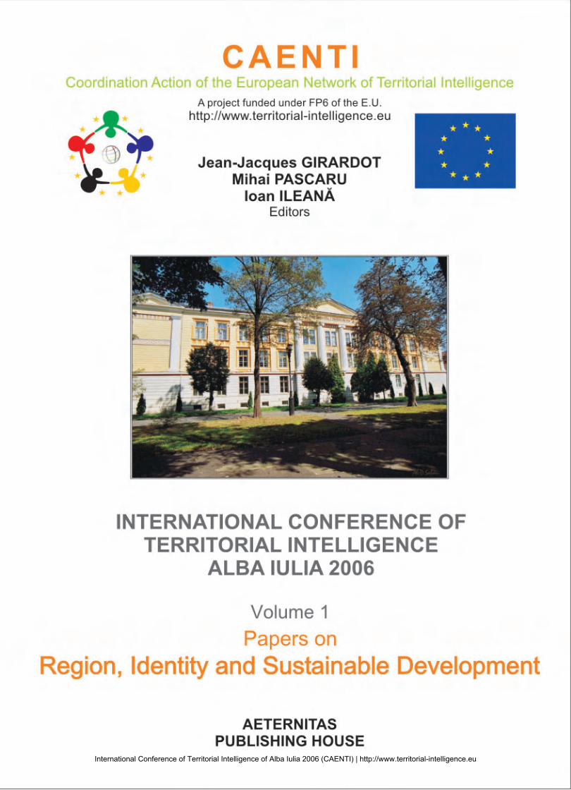
International Conference of Territorial Intelligence
ALBA IULIA 2006
Volume 1
Papers on REGION, IDENTITY AND
SUSTAINABLE DEVELOPMENT
AETERNITAS PUBLISHING HOUSE
ALBA IULIA
International Conference of Territorial Intelligence of Alba Iulia 2006 (CAENTI) | http://www.territorial-intelligence.eu
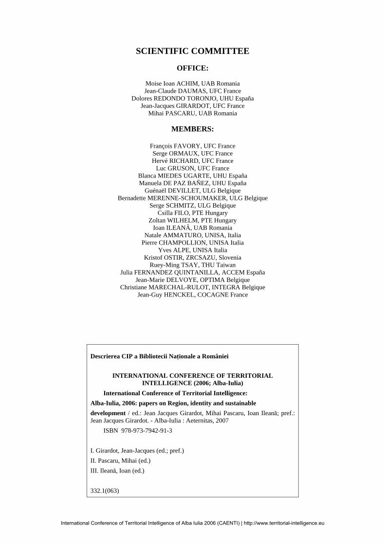
SCIENTIFIC COMMITTEE
OFFICE:
Moise Ioan ACHIM, UAB Romania Jean-Claude DAUMAS, UFC France
Dolores REDONDO TORONJO, UHU España Jean-Jacques GIRARDOT, UFC France
Mihai PASCARU, UAB Romania
MEMBERS:
François FAVORY, UFC France Serge ORMAUX, UFC France Hervé RICHARD, UFC France
Luc GRUSON, UFC France Blanca MIEDES UGARTE, UHU España Manuela DE PAZ BAÑEZ, UHU España
Guénaël DEVILLET, ULG Belgique Bernadette MERENNE-SCHOUMAKER, ULG Belgique
Serge SCHMITZ, ULG Belgique Csilla FILO, PTE Hungary
Zoltan WILHELM, PTE Hungary Ioan ILEANĂ, UAB Romania
Natale AMMATURO, UNISA, Italia Pierre CHAMPOLLION, UNISA Italia
Yves ALPE, UNISA Italia Kristof OSTIR, ZRCSAZU, Slovenia
Ruey-Ming TSAY, THU Taiwan Julia FERNANDEZ QUINTANILLA, ACCEM España
Jean-Marie DELVOYE, OPTIMA Belgique Christiane MARECHAL-RULOT, INTEGRA Belgique
Jean-Guy HENCKEL, COCAGNE France
Descrierea CIP a Bibliotecii Naţionale a României
INTERNATIONAL CONFERENCE OF TERRITORIAL INTELLIGENCE (2006; Alba-Iulia)
International Conference of Territorial Intelligence: Alba-Iulia, 2006: papers on Region, identity and sustainable development / ed.: Jean Jacques Girardot, Mihai Pascaru, Ioan Ileană; pref.: Jean Jacques Girardot. - Alba-Iulia : Aeternitas, 2007 ISBN 978-973-7942-91-3 I. Girardot, Jean-Jacques (ed.; pref.) II. Pascaru, Mihai (ed.) III. Ileană, Ioan (ed.) 332.1(063)
International Conference of Territorial Intelligence of Alba Iulia 2006 (CAENTI) | http://www.territorial-intelligence.eu
PAPERS ON REGION, IDENTITY AND SUSTAINABLE DEVELOPMENT
5
SUMMARY
International conference of territorial intelligence Alba Iulia 2006. Presentation of the acts ..................... 7
Program .............................................................................................................................................................. 8
Conference abstracts .......................................................................................................................................... 15
Participants list ................................................................................................................................................... 31
Speakers list ........................................................................................................................................................ 35
Introduction ........................................................................................................................................................ 37
Activities and prospects of CAENTI. Jean-Jacques GIRARDOT ....................................................................... 39
Invited conferences ............................................................................................................................................ 49
Is region the most appropriate space to think sustainable development? A framework for research and
implementation. Philippe DUMAS ...................................................................................................................... 51
The environmental information system in Romania: an institutional and behavioural approach. Daniela-
Luminiţa CONSTANTIN, Constantin MITRUŢ ................................................................................................. 63
A - Regions development, territorial identity and community ....................................................................... 71
A regional analysis on subjective welfare. Romanians' major concerns on developing regions. Călina Ana
BUŢIU ................................................................................................................................................................. 73
Geographic identity aspects of the Land of the Moţi. Cristian Nicolae BOŢAN, Oana-Ramona ILOVAN ........ 87
Corsica, island heritage and regional identity: to the territorial intelligence. Marie-Michèle VENTURINI,
Julien ANGELINI ................................................................................................................................................ 95
Alba county: towards a balanced development of the territory based on its cultural heritage. Marian AITAI .... 103
B - Employment and territorial delimitation ................................................................................................... 111
Geographical, historical and administrative basis of the regions of Hungary. József TÓTH, Zoltán
WILHELM ........................................................................................................................................................... 113
Are local labour markets suitable space units in order to define sustainable territorial development strategies?
Blanca MIEDES UGARTE, Celia SANCHEZ LOPEZ, German PEREZ MORALES, Antonio J. MORENO
MORENO ............................................................................................................................................................ 123
Regional development, career choice and territorialization of the training supply: Elements of
problematisation. Pierre CHAMPOLLION ......................................................................................................... 133
ACCEM experience in the implementation of a territorial management system of social and professional
skills since immigrant labour insertion and social integration processes in Spain. Francisco Javier MAHIA
CORDERO .......................................................................................................................................................... 137
The choice of the employment area as an intervention territory in the field of the professional insertion.
Evelyne BRUNAU ............................................................................................................................................... 145
International Conference of Territorial Intelligence of Alba Iulia 2006 (CAENTI) | http://www.territorial-intelligence.eu
INTERNATIONAL CONFERENCE OF TERRITORIAL INTELLIGENCE ALBA IULIA 2006
6
C - Local observation ......................................................................................................................................... 149
The observation strategy of the ACCEM. Julia FERNANDEZ QUINTANILLA, Javier MAHIA CORDERO,
Braulio CARLES BARRIOPEDRO, Jean-Jacques GIRARDOT, Cyril MASSELOT ........................................ 151
Development of a co-operative information system for the follow-up of the evolution of users’ situation
(children, youngs and adults mentally handicapped). Anne PERETZ, Jean-Pierre GIMBERT .......................... 159
Is territorial sensitivities method acceptable in the territorial intelligence approaches? Serge SCHMITZ .......... 165
D - Regional instruments and sustainable development ................................................................................. 169
For an economic regional observatory in Franche-Comté: Between mutualisation and independence. Marie-
Hélène DE SEDE-MARCEAU, Alexandre MOINE ........................................................................................... 171
Sustainable development and forestry resources administration in the Apuseni Mountains area. Ioana
RÎŞTEIU, Marin BÎRLA ...................................................................................................................................... 183
Trends in social mobility in Romania since the Middle of the Twentieth Century. Economical change as an
explicative factor of the social mobility. Liliana IONAŞ ..................................................................................... 189
Businesses as one of the key elements of a regions sustainable development. Natalya MOISEYENKO ............ 201
Territorial intelligence and local development. The restoring of results of the sociological inquiry in a micro-
regional area. Mihai PASCARU .......................................................................................................................... 211
Knowledge-based development models. Csilla FILO .......................................................................................... 225
E - GIS and territorial intelligence systems ..................................................................................................... 229
Data analysis using GIS and data mining. Fang-Yie LEU, Tai-Hsiang WANG .................................................. 231
ModeLTER: modelling of landscapes and territories over the long term, the members of an European
Associated Laboratory (EAL) in CAENTI. François-Pierre TOURNEUX, Laure NUNINGER, Kristof
OSTIR .................................................................................................................................................................. 239
Cellular world simulation: A collaborative model for spatial visioning and Territorial Intelligence. Jean-
Philippe ANTONI ................................................................................................................................................ 249
The editorial function of the territorial intelligence systems. Jean-Jacques GIRARDOT ................................... 255
Application of Internet GIS tools for heritage management. ARKAS case study. Ziga KOKALJ, Peter
PEHANI, Sneza Tecco HVALA, Kristof OSTIR ................................................................................................ 267
Sharing and disseminating knowledge of advanced spatial modelling. Presentation of an action carried out by
the european research group S4 (spatial simulation for social sciences). Cécile TANNIER ............................... 273
International Conference of Territorial Intelligence of Alba Iulia 2006 (CAENTI) | http://www.territorial-intelligence.eu
PAPERS ON REGION, IDENTITY AND SUSTAINABLE DEVELOPMENT
7
INTERNATIONAL CONFERENCE OF TERRITORIAL INTELLIGENCE ALBA IULIA 2006.
PRESENTATION OF THE ACTS
Jean-Jacques GIRARDOT
Scientific coordinator of CAENTI Université de Franche-Comté
These acts gather the communications of the International Conference of Territorial Intelligence that took place in ALBA IULIA in Romania, from September, the 20th to September, the 22nd 2006. This conference was the fourth conference of territorial intelligence, but the conference of ALBA IULIA is the first one that took place in the CAENTI, Coordination Action of the European Network of Territorial Intelligence, framework. Consequently, it has a particular organization. A part is devoted to the presentation of the CAENTI research activities and of their prospects. The CAENTI specific communications are published in another volume. They are also accessible on the website of territorial intelligence http://www.territorial-intelligence.eu. The other part is constituted of communications that were valuated after a call for proposals about the specific thematic of this conference “Region, identity and sustainable development” which is sub-divided in three themes presented under a question form: 1. Is region the most appropriate space to think sustainable development? 2. In the framework of the regional identity construction, what are the problems, experiences and good practices? 3. Which methods and tools should be used to implement the territory sustainable development? This volume of acts includes a selection of 24 communications that were presented in the framework of these thematic workshops. The Scientific Committee valuated the best papers written in English and enriched by debates. They were brought together in five themes: A. Regional development, regional identity and sustainable development. B. Employment and definition of the territory. C. Local observation. D. Regional tools and sustainable development. E. GIS and territorial intelligence systems. It will be possible to find all the communications, as well as versions in other languages than English, on the website http://www.territorial-intelligence.eu. I would like you find interest in reading these acts. I invite you to the next annual conference of territorial intelligence, from October, the 24th to the 27th 2007, in HUELVA in Spain. Since this moment, we will be pleased to welcome you on the website of territorial intelligence http://www.territorial-intelligence.eu.
International Conference of Territorial Intelligence of Alba Iulia 2006 (CAENTI) | http://www.territorial-intelligence.eu
INTERNATIONAL CONFERENCE OF TERRITORIAL INTELLIGENCE ALBA IULIA 2006
8
PROGRAM
Wednesday, September the 20th 2006 - CAENTI day.
10.00-12.00: CAENTI Steering Committee (Animator: Jean-Jacques GIRARDOT. Jean-Charles DUCHENE will give a report). PARC HOTEL.
• Welcome by Moise Ioan ACHIM, Rector of the University of Alba Iulia. • First intermediary activity report. Jean-Jacques GIRARDOT, CAENTI Scientific coordinator,
University of Franche-Comté. • First intermediary management and financial report. Amélie BICHET-MIÑARO; CAENTI manager,
University of Franche-Comté. • First intermediary innovation and dissemination report. Juan-Sebastian GONZALEZ, Innovation and
dissemination manager, University of Huelva.
14.00-15.45: Scientific Committee (Animator: Moise Ioan ACHIM. Jean-Claude DAUMAS will give a report). PARC HOTEL.
• Reception and framing of the Scientific Committee. Moise Ioan ACHIM, Rector of the University Alba Iulia.
• Reception of the organisational Committee. Organisation of the international conference of Alba Iulia 2006. Mihai PASCARU, University Alba Iulia.
• Organisation of the conferences acts publishing. Ioan ILEANĂ, University Alba Iulia. • Preparation of the international conference of HUELVA 2007. Dolores REDONDO-TORONJO,
University of Huelva.
15.45-16.15: Coffee break.
16.15-18.00: Editorial Committee of the portal www.territorial-intelligence.eu (Animator: Cyril MASSELOT. Anne PIPONNIER will give a report). PARC HOTEL.
• Presentation of the portal and of the Editorial Committee organisation. Cyril MASSELOT, University of Franche-Comté, Anne PIPONNIER, University of Salerno.
• Presentation of the cooperative workspace CooSpace. Peter ACS, University of Pécs. • Presentation of the review on Internet www.isdm.univ-tln.fr. Yann BERTACCHINI, Laboratory I3M-
EA3820, University of “Sud-Toulon-Var”.
20.00: Meeting with the Regional Development Agency “CENTRU”.
Thursday, September the 21st 2006-CAENTI day.
09.00-09.30: Reception of the participants. PARC HOTEL.
09.30-10.30: Opening speech. PARC HOTEL. Welcome of participants.
Moise Ioan ACHIM, Rector of the University "1 Decembrie 1918", Alba Iulia. Ioan DUMITREL, President of the County Council of Alba. Mircea HAVA, Mayor of Alba Iulia.
Presentation of the activities and prospects of the CAENTI, and of the conference, Jean-Jacques GIRARDOT, Scientific Coordinator of the CAENTI, University of Franche-Comté.
10.30-10.45: Coffee break.
International Conference of Territorial Intelligence of Alba Iulia 2006 (CAENTI) | http://www.territorial-intelligence.eu
PAPERS ON REGION, IDENTITY AND SUSTAINABLE DEVELOPMENT
9
10.45-12.30: Invited conferences REGION, IDENTITY AND SUSTAINABLE DEVELOPMENT. (Animator: Moise Ioan ACHIM. Mihai PASCARU will give a report). PARC HOTEL.
• 10.45-11.15: Is region the most appropriate space to think sustainable development? A framework for research and implementation. Philippe DUMAS, Director of I3M-EA3820 laboratory, University of “Sud-Toulon-Var”.
• 11.15-11.45: In the framework of the regional identity construction, what are problems, experiments and good practices? Laura GARCIA VICTORIA, Scientific director of the European network of Numerical Cities, responsible for the External relations of the European Institute of Ethics and Sustainable Development.
• 11.45-12.15: The environmental information system in Romania: an institutional and behavioural approach. Daniela-Luminiţa CONSTANTIN, Constantin MITRUŢ, Bucharest Academy of Economics Studies.
12.30-14.00: Lunch (Ulpia Traiana Restaurant).
14.00-18.00: CAENTI workshops WP4 - Fundamental methods (Animator : Csilla FILO. Di CHEN will give a report). PARC HOTEL.
• 14.00-14.20: The spreading of fundamental methods and research design in territorial information analysis within the social sciences and humanities sciences. Csilla FILO, University of Pécs.
• 14.20-14.40: (WP4M) – Methods for territorial intelligence. Serge ORMAUX, Director of ThéMA laboratory, University of Franche-Comté.
• 14.40-15.00: (WP4I) – Territorial information, themes, indicators and sources. Di CHEN, Guénaël DEVILLET, Director of the SEGEFA, University of Liège.
• 15.00-15.20: (WP4P) – Evaluation of projects funded by the European Commission and of the existing information of the GDs that might be relevant in the territorial intelligence field coordination group WP4P “Projects” of CAENTI. Amélie BICHET-MIÑARO, Jean-Jacques GIRARDOT, University of Franche-Comté.
• 15.20-15.40: (WP4T) – Territory and territorialisation. Pierre CHAMPOLLION, Observatory of Rural School, University of Salerno.
• 15.40-16.00: (WP4C) – Territories competitiveness for territorial intelligence. Csilla FILO, University of Pécs.
• 16.00-16.30: Coffee break. • 16.30-18.00: Discussion.
20:00: Official dinner, PARC HOTEL. Friday, September the 22nd 2006 – CAENTI day. 09.00-10.30: CAENTI workshops WP5 – Governance Principles (Animator: Blanca MIEDES UGARTE. Alexandre MOINE will give a report). PARC HOTEL.
• 09:00-09:30: Analysis of the application of the governance principles of sustainable development to territorial research action. Blanca MIEDES UGARTE, University of Huelva.
• 09:30-09:50: Precisions of the authors of experiments catalogues. • 09:50-10:30: Discussion.
10.30-11.00: Coffee break. 11.00-12.30: CAENTI workshops WP6 – Tools for territorial actors (Animator: Jean-Jacques GIRARDOT. José Maria ASENSIO COTO will give a report). PARC HOTEL.
International Conference of Territorial Intelligence of Alba Iulia 2006 (CAENTI) | http://www.territorial-intelligence.eu
INTERNATIONAL CONFERENCE OF TERRITORIAL INTELLIGENCE ALBA IULIA 2006
10
• 11.00-11.20: (WP6) – Activities and prospects of research activities concerning tools of territorial intelligence for sustainable development actors Workpackage 6 “Tools for actors” of CAENTI. Jean-Jacques GIRARDOT, University of Franche-Comté.
• 11.20-11.35: Specifications of the contents of the European guide of diagnosis and evaluation. Célia SANCHEZ LOPEZ, University of Huelva, Jean-Jacques GIRARDOT, University of Franche-Comté.
• 11.35-11.50: Towards a European observatory of elementary school: feasibility study from the french experience Observatory of Rural School. Yves ALPE, University of Salerno.
• 11.50-12.30: Discussion. 12:30-14:00: Lunch.
14:00-15:30: Thematic workshops. University of Alba Iulia. Theme 1 – Regions development, territorial identity and community. 14.00-15.30: Workshop 1.1 – Romanian Regions Development (Animator: Filimon STREMŢAN. Claudia PĂTRUŢ will give a report).
• 14.00-14.30: Centru Region. Natural and Anthropological potential and sustainable development perspectives. Simeon CRETU, ADR Centre.
• 14.30-15.00: Regional analysis on subjective welfare. Călina Ana BUŢIU, University of Alba Iulia.
15.30-16.00: Coffee break.
16.00-17.30: Workshop 1.2 – Employment and territorial delimitation (Animator: Serge ORMAUX. Yves ALPE will give a report).
• 16.00-16.30: Are local labour markets suitable space units in order to define sustainable territorial development strategies?. Blanca MIEDES UGARTE, Celia SANCHEZ LOPEZ, German PEREZ MORALES, Antonio J. MORENO MORENO, University of Huelva.
• 16.30-17.00: Regional development, career choice and territorialisation of training supply: elements of problematisation. Pierre CHAMPOLLION, University of Salerno.
• 17.00-17.30: The choice of the employment area as an intervention territory in the field of the professional insertion. Evelyne BRUNAU, “Relais Emplois”.
International Conference of Territorial Intelligence of Alba Iulia 2006 (CAENTI) | http://www.territorial-intelligence.eu
PAPERS ON REGION, IDENTITY AND SUSTAINABLE DEVELOPMENT
11
16.00-17.30: Workshop 1.3 – Other regions development (Animator: Ioan ILEANĂ. Laura VOICULESCU will give a report).
• 16.00-16.30: Comparative study regarding the evolution of the foreign direct investments in central and eastern Europe region. Ionela GAVRILA-PAVEN, University of Alba Iulia.
• 16.30-17.00: Peril or promise? Building a science park in central Taiwan. Cheng-Hui Lucy CHEN, Rueyming TSAY, Thungai University (Information System for Social Policy Unit).
• 17.00-17.30: Geographical, historical and administrative basis of the regions of Hungary. József TÓTH, Zoltán WILHELM, Faculty of Sciences, University of Pécs.
• System of the fortifications of the maritime Syria: territoriality and sustainable development. Mohamed SAIDI, Mourad BOUTEFLIKA, University of Constantine.
Theme 2 – Employment and territorial delimitation. 14.00-15.30: Workshop 2.1 – Territorial identity (Animator: Natale AMMATURO. Dolores REDONDO TORONJO will give a report).
• 14.00-14.30: Geographic identity of the Land of the Moti. Cristian Nicolae BOŢAN, Oana-Ramona ILOVAN, University of Cluj-Napoca.
• 14.30-15.00: Mechanisms in construction and deconstruction of Territorial Identity in the "Lands" of Romania. Oana-Ramona ILOVAN, University of Cluj- Napoca.
• 15.00-15.30: Corsica, island heritage and regional identity: to the territorial intelligence. Marie-Michèle VENTURINI, Julien ANGELINI, University of Corsica.
• 15.30-16.00: Coffee break. 16.00-17.30: Workshop 2.2 – Territory and community (Animator: Cheng-Hui Lucy CHEN. Tullia SACCHERI will give a report).
• 16.00-16.30: Alba County: the role of the mountain region within social cohesion strategy. Dan Coriolan SIMEDRU, University of Alba Iulia.
• 16.30-17.00: Alba County: towards a balanced development of the territory based on its cultural heritage. Marian AITAI, County Council of Alba.
• 17.00-17.30: Community recovery and sustainable development in the region of seismic center in Taiwan after the 1999 CHI-CHI Earthquake. Hsiu-Jen Jennifer YEH, Thungai university (Information System for Social Policy Unit).
Theme 3: Local observation. 14.00-15.30: Workshop 3.1 – GIS and other methods of territorial analysis. (Animator: Guénaël DEVILLET. François-Pierre TOURNEUX will give a report).
• 14.00-14.30: Data analysis using GIS and data mining. Fang-Yie LEU, Tai-Hsiang WANG, Thungai University (Information System for Social Policy Unit).
• 14.30-15.00: Application of Internet GIS tools for heritage management. ARKAS case study. Ziga
International Conference of Territorial Intelligence of Alba Iulia 2006 (CAENTI) | http://www.territorial-intelligence.eu
INTERNATIONAL CONFERENCE OF TERRITORIAL INTELLIGENCE ALBA IULIA 2006
12
KOKALJ, Peter PEHANI, Sneza Tecco HVALA, Kristof OSTIR, Scientific Research Centre of the Slovenian Academy of Sciences and Arts (Institute of Anthropological and Spatial Studies).
• 15.00-15.30: Sharing and disseminating knowledge of advanced spatial modelling. Presentation of an action carried out by the European research group S4 (spatial simulation for social sciences). Cécile TANNIER, University of Franche-Comté.
14.00-15.30: Workshop 3.2 – Local observation (Animator: Jean-Marie DELVOYE. Cyril MASSELOT will give a report).
• 14.00-14.30: The observation strategy of the ACCEM. Julia FERNANDEZ QUINTANILLA, Accem, Javier MAHIA CORDERO, Accem, Jean-Jacques GIRARDOT, University of Franche-Comté, Cyril MASSELOT, University of Franche-Comté.
• 14.30-15.00: Development of a co-operative information system for the follow up of evolution of users’ situation (children, youngs and adults mentally handicapped). Anne PERETZ, Jean-Pierre GIMBERT, ADAPEI of Besançon.
• 15.00-15.30: Is territorial sensitivities method acceptable in the territorial intelligence approaches? Serge SCHMITZ, Universty of Liège.
14.00-15.30: Workshop 3.3 – Sustainable territorial development limits (Animator: Jean-Guy HENCKEL. Manuela DE PAZ BAÑEZ will give a report).
• 14.00-14.30: Sustainable development between possibilities and limits. Pompei COCEAN, Oana-Ramona ILOVAN, University of Cluj-Napoca.
• 14.30-15.00: Sustainable development: elements for its interpretation. Maria José ASENSIO COTO, Olga MINGUEZ MORENO, University of Huelva.
• 15.00-15.30: Sustainable development and administration of the forest resources in the Apuseni Mountains area. Ioana RÎŞTEIU, Babeş-Bolyai’’ University, Cluj-Napoca, Marin BÎRLA, Town council of Bistra, Department of Alba.
15.30-16.00: Coffee break. 16.00-17.30: Workshop 3.4 – Regional instruments for sustainable development. (Animator: Csilla FILO. Maria MUREŞAN will give a report).
• 16.00-16.30: Digital Alba Iulia. System integration for regional e-government SIRE-go. Mircea RÎŞTEIU, Ioan ILEANĂ, Mihai PASCARU, University of Alba Iulia.
• 16.30-17.00: For an economic regional observatory in Franche-Comté: between mutualisation and independence. Alexandre MOINE, Marie-Hélène DE SEDE-MARCEAU, University of Franche-Comté.
• 17.00-17.30: Individual Farming. Iuliana CENAR, Constantin DEACONU, University of Alba Iulia. 16.00-17.30: Workshop 3.5 – Sustainable development socio-economic factors. (Animator: Kristof OSTIR. Felician COTEA will give a report).
• 16.00-16.30: Trends in social mobility in Romania since the middle of the twentieth century. Economical change as an explicative factor of the social mobility. Liliana IONAŞ, University of Alba Iulia.
• 16.30-17.00: Businesses as one of the key elements of a region sustainable development. Natalya MOISEYENKO, University of Franche-Comté.
• 17.00-17.30: Territorial intelligence and local development. The restoring of results of the sociological
International Conference of Territorial Intelligence of Alba Iulia 2006 (CAENTI) | http://www.territorial-intelligence.eu
PAPERS ON REGION, IDENTITY AND SUSTAINABLE DEVELOPMENT
13
inquiry in a micro-regional area. Mihai PASCARU, University of Alba Iulia. 16.00-17.30: Workshop 3.6 – Territorial intelligence systems (Animator: Pierre CHAMPOLLION. Isabelle MOURET will give a report).
• 16.00-16.30: ModeLTER: modelling of landscapes and territories over the long term, the members of an European Associated Laboratory (EAL) in CAENTI. François-Pierre TOURNEUX, Laure NUNINGER, University of Franche- Comté, Kristof OSTIR, Scientific Research Centre of the Slovenian Academy of Sciences and Arts (Institute of Anthropological and Spatial Studies).
• 16.30-17.00: The editorial function of the territorial intelligence systems. Jean-Jacques GIRARDOT, University of Franche-Comté.
17.30-18.00: Closing speech. 19:00: Diner in the Romanian village of PETRESTI. Saturday, September the 23rd 2006 11.00-12:00: Ceremony of “The three fortifications”. Alba Iulia.
International Conference of Territorial Intelligence of Alba Iulia 2006 (CAENTI) | http://www.territorial-intelligence.eu
INTERNATIONAL CONFERENCE OF TERRITORIAL INTELLIGENCE ALBA IULIA 2006
14
International Conference of Territorial Intelligence of Alba Iulia 2006 (CAENTI) | http://www.territorial-intelligence.eu
PAPERS ON REGION, IDENTITY AND SUSTAINABLE DEVELOPMENT
15
CONFERENCE ABSTRACTS
Wednesday, September the 20th 2006 - CAENTI day.
10.00-12.00: CAENTI Steering Committee.
• First intermediary activity report. Jean-Jacques GIRARDOT, CAENTI Scientific coordinator, University of Franche-Comté.
The first CAENTI scientific activity report concerns the first six months, from March to August 2006. This six-month period was active. It ends with the first conference to which a hundred people registered, from almost ten countries. 56 communications will be presented, 20 will be reports about the progress of the coordination activities that were developed during the first six months within the CAENTI, and 36 communications will be presented by researchers, some are CAENTI members (17) and some not (21). This first six-month period was essentially devoted to organization activities. Amélie BICHET-MIÑARO will present the work that was made to implement the management. The Internet website was active as of the kick-off meeting that took place on March, the 23rd and 24th 2006. Since this date, the Internet website has developed much, thus the contents of the CAENTI presentation, its participants’ one and its activities one were translated in eight languages. Now, it can direct itself towards an editorial activity. During the kick-off meeting, we could also present a first version of the workspace Coospace, which has been working since June 2006, as we planned. Lots of exchange spaces and forums were implemented after the coordination seminars. Now, there is their use development left. The scientific coordination activities were quickly implemented as far as the three workshops, Fundamental methods (WP4), Governance principles (WP5) and Tools for actors (WP6) are concerned. The seminar of Huelva has allowed structuring the WP5 activities since May, the 5th 2006. The first reports were written after this conference where a first synthesis was presented. The WP4 and WP6 groups were structured through the seminars of Durbuy, Aix-en-Provence and Besançon in May and June, 2006. The orientations of the WP4 Methods coordination groups were defined. An important work was made within the WP6 Tools. A doctoral training course was made; it allowed harmonizing the CATALYSE diagnosis and evaluation guide at the European level, and then defining the contents specifications of this guide. We also started thinking about submitting a candidature to a Network of Excellence in 2009, what implies a strong integration of the CAENTI teams’ research programs, the increase of the partners’ number and the integration of new dimensions (training, edition, transfer). Contacts were established and projects were submitted to associate new partners.
• First intermediary management and financial report. Amélie BICHET-MIÑARO, CAENTI Manager, University of Franche-Comté.
The CAENTI management aims at easing leading quality research activities and at facilitating the collaborative work. During the first six months of the project, we first created a legal framework for the CAENTI project, by signing a Consortium agreement on April, the 10th 2006. We also planned and regularly followed up the use of the European subvention. After a six-month activity period, we can emphasize two points in relation with administrative and financial issues. We may underline that two tasks are already finished up and the funds that were devoted to the latter ones were spent. Moreover, as decided, the fifteen CAENTI partners used the European subvention with economy. These elements will be useful to write the first annual report we will present to the European Commission in February 2007
14.00-15.45: Scientific Committee.
• Reception and framing of the Scientific Committee. Moise Ioan ACHIM, Rector of the University of Alba Iulia.
The report shows first the general principles of the organisation and functioning of a Scientific Committee in a project such as CAENTI. Then it follows the presentation of the scientific committee of our project and the constitution modality so that every workpackage and research group be represented
International Conference of Territorial Intelligence of Alba Iulia 2006 (CAENTI) | http://www.territorial-intelligence.eu
INTERNATIONAL CONFERENCE OF TERRITORIAL INTELLIGENCE ALBA IULIA 2006
16
through their leaders, as well as the representatives of the main research centres. The functioning of the Scientific Committee is provided by a bureau whose constitution and functioning rules are also presented. The main purpose of the Scientific Committee is that of validating the research activities set of the coordination section, especially in relation with the Conferences organised within the project. A series of concrete measures for the optimisation of the Scientific Committee activities regarding the Conference in development in Alba Iulia as well as the conferences in Huelva (2007) and Besançon (2008) will also be presented in the report.
• Reception of the organisational Committee. Organisation of the international conference of Alba Iulia 2006. Mihai PASCARU, University of Alba Iulia.
The report presents the general principles of the organisation and functioning of the Organising Committee in a project such as CAENTI, with an emphasis on the fundamental principle of a team easy to organise. The previous analysed experience in the project will also be presented, and there will also be a definition of the evolution of the organisation towards the involvement of all workpackages in specific activities, through their representatives. A special chapter will be dedicated to the organising experience of the Conference in Alba Iulia, and to the need to think the calendar of the different stages in organising the Conferences, with strict deadlines and concrete responsibilities for each and every partner so that the organisation of the future conferences should reflect the involvement of all participants. An important issue will represent an operative permanent connection between the Organising Committee, the Scientific Committee and the Editorial Committee. The report will end with the presentation of a possible problems series regarding the financial aspects of the project.
• Preparation of the international conference of Huelva 2007, "Territorial intelligence and governance". Dolores REDONDO-TORONJO, University of Huelva.
The CAENTI project plans international conferences of Territorial intelligence as an integrative activity between the scientific teams. Each international conference analyses a specific thematic, and the University of Huelva is responsible of the International conference that will take place in 2007. The specific theme is “Territorial intelligence and governance”. This Conference will aim at presenting, debating and disseminating the main questions of the CAENTI scientific centre WP5, that is to say the analysis of the application of the sustainable development governance principles in the territorial research-action. This conference will focus on the debate about good practices in the scientific production of Humanities and Social Sciences and area that favour and inspire territorial governance. Another aspect that will be evoked in this Conference will be the discussion on standards and norms that must be used for this kind of research activities. The CAENTI works will be presented so as to establish the quality criteria in the research that is made in cooperation between scientific teams and ground actors who are involved in the economic, social and environmental development.
16.15-18.00: Editorial Committee of the portal www.territorial-intelligence.eu.
• Presentation of Portal and Editorial Committee organisation (WP3). Cyril MASSELOT, University of Franche-Comté, Anne PIPONNIER, University of Salerno.
The object of the WP3 [PORTAL] – Internet and Extranet portal of territorial intelligence is to provide the CAENTI with an intra-consortium website and a cooperative work platform (CooSpace), by means of the installation, feeding, maintenance and actualization of the portal, in accordance with the decisions of the Steering Committee and under the Editorial Committee authority.
This report initially presents the general design of the portal in three specific tools:
Internet Portal for general public: objectives and public target Extranet: design and management of the portal administration Cooperative Workspace CooSpace: objectives, users and organization
We detail then the evolution of each one as of these tools during the first 6 months of activities within the CAENTI (from 01/03/06 to 31/08/06):
International Conference of Territorial Intelligence of Alba Iulia 2006 (CAENTI) | http://www.territorial-intelligence.eu
PAPERS ON REGION, IDENTITY AND SUSTAINABLE DEVELOPMENT
17
Design and realization; Evolutions since its official opening; Statistics (frequentation - use - referencing); Current Situation; Evolutions to come, tasks to be organized.
The prospects for evolution of the current portal can be used as a basis of discussion to program the continuation of work to carry out together?, in particular the numerical edition chain of the research in progress results, and the publication of the annual and virtual conferences acts. These operations should be organized according to the decisions of the Steering Committee, in relation to the Scientific Committee, and by developing new partnerships such as the online review ISDM (laboratory I3M).
Thursday, September the 21st 2006 - CAENTI day.
09.30-10.30: Opening speech (University/Region/CAENTI).
• 10.00-10.30: Introducton “Activities and prospects of CAENTI”. Jean-Jacques GIRARDOT, Scientific coorinator of CAENTI.
This communication constitutes the introduction of the International Conference of Territorial Intelligence, which stands in ALBA IULIA, Romania, in September 2006. It quickly presents the CAENTI Coordination Action of the European Network of Territorial Intelligence. It introduces a reflexion about the definition of territorial intelligence within the CAENTI. It details CAENTI' research and dissemination activities, its first results and its prospects, as they result for the intermediary activity report writed after six months of activity, at the end of August 2006.
10.45-12.30: Invited conferences “Region, identity and sustainable development”.
• Is region the most appropriate space to think sustainable development? A framework for research and implementation. Philippe DUMAS, Director of I3M-EA3820 laboratory, University of “Sud-Toulon-Var”.
Whatever the challenge is for a rational observer, European regions and Regionalism have become common concerns in Europe for the last thirty years in the realm of European Union, not to speak of centuries in some European states. Sustainable development is another controversial notion although it is largely used and has been introduced since the late eighties in European glossary. In the line of the CAENTI Alba Iulia conference program, the aim of this communication is to relate together those two concepts – region and sustainable development - with the one of territorial intelligence. In a world that continuously witnesses the disasters of state imperialism and aggressive competition, territorial intelligence dictates that regions should not behave and/or be considered as mini-states, i.e. territorial or sociocultural entities that establish their legitimacy on zero sum antagonisms. It is our view that the permanence of regions in the history and around the world is a proof that (a) region has a profound popular meaning, and (b) that a fresh conception of regional governance is a chance for the implementation of sustainable development. As a provisional conclusion to these reflections, we suggest some guidelines of action for a group of benevolent people looking to implement a more friendly world on the basis of a regional leverage.
• The environmental information system in Romania: an institutional and behavioural approach. Daniela-Luminiţa CONSTANTIN, Constantin MITRUŢ, Bucharest Academy of Economic Studies.
When the environmental issues are addressed in sustainability, human security terms the information demand is getting more complex, emphasising the need to integrate environmental, economic and
International Conference of Territorial Intelligence of Alba Iulia 2006 (CAENTI) | http://www.territorial-intelligence.eu
INTERNATIONAL CONFERENCE OF TERRITORIAL INTELLIGENCE ALBA IULIA 2006
18
socio-cultural information. This paper proposes an insight into the data and indicator issues on environment and human security in Romania from an institutional perspective. The environmental information system has been critically assessed in terms of content, information flows and further developments related to human security issues. The data reliability at various territorial levels of data gathering, processing and transmitting has been also analysed in this context. A special emphasis has been put on the actors involved in employing the environmental information for strategy and policy elaboration and implementation, management and administration as well as for scientific research, environmental education and public participation purposes. A typology of these actors from organisational viewpoint has been proposed and analysed, pointing out the need of enhancing the networking effects at both national and international levels.
14.00-18.00: CAENTI workshops 4 - Fundamental methods.
• 14.00-14.20: The spreading of fundamental methods and research design in territorial information analysis within the social sciences and humanities. Csilla FILO, University of Pécs.
The WP4 activities should direct themselves towards two main objectives that will influence the CAENTI activities during the next months.
Which are the generic methods in Territorial Intelligence? This questioning transcends the strict framework of social sciences.
How to improve the diffusion of these methods within social sciences? These questions refer to the training of persons who work in the social field and to the development of inter-relations between researchers and social actors. The presentation emphasizes the works that were led during preliminary seminars.
• 14.20-14.40: (WP4M) – Methods for territorial intelligence. Serge ORMAUX, Director of ThéMA laboratory, University of Franche-Comté.
The author will make a brief presentation of the methods and generic tools that are used by the researchers in social sciences to study territories. This state of art will be discussed in the prospect of the WP4M report that will be written on this theme in December 2006. The main kinds of used methods are evoked, and there are links with the answers of the survey which was made with the members of the WP4M.
At the end, we shall answer to the following questions: - Which methods are used, in which disciplines and in which laboratories? - Which methods can be used to elaborate tools for territorial actors?
We will genuinely answer to these questions at the end of the second year of the CAENTI project, but we must already take stock of these practices.
• 14.40-15.00: (WP4I) – Territorial information, themes, indicators and sources. Di CHEN, University of Liège, Guénaël DEVILLET, Director of the SEGEFA, University of Liège.
Territorial information can be gathered on many Internet websites. However, the spatial level, the year and the validity of data vary according to the information that is required. An important task for an international project like ours is to find a common territorial division that makes possible the comparisons between data across all European and Caenti countries. This question can be partly solved by the use of the NUTS (Nomenclature of Territorial Units for Statistics) created by Eurostat.
The first step of WP4I is to establish which themes and indicators are needed within the Humanities and Social Sciences, and parallel to this, we have to consider what indicators are actually available on Internet. In this context, a research and analysis over European territorial observatories, international and national statistical sources have been led. Discussions between the WP4 teams were held to choose among a first proposition of themes and indicators and to exchange different points of view. The difficulties that appeared during our researches are also underlined.
International Conference of Territorial Intelligence of Alba Iulia 2006 (CAENTI) | http://www.territorial-intelligence.eu
PAPERS ON REGION, IDENTITY AND SUSTAINABLE DEVELOPMENT
19
• 15.00-15.20: (WP4P) – Evaluation of projects funded by the European Commission and of the Gds that might be relevant in the territorial intelligence field coordination group wp4p “Projects” of CAENTI. Amélie BICHET-MIÑARO, Jean-Jacques GIRARDOT, University of Franche-Comté.
This communication makes a state of the activities carried out by the WP4P coordination group of the 4th work package “Fundamental methods” of the CAENTI, Coordination Action of the European Network of Territorial Intelligence. The WP4P concerns a technical issue, the evaluation of projects funded by the European Commission and of the existing information of the GDs that might be relevant in the territorial intelligence field. The first six months of the CAENTI were mainly devoted to the projects selection. A first task consisted in identifying the projects which are funded by the European Union and that can be considered as belonging to the territorial intelligence field. A first group of keywords was suggested to select them. The first selection essentially underlines projects that are linked to governance. We need to enlarge key words to make e new selection. The objective for 2007 is to organize a seminar that will gather the projects leaders of the most relevant projects about territorial action and the CAENTI territorial actors to deepen the principles and the practice of territorial intelligence with them.The identification of the information that the GD owns and that is relevant for territorial intelligence will be made in collaboration with the WP4I group that leads research activities about territorial information (WP4I), before making a survey of the GDs. During this conference, the WP4P should define and program its prospects. 15.20-15.40: (WP4T) – Territory and territorialisation: present state of the CAENTI thought. Pierre CHAMPOLLION, University of Salerno. This presentation aims at summing up the present state of the scientific thought about territory, territoriality and process of site specification. In this way, it uses recent scientific works which were led between 2004 and 2006 by the REIT and the CAENTI in Pécs (HU, 2004), Liège (BE, 2005) and Aix-en-Provence (FR, 2005 & 2006). From different disciplinary approaches, as from main fundamental questions, a first interdisciplinary definition can be suggested. Territories refer to “places, that are not obligatory adjacent, but that are networked, fitted together into changing scales, productive of meaning and identities” (CHAMPOLLION & POIREY, 2004). So “there is no territory, including immaterial one, without collective projection of its actors towards a common structuring future, which generates identity and symbolism” (CHAMPOLLION & PIPONNIER, 2005).
• 15.40-16.00: (WP4C) – Territorial competitiveness for territorial intelligence. Csilla FILO, University of Pécs.
Surveying, analysing and adequately developing the human potential of the region is a priority of the knowledge intensive development model. When we analyse regional competitiveness, the interrelated development opportunities of cognitive society and economy shall be considered, and the multidimensional survey of society and economy should be its starting point. To reveal the development potentials of a given territory, we need to determine the measurement units relating to the processes we are observing.
Factors of competitiveness: Economic structure, Innovation, Accessibility, Qualified human resources.
Friday, September the 22nd 2006 – CAENTI day.
09.00-10.30: CAENTI workshops WP5 – Governance Principles.
• 09:00-09:30: Analysis of the application of the governance principles of sustainable development to territorial research action. Blanca MIEDES UGARTE, University of Huelva.
WP5 GOVERNANCE activities are focused on mutualisation, systematisation, capitalisation and diffusion of knowledge and know-how of CAENTI research teams and territorial actors in the field of sustainable development governance. Therefore, systematic efforts are gathering and they are being performed in this WP in order to achieve the following objectives:
International Conference of Territorial Intelligence of Alba Iulia 2006 (CAENTI) | http://www.territorial-intelligence.eu
INTERNATIONAL CONFERENCE OF TERRITORIAL INTELLIGENCE ALBA IULIA 2006
20
1) Establishing a common analysis framework specifying impacts, potentialities, risks and limiting implementation factors of the governance principles to sustainable territorial development.
2) Ensuring, through a European suitable letter of quality, ethical principles and conditions to be respected in research projects development. Thus, they will efficiently contribute through their impact on governance, to generate dynamics of sustainable territorial development and to identify the way those principles constrain research, in terms of processes, tools and results.
3) Defining technological developments encouraging practical implementation of research cooperative principles. The main WP5 objective that is tackled in this first phase (From March to December 2006) is to settle the subsequent work framework. In order to achieve this goal, during a seminar which was celebrated in Huelva University in May 5th, research teams agreed in answering the following questions based on their own experience:
What is the general framework for the relationships between sustainable development, territorial governance principles, HSS research and territorial intelligence?
In which way, do “research-action” processes improve governance, by favouring territorial sustainable development?
How does the respect of well-balanced approach, partnership and participation principles condition the research process, methods and results?
How do new technologies influence these processes? By following the previously approved common guidelines, every research team has worked on reporting its reflections and its accumulated experience. The content of these first-drafts reports will be discussed in CAENTI WP5 GOVERNANCE PRINCIPLES WORKSHOP in Alba Iulia Conference. Members of the workshop will argue and add comments on their previous first-drafts reports in order to shape the final version. These reviews and the workshop conclusions will be integrated in a common document. This final report will constitute the deliverable of the project: “Application of the sustainable development governance principles to the territorial research-action” (September to December 2006).
• 09:30-09:50: Precisions of the experiments catalogues authors.
11.00-12.30: WP6 workshops.
• 11.00-11.20: WP6 – Activities and prospects of research activities concerning tools of territorial intelligence for sustainable development actors Workpackage 6 “Tools for actors” of CAENTI. Jean-Jacques GIRARDOT, University of Franche-Comté. This communication makes a state of the coordination activities carried out by the 6th work package “Tools for actors” of the CAENTI, Coordination Action of the European Network of Territorial Intelligence.The WP6 aims at designing and disseminating tools of territorial intelligence from CATALYSE tools that most of the CAENTI participants use. CATALYSE suggests tools 1) of diagnosis and evaluation, 2) of inventory of the territorial services and 3) of analysis of territorial information. These tools were tested in different countries or regions of Europe. In 2006, the activity of the WP6 is focused on the definition of the specifications of a “CATALYSE” toolkit, starting from the experiment of the CAENTI participants, which contributed to the development of these tools since the beginning of the 1990s. It will make a homogeneous synthesis at the European level which will be accessible to new users. Then, the program plans the online publishing of diagnosis and evaluation tools in 2007 and the constitution of an indicators portal in 2008. The first months of the CAENTI were devoted to the definition of the specifications of the diagnosis and evaluation guide contents, which is a determinant tool of the method. Celia SANCHEZ LOPEZ coordinated the definition of both a diagnosis and an evaluation guides that correspond to the European standards concerning socio-economic data, thanks to the guides that are used by the CAENTI actors. Presently, this work led to specifications that she will present. From now on, these research results, which are presented in another communication, allow directing the research towards the protocols of statistical and spatial treatment and towards the specifications of the data processing tools.
International Conference of Territorial Intelligence of Alba Iulia 2006 (CAENTI) | http://www.territorial-intelligence.eu
PAPERS ON REGION, IDENTITY AND SUSTAINABLE DEVELOPMENT
21
• 11.35: Specifications of the contents of the European Guide of Diagnosis and Evaluation. Célia SANCHEZ LOPEZ, University of Huelva, Jean-Jacques GIRARDOT, University of Franche-Comté.
This communication evokes the coordination activities that were made within the WP6C group that is in charge of the definition of the CATALYSE toolkit contents. The diagnosis and evaluation guides that have been defined and used by the present CAENTI partners since 1994 were harmonized. The latter wade also made so as to respect the European standards for the concerned data and to facilitate its confrontation with the available indicators at the European level. A series of specifications was defined concerning the functions of this guide (communication instrument/data processing base), its structure (welcome/project/evaluation), the information it includes, and the data processing protocols of this information. The works in progress, of which continuation has now to be organized and planned, are linked to: the precise definition and the contents formulation according to national differences and local practices; the process designs redaction, according to statistical procedures.
• 11.35-11.50: Towards a European observatory of elementary school: feasibility study from the
french experience “Observatory of the rural school”. Yves ALPE, Observatory of Rural School, University of Salerno. After having presented the present operation of the Observatory of Rural School, its organisational principles and its scientific methods, the produced results and their valorisation, the turning-back to new questions…we will evoke the question of the action operational strategy to implemented in the European framework: preliminary tasks to be made, material and organisational problems to be solved, modalities of the scientific work, etc.
14:00-15:30: Thematic workshops. Theme 1 – Regions development, territorial identity and community. Workshop 1.1 – Romanian regions development.
Regional analysis on subjective welfare. Călina Ana BUŢIU, University of Alba Iulia.
The governments having successively come during the last two transition decades in Romania could hardly manage to give the right answers to the Romanians’ expectations. The unstressed efficiency, the fluctuations and the public institutions hesitation have all generated insecure feelings and thoughts to population, and all of these ones can be regarded as general, relatively lasting but uncontrolled fears of the human being. Fears are tensional states having an objective basis and revealing the individual’s more or less depicted expectations, concerning the public institutions. The developing regions creation (for now territorial frames with distinct profiles, without personal governance, aiming the absorption and financial administration of the EU funds) takes into account the compensation of the needs and the differentiated territorial expectations. Diseases, firstly, then prices and children’s future represent the main concerns of the Romanians (according to Public Opinion Barometers), with territorial differences, of course. A maximum percentage of diseases fear is registered in the Western Region (a relatively developed region) where we can hardly face the children’s future fear. Prices fear is an important concern for the population in the poorest regions. As there are plenty of explanatory variables in shaping the fears, we may take into consideration a psychosocial profile of all the regions in the approach of the sustainable development strategies.
International Conference of Territorial Intelligence of Alba Iulia 2006 (CAENTI) | http://www.territorial-intelligence.eu
INTERNATIONAL CONFERENCE OF TERRITORIAL INTELLIGENCE ALBA IULIA 2006
22
Workshop 1.2 – Employment and territorial delimitation.
Are local labour markets suitable space units in order to define sustainable territorial development strategies? Blanca MIEDES UGARTE, Celia SÁNCHEZ LÓPEZ, Germán PÉREZ MORALES, Antonio J. MORENO MORENO, University of Huelva.
The analysis of population daily mobility spaces due to labour reasons is a broadly used method for local labour markets demarcation (Combes 1986; Eurostat, 1992; Casado Díaz, 1991). These spaces of mobility are the result of multiple factors interaction: natural factors (especially the orography), socioeconomic factors (type of local productive activity in connection with human capital characteristics in each area, dwelling availability and housing market, services availability and public and private infrastructures (transport, schools, nurseries, health services, etc.), and even cultural factors as those determining the labour mobilization and population's learning patterns. Thereby the “local labour markets” delimitation has been proved to be very useful to plan several aspects in relation with the economic and social development, especially in urban environments, as transports policies, urbanism and public services supply. The question we address in this communication is if these spaces are also suitable territorial units to conceptualize wider multidimensional politics promoting territorial sustainable development. In other words, are these local labour markets suitable space units in order to define sustainable territorial development strategies? Which are the main advantages and inconveniences of using this delimitation as basis of territorial diagnosis? Is the use of these space units useful to favour territorial governance? The discussion will be based on the results of an empirical study developed by the Local Employment Observatory of Huelva University, about the specific labour market regionalization of the province of Huelva (Spain).
Regional development, career choice and territorialization of training supply: elements of problematisation. Pierre CHAMPOLLION, University of Salerno.
In the framework of decentralisation laws (1980), the secondary general and professional training supply became progressively partly “regional”. “Region” means in France political and administrative federative space of many different territories, which are coming from history and which are not obligatory carrying collective and democratic projects. School competences of the regions today affects only high schools. These competences concern construction, equipment and operation. Diplomas, curricula and teachers always belong to the state. High school training supply is a global competence which is divided between region and state. In the framework of this divided competence, secondary general training supply has been organized through territorial development by both partners, state and region. Professional training supply is today not completely adjusted to regional economic needs, even if it was sometimes adjusted to specific local economic needs (CHAMPOLLION, 1987). Teacher training on its side is now not really adapted to regional contexts (CHAMPOLLION, 2005). Pupil’s career choice is influenced by territory through “territory effects” (CHAMPOLLION, 2005). Generally, the French minister of education (DEP, School Geography) has established for more than ten years that there was disparities between different educational districts (“academies”). But, actually, these disparities concern more the different types of territories (rural or urban, for example) in a same region than the different regional spaces (DAVAILLON, 1998; ARRIGHI, 2004; GRELET, 2004 & 2006).
The choice of the employment area as an intervention territory in the field of the professional insertion. Evelyne BRUNAU, “Relais Emplois”.
Alsace is a small region that includes two departments, Haut-Rhin and Bas-Rhin. During decades, it was considered as a rich region, of which economical and employment results were always among the most performant of France.
International Conference of Territorial Intelligence of Alba Iulia 2006 (CAENTI) | http://www.territorial-intelligence.eu
PAPERS ON REGION, IDENTITY AND SUSTAINABLE DEVELOPMENT
23
Nevertheless, the economic recession has struck this area for ten years and the economic and institutional actors had to make an inventory of a territory, which seemed very homogeneous but that is actually very diversified, as in terms of ability to intervene on local development as in terms of unemployed people accompaniment. I will explain the step that allowed creating a strong partnership in relation with the employment basin concept as a relevant area of intervention.
Workshop 1.3: Other regional development.
Geographical, historical and administrative basis of the regions of Hungary. József TÓTH, Zoltán WILHELM, University of Pécs.
The professional and political debate on the superficial or in-depth reorganization and reform of Hungary 's administrative regions – which has been a constant feature on the agenda, albeit with varying levels of importance since the regime change in 1990 – has today been revived. The reforms carried out in Hungary during the past decade, although affecting area organization at many levels, have failed within the modified conditional system to provide a viable and comprehensive system. The internal structure of a state is determined by the state boundaries. Speaking about state borders with regard to a uniting Europe is no easy task, since the import of the expression is changing within the framework of this integration. The outer borders of the EU lie along natural boundaries, and therefore may be clearly defined, while serving as protective enclosures for achievements which present inhabitants reached over many decades. In recent decades this produced a predominantly isolating tendency, and its liberalization in relation to penetrability may be mainly interpreted as a result of the expansion process. It seems appropriate to emphasise this notion, since after the enlargement in 2004, today’s Schengen border will partly become an internal one, and in parallel will be gradually pushed eastwards, creating a wall or barrier in regions where it was traditionally desirable to maintain penetrability.
Theme 2 – Employment and territorial delimitation. Workshop 2.1 – Territorial Identity.
Geographic identity aspects of the Land of the Moţi. Cristian Nicolae BOŢAN, Oana-Ramona ILOVAN, University of Cluj-Napoca.
Geographical Identity Aspects of the Land of the Moţi. The “land” type regional entities of Romania have been characterised by several fundamental features (‘fortified’ areas where the Romanian ethnics were protected, Orthodoxy, specificity of the ethnographic and toponymy components etc.). On one hand, many of these attributes were common to all the Romanian “lands”, and on the other hand each of these geographic entities has its own features. For the Land of the Moţi, the following characteristics are significant: a different morphology from those of the other “lands” - it is an “over the mountain tops land”, no depressions; relevant historical and geographical features (that imposed the community as a representative of all the Romanians during certain periods); the existence of certain valuable resources (such as gold and wood and thus framing the economic profile of the region); poor or lack of agricultural lands (triggering continuous mobility for the people in order to ensure food) etc. This paper focuses on analysing all the geographical and historical aspects that were involved into creating the geographical identity of this region in the heart of the Apuseni Mountains. A first image of the community and its features is that of the moţi themselves and the second one, more important, is that of several other communities either from Romania or from abroad. The purpose of such a both delicate and scientifically rigorous study is to identify and establish the future strategies for the sustainable development of the Land of the Moţi while underlining first the strengths and the weaknesses of the territorial system.
International Conference of Territorial Intelligence of Alba Iulia 2006 (CAENTI) | http://www.territorial-intelligence.eu
INTERNATIONAL CONFERENCE OF TERRITORIAL INTELLIGENCE ALBA IULIA 2006
24
Corsica, island heritage and regional identity: to the territorial intelligence. Marie Michèle VENTURINI, Julien ANGELINI, University of Corsica.
Our communication corresponds to the second theme of the Territorial Intelligence Conference: Region, Identity and sustainable. Our goal is to locate the society present reality of Corsica region to demonstrate that it constitutes a favourable ground to apply territorial intelligence processes. Insular, Mediterranean and European region, Corsica is a rich historical and cultural heritage on a territory that is a remarkable natural inheritance. Far from considering that its identity only consists in its resources presentation, Corsica, thought its University; opens the modernity way with an original valorisation of its heritage that is also a humane and social one. We consider regional identity lays in the local actors’ ability to identify, gather and valorise the heritage elements in a broad meaning and to locate them in transboarder mutualisation logic. That is why ICT that are a major dimension of the territorial intelligence process, constitute an indispensable tool in this step. Through actions that were led in our region, we want to demonstrate regional identity is a perpetual build that has a transhistoric nature, belongs to local actors and entered a new era of collaborative experiences thanks to Internet. The European wealth is obviously constituted by the valorisation of local richness that creates the harmonious mosaic of its identity.
Workshop 2.2 – Territory and Community.
Alba County: towards a balanced development of the territory based on its cultural heritage. Marian AITAI, County Council of Alba.
The cultural heritage of Alba County, from the cultural landscape of rural areas to the historic town centres of Alba Iulia, Blaj and Aiud cities, is the expression of its identity. It is important for the County Council to spread cultural value of this land through the other EU countries by strengthening the cultural facilities, upgrading and maintaining the quality of public space and reviving commemorative sites. The natural and cultural heritage of the rural and urban areas are economic factors which may contribute substantially for regional development. The accessibility within the region, the quality of infrastructure and services, and the last but not the least, the quality of the public management are seen as crucial factors for location decision of new companies and precondition for the tourism development. The Alba County is in the process of developing, by the end of the year, its development strategy, based on 4 pillars: social, economic, cultural and spatial. The main aim of the strategy is to balance both, preservation and development of the build and natural heritage. This can play an important role of social and spatial balancing and protection of protected areas and environmentally sensitive areas.
Theme 3 - Which methods and instruments must be used to implement the territory sustainable development?
Workshop 3.1 – GIS and other methods of territorial analysis. Data analysis using GIS tools and data mining. Fang-Yie LEU, Tai-Hsiang WANG, Thungai University (Information System for Social Policy Unit).
Recently, many commercial Geographic Information Systems (GISs) have been developed and released. Their functions are also quickly growing up. Researchers and policymakers can input environmental data to a GIS system to obtain spatial analysis result which can show how data are geographically dispersed. Besides, the data mining and data warehousing technologies can automatically mine the hidden knowledge and extract knowledge from raw data, respectively. This is why people call them machine learning tools. However, if we can put them in use with GIS, we can catch the hidden meanings or rules of the environmental data more deeply and precisely than before. In this proposal, we propose a framework that integrates GIS and data mining techniques to analyze the data collected for the Situn so that researchers can realize some facts that originally can not be found from raw data superficially.
International Conference of Territorial Intelligence of Alba Iulia 2006 (CAENTI) | http://www.territorial-intelligence.eu
PAPERS ON REGION, IDENTITY AND SUSTAINABLE DEVELOPMENT
25
Application of Internet GIS tools for heritage management. ARKAS case study. Ziga KOKALJ, Peter PEHANI, Sneza Tecco HVALA, Kristof OSTIR, Scientific Research Centre of the Slovenian Academy of Sciences and Arts (Institute of Anthropological and Spatial Studies).
Abstract Geographical information systems are becoming a common tool in applications that involve spatial objects and relations, including heritage management. During the last years the internet technology is moving GIS towards web based applications, simplifying the interaction between users and GIS, and at the same time reducing the ownership and maintenance costs. At the Scientific Research Centre of the Slovenian Academy of Sciences and Arts (ZRC SAZU) the GIS internet server has been recently established to present databases and researches to general and professional public. During the design period, various software products and implementation methods have been evaluated, and finally a combined solution – with basic and advanced component – has been selected. The basic one enables simple display and identification of spatial data, while the advanced web GIS gives sophisticated display options and tools for spatial analyses. The register of archaeological sites of Slovenia is one of the first databases that has been implemented for both general and advanced users. The database contains 7000 archaeological sites in Slovenia (with different spatial and descriptive attributes) and is supplemented with topographic maps, digital elevation model etc. Buffering, distance measurement, and sophisticated selections have been implemented together with simple display and identification to build a sophisticated and useful tool.
Sharing and disseminating knowledge of advanced spatial modelling. Presentation of an action carried out by the European research group S4 (spatial simulation for social sciences). Cécile TANNIER, University of Franche-Comté.
The European research group S4 (Spatial simulation for social sciences) gathers researchers in geography as well as in geographical information sciences coming from about 30 European research centres. One action of the European research group S4 consists in sharing and disseminating knowledge of advanced spatial modelling. We propose here to describe several aspects of this action that are relevant considering the objectives of the CAENTI. The first aim of the action is to improve the diffusion of the research results in advanced spatial modelling, particularly in the direction of regional and urban management and planning. The second aim is the development of tools and methods to improve coherence of knowledge and experiences that is especially required in these fields characterised by a rapidly developing research as it is the case for spatial systems analysis and modelling.
Workshop 3.2 – Local Observation.
The observation strategy of the ACCEM. Julia FERNANDEZ QUINTANILLA, Javier MAHIA CORDERO, ACCEM, Jean-Jacques GIRARDOT, Cyril MASSELOT, University of Franche-Comté.
ACCEM is a non-governemental organization that works in favour of refugees and immigrants in Spain. Since 1996, it has been developing a strategy of observation that articulates national observation and local observatories. The objective of the local observatories is to improve the services which are offered to the migrants, thanks to a better knowledge of their needs and to the use of tools of territorial intelligence, CATALYSE and the trees of knowledge. Since 1996, the Gorion national observatory has been gathering in Madrid the individual data of migrants from the regional centres and from the different programmes that were carried out by ACCEM. It provides a wider knowledge of migrants and of their different request profiles. Thus, it allows better programming the actions. It is also possible to answer the administration, economic actors and local centres demands of information about the actions and programmes. In the same way, two local observatories were developed in GIJÓN and SIGÜENZA in partnership with the local services and the public associations. The objective was to answer in a global way the needs of the migrants whilst establishing and reinforcing the synergies between the services in the respect of the local specificities. They notably improved the knowledge of the migrant population in its diversity within the community. They allowed us putting in practice the adapted individual answers but
International Conference of Territorial Intelligence of Alba Iulia 2006 (CAENTI) | http://www.territorial-intelligence.eu
INTERNATIONAL CONFERENCE OF TERRITORIAL INTELLIGENCE ALBA IULIA 2006
26
also improving the well-being of the territorial communities. They developed new "satellites" observatories that are respectively in OVIEDO and in GUADALAJARA. Since 2004, ACCEM has been planning to develop a larger network of local observatories on the basis of its experiences. The objective is to harmonize a common language, to widen the vision of the needs and to improve the articulation between the three levels: local, regional and national. In a first time, the CATALYSE tools were harmonized in each observatory by all the partners who are involved in the latter. From now on, they are harmonized in all the observatories and they are used by two new ones, in SEVILLA and in LEÓN. Now, the project e-gorrion aims at putting online the tools to make them more accessible and to develop some answers in real time.
Development of a co-operative information system for the follow-up of evolution of users’ situation (children, youngs and adults mentally handicapped). Anne PERETZ, Jean-Pierre GIMBERT, ADAPEI of Besançon.
On the basis of tools and method CATALYSE, the ADAPEI of Besancon realized :
1994 : reflexion about evaluation
1999 : experimentation of the software PARADA conceived for only one service (350 users) within a difficult and long work taking into account the professional revolution in the use of data processing for the follow-up of the represented users,
2002 : the data base/tool of collective evaluation by intranet “EXIGENCE” allowing the opening of this practice towards a work in regional partnership (750 users)
2005-2008 : the project profits from the conclusions drawn from these 2 experiments ; particularly from the mentalities, laws and norm ISO 9001 v.2000 points of view; but also from the point of view of the considerable technological advances recorded by the development of a co-operative work “OSUA” (1000 users concerned) system.
Is territorial sensitivities method acceptable in the territorial intelligence approaches? Serge SCHMITZ, University of Liège.
The territorial sensitivities method was suggested as an empathic tool to collect the sense of places (Tuan, 2001) and the meanings of the landscape features. It was presented as a possible alternative to the traditional participation process so as to take into account the meanings of people in physical planning projects (Schmitz, 1998). The methodology is based on the comparison between an “objective” inventory of localisable changes and those which are collected in the speech of the inhabitants. Analysing which changes are mentioned, but also which ones are absent, help to grasp the places appropriation (Schmitz, 2001). After a short presentation of the method, the paper wonders if this method is acceptable in the context of territorial intelligence. Is it suitable to join non participative empathic methods in the set of territorial intelligence tools?
Workshop 3.3 – Sustainable territorial development limits.
Sustainable development and forestry resources administration in the Apuseni Mountains area. Marin BÎRLA, Town council of Bistra, Ioana RÎŞTEIU, graduate in sociology, University of Alba Iulia.
Due to irrational forest administration in Romania, we are witnesses of a decline concerning this issue. The present statistics demonstrate the fact that around 2 million ha in Romania are deteriorated, being almost unsuitable to agriculture. Consequently, the decisional factors taking into account the forest administration in Romania – Parliament, Government but especially the specialized ministry and the Forest National Department – have sufficient reasons for action with a view to stop the forests decline. So, the question raising up is the following one: Can the ones involved in the ecological forest reconstruction count on the territorial communities and the local actors territorial intelligence? Which is
International Conference of Territorial Intelligence of Alba Iulia 2006 (CAENTI) | http://www.territorial-intelligence.eu
PAPERS ON REGION, IDENTITY AND SUSTAINABLE DEVELOPMENT
27
the balance between the community territorial intelligence and the local governance in this complex approach? In our attempt to answer to this question, during the last years, we realized a series of analysis and investigations in the Apuseni Mountains area– Romania. The obtained results emphasize the idea of global approaches, partnerships creation and the citizens’ participation in the decision-making linked to the forest administration.
Workshop 3.4 – Regional instruments for sustainable development.
For an economic regional observatory in Franche-Comté: between mutualisation and independence. Alexandre MOINE, Marie-Hélène DE SEDE-MARCEAU, University of Franche-Comté.
Presently, in France the sets of actors are deeply conditioned by the effects of the decentralisation that took place in 1982, and by the competences transfers. By progressively giving importance to the local levels, the French state gave them the first rank in terms of economical development. Nevertheless, in a very changing overall context, the determinants of the companies’ localization and as a consequence the economical attractiveness of territories changes very quickly. As a result it is essential to obtain tools of territorial intelligence that are able at the same time to describe and anticipate the socioeconomic evolutions and also to link the actors who are in charge of territorial development, from the regional to the infra-regional levels. Consequently, the observation issue in these territorial frameworks that are encased the ones inside the others and linked the ones with the others requires the implementation of specific tools: That are able to integrate time and to allow a great reactivity compared to the data updating and processing; That are able to offer various analysis scales and the capacity to select analysis areas that transcend the institutional cuttings; That allow the implementation of shared and recognized indicators; That are accessible on Internet, as from the management point of view as from the exploitation one; That are shared by lots of actors, insofar as the failure of one of them does not completely question the whole exploitation. We would like to present an experiment that is taking place in Franche-Comté and which consists in the structuring of a regional resources platform that is associated to semi independent departmental observatories. We will try to describe what was expected from the regional and infra-regional observatory to implement efficient governance, from the project genesis (schedule of conditions and actors consultation) to the philosophy of the technical proposals. Workshop 3.5 – Sustainable development socio-economic factors.
Trends in social mobility in Romania since the middle of the twentieth century. Economical change as an explicative factor of the social mobility. Liliana IONAŞ, University of Alba Iulia.
One of the explanations of the social mobility’s growth in industrial countries from Europe and North America since the mid-twenty century is the occupational change due to the modifications produced in the economic sectors. The pattern of upward social mobility can change because the number of desirable social positions do not increase endlessness, because the parents of younger birth-cohorts (people born from the 1960’s) have already benefited from upward social mobility so there is less scope for further upward mobility of their descendents. This paper aims to verify if the pattern of constant absolute social mobility applies to Romanian context, if some changes have occurred in the regime of social mobility in Romania since the middle of the twentieth century, and how many are those due to the dynamic from the occupational structure. The paper uses the frame of social classification proposed by Erikson and Goldthorpe (in their work, The Constant Flux: A Study of Class Mobility in Industrial Societies, Oxford, Clarendon Press, 1992), and applies it to Romanian society. The data selected were from The Romanian Population and Household Census of 2002 and Public Opinion Barometers available to SOROS Foundation for an Open Society from Romania.
International Conference of Territorial Intelligence of Alba Iulia 2006 (CAENTI) | http://www.territorial-intelligence.eu
INTERNATIONAL CONFERENCE OF TERRITORIAL INTELLIGENCE ALBA IULIA 2006
28
Businesses as one of the key elements of a region sustainable development. Natalya MOISEYENKO, University of Franche-Comté.
The regionalization and local development, encouraged by the European Union involves the notion of “territory”. Today “territory” or “region” should be seen as a system of actors. The concept of sustainable development should be taken into account by these actors. Businesses (especially SMEs) whose aim is to assure local development, economic growth and job creation are one of the key elements of territory’s sustainability.
Territorial intelligence and local development. The restoring of the sociological inquiry in a micro-regional area. Mihai PASCARU, University of Alba Iulia.
The proposed study is first the result of the activities and research developed in a CNCSIS project in Romania. But it also is the result of some long-term reflections, with deep openings in future. In its first part (FUNDAMENTAL NOTIONS AND EXPLORATORY INVESTIGATIONS) the study intends to reunite a series of conceptual delimitations, the focused concepts being especially those of territorial intelligence, community development and governance. The second part of the study, dedicated to our more recent investigations in the Apuseni Mountains (Romania), starts with a short description of the studied territory: the micro-region Albac-Scărişoara-Horea (Alba county). In the sociological inquiry made in the micro-region, we mainly focused on the inhabitants’ representations of the studied territory. The results of the sociological inquiry were then restored to the local actors, thus shaping an important instrument of settling territorial intelligence, community development and local governing in a micro-regional context. Workshop 3.6 – Territorial intelligence systems.
ModeLTER: modelling of landscapes and territories over the long term, the members of an European Associated Laboratory (EAL) in CAENTI. François Pierre TOURNEUX, Laure NUNINGER, University of Franche-Comté, Kristof OSTIR, Scientific Research Centre of the Slovenian academy of Sciences and Arts (Institute of Anthropological and Spatial Studies).
This project concerns the modelisation of landscapes and territories over the long term. This has been a topic that engaged the proposed research team for several years, particularly in the frame of two European projects, Archeomedes I & II, during the 1990s. Since this period, the collaboration of French and Slovenian researchers has increased in activity, and finds now a new organization in a European associated laboratory, linking archaeologists, anthropologists, geodesists and geographers in a small and trained team. An European Associated Laboratory is an out wall structure, linking researchers from several European countries, during four years. In this case, it should be organized in a small group with a particular competence. In ModeLTER, our purpose is to develop concepts and methods regarding the relationships between societies and their environment over the long term, e.g. from Iron Age (8 centuries before JC) to nowadays. The team will study the territorial strategies – i.e. how societies did change in their way to occupy their land - and their links with landscape production – i.e. how societies did produce new organization of their environment. ModeLTER will have a dual purpose: to model conceivable explanations of changes, and to understand resilience phenomena in order to provide useful indicators for sustainable development studies. The ModeLTER’s scientific program consists of a threefold activity: 1) Detection of features related to past landscapes: this is the basic level required to produce and to process original data, such as archaeological maps, land-use, and terrain models depicting relief (DEM/DTM); 2) Contexts of the past societies in their natural, social and historical aspects: this is the analytical level, where original data will be overlaid and combined to create indicators of changes, to understand decision strategies regarding settlement pattern and territory;
International Conference of Territorial Intelligence of Alba Iulia 2006 (CAENTI) | http://www.territorial-intelligence.eu
PAPERS ON REGION, IDENTITY AND SUSTAINABLE DEVELOPMENT
29
3) Prediction of what could have happened, when or where we cannot get information through detection: the purpose is to produce models and to confirm indicators defined within the framework of previous step. Furthermore, ModeLTER should develop an additional activity, called “Tools and databases”, integrating the group within the framework of different cooperation platforms such as CAENTI.
The editorial function of the territorial intelligence systems. Jean-Jacques GIRARDOT, University of Franche-Comté.
Whilst the knowledge society is developing, the editorial function is also developing within the territorial intelligence systems. It is directly linked to the promotion of partnership and participation. The territorial intelligence systems develop as an instrument of the second-range actors of territorial development: development agencies, town planning agencies, settlement services, socio-economic observatories, etc. They are shared and cooperative systems. During the latest years, they allowed the information mutualisation and their processing. The growing importance of the editorial function implies that lots of present evolutions continue: Internet accessibility, integration and automation of the data processing and integration of expertise and experiences. Besides, the editorial function implies the harmonization of meta-data and the interface between man and computer, so as to make the data and results of their processing accessible to the partners and inhabitants.
International Conference of Territorial Intelligence of Alba Iulia 2006 (CAENTI) | http://www.territorial-intelligence.eu

INTERNATIONAL CONFERENCE OF TERRITORIAL INTELLIGENCE ALBA IULIA 2006
30
International Conference of Territorial Intelligence of Alba Iulia 2006 (CAENTI) | http://www.territorial-intelligence.eu
PAPERS ON REGION, IDENTITY AND SUSTAINABLE DEVELOPMENT
31
PARTICIPANTS LIST
Moise Ioan ACHIM, University of Alba Iulia, Romania. Peter ACS, University of Pécs, Hungary. Marian AITAI, County council of Alba, Romania. Yves ALPE, University of Salerno, Italy. Laurent AMIOTTE-SUCHET, University of Franche-Comté, France. Natale AMMATURO, University of Salerno, Italy. Julien ANGELINI, University of Corsica. Jean-Philippe ANTONI, University of Franche-Comté, France. Maria José ASENSIO COTO, University of Huelva, Spain. Enrique BARBERO RODRIGUEZ, ACCEM, Spain. Andrea BARBIERI, University of Salerno, Italy. Braulio Carles BARRIO PEDRO, ACCEM, Spain. Yann BERTACCHINI, University of “Sud-Toulon-Var”, France. Amélie BICHET-MIÑARO, University of Franche-Comté, France. Marin BÎRLA, Town council of Bistra, department of Alba, Romania. Cristian Nicolae BOŢAN, University of Cluj-Napoca, Romania. Mourad BOUTEFLIKA, Assistant professor, University of Constantine, Algeria. Evelyne BRUNAU, Relais Emplois, France. Emmanuelle BRUNETTI, OPTIMA asbl, Belgium. Călina Ana BUŢIU, University of Alba Iulia, Romania. Iuliana CENAR, University of Alba Iulia, Romania. Silvia CERCADILLO RUBIO, University of Huelva, Spain. Pierre CHAMPOLLION, University of Salerno, Italy. Julien CHARLIER, University of Liège, Belgium. Di CHEN, University de Liège, Belgium. Cheng-Hui Lucy CHEN, Tunghai University (Information System for Social Policy Unit), Taiwan
(R.O.C.). Alain CHOLET, DINNOVIAL development, France. Pompei COCEAN, University of Cluj-Napoca, Romania. Daniela-Luminiţa CONSTANTIN, Bucharest Academy of Economics Studies, Romania. Felician COTEA, University of Alba Iulia, Romania. Simeon CREŢU, ADR Centre, Romania. Concetta CUSUMANO, OPTIMA asbl, Belgium. Jean-Claude DAUMAS, University of Franche-Comté, France. Constantin DEACONU, University of Alba Iulia, Romania. Manuela DE PAZ BAÑEZ, University of Huelva, Spain. Jean-Marie DELVOYE, OPTIMA asbl, Belgium. Marie-Hélène DE SEDE-MARCEAU, University of Franche-Comté, France. Guénaël DEVILLET, University of Liège (ULG), Belgium. Jean-Charles DUCHENE, University of Franche-Comté, France. Philippe DUMAS, University of “Sud-Toulon-Var”, France. Julia FERNANDEZ QUINTANILLA, ACCEM, Spain.
International Conference of Territorial Intelligence of Alba Iulia 2006 (CAENTI) | http://www.territorial-intelligence.eu
INTERNATIONAL CONFERENCE OF TERRITORIAL INTELLIGENCE ALBA IULIA 2006
32
Csilla FILO, University of Pécs, Hungary. Maria Isabel FRANCO LIGENFERT, VALDOCCO foundation, Spain. Laura GARCIA VICTORIA, Scientific director of the European Network of Numerical cities,
responsible for the external relations of the European Institute of Ethics and Sustainable Development, France.
Ionela GAVRILĂ-PAVEN, University of Alba Iulia, Romania. Jean-Jacques GIRARDOT, University of Franche-Comté, France. Jean-Pierre GIMBERT, ADAPEI of Besançon, France. Ahmed HAMMAD, University of Franche-Comté, France. Coralia HANDREA, University of Alba Iulia, Romania. Jean-Guy HENCKEL, Network of COCAGNE gardens, France. Oscar HERNANDO SANZ, ACCEM, Spain. Ahmed HOUSNI, University of Franche-Comté, France. Sneza Tecco HVALA, Scientific Research Centre of the Slovenian Academy of Sciences and Arts
(Institute of Anthropological and Spatial Studies), Slovenia. Ioan ILEANĂ, University of Alba Iulia, Romania. Oana-Ramona ILOVAN, University of Cluj-Napoca, Romania. Liliana IONAŞ, University of Alba Iulia, Romania. Zoltan KADAR, Baranya County, Hungary. Orsolya KEKKO, University of Pécs, Hungary. Ziga KOKALJ, Scientific Research Centre of the Slovenian Academy of Sciences and Arts (Institute of
Anthropological and Spatial Studies), Slovenia. Fang-Yie LEU, Tunghai University (Information System for Social Policy Unit), Taiwan (R.O.C.). André LOECHEL, Scientific director of the European network of Numerical cities, responsible for the
external relations of the European Institute of Ethics and Sustainable Development, France. Francisco Javier MAHIA CORDERO, ACCEM, Spain. Emiliane MANGONE, University of Salerno, Italy. Ales MARSETIC, Scientific Research Centre of the Slovenian Academy of Sciences and Arts (Institute
of Anthropological and Spatial Studies), Slovenia. Marisa MARTINEZ GONZALEZ, ACCEM, Spain. Cyril MASSELOT, University of Franche-Comté, France. Cristian MATEI, University of Alba Iulia, Romania. Blanca MIEDES UGARTE, University of Huelva, Spain. Olga MINGUEZ-MORENO, University of Huelva, Spain. Constantin MITRUŢ, ASE Bucureşti, Romania. Alexandre MOINE, University of Franche-Comté, France. Natalya MOISEYENKO, University of Franche-Comté, France. Antonio J. MORENO MORENO, University of Huelva, Spain. Isabelle MOURET, University of Franche-Comté, France. Maria MUREŞAN, University of Alba Iulia, Romania. Laure NUNINGER, University of Franche-Comté, France. Szilvia OCS, Baranya County, Hungary. Serge ORMAUX, University of Franche-Comté, France. Kristof OSTIR, Scientific Research Centre of the Slovenian Academy of Sciences and Arts (Institute of
Anthropological and Spatial Studies), Slovenia. Raquel PALACIO TORRE, ACCEM, Spain. Mihai PASCARU, University of Alba Iulia, Romania.
International Conference of Territorial Intelligence of Alba Iulia 2006 (CAENTI) | http://www.territorial-intelligence.eu
PAPERS ON REGION, IDENTITY AND SUSTAINABLE DEVELOPMENT
33
Caroline PASTORELLO, INTEGRA Plus, Belgium. Claudia PĂTRUŢ, University of Alba Iulia, Romania. Emilia PAVEL-IVANCU, University of Alba Iulia, Romania. Peter PEHANI, Scientific Research Centre of the Slovenian Academy of Sciences and Arts (Institute of
Anthropological and Spatial Studies), Slovenia. Anne PERETZ, ADAPEI of Besançon, France. German PEREZ MORALES, University of Huelva, Spain. Eddy PETIT, University of Franche-Comté, France. Anne PIPONNIER, University of Salerno, Italy. Jean-Louis POIREY, University of Franche-Comté, France. Dolores REDONDO TORONJO, Universidad de Huelva, Spain. Ioana RÎŞTEIU, University of Alba Iulia, Romania. Mircea RÎŞTEIU, University of Alba Iulia, Romania. Tullia SACCHERI, University of Salerno, Italy. Mohamed SAIDI, Assistant professor, University of Constantine, Algeria. Celia SANCHEZ LOPEZ, University of Huelva, Spain. Serge SCHMITZ, University of Liège, Belgium. Dan Coriolan SIMEDRU, University of Alba Iulia, Romania. Filimon STREMŢAN, University of Alba Iulia, Romania. Cécile TANNIER, University of Franche-Comté, France. Nicolae TODEA, University of Alba Iulia, Romania. François-Pierre TOURNEUX, University of Franche-Comté, France. Giovanna TRUDA, University of Salerno, Italy. Rueyming TSAY, Thungai University (Information System for Social Policy Unit), Taiwan (R.O.C.). Aurore URBANO, OPTIMA asbl, Belgium. Marie-Michèle VENTURINI, University of Corsica. Laura VOICULESCU, University of Alba Iulia, Romania. Tai-Hsiang WANG, Tunghai University (Information System for Social Policy Unit), Taiwan (R.O.C.). Zoltan WILHELM, University of Pécs, Hungary. Hsiu-Jen Jennifer YEH, Tunghai University (Information System for Social Policy Unit), Taiwan
(R.O.C.).
International Conference of Territorial Intelligence of Alba Iulia 2006 (CAENTI) | http://www.territorial-intelligence.eu

INTERNATIONAL CONFERENCE OF TERRITORIAL INTELLIGENCE ALBA IULIA 2006
34
International Conference of Territorial Intelligence of Alba Iulia 2006 (CAENTI) | http://www.territorial-intelligence.eu
PAPERS ON REGION, IDENTITY AND SUSTAINABLE DEVELOPMENT
35
SPEAKERS LIST
• Moise Ioan ACHIM, University of Alba Iulia, Romania. • Peter ACS, University of Pécs, Hungary. • Yves ALPE, University of Salerno, Italy. • Julien ANGELINI, University of Corsica, France. • Maria José ASENSIO COTO, University of Huelva, Spain. • Marian AITAI, Department council of Alba, Romania. • Yann BERTACCHINI, University of “Sud-Toulon-Var”, France. • Amélie BICHET-MIÑARO, University of Franche-Comté, France. • Marin BÎRLA, Town council of Bistra, department of Alba, Romania. • Cristian Nicolae BOŢAN, University of Cluj-Napoca, Romania. • Mourad BOUTEFLIKA, University of Constantine, Algeria. • Evelyne BRUNAU, Relais Emplois, France. • Calina Ana BUŢIU, University of Alba Iulia, Romania. • Iuliana CENAR, University of Alba Iulia, Romania. • Pierre CHAMPOLLION, University of Salerno, Italy. • Cheng-Hui Lucy CHEN, Thungai University (Information System for Social Policy Unit), Taiwan
(R.O.C.). • Pompei COCEAN, University of Cluj-Napoca, Romania. • Daniela-Luminiţa CONSTANTIN, Bucharest Academy of Economics Studies, Romania. • Simeon CREŢU, ADR Centre, Romania. • Constantin DEACONU, University of Alba Iulia, Romania. • Marie-Hélène DE SEDE-MARCEAU, University of Franche-Comté, France. • Guénaël DEVILLET, University of Liège, Belgium. • Philippe DUMAS, University of “Sud-Toulon-Var”, France. • Ioan DUMITREL, President of the County Council of Alba. • Julia FERNANDEZ QUINTANILLA, ACCEM, Spain. • Csilla FILO, University of Pécs, Hungary. • Laura GARCIA VICTORIA, Scientific director of the European network of Numerical cities,
responsible for the External relations of the European Institute of Ethics and Sustainable Development, France.
• Ionela GAVRILĂ-PAVEN, University of Alba Iulia, Romania. • Jean-Pierre GIMBERT, ADAPEI of Besançon, France. • Jean-Jacques GIRARDOT, University of Franche-Comté, France. • Juan-Sebastian GONZALEZ, University of Huelva, Spain. • Mircea HAVA, Mayor of Alba Iulia, Romania. • Sneza Tecco HVALA, Scientific Research Centre of the Slovenian Academy of Sciences and Arts
(Institute of Anthropological and Spatial Studies), Slovenia. • Ioan ILEANĂ, University of Alba Iulia, Romania. • Oana-Ramona ILOVAN, University of Cluj-Napoca, Romania. • Liliana IONAŞ, University of Alba Iulia, Romania.
International Conference of Territorial Intelligence of Alba Iulia 2006 (CAENTI) | http://www.territorial-intelligence.eu
INTERNATIONAL CONFERENCE OF TERRITORIAL INTELLIGENCE ALBA IULIA 2006
36
• Ziga KOKALJ, Scientific Research Centre of the Slovenian Academy of Sciences and Arts (Institute of Anthropological and Spatial Studies), Slovenia.
• Fang-Yie LEU, Thungai University (Information System for Social Policy Unit), Taiwan (R.O.C.). • Javier MAHIA CORDERO, ACCEM, Spain. • Cyril MASSELOT, University of Franche-Comté, France. • Blanca MIEDES UGARTE, University of Huelva, Spain. • Olga MINGUEZ MORENO, University of Huelva, Spain. • Constantin MITRUŢ, Bucharest Academy of Economics Studies, Romania. • Alexandre MOINE, University of Franche-Comté, France. • Natalya MOISEYENKO, University of Franche-Comté, France. • Antonio J. MORENO MORENO, University of Huelva, Spain. • Laure NUNINGER, University of Franche-Comté, France. • Serge ORMAUX, University of Franche-Comté, France. • Kristof OSTIR, Scientific Research Centre of the Slovenian Academy of Sciences and Arts (Institute of
Anthropological and Spatial Studies), Slovenia. • Mihai PASCARU, University of Alba Iulia, Romania. • Peter PEHANI, Scientific Research Centre of the Slovenian Academy of Sciences and Arts (Institute of
Anthropological and Spatial Studies), Slovenia. • Anne PERETZ, ADAPEI of Besançon, France. • German PEREZ MORALES, University of Huelva, Spain. • Anne PIPONNIER, University of Salerno, Italy. • Dolores REDONDO-TORONJO, University of Huelva, Spain. • Ioana RÎŞTEIU, University of Alba Iulia, Romania. • Mircea RÎŞTEIU, University of Alba Iulia, Romania. • Mohamed SAIDI, University of Constantine, Algeria. • Célia SANCHEZ LOPEZ, University of Huelva, Spain. • Serge SCHMITZ, University of Liège, Belgium. • Dan Coriolan SIMEDRU, University of Alba Iulia, Romania. • Cécile TANNIER, University of Franche-Comté, France. • József TÓTH, University of Pécs, Hungary. • François-Pierre TOURNEUX, University of Franche-Comté, France. • Rueyming TSAY, Thungai University (Information System for Social Policy Unit), Taiwan (R.O.C.). • Marie-Michèle VENTURINI, University of Corsica, France. • Tai-Hsiang WANG, Thungai University (Information System for Social Policy Unit), Taiwan (R.O.C.). • Zoltán WILHELM,University of Pécs, Hungary. • Hsiu-Jen Jennifer YEH, Thungai University (Information System for Social Policy Unit), Taiwan
(R.O.C.).
International Conference of Territorial Intelligence of Alba Iulia 2006 (CAENTI) | http://www.territorial-intelligence.eu
PAPERS ON REGION, IDENTITY AND SUSTAINABLE DEVELOPMENT
37
INTRODUCTION
International Conference of Territorial Intelligence of Alba Iulia 2006 (CAENTI) | http://www.territorial-intelligence.eu

INTERNATIONAL CONFERENCE OF TERRITORIAL INTELLIGENCE ALBA IULIA 2006
38
International Conference of Territorial Intelligence of Alba Iulia 2006 (CAENTI) | http://www.territorial-intelligence.eu
PAPERS ON REGION, IDENTITY AND SUSTAINABLE DEVELOPMENT
39
ACTIVITIES AND PROSPECTS OF CAENTI
Jean-Jacques GIRARDOT Associate Professor in Economics
CAENTI Scientific coordinator [email protected], GSM: + 33 (6) 13 33 29 58
Professional address Maison des Sciences de l'Homme Claude Nicolas LEDOUX
UMR 6049 CNRS/UFC ThéMA Université de Franche-Comté - 32 rue Mégevand - F-25030 BESANÇON cedex, France.
Abstract: This communication constitutes the introduction of the International Conference of Territorial Intelligence which stands in ALBA IULIA, Romania, in September 2006. It quickly presents the CAENTI Coordination Action of the European Network of Territorial Intelligence. It introduces a reflexion about the definition of territorial intelligence within the CAENTI. It details CAENTI' research and dissemination activities, its first results and its prospects, as they result for the intermediary activity report writed after six months of activity, at the end of August 2006. Résumé: Cette communication constitue l'introduction à la Conférence Internationale qui s'est tenue à ALBA IULIA, Roumanie, en septembre 2006. Elle présente rapidement la CAENTI Coordination Action of the European Network of Territorial Intelligence (Action de Coordination du Réseau Européen d'Intelligence Territoriale). Elle introduit une réflexion sur la définition de l'intelligence territoriale au sein de la CAENTI. Elle détaille les activités de recherche et de dissémination de la CAENTI, ses premiers résultats et ses perspectives tels qu'ils résultent du rapport intermédiaire d'activité rédigé au terme de six mois d'activité, fin août 2006. Keywords: Territorial intelligence, Information and communication technologies, Sustainable development. Mots clés: Intelligence territoriale, Technologies de l'information et de la communication, Développement durable.
International Conference of Territorial Intelligence of Alba Iulia 2006 (CAENTI) | http://www.territorial-intelligence.eu
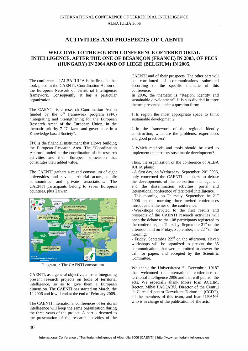
INTERNATIONAL CONFERENCE OF TERRITORIAL INTELLIGENCE ALBA IULIA 2006
40
ACTIVITIES AND PROSPECTS OF CAENTI
WELCOME TO THE FOURTH CONFERENCE OF TERRITORIAL
INTELLIGENCE, AFTER THE ONE OF BESANÇON (FRANCE) IN 2003, OF PECS (HUNGARY) IN 2004 AND OF LIEGE (BELGIUM) IN 2005.
The conference of ALBA IULIA is the first one that took place in the CAENTI, Coordination Action of the European Network of Territorial Intelligence, framework. Consequently, it has a particular organization. The CAENTI is a research Coordination Action funded by the 6th framework program (FP6) “Integrating and Strengthening for the European Research Area” of the European Union, in the thematic priority 7 “Citizens and governance in a Knowledge-based Society”. FP6 is the financial instrument that allows building the European Research Area. The “Coordination Actions” underline the coordination of the research activities and their European dimension that constitutes their added value. The CAENTI gathers a mixed consortium of eight universities and seven territorial actors, public communities and private associations. The CAENTI participants belong to seven European countries, plus Taiwan.
Diagram 1: The CAENTI consortium.
CAENTI, as a general objective, aims at integrating present research projects on tools of territorial intelligence, so as to give them a European dimension. The CAENTI has started on March, the 1st 2006 and it will end at the end of February 2009. The CAENTI international conferences of territorial intelligence will keep the same organization during the three years of the project. A part is devoted to the presentation of the research activities of the
CAENTI and of their prospects. The other part will be constituted of communications submitted according to the specific thematic of this conference. In 2006, the thematic is “Region, identity and sustainable development”. It is sub-divided in three themes presented under a question form: 1. Is region the most appropriate space to think sustainable development? 2. In the framework of the regional identity construction, what are the problems, experiences and good practices? 3. Which methods and tools should be used to implement the territory sustainable development? Thus, the organisation of the conference of ALBA IULIA plans: - A first day, on Wednesday, September, 20th 2006, only concerned the CAENTI members, to debate the developments of the consortium management and the dissemination activities: portal and international conference of territorial intelligence. - This morning, on Thursday, September the 21st
2006 on the morning three invited conferences introduce the themes of the conference; - Workshops devoted to the first results and prospects of the CAENTI research activities will open the debate to the 108 participants registered to the conference, on Thursday, September 21st on the afternoon and on Friday, September, the 22nd on the morning; - Friday, September 22nd on the afternoon, eleven workshops will be organized to present the 35 communications that were submitted to answer the call for papers and accepted by the Scientific Committee. We thank the Universitatea “1 Decembrie 1918” that welcomed the international conference of territorial intelligence 2006 and that will publish the acts. We especially thank Moise Ioan ACHIM, Rector, Mihai PASCARU, Director of the Centrul de Cercetări pentru Dezvoltare Teritoriala (CCDT), all the members of this team, and Ioan ILEANĂ who is in charge of the publication of the acts.
International Conference of Territorial Intelligence of Alba Iulia 2006 (CAENTI) | http://www.territorial-intelligence.eu
PAPERS ON REGION, IDENTITY AND SUSTAINABLE DEVELOPMENT
41
We also thank the partners of the Universitatea “1 Decembrie 1918” that are strongly involved in the organisation of this conference: - Consiliul Judeţean ALBA ; - Primaria ALBA IULIA ; - Prefectura ALBA ; - Agenţia pentru Dezvoltare Regională CENTRU. By organising this first conference of the CAENTI in ALBA IULIA, we wanted to celebrate the entry of Romania in the European Union, which will take place on January, the 1st 2007. This presentation will develop the concept of territorial intelligence as it is got onto within the CAENTI, before giving details about the research and dissemination activities the CAENTI developed on this theme, then presenting its first results and its prospects.
1. TERRITORIAL INTELLIGENCE Territorial intelligence is an emerging concept. Its definition remains imprecise because, on the one hand, it is polysemous and, on the other hand, it is not always easy to dissociate it from other concepts, as economic intelligence, competitive intelligence, collective intelligence, community development, community health, co-development, decentralised cooperation, etc. Thus, during the first months of activity of the CAENTI we worked to specify with which meaning we used the concept of territorial intelligence within the European network of territorial intelligence. Then, it will be easier for us to locate ourselves within the different interpretations of territorial intelligence and with respect to the close concepts. Since 1999, the present partners of the CAENTI refer to territorial intelligence to indicate an approach of the territorial development that is characterised by a multi-disciplinary approach, by the introduction of the spatial dimension in the study of the human phenomena and by the use of the information and communication technologies (ICT). In 2000, our first definition refers to the fact production of knowledge and territorial action are complementary. “Territorial intelligence is a means for the researchers, for the actors and for the territorial community to get a better knowledge of the territory, but also to better control its development. The appropriation of the information and communication technologies is an indispensable step so as the actors enter a learning process that will allow them acting in a relevant and efficient way. Territorial intelligence is
especially useful to help the territorial actors planning, defining, animating and valuating the policies and actions of sustainable territorial development.” [GIRARDOT, 2000]. It is a research-action approach that concerns the territorial community. It especially involves the researchers and the other actors of the territory. This definition introduces the spatial analysis in a prospect where “the territory is not considered any more as a natural framework, more or less binding and endowed of a more or less rewarding historical patrimony, but as a construction of the actors.” [DAUMAS, 2002]. Territory is a complex system, which is not reduced to a natural or geographical space. It is also the space of project and action of a community. By this reference to the community, territorial intelligence approaches to the concept of community health, or the one of community development that “refers to voluntary changes in, by and for community.” [SANDU, 2005]. Nevertheless, community development does not refer to ICT, whereas in the information society and presently in the knowledge-based society, the ICT are not only a tool for the development actors, but also a new vector of development, as at global as at local scale. Consequently, dissemination of the ICT use should be made in harmony with sustainable development, which constitutes the reference framework of territorial intelligence for territories development. Sustainable development "meets the needs of the present without compromising the ability of future generations to meet their own needs, in the field of environmental protection, economic growth and social equity” [BRUNDTLAND report, 1987]. It constitutes the reference that establishes principles of democratic governance that are often recorded in the texts of the European Union. “Territorial intelligence put the information technologies at the service of the territories sustainable development in the knowledge-based society whilst respecting the principles of the democratic governance: participation, integrated approach and partnership.” [GIRARDOT, 2000]. The originality of territorial intelligence consists in the articulation between the information and communication technologies use and the respect of the ethical principles of democratic governance that guarantee a sustainable development, that is to say: integrated and well-balanced territorial approach (multi-disciplinary and multi-sector); and actors partnership. The ICT have an important potential to reinforce the collaboration between remote actors and to improve information and communication within the community. Nevertheless, the uses should remain compatible with sustainable development and democratic governance.
International Conference of Territorial Intelligence of Alba Iulia 2006 (CAENTI) | http://www.territorial-intelligence.eu
INTERNATIONAL CONFERENCE OF TERRITORIAL INTELLIGENCE ALBA IULIA 2006
42
The CAENTI project appropriates the definition that was used for the scientific project of the Maison des Sciences de l'Homme C. N. LEDOUX (Institute of Humanities and Social Sciences C. N. LEDOUX). “The concept of territorial intelligence refers to the whole multi-disciplinary knowledge that, on the one hand, contribute to the understanding of the territorial structures and dynamics, and on the other hand, have the ambition to be a tool at the service of the actors of the territories sustainable development.” [GIRARDOT, 2002]. It brings this definition closer to Philippe DUMAS’ and Yann BERTACCHINI’s ones, that come from information and communication sciences. “Intelligence: a cognitive process and an information organization, and territory: a space of significant relations.” [DUMAS, 2004]. “Territorial intelligence can be assimilated to territoriality that results from the phenomenon of connexion of a territory resources and of transfer of competences between local actors that have different cultural orientations.” [BERTACCHINI, 2004]. Since the beginning of the CAENTI action, we feel it is necessary to make our definition of territorial intelligence evolve, so as to enrich it by contributions of different disciplines within a multi-disciplinary approach, whilst avoiding each academic discipline re-appropriates the concept. We can present a first synthesis that insists on the articulation of the research fundamental (knowledge), technologic (methods) and applied (tools and governance) levels: “Territorial intelligence is the cognitive process that communities work out to guarantee the equitable and sustainable development of their territories. It compares and integrates the multi-disciplinary and intercultural knowledge on territorial structures and dynamics. It adapts the fundamental methods and generic tools of wide applicability to analyse the territories and the territorial information. It valuates the governance principles that guarantee a well-balanced taking into account of all the needs, as well as the equitable distribution and durability of resources, thanks to partnership and participation. It designs and makes tools with the territorial actors who would like to develop their territories, whilst respecting these ethical principles.” This suggestion includes the expression “cognitive process” that was used by Philippe DUMAS to make intelligence explicit. It wants to present
intelligence as a collective ability that is got by the community, so as to distinguish it from business intelligence that rather refers to military intelligence. It adds the equitable dimension to sustainable development that has become a famous cause, but that has often been strictly limited to its environmental dimension. The CAENTI, which participants work in tense territories, either struck by industrial recession, either forgotten by economic development, also wants to restore its social dimension. Besides, we would like to include the cultural dimension, as Yann BERTACCHINI did, by making the definition evolve as follows: “Sustainable development meets the needs of the present, uppermost of the most underprivileged people, without compromising the ability of future generations to meet their own needs in the field of environmental protection, economic growth, social equity and culture.” Our suggestion completes multi-disciplinarity, which can explain variations in the conceptual approach of territorial intelligence, by referring to intercultural diversity, which constitutes an important aspect in the comparative approach at the European and global scale. It also insists on the respect of the democratic governance, especially at the level of the tools use.
2. CAENTI ACTIVITIES AND PROSPECTS The CAENTI activities, like those of all the 6th FP actions, fall under the prospect of the ambitious objectives the Summit of LISBON of 2000 gave to the European Union: becoming the most competitive knowledge-based economy, having a sustainable growth and improving the social cohesion. The CAENTI project precisely belongs to the 7th thematic priority “Citizens and governance in a knowledge-based society” which aims at supporting and promoting the social sciences in order to realize quality research activities in fields that are linked to public policies. More precisely, the project comes over the theme “Actions to promote the European Research Area in the Social Sciences and Humanities and their contribution to the knowledge-based society in Europe.” So as to integrate research activities in progress on the tools of territorial intelligence, the CAENTI wants to promote the comparative research so as to design and spread tools, methodologies and protocols accessible to the researchers in Social
International Conference of Territorial Intelligence of Alba Iulia 2006 (CAENTI) | http://www.territorial-intelligence.eu
PAPERS ON REGION, IDENTITY AND SUSTAINABLE DEVELOPMENT
43
Sciences and to the actors of territories sustainable development. To do so, it works out three activities of comparative research coordination and two activities of dissemination.
2.1. Research coordination activities
The research coordination activities correspond to three “work packages” (WP), according to the denomination of the European programs: - Tools for actors. - Fundamental methods. - Governance principles. They are articulated according to the following diagram:
Diagram 2: Research coordination in the CAENTI The WP6 “Tools for actors” carries out the CAENTI objective. Upstream, it is fed, on the one hand, by the WP4 “Fundamental methods” that gives it technological solutions that come from research generic tools and, on the other hand, by the WP5 “Governance principles” that valuates these solutions acceptability by referring to sustainable development. The CAENTI also aims at making data sets thsat are applicable for the multi-disciplinary research and for territorial development.
2.1.1. Tools for actors (WP6)
This activity, led by the Université de Franche-Comté (France), designs, makes and disseminates methods and tools of territorial intelligence that are accessible to territorial actors and respect the ethics of sustainable development. For several years, the European Union has introduced the demand of project management and evaluation. Since GOTHENBURG, in 2001, sustainable development has established the principles of good governance: participation, well-balanced approach and partnership. Scientific approaches adapted to these principles are available for experts, but the territorial actors more rarely
benefit from simple and cheap tools to draft, manage, observe and valuate their projects. Such instruments mobilise research, which provides a quality guarantee, and territorial actors, that experiment and valuate them. Consequently, the CAENTI associates research teams and actors to create tools of territorial intelligence. This coordination activity aims at giving a European dimension to the CATALYSE tools that have been used by the CAENTI participants since 1994 in various territorial contexts and on different publics. The WP6 TOOLS on the one hand makes a synthesis of the indicators and tools that are used, as well as of the uses the actors make of them. On the other hand, it brings the indicators closer to the European standards.
Diagram 3: Use of CATALYSE tools in Europe.
Diagram 4: CATALYSE method and tools.
The design of a European Observatory of Elementary School is another activity of the WP6.
International Conference of Territorial Intelligence of Alba Iulia 2006 (CAENTI) | http://www.territorial-intelligence.eu
INTERNATIONAL CONFERENCE OF TERRITORIAL INTELLIGENCE ALBA IULIA 2006
44
The WP6 also aims at identifying and valuating complementary tools of territorial intelligence or new tools.
2.1.2. Fundamental methods (WP4)
This activity, led by the University of PÈCS (Hungary) studies the spreading of fundamental methods and research procedures in territorial information analysis within Humanities and Social Sciences. The fundamental methods and the generic tools can provide technologies and tools that are accessible for a professional use. Nevertheless, their use remains limited and unequal according to the disciplines and universities within HSS. As a consequence, the WP4 METHODS aims at answering two questions: - Which are the methods, protocols and generic tools of wide applicability that are used to analyse the territories and the territorial information within Humanities and Social Sciences? - How to improve their diffusion within Humanities and Social Sciences? During the first two years, the WP4 will work on five themes that prepare a final synthesis: 1. The fundamental methods and generic tools of territorial information analysis (led by the Université de Franche-Comté, France). 2. European territorial information (led by the Université de LIEGE, Belgium). 3. The evaluation of territorial intelligence projects that are supported by the European Commission (led by the Université de Franche-Comté, France). 4. The concept of territory (led by the Università di SALERNO, Italy). 5. The indicators of territories competitiveness (led by the University of PECS, Hungary).
2.1.3. Governance principles (WP5)
This activity led by the Universidad de HUELVA (Spain) analyses the application of the governance principles of sustainable development to the territorial research-action. The WP5 GOVERNANCE wonders about two questions: - Which are the best practices in the scientific production that inspire territorial governance whilst respecting sustainable development? - Which ethic principles, standards and protocols the territorial research-action and the tools of territorial intelligence should fulfill? Six universities firstly made “experiences catalogues” on their practices in the field of
research-action and on the impacts, potentials, risks and constraints of the governance principles of sustainable development. Then, a European “letter of quality” will be drafted in 2007. The last year, 2008, will a dissemination period with: - The identification of the technical constraints that result from the respect of ethical principles; - The definition of the technological developments that encourage these principles application.
2.2. Dissemination activities
The dissemination activities also constitute two work packages: - Portal of territorial intelligence. - International annual Conference of territorial intelligence.
2.2.1. Portal of territorial intelligence (WP3)
The portal http://territorial-intelligence.eu is animated by the Université de Franche-Comté (France). In addition to its Internet part, it includes an Intra-consortium website that only concerns the CAENTI participants and a cooperative work space (made by the University of PECS, Hungary). 2.2.2. International annual conference of territorial intelligence (WP2). This activity is coordinated by the Universitatea ALBA IULIA (Romania) that animates the scientific committee, the organisational committee and the acts publication. The next international conferences will take place in HUELVA (Spain) on October, 24th-27th and then in BESANÇON (France), on October, 15th-18th 2008.
2.3. First results
In few months, the CAENTI reached appreciable results. This period was rather devoted to the organisational and management tasks. Thus, it was possible to quickly start the whole coordination activities. The Kick-off meeting was organised on March, the 23rd and 24th 2006. It gathered all the CAENTI participants in the presence of Mrs. Andrea SCHMOELZER, Scientific Officer of the project in the European Commission. It allowed debating and collectively validating all the CAENTI activities and their provisional programming during the three years of the action. The management activities were presented with many details. During the Kick-Off meeting, we particularly debated the Consortium Agreement that was
International Conference of Territorial Intelligence of Alba Iulia 2006 (CAENTI) | http://www.territorial-intelligence.eu
PAPERS ON REGION, IDENTITY AND SUSTAINABLE DEVELOPMENT
45
actively prepared since the beginning of the year. Consequently, we could sign it on April, the 10th 2006. The Internet portal of territorial intelligence http://www.territorial-intelligence.eu has been active since March, the 1st 2006. The Intra-consortium website that is only used by the consortium partners and the cooperative workspace CooSpace could be used since the beginning of the action as the logins. The main key words were distributed to leaders during the Kick-Off meeting. The web services were finalised in June, in accordance with the planned programming. Since this moment, they benefited from improvements that answer the users’ requests. At the end of August 2006, the ALBA IULIA annual International Conference of Territorial Intelligence was organised. One hundred and eight researchers were registered. The Scientific Committee validated fifty communications. The preparation of the conference of HUELVA 2007 was also initiated. Governance will be its thematic. We will debate its themes in order to issue the call for papers at the beginning of January. All the work packages and most of their internal groups have had their coordination meeting from May to the beginning of July: - In HUELVA (Spain) on the governance principles (WP5) on May, 2006, - In DURBUY (Belgium) on the tools for actors (WP6) in June, 2006. - In AIX-EN-PROVENCE (France) on the fundamental methods (WP4) and on the European Observatory of Elementary School (WP6e) on July, 2006. These coordination meetings allowed detailing the objectives of each group, defining the approaches and methodological protocols as well as a research calendar. The cooperative work of the groups was evaluated at this occasion. They prepared the drafting of the scientific reports of the end of the year, and they defined the content of the communications that will be presented in this conference.
2.4. Prospects
The presentation of the first results in the part devoted to the CAENTI coordination groups at the occasion of the plenary conferences and the debates that followed can question the orientations that were defined at the beginning of the project. During these sessions, the work organisation and the calendar are specified.
Since the beginning of the Coordination Action, three new prospects were opened. - A European Master of Territorial Intelligence. - The development of the edition means about territorial intelligence. - A project of network of excellence to continue and amplify the CAENTI. At the occasion of the CAENTI Kick-Off meeting, Claude CONDÉ, President of the Université de Franche-Comté, suggested the authorization of a European Master of Territorial Intelligence as a presidential project, in the framework of the campaign in progress of authorization of the diplomas. Since this moment, the department of geography of the Université de Franche-Comté has gathered all the specialities in a single mention of the Master in Humanities and Social Sciences, the Mention Territorial Intelligence. This project of new diploma will be submitted at the end of the year to the authorization of the Ministry of Higher Education and Research as “European master”. The European universities of the CAENTI demonstrated their interest to participate to this master in the framework of a Erasmus Mundus consortium. We are studying the precise formations that could collaborate in this framework and which value units they could assume in relation with their specificity. We also think about a mock-up that respects the architectures of the academic formations that still remain very different from a country to another one. This project will contribute to a better integration between these universities and to the diffusion of the CAENTI results, by bringing the teams of teachers-researchers closer, by making formation modules, among which some will be able to be put online and by educating students to territorial intelligence and to the implementation of its tools. An important collaboration as regards edition was established with the laboratory “Information Médias Milieux Médiation” (I3M, Information, Medias, Mediums, Mediation) of the Université du Sud Toulon Var at the occasion of the Fifth days “TIC et Territoires” (“ICT and Territories”) that were organised in BESANÇON with the Université de Franche-Comté on June, the 9th and 10th 2006. The interest of such collaboration is not only editorial, but also scientific, insofar as I3M is, with the Maison des Sciences de l’Homme C.N. Ledoux and the laboratory ThéMA of the Université de Franche-Comté, the second team specialized in territorial intelligence in France. I3M managed to make territorial intelligence recognized as a discipline by the scientific authorities of the Information and Communication Sciences. I3M also publishes the online review ISDM - Information Sciences for Decision Making http://isdm.univ-tln.fr - that will be from now on an important vector of diffusion of the CAENTI works
International Conference of Territorial Intelligence of Alba Iulia 2006 (CAENTI) | http://www.territorial-intelligence.eu
INTERNATIONAL CONFERENCE OF TERRITORIAL INTELLIGENCE ALBA IULIA 2006
46
and of the research activities in territorial intelligence. Yann BERTACCHINI, ISDM editor in chief, was invited to this conference to present the ISDM review and the edition means that were offered to the CAENTI members, and more generally, to the research work in territorial intelligence. We started thinking about the after-CAENTI. We contemplate a project of network of excellence in the framework of the 7th European Framework-Program of Research and Technological Development. It will be presented as an action project in the framework of the scientific project of the MSH submitted to the French National Centre of Scientific Research and to national authorities of research. The conference “FP6 Priority 7 Project Management” that was organised in BRUSSELS by the European Commission on June, the 8th and 9th 2006 showed the interest to start the preparation of such project at least two years before the submission. The choice of the instrument “network of excellence” is not definitive as it is a contested and debated instrument, which is presently valuated by the European Commission. It is the integration objective that mainly catches our interest and that leads us to organise our thinking, and the CAENTI evolution, according to six orientations: 1. Integrating the research programmes of the CAENTI teams, so as to submit a common research programme. 2. Making evolve the partnership, so as to improve the management quality and to amplify dissemination. 3. Generating innovation. 4. Integrating new dimensions, as training, edition and transfer. We progressed in this direction. 5. Increasing visibility and « dissemination » 6. Adapting the management to guarantee the network durability.
CONCLUSION As a conclusion, I would wish you an interesting work and a good stay in ALBA IULIA. I hope I provided you useful information about the definition of territorial intelligence, as well as the CAENTI activities and prospects. I invite you to the next annual conference of territorial intelligence, from October, the 24th to the 27th 2007, in HUELVA in Spain. Devoted to governance, it should be organised according to the following three themes: 1.- Territorial intelligence and the new challenges of territorial governance. 2.- Research activities at the service of the sustainable economic and social development.
3.- The quality indicators of research activities in the field of Social Sciences to develop territorial governance. Your proposals of communication and your participation will be welcomed Before that, we will be pleased to welcome you on the website of territorial intelligence http://www.territorial-intelligence.eu.
BIBLIOGRAPHY BERTACCHINI, Y., GIRARDOT, J., GRAMMACIA, G., 2006: “De l'intelligence territoriale : Théorie, Posture, Hypothèses, Définition”, in: Actes du 5ème Colloque TIC & Territoire : quels développements ?, Université de Franche-Comté, Besançon, 9-10 juin 2006, ISDM, n° 26, 7 p. <URL: http://isdm.univ-tln.fr/PDF/isdm26/3.YB-JJG-GG.pdf> LIU, L.W., GIRARDOT, J., 2006: “Globalization and Community Development. Multi-Sector Collaboration with Information Technology as Strategies”, in: 52nd Annual Program Meeting, Council on Social Work Education, Chicago (USA), 301c, February 16th-19th. GIRARDOT, J. -J., 2005: “Concepts, principes et outils de la méthode CATALYSE”, in: 3e colloque international du Réseau Européen d'Intelligence Territoriale, Liège (Belgique), 20-21 octobre 2005. <URL:http://mti.univ-fcomte.fr/reit/SemiLiegeOct2005> BERTACCHINI, Y., 2004: “Entre information & processus de communication: l’intelligence territoriale”, in: “3èmes Rencontres TIC & Territoires: quels développements?”, Lille, 14 Mai 2004, Enic et Cies, ISDM, n° 16, 13 p. <URL: http://isdm.univ-tln.fr/PDF/isdm16/isdm16a154_bertacchini.pdf> DELVOYE, J. -M., GIRARDOT, J. -J., et al., 2004: “Intelligence territoriale et développement communautaire: application de la méthode Catalyse à Seraing”, in: 2ème colloque international sur les programmes locaux et régionaux de santé, Québec (Canada), 15 octobre 2004. DUMAS, P., 2004: “Intelligence, Territoire, Décentralisation, ou la Région à la française”, in: “3èmes Rencontres TIC & Territoires: quels développements?”, Lille, 14 Mai 2004, Enic et Cies, ISDM, n° 16, 4 p. <URL: http://isdm.univ-tln.fr/PDF/isdm16/isdm16a163_dumas.pdf> GIRARDOT, J. -J., 2004: “Intelligence territoriale et participation”, in: "3èmes Rencontres TIC & Territoire : quels développements?”, Lille, 14 Mai 2004, Enic et Cies, ISDM, n° 16, 13 p. <URL:
International Conference of Territorial Intelligence of Alba Iulia 2006 (CAENTI) | http://www.territorial-intelligence.eu
PAPERS ON REGION, IDENTITY AND SUSTAINABLE DEVELOPMENT
47
http://isdm.univ-tln.fr/PDF/isdm16/isdm16a161_girardot.pdf> DAUMAS, J. C., GIRARDOT, J. -J., et al., 2002: “Programme de recherche de la Maison des Sciences de l’Homme Ledoux. Pôle 1 “Intelligence territoriale””, sous la direction de FAVORY, F. GIRARDOT, J. -J., 2002: “L'intelligence territoriale”, in: “Mélanges, Jean-Claude WIEBER” Annales Littéraires de Franche-Comté, Besançon.
GIRARDOT, J. -J., 2000: “Principes, Méthodes et Outils d'Intelligence Territoriale. Évaluation participative et Observation Coopérative”, in: “Conhecer melhor para agir melhor, Actes du séminaire européen de la Direction Générale de l'Action Sociale du Portugal”, Evora (Portugal), 3-5 mai 2000, DGAS, Lisbonne (Portugal), décembre 2000, p. 7-17. GIRARDOT, J. -J., 2000: “Pauvreté, Expertise et Action”, in: Cités “Sociétés sans droits ?”, PUF, Paris, janvier 2000, p. 63-88.
International Conference of Territorial Intelligence of Alba Iulia 2006 (CAENTI) | http://www.territorial-intelligence.eu

INTERNATIONAL CONFERENCE OF TERRITORIAL INTELLIGENCE ALBA IULIA 2006
48
International Conference of Territorial Intelligence of Alba Iulia 2006 (CAENTI) | http://www.territorial-intelligence.eu
PAPERS ON REGION, IDENTITY AND SUSTAINABLE DEVELOPMENT
49
INVITED CONFERENCES
International Conference of Territorial Intelligence of Alba Iulia 2006 (CAENTI) | http://www.territorial-intelligence.eu

INTERNATIONAL CONFERENCE OF TERRITORIAL INTELLIGENCE ALBA IULIA 2006
50
International Conference of Territorial Intelligence of Alba Iulia 2006 (CAENTI) | http://www.territorial-intelligence.eu
PAPERS ON REGION, IDENTITY AND SUSTAINABLE DEVELOPMENT
51
IS REGION THE MOST APPROPRIATE SPACE TO THINK
SUSTAINABLE DEVELOPMENT? A FRAMEWORK FOR RESEARCH AND IMPLEMENTATION
Philippe DUMAS Professor Sciences of information – communication
Director I3M Laboratory-EA3820 [email protected] , http://i3m.univ-tln.fr
Tél: + 33 (4) 94 14 22 36, Fax: + 33 (4) 94 14 25 37
Professional address Université du Sud, Toulon-Var
I3M - BP 132 - F-83957 LA GARDE Cedex, France.
Abstract: Whatever the challenge is for a rational observer, European regions and Regionalism have become common concerns in Europe for the last thirty years in the realm of European Union, not to speak of centuries in some European states. Sustainable development is another controversial notion although it is largely used and has been introduced since the late eighties in European glossary. In the line of the Caenti Alba Iulia conference program, the aim of this communication is to relate together those two concepts – region and sustainable development- with that of territorial intelligence. In a world that continuously witnesses the disasters of state imperialism and aggressive competition, territorial intelligence dictates that regions should not behave and/or be considered as mini-states, i.e. territorial or sociocultural entities that establish their legitimacy on zero sum antagonisms. It is our view that the permanence of regions in the history and around the world is a proof that (a) region has a profound popular meaning, and (b) that a fresh conception of regional governance is a chance for the implementation of sustainable development. As a provisional conclusion to these reflections, we suggest some guidelines of action for a group of benevolent people looking to implement a more friendly world on the basis of a regional leverage.
Key Words: Information, Communication, European Union, Regions, Territorial intelligence, Subsidiarity.
International Conference of Territorial Intelligence of Alba Iulia 2006 (CAENTI) | http://www.territorial-intelligence.eu
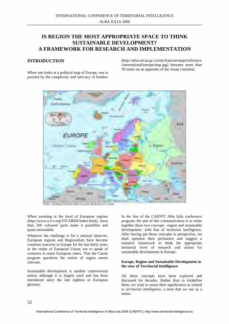
INTERNATIONAL CONFERENCE OF TERRITORIAL INTELLIGENCE ALBA IULIA 2006
52
IS REGION THE MOST APPROPRIATE SPACE TO THINK
SUSTAINABLE DEVELOPMENT? A FRAMEWORK FOR RESEARCH AND IMPLEMENTATION
INTRODUCTION When one looks at a political map of Europe, one is puzzled by the complexity and intricacy of borders
(http://atlas.nrcan.gc.ca/site/francais/maps/reference/international/europe/map.jpg) between more than 30 states on an appendix of the Asian continent.
When zooming at the level of European regions (http://www.a-e-r.org/VICARDS/index.html), more than 200 coloured spots make it pointillist and quasi-unreadable. Whatever the challenge is for a rational observer, European regions and Regionalism have become common concerns in Europe for the last thirty years in the realm of European Union, not to speak of centuries in some European states. That the Caenti program questions the notion of region seems relevant. Sustainable development is another controversial notion although it is largely used and has been introduced since the late eighties in European glossary.
In the line of the CAENTI Alba Iulia conference program, the aim of this communication is to relate together those two concepts –region and sustainable development- with that of territorial intelligence. After having put those concepts in perspective, we shall question their pertinence and suggest a tentative framework to think the appropriate territorial level of research and action for sustainable development in Europe.
Europe, Region and Sustainable Development in the view of Territorial Intelligence
All these concepts have been explored and discussed for decades. Rather than to (re)define them, we wish to retain their significance as related to territorial intelligence, a term that we use as a motto.
International Conference of Territorial Intelligence of Alba Iulia 2006 (CAENTI) | http://www.territorial-intelligence.eu
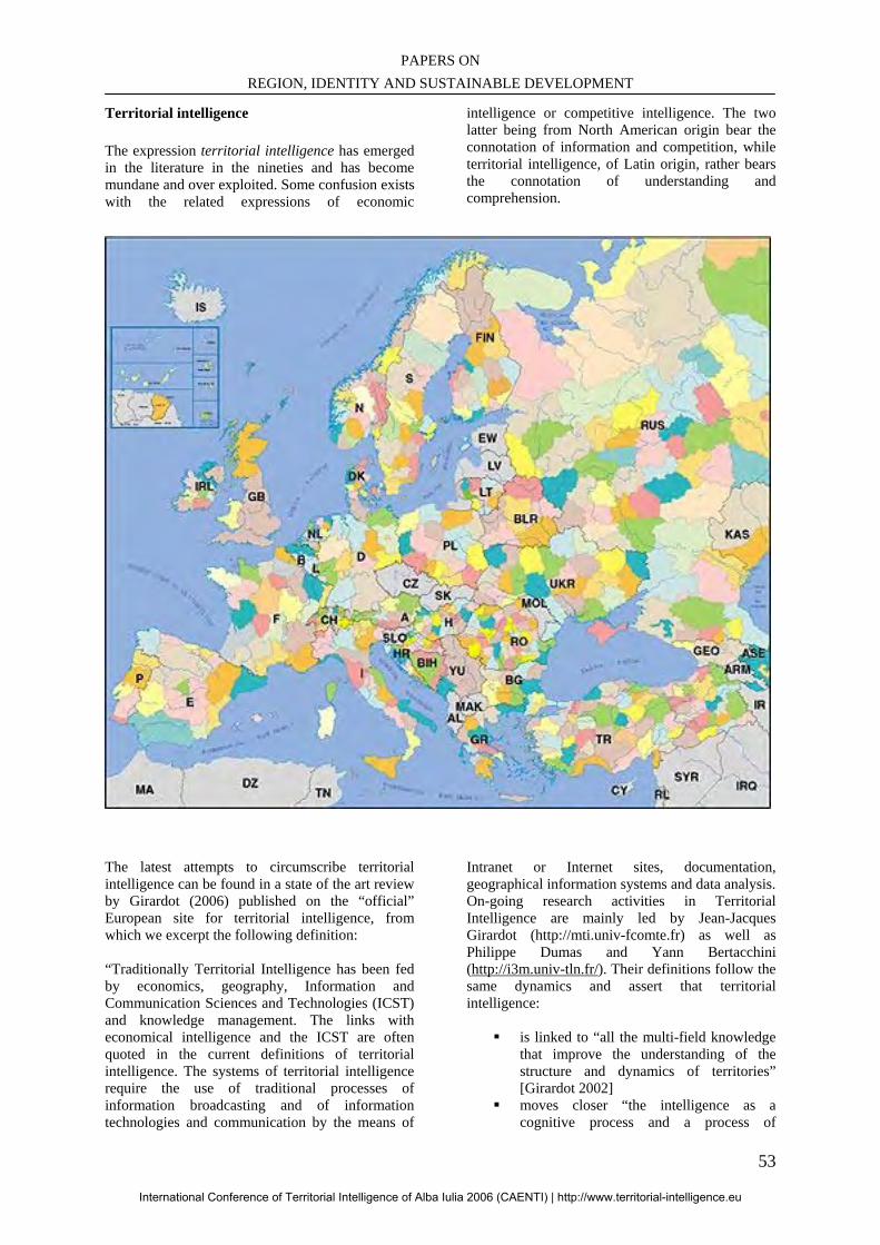
PAPERS ON REGION, IDENTITY AND SUSTAINABLE DEVELOPMENT
53
Territorial intelligence
The expression territorial intelligence has emerged in the literature in the nineties and has become mundane and over exploited. Some confusion exists with the related expressions of economic
intelligence or competitive intelligence. The two latter being from North American origin bear the connotation of information and competition, while territorial intelligence, of Latin origin, rather bears the connotation of understanding and comprehension.
The latest attempts to circumscribe territorial intelligence can be found in a state of the art review by Girardot (2006) published on the “official” European site for territorial intelligence, from which we excerpt the following definition: “Traditionally Territorial Intelligence has been fed by economics, geography, Information and Communication Sciences and Technologies (ICST) and knowledge management. The links with economical intelligence and the ICST are often quoted in the current definitions of territorial intelligence. The systems of territorial intelligence require the use of traditional processes of information broadcasting and of information technologies and communication by the means of
Intranet or Internet sites, documentation, geographical information systems and data analysis. On-going research activities in Territorial Intelligence are mainly led by Jean-Jacques Girardot (http://mti.univ-fcomte.fr) as well as Philippe Dumas and Yann Bertacchini (http://i3m.univ-tln.fr/). Their definitions follow the same dynamics and assert that territorial intelligence:
is linked to “all the multi-field knowledge that improve the understanding of the structure and dynamics of territories” [Girardot 2002]
moves closer “the intelligence as a cognitive process and a process of
International Conference of Territorial Intelligence of Alba Iulia 2006 (CAENTI) | http://www.territorial-intelligence.eu
INTERNATIONAL CONFERENCE OF TERRITORIAL INTELLIGENCE ALBA IULIA 2006
54
information organization, and the territory as a space of significant relations” [Dumas 2004]
or still “can be likened to the territoriality which results from the phenomenon of appropriation of the territory resources then in the skills transfers between categories of local actors of different culture” [Bertacchini 2004].”
Another trait of territorial intelligence is the reference to territory. This also may bear confusion esp. with the geographer since here “territorial” refers to both physical and symbolic dimensions of the territory (Rasse, 2001, Herbaux, 2006). The territorial intelligence movement is rooted in two major epistemologies of the late century: the socio-systems approach such as practiced by Morin (1991 for example) and the constructivism summarized by Gastil (1994) or LeMoigne (2002). Keeping those premises in mind, one of the major characteristics of the territorial intelligence is that it is an endless process, which deals with complexity, openness, multifactor reasoning and fuzzy boundaries. It can’t be reduced to simplistic or one-dimensional arguments. A tentative vintage definition that respects those principles of systems, complexity and constructivism could be: Territorial intelligence is the process of dynamically understanding the territory that makes up the territory. Regions in the EU Regions are formally recognized by the UE and its bodies among which the European Commission. However it must be reminded that the quasi totality of European machinery is directed towards the state level, or in Brussels jargon, the “Member States”. Regions are not the focus. Several institutions1 in Europe are either representative of the regions (such as the Aer, Assembly of European Regions, or the Afccre, Association française des communes et régions d’Europe) or consultative for the European Commission (like the Committee of the Regions, instituted by the Maastricht treaty, 1992). According to the Aer's Declaration on the regionalism in Europe, (http://www.a-e-r.org/about-aer/members/1.html) "the region is the territorial body of public law established at the level immediately below that of
1 Please see references in the webography at the end.
the State and endowed with political self-government. The region shall be recognised in the national constitution or in legislation which guarantees its autonomy, identity, powers and organisational structures." Regional competences vary from one country to another and 6 types of situation can currently be distinguished:
Constitutional regions having the prerogatives of a State (Germany, Austria, Belgium, Switzerland...),
Regions with large political and administrative autonomy (Spain, Italy, certain regions or autonomous islands in Denmark, the United Kingdom, Portugal),
Regions in decentralised States (France, Holland, Poland, the Czech Republic),
Regions with a district, département or county-like nature (Croatia, Denmark, Finland, Hungary, Greece, Lithuania, Norway, Romania, Sweden, Turkey, Ukraine),
Regional authorities made up of county delegations (Ireland),
Small States whose size corresponds to that of a region (Malta).
Some non-regionalised States remain in Europe.” The following are a few examples of the denominations of regions in Europe: Germany, Austria/Land, Spain/Comunidad Autonoma, France/Region, Hungary/Megye, Italy/Provincia autonoma & Regione, Poland/Wojewodztwo, Sweden/Landsting, Switzerland/Canton. Sustainable development in and out of Europe Quoting the CAENTI conference program, “Since the European Council of Göteborg in June 2001, the sustainable development approach has been recognized as one of the main priorities of the European Union for the years to come. Now, it constitutes the basic framework from which the principles of good governance are defined. The community policies have to conform to them by respecting: The participation of the citizens. The global approach of territories and communities, characterized by an adequate balance between the economical, social, environmental and cultural dimensions.
International Conference of Territorial Intelligence of Alba Iulia 2006 (CAENTI) | http://www.territorial-intelligence.eu
PAPERS ON REGION, IDENTITY AND SUSTAINABLE DEVELOPMENT
55
The partnership of the territorial actors.” On June, 9, 2006, the Council of the European Union has issued a new directive on the Renewed EU sustainable development strategy, emphasizing
• Involvement of citizens • Involvement of businesses and social
partners • Policy coherence and governance • Policy integration • Precautionary principle • Making polluters pay
Official documents of EU mainly address the issue of sustainable development from the Brussels viewpoint. For example, the above mentioned Renewed EU sustainable development strategy cite the term “region” only once in page 25 to offer a prize to “regional and local authorities”. It mostly deals with “the Commission and the Member States”. Henceforth, a sustainable development strategy has to be assessed from the regional viewpoint too. Such an effort has been made by Feder program and “member states”, like that report by Prager (2005) on Le management stratégique des régions en Europe, which offers a classical analysis in terms of competitive intelligence. A more comprehensive approach is needed and does not seem to be performed outside the sphere of territorial intelligence (Herbaux, 2006). Three views of the sustainable development by the regions can be identified: Sustainable development of a European region How regional policies and practices favour a well being state of citizens within regional area; how they take into consideration the future generations of its populations; how they implement citizens’ participation. Regions for the sustainable development of Europe How the region contributes to general objectives of EU. Regions for the sustainable development of the planet How the region participates to meeting the global challenges of the planet.
The bases of a framework to think regional governance Theoretical: the permanence and modernity of regions The concept of region has spread over history as well as continents. It has a profound popular anchorage, whatever the actual form any region has taken. Several typologies have been proposed to categorize the regions, none being entirely satisfactory. However it is a useful guidance to recall the major ones in order to better assess the legitimacy of region as a node for territorial intelligence. History Historical empires whether Chinese, Roman, Islamic, Hispanic, British or French for instances have always been divided into regions. Region is pervasive in History, although not always emphasized. In the modern times, region has become a renewed concept not only linked to the imperialistic necessity of administering manageable parts of large empires. Paradoxically at first glance, the emergence of regions is contemporary of that of globalization. This is an occurrence of one essential principle of “glocalization”: the more the individual is exposed to global winds, the more he/she has to anchor his/her identity on a local ground. The participants in the Colloque Territoire-acteur et mondialisation (2003), which was held in Chambéry in October 2003, highlighted this dynamics between territory and globalization. They see the territory “like a space and a concept to be redefined. This globalization thus creates paradoxically possibilities for the local level”. Claude Courlet notes that “the economists rediscover the geography, with assertion of the new centrality of the local economies”. “The territory, escaping a simply administrative designation is defined by that of which it is able: a social place of proximity building itself to conceive horizons and projects […] Consequently appear fundamental dimensions which one finds on the two levels of the local and the global: history, culture, collective psychology. And thus the territory, far from being a field of retreat, has to be a space of relations and openness instituting its own coherence and its bond with the world. The effect of proximity which characterizes the territory helps to create confidence and contributes to the visibility of the stakes, the initiatives and their carriers […] Locus of human resources, it thus becomes a privileged site of constitution of the formal capital. By there, it will be the base of the governance of tomorrow.”
International Conference of Territorial Intelligence of Alba Iulia 2006 (CAENTI) | http://www.territorial-intelligence.eu
INTERNATIONAL CONFERENCE OF TERRITORIAL INTELLIGENCE ALBA IULIA 2006
56
Even if we simplify a little too much, we can say that the European region is a world specificity. It corresponds to a history and a cultural configuration with null other similar. It must answer a unique ambition, that which emerges from the new world relationship since September 11. It was illustrated by the last Iraqi conflict, and the clash between European public opinions and the North American one. It aims at promoting a multiple culture, complex and Hegelian, in the sense that a higher authority is emerging from the confrontation of diversity. The European region, being based on the principle of subsidiarity, is the level which gets the best visibility for its various cultures and richness; it is allowing European Community, relying on each one of its citizens, to continue differently on the world scene. Recent examples (Irak, Lebanon, Iran, …), although still very frustrating, show the way to practice the research of peace by the consensus rather than by the force, the “shock and awe” set forth by MM. Bush and Rumsfeld. Although significant at world level, the European region does not obey a single model. The regions of the countries that we quoted in section 2.2 (Germany, Italy, Spain, United Kingdom, etc.) have different stories, which led some of them to be constituted almost like sub-nations; others have developed strong city-sates since the Middle Ages (Bagnasco, 1995), especially along the axis Northern Italy – Baltic Hansas. The French regionalization that has been done in front of us for fifty years will be a new “French exception”. Regional nationalism is not its major dimension and should not become it. The French Catalan will not feel “Catalan” in the same way as the Spanish Catalan. From a certain point of view, French regionalization is more rational; it comes from the feeling that the transformations of our relations to space under the impact of technologies, to the authority under the influence of the ways of life, to the effectiveness of the public action, pushes us towards another organization of the nation to which we keep a now secular attachment. It has apparently inspired a way to regionalism in former centralized states of Eastern Europe. The development of the modern European idea follows the chaotic way of a permanent hesitation between the feeling of a national identity inherited from the theorists and politicians of the XIX° century and that of a membership to a common culture and geography, much older and more modern at the same time. This physical and mythical attachment with the ground, the territoriality, appears in the revival of the regional feeling and allows us to conclude that the two feelings are at the same time alive and complementary. Our forecast is that they will continue to act in the years which come and within the new Europe which is institutionally building itself to reach twenty five states today and more than thirty, tomorrow. The central idea of this
construction must remain that of the precursors, such as J. Monnet who had posed in his time that the “project of European Union is not to link the states but to link the people”. A consequence of that historical sketch is a middle-term trend towards the weakening of states inherited from the XIX century Europe. Our hypothesis is that the relative institutional and political void left by the weakening of traditional states may be filled by a more active role of the regions grounded in their territorial intelligence. Language and culture Linguistic difference from a population to another is a common criterion to establish a regional border. It is however highly controversial since some region may have several languages, and one language spread over several regions. Example: in Europe, four main linguistic areas are recognized (http://en.wikipedia.org/wiki/Regions_of_Europe) that do not delineate regions: “Germanic Europe” Germanic Europe is where the Germanic languages are predominantly spoken. This area corresponds more or less to north-western Europe and some parts of central Europe. This region consist of: United Kingdom, Ireland, Iceland, Germany, Austria, Netherlands, Denmark, Sweden, Norway, German-speaking Switzerland, Alto-Adige and the Flemish part of Belgium. Latin Europe Latin Europe, where the Romance languages are spoken. This area corresponds more or less to south-western Europe, with the exception of Romania and Moldova which are situated in Eastern Europe. This area consists of Italy, Spain, Portugal, France, Romania, Moldova, French-speaking Belgium, and French and Italian speaking Switzerland. Slavic Europe Slavic Europe, where the Slavic languages are spoken. This area corresponds more or less to Eastern Europe. This area consists of: Russia, Belarus, Ukraine, Poland, Czech Republic, Slovakia, Slovenia, Croatia, Serbia, and Bulgaria. Celtic Europe Celtic Europe, where Celtic languages are spoken, or where they were recently spoken and the
International Conference of Territorial Intelligence of Alba Iulia 2006 (CAENTI) | http://www.territorial-intelligence.eu
PAPERS ON REGION, IDENTITY AND SUSTAINABLE DEVELOPMENT
57
population has kept its Celtic heritage for non-linguistic reasons. The Celtic nations are: Scotland, Wales, Cornwall (within the United Kingdom), the Isle of Man (a British Crown dependency), Ireland, and Brittany (within France). These are all nations where a Celtic language is spoken, or was spoken into modern times, and there is a degree of shared culture (see Pan Celticism). Outside of this classification Outside of these four main groups we can find : Greece & Cyprus: The only countries of "Hellenic Europe". They are sometimes associated with the Latin countries, due to the geographical and cultural ties to the Mediterranean Sea, and sometimes to the Slavic-Orthodox part of Europe due to the importance of the Orthodox Church in both. Hungary, whose language is distantly related to Finnish and Estonian. Due to its geographical location Hungary is more often related to other central or Eastern European countries. Finland and Estonia, whose languages are closely related and more distantly related to Hungarian. Despite this connection, Finland is often referred to simply as a country of Nordic Europe. However, because of its language and culture, it is not a Scandinavian country. Latvia and Lithuania, two linguistically Baltic countries (as opposed to the political concept which also includes Estonia). Malta, which has close linguistic ties to the Arabic world, yet close cultural ties to Italy and Catholic Europe. Turkey, which speaks an Altaic language that is not related to other European languages. The Basque Country, where the Basque language has continued while Indo-European languages have displaced other languages in Europe over the past 5000 years.” We drastically condense the cultural typology of regions by associating it with linguistic divisions; it is a reminder of the combined importance of language, culture and even religion in defining a regional bondage, although neither complete nor excusive. For example, Nordic countries, Anglo Celtic countries, Benelux, Baltic States, Alpine countries, etc. do not follow the linguistic and cultural lines to build up regions.
Physical geography
Following this theory2, regions would rest on natural borders such as rivers, mountains, and seas; peninsulas would make up regions. Counter examples are found in Catalogne and Catalunya which are separated by Pyrenees; Alsace and Baden-Württemberg by the Rhine river; on the other hand, the famous Oder-Neisse border has driven politics for decades, etc. The argument of physical borders is so weak that we are not going to elaborate on it, mentioning only the fact that it is also a factor of unity. It will reappear in the following when considering the various programs of interregional cooperation (§ 3.3.2) Economic poles Following the examples of City States of the Antiquity or the Middle Ages, strictly economic factors have been the rationale for numerous regions; the prominent economic factor is the cost of communication: physical communication facilities that make up local markets, and interpersonal communications that build up the trust without which no business is possible. Modern metropolis and industrial basins around which many European regions have grown up are the heirs of that antique cause. Interestingly enough is the modern development of Ict (information and communication technology) that simultaneously reinforces the regional concept with the quest for identity and community ties and authorizes the dissemination of physical facilities, what we call “delocalization”. The concept of “Industrial Districts” introduced initially by Marshall at the beginning of XX° century, highlights the importance of coordination to explain regional development. It is used nowadays to characterize the mix of socio economic conditions that builds up regional entities, especially in Northern Italy and Central Germany. They are taking shape elsewhere (Spain, France, e.g.). Those regions are generally considered highly successful, conduct dynamic strategies and have a major impact on the world scene. For a richer approach: The result of a socio political process Taking in account that none of the previous criteria can alone explain the present division of European
2 This theory has been applied to regions, and even states, generally to justify imperialistic views.
International Conference of Territorial Intelligence of Alba Iulia 2006 (CAENTI) | http://www.territorial-intelligence.eu
INTERNATIONAL CONFERENCE OF TERRITORIAL INTELLIGENCE ALBA IULIA 2006
58
Union into regions, whatever the strength of the regional movement is, we have to assume that actual regions are the result of a mix of those factors in a complex process of socio political nature. Following the techniques of modelling, the process of partitioning a wider area like Europe into regions could be thought as a global optimization game. At a given time, the regional deal would minimize some constraints like intercultural conflicts, environmental challenges, costs of communication and the like, while it would maximize resources allocations, international visibility, individual well being and the like. Such a view introduces the idea that regions would be essentially contingent and the optimum permanently subject to change. That view is consistent with the notion of territorial intelligence and will be reasserted here below. Legal: the principle of subsidiarity For us, the principle of subsidiarity and its corollary, the principle of proportionality, are the major juridical concepts that establish the legal, administrative and cultural bases of the powers and responsibilities of European regions. It has been constitutionally laid down in the Treaty of Amsterdam (1997) in the form of a Protocol on the application of the principles of subsidiarity and proportionality. Although the treaty explicitly deals with the relationship between the Commission and the Member States (as usual!), the spirit of that text should be extended to the relationship between Member States and the Regions. For example, changing the names (Commission or Community for {State}, and Member State for {Region}, one can read (http://europa.eu.int/eur-lex/en/treaties/selected/livre345.html): § 3, “The principle of subsidiarity provides a guide as to how those powers are to be exercised at the {State} level. Subsidiarity is a dynamic concept and should be applied in the light of the objectives set out in the Treaty. It allows {State}action within the limits of its powers to be expanded where circumstances so require, and conversely, to be restricted or discontinued where it is no longer justified.” Or § 6, “The form of {State}action shall be as simple as possible, consistent with satisfactory achievement of the objective of the measure and the need for effective enforcement. The {State}shall legislate only to the extent necessary. Other things being equal, directives should be preferred to regulations and framework directives to detailed measures. Directives as provided for in Article 249 of the Treaty, while binding upon each {Region} to
which they are addressed as to the result to be achieved, shall leave to the {regional} authorities the choice of form and methods.” Thus we think of the European socio political structure as a hierarchy, where subsidiarity circulates up and down between the structured and visible levels: European Community, State, Region, Department/Province (or equivalent in each national setting), City or agglomeration. Pragmatic: what regional institutions do Besides theoretical and legal approaches, some examples of current regional achievements will reinforce the legitimacy of our interest for the European Region. Regions as laboratories for a renewed citizenship The extraordinary development of regional idea in XX° century Europe has proven that regions are contemporary nodes of communication, confidence, relationship, experimentation. All those achievements make up a locus of the implementation of sustainable development paradigm. Regional initiatives Interreg Jurassien http://www.arcjurassien-ctj.org/INTERREG/index.htm http://www.interreg3afch.org/introduction.php Arco Latino CRPM (Conférence des Régions Périphériques Maritimes d'Europe). http://www.crpm.org/fr/index.php CIPRA (Alpine regions) COTRAO (Mediterranean) A counter example of resistance to regionalism Difficulties of former communist states to conceive and implement regionalism. http://geoconfluences.ens-lsh.fr/doc/etpays/Europe/EurScient.htm#haut Partnership between states and recently created regions is to defined and implement. It needs time, probably at least one generation. The new regional architecture of Central European regions is probably on an evolutionary cycle similar to what has been witnessed in France and other strong states during the XX° century. Some are questioning the possibility of a European view of regional governance. http://geoconfluences.ens-lsh.fr/doc/etpays/Europe/EurScient.htm#S1
International Conference of Territorial Intelligence of Alba Iulia 2006 (CAENTI) | http://www.territorial-intelligence.eu
PAPERS ON REGION, IDENTITY AND SUSTAINABLE DEVELOPMENT
59
Conclusion : What is a European region The present partition of European Union into some 200 administratively recognized regions is an undeniable fact. It has legal, historical, socio political and cultural legitimacies, albeit their levels of recognition and permanence may be diverse. As a coordinating body, we have to take present European regions as given, and deal with them. But we also have to accept a dynamic view of the mapping and a constructivist approach to regionalism. In addition, other levels of subdivision of states are also candidates for territorial recognition. We now have to address the question: is the European Region the optimal level to think sustainable development? Where to set the cursor for territorial intelligence in action After having reviewed the theoretical and practical roots of regionalism in Europe, we are in a position to compare advantages and drawbacks of the four major levels of administrative division already existing in Europe. We hope to have demonstrated that the European region is a meaningful conceptual level for the implementation of sustainable development. This doesn’t yet answer the question whether it is the “most appropriate” one. We have to compare with other possible levels of socio political action. Let four levels be considered in this paper, respectively, the state, the region and the sub-region as defined either by department, or agglomeration or city. Without entering complex and long considerations about the definitions of these four levels, we can draw the following table of perceived advantages (+) and drawbacks (-) of each of those with respect to the principles of sustainable development. CONCLUSIONS Region and a new world governance based on the regions In the face of vanishing states in Europe, the role of lower territorial levels is going to shape new modes of governance and relationship between public administration and the citizens. The European Region, the Department/Province, the City/Agglomeration are all possible candidates for that role. After weighing the pros and cons of each of them, we think that the major node for XXI° century governance, prone to develop sustainable development approach, is the European Region. This judgement must be accompanied by two strong political conditions: (1) regions shall not behave as mini-states with all their prejudices; (2)
regional policy is grounded in an ethics that is stemming from the concern for sustainable development. A new paradigm of public governance: mundiality and ethics In a world that continuously witnesses the disasters of state imperialism and aggressive competition, territorial intelligence dictates that regions should not behave and/or be considered as mini-states, i.e. territorial or sociocultural entities that establish their legitimacy on zero sum antagonisms. It is our view that the permanence of regions in the history and around the world is a proof that (a) region has a profound popular meaning, and (b) that a fresh conception of regional governance is a chance for the implementation of sustainable development. After several authors, we propose the term of “mundiality” to qualify a new paradigm of public governance. Mundiality is a sense of actively pertaining to the world in a community in constant becoming (Dumas, 2006). It is consistent with our definition of territorial intelligence (see § 2.13). It is obviously different form “mundialism” or “globalization”. In that view, a territory is not defined by its limits, but by the proximities it generates. Frontiers are no longer the horizon. Ricoeur (2004) explains how the world map can be transformed from a juxtaposition of physically bounded pieces of land into a network of radiating nodes. Those nodes, than we can equate with our regions, interact through reciprocal illuminations. In that context, identities are not eternal characteristics, but rather living, evolving and narrative clues that are rooted in history and project themselves in a promise, attached to a horizon. A horizon that is never touched, but is made of successive plans, from the closest very mobile, to the farthest very stable. This model of radiating territories implies two corollaries: the need of translation between cultures, and the acceptation of one’s lost in the relation with other. Translation (not only linguistic) can be supported by Ict, acceptation of lost supposes an ethics of government relationship.
3 “Territorial intelligence is the process of dynamically understanding the territory that makes up the territory”
International Conference of Territorial Intelligence of Alba Iulia 2006 (CAENTI) | http://www.territorial-intelligence.eu
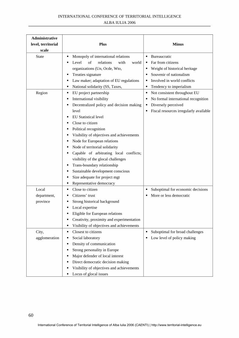
INTERNATIONAL CONFERENCE OF TERRITORIAL INTELLIGENCE ALBA IULIA 2006
60
Administrative level, territorial
scale Plus Minus
State Monopoly of international relations Level of relations with world
organizations (Un, Ocde, Wto, Treaties signature Law maker; adaptation of EU regulations National solidarity (SS, Taxes,
Bureaucratic Far from citizens Weight of historical heritage Souvenir of nationalism Involved in world conflicts Tendency to imperialism
Region EU project partnership International visibility Decentralized policy and decision making
level EU Statistical level Close to citizen Political recognition Visibility of objectives and achievements Node for European relations Node of territorial solidarity Capable of arbitrating local conflicts;
visibility of the glocal challenges Trans-boundary relationship Sustainable development conscious Size adequate for project mgt Representative democracy
Not consistent throughout EU No formal international recognition Diversely perceived Fiscal resources irregularly available
Local department, province
Close to citizen Citizens’ trust Strong historical background Local expertise Eligible for European relations Creativity, proximity and experimentation Visibility of objectives and achievements
Suboptimal for economic decisions More or less democratic
City, agglomeration
Closest to citizens Social laboratory Density of communication Strong personality in Europe Major defender of local interest Direct democratic decision making Visibility of objectives and achievements Locus of glocal issues
Suboptimal for broad challenges Low level of policy making
International Conference of Territorial Intelligence of Alba Iulia 2006 (CAENTI) | http://www.territorial-intelligence.eu
PAPERS ON REGION, IDENTITY AND SUSTAINABLE DEVELOPMENT
61
Sketch of ethical rules for regional governance:
Behave with other regions on the basis of mutual respect, exchange and radiation of cultures rather than domination.
Behave with Departments and Cities (i.e. subdivisions of the region) according to subsidiarity principle.
Act for what you think is fair, i.e. is useful for your regional community, and especially the poorest of them. Don’t act in function of your immediate interest.
Proposals In this paper, we have raised many questions. Some of them have had firm answers; some are still open to debate and controversy. As a provisional conclusion to these reflections, we wish to suggest some guidelines of action for a group of benevolent people looking to implement a friendlier world on the basis of a regional leverage. Quoting Prince Wilhelm of Orange-Nassau, “There is no need to have much hope to start some endeavour, nor to succeed to persevere”. Some guidelines for action at the regional level … as an opening for further discussions and a program of research.
• How to build up an interregional network organization
• Contagion as a mode of expansion and dissemination of regional ideas
• Organization and measurement of EU support
• Region vs. state: typologies, share of responsibilities, of resources
• Region vs. communities (cities, agglomerations, other administrative or sociocultural levels); redefinition of roles and responsibilities
• Evaluating and controlling regional governance according with sustainable development
• Redefining regional lobbying and citizen participation
• World openness, especially to circum European regions
• How the spirit of mundiality infuse governance of the regions
• Educational concern • Caenti: a think tank for XXI° century
regionalis
BIBLIOGRAPHY Bagnasco, A. (1995), “Le nouveau pouvoir des villes”, Sciences Humaines, N°8, févr. Mars. Bertacchini, Y. (2004), « Entre information et processus de communication, l’intelligence territoriale » Humanisme et Entreprise, Paris, N° 267, Octobre. Berthoz, A., Jorland, G., (2004), L’empathie, Paris, Odile Jacob Bertolino, R. (2003) « Territoires et universités », Colloque Territoire-acteur et mondialisation, in http://www.territoires-mondialisation.org/ consulté le 30/04/06 Blanquer, JM, Quenam, C. (2004), « L’enjeu de Guadalajara », Le Monde Bulinge, F. & Agostinelli, S. (2005), « L’analyse d’information : d’un modèle individuel à une culture collective », Management et communication pour une économie de la connaissance, http://www.revue -r3i.com Colloque Territoire-acteur et mondialisation (2003), http://www.territoires-mondialisation.org/ consulté le 30/04/06 Colloques Tic et Territoires (2003, 2004, 2005, 2006) in http://i3m.univ-tln.fr/imprimer.php3?id_article=127 consulté le 30/04/06 Cyrulnik, B. (2003), Le murmure des fantômes, O. Jacob, Paris. Dumas P. (2005), « Le Distic et le rayonnement des cultures », Colloque Culture des organisations, Université de Nice, in http://www.archivesic.ccsd.cnrs.fr/sic_00001578.en.html Dumas P. (2006), “Territoire et mondialité” in Actes du colloque Tic et Territoires 2006, Université de Franche Comté. Gastil, J. (1994). “An appraisal and revision of the constructivist research program”. In B. Burleson (Ed.), Communication Yearbook 18 (pp. 83-104). Newbury Park, CA: Sage Girardot J-J. (2006), “State-of-the-art of territorial intelligence” in http://www.territorial-intelligence.eu/?file=definition&lang=en Goffman, E. (1974), Les rites d’interaction. Paris : les éditions de Minuit
International Conference of Territorial Intelligence of Alba Iulia 2006 (CAENTI) | http://www.territorial-intelligence.eu
INTERNATIONAL CONFERENCE OF TERRITORIAL INTELLIGENCE ALBA IULIA 2006
62
Goria, S. (2006), L’expression du problème dans la recherche d’information : application à un contexte d’intermédiation territoriale, Thèse doctorat Université de Nancy 2 Herbaux, Ph (2006) L'Intelligence Territoriale: d'une représentation générale à un concept de finalité. Thèse doctorat Université du Sud Hulot, N (2006) Economy for moderation Le Moigne, J-L., (2002), Le constructivisme, épistémologies de l’interdisciplinarité. Tome 2, Paris : L’Harmattan Levy, P. (2000), World Philosophy, O. Jacob, Paris Lovelock, J. (2006), The Revenge of Gaia, Why the Earth Is Fighting Back - and How We Can Still Save Humanity, Penguin, London Lucas C. & Trépère G. (2002), in http://www.lcr-rouge.org/archives/011101/pleinfeu.html consulté le 30/04/06 Masselot, C. (2004), Accessibilité et qualité des systèmes d’information multimédia : transfert méthodologique et technologique, Thèse Université de Besançon Morin, E., (1991), Introduction à la pensée complexe. 2e ed. Paris : ESF Pitasi,A. (2001), “Interview with Ernst von Glasersfeld, in http://www.univie.ac.at/constructivism/papers/glasersfeld/glasersfeld01-interview.html Prager, J-C. (2005), Le management stratégique des régions en Europe, Adit, in http://www.adit.fr/IT/evenement_IT.html Rasse, P. (2001), Les identités locales, face aux processus de mondialisation. Unité-diversité. Les identités culturelles dans le jeu de la mondialisation, ouvrage collectif, Rasse P. & al. (ed.). Paris : L’Harmattan, 382 p., p.21-46. Reeves, H (2006) Ricoeur, P. (2004), « Cultures, du deuil à la traduction », Conférence aux Entretiens du XXI° siècle, Unesco, in Le Monde, 25 mai, p1,19) Simon, H.A. (1960) The new Science of Management Decision, Harper and Row, N.Y.
Sternhell, Z. (2006) Les Anti-Lumières, du XVIII° siècle à la guerre froide, Fayard, Paris Treaty of Amsterdam (1997), “Protocol on the application of the principles of subsidiarity and proportionality” http://europa.eu.int/eur-lex/en/treaties/selected/livre345.html Zarifian, Ph., (1999) L'émergence d'un Peuple Monde, PUF, in http://perso.wanadoo.fr/philippe.zarifian/page6.htm (2002), consulté 30/04/06 WEBOGRAPHY AS OF 17/08/06 Afccre (Association française des communes et régions d’Europe) http://www.afccre.org/fr/default.asp Comité des régions / Committee of the Regions http://www.vie-publique.fr/decouverte_instit/europe/europe_2_1_0_q10.htm http://www.carrefourlocal.org/europe/comite_regions/index0.html Assemblée des régions d’Europe/ Assembly of European Regions http://www.a-e-r.org/fr/home-en.html http://www.a-e-r.org/en/home-en.html Carte régions europe, Visiting cards region http://www.a-e-r.org/VICARDS/index.html Interreg Jurassien http://www.arcjurassien-ctj.org/INTERREG/index.htm http://www.interreg3afch.org/introduction.php Conférence des Régions Périphériques Maritimes d'Europe (CRPM). http://www.crpm.org/fr/index.php Renewed EU sustainable development strategy http://register.consilium.europa.eu/pdf/en/06/st10/st10117.en06.pdf State-of-the-art of territorial intelligence http://www.territorial-intelligence.eu/?file=definition&lang=en Wikipedia : regions of Europe http://en.wikipedia.org/wiki/Regions_of_Europe
International Conference of Territorial Intelligence of Alba Iulia 2006 (CAENTI) | http://www.territorial-intelligence.eu
PAPERS ON REGION, IDENTITY AND SUSTAINABLE DEVELOPMENT
63
THE ENVIRONMENTAL INFORMATION SYSTEM IN ROMANIA:
AN INSTITUTIONAL AND BEHAVIOURAL APPROACH
Daniela-Luminiţa CONSTANTIN Professor, Academy of Economic Studies of Bucharest
Constantin MITRUŢ
Professor, Academy of Economic Studies of Bucharest
Professional address
Academy of Economic Studies of Bucharest – RO-BUCHAREST, Romania.
Abstract: When the environmental issues are addressed in sustainability, human security terms the information demand is getting more complex, emphasising the need to integrate environmental, economic and socio-cultural information. This paper proposes an insight into the data and indicator issues on environment and human security in Romania from an institutional perspective. Keywords: Sustainability, Indicator issues on environment and human security.
International Conference of Territorial Intelligence of Alba Iulia 2006 (CAENTI) | http://www.territorial-intelligence.eu
INTERNATIONAL CONFERENCE OF TERRITORIAL INTELLIGENCE ALBA IULIA 2006
64
THE ENVIRONMENTAL INFORMATION SYSTEM IN ROMANIA:
AN INSTITUTIONAL AND BEHAVIOURAL APPROACH INTRODUCTION In its transition to the market economy, Romania, like other Central and East European countries, has undergone a stressful and often painful process of radical change. Prior to 1990, the central planning system had a set of priorities that focused on production maximization; environmental concerns had lower priority. Although there was no incentive to pollute (since there was no opportunity for private profit), that set of priorities created serious environmental problems: high levels of air and water pollution, harmful solid waste, poor quality food and deteriorating human health. Considering these realities, the transition to a new society has had to face important environmental challenges, along with great political, economic, social, organisational, cultural and behavioural ones. Solutions have focused on all the elements of the structural reform, including the institutional and legislative framework for the market economy, the reform of enterprise structures, the physical structure for a competitive economy and human capital and attitudes. Accordingly, the national strategy developed to prepare Romania for accession to the European Union contains, as one of its main components, the strategy for environmental protection. But the development of the environmental protection strategy is only a means to an end, implementation, monitoring and evaluation being of the same importance. In all these phases of the strategy process information is essential: it helps to gain insight into the state of environment, to forecast further developments, to formulate adequate policies, to implement them, to monitor and to evaluate the effects. As defined by Nijkamp et al. (1990) and quoted by Douven (1997, p.4), information is ‘data that are collected and organised (for instance by way of statistical techniques and modelling) so as to improve insight or knowledge regarding a certain phenomenon’. Many dimensions can depict environmental information. They refer to the type of problem (e.g. diffusion, waste, acidification, climate change, depletion of ozone layer), its sources (various economic groups or activities), the spatial scale of effects (local, regional, continental, global), the environmental factors (air, water, soil), the public
functions (e.g. drinking water provision, the protection of outstanding natural beauty areas), the environmental policy and management aspects (Douven, 1997). Starting from these overall considerations this paper explores the possibilities of improving the environmental information system in Romania from the perspective of accession to the European Union, following an institutional and behavioural approach.
1. THE ENVIRONMENTAL INFORMATION SYSTEM – CONTENT AND FURTHER DEVELOPMENTS
The institutional aspects of environmental data collecting, transmitting, processing and employing derive from the overall institutional and legislative framework of environmental protection, previously depicted. The approach of these aspects must start with the analysis of the content of the environmental information system, able to reveal the available data and indicators, the way they are used as well as further needs and possible developments. From the beginning a distinction should be made between monitoring data and environmental statistics (Mandricelu, 1998). Monitoring data are obtained by technical means, which help to observing the behaviour of a given parameter in a given place, at a given time, making it difficult time and space generalisation. Environmental statistics offer the possibility of time and space generalisations, so as to provide a global view on the most important aspects of the evolution of a particular situation that represents a public concern. Given these particularities, monitoring data can serve as a source to environmental statistics provided they are processed in accordance with the principles and the rules of statistics. The main statistical information on the environmental protection domain is provided by special annual bulletins issued by the National Commission for Statistics in collaboration with the Ministry of Environment. A synthesis of the indicators included in this bulletin can be also found in the Romanian Statistical Yearbook.
International Conference of Territorial Intelligence of Alba Iulia 2006 (CAENTI) | http://www.territorial-intelligence.eu
PAPERS ON REGION, IDENTITY AND SUSTAINABLE DEVELOPMENT
65
All environmental statistical information is organised in a database administered by the National Commission for Statistics. Its specialised dissemination department provides the information required by various organisations, usually upon request. The environmental protection indicators are both physical and value indicators. The physical ones refer to natural characteristics, natural resources, pressures on the environment, quality of environmental factors, while the value ones mainly focus on the sources and destinations of environmental expenditures. There are also indicators serving to international comparisons. The data sources consist in statistical reports filled in by the corporate sector’s firms and the county agencies for environmental protection, for data concerning the quality of air in some localities and expenditures for environmental protection (National Commission for Statistics, 2005). From administrative viewpoint, the Institute of Geography of the Romanian Academy and the Public Utility Company for Meteorology and Hydrology are responsible for data regarding the natural characteristics, the Ministry of Agriculture for data concerning the land fund, the Ministry of Environment for data about protected areas, the Public Utility Company “Apele Romane” (“Romanian Waters”) for data on water resources and the superficial water quality, the self-administrated authority ROMSILVA for data on trees defoliation, the Institute for Pedological and Agrochemical Research for data concerning the quality of soil. The national reports on the environment state in Romania annually issued by the National Institute of Research for Environmental Protection are another relevant source of information. The activity of this institute is particularly important in an international context too since it provides specialised assistance to the Permanent Secretariat of the United Nations – Framework Convention for Climate Change, to the Commission for the Vienna Convention on the ozone layer protection and the Montréal Protocol regarding the substances which damage the ozone layer. In this context it elaborates the country report referring to the emissions inventory and various ecosystems sensitivity to climate change. Special measurements are also performed by the Institute for Atomic Physics where, for example, the Cyclotron Laboratory carries on research related to measuring the radioactivity after the Chernobyl nuclear accident and the influence upon various
foodstuff, soil, water) and by the Institute for the Earth’s Physics, which monitors a wide range of parameters relevant to earthquakes occurrence. To elucidate the question of data reliability post 1990, a presentation of data collecting and transmitting is necessary. As regards monitoring data, there are three levels of data collecting, processing and transmitting *. The first level regards environmental data collected by laboratories of the territorial agencies for environmental protection (42, set up at county level) as well as by laboratories belonging to the Public Utility Company “Apele Romane” (responsible for water consumption and quality) and the self-administrated authority ROMSILVA (involved in forest preservation, in approving hunting and fishing permits) and to the Ministry of Health (for air and drinking water quality in populated areas). The firms must provide data themselves, when required by territorial agencies. The correlation and coherence of data collected at territorial level is ensured by the county agencies of environmental protection. This continuous, regular monitoring, in accordance with various technological processes, ensures primary data correctly reflecting the evolution of environmental parameters as well as the stability over time and the quality of data. The second level regards transmitting these data to the National Institute of Research for Environmental Protection, which ensures the co-ordination of the whole process. At the third level the Ministry of Environment appears as the main beneficiary, receiving detailed reports on all environmental factors. A national reference laboratory for environmental preservation was set up within the National Institute of Research for Environmental Protection. It has to accredit a national network of environmental laboratories. At the moment, the process is under way, involving the implementation of a whole management system of environmental quality and accrediting. As long as the environmental data are collected within the system described, there are good reliability chances. The system has been considerably improved in the last years, from both institutional and technical endowment viewpoints. The state budget and the PHARE programme have been the main contributors. Some achievements can be mentioned: a national reference laboratory for
* The information provided for this section by Dr. Ioan Jelev is gratefully acknowledged.
International Conference of Territorial Intelligence of Alba Iulia 2006 (CAENTI) | http://www.territorial-intelligence.eu
INTERNATIONAL CONFERENCE OF TERRITORIAL INTELLIGENCE ALBA IULIA 2006
66
environmental radioactivity measurement (with the support of the International Agency of Atomic Energy), automatic systems for air emissions monitoring (at Baia Mare and Bacau), the use of mobile laboratories. Apart from the mobile laboratory system within the Ministry of Environment and other organisations, economic agents have started to set up self-monitoring systems based on mobile laboratories (Bucharest municipality, the self-administrated authority for electric power, RENEL, etc.). At present a special emphasis is put on creating and implementing warning systems as well as managerial procedures of real time reporting and supervising crisis situations, considering the concerns with preventing Romania from becoming a source of regional environmental insecurity. These efforts will be correlated with the future actions of setting up a regional integrated system for monitoring the environmental factors and consolidating the reaction capacity in crisis situations (floods and other natural disasters). However, the overall analysis of the data sources and flows points out some drawbacks, which cannot be ignored. Thus, the multitude of primary data collecting systems, the existence of many data processing structures, some ambiguities in defining the responsibilities of various organisations with regard to the information they should provide make environmental information be still too much fragmented, without clear links between various components and possibilities for further developments in quantity and quality terms (Mandricelu, 1998, Constantin and Mitrut, 1999) . To work out these drawbacks a new approach to environmental statistics organisation, in accordance with the EU accession requirements and new international standards, is taken into consideration by the National Commission for Statistics, focusing on an integrated impact – state – response framework. This framework is conceived so as to connect the information on environmental factors – flora, fauna, air, water, soil and on human settlements to the information regarding socio-economic activities and natural phenomena, environmental impact of human activities, the responses to this impacts, stocks, inventories and reference conditions (Mandricelu, 1999, Mandricelu, 2000). The framework for environmental statistics development can employ a structure with the following components: • statistics of the economic and social activities and natural phenomena, with indicators regarding the use of natural resources in the context of economic
activity development, pollutant substances emissions and waste treatment, natural phenomena; • statistics of the environmental impact of economic and social activities and natural phenomena, focusing on: natural resources variation, environmental factors quality, human health and ecological disruption; • statistics highlighting the response to the environmental impact in terms of ecological reconstruction, monitoring and fighting pollution, prevention from natural disasters and risk alleviation, corporate sector’s reactions. The improvement of the existing database so as to include all the above mentioned components would represent a decisive step towards the integration of the Romanian environmental statistics in the international information flows in this field. It can also serve as an appropriate basis for expanding the international efforts with GIS to Romania as well as for including the country in the recent studies linking environment to human security questions. So far the main preoccupations with human security aspects in an especially institutionalised framework have concentrated on the elaboration of the National Human Development Report which is prepared every year, starting from 1994, by the National Institute for Economic Research of the Romanian Academy in collaboration with the National Commission for Statistics, commissioned and financed by the UNDP. The report is rich in information on the aspects regarding human development, inclusively environmental protection: macrostabilisation and human development in the transition period, equity and social cohesion, efficiency of governance in support of human development, legitimate governance, legitimacy of social policies. To establish the rank of Romania among the UN member countries, the Human Development Index (HDI) is calculated, using three criteria: - longevity, measured by life expectancy at birth; - educational attainment, measured by a combination of adult literacy and combined primary, secondary and tertiary enrolment ratios; - standard of living, in terms of GDP per capita in purchasing power parity dollars. Since 1997 the Human Poverty Index (HPI) has been included in the Human Development Report as well, concentrating on the following essential elements of poverty: longevity, knowledge and a decent standard of living.
International Conference of Territorial Intelligence of Alba Iulia 2006 (CAENTI) | http://www.territorial-intelligence.eu
PAPERS ON REGION, IDENTITY AND SUSTAINABLE DEVELOPMENT
67
To a country like Romania, confronted with big social problems specific to the transition phase the calculation of the HDI and HPI provides useful information about the changes in the level of development of the whole community and the proportion of population left out of the progress, as a background for future development strategies and policies aiming to stop the decline and then to decrease the discrepancies between Romania and the developed countries. These indices offer the possibility of reliable comparisons with the other countries considered in international analyses. The implementation of the new framework proposed for the development of environmental statistics would create appropriate conditions to creating more analytical structures and, thus, to providing the indicators needed for international studies based on the calculation of the Index of Human Insecurity (IHI) and Index of Vulnerabilty (Lonergan, 1998, Lonergan et al., 2000). In brief, the Index of Human Insecurity comprises a set of indicators referring to environment (net energy imports, soil degradation, safe water, arable land), economy (real GDP per capita, GNP per capita, adult illiteracy rate, value of imports and exports of goods and services), society (urban population growth, young male population, maternal mortality ratio, life expectancy), institutions (public expenditure on defence versus education, primary and secondary, gross domestic fixed investment, degree of democratisation, human freedoms index ). For constructing the Index of Vulnerability the indicators were selected for six categories (ecological/resource indicators, economic indicators, health indicators, social and demographic indicators, political/social indicators, food security indicators). Compared to the HDI, the IHI provides a deeper theoretical perspective on both human security and human development and can be linked to indicators characterising specific aspects of environmental disruption and vulnerability (in terms of water, food security, etc.) as well as the capacity of reaction to environmental changes.
2. ACTORS INVOLVED IN EMPLOYING ENVIRONMENTAL INFORMATION
The complexity of environmental protection issue entails a multitude of actors using environmental information for strategy and policy development and implementation, management and administration as well as for scientific research, environmental education and public participation
purposes, all these activities being closely interrelated. Accordingly, a typology of these actors should contain: governmental institutions (at central and local level), corporate sector, research institutes, universities and the public. As the role of government and corporate sector has been already discussed, in this section the emphasis is to be put on the last three categories. In general terms, the environmental scientific research in Romania is related to the actions promoted by the environmental protection strategy and the national action plan and concentrates on programmes and themes which attract scientists of various backgrounds (ecology, economy, geography, land-use, sociology, politics, etc.) as well as research teams and institutes of various profiles. The multidisciplinary character of scientific research is here more obvious than in any other scientific domain. This character is very well reflected by the variety of scientific research institutes with environment and human security related activities. From organisational viewpoint these institutes fall into a couple of categories as follows (Constantin and Popescu, 1999): • national research institutes in sectoral domains (e.g.: the National Institute of Research and Development for Environmental Protection, the National Centre for Sustainable Development, URBANPROIECT); • departmental research institutes subordinated to the corresponding ministries (e.g.: the Research and Design Institute “The Danube Delta” and the Romanian Institute for Marine Research, co-ordinated by the Ministry of Environment, the Institute for the Earth’s Physics and the Institute of Atomic Physics, co-ordinated by the National Agency for Science, Technology and Innovation, the Institute for Hygiene and Public Health, co-ordinated by the Ministry of Health); • research institutes belonging to the Romanian Academy, especially carrying on fundamental research (e.g.: the Institute of Geography, the National Institute of Economic Research, including: the National Economy Institute, the World Economy Institute, the Institute of Industrial Economics, the Institute of Agricultural economics, the Institute of Economic Forecasting, the Institute for the Quality of Life, the Institute of Finance, the Centre of Demography); • research institutes belonging to the Academy of Agricultural and Sylvical Sciences (Research Institute for Pedology and Agrochemistry, the Institute for Sylvical Research and Improvement);
International Conference of Territorial Intelligence of Alba Iulia 2006 (CAENTI) | http://www.territorial-intelligence.eu
INTERNATIONAL CONFERENCE OF TERRITORIAL INTELLIGENCE ALBA IULIA 2006
68
• research institutes acting as private companies (e.g.: the Research and Planning Institute for Land Improvement). Starting from the institutionalised framework and the existing environmental information flows these institutes concentrate their research activities on monitoring, data collection, simulation modelling, scenario development and reference value development. Generally, three main components can be identified in environmental research, namely data handling functionality, environmental modelling functionality and decision-support activities (Douven, 1996). Environmental research is also developed within Romanian universities, closely related to environmental training and education activities in various fields (e.g. economics, law, geography, biology, engineering, architecture, sociology). The environmental curricula include a wide range of subjects of a particular relevance to environment and human security issues such as: environmental monitoring and dynamic protection, pollution and pollution prevention on air, water, soil, recycling and storing of industrial materials and waste, environmental problems in enterprise design, nuclear plants and environmental protection, environmental reconstruction, mathematical modelling of the environment, urban ecological systems, urbanism and zoning policies, architectural landscape management, environmental architecture for tourism, soil erosion control and water sources regulation, rural sociology, environmental economics, environmental management, environmental law and so on. Last but not the least, the need to increase the awareness and concern about environmental problems and human security requires the participation of the public, with environmental NGOs, community groups, individuals, media, etc. as potential actors. For public participation to be meaningful, three main provisions must be ensured: access to information, provision for consultation and rights for standing (Caddy, 1999). Before 1990 the information monopoly of the Romanian communist regime made it possible to conceal environmental statistics and most important information on the quality of environment. Environmental data were secret and the public did not have any access to environmental information. Local communities did not have a real image of the environmental conditions in their regions excepting those living in areas where environmental devastation was obvious. The lack of information led to a lack of interest among the public about environmental issues. Like in other communist countries, Romanians who tried to express their
insatisfaction, disagreement with environmental policy were persecuted. Compared with the previous period a favourable evolution has been recorded in the last nine years. The democratisation of society has been creating an adequate framework for the participation of the public in promoting environmental preservation projects in accordance with its own interests: it may protest against pollution practices and demand better governmental action. Basically the information monopoly was removed but some fundamental problems remain. Thus, the long communist period had a very negative influence on the behaviour of local communities and society as a whole. The perception of democratic values and attitudes has been greatly perverted and, in the transition to a democratic society, old mentalities and attitudes are not easily transformed. After nearly fifty years of a government monopoly on environmental information it is hard to believe that a completely new way of perceiving environmental issues can be realised in a few years. The economic and social problems such as production decline and growing unemployment have made public concerns shift away from environmental issues to more immediately stressful ones: real wages are falling and job security is growing (Constantin, 1999). Under these circumstances in parallel with the efforts to raise the quality of life in economic terms the environmental education must play an essential role, with a special emphasis on the elements less known or unknown to the public: climate change, energy saving, natural resource depletion, draught, flood, landslides, impact of pollutant substances emission on air, water and soil. The approach of this issue should be a behavioural one: ‘behaviour simply means what people do, as opposed to what they say they do or what they are supposed to do in legal and institutional terms’ (Stayner, 1980, p.26). In order to make a decisive step towards an effective implementation of the environmental protection strategy, reflected in an increase in the quality of environmental management and participation of all responsible actors, communication must be considered a cornerstone. ‘To develop institutional and scientific linkages between the current needs in environmental regulation and advances in ecosystem science, improved communication is required between regulators, scientists and the public’ (De Gloria, 1993, quoted by Douven, 1997, p.66). To a country still in transition like Romania, this requirement has a particular significance: creating new, democratic institutions was a must in the first years, but at present the greatest challenge is making them work effectively.
International Conference of Territorial Intelligence of Alba Iulia 2006 (CAENTI) | http://www.territorial-intelligence.eu
PAPERS ON REGION, IDENTITY AND SUSTAINABLE DEVELOPMENT
69
The establishment of real, helpful linkages between the institutions involved in environment and human security issues can be realised in various ways: promoting multidisciplinary research projects, organising workshops able to bring together managers, scientists and public representatives, creating web-sites and internet user groups, setting up networks, etc. The participation of governmental institutions, research institutes and universities, business firms, NGOs in international networks has got a special relevance, the first positive effects being already noticed. They consist in increasing alignment to the European standards and regulations, a better access to the international sources of information, learning from successful experiences (or failures) of foreign partners and so on. The growing commitment of the responsible factors of Romanian society to carrying out the reform processes and to meeting the conditions of accession to the European Union is expected to enhance these networking efforts with mutually advantageous effects.
CONCLUDING REMARKS The environmental information system must be conceived and implemented in accordance with the information users. Thus, this system can be imagined as a pyramid with the policy makers at the top, followed by the public, the resource managers in the middle and the researchers and academics at the bottom. The policy makers need a relatively small amount of information, materialised in synthesis indicators. The public also needs compact information presented in summary form. Given their role in making decisions about resources and environmental management, the resource managers require more specific information, even though much of it is still in the form of summary indicators. Finally, the researchers and academics use a large amount of information, most of it in an analytical, less aggregated form. This pyramid grows in complexity if the spatial component is considered too. It generates specific organisational structures at local and central level for data collecting, processing and transmitting, making it necessary to carefully avoid shortages and/or overlaps. This implies the optimisation of the institutional system in environmental field, with orientations (norms, targets), mechanisms (procedures, standards) and organisations as basic components, decisively influencing the way in which the actors behave (Lonergan et al., 2000). In Romania, the institutional aspects of environmental data collecting, transmitting,
processing and employing derive from the overall institutional framework of environmental protection, considerably improved since 1990. Yet, the assessment of the existing environmental information system has revealed a series of drawbacks such as: the multitude of primary data collecting systems, the existence of many data processing structures, ambiguities in defining the responsibilities of various organisations with regard to the information they should provide, all of these making environmental information be too much fragmented, without clear links between various components and possibilities for further developments in quantity and quality terms. The environmental statistics improvement, based on an integrated impact–state–response framework, would create appropriate conditions to working out many of the above mentioned drawbacks and to providing the indicators needed for international analyses, in accordance with the EU accession requirements. In an integrated outlook these requirements should be understood from the viewpoint of the exigencies of the EU environmental statistics as well as from the viewpoint of observing the EU norms and standards in environmental protection field. In a broader context the great importance of enhancing the networking efforts at both national and international level should be also taken into consideration.
BIBLIOGRAPHY Constantin, D. L. (1999), “Environmental Preservation Strategy in the New Romania: Institutional and Behavioural Challenges”, in S.C. Lonergan (ed.), Environmental Change, Adaptation and Security, Kluwer Academic Publishers. Constantin, D.L. (1998), “Environmental Protection and Capacity Building in Romania”, in Andersen, M.S., (ed.) Environmental Policy and the Role of Foreign Assistance in Central and Eastern Europe, KPMG, Copenhagen. Constantin, D.L., Popescu, C.R. (1999, October), “National Case Study on Human Dimensions Research in Romania”, paper presented at the Central and Eastern European Countries and Newly Independent States Workshop on National Human Dimensions, Amsterdam. Constantin, D.L., Mitruţ, C. (1999, December), “Data and Indicator Issues on Environment and Human Security in Romania: An Institutional Perspective”, paper presented at the ENRICH-NES and GECHS Workshop, San José de la Montagna, Costa Rica.
International Conference of Territorial Intelligence of Alba Iulia 2006 (CAENTI) | http://www.territorial-intelligence.eu
INTERNATIONAL CONFERENCE OF TERRITORIAL INTELLIGENCE ALBA IULIA 2006
70
Caddy, J. (1999), “Strengthening Institutional Capacity for Implementation in Central and Eastern Europe”, in S.C. Lonergan (ed.), Environmental Change, Adaptation and Security, Kluwer Academic Publishers. De Gloria, S.D. (1993), “Preface Special Issue: Mapping and Visualizing Environmental Data”, in International Journal of GISs, 7. Douven, W. (1997), “Improving the Accessibility of Spatial Information for Environmental Management”, PhD thesis, Free University of Amsterdam. Government of Romania (2000), Romania’s Mid-Term Economic Development Strategy, Bucharest. Government of Romania (2004), Governing Programme, www.gov.ro. Lonergan, S.C. (1998), The Role of Environmental Degradation in Population Displacement, second edition, IHDP, GECHS. Lonergan, S.C., Gustavson, K., Carter, B. (2000), “The Index of Human Insecurity”, AVISO,6. Mandricelu, C. (1998), “The Conceptual Framework of Environmental Statistical Research” (in Romanian), doctoral research paper, Academy of Economic Studies, Bucharest. Mandricelu, C. (1999), “The statistical analysis of environmental protection” (in Romanian), in Romanian Review of Statistics, 6, 52-61. Mandricelu, C. (2000), “Specifying environmental protection activities as a major action for environmental data estimation” in Romanian Review of Statistics, 5, 44-53. Mandricelu, C. (2004), “Environmental Statistics System – Instrument of Romania’s Accession to the EU” (in Romanian), Tulcea, May 13-14, 2004, www.insse.ro/evenimente/Tulcea. National Commission for Statistics (2005), Romanian Statistical Yearbook, Bucharest. Nijkamp, P., Rietveld, P., Voogd, H. (1990), Multicriteria Evaluation in Physical Planning, North Holland, Amsterdam. Stayner, J. (1980), Understanding Local Government, Martin Robertson, Oxford.
International Conference of Territorial Intelligence of Alba Iulia 2006 (CAENTI) | http://www.territorial-intelligence.eu
PAPERS ON REGION, IDENTITY AND SUSTAINABLE DEVELOPMENT
71
A-REGIONS DEVELOPMENT, TERRITORIAL IDENTITY AND COMMUNITY
This chapter gathers the interventions that were
presented in the Workshop 1.1 “Romanian regions development”, Workshop 2.1 “Territorial identity”
and Workshop 2.2 “Territory and community”.
International Conference of Territorial Intelligence of Alba Iulia 2006 (CAENTI) | http://www.territorial-intelligence.eu
INTERNATIONAL CONFERENCE OF TERRITORIAL INTELLIGENCE ALBA IULIA 2006
72
International Conference of Territorial Intelligence of Alba Iulia 2006 (CAENTI) | http://www.territorial-intelligence.eu
PAPERS ON REGION, IDENTITY AND SUSTAINABLE DEVELOPMENT
73
A REGIONAL ANALYSIS OF SUBJECTIVE WELFARE.
ROMANIANS’ MAJOR CONCERNS ON DEVELOPING REGIONS
Călina Ana Buţiu
Lecturer, University “1 Decembrie 1918” Alba Iulia [email protected]
tel. 0744 792 174 Summary: Throughout the new created development regions in Romania the compensation of the population needs and the territorially differentiated expectations must be taken into account. According to the Public Opinion Barometer (Oct. 2004), the main concerns of Romanians are, first of all, diseases and then prices and children’s future, with territorial (regional) differences. The sustainable development strategies may be more successful if a psychosocial profile of the regions is taken into consideration. Rezumat: Prin regiunile de dezvoltare nou create în România trebuie să se ia în calcul compensarea nevoilor populaţiei şi aşteptările diferenţiate teritorial. Conform Barometrului de Opinie Publică (oct. 2004), boala mai întâi, apoi preţurile şi viitorul copiilor, sunt principalele temeri ale românilor, cu deferenţieri teritoriale (regionale). Strategiile de dezvoltare durabilă pot avea mai mult succes luând în considerare un profil psihosocial al regiunilor.
Key words: regional analysis, development region, subjective welfare, development strategies. Cuvinte cheie: analiză regională, regiune de dezvoltare, bunăstare subiectivă, strategii de dezvoltare
International Conference of Territorial Intelligence of Alba Iulia 2006 (CAENTI) | http://www.territorial-intelligence.eu
INTERNATIONAL CONFERENCE OF TERRITORIAL INTELLIGENCE ALBA IULIA 2006
74
A REGIONAL ANALYSIS OF SUBJECTIVE WELFARE
ROMANIANS’ MAJOR CONCERNS ON DEVELOPING REGIONS
1. TRANSITION AND WELFARE IN ROMANIA Welfare is a multidimensional concept whose defining has powerful implications in social policies maintained after a time. N. Barry asserted (1998) that reorienting public policies towards increasing prosperity or people’s satisfaction represents a general imperative of well being. On the other side, the set of social indicators that measure the welfare of individuals and collectivities is continuously diversifying and refining because, as E. Zamfir noticed, these are not simple a posteriori measurements, ascertaining the achieved progress, but a necessary feed-back for development. The evolution of society determines an increase in the number of social indicators, but also a modification of their function, from administration functions to planning and adjusting functions (Zamfir, 1989, p. 149). Regional development, proceeded by regionalizing (see Pascaru, 2005), is based on theoretically and empirically grounded diagnosis. The territorial statistics based on acknowledged indicators offer a diagrammatic image of the social reality, enriched by combining multiple types of indicators. We will further analyze the relation between the development level of the regions in Romania (relatively new constituted) and fear as a social indicator of welfare, in the national social-political context, using three important data sources: Human Development Report for Romania 2003 – 2005, regional data supplied by the National Institute of Statistics and the October 2004 Public Opinion Barometer’s data base. 1.1 Transition and Institutional Hesitations In an analysis of transition in Romania Cătălin Zamfir (2005) shows that the process itself, the transformation of a socialist organization into a capitalist one, is a new, not yet experienced in history, so it is natural to reveal a series of problems connected to the larger social construction implied by these changes. The lack of a coherent transition strategy is thus accountable, notices the author, by its explorative nature but also by the fact that the changes in former socialist countries pursue, firstly, a supranational logic. One of the aspects of this logic that should be considered is the apparition of development regions, a political-economical fact, defined as regionalizing , which stands out by regionalization,
as a socio-historical fact (Pascaru, 2005). Dumitru Sandu (1999, p. 168) specifies that experts delimited the eight development regions in Romania in order to “allow the elaboration and implementation of politics for reducing the developing disparities and maximizing the competition of the regions”. We can conclude, even without an explicit wording that the disparities and the competition increase imply a double reporting, a national and a European one. The 151/1998 Law, the first legal document by which the regionalizing of Romania became statutory, repealed in 2004 by the Law 315/2004 (which keeps a significant part from the content of the first law), are the main rules on which basic new institutions were created (Regional Council for Regional Developing and Regional Developing Agencies). Regional development strategies and projects are elaborated, aiming a multiple level impact: local, regional and national.
1.2. The Problems of Governing in Romania
Regarding the decentralization of political administrative responsibilities, the Human Development Report in Romania, 2003-2004, remarks the progresses made by adopting a set of legal documents and regulations through which the re-allotting functions, positioned between local, county and central level of the administration. The report also underlines the fact that ambiguities and confusions still persist, especially regarding the responsibilities at county and local level (regarding the medical protection and assistance, services for elderly and persons with special needs, water supplies and sewerage, secondary school education etc.). Financed investments at the local level presents aspects which haven’t been solved yet: the lack of political will often generated by the opinion divergences between mayors and local counselors will lead to a lack of political involvement, the poor use of external loans, the lack of a legal frame for the bankruptcy regulations of local governments dissolution, solving current issues etc. On the other hand, by transferring the income taxes and public expenses responsibilities towards public local authorities, regional disparities increase, as the richer areas (which also have higher pressure potential) manage to reduce the intra-regional inequalities. For Romania, national statistics and analysis presented in the Human Development Report, 2003-2005, show different schemes of the main
International Conference of Territorial Intelligence of Alba Iulia 2006 (CAENTI) | http://www.territorial-intelligence.eu
PAPERS ON REGION, IDENTITY AND SUSTAINABLE DEVELOPMENT
75
development indicators’ tendencies that compose the human development index (HDI), respectively, income (expressed in Gross Domestic Product), education and longevity (life expectancy). Although the progresses made in the last transition decade in the economic and government plan are obvious, one can ascertain the persistence of two major issues: poverty and regional disparities. The regional and local approach of needs seems to have been neglected until now by the central institutions in Romania. In comparison to the other states in Central and Eastern Europe, according to HDI, Romania was situated on the 14th position in a hierarchy of 15 countries in this region (0,786 compared to a maximum of 0,848 registered by Hungary and a minimum of 0,751, for Turkey)4. Disparities regarding HDI in development regions (Table 1) are obvious and mirrored in the components of the index. From these, the economic component, expressed in GDP has the biggest contribution to regional differentiation. Regarding GDP per inhabitant, only the Bucharest and West regions are situated over the national average (Bucharest registering double value compared to the average) and the North-East Region has the smallest GDP value, situated at one third from the country average. Poverty has the same regional distribution, the highest poverty rates being registered in the North-East Region where HDI has the lowest values. According to the data supplied by the World Bank Report (2003), the North-East Region presents the highest risk of poverty, the national average being exceeded with 47%. The same Report shows that after 1996, the regional differences regarding poverty slightly reduced, but the incidence of poverty in Romania seems to be correlated with education and the occupational statute of the household chief, associated with the gipsy ethny, residence in the rural area and in the North-East Region. 2. FEAR - SUBJECTIVE WELFARE INDICATOR The Romanian governors are not as interested as the scientific community is in the subjective dimensions of welfare which are clearly surprised or placed in relation to other dimensions. Consequently, justified interrogations appeared regarding the efficiency of governments’ programs,
4 At the level of the year 2002, according to Human Development Report 2003 – 2005, UNDP
which are evaluated almost exclusively based on quantitative data. In the social politics and programs the normative needs are taken into consideration more than the felt ones, which contain powerful subjective components, even if they are constituted by general legitimate elements as well. And, generally, the welfare of the individual can be defined as a situation where his needs are satisfied. But further, let’s see a few of the theoretical distinctions of subjective welfare, as they are approached by the social sciences. The psychologists define the fear as a negative emotion, implying insecurity, anxiety, alarm, excitement and tendency to avoid an imminent or distant danger (Popescu-Neveanu, 1978). But fear, between certain limits, has also indisputable virtues, as justifying factor for adaptation and preservation and as a cohesive force for human groups. A human need, like security, generates a certain type of behavior. Complex mechanisms of social support (emotional, instrumental, informational etc.) are triggered, more or less efficiently, in order to reduce stress factors (such as fears, as it is shown in a series of studies) which were the object of the relation between psychological welfare and the social support network. (see Turner, 1981; House, 1987; Cooke, Martin Rossmann, McCubbin, Patterson, 1988; Diener, Sapyta, Suh, 1998). The positive side of fears is that they enhance sociability, as a factor of group cohesion, and the negative part appears only when the support provided by the social network is missing. Public institutions have also a significant role in the creation of the formal dimension of the social support system, by achieving a larger objective, the social cohesion, as a relation that facilitates the collaboration and the fair distribution of resources at the family and community level. When the connections between groups that assure security and reduce power asymmetries are weakened, trust in public institutions diminishes and social fragmentation increases. Bradburn (1969), in the monograph dedicated to the psychological structure of welfare, includes the fear on the list of negative emotion which diminish psychological welfare and finds, on practical basis, that there are correlations between material welfare, social-professional statute, marriage satisfaction and psychological welfare. But he also admits the limits of a simple determination between the enumerated dimensions and psychological welfare, which he metaphorically represents as a forest or a jungle having a scheme which is diverse, complex and almost unrepeatable from an individual to another. Seen as the opposite of mental illness,
International Conference of Territorial Intelligence of Alba Iulia 2006 (CAENTI) | http://www.territorial-intelligence.eu
INTERNATIONAL CONFERENCE OF TERRITORIAL INTELLIGENCE ALBA IULIA 2006
76
psychological welfare is measured by the author through indicators of general life satisfaction, of main fears, of somatic symptoms and anxiety. These are analogous to few of the significant „trees” which compose „the forest” that represents psychological welfare. The location (the territory) and the context (variable in time and space) are the ground on which situations more or less particular are being developed. The difficulties of life are dependent on the individuals’ specific features, considerable differences regarding their degree and duration being registered. But living the life difficulties are not simple function of individuals’ specific features, the features of the environment being an important factor as well In a sociological approach of fears, Ozana Cucu-Oancea (2005, p. 169) makes the distinction between particular fears, which change every day and from an individual to another, according to the life events each lives, and general fears (called by the author also community fears) which affect a large number of individuals, becoming specific for some groups, communities and societies. Having a relative stability, general fears are the ones, which get social issues statute. We can affirm that fears have an objective basis, where some components are inherent and inevitable, specific to the entire humanity, and others are determined by psychosocial, economical and political factors, and also a subjective basis, as the ground on which a likely representation is forming as prior to a certain general fear. Consequently, the analysis of general fears is a necessary indicator, but not necessarily sufficient in identifying and analyzing social issues, and from this derives its importance amongst the other social indictors. 3. ROMANIANS’ FEARS IN A REGIONAL PERSPECTIVE The series of Public Opinion Barometers, as periodical surveys (sustained by the Foundation for an Open Society, starting 1994, on representative samples for the national level) provides a rich material for analysis and reflection regarding the multiple aspects of social life in Romania. Intensely exploited by sociologists (thanks to the access to the data basis), with results that are in the attention of the media and, most likely, politicians’ and governors as well, each barometer contributes to the exploration of the social realities in Romania. The questionnaire contains questions with a contextual character (related to public events), but also a significant number of items, which are maintained from one Barometer to another. Their constant presence allows longitudinal analysis, on certain themes, showing the dynamics and the tendencies
of the public opinions (as opinions, attitudes, evaluations etc., see Rotariu, Iluţ, 1999), centered on the subjective aspect of the social reality. It is also the case of the question referring to general fears (“Which are the thing that you most fear of at the present moment?”), accompanied by the presentation of a predefined list and an open answer variant, from which the subject selects (or formulates, for the free choice) the fears situated on the first and second position. An analysis of the evolution of Romanians’ fears in the period March 1995 - May 2004 (from the data basis of 19 Barometers and a CURS survey), made by O. Cucu-Oancea (2005) and based on answers regarding the first fear, reflects stressed concerns regarding fear for war and illness, which occupies the most different positions in the general hierarchy of fears (from the first to the fifth position), compared to other fears which have a relative stability in the hierarchy. The fear for prices constantly occupies prominent positions (the first place, except the barometers in November 1998, May 1999 and May 2001), because “... represents not only an indicator of the general frame of mind, but also a significant measure of the general economic situation.” (Cucu-Oancea, 2005, p.177). The disparities regarding fears, pointed out by the author, varying in correlation with the residence environment, as per the data base of the CURS survey - May 2003, are the following: the urban inhabitants fear most the prices than the rural ones. In the rural area, men, aged between 46 and 65, having maximum 10 grades, with no occupation, day-laborers or which work only in their own household, inhabitants of historical regions Crişana, Maramureş and Banat, are the ones that most fear prices. Regarding disease, as a danger difficult to control, not only by the individual but also by social, political and administrative measures, the differences varying with the residence environment are mitigating. But, by the criteria of the location in a certain region (historical), age, education level, health state and income (variables taken into calculation in the mentioned study), significant differences are revealed. Thus, the fear for disease is registered more among the ones in Moldova, the elderly, the ones having a low education level, (maximum 7 grades), with income under the minimum income per economy. Having as starting point the above mentioned data and the need to pencil a psychosocial profile of the development regions in Romania, we have resorted to an analysis of the main fears based on territorial criteria. We used information in the statistics of development regions (presented on the web site www.insee.ro) and in the data base of the last available Public Opinion Barometer, respectively from October 2004 (www.osf.ro).
International Conference of Territorial Intelligence of Alba Iulia 2006 (CAENTI) | http://www.territorial-intelligence.eu
PAPERS ON REGION, IDENTITY AND SUSTAINABLE DEVELOPMENT
77
Disease fear occupies the first place in the regional distribution picture (Table 2) and it’s due mostly to the fact that disease is a part of the human existence and, even more, as K. Riesler showed (1944), it contains the fear for death, which is absolutely inherent, it isolates the individual but also has a powerful social dimension. Besides the objective aspects (the health state, the quality of medical services etc.) there are also a series of subjective factors which lead to expressing the fear for disease and the regional distribution of expressed fears, in relation to other indicators, can reveal likely new dimensions components of fear. To what extent the disease fear can point out a social problem? We suppose that in expressing the fear there are also implied factors which contain the representations of the subjects regarding the opportunities and costs for treatment in comparison to the incomes, an objective dimension on which the state has unquestionable responsibilities. From the data supplied by the National Institute of Statistics results the decreasing evolution of sanitary units; being mostly state propriety in all the development regions, (Table 4). The most significant decrease is registered in the number of polyclinics and health units, as an effect of the creation of private companies’ policies in these medical institutions. The medical services for which the costs are being supported through the state insurance health system (compulsory for all employees in Romania), are different from public institutions in comparison to the private ones from the point of view of satisfying the care/treatment needs but also from the quality’s point of view. So, massive particularization of health units should reduce the Romanians’ fears for disease if we take into consideration only the new opportunities for treatment created by the reform in the health system. We can observe, in Table 4, that the regions where the most stressed particularization occurs are Bucureşti-Ilfov and the West, these being also the ones that occupy the first two positions as regards to the degree of urbanization (Table 3), of GDP/one inhabitant (Table 1), of the number of beds in hospitals and of medical staff (Table 4). But the maximum for disease fears is registered here, rather than in other regions. An explanation, of a hypothetical nature, would be a more intense preoccupation than the inhabitants of this region have, as it is clearly more developed from the economic point of view and the poverty rates are the lowest, for health care, in terms of the existence of some new treatment opportunities but which also implies high costs. Fear for prices, one of the most stable fears, which is always in the top of the hierarchy, contains
mostly relations to the stressed prices increase, which was constant starting from 1990, and which was not compensated by a proportional income increase. But it can also contain the distance between aspirations (often transformed in needs) and the power to buy products or services necessary to satisfy these aspirations. An argument for this could be the maximum frequency of price fear encountered in the North-West Region (Table 2), where the average for the national level is outrun by over 10%, without registering very high values of poverty rate and where human development indicators register medium values (Table 1). Children’s future worries the most the inhabitants in the South-East Region (18,7%) and, very close as percentage, the ones in the North-West Region (17,8%). Deciphering the reasons for these fears can be done by observing the traditional preoccupation of the family for assuring the education, the work place and a home for their children, which are all more problematical now than in the former system. In the absence of some variables that could explain this type of fear, we have tried to identify a relation between the number of children in the household of the subjects that answered the questionnaires and expressing fear, but the results were not relevant enough. In the North-East Region, with the highest medium number of children per household (0,97), this fear is less spread than in other regions5. Fear of war in the area, the last from the group of fears with frequency over 10%, has had sinuous evolutions, but has always occupied one of the first positions in the hierarchy of Romanians’ fears. Alternatively, it was surpassed only by the fear for prices, disease and children’s future (see Cucu-Oancea, 2005). We consider that taking into consideration the fact that the common citizen has no chances to control the beginning of a war, the feeding for this fear was made firstly by the armed conflicts in the neighboring countries. It is interesting the fact that the inhabitants of the North-East Region fear war the most (15,8%), considering the fact that the neighboring countries are the Republic of Moldavia and Ukraine and the ones in the North-West Region fear war less (7%), while having the borders with Ukraine and Hungary. The geopolitical context and the events intensely made known, but differently incorporated in the social conscience are, very likely, factors that determine expressing not only this type of fear but also the one regarding a terrorist attack.
5 Average calculated on total households, including the ones with no children (approximately 50%). For the other regions, the values obtained were the following: South-East: 0,65; South: 0,67; South-West: 0,7; West: 0,67; North-West: 0,91; Centre: 0,67; Bucharest-Ilfov: 0,44.
International Conference of Territorial Intelligence of Alba Iulia 2006 (CAENTI) | http://www.territorial-intelligence.eu
INTERNATIONAL CONFERENCE OF TERRITORIAL INTELLIGENCE ALBA IULIA 2006
78
Unemployment doesn’t represent a fear anymore for most Romanians and its importance decreases, almost constantly since March ’95 (when it was on the third position, after fear of prices and of war). The explanation lies in the relatively constant decrease of unemployment rate, from the explosive increase registered between 1991 (3%) and 1993 (10,4%). The situation of unemployment rate “boom” in that period was otherwise specific to central and European south-east countries, among which Poland and Bulgaria were, from this point of view, in the most dramatic situation, with unemployment rates which surpassed 16% in 1993 (Popescu, 2004, p.158). The picture of the unemployment rate evolution in Romania for the last years (Table 5) justifies, at least partially, the minimum frequency of unemployment fear (1,3%) for the inhabitants of the North-Western Region, where the percentage of unemployed workers is the lowest (except the Bucharest-Ilfov Region), but we notice that in regions with unemployment rates situated over the national average, other fears occupy more important positions. The North-East Region strikes again by the discrepancy between the constantly very high unemployment rate and the temperate frequency of expressing fear. We consider useful a more detailed analysis of fears in these regions, trying to point out the common and especially the specific elements of expressed fears, varying according to the residence environment, age, gender, educational level and declared trust in the main institutions and in people, in general6. For the analysis, we also appeal to data supplied by the National Institute of Statistics, reference year 2003. 3.1. North-East Region Comparatively to the other development regions, it is the region with the largest population (17,22% from the population of Romania), having a high percentage (almost maximum) of the inhabitants in the rural area (59,22%) and the most balanced age group distribution: this is the only region where the percentage of children is higher than the one of the elderly (Table 3). Still here were constantly registered maximum rates of poverty and unemployment. The minimum development degree is mirrored also in the human development index that, from all regions, here are registered the lowest value (Table 1). 6 We considered three of the institutions which have a certain role in forming the most frequently expressed fears, the Church, the Army and the Government, by analyzing the answers to the question “How much do you trust in...” and for trust in people, the answers to the question “Do you think you can trust most of the people?”.
Here people fear disease the most, as in the other regions, but before the fear of prices and children’s future, the fear of a war in the area is more spread. Inhabitants in the rural fear less disease than the ones living in towns, with a difference in the expressed fear percentage, δ =10,3%7. In exchange, in the rural areas, the percentage of the ones who fear war overtakes the one registered in towns (δ = 13%). Other fears prevalently met in the rural areas in comparison to the urban areas are the ones of terrorist attacks (δ = 2%) and children’s future (δ =1,4%). Varying with age, we can establish that fear of disease is approximately equally registered in the case of youth, adults and elderly8. Most young people fear more prices and unemployment and most of the adults fear the children’s future and terrorist attacks. Elderly offer the greatest number of responses to the open variant (“something else”). The more stressed differences between the fears of men and women in the region are regarding disease (women fear more, δ = 7%), and war (men fear more, δ = 10,8%). According to the level of training, it was registered that war and disease are feared the most by those who have at the most lower studies (0-8 grades) and the ones having medium studies most fear prices and children’s future. The university graduates (10,9% from the total of respondents in the region) have fears like the ones regarding delinquency and offences. The vertical level trust (in institutions) seems to be here more powerful than the horizontal level one (in people), as region where it is expressed in the greatest percentage a very big trust in the Church (58,7%) and the Government (8,3%) and regarding trust in the Army, it is outrun only by the South-West Region (Table 6). 3.2. South-East Region It includes 13,5% of the population of Romania, from which 55,19% live in towns. It is the second region in the hierarchy of family poverty although, after GDP/one inhabitant is placed in a medium position (see Table 1). Comparatively to the other regions, it points out by maximum percentages of fears for the children’s future (18,7%) and terrorist attacks (7,8%) and disease fear is much more reduced here than in the neighboring region, from north. Considering the residence environment, it registers a relative
7δ represents the difference calculated between two values which result from the cross-tabulation tables. 8 For the analysis, we have built the variable age_c, with three categories: young people: 18-40 years; adults: 41-59 years; seniors: 60 years and more.
International Conference of Territorial Intelligence of Alba Iulia 2006 (CAENTI) | http://www.territorial-intelligence.eu
PAPERS ON REGION, IDENTITY AND SUSTAINABLE DEVELOPMENT
79
homogeneity in the fear of prices, unemployment and delinquency/offences. But in the rural area, people fear more war (δ =10%) and disease (δ = 8%) than those living in urban. In turn, the towns’ people fear most terrorist attacks (δ =10,2%) and children’s future (δ =3,6%). Naturally, the elderly fear disease more, and for them other fears (like the fear of war or social problems) are greater than for youth and adults. The young ones fear more for children’s future and prices, and adults for delinquency/offences. Regarding the gender differences, women more fear for the children’s future (δ =11,8%) and men for prices (δ =10,8%). Disease and prices fear decrease with the training level. The ones having lower studies fear war and delinquency/offences, while the ones having medium studies are more preoccupied by children’s future and terrorist attack. For the ones with university degrees the fears are distributed, in almost all predefined types, according to medium values. As for trust in institutions, it is the region which clearly stands out by the big percentage of people who don’t trust the Government at all, as institution of the central power (31,7% of the respondents, compared to the following region in the hierarchy of not trusting the Government, Bucureşti-Ilfov, with 14% choices of the variant “at all” at the question regarding the degree of trust in the Government). 3.3. South Region (Muntenia) It is the second region as percentage in the total population of Romania (15,37%) and which registers the biggest percentage of inhabitants in the rural (59,28%) and elderly (21,26 %, Table 1), which is specific to the rural environment in Romania, characterized by demographic ageing. In conclusion it does not come as a surprise the fact that here are the lowest teaching rates and combined raw schooling rates (Table 1), comparatively to the other development regions’ values for these indicators. After the criterion of expressed fear, it doesn’t point out by occupying a front position; on the contrary, it is placed on middle positions for almost all types of predefined fears. Intraregional reports, varying with the residence environment, show a higher frequency in the case of fear for war and disease in the rural area compared to towns (δ = 8%, respectively 7,8%). After the age criterion, the young people especially fear for the children’s future and prices, adults fear of unemployment and terrorist attack, and of the senior’s disease and war; consequently the main fears appear in this order. The gender differences seem less stressed here, the figures indicating that disease alone is a fear which
manifests more frequently on women than on men (δ = 8,3%) and that among men, most fear for prices (δ = 7%). The ones with no education only fear disease and war and as educational level grows, the fears diversify. For the ones having at the most lower school, disease is prevalent as fear, and for the ones having secondary studies, the fears of unemployment (78,6% of the total) and for children’s future (68,4%) appear more frequently. The university graduates fear of prices and delinquency/offences. The ones with no school don’t fear terrorist attack, or the ones with high studies, but the ones which are on a lower and medium educational level. In Table 6, a comparison of the results for questions regarding trust in Church, Army, Government and people, generally, it points out that the inhabitants of this region also express themselves temperately regarding this issue. 3.4. South-West Region (Oltenia) Inhabited by 10,71% from the population of Romania, in this region the rural population prevails (54,66%), but in a more reduced percentage than in the North-East Region and South Region. It is placed on the second position regarding the percentage of elderly (20,87%), right after South Region (Table 3) and on the third position regarding poverty rate and human developing index (Table 1). The unemployment rate had here, in 2003, the highest value (9,1%). And given all these, the fear of unemployment didn’t registered values more high than in other regions (Table 2), as otherwise there are not big disparities in the region regarding the majority of expressed fears. We only signal the following differences: in the rural environment the fear of disease and prices is more often registered than in towns (δ = 10,5%, respectively 7,5%), the fear of prices is more often registered on young people than on adults, and on adults is more often registered than on elderly (δ = 10%). The significant gender differences only appear in the case of war fear that manifests more often on women than on men (δ = 12,6%). Taking into consideration the educational level, we find here, as well, that the ones with lower studies at the most fear especially disease and prices and the ones with middle studies fear most unemployment, children’s future and terrorist attack. For war fear most of the university graduates (12,6% of the total respondents in the region). Trust in institutions, including Church, and in people, is generally more reduced, but an exception is the Army, which is given the maximum trust by
International Conference of Territorial Intelligence of Alba Iulia 2006 (CAENTI) | http://www.territorial-intelligence.eu
INTERNATIONAL CONFERENCE OF TERRITORIAL INTELLIGENCE ALBA IULIA 2006
80
the ones who answered to the questions in the questionnaire (Table 6). 3.5. West Region It is the region with the most reduced number of inhabitants (8,92% from the total of the population in Romania) and, besides the Bucharest-Ilfov Region, it is the only one where the majority of the population lives in towns (61,67%). It registers, on all indicators that reflect the development level, values higher than the other regions (excluding the region which includes the capital of Romania), so it can be considered as the most developed. But here are expressed the most frequent fears of unemployment (although the unemployment rate is under the national average, respectively 7%) and the most rare fears of terrorist attacks (in spite of the fact that this is a typical fear for the urban environment). The townspeople here fear in a higher percentage for their children’s future (δ = 12,2%) and disease (δ = 7,6%). The ones living in rural areas fear more of prices and unemployment (δ = 17,5%, respectively 6,7%). For the young people, prices and a war in the area are more important fears than for adults and elderly. Adults are here more concerned by the children’s future (more men express this fear) and among the ones with ages over 60 years, 59% fear of disease (the majority are women). After the educational level, the ones having lower studies fear less disease, but which represent the majority in the group of the ones who fear unemployment and children’s future. As regards trust, we notice the fact that here we can register the most reduced percentage of the ones who trust people (15,7%) but the institutions are not trusted here either compared to the regions described until now (see Table 6). 3.6. North-West Region It includes 12,62% of the population of the country, relatively equally distributed in rural areas and towns (see Table 3) and has a better situation regarding the percentage of children in comparison to the other regions (with an exception, the North-East Region). After the human development index calculated for the year 2002, it occupied the forth place and regarding GDP/one inhabitant was situated under the national average (Table 1). The registration of a low unemployment rate (5,4% compared to 7,4%, the average for Romania in 2003) is confirmed also subjectively by the fear less expressed here (only 1,3% of the respondents place this fear as prior). Here there are also the fewest people who declare firstly fear disease (26,1%), but there are also registered maximum values, in comparison to other regions, regarding the fear of prices (27,8%, with approximately 10% over the
average value of fear, see Table 2). War is also a worry reason less encountered here. The ones who fear for children’s future are situated more in towns than in the rural areas (δ = 12,8%). In exchange, in the rural area the ones that fear disease are more numerous (δ = 9,7%). Here, children’s future represents a fear for most of the middle-aged (41-59 years). None of the fears are register differences higher than 10% between men and women, the most significant one being registered regarding war (women fear in a higher percentage than men with δ = 7,3%). In accordance to educational level, fears of disease decrease with the years of school, and the ones regarding children’s future register maximum values between the ones having secondary studies. The values registered for the variables regarding the vertical level of trust (very much and a lot) (in institutions) have here higher variations varying with the institution that the question refers to. The Church and the Government are trusted similarly as the in the case of the less developed regions and the Army is credited with the least trust (closer to the percentages registered by the developed regions). 3.7. Centre Region This region is placed on the fifth position regarding the percentage of population from the total population of the country (11,71%), on the third place regarding the percentage of inhabitants in the urban environment and of hierarchy after the human development index (Table 1) and it is the region where, after the fears expressed in comparison to the other regions, unemployment is a more frequently registered reason for worry (see Table 2). Submitted to industrial reorganization, a large number of towns in the region (especially the monoindustrial ones) hardly cope with passing to market economy which led to an unemployment rate of 8,3% in 2003 (Table 5); from this point of view it is close to the group of less developed regions, although for other development indicators it has a medium or even good situation. It does not show significant differences between the fears expressed by the townspeople in comparison to the ones in the rural areas, but what is significant is the most of the inhabitants of the rural area fear unemployment the most (δ = 3%) and, as in the other regions, townspeople fear most for children’s future (δ = 5,5%). The prices are concern most the young people, followed by adults and then by the elderly. Disease, not surprisingly, is a type of fear that manifests more intensely with age. The gender differences regarding fears are lower here, too, under 10% for all fears, but we notice a great percentages of fear for disease at women (δ = 7,4%)
International Conference of Territorial Intelligence of Alba Iulia 2006 (CAENTI) | http://www.territorial-intelligence.eu
PAPERS ON REGION, IDENTITY AND SUSTAINABLE DEVELOPMENT
81
and of war (δ = 5,2%) and more men fear unemployment (δ = 7,9%). Children’ future preoccupies almost equally men and women. Educational level doesn’t reveal great differences regarding the main fears. The clearly expressed lack of trust in people has minimum percentages (50%), but we can find a greater reticence in firm answers regarding trust in people, through the high rate of non-responses (14,5 %). The Church is invested with very much trust, but in a low percentage, nevertheless, nor are other institutions better credited. 3.8. Bucharest-Ilfov Region It is the region whose analysis is the most difficult, firstly because of the false image that can be conferred by summing up of some figures that contain data referring to the capital of the country with the ones of the surrounding area, Ilfov County. Otherwise, in some of the reports and analysis of sociologists, even when they are performed under the title of regional analysis, Bucharest is treated distinctively from Ilfov County, but the effects of the neighborhoods on the capital of the country can’t be neglected, on the contrary, the disparities between regions must be identified. Generally, the region is the best quoted on all development indicators, less regarding trust (as an indicator of social capital) estimated by the questions from the Barometer (Table 5). But, regarding the fears, important differences appear varying with the residence environment. And actually we will make the comparison only on the basis of this criterion, because of the total respondents in the region, 90% are inhabitants of the capital. The greatest difference is registered regarding the fear of war (in rural areas is higher than in the towns with 15%), followed by the fear for children’s future, higher in the urban areas by 11,1%. Prices worry mostly the ones living in towns (δ = 7,9%) whose majority also fear disease (δ = 6,1%). CONCLUSIONS Welfare, a concept more and more disputed in the academic society, has the same meaning, that of opposite of poverty, which is at least just as difficult to define. If poverty is discussed more and more under two aspects, objective and subjective, its opposite should be treated in the same manner. The significances of subjective well being can be analyzed using the tensional states represented by the general fears and by the expectations that the citizen have from the welfare suppliers. The role of the state is to respond to those expectations that are in accordance to the development objectives,
established through strategies, moreover these objectives shouldn’t be formulated independently of what the people want to accomplish for themselves. From the analysis of fears, combined to other indicators, territorial profiles more rich in information can shape up and which can serve to elaborating territorial development strategies. The fears signal social problems, as people, their delimiting nature thus decreasing, feel them. They are in the same time indicators for weaknesses of the social support system (formal and informal), as long as the social support is built on the basis of normative needs but also on the felt ones. The creation of development needs in Romania through an act of political and administrative nature was also accompanied by the elaboration of the territorial profiles based mostly on economical and demographic indicators. Most of the regional analyses realized by sociologists still refer to the historical regions that only partially overlap with the development regions (an exception is the South-West Region – Oltenia). The standard-profile of the inhabitant of a historical region (Wallachian, Oltenian, Moldavian etc.) was formed and deeply rooted a long time ago in the common knowledge even if it is often a negative stereotype; but it also has positive valences, as nucleus of territorial identity. If one can’t say now when and if such a profile on development regions will be created, the scientific knowledge has the role to supply data useful for the social intervention. As long as the regional development is an intervention form, and social intervention always considers the features of the target-population, the elaboration of a psycho-social profile is useful to the extent in which the developing programs want to be the more specific and more applied to the region itself. Until now, we notice that the inhabitants of the North-East Region, the poorest region of all, have differently distributed fears (after residence environment, age and education) in comparison to the ones from the developed regions but not in the sense of the terms poor/developed, but rather in the sense of life satisfaction, a dimension purely subjective of poverty/development. Food for the mind for the specialists in regional strategies can be developed, starting from the subjective dimension of well being. This can contribute to a more intense local participation in developing projects. BIBLIOGRAPHY Barry, N. (1998), Bunăstarea, Bucureşti, Editura DU Style.
International Conference of Territorial Intelligence of Alba Iulia 2006 (CAENTI) | http://www.territorial-intelligence.eu
INTERNATIONAL CONFERENCE OF TERRITORIAL INTELLIGENCE ALBA IULIA 2006
82
Bradburn, N.M. (1969), The Structure of Psichological Well-Being, Chicago, Aldine Publishing Company. Cooke, B.D.; Martin Rossmann, M.; McCubbin, H.I.; Patterson, J.M. (1988), “Examining the Definition and Assement of Social Support: A Resource for Individuals and Families”, în Family Relations, Vol. 37, No.2, pp. 211-216. Cucu-Oancea, O. (2005), “Disparităţi regionale privind temerile românilor”, în M. Pascaru (coord.), Catalyse. Cunoaştere, participare şi dezvoltare în spaţiu comunitar, Cluj-Napoca, Editura Argonaut, pp. 169-190. Diener, E.; Sapyta, J.J.; Suh, E.(1998), “Subjective Well-Being Is Essential to Well-Being”, în Psychological Inquiry, Vol. 9, No. 1, pp. 33-37. House, J.S. (1987), “Social Support and Social Structure”, în Sociological Forum, Vol. 2, No. 1, pp. 135-146. Pascaru, M. (2005), Introducere în sociologia regională, Cluj-Napoca, Editura Argonaut. Popescu, L. (2004), Politici sociale est-europene între paternalism de stat şi responsabilitate individuală, Cluj-Napoca, Editura Presa Universitară Clujeană. Popescu-Neveanu, P. (1978), Dicţionar de psihologie, Bucureşti, Editura Albatros. Riesler, K. (1944), “The social Psychology of Fear” în The American Journal of Sociology, pp.489-498. Rotariu, T; Iluţ, P. (1999), Ancheta sociologică şi sondajul de opinie. Teorie şi practică, Iaşi, Editura Polirom. Sandu, D. (1999), Spaţiul social al tranziţiei, Iaşi, Editura Polirom. Turner, R.J. (1981), “Social Support as a Contingency in Psychological Well-Being”, în Journal of Health and Social Behaviour, Vol.22, No. 4, pp. 357-367. Zamfir, C. (2004), O analiză critică a tranziţiei. Ce va fi “după”, Iaşi, Editura Polirom. δδδ Raportul Dezvoltării Umane din România 2003 – 2005, www.pnud.ro (consultat în iunie 2006). *** România: evaluarea sărăciei, Raport Nr.26169-RO, Volumul I. Raportul principal. Octombrie 2003, Document al Băncii Mondiale
International Conference of Territorial Intelligence of Alba Iulia 2006 (CAENTI) | http://www.territorial-intelligence.eu
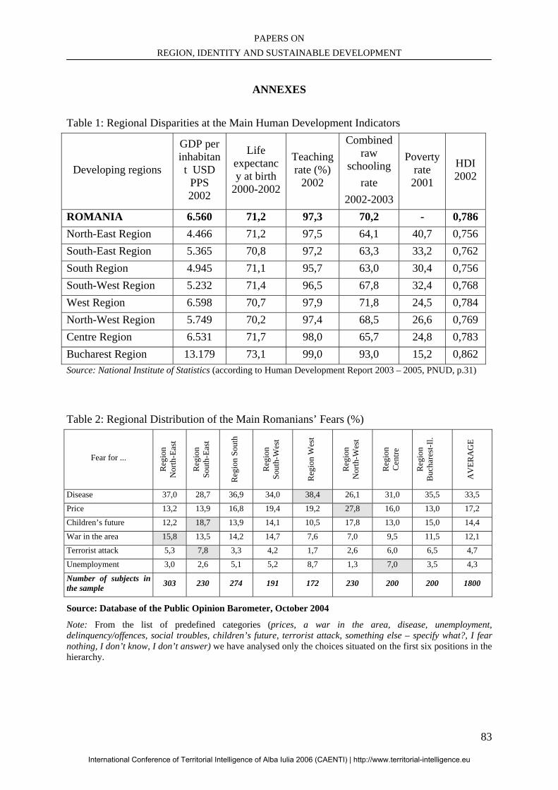
PAPERS ON REGION, IDENTITY AND SUSTAINABLE DEVELOPMENT
83
ANNEXES
Table 1: Regional Disparities at the Main Human Development Indicators
Developing regions
GDP per inhabitant USD
PPS 2002
Life expectancy at birth
2000-2002
Teaching rate (%)
2002
Combined raw
schooling rate
2002-2003
Poverty rate 2001
HDI 2002
ROMANIA 6.560 71,2 97,3 70,2 - 0,786 North-East Region 4.466 71,2 97,5 64,1 40,7 0,756 South-East Region 5.365 70,8 97,2 63,3 33,2 0,762 South Region 4.945 71,1 95,7 63,0 30,4 0,756 South-West Region 5.232 71,4 96,5 67,8 32,4 0,768 West Region 6.598 70,7 97,9 71,8 24,5 0,784 North-West Region 5.749 70,2 97,4 68,5 26,6 0,769 Centre Region 6.531 71,7 98,0 65,7 24,8 0,783 Bucharest Region 13.179 73,1 99,0 93,0 15,2 0,862 Source: National Institute of Statistics (according to Human Development Report 2003 – 2005, PNUD, p.31)
Table 2: Regional Distribution of the Main Romanians’ Fears (%)
Fear for ...
Reg
ion
N
orth
-Eas
t
Reg
ion
So
uth-
East
Reg
ion
Sout
h
Reg
ion
So
uth-
Wes
t
Reg
ion
Wes
t
Reg
ion
N
orth
-Wes
t
Reg
ion
C
entre
Reg
ion
B
ucha
rest
-Il.
AV
ERA
GE
Disease 37,0 28,7 36,9 34,0 38,4 26,1 31,0 35,5 33,5
Price 13,2 13,9 16,8 19,4 19,2 27,8 16,0 13,0 17,2
Children’s future 12,2 18,7 13,9 14,1 10,5 17,8 13,0 15,0 14,4
War in the area 15,8 13,5 14,2 14,7 7,6 7,0 9,5 11,5 12,1
Terrorist attack 5,3 7,8 3,3 4,2 1,7 2,6 6,0 6,5 4,7
Unemployment 3,0 2,6 5,1 5,2 8,7 1,3 7,0 3,5 4,3
Number of subjects in the sample 303 230 274 191 172 230 200 200 1800
Source: Database of the Public Opinion Barometer, October 2004
Note: From the list of predefined categories (prices, a war in the area, disease, unemployment, delinquency/offences, social troubles, children’s future, terrorist attack, something else – specify what?, I fear nothing, I don’t know, I don’t answer) we have analysed only the choices situated on the first six positions in the hierarchy.
International Conference of Territorial Intelligence of Alba Iulia 2006 (CAENTI) | http://www.territorial-intelligence.eu
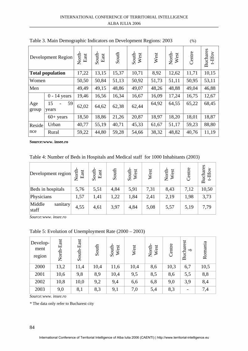
INTERNATIONAL CONFERENCE OF TERRITORIAL INTELLIGENCE ALBA IULIA 2006
84
Table 3. Main Demographic Indicators on Development Regions: 2003 (%)
Development Region
Nor
th-
East
Sout
h-Ea
st
Sout
h
Sout
h-W
est
Wes
t
Nor
th-
Wes
t
Cen
tre
Buc
hare
st-I
lfov
Total population 17,22 13,15 15,37 10,71 8,92 12,62 11,71 10,15 Women 50,50 50,84 51,13 50,92 51,73 51,11 50,95 53,11 Men 49,49 49,15 48,86 49,07 48,26 48,88 49,04 46,88
Age group
0 - 14 years 19,46 16,56 16,34 16,67 16,09 17,24 16,75 12,67 15 - 59 years 62,02 64,62 62,38 62,44 64,92 64,55 65,22 68,45
60+ years 18,50 18,86 21,26 20,87 18,97 18,20 18,01 18,87
Residence
Urban 40,77 55,19 40,71 45,33 61,67 51,17 59,23 88,80 Rural 59,22 44,80 59,28 54,66 38,32 48,82 40,76 11,19
Source:www. insee.ro
Table 4: Number of Beds in Hospitals and Medical staff for 1000 Inhabitants (2003)
Development region
Nor
th-
East
Sout
h-Ea
st
Sout
h
Sout
h-W
est
Wes
t
Nor
th-
Wes
t
Cen
tre
Buc
hare
st-I
lfov
Beds in hospitals 5,76 5,51 4,84 5,91 7,31 8,43 7,12 10,50 Physicians 1,57 1,41 1,22 1,84 2,41 2,19 1,98 3,73 Middle sanitary staff 4,55 4,61 3,97 4,84 5,08 5,57 5,19 7,79
Source:www. insee.ro
Table 5: Evolution of Unemployment Rate (2000 – 2003)
Develop-ment
region
Nor
th-E
ast
Sout
h-Ea
st
Sout
h
Sout
h-W
est
Wes
t
Nor
th-
Wes
t
Cen
tre
Buc
hare
st
δ
Rom
ania
2000 13,2 11,4 10,4 11,6 10,4 8,6 10,3 6,7 10,5 2001 10,6 9,8 8,9 10,4 9,5 8,5 8,6 5,5 8,8 2002 10,8 10,0 9,2 9,4 6,6 6,8 9,0 3,9 8,4 2003 9,0 8,1 8,3 9,1 7,0 5,4 8,3 - 7,4
Source:www. insee.ro
* The data only refer to Bucharest city
International Conference of Territorial Intelligence of Alba Iulia 2006 (CAENTI) | http://www.territorial-intelligence.eu
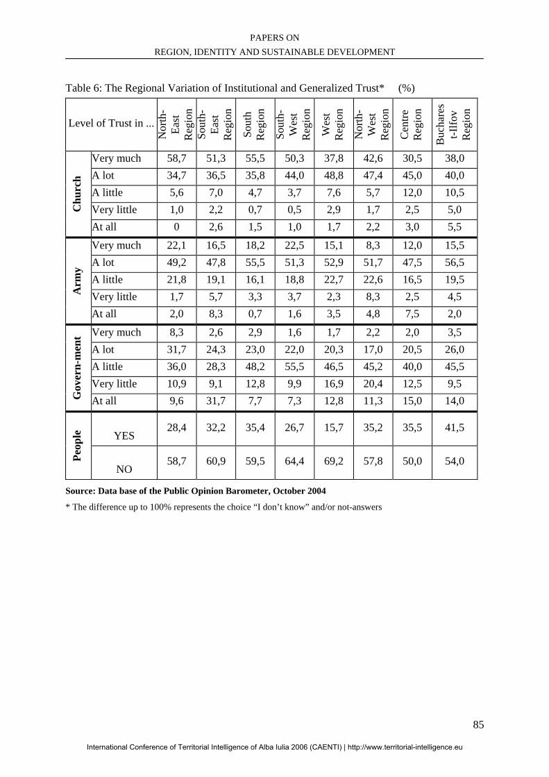
PAPERS ON REGION, IDENTITY AND SUSTAINABLE DEVELOPMENT
85
Table 6: The Regional Variation of Institutional and Generalized Trust* (%)
Level of Trust in ...
Nor
th-
East
R
egio
n
Sout
h-Ea
st
Reg
ion
Sout
h R
egio
n
Sout
h-W
est
Reg
ion
Wes
t R
egio
n
Nor
th-
Wes
t R
egio
n
Cen
tre
Reg
ion
Buc
hare
st-I
lfov
Reg
ion
Chu
rch
Very much 58,7 51,3 55,5 50,3 37,8 42,6 30,5 38,0 A lot 34,7 36,5 35,8 44,0 48,8 47,4 45,0 40,0 A little 5,6 7,0 4,7 3,7 7,6 5,7 12,0 10,5 Very little 1,0 2,2 0,7 0,5 2,9 1,7 2,5 5,0 At all 0 2,6 1,5 1,0 1,7 2,2 3,0 5,5
Arm
y
Very much 22,1 16,5 18,2 22,5 15,1 8,3 12,0 15,5 A lot 49,2 47,8 55,5 51,3 52,9 51,7 47,5 56,5 A little 21,8 19,1 16,1 18,8 22,7 22,6 16,5 19,5 Very little 1,7 5,7 3,3 3,7 2,3 8,3 2,5 4,5 At all 2,0 8,3 0,7 1,6 3,5 4,8 7,5 2,0
Gov
ern-
men
t Very much 8,3 2,6 2,9 1,6 1,7 2,2 2,0 3,5
A lot 31,7 24,3 23,0 22,0 20,3 17,0 20,5 26,0 A little 36,0 28,3 48,2 55,5 46,5 45,2 40,0 45,5 Very little 10,9 9,1 12,8 9,9 16,9 20,4 12,5 9,5 At all 9,6 31,7 7,7 7,3 12,8 11,3 15,0 14,0
Peop
le
YES
28,4 32,2 35,4 26,7 15,7 35,2 35,5 41,5
NO
58,7 60,9 59,5 64,4 69,2 57,8 50,0 54,0
Source: Data base of the Public Opinion Barometer, October 2004
* The difference up to 100% represents the choice “I don’t know” and/or not-answers
International Conference of Territorial Intelligence of Alba Iulia 2006 (CAENTI) | http://www.territorial-intelligence.eu

INTERNATIONAL CONFERENCE OF TERRITORIAL INTELLIGENCE ALBA IULIA 2006
86
International Conference of Territorial Intelligence of Alba Iulia 2006 (CAENTI) | http://www.territorial-intelligence.eu
PAPERS ON REGION, IDENTITY AND SUSTAINABLE DEVELOPMENT
87
GEOGRAPHIC IDENTITY ASPECTS OF THE LAND OF THE MOŢI
Cristian Nicolae BOŢAN
Professor Assistant in Regional Geography [email protected], Tél: + 40 740 088 945
Oana-Ramona ILOVAN
Professor Assistant in Regional Geography [email protected], Tél: + 40 742 074 946
Professional address
Babeş-Bolyai University, Faculty of Geography, Clinicilor Street 5-7 – R-400006, CLUJ-NAPOCA, Romania
Abstract: This paper focuses on analysing all the geographic and historical aspects that were involved into creating the geographic identity of the Land of the Moţi, a region in the heart of the Apuseni Mountains. The purpose of the study is that of identifying and establishing the future strategies for the sustainable development of this region while underlining first the strengths and the weaknesses of the territorial system. Rezumat: Lucrarea noastră este o analiză a tuturor aspectelor geografice şi istorice care au dus la crearea identităţii geografice a unei regiuni din inima Munţilor Apuseni: Ţara Moţilor. Scopul studiului este de a identifica şi de a stabili viitoarele strategii pentru dezvoltarea durabilă a acestei regiuni, subliniind întâi punctele tari şi slabe ale acestui sistem regional. Key words: “Land”, Geographic-functional entity, Resources, Development, Image. Cuvinte cheie: „Ţară”, Entitate geografică funcţională, Resurse, Dezvoltare, Imagine.
International Conference of Territorial Intelligence of Alba Iulia 2006 (CAENTI) | http://www.territorial-intelligence.eu
INTERNATIONAL CONFERENCE OF TERRITORIAL INTELLIGENCE ALBA IULIA 2006
88
GEOGRAPHIC IDENTITY ASPECTS OF THE LAND OF THE MOŢI
The “land” type regional entities of Romania have been characterised by several fundamental features (‘fortified’ areas where the Romanian ethnics were protected, Orthodoxy, specificity of the ethnographic and toponymy components, etc.). On one hand, many of these attributes were common to all the Romanian “lands”, and, on the other hand, each of these geographic entities has its own features. For the Land of the Moţi, the following characteristics are significant: a different morphology from those of the other “lands” - it is an “over the mountain tops land”, no depressions; relevant historical and geographic features (that imposed the community as a representative of all the Romanians during certain periods); the existence of certain valuable resources (such as gold and wood and thus framing the economic profile of the region); poor or lack of agricultural lands (triggering continuous mobility for the people in order to ensure their food), etc. This paper focuses on analysing all the geographic and historical aspects that were involved into creating the geographic identity of this region in the heart of the Apuseni Mountains. A first image of the community and its features is that of the moţi themselves and the second one, more important, is that of several other communities either from Romania and from abroad. The purpose of such a both delicate and scientifically rigorous study is that of identifying and establishing the future strategies for the sustainable development of the Land of the Moţi while underlining first the strengths and the weaknesses of this territorial system. 1. THE LAND OF THE MOŢI – REGIONAL GEOGRAPHIC SYSTEM? Our paper brings new pieces of information for the geographic identity aspects of the Land of the Moţi, but is has also fragments treated in several of our old papers (Boţan, 2005a, 2005b, 2005c, Boţan, 2006, Boţan, Ilovan, Pop, 2005, Boţan, Ilovan, 2006, Cocean, Boţan, 2005) as we felt it is important to bring them to the attention of a larger audience (the mentioned papers were mostly published in Romanian or only in Romania). In order that a territory is considered a geographic region (regional system) and defined as such it has to have several essential features (we have to draw the reader’s attention to the methodology for including certain territories into the regional geographic systems category which has become more strict in order to do away with the extant ambiguity during the recent periods).
Prestigious papers in the field (Cocean, 2005) show exactly the main features (characteristics) of the territory considered a regional geographic system. These features are the following: - Well-defined spatial localisation. This is done according to certain mathematic coordinates that are compatible to the matrix of geographic orientation; - Nuanced spatial extension including territories that allow generalisations; - The existence of certain limits based on the areal distribution of the features selected for analysis – the limits are there where these features are no longer dominant (Cocean, 2005); - A strict hierarchy although the typology and the extension may vary a lot; - The existence of the components and features generating the specificity of the region as different from the neighbouring regions; - The existence of certain functional relations among the components of the territory which ensure the continuous economic development of the respective region; - Enough complexity that ensures that the region will not periodically undergo negative impact changes; - Interrelations with the neighbouring units, as well as with the remote ones; - Personal ethos for the respective territory in order to become well-known within the state and the continent; - Certain internal capacity for modelling its negative characteristics and for inhibiting their potential impact (this may be done by promoting other, favourable features as viable alternatives), etc. The projection of the above-mentioned features of a region upon the central part of the Land of the Moţi renders possible the inclusion of the respective space into the regional geographic systems category. The arguments are the following (Boţan, 2006, Boţan, Ilovan, 2006):
International Conference of Territorial Intelligence of Alba Iulia 2006 (CAENTI) | http://www.territorial-intelligence.eu
PAPERS ON REGION, IDENTITY AND SUSTAINABLE DEVELOPMENT
89
- Certainty and clarity of the limits: the region lies in the superior part of the Arieş hydrographical basin. It is mostly delimited by the line of the peaks belonging to the nearby massifs including the convergent orienting slopes. The extension of the region and its limits are supported by the fact that they overlap the inhabited areas by those bearing the name of moţ (the other human communities in the Apuseni Mountains that are outside the above-mentioned limits do not bear the same name and do not consider themselves moţi). The limits of the Land of the Moţi are sinuous, and are situated on the line of the highest peaks of the surrounding mountains: in the south-west, the west and the north-west, this line follows the highest peaks of the Găina and the Bihor Mountains (e.g. Găina, Bihor, Biharia, etc.); in the north, the north-east and the east, the limit is situated in the Gilău and the Muntele Mare Mountains, on the following peaks: Bătrâna, Petreasa, Balomireasa, Muntele Mare, etc., then continuing to the south on the Arieşul Valley, on the interfluve between the Ştefanca and Muşcanilor Valley, then following the peaks Vârşii Mari and Geamăna. To the south, the limit is situated on several other peaks such as Petriceaua, Brădişoru, Vulcan, etc., then coming to a closing towards south-east where the peaks Răchita and Ştiubei are situated. The seemingly exclusive geomorphologic character of the limit has strong functional meaning as it delimits a quasi-mountainous space, a human community clearly belonging to it, certain mental, economic, and significant ethnographic specificity;
- Territorial extension that allows
generalisations: the Land of the Moţi is large enough for generalisations. This is true mostly for the similar “land” type entities: the dominant anthropic component is the Romanian ethnic one, the Orthodox religion is best represented, and the economy consists mostly of wood exploiting and processing, etc.;
- Functional intra- and interrelations. Among
this region’s components there are clear functional relations that allow its inclusion (although a difficult one) on the ascendant economic development trend. One may remark the existence of two different functional and economic subsystems: the forestry one polarised by Câmpeni and the gold mining one polarised by Abrud and Roşia Montană (Boţan, Ilovan, 2006). The main transport axis along which also the fluxes of mass, energy, and information are oriented is that of the Arieşul Mare river valley supported also by that of the Arieşul Mic. The development of the agricultural touristic field, of wood industry, and the correct implementing of the gold and silver exploitation project are several other strengths of the Land of the Moţi, as a functional regional
system, besides a certain mentality maintained from the difficult periods for the survival of the community. Relations with other geographic units are to be identified for the infrastructure and the means of transport in the region, as well al for touristic objectives that attract a lot of tourists, for the liberalisation of the labour market that offers opportunities for working abroad, etc.;
- Impact of the critical features. Any regional
system is characterised by the “functioning” of several critical elements that endanger up to a certain degree the functionality of the respective entity. The quality and the complexity of the system is verified and certified only when those critical attributes are overpassed, and economic development follows an ascendant trend. The Land of the Moţi is no exception. Elements such as “the critical character of the mountainous agriculture (that does not ensure enough food for the local community), the social-historic conditions (these imprinted themselves on the collective mentality), the critical features of the nowadays demographical phenomena in the region (these render the Land of the Moţi as one of the most fragile mountainous regions from this perspective), the extant state of gold mining (this situation is particularly related to the implementing of the mining mega project Gold Corporation that contradicts obviously the European laws in this field)” (Boţan, 2005c) give at least a hint to the uncertainty for the vitality of the system without changing its direction of economic development. Still, one may easily see that the Land of the Moţi can be considered a regional geographic entity as it has real functional attributes and presents features that are similar to other mountain systems (figure 1). At the same time, a strong personal ethos is to be identified and thus originality is a feature of the analysed system. See figure 1.
2. ELEMENTS OF GEOGRAPHIC IDENTITY OF THE LAND OF THE MOŢI
2.1. Morphology (Botan, 2005a) Morphology differentiates this geographic entity through several features that are not to be identified in the case of the similar regions of Romania (the “land” type regions). The Land of the Moti is spread on the peaks and platforms of the Apuseni Mountains and the defensive function is not ensured by the closed basin type of relief but by the high altitude, the great slopes, and the low access forests. Morphology has both positive and restrictive features for the appearance and development of the regional system of the Land of the Moţi. Its impact
International Conference of Territorial Intelligence of Alba Iulia 2006 (CAENTI) | http://www.territorial-intelligence.eu
INTERNATIONAL CONFERENCE OF TERRITORIAL INTELLIGENCE ALBA IULIA 2006
90
may be identified at the following three levels: first, in the morphologic personality of the land, then at the level of the settlement system, and finally its restrictiveness for the development of agriculture. 2.2. Hydrography (Boţan, 2006) The way in which the hydric component (especially the rivers) contributes to the identity of the regional system of the Land of the Moţi is a very important one as there is an intrinsic relationship between the hydrography of the region and the appearance and development of this functional region (Apolzan, 1987, Manciulea, 1997).
The first conditioning resides in the inclusion of the region into the superior part of the Arieş hydrographical basin and this imposes the flux orientation within the territorial system. From this point of view, one may notice a privileged axis within the Câmpeni-Bistra sector that goes also along the Arieşul Mare Valley down to Arieşeni. Most of the mass, energy and information fluxes in this “land” are oriented along this axis, approximately from the east to the west where the most important road of the region is situated. In our opinion, this axis has a double role. First, the role of creating the regional cohesion as the tributaries have a centripetal orientation, and thus all the fluxes merge to the main river. Secondly, the centrifugal aspect is also present as part of the system energy is lost both to the west (through the Vârtop Pass and later on towards the Beiuş Depression and to the western part of Romania) and to the east (along the Arieş Valley). On the other hand, the hydrographical network was an apriori condition (because of its distribution) for settling the region. The human component followed the rivers, especially the Arieşul, the Arieşul Mare, the Arieşul Mic, and the Abrud. Thus, the first settlements were situated along the rivers into small depression basins: Avram Iancu, Bistra, Gârda de Sus, Gârda Seacă, Izvoarele, Câmpeni, Certege, Albac, Horea, Sohodol, Abrud, etc. Here we mentioned the initial nucleus of the respective settlements as they were the spots of the population’s later diffusion to the high altitude plateaus. Two aspects should be underlined: one of them is that the first settlements (especially the commune centres), when they got short of the river meadow, reached to the nearby mountainous space, and the other aspect refers to the small villages that appeared later on and settled almost exclusively the Măguri-Mărişel platform (Surd, 1993). Therefore, in the river meadow of the Arieş there are only two major settlements (Câmpeni and Bistra), with a very small percent of the number of inhabitants in their central area (about 32% in Câmpeni and 20% in Bistra).
In addition to the above-mentioned issues, the hydric component induces a major paradox in the regional system of the Land of the Moţi related to the way the moţi perceive the importance of water. Along the rivers there are certain small spots where there are no households despite the fact that they are favourable to settlement. Moreover, the respective groups of households appear in the heart of the mountains where there is no water and it has to be carried from long distance. Many other resources seem to be more important than water in that karst region: the horizontal platforms, the natural pastures and hayfields favourable to animal breeding, and the forests (Plăiaş, 1994). 2.3. Forest and forest capitalising (Boţan, Ilovan, 2006) Out of the elements that influenced the life of the inhabitants within the Land of the Moţi, and of the Romanians, in general, during the centuries, was the forest. It had mainly the role of shelter during uprisings or invasions. During the calm periods, the forest influenced decisively the inhabitant’s life, in this region, on an every day basis. His household, sheepfold, mill, and his church, in an archaic form, his furniture, his tools and his weapons, his means of communication, on land and water, as well as many of his customs, from his spiritual life, his literary and artistic creation were related to the forest. Thus one might speak of a Land of the Moţi wood civilisation, having its specific forms (from more than 15 hundred years) since Dacia province was left by the Roman legions. As a commodity (processed or not), the wood had an ascendant trend as far as the price was concerned. During the Early Middle Ages, when the population was relatively scarce, within the context of the extended forest, the price of wood was very low. Therefore, anyone could use the wood for his household needs, cut or burn the forest in order to gain land for cultivating plants or for breeding his animals. The price of wood increased progressively, due to the increase in the number of the inhabitants and the higher degree of processing. The moţi were well-known for the products that they created during the centuries (this phenomenon drastically decreased), and therefore they were determined to descend from their mountains to exchange products or to sell their own. In the Land of the Moţi, wood was the main source for the inhabitants’ existence, an existential monopoly. Wood was transformed into valuable products, which the people transported to the field areas. In exchange, they received cereals and several food products. When the number of the inhabitants increased significantly and the markets started to expand, the peasants’ right to cut the local
International Conference of Territorial Intelligence of Alba Iulia 2006 (CAENTI) | http://www.territorial-intelligence.eu
PAPERS ON REGION, IDENTITY AND SUSTAINABLE DEVELOPMENT
91
forest was limited and then they were prevented from this activity (in the second half of the 19th century). At the same time, the price of wood increased as the people noticed that wood could be used not only for their houses, tools, vessels, their weapons or for obtaining coal by burning it (like in the Middle Ages), but also for chemically obtaining varied products such as paper, tar, and acetic acid.
Therefore, nobody will be surprised that the forest, so much linked to the moţ’s heart along the centuries, influenced the literary creation of the inhabitants within this region. Similarly, the artistic sense of the Romanian people manifested itself upon wood, more than upon stone. A proof is the moţ’s houses and churches, his tools and wood objects characteristic to his household. Even one of the leaders of a revolt (in year 1784, Horea), was a talented builder of wood churches.
Maybe, the most important element of social cohesion and uniformity in the way of thinking and reacting of the moţ was the forest and most of all the sense that he, together with his neighbours, was the owner of the forest. The inhabitants of this region were first related to forestry and wood processing, and secondly, to mining.
In the central part of the Apuseni Mountains, the home industry of wood is very old and varied and is determined by the abundance of this resource, as well as by the low income that the people have from their secondary occupations (e.g. agriculture). Thus, the moţ has been determined to become a good confectioner of all kind of wood products and this old occupation has led to identifying the moţ with his forest, so that, in certain periods, not even the perspective of leading a better life could determine him to give up his old occupation.
I. Popa (2003), presents the moţ’s attachment to his native region: those who left for America for a better life, could not make it without their home and came back after 2-3 years of work; similarly, while travelling through the country in order to sell his products, the moţ saw more welcoming places than his native one, but none could attract him, so that he came back to his dear mountains and forest. This affective relationship that the moţ had with his mountains and forest explained also the failure of the action of colonising him in the proximity of the western border of Romania, where although he received fertile lands, he stayed there only during the agricultural works, while spending the rest of the time at his household in the mountains.
From what we have presented so far, related to the importance of the wood for the Land of the Moţi, one may notice that the tradition of forestry and wood processing has an overwhelming importance
for the every day existence of the people in this region.
The way in which the inhabitants reacted when they were in the situation to lose what was their most important good – the forest – was defining for understanding what the process of the appearance of a “land” meant: the real moţi are those who fought for this resource. The forest was perceived as a sacred property by the moţ, that was why significant social movements (proof of their social cohesion) took place (e.g. in 1784 and 1848) (for defending their forest from the foreign rulers). Wood processing, at a small scale, of handicraft dates back to very old times. But, at an industrial scale, in the Land of the Moţi, wood processing is a recent one. Close to Roşia Montană, in Câmpeni, such an industrial unit has been functioning for several decades and, also at present; it offers jobs for about 1000 employees. After 1990, other smaller units that exploit the “green gold” appeared in Câmpeni.
2.4. Gold Mining (Boţan, Ilovan, 2006)
Another exception to the above-mentioned profile is that in the Abrud Valley basin the millenary gold mining replaced wood exploitation and processing. The economic complementarity did not modify the mentality of the people in the region, the ethnographic elements having the same contents (architecture, customs, and folklore, etc.). The specificity of the economic activities in the area of the Abrud Valley, as different from the rest of the Land of the Moţi, determined some of the authors to identify two “land” type geographic entities in the centre of the Apuseni Mountains: one characterised by forestry specificity (the Land of the Moţi) and another one with mining specific activities (the Land of Abrud). We disagree with this idea. If individualising such a “Land of Abrud” would draw our attention to some differences, its delimiting as a sub-system of the Land of the Moţi would be a fact.
The importance of gold mining in the Land of the Moţi resides in the population fluxes it oriented towards this region, in the high value of the metal, and in the instability it induces at present.
CONCLUSION
We consider that the four above-mentioned and analysed attributes are the most important identifying elements of the Land of the Moţi. Beside these, several others may be included, too: social-historical conditions, the specificity of spatial individualising, the specificity of the climate, the features of demography, of tourism,
International Conference of Territorial Intelligence of Alba Iulia 2006 (CAENTI) | http://www.territorial-intelligence.eu
INTERNATIONAL CONFERENCE OF TERRITORIAL INTELLIGENCE ALBA IULIA 2006
92
and of the ethnographic component, etc. Nevertheless, their impact is weaker in the process of creating the personality of the region.
What is surprising is that despite the “opposition” of some characteristics and their inhibiting role, this regional system is a functional one and may be considered a model for other “land” type regions provided that the promoted sustainable development models are implemented correctly no matter the difficulties. The Land of the Moţi remains a significant geographic entity inside Romania having the possibility of being included among the emblematic regions of the European Union.
BIBLIOGRAPHY
Apolzan, Lucia (1987), Carpaţii-Tezaur de Istorie. Perenitatea aşezărilor risipite pe înălţimi, Editura Ştiinţifică şi Enciclopedică, Bucureşti. Boţan, C. (2005a), „Premisele morfologice ale individualizării sistemului regional în Ţara Moţilor”, in volume IX, Comunicări de Geografie, Editura Universităţii din Bucureşti, Bucureşti. Boţan, C. (2005b), „Populaţia - factor critic în constituirea sistemului regional al Ţării Moţilor”, in Probleme demografice ale populaţiei în contextul integrării europene, Editura ASEM, Chişinău. Boţan, C. (2005c), „Aspecte critice în sistemul geografic al Ţării Moţilor”, in Studia UBB, Geographia, no. 2, Editura Presa Universitară Clujeană, Cluj-Napoca.
Boţan, C. N. (2006), „Premise climatice şi hidrologice în constituirea sistemului regional al Ţării Moţilor”, în Studia UBB, Geographia, nr. 2, Editura Presa Universitară Clujeană, Cluj-Napoca. Boţan, C. N., Ilovan, Oana-Ramona, Pop, Ana-Maria (2005), „The Geographical Region and the Desiderata of Sustainable Development”, in Romanian Review of Regional Studies, no. 1, Presa Universitară Clujeană, Cluj-Napoca. Boţan, C. N., Ilovan, Oana-Ramona (2006), „Trends of Industrial Reconversion in the Land of the Moţi”, in Romanian Review of Regional Studies, no.1, Presa Universitară Clujeană, Cluj-Napoca. Cocean, P. (2005), Geografie Regională, Editura Presa Universitară Clujeană, Cluj-Napoca.
Cocean, P., Boţan, C. N. (2005), „Specificitatea individualizării spaţiale a Ţării Moţilor”, in Studia UBB, Geographia, no. 1, Editura Presa Universitară Clujeană, Cluj-Napoca. Manciulea, Şt. (1997), Ţara Moţilor. Studii, articole şi comunicări, vol.V, Editura Clusium, Cluj-Napoca. Plăiaş, I. (1994), Agricultura montană↔Societate, Munţii Apuseni, Editura Libris, Cluj-Napoca. Popa, I. (2003), Industria şi comerţul lemnului în Munţii Apuseni, Editura Altip, Alba Iulia. Surd, V. (1993), Aşezările din bazinul montan al Arieşului-Studiu de geografie aplicată, Editura Interferenţe, Cluj-Napoca.
International Conference of Territorial Intelligence of Alba Iulia 2006 (CAENTI) | http://www.territorial-intelligence.eu
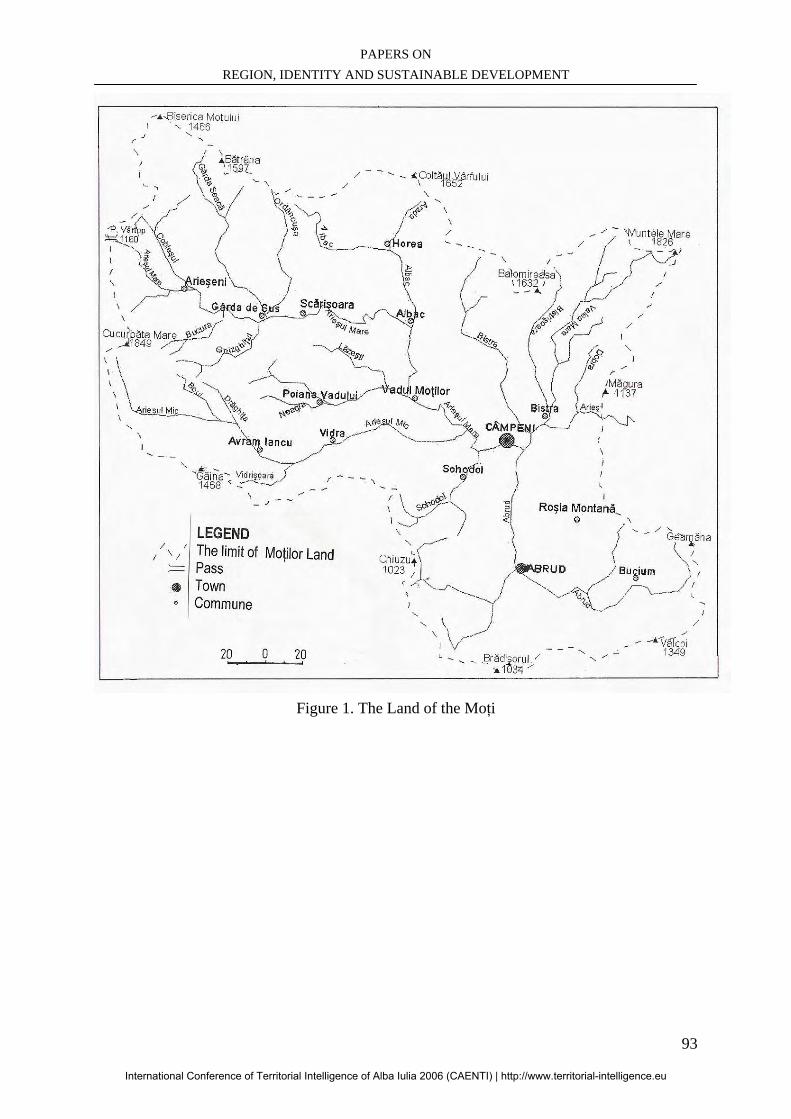
PAPERS ON REGION, IDENTITY AND SUSTAINABLE DEVELOPMENT
93
Figure 1. The Land of the Moţi
International Conference of Territorial Intelligence of Alba Iulia 2006 (CAENTI) | http://www.territorial-intelligence.eu

INTERNATIONAL CONFERENCE OF TERRITORIAL INTELLIGENCE ALBA IULIA 2006
94
International Conference of Territorial Intelligence of Alba Iulia 2006 (CAENTI) | http://www.territorial-intelligence.eu
PAPERS ON REGION, IDENTITY AND SUSTAINABLE DEVELOPMENT
95
CORSICA, ISLAND HERITAGE AND REGIONAL IDENTITY: TO THE
TERRITORIAL INTELLIGENCE
Marie Michèle VENTURINI University of Corsica– Pasquale Paoli
[email protected], [email protected] , GSM: + 33 (6) 15 28 11 15
Julien ANGELINI University of Corsica – Pasquale Paoli
[email protected] , GSM: + 33 (6) 21 03 64 85
Professional address University of Corsica - Pasquale Paoli – Avenue Jean Nicoli – BP 52 F-20250 CORTE, France.
Abstract: Our objective is to locate societal information topics in Corsica in order to show that it constitutes a ground favourable to the application of territorial intelligence processes. Corsica is an island, a Mediterranean and European area, so it is rich of a historical and cultural heritage consequent on a territory constitutive of a remarkable natural patrimony. Far from considering that its identity is summarized with the presentation of its resources, thanks to its University Corsica opens the way to modernity in an original valorisation of its patrimony which includes human and social elements. We consider that the regional identity lies in the capacity of the actors of the local to identify, gather and develop the elements of the heritage in a widened meaning and to position them in a logic of a mutualisation without borders. This is why the TIC, the major part of the process of territorial intelligence constitutes an essential tool to this step. We wish to show, through the actions undertaken in our area, that the regional identity is a perpetual construction, of permanent nature, belonging to the actors of the local, who, thanks particularly to Internet, have now entered a new era of collaborative experiments. The European richness is obviously constituted of the valorisation of the local richness, thus creating the harmonious mosaic of its identity. Résumé: Notre objectif est de situer l’actualité sociétale de la région Corse afin de démontrer qu’elle constitue un terrain propice à l’application de processus d’intelligence territoriale. Région insulaire, méditerranéenne et européenne, la Corse est riche d’un patrimoine historique et culturel conséquent sur un territoire constitutif d’un patrimoine naturel remarquable. Loin de considérer que son identité se résume à la présentation de ses ressources, la Corse par son Université ouvre la voie de la modernité dans une valorisation originale de son patrimoine qui est aussi humain et social. Nous considérons que l’identité régionale réside dans la capacité des acteurs du local à identifier, regrouper et valoriser les éléments du patrimoine dans une acception élargie et à les positionner dans une logique de mutualisation transfrontalière. C’est pourquoi les TIC, volet majeur du processus d’intelligence territoriale constituent un outil indispensable à cette démarche. Nous souhaitons démontrer au travers des actions entreprises dans notre région, que l’identité régionale est un construit perpétuel de nature transhistorique appartenant aux acteurs du local désormais entrés, grâce notamment à Internet, dans une nouvelle ère des expériences collaboratives. La richesse européenne est évidemment constituée de la valorisation des richesses locales, créant ainsi la mosaïque harmonieuse de son identité. Keywords: Territorial intelligence, Island inheritances, Regional identity, Sustainable development, Networks, Corsican area, Mutualisation. Mots clés: Intelligence territoriale, Patrimoines insulaires, Identité régionale, Développement durable, Réseaux, Région Corse, Mutualisation.
International Conference of Territorial Intelligence of Alba Iulia 2006 (CAENTI) | http://www.territorial-intelligence.eu
INTERNATIONAL CONFERENCE OF TERRITORIAL INTELLIGENCE ALBA IULIA 2006
96
CORSICA, ISLAND HERITAGE AND REGIONAL IDENTITY: TO THE
TERRITORIAL INTELLIGENCE
INTRODUCTION
Our communication fits in axis 2 of the first annual Conference of the CAENTI (Action of Coordination of the European network of territorial Intelligence), whose problematic are as follows: “Within the framework of regional identity construction, what are the problems, the experiments and the good practices?” In effect, the concept of territory is currently feeding from many debates and many reflexions in particular as for a modernized definition of this very old term. For a long time the territory has been the spatial and material representation of a Community space. This definition is certainly still appropriate in several places of the sphere but raises from now on a problem related to a modern conception of the identity, interculturality and exchanges. If it is agreed that Internet marked the completion of "globalisation", the concepts of territory and local should then be going to change. However it seems that a movement of "return to the local" takes place in spite of the triumph of the planetary village. As P. Dumas underlined at the "Ve meetings TIC and Territories. Which developments?" the debate must be prolonged beyond the concept of "glocalisation". In this communication, we wish to propose an approach of the regional identity, its construction, its report to the territories and its resonance through the processes of territorial intelligence. By presenting the development of Corsica to the territorial intelligence, we testify to a local experiment of the work of analysis necessary to the installation of such processes. The concepts of territory and identity take a particular dimension in Corsica. That is explained mainly by islandity, its positioning in comparison with European space and by its historical evolution. We thus propose initially to define the two concepts: “identity” and “inheritance” to feed a reflection on the construction of the regional identity and that of Corsica as a private individual. We will be interested thereafter in the administrative, economic and political context of the island in order to show a total sight of the current situation of the Corsican society. That will enable us to refine the relation between the current and historical context of the society, to clarify potentialities of evolutions. Lastly, we will evoke two examples of actions carried out in our area which are assimilated to
processes of territorial intelligence. If these actions are premises, they want in any case to show that the way of a new dimension of the territorial projects of development takes form in Corsica. 1. IDENTITY, HERITAGE
“The concept of identity is, with that of the otherness, perceived by much like central, even federator, for the ethnology as for other disciplines of social sciences, however, with which wants to apprehend it, it is concealed constantly. It indicates as well this which stays as what distinguishes as what gathers. It applies to the individual as with groups. It is not conceived like the combination of very heterogeneous elements. It is tested and appeared in figures selected according to the contexts. It changes with the evolution of the social reports and the memberships. Ambiguous finally, it can be turn keep silent and affirmed. Thus in no case the identity is let converted into formulas or to reduce to combinations of attributes and one can wonder about the advantages which one finds to refer to such a concept, so much the phenomena which it indicates are diversified in their demonstrations, their significances and their determinations”9. This extract clearly shows the difficulty inherent in the use of the concept of identity in the scientific field and more particularly for social sciences. We must thus approve certain meanings of direction to try to determine contours of the regional identity and more precisely of a Corsican regional identity. According to Denis Chevallier and Alain Morel, three criteria make it possible to work around the concept of identity. They are historical criteria (maintenance in time), then of criteria of exclusion and finally of inclusion. According to us it is also necessary to distinguish the level from territorial application of the identity recognition. This is why we want to present in an objective way the existence of a whole of open criteria allowing to give to Corsica an identity within the world Mediterranean euro. The main repercussion of identity phenomena is that of national political scene. In the European questioning of the regional identities, France is confronted with several areas asserting the existence of a particular identity in the Republic
9 Chevallier D., Morel, A., « Identité culturelle et appartenance régionale », in Terrain, n°5, Identité culturelle et appartenance régionale, Octobre 1985.
International Conference of Territorial Intelligence of Alba Iulia 2006 (CAENTI) | http://www.territorial-intelligence.eu
PAPERS ON REGION, IDENTITY AND SUSTAINABLE DEVELOPMENT
97
(Corsica, Brittany, Basque Country, Alsace). The long “jacobine” tradition of the State always opposed the wills of regional emancipations to the name of the unit of the Republic and the good measurement of the State as tallies of public action. However, the problems seem today to moult of the regional political claim towards the search for a relevant framework of development. If the definition factors of identity remain the same ones, they are consequently apprehended on an inclusion way and not either on that of exclusion. We will thus try to see the natural and historical factors of the Corsican identity construction to tackle the question of the cultural membership. That will lead us to show in the following section of this communication the identity concept impact on the local action. Above all we must indicate that the concept of islandity is a central factor of Corsican identity construction. Indeed, Corsica is a “mountain in the sea” in the Mediterranean, more precisely in the Genoa gulf. Its strategic position on the sea routes made an object of covetousness for the European leading countries. From peopling origins to the 18° century, Corsicans were for most of them, mountain and pastoral people. On the 365 communes constituting today the region, up the half are small mountain villages coming from the historical defensive tradition of Corsicans against his invaders. The island knew several occupations (from Pisa, Genoa, and France) more or less tyrannical which never annihilate Corsican language, rites and habits. From these historical data, we can understand that the construction of Corsican identity has been territorial, defensive and exclusive. Moreover, we must go beyond this definition. Keep only the defensive and exclusive base of the definition would be the ground of a “zero development” at the present time. The present challenge of Corsica is coming in the modernity and to manage to take a part of the European construction. It is consequently necessary to differentiate at this stage, the identity in term from image conveyed by the island and the identities lived by the Corsicans who are multiple and variable. According to Helene Cardy, “it appears all the same to a certain extent that the speeches on the regional identity produce tangible effects. However, the localised social practices which result from this necessarily do not correspond so that one could expect some. It is that the whole of the speeches produced on the identity is intended to be used as points of recognition and the private behaviours, even with codes of prohibition. Whereas practices, hold by nature counts context
and do not go inevitably in the direction of recognition impelled by the regional decision makers and persons in charge”10. There is thus well an interaction, a reciprocal influence between the image impelled by the local authorities and the image emanating of the activity of the whole of the actors of the local. It seems that ultimately the most faithful measurement of the identity of a territory is within crossroads between its history, its inheritance, its decision makers and the activity of the whole of the local actors. This is why we can say that identity, just like the heritage is in perpetual construction from its character of “regional mosaic” where each one takes share with the life of the unit. If Corsica, because of islandity, does not have frontier problems, it is also pressed on a natural, historical and social consequent heritage, which reinforces the concept of cultural membership. We can then differentiate an identity from ground membership (personal) and an identity of cultural membership (common). We thus take the party to cultivate the patrimonial richness of Corsica in order to develop it outside, in Europe and in the world. We think that the knowledge of the island heritage by Corsican themselves is an essential starting point and that it is a public question of education. According to Jean Davallon, the process of patrimonialisation cuts out in six distinct stages: “The discovery of the object, the certification of the object origin, establishment of the existence of the world of origin, the representation of the object “lucky find” by its exposure and obligation to transmit to the future generations”11. It approaches the process of “reversed descent”12 to define the patrimonialisation. In fact we do not inherit the heritage, we produce it, from the present towards the past. All in all, as from the present, the patrimonialisation created or recreated a bond between men of passed while choosing to preserve objects that they bequeathed us to transmit them to the future generations. But also, to know oneself is an important required and a precondition to the meeting of the other in order to be able to exchange and weave bonds.
10 Cardy, H., Construire l’identité régionale. La communication en question, Ed. L’Harmattan, 1997. 11 Davallon, Jean, « Comment se fabrique le patrimoine ?, in Sciences Humaines, Hors Série n°36, mars 2002. 12 Expression from Jean Pouillon repeated by Gérard Lenclud, in « La tradition n’est plus ce qu’elle était … », in Terrain, n°9, octobre 1987.
International Conference of Territorial Intelligence of Alba Iulia 2006 (CAENTI) | http://www.territorial-intelligence.eu
INTERNATIONAL CONFERENCE OF TERRITORIAL INTELLIGENCE ALBA IULIA 2006
98
The construction of Europe does not dilute the regional identities but stimulates them and exhorts with the recognition of the local richnesses. It is from there that the identity becomes inclusive and certainly mainly in the logic of joint project. Indeed the recognized and developed identity ceases to be defensive and makes it possible to enter the way of the development, description of the richnesses and in the mutualisation of the resources. However, the variety of the symbolic representations of the territory as well as the recurrence of the endemic socio cultural practices still constitute a major barrier to the production of a development culture by the co-operation and the opening. The key of this problematic certainly lies in the actors information division level that we will see ahead. 2. TO THE TERRITORIAL INTELLIGENCE As we have just seen it, it seems that the regional identity is human construction. Inseparable from the patrimonial heritage and culture, it is the starting point of a possible emergence of the “capital formal territorial” and of a major anchoring in a prospect of sustainable development. Indeed, culture became the fourth pillar of the sustainable development. “(…) the culture must be an essential element of the concept of human sustainable development because it touches with the values, with the traditions, with the inheritance, with the knowledge and the creativity without which human development is unthinkable. (…) If the culture is a vital element of the development of the society, it is thanks to its extraordinary diversity, which is the expression of the single value of each individual, (…) of each area and each people (…)”13. This is why after having apprehended the concept of symbolic representation of the territory and the identity like membership of the local, we should expose a short panorama of the administrative, economic and social status of the island. That will enable us to clarify the structural difficulties of Corsica in term of development. Thus we will clarify why with our thinking the processes of territorial intelligence can be completely favourable with a new dynamic for the island territory. Corsica counts two departments: the High-Corsica and Southern Corsica. Corsica depends on the Court of Appeal of Bastia, academy of Ajaccio, and
13Avis de la Commission de la culture, de la science et de l’éducation de l’Assemblée parlementaire de la Francophonie, Mondialisation et développement durable, 28 Janvier 2003.
belongs to the military area of Lyon. Bastia is the chief town of the department of the High-Corsica. The Southern Corsica has Ajaccio for chief town. Corsica saw herself allotting since 1982 the particular statute of local authority, and since 1992, the administration of the Area is attached to the executive Council of seven members and at a regional assembly of fifty and one persons elected by the vote for all. The local authority of Corsica has capacities more advanced than the other areas of the French Republic. This particular statute is mainly the fruit of the negotiations that the State agrees to engage with the various regional political movements. The process of decentralization and transfer of competences continues questioning always more the island society on the shape of local action of the executive. The territorialisation of the public action is started but the impact of the State is still consequent. The particular statute of the island for the time being notably did not modify the forms of expression of the citizenship on the island. However, the political scene of Corsica is varied and the whole of the tendencies and the sensitivities are represented. In light, Corsica knows a stable political situation and advances gradually on the way of the territorialisation of the public actions and the citizenship. The economic situation of Corsica is an alarming subject. Indeed, it is the last French area in term off GDP per head14. From the structural point of view, Corsica is characterized by a distribution of the value added by sector extremely typified. In spite of a tough image of agricultural economics, Corsica has a population very mainly urban (63%). Exclude from the movement of industrial revolution, it moreover counts the less developed secondary sector of the country. It constitutes finally the French area most directed towards the tertiary sector where it has major assets to support its development and to overcome its traditional handicaps (islandity, relief, demographic stagnation…). Its tourist potential inherent in a rich and varied cultural and environmental heritage, as its capacities of innovation and exploitation of the TIC, constitute the two major axes in wich Corsica should be active15. From the conjectural point of view, force is to note that the general economic situation of the island is currently in process of improvement. Corsica knows in particular a rather dynamic demography of companies and a clear correction of the national average in terms of employment, with a differential of rate of unemployment of 0,4 point in the 2nd 14PIB/head 2002 : 19133€ - 13% of national mean 15INSEE data ; www.insee.fr
International Conference of Territorial Intelligence of Alba Iulia 2006 (CAENTI) | http://www.territorial-intelligence.eu
PAPERS ON REGION, IDENTITY AND SUSTAINABLE DEVELOPMENT
99
quarter 2005, against 4 points in 1997 (- 48,6%). Growth of Corsica, stable compared to that of the continent, should knows in the years to come a clear acceleration to the favour from the progressive installation from the Exceptional Investment Program (PEI), provided that the island is able to solve the constraints of offer inherent in the limitedness of its domestic market by an opening increased with the foreign trade16. We have just presented the natural and structural constraints which partly explain the economic weakness of Corsica. However, many indicators allow us to affirm that this situation is not a fate. Indeed, if we analyse the data exposed previously, we can immediately notice the obvious potentialities that Corsica can exploit. First of all, the attractivity of the territory represents a major asset as well on the tourist level as from the economic point of view. Then, the natural, cultural and historical patrimonial wealths, reinforces the geographical attractivity. Lastly, the fast evolution of an increasingly dynamic tertiary sector leaves the possibility of drawing some tracks of development, of which TIC appear in the forefront. The Local Authority of Corsica (CTC) decided to begin in the support for the development of the TIC and created ,in July 2003, the Mission of Information Technologies for Corsica (MiTIC). That made it possible by delegation of public utility to set up a powerful network which opens the access to connection Internet high flow for all the area. This mission works currently within the development of Internet equipment of the local communities and the companies. It for that launched projects of the creation of Internet sites in direction of the local communities, then for the creation of sites of valorisation of the inheritance. At the present time, 75% of the 365 communes have access to the high flow and the totality of the area will be equipped at the beginning of the year 2007. This fast development of the TIC and the presence of a public action in their favour constitute an upheaval for the local economy. Indeed, many services can develop in the field of the TIC. However, we will be interested particularly in the uses related to Internet because beyond the economic development it is the upheaval of the concept of transfer and division of information which we consider. Administrations, the local authorities and companies start to be equipped of connection Internet and more and more of sites are created. That takes part in the formation of a regional numerical landscape. This virtual projection consequently makes it possible to gather several dimensions of the construction of the regional identity. Through the diffusion of numerical 16 INSEE data ; www.insee.fr
information via Internet Corsica can develop his inheritance, to constitute virtual territories and to share beyond the borders its identity, its activity and to weave new bonds. That becomes a reality for all the territories and all the countries connected to the Web, however we think that this new culture of the division of information must come to question social and cultural dimension on a territory. We convene for that the territorial intelligence in order to provide us a framework of reflexion and pragmatic action in the controlled and strategic use of the TIC. We are based on a definition of Yann Bertacchini17 for which the Territorial Intelligence is an “informational and anthropological process, regular and continuous, initiate by local actors physically present andor distant which adapts the resources of a space while mobilizing then by transforming the energy of the territorial system into capacity of project. So the territorial intelligence can completely be comparable with the territoriality which results from the phenomenon of appropriation of the resources of a territory then to the transfers of competences between categories of local actors of different cultures". We thus consider as well as a bond is weaved between the processes of territorial intelligence and the socio cultural facts inherent in a population on a specifical territory. Concepts of division of information, of mutualisation of the signals, or of joint project inevitably see themselves confronted with a “local social reality” more or less restive with the co-operative and collaborative fact. We then make the report of a traditional shelf, reason recurring failure of the territorial projects, it means the division of a coherent and common vision by a whole of actors. For as much, we cannot limit ourselves to this report and want to show the processes of territorial intelligence up to what point can be a key of development for Corsica. The development of the TIC is a phenomenon moving and certainly inescapable. The growing penetration of connections Internet will generalize the use of the Web in a very short term, in the sectors private and public but also for the private individuals. The social practices will evolve with the propensity of the society to improve its operation thanks to the TIC. Therefore we think the TIC and the processes of territorial intelligence are particularly relevant for the island territory. They are with our direction the operational link in the chain of the construction of a numerical projection of the regional identity modernized and developed in a virtual space place of meetings and transborder exchanges. Admittedly, the construction of the identity belongs
17 Bertacchini, Yann, Intelligence territoriale, - volet 2 – Mesurer la distance ; Penser la durée ; mémoriser le virtuel, Coll. Les Etic, p. 229.
International Conference of Territorial Intelligence of Alba Iulia 2006 (CAENTI) | http://www.territorial-intelligence.eu
INTERNATIONAL CONFERENCE OF TERRITORIAL INTELLIGENCE ALBA IULIA 2006
100
to the local actors, but it takes direction only in its diffusion and thus by its reception by others. The starting link is well the patrimonial resource. It is initially necessary to count, to develop and diffuse on the territory this whole of information. Thus the construction of the regional identity can evolve to modernity and influence the systemic territorial one. We support the idea that the formulation and the promotion of innovating projects take part directly of the evolution of the glance of the local actors on their own territory. It is well of this dynamics which can spout out a new approach of the territorialisation of the actions and local development. The examples which we will expose now put forward the carried out projects in Corsica area and which are unquestionably comparable to processes of territorial intelligence. Facing certain phenomena, the need for forming networks of competences and for federating capacities of project takes the step on the opposition to progress and uncertainty. The following examples show that the way of the territorial intelligence is open in Corsica and that it is advisable to work from now on with its prolongation. 3. TWO CASES 3.1. Environmental problems: The project that we present was set up during the year 2005-2006 by members of the teaching team of Master Communication Europe and the Mediterranean of the University of Corsica with like objective sensitizing the students with a step of territorial intelligence. This project was proposed in response to a recurring environmental problem in Corsica, namely the fires of forests. During the summer 2005 a fire devastated a massif of the area of Balagne located in the western north of the island. New catastrophe of a long series, it caused a detailed attention on behalf of the students in the communication dimension of the repercussions of the disaster. Indeed, many actors are implied in the problems of the forest fires . A short analysis makes it possible to see that all the social bodies of a locality are touched by this phenomenon (the institutional body, firemen, inhabitants, tradesmen, farmers…). The report of a crisis was carried out the shortly after this fire of scale. The reasons are rather simple. Facing the general desolation, everyone seeks to establish the responsibilities and the errors. But uncertainty reigns about the roles and duties of each one, feeding the tensions and resentments, reinforcing the opposition to progress and slowing down the development of methodologies of suitable actions. The project consisted on the formulation of a methodology of constitution of informational networks making it possible to put in bond the key
actors of the prevention. This situation is centered on the dysfunctions related to the division of information between the actors. Indeed, it was noted that there was no network formalized between actors having however to share a certain level of information for an effective action. This problematic requires well an approach in term of territorial intelligence and the formulation of a consequent collective project of prevention and safeguard of the environment. For that it must cause the recognition and the adhesion of the whole of the actors. So, several stages were identified. The finality was to define a methodology of analysis and transferable action in the whole of the island territory.
- Identification of nodal actors and investigation
- Analyzes legal dispute - Analyses media cover
This first phase of investigation makes it possible to draw up a chart of the actors, to define the major responsibilities for each one, to define the points of conflicts and to measure the territorial extent of the phenomenon. Thereafter, an open debate was to make it possible each actor to freely return on the problems and that with an aim of centring and to make public sectorized exchanges. The project poses that once the conflict clearly exposed thanks to a phase of “catharsis”, it is possible to pass to a constructive phase centred on the operational dimension of the prevention. At this time, technical and specific workshops were defined, having to make it possible to work sector by sector with the analysis of the potentials and the gaps. This initial work would be followed by the start up of an Internet network making it possible to make evolve the exchanges of information from each actor to the others. This project makes it possible to draw two extremely productive conclusions for Corsica. Initially it shows that a process of territorial intelligence can be applied in Corsica and to put in network usually “disconnected” actors who find themselves concerned by the same problems. In this case, the territorial intelligence is an analytical and operational process which comes to influence the systemic territorial one. Indeed, to gather a whole of actors around the definition of a common policy about an environmental problem, inevitably impacts on the life of all a micro area. Moreover, it shows that such a process acts on “ritual” facts found unproductive by the territorial community, then coming to sound the regional identity. To carry projects of this importance on the scale of the area is the starting point of an extension of a Mediterranean and European network of fire control. And that takes part of the production of the
International Conference of Territorial Intelligence of Alba Iulia 2006 (CAENTI) | http://www.territorial-intelligence.eu
PAPERS ON REGION, IDENTITY AND SUSTAINABLE DEVELOPMENT
101
image of the area which arises at its neighbours in a dynamics of project. 3.2 The “LIVRE BLANC” The “LIVRE BLANC” was elaborated in order to “support the economic and social development of the Corsican society in a European and Mediterranean environment”18 in particular thanks to the use of Communication and Information Technologies (Tic). Indeed, its specific objectives are:
- First of all “to allow Corsica to better use the Tic to contribute to its policy of development
- Then to allow the citizens and the Corsican companies to profit by the repercussions of the Information society
- Finally to allow Corsica to take part in the Information society and the economy of the knowledge based on the networks, access to the knowledge and services”19.
That by identifying on the one hand the best practices to be implemented to make live and animate the communities, but also in order to cause reactions as well on the existing public policies as on those to implement, and finally to analyze the capacities to answer to the various communities of practices. All in all, the “LIVRE BLANC” counts primarily on the mobilization of the actors of various territories. Seven broad topics were retained during its process:
- Public access and Internet - Public administration and services - Contribute to the person - Sustainable development - Economy - Education - Inheritance, culture, Corsican language
and identity. It consists in fact on providing an assessment of the actions and Tic projects selected for their exemplary character, likely to lead to pedagogy by example. “The LIVRE BLANC thus brings useful informations to the public actors and the local actors of the Information society by presenting know-how, practices, steps, innovating policies carried out in Corsica or in other areas or country”20. The activities of the LIVRE BLANC will seek to establish in what and how a concerted
18 La démarche du Livre Blanc, document d’étape Juin 2006, Collectivité Territoriale de Corse. 19Ibid. 20Ibid.
and reflected emergence of the Information society in Corsica is a lever to the problems evoked above. Concerning the topic on which we worked, namely inheritance, culture, Corsican language and identity, we know today that the TIC can be a tool for valorisation of the natural and cultural inheritances of Corsica, with in particular the installation of innovating services in culture and environment. The LIVRE BLANC will treat not only, work around the problems putting the TIC at the service of the appropriation of the inheritance, identity and diversity, but it will also treat setting in synergy of the development of the innovating services of information and communication and then digitalization of the natural and cultural inheritances and implementation of contents multimedia specific to Corsica. After a few months of meetings, exchanges between actors of different nature and culture, a first assessment of this process enables us to advance that “the participative dynamics which accompanies the process must be understood just like an effort of mobilization of the whole Corsican society: it is not a question here to communicate on the action, but to invite each one to express themselves and act, to draw a collective vision, to maintain an open process”21. A certain number of lessons can be drawn from this step. Indeed, the first questioning posed by the LIVRE BLANC relates primarily to the analysis of the needs for the Corsican territory. For the majority, they are not initially directly in relation with the Tic. They are mainly needs for installation, development, valorisation, competitiveness, attractiveness or safeguard. Thus a footbridge was established between the projects known as “numerical” in Corsica and the major problem of regional planning, sustainable development, economic development, valorisation of the inheritances, and education”22. Then, it is essential that Corsica obtains the levers necessary to the expression of its ambitions, but also a common vision, shared by all the actors and carrying out the structuring elements of its development strategy in the various fields quoted previously. “Work of the LIVRE BLANC thus made it possible to build this vision on three ambitions:
- Corsica must reinforce her potentials - Corsica must turn herself to the future - Corsica must increase his radiation
towards outside”23.
21Ibid 22Ibid 23Ibid
International Conference of Territorial Intelligence of Alba Iulia 2006 (CAENTI) | http://www.territorial-intelligence.eu
INTERNATIONAL CONFERENCE OF TERRITORIAL INTELLIGENCE ALBA IULIA 2006
102
All in all, the LIVRE BLANC must be regarded as a “dynamic programming tool”, and in fact only the human networks will make it possible numerical Corsica to be constituted.
CONCLUSION The question of the regional identity seems to be with double edge. Turned towards the past it is a risk of “against productivity” and asphyxiation for an area cutting it of the rest of the world. Turned towards the future it can create the conditions of recognition and a valorisation of its heritages an identity vector and bases exchanges with the other areas. In a direction it is motionless and stays in a sterile insulation. In the other, it must be daring, dynamics and determined to nourish the bond “past-present-future” in a marked will to weave bonds increasingly richer with outside in Europe, wich is in constant evolution. We showed it, Corsica is equipped with an extremely rich inheritance. It has many assets necessary to the definition of ambitious policies of development. Evolution of the definition of the concept of sustainable development which includes from now on the culture in its pillars, let foresee for Corsica a new opportunity as for his integration in the dynamics of governance process. We support the idea that the local can be the source of all the developments. The discovery or the rediscovery of the richness of the local is the basis of a human dimension of the territories development. The territory now released of its geographical yoke is the stake of reflections and initiatives. Removed from the frontier and geographical constraints, the virtual networks give a new dimension to the human networks, bases of considerable projects. It is there with our thinking that a modern conception of the regional identity is. To reach another scale of projects and mutualisation of signals represents for an area like Corsica an important stake. The destiny of territorial space belongs more than ever to its actors. It is even about a way to get a better knowledge of its own territory. It is also probably about the main way towards the processes of territorial governing. While being a vector of “reappropriation” of the territoriality of the actions, the processes of territorial intelligence represent certainly the main framework in the research of the ideal dimension of the territory. So an area counts
infinity of territories which are the result of the dialogue of actors around joint projects.
BIBLIOGRAPHY Bassand, M., (1991), Identité et développement régional, Conseil de l’Europe, Peter Lang, Berne. Bertacchini Y., Herbaux P., (2003), “Mutualisation et intelligence territoriale”, 2ème rencontres de Saint Raphaël, “Tic et Territoires : quels développements ? ”, Saint Raphaël (France). Cardy, H. (1997), Construire l’identité régionale. La communication en question, Ed. L’Harmattan. Chevallier, D. (Dir.), (1996), Savoir faire et pouvoir transmettre, Ed. de la Maison des Sciences de l’Homme, Paris. Chevallier D., Morel A., (1985), Identité culturelle et appartenance régionale quelques orientations de recherche, Terrain n°5. Collectif, (1996), Quand le patrimoine fait vivre les territoires, Ed. CNFPT. Collectif, (2006), Les politiques régionales : identités et territoires, Quaderni n°59, Hiver 2005-2006, Ed. Sapienta. Collectivité Territoriale de Corse, (2006), La démarche du Livre Blanc, Document d’étape. Collectivité Territoriale de Corse, (2006), Note de synthèse en préparation de l’écriture du Livre Blanc. Davallon, J., (2002), “Comment se fabrique le patrimoine ? ”, Sciences Humaines, Hors série n°36. Lajarge, R., Roux, E., (2000), “Territoire de projet et projets d’acteurs : la complexité nécessaire” , Actes du Colloque “Les territoires locaux construits par les acteurs”, ENS Lettres et Sciences Humaines Géophile, p. 229-238. Lenclud, G., (1987), “La tradition n’est plus ce qu’elle était …”, Terrain n°9.
International Conference of Territorial Intelligence of Alba Iulia 2006 (CAENTI) | http://www.territorial-intelligence.eu
PAPERS ON REGION, IDENTITY AND SUSTAINABLE DEVELOPMENT
103
ALBA COUNTY: TOWARDS A BALANCED DEVELOPMENT OF THE TERRITORY BASED ON ITS CULTURAL HERITAGE
Marian AITAI
Executive Director [email protected], Tél: 0743098487
Professional address
Alba County Council, 1, I.I.C. Bratianu Square – R-ALBA IULIA, Romania.
Abstract: The objective of the paper is to make a brief presentation of the cultural potential of the Alba County, as a major opportunity for future development. As the formulation of the development strategy is in progress, only the analysis stage being completed, this paper will provide some personal ideas on the future development policies that need to address the sensitive issue of cultural heritage. Keywords: Cultural heritage, Development strategy, Policy, Tourism.
International Conference of Territorial Intelligence of Alba Iulia 2006 (CAENTI) | http://www.territorial-intelligence.eu
INTERNATIONAL CONFERENCE OF TERRITORIAL INTELLIGENCE ALBA IULIA 2006
104
ALBA COUNTY: TOWARDS A BALANCED DEVELOPMENT OF THE
TERRITORY BASED ON ITS CULTURAL HERITAGE
INTRODUCTION Facts: The cultural heritage of Alba County, from the cultural landscape of rural areas to the historic town centres of Alba Iulia, Blaj and Aiud cities, is the expression of its identity. It is important for the County Council to spread cultural value of this land through the other EU countries by strengthening the cultural facilities, upgrading and maintaining the quality of public space and reviving commemorative sites. The cultural heritage of the rural and urban areas is an economic factor which may contribute substantially to regional development. The accessibility within the region, the quality of infrastructure and services, and the last but not least, the quality of the public management, are seen as crucial factors for location decision of new companies, and precondition for tourism development. At the same time, the access to culture and the participation in cultural life are fundamental rights, therefore the county policy will promote cultural diversity and will protect cultural identity, while ensuring the long term benefits on natural, cultural and economic environment. What should be done? The Alba County is in the process of developing, by the end of the year, its development strategy, based on 4 pillars: socio, economic, cultural and spatial. The main aim of the strategy is to balance both preservation and development of the build and natural heritage. This can play an important role of social and spatial balancing, and in the protection of conservation areas and environmentally sensitive areas. Objective of the paper: The objective of the paper is to make a brief presentation of the cultural potential of the Alba County, as a major opportunity for future development. As the formulation of the development strategy is in progress, only the analysis stage being completed, this paper will provide some personal ideas on the future development policies that need to address the sensitive issue of cultural heritage.
Structure of the paper: The paper is structured on the following chapters: Chapter 1: Characteristics of the cultural
heritage in Alba County; Chapter 2: Cultural based opportunities for
county sustainable development; Chapter 3: Policy recommendations for the an
integrated development strategy CHARACTERISTICS OF THE CULTURAL HERITAGE IN ALBA COUNTY In the last decades, development policies have focussed especially in Europe on an integrated approach of cultural, social, economic and environment aspects, where cultural heritage plays a catalytic role for socio-economic development. In this context, Alba County Council will formulate a new policy for an integrated management of the county’s potential. Alba County has a privileged position in the country, as regards the cultural heritage, both from quantitative and qualitative point of view. The county is perceived as a place linked to the whole history, preserving important archaeological and historical vestiges. A series of studies and regulations developed at national and county level were used to build a general framework for the management of cultural heritage, in line with the Guiding Principles for Sustainable Spatial Development of the European Continent (CEMAT, Hanover 2000). The 7th principle of a planning policy for sustainable development in Europe refers to enhancing the cultural heritage as a factor for development: “Increasing the appeal of settlements and regions for investors, tourists and the general public by enhancing the cultural heritage makes an important contribution to economic development and to strengthening regional identity. Spatial development policy should contribute to integrated management of the cultural heritage conceived as an evolutionary process protecting and conserving the heritage and taking into account the need of modern society”.
International Conference of Territorial Intelligence of Alba Iulia 2006 (CAENTI) | http://www.territorial-intelligence.eu
PAPERS ON REGION, IDENTITY AND SUSTAINABLE DEVELOPMENT
105
This chapter will look at the cultural landscape in Alba County classified in two main categories: tangible and intangible heritage24, considering their specific features in urban and rural environment: The tangible heritage includes: historic
monuments, archaeology, architecture, visual arts, museums, and collections.
The intangible heritage covers the area of temporary visual arts, theatre, music, dance, including also techniques and skills, popular traditions of clothes, local customs/cuisine, local events.
1.1. The tangible heritage At the county level, there are 668 listed monuments25, as well as a series of conservation areas of category A and B. All these are spread over urban and rural areas26. In urban areas, the most important cities are Alba Iulia, Aiud, and Blaj, representative both for the existing monuments, and national scale events. A second range of towns, Abrud, Baia de Arieş, Câmpeni, Cugir, Ocna Mureş, Sebeş, Teiuş şi Zlatna, have a high density of monuments, and archaeological site. The following examples point out the variety of this urban heritage: Alba Carolina citadel - Alba Iulia; Urban representatives buildings - Alba Iulia; Urban ensembles - Alba Iulia, Sebeş; Churches and monasteries - Alba Iulia, Blaj,
Zlatna, Sebeş; Roman fortifications - Alba Iulia; Antic cities - Municipiul Alba; Memorials - Alba Iulia, Blaj, etc
The importance of Alba Iulia, the capital city of the county, goes beyond the local level, up to the national and international level. The historic city centre is involved in the programs of the European Institute for Cultural Routes (Millennium Program). As capital of Dacia Apulensis, during the Roman Empire, the city has important vestiges of the Roman civilisation impact. The city image is determined today by the Vauban citadel, placed in the city centre, and accommodating important historic buildings and urban functions (university, library, museum, church, etc.).
24 2003, European Rural heritage, Observation Guide, CEMAT, Budapest. 25 Ministry of Culture and Religious Affairs, National Institute of Historic Monuments, 2004 26 1999, Regional Development Plan (P.A.T.J), S.C. "PROIECT Alba" S.A
The rural areas present a diverse valuable tangible heritage at the level of: traditional architecture in Arieşeni, Gîrda,
Vidra, Avram Iancu, Albac, Mogoş, Ponor, Rîmeţ,
historic centres of rural settlements, in Roşia Montană,
wooden churches and monasteries, castles, houses, and palaces, industrial architecture, mining galleries in
Roşia Montană, Neolithic fortifications and human settlements, Dacic fortifications.
Two places in the county are listed on the World Heritage List: Câlnic is a village site with fortified church,
having a considerable value for ethnology, history of architecture, planning, and also social and religious history.
Căpâlna is a Dacic fortification, having purely military function, with an unique defensive system, characteristic for the classical phase of the Dacic civilisation.
1.2. The intangible heritage The intangible heritage can be identified on the whole county area, with different categories having different concentrations in urban and rural areas. In urban areas, categories like libraries, theatre, music and cinema can be easily found, accompanied by specific events related to important dates in the national history, like in the cities of Alba Iulia, Blaj, Sebeş, Aiud, or to important characters in the national culture/history (Mihai Viteazul, Horia Cloşca and Crişan, Avram Iancu, representatives of the movement called Scoala Ardeleana, etc.) In the case of Alba Iulia, the intangible heritage of the city is also associated with a series of events linked to the National Day. All related activities, like the beautification of the city, meetings and festivals, contribute to increasing the importance of the moment, in the sense of cultural diversity. In the rural areas, the traditional expression means were better preserved. Some local communities are well known internationally due to popular artists and traditional crafts. A series of events, like the Maidens’ Fair on the Gaina Mountain, the popular costumes of Buciumanilor and the dance of Tarina Abrudului are considered tourist attractions.
International Conference of Territorial Intelligence of Alba Iulia 2006 (CAENTI) | http://www.territorial-intelligence.eu
INTERNATIONAL CONFERENCE OF TERRITORIAL INTELLIGENCE ALBA IULIA 2006
106
The traditional costumes and crafts from Şugag, Căpîlna, Laz, Săsciori, Gîrda de Sus, as well as traditional events from Apuseni Mountains are known and promoted at national and international scale, having a major relevance for the national cultural image. In addition, the International Festival „Lucian Blaga”, the International Camp Interart stimulate the actual creativity and the dialogue among cultures. CULTURAL BASED OPPORTUNITIES FOR COUNTY SUSTAINABLE DEVELOPMENT The purpose of the analysis is to identify interventions opportunities to formulate a policy for conservation and revitalisation of the cultural heritage, and to put it on a world cultural map. The cultural potential of Alba county represents a valuable asset for future development, in economic terms, if an appropriate development policy is in place to protect, preserve, revitalise, promote, and make use, in a sustainable way, of this asset. To conclude a brief overview of the county cultural heritage, SWOT27 analysis identified the main strengths, weaknesses, opportunities and threats, in order to formulate development policies for an integrated county strategy. POLICY RECOMMENDATIONS FOR THE AN INTEGRATED DEVELOPMENT STRATEGY The SWOT analysis reveals a series of opportunities for tourism development, both in urban and rural areas: The urban area is the environment where both
the tangible and intangible heritage contributes to the cultural image. The basic characteristic is the presence of urban ensembles, vestiges and architectural monuments of national importance. Additional value is given by the cultural/historic events that bring together people from all over the country;
The rural area has a less known heritage, but
that can be exploited to create added value. Besides existing architectural monuments and archaeological vestiges, the intangible heritage is well represented at the level of traditions, crafts and events, in a strong sense of cultural diversity.
27 2006, Alba County Council, Cultural Development Strategy of Alba County, Phase I: Auditing, IHS Romania SRL
As a key element of sustainable development, the tangible and intangible heritage has a central role in development policies at European, national and regional level. According to the European Landscape Convention28 this role can be achieved through the protection, management and planning of landscape, including natural, urban, rural, and metropolitan areas. The county development strategy will need to integrate cultural heritage policy with other development policies, like environment, public infrastructure, and economic development policy, to reach this goal. The cultural policy should guide the future interventions on heritage on three types of actions related to its attached values: Economic value, which refers to the use of
tangible heritage; Emotional value, which refers to the individual
and collective perception, and understanding; Knowledge value, which refers to a permanent
education of the public linked to promotion of the previous two values.
Three types of policy directions derives from these attached values29:
A. policy to renovate/repair to buit heritage, and to allow appropriate functions to locate there;
B. policy to preserve the character of the tangible heritage, and the traditions, customs, and events (as part of the intangible heritage);
C. policy to promote the tangible and intangible heritage to the local communities, in the region, in the country, and internationally.
To support the long term development strategy, additional policies should be formulated, in an integrated approach, at the level of infrastructure, economic development and environment, on the following directions:
D. policy to improve accessibility of the heritage sites by roads/rail infrastructure works;
28 The European Landscape Convention was opened for signature in Florence, Italy, on 20 October 2000 in the framework of the Council of Europe Campaign “Europe, a common heritage”. 29 The policy directions were publicly debated by all key local stakeholders and will be detailed through projects, within the Cultural Development Strategy of Alba County. The first list of projects will be debated end of February 2007.
International Conference of Territorial Intelligence of Alba Iulia 2006 (CAENTI) | http://www.territorial-intelligence.eu
PAPERS ON REGION, IDENTITY AND SUSTAINABLE DEVELOPMENT
107
E. policy to stimulate business location and
development in existing buildings with monument character;
F. policy to support employment creation in the field of buildings restoration, and local crafts;
G. policy to protect the natural environment, and to prevent industrial pollution that may damage, on the long term, the cultural heritage.
On top of these, to ensure a performing public management, in the policy implementation phase, an institutional development policy will be needed at county and local level:
H. policy to improve the county operational capacity to manage tangible/intangible cultural heritage;
I. policy to improve county/local capacity to attract financial resource for cultural heritage.
As identified in the SWOT analysis, the issue of financial resources from EU structural funds is a major opportunity for the next period, 2007-2013, to support the implementation of programs and projects, in line with the policy directions stated before. The National Strategic Reference Framework (NSRF) sets out the strategy that frames the Operational Programmes, which will be co-financed under the structural funds. In this category, the Regional Operational Programme will be targeted to those areas which are in economic decline, have inadequate infrastructure, but have development potential. The key aims of the NSRF are to strengthen the strategic focus of Romania’s Economic and Social Cohesion and Regional Policies and to make correct and appropriate linkages to the European Commission policies, notably the Lisbon Strategy. The NSRF had its genesis in the National Development Plan, which was developed as a tool to guide national, EU, and other funding sources available to Romania. It justifies and prioritises public investment related to the European economic and social cohesion policy and defines Romania’s multi-annual strategic planning and financial programming.30
30 Government of Romania, National Strategic Reference Framework 2007-2013 (draft), April 2006
Priority axis 3 in this programme refers to development of regional and local tourism, and has as main objectives: rehabilitation of tourist areas, restoration and development of historic, cultural and natural heritage, and development of business environment in tourism. Other priority axes, like improvement of local public infrastructure, sustainable urban development, promoting active employment measures, promoting social inclusion, etc. refer to the issue of inner city renewal as well. For the period 2007 – 2013, the structural funds may be one of the funding sources for interventions in historic centres, if projects match the eligibility criteria for financing. Three objectives and three instruments will be available for 2007 – 2013, out of which only objectives 1 and 3 for Romania. Objective 1 and the European Fund for Regional Development (managed through the Regional Development Agencies) could support heritage projects through axis 4 (development of regional and local tourism) and axis 5 (integrated urban projects)31. In addition, the access to CULTURA 2000 program will expand to CULTURA 2007, and to programs for the audio-visual sector, through the MEDIA 2007 program, attracting specific funds, and increasing the opportunities to develop projects that have a cultural impact. The projects that will be formulated and implemented in line with the above mentioned policy directions will take into consideration on one side the EU funding requirements, and the local needs and communities expectations on the other side. As the access to culture and participation in cultural life are fundamental rights that need to be promoted and respected, a county development strategy should ensure the balance between the cultural, socio-economic and environmental benefits, to reach the ultimate goal of sustainable development of the territory32. BIBLIOGRAPHY 2006, Romanian Ministry of European Integration, Regional Operational Program 2007-2013 2006, Government of Romania, National Strategic Reference Framework 2007-2013 (draft)
31 2006, Romanian Ministry of European Integration, Regional Operational Program 2007-2013. 32 2002, Recommendation (2002)1 of the Committee of Ministers to Member States on the Guiding Principles for Sustainable Spatial Development of the European Continent
International Conference of Territorial Intelligence of Alba Iulia 2006 (CAENTI) | http://www.territorial-intelligence.eu
INTERNATIONAL CONFERENCE OF TERRITORIAL INTELLIGENCE ALBA IULIA 2006
108
2006, Alba County Council, Cultural Development Strategy of Alba County, Phase I: Auditing, Project 1476/201, S.C. IHS Romania SRL 2003, European Rural Heritage, Observation Guide, Council of Europe, CEMAT 2002, Recommendation (2002)1 of the Committee of Ministers to Member States on the Guiding Principles for Sustainable Spatial Development of the European Continent
2000, European Conference of Ministers responsible for Regional Planning (CEMAT), Guiding Principles for Sustainable Spatial Development of the European Continent (Hanover) 1999, Regional Development Plan (P.A.T.J), Project 4406, Vol. IV, Conservation Areas, S.C. "PROIECT Alba" S.A
International Conference of Territorial Intelligence of Alba Iulia 2006 (CAENTI) | http://www.territorial-intelligence.eu
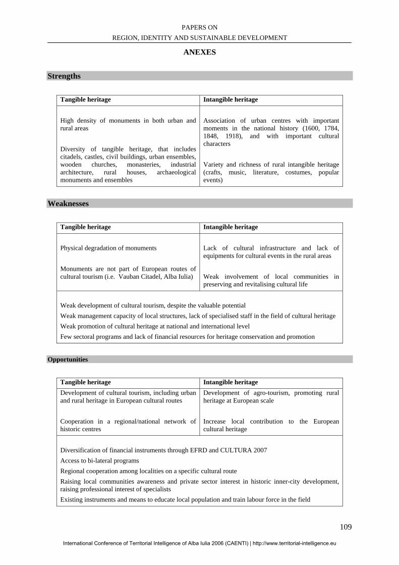
PAPERS ON REGION, IDENTITY AND SUSTAINABLE DEVELOPMENT
109
ANEXES Strengths
Tangible heritage Intangible heritage High density of monuments in both urban and rural areas Diversity of tangible heritage, that includes citadels, castles, civil buildings, urban ensembles, wooden churches, monasteries, industrial architecture, rural houses, archaeological monuments and ensembles
Association of urban centres with important moments in the national history (1600, 1784, 1848, 1918), and with important cultural characters Variety and richness of rural intangible heritage (crafts, music, literature, costumes, popular events)
Weaknesses
Tangible heritage Intangible heritage Physical degradation of monuments Monuments are not part of European routes of cultural tourism (i.e. Vauban Citadel, Alba Iulia)
Lack of cultural infrastructure and lack of equipments for cultural events in the rural areas Weak involvement of local communities in preserving and revitalising cultural life
Weak development of cultural tourism, despite the valuable potential Weak management capacity of local structures, lack of specialised staff in the field of cultural heritage Weak promotion of cultural heritage at national and international level Few sectoral programs and lack of financial resources for heritage conservation and promotion
Opportunities
Tangible heritage Intangible heritage Development of cultural tourism, including urban and rural heritage in European cultural routes Cooperation in a regional/national network of historic centres
Development of agro-tourism, promoting rural heritage at European scale Increase local contribution to the European cultural heritage
Diversification of financial instruments through EFRD and CULTURA 2007 Access to bi-lateral programs Regional cooperation among localities on a specific cultural route Raising local communities awareness and private sector interest in historic inner-city development, raising professional interest of specialists Existing instruments and means to educate local population and train labour force in the field
International Conference of Territorial Intelligence of Alba Iulia 2006 (CAENTI) | http://www.territorial-intelligence.eu
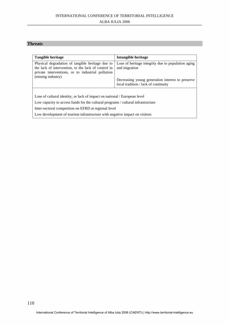
INTERNATIONAL CONFERENCE OF TERRITORIAL INTELLIGENCE ALBA IULIA 2006
110
Threats
Tangible heritage Intangible heritage Physical degradation of tangible heritage due to the lack of intervention, to the lack of control in private interventions, or to industrial pollution (mining industry)
Lose of heritage integrity due to population aging and migration Decreasing young generation interest to preserve local tradition / lack of continuity
Lose of cultural identity, or lack of impact on national / European level Low capacity to access funds for the cultural programs / cultural infrastructure Inter-sectoral competition on EFRD at regional level Low development of tourism infrastructure with negative impact on visitors
International Conference of Territorial Intelligence of Alba Iulia 2006 (CAENTI) | http://www.territorial-intelligence.eu
PAPERS ON REGION, IDENTITY AND SUSTAINABLE DEVELOPMENT
111
B – EMPLOYMENT AND TERRITORIAL DELIMITATION
This chapter includes the communications of the
Workshops 1.2 “Employment and territorial delimitation” and 1.3 “Other regions development”.
International Conference of Territorial Intelligence of Alba Iulia 2006 (CAENTI) | http://www.territorial-intelligence.eu

INTERNATIONAL CONFERENCE OF TERRITORIAL INTELLIGENCE ALBA IULIA 2006
112
International Conference of Territorial Intelligence of Alba Iulia 2006 (CAENTI) | http://www.territorial-intelligence.eu
PAPERS ON REGION, IDENTITY AND SUSTAINABLE DEVELOPMENT
113
GEOGRAPHICAL, HISTORICAL AND ADMINISTRATIVE BASIS OF
THE REGIONS OF HUNGARY
József TOTH Rector Emeritus, Director of the Institute of Geography, Faculty of Sciences
Zoltán WILHELM
Associate Professor, Director of the Asia Centre, Faculty of Sciences
Professional address RT TD&ICT : Research Team on Territorial Development & Information & Communication Technologies,
University of Pécs, Szanto K. J. u. 1/b – H-7633 PECS, Hungary.
Abstract: The professional and political debate on the superficial or in-depth reorganization and reform of Hungary 's administrative regions – which has been a constant feature on the agenda, albeit with varying levels of importance since the regime change of 1990 – has today been revived. The reforms carried out in Hungary during the part decade, although affecting area organization at many levels, have failed within the modified conditional system to provide a viable and comprehensive system.
International Conference of Territorial Intelligence of Alba Iulia 2006 (CAENTI) | http://www.territorial-intelligence.eu
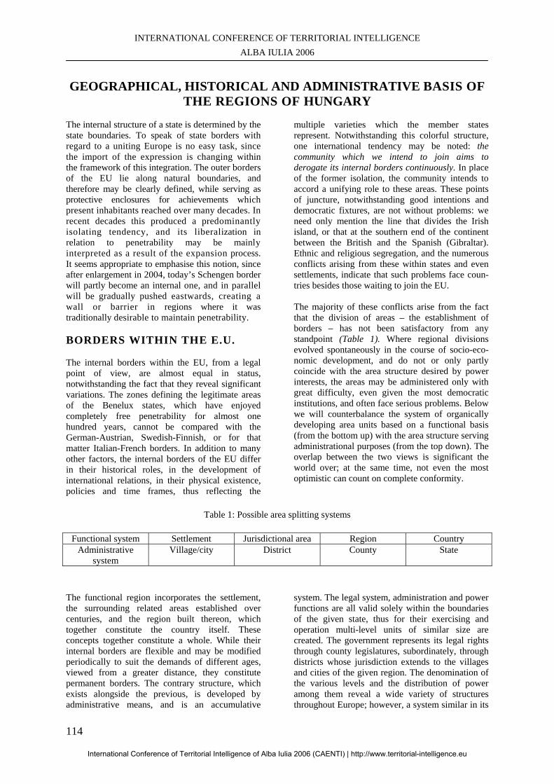
INTERNATIONAL CONFERENCE OF TERRITORIAL INTELLIGENCE ALBA IULIA 2006
114
GEOGRAPHICAL, HISTORICAL AND ADMINISTRATIVE BASIS OF
THE REGIONS OF HUNGARY The internal structure of a state is determined by the state boundaries. To speak of state borders with regard to a uniting Europe is no easy task, since the import of the expression is changing within the framework of this integration. The outer borders of the EU lie along natural boundaries, and therefore may be clearly defined, while serving as protective enclosures for achievements which present inhabitants reached over many decades. In recent decades this produced a predominantly isolating tendency, and its liberalization in relation to penetrability may be mainly interpreted as a result of the expansion process. It seems appropriate to emphasise this notion, since after enlargement in 2004, today’s Schengen border will partly become an internal one, and in parallel will be gradually pushed eastwards, creating a wall or barrier in regions where it was traditionally desirable to maintain penetrability. BORDERS WITHIN THE E.U. The internal borders within the EU, from a legal point of view, are almost equal in status, notwithstanding the fact that they reveal significant variations. The zones defining the legitimate areas of the Benelux states, which have enjoyed completely free penetrability for almost one hundred years, cannot be compared with the German-Austrian, Swedish-Finnish, or for that matter Italian-French borders. In addition to many other factors, the internal borders of the EU differ in their historical roles, in the development of international relations, in their physical existence, policies and time frames, thus reflecting the
multiple varieties which the member states represent. Notwithstanding this colorful structure, one international tendency may be noted: the community which we intend to join aims to derogate its internal borders continuously. In place of the former isolation, the community intends to accord a unifying role to these areas. These points of juncture, notwithstanding good intentions and democratic fixtures, are not without problems: we need only mention the line that divides the Irish island, or that at the southern end of the continent between the British and the Spanish (Gibraltar). Ethnic and religious segregation, and the numerous conflicts arising from these within states and even settlements, indicate that such problems face coun-tries besides those waiting to join the EU. The majority of these conflicts arise from the fact that the division of areas – the establishment of borders – has not been satisfactory from any standpoint (Table 1). Where regional divisions evolved spontaneously in the course of socio-eco-nomic development, and do not or only partly coincide with the area structure desired by power interests, the areas may be administered only with great difficulty, even given the most democratic institutions, and often face serious problems. Below we will counterbalance the system of organically developing area units based on a functional basis (from the bottom up) with the area structure serving administrational purposes (from the top down). The overlap between the two views is significant the world over; at the same time, not even the most optimistic can count on complete conformity.
Table 1: Possible area splitting systems
Functional system Settlement Jurisdictional area Region Country
Administrative system
Village/city District County State
The functional region incorporates the settlement, the surrounding related areas established over centuries, and the region built thereon, which together constitute the country itself. These concepts together constitute a whole. While their internal borders are flexible and may be modified periodically to suit the demands of different ages, viewed from a greater distance, they constitute permanent borders. The contrary structure, which exists alongside the previous, is developed by administrative means, and is an accumulative
system. The legal system, administration and power functions are all valid solely within the boundaries of the given state, thus for their exercising and operation multi-level units of similar size are created. The government represents its legal rights through county legislatures, subordinately, through districts whose jurisdiction extends to the villages and cities of the given region. The denomination of the various levels and the distribution of power among them reveal a wide variety of structures throughout Europe; however, a system similar in its
International Conference of Territorial Intelligence of Alba Iulia 2006 (CAENTI) | http://www.territorial-intelligence.eu
PAPERS ON REGION, IDENTITY AND SUSTAINABLE DEVELOPMENT
115
essentials can be found everywhere. Below, using the forming map of Europe, we will draw attention to the theoretical and practical differences between these two notions. The first line of argument is based on secular development. With the development of settlements came the need for some level of insurance that people could work, live and perform some activity within their own habitat. These activities acquired shape and were concentrated in specific institutions whose jurisdiction varied. This occurred because their existence, given the geographical circumstances and scope for utilization thereof, was based on the size of the habitation and the needs of the inhabitants, therefore on the functional construction. The settlement organizes itself into jurisdictional regions, the definition of which is quite broad within the given related literature. One thing is certain: long-term coexistence, traditions and a developed scale of shared values unite the people living therein; it also seems correct to say that a region is built up of jurisdictional regions, similar to building blocks. From these regions, between which belt-like areas of lower density may be found, a country is constructed, meaning the coexistence of many regions and their mutual cooperation. Switching to the other line of argument (the administrational system), we encounter the idea of building from the top downwards; that is, a state is created as a single administrational territory. In establishing area units, we divide the country area; the background to this notion is thus rather different. The other significant difference from the previous concept is that the constituent parts are surrounded by linear borders; that is, there is no single point of space which does not fall under some jurisdiction. The village is declared such by the competent agency, or by legal jurisdiction. This means that one settlement may be designated a village, another simply a populated outer region: if it is declared that this other is more developed, on the basis of some numerically defined aspect, then the settlement may be declared a town or city. The villages group together into a district, whose center, through an administrational system serving specified functions, will administer the settlements under its jurisdiction. We are able to provide similar examples in relation to both districts and counties. We should however be wary of doing so, at least for the moment. We may see from the above that each of the notions even in this manner produces pairs, but the question of the county and the region constitutes a lively point of debate in today's administrational reforms, and represents the issue between differing interests. Many who would not wish to recognize the differences between these two notions attempt to establish regions built up of counties. These units, in our
opinion, do not cover the regions actually established through economic processes, whose establishment would not be worth expending energy on. The real regions already exist: through our everyday use of our surroundings we have already brought them about. We should expose them and on them construct the municipal system. This may be achieved in parallel with the counties, but it would be more appropriate to replace the counties with the newly developed regions. However, their development is a serious problem, since our electoral system is based on the counties, and would never permit a situation whereby the victorious political power destroyed the basis of its own victory, on which its legitimacy is founded. In order to create the optimal situation, most probably the present four-year cycle stipulated by the present legal system is insufficient for the effective operation of the government. A longer time-span is required to deal with the problem of how we may move forward, and by what method we can establish and shape a new (geo-)political background. The state is made up of counties, or more precisely, the state area is administratively divided into counties. The country is the outcome of an objective evolutional process, while the state is the product of a general principle operating in the world, and not an area which is the natural outcome of social and economic processes. A state border is established by permanent or temporary force and power relations; the question of forms created by socio-economic arrangements does not arise. In a broader interpretation of the above as regards our whole continent, we may assert that despite the possibility of lower hierarchy level categorizations, Europe can be divided into states and countries. We are able to do this once we have defined the continent. This in itself is not a simple task, since its political (country-based) and geographical boundaries significantly differ. From a state point of view Europe is present in Africa (e.g. Keota), America (e.g. French Guyana) and Asia (e.g. Turkey). The phrase “Europe of Nations” has appeared periodically in the presentational materials of the integration process; whether actually nation-states or not, the materials certainly refer to the states of Europe. It is sufficient to refer simply to the “nation of Belgium”, which as a state is one, though its citizens are strongly attached to more than one nation along linguistic, cultural and other lines. Considered thus, and including even the smallest, there are at least 50 nations in our continent, all significantly different. One need to think only of the 0.44 km2 Vatican, or of Russia stretching far beyond the confines of Europe.
International Conference of Territorial Intelligence of Alba Iulia 2006 (CAENTI) | http://www.territorial-intelligence.eu
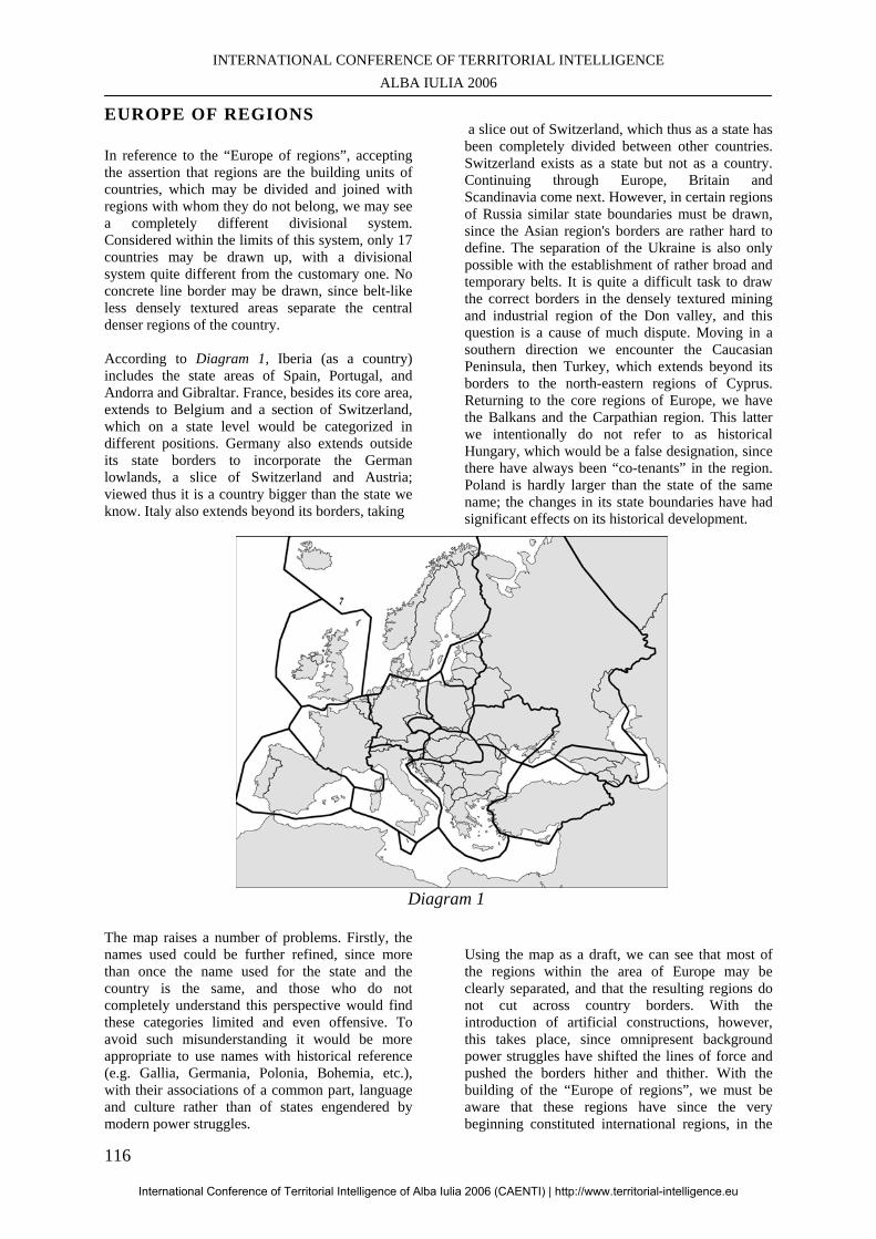
INTERNATIONAL CONFERENCE OF TERRITORIAL INTELLIGENCE ALBA IULIA 2006
116
EUROPE OF REGIONS In reference to the “Europe of regions”, accepting the assertion that regions are the building units of countries, which may be divided and joined with regions with whom they do not belong, we may see a completely different divisional system. Considered within the limits of this system, only 17 countries may be drawn up, with a divisional system quite different from the customary one. No concrete line border may be drawn, since belt-like less densely textured areas separate the central denser regions of the country. According to Diagram 1, Iberia (as a country) includes the state areas of Spain, Portugal, and Andorra and Gibraltar. France, besides its core area, extends to Belgium and a section of Switzerland, which on a state level would be categorized in different positions. Germany also extends outside its state borders to incorporate the German lowlands, a slice of Switzerland and Austria; viewed thus it is a country bigger than the state we know. Italy also extends beyond its borders, taking
a slice out of Switzerland, which thus as a state has been completely divided between other countries. Switzerland exists as a state but not as a country. Continuing through Europe, Britain and Scandinavia come next. However, in certain regions of Russia similar state boundaries must be drawn, since the Asian region's borders are rather hard to define. The separation of the Ukraine is also only possible with the establishment of rather broad and temporary belts. It is quite a difficult task to draw the correct borders in the densely textured mining and industrial region of the Don valley, and this question is a cause of much dispute. Moving in a southern direction we encounter the Caucasian Peninsula, then Turkey, which extends beyond its borders to the north-eastern regions of Cyprus. Returning to the core regions of Europe, we have the Balkans and the Carpathian region. This latter we intentionally do not refer to as historical Hungary, which would be a false designation, since there have always been “co-tenants” in the region. Poland is hardly larger than the state of the same name; the changes in its state boundaries have had significant effects on its historical development.
Diagram 1
The map raises a number of problems. Firstly, the names used could be further refined, since more than once the name used for the state and the country is the same, and those who do not completely understand this perspective would find these categories limited and even offensive. To avoid such misunderstanding it would be more appropriate to use names with historical reference (e.g. Gallia, Germania, Polonia, Bohemia, etc.), with their associations of a common part, language and culture rather than of states engendered by modern power struggles.
Using the map as a draft, we can see that most of the regions within the area of Europe may be clearly separated, and that the resulting regions do not cut across country borders. With the introduction of artificial constructions, however, this takes place, since omnipresent background power struggles have shifted the lines of force and pushed the borders hither and thither. With the building of the “Europe of regions”, we must be aware that these regions have since the very beginning constituted international regions, in the
International Conference of Territorial Intelligence of Alba Iulia 2006 (CAENTI) | http://www.territorial-intelligence.eu
PAPERS ON REGION, IDENTITY AND SUSTAINABLE DEVELOPMENT
117
political, geographical and state-geological meaning of the term. In reality, confrontation occurred in quite the opposite way, but since the power structure is built upon territory units surrounded by country borders, the viewpoint may be interpreted in this manner. Natural regional cooperation, which can also be international, means cooperation built on an original organic economic and territorial placement basis. At the same time, this also means that state power continues its influence through state institutions. We can say only theoretically that we should reorganize Europe into a Europe of countries, if in fact we are speaking of a Europe of regions. We are aware of the fact that such regional cooperation must be coordinated at state level. Where the state is sovereign, in the original meaning of the word, it does not actually allow its interests to be infringed, therefore in regional interaction dispute tends to replace cooperation. In favorable situations the state is willing to renounce a portion of its sovereignty when obliged to do so, since the other side offers favorable advantages, which are the regular attributions of regional cooperation, despite the fact that these entail a number of inter-state agreements and compromises. In an examination of the internal borders and arrangements of states, one of the most critical areas is the Balkans, where a high level of differentiation may be seen in the appearance of the given countries. Diagram 1 refers to the critical point of splitting, and has a scientific importance, which merits further attention. The drawing of borders is not clearcut even within the most peaceful regions of Europe. We are unable to decide for instance what should be done with the Czech Republic: all experiments which attempted PolishCzech construction, including the statelevel implemented Czechoslovakia, were built on weak foundations. According to Gyula Prinz, whose statecountry dichotomy is used as a starting point for presentday study, Czechoslovakia is the greatest absurdity in state geography. The situation is similar in the region of the Baltic states, some of which are too small to be considered separate countries; however, to arrive at a decision on the issue we should conduct indepth research into area organization of state constitutions. Circumstances are similar in Slovenia, a country which probably owes its good fortune to its switchplate role. We may apply this expression to all regions of Europe whose affiliation is unclear. In previous constellations this could be considered a disadvantage, but in the integrating Europe a switchplate position has acquired much greater importance as a potentially exploitable bridge; thus accession of these regions to the EU within the near future may be understood in this manner.
In presenting these ideas we aim solely to shed light on the problem raised by borders within Europe, the frequently strange, complex and very complicated appearance of the muchused idea which we must take into account on the eve of our accession to the European Union. Our place of residence may be interpreted within a certain area (Europe), one half of which possesses more developed democratic traditions and institutional systems which we must soon officially adopt. While we will not separate from or leave the area which constitutes the Carpathian Basin, the new circumstances imply several types of border. Our Schengen border is the result of natural surroundings, historical events and conjoining rights. This must be handled in such a way that we are able to ensure the greatest possible level of advantage created by regional cooperation, for not only ourselves but on a reciprocal basis, for our partners as well, while respecting every state and EU border. We will have to maintain, develop and coordinate our relational systems in such a way that we derive advantage from the whole process, from the temporary system to be established and hopefully in the longer term from the system of a united Europe.
JUSTIFICATION OF REGIONAL EXAMINATIONS Regional examinations are determined in time. They may only be interpreted from the point when the development process of productive power has reached a phase whereby – in accordance with the viewpoint of workforce areabased distribution – such regions separate from one another as have a particular developmental curve, structure, and future, and which therefore also have developmental problems. Viewed thus these area regions possess a certain cohesion: their texture at the core territory is denser, lessening towards the periphery; they exist in the minds of the population as entities, and have certain complexities. In examining Hungary's regional structure, we will be obliged to open on both a time and space level in comparison to the present situation, since today's state area is an artificial area unit whose historical and economic roots may be found in the part, and lead us back to the historical Hungary. Eastern Central Europe started to approach this phase of regional development in the second half of the 1 9th century. The relationship between separate regions is based on whether, as a result of specialization due to division, product and activity exchange occurs not only between the separate branches but between areas embodying territorial allocations (regions). The relationship between independent zones occurs
International Conference of Territorial Intelligence of Alba Iulia 2006 (CAENTI) | http://www.territorial-intelligence.eu

INTERNATIONAL CONFERENCE OF TERRITORIAL INTELLIGENCE ALBA IULIA 2006
118
during the preceding phase of the development of productive forces, but we can also speak of definitive interregional relations. This can only be considered a reality in Eastern Central Europe since the end of the nineteenth century. In our opinion the regions of a country may be interpreted according to the configuration of the secular socio-economic development of the regions, their area structure, and the changes in the texture thereof, the peripheral borders being also the borders of the country itself. Their existence is not influenced by the fact that the international power setup at times cuts across their fixative borders, therefore even unintentionally they drive together regional portions with different development timeframes, i.e. different territorial organizational systems. At the same time we consider it natural that the operation areas which may be called international regions existing in such a situation are influenced mainly by the social and economic circumstances of the given state, and furthermore by how the political intention as to cooperation develops between them. The objective cooperation which comes about due to the development of intra- and inter-regional productive forces is therefore a question loaded with political issues, which political instruments may for a time have hindered, but which may also effectively help. Today, based on analysis of the experience of the western part of our continent, encouragement of intra- and inter-regional cooperation independent of state borders is becoming ever more timely within the Eastern Central European region. The fact that all of the states within this region wish to become members of the European Union, and must therefore follow its system of norms, including hierarchical and cooperative order, cannot be said to influence positively the intentions, which may hardly be called unified, existing in each of the states. HISTORICAL BASIS OF DEVELOPMENT When examining the history of the Carpathian Basin, we find many instances of segregation between its entities, which were effective for longer and shorter periods. Interestingly, none of these was built on obvious natural area differences: their occurrence was merely exceptional, occasional, and in most cases partial and temporary. From a purely superficial examination of these periods characterized by segregation, it is clear that in almost all cases military-political reasons lay behind them, thus they cannot be considered as forerunners of regional developments or the development of the regional process. The secular development processes which split the Carpathian Basin into regions were not felt, and its unity was beyond question. The strongest basis for
this, based also on natural circumstance, was the state unity of the historical Hungary, which was reestablished for the modern age within the framework of the Austro-Hungarian Empire, with the 1867 Hungarian-Austrian Agreement. Despite the fact that Croatia possessed political autonomy from 1868 and that Transylvania also enjoyed a degree of autonomy, Hungary could be considered an entity. A clear consequence of this, from another viewpoint, was that the basis for further development was an integrated railway system. The density of this decreased towards the outer regions; it was only in the direction of Austria that a transition showing unified development could be seen through a dense network system.
A similarly unified picture can be seen in the settlement system of the Carpathian Basin. This unity should be emphasized despite the fact that in many cases it was achieved through not insignificant deviations (farms, small villages, mining cities, agricultural cities). With the commencement and reinforcement of the urban-ization process, this unity was increasingly the trend, hierarchical relations began to stabilize, as did the typical configuration of the settlement system. Within this system the centers with the highest hierarchy system were the integrated centers encircling Budapest, which had become a metropolis. In the capitalized historical Hungary at the end of the 19th century and the beginning of the 20th, the outlines of core regions of regional development emerged, and certain regional points may be isolated from which, in the event of undisturbed development, definitive regions could have developed. Among these could be found broader and narrower zones, many-sided and with less intensive relation-systems and lower density, whose “jurisdiction” would be decided on subsequently. In our opinion there were nine such region developments within the territory of Hungary after the turn of the century. To summarize: the Hungary which existed prior to the First World War, filling the entire Carpathian Basin, could be divided into regional developments with varying levels of maturity; however, these could not yet be deemed definitive regions. THE INTER-WAR PERIOD Following the political reorganization after the First World War, the Carpathian Basin contained many state borders. In certain cases these split regional developments (sometimes into many pieces), while making inter-regional relations impossible. The fact that the Central European region, incorporating the Carpathian region, was “fragmented” became a
International Conference of Territorial Intelligence of Alba Iulia 2006 (CAENTI) | http://www.territorial-intelligence.eu
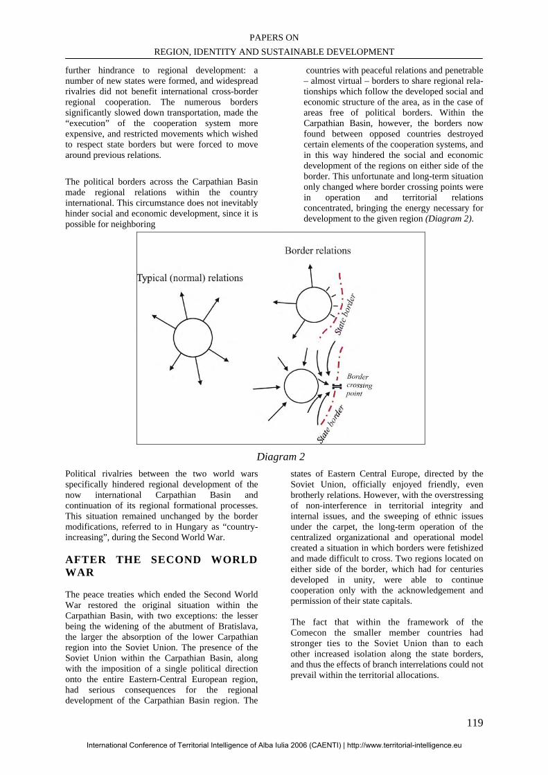
PAPERS ON REGION, IDENTITY AND SUSTAINABLE DEVELOPMENT
119
further hindrance to regional development: a number of new states were formed, and widespread rivalries did not benefit international cross-border regional cooperation. The numerous borders significantly slowed down transportation, made the “execution” of the cooperation system more expensive, and restricted movements which wished to respect state borders but were forced to move around previous relations.
The political borders across the Carpathian Basin made regional relations within the country international. This circumstance does not inevitably hinder social and economic development, since it is possible for neighboring
countries with peaceful relations and penetrable – almost virtual – borders to share regional rela-tionships which follow the developed social and economic structure of the area, as in the case of areas free of political borders. Within the Carpathian Basin, however, the borders now found between opposed countries destroyed certain elements of the cooperation systems, and in this way hindered the social and economic development of the regions on either side of the border. This unfortunate and long-term situation only changed where border crossing points were in operation and territorial relations concentrated, bringing the energy necessary for development to the given region (Diagram 2).
Diagram 2
Political rivalries between the two world wars specifically hindered regional development of the now international Carpathian Basin and continuation of its regional formational processes. This situation remained unchanged by the border modifications, referred to in Hungary as “country-increasing”, during the Second World War.
AFTER THE SECOND WORLD WAR The peace treaties which ended the Second World War restored the original situation within the Carpathian Basin, with two exceptions: the lesser being the widening of the abutment of Bratislava, the larger the absorption of the lower Carpathian region into the Soviet Union. The presence of the Soviet Union within the Carpathian Basin, along with the imposition of a single political direction onto the entire Eastern-Central European region, had serious consequences for the regional development of the Carpathian Basin region. The
states of Eastern Central Europe, directed by the Soviet Union, officially enjoyed friendly, even brotherly relations. However, with the overstressing of non-interference in territorial integrity and internal issues, and the sweeping of ethnic issues under the carpet, the long-term operation of the centralized organizational and operational model created a situation in which borders were fetishized and made difficult to cross. Two regions located on either side of the border, which had for centuries developed in unity, were able to continue cooperation only with the acknowledgement and permission of their state capitals. The fact that within the framework of the Comecon the smaller member countries had stronger ties to the Soviet Union than to each other increased isolation along the state borders, and thus the effects of branch interrelations could not prevail within the territorial allocations.
International Conference of Territorial Intelligence of Alba Iulia 2006 (CAENTI) | http://www.territorial-intelligence.eu
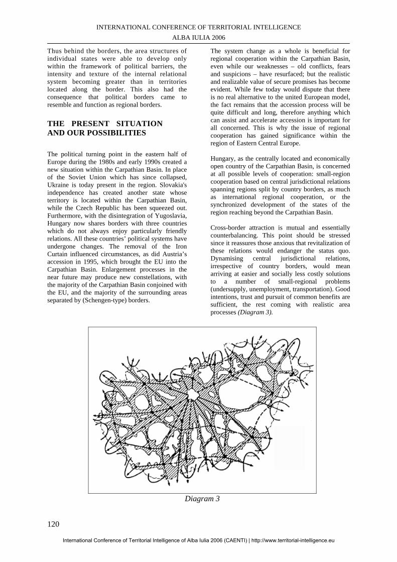
INTERNATIONAL CONFERENCE OF TERRITORIAL INTELLIGENCE ALBA IULIA 2006
120
Thus behind the borders, the area structures of individual states were able to develop only within the framework of political barriers, the intensity and texture of the internal relational system becoming greater than in territories located along the border. This also had the consequence that political borders came to resemble and function as regional borders.
THE PRESENT SITUATION AND OUR POSSIBILITIES The political turning point in the eastern half of Europe during the 1980s and early 1990s created a new situation within the Carpathian Basin. In place of the Soviet Union which has since collapsed, Ukraine is today present in the region. Slovakia's independence has created another state whose territory is located within the Carpathian Basin, while the Czech Republic has been squeezed out. Furthermore, with the disintegration of Yugoslavia, Hungary now shares borders with three countries which do not always enjoy particularly friendly relations. All these countries’ political systems have undergone changes. The removal of the Iron Curtain influenced circumstances, as did Austria’s accession in 1995, which brought the EU into the Carpathian Basin. Enlargement processes in the near future may produce new constellations, with the majority of the Carpathian Basin conjoined with the EU, and the majority of the surrounding areas separated by (Schengen-type) borders.
The system change as a whole is beneficial for regional cooperation within the Carpathian Basin, even while our weaknesses – old conflicts, fears and suspicions – have resurfaced; but the realistic and realizable value of secure promises has become evident. While few today would dispute that there is no real alternative to the united European model, the fact remains that the accession process will be quite difficult and long, therefore anything which can assist and accelerate accession is important for all concerned. This is why the issue of regional cooperation has gained significance within the region of Eastern Central Europe. Hungary, as the centrally located and economically open country of the Carpathian Basin, is concerned at all possible levels of cooperation: small-region cooperation based on central jurisdictional relations spanning regions split by country borders, as much as international regional cooperation, or the synchronized development of the states of the region reaching beyond the Carpathian Basin. Cross-border attraction is mutual and essentially counterbalancing. This point should be stressed since it reassures those anxious that revitalization of these relations would endanger the status quo. Dynamising central jurisdictional relations, irrespective of country borders, would mean arriving at easier and socially less costly solutions to a number of small-regional problems (undersupply, unemployment, transportation). Good intentions, trust and pursuit of common benefits are sufficient, the rest coming with realistic area processes (Diagram 3).
Diagram 3
International Conference of Territorial Intelligence of Alba Iulia 2006 (CAENTI) | http://www.territorial-intelligence.eu
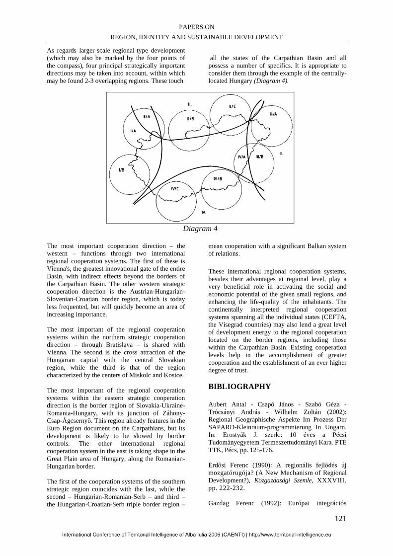
PAPERS ON REGION, IDENTITY AND SUSTAINABLE DEVELOPMENT
121
As regards larger-scale regional-type development (which may also be marked by the four points of the compass), four principal strategically important directions may be taken into account, within which may be found 2-3 overlapping regions. These touch
all the states of the Carpathian Basin and all possess a number of specifics. It is appropriate to consider them through the example of the centrally-located Hungary (Diagram 4).
Diagram 4
The most important cooperation direction – the western – functions through two international regional cooperation systems. The first of these is Vienna's, the greatest innovational gate of the entire Basin, with indirect effects beyond the borders of the Carpathian Basin. The other western strategic cooperation direction is the Austrian-Hungarian-Slovenian-Croatian border region, which is today less frequented, but will quickly become an area of increasing importance. The most important of the regional cooperation systems within the northern strategic cooperation direction – through Bratislava – is shared with Vienna. The second is the cross attraction of the Hungarian capital with the central Slovakian region, while the third is that of the region characterized by the centers of Miskolc and Kosice. The most important of the regional cooperation systems within the eastern strategic cooperation direction is the border region of Slovakia-Ukraine-Romania-Hungary, with its junction of Záhony-Csap-Ágcsernyő. This region already features in the Euro Region document on the Carpathians, but its development is likely to be slowed by border controls. The other international regional cooperation system in the east is taking shape in the Great Plain area of Hungary, along the Romanian-Hungarian border. The first of the cooperation systems of the southern strategic region coincides with the last, while the second – Hungarian-Romanian-Serb – and third – the Hungarian-Croatian-Serb triple border region –
mean cooperation with a significant Balkan system of relations. These international regional cooperation systems, besides their advantages at regional level, play a very beneficial role in activating the social and economic potential of the given small regions, and enhancing the life-quality of the inhabitants. The continentally interpreted regional cooperation systems spanning all the individual states (CEFTA, the Visegrad countries) may also lend a great level of development energy to the regional cooperation located on the border regions, including those within the Carpathian Basin. Existing cooperation levels help in the accomplishment of greater cooperation and the establishment of an ever higher degree of trust.
BIBLIOGRAPHY
Aubert Antal - Csapó János - Szabó Géza - Trócsányi András - Wilhelm Zoltán (2002): Regional Geographische Aspekte Im Prozess Der SAPARD-Kleinraum-programmierung In Ungarn. In: Erostyák J. szerk.: 10 éves a Pécsi Tudományegyetem Természettudományi Kara. PTE TTK, Pécs, pp. 125-176. Erdősi Ferenc (1990): A regionális fejlődés új mozgatórugója? (A New Mechanism of Regional Development?), Közgazdasági Szemle, XXXVIII. pp. 222-232. Gazdag Ferenc (1992): Európai integrációs
International Conference of Territorial Intelligence of Alba Iulia 2006 (CAENTI) | http://www.territorial-intelligence.eu
INTERNATIONAL CONFERENCE OF TERRITORIAL INTELLIGENCE ALBA IULIA 2006
122
intézmények. (Integrational Organisations in Europe), KJK, Budapest. p. 235. Golobics Pál (1994): A nemzetközi regionális együttműködés közigazgatási vonatkozásai. (Regional Cooperation and State Administration), In: Tóth József-Mátrai M.. (szerk.): A középszintű közigazgatás reformja Magyarországon. 2. kötet. Székesfehérvár-Pécs. pp. 39-43. Golobics Pál (1995): A határmenti térségek városainak szerepe a regionális együttműködésben. (Role of Cities of Boreder Regions in Regional Cooperation), Közlemények a JPTE Általános Társadalomföldrajzi és Urbanisztikai Tanszékéról., 3. sz. Pécs. p. 33 Golobics, P. -Tóth, J. (1996): Ekonomicseszkij roszt - mezsdunarodnoje szotrudnyicsesztvo (Vengrija na poroge xxi-vo veka). Ulan bator, Mongolia. p. 20. Guerit, F. - Kampis, B. - Trócsányi, A. (2002): Espace perimetropolitain, decentralisation et developpement regional: les ambiguites de la transition hongroise. In: Mirloup, J. (ed.): Regions perimetropolitaines et metropolisation. Presses universitaires orleans. pp. 139-160. Horváth Gyula (1992): Az európai integráció és területi együttműködések hatása a piacgaz-daságok regionális politikájára. (Effect of European Integration and Territorial Co-operations on the Regional Policy of Market Economies), Tér és társadalom 4., pp. 51-68. Horváth Gyula (1992): A közép-európai inte-grációk gazdasági indikátorai. (Economic Indicators of Integrations in Central Europe), MTA RKK, Pécs. (manuscript). Inotai András (1994): Az új regionalizmus a világgazdaságban. (The New Regionalism in the World Economy), Külgazdaság, 1. sz. pp. 28-44. Pap Norbert (1998): A földrajzi régió fogalom manipulálásának lehetőségei. (Possible Manipulations of the Meaning of Economic Region), In: Tóth József - Pap Norbert. (szerk.): Regionális térszerkezet a Kárpátmedencében. JPTE Földrajzi intézet, Pécs. pp. 1-7. Perczel György - Tóth József (szerk.) (1994):
Magyarország társadalmi-gazdasági földrajza. (Hungary's Socio-economic Geography), ELTE, Eötvös kiadó, Budapest. p. 462. Süli-Zakar István (1994): Regionalizmus és régió. (Regionalism and Regions), In: Tóth József - Mátrai M. (szerk.): A középszintű közigazgatás reformja Magyarországon. 2. kötet. Székesfehérvár-Pécs. pp. 14-22.
Tésits Róbert - Wilhelm Zoltán (1997): Possibilities Of Regional Development In The Case Of A Municipal Association. In: Geography Within The Context Of Contemporary Development, Babes-Bolyai University Of Cluj-Napoca, Faculty of Geography, Cluj-Napoca, pp. 45-58.
Tóth József (1992): Magyarország illeszkedése a régiók Európájába. (Hungary's Adjustment into the Europe of Regions), MTA RKK, Pécs. (manuscript) Tóth József - Golobics Pál (1996): Spatial and Environmental Problems of Border Regions in East-central Europe. Paper for international conference on environment, planning and land use. Keele, United Kingdom. p. 16. Tóth József - Trócsányi András - Wilhelm Zoltán (1996): Regions and Interregional Relationship in the Carpathian-basin. In: Drozg, V. (ed.): New Directions in Regional Development. Maribor. pp. 21-36. Trócsányi András - Wilhelm Zoltán (1997): Regional Differences in Hungary. Eurogeo, no. 8. Utrecht, Netherlands, pp. 79-80. Trócsányi András - Wilhelm Zoltán (1999): Süd-Transdanubien Als Eine Mögliche Version Des Multikulturellen Models. In: Aubert A.-Miszler M. (Herausgeber): Globalisation-Regionalisation/Regionalismus, JPU, Institut Für Geographie, Pécs, pp. 37-48.
Wilhelm Zoltán - Cserti Csapó Tibor (1996): The Impact Of Political Factors On Environmental Condition In Regions Of The Southern Border in Hungary. in: Koter, M.-Heffner, C. (ed.): Borderlands or Transborder Regions - Geographical, Social and Political Problems, Region and Regionalism Nr. 3., University of Lódz Silesian Institut in Opole-Lodz, pp. 116-123.
International Conference of Territorial Intelligence of Alba Iulia 2006 (CAENTI) | http://www.territorial-intelligence.eu
PAPERS ON REGION, IDENTITY AND SUSTAINABLE DEVELOPMENT
123
ARE LOCAL LABOUR MARKETS SUITABLE SPACE UNITS IN ORDER TO DEFINE SUSTAINABLE TERRITORIAL DEVELOPMENT
STRATEGIES?
Blanca MIEDES UGARTE Associated Professor of Labour Economics
[email protected], Tél: + 34 6 55 44 78 41
Celia SANCHEZ LOPEZ Assistant Professor of Labour Economics [email protected], Tél: + 34 9 59 21 95 25
Antonio MORENO MORENO Researcher on Computer Sciences at OLE [email protected], Tél: + 34 9 59 21 94 55
Germán PEREZ MORALES Assistant Professor of Statistics
[email protected], Tél: + 34 9 59 21 94 15
Profesional Address Observatorio Local del Empleo – Universidad de Huelva
Avda. Fuerzas Armadas s/n. Campus de « El Carmen » PB7 S-21071 HUELVA, Spain.
Facultad de Ciencias del Trabajo -Universidad de Huelva
Avda. Fuerzas Armadas s/n. Campus de « El Carmen » S-21071 HUELVA, Spain.
Facultad de Ciencias Empresariales -Universidad de Huelva
Plaza de la Merced, 11 S-21071 HUELVA, Spain.
Abstract : Social scientists from several disciplinary fields long agree that local labour markets can be defined as spaces of daily population mobility due to labour reasons (Combes 1986; Eurostat, 1992; Casado Díaz, 1991). The question we address in this paper is whether these spaces are not only useful for territorial management of employment policy, but also suitable territorial units in conceptualizing wider multidimensional politics that can facilitate sustainable territorial development. Resumen : Una amplia tradición de científicos sociales de varios campos disciplinares están de acuerdo en definir los mercados de trabajo locales como espacios de movilidad diaria de la población por motivos de trabajo (Combes 1986; Eurostat, 1992; Casado Díaz, 1991). La cuestión que se plantea en esta comunicación es si estos espacios además de ser útiles para la gestión territorial de las políticas de empleo pueden resultar unidades territoriales adecuadas para la concepción de políticas multidimensionales más amplias promotoras del desarrollo sostenible de los territorios que delimitan. Keywords:: Travel to work areas, Local labour market, Territorial development, Territorial governance. Palabras clave: Areas de movilidad residencia-trabajo, Mercado de trabajo local, Desarrollo territorial, Gobernanza territorial.
International Conference of Territorial Intelligence of Alba Iulia 2006 (CAENTI) | http://www.territorial-intelligence.eu
INTERNATIONAL CONFERENCE OF TERRITORIAL INTELLIGENCE ALBA IULIA 2006
124
ARE LOCAL LABOUR MARKETS SUITABLE SPACE UNITS IN
ORDER TO DEFINE SUSTAINABLE TERRITORIAL DEVELOPMENT STRATEGIES?
INTRODUCTION One of the questions outlined in this International Conference of CAENTI (Coordination Action of the European Network of Territorial Intelligence) is whether regions are appropriate spaces for promoting and managing sustainable development policies. Given the important role that labour market performance plays in economic and social development, we have taken the liberty of rephrasing the question, changing the term region to subregional demarcation that takes local labour markets as a point of reference, such as the British Travel to Work Areas (TWAs) (Combes, 1986). Analysis of commuting areas (TWAs) is a broadly used method for the demarcation of local labour markets (Combes 1986; Eurostat, 1992; Casado Díaz, 1991). These spaces of mobility are the result of the interaction of multiple aspects: natural factors (especially the orography), socioeconomic factors (type of local productive activity in connection with human capital characteristics in each area, dwelling availability and housing market, and availability of services and public and private infrastructures such as transportation, schools, nurseries, health services, etc.), and even cultural factors such as those determining labour mobilization and the population's learning patterns. Therefore, “local labour markets” delimitation has been proven to be very useful in planning several issues related to the economic and social development, particularly in urban environments such as transportation policies, urbanism and public services supply. The question we address in this paper is whether these spaces are not only useful for territorial management of employment policy, but also suitable territorial units in conceptualizing wider multidimensional politics that can facilitate territorial sustainable development. In other words, are these local labour markets suitable space units to define sustainable territorial development strategies? What are main advantages and disadvantages of using this delimitation for this
purpose? And finally, do the notions of the territorial unit for diagnosis and the territorial unit for action overlap? That is, is the use of these space units useful in the benefit of territorial governance? We consider that the only attempt of answering these questions can be worthwhile in analysing the pertinence of regional delimitations of diverse scales and nature. Therefore a better comprehension of the commuting areas configuration should enhance the understanding and promotion of sustainable development. Obviously the responses will be conditioned, on the one hand, by the departing notion of sustainable development, and, on the other hand, by the role that is conferred to the labour market in the economic and social development process. We will discuss these aspects in section 2, where the territorial dimension of both aspects will be introduced. The advantages and disadvantages of the use of this territorial demarcation will be summarized in section 3. The discussion will be illustrated with the results of an empirical study developed by the Local Observatory of Employment (LOE) of Huelva University about the specific labour market regionalization of the province of Huelva (Spain).
1. SUSTAINABLE TERRITORIAL DEVELOPMENT, LABOUR MARKET AND THE TERRITORIAL DIMENSION Sustainable territorial development We will first outline the concept of sustainable development that this paper focuses on. This is an approach based on several works from the field of Economic Development, from authors such as José Luís Sampedro (Sampredo & Martínez-Cortiña, 1975), Françoi Perroux (1984) and Albert O. Hirschman (Meldolesi, 1997). It is also based on the valuable contributions to the concept of Human Development of Amartya Sen (Sen 1993, Nussbaum & Sen 1993). Lastly, it is influenced by the different international reports about the economic growth limits.
International Conference of Territorial Intelligence of Alba Iulia 2006 (CAENTI) | http://www.territorial-intelligence.eu
PAPERS ON REGION, IDENTITY AND SUSTAINABLE DEVELOPMENT
125
It is a conception based on specific ethical premises that, according to Anad & Sen (1994), can be summarized as follows: First, it refers to human sustainable development. This implies an anthropocentric view that provides a crucial role for the generation of vital opportunities so that human beings lead life worth living. The objective is not only for people to have more and better options in life, but also for people to have more freedom to choose among those options. Second, this is a universalistic conception that postulates concrete and limited human needs with a non-historic nature, detached from relativism in culture, class, gender, race, community and generation. It is referring to the latter that the reference to the sustainability makes sense. Therefore, this is a conception that emphasizes the redistributive aspects of development, both intragenerational and intergenerational. The external limit of this development comes from the sustainable capability of earth. “The sustainable capability of a particular territory is defined from an environmental point of view, and for a specific species, as the largest population in that specific species that can be supported indefinitely, without degradation in the resources that could mean a reduction in population in the future”. When this definition is applied to the human species, two relevant aspects are introduced (Asensio, 2004: 11): a) Environmental degradation not only could be the result of the pressure of the population, but also the pressure of production, particularly when the latter is led to export. This gives a relevant role to both the technology that has been used as well as the social organization and institutional framework in which the productive processes have been developed. b) As the pressure created by different human groups are not equal, the sustainable capability would only make sense when it refers to the entire planet (that is to say it would not be relevant if the majority lived according to limits and a small group had enormous destructive power). Would this mean that the only territorial delimitation that could study and analyze all the aspects affecting sustainable development be our planet? Ultimately, the answer would be ‘yes,’ because needs are universal and the boundaries are global. However, the organization of human action reveals a noteworthy local structuration which valorises this space as a sphere for planning,
decision making and actions in regard to sustainable development. Furthermore, sustainability within this approach is placed in the means, in the “satisfactors” of human needs, but it is not in the needs themselves. This way, some of the limits could be avoided when “dematerialization” of these “satisfactors” is achieved. That is, as the means with which we satisfy our needs are replaced with other means which make less-intensive use of energy and other natural resources, and with a smaller level of production of non-biodegradable waste. It is in this very last point that the local dimension reaches greater relevance, as the dematerialization is a matter of great complexity which extends to some technical aspects, and which involves processes of social agreement (social dialogue and consultation involving several economic and social private actors and the administration) based on systems of incentives and sanctions which would eventually help to obtain this goal for every circumstance. Considering the enormous differences observed in the different human groups on a planetary scale, these agreements processes could only take place on a local level. The processes themselves would depend on how needs for the human groups involved are covered, on the production characteristics at the local level as well as on the particular institutional framework that would determine potential agreements. The agreements at the local level should be coordinated with those that take place using a global framework on a planetary scale. The last ones are crucial, but also inefficient without the first ones. All the above, from our point of view, gives full meaning to the term sustainable territorial development. Sustainability is a matter that can and must be dealt with at a local level, but can it be also used with any territorial demarcation? Is there any type of spatial demarcation that can or must be granted a privilege at a local level? We think that the spatial demarcations that fit the local labour markets (TWA) could be considered good candidates to work in this area, although they also present some limitations. We will present our arguments in section 3, but before that, we will discuss the role of the labour market on the dynamic generations of sustainable development. We will also discuss some other general ideas related to the territorial aspect of the labour market.
International Conference of Territorial Intelligence of Alba Iulia 2006 (CAENTI) | http://www.territorial-intelligence.eu
INTERNATIONAL CONFERENCE OF TERRITORIAL INTELLIGENCE ALBA IULIA 2006
126
Labour market as the cornerstone of economic, social and environmental sustainability In the most traditional notion of the term, a labour market consists of the exchange of labour for a sum of money or goods between workers who possess specific qualifications (supply) and employers, usually a business, but also the State or families who would like to cover a job or position (demand). However, the labour market is not just any market, but rather behaves like a social institution (Solow, 1992), comprising a set of socio-economic institutions that shape the characteristics of the supply and demand as well as how they both interact with each other. Among the institutions that influence the structure of the supply are the family, the educational and training systems, and the systems of predominant values of a given society. Among the more relevant institutions that shape labour demand, we could mention the different ways of organizing production and the different ways of managing human resources by business in general. On the other hand, employment policy, labour legislation, different forms of collective bargaining, and the mechanisms for social agreement are the most relevant institutions responsible for regulating the interaction between the labour supply and the labour demand. At the same time, the fact that most people will earn their income from their participation in the labour market gives the labour market a very essential role within the economic and social organization systems, particularly regarding distribution. As a matter of fact, most of the worldwide population makes a living from their labour (although often just barely, as the 2005 ILO report reminds us). The participation in the labour market – either as an employee or entrepreneur, in a formal or informal manner – is the very common way of “making a living”. This explains the fact that most current systems of social protection have stemmed from the labour market and thus, legal contracts have incorporated no economical aspects that have not been strictly demanded by the market (Castel, 1998:406). This way, labour income and those rights linked to labour participation are within the core of people’s
ability “to live lives that are worth living”33. On the one hand, the intensity and manner in which people participate in a labour market is the result of “pre-market” opportunities: nutrition, health, education, and skill development –and, in the case of the independent workers, the forms of access to the property of production means. On the other hand, peoples’ current situations regarding the labour market determine their current and future vital opportunities: their potential professional development, access to specific rights regarding social protection for illness or the advancement of age, even social status. And what is even more important, parents’ current position within the labour market influences, at least indirectly, the children’s “pre-market” opportunities, and thus their skills, even though it may not fully determine their professional future. In short, the specific configuration that shapes the labour market determines the intensity and the manner in which the economic growth influences the population’s social wellbeing. In this sense, it could be said that the labour market is the main “transformer” of economic growth into social wellbeing. This way, if a specific labour market gives rise to informal hiring practices (absence of social protection) and a precarious labour situation (low salaries, unstable and unfavourable employment conditions, low labour qualification), the probabilities of making the economic growth become a reality in terms of social wellbeing, and vital opportunities for the population will significantly lessen as a result. To the contrary, the possibilities for economic growth to give rise to social wellbeing and vital opportunities increase as regular employment grows and better labour conditions are established. The incentive system generated for the development of individual productivity at work plays an essential role in these “transforming” processes, as well. In short, around the labour market the decisions of the employers, the workers and the State take shape
33 In spite of successive signed acts of death, we continued living in a "work society" in which the economic, participative and vital opportunities are connected – directly or through private and public economic units– to the lucrative work (Offe, 1992:10).
International Conference of Territorial Intelligence of Alba Iulia 2006 (CAENTI) | http://www.territorial-intelligence.eu
PAPERS ON REGION, IDENTITY AND SUSTAINABLE DEVELOPMENT
127
(either by action or omission), with very important consequences for the distribution of the outcome and, therefore, for the well-being and the quality of life of the population. Additionally, employers are larger part of system producers, and the employees and their families comprise the main body of consumers, and so the conscious or unconscious coordination of their actions also have important consequences for the environmental aspect of development. The strategies used by both types of agents in the labour market, determined by the situation in the rest of the markets, affects both the methods employed in the production processes (particularly the technology in use) as well as the socially predominant modes of consumption. Both aspects, the technology in use and the modes of consumption, more or less dematerialized, have a considerable impact, as we have already seen, on the capacity of sustainability of the system. Therefore, for a specific society, the unique characteristics of the labour market show how, in that very same society, the interwoven economic and social dynamics result in a very unique model of development. At the very same time, however, the sustainability of this model of development will partially depend on the ability of the labour market to distribute the outcome of production, on the ability to increase the human resources training, and on the ability to select organizational methods that are respectful of the environment. Regarding the notion of sustainable development we are discussing here, the labour market becomes the cornerstone of the three dimensions of sustainability: economic, social and environmental. The territorial dimension of the labour market It is a fact that the intervening factors within the configuration of the labour market differ both from a qualitative and quantitative point of view from one geographical region to the next. In each area, the institutions and environmental factors (economic, social, cultural, political …) are combined in different ways, resulting in labour markets with different characteristics. Consequently, the structure of the employed vs. unemployed population, the employment conditions, and most importantly, the different levels of wellbeing that the working population
reaches, are characterized by unique features in every area34. The different structures and dynamics of the labour market result in a variety of ways that the different areas adapt to the economic cycles, and thus, into different guidelines of development. Consequently, we can assert that the labour market has a pronounced territorial dimension. Within the last few years, decentralization in developing countries’ employment policies has occurred, so that goals and instruments could be better adapted to the specific needs of each territory. With this aim in mind, regional and national officials have developed different territorial delimitations (geographical cuttings) in the labour markets. These “local labour markets” intentionally overlap with areas that enjoy some political and/or administrative autonomy for departments, provinces, and other municipalities or groups thereof. However, this rationale seems to favour the control of political politico-administrative management. As a result, the territories marked for diagnostics and action ultimately ignore the socio-economical dynamics of the development of the “natural” local labour markets. The local labour market (LLM) refers to this very same concept. The LLM is characterized as that which “within its confines, agreements between a significant number of employees and employers take place, and these areas are thus reflective of the spatial organization of the labour market […] The borders of these markets are characterized by being relatively impermeable to the everyday commute to work. Thus, most workers who live within one of these local markets also work within its borders and, simultaneously, most of the job postings that are open in the area are filled by employees who also live there.” (Casado Díaz, 2000:21). In short, and according to the definition above, a local labour market delimits the daily mobility space because of labour obligations of the population living in it. For the scientific delimitation of these LLMs, different regionalization algorithms have been used. Those mostly employed are the ones, based on Combes’ work (1986), that use the daily labour mobility matrix from the census of population as the source of information. 34 In another work we have shown that this territorial differentiation is quite appreciable even in subregional scopes (Miedes, Pérez & Sánchez, 2003).
International Conference of Territorial Intelligence of Alba Iulia 2006 (CAENTI) | http://www.territorial-intelligence.eu
INTERNATIONAL CONFERENCE OF TERRITORIAL INTELLIGENCE ALBA IULIA 2006
128
The intensity of the daily commute between municipalities of home and work makes it possible to quantify the degree of interaction between territories, and it has become the fundamental criterion for the addition of municipalities within areas. The resulting areas are usually required to maintain a minimum quota on the number of jobs as well as offer a variety of employment options within their territory. Likewise, the resulting regionalization must respect the geographic boundaries of the territory and avoid shifts from municipalities to nonadjacent areas. The delimitation of theses LLMs are like the British Travel to Work Areas, which have successfully captured the population’s daily commute between home and work, and consequently have been very useful in the planning the management of the transportation system as well as other aspects related to the decentralization of public services. What is particularly relevant about these Travel to Work Areas is the fact that they represent the area within which people would travel to search for employment if they did not want to move out or change their place of residence. The issue here is whether these spatial entities defined as LLMs could also be considered microregions with dynamics of relatively independent socio-economic development, which could serve for new conceptualizations, designs and implementations of actions that promote sustainable territorial development. 2. THE LLMS AS SPACES FOR THE DIAGNOSIS AND THE PROMOTION OF SUSTAINABLE DEVELOPMENT. The LLMs as spaces to think about sustainable development Someone’s daily mobility depends on many different factors. Some of them are personal in nature; others are related to the economic and social aspects of the area. Among the personal factors, we should mention the type of home from which these individuals come, their position in it, the phase of their vital cycle, their educational level and professional qualifications, work experience, whether they own a vehicle, the type of housing, whether they own or rent their domicile, the type of social network available, etc. Among the socio-economic factors are important items like transportation infrastructure, public service infrastructure (nurseries, public employment services, social services, etc.), the type of employment positions offered in the area in relation
to the areas that may request a change of residence, the local productivity specialization, the particular features of the business network of the area, comparative data on local homes for sale, social networks, and especially those factors that are part of the search for employment, among others. Consequently, the LLM is the geographical area that results from the interaction of all these characterisitics as well as the trajectories of employees and business in relation to the structural features and socio-economic dynamics of the territory, including the supply of infrastructure (housing, transportation, and public services) and the institutional framework (the network of human agents and their public and private actions that are somehow involved in the territory). We believe that the observation of the structure and configuration of these spaces can be particularly revealing for the understanding of whatever main factors are involved and how they interact, eventually affecting the quality of life of the population. Ultimately, isn’t this what helps us understand the dynamics of territorial development? Would a multidimensional analysis provide a better grasp of the sustainability model of territorial development in the long run? At first glance, yes. However, the issue here is whether these spaces shape systems that are independent enough (that is, cohesive and with socio-economic dynamics that are clearly differentiated from those in their most immediate surroundings) and consistent enough so as to provide basis for the analysis of territorial development. There are, however, some elements that should be taken into account: First, we should take into consideration the size of the population in those markets. It is a fact that in order to guarantee independence and, more importantly, stability, a critical mass for each area should be required. For independence (the very same definition already implies that LLMs have relatively independent dynamics, since these are areas whose vast majority of residents work and live there), this critical mass could be established a posteriori based on the analysis of the algorithm used to determine the LLM, analyzing the characteristics of the areas and the degree of socio-economic interaction between them. Using a qualitative and ideographic process of analysis, we could initiate the process of annexing the original LLMs one by one until the resulting area fulfills the requirements of an LLM
International Conference of Territorial Intelligence of Alba Iulia 2006 (CAENTI) | http://www.territorial-intelligence.eu
PAPERS ON REGION, IDENTITY AND SUSTAINABLE DEVELOPMENT
129
whose dynamics could be considered independent enough. Among the criteria that could be used are the intensity of the flow between geographic adjacent areas, the characteristics of the productive network and their institutional similarities. This very same analysis on the independence of an LLM would shed light on the dynamics of local territorial development. Regarding stability, it is clear that changes in the productive network, the systems of qualification of the population, the systems of transportation, and the factors that affect the availability of housing and different ways of accessing it, can significantly alter the map of an LLM. Nevertheless, because a critical size is required for an LLM, and because most factors that have an influence on the transformation have a structural character, these changes will not happen in the short run, but rather the medium to long run. As a matter of fact, from an analytical point of view (as in the case of the independence), studying the evolution of the LLMs can also help to explain the dynamics of territorial development. Another issue to take into account regarding the LLMs as the starting point for a socio-economic territorial diagnosis is that the mobility patterns from different social groups have different dynamics, and this is not only based on the type of job. For instance, freelancers usually work at home or very close by. This is also true for agricultural workers. This particular feature creates local labour markets with very peculiar characteristics whenever these groups are present. It is also observed that different features are present according to gender. For instance, women with lesser professional qualifications usually stay in smaller areas. These behaviours should be taken into consideration whenever the structure and dynamics of the LLMs are to be analyzed. Research in this area can provide a lot of information about how the local labour market works and how the economic and social systems interact in each case. Regarding the issues related to the natural environment, in addition to the analysis of technology as well as of production methods used in the area, the analysis of commuting areas become the ground for comparison with other travel areas, particularly with those areas used for training, entertainment and consumption. This would shape the physical map of “satisfactors” of the population’s needs.
With this last map, the patterns of energy consumption and natural resources as well as the environmental impact of productive and domestic waste could be analyzed. The results of these analyses could become the ground for discussing the process of dematerialization that affects the capacity of sustainability of the system. However, despite these theoretical potentialities, according to the view that has been explained above, the LLMs have important disadvantages to their becoming areas of territorial diagnosis. In the following paragraphs, we will mention the three main problems. The first problem lies in the fact that an approach to the labour market, defined as the cornerstone of sustainable territorial development, has been scarcely explored. Consequently, there has been less interest in the delimitations of the geographical areas described in the LLMs. This is true despite the fact that most analyses on territorial development emphasize the crucial role of labour and the type of employment generated through those processes. The second disadvantage lies in the lack of information available to delimit LLMs. When the information is in fact present (i.e., census data), there is a lack of means to update such information. Finally, the absence of a systematic vision about the main elements that work together on the configuration of these areas – as well as those factors that are part of the transformation – have hindered the development of integrated systems of indicators. These indicators can represent and adequately reflect on their economic, social, and environmental sources and could help compile any information required so that the multidimensional vision would be accomplished. All these disadvantages give rise to the fact that LLMs have hardly been used as the basis for analysis by the experts in this field up to now. However, as we will argue in this paper, the main problems are not theoretical or technical, nor are they related to the potential of these areas as basis for a diagnosis, but rather are political and administrative problems related to the possibility that these areas can constitute territories for actions and projects that would benefit the development of sustainability.
International Conference of Territorial Intelligence of Alba Iulia 2006 (CAENTI) | http://www.territorial-intelligence.eu
INTERNATIONAL CONFERENCE OF TERRITORIAL INTELLIGENCE ALBA IULIA 2006
130
LLMs as spaces to act upon sustainable development We asked at the beginning of this paper whether the definition of LLM could somehow contribute to the development of local governance in aspects related to sustainable development. In the previous section, when we discussed the territorial dimension of development, we stated that it is linked to the possibility that areas of social agreement are created around local areas. Within these social pacts, the human agents involved reach accords that can offer answers to the challenges of sustainable development. Consequently, an affirmative answer to the question that has been posed would entail that the LLMs were actual territories of local agreement. This would imply that on the one hand, these spaces were acknowledged as a territory of action by the population; on the other hand, it would imply that they were recognized as “territories for projects” of actions and policies of sustainable development by the public agents. The first statement involves the acknowledgement on the part of the LLM’s citizenship as a space that would satisfy their needs; the second statement requires an acknowledgment of LLMs as political identities, and as territories shared for future sustainable development projects and plans. Regarding the first matter, the very definition of the LLM implies a geographical area within which a significant part of their residents also search for work. Conversely, it is also the area within which most businesses would search for workers. The residential areas are usually situated next to consumer areas, at least for basic products and provided with public services, such as education, health and social services, although these sometimes come later into the area. In short, people usually address their needs either close to their jobs or close to their areas of residence. This gives LLMs some relevance as vital geographical spaces in the mental representation of those who live in them. In this regard, the research studies completed by the OLE from the University of Huelva about the province of Huelva in Spain (Miedes et al., 2005) show that LLMs are better identifiers of the agents (employees and businesses) as relatively homogenous socio-economic territories as opposed
to the territorial demarcation proposed by those in charge of regional employment for the planning of territorial policy (so-called Territorial Department of Employment and Technological Development). Citizens’ identification with LLMs as a territory in which their actions take place is a necessary condition for their active participation in the process if social agreement in the territory is to be achieved. However, it is not enough. In order to achieve these agreements, it would be necessary for the LLMs to be acknowledged as spaces of coordination for the economic and social policies of the territory by the public and private agents involved in the design and implementation of policies, actions and projects related to territorial development. This does not happen frequently, as public employees and other local workers usually identify themselves better with the politico-administrative demarcations where they work. The rationale behind it lies, among other things, with the fact that, for them, working outside this framework makes their task more difficult, if not impossible. Despite the above and as the recent work of OCDE (2004) shows, more and more public and private agents are acknowledging the central role of the local labour market in the processes of territorial development and the important role that the employment policy can have in the coordination of the economic and social policies in general. Regarding this very last point, LLMs have important advantages as grounds for the development and evaluation of policies of integral territorial development in a short and long run: In the short run, as it locates employers and
employees in the same area, it is the most suitable space for the actions designed and developed by territorial employment services.
In the long run, as we have mentioned above,
for the territory of a labour market economy, the joint social and political factors that affect the configuration of supply and demand should be taken into account. They are therefore both the consequence and the cause of the dynamics of the economic development and the particular situation of social cohesion in the same area. It is in this very same space that the global results in employment and quality of life of the population from the different structural policies can be evaluated and compared, thus testing its relevance, coherence and sustainability.
International Conference of Territorial Intelligence of Alba Iulia 2006 (CAENTI) | http://www.territorial-intelligence.eu
PAPERS ON REGION, IDENTITY AND SUSTAINABLE DEVELOPMENT
131
The acknowledgement and assessment of these potentialities would be an opportunity to use demarcation of LLMs by public authorities. LLMs could become the grounds for the development of integral projects of sustainable territorial development. However, this would also require a parallel “bottom-up” approach so that these spaces would become “territories for projects” with which the authorities and operators could identify. Only in this way would the objectives of the LLMs be realized as true spaces of social agreement. CONCLUSION In this paper we have argued that if the local labour market, defined as spaces of daily mobility for the population due to reasons of work, are spatial entities that could serve as the grounds to think and act upon the sustainable territorial development. We think that we have provided enough arguments that favour the use of these for such purposes. We have also mentioned however, both technical and political obstacles of great importance. Among the former, we have pointed to the lack of information available for analysis and adequate description as well as the lack of a theoretical model that would help systemize the role of the labour market as a cornerstone of a sustainable territorial development processes with a greater level of precision and depth. We researchers in the field still have a very important path to study in order to give answers to the existing queries. As a matter of fact, we think that the development of research on LLM, particularly research related to designing a battery of indicators and tools for the territorial agents’ use, so that there is a better understanding of how a local labour market works, would very much contribute to the agents’ recognition of how to improve the information systems in these areas. As we can only act upon what we know (even though it may only be intuitively), better knowledge about social and economic dynamics taking part in the configuration of these spaces would facilitate their transformation into “project territories” which then become the focus of territorial development interventions. This is a very important challenge for researchers in the field of territorial intelligence (Girardot, 2005). First, as it concerns the scientific-technical analysis of LLMs from a multidisciplinary point view; second, as it concerns the design and transfer of useful technologies that became available to the agents of territorial development; and finally, as it concerns the generation of processes of research-action that would involve agents in the territory,
and that would facilitate the use of the acquired knowledge on territorial governance.
BIBLIOGRAPHY Anand, S. y Sen A. (1994): “Desarrollo Humano Sostenible: Conceptos y Prioridades”. Available in http://portal.onu.org.do/contenidos/archivos/(%20traducci%C3%B3n)%20Desarrollo%20humano%20sostenible.pdf#search=%22Sen%20Anand%20Desarrollo%20Humano%20Sostenible%3A%20Conceptos%20y%20Prioridades%22 Asensio, M. J. (2004): “El modelo de Desarrollo Sostenible”. Módulo Desarrollo Sostenible. Master Universitario Economía Social y Desarrollo Local. Universidad de Huelva. Mimeografía. Casado Díaz, J.M. (2000): Trabajo y territorio. Los mercados laborales locales de la Comunidad Valenciana, Publicaciones Universidad de Alicante, Alicante. Castel, R. (1997): Las metamorfosis de la cuestión social. Una crónica del salariado, Paidós, Buenos Aires, (e. o. 1995: Les métamorphoses de la question sociale, Librairie Arthême Fayard, París). Comisión Mundial del medio Ambiente y desarrollo (1992): Nuestro futuro común, Alianza Editorial, Madrid. Coombes, M.G, Green, A.E. y Openshaw, S. (1986): “An Efficient Algorithm to Generate Official Statistical reporting Areas: The case of 1984 Travel-to-Work-Areas Revision in Britain”, Journal of the Operational Research Society; vol 37, num. 10, págs. 943-953. Girardot, J. J. (2005): “Intelligence territoriale et participation”. Available in http://labiso.be/ecolloque/forums/read.php?3,197,197. International Labour Organization (2005): World Employment Report 2004-05. Employment, Productivity and Poverty Reduction. Chap.1 & 2: “Does productivity helps or harm employment growth?” Available in http://www.ilo.org/public/english/employment/strat/wer2004.htm Meldolesi, L. (1997): En búsqueda de lo posible. El sorprendente mundo de Albert O. Hirschman, Fondo de Cultura Económica, México.
International Conference of Territorial Intelligence of Alba Iulia 2006 (CAENTI) | http://www.territorial-intelligence.eu
INTERNATIONAL CONFERENCE OF TERRITORIAL INTELLIGENCE ALBA IULIA 2006
132
Miedes, B., Moreno, A., Pérez, G. y Sánchez, C. (2005): “La dimensión territorial del mercado de trabajo: hacia una delimitación operativa de los mercados de trabajo locales”. Troisième Colloque international du réseau européen d’intelligence territoriale “Territoire, bien être et inclusion sociale” Université de Liège, Liège, 20 - 21 octobre 2005. Miedes, B., Pérez, G. y Sánchez, C. (2003): “La segmentación del desempleo: tipologías de desempleados según las características de los mercados de trabajo locales”, V Jornadas de Economía Laboral, 9-11 julio, Reus, 2003. Nussbaum, M. and Sen A. (eds.) (1993): The Quality of Life. Oxford: Clarendon Press. OECD (2004): Managin Descentralisation. A New Role for Labour Market Policy, París
Offe, C. (1992): La sociedad del trabajo. Problemas estructurales y perspectivas del futuro, Alianza, Madrid. Perroux, F. (1984): El desarrollo y la nueva concepción de la dinámica económica, Serbal/Unesco, Barcelona. Sampedro, J. L. y Martínez-Cortiña, R. (1975): Estructura Económica. Teoría básica y estructura mundial, Ariel, Barcelona, (1ª edición 1969). Sen, A. (1992): Inequalyty Reexamined, Oxford Clarendon Press; and Cambridge, MA Harvard University Press. Solow, R. M. (1992) El mercado de trabajo como una institución social, Alianza, Madrid.
International Conference of Territorial Intelligence of Alba Iulia 2006 (CAENTI) | http://www.territorial-intelligence.eu
PAPERS ON REGION, IDENTITY AND SUSTAINABLE DEVELOPMENT
133
REGIONAL DEVELOPMENT, CAREER CHOICE AND
TERRITORIALIZATION OF THE TRAINING SUPPLY: ELEMENTS OF PROBLEMATISATION
Pierre CHAMPOLLION
IA-IPR AVS, OER, UMR ADEF Leader WP4T CAENTI
IUFM de l’académie de Grenoble [email protected], Tél: + 33 (4) 75 44 92 92
Professional address
IUFM de Grenoble, site de Valence - 36 avenue de l’Ecole Normale - F-26000 VALENCE, France.
Abstract: Due to the decentralization laws of 1982-1983, the secondary general and professional education and training supply progressively and partly became “regional”. In France, “Region” refers to a political and administrative federative space of many different territories, which are linked to the French history and which do not necessarily have collective and democratic projects. The competence of the regions in education and training issues only concern upper secondary schools (high schools that is to say the so-called “lycées”). The region competences include buildings, equipment and operational costs. Diploma, curricula and teachers are always under the central State responsibility. Thus, upper secondary school education and training (at the high school level) is a global competence which is shared by region and State. In the framework of this shared competence, upper secondary general education and training supply are organized through territorial development by two partners, State and region. Presently, professional education and training supply are not completely adjusted to regional economic needs, even if it was sometimes adjusted to specific local ones (CHAMPOLLION, 1987). As far as teacher is concerned, it is presently not genuinely adapted to regional contexts (CHAMPOLLION, 2005). A pupil’s career choice is influenced by territory through “territory effects” (CHAMPOLLION, 2005). For more than ten years, the French ministry of education (DEP, School Geography) has established that there are disparities between different educational districts (that are called “académies”). Nevertheless, these disparities concern more the different kinds of territories (for example rural or urban one) in a same region than the different regional spaces (DAVAILLON, 1998; ARRIGHI, 2004; GRELET, 2004 & 2006). Key words: Regional development, Decentralization, Territory effect, Career choice, Training supply.
International Conference of Territorial Intelligence of Alba Iulia 2006 (CAENTI) | http://www.territorial-intelligence.eu
INTERNATIONAL CONFERENCE OF TERRITORIAL INTELLIGENCE ALBA IULIA 2006
134
REGIONAL DEVELOPMENT, CAREER CHOICE AND
TERRITORIALIZATION OF THE TRAINING SUPPLY: ELEMENTS OF PROBLEMATISATION
“Preliminary warning”: this presentation, which is voluntarily brief, aims at quickly giving a chronological scope to the institutional, contextual and scientific perspectives that presently allow scientifically study school territorialisation and territory effects that seem to take place, in some contexts… 35
INTRODUCTION: THE FRENCH REGIONAL REALITY It is characterised by the following relevant elements:
• It is very often a composite or complex territory or area: e.g. the region Rhône-Alpes.
• It is the consequence of an historic territory (e.g. the Corsica region).
• Presently, it is a territory which entitles specific, exclusive or shared competences.
1/ THE REGIONAL INSTITUTIONAL EDUCATIONAL CONTEXT These competences progressively developed. Presently, they concern: •The financial and administrative supervision of the upper secondary schools (lycées): building, equipment, functioning (1982-1983). •The responsibility for the development of the offer of further professional (1983 for 16-25 year-old people; 2002 for adults; 2004 for all-age groups). • The joint development of initial professional training by the region and the central State (2005). 2/ THE TERRITORIALISATION OF THE OFFER OF INITIAL TRAINING 2.1 The offer of general initial training • The territorialisation of the development of the
initial general and technological training offer is a shared responsibility of the State and of the regions. It is arbitrated by the public authority.
• It is strongly linked to the national policies or to 35 See bibliography : CHAMPOLLION (OER) and GRELET (CEREQ).
the regional planning and to the territory development which intends to reduce the differences and inequalities between the territories.
2.2 The offer of initial professional training • It is more directly linked to the implementation of
a genuine regional competence that is, however, still shared with the central State.
• Its main objective is to favour at the same time the regional development and the professional integration, whilst answering the regional economic needs. .
• In certain territories, such as mountain areas, it is prescribed by law (1985)
• Its implementation globally remains marginal. 3/ THE IMPORTANCE OF THE TERRITORY FOR THE PUPILS’ORIENTATION • Paradoxically, in mountain areas, and more
generally in rural and especially isolated areas, the good school results the pupils get are not capitalised in school orientations. Indeed, it is usually more general and modest and less open than in urban areas.
• In urban disadvantaged areas that are part of priority education (EP), the worst school results logically lead to a less ambitious orientation.
4/ THE TAKING INTO ACCOUNT OF THE TERRITORIAL CONTEXT IN THE TEACHERS’ INITIAL TRAINING Generally speaking, it is very limited (CHAMPOLLION, 2005):
• It mainly covers the school organisation;
• It partly covers the so-called “(Zone d’Education Prioritaire”, Priority Education Areas). It slightly covers the rural aspects, but not at all of them in mountainous areas.
5/ THE «TERRITORIAL EFFECTS” ON SCHOOLING The territory effect has been underlined through the example of the French mountainous area (GRELET, 2004; CHAMPOLLION, 2005). The
International Conference of Territorial Intelligence of Alba Iulia 2006 (CAENTI) | http://www.territorial-intelligence.eu
PAPERS ON REGION, IDENTITY AND SUSTAINABLE DEVELOPMENT
135
postulate is being verified in the rural isolated areas. In mountain areas, it is characterised by: •A strong territorial integration that generates a weak geographical mobility. •A weak ability to project oneself in a distant future, what also limits the ambitions. 6/ PENDING QUESTIONS The main pending issues are the following ones: • Are presently the regions educational
competences sufficient to influence or have an impact on the regional development?
• Is it necessary to “territorialise” the initial training
offer more? • Is it advisable and necessary to train the teachers
more, in order they can deal with the education and training territorial dimension and with pupils’ orientation?
• Is there a genuine territory didactics (PESIRI,
1996)?
CONCLUSIONS Territorialised or not, partially or completely territorialized? The development of an initial training offer should answer three requirements so as to take into account sustainable territorial development (FREMONT & CHAMPOLLION, end of the 1980s , when we developed the map of teacher training of the académie de Grenoble): • To be implemented, it should have at its disposal
material and human means. • It should be based on a quite large group of pupils
that were democratically selected. • It should answer social, economic and cultural
needs that were clearly identified, recognised and expressed.
BIBLIOGRAPHY ARRIGHI J.-J., « Les Jeunes dans l’espace rural : une entrée précoce sur le marché du travail ou une migration probable », Formation-Emploi, no 87, Paris, 2004, 20 p. BOIX R. (coord.), La Escuela rural : funcionamiento y necesidades, Barcelona : Editorial Praxis, 2004
CARO P., HILLAU B., « La Logique dominante des publics scolaires : offre de formation et environnement local », Formation-Emploi, no 59, Paris, 1997 CHAMPOLLION P., « Effets de territoires et orientation », in L’Enseignement scolaire en milieu rural et montagnard, Tome 4, Parcours scolaires et constructions de projets au collège, Presses universitaires franc-comtoises, Besançon, 2006 CHAMPOLLION P. (2005), Impact de la scolarisation en « zone de montagne » sur la réussite scolaire et l’orientation des élèves du CM2 jusqu’à la fin du collège, Aix-en-Provence : Thèse de doctorat, université de Provence, 291 p. Collèges et lycées, partenaires des territoires ruraux (1997), Paris : La Documentation Française, 295 p. DAVAILLON A, OEUVRARD F., Réussit-on à l’école rurale ? », Cahiers pédagogiques, no 365, 1998, pp. 33-35 DETANG-DESSENDRE C., PERRIER-CORNET P., « Insertion professionnelle des jeunes d’origine rurale : les enjeux des choix de localisation », Revue d’économie régionale et urbaine, n° 2, 1996, pp. 343-362 DURU-BELLAT M., MINGAT A., « Le Déroulement de la scolarité : le contexte fait des différences », Revue Française de Sociologie, no 29, Paris, 1998, pp. 649-666 GRELET Y., « La Reproduction sociale s’inscrit dans le territoire », Formation-Emploi, no 87, Paris : La Documentation Française, 2004 GRELET Y., « Des Territoires qui façonnent les parcours scolaires des jeunes », Bref CEREQ, no 228, mars 2006, 4 p. GUMUCHIAN H., « Ecole, territoire et développement durable », in L’Enseignement scolaire en milieu rural et montagnard, Tome 1, Espaces ruraux et réussites scolaires, Besançon : Presses universitaires franc-comtoises, Besançon, 2001, pp.43-46 JAROUSSE J.-P., MINGAT A., « Les Disparités d’acquisitions scolaires en CE2 : caractéristiques individuelles, contexte scolaire et social de scolarisation, effets d’école et de circonscription », Rapport à la DEP, Paris : MEN, 1993, 14 p. JEAN Y., « Ecole et aménagement du territoire rural. Quel avenir pour les petites structures
International Conference of Territorial Intelligence of Alba Iulia 2006 (CAENTI) | http://www.territorial-intelligence.eu
INTERNATIONAL CONFERENCE OF TERRITORIAL INTELLIGENCE ALBA IULIA 2006
136
scolaires et les communes rurales ? », Annales de Géographie, no 583, Paris, 1995, pp. 236-255 LACOUTURE M., « Réseaux scolaires et moyenne montagne. Les écoles des hautes terres du Puy-de-Dôme », Clermont-Ferrand : Presses universitaires Blaise Pascal, 2000, 547 p. OEUVRARD F., « Les Performances en français et en mathématiques des écoles à classes uniques »,
Education et Formations, no 43, Paris, 1995, pp. 113-116 PERRIER-CORNET P., « L’Avenir des espaces ruraux français », Futuribles, no 299, Paris, 2004, 20 p. POIREY J.-L., FROMAJOUX R.-C. et alii, L’Ecole rurale au carrefour des territoires et des réseaux, Exemple du département de l’Ain, Lyon : Presses Universitaires de Lyon, 1998, 135 p.
International Conference of Territorial Intelligence of Alba Iulia 2006 (CAENTI) | http://www.territorial-intelligence.eu
PAPERS ON REGION, IDENTITY AND SUSTAINABLE DEVELOPMENT
137
ACCEM EXPERIENCE IN THE IMPLEMENTATION OF A TERRITORIAL MANAGEMENT SYSTEM OF SOCIAL AND PROFESSIONAL SKILLS
SINCE IMMIGRANT LABOUR INSERTION AND SOCIAL INTEGRATION PROCESSES IN SPAIN
Francisco Javier MAHIA CORDERO [email protected], Tél: + 34 91 532 74 78/79, Fax: + 34 91 532 20 59
Professional address
ACCEM C/ Luís Vélez de Guevara nº 2-2ª planta – S-28012 MADRID, Spain.
Abstract: ACCEM is a nation-wide non governmental organization that has developed its work and programmes in the field of the migration since 1992. The entity is present in ten Autonomous Communities of the Spanish state (in twenty-one counties and twenty-six municipalities). Since 1996 and through the Community Initiatives of Employment and Development of Human resources "HORIZON" and "INTEGRA", ACCEM has started experimenting a methodology in order to establish a Territorial Management System of Social and Professional Skills that could facilitate the social integration and labour insertion of asylum applicants, refugees and immigrants in the reception territories, through the skills management (abilities, aptitudes and attitudes). One of the basic action principles for the development of this methodology is “allowing the migrant community entering a space of communication and a dynamic of relationship with the different actors who are directly involved in the insertion processes in the labour market (people who are searching a job, managers and vocational training possibilities), to facilitate their labour insertion in the territory, through the expression and visualization of their social and professional skills". The development of the System is mainly centred on two axes, on the one hand on the creation of a partnership which is linked to the local, economic development and existent employment in the experimentation territories, and on the other hand on the design and implementation of the methodological elements that allow managing and exploiting the Skills Visualization Tool. The fact ACCEM assumed the challenge of starting a Skill Territorial Management System, allowed us experimenting and acquiring a knowledge which is much based on the daily practice as on the thinking about the processes and the phases that we consider as having to presently take part of a Methodological Framework for the implementation of the System
International Conference of Territorial Intelligence of Alba Iulia 2006 (CAENTI) | http://www.territorial-intelligence.eu
INTERNATIONAL CONFERENCE OF TERRITORIAL INTELLIGENCE ALBA IULIA 2006
138
ACCEM EXPERIENCE IN THE IMPLEMENTATION OF A
TERRITORIAL MANAGEMENT SYSTEM OF SOCIAL AND PROFESSIONAL SKILLS SINCE IMMIGRANT LABOUR INSERTION
AND SOCIAL INTEGRATION PROCESSES IN SPAIN 1. ACTION CONTEXT 1.1. Institutional context ACCEM is a nation-wide non governmental organization that has developed its work and programmes in the field of the migration since 1992. The entity is present in ten Autonomous Communities of the Spanish state (in twenty-one counties and twenty-six municipalities). The main programmes that are developed by ACCEM are;
• Temporary reception of refugees and immigrants (Reception Centres)
• Social integration and labour insertion. • Social and educational training (language
learning, environment knowledge, social abilities, etc.)
• Awareness Raising • Investigation and Community
Development (Development and Management of Observatories).
• Community initiatives of Employment and Development of Human resources.
1.2. Background. Experimental context. Since 1996 and through the Community Initiatives of Employment and Development of Human resources "HORIZON" and "INTEGRA", ACCEM has started experimenting a methodology in order to establish a Territorial Management System of Social and Professional Skills that could facilitate the social integration and labour insertion of asylum applicants, refugees and immigrants in the reception territories, through the skills management (abilities, aptitudes and attitudes). One of the basic action principles for this methodology development consists in “allowing the migrants community entering a space of communication and a dynamic of relationship with the different actors who are directly involved in the insertion processes in the labour market (people who are looking for a job, managers and vocational training possibilities), to facilitate their labour insertion on the territory, through the expression and visualization of their social and professional skills”.
With that purpose and as a complement to the methodology experimentation, GINGO, a Skill Management Visualization Tool, was implemented. GINGO ("Trees of Knowledge", by Trivium SA) The implementation of a Territorial Management System of Social and Professional Skills is carried out in three municipalities, Gijon (Asturias) with a population of 270.000 inhabitants and an economic context of industrial tradition that is in a rationalization and restructuration phase. Leon with 140.000 inhabitants and an economic activity that mainly focuses on the sector of the services, and Siguenza (Guadalajara) with a population of 5.000 inhabitants and a productive activity which is based on the rural and tourism development.
The development of the System is mainly centred on two axes, on the one hand on the creation of a partnership that is linked to the local, economic development and the existent employment in the experimentation territories, and on the other hand on the design and implementation of the methodological elements that allow managing and exploiting the Skills Visualization Tool.
At this stage, during the experimentation of the Skill Territorial Management System a series of methodological basic elements were identified. They will be the base of the System in the future;
1. System Interactivity (relationships, communication, common language among the involved actors). 2. Global vision and dynamics of the territory socioeconomic framework. 3. Visualization of the map of Social and professional skills in relation with the actors' necessities and interests (potentialities, capacities, training and labour offer/demand). 2. METHODOLOGICAL FRAMEWORK FOR A TERRITORIAL MANAGEMENT SYSTEM OF SOCIAL AND PROFESSIONAL SKILLS
The fact ACCEM assumes the challenge of starting a Skill Territorial Management System allowed us
International Conference of Territorial Intelligence of Alba Iulia 2006 (CAENTI) | http://www.territorial-intelligence.eu
PAPERS ON REGION, IDENTITY AND SUSTAINABLE DEVELOPMENT
139
getting experience and a knowledge which is based as much on the daily practice as on the thinking on the processes and the phases that should presently take part in a Methodological Framework for the System implementation. During the latest years we made tests. It facilitated carrying out new reorientations and reformulations of the starting methodological proposals. Consequently, among other aspects that explain ACCEM development and institutional expansion, we should also emphasize the socioeconomic changes in the intervention territories (eg. the immigrant population augmentation) and the innovations of the information and communication society technologies.
2.1. - Methodological Framework Dimension.
To be able to systematize and operate the Methodological Framework, five dimensions that are pillars of the Skill Territorial Management System were established;
1. Contextual dimension. 2. Strategic dimension. 3. Conceptual dimension. 4. Methodological dimension 5. Technological dimension.
2.1.1. - Contextual Dimension.
This dimension refers to the environment, the space and the relational and operational framework where the System is carried out. Four sub-dimensions that articulate and orientate this dimension are distinguished;
a) - Strategic internal sub-dimension to achieve the objective of adaptation of the System implementation to the territorial context.
At this point the objectives ACCEM outlined are;
1. To create a Territorial Management System of Social and Professional Skills that satisfies ACCEM present institutional and operational necessities (augmentation of ACCEM territorial centers, augmentation of the programmes and projects of social integration and labour insertion, augmentation of the number of immigrants’ integration itineraries, etc.), with the final purpose to facilitate the social integration and labour insertion of the target group (asylum applicants, refugees and immigrants), through the implementation of an information system in the ten autonomous communities where there is ACCEM.
2. To become an interlocutor for the actors who are directly involved in programmes, plans and policies
of development of the immigrants’ social integration and labour insertion.
3. To facilitate ACCEM recognition as an "actor with scientific knowledge" in the immigrants’ labour insertion processes (diagnoses and prospective in ACCEM territories, comparison with other context diagnoses, etc.) b) Operational internal Sub-dimension (of ACCEM toward its social capital, HHRR, immigrants); in order to strengthen and to optimize the technical and human resources of the entity that impels and supports the System. The proposed objectives are;
1. To establish a common and harmonized methodology in the management of the intervention of the different labour insertion programmes which are developed by the entity.
2. To endow ACCEM HHRR with the necessary training to incorporate the Territorial Management System of Social and Professional Skills in the intervention processes.
3. To provide to the migrants community the strategies and tools which allow them directing and locating their itineraries of labour insertion, starting from the diagnosis of their social and professional skills, in order to facilitate their access to the labour market.
c)- External Strategic Sub-dimension, it studies the impact and influence of the System on agents, actors and external operators with an ability to transform the different management dynamics and structures of a territory social capital (systems of management of the professional occupations, skills, labour intermediation, etc..). The objectives we try to reach are:
1. To reinforce the relationships and the communication in each of the actors that participate to the territory socioeconomic development (actors who configure a territory structure of the social, managerial and training capital).
2. To show to the political stake-holders and the social and economic agents the dynamics of the social and professional skills that are available in the territory that allow, in relation with this, analyzing the evolution of the economic activity and of the employment and vocational training opportunities which are available in the territory. 3. To suggest to the official operators (Employment Public Services, Employment Agencies, Ministry of Education, Qualification National Institute, etc.), innovative proposals to give up rigid and orthodox models, in the Social and Professional Skill
International Conference of Territorial Intelligence of Alba Iulia 2006 (CAENTI) | http://www.territorial-intelligence.eu
INTERNATIONAL CONFERENCE OF TERRITORIAL INTELLIGENCE ALBA IULIA 2006
140
Management, thanks to the study of these traditional models. d) Operational external Sub- dimension, aims at strengthening the transfer and exchange of the different procedures, strategies and tools for the territorial management of skills, according to the interests and objectives of each of the involved actors. The objectives that come from this sub-dimension are; 1. To synchronize and to operate with the official reference framework, which is used for the management of professional skills (National Catalogue of Qualifications, National Certificate of Occupations of the National Employment Institute and of the National Institute of Qualifications). 2. To facilitate the development and specifications by the businessmen/employers of their offer / demand of economic activity having in mind the social and professional skills that are available among the human capital of a territory. To reinforce the relationships and the communication among all the actors that participate to the territory socioeconomic development (actors who configure the structure of the social, managerial and training capital of a territory). 3. To offer to the official operators (Public Services of Employment, Placement Agencies, Ministry of Education, National Institute of the Qualifications, etc.), innovative proposals to give up rigid and orthodox models, in the Social and Professional Skill Management, thanks to the recognition of these traditional models. 2.1.2. - Strategic Dimension: Partnership as a model of relationships management. Through this dimension we aim at defining and structuring the orientation elements that will allow us negotiating the relationships and the processes of stimulation of the different dimensions with the structures that intervene in the Skill Territorial Management System. ACCEM consider the partnership is created within a strategy that will allow us mobilizing and articulating the available resources (human, technical, material, economic, financial….), around a dynamic of social and economic activity creation, which is close to the genuine necessities of the territories. In this case, creating a partnership (or partnerships) that strengthens and gives feedbacks on the relationship and communication flows between the different actors of the management system constitutes an element of sustainability in itself for the structures (actors) of the different dimensions (entities and institutions that intervene
at the level of planning the social, economic and employment policies, and also at the operational level of execution of the programmes and projects). 2.1.3. - Conceptual Dimension: Social and professional skills We would like to define and to establish the frameworks and conceptualization approaches of one of the main elements on which the System, the Social and Professional Skills, is based. This conceptualization will facilitate on the one hand the communication between actors and on the other hand to make the vectors of the System, that is to say the skills, operative. It is necessary to establish a series of Analytic Categories that facilitates the management and treatment of the latter. 2.1.3.1. - Notion of Social and Professional Skill(s). Within the framework of the Territorial Management System of Social and Professional Skills we define the concept of skill as “the group of knowledge, abilities, aptitudes and attitudes which implementation optimizes the action in a certain task in order to achieve the objectives the activity implies ". Nevertheless, this definition of the skill is a starting conceptualization, on which we should think, that the actors that constitute the Management System should discuss, modificate and validate. It means that any definition of the skill(s) is valid only if it is understood by all the actors of the System, as each actor is involved in and participates to its preparation. 2.1.3.2. - Analytic Categories of the Territorial Management System of Social and Professional Skills. The Analytic Categories ACCEM suggests are as following ones; 1.- Technical skills; group of knowledge, abilities and applied dexterities which have a technical nature or that are associated to a professional occupation. 2.- Transversal skills; they are the knowledge and abilities that are included in different productive sectors, that are transferable to different tasks and involved in more than a professional occupation. The following ones could be included; a) Linguistic Skills; aptitudes and attitudes referring to the expression and oral and written interpretation of a language. b) Relational Skills; aptitudes, attitudes and abilities with are linked to the ability of inter-relating (accurate, empathize), individually or in group, as
International Conference of Territorial Intelligence of Alba Iulia 2006 (CAENTI) | http://www.territorial-intelligence.eu
PAPERS ON REGION, IDENTITY AND SUSTAINABLE DEVELOPMENT
141
well as to communicate (to transmit ideas, objectives….). c) Personal Skills; attitudes and inherent abilities to the person that allows him/her adapting to the present and emergent necessities of a job position and/or of the labour environment (functional, geographical mobility, overloads productive, tolerance to the stress....). d) Basic Computer Skills, knowledge as regards the use and handling of the information technologies and the basic development of administrative tasks which are associated to any professional occupation. 2.1.4. - Methodological Dimension; Methodological instruments of the System. We aim at mainly gearing the contextual, strategic and conceptual dimension of the Skill Territorial Management System. The technological dimension should obviously be included. But we consider that this one should play an outstanding role as a motor of the System. 2.1.4.1. - Adaptation of the Management System to the Contextual Reference Frames as regards the Management of the social and professional skills. Two of the contextual strategic sub-dimension objectives are to synchronize and to operate with the reference frameworks and official operators in the management of social and professional skills. Through the adoption of the contextual reference framework we pretend to make to the official operators innovative proposals to give up rigid and orthodox models, in the Social and Professional Skill Management, thanks to the recognition of these traditional models Consequently, we are using as a reference three systems of official classification that make links between the qualifications, occupations and economic activities and the professional skills of the System; 1. Classification of the Qualifications and Professional Skills of the INCUAL (National Institute of Qualifications, Ministry of Education and Science). 2. National classification of the Occupations, CON-94 (Ministry of Labour and Social Affairs. 3. National classification of Economic Activities, CNAE (National Institute of Statistics)
These three Systems of Classification are harmonized with ACCEM Social and Professional Skills Base (see annex) The use of these three Classifications in ACCEM Skill Territorial Management System was carried out for the following reasons; a) The use of a skills classification system that is harmonized by the National Institute of Qualifications (INCUAL, national reference point), based on the professional qualification classification systems of state administrations (Employment and Education), and the consideration of qualification systems of other countries of the European Union. b) The possibility to compare ACCEM Harmonized Base of social and professional skills, to an economic-productive contextual dimension, to an occupational contextual dimension of the labour market and to a contextual dimension of the qualifications that promote the different systems of occupational vocational training, when taking as a reference the National Classification of Economic Activities (that was drafted by the National Institute of Statistic) and the National Classification of Occupations (which was drafted by the National Institute of Employment). c) To incorporate into ACCEM skills classification system the different contexts: economic, employment and relational, where the social and professional skills are needed. d) The possibility to exploit and to compare in an integrated and homogeneous way, the base of social and professional skills of the Management System of Administration to the data and studies on the context. 2.1.4.2. - Harmonized Base of Social and Professional Skills. Within the Conceptual Dimension, we pointed out the importance of the Social and Professional Skills as a pillar on which the System was based, and the need of conceptualizing them arranging some Analytic Categories. These Categories articulate the Skill Base that is created according to the need of harmonizing and operating the different formulations and definitions of skills that were given in the different territorial contexts of the Management System. When we speak about Harmonized Skills Base, we refer to the repertory of social and professional skills that is expressed and defined by a collective that has a specific and inter-sector nature and that is assigned to the different economic activities and
International Conference of Territorial Intelligence of Alba Iulia 2006 (CAENTI) | http://www.territorial-intelligence.eu
INTERNATIONAL CONFERENCE OF TERRITORIAL INTELLIGENCE ALBA IULIA 2006
142
Professional Occupations on which the labour Market is structured. The Skill Base is common to all the territories which are integrated in the System, what facilitates the communication among the system actors of the system and carrying out diagnoses about the qualified offer and demand not only at the territorial level but also at the national level. The creation of the System Skill Base implied the harmonization, fusion and redefinition of a total of 645 skills. Presently, the Base includes 226 skills. At the same time as the new formulations of skills, a Group of Upgrade and Validation was constituted. It is in charge of the negotiation of the Base of Skills of the System. 2.1.4.3. - Formulation and validation procedures of social and professional skills. One of the basic elements that was identified in the experimentation of the Management System during the first stage, was the necessity of being “interactive ", because it allows the actors of the System having relationships and communication, thanks to the construction of a common language and culture. In this prospect, the formulation processes and the skills validation -yet having Official Reference Frames and also the System Harmonize Base- should keep in mind the fore-mentioned elements of the Notion of Social and Professional Skill section. Any definition of skill(s) is valid, only if it is understood by all the System actors. It means that the formulation and validation procedures of skills of the System need, to be coherent, the involvement and participation of each actor in their definition. That is why the "partnership" (Strategic Dimension of the System) is fundamental for the procedure. The formulation and validation procedure of skills is structured by the following steps; A. Reformulation and redefinition of the immigrant’s skills; drafting of the profile / balance of social and professional skills. B. Validation of the Social and Professional Skills (structuring of working groups with immigrants, employers and trainers). C. Identification of the actions to be developed; adjustment and/or socio-educational reorientation for the insertion, professional adjustment and reorientation (identification of the criteria: reorientation and/or professional adjustment).
A) - The Reformulation and redefinition of the immigrant’s skills; drafting of the profile / balance of social and professional skills. At this moment, an important part of the process is the “self-diagnosis of skills”, that implies the person’s participation and involvement in the formulation of the skills. We try to structure a repertory of degrees and/or trainings, but we above all intend helping the person concretely identifying his/her skills, his/her knowledge and what he/she considers as important to offer to the labour market. In this prospect, the self-diagnosis allows better defining and diversifying the insertion itineraries, through the aggregation of the skill profiles. It also leads to the "reinforcement of the self-esteem" since this dynamic facilitates the migrants’ awareness of their potentialities. B. Validation of the Social and Professional Skills (structuring of working groups with immigrants, employers and trainers). Three validation typologies are distinguished within the Skill Territorial Management; 1. - “Objective” Validation; Certification, by completing an Official Training Course. 2. - “Internal” Institutional Validation: the skills that are got by practice in the internal context of the Company or Institution. 3. - "Subjective" Validation: Self-proclamation, what means when none of the other two typologies are used to validate a skill. We refer to the cases when a person acquired the skill in an environment that is different to the labour or training one. Validation is a step more within the process of skills formulation, since to harmonize the description and definition of the same ones, it is necessary to put in common the skills descriptions, by means of the dynamic of "group discussion" and the verification of these descriptions with the other actors (trainers, employers, external experts, technicians,…). It is called “cooperative validation of the social and professional skills in the Skill Territorial Management System”. The actions which are carried out with the different actors for the skills validation are: a) - as regards the training mechanisms:
• Identification of training programmes and contents that are developed by the official training centres, then transfer of the latter to skills and putting in connection of them with
International Conference of Territorial Intelligence of Alba Iulia 2006 (CAENTI) | http://www.territorial-intelligence.eu
PAPERS ON REGION, IDENTITY AND SUSTAINABLE DEVELOPMENT
143
the demands of the labour market and the social and professional skills that are formulated by the human capital (immigrants).
• Programming of work sessions with experts'
groups (training for professionals and technicians) that work in the official and vocational training field. During the sessions, the training contents are analyzed in relation with the evolution of the managerial demands and the social and professional skills of the human capital (immigrants).
• Internal sessions of skills evaluation (in the
training centres). b) - as regards the companies:
• Identification of potential activity of employment; this action aims at developing a relationship with the companies to identify the demanded professional profiles, in order to establish processes of labour mediation in relation with the skills that are offered by the immigrants.
• Programming of work sessions with managers, employers and/or professionals to analyze and study the possible adaptations of the training contents and the formulation of the social and professional skills of the human capital (immigrants) in relation with the demands of the labour market.
• Internal sessions of skills evaluation (within the companies).
Some of the impacts that were obtained with this formulation proposal and skills cooperative validation are;
• The available skills are concretely and precisely identified in relation with the demanded profiles for the companies.
• Better adjustment between the training and labour offer and demand.
• Better definition and precision of the offered and demanded professional profiles.
• The available skills are certified and contrasted.
• It allows establishing processes of adaptation and/or transformation of the offered / demanded skills.
• It improves the relationship management and accuracy among actors.
• The management by skills allows not making any discrimination for gender, origin, etc…reason.
c) - design of the personal itinerary of social integration and labour insertion
At this third complementary and circular stage, the design of the itinerary of social integration and labour insertion is carried out, from the formulation and validation of the person's skills, thanks to our experience in the field of immigrants’ skills. The following actions are developed at this stage of the Skill Territorial Management; 1. Social and educational training for insertion 2. Social and educational training for employment. 3. Training in new technologies of the information society (ICT). 4. Insertion through mechanisms of vocational training. 5. Alternation training. 6. Labour intermediation 7. Follow up and evaluation of the Itinerary. In this section, we want to point out again the importance of the "partnership" to supplement and optimize the different actions and resources of the System. 2.1.4.4. - Technological Dimension. To negotiate, systematize and channel the relationships and information that come from the actors who are involved in the System, it becomes necessary to have a technology that optimizes and maximizes the human and technical resources, under three basic principles that have already been mentioned at the beginning of this communication; 1.- Interactivity of the System (relationship, communication, common language among the involved actors). 2.- Global vision and dynamics of the territory social and economic network. 3.- Visualization of the map of Social and professional skills that are available on the territory. This technology should not be an objective of the System itself, but it should be an accompaniment, revitalization, management and evaluation instrument. During the first experimentation stage of the System, a technology of visualization of the offered and demanded skills in a territory economic activity was used, it is known as the “Gingo-trees of Knowledge" (GINGO, Arbres de la Connaissance. Societe Trivium). Later on and consequently, mainly of the expansion of the territorial contexts of the System (ACCEM institutional development), of their new technological needs and of the constant changes and transformations of the information and communication technologies started the implementation in the System, of an evolution of the tool that was previously known as See.k -.
International Conference of Territorial Intelligence of Alba Iulia 2006 (CAENTI) | http://www.territorial-intelligence.eu
INTERNATIONAL CONFERENCE OF TERRITORIAL INTELLIGENCE ALBA IULIA 2006
144
The integration of this new technology, implies the adaptation of the technical potentialities of the conceptual tool See.k, to the different Dimensions that structure the Skill Territorial Management System. Two accompaniment instruments were designed for the technology implementation (Seek); a) - Protocol of Architecture (conceptualization of the technology to the Management System); where the different interaction contexts of the System are gathered; structuring and setting of the navigation scenarios, information and communication flows among actors, exploitation levels and charts, cartography, etc. b) - Manual of the System of Territorial Management of Skills; this manual is addressed to the actors that are directly involved in the System (human/social capital, managerial and training structures). This manual purpose is to inform these actors of the way the tool is conceptually configured, and at the same time to train them to the System management and navigation. These two tools are subject to updating, according to the adjustments that should arise after the implementation. 3. - COORDINATION TEAM OF THE SKILL TERRITORIAL MANAGEMENT SYSTEM To confront the application of the System in its second experimentation stage, a Work Team was constituted in ACCEM. It is in charge of steering and managing the different implementation processes. This team is divided into different work groups, according to their functions and tasks; - Group of Strategic Follow-up; it is formed by executives of the structure, it is in charge of carrying out the follow-up as regards the strategic dimensions and objectives of the System. - Senior Group; it is formed by seven technicians of different ACCEM territorial centers, that are mainly in areas where the first experimentation of the System was carried out (Gijon, Leon and Siguenza). Their key-functions are to design and start the Methodological Instruments of the System, and also to carry out an appropriate transfer of training to the members of the Junior Group (ACCEM technical staff that comes from territories that will use the System). - Junior Group; it is composed by a technical staff which comes from the different ACCEM territorial centres. The group is formed by 14
people whose main function is to be the technical referent of the Skill Management System in their intervention territory (implementation of the Methodological Instruments). - Skill Updating Group; it is formed by three people, whose main function is to negotiate the Harmonized Base of Skills of the System. 3.1. - Territorial Management System of Social and Professional Skills ACCEM Since 1996 and through the Community Initiatives of Employment and Development of Human resources "HORIZON" and "INTEGRA", ACCEM starting experimenting a methodology for the application of a Territorial Management System of Social and Professional Skills that facilitates the social integration and labour insertion of asylum applicants, refugees and immigrants in the reception territories, through the management of their skills (abilities, aptitudes and attitudes). One of the basic action principles for the development of this methodology, is “to allow the migrant community entering a dynamic communication and relationship space with the actors that are directly involved in the labour market insertion processes (employment researchers, managers and vocational training mechanisms), to facilitate their labour insertion in the territory, through the expression and visualization of their social and professional skills”. To do so, and as a complement to the experimentation of the methodology, GINGO ("Trees of Knowledge", by Trivium SA) which is a Skill Management Visualization Tool, was implemented. The implementation of a Territorial Management System of Social and Professional Skills is carried out in three municipalities, Gijon (Asturias) with a population of 270.000 inhabitants and an economic context of industrial tradition in rationalization and restructuring phase, Leon with 140.000 inhabitants and an economic activity which is mainly centred on the sector services, and Siguenza (Guadalajara) with a population of 5.000 inhabitants and a productive activity which is based on the rural and tourism development. The development of the System essentially focuses on two orientations, on the one hand on the creation of a partnership which is linked to the local, economic development and existent employment in the experimentation territories, and on the other hand on the design and implementation of the methodological elements that allows managing and exploiting the Skills Visualization Tool.
International Conference of Territorial Intelligence of Alba Iulia 2006 (CAENTI) | http://www.territorial-intelligence.eu
PAPERS ON REGION, IDENTITY AND SUSTAINABLE DEVELOPMENT
145
THE CHOICE OF THE EMPLOYMENT AREA AS AN INTERVENTION TERRITORY IN THE FIELD OF THE PROFESSIONAL INSERTION
________________________________________________________________
Evelyne BRUNAU Relais Emplois, France.
Abstract: As far as the size is concerned, Alsace is a small region that includes two departments: the Haut-Rhin and the Bas-Rhin. During decades, it was considered as a wealth region which economical and employment results were always among the most performing of France. Nevertheless, the economic recession a struck this area and the economic and institutional actors had to make an inventory of a territory that is apparently very homogeneous but extremely diversified as concerning its ability to intervene on the local development as concerning the applicants for work’s accompaniment. I will explain the step that allowed constituting a strong partnership around the concept of employment basin, as a relevant intervention zone.
International Conference of Territorial Intelligence of Alba Iulia 2006 (CAENTI) | http://www.territorial-intelligence.eu
INTERNATIONAL CONFERENCE OF TERRITORIAL INTELLIGENCE ALBA IULIA 2006
146
THE CHOICE OF THE EMPLOYMENT AREA AS AN
INTERVENTION TERRITORY IN THE FIELD OF THE PROFESSIONAL INSERTION
AN ALARMING SITUATION Alsace and its different employment zones, that are for example constituted by the Strasbourg, Mulhouse, Colmar basins, had been for a long time a region of relative economic prosperity where the unemployment level was always inferior to the national level of more or less two points. This Alsatian specificity disappeared during the latest years, almost surreptitiously until the numbers shown that the unemployment rate was constantly increasing and was notably superior to the national average in 2005. These difficulties, that were new in the region, can be partly explained by the frontier context and the demographical evolutions. Indeed, the Alsatian firms are strongly linked to the German firms. However, the German economic context is not favourable. This situation has a double socio-economic consequence on the Strasbourg area, and more generally on the Alsatian one. - The first element appears through the drop of
the subcontracting and of the orders, and consequently through the employments number.
- The second element directly concerns the working population of Strasbourg employment area who work in Germany. The frontier workers number decreased of 1700 in two years.
The degradation of the unemployment situation can be explained by the residential attractivity of Strasbourg employment area. In the years 1990, this sector, as the whole Alsace, became again attractive, certainly because of the economic situation of the region at this moment. The first results of the renovated census 2004 shown that this residential attractivity continues whereas the economic situation degrades. It could partly explain why the augmentation of the number of unemployed people is stronger than in other places. These numbers shocked a lot as if no one noticed this evolution that was particularly unfavourable,
firstly in comparison with the national average and even more in comparison with the agglomerations with a comparable size. Some numbers to illustrate the situation: - On the period 2000-2004, the unemployment
increased of 72% in the region, 62% in the Bas-Rhin department and 58% in Strasbourg employment area. This augmentation is four times superior to the augmentation in Metropolitan France during the same period, whatever the kinds of unemployed people are concerned.
- In parallel, the evolution of the number of
recipients of social minimum is very alarming (+45% of augmentation of the number of recipients of the insertion minimum income since 2000, whereas it was +18% in Metropolitan France).
The situation of Strasbourg employment zone is unfavourable in almost three activity sectors over four; when the situation is favourable at the national level, it is less in Strasbourg (it is for example the case for the services to the firms (+70% of employment between 1993 and 2003 whereas it was +54% in Strasbourg); when it is unfavourable at the national level, it is still more Strasbourg. It is the example of the industries of equipment goods (-13% in Strasbourg and -3,6% at the national level. The paradox Nevertheless, the firms have difficulties to find people for the jobs that are available in some sectors. Conventions are already implemented, especially in catering, so as to import working force from other Countries of the Union. Consequently we are in a paradox phase when unemployment and the number of recipients of social minima increase at the same time as the number of non provided stations in some firms which are obliged to appeal the working force of other countries. The project of House of employment project, as a federator intervention tool The programming law for social cohesion of January 2005 planned ten programmes to take up the challenge of unemployment in France
International Conference of Territorial Intelligence of Alba Iulia 2006 (CAENTI) | http://www.territorial-intelligence.eu
PAPERS ON REGION, IDENTITY AND SUSTAINABLE DEVELOPMENT
147
The first one of these programmes is entitled “Federate the initiatives for a new contract with the applicants for work”. In this framework, the Houses of employment had to constitute one of the tools that federate the public and private initiatives in favour of employment on a territory which borders were not defined in the law text. The urban community of Strasbourg that gathers 28 communes (550 000 inhabitants), used this tool to start an important action that allows implementing an operational programme which takes into account the weaknesses and forces. Indeed, if the economic context is less favourable, Alsace has assets: its demography, its geographic situation and its infrastructures, its public research and its industrial grid (competitivity poles, ability to innovate…). The stakes for the employment market They are especially: - Increasing the employment number - Accompanying the economic evolutions
(reclassifications, reconversion, development of new competences)
- Better answering the employment offers (professional orientation)
- Remedying the degradation of the young people professional insertion
- Increasing the qualification level Strasbourg Urban community solicited the Department, Region, Consular houses and State services elected members so as to define the limits of the most relevant territory to start a broad action. Region seemed interesting because of its competences in the economic planning and training/qualification fields. But it was necessary to mobilize two General councils, among which the Haut-Rhin with has problems that are different from the ones of the Strasbourg area (urban area/industrial sector that is linked to automobile) Department was involved in its activity field, local development and insertion, but the so-called CUS (Strasbourg Urban Community) though the territory was too diversified, as it integrated a semi-rural and rural zone which concerns are very different from the ones of the urban site of Strasbourg.. The CUS made a general and shared diagnosis with all its partners firstly on Alsace that is the subject I have just developed. Then, it made some “zooms” on situations that seemed specific.
Beyond the fundamental axis in the fields of economic development or firms maintenance, structuring investments, the life basins were taken into account. By integrating the inhabitants’ displacements from their living place to their working place, firms delocalisation; within Strasbourg city, in its close surroundings or abroad. The communes have a fundamental responsibility of social cohesion on their territory. The regrouping of the 101 communes of the employment basin, beyond the Urban Community of Strasbourg, appeared to be the most relevant to lead an intervention project in the professional insertion field of the House of Employment. Consequently, the regional or departmental dimensions partly lose their meaning, because they do not return account of the specificity of the people who live in the blocks and cities. Lastly because the unemployed people and the social minimum recipients are concentrated in the big cities, as in Strasbourg (in the Bas-Rhin, the city of Strasbourg concentrates the two thirds of the RMI –insertion minimum income-, that is to say 11 000 households and 20 000 people). And in the heart of the city, some blocks concentrate an important part of the RMI recipients, especially in the so-called “ZUS” blocks (sensitive urban zones) or in the parking spaces for former travellers. When we try to go beyond this point and we study the social minimum recipients’ needs and the unemployed people ones in terms of social and professional insertion, the macro approach seems still more shifted The brakes to the activity renewal are so important that the approach should be very detailed and should particularly (take into account element like: - mobility – it means non only using the major
roads, but without driving licence and car we should make sure that there are some public transports, the vacancy of working stations in sectors in tension, such as hotel trade-caring, construction, services are the ones which imply space displacements and unusual schedules.
- qualification – it is indispensable to reach being recruited or sometimes kept. Adapting the qualification to the different public is difficult for example when they are refugees (with skills and diploma, but without being
International Conference of Territorial Intelligence of Alba Iulia 2006 (CAENTI) | http://www.territorial-intelligence.eu
INTERNATIONAL CONFERENCE OF TERRITORIAL INTELLIGENCE ALBA IULIA 2006
148
able to speak French) or young people who have lost contact with the school system.
These two examples, mobility and qualification, can seem simple to implement, event on broad space like a region or a group of regions. Nevertheless, we should not forget that the decentralization laws of the 1980’s and then of the three latest years changed the competences. Besides, the regional, departmental assemblies and the municipal councils decide the political orientations they want to give to their community in all legitimacy. Thus, the Alsace region decided to give the priority to the qualifying training, so as to adapt as much as possible the applicants for work and the employees to the technical and economic requirements of the firms. Moreover, it is what the firms claim. This political choice is relevant, but does not allow solving the situations of people who are very far from the employment world and who need pre-qualifications phases or training phases to learn the basic knowledge (French language, or know-how) In the same way, each general council which is in charge of the RMI recipients’ insertion considers that it is a heavy activity. The Bas-Rhin general council directed its funding towards the RMI public who is able to directly accede to an employment and left the social sector dealing with the other situations. The State institutions and services have a national logic: the ANPE is in charge of the follow-up of the applicants for work who have a strong ability to occupy a job. The furthest away from employment publics are directed towards the insertion local plans. We should also notice that less than the half of the people who are dealt with by the receptions for young people and adults except in the ANPE are inscribed as applicants for work. As we conceived the House of employment programme, it had to take into account the following essential elements: - The region takes deals with the qualifying
professional training
- The department deals with the direct access to the employment of the RMI recipients
- The ANPE (National Agency for Employment) deals with the applicants for
work’s placing and follow-up (inscribed people)
Consequently, two hypotheses were possible: ♦ the regional level was chosen as an intervention territory and policy, and all the people who were not able to directly get a qualifying formation were rejected ♦ the more precise level of employment basin (101 communes/550 000 inhabitants) was chosen, so as to guarantee the construction of insertion itineraries that take into account the persons and the economic context of the firms which need working force. As a consequence, the choice was to invest the interstices that were left by the regional or national policies and, so as to complete the territorial and State communities work, we directed the project of House of employment towards social inclusion and preparation to employment. As a conclusion, I wanted to draw the attention on the convergence of the global and local visions, insofar as they coexist and articulate in a relevant way. Obviously, at the European level, we should reduce the gaps between the countries and the regions and reinforce the economic and social cohesion between these regions, by supporting those which have the most difficulties. In each region, it is necessary to privilege the big projects that are structuring (for example transports, heavy investments) to guarantee an efficient organization and an economic development. Nevertheless, it is indispensable to make sure that these investments do not only benefit to the most integrated people, what could organize the most fragile people exclusion. Maintaining the social cohesion in each communes and block implies a tuned and adapted approach of the people and local firms needs. But this very local approach is useful insofar as it is inscribed in more global contracts, in our case the planning contact between the State and the region, the city contract which is presently renovated and the policy of the European Social Fund (ESF). Thus, each intervention level corresponds to a territory. The Human aspect remains very local.
International Conference of Territorial Intelligence of Alba Iulia 2006 (CAENTI) | http://www.territorial-intelligence.eu
PAPERS ON REGION, IDENTITY AND SUSTAINABLE DEVELOPMENT
149
C – LOCAL OBSERVATION
The communications presented in the theme “Local Observation” were made during the
workshop 2.2.
International Conference of Territorial Intelligence of Alba Iulia 2006 (CAENTI) | http://www.territorial-intelligence.eu

INTERNATIONAL CONFERENCE OF TERRITORIAL INTELLIGENCE ALBA IULIA 2006
150
International Conference of Territorial Intelligence of Alba Iulia 2006 (CAENTI) | http://www.territorial-intelligence.eu
PAPERS ON REGION, IDENTITY AND SUSTAINABLE DEVELOPMENT
151
THE OBSERVATION STRATEGY OF THE ACCEM
Julia FERNANDEZ QUINTANILLA, Javier MAHIA CORDERO Braulio CARLES BARRIOPEDRO
[email protected], Tél: + 34 91 532 74 78/79, Fax: + 34 91 532 20 59
Jean-Jacques GIRARDOT, Cyril MASSELOT Assistant professor in Economics Sciences, Assistant professor in information and communication sciences
[email protected], [email protected], Tél: + 33 (3) 81 66 51 56
Professional address ACCEM
C/ Luís Vélez de Guevara nº 2-2ª planta E-28012 MADRID (Spain)
Maison des Sciences de l'Homme Claude-Nicolas Ledoux
Université de Franche-Comté - UMR/CNRS 6049 – ThéMA - 30, rue Mégevand F-25030 BESANÇON cedex, France
Abstract: ACCEM is a non-governemental organization that works in favour of refugees and immigrants in Spain. Since 1996, it has been developing a strategy of observation that articulates national observation and local observatories. The objective of the local observatories is to improve the services which are offered to the migrants, thanks to a better knowledge of their needs and to the use of tools of territorial intelligence, CATALYSE and the trees of knowledge. Since 1996, the Gorion national observatory has been gathering in Madrid the individual data of migrants from the regional centres and from the different programmes that were carried out by ACCEM. It provides a wider knowledge of migrants and of their different request profiles. Thus, it allows better programming the actions. It is also possible to answer the administration, economic actors and local centres demands of information about the actions and programmes. In the same way, two local observatories were developed in GIJÓN and SIGÜENZA in partnership with the local services and the public associations. The objective was to answer in a global way the needs of the migrants whilst establishing and reinforcing the synergies between the services in the respect of the local specificities. They notably improved the knowledge of the migrant population in its diversity within the community. They allowed us putting in practice the adapted individual answers but also improving the well-being of the territorial communities. They developed new "satellites" observatories that are respectively in OVIEDO and in GUADALAJARA. Since 2004, ACCEM has been planning to develop a larger network of local observatories on the basis of its experiences. The objective is to harmonize a common language, to widen the vision of the needs and to improve the articulation between the three levels: local, regional and national. In a first time, the CATALYSE tools were harmonized in each observatory by all the partners who are involved in the latter. From now on, they are harmonized in all the observatories and they are used by two new ones, in SEVILLA and in LEÓN. Now, the project e-gorrion aims at putting online the tools to make them more accessible and to develop some answers in real time. Keywords: Observatory, Partnership, Evaluation, Participation, Observation, Immigration, Refugee, Information, Diagnosis, Territory.
International Conference of Territorial Intelligence of Alba Iulia 2006 (CAENTI) | http://www.territorial-intelligence.eu
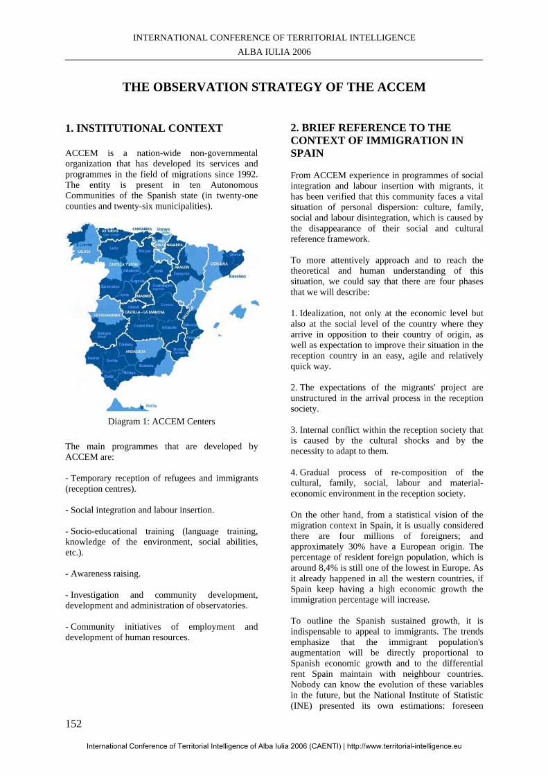
INTERNATIONAL CONFERENCE OF TERRITORIAL INTELLIGENCE ALBA IULIA 2006
152
THE OBSERVATION STRATEGY OF THE ACCEM
1. INSTITUTIONAL CONTEXT
ACCEM is a nation-wide non-governmental organization that has developed its services and programmes in the field of migrations since 1992. The entity is present in ten Autonomous Communities of the Spanish state (in twenty-one counties and twenty-six municipalities).
Diagram 1: ACCEM Centers
The main programmes that are developed by ACCEM are:
- Temporary reception of refugees and immigrants (reception centres). - Social integration and labour insertion. - Socio-educational training (language training, knowledge of the environment, social abilities, etc.). - Awareness raising. - Investigation and community development, development and administration of observatories. - Community initiatives of employment and development of human resources.
2. BRIEF REFERENCE TO THE CONTEXT OF IMMIGRATION IN SPAIN
From ACCEM experience in programmes of social integration and labour insertion with migrants, it has been verified that this community faces a vital situation of personal dispersion: culture, family, social and labour disintegration, which is caused by the disappearance of their social and cultural reference framework.
To more attentively approach and to reach the theoretical and human understanding of this situation, we could say that there are four phases that we will describe:
1. Idealization, not only at the economic level but also at the social level of the country where they arrive in opposition to their country of origin, as well as expectation to improve their situation in the reception country in an easy, agile and relatively quick way.
2. The expectations of the migrants' project are unstructured in the arrival process in the reception society.
3. Internal conflict within the reception society that is caused by the cultural shocks and by the necessity to adapt to them.
4. Gradual process of re-composition of the cultural, family, social, labour and material-economic environment in the reception society.
On the other hand, from a statistical vision of the migration context in Spain, it is usually considered there are four millions of foreigners; and approximately 30% have a European origin. The percentage of resident foreign population, which is around 8,4% is still one of the lowest in Europe. As it already happened in all the western countries, if Spain keep having a high economic growth the immigration percentage will increase.
To outline the Spanish sustained growth, it is indispensable to appeal to immigrants. The trends emphasize that the immigrant population's augmentation will be directly proportional to Spanish economic growth and to the differential rent Spain maintain with neighbour countries. Nobody can know the evolution of these variables in the future, but the National Institute of Statistic (INE) presented its own estimations: foreseen
International Conference of Territorial Intelligence of Alba Iulia 2006 (CAENTI) | http://www.territorial-intelligence.eu
PAPERS ON REGION, IDENTITY AND SUSTAINABLE DEVELOPMENT
153
entrances in the year 2002, 227.000 immigrants; in 2003, 204.000; in 2004, 181.000 and in 2005, 160.000.
All these realities outline the challenge of creating and structuring the social reception and integration policies in Spain. This challenge will increase. It will be assumed by the territorial board of the immigration phenomenon. It will identify the problems and necessities and at the same time suggest policies and actions that can be led to generate processes of intercultural cohesion and coexistence among the foreign and autochthonous population.
Consequently, to be able to create actions that may respond to the reality this population faces, diagnosis processes, sources for gathering the flows and coordinated information from different sources should be established, (social services, health centres, entities, public and private institutions, NGO, NLO, etc.). It will allow designing interventions in each territory that will be coherent with the needs and demands that were detected through the information transmitted by the vulnerable population itself.
3. ACCEM OBSERVATION NETWORK
ACCEM observation strategy is articulated by the application of permanent observation mechanisms among all the actors that intervene in the reality, those who operate on the ground and those who plan and make decisions in the social policy. It allows approaching the reality in a scientific way quantitatively and qualitatively, in order to analyze the complexity of reality, to suggest intervention strategies and to plan actions in consonance with the problems and needs the migrants' community face in. These problems and needs constitute a changing problem that requires permanent observation and analysis tools.
ACCEM suggest the creation of spaces of cooperative and participative observation among public entities and the third sector, which work with the immigrant community in a direct and transverse way. It would generate an integral knowledge on the social, educational and economic situation of the immigration, and would also facilitate actions application and creation of networks of social services to make the migrants' integration processes easier, especially for those who are affected by precariousness or social exclusion.
The objectives that are pursued by the different ACCEM observation network are: 1. To analyze and to evaluate in a dynamic way the socio-economic context in which the migrants live,
from a territorial perspective of local development that improves the knowledge of the immigration phenomenon.
2. To establish cooperation processes, as well as information and good practices networking and exchange among the local actors that operate on the territory (social and economic agents, public and private institutions, NGOs, etc.) so as to facilitate an analysis, a combined action and a generation of networks of social support that approaches the community and the reception territory problems.
3. To establish participation and accessibility processes for immigrants in the formulation, planning and development of actions.
4. To give to the different actors involved in the processes of planning and execution of the different plans, programmes, projects (educational, social, cultural, economic, etc.): - Tools for the agreed creation of indicators on the community and on the area socio-economic situation.
- Information to establish hypothesis that allow analyzing in a more concrete, dynamic and up-to-date way the problems of the community and of the territory, in order to help the decision makers design their plans, programmes and intervention projects.
3.1. Territorial management system of social and professional skills
Since 1996 and through the European initiatives of employment and development of human resources "HORIZON" and "INTEGRA", ACCEM started testing a methodology for the application of a territorial management system of social and professional skills that facilitates the social integration and labour insertion of asylum applicants, refugees and immigrants in the reception territories, through their skills management (abilities, aptitudes and attitudes).
One of the basic action principles for the development of this methodology, is to allow the migrant community entering a dynamic communication and relationship space among the different actors who are directly involved in the labour market insertion processes (employment searchers, managers and vocational training mechanisms), to facilitate their labour insertion in the territory, through the expression and visualization of their social and professional skills.
To do so and as a complement to the methodology experimentation, GINGO ("Trees of knowledge",
International Conference of Territorial Intelligence of Alba Iulia 2006 (CAENTI) | http://www.territorial-intelligence.eu
INTERNATIONAL CONFERENCE OF TERRITORIAL INTELLIGENCE ALBA IULIA 2006
154
by Trivium Limited company), a skills management visualization tool, was implemented.
The implementation of a territorial management system of social and professional skills is carried out in three municipalities. GIJÓN (Asturias) has a population of 270.000 inhabitants. Its economic context is characterized by an industrial tradition that is rationalizing and restructuring. LEÓN has 140.000 inhabitants and its economic activity is mainly centred on the “services” sector. SIGÜENZA (Guadalajara) has a population of 5.000 inhabitants and a productive activity based on the rural development and tourism.
The development of the system is essentially centred on two axes, on the one hand on the creation of a partnership that is linked to the local economic development and the existent employment in the experimentation territories and on the other hand on the design and implementation of the methodological elements that allow managing and exploiting the skills visualization tool.
3.2. Internal system of observation GORION
Since 1996 ACCEM has implemented in co-operation with the University of Franche-Comté (France) and the University of HUELVA (Spain), a national information system that is called GORION. It is a diagnoses accompaniment and evaluation tool that allows knowing the needs so as to build the profiles and typologies of the target community (asylum applicants, refugees and immigrants), on the different intervention territories where ACCEM operates.
Since 1997, GORION has allowed registering social, economic, professional, etc. data about 80.000 people and about 400.000 interventions.
We are presently working on adapting and specifying the system according to the new needs of the entity, not only at the conceptual level but also at the technologic one. It is the so-called e-gorrion.
E-gorrion design implied and still implies on the one hand harmonizing and updating the different registration systems and the information sources at the internal level (follow-up of the target group data base) and at the external level (statistical records and follow-up reports that are requested by the authorities) so as ACCEM can use them at the national level. On the other hand, it also bears an adaptation of the system of information technology. The instruments to carry out this internal information system are the following ones:
- A harmonized guide for observation that is structured on different stages and processes that correspond to the immigrants' integration itineraries (reception, orientation, education, training, employment, housing, health, autonomy, individual diagnosis and evaluation). - A manual to use the guide which main purpose is to establish a common framework and language for the observation, at the internal level. - A computer programme, e-pragma, on the Internet to administrate the system.
Through this system, ACCEM will have an analysis, diagnosis, and combined evaluation, not only of the different intervention processes (social, labour, legal, etc.), but also of the actions territories where the target group is. It allows guiding the strategic and operative policies of ACCEM, in the design of future plans, programmes and projects.
All these elements mean an effort and investment of the entity in economic, technological and human resources, since the installation and maintenance of information system becomes necessary to implement and to systematize internal procedures, not only in the management of the intervention in the different areas and departments of ACCEM, but also in the information gathering among the technical staff of the association. It also implies the creation and structuring of technical teams to manage and evaluate the information system (analysis and treatment of the information, execution of diagnoses, technological adaptation, training and accompaniment of the entity staff).
3.3. Local observatories
As a complement to the GORION internal system of information, in 1998 ACCEM carried out the creation and implementation of the immigration permanent observatories of Asturias (ODINA) and SIGÜENZA (SAVIA, then OPASI), in cooperation with the University of Franche-Comté.
Both observatories are based on the principles of territorial intelligence:
- Citizens' participation. - Global approach of the territory. - Partnership of local actors. - Information society technologies. - Accessibility of the information. - Information quality.
And on the CATALYSE methodology:
International Conference of Territorial Intelligence of Alba Iulia 2006 (CAENTI) | http://www.territorial-intelligence.eu
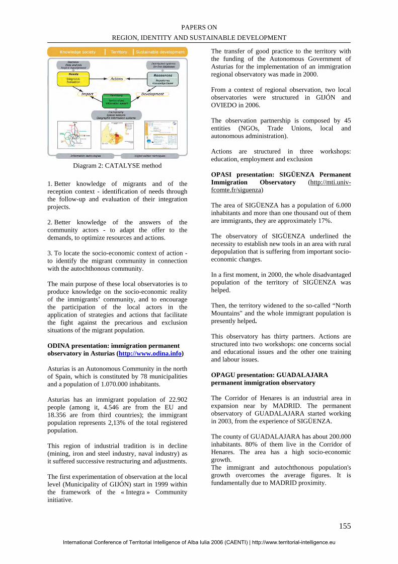
PAPERS ON REGION, IDENTITY AND SUSTAINABLE DEVELOPMENT
155
Diagram 2: CATALYSE method
1. Better knowledge of migrants and of the reception context - identification of needs through the follow-up and evaluation of their integration projects.
2. Better knowledge of the answers of the community actors - to adapt the offer to the demands, to optimize resources and actions.
3. To locate the socio-economic context of action - to identify the migrant community in connection with the autochthonous community.
The main purpose of these local observatories is to produce knowledge on the socio-economic reality of the immigrants’ community, and to encourage the participation of the local actors in the application of strategies and actions that facilitate the fight against the precarious and exclusion situations of the migrant population. ODINA presentation: immigration permanent observatory in Asturias (http://www.odina.info) Asturias is an Autonomous Community in the north of Spain, which is constituted by 78 municipalities and a population of 1.070.000 inhabitants.
Asturias has an immigrant population of 22.902 people (among it, 4.546 are from the EU and 18.356 are from third countries); the immigrant population represents 2,13% of the total registered population.
This region of industrial tradition is in decline (mining, iron and steel industry, naval industry) as it suffered successive restructuring and adjustments.
The first experimentation of observation at the local level (Municipality of GIJÓN) start in 1999 within the framework of the « Integra » Community initiative.
The transfer of good practice to the territory with the funding of the Autonomous Government of Asturias for the implementation of an immigration regional observatory was made in 2000.
From a context of regional observation, two local observatories were structured in GIJÓN and OVIEDO in 2006.
The observation partnership is composed by 45 entities (NGOs, Trade Unions, local and autonomous administration).
Actions are structured in three workshops: education, employment and exclusion OPASI presentation: SIGÜENZA Permanent Immigration Observatory (http://mti.univ-fcomte.fr/siguenza)
The area of SIGÜENZA has a population of 6.000 inhabitants and more than one thousand out of them are immigrants, they are approximately 17%.
The observatory of SIGÜENZA underlined the necessity to establish new tools in an area with rural depopulation that is suffering from important socio-economic changes.
In a first moment, in 2000, the whole disadvantaged population of the territory of SIGÜENZA was helped.
Then, the territory widened to the so-called “North Mountains" and the whole immigrant population is presently helped.
This observatory has thirty partners. Actions are structured into two workshops: one concerns social and educational issues and the other one training and labour issues. OPAGU presentation: GUADALAJARA permanent immigration observatory The Corridor of Henares is an industrial area in expansion near by MADRID. The permanent observatory of GUADALAJARA started working in 2003, from the experience of SIGÜENZA.
The county of GUADALAJARA has about 200.000 inhabitants. 80% of them live in the Corridor of Henares. The area has a high socio-economic growth. The immigrant and autochthonous population's growth overcomes the average figures. It is fundamentally due to MADRID proximity.
International Conference of Territorial Intelligence of Alba Iulia 2006 (CAENTI) | http://www.territorial-intelligence.eu
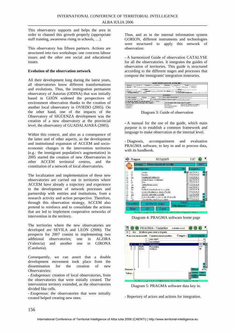
INTERNATIONAL CONFERENCE OF TERRITORIAL INTELLIGENCE ALBA IULIA 2006
156
This observatory supports and helps the area in order to channel this growth properly (appropriate staff training, awareness rising in schools, …).
This observatory has fifteen partners. Actions are structured into two workshops: one concerns labour issues and the other one social and educational issues. Evolution of the observation network All their development long during the latest years, all observatories know different transformations and evolutions. Thus, the immigration permanent observatory of Asturias (ODINA) that was initially based in GIJÓN widened the perspectives of environment observation thanks to the creation of another local observatory in OVIEDO (2005). On the other hand, one of the impacts of the Observatory of SIGÜENZA development was the creation of a new observatory at the provincial level, the observatory of GUADALAJARA (2005). Within this context, and also as a consequence of the latter and of other aspects, as the development and institutional expansion of ACCEM and socio-economic changes in the intervention territories (e.g.: the immigrant population's augmentation) in 2005 started the creation of new Observatories in other ACCEM territorial centres, and the constitution of a network of local observatories. The localization and implementation of these new observatories are carried out in territories where ACCEM have already a trajectory and experience in the development of network processes and partnership with entities and institutions, from a research activity and action perspective. Therefore, through this observation strategy, ACCEM also pretend to reinforce and to consolidate the actions that are led to implement cooperative networks of intervention in the territory. The territories where the new observatories are developed are SEVILA and LEÓN (2006). The prospects for 2007 consist in implementing two additional observatories; one in ALZIRA (Valencia) and another one in GIRONA (Catalunia). Consequently, we can assert that a double development movement took place from the dissemination for the creation of new Observatories: - Endogenous: creation of local observatories, from the observatories that were initially created. The intervention territory extended, as the observatories divided like cells. - Exogenous: the observatories that were initially created helped creating new ones.
Thus, and as in the internal information system GORION, different instruments and technologies were structured to apply this network of observation: - A harmonized Guide of observation CATALYSE for all the observatories. It integrates the guides of observation of territories. This guide is structured according to the different stages and processes that compose the immigrants' integration itineraries.
Diagram 3: Guide of observation
- A manual for the use of the guide, which main purpose is to establish a common framework and language to make observation at the internal level. - Diagnosis, accompaniment and evaluation PRAGMA software, to key in and to process data, with its handbook.
Diagram 4: PRAGMA software home page
Diagram 5: PRAGMA software data key in.
- Repertory of actors and actions for integration.
International Conference of Territorial Intelligence of Alba Iulia 2006 (CAENTI) | http://www.territorial-intelligence.eu
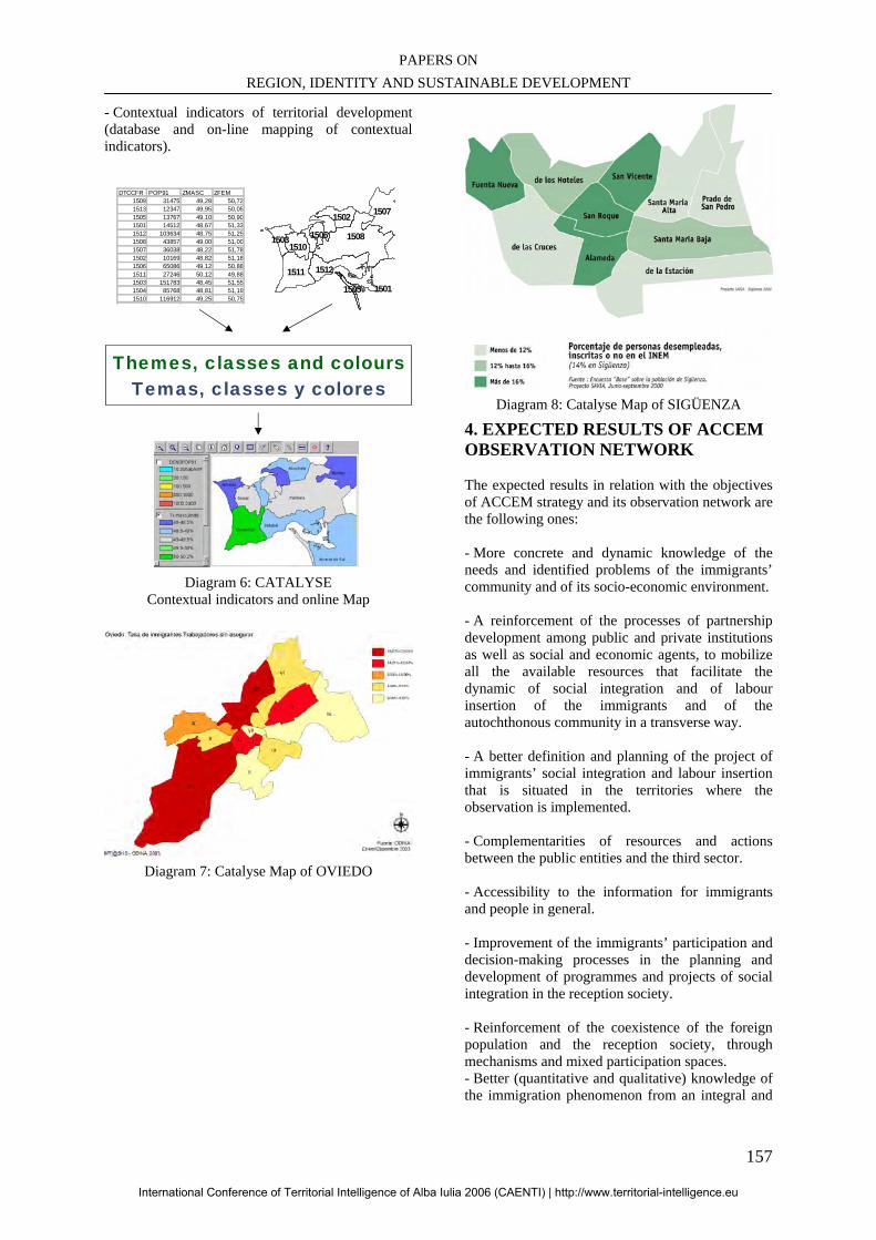
PAPERS ON REGION, IDENTITY AND SUSTAINABLE DEVELOPMENT
157
- Contextual indicators of territorial development (database and on-line mapping of contextual indicators).
DTCCFR POP91 ZMASC ZFEM
1509 31475 49,28 50,721513 12347 49,95 50,051505 13767 49,10 50,901501 14512 48,67 51,331512 103634 48,75 51,251508 43857 49,00 51,001507 36038 48,22 51,781502 10169 48,82 51,181506 65086 49,12 50,881511 27246 50,12 49,881503 151783 48,45 51,551504 85768 48,81 51,191510 116912 49,25 50,75
1508
1501
1511
1507
1512
1502
15101503 1506
1505
Themes, classes and coloursTemas, classes y colores
Diagram 6: CATALYSE
Contextual indicators and online Map
Diagram 7: Catalyse Map of OVIEDO
Diagram 8: Catalyse Map of SIGÜENZA
4. EXPECTED RESULTS OF ACCEM OBSERVATION NETWORK The expected results in relation with the objectives of ACCEM strategy and its observation network are the following ones:
- More concrete and dynamic knowledge of the needs and identified problems of the immigrants’ community and of its socio-economic environment.
- A reinforcement of the processes of partnership development among public and private institutions as well as social and economic agents, to mobilize all the available resources that facilitate the dynamic of social integration and of labour insertion of the immigrants and of the autochthonous community in a transverse way.
- A better definition and planning of the project of immigrants’ social integration and labour insertion that is situated in the territories where the observation is implemented.
- Complementarities of resources and actions between the public entities and the third sector.
- Accessibility to the information for immigrants and people in general.
- Improvement of the immigrants’ participation and decision-making processes in the planning and development of programmes and projects of social integration in the reception society.
- Reinforcement of the coexistence of the foreign population and the reception society, through mechanisms and mixed participation spaces. - Better (quantitative and qualitative) knowledge of the immigration phenomenon from an integral and
International Conference of Territorial Intelligence of Alba Iulia 2006 (CAENTI) | http://www.territorial-intelligence.eu
INTERNATIONAL CONFERENCE OF TERRITORIAL INTELLIGENCE ALBA IULIA 2006
158
cooperative point of view, and at a territorial and local level.
- More precise, dynamic and optimized visibility of the available social resources on the territory to answer the community needs.
- Improvement of the processes of exchange of information, data, studies and publications about the community knowledge, among other actors of the research fields.
- Combined planning of the led actions to favour the community integration processes, from a cooperative diagnosis that will be made among the entities and institutions that are involved in observation. 5. MANAGEMENT AND COORDINATION TEAM OF OBSERVATION
To confront the application of the different observation mechanisms, a team of work was constituted in ACCEM. It is in charge of the steering and the negotiation of the different application processes. This team is divided into different work groups according to the functions and tasks of the members;
- The strategic group is in charge of carrying out the follow-up as regards the strategic dimensions and objectives of the system. It meets the management staff members of the entity (directress, sub-director and territorial leaders), by the coordinator of the observation and the University of Franche-Comte. - Senior group. Seniors are technicians who experiments first local observatories and territorial management system of social and professionals skills (GIJÓN, SIGÜENZA and LEÓN). They have made at least three diagnoses. Their key-functions are to conceptually design and implement the instruments of observation and at the same time to carry out an appropriate training transfer to new observation technicians, the so-called juniors. - Junior group. Whilst having experience, juniors will take part in the senior group. CONCLUSION The endogenous and exogenous development of the observatories generated a modification of the organization and governance of the network. The objective is the integration of these observatories in the territories global policy, so as to develop a genuine territorial responsibility and involvement.
A monitoring group is in progress, in order to reinforce the articulation of the seniors and juniors in a network that will have a virtual cooperative workspace. The endogenous development implied new local responsibilities of members of the senior group, what limits their availability to assume the needs of new observatories. A technical referent became indispensable to register the observatories demands that are usually urgent, to directly answer them or to relay them towards a competent and available senior technician. Nevertheless, this technical referent will not be immediately operational. He/she will have to be trained by the senior technicians. The next step consists in training the permanent technical referent, in order to answer the demands in real time and to coordinate the training and accompaniment actions. This technical referent will also have to progressively make the regular follow-up of the observatories activity so as to prevent the difficulties they can possibly face. He has to become the animator of the observatories senior and junior technicians network, especially via the cooperative workspace.
The tasks of this technical referent will have to be clearly distinguished from the strategic follow-up of the observatories that concern the political orientations of the partnership and of the projects. Consequently, it should be made within the strategic follow-up group, at the territorial responsible level and guarantee their political involvement at the network of territorial observatories level. BIBLIOGRAPHY MASSELOT C., 2006. "Systèmes d'information territoriaux et politiques sociales : quand l'observation territoriale s'empare du net”, in : 15ème Colloque de la Société Française des Sciences de l'Information et de la Communication, Bordeaux, mai 2006.
GIRARDOT J.-J., 2005 : “Concepts, principes et outils de la méthode CATALYSE”, in : 3e colloque international du Réseau Européen d'Intelligence Territoriale, Liège, Belgique, septembre 2005.
MASSELOT C., 2004 : « Les TIC dans la méthode Catalyse : Transfert méthodologique et technologique », in : "Tic & Territoires : quels développements ?», Lille, mai 2004, ENIC et Cie.
GIRARDOT J.-J., 2000. “Principes, Méthodes et Outils d'Intelligence Territoriale. Évaluation participative et Observation Coopérative.”, in : Conhecer melhor para agir melhor, Actes du séminaire européen de la Direction Générale de l'Action Sociale du Portugal, EVORA, 3-5 mai 2000, DGAS, LISBONNE (Portugal), décembre 2000, 7-1
International Conference of Territorial Intelligence of Alba Iulia 2006 (CAENTI) | http://www.territorial-intelligence.eu
PAPERS ON REGION, IDENTITY AND SUSTAINABLE DEVELOPMENT
159
DEVELOPMENT OF A CO-OPERATIVE INFORMATION SYSTEM
FOR THE FOLLOW-UP OF THE EVOLUTION OF USERS’ SITUATION (CHILDREN, YOUNGS AND ADULTS MENTALLY HANDICAPPED)
Anne PERETZ, Jean-Pierre GIMBERT ADAPEI de Besançon
Professional address
ADAPEI of Besançon, 81 rue de Dole – F-25020 BESANÇON cedex 7, France.
International Conference of Territorial Intelligence of Alba Iulia 2006 (CAENTI) | http://www.territorial-intelligence.eu
INTERNATIONAL CONFERENCE OF TERRITORIAL INTELLIGENCE ALBA IULIA 2006
160
DEVELOPMENT OF A CO-OPERATIVE INFORMATION SYSTEM
FOR THE FOLLOW-UP OF THE EVOLUTION OF USERS’ SITUATION
(CHILDREN, YOUNGS AND ADULTS MENTALLY HANDICAPPED)
1 - “PARADA”, OBSERVATORY OF THE ADAPEI USERS’ PROCESS OF INTEGRATION
Context In 1994, the SASP/SIP (Service of Social and Professional Accompaniment) of the ADAPEI of Besancon (association of the friends and parents of mental handicapped people) begins an evaluation program for his users’ process of integration. The legal context which governs the medico-social sector at that time starts to favour the individual project of the mentally handicapped persons as a base of the associative and services projects. It introduces notions of “management by project” as a base for the accompaniment by specialized institutes. New technologies from now on are considered like possible tools for the realization of the individual project. Aims of the SASP are to use the NTIC like : - Tool for an evaluative step of his users’ social integration based on the observation of the user/service interaction as an indicator of the evolution of the insertion of the users. The main idea is that there is a strong and complex link between the actions in direction of the user and the quality of his insertion. - Database to improve the observation of the evolution of the social action for the users of the service, (analysis of the practice). - Means of presentation of the results obtained by the service in direction of the association and the financial authorities. CATALYSE It is in 1997, with the help of a European financing (program “Horizon Adapt-Employment”), that a partnership is founded between the SASP of ADAPEI of Besançon and the Center MTI@SHS of the University of Franche-Comté. It’s based on the method and the tools CATALYSES that it develops. Its aims are : - Create a car-evaluation software based on a questionnaire of standard evaluation and its note of accompaniment,
- Install it, try it, train the users and follow-up the work realized - Work out a first statistical position and accompany its analysis, interpretation and synthesis of the results with the participation of the operators. Finally, the designed tool allows the improvement of the users’ monitoring, but also their evaluation and the activity of the social workers. Reserved for all the professionals of accompaniment who wish to facilitate the evaluation of their actions, it supports: - Collection of information regarding the initial situation and difficulties of the users or their families - Emergence of the actions to set up in order to comply with their needs - Emergence of those which were realized - Description of the user’s final situation. The analysis of this information by the professionals, periodically allows them to evaluate the projects by comparing the aims and the achievements, and to improve their strategy of action. Description of the software PARADA A file of user contains the whole information necessary to the social workers to ensure the reception and the accompaniment: principal information relating to the person, data on marital status, information on residence, health, professional situation… and of all the actions this user benefited from since his arrival. For each intervention, the professionals of services SASP/SIP fill an “intervention card” which makes it possible to keep track of the actions. Each intervention is recorded in the software. For every intervention, the elements of user’s situation can be updated, if necessary. Previous information is archived in the software and can be subsequently consulted. This data recording allows for the follow-up of the user’s process of integration, and provides fundamental information to work with his evaluation. The software takes into account the legal norms defined in France by the CNIL (Data-processing National Commission and Freedom).
International Conference of Territorial Intelligence of Alba Iulia 2006 (CAENTI) | http://www.territorial-intelligence.eu

PAPERS ON REGION, IDENTITY AND SUSTAINABLE DEVELOPMENT
161
The access to the data is made safe by the use of logins and passwords, and by the possibility to define different levels of use and restrictions in the access to information according to their nature. From a single-user tool, designed so that each professional manages the files of his users, the software evolves from 2000 to a network in which each one can have access to the whole of the files (350 users concerned). It should be noted that this tool does not abolish times of exchange between social workers, but it optimizes them: from now on, these meetings are not more dedicated to get informed about the actions made, but to think together to the total situation of the user. Principal difficulties for the implementation of PARADA - A very long work of development - Fears of the personnel about the change of its practices, about the possible risks of “control” dependent on the data-collection and their use by the directors, and about the deontological implications. Prospects at the end of 2000 At the end of this project, it appears necessary to allow for a greater personalization of the system, so that PARADA is used in autonomy by the services (for the changes of items, of way of interventions, request of the financial power…), for a better adaptation and speed of response specifically because of the changes of the context. 2 - BASE DATA AND TOOL FOR COLLECTIVE EVALUATION ON LINE IN A REGIONAL PARTNERSHIP “EXIGENCE” Context Since 2002, this logic of evaluation of the users’ process of integration for only one institution must from now on evolve to a greater autonomy of use and a collective use in partnership : because the development of this way of working is now recognized by the financial authorities. This way of working is now possible thanks to a new European program “Equal” for the “fight against discriminations on the labour market”. It’s a regional partnership of 7 members, social actors for handicapped people or people with great social difficulties, in the Franche-Comté area. With the Center MTI@SHS, this partnership conceives, experiments and uses a database and a tool of collective evaluation on the Web (site intranet www.exigence.org), during 3 years.
The conclusion of this work wishes to contribute to the development of a regional observatory from the individual users’ process of integration recorded by each partner. Each of them gives his feedback of experience, measuring then improving his practices and the processes of insertion used by the institutions. Description of the tool “EXIGENCE” It is an individualized talk guide on the Web, made safe, accessible on the partnership intranet site for data collection, consultation, creation of interventions and dashboards of the actions and various criteria. The aim of this talk guide is to fill the data progressively with the information provided by the user, and to update it according to the evolution of his situation. The talk guide details the situation of the user at his entry in the service and at his exit, and the actions realized. It is composed of 3 parts: - The first part (reception) includes general information, often obtained during the first talk with the person. - The second part (diagnosis) completes the questions of the first part (about the situation of residence, health, employment…). It results in the actions of integration, needed by users and proposed to set up by the professional. - The third part concerns the follow-up and the evaluation of the situation of the person, recording the actions carried out and the situation at the end of his accompaniment. The work of interpretation of the data is made by the professionals, with a strong implication of the user, and takes place on several talks based on the talk guide. This tool makes it possible to describe the evolution of the situation of : - each user - groups of users - all users, showing their progress in quantitative and qualitative terms (analyzes data, definition of the individual profile and needs). Finally, on the basis of this tool, the partnership records the production during 3 years of: - quarterly and annual statistics - annual qualitative analysis of these results, interpretation and conclusions about the actions, the situation of the users, and the co-operative work in partnership.
International Conference of Territorial Intelligence of Alba Iulia 2006 (CAENTI) | http://www.territorial-intelligence.eu
INTERNATIONAL CONFERENCE OF TERRITORIAL INTELLIGENCE ALBA IULIA 2006
162
Difficulties recorded for the implementation of the tool “EXIGENCE” - It’s difficult to adapt the indicators of users’ evolution to the needs of the partners: their activities are very diverse in terms of production of results personalized by structure or action - The database does not make it possible to record exploitable information on the capacities and necessary socio-professional users’ skills for the working stations: it requires the use of other complementary tools of evaluation - In spite of the improvements recorded, compared to the software PARADA, the database/tool of evaluation EXIGENCE still does not appear rather easily and quickly flexible, adaptable to the changes of the environment. Perspectives in 2005 On the basis of a software used by only one institution then by the database and tools of evaluation on line for a regional partnership (750 users concerned), after nearly 10 years of work and consideration: - the evolution of the system of observation of targeted populations must still be developed so that it will become better adapted to the needs of the social actors. But it already made possible changes in the mentalities of the professional users, by a clear evolution of the appropriation of the concept of “evaluation” and its results in terms of actions.
3 - FINALIZATION OF A SYSTEM OF CO-OPERATIVE INFORMATION ON LINE “OSUA”, FOR ADMINISTRATIVE, SOCIAL AND PERSONAL DATA USED IN THE TOTAL AND INDIVIDUALIZED USERS’ PROCESS OF ACCOMPANIMENT
Context In this new work phase which begins in July 2005, the stress is laid on the importance of the rationalization of the information management to give better answers to the users. According to the law 2002-2 (evolution of the medico-social institutions), the ADAPEI of Besancon started a rationalization of its internal procedures by beginning quality actions, for which it obtained a certification ISO 9001 v.2000 in december 2005. This is why it was recommended by the Center
MTI@SHS to develop a data-processing solution, very flexible, able to absorb in an intelligent way these constant adaptations to the legislative, administrative, and social contexts. Public aimed: mentally handicapped persons, poly-handicapped persons, and in a more general way people in great social difficulty of insertion. In the long term, the information system developed will be able to adapt to all types of population in great difficulty accompanied by specialized services or structures. Description of the co-operative information system “OSUA” - co-operative information system in line (19 sites of the ADAPEI are initially concerned, with opening to the external partners for a real coordination in the users’ project of total and individualized accompaniment) - It integrates forms of follow-up of users’ situation evolution, at the arrival and at the exit of the service, with indicators and criteria of evaluation - It integrates notes and online help to ensure the accompaniment of the users. This system, initiated and carried out by the ADAPEI of Besancon is a complete tool for collective use at disposal of any social actor of socio-professional insertion users’ project for: • quantitative and qualitative evaluation of the efficiency of the actions carried out on the individual situations • quantitative and qualitative car-evaluation of the performance of the institutions • definition of the individual profile and needs. The aim is to evaluate the process of socio-professional insertion. The recommended solution is to generate a collection of information for any intervention with the user, as in the 2 preceding systems. Objectives for the professionals - data acquisition - grant all the interventions concerning a user, - navigate between the situations, - consult the calendars, the statistics, - publish the file of a user, - communicate all information concerning the users between the various actors, complementary intermediaries in different fields, proposal for a meeting, transmission of a situation or detail of an intervention… - calculate statistics based on the information recorded in the database. These calculations will be carried out starting from simple and crossed requests, on the basis of clearly identified descriptors.
International Conference of Territorial Intelligence of Alba Iulia 2006 (CAENTI) | http://www.territorial-intelligence.eu
PAPERS ON REGION, IDENTITY AND SUSTAINABLE DEVELOPMENT
163
“It is a question of developing a common tool for the whole sectors of the association where each one will be able to find what he needs for his users. Moreover, it will allow us to develop an individual estimation per user and also an estimation of activity of an institution. It will also be used as a tool for the synthesis of actions by the coordinator in the individual user’s project of accompaniment. “ The solution consists of several modules to implement: - Platform Web - Joint Base - Administrative Management of the user - Modules to be developed in association with the joint base, concerning health, mobility transport, education, employment, residence, leisure, finances,… - Manager of contents - Integral search engine - Electronic Management of documents - Glossary/On line help For a real flexibility, an optimum adaptation, and to take into account the technology selected, the system will be able to evolve easily, quickly, without intermediary and progressively with the evolution of the environment of the accompaniment of the users, or of the institutional or legal needs. For this management of the contents, a procedure is developed, organizing the role of every actor in the system. Today, we record a strong mobilization of the persons who work on this project, thanks to an awareness that the system in the long term represents the tool of accompaniment and coordination of the actions implemented for the users, in the respect of the new legislation (individual project of the users, internal and external evaluation of the structures). Work done today - definition and validation of the architecture of the system - principal common validated data - writing of the procedure of management of contents of the system - launching of the technological development of the system
Work still to do in July 2006 - Glossary (common with project CAENTI, to adapt to the French national context) - Deposit of the project with the CNIL - Detail of the data necessary to the structures of ADAPEI - Instruction manual and online help - Development, experimentation, correction, training of the professionals to use the system The system will be efficient as of the end of the year 2006 for experimentation, for nearly 1.000 users. CONCLUSION On the basis of tools and method CATALYSE, ADAPEI of Besancon conducted the following actions: - 1994: reflexion about evaluation - 1999: experimentation of the software PARADA conceived for only one service (350 users) within a difficult and long work taking into account the professional revolution which the use of data processing for the follow-up of the users represented, - 2002: the database/tool of collective evaluation by intranet “EXIGENCE” allows for the opening of this practice towards a work in regional partnership (750 users) - 2005-2008: the project profits from the conclusions drawn from these 2 experiments ; particularly from the points of view of mentalities, laws and norm ISO 9001 v.2000 ; but also from the point of view of the considerable technological advances recorded by the development of a system of co-operative work “OSUA” (1 000 users concerned). It should be noted that the ADAPEI of Besancon sought a partnership for the widening and the diffusion of its product and method, for the enrichment of its reflexion, practices and tools with project CAENTI. In return, the ADAPEI of Besancon contributes to project CAENTI by sharing the work completed during his projects. The association will show its expertise capacity related on the handicap and the people in very great socio-professional difficulty.
International Conference of Territorial Intelligence of Alba Iulia 2006 (CAENTI) | http://www.territorial-intelligence.eu
INTERNATIONAL CONFERENCE OF TERRITORIAL INTELLIGENCE ALBA IULIA 2006
164
International Conference of Territorial Intelligence of Alba Iulia 2006 (CAENTI) | http://www.territorial-intelligence.eu
PAPERS ON REGION, IDENTITY AND SUSTAINABLE DEVELOPMENT
165
IS TERRITORIAL SENSITIVITIES METHOD ACCEPTABLE
IN THE TERRITORIAL INTELLIGENCE APPROACHES?
________________________________________________________________
Serge Schmitz Associate Professor
Professional adress University of Liege - Department of Geography - Allée du 6 Aout, 2 - B-4000 LIEGE, Belgium
Abstract : The territorial sensitivities method was proposed as a tool to collect senses of places and meanings of landscape features. It was presented as an alternative of the traditional participation process to take into account the inhabitants’ meanings in physical planning projects. The method is based on the comparison of an “objective” inventory of localisable changes and those collected in the speech of the inhabitants. Analysing which changes are mentioned but also which ones are absent contributes to grasp the places appropriation. After a short presentation of the method, the paper asks about the acceptability of this one in the context of the territorial intelligence. Is it suitable to join non participative empathic methods in the set of tools of the territorial intelligence? Keywords: Territorial sensitivity, Life world, Territorial intelligence, Participation, Planning, Ethic. Résumé: La méthode des sensibilités territoriales a été proposée en tant qu’outil pour appréhender le sens des lieux et les significations accordées aux éléments du paysage. Il fut présenté comme une alternative aux processus de participation traditionnels qui permettent de prendre en compte l’avis de la population dans les projets d’aménagement de l’espace. La méthodologie se base sur la comparaison d’un inventaire « objectif » de changements localisables et d’inventaires de changements recueillis dans le discours des habitants. Analyser quels sont les changements mentionnés mais également ceux qui sont absent permet d’appréhender l’appropriation des lieux. Après une courte présentation de la méthode, la communication s’interroge sur l’acceptabilité de celle-ci dans le contexte de l’intelligence territoriale. Est-il convenable d’adjoindre des méthodes empathiques mais non participatives à la boîte à outils de l’intelligence territoriale ? Mots clés: Sensibilité territoriale, Espace vécu, Intelligence territoriale, Participation, Aménagement de l’espace, Ethique.
International Conference of Territorial Intelligence of Alba Iulia 2006 (CAENTI) | http://www.territorial-intelligence.eu
INTERNATIONAL CONFERENCE OF TERRITORIAL INTELLIGENCE ALBA IULIA 2006
166
IS TERRITORIAL SENSITIVITIES METHOD ACCEPTABLE
IN THE TERRITORIAL INTELLIGENCE APPROACHES? a) Backgrounds The territorial sensitivities method was proposed as an empathic tool to collect senses of places (Tuan, 2001) and meanings of landscape features. It was presented as an alternative of the traditional participation processes to take into account the inhabitants’ meanings in physical planning projects (Schmitz, 1998). A study of practices in Walloon region showed the weak success of participation processes. Walloon people were not enthusiast to participate in public inquiries. They are not well informed about it, and they have a lack of training in physical planning, environmental concerns, and the society where they live. The fact that some people never take part in this kind of process because of cultural barriers (to write a letter, to express an opinion) is an other problem. The local and regional authorities regarded participation as an obligation that consumes time and that generates problems. In their opinion, participation is not a way to get a better decision. In fact, participation in Walloon Region was more an information process than an opportunity to work together on the best solution. The worse thing is that participation processes are often a way for a small, well organized, group to frost some important works. When I studied the public inquiry on the LGV in 1998 (Schmitz, 1998), I remarked that numerous protests are less connected with real impacts than with the social network of an active protester. In these cases, it appears that participation processes could lead to a misappropriation of democratic practices. b) The territorial sensitivities method The territorial sensitivities methodology suggests to start with interviews of inhabitants or questionnaires before any planning project in order to get information about the way they appropriate the different places. The idea is to take into account these appropriations in planning and territorial development projects. These interviews focus on reactions, sensitivities, to locatable changes. The method is based on the comparison of an “objective” inventory of locatable changes and those collected in the speech of the inhabitants. The questionnaire proposes different places to the inhabitants or users and asks for each location: which changes occurred in the last years? Analysing which changes are mentioned but also which ones are absent contributes to grasp the
places appropriation. It permits to underline high and less sensitive places and to cluster inhabitants around specific places appropriation. More than a test about the change perceptions, it deals with the normality and the sense of place (Schmitz, 2001). The interview or questionnaire ends with the test on changing places. The test proposes twenty too thirty-five places where changes happened in the last years. These changes are chosen because of their localisation and their diversity. For instance, it could be building of houses along the main road, planting of trees changing the face of landscape, opening of a museum or operating of industrial plant. The results of the test are analysed in two steps: 1) score (number of mentions in the sample) of each changes, 2) cluster analysis of the sensitivity register of each respondent. The score analysis allows (if the sampling is acceptable) the development of a synthesis on the interest and the meaningfulness of places of the local society. The cluster analysis underlines the diversity of life worlds and senses of place but also regroups inhabitants on the point of view of the environmental expectations. c) Discussion The territorial sensitivities methodology suggests anticipating the debate about the land-use through a questionnaire and an analysis free of the stress of any factual projects (Tricot, 1994). It collects information from the inhabitants and is adapted to who do not participate in the usual participative processes. However, this method is far away from a participative process because inhabitants do not participate in the decision process. The method is just a way of collecting information about the meanings of places in order to take appropriate decisions. It is an empathic technocratic tool. People do not know how the results of the questionnaire will be used. Moreover, the analysis of the result is based on a hermeneutic work. Is it suitable to join non-participative empathic tool in the set of tools of the territorial intelligence? One of the main principles of the territorial intelligence is the participation of the actors in the different steps of the process. Nevertheless, it does not mean that technocratic tools could not be used in the context of the territorial intelligence. The condition is that the tools are understood by the actors. In the stage of development of the territorial sensitivities method, it does not respect this condition but a
International Conference of Territorial Intelligence of Alba Iulia 2006 (CAENTI) | http://www.territorial-intelligence.eu
PAPERS ON REGION, IDENTITY AND SUSTAINABLE DEVELOPMENT
167
revision of the protocol would permit to meet this condition in the future. BIBLIOGRAPHY Jaschko G., 2002. Représentations des modifications territoriales des habitants de l’entité de Dour : contribution à la recherche sur les sensibilités territoriales et à la gestion du territoire en fonction des sentiments des habitants envers les lieux, Université de Liège, Mémoire. Rasquez P., 2004. La palmeraie de M’hamid, Moyenne vallée du Drâa, Maroc, Suivi de la désertification à travers des données de télédétection et la méthode des sensibilités territoriales, Université de Liège, Mémoire. Schmitz S., 1998. Participation et aménagement empathique. Réflexions à partir du cas wallon, Bulletin de la Société géographique de Liège, 34 : 77-84.
Schmitz S., 1999. Les sensibilités territoriales, contribution à l’étude des relations homme-environnement, Université de Liège, Thèse de doctorat. Schmitz S., 2001. “ La recherche de l'environnement pertinent, contribution à une géographie du sensible”, L'Espace géographique, 30/4 : 321-332. Schmitz S., 2003. “ De nouveaux entrelacs territoriaux, Globalisation et diversification des modes d’habiter” dans Tonke Lask, Les constructions sociales de l'espace, Les territoires de l’anthropologie de la communication,. Liège : Les Editions de l'Université de Liège., 43-51. Tricot A., 1994. “ La prise en compte de la controverse dans l’aménagement du territoire, Peut-on négocier le future”, Espaces et Sociétés, 74-75 : 69-97. Tuan Y-F, 2001. Space and Place, the Perspective of Experience, University of Minnesota Press.
International Conference of Territorial Intelligence of Alba Iulia 2006 (CAENTI) | http://www.territorial-intelligence.eu

INTERNATIONAL CONFERENCE OF TERRITORIAL INTELLIGENCE ALBA IULIA 2006
168
International Conference of Territorial Intelligence of Alba Iulia 2006 (CAENTI) | http://www.territorial-intelligence.eu
PAPERS ON REGION, IDENTITY AND SUSTAINABLE DEVELOPMENT
169
D – REGIONAL INSTRUMENTS AND SUSTAINABLE DEVELOPMENT
This chapter gathers the communications that were made in the Workshops 3.3 “Sustainable
territorial development limits”, 3.4 “Regional instruments for sustainable development” and 3.5
“Sustainable development socio-economic factors”.
International Conference of Territorial Intelligence of Alba Iulia 2006 (CAENTI) | http://www.territorial-intelligence.eu

INTERNATIONAL CONFERENCE OF TERRITORIAL INTELLIGENCE ALBA IULIA 2006
170
International Conference of Territorial Intelligence of Alba Iulia 2006 (CAENTI) | http://www.territorial-intelligence.eu
PAPERS ON REGION, IDENTITY AND SUSTAINABLE DEVELOPMENT
171
FOR AN ECONOMIC REGIONAL OBSERVATORY IN FRANCHE-COMTÉ: BETWEEN MUTUALISATION AND
INDEPENDENCE
________________________________________________________________
Marie-Hélène DE SEDE-MARCEAU, Alexandre MOINE Professors of geography
[email protected], [email protected]
Professional address CERSOT-ThéMA, UMR-6049 (CNRS)
University of Franche-Comté - 32 rue Mégevand – F-25030 BESANÇON cedex, France. Abstract: Presently, in France the sets of actors are deeply conditioned by the effects of the decentralisation that took place in 1982, and by the competences transfers. By progressively giving importance to the local levels, the French state gave them the first rank in terms of economical development. Nevertheless, in a very changing overall context, the determinants of the companies’ localization, and as a consequence the economical attractiveness of territories, change very quickly. As a result it is essential to obtain tools of territorial intelligence that are able at the same time to describe and anticipate the socioeconomic evolutions and also to link the actors who are in charge of territorial development, from the regional to the infra-regional levels. We would like to present an experiment that is taking place in Franche-Comté with the regional development agency (ARD-FC) and which consists in the structuring of a regional resources platform that is associated to semi independent departmental observatories. We will try to describe what was expected from the regional and infra-regional observatory to implement efficient governance, from the project genesis (schedule of conditions and actors consultation) to the philosophy of the conceptual proposals. Keywords: Observatory, Territory, Space, Time, Regional, Resources platform.
International Conference of Territorial Intelligence of Alba Iulia 2006 (CAENTI) | http://www.territorial-intelligence.eu
INTERNATIONAL CONFERENCE OF TERRITORIAL INTELLIGENCE ALBA IULIA 2006
172
FOR AN ECONOMIC REGIONAL OBSERVATORY IN FRANCHE-
COMTÉ: BETWEEN MUTUALISATION AND INDEPENDENCE
INTRODUCTION Presently, in France the actors’ games are deeply conditioned by the decentralisation effects of 1982 and by the competences transfers. By progressively giving importance to the local scales, The French State put them at the first rank in the field of the economic field. Nevertheless, in a very moving and complex context, where the phenomena are conditioned by several factors, both local and global, the determinants of the firms localisations, and consequently of the economic attractiveness of territories, change very quickly. As a consequence, it is indispensable to have tools of territorial intelligence that are able to describe and to anticipate the socioeconomic evolutions, whilst trying to respect the coherence between the different intervention territorial levels, from the regional scale to the infra-regional scales. The observation issue in these encased and linked territorial frames needs the implementation of specific tools: • Able to integrate time and to allow a quick
reactivity to updating and information processing;
• Able to offer several analysis scales and ability to select analysis areas that transcend the institutional cuttings;
• That allow the implementation of shared, recognized and complementary indicators, especially from a skill level to another;
• Accessible on the Internet, from the
management and from the exploitation point of view;
• Shared by several actors, without the failure of
one of them questioning the exploitation of the whole and that gives a minimum of independence, in terms of functionality and of management.
However, beyond these methodological expected elements, lies the question, that is very crucial, of the sharing of such a tool. As a consequence, we offer to report an experience that is in progress in Franche-Comté, about the structuring of a platform of regional resources that is linked to the theme of the economic development and that is associated to
departmental observatories that are semi-independent. From the project gestation to the philosophy of the conceptual proposals, we will try to describe the expected elements of the regional and infra-regional observation to implement efficient governance.
1. A DÉCENTRALISATION THAT COMPLEXIFIED THE PAPERwork AND RELATIONSHIPS OF THE TERRITORIAL ACTORS
The décentralisation and territorial recompositions issue The understanding of the territories functioning is presently a genuine stake of the complexification of the relations between actors, the multiplication of the scales levels, the exigence of coherence in the frame of sustainable development, the volatility of the socio-economic phenomena, are elements that need to consider the territories in their triple dimension: space, time and organisational, to observe and to understand their functioning in order to anticipate their future. If today the balance of the 1982 decentralisation is clearly positive, we should also admit that in a European and worldwide exchanges frame which is more and more complex, the French territorial management system creates some problems: the paramount paper of the State was never disclaimed, but it is perhaps a necessity to efficiently accompany this decentralisation; the links between the State and the new territorial collectivities remained complex, ambiguous in some cases, confusing in some others. The emergence of new management territories in relation to the increasing importance of intercommunality created confusion, especially in the funding devices. All these elements result from an essential lack in the Law of decentralisation: the institutions were partly reformed by the territorial frame. Thus, we kept adding territorial grades without removing any at any moments. Presently, we are going from a territory settling policy that recommended the classic space approach to a project territorial policy within which the economic development has a paramount importance. In parallel, intercommunality growth shown that the local grade was included in new forms of
International Conference of Territorial Intelligence of Alba Iulia 2006 (CAENTI) | http://www.territorial-intelligence.eu
PAPERS ON REGION, IDENTITY AND SUSTAINABLE DEVELOPMENT
173
functioning. The territories are there, they correspond to the citizens, and firms present concerns that transcend the communal frame, dispersion of which is a handicap that is more and more difficult to manage, when we know that 80% of the collectives had less than 2000 inhabitants in 1999. Unfortunately, during the decentralisation, the relative improvement of the management means of intercommunality was not accompanied by the recognition of the micro-regional grade that eventually was justified only in relation with the inability of the traditional territorial communities to solve the local problems. Presently, territories attract a particular attention, with the development of global approaches that genuinely integrate the whole actors, the whole of their relationships and of their projects. The territory concept keeps its relevance and all the issue consists in the integration of the local in the global. How, through the different management grades, to give a global coherence to the actions that are undertaken, how to concretize the requirements that are identified at the global level by local actions, on which bases should we constitute the observation tools, which information sharing for which actions? All these questions are emerging from the complexity of the relationships between the different French institutional grades. 1.2. Multiple and shared skills In the economic field, these difficulties to make clear local skills emerge have a particular illustration. Indeed, the economical development, the promotion we can associate to it, the difficulties we have to manage so as to maintain or create employments, constitute thematic that are absolutely not mutualised. Even worse, strong concurrences appear between the different institutional grades. Thus, the actors who intervene at the different territorial scales lay out entities, that are bearer of a set of potentialities they manage at economical but also social ends36. To do so, they base their thinking on certain bases that are evolutive or not, they describe these entities, by indicating their evolution, but they rarely study the complexity that is a characteristic of the territorial systems, that is characterized by the multiple relations that have the different actors of the territory between with the other ones and with their settled support. Indeed, the different types of data that are used are rarely connected, at the different
36The law insists on the idea of interdependent development of territories.
required scales to help an efficient decision-making, insofar as, besides, the economical skill was never attributed to a particular decentralized grade. However firms, employment and the whole factors of economic expansion directly take part to the territories functioning and contribute to their development, through different recognized scales: • At the regional scale, the economic promotion
is a competence, for example through the development of the regional attractivity. Besides, the regions should guarantee coherence between the professional training and the local firms grid. We may add that the issues of interregional and trans-border cooperation fall on regions, and want the mobilisation of specific data. In Franche-Comté two inter-regional devices are devoted to the economic development. They are the competitivity pole « vehicles of the future » between Montbéliard-Belfort and Mulhouse ; and the metropolitan network from Mulhouse to Dijon ;
• At the departmental scale, there is still an economic promotion; it often materializes in development agencies that contribute to the local firms development and expansion. Moreover, this grade corresponds to social cohesion, consequently very detailed knowledge of the employment conditions are necessary. Lastly, it is at this scale that the consular structures bring help to the private firms grid with which they have strong relations.
• At the communes and inter-communal scale, the law about the Territorial Administration of the Republic (ATR-1992), determined new frameworks for the local development, with the creation of new structures of Public Establishments so as to net the territory: the Agglomeration Communities (>50 000 inhabitants), the Urban Communities (>500 000 inhabitants), or the Communes Communities in the rural spaces where they constitute the base to develop the Countries, which is the rural correspondent of the Agglomeration Communities37. Then, the law Solidarity and Urban renewal (SRU-2001) reinforced the cooperation devices with the implementation of the Territorial Coherence Diagrams (SCOT) that aim at orienting the development in the framework of the
37 GUERANGER (D.), 1999, « De la Loi Joxe à la Loi Chevènement, premiers éléments pour une étude comparative », in "Montagnes méditerranéennes" n°9, université de Grenoble, pp.23-26.
International Conference of Territorial Intelligence of Alba Iulia 2006 (CAENTI) | http://www.territorial-intelligence.eu
INTERNATIONAL CONFERENCE OF TERRITORIAL INTELLIGENCE ALBA IULIA 2006
174
Agglomeration Communities. Concerning the economic development, consequently we should precisely know the firms, equipments and services sharing, and the transport infrastructures localisation, in relation with a territorial context that is intrinsically complex.
• .At a strictly communal scale, the issue of the
Activity zones remains crucial, as it is around them that a part of the economic promotion and of the territorial planning. We notice that new territorial frameworks are emerging and they are supported by successive laws, where the needs expression concerning the data structuring is important. Now, it is necessary to manage the concerned territories by deciding between often contradictory requests that should be comforted or refuted thanks to strong arguments.
On that point, the Director diagrams are the angular stones of a coherent local urban development,38, and they are relayed by the SCIT, whereas the countries charts progressively organize the rural spaces. As a consequence it is clear that the different intervention grades make appear needs that are at the same time close and complementary:
• Close, as the data and information base is
common to all the entities;
• Complementary, as each intervention grade needs specific indicators.
As a consequence, the intervention needs are between mutualisation and independence, and if they are properly managed, they constitute the base of efficient governance. • Mutualisation, as the information mass to
acquire, to manage, to process and to diffuse is very important and needs some means ;
• Independence, insofar as an important part of
the economic development is based on promotion actions that create a concurrence between the different territorial. In this prospect, the data to share are often considered as to have to remain confidential by the local actors.
As a consequence, it is indispensable to develop performing tools that allow gathering, organizing and diffusing a lot of information, so as to support the observation and the help for decision-making, by restoring, as faithfully as possible the
38Director Diagram of Besançon agglomeration of which revision started in January1996, and that was approved in June 2000.
organization of the concerned territories. Data and information should be spatialized and replaced in a evolutionary time framework, according to the needs of the different actors who are present at the different regional and infra-regional institutional levels.
2. METHODOLOGICAL EXPECTATIONS ABOUT THE OBSERVATION TOOLS
2.1. The observation expectations As we noticed, territories observation and follow-up are privileged missions of the organization that manage, settle and develop the territory. Knowing the state and the territories potentialities, apprehending the way they evolve according to the devices and the actions that are led, that can be peri-urban or urban, have a dimension which is eminently political and strategic. Indeed, beyond the knowledge, it aims at having elements that are able to evaluate the impacts of the policies and above all of the investments that were accepted. It opens the way to prospect and thus favours a promotion and a coherent and sustainable development of the territory. Lots of organizations implement observation systems or observatories39, that are more or less open and complex, as the Observatory of territories that was recently implemented in France by the Delegation for Land Settlement and Regional Action (the DATAR that is presently the DIACT) and accessible through Internet40. These observatories allow acceding to a certain number of indicators which are regularly updated. For the DATAR observatory for example, three main entries are possible: • An entry by stake, that presents the indicators
from the development dynamics, the territorial cohesion, the political policies and the territories stakes point of view
• An entry by territory, which presents the indicators in a European, national or regional context
• A free entry, which presents the indicators by theme, such as infrastructures, population,
39 « An Observatory is an observation device (of the territory as far as we are concerned) that is implemented by one or several organizations to follow-up the evolution of a phenomenon, of z field or of a territory portion in time and space. Most of the Observatories have the shape of data processing applications in which the data are aggregated and restored in the form of synthetic tables, maps and/or statistical indicators. » (H. Pornon). 40 Site http://www.territoire.gouv.fr/index.php.
International Conference of Territorial Intelligence of Alba Iulia 2006 (CAENTI) | http://www.territorial-intelligence.eu
PAPERS ON REGION, IDENTITY AND SUSTAINABLE DEVELOPMENT
175
employment, living conditions, environment, etc…
These systems fully give satisfaction but they do not always allow efficiently sharing the knowledge, nor really measuring the evolutions with the necessary reactivity. Indeed, it is not always possible to go out the offered frame, for example by asking to calculate an indicator on a zoning that is composed « with the chart » or on « intervals » that are different from the ones that are suggested as standards by the system. There is not necessarily any dynamic link between the data base and cartography, what strongly decreases the tool « reactivity » The suggested indicators often remain « simple » and do not really take advantage of the interpretation wealth a crossed-look on the territory can bring. As C. Grasland underlined: « A first research track consists in freeing oneself of the usual official statistics (wealth per inhabitant, unemployment…) and exploring new indicators families, so as to define criteria that can valuate the “cultural resources” or the “natural resources” and develop a policy to conserve the inheritance41 ». In this context, it seems necessary to go back to the concepts that base the development of these observation tools so as to detail their methodological and technical consequences, as well as the organisational constraints without which the aims can be genuinely reached. Observing42 implies to pay attention to the whole system that is in the interests centre. Implementing observation devices impose to control the observation itself and as a consequence, implicitly to understand the observed system so as to be able to partly restore the complexity through the developed tools, that can be called “observatories” or “territorial information systems” or “geographical information systems”. The stake is to control the observation constraints in a multi-partnership context that implies beyond the administrative and political frameworks, cooperation and sharing. Only with these conditions, it becomes fairly possible to produce knowledge that are individually inaccessible. In addition, whatever the interest themes and the fixed
41 In « Un observatoire du territoire européen », http://www2.cnrs.fr/presse/thema/52.htm. 42 Observation : Action of observing, of considering with a continuous attention Nature, Man, society, so as to know better. Action of scientifically observing (a noticed, described, measured phenomenon). Attentive monitoring to which an alive being, a phenomenon, a system, is submitted. (Le Robert dictionary, 1992).
objectives are (in this project framework they are clearly promotion and economical development objectives), it would presently seem incoherent to evoke the territorial observation issue without immediately integrating a space dimension. The space representations are presently in the heart of the exchanges and negotiations between the different actors of territorial development [Lardon, 01]. The assets of a localisation, the problems which are linked to a site, or a region, accessibility, the proximity of the consumption markets, the concurrency sharing are indicators that bear upon the implantation choices of the firms. Which constraints the observation tools development imposes to us? • Control time and space, that is a reference and
evolution framework for all the phenomena and consequently for the data that describe them. These dimensions allow expressing at the same time the thematic changes but also to take into account the localisations and their evolutions whatever nature the items that are in the concerns centre have. The classical approaches of data bases control the time dynamics that are specific to the data, for a long time. On the contrary, it becomes more complicated to conceive tools that allow apprehending in a dynamic way the space mutations that affect objects and consequently their follow-up (for example the evolution of the micro-techniques firms repartition in Franche-Comté, the space reorganization of some activities, the evolution of the border employment basins since ten years). Besides, in the “globally thinking, locally acting” logic that is imposed by globalization, it becomes indispensable to develop multi-scales approaches that allow replacing the actions and projects territories in broader regional wholes, which operating modes and the dependences are at the interface “local/global”.
• Managing the information multi-perception/ multi-representations. The National Council for Geographic Information and Analysis (NCGIA, EU) define the multiple representations as “the coexistence within a same system of several modelling of the real world”. In the prospect of the mutualisation of the territorial socio-economic data, it is indispensable to apprehend the visions diversity and consequently the representations one that each actor has of a territory that is common to all; they can be thematic or space representations. We also notice that the multi-perception multi-representation applies to the multi-scales problematic, as each territorial actor apprehends the real through a scale that
International Conference of Territorial Intelligence of Alba Iulia 2006 (CAENTI) | http://www.territorial-intelligence.eu
INTERNATIONAL CONFERENCE OF TERRITORIAL INTELLIGENCE ALBA IULIA 2006
176
fits him and thus produces his own representations.
• Sharing and assimilating quality data. The Internet slant, their putting at the disposal of users communities that are broader and broader presently underline the necessity to provide efficient tools that allow their understanding and their sharing in a confident way as far as quality is concerned. Different expectations levels can be defined according to the users kinds. The latter can be gathered according three main families :
The « classical» users for whom the data
are the means to answer the questions they have in the framework of their professional activities on phenomena, real world processes. These users do not really know the application fields of the data that are put at their disposal. The meta data provide them a quality seal of approval and a use guide that are associated to the different data which are integrated in the system.
The stake-holders, who represent according to [Spéry, 98] the scientific and the managers. They have general knowledge of the field and of the products they use.
The experts, who gather the technical elite (in the data-processing meaning) and who control the specifications, the structure of the data that are in the base. In this context, the metadata is a resource that supports the conceptualisation, the modelling and the systems implantation. Presently, in the context that characterizes our « information society » it seems relevant to add to these three big categories the « general public user », who is a citizen who wants to be informed on the territorial context in which he is inscribed, because of a personal project. However, beyond the aspects that are purely linked to the data, the sharing obviously implies as a preliminary to make the tool durable on the one hand the identification and on the other hand, as it was mentioned by the ARD-FC, the formalization of a motivated and aware of the interest of this information mutualisation partners network43. Downstream, this organizational configuration will oblige to appeal to technical solutions that allow controlling the accesses, maintenance, the diffusion conditions, but also the opening and collaboration with other systems…
43 This formalisation can have different aspects, either contractualisations or chart letters. On this point, there are many examples (ASIT-VD chart letter in the Vaud canton…).
• Defining and calculating relevant indicators. An indicator is not, by definition, an unrefined data. It is the result of the combination of a certain number of data. Then, there lays the interest of the observatories that allow for the mutualization and integrating data from the different partners and thus to generate new information that are individually inaccessible. An indicator interpretation is made with reference to the norms or with comparisons. It is an indicator variable that is significant of a state or even of an evolution (variation rate for example) at a certain perception level. This latest remark leads to questionings such as “who observe what and at which scale level”, based that the indicators that are produced at an agglomeration level only can be complementary of the ones that are produced by a Region. These remarks, event if they look obvious, are not presently investigated. The territorial and thematic observatories are multiplicating at every level (communes, communes communities, agglomerations, regions, State, without speaking of the targeted projects that are developed at the initiative of interests or projects communities). Nevertheless, no thinking is led on the complementarity of the observation tools in general and on the indicators one in particular.
Lots of observation tools give the opportunity to calculate indicators. However, the majority of these indicators remain statistical (example: variation of the commune people between 1990 and 1999), the suggested systems do not allow to choose the reference dates dynamically. Fixed approaches remains unsatisfactory in the context of a “prospective” observation where the data exploration allows a better apprehension of the phenomena. That is why dynamics indicators construction seems as one of the most important functionality of the observation and follow-up tools.
2.2. The mutualisation step around the observatories The ARD-FC, as the organizations that support observatories projects, wants to be considered as a privileged « resources partner » of the economical development at the regional level. This goal implies the implementation of a true identification, organization, diffusion and valorisation strategy of the data and knowledge, on the base of the means and resources mutualisation at the regional level, especially by the partnerships promotion for exchange and collaboration. In the project framework, the paper of resource partner implies- that the ARD-FC frames
International Conference of Territorial Intelligence of Alba Iulia 2006 (CAENTI) | http://www.territorial-intelligence.eu
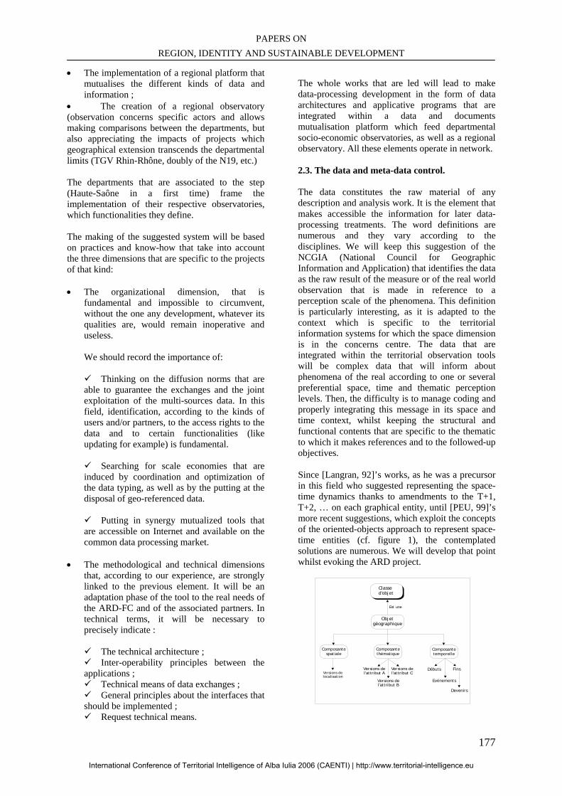
PAPERS ON REGION, IDENTITY AND SUSTAINABLE DEVELOPMENT
177
• The implementation of a regional platform that mutualises the different kinds of data and information ;
• The creation of a regional observatory (observation concerns specific actors and allows making comparisons between the departments, but also appreciating the impacts of projects which geographical extension transcends the departmental limits (TGV Rhin-Rhône, doubly of the N19, etc.) The departments that are associated to the step (Haute-Saône in a first time) frame the implementation of their respective observatories, which functionalities they define. The making of the suggested system will be based on practices and know-how that take into account the three dimensions that are specific to the projects of that kind: • The organizational dimension, that is
fundamental and impossible to circumvent, without the one any development, whatever its qualities are, would remain inoperative and useless.
We should record the importance of:
Thinking on the diffusion norms that are
able to guarantee the exchanges and the joint exploitation of the multi-sources data. In this field, identification, according to the kinds of users and/or partners, to the access rights to the data and to certain functionalities (like updating for example) is fundamental.
Searching for scale economies that are induced by coordination and optimization of the data typing, as well as by the putting at the disposal of geo-referenced data.
Putting in synergy mutualized tools that
are accessible on Internet and available on the common data processing market.
• The methodological and technical dimensions
that, according to our experience, are strongly linked to the previous element. It will be an adaptation phase of the tool to the real needs of the ARD-FC and of the associated partners. In technical terms, it will be necessary to precisely indicate :
The technical architecture ; Inter-operability principles between the
applications ; Technical means of data exchanges ; General principles about the interfaces that
should be implemented ; Request technical means.
The whole works that are led will lead to make data-processing development in the form of data architectures and applicative programs that are integrated within a data and documents mutualisation platform which feed departmental socio-economic observatories, as well as a regional observatory. All these elements operate in network. 2.3. The data and meta-data control. The data constitutes the raw material of any description and analysis work. It is the element that makes accessible the information for later data-processing treatments. The word definitions are numerous and they vary according to the disciplines. We will keep this suggestion of the NCGIA (National Council for Geographic Information and Application) that identifies the data as the raw result of the measure or of the real world observation that is made in reference to a perception scale of the phenomena. This definition is particularly interesting, as it is adapted to the context which is specific to the territorial information systems for which the space dimension is in the concerns centre. The data that are integrated within the territorial observation tools will be complex data that will inform about phenomena of the real according to one or several preferential space, time and thematic perception levels. Then, the difficulty is to manage coding and properly integrating this message in its space and time context, whilst keeping the structural and functional contents that are specific to the thematic to which it makes references and to the followed-up objectives. Since [Langran, 92]’s works, as he was a precursor in this field who suggested representing the space-time dynamics thanks to amendments to the T+1, T+2, … on each graphical entity, until [PEU, 99]’s more recent suggestions, which exploit the concepts of the oriented-objects approach to represent space-time entities (cf. figure 1), the contemplated solutions are numerous. We will develop that point whilst evoking the ARD project.
Classed'objet
Objetgéographique
Est une
Composantetemporelle
Composantethématique
Composantespatiale
Versions delocalisation
Versions del'attribut B
Versions del'attribut A
Versions del'attribut C
Evénements
Débuts Fins
Devenirs
International Conference of Territorial Intelligence of Alba Iulia 2006 (CAENTI) | http://www.territorial-intelligence.eu
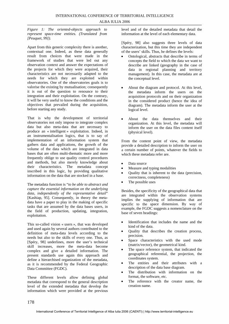
INTERNATIONAL CONFERENCE OF TERRITORIAL INTELLIGENCE ALBA IULIA 2006
178
Figure 1: The oriented-objects approach to represent space-time entities. (Translated from [Peuquet, 99]).
Apart from this generic complexity there is another, contextual one. Indeed, as these data generally result from choices that were made in the framework of studies that were led out any observation context and answer the expectations of the projects for which they were acquired, their characteristics are not necessarily adapted to the needs for which they are exploited within observatories. One of the observatories goals is to valorise the existing by mutualisation; consequently it is out of the question to renounce to their integration and their exploitation. On the contrary, it will be very useful to know the conditions and the objectives that prevailed during the acquisition, before starting any study. That is why the development of territorial observatories not only impose to integrate complex data but also meta-data that are necessary to produce an « intelligent » exploitation. Indeed, in an instrumentalisation logics, that is to say of implementation of an information system that gathers data and applications, the growth of the volume of the data which are integrated in data bases that are often multi-thematic more and more frequently oblige to use quality control procedures and methods, but also merely knowledge about their characteristics. The metadata concept inscribed in this logic, by providing qualitative information on the data that are stocked in a base. The metadata function is “to be able to abstract and capture the essential information on the underlying data, independently of the representative detail” [Kashiap, 95]. Consequently, in theory the meta-data have a paper to play in the making of specific tasks that are assumed by the data bases users, in the field of production, updating, integration, exploitation.
This so-called vision « users », that was developed and used again by several authors contributed to the definition of meta-data levels according to the needs but also to the skills of every one. Thus, as [Spéry, 98] underlines, more the user’s technical skill increases, more the meta-data become complex and give a detailed information. The present standards use again this approach and define a hierarchised organization of the metadata, as it is recommended by the Federal Geographic Data Committee (FGDC). These different levels allow defining global metadata that correspond to the general description level of the extended metadata that develop the information which were provided at the previous
level and of the detailed metadata that detail the information at the level of each elementary data.
[Spéry, 98] also suggests three levels of data characterization, but this time they are independent of the users’ skills. Thus, he defines the levels: • Ontological, abstracts that describe in terms of
concepts the field to which the data we want to describe are linked (geography in the case of data in regional planning and territory management). In this case, the metadata are at the conceptual level.
• About the diagram and protocol. At this level, the metadata inform the users on the acquisition protocols and on their organization in the considered product (hence the idea of diagram). The metadata inform the user at the logical level.
• About the data themselves and their organization. At this level, the metadata will inform the user on the data files content itself (physical level).
From the content point of view, the metadata provide a detailed description to inform the user on a certain number of points, whatever the fields to which these metadata refer are.
• Data source • Measure and typing modalities • Quality that is inherent to the data (precision,
correctness, completeness) • The possible uses Besides, the specificity of the geographical data that are integrated within the observation systems implies the supplying of information that are specific to the space dimension. By way of example, the FGDC suggests a nomenclature on the base of seven headings:
• Identification that includes the name and the
kind of the data. • Quality that describes the creation process,
precision. • Space characteristics with the used mode
(matrix/vector), the geometrical kind. • The space reference system, that indicated the
geographical referential, the projection, the coordinates system.
• The entities and their attributes with a description of the data base diagram.
• The distribution with information on the format, the software, etc.
• The reference with the creator name, the creation name.
International Conference of Territorial Intelligence of Alba Iulia 2006 (CAENTI) | http://www.territorial-intelligence.eu
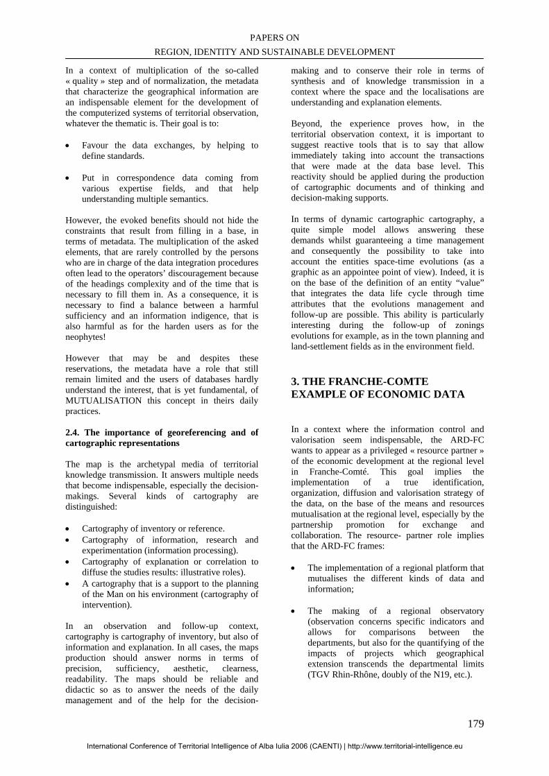
PAPERS ON REGION, IDENTITY AND SUSTAINABLE DEVELOPMENT
179
In a context of multiplication of the so-called « quality » step and of normalization, the metadata that characterize the geographical information are an indispensable element for the development of the computerized systems of territorial observation, whatever the thematic is. Their goal is to: • Favour the data exchanges, by helping to
define standards.
• Put in correspondence data coming from various expertise fields, and that help understanding multiple semantics.
However, the evoked benefits should not hide the constraints that result from filling in a base, in terms of metadata. The multiplication of the asked elements, that are rarely controlled by the persons who are in charge of the data integration procedures often lead to the operators’ discouragement because of the headings complexity and of the time that is necessary to fill them in. As a consequence, it is necessary to find a balance between a harmful sufficiency and an information indigence, that is also harmful as for the harden users as for the neophytes! However that may be and despites these reservations, the metadata have a role that still remain limited and the users of databases hardly understand the interest, that is yet fundamental, of MUTUALISATION this concept in theirs daily practices. 2.4. The importance of georeferencing and of cartographic representations The map is the archetypal media of territorial knowledge transmission. It answers multiple needs that become indispensable, especially the decision-makings. Several kinds of cartography are distinguished:
• Cartography of inventory or reference. • Cartography of information, research and
experimentation (information processing). • Cartography of explanation or correlation to
diffuse the studies results: illustrative roles). • A cartography that is a support to the planning
of the Man on his environment (cartography of intervention).
In an observation and follow-up context, cartography is cartography of inventory, but also of information and explanation. In all cases, the maps production should answer norms in terms of precision, sufficiency, aesthetic, clearness, readability. The maps should be reliable and didactic so as to answer the needs of the daily management and of the help for the decision-
making and to conserve their role in terms of synthesis and of knowledge transmission in a context where the space and the localisations are understanding and explanation elements. Beyond, the experience proves how, in the territorial observation context, it is important to suggest reactive tools that is to say that allow immediately taking into account the transactions that were made at the data base level. This reactivity should be applied during the production of cartographic documents and of thinking and decision-making supports. In terms of dynamic cartographic cartography, a quite simple model allows answering these demands whilst guaranteeing a time management and consequently the possibility to take into account the entities space-time evolutions (as a graphic as an appointee point of view). Indeed, it is on the base of the definition of an entity “value” that integrates the data life cycle through time attributes that the evolutions management and follow-up are possible. This ability is particularly interesting during the follow-up of zonings evolutions for example, as in the town planning and land-settlement fields as in the environment field.
3. THE FRANCHE-COMTE EXAMPLE OF ECONOMIC DATA
In a context where the information control and valorisation seem indispensable, the ARD-FC wants to appear as a privileged « resource partner » of the economic development at the regional level in Franche-Comté. This goal implies the implementation of a true identification, organization, diffusion and valorisation strategy of the data, on the base of the means and resources mutualisation at the regional level, especially by the partnership promotion for exchange and collaboration. The resource- partner role implies that the ARD-FC frames: • The implementation of a regional platform that
mutualises the different kinds of data and information;
• The making of a regional observatory (observation concerns specific indicators and allows for comparisons between the departments, but also for the quantifying of the impacts of projects which geographical extension transcends the departmental limits (TGV Rhin-Rhône, doubly of the N19, etc.).
International Conference of Territorial Intelligence of Alba Iulia 2006 (CAENTI) | http://www.territorial-intelligence.eu
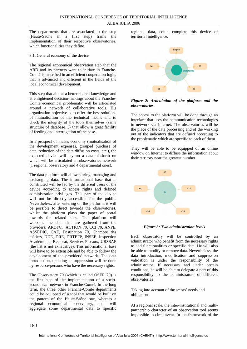
INTERNATIONAL CONFERENCE OF TERRITORIAL INTELLIGENCE ALBA IULIA 2006
180
The departments that are associated to the step (Haute-Saône in a first step) frame the implementation of their respective observatories, which functionalities they define. 3.1. General economy of the device The regional economical observation step that the ARD and its partners want to initiate in Franche-Comté is inscribed in an efficient cooperation logic, that is advanced and efficient in the fields of the local economical development. This step that aim at a better shared knowledge and at enlightened decision-makings about the Franche-Comté economical problematic will be articulated around a network of collaborative tools. His organization objective is to offer the best solutions of mutualisation of the technical means and to check the integrity of the tools themselves (same structure of database…) that allow a great facility of feeding and interrogation of the base. In a prospect of means economy (mutualisation of the development expenses, grouped purchase of data, reduction of the data diffusion costs, etc.), the expected device will lay on a data platform on which will be articulated an observatories network (1 regional observatory and 4 departmental ones). The data platform will allow storing, managing and exchanging data. The informational base that is constituted will be fed by the different users of the device according to access rights and defined administration privileges. This part of the device will not be directly accessible for the public. Nevertheless, after entering on the platform, it will be possible to direct towards the observatories, whilst the platform plays the paper of portal towards the related sites. The platform will welcome the data that are gathered from the providers: ARDFC, ACTION 70, CCI 70, ANPE, ASSEDIC, CAF, Destination 70, Chambre des métiers, DDE, DRE, DRTEFP, INSEE, Inspection Académique, Rectorat, Services Fiscaux, URSSAF (the list is not exhaustive). This informational base will have to be extensible and be able to follow the development of the providers’ network. The data introduction, updating or suppression will be done by resource-persons who have the necessary rights. The Observatory 70 (which is called OSER 70) is the first step of the implementation of a socio-economical network in Franche-Comté. In the long term, the three other Franche-Comté departments could be equipped of a tool that would be built on the pattern of the Haute-Saône one, whereas a regional economical observatory, that will aggregate some departmental data to specific
regional data, could complete this device of territorial intelligence.
Figure 2: Articulation of the platform and the observatories The access to the platform will be done through an interface that uses the communication technologies in network via Internet. The observatories will be the place of the data processing and of the working out of the indicators that are defined according to the problematic which are specific to each of them. They will be able to be equipped of an online window on Internet to diffuse the information about their territory near the greatest number.
Figure 3: Two administration levels Each observatory will be controlled by an administrator who benefit from the necessary rights to add functionalities or specific data. He will also be able to modify or remove data. Nevertheless, the data introduction, modification and suppression validation is under the responsibility of the administrator. If necessary and under certain conditions, he will be able to delegate a part of this responsibility to the administrators of different observatories
Taking into account of the actors’ needs and obligations
At a regional scale, the inter-institutional and multi-partnership character of an observation tool seems impossible to circumvent. In the framework of the
International Conference of Territorial Intelligence of Alba Iulia 2006 (CAENTI) | http://www.territorial-intelligence.eu
PAPERS ON REGION, IDENTITY AND SUSTAINABLE DEVELOPMENT
181
presented project, that combines regional and departmental observation, the ARD-FC and Action 70 developed some contacts. A catalogue of available data refers around forty potential providers/partners. Data providers and owners can have different expectations (technical, methodological, training, access to the data) or face specific problems. Besides, they can sometimes have different angles of incidence about the regional planning and particularly economical development. The data to mobilize can be very different. The actors’ needs and expectations taking into account seems all the more important as it aims at optimizing the social and institutional benefits of the project, reinforcing the base of common objectives of the platform and observatories network project and bringing a new lighting on the situation in Franche-Comté and on its evolution. So as to better know the expectations, in a first time we will have to identify all the stakeholders (at the internal and external levels) that can be linked to the project. An identification sheet “Actor” will allow detailing the different points of view on the problem, the nature of the faced problems, the specific needs, the solutions that can be suggested. This sheet could include five items to decline: • Organization characteristics : organization
name status, organization, behaviours, social situation, economical situation, etc. ;
• Interests, expectations, objectives : specific skills ;
• Sensitiveness in relation with the transversal approaches : involvement in federative structures, partnership actions, etc. ;
• Potentialities and weaknesses: human resources, knowledge about a field, information sources, endogenous production of data, experience, know-how, potential contribution, communication tools, etc.
• Involvement in the project: actions that can be led / supported, interpellation methods, implicit or explicit bridge, agreement/ contract, etc.
This part of the work should allow analysing the actors’ and local governance system. We are specially interested by the relationships between actors who can be stakeholders of the project In a second time, we will have to give in prospect the different problematic that can be supported by the observation system that is implemented. A three-stage step is recommended:
• Precisely defining the analyse framework and subject;
• Identifying the major problems that are faced by the targeted groups and the recipients (is/are the problem(s)? ;
• Visualising the problems in a diagram that is
called « problems tree »or « problems hierarchy » so as to establish the relations of cause for purpose.
The analyse aims at identifying the real bottlenecks that the stakeholders consider as a priority and that they try to reabsorb during the translation of the problems into intervention objectives. Lastly, we will have to implement a system of dynamic indicators that can enlighten the structural, space and time evolutions of the observed phenomena (problems), feed the evaluation, the follow-up and the prospect of the public or private intervention. This indicators system will be established by mobilizing the scientific corpus and the professional practices. It will be possible to consider three categories of indicators: • Context indicators: the context indicators allow
us to have a knowledge of the fundamental situation and returning account of the global evolution of the territory, an activity sector or a firm during an observation period. They are established in relation with objectives that is to say in answer to identified problems.
• Realization indicators: They are about the actors’ activity within a territory. They are measured in physical or monetary units (number of manifestations, number of firms that benefited from a financial support, commercial areas that were created, etc.);
• Result indicators: they are about the direct and immediate effect that is induced by the intervention. They give information on the evolution, for example of the behaviour, of the ability or of the direct recipients’ performances. These indicators can have a physical nature (welcoming ability, migratory balance, number of road accidents, etc.) or a financial nature (influence of the means of the private sector, drop of the transports costs).
The context indicators are usually generic data as they are exploited by all the actors of the territorial and economic engineering, in a recurring way. The realization and results indicators are defined at each intervention centre, communities and other
International Conference of Territorial Intelligence of Alba Iulia 2006 (CAENTI) | http://www.territorial-intelligence.eu
INTERNATIONAL CONFERENCE OF TERRITORIAL INTELLIGENCE ALBA IULIA 2006
182
development actors’ level. They especially contribute to measure the territory dynamism and to valuate the eventual failures in terms of accompaniment measures. CONCLUSION The territorial observation needs do not cease increasing because of the complexification of our socio-economic environment. The expectations we presented and the illustration by a starting project of data and information mutualisation at the regional and departmental scale show how this step is difficult. In the present case, a functional schedule of conditions will allow defining the methodological and technical expectations that will constitute the starting-point of the implementation of this whole of regional and departmental observatories which are associated to a regional platform.
BIBLIOGRAPHY Kashyap V., SHAH K., SHETH A. « Multimedia database systems : Issues and research directions », chapitre « Metadata for building the Multimedia Patch Quilt ». Springer Verlag, 1995.
Langran G. « Time in geographic information systems ». London, Taylor and Francis, 1992
Lardon S., Maurel P., Piveteau V. (sous la direction de). «Représentations spatiales et développement territorial ». Editions Hermes, Paris, 2001, 437 pages
Peuquet D. J. «Time in GIS and geographical databases». Geographical Information Systems, volume 1, Principles and Technical Issues, Edited by Paul A. Longley, Michael F. Goodghild, David J. Maguire, David W. Rhind, 1999, p. 91-102.
Spéry L., Libourel T. « Vers une structuration des métadonnées ». Revue Internationale de Géomatique, Volume 8- no 1-2/1998, p. 59-74.
International Conference of Territorial Intelligence of Alba Iulia 2006 (CAENTI) | http://www.territorial-intelligence.eu
PAPERS ON REGION, IDENTITY AND SUSTAINABLE DEVELOPMENT
183
SUSTAINABLE DEVELOPMENT AND FORESTRY RESOURCES ADMINISTRATION IN THE APUSENI MOUNTAINS AREA
________________________________________________________________
Ioana RÎŞTEIU MA. in Sociology, Babeş-Bolyai’’ University, Cluj-Napoca
Marin BÎRLA Inspector of speciality,
Professional address Bistra City Hall, Alba County, Romania.
Abstract: Due to irrational cuttings and despite the sustainable development principles, the Romanian forestry environment has suffered a real decline; the factors responsible for the forests status in Romania are identified and the goal is now to ecologically restore the forests. But what can be expected from the territorial community and territorial actors’ intelligence and what are the possible links between the communitarian territorial intelligence and the local governance? To bring an answer to all these questions, we proceeded to a set of analyses and investigations in the region of Apuseni Mountains – Romania. The final results are the basis of our research study; they emphasize the need for a global approach, partnerships and citizens’ participation to the decisions taking action.
Rezumat: Prin tăieri neraţionale, mediul forestier din România se află într-un continuu declin, contrar principiilor dezvoltării durabile; factorii responsabili de soarta pădurilor ţării au suficiente motive pentru a acţiona energic în vederea reconstrucţiei ecologice a pădurilor. Cât se pot baza pe intervenţia comunităţilor teritoriale şi pe inteligenţa teritorială a actorilor locali şi care poate fi raportul între inteligenţa teritorială comunitară şi guvernarea locală în acest demers complex? În încercarea de a răspunde la aceste întrebări, în ultimii ani, am realizat o serie de analize şi investigaţii în regiunea Munţilor Apuseni – România. Rezultatele obţinute fac obiectul comunicării noastre; ele scot în evidenţă necesitatea abordării globale, a constituirii de parteneriate şi a participării locuitorilor la luarea deciziilor legate de fondul forestier.
Keywords: Forest administration, Communitarian territorial intelligence, Forest cuttings control, Environmental education. Cuvinte cheie: Mediu forestier, Inteligenţă teritorială comunitară, Controlul tăierilor de pădure, Educaţie ecologică
International Conference of Territorial Intelligence of Alba Iulia 2006 (CAENTI) | http://www.territorial-intelligence.eu
INTERNATIONAL CONFERENCE OF TERRITORIAL INTELLIGENCE ALBA IULIA 2006
184
SUSTAINABLE DEVELOPMENT AND FORESTRY RESOURCES
ADMINISTRATION IN THE APUSENI MOUNTAINS AREA
1. THEORETICAL APPROACH
Why is environment a major concern for sociologists? Isn’t it a concern for other scientists or technicians? Isn’t the people’s impact on nature a physical one, created by the modern industrial production? Our answer to these questions is an affirmative one, as industry and technology have been created depending on various social institutions. Both our actions over environment and their consequences are of social origin. The global environment safeguarding should be a social and a technological one, as well. Some ecologists sustain the idea that members of rich societies should disapprove the consuming society and return to simpler ones, if a global ecological disaster is taken into account (Giddens, 2000).
1.1. Forestry resources administration
The main problem in terms of forestry environment, in Romania and all over the world, is the way of determining the right administration of forests that allows the sustainable supplies of goods and services that society might need in the domain of forestry.
On the other hand, forest offers a great quantity of wood to the population, and its value, in terms of creating work places, provides an economic function. Wood production and processing activities play an important role as far as the rural space is concerned, and represent the major income source of the forestry workers; these workers are allowed to proceed to the necessary investments for the forestry resources maintenance and revitalization. All these issues require a correct program of administrating the forestry resources, the legislative framework (regarding both the wood seller and the producer, the raw material and the finite product, the production cycle and the forestry policy) aiming to protect the forests against the uncontrolled grubbiness (Despres. A., Normandin. D., 1996). The entire forestry patrimony is now diminishing, the pressures over forests being considerable. 20 countries where 100 million people live do not own the necessary minimum wood supplies whereas half of the world population uses wood as a living resource and as a source of animal food. Every
year, 10 to 20 million hectares of forest are destroyed. The rich countries use and waste in different ways, especially rare essences that hardly regenerate. Forestry exploitation destined to rich countries represents more than 20% of the cuttings in the third world (Bari, 2003). Taking into account all these issues, the Romanian forests health is extremely important for the ecological equilibrium maintenance; on the contrary, actual statistics illustrate the bad conditions of the Romanian forests, generated by different phenomena such as excessive dryness or major floods, local and trans-border pollution phenomena or aggressive biotic and abiotic factors. This fact is a real consequence of some forestry measures inappropriately applied, in the last decades but not only, due to large forests areas given back to their owners, according to Law 18/1992. The private property retrocession of a large part of the Romanian forests, as a result of the modified forests law previously mentioned, created great disadvantages for the forest domain; and reflected a wrong way of administrating them and, of course the lack of strict rules for their cultural maintaining process (Berca, 1998).
1.2. Forest conscience The forestry history of many countries (especially European and North American countries), as well as the Romanian forestry economy, demonstrates the idea that the status and the future of forests in general, and the environment security do not depend on the laws number and quality, the forest structures or the foresters wishes and number. More than that, there is another significant factor with great positive or negative influence, regarding the forests’ preservation and the rational sustainable forestry economy. This specific force is of social and emotional origin and is generated by the way population, public opinion, but especially politicians, the legislative, executive and decisional power do really understand the forest life and importance in the local community and people’s destiny and even for each individual in the society. In many countries and in Romania as well, this issue has been called forest conscience, and that means „the total number of forests and tree status knowledge in the nature and national economy, on the one hand, and the method according to which all this knowledge are disseminated to population
International Conference of Territorial Intelligence of Alba Iulia 2006 (CAENTI) | http://www.territorial-intelligence.eu
PAPERS ON REGION, IDENTITY AND SUSTAINABLE DEVELOPMENT
185
or at least to those citizens involved in the right government of their country. It also refers to people’s sensitivity and understanding of forests, and consequently, respect and love for tree and forest, all of these analyzing forests’ faith in a country at a moment” (Drăcea, in Giurgiu, 2003).
2. INVESTIGATIONS ON FOREST CONSCIENCE IN THE APUSENI AREA COMMUNITIES
2.1. Investigations objectives and a few methodological aspects The present research objectives refer to the identification of the reasons and the causes that lead to the forest’s role in the environment, to the lack of concern when someone tries to reveal the dangers created by the lack of ecological conscience, and implicitly to the lack of forest conscience, when speaking about the Apuseni Mountains population (Horea – Albac and Bistra area). So, in accordance to the national and regional acknowledgement, we’ve tried to reveal in our actual research study the hypothesis that in the investigated area the level of forest conscience is very low (regarding a few empirical information and traditional justifications). A great priority is given to financial resources and to the living conditions improvement, without taking into account the moral and ecological aspects. The present paper research methodology is based on the qualitative component within which we used the direct observation as a first research method aiming at stressing the physical, geographical and infrastructural conditions that might be the causes or the effects of some individual or social behaviors regarding the forestry exploration in the defined area. Another investigation method was the interview (half structured), according to which we followed the exploration of concrete situations referring to exploring and processing the wood. In this respect, we interviewed a few persons dealing with this kind of activities, persons with a great influence for the community – the informal leaders – and neutral persons who have no connection to forests exploration, but who may have an opinion based on specialized knowledge. Therefore we used the snowball technique, trying to identify the interesting cases from people knowing people, from those who know the ones providing necessary and complete information on the analyzed situation in our paper (Agabrian, M., 2004).
The documents analyses regarding the forests administration concern (some situations and statistics of the forestry resources in the studied micro region – in accordance to the forests departments belonging to Albac and Horea communes) has been taken into consideration also in the present research study. We analyzed and correlated to our paper’s theme and objectives a set of documents on the investigated area’s physical and geographical location and to the demographical, social and economical structure of the population in that area, in accordance to the local public administration’s documents.
2.2. The research framework
Horea (Alba County): the commune is situated in the North-West part of Alba County, on the shore of Arazii Valley – Arieşul Mare River’s tributary, is at a 102 km distance to Alba Iulia city and at a 26 km distance to Câmpeni town. The commune area is of 60,4 km2. Administratively the commune consists of 15 villages. The commune population is of 2371 inhabitants, having as major occupations agriculture (breeding animals especially), the forestry resources’ exploitation and processing (Horea’s legendary commune is also called ’’the wood country’’) and lately, agrotourism (Mătişeşti village being declared agrotouristic station since 2003). In terms of existent buildings in the commune there are around 808, 90% of which are built of wood and brick. We also mention the fact that recently, the great majority of them have been renovated and there is a tendency for building new households, stressing the idea that migration phenomenon is much diminished in the area. Albac (Alba County): situated at the Albac River’s mouth in the Arieşul Mare River, in the North-West part of Alba County, is at a 100 km distance to Alba Iulia city (on DN 75 and DJ 108); it consists of 16 villages and hamlets. The commune area is of 52 km2. Its neighbors are as follows: in the North–Horea commune, in the West–Scărişoara commune, in the East–Vadul Moţilor commune, and in the South-East- Câmpeni town. The commune has got 2220 inhabitants and 768 households, most of them renovated quite recently. Its population has as a main occupation agriculture (breeding animals especially) and the forestry resources’ exploitation and processing. The place is documentary attested since 1795 (Ghereş, M., Culda, S., 2000). Bistra (Alba County): is situated in the middle of the Apuseni Mountains, on the high water course of the Aries River in a depression-basin – the Câmpeni
International Conference of Territorial Intelligence of Alba Iulia 2006 (CAENTI) | http://www.territorial-intelligence.eu
INTERNATIONAL CONFERENCE OF TERRITORIAL INTELLIGENCE ALBA IULIA 2006
186
Depression – Bistra, at a 527 m elevation. The commune territory has the following neighbors: in the East–Lupşa commune (10 km distance), in the West – Câmpeni town (5 km distance), in the South – Roşia Montană commune (10 km distance), in the North – Valea Ierii commune (33 km distance). Opposing to other important centers, this commune is situated 88 km from Alba Iulia and 109 km from Cluj-Napoca. The occupational structure shows the following: 1098 farmers; 674 employees; 106 teachers; 1362 pensioners; 387 free-workers; 380 unemployed; others 1239 (Bistra Commune Monograph, 2005). As far as the forestry areas on the studied communes are concerned, we have to specify that these are communes with great forest areas, with forest species being mainly resinous trees. Studying the entire area we’ve noticed a kind of co-inhabiting way of people and forest, the forest areas spreading close to households. The wood exploitation is also significantly represented. The communes with the highest density of installations for wood material processing per area unit (in Horea commune, for example, more than half of households own their family equipment for wood primarily processing – there are 416 family equipments). All these aspects correlated to the area’s accessibility for the researcher, are the main reason why we’ve chosen to study the entire Apuseni Mountains area. We also add the fact that Albac and Horea forestry resources are administrated by two forest departments: the Forest Department „Valea Arieşului” Câmpeni (a public department) and the Forest Department „Horea – Apuseni” (a private department). In administrating the public forestry fond the public property forests prevail (the city hall’s forests, the school’s, the church’s), so the entire forest area being larger than the private forest department’s; this one possesses the private property forests, but their owners want this department to administrate their areas, so there is a tendency of enlarging the administrated surface (according to Law 38/2006 – all forest owners have to leave their forests under the direct administration of a forest department). 2.3. Research results As we tried to illustrate, our researches aimed at evaluating the forest conscience in the Apuseni Mountains area, Horea – Albac and Bistra, and the major role that each community and person have, especially in the context of a research elaborated in a mountain area. It’s obvious that this is a concern
of both institutional and common sense level, and it represents the administrating way of one of the most significant resources provided by this area, the forest, and of course, all the social and economical implications concerning the forest exploration and processing in Horea, Albac and Bistra communes. The data collecting instrument (interview guide) allows the interviewed to make a description at the community level, not at the household level, to express their own perceptions on the forests exploitation in general, without peculiarities or specific specifications such as ’’good-true-nice’’. These general descriptions contributed to the very evaluation of the forest conscience, and more, to the good administration of forest resources. Seven relevant and important interviews have been realized in the Horea – Albac area (four local authorities and three community members), and ten interviews have been done in Bistra commune (three local authorities and seven community members). Face-to-face discussions were conducted for both informative level (learning selectively data, perceptions of the analyzed situation) and confirmative level (verifying data and information or emphasizing some perceptions in view of valid, general issues). 2.3.1. Community, forestry resources and living level
The conclusions of the first analyses of the inhabitants’ perception on the forestry resources show that the environment is not a simple design and doesn’t consists in material elements; man is present continuously everywhere. The man’s background is shared with others who will interact with the material lifestyle, on the one side, and depending on someone else’s presence, marking this way the individual’s perceptions, representations and behavior. According to this perspective, population in the investigated area tries to use rationally the forest resources, but not only, bringing into attention their right administration for the general social and economic progress. But man will think firstly of the realization of some financial objectives, without reconsidering the ecological importance of forests, and sometimes without thinking of the forests massive exploitation, aiming the direct economic needs. The area offers rich resources and well-balanced exploitation potential, but in the last two decades great changes at the social level, occurred (the economic relationships, the values system, the individual behavior, the fundamentals of the rural communitarian life, all of these changed); and
International Conference of Territorial Intelligence of Alba Iulia 2006 (CAENTI) | http://www.territorial-intelligence.eu
PAPERS ON REGION, IDENTITY AND SUSTAINABLE DEVELOPMENT
187
those are aspects imposing in a way, the idea of progress and development. But emphasizing the individual’s wishes, one can notice from the taken interviews, forgetting about the common interests, the risk of affecting the others, the environment degradation due to individual actions. Population exploit intensively the forest resources, remaining indifferent to the massive forests exploitations, and being dominated by the enrichment desire; this way the forest conscience remains at the minimum level of its existence.
“… I can characterize forest exploitation as awful; I mean that too large a quantity of wood is cut and planting and cleaning are neglected. Everyone cuts for their own good, without thinking of the consequences and only thinking about the money” (C. M, 63).
“… Years ago, during ’92 - ’98, the law was respected in proportion of fifty percent or less … now are less and less illegal exploitations and legal exploitations will be less also as we grow close to the date of January 1st 2007. However, generally speaking, took much forest is cut down; the forest owners often cut down everything they have. Ecologically speaking, it cannot go further as cutting is at the maximum limit. But people would like to cut more. If it were allowed, people would organize a wood cutting and carrying contest” (F. I., 38).
“… People never have enough and the forest grows but not in the rhythm it is cut; there is no conscience about it. People do not think about it and besides, they must act civil in the forest, not in a chaotic manner how they use forest equipment now, crushing young trees…which is a spillage for the future” (M. I., 73).
“… Few people realize what happens through massive deforestation, and maybe if they realized it, they would not even come close to the forest; maybe they would influence each other, but now everyone does what they want; besides, no matter how much wood they take, they will not get rich; gold does not make people better. Few people realize how important the forest is in their daily life; they give it a material and not an environmental importance; they only think about the wood, and not that it is necessary for breathing. They are not aware of its role; otherwise, everyone would take care of every tree around them.” (B. G., 53). The economic progress of the micro region is remarkable, in the recent decades, the local authorities supporting the individual development,
generating the community development. As a progress source, the local public administration (the local administrators with whom they discussed) have maintained the good resources management, valuating the agricultural and tourist potential of the area, the rational forest potential, of course with people’s support. The inhabitants agree the mentioned sources, but they also recognize wood exploitation as an enrichment source, as they quote: “it was better a few years ago, now wood is no more an interesting issue, those who knew, managed, others didn’t; now things are going wrong, even if one wants to do something, it’s not possible anymore. Some set up their own businesses, building touristic stations, others...” (P. M., 36 ani). The inhabitants’ idea on wood exploitation already exists, and we noticed analyzing the interviewers’ answers that the forests cuttings were massive in the last decades, but they were not monitored and insufficiently punished by the competent local authorities. At present we recognize that the illegal forest cuttings were practiced in the last years, but the forestry regime has been drastically applied. But even now there are a few ’’escaping gates” (as they are called by inhabitants), in spite of the great support offered by the local authorities (actions of informing about the forests’ rational exploitation, controls and amendments, cooperation and communication with population). It’s known that people do recognize the illegal facts that happened in the past, (a decade ago), which were not identified at that moment by authorities; they also avoid to speak about the present acts, but if they do this, they do it positively (the forestry domain being highly respected now due to the forests law) or suspecting someone of minor illegal acts (persons with different hierarchical status (social and economic) – ascendant or descendent). 2.3.2. Forest-economical and ecological significance Even less recognized and declaratively minor, the illegal cuttings problem is an actual one. The actual policy tends to reduce this phenomenon, the present forestry legislative frame allowing for the implementation of this policy and making the forests owners more responsible in terms of administrating the possessed forest surfaces. Even if the owners’ over evaluating role does exist, the final aims the forest conscience development – forests administration is more efficient and its ecological effect highly emphasized. But human nature tends to satisfy the individual needs firstly, and from this reason, many of the moral and civic
International Conference of Territorial Intelligence of Alba Iulia 2006 (CAENTI) | http://www.territorial-intelligence.eu
INTERNATIONAL CONFERENCE OF TERRITORIAL INTELLIGENCE ALBA IULIA 2006
188
norms are surpassed (under the slogan „for the family’s benefit”); this may lead many inhabitants to renounce to the civic consciousness in favor of their own families’ benefit (improving lifestyle doesn’t imply law’s violation). The above statements are stressed by the fact that there is a forest conscience coupled with a traditional one, according to which, people avoid the massive cuttings, as their ancestors used to do, and it’s the present generation’s duty to act consequently, acting in a similar way for the future generations.
CONCLUSIONS AND SUGGESTIONS
The forestry patrimony security and sustainability are considered essential conditions, and in this respect, some well supported statements, bringing into play both man and forest’s importance, are noticed: „the following fundamental truth is clearly distinguished: the third millennium will be one of reconciliation between the Romanian people and the forest, or it will be a hostile environment for us or even it will not exist at all” (Berca, 1998). As a consequence, the necessity of an education based on the forest conscience, within the larger and general context of environment conscience has been applied. Today, education for the environment is concentrated on the person and his behavior. This consists in offering the right knowledge and information to population. But human beings do not act in accordance to their knowledge. They need specific conditions needs and knowledge for their referential group. We agree to offer a communitarian dimension to environmental education. Educating the communities, we stress their control power over man’s individual behavior, power of traditional communities especially (Pascaru, 2003).
BIBLIOGRAPHY Agabrian, M. (2004), Cercetarea calitativă a socialului: design şi performare (Social Qualitative Research: Design and Performing); Iaşi: the European Institute Bari, I. (2003), Probleme globale contemporane (Contemporary Global Problems); Bucharest: Economic Publishing House Berca, M. (1998) Strategii pentru protecţia mediului şi gestiunea resurselor (Strategies for Environment Security and Resources
Administration); Bucharest: Grand Publishing House Despres, A., Normandin, D. (1996), Questions d’economie forestiere – Les services d’environnement fournis par la foret: evaluation et regulation; Chaiers d’Economie et Sociologie Rurales Ghereş, M., Culda, S. (2000), Turism rural (Rural Tourism); Cluj-Napoca: Risoprint Publishing House Giddens, A. (2000), Sociologie (Sociology); Bucharest: Bic All Giurgiu, V. (2003), Conştiinţa forestieră la români (The Forest Conscience in Romanians’ View); Bucharest: Snagov Publishing House Pascaru, M. (2003), Sociologia comunităţilor (Communities’ Sociology); Cluj-Napoca, Argonaut Publishing House *** (2005), Monografia comunei Bistra (Bistra Commune Monograph); Bistra City Hall
International Conference of Territorial Intelligence of Alba Iulia 2006 (CAENTI) | http://www.territorial-intelligence.eu
INTERNATIONAL CONFERENCE OF TERRITORIAL INTELLIGENCE ALBA IULIA 2006
189
TRENDS IN SOCIAL MOBILITY IN ROMANIA SINCE THE MIDDLE OF
THE TWENTIETH CENTURY. ECONOMICAL CHANGE AS AN EXPLICATIVE FACTOR OF THE SOCIAL MOBILITY
________________________________________________________________
Liliana IONAŞ Assistant
Professional address
Centrul de Cercetări pentru Dezvoltare Teritorială, Universitatea "1 Decembrie 1918", str. Nicolae Iorga 13 – R-510009 ALBA IULIA, Romania.
Abstract: One of the explanations of the social mobility’s growth in industrial countries from Europe and North America since the midtwenty century is the occupational change due to the modifications produced in the economic sectors. The pattern of upward social mobility can change because the parents of younger birthcohorts (people born since the 1960’s) have already benefited from upward social mobility so there is less scope for further upward mobility of their descendents. This paper aims to verify if the pattern of constant absolute social mobility applies to Romanian context, if some changes have occurred in the regime of social mobility in Romania since the middle of the twentieth century, and how much are these due to the dynamic from the occupational structure. Key-words : Social mobility, Social stratification, Social inequalities, Social and economic change.
International Conference of Territorial Intelligence of Alba Iulia 2006 (CAENTI) | http://www.territorial-intelligence.eu
INTERNATIONAL CONFERENCE OF TERRITORIAL INTELLIGENCE ALBA IULIA 2006
190
TRENDS IN SOCIAL MOBILITY IN ROMANIA SINCE THE MIDDLE OF THE TWENTIETH CENTURY. ECONOMICAL CHANGE AS AN
EXPLICATIVE FACTOR OF THE SOCIAL MOBILITY.
INTRODUCTION Social mobility is the moving of the people – individuals or groups – through the social space, from one social class to another, from one social position to another. Some authors (Erikson & Goldthorpe, 1993) define the concept of social mobility like the individual’s movement across different positions of the labor’s social division. Social mobility is a major mediating process between the social structure and the social action. The extent and nature of social mobility could influence the evaluation that people make about the social order, about its legitimacy. In modern societies, some barriers (juridical, religious) for the social mobility has been removed, and other, like educational system, and professional qualification system, has been recently introduced or reinforced. Already from the first decades of the twentieth century, researchers (eg Sorokin, 1964) of the social mobility suggested that, as the time passes, the social strata become more and more closed for new inputs, and that the trend, on long term, is the reducing of social mobility. However, in the Occidentals industrialized societies there is a great rate of mobility (absolute mobility), due to the economic development.
1. THE CONCEPTUAL FRAMEWORK
There are two main traditional approaches of the social mobility. One of these, assets the social process that occurs within the class structure and the other suppose that social mobility is a process occurring within some forms of social hierarchy. The first approach refers to the movement of individuals between different social positions defined in terms of the labor market relations. The researchers who adopt this framework stress on the structural shifts produced at the level of these relations. These changes do not implies necessary the social ascension or descend. This approach is useful for the study of the ties between social mobility and socioeconomic development. The second approach refers to the movement of people between different social aggregates ordered from the point of view of the correspondent prestige, status, economic resources, and so on, that characterize the members of these social groupings.
This later theoretical perspective fits for the study of the status attainment, individual success, or fail. The paradigm of status attainment is useful for the macrosociological studies and comparative analysis, where the main objective is to characterize different societies like more or less opened. The present paper uses the social structure conceptual and theoretical context of analyses.
2. DATA, VARIABLES, AND METHODOLOGY
Methodologically, the researchers of the social mobility process can approach it by the quantitative paradigm, and study it with statistical techniques, from simple descriptive statistics to different kind of statistic modeling. If the interest of the researcher is centered on the association per se between social origin and destination, on the pattern of this relation, on the measure in which the pattern and its variations in time and space reflect the endogenous and exogenous (structural) influences, then one indicate technique of analysis is the use of the social mobility tables. Therefore, the researcher can analyze both the actual fluxes of social mobility, and the propensity for social mobility between the social categories distinguished. The social mobility tables represent a particular case of crosstabs. The absolute rates of mobility or immobility refer to the proportion of people from some categories that are mobile, respectively immobile, and make possible the analyses of the inflows and outflows. Structural changes of the economies (the grade of development of different economical sectors, the labor force demand) or of the societies (demographic structure) can generate the absolute mobility. Relative rates of social mobility express the social fluidity, the probability to pass from an origin to a destination category. Relative mobility shows the chances of people from different sociocultural contexts to reach in different social position. We used the data from the public SPSS (Statistical Package for Social Sciences) databases of the Public Opinion Barometers (BOP), a biannual
International Conference of Territorial Intelligence of Alba Iulia 2006 (CAENTI) | http://www.territorial-intelligence.eu
PAPERS ON REGION, IDENTITY AND SUSTAINABLE DEVELOPMENT
191
research organized by the Foundation for an Open Society from Romania. I retained the data from the period 19982005. I found in these databases some explicitly defined variables reflecting the social position – occupation, level of education, incomes, social capital, and consumption. For the present study, I adopted the social classification based on the occupation of the individuals. Thus, I retained the variables occupation of the respondent, and the father’s occupation. Yet, I have encountered some methodological problems. Usually, the social mobility researches based on mobility tables compare the generation of fathers with the generation of sons in some reference moments of their life, but in the databases mentioned above it was indicated both for the fathers, and for their descendents only the occupation at the moment of the survey. Then, there is no certitude that I obtained a representative sample for the present real social structure thru the merging of the files corresponding to the biannual survey. Anyway, I putted together the cases from the sixteen databases, after some previous transformations of the variables, so that I similarly defined them. For the occupation variable, I started from the classification used in the Romanian Population and Household Census of 2002. This classification includes ten main occupational categories. The first main occupational group is that of legislators, Executive members, managers from public administration, and economic, social, and politic organizations. Specialists with intellectual and scientific occupations represent the second main occupational group. The third main occupational group is that of technicians, supervisors and assimilated ones. The employees constitute the fourth main occupational group. The fifth main occupational group includes operative labourers in services and commerce, and the assimilated. The farmers and qualified labourers from agriculture, forestry, and fishing constitute the sixth main occupational group. The artisans and skilled workers form the seventh main occupational group. The installation and machines operators, and machines, equipments and other products assemblers form the eight main occupational group. The unskilled workers constitute the ninth occupational main group. The army is the tenth main occupational group. In order to simplify the analysis, I reduced the number of occupational categories by combining some main occupational groups. I combined the first and the second main occupational group thinking that both of these main occupational groups include non/manual activities and demand a high level of formal instruction. Therefore, I have obtained the first class of my classification: intellectual occupations, owners and managers of the economic, social, and politic organizations, officials, and public officials (class I). The third main occupational group became the
second class of my classification: technicians, supervisors (class II). The fourth and the fifth main occupational group combined gave the third classof my classification: employees and operative labourers in services and commerce (class III). This combination grounds on the similar level of formal instruction specific to the members of these two main occupational groups. The sixth main occupational group became the fourth class of my classification: farmers and qualified labourers from agriculture, forestry, and fishing (class IV). The seventh and the eighth main occupational group formed the fifth class of my classification: skilled workers (class V). The ninth main occupational group became the sixth class of my classification: unskilled workers (class VI). The tenth main occupational group became the seventh class of my classification: army. The last class, I have excluded from analysis because its corresponding number of cases was too small to make valid comparative inferences. Therefore, only six categories remained on the classification of occupations. By joining the cases from the sixteen samples, I obtained a database containing 30371 cases. I set the condition that the respondent’s age is no less than twentyfour years and no bigger than sixtyfour years. In addition, I retained only the cases for which the occupation of fathers and sons/daughters simultaneously figure in the database and that are different from army forces. Therefore, I reached at a 5995 individuals subsample. Since I did not selected this subsample strictly by chance, and was not representative for the entire population, I appealed to the construction of a weighting variable for the subject’s age, with the purpose to correct the selection error. Thus, I transformed the variables from the last database in weighted variables. In this way, I obtained 262659 valid cases, which satisfy the previous conditions. As I took the cases from different databases correspondent to different years, the variable age cannot be included in statistical analysis just like that. I have considered that the birth year is better than the age to be included in comparative analysis. For passing over this problem, I’ve created, before merging the files from different years, an index file variable (for the month and the year when the survey was realised), so that I knew every moment for which year the respondent’s age was that registered in the final database. As the birth year of respondents does not figure in every year database, I calculated the respondent’s birth year extracting the respondent age registered in the initial databases from the year when the survey was carry on. Thus, for the interval of age between 24 years and 64 years correspond the period between 1935 and 1980, i.e. in the analysis I included only the respondents that were born in this period. I divided this period in three equal intervals: 19351949, 19501964, and 1965
International Conference of Territorial Intelligence of Alba Iulia 2006 (CAENTI) | http://www.territorial-intelligence.eu
INTERNATIONAL CONFERENCE OF TERRITORIAL INTELLIGENCE ALBA IULIA 2006
192
1979. Thus, I have created the cohort variable, with three values, which was included in further analysis. For the crosstabulation between father’s occupation and subject’s occupation, by birth cohort, we can reject the null hypothesis of independence between origin and destination. Therefore, we can affirm that the subject occupation depends on father occupation in all three birthcohorts.
See Table 1 and Table 2 3. TRENDS IN SOCIAL MOBILITY
3.1. Absolute mobility At the first sight upon the mobility tables it is obvious that the occupational category of the farmers and qualified labourers from agriculture, forestry and fishing (class IV), and the occupational category of the unskilled workers (class VI) was in continuous decline since the middle of the twentieth century. In the same time, the number of those from the occupational category of intellectual occupations, owners and managers of the economic, social and politic organizations, officials, statesmen (class I), and the occupational category of the employees and operative labourers in services and commerce (class III) has constantly increased. These changes in the occupational structure of the population were determined by the decline of the agriculture sector, by the development of industrial sector, and, consequently, by the development of the tertiary sector of economy (that modified the labour force offer and demand). In addition, the increased access to education, and the demographic phenomena (differential fertility of different class) could influence these shifts in the social structure. However, there are some differences in the pattern of the mobility between the cohort of those born in 19651979 and the previous cohorts (19351949, and 19501964). It means that the new politicaleconomic context after 1989 has determined new shifts in the social structure. Comparative with the previous cohorts, in the 19651979 birth cohort the number of technicians, foremen and assimilated (class II), artisans and skilled workers, installation and machines operators, machines, equipments and other products assemblers (class V) has decreased. The differences between the marginal frequencies from the table 1 suggest the hypothesis of a constant social flux, but not a unidirectional one. Absolute rates of mobility show, for each cohort, the proportion of those who are changing the social class: 61.6%, for the birth cohort 1935 1949, 68.6%, for the birth cohort 1950 – 1964, and 60.44%, for the birth cohort 1965 – 1979. It seems that the extent of mobility has increased since the
middle of the twentieth century until the end of 1980’s years, and then it became to decrease. This change in the regime of the social mobility can correlate with the economical development produced by the industrialisation of the country after the 1950’s years, and by the growing of the services sector, that generated the growth of some occupational categories and the correspondent decrease of the others. Since the 1990’s years, the number of those who are socially mobile has decreased again. One argument for this situation can be the fact that the number of different social and occupational positions do not increase permanently, but it stops at a given level, so that the new entrants in the labour market have to search their place only between the existent social positions. In other words, the parents of younger birthcohorts (people born since the 1960’s) have already benefited from upward social mobility so there is less scope for their own further upward mobility. 3.2. Outflow relative mobility rates I calculated the odds ratios to analyze whether the chances of individuals who belong to a given occupational category to pass thru different occupational categories are equal or not.
See Table 3 The odds ratio corresponding to the maintaining in class I of those originated in class I increased between the end of 1950’s years and the end of 1980’s years, grace to the enlargement of the class I boundaries and to the demographic changes. Since the end of the 1980’s years, the probability of keeping the social position has decreased to a lower level than that from the end of 1950’s years. Since the middle of the twentieth century, the class I was constantly the main destination of those born in class I. Since the end of the 1950’s years until the end of the 1980’s years the probability of passing from class I thru class V has increased, then the level of this probability kept relatively constant. Since the end of the 1950’s years till the beginning of the 1970’s years, and then, since the end of the 1980’s years, those whose fathers was in class I, who did not succeeded in staying in class I have oriented themselves mostly thru the class III. Comparative with these periods of time, since the middle of the 1970’s years until the end of the 1980’s years, those originated in class I, who did not reached the class I, have oriented themselves mostly thru the class V. The probability that those whose origin was in class I to get in class IV was low and in continuous decrease, since the middle of the twentieth century. Since the middle of the 1970’s years until the end of the 1980’s years, comparative with the previous period, the
International Conference of Territorial Intelligence of Alba Iulia 2006 (CAENTI) | http://www.territorial-intelligence.eu
PAPERS ON REGION, IDENTITY AND SUSTAINABLE DEVELOPMENT
193
probability of those originated in class I to reach in class II increased, and then, since the end of the 1980’s years, this probability decreased very much. The chances that those originated in class I reach in class III decreased since the middle of the 1970’s years until the end of the 1980’s years comparative with the previous period. Then, since the end of the 1980’s years, they increased to a level that was superior to that from the period since the end of the 1950’s years until the beginning of the 1970’s years. This occurred because since the end of the 1980’s years, the occupational category of employees and of the operative labourers in commerce and services has considerably enlarged. The probability that those originated in class I get in class VI was permanently low since the middle of the twentieth century. Since the middle of the twentieth century, those from class I had better chances to stay in their own class than to get in other classes. Then, those from class I had better chances to get in the class III or in class V than in other classes. Those whose fathers were from class II have oriented themselves predominantly thru the class I, since the middle of the twentieth century. The probability of passing from the class II thru the class I was constantly higher than the probabilities of passing thru other classes. The class I is a favourite destination class for those originated in class II. The probability of social reproduction of the class II was in continuous decrease since the middle of the twentieth century. Those originated in class II had a higher level of social mobility than those originated in class I. Apart from the class I, another destination for those originated in the class II was the class III. The probability of getting in class III from the class II constantly increased since the middle of the twentieth century. Since the end of the 1950’s years until the beginning of the 1970’s years, the probability of passing from the class II thru the class V was higher than the probability of passing from the class II thru the class III. Contrary, since the middle of the 1970’s years the chances of getting in class III was higher than that of getting in the class V. The probability of passing from the class II thru the class IV was constantly low and it permanently decreased since the middle of the twentieth century until the end of the 1980’s years. The probability of passing from the class II thru the class V has little decreased since the middle of the 1970’s years until the end of the 1980’s years comparative with the previous period. Then it has increased to a level a little higher than that from the period since the end of the 1950’s years until the beginning of the 1970’s years. The probability of passing from the class II thru the class VI was low and it increased a little
since the middle of the twentieth century. Those originated in the class II had better chances to get in the class I, the class III or the class V than to stay in their own class or to get in the class VI or in the class IV. Comparative with the probabilities of passing from the class III thru other classes, the chance of passing thru the class I was the highest since the middle of the twentieth century. The probability of passing from the class III thru the class I increased a little since the middle of the 1970’s years until the end of the 1980’s years comparative with the previous period, and then, since the end of the 1980’s years, it reached to the initial level. The class I is a favourite destination class for those originated in the class III. The probability of the social reproduction of the class III has constantly increased since the middle of the twentieth century and it tends to equalise the probability of passing from the class III thru the class I. The probability of passing from the class III thru the class II was in continuous decrease since the middle of the twentieth century, reaching to be lower than the probability of passing from the class III thru the class VI since the end of the 1980’s years. The probability of those originated in the class III to get in the class V has constantly increased since the middle of the twentieth century. Since the middle of the 1970’s years until the end of the 1980’s years, comparative with the previous period, the probability to get in the class IV decreased. Then, it has surprisingly increased again since the end of the 1980’s years near to the level from the period since the end of the 1950’s years until the beginning of the 1970’s years. The probability of passing from the class III thru the class VI has followed the same tendency like the probability of passing from the class III thru the class IV, but the increase since the end of the 1980’s years was lowest than in the previous case. It seems that since the end of the 1980’s years those originated in the class III succeed harder than before in getting in the class I or in the class II, so they orient themselves rather thru their own class or thru the class V. The probability of those originated in the class IV to get in the class I was relatively low since the middle of the twentieth century. Since the middle of the 1970’s years until the end of the 1980’s years, The probability of passing from the class IV thru the class I has increased a little comparative with the previous period. However, since the end of the 1980’s years, it decreased again to a lower level than in the period since the end of the 1950’s years until the beginning of the 1970’s years. The probability to get in the class II from the class IV
International Conference of Territorial Intelligence of Alba Iulia 2006 (CAENTI) | http://www.territorial-intelligence.eu
INTERNATIONAL CONFERENCE OF TERRITORIAL INTELLIGENCE ALBA IULIA 2006
194
had the same tendency like the probability to get in the class I from the class IV. Those originated in the class IV had relatively constant chances to get in the class III, since the middle of the twentieth century. The tendency of this last probability was to increase slowly, but, since the middle of the twentieth century, the chances of those originated in the class IV to get in the class III was lower than the chances of staying in their own class or than the chance of getting in the class V. The probability that those originated in the class IV to stay in their own class has decreased since the middle of the 1970’s years until the end of the 1980’s years, comparative with the previous period. Then, it has increased again since the end of the 1980’s years to a lower level than that of the probability of passing from the class IV thru the class V. Since the middle of the 1970’s years until the end of the 1980’s years comparative with the previous period, the probability to get in the class V from the class IV has increased, becoming the highest comparative to the probabilities of passing from the class IV thru the others classes. Then, since the end of the 1980’s years, it has decreased a little, comparative to the previous period. Since the end of the 1980’s years, the chances of those originated in the class IV to get in the class V are the best comparative to the chances of passing from the class IV thru others classes. The chances of those originated in the class IV to get in the class VI was in slowly continuous increase since the middle of the twentieth century, but was always lower than the chances of passing from the class IV thru the class V or of staying in their own class. Those originated in the class IV had better chances to get in the class V, or to stay in the class IV, or to get in the class III than those to get in the class I, or to get in the class II, or in the class VI, since the middle of the twentieth century. The probability of passing from the class V thru the class I constantly decreased since the middle of the twentieth century, but it was always higher than the probability of passing from the class V thru the class II, or thru the class IV, or thru the class VI. The probability that those originated in the class V to get in the class II has constantly decreased, more than the probability of passing from the class V thru the class I. The chance of those originated in the class V to get in the class III increased since the end of the 1950’s years until the end of the 1980’s years, then, it remained relatively constant. For those from the birth cohort 1935 – 1949, the chances to get in the class I were better than the chances to get in the class III. For the further cohorts, the chances of getting in the class III from the class V became better than the chances of passing thru the class I from the class V. The probability to pass from the class V thru the class IV was low since the middle of the twentieth century comparative to the probabilities of passing
from the class V thru the class I, or thru the class III. The tendency, for the probability of passing from the class V thru the class IV, was similar to the probability of passing from the class III thru the class IV. It decreased since the end of the 1950’s years until the end of the 1980’s years, then, it increased again. However, it did not reach the same level from the period since the end of the 1950’s years until the beginning of the 1970’s years. The probability of the social reproduction of the class V has constantly grown since the middle of the twentieth century. Comparative to the probability of passing from the class V thru others classes, the probability of staying in the class V was always higher than the probabilities of passing from the class V thru other classes. The level of social heredity is high in the case of the class V, but it is not so high like the level of social heredity of the class I. Anyway, since the middle of the 1970’s years, the level of social reproduction of the class V is higher than that of the class IV. The probability that those originated in class V pass thru the class VI has increased constantly and slowly since the middle of the twentieth century. Those originated in the class V had, since the middle of the twentieth century, the chances of staying in the same class better than the chances of getting in other classes. The probability that those coming from the class VI get in the class I was relatively low since the middle of the twentieth century. Comparative to the period since the end of the 1950’s years until the beginning of the 1970’s years, since the middle of the 1970’s years until the end of the 1980’s years, the probability of passing from the class VI thru the class I has slowly increased. Then, since the end of the 1980’s years, it has decreased to an inferior level than that from the initial period. The probability to pass from the class VI thru the class II was in continuous decrease since the middle of the twentieth century and was always lower than the probabilities of passing from the class VI thru the other classes. The probability that those originated in the class VI get in the class III has slightly increased since the middle of the twentieth century. The probability of passing from the class VI thru the class IV has decreased since the end of the 1950’s years until the end of the 1980’s years, and then it remained relatively constant. The probability of passing from the class VI thru the class V has increased since the end of the 1950’s years until the end of the 1980’s years. Since the middle of the 1970’s years the chances of those originated in the class VI to get in the class V was better than the chances to get in the other classes. Since the end of the 1980’s years the probability to pass from the class VI thru the class V has decreased, but was still higher than in the period
International Conference of Territorial Intelligence of Alba Iulia 2006 (CAENTI) | http://www.territorial-intelligence.eu
PAPERS ON REGION, IDENTITY AND SUSTAINABLE DEVELOPMENT
195
since the 1950’s years until the beginning of the 1970’s years. The probability of those originated in the class VI to stay in the same class has decreased between the middle of the 1970’s years and the end of the 1980’s years, comparative to the period since the end of the 1950’s years until the beginning of the 1970’s year. Then, since the end of the 1980’s years, it increased again, reaching a superior level than that from the period since the end of the 1950’s years until the beginning of the 1970’s years. The chances to pass from the class VI thru the class V or thru the class III, and respectively the chances of those originated in the class VI to stay in their own class was better than the chances to get in the other classes from the class VI, since the middle of the twentieth century. 3.3. Inflow relative mobility rates I calculated the odds ratios of getting in a given occupational category from other categories.
See Table 4 The better chances to get in the class I was those of the people originated in the class V. Since the middle of the twentieth century, their chances to get in the class I has constantly increased comparative to the chances of those originated in other classes. The chances of those originated in the class I to accede in their own class was always worse than the chances of those originated in the class V to accede in the class I. The level of social heredity of the class I has decreased since the middle of the 1970’s until the end of the 1980’s years comparative to the previous period, and then it has increased again, reaching a superior level than that from the initial period. The chances of those originated in the class II to accede in the class I has constantly increased since the middle of the twentieth century. Since the end of the 1950’s years until the end of the 1980’s years, the worst chances to accede in the class I was those of the people originated in the class II. Contrary, since the end of the 1980’s years, the worst chances to get in the class I was those of the people originated in the class VI and in the class IV. The chances of those originated in the class III to accede in the class I have increased since the end of the 1950’s years until the end of the 1980’s years. Then, their chances have decreased to an inferior level than the initial one. The chances of those originated in the class IV to accede in the class I have constantly decreased since the middle of the twentieth century. The chances to accede in the class I of those originated in the class VI has constantly decreased since the middle of the twentieth century (probably because they had less from the economic and cultural capital and they invested less in their education). Since the end of the 1950’s years until the end of the 1980’s years,
those originated in the class VI and those originated in the class I had relatively equal chances to accede in the class I. Since the end of the 1980’s years, contrary, those originated in the class VI had the worst chances, comparative to the members of the other classes, to get in the class I. The best chances to accede in the class II was those of the people originated in the class V, since the middle of the twentieth century. Their chances to get in the class II has constantly increased in this period. The probability that the members of the class I accede in the class II has slightly increased since the middle of the twentieth century, but remained lower than the chances of those originated in the other classes to be recruited by the class II. The probability that those originated in the class II to get in their own class has increased a little since the middle of the twentieth century. Therefore, it remained to a low level, like in the case of those originated in the class I. Those originated in the class I and in the class II had relatively equal chances to accede in the class II. Since the end of the 1950’s years until the beginning of the 1970’s years, the chances of those originated in the class III to accede in the class II were relatively high, comparative to the chances of those originated in the class I and in the class II. Since the middle of the 1970’s years, contrary, the chances of those originated in the class I, in the class II and in the class III to accede in the class II became relatively equal. The chances of those originated in the class Iv to accede in the class II was sensibly better than the chances of those originated in the class I, in the class II or in the class III, since the middle of the twentieth century. Since the end of the 1950’s years until the beginning of the 1970’s years, the chances of those originated in the class VI to accede in the class II were relatively equal to the chances of those originated in the class V. Since the middle of the 1970’s years, contrary, the inequalities of chance between those originated in the class V and those originated in the class VI to accede in the class II has accentuated more and more. Different from those originated in the class V, the chances of those originated in the class VI to accede in the class II have constantly decreased since the middle of the twentieth century. They reached to a relatively equal level to that of the probability of those originated in the class I, or in the class II, or in the class III to accede in the class II. The best chances to accede in the class III was those of the people originated in the class V, since the middle of the twentieth century. Their chances were in continuous increase since the middle of the twentieth century. Since the end of the 1950’s years until the beginning of the 1970’s years, the chances of those originated in the class IV to accede in the class III were relatively equal to the chances of the
International Conference of Territorial Intelligence of Alba Iulia 2006 (CAENTI) | http://www.territorial-intelligence.eu
INTERNATIONAL CONFERENCE OF TERRITORIAL INTELLIGENCE ALBA IULIA 2006
196
people originated in the class V. The chances of those originated in the class IV to accede in the class III have constantly decreased since the middle of the twentieth century, apart from those originated in the class V. Therefore, they remained higher than the chances of those originated in the class I, in the class II, in the class III, or in the class VI. Since the middle of the 1970’s years, the worst chances to accede in the class III were those of the people originated in the class I. Since the end of the 1950’s years until the beginning of the 1970’s years, only those originated in the class II had worse chances than those originated in the class I to accede in the class III. The probability that those originated in the class II to accede in the class III has constantly increased since the middle of the twentieth century. It became, since the end of the 1980’s years, relatively equal to the probability of those originated in the class III to accede in their own class. The chances of those originated in the class III to accede in their own class has remained relatively constant since the middle of the twentieth century. The probability that those originated in the class VI to accede in the class III has constantly decreased since the middle of the twentieth century, still remaining higher than the probability to accede in the class III of those originated in the class I, in the class II, and in the class III. Since the middle of the twentieth century, the best chances to accede in the class IV was that of those originated in the class IV. Their chances have decreased constantly and slowly since the middle of the twentieth century. The probability that those originated in the class I, in the class II, or in the class III to accede in the class IV was very low, since the middle of the twentieth century. The probability that those originated in the class V accede in the class IV has slightly increased since the middle of the twentieth century, remaining sensibly lower than the probability that those originated in the class IV get in their own class. The chances of those originated in the class VI to accede in the class IV were higher than the chances of those originated in the class I, in the class II, in the class III, or in the class V, since the end of the 1950’s years until the end of the 1980’s years. Since the end of the 1980’s years, the chances of those originated in the class VI to accede in the class IV became lower than the chances of those originated in the class V. The class IV was an unwanted destination by the members of the other classes (and mostly by those originated in the class I, in the class II, and in the class III). Since the end of the 1950’s years until the beginning of the 1970’s years, the chances to accede in the class V were relatively equal for those originated in the class IV, in the class V, and in the class VI. Since the middle of the 1970’s years, the
chances to accede in the class V have kept relatively equal only for those originated in the class IV and in the class VI. Since the middle of the twentieth century, the chances of those originated in the class V to get in their own class have constantly increased. However, the chances to accede in the class V have constantly increased for those originated in the class I, in the class II, and in the class III, these chances remained to a low level, since the middle of the twentieth century. The probability that those originated in the class IV or in the class VI to accede in the class V has constantly decreased since the middle of the twentieth century. Since the end of the 1950’s years until the end of the 1980’s years the best chances to get in the class VI were those of the people originated in the class VI. Since the end of the 1980’s years, those originated in the class V had a little higher chance to accede in the class VI than those originated in the class VI. The chances of those originated in the class VI to get in their own class have constantly decreased since the middle of the twentieth century. Contrary, the probability that those originated in the class V to accede in the class VI has constantly increased since the middle of the twentieth century. The probability that those originated in the class I, in the class II, or in the class III to get in the class VI was constantly low, compare to the probability that those originated in the other classes accede in the class VI.
CONCLUSION Data from the Public Opinion Barometers (BOP) organized by the Foundation for an Open Society from Romania show that, correspondingly to the different stages of economic development, there was a decline of social fluxes oriented thru the occupational categories from agriculture sector. In addition, there was an increase of mobility from agricultural occupations to the industrial occupations, an increased flux of mobility between the occupational categories from agriculture and the occupational categories from industry and services. These trends in the social mobility relate with the massive development of the industrial sector, since the middle of the twentieth century until the end of the 1980’s years, with the decline of the agricultural sector since the middle of the twentieth century, and with the development of the tertiary sector, since the middle of the twentieth century. These trends are similar to those from other European nations (see Erikson and Goldthorpe, 1993). The Romanian sample shows that the pattern of the absolute mobility has changed since the end of the 1980’s years comparative to the period since the
International Conference of Territorial Intelligence of Alba Iulia 2006 (CAENTI) | http://www.territorial-intelligence.eu
PAPERS ON REGION, IDENTITY AND SUSTAINABLE DEVELOPMENT
197
middle of the twentieth century until the end of the 1980’s years. The proportion of those who were mobile in the total of the population became less than in the previous period. Since the middle of the twentieth century until the end of the 1980’s years, the ample development of the industrial sector determined the spectacular development of the occupational categories of supervisors and technicians, respectively the numerical increase of the occupational category of the skilled workers. In this period, the category of intellectual occupations has numerically grown. In addition, the proportion of the (low level) employees and of the operative labourers in services and commerce has grown in the total of the population. Contrary, the proportion of the population occupied in the agricultural sector and the proportion of the unskilled workers have dramatically decreased since the middle of the twentieth century. This evolution of the borders of the occupational categories mentioned above demonstrates the increase of the general instruction and professional qualification level of the Romanian population since the middle of the twentieth century. Since the end of the 1980’s years, we assist to the massive decline of the industrial sector, respectively to the evident development of the tertiary sector. The accentuated numerical increase of the (low level) employees and of the operative labourers in services and commerce, and the ample numerical decline of the occupational category of the supervisors and technicians, and the numerical decrease of the skilled workers, respectively of the farmers and qualified labourers from agriculture, forestry, and fishing illustrate this evolution.
BIBLIOGRAPHY Biblarz, T.J.; Bengston, V.L.; Bucur, A. (1996) “Social Mobility Across Three Generations”, Journal of Marriage and the Family, vol. 58, No. 1, pp. 188200 Clogg, C.C; Rudas, T.; Xi, L. (1995) “A New Index of Structure for the Analysis of Models for Mobility Tables and Other Cross Classifications”, Sociological Methodology, vol. 25, pp. 197222 Erikson, R.; Goldthorpe, J. (1993) The Constant Flux: A Study of Class Mobility in Industrial Societies, Oxford, Clarendon Press Iannelli, C.; Paterson, L. (2005), Moving Up and Down the Social Class Ladder in Scotland, www.ces.ed.ac.uk/SocMobility/mobility.htm Iannelli, C.; Paterson, L.(2004), Social Mobility in
Scotland since the Middle of the Twentieth Century, ESRC Research Project, Working Paper 1, www.ces.ed.ac.uk/SocMobility/mobility.htm McCann, J.C. (1977) “A Theoretical Model for the Interpretation of Tables of Social Mobility”, American Sociological Review, vol. 42, No. 1/1977, pp. 7490 Paterson, L; Iannelli, C.(2005), Period changes in men’s class reproduction in Scotland, 1974 – 2001, ESRC Research Project, Working Paper 6, www.ces.ed.ac.uk/SocMobility/mobility.htm Sorokin, P. (1964), Social and Cultural Mobility, New York, The Free Press
International Conference of Territorial Intelligence of Alba Iulia 2006 (CAENTI) | http://www.territorial-intelligence.eu
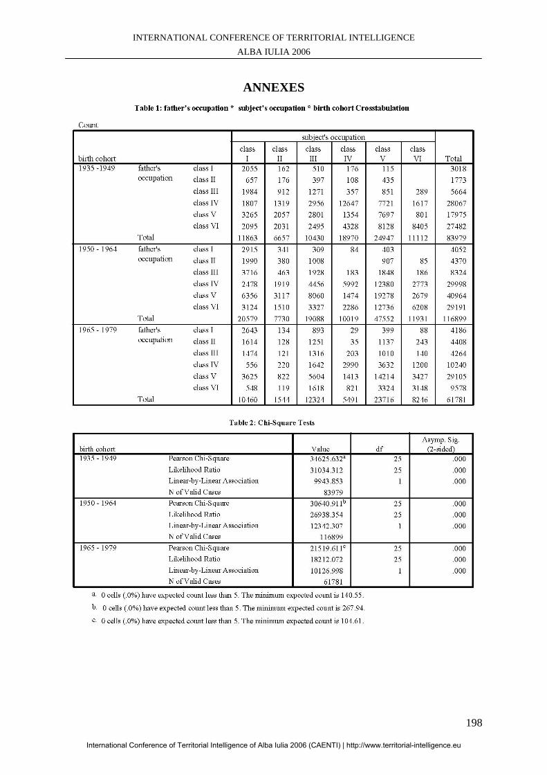
INTERNATIONAL CONFERENCE OF TERRITORIAL INTELLIGENCE ALBA IULIA 2006
198
ANNEXES
International Conference of Territorial Intelligence of Alba Iulia 2006 (CAENTI) | http://www.territorial-intelligence.eu
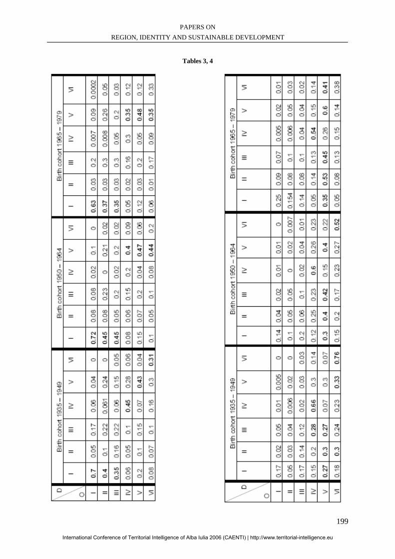
PAPERS ON REGION, IDENTITY AND SUSTAINABLE DEVELOPMENT
199
Tables 3, 4
International Conference of Territorial Intelligence of Alba Iulia 2006 (CAENTI) | http://www.territorial-intelligence.eu
INTERNATIONAL CONFERENCE OF TERRITORIAL INTELLIGENCE ALBA IULIA 2006
200
International Conference of Territorial Intelligence of Alba Iulia 2006 (CAENTI) | http://www.territorial-intelligence.eu
PAPERS ON REGION, IDENTITY AND SUSTAINABLE DEVELOPMENT
201
BUSINESSES AS ONE OF THE KEY ELEMENTS OF A REGION
SUSTAINABLE DEVELOPMENT
________________________________________________________________
Natalya MOISEYENKO PhD student in geography and spatial planning
[email protected], Tél: + 33 (3) 81 66 54 01
Professional address Université de Franche-Comté, ThéMA - 32 rue Mégevand – F-25030 BESANÇON cedex, France
Abstract: The regionalization and local development, encouraged by the European Union involves the notion of “territory”. Today “territory” or “region” should be seen as a system of actors. The concept of sustainable development should be taken into account by these actors. Businesses (especially SMEs) whose aim is to assure local development, economic growth and job creation are one of the key elements of territory’s sustainability.
Résumé: La régionalisation favorisée par l’Union Européenne implique la notion de territoire. Des acteurs s’expriment dans des systèmes complexes et le concept de développement durable doit être globalement pris en compte. Les entreprises, acteurs de ces territoires pour assurer le développement économique et l’emploi, se retrouvent au cœur de la problématique de développement durable. Key-words: Sustainable development, Territory, Businesses, Governance, Stakeholders.
Mots-clés : Développement durable, Territoire, Entreprise, Gouvernance, Parties prenantes.
International Conference of Territorial Intelligence of Alba Iulia 2006 (CAENTI) | http://www.territorial-intelligence.eu
INTERNATIONAL CONFERENCE OF TERRITORIAL INTELLIGENCE ALBA IULIA 2006
202
BUSINESSES AS ONE OF THE KEY ELEMENTS OF A REGION
SUSTAINABLE DEVELOPMENT
INTRODUCTION The Brundtland Report (1987) defined sustainable development (SD) as development that "meets the needs of the present generation without compromising the ability of future generations to meet their needs". (Brundtland, 1987) The 1995 World Summit on Social Development further defined this term as "the framework for our efforts to achieve a higher quality of life for all people," in which "economic development, social development and environmental protection are interdependent and mutually reinforcing components". In August 2002, the Johannesburg World Summit on Sustainable Development expanded this definition identifying the "three overarching objectives of sustainable development" to be (1) eradicating poverty, (2) protecting natural resources, and (3) changing unsustainable production and consumption patterns. That is to say, one of the factors which sustainable development must overcome is environmental degradation, but it must do so without forgoing the needs of economic development, social equality and justice. (UN Commission on Sustainable development site) Many international organisations have adopted their sustainable development strategies, or even created special commissions in charge of this question. The European Union has chosen “Sustainable Development Strategy” one of its priorities. Following the review of the EU Sustainable Development Strategy 2001 launched by the Commission in 2004, the European Council adopted in June 2006 an ambitious and comprehensive renewed Sustainable Development Strategy for an enlarged European Union. A hierarchical theme framework has been developed on the basis of the policy priorities of the Sustainable Development Strategy. The ten themes, which may be further developed in the future, are:
1. Economic development 2. Poverty and social exclusion 3. Ageing society 4. Public Health 5. Climate change and energy 6. Production and consumption patterns 7. Management of natural resources
8. Transport 9. Good governance 10. Global partnership
Source site of the European Commission Sustainable Strategy The re-launched Lisbon Strategy has already been refocused on those issues of most importance to the citizens, jobs and growth, in full coherence with the Sustainable Development Strategy; special emphasis has been laid on investment in knowledge and innovation, business potential, especially of Small and Medium Enterprises (SMEs), and employment of priority categories. (EC Presidency Conclusions, 2006) The regionalization and local development, encouraged by the EU implies the notion of “territory”. Today “territory” or “region” should be seen as a system of actors. Thus the concept of sustainable development should be taken into account by these actors. Businesses (especially SMEs) whose aim is to assure local development, economic growth and job creation are one of the key-figures of territory’s sustainability. But how “territory” and especially “region” can encourage and help the businesses to incorporate the sustainable development principles into theirs strategies? It is quite challenging for a company to act by itself. Communities within and between regions often compete to attract external and local investment. Opportunities exist for communities across regions to collaborate with each other to help their economies grow by supporting infrastructure or environmental improvements that demonstrate a broad regional impact (Swinburn, 2004). The same for businesses, their strength might be in joining networks or clusters. The idea of joining the networks may be seen as a necessity, but it is also a new opportunity. It is usually more difficult for SMEs to “find their way” of doing things. Many multinational companies are very present and sometimes more forceful than international organisations to push ahead. Since cases like Enron, WorldCom and Arthur Anderson the way business is conducted has changed.
International Conference of Territorial Intelligence of Alba Iulia 2006 (CAENTI) | http://www.territorial-intelligence.eu
PAPERS ON REGION, IDENTITY AND SUSTAINABLE DEVELOPMENT
203
More and more attention is paid to the questions like corporate responsibility or stakeholders’ value. Some sceptics will say that is all marketing and communication; the multinational corporations know how to use the communication tools to their advantage. But for some years now a real change is taking place. Transparency in financial reporting is one a piece of the puzzle, social and environmental performance and dialogue with stakeholders have become crucially important to success in business (Laszlo, 2001). More and more companies use the term “triple bottom line performance” which implies not only financial results as before, but also social and environmental performance. Almost all big multinationals are engaged in reporting on the company’s sustainable development. Sustainability reporting has become a vehicle for linking typically discrete and insular functions of the corporation – finance, marketing, research and development – in a more strategic manner. Sustainability reporting opens internal conversations (between departments within a company) where they would not otherwise occur. (Global Reporting Initiative, 2002)
1. SUSTAINABLE DEVELOPMENT IS AN INEVITABLE NEED FOR TERRITORY / REGION TODAY
Today every country faces the problems of globalisation or relocations, but it is regions in particular that suffer most from these problems. One of the possible answers is sustainable regional development, with respect towards environment, mutually beneficial economic development and social cohesion. Expansion of global capital markets and information technology continue to bring unprecedented opportunities for the creation of new wealth. At the same time, there is deep scepticism among many that such wealth will do anything to decrease social inequities. While governmental and non-governmental organisations are major players in the globalisation process, it is corporate activity that remains its driving force. The borderless global economy requires also borderless governance structures to help direct private sector activity toward outcomes that are socially and environmentally, as well as economically, beneficial. (Global Reporting Initiative, 2002) The concept of sustainable development which involves the questions of ethics and good governance obliges public and private sector to
search for new models of international governance, affecting such areas as climate change, loss of bio diversity, ozone depletion, social exclusion, labour practices, and financial accounting standards. A key element of these emerging new governance models is the demand for higher levels of transparency and cooperation. The same globalisation, expansion of information technologies and governance trends evident in industrial nations are taking root in emerging economies. We can talk about “global role of emerging economies”: nations such as China, India or Brazil are full participants in the globalisation process. The technology innovation and capital flows that powered globalisation in the last decade now permeate these emerging nations, positioning them as regional and global players on the economic stage of the 21st century. As sustainable development has become widely adopted as a foundation of public policy and organisational strategy, many organisations have turned their attention to the challenge of translating the concept into practice. The need to better assess an organisation’s status and align future goals with a complex range of external factors and partners has increased the urgency of defining broadly accepted sustainability performance indicators. (Global Reporting Initiative, 2002) When the Brundtland Report (1987) was first published governmental interest in integrated economic, environmental, and social reporting was scant. Today, voluntary, statutory, and regulatory initiatives abound. In Japan, the United States of America, Canada and the European Union countries such as France, Germany, UK or Sweden incentives and requirements to enlarge the scope of different initiatives on diverse levels from political to ecological are rapidly unfolding. Some actions are motivated by national environmental and social policy goals, others by investor pressures to obtain a clearer picture of corporate performance via the securities regulatory process. All indications point to continuing expansion of different initiatives to new countries and regions over the next few years. In many countries policies that hold local economies potential to account have been designed and pursued. Local development both social and economical is one of the key objectives of sustainable development of territories. Action on sustainable energy for ecological balance is being taken with a view to enhancing security of energy supply, reducing climate change and local air pollution, poverty and improving security, while promoting rural and local development. The
International Conference of Territorial Intelligence of Alba Iulia 2006 (CAENTI) | http://www.territorial-intelligence.eu
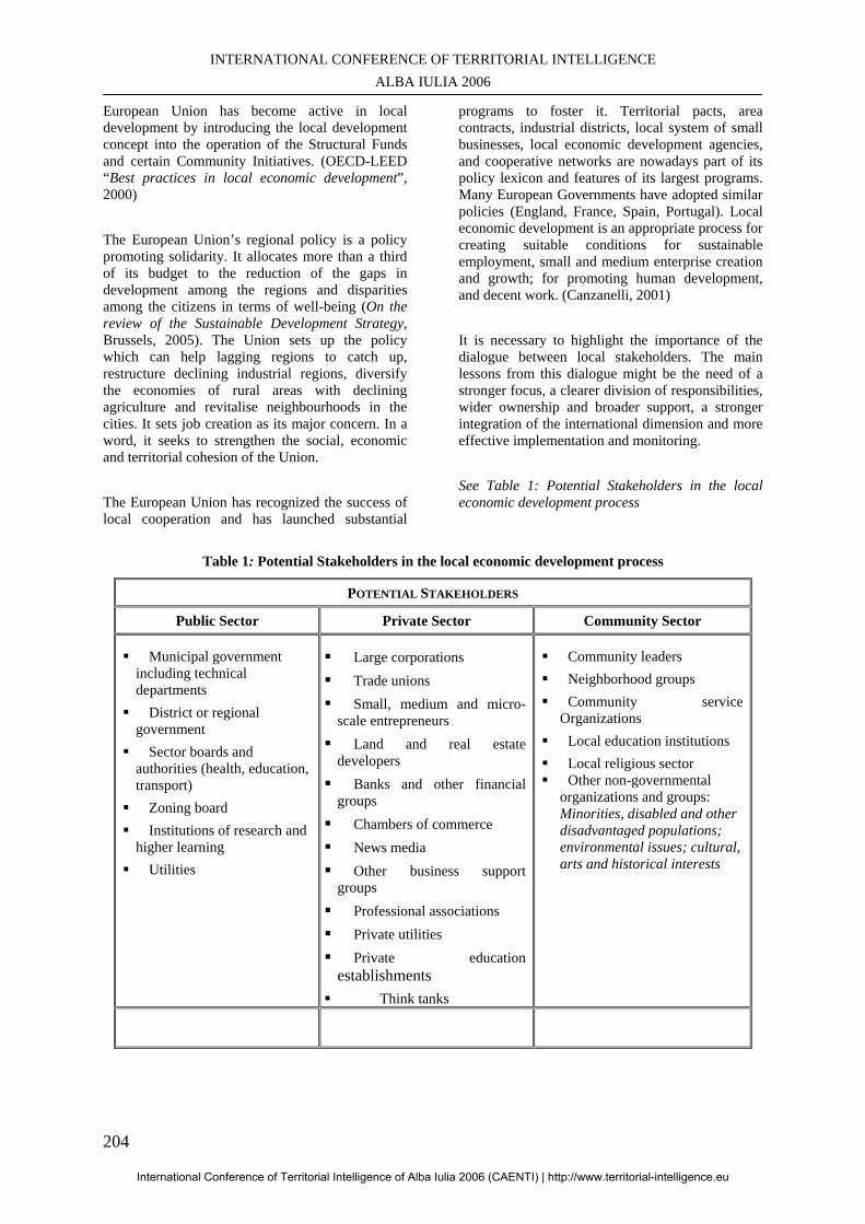
INTERNATIONAL CONFERENCE OF TERRITORIAL INTELLIGENCE ALBA IULIA 2006
204
European Union has become active in local development by introducing the local development concept into the operation of the Structural Funds and certain Community Initiatives. (OECD-LEED “Best practices in local economic development”, 2000) The European Union’s regional policy is a policy promoting solidarity. It allocates more than a third of its budget to the reduction of the gaps in development among the regions and disparities among the citizens in terms of well-being (On the review of the Sustainable Development Strategy, Brussels, 2005). The Union sets up the policy which can help lagging regions to catch up, restructure declining industrial regions, diversify the economies of rural areas with declining agriculture and revitalise neighbourhoods in the cities. It sets job creation as its major concern. In a word, it seeks to strengthen the social, economic and territorial cohesion of the Union. The European Union has recognized the success of local cooperation and has launched substantial
programs to foster it. Territorial pacts, area contracts, industrial districts, local system of small businesses, local economic development agencies, and cooperative networks are nowadays part of its policy lexicon and features of its largest programs. Many European Governments have adopted similar policies (England, France, Spain, Portugal). Local economic development is an appropriate process for creating suitable conditions for sustainable employment, small and medium enterprise creation and growth; for promoting human development, and decent work. (Canzanelli, 2001) It is necessary to highlight the importance of the dialogue between local stakeholders. The main lessons from this dialogue might be the need of a stronger focus, a clearer division of responsibilities, wider ownership and broader support, a stronger integration of the international dimension and more effective implementation and monitoring. See Table 1: Potential Stakeholders in the local economic development process
Table 1: Potential Stakeholders in the local economic development process
POTENTIAL STAKEHOLDERS
Public Sector Private Sector Community Sector
Municipal government including technical departments
District or regional government
Sector boards and authorities (health, education, transport)
Zoning board Institutions of research and higher learning
Utilities
Large corporations Trade unions Small, medium and micro-scale entrepreneurs
Land and real estate developers
Banks and other financial groups
Chambers of commerce News media Other business support groups
Professional associations Private utilities Private education establishments
Think tanks
Community leaders Neighborhood groups Community service
Organizations Local education institutions Local religious sector Other non-governmental
organizations and groups: Minorities, disabled and other disadvantaged populations; environmental issues; cultural, arts and historical interests
International Conference of Territorial Intelligence of Alba Iulia 2006 (CAENTI) | http://www.territorial-intelligence.eu
INTERNATIONAL CONFERENCE OF TERRITORIAL INTELLIGENCE ALBA IULIA 2006
205
The ultimate configuration of the stakeholder group should really be determined by a strategic assessment of the local economy and the key local economic actors themselves (Swinburn, 2004). Territorial Employment pacts are just one of the tools used by the European Union to promote local economic development. These come in full recognition of the importance of local participation in the local economic development processes, which is also underlined by the fact that together with the concepts of subsidiarity and additionality, partnerships and coordination are among the basic principles of the guidelines for structural funds funding. The territorial employment pacts were elaborated originally in 1997 after the confidence pact of Mr. Jaques Santer, former president of the European Commission. They are generally funded by the European Social Fund, which intervenes within the framework of the European Employment Strategy. Initiatives for SME support, community building projects, micro-credit programs are a clear example of this. (Canzanelli, 2001) The European Commission now undertakes impact assessments for all major policy proposals to assess their contribution to sustainability. The reform of the agricultural and fisheries policy, the reinforcement of rural development policy as well as the modernisation of cohesion policy reflects this commitment to integrated policy making. (On the review of the Sustainable Development Strategy, Brussels, 2005) It is clearly understood that, in order to realize sustainable development at local level, it is necessary that the stakeholders share a mutual vision of the future. This necessary, albeit not sufficient, condition is generally lacking in developing countries, which rare exceptions to this rule. Usually the first thing to be done is to create participation. Sharing a mutual strategic vision of development may be one of the most difficult things to achieve and the only way to meet this condition is to commence a long and tortuous dialogue among the local actors which may also be unsuccessful. The difficulties of succeeding in the elaboration of a mutual shared vision are strictly related to the wideness of the territory concerned, being these two factors indirectly related. (Canzanelli, 2001) The main objective of the territorial employment can be easily read in the ”Guide for Territorial Employment Pacts 2000-2006”. The basic objective of a pact is to encourage local regional partnerships in order to:
• identify the difficulties, concerns and future prospects facing each of the territorial players with responsibility for employment
• mobilize all available resources in favour of an integrated strategy accepted by all parties concerned, based on their real needs and expressed in a formal commitment
• improve the integration and coordination of job creation measures
• implement exemplary actions and measures in favour of employment
Territorial Employment Pacts are “participated tools” aimed at identifying and then implementing a coordinated set of interventions with the intention of mobilizing the necessary resources to trigger self-propulsive development, based on the endogenous resources of the territory. Promoting a bottom-up approach, through participation of all the local stakeholders from the public and the private sectors (who subscribe a formal memorandum of understanding which binds them to actively participate in the pact), various intervention on the territory must be planned and realized in order to render the territory more attractive to entrepreneurs. The strategy of intervention and the action plan following it are based on a local diagnosis undertaken by the local stakeholders. Innovative means for job creation, elaborated within a more complex framework of overall local development, should be one of the final outputs of the action plan. (Canzanelli, 2001) Transparency and public engagement are key characteristics of decision making for sustainability, which joints the demands for the good governance. The importance of context, the benefits of diversity and the inevitability of surprise all suggest that transparency and active public engagement are necessary qualities of governance for sustainability. Openness and participation are favoured by the emphasis of sustainability on lively citizenship, which is seen not just as a means of building understanding and commitment, but also as an end in itself – an aspect of the necessary and richer alternatives to lives centred on material consumption. The final characteristic with implications for governance is that sustainable development is an open-ended process. It is not necessarily perceived as a particular specified target. Pursuit of sustainability is a long-term, indeed never-ending process. The notion of sustainable ‘landing places’ that is sometimes used by the European Commission is therefore misleading. It suggests that the problem of sustainable development can be ‘solved’ whereas in reality only specific issues can
International Conference of Territorial Intelligence of Alba Iulia 2006 (CAENTI) | http://www.territorial-intelligence.eu
INTERNATIONAL CONFERENCE OF TERRITORIAL INTELLIGENCE ALBA IULIA 2006
206
be resolved and managed. There will always be ‘problems’ and needs for change (Rammel and van den Bergh, 2003). What is interesting to highlight, the European regionalisation has historically been: - government led rather than private-sector driven,
but oriented toward political unification rather than economic integration.
In comparison to Latin American which is: - government led, but oriented toward economic integration rather than political unification and Asian which is: private-sector driven, oriented toward economic integration. (Ken-Ichi Ando, 2001) National governments could act like catalysts and mediators : - fostering the different initiatives for local economic development; - eliminating the obstacles and facilitating the appropriate instruments; - decentralizing the information, the knowledge and the decisions; - stimulating the elaboration of development plans by the local organizations, and incorporating them in the national development strategies; - facilitating financial endorsement for the small companies (like seed capital, risk capital, reciprocal guarantee companies, etc.), - delegating functions of control and services to independent organisms, respecting the agreements of the territorial actors; - and jointly reinforcing the functions of evaluation with the local actors. (Ganzelli, 2001) 2. BUSINESSES AS REGIONAL
ACTORS
Businesses are one of the key players for the successful continuous development of regions. By developing themselves they develop the territory, enrich it and create addition value. This process is interdependent. Moreover today the expectations in terms of social and environmental respect are much higher than even ten year ago. The necessity of economic development is bordered by the questions of social cohesion and ecological balance. Citizens’ participation, their interests and growing demand for ethical behaviour should be taken into account by any institution functioning on the territory. The emergence of new ethics changes rapidly traditional forms of governing. It is what Ch. Laszlo calls “planetary ethics”. It originates with changing social expectations as expressed by consumers, employees, local communities, business partners or other stakeholders.
It is not political in the sense of attempting to impose the beliefs of one group on another group; it is not moralistic because it does not exhort companies to adopt one or another moral ideology, but it expands the code of good conduct to the globe. It encompasses a company’s responsibility for society and the environment, and it shifts the moral basis of action from abstract questions of right and wrong to consideration of whether a company is operating sustainability. (Laszlo, 2003) A strategic vision for the development of a certain territory (the importance is the same as that of strategic value for businesses) is the first step the local actors pursue for fixing collective ideas and images, exchanging interests and values, identifying strengths and weaknesses of their territory, and all the necessary issues for the assessment of future coherent actions. At the local level the relation between social and economic objectives is much more visible, because they lead to the same final aim that is the well being of the population, the maintenance and improvement of living conditions for current and future generations. So attention to gender equality, education, health, social security, workers protection, entrepreneurial values, and environment are part of the same strategy. Another important aspect that comes from the international experience consists in the needs to involve not only the entrepreneurs, but also other local actors, if employment and development strategies have to be realised. It is evident that local administrations are under pressure to provide answers for unemployed women and men, but they cannot provide it without the involvement of the private sector. On the other hand the private sector, even if strongly associated, cannot give solutions alone, because of the need of institutional framework and regulations, regarding the use of the space, of the natural resource, the training, the business services, and, least but not last, the consensus of the population about the development strategy for avoiding possible conflicts, and the lobbying with national and international institutions for different type of support (Canzanelli, 2001) The local development strategies can be based on number of essential elements: - they exploit a critical mass of local potential resources (natural, human, traditional know-how), rendering infinite the possibilities of generating new product (positive sum game) - they realise frequent innovations and high productivity through cooperation (on external
International Conference of Territorial Intelligence of Alba Iulia 2006 (CAENTI) | http://www.territorial-intelligence.eu
PAPERS ON REGION, IDENTITY AND SUSTAINABLE DEVELOPMENT
207
economies) and competition (on internal economies and products) - they are based on and they build a territorial awareness, a territorial system (businesses, services, governance), which turn as the real competitive factor, able to multiply the business opportunities and the attraction of new external investment. (Canzanelli, 2001) Territorial awareness might be based on the tools of the territorial intelligence. The existing and mostly popular tools of the economic intelligence are not sufficient for prosperous region’s functioning. Usually being focused only on the analysis of economical factors, they have become obsolete today. Territorial intelligence which embraces the fields of economics, geography, sociology, informational technologies, knowledge management is based also on the ethical principle of participation. The use of the tools of territorial intelligence can allow a more profound and complete analysis of the “structure and dynamics of territories” (Girardot, 2002) Today many SMEs may find their potential market chances and business partners in different countries or territories. Nevertheless, it must be understood that their existence and competence were also strongly supported by regional or local business concentration and networking, which is based on deep social division of labour and specialisation, including typical subcontracting system controlled by a big manufacturer, as well as industrial districts where small manufacturing or trading firms come all together. Mostly SMEs cannot survive or can’t be sustainable if they simply depend on their own limited resources and specialised skill and technological capabilities alone. The globalising economy inevitably tests whether individual regional economies and SMEs within them can compete and survive by showing their own competitiveness or not. Once it was widely believed that the very development of transport and information technology and borderless economy inevitably break the barrier of distance and make regional economies or industries almost meaningless. Nevertheless, surprisingly a sort of reincarnation of regionalism started in the 1980s, and many academics and researchers then ignited debates as well as numbers of empirical research works on the importance of regional industrial agglomeration and local networking. (Mitsui, 2004) Very well known notion of “clusters”, introduced by Harvard Professor Michel Porter is widely used and probably is the most popular. Clusters promotes both competition and cooperation. Rivals compete intensely to win and retain customers. According to the M. Porter definition a cluster is a “geographic
concentration of interconnected companies and institutions in a particular field. It includes, for example, suppliers of specialistic inputs such as components, machinery, and services, and providers of specialised infrastructure. Clusters often extend downstream to customers and laterally to manufacturers of complementary products. Finally many clusters include government and other institutions, such as universities, think tanks, vocational training providers, information, research, education, and technical support structures. Clusters represent a kind of a new spatial organisation form between the market and hierarchy, turning as an alternative way of organising the chain of value. Compared with market transactions among dispersed and random buyers and sellers, the proximity of companies and institutions in one location foster better coordination and trust.” (M. Porter, 1998) One of the reasons of clusters’ success is a fruitful dialogue between different potential stakeholders. (See Table 1) Regional clusters, the geographic concentration of economic activities in a specific field connected through different types of linkages, from knowledge spill-overs to the use of a common labour market, are increasingly viewed as an interesting conceptual tool to understand the economic strength or competitiveness of a region. In recent years, this view has also motivated more and more policy makers and economic development practitioners to turn to cluster-based concept as new tools to strengthen regional economies. The profile of a regional cluster today depends much on its profile in the past, and understanding these dynamic relationships is critical to devise policies that can change a regional cluster’s trajectory in a sustained, positive way. (Ketles, 2004) Prof. C. Ketles and O. Sölvell have undertook an interesting study on clusters functioning in the new European Union states with special attention to the systematic mapping and the analysis of regional clusters. The observations in this report, especially the findings on the low current level of regional specialization relative to the United States and the correlations between regional specialization and economic performance, suggest that the policies pursued by the European Union institutions should focus on enhancing the process of geographical specialization of industries within Europe. Second, the European Union institutions should develop data, tools, and methodology to enable cluster ini-tiatives within member nations to become more effective. Finally, the European Union should focus its own policies on enhancing the microeconomic capacity of its member countries and their regional economies.
International Conference of Territorial Intelligence of Alba Iulia 2006 (CAENTI) | http://www.territorial-intelligence.eu
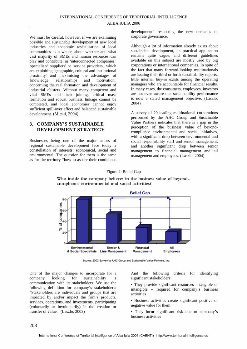
INTERNATIONAL CONFERENCE OF TERRITORIAL INTELLIGENCE ALBA IULIA 2006
208
We must be careful, however, if we are examining possible and sustainable development of new local industries and economic revitalisation of local communities as a whole, about whether and what vast majority of SMEs and human resources can play and contribute, as 'interconnected companies,' 'specialised suppliers' or 'service providers,' which are exploiting 'geographic, cultural and institutional proximity' and maximising the advantages of 'knowledge, relationships and motivation,' concerning the real formation and development of industrial clusters. Without many competent and vital SMEs and their joining, critical mass formation and robust business linkage cannot be completed, and local economies cannot enjoy sufficient spill-over effect and balanced sustainable development. (Mitsui, 2004) 3. COMPANY’S SUSTAINABLE
DEVELOPMENT STRATEGY
Businesses being one of the major actors of regional sustainable development face today a constellation of interests: economical, social and environmental. The question for them is the same as for the territory “how to assure their continuous
development” respecting the new demands of corporate governance. Although a lot of information already exists about sustainable development, its practical application remains quite vague, and different guidelines available on this subject are mostly used by big corporations or international companies. In spite of the fact that many forward-looking multinationals are issuing their third or forth sustainability reports, little internal buy-in exists among the operating managers who are accountable for financial results. In many cases, the consumers, employees, investors are not even aware that sustainability performance is now a stated management objective. (Laszlo, 2004) A survey of 20 leading multinational corporations performed by the AHC Group and Sustainable Value Partners indicates that there is a gap in the perception of the business value of beyond-compliance environmental and social initiatives, with a significant drop between environmental and social responsibility staff and senior management, and another significant drop between senior management to financial management and all management and employees. (Laszlo, 2004)
Figure 2: Belief Gap
One of the major changes to incorporate for a company looking for sustainability is communication with its stakeholders. We use the following definition for company’s stakeholders: “Stakeholders are individuals and groups that are impacted by and/or impact the firm’s products, services, operations, and investments, participating (voluntarily or involuntarily) in the creation or transfer of value. “(Laszlo, 2003)
And the following criteria for identifying significant stakeholders: • They provide significant resources – tangible or intangible – required for company’s business activities • Business activities create significant positive or negative value for them • They incur significant risk due to company’s business activities
International Conference of Territorial Intelligence of Alba Iulia 2006 (CAENTI) | http://www.territorial-intelligence.eu
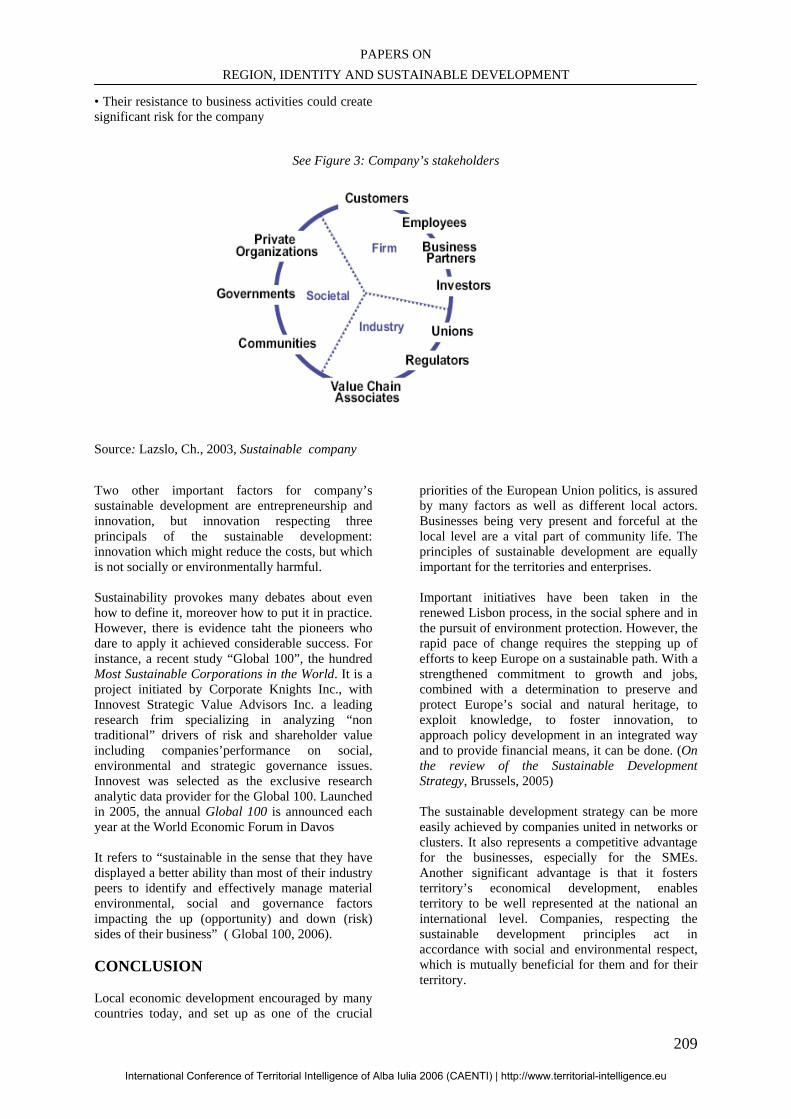
PAPERS ON REGION, IDENTITY AND SUSTAINABLE DEVELOPMENT
209
• Their resistance to business activities could create significant risk for the company
See Figure 3: Company’s stakeholders
Source: Lazslo, Ch., 2003, Sustainable company Two other important factors for company’s sustainable development are entrepreneurship and innovation, but innovation respecting three principals of the sustainable development: innovation which might reduce the costs, but which is not socially or environmentally harmful. Sustainability provokes many debates about even how to define it, moreover how to put it in practice. However, there is evidence taht the pioneers who dare to apply it achieved considerable success. For instance, a recent study “Global 100”, the hundred Most Sustainable Corporations in the World. It is a project initiated by Corporate Knights Inc., with Innovest Strategic Value Advisors Inc. a leading research frim specializing in analyzing “non traditional” drivers of risk and shareholder value including companies’performance on social, environmental and strategic governance issues. Innovest was selected as the exclusive research analytic data provider for the Global 100. Launched in 2005, the annual Global 100 is announced each year at the World Economic Forum in Davos It refers to “sustainable in the sense that they have displayed a better ability than most of their industry peers to identify and effectively manage material environmental, social and governance factors impacting the up (opportunity) and down (risk) sides of their business” ( Global 100, 2006). CONCLUSION Local economic development encouraged by many countries today, and set up as one of the crucial
priorities of the European Union politics, is assured by many factors as well as different local actors. Businesses being very present and forceful at the local level are a vital part of community life. The principles of sustainable development are equally important for the territories and enterprises. Important initiatives have been taken in the renewed Lisbon process, in the social sphere and in the pursuit of environment protection. However, the rapid pace of change requires the stepping up of efforts to keep Europe on a sustainable path. With a strengthened commitment to growth and jobs, combined with a determination to preserve and protect Europe’s social and natural heritage, to exploit knowledge, to foster innovation, to approach policy development in an integrated way and to provide financial means, it can be done. (On the review of the Sustainable Development Strategy, Brussels, 2005) The sustainable development strategy can be more easily achieved by companies united in networks or clusters. It also represents a competitive advantage for the businesses, especially for the SMEs. Another significant advantage is that it fosters territory’s economical development, enables territory to be well represented at the national an international level. Companies, respecting the sustainable development principles act in accordance with social and environmental respect, which is mutually beneficial for them and for their territory.
International Conference of Territorial Intelligence of Alba Iulia 2006 (CAENTI) | http://www.territorial-intelligence.eu
INTERNATIONAL CONFERENCE OF TERRITORIAL INTELLIGENCE ALBA IULIA 2006
210
WEBOGRAPHY AND BIBLIOGRAPHY http://ec.europa.eu/sustainable/welcome/index_en.htm European Commission web-site, information about the Reviewed Policy on sustainable development (June, 2006). http://www.globalreporting.org/ Site of the Global Reporting Initiative, one the most important international reporting standards in sustainable development (sited version 2002, revised in 2006). http://www.global100.org/ Site of the 100 global most sustainable enterprises in the world (the 2006 list). http://www.iisd.org Site of the International Institute of Sustainable Development. http://www.iog.ca Site of the Institute on Gouvernance (Canada), information of the question of good governance and corporate governance. http://www.nssd.net/ Site of the National Strategy on Sustainable Development, UK. http://www.oecd.org Site of the Organisation of Economic Cooperation and Development, documents on OECD principles on corporate governance. http://www.un.org/esa/sustdev/csd/policy.htm Site of the UN Sustainable Development Commission (the UN official strategy on the sustainable development). Brundtland, G.H. (1987), Our common future: The World Commission on Environment and Development, Oxford, Oxford University Press. Canzanelli, G., (2001), Overview and learned lessons on Local Economic Development, Human Development, and Decent Work, research paper, ILO programme “Universitas” Canzanelli, G., Dichter, G., (2001) Paper 2: Best practices and trends, Local Economic Development, Human Development, and Decent Work , ILO programme “Universitas” Catlin K., Matthews J., (2002) Building awesome organization, Hungry Minds Inc., NY Communication from the Commission to the Council and the European Parliament, On the review of the Sustainable Development Strategy, Brussels, 13.12.2005, COM (2005) 658 final
Entreprises et Développement Durable, (2004) Une édition du Comité 21, comité français pour l’environnement et le développement durable Giuliani, E., (2002), Cluster absorptive capability: an evolutionary approach for industrial clusters in developing countries, paper presented at the DRUID Summer Conference on "Industrial Dynamics of the New and Old Economy – who is embracing whom?", Copenhagen/Elsinore, June 2002 Ken-Ichi Ando, (2001), Regionalisation in Europe, A theoretical and empirical examination, presentation, Institute of Social Science, University of Tokyo Ketels, Ch., Sölvell, O., (2004), Clusters in the EU-10 new member countries, Europe Innova, research paper Laville, E., (2002) L’entreprise verte, le développement durable change l’entreprise pour changer le monde, Editions Village Mondial, Paris. Laszlo, Ch., (2003), The sustainable company, Island Press, Washington, Mitsui I., (2003), Industrial cluster policies and regional development in the age of globalisation; Eastern and Western approaches and their differences, research paper presented at the 30th ISBC in Singapore OECD-LEED Commission, (2000), “Best practices in local economic development” Porter, M., (1998),“Cluster and the new economics of competition” Harvard Business Review, November-December Rammel, C. and van den Bergh, J.C.J.M. (2003) Evolutionary policies for sustainable development adaptive flexibility and risk minimising’, Ecological Economics, Vol.47, p.121 Swinburn, G., Goga, S., Murphy, F., (2004) Local economic development: a primer developing and implementing local economic development strategies and action plans, A knowledge product of Cities of Change, the World Bank, Bertelsmann Stiftung. Girardot, J-J. (2003), “Concept, method and tools of territorial intelligence”, invited conference in the Social Worker National Training School, Nantau (Taiwan).
International Conference of Territorial Intelligence of Alba Iulia 2006 (CAENTI) | http://www.territorial-intelligence.eu
PAPERS ON REGION, IDENTITY AND SUSTAINABLE DEVELOPMENT
211
TERRITORIAL INTELLIGENCE AND LOCAL DEVELOPMENT.
THE RESTORING OF RESULTS OF THE SOCIOLOGICAL INQUIRY IN A MICRO-REGIONAL AREA
Mihai PASCARU Senior Lecturer, PhD
[email protected], Tél: + 40746080151
Professional Address Centrul de Cercetări pentru Dezvoltare Teritorială - Universitatea "1 Decembrie 1918", str. Nicolae Iorga 13 – R-
510009 ALBA IULIA, Romania. Abstract: In its first part the study intends to reunite a series of conceptual delimitations, the focused concepts being especially those of territorial intelligence, community development and governance. The second part of the study, dedicated to our more recent investigations in the Apuseni Mountains (Romania), starts with a short description of the studied territory: the micro-region Albac-Scărişoara-Horea (Alba county). In the sociological inquiry made in the micro-region, among other objectives, we mainly focused on the inhabitants’ representations of the studied territory. The results of the sociological inquiry were then restored to the local actors, thus shaping an important instrument of settling territorial intelligence, community development and local governing in a micro-regional context. Rezumat: În prima sa parte studiul îşi propune să reunească mai ales o serie de delimitări conceptuale, conceptele vizate fiind cu deosebire cele de inteligenţă teritorială, dezvoltare comunitară şi guvernanţă. A doua parte a studiului este consacrată unor investigaţii recente în Munţii Apuseni (România), plecând de la o scurtă descriere a teritoriului studiat: micro-regiunea Albac-Scărişoara-Horea (Judeţul Alba). În ancheta sociologică realizată în microregiune, între alte obiective, ne-am concentrat atenţia asupra reprezentărilor pe care locuitorii le au în legătura cu spaţiul studiat. Rezultatele anchetei sociologice au fost restituite către actorii din spaţiul studiat, restituirea fiind unul din importantele instrumente ale inteligenţei teritoriale, dezvoltării comunitare deopotrivă. Keywords: Territorial intelligence, Community development, Governance, Restoring of results. Cuvinte cheie: Inteligenţă teritorială, Dezvoltare comunitară, Guvernanţă, Restituirea rezultatelor.
International Conference of Territorial Intelligence of Alba Iulia 2006 (CAENTI) | http://www.territorial-intelligence.eu
INTERNATIONAL CONFERENCE OF TERRITORIAL INTELLIGENCE ALBA IULIA 2006
212
TERRITORIAL INTELLIGENCE AND LOCAL DEVELOPMENT.
THE RESTORING OF RESULTS OF THE SOCIOLOGICAL INQUIRY IN A MICRO-REGIONAL AREA
INTRODUCTION
The present study is above all the result of the activities and research developed in a CNCSIS project in Romania. But it is, at the same time, the result of some long reflections with future perspectives. In its first part, (FUNDAMENTAL NOTIONS AND EXPLORATIVE INVESTIGATIONS), the study intends to reunite mainly a series of conceptual delimitations, the focused concepts being mainly those of territorial intelligence, community development and governance. In the same first part, we also focus on a series of methodological specifications, mainly regarding the restoring of the results of the sociological inquiry, a method which we shall refer to along the study. The second part of the study, dedicated to our recent investigations in the Apuseni Mountains (Romania), begins with a short description of the studied territory: the micro-region Albac – Scărişoara – Horea (Alba county). A series of economic indicators (the percentage of the arable surface, the cattle in a household per 1000 villagers, the milk production) and social factors (mainly the poverty rate) will show us which the specific of the region is, as compared to the rural territory in Alba county or with Alba county as a whole. Taking into account all these contextual aspects, in the sociological inquiry made in the region, we focused mainly on the inhabitants’ representations of the studied territory. We aimed at establishing a hierarchy of the main community and territorial problems (the bad roads, the poor water supply, the poor reception of TV channels) and at identifying other problems as well, which, as compared to those declared by the villagers, are specific for the studied region. We have believed that the representations of the development opportunities in the micro-region are closely related to the representations of the community-territorial problems. The shaping of a hierarchy at the level of the development opportunities is useful especially when possible projects of development would mean the participation of the inhabitants of the entire micro-region. A hierarchy of the development opportunities is also useful as a starting point for the deep analysis of the community-territorial
problems, when, through restoring, it is subject to the villagers’ analysis who participated to its shaping. Territorial delimitation at micro-regional level, taking into account the administrative territory of several communes, would involve totally the idea of partnership. This type of partnership is well-known in a series of European countries as inter-communal association. Inter-communality relies on a consistent legislative support, for example, in a country such as France.44 In our sociological inquiry made in the micro-region Albac-Scărişoara-Horea, we were interested in this aspect as well, more precisely in the extent to which the association of the three communes is desired and is seen as a solution to the specific community-territorial problems.
1. FUNDAMENTAL NOTIONS: TERRITORIAL INTELLIGENCE, COMMUNITY DEVELOPMENT AND GOVERNANCE 1.1. Definitions and principles of territorial intelligence What is territorial intelligence if it is not the intelligence to live together in a given space-time? asked at one moment Bernard Corbineau. And he went on by saying that “time-space” (espace-temps) faces a fast change, without changing the essence of the definition of territorial intelligence (Corbineau, 2005). Another definition: “The innovative, mutual and network organisation, with a collective or individual purpose, of the set of information and knowledge useful for the development and competitiveness of a territory”.45 The authors of the same site, i-KM.fr, state the following: “… Territorial intelligence is for us the capacity of a territory to provide itself with means and methods pertinent for its development, for its promotion, for the application of the criteria of innovative competitiveness.” Territorial intelligence aims also at the notion of “collective intelligence”: 1) the
44 See Chevenement Law, 1991. 45 http://www.i-km.fr/dossiers/dossiers.php?id_dossier=3i.
International Conference of Territorial Intelligence of Alba Iulia 2006 (CAENTI) | http://www.territorial-intelligence.eu
PAPERS ON REGION, IDENTITY AND SUSTAINABLE DEVELOPMENT
213
application of the animation of networks, 2) the modernisation of the organisation through an innovative policy of human resources, 3) the application of the devices of performing monitoring and 4) reflections upon the real needs of the small and medium enterprises (PME-PMI). From the lines above results also the fact that sometimes the notion of territorial intelligence is tightly related to the economic domain. A more complex perspective seems to be proposed by Eric Ferrari: “Territorial intelligence can be synonym to the territoriality which results from the phenomenon of bringing together the resources of a territory and of transfer of competences among local actors of different cultural orientations.” It cannot exist, however, without resorting to the technologies of information and without mobilising competences in the service of attractiveness and competitiveness of territories (Ferrari, 2006). In this definition, the stress is laid on the territory and its mastering. In a study in 2004, Blancherie and François Badénès appreciated that territorial intelligence had the function to “transform the individual intelligence and competence in collective intelligence and competence” (Blancherie, Badénès, 2004), at the same time representing “the transmission of results of the research to the interested public”, which meant new relations between culture and innovation at territorial scale and also integrating new practices in sustaining the development. Aurelien Gaucherand had three starting points for the definition of the notion which presents interest for us here: 1) economic territorial intelligence (the creation of products and and the animation of the services of economic intelligence for the actors of the economic innovation) 2) strategic territorial intelligence (the creation of permanent infrastructures for a strategic supervision - veille strategique territoriale); 3) the administration of territorial communities – the creation of a resource centre to encourage the development of different “numeric territories” (Gaucherend, 2006). Consequently, when we say territorial intelligence, we also mean technologies of information used wisely in supporting territorial development. Taking into account implicitly such an aspect, Philippe Dumas, in a study in 2003, brings to discussion the ethical dimension of territorial intelligence, seen also as expression of territorial information “accessible and free for any citizen” (Dumas, 2003). Dumas speaks of such a “percept of reality in creating the contents of the systems of
territorial information” as “every territorial community gathers various sensibilities and interests, if not conflicting”. Everyone must find himself or herself in what can be named “numeric citizenship” (citoyenneté numérique) created by the territorial internet sites. In 2005, Jean-Jacques Girardot presented an ample study under the title “Territorial intelligence and participation”. Girardot confesses in his study that he himself proposed the term of territorial intelligence in 1999, in tight relation with that of territorial engineering (ingénierie territoriale), territorial intelligence meaning “putting the management of projects and technologies of information society in the service of sustainable development”. Along the development of several projects coordinated by Girardot, a new methodology suitable for the development of territorial intelligence is shaping, a methodology named Catalyse. Catalyse means “methods and instruments which allow the great involvement of territorial actors in the accomplishment of the territorial diagnoses or in the local laboratories in order to elaborate more efficient and pertinent action projects for development (Girardot, 2005). The main characteristic of the Catalyse methodology, according to Girardot, is participation. Actors represent first an informal partnership for the making of a data-collecting guide in order to proceed to a social or territorial diagnosis. Each of the actors collects the data at the level of his or her users (ses usagers). The data is enhanced for analysis, and then the actors participate to the interpretation of data as well. For Girardot, the concept of territorial intelligence means “the set of inter-disciplinary knowledge which, on the one hand, contribute to the understanding of the structures and dynamics of the territories, and, on the other hand, intends to be an instrument in the service of the the actors of the sustainable territorial development” (Girardot, 2005). Territorial intelligence, according to Girardot, relies on six ethical and methodological principles, among which the first is the principle of participation. We consider the identification of the ethical principles of territorial intelligence in the principles of sustainable development of special heuristic value. According to Girardot, sustainable development relies on three principles validated by numerous moral and political instances at world scale: 1) the participation of all actors to development, mainly of the villagers 2) the global approach of the situations, characterized by a proper equilibrium among the economic, social and
International Conference of Territorial Intelligence of Alba Iulia 2006 (CAENTI) | http://www.territorial-intelligence.eu
INTERNATIONAL CONFERENCE OF TERRITORIAL INTELLIGENCE ALBA IULIA 2006
214
environmental considerations 3) the partnership of the actors. These ethical principles associate with three methodological principles able to guarantee their observance 1) the approach of the territory as action space, 2) the dissemination of the culture of evaluation and the administration through projects and 3) the development of the accessibility of the technologies of the information society. Girardot states that these principles take into account first that the global approach relies on a both territorial and prospective vision and, second, that participation and partnership define territorial intelligence as an approach mainly focused on actors, and which relies on the accessibility of the information technologies as well as on the cooperation of the actors. 1.2 Territorial intelligence and community development Territorial intelligence, we believe, through some of its contents and principles (such as that of participation and partnership) comes rather close to what is called today community development. Being extremely synthetic, Dumitru Sandu writes that community development “means voluntary changes in, through and for the community” (Sandu, 2005, p. 15).
These lines, convergent to a great extent shape and improve methodologies of community organisation and planning through participative methods and fund raising for local communities through participation to project auctions. Intervention from outside the community is made only to facilitate the processes within and in a “horizontal” working manner (Buţiu, 2006). We believe that it is what corresponds, to a large extent, to territorial intelligence, but, definitely, the relations between notions needs deepening, as territorial intelligence seems to aim at a more pregnant scientific dimension and involves the information technologies in knowledge partnerships, which are to found the projects of sustainable territorial development. 1.3 Territorial intelligence, community development and governance A term rather new in the socio-human approaches, “governance” has multiple meanings, most often complementary. Generally, it is accepted that “governance comprises the traditions, institutions and processes that determine how power is exercised, how citizens are given a voice, and how
decisions are made on issues of public concern.”46 Governance refers to the patterns and the distribution of the institutionalised capacity to make and influence the decisions regarding a certain locality47. The characteristics of good governance include: 1) politic responsibility, 2) the freedom of association and participation, 3) a powerful judicial system 4) the bureaucratic responsibility, 5) the freedom of expression and information and 6) the building of the action capacity. All these aspects are seen as essential for sustainable development. 48 The term of governance seems to make a link between the governing act and especially territory and participation, which, to a certain extent, allows us to identify the closeness of this concept to that of territorial intelligence and also to that of community development. The principles of good governance (governing) are synthetically presented in the White Paper of the European Governance. There are five principles which lie at the basis of a good governance and of the changes proposed by the document mentioned above: opening, participation, responsibility, efficiency and coherence (White Paper, 2001). According to the first principle, institutions should be more open and should also use a more accessible language for the public. This is a very important aspect as it would determine an increase of confidence in the complex institutions. The principle of participation starts from the statement that, generally, the quality, relevance and efficiency of the European policies depend on the insurance of large participation all along the process of accomplishing the policies – from their elaboration to their implementation. Larger participation will lead to the increase of trust in the final result and in the institutions which accomplish the policies. The principle of responsibility requires that the roles in the legislative and executive processes be more clearly delimited and associated with a precise responsibility.
46www.phac-aspc.gc.ca/vs-sb/voluntarysector/glossary.html. 47www.rri.wvu.edu/WebBook /Danson/glossaryterms.htm. 48www.polity.org.za/html/govdocs/white_papers/social97gloss.html
International Conference of Territorial Intelligence of Alba Iulia 2006 (CAENTI) | http://www.territorial-intelligence.eu
PAPERS ON REGION, IDENTITY AND SUSTAINABLE DEVELOPMENT
215
Efficiency associates with opportunity, with the definition of clear objectives and decision-making at the right level.
The principle of coherence imposes that policies and actions be coherent and easy to understand under the circumstances of an increase in the complexity of the global and local processes. In the end, it is appreciated that every principle is important to itself, yet their observance not being possible through separate actions. The principle of the principles seems to be here also that of global approach and this proves how important the perspective of territorial intelligence in sustaining good governance is. 1.4. Methodological aspects: the restoring of results and the action research The methodological nucleus of the approaches from the perspective of territorial intelligence is represented by the Catalyse methodology (Girrardot, 2005). In its turn, this methodology relies mainly on restoring. But what is restoring? Bernard Bergier noticed that the more the research manuals and other methodological guides speak about media and offer advice for the settlement and organisation of data collection, the more the relation with the beneficiary and its impact upon the sociologist and the ethnologist. (Bergier, 2000). The beneficiary focused on by the restoring is represented by the researcher’s interlocutors in the field. Bergier was wondering about the aim of restoring: Is it an ideological instrument, a stimulating procedure or a form of participative management of the researcher? Is it a convention which allows paying the debt to the investigated population? Is it a strategy of complementary investigation, where the restored content is to serve the stimulation to produce and collect new material (information)? Is it a test which allows that the restoring of results be accomplished by separating truth from falsehood? Is it a space of confrontation between likelihood and the research hypotheses? In short, Bergier was wondering whether we should consider restoring as a constitutive element of the research or as an act outside it? Bergier will propose the following provisory definition for restoring: “… That act or dynamics through which the researcher shares the provisory and/or definitive results of the worked collected
data with the aim of their analysis, to his interlocutors in the field.” (Bergier, 2000, p. 8). From the definition of restoring proposed by Bergier, we retain the ethical and the heuristic objectives. We could go on talking about a gift-restoring, or an ethical restoring or a heuristic restoring, according to these objectives. We believe, however, that restoring is also related to the strategic action research or to the sociological intervention. For M. R. Verspieren, it is obligatory that the starting point in the action research be two types of hypotheses: the research hypotheses and the action hypotheses. The research hypotheses, when they are validated, have the knowledge production as result, while the action hypotheses aim at the transformation of reality (Verspieren, 1990). The relations between the researcher and the actor in the strategic action research mean, in Vespieren’s vision, the involvement of the actor in the research and of the researcher in the action, which means to educate the researcher to become a practitioner and the practitioners to become a researcher, thus giving birth to a collective actor. Accepting the observations above, we shall distinguish the gift-restoring, the knowledge-restoring and the intervention-restoring.. 2. THE RESTORATION OF RESULTS OF THE SOCIOLOGICAL INQUIRY IN A MICRO-REGIONAL AREA
2.1. The studied territory and its characteristics. The micro-region Albac-Scărişoara-Horea is situated in the North-West of the Alba county. It lies on a surface of 20871 ha, which represents 4.3% of the rural region of the Alba county. Here 4% of the rural population lives (6487 persons) in 3.7% of the households of the villages in Alba (see also Tabel 1, in ANNEXES). At the level of the rural area of the Alba county, women represent 49.6% and in the studied micro-region 48%. The birth rate of the live new-born babies is 9.3‰ in the rural part of Alba and 10.5‰ in the micro-region Albac-Scărişoara-Horea. The deceased represent 15.4‰ in the villages in the Alba county and 10.9‰ in the micro-region. For a population which represents 4%, the total agricultural surface represents only 2%, of which the arable land represents 14%, as compared to 40% in the villages of Alba. The pastures and hayfields represent 86% of the agricultural land in the micro-region, and, correspondingly, the number of cattle is 639 per 1000 villagers as compared to 336 of the total amount of the rural region of Alba. The milk production is 7.8hl/person in the micro-region, only
International Conference of Territorial Intelligence of Alba Iulia 2006 (CAENTI) | http://www.territorial-intelligence.eu
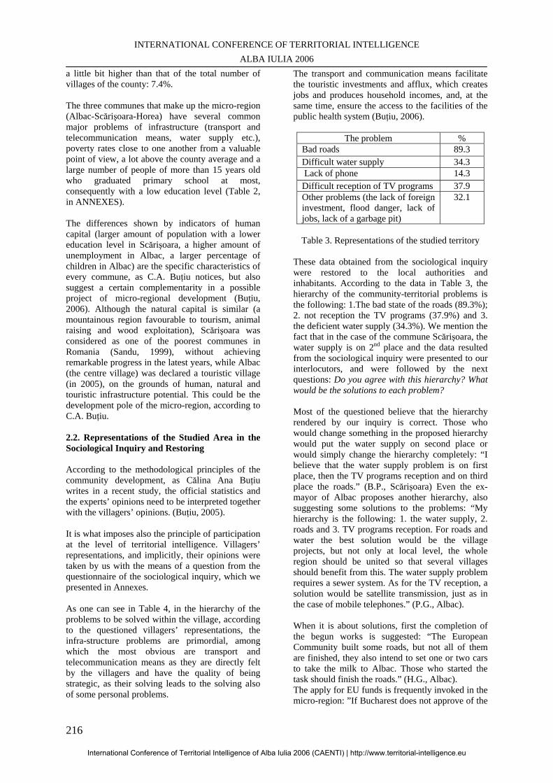
INTERNATIONAL CONFERENCE OF TERRITORIAL INTELLIGENCE ALBA IULIA 2006
216
a little bit higher than that of the total number of villages of the county: 7.4%. The three communes that make up the micro-region (Albac-Scărişoara-Horea) have several common major problems of infrastructure (transport and telecommunication means, water supply etc.), poverty rates close to one another from a valuable point of view, a lot above the county average and a large number of people of more than 15 years old who graduated primary school at most, consequently with a low education level (Table 2, in ANNEXES). The differences shown by indicators of human capital (larger amount of population with a lower education level in Scărişoara, a higher amount of unemployment in Albac, a larger percentage of children in Albac) are the specific characteristics of every commune, as C.A. Buţiu notices, but also suggest a certain complementarity in a possible project of micro-regional development (Buţiu, 2006). Although the natural capital is similar (a mountainous region favourable to tourism, animal raising and wood exploitation), Scărişoara was considered as one of the poorest communes in Romania (Sandu, 1999), without achieving remarkable progress in the latest years, while Albac (the centre village) was declared a touristic village (in 2005), on the grounds of human, natural and touristic infrastructure potential. This could be the development pole of the micro-region, according to C.A. Buţiu.
2.2. Representations of the Studied Area in the Sociological Inquiry and Restoring According to the methodological principles of the community development, as Călina Ana Buţiu writes in a recent study, the official statistics and the experts’ opinions need to be interpreted together with the villagers’ opinions. (Buţiu, 2005). It is what imposes also the principle of participation at the level of territorial intelligence. Villagers’ representations, and implicitly, their opinions were taken by us with the means of a question from the questionnaire of the sociological inquiry, which we presented in Annexes. As one can see in Table 4, in the hierarchy of the problems to be solved within the village, according to the questioned villagers’ representations, the infra-structure problems are primordial, among which the most obvious are transport and telecommunication means as they are directly felt by the villagers and have the quality of being strategic, as their solving leads to the solving also of some personal problems.
The transport and communication means facilitate the touristic investments and afflux, which creates jobs and produces household incomes, and, at the same time, ensure the access to the facilities of the public health system (Buţiu, 2006).
The problem % Bad roads 89.3 Difficult water supply 34.3 Lack of phone 14.3 Difficult reception of TV programs 37.9 Other problems (the lack of foreign investment, flood danger, lack of jobs, lack of a garbage pit)
32.1
Table 3. Representations of the studied territory
These data obtained from the sociological inquiry were restored to the local authorities and inhabitants. According to the data in Table 3, the hierarchy of the community-territorial problems is the following: 1.The bad state of the roads (89.3%); 2. not reception the TV programs (37.9%) and 3. the deficient water supply (34.3%). We mention the fact that in the case of the commune Scărişoara, the water supply is on 2nd place and the data resulted from the sociological inquiry were presented to our interlocutors, and were followed by the next questions: Do you agree with this hierarchy? What would be the solutions to each problem? Most of the questioned believe that the hierarchy rendered by our inquiry is correct. Those who would change something in the proposed hierarchy would put the water supply on second place or would simply change the hierarchy completely: “I believe that the water supply problem is on first place, then the TV programs reception and on third place the roads.” (B.P., Scărişoara) Even the ex-mayor of Albac proposes another hierarchy, also suggesting some solutions to the problems: “My hierarchy is the following: 1. the water supply, 2. roads and 3. TV programs reception. For roads and water the best solution would be the village projects, but not only at local level, the whole region should be united so that several villages should benefit from this. The water supply problem requires a sewer system. As for the TV reception, a solution would be satellite transmission, just as in the case of mobile telephones.” (P.G., Albac). When it is about solutions, first the completion of the begun works is suggested: “The European Community built some roads, but not all of them are finished, they also intend to set one or two cars to take the milk to Albac. Those who started the task should finish the roads.” (H.G., Albac). The apply for EU funds is frequently invoked in the micro-region: ”If Bucharest does not approve of the
International Conference of Territorial Intelligence of Alba Iulia 2006 (CAENTI) | http://www.territorial-intelligence.eu
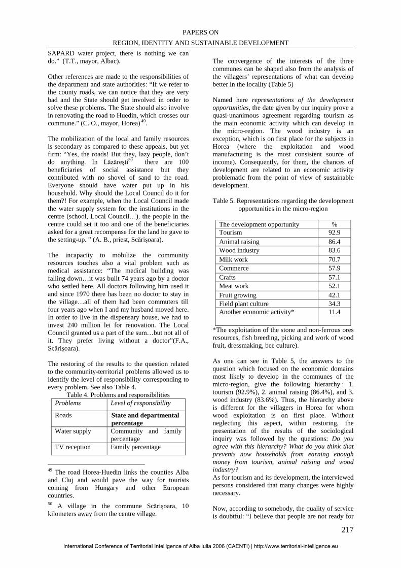
PAPERS ON REGION, IDENTITY AND SUSTAINABLE DEVELOPMENT
217
SAPARD water project, there is nothing we can do.” (T.T., mayor, Albac). Other references are made to the responsibilities of the department and state authorities: “If we refer to the county roads, we can notice that they are very bad and the State should get involved in order to solve these problems. The State should also involve in renovating the road to Huedin, which crosses our commune.” (C. O., mayor, Horea) 49. The mobilization of the local and family resources is secondary as compared to these appeals, but yet firm: “Yes, the roads! But they, lazy people, don’t do anything. In Lăzăreşti50 there are 100 beneficiaries of social assistance but they contributed with no shovel of sand to the road. Everyone should have water put up in his household. Why should the Local Council do it for them?! For example, when the Local Council made the water supply system for the institutions in the centre (school, Local Council…), the people in the centre could set it too and one of the beneficiaries asked for a great recompense for the land he gave to the setting-up. ” (A. B., priest, Scărişoara). The incapacity to mobilize the community resources touches also a vital problem such as medical assistance: “The medical building was falling down…it was built 74 years ago by a doctor who settled here. All doctors following him used it and since 1970 there has been no doctor to stay in the village…all of them had been commuters till four years ago when I and my husband moved here. In order to live in the dispensary house, we had to invest 240 million lei for renovation. The Local Council granted us a part of the sum…but not all of it. They prefer living without a doctor”(F.A., Scărişoara). The restoring of the results to the question related to the community-territorial problems allowed us to identify the level of responsibility corresponding to every problem. See also Table 4.
Table 4. Problems and responsibilities Problems Level of responsibility
Roads State and departmental percentage
Water supply Community and family percentage
TV reception Family percentage
49 The road Horea-Huedin links the counties Alba and Cluj and would pave the way for tourists coming from Hungary and other European countries. 50 A village in the commune Scărişoara, 10 kilometers away from the centre village.
The convergence of the interests of the three communes can be shaped also from the analysis of the villagers’ representations of what can develop better in the locality (Table 5) Named here representations of the development opportunities, the date given by our inquiry prove a quasi-unanimous agreement regarding tourism as the main economic activity which can develop in the micro-region. The wood industry is an exception, which is on first place for the subjects in Horea (where the exploitation and wood manufacturing is the most consistent source of income). Consequently, for them, the chances of development are related to an economic activity problematic from the point of view of sustainable development.
Table 5. Representations regarding the development
opportunities in the micro-region
The development opportunity % Tourism 92.9 Animal raising 86.4 Wood industry 83.6 Milk work 70.7 Commerce 57.9 Crafts 57.1 Meat work 52.1 Fruit growing 42.1 Field plant culture 34.3 Another economic activity* 11.4
*The exploitation of the stone and non-ferrous ores resources, fish breeding, picking and work of wood fruit, dressmaking, bee culture).
As one can see in Table 5, the answers to the question which focused on the economic domains most likely to develop in the communes of the micro-region, give the following hierarchy : 1. tourism (92.9%), 2. animal raising (86.4%), and 3. wood industry (83.6%). Thus, the hierarchy above is different for the villagers in Horea for whom wood exploitation is on first place. Without neglecting this aspect, within restoring, the presentation of the results of the sociological inquiry was followed by the questions: Do you agree with this hierarchy? What do you think that prevents now households from earning enough money from tourism, animal raising and wood industry? As for tourism and its development, the interviewed persons considered that many changes were highly necessary. Now, according to somebody, the quality of service is doubtful: “I believe that people are not ready for
International Conference of Territorial Intelligence of Alba Iulia 2006 (CAENTI) | http://www.territorial-intelligence.eu
INTERNATIONAL CONFERENCE OF TERRITORIAL INTELLIGENCE ALBA IULIA 2006
218
tourism, as you simply can’t send people to a toilet outside or have them sleep in the same room with you. You must have a good room, and a bathroom with a shower and hot water. If you do something, you should do it well.” (P.I., Albac). It is considered that prices are too high as compared to the services offered, even where there are proper accommodation conditions: “Well, people got ready for tourism, but there have been too few people this summer. Maybe, if the prices were lower, tourists would feel encouraged to come. They have rooms and bathrooms but their prices are rather high.” (F.A., Albac). In Horea, not only tourism development is prevented by the precarious infrastructure: “Tourism is prevented by the infrastructure of roads with the Cluj county. From Mătişeşti to Cluj the road is not asphalted and people don’t look for accommodation in Horea.” (F.B., Horea).51 Bureaucracy is considered a stop in the development of tourism entrepreneurship, which is a primordial condition for investments in this domain: “The State doesn’t sustain people who take initiative to set up a commercial company with simple and profitable laws, one needs a lot of documents to register it, doesn’t get profitable loans, being prevented by the lack of money.” (T. T., Scărişoara). The micro-region needs another promotion as well: “In our region there are no tourists as the region is not mediated, if there were some better defined touristic objectives, there would be a chance.” (P.G., Albac). In spite of the position it has in our hierarchy, animal raising is not regarded with too much optimism. The numerous stops brought about, such as the quality of the fodder and the lack of market for the products, are the most signalized: “Animal raising would not develop as one cannot raise a cow with the fodders we have here, as they are wild and do not give enough milk.” 52 (F.C., Horea); “The villagers raise their animals in their own households, without having the possibility to verify the milk and the milk products, the pork and chicken meat. Centres to collect these products would be necessary, through investment of the state.” (D.E., Scărişoara). The commentaries regarding the wood industry reflect the complexity of the processes related to this domain, which are ecologic, economic and
51 See footnote no. 5. 52 Poor in nutritive substances
social. Thus, we notice first the total dependence of the villagers to the wood industry in the region: “With us, if we run out of wood, it’s disastrous!” (P.H., Albac). It is then appreciated that the wood industry is difficult and expensive, especially for old people: “Those who take care of the forests earn huge sums of money, but not everybody can be involved as the hills are difficult to climb and it takes several people and you can’t go there alone to cut down a Christmas tree and till you cut up some …and then transport is expensive. In the end, you get nothing.” (F.A., 82 years, Albac). The processing work itself is also expensive: “In wood processing, there is not enough money for a sawmill or other tools to work the wood.” (T.T., mayor, Albac). In the end, the lack of wood stock leads to unsatisfactory prices: “I think that the market prevents the people from earning sufficient money from this economic activities, the lack of wood stock, if we can say so.” (C.O., mayor, Horea). The exhaustion of wood resources is also signalised: “In wood industry, how can there be wood if it was all cut down?” (A.B., Albac). Hence the emergency signal regarding the impact of wood cutting upon sustainable development: “…They almost finished with wood cutting. They should let the forests grow again so that our grandchildren should also benefit from it.” (F.C., Horea); “We should stop cutting wood as we spoil the environment…”(B.C., priest, Scărişoara). Tourism could succeed the wood industry, according to some opinions: “At present, everybody lives out of wood, and they do what they can do as long as they can do. Then, when the wood is over, tourism can develop.” (F.D., Horea). The problem of the inter-communal association can be an indicator of the cohesion of the studied micro-region in the event of some projects of micro-regional level. Because of this reason, in our inquiry we also focused on this aspect. Conditionally or not, most of the villagers in the three communes consider association necessary (See also Table 6).
International Conference of Territorial Intelligence of Alba Iulia 2006 (CAENTI) | http://www.territorial-intelligence.eu
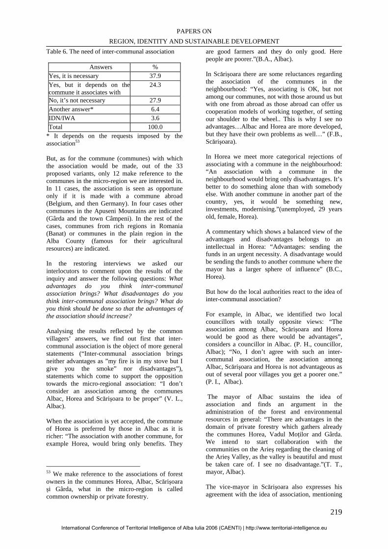
PAPERS ON REGION, IDENTITY AND SUSTAINABLE DEVELOPMENT
219
Table 6. The need of inter-communal association
Answers % Yes, it is necessary 37.9 Yes, but it depends on thecommune it associates with
24.3
No, it’s not necessary 27.9 Another answer* 6.4 IDN/IWA 3.6 Total 100.0
* It depends on the requests imposed by the association53
But, as for the commune (communes) with which the association would be made, out of the 33 proposed variants, only 12 make reference to the communes in the micro-region we are interested in. In 11 cases, the association is seen as opportune only if it is made with a commune abroad (Belgium, and then Germany). In four cases other communes in the Apuseni Mountains are indicated (Gârda and the town Câmpeni). In the rest of the cases, communes from rich regions in Romania (Banat) or communes in the plain region in the Alba County (famous for their agricultural resources) are indicated. In the restoring interviews we asked our interlocutors to comment upon the results of the inquiry and answer the following questions: What advantages do you think inter-communal association brings? What disadvantages do you think inter-communal association brings? What do you think should be done so that the advantages of the association should increase? Analysing the results reflected by the common villagers’ answers, we find out first that inter-communal association is the object of more general statements (“Inter-communal association brings neither advantages as ”my fire is in my stove but I give you the smoke” nor disadvantages”), statements which come to support the opposition towards the micro-regional association: “I don’t consider an association among the communes Albac, Horea and Scărişoara to be proper” (V. L., Albac). When the association is yet accepted, the commune of Horea is preferred by those in Albac as it is richer: “The association with another commune, for example Horea, would bring only benefits. They
53 We make reference to the associations of forest owners in the communes Horea, Albac, Scărişoara şi Gârda, what in the micro-region is called common ownership or private forestry.
are good farmers and they do only good. Here people are poorer.”(B.A., Albac). In Scărişoara there are some reluctances regarding the association of the communes in the neighbourhood: “Yes, associating is OK, but not among our communes, not with those around us but with one from abroad as those abroad can offer us cooperation models of working together, of setting our shoulder to the wheel.. This is why I see no advantages…Albac and Horea are more developed, but they have their own problems as well…” (F.B., Scărişoara). In Horea we meet more categorical rejections of associating with a commune in the neighbourhood: “An association with a commune in the neighbourhood would bring only disadvantages. It’s better to do something alone than with somebody else. With another commune in another part of the country, yes, it would be something new, investments, modernising.”(unemployed, 29 years old, female, Horea). A commentary which shows a balanced view of the advantages and disadvantages belongs to an intellectual in Horea: “Advantages: sending the funds in an urgent necessity. A disadvantage would be sending the funds to another commune where the mayor has a larger sphere of influence” (B.C., Horea). But how do the local authorities react to the idea of inter-communal association? For example, in Albac, we identified two local councillors with totally opposite views: “The association among Albac, Scărişoara and Horea would be good as there would be advantages”, considers a councillor in Albac. (P. H., councillor, Albac); “No, I don’t agree with such an inter-communal association, the association among Albac, Scărişoara and Horea is not advantageous as out of several poor villages you get a poorer one.” (P. I., Albac). The mayor of Albac sustains the idea of association and finds an argument in the administration of the forest and environmental resources in general: “There are advantages in the domain of private forestry which gathers already the communes Horea, Vadul Moţilor and Gârda. We intend to start collaboration with the communities on the Arieş regarding the cleaning of the Arieş Valley, as the valley is beautiful and must be taken care of. I see no disadvantage.”(T. T., mayor, Albac). The vice-mayor in Scărişoara also expresses his agreement with the idea of association, mentioning
International Conference of Territorial Intelligence of Alba Iulia 2006 (CAENTI) | http://www.territorial-intelligence.eu
INTERNATIONAL CONFERENCE OF TERRITORIAL INTELLIGENCE ALBA IULIA 2006
220
the reduced resources Scărişoara could contribute with as well: “Associating with Horea and Albac would bring us only advantages but not to them as well…[as] we bring almost nothing: neither touristic objectives, nor infrastructure, people are old and we don’t have much labour power as the other two communes have…”(B, 49 years old, vice-mayor, SC). One of the local councillors in Scărişoara sustains the idea of the association due to a cultural and moral need with the perspective of the European integration: “Yes, I would agree with an association as we would have advantages such as culture and positive thinking. There would be no disadvantages. The association with Albac and Horea would also be profitable, all three of them could help one another and they could become a European commune.” (I.V., councillor, Scărişoara). Similarly to the villagers, the local authorities in Horea do not favour the association either, being rather against it: “No, I don’t favour the association with other communes since the commune can develop on its own.” (F. B., councillor, Horea). Let us also retain here the idea of a larger association, perhaps at the level of the Apuseni Mountains: “…Not only thsese three communes should associate, but also the other communes in the region as they are all Romanian living in the mountains”(B.A., Horea).
The same problem of inter-communal association was approached in a group association at the level of the Local Council in Albac. On this occasion, we found out that the French model of inter-communal association was well-known within the Local Council: “In France, the associations function because the French State encourages and finances this. It is good as, for example, a waste machine (buying and using it) is too much for a single commune feed pipe or waste water treatment system”(M.M., councillor, Albac). Within the same context, it was reminded that in the past there used to be only one commune from Câmpeni to Horea (the commune Râul Mare) and the ecological argument of the association was brought up again: “We, the people in Albac, have already started an ecological action…to gather the waste with a cart. But we do it in vain as the river brings the waste again from Arieşeni and Gârda. We intended once to put up a grating and show the waste to the mayor in Horea…It’s in vain as it is only we who clean up.”(T.B., councillor, Albac). CONCLUSIONS AND OPENINGS
In the following lines, we shall concentrate especially on the heuristic valences of the restoring of results, valences underlined by our investigation
in the micro-region Albac-Scărişoara-Horea. In short, what does the restoring of results bring us as information for the organizer of the sociological inquiry? We first found out that, when it was about hierarchies of the community-territorial problems or of the personal and family problems, through the restoring of results, some of these hierarchies were confirmed and some were infirmed. The possible inconcordances at this level can be valorized in the direction of the deep analysis of the researches, possibly through an improvement of the questionnaire as main instrument of investigation. The restoring of results seems to be a proper method to identify the solutions to the major problems shown by the inquiry. The settling of the responsibility level, as it is shown in the dialogues with the local actors (villagers and inhabitants) can represent the main gain of the restoring of results as a deep knowledge instrument of the community-territorial problems. The restoring of results brought forward some community –territorial problems not intended in our inquiry, such as the problem of medicine supply or the problem of general medical assistance. We must mention the fact that although our research focused on the villages in the centre of the commune, many recorded commentaries along the restoring of results made reference to the specific problem of the other villages: isolation, traditional mentality, reduced infrastructure and a necessary continuous high effort to survive. The restoring of results proved to be no less important in relation to those themes towards which the villagers and the citizens have more or less divergent opinions (the decisional transparency, the participation to the local gatherings already organized or which would have to be organized in future). The fact that the villagers often blame the authorities and the authorities blame the villagers for the lack of accomplishments at these levels (transparency, participation) can represent an important piece of information for the description of certain mentalities and spiritual statuses in the micro-region. The problem of inter-communal association, analyzed in our research through the restoring at the level of the Local Council in Albac, revealed to us, on the one hand, a high level of theme knowledge (as it is developed in France, for example) but also the confusion between communal twinning and inter-communal association. Such situations had not been anticipated at the time of the making of the questionnaire inquiry.
International Conference of Territorial Intelligence of Alba Iulia 2006 (CAENTI) | http://www.territorial-intelligence.eu
PAPERS ON REGION, IDENTITY AND SUSTAINABLE DEVELOPMENT
221
We can now conclude that the valences of the restoring of results of our inquiry in the micro-region Albac-Scărişoara-Horea, were edificatory in these two directions: 1) the development and deep analysis of opinion and attitude knowledge of the local actors and 2) the signaling of some limits of the inquiry and of its fundamental instrument – the questionnaire. As for these two consequences, a reevaluation of the whole research of themes such as the ones we focused on in the micro-region Albac-Scărişoara-Horea seems to be necessary in the future. A better adjustment to the specific of the studied territory can represent the key to the new logic of approach. BIBLIOGRAPHY Blancherie, J. M., Badénès, F. (2004), [Quelques pistes de réflexion et d’action pour des dispositifs opérationnels d’Intelligence territoriale], http://www.i-km.com/ article-veillemagazine.htm Buţiu, C. A. (2006), Probleme şi oportunităţi de dezvoltare în Munţii Apuseni. Reprezentări comparate în microregiunea Albac-Scărişoara-Horea (judeţul Alba), în Studii şi cercetări în domeniul ştiinţelor socio-umane, vol. 15-206, Cluj-Napoca, Editura Argonaut, pp. 147-163 Corbineau, B. (2005), Intelligence territoriale et société en reseau – les Médiathèques de proximité,
portails de la connaissance, http://isdm.univ-tln.fr/PDF/isdm22/isdm22_corbineau.pdf Dumas, Ph. (2003), Entre la création de contenus et l'intelligence territoriale: la dimension éthique http://archivesic.ccsd.cnrs.fr/sic_00000537.en.html Gaucherend, A. (2006) Introduction à la notion d’Intelligence Territoriale, http://intellitoria.viabloga.com/files/ presentation_2.pdf Girardot, J.-J. (2005), Intelligence territoriale et participation, http://labiso.be/ecolloque/forums/read.php?3,197,197 Pascaru, M., Buţiu, C. A., Vasiu, I. (2006), The European Principles of Good Governance and the Restitution of Sociological Inquiry Results. Experimentations in Apuseni Mountains, Romania, în MicroCAD 2006, International Scientific Conference, Mikolcs,Hungary, 16-17 March, 2006, Matemtics and Computer Science, pp. 123-129 Sandu, D. (2005), Dezvoltare comunitară, Iaşi, Polirom Verspieren, M. R. (1990), Recherche-action de type stratégique et science(s) de l'éducation, coédition l'Harmattan (Paris) et Contradictions (Bruxelles). ***European Governance: A White Paper, COM(2001)428, 25 July 2001, http://europa.eu.int
International Conference of Territorial Intelligence of Alba Iulia 2006 (CAENTI) | http://www.territorial-intelligence.eu
INTERNATIONAL CONFERENCE OF TERRITORIAL INTELLIGENCE ALBA IULIA 2006
222
ANNEXES
Table 1. Economic indicators of the micro-region Albac-Scărişoara-Horea,
as compared to the rural areas of the Alba County Economic indicators Rural areas in Alba Micro-region
Total surface 486965 20871 Number of households 61799 2293 Population 161478 6487 Percentage of women 49.5 48 Live newborn babies per 1000 villagers 9.3 10.5 Deceased per 1000 villagers 15.4 10.9 Total agricultural area 266913 5326 Percentage of arable area 40 14 Percentage of pastures and hayfields 60 86 Cattle in the households of the population per 1000 villagers 366 639 Cow and buffalo cow milk production (hl/1000 villagers)
7.37 7.8
Source: The Statistics Direction of the Alba County ( 2003)
Table 2. Problems of the micro-region Albac-Scărişoara-Horea reflected by poverty indicators Poverty indicators The average per
micro-region Average per the
Alba county Poverty percentage54 0.41 0.25 The percentage of population with age under 16 22.91 19.1 The percentage of the population with an age over 65 18.21 14.6 The percentage of the population with an age over 15 and with an education with at most primary school
33.84 17.86
Percentage of long-term unemployment 8.51 6.50 Percentage of the population without access to tap water 83.03 45.74
Source: The Anti-poverty and Promotion of Social Inclusion ; taken over from Buţiu (2006).
54 The poverty rate is calculated according to the methodology elaborated by the World Bank and The Committee Anti-Poverty and Promotion of Social Inclusion, by taking into account some demographic variables (the width of the household, the gender division, age etc.), of some characteristics of the members of the household (education and occupation), data reg0arding the quality of the household and the access to public utilities and public unities as well as territorial characteristics (the width of the locality, demographic and economic characteristics etc.). See also Lucian Pop, coordinator, Harta Sărăciei în România. Metodologia utilizată şi prezentarea rezultatelor, Bucureşti, CASPIS, 2004.
International Conference of Territorial Intelligence of Alba Iulia 2006 (CAENTI) | http://www.territorial-intelligence.eu
PAPERS ON REGION, IDENTITY AND SUSTAINABLE DEVELOPMENT
223
QUESTIONNAIRE (SELECTIVE)
1.2. In your opinion, what are the main problems which should be solved in this village?
Problems YES NO IDK/IWA* Roads Water supply Telephone TV Reception Another problem 1 (which) Another problem 2 (which) *IDK = Nu ştiu IWA = Non Raspuns 1.5. What do you think could better develop in this village in future? [Multiple answer. The corresponding answer is marked with an x and it is written: Another economic activity.]
Domain Yes No IDK/IWA*
Field plant culture
Fruit growing
Animal raising
Milk processing
Meat processing
Tourism
Trade
Crafts
Wood industry
Another economic activity (which)
*IDK = Nu ştiu IWA = Non Raspuns 2.19. In order to solve mutual problems, in Europe and in many places in the country, several communes organised communal associations, in order to administrate their money better. Do you think that here the association of the commune (name of commune) with another commune would be necessary?
1. Yes, it is necessary 2. Yes, but it depends on with which commune it associates 3. No, it’s not necessary 4. Another answer (which) 9. IDK/IWA
2.20. [For those who answer YES (1, 2, maybe 4) to the question 2.13.] What do you think is the best commune?
INTERVIEW GUIDE – ALBAC (Selection)
3. Another question aimed at the problems of the village or of the commune. Here the results of our research show us the following order: (1) roads (81.6%); (2) TV reception (40.8%); (3) water supply (36.7%).
3.1. Do you agree with this order? 3.2. What would be the solutions to these problems? 4. To the question regarding the domains which are most likely to develop in Albac, the answers we gathered
say the following: 1. tourism (98%), 2. animals growing (79.6%) and 3. wood industry (77.6%). 4.1. Do you agree with this classification?
International Conference of Territorial Intelligence of Alba Iulia 2006 (CAENTI) | http://www.territorial-intelligence.eu
INTERNATIONAL CONFERENCE OF TERRITORIAL INTELLIGENCE ALBA IULIA 2006
224
4.2. What do you think that prevents now households from earning enough money out of tourism, animals growing, and wood industry?
7. When asked whether they considered it necessary for the commune Albac to associate with another commune or other communes, most of the villagers (63.3%) answered YES, and a part (24.5%) answered NO.
7.1.What advantages do you think inter-communal association brings?
7.2.What disadvantages do you think inter-communal association brings?
7.3.Would an association between the communes Albac, Horea and Scărişoara be suitable?
International Conference of Territorial Intelligence of Alba Iulia 2006 (CAENTI) | http://www.territorial-intelligence.eu
PAPERS ON REGION, IDENTITY AND SUSTAINABLE DEVELOPMENT
225
KNOWLEDGE-BASED DEVELOPMENT MODELS
_______________________________________________________________________________
Csilla FILO Assistant Lecturer of Human resource development,
[email protected], Tél: + 36 30 640 22 19
Professional adress University of Pecs - Faculty of Natural Science - Research Team on Territorial Development & Information and
Communication Technologies (RTTD&ICT) Ifjúság str 6, H-7624, PÉCS, Hungary.
Abstract: A region is the functional connection and integration of geographically close urban areas, agglomerations, settlement units, and infrastructural networks characterized by the gradually growing importance of neighbourhood contacts. The basis of the creation of a region is the territorial blending of society and economy, and an awareness of close interrelatedness between local communities, based on historical grounds and the regional competitiveness. To survey, analyse and adequately develop the human potential of the region is a priority of the knowledge intensive development model. When analysing regional competitiveness, the interrelated development opportunities of cognitive society and economy shall be considered, and the multidimensional survey of society and economy should be its starting point. To reveal the development potentials of a given territory, we need to determine the measurement units relating to the processes we are observing. This unit cannot be but the competitiveness of each area. Factors of competitiveness: Economic structure, Innovation, Accessibility, Qualified human resources Key words: Region and territory development, Territorial competitveness, Territorial analysis, Territorial diagnosis.
International Conference of Territorial Intelligence of Alba Iulia 2006 (CAENTI) | http://www.territorial-intelligence.eu
INTERNATIONAL CONFERENCE OF TERRITORIAL INTELLIGENCE ALBA IULIA 2006
226
KNOWLEDGE-BASED DEVELOPMENT MODELS
INTRODUCTION The knowledge-based society of the coming century has a strong dynamics in which information technology makes information access, storage and transmission increasingly faster, cheaper and easier. This development requires a three-folded role from human development programs. First, it has to effectively transfer more and more knowledge and skills adjusted to cognitive society. Second, it has to find the ways in which we do not get lost in the loads of information. And third, it has to set new ways of human resources development. If these do not happen, European society might become divided: there will be those who could only interpret things and others could only apply them, while some other people will move to the periphery. It means that those who know will be separated from those who do not. For a cognitive (knowledge-based) society, decreasing the distance between these groups is really at stake.
This type of human resources development is not simply a social and individual program to learn cultural assets, but it is an investment into human capital which produces knowledge capital and its development is in the interest of man as a resource. In this process, education and training is an investment (using private, family, corporate, social and state sources) as well as a production cost.
Modernisation assumes continuous innovation where the objective of learning (life-long learning) is to produce competencies and to allocate them – i.e. to create a proper balance of the demand and supply of competencies. Accordingly, knowledge society requires a different role from learning, education and qualification. On one hand, it calls for an education system and quality which serves technical and technological demands. On the other hand, it has to prevent the division of societies by giving a chance for the disadvantaged to catch up through special programs. At the beginning of the 21st century, in the domestic spatial structure, cognitive society shows a strong differentiation. The capital city is significantly separated from other parts of the country in terms of elements of the knowledge society and economy. It could be stated based on the absolute figures of the characteristics and on per inhabitant values as well. In addition, it could be said that the cognitive social and economic competitiveness and development greatly depends on the size of the settlements. As a result of urban development, the countryside is becoming increasingly poorer and lags behind. Moreover, the
community, solidarity, co-operation and relationship network is breaking up fast that used to facilitate the preventive and survival ability of village communities. However, state interventions – mainly investments using state funds - of the last decade have not considerably improved the chances of rural inhabitants to make income. Most of the regions that marginalised at the beginning of the 90’s could not present positive figures by the turn of the Millennium. Whereas the economic advantage of those regions that started to develop after the Regime Change has multiplied, compared to that of the disadvantaged regions, which is proved by several research results. In the last couple of decades, we have started a research and development project in the marginalised small region to develop complex programs to change its competitiveness and human potential.
DIAGNOSIS AND ANALYSIS Surveying the characteristics, strengths and weaknesses of a particular region and examining the relations between the region and its inhabitants and the relevant tasks are all involved in diagnosis. Each regional development process should start with this step. But how shall we carry out this diagnosis? What shall be the scope of analysis and evaluation in a regional development project? How shall we avoid the obstacles of a simple technical approach so that we could find the real means of local mobilisation and animation? How shall we adjust the different times that influence the life of a project i.e. the long period thinking about the development of the region and the short time for decision making? The regional information system (‘Coactive Local Space’) developed by the research team of the Pécs University during several projects provides the answers and the solutions to the above questions. The ‘Coactive Local Space’ is the central part of the ‘Regional Intelligence’ project. It is a collection of tools and methods providing a basis for diagnosis and for the implementation of development projects. The ‘Coactive Local Space’ is built on the network of participants involved in regional development and participation-based observation and activity-based evaluation are its core elements. The aim of the system is to give a precise description – by continuous monitoring - on the overall conditions
International Conference of Territorial Intelligence of Alba Iulia 2006 (CAENTI) | http://www.territorial-intelligence.eu
PAPERS ON REGION, IDENTITY AND SUSTAINABLE DEVELOPMENT
227
and problems of the region and to identify key issues. The strong regional links require that those involved are organised into networks since only that way could we provide the most precise picture. This necessitates a wide-range of co-operation. The ‘Coactive Local Space’ ensures information flow to improve local knowledge and to support the decision making process and the follow-up activities of those involved in regional development. The system includes four functions supplementing each other: - technical function (information collection and exchange, data processing and analysis) - animation function (mobilisation, structuring and managing participants) - transferring observation into elements that support decision making and action - function evaluating the impact of actions and co-operation work on regional development (principle of continuous monitoring) When analysing regional competitiveness, the interrelated development opportunities of cognitive society and economy shall be considered, and the multidimensional survey of society and economy should be its starting point. Therefore, in research and analysis we need indicators of training and qualification, and of social, health, mental hygienic and demographic status as well as microeconomic figures. In addition, the role of civil organisations should be assessed; cultural indicators and figures related to telecommunication coverage, infrastructure and other indirect local indicators are also required. It is needed so that social activity or inactivity could be examined from different perspectives thus obtaining information on the causes and development opportunities. To survey, analyse and adequately develop the human potential of the region is a priority of the knowledge intensive development model. Earlier in Hungary, human resources research and development has not been regarded as the basis for regional development but only as a supplementary tool. However, socioeconomic factors influencing economic competitiveness include significant human factors as well. In successful regions, the knowledge base of manpower is high and could flexibly adapt to changes. Developments of the 90’s also show that opportunities created by social and economic changes were utilised best by regions that did not only have a favourable geographical location but they had the appropriate human potential, too. This determined their future investment and development opportunities. As a result of the technical ad technological development of the knowledge-based society, the demand for skilled and qualified
workforce will increase. This partly arises from the technological development of the industries and partly from the fact that knowledge intensive industries will become more dominant in the economic structure. In the 90’s, foreign capital inflow was a major process. The concentration of foreign capital strongly correlates with socioeconomic indicators. In regions attracting significant amounts of foreign capital, the rate of unemployment is lower and the income level is higher. This is why those empirical analyses are essential that have been investigating the criteria for selecting the company location or seat of investors (mainly of foreign investors). These indicators are important for us because qualitative and quantitative features of human resources are included among major factors considered during selecting the company location. In such case, qualification does not exclusively or primarily mean formal school education but rather flexibility and the ability to adapt. Accordingly, the investors expect vocational training providing a general base to which internal training could be later provided. Labour is one of the most space (residence) specific production factors, thus it plays an increasingly significant role in location selection of economic players and in the design of economic spatial structure. When examining social and economic spatial structures, unemployment as a key indicator of regional differences is of primary importance. From a social perspective, the rate of unemployment is critical while for economic players the number of unemployed and the volume of free workforce are essential. The lack of education and qualification has become a deviation in knowledge society. Active participation in democracy and effective contribution to economic development requires more and more complex skills and competencies. The private, social and professional life of each person involves unavoidable and often difficult decisions which he or she has to deal with. Development chances of communities or regions depend on whether there are very poorly educated groups of people rather than on the general ‘literacy’ level of the population. Therefore, it has become generally accepted that governments, authorities, companies and individuals all have to contribute to life-long learning.
Operating a modern economy and society has entailed the increase of the ‘knowledge demand’ in almost all sectors. This has required new responses from societies in developed countries. We could only respond to this challenge by increasing the number of people involved in education and by providing the
International Conference of Territorial Intelligence of Alba Iulia 2006 (CAENTI) | http://www.territorial-intelligence.eu
INTERNATIONAL CONFERENCE OF TERRITORIAL INTELLIGENCE ALBA IULIA 2006
228
time for them for learning and training. It shall be an objective to create a ‘learning society’ since operating and running an ever more ‘knowledge-based society’ is becoming impossible without this. BIBLIOGRAPHY
Gáspár László(2000): Bevezetés az emberi erőforrások elméletébe Pécs
Nagy József (2000): XXI. század és nevelés OSIRIS
Bánlaky Pál (1999): Térségfejlesztés – ki mondja meg, hogy mit tegyünk? In A terület és településfejlesztés társadalmi összefüggésrendszere JPTE Pécs
Bendixen, Peter (1995): A kultúra és a piac in: Kultúra és Közösség 1995/1
Bálint János – Juhász Mária – Nemes Gusztáv – Bálint András (2000): Javaslat a TEP = Technológiai
Előretekintési Program Magyarországon térség- és vidékfejlesztési fejezetére Jakobi Ákos (2002): A területi egyenlőtlenségek új elemei az információs társadalomban in: A regionális földrajzi tanszék jubileuma ELTE Budapest.
Ács Péter – Béres Csaba – Filó Csilla (2003): e-neighbourhood, azaz a hipertér lokális perspektívái in: Kultúra és Közösség 2003/1
A gazdasági térszerkezet vizsgálatát elősegítő új dimenziók illetve az ezzel kapcsolatos módszerek kutatása, Zárójelentés kutatási összefoglaló Budapest,(2003) www.vati.hu
Filó Csilla (2003): Esélyegyenlőség és felnőttoktatás In: Német-magyar együttműködés az európai partnerségben Pécs PTE
Radó Péter (2003): Esélyegyenlőség és oktatáspolitika In: Pedagógiai szemle 2003/12
International Conference of Territorial Intelligence of Alba Iulia 2006 (CAENTI) | http://www.territorial-intelligence.eu
PAPERS ON REGION, IDENTITY AND SUSTAINABLE DEVELOPMENT
229
E-GIS AND TERRITORIAL INTELLIGENCE SYSTEMS
Lastly, we will find here the communications that
were made in the Workshops 3.6 “Territorial intelligence systems” and 3.1 “GIS and other
methods of territorial analysis”.
International Conference of Territorial Intelligence of Alba Iulia 2006 (CAENTI) | http://www.territorial-intelligence.eu
INTERNATIONAL CONFERENCE OF TERRITORIAL INTELLIGENCE ALBA IULIA 2006
230
International Conference of Territorial Intelligence of Alba Iulia 2006 (CAENTI) | http://www.territorial-intelligence.eu
PAPERS ON REGION, IDENTITY AND SUSTAINABLE DEVELOPMENT
231
DATA ANALYSIS USING GIS AND DATA MINING
___________________________________________________________________
Fang-Yie Leu, Tai-Shiang WANG leufy, g932810}@thu.edu.tw
Professional adress
Dept. of Computer Science and Information Engineering - Tunghai University – T-TAÏCHUNG, Taiwan (R.O.C.).
Abstract: Recently, many commercial Geographical Information Systems (GISs) have been developed. Their functions are quickly growing up. Researchers and policymakers can input environmental data to a GIS system to gain spatial analysis result which can show up how data are geographically dispersed. Besides, the data mining and data warehouse technologies can automatically mine hidden knowledge and analyze/extract knowledge from raw data, respectively. If we can put them in use with GIS, the hidden meanings or rules embedded in the environmental data can be then more deeply and precisely uncovered. In this paper, we will discuss how to use the two data analytical tools, GIS and data mining, to analyze the data collected for the Situn district so that researchers can realize some facts that can not be superficially obtained from raw data. Keywords: GIS, Data mining, Data analysis.
International Conference of Territorial Intelligence of Alba Iulia 2006 (CAENTI) | http://www.territorial-intelligence.eu
INTERNATIONAL CONFERENCE OF TERRITORIAL INTELLIGENCE ALBA IULIA 2006
232
DATA ANALYSIS USING GIS AND DATA MINING
INTRODUCTION Nowadays, a huge amount of geographic information has been produced and collected, especially from satellite remote measurement and map digitalization. A part of them have been transformed from traditional formats into digital so that they can be stored in a computer system. Geographical Information Systems (GISs) are widely used in modern time, particularly in designing and showing a city’s road networks, underground pipes, power lines, and et al. Users can search roads or landmarks on a electronic map or in internet if the map provides a web version, to realize the locations they are interested in. Besides, expert systems and machine learning are also well known intelligent techniques/models. Most of the researchers or decision makers rely on computers to analyze their data in deep which are always stored in computer databases or files. However, databases or files are passive facilities. We can query or manipulate them only. They never actively tell us the knowledge deeply embedded or hidden in them. In the social or geographic domain, few applications deploy GIS and data mining at the same time. In this paper, we use them to analyze social and geographic phenomena, and then explain the phenomena according to the mining result. The rest of this article is organized as follows. Section 2 shows the application domains that have been developed. Section 3 introduces the mining techniques. Section 4 describes GIS systems. Case study and examples are presented in section 5. Section 6 concludes this article. 1. RELATED WORK To date, many application domains have employed data mining or GIS techniques, but not both, to promote their business. In health care domain, Mitchell [1] described several prototypical uses of data mining, including an expert system able to predict women at high risk of requiring an emergency C-section. Merck-Medco Managed Care, a pharmaceutical insurance and prescription mail-order unit of Merck, used data mining to help uncover less expensive but equally effective drug treatments for certain types of diseases or patients [2]. In finance domain, Bank of America deployed data mining to detect which customers were using which
Bank of America products so they could offer the right mix of products and services to better meet customer needs [2]. In sports domain, Brain James, assistant coach of the Toronto Raptors professional basketball teams, used Advanced Scout, a data mining/warehousing tool developed by IBM especially for NBA, to create favorable player matchups and help call the best plays [3]. Besides, many commercial products of GIS have been released, such as ArcGIS [4], TomTom Navigator [5], Google Map [6], Yahoo Map [7]. Some of the products are for single client use, and others for web-based service. For analysis purpose, the ArcGIS is much more mature than others since it can perform almost every type of geographical analysis. or mobile or navigation purpose, Garmin and TomTom have released many products in this domain. 2. THE “MINING” TECHNIQUES Data mining is the process of employing one or more computer learning techniques to automatically analyze and extract knowledge from data collected in a large database. Its purpose is to identify trends and patterns in data so that users can extract hidden predictive information from the database. It is a powerful technology with great potential to help researchers focus on the most important information in their raw data. Machine learning is a complex process. Computers are sometimes good at learning concepts. A concept is a set of objects, symbols, or events grouped together due to sharing certain characteristics. Concepts can be well designed and structured for future retrieval and management. Common concept structures include trees, rules, networks, and mathematical equations. 2.1. Types of Learning Many types of data mining techniques adopt induction-based learning [8], which is the process of forming concepts and definitions by observing concept examples and concept objects to be learned, as the core algorithms to mine knowledge. Learning can be classified into two types: supervised and unsupervised. Supervised learning is a learning model that intercepts instances of concepts representing animals, plants, and the like, or labels given to individual instances, and
International Conference of Territorial Intelligence of Alba Iulia 2006 (CAENTI) | http://www.territorial-intelligence.eu
PAPERS ON REGION, IDENTITY AND SUSTAINABLE DEVELOPMENT
233
then chooses what we believe to be the definite concept features. We can use supervised learning to build classification or prediction models from sets of data containing examples and non-examples of the concepts to be learned. Then the model (e.g., the decision tree.) is used to determine the classification or predict the outcomes of newly presented instances of unknown origin. Unsupervised learning is a learning model that builds models from data without predefined classes. Data instances are grouped together based on specific features defined by the learning clustering system. Users have to interpret the meaning of the formed clusters with the help of evaluation techniques to determine whether the classification meets our requirements or not. 2.2. Data Mining and Data Query Databases collect and store passive data in their predefined-format storages or data structures, from which users can retrieve the data and aggregate data. Data mining can mine the hidden rules or knowledge embedded in the raw data. Before deploying data mining as a problem-solving technique, we need to consider three questions. (1). How to clearly define the problem? i.e., what we want to mine which gives us a mining direction. (2). Does potential hidden meaningful data truly exist? If not, the mining process is in vain. (3). Is the mining cost less than the profit gained from the mining process? If yes, we will lose much more during/after the process. Without consideration of the three issues, a data mining is meaningless. There are four general types of knowledge that can help us determine whether data mining or data query is suitable for us. (1). Data: sometimes data is also called shallow knowledge which can be easily stored in a database and manipulated by DBMS. Data query, for example, using SQL is enough. No data mining is required. (2). Multidimensional data: Data of this type is often used to represent a multidimensional object in a multidimensional format. On-Line Analytical Processing (OLAP) [9] is an appropriate tool to manipulate this type of data. (3). Hidden knowledge: patterns or regularities hidden in data that cannot be easily found using database query languages. Data mining algorithms are suitable for this type of knowledge.
(4). Deep knowledge: defined as the data that can only be found if we are given some hints or directions about what we are looking for. No current data mining tools and DBMSs are able to locate knowledge of this type. Existing database query languages, such as SQL and QUEL, and OLAP are good enough to process data of the first two types [10]. Data mining leads us one step further to explore data of the third type. But no one dares to say that current mining techniques are sufficient to uncover all hidden knowledge. So, computer scientists have to work hard continuously.
Knowledge Base Inference Engine
Fig.1 The framework of an expert system
2.3. Expert Systems An expert system often comprises knowledge base and inference engine [11,12] as shown in Fig. 1. The former is the place to hold the knowledge of the system, whereas the latter is the mechanism that inferences new facts from exiting facts. From application viewpoint, an expert system is a computer program that gathers expertise from human experts to construct its knowledge base so as to emulate the problem-solving skills of human experts in specific problem domains. That means the program must solve problems using methods similar to those employed by the experts. Knowledge base is often implemented with rule-based approach. A rule, formatted by if x then y, can be created by data mining or extracted from human experts by knowledge engineers who are people trained to interact with experts to capture their knowledge, where x is the antecedent (or condition) and y is the action (or conclusion). To operate an expert system, inference engine tries to match known facts with “if” part (i.e., antecedent) of a rule to see whether the rule can be fired or not. If yes, the then part (action) of the rule is then executed. If not, inference engine continues to match other rules and facts. 3. GEOGRAPHICAL INFORMATION SYSTEM (GIS) A GIS system (or GIS in short) is an application system for creating, storing, analyzing and managing spatial data and associated attributes [13]. In a more generic sense, a GIS is a software tool that enables users to create interactive queries, analyze spatial information, edit data and display geographically-referenced information.
International Conference of Territorial Intelligence of Alba Iulia 2006 (CAENTI) | http://www.territorial-intelligence.eu
INTERNATIONAL CONFERENCE OF TERRITORIAL INTELLIGENCE ALBA IULIA 2006
234
GIS is often used for scientific investigations, resource management, asset management, environmental impact assessment, city development planning, cartography, and route planning, for example, to identify a polluted area that need to be isolated from others. 3.1. Data Creation Modern GIS technologies rely on digital information, for which there are a number of collection methods. The most common and popular one is digitization, where a hardcopy map or survey plan is transferred into a digital medium through the use of a digitization tool which is a computer-aided drafting (CAD) program with geo-referencing capabilities. 3.2. Data Representation GIS represents real world objects (roads, wetlands, buildings) with digital data. Raster and vector are two common methods used to store data in a GIS for discrete objects and continuous fields. Raster images consist of rows and columns of cells where a cell stores a single value. The value recorded for each cell may be a discrete value, a continuous value, or a null value (if no data is available). Vector uses geometries such as points, lines (series of point coordinates), or polygons (shapes bounded by lines), to represent objects. Examples include property boundaries for gardens represented as polygons and pond locations represented as points. Vector features can be made to respect spatial integrity constraints through the application of topology rules such as 'polygons must not overlap'. Vector data can also be used to represent continuously varying phenomena to show us the continuous change of objects, e.g., the annual development of last 20 years. Raster datasets record a value for each point in the area covered which may consume more storage than representing data in a vector format that store data only as needed. Vector data can be displayed as vector graphics used on traditional maps, whereas raster data will appear as an image that may have a blocky appearance for object boundaries. Additional non-spatial data can also be stored besides the spatial data, e.g., ages and genders collected through questionnaires or interview. In vector data, attributes of object are required. For example, a city inventory polygon may also have an identifier value and information about its population. In raster data, the cell value can be attribute information, or an identifier relating to records in another table. 3.3. Data Capture
Entering information into a GIS system consumes much of the time of its users/creators. There are a variety of methods used to enter data in a digital format into a GIS. Existing data printed on paper or film maps can be digitized or scanned to produce digital data. A digitizer produces vector data as an operator traces points, lines, and polygon boundaries from a map. Raster data produced by scanning a map could be further processed to generate vector data. Positions from a Global Positioning System (GPS), a survey tool, can also be directly entered into a GIS. Remotely sensed data also plays an important role in data collection. A sensing system consists of sensors attached to a collection mechanism. Sensors include cameras, digital scanners and so on, while collection mechanisms are often aircrafts or satellites. The majority of digital data currently comes from photo interpretation of aerial photographs. After entering data into a GIS, it usually requires editing, removing errors, or further processing. For vector data it must be made "topologically correct" before it can be used for some advanced analysis. For example, in a city map, a polygon should be a closed area. Two adjacent lines of the object must connect together at an intersection. Otherwise, GIS will treat them as two disconnected line segments, i.e., errors such as undershoots and overshoots must also be removed or corrected. For scanned maps, blemishes on the source map need to be removed from the resulting raster. Otherwise two disconnected lines, for example, may become connected due to a dirtied spot located between the two lines and connecting the two lines. 3.4. Coordinate Systems Two different maps might show data at different scales. Map information in a GIS must be modified or adjusted so that it can fit with information gathered from other maps. The modification or adjustment includes projection and coordinate conversions. The earth is represented by various models, each of which may provide a different set of coordinates (e.g., latitude, longitude, elevation) for any given point on the earth's surface. As more measurements of the earth have been accumulated, the models of the earth have become more sophisticated and more accurate. In fact, there are models that apply to different areas of the earth to provide increased accuracy (e.g., North American Datum, 1983, NAD83, works well in North America, but not in Europe). Therefore, coordinate conversions are required. A projection is the process of transferring information from a model of three-dimensional curved surface to a two-dimensional medium, e.g., a paper or a computer screen. Different projections are used for different
International Conference of Territorial Intelligence of Alba Iulia 2006 (CAENTI) | http://www.territorial-intelligence.eu
PAPERS ON REGION, IDENTITY AND SUSTAINABLE DEVELOPMENT
235
types of maps because each projection particularly suits certain uses. For example, a projection that accurately represents the shapes of the oceans will distort their relative sizes. Since much of the information in a GIS comes from existing maps, a GIS should benefit processing power of computer systems to accurately transform digital information, gathered from sources with different projections and/or different coordinate systems, to a common projection and coordinate system before we can correctly put the information of different sources together and then manipulate the integrated information precisely. 3.5. Current Systems There are three common types of GIS hardware platforms: Single PC, Web-based (or Net-based) and mobile devices. 3.5.1 Single PC We call this type of platforms resource-rich platforms since a PC as compared with a mobile device (e.g., pocket PC, smart-phone) often provides many more hardware and software resources. A GIS that operates in desktop or laptop has its own databases on which we can easily perform complex analysis or manipulation, such as overlapping, routing and 3D modeling. The major parameters that affect system performance include CPU capacity, memory capacity and so on. 3.5.2 Web-based In a Web-based GIS system, the data is generally stored in network servers. The client side applications are just operational interfaces. Besides temporary results, they store nothing for the map currently manipulated. Platforms of this type are suitable for research teams or programmers in school in which most data are managed centrally. Furthermore, interactive web GIS is most popular nowadays, such as the Google Maps. The Google Maps exposes an API, based on Asynchronous JavaScript and XML, enabling users to associate attributes with interactive maps. 3.5.3 Mobile Devices
GIS systems developed for running on mobile devices (such as cellphone, PDA) are rare. Their main applications focus on car navigation and disaster rescue. Due to limited device resources, venders often reduce down sizes of their digital geographic databases and confine their system analytical capabilities. So, most mobile systems are not able to analyze the geographic information as deeply as the system run on desktop.
4. CASE STUDY We had a research project concerning GIS and data mining, which is supported by Taichung City Government, Taiwan. More than 650 clients, whom were served by seven social service agencies for in-home services, made up the list of investigation for this project. These seven social service agencies have had contracting relations with the Taichung City Government in delivering in-home services to the elderly. A survey questionnaire was designed by our research team to be used as the main source for obtaining information regarding important variables of elderly needs and the satisfaction of clients towards the current service delivery system which carried out in-home services. GIS was used to enhance data storage and spatial analytical capacity, and to develop an in-home service information management system. 4.1. GIS Operations Three main concepts of the project that use GIS to analyze social and in-home service resources are: (1). Characteristics and satisfaction of clients. To understand the characteristics of elderly subjects who received in-home services, and to evaluate the satisfaction of the clients towards the current service delivery system for in-home services. (2). How to use GIS to learn more about our services. To describe the use of GIS combining with other visualized statistical tools, such as correspondence analysis, and data mining in developing an in-home service management system to enhance our understanding of service satisfaction of the elderly and the issues of the elderly both for in-home services. (3). How to use GIS to improve local government decisions. To explore the potential uses of information techniques for constructing decision support systems for local government who governs human services. We analyzed the service satisfaction data and show them on digital maps. Thus we can easily understand that every recipient’s satisfaction status. Furthermore, we used the “buffer zone” and “overlapping” functions to analyze the public facilities and in-home service centers’ locations. Thus, we can learn which section is lacking of service center and/or public facilities. After that, the decision makers can refer to them to make the decisions more accurately and worthy. 4.2. Data Mining Application We have analyzed the survey data gathered through questionnaires with a data mining tools. The following gives examples.
International Conference of Territorial Intelligence of Alba Iulia 2006 (CAENTI) | http://www.territorial-intelligence.eu
INTERNATIONAL CONFERENCE OF TERRITORIAL INTELLIGENCE ALBA IULIA 2006
236
A. Completely free or partially pay the service fee against service satisfaction (1). If (completely free) then the answer is “satisfied” :rule accuracy 77.26% :rule coverage 87.86% The result represents that 77.26% of recipients, whose in-home services payment were totally paid by government, were satisfied with their in-home servants’ services. Also, 87.86% of recipients who were satisfied with their in-home servants’ services fitted this rule. (2). If (Partially pay) then the answer is “satisfied” :rule accuracy 64.71% :rule coverage 11.61% The result represents that 64.71% of recipients, whose in-home service payment were partially paid by government, were satisfied with their in-home servants’ services. Also, 11.61% of recipients who were satisfied with their services fitted this rule. We can conclude that most recipients enjoyed their in-home servants’ services if the service payment was completely free or partially paid by government, no matter the services were truly what they wanted. That is, free lunch makes one feel happy and satisfied. B. Participating home parties against service satisfaction (1). If (the recipients have never taken part in home parties) then the answer is “satisfied” rule accuracy 76.05% rule coverage 62.01% The result represents that 76.05% of recipients, who have never participated in home parties, were satisfied with their in-home servants’ services. 62.01% of recipients who were satisfied with their in-home servants’ services fitted this rule. (2). If (the recipients have ever taken part in home parties) then the answer is “satisfied” rule accuracy 75.00% rule coverage 37.20% The result represents that 75.00% of recipients, who have ever participated in home parties, were satisfied with their in-home servants’ services. 37.20% of recipients who were satisfied with their services fitted this rule. We can conclude that most recipients enjoyed their in-home servants’ services no matter they have never or ever participated in home parties. The deep meaning is that most of the recipients feel lonely. They feel happy
and satisfied with the in-home services due to having the chance to talk with someone, even the one is their In-home servant. 5. CONCLUSION AND FUTURE WORK In the past, we have deployed GIS and data mining to analyze the data concerning social work, and got a series of results. In the future, we will apply these experience to analyze the data collected from Situn district regarding the development of this area during the past twenty or thirty years, and to uncover how the development of the Central Taiwan Science Park affects the development of Situn district. We expect to explore and learn what changes or advancement/regression were happened, and/or will happen. In GIS, we expect to: (1). Input, edit, store and manage the spatial data and attribute data collected from Situn district. (2). Display data (maps, charts, and tables). (3). Explore data (data query, geographic visualization). (4). Analyze data (buffering, overlay, distance measurement, map manipulation, spatial interpolation, regions-based analysis, network analysis, etc.). In Data Mining, we expect to: (1). Code the questionnaires’ result into databases. (2). Use the supervised learning to mine the hidden knowledge embedded in the database. (3). Display the mining result with GIS, and manually or automatically explain why they happen. REFERENCES [1] T.M. Mitchell, “Does Machine Learning Really
Work?” AI Magazine, vol.18, no.3, 1997, pp.11-20.
[2] V. McCarthy, “Strike It Rich, ” Datamation,
vol.43, no.2, 1997, pp.44-50. [3] H. Baltazar, “NBA Coaches’ Latest Weapon : Data
Mining,” PC Week, March 2000, pp.69-69. [4] ESRI - The GIS Software Leader,
http://www.esri.com/. [5] Systèmes de navigation routière GPS portables de
TomTom, http://www.tomtom.com/index.php. [6] Google Maps, http://maps.google.com/. [7] Yahoo! Maps, Driving Directions, and Traffic,
http://maps.yahoo.com.
International Conference of Territorial Intelligence of Alba Iulia 2006 (CAENTI) | http://www.territorial-intelligence.eu
PAPERS ON REGION, IDENTITY AND SUSTAINABLE DEVELOPMENT
237
[8] R.J. Roiger and M.W. Geatz, Data Mining: A Tutorial-Based Primer, Addison Wesley, 2003.
[9] H. Garcia-Holina, J.D. ullman and J. Widoma, Database System Implementation, Prentice Hall, 2000.
[10] P. Adriaans and D. Zantinge, Data Mining,
Addison Wesley, 1996. [11] V.S. Moustakis, M. Lehto and G. Salvendy,
“Survey of expert opinion: which machine learning method may be used for which task?” Special issue on machine learning of International Journal of HCI, 1996.
[12] M. Lavrac and S.K. Wrobel, Machine Learning:
ECML-95, New York: Springer Verlag, 1995. [13] Wikipedia, the free encyclopedia,
http://en.wikipedia.org/wiki/.
International Conference of Territorial Intelligence of Alba Iulia 2006 (CAENTI) | http://www.territorial-intelligence.eu

INTERNATIONAL CONFERENCE OF TERRITORIAL INTELLIGENCE ALBA IULIA 2006
238
International Conference of Territorial Intelligence of Alba Iulia 2006 (CAENTI) | http://www.territorial-intelligence.eu
PAPERS ON REGION, IDENTITY AND SUSTAINABLE DEVELOPMENT
239
MODELTER: MODELLING OF LANDSCAPES AND TERRITORIES
OVER THE LONG TERM, THE MEMBERS OF AN EUROPEAN ASSOCIATED LABORATORY (EAL) IN CAENTI
François Pierre TOURNEUX
Laure NUNINGER
Kristof OSTIR
Professional address
Laboratory ThéMA, UMR 6049 CNRS/UFC/UB - 30 rue Mégevand – F-25030
BESANÇON cedex, France.
Laboratory of Chrono-Ecology (LCE) - UMR 6565 CNRS/UFC - 30 rue Mégevand – F-25030 BESANÇON cedex, France.
Institute for Anthropological and Spatial Studies (IASS), ZRC SAZU, Novi trg 2 - S-1000 LJUBLJANA, Slovenia.
International Conference of Territorial Intelligence of Alba Iulia 2006 (CAENTI) | http://www.territorial-intelligence.eu
INTERNATIONAL CONFERENCE OF TERRITORIAL INTELLIGENCE ALBA IULIA 2006
240
ModeLTER: MODELLING OF LANDSCAPES AND TERRITORIES
OVER THE LONG TERM, THE MEMBERS OF AN EUROPEAN ASSOCIATED LABORATORY (EAL) IN CAENTI
INTRODUCTION The aim of this new project is the modelisation of landscapes and territories over the long term. This has been a topic that engaged the proposed research team for several years, particularly in the frame of two European projects, Archeomedes I & II, during the 1990s (Van der Leeuw S., Favory F., Fiches J.-L. (eds.) 2003, Favory F., Girardot J.-J., van der Leeuw S. 2004). Both French and Slovenian teams were involved in the project by Professors S. Van der Leeuw and Z. Stančič. Since this period, the collaboration of French and Slovenian researchers increased in activity, and it finds now a new organization in an European Associated Laboratory, linking archaeologists, anthropologists, geodesists and geographers in a small and trained team. An European Associated Laboratory is an out wall structure, linking researchers from several European countries, during four years. Depending upon the cases, it can be a federative association of overall laboratories, or it can be a small group with a particular competence involved in a specific research. ModeLTER corresponds to the second profile. It starts in 2007. The following lines give a simplified overview of the program. In ModeLTER, our purpose is to develop concepts and methods regarding the relationships between societies and their environment over the long term, meaning from Iron Age (8 centuries before JC) to nowadays. The team will study the territorial strategies – i.e. how societies did change in their way to occupy their land - and their links with the system of landscape production – i.e. how societies did produce new organization of their environment. ModeLTER will have a dual purpose: to model conceivable explanations of changes, and to understand resilience phenomena in order to provide useful indicators for sustainable development studies. The ModeLTER’s scientific program consists of a fourfold activity:
1) Detection of features related to past landscapes: this is the basic level required to produce and to process original data, such as archaeological maps, land-use, and terrain models depicting relief (DEM/DTM).
2) Contexts of the past societies in their natural, social and historical aspects: this is the analytical level, where original data will be overlaid and combined to create indicators of changes, to understand decision strategies regarding settlement pattern and territory.
3) Prediction of what could have happen,
when or where we cannot get information through detection: the purpose is to produce interpolation models and to predict spatial information using indicators defined within the framework of previous steps.
4) "Tools and databases”, in order to integrate the group within the framework of different cooperation platforms, such as Archaeores, Arkas, ZRCGIS or CAENTI. This work package aims to build, diffuse and transfer tools and databases produced by the LEA.
Several cases of study will be followed-up in different areas, in Europe and overseas (Albania, Croatia, France, Hungary, Italia, Mexico, Romania, and Slovenia).
1. DETECTION
Detection is the basic level required to efficiently produce and process high quality and high resolution original data. The main aim of detection is to reveal past features, to design them in GIS entities, and to provide data for modelling of landscapes over the long term. Remote sensing – airborne and satellite, optical, radar, and lidar – will be used and complemented with advanced data processing. 1.1. Satellite images and aerial photography With optical image processing we will continue the work already performed by the members of the group in different areas in France, Slovenia, Mexico, and Croatia. Medium (Landsat, SPOT) and high resolution (QuickBird and IKONOS) satellite images will be processed to expose features related to archaeological remains and paleorelief (Oštir et al. 1999, Nuninger and Oštir 2005). Information about “anomalies” manifested through changes in vegetation, for example, can be obtained by
International Conference of Territorial Intelligence of Alba Iulia 2006 (CAENTI) | http://www.territorial-intelligence.eu
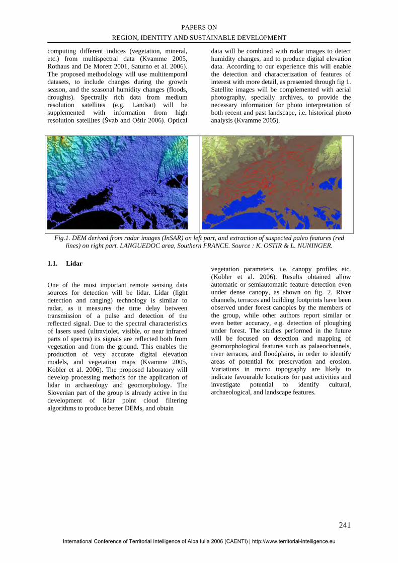
PAPERS ON REGION, IDENTITY AND SUSTAINABLE DEVELOPMENT
241
computing different indices (vegetation, mineral, etc.) from multispectral data (Kvamme 2005, Rothaus and De Morett 2001, Saturno et al. 2006). The proposed methodology will use multitemporal datasets, to include changes during the growth season, and the seasonal humidity changes (floods, droughts). Spectrally rich data from medium resolution satellites (e.g. Landsat) will be supplemented with information from high resolution satellites (Švab and Oštir 2006). Optical
data will be combined with radar images to detect humidity changes, and to produce digital elevation data. According to our experience this will enable the detection and characterization of features of interest with more detail, as presented through fig 1. Satellite images will be complemented with aerial photography, specially archives, to provide the necessary information for photo interpretation of both recent and past landscape, i.e. historical photo analysis (Kvamme 2005).
Fig.1. DEM derived from radar images (InSAR) on left part, and extraction of suspected paleo features (red
lines) on right part. LANGUEDOC area, Southern FRANCE. Source : K. OSTIR & L. NUNINGER.
1.1. Lidar
One of the most important remote sensing data sources for detection will be lidar. Lidar (light detection and ranging) technology is similar to radar, as it measures the time delay between transmission of a pulse and detection of the reflected signal. Due to the spectral characteristics of lasers used (ultraviolet, visible, or near infrared parts of spectra) its signals are reflected both from vegetation and from the ground. This enables the production of very accurate digital elevation models, and vegetation maps (Kvamme 2005, Kobler et al. 2006). The proposed laboratory will develop processing methods for the application of lidar in archaeology and geomorphology. The Slovenian part of the group is already active in the development of lidar point cloud filtering algorithms to produce better DEMs, and obtain
vegetation parameters, i.e. canopy profiles etc. (Kobler et al. 2006). Results obtained allow automatic or semiautomatic feature detection even under dense canopy, as shown on fig. 2. River channels, terraces and building footprints have been observed under forest canopies by the members of the group, while other authors report similar or even better accuracy, e.g. detection of ploughing under forest. The studies performed in the future will be focused on detection and mapping of geomorphological features such as palaeochannels, river terraces, and floodplains, in order to identify areas of potential for preservation and erosion. Variations in micro topography are likely to indicate favourable locations for past activities and investigate potential to identify cultural, archaeological, and landscape features.
International Conference of Territorial Intelligence of Alba Iulia 2006 (CAENTI) | http://www.territorial-intelligence.eu
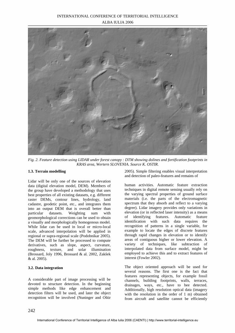
INTERNATIONAL CONFERENCE OF TERRITORIAL INTELLIGENCE ALBA IULIA 2006
242
Fig. 2. Feature detection using LIDAR under forest canopy : DTM showing dolines and fortification footprints in
KRAS area, Wertern SLOVENIA. Source K. OSTIR.
1.3. Terrain modelling Lidar will be only one of the sources of elevation data (digital elevation model, DEM). Members of the group have developed a methodology that uses best properties of all existing datasets, e.g. different raster DEMs, contour lines, hydrology, land cadastre, geodetic point, etc., and integrates them into an output DEM that is overall better than particular datasets. Weighting sum with geomorphological corrections can be used to obtain a visually and morphologically homogenous model. While lidar can be used in local or micro-local scale, advanced interpolation will be applied in regional or supra-regional scale (Podobnikar 2005). The DEM will be further be processed to compute derivatives, such as slope, aspect, curvature, roughness, texture, and solar illumination (Brossard, Joly 1996, Brossard & al. 2002, Zakšek & al. 2005). 3.2. Data integration A considerable part of image processing will be devoted to structure detection. In the beginning simple methods like edge enhancement and detection filters will be used, and later the object recognition will be involved (Nuninger and Oštir
2005). Simple filtering enables visual interpretation and detection of paleo-features and remains of human activities. Automatic feature extraction techniques in digital remote sensing usually rely on the varying spectral properties of ground surface materials (i.e. the parts of the electromagnetic spectrum that they absorb and reflect to a varying degree). Lidar imagery provides only variations in elevation (or in reflected laser intensity) as a means of identifying features. Automatic feature identification with such data requires the recognition of patterns in a single variable, for example to locate the edges of discrete features through rapid changes in elevation or to identify areas of contiguous higher or lower elevation. A variety of techniques, like subtraction of interpolated data from surface model, might be employed to achieve this and to extract features of interest (Fowler 2002). The object oriented approach will be used for several reasons. The first one is the fact that features representing objects, for example fossil channels, building footprints, walls, terraces, drainages, ways, etc., have to bee detected. Additionally, high resolution optical data (imagery with the resolution in the order of 1 m) obtained from aircraft and satellite cannot be efficiently
International Conference of Territorial Intelligence of Alba Iulia 2006 (CAENTI) | http://www.territorial-intelligence.eu
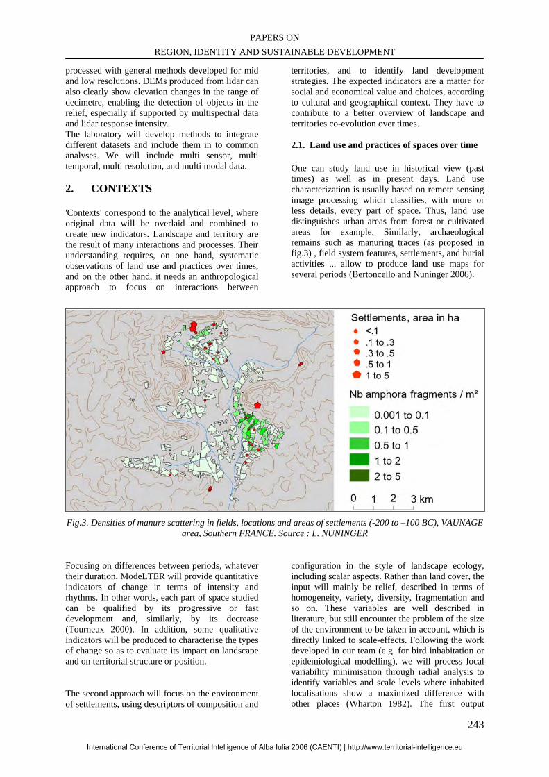
PAPERS ON REGION, IDENTITY AND SUSTAINABLE DEVELOPMENT
243
processed with general methods developed for mid and low resolutions. DEMs produced from lidar can also clearly show elevation changes in the range of decimetre, enabling the detection of objects in the relief, especially if supported by multispectral data and lidar response intensity. The laboratory will develop methods to integrate different datasets and include them in to common analyses. We will include multi sensor, multi temporal, multi resolution, and multi modal data. 2. CONTEXTS
'Contexts' correspond to the analytical level, where original data will be overlaid and combined to create new indicators. Landscape and territory are the result of many interactions and processes. Their understanding requires, on one hand, systematic observations of land use and practices over times, and on the other hand, it needs an anthropological approach to focus on interactions between
territories, and to identify land development strategies. The expected indicators are a matter for social and economical value and choices, according to cultural and geographical context. They have to contribute to a better overview of landscape and territories co-evolution over times. 2.1. Land use and practices of spaces over time One can study land use in historical view (past times) as well as in present days. Land use characterization is usually based on remote sensing image processing which classifies, with more or less details, every part of space. Thus, land use distinguishes urban areas from forest or cultivated areas for example. Similarly, archaeological remains such as manuring traces (as proposed in fig.3) , field system features, settlements, and burial activities ... allow to produce land use maps for several periods (Bertoncello and Nuninger 2006).
Fig.3. Densities of manure scattering in fields, locations and areas of settlements (-200 to –100 BC), VAUNAGE
area, Southern FRANCE. Source : L. NUNINGER
Focusing on differences between periods, whatever their duration, ModeLTER will provide quantitative indicators of change in terms of intensity and rhythms. In other words, each part of space studied can be qualified by its progressive or fast development and, similarly, by its decrease (Tourneux 2000). In addition, some qualitative indicators will be produced to characterise the types of change so as to evaluate its impact on landscape and on territorial structure or position.
The second approach will focus on the environment of settlements, using descriptors of composition and
configuration in the style of landscape ecology, including scalar aspects. Rather than land cover, the input will mainly be relief, described in terms of homogeneity, variety, diversity, fragmentation and so on. These variables are well described in literature, but still encounter the problem of the size of the environment to be taken in account, which is directly linked to scale-effects. Following the work developed in our team (e.g. for bird inhabitation or epidemiological modelling), we will process local variability minimisation through radial analysis to identify variables and scale levels where inhabited localisations show a maximized difference with other places (Wharton 1982). The first output
International Conference of Territorial Intelligence of Alba Iulia 2006 (CAENTI) | http://www.territorial-intelligence.eu
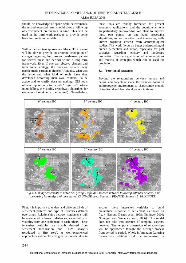
INTERNATIONAL CONFERENCE OF TERRITORIAL INTELLIGENCE ALBA IULIA 2006
244
should be knowledge of space scale determinants, the second expected result should show a follow up of environment preferences in time. This will be used in the third work package to provide some basis for prediction models.
Within the first two approaches, ModeLTER’s team will be able to provide an accurate description of changes regarding land use and settlement pattern for several areas and periods within a long term framework. Even if one can observe changes and infer some strategy, the question remains: why people made particular choices? Actually, what was the issue and what kind of reply have they developed according their own context? To be active and to clarify decision making, GIS tools offer an opportunity to include “cognitive” criteria in modelling, as visibility or pathway algorithms for example (Zakšek et al. submitted). Nevertheless,
these tools are usually formatted for present economic applications, and the cognitive criteria are particularly unlooked-for. We intend to improve these two points, on one hand processing algorithms, and on the other hand integrating well-known cognitive criteria from anthropological studies. This work favours a better understanding of human perception and action, especially for past societies, regarding territory and landscape production. The main goal is to define assumptions and models of strategies which can be used for prediction. 3.1. Territorial strategies Beyond the relationships between human and natural components of space, the team will focus on anthropogenic environment to characterize models of territorial and land development in times.
6th century BC 5th century BC 4th century BC
3rd century BC 2nd century BC 1st century BC
Fig 4. Linking settlements in networks, giving « infields » to each network following different criteria, and preparing for analysis of time series. VAUNAGE area, Southern FRANCE. Source : L. NUNINGER
First, it is important to understand different kinds of settlement patterns and type of territories defined over times. Relationships between settlements will be considered in terms of distances, accessibility or visibility from one settlement to each others. These inter-sites variables are mainly derived from settlement localization and DEM analysis (produced in first step). A well-experienced approach based on classical gravity models takes in
account these inter-sites variables to build hierarchical networks of settlement, as shown on fig. 4 (Durand-Dastes et al. 1998; Nuninger 2004; Nuninger and Sanders coord., 2006). This model does not take into account of temporal aspects, however. The temporal dimension of relationships will be approached thought the heritage process from period to period. Whole information featuring connectivity relations could be summarized in
International Conference of Territorial Intelligence of Alba Iulia 2006 (CAENTI) | http://www.territorial-intelligence.eu
PAPERS ON REGION, IDENTITY AND SUSTAINABLE DEVELOPMENT
245
contiguity matrices encapsulating time and space links. Then, each settlement, described by this matrix, can be considered as a statistical record, belonging to a single general matrix featuring all the connections in space and time. This general matrix can be analysed using multivariate analysis algorithms to produce synthetic typology of site connections, in space on one hand, and in time on the other hand. The basic idea is to bring to the fore settlement networks as a kind of skeleton of territories. The second level of analysis aims to study landscape production, which could be defined as the “skin” of territories. The French part of the group studied techniques and processes of land development from prehistory to nowadays. These studies are based on field system objects, shape of parcels or parcel boundaries for example. At this level, the aim is to understand processes of land development around the network of inhabitation, i.e. to understand how communities built their environment to define their own space (Klopatek and Gardner 1999). The landscape will be systematically described according to a grid of analysis based on experiences and competences of the geographical team, and then processed for multivariate analysis (Tourneux 2000, Tolle 2005). The challenge will be to adapt the grid to historical and archaeological criteria as we did it for settlement pattern, to get a large overview of landscape production over times based on the same methodology. At last, with approaches and facts observed within the first work package, we should be able to point out anomalies, like unusually fast changes or extraordinary behaviours (Nuninger 2004). Regarding our historical, ethnographical or geographical background, focusing on anomalies should give a better understanding of trajectory followed by the communities of each study area. At this step, it is important to point out that the interpretation or explanation of phenomena will be based on references elaborated at each level according to the same methodology for each area. The definition of anomalies, and their explanation, will be helpful to introduce uncertainty in the prediction processes.
3. PREDICTION
Using references from environmental features and from human behaviour produced in the work packages 1 and 2, the team will be able to develop prediction modelling (Van Leusen and Kamermans (eds.) 2005, Kamermans 2006, Stančič & al. 2000, Stančič and Veljanovski 2000).
Two main approaches will be followed: first, an explicative method at local level, predicting settlements positions using relief characteristics, scale effects, and territorial strategies; and second, a geostatistical method at regional level, taking in account the spatial structures of settlement densities and co-explicative variables. 3.1. Prediction with explicative methods The purpose of explicative methods is to draw a theoretical map of settlement dispersion over poorly known areas, using the data and knowledge acquired in the previous steps. As far as environmental preferences have been highlighted, including their scale components and interactions between settlements, it can be possible to build explanatory statistical models, giving for each period the probability to find a settlement in each place. Typically, binary logistic regression with Logit model can be used in this way, helped with algorithms for evaluations of model performance (Stančič and Kvamme 1999, Tomlin 1990). One major interest of this kind of prediction is to give for each place a value between 0 and 1 (where 0 means no settlement, and 1 means settlement), and to maintain local scale, while other methods need continuous variables, implying scale reduction. Binary logistic regression has already been employed in archaeological prediction modelling (Verhagen et al. 2005). Here, the innovating aspect of the research is demonstrated in several ways. First is the use of high quality archaeological and environmental data, transformed in occupation variables including territorial strategies. Next is the large time depth series covering different land use practices, and last is the evaluation of model performance through statistics indicators and field comparisons. In this way, such a model is at the same time inductive (facts based) and deductive (strategies oriented), and maintained between safety guides. 3.2. Prediction with geostatistical methods Rather than estimating local probabilities, this approach produces predictive maps of settlement densities at regional scales. Taking in account, for a given period, the localizations of known settlements and the areas of archaeological survey, a cellular model can be derived, representing the densities of settlement trough a regular grid. This means that the information goes from Boolean level to true quantitative level, offering the opportunity to process various interpolation models. Among them, geostatistical methods such as co-kriging allow to base the prediction both on the spatial structure of the observed phenomenon (settlement density dispersion), and on explicative phenomenon
International Conference of Territorial Intelligence of Alba Iulia 2006 (CAENTI) | http://www.territorial-intelligence.eu
INTERNATIONAL CONFERENCE OF TERRITORIAL INTELLIGENCE ALBA IULIA 2006
246
(environmental and anthropogenic context, heritage). The expected output is a temporal stack of predictive spatial models at regional scale, which could become a new basis for temporal observation of land occupation dynamics, summarizing stability times, crisis and reorganizations.
4. TOOLS AND DATABASES
At present, individual existing groups use various data processing and analysis tools, both commercial and developed by themselves. The fourth activity in LEA ModelTER focuses on three axes : optimisation in the use of tools, increasing of their availability, and preventing their duplication (even multiplication). This will decrease costs, and organize the entire group with common software and hardware. The individual groups in the laboratory already manage a significant number of archaeological databases and other spatial data layers. It is anticipated that in the next years these will be updated and supplemented with new ones. Common technical team will therefore work intensively on database management, maintenance and storage, involving intensive application of internet database technologies. The GIS systems will be used both locally within the group, and through networks for the scientific community, plus, with some limitations, to the general public. A Web mapping system – based on existing knowledge and expertise – will be developed with tools available for basic and advanced analyses, processed in the laboratories or in the field (for mobile devices, equipped with GPS receivers). Up-to-date technical equipment will be deployed to enable the collaboration between the members of the out walls laboratory. An Access Grid node will be established with a set of resources, including multimedia large-format displays, presentation and interactive environments to support group-to-group interactions. Additionally, a multi user document repository (knowledgebase) system for publishing files/documents onto the web will be used. All the tools and documents developed or produced in the laboratory will be published and made available for interested users. Both scientific results and tools will be promoted on the ModeLTER’s website, that will be built within the Archaeores platform to provide a scalable and a self updating framework for coordinators and researchers. This site will be partly in open access, partly reserved to the research group, and linked to the e-collaboration tools mentioned above.
CONCLUSION The proposed ModeLTER teams have proven with recent projects that the laboratory is able to achieve the envisioned goals. At the European level, apart from individual programs of research, a unit associating, so tightly, archaeological, geographical and geodetic skills, working on territorial and landscape issues where human strategies are at the heart of research, does not exist yet. We believe that ModeLTER can become an incubator of ideas and methods. ModelTER projects are at the core of methods for the understanding of territories. They link acquisition, structure, analysis and dissemination of spatial and temporal information, at various scales, regarding natural and anthropogenic phenomena and processes. The team is designed through several partnerships, established between different laboratories in France and Slovenia. This places ModelTER in the canvas of territorial intelligence.
BIBLIOGRAPHY Berger J.-F., Nuninger L., van der Leeuw S. accepted: Modeling the Role of Resilience in Socio-Environmental Co–Evolution: the Middle Rhone Valley between 1000 bc and ad 1000. In T. A. KOLHER et S. van der LEEUW (ed.), Modeling Socioecological Systems, workshop proceedings “Modeling Long-Term Culture Change” October 24-27, 2004, Santa Fe Institut ed. Bertoncello F., Nuninger L. 2006: From Archaeological Sherds to Qualitative Information for Settlement Pattern Studies. In F. Niccolucci, ed., Beyond the artefact – Proceedings of CAA2004 – Prato 13-17 April 2004. Archaeolingua, Budapest, in press., Brossard Th., Joly D. 1996: Using a GIS data base at a hight resolution for geomorphological cartography of polar environment. 28ème Congrès de l'UGI, La Haye 4-10 août 1996, abstract book, p. 69. Brossard Th., Elvebakk A., Joly D., Nilsen L. 2002: Modelling index of thermophily by means of a multi-source database on Broggerhalvoya Peninsula (Svalbard), International Journal of Remote Sensing, vol. 23, n°21, p. 4683-4698. Durand-Dastes F., Favory F., Fiches J.-L., Mathian H., Pumain D., Raynaud C., Sanders L., Van der Leeuw S. 1998: Des oppida aux métropoles, Archéologues et géographes en vallée du Rhône, Anthropos, Paris 1998 (coll. Villes).
International Conference of Territorial Intelligence of Alba Iulia 2006 (CAENTI) | http://www.territorial-intelligence.eu
PAPERS ON REGION, IDENTITY AND SUSTAINABLE DEVELOPMENT
247
Favory F., Girardot J.-J., van der Leeuw S. 2004: The archaeological study of environmental degradation. An example from Southern France, in Charles L. Redman, Steven R. James, paul. R. Fish & J. Daniel Rogers, The Archaeology of global change. The impact of humans on their environment, Smithsonian Institution 2004, p. 112-129. Fowler M.J.F. 2002: Satellite remote sensing and archaeology: a comparative study of satellite imagery of the environs of Figsbury Ring, Wiltshire, Archaeological Prospection 9: 55-69. Holcomb D.W. 1998: Applications of Imaging Radar to Archaeological Research. In Floyd M. Henderson and Anthony J. Lewis, eds., Manual of Remote Sensing, Volume 2, Principles and Applications of Imaging Radar, New York: John Wiley and Sons, 769-776. Kamermans H. 2006: The Application of Predictive Modelling in Archaeology: Problems and Possibilities. In F. Niccolucci, ed., Beyond the artefact – Proceedings of CAA2004 – Prato 13-17 April 2004. Archaeolingua, Budapest, in press. Kobler A., Pfeifer N., Ogrinc P., Todorovski L., Oštir K., Džeroski S. 2006: Using redundancy in aerial lidar point cloud to generate DTM in steep forestedrelief. In Koukal T., Schneider W., eds., 3D remote sensing in forestry, Vienna : University of Natural Resources and Applied Life Sciences, Department of Spatial, Landscape and Infrastructure-Sciences, p. 264-269. Koplatek J.M., Gardner R.H. (eds) 1999: Landscape ecological analysis. Issues and applications, New York. Kvamme K.L. 2005: Terrestrial Remote Sensing in Archaeology. In H. MASCHNER and C. CHIPPINDALE, eds., Handbook Of Archaeological Methods, Lanham: AltaMira Press, 423-477. Lira J., López P., Rodriguez A. 2005: Detection of Maya’s archaeological sites using high resolution radar images, International Journal of Remote Sensing 26 (6): 1245-1260. Nuninger L. 2004: Understanding the protohistorical territorial heritage by means of Iron Age settlement system analysis in GIS: a case study in the eastern Languedoc (France). In W. BORNER (ed.), Enter the past: the E-way into the four Dimensions of Cultural Heritage CAA2003, Computer Applications and Quantitative Methods in Archaeology, BAR International, Archaeopress, Oxford.
Nuninger L., Oštir K. 2005: Contribution à la modélisation des paléo-reliefs de la plaine littorale de l’Etang de Mauguio (Languedoc, France) : premières approches par télédétection. In F. BERGER, F. BERTONCELLO, F. BRAEMER, G. DAVTIAN et M. GAZENBEEK (ed.), Temps et espaces de l'homme en société, analyses et modèles spatiaux en archéologie, XXVe Rencontres Internationales d'Archéologie et d'Histoire d'Antibes. APDCA, 2005. Nuninger (coord.), Sanders (coord.), Favory F., Garmy P., Raynaud C., Rozenblat C., Kaddouri L., Mathian H., Schneider L. 2006 : La modélisation des réseaux d'habitat en archéologie : trois expériences. Mappemonde. 2006. Oštir K., Stančič Z., Trušnovec M. 1999: Multispectral classification of satellite images, Geographical information systems and landscape archaeology, Oxford, Oxbow Books, 1999. Podobnikar T. 2005: Production of integrated digital terrain model from multiple datasets of different quality. International journal of geographical information science, 19/1, 69-89. Rothaus R.M., De Morett A.A. 2001: Landsat TM imagery in landcape archaeology: Detection and modelling. In S. CAMPANA and M. FORTE, eds., Remote Sensing in Archaeology, Firenze: All'Insegna del Giglio, 149-173. Saturno W.A., Sever T.L, Irwin D.E. Howell B.F. 2006: Regional Scale Landscape Archaeology: 21st Century Remote Sensing Technology and the Ancient Maya. In A.B. RENCZ, M.K. RIDD, J.D. HIPPLE, eds., The Manual of Remote Sensing, 3rd Edition (A Series): Volume 5: Remote Sensing of Human Settlements, Bethesda: American Society for Photogrammetry and Remote Sensing, 489-502. Stančič Z., Veljanovski T., Oštir K., Podobnikar T. 2001: Archaeological predictive modelling for highway construction planning, Computing archaeology for understanding the past CAA2000, Oxford, Archaeopress, 2001. Stančič Z., Veljanovski T., Podobnikar T. 2000: Understanding Roman settlement patterns through multivariate statistics and predictive modelling. In F. Vermuelen, M. de Dapper, eds., Geoarchaeology of the landscapes of classical antiquity : Géoarchéologie des paysages de l'antiquité classique : international colloquium Ghent, 23-24 October 1998 = colloque international Gand, 23-24 octobre 1998, (BABESCH. Supplement, 5). Leiden: Stichting BABESCH, 179-187.
International Conference of Territorial Intelligence of Alba Iulia 2006 (CAENTI) | http://www.territorial-intelligence.eu
INTERNATIONAL CONFERENCE OF TERRITORIAL INTELLIGENCE ALBA IULIA 2006
248
Stančič Z., Veljanovski T. 2000: Understanding Roman settlement patterns through multivariate statistics and predictive modelling. In Lock, G.R. (ed.), Beyond the map: archaeology and spatial technologies, NATO advanced science institutes series, Series A, Life sciences, 321. Oxford, IOS Press, 2000. Stančič Z., Kvamme K.L. 1999: Settlement pattern modelling through Boolean overlays of social and environmental variables. In J.A. Barceló, I. Briz, A. Vila, eds., New technique for old times : CAA 98 – computer applications and quantitative methods in archaeology : proceedings of the 26th conference, Barcelona, March 1998, (BAR International Series, 757). Oxford: Archaeopress, 231-237. Švab A., Oštir K. 2006: High-resolution image fusion: methods to preserve spectral and spatial resolution, Photogrammetric engineering and remote sensing, 72, No. 5, p. 565-572. Tolle F. 2005: Paysage et risque sanitaire. Le cas de l'échinococcose alvéolaire, approche multiscalaire. Thèse de Doctorat, Géographie, Université de Franche-Comté, Besançon, 2005 Tomlin, C.D. 1990: Geographic Information Systems and Cartographic Modelling. Prentice Hall, Englewood Cliffs, New Jersey. Tourneux F.-P.. 2000: Modes de représentation des paysages. Thèse de Doctorat, Géographie, Université de Franche-Comté, Besançon, 2000 Van der Leeuw S., Favory F., Fiches J.-L. (eds.) 2003: Archéologie et systèmes socio-environnementaux. Etudes multiscalaires sur la vallée du Rhône dans le programme ARCHEOMEDES, Paris : CNRS Editions, 403 p. (Monographies du CRA ; 27).
Van Leusen M., Kamermans H. (eds) 2005: Predictive Modelling for Archaeological Heritage Management: A research agenda (Nederlandse Archeologische Rapporten 29). Amersfoort: ROB. Verhagen, Ph., J. Deeben, D. Hallewas, P. Zoetbrood, H. Kamermans, M. van Leusen, 2005: A review of predictive modeling for archaeological heritage management in the Netherlands, in: J.-F. Berger / F. Bertoncello / F. Braemer / G. Davtian / M. Gazenbeek (eds),Temps et espaces de l’homme en société, analyses et modèles spatiaux en archéologie. XXVe rencontres internationales d’archéologie et d’histoire d’Antibes. Éditions APDCA, Antibes, 83-92. Wharton S. W. 1982: A contextual classification method for recognizing land use patterns in high resolution remotely sensed data. Pattern Recognition. 15(4), p. 317-324. Zakšek K., Podobnikar T., Oštir K. 2005: Solar radiation modelling. Comput. geosci., 31, pp. 233-240. In preparation: Zakšek K., Fovet E., Nuninger L. submitted: Path modelling for ancient communities from Iron Age to medieval period, GeoInformatica. Oštir K., Nuninger L. submitted, Paleorelief detection and paleoDEM modelling: a case of study in eastern Languedoc (France), From Space to Place, 2nd International Meeting of Remote Sensing in Archaeology, 4-7 decembre 2006, Rome.
International Conference of Territorial Intelligence of Alba Iulia 2006 (CAENTI) | http://www.territorial-intelligence.eu
PAPERS ON REGION, IDENTITY AND SUSTAINABLE DEVELOPMENT
249
CELLULAR WORLD SIMULATION: A COLLABORATIVE MODEL FOR SPATIAL VISIONING AND
TERRITORIAL INTELLIGENCE
Jean-Philippe ANTONI
Professional adress
Laboratoire ThéMA-CNRS UMR 6049 - Université de Franche-Comté - 32 rue Mégevand – F-25030 BESANÇON, France.
Abstract: Urban sprawl is a typical problem that cannot be correctly understood and resolved because it relies on several different fields and concerns different actors. With traditional approaches, the whole process cannot be apprehended. This context partly explains the inefficiency of traditional planners’ works, and asks for urban planning considered through the idea of collaborative projects. The CamDeus (Cellular Automata Models to Design Environmental and Urban Systems) project is an operational decision-making software giving cartographic and mathematical solutions in order to harmonize and share data and knowledge among scientists, territorial or administrative technicians or elected people. It consists in simplifying the modelling process, so that it can be understood by persons with different technical languages and different scientific qualifications. Thus, the question of urban dynamics is decomposed into three simple and operational questions associated with a particular and relatively simple model : “How many?” (how many hectares will be concerned by urban sprawl in the future?) ; “Where?” (where are the surfaces that will move to another landuse category?) ; “What?” (what is the land use category of the spaces quantified in the first step and located in the second one?). This global modelling is then relatively complex and allows the study of urban changes with efficiency. Its decomposition into three steps appears simplified enough to be simultaneously understood by all the actors concerned with urban planning. CamDeus then allows different points of view to be put together and concrete actions to be modeled for the development of urban territories in the perspective of sustainable development.
International Conference of Territorial Intelligence of Alba Iulia 2006 (CAENTI) | http://www.territorial-intelligence.eu
INTERNATIONAL CONFERENCE OF TERRITORIAL INTELLIGENCE ALBA IULIA 2006
250
CELLULAR WORLD SIMULATION:
A COLLABORATIVE MODEL FOR SPATIAL VISIONING AND TERRITORIAL INTELLIGENCE
INTRODUCTION In the “Risk society” defined by U. Beck (1986), the old idea of “danger” is partially opposed to the post-modern notion of “risk”: in the past, it was possible to identify and localize the danger, while currently the risk is anonymous, diffuse and omnipresent ; this way, the “enemy” (political, ecological, epidemiological, etc.) is everywhere and nowhere at the same time ; it depends on many actors, possibly conscientiously interacting, possibly not. For geographers in charge with planning, this idea is relied by a new epistemological approach claiming to face up the paradigm of complexity (Chamussy 2003). Concretely, this conceptual changes suggest to explore different ways and new methods for managing daily actions so as to reach the utopia of “zero risk”. Recent modifications of the French legislation confirm this fact, asking for more complete and integrated reasoning before answering the complex question of urban or regional planning. The CWS55 project initially started from here ; it tries to release discussion pools between most of the actors concerned with planning decisions for better simulating the consequences and the level of efficiency of their project. Finally CWS can now be considered as an operational decision-making tool (software) and an interesting mediation for sharing environmental knowledge in the context of territorial intelligence.
RELEASE DISCUSSIONS ABOUT PLANNING DECISIONS
The Nouveaux principes de l’urbanisme (Ascher 2000) offer a good example of the changes and the new principles that appeared since the end of the 20th century in the realm of urban planning. As the majority of planners, F. Ascher works on the assumption that French administrative procedures usually take place in a bulk-heading context that reduces the efficiency of any action. This is particularly true in the case of (urban) planning issues. Urban sprawl, for example, is a typical 55 CWS (Cellular World Simulation) is a Land Use and Cover Change (LUCC) model developped by J.P. Antoni and G. Vuidel. First developments were made in the Laboratory Image et Ville (CNRS UMR 7011) in Strasbourg.
problem that cannot be correctly understood and resolved because it relies on several different fields and concerns different actors: a minister in charge with transportation, a property developer who buys and sells building lands, a lawyer or a territorial technician employed to determine and apply local environmental and urban legislation, and a simple citizen (unaware of any other) that only wishes to build a house of his own. Globally, all the goals, all the points of view, all the administrative procedures associated to these actors appear divided into opaque sectors and do not allow to build a project crossing everybody’s objective. It ensues two major lacks: on the one hand the information related to urban planning is not shared from one administration (or one administrative service) to another; on the other hand, the knowledge and the solutions proposed by scientists or experts are not correctly transferred to concrete possibilities of action for planners. Lots of examples show that traditional approaches do not allow to comprehend the whole urban sprawl process. This context partly explains the inefficiency of traditional planners’ works, and the new deal imposed since 2000 by the French legislation: “Solidarité et Renouvellement Urbains” (Solidarity and Urban Renewal). This law claims to consider urban planning in a way that partially corresponds to the idea of “collaborative projects” or transversality. Japanese (Shen 2003) and Dutch (Stouffs 2003) experiences of “decision collaboration systems” appear thus as excellent examples of achieving concretely such a difficult goal. The principle consists in using web-based technology to communicate with clients, officials and partners about urban planning projects, by the way of interactive on-line cartography and dialogues. The computer-assisted interface which is supporting these communication processes appears then as an interesting technological development for sharing (possibly contradictory or conflictual) information and co-building solutions for each other project. In urban planning and territorial management, most of the projects can rely on such kind of virtual simulations. But concretely, these simulations always rely on modelling (as P. Haggett defined it56
56For P. Haggett, a model is a “simplified version of reality built in order to demonstrate certain properties of reality”.
International Conference of Territorial Intelligence of Alba Iulia 2006 (CAENTI) | http://www.territorial-intelligence.eu
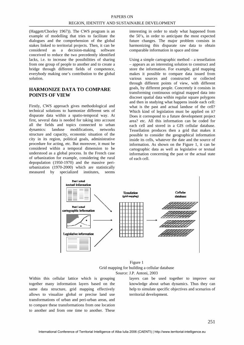
PAPERS ON REGION, IDENTITY AND SUSTAINABLE DEVELOPMENT
251
(Haggett/Chorley 1967)). The CWS program is an example of modelling that tries to facilitate the dialogues and the comprehension of the global stakes linked to territorial projects. Then, it can be considered as a decision-making software conceived to reduce the two precedently identified lacks, i.e. to increase the possibilities of sharing from one group of people to another and to create a bridge through different fields of competence, everybody making one’s contribution to the global solution.
HARMONIZE DATA TO COMPARE POINTS OF VIEW
Firstly, CWS approach gives methodological and technical solutions to harmonize different sets of disparate data within a spatio-temporal way. At first, several data is needed for taking into account all the fields and topics connected to urban dynamics: landuse modifications, networks structure and capacity, economic situation of the city in its region, political goals, administrative procedure for acting, etc. But moreover, it must be considered within a temporal dimension to be understood as a global process. In the French case of urbanization for example, considering the rural depopulation (1950-1970) and the massive peri-urbanization (1970-2000) which are statistically measured by specialized institutes, seems
interesting in order to study what happened from the 50’s, in order to anticipate the most expected future changes. The major problem consists in harmonizing this disparate raw data to obtain comparable information in space and time Using a simple cartographic method – a tessellation – appears as an interesting solution to construct and store the information. For example, grid mapping makes it possible to compare data issued from various sources and constructed or collected through different points of view, with different goals, by different people. Concretely it consists in transforming continuous original mapped data into discreet spatial data within regular square polygons and then in studying what happens inside each cell: what is the past and actual landuse of the cell? Which kind of legislation must be applied on it? Does it correspond to a future development project area? etc. All this information can be coded for each cell and stored in a GIS cellular database. Tessellation produces then a grid that makes it possible to consider the geographical information inside its cells, whatever the date and the source of information. As shown on the Figure 1, it can be cartographic data as well as legislative or textual information concerning the past or the actual state of each cell.
Figure 1
Grid mapping for building a cellular database Source: J.P. Antoni, 2003
Within this cellular lattice which is grouping together many information layers based on the same data structure, grid mapping effectively allows to visualize global or precise land use transformations of urban and peri-urban areas, and to compare these transformations from one location to another and from one time to another. These
layers can be used together to improve our knowledge about urban dynamics. Thus they can help to simulate specific objectives and scenarios of territorial development.
International Conference of Territorial Intelligence of Alba Iulia 2006 (CAENTI) | http://www.territorial-intelligence.eu
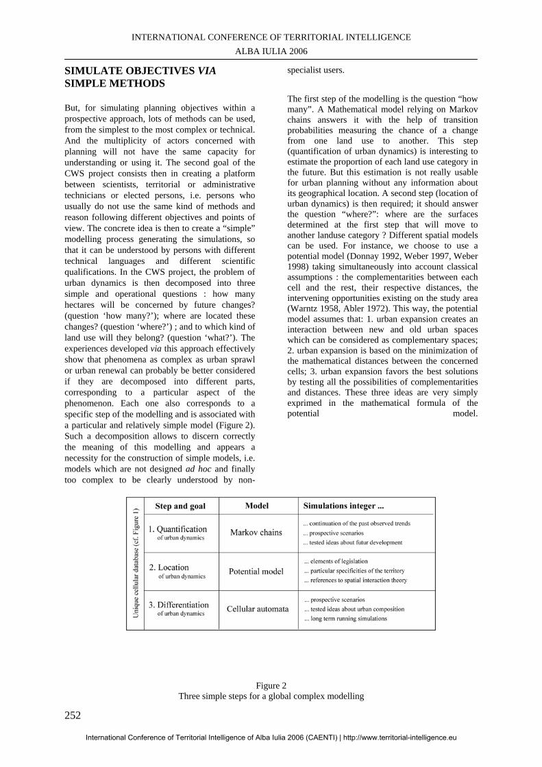
INTERNATIONAL CONFERENCE OF TERRITORIAL INTELLIGENCE ALBA IULIA 2006
252
SIMULATE OBJECTIVES VIA SIMPLE METHODS
But, for simulating planning objectives within a prospective approach, lots of methods can be used, from the simplest to the most complex or technical. And the multiplicity of actors concerned with planning will not have the same capacity for understanding or using it. The second goal of the CWS project consists then in creating a platform between scientists, territorial or administrative technicians or elected persons, i.e. persons who usually do not use the same kind of methods and reason following different objectives and points of view. The concrete idea is then to create a “simple” modelling process generating the simulations, so that it can be understood by persons with different technical languages and different scientific qualifications. In the CWS project, the problem of urban dynamics is then decomposed into three simple and operational questions : how many hectares will be concerned by future changes? (question ‘how many?’); where are located these changes? (question ‘where?’) ; and to which kind of land use will they belong? (question ‘what?’). The experiences developed via this approach effectively show that phenomena as complex as urban sprawl or urban renewal can probably be better considered if they are decomposed into different parts, corresponding to a particular aspect of the phenomenon. Each one also corresponds to a specific step of the modelling and is associated with a particular and relatively simple model (Figure 2). Such a decomposition allows to discern correctly the meaning of this modelling and appears a necessity for the construction of simple models, i.e. models which are not designed ad hoc and finally too complex to be clearly understood by non-
specialist users. The first step of the modelling is the question “how many”. A Mathematical model relying on Markov chains answers it with the help of transition probabilities measuring the chance of a change from one land use to another. This step (quantification of urban dynamics) is interesting to estimate the proportion of each land use category in the future. But this estimation is not really usable for urban planning without any information about its geographical location. A second step (location of urban dynamics) is then required; it should answer the question “where?”: where are the surfaces determined at the first step that will move to another landuse category ? Different spatial models can be used. For instance, we choose to use a potential model (Donnay 1992, Weber 1997, Weber 1998) taking simultaneously into account classical assumptions : the complementarities between each cell and the rest, their respective distances, the intervening opportunities existing on the study area (Warntz 1958, Abler 1972). This way, the potential model assumes that: 1. urban expansion creates an interaction between new and old urban spaces which can be considered as complementary spaces; 2. urban expansion is based on the minimization of the mathematical distances between the concerned cells; 3. urban expansion favors the best solutions by testing all the possibilities of complementarities and distances. These three ideas are very simply exprimed in the mathematical formula of the potential model.
Figure 2 Three simple steps for a global complex modelling
International Conference of Territorial Intelligence of Alba Iulia 2006 (CAENTI) | http://www.territorial-intelligence.eu
PAPERS ON REGION, IDENTITY AND SUSTAINABLE DEVELOPMENT
253
Source: J.P. Antoni, 2003
The calculation of potential values for each cell demands to determine m masses associated to the landuse categories. This determination is one of the major problem of the modeling. In a first time, it can rely on the observation of comparable past periods that the regular cellular structure allows to do. In a second time, it can rely on everyone’s experience, goal and project. Then, the masses can be considered as the “attractiveness level” of a landuse category, and exprimed on a defined scale, e.g. from 1 to 10 for example. An engineer can determine it according to his technical goals, a jurist to legal dispositions, a politician to its development project, etc. The advantage of this quantitative modelling is double : 1. Each actor’s objective can be compared with another (the mean objectif could then be calculated!) because they all reason with similar tools and rules; 2. Everyone’s opinion or will can be understood by each other because it is exprimed on the same graduated scale. At this stage, the modelling approach allows to locate the future simulated changes, but it cannot describe more precisely the nature of these changes. For instance, it does not allow to know if they will create residential, industrial units or facilities. Last question is “What?”: What is the land use category of these spaces (differentiation of urban dynamics). Cellular automata answer this third question through complex rules of transition. Recent works in urban geography, using techniques issued from Artificial Distributed Intelligence, effectively offer a new conceptual framework to treat such kind of problems (White 1994, Langlois/Phipps 1997, Batty 1999, White 2003). Automata should assume that the category of the cells is determined by its neighborhood, actually by the categories of the neighbor cells. The analysis of each cell’s cellular neighborhood (grid mapping) allows to define transition rules, explaining why a cell has moved from one landuse category to another. Such kind of rules can then be applied to most of the other cells for choosing their category. As precedently, the biggest problem consists in defining pertinent rules. At first, they can be determined by empirical tests, according to the users’ estimation and observation of past periods. Then, a statistical method should be developed to construct a set of rules closely relying on quantified observations. CONCLUSION Finally, the global combined modelling appears relatively complex and allows the study of urban growth with efficiency. But its decomposition into three steps appears simple enough to be simultaneously understood by all the actors concerned with urban planning. A complementary document called “scenario sheet” helps to connect
these different kinds of actors and to put together there points of view in a sharing process of modelling: everyone writes his ideas about what the future of the urban area could be on the sheet ; then the texts are translated into mathematical coefficients and parameters able to feed the three models. Such a translation can be done by the actors themselves, but can although be confided to a third party. This way, such a modelling really corresponds to an “accompanied modelling”, animated by a mediator who collects, translates, and simulates everyone’s idea within the process proposed by CWS. As J.M Dziedzicki (Dziedzicki 2003) explained it, this mediation process seems particularly interesting for planning issues, because it leads to a possible participative and evaluation, i.e. a real dialogue based on terrirorial intelligence. It is then an undeniable progress for all the concerned persons and an evolution in our manner to conceive projects (Brunet 2001). According to the notion of reflexivity associated to the “Risk society” (Giddens 1994, 1998), such a kind of deliberative process can be envisaged as a complement for the traditional institutions of our democratic systems. Finally, complex and complete scenarios of urban dynamics can emerge from this collaborative modelling. They could although allow concrete actions for the development of territories in the perspective of sustainable development. BIBLIOGRAPHY Abler, R. (et al.) (1972) Spatial Organization: the Geographer’s View of the World. Prentice Hall International, London. Ascher, F. (2000): Nouveaux principes de l’urbanisme, Ed. de l’Aube. Batty, M. (et al.) (1998): GIS and Urban Design, Working Paper of the Center for Advanced Spatial Analysis (CASA) 3, Batty, M., Jiang, B. (1999): Multi-Agent Simulation: New Approaches to Exploring Space-Time Dynamics within GIS, Working Paper of the Center for Advanced Spatial Analysis (CASA) 10 Beck, U. (1986): Risokogesellschaft, Suhrkamp Verlag, Frankfurt am Main. Brunet, S. (2001): Risques réflexifs et processus délibératifs, in: Hupet, P., Risques et systèmes complexes, les enjeux de la communication, PIE Peterlang. Chamussy, H. (2003): Facing up against the complexity, Proceedings of the 13th European
International Conference of Territorial Intelligence of Alba Iulia 2006 (CAENTI) | http://www.territorial-intelligence.eu
INTERNATIONAL CONFERENCE OF TERRITORIAL INTELLIGENCE ALBA IULIA 2006
254
colloquium on theoretical and quantitative geography, Lucca, Italy, September 5-9. Donnay, J.C. (1992): Développement Urbain, Université de Liège. Dziedzicki, J.M, (2003): Médiation environnementale: des expériences internationales aux perspectives dans le contexte français, in: Concertation, décision et environnement, Ministère de l’écologie et du développement durable, La documentation Française. Giddens, A. (1994): Beyond Left and Right, Polity Press, Cambridge. Giddens, A. (1998): The politics of Risk Society, in: Franklin Jane (ed.), Polity Press, Cambridge. Haggett, P., Chorley, R.J. (1967): Models in geography, The trinity Press Langlois, A., Phipps M. (1997) : Automates Cellulaires. Application à la Simulation Urbaine, Hermes, Paris. Shen, Z. (et al.) (2002): Study on the development of a online design collaboration system for public participation, Proceedings of the 6th international conference on design and decision support systems in urban planning, Ellecom, The Netherlands, July 7-10
Stouffs, R. (et al.) (2002): WoonWerf.nl revisited: the potential of web-based design communication with future clients, Proceedings of the 6th international conference on design and decision support systems in urban planning, Ellecom, The Netherlands, July 7-10 Warntz, W., Steward, J.Q. (1958): Physics of population distribution, in: Journal of Regional Science, 1, pp. 130-140. Weber, C. (1998): La croissance urbaine de Kavala. Evolutions et perspectives, in: Société française de photogrammétrie, 151, pp. 29-39. Weber, C.,Hirsch J. (1997): Potential model applications in planning issues, Proceedings of the 11th European Colloquium on Quantitative and Theoretical Geography, Durham Castle, City of Durham, UK, September 3-7. White, R. (1994): Cellular Dynamics and GIS: Modelling Spatial Complexity, in: Geographical systems, 1, pp. 237-253. White, R. Engelen G. (2003): A calibration procedure for constrained large neighborhood cellular automata based land used models, Proceedings of the 13th European colloquium on theoretical and quantitative geography, Lucca, Italy, September 5-9.
International Conference of Territorial Intelligence of Alba Iulia 2006 (CAENTI) | http://www.territorial-intelligence.eu
PAPERS ON REGION, IDENTITY AND SUSTAINABLE DEVELOPMENT
255
THE EDITORIAL FUNCTION OF THE TERRITORIAL INTELLIGENCE
SYSTEMS
Jean-Jacques GIRARDOT Associate Professor in Economics
[email protected], GSM: + 33 (6) 13 33 29 58
Professional address Maison des Sciences de l'Homme Claude Nicolas LEDOUX
Université de Franche-Comté - 32 rue Mégevand - F-25030 BESANÇON cedex, France Abstract: Whilst the knowledge society is developing, the editorial function is also developing within the territorial intelligence systems. It is directly linked to the promotion of partnership and participation. The territorial intelligence systems develop as an instrument of the second-range actors of territorial development: agencies, town planning agencies, settlement services, socio-economic observatories, etc. They are shared and cooperative systems. During the latest years, they allowed the information mutualisation and their processing. The growing importance of the editorial function implies that lots of present evolutions continue: Internet accessibility, integration and automation of the data processing and integration of expertise and experiences. Besides, the editorial function implies the harmonization of meta-data and the interface between man and computer, so as to make the data and results of their processing accessible to the partners and inhabitants. The communication makes an updating of our thinking about the editorial function of the systems of territorial intelligence. Computer science and information systems aim at increasing the communication between the human beings. A territorial intelligence system is an instrument at the service of the actors who ambition to control the equitable and sustainable development of their territory. Since the irruption of data processing, we led research activities to design friendly software, then to model the structure of a territorial information system that is at the service of a network of territorial actors, and more recently to integrate the data analysis functions. They led us to presently consider the territorial intelligence system from the prospect of a digital edition chain, which is animated by a partnership of territorial actors at the service of a territorial community. Keywords: Territorial intelligence, Information systems, Geographical Information Systems (GIS), Data analysis, Digital edition, Territorial governance. This communication summaries results of research activities initially funded by the Conseil Régional de Franche-Comté (regional assembly), the Direction Régionale de la Recherche et de la Technologie, the Direction Régionale de l'Industrie, de la Recherche et de l'Économie and by the European Fund for Regional Development in the framework of the Institut des Sciences et Technologies de l'Information de l'Université de Franche-Comté.
International Conference of Territorial Intelligence of Alba Iulia 2006 (CAENTI) | http://www.territorial-intelligence.eu
INTERNATIONAL CONFERENCE OF TERRITORIAL INTELLIGENCE ALBA IULIA 2006
256
THE EDITORIAL FUNCTION OF THE TERRITORIAL
INTELLIGENCE SYSTEMS An information system is a structured whole of data bases that gather a defined set of information and functions that allow establishing relations between these information, defining the direction of these relations or, better, measuring them. In a Territorial Information System (TIS), the information concerns a territory, that is to say a geographical space and its community. They are referenced in space and time. Functions of statistical and spatial analysis aim at helping the territorial actors producing knowledge on this territory.
Thus, a TIS allows: - Gathering and regrouping information; - Analyzing them according to scientific protocols,
especially in a spatial prospect; - Interpreting the results of these analyses; - Representing the information and the results; - Drafting decision-making scenarios; - Managing and valuating the policies, programs,
devices, projects and actions that result from the decisions.
A territorial intelligence system is a Territorial Information System that is at the service of a partnership of territorial actors that want to develop democratic governance at the service of sustainable development. - It favors the information sharing within a territorial development partnership; - It instruments the data cooperative analysis and the results participative interpretation - It introduces the citizens’ participation in the process of decision-making; - It provides the actors with the useful information to draft projects, and then to manage them and valuate them.
It exploits the potential that computer science offers to gather information, share this information, favor the actors’ partnership from the information cooperative analysis, and to increase the citizens’ participation by improving their information and their access to information. It respects the constraints that sustainable development, particularly participation and partnership, imposes to information processing and publication protocols.
This article shows how we converged, from the friendliness notion toward the editorial chain one, through accessibility of information systems and integration of information analysis functions. This
evolution is linked to the information technologies diffusion but also to the permanent concern of making them accessible to a great number of people without any prejudice for the information quality.
The computer science, information systems, digital networks, and then digital edition via Internet development allowed us designing and progressively making solutions that appeared to be useful for the territorial information systems. Computer science firstly allowed constituting important data sets and then analyzing them with quantitative statistical methods. It made possible the application of statistical qualitative methods as well as the factorial analysis or classification [BENZECRI, 1982]. The data sets developed, and then it was the case of the information systems. Information that was conserved on different supports, were digitalized so as to be massively stocked on a same support within which they lose their readability. Internet popularized the information sharing, their collaborative processing and the massive publication at the world scale. We suggest summing up our research activities history about the territorial intelligence systems, the present results and our prospects. Doctor in Economics, engaged in a laboratory of mathematics, statistics and computer science in a Humanities and Social Sciences faculty, I developed convivial data processing solutions during the 1970’s to diffuse the data analysis protocols that came from the Matter and Nature Sciences among the researchers in Humanities and Social Sciences. Thanks to collaboration with computer science researchers, the SITRA, Territorial Information Systems for Actors Network, research action allowed completing the data statistical analysis by tools of spatial analysis and cartography. ICASIT, Integration of Analytical Chain of the Territorial Information Systems, started updating and making the software of data statistical and spatial analysis that were previously developed evolve. There was a communication of these works during the ICTAMI conference in ALBAC (Romania) in September 2006 and there will be another two presentations in Taiwan in November 2007.
International Conference of Territorial Intelligence of Alba Iulia 2006 (CAENTI) | http://www.territorial-intelligence.eu
PAPERS ON REGION, IDENTITY AND SUSTAINABLE DEVELOPMENT
257
By doing this work, we became aware of the importance of the editorial function of this convivial analytical chain that is directed towards online edition of the results. In the context of the territorial intelligence systems, this editorial chain concerns production of digital documents that should be shared within an actors’ partnership. It is also a work flow that can not be organized only according to the technical protocols of data analysis, but also so as to allow participation within the partnership, but above all beyond it, within the territorial community. That is why we call them Territorial Intelligence Community Systems (TICS). Deepening and instrumenting the TICS editorial function is our present research prospect.
1. THE DEVELOPMENT OF „FRIENDLY” SOFTWARE OF DATA ANALYSIS It is important to go back to software that are recently the fundamental modules of the TICS. They are based on a notion that constitutes a base of the editorial function of the TICS: friendliness. The software ANACONDA – Analyse CONviviale des Données (data friendly analysis) was published in 1981 to diffuse the data qualitative analysis methods (factorial analysis and classification) in Humanities and Social Sciences. PRAGMA, which is quantitative analysis of questionnaires software, was made in 1991 to facilitate the drafting of the data tables so as to make a data statistical qualitative analysis. The concept of friendliness that is fundamental in their conception implied the ideas of economy, simplicity in the use, accessibility, sharing and cooperation. During their development within the research group “Techniques Nouvelles en Sciences de l'Homme” (new techniques in humanities and social sciences), the conception of these software took into account specificities that are proper to: - Humanities and Social Sciences (HSS); - Multi-discipline uses; - Systematic and collective gathering of large data sets; - Complementarily with spatial analysis. 1.1. Anaconda
It was developed in 1981 [GIRARDOT, 1982], and its main objective was to provide a cheap and accessible solution to analyze data. They are multi-criteria methods that allow analyzing statistical individuals who are described by a set of multidimensional characters. The factorial analysis determines the structural factors or trends, of an
important data set. The classification dissociated its main classes. These methods imply important calculations that impose to use a computer, contrary to the quantitative tables that we can “manually” make [BENZECRI, 1982]. During the 70’s, these calculations were made in calculations centers, what cost much money for the HSS laboratories. As soon as the characters were more than one hundred or the number of individuals was higher than one thousand, we had to go to PARIS to process data. Indeed, there were frequently data sets composed by more than a thousand of individuals in geography. ANACONDA allowed analyzing data sets until one hundred characters and one thousand individuals on one's desk with an Apple II (48k). These limits were quickly pushed back.
ANACONDA combines Jean-Pierre BENZECRI’s Correspondences Factor Analysis with Michel ROUX’s Hierarchic Ascendant Classification57 [ROUX, 1985]. It is based on a matrix diagonalization algorithm that was designed by Jean-Philippe MASSONIE and initially programmed by Xuan LUONG.
ANACONDA is directed to the HSS researchers; it was designed as free and easy-to-use software for users without computer science qualification. Microprocessing allowed simplifying the use. Of course, it was possible to make data analysis on one’s personal computer. It presented a very simple interface in comparison with the data processing software. It was interfaced with the usual office automation module. ANACONDA was designed to import the data in the form of a data table58, that is constituted by a word processing or a spreadsheet and it is saved in a file that is in format “text”59. It is totally automated for a current use. It applies a principle that was popularized by Jean-Pierre FÉNELON [1981]: “do we need a thesis in thermodynamics to drive a car?” It does not need any other knowledge in mathematics than the ones that are useful to understand the results. The choices are defined by parameters with initial values that correspond to 99% of the uses. It is enough to indicate the name of the file that includes
57 It is based on the distance of the Chi2 and on the aggregation by the focused moments of order two. 58 The data table presents the individuals on lines and their characters on columns. The first line is reserved for the characters identification codes and the first column is reserved of the individuals’ indicators. 59 Suffix txt. Each line of the table is separated from the continuation by the “return” character (ASCII 13). In each line, each column is separated from the following one by the tabulation character (ASCII 11).
International Conference of Territorial Intelligence of Alba Iulia 2006 (CAENTI) | http://www.territorial-intelligence.eu
INTERNATIONAL CONFERENCE OF TERRITORIAL INTELLIGENCE ALBA IULIA 2006
258
data to analyze so as the calculation of contingences (the whole cross sorting from a data set), the factorial analysis and the ascending hierarchic classification are made. Then, the “NUAGE” software simplifies the results analysis and interpretation thanks to a 3D animation. But, ANACONDA is above all adapted to the main methodological specificity of the HSS where the analysis mainly concerns the individuals in comparison with the characters. The experimental methods that come from the Matter Sciences focus on the relations between the variables, whilst neutralizing the individuals. More than in the Nature Sciences that are characterized by the variety, the HSS are singularized by the individuals diversity and by individuality. The main interest of the qualitative analysis consists in its ability to study this diversity. We chose the correspondences factorial analysis that allows analyzing not only the relations between the variables but also the relations between the individuals, and the relations between the individuals and the variables. The classification allows studying the individuals’ diversity by determining the main classes of individuals and their characters’ profiles. ANACONDA allows associating both approaches by the representation of the classification in the factorial space. Thus, the ANACONDA friendliness is based on: - Automation of functions which knowledge is not indispensable to the results understanding; - Choice parameters definition with initial values that cover the usual situations; - An interface with the most popular office automation standards; - An adaptation to the specificities of Humanities and Social Sciences.
ANACONDA received the Golden Apple award, in the Research and Development category, in 1981. We followed its diffusion during a decade. When we had to stop this follow-up because we lack of means and time, it there were more than one thousand specimens. ANACONDA was used in diversified fields: in the scientific research on the landscapes analysis in geography and on the structure and dynamic of the archaeological establishments. In diversified research activities fields of applied research and research-action: studies of the structure of the museums collections and of the audiences of cultural manifestations, diagnosis of the variety and of the complexity of the needs of underprivileged people and evaluation of the actions that aim at improving these persons’ situation, etc.
1.2. Pragma
PRAGMA consists in software of analisys of questionnaires surveys that is directed towards the quantitative processing. It was initially developed in 1991 [GIRARDOT, 1991] to make the coding operations that are necessary: 1. To make simple and cross quantitative sorting; 2. Then, to make the data table in the prospect of the data qualitative analyze that will be made by ANACONDA. Besides, PRAGMA design answered several needs that it was possible to jointly satisfy thanks to the fabulous intuitive and interactive potential of the HyperCard software. Since 1984, the micro-computer “Macintosh” by Apple popularized a graphic interface that notably simplified use of computers. With HyperCard, it became possible to develop intuitive applications that are closed to the working practices.
1.2.1. An intuitive use PRAGMA shows each question on the screen with a similar presentation to which it has on the paper questionnaire. We key in an answer by clicking on the modality that corresponds in the modalities list that is on the screen. In the case of an open question, we key its value in, as we usually do with a word processor. At any moment, we visualize the list of answers made by a person, by clicking on its code. It is only possible to go back to a question to consult the modalities frequency or to establish an index of the values that allow consulting the persons who made the same answer. To code a question, it is only necessary to select values the meanings of those are close and then to constitute a new modality with some clicks. In the same way, we gather several modalities in a new one. The answers are summed in real time at each question level: by consulting, or possibly printing, the screen of a question to have a corresponding counting table, for all the people or for a selection. The simple or cross tables are registered in files at text format. A spreadsheet such as Excel, allows reading them, completing the calculations and drawing varied kinds of histograms.
PRAGMA affirmed itself as a simple to use software. The keying in has become an operation that can be made by any person who know how to use a word processor. The researchers and the professionals could make the coding, recoding, selection, statistic sorting operations, and then complete the exploitation and communication of the results thanks to usual office automation tools.
International Conference of Territorial Intelligence of Alba Iulia 2006 (CAENTI) | http://www.territorial-intelligence.eu
PAPERS ON REGION, IDENTITY AND SUSTAINABLE DEVELOPMENT
259
1.2.2. A collective tool
PRAGMA was designed for a collective use, to mutualize and share the data upstream, and to collectively analyze the results of the data- processing treatments downstream. With the diffusion of the micro-processing, the data-processing users circle notably widened and the size of the data bases strongly increased. At the beginning of the 1980’s, important data sets were collected “on the ground” thanks to surveys or observations. The laboratories of Geography, Archaeology and Chronoecology were particularly specialized in the systematic gathering of data sets about several thousands of persons or observations. The gathering needed the coordination of several teams. The new users of data-processing were neither data processing specialists nor experienced users of software. They worked in varied data-processing environments. The shared keying-in allowed constituting voluminous bases that combine skills of several disciplines or of several activity sectors. Analysis and interpretation of results have also become multi-discipline and multi-sector cooperation. The HyperCard, and then ToolBook software, had the advantage to gather in a same file all the software functions and data. It allowed gathering data entries that were made by uncollected users without any complication, very closely to the survey or observation places.
Thus, PRAGMA allowed leading the gathering of data about more than 2155 descriptions of archaeological establishments, so as to cross them with environmental bases corresponding to an area of 15000 km2 in the Rhone Valley (in a triangle between Lyon, Nice and Montpellier in France), in the framework of the Archaeomedes programme of fight against soils desertification in Europe (1992-2000). Then, it was used to establish the social map of HUELVA (Spain) with multi-sector data about 3852 households; the diagnosis of the Departmental Plan of insertion of Doubs (1994) about 8897 households or the evaluation of 16 Boutiques Solidarité of the Abbé Pierre Foundation concerning 5895 homeless in France (1995). These bases were constituted by tens of teams of researchers or actors. They defined and validated a common questionnaire that integrates several disciplinary themes or several sector approaches. This questionnaire was registered in PRAGMA. A virgin specimen of data was distributed to each team. Each of them gathered and keyed in its data in a partial file. These files were gathered in only one PRAGMA basis, that is similar to the partial bases but that includes all the statistical individuals. There were global and partial analyses and possibly a confrontation with other data. The teams that
shared their data were associated to the data analysis and interpretation. The PRAGMA friendliness lays on the reproduction of the usual working environment by the data processing tool. Then, it is based on the integration of PRAGMA in the office automation environment. Thus, it prepares a transition towards new uses that the usual working environment cannot provide. PRAGMA also emphasizes the collective dimension of friendliness that is based on the concepts of sharing and cooperation. Presently, we become aware of its implications.
1. It implies the constitution of a community that is united by a common project.
2. It needs a partnership organization to define the tasks that contribute to the objective execution, to make an inventory useful means, to establish a working calendar and to implement a communication. Nevertheless, a decision-making hierarchy does not always structure the community. Communication is not channeled from the top to the bottom. It also works upwards and in a transversal way. The members' rights are equal, what implies a proposition and validation process in decision making.
3. Each community member should find its advantage in cooperation without prejudice for the global added value. Thus, beforehand it is imperative to define each ones’ right on the shared information. The information contribution and the time that is devoted to it imply a restitution that has interest for the participants on a collective and personal basis. The participation to the analysis and interpretation of results are the complement of the information sharing.
4.The improvement of the information accessibility, data and results, is another condition of the community members involvement,
5. As well as the transfer of scientific and technical skills about the methods, protocols and tools of analysis that are used.
PRAGMA should also provide the possibility to statistically exploit databases. Diffusion of micro processing in the 1980’s also contributed to the important development of databases. Many firms and administrations constituted bases that can be used to make statistical analyses. Nevertheless, they were not designed in this prospect. It was necessary to restructure them to respect the constraints of a statistical processing.
International Conference of Territorial Intelligence of Alba Iulia 2006 (CAENTI) | http://www.territorial-intelligence.eu
INTERNATIONAL CONFERENCE OF TERRITORIAL INTELLIGENCE ALBA IULIA 2006
260
1.2.3 Robustness and automatic control of the data quality
So as to favor the access of an increasing number of users to the information quantitative and qualitative analysis techniques, but also to face the demand of statistical exploitation of databases, PRAGMA integrates control procedures of data quality.
These controls essentially concern the questions form. They are based on the one hand on the questionnaire specificity and on the other hand on the contradictions resolution that characterize its two complementary functions: communication and processing structuring.
The questionnaire is an interactive document of gathering of information that structures the latter so as to simplify its treatment. It allows making the same number of questions to all the surveyed people, in the same order and with the same formulation. When the statistical individuals are not people but items, the most important constraints are the questions number and meaning. The meaning of each question is established before the data gathering and it should not be modified afterwards. It is indispensable to define a language that is common to all the people who will be associated to the data gathering, analysis, interpretation and publication. PRAGMA considers that the design and drafting of the questionnaire constitute a preliminary question. It allows digitalizing the questionnaire when it is drafted. It controls the questions form, and not their formulation.
Communication and processing structuring, can be contradictory. The opened question, that appeals an individualized answer, is particularly preferable as far as communication is concerned. The closed question, that offers choosing among a pre-defined modalities list, is appropriated to the treatment as it allows directly making statistical sorting, making graphs and geographical maps, and then preparing the qualitative analyses. Nevertheless, PRAGMA is not normative software. It does not oblige to only use closed questions. It does not freeze the questions form as it considers it is evolutionary: it is possible to close the opened question by coding its answers. Thus, PRAGMA allows keying in and importing questions under opened form and closed form. PRAGMA controls the questions form so as to offer then assisted coding functions. The automatic controls concern: - Answers absence. - Answers unicity or multiplicity.
PRAGMA locates and systematically accounts the answer absence by automatically dissociating situations where the question becomes without
object. It precisely checks the keying in of the questions with “only one answer” or with “multiple answer”, and especially if the modalities are exclusive or can be used once or several times.
The questions to which answers are missing and those that accept several answers are more complex to sort and analyze. In both cases, the total number of answers is different from the number of surveyed people. It is inferior when answers are missing. It is superior if it is possible to indicate several answers. It leads to confusions according to the fact percentages and histograms are calculated according to the number of people or to the total of expressed answers. To limit these confusions, PRAGMA calculates both percentages, on the quantitative global balance that is exported under the “text” format.
In addition to the control of manipulation errors at the data processing level, these formal controls make PRAGMA a robust tool. It could be used in extremely diversified conditions, closest to the observation situations by people without any data processing or statistical qualification – what does not mean without training and follow-up. In return, these experiences allowed improving PRAGMA robustness, what constitute an important friendliness factor.
PRAGMA completes the automatic controls by coding and recoding functions that provide help to the user according to a data qualification protocol: - Management of the missing answers; - Coding of the opened answers; - Recoding of the closed questions; - Selection of questions and modalities; - Coding in the prospect to make data analysis. These functions that need more expertise are strongly assisted to avoid as many errors as possible. The missing answers management concerns at the same time individuals and questions. As a principle, it would be necessary to eliminate all the individuals for which an answer is missing. Nevertheless, the cost of acquisition of the data or the concern not to introduce bias in a sample can oppose to a drastic information loss. In this case, we should be careful to eliminate the questions and individuals for which the missing answers rate is too high. Insofar as the control of missing answers leads to the elimination of individuals and questions, it is the first step of the protocol of data qualification, at the end of which, as well as at each step, the global quantitative balance will be able to be easily updated.
International Conference of Territorial Intelligence of Alba Iulia 2006 (CAENTI) | http://www.territorial-intelligence.eu
PAPERS ON REGION, IDENTITY AND SUSTAINABLE DEVELOPMENT
261
The opened questions coding aims at transforming them into closed questions that is to say the answers that are expressed under values form into codes. PRAGMA simply offers to gather values according to a new modality. It is also possible to directly code a value which meaning already corresponds to an existing modality. Thus, when the keying in is made, it is possible to directly code an answer or to indicate its value in case of doubt. Then, it will be able to be coded either by affecting it to an existing modality or by creating a new modality. The recoding of the closed questions is a similar re-gathering operation that does not concern values any more but answers that already have a codes form. It concerns the modalities which frequency is too low to be considered as representative. PRAGMA allows removing these modalities, or when the modalities meaning allows it, gathering them with other modalities or some of them so as to avoid the information loss. Recoding is also a mean of questions or modalities selection according to the stage of analysis, exploratory or deepened, or a mean to prepare the results communication. These coding, recoding and selection functions were particularly developed to select the characters that will constitute the Boolean data table in the prospect of the data qualitative analysis. PRAGMA allows globally selecting the questions to be processed and then to choose and define the characters to be analyzed from modalities, possibly by gathering several modalities. This “data table” constitutes an important link for PRAGMA and ANACONDA integration. Conversely, the typology that is determined by ANACONDA can be imported in PRAGMA as a question which classes constitute the modalities, so as to calculate the frequencies of the original modalities in each class, by a cross sorting.
These operations are also useful for the results communication; to associate the partners who participated to the data mutualization to the results interpretation and to diffuse the results on Internet. In both cases, the gross results of the quantitative analysis can not be published in their state. There should be a selection among them and specific recoding. We emphasized the need to make restitution the results to the partners’ network who accept to share their data. With PRAGMA, this restitution is made at an individual level, since the keying in, since each partner can make the quantitative and qualitative analyses he wants from his data,
including before putting them in common. But restitution has above all a collective dimension, after the data gathering. The partners can participate to the analysis, direct the processing progression and enrich the results interpretation through the contribution of experience data, information or specific knowledge. This restitution implies an animation that is based on the results communication.
As regards the publication of the results on Internet, it implies a progressive drafting of the documents under a digital form. These documents have many particular characteristics. They are new in information systems that are generally designed for more traditional documents. They are automatically produced, but they are also re-made by human interventions according to technical or communicational imperatives. They are also very varied. 3.3. Nuage
NUAGE is software of representation in three dimensions of the results of the Correspondences Factorial Analysis of and of the Hierarchic Ascendant Classification. It was developed in 2003 so as to replace the American software MACSPIN which development had been stopped since 1991. The software of data graphic analysis allowed making a three-dimension representation of the ANACONDA results. This representation was much simpler to use than the representations through maps on sheets of paper. It was above all more intuitive and allowed the collective interpretation of the results of the qualitative analyses in small groups. But MACSPIN could also be used on Apple computer and it became almost impossible to use it after 2002, because of the generalization of the exploitation system “X” of APPLE.
NUAGE that was developed in JAVA by Hervé FEHNER is multi-platform software. It makes the restitution of all the graphic functions of MACSPIN, but its interface is specifically adapted to the double representation of the factorial analysis and of the classification, and to the interpretation of the data qualitative analysis. Indeed, it automatically integrates a series of operations that had to be manually made before. It also memorizes the results of the analyses and representations. Despite an important work on the interface, it essentially produces work documents. The thinking should presently direct to the production of documents that can be published.
International Conference of Territorial Intelligence of Alba Iulia 2006 (CAENTI) | http://www.territorial-intelligence.eu
INTERNATIONAL CONFERENCE OF TERRITORIAL INTELLIGENCE ALBA IULIA 2006
262
4. SITRA
The research action « Territorial Information Systems for Actor Network » was led from 2002 to 2004, so as to model convivial territorial information systems that are accessible online to networks of local actors of the sustainable territorial development so as to develop their ability of mobilization, decision, action and evaluation. The objective was especially to define a TIS architecture that is adapted to the work in network and to complete the data statistic analysis with convivial cartographic solutions. The SITRA results were applied to draft the ADRI (Agency for the Development of the Intercultural Relations) resources management system, the resources management system of the Inter-ministries Delegation of Town (DIV) and to make the territorial “CATALYSE” observatories evolve.
The word « network » referred to the reality of actors who cooperate on a common project, but working in different organizations at the institutional level, without any hierarchic link and being geographically far away the ones from the other ones. It prefigured the concepts of partnership and of community that constitute a fundamental economical principle of sustainable development. The latter one advocates the use of local resources in a spirit of cooperation rather than the creation of new structures. It implies a multi-discipline and multi-sector approach. Partnership is presently a current word at the level of territorial action. The European programme of social-economical action “EQUAL” funds for example actions that are led by consortiums that are called “development partnerships”. Because of the development of cooperation at the level of the data analysis thanks to PRAGMA friendliness, the SITRA stakes always concerned the information sharing and its cooperative exploitation. From now on, we had to mobilize in coherent way extremely varied information that is referenced in space and time. They should be statistically analyzed or be used for something else. The SITRA action gathered researchers in Humanities and Social Sciences and Computer Science, whereas we used to make software of data analysis inside the organizations. We wanted to use the Internet potential and it implied wider knowledge and skills in computer networks, modeling of information systems and databases.
SITRA allowed: - Starting the integration of functions of statistical and spatial analysis by designing friendly cartographic tools. - Defining a procedure of global management of all the documents, despite their variety.
-Designing a system of rights that would be appropriated to a partnership management.
The word « territorial information systems » (TIS) refers to a project that would be at the same time more ambitious and simpler than the one of « geographical information system » (GIS). The GIS allow geographically referencing the information, making spatial analyses, analyzing them and mapping the information and results. From this point of view, a GIS is the TIS basis module. Nevertheless, the experience of the “ARCHAEOMEDES” project and of the “CATALYSE” observatories shown the data bases of the GIS could not manage in a coherent way neither the very varied involved documents, nor the actors diversity nor the documentary flow. Besides, their use remains expensive and complex and the performances poor as regards digital edition on Internet. If this cost and this complexity could be justified for these specialized spatial analyses, it was not the case to make simples spatial analyses and to edit maps, functions for which there was a free and more friendly offer. It was necessary that the TIS architecture is inspired by a GIS structure to integrate these functions. ARCHAEOMEDES uses a GIS to make spatial analyses, whereas the bad called SIGVILLE draws maps according to the demand as regards public social-economical indicators that are appropriated to the territories observation and to the evaluation of devices on all the territories of the town policy (around 700 infra and inter communes zones) thanks to a cartographic online tool (ALOVMAP). The manipulation is extremely simple as it is enough to select the zone and the data to map. This friendly solution is also used for the cartography of the diagnoses and of the territorial indicators on the “CATALYSE” observatories, by using in particular files in format text to map the results that come from PRAGMA and ANACONDA. Indeed, SITRA kept making the integration of the statistic software with the new cartographic functions. It started the execution of a free and multi-platform version of ANACONDA in Java, and a free online prototype of PRAGMA, epragma, in PHP/MySQL.
A TIS manages the access online of a great variety of documents in Extranet secured network or on Internet. SIGVILLE also manages the documentation that is linked to the actions of the town policy (contracts, maps, reports). It is an element of the website of online resources of the town policy : books, magazines, circulars, reports, maps, conventions, numbers tables, graphs, experiences cards, links to partners websites…This variety is also enriched by the multi-disciplinary and multi-sector approach that characterizes territorial action. The website of the ADRI (that has become National City of the Immigration History)
International Conference of Territorial Intelligence of Alba Iulia 2006 (CAENTI) | http://www.territorial-intelligence.eu
PAPERS ON REGION, IDENTITY AND SUSTAINABLE DEVELOPMENT
263
offers a simplified system of metadata so as to improve the accessibility of the data through Internet. Whilst it offered several researches according to the kind of document, SITRA modeled for the Resources of the Town Policy a TIS that references and that manages in the same way referenced and digital documents. Thus, we have access with only a key-word to the whole documents that are linked to a theme, whatever their original support, their digital format, their kind or their function is… A TIS is characterized by the production of new documents from other documents. The documents management also concerns the referencing of the new documents and the management of the analytical flow.
SITRA also started the modeling of a security system that is adapted to the partnership networks, by offering a procedure that has generalized from this moment. The administrator offers a login and a password that can be modified by the user. SITRA has the same organization of individuals in groups that PRAGMA. This notion offered the possibility to gather the persons who are informed by a same structure or who live in a same territorial zone… SITRA introduced the differencing of the accesses in function of the groups, what allowed, by defining the groups according to an organization for example, limiting to the users of this organization the right to have access to the persons who belong to this group. The works of secure of the TIS led to deepen the link between metadata, document and information, according to the information updating. We can illustrate this thinking as follows. We can constitute for the cartographic representation of indicators a table which columns are the indicators and the lines the geographic units to be mapped. We can consider that this table is a document and attach to it metadata, as the updating date, and rights. It will be insufficient if each indicator or each zone can be independently updated by different users. In this case, we should attach the metadata and the rights to the column or the line that corresponds in the table. If we are susceptible to independently modify each piece of information, we should attach metadata to each piece of information of the table.
Thus, SITRA allowed making a first list of specifications to make TIS and experimenting them with important executions as SIGVILLE. 5. ICASIT.
The ICASIT action “Integration of the Analytical Chain of the Territorial Information Systems” followed SITRA from 2004 to 2006 by emphasizing the notion of analytical chain that will eventually lead to the one of editorial chain. SITRA
put the bases of an analytical chain that integrates the software functions within the TIS, from the data gathering with PRAGMA until the online publication of the results, mainly maps. ICASIT followed the integration effort of the software of analysis with two practical objectives: 1. Making integrated, free and multi-platform versions of the TIS software functions. 2. Putting these functions online.
NUAGE was developed in multi-platform version Java to represent in 3D the ANACONDA results. The specifications of a multi-platform version of PRAGMA were established. The cartographic functions were extended with the flows representation.
A beta version of online PRAGMA, epragma, was experimented in the framework of the ACCEM migrations observatories.
This effort of evolution and integration was made and will continue with the constant concern to improve the accessibility of the software tools in different ways:
- By using and making free software that are widely opened to the developers community. - By making multi-platform versions, which work on all the computers, on all the exploitation systems and independent from their evolution.
- By automating, as it was initiated with ANACONDA, all the functions of which neither the expertise nor the technical control are indispensable to understand the results. The operational and decisional steps remain; they need an intervention of the users via the man-machine interface. The pursuing of the processing implies new information that is generally transmitted through documents or decisions that are transmitted under the form of parameters that condition the treatment.
- By integrating the expertise. Initial values are usually attributed to the parameters by the experts. The user has a proposal that corresponds either to the usual uses or at expert advice, and that they can modify. For example, in SIGVILLE, the user can request the representation of a map by indicating the zone and the indicator. Experts define the choices of the classes and of the colors representing each indicator as parameters. They integrate an expertise on the one hand that is adapted to each indicator and on the other hand to the cartographic representation.
- By memorizing the users’ decisions. The evaluation and observation steps often imply the
International Conference of Territorial Intelligence of Alba Iulia 2006 (CAENTI) | http://www.territorial-intelligence.eu
INTERNATIONAL CONFERENCE OF TERRITORIAL INTELLIGENCE ALBA IULIA 2006
264
repetition of decisions from a period to another one. The parameters are used to memorize the decisions. The definition of a multi-sector guide of diagnosis and evaluation, that is coordinated within the CAENTI, aims at offering a selection of questions and for each question a protocol of processing according to the expertise and experience of the CAENTI partners. The research activities that are led within SITRA on the integration of the functions of information analysis emphasized the documents flow that is gathered and produced within the TIS, from the gathering to the data publication. As we previously underlined, a TIS references and digitalizes a great variety of documents, among which some remain few usual (statistical tables and graphs, maps…) that is widens by the production of the production of digital documents. ICASIT put the bases of the modeling of the documentary flow, by starting the inventory of the used (input) and produced documents (output) by the analytical chain. The objective is to define a metadata system that describes the information source and the made processing, if possible in an automatic way. In the continuity of the effort of simplification that was initiated by SITRA, these research activities aim at integrating the “DUBLIN CORE” standard, especially the norms that are presently developed for the geographical information. It is also a condition for the metadata to constitute vectors of communication with other systems. ICASIT emphasized the TIS editorial function and their community dimension. The integration of the analytical process on Internet is conditioned by the online publication of the results. The knowledge production and the information documentation are inscribed in a “workflow” of digital scientific and technical edition that organizes the continuity of the technical functions from the information gathering to the results publication, via the data sharing, the results analysis and interpretation, the documents drafting and documentation and their validation. Thanks to the digital edition on Internet, the TIS offer a huge potential for the sustainable development. The cooperation online tools are indispensable to the partnership. Digital edition allows informing the territorial community, guaranteeing the visibility of its identity and developing participation by the means of interactive services. This potential makes the TIS systems of territorial intelligence that offer concrete solutions of instrumentation of partnership and participation. Nevertheless, this potential is initially controlled by the experts. Territorial information accessibility and
conviviality of processing are the conditions to release this potential at the service of the collective intelligence of the territorial community. Their ambition is to constitute territorial intelligence community systems of territorial intelligence (TICS).
This orientation implies the categorization of the TICS users – a priori; experts, actors, partners and community, and the study of their uses. Which functions need an expertise? Which functions are transferable to the users? According to which pedagogy and with which accompaniment? How to organize the sharing of the territorial information, and then the cooperation at the level of their analysis and their edition? Which are the actors, partnership, territorial community functions? How to associate the community by the means of the participative interactive systems? This modeling implies an adaptation of the steps of the data analysis and of the results interpretation, as well as of the editorial flow, to the communication, animation objectives of the partnership, the participation and of governance of the territorial community. CONCLUSION The development of the methods friendliness and of the generic tools of wide-applicability of information analysis towards the researchers in Humanities and Social Sciences presently leads to the opening of the TIS to the partnership of the territorial actors and to the participation of the territorial community. This evolution reflects the friendliness one that at the origin essentially referred to the simplification of the individual access to the computer technologies. Then, it got a collective dimension in the framework of the information sharing and of its cooperative processing. In this case, it progressively includes accessibility to information and its analysis, interpretation and edition tools. Thus, the research activities on the territorial intelligence community systems (TICS) presently concern: - Modeling of their architecture and definition of their functional specifications according to logics that are proper to analysis, documentation, edition and communication in the partnership and participation framework; - Modeling of the contents, documents and editorial workflow by integrating the human individual and collective interventions; - The metadata specifications; - The description of the processing protocols; - The uses evaluation;
International Conference of Territorial Intelligence of Alba Iulia 2006 (CAENTI) | http://www.territorial-intelligence.eu
PAPERS ON REGION, IDENTITY AND SUSTAINABLE DEVELOPMENT
265
- The modeling of the decisional, governance, partnership and participation process within the
territorial community.
The word « territorial community » does not refer to the biological, historical or religious dimension. It assigns a set of people that are united by a common project. It is also the meaning that is used in computer science to name a users community. This meaning covering will allow studying the conditions in which the territorial community can constitute the TICS users community. We should also take into account the fact that if the information analysis can constitute a project for the TICS: it is an intermediary step at the service of an objective of sustainable development for the territorial community, or more simply for the local actors who want to plan, lead and evaluate actions of local development. BIBLIOGRAPHY
BENZECRI J.-P., 1982. “Histoire et préhistoire de l'analyse des données.”, Dunod, PARIS.
BENZECRI J.-P. et F., 1976. “Pratique de l'analyse des données.”, 2 tomes, Dunod, PARIS.
FENELON J.P., 1981. “Qu'est-ce que l'analyse des données ?”, Lefonen, PARIS.
GHIGLIONE R., MATALON B., 1978. “Les enquêtes sociologiques.” Théorie et pratique, Colin, PARIS.
GIRARDOT J.-J., 2005. “Concepts, principes et outils de la méthode CATALYSE.”, in: 3ème colloque international du Réseau Européen d'Intelligence Territoriale, LIÈGE, 20- 22 Septembre 2005.
GIRARDOT J-J., 2005: “Integration of data analysis tools within territorial information systems.”, International Conference on Theory and Applications of Mathematics and Informatics, ALBAC (Romania), September, 15-17.
VAN DER LEEUW S., FAVORY F., GIRARDOT J.-J., 2004. “The archaeological study of environmental degradation. An example from Southern France.”, in CH. L. Redman & al., “The Archaelogy of global change”, Smithsonian Institution, WASHINGTON, 112-129.
GIRARDOT J-J., 2000. “Principes, Méthodes et outils d’intelligence territoriale. Évaluation participative et observation coopérative”, in “Conhecer melhor para agir melhor”, séminaire européen de la Direction Générale de l'Action Sociale du Portugal, à Evora (mai 2000), Décembre 2000, DGAS, LISBONNE.
GIRARDOT J.-J., 1987. “Expertise du logiciel MACSPIN d'analyse graphique de données.”, Sciences et Vie Micro, n°37, 100-103, PARIS. GIRARDOT J.-J. - 1982 –“ANACONDA, système conversationnel d'analyse des données.”, Cahiers du SURF, 1, nouvelle série, 37-74. Laboratoire MIS. Université de Franche-Comté, BESANÇON.
MASSELOT C., 2006. “Systèmes d'information territoriaux et politiques sociales : quand l'observation territoriale s'empare du net.”, in : 15ème Colloque de la Société Française des Sciences de l'Information et de la Communication, BORDEAUX, mai 2006.
MASSONIE, J.-P., 1990. “Pratique de l'analyse des correspondances.”, Collection “Techniques Nouvelles en Sciences de l'Homme”, Annales Littéraires, BESANÇON.
ROUX, M., 1985, “Algorithmes de classification.”, Masson, PARIS. SANDU D., 2005. “Dezvoltare comunitarã. Cercetare, practicã, ideologie.”, Iami, Editura Polirom. WEBOGRAPHY
Portail Internet du centre de ressources de la délégation interministérielle à la ville (DIV, PARIS, France) http://i.ville.gouv.fr
Système d'information géographique de la politique de la ville (PARIS, France) http://i.ville.gouv.fr/sigville
Observatoire des migrations ODINA en Asturies (Espagne) http://www.odina.info
Observatoire des migrations OPASI de SIGÜENZA (Espagne) http://mti.univ-fcomte.fr/siguenza
Observatoire communautaire OPTIMA de SERAING (Belgique) http://www.optima-obs.org Observatoire Intercommunal INTEGRA (Belgique) http://www.integraplus.be
Agence pour le Développement des Relations Interculturelles ADRI (PARIS, France) http://www.adri.fr http://www. alterites.com, http://www.histoire-immigation.fr
International Conference of Territorial Intelligence of Alba Iulia 2006 (CAENTI) | http://www.territorial-intelligence.eu
INTERNATIONAL CONFERENCE OF TERRITORIAL INTELLIGENCE ALBA IULIA 2006
266
International Conference of Territorial Intelligence of Alba Iulia 2006 (CAENTI) | http://www.territorial-intelligence.eu
PAPERS ON REGION, IDENTITY AND SUSTAINABLE DEVELOPMENT
267
APPLICATION OF INTERNET GIS TOOLS FOR HERITAGE
MANAGEMENT. ARKAS CASE STUDY
________________________________________________________________
Ziga KOKALJ, Peter PEHANI, Sneza Tecco HVALA, Kristof OSTIR {ziga.kokalj, tecco, peter.pehani, kristof}[@]zrc-sazu.si, Tél: + 386 1 47 06 495
Professional address
Scientific Research Centre of the Slovenian Academy of Sciences and Arts, Novi trg 2, S-1000 LJUBLJANA, Slovenia.
Abstract : Geographical information systems are becoming a common tool in applications that involve spatial objects and relations, including heritage management. In the last years the internet technology is moving GIS towards web based applications, simplifying the interaction between users and GIS, and at the same time reducing the ownership and maintenance costs. Archaeology is forced to incorporate the activities of protection, investigation and presentation to new tendencies of contemporary open society. It has to constantly renew and modernize its informational infrastructure with the purpose of more effective cultural heritage management and as an effective base for research. Internet based databases that include mapping capabilities can provide a useful and efficient way of storing and disseminating data and results to the public and researchers. At the Scientific Research Centre of the Slovenian Academy of Sciences and Arts an internet based mapping application for Archaeological Sites and Monuments Records of Slovenia (ARKAS) has been designed and implemented. Keywords : Internet mapping, Heritage management, Archaeological information system.
International Conference of Territorial Intelligence of Alba Iulia 2006 (CAENTI) | http://www.territorial-intelligence.eu
INTERNATIONAL CONFERENCE OF TERRITORIAL INTELLIGENCE ALBA IULIA 2006
268
APPLICATION OF INTERNET GIS TOOLS FOR HERITAGE
MANAGEMENT. ARKAS CASE STUDY 1. INTERNET MAPPING TECHNOLOGY Internet mapping technology enables the delivery of dynamic maps, data from Geographic Information Systems (GIS), and associated metadata over the Internet. Web browser is used as a client on the user’s side and therefore no additional installation and download is necessary. It may be accessed from desktop and portable computers, and through a variety of mobile and wireless devices, such as cellular phones, personal digital assistants, ultra mobile computers, and advanced positioning systems. It can enable publication of high-quality interactive maps, with the ability to query, manipulate, and interact with data. Normally it can display both raster and vector data structures, enabling the dissemination of a wide variety of data types, for example satellite imagery, topographic survey data, excavation plans, and geophysical data. Maps may also be linked to databases and other information sources, allowing it to be visualised and queried. The system can also be extended to link to other resources and allow photographs, video, sound or further information to be displayed for particular features of the map [Longley et. al (2001)]. Internet GIS technology is composed of several components – the internet GIS server hardware and software, and server application that produces the output on user's side. The basic idea is to deliver a map to the remote user: user can display himself a map that is prepared on the server and sent to him via the internet. Since this map is not a static one, user can interact with it, producing desired view and performing desired functions. User needs only an internet connection and an internet browser, and sometimes also a plug in that has to be downloaded and installed. No other special software is needed. Grand archaeological and other cultural sites are usually a magnet for tourists. Tourism flow management presents a formidable opportunity for internet based GIS, because on a large scale, tourism planning can play an important role in the protection of archaeological sites. For example, some sites can be over-visited while others have not yet been discovered by tourists. One way to protect sites is to divert tourism to other locations. Which sites to develop for tourism should be decided not only on the basis of the cultural and natural interest but also on their ability to support tourism. For both, natural and cultural areas of interest, a tourism carrying capacity can be calculated using GIS [Lo Tauro (2005)]. However important, this is only one
example how GIS can be used and play an important role in protecting natural and cultural heritage. Integration of GIS and internet enables attraction of broader audience ranging from scientists, regional planners, local communities and tourists, and provide them with suitable data and tools to reach their objectives. Therefore, it is not surprising that there are numerous cases of applying internet GIS for cultural environmental management [Tsou (2004); Kelly/Tuxen (2003); Gouveia (2004); Zhu (2001)]. 2. FUNCTIONAL AND STRUCTURAL FRAMEWORK While deciding on the functional and structural framework of the mapping site, it has to be assured that a finished and fully implemented site will:
- combine and integrate geographic data and provide secure access to map services, - give support to a wide range of users and have an appropriate range of GIS capabilities, - have a highly scalable architecture and a standards-based communication and
- provide useful metadata services and have a management component. The following basic
concepts have to be considered to achieve the chosen goals:
- the site has to serve various potential users; - it has to be simple, easily understandable and manageable; - at the same time it has to allow (basic) GIS
analysis. If required, an internet site can be designed as a multi user level product. The suggestion that there is a need for such a division derives from the following principles: variation in user knowledge of GIS, variation in user interest (informative level, professional level), and variation in security policies for different data sets. For example, on one side there are common users, needing general information about the area or objects of interest, and on the other, there are expert users whose daily work is connected to the information an internetmapping site can provide. These users can be divided further into users with average knowledge of GIS technologies and advanced GIS user. A distinct web GIS page should be accessible from the main (intro) page for each of the required user levels. It is recommended that web pages for different user-levels differ in: set of available tools, degree of availability of data (scale, set of layers), degree of data generalisation, degree of data correction (manipulation), number of data categories available, and different security measures (public access or password protection. login, min-max scale available,
International Conference of Territorial Intelligence of Alba Iulia 2006 (CAENTI) | http://www.territorial-intelligence.eu
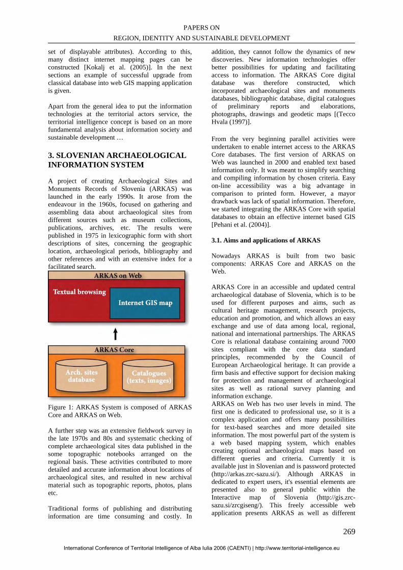
PAPERS ON REGION, IDENTITY AND SUSTAINABLE DEVELOPMENT
269
set of displayable attributes). According to this, many distinct internet mapping pages can be constructed [Kokalj et al. (2005)]. In the next sections an example of successful upgrade from classical database into web GIS mapping application is given. Apart from the general idea to put the information technologies at the territorial actors service, the territorial intelligence concept is based on an more fundamental analysis about information society and sustainable development … 3. SLOVENIAN ARCHAEOLOGICAL INFORMATION SYSTEM A project of creating Archaeological Sites and Monuments Records of Slovenia (ARKAS) was launched in the early 1990s. It arose from the endeavour in the 1960s, focused on gathering and assembling data about archaeological sites from different sources such as museum collections, publications, archives, etc. The results were published in 1975 in lexicographic form with short descriptions of sites, concerning the geographic location, archaeological periods, bibliography and other references and with an extensive index for a facilitated search.
Figure 1: ARKAS System is composed of ARKAS Core and ARKAS on Web. A further step was an extensive fieldwork survey in the late 1970s and 80s and systematic checking of complete archaeological sites data published in the some topographic notebooks arranged on the regional basis. These activities contributed to more detailed and accurate information about locations of archaeological sites, and resulted in new archival material such as topographic reports, photos, plans etc. Traditional forms of publishing and distributing information are time consuming and costly. In
addition, they cannot follow the dynamics of new discoveries. New information technologies offer better possibilities for updating and facilitating access to information. The ARKAS Core digital database was therefore constructed, which incorporated archaeological sites and monuments databases, bibliographic database, digital catalogues of preliminary reports and elaborations, photographs, drawings and geodetic maps [(Tecco Hvala (1997)]. From the very beginning parallel activities were undertaken to enable internet access to the ARKAS Core databases. The first version of ARKAS on Web was launched in 2000 and enabled text based information only. It was meant to simplify searching and compiling information by chosen criteria. Easy on-line accessibility was a big advantage in comparison to printed form. However, a mayor drawback was lack of spatial information. Therefore, we started integrating the ARKAS Core with spatial databases to obtain an effective internet based GIS [Pehani et al. (2004)]. 3.1. Aims and applications of ARKAS Nowadays ARKAS is built from two basic components: ARKAS Core and ARKAS on the Web. ARKAS Core in an accessible and updated central archaeological database of Slovenia, which is to be used for different purposes and aims, such as cultural heritage management, research projects, education and promotion, and which allows an easy exchange and use of data among local, regional, national and international partnerships. The ARKAS Core is relational database containing around 7000 sites compliant with the core data standard principles, recommended by the Council of European Archaeological heritage. It can provide a firm basis and effective support for decision making for protection and management of archaeological sites as well as rational survey planning and information exchange. ARKAS on Web has two user levels in mind. The first one is dedicated to professional use, so it is a complex application and offers many possibilities for text-based searches and more detailed site information. The most powerful part of the system is a web based mapping system, which enables creating optional archaeological maps based on different queries and criteria. Currently it is available just in Slovenian and is password protected (http://arkas.zrc-sazu.si/). Although ARKAS in dedicated to expert users, it's essential elements are presented also to general public within the Interactive map of Slovenia (http://gis.zrc-sazu.si/zrcgiseng/). This freely accessible web application presents ARKAS as well as different
International Conference of Territorial Intelligence of Alba Iulia 2006 (CAENTI) | http://www.territorial-intelligence.eu
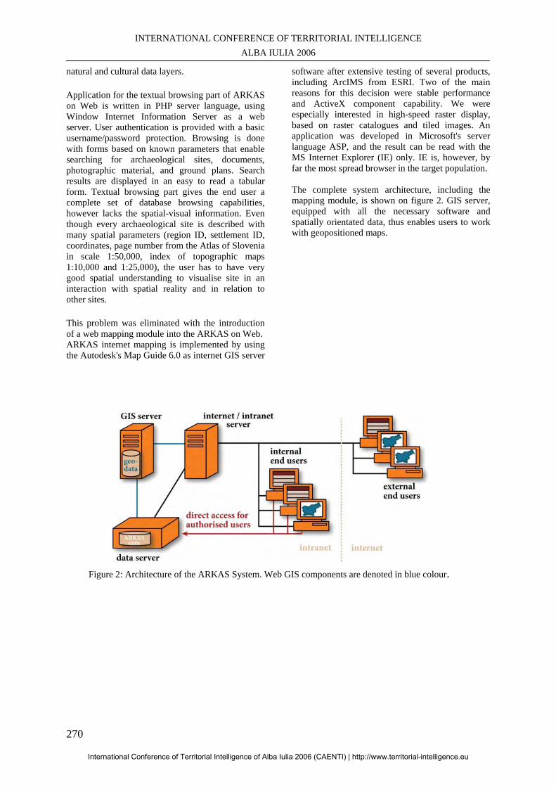
INTERNATIONAL CONFERENCE OF TERRITORIAL INTELLIGENCE ALBA IULIA 2006
270
natural and cultural data layers. Application for the textual browsing part of ARKAS on Web is written in PHP server language, using Window Internet Information Server as a web server. User authentication is provided with a basic username/password protection. Browsing is done with forms based on known parameters that enable searching for archaeological sites, documents, photographic material, and ground plans. Search results are displayed in an easy to read a tabular form. Textual browsing part gives the end user a complete set of database browsing capabilities, however lacks the spatial-visual information. Even though every archaeological site is described with many spatial parameters (region ID, settlement ID, coordinates, page number from the Atlas of Slovenia in scale 1:50,000, index of topographic maps 1:10,000 and 1:25,000), the user has to have very good spatial understanding to visualise site in an interaction with spatial reality and in relation to other sites. This problem was eliminated with the introduction of a web mapping module into the ARKAS on Web. ARKAS internet mapping is implemented by using the Autodesk's Map Guide 6.0 as internet GIS server
software after extensive testing of several products, including ArcIMS from ESRI. Two of the main reasons for this decision were stable performance and ActiveX component capability. We were especially interested in high-speed raster display, based on raster catalogues and tiled images. An application was developed in Microsoft's server language ASP, and the result can be read with the MS Internet Explorer (IE) only. IE is, however, by far the most spread browser in the target population. The complete system architecture, including the mapping module, is shown on figure 2. GIS server, equipped with all the necessary software and spatially orientated data, thus enables users to work with geopositioned maps.
Figure 2: Architecture of the ARKAS System. Web GIS components are denoted in blue colour.
International Conference of Territorial Intelligence of Alba Iulia 2006 (CAENTI) | http://www.territorial-intelligence.eu
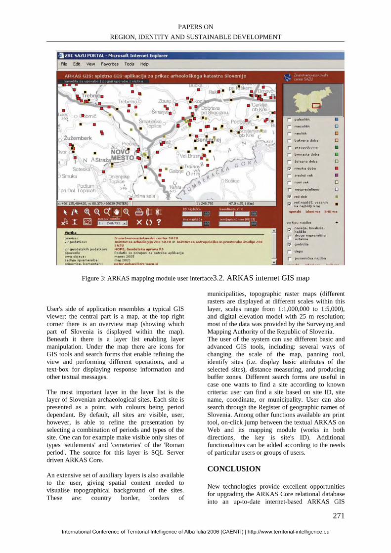
PAPERS ON REGION, IDENTITY AND SUSTAINABLE DEVELOPMENT
271
Figure 3: ARKAS mapping module user interface3.2. ARKAS internet GIS map
User's side of application resembles a typical GIS viewer: the central part is a map, at the top right corner there is an overview map (showing which part of Slovenia is displayed within the map). Beneath it there is a layer list enabling layer manipulation. Under the map there are icons for GIS tools and search forms that enable refining the view and performing different operations, and a text-box for displaying response information and other textual messages. The most important layer in the layer list is the layer of Slovenian archaeological sites. Each site is presented as a point, with colours being period dependant. By default, all sites are visible, user, however, is able to refine the presentation by selecting a combination of periods and types of the site. One can for example make visible only sites of types 'settlements' and 'cemeteries' of the 'Roman period'. The source for this layer is SQL Server driven ARKAS Core. An extensive set of auxiliary layers is also available to the user, giving spatial context needed to visualise topographical background of the sites. These are: country border, borders of
municipalities, topographic raster maps (different rasters are displayed at different scales within this layer, scales range from 1:1,000,000 to 1:5,000), and digital elevation model with 25 m resolution; most of the data was provided by the Surveying and Mapping Authority of the Republic of Slovenia. The user of the system can use different basic and advanced GIS tools, including: several ways of changing the scale of the map, panning tool, identify sites (i.e. display basic attributes of the selected sites), distance measuring, and producing buffer zones. Different search forms are useful in case one wants to find a site according to known criteria: user can find a site based on site ID, site name, coordinate, or municipality. User can also search through the Register of geographic names of Slovenia. Among other functions available are print tool, on-click jump between the textual ARKAS on Web and its mapping module (works in both directions, the key is site's ID). Additional functionalities can be added according to the needs of particular users or groups of users.
CONCLUSION New technologies provide excellent opportunities for upgrading the ARKAS Core relational database into an up-to-date internet-based ARKAS GIS
International Conference of Territorial Intelligence of Alba Iulia 2006 (CAENTI) | http://www.territorial-intelligence.eu
INTERNATIONAL CONFERENCE OF TERRITORIAL INTELLIGENCE ALBA IULIA 2006
272
System. In short-term our goals are to provide dedicated expert users with high-quality spatial data infrastructure and efficient tools for spatial analysis. A preference is to integrate archived digital graphic and photographic material, however in the long term we intend to harmonize the databases and connect them with other databases with reference to Slovenian archaeological heritage, such us museum collections, excavation documentation, and databases of paleo-environmental studies. The ultimate aim is to ensure a solid infrastructure for cooperation with local, regional, national and international organizations and partnerships.
BIBLIOGRAPHY Garrett, W. E. (editor) (1989): La Ruta Maya, in: National Geographic, No. 4, 424 479. Gouveia, C., Fonseca, A., C‰mara, A., Ferreira, F. (2004): Promoting the use of environmental data collected by concerned citizens through information and communication technologies, in: Journal of Environmental Management, Vol. 71, No. 2, p. 135-154. PROCIG (2004): IGN activities report. Url: http://www.procig.org/downloads/resumen-actividades-ign-guatemala.pdf Initiative launched to promote sustainable tourism in Mayan region of Central America, Inter-American development bank, Press release, 16. January 2003. Url: http://www.iadb.org/NEWS/Display/ http://gis.zrc-sazu.si/zrcgiseng/ (10.10.2005, public access) http://arkas.zrc-sazu.si/ (10.10.2005, password protected) Kelly, M. N., Tuxen, K. (2003): WebGIS for Monitoring “Sudden Oak Death” in coastal California, in: Computers, Environment and Urban Systems, Vol. 27, No. 5, pp. 527 547. Kokalj., Ž., Pehani, P., Podobnikar, T., Goochild, H., Gaffney, V.L., Oštir, K. (2005): A GIS
mapping framework for the cultural site/route management of the Mundo Maya sustainable tourism program. In: (Jiř’ Hřeb’ček, Jaroslav R‡ček, eds) 2005. Networking enviromental information. EnviroInfo Brno 2005. Proceedings of the 19th International Conference Informatics for Environmental Protection, September 7-9,2005, Brno, Czech Republic, 284-288. Lo Tauro, A., Di Paola, G., Spina, S. E. (2005): Preservation and valorisation of cultural and environmental resources and information systems, an investigation into a Web GIS. In: CORP 2005 proceedings, University of technology, Vienna, Austria, 311 318. Longley et al. (2001): Geographic Information Systems and Science. John Wiley & Sons, Ltd., pp. 454. Mundo Maya sustainable tourism program, Document for the MMO-IDB-CI-CPI-NGS Alliance. November, 2002, Guatemala city, Guatemala, 39. Pehani, P., Podobnikar, T., Tecco Hvala, S. 2004. Zasnova in vzpostavitev internetnega GIS-strežnika na ZRC SAZU. Design and implementation of the internet GIS-server at the ZRC SAZU. In: (Podobnikar, T. et al., eds) 2004. Geografski informacijski sistemi v Sloveniji 2003-2004, Ljubljana, 157-167. Tecco Hvala, S. 1997. Towards a standardisation of archaeological data. Journal for protection of Monuments 37, Ljubljana, 180-184. Tsou, M. H. (2004): Integrating Web-based GIS and image processing tools for environmental monitoring and natural resource management, in: Journal of Geographical Systems, Vol. 6, No. 2, p. 155-174. Zhu, X., McCosker, J., Dale, A. P., Bischof R. J (2001): Web-based decision support for regional vegetation management, in: Computers, Environment and Urban Systems, Vol. 25, No. 6, p. 605 627.
International Conference of Territorial Intelligence of Alba Iulia 2006 (CAENTI) | http://www.territorial-intelligence.eu
PAPERS ON REGION, IDENTITY AND SUSTAINABLE DEVELOPMENT
273
SHARING AND DISSEMINATING KNOWLEDGE OF ADVANCED
SPATIAL MODELLING. PRESENTATION OF AN ACTION CARRIED OUT BY THE EUROPEAN
RESEARCH GROUP S4 (SPATIAL SIMULATION FOR SOCIAL SCIENCES)
________________________________________________________________
Cécile TANNIER Permanent researcher – French National Centre for Scientific Research
[email protected], Tél: + 33 (3) 81 66 54 81
Professional address ThéMA - 32 rue Mégevand – F-25030 BESANÇON cedex, France.
Abstract: The European research group S4 (Spatial simulation for social sciences) gathers researchers in geography as well as in geographical information sciences coming from about 30 European research centres. One action of the European research group S4 consists in sharing and disseminating knowledge of advanced spatial modelling. We propose here to describe several aspects of this action that are of interest considering the objectives of the CAENTI. The first aim of the action is to improve the diffusion of the results of the research in advanced spatial modelling, particularly in direction of regional and urban management and planning. The second aim is the development of tools and methods to improve coherence of knowledge and experiences that is especially required in those fields characterised by a rapidly developing research as it is the case for spatial systems analysis and modelling. Keywords: Spatial modelling, Spatial simulation, Geography, Internet, Knowledge dissemination.
International Conference of Territorial Intelligence of Alba Iulia 2006 (CAENTI) | http://www.territorial-intelligence.eu
INTERNATIONAL CONFERENCE OF TERRITORIAL INTELLIGENCE ALBA IULIA 2006
274
SHARING AND DISSEMINATING KNOWLEDGE OF ADVANCED
SPATIAL MODELING. PRESENTATION OF AN ACTION CARRIED OUT BY THE EUROPEAN RESEARCH GROUP S4
(SPATIAL SIMULATION FOR SOCIAL SCIENCES) Presentation of an action carried out by the European research group S4 (spatial simulation for social sciences)As in many sciences, the conception and the use of spatial modelling in geography has increased during the last ten years. Such a modelling approach is called "theoretical and quantitative geography". It aims to characterise and to study the spatial distribution of different kinds of phenomena using spatial data analysis and modelling. Studied phenomena can be for example population, activities, diseases, road networks, types of landscapes... Belonging to this field of research, the European research group S4 (Spatial simulation for social sciences) gathers researchers in geography as well as in geographical information sciences coming from about 30 European research centres60. It has been created in January 2006, but its informal existence goes back 1978 (date of the first European colloquium on theoretical and quantitative geography). Even if some parts of research belonging to the field of theoretical and quantitative geography could be very useful for urban and regional development and planning, at the moment, they remain mostly in the field of research. A fact is that few results are applied for answer practical concerns, in particular in France. The conclusions of a study realised in the framework of the PREDIT (French program dedicated to the promotion of research and innovation for transportation systems) illustrates this statement. The study underlines the real urgency both of a better legibility of spatial modelling research and of an increased coherence of the results of this research in order to better integrate them in the field of the territorial management. It emphasizes in particular the interest of the use of renewed and advanced mobility models for urban transportation management61.
60 European Research Groups are research networks,
with no legal identity, made of public or private European laboratories, working on the same scientific theme. The European Research Group S4 proposes to develop spatial dynamic modelling as an integrative tool for understanding, discussing and helping to manage the evolution of our complex societies. It is directed by Denise Pumain.
61 Baye E. et al., Bilan de compétences des laboratoires
en recherche français en matière de modélisation des déplacements de voyageurs et de marchandises,
Regarding this statement, the European research group S4 decided to develop an action entitled "Sharing and disseminating knowledge of advanced spatial modelling". The first aim of this action is to improve the diffusion of the results of research in spatial modelling, particularly in direction of regional and urban management and planning. The second aim is the development of tools and actions to improve coherence of knowledge and experiences that is especially required in those fields characterised by a rapidly developing research as it is the case for spatial systems analysis and modelling. Ensuing from these aims, 4 objectives govern the presented action. First aim: diffusion of the results of the research in spatial modelling Objective 1 Diffuse the research results to the whole scientific community interested in spatial simulation: geography, urban and regional planning, but although economy, informatics, physics, biology... Objective 2 Disseminate methods, outputs and results to stakeholders. Objective 3 Promote main findings among the public through a “Science and Society” approach. Second aim: development of tools and actions to improve coherence of knowledge and experiences. Objective 4 Ensure an optimal sharing of knowledge between the members of the S4 research group. To answer these 4 objectives, several actions have been programmed. Some of them are in the process of being realised.
Octobre 2002, Rapport PREDIT.
International Conference of Territorial Intelligence of Alba Iulia 2006 (CAENTI) | http://www.territorial-intelligence.eu
PAPERS ON REGION, IDENTITY AND SUSTAINABLE DEVELOPMENT
275
1. ACTION 1: DEVELOPMENT OF AN INTERACTIVE PLATFORM FOR GEOGRAPHY AND SPATIAL MODELLING The S4 Interactive Platform is a web site with a double key access: for the members themselves and for an interested public (i.e. the whole scientific community, stakeholders, end-users and students).
http://www.spatial-modelling.info/ From a technical point of view, the S4 Interactive Platform is an ergonomic website characterized by a high level of user-friendliness and the ease of navigation. The Web-designers (grafactory.net, Besançon) have developed a customised Content Management System, which allows a dynamic site by preserving the autonomy of the authors for the content (articles, models, links…): modifications and news are set on line in real time by the members of the S4 research group themselves without needing to go through a web master. The S4 Interactive Platform is organised on the basis of seven main entries.
• Who are we – This first heading offers basic information about the ERG S4.
• If you want contribute to the S4 platform – This second heading gives practical information about how to do this.
• Directory of links – This third heading is dedicated to the search of other web sites that deal with spatial analysis and modelling.
• Activities – This fourth heading offers a set of information about the network events. The announcement of seminars, conferences and general meetings appears here.
• Electronic Publication Platform - This fifth heading gathers two publications. Firstly, the European Journal of Geography Cybergeo62 is a purely electronic journal founded in 1996. It was the first electronic journal in geography to appear in the world and one of the first in social sciences. The journal addresses the whole domain of geography, with a special emphasis on interfacing with other sciences and developing theoretical and applied modelling. Cybergeo plays a central role in the
62 http://www.cybergeo.presse.fr/
S4 Research Group, enhancing both its experience and reputation through a wider and more efficient dissemination of knowledge. Secondly, the Electronic Encyclopaedia Hypergeo is dedicated to the definition of basic terms used in geography. The aim of Hypergeo is to improve the diffusion of the concepts and the theories of the actual geography, particularly in direction of students and teachers.
• S4 Private Room – This sixth heading is dedicated to the exchanges between the members of the ERG S4. It allows them to share information about work in progress and results obtained in each working group. Facilities for shared writing is provided.
• Spatial Modelling Park - In the framework of the CAENTI, this last heading represents the most interesting part of the S4 Interactive Platform. It requires a more detailed description.
Spatial Modelling Park Several initiatives already exist, which aim to increase exchanges and communication about research on spatial systems modelling via Internet. As examples, we chose to quote the inventory of web sites realised by the CSISS (Centre for Spatially Integrated Social Sciences)63 of the University of Santa Barbara; and also the on line disposal software for spatial analysis and simulation as proposed by the AI-GEOSTATS, a Web service for geostatistics and spatial statistics (Joint Research Centre - European Commission) or by the Global Warming Resource Centre of the US Environmental Protection Agency. Although interesting, such initiatives only deal with one precise aspect (which could be either methodological, technical or centred on a given topic) of the whole field of spatial modelling of social systems. Moreover, most part of the research developed by the S4 members is not presented on these web sites. These statements led to the decision to create the Spatial Modelling Park. Several years before the creation of the S4 Interactive Platform, two actors of the ERG S4 have already been interested in developing comparable initiatives. • The French Research Group Libergeo has
63 http://www.csiss.org/
International Conference of Territorial Intelligence of Alba Iulia 2006 (CAENTI) | http://www.territorial-intelligence.eu
INTERNATIONAL CONFERENCE OF TERRITORIAL INTELLIGENCE ALBA IULIA 2006
276
developed an Interactive database on spatial modelling64 which contains 21 models (1999-2003).
• The web site of the Centre for Advanced Spatial Analysis (CASA) of London contains a set of pages dealing with the recent advances in the research on spatial simulation models (in particular, cellular automata and multi-agent systems) developed for studying and planning urban systems65.
At the moment, the S4 Spatial Modelling Park comprises four on-line services:
• The section Spatial simulation models is a database on spatial modelling which comprises standard description of simulation models including tools for analysing the contained data.
• The Spatial simulation software repository contains downloadable software dedicated to the construction of different types of simulation model.
• The section Spatial analysis tools contains the description of a set of tools most of them being downloadable.
• The section Educational modules is dedicated to the presentation of basic scientific models. The aim of this section is to promote and popularise research in advanced spatial modelling by giving simple modelling demonstrations and applications.
It has also been planned to develop two other services:
• Consultancy, assessment, valuation of spatial simulation tools, which will allow the users to set the performance of the models, in particular by defining their field of application.
• Technology watch, which will help users by giving information about new advances as well as about the evolution of the available contents of other resources centres. The performance of the technology watch will be ensured by using an automatic news search engine.
Even if those two services are not yet developed, they are perhaps the most important ones. Actually, the concept of the S4 Interactive Platform is very close to existing Internet realisations, which aim to help the development of innovative firms by providing innovation tools and user reviews about each of them. In particular, the Virtual
64 http://www.mgm.fr/libergeo/modele 65 http://www.casa.ucl.ac.uk/research/index.htm
Environment for Innovation Management Technologies (developed in the frame of the European VERITE network) and the ONLI (On-Line Innovation) project (also supported by the European Commission) were an inspiration for the Spatial Modelling Park. A fact is that the assessment and the valuation of spatial simulation models is a broad and rather unexplored field of investigation, but several members of the ERG S4 already began to work in that direction. The actual content of the S4 Modelling Park is as following (see tables 1 and 2).
• 11 simulation models are described on line, 8 of them being downloadable. 13 other simulation models will soon be published on line. At the moment, their description is not yet completed and only available via the S4 private room.
• 6 spatial analysis tools are described on line, 5 of them being downloadable. 2 other tools will soon be published on line.
• 1 software dedicated to the development of a given type of simulation model (i.e. cellular automata) is downloadable on line.
• 6 educational modules are described on line and 1 more module will soon be published on line.
Table 1
The S4 Interactive Platform: on line spatial simulation models (July 2006)
Table 2 The S4 Interactive Platform: on line spatial
analysis tools (July 2006) Considering the general orientation of the Spatial Modelling Park, the development of a network policy for the preservation of intellectual property is required in order to avoid the plagiarizing of the know-how and to assure the platform’s durability. A thought to this topic is work in progress. Some of the contributors to the S4 platform are in favour of the open source and free ware distribution of their software. Other contributors are not. A first possibility to preserve the intellectual property of their applications has been explored, which is the registration of a software using an InterDeposit Digital Number. The InterDeposit Digital Number is an international system for the identification of works offering the possibility of protecting any type of digital creation (music, sound, photographs, moving and still pictures, logos, texts, software, data bases, web sites, etc.) regardless of format. At the moment, one software of the S4 Platform (named Fractalyse) has been protected via an
International Conference of Territorial Intelligence of Alba Iulia 2006 (CAENTI) | http://www.territorial-intelligence.eu
PAPERS ON REGION, IDENTITY AND SUSTAINABLE DEVELOPMENT
277
IDDN. The registration of the software Fractalyse is successful. Indeed, Fractalyse was potentially interesting for a scientific community not very numerous, widespread all around the world and not specific to a given scientific field. But, without any protection, the rights holders of the software would not have allowed many people to download it. Since Fractalyse is available on line, it is downloaded by people from all around the world belonging to different scientific fields (geographers, computer scientists, physicists...). The S4 platform is in course of development. It means that it is the beginning of its life. Much is still to be done in order to add more contain, more description of applications, more spatial analysis tools and more software. But, the development of the platform is seen as a long time project, which should go on for several years.
An increased sharing of knowledge and know-how as a result of the development of the S4 Interactive Platform should generate important benefits. Especially in terms of research in the field of spatial dynamics of social systems, the consequences should be: • enhancing the initiatives dealing with the
coupling of several models, • increasing knowledge of spatial processes
through the comparison of numerous simulation results,
• the diffusion of the models throughout the different research teams of the S4 network as some other tools circulate via Internet.
The expected results are the improvement of the capabilities and the performance of the future models that will be built by research teams of different countries. 2. ACTION DISSEMINATING METHODS, INSTRUMENTS, OUTPUTS AND RESULTS TO STAKEHOLDERS AND END-USERS To attain this objective some preliminary work is required, which will involve the definition of categories of stakeholders: national governments, local and regional authorities, regional development agencies, consultancy firms specialised in regional development and spatial and urban planning, corporate location professionals, professional and business organisations, etc. Then, the transition from stakeholders to end-users comes down the definition of a potential market of end-users. Once the preliminary work of definition has been completed, it will be possible to define actions
aiming to disseminate the S4 knowledge. This requires to look at the simulation methods and models themselves. Actually, as regards the needs of stakeholders and end-users, it is of crucial importance to test the operational use of models and to improve them. Ensuing from this is a very close link with the development of the Spatial Modelling Park to the S4 Interactive Platform. The goals are indeed converging in the same direction: sharing the knowledge between communities of actors of different level (searchers, stakeholders, end-users), promoting the understanding of the models and their reuse, striving towards a better understanding of the modelling process for spatial simulation in social sciences. Hence, testing the operational use of models and improving it represents a way of both exploiting the contents of the Spatial Modelling Park as well as improving it. Another kind of reflection is also required which aim is to evaluate and better define the real possibilities of the operational use of the developed modellings. Such a field of investigation is at the heart of a doctoral research currently undertaken in the research centre ThéMA (Besançon, France)66. The research proceeds from the statement that several factors may occur in the fact that the spatial simulation models developed by researchers can mostly not be directly used for operational purposes. Firstly, existing modellings are characterised by a lack of conceptual framework, which consequence is the very few possibilities of combining the models the ones with the others. Secondly, the user interfaces are not enough oriented toward a general use. Thirdly, the applications are operational considering a given case (either fictitious or real), but they rarely allow the introduction of data different from those originally used. The central question of the discussed research is about the identification of the possible transfers of the scientific knowledge as well as the possible diffusion of simulation tools to the social and economic world. As a result, the way of performing such transfers is of well interest. Three steps have been defined to tackle this question. The first step aims to determine the relevance of different types of spatial simulation modellings considering operational goals (i.e. urban and regional planning).
66 S. Grandjean "Simulations spatiales intra-urbaines -
Rendre opérationnels les modèles issus de la recherche fondamentale", directed by P. Frankhauser and C. Tannier.
International Conference of Territorial Intelligence of Alba Iulia 2006 (CAENTI) | http://www.territorial-intelligence.eu
INTERNATIONAL CONFERENCE OF TERRITORIAL INTELLIGENCE ALBA IULIA 2006
278
The second step deals with the modelling process itself: its formal description will give a conceptual and reusable framework, which could be used to generalise the existing modelling tools and applications. Such a reusable framework would be helpful for:
- the share of knowledge between several types of users and actors (researchers, planners, consultancy firms...), - the promotion of the modelling tools and their reuse, - a better knowledge of the modelling process itself considering the goal of the simulation of spatial systems.
Within the field of Information Systems Development and Knowledge Representation, some methods have been developed which could helpfully be applied to move in such direction. One of these methods is the definition of an ontology which aims to identify and to represent the knowledge in the field of spatial modelling. The second method is the formalisation of the knowledge through reusable patterns that will serve as a basis for building Product Models. Here, a pattern represents a solution advocated to solve a recurrent problem defined in a given context. Now, regarding the previously mentioned problem of the plagiarizing of the S4 know-how, combining these two approaches (ontology and reusable patterns for building product models) will lead to the development of a shadowing method for the models.
The third step is dedicated to the application of the tools and methods developed during the two previous steps in order to create and apply operational spatial simulation modellings.
3. ACTION EVALUATION OF EFFICIENCY OF THE ACTIONS 1 AND 2 Two benchmarking actions should be usefully undertaken, but at the moment, they remain under consideration. The first action would aim to evaluate sharing of knowledge as a crucial part of the efficiency and effectiveness of the ERG S4. Its realisation could be based on the definition of quantitative and qualitative indicators and face-to-face interviews and meetings during the conferences and workshops. The second action could consist in ex-ante and ex-post evaluation of the dissemination actions also through the definition of quantitative and qualitative indicators.
CONCLUSION The action "Sharing and disseminating knowledge of advanced spatial modelling", carried out by the European research group S4, participates in the development of research in geography seen as very active regarding its opening toward other scientific fields as well as the evident potentiality of using spatial modellings for urban and regional planning. But, although very promising, much is still to be done to ensure the general use of spatial modelling for operational purposes.
International Conference of Territorial Intelligence of Alba Iulia 2006 (CAENTI) | http://www.territorial-intelligence.eu
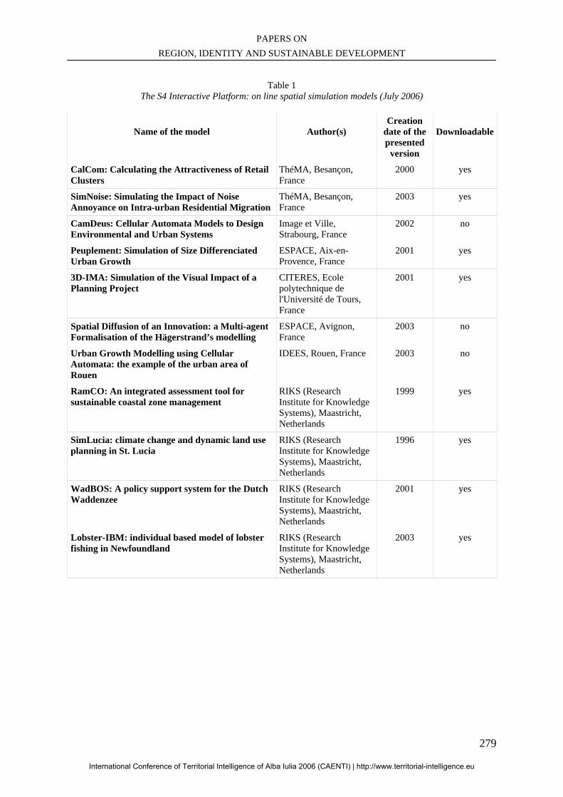
PAPERS ON REGION, IDENTITY AND SUSTAINABLE DEVELOPMENT
279
Table 1
The S4 Interactive Platform: on line spatial simulation models (July 2006)
Name of the model
Author(s)
Creation date of the presented
version
Downloadable
CalCom: Calculating the Attractiveness of Retail Clusters
ThéMA, Besançon, France
2000 yes
SimNoise: Simulating the Impact of Noise Annoyance on Intra-urban Residential Migration
ThéMA, Besançon, France
2003 yes
CamDeus: Cellular Automata Models to Design Environmental and Urban Systems
Image et Ville, Strabourg, France
2002 no
Peuplement: Simulation of Size Differenciated Urban Growth
ESPACE, Aix-en-Provence, France
2001 yes
3D-IMA: Simulation of the Visual Impact of a Planning Project
CITERES, Ecole polytechnique de l'Université de Tours, France
2001 yes
Spatial Diffusion of an Innovation: a Multi-agent Formalisation of the Hägerstrand’s modelling
ESPACE, Avignon, France
2003 no
Urban Growth Modelling using Cellular Automata: the example of the urban area of Rouen
IDEES, Rouen, France 2003 no
RamCO: An integrated assessment tool for sustainable coastal zone management
RIKS (Research Institute for Knowledge Systems), Maastricht, Netherlands
1999 yes
SimLucia: climate change and dynamic land use planning in St. Lucia
RIKS (Research Institute for Knowledge Systems), Maastricht, Netherlands
1996 yes
WadBOS: A policy support system for the Dutch Waddenzee
RIKS (Research Institute for Knowledge Systems), Maastricht, Netherlands
2001 yes
Lobster-IBM: individual based model of lobster fishing in Newfoundland
RIKS (Research Institute for Knowledge Systems), Maastricht, Netherlands
2003 yes
International Conference of Territorial Intelligence of Alba Iulia 2006 (CAENTI) | http://www.territorial-intelligence.eu
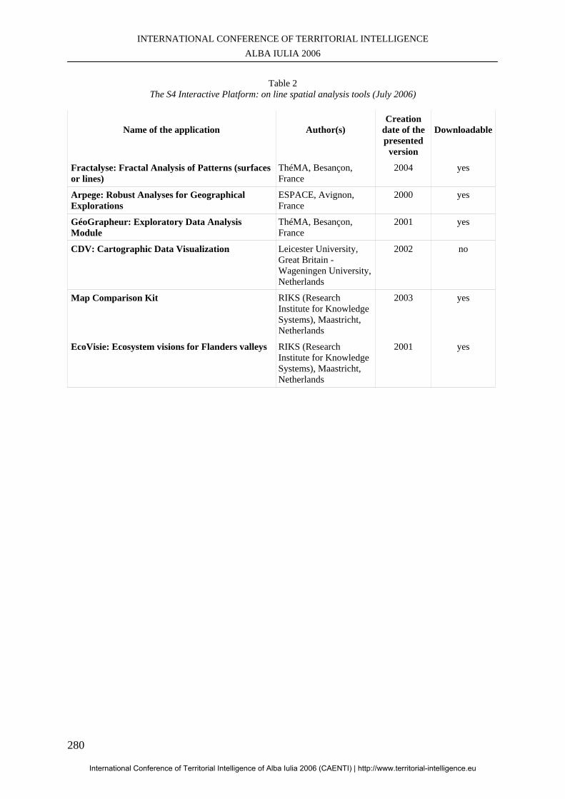
INTERNATIONAL CONFERENCE OF TERRITORIAL INTELLIGENCE ALBA IULIA 2006
280
Table 2
The S4 Interactive Platform: on line spatial analysis tools (July 2006)
Name of the application
Author(s)
Creation date of the presented
version
Downloadable
Fractalyse: Fractal Analysis of Patterns (surfaces or lines)
ThéMA, Besançon, France
2004 yes
Arpege: Robust Analyses for Geographical Explorations
ESPACE, Avignon, France
2000 yes
GéoGrapheur: Exploratory Data Analysis Module
ThéMA, Besançon, France
2001 yes
CDV: Cartographic Data Visualization Leicester University, Great Britain - Wageningen University, Netherlands
2002 no
Map Comparison Kit RIKS (Research Institute for Knowledge Systems), Maastricht, Netherlands
2003 yes
EcoVisie: Ecosystem visions for Flanders valleys RIKS (Research Institute for Knowledge Systems), Maastricht, Netherlands
2001 yes
International Conference of Territorial Intelligence of Alba Iulia 2006 (CAENTI) | http://www.territorial-intelligence.eu
PAPERS ON REGION, IDENTITY AND SUSTAINABLE DEVELOPMENT
281
SUMMARY VOLUME 2
Introduction ........................................................................................................................................................ 7
Activities and prospects of CAENTI. Jean-Jacques GIRARDOT ....................................................................... 9
WP4: The spreading of fundamental methods and research design in territorial information analysis
within the social sciences and humanities ........................................................................................................ 19
The spreading of fundamental methods and research design in territorial information analysis within the
social sciences and humanities sciences. Csilla FILO.......................................................................................... 21
Methods for territorial intelligence. Serge ORMAUX ......................................................................................... 25
Territorial information, themes, indicators and sources. Di CHEN, Guénaël DEVILLET .................................. 29
Evaluation of projects funded by European Commission and of the existing information of the GDs that
might be relevant in the territorial intelligence field coordination group WP4P “Projects” of CAENTI. Jean-
Jacques GIRARDOT, Amélie BICHET-MIÑARO ............................................................................................ 45
Territory and territorialisation: present state of the CAENTI thought. Pierre CHAMPOLLION ........................ 51
Territorial competitiveness for territorial intelligence. Csilla FILO .................................................................... 59
WP5: Analysis of the application of the principles of governance of sustainable development in
territorial research-action ................................................................................................................................. 63
Analysis of the application of the governance principles of sustainable development to territorial research
action. Blanca MIEDES UGARTE ...................................................................................................................... 65
WP6: Conception and dissemination of methods and tools of territorial intelligence for the territorial
actors and respectful of a sustainable development ethics ............................................................................. 73
Activities and prospects of research activities concerning tools of territorial intelligence for sustainable
development actors Workpackage 6 “Tools for actors”of CAENTI. Jean-Jacques GIRARDOT ........................ 75
Specifications of the contents of the European guide of diagnosis and evaluation. Celia SANCHEZ LOPEZ,
Jean-Jacques GIRARDOT ................................................................................................................................... 89
Towards a European observatory of elementary school: feasibility study from the french experience
“Observatory of rural school”. Yves ALPE ......................................................................................................... 113
International Conference of Territorial Intelligence of Alba Iulia 2006 (CAENTI) | http://www.territorial-intelligence.eu


