Embed Size (px)
Citation preview

TECTONICS, VOL. 19, NO. 2, PAGES 258-289 APRIL 2000
Intraplate deformation and basin formation during the Tertiary within the northern Iberian plate- Origin and evolution of the Almazn Basin
Antonio M. Casas-Sainz, Angel L. Cort6s-Gracia, and Adolfo Maestro-Gonzfilez Departamento de Geologia, Facultad de Ciencias, Universidad de Zaragoza, Zaragoza, Spain
Abstract. The Tertiary Almazfin Basin was a topographic high during the Mesozoic rifting at the northern part of the Iberian plate. It was bordered by two Mesozoic basins: (1) the Castilian Basin (with a maximum thickness of more than 2000 m) to the south and (2) the Cameros Basin (with a maximum thickness of 9000 m) to the north. To the east the Almazfin Basin is bordered by Paleozoic rocks of the NW-SE trending Aragonian Range, which underwent little subsidence during the Mesozoic. The two Mesozoic basins show an E-W direction. During the Tertiary NNE-SSW compression (mainly late Eocene-early Miocene), both Mesozoic basins were inverted and uplifted, and the Almazfin Basin, with an overall synclinal geometry, was filled with syn-tectonic terrestrial sediments, reaching a maximum thickness of 3500 m. Deformation during the Tertiary was strongly controlled by preexisting structures, both Mesozoic extensional faults and reactivated Variscan folds. The depocenter of the Tertiary basin migrated southward during the Paleogene. This migration is consistent with a piggyback transport of the whole basin northward, due to the movement on the underlying, crustal-scale north verging Cameros thrust. The geometry and sedimentary evolution of the Almazfin thick- skinned piggyback basin was controlled by the uplift associated with the main crustal-scale thrust, which was the main source area, and was separated from the foreland basin since the early stages of filling (late Eocene). This makes the main difference with thin-skinned piggyback basins, controlled by the foreland thrust belt and separated from the foreland basin only at their late stages.
1. Introduction
The inner part of the Iberian plate was strongly deformed during the Tertiary by the collision between Africa, Europe, and Iberia, forming intraplate mountain chains and non- marine basins [Sanz de Galdeano, 1996]. The greatest thickness (2500-5000 m) of syntectonic Tertiary terrigenous sediments is found at the northern part of the Ebro and Duero Basins (foreland to the Pyrenean margin, [Riba et al., 1983; Instituto Tecnol6gico GeoMinero de Espana (ITGE), 1990]). Some areas within the plate subsided significantly: the Madrid and Almazfin Basins, located south and north of the Central
Copyright 2000 by the American Geophysical Union.
Paper number 1999TC900059. 0278-7407/00/1999TC900059512.00
System, respectively, each show cumulate thickness over 2500 m of Tertiary deposits, with structural reliefs of nearly 5000 m between the bottom of the basins and the tops of the neighboring mountain chains [De Vicente et al., 1996a,b]. The processes involved in intraplate deformation were mainly basement thrusting, strike-slip faulting and inversion of Mesozoic basins [Guimer• and Alvaro, 1990; Casas-Sainz, 1993; Van Wees and Stephenson, 1995; Casas-Sainz and Gil- Imaz, 1998]. Structures formed during inversion were strongly controlled by the orientation and geometry of pre-existing extensional faults. Inherited basement structures also played an important role in the geometry of extension and inversion [Mu•oz, 1992; Liesa-Carrera and Casas Sainz, 1995; Alonso et al., 1996].
Continental deformation sometimes implies the formation of piggyback basins, defined as intermontane basins that formed and were filled while being carried on moving thrust sheets [Ori and Friend, 1984]. Piggyback basins usually show an elongated shape, following the trend of the thrust system. The active thrusts transporting piggyback basins may be detached at shallbw crustal levels, namely, on evaporites or shallow strength units [Ori and Friend, 1984; Lawton and Trexler, 1991; Gonzalez and Guimerd, 1993; Hyppolyte et al., 1994; Teixell and Garcœa-Sansegundo, 1995; G6mez et al., 1996; Gimbnez Montsant and Salas, 1997; Mu•oz-Martfn and De Vicente, 1998], or may involve a thickness of several kilometers of the upper crust [Beer et al., 1990; Baby et al., 1995; Bonini, 1999a,b]. The sedimentary syntectonic evolution of piggyback basins is strongly influenced by the geometry of thrust sheets [Zoetemeijer et al., 1993; Talling et al., 1995; Pivnik and Khan, 1996; Bonini, 1999a,b], and is recorded by the main unconformities within the sedimentary filling [Beer et al., 1990; Zoetemeijer and Sassi, 1992]. The foreland thrust belt usually provides one of the main controls in basin geometry and is commonly the source area for the piggyback basin during its first stages. Toward the middle stages of its evolution a longitudinal drainage may appear, and finally the leading edge of the underlying thrust may emerge [Mugnier et al., 1997], also becoming a source area [Puigdefdbregas, 1975; Ori and Friend, 1984; Lawton and Trexler, 1991; Turner, 1992; Pivnik and Khan, 1996].
The Almazfin Basin, defined as a piggyback basin [Guimerit et al., 1995], was an area of high subsidence during the Tertiary in the inner part of the Iberian plate, with a thickness of 3500 m of Tertiary terrigenous sediments [Armenteros et al., 1989; Bond, 1996]. It is located between mountain ranges where older rocks (Paleozoic and Mesozoic) crop out: the
258

CASAS-SAINZ ET AL.: PIGGYBACK BASIN EVOLUTION (NORTHERN SPAIN) 259
c-
+ + + +
+ +
+ + +
+ + + + +
+ +
t
t

260 CASAS-SAINZ ET AL.: PIGGYBACK BASIN EVOLUTION (NORTHERN SPAIN)
Aragonian Range of the Iberian Chain to the east, the Cameros Massif to the north and the Castilian Range to the south (Figure 1). Both the Cameros Massif and the Castilian Range were basinal areas during the Mesozoic and underwent positive tectonic inversion during the Tertiary. The Cameros Basin shows a horizontal displacement of 25-30 km northward on the Cameros thrust and a lower displacement (2- 3 km) southward, toward the Almazfin Basin [Platt, 1990; Guimer• et al., 1995]. The Castilian Range is limited by monoclines or reverse faults involving the Paleozoic basement. The Aragonian Range subsided during the Triassic and late Cretaceous and was a topographic high during ail the Jurassic and the early Cretaceous. During the Tertiary it was folded with NW-SE trend, parallel to the underlying Variscan folds. According to Guimerh and Alvaro [1991] Tertiary thrusting involving Paleozoic rocks was favored by a midcrustal detachment in the Iberian plate.
The objectives of this work are (1) to characterize the Mesozoic-Tertiary evolution of the Almazfin Basin, (2) to determine the influence of preexisting structures (Mesozoic extensional faults and Variscan folds and thrusts) on the development of compressional structures, (3) to determine the history of Tertiary deformation from relationships between tectonics and sedimentation, and (4) to establish a model of basin evolution and compare it with described piggyback basins. The methodology used involved the study of seismic profiles, aerial photographs, and field mapping to constrain balanced cross sections and the geometrical relationships between tectonosedimentary units.
2. Main Tectonostratigraphic Domains The Tertiary Almazfin Basin is located in the northwestern
sector of the Iberian Chain, an intraplate mountain range that occupies the central-eastern part of the Iberian peninsula [Julivert, 1978; Alvaro et al., 1979; Capote, 1983a] and which concentrated much of the intraplate deformation during the Mesozoic and the Tertiary. Variscan structures include cleavage, folds, and thrusts with N-S to NW-SE orientation [Capote, 1983b]. Late Variscan faults and fractures are arranged in two sets: NW-SE and NE-SW [Arthaud and Matte, 1975; 1977; Alvaro et al., 1979; Capote, 1983a,b; Ziegler, 1989; Vegas et al., 1990], forming part of a system with relatively constant orientation throughout western Europe [Dikkers, 1977; Illies, 1977; Johnson and Frost, 1977; Ramberg et al., 1977; Ziegler, 1989]. These faults were reactivated as normal faults during Mesozoic rifting and as wrench or reverse faults during the Tertiary shortening [Alvaro et al., 1979; Arias et al., 1979; $alas and Casas, 1993], controlling the location of structures in the Mesozoic cover. In some parts of the chain Tertiary deformation is thin- skinned, with a detachment level in the upper Triassic evaporites. The Almazfin Basin is surrounded by three main tectonic units within the Iberian Chain (Figure 1): the Cameros Massif to the north, the Aragonian Range to the east, and the Castilian Range to the south.
2.1. The Cameros Massif
The Cameros Massif is the result of the Tertiary inversion of the Mesozoic (mainly upper Jurassic-lower Cretaceous)
Cameros Basin [Casas-Sainz, 1993; Guimer& et al., 1995]. It consists of Mesozoic rocks, with upper Triassic evaporites, marine Jurassic limestones (up to 800 m thick), and a series (up to 8000 thick) of terrigenous Kimmeridgian to Albian deposits (sandstones, shales, and lacustrine limestones) [Guiraud and S•guret, 1984]. The basin was a half graben bounded northward by large NW-SE normal faults with downthrow to the south-west of up to 8 km [Casas-Sainz and Gil-Imaz, 1998] and bounded southward by smaller faults, with downthrows of up to 2-3 km [Platt, 1990; Clemente and P•rez- Arlucea, 1993; Guimer& et al., 1995]. The normal faults at the southern margin of the basin show two main strikes, WNW- ESE and NE-SW, which coincide with the late Variscan fracture directions [Salomon, 1980, 1983; Clemente and Alonso, 1990]. Up to 1000 m of Albian-Cenomanian sandstones (Utrillas Formation) and upper Cretaceous limestones constitute the postrift sequence (Figure 2).
The present-day structure of the Cameros Massif reflects positive inversion. To the north the Cameros Massif overthrusts the Tertiary deposits of the Ebro Basin along the E-W-striking, shallow-dipping Cameros thrust with a detachment level in the upper Triassic gypsiferous beds [Casas-Sainz, 1993]. This thrust continues to the west in the Sierra de la Demanda (defining a continuous front 100 km long) where Paleozoic rocks are exposed in the hanging wall. The horizontal displacement of the Cameros thrust is between 15 and 25 km and its vertical throw is more than 4 km
[Mut•oz-Jim•nez and Casas-Sainz, 1997]. The present-day southern border of the Cameros Massif shows folds and
thrusts, with NE-SW and NW-SE segments (Figure 1•). They result either from the reactivation of the Mesozoic normal faults limiting the Cameros Basin or from newly formed thrusts [Navarro, 1988; Platt, 1990; Clemente and P•rez- Arlucea, 1993; Guimer• et al., 1995]
2.2 Aragonian Range
The Aragonian Range consists of two NW-SE oriented antiforms of Paleozoic rocks (-150x10 km), bordered by Mesozoic sediments. The Paleozoic rocks of the Aragonian Range are included in the Western Asturian-Leonese Zone of the Iberian Massif [Lotze, 1945; Julivert et al., 1972]. In the southernmost antiform, which forms the eastern limit of the Almazfin Basin, the Paleozoic sequence consists of Cambrian and Ordovician sandstones and shales, up to 7000 m thick, folded in NW-SE direction during the Variscan orogeny [Julivert et al., 1972; Lendfnez Gonzc•lez and Martfn Herrero, 1987; Ruiz-Fernc•ndez et al., 1987]. The Mesozoic sedimentary series outcropping at the border with the Almazfin Basin is -500 m thick and comprises Triassic rocks (mainly Buntsandstein facies) [Tallos-Gonzc•lez, 1984], Albian- Cenomanian sandstones, and upper Cretaceous limestones (Figure 2). To the north and south the thickness of the Mesozoic series increases, as it approaches the Cameros

CASAS-SAINZ ET AL.' PIGGYBACK BASIN EVOLUTION (NORTHERN SPAIN) 261
• _• •o

262 CASAS-SAINZ ET AL.: PIGGYBACK BASIN EVOLUTION (NORTHERN SPAIN)
Basin and the Castilian Range. The Tertiary structure of the southern antiform of the Aragonian Range is defined by NW- SE north plunging folds. Several thrusts dipping between 30 ø and 80 ø S, with displacements between 100 m and 1 km, crosscut the Mesozoic series [Maestro et al., 1997].
2.3. Castilian Range
The Castilian Range consists mainly of Triassic and Jurassic rocks reaching a maximum thickness of 2000 m. The Permian series, localized in small basins in the western part of the Castilian Range, can reach thicknesses of more than 2000 m [Virgili et al., 1983]. The Triassic appears in Germanic facies: Buntsandstein (sandstones and shales), Muschelkalk (limestones, marls, and evaporites), and Keuper (lutites and evaporites), corresponding approximately to the lower, middle, and upper Triassic, respectively [Sopeha et al., 1983]. The Jurassic consists mainly of marine limestones [Goy et al., 1976; Goy and Sudrez Vega, 1983]. Albian sandstones and upper Cretaceous limestones constitute the top of the Mesozoic series [Garcœa-Hidalgo et al., 1997]. The Paleozoic rocks below the Triassic are Ordovician to Devonian sandstones, shales and limestones, more than 3 km thick [Adell Argilds et al., 1978; Bascones-Alvira et al., 1978]. Variscan folds show a'NNW-SSE to NNE-SSW direction, with beds dipping between 30 ø and 60 ø .
Sedimentation of the lower Triassic is linked to WNW-ESE
normal faults which probably crosscut the whole crust, since alkali basalts with mantle affinity are present in many parts of the Iberian chain [Lago et al., 1988; Pocovi et al., 1997]. The lower Triassic shows sharp thickness changes controlled by these faults [Sopeha et al., 1983; Capote, 1983b]. Triassic grabens are asymmetric, with the main faults dipping northward [Mugoz et al., 1995, Figure 2]. Two WNW-ESE striking, SSW dipping normal faults are also present in the western part of the studied area (Figure 2). Normal faults were probably active during all the Mesozoic, since the Albian sandstones and the Cenomanian are also crosscut by them [Bascones Alvira et al., 1978; Lendœnez, 1987; Lendfnez Gonzdlez and Muhoz del Real, 1988].
The Castilian Range shows fiat-lying and gently folded Mesozoic strata. The orientation of Tertiary folds is WNW- ESE to E-W, changing to NE-SW near the Central System [De Vicente, 1988]. To the north and south the Castilian Range is in contact with Tertiary basins (the Almazfin and Madrid basins, respectively), with a structural relief of-3500 m [De Vicente et al., 1994].
2.4. The Almazfin Basin
The Almazfin Basin occupies an area of 4500 km 2, with an average elevation of 1100 m. The basin fill consists of Paleogene and Neogene sediments, composed of alluvial deposits, with conglomerates and sandstones near the basin borders and shales and lacustrine limestones and gypsum toward the basin center. At present, most of the basin is covered by horizontal Neogene sediments, which onlap the Mesozoic rocks of the southern border, and the Paleogene materials only crop out at the northeastern margin (Figure 1). To the west the Neogene sediments are in continuity with
those of the Duero Basin. The Paleogene and the lower Miocene are divided into four tectonosedimentary units separated by unconformities or sedimentary breaks [Armenteros et al., 1989; Carballeira and Pol, 1989; Bond, 1996; Mediavilla et al., 1996; Santisteban et al., 1996], while the Neogene, from the lower Miocene to the Pliocene, is divided into two units [Bond, 1996; Varas Muriel, 1997].
During the Mesozoic rifting the Almazfin Basin, together with the Aragonian Range, was a structural high [Sope•a et al., 1983; Marfil and G6mez Gras, 1992; Mu•oz et al., 1995]. bordered by subsiding basins. In the central part of the basin the Mesozoic series below the Tertiary is less than 500 m thick, in some places the Albian sandstones lie directly on the Paleozoic [Lanaja, 1987; ITGE, 1990, see Figure 2). The thickness of the Triassic and Jurassic sequence below the Tertiary basin increases westward, reaching more than 1000 m in the borehole Gormaz-1 (Figure 2).
East of Almazfin, the Almaz•n Basin shows an overall synclinal geometry, with a maximum thickness (3500 m) of preserved Tertiary deposits located along a WNW-ESE trend [ITGE, 1990; Bond, 1996]. Folds located within the basin show E-W to NW-SE trends. West of Almaz•n, the structure is characterized by E-W folds and thrusts, with a maximum preserved thickness of Tertiary deposits of -2000 m.
3. Structures Within the Almazfin Basin
The overall geometry of the Almazfin Basin can be inferred from the contours of the base of the Tertiary constructed from seismic reflection data (lines shown in Figure 2). The contour map was constructed taking into account the depth of the base of the Tertiary, calculated at the common depth point reflections (CDPs) of each seismic profile, and tracing the contours according to the dominant strike of beds at surface (Figure 3a). Two sectors were considered: an eastern sector (east of the Almazfin-Soria meridian) where the dominant strike is NW-SE and a western sector (west of the Almazfin- Sofia meridian) with dominant strike E-W (Figure 3b).
The structure of the basin is characterized by folds, with NW-SE to E-W trends, associated in some cases with north- verging thrusts (Figures 3a and 3b). Four areas with different structures can be distinguished within the basin:
1. In the basin center, east of Almazfin, the main structure is a flat-bottomed E-W trending syncline bordered by the G6mara and Almazfin monoclines (Figures 3a and 3b). It is 8 km wide (half wavelength), and can be followed 25 km along trend (Figures 3a, 3b, and 4, cross section 3-3'). The thickness of preserved Paleogene deposits at the core of the syncline is -3000 m. To the east this syncline becomes a symmetric NW- SE synclinorium, reaching the Aragonian Range. The western prolongation is an asymmetric syncline with a thrusted southern limb (Figures 3b and 5, cross section 4-4'). The G6mara monocline dips 200-30 ø S, gradually diminishing westwards [Ferreiro Pad(n, 1988]. The Almazfin monocline changes from very shallow dips at the eastern part to more than 60 ø in the western sector.
2. The Almazfin monocline is separated from the Arcos monocline (Figure 3b) by a zone of shallow-dipping beds occupying and area 60x15 km wide. The average thickness of

CASAS-SAINZ ET AL.: PIGGYBACK BASIN EVOLUTION (NORTHERN SPAIN) 263
ß .
:•. "•-•,•'.' .'7--: "' •'.'.- ;• '•'.•b.;•'-•.' ...... .•.-.-.-.-...-•..,•.-.
• :.) • •-•' - .. -. -. %• •,• .•'•'. -.....
epth to . •. Upper Cr . -.
[½'""•"•-••4• >• ß ..:.:.:::::::::::::(•• ••/• ....... .:• E½-•½•• ... :. :. :. :. ;. ;. •. ;,-.', •< ..... •,..:., ß , .... .........-
. . . '. -. -. -• •. .' .-.-. ........
. . .
.....
0 15 30 km i II j
........ SOUTHERN ........ .........
.................... ß .'...- ........
ß Sgri(
EASTERN SECTOR N
.... b ......
Almaze::ln • •:• • ,:•i'-i-i.i-i- • ß ß ß
.......... '"' :'::::":::::;i:%-..•:,.:;.i.:.•..•.: ...... ' ß ' ß ' - '
/; ,.:.:•.-.'.. . • ........ •. :•/. :.•:•....
'.. :::::::::::::::::::::::::::: + ' I ". '•?:•' .-• ' L •anticline • syncline .• •. •.,
.............
n = 286
Figure 3. (a) Contours showing the depth (elevation above sea level) of the top of the upper Cretaceous, obtained from the interpretation of seismic profiles, boreholes, and surface data. The main structural features of the basin can be seen. (b) Structural (subcrop) map of the Paleogene of the Almaz•n Basin, drawn from the interpretation of seismic profiles, boreholes, and surface data. Stereograms (Schmidt projection, lower hemisphere) show the attitude of bedding at the western and eastern sectors of the basin.

264 CASAS-SAINZ ET AL.: PIGGYBACK BASIN EVOLUTION (NORTHERN SPAIN)
• C 0 0
O) 0 0 0 0 (1) '•- -•-
0
/_-- /,
/, /-
-/. /-
--4
--/,

CASAS-SAINZ ET AL.: PIGGYBACK BASIN EVOLUTION (NORTHERN SPAIN) 265
ß

266 CASAS-SAINZ ET AL.: PIGGYBACK BASIN EVOLUTION (NORTHERN SPAIN)
the Paleogene sequence in this sector is 1000-1500 m (Figure 4, cross sections 2-2' and 3-3'). Toward the west the Paleogene sequence is thicker, and folds become tighter. Toward the east this shallow-dipping area becomes a flat-bottomed syncline between the Arcos monocline and the Aragonian Range (Figures 3a, 3b, and 4, cross section 1-1'). At the southern limb of the Arcos monocline the Mesozoic rocks of the Castilian Range crop out.
3. West of Almazfin the reconstruction of the structure below the horizontal Neogene cover is not so accurate, since there are less seismic profiles, and they are oblique to the main structures (see location of seismic lines in Figure 2). The structure is characterized by E-W folds, with locally thrusted northern limbs (Figures 3b and 5, cross section 5-5'). The maximum preserved thickness of the Paleogene is - 2000 m.
4. To the north of the G6mara monocline (Figure 3a,b) the preserved thickness of the Paleogene is about 1000 m. Together with the Aragonian Range, folds form an arc-shaped band with E-W to NW-SE trend (Figure 3b), limiting to the north with the southern Cameros thrust system. Wavelengths are between 2 and 4 kin, and their enveloping surface is horizontal or shows a shallow dip (- 10 ø) basinward (Figure 5, cross section 4-4'). Some of the anticlines are a doubley- plunging (dome) shape, with steeply-dipping thrusts at their northern front limbs. At the northern border of the Almazfin Basin the main structures result from the inversion of the Cameros Basin, with shallow-dipping thrusts involving the Paleozoic [Guimer• et al., 1995]. These E-W thrusts show NE- SW and WNW-ESE segments, which correspond to the orientation of Mesozoic extensional faults [Clemente and Alonso, 1990].
4. Balanced and Restored Cross Sections: Styles of deformation
cross sections 3-3', 4-4', and 5-5'), probably because their direction was nearly perpendicular to the Tertiary compression. They are overlain by non-thrusted upper Cretaceous and Tertiary strata with syncline geometry. east of Soria, at the northern limit of the Aragonian Range, the main NE-SW normal fault limiting the Cameros Basin divides into an E-W normal fault system (Figure 2). At the northern basin border (cross section 6-6', Figure 5) the WNW-ESE-striking Mesozoic faults were inverted only where they dip northward, favoring the thrusting of the Cameros Basin over the Tertiary deposits.
In the Castilian Range the basement is folded in the footwall of normal faults, without apparent reactivation or inversion of Mesozoic faults. Within the basin, small thrusts and folds (Figure 6) are associated with mesozoic normal faults. These folds propagate upward into the Paleogene beds. In some places along the Aragonian Range (section 2-2', Figure 4) the structure in detail shows Triassic normal faults that were folded, and not reactivated, during the Tertiary.
In cross section 5-5' (Figures 5 and 7) Mesozoic normal faults can be inferred from the changes in thickness of the pre-Cretaceous seismic reflectors. The Cretaceous and Tertiary units define asymmetric north-verging anticlines with straight southern limbs 3-4 km long dipping 10ø-13 ø S and steeper northern limbs, less than 1 km long dipping between 28 ø and 37 ø The geometry of the Tertiary growth strata indicates a genesis by limb rotation (Figure 7). Hinges of folds involving the Cretaceous and the Tertiary are located over the expected points of intersection between the faults and the Cretaceous (Figure 7). In this case the Tertiary compressional deformation can be interpreted as conditioned and localized by the underlying normal faults [see, e.g., Huntoon, 1993], inverted or nonreactivated according to their sense of dip (Figure 7).
Six cross sections, showing the main structures and their relationships with the Tertiary sedimentary units, have been drawn (Figures 4 and 5). Cross sections 1-4 coincide with seismic profiles along most of their length. Cross sections 5 and 6 are constrained at depth by their intersections with some seismic profiles. At the basin borders, the structure was determined from photogeological studies and surface mapping. At the basin center, cross sections are constrained only by seismic reflection profiles. The amount of Tertiary shortening (obtained from the top of the upper Cretaceous) varies between 1 km in cross section 1-1' (Figure 4) and 6-7 km in cross sections 3-3' (Figures 4 and 6) and 4-4' (Figure 5), with values of 4 km in cross section 5-5'(Figure 5). The amount of shortening is relatively homogeneous, between 7 and 8% in the majority of the cross sections. The main mechanisms controlling the geometry of structures are the inversion of Mesozoic faults, "basement" folding and faulting, and reactivation of Variscan folds.
4.1. Inversion of Mesozoic normal faults
The southern limit of the Cameros Massif is formed by south-verging folds and thrusts, with NE-SW, NW-SE, and E- W trends, controlled by the geometry of the Mesozoic basin. Some segments of the Mesozoic faults, dipping steeply to the north, were not reactivated during the Tertiary inversion (see
4.2. Basement-involved monoclines
The Almazfin monocline shows a growth geometry in the Paleogene strata (cross section 3-3', Figures 4 and 6), with maximum changes of thickness in units A2 and A3. The average dip of the monocline changes from 15 ø at the eastern part to more than 45 ø in the western sector, being substituted westward by a north verging, steeply dipping thrust. Farther west (cross sections 5-5' and 6-6', Figure 5) a series of asymmetric folds occupy the central part of the Almazfin Basin, with thinned, preserved Tertiary deposits.
Growth strata over the dipping limb show rotational offlap- onlap syntectonic unconformities, with progressively decreasing dips from bottom to top, indicating that limb
rotation took place during the first stages of folding (Figure 6, section A80-07, see also Figure 10.a). The limits of the dipping limb are an anticline and a syncline with rounded geometry (Figure 6, section A80-14). The single hinges may be substituted by two kink bands (Figure 6, section A80-07). Within the kink band, beds show dips between 30 ø and 45 ø . The axial surfaces of the kink bands converge upward for the A3 and A4 tectonosedimentary units, being parallel in the older units (A2 and the Mesozoic).
From the geometry of growth strata the superposition of two folding mechanisms can be inferred: (1) limb rotation is interpreted from the upward decreasing dip of beds together

LINE DI"•W A79-01
267
"'•""•":'•:•<-'-- - -'•i: ::'•:•::-:::::::i;l...•.•'---'------------,•:,'•'::::•'---" '""-'•:':':•":•'•••:.....•:•.:•.:'•
........ • .•-••:•••••••:•:• :: :.:..•:• ::::::::::::::::::::::::::::::: M- o--'-'•" •*:::•::•'•;• ............. ' ........................... ":• •. •:•:•"•"•-•;:•:•----:-/•:•D•.:.:•:.::•::•:• ............................ •.....• :..,:...::;::..:•::•4•.::;;:•:;:•:•:::•:•,.;::•..;•:•½:, • .... .............. •.__ •½• :•--•:;•.
..... '"•-::• ..:•-•.-:•;•(:;........• .•::: . .:::..... .. :..... :......:..:. : ... :-•-•- ............ .
ß .. :
LINE DI•W A80-07 '" ......... :: ....... ß .................. ß ........... : ...... ß ............ "'..:' .... 3,
,i' ,, ß .* •. ,,' -• -.:...•....- •,, ..•. •.•./,,•,,,.•.,,•_.-..•,.• ,,•,, .•,.*, ,•%. ,. ....... • ...... •. .,A...,•,•.•.•.,.•..• •.•,•.•,•,,,•,..• ':.,•: ". ..... • '• •,,.• "' •.m• '•. ,•,,,. •-•.: -': :,•: ..::':::.:: :'. :..-' •-. ;,• • •': ::.:.:'.'•:':.•: •.:" .' .-::;:.'•.:; •"'.:•:.."- :.';•::•..•.:::"•;:;-' i..:'."::,• .... .• :•,. • ..":?: -.'.:::':." •:.;-: ,:/'. ß -,.-?i:..'.;:.•'.':-': '-".::.-'::':,..; :.:..:':- :'.: ;"., ,,,:: ....•r•: .... : .. '-"." '... '-- •"-..-":•'-•-" -' :' :;""' : :.•.'" .. ': :-•.•.;"•-' ' ½•?"' •" '• • •" ::" :. '"'"' ..... ,.'•.:' ,'•'.-•.': .... ': ..:."' "<'•"•:'
. :: ' •... --'.;--.-; .: • '....'..-, :":. ;:.7•;f:: . :•:? '.-.'::-, .' ': •. ':";--' ..:..: ;.': :..'"*•'•'%••Z•.:;:•.,:•) ;:. ;•.;,%½•,½:•'•-•/Z•:•:.:•;.%½:,.• • ': :½" ;.½• .' :,...-:--;:::'-": ', :: '::' ': .-.'--: :.' ':..:--. ....... ½: ' '• ...'... ::• .... :. . :;:: -'-.. :.; :•',;:;,-:-..•-- -:%',•%•..%½ •::-(• ,.•: ½-:=5. '7•::½;,•%½:4.•'½':•,;;;;;'• - ' -- ß :.. •: .:..;.:-. --%":-,., :." •,,.-. :-.. ;.::--.- - . -.; ,.. ; ß •.---:.:.½:.-•;-,: ,...... ? :• .,.-,-,. 4...-..:,•:•;•::.•.•;•., •%•.;-.-.-...;:%• .;;.•..•-..•.•.•'*"•.•..:(•T.;½•..%½'= '."." .½½-;' . :' - ...... -" -:- •::-...: . -.. :.:,:-... ;; ;,-:": .;'.. ,', ..-• ;.',.: .... ...•-:.., ,..,: ,:........•.:- ...•:-.. : ..........: .•:;.•½ ..... . .... ½• ?;;..•?•.;.!.•&•;.½..:•.:•:/.:..½•.;:::•.:.•:%•:•'½•;•.;•4.•,•:• . -.•:..?,,...:... .... : :- .- - •. -. - : -.. ' .. -. , • :-- :. ß . -: - :'... ,, . •- .•. ½. -- . .' .... - .... .,- - •,r;½½4%T.-• •.- * ':.--.:;•?..•'•:•.,% ,.- .•%•&..,,'• .-,--..: ; ½ -- z .-. ,.- - •:: ..: ::- ':.:.;' :'.-'/' :' ':• '.•'.:" ,'-•'•..: ?.: •: :: ;',;':-:; •'•: ;': :: ;:.; :.'; ::: ;.':;; {)•'; • ';•'t:½;-'i•-:*"-•.•:-'• .: :;'". ':';. ;'-:';.':.':'•'•:7" •.• ½7%; ;';•,•?::•-•½•:.•:;:-. ;:?-. ;'::.': ::: :,.•: :' :... •:.; :'-.-; ;:...re ;..;, •:;:.."•: •; '.:'..::.. . ...... . .. •..- --....,...::....'•::....•:. : :.-•:.::: •-... • :• .;:..',:.; -,..,.:• ,. .;• .... ]..•:.• :. ß . :,:-.-;,. ..... .:..... .•', -.. .....:: ..- •..•...•-;•½::•,. ......... , ..... .:. .... .,.. ......... ......... ...... ......... ... ....... ..:.., , ..... .,.....,.. ...... . ........ .f, ...... . .................. ...... :.... -....•- ..... . : ,..:-•., '....:.:• j.. :;..; -;-;½::; ..:..,,•,•'.•?:....::/::.-.:..-., :.-.... • .... '.:-:-.:• . . .:..?:-.-:,..:;-• -::.-:.-::, :: .':-:-•.: ß .-:..•.'.:.;: ::-.:: ... ,:-.:..': :.-:-;.;' ; - SEIS••R•E A80-14 a:nd•A•8•/,.•,i,;'.:*." ?'"" ;::.,:; :.:':::':': ..... '-.;'•: ';-:i'..-. ":...? ::'•-' ":'." .:" :-:.;.-"": .... :.. ': •:' :"'"-: ':" '::'•"•-'.": 5 "":*'•-': ;; ........ • .• .: ; ...... • ..• ..•. f.:- • : •. :: -:;' .. :.. .... : .' '..:-.....•;.•', ': .... - .; ........
SWo.
::•::.:• •:: .-:-:-:, .............. : ........... . ..... '½• •; :'•":•:'::"'"•"•':' •':'"<:?•;57•.•?•" ?•: ,.•::;•?:--. -•-"•-•:• .... :: •?::-:::::•?•.•}: .... ..?•.:,:.•:•:•:•...:•;.;•.:;.•::•:: .-..-•,•-•?:•::•:::%;.:, •:•5•E-•:½:.• ......... • ..: ....... ?'""•:•'-'•:• ...... •:':":" .......................... ' .............. ??•;/'??:'•:•:•::•::":-;•A..::;• '• ':":'"'•.;::•::•77';.;•½•½;•?½•½;:::;•;::•i.0"'.0• • •'•'•:•'•:•:':•'•:'"'•:•'•'":•' ............ ?'...::::•::::; •:::•'•:•,.:•,;,:.•- -'::'"•<'• :::•:•:•:::•-..•;•:;:• -n•.::.....; .... ':: ::::::::::::::::::::::::::::::::::::::::::::::::::,:::•:•...'•...-'• •;:• • .-•:.::• :::
ß ':?:: .. :':..: •.• .:.•:.•:.::. .... :::.:: .......... : ............. • .......... - .......... •--•.•••-:::.:.•... _....•----•----•.--•.--• ..:...... .......... ..•::: .............. ..•.....-:•...;:.... :.... ....
.... ;i:}..:.::5:. ,.:.%....... " ' .:;'?' :"' ':' '..".':::'....:::.:::•:;•. :.......:...::: :. '%:..:.- • .•:. •::.. :......7...::•..•:•. ::....: .' "' :...::':: :.•:. .... :..½ .::::::: :• .......
..... .:...::....:.•: ....... . ......... ..... .:::... LINE D•W A80-14 ond A80-08 '.:•: .......... ::::.:...: .. :..:.......:.•.:.:.•.:•..::...:,...:....::.,,.....:•:.•:,::.: ....................... ...:.:...-, ........... ß ......... : ....................... . ......... :............ ....................... ...:...::..:
Figure 6. Migrated seismic profiles and line drawings of lines A79-01, A80-07, and A80-08 together with A80-14 (see location in Figure 2) showing the geometry of the Almaz•n Basin. Line A80-14 corresponds partly to cross section 3-3' of Figure 4. At the Almaz•n monocline only well-defined axial surfaces have been drawn, in the upper part of the sedimentary sequence. Toward the lower part these surfaces are more difficult to define, mostly owing to the existence of rounded hinges in folds.

268 CASAS-SAINZ ET AL.: PIGGYBACK BASIN EVOLUTION (NORTHERN SPAIN)
NE
61<m
?*:,i<*-•?" •*• ...:::;::.:: ':' . . ................................................................ •;:•:,•e::z•;.•Sa.,a•?;&?.•:.....f>:•**--,g;?*.a:.:.:.:.:....•' :'*'•'• :; ':'
.•.
NE
;•-' .... •....•. - ..... •,:• , ......... ?. ....... '.....,..:.?.,.• ........... .;.**..... ................................. ;,. ........ •.•.•....•,.,..•,,, ........................... . ...... • ................................................. , ................. ;-•:?'"':" ;: •;.;.:' .' ':':' !'"'-::/:'.:":,5. •' ' ;:'::-.; i'" ?. :";-,-,; ":; :'i;::: i.'. '"" .-":;;'; -•" .• ;:'/-":. :;:'.;-' i .' 'i?': ? ': :?ii:' i- ';. '-.• :.,::: .• •.-' •'•:. :..;-' • ::.-' '? •,"' • •:: • ;:. :.•/'. •: ;•x • :'•' •'.; ;:•,* ' '. *- '-"' /'/;;3:;;,';,..' ,< ..... ;.": :. '..:,':"%•'•;..' .-""':•..:'-;}'.2'. '...•-•'.•.•,:•-,..:'-?.,{**r.; .... .;:-......-,-:.: .... ': ..... ...**;',.:>;,, - '-'"'. ':.-.':' .:' :" .' '". '..- :., ::•.•'.**•,...•..- ........... - ...... ..,. ......... , .... : .,... .. .. ,•;:,.'...: .-.-• ..... ' .c,•;½•¾.?.'•:•:; ,:.., .• •.': ...... . ........ , ..½ •... c•-....'%.e' ' ..'" '- * ß ..•*. ; . '*'*':.• :..' ;""•:'•,:., ' - •'"..:,<.,'•,. ,• .' ß ..:-;' - :' .. *..';•: •e•:•::'•?,:• •.*..;.•:.; '•. •;5.', ',: ß ' ' ' ".- ß . ' ' '" ' -- .' ' . :•'.*'. ..... .':,,: :-.. : :' ; : ß :'•., ..-. , '..-.,..•;•* :, '•Z.'•;.;,•:......i . . ',;..;., -•: •. . - ß: . : . •.;t.•.*,.: • -•.•'*.; :.. :'•-':• ';*' .*•>.: ' - .. -. ".".-' . ...... ' ', '.' • .-r' .:' •'.: • .' ....... --,:r,,.•,•. . *•..'..q.-•.•:.•*"' ..'•.,.½.?-.• •T*:•..:•.:•.,'*•, ..'.. ;.. - -•r '. -:.:•.'s:*•-•',*• •',:..,,:' .,.- .: :.-...• .:. •':.•.- . ..... . ..... . . •... ,.. :. ,.,• •.::•.•..•.,•}.' •.. , . ..•:•::•.,,.'.,•:•;.•;;,• .•.•.•,, ;;•'::,,• ,..- ............ .. ;: . ........... . .,, .......... •.' • .......... . . • •......;., :;; .• .... ,4{'•.:•:;•½•:.• ß .•.;•...• •:.•..• •.. •.;z•;•:.•.., :. . ........ . .......... , • • ,.•; .,-' ..:.•/;::. :,:: .... '; .. :.. :'• ..: .... ' ?.•'•..•:'::X•:'.;:•;•;,. • '...•:?-- •;:• •:./..:-:' .•;:.:'•:,•.•.•;:;¾X:.'•':'•?•:•;,.,:•'•:• ,. ,'.-.;;:., .,';: .v': •..-: ;,'.::.-.. •:.. ,;. -",5, •'•';•.•. •.• .;; -, '- ............. ': :' - . .... . ...... "- ...... ß •" :' • , ,,**'. :*:';•" - - ..•}•':•.•?L: ;'½'.': •:'•'; •:.'• • •Z•;;•".* ,•'•:• ß * :,' -.. • - .• ' -';: '.-..:: • •'*; .• • ?'•'; •; ' • "• -•."< .... ' '.. ':•' -"-:: ' '.;: :'" :.- .... -' '.., • ' ' ß ' ß "- : , .? ' . . '**';;' , . ."'. :• • '/..•*.*-•" .:4' ;•; ...... •;•::'•;•½•...,:'* -- •: "ß :' '<" ' ' ' ': :*';"'•*•;.'•.'• •'• ' "• .•.:. :'.:-:':,';.:• .: .'•-•/•":..:.','.' '•'..':•'•4...;'.-:'. ':-' :'."-.'.',• ....... '.'-: ..... :-'•;;•.-•,..'.,•::•:::?•;•y•..:•%... •.•:*•*•'; .. ,:-..;;..;.;.;;.-•':...:-;;.:.-. ' ;':.';:;•.•./'•.;; • :--:f•:.•:;;.'-.:•::• • .'• :. ;: :. ,' ..... ; •... ;..' ..':-•.,:'•L.•,•'<.' '.• ;.'..':.,,• "•:•;•:?•:•:';".•.•';•'•;•::.: * ;":..; .... ::, .•'-•4.:.:-:' ..'.'-.,::,.'."""-': ';'..'• '•'• ."•
•..•.. :... ..... •.-,::.,:•.,;,, .::.:- ... ..... ..:.. . . .....: .;.....:.,........ •..,...... :•:•-•L.•.,.•.•..-•,•.•: .. -.- :: ... •; ,• . .::.. ..... .; .... .:.;..•:. : .... •.•:•,,•,., ,. ß . .: '.- :- '.'• :';: ß , .-': . :.<- ß :..: -. .-- ß . . •;•.,•. -' ... •:.,..:,.;.:.• • . ß: -. '. ' ' ...' .. •, . :•:•:•,.;'.•+.•.'•..•,•:..., :• .•;... *,• : - :•.:..-, ß -- .--:--.:: .: ... ß ,, .: ß •-;, •.,:x..&.• •:•.•.•;,•..• :. . . -,. ",.:' ,. •-': ;;- •: ::.':: •;::; -:: '.* •. ;•.,• - . • •::.•.-: . . ,•;-/ •..• :,... :. .. ':• :';;:l,; ,'•?:•.•:•.•:';:,:•.,..L.:.•.::• ,:: •::;,• ,.. ::.. :. ':-." - .*. , .*•..'•';.•;,•.:•,-*,*.•:.'•'.•':,' •; ß ;; r .-f?'. •.'. ,.;-.•; :.;;,,• ?:,•-:, '::-: .:'. •' .' :",:.. '.- •:.a '•..:.: --,-..•..:;•;•: . :•. ' ..;. ':}:'"•:..•c'$•,:•'•.:.•',: "*•":•'?'•'•'::f:*;':., ' ' -:•.."-'• '• ;:>•"•?'•:•:.'•:.• •.•.:.;•L•?.:•. .'•' :: ::.. ,.,., ....• •, •. :. •, ..- .. ,. . .: .,•:•: ... •..•.•:.•.. ....... ,.•:...•.•:..• . ..,•..: .......,,: .•,.•..•::•,,..:•.•.•,.•:•.. , .• ..... •,•;•.;.. ,.... .... . . . .... .. : •. :•,.•,.:..•.:•;•:•;•,•.:, :.• ...,.. • :.: .... ,•:• .. :,... :; ... : .. , •:. • •. :..•..;....• :.: ..•.•::.•,•..•.•.• •.•..•.., ..... .,... .: .•..?,.•.•.• •...•,;.;•:...•...; .•,:*- ,......, ß ..•,..........•..•.•::.:..:•.•.,;:•.•.•,:•.•:,:; •- :,. • . .•-•:: ::: -. ,,:, •:: - • . • ;- - . ;.::• • . •;,,.. ,.- ..:..,**....•;,.•>•:.•,;. .: - '. ...... •..•; •:s•.•: *•:"•.•.*..' - :.. • - ,:-.'-•--•..• :;, •-•,.•.'•.•:;.'"*.•.'• .*L•,:.-'•:.• ;*;., •., • .: ,• .•-.:.. . .-.. :. •...•.....• -. ..•., •..• •..,.:• ß •.•..•:,:• •. < :. •,. : •c.•.., ,..,4., .... . ,' -: '.: •:: •::•.•,•4 .::-,x -*- *.'* •'.:• •, •:.:,:..{..,; ', .. , :., -. :.' '. .... •.•:.•.,;.,..½ •.,..;:."•: • * ß '.•'*::•. •:.. ,• , . *.; s ,: •':" ,...:':':.'.:-::. '.'...;:• .-';':'.. ':: ,;:'.•.•* -*•t,•...*:...--"•':•.:•'L•.'•'-:? • :f•;'•:'•.•?..•,.r,* .• •: ....... •r .•;: ,,-,.•..,•'•. •, .. •T;..•.:,•:;....,,; :. •.•: ,.•,'.•.•:.,..•"•'•.:•:. .?.,;.' "..._,. ,.. ,.• .... :. ,.;:,.,-:., •., .,-,•,•: ': •..•?.?..•',:.• ;-' •.•:.,•.•?;.•:*--..,•*... ; :..;•...•.... ;-. :.•..•'•,•;.,;• ..... •.*-,.: -..:. •.,:.-. .•'..,•,•:,..•/•*,• •..;'•,.?.--•.-...; ..• ,,
NE
Figure 6. (cominued)
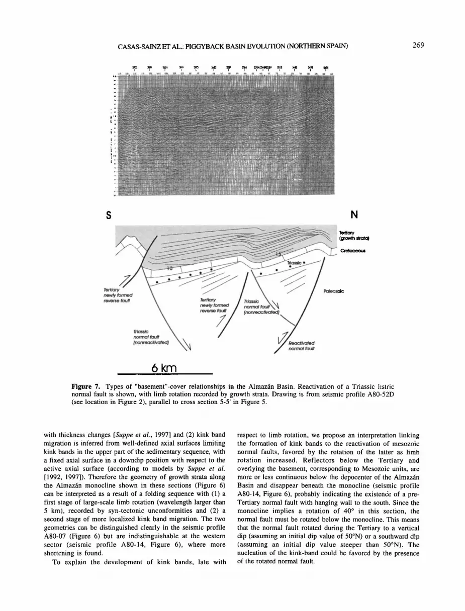
CASAS-SAINZ ET AL.: PIGGYBACK BASIN EVOLUTION (NORTHERN SPAIN) 269
s N
6 km
Figure 7. Types of "basement"-cover relationships in the Almazfin Basin. Reactivation of a Triassic listtic normal fault is shown, with limb rotation recorded by growth strata. Drawing is from seismic profile A80-52D (see location in Figure 2), parallel to cross section 5-5' in Figure 5.
with thickness changes [Suppe et al., 1997] and (2) kink band migration is inferred from well-defined axial surfaces limiting kink bands in the upper part of the sedimentary sequence, with a fixed axial surface in a downdip position with respect to the active axial surface (according to models by Suppe et al. [1992, 1997]). Therefore the geometry of growth strata along the Almazfin monocline shown in these sections (Figure 6) can be interpreted as a result of a folding sequence with (1) a first stage of large-scale limb rotation (wavelength larger than 5 km), recorded by syn-tectonic unconformities and (2) a second stage of more localized kink band migration. The two geometries can be distinguished clearly in the seismic profile A80-07 (Figure 6) but are indistinguishable at the western sector (seismic profile A80-14, Figure 6), where more shortening is found.
To explain the development of kink bands, late with
respect to limb rotation, we propose an interpretation linking the formation of kink bands to the reactivation of mesozoic normal faults, favored by the rotation of the latter as limb rotation increased. Reflectors below the Tertiary and overlying the basement, corresponding to Mesozoic units, are more or less continuous below the depocenter of the Almazfin Basin and disappear beneath the monocline (seismic profile A80-14, Figure 6), probably indicating the existen6e of a pre- Tertiary normal fault with hanging wall to the south. Since the monocline implies a rotation of 40 ø in this section, the normal fault must be rotated below the monocline. This means that the normal fault rotated during the Tertiary to a vertical dip (assuming an initial dip value of 50øN) or a southward dip (assuming an initial dip value steeper than 50øN). The nucleation of the kink-band could be favored by the presence of the rotated normal fault.

270 CASAS-SAINZ ET AL.: PIGGYBACK BASIN EVOLUTION (NORTHERN SPAIN)
4.3. Reactivation of Variscan Folds:
The Aragonian Range and the Northern Sector of the Almaz,4n Basin
In the Aragonian Range the structure is defined by the southwestern limb of a Paleozoic-cored antiform (Figure 8.a), giving an structural relief of- 3000 m with respect to the Almazfin Basin (cross section 2-2', Figures 4 and 7). To interpret the Tertiary compressional deformation of the Aragonian Range a couple of observations must be taken into account:
1. The strike of beds and fold orientations are very similar in the Paleozoic and the Mesozoic units (Figure 8b), with a generally steeper dip for the Paleozoic beds (average 70 ø to the SW) and lower (30 ø to the SW) for the Mesozoic. The trend of folds in the pre- and post-Variscan units is probably similar below the Almazfin Basin in the Soria-G6mara area (Figure 3b), since the Variscan structural trends change from E-W at the Cameros Massif to NW-SE in the Aragonian Range (see Figure 1).
2. Some steeply dipping thrusts in the Aragonian Range crosscut the Mesozoic units but are parallel to the underlying Paleozoic units and do not imply superimposition or repetitions of the Paleozoic (Figure 8a).
Many of the structural features of the Aragonian Range can be explained by the reactivation of Paleozoic folds, involving a general increase of dip of the SW limb of a NW-SE trending Variscan anticline (Figure 8c). Considering the Aragonian Range as a whole, the original unconformity angle Paleozoic/Mesozoic is - 30 ø, and the dip increase is - 40 ø [Maestro et al., 1997] (Figure 8b). The lack of data of the relationships between the Paleozoic and Mesozoic units at the central cross sections precludes the balancing of cross sections of the Aragonian Range. Nevertheless, some quantitative relationships obtained from the geometrical properties on the reactivation of folds can help to constrain cross sections and the mechanism of fold reactivation (Figure 9). Folds and steeply dipping thrusts involving the Mesozoic units can be interpreted as the result from the reactivation of the Paleozoic bedding surfaces by flexural slip (according to models proposed by Alonso, 1985, 1989, Figure 9a). In some slaty units (03 in Figure 8a,c) shortening of the Mesozoic beds, arriving to values of 40%, can be explained by flexural flow of the Paleozoic (Figure 9b). The origin of Tertiary folds by reactivation of Variscan folds explains the obliquity between the NNE main shortening direction [Casas-Sainz and Maestro-Gonztilez, 1996] and Tertiary folds and thrusts at the Aragonian Range.
The anticlines at the northern part of the Almazgn Basin show a flat hinge zone in cross section (sections 3-3' and 4-4', Figures 4 and 5), with steeper frontal (northern) limbs and broader shallow-dipping back-limbs (Figure 9c). The synclines linking the anticlines are of kink-type, with angular hinges and straight limbs. In some of the anticlines the front limbs are crosscut by thrusts that propagate into the Tertiary series (cross section 3-3', Figure 4). Although in these folds the basement-cover relationships cannot be accurately established, owing to the lack of dip data in the Paleozoic, their origin can be related with simple shear, owing to flexural flow in some of the Paleozoic units (Figure 9c), [see also Casas et al., 1994). The increase in dip of the
Paleozoic beds would produce: (1) a consequent tilt, with the same dip sense, of the Mesozoic beds at the back limbs in nonsheared units and (2) an opposite tilt of the forelimbs when a minimum value of dip increase was reached in sheared units (Figure 9d). According to this model, the existence of north verging thrusts crosscutting the forelimbs may be due to larger displacements by flexural slip between Paleozoic units. The original unconformity angle between the Paleozoic and the Mesozoic was - 40 ø, and the Tertiary dip increase was - 25 ø at the northern part of the Almaz•n Basin (Figure 9d), which is consistent with data obtained at the Aragonian Range.
Some of the structures found in the Aragonian Range, especially at its northern and southern ends (Figure 8c, cross sections I-I' and III-III'), do not fit with a single scheme of fold reactivation. At the northern sector (Figure 8c, cross section I-I') the overall geometry changes owing to (1) the existence of NE-dipping normal faults, determined from the thickness changes of the Mesozoic, possibly folded during the Tertiary and (2) the presence of folds involving both the Paleozoic and the Mesozoic, what implies that in some areas the beds of both units were parallel before folding. At the southern sector (Figure 8c, cross section III-III') the structure of the Paleozoic previous to Tertiary folding was defined by an asymmetric north verging anticline. During the Tertiary this fold was reactivated and tightened, and secondary folds at its southern limb were also tilted and tightened, giving an apparent southward vergence (Figure 8c, cross section III-III').
5. Deformation History of the Basin The Tertiary filling of the Almazfin Basin shows a
syntectonic geometry, with a thickness of 3500 m at the basin center, decreasing very quickly southward (500 m at the uplifted limb of the Almazfin monocline and disappearing south of the Arcos monocline). Toward the north the overall thickness of the Tertiary series decreases more gradually, the present-day northern border of the Almazfin Basin being erosional (see cross section 3-3', Figures 4 and 6). From the study of seismic reflection profiles, four sedimentary units, limited by unconformities at the basin borders and correlative conformities to the basin center (unconformity-bounded units of Chang [1975] and tectonosedimentary units (TSU) of Garrido-Megfas [1973], Gonztilez et al. [1988], Pardo et al. [1989], Villena et al. [1996] and Muhoz-Jimgnez and Casas- $ainz [1997]), can be distinguished between the Eocene and the lower Miocene (Figures 6 and 10).
The lithological composition of the tectonosedimentary units can be determined from outcrop observations only at the northeastern margin of the basin (Figure 11). In A1, lutites and lacustrine limestones dominate in its outcropping area, with coarse-grained deposits associated with short alluvial fans coming from the Aragonian Range. Unit A2 consists of lutites with conglomerates and sandstones associated with channel deposits (Figure 11a). Units A3 and A4 consist mainly of conglomerates and sandstones. Most pebbles in the conglomerates come from the Jurassic and the lower Cretaceous (Wealden). Paleocurrents indicate a constant NE provenance from the upper part of A1 to A3 [Armenteros et al., 1989; Carballeira and Pol, 1989; Armenteros, 1994; Bond,

CASAS-SAINZ ET AL.: PIGGYBACK BASIN EVOLUTION (NORTHERN SPAIN) 271
o o o
J-•-J Neogene o • Paleogene .)• anticline .-".•L,• Upper Cretaceous • syncline '• Alblan '1 Lower . o :• Weald monacline FaclesJCretaceou V JT'J--• Jurassic • Keuper '1 / reverse fault
'"'"*• Buntsondstein • Triassic Muschelkalk J normal J-• Upper Ordovician / fault J--•--J Middle Ordoviclan inferred ß normal J• Lower Ordoviclan • fault J• Upper-Middle Cambrian • Lower Cambrian / fault
o
o
o
o
o
o
o
Ix o
o o
o
o o
o
o o
o
o
x
o ,.,
o .,.
o o
o
o
o
Oil I o
O! ",. ,x
b
' ScN.Oi• !32•.•O i c t ,11o I o I
L. o o o • So Palaeozoic C• o o o , N = 306
ß '\ C.l. = 2.0 % •,.j\ L_ x o o o
C2 ' • o o IH' 'F• _.)x, ' o
o o o
10 km
J•J Neogene J-•J Paleogene --j--J Upper Cretaceous J-• Alblan q Lower :• Weald Faci•J Cretaceøus J--T•J Jurassic I Triassic J--• Post-Ordovician J• Upper Ordoviclan J•J Middle Ordovician J-•--J Lower Ordovician J• Upper-Middle Cambrian J•-J Lower Cambrian J-•-J Precambrian
Figure 8. Structure of the Aragonian Range. (a) Simplified geological map of the Aragonian Range (modified from Ruiz Fernfindez et al. [1987] and Navarro Vfizquez [1988]). (b) Poles to bedding of the Paleozoic and the Mesozoic beds. N, number of data; C.I., contour interval. (c) Cross sections of the Aragonian Range (location in Figure 8a).

272 CASAS-SAINZ ET AL.: PIGGYBACK BASIN EVOLUTION (NORTHERN SPAIN)
1996]. In the Neogene units, lutites and limestones dominate over coarse-grained deposits.
Unit A1 is more than 1000 m thick at the northern border of
the basin (Figures 11 and 12) and shows a pinch-out near the basin center, onlapping to the south on the upper Cretaceous (see Figure 6). Unit A2 shows its minimum thickness at the uplifted limb of the Almazfin monocline, and onlaps the upper Cretaceous southward, disappearing at the Arcos monocline. At the central sector of the basin and its northern border its thickness is between 1000 and 1500 m, with a gradual thickening from south to north, reaching its maximum at the present-day northern border of the Almazfin Basin (Figure 12). Unit A3 shows a maximum thickness of 1500 m at the basin center and its thickness decreases gradually toward the margins (cross section 3-3', Figure 4). At the southern margin it onlaps over A2. To the north it shows a progressive unconformity, the dip of strata gradually decreasing upward (see Figure 6). Unit A4 is only represented at the basin center, onlapping A3 at the Almaz•n monocline and also showing a progressive unconformity at the northern basin margin (cross section 3-3', Figures 4 and 6). Its maximum thickness is -- 500 m. The geometry of the horizontal Neogene beds lying upon A4 cannot be defined from the seismic profiles. These beds correspond to the final stages of the filling of the basin, and their geometry is not so strongly controlled by tectonic activity at the basin borders.
Tectonosedimentary (unconformity-bounded) units A1-A4 defined by us from the seismic sections coincide approximately with the TSU 1-4 (Paleogene-lower Miocene) defined by several authors in the Almaz•n Basin [Armenteros et al., 1989; Carballeira and Pol, 1989; Bond, 1996]. The vertical evolution of each TSU is a fining-upward-coarsening upward sequence (Figure 10a), except for unit A4 (fining- upward only). Dating of tectonosedimentary units (and synsedimentary deformation) is not easy, since most Paleogene rocks are coarse alluvial deposits. Only A1 and A4 are dated with micromammals (Figure 10a) as middle/upper Eocene (Headonian) and upper Oligocene/lower Miocene (Agenian), respectively [Guisado et al., 1988; Armenteros et al., 1989; Armenteros, 1994; Cuesta-Ruiz-Colmenares and Jimdnez-Fuentes, 1994]. The maximum deformation period can be constrained between these two times. The maximum
average sedimentation rate during this period is 10-30 cm per 1000 years (not considering the effect of compaction), comparable with the one obtained in the Rioja Trough (Figure 10a), located to the north, at the footwall of the Cameros thrust [Mugoz-Jim•nez and Casas-Sainz, 1997]. From the early Miocene the sedimentation rate and tectonic activity diminished, and only fractures and faults formed. The main structures contemporary with Tertiary deposition were the Almazfin and Arcos monoclines at the southern basin border
and the G6mara monocline at the northern border (Figure 13). Since the Almazfin Basin was an intracontinental basin
internally drained from the late Eocene to the late Miocene (Bond, 1996; Santisteban et al., 1996], the geometry and evolution of sedimentary units can be interpreted in terms of the relationship between tectonic uplift and sediment supply [Garrfdo-Mejœas, 1973; Beer et al., 1990; Muhoz-Jim•nez and Casas-Sainz, 1997]: fining-upward sequences together with onlap geometry and low accumulation rate suggest episodes of decreasing (negative acceleration) of the tectonic uplift of
basin margin/sediment supply relationship, whereas coarsening-upward sequences, together with offlap geometries, progradation of alluvial systems, and high accumulation rates, can be associated with an increasing tectonic uplift of basin margin/sediment supply relationship. According to this interpretation, syntectonic unconformities (offiap-onlap [Riba, 1976], Figure 10b) record the maxima of the ratio tectonic uplift of basin margin/sediment supply. Other models for progressive unconformities [Hardy and Poblet, 1994] propose that onlap geometries can occur even in conditions of increasing displacement rate or tectonic activity, since the rate of uplift is also depending on the dip of the fold limb. In our opinion it is not possible to apply directly these theoretical models to the example studied because (1) the rate of sedimentation is not an independent variable, since it is related with the uplift of the source area (tectonic activity), (2) in basement-involved folds, with several active structures (see cross sections in Figure 4) the uplift/shortening relationship may differ from that of detachment folds and (3) in terrestrial basins the accommodation space is created during the uplift of the active structures, and the geometry of the sedimentary sequence depends more strongly on tectonic activity than in marine basins, where sea level changes can also influence this geometry. In any case, even in the models proposed by Hardy and Poblet [1994, Figure 4], the offlap/onlap geometries coincide with maxima of displacement rate, as interpreted by Riba [1976] in terrestrial basins. Other maxima of displacement rate, with a lower rate of uplift with respect to sedimentation, would only give a stronger thinning of the involved sedimentary units close to the fold limb [Hardy and Poblet, 1994].
The main sediment supply during A2 and A3 was given by two fluvial systems (radius 35-40 km [Bond, 1996]) coming from the Moncayo Massif (see Figure 1). To check the provenance of materials in the Tertiary basin a contour map showing the eroded Mesozoic series in the basin margins was drawn (Figure 14a), with a square grid lkm x lkm wide and taking into account the sedimentary sequence in each sector, described in geological maps at 1:50,000. The assumptions for constructing this map are the following:
1. The envelope of the present-day erosion level coincides approximately, in most of the surrounding areas of the Almazfin Basin, with the late Miocene-Pliocene topography [Guti6rrez Elorza and Gracia, 1997], showing at present an average elevation of 1000-1200 m above sea level. Little erosion has occurred during the Quaternary, as can be assessed from the scarce development of terraces along the Duero river. The local present-day base level is at an elevation of 900- 1000 m above sea level (asl), only 200 m below the top of the lacustrine Miocene series. The present-day fluvial network linked to the tributaries of the Duero river can be considered as
inherited from Tertiary times (Figure 14b). This assumption cannot be applied to the southern sector of the basin, drained by the Ja16n river, a tributary of the Ebro river, with a local base level in the studied area 500 m below the top of the lacustrine Miocene.
2. The volume of Tertiary rocks filling the Almazfin Basin, most of them clastic, must be of the same order of magnitude as the eroded volume of Mesozoic sequences around the basin.

CASAS-SAINZ ET AL.: PIGGYBACK BASIN EVOLUTION (NORTHERN SPAIN) 273
Since the density of Tertiary rocks (2600 kg m '3) is the same as the average of the Mesozoic series (2400 for the Albian sandstones, 2600 for the upper Jurassic-lower Cretaceous, and 2750 kg m -3 for the marine Jurassic [Rivero et al., 1996]), this equality can be used to constrain the contour map obtained. The volume of the basin obtained from the contour map of the base of the Tertiary (Figure 3a), considering an elevation of 1150 m as the top of the basin and neglecting Quaternary erosion, is 6.7x10³ km 3, and the volume of eroded rocks is 6.33x10³ km 3.
The thickness of the eroded series is maximum (- 5 km) in the Moncayo Massif and neighboring areas of the Cameros Massif and decreases toward the west and the Aragonian Range, where only local alluvial fans (radius between 0.5 and 8 km [Bond, 1996]) were sourced during the Paleogene. The southern basin margin (Castilian Range) was a minor source of sediments. The lithology of pebbles in Paleogene conglomerates (mainly marine Jurassic and lacustrine upper Jurassic-lower Cretaceous) also agrees with this interpretation. Because of the sedimentary nature of the rocks surrounding the basin, no fission track data about the uplifting of the ranges are available. In the granites of the Central System, west of the Castilian Range (see Figure 1 for location) the maximum uplift, of- 1.7 km, from fission tracks in apatite took place during the early Eocene, which can be correlated with the sedimentary rupture at the top of the upper Cretaceous [Sell et al., 1995].
6. A Model for the Evolution of the Almazfin Basin
6.1. Tectonic inversion. Crustal-scale cross section
The Almazfin Basin was a very low subsidence area during all the Mesozoic extensional stage with respect to the surrounding basins within the eastern part of the Iberian plate. It probably did not emerge above the deposition level during this period, except for some times during the early Cretaceous, when alluvial fans were sourced at the southern margin of the Cameros Basin [Clemente and Alonso, 1990]. During the rest of the Mesozoic the marine and terrigenous facies are similar at the different margins of the Almazfin Basin. Widespread
deposition occurred only during the Albian-late Cretaceous, coinciding with the maximum extension of these facies in the eastern part of Iberia. To the south (Castilian Range), and north (Cameros Basin) important sedimentary basins developed during the Triassic-Jurassic and the Jurassic-early Cretaceous, respectively.
The Triassic graben were mainly limited by steep northward dipping basement normal faults [Arche and LOpez-GOmez, 1996]. The depth to the detachment is difficult to determine. Arche and LOpez-GOmez [1996] propose a shallow detachment associated with listric normal faults. The late Jurassic-early Cretaceous faults detached probably, according to geometric reconstruction, in a midcrustal level between 10 and 15 km deep [Casas-Sainz, 1993; Guimerd et al., 1996; Casas-Sainz and Gil-Imaz, 1998]. The main differences between Triassic and early Cretaceous extension in the Cameros Massif, the Aragonian Range and the Castilian Range, which point toward a higher depth to detachment for the Triassic faults, are: (1) the widespread alkali magmatism of mantelic origin during the Triassic and (2) the different geometrical configuration of graben, narrower and with more rapid changes between deposition and nondeposition areas during the Triassic [Sopega et al., 1983; Van Wees et al., 1998]. The average thinning of the continental crust during the Mesozoic in basinal areas within the Iberian Chain can be estimated, taking into account the thickness and assuming a pure shear model, as [•=1.31 [Salas and Casas, 1993]. This value is consistent with the amount of extension obtained for the Cameros Basin [Casas-Sainz and Gil-Imaz, 1998]. Guimera et al. [1996] obtained smaller values of extension, between [•=1.11 and [3=1.19, in the central part of the Iberian Chain, with an "average" thickness of the Mesozoic cover. These differences arise owing to the different rate of extension in different areas. Subsidence was much lower in the central part of the Iberian Chain and maximum at its two extremes (Maestrazgo and Cameros Basin). The calculation of the thickness of the Mesozoic crust is speculative, because the initial, post-Variscan thickness is not known. Salas and Casas [1993], assuming a post-Variscan crust 32 km thick, propose a thickness between 22 km at the depocenter of basinal areas and 27-30 km at the margins, at the end of the Mesozoic. Guimerd et al. [1996], using the lower rate of
Figure 9. Basement-cover relationships in the Aragonian Range. According to the average orientation of the Paleozoic and the Mesozoic (Figure 8b) and initial dip of 30 ø and a final dip of 70 ø (increase of 40 ø) for the Paleozoic beds and an initial dip of 0 ø and a final dip of 40 ø for the Mesozoic can be assumed. (a) Reactivation of Paleozoic folds by flexural slip and formation of reverse faults and steeply dipping thrusts in the Mesozoic cover. Calculation of the faults throws is shown. (b) Shortening associated with flexural-flow in slaty noncompetent units and calculation of shortening in the Mesozoic beds for different dip and dip increase values of the Paleozoic series. (c) Hypothesis proposed for the reactivation of Variscan folds at the northern sector of the Almazfin Basin (simplified from cross section 3-3' in Figure 4), with formation of steeply dipping thrusts in the Mesozoic cover and folds linked to alternating sheared and non-sheared Paleozoic units (modified from Alonso [1985] and Casas et al. [1994]). (d) Dip of the post-Paleozoic beds at the front limbs of the anticlines (It) resulting from an increase of dip of a Paleozoic series (A0) consisting of alternating nondeformed units (nonsheared) and units deformed by flexural flow (sheared). Calculations have been done considering that the amount of shear is equal to the dip increase (in radians) multiplied by the thickness ratio between sheared and nonsheared units [Casas et al., 1994]. The folds represented in Figure 8c can be explained by a dip increase between 20 and 30 ø of a Paleozoic series initially dipping 350-40 ø, considering a ratio (sheared/nonsheared beds)= 1/2.

274 CASAS-SAINZ ET AL.' PIGGYBACK BASIN EVOLUTION (NORTHERN SPAIN)
PREREACTIVATION
esozol•
REACTIVATION o
90-e-•o •.• • e/tano
. e.t• AB
h=e (1/tan0-tan(90-0-A0)) sen(0+AO)
lO00
8OO
a • 600
•O 400 2OO
0
O (original dip of the Paleozoic sedes)
, ,/'i ......... 2"'. ........ ...-"• 4 ../'
..,'..../i.•.!?• ......... %.. -' '"i .... ? ."[ .;;" ..'•. I i x • .• / / :::::::::::::::::::::::::::::::::::::::::::::::::::::::::::::: ,,,r ..' /j..' / , /: / . ::::::::::::::::::::::::::::::::::::::::::::::::::::::::::::
....... :-4;/•.';7- ...... •' •" '• •-"'..•'•", '•- =========================================
,,,,,,/ *j,- ,• .::•f•._'.• , ,
• •o • •o (increase in dip of the Paleozoic units)
cotc•*=cot•-Ae (o in radians) d*/d=sinc•/sinc•*
100
0 10 20 30 40 ,50 60 70 80 original dip of the Paleozoic series (e)
Cretaceous •.m.:•....:.: .-...----'-'-• 33
• •_ --•'•••• .-....• .,:• • •--'"'•-"•-•-'"••...•••:,••••_•• / 25 ø .....,.•:.•:;.?•.• .............. . • '>:"., :.::•::'..:: ..........
c
THICKNESS RELATIONSHIP SHEARED/ • - range of values NON SHEARED BEDS=l/2
consistent with
p=[180-atan(1/(cot(180-O)-(zXO+H,xO)))]-(O+AO)
d
the observed folds
>.0•' 40
'-- 2• •- 0
OCr-
E _O '-- -20 r-=Q)
• • 20 O original dip of the Paleozoic
Figure 9.

CASAS-SAINZ ET AL.: PIGGYBACK BASIN EVOLUTION (NORTHERN SPAIN) 275
a
^gen•-•_ •
o
U o
= 0
ALMA7_• BASIN - - I trend I '• I •tosl
400•
3500
3000
2500 --- ----
2000
1500 .......
b
l.,•O• I •I __
,oøi soo
5OO
DO0
RIOJA TROUGH Ive.•oll •.,,.. I fos• L!thOtOgy I trend I ,•u I sites l
, , . R7 --T-- _ --
' R5
......
R3
i i ! i
K L SCo
0 _S N
5km
Figure 10. (a) Synthetic stratigraphic profile of the Paleogene of the northern border of the Almazfin Basin and the Rioja Trough, showing the vertical evolution of tectonosedimentary units. Lithology includes the following: K, lacustrine limestones; L, lutites; S, sandstones; Co, conglomerates. Micromammal fossil sites are All, Mazater6n; AI2, Deza; A13, Cetina; A14, Ariza; and A15, Radona in the Almazfin Basin (data are from Guisado et al. [1988], Armenteros et al. [1989], Armenteros [1994], Cuesta-Ruiz-Colmenares and JirnEnez- Fuentes [1994]), and Ril, Bergasa-Arnedo; Ri2, Autol-Valhondo; Ri3, Quel; Ri4, Carretil' Ri5, lslallana; Ri6, Fuenmayor; Ri7, Los Agudos; Ri8, Badarfin; Ri9, Cel16rigo (data from SantalE et al. [1982], Cuenca [1983, 1985], Daarns and Meulen [1984], Martœnez-Salanova [1987], Alvarez-Sierra [1987], Alvarez-Sierra et al. [1987], Agustœ et aL [1988], Lacomba and Martœnez-Salanova [1988], Cuenca et al. [1992] and Mugoz- Jim•nez [1992]). (b) Seismic expression and line drawing of the rotational syntectonic unconformity (in the sense of Riba [1976]) between units A2-A3 and A3-A4 at the Almazfin monocline in seismic profile A80-07 (see location in Figure 2). Offlap geometries atop of units A2 and A3 and onlap geometries at the bottom of units A3 and A4 can be seen. TSU, tectonosedimentary unit; TWT, two-way time.

276 CASAS-SAINZ ET AL.: PIGGYBACK BASIN EVOLUTION (NORTHERN SPAIN)
a A4 / A3 / A2 / A1 ! UpperCretaceous
.:• . ......... •' ::•::• •;-.•':.' :::::::::::::::::::::::::::::::::::: -:::?::•::. •.....•::::::::::::::::::::::•:•.:•?:•?:}•:.•::::::::•:•:•u•}}::::::.`.•:•:::::•5•::::::::>:•*;•>•C•`.`•:i:•{````•:•:.•. •...•:•::::::::::::::::•;•:•.•3•D•::::::::::::::::::•...•.•M•::::•::::::•:•:•`•::•::•::.:.•..`•::::::::::::::::::::::•::::::::.•.:.•:•:•:...``•::::::::::::•:.:•5•::::::::::::::•g•::•::::::::::::::::::::::::::•::•:`;•}•::::•::::•::::•::•...•.....•::•;•::::
b
horizontal Neogene ['• Paleogene
Paleozoic and Mesozoic
5 km
photograph in Figure 1 la
Figure 11. (a) Photograph showing the border between the Almaz•n monocline and the Aragonian Range, with units A l, A2, and A3 and the unconformable horizontal Neogene. (b) Photogeological sketch showing the geometrical relationships between Tertiary units at the northern sector of the Almaz•n Basin (shows the point of view of the location in Figure 1 l a). See location of sketch in Figure 1.
extension ([3=1.11 to [3=1.19) propose an average value of 30 km at the end of the Mesozoic at the central sector of the Iberian Chain.
During the Tertiary, with an overall NNE-SSW shortening [Guimer• and Alvaro, 1990; Casas-Sainz and Maestro- Gonzdlez, 1996], the sedimentary polarity reversed, and the inverted Mesozoic basins became elevated source areas for the
depressed Almazfin Basin. Similar kinds of inversion are found in areas adjacent to orogenic belts, where blocks of basement were individualized by normal faults during extension [De Graciansky et al., 1989; Hayward and Graham, 1989]. The main structure developed during this stage was the north verging Cameros thrust, its foreland, the Rioja Trough, located to the north (Figs. 15, 16). Syninversion

CASAS-SAINZ ET AL.: PIGGYBACK BASIN EVOLUTION (NORTHERN SPAINi 277
•--.:_,:' .;•½'.iiiii•!•i•;i:E:::;.½!-:.•:•-•,•i.•.'..,,•.•?•?.•-• •i::•::•i½•,:•i:•i•:½'::" ß . ...... ::::::::::::::::::::::::::::::::::::::::.:::::.::. • ...... •..•,•2•.•.•: •:s½•-:•r• ß ß ß ß • '.'.'•'.
...... •'' . .
30 km
-... A4+Horizontal Neogene
o-. , :%'
' THICKNESS OF TERTIARY UNITS
...... '" • '•' •"' ' ' ' •'"' '•"',• •'-••i• rn ' !i• '•*""• >500 >1000 rn
Figure 12. Isopach maps of Tertiary units A1 to A4, obtained from the seismic profiles and outcrop observations. In the western part of the basin it is difficult to determine the limits between tectonosedimentary units, because no profile links this area with the eastern sector and the outcrop conditions are worse.
sedimentation took place within the Almaz•in Basin, and large volumes of syn-tectonic sediments were preserved. The nature and geometry of the older basins conditioned the Tertiary compressional structure: At the northern basin margin there are thin-skinned folds and thrusts involving the Mesozoic cover and shallow-dipping thrusts, reactivating, or shortcutting, the Mesozoic normal faults. In areas near the Castilian Range the main compressional structures are monoclines, involving the rotation and reactivation of northward dipping normal faults. The differences with the northern basin border probably lie in (1) the difficulty for reactivating steeply dipping normal faults under compression nearly perpendicular to them [Etheridge, 1986; Gillcrist et al., 1987], (2) the different structural trends of the Paleozoic "basement" (NNW to NNE), with relationship to the Tertiary structures (WNW-ESE), and (3) the very nature of the Paleozoic "basement", with an increasing incidence of igneous rocks
toward the Central System [see, e.g., Escuder Viruete et al., 1998].
In the crustal-scale cross section presented (Figure 17) we consider the possibility that the newly formed thrust crosscuts the whole continental crust (hypothesis proposed by Salas and Casas [1993]), the Moho acting as a d6collement, as has been interpreted in mountain uplifts developed in front of orogens [Cook and Varsek, 1994]. Since no deep seismic profile exists in the studied area, the variations in depth of the Moho can only be determined from gravimetric data [Salas and Casas, 1993], correlated with seismic relYaction data in the eastern Iberian Chain [Zeyen et al., 1985].
Midcrustal levels have been suggested as the detachment for the Cameros thrust and other large structures in the Iberian Chain [Guimer& and Alvaro, 1990; Guimerh et al., 1995]. From a geometrical point of view, the main difference between the two models would be the location of the thickened crust

278 CASAS-SAINZ ET AL.: PIGGYBACK BASIN EVOLUTION (NORTHERN SPA1N)
age Late
OLiGOCENE I A3
i EOCENE ' PALEOCENE?
I A2 Figure 13. Activity of the main structures at both basin borders obtained from their relationships with tectono-sedimentary units.
with respect to thrusts (Figure 18a). According to thrust geometry, in the midcrustal detachment model the region of maximum crustal thickening coincides with the zone of hanging wall flat/footwall flat (duplication of the whole upper crust involved in thrusting). If the thrust crosscuts the whole crust, the region of crustal thickening will be located both beneath the uplift and at the hinterland of the main thrust (Figure 18a). Gravimetric data in the section of the Cameros thrust and the Almazgn Basin (Figure 17), are consistent with the second model, if the actual displacement of the Cameros thrust (between 25 and 35 km [Guimer• et al., 1995; Casas- Sainz and Gil-lmaz, 1998]) is taken into account.
6.2. A Piggyback Basin Above a Crustal-Scale Thrust
Facies and thickness distributions of the first
tectonosedimentary unit, A1, (Figure 12a) indicate that both the basin center (marked by the occurrence of lacustrine limestones and gypsum) and the depocenter of the basin were at the northeastern border of the present-day Almaz•n Basin (or farther north). The tectonic setting of A1 is not easy to determine, since there are no progressive or syntectonic unconformities with which to define that relationship to folding at the basin borders. Some tilted normal faults at the northern border are associated with thickness changes of this unit. Normal faults at the outcrop scale crosscutting the upper Cretaceous and A1 are also present. These observations seem to indicate an extensional regime in the Almaz•n Basin during deposition of A1, probably related to the crustal flexure of the Iberian lithosphere during the emplacement of Pyrenean thrusts (-- 150 km north of the Almaz•n Basin) during the early-middle Eocene.
Within the second tectonosedimentary unit, A2, the outcrops at the northern basin border show distal facies (see Figure 11), the depocenter is also found near the northern basin border, and progressive unconformities are only found
at the southern border, over the Almaz•n monocline. For units A3 and A4 the situation is completely different, since the depocenter of both units coincide with the present-day basin center, and proximal facies are found at the present-day northern basin border. At the northern and southern basin
borders both units show progressive or syntectonic unconformities, indicating that these units probably did not extend much farther north from their present-day outcrops. The southward migration of the depocenter of the basin and the erosion of the northern sector of older units from the
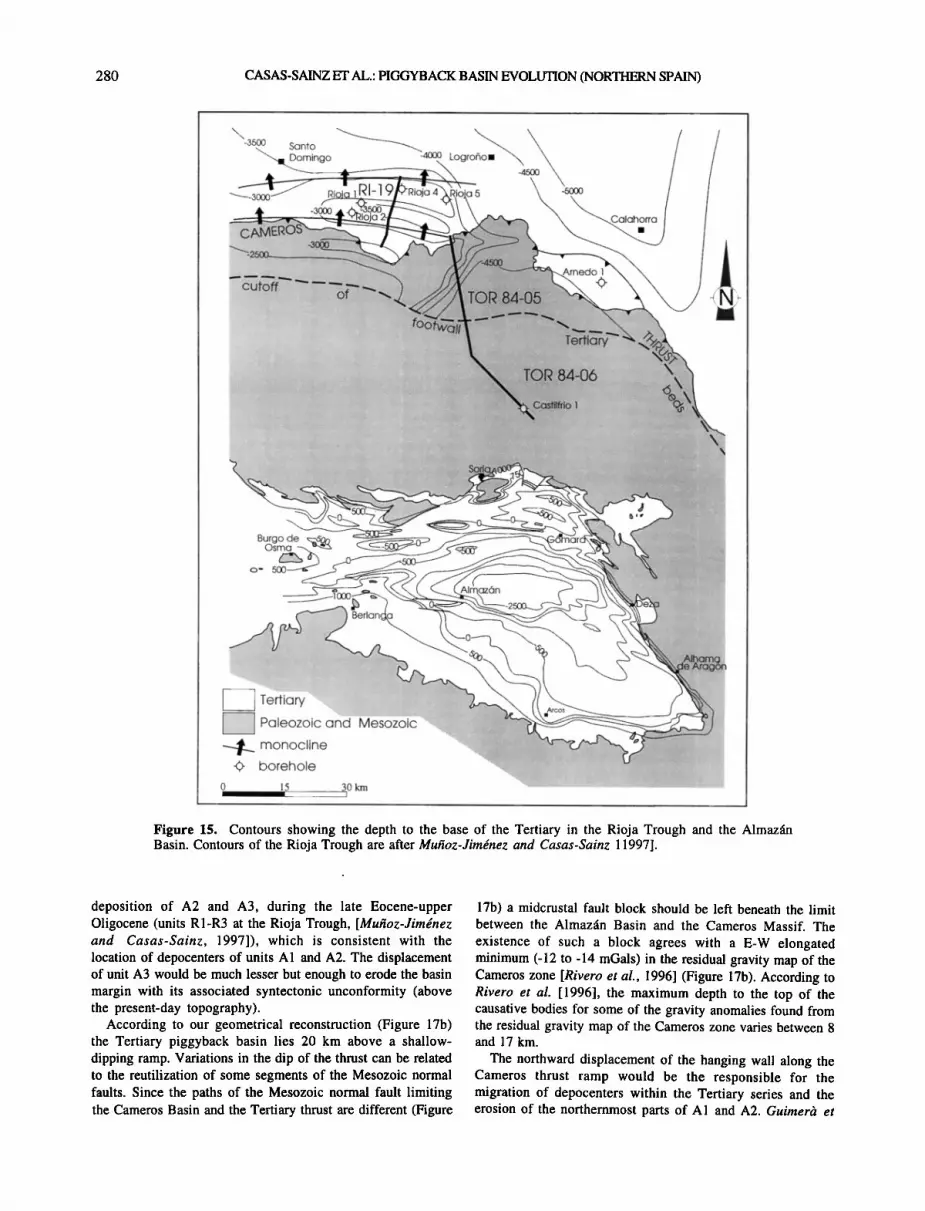
Oligocene to the Miocene agree with the hypothesis of considering the Almaz•n Basin as a piggyback basin of the crustal-scale Cameros thrust [Gttirner• et al., 1995]. The elevation of the base of the Tertiary, 1500-2500 m deeper in the Rioja Trough with respect to the Almaz•in Basin (see Figure 15), is also consistent with this hypothesis.
The comparison between the age, thickness and e•olution of tectono-sedimentary units at the Rioja Trough and the Almaz•n Basin (see Figures 10 and 15) agrees with the coeval development of the foreland (Rioja Trough) and the piggyback (Almaz•n Basin) basins of the Cameros thrust. The main deformation period is constrained, in both basins, between the late Eocene and the early Miocene, and the unconformities limiting the A4-R4 units can be fairly well correlated in both basins. The main difference is the thicker Neogene (Aragonian to Turolian) series in the Rioja Trough, favored by the prolongation of thrusting till the Vallesian [Mtt•oz- Jirndnez and Casas-Sainz, 1997]. The erosion of the syntectonic unconformities between A3 and A4 at the northern border of the Almaz•n Basin can be attributed to these late movements.
The northward displacement (-- 25 km) of the Cameros block over the Ebro Basin (together with the shortening associated to southward thrusting and folding at the northern margin of the Almaz•n Basin) implies also a northward transport of the Almaz•n Basin during its development (Figure 17b). The maximum displacement took place during the

CASAS-SAINZ ET AL.: PIGGYBACK BASIN EVOLUTION (NORTHERN SPAIN) 279
b
Figure 14. (a) Digital model of the topography showing the tributaries of the Duero river at the northern source area of the Almazan Basin. (b) Contours of the thickness of Mesozoic sedimentary series missing above the present-day erosion level. Since Quaternary erosion is negligible, the contours indicate the values of Tertiary erosion in the neighboring areas of the Almazan Basin. The rectangle indicates the area covered by Figure 14a.
280 CASAS-SAINZ ET AL.: PIC•YBACK BASIN EVOLUTION (NORTHERN SPAIN)
3500 Santo • Domingo -4cx]0 Logr
•-•--3000' Ri• 5
Burgo de • osma
Paleozoic and Mesozoic "%.. .........
borehole "•:.....
•5 30 • "' I
Figure 15. Contours showing the depth to the base of the Tertiary in the Rioja Trough and the Almazfin Basin. Contours of the Rioja Trough are after Muhoz-Jirngnez and Casas-Sainz 11997].
deposition of A2 and A3, during the late Eocene-upper Oligocene (units R1-R3 at the Rioja Trough, [Muhoz-Jimdnez and Casas-Sainz, 1997]), which is consistent with the location of depocenters of units A1 and A2. The displacement of unit A3 would be much lesser but enough to erode the basin margin with its associated syntectonic unconformity (above the present-day topography).
According to our geometrical reconstruction (Figure 17b) the Tertiary piggyback basin lies 20 km above a shallow- dipping ramp. Variations in the dip of the thrust can be related to the reutilization of some segments of the Mesozoic normal faults. Since the paths of the Mesozoic normal fault limiting the Cameros Basin and the Tertiary thrust are different (Figure
17b) a midcrustal fault block should be left beneath the limit between the Almazfin Basin and the Cameros Massif. The existence of such a block agrees with a E-W elongated minimum (-12 to -14 mGals) in the residual gravity map of the Cameros zone [Rivero et al., 1996] (Figure 17b). According to Rivero et al. [1996], the maximum depth to the top of the causative bodies for some of the gravity anomalies found from the residual gravity map of the Cameros zone varies between 8 and 17 km.
The northward displacement of the hanging wall along the Cameros thrust ramp would be the responsible for the migration of depocenters within the Tertiary series and the erosion of the northernmost parts of A1 and A2. Guirner• et

CASAS-SAINZ ET AL.: PIGGYBACK BASIN EVOLUTION (NORTHERN SPAIN) 281
ß ..• SEISMIC PROFILE TOR 84-05 and TOR 84-06 ß --'"•:-•; :• .: •' ':"...:: ::-':: :-':,.'::t •... ::. ':: ':.. '. ,:: ::::.: .: ........ :'",, ;' .:.: :. ,.
,i ........... I .............
SSE /
LINE DRAW TOR 84-05 and TOR 84-06
SSW o .......
LINE DRAW R1-19
Rioja 4 NNE
Figure 16. Seismic profiles and line drawings showing the structure of the Cameros thrust and the Rioja Trough. Location of seismic profiles is shown in Figure 15.

282 CASAS-SAINZ ET AL.: PIGGYBACK BASIN EVOLUTION (NORTHERN SPAIN)
NNW
Figure 16. (con•inued/
Tertiary Mesozoic Paleozoic
5 km
al. [1996] propose a model with fault bend folding at the northern part of the Almazfin Basin over a footwall ramp dipping - 25 ø at 12-15 km depth. However, only a relatively small sector of the northern border of the basin (the G6mara monocline can be followed for - 20 km) shows a geometry consistent with this possible fault bend fold, and this monocline is probably linked to the reactivation of Variscan folds. Neoformed folds, reactivation of folds, and thrusting of the Paleozoic in the hanging wall of the Cameros thrust at the present-day border of the Almazfin Basin seem to have played an important role during the Tertiary compression, which is consistent with deformation of the hanging wall and makes it difficult to apply directly the template constraint.
7. Discussion' Controls on piggyback Basin Evolution
Most of the piggyback basins described in the literature [Ori and Friend, 1984; Gonzdlez and Guimer•, 1993'
Hyppolyte et al., 1994; Talling et al., 1995; Teixell and Garcœa-Sansegundo, 1995; G6mez et al., 1996; Pivnik and Khan, 1996] are controlled by the foreland thrust belt, from which most sediments filling the basin derive. The sedimentary partitioning between the foreland and the piggyback basins can be considered as a late stage of the basin filling (Figure 18b). The frontal structures associated to the thrust below the transported basin are responsible for modifying the geometry of sedimentary sequences, but the real causes of subsidence and for basin-scale changes in sedimentation are thrust sequences and stacking of thrust sheets [Puigdefabregas et al., 1992; Barnolas and Teixell, 1992; Milldn et al., 1994; Tailing et al., 1995]. From the geometrical point of view, this kind of piggyback basin can be considered thin-skinned, since the thrust surface below these piggyback basins is detached at shallow levels within the crust [Ori and Friend, 1984]. The amount of transport is relatively small, as compared with shortening at the thrust belt.

CASAS-SAINZ ET AL.: PIGGYBACK BASIN EVOLUTION (NORTHERN SPAIN) 283
_ oo o oo o o E < o- • , •'•o• •"9 • •o,, n- c:Fo E .......... I I I I I •8
o o o o
! , , i i ! ,
I .! •- + + + + I • ti."l' 4 •- + + + +
o• ß t ++ + ++ ++ • ß :, + + + +
• g•1•1u•/ k • + + + +
•B • +k. + +* ++ ++ ++ ++•
+
+
+ + + ++ i ++ ++ •
,+ '-- o
+
o [.• + • + + + 1(•i*. + X. + + o
• + + + + +
• + +
k ++ + ++ + • + • + + c •+ + -- c • i
k+ + ] + + + • + + + + • + + + + • + + + +
• + + + B
! . i + + + i+ + + +
ß .
ß
ß
I

284 CASAS-SAINZ ET AL.: PIGGYBACK BASIN EVOLUTION (NORTHERN SPAIN)
midcrustal
zone of crustal thickening
d
MOHO
zone of crustal thickening
of t•• wj• detachment at the base
UPPER CRUST
LOWER CRUST
UPPER CRUST
LOWER CRUST
basement sheets cover sheets
ß ++ ++ +•.• ,.,,•11111111/•. foreland basin + .••.•.:•:.•.:.:.•.;.;•:•;.:.•.:.:.:•:.•.•••.:.:•:•:••.:.•.••;.•.•.;.;.;.:.•.;.•.•.:•;•;•:•;•;.•.;.••:.:.•.:.;.:.:•:.;.•.:•:.;.•.;.
+ + + + + + + + + + + . + + + + + . + + + + + + + + + + +
basin feeding THIN-SKINNED (JACA-•PE) + + +• • piggyback basin foreland basin PIGGYBACK + + +•
;• •:•:.. ", + ß ,•-:•'• ........................................ .................................. + + + + + + + + + +
piggyback basin foreland basin
+ •r + + + + + + + + + + + + + ============================================================================== •'r - • + +• + , + + + + + + + + + , + _-,'•..v;':':".':';':'"":'"""':"v":'"""¾ ...... ½" ";"'¾'"¾"•F olA•b 1
+/+ + + + + + + + + + + • + + + + + + + + + + + + CONTINENTAL /+ + + + + + + + + + + .•,,,ff- + + + + + + + + + + + + + -.k
/'+'+ + + + + +'+'+•'+'+'+'+ + + + + + + + + + +GRUST , + + + + +.+•+ + + + + +•½__.z:--•--
• ...... + + THICK-SKINNED (ALMAZAN-TYPE) PIGGYBACK a k • foreland basin • piggyb c bas'n • • '
+ • +/•'" ¾.. •-•-•--•+ + + + + + + + •1•,,,•-'-'-'-'.•-•'......-'...••";;-..'..'.;.:.:-:::::-_:.:-:.:-.'.:.:.;.;.'.-.'-'..: -".','.'.'-'.'.'.
+/+ + + + + + + + + + + ?,•,,,-'+•+ + + + + + + + + + + • /+ + + + + + + + + + + • + •- + + + + + + + + + +½,(•iNlTiiXJi=iXJTA/
,4- + + + + + + + + + • + + + + + + + + + + + + • .............. ¾ + + + + + + + + +•,,--•+ + + + + + + + + + + + + +CRUST /+ + + + + + +•,t,---"• + + + + + + + + + + + t ß ß ß ¾ + + + + + + + + +
b
Figure 18. (a) The two possible solutions for intraplate thrusting. The upper cross section shows midcrustal subhorizontal detachment. The region of maximum crustal thickening must be located below the zone of hanging wall flat/footwall flat (duplication of the whole upper crust involved in thrusting). The lower cross section shows the thrust crosscutting the whole crust. The region of crustal thickening is located both beneath the uplift and at the hinterland of the main thrust. (b) Geometry of the two extreme types of piggyback basins and their relationship with sedimentation. The upper cross section shows a thin-skinned piggyback basin. The sedimentary evolution is controlled by the foreland thrust belt, and the basal thrust only displaces the whole basin at the end of the filling stage. The lower cross section shows a thick-skinned kind of piggyback basin. The sedimentary evolution is controlled by the main thrust in both the foreland and the piggyback basin.

CASAS-SAINZ ET AL.: PIGGYBACK BASIN EVOLUTION (NORTHERN SPAIN) 285
From A2 (early Oligocene) to the late Miocene the Almazfin Basin was isolated from its main foreland, the Rioja Trough, by a topographic high, with a minimum horizontal separation of 60 km between both basins (width of the uplifted Cameros block). Palaeocurrents indicate a filling of the basin, with the main source area located at the northern basin border during most of the filling stage, which supports the interpretation of its separation from the foreland basin. In the Rioja Trough, palaeocurrents indicate a southward provenance [Muhoz- Jimdnez and Casas-Sainz, 1997], which implies that both basins shared the same source area. At the hinterland of the piggyback no fold-and-thrust belt exists, and therefore the tectonic control of the basin is given by the thrust underlying the piggyback. The piggyback character of the Almazfin Basin is defined by the northward movement of the whole basin, conditioning the geometry of the sedimentary units. The transport of the piggyback basin toward the foreland, together with the Cameros crustal block, is much more important than in the case of thin-skinned piggyback basins. This basin configuration is more likely to occur when the origin of the piggyback is a crustal-scale thrust such the Cameros thrust and can be defined as thick-skinned. Other thick-skinned piggyback basins [Beer et al., 1990] show similar controls on the sedimentary evolution, but because of the different configuration of the frontal structures associated with the crustal-scale thrust underlying the basin, the origin of unconformities is also related to episodic communications between the foreland and the piggyback. In some cases [Bonini, 1999a,b] the geometry of the basin may be a combination of thin-skinned and thick-skinned tectonics but the geometrical characteristics of this model must be particular [Bonini, 1999a,b].
The overall geometry of syntectonic units and unconformities at the Almazfin Basin, the migration of depocenters during basin transport in the opposite sense of movement of the main thrust, and the erosion of the earlier sedimentary units in the hanging wall of the main thrust allow us to relate the Almazfin Basin to the geometrical models proposed for other thin-skinned or thick-skinned piggyback basins. The Almazfin Basin fits with the model of an only active thrust with slow displacement, allowing the migration of depocenters [Zoetemeijer and Sassi, 1992] or with a sequence of thrusts separated by the piggyback basin, in which the faster (or the active) thrust is located toward the foreland (types 2 and 4, respectively, of Bonini [1999b]).
One of the main controls in the formation of the Almazfin piggyback basin was the change from an external (till the late Eocene) to an internal drainage pattern, which remained till the late Miocene. The geometry of the later units (horizontal Neogene), in continuity with the contiguous Calatayud basin (see location in Figure 1), indicates that the final stages of filling were atectonic at the basin scale, although thrusting continued to occur at the Cameros thrust [Muhoz-Jim•nez and Casas-Sainz, 1997]. Depending on the amount of uplift of the mountain borders, the change from external to internal drainage may cause the accumulation of a significant thickness of sediments [Tailing et al., 1995]. Although in the case of the Almazfin Basin a complete subsidence curve cannot be done, owing to the lack of precise dating during the main accumulation period, an approximation to the contribution of
the sedimentary load can be done considering the equation derived of isostatic compensation [Steckler and Watts, 1978],
s=(Pa-Pw)z (l) \Pa-Pz where Pa is the density of the asthenosphere, Ps is the density of sediment, Pw is the density of water, Z is the initial depth of basin, and S is the subsidence due to sedimentary charge.
Assuming that the initial accommodation space was not filled with water (lacustrine facies, when existing are shallow [Bond, 1996], that is equaling to zero the term Pw, and the values of pa=3300 kg m -3 and Ps=2300 kg m -3, a value of S=3.3Z would be obtained, a higher value than the obtained (2.3Z) in marine basins. In the case of internally drained basins, Z can be considered as the difference in elevation between the uplifting mountain borders and the bottom of the basin. This value can only be considered as approximate, owing to the possible variations of Pa and Ps and possible conditions of nonisostatic equilibrium, but it gives an idea of the subsidence created by the sedimentary load once an internal drainage was created by the uplifting of the mountains surrounding the basin.
All the referenced piggyback basins, thick-skinned and thin-skinned, are located above thrusts marginal to the orogenic belts with the same vergence as that of the main thrusts. The Cameros thrust can be considered as a basement
uplift, facing the Pyrenean orogen [Guirnerd and Alvaro, 1990; Casas-Sainz and Gil-Imaz, 1998]. In basement uplifts of the type of the Cameros thrust, opposite to orogenic belts as the Laramides [Brown, 1988; Erslev, 1993; Stone, 1993], no piggyback basins are described, probably owing to the nonconfluence of the variables found at the Cameros thrust:
(1) a nonrigid pre-Cambrian and Paleozoic basement, more than 10 km thick at most part of the hanging wall, (2) internally drained basins in the hanging wall, allowing the accumulation of sediments and subsequent sediment load subsidence, (3) irregularities at the footwall ramp due to preexisting extensional structures, and (4) the asymmetry in the displacement of the thrusts limiting the basement uplift that separates the foreland and the piggyback basins. In this sense, the Almazfin Basin can be considered as a particular type of basin, developed above a basement uplift, till now not described.
8. Conclusions: Intraplate Deformation and Basin Formation
The Almazfin Basin can be understood within a strongly deformed zone in the central part of Iberia, between the Central System and the Castilian Range to the south and the Cameros Massif to the north. The structural reliefs are more than 5 km, since the Paleozoic mountains are between 2200 and 2500 m above sea level, and the top of the Paleozoic is more than 2500 m below sea level in the Almazfin and Ebro Basins. West of the Almazfin Basin, the E-W elongated Aranda basin, filled with Paleogene rocks, can be inferred from subsoil exploration [ITGE, 1990] (Figure 17a). At the southern limit of the Castilian Range the Madrid Basin is also filled with Paleogene (up to 2000 m) and Neogene (up to 1200 m) deposits [Racero Baena, 1988; Calvo Sorando et al., 1991;

286 CASAS-SAINZ ET AL.' PIGGYBACK BASIN EVOLUTION (NORTHERN SPAIN)
De Vicente et al., 1996a, b], the thickness of the Tertiary units decreasing progressively toward the east. The northwestern border of the Madrid Basin is a NE-SW reverse fault against the Paleozoic rocks (igneous and metamorphic) of the Central System [Banks and Warburton, 1991' Stinchez Serrano et al., 1993' De Vicente et al., 1994]. Both in the Castilian Range and in the Central System, Tertiary structures formed at high angles to the Variscan (N-S to NNE-SSW) structures.
Intraplate deformation during the Tertiary within the Iberian plate gave rise to sedimentary basins, subsiding between 2000 and 3000 m below their original elevation (the shallow marine upper Cretaceous limestones may be taken as a reference). Intraplate mountain ranges (Iberian Range and Spanish Central System) were elevated more than 2000 m. In the Almazfin Basin the initial subsidence could be due to the flexure of the lithosphere caused by the emplacement of the Cameros thrust sheet, 60 km wide and 1-6 km high [Guimerg
et al., 1995; Casas-Sainz and Gil-Imaz, 1998] and the uplifting of the Castilian Branch. The change to internal drainage was also probably responsible for the amount of subsidence in this area. During compression the continental crust thickened to more than 40 km below and north of the Almazfin Basin [Salas and Casas, 1993]. The Tertiary evolution, recorded by deposition, indicates a coeval deformation at the western sector of the Ebro Basin, constituting the Rioja Trough [Muhoz-Jimdnez and Casas- Sainz, 1997] and the Almaz•n Basin, with a main deformation period between the late Eocene and the late Oligocene.
Acknowledgments. The authors are very grateful to Mary Ford, Franqois Roure, and Joan Guimerh for their suggestions, which improved the original manuscript, and to W. L6pez, Repsol-exploraci6n, and the Ministry of Energy and Industry of Spain for allowing usto use and copy the seismic reflection profiles. This work was supported by project PB97-0997 of the Direcci6n General de Ensefianza Superior (Spain).
References
Adell Argi16s, F., F. Gonzfilez Lodeiro and M. Tena-Dfivila, Mapa geoldgico de Espaha, scale 1:50,000, sheet 434, 45 pp. Inst. Geol. y Minero de Esp., Madrid, 1978.
AgustL J., L. Cabrera, P. Anad6n, and S. Arbiol, A late Oligocene-early Miocene rodent biozonation from the SE Ebro Basin (NE Spain): A potential mammal stage stratotype, Newsletter Stratigr., 18, 81-97, 1988.
Alonso, J.L., Estructura y evoluci6n tectonoestratigrfifica de la regi6n del manto del Esla (zona Cantfibrica, NW de Espa•a), 276 pp., Diputaci6n Provincial de Le6n, Le6n, Spain, 1985.
Alonso, J.L., Fold reactivation involving angular unconformable sequences: theoretical analysis and natural examples from the Cantabrian Zone (Northwest Spain). Tectonophysics, 170, 57-77, 1989.
Alonso, J.L., J.A. Pulgar, J.C. Garcia-Ramos, and P. Barba, Tertiary basins and Alpine tectonics in the Cantabrian Mountains (NW Spain), in Tertiary basins of Spain: The Stratigraphic Record of Crustal Kinematics, edited by P.F. Friend and C.J. Dabrio, pp. 214-227, Cambridge Univ. Press, New York, 1996.
Alvarez-Sierra, M. A., Estudio sistemfitico y bioestratigrfifico de los Eomyidae (Rodentia) del Oligoceno superior y Mioceno inferior espafiol, Script. Geol., 86, 1-207, 1987.
Alvarez-Sierra, M. A., R. Daams, J.I. Lacomba, N. L6pez-Martinez, and M.A. Sacristfin-Marffn, Succession of micromammal faunas in the Oligocene of Spain, Munchner Geowiss. Abh. A, 10, 43-48, 1987.
Alvaro, M., R. Capore, and R. Vegas, Un modelo de evoluci6n geotect6nica para la Cadena Celtib6rica, Acta Geol. Hisp., 14, 172-177, 1979.
Arche, A., and J. L6pez-G6mez, Origin of the Permian-Triassic Iberian Basin, central- eastern Spain, Tectonophysics, 266, 443-464, 1996.
Arias, C., R. Mas, A. Garcia, A. Alonso, L. Vilas, R. Rinc6n, and N. Me16ndez, Les facies Urgoniens et leurs variations pendant la transgression aptienne occidental de la Chatne Ib6rique (Espagne), Geobios, 3, 11-23, 1979.
Armenteros, I., C. J. Dabrio, R. Guisado, and A. Sfinchez de Vega, Megasecuencias sedimentarias del terciario del borde oriental de la Cuenca de Almazan (Soria-Zaragoza) Stud. Geol. Salmanticensia, 5, 107-127, 1989.
Armenteros, I., Sintesis del pale6geno del borde oriental de la Cuenca de Almazfin (Soria): Geologia del yacimiento de Mazater6n, Stud. Geol. SaImanticensia, 29, 145-156, 1994.
Arthaud, F., and P. Matte, Les d&rochements tardi-herciniens du Sud-Ouest de l'Europe: Ge6metrie et essai de reconstruction des conditions de la deformation, Tectonophysics, 25, 139-171, 1975.
Arthaud, F. and P. Matte, Late Paleozoic strike- slip faulting in southern Europe and north Africa: Results of a right-lateral shear zone between the Appalachians and the Urals, Geol. Soc. Am. Bull., 88, 1305-1320, 1977.
Baby, P., B. Colletta and D. Zubieta, Etude gfiom•trique et expfirimentale d'un bassin transportfi: exemple du synclinorium de l'Alto Beni (Andes centrales), Bull. Soc. Ggol. Fr., 166(6), 797-811, 1995.
Banks, C.J., and J. Warburton, Mid-crustal detachment in the Betic system of southeast Spain. Tectonophysics, 191, 275-289, 1991.
Barnolas, A., and A. Teixell, La cuenca surpirenaica de Jaca como ejemplo de cuenca de antepais marina profunda con sedimentaci6n carbonfitica en el margen distal, paper presented at III Congreso Geo16gico de Espafia, Sociedad Geo16gica de Espafia, Salamanca, Spain, 1992.
Bascones-Alvira, L., F. Gonzfilez-Lodeiro, F. Martinez Alvarez, V. Gabald6n L6pez, and P. Ruiz Reig, Mapa geoltSgico de Espaha, scale 1:50,000, sheet 433, Inst. Geol. y Minero de Esp., Madrid, 1978.
Beer, J.A., R.W. Allmendinger, D.E. Figueroa, and T.E. Jordan, Seismic stratigraphy of a Neogene piggyback basin, Argentina, A.A.P.G. Bull., 74, 1183-1202, 1990.
Bergamin, J.F., G. De Vicente, R. Tejero, F. Sfinchez Serrano, D. G6mez, A. Mufioz Martin, and M.A. Perucha, Cuantificaci6n del desplazamiento dextroso Alpino en la cordillera Ibfirica a parfir de datos gravim•tricos, Geogaceta, 20(4), 917-920, 1996.
Bond, J., Tectono-sedimentary evolution of the Almazfin Basin, NE Spain, in Tertiary basins of Spain: the stratigraphic record of crustal kinematics, edited by P.F. Friend and C.J. Dabrio, pp. 203-213, Cambridge Univ. Press, New York, 1996.
Bonini, M., Basement-controlled Neogene polyphase cover thrusting and basin
development along the Chianti Mountains ridge (Northern Apennines, Italy), Geol. Mag., 136, 133-152, 1999a.
Bonini, M., Evolution and depocentre migration in thrust-top basins: Inferences from the Messinian Velona Basin (Northern Apennines, Italy), Tectonophysics, 304, 95- 108, 1999b.
Brown, W.G., Deformation style of Laramide uplifts in the Wyoming foreland, inlnteraction o.! the Rock)' Mountain )'breIand and the Cordilleran thrust belt, edited by C.J. Schmidt and W.J. Perry, Mem. Geol. Soc. Am., 171, 1-26, 1988.
Calvo Sorando, P., G. De Vicente, and A.M. Alonso Zarza, Correlaci6n entre las deformaciones alpinas y la evoluci6n del relleno sedimentario de la Cuenca de Madrid durante el Mioceno, paper presented at I Congreso del Grupo Espafiol del Terciario, Grupo Espafiol del Terciario, Vic, Espafia, 1991.
Capote, R., La evoluci6n tardihercinica, in Geologfa de Espaha: Libro Jubilar de J.M. Rios, vol. 2, edited by J.A. Comba, pp. 17-25, Inst. Tecnol. GeoMinero de Esp., Madrid, 1983a.
Capore, R., La tect6nica de la Cordillera Ib6rica, in GeoIog[a de Espaha: Libro Jubilar de J.M. Rios, vol. 2, edited by J.A. Comba, pp. 108- 120, Inst. Tecnol. GeoMinero de Esp., Madrid, 1983b.
Carballeira, J., and C. Pol, lnforme complementario sobre el Pale6geno de la Cuenca de Almazfin, in Mapa geoldgico de Espaha, scale 1:50,000, Inst. Tecnol. GeoMinero de Esp., Madrid, 1989.
Casas, A.M., I.Gil, B. Lerfinoz, H. Millfin, and J.L. Sim6n, Quaternary reactivation of flexural slip folds by diapiric activity: example from the western Ebro Basin (Spain), Geol. Runds., 83, 853-867, 1994.
Casas-Sainz, A.M., Oblique tectonic inversion and basement thrusting in the Cameros Massif (Northern Spain), Geodin. Acta , 6(3), 202- 216, 1993.
Casas-Sainz, A.M., and A. Gil-Imaz, Extensional subsidence, contractional folding and subsequent inversion of the Eastern Cameros Basin (NW Spain), Geol. Runds., 86, 802- 818, 1998.
Casas Sainz, A., and A. Maestro Gonzfilez, Deflection of a compressional stress field by
CASAS-SAINZ ET AL.: PIGGYBACK BASIN EVOLUTION (NORTHERN SPAIN) 287
large-scale basement faults: A case study from the Tertiary Almazfin Basin (Spain), Tectonophysics, 255, 135-156, 1996.
Chang, K. H., Unconformity bounded stratigraphic units, Geol. Soc. Am. Bull., 66, 1544-1552, 1975.
Clemente, P., and A. Alonso, Estratigrafia y sedimentologia de las facies continentales del Cretficico inferior en el borde meridional de la Cuenca de los Cameros. Estud. geol., 45, 90-109, 1990.
Clemente, P., and M. P6rez-Arlucea, Deposiuonal architecture of the Cuerda del Pozo Formation, lower Cretaceous of the extensional Cameros Basin, north-central Spain, J. Sediment. Petrol., 63, 437-452, 1993.
Cook, F. A., and J.L. Varsek, Orogen-scale decollements. Rev. Geophys., 32, 37-60, 1994.
Cuenca, G., Nuevo yacimiento de vertebrados del Mioceno inferior del horde meridional de la Cuenca del Ebro, Estud. Geol., 39, 217-224, 1983.
Cuenca, G., Los Roedotes (Mammalia) del Mioceno lnj•rior de Autol (La Rioja), 96 pp., Ciencias de la Tierra, 2, Inst. de Estud. Riojanos, Logrofio, Spain, 1985.
Cuenca, G., J.I. Canudo, C. Laplana, and J.A. Andr6s, Bio y cronoestratigrafia con mamiferos en la Cuenca Terciaria del Ebro: Ensayo de sintesis, Acta Geol. Hisp., 27, 127- 143, 1992.
Cuesta-Ruiz-Colmenares, M.A., and E. Jim6nez- Fuentes, Sintesis del Pale6geno del horde oriental de la Cuenca de Almazfin (Soria): Vertebrados de Mazater6n. Stud. Geol. Salmanticensa, 29, 157-175, 1994.
Daams, R., and A. Meulen, Paleoenvironmental and paleoclimatic interpretation of micromammal faunal successions in the Upper Oligocene and Miocene of north central Spain, Paleobiol. Conti., 14(2), 241-257, 1984.
De Graciansky, P.C., G. Dardeau, M. Lemoine, and P. Tricart, The inverted margin of the French Alps and foreland basin inversion, in Inversion Tectonics, edited by M.A. Cooper and G.D. Williams, Geol. Soc. Spec. Pub., 44, 87-104, 1989.
De Vicente, G., Anfilisis poblacional de fallas: E1 sector de enlace Sistema Central-Cordillera Ib6rica, doctoral thesis, 317 pp., Univ. Complutense de Madrid, Madrid, 1988.
De Vicente, G., J.M. Gonzfilez Casado, J.P. Calvo, A. Mufioz Martin, J. Giner, and M. Rodriguez Pascua, Evoluci6n y estructuras alpinas en la zona del centro peninsular, Cuadernos Lab. Xeohixico Laxe, 19, 175-190, 1994.
De Vicente, G., J.P. Calvo, and A.Mufioz Martin, Neogene tectono-sedimentary review of the Madrid basin, in Tertiary Basins 03" Spain, edited by P.F. Friend and C.J. Dabrio, pp. 267-271, Cambridge Univ. Press, New York, 1996a.
De Vicente, G., J.M. Gonzfilez Casado, A. Mufioz Martin, J. Giner, and M.A. Rodriguez Pascua, Structure and Tertiary evolution of the Madrid basin, inTertiary Basins of Spain, edited by P.F. Friend and C.J. Dabrio, pp. 263-267, Cambridge Univ. Press, New York, 1996b.
Dikkers, A.J., Sketch of a possible lineament pattern in northwest Europe. Geol. Mijnbouwn, 56(4), 275-285, 1977.
Erslev, E.A., Thrusts, back-thrusts and detachment of Rocky Mountain foreland arches, in Laramide Basement Dejbrmation in the Rock), Mountain Foreland of the Western United States, edited by C.J. Schmidt, R.B. Chase and E.A. Erslev, Spec. Pap. Geol. Soc. Am., 280, 339-358, 1993.
Escuder Viruete, J., P.P. Hernfiiz Huerta, P. Valverde-Vaquero, R. Rodriguez Fernfindez,
and G. Dunning, Variscan syncollisional extension in the Iberian Massif: Structural, metamorphic and geochronological evidence from the Somosierra sector of the Sierra del Guadarrama (Central Iberian Zone, Spain), Tectonophysics, 290, 87-109, 1998.
Etheridge, M.A., On the reactivation of extensional fault systems, Philos. Trans. R. Soc. London, Set. A, 317, 179-194, 1986.
Ferreiro Padin, E., Mapa geoldgico de Espaga, scale 1:50,000, sheet 379, Inst. Tecnol. GeoMinero de Esp., Madrid, 1988.
Garcia-Hidalgo, J.F., M. Segura , and A. Garcia, E1 Cretficico del borde septentrional de la Rama Casteliana de la Cordillera Ib6rica, Rev. Soc. Geol. Esp., 10(1-2), 39-54, 1997.
Garrido-Megias, A., Estudio geol6gico y relaci6n entre tect6nica y sedimentaci6n del Secundario y Terciario de la vertiente meridional pirenaica en su zona central (provincias de Huesca y L6rida), doctoral thesis, 395 pp., Univ. of Granada, Spain, 1973.
Gillcrist, R., M. Coward, and J.L. Mugnier, Structural inversion and its controls: Examples from the Alpine foreland and the French Alps, Geodin. Acta, l(1), 5-34, 1987.
Gim•nez Montsant, J., and R. Salas, Subsidence analysis in thrust tectonics: Application to the southeastern Pyrenean foreland, Tectonophysics, 282, 331-352, 1997.
G6mez, J.J., M. Diaz-Molina, and A. Lendinez, Tectono-sedimentary analysis of the Loranca Basin (Upper Oligocene-Miocene, Central Spain): A "non-sequenced" foreland basin. in Tertiary basins of Spain, edited by P.F. Friend and C.J. Dabrio, pp. 285-294, Cambridge Univ. Press, New York, 1996.
Gonzfilez, A., and J. Guimerh, Sedimentaci6n sintect6nica en una cuenca transportada sobre una lfimina de cabalgamiento: La cubeta terciaria de Aliaga, Rev. Soc. Geol. Esp., 6(1- 2), 151-165, 1993.
Gonzfilez, A., G. Pardo , and J. Villena, E1 anfilisis tectosedimentario como instrumento de
correlaci6n entre cuencas, paper presented at II Congreso Geol6gico de Espafia, Sociedad Geo16gica de Espafia, Granada, Spain, 1988.
Goy, A., and L.C. Sufirez Vega, Tect6nica y estratigrafia mesozoicas: E1 Jurfisico, in Geologfa de Espaga. Libro Jubilar J.M. Rios, vol. 2, edited by J.A. Comba, pp. 62-79, Inst. Geol. Min. de Esp., 1983.
Goy, A., J.J. G6mez, and A. Y6benes, E1 Jurfisico de la Rama Casteliana de la Cordillera Ib6rica (Mitad Norte), I, Unidades litoestratigrfificas, Estud. Geol., 32, 391-423, 1976.
Guimerh, J., and M. Alvaro, Structure et 6volution de la compression alpine dans la Chaine Ib6rique et la Chaine Coti•re Catalane (Espagne), Bull. Soc. Gdol. France, 6(2), 339-348, 1990.
Guimerh, J., A. Alonso, and J.R. Mas, Inversion of an extensional-ramp basin by a neoformed thrust: The Cameros Basin (N Spain), in Basin Inversion, edited by J. G. Buchanan, and P. G. Buchanan, Geol. Soc. Spec. Pub., 88, 433- 453, 1995.
Guimerh, J., R. Salas, J. Verg6s, and A. Casas, Extensi6n mesozoica e inversi6n compresiva terciaria en la Cadena Ib6rica: Aportaciones a partir del anfilisis de un perill gravim6trico, Geogaceta, 20 (7), 1691-1694, 1996.
Guiraud, M., and M. S6guret, Releasing overstep model for the Late Jurassic-Early Cretaceous (Wealdian) Soria strike-slip basin (North Spain), in Strike-slip deJbrmation, basin jbrmation and sedimentation, edited by K.T. Biddle, and N. Christie-Blick, SEPM Spec. Pub., 37, 159-175, 1984.
Guisado, R., I. Armenteros, and C. Dabrio, Sedimentaci6n continental pale6gena entre
Almazul y Deza (Cuenca de Almazfin oriental, Soria), Stud. Geol. Salmanticensa, 25, 67-86, 1988.
Guti6rrez Elorza, M., and F.J. Gracia, Environmental interpretation and evolution of the Tertiary erosion surfaces in the Iberian Range (Spain), in Palaeosurj'aces: Recognition, Reconstruction and Palaeoenvironmental Interpretation, edited by M. Widdowson, Geol. Soc. Spec. Pub., 120, 147-158, 1997.
Hardy, S., and J. Poblet, Geometric and numerical model of progressive limb rotation in detachment folds, Geology, 22, 371-374, 1994.
Hayward, A.B., and R.H. Graham, Some geometrical characteristics of inversion, in Inversion Tectonics, edited by M.A. Cooper and G.D. Williams, Geol. Soc. Spec. Pub., 44, 17-39, 1989.
Huntoon, P.V., Influence of inherited Precambrian basement structure on the localization and form of Laramide monoclines, Grand Canyon, Arizona, in Laramide basement de.[ormation in the Rocky Mountain l'breland , t the Western United States, edited by C.J. Sc, midt, R.B. Chase, and E.A. Erslev, Spec. Pap. Geol. Soc. Am., 280, 243-256, 1993.
Hyppolyte, J.C., J. Angelier, F. Roure, and P. Casero, Piggyback basin development and thrust belt evolution: Structural and palaeostress analysis of Plio-Quaternary basins in the Southern Appennines, J. Struct. Geol., •6(2), 159-173, 1994.
Illies, J.H., Ancient and recent rifting in the Rhinegraben. Geol. Mijnbouwn, 56(4), 329- 350, 1977.
Instituto Tecno16gico GeoMinero de Espafia, Documentos sobre la Geologfa del Subsuelo de Espaga, vol. 5: Duero-Almazdn., Madrid, 1990.
Johnson, M.R.W., and R.T.C. Frost, Fault and lineament patterns in the southern highlands of Scotland, Geol. Mijnbouwn, 56(4), 287- 294, 1977.
Julivert, M., The areas of Alpine folded cover in the Iberian Meseta (Iberian Chain,
'Catalanides, etc.), in Geological Atlas of Alpine Europe and Adjoining Alpine Areas, pp. 93-112, Elsevier Sci., New York, 1978.
Julivert, M., A. Marcos, and J. Truyols, L'6volution pa16og6ographique du NW de l'Espagne pendant l'Ordovicien-Silurien, Bull. Soc. Gdol. Min. Bretagne,Ser. C, 4, 1-7, 1972.
Lacomba, J. I., and J. Martinez-Salanova, Quercomys Bijami Gen. Nov. Sp. Nov. (Gliridae, Rodentia, Mammalia) del trfinsito Oligoceno-Mioceno espafiol, Estud. Geol., 44, 107-118, 1988.
Lago, M., A. Pocovi, J. Bastida, and J.M. Amig6, The alkaline magmatism in the Triassic-Liassic boundary of the Iberian Chain: geological and petrological characters, paper presented at II Congreso Geo16gico de Espafia, Sociedad Geo16gica de Espafia, Granada, Spain, 1988.
Lanaja, J. M., Contribuci6n de la exploraci6n petrolifera al conocimiento de la Geologia de Espafia, 465 pp., Inst. Geol. Minero de Esp., Madrid, 1987.
Lawton, T.F., and J.H. Trexler, Piggyback basin in the Sevier orogenic belt, Utah: implications for development of the thrust wedge, Geology, 19, 827-830, 1991.
Lendlnez, A., Mapa geol6gico de Espaga, scale 1:50,000, sheet 435, Inst. Tecnol. GeoMinero de Esp., Madrid, 1987.
Lendinez Gonzfilez, A., and Di Martin Herrero, Mapa geoldgico de Espai•a, scale 1:50,000, sheet 436, Inst. Tecnol. GeoMinero de Esp., Madrid, 1987.

288 CASAS-SAINZ ET AL.: PIGGYBACK BASIN EVOLUTION (NORTHERN SPAIN)
Lendinez Gonzfilez, A., and J.L. Mufioz del Real, Mapa geoldgico de Espaha, scale 1'50,000, sheet 405, Inst. Tecnol. GeoMinero de Esp., Madrid, 1988.
Liesa-Carrera, C., and A.M. Casas Sainz, Reactivaci6n alpina de pliegues y fallas del z6calo hercinico de la Cordillera Ib6rica: ejemplos de la Sierra de la Demanda y la Serranla de Cuenca. Cuadernos Lab. Xeoldxico Laxe, 19, 119-135, 1995.
Lotze, F., Einige probleme der Iberischen Meseta, Geotecton. Fersch., 6, 1-12, 1945.
Maestro, A., A. Cort6s, and A.M. Casas, Pliegues y cabalgamientos terciarios en el sector noroccidental de la Rama Aragonesa (Cordillera Ib6rica), in A vances en el Conocimiento del Terciario Ibdrico, edited by J.P. Calvo and J. Morales, pp. 113-116, Univ. Comp. de Madrid, Madrid, 1997.
Marill, R., and D. G6mez Gras, Procedencia y modelo diagen6tico de las areniscas de facies Utrillas en la Cordillera Ib6rica (umbral de Ateca) y la meseta norcastellana, Rev. Soc. Geol. Esp., 5 (3-4), 101-115, 1992.
Martinez-Salanova, J., Estudio PaleontoIdgico de los Micromamœferos del Mioceno inferior de Fuenmayor (La Rioja), vol. 10, 99 pp., Ciencias de la Tierra, Inst. Estud. Riojanos, Logrofio, Spain, 1987.
Mediavilla, R., C.J. Dabrio, A. Martin-Serrano, and J.I. Santisteban, Lacustrine Neogene systems of the Duero Basin: evolution and controls, in Tertiary Basins of Spain: The Stratigraphic Record of Crustal Kinematics., edited by P.F. Friend and C.J. Dabrio, pp. 228-236, Cambridge Univ. Press, New York, 1996.
Mezcua, J., A. Gil, and R. Benarroch, Estudio gravim6trico de la Peninsula Ib6rica y Baleares, Inst. Geogr. Nac., Madrid, Spain, 1996.
Mill fin, H., M. Aurell, and A. Me16ndez, Synchronous detachment folds and coeval sedimentation in the Prepyrenean External Sierras (Spain): A case study for a tectonic origin of sequences and system tracts, Sedimentology, 41, 1001-1024, 1994.
Mugnier, J.L., P. Baby, B. Colletta, P. Vinour, P. Ba16, and P. Leturmy, Thrust geometry controlled by erosion and sedimentation: A view from analogue models, Geology, 25 (5), 427-430, 1997.
Mufioz, A., A. Ramos, A. Sopefta, and Y. Sfinchez Moya, Caracterizaci6n de las unidades litoestratigrfificas del Trifisico en el subsuelo del tercio noroccidental de la Cordillera Ib6rica y fireas adyacentes, Cuad. Geol. Ibdrica, 19, 129-171, 1995.
Mufioz, J.A., Evolution of a continental collision belt: ECORS-Pyrenees crustal balanced cross section, in Thrust Tectonics, edited by K.R. McClay, pp. 235-243, Chapman and Hall, New York, 1992.
Mufioz-Jim6nez, A., Andlisis Tectosedimentario del Terciario del Sector Occidental de la Cuenca deI Ebro (Comunidad de La Rio. ja), vol. 15, 347 pp., Cienc. de la Tierra, Inst. Estud. Riojanos, Logrofio, Spain, 1992.
Mufioz-Jim6nez, A., and A.M. Casas-Sainz, The Rioja Trough (N Spain): tecto-sedimentary evolution of a symmetric foreland basin, Basin Res., 9, 65-85, 1997.
Mufioz-Martin, A., and G. De Vicente, Cuantificaci6n del acortamiento alpino y estructura en profundidad del extremo suroccidental de la Cordillera Ib6rica (Sierras de Altomira y Bascufiana), Rev. Soc. Geol. Esp., 11(3-4), 233-252, 1998.
Navarro, D., Mapa geoldgico de Espaha, scale 1:50,000, sheet 350, Inst. Tecnol. GeoMinero de Esp., Madrid, 1988.
Navarro Vfizquez, D., Mapa geoldgico de Espaga,
scale 1:50,000, sheet 380, Inst. Tecnol. GeoMinero de Esp., Madrid, 1987.
Ori, G.G., and P.F. Friend, Sedimentary basins formed and carried piggyback on active thrust sheets, Geology, 12, 475-478, 1984.
Pardo, G., J. Villena, and A. Gonzfilez, Contribuci6n a los conceptos y a la aplicaci6n del anfilisis tectosedimentario: Rupturas y unidades tectosedimentarias como fundamento de correlaciones estratigrfificas, Rev. Soc. Geol. Esp., 2, 199-221, 1989.
Pivnik, D.A., and J. Khan, Transition from foreland- to piggyback-basin deposition, Plio- Pleistocene Upper Siwalik Group, Shinghar Range, NW Pakistan, Sedimentology, 43, 631-646, 1996.
Platt, N.H., Basin evolution and fault reactivation in the Western Cameros Basin, Northern Spain, J. Geol. Soc. London, 147, 165-175, 1990.
Pocovi, A., A. Me16ndez, and G. Me16ndez, Los aspectos mfis obvios del Jurfisico de los Pirineos, paper presented at IV Congreso de Jurfisico de Espafia, Universidad de Zaragoza, Alcafiiz, Spain, 1997.
Puigdefhbregas, C., La sedimentaci6n molfisica en la Cuenca de Jaca, Monogr. 104, 188 pp., Inst. Estud. Pirenaicos, Jaca, Spain, 1975.
Puigdefhbregas, C., J.A. Mufioz, and J. Verg6s, Thrusting and foreland basin evolution in the Southern Pyrenees, in Thrust Tectonics, edited by K.R. McClay, pp. 247-254, Chapman and Hall, New York, 1992.
Racero Baena, A., Consideraciones acerca de la evoluci6n geo16gica del margen NW de la cuenca del Tajo durante el Terciario a partir de los datos del subsuelo, paper presented at II Congreso Geo16gico de Espafia, Sociedad Geo16gica de Espafia, Granada, Spain, 1988.
Ramberg, I.B., R.H. Gabrielsen, B.T. Larsen, and A. Solli, Analysis of fracture patterns in southern Norway,Geol. Mijnbouwn, 56(4), 295-310, 1977.
Riba, O., Syntectonic unconformities of the Alto Cardener, Spanish Pyrenees: A genetic interpretation, Sediment. Geol., 15, 213-233, 1976.
Riba, O., S. Reguant, and J. Villena, Ensayo de sintesis estratigrfifica y evolutiva de la cuenca terciaria del Ebro, in Geolog[a de Espa•a: Libro Jubilar de J.M. Rios, vol. 1, edited by J.A. Comba, pp. 131-159, Inst. Tecnol. GeoMinero de Esp., Madrid, 1983.
Rivero, L., J. Guimerh, and A. Casas, Estructura profunda de la cuenca de Cameros (Cordillera Ib6rica) a partir de datos gravim6tricos, Geogaceta, 20(7), 1695-1697, 1996.
Ruiz Fernfindez, V., A. Lendinez, and D. Martin Herrero, Mapa geoldgico de Espa•a, scale 1:50,000, sheet 408, Inst. Tecnol. GeoMinero de Esp., Madrid, 1987.
Salas, R., and A. Casas, Mesozoic extensional tectonics, stratigraphy and crustal evolution during the Alpine cycle of the eastern Iberian basin, Tectonophysics, 228, 33-35, 1993.
Salomon, J., Apparition des principaux traits structuraux de la Sierra de Los Cameros (Cha•ne Ib6rique, Espagne du Nord) au Jurassique sup6rieur-Cr6tac6 inf6rieur, C. R. Acad. Sci. Paris, 290, 955-958, 1980.
Salomon, J., Les phases "foss6e" dans l'histoire du bassin de Soria (Espagne du Nord) au Jurassique sup•rieur-Cr6tac• inf•rieur, Bull. Centr. Rech. Explor.-Prod. Elf Aquitaine, 7(2), 399-407, 1983.
Sfinchez Serrano, F., G. De Vicente Mufioz, and J.M. Gonzfilez Casado, Cortes compensados para la deformaci6n principal alpina en el borde sur oriental del Sistema Central espafiol (Zona de Tamaj6n, Guadalajara), Rev. Soc. Geol. Esp., 6(1-2), 7-14, 1993.
Santaf& J. V., L. Casanovas, and E. Alf•rez,
Presencia del Vallesiense en el Mioceno continental de la Depresi6n del Ebro, Rev. R. Acad. Cienc. Exactas, F[s. Nat. Madrid, 76, 277-284, 1982.
Santisteban, J. I., R. Mediavilla, A. Mart/n- Serrano, and C. J. Dabrio, The Duero Basin: a general overview, in Tertiary Basins of Spain: The Stratigraphic Record of Crustal Kinematics, edited by P.F. Friend and C.J. Dabrio, pp. 183-187, Cambridge Univ. Press, New York, 1996.
Sanz de Galdeano, C.M., Tertiary tectonic framework of the Iberian Peninsula, in Tertiary Basins of Spain: The Stratigraphic Record of Crustal Kinematics, edited by P.F. Friend and C.J. Dabrio, pp. 9-14, Cambridge Univ. Press, New York, 1996..
Sell, I., G. Poupeau, C. Casquet, C. Galindo, and J.M. Gonzfilez-Casado, Exhumaci6n alpina del bloque morfotect6nico Pedriza-La Cabrera (Sierra del Guadarrama, Sistema Central Espafiol): Potencialidad de la termocronometria por trazas de fisi6n en apatitos, Geogaceta, 18, 23-26, 1995.
Sopefta, A., C. Virgili, A. Arche, A. Ramos, and S. Hernando, E1 Trifisico, in Geologfa de Espatia: Libro Jubilar J.M. Rh•s, vol. 2, edited by J.A. Comba, pp. 47-63, Instituto Geol. Min. de Esp., Madrid, 1983.
Steckler, M.S., and A.B. Watts. Subsidence of the Atlantic type continental margin off New York. Earth Planet. Sci. Let., 42, 1-13, 1978.
Stone, D.S., Basement-involved thrust-generated folds as seismically imaged in the subsurface of the central Rocky Mountain foreland, in Laramide Basement De./brmation in the Rocky Mountain Foreland o! the Western United States, edited by C.J. Schmidt, R.B. Chase and E.A. Erslev, Spec. Pap. Geol. Soc. Am., 280, 271-318, 1993.
Suppe, J., Chou, G.T., and Hook, S.C., Rates of folding and faulting determined from growth strata, in Thrust Tectonics, edited by K.R. McClay, pp. 105-121. Chapman and Hall, New York, 1992.
Suppe, J., F. Sfibat, J.A. Mufioz, J. Poblet, E. Roca, and J. Vergfis, Bed-by-bed fold growth by kink-band migration: Sant Llorenq de Morunys, eastern Pyrenees, J. Struct. Geol., I9(3-4), 443-461, 1997.
Talling, P.J., T.F. Lawton, D.W. Burbank, and R.S. Hobbs, Evolution of latest Cretaceous- Eocene nonmarine deposystems in the Axhandle piggyback basin of central Utah, Geol. Soc. Am. Bull., 107, 297-315, 1995.
Tallos Gonzfilez, A. Distribuci6n y evoluci6n sedimentaria de las facies detriticas trifisicas de la Rama Aragonesa de la Cordillera Ibmfica, paper presented at I Congreso Espafiol de Geologia, Sociedad Geo16gica de Espafia, Salamanca, Spain, 1984.
Teixell, A., and J. Garcia-Sansegundo, Estructura del sector central de la Cuenca de Jaca (Pirineos meridionales), Rev. Soc. Geol. Esp., 8 (3), 215-228, 1995.
Turner, J.P., Evolving alluvial stratigraphy and thrust front development in the West Jaca piggyback basin, Spanish Pyrenees, J. Geol. Soc. London, 149, 51-63, 1992.
Van Wees, J.D., and R.A. Stephenson, Quantitative modelling of basin and theological evolution of the Iberian Basin (Central Spain): Implications for lithospheric dynamics of intraplate extension and inversion, Tectonophysics, 252, 163-178, 1995.
Van Wees, J.D., A. Arche, C.G. Beijdorff, J. L6pez-G6mez, and S.A.P.L. Cloetingth, Temporal and spatial variations in tectonic subsidence in the Iberian Basin (eastern Spain): Inferences from automated forward modelling of high-resolution stratigraphy

CASAS-SAINZ ET AL.: PIGGYBACK BASIN EVOLUTION (NORTHERN SPAIN) 289
(Permian-Mesozoic), Tectonophysics, 300, 285-310, 1998.
Varas Muriel, M.J., Sedimentaci6n continental ne6gena en el SE de la Cuenca de Almaz•in. tesis de licenciatura, 77 pp., Univ. Salamanca, Salamanca, Spain, 1997.
Vegas, R., J.T. V•izquez, E. Surifiach, and A. Marcos, Model of distributed deformation, block rotations and crustal thickening for the formation of the Spanish Central System, Tectonophysics, 184, 367-378, 1990.
Viilena, J., G. Pardo, A. P6rez, A. Mufioz- Jim6nez, and A. Gonzfilez, Tertiary of the Iberian margin of the Ebro Basin: 1) Stratigraphic synthesis, in Tertiary Basins of Spain: The Stratigraphic Record of Crustal Kinematics, edited by P.F. Friend and C.J. Dabrio, pp. 77-82, Cambridge Univ. Press, New York, 1996.
Virgili, C., A. Sopefta, A. Ramos, A. Arche, and S. Hernando, El relleno posthercfnico y el comienzo de la sedimentaci6n mesozoica, in Geologia de Espa•a, Libro Jubilar de J.M. Rios, vol. 1, edited by J.A. Comba, pp. 25-36, Inst. Geol. Min. de Esp., Madrid, 1983.
Zeyen, H.J., E. Banda, J. Gallart, and E. Ansorge, A wide angle seismic reconnaissance survey of the crust and upper mantle in the Celtiberian Chain of eastern Spain, Earth Planet. Sci. Let., 75, 393-402, 1985.
Ziegler, P.A., Evolution of the North Atlantic: An overview, in Extensional Tectonics and stratigraphy of the North Atlantic Margins, edited by A.J. Tankard and H.R. Balkwill, AAPG Mere.,46, 111-129, 1989.
Zoetemoijer, R., S. Cloetingh, W. Sassi, and F. Roure, Modelling of piggyback-basin
stratigraphy: record of tectonic evolution, Tectonophvsics, 226, 253-269, 1993.
Zoetemeijer, R., and W. Sassi, 2-D reconstruction of thrust evolution using the fault-bend fold method, in Thrust Tectonics, edited by K.R. McClay, pp. 133-140, Chapman and Hall, New York, 1992.
A.M. Casas-Sainz, A.L. Cort6s-Gracia, and A. Maestro-Gonzfilez, Departamento de Geologfa, Facultad de Ciencias, Universidad de Zaragoza, 50009 Zaragoza, Spain ([email protected])
(Received April 4, 1998; revised July 27, 1999; accepted September 7, 1999.)


