Embed Size (px)
Citation preview
Journal of Kirkuk University – Scientific Studies , vol.5, No.1,2010
31
Intraplate Earthquakes in Iraqi Western Desert
Emad A.M. Al-Heety
College of science - University of Anbar
Received: 1/10/2008, Accepted: 4/10/2009
Abstract
The seismicity of Iraqi western desert was analyzed. During the period from 1900 to
2004, there occurred about 40 events with magnitude Mw ≥ 3.0.The area was inactive
before 1970.This may be attributed to quietness of the area and / or to missing of data
and the poor coverage for the local and regional seismic stations. The relation between
earthquake magnitude Mw and cumulative frequency Nc for the studied area is
Log Nc = 3.51 – 0.54 Mw .The spatial epicentral distribution in western desert shows
that there are two seismic zone , Zone (I) and Zone (II). Most events were located in and
around the Rutbah uplift ( Zone II). The focal depth of most events in the area belongs
to the crust. In order to understand the cause of intraplate earthquakes in the western
desert, the idea of intraplate seismicity occurs in vicinity of '' stress concentrators"
within preexisting zones of weakness is considered. These concentrators are buried
intrusions and intersecting faults. It is found that there is a causal association between
the seismicity of western desert and the buried intrusions and fault intersections. A
better understanding of the seismicity of western desert requires detailed information
about stress and strain within the area, crustal structure, continuous geodetic
measurements, heat flow data and detailed microearthquakes monitoring.
Introduction Earthquakes that occur far from plate boundaries are known as intraplate
earthquakes. The globally averaged seismic moment release for intraplate
earthquakes is about 5% of the total global moment release (Johnston &
Kanter,1990).Although limited in seismic energy release ,their consequences
can be disastrous, as illustrated by a very recent example , the Mw = 7.7
earthquake of 26 January 2001 , in Bhuj , India. As a result of this earthquake
at least 20,000 lives were lost, more than 200,000 people were injured and
nearly 400,000 houses destroyed (Rajendran et al., 2001) .The nature of
intraplate seismicity is not well understood as that of its plate boundary
counterparts. Many studies have described several characteristic features of
intraplate earthquakes (e.g. Sykes, 1978; Johnston, 1989; Talwani,1989;
Talwani & Rajendran, 1991: Zoback, 1992; Johnston et al., 1994).Intraplate
earthquakes are characterized by very low strain rates ( Johnston , 1989;
Johnston et al.,1994).They have longer return periods compared to their plate
boundary counterparts (Gangopadhyay & Talwani, 2003). With few
exceptions, most of intraplate earthquakes occur in the upper crust, at depth
Journal of Kirkuk University – Scientific Studies , vol.5, No.1,2010
32
usually shallower than 15 km (Talwani,1989). The low b- value is a
characteristic feature of the intraplate environment (Talwani, 1989). Intraplate
earthquakes are characterized also by a general absence of accompanying
surface ruptures (Gangopadhyay & Talwani, 2003). To understand where
intraplate earthquakes might occur, it is necessary to have idea about the
mechanisms that cause them. These mechanisms are subject to considerable
debate. Several models have been proposed to explain the intraplate
earthquakes. These models involve weak zones, stress concentration, flexural
stresses, or combination of the above factors (Assumpcao et al., 2004). The
zone of weakness model as a cause for intraplate seismicity is widely accepted
(Talwani,1989). Several studies have noted spatial association of intraplate
and interplate earthquakes with fault bend and intersections(e.g. Talwani,
1999; Gangopadhyay & Talwani ,2005) .An observed spatial association of
intraplate earthquakes with buried plutons and analytical computations led to
suggestions of causal association ( Kan, 1977; Barstow et al., 1981). Other
proposed models to explain intraplate earthquakes include the deglaciation
model, gravitationally induced stresses at structural boundaries and reduction
of strength of rocks by mechanical or chemical means (Stein et al., 1979;
Goodacre & Hasegawa , 1980; Costain et al., 1987).The objective of this
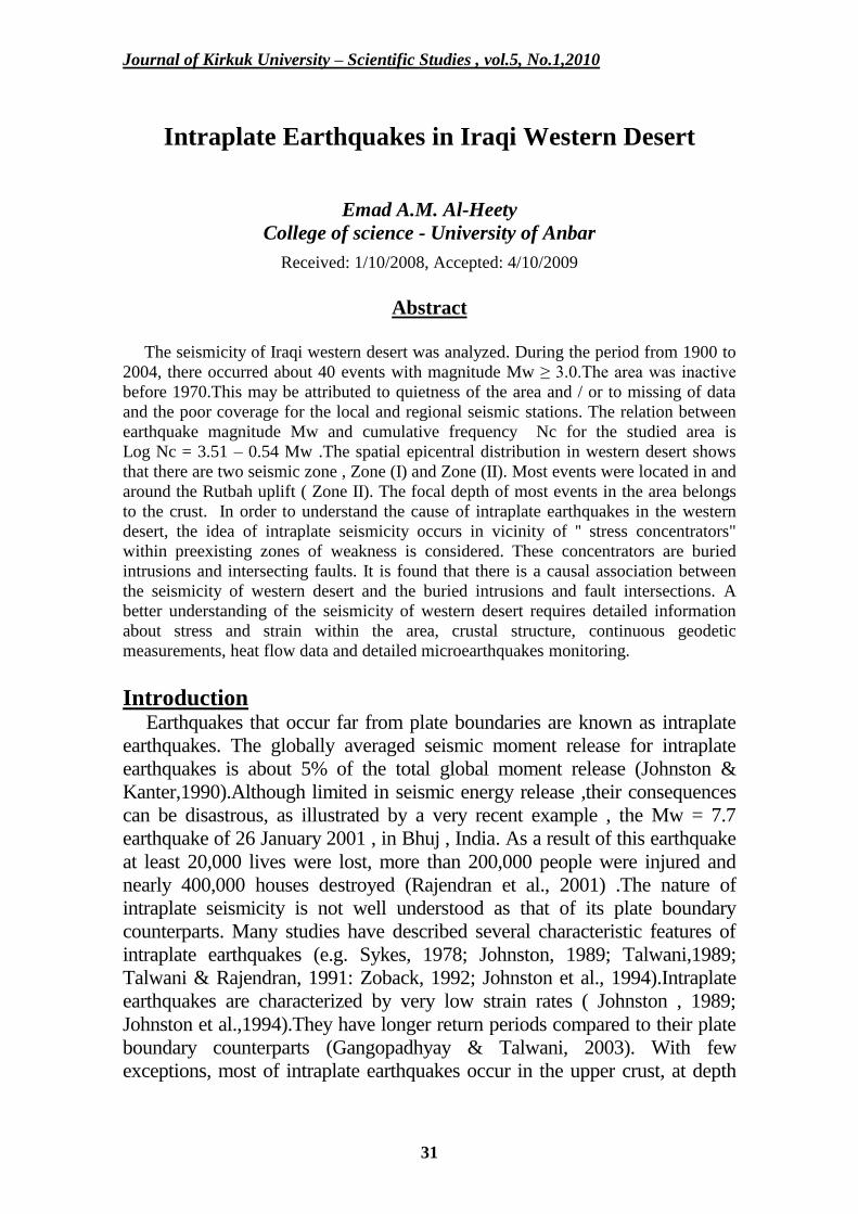
paper is to study seismicity of the western desert in Iraq (Fig.1) as an example
of intraplate seismicity. This area includes several population centers, large
dam, industrial enterprises and promising hydrocarbon accumulations.
Fig.1: Location Map of the Studied Area.
Journal of Kirkuk University – Scientific Studies , vol.5, No.1,2010
33
Seismicity and Seismotectonic of Iraq
Iraq is located in a relatively active seismic zone, and most regions of
the country were subjected to a seismic activity in the past and may be
subjected to seismic activity in the future (Alsinawi & Issa, 1986). The
seismicity of Iraq is influenced mainly by the Zagros and Taurus systems
with partial effect of the neotectonic activation of the upper crust. Fault
plane solutions gave a trend parallel to the structural trends of the Zagros –
Taurus Belts and the pressure axes are approximately perpendicular to the
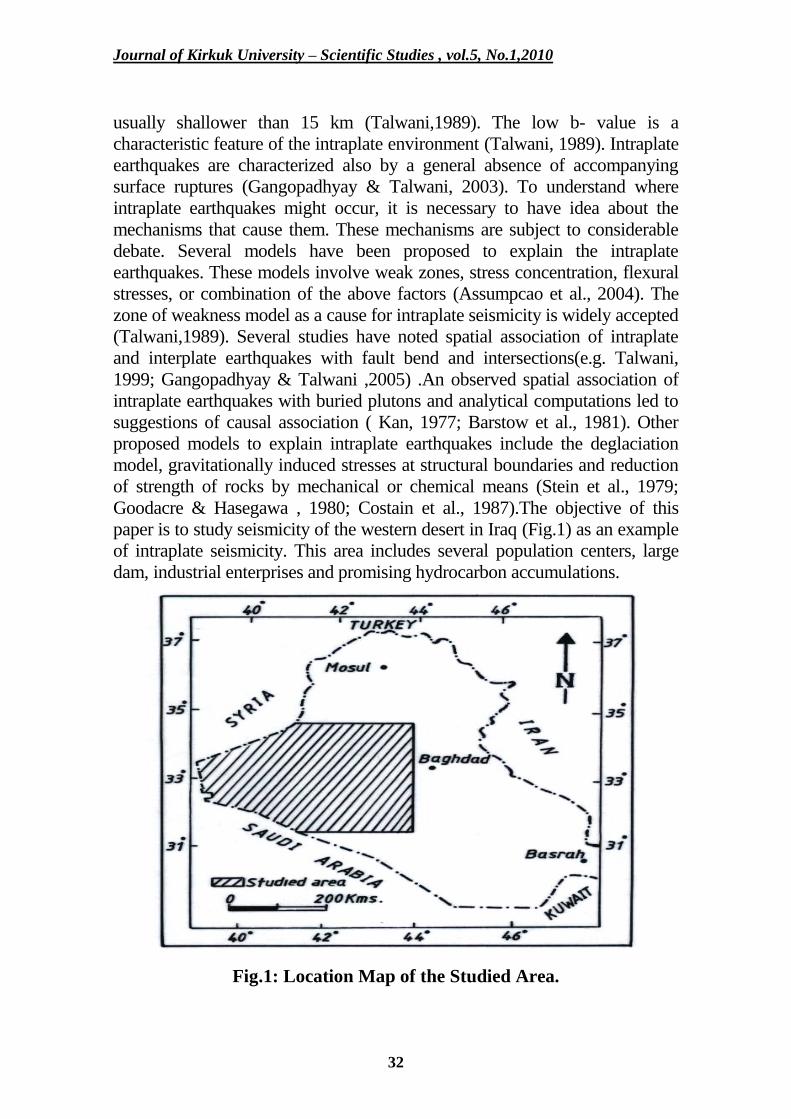
major structures (Alsinawi, 2002). More detailed accounts for seismicity of
Iraq is given by Alsinawi & Ghalib (1975), Alsinawi & Issa (1986) and
Alsinawi & Al-Qasrani (2003). Fig.2 shows the spatial distribution of
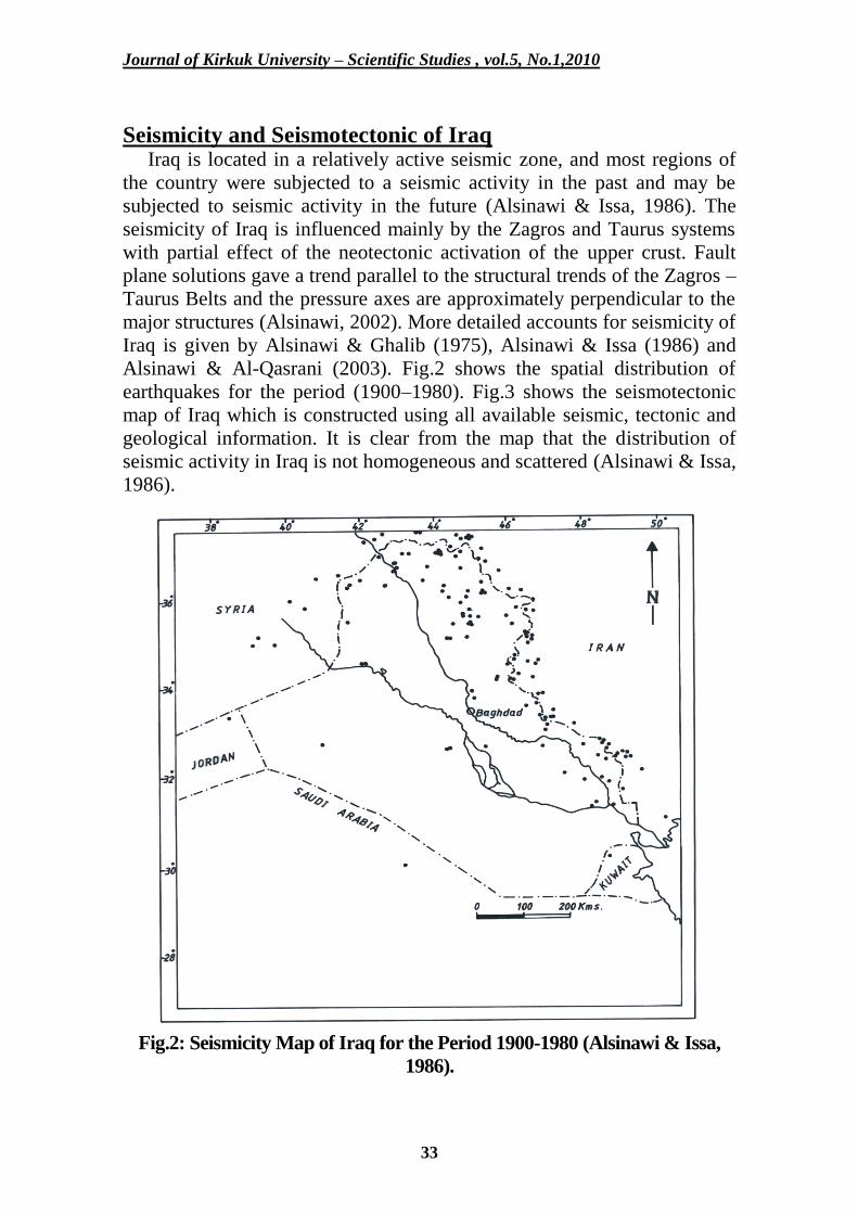
earthquakes for the period (1900–1980). Fig.3 shows the seismotectonic
map of Iraq which is constructed using all available seismic, tectonic and
geological information. It is clear from the map that the distribution of
seismic activity in Iraq is not homogeneous and scattered (Alsinawi & Issa,
1986).
Fig.2: Seismicity Map of Iraq for the Period 1900-1980 (Alsinawi & Issa,
1986).
Journal of Kirkuk University – Scientific Studies , vol.5, No.1,2010
34
Fig.3: Seismotectonic Map of Iraq (Issa, 1983).
Fig.3: Seismotectonic Map of Iraq (Issa, 1983).
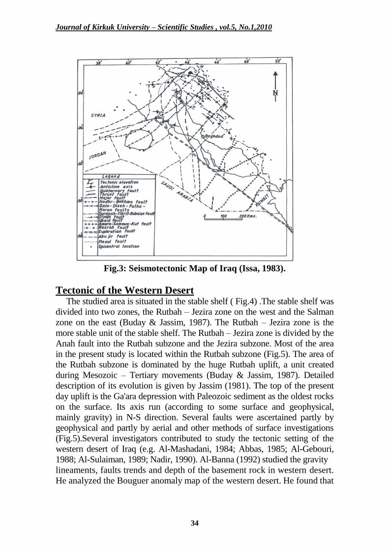
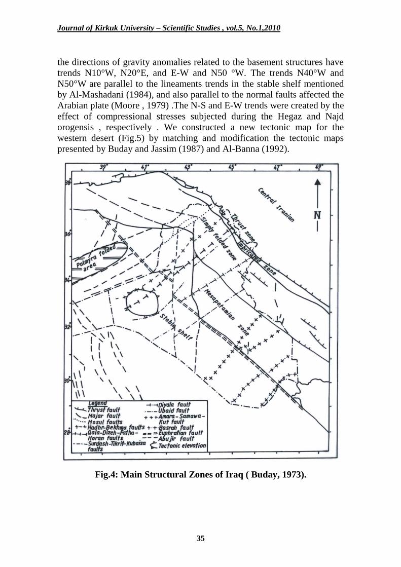
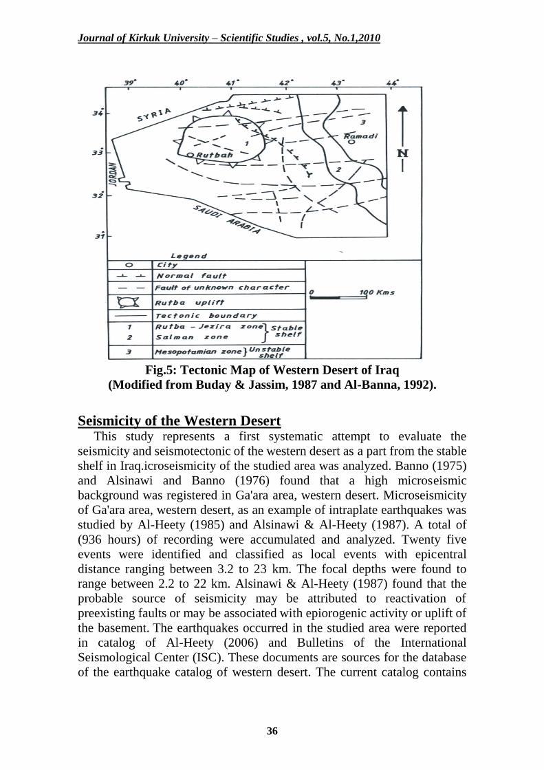
Tectonic of the Western Desert The studied area is situated in the stable shelf ( Fig.4) .The stable shelf was
divided into two zones, the Rutbah – Jezira zone on the west and the Salman
zone on the east (Buday & Jassim, 1987). The Rutbah – Jezira zone is the
more stable unit of the stable shelf. The Rutbah – Jezira zone is divided by the
Anah fault into the Rutbah subzone and the Jezira subzone. Most of the area
in the present study is located within the Rutbah subzone (Fig.5). The area of
the Rutbah subzone is dominated by the huge Rutbah uplift, a unit created
during Mesozoic – Tertiary movements (Buday & Jassim, 1987). Detailed
description of its evolution is given by Jassim (1981). The top of the present
day uplift is the Ga'ara depression with Paleozoic sediment as the oldest rocks
on the surface. Its axis run (according to some surface and geophysical,
mainly gravity) in N-S direction. Several faults were ascertained partly by
geophysical and partly by aerial and other methods of surface investigations
(Fig.5).Several investigators contributed to study the tectonic setting of the
western desert of Iraq (e.g. Al-Mashadani, 1984; Abbas, 1985; Al-Gebouri,
1988; Al-Sulaiman, 1989; Nadir, 1990). Al-Banna (1992) studied the gravity
lineaments, faults trends and depth of the basement rock in western desert.
He analyzed the Bouguer anomaly map of the western desert. He found that
Journal of Kirkuk University – Scientific Studies , vol.5, No.1,2010
35
the directions of gravity anomalies related to the basement structures have
trends N10°W, N20°E, and E-W and N50 °W. The trends N40°W and
N50°W are parallel to the lineaments trends in the stable shelf mentioned
by Al-Mashadani (1984), and also parallel to the normal faults affected the
Arabian plate (Moore , 1979) .The N-S and E-W trends were created by the
effect of compressional stresses subjected during the Hegaz and Najd
orogensis , respectively . We constructed a new tectonic map for the
western desert (Fig.5) by matching and modification the tectonic maps
presented by Buday and Jassim (1987) and Al-Banna (1992).
Fig.4: Main Structural Zones of Iraq ( Buday, 1973).
Journal of Kirkuk University – Scientific Studies , vol.5, No.1,2010
36
Fig.5: Tectonic Map of Western Desert of Iraq
(Modified from Buday & Jassim, 1987 and Al-Banna, 1992).
Seismicity of the Western Desert This study represents a first systematic attempt to evaluate the
seismicity and seismotectonic of the western desert as a part from the stable
shelf in Iraq.icroseismicity of the studied area was analyzed. Banno (1975)
and Alsinawi and Banno (1976) found that a high microseismic
background was registered in Ga'ara area, western desert. Microseismicity
of Ga'ara area, western desert, as an example of intraplate earthquakes was
studied by Al-Heety (1985) and Alsinawi & Al-Heety (1987). A total of
(936 hours) of recording were accumulated and analyzed. Twenty five
events were identified and classified as local events with epicentral
distance ranging between 3.2 to 23 km. The focal depths were found to
range between 2.2 to 22 km. Alsinawi & Al-Heety (1987) found that the
probable source of seismicity may be attributed to reactivation of
preexisting faults or may be associated with epiorogenic activity or uplift of
the basement. The earthquakes occurred in the studied area were reported
in catalog of Al-Heety (2006) and Bulletins of the International
Seismological Center (ISC). These documents are sources for the database
of the earthquake catalog of western desert. The current catalog contains
Journal of Kirkuk University – Scientific Studies , vol.5, No.1,2010
37
the events with moment magnitude Mw ≥ 3.0 within the western desert for
the period from 1900 to 2004.
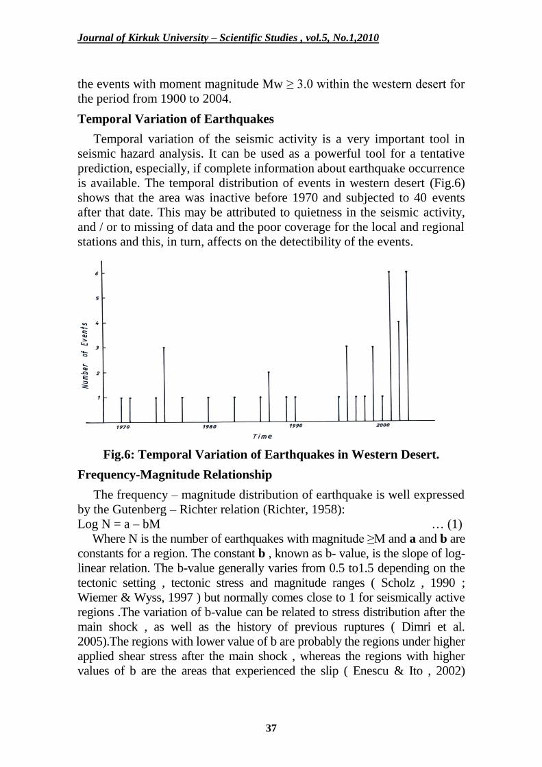
Temporal Variation of Earthquakes
Temporal variation of the seismic activity is a very important tool in
seismic hazard analysis. It can be used as a powerful tool for a tentative
prediction, especially, if complete information about earthquake occurrence
is available. The temporal distribution of events in western desert (Fig.6)
shows that the area was inactive before 1970 and subjected to 40 events
after that date. This may be attributed to quietness in the seismic activity,
and / or to missing of data and the poor coverage for the local and regional
stations and this, in turn, affects on the detectibility of the events.
Fig.6: Temporal Variation of Earthquakes in Western Desert.
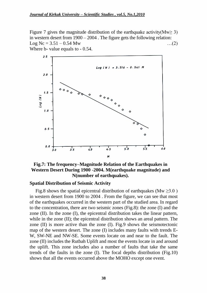
Frequency-Magnitude Relationship
The frequency – magnitude distribution of earthquake is well expressed
by the Gutenberg – Richter relation (Richter, 1958):
Log N = a – bM … (1)
Where N is the number of earthquakes with magnitude ≥M and a and b are
constants for a region. The constant b , known as b- value, is the slope of log-
linear relation. The b-value generally varies from 0.5 to1.5 depending on the
tectonic setting , tectonic stress and magnitude ranges ( Scholz , 1990 ;
Wiemer & Wyss, 1997 ) but normally comes close to 1 for seismically active
regions .The variation of b-value can be related to stress distribution after the
main shock , as well as the history of previous ruptures ( Dimri et al.
2005).The regions with lower value of b are probably the regions under higher
applied shear stress after the main shock , whereas the regions with higher
values of b are the areas that experienced the slip ( Enescu & Ito , 2002)
Journal of Kirkuk University – Scientific Studies , vol.5, No.1,2010
38
Figure 7 gives the magnitude distribution of the earthquake activity(Mw≥ 3)
in western desert from 1900 – 2004 . The figure gets the following relation:
Log Nc = 3.51 – 0.54 Mw …(2)
Where b- value equals to - 0.54.
Fig.7: The frequency–Magnitude Relation of the Earthquakes in
Western Desert During 1900 -2004. M(earthquake magnitude) and
N(number of earthquakes).
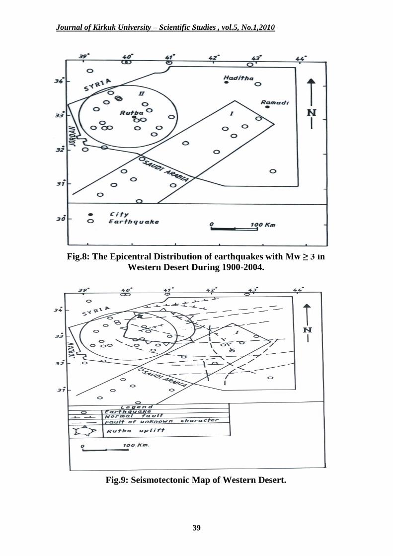
Spatial Distribution of Seismic Activity
Fig.8 shows the spatial epicentral distribution of earthquakes (Mw ≥3.0 )
in western desert from 1900 to 2004 . From the figure, we can see that most
of the earthquakes occurred in the western part of the studied area. In regard
to the concentration, there are two seismic zones (Fig.8): the zone (I) and the
zone (II). In the zone (I), the epicentral distribution takes the linear pattern,
while in the zone (II); the epicentral distribution shows an areal pattern. The
zone (II) is more active than the zone (I). Fig.9 shows the seismotectonic
map of the western desert. The zone (I) includes many faults with trends E-
W, SW-NE and NW-SE. Some events locate on and near to the fault. The
zone (II) includes the Rutbah Uplift and most the events locate in and around
the uplift. This zone includes also a number of faults that take the same
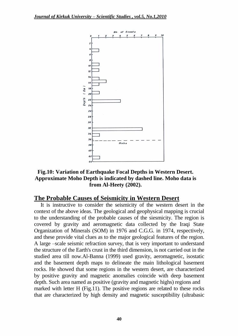
trends of the faults in the zone (I). The focal depths distribution (Fig.10)
shows that all the events occurred above the MOHO except one event.
Journal of Kirkuk University – Scientific Studies , vol.5, No.1,2010
39
Fig.8: The Epicentral Distribution of earthquakes with Mw ≥ 3 in
Western Desert During 1900-2004.
Fig.9: Seismotectonic Map of Western Desert.
Journal of Kirkuk University – Scientific Studies , vol.5, No.1,2010
40
Fig.10: Variation of Earthquake Focal Depths in Western Desert.
Approximate Moho Depth is indicated by dashed line. Moho data is
from Al-Heety (2002).
The Probable Causes of Seismicity in Western Desert It is instructive to consider the seismicity of the western desert in the
context of the above ideas. The geological and geophysical mapping is crucial
to the understanding of the probable causes of the siesmicity. The region is
covered by gravity and aeromagnetic data collected by the Iraqi State
Organization of Minerals (SOM) in 1976 and C.G.G. in 1974, respectively,
and these provide vital clues as to the major geological features of the region.
A large –scale seismic refraction survey, that is very important to understand
the structure of the Earth's crust in the third dimension, is not carried out in the
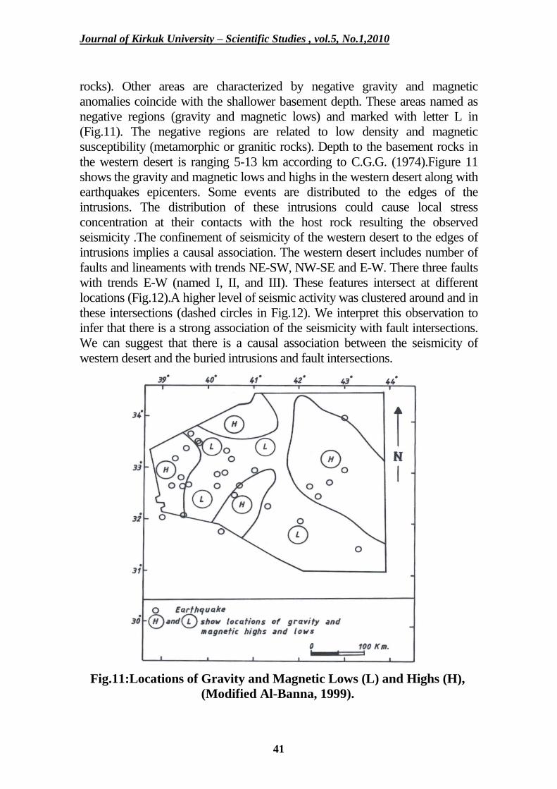
studied area till now.Al-Banna (1999) used gravity, aeromagnetic, isostatic
and the basement depth maps to delineate the main lithological basement
rocks. He showed that some regions in the western desert, are characterized
by positive gravity and magnetic anomalies coincide with deep basement
depth. Such area named as positive (gravity and magnetic highs) regions and
marked with letter H (Fig.11). The positive regions are related to these rocks
that are characterized by high density and magnetic susceptibility (ultrabasic
Journal of Kirkuk University – Scientific Studies , vol.5, No.1,2010
41
rocks). Other areas are characterized by negative gravity and magnetic
anomalies coincide with the shallower basement depth. These areas named as
negative regions (gravity and magnetic lows) and marked with letter L in
(Fig.11). The negative regions are related to low density and magnetic
susceptibility (metamorphic or granitic rocks). Depth to the basement rocks in
the western desert is ranging 5-13 km according to C.G.G. (1974).Figure 11
shows the gravity and magnetic lows and highs in the western desert along with
earthquakes epicenters. Some events are distributed to the edges of the
intrusions. The distribution of these intrusions could cause local stress
concentration at their contacts with the host rock resulting the observed
seismicity .The confinement of seismicity of the western desert to the edges of
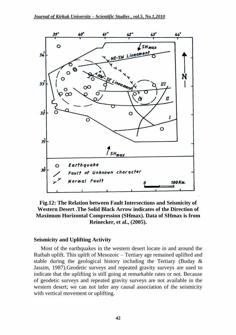
intrusions implies a causal association. The western desert includes number of
faults and lineaments with trends NE-SW, NW-SE and E-W. There three faults
with trends E-W (named I, II, and III). These features intersect at different
locations (Fig.12).A higher level of seismic activity was clustered around and in
these intersections (dashed circles in Fig.12). We interpret this observation to
infer that there is a strong association of the seismicity with fault intersections.
We can suggest that there is a causal association between the seismicity of
western desert and the buried intrusions and fault intersections.
Fig.11:Locations of Gravity and Magnetic Lows (L) and Highs (H),
(Modified Al-Banna, 1999).
Journal of Kirkuk University – Scientific Studies , vol.5, No.1,2010
42
Fig.12: The Relation between Fault Intersections and Seismicity of
Western Desert .The Solid Black Arrow indicates of the Direction of
Maximum Horizontal Compression (SHmax). Data of SHmax is from
Reinecker, et al., (2005).
Seismicity and Uplifting Activity
Most of the earthquakes in the western desert locate in and around the
Rutbah uplift. This uplift of Mesozoic – Tertiary age remained uplifted and
stable during the geological history including the Tertiary (Buday &
Jassim, 1987).Geodetic surveys and repeated gravity surveys are used to
indicate that the uplifting is still going at remarkable rates or not. Because
of geodetic surveys and repeated gravity surveys are not available in the
western desert; we can not infer any causal association of the seismicity
with vertical movement or uplifting.
Journal of Kirkuk University – Scientific Studies , vol.5, No.1,2010
43
Discussion and Conclusions The seismicity of western desert in Iraq was analyzed based on the
available geological, geophysical and seismological data. This analysis
allowed us to conclude the following:
1. The temporal distribution of events in western desert shows that the area
was inactive before 1970 .This may be attributed to quietness in the seismic
activity and/or to missing of data and the poor coverage for the local and
regional seismic stations and this, in turn, affects on the detectibility of the
events.
2. The value of constant b in the frequency –magnitude distribution was
estimated using the Least Squares Method. The estimated value is – 0.54.
The low b-value is a characteristic feature of the intraplate environment
(Talwani, 1989).
3. The spatial epicentral distribution in western desert shows that there are
two seismic zones ( zone I and zone II ).The second one is more active than
the first zone. Most events in zone (II) locate in and around the Rutbah
uplift, the outcropped tectonic feature in the studied area.
4. All the events in the western desert occurred above the MOHO except
one event. Most of these events occurred in the lower crust. Most
earthquakes in the continental lithosphere occur in the upper crust (Chen &
Molnar, 1983; Chen, 1988; Talwani,1989; Cattanea et al.,1999).Maggi et
al. (2000a) found no convincing evidence that seismicity occurs any where
in the continental mantle except for a single small (ML 3.8), isolated event
at 90 km depth reported in Northern Utah ( Zandt & Richins, 1979)
.Almost all earthquakes on the continents are confined within a crustal
layer that varies in the thickness from about 10 to 40 km, and are not in the
mantle ( Maggi et al.,2000b)They found that the aseismic nature of the
continental mantle and the lower crustal seismicity beneath some shields
are probably related to their water contents . Lamontagne & Ranalli (1996)
found that high pressures and /or low static coefficient of friction are
required for the occurrence of lower – crustal earthquakes in the
Charlevoix, Canada. A low rate of heat flow in these regimes has been
suggested as a possible reason for the deep intraplate seismicity (Talwani,
1989). To explain a reason of anomalously deep intraplate earthquakes in
northwestern Italy, Cattaneo et al. (1999) suggested a direct link between
elastic and rheological properties of the lower crust and upper mantle.
5. To explain the cause of intraplate earthquakes in western desert, we
examined the idea that intraplate seismicity occurs in vicinity of "stress
concentrators" within pre-existing zones of weakness. These stress
Journal of Kirkuk University – Scientific Studies , vol.5, No.1,2010
44
concentrators are structures where plate tectonic stresses can cause a
localized build –up of stresses and ultimately, earthquakes. We tested two
types of stress concentrators, buried intrusions and intersecting faults.
6. We observed that some events are distributed to the edges of the buried
intrusions. The confinement of the seismicity in the western desert to the
edges of the intrusions implies a causal association.
7. A higher level of seismic activity was clustered around and in the
intersecting faults at different locations in the western desert. This
observation was interpreted that there is a strong causal association of
seismicity with fault intersections.
8. Most of events in the western desert locate in and around the Rutbah
uplift. Because of geodetic and repeated gravity surveys are not available in
the western desert; we can not infer any causal association of the seismicity
with the vertical movement or uplifting.
9. We can suggest that there is a causal association between the seismicity
of western desert and the buried intrusions and fault intersections.
10. A better understanding of the seismicity of western desert requires
information about the distribution of stresses and strain within area,
geophysical surveys to better resolve crustal structure, heat flow data,
detailed microearthquakes monitoring and more detailed studies of the
seismicity including accurate hypocenter location and focal mechanisms.
References
Abbas, M.J., (1985): Analysis of Gravity Lineaments in Western
Desert. J. Geol. Soc. Iraq, Vol. 18, pp: 37 – 46.
Al-Banna, A.S., (1992): Gravity Lineaments, Fault Trends and Depth of
the Basement Rocks in Western Desert. Iraqi J. Sci., Vol. 33, pp: 63-79.
Al-Banna, A.S., (1999): The Main Lithological Basement Regions
Inferred from Geophysical Data in Western Desert of Iraq. Iraqi J.
Sci., Vol. 40C, pp: 8-22.
Al-Heety, E.A.,(1985): Microseismicity of Ga'ara Area, Western
Desert.M.Sc.thesis, University of Baghdad, 145p, unpublished.
Al-Heety, E.A., (2002): Crustal Structure of the Northern Arabian
Platform Inferred Using Spectral Ratio Method. Journal of
Geodynamics Vol. 34, pp: 63-75.
Journal of Kirkuk University – Scientific Studies , vol.5, No.1,2010
45
Al-Heety, E.A., (2006): An Earthquake Catalog for Stable Continental
Regions of the Arabian Plate. Gulf Seismic Forum III, February 19-22,
2006, Sultan Qaboos University, Oman (extended abstracts).
Al-Gebouri, M.R., (1988): Fractures Strength in Folded and Unfolded
Area. M.Sc. thesis, University of Baghdad, 90p, unpublished.
Al-Mashadani, A., (1984): Geodynamic Evaluation of the Iraqi
Sedimentary Basins: Consequences on the Distribution of Fluids. PhD
thesis, University of Pau, France, 320p, unpublished.
Alsinawi, S.A., Ghalib, H, A., (1975): Seismicity and
Seismotectonics of Iraq. Bull. Coll. Sci., Vol. 16,pp: 369- 413.
Alsinawi, S.A., Banno, I.S., (1976): The First Microearthquake
Recording in Iraq. Tectonophysics , Vol. 36, T1 – T6.
Alsinawi, S.A., Issa, A.A., (1986): Seismicity and Seismotectonics of
Iraq. J. Geol. Soc. Iraq, Vol. 19,pp: 39-59.
Alsinawi, S.A., Al-Heety, E.A., (1987): Microseismicity of Ga'ara: An
Example of Intraplate Seismicity. Proceedings Regional Crustal Stability
and Geological Hazards, December, 1987, Beijin, China,pp: 7-12.
Alsinawi, S.A., (2002) Seismicity, Seismotectonics, Crustal Structure
and Attenuation Data on Iraq. The RELEMER Meeting, Antakya,
Turkey, 12-14 December, 2002.
Alsinawi, S.A., AlQasrani, Z.O., (2003): Earthquake Hazards
Consideration for Iraq. Proceedings Fourth International Conference
of Earthquake Engineering and Seismology, Tehran, Iran.
Al-Sulaiman, F.A., (1988): Structural Study of Fractures Systems in
Western Desert Using Remote Sensing Data. M.Sc. thesis, University
of Baghdad, 125p, unpublished.
Assumpcao, M., Schimmel, M., Escalante, C., Barbosa, J., Rocha, M.,
Barros, L., (2004): Intraplate Seismicity in SE Brazil: Stress
Concentration in Lithospheric Thin Spots. Geophys. J. Int., Vol.
159,pp: 390-399.
Banno, I.S., (1975): A Reconnaissance Investigation of
Microearthquake Activity in Iraq. M.Sc. thesis, University of
Baghdad, 140p, unpublished.
Barstow, N.L., Brill, K.G., Nuttli, O.W., Poweroy, P.W., (1981): An
Approach to Seismic Zonation for Sitting Nuclear Electric Power
Generating Facilities in the Eastern United States . NUREG/CR-1577, U.S.
Journal of Kirkuk University – Scientific Studies , vol.5, No.1,2010
46
Buday, T., (1973): The Regional Geology of Iraq. SOM. Library,
Baghdad , unpublished.
Buday, T., Jassim, S.Z., (1987): The Regional Geology of Iraq,
Tectonism, Magmatism and Metamorphism. Vol.2, Iraqi Geol. Surv.
And Min.Invest. Press, Baghdad, 352p.
Campbell, D.L.,(1978): Investigation of the Stress–Concentration Mechanism
for Intraplate Earthquakes.Geophys. Res.Lett.,Vol. 5,pp: 477-479.
Cattaneo, M., Augliera, P., Parolai, S., Spallarossa, D., (1999):
Anomalously Deep Earthquakes in Northwestern Italy. Journal of
Seismology, Vol. 3,pp: 421-435.
Compagine General de Geophysique (C.G.G.), (1974): Aeromagnetic
and Aero spectrometric Survey, interpretation report, SOM, Baghdad.
Chen, W.P.,(1988): A Brief Update on the Focal Depths of
Intracontinental Earthquakes and Their Correlations with Heat Flow
and Tectonic Age . Seis. Res. Lett., Vol.59,pp: 263-272.
Chen, W.P., Molnar, P.,(1983): Focal Depths of Intracontinental and
Intraplate Earthquakes and Their Implications for the Thermal and
Mechanical Properties of the Lithosphere. J.Geophys.Res., Vol. 88,
pp: 4183-4214.
Constain, J.K., Bollinger, G.A., Speer, J.A., (1987): Hydroseismicity:
A hypothesis for the Role of Water in the Generation of Intraplate
Seismicity .Seis.Res.Lett., Vol. 58, pp:41-64.
Dimri, V.P., Vedanti, N., Chattopadhyay, S., (2005): Fractal Analysis
of Aftershock Sequence of the Bhuj earthquake: A Wavelet – Based
Approach. Current Science, Vol. 88, pp: 1617-1620.
Enescu, B., Ito, K., (2002): Spatial Analysis of the Frequency –Magnitude
Distribution and Decay Rate of Aftershock activity of the 2000 Western
Tottari Earthquake . Earth Planets Space, Vol. 54, pp: 847-859.
Gangopadhyay, A., Talwani, P., (2003): Symptomatic Features of
Intraplate Earthquakes. Seis.Res.Lett., Vol. 74,pp: 863-883.
Gangopadhyay, A., Talwani, P., (2005): Fault Intersections and
Intraplate Seismicity in Charleston, South Carolina: Insights from 2-D
Numerical Model. Current Science, Vol. 88,pp: 1609-1616.
Goodacre, A.K., Hasegawa, H.S., (1980): Gravitational Induced
Stresses at Structural Boundaries. Canadian J. of Earth Sciences, Vol.
17, pp: 1286-1291.
Journal of Kirkuk University – Scientific Studies , vol.5, No.1,2010
47
Issa, A.A.,( 1983): Seismicity and Seismotectonics of Iraq, M.Sc.
thesis , University of Baghdad,142p, unpublished.
Jassim, S.Z., (1981): Excursion Guide to the western Desert of Iraq.
Sixth Iraqi Geol. Congr., 28-31 December, 1981, Baghdad.
Johnston, A.C., (1989): The Seismicity of "Stable Continental Interiors ".
In: Gregersen, S., Basham, P.W., (Eds.), Earthquakes at North –Atlantic
Passive Margins: Neotectonics and Post –Glacial Rebound. NATO ASI
Ser. C, Mathematical and Physical Sciences, pp: 563-579.
Johnston, A.C., Kanter, L.R., (1990): Earthquakes in Stable
Continental Crust. Sci.Am., Vol. 262, pp: 68-75.
Johnston, A.C., Coppersmith, K.J., Kanter, L.R., Cornell, C.A.,
(1994): The Earthquakes of Stable Continental Regions: Assessment
of large Earthquake Potential. EPRI Rep. Tr-102261, Ed. J.F.,
Schneider. Palo Alto, CA: Elect. Power Res. Inst., 309p.
Kane, M.F., (1977): Correlation of Major Eastern Earthquake Centers
with Mafic / Ultramafic Basement Masses. In Rankin, D.W. (Ed.),
Studies Related to the Charleston, South Carolina Earthquake of 1886
– A Preliminary Report: US Geological Survey, Professional Paper,
Vol. 1028, pp: 199-204.
Lamontagne, M., Ranalli, G., (1996): Thermal and Rheological
Constraints on the Earthquake Depth Distribution in the Charlevoix,
Canada, Intraplate Seismic Zone. Tectonophysics,Vol. 256,pp: 55-69.
Maggi, A., Jackson, J.A., Priestley, K., Baker, C., (2000a): A
Reassessment of Focal Depth Distribution in Southern Iran, Tien
Shan and Northern India: Do Earthquakes Really Occur in the
Continental Mantle? Geophys.J.Inter., Vol. 143,pp: 629-661.
Maggi,A.,Jackson,J.A.,Mckenzie,D.,Priestley,K.,(2000b): Earthquake
Focal Depths, Effective Elastic Thickness, and the Strength of the
Continental Lithosphere. Geology, Vol.28, pp: 495-498.
Mooer, J., (1979): Tectonic of the Najd Transcurrent Faults System,
Saudi Arabia. J. Geol.Soc.London, Vol. 136, pp: 441-454.
Nadir, B.M., (1990): Tectonic of Rutbah Uplift. M.Sc. thesis,
University of Baghdad, 98p, unpublished.
Rajendran, K., Rajendran, C.P., Thakkar, M., Tuttle, M.P., (2001):
The 2001 Kutch (Bhuj) earthquake: Coseismic Surface Features and
Their Significance. Current Science, Vol. 80, pp: 1397 -1405.
Journal of Kirkuk University – Scientific Studies , vol.5, No.1,2010
48
Reinecker, J., Heidback, O., Tingay, M., Sperner, B., Muller, B.,
(2005): The Release 2005 of the World Stress Map. www.world-
stress-map.org
Richter,C., (1958): Elementary Seismology. Freeman, San
Franscusco, Cali. 768p.
Scholz, C.H., (1990): The Mechanics of Earthquakes and Faulting.
Cambridge Univ. Press, NewYork.
Stein, S., Sleep, N., Geller, R.J., Wang, C.C., Kroeger, G.C., (1979):
Earthquakes along the Passive Margin of Eastern Canada. Geophys.
Res. Lett., Vol.6, pp: 537-540.
Sykes, L.R., (1978): Intraplate Seismicity , Reactivation of
Preexisting Zones of Weakness , Alkaline Magmatism, and other
Tectonism Postdating Continental fragmentation . Reviews Geophys.
And Space Physics, Vol. 16, pp: 621-688.
Talwani, P., (1989): Characteristic Features of Intraplate Earthquakes
and the Models Proposed to Explain Them. In: Gregersen , S.,
Basham, P.W.(Eds.), earthquakes at North- Atlantic Passive Margins :
Neotectonic and Post-Glacial Rebound . NATO ASI Ser. C,
Mathematic and Physical Sciences, pp: 563-579.
Talwani, P., Rajendran, K., (1991): Some Seismological and
Geometric Features of Intraplate Earthquakes. Tectonophysics,
Vol.186,pp: 19-41.
Talwani, P., (1999): fault Geometry and Earthquakes in Continental
Interiors. Tectonophysics, Vol. 305,pp: 371-379.
Wiemer, S., Wyss, M., (1997): Mapping the Frequency – Magnitude
Distribution in Asperities: An Improved Technique to Calculate
Recurrence Times. j. Geophys. Res., Vol. 102, pp: 15115-15128.
Zandt, G., Richins, W.D., (1979): An Upper Mantle Earthquake
beneath the Middle Rocky Mountains in NE Utah (abs.): Earthquake
Notes, Vol.50, pp: 69-70.
Zoback, M.L., (1992): Stress Field Constraints on Intraplate
Seismicity in Eastern North America. J. Geophys. Res., Vol. 97,pp:
11761-11782.
Journal of Kirkuk University – Scientific Studies , vol.5, No.1,2010
49
الهزات داخل الصفائح في الصحراء الغربية العراقية
عماد عبد الرحمن محمد الهيتي
جامعة االنبار –كلية العلوم 4/11/8112،تاريخ القبول 1/11/8112تستما: تاريخ اال
ةصخالال
ت المنطقة خمال هذه . تعرض 8114الى 1211ت: دراتسة زلزالية الصحراء الغربية العراقية للفترة من
. كانت المنطقة غير نشذطة 3( أكبر من ويتساوي Mwهزة أرضية بمقادير زلزالية عزمية ) 41الفترة الى وربما يعزى هها الى هدوء المنطقة و/ أو غياب البيانات والتغطية الفقيرة للمحطات الزلزاليذة 1291قبل عا: قدار الزلزالي والتكرار التراكمي للهزات األرضية بالمعادلةيعبر عن العماقة بين الم. واإلقليميةالمحلية
Log Nc = 3.51-0.54 Mw. تركزت الهزات األرضية في الصحراء الغربية العراقية فذي نطذاقين همذا( . تقع أغلب الهزات في النطاق I( أكثر نشاطا من النطاق ) II( ، وكان النطاق ) II( والنطاق ) Iالنطاق )
(II . في وحول نهوض الرطبة )لفهذ: تسذبب حذدو . يعود للقشرةألغلب الهزات المتسجلة يالبؤر العمقالهزات داخل الصفائح في الصحراء الغربية العراقية ت: اختبار فكرة أن الزلزالية داخل الصفائح تحذد فذي
دفونة والصدوع المتقاطعة الضعف التسابقة. هه المركزات هي المقتحمات الم انطقهجوار مركزات الجهد خمال عذد: تذوفر إنهناك عماقة تسببية بين زلزالية الصحراء الغربية واالندفاعات المدفونة وتقاطعات الفوالذق . .
يتسمح لنا اتستنتاج وجود عماقة تسذببية بذين المتسوحات الجيوديتسية والجهبية المتكررة في الصحراء الغربية الفهما أفضل لزلزالية الصحراء الغربيذة يتطلذب إنية او النهوض . حدو الهزات األرضية والحركات العمود
معلومات تفصيلية حول الجهد و اإلجهاد في المنطقة ، تركيب القشرة األرضذية ، بيانذات انتسذياب الحذرارة ومراقبة تفصيلية للزلزالية الدقيقة في المنطقة .


