Embed Size (px)
Citation preview
Archaeometry
46
,
1 (2004) 67–84. Printed in Great Britain
© University of Oxford, 2004
Blackwell Publishing LtdOxford, UKARCHArchaeometry0003-813X© University of Oxford, 2004February 20044611000Original Articles
Investigating activity patterns in prehispanic plazasE. C. Wells
INVESTIGATING ACTIVITY PATTERNS IN PREHISPANIC PLAZAS: WEAK ACID-EXTRACTIONICP–AES ANALYSIS OF ANTHROSOLS AT CLASSIC
PERIOD EL COYOTE, NORTHWESTERN HONDURAS
E. C. WELLS
Department of Anthropology, University of South Florida, Tampa, FL 33620, USA
Weak acid-extraction ICP–AES analysis was performed to obtain multi-elemental charac-terizations of anthropogenic sediments from plaza spaces that no longer contain artefactsand adjacent trash deposits at the prehispanic site of El Coyote in northwestern Honduras.Multivariate quantitative assessments of the anthrosol chemical data, along with associatedinventories of midden materials, are examined to derive signatures for activity areas andrefuse dumps that can be linked across portions of the site. The findings of this study permitthe reconstruction of activity patterns in the site’s main plaza and in its environs. Thishas important implications for understanding the relationship among ritual practice,craft production and political economy during the Late and Terminal Classic periods,c.
AD
600–1000.
KEYWORDS:
HONDURAS, EL COYOTE, CLASSIC PERIOD, ANTHROSOL CHEMISTRY, WEAK ACID EXTRACTION, ICP–AES, SOILS, MIDDENS, PLAZAS, POLITICAL ECONOMY
INTRODUCTION
Recent advances in geoarchaeological research on pedogenesis in cultural settings have demon-strated that soil science has a powerful analytical potential for archaeological investigationsconcerned with feature prospection, household studies, agricultural practices and a wide rangeof other topics central to anthropological research. The past decade has witnessed a dramaticincrease in the reliance on and development of techniques in the analysis of soil chemistry inparticular, which has enhanced greatly the interpretive capabilities of archaeologists workingat a range of scales: feature, site and region (e.g., Barba 1990; Bintliff
et al.
1990; Dormaar andBeaudoin 1991; Ball and Kelsay 1992; Kshirsagar 1996; Sánchez
et al.
1996; Middleton andPrice 1996; Dunning
et al.
1997; Entwistle
et al.
1998; Terry
et al.
2000; Wells
et al
. 2000).In this paper, the explanatory capability of these types of analyses is extended through a multi-elemental characterization by weak-acid extraction ICP–AES of anthropogenic sedimentsfrom plaza spaces that no longer contain artefacts and adjacent trash deposits at El Coyote, theprehispanic capital settlement of the lower Cacaulapa River Valley in northwestern Honduras(Fig. 1). Multivariate quantitative assessments of the soil chemical data, along with associatedinventories of midden materials, are examined to derive signatures for different classes ofactivity areas and refuse dumps, which can be linked across portions of the site. The findingsof this study permit the reconstruction of activity patterning in El Coyote’s main plaza, whichcan be used to evaluate hypotheses regarding site structure and function during the Late andTerminal Classic periods,
c
.
ad
600–1000. More broadly, by studying the chemical behaviour
68
E. C. Wells
of anthrosols, the research presented here provides a design for generating inferences aboutthe ranges and locations of activities within archaeological contexts where little or no directmaterial evidence persists.
THE LOWER CACAULAPA VALLEY AND EL COYOTE
Bounded by steep escarpments of tall sedimentary hills, the lower Cacaulapa River has carvedout a narrow passage that links the middle Chamelecon and Ulua Valleys in northwesternHonduras. The two primary geomorphological features that characterize the Cacaulapa Valleyare bottomlands composed of alluvium and sedimentary conglomerate and uplands composedof gently sloping alluvial and colluvial fans that overlie limestone bedrock. The northern partof the valley consists of Palaeozoic gneissose mica schists, metamorphosed andesite and tuff(the Minitas Formation), massive limestone (the Atima Formation), and dykes and stocks ofgranodiorite and andesite intruding into the beds of the Minitas Formation (see UNDP 1974;MMAJ 1979). The southern region is dominated by volcanic layers of andesite, basalt, basaltic
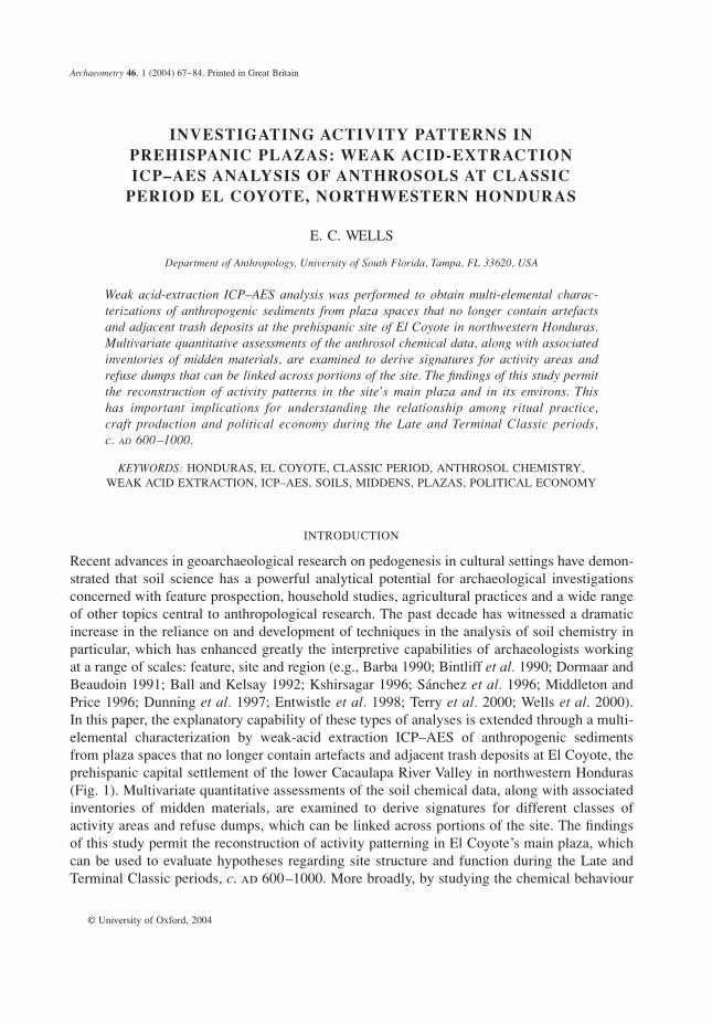
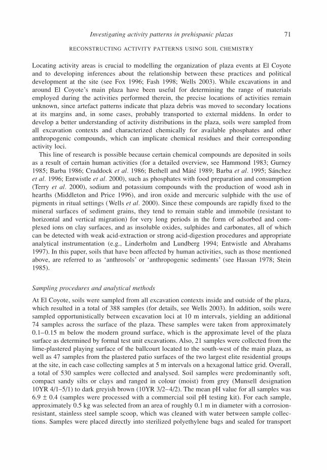
Figure 1 A plan view of the site of El Coyote, showing the location of the main plaza (redrawn after original inked by P. Urban, 2000–1). The inset on the right-hand side is a kriged contour map of artefact density inside the plaza (kriging type = point, based on a linear variogram model where slope = 1, anisotropy = 1, 0: see Cressie 1990;Kitanidis 1997). The density is expressed as the number of artefacts per cubic metre of excavated soil. The blackdots represent midden deposits: 1–4, ‘West Middens’; 5, ‘NW Midden’; 6, ‘NE Midden’; 7–8, ‘Lithic Midden’;9–12, ‘East Middens’.
Investigating activity patterns in prehispanic plazas
69
pyroclastic rocks and rhyolite (the Matagalpa Formation) that overlie the Minitas and AtimaFormations.
Soils in the bottomlands can be characterized as mildly acidic inceptisols (typic ustropeptand ustic dystropept) and entisols (typic ustifluvents and mollic ustifluvents) that are silty tosandy loam with good to imperfect drainage, while those of the uplands represent neutralto mildly alkaline mollisols (typic rendolls) that are clayey to sandy or gravely loam withrelatively good drainage (for details, see Soil Survey Staff 1975, 1998). In the valley, areas ofgenerally flat to gently sloping (1–5
°
) terrain are limited to discontinuous segments of remnantand active floodplain and alluvial and colluvial shelves, none of which measure more than1 km across. Together, these zones compose approximately 7 km
2
of agriculturally productiveland. Local informants prize the soils around El Coyote for their fertility (Urban
et al.
1999,22), a feature that most probably results from their great depth (over 3 m thick in some areas),generally good drainage and formation from limestone parent materials, which provide highconcentrations of available calcium and nitrogen, among other plant nutrients. Yet, while valleysoils are generally productive, the paucity and dispersed nature of their distribution probablyimpeded prehispanic efforts at population nucleation crucial to political centralization withinthe lower Cacaulapa.
Tropical deciduous forest was probably the natural vegetation type in the valley prior tohuman occupation, as indicated by remnants of this plant community that are still found inthe neighbouring Naco and Ulua Valleys (Smith and Johnson 1945). Today, most bottomlandareas have been cleared for
milpa
farming and cattle raising. Tobacco, sugarcane and coffeeare the primary cash crops for export. Ethnohistoric sources reveal that
cacao
(chocolate), andpossibly cotton, were major export products in the Ulua Valley at the time of the Spanishconquest in the mid-16th century (see Millon 1955; Bergman 1969). Upland areas on eitherside of the valley are dominated by pine–oak forest, which is exploited presently as a timbersource and for coffee production following clearance. Annual precipitation averages approxim-ately 1300 mm, which is generally low compared to other parts of northwestern Hondurasbut sufficient to support rainfall agriculture (Andrade 1990). In the adjacent Naco Valley,which experiences a similar pattern of precipitation, farmers harvest two maize crops per yearon the most fertile soils, without the benefit of irrigation.
The site of El Coyote covers nearly 0.25 km
2
of high terrace land about 150 m west of thelower Cacaulapa River. A recent survey in the valley by Urban, Schortman and their colleagues(1999) has revealed a scattered occupation of 37 sites. These sites range from artefact scattersand clusters of cobble arrangements to aggregations of stone-faced platforms of considerablesize, located on limited terrace segments overlooking the Cacaulapa River. Using these data,Urban and Schortman have proposed a three-level hierarchy of sites in the valley based on thesizes of sites. The largest settlement, El Coyote, is delimited by deep, narrow arroyos to thenorth and south, the steep hillside terrain of Cerro Macutalo on the west and a precipitousdescent on the east of roughly 30 m down to the lower floodplain. The site is composed of amonumental core that contains 28 platforms (1–10 m high) arranged around six contiguousplazas (the largest of which, the main plaza, covers approximately 5450 m
2
), a ballcourt andas many as 226 other structures.
The focus of the present paper is on work conducted in and around the main plaza, a lime-plastered surface measuring approximately 107 m north to south by 51 m east to west. Anumber of monumental buildings delimit the plaza, and can be divided into two formalcategories: generally square edifices with steep flanks and very restricted summits, located onthe eastern side; and rectangular buildings with gradually sloping sides and broader summit
70
E. C. Wells
areas on the west. Excavations were conducted around these buildings in the environs of theplaza over two three-month field seasons (2000 and 2001), as part of a research project aimedat understanding the range of activities carried out in the plaza and the ways in which plazaactivities articulated with the ancient political economy (Wells 2003).
Excavation of the plaza surface consisted of 40 test units, each measuring 2 m
×
2 m,arranged in a hexagonal 100 m
×
50 m lattice grid. This work yielded fragments of largeplainware jars (constituting roughly 80–90% of the ceramic assemblage), some with burned orsooted exteriors and lime deposits on their interiors, large bowls (10–20% of the assemblage),with diameters in excess of 25 cm, and groundstone implements (for grinding corn and seeds),as well as a variety of multifunctional obsidian and chert tools. All of these items were foundresting on the plastered surface of the plaza, mostly clustering in the south-east quadrant andaround one of the cobble platforms near the centre of the plaza (see Fig. 1). Artefact densitywas generally low (an average of 58 ceramic sherds per cubic metre of excavated soil, fourobsidian fragments per cubic metre and two chert flakes per cubic metre) compared to residen-tial areas at the site, which yielded nearly three to five times as many artefacts per cubic metreof excavated soil. This is not surprising, however, since ethnohistoric reports (e.g., Tozzer1941; Herrera y Tordesillas 1944) indicate that plazas in this region often were ritually cleanedbefore and after major events, thereby erasing most of the material residues of plaza activities.Taken together, these materials suggest that the plaza was the locus for the preparation andconsumption of food and beverages on a large scale.
Additional investigations situated behind the plaza’s component buildings encounterednumerous midden deposits, most of which probably contain the material culture employed inplaza activities. Table 1 summarizes the contents of each major trash deposit (more detailedinventories appear in Wells 2003). While the presence of ceramic dishes, grinding implementsand faunal remains suggests food production and consumption, most of the materials recoveredfrom the middens indicate other practices, particularly craft manufacture (lithic debris fromfashioning stone tools, bark beaters for bark cloth- or paper-making, and mortars and pestlesfor processing pigments or preparing foods) and ritual activities (incense-burning censers).
Table 1 A summary of materials recovered from middens around the main plaza
Material class
Deposit Ceramic Censer Obsidian* Chert* Groundstone† NISPvertebrate
fauna
Totalmaterials
Excavationvolume‡
Materialdensity§
NE Midden 24 808 201 1 216 251 3 1 26 480 53.2 497.7NW Midden 12 565 56 4 500 974 43 11 18 149 27.3 665.3Lithic Midden 1 847 3 4 288 997 1 10 7 146 13.2 541.4East Middens 11 652 73 4 215 1 004 13 32 16 989 58.6 289.9West Middens 8 619 55 2 813 657 9 160 12 313 61.5 200.2
Totals 59 491 388 17 032 3 883 69 214 81 077 213.8 379.3
* Includes tools and production debris.
† Includes manos, metates, mortars, pestles and bark beaters.
‡ Reported in cubic metres of excavated soil.
§ Represents the proportion of total materials to excavation volume, as reported in the table.
Investigating activity patterns in prehispanic plazas
71
RECONSTRUCTING ACTIVITY PATTERNS USING SOIL CHEMISTRY
Locating activity areas is crucial to modelling the organization of plaza events at El Coyoteand to developing inferences about the relationship between these practices and politicaldevelopment at the site (see Fox 1996; Fash 1998; Wells 2003). While excavations in andaround El Coyote’s main plaza have been useful for determining the range of materialsemployed during the activities performed therein, the precise locations of activities remainunknown, since artefact patterns indicate that plaza debris was moved to secondary locationsat its margins and, in some cases, probably transported to external middens. In order todevelop a better understanding of activity distributions in the plaza, soils were sampled fromall excavation contexts and characterized chemically for available phosphates and otheranthropogenic compounds, which can implicate chemical residues and their correspondingactivity loci.
This line of research is possible because certain chemical compounds are deposited in soilsas a result of certain human activities (for a detailed overview, see Hammond 1983; Gurney1985; Barba 1986; Craddock
et al.
1986; Bethell and Máté 1989; Barba
et al.
1995; Sánchez
et al.
1996; Entwistle
et al.
2000), such as phosphates with food preparation and consumption(Terry
et al.
2000), sodium and potassium compounds with the production of wood ash inhearths (Middleton and Price 1996), and iron oxide and mercuric sulphide with the use ofpigments in ritual settings (Wells
et al.
2000). Since these compounds are rapidly fixed to themineral surfaces of sediment grains, they tend to remain stable and immobile (resistant tohorizontal and vertical migration) for very long periods in the form of adsorbed and com-plexed ions on clay surfaces, and as insoluble oxides, sulphides and carbonates, all of whichcan be detected with weak acid-extraction or strong acid-digestion procedures and appropriateanalytical instrumentation (e.g., Linderholm and Lundberg 1994; Entwistle and Abrahams1997). In this paper, soils that have been affected by human activities, such as those mentionedabove, are referred to as ‘anthrosols’ or ‘anthropogenic sediments’ (see Hassan 1978; Stein1985).
Sampling procedures and analytical methods
At El Coyote, soils were sampled from all excavation contexts inside and outside of the plaza,which resulted in a total of 388 samples (for details, see Wells 2003). In addition, soils weresampled opportunistically between excavation loci at 10 m intervals, yielding an additional74 samples across the surface of the plaza. These samples were taken from approximately0.1–0.15 m below the modern ground surface, which is the approximate level of the plazasurface as determined by formal test unit excavations. Also, 21 samples were collected from thelime-plastered playing surface of the ballcourt located to the south-west of the main plaza, aswell as 47 samples from the plastered patio surfaces of the two largest elite residential groupsat the site, in each case collecting samples at 5 m intervals on a hexagonal lattice grid. Overall,a total of 530 samples were collected and analysed. Soil samples were predominantly soft,compact sandy silts or clays and ranged in colour (moist) from grey (Munsell designation10YR 4/1–5/1) to dark greyish brown (10YR 3/2–4/2). The mean pH value for all samples was6.9
±
0.4 (samples were processed with a commercial soil pH testing kit). For each sample,approximately 0.5 kg was selected from an area of roughly 0.1 m in diameter with a corrosion-resistant, stainless steel sample scoop, which was cleaned with water between sample collec-tions. Samples were placed directly into sterilized polyethylene bags and sealed for transport
72
E. C. Wells
back to the field laboratory for processing, where they were air-dried and sieved in a 2 mm
2
mesh plastic screen to remove organic debris and clastic materials larger than sand.Later, samples were transported to the Laboratory for Archaeological Chemistry at the
University of Wisconsin–Madison, where they were analysed for phosphorus and other majorand minor elements using a weak acid-extraction approach developed by Burton and Simon(1993, 1996) and adapted for soil analysis by Middleton and Price (1996). For this technique,a 0.2 g portion was taken from each sample, pulverized with a Coors porcelain mortar, mixedwith 20 ml of 1M HCl in a polyethylene vial, and shaken vigorously for approximately 30 s.For each sample, the resultant solution was then allowed to sit for 14 days at room temperature(approximately 26
°
C), with intermittent agitation, after which the solution was filtered usingashless filter paper and decanted into clean polyethylene vials. The concentrations of aluminium(Al), barium (Ba), calcium (Ca), iron (Fe), potassium (K), magnesium (Mg), sodium (Na),phosphorus (P), strontium (Sr), zinc (Zn), manganese (Mn) and titanium (Ti) were determinedusing an ARL 3520 OES inductively coupled plasma – atomic emission spectrometer (forsystem specifications, see Routh and Paul 1985; Burton and Simon 1993, table 1). The resultswere reported in parts per million (ppm) of the element and subsequently converted to base10 logarithms for comparability, since natural abundances of elements tend not to have normaldistributions but to be positively skewed and log-normally distributed (Burton and Simon1993, 48; see also Ahrens 1965). While this standardization procedure is useful for the analysesand visual displays of the data presented here, it is less useful for describing patterns in termsof elemental concentrations. Therefore, in the discussion that follows, I refer to elementalconcentrations using the more intuitive ppm unit of measurement.
The raw chemical data on which this study is based are too numerous to be listed in thepresent paper, but are presented elsewhere (Wells 2003, appendix III). Summary statistics forthe results of the chemical analysis of the anthrosols (in ppm) are presented in Table 2.The table also lists the summary data for 13 off-site standards (‘controls’) collected from geo-morphic points within 1 km of El Coyote that approximate conditions (elevation, slope, aspect,
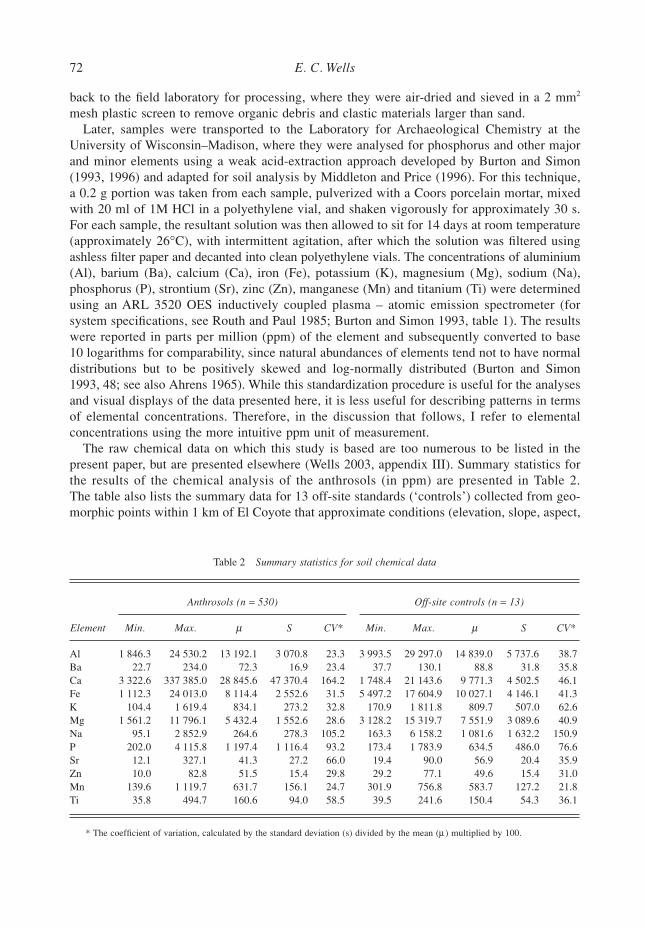
Table 2 Summary statistics for soil chemical data
Anthrosols (n = 530) Off-site controls (n = 13)
Element Min. Max. µ S CV* Min. Max. µ S CV*
Al 1 846.3 24 530.2 13 192.1 3 070.8 23.3 3 993.5 29 297.0 14 839.0 5 737.6 38.7Ba 22.7 234.0 72.3 16.9 23.4 37.7 130.1 88.8 31.8 35.8Ca 3 322.6 337 385.0 28 845.6 47 370.4 164.2 1 748.4 21 143.6 9 771.3 4 502.5 46.1Fe 1 112.3 24 013.0 8 114.4 2 552.6 31.5 5 497.2 17 604.9 10 027.1 4 146.1 41.3K 104.4 1 619.4 834.1 273.2 32.8 170.9 1 811.8 809.7 507.0 62.6Mg 1 561.2 11 796.1 5 432.4 1 552.6 28.6 3 128.2 15 319.7 7 551.9 3 089.6 40.9Na 95.1 2 852.9 264.6 278.3 105.2 163.3 6 158.2 1 081.6 1 632.2 150.9P 202.0 4 115.8 1 197.4 1 116.4 93.2 173.4 1 783.9 634.5 486.0 76.6Sr 12.1 327.1 41.3 27.2 66.0 19.4 90.0 56.9 20.4 35.9Zn 10.0 82.8 51.5 15.4 29.8 29.2 77.1 49.6 15.4 31.0Mn 139.6 1 119.7 631.7 156.1 24.7 301.9 756.8 583.7 127.2 21.8Ti 35.8 494.7 160.6 94.0 58.5 39.5 241.6 150.4 54.3 36.1
* The coefficient of variation, calculated by the standard deviation (s) divided by the mean (µ ) multiplied by 100.
Investigating activity patterns in prehispanic plazas
73
flora and fauna) found at the site and that are believed to represent prehispanic Classic periodstrata unaffected by human occupation. That the mean concentration for most elements isless than or equal to the elemental means of the controls may reflect differences in the parentmaterials of the soils from both sample sets. Many of the anthrosol samples derive fromplastered surfaces of the plaza and residential patios, which are naturally high in Ca and lowin P, while the controls derive from natural soil surfaces where Ca likely was depleted byweathering and P probably was enriched over time.
In addition to natural variation in Ca and P levels, the compositional differences betweenanthrosols and controls may reflect a high degree of soil movement at the site, such as wasprobably involved in the creation of the middens that abut the back sides of the buildingsbordering the plaza. Activity areas constantly swept clean of refuse and debris would notalways provide an opportunity for compounds to fix to the surfaces of mineral particles insoils. Also, by constantly moving, removing and shifting soils, one possible result is a depletionof some ions in soils, which could explain the particularly low concentrations of some elementsin the samples compared to the controls (e.g., Bintliff
et al.
1990; Entwistle
et al.
1998). Thiswas probably the case for some mobile cations, such as Na
+
, K
+
and Fe
2
+
, which are highlyreactive towards oxidizing agents. However, given the mildly acidic nature of El Coyote’ssoils, oxidation–reduction reactions may not account for the high number of exchangeablecations (Eidt 1985, 162; see also Jeffery 1960). Instead, lower quantities of active cations(especially Na
+
) might reflect the degree to which soils at the site experienced leaching as aresult of weathering and bioturbation processes (Eidt 1977, 1328; see also Woods 1977).
Chemical characterization of plaza anthrosols
Since some activities, especially those involving organic materials, result in the productionand deposition of elemental P and K in the form of compounds that bind to the surfaces ofmineral particles in soils, studying the horizontal distribution of the concentrations of differentchemical elements is one way to detect activity loci (e.g., Skinner 1986; Cavanagh
et al.
1988;Lippi 1988; Ortíz Butrón and Barba 1992; Dunning 1993). This approach is particularly usefulwhen the sampling matrix involves plastered or stuccoed surfaces, since it has been demon-strated that these surfacings are highly effective in trapping and preserving chemical residuesdue to the calcareous nature of constituent sediments (Barba 1990; Manzanilla and Barba1990; Ortiz Butrón
et al.
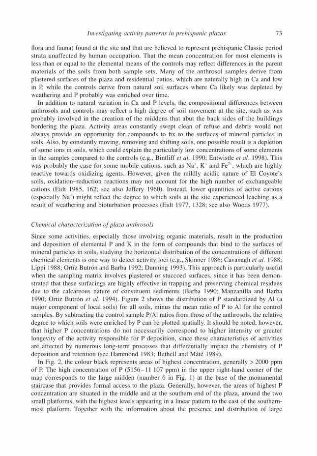
1994). Figure 2 shows the distribution of P standardized by Al (amajor component of local soils) for all soils, minus the mean ratio of P to Al for the controlsamples. By subtracting the control sample P/Al ratios from those of the anthrosols, the relativedegree to which soils were enriched by P can be plotted spatially. It should be noted, however,that higher P concentrations do not necessarily correspond to higher intensity or greaterlongevity of the activity responsible for P deposition, since these characteristics of activitiesare affected by numerous long-term processes that differentially impact the chemistry of Pdeposition and retention (see Hammond 1983; Bethell and Máté 1989).
In Fig. 2, the colour black represents areas of highest concentration, generally
>
2000 ppmof P. The high concentration of P (5156–11 107 ppm) in the upper right-hand corner of themap corresponds to the large midden (number 6 in Fig. 1) at the base of the monumentalstaircase that provides formal access to the plaza. Generally, however, the areas of highest Pconcentration are situated in the middle and at the southern end of the plaza, around the twosmall platforms, with the highest levels appearing in a linear pattern to the east of the southern-most platform. Together with the information about the presence and distribution of large
74
E. C. Wells
Figure 2 A kriged image map of extractable soil P from the main plaza at El Coyote (kriging type = point, based on a linear variogram model where slope = 1, anisotropy = 1, 0: see Cressie 1990; Kitanidis 1997). Concentrations are expressed as [Panthrosol (ppm)/Alanthrosol (ppm) ] − [µPcontrol (ppm)/µAlcontrol (ppm) ]. The colour white (zero on the scale bar) represents ‘natural’ levels of P, calculated as µPcontrol (ppm)/µAlcontrol (ppm), with ncontrol = 13. Darker huescorrespond to higher concentrations of P.
Investigating activity patterns in prehispanic plazas
75
bowls and jars, censers, and grinding and other food processing implements, patterning inelevated levels of P strongly suggests that these buildings were involved in activities related tothe preparation and/or consumption of foods and possibly beverages. In contrast, the northernend of the plaza is largely devoid of significant (that is,
>
2000 ppm compared to the controlmean of 634
±
486 ppm) P concentrations, suggesting that this area may have been reservedfor activities that did not involve organic substances. Alternatively, this pattern could reflectsweeping and cleaning of the northern half of the plaza immediately following consumptiveactivities, which would have prevented phosphates from fixing to the plaza surface.
The elevated concentrations of P (1320–1823 ppm), compared to adjacent soil P, outside theplaza to the west correspond to midden deposits (numbers 7–12 in Fig. 1). Generally, however,areas outside the plaza appear to lack significantly elevated levels of P, apart from the middens.Such low concentrations stand in sharp contrast to soils inside the plaza, and suggest that areasexternal to the plaza were not involved significantly with food production and/or consumption,or that these spaces were kept clean of accumulated organic debris. The exceptions are theelite residential patios and the ballcourt to the south of the plaza. Levels of P are generallyhigh among the patios, which is expected given the presumed domestic character of theseareas that would have involved food preparation and consumption on a daily basis. That highlevels of P also appear in the end zones of the ballcourt, along with a noticeable absence (orvery low levels) of P in the central playing alley, is interesting. If the deposition of P in theballcourt represents evidence for food consumption, then this finding would support priorsuggestions that ballcourts in southeastern Mesoamerica served as stages for ritual feasts (e.g.,Fox 1996).
In addition to P, the distributions of K and Ca also are useful for locating plaza activities.Based on ethnographic information from studies among the contemporary Lenca who occupythe present-day regions of central and northern Honduras (e.g., Chapman 1985; Castegnaro deFoletti 1989), the presence and distribution, in El Coyote’s main plaza, of large jars with limedeposits on their interiors and burning or sooting on their exteriors might constitute evidencefor the manufacture of corn-based products, such as
cususa
(a fermented corn drink sweetenedwith honey or pineapple) and possibly
nixtamal
(corn dough used for making
tortillas
,
tamales
and
atole
). If these products were prepared or consumed in the plaza in significant quantities,as suggested by the elevated levels of P and the high proportions of large jar sherds comparedto domestic assemblages at the site, then the patterned distribution of K (contributed to soilsby wood ash from cooking) and Ca (contributed by the use of lime in processing corn) in plazasoils should distinguish areas of food preparation from those of consumption, the latter beingdominated by high P levels. For example, in their chemical study of contemporary householdfloors in Oaxaca, Mexico, Middleton and Price (1996, 678) found elevated levels of Ca and astrong positive correlation (Pearson’s
r
=
0.81, where
p
=
0.05) between K and P in areas of
nixtamal
production. However, since the plaza floor at El Coyote is composed of crushedlimestone and was coated in parts with lime-based plaster, the high concentrations of calciumcarbonate (CaCO
3
) in these surfacings probably mask the distribution of Ca deposited bycooking and food/beverage consumption. Therefore, it is more useful to consider the distribu-tion of K as a proxy for food preparation involving wood burning.
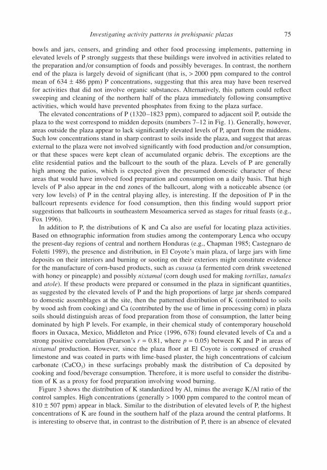
Figure 3 shows the distribution of K standardized by Al, minus the average K/Al ratio of thecontrol samples. High concentrations (generally
>
1000 ppm compared to the control mean of810
±
507 ppm) appear in black. Similar to the distribution of elevated levels of P, the highestconcentrations of K are found in the southern half of the plaza around the central platforms. Itis interesting to observe that, in contrast to the distribution of P, there is an absence of elevated
76
E. C. Wells
Figure 3 A kriged image map of extractable soil K from the main plaza at El Coyote (kriging type = point, based on a linear variogram model where slope = 1, anisotropy = 1, 0: see Cressie 1990; Kitanidis 1997). Concentrations are expressed as [Kanthrosol (ppm)/Alanthrosol (ppm) ] − [µKcontrol (ppm)/µAlcontrol (ppm) ]. The colour white (zero on the scale bar) represents ‘natural’ levels of K, calculated as µKcontrol (ppm)/µAlcontrol (ppm), with ncontrol = 13. Darker huescorrespond to higher concentrations of K.
Investigating activity patterns in prehispanic plazas 77
levels of K immediately encircling the platforms, perhaps indicating that the buildings them-selves were reserved for activities other than food preparation, or else they were consistentlycleaned of debris. However, this pattern also might be explained by the fact that, since K ismore reactive than P in solution, P adsorption may have been inhibited if these spaces weresaturated with K. That P and K are not correlated (r = 0.1, where p < 0.05) supports this idea.Levels of K are also generally high in the residential areas, particularly near the bases of theedges and corners of buildings, which is expected if K marks areas of wood ash deposits (fromcooking fires), which would have been allowed to collect in these spaces. Concentrations ofK are quite low for the ballcourt, save for the centre of the playing alley, which exhibits anunexpected spike of 780 ppm, perhaps marking the location of incense burning that wouldhave enriched soils with ash deposits.
Chemical characterization of midden anthrosols
Another means of locating activity areas around El Coyote’s main plaza is to investigate thepossibility that middens containing material residues of certain classes of activities (e.g., craftproduction, ritual and domestic) have distinct chemical signatures, and that these signaturescan be linked to non-midden soils. The basic assumption is that different types of middens formfrom the deposition of different kinds of materials (only some of which may have survived inthe archaeological record) or similar kinds of materials but in different proportions. As a result,these formation processes deposit different combinations of chemical elements in differentproportions on to the surfaces of mineral sediments in middens. By extracting the availableions from mineral surfaces and clay interlayers and chemically characterizing them, it may bepossible to derive different chemical signatures for each class of midden in areas where soilsformed under similar geomorphic conditions. For example, Parnell and colleagues (2001) havedemonstrated that extractable soil P in domestic middens at Piedras Negras, Guatemala, has astrong positive correlation (r = 0.72, where p < 0.05) with ceramic sherd density.
Middens produced from lithic manufacturing activities might be expected to have elevatedconcentrations of Fe, Ti, Al and K, related to the deposition of phenocrysts and micro-phenocrysts (i.e., quartz, potassium feldspar, iron oxide, titanium dioxide and ferromagnesianminerals) that compose volcanic glass and some types of cryptocrystalline materials (e.g.,Merrick and Brown 1984). Food-production middens should have elevated concentrations ofP and Ca, produced from the deposition of faunal bones and other organic remains (e.g., Terryet al. 2000), as well as K and Na related to the deposition of wood ash associated with cookingfires (e.g., Middleton and Price 1996). Middens containing ritual paraphernalia might beexpected to be the most complex and variable given the variety of potential activities, but maycontain elevated concentrations of Fe and Ti (e.g., Wells et al. 2000), which reflect the use ofhematite (iron oxide, Fe2O3) or ilmenite (FeTiO3) and limonite (‘ochre’ or hydrated ferric oxide,FeO[OH] )—mineral-based pigments that witnessed widespread ritual use in prehispanicMesoamerica (Vázquez N. and Velázquez 1996; Chase and Chase 1998; Fash 2001).
To differentiate chemically among middens surrounding the main plaza with respect to theactivities responsible for their formation, I identified two primary compositional groups thatderive from soils sampled in the main plaza (n = 177) and among the residential patios (n = 47)using a principal components analysis conducted on six element concentrations identifiedfor each sample: Ca, Fe, K, Na, P and Ti (the first five principal components account forapproximately 97% of the sample variance). These elements were selected for analysisbecause the deposition of each can be linked, through ethnoarchaeological studies, to specific
78 E. C. Wells
human activities (e.g., Barba and Bello 1984; Barba and Ortiz Butrón 1992; Barba et al. 1995;Middleton and Price 1996; Wells and Urban 2002). While Na has the potential to be a highlymobile ion, especially in contexts of heavy rainfall and good soil drainage (i.e., sandy soilswith a high clay percentage), and so may have been leached from the soils that I sampled, thedata associated with this element most strongly affect the fifth principal component, which isnot utilized in the present analyses. The other element concentrations recorded using ICP–AES (Al, Ba, Mg, Sr, Zn and Mn) have less understood connections to human activities and,as a result, were not included in the present analyses (see Entwistle et al. 1998, 2000).
I evaluated the multivariate probabilities that the analysed samples belong to one of the tworeference groups using a discriminant analysis, which resolved the data into two primarycompositional groups corresponding to their provenance either in the main plaza or among theresidential patios. The first two discriminant scores correctly assigned 200 of 224 samples(approximately 90%) according to their provenances. I chose a correlation matrix for thediscriminant analysis so as to give equal influence to all variables (element concentrations), asCa and Fe are major constituents of the sediments’ chemistry and potentially could dull theeffects of the other elements (K, Na, P and Ti) in the analysis (see Baxter 1994).
Soil samples from all middens and suspected activity areas outside the plaza were character-ized chemically. These data, also analysed with principal components analysis, were projectedagainst those of the reference groups to determine whether middens and activity areas could becorrelated with plaza or residential spaces. Bivariate plots of some of the principal components(with eigenvectors of the covariance matrix as reference axes) for the sample compositionsindicate chemical group distinctions (Fig. 4).
Soils from the midden outside the north-west corner of the plaza (‘NW Midden’, or num-ber 5 in Fig. 1; n = 25), from the middens behind the buildings on the western side of theplaza (‘West Middens’, or numbers 1–4 in Fig. 1; n = 13) and from two adjoining middensfrom a suspected lithic manufacturing area behind the building on the north-east corner of theplaza (‘Lithic Midden’, or numbers 7 and 8 in Fig. 1; n = 4) all represent the same general classof midden deposit based on their combined soil chemistry (‘Group I soils’). Within this group ofsamples there appears to be some degree of internal differentiation among data sets, however,which may reflect the particular collection of artefacts associated with each midden (seeTable 1). The differences among the larger data sets derive, in part, from differences in theconcentrations of K and P. Compared to plaza and residential soils, the sampled midden soilshave generally lower concentrations of K and P, which suggests that they do not contain theresidues of food production (K from wood ash) and consumption (P from organics) in theamounts characteristic of soils from plaza and residential settings. If the sampled middensrepresent practices that resulted in the deposition of similar kinds of residues, which is sug-gested by the chemical analysis, then materials unearthed from the NW Midden may be takento represent the range of activities in the areas encompassed by the sampled middens. Sincethe NW Midden contains ample evidence for craft production activities, it may have been thecase that such activities were performed outside the plaza in these locales. This is an interestinghypothesis that needs to be evaluated further with additional excavation in the area.
Soils from the midden uncovered at the base of a monumental staircase at the north-eastcorner of the plaza (‘NE Midden’, or number 6 in Fig. 1; n = 6) and from the edges of theballcourt’s alley (n = 20) both represent another class of soil (‘Group II soils’), which overlapsdirectly with the main plaza reference group. This pattern is not surprising, since the mainplaza and probably the ballcourt were associated with ritual activities. Two important differ-ences are evident between the Group II soils and the main plaza soils. Group II soils contain
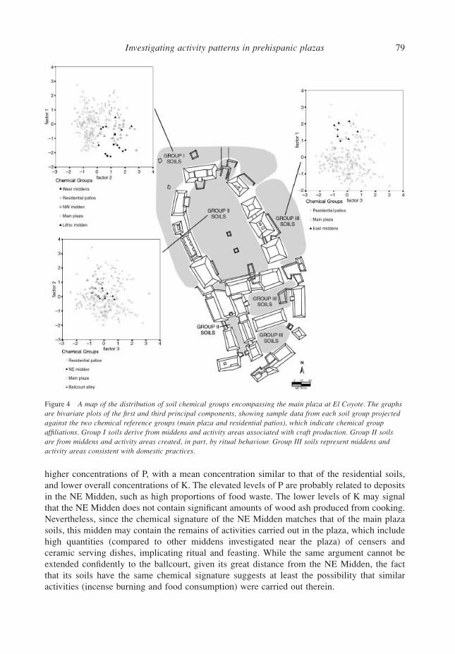
Investigating activity patterns in prehispanic plazas 79
higher concentrations of P, with a mean concentration similar to that of the residential soils,and lower overall concentrations of K. The elevated levels of P are probably related to depositsin the NE Midden, such as high proportions of food waste. The lower levels of K may signalthat the NE Midden does not contain significant amounts of wood ash produced from cooking.Nevertheless, since the chemical signature of the NE Midden matches that of the main plazasoils, this midden may contain the remains of activities carried out in the plaza, which includehigh quantities (compared to other middens investigated near the plaza) of censers andceramic serving dishes, implicating ritual and feasting. While the same argument cannot beextended confidently to the ballcourt, given its great distance from the NE Midden, the factthat its soils have the same chemical signature suggests at least the possibility that similaractivities (incense burning and food consumption) were carried out therein.
Figure 4 A map of the distribution of soil chemical groups encompassing the main plaza at El Coyote. The graphs are bivariate plots of the first and third principal components, showing sample data from each soil group projected against the two chemical reference groups (main plaza and residential patios), which indicate chemical groupaffiliations. Group I soils derive from middens and activity areas associated with craft production. Group II soils are from middens and activity areas created, in part, by ritual behaviour. Group III soils represent middens and activity areas consistent with domestic practices.
80 E. C. Wells
Finally, soils from the middens (‘East Middens’, or numbers 9–12 in Fig. 1; n = 8) on theterraces flanking the buildings on the east side of the plaza map directly on to the referencegroup representing the residential patios (‘Group III soils’). This might be explained by the factthat, on the basis of the artefact assemblages recovered from the middens, numerous activitiesappear to be represented on the eastern terraces, creating soils in a manner similar to thatfor residential areas, which also undoubtedly hosted a variety of domestic activities. Thesepractices included at least food preparation and lithic tool manufacture, as suggested byartefact patterning among neighbouring middens and activity areas. Soils from the EastMiddens have the lowest mean concentration of K among the data sets, perhaps reflectingfewer activities that produced wood ash. Variation in excavation intensity and the small samplesize of analysed soils in this area, however, preclude firm conclusions.
Table 3 compares correlation coefficients among chemical elements from soils and densitiesof artefact classes from the middens studied in this paper. Ceramic density has a strong positivecorrelation with P (r = 0.62) and groundstone density correlates with K (r = 0.69), suggestingthat P and K are good indicators of food consumption and preparation. Faunal remains (boneand shell) have strong positive correlations with Na (r = 0.61 and r = 0.77, respectively) andpositive, although weaker, correlations with Ca (r = 0.36 and r = 0.46, respectively), suggestingthat elevated levels of Na and Ca in soils may mark locations of food deposition. As discussedpreviously, however, this signature may be affected strongly by the mobility of Na and thegenerally high concentrations of Ca in the soil as a result of its creation from limestone parentmaterials. Finally, obsidian density correlates mildly with Ti (r = 0.51), Fe (r = 0.23) and K(r = 0.33), suggesting that patterning in these elements across space (deposited in soils asconstituents of volcanic glass) may reveal areas of lithic tool use and/or lithic manufacture,although the correlations are especially weak for Fe and K.
CONCLUSIONS
Compositional analysis of plaza anthrosols reveals locations of probable activities in ElCoyote’s main plaza, which include food and/or beverage preparation and consumption assuggested by the artefacts recovered from excavations inside the plaza. Ethnohistoric accountsof plaza events in northern Honduras during the late 16th century by the Spanish historian,Antonio de Herrera y Tordesillas (1944), indicate that feasting was a primary component ofchiefly largesse, aimed at attracting labour for agricultural and craft manufacturing work-parties(composturas), which continue to serve as effective mechanisms for mobilizing labour among
Table 3 Correlation coefficients for artefacts and elemental concentrations in anthrosols
Material Al Ba Ca Fe K Mg Na P Sr Zn Mn Ti
Ceramic 0.20 0.16 0.44 −0.20 −0.36 0.07 −0.10 0.62 0.24 0.33 0.15 −0.37Obsidian −0.15 −0.10 −0.52 0.23 0.33 −0.01 −0.28 −0.26 −0.25 0.01 0.07 0.51Chert −0.14 −0.05 −0.44 0.18 0.08 −0.07 −0.24 −0.25 −0.18 −0.03 0.04 0.38Groundstone 0.02 −0.09 −0.10 −0.02 0.69 0.26 −0.10 0.01 −0.06 0.18 0.20 0.30Bone −0.60 −0.27 0.36 −0.57 −0.38 −0.79 0.61 −0.23 −0.16 −0.91 −0.80 −0.29Shell −0.58 −0.30 0.46 −0.59 −0.43 −0.77 0.77 −0.22 −0.15 −0.89 −0.79 −0.34
Note: highlighted values indicate that the correlation is significant at the 0.05 level.
Investigating activity patterns in prehispanic plazas 81
the contemporary Lenca (Chapman 1985). Chemical studies of anthrosols in trash depositsoutside the plaza extend the interpretive potential of midden inventories by suggesting beha-vioural links between the formation of particular middens and specific activity areas. Excava-tions of middens recovered evidence indicating a variety of craft activities, including lithictool production (tools and manufacturing debris), animal or hide processing (chert scrapersand large mammal bones, including deer and feline phalanxes), paper-making (bark beaters andceramic stamps), pigment processing (mortars, pestles, and red and yellow mineral pigments),and possibly ceramic manufacture (a possible workshop and clay extraction pit located nearby).
The combined soil chemical data and midden inventories strongly suggest that the main plazaand its adjacent spaces represent three different suites of behaviour, and that the deposition ofrefuse generated by those behaviours occurred in close proximity to what may have been theirpoints of origin. Figure 4 shows the distribution of the three primary classes of activity areasaround the main plaza. The shaded area encompassing Group I soils and associated trashdeposits corresponds to areas that I suspect were used for craft manufacturing activities, giventheir association with large amounts of lithic tools and debris and soils containing Fe and Ti inhigher concentrations than the control samples. The main plaza and the ballcourt, distinguishedby Group II soils and adjacent middens, represent areas where ritual activities, includingfood and beverage consumption, may have been performed. Artefacts unearthed in thesespaces include ceramic serving dishes and groundstone implements, along with ceramicbraziers and censers (used for burning incense). Compared to the control samples, I found thatsoils in these spaces have exceptionally high amounts of P, K, Ca and Na—possibly depositedas a result of activities consistent with food preparation and consumption. Finally, Group IIIsoils and artefact concentrations define the region outside the plaza immediately to the eastand residential patios to the south of the plaza. These soils appear to have been formed frombehaviours associated with domestic activities, such as those evinced by the grinding stones,cooking and serving dishes, and stone tools that I encountered in these spaces.
The study reported here demonstrates that investigation of the soil chemistry of middensand activity areas at archaeological sites, coupled with excavation data on artefact assemblagesand their associated formation processes, can yield important information about the intra-siteprovenance of material culture contained in middens. Exploring the relationship between thechemical signatures of middens and those of activity areas has been particularly useful at ElCoyote, because activity residues in the main plaza and adjacent spaces were swept clean inantiquity. Together, the artefact and soil chemical information provide a reservoir of new datathat can suggest future research directions for exploring social dynamics at El Coyote. Sincesoil samples also have been collected from individual midden strata and from stratigraphiclayers and resurfacings of the main plaza, it will be possible in future analyses to tracktemporal, as well as spatial, changes in the organization of plaza activities.
More broadly, the results of this research suggest that, by studying the chemical behaviourof anthrosols, inferences can be made regarding the ranges and locations of activities withinarchaeological contexts where little or no direct material evidence has survived. Whileelemental P and K often can be assigned confidently to activities involving food production,consumption and deposition, other major and minor elements and the activities potentiallyresponsible for their deposition need to be explored. Future studies must include ethnoarch-aeological investigations (e.g., Barba and Bello 1984; Barba 1990; Barba and Ortiz Butrón 1992;Barba et al. 1995; Middleton and Price 1996; Fernández et al. 2002; Wells and Urban 2002)with the aim of developing much needed bridging arguments to be able to link observedpatterning in the chemical data directly with human behaviour.
82 E. C. Wells
ACKNOWLEDGEMENTS
Work at El Coyote was conducted with the permission and support of the Instituto Hondureñode Antropología e Historia (IHAH), directed by Olga Hoya. I gratefully acknowledge the aidof Carmen Julia Fajardo, Juan Alberto Durón and Carlos Alberto Acosta of IHAH. I also thankthe directors of the Cacaulapa Valley Archaeological Project, Patricia A. Urban and EdwardM. Schortman of Kenyon College, for allowing me to conduct research at El Coyote and forproviding critical guidance throughout the research process. Funding for this research wasprovided by a Doctoral Dissertation Improvement Grant from the National Science Foundation(BCS-0108742) and a Dissertation Fieldwork Grant from the Wenner-Gren Foundation forAnthropological Research. Soil analysis was conducted with the support and advice of JamesH. Burton and T. Douglas Price, as part of a Research Award in Archaeometry from theLaboratory for Archaeological Chemistry at the University of Wisconsin–Madison. Additionalfunding, which aided soil collection and analysis, was provided by a Claude C. Albritton, Jr,Memorial Student Research Award from the Archaeological Geology Division of the Geolo-gical Society of America, a Dissertation Research Grant from the Department of Anthropologyat Arizona State University (ASU) and a Graduate Research Fellowship from the Archaeo-logical Research Institute at ASU. I would like to thank James H. Burton, George L. Cowgill,Karla L. Davis-Salazar, Kelly J. Knudson, David Meiggs, Ben A. Nelson, T. Douglas Price,Michael P. Richards, Edward M. Schortman, Arleyn W. Simon, Barbara L. Stark, Richard E.Terry and Patricia A. Urban for their assistance throughout the research process and for theirhelpful comments on drafts of this manuscript.
REFERENCES
Ahrens, L. H., 1965, Distribution of the elements in our planet, McGraw-Hill, New York.Andrade, E., 1990, Los modalidades de la lluvia en Honduras, Editorial Guaymaras, Tegucigalpa, Honduras.Ball, J. W, and Kelsay, R. G., 1992, Prehistoric intrasettlement land use and residual soil phosphate levels in the
Upper Belize Valley, Central America, in Gardens of prehistory: the archaeology of settlement agriculture ingreater Mesoamerica (ed. T. W. Killion), 234–62, University of Alabama Press, Tuscaloosa.
Barba, L., 1986, La química en el estudio de áreas de actividad, in Análisis de unidades habitacionales mesoameri-canas y sus áreas de actividad (ed. L. Manzanilla), 21–39, Instituto de Investigaciones Antropológicas, Univer-sidad Nacional Autónoma de México, Mexico City, Mexico.
Barba, L., 1990, El análisis químico de pisos de unidades habitacionales para determinar sus áreas de actividad, inEtnoarqueología Coloquio Bosch Gimpera 1988, (eds. Y. Sugiura and M. C. Serra Puche), 177–200, Instituto deInvestigaciones Antropológicas, Universidad Nacional Autónoma de México, Mexico City, Mexico.
Barba, L., and Bello, G., 1984, Análisis de fosfatos en el piso de una casa habitada actualmente, Notas Antropológicas,I, 188–93.
Barba, L., and Ortiz Butrón, A., 1992, Análisis químico de pisos de ocupación: un caso etnográfico en Tlaxcala,México, Latin American Antiquity, 3, 63–82.
Barba, L., Pierrebourg, F. D., Trejo, C., Ortiz Butrón, A., and Link, K., 1995, Activites Humaines refletees dans les solss’unites d’habitation contemporaine et prehispanique de Yucatan (Mexique): etudes chimiques, ethnoarchéologiqueset archéologiques, Revue d’Archéométrie, 19, 79–95.
Baxter, M. J., 1994, Exploratory multivariate analysis in archaeology, Edinburgh University Press, Edinburgh.Bergman, J., 1969, The distribution of cacao cultivation in pre-Columbian America, Annals of the Association of
American Geographers, 59, 85–96.Bethell, P., and Máté, I., 1989, The use of soil phosphate analysis in archaeology: a critique, in Scientific analysis in
archaeology and its interpretation (ed. J. Henderson), 1–29, Institute of Archaeology, University of California,Los Angeles.
Bintliff, J. L., Gaffney, C., Waters, A., Davis, B., and Snodgrass, A., 1990, Trace element accumulation in soils in andaround ancient settlements in Greece, in Man’s role in the shaping of the eastern Mediterranean landscape (eds.S. Bottema, G. Entijes-Nieborg and W. V. Zeist), 159–72, Balkema, Rotterdam.
Investigating activity patterns in prehispanic plazas 83
Burton, J. H., and Simon, A. W., 1993, Acid extraction as a simple and inexpensive method for compositionalcharacterization of ceramics, American Antiquity, 58, 45–59.
Burton, J. H., and Simon, A. W., 1996, A pot is not a rock: reply to Neff, Glascock, Bishop, and Blackman, AmericanAntiquity, 61, 405–13.
Castegnaro de Foletti, A., 1989, Alfarería Lenca contemporánea de Honduras, Editorial Guaymuras, Tegucigalpa,Honduras.
Cavanagh, W. G., Hirst, S., and Litton, C. D., 1988, Soil phosphate, site boundaries, and change point analysis, Journalof Field Archaeology, 15, 67–83.
Chapman, A. M., 1985, Los hijos del copal y la candela: ritos agrarios y tradición oral de los lencas de Honduras,Universidad Nacional Autónoma de México, Mexico City, Mexico.
Chase, D. Z., and Chase, A. F., 1998, The architectural context of caches, burials, and other ritual activities for theClassic period Maya (as reflected at Caracol, Belize), in Function and meaning in Classic Maya architecture (ed.S. D. Houston), 299–332, Dumbarton Oaks, Washington, DC.
Craddock, P. T., Gurney, D. A., Pryor, F., and Hughs, M., 1986, The application of phosphate analysis to the locationand interpretation of archaeological sites, Archaeological Journal, 142, 361–76.
Cressie, N. A. C., 1990, The origins of kriging, Mathematical Geology, 22, 239–52.Dormaar, J. F., and Beaudoin, A. B., 1991, Application of soil chemistry to interpret cultural events at the Calderwood
Buffalo Jump (DkPj-27), southern Alberta, Canada, Geoarchaeology, 6, 85–98.Dunning, N. P., 1993, Ancient Maya anthrosols: soil phosphate testing and land use, in Proceedings of the First Inter-
national Conference on Pedo-Archaeology (eds. J. E. Foss, M. E. Timpson and M. W. Morris), 203–11, AgriculturalExperiment Station Special Publication 93-03, University of Tennessee, Knoxville.
Dunning, N. P., Beach, T., and Rue, D. J., 1997, The paleoecology and ancient settlement of the Petexbatun region,Guatemala, Ancient Mesoamerica, 8, 255–66.
Eidt, R. C., 1977, Detection and examination of anthrosols by phosphate analysis, Science, 197, 1327–33.Eidt, R. C., 1985, Theoretical and practical considerations in the analysis of anthrosols, in Archaeological geology
(eds. G. Rapp and J. A. Gifford), 155–90, Yale University Press, New Haven, CT.Entwistle, J. A., and Abrahams, P. W., 1997, Multi-elemental analysis of soils and sediments from Scottish historical
sites: the potential of inductively coupled plasma–mass spectrometry for rapid site investigation, Journal ofArchaeological Science, 24, 407–16.
Entwistle, J. A., Abrahams, P. W., and Dodgshon, R. A., 1998, Multi-elemental analysis of soils from Scottish historicalsites: interpreting land-use history through the physical and geochemical analysis of soil, Journal of ArchaeologicalScience, 25, 53–68.
Entwistle, J. A., Abrahams, P. W., and Dodgshon, R. A., 2000, The geoarchaeological significance and spatial variabil-ity of a range of physical and chemical soil properties from a former habitation site, Isle of Skye, Journal ofArchaeological Science, 27, 287–303.
Fash, W. L., 1998, Dynastic architectural programs: intention and design in Classic Maya buildings at Copán andother sites, in Function and meaning in Classic Maya architecture (ed. S. D. Houston), 223–70, Dumbarton Oaks,Washington, DC.
Fash, W. L., 2001, Scribes, warriors, and kings: the city of Copán and the ancient Maya, Thames and Hudson, London.Fernández, F. G., Terry, R. E., Inomata, T., and Eberl, M., 2002, An ethnoarchaeological study of chemical residues
in the floors and soils of Q’eqchi’ Maya houses at Las Pozas, Guatemala, Geoarchaeology, 17, 487–519.Fox, J. G., 1996, Playing with power: ballcourts and political ritual in southern Mesoamerica, Current Anthropology,
37, 483–509.Gurney, D. A., 1985, Phosphate analysis of soils: a guide for the field archaeologist, Technical Paper no. 3, Institute
of Field Archaeologists, Birmingham, AL.Hammond, F. W., 1983, Phosphate analysis of archaeological sediments, in Landscape archaeology in Ireland (eds.
T. Reeves-Smyth and F. Hammond), 47–80, BAR no. 116, British Archaeological Reports, Oxford.Hassan, F. A., 1978, Sediments in archaeology: methods and implications for paleoenvironmental and cultural analysis,
Journal of Field Archaeology, 5, 197–213.Herrera y Tordesillas, A. D., 1944, Historia general de los hechos de los Castellanos en las islas y tierra-firme de el
mar océano, Editorial Guarania, Asunción del Paraguay.Jeffery, J. W. O., 1960, Iron and the Eh of waterlogged soils with particular reference to paddy, Journal of Soil Science,
11, 140–8.Kitanidis, P., 1997, Introduction to geostatistics: applications in hydrogeology, Cambridge University Press, Cambridge.Kshirsagar, A., 1996, Anthrosols from Balathal: a chemical study, Man and Environment, 21, 111–16.Linderholm, J., and Lundberg, E., 1994, Chemical characterization of various archaeological soil samples using main
84 E. C. Wells
and trace elements determined by inductively coupled plasma atomic emission spectrometry, Journal of Archaeo-logical Science, 21, 303–14.
Lippi, R. D., 1988, Paleotopography and phosphate analysis of a buried jungle site in Ecuador, Journal of FieldArchaeology, 15, 85–97.
Manzanilla, L., and Barba, L., 1990, The study of activities in classic households: two case studies from Coba andTeotihuacan, Ancient Mesoamerica, 1, 41–9.
Merrick, H. V., and Brown, F. H., 1984, Rapid chemical characterization of obsidian artifacts by electron microprobeanalysis, Archaeometry, 26, 230–6.
Middleton, W. D., and Price, T. D., 1996, Identification of activity areas by multi-elemental characterization of sedi-ments from modern and archaeological house floors using inductively coupled plasma – atomic emission spectros-copy, Journal of Archaeological Science, 23, 673–87.
Millon, R., 1955, When money grew on trees: a study of cacao in ancient Mesoamerica, Ph.D. dissertation, ColumbiaUniversity, New York.
Metal Mining Agency of Japan (MMAJ), 1979, Western Honduras project, Mineral Resources Information Center,Metal Mining Agency of Japan, Tokyo, Japan.
Ortíz Butrón, A., and Barba, L., 1992, Estudio químico de los pisos del Satunsat, en Oxkintok, Yucatan, Oxkintok, 4,119–26.
Ortiz Butrón, A., Barba, L., López Luján, L., and Link, K. F., 1994, Stuccoed floors: a resource for the study of ritualactivities, the case of Templo Mayor, México, in Materials issues in art and archaeology IV (eds. P. B. Vandiver,J. R. Druzik, M. Galvan, I. C. Freestone and G. S. Wheeler), 723–6, Materials Research Society, Pittsburgh, PA.
Parnell, J. J., Terry, R. E., and Golden, C., 2001, Using in-field phosphate testing to rapidly identify middens at PiedrasNegras, Guatemala, Geoarchaeology, 16, 855–73.
Routh, M. W., and Paul, K. J., 1985, A fixed grating sequential ICP spectrometer with multitasking software, AmericanLaboratory, June, 84–97.
Sánchez, A., Canabate, L., and Lizcano, R., 1996, Phosphorous analysis at archaeological sites: an optimization of themethod and interpretation of the results, Archaeometry, 38, 151–64.
Skinner, S. M., 1986, Phosphorus as an anthrosol indicator, Midcontinental Journal of Archaeology, 11, 51–78.Smith, A. C., and Johnson, I., 1945, A phytogeographic sketch of Latin America, in Plants and plant science in Latin
America (ed. F. Verdoorn), 11–18, Chronica Botanica, Waltham, MA.Soil Survey Staff, 1975, Soil taxonomy: a basic system of soil classification for making and interpreting soil surveys,
Agriculture Handbook no. 436, Soil Conservation Science, United States Department of Agriculture, Washington, DC.Soil Survey Staff, 1998, Keys to soil taxonomy, 8th edn, Natural Resources Conservation Service, United States
Department of Agriculture, Washington, DC.Stein, J. K., 1985, Interpreting sediments in cultural settings, in Archaeological sediments in context (eds. J. K. Stein
and W. R. Farrand), 5–19, Peopling of the Americas Edited Volume Series no. 1, University of Maine, Orono.Terry, R. E., Hardin, P. J., Houston, S. D., Nelson, S. D., Jackson, M. W., Carr, J., and Parnell, J. J., 2000, Quantitative
phosphorus measurement: a field test procedure for archaeological site analysis at Piedras Negras, Guatemala,Geoarchaeology, 15, 151–66.
Tozzer, A. M., 1941, Landa’s relación de las cosas de Yucatan, Papers of the Peabody Museum of American Archae-ology and Ethnology 18, Harvard University, Cambridge, MA.
United Nations Development Programme (UNDP), 1974, Invesigación de los recursos minerales en areas selecciona-das, Honduras: geología de la región noroeste de Honduras, United Nations Development Programme, New York.
Urban, P. A., Schortman, E. M., and Ausec, M. T., 1999, The Proyecto Valle de Cacaulapa, northwestern Honduras:archaeological investigations conducted during the 1999 field season, Instituto Hondureño de Antropología e Historia.
Vázquez, N. J., and Velázquez, R., 1996, Análisis químico de materiales encontrados en excavación, dos casos:porta-incensarios tipo Palenque y cinabrio usado en practicas funerarias, in Eighth Palenque Round Table, 1993(eds. M. Macri and J. McHargue), 103–6, The Pre-Columbian Art Research Institute, San Francisco.
Wells, E. C., 2003, Artisans, chiefs, and feasts: Classic period social dynamics at El Coyote, Honduras, Ph.D. disser-tation, Department of Anthropology, Arizona State University.
Wells, E. C., and Urban, P. A., 2002, An ethnoarchaeological perspective on the material and chemical residues of com-munal feasting at El Coyote, northwest Honduras, in Materials issues in art and archaeology VI (eds. P. Vandiver,M. Goodway and J. Mass), 193–8, MRS Proceedings Volume 712, Materials Research Society, Warrendale, PA.
Wells, E. C., Terry, R. E., Parnell, J. J., Hardin, P. J., Jackson, M. W., and Houston, S. D., 2000, Chemical analysesof ancient anthrosols in residential areas at Piedras Negras, Guatemala, Journal of Archaeological Science, 27,449–62.
Woods, W. I., 1977, The quantitative analysis of soil phosphate, American Antiquity, 42, 248–52.


