Embed Size (px)
Citation preview

The Cryosphere, 2, 53–66, 2008www.the-cryosphere.net/2/53/2008/© Author(s) 2008. This work is distributed underthe Creative Commons Attribution 3.0 License.
The Cryosphere
Is snow sublimation important in the alpine water balance?
U. Strasser1, M. Bernhardt 1, M. Weber2, G. E. Liston3, and W. Mauser1
1Department of Geography, Ludwig-Maximilians University (LMU), Luisenstr. 37, 80333 Munich, Germany2Comm. for Glaciology, Bavarian Academy of Sciences and Humanities, Alfons-Goppel-Str. 11, 80539 Munich, Germany3Cooperative Institute for Research in the Atmosphere, Colorado State University, Fort Collins, Colorado 80523, USA
Received: 3 August 2007 – Published in The Cryosphere Discuss.: 6 September 2007Revised: 25 April 2008 – Accepted: 25 April 2008 – Published: 23 May 2008
Abstract. In alpine terrain, snow sublimation represents animportant component of the winter moisture budget, repre-senting a proportion of precipitation which does not con-tribute to melt. To quantify its amount we analyze the spatialpattern of snow sublimation at the ground, from a canopy andfrom turbulent suspension during wind-induced snow trans-port for a high alpine area in the Berchtesgaden National Park(Germany), and we discuss the efficiency of these processeswith respect to seasonal snowfall. Therefore, we utilized in-terpolated meteorological recordings from a network of auto-matic stations, and a distributed simulation framework com-prising validated, physically based models. The applied sim-ulation tools were: a detailed model for shortwave and long-wave radiative fluxes, a mass and energy balance model forthe ground snow cover, a model for the microclimatic con-ditions within a forest canopy and related snow-vegetationinteractions including snow sublimation from the surface ofthe trees, and a model for the simulation of wind-inducedsnow transport and related sublimation from suspended snowparticles. For each of the sublimation processes, mass rateswere quantified and aggregated over an entire winter sea-son. Sublimation from the ground and from most canopytypes are spatially relatively homogeneous and sum up toabout 100 mm of snow water equivalent (SWE) over the win-ter period. Accumulated seasonal sublimation due to turbu-lent suspension is small in the valley areas, but can locally,at very wind-exposed mountain ridges, add up to more than1000 mm of SWE. The fraction of these sublimation lossesof winter snowfall is between 10 and 90%.
Correspondence to:U. Strasser([email protected])
1 Introduction
Snow sublimation (the phase transition of water from solidto vapour) is a fundamental component of the alpine mois-ture budget. The total energy required is the sum of the la-tent heat of fusion (melting or freezing) and the latent heatof vaporization (evaporation or condensation), for a total of2.838 kJ/kg at 0◦C and standard pressure. In this sum, thelatent melting heat only represents 12% of the latent heat ofvaporization. The energy and water exchange at the snow-atmosphere interface is constrained by two important factors:the temperature of the (melting) snow surface cannot exceed0◦C, and, consequently, the water vapour partial pressure atthe surface will not exceed 6.11 hPa, limiting the humidityconditions at which evaporation can occur. Turbulent motionin the surface layer is driven mechanically by wind shear,and thermally by buoyancy over small-scale surface hetero-geneities. Over snow, and in particular above inclined sur-faces, the latter effect is typically not very significant. Dueto the relatively large amount of energy required for sub-limation, related snow mass change rates are generally as-sumed small compared with melting; however, for cold snowthey can represent the only mass loss. In high mountainregions where the ridges are extremely wind-exposed andslopes are steep, accumulated solid precipitation is removedby the combined effects of sublimation, blowing-snow andavalanches. As a result, and in accordance with visual expe-rience, the snowpack does not infinitely accumulate in areaswhere no melt occurs. Snow mass-balance models which donot include the latter effects underestimate ablation and leadto unrealistically high snow depths in long-term simulations.
Published by Copernicus Publications on behalf of the European Geosciences Union.

54 U. Strasser et al.: Is snow sublimation important in the alpine water balance?
Figures 706
707 708
709
Figure 1. Wind-induced snow plume on a mountain crest during blue skies (Photo: P.
Neusser).
24
Fig. 1. Wind-induced snow plume on a mountain crest during blueskies (Photo: P. Neusser).
Much work has been invested in the study of snow subli-mation processes and its important contribution to alpine wa-ter balances (Lang, 1981). At Niwot Ridge, Colorado FrontRange, Hood et al. (1999) found 195 mm of water equiva-lent total net sublimation from the ground, or 15% of max-imum snow accumulation, for the 1994–1995 snow season.The majority of this amount sublimated during the snow ac-cumulation period, whereas 30 mm net resublimation to thesnowpack occurred during the snowmelt period. The 15%total seasonal snow accumulation lost to sublimation com-pares well with earlier results, e.g. by Marks et al. (1992) orKattelmann and Elder (1991). For Hintereisferner, an alpineglacier in theOtztal Alps (Austria), annual mass losses dueto snow and ice evaporation of approximately 100 mm havebeen measured with a lysimeter (Kaser, 1983).
In addition to latent fluxes from the ground, interceptedsnow in a forest canopy can sublimate back into the atmo-sphere. Interception efficiency increases with the availabledeposition surface, increasing size of falling snow crystals,decreasing temperature, decreasing wind speed, and decreas-ing density of the falling snow (Pomeroy and Gray, 1995).Due to the large surface area to mass ratio, and the frequenthigh wind speeds in mountain forest canopies, an efficientturbulent exchange and thus sublimation process is enabled.The resulting proportion of snowfall which sublimates variesdepending on interception efficiency, exposure time, and at-mospheric conditions. Pomeroy et al. (1998) reported mod-elled seasonal intercepted snow sublimation to range from13% of annual snowfall for a mixed spruce-aspen, 31% formature pine and 40% for a mature spruce stand in the south-
ern boreal forest of central Canada (Waskesiu Lake, PrinceAlbert National Park, Saskatchewan). Measurements of sub-limation from intercepted snow within a subalpine forestcanopy at a US continental site amounted to 20–30% of totalsnowfall accumulated at the site (Montesi et al., 2004).
In addition to interception and sublimation processes, mi-crometeorological conditions at the surface of a ground snowcover are modified by the existence of a forest canopy: short-wave radiation, precipitation and wind speed are reduced andthe daily variations in the amplitude of temperature are de-creased, whereas longwave radiation and humidity are morepronounced (Link and Marks, 1999; Tribbeck et al., 2004;Strasser and Etchevers, 2005). Consequently, latent fluxesand the associated sublimation rates at the snow surface in-side a forest canopy differ from those in the open. The impactof snow interception on forest canopy optical properties andtheir implications for snowmelt modelling are discussed byPomeroy and Dion (1996).
Finally, efficient exchange of energy and mass betweenthe snow surface and the air masses above can occur dur-ing blowing-snow conditions (Pomeroy and Gray, 1995). Bymeans of turbulent suspension the suspended snow crystalsare mechanically decomposed and sublimate, the process be-ing most efficient where fresh snow is available and the windis accelerating, e.g. at ridges or narrow cols. In nature, sub-limating snow from turbulent suspension can be observed asthe snow plumes which are blown from high crests into theblue-sky atmosphere (Fig. 1), obviously revealing efficientremoval of moisture from the near-surface layer of air. Dur-ing snow storms sublimation may be limited due to highersaturation of the overlying air masses. A proper representa-tion of the wind field is most relevant for an accurate sim-ulation of wind-blown snow and the respective suspensionand sublimation processes (Liston et al., 2007; Bernhardt etal., 2008a, b1). Although sublimation losses from turbulentsuspension of wind-blown snow are limited in their spatialextent, they can locally reduce accumulated winter precipi-tation by a remarkable amount. Simulations of these effectsresult in significant portions of winter snowfall being subli-mated, with the resulting moisture transport being importantas both a source of water vapour to the atmosphere and in re-ducing the snow depth and snowmelt runoff in spring (Marsh,1999).
Few models exist which simulate the full seasonal snowevolution including sublimation from the ground snow cover,from canopy-intercepted snow as well as blowing-snow re-distribution processes (Burlando et al., 2002). An exceptionis SnowModel (Liston et al., 2007; Liston and Elder, 2006),which has been applied over a wide variety of blowing-snowenvironments. However, to our knowledge no investigation
1Bernhardt, M., Strasser, U., Liston, G. E., and Mauser, W.:High resolution modelling of snow transport in complex terrainusing simulated wind fields, The Cryosphere Discuss., submitted,2008b.
The Cryosphere, 2, 53–66, 2008 www.the-cryosphere.net/2/53/2008/

U. Strasser et al.: Is snow sublimation important in the alpine water balance? 55
has yet been conducted to include all relevant processes ofsnow sublimation for alpine areas by means of a distributed,continuous simulation, including lateral movement of snowslides which is a crucial prerequisite to realistically describesnow redistribution in areas with characteristic alpine orog-raphy. The goal of this study is to apply AMUNDSEN(Strasser et al., 2004, 2008), a modelling framework to sim-ulate the energy and mass balance of a mountain snow cover,including coupled modules for forest snow processes (Listonand Elder, 2006) and snow slides (Gruber, 2007), togetherwith SnowTran-3D (Liston and Sturm, 1998; Liston et al.,2007) to quantify the seasonal pattern of snow sublimationlosses due to each of the specific processes, and identify theircumulative effect on the winter moisture budget at the scaleof an alpine catchment (210 km2).
2 Methods
2.1 Site description
Berchtesgaden National Park is located in southeast Ger-many in Bavaria, at the southern corner of the administra-tive district Berchtesgadener Land (Fig. 2), and comprisesan area of 210 km2 (http://www.nationalpark-berchtesgaden.de/). For the most part, the border of the National Park is rep-resented by the national boundary to Austria. The moderateto high alpine area of the National Park includes the mas-sifs Watzmann (2713 m a.s.l.) and Hochkalter (2606 m a.s.l.)as well as parts of the massifs Hoher Goell, Hagengebirge,Steinernes Meer and Reiter Alm. The mountain massifs areseparated by the deep valleys stretching from south to northof the Koenigssee (water level 603 m a.s.l.), the Wimbach andthe Klausbach. The valley areas are characterized by ex-tensive forests with larch, spruce and mountain pine stands(Konnert, 2004). The mountains reach up to the nival zone.
The climate of the National Park area is subject to signifi-cant spatial variability, in response to the over 2000-m reliefgradient. Small scale local differences are mainly caused bythe general position in the mountainous landscape, the wind-ward or lee position relative to the prevailing winds and solarexposure. Mean measured annual rainfall in the valleys isapproximately 1500 mm with a July maximum.
2.2 Data
The input data required for the distributed modelling of snowprocesses consists of a digital elevation model (DEM, reso-lution 50 m), the sky view factor (portion of the sky hemi-sphere which is visible at each location), hourly meteorolog-ical forcings of precipitation, global radiation, temperature,humidity, and wind speed, as well as the data characteriz-ing the forest canopies in the area. Fields of simulated winddirections are derived using the Penn State University – Na-tional Center for Atmospheric Research MM5 model (Grell
710 711
712
Figure 2. Location of the Berchtesgaden National Park (Germany). The center (Watzmann) is
located at 47.6 N / 12.9 E.
25
Fig. 2. Location of the Berchtesgaden National Park (Germany).The center (Watzmann) is located at 47.6 N/12.9 E.
et al., 1995) and downscaled with an energy-conserving pro-cedure considering small-scale topography (Bernhardt et al.,2008a).
2.2.1 Meteorological data
The automatic network of meteorological stations locatedwithin the National Park are part of the operational in-frastructure from the Bavarian avalanche warning service(LWZ) of the State Office for Environment (Jenner, Re-iter Alm, Kuehroint, Funtenseetauern), the Administrationof Salzburg (Untersberg) and the German Weather Service(DWD) (Schoenau). The meteorological stations are as-sembled according to the standards of the respective in-stitutions (http://www.lawinenwarndienst-bayern.de/, http://www.lwz-salzburg.org/station.asp?ID=9, http://www.dwd.de/). Figure 3 shows the locations of the stations, and theirposition with respect to surrounding topography, e.g. thestations on the summits of Untersberg or Funtenseetauern(1776 m and 2445 m a.s.l., respectively). Table 1 gives anoverview of the parameters recorded at each station. Alldata are aggregated to hourly means. For the study presentedherein, we used the data from the annual period August 2003to July 2004.
www.the-cryosphere.net/2/53/2008/ The Cryosphere, 2, 53–66, 2008

56 U. Strasser et al.: Is snow sublimation important in the alpine water balance?
Table 1. Altitude, location and set of recorded parameters with temporal resolution for the stations comprising the automatic network in theBerchtesgaden National Park. Coordinate system is UTM. The height of the sensors above the ground is between 3 and 8 m. Accuracy of therecordings according to the technical specifications of the manufacturers is 0.3 m s−1 (wind speed),±0.3◦C (temperature),±1% (humidity),±5% (global radiation) and<0.4% (precipitation), respectively.
Station Altitude [a.s.l.] Easting [m] Northing [m] Parameters Resolution
Reiter Alm I 1755 m 4560494 5279436 WS 10 minReiter Alm II 1670 m 4560835 5279235 T, H 10 minReiter Alm III 1615 m 4560950 5278982 T, H, GR, P 10 minKuehroint 1407 m 4572314 5270625 T, H, GR, WS, P 10 minFuntenseetauern 2445 m 4572939 5261755 T, H, WS 10 minJenner I 1200 m 4576659 5272417 T, H 10 minJenner II 660 m 4575000 5273988 T, H, P 15 minSchoenau 617 m 4573987 5275597 T, H, GR, WS, P 10 minUntersberg 1776 m 4575822 5287649 T, H, WS, P 30 min
WS = wind speed, T = air temperature, H = humidity, GR = global radiation, P = precipitation
713 714
715
716
717
Figure 3. Digital elevation model (DEM) for the National Park area and its surrounding,
resolution 50 m. The triangles represent the locations of the meteorological stations which
comprise the automatic network. The straight profile line is a cross-section from the summit
of Hochkalter (2607 m a.s.l.) to the one of Watzmann (2713 m a.s.l.).
26
Fig. 3. Digital elevation model (DEM) for the National Park areaand its surrounding, resolution 50 m. The triangles represent thelocations of the meteorological stations which comprise the auto-matic network. The straight profile line is a cross-section fromthe summit of Hochkalter (2607 m a.s.l.) to the one of Watzmann(2713 m a.s.l.).
Meteorological fields are provided hourly from the stationrecordings as follows: first, a so called gradient field is de-rived by linear regression of the meteorological observationswith altitude; this regression is then applied for the entirearea represented by the DEM within the altitudinal range inwhich the stations are located (above and below the gradient
can be set to zero). Then, the residuals (i.e., the deviationsof the measurements from the gradient field) are spatially in-terpolated by applying an inverse distance weighting (IDW)approach, resulting in a so called residual field representingthe local deviations from the gradient field. The weights arethe distances between a location represented by a DEM pixeland the stations. Relative humidity is converted to absolutehumidity before spatial interpolation. In a last step, the gradi-ent and residual fields are summed. This algorithm, appliedfor each time step, ensures that the station observations arereproduced, and it can be applied irrespective of whether arelation of the meteorological variable with altitude or localdeviations exist. We are aware that with this procedure wecannot consider all energy exchange processes in the areabetween the stations and the uncertainty in spatially inter-polating the measurements in the area of our investigationmight be a magnitude larger than the one inherent in the mea-surements themselves. However, we trust in its applicabilityduring the snow season in which at least the surface is mostlycovered by snow and therefore the representativeness of therecordings is high. Since we are interpreting seasonal totals,many of the errors might also compensate for each other.
2.2.2 Forest canopy data
For the simulation of canopy interception processes, datafields of leaf area index (LAI) and canopy height are requiredas model inputs. In the National Park area, these datasetshave been derived from a combination of forest inventorydata, a color infrared aerial photograph interpretation, and byapplication of the relations by Hammel and Kennel (2001).For snow cover modelling, an effective LAI including stems,leaves, and branches (Chen et al., 1997) is required. To ac-count for that, values for the cortex area index are added.During winter, vegetation is not active; minimum LAI val-ues for the winter season have therefore been derived by
The Cryosphere, 2, 53–66, 2008 www.the-cryosphere.net/2/53/2008/

U. Strasser et al.: Is snow sublimation important in the alpine water balance? 57
718 719
720
721
Figure 4. Effective winter leaf area index for the forest canopies within the National Park
area. The pattern reflects the fact that canopy data is only available for the National Park
central area.
27
Fig. 4. Effective winter leaf area index for the forest canopies withinthe National Park area. Canopy data is only available for the Na-tional Park central area.
multiplying the values for spruce (picea abies) with a fac-tor of 0.8, and the one for pine (pinus cembra) with 0.6; forthe mountain pine shrubs (pinus mungo) LAI is assumed tobe 3.2 (V. Konnert, personal communication, 2006.). Result-ing effective winter LAI and canopy height are illustrated inFigs. 4 and 5, respectively.
2.3 Models
2.3.1 Ground snow processes
The Alpine MU ltiscale Numerical Distributed SimulationENgine AMUNDSEN (Strasser et al., 2004, 2008) is a sim-ulation framework for continuous, distributed modelling ofsnow processes in high mountain areas. In the current ver-sion, the functionality of AMUNDSEN includes rapid com-putation of topographic parameters from a digital elevationmodel, several interpolation routines for scattered meteoro-logical measurements (Strasser et al., 2004), simulation ofshortwave and longwave radiative fluxes including consider-ation of shadows and cloudiness (Corripio, 2003; Greuell etal., 1997), parameterization of snow albedo (US Army Corpsof Engineers, 1956; Rohrer, 1992), modelling of snowmeltwith either an energy balance model (Strasser et al., 2008)or an enhanced temperature index model considering radia-tion and albedo (Pellicciotti et al., 2005), modelling of forestsnow processes (Liston and Elder, 2006), as well as simula-tion of snow slides from steep mountain slopes along couloir
722 723
724
Figure 5. Canopy height for the forest canopies within the National Park area. The pattern
reflects the fact that canopy data is only available for the National Park central area.
28
Fig. 5. Canopy height for the forest canopies within the NationalPark area. Canopy data is only available for the National Park cen-tral area.
courses which are derived from the DEM (Gruber, 2007).The latter is required to remove snow from areas where itwould otherwise infinitely accumulate in long-term simula-tions. The time step for the snow slide module is set to oncea day. Finally, a built-in stochastic weather generator can beused to produce synthetic future meteorological data for cli-mate change scenario simulations of any length (Strasser etal., 2008).
Of specific importance for snow modelling in mountain-ous regions is the calculation of the shortwave radiativefluxes, significant local differences being caused by severalelevation dependent atmospheric processes and the effect oftopography. In AMUNDSEN, they are quantified by meansof a parameterization scheme which considers the effects ofhill shading, the decrease of atmospheric transmittance dueto the individual processes of scattering, multiple reflectionsbetween the atmosphere and the ground, as well as reflec-tions from surrounding terrain. Atmospheric longwave ra-diative fluxes are computed using the formula of Greuell etal. (1997), based on a virtual longwave emissivity of theatmosphere which depends on temperature, humidity andcloudiness. The latter is derived by comparison of poten-tial global radiation with the recordings. In addition, long-wave thermal radiation from surrounding slopes are consid-ered, thereby accounting for whether these slopes are snowcovered or not.
The physically based snow cover module in AMUNDSENis designed to simulate the surface energy balance, water
www.the-cryosphere.net/2/53/2008/ The Cryosphere, 2, 53–66, 2008

58 U. Strasser et al.: Is snow sublimation important in the alpine water balance?
equivalent, and melt rate of snow in the domain. In eachtime step the following scheme is followed: first, it dis-tinguishes between areas with melting conditions (air tem-perature≥273.16 K), and areas with no melt (air temper-ature<273.16 K). For the first case, the computations in-clude: (a) calculation of the radiation balance, (b) calculationof the turbulent fluxes including mass changes by sublima-tion/resublimation, (c) decision whether eventual precipita-tion is solid or liquid (if not measured), and calculation of therespective advective heat flux, (d) calculation of snowmelt, ifthe resulting surface energy balance is positive, and (e) up-date of the mass budget. For the other areas (air tempera-ture<273.16 K), an iterative procedure is used to determinethe snow surface temperature required to satisfy the surfaceenergy balance. For physical descriptions of the turbulentfluxes, detailed measurements of the snow surface proper-ties are required. Therefore, AMUNDSEN incorporates acommon empirical description valid for the (most frequent)conditions of medium roughness, stable stratification and awide range of wind speeds. The latent heat fluxV (in W/m2)
is calculated using the formula proposed by Kuchment andGelfan (1996):
V = 32.82 · (0.18+ 0.098· W) · (el − es) (1)
whereW is the measured wind speed (m/s),el is the watervapour partial pressure at measurement level andes the wa-ter vapour saturation pressure at the snow surface, with bothwater vapour pressures being calculated using the Magnusformula and expressed in hPa. This formula is one exampleout of the many available empirically derived bulk formulasthat depend on mean wind speed recorded at a single height(usually 2 m). The small mass changesδe (mm) generated bysublimation or resublimation to surface hoar are then simu-lated with
δe =V · dt
ls(2)
where ls is the sublimation/resublimation heat of snow(2.838 kJ/kg) anddt the duration between two modellingtime steps (here 3600 s). With a positive latent flux (to-wards the snow surface), mass is gained with resublimation,whereas with a negative latent flux (away from the surface),mass is lost due to sublimation. Equations (1) and (2) pro-vide a robust approach to calculate the mass flux towards andaway from the ground snow surface that is appropriate for thescale considered here and only requires minimal input data.
The algorithm used to simulate snow sliding down steepmountain slopes is a mass-conserving, multiple flow direc-tions procedure which propagates the snow masses alongpredefined flow couloirs (Gruber, 2007). At decreasing slopeangle, the snow is deposited. As a result, snow is removedfrom the steep rock faces and accumulated at the foot of thehill slopes in the valleys.
2.3.2 Canopy interception and sublimation
Processes affecting snow cover beneath a forest canopy aredifferent from those in the open: on one hand, the meteoro-logical parameters for simulating the evolution of the snowbeneath the canopy are different, and on the other hand, a cer-tain amount of precipitation is retained as interception stor-age. From there, it can melt and fall down to the ground,or sublimate into the air masses above the canopy. This lat-ter process leads to a reduction of precipitation accumulatedand stored in the ground snowpack. A forest canopy can leadto both less SWE and shorter duration, or more SWE andlonger duration of the snow cover beneath the trees, depend-ing on many factors such as canopy density, gap size and dis-tribution, geographic location and meteorological conditions(Pomeroy et al., 2002). In AMUNDSEN, the processes ofinterception, unloading by melt and fall down to the ground,as well as sublimation are calculated depending on canopyheight and effective LAI, using two well-documented param-eterizations from the literature, mostly following the schemeof Liston and Elder (2006) which is based on the work ofPomeroy et al. (1998). The mass loss ratedm/dt from anice sphere (in kg), given by the combined effects of humiditygradients between the particle and the atmosphere, absorbedsolar radiation, particle size and ventilation influences, iscomputed with:
dm
dt=
2 · π · r ·(
H100 − 1
)− Sa · �
ls · � +1
D·ρv ·Sh
(3)
with m (kg) being the particle mass,r the radius,H the mea-sured relative humidity in %,Sa (W/m2) the solar radiationabsorbed by the ice particle,ρν the water vapor density atsaturation (kg/m3), Sh the Sherwood number andD the dif-fusivity of water vapor in the atmosphere (m2/s) at air tem-peratureT . � is a term describing ventilation efficiency.
In addition to mass lost by sublimation, snow can melt andbe unloaded through falling down to the ground. For air tem-peratures above freezing, we assume a daily unloading rateof 5 kg/(m2 d K) for both the combined effects of melt andfalling down of snow to the ground (Liston and Elder, 2006).The resulting unloaded mass is added to the solid precipita-tion reaching the ground beneath the trees. There, the energybalance is computed as for the open, but using meteorolog-ical parameters modified for forest conditions: precipitationis reduced by the amount of snow that has been interceptedin the canopy, wind speed is reduced applying a relationshipby Cionco (1978) considering canopy height, humidity is in-creased (Durot, 1999), and, finally, reference level tempera-ture attenuation is simulated after Obled (1971).
2.3.3 Wind-induced snow transport
For the simulation of wind-induced snow transport and therelated snow sublimation losses originating from turbulentsuspension we used SnowTran-3D (Liston and Sturm, 1998;
The Cryosphere, 2, 53–66, 2008 www.the-cryosphere.net/2/53/2008/

U. Strasser et al.: Is snow sublimation important in the alpine water balance? 59
Liston et al., 2007). SnowTran-3D is a three dimensional,physically based model which simulates snow-depth evolu-tion resulting from wind-blown snow. The model was origi-nally developed and validated in the arctic tundra of Alaskabut has since its introduction been applied in a wide rangeof landscapes (Green et al., 1999; Liston et al., 2000; Prasadet al., 2001; Hiemstra et al., 2002; Liston and Sturm, 2002;Hasholt et al., 2003; Bruland et al., 2004; Hiemstra et al.,2006). Recently, the use of modelled wind fields has al-lowed to apply and validate the model in the high moun-tain area of the Berchtesgaden National Park (Bernhardt etal., 2008a, b1). The main component of SnowTran-3D in-clude a) the wind forcing field (here replaced by the Bern-hardt et al. (2008a) modelled wind fields), the wind shearstress at the surface, the transport of snow by turbulent sus-pension, the sublimation of suspended snow, and the accu-mulation and erosion of snow (Liston and Sturm, 1998).The model’s formulation for the sublimation rate of wind-transported snow follows that of Pomeroy et al. (1993) andPomeroy and Gray (1995). The sublimation rate of trans-ported snowQv (kg/(m2s)), per unit area of snow cover, isgiven with x∗ (m) being the horizontal coordinate in a ref-erence frame defined by the wind-flow direction (increasingdown-wind):
Qv
(x∗
)= 9S8Sh∗ +
zt∫h∗
9t
(x∗, z
)8t
(x∗, z
)dz (4)
where9 (1/s) is the sublimation loss-rate coefficient and8
(kg/m3) is the vertical mass-concentration distribution. Theintegration limits range from the snow surface through thesaltating and turbulent-transport regimes (Liston and Sturm,1998). The subscriptsS and t represent saltation (z=0 toz=h∗, the height of the saltation layer) and turbulent suspen-sion layers, respectively.
The sublimation loss rate coefficient, describing the rate ofparticle mass loss as a function of height within the driftingsnow profile, is a function of temperature-dependent humid-ity gradients between the snow particle and the atmosphere,conductive as well as advective energy and moisture trans-fer mechanisms, particle size and solar radiation interceptedby the particle. Thereby, the time rate of mass loss froman ice sphere is calculated based on the same principles asgiven in Eq. (3). It is assumed that (a) the mean particle sizedecays exponentially with height, (b) the relative humidityfollows a logarithmic vertical profile, (c) the air temperaturein the snow-transport layer is well mixed and constant withheight, (d) the variables defined within the saltation layer areconstant with height and those in the turbulent suspensionlayer vary with height, and (e) the solar radiation absorbedby snow particles is a function of the solar elevation angleand fractional cloud cover. The details of this formulationare given by Liston and Sturm (1998); the specific setting ofthe model as adopted to our domain is described in Bernhardtet al. (2008b)1.
725 726
727
728
Figure 6. Measured and modelled seasonal course of snow water equivalent at Kuehroint
(1407 m a.s.l.), winter season 2004/05 (no validation data available before). Mean deviation:
26.6 mm.
29
Fig. 6. Measured and modelled seasonal course of snow waterequivalent at Kuehroint (1407 m a.s.l.), winter season 2004/05 (novalidation data available before). Mean deviation: 26.6 mm.
Using SnowTran-3D, 15–50% of the snow cover werefound to be returned to the atmosphere by sublimation in theArctic (e.g., Liston and Sturm, 1998; Essery and Pomeroy,1999; Pomeroy and Essery, 1999), or 15–41% in the Cana-dian prairies (Pomeroy and Gray, 1995).
2.4 Validation
Concerning validation of the effects considered here, we relyon models which have been validated elsewhere and provedto deliver robust results compared to local measurements. Inparticular, the modelling of the ground snow cover as imple-mented here has been compared with measurements by sev-eral investigators (Strasser et al., 2002; Zappa et al., 2003),including analyses at the regional scale using satellite-dataderived snow cover (Strasser and Mauser, 2001; Prasch etal., 2007). As an example, comparison of modelled SWEwith snow pit measurements is illustrated in Fig. 6 for theKuehroint station site. The snow interception model hasbeen validated by Montesi et al. (2004) using observationsfrom a continental climate site located within the US De-partment of Agriculture (USDA) Fraser Experimental For-est (39◦53′ N, 105◦54′ W) near Fraser, Colorado, USA. Theresults achieved here are also in agreement with the onescollected by Suzuki and Nakai (2008) for various sites indifferent climates. The inside-canopy modification of me-teorological parameters has been measured, and the respec-tive parameterization derived, by Durot (1999) for the Col dePorte observation site (1420 m a.s.l.) in the French Alps. Thesnow slides module has been set up and parameterized withdata from the Pizzac Avalanche in the Italian Alps (Sovilla,2004) by Gruber (2007). Finally, SnowTran-3D has been val-idated at a vide variety of landscapes, including Colorado,Antarctica, Idaho, Wyoming/USA, Alaska, Greenland, Sval-bard/Norway and Siberia (complete references are given inListon et al., 2007). Bernhardt et al. (2008b)1 validated the
www.the-cryosphere.net/2/53/2008/ The Cryosphere, 2, 53–66, 2008
60 U. Strasser et al.: Is snow sublimation important in the alpine water balance?
729 730
731
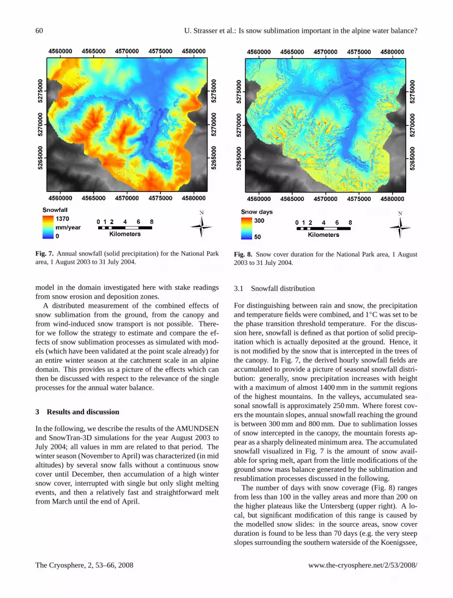
Figure 7. Annual snowfall (solid precipitation) for the National Park area, August 1, 2003 to
July 31, 2004.
30
Fig. 7. Annual snowfall (solid precipitation) for the National Parkarea, 1 August 2003 to 31 July 2004.
model in the domain investigated here with stake readingsfrom snow erosion and deposition zones.
A distributed measurement of the combined effects ofsnow sublimation from the ground, from the canopy andfrom wind-induced snow transport is not possible. There-for we follow the strategy to estimate and compare the ef-fects of snow sublimation processes as simulated with mod-els (which have been validated at the point scale already) foran entire winter season at the catchment scale in an alpinedomain. This provides us a picture of the effects which canthen be discussed with respect to the relevance of the singleprocesses for the annual water balance.
3 Results and discussion
In the following, we describe the results of the AMUNDSENand SnowTran-3D simulations for the year August 2003 toJuly 2004; all values in mm are related to that period. Thewinter season (November to April) was characterized (in midaltitudes) by several snow falls without a continuous snowcover until December, then accumulation of a high wintersnow cover, interrupted with single but only slight meltingevents, and then a relatively fast and straightforward meltfrom March until the end of April.
732 733 Figure 8. Snow cover duration for the National Park area, August 1, 2003 to July 31, 2004.
31
Fig. 8. Snow cover duration for the National Park area, 1 August2003 to 31 July 2004.
3.1 Snowfall distribution
For distinguishing between rain and snow, the precipitationand temperature fields were combined, and 1◦C was set to bethe phase transition threshold temperature. For the discus-sion here, snowfall is defined as that portion of solid precip-itation which is actually deposited at the ground. Hence, itis not modified by the snow that is intercepted in the trees ofthe canopy. In Fig. 7, the derived hourly snowfall fields areaccumulated to provide a picture of seasonal snowfall distri-bution: generally, snow precipitation increases with heightwith a maximum of almost 1400 mm in the summit regionsof the highest mountains. In the valleys, accumulated sea-sonal snowfall is approximately 250 mm. Where forest cov-ers the mountain slopes, annual snowfall reaching the groundis between 300 mm and 800 mm. Due to sublimation lossesof snow intercepted in the canopy, the mountain forests ap-pear as a sharply delineated minimum area. The accumulatedsnowfall visualized in Fig. 7 is the amount of snow avail-able for spring melt, apart from the little modifications of theground snow mass balance generated by the sublimation andresublimation processes discussed in the following.
The number of days with snow coverage (Fig. 8) rangesfrom less than 100 in the valley areas and more than 200 onthe higher plateaus like the Untersberg (upper right). A lo-cal, but significant modification of this range is caused bythe modelled snow slides: in the source areas, snow coverduration is found to be less than 70 days (e.g. the very steepslopes surrounding the southern waterside of the Koenigssee,
The Cryosphere, 2, 53–66, 2008 www.the-cryosphere.net/2/53/2008/

U. Strasser et al.: Is snow sublimation important in the alpine water balance? 61
734 735
736
Figure 9. Modelled total winterly snow sublimation losses from the snow surface in the
National Park area (2003/2004).
32
Fig. 9. Modelled total winterly snow sublimation losses from thesnow surface in the National Park area (2003/2004).
or the northwestern edge of the Lattengebirge in the north ofthe Park area). On the other hand, some accumulation ar-eas in the valleys remain snow-covered for more than 300days (at the run-out zones of the couloir gullies at the foot ofsteep mountain slopes). Consequently, some of these regionscoincide with the locations of the existing glaciers (Blaueis-gletscher and Watzmanngletscher).
3.2 Ground snow sublimation and resublimation
The processes of sublimation and resublimation at an ex-posed snow surface are associated with simultaneous adjust-ment of both the thermal energy and the water content ofthe affected snow layer. According to our previous consider-ations, mechanically induced turbulence is the main mech-anism for the transport of latent heat between the surfaceand the atmosphere. Its efficiency depends on the irregularand chaotic small scale motion in the surface layer air flow.Generally, one prerequisite for sublimation is a negative sat-uration deficit, and available energy for the phase transition.At night, sublimation can therefore occur only under verydry and warm conditions with stable stratification, usuallywithin katabatic flow layers, when the sensible heat flux com-pensates for longwave emission (usually in the range of 0 to−70 W/m2).
For the purpose considered here, the latent heat flux canbe parameterized using empirically derived bulk formulasof the type of Eq. (1). Such are based on flux-variance-relationships and assuming kinematic latent fluxes can be
737 738
739
Figure 10. Modelled total winterly snow yield by resublimation to the snow surface in the
National Park area (2003/2004).
33
Fig. 10. Modelled total winterly snow yield by resublimation to thesnow surface in the National Park area (2003/2004).
calculated from the product of variances of vertical windspeed and water vapour (Foken, 2003); the variances are es-timated using mean horizontal wind speeds and water vapourdifferences (Weber, 2007). Utilizing this approach togetherwith Eq. (2), the mass flux form the snow surface to the at-mosphere or vice versa were hourly computed. Resublima-tion was only considered if snow is present at the ground.Required inputs of wind speed and relative humidity at eachtime step were provided using the same spatial distributionprocedure as used for the other meteorological variables (seeSect. 2.2.1). Resulting rates of sublimation mass loss and re-sublimation mass gain are considered in the hourly modellingof the mass balance of the snow cover. Figures 9 and 10 showthe accumulated seasonal patterns of sublimation and resub-limation at the ground surface for the National Park area.
Minimum ground snow sublimation of only a few mm wassimulated for the valley areas where the snow cover durationwas short, wind speeds were low and turbulent mixing at thesnow surface was limited (snow cover duration is illustratedin Fig. 8). At higher elevations, sublimation losses generallyincrease, with maxima of approximately 180 mm occurringin the summit regions. Highest sublimation occurs at loca-tions where snow is exposed to relatively high wind speeds(e.g., on the summit crests of Hochkalter and Watzmann, thestart and end points of the profile transect in Fig. 3). Forestcanopy areas represent local minima for ground snow subli-mation (10 mm to 30 mm). In these areas not only the amountof snow reaching the ground is reduced, but also incoming ra-diation and wind speed are less, and humidity is higher than
www.the-cryosphere.net/2/53/2008/ The Cryosphere, 2, 53–66, 2008

62 U. Strasser et al.: Is snow sublimation important in the alpine water balance?
740 741
742
Figure 11. Modelled total winterly snow sublimation from the canopies in the National Park
area (2003/2004).
34
Fig. 11. Modelled total winterly snow sublimation from thecanopies in the National Park area (2003/2004).
in the open. Couloirs and very steep slopes where most ofthe snow is removed by snow slides are also areas of com-parably low seasonal sublimation amount, results are in therange of 50 mm. Steep rock faces are represented as brightbands around the mountain plateau massifs (e.g., Reiter Almor Untersberg), here the snow that has slided down accumu-lates and often remains until late spring. The ground resub-limation picture (Fig. 10) reveals small values of 10 mm to20 mm in the most areas. High maximum values of more than200 mm can be found in the small snow deposition zoneswhere the snow slides are retained and accumulate: here, thesnow covered period lasts until summer (see Fig. 8), and con-sequently, frequent warm air and high water vapour pressureconditions in the surface layer enable an efficient latent fluxtowards the snow surface.
3.3 Canopy snow sublimation
In general, sublimation of snow intercepted in the trees ofa mountain canopy increases with (a) larger LAI, (b) higherair temperature, (c) more incoming solar radiation, (d) lessatmospheric moisture, and (e) higher wind speed and thusmore efficient turbulent mixing, at least up to a certain windspeed threshold. In Fig. 11 the sublimation rates have beenaccumulated to a seasonal total of sublimation SWE lossfor the National Park canopies. Resulting total sublima-tion ranges between approximately 30 mm (mountain pinestand at the Reiter Alm) and typically around 200 mm forthe 30 m and higher spruce stands east of the Koenigssee.
743 744
745
Figure 12. Modelled total winterly snow sublimation from wind-induced snow transport in the
turbulent suspension layer in the National Park area (2003/2004).
35
Fig. 12. Modelled total winterly snow sublimation from wind-induced snow transport in the turbulent suspension layer in the Na-tional Park area (2003/2004).
Maximum values of more than 250 mm can be found forvery dense stands in well ventilated, south-exposed slopes.Generally, frequent smaller snowfall events during winter re-sult in higher total sublimation amount than do intensive butsingular events, since the interception storage is limited andhence precipitation surplus falls to the ground. Hence, it isthe frequency and duration of snow undergoing the intercep-tion processes that governs total sublimation amount. Snowthat does not sublimate and therefore remains within the in-terception storage can melt and fall down to the ground later;this process is computed with a temperature-index model fol-lowing Pellicciotti et al. (2005).
3.4 Sublimation of snow from turbulent suspension
For the simulations of total winter snow sublimationlosses due to wind-induced snow transport discussed here,SnowTran-3D was run with the same DEM and meteorolog-ical forcing as AMUNDSEN. Only wind speed and directiondata were provided using a library of local wind fields sim-ulated with the Penn State University – National Center forAtmospheric Research MM5 model (Grell et al., 1995), ap-plying the procedure described in Bernhardt et al. (2008a).The efficiency of the sublimation process during blowing-snow events depends on the amount of snow in the simu-lated layers of saltation and turbulent suspension. Accumu-lated blowing-snow sublimation rates for winter 2003/2004are illustrated in Fig. 12. Although the areas of significant
The Cryosphere, 2, 53–66, 2008 www.the-cryosphere.net/2/53/2008/

U. Strasser et al.: Is snow sublimation important in the alpine water balance? 63
746 747
748
749
Figure 13. Modelled total winterly snow sublimation from the ground, the canopies and from
wind-induced snow transport in the turbulent suspension layer in the National Park area
(2003/2004).
36
Fig. 13.Modelled total winterly snow sublimation from the ground,the canopies and from wind-induced snow transport in the turbulentsuspension layer in the National Park area (2003/2004).
sublimation losses due to turbulent suspension are spatiallylimited (below 1800 m a.s.l. they are negligibly small), theeffect is very significant at the local (pixel) scale: at the sum-mit crests and ridges of the mountain massifs of Hochkalterand Watzmann, more than 1000 mm of SWE are modelled tosublimate into the atmosphere. At such wind-exposed loca-tions with frequent occurrence of high wind speeds the pro-cesses of snow entrainment and transport are very efficient,and so is moisture transport across the top of the boundarylayer in the air masses above.
3.5 Distribution of total snow sublimation
Total snow sublimation losses from the winter snow cover isgiven by the sum of the three described processes (Fig. 13).Sublimation from the ground and the canopy interceptionstorage are similar in their seasonal efficiency and represent atotal loss of approximately 100 mm of SWE over quite exten-sive areas in our test site. Only in a small, but exceptionallydense spruce stand east of the Koenigssee almost 300 mmof SWE sublimates from the canopy due to the high effec-tive LAI there (see Fig. 4). The general shape of the groundsublimation profile is driven by the exponential expressionof the water vapour calculation required for solving Eq. (1).Sharp edges result from the snow slide erosion/deposition ar-eas where the melt out is distinctly different from that in theother regions in the same altitude. Minima can result fromsouth-exposed areas where the melt out is earlier, from areas
750 751
752
753
754
Figure 14. Simulated contributions to annual snow sublimation from the ground, canopy
intercepted snow and wind-induced, turbulent suspended snow along a cross-section from
Hochkalter (2607 m a.s.l.) through the Wimbachtal to Watzmann (2713 m a.s.l.) (see also fig.
3).
37
Fig. 14. Simulated contributions to annual snow sublimationfrom the ground, canopy intercepted snow and wind-induced, tur-bulent suspended snow along a cross-section from Hochkalter(2607 m a.s.l.) through the Wimbachtal to Watzmann (2713 m a.s.l.)(see also Fig. 3).
where snow is laterally removed, or from beneath trees whereless snow is accumulated at the ground. Sublimation ofsnow from turbulent suspension during blowing-snow eventsis generally much more efficient, but very limited in its localextent. In Fig. 14, all modelled sublimation losses are illus-trated for a profile transect from Hochkalter (2607 m a.s.l.)across the Wimbach valley to the Watzmann (2713 m a.s.l.),both summits being prominent culmination points. At bothsides of the profile transect, sublimation rates increase sig-nificantly due to the contribution from turbulent suspensionduring wind-induced snow transport. In the spatial represen-tation (Fig. 15) this effect is dominant over the other two:the wind-exposed mountain crests appear as maximum areaswith total sublimation amount of up to 1200 mm. Dividingthis picture by the seasonal snowfall distribution (Fig. 7) re-sults in the fraction of sublimation losses from total seasonalsnowfall precipitation as shown in Fig. 15. This fractionamounts to 10 to 20% in large valley areas and on moun-tain slopes, up to 50% in the denser canopy stands, and up to90% at the highest mountain crests.
Finally, it is possible to determine the relative contribu-tion of the simulated components of the winter water bal-ance computed as mean quantities over the domain (Ta-ble 2). Snowmelt is by far the dominant element (more thansnowfall, despite the different losses, due to rain-on-snow),while the contribution of the ground and wind-induced trans-port sublimation fluxes is small (6.9 and 4.1%, respectively).Sublimation from snow previously intercepted in the canopycan be classified as moderate (13.9%), due to the efficiencyof the process, and the relatively large proportion of forestedareas in the catchment. With only 2.4% of snowfall, groundcondensation contribution is the smallest. At the local scale,interpolated precipitation, as well as modelled snowmeltand sublimation during wind-induced snow transport areimportant water balance quantities, whereas the importance
www.the-cryosphere.net/2/53/2008/ The Cryosphere, 2, 53–66, 2008

64 U. Strasser et al.: Is snow sublimation important in the alpine water balance?
Table 2. Contributions relative to total snowfall and scale-dependent significance of the winter water balance components as modelled withAMUNDSEN for the Berchtesgaden National Park domain for 2003/2004. The additional amount of snowmelt is caused by rain-on-snow.
Water balance component Seasonal amount (mm) Relative contribution (%) Local significance Regional significance
Snowfall +651.1 +100.0 high highGround resublimation +15.8 +2.4 moderate smallGround sublimation −44.9 −6.9 moderate smallCanopy sublimation −84.9 −13.0 moderate moderateSublimation from turbulent suspension −26.5 −4.1 high smallSnowmelt −693.1 −106.5 high high
755 756
757
Figure 15. Fraction of modelled total winterly snow sublimation losses of total winterly
snowfall precipitation in the National Park area (2003/2004).
38
Fig. 15. Fraction of modelled total winterly snow sublimationlosses of total winterly snowfall precipitation in the National Parkarea (2003/2004).
of condensation and sublimation of snow at the ground andfrom the canopy is moderate. At the regional scale, precip-itation and snowmelt still represent important water balancequantities, whereas the contributions of sublimation from thecanopy are moderate, while the ones of condensation andsublimation of snow at the ground as well as from wind-induced snow transport are small. Lateral redistribution ofsnow does not affect the water balance of the entire snowstorage system, but locally the amount of snow affected maybe highly significant.
4 Conclusions
We applied the combined, physically based modelsAMUNDSEN and SnowTran-3D to simulate snow sublima-
tion from the ground, from the forest canopy, and from turbu-lent suspension during wind-induced snow transport in a highmountain region. Our results indicate the seasonal pattern ofaccumulated snow sublimation is highly variable, with thecontributions from ground being spatially relatively homo-geneous and adding to about 100 mm of SWE. This processis most efficient where the snow cover duration is long andwind speeds are generally high, i.e. in the upper regions ofthe test site. Sublimation from canopy-intercepted snow ismost efficient in stands characterized by high trees or in verydense stands, and periods with frequent snowfall events. Re-sults indicate total SWE losses in the range of 100 mm, but invery dense stands with exceptional high LAI almost 300 mmof SWE is transported back into the atmosphere, but the spa-tial extent of such canopy types is limited. Most efficientis sublimation from turbulent transport during blowing-snowevents: on the most exposed mountain ridges, accumulatedsublimation losses add up to more than 1000 mm of SWE,due to the long duration of snow availability and efficientturbulence at the frequent high wind speed situations. Thetotal fraction of these sublimation losses from winter precip-itation is between 10 and 90%. This amount of precipitationis not stored as snow on the ground, and does not contributeto later melt.
We can conclude that snow sublimation does have a sig-nificant effect on the alpine water balance, notably in areaswhere wind-induced snow transport is frequent and efficient.However, these areas are spatially relatively limited. Sincethe topography of our test site can be regarded as relativelyextreme, our results can be interpreted as upper limits, at leastfor alpine measures. In the valley regions the effect of snowsublimation from the ground and from the canopies is mod-erate; there, our results are in accordance with the literature(Hood et al., 1999; Marks et al., 1992; Kattelmann und Elder,1991; Kaser, 1983).
Important aspects arise if the presented model algorithmsare included as part of water balance modelling. Generally,in high mountain areas the precipitation inputs are consideredto be the most inaccurate quantity, particularly for snowfallwhich is extremely difficult to measure. Considering oursnow sublimation estimates, the usually assumed precipita-tion underestimation in the measurements is even larger by
The Cryosphere, 2, 53–66, 2008 www.the-cryosphere.net/2/53/2008/

U. Strasser et al.: Is snow sublimation important in the alpine water balance? 65
the respective sublimation amount. If the relevant water ex-change processes between the snow surface and the atmo-sphere can be accurately calculated, atmospheric precipita-tion distributions could be estimated with an inverse mod-elling approach (e.g., Liston and Sturm, 2002): for that pur-pose, we are intending to couple our snow processes mod-els with a runoff scheme, and compare simulated streamflowwith observations.
Finally, the processes modelled here are important withrespect to understanding the long-term snow cover dynam-ics in high mountain regions under the influence of changingclimatic conditions: the high sublimation losses from tur-bulent suspension at mountain crests are limited to compa-rably small areas and may not affect alpine water balancessignificantly. However, if not considered in long-term sim-ulations, snow can accumulate unrealistically in areas wheremelting processes are relatively inefficient or limited in theirseasonal duration. Additionally, the consideration of gravita-tional snow transport is required for consistently accountingfor the removal of snow from higher ridge crests and deposit-ing it in the transition zones at the foot of mountain slopes.In that respect, snow sublimation processes and transport byslides is a prerequisite for obtaining realistic results in thesimulated snow cover patterns, and for an adequate represen-tation of accumulation and ablation in the long-term mod-elling of high mountain snow cover and glacier response toclimate change.
Acknowledgements.We are thankful to all who provided theirhelp and assistance for writing the manuscript of this paper, inparticular Helmut Franz, Volkmar Konnert and Michael Vogelfrom the National Park Administration (Berchtesgaden) for dataprocessing and subsidizing our activities. We also acknowledge thecontributions of the team of Park rangers for their technical supportand valuable expertise for the field work. The meteorologicaldata were generously supplied by the Administration of Salzburg(Untersberg), the Administration Union of the Berchtesgaden-Koenigssee region (Schoenau) and the Bavarian AvalancheWarning Center of the State Office for Environment in Munich(Jenner, Reiter Alm, Kuehroint and Funtenseetauern). MichaelWarscher (Munich) set up the database for automatically collectingand distributing the meteorological records. The developmentof AMUNDSEN has profited from the valuable contributions ofMonika Prasch (Munich), Javier Corripio (Innsbruck) and StephanGruber (Zurich). A significant part of the grants with which thiswork was facilitated has been provided by the GLOWA-Danubeproject (http://www.glowa-danube.de/).
Edited by: M. Van den Broeke
References
Bernhardt, M., Zangl, G., Liston, G. E., Strasser, U., and Mauser,W.: Using wind fields from a high resolution atmospheric modelfor simulating snow dynamics in mountainous terrain, Hydrol.Process., 27, in press, 2008a.
Bruland, O., Liston, G. E., Vonk, J., Sand, K., and Killingtveit,A.: Modelling the snow distribution at two high arctic sites atSvalbard, Norway, and at an Alpine site in central Norway, Nord.Hydrol., 35, 191–208, 2004.
Burlando, P., Pellicciotti, F., and Strasser, U.: Modelling Mountain-ous Water Systems Between Learning and Speculating, Lookingfor Challenges, Nord. Hydrol., 33(1), 47–74, 2002.
Chen, J. M., Rich, P. M., Gower, S. T., Norman, J. M., and Plummer,S.: Leaf area index of boreal forests: Theory, techniques, andmeasurements, J. Geophys. Res., 102, 29 429–29 443, 1997.
Cionco, R. M.: Analysis of canopy index value for various canopydensities, Bound.-Lay. Meteorol., 15, 81–93, 1978.
Corripio, J.: Vectorial algebra algorithms for calculating terrain pa-rameters from DEMs and solar radiation modelling in mountain-ous terrain, Int. J. Geogr. Inf. Sci., 17(1), 1–23, 2003.
Durot, K.: Modelisation hydrologique distribuee du bassin ver-sant nivo-pluvial de Sarennes. Validation des donnees d’entreeet developement d’un module de fonte nivale sous foret, Ph.D.dissertation, LTHE, Grenoble, 332 pp., 1999.
Foken, T.: Angewandte Meteorologie – MikrometeorologischeMethoden, Springer Verlag, ISBN 3540003223, 289 pp., Berlin,2003.
Greene, E. M., Liston, G. E., and Pielke, R. A.: Simulation of abovetreeline snowdrift formation using a numerical snow-transportmodel, Cold Reg. Sci. Tech., 30, 135–144, 1999.
Grell, G. A., Dudhia, J., and Stauffer, D. R.: Tech. Note NCAR/TN–398+STR, Boulder, Colorado, 1995.
Greuell, W., Knap, W., and Smeets, P.: Elevational changes in mete-orological variables along a midlatitude glacier during summer,J. Geophys. Res., 102(22), 25 941–25 954, 1997.
Gruber, S.: A mass-conserving fast algorithm to parameterize grav-itational transport and deposition using digital elevation models,Water Resour. Res., 43, W06412, doi:10.1029/2006WR004868,2007.
Hammel, K. and Kennel, M.: Charakterisierung und Analyseder Wasserverfugbarkeit und des Wasserhaushaltes von Wald-standorten in Bayern mit dem Simulationsmodell BROOK90,Forstliche Forschungsberichte Munchen, 185, 148 pp., 2001.
Hasholt, B., Liston, G. E., and Knudsen, N. T.: Snow-distributionmodelling in the Ammassalik region, south east Greenland,Nord. Hydrol., 34, 1–16, 2003.
Hiemstra, C. A., Liston, G. E., and Reiners, W. A.: Snow redistribu-tion by wind and interactions with vegetation at upper treeline inthe Medicine Bow Mountains, Wyoming, USA, Arct., Antarct.Alp. Res., 34, 262–273, 2002.
Hiemstra, C. A., Liston, G. E., and Reiners, W. A.: Observing, mod-elling, and validating snow redistribution by wind in a Wyomingupper treeline landscape, Ecol. Mod., 197, 35–51, 2006.
Hood, E., Williams, M., and Cline, D.: Sublimation from a seasonalsnowpack at a continental, mid-latitude alpine site, Hydrol. Pro-cess., 13, 1781–1797, 1999.
Kattelmann, R. and Elder, K.: Hydrologic characteristics and waterbalance of an alpine basin in the Sierra Nevada, Water Resour.Res., 27, 1553–1562, 1991.
Kaser, G.:Uber die Verdunstung auf dem Hintereisferner, Ztschr. f.Gletschk. Glazialgeol., 19(2), 149–162, 1983.
Konnert, V.: Standortkarte Nationalpark Berchtesgaden.Forschungsbericht, 49, Nationalpark Berchtesgaden, Berchtes-gaden, 151 pp., 2004.
www.the-cryosphere.net/2/53/2008/ The Cryosphere, 2, 53–66, 2008

66 U. Strasser et al.: Is snow sublimation important in the alpine water balance?
Kuchment, L. S. and Gelfan, A. N.: The determination of thesnowmelt rate and the meltwater outflow from a snowpack formodelling river runoff generation, J. Hydrol., 179, 23–36, 1996.
Lang, H.: Is evaporation an important component in high alpinehydrology?, Nord. Hydrol., 12, 217–224, 1981.
Lee, L. W.: Sublimation of snow in a turbulent atmosphere, Ph.D.dissertation, University of Wyoming, 162 pp., 1975.
Link, T. and Marks, D.: Point simulation of seasonal snow cover dy-namics beneath boreal forest canopies, J. Geophys. Res, 104(22),27 841–27 857, 1999.
Liston, G. E. and Sturm, M.: A snow-transport model for complexterrain, J. Hydromet., 3, 646–659, 1998.
Liston, G. E., and Sturm, M.: Winter precipitation patterns in Arc-tic Alaska Determined from a Blowing-Snow Model and Snow-Depth Observations, Nord. Hydrol., 35, 325–334, 2002.
Liston, G. E. and Elder, K.: A Distributed Snow-Evolution Model-ing System (SnowModel), J. Hydromet., 7(2), 217–234, 2006.
Liston, G. E., Winther, J. G., Bruland, O., Elvehoy, H., Sand, K.,and Karlof, L.: Snow and blue-ice distribution patterns on thecoastal Antarctic Ice Sheet, Antarc. Sci., 12, 69–79, 2000.
Liston, G. E., Haehnel, R. B., Sturm, M., Hiemstra, C. A., Bere-zovskaya, S., and Tabler, R. D.: Simulating complex snow distri-butions in windy environments using SnowTran-3D, J. Glaciol.,53(181), 241–256, 2007.
Marks, D., Dozier, J., and Davis, R. E.: Climate and energy ex-change at the snow surface in the alpine region of the SierraNevada: 1. Meteorological measurements and monitoring, Wa-ter Resour. Res., 17, 609–627, 1992.
Marsh, P.: Snowcover formation and melt: recent advances and fu-ture prospects, Hydrol. Process., 13, 2117–2134, 1999.
Montesi, J., Elder, K., Schmidt, R. A., and Davis, R. E.: Sublima-tion of intercepted snow within a subalpine forest canopy at twoelevations, J. Hydromet., 5, 763–773, 2004.
Obled, Ch.: Modele mathematique de la fusion nivale, Ph.D. dis-sertation, Institut de mecanique de Grenoble, Grenoble, 170 pp.,1971.
Pellicciotti, F., Brock, B., Strasser, U., Burlando, P., Funk, M., andCorripio, J.: An enhanced temperature-index glacier melt modelincluding shortwave radiation balance: development and test-ing for Haut Glacier d’Arolla, Switzerland, J. Glaciol., 51(175),573–587, 2005.
Pomeroy, J. W. and Gray, D. M.: Snowcover: Accumulation, Re-location, and Management. National Hydrology Research Insti-tute, Saskatoon, Canada, NHRI Science Report, 7, Saskatoon,144 pp., 1995.
Pomeroy, J. W. and Dion, K.: Winter radiation extinction and re-fection in a boreal pine canopy: measurements and modelling,Hydrol. Process., 10, 1591–1608, 1996.
Pomeroy, J. W. and Essery, R. L. H.: Turbulent fluxes during blow-ing snow: field test of model sublimation prediction, Hydrol.Process., 13, 2963–2975, 1999.
Pomeroy, J. W., Gray, D.M., and Landine, P. G.: The Prairie Blow-ing Snow Model – characteristics, validation, operation, J. Hy-drol., 144, 165–192, 1993.
Pomeroy, J. W., Gray, D. M., Shook, K. R., Toth, B., Essery, R. L.H., Pietroniero, A., and Hedstrom, N.: An evaluation of snowaccumulation and ablation for land surface modelling, Hydrol.Process., 12, 2339–2367, 1998.
Pomeroy, J. W., Gray, D. M., Hedstrom, N., and Janowicz, J. R.:
Prediction of seasonal snow accumulation in cold climate forests,Hydrol. Process., 16, 3543–3558, 2002.
Prasad, R., Tarboton, D. G., Liston, G. E., Luce, C. H., and Seyfried,M. S.: Testing a blowing snow model against distributed snowmeasurements at Upper Sheep Creek, Idaho, United States ofAmerica, Water Resour. Res., 37, 1341–1356, 2001.
Prasch, M., Strasser, U., and Mauser, W.: Validation of a phys-ically based snow model for the simulation of the accumu-lation and ablation of snow (ESCIMO), in: Proceedings ofthe Alpine*Snow*Workshop (www.alpinesnowworkshop.org),edited by: Strasser, U. and Vogel, M., Munich, October 5–6,2006, Germany, Berchtesgaden National Park research report,53, 2007.
Rohrer, M. B.: Die Schneedecke im Schweizer Alpenraum und ihreModellierung, Zuer. Geogr. Schriften, 49, 178 pp., 1992.
Sovilla, B.: Field experiments and numerical modelling of mass en-trainment and deposition in snow avalanches, Ph.D. dissertation,ETH Zurich, Switzerland, 2004.
Strasser, U. and Mauser, W.: Modelling the Spatial and TemporalVariations of the Water Balance for the Weser Catchment 1965–1994, J. Hydrol., 254(1–4), 199–214, 2001.
Strasser, U. and Etchevers, P.: Simulation of Daily Dischargesfor the Upper Durance Catchment (French Alps) Using SubgridParameterization for Topography and a Forest Canopy ClimateModel, Hydrol. Process., 19, 2361–2373, 2005.
Strasser, U., Etchevers, P., and Lejeune, Y.: Intercomparision oftwo Snow Models with Different Complexity Using Data froman Alpine Site, Nord. Hydrol., 33(1), 15–26, 2002.
Strasser, U., Corripio, J., Brock, B., Pellicciotti, F., Burlando, P.,and Funk, M.: Spatial and Temporal Variability of Meteorologi-cal Variables at Haut Glacier d’Arolla (Switzerland) During theAblation Season 2001: Measurements and Simulations, J. Geo-phys. Res., 109(3), D03103, doi:10.1029/2003JD003973, 2004.
Strasser, U., Franz, H., and Mauser, W.: Distributed modellingof snow processes in the Berchtesgaden National Park (Ger-many), in: Proceedings of the Alpine*Snow*Workshop (www.alpinesnowworkshop.org), edited by: Strasser, U. and Vogel, M.,Munich, October 5–6, 2006, Germany, Berchtesgaden NationalPark research report, 52, 2008.
Suzuki, K. and Nakai, Y.: Canopy snow influence on water and en-ergy balances in a coniferous forest plantation in northern Japan,J. Hydrol., 352, 126–138, 2008.
Tribbeck, M. J., Gurney, R., Morris, E. M., and Pearson, D. W. C.:A new Snow-SVAT to simulate the accumulation and ablationof seasonal snow beneath a forest canopy, J. Glaciol., 50(169),171–182, 2004.
US Army Corps of Engineers: Snow Hydrology, US Army Corpsof Engineers, North Pacific Division, Portland, 437 pp., 1956.
Weber, M.: A parameterization for the turbulent fluxes overmelting surfaces derived from eddy correlation measure-ments, in: Proceedings of the Alpine*Snow*Workshop (www.alpinesnowworkshop.org), edited by: Strasser, U. and Vogel, M.,Munich, October 5–6, 2006, Germany, Berchtesgaden NationalPark research report, Nr. 53, 2007.
Zappa, M., Pos, F., Strasser, U., Warmerdam, P., and Gurtz, J.:Seasonal water balance of an Alpine catchment as evaluated bydifferent methods for spatially distributed snowmelt modelling,Nord. Hydrol., 34(3), 179–202, 2003.
The Cryosphere, 2, 53–66, 2008 www.the-cryosphere.net/2/53/2008/


