Embed Size (px)
Citation preview
Environmental Impact Assessment & Environment Management Plan
IYLI GURUNATH IRON ORE MINE
MES/EIA/Sec-1/20-20
ENVIRONMENTAL IMPACT ASSESSMENT &
ENVIRONMENT MANAGEMENT PLAN
Iyli Gurunath Iron Ore Mine ML Area : 20.23Ha.
(20.35 Ha as per CEC Survey)
Ramgad - village of
Sandur-Taluk, Ballari - District,
Karnataka State
PROPONENT
M/s. RAMGAD MINERALS & MINING LIMITED
Hosapete, Ballari District
November-2021
EIA Consultant
MINERAL ENGINEERING SERVICES 25/XXV, Club Road, BALLARI-583103, Karnataka
email : [email protected]
Tel/Fax 08392-267421, Mob: 091-9448367421,
NABET QCI No: ORG000756
Environmental Impact Assessment & Environment Management Plan
IYLI GURUNATH IRON ORE MINE
Page | 1
MINERAL ENGINEERING SERVICES
EIA & EMP REPORT
Environmental Impact Assessment & Environment Management Plan
IYLI GURUNATH IRON ORE MINE
Page | 2
MINERAL ENGINEERING SERVICES
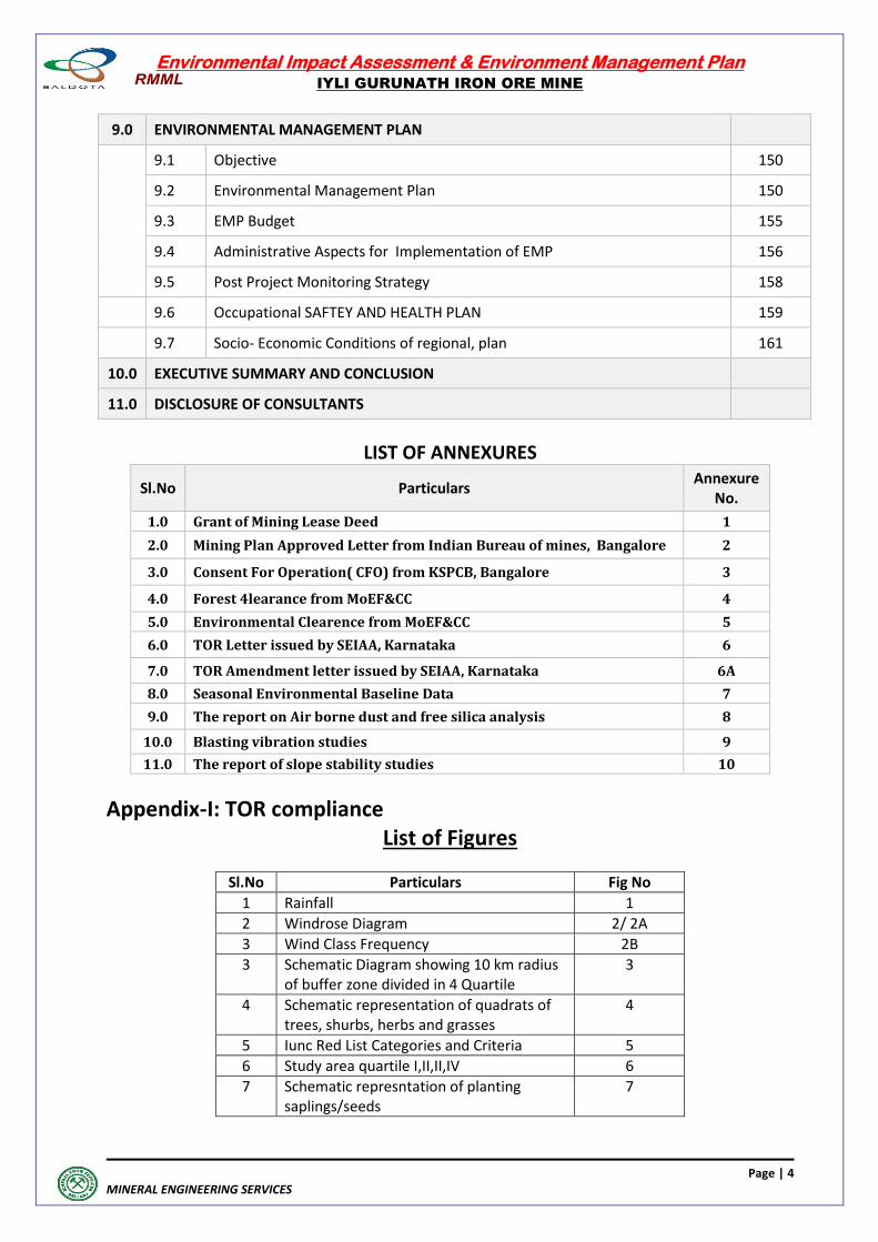
CONTENTS
Chapter No Description Page No.
1.0 INTRODUCTION
1.0 Introduction 10
1.1 Purpose of the Report 10
1.2 Identification of Project Proponent & Project 11
1.3. Brief Description of Nature, Size And Location of The Project 11
1.4 Scope of the Study 11
2.0 PROJECT DESCRIPTION
2.1 Type & Project Description 15
2.2 Need for the project 16
2.3 Location of the map 16
2.4 Size or Magnitude of Operation 16
2.5 Geology 16
2.6 Drainage 18
2.7 Hydrogeology 19
2.8 Man Power 21
2.9 Minerals and Mining History 21
2.10 Reserves & Resources 21
2.11 Mining Operation 21
2.12 Assessment of New & Untested technology for the risk of Technological Failure
23
2.13 Proposed Schedule for Approval and Implementation 23
3.0 DESCRIPTION OF THE ENVIRONMENT
3.1 Study Area 26
3.2 Study Period 26
3.3 Environmental Components 27
3.4 Methodology 27
3.5 Base line Data & Base Maps –Environmental Components 31
3.6 Land Environment 45
3.7 Ecology and Biodiversity Baseline Data 46
3.8 Social Environment 64
3.9 Traffic Density 82
Environmental Impact Assessment & Environment Management Plan
IYLI GURUNATH IRON ORE MINE
Page | 3
MINERAL ENGINEERING SERVICES
4.0 ANTICIPATED ENVIRONMENTAL IMPACTS & MITIGATION MEASURES
4.1 Environmental Impacts 84
4.2 Air Quality Prediction 88
4.3 Impact of Noise Level & Vibration on Environment and Proposed Mitigative Measures
94
4.4 Impact On Water And Proposed Migative Measure 96
4.5 Soild Waste mangament 97
4.6 Land use & Impact due to rehabilitation of a completed project & Mitigative Measures
98
4.7 Impact on Biological Environment 98
4.8 Impact on Society/Public 112
4.9 Assessment of Significance of Impacts 116
4.10 Impact on Local Transport infrastructure 116
5.0 ANALYSIS OF ALTERNATIVES (TECHNOLOGY & SITE)
5.1 Alternative Technologies 118
5.2 Alternative Sites 118
6.0 ENVIRONMENTAL MONITORING PROGRAMME
6.0 General 120
6.1 Techinal Aspects 120
7.0 ADDITIONAL STUDIES
7.1 Public Consultation 127
7.2 Risk Assessment 127
7.3 Disasters 136
7.4 Occupational Health & Safety 136
7.5 Social Impact Assessment 140
7.6 R & R Action Plan 140
7.7 Care and maintainance during temporary discontinuance 140
8.0 PROJECT BENEFITS
8.1 Socio – Economic Development 143
8.2 Environmental Benefits 147
8.3 Employment Opportunity 148
8.4 Contribution to the economy 148
Environmental Impact Assessment & Environment Management Plan
IYLI GURUNATH IRON ORE MINE
Page | 4
MINERAL ENGINEERING SERVICES
9.0 ENVIRONMENTAL MANAGEMENT PLAN
9.1 Objective 150
9.2 Environmental Management Plan 150
9.3 EMP Budget 155
9.4 Administrative Aspects for Implementation of EMP 156
9.5 Post Project Monitoring Strategy 158
9.6 Occupational SAFTEY AND HEALTH PLAN 159
9.7 Socio- Economic Conditions of regional, plan 161
10.0 EXECUTIVE SUMMARY AND CONCLUSION
11.0 DISCLOSURE OF CONSULTANTS
LIST OF ANNEXURES
Sl.No Particulars Annexure
No.
1.0 Grant of Mining Lease Deed 1
2.0 Mining Plan Approved Letter from Indian Bureau of mines, Bangalore 2
3.0 Consent For Operation( CFO) from KSPCB, Bangalore 3
4.0 Forest 4learance from MoEF&CC 4
5.0 Environmental Clearence from MoEF&CC 5
6.0 TOR Letter issued by SEIAA, Karnataka 6
7.0 TOR Amendment letter issued by SEIAA, Karnataka 6A
8.0 Seasonal Environmental Baseline Data 7
9.0 The report on Air borne dust and free silica analysis 8
10.0 Blasting vibration studies 9
11.0 The report of slope stability studies 10
Appendix-I: TOR compliance List of Figures
Sl.No Particulars Fig No
1 Rainfall 1
2 Windrose Diagram 2/ 2A
3 Wind Class Frequency 2B
3 Schematic Diagram showing 10 km radius of buffer zone divided in 4 Quartile
3
4 Schematic representation of quadrats of trees, shurbs, herbs and grasses
4
5 Iunc Red List Categories and Criteria 5
6 Study area quartile I,II,II,IV 6
7 Schematic represntation of planting saplings/seeds
7
Environmental Impact Assessment & Environment Management Plan
IYLI GURUNATH IRON ORE MINE
Page | 5
MINERAL ENGINEERING SERVICES
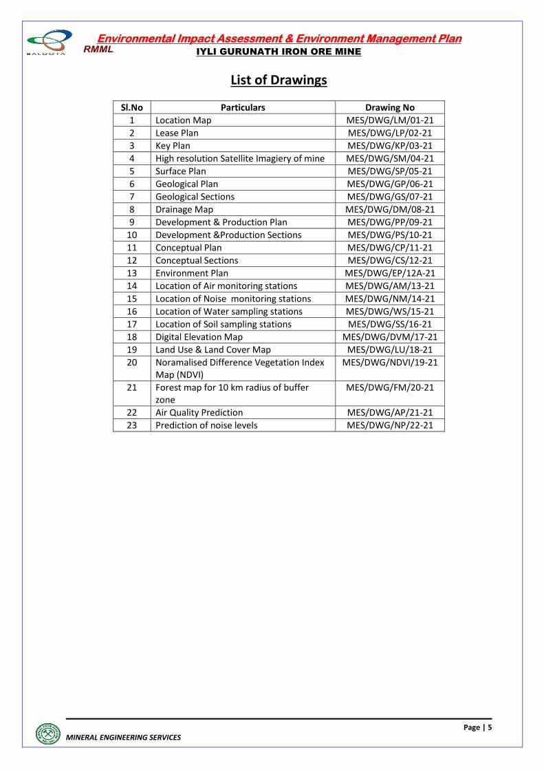
List of Drawings
Sl.No Particulars Drawing No
1 Location Map MES/DWG/LM/01-21
2 Lease Plan MES/DWG/LP/02-21
3 Key Plan MES/DWG/KP/03-21
4 High resolution Satellite Imagiery of mine MES/DWG/SM/04-21
5 Surface Plan MES/DWG/SP/05-21
6 Geological Plan MES/DWG/GP/06-21
7 Geological Sections MES/DWG/GS/07-21
8 Drainage Map MES/DWG/DM/08-21
9 Development & Production Plan MES/DWG/PP/09-21
10 Development &Production Sections MES/DWG/PS/10-21
11 Conceptual Plan MES/DWG/CP/11-21
12 Conceptual Sections MES/DWG/CS/12-21
13 Environment Plan MES/DWG/EP/12A-21
14 Location of Air monitoring stations MES/DWG/AM/13-21
15 Location of Noise monitoring stations MES/DWG/NM/14-21
16 Location of Water sampling stations MES/DWG/WS/15-21
17 Location of Soil sampling stations MES/DWG/SS/16-21
18 Digital Elevation Map MES/DWG/DVM/17-21
19 Land Use & Land Cover Map MES/DWG/LU/18-21
20 Noramalised Difference Vegetation Index Map (NDVI)
MES/DWG/NDVI/19-21
21 Forest map for 10 km radius of buffer zone
MES/DWG/FM/20-21
22 Air Quality Prediction MES/DWG/AP/21-21
23 Prediction of noise levels MES/DWG/NP/22-21
Environmental Impact Assessment & Environment Management Plan
IYLI GURUNATH IRON ORE MINE
Page | 6
MINERAL ENGINEERING SERVICES
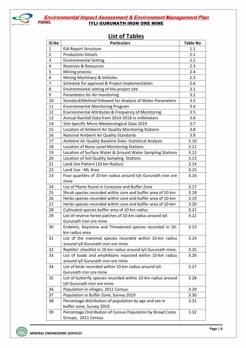
List of Tables Sl.No Particulars Table No
1 EIA Report Structure 1.1
2 Production Details 2.1
3 Environmental Setting 2.2
4 Reserves & Resources 2.3
5 Mining process 2.4
6 Mining Machinary & Vehicles 2.5
7 Schedule for approval & Project implementation 2.6
8 Environmental setting of the project site 3.1
9 Parameters for Air monitoring 3.2
10 Standard/Method followed for Analysis of Water Parameters 3.3
11 Environmental Monitoring Program 3.4
12 Envrionmental Attributes & Frequency of Monitoring 3.5
13 Annual Rainfall Data from 2014-2018 in millimeters 3.6
14 Site-Specific Micro-Meteorological Data 2019 3.7
15 Location of Ambient Air Quality Monitoring Stations 3.8
16 National Ambient Air Quality Standards 3.9
17 Ambient Air Quality Baseline Data- Statistical Analysis 3.10
18 Location of Noise Level Monitoring Stations 3.11
19 Location of Surface Water & Ground Water Sampling Stations 3.12
20 Location of Soil Quality Sampling Stations 3.13
21 Land Use Pattern (10 km Radius) 3.14
22 Land Use - ML Area 3.15
23 Four quartiles of 10-km radius around Iyli Gurunath iron ore mine
3.16
24 List of Plants found in Corezone and Buffer Zone 3.17
25 Shrub species recorded within core and buffer area of 10-km 3.18
26 Herbs species recorded within core and buffer area of 10-km 3.19
27 Herbs species recorded within core and buffer area of 10-km 3.20
28 Cultivated species buffer area of 10 km radius 3.21
29 List of reserve forest patches of 10-km radius around Iyli Gurunath iron ore mine
3.22
30 Endemic, Keystone and Threatened species recorded in 10-km radius area
3.23
31 List of the mammal species recorded within 10-km radius around Iyll Gurunath iron ore mine.
3.24
32 Reptiles’ checklist in 10-km radius around Iyli Gurunath mine. 3.25
33 List of toads and amphibians reported within 10-km radius around Iyli Gurunath iron ore mine
3.26
34 List of birds recorded within 10-km radius around Iyli Gurunath iron ore mine
3.27
35 List of butterfly species recorded within 10-km radius around Iyll Gurunath iron ore mine.
3.28
36 Population in villages, 2011 Census. 3.29
37 Population in Buffer Zone, Survey 2019 3.30
38 Percentage distribution of population by age and sex in buffer zone, Survey 2019.
3.31
39 Percentage Distribution of Census Population by Broad Caste Groups, 2011 Census
3.32
Environmental Impact Assessment & Environment Management Plan
IYLI GURUNATH IRON ORE MINE
Page | 7
MINERAL ENGINEERING SERVICES
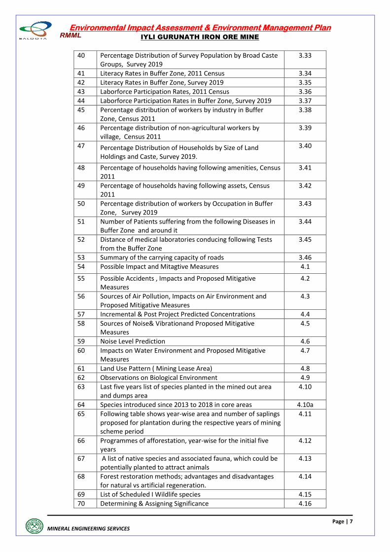
40 Percentage Distribution of Survey Population by Broad Caste Groups, Survey 2019
3.33
41 Literacy Rates in Buffer Zone, 2011 Census 3.34
42 Literacy Rates in Buffer Zone, Survey 2019 3.35
43 Laborforce Participation Rates, 2011 Census 3.36
44 Laborforce Participation Rates in Buffer Zone, Survey 2019 3.37
45 Percentage distribution of workers by industry in Buffer Zone, Census 2011
3.38
46 Percentage distribution of non-agricultural workers by village, Census 2011
3.39
47 Percentage Distribution of Households by Size of Land Holdings and Caste, Survey 2019.
3.40
48 Percentage of households having following amenities, Census 2011
3.41
49 Percentage of households having following assets, Census 2011
3.42
50 Percentage distribution of workers by Occupation in Buffer Zone, Survey 2019
3.43
51 Number of Patients suffering from the following Diseases in Buffer Zone and around it
3.44
52 Distance of medical laboratories conducing following Tests from the Buffer Zone
3.45
53 Summary of the carrying capacity of roads 3.46
54 Possible Impact and Mitagtive Measures 4.1
55 Possible Accidents , Impacts and Proposed Mitigative Measures
4.2
56 Sources of Air Pollution, Impacts on Air Environment and Proposed Mitigative Measures
4.3
57 Incremental & Post Project Predicted Concentrations 4.4
58 Sources of Noise& Vibrationand Proposed Mitigative Measures
4.5
59 Noise Level Prediction 4.6
60 Impacts on Water Environment and Proposed Mitigative Measures
4.7
61 Land Use Pattern ( Mining Lease Area) 4.8
62 Observations on Biological Environment 4.9
63 Last five years list of species planted in the mined out area and dumps area
4.10
64 Species introduced since 2013 to 2018 in core areas 4.10a
65 Following table shows year-wise area and number of saplings proposed for plantation during the respective years of mining scheme period
4.11
66 Programmes of afforestation, year-wise for the initial five years
4.12
67 A list of native species and associated fauna, which could be potentially planted to attract animals
4.13
68 Forest restoration methods; advantages and disadvantages for natural vs artificial regeneration.
4.14
69 List of Scheduled I Wildlife species 4.15
70 Determining & Assigning Significance 4.16
Environmental Impact Assessment & Environment Management Plan
IYLI GURUNATH IRON ORE MINE
Page | 8
MINERAL ENGINEERING SERVICES
71 Environmental Setting 5.1
72 Monitoring Schedule for Environmental Parameters 6.1
73 Risks,Cause & Control Measures 7.1
74 Proposed Community Development Activities 8.1
75 Annual Socio Economic expenditure proposed & CER 9.1 & 9.1A
76 Monitoring Schedule for Environmental Parameters 9.2
77 Environment setting of the project site 10.1
78 Annual Budget for Corporate Enivronment Responsibility (CER)
10.2
79 Annual Budget for CSR 10.3
Environmental Impact Assessment & Environment Management Plan
IYLI GURUNATH IRON ORE MINE
Page | 9
MINERAL ENGINEERING SERVICES
INTRODUCTION
Environmental Impact Assessment & Environment Management Plan
IYLI GURUNATH IRON ORE MINE
Page | 10
MINERAL ENGINEERING SERVICES
1.0 INTRODUCTION
The Iyli Gurunath iron ore mine is operated by Ramgad Mines & Minerals Limited (RMML) and
is one of the largest iron ore mines in the Ballari region of Karnataka. The mining lease is
situated on the hill-top of the Ramgad forest, Sandur Taluk, Ballari district, and was originally
granted to Sri Iyli Gurunath, over an area of 20.23 ha (20.35 Ha as per CEC survey and
digitization of the lease deed sketch). The lease got transferred to RMML and has been
certified for ISO-9001:2015 standards by “Bureau Veritas” for the mining, processing and
marketing of iron ore of different grades and sizes.
The original Mining Lease was granted for twenty years w.e.f. 24/02/1966 to 23/02/1986
under ML No. 622 and after subsequent renewals the present mining lease executed under ML
No. 2593 for a period of 20 years w.e.f 24/02/2006 and is valid upto 23/02/2026 given vide
(Annexure No.-1). The lessee has obtained all the required statutory approvals as shown
below:
Approved Mining Plan is valid upto 31.03.2024 from Indian Bureau of mines, Bangalore
vide their letter No.279/624/99/BNG/720 dated 20.07.2021 (Annexure No.-2)
Consent for Operation (CFO) from KSPCB, Bangalore vide their letter no.
PCB/179/MIN/CFO/2018-19/6936 dated 30.03.2019 valid upto 30.06.2022 (Annexure No -3).
Forest Clearance from MoEF&CC vide letter.no. 8-98/99-FC 15/16th March 2005 valid
upto 23.02.2026 (Annexure No. -4)
Environmental Clearance from MoEF&CC vide letter no. J-11015/10/2005-IA-IIM dated 09.01.2006 (Annexure No. -5) 1.1 PURPOSE OF THE REPORT The lessee had obtained environment clearance (EC) under provisions of 1994 notification for 0.5 MTPA. The lessee has been asked to obtain fresh EC under EIA notification, 2006.
To obtain Environmental Clearance for the proposed Iron Ore production of 0.975 MTPA over
an extent of 20.23 Ha (20.35 Ha as per CEC survey and digitization of the lease deed sketch) of
ML area under EIA Notification, 2006.
The proponent has applied earlier for TOR as per MoEF&CC notification for obtaining fresh EC
under EIA notification 2006. TOR letter has been issued by SEIAA, Karnataka vide their letter
no. SEIAA 59 MIN (VIOL) 2018 dated 30.01.2019. (Annexure. No-6). Compliance report of TOR
conditions is enclosed vide Appendix-1
The Proponent has now applied for amendment to ToR granted by SEIAA for enhanced
production limit of 0.975 mtpa. The same has been considred by SEIAA in their meeting held on
8th September, 2021 and approved to issue corrigendum to increase the production limit to
0.975 mtpa.
Environmental Impact Assessment & Environment Management Plan
IYLI GURUNATH IRON ORE MINE
Page | 11
MINERAL ENGINEERING SERVICES
1.2 IDENTIFICATION OF PROJECT PROPONENT & PROJECT
Iyli Gurunath Iron Ore mine is owned by M/s Ramgad Minerals & Mining Ltd., Hosapete. This is
an operating mine. It is located in Ramgad village, Sandur taluk, Ballari Dist, Karnataka. The
location is on hill top falling in Ramgad block of Sandur Range forest.
1.3. Brief Description of Nature, Size and Location of the Project
This mining lease lies in Toposheet number D43E8 (OLD.No 57/A/8) as shown in
MES/DWG/KP/03-21. Latitude and Longitude of boundary pillars are given as under
ML Corner Points
Latitude Longitude
1 N 150 09' 33.74156" E 76
0 26' 26.70630"
2 N 150 09' 39.08842" E 76
0 26' 34.95361"
3 N 150 09' 20.80687" E 76
0 26' 47.86249
4 N 150 09' 15.41213" E 76
0 26' 39.41449"
General elevation of ML area varies from 960 m to 850 m above MSL. The location plan, lease
plan and key plan are enclosed vide MES/DWG/LM/01-21, MES/DWG/LP/02-21 &
MES/DWG/KP/03-21 respectively.
The project is located at a distance of 5 kms from State Highway (SH-49) between Sandur and
Hosapete. Hosapete railway station is 23 kms from the mine. The nearest airport is at
Vidhyanagar, which is 30 kms from the mine. There are no perennial water bodies within ML
area. Only one seasonal nallah cut across the ML area. Map showing location of the Mine is
given in MES/DWG/SM/04-21
1.4 SCOPE OF THE STUDY
The studies in this report have been carried out in compliance with amended TOR issued by
SEIAA, Karnataka vide their letter No. SEIAA 59 MIN (VIOL) 2018 dated 19th November 2021-
Annexure-6A
1.4.1 IMPORTANCE OF THE PROJECT TO THE COUNTRY AND REGION The iron ore mining industry in the State of Karnataka went through a turbulent time during
2009-2011 when some illegal mining brought bad name to the entire mining sector. After
various interventions in the form of judicial orders and administrative orders, the state has
restarted sale of iron ore through Monitoring Committee constituted by Central Empowered
Committee (CEC) in Sept 2011.
The present sale of iron ore is through e-auction conducted by MSTC. RMML Limited has
started offering its iron ore through these auctions. At present Iyli Gurunath Iron Ore Mine
have started operation after clearance from Central Empowered Committe Consitituted by
Hon’ble Supreme court of India.
Environmental Impact Assessment & Environment Management Plan
IYLI GURUNATH IRON ORE MINE
Page | 12
MINERAL ENGINEERING SERVICES
Sale of Iron ore pellets
Prior to 2006, Indian steel sector was mostly using iron ore lumps as feed material. Few
integrated steel plants had the capacity to use fines through captive sinter plants. The lower
usage of fines, which constitute 80-90% of the iron ore production, was a big challenge.
Accumulation of fines at mine head was an environmental hazard as well as lowered overall
mining output due to space constraints.
In order to facilitate the usage of fines for domestic consumption, Government of India
promoted setting up of pellet plants where the loose fines can be agglomerated in the form of
pellets having defined properties.
The present capacity of pellet making in India is more than 85 MTPA as on June 2019, which
includes captive capacity of 60% approx. (Source Business Line: Steel news dated 18 Jun, 2019)
Within Karnataka, as on April 2014, 5 major pellet manufacturers are having operations. MSPL
Limited is operating a 1.2 MTPA pellet plant for serving the domestic iron and steel industry.
There are around 60 mid-sized sponge iron units located in Karnataka and nearby states like
Telangana, Goa, AP and Maharashtra. MSPL Limited is a preferred supplier to most of these
units due to quality and service. Pellets made by MSPL have high Fe content which gives better
yield to the buyers while converting into liquid steel. The consistent quality of the pellets has
made a niche for itself.
1.4.2 BASELINE DATA GENERATION
The study includes a detailed characterization of the baseline environment of core zone
covering ML area and Buffer zone over an area covering 10 km radius around the Mining Lease
Area. The study included assessing the environmental parameters like Air, Water, Noise, Land,
Biological and Socio-economic aspects covering three months i.e., March, April and May 2019.
The details of Envrionmental Monitoring have been covered in the EIA report.
1.4.3 SECONDARY DATA COLLECTION: Secondary data was collected from the following sources: India Meteorological Department (IMD)
Geological Survey of India (GSI)
Botanical Survey of India
Zoological Survey of India
CGWB, GOI
NRSC
Census of India, 2011
Approved Minign Plan
Environmental Impact Assessment & Environment Management Plan
IYLI GURUNATH IRON ORE MINE
Page | 13
MINERAL ENGINEERING SERVICES
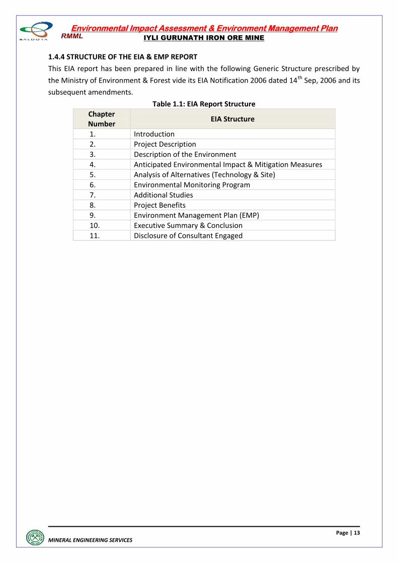
1.4.4 STRUCTURE OF THE EIA & EMP REPORT
This EIA report has been prepared in line with the following Generic Structure prescribed by
the Ministry of Environment & Forest vide its EIA Notification 2006 dated 14th Sep, 2006 and its
subsequent amendments.
Table 1.1: EIA Report Structure
Chapter Number
EIA Structure
1. Introduction
2. Project Description
3. Description of the Environment
4. Anticipated Environmental Impact & Mitigation Measures
5. Analysis of Alternatives (Technology & Site)
6. Environmental Monitoring Program
7. Additional Studies
8. Project Benefits
9. Environment Management Plan (EMP)
10. Executive Summary & Conclusion
11. Disclosure of Consultant Engaged
Environmental Impact Assessment & Environment Management Plan
IYLI GURUNATH IRON ORE MINE
Page | 14
MINERAL ENGINEERING SERVICES
PROJECT DESCRIPTION
Environmental Impact Assessment & Environment Management Plan
IYLI GURUNATH IRON ORE MINE
Page | 15
MINERAL ENGINEERING SERVICES
PROJECT DESCRIPTION
2.1 TYPE & PROJECT DESCRIPTION
This project proposal is to get Enivronmental Clearance of existing Iyli Gurunath Iron Ore Mine
@ 0.975 MTPA within the existing Mining Lease (ML) Area of 20.23 Ha (20.35 Ha as per CEC
survey and digitization of the lease deed sketch) in Government Forest Land.
The opencast mechanized conventional method of mining with drilling and blasting as
presently followed will be continued in the future also.
The capital cost of existing land and infrastructure is Rs. 22 crores
The applicant company has obtained MoEF clearance from Ministry of Environmental Forest,
New Delhi vide letter J-1105/10/2005-IA.IIMI dated 09.01.2006 and also obtained Consent for
Operation from Karnataka Pollution Control Board for a production of 0.5 MTPA of Iron Ore.
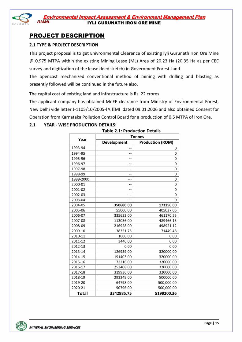
2.1 YEAR - WISE PRODUCTION DETAILS: Table 2.1: Production Details
Year Tonnes
Development Production (ROM) 1993-94 -- 0 1994-95 -- 0 1995-96 -- 0 1996-97 -- 0 1997-98 -- 0 1998-99 -- 0 1999-2000 --- 0 2000-01 -- 0 2001-02 -- 0 2002-03 -- 0 2003-04 -- 0 2004-05 350680.00 173156.00 2005-06 55000.00 405037.06 2006-07 335632.00 461170.55 2007-08 113036.00 489466.15 2008-09 216928.00 498921.12 2009-10 38351.75 71449.48 2010-11 1000.00 0.00 2011-12 3440.00 0.00 2012-13 0.00 0.00 2013-14 126939.00 320000.00 2014-15 191403.00 320000.00 2015-16 72216.00 320000.00 2016-17 252408.00 320000.00 2017-18 319936.00 320000.00 2018-19 293249.00 500000.00 2019-20 64798.00 500,000.00
2020-21 90796.00 500,000.00
Total 3342985.75 5199200.36
Environmental Impact Assessment & Environment Management Plan
IYLI GURUNATH IRON ORE MINE
Page | 16
MINERAL ENGINEERING SERVICES
2.2 NEED FOR THE PROJECT
The Iron Ore fines produced from the mine are being utilised in the Pellationsation Plants
located nearby. The Iron ore fines produced in this mine are auctioned and the successful
bidders utilize these fines in their Pellet Plants.
2.3 LOCATION MAP (Maps showing general location, specific location, project boundary & project site layout shown in the MES/DWG/LP/01-21 2.3.1 LOCATION OF THE PROJECT
The details of the location are provided in Chapter 1 under Section 1.3
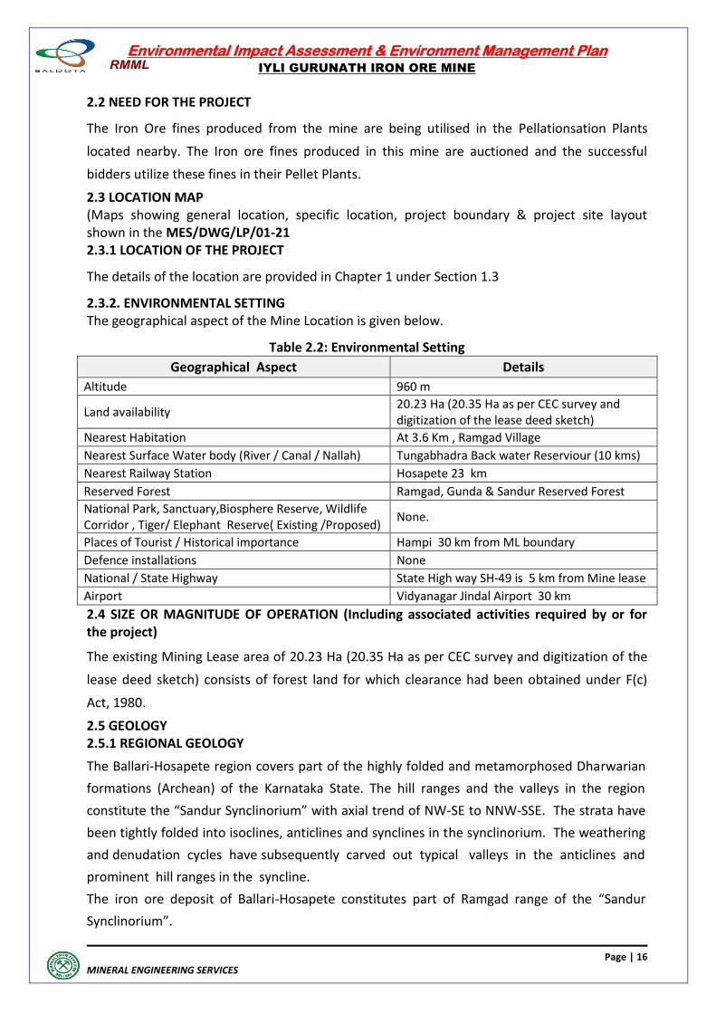
2.3.2. ENVIRONMENTAL SETTING The geographical aspect of the Mine Location is given below.
Table 2.2: Environmental Setting
Geographical Aspect Details
Altitude 960 m
Land availability 20.23 Ha (20.35 Ha as per CEC survey and digitization of the lease deed sketch)
Nearest Habitation At 3.6 Km , Ramgad Village
Nearest Surface Water body (River / Canal / Nallah) Tungabhadra Back water Reserviour (10 kms)
Nearest Railway Station Hosapete 23 km
Reserved Forest Ramgad, Gunda & Sandur Reserved Forest
National Park, Sanctuary,Biosphere Reserve, Wildlife Corridor , Tiger/ Elephant Reserve( Existing /Proposed)
None.
Places of Tourist / Historical importance Hampi 30 km from ML boundary
Defence installations None
National / State Highway State High way SH-49 is 5 km from Mine lease
Airport Vidyanagar Jindal Airport 30 km
2.4 SIZE OR MAGNITUDE OF OPERATION (Including associated activities required by or for the project)
The existing Mining Lease area of 20.23 Ha (20.35 Ha as per CEC survey and digitization of the
lease deed sketch) consists of forest land for which clearance had been obtained under F(c)
Act, 1980.
2.5 GEOLOGY 2.5.1 REGIONAL GEOLOGY
The Ballari-Hosapete region covers part of the highly folded and metamorphosed Dharwarian
formations (Archean) of the Karnataka State. The hill ranges and the valleys in the region
constitute the “Sandur Synclinorium” with axial trend of NW-SE to NNW-SSE. The strata have
been tightly folded into isoclines, anticlines and synclines in the synclinorium. The weathering
and denudation cycles have subsequently carved out typical valleys in the anticlines and
prominent hill ranges in the syncline.
The iron ore deposit of Ballari-Hosapete constitutes part of Ramgad range of the “Sandur
Synclinorium”.
Environmental Impact Assessment & Environment Management Plan
IYLI GURUNATH IRON ORE MINE
Page | 17
MINERAL ENGINEERING SERVICES
The ore bearing terrain south of Ballari-Hosapete comprises of Ramdurg, Kumaraswamy,
Donimalai, Thimmappanagudi and Devadarigudda sections along the eastern and western
regions of the Sandur Hills.
2.5.2 LOCAL GEOLOGY
The various litho units exposed in the area are part of the Ramanamalai, Deogiri and
Yeshwantnagar formations of lower units of the stratigraphic sequence of the Sandur
Synclinorium. The geological mapping and exploration in the leasehold area established the
various lithounits as furnished below:
Laterite
Hematitic Iron Ore (Friable), Hematitic Siliceous Iron Ore
Shale/Phylite
Banded Hematite Quartzite /Chert (BHQ /BHC)
The area is characterized by the absence of any mapable fold or fault. The overall structural set
up of the area is marked by tightly isoclinals folds with strike directions NW-SE, while dip
generally varies from 80° to 85° NE.
The Iyli Gurunath lease hold has insitu ore deposit in the upper part of North-Eastern slope of
the Ramgad hill range. The ore occurs generally below a capping of laterite Hematitic Iron ore
(Friable) and Hematitic Siliceous Iron ore. It is apparent from field observations that the ore
body is formed by leaching of silica and iron ore in BHQ/BHC in the form of iron ore Fe content
in the ore is contributed prominently by hematite. In Hematitic Siliceous iron ore the silica in
the ore is contributed predominantly due to presence of quartz/chert in the gangue and Fe in
the ore is contributed predominantly by presence of hematite and subordinate to minor
amounts of maghematite. These are formed by volcano sedimentary process.
The Hematitic Iron ore having a length of 540 m average width varying from 20 to 150 m and
the average depth is 80 - 100 m. Hematitic Siliceous Iron ore is below the friable iron ore. The
base of the Hematitic iron ore & Hematitic Siliceous iron ore has been established by diamond
core drilling and RC drilling. The quality of the iron ore is in this lease area is varying between
56 to 66% Fe. Overall Lumps and fines ratio is 13: 87 (Lumps +10mm, Fines -10 mm).
The Hematitic Siliceous iron ore normally occurs in transition zone of friable iron ore and in
depth with grades varying 35% Fe to 45% Fe. The Hematitic siliceous ore is characterized by
hematite and cherty minerals as gangue. The presence of Hematitic Siliceous Ore with 35% Fe
(Min) as per the latest threshold value of minerals notification dated 25/04/2018, all the
resources has been assessed upto the threshold value.
The Surface Plan, Geological plan and Geological Sections are shown vide
MES/DWG/SP/05-21, MES/DWG/GP/06-21 and MES/DWG/GS/07-21
Environmental Impact Assessment & Environment Management Plan
IYLI GURUNATH IRON ORE MINE
Page | 18
MINERAL ENGINEERING SERVICES
2.5.3 GEOMORPHOLOGY The Iyli Gurunath Iron Ore Mine is located in hilly terrain of Ballari- Hosapete region. The
dominant physiographic feature of the region is NW-SE trending narrow hill ranges. There are
two hill ranges, which contain the iron ore deposits. The mine is located in the central part of
the southern hill range called Ramgad hill.
The ore zone is presently exposed in the altitude range of 960 to 850 m. i.e for vertical space of
about 110m.
The physiographic disposition is primarily caused by regional tectonic influence dominated
by the highly folded and metamorphosed litho-units of Dharwarian formations. The hill
ranges of the region generally constitute part of the “Sandur Synclinorium” with axial trend of
NNW-SSE plunging at about 200 towards NW. The area has quite low rainfall averaging about
667 mm per year. Whatever rain water falls over the hilly region of the area, it flows down the
slopes. Usually, there is no water in these water courses after rainy season every year. The
ground water level in the hilly terrain is very deep. Even on lower levels, the ground water
table is at 500 m above MSL in the ML area.
The vegetation cover on slopes of the ML area is fairly good. In valleys and at foothills of the
hills outside the lease, vegetation cover is comparatively thicker. No major nallah, stream or
rivers are present in the core area. However, numerous small seasonal water courses are
present in the western and eastern slopes of the hill range to carry whatever rainfall occurs in
the area.
2.6 DRAINAGE
Minimum and maximum depth of water table based on observations from nearby wells and
water bodies.
The whole of the lease area is hilly terrain and there are no perennial water courses in
the lease or surrounding area within a distance of 10 km. The mining operations for iron ore
are located on hill top. The area receives quite low average yearly rain fall of 667 mm. All rain
water flow down the hill slopes by way of either direct run off or percolates through strata.
There are numerous seasonal water courses along hill slopes, which drain out rain water
falling over the area, These water courses have water only during rains or few hours after
heavy rain fall.
a) Since the mine is located in hilly area, the ground water table is well below mine working
levels. Even when iron ore mining will reach its bottom most level, the situation will be same.
The ground water table is at 500 m above MSL, hence there shall be no adverse impact on
ground water regime due to mining.
b) The maximum elevation is 960 m above MSL and the minimum is 865 m above MSL of
mine workings during the plan period 2019-20 to 2023-24.
c) There is no water likely to be encountered in the mine pit.
Environmental Impact Assessment & Environment Management Plan
IYLI GURUNATH IRON ORE MINE
Page | 19
MINERAL ENGINEERING SERVICES
d) The drainage pattern of the area is sub-dendritic in nature. Half of the run-off within the
buffer zone drains towards northeast. The other part of the run-off flow towards SW.
The mine drainage is conveniently manageable as rainfall in the region is low (average 667 mm
per annum). The rainwater run-off is guided by the hill slopes channels.
There are no major nallahs, streams or river (except backwater of Tungabhadra reservoir)
in the buffer zone area.
Within the lease area, there are water run-offs only when it is raining. The management
over the years has constructed a large number of gully plugs and bunds to arrest the water at
the bottom of hills so that no suspended solids are carried towards down slopes. The quality
of water overflowing these gully plugs/bunds is regularly monitored during the rainy
season and except for a rare very heavy rainfall, the suspended solids do not exceed
prescribed limits. The drainage map for 10 km buffer distance from lease area is shown in
MES/DWG/DP/08-21
2.7 HYDROGEOLOGY
Groundwater occurs in Achaean crystalline province mostly under unconfined to semi confined
conditions. The rock units do not have the primary porosity. The occurrence and movement of
groundwater is through secondary porosity developed from the erosional and structural
deformity undergone by the rocks. The main source of recharge is precipitation and by return
flow from applied irrigation in the plain area and percolation of rainfall runoff in plateau area.
The rocks have undergone different degree of weathering with fissures and fractures. The
movement of groundwater is through the weathered zone extending up to 12 m. in phreatic
aquifers. The productivity of the aquifers generally depends on the precipitation in general and
weathered zone, fissures and fractures in particular.
Hydrogeological surveys carried out in Sandur Taluk by the Central Ground Water Board
indicate the fluctuation of water table varied between 0.52 m to 0.82 m per annum. The
fluctuations are less near the drainage system and topographic lows and higher in the
topographic highs and hilly areas. Change in ground water scenario over a decade in Sandur
Taluk show rise in water level from 0.30 to 3.90 m / year in respect of three National
Hydrograph Stations (NHS) while decline is not observed in any of the three hydrograph
stations.This clearly indicates ground water development is very low when compared with the
recharge in the area. The long-term average annual fluctuation is arrived at 2.4 m / annum.
Environmental Impact Assessment & Environment Management Plan
IYLI GURUNATH IRON ORE MINE
Page | 20
MINERAL ENGINEERING SERVICES
The total water requirement for the Iyli Gurunath Iron Ore mines at Ramgad, Sandur taluks,
Ballari district, Karnataka is 50 m³/day and is proposed to meet from borewell from outside the
core area. The proponent has not tried to drill the own bore well because of unfavorable
Hydrogeological Conditions within the corezone. However, it is now proposed to drill a
Piezometer within the core area. Based on the results obtained, one bore well is proposed for
the project area. The ground water requirements are essentially for the dust suppression,
green belt and domestic needs. The lessee also plans to conserve rain water through Roof Top
Rainwater harvesting and Rainfall Run-off management for recharge to ground water body and
other uses. There is no waste water generated in the mine area. The proposed recharge to
ground water body through various conservation structures at present will be more than the
quantity of ground water proposed to withdraw for the mine water requirements.
The quantity of ground water proposed to withdraw is less than 27 % of the total water
envisaged for recharge to ground water body.
Thus, no impact on ground water and water levels due to utilization of ground water for the
infrastructure development. The taluk as per the latest GEC norms categorized as “SAFE”
The details of the water requirements and utilization plan are given below.
The mine is not generating any waste water, Industrial waste, effluents, Sewage and hence no
treatment plants are established.
Projected Water Requirements and utilization plan I. Water Requirement:
For dust suppression, green belt and domestic needs : 50 m ³ / day
Total : 50 m ³ / day
II. Source Water
A) Ground Water
a) From bore well located outside the core area : 50 m ³ / day
b) Other source : Nil Total : 50 m ³ / day
Environmental Impact Assessment & Environment Management Plan
IYLI GURUNATH IRON ORE MINE
Page | 21
MINERAL ENGINEERING SERVICES
2.8 MAN POWER
There number of officers and supervisory staff and other workmen as direct employees is
indicated below.
Highly Skilled 10
Skilled 38
Semi skilled 26
Un-Skilled 56
Total 130
2.9 MINERALS AND MINING HISTORY
Iron ore is being used for manufacture of pellets, sponge iron, pig iron and steel in the
domestic indusrty. About 30 million tonnes of iron ore is produced per annum from Ballari-
Hosapete sector. No export is allowed from Karnataka.
2.10 RESERVES & RESOURCES Reserves estimated by conducting detailed exploration (G1) involves the detailed three
dimensional delineation of a regular deposit achieved through sampling such as face
sampling, out crop sampling, bore holes sampling and updated the plan & sections. The
detailed calculation of reserves/resources are estimated as on 30.06.2021 is given below.
Table: 2.3 Estimated Reserves/Resources as on 30.06.2021
Level of Exploration Resources in million tonnes
Grade
G1-Detailed Exploration 111-19.513 211-4.233
TOTAL – 11736085
56.85% Fe
G2-General Exploration - -
G3-Prospecting - -
G4-Reconnaissance - - Total 23.746
2.10.1 Life of Mine
Life of the mine with 19.513 million tonnes of proved reserves shall be 20 years @ 0.975 MTPA
production. However, the mining lease is only valid upto 23.02.2026.
2.11 MINING OPERATION
2.11.1 TECHNOLOGY & MINING PROCESS
Mining Method: Open Cast Mining The current Method of Mining, as explained below, will be continued for the future operations
also.Mining operation is carried out by fully mechanized opencast method with deep hole
drilling and blasting utilizing Heavy Earth Moving Machinary (HEMM). The diameter of drill hole
is 110 mm. The depth of the hole is 10m. Wagon drills in conjunction with Portable Diesel Air
Compressor are used for drilling.
Ist Class Mines Manager 01
II nd Class Mines Mangers 02
Foremen 04
Mine Mates 08
Blaster 01
Geologist 01
Mechanical Engineer 01
Admin Officers 02
Total 20
Environmental Impact Assessment & Environment Management Plan
IYLI GURUNATH IRON ORE MINE
Page | 22
MINERAL ENGINEERING SERVICES
Since the formations are soft, only 20% of the waste and ore require drilling.
The explosives required for blasting shall be supplied by an authorized dealer and conduct
blasting operations under the supervision of statutorily authorized supervisors of the lessee.
Deep hole blasting is carried out with Slurry Explosives and and Nonel. The blasted ore and
waste is excavated using Hydraulic Excavators. The excavated material is then loaded into
Tippers.
2.11.2 FORMATION OF PITS & BENCHES
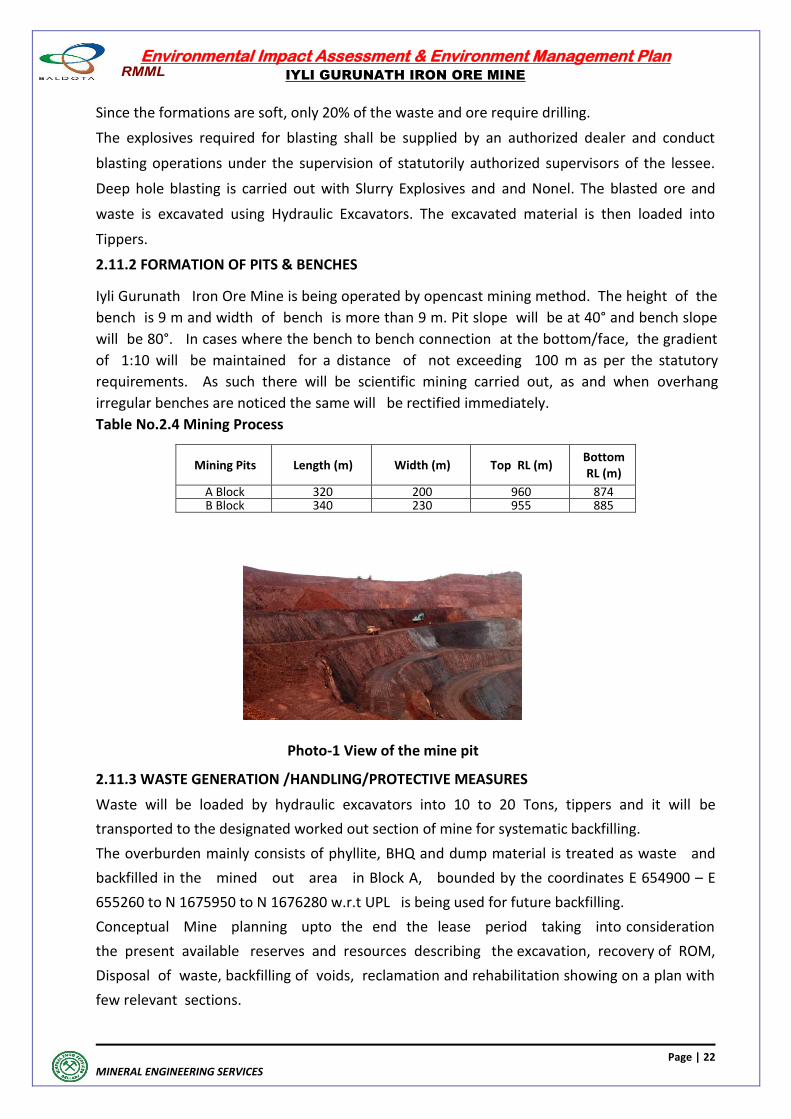
Iyli Gurunath Iron Ore Mine is being operated by opencast mining method. The height of the
bench is 9 m and width of bench is more than 9 m. Pit slope will be at 40° and bench slope
will be 80°. In cases where the bench to bench connection at the bottom/face, the gradient
of 1:10 will be maintained for a distance of not exceeding 100 m as per the statutory
requirements. As such there will be scientific mining carried out, as and when overhang
irregular benches are noticed the same will be rectified immediately.
Table No.2.4 Mining Process
Mining Pits Length (m) Width (m) Top RL (m) Bottom RL (m)
A Block 320 200 960 874 B Block 340 230 955 885
Photo-1 View of the mine pit
2.11.3 WASTE GENERATION /HANDLING/PROTECTIVE MEASURES
Waste will be loaded by hydraulic excavators into 10 to 20 Tons, tippers and it will be
transported to the designated worked out section of mine for systematic backfilling.
The overburden mainly consists of phyllite, BHQ and dump material is treated as waste and
backfilled in the mined out area in Block A, bounded by the coordinates E 654900 – E
655260 to N 1675950 to N 1676280 w.r.t UPL is being used for future backfilling.
Conceptual Mine planning upto the end the lease period taking into consideration
the present available reserves and resources describing the excavation, recovery of ROM,
Disposal of waste, backfilling of voids, reclamation and rehabilitation showing on a plan with
few relevant sections.
Environmental Impact Assessment & Environment Management Plan
IYLI GURUNATH IRON ORE MINE
Page | 23
MINERAL ENGINEERING SERVICES
2.11.4 MINING MACHINERY The details of Mining Machinery and vehicles required are given below. Table.No.2.5 Machinery Details
2.12 ASSESSMENT OF NEW & UNTESTED TECHNOLOGY FOR THE RISK OF TECHNOLOGICAL
FAILURE
The well established open cast conventional type of mining is being followed now and the
same methodology will be continued for the future opertaions also. No new or untested
technology or methodology is proposed to be followed.
2.13 PROPOSED SCHEDULE FOR APPROVAL AND IMPLEMENTATION
The State Environmental Impact Assessment Authority of Karnataka has approved modification
in the Terms of Reference issued earlier vide its letter SEIAA 59 MIN (VIOL) 2018 dated
30.01.2019 for the proposed Mining Capacity of Iyli Guruntah Iron Ore Mine of 0.975 mtpa
within the existing Mining Lease Area of 20.35 ha. Now the approved ToR is applicable for a
production capacity of 0.975 mtpa. The proposed schedule for getting Environmental
Clearance and Implementation of the project is as given below.
Items No.of days
Capacity No.of
machines No.of hours
Capacity Tons per year
Remarks
Excavators-ore 285 240 TPH 2 8 to 10 hrs 1094400 8 Hours per day
Excavators- Waste 285 140 TPH
2 6.5 hrs 519700
Capacity per year will change year to year as per area of working
Excavator for Weigh bridge
285 40 TPH 1 10 hrs To adjust weighment to 16 tonnes/10
tonnes
Excavator- Crusher feeding
285 190 TPH
2 8 to 10 hrs
Excavator spare 120 TPH 1 6.5 hrs Misc works
Excavator for dispatch material
285 200 TPH 1 10 hrs for dispatch material
Tippers 285 20 tonners 20 8 to10 hrs Internal movement/other works–
including spare
Drill 285 6 mts/hr 2 6.5 22230 mts
Wheel Loaders 285 200 TPH 5 6.5 Mine pit , stock yards & product
loading
Water Tankers 285 8 KL 6
Mobile C&S plant
285
150 TPH to 200
TPH
4
10
1140000
Screening Plant 200 TPH & crushing plant of 150 TPH is
considered.
* Requirement of machinery calculated based on assumptions and it may change depends on practical conditions
Environmental Impact Assessment & Environment Management Plan
IYLI GURUNATH IRON ORE MINE
Page | 24
MINERAL ENGINEERING SERVICES
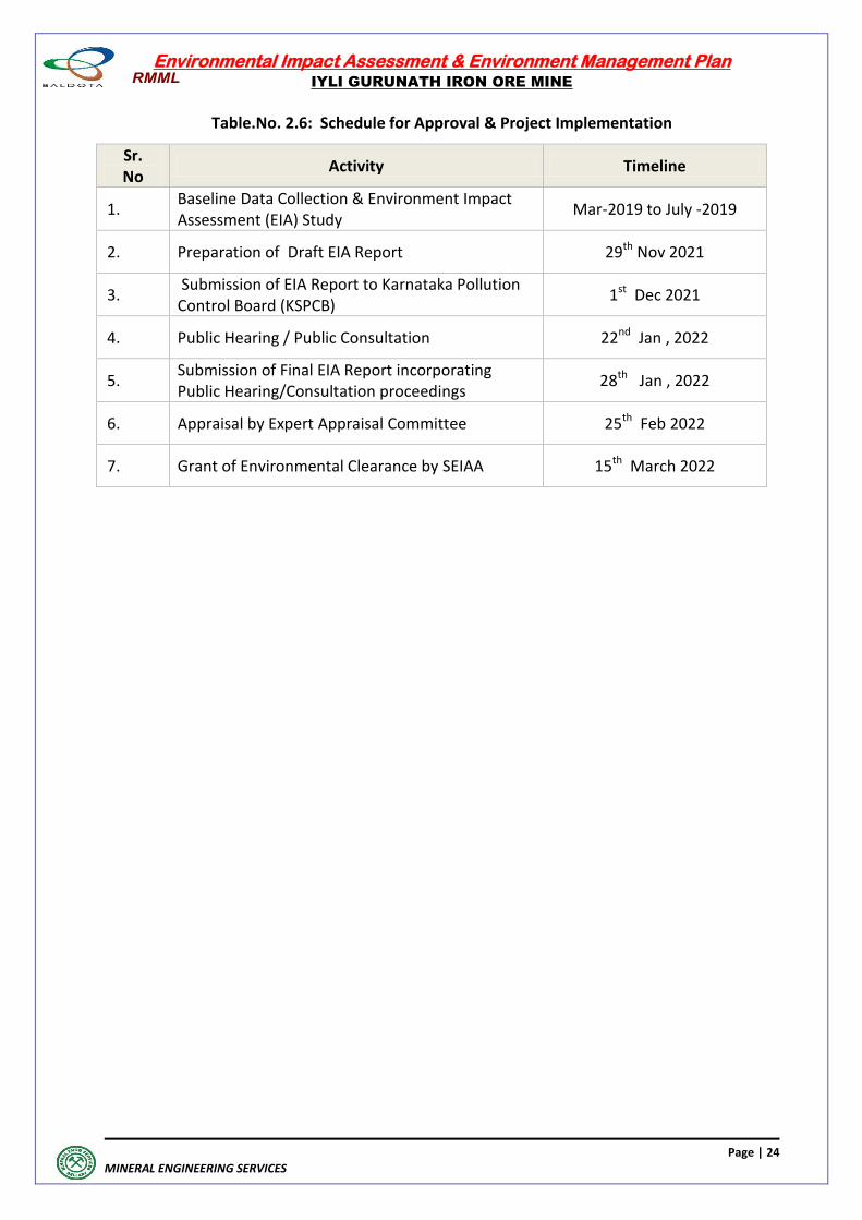
Table.No. 2.6: Schedule for Approval & Project Implementation
Sr. No
Activity Timeline
1. Baseline Data Collection & Environment Impact Assessment (EIA) Study
Mar-2019 to July -2019
2. Preparation of Draft EIA Report 29th Nov 2021
3. Submission of EIA Report to Karnataka Pollution Control Board (KSPCB)
1st Dec 2021
4. Public Hearing / Public Consultation 22nd Jan , 2022
5. Submission of Final EIA Report incorporating Public Hearing/Consultation proceedings
28th Jan , 2022
6. Appraisal by Expert Appraisal Committee 25th Feb 2022
7. Grant of Environmental Clearance by SEIAA 15th March 2022
Environmental Impact Assessment & Environment Management Plan
IYLI GURUNATH IRON ORE MINE
Page | 25
MINERAL ENGINEERING SERVICES
DESCRIPTION OF THE
ENVIRONMENT
Environmental Impact Assessment & Environment Management Plan
IYLI GURUNATH IRON ORE MINE
Page | 26
MINERAL ENGINEERING SERVICES
DESCRIPTION OF THE ENVIRONMENT
3.1 STUDY AREA
The seasonal environmental baseline data generated is presented under Annexure No.7.
The study area of 10 km radius (from the boundary of Mining Lease) has been considered for
assessing the baseline environmental status. ML Area is the Core Zone and the 10 km radius
area around the ML Area is the Buffer Zone. The study area of 10 km radius of the mine falls in
Survey of India- Toposheet Number D 43 E8 (57A/ 8) & D43 E12 (57A/12).
3.2 STUDY PERIOD
The base line data have been collected for various environmental components from Mar’19 to
May’19, which is the summer season.
Table 3.1 : Environmental Setting of the Project Site
S.No Particulars Details
1. Location Ramgad Village, Sandur Taluk, Ballari District,Karnataka
2. Project Coordinates Latitude : N 15
o 09’ 15.41” to N 15
o 09’39.08”
Longitude : E 76o 26’26.70” to E 76
o 26’ 47.86
3. Lease Area 20.23 ha (20.35 ha as per CEC survey and digitization of
the lease deed sketch)
4. Geographical Location in Topo Sheet D 43 E8 (57A/ 8) & D43E12(57A/12) 5. Nearest Habitat At 3.6 Km , Ramgad Village
6.
Connectivity Nearest Town is Sandur at 15 kms and Hosapete at 23 km in North West direction State Highway SH -49 (Hosapete to Sandur) passing at a distance of 5 km from mining lease area towards North directionNearest Railway Station, Hosapete is at 23 km in North West direction.Nearest Airport, JSW Jindal Torangallu, 30 km in North East East direction
7. Wildlife Sanctuary / National Park / Reserve Forest
Ramgad, Gunda and Sandur Reserve forest
8.
Climatic Conditions Annual Max temp 37.6°C Annual Min temp 19.6
o C
Annual Max Humidity 78.0% Annual Min Humidity 33.0% Annual Rainfall 630 mm
9.
Ecologically sensitive areas/ protected areas as per Wildlife Protection Act 1972 (National Parks/Wild life sanctuaries / bio-sphere reserves/ tiger reserves)
No wildlife sanctuary/ No National Park within 15 km from mine site
Environmental Impact Assessment & Environment Management Plan
IYLI GURUNATH IRON ORE MINE
Page | 27
MINERAL ENGINEERING SERVICES
3.3 ENVIRONMENTAL COMPONENTS
Considering the Environmental setting of the project, project activities and their interaction,
and environmental regulations & standards, the following Environmental Attributes have been
included in EIA Study, as a part of baseline data.
Site Specific Micrometeorological Data (hourly readings from core zone) on wind speed
& direction (wind roses), temperature, humidity, atmospheric pressure. There was no rainfall
during monitoring period.
Ambient Air Quality Monitoring at 8 Stations on 24-hourly basis, for 2 days in a week for
13 weeks in summer season for the parameters PM2.5, PM10, for Heavy Metals analysis in
Particulates, S02, NO2, CO, Ozone, Benzene and Benzo(a)pyrene
Noise Level Measurements at 8 noise monitoring stations for Leq, Lday and Lnight values
once in the season
Water Quality Monitoring by grab sampling once in the season for
Surface Waters (5 locations)
Ground Waters (10 Locations)
Soil Quality Monitoring at 8 locations once in the study period for
Textural & Physical Parameters
Nutrients
Land use pattern based on Satellite Imagery
Biotic Attributes (twice in the study period) for
Flora-Core & Buffer Zones Fauna-Core & Buffer Zones Socio-Economic Profile, based on 2011-Census and Survey 2019 for Total Population I Household Size I Age Gender Composition S.C I S.T Literacy Level Occupational Structure 3.4 METHODOLOGY
The methodologies followed are detailed below.
3.4.1 MICROMETEOROLOGY
As a part of the study, the micrometeorology and microclimatic parameters have been
recorded by installing a Weather Monitoring Station. The data on wind Speed, wind direction,
ambient temperature, relative humidity, have been recorded at hourly intervals along with
rainfall during the monitoring period.

Environmental Impact Assessment & Environment Management Plan
IYLI GURUNATH IRON ORE MINE
Page | 28
MINERAL ENGINEERING SERVICES
3.4.2 AMBIENT AIR QUALITY
The study area represents the Industrial, Residential, Rural and Other Areas. Calibrated Fine
Particulate Samplers have been used for monitoring of PM2.5. Calibrated Respirable Dust
Samplers have been used for monitoring of PM10. Gaseous samples have been collected by
integrated gas sampling assembly.
Table 3.2 : Parameters for Air Monitoring
Monitored parameters & duration
Method used
24 hourly monitoring twice a week for 4 weeks per month for one season of 3 months
PM10 PM2.5 Gravimetric Sampling using Respirable Dust Sampler
Sulphur Dioxide (SO2) Modified West & Gaeke Method
Nitrogen Dioxide (NO2) Jacob & Hoechhiesher Method
Lead AAS /ICP Method after sampling on EPM 2000 or equivalent filter Paper
Ammonia Independent blue method
Benzene Adsorption & desorption followed by GC analysis
Nickel AAS /ICP Method after sampling on EPM 2000 or equivalent filter Paper
Arsenic AAS /ICP Method after sampling on EPM 2000 or equivalent filter Paper
Benzo-alco-pyrene Solvent extraction followed by HPLC/GC analysis
Hourly Monitoring: twice a week for 13 weeks per for one season of 3 months
CO Non dispersive Infrared (NDIR) Spectroscopy
Ozone Chemical method 3.4.3 NOISE LEVELS
Noise levels have been monitored at all air monitoring locations during day time as well as
night time in a day. The sound level meters are used in accordance with IS: 9979 and IEC 651
standards for noise survey. The basic unit of measurement is A-weighted sound level, the most
widely used scale. The measurements are taken in the fast mode and are sampled to yield
statistical information such as Leq (equivalent noise level).
3.4.4 WATER QUALITY
No major roads pass through the mining lease area, the terrain is hilly, sloping towards north.
There are no major nallahs, streams or river except back water of tungabhadra reservior in the
periphery of buffer area. The highest and lowest elevations (bottom of the mining pit) in the
area has an elevation difference of 75m. (i.e. RL 960 and 865 m respectively).
The drainage partern of buffer zone area is dendritic to sub-dendritic in nature. The seasonal
nallahs flow on western, eastern and southern sides of the lease area and flows towards the
Tungabhadra back water reservior. As no ground water pumping is being done from the pit no
clearance from Central ground water Authority for drawl of water is required presently.
Environmental Impact Assessment & Environment Management Plan
IYLI GURUNATH IRON ORE MINE
Page | 29
MINERAL ENGINEERING SERVICES
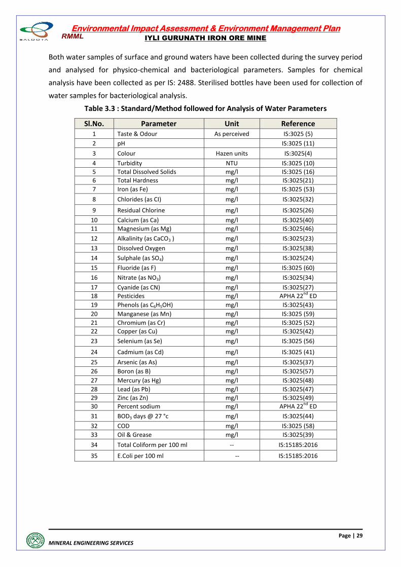
Both water samples of surface and ground waters have been collected during the survey period
and analysed for physico-chemical and bacteriological parameters. Samples for chemical
analysis have been collected as per IS: 2488. Sterilised bottles have been used for collection of
water samples for bacteriological analysis.
Table 3.3 : Standard/Method followed for Analysis of Water Parameters
Sl.No. Parameter Unit Reference 1 Taste & Odour As perceived IS:3025 (5)
2 pH
IS:3025 (11)
3 Colour Hazen units IS:3025(4)
4 Turbidity NTU IS:3025 (10)
5 Total Dissolved Solids mg/l IS:3025 (16)
6 Total Hardness mg/l IS:3025(21)
7 Iron (as Fe) mg/l IS:3025 (53)
8 Chlorides (as CI) mg/l IS:3025(32)
9 Residual Chlorine mg/l IS:3025(26)
10 Calcium (as Ca) mg/l IS:3025(40)
11 Magnesium (as Mg) mg/l IS:3025(46)
12 Alkalinity (as CaCO3 ) mg/l IS:3025(23)
13 Dissolved Oxygen mg/l IS:3025(38)
14 Sulphale (as SO4) mg/l IS:3025(24)
15 Fluoride (as F) mg/l IS:3025 (60)
16 Nitrate (as NO3) mg/l IS:3025(34)
17 Cyanide (as CN) mg/l IS:3025(27)
18 Pesticides mg/l APHA 22nd
ED
19 Phenols (as C6H5OH) mg/l IS:3025(43)
20 Manganese (as Mn) mg/l IS:3025 (59)
21 Chromium (as Cr) mg/l IS:3025 (52)
22 Copper (as Cu) mg/l IS:3025(42)
23 Selenium (as Se) mg/l IS:3025 (56)
24 Cadmium (as Cd) mg/l IS:3025 (41)
25 Arsenic (as As) mg/l IS:3025(37)
26 Boron (as B) mg/l IS:3025(57)
27 Mercury (as Hg) mg/l IS:3025(48)
28 Lead (as Pb) mg/l IS:3025(47)
29 Zinc (as Zn) mg/l IS:3025(49)
30 Percent sodium mg/l APHA 22nd
ED
31 BOD3 days @ 27 °c mg/l IS:3025(44)
32 COD mg/l IS:3025 (58)
33 Oil & Grease mg/l IS:3025(39)
34 Total Coliform per 100 ml -- IS:15185:2016
35 E.Coli per 100 ml -- IS:15185:2016
Environmental Impact Assessment & Environment Management Plan
IYLI GURUNATH IRON ORE MINE
Page | 30
MINERAL ENGINEERING SERVICES
3.4.5 Soil Characterstics
The Sandy loam soil mixed with black and grey soil occurs along the stream beds. These are
originated from gneisses and granites. They are permeable and mildly alkaline in nature. The
thickness of the soil varies from 0.2 to 1.00m. The Red soil is the major type of soil in the
district, found mainly at elevated places especially at fringes of hills due to decomposition of
rocks and surrounding granitic and gneissic hills. These soils are with high permeability and
neutral PH. Black soil with high initial infiltration rate when dry and cracked. On getting wet,
cracks will close and infiltration rate will be very low. These are derived from schistose rocks.
The Black soil is found in the prolonged submerged areas and canal command areas having low
Permeability. It is calcareous and mildly alkaline in nature.
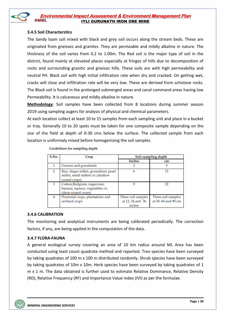
Methodology: Soil samples have been collected from 8 locations during summer season
2019 using sampling augers for analysis of physical and chemical parameters.
At each location collect at least 10 to 15 samples from each sampling unit and place in a bucket
or tray. Generally 10 to 20 spots must be taken for one composite sample depending on the
size of the field at depth of 0-30 cms below the surface. The collected sample from each
location is uniformaly mixed before homogenizing the soil samples.
3.4.6 CALIBRATION
The monitoring and analytical instruments are being calibrated periodically. The correction
factors, if any, are being applied in the computation of the data.
3.4.7 FLORA-FAUNA
A general ecological survey covering an area of 10 km radius around ML Area has been
conducted using least count quadrate method and reported. Tree species have been surveyed
by taking quadrates of 100 m x 100 m distributed randomly. Shrub species have been surveyed
by taking quadrates of 10m x 10m. Herb species have been surveyed by taking quadrates of 1
m x 1 m. The data obtained is further used to estimate Relative Dominance, Relative Density
(RD), Relative Frequency (RF) and Importance Value index (IVI) as per the formulae.
Environmental Impact Assessment & Environment Management Plan
IYLI GURUNATH IRON ORE MINE
Page | 31
MINERAL ENGINEERING SERVICES
Faunal survey covers the Terrestrial Fauna, Avian Fauna and Aquatic Fauna. The survey is based
on personal observation, enquiry with local population and records available. This study
includes the identification of endangered and rare species as per Red Book.
3.4.8 SOCIO-ECONOMIC SURVEY
As the proposed Mining activity is within the existing ML Area, this Project does not involve
resettlement/rehabilitation. The Socio-Economic profile of the population living in study area
has been prepared based on Census 2011 data and Survey 2019.
3.5 BASE LINE & BASE MAPS -ENVIRONMENTAL COMPONENTS
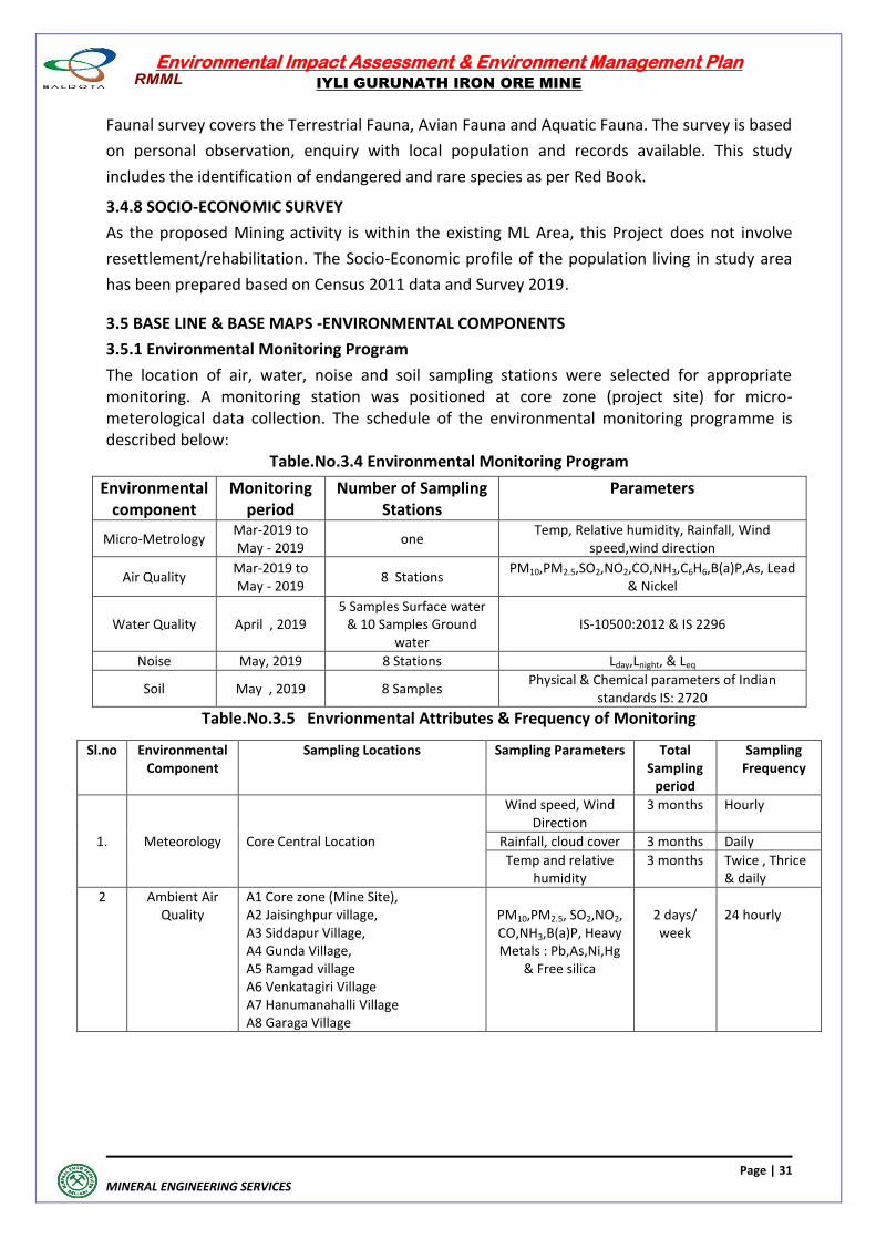
3.5.1 Environmental Monitoring Program
The location of air, water, noise and soil sampling stations were selected for appropriate monitoring. A monitoring station was positioned at core zone (project site) for micro-meterological data collection. The schedule of the environmental monitoring programme is described below:
Table.No.3.4 Environmental Monitoring Program
Environmental component
Monitoring period
Number of Sampling Stations
Parameters
Micro-Metrology Mar-2019 to May - 2019
one Temp, Relative humidity, Rainfall, Wind
speed,wind direction
Air Quality Mar-2019 to May - 2019
8 Stations PM10,PM2.5,SO2,NO2,CO,NH3,C6H6,B(a)P,As, Lead
& Nickel
Water Quality April , 2019 5 Samples Surface water
& 10 Samples Ground water
IS-10500:2012 & IS 2296
Noise May, 2019 8 Stations Lday,Lnight, & Leq
Soil May , 2019 8 Samples Physical & Chemical parameters of Indian
standards IS: 2720
Table.No.3.5 Envrionmental Attributes & Frequency of Monitoring
Sl.no Environmental Component
Sampling Locations Sampling Parameters Total Sampling
period
Sampling Frequency
1. Meteorology Core Central Location
Wind speed, Wind Direction
3 months Hourly
Rainfall, cloud cover 3 months Daily
Temp and relative humidity
3 months Twice , Thrice & daily
2 Ambient Air Quality
A1 Core zone (Mine Site), A2 Jaisinghpur village, A3 Siddapur Village, A4 Gunda Village, A5 Ramgad village A6 Venkatagiri Village A7 Hanumanahalli Village A8 Garaga Village
PM10,PM2.5, SO2,NO2, CO,NH3,B(a)P, Heavy Metals : Pb,As,Ni,Hg
& Free silica
2 days/ week
24 hourly
Environmental Impact Assessment & Environment Management Plan
IYLI GURUNATH IRON ORE MINE
Page | 32
MINERAL ENGINEERING SERVICES
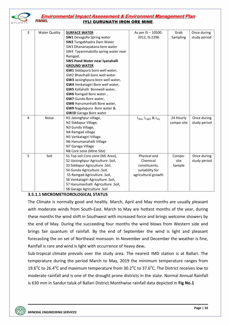
3 Water Quality SURFACE WATER SW1 Devagolla Spring water SW2 Tungabhadra Dam Water SW3 Dhananayakana kere water SW4 Tayammakolla spring water near Ramgad, SW5 Pond Water near Iyanahalli GROUND WATER GW1 Siddapura bore well water, GW2 Bhavihalli bore well water GW3 Jaisinghpura bore well water, GW4 Venkatagiri Bore well water, GW5 Kallahalli Borewell water, GW6 Ramgad Bore water , GW7 Gunda Bore water, GW8 Hanumanhalli Bore water, GW9 Nagalapura Bore water & GW10 Garaga Bore water
As per IS – 10500: 2012, IS:2296
Grab Sampling
Once during study period
4 Noise N1 Jaisinghpur village, N2 Siddapur Village, N3 Gunda Village, N4 Ramgad village N5 Venkatagiri Village N6 Hanumanahalli Village N7 Garaga Village N8 Core zone (Mine Site)
Lday, Lnight & Leq 24 Hourly compo-site
Once during study period
5 Soil S1 Top soil Core zone (ML Area), S2 IJaisinghpur Agriculture .Soil, S3 Siddapur Agriculture .Soil, S4 Gunda Agriculture .Soil, S5 Ramgad Agriculture .Soil, S6 Venkatagiri Agriculture .Soil, S7 Hanumanhalli Agriculture .Soil, S8 Garaga Agriculture .Soil
Physical and Chemical
constituents, suitability for
agricultural growth
Compo-site
Sample
Once during study period
3.5.1.1 MICROMETEOROLOGICAL STATUS
The Climate is normally good and healtly. March, April and May months are usually pleasant
with moderate winds from South-East. March to May are hottest months of the year, during
these months the wind shift in Southwest with increased force and brings welcome showers by
the end of May. During the succeeding four months the wind blows from Western side and
brings fair quantum of rainfall. By the end of September the wind is light and pleasant
forecasting the on set of Northeast monsoon. In November and December the weather is fine,
Rainfall is rare and wind is light with occurrence of heavy dew.
Sub-tropical climate prevails over the study area. The nearest IMD station is at Ballari. The
temperature during the period March to May, 2019 the minimum temperature ranges from
19.6oC to 26.4oC and maximum temperature from 30.2oC to 37.6oC. The District receives low to
moderate rainfall and is one of the drought prone districts in the state. Normal Annual Rainfall
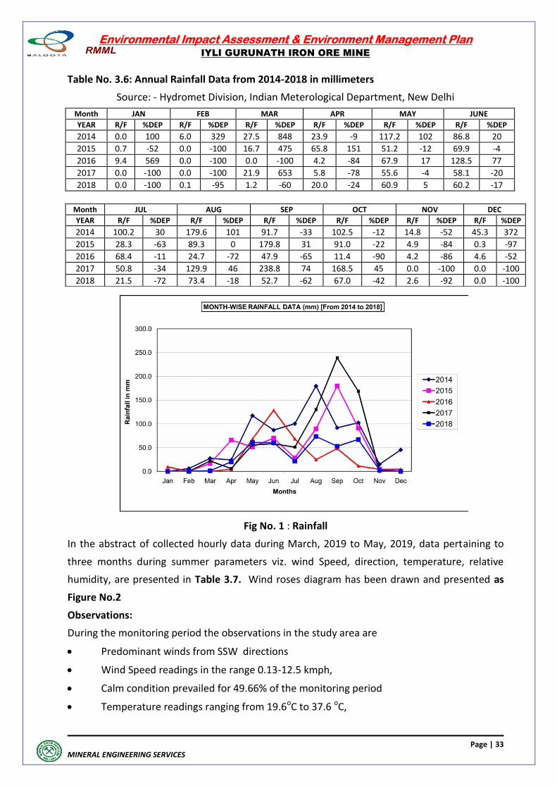
is 630 mm in Sandur taluk of Ballari District.Monthwise rainfall data depicted in Fig No.1
Environmental Impact Assessment & Environment Management Plan
IYLI GURUNATH IRON ORE MINE
Page | 33
MINERAL ENGINEERING SERVICES
Table No. 3.6: Annual Rainfall Data from 2014-2018 in millimeters
Source: - Hydromet Division, Indian Meterological Department, New Delhi
Month JAN FEB MAR APR MAY JUNE
YEAR R/F %DEP R/F %DEP R/F %DEP R/F %DEP R/F %DEP R/F %DEP
2014 0.0 100 6.0 329 27.5 848 23.9 -9 117.2 102 86.8 20
2015 0.7 -52 0.0 -100 16.7 475 65.8 151 51.2 -12 69.9 -4
2016 9.4 569 0.0 -100 0.0 -100 4.2 -84 67.9 17 128.5 77
2017 0.0 -100 0.0 -100 21.9 653 5.8 -78 55.6 -4 58.1 -20
2018 0.0 -100 0.1 -95 1.2 -60 20.0 -24 60.9 5 60.2 -17
Fig No. 1 : Rainfall
In the abstract of collected hourly data during March, 2019 to May, 2019, data pertaining to
three months during summer parameters viz. wind Speed, direction, temperature, relative
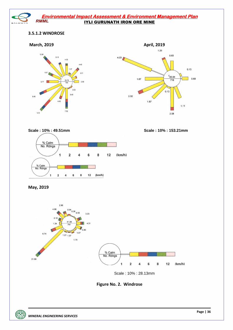
humidity, are presented in Table 3.7. Wind roses diagram has been drawn and presented as
Figure No.2
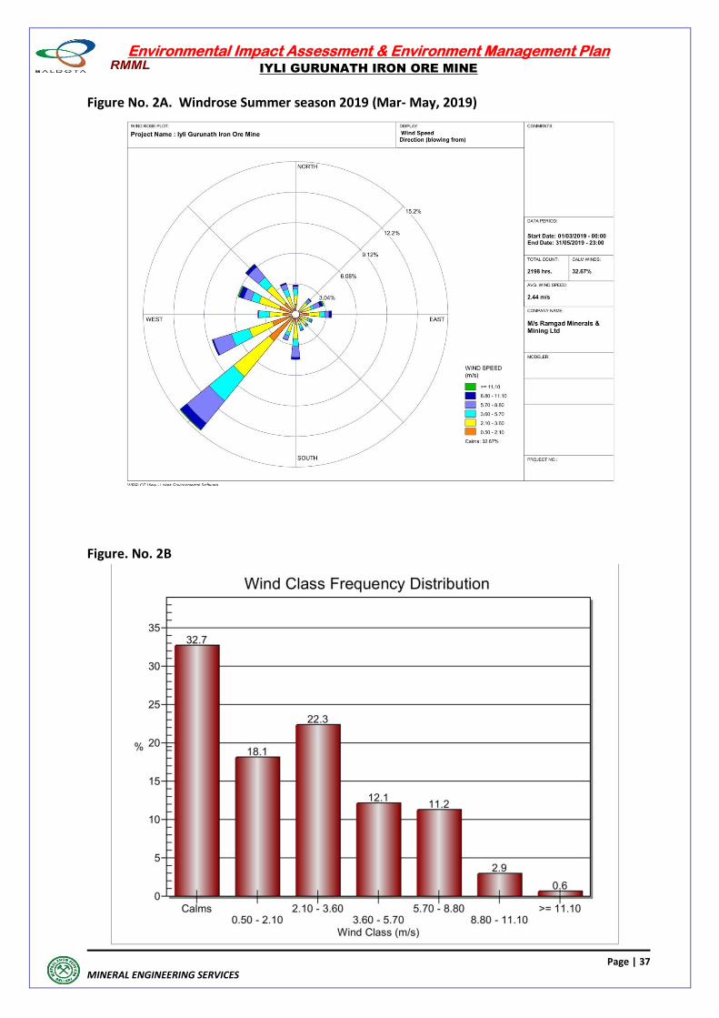
Observations:
During the monitoring period the observations in the study area are
Predominant winds from SSW directions
Wind Speed readings in the range 0.13-12.5 kmph,
Calm condition prevailed for 49.66% of the monitoring period
Temperature readings ranging from 19.6oC to 37.6 oC,
Month JUL AUG SEP OCT NOV DEC
YEAR R/F %DEP R/F %DEP R/F %DEP R/F %DEP R/F %DEP R/F %DEP
2014 100.2 30 179.6 101 91.7 -33 102.5 -12 14.8 -52 45.3 372
2015 28.3 -63 89.3 0 179.8 31 91.0 -22 4.9 -84 0.3 -97
2016 68.4 -11 24.7 -72 47.9 -65 11.4 -90 4.2 -86 4.6 -52
2017 50.8 -34 129.9 46 238.8 74 168.5 45 0.0 -100 0.0 -100
2018 21.5 -72 73.4 -18 52.7 -62 67.0 -42 2.6 -92 0.0 -100
Environmental Impact Assessment & Environment Management Plan
IYLI GURUNATH IRON ORE MINE
Page | 34
MINERAL ENGINEERING SERVICES
Relative humidity values ranging in between 11.2 % to 75.5%,
Mean atmospheric pressure 755 mm (of mercury),
Clear skies prevailed most of the times and
No major rainy days during the monitoring period have been observed
The collected meteorological data during this season represents the local weather phenomena.
Table 3.7 : Site-Specific Micro-Meteorological Data 2019
Date Temperature in
OC Relative Humidity in % Wind Speed Km/hr
Min. Max. Min. Max. Average Max.
01/03/2019 21.1 31.5 26.8 74.1 8.0 3.5
02/03/2019 20.8 31.0 28.3 80.4 11.0 4.7
03/03/2019 20.2 30.2 27.0 84.4 11.0 3.6
04/03/2019 21.5 30.5 33.7 73.7 8.0 3.2
05/03/2019 19.6 31.0 28.1 78.7 8.0 3.2
06/03/2019 21.7 31.4 19.0 55.6 8.0 4.0
07/03/2019 22.3 32.2 19.0 46.5 6.0 3.3
08/03/2019 21.4 32.4 13.8 55.9 9.0 4.3
09/03/2019 21.8 33.7 16.4 59.2 11.0 4.4
10/03/2019 21.4 34.1 14.7 58.1 8.0 3.3
11/03/2019 22.8 33.2 19.0 53.5 8.0 3.0
12/03/2019 21.7 34.0 12.9 74.2 8.0 3.5
13/03/2019 21.9 34.1 11.2 75.5 6.0 2.4
14/03/2019 22.1 33.9 16.4 94.7 9.0 3.2
15/03/2019 23.4 34.0 20.8 92.9 12.0 3.7
16/03/2019 22.9 34.5 15.5 34.3 6.0 2.2
17/03/2019 22.9 34.5 13.8 32.7 6.0 2.1
18/03/2019 21.6 34.2 20.8 92.9 12.0 3.7
19/03/2019 22.9 35.1 15.5 34.3 6.0 2.2
20/03/2019 23.4 33.9 16.4 94.7 9.0 3.2
21/03/2019 22.8 35.0 19.0 53.5 8.0 3.0
22/03/2019 22.9 34.0 13.9 32.7 6.0 2.3
23/03/2019 23.0 35.0 15.5 34.3 6.0 2.1
24/03/2019 24.3 34.5 16.4 94.7 9.0 3.2
25/03/2019 21.0 35.1 20.8 92.9 12.0 3.7
26/03/2019 22.6 34.6 26.4 80.4 11.0 4.7
Date Temperature in°C Relative Humidity in % Wind Speed Km/hr
Min Max. Min. Max. Max. Average 01/04/2019 24.4 32.0 22.3 59.0 6.0 0.7
02/04/2019 25.0 36.0 27.2 59.4 3.0 0.4
03/04/2019 26.0 37.0 21.5 54.3 6.0 1.0
04/04/2019 23.0 35.0 21.0 59.0 4.0 0.7
05/04/2019 24.0 36.0 21.0 61.5 3.0 0.7
06/04/2019 25.0 37.0 22.0 41.3 6.0 0.9
07/04/2019 24.3 35.6 16.1 51.1 6.0 0.8
08/04/2019 24.3 36.0 22.3 59.0 4.0 0.6
09/04/2019 25.0 37.0 27.2 59.4 3.0 0.4
10/04/2019 24.3 35.7 21.5 54.3 4.0 0.8
11/04/2019 25.0 36.7 21.0 59.0 3.0 0.8
12/04/2019 24.3 35.6 21.0 61.5 4.0 0.5
13/04/2019 25.0 37.0 22.0 41.3 4.0 0.5
Environmental Impact Assessment & Environment Management Plan
IYLI GURUNATH IRON ORE MINE
Page | 35
MINERAL ENGINEERING SERVICES
14/04/2019 24.6 36.2 16.1 51.1 6.0 0.8
15/04/2019 23.4 35.4 18.6 57.0 4.0 0.8
16/04/2019 25.6 35.4 22.0 58.0 3.0 0.5
17/04/2019 23.0 35.0 24.0 52.4 6.0 0.8
18/04/2019 25.0 37.0 17.1 55.3 4.0 0.6
19/04/2019 23.0 34.5 16.0 68.3 4.0 0.5
20/04/2019 25.3 35.6 21.4 54.2 4.0 0.3
21/04/2019 25.0 37.0 24.0 53.1 3.0 0.7
22/04/2019 24.8 35.6 15.1 55.5 3.0 0.8
23/04/2019 24.3 36.0 15.2 53.2 4.0 0.8
24/04/2019 25.0 37.0 16.1 43.5 1.0 0.3
25/04/2019 25.4 35.8 14.0 35.1 3.0 0.6
26/04/2019 24.7 36.5 19.6 53.0 6.0 0.9
27/04/2019 25.0 37.0 17.2 51.2 4.0 0.7
28/04/2019 24.6 36.7 19.0 53.2 0.8 0.1
29/04/2019 25.0 36.8 25.6 73.2 3.4 0.7
30/04/2019 23.4 37.6 38.2 81.2 2.4 0.9
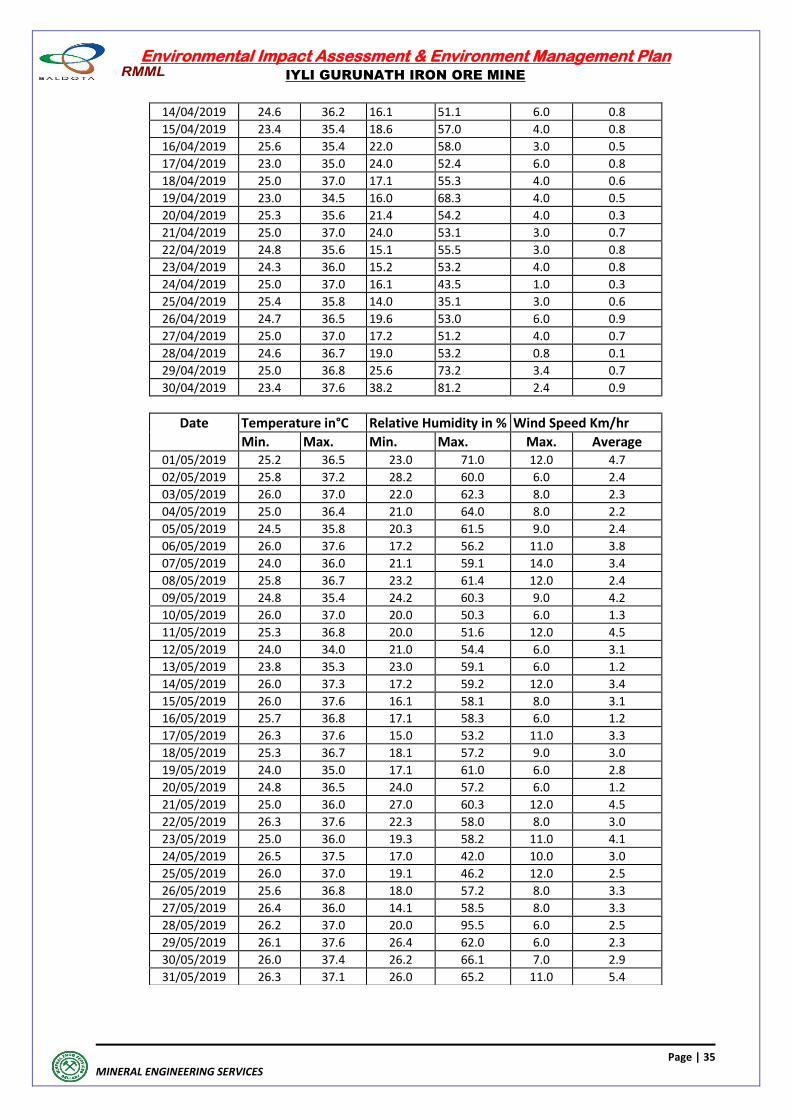
Date Temperature in°C Relative Humidity in % Wind Speed Km/hr Min. Max. Min. Max. Max. Average
01/05/2019 25.2 36.5 23.0 71.0 12.0 4.7
02/05/2019 25.8 37.2 28.2 60.0 6.0 2.4
03/05/2019 26.0 37.0 22.0 62.3 8.0 2.3
04/05/2019 25.0 36.4 21.0 64.0 8.0 2.2
05/05/2019 24.5 35.8 20.3 61.5 9.0 2.4
06/05/2019 26.0 37.6 17.2 56.2 11.0 3.8
07/05/2019 24.0 36.0 21.1 59.1 14.0 3.4
08/05/2019 25.8 36.7 23.2 61.4 12.0 2.4
09/05/2019 24.8 35.4 24.2 60.3 9.0 4.2
10/05/2019 26.0 37.0 20.0 50.3 6.0 1.3
11/05/2019 25.3 36.8 20.0 51.6 12.0 4.5
12/05/2019 24.0 34.0 21.0 54.4 6.0 3.1
13/05/2019 23.8 35.3 23.0 59.1 6.0 1.2
14/05/2019 26.0 37.3 17.2 59.2 12.0 3.4
15/05/2019 26.0 37.6 16.1 58.1 8.0 3.1
16/05/2019 25.7 36.8 17.1 58.3 6.0 1.2
17/05/2019 26.3 37.6 15.0 53.2 11.0 3.3
18/05/2019 25.3 36.7 18.1 57.2 9.0 3.0
19/05/2019 24.0 35.0 17.1 61.0 6.0 2.8
20/05/2019 24.8 36.5 24.0 57.2 6.0 1.2
21/05/2019 25.0 36.0 27.0 60.3 12.0 4.5
22/05/2019 26.3 37.6 22.3 58.0 8.0 3.0
23/05/2019 25.0 36.0 19.3 58.2 11.0 4.1
24/05/2019 26.5 37.5 17.0 42.0 10.0 3.0
25/05/2019 26.0 37.0 19.1 46.2 12.0 2.5
26/05/2019 25.6 36.8 18.0 57.2 8.0 3.3
27/05/2019 26.4 36.0 14.1 58.5 8.0 3.3
28/05/2019 26.2 37.0 20.0 95.5 6.0 2.5
29/05/2019 26.1 37.6 26.4 62.0 6.0 2.3
30/05/2019 26.0 37.4 26.2 66.1 7.0 2.9
31/05/2019 26.3 37.1 26.0 65.2 11.0 5.4
Environmental Impact Assessment & Environment Management Plan
IYLI GURUNATH IRON ORE MINE
Page | 36
MINERAL ENGINEERING SERVICES
3.5.1.2 WINDROSE March, 2019 April, 2019
Scale : 10% : 49.51mm Scale : 10% : 153.21mm
May, 2019
Scale : 10% : 28.13mm
Figure No. 2. Windrose
Environmental Impact Assessment & Environment Management Plan
IYLI GURUNATH IRON ORE MINE
Page | 37
MINERAL ENGINEERING SERVICES
Figure No. 2A. Windrose Summer season 2019 (Mar- May, 2019)
Figure. No. 2B
Environmental Impact Assessment & Environment Management Plan
IYLI GURUNATH IRON ORE MINE
Page | 38
MINERAL ENGINEERING SERVICES
3.5.2 AMBIENT AIR QUALITY
The ambient air quality with respect to the study zone of 10 km radius around the mine forms
the baseline information. The study area represents mostly rural environment. The various
sources of air pollution in the region are vehicular traffic, dust arising from unpaved village
roads & domestic fuel burning. The prime objective of baseline air quality survey is to assess
the existing air quality of the study area. This will also be useful in assessing the conformity to
standards of the ambient air quality.
3.5.2.1 SELECTION OF SAMPLING STATIONS
The baseline status of the ambient air quality can be assessed through scientifically designed
Ambient Air Quality Monitoring Network. The selection of sampling locations for the air quality
surveillance programmed is based on the following.
(a) Representation of the Mine
(b) Representation of down wind direction
(c) Representation of upwind direction
(d) Representation of cross wind direction
(e) Representation of residential areas
(f) Representation of regional background levels
(g) Representation of sensitive receptors
Since the ground level concentration of the pollutants, mainly the dust released from the
mine do not spread beyond 5 km radius, the locations of monitoring stations in the buffer zone
have been kept close to ML Area. The AAQ monitoring, stations have been selected on the
basis of wind direction. The wind direction conditions have been considered and correlated
during the monitoring. The stations monitored for ambient air quality are furnished below and
refer MES/DWG/AM/13-21.
Table 3.8 : Location of Ambient Air Quality Monitoring Stations
Station Code
Location Distance
(Km) Direction Latitude Longitude
A1 Core Zone (ML Area) - - N 15009'18.8" E 76
026'43.31"
A2 Jaisingpur village 3.38 N N 15011'08.59" E 76
026'11.40"
A3 Siddapur village 2.73 E N 15009'16.0" E 76
028'12.08"
A4 Gunda Village 5.51 SWW N 15008'40.2" E 76
023'40.6"
A5 Ramgad Village 3.61 SSE N 15007'42.0" E 76
027'43.0"
A6 Venkatagiri Village 5.30 NNW N 15012'01.0" E 76
025'30.0"
A7 Hanumanahalli Village 7.77 NWW N 15010'57.8" E 76
022'39.1"
A8 Garaga Village 7.69 SSW N 15003'27.00" E 76
025'14.29"
Environmental Impact Assessment & Environment Management Plan
IYLI GURUNATH IRON ORE MINE
Page | 39
MINERAL ENGINEERING SERVICES
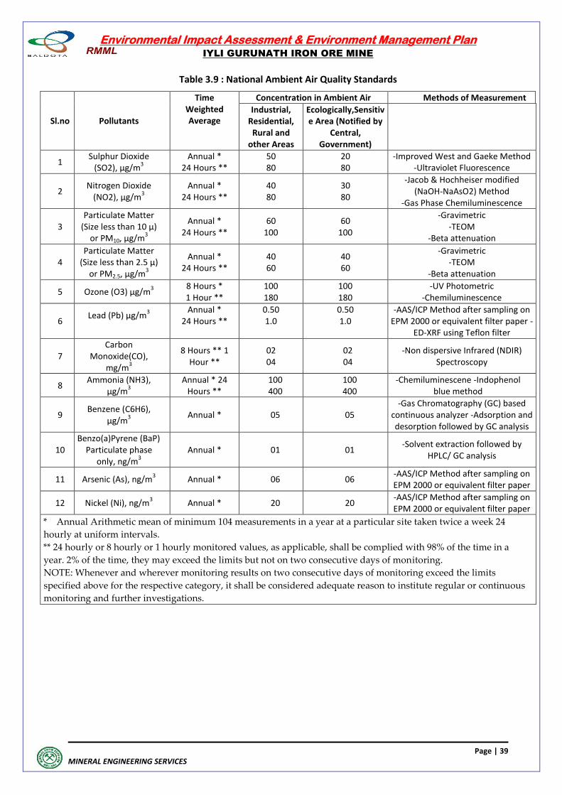
Table 3.9 : National Ambient Air Quality Standards
Sl.no Pollutants
Time Weighted Average
Concentration in Ambient Air Methods of Measurement
Industrial, Residential, Rural and
other Areas
Ecologically,Sensitive Area (Notified by
Central, Government)
1 Sulphur Dioxide
(SO2), μg/m3
Annual * 24 Hours **
50 80
20 80
-Improved West and Gaeke Method -Ultraviolet Fluorescence
2 Nitrogen Dioxide
(NO2), μg/m3
Annual * 24 Hours **
40 80
30 80
-Jacob & Hochheiser modified (NaOH-NaAsO2) Method
-Gas Phase Chemiluminescence
3 Particulate Matter
(Size less than 10 μ) or PM10, μg/m
3
Annual * 24 Hours **
60 100
60 100
-Gravimetric -TEOM
-Beta attenuation
4 Particulate Matter
(Size less than 2.5 μ) or PM2.5, μg/m
3
Annual * 24 Hours **
40 60
40 60
-Gravimetric -TEOM
-Beta attenuation
5 Ozone (O3) μg/m3
8 Hours * 1 Hour **
100 180
100 180
-UV Photometric -Chemiluminescence
6 Lead (Pb) μg/m
3
Annual * 24 Hours **
0.50 1.0
0.50 1.0
-AAS/ICP Method after sampling on EPM 2000 or equivalent filter paper -
ED-XRF using Teflon filter
7 Carbon
Monoxide(CO), mg/m
3
8 Hours ** 1 Hour **
02 04
02 04
-Non dispersive Infrared (NDIR) Spectroscopy
8 Ammonia (NH3),
μg/m3
Annual * 24 Hours **
100 400
100 400
-Chemiluminescene -Indophenol blue method
9 Benzene (C6H6),
μg/m3
Annual * 05 05 -Gas Chromatography (GC) based
continuous analyzer -Adsorption and desorption followed by GC analysis
10 Benzo(a)Pyrene (BaP)
Particulate phase only, ng/m
3 Annual * 01 01
-Solvent extraction followed by HPLC/ GC analysis
11 Arsenic (As), ng/m3
Annual * 06 06 -AAS/ICP Method after sampling on EPM 2000 or equivalent filter paper
12 Nickel (Ni), ng/m3
Annual * 20 20 -AAS/ICP Method after sampling on EPM 2000 or equivalent filter paper
* Annual Arithmetic mean of minimum 104 measurements in a year at a particular site taken twice a week 24
hourly at uniform intervals.
** 24 hourly or 8 hourly or 1 hourly monitored values, as applicable, shall be complied with 98% of the time in a
year. 2% of the time, they may exceed the limits but not on two consecutive days of monitoring.
NOTE: Whenever and wherever monitoring results on two consecutive days of monitoring exceed the limits
specified above for the respective category, it shall be considered adequate reason to institute regular or continuous
monitoring and further investigations.
Environmental Impact Assessment & Environment Management Plan
IYLI GURUNATH IRON ORE MINE
Page | 40
MINERAL ENGINEERING SERVICES
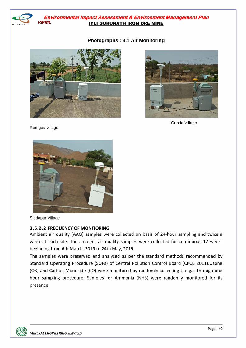
Photographs : 3.1 Air Monitoring
Gunda Village Ramgad village
Siddapur Village
3.5.2.2 FREQUENCY OF MONITORING
Ambient air quality (AAQ) samples were collected on basis of 24-hour sampling and twice a
week at each site. The ambient air quality samples were collected for continuous 12-weeks
beginning from 6th March, 2019 to 24th May, 2019.
The samples were preserved and analysed as per the standard methods recommended by
Standard Operating Procedure (SOPs) of Central Pollution Control Board (CPCB 2011).Ozone
(O3) and Carbon Monoxide (CO) were monitored by randomly collecting the gas through one
hour sampling procedure. Samples for Ammonia (NH3) were randomly monitored for its
presence.
Environmental Impact Assessment & Environment Management Plan
IYLI GURUNATH IRON ORE MINE
Page | 41
MINERAL ENGINEERING SERVICES
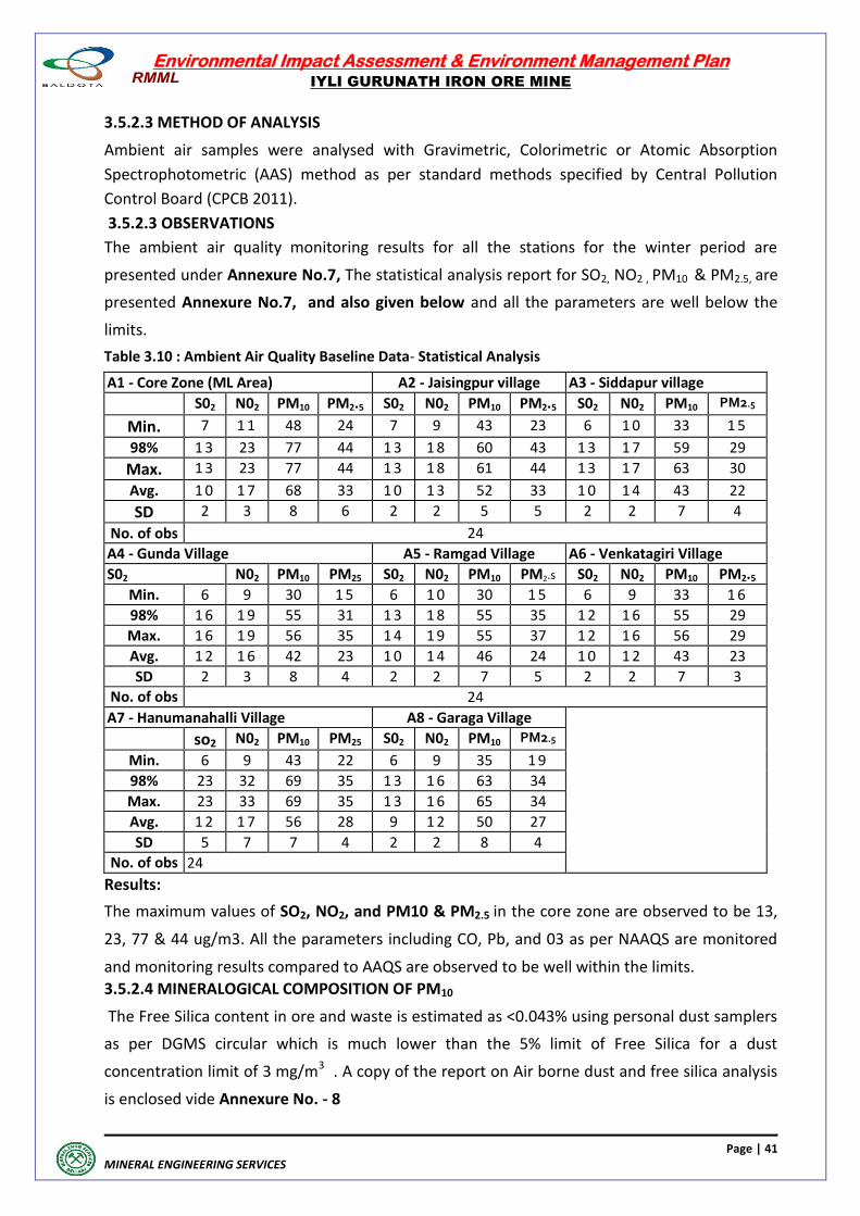
3.5.2.3 METHOD OF ANALYSIS
Ambient air samples were analysed with Gravimetric, Colorimetric or Atomic Absorption
Spectrophotometric (AAS) method as per standard methods specified by Central Pollution
Control Board (CPCB 2011).
3.5.2.3 OBSERVATIONS
The ambient air quality monitoring results for all the stations for the winter period are
presented under Annexure No.7, The statistical analysis report for SO2, NO2 , PM10 & PM2.5, are
presented Annexure No.7, and also given below and all the parameters are well below the
limits.
Table 3.10 : Ambient Air Quality Baseline Data- Statistical Analysis
A1 - Core Zone (ML Area) A2 - Jaisingpur village A3 - Siddapur village
S02 N02 PM10 PM2.5 S02 N02 PM10 PM2.5 S02 N02 PM10 PM2.5
Min. 7 1 1 48 24 7 9 43 23 6 1 0 33 1 5
98% 1 3 23 77 44 1 3 1 8 60 43 1 3 1 7 59 29
Max. 1 3 23 77 44 1 3 1 8 61 44 1 3 1 7 63 30
Avg. 1 0 1 7 68 33 1 0 1 3 52 33 1 0 1 4 43 22
SD 2 3 8 6 2 2 5 5 2 2 7 4
No. of obs 24
A4 - Gunda Village A5 - Ramgad Village A6 - Venkatagiri Village
S02 N02 PM10 PM25 S02 N02 PM10 PM2.s S02 N02 PM10 PM2.5
Min. 6 9 30 1 5 6 1 0 30 1 5 6 9 33 1 6
98% 1 6 1 9 55 31 1 3 1 8 55 35 1 2 1 6 55 29
Max. 1 6 1 9 56 35 1 4 1 9 55 37 1 2 1 6 56 29
Avg. 1 2 1 6 42 23 1 0 1 4 46 24 1 0 1 2 43 23
SD 2 3 8 4 2 2 7 5 2 2 7 3
No. of obs 24
A7 - Hanumanahalli Village A8 - Garaga Village
so2 N02 PM10 PM25 S02 N02 PM10 PM2.5
Min. 6 9 43 22 6 9 35 1 9
98% 23 32 69 35 1 3 1 6 63 34
Max. 23 33 69 35 1 3 1 6 65 34
Avg. 1 2 1 7 56 28 9 1 2 50 27
SD 5 7 7 4 2 2 8 4
No. of obs 24
Results:
The maximum values of SO2, NO2, and PM10 & PM2.5 in the core zone are observed to be 13,
23, 77 & 44 ug/m3. All the parameters including CO, Pb, and 03 as per NAAQS are monitored
and monitoring results compared to AAQS are observed to be well within the limits.
3.5.2.4 MINERALOGICAL COMPOSITION OF PM10
The Free Silica content in ore and waste is estimated as <0.043% using personal dust samplers
as per DGMS circular which is much lower than the 5% limit of Free Silica for a dust
concentration limit of 3 mg/m3 . A copy of the report on Air borne dust and free silica analysis
is enclosed vide Annexure No. - 8
Environmental Impact Assessment & Environment Management Plan
IYLI GURUNATH IRON ORE MINE
Page | 42
MINERAL ENGINEERING SERVICES
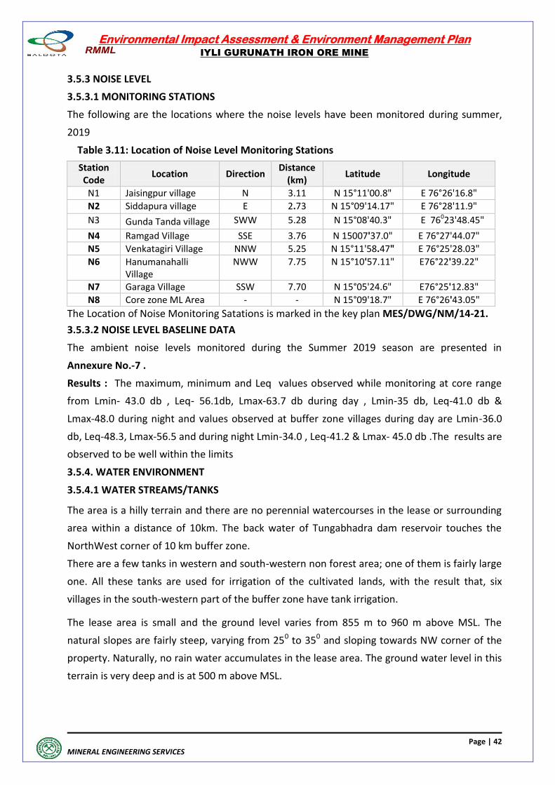
3.5.3 NOISE LEVEL
3.5.3.1 MONITORING STATIONS
The following are the locations where the noise levels have been monitored during summer,
2019
Table 3.11: Location of Noise Level Monitoring Stations
Station Code
Location Direction Distance
(km) Latitude Longitude
N1 Jaisingpur village N 3.11 N 15°11'00.8" E 76°26'16.8"
N2 Siddapura village E 2.73 N 15°09'14.17" E 76°28'11.9"
N3 Gunda Tanda village SWW 5.28 N 15°08'40.3" E 76023'48.45"
N4 Ramgad Village SSE 3.76 N 15007'37.0" E 76°27'44.07"
N5 Venkatagiri Village NNW 5.25 N 15°11'58.47" E 76°25'28.03"
N6 Hanumanahalli Village
NWW 7.75 N 15°10'57.11" E76°22'39.22"
N7 Garaga Village SSW 7.70 N 15°05'24.6" E76°25'12.83"
N8 Core zone ML Area - - N 15°09'18.7" E 76°26'43.05"
The Location of Noise Monitoring Satations is marked in the key plan MES/DWG/NM/14-21.
3.5.3.2 NOISE LEVEL BASELINE DATA
The ambient noise levels monitored during the Summer 2019 season are presented in
Annexure No.-7 .
Results : The maximum, minimum and Leq values observed while monitoring at core range
from Lmin- 43.0 db , Leq- 56.1db, Lmax-63.7 db during day , Lmin-35 db, Leq-41.0 db &
Lmax-48.0 during night and values observed at buffer zone villages during day are Lmin-36.0
db, Leq-48.3, Lmax-56.5 and during night Lmin-34.0 , Leq-41.2 & Lmax- 45.0 db .The results are
observed to be well within the limits
3.5.4. WATER ENVIRONMENT
3.5.4.1 WATER STREAMS/TANKS
The area is a hilly terrain and there are no perennial watercourses in the lease or surrounding
area within a distance of 10km. The back water of Tungabhadra dam reservoir touches the
NorthWest corner of 10 km buffer zone.
There are a few tanks in western and south-western non forest area; one of them is fairly large
one. All these tanks are used for irrigation of the cultivated lands, with the result that, six
villages in the south-western part of the buffer zone have tank irrigation.
The lease area is small and the ground level varies from 855 m to 960 m above MSL. The
natural slopes are fairly steep, varying from 250 to 350 and sloping towards NW corner of the
property. Naturally, no rain water accumulates in the lease area. The ground water level in this
terrain is very deep and is at 500 m above MSL.
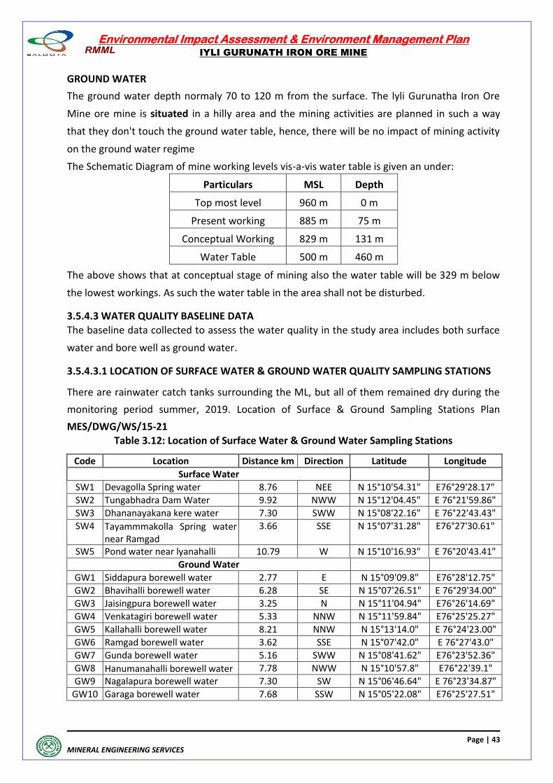
Environmental Impact Assessment & Environment Management Plan
IYLI GURUNATH IRON ORE MINE
Page | 43
MINERAL ENGINEERING SERVICES
GROUND WATER
The ground water depth normaly 70 to 120 m from the surface. The lyli Gurunatha Iron Ore
Mine ore mine is situated in a hilly area and the mining activities are planned in such a way
that they don't touch the ground water table, hence, there will be no impact of mining activity
on the ground water regime
The Schematic Diagram of mine working levels vis-a-vis water table is given an under:
Particulars MSL Depth
Top most level 960 m 0 m
Present working 885 m 75 m
Conceptual Working 829 m 131 m
Water Table 500 m 460 m
The above shows that at conceptual stage of mining also the water table will be 329 m below
the lowest workings. As such the water table in the area shall not be disturbed.
3.5.4.3 WATER QUALITY BASELINE DATA
The baseline data collected to assess the water quality in the study area includes both surface
water and bore well as ground water.
3.5.4.3.1 LOCATION OF SURFACE WATER & GROUND WATER QUALITY SAMPLING STATIONS
There are rainwater catch tanks surrounding the ML, but all of them remained dry during the
monitoring period summer, 2019. Location of Surface & Ground Sampling Stations Plan
MES/DWG/WS/15-21 Table 3.12: Location of Surface Water & Ground Water Sampling Stations
Code Location Distance km Direction Latitude Longitude
Surface Water
SW1 Devagolla Spring water 8.76 NEE N 15°10'54.31" E76°29'28.17"
SW2 Tungabhadra Dam Water 9.92 NWW N 15°12'04.45" E 76°21'59.86"
SW3 Dhananayakana kere water 7.30 SWW N 15°08'22.16" E 76°22'43.43"
SW4 Tayammmakolla Spring water near Ramgad
3.66 SSE N 15°07'31.28" E76°27'30.61"
SW5 Pond water near lyanahalli 10.79 W N 15°10'16.93" E 76°20'43.41"
Ground Water
GW1 Siddapura borewell water 2.77 E N 15°09'09.8" E76°28'12.75"
GW2 Bhavihalli borewell water 6.28 SE N 15°07'26.51" E 76°29'34.00"
GW3 Jaisingpura borewell water 3.25 N N 15°11'04.94" E76°26'14.69"
GW4 Venkatagiri borewell water 5.33 NNW N 15°11'59.84" E76°25'25.27"
GW5 Kallahalli borewell water 8.21 NNW N 15°13'14.0" E 76°24'23.00"
GW6 Ramgad borewell water 3.62 SSE N 15°07'42.0" E 76°27'43.0"
GW7 Gunda borewell water 5.16 SWW N 15°08'41.62" E76°23'52.36"
GW8 Hanumanahalli borewell water 7.78 NWW N 15°10'57.8" E76°22'39.1"
GW9 Nagalapura borewell water 7.30 SW N 15°06'46.64" E 76°23'34.87"
GW10 Garaga borewell water 7.68 SSW N 15°05'22.08" E76°25'27.51"
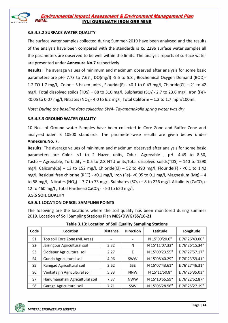
Environmental Impact Assessment & Environment Management Plan
IYLI GURUNATH IRON ORE MINE
Page | 44
MINERAL ENGINEERING SERVICES
3.5.4.3.2 SURFACE WATER QUALITY
The surface water samples collected during Summer-2019 have been analysed and the results
of the analysis have been compared with the standards is IS: 2296 surface water samples all
the parameters are observed to be well within the limits. The analysis reports of surface water
are presented under Annexure No.7 respectively
Results: The average values of minimum and maximum observed after analysis for some basic
parameters are pH- 7.73 to 7.67 , DO(mg/l) -5.5 to 5.8 , Biochemical Oxygen Demand (BOD)-
1.2 TO 1.7 mg/l, Color – 5 hazen units , Flouride(F) - <0.1 to 0.43 mg/l, Chloride(Cl) – 21 to 42
mg/l, Total dissolved soilds (TDS) – 88 to 310 mg/l, Sulphates (SO4)- 2.7 to 23.6 mg/l, Iron (Fe)-
<0.05 to 0.07 mg/l, Nitrates (NO3)- 4.0 to 6.2 mg/l, Total Coliform – 1.2 to 1.7 mpn/100ml.
Note: During the baseline data collection SW4- Tayamanakolla spring water was dry
3.5.4.3.3 GROUND WATER QUALITY
10 Nos. of Ground water Samples have been collected in Core Zone and Buffer Zone and
analysed uder IS 10500 standards. The parameter-wise results are given below under
Annexure.No. 7.
Results: The average values of minimum and maximum observed after analysis for some basic
parameters are Color- <1 to 2 Hazen units, Odur- Agreeable , pH- 4.49 to 8.30,
Taste – Agreeable, Turbidity – 0.5 to 2.8 NTU units,Total dissolved soilds(TDS) – 140 to 1590
mg/l, Calicum(Ca) – 13 to 152 mg/l, Chloride(Cl) – 52 to 490 mg/l, Flouride(F) - <0.1 to 1.42
mg/l, Residual free chlorine (RFC) - <0.1 mg/l, Iron (Fe)- <0.05 to 0.1 mg/l, Magnesium (Mg) – 4
to 58 mg/l, Nitrates (NO3) - 7.7 to 73 mg/l, Sulphates (SO4) – 8 to 226 mg/l, Alkalinity (CaCO3)-
12 to 460 mg/l , Total Hardness(CaCO3) - 50 to 620 mg/l,
3.5.5 SOIL QUALITY
3.5.5.1 LOCATION OF SOIL SAMPLING POINTS
The following are the locations where the soil quality has been monitored during summer 2019. Location of Soil Sampling Stations Plan MES/DWG/SS/16-21
Table 3.13: Location of Soil Quality Sampling Stations
Code Location Distance Direction Latitude Longitude
S1 Top soil Core Zone (ML Area) - - N 15°09'20.0" E 76°26'43.00"
S2 Jaisingpur Agricultural soil 3.32 N N 15°11'07.33" E 76°26'15.34"
S3 Siddapur Agricultural soil 2.27 E N 15°09'23.55" E 76°27'57.17"
S4 Gunda Agricultural soil 4.96 SWW N 15°08'40.29" E 76°23'59.41"
S5 Ramgad Agricultural soil 3.62 SSE N 15°07'43.61" E 76°27'46.31"
S6 Venkatagiri Agricultural soil 5.33 NNW N 15°11'50.8" E 76°25'35.03"
S7 Hanumanahalli Agricultural soil 7.37 NWW N 15°10'55.59" E 76°22'52.87"
S8 Garaga Agricultural soil 7.71 SSW N 15°05'28.56" E 76°25'27.19"
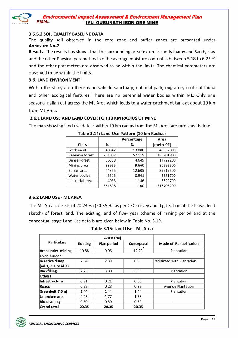
Environmental Impact Assessment & Environment Management Plan
IYLI GURUNATH IRON ORE MINE
Page | 45
MINERAL ENGINEERING SERVICES
3.5.5.2 SOIL QUALITY BASELINE DATA The quality soil observed in the core zone and buffer zones are presented under Annexure.No-7. Results: The results has shown that the surrounding area texture is sandy loamy and Sandy clay
and the other Physical parameters like the average moisture content is between 5.18 to 6.23 %
and the other parameters are observed to be within the limits. The chemical parameters are
observed to be within the limits.
3.6. LAND ENVIRONMENT
Within the study area there is no wildlife sanctuary, national park, migratory route of fauna
and other ecological features. There are no perennial water bodies within ML. Only one
seasonal nallah cut across the ML Area which leads to a water catchment tank at about 10 km
from ML Area.
3.6.1 LAND USE AND LAND COVER FOR 10 KM RADIUS OF MINE
The map showing land use details within 10 km radius from the ML Area are furnished below.
Table 3.14: Land Use Pattern (10 km Radius)
Class ha Percentage
% Area
[metre^2] Settlement 48842 13.880 43957800
Researve forest 201002 57.119 180901800
Dense Forest 16358 4.649 14722200
Mining area 33995 9.660 30595500
Barran area 44355 12.605 39919500
Water bodies 3313 0.941 2981700
Industrial area 4033 1.146 3629700
351898 100 316708200
3.6.2 LAND USE - ML AREA
The ML Area consists of 20.23 Ha (20.35 Ha as per CEC survey and digitization of the lease deed
sketch) of forest land. The existing, end of five- year scheme of mining period and at the
conceptual stage Land Use details are given below in Table No. 3.19.
Table 3.15: Land Use - ML Area
Particulars
AREA (Ha)
Existing Plan period Conceptual period
Mode of Rehabilitation
Area under mining 10.88 9.96 12.29 Plantation
Over burden
In active dump (ad-1,id-1 to id-3)
2.54 2.39 0.66 Reclaimed with Plantation
Backfilling 2.25 3.80 3.80 Plantation
Others
Infrastructure 0.21 0.21 0.00 Plantation
Roads 0.28 0.28 0.28 Avenue Plantation
Greenbelt(7.5m) 1.44 1.44 1.44 Plantation
Unbroken area 2.25 1.77 1.38 -
Bio-diversity 0.50 0.50 0.50 -
Grand total 20.35 20.35 20.35
Environmental Impact Assessment & Environment Management Plan
IYLI GURUNATH IRON ORE MINE
Page | 46
MINERAL ENGINEERING SERVICES
3.7 ECOLOGY AND BIODIVERSITY BASELINE DATA
The biodiversity study was undertaken to assess the biodiversity of Mining Lease Area and its
buffer area of 10 Km radius with the following objectives.
Collection and synthesis of secondary information on the status of biodiversity in study
region
Field survey to assess the status of flora and fauna component in core and buffer areas
of project site
Authenticating the report on Wildlife Management Plan of Schedule –I species by
Forest Departmetn Authority
Identification and listing of flora and fauna which are important as per the Wildlife
(protection) Act 1972.
3.7.1 A STUDY REGION
Iyli Gurunath iron ore mine is situated in Ramanmalai hill range of Sandur forest near Ramgad
village, Sandur taluk, Bellary district of Karnataka state. The extent of lease is 20.23 Ha (20.35
Ha as per CEC survey and digitization of the lease deed sketch) Latitude: N 15009’ 15.41" to
15009’ 39.08", Longitude: E 76026' 26.7” 76026' 47.86” (MES/DWG/SP/05-21). The entire lease
is forest land, which is part of Ramgad RF. There are no National Parks, wildlife sanctuaries or
biosphere reserves located within 10 km radius from mine core area. The project does not
involve displacement of population.
3.7.1 B Approach
A participatory and consultative approach was followed in executing the assignment on
Ecology & Biodiversity assessment of the core area and 10-km radius buffer region. Further
enquiries were made with forest officials, revenue department and local villagers.
Literature survey included a review of the forest working plan, Census hand book, Gazetteer
and other records related to the ecology of the region.
A team comprising flora and fauna specialists from Mineral Engineering Services along with Mr.
M.S. Raju have visited the Iyli Gurunath Iron ore mine and 10-km buffer area during summer
season of Mar to May 2019 and held discussion with Mines Manager, environmental officer &
Surveyor (Photo 3.2). They have highlighted the mining history, shown us the mine lease
boundary.
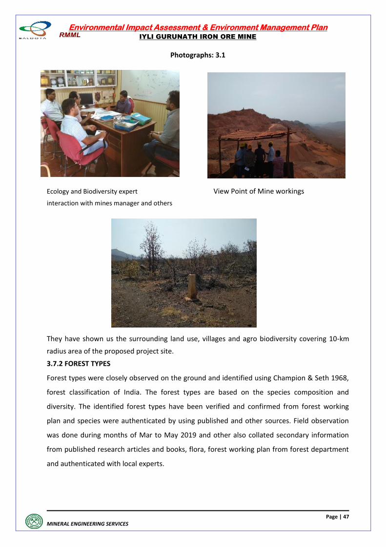
Environmental Impact Assessment & Environment Management Plan
IYLI GURUNATH IRON ORE MINE
Page | 47
MINERAL ENGINEERING SERVICES
Photographs: 3.1
Ecology and Biodiversity expert View Point of Mine workings
interaction with mines manager and others
They have shown us the surrounding land use, villages and agro biodiversity covering 10-km
radius area of the proposed project site.
3.7.2 FOREST TYPES
Forest types were closely observed on the ground and identified using Champion & Seth 1968,
forest classification of India. The forest types are based on the species composition and
diversity. The identified forest types have been verified and confirmed from forest working
plan and species were authenticated by using published and other sources. Field observation
was done during months of Mar to May 2019 and other also collated secondary information
from published research articles and books, flora, forest working plan from forest department
and authenticated with local experts.
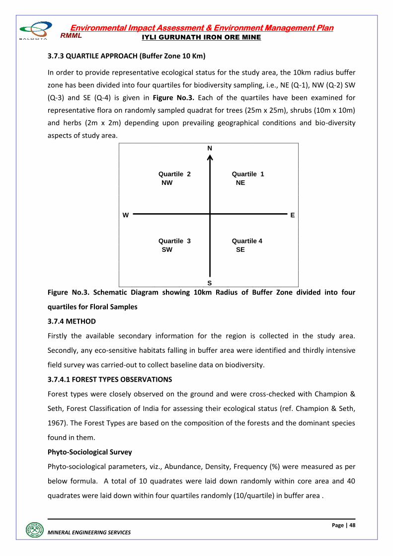
Environmental Impact Assessment & Environment Management Plan
IYLI GURUNATH IRON ORE MINE
Page | 48
MINERAL ENGINEERING SERVICES
3.7.3 QUARTILE APPROACH (Buffer Zone 10 Km)
In order to provide representative ecological status for the study area, the 10km radius buffer
zone has been divided into four quartiles for biodiversity sampling, i.e., NE (Q-1), NW (Q-2) SW
(Q-3) and SE (Q-4) is given in Figure No.3. Each of the quartiles have been examined for
representative flora on randomly sampled quadrat for trees (25m x 25m), shrubs (10m x 10m)
and herbs (2m x 2m) depending upon prevailing geographical conditions and bio-diversity
aspects of study area.
N
Quartile 2
Quartile 1
NW
NE
W
E
Quartile 3
Quartile 4
SW
SE
S
Figure No.3. Schematic Diagram showing 10km Radius of Buffer Zone divided into four
quartiles for Floral Samples
3.7.4 METHOD
Firstly the available secondary information for the region is collected in the study area.
Secondly, any eco-sensitive habitats falling in buffer area were identified and thirdly intensive
field survey was carried-out to collect baseline data on biodiversity.
3.7.4.1 FOREST TYPES OBSERVATIONS
Forest types were closely observed on the ground and were cross-checked with Champion &
Seth, Forest Classification of India for assessing their ecological status (ref. Champion & Seth,
1967). The Forest Types are based on the composition of the forests and the dominant species
found in them.
Phyto-Sociological Survey
Phyto-sociological parameters, viz., Abundance, Density, Frequency (%) were measured as per
below formula. A total of 10 quadrates were laid down randomly within core area and 40
quadrates were laid down within four quartiles randomly (10/quartile) in buffer area .
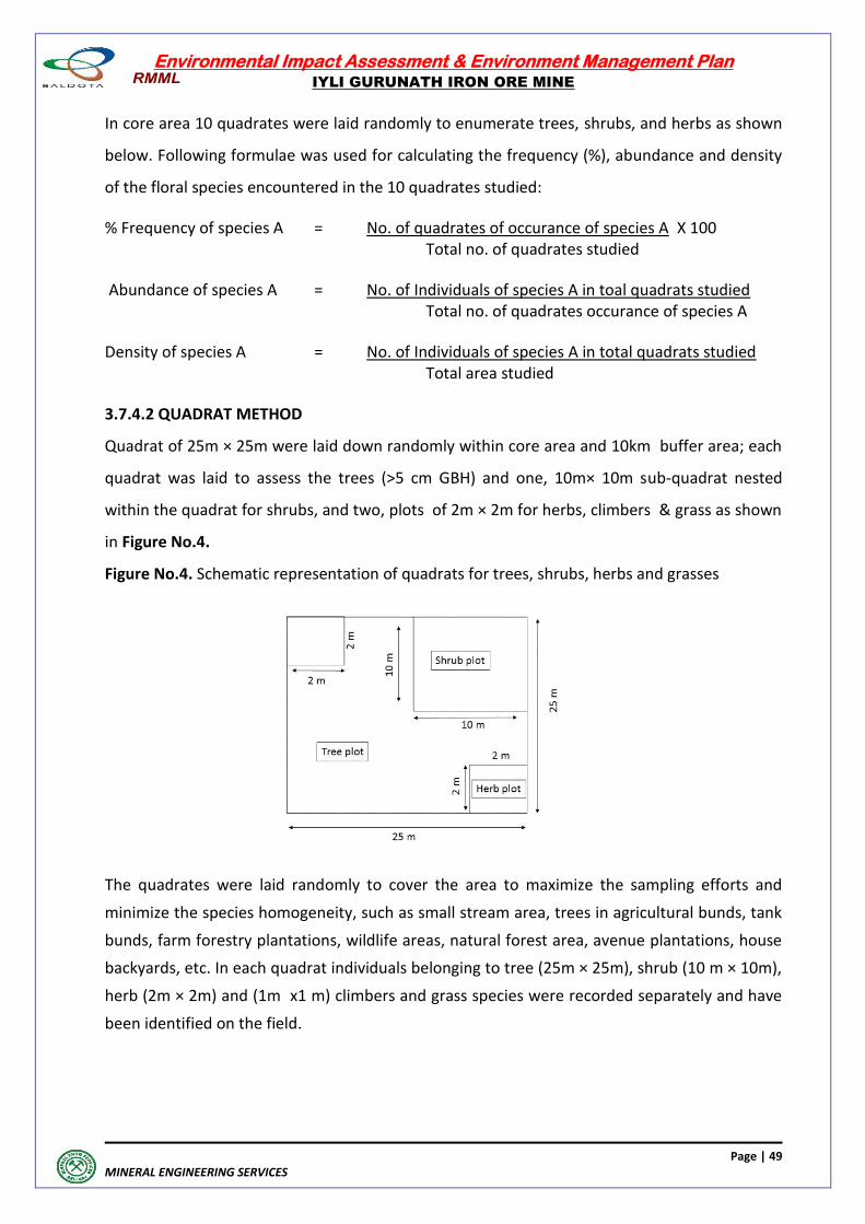
Environmental Impact Assessment & Environment Management Plan
IYLI GURUNATH IRON ORE MINE
Page | 49
MINERAL ENGINEERING SERVICES
In core area 10 quadrates were laid randomly to enumerate trees, shrubs, and herbs as shown
below. Following formulae was used for calculating the frequency (%), abundance and density
of the floral species encountered in the 10 quadrates studied:
% Frequency of species A = No. of quadrates of occurance of species A X 100 Total no. of quadrates studied
Abundance of species A = No. of Individuals of species A in toal quadrats studied Total no. of quadrates occurance of species A
Density of species A = No. of Individuals of species A in total quadrats studied Total area studied
3.7.4.2 QUADRAT METHOD
Quadrat of 25m × 25m were laid down randomly within core area and 10km buffer area; each
quadrat was laid to assess the trees (>5 cm GBH) and one, 10m× 10m sub-quadrat nested
within the quadrat for shrubs, and two, plots of 2m × 2m for herbs, climbers & grass as shown
in Figure No.4.
Figure No.4. Schematic representation of quadrats for trees, shrubs, herbs and grasses
The quadrates were laid randomly to cover the area to maximize the sampling efforts and
minimize the species homogeneity, such as small stream area, trees in agricultural bunds, tank
bunds, farm forestry plantations, wildlife areas, natural forest area, avenue plantations, house
backyards, etc. In each quadrat individuals belonging to tree (25m × 25m), shrub (10 m × 10m),
herb (2m × 2m) and (1m x1 m) climbers and grass species were recorded separately and have
been identified on the field.
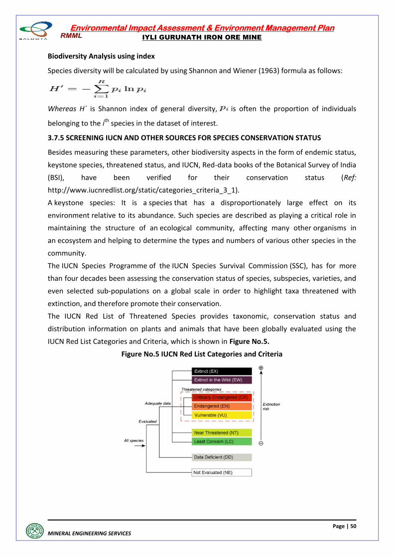
Environmental Impact Assessment & Environment Management Plan
IYLI GURUNATH IRON ORE MINE
Page | 50
MINERAL ENGINEERING SERVICES
Biodiversity Analysis using index
Species diversity will be calculated by using Shannon and Wiener (1963) formula as follows:
Whereas H΄ is Shannon index of general diversity, is often the proportion of individuals
belonging to the ith species in the dataset of interest.
3.7.5 SCREENING IUCN AND OTHER SOURCES FOR SPECIES CONSERVATION STATUS
Besides measuring these parameters, other biodiversity aspects in the form of endemic status,
keystone species, threatened status, and IUCN, Red-data books of the Botanical Survey of India
(BSI), have been verified for their conservation status (Ref:
http://www.iucnredlist.org/static/categories_criteria_3_1).
A keystone species: It is a species that has a disproportionately large effect on its
environment relative to its abundance. Such species are described as playing a critical role in
maintaining the structure of an ecological community, affecting many other organisms in
an ecosystem and helping to determine the types and numbers of various other species in the
community.
The IUCN Species Programme of the IUCN Species Survival Commission (SSC), has for more
than four decades been assessing the conservation status of species, subspecies, varieties, and
even selected sub-populations on a global scale in order to highlight taxa threatened with
extinction, and therefore promote their conservation.
The IUCN Red List of Threatened Species provides taxonomic, conservation status and
distribution information on plants and animals that have been globally evaluated using the
IUCN Red List Categories and Criteria, which is shown in Figure No.5.
Figure No.5 IUCN Red List Categories and Criteria
Environmental Impact Assessment & Environment Management Plan
IYLI GURUNATH IRON ORE MINE
Page | 51
MINERAL ENGINEERING SERVICES
This system is designed to determine the relative risk of extinction, and the main purpose of
the IUCN Red List is to catalogue and highlight those plants and animals that are facing a higher
risk of global extinction (i.e., those listed as Critically
Endangered, Endangered, and Vulnerable). The IUCN Red List also includes information on
plants and animals that are categorised as Extinct or Extinct in the Wild; on taxa that cannot be
evaluated because of insufficient information (i.e., are Data Deficient); and on plants and
animals that are either close to meeting the threatened thresholds or that would be
threatened if not considered for an ongoing taxon-specific conservation programme (i.e.,
are Near Threatened).
3.7.6. FAUNAL DIVERSITY
Mammals were observed using indirect methods such as faecal matter (i.e., scat) and pug mark
by establishing 10 × 100-m linear transects depending on the habitat (i.e,. existing wildlife
game routes/forest trails used). We have also documented few mammals by direct sighting.
We have used point count method for bird documentation as per standard method by
Sutherland (1996), which involved 10-minute observation in each point during early morning
hours (6.00 to 10.00 AM). We have enumerated 20 point-counts in each quartile, which
constitute a total of 80 points-counts (20 × 4) within 10-km radius area.
The butterfly was enumerated by 2 linear transects of 10 × 100 m were laid within each
quartile at minimum interval of 1 km.
Further, reptiles and fishes documented in existing literature and secondary information in
consultation with local people and wildlife experts.
Apart from field observation, consultations were held with knowledgeable persons of the
villages, and frontline forest department officials to validate the field observation and
information cited in the literature.
To know the endemic or conservation status of the fauna, Schedule 1 of the Wildlife
Preservation Act (1972) has been screened.
3.7.7 BASELINE DATA OF BIODIVERSITY
3.7.7.1 OVERVIEW OF FOREST TYPES
The vegetation occurring in the area belongs to Southern Tropical dry deciduous forests
according to Champion and Seth Classification of forest types of India, 1968. The area falls
under the mixed deciduous sub classification. According to the classification made by Legris
and Pascal (1982) the area falls under deciduous climax forests.
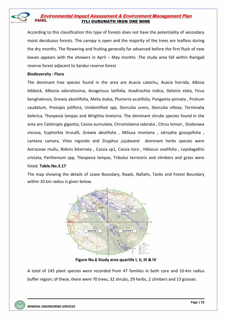
Environmental Impact Assessment & Environment Management Plan
IYLI GURUNATH IRON ORE MINE
Page | 52
MINERAL ENGINEERING SERVICES
According to this classification this type of forests does not have the potentiality of secondary
moist deciduous forests. The canopy is open and the majority of the trees are leafless during
the dry months. The flowering and fruiting generally far advanced before the first flush of new
leaves appears with the showers in April – May months .The study area fall within Ramgad
reserve forest adjacent to Sandur reserve forest
Biodeversity : Flora
The dominant tree species found in the area are Acacia catechu, Acacia horrida, Albizia
lebbeck, Albizzia odoratissima, Anogeissus latifolia, Azadirachta indica, Delonix elata, Ficus
benghalensis, Grewia abutilifolia, Melia dubia, Plumeria acutifolia, Pongamia pinnata , Protium
caudatum, Prosopis juliflora, Unidentified spp, Sterculia urens, Sterculia villosa, Terminalia
belerica, Thespesia lampas and Wrightia tinetoria. The dominant shrubs species found in the
area are Calotropis gigantia, Cassia auriculata, Chromolaena odorata , Citrus lemon , Dodonaea
viscosa, Euphorbia tirucalli, Grewia abutifolia , Miliusa montana , Jatropha gossypifolia ,
Lantana camara, Vitex nigondo and Zizyphus jujubeand dominant herbs species were
Astraceae mullu, Bidens biternata , Cassia sp1, Cassia tora , Hibiscus ovalifolia , Lepidagathis
cristata, Parthenium spp, Thespesia lampas, Tribulus terrestris and climbers and grass were
listed. Table.No.3.17
The map showing the details of Lease Boundary, Roads, Nallahs, Tanks and Forest Boundary
within 10 km radius is given below.
Figure No.6 Study area quartile I, II, III & IV
A total of 145 plant species were recorded from 47 families in both core and 10-km radius
buffer region; of these, there were 70 trees, 32 shrubs, 29 herbs, 2 climbers and 13 grasses.
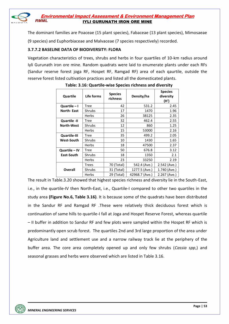
Environmental Impact Assessment & Environment Management Plan
IYLI GURUNATH IRON ORE MINE
Page | 53
MINERAL ENGINEERING SERVICES
The dominant families are Poaceae (15 plant species), Fabaceae (13 plant species), Mimosaeae
(9 species) and Euphorbiaceae and Malvaceae (7 species respectively) recorded.
3.7.7.2 BASELINE DATA OF BIODIVERSITY: FLORA
Vegetation characteristics of trees, shrubs and herbs in four quartiles of 10-km radius around
Iyli Gurunath iron ore mine. Random quadrats were laid to enumerate plants under each RFs
(Sandur reserve forest joga RF, Hospet RF, Ramgad RF) area of each qaurtile, outside the
reserve forest listed cultivation practices and listed all the domesticated plants.
Table: 3.16: Quartile-wise Species richness and diversity
Quartile Life forms Species richness
Density/ha Species
diversity (H')
Quartile – I North- East
Tree 42 531.2 2.45
Shrubs 17 1470 1.96
Herbs 26 38125 2.35
Quartile -II North-West
Tree 32 462.4 2.55
Shrubs 12 860 1.25
Herbs 15 53000 2.16
Quartile-III West-South
Tree 35 499.2 2.05
Shrubs 10 1430 1.65
Herbs 18 47500 2.37
Quartile – IV East-South
Tree 50 676.8 3.12
Shrubs 18 1350 2.1
Herbs 23 33250 2.19
Overall
Trees 70 (Total) 542.4 (Ave.) 2.542 (Ave.)
Shrubs 31 (Total) 1277.5 (Ave.) 1.740 (Ave.)
Herbs 29 (Total) 42968.7 (Ave.) 2.267 (Ave.)
The result in Table.3.20 showed that highest species richness and diversity lie in the South-East,
i.e., in the quartile-IV then North-East, i.e., Quartile-I compared to other two quartiles in the
study area (Figure No.6, Table 3.16). It is because some of the quadrats have been distributed
in the Sandur RF and Ramgad RF .These were relatively thick deciduous forest which is
continuation of same hills to quartile-I fall at Joga and Hospet Reserve Forest, whereas quartile
– II buffer in addition to Sandur RF and few plots were sampled within the Hospet RF which is
predominantly open scrub forest. The quartiles 2nd and 3rd large proportion of the area under
Agriculture land and settlement use and a narrow railway track lie at the periphery of the
buffer area. The core area completely opened up and only few shrubs (Cassia spp,) and
seasonal grasses and herbs were observed which are listed in Table 3.16.
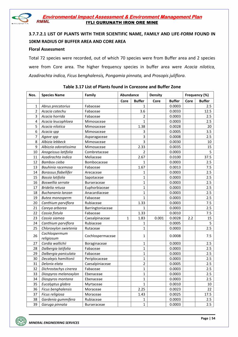
Environmental Impact Assessment & Environment Management Plan
IYLI GURUNATH IRON ORE MINE
Page | 54
MINERAL ENGINEERING SERVICES
3.7.7.2.1 LIST OF PLANTS WITH THEIR SCIENTIFIC NAME, FAMILY AND LIFE-FORM FOUND IN
10KM RADIUS OF BUFFER AREA AND CORE AREA
Floral Assessment
Total 72 species were recorded, out of which 70 species were from Buffer area and 2 species
were from Core area. The higher frequency species in buffer area were Acacia nilotica,
Azadirachta indica, Ficus benghalensis, Pongamia pinnata, and Prosopis juliflora.
Table 3.17 List of Plants found in Corezone and Buffer Zone
Nos. Species Name Family Abundance Density Frequency (%)
Core Buffer Core Buffer Core Buffer
1 Abrus precatorius Fabaceae 1 0.0003 2.5
2 Acacia catechu Fabaceae 3.6 0.0033 12.5
3 Acacia horrida Fabaceae 2 0.0003 2.5
4 Acacia leucophloea Mimosaceae 1 0.0003 2.5
5 Acacia nilotica Mimosaceae 1.38 0.0028 20
6 Acacia spp Mimosaceae 3 0.0005 3.5
7 Agave spp Asparagaceae 3 0.0008 2.5
8 Albizia lebbeck Mimosaceae 3 0.0030 10
9 Albizzia odoratissima Mimosaceae 2.33 0.0035 15
10 Anogeissus latifolia Combretaceae 2 0.0003 5
11 Azadirachta indica Meliaceae 2.67 0.0100 37.5
12 Bambox cieba Bombocaceae 1 0.0003 2.5
13 Bauhinia racemosa Fabaceae 1.67 0.0013 7.5
14 Borassus flabellifer Arecaceae 1 0.0003 2.5
15 Bassia latifolia Sapotaceae 1 0.0003 2.5
16 Boswellia serrate Burseraceae 1 0.0003 2.5
17 Bridelia retusa Euphorbiaceae 1 0.0003 2.5
18 Buchanania lanzan Anacardiaceae 1 0.0003 2.5
19 Butea monosperm Fabaceae 1 0.0003 2.5
20 Canthium parviflora Rubiaceae 1.33 0.0003 7.5
21 Careya arborea Barringtoniaceae 1 0.0003 2.5
22 Cassia fistula Fabaceae 1.33 0.0010 7.5
23 Cassia siamea Caesalpinaceae 1 1.83 0.001 0.0028 2.2 15
24 Canthium parviflora Rubiaceae 1 0.0005 5
25 Chloroxylon swietenia Rutaceae 1 0.0003 2.5
26 Cochlospermum religiosum
Cochlospermaceae 1 0.0008 7.5
27 Cordia wallichii Boraginaceae 1 0.0003 2.5
28 Dalbergia latifolia Fabaceae 1 0.0003 2.5
29 Dalbergia paniculata Fabaceae 1 0.0003 2.5
30 Decalepis hamiltonii Periplocaceae 1 0.0003 2.5
31 Delonix elata Caesalpiniaceae 2 0.0005 2.5
32 Dichrostachys cinerea Fabaceae 1 0.0003 2.5
33 Diospyros melanoxylon Ebenaceae 1 0.0003 2.5
34 Diospyros montana Ebenaceae 1 0.0003 2.5
35 Eucalyptus glabra Myrtaceae 1 0.0010 10
36 Ficus benghalensis Moraceae 2.25 0.0023 22
37 Ficus religiosa Moraceae 1.43 0.0025 17.5
38 Gardenia gummifera Rubiaceae 1 0.0003 2.5
39 Garuga pinnata Burseraceae 1 0.0003 2.5
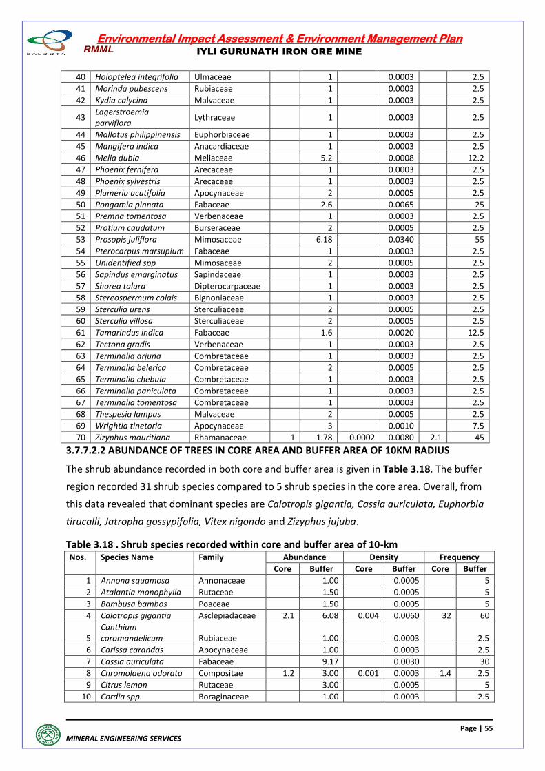
Environmental Impact Assessment & Environment Management Plan
IYLI GURUNATH IRON ORE MINE
Page | 55
MINERAL ENGINEERING SERVICES
40 Holoptelea integrifolia Ulmaceae 1 0.0003 2.5
41 Morinda pubescens Rubiaceae 1 0.0003 2.5
42 Kydia calycina Malvaceae 1 0.0003 2.5
43 Lagerstroemia parviflora
Lythraceae 1 0.0003 2.5
44 Mallotus philippinensis Euphorbiaceae 1 0.0003 2.5
45 Mangifera indica Anacardiaceae 1 0.0003 2.5
46 Melia dubia Meliaceae 5.2 0.0008 12.2
47 Phoenix fernifera Arecaceae 1 0.0003 2.5
48 Phoenix sylvestris Arecaceae 1 0.0003 2.5
49 Plumeria acutifolia Apocynaceae 2 0.0005 2.5
50 Pongamia pinnata Fabaceae 2.6 0.0065 25
51 Premna tomentosa Verbenaceae 1 0.0003 2.5
52 Protium caudatum Burseraceae 2 0.0005 2.5
53 Prosopis juliflora Mimosaceae 6.18 0.0340 55
54 Pterocarpus marsupium Fabaceae 1 0.0003 2.5
55 Unidentified spp Mimosaceae 2 0.0005 2.5
56 Sapindus emarginatus Sapindaceae 1 0.0003 2.5
57 Shorea talura Dipterocarpaceae 1 0.0003 2.5
58 Stereospermum colais Bignoniaceae 1 0.0003 2.5
59 Sterculia urens Sterculiaceae 2 0.0005 2.5
60 Sterculia villosa Sterculiaceae 2 0.0005 2.5
61 Tamarindus indica Fabaceae 1.6 0.0020 12.5
62 Tectona gradis Verbenaceae 1 0.0003 2.5
63 Terminalia arjuna Combretaceae 1 0.0003 2.5
64 Terminalia belerica Combretaceae 2 0.0005 2.5
65 Terminalia chebula Combretaceae 1 0.0003 2.5
66 Terminalia paniculata Combretaceae 1 0.0003 2.5
67 Terminalia tomentosa Combretaceae 1 0.0003 2.5
68 Thespesia lampas Malvaceae 2 0.0005 2.5
69 Wrightia tinetoria Apocynaceae 3 0.0010 7.5
70 Zizyphus mauritiana Rhamanaceae 1 1.78 0.0002 0.0080 2.1 45
3.7.7.2.2 ABUNDANCE OF TREES IN CORE AREA AND BUFFER AREA OF 10KM RADIUS
The shrub abundance recorded in both core and buffer area is given in Table 3.18. The buffer
region recorded 31 shrub species compared to 5 shrub species in the core area. Overall, from
this data revealed that dominant species are Calotropis gigantia, Cassia auriculata, Euphorbia
tirucalli, Jatropha gossypifolia, Vitex nigondo and Zizyphus jujuba.
Table 3.18 . Shrub species recorded within core and buffer area of 10-km Nos. Species Name Family Abundance Density Frequency
Core Buffer Core Buffer Core Buffer
1 Annona squamosa Annonaceae 1.00 0.0005 5
2 Atalantia monophylla Rutaceae 1.50 0.0005 5
3 Bambusa bambos Poaceae 1.50 0.0005 5
4 Calotropis gigantia Asclepiadaceae 2.1 6.08 0.004 0.0060 32 60
5 Canthium coromandelicum Rubiaceae
1.00
0.0003
2.5
6 Carissa carandas Apocynaceae 1.00 0.0003 2.5
7 Cassia auriculata Fabaceae 9.17 0.0030 30
8 Chromolaena odorata Compositae 1.2 3.00 0.001 0.0003 1.4 2.5
9 Citrus lemon Rutaceae 3.00 0.0005 5
10 Cordia spp. Boraginaceae 1.00 0.0003 2.5
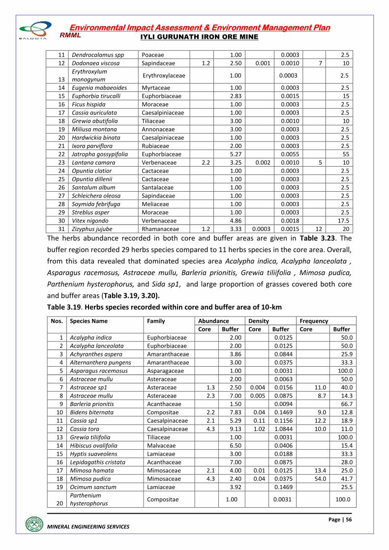
Environmental Impact Assessment & Environment Management Plan
IYLI GURUNATH IRON ORE MINE
Page | 56
MINERAL ENGINEERING SERVICES
11 Dendrocalamus spp Poaceae 1.00 0.0003 2.5
12 Dodonaea viscosa Sapindaceae 1.2 2.50 0.001 0.0010 7 10
13 Erythroxylum monogynum
Erythroxylaceae 1.00 0.0003 2.5
14 Eugenia mabaeoides Myrtaceae 1.00 0.0003 2.5
15 Euphorbia tirucalli Euphorbiaceae 2.83 0.0015 15
16 Ficus hispida Moraceae 1.00 0.0003 2.5
17 Cassia auriculata Caesalpiniaceae 1.00 0.0003 2.5
18 Grewia abutifolia Tiliaceae 3.00 0.0010 10
19 Miliusa montana Annonaceae 3.00 0.0003 2.5
20 Hardwickia binata Caesalpiniaceae 1.00 0.0003 2.5
21 Ixora parviflora Rubiaceae 2.00 0.0003 2.5
22 Jatropha gossypifolia Euphorbiaceae 5.27 0.0055 55
23 Lantana camara Verbenaceae 2.2 3.25 0.002 0.0010 5 10
24 Opuntia clatior Cactaceae 1.00 0.0003 2.5
25 Opuntia dillenii Cactaceae 1.00 0.0003 2.5
26 Santalum album Santalaceae 1.00 0.0003 2.5
27 Schleichera oleosa Sapindaceae 1.00 0.0003 2.5
28 Soymida febrifuga Meliaceae 1.00 0.0003 2.5
29 Streblus asper Moraceae 1.00 0.0003 2.5
30 Vitex nigondo Verbenaceae 4.86 0.0018 17.5
31 Zizyphus jujube Rhamanaceae 1.2 3.33 0.0003 0.0015 12 20
The herbs abundance recorded in both core and buffer areas are given in Table 3.23. The
buffer region recorded 29 herbs species compared to 11 herbs species in the core area. Overall,
from this data revealed that dominated species area Acalypha indica, Acalypha lanceolata ,
Asparagus racemosus, Astraceae mullu, Barleria prionitis, Grewia tiliifolia , Mimosa pudica,
Parthenium hysterophorus, and Sida sp1, and large proportion of grasses covered both core
and buffer areas (Table 3.19, 3.20).
Table 3.19. Herbs species recorded within core and buffer area of 10-km
Nos. Species Name Family Abundance Density Frequency
Core Buffer Core Buffer Core Buffer
1 Acalypha indica Euphorbiaceae 2.00 0.0125 50.0
2 Acalypha lanceolata Euphorbiaceae 2.00 0.0125 50.0
3 Achyranthes aspera Amaranthaceae 3.86 0.0844 25.9
4 Alternanthera pungens Amaranthaceae 3.00 0.0375 33.3
5 Asparagus racemosus Asparagaceae 1.00 0.0031 100.0
6 Astraceae mullu Asteraceae 2.00 0.0063 50.0
7 Astraceae sp1 Asteraceae 1.3 2.50 0.004 0.0156 11.0 40.0
8 Astraceae mullu Asteraceae 2.3 7.00 0.005 0.0875 8.7 14.3
9 Barleria prionitis Acanthaceae 1.50 0.0094 66.7
10 Bidens biternata Compositae 2.2 7.83 0.04 0.1469 9.0 12.8
11 Cassia sp1 Caesalpinaceae 2.1 5.29 0.11 0.1156 12.2 18.9
12 Cassia tora Caesalpinaceae 4.3 9.13 1.02 1.0844 10.0 11.0
13 Grewia tiliifolia Tiliaceae 1.00 0.0031 100.0
14 Hibiscus ovalifolia Malvaceae 6.50 0.0406 15.4
15 Hyptis suaveolens Lamiaceae 3.00 0.0188 33.3
16 Lepidagathis cristata Acanthaceae 7.00 0.0875 28.0
17 Mimosa hamata Mimosaceae 2.1 4.00 0.01 0.0125 13.4 25.0
18 Mimosa pudica Mimosaceae 4.3 2.40 0.04 0.0375 54.0 41.7
19 Ocimum sanctum Lamiaceae 3.92 0.1469 25.5
20 Parthenium hysterophorus
Compositae 1.00 0.0031 100.0
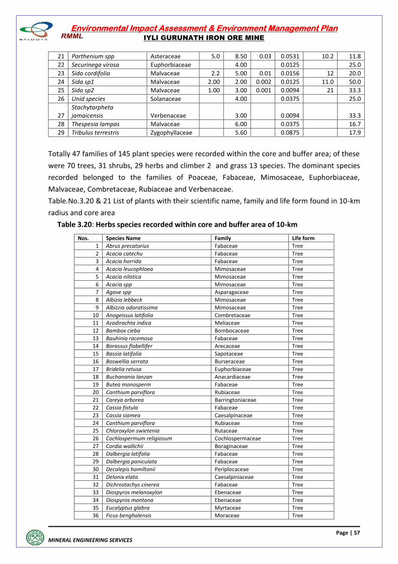
Environmental Impact Assessment & Environment Management Plan
IYLI GURUNATH IRON ORE MINE
Page | 57
MINERAL ENGINEERING SERVICES
21 Parthenium spp Asteraceae 5.0 8.50 0.03 0.0531 10.2 11.8
22 Securinega virosa Euphorbiaceae 4.00 0.0125 25.0
23 Sida cordifolia Malvaceae 2.2 5.00 0.01 0.0156 12 20.0
24 Sida sp1 Malvaceae 2.00 2.00 0.002 0.0125 11.0 50.0
25 Sida sp2 Malvaceae 1.00 3.00 0.001 0.0094 21 33.3
26 Unid species Solanaceae 4.00 0.0375 25.0
27 Stachytarpheta jamaicensis Verbenaceae
3.00
0.0094
33.3
28 Thespesia lampas Malvaceae 6.00 0.0375 16.7
29 Tribulus terrestris Zygophyllaceae 5.60 0.0875 17.9
Totally 47 families of 145 plant species were recorded within the core and buffer area; of these
were 70 trees, 31 shrubs, 29 herbs and climber 2 and grass 13 species. The dominant species
recorded belonged to the families of Poaceae, Fabaceae, Mimosaceae, Euphorbiaceae,
Malvaceae, Combretaceae, Rubiaceae and Verbenaceae.
Table.No.3.20 & 21 List of plants with their scientific name, family and life form found in 10-km
radius and core area
Table 3.20: Herbs species recorded within core and buffer area of 10-km
Nos. Species Name Family Life form
1 Abrus precatorius Fabaceae Tree
2 Acacia catechu Fabaceae Tree
3 Acacia horrida Fabaceae Tree
4 Acacia leucophloea Mimosaceae Tree
5 Acacia nilotica Mimosaceae Tree
6 Acacia spp Mimosaceae Tree
7 Agave spp Asparagaceae Tree
8 Albizia lebbeck Mimosaceae Tree
9 Albizzia odoratissima Mimosaceae Tree
10 Anogeissus latifolia Combretaceae Tree
11 Azadirachta indica Meliaceae Tree
12 Bambox cieba Bombocaceae Tree
13 Bauhinia racemosa Fabaceae Tree
14 Borassus flabellifer Arecaceae Tree
15 Bassia latifolia Sapotaceae Tree
16 Boswellia serrata Burseraceae Tree
17 Bridelia retusa Euphorbiaceae Tree
18 Buchanania lanzan Anacardiaceae Tree
19 Butea monosperm Fabaceae Tree
20 Canthium parviflora Rubiaceae Tree
21 Careya arborea Barringtoniaceae Tree
22 Cassia fistula Fabaceae Tree
23 Cassia siamea Caesalpinaceae Tree
24 Canthium parviflora Rubiaceae Tree
25 Chloroxylon swietenia Rutaceae Tree
26 Cochlospermum religiosum Cochlospermaceae Tree
27 Cordia wallichii Boraginaceae Tree
28 Dalbergia latifolia Fabaceae Tree
29 Dalbergia paniculata Fabaceae Tree
30 Decalepis hamiltonii Periplocaceae Tree
31 Delonix elata Caesalpiniaceae Tree
32 Dichrostachys cinerea Fabaceae Tree
33 Diospyros melanoxylon Ebenaceae Tree
34 Diospyros montana Ebenaceae Tree
35 Eucalyptus glabra Myrtaceae Tree
36 Ficus benghalensis Moraceae Tree
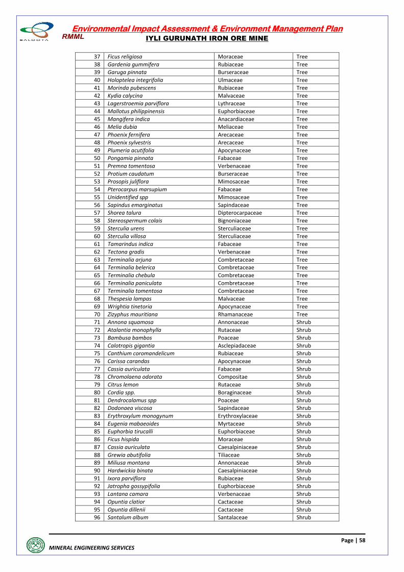
Environmental Impact Assessment & Environment Management Plan
IYLI GURUNATH IRON ORE MINE
Page | 58
MINERAL ENGINEERING SERVICES
37 Ficus religiosa Moraceae Tree
38 Gardenia gummifera Rubiaceae Tree
39 Garuga pinnata Burseraceae Tree
40 Holoptelea integrifolia Ulmaceae Tree
41 Morinda pubescens Rubiaceae Tree
42 Kydia calycina Malvaceae Tree
43 Lagerstroemia parviflora Lythraceae Tree
44 Mallotus philippinensis Euphorbiaceae Tree
45 Mangifera indica Anacardiaceae Tree
46 Melia dubia Meliaceae Tree
47 Phoenix fernifera Arecaceae Tree
48 Phoenix sylvestris Arecaceae Tree
49 Plumeria acutifolia Apocynaceae Tree
50 Pongamia pinnata Fabaceae Tree
51 Premna tomentosa Verbenaceae Tree
52 Protium caudatum Burseraceae Tree
53 Prosopis juliflora Mimosaceae Tree
54 Pterocarpus marsupium Fabaceae Tree
55 Unidentified spp Mimosaceae Tree
56 Sapindus emarginatus Sapindaceae Tree
57 Shorea talura Dipterocarpaceae Tree
58 Stereospermum colais Bignoniaceae Tree
59 Sterculia urens Sterculiaceae Tree
60 Sterculia villosa Sterculiaceae Tree
61 Tamarindus indica Fabaceae Tree
62 Tectona gradis Verbenaceae Tree
63 Terminalia arjuna Combretaceae Tree
64 Terminalia belerica Combretaceae Tree
65 Terminalia chebula Combretaceae Tree
66 Terminalia paniculata Combretaceae Tree
67 Terminalia tomentosa Combretaceae Tree
68 Thespesia lampas Malvaceae Tree
69 Wrightia tinetoria Apocynaceae Tree
70 Zizyphus mauritiana Rhamanaceae Tree
71 Annona squamosa Annonaceae Shrub
72 Atalantia monophylla Rutaceae Shrub
73 Bambusa bambos Poaceae Shrub
74 Calotropis gigantia Asclepiadaceae Shrub
75 Canthium coromandelicum Rubiaceae Shrub
76 Carissa carandas Apocynaceae Shrub
77 Cassia auriculata Fabaceae Shrub
78 Chromolaena odorata Compositae Shrub
79 Citrus lemon Rutaceae Shrub
80 Cordia spp. Boraginaceae Shrub
81 Dendrocalamus spp Poaceae Shrub
82 Dodonaea viscosa Sapindaceae Shrub
83 Erythroxylum monogynum Erythroxylaceae Shrub
84 Eugenia mabaeoides Myrtaceae Shrub
85 Euphorbia tirucalli Euphorbiaceae Shrub
86 Ficus hispida Moraceae Shrub
87 Cassia auriculata Caesalpiniaceae Shrub
88 Grewia abutifolia Tiliaceae Shrub
89 Miliusa montana Annonaceae Shrub
90 Hardwickia binata Caesalpiniaceae Shrub
91 Ixora parviflora Rubiaceae Shrub
92 Jatropha gossypifolia Euphorbiaceae Shrub
93 Lantana camara Verbenaceae Shrub
94 Opuntia clatior Cactaceae Shrub
95 Opuntia dillenii Cactaceae Shrub
96 Santalum album Santalaceae Shrub
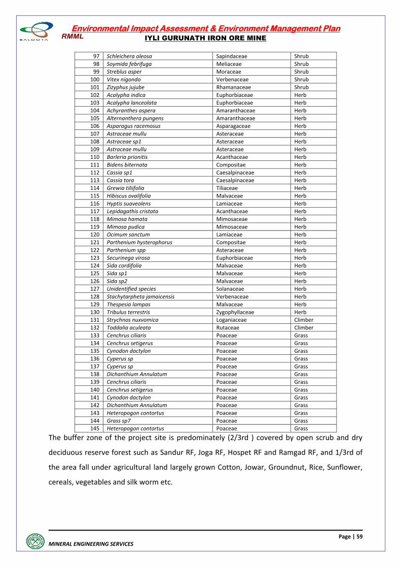
Environmental Impact Assessment & Environment Management Plan
IYLI GURUNATH IRON ORE MINE
Page | 59
MINERAL ENGINEERING SERVICES
97 Schleichera oleosa Sapindaceae Shrub
98 Soymida febrifuga Meliaceae Shrub
99 Streblus asper Moraceae Shrub
100 Vitex nigondo Verbenaceae Shrub
101 Zizyphus jujube Rhamanaceae Shrub
102 Acalypha indica Euphorbiaceae Herb
103 Acalypha lanceolata Euphorbiaceae Herb
104 Achyranthes aspera Amaranthaceae Herb
105 Alternanthera pungens Amaranthaceae Herb
106 Asparagus racemosus Asparagaceae Herb
107 Astraceae mullu Asteraceae Herb
108 Astraceae sp1 Asteraceae Herb
109 Astraceae mullu Asteraceae Herb
110 Barleria prionitis Acanthaceae Herb
111 Bidens biternata Compositae Herb
112 Cassia sp1 Caesalpinaceae Herb
113 Cassia tora Caesalpinaceae Herb
114 Grewia tiliifolia Tiliaceae Herb
115 Hibiscus ovalifolia Malvaceae Herb
116 Hyptis suaveolens Lamiaceae Herb
117 Lepidagathis cristata Acanthaceae Herb
118 Mimosa hamata Mimosaceae Herb
119 Mimosa pudica Mimosaceae Herb
120 Ocimum sanctum Lamiaceae Herb
121 Parthenium hysterophorus Compositae Herb
122 Parthenium spp Asteraceae Herb
123 Securinega virosa Euphorbiaceae Herb
124 Sida cordifolia Malvaceae Herb
125 Sida sp1 Malvaceae Herb
126 Sida sp2 Malvaceae Herb
127 Unidentified species Solanaceae Herb
128 Stachytarpheta jamaicensis Verbenaceae Herb
129 Thespesia lampas Malvaceae Herb
130 Tribulus terrestris Zygophyllaceae Herb
131 Strychnos nuxvomica Loganiaceae Climber
132 Toddalia aculeata Rutaceae Climber
133 Cenchrus ciliaris Poaceae Grass
134 Cenchrus setigerus Poaceae Grass
135 Cynodon dactylon Poaceae Grass
136 Cyperus sp Poaceae Grass
137 Cyperus sp Poaceae Grass
138 Dichanthium Annulatum Poaceae Grass
139 Cenchrus ciliaris Poaceae Grass
140 Cenchrus setigerus Poaceae Grass
141 Cynodon dactylon Poaceae Grass
142 Dichanthium Annulatum Poaceae Grass
143 Heteropogon contortus Poaceae Grass
144 Grass sp7 Poaceae Grass
145 Heteropogon contortus Poaceae Grass
The buffer zone of the project site is predominately (2/3rd ) covered by open scrub and dry
deciduous reserve forest such as Sandur RF, Joga RF, Hospet RF and Ramgad RF, and 1/3rd of
the area fall under agricultural land largely grown Cotton, Jowar, Groundnut, Rice, Sunflower,
cereals, vegetables and silk worm etc.
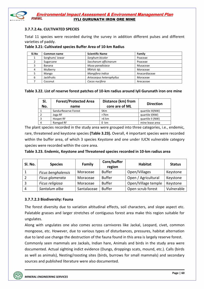
Environmental Impact Assessment & Environment Management Plan
IYLI GURUNATH IRON ORE MINE
Page | 60
MINERAL ENGINEERING SERVICES
3.7.7.2.4a. CULTIVATED SPECIES
Total 11 species were recorded during the survey in addition different pulses and different varieties of paddy. Table 3.21: Cultivated species Buffer Area of 10-km Radius
Sl.No Common name Scientific Name Family
1 Sorghum/ Jowar Sorghum bicolor Poaceae
2 Sugarcane Saccharum officinarum Poaceae
3 Banana Musa paradisiaca Musaceae
4 Mulberry Morus sp. Moraceae
5 Mango Mangifera indica Anacardiaceae
6 Jackfruits Artocarpus heterophyllus Moraceae
7 Coconut Cocos nucifera Arecaceae
Table 3.22. List of reserve forest patches of 10-km radius around Iyli Gurunath iron ore mine
Sl. No.
Forest/Protected Area name
Distance (km) from core are of ML
Direction
1 SandurReserve Forest 5Km quartile III(NW)
2 Joga RF >7km quartile I(NW)
3 Hospet RF >6 km quartile II (NW)
4 Ramgad RF 0 km mine lease area
The plant species recorded in the study area were grouped into three categories, i.e., endemic,
rare, threatened and keystone species (Table 3.23). Overall, 4 important species were recorded
within the buffer area, of which 3 species Keystone and one under IUCN vulnerable category
species were recorded within the core area.
Table 3.23. Endemic, Keystone and Threatened species recorded in 10-km radius area
Sl. No. Species Family Core/buffer
region Habitat Status
1 Ficus benghalensis Moraceae Buffer Open/Villages Keystone
2 Ficus glomerata Moraceae Buffer Open / Agricultural Keystone
3 Ficus religiosa Moraceae Buffer Open/Village temple Keystone
4 Santalum alba Santalaceae Buffer Open scrub forest Vulnerable
3.7.7.2.3 Biodiversity: Fauna
The forest diversity due to variation altitudinal effects, soil characters, and slope aspect etc.
Palatable grasses and larger stretches of contiguous forest area make this region suitable for
ungulates.
Along with ungulates one also comes across carnivores like Jackal, Leopard, civet, common
mongoose, etc. However, due to various types of disturbances, pressures, habitat alternation
due to land use change the destruction of the fauna found in this area is largely reserve forest.
Commonly seen mammals are Jackals, Indian hare, Animals and birds in the study area were
documented. Actual sighting indict evidence (Dungs, droppings scats, mound, etc.). Calls (birds
as well as animals), Nesting/roosting sites (birds, burrows for small mammals) and secondary
sources and published literature were also documented.
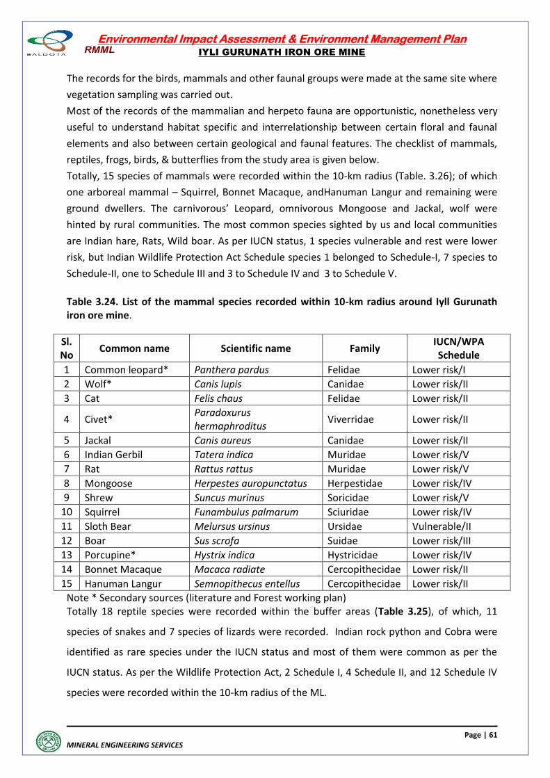
Environmental Impact Assessment & Environment Management Plan
IYLI GURUNATH IRON ORE MINE
Page | 61
MINERAL ENGINEERING SERVICES
The records for the birds, mammals and other faunal groups were made at the same site where
vegetation sampling was carried out.
Most of the records of the mammalian and herpeto fauna are opportunistic, nonetheless very
useful to understand habitat specific and interrelationship between certain floral and faunal
elements and also between certain geological and faunal features. The checklist of mammals,
reptiles, frogs, birds, & butterflies from the study area is given below.
Totally, 15 species of mammals were recorded within the 10-km radius (Table. 3.26); of which
one arboreal mammal – Squirrel, Bonnet Macaque, andHanuman Langur and remaining were
ground dwellers. The carnivorous’ Leopard, omnivorous Mongoose and Jackal, wolf were
hinted by rural communities. The most common species sighted by us and local communities
are Indian hare, Rats, Wild boar. As per IUCN status, 1 species vulnerable and rest were lower
risk, but Indian Wildlife Protection Act Schedule species 1 belonged to Schedule-I, 7 species to
Schedule-II, one to Schedule III and 3 to Schedule IV and 3 to Schedule V.
Table 3.24. List of the mammal species recorded within 10-km radius around Iyll Gurunath iron ore mine.
Sl. No
Common name Scientific name Family IUCN/WPA Schedule
1 Common leopard* Panthera pardus Felidae Lower risk/I
2 Wolf* Canis lupis Canidae Lower risk/II
3 Cat Felis chaus Felidae Lower risk/II
4 Civet* Paradoxurus hermaphroditus
Viverridae Lower risk/II
5 Jackal Canis aureus Canidae Lower risk/II
6 Indian Gerbil Tatera indica Muridae Lower risk/V
7 Rat Rattus rattus Muridae Lower risk/V
8 Mongoose Herpestes auropunctatus Herpestidae Lower risk/IV
9 Shrew Suncus murinus Soricidae Lower risk/V
10 Squirrel Funambulus palmarum Sciuridae Lower risk/IV
11 Sloth Bear Melursus ursinus Ursidae Vulnerable/II
12 Boar Sus scrofa Suidae Lower risk/III
13 Porcupine* Hystrix indica Hystricidae Lower risk/IV
14 Bonnet Macaque Macaca radiate Cercopithecidae Lower risk/II
15 Hanuman Langur Semnopithecus entellus Cercopithecidae Lower risk/II
Note * Secondary sources (literature and Forest working plan) Totally 18 reptile species were recorded within the buffer areas (Table 3.25), of which, 11
species of snakes and 7 species of lizards were recorded. Indian rock python and Cobra were
identified as rare species under the IUCN status and most of them were common as per the
IUCN status. As per the Wildlife Protection Act, 2 Schedule I, 4 Schedule II, and 12 Schedule IV
species were recorded within the 10-km radius of the ML.
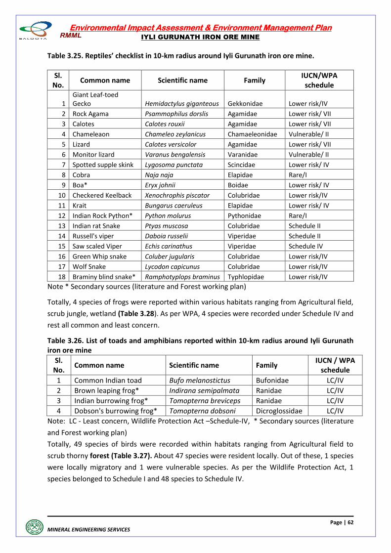
Environmental Impact Assessment & Environment Management Plan
IYLI GURUNATH IRON ORE MINE
Page | 62
MINERAL ENGINEERING SERVICES
Table 3.25. Reptiles’ checklist in 10-km radius around Iyli Gurunath iron ore mine.
Sl. No.
Common name Scientific name Family IUCN/WPA schedule
1 Giant Leaf-toed Gecko Hemidactylus giganteous Gekkonidae Lower risk/IV
2 Rock Agama Psammophilus dorslis Agamidae Lower risk/ VII
3 Calotes Calotes rouxii Agamidae Lower risk/ VII
4 Chameleaon Chameleo zeylanicus Chamaeleonidae Vulnerable/ II
5 Lizard Calotes versicolor Agamidae Lower risk/ VII
6 Monitor lizard Varanus bengalensis Varanidae Vulnerable/ II
7 Spotted supple skink Lygosoma punctata Scincidae Lower risk/ IV
8 Cobra Naja naja Elapidae Rare/I
9 Boa* Eryx johnii Boidae Lower risk/ IV
10 Checkered Keelback Xenochrophis piscator Colubridae Lower risk/IV
11 Krait Bungarus caeruleus Elapidae Lower risk/ IV
12 Indian Rock Python* Python molurus Pythonidae Rare/I
13 Indian rat Snake Ptyas muscosa Colubridae Schedule II
14 Russell's viper Daboia russelii Viperidae Schedule II
15 Saw scaled Viper Echis carinathus Viperidae Schedule IV
16 Green Whip snake Coluber jugularis Colubridae Lower risk/IV
17 Wolf Snake Lycodon capicunus Colubridae Lower risk/IV
18 Braminy blind snake* Ramphotyplops braminus Typhlopidae Lower risk/IV
Note * Secondary sources (literature and Forest working plan)
Totally, 4 species of frogs were reported within various habitats ranging from Agricultural field,
scrub jungle, wetland (Table 3.28). As per WPA, 4 species were recorded under Schedule IV and
rest all common and least concern.
Table 3.26. List of toads and amphibians reported within 10-km radius around Iyli Gurunath iron ore mine
Sl. No.
Common name Scientific name Family IUCN / WPA
schedule
1 Common Indian toad Bufo melanostictus Bufonidae LC/IV
2 Brown leaping frog* Indirana semipalmata Ranidae LC/IV
3 Indian burrowing frog* Tomopterna breviceps Ranidae LC/IV
4 Dobson's burrowing frog* Tomopterna dobsoni Dicroglossidae LC/IV
Note: LC - Least concern, Wildlife Protection Act –Schedule-IV, * Secondary sources (literature
and Forest working plan)
Totally, 49 species of birds were recorded within habitats ranging from Agricultural field to
scrub thorny forest (Table 3.27). About 47 species were resident locally. Out of these, 1 species
were locally migratory and 1 were vulnerable species. As per the Wildlife Protection Act, 1
species belonged to Schedule I and 48 species to Schedule IV.
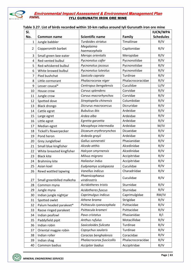
Environmental Impact Assessment & Environment Management Plan
IYLI GURUNATH IRON ORE MINE
Page | 63
MINERAL ENGINEERING SERVICES
Table 3.27. List of birds recorded within 10-km radius around Iyli Gurunath iron ore mine
Sl. No. Common name Scientific name Family
IUCN/WPA Schedules
1 Jungle babbler Turdoides striatus Timaliinae R/IV
2 Coppersmith barbet Megalaima haemacephala
Capitonidae R/IV
3 Small green bee-eater Merops orientalis Meropidae R/IV
4 Red-vented bulbul Pycnonotus cafer Pycnonotidae R/IV
5 Red-whiskered bulbul Pycnonotus jocosus Pycnonotidae R/IV
6 White browed bulbul Pycnonotus luteolus Pycnonotidae R/IV
7 Pied bushchat Saxicola caprata Turdinae R/IV
8 Little cormorant Phalacrocorax niger Phalacrocoracidae R/IV
9 Lesser coucal* Centropus bengalensis Cuculidae U/IV
10 House crow Corvus splendens Corvidae R/IV
11 Jungle crow Corvus macrorhynchos Corvidae R/IV
12 Spotted dove Streptopelia chinensis Columbidae R/IV
13 Black drongo Dicrurus macrocercus Dicruridae R/IV
14 Cattle egret Bubulcus ibis Ardeidae R/IV
15 Large egret Ardea alba Ardeidae R/IV
16 Little egret Egretta garzetta Ardeidae R/IV
17 Median egret Mesophoyx intermedia Ardeidae M/IV
18 Tickell's flowerpecker Dicaeum erythrorynchos Dicaeidae R/IV
19 Pond heron Ardeola grayii Ardeidae R/IV
20 Grey Junglefowl Gallus sonneratii Phasianidae R/IV
21 Small blue kingfisher Alcedo atthis Alcedinidae R/IV
22 White breasted kingfisher Halcyon smyrnensis Alcedinidae R/IV
23 Black kite Milvus migrans Accipitridae R/IV
24 Brahminy kite Haliastur indus Accipitridae R/IV
25 Asian koel Eudynamys scolopacea Cuculidae R/IV
26 Rewd wattled lapwing Vanellus indicus Charadriidae R/IV
27 Small greenbilled malkoha Phaenicophaeus viridirostris
Cuculidae R/IV
28 Common myna Acridotheres tristis Sturnidae R/IV
29 Jungle myna Acidotheres fuscus Sturnidae R/IV
30 Indian jungle nightjar Caprimulgus indicus Caprimulgidae RM/IV
31 Spotted owlet Athene brama Strigidae R/IV
32 Palum headed parakeet* Psittacula cyanocephala Psittacidae R/IV
33 Raose ringed parakeet Psittacula krameri Psittacidae R/IV
34 Indian peafowl Pavo cristatus Phasianidae R/I
35 Paddyfield pipit Anthus rufulus Motacillidae R/IV
36 Indian robin Saxicoloides fulicata Turdinae R/IV
37 Oriental magpie robin Copsychus saularis Turdinae R/IV
38 Indian roller Coracias benghalensis Coraciidae R/IV
39 Indian shag Phalacrocorax fuscicollis Phalacrocoracidae R/IV
40 Common badius Accipiter badius Accipitridae R/IV
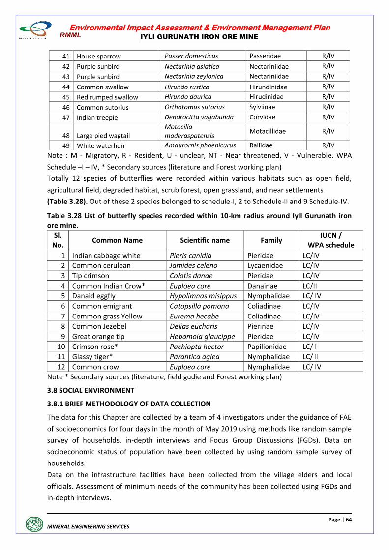
Environmental Impact Assessment & Environment Management Plan
IYLI GURUNATH IRON ORE MINE
Page | 64
MINERAL ENGINEERING SERVICES
41 House sparrow Passer domesticus Passeridae R/IV
42 Purple sunbird Nectarinia asiatica Nectariniidae R/IV
43 Purple sunbird Nectarinia zeylonica Nectariniidae R/IV
44 Common swallow Hirundo rustica Hirundinidae R/IV
45 Red rumped swallow Hirundo daurica Hirudinidae R/IV
46 Common sutorius Orthotomus sutorius Sylviinae R/IV
47 Indian treepie Dendrocitta vagabunda Corvidae R/IV
48 Large pied wagtail Motacilla maderaspatensis
Motacillidae R/IV
49 White waterhen Amaurornis phoenicurus Rallidae R/IV
Note : M - Migratory, R - Resident, U - unclear, NT - Near threatened, V - Vulnerable. WPA
Schedule –I – IV, * Secondary sources (literature and Forest working plan)
Totally 12 species of butterflies were recorded within various habitats such as open field,
agricultural field, degraded habitat, scrub forest, open grassland, and near settlements
(Table 3.28). Out of these 2 species belonged to schedule-I, 2 to Schedule-II and 9 Schedule-IV.
Table 3.28 List of butterfly species recorded within 10-km radius around Iyll Gurunath iron ore mine.
Sl. No.
Common Name Scientific name Family IUCN /
WPA schedule
1 Indian cabbage white Pieris canidia Pieridae LC/IV
2 Common cerulean Jamides celeno Lycaenidae LC/IV
3 Tip crimson Colotis danae Pieridae LC/IV
4 Common Indian Crow* Euploea core Danainae LC/II
5 Danaid eggfly Hypolimnas misippus Nymphalidae LC/ IV
6 Common emigrant Catopsilla pomona Coliadinae LC/IV
7 Common grass Yellow Eurema hecabe Coliadinae LC/IV
8 Common Jezebel Delias eucharis Pierinae LC/IV
9 Great orange tip Hebomoia glaucippe Pieridae LC/IV
10 Crimson rose* Pachiopta hector Papilionidae LC/ I
11 Glassy tiger* Parantica aglea Nymphalidae LC/ II
12 Common crow Euploea core Nymphalidae LC/ IV
Note * Secondary sources (literature, field gudie and Forest working plan)
3.8 SOCIAL ENVIRONMENT
3.8.1 BRIEF METHODOLOGY OF DATA COLLECTION
The data for this Chapter are collected by a team of 4 investigators under the guidance of FAE
of socioeconomics for four days in the month of May 2019 using methods like random sample
survey of households, in-depth interviews and Focus Group Discussions (FGDs). Data on
socioeconomic status of population have been collected by using random sample survey of
households.
Data on the infrastructure facilities have been collected from the village elders and local
officials. Assessment of minimum needs of the community has been collected using FGDs and
in-depth interviews.
Environmental Impact Assessment & Environment Management Plan
IYLI GURUNATH IRON ORE MINE
Page | 65
MINERAL ENGINEERING SERVICES
Data on morbidity pattern have been collected from any heath institution (PHC or CHC or clinic
or dispensary) in the buffer zone. Data on village population, caste composition, literacy status,
labor force participation, occupational classification and industrial classification of workers
have been collected from Census 2011.
The SOP contains detailed account of sampling frame work and design for selecting villages and
households, data collection instruments, procedures of data collection, checks for quality of
data, analysis of data and report layout for household survey. The study has attempted to
assess minimum needs of the community for CSR activities, impact assessment and mitigation
measures of CSR activities and impact assessment of environment on agriculture and
population
Photographs: 3.3
SocioEconomic Survey of Iyli Gurunath Iron Ore Mine
1) Composition and size of families
Demographic status: There are 17 villages in buffer zone. Of them, 12 villages are in Hospet
Taluk and the rest 5 in Sandur Taluk in Bellary district.
The total population of the buffer zone is 56,465 according to 2011 census (Table 3.29). The
village population ranged from a minimum of 110 persons in Emmihatti to a maximum of
15,940 persons in Mariyammanahalli. The sex ratio is 971 females per 1000 males according to
2011 census and 977 females per 1000 males according to survey 2019 (Table 3.30). There are
about 5.2 persons per household according to the census and 5.5 persons according to the
survey.
Environmental Impact Assessment & Environment Management Plan
IYLI GURUNATH IRON ORE MINE
Page | 66
MINERAL ENGINEERING SERVICES
Comparison with Bellary Rural district: The sex ratio (number of females for 1000 males) is
similar in buffer zone according to census and survey, and also in the rural areas of Bellary
district. That means male to female ratio balances and has not been affected by the
exceptional male out migration or mortality in buffer zone. The average number of persons per
household is around 5.3 persons in buffer zone, rural areas of Bellary district and survey.
Inferences focusing on need assessment: There seems to be male out migration from buffer
zone in search of jobs is not significant. So there seems to be employment opportunity in
buffer zone. The males, females, children and elders are in need of health and education.
Table 3.29 : Population in villages, 2011 Census.
Village Number of households
Male Female Total Sex ration/(F/M
per 1000) Vyasanakere 460 1200 1223 2423 1019
Danapuram 1530 3741 3515 7256 940
Mariyammanahalli 3243 7944 7996 15940 1007
Mariyammanahalli Thanda 432 1413 1338 2751 947
Danayakanakere 516 1421 1353 2774 952
Nagalapura 945 2869 2699 5568 941
Gollarahalli 366 1087 1018 2105 937
Byalakundi 204 552 522 1074 946
Garga 397 1161 1097 2258 945
Rajapura 172 451 433 884 960
Kallahalli 409 1269 1256 2525 990
Vadrahalli 264 718 649 1367 904
Ramgad 63 133 138 271 1038
Jaisingapur 539 1372 1342 2714 978
Emmihatti 21 87 23 110 264
Siddapur 257 757 711 1468 939
Suseelnagar 854 2469 2508 4977 1016
Buffer zone 10672 28644 27821 56465 971
Bellary Rural 295258 774093 758263 1532356 980
Table 3.30: Population in Buffer Zone, Survey 2019.
Village Number of households
Male Female Total Sex ration/(F/M
per 1000)
Buffer Zone 200 555 542 1097 977
Demographic status: Very marginal decline in fertility can be seen in the percentage of population age less than 14 years which is about 26 per cent according to the survey 2019 (Table 3.31). About 62 per cent of the total population is in the working age 15-59 and about 12 per cent of the total population is in the older age 60+. Thus, while younger population, age less than 14 years, has declined very marginally over the years, the older population, age more than 60 years, has increased.
Inferences focusing on need assessment: About 12 per cent of the population is elderly (60+)
needing health and other assistance like general health checkup, eye checkup, providing vision
glasses and old age supporting equipment like walking sticks, and the like.
Environmental Impact Assessment & Environment Management Plan
IYLI GURUNATH IRON ORE MINE
Page | 67
MINERAL ENGINEERING SERVICES
About 8 per cent of the population (5-9) is in school going age and welfare programs like supply
of school uniforms and books, transport to school, tuitions and supporting mid-day meal
program and the like.
Eight and half per cent of the population in 10-15 age is entering into labour force and for them
vocational training centers should be planned. These centers have to focus the needs of the
local industry, so that they become employable after training.
About 62 per cent of the population is in the working age 15-59. Many of them might be in
need of employment, especially females. Therefore, feasible welfare programs such as female
oriented self-employment schemes like milk dairy, poultry, sheep rearing, piggery and the like.
Table 3.31C: Percentage distribution of population by age and sex in buffer zone, Survey 2019
Age Male Female Total
0 – 4 9.3 9.6 9.5
5- 9 8.6 8.4 8.5
10-14 8.2 8.6 8.4
15-19 8.2 8.8 8.5
20-24 8.2 8.4 8.3
25-29 8.5 8.8 8.7
30-34 8.9 8.3 8.6
35-39 7.9 6.7 7.3
40-44 6.8 6.6 6.7
45-49 5.9 5.9 5.9
50-54 4.6 3.4 4.0
55-59 3.8 3.6 3.7
60-64 3.2 3.7 3.4
65-69 3.1 3.8 3.4
70-74 2.7 2.6 2.7
75-79 1.2 1.6 1.4
80+ 0.9 1.2 1.0
Total 100.0 (555) 100.0 (542) 100.0 (1097)
Social Status: The percentage distribution of population by caste from census 2011 and survey
2019 has been presented in Tables 3.32 and 3.33. The percentage of SC population in the
buffer zone is 34.6 according to census and 30.0 per cent according to survey. However, the
percentage of SC population is not uniform across villages.
The SC population of below 100 persons has not been recorded in 4 villages, namely Siddapur,
Emmihatti, Ramgad and Rajapura. Between 100 and 500 persons has been recorded in 4
villages, namely Gollarahalli, Byalakundi, Vyasanakeri and Garga. Between 500 and 1000
persons has been recorded in 2 villages, namely Vadrahalli and Danayakanakere. More than
1500 persons has been recorded in the rest of 7 villages, namely Jaisingapur, Danapuram,
Kallahalli, Nagalapura, Mariyammanahalli Thanda, Suseelnagar and Mariyammanahalli.
The percentage of ST population in the buffer zone is 24.0 according to census and 32.0
according to survey. The percentage of ST population is not uniform across villages.
The ST population of below 100 persons has been recorded in 4 villages, namely
Mariyammanahalli Thanda, Emmihatti, Vadrahalli and Byalakundi. Between 100 and 500
persons has been recorded in 3 villages, namely Ramgad, Rajapura and Jaisingapur.
Environmental Impact Assessment & Environment Management Plan
IYLI GURUNATH IRON ORE MINE
Page | 68
MINERAL ENGINEERING SERVICES
Between 500 and 1000 persons has been recorded in 5 villages, namely Kallahalli,
Danayakanakere, Vyasanakeri, Suseelnagar and Garga More than 1000 persons has been
recorded in 5 villages, namely Gollarahalli, Danapuram, Siddapur, Nagalapura and
Mariyammanahalli.
Comparison with Ballari rural district: The percentage of both SC and ST population is
significantly high in buffer zone according to census and survey compared to Bellary rural
district. Inference focusing on need assessment: There is substantial SC and ST population in
buffer zone to be focused in the development activities - separated health and education and
other programs.
Table 3.32: Percentage Distribution of Census Population by Broad Caste Groups, 2011 Census.
Village % SC % ST % Others Total Vyasanakere 19.2 27.1 53.7 100.0
Danapuram 23.0 14.9 62.1 100.0
Mariyammanahalli 19.8 22.2 58.0 100.0
Mariyammanahalli Thanda 99.7 0.1 0.2 100.0
Danayakanakere 31.5 22.8 45.7 100.0
Nagalapura 41.0 39.3 19.7 100.0
Gollarahalli 12.0 48.8 39.2 100.0
Byalakundi 29.5 8.9 61.5 100.0
Garga 21.6 40.5 37.9 100.0
Rajapura 10.5 33.1 56.3 100.0
Kallahalli 69.6 20.2 10.2 100.0
Vadrahalli 51.8 5.4 42.8 100.0
Ramgad 15.9 44.3 39.9 100.0
Jaisingapur 55.7 14.0 30.3 100.0
Emmihatti 30.0 7.3 62.7 100.0
Siddapur 1.6 89.1 9.3 100.0
Suseelnagar 63.1 14.2 22.6 100.0
Buffer zone 34.6 24.0 41.4 100.0
Bellary Rural 23.9 21.8 54.3 100.0
Table 3.33: Percentage Distribution of Survey Population by Broad Caste Groups, Survey 2019.
Village % SC % ST % Others Total
Buffer Zone 30.2 32.0 37.8 100.0
2) Educational Status
Development status: The literacy rates derived from census 2011 and survey 2019 have been
presented in Tables 3.34 and 3.35. It is interesting to observe that the literacy rates are
moderately high in buffer zone as revealed by both Census and survey.
About 62 per cent of the population aged more than 6 literate in Census and 71.8 per cent in
survey.
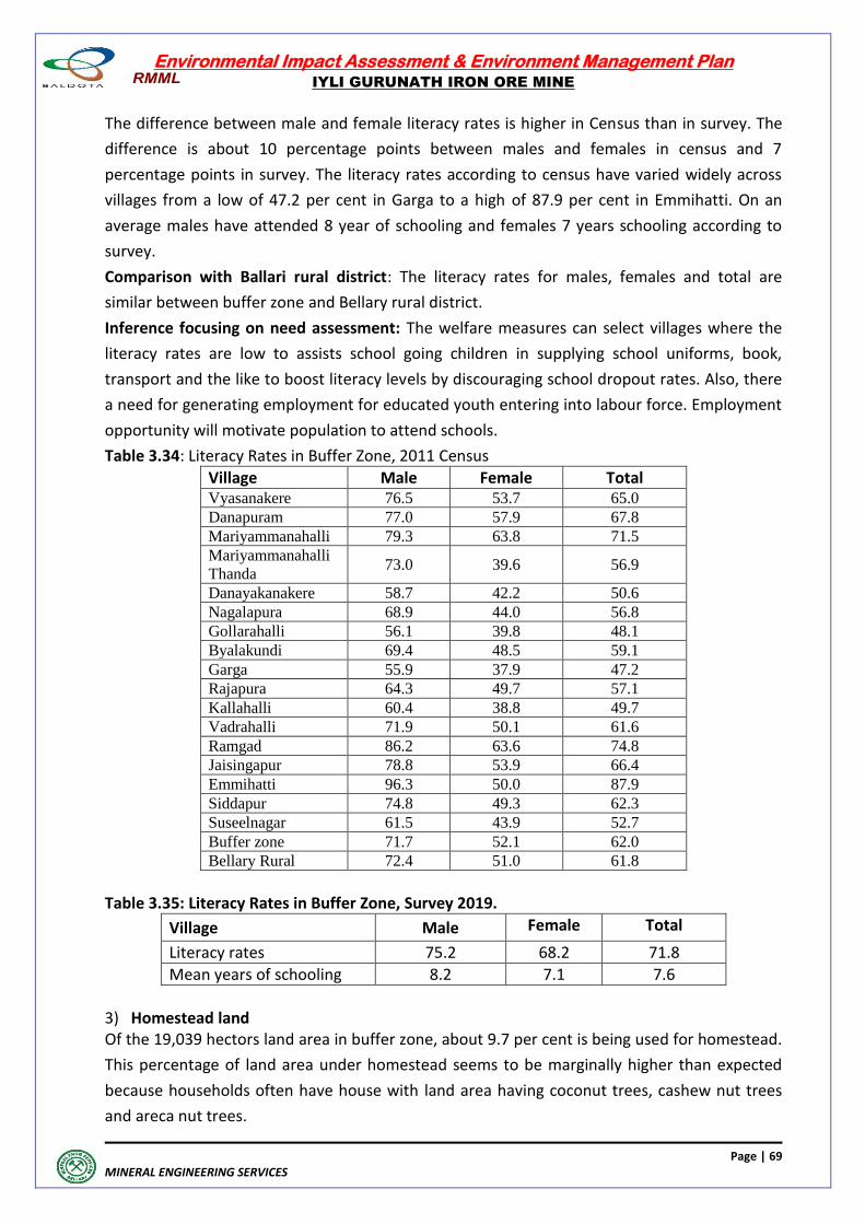
Environmental Impact Assessment & Environment Management Plan
IYLI GURUNATH IRON ORE MINE
Page | 69
MINERAL ENGINEERING SERVICES
The difference between male and female literacy rates is higher in Census than in survey. The
difference is about 10 percentage points between males and females in census and 7
percentage points in survey. The literacy rates according to census have varied widely across
villages from a low of 47.2 per cent in Garga to a high of 87.9 per cent in Emmihatti. On an
average males have attended 8 year of schooling and females 7 years schooling according to
survey.
Comparison with Ballari rural district: The literacy rates for males, females and total are
similar between buffer zone and Bellary rural district.
Inference focusing on need assessment: The welfare measures can select villages where the
literacy rates are low to assists school going children in supplying school uniforms, book,
transport and the like to boost literacy levels by discouraging school dropout rates. Also, there
a need for generating employment for educated youth entering into labour force. Employment
opportunity will motivate population to attend schools.
Table 3.34: Literacy Rates in Buffer Zone, 2011 Census
Village Male Female Total Vyasanakere 76.5 53.7 65.0
Danapuram 77.0 57.9 67.8
Mariyammanahalli 79.3 63.8 71.5
Mariyammanahalli
Thanda 73.0 39.6 56.9
Danayakanakere 58.7 42.2 50.6
Nagalapura 68.9 44.0 56.8
Gollarahalli 56.1 39.8 48.1
Byalakundi 69.4 48.5 59.1
Garga 55.9 37.9 47.2
Rajapura 64.3 49.7 57.1
Kallahalli 60.4 38.8 49.7
Vadrahalli 71.9 50.1 61.6
Ramgad 86.2 63.6 74.8
Jaisingapur 78.8 53.9 66.4
Emmihatti 96.3 50.0 87.9
Siddapur 74.8 49.3 62.3
Suseelnagar 61.5 43.9 52.7
Buffer zone 71.7 52.1 62.0
Bellary Rural 72.4 51.0 61.8
Table 3.35: Literacy Rates in Buffer Zone, Survey 2019.
Village Male Female Total
Literacy rates 75.2 68.2 71.8
Mean years of schooling 8.2 7.1 7.6
3) Homestead land Of the 19,039 hectors land area in buffer zone, about 9.7 per cent is being used for homestead.
This percentage of land area under homestead seems to be marginally higher than expected
because households often have house with land area having coconut trees, cashew nut trees
and areca nut trees.
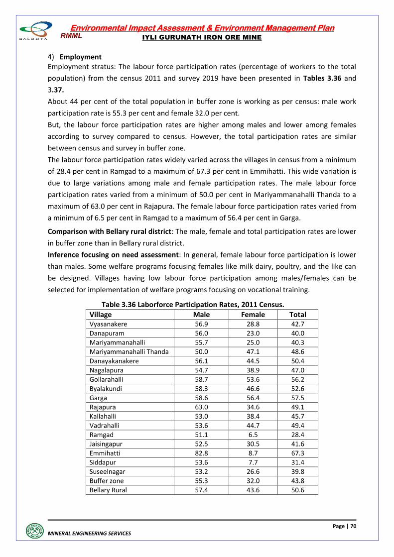
Environmental Impact Assessment & Environment Management Plan
IYLI GURUNATH IRON ORE MINE
Page | 70
MINERAL ENGINEERING SERVICES
4) Employment Employment stratus: The labour force participation rates (percentage of workers to the total
population) from the census 2011 and survey 2019 have been presented in Tables 3.36 and
3.37.
About 44 per cent of the total population in buffer zone is working as per census: male work
participation rate is 55.3 per cent and female 32.0 per cent.
But, the labour force participation rates are higher among males and lower among females
according to survey compared to census. However, the total participation rates are similar
between census and survey in buffer zone.
The labour force participation rates widely varied across the villages in census from a minimum
of 28.4 per cent in Ramgad to a maximum of 67.3 per cent in Emmihatti. This wide variation is
due to large variations among male and female participation rates. The male labour force
participation rates varied from a minimum of 50.0 per cent in Mariyammanahalli Thanda to a
maximum of 63.0 per cent in Rajapura. The female labour force participation rates varied from
a minimum of 6.5 per cent in Ramgad to a maximum of 56.4 per cent in Garga.
Comparison with Bellary rural district: The male, female and total participation rates are lower
in buffer zone than in Bellary rural district.
Inference focusing on need assessment: In general, female labour force participation is lower
than males. Some welfare programs focusing females like milk dairy, poultry, and the like can
be designed. Villages having low labour force participation among males/females can be
selected for implementation of welfare programs focusing on vocational training.
Table 3.36 Laborforce Participation Rates, 2011 Census.
Village Male Female Total Vyasanakere 56.9 28.8 42.7
Danapuram 56.0 23.0 40.0
Mariyammanahalli 55.7 25.0 40.3
Mariyammanahalli Thanda 50.0 47.1 48.6
Danayakanakere 56.1 44.5 50.4
Nagalapura 54.7 38.9 47.0
Gollarahalli 58.7 53.6 56.2
Byalakundi 58.3 46.6 52.6
Garga 58.6 56.4 57.5
Rajapura 63.0 34.6 49.1
Kallahalli 53.0 38.4 45.7
Vadrahalli 53.6 44.7 49.4
Ramgad 51.1 6.5 28.4
Jaisingapur 52.5 30.5 41.6
Emmihatti 82.8 8.7 67.3
Siddapur 53.6 7.7 31.4
Suseelnagar 53.2 26.6 39.8
Buffer zone 55.3 32.0 43.8
Bellary Rural 57.4 43.6 50.6
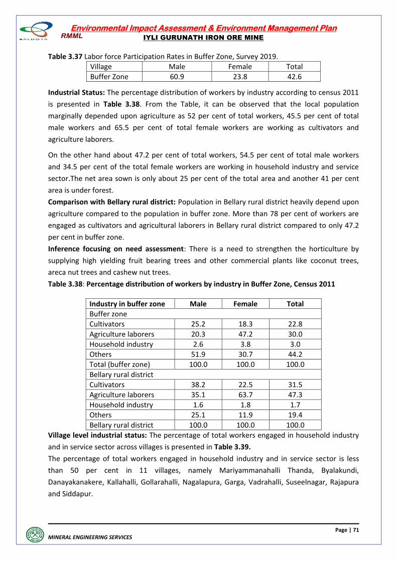
Environmental Impact Assessment & Environment Management Plan
IYLI GURUNATH IRON ORE MINE
Page | 71
MINERAL ENGINEERING SERVICES
Table 3.37 Labor force Participation Rates in Buffer Zone, Survey 2019.
Village Male Female Total
Buffer Zone 60.9 23.8 42.6
Industrial Status: The percentage distribution of workers by industry according to census 2011
is presented in Table 3.38. From the Table, it can be observed that the local population
marginally depended upon agriculture as 52 per cent of total workers, 45.5 per cent of total
male workers and 65.5 per cent of total female workers are working as cultivators and
agriculture laborers.
On the other hand about 47.2 per cent of total workers, 54.5 per cent of total male workers
and 34.5 per cent of the total female workers are working in household industry and service
sector.The net area sown is only about 25 per cent of the total area and another 41 per cent
area is under forest.
Comparison with Bellary rural district: Population in Bellary rural district heavily depend upon
agriculture compared to the population in buffer zone. More than 78 per cent of workers are
engaged as cultivators and agricultural laborers in Bellary rural district compared to only 47.2
per cent in buffer zone.
Inference focusing on need assessment: There is a need to strengthen the horticulture by
supplying high yielding fruit bearing trees and other commercial plants like coconut trees,
areca nut trees and cashew nut trees.
Table 3.38: Percentage distribution of workers by industry in Buffer Zone, Census 2011
Industry in buffer zone Male Female Total
Buffer zone
Cultivators 25.2 18.3 22.8
Agriculture laborers 20.3 47.2 30.0
Household industry 2.6 3.8 3.0
Others 51.9 30.7 44.2
Total (buffer zone) 100.0 100.0 100.0
Bellary rural district
Cultivators 38.2 22.5 31.5
Agriculture laborers 35.1 63.7 47.3
Household industry 1.6 1.8 1.7
Others 25.1 11.9 19.4
Bellary rural district 100.0 100.0 100.0
Village level industrial status: The percentage of total workers engaged in household industry
and in service sector across villages is presented in Table 3.39.
The percentage of total workers engaged in household industry and in service sector is less
than 50 per cent in 11 villages, namely Mariyammanahalli Thanda, Byalakundi,
Danayakanakere, Kallahalli, Gollarahalli, Nagalapura, Garga, Vadrahalli, Suseelnagar, Rajapura
and Siddapur.
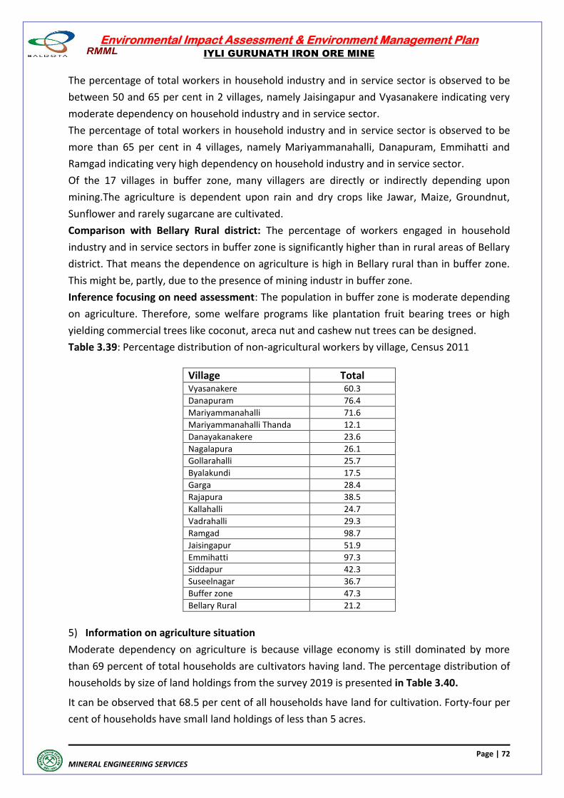
Environmental Impact Assessment & Environment Management Plan
IYLI GURUNATH IRON ORE MINE
Page | 72
MINERAL ENGINEERING SERVICES
The percentage of total workers in household industry and in service sector is observed to be
between 50 and 65 per cent in 2 villages, namely Jaisingapur and Vyasanakere indicating very
moderate dependency on household industry and in service sector.
The percentage of total workers in household industry and in service sector is observed to be
more than 65 per cent in 4 villages, namely Mariyammanahalli, Danapuram, Emmihatti and
Ramgad indicating very high dependency on household industry and in service sector.
Of the 17 villages in buffer zone, many villagers are directly or indirectly depending upon
mining.The agriculture is dependent upon rain and dry crops like Jawar, Maize, Groundnut,
Sunflower and rarely sugarcane are cultivated.
Comparison with Bellary Rural district: The percentage of workers engaged in household
industry and in service sectors in buffer zone is significantly higher than in rural areas of Bellary
district. That means the dependence on agriculture is high in Bellary rural than in buffer zone.
This might be, partly, due to the presence of mining industr in buffer zone.
Inference focusing on need assessment: The population in buffer zone is moderate depending
on agriculture. Therefore, some welfare programs like plantation fruit bearing trees or high
yielding commercial trees like coconut, areca nut and cashew nut trees can be designed.
Table 3.39: Percentage distribution of non-agricultural workers by village, Census 2011
Village Total Vyasanakere 60.3
Danapuram 76.4
Mariyammanahalli 71.6
Mariyammanahalli Thanda 12.1
Danayakanakere 23.6
Nagalapura 26.1
Gollarahalli 25.7
Byalakundi 17.5
Garga 28.4
Rajapura 38.5
Kallahalli 24.7
Vadrahalli 29.3
Ramgad 98.7
Jaisingapur 51.9
Emmihatti 97.3
Siddapur 42.3
Suseelnagar 36.7
Buffer zone 47.3
Bellary Rural 21.2
5) Information on agriculture situation
Moderate dependency on agriculture is because village economy is still dominated by more
than 69 percent of total households are cultivators having land. The percentage distribution of
households by size of land holdings from the survey 2019 is presented in Table 3.40.
It can be observed that 68.5 per cent of all households have land for cultivation. Forty-four per
cent of households have small land holdings of less than 5 acres.
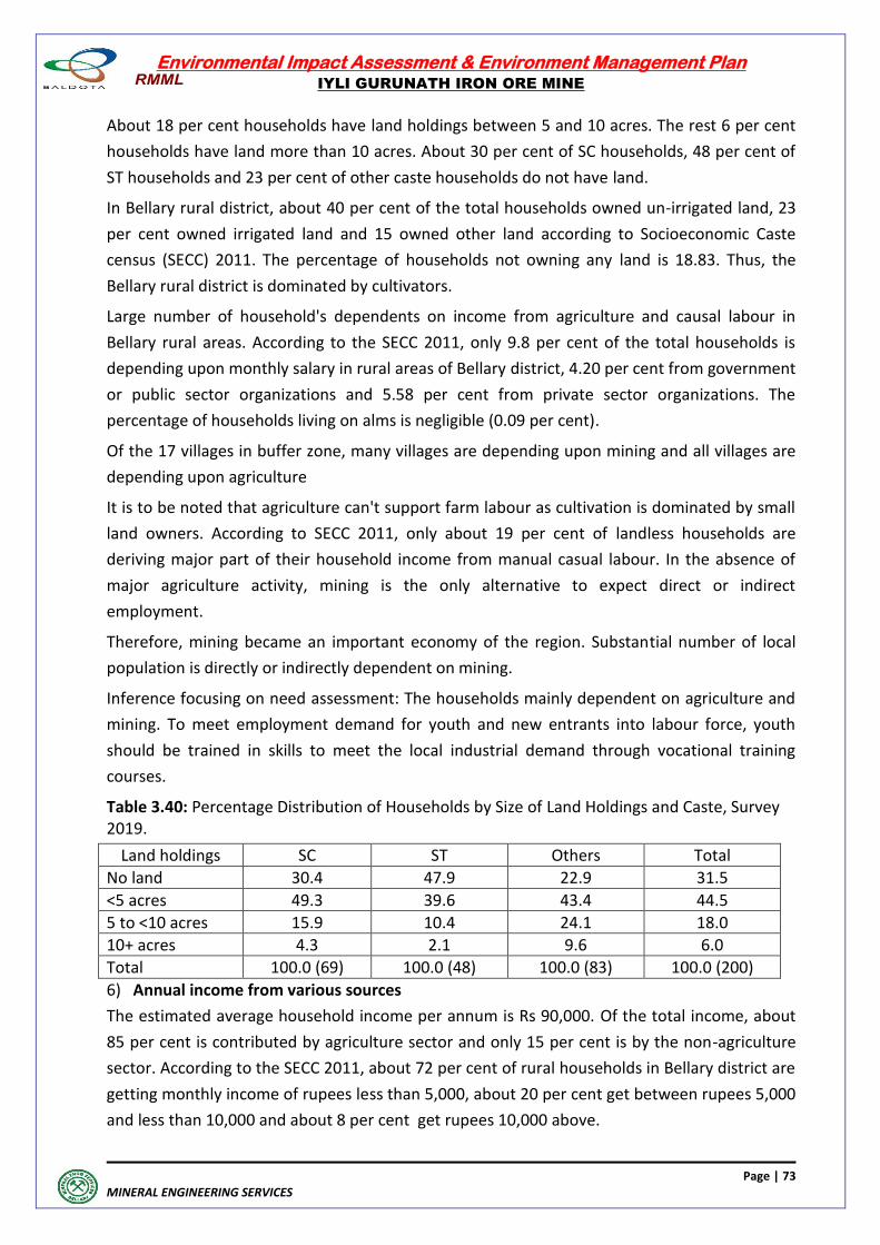
Environmental Impact Assessment & Environment Management Plan
IYLI GURUNATH IRON ORE MINE
Page | 73
MINERAL ENGINEERING SERVICES
About 18 per cent households have land holdings between 5 and 10 acres. The rest 6 per cent
households have land more than 10 acres. About 30 per cent of SC households, 48 per cent of
ST households and 23 per cent of other caste households do not have land.
In Bellary rural district, about 40 per cent of the total households owned un-irrigated land, 23
per cent owned irrigated land and 15 owned other land according to Socioeconomic Caste
census (SECC) 2011. The percentage of households not owning any land is 18.83. Thus, the
Bellary rural district is dominated by cultivators.
Large number of household's dependents on income from agriculture and causal labour in
Bellary rural areas. According to the SECC 2011, only 9.8 per cent of the total households is
depending upon monthly salary in rural areas of Bellary district, 4.20 per cent from government
or public sector organizations and 5.58 per cent from private sector organizations. The
percentage of households living on alms is negligible (0.09 per cent).
Of the 17 villages in buffer zone, many villages are depending upon mining and all villages are
depending upon agriculture
It is to be noted that agriculture can't support farm labour as cultivation is dominated by small
land owners. According to SECC 2011, only about 19 per cent of landless households are
deriving major part of their household income from manual casual labour. In the absence of
major agriculture activity, mining is the only alternative to expect direct or indirect
employment.
Therefore, mining became an important economy of the region. Substantial number of local
population is directly or indirectly dependent on mining.
Inference focusing on need assessment: The households mainly dependent on agriculture and
mining. To meet employment demand for youth and new entrants into labour force, youth
should be trained in skills to meet the local industrial demand through vocational training
courses.
Table 3.40: Percentage Distribution of Households by Size of Land Holdings and Caste, Survey 2019.
Land holdings SC ST Others Total
No land 30.4 47.9 22.9 31.5
<5 acres 49.3 39.6 43.4 44.5
5 to <10 acres 15.9 10.4 24.1 18.0
10+ acres 4.3 2.1 9.6 6.0
Total 100.0 (69) 100.0 (48) 100.0 (83) 100.0 (200)
6) Annual income from various sources
The estimated average household income per annum is Rs 90,000. Of the total income, about
85 per cent is contributed by agriculture sector and only 15 per cent is by the non-agriculture
sector. According to the SECC 2011, about 72 per cent of rural households in Bellary district are
getting monthly income of rupees less than 5,000, about 20 per cent get between rupees 5,000
and less than 10,000 and about 8 per cent get rupees 10,000 above.
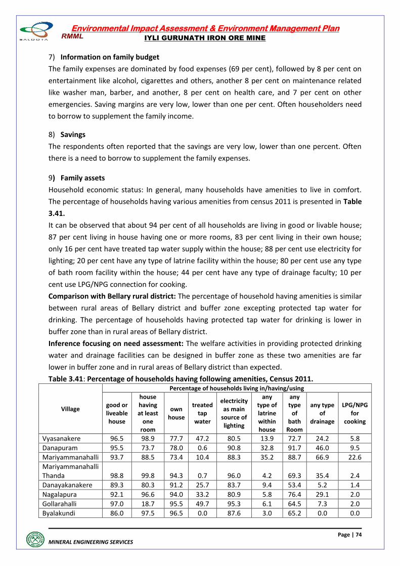
Environmental Impact Assessment & Environment Management Plan
IYLI GURUNATH IRON ORE MINE
Page | 74
MINERAL ENGINEERING SERVICES
7) Information on family budget
The family expenses are dominated by food expenses (69 per cent), followed by 8 per cent on
entertainment like alcohol, cigarettes and others, another 8 per cent on maintenance related
like washer man, barber, and another, 8 per cent on health care, and 7 per cent on other
emergencies. Saving margins are very low, lower than one per cent. Often householders need
to borrow to supplement the family income.
8) Savings
The respondents often reported that the savings are very low, lower than one percent. Often
there is a need to borrow to supplement the family expenses.
9) Family assets
Household economic status: In general, many households have amenities to live in comfort.
The percentage of households having various amenities from census 2011 is presented in Table
3.41.
It can be observed that about 94 per cent of all households are living in good or livable house;
87 per cent living in house having one or more rooms, 83 per cent living in their own house;
only 16 per cent have treated tap water supply within the house; 88 per cent use electricity for
lighting; 20 per cent have any type of latrine facility within the house; 80 per cent use any type
of bath room facility within the house; 44 per cent have any type of drainage faculty; 10 per
cent use LPG/NPG connection for cooking.
Comparison with Bellary rural district: The percentage of household having amenities is similar
between rural areas of Bellary district and buffer zone excepting protected tap water for
drinking. The percentage of households having protected tap water for drinking is lower in
buffer zone than in rural areas of Bellary district.
Inference focusing on need assessment: The welfare activities in providing protected drinking
water and drainage facilities can be designed in buffer zone as these two amenities are far
lower in buffer zone and in rural areas of Bellary district than expected.
Table 3.41: Percentage of households having following amenities, Census 2011.
Village
Percentage of households living in/having/using
good or liveable house
house having at least
one room
own house
treated tap
water
electricity as main
source of lighting
any type of latrine within house
any type
of bath
Room
any type of
drainage
LPG/NPG for
cooking
Vyasanakere 96.5 98.9 77.7 47.2 80.5 13.9 72.7 24.2 5.8
Danapuram 95.5 73.7 78.0 0.6 90.8 32.8 91.7 46.0 9.5
Mariyammanahalli 93.7 88.5 73.4 10.4 88.3 35.2 88.7 66.9 22.6
Mariyammanahalli Thanda 98.8 99.8 94.3 0.7 96.0 4.2 69.3 35.4 2.4
Danayakanakere 89.3 80.3 91.2 25.7 83.7 9.4 53.4 5.2 1.4
Nagalapura 92.1 96.6 94.0 33.2 80.9 5.8 76.4 29.1 2.0
Gollarahalli 97.0 18.7 95.5 49.7 95.3 6.1 64.5 7.3 2.0
Byalakundi 86.0 97.5 96.5 0.0 87.6 3.0 65.2 0.0 0.0
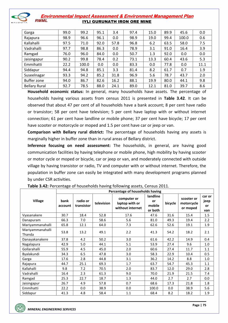
Environmental Impact Assessment & Environment Management Plan
IYLI GURUNATH IRON ORE MINE
Page | 75
MINERAL ENGINEERING SERVICES
Garga 99.0 99.2 95.1 3.4 97.4 15.0 89.9 45.6 0.0
Rajapura 98.9 96.6 96.1 0.0 98.9 19.0 99.4 100.0 0.6
Kallahalli 97.5 71.0 92.0 57.8 96.8 6.2 63.5 58.0 7.5
Vadrahalli 97.7 98.8 86.3 0.0 78.9 3.1 91.0 16.4 3.9
Ramgad 76.0 96.0 84.0 0.0 50.7 1.3 92.0 0.0 0.0
Jaisingapur 90.2 99.8 78.4 0.2 73.1 13.3 60.4 43.6 5.3
Emmihatti 22.2 100.0 0.0 0.0 83.3 0.0 77.8 0.0 11.1
Siddapur 94.4 94.8 85.1 3.3 81.4 8.2 61.7 0.7 1.9
Suseelnagar 93.3 94.2 85.2 31.8 96.9 5.6 78.7 43.7 2.0
Buffer zone 94.0 86.7 82.6 16.2 88.1 19.9 80.0 44.1 9.8
Bellary Rural 92.7 78.5 88.0 24.1 89.0 12.1 81.0 39.7 8.6
Household economic status: In general, many households have assets. The percentage of
households having various assets from census 2011 is presented in Table 3.42. It can be
observed that about 47 per cent of all households have a bank account; 8 per cent have radio
or transistor; 58 per cent have television; 5 per cent have laptop with or without internet
connection; 61 per cent have landline or mobile phone; 37 per cent have bicycle; 17 per cent
have scooter or motorcycle or moped and 1.5 per cent have car or jeep or van.
Comparison with Bellary rural district: The percentage of households having any assets is
marginally higher in buffer zone than in rural areas of Bellary district.
Inference focusing on need assessment: The households, in general, are having good
communication facilities by having telephone or mobile phone, high mobility by having scooter
or motor cycle or moped or bicycle, car or jeep or van, and moderately connected with outside
village by having transistor or radio, TV and computer with or without internet. Therefore, the
population in buffer zone can easily be integrated with many development programs planned
by under CSR activities.
Table 3.42: Percentage of households having following assets, Census 2011.
Village
Percentage of households having
bank account
radio or transistor
television computer or
laptop with or without internet
landline or
mobile or both
bicycle scooter or motorcycle or moped
car or jeep or
van
Vyasanakere 30.7 18.4 52.8 17.6 47.6 31.6 15.4 1.5
Danapuram 66.3 7.0 58.6 5.6 81.0 49.3 19.4 2.2
Mariyammanahalli 65.8 12.1 64.0 7.3 62.6 52.6 19.1 1.9
Mariyammanahalli Thanda
53.8 13.2 49.1 2.2 41.3 54.2 18.2 2.1
Danayakanakere 37.8 4.2 50.2 3.0 61.6 42.2 14.9 0.4
Nagalapura 42.9 5.0 44.1 5.1 53.9 27.4 9.6 1.0
Gollarahalli 55.9 4.5 45.0 2.0 60.6 27.4 11.7 1.1
Byalakundi 34.3 6.5 47.8 3.0 58.3 22.9 10.4 0.5
Garga 17.6 2.8 44.8 3.1 36.2 14.2 8.8 1.0
Rajapura 44.7 25.1 69.3 1.7 63.7 54.7 45.3 1.1
Kallahalli 9.8 7.2 70.5 2.0 83.7 12.0 29.0 2.8
Vadrahalli 16.4 2.3 61.3 9.0 70.0 21.9 21.5 7.4
Ramgad 25.3 22.7 18.7 1.3 44.0 2.7 2.7 0.0
Jaisingapur 26.7 4.9 57.8 0.7 68.6 17.3 21.8 1.8
Emmihatti 22.2 0.0 38.9 0.0 100.0 0.0 38.9 5.6
Siddapur 41.3 4.8 58.4 1.1 68.4 8.2 18.2 1.9
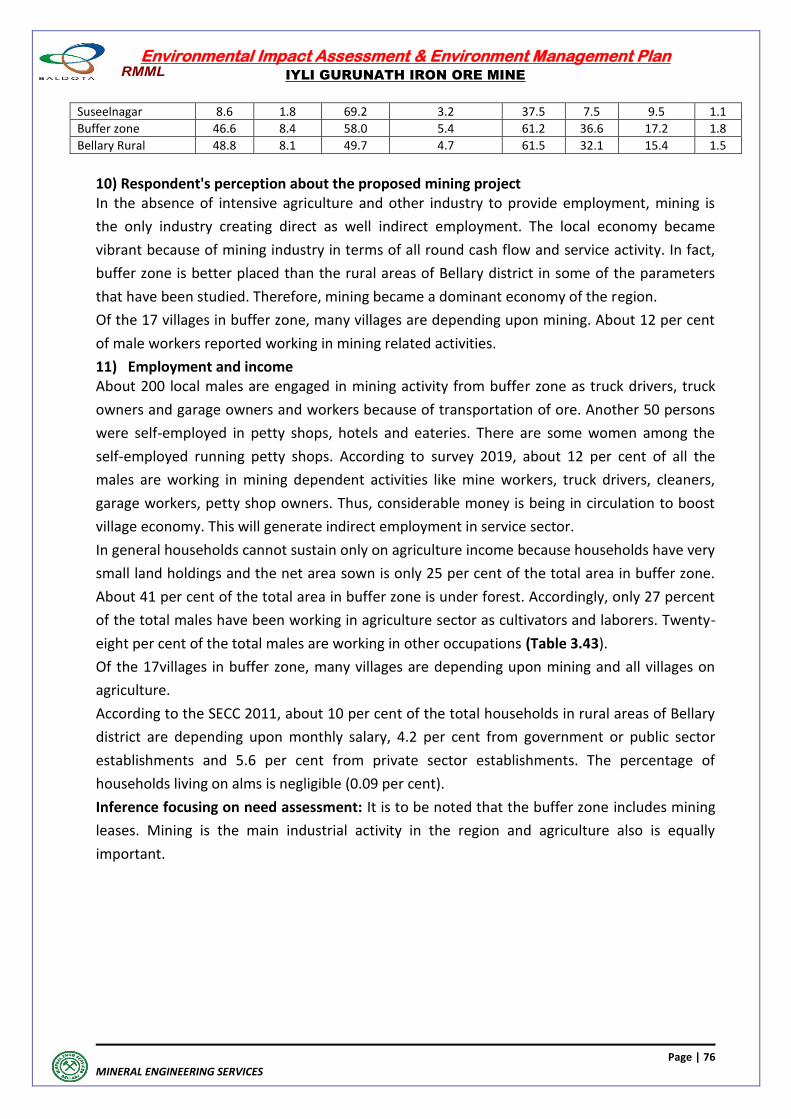
Environmental Impact Assessment & Environment Management Plan
IYLI GURUNATH IRON ORE MINE
Page | 76
MINERAL ENGINEERING SERVICES
Suseelnagar 8.6 1.8 69.2 3.2 37.5 7.5 9.5 1.1
Buffer zone 46.6 8.4 58.0 5.4 61.2 36.6 17.2 1.8
Bellary Rural 48.8 8.1 49.7 4.7 61.5 32.1 15.4 1.5
10) Respondent's perception about the proposed mining project In the absence of intensive agriculture and other industry to provide employment, mining is
the only industry creating direct as well indirect employment. The local economy became
vibrant because of mining industry in terms of all round cash flow and service activity. In fact,
buffer zone is better placed than the rural areas of Bellary district in some of the parameters
that have been studied. Therefore, mining became a dominant economy of the region.
Of the 17 villages in buffer zone, many villages are depending upon mining. About 12 per cent
of male workers reported working in mining related activities.
11) Employment and income About 200 local males are engaged in mining activity from buffer zone as truck drivers, truck
owners and garage owners and workers because of transportation of ore. Another 50 persons
were self-employed in petty shops, hotels and eateries. There are some women among the
self-employed running petty shops. According to survey 2019, about 12 per cent of all the
males are working in mining dependent activities like mine workers, truck drivers, cleaners,
garage workers, petty shop owners. Thus, considerable money is being in circulation to boost
village economy. This will generate indirect employment in service sector.
In general households cannot sustain only on agriculture income because households have very
small land holdings and the net area sown is only 25 per cent of the total area in buffer zone.
About 41 per cent of the total area in buffer zone is under forest. Accordingly, only 27 percent
of the total males have been working in agriculture sector as cultivators and laborers. Twenty-
eight per cent of the total males are working in other occupations (Table 3.43).
Of the 17villages in buffer zone, many villages are depending upon mining and all villages on
agriculture.
According to the SECC 2011, about 10 per cent of the total households in rural areas of Bellary
district are depending upon monthly salary, 4.2 per cent from government or public sector
establishments and 5.6 per cent from private sector establishments. The percentage of
households living on alms is negligible (0.09 per cent).
Inference focusing on need assessment: It is to be noted that the buffer zone includes mining
leases. Mining is the main industrial activity in the region and agriculture also is equally
important.
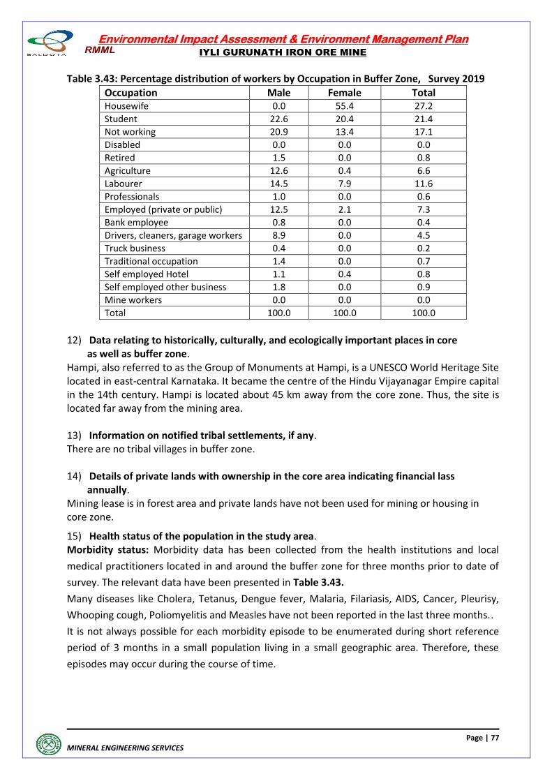
Environmental Impact Assessment & Environment Management Plan
IYLI GURUNATH IRON ORE MINE
Page | 77
MINERAL ENGINEERING SERVICES
Table 3.43: Percentage distribution of workers by Occupation in Buffer Zone, Survey 2019
Occupation Male Female Total Housewife 0.0 55.4 27.2
Student 22.6 20.4 21.4
Not working 20.9 13.4 17.1
Disabled 0.0 0.0 0.0
Retired 1.5 0.0 0.8
Agriculture 12.6 0.4 6.6
Labourer 14.5 7.9 11.6
Professionals 1.0 0.0 0.6
Employed (private or public) 12.5 2.1 7.3
Bank employee 0.8 0.0 0.4
Drivers, cleaners, garage workers 8.9 0.0 4.5
Truck business 0.4 0.0 0.2
Traditional occupation 1.4 0.0 0.7
Self employed Hotel 1.1 0.4 0.8
Self employed other business 1.8 0.0 0.9
Mine workers 0.0 0.0 0.0
Total 100.0 100.0 100.0
12) Data relating to historically, culturally, and ecologically important places in core as well as buffer zone. Hampi, also referred to as the Group of Monuments at Hampi, is a UNESCO World Heritage Site located in east-central Karnataka. It became the centre of the Hindu Vijayanagar Empire capital in the 14th century. Hampi is located about 45 km away from the core zone. Thus, the site is located far away from the mining area. 13) Information on notified tribal settlements, if any. There are no tribal villages in buffer zone. 14) Details of private lands with ownership in the core area indicating financial lass annually. Mining lease is in forest area and private lands have not been used for mining or housing in core zone.
15) Health status of the population in the study area. Morbidity status: Morbidity data has been collected from the health institutions and local
medical practitioners located in and around the buffer zone for three months prior to date of
survey. The relevant data have been presented in Table 3.43.
Many diseases like Cholera, Tetanus, Dengue fever, Malaria, Filariasis, AIDS, Cancer, Pleurisy,
Whooping cough, Poliomyelitis and Measles have not been reported in the last three months..
It is not always possible for each morbidity episode to be enumerated during short reference
period of 3 months in a small population living in a small geographic area. Therefore, these
episodes may occur during the course of time.
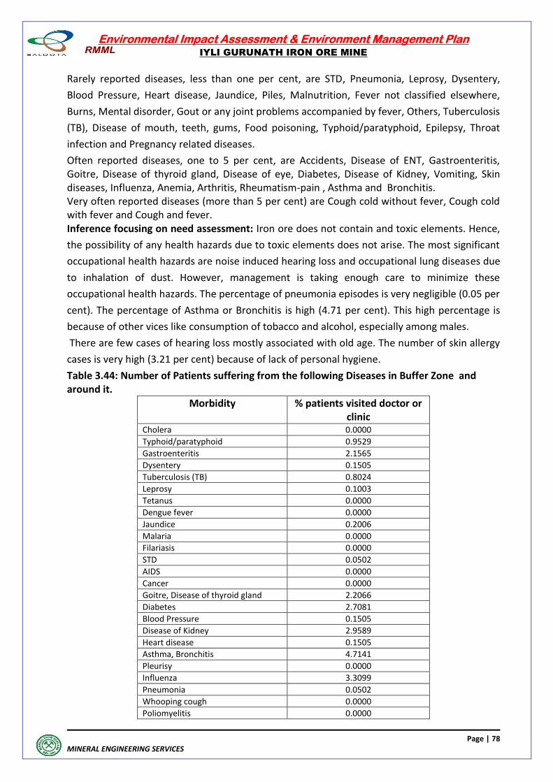
Environmental Impact Assessment & Environment Management Plan
IYLI GURUNATH IRON ORE MINE
Page | 78
MINERAL ENGINEERING SERVICES
Rarely reported diseases, less than one per cent, are STD, Pneumonia, Leprosy, Dysentery,
Blood Pressure, Heart disease, Jaundice, Piles, Malnutrition, Fever not classified elsewhere,
Burns, Mental disorder, Gout or any joint problems accompanied by fever, Others, Tuberculosis
(TB), Disease of mouth, teeth, gums, Food poisoning, Typhoid/paratyphoid, Epilepsy, Throat
infection and Pregnancy related diseases.
Often reported diseases, one to 5 per cent, are Accidents, Disease of ENT, Gastroenteritis, Goitre, Disease of thyroid gland, Disease of eye, Diabetes, Disease of Kidney, Vomiting, Skin diseases, Influenza, Anemia, Arthritis, Rheumatism-pain , Asthma and Bronchitis. Very often reported diseases (more than 5 per cent) are Cough cold without fever, Cough cold with fever and Cough and fever. Inference focusing on need assessment: Iron ore does not contain and toxic elements. Hence,
the possibility of any health hazards due to toxic elements does not arise. The most significant
occupational health hazards are noise induced hearing loss and occupational lung diseases due
to inhalation of dust. However, management is taking enough care to minimize these
occupational health hazards. The percentage of pneumonia episodes is very negligible (0.05 per
cent). The percentage of Asthma or Bronchitis is high (4.71 per cent). This high percentage is
because of other vices like consumption of tobacco and alcohol, especially among males.
There are few cases of hearing loss mostly associated with old age. The number of skin allergy
cases is very high (3.21 per cent) because of lack of personal hygiene.
Table 3.44: Number of Patients suffering from the following Diseases in Buffer Zone and around it.
Morbidity % patients visited doctor or clinic
Cholera 0.0000
Typhoid/paratyphoid 0.9529
Gastroenteritis 2.1565
Dysentery 0.1505
Tuberculosis (TB) 0.8024
Leprosy 0.1003
Tetanus 0.0000
Dengue fever 0.0000
Jaundice 0.2006
Malaria 0.0000
Filariasis 0.0000
STD 0.0502
AIDS 0.0000
Cancer 0.0000
Goitre, Disease of thyroid gland 2.2066
Diabetes 2.7081
Blood Pressure 0.1505
Disease of Kidney 2.9589
Heart disease 0.1505
Asthma, Bronchitis 4.7141
Pleurisy 0.0000
Influenza 3.3099
Pneumonia 0.0502
Whooping cough 0.0000
Poliomyelitis 0.0000
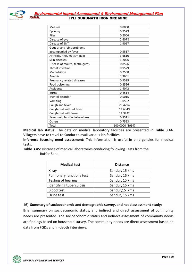
Environmental Impact Assessment & Environment Management Plan
IYLI GURUNATH IRON ORE MINE
Page | 79
MINERAL ENGINEERING SERVICES
Measles 0.0000
Epilepsy 0.9529
Piles 0.2006
Disease of eye 2.6078
Disease of ENT 1.9057
Gout or any joint problems accompanied by fever 0.5517
Arthritis, Rheumatism-pain 3.6610
Skin diseases 3.2096
Disease of mouth, teeth, gums 0.8526
Throat infection 0.9529
Malnutrition 0.2508
Anemia 3.3601
Pregnancy related diseases 0.9529
Food poisoning 0.8526
Accidents 1.4042
Burns 0.4514
Mental disorder 0.5015
Vomiting 3.0592
Cough and fever 26.4794
Cough cold without fever 11.6349
Cough cold with fever 14.3932
Fever not classified elsewhere 0.3511
Others 0.7523
Total 100.0000 (1994)
Medical lab status: The data on medical laboratory facilities are presented in Table 3.44. Villagers have to travel to Sandur to avail various lab facilities. Inference focusing need assessment: This information is useful in emergencies for medical tests. Table 3.45: Distance of medical laboratories conducing following Tests from the Buffer Zone.
Medical test Distance
X-ray Sandur, 15 kms
Pulmonary functions test Sandur, 15 kms
Testing of hearing Sandur, 15 kms
Identifying tuberculosis Sandur, 15 kms
Blood test Sandur,15 kms
Urine test Sandur, 15 kms
16) Summary of socioeconomic and demographic survey, and need assessment study:
Brief summary on socioeconomic status; and indirect and direct assessment of community
needs are presented. The socioeconomic status and indirect assessment of community needs
are findings based on household survey. The community needs are direct assessment based on
data from FGDs and in-depth interviews.
Environmental Impact Assessment & Environment Management Plan
IYLI GURUNATH IRON ORE MINE
Page | 80
MINERAL ENGINEERING SERVICES
The direct assessment of community needs by Focus Group Discussions (FGDs) and in-depth
interviews has been derived on focusing issues like health needs, communication needs,
sanitation needs, education needs and other social issues like tree plantation and maintenance
of schools, temples and village roads. The directly assessed needs have been presented
according the respondents' priority
Socioeconomic and Demographic Status
Village population size varied widely in the buffer zone. There are more males than
females in buffer zone as well as in rural areas of Bellary district. The levels of sex ratios
indicate that male out migration for work from the buffer zone.
The typical age structure indicated aging of population, decreasing child population,
increasing working age and elderly population.
There is very high concentration scheduled castes and tribe in the buffer zone than in
rural areas of Bellary district. The scheduled caste and tribe population varies widely
across villages.
The literacy rates are low in buffer zone than in rural areas of Bellary district. There is a
significant variation in literacy rates across villages.
Agriculture sector is active but not very prominent as only dry crops are cultivated and
agriculture is dependent on rain and vagaries of weather. The dependence on
agriculture is lower in buffer zone than in rural areas of Bellary district.
The local economy is depending upon agriculture. Mining activity will definitely boost
the local economy.
The general morbidity pattern is studied. It is found that miming related diseases are
not high.
The households, in general, are having good amenities to live comfortably in buffer
zone and rural areas of Bellary district. The possession of assets indicates good
communication facilities and well connected with outside buffer zone. The population
in buffer zone can easily be integrated with many development programs planned
under CSR activities.
Indirect assessment of community needs.
About 12 per cent of the population is elderly (aged 60+) needing health and other
elderly assisting programs. Some feasible welfare programs are general health checkup,
eye checkup, providing vision glasses and old age supporting equipment like walking
sticks and the like can be planned.
About 9 per cent of the population (aged 5-9) is in school going age. Some feasible
welfare programs like supply of school uniforms and books, transport, tuitions and
supporting mid-day meal program and the like can be planned.
Environmental Impact Assessment & Environment Management Plan
IYLI GURUNATH IRON ORE MINE
Page | 81
MINERAL ENGINEERING SERVICES
About 17 per cent of the population (aged 10-19) is entering into labour force and the
project proponent can think of starting vocational schools to prepare them for
employment.
About 62 per cent of the population is in the working age group (15 to 59). Many of
them are in need of employment, especially females. The project proponent can
formulate feasible female oriented self-employment schemes like milk dairy, poultry,
sheep rearing, piggery and the like.
There is a sizable SC and ST population in the buffer zone. Separate health camp, water
supply and sanitation facilities and the like can be planned targeting these special
groups.
In general the percentage of households having protected tap water for drinking is very
low in buffer zone. The CSR activities can plan to provide protected drinking water to
villages in buffer zone.
The general literacy rates are not high in buffer zone, Some villages having very low
literacy rates can be selected to assist school going children by supplying school
uniforms, books, transport and the like to boost literacy levels and discouraging school
dropout rates.
In general, there is unemployment in the buffer zone as elsewhere. Males in working
ages are migrating out of buffer zone. This is because agricultural economy is unable to
keep phase with fast growing working population to provide any good jobs. The
solution for this may lie in designing vocational courses to meet local industrial need.
Such an attempt can be made.
To rejuvenate primary sector, agriculture related activities like milk diary, poultry, sheep rearing and piggery can be designed and also supply of high yieldng fruit trees, and coconut, areca nut and cashew nut trees can be supplied.
Direct assessment of community needs 1) Employment 2) Water supply for agriculture, 3) Heath care 4) Tree plantation. 5) Vocational training centers 6) Construction and maintenance of temples, 7) Construction village roads and maintenance,
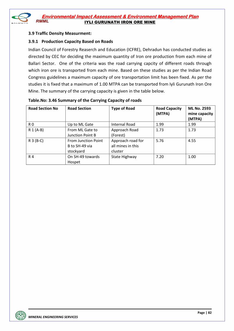
Environmental Impact Assessment & Environment Management Plan
IYLI GURUNATH IRON ORE MINE
Page | 82
MINERAL ENGINEERING SERVICES
3.9 Traffic Density Measurment:
3.9.1 Production Capacity Based on Roads
Indian Council of Forestry Reaserch and Education (ICFRE), Dehradun has conducted studies as
directed by CEC for deciding the maximum quantity of Iron ore production from each mine of
Ballari Sector. One of the criteria was the road carrying capcity of different roads through
which iron ore is transported from each mine. Based on these studies as per the Indian Road
Congress guidelines a maximum capacity of ore transportation limit has been fixed. As per the
studies it is fixed that a maximum of 1.00 MTPA can be transported from Iyli Gurunath Iron Ore
Mine. The summary of the carrying capacity is given in the table below.
Table.No: 3.46 Summary of the Carrying Capacity of roads
Road Section No Road Section Type of Road Road Capacity (MTPA)
ML No. 2593 mine capacity (MTPA)
R 0 Up to ML Gate Internal Road 1.99 1.99
R 1 (A-B) From ML Gate to Junction Point B
Approach Road (Forest)
1.73 1.73
R 3 (B-C) From Junction Point B to SH-49 via stockyard
Approach road for all mines in this cluster
5.76 4.55
R 4 On SH-49 towards Hospet
State Highway 7.20 1.00
Environmental Impact Assessment & Environment Management Plan
IYLI GURUNATH IRON ORE MINE
Page | 83
MINERAL ENGINEERING SERVICES
ANTICIPATED ENVIRONMENTAL
IMPACTS & MITIGATION
MEASURES
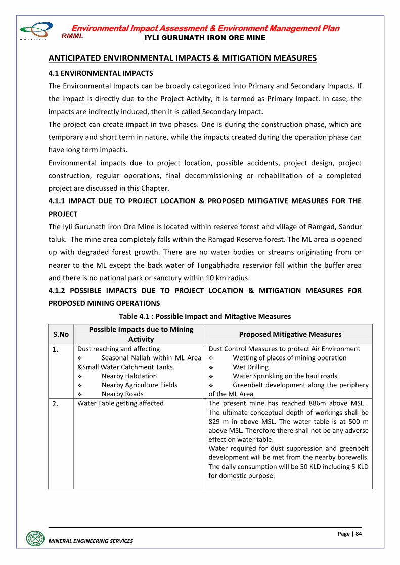
Environmental Impact Assessment & Environment Management Plan
IYLI GURUNATH IRON ORE MINE
Page | 84
MINERAL ENGINEERING SERVICES
ANTICIPATED ENVIRONMENTAL IMPACTS & MITIGATION MEASURES
4.1 ENVIRONMENTAL IMPACTS
The Environmental Impacts can be broadly categorized into Primary and Secondary Impacts. If
the impact is directly due to the Project Activity, it is termed as Primary Impact. In case, the
impacts are indirectly induced, then it is called Secondary Impact.
The project can create impact in two phases. One is during the construction phase, which are
temporary and short term in nature, while the impacts created during the operation phase can
have long term impacts.
Environmental impacts due to project location, possible accidents, project design, project
construction, regular operations, final decommissioning or rehabilitation of a completed
project are discussed in this Chapter.
4.1.1 IMPACT DUE TO PROJECT LOCATION & PROPOSED MITIGATIVE MEASURES FOR THE
PROJECT
The Iyli Gurunath Iron Ore Mine is located within reserve forest and village of Ramgad, Sandur
taluk. The mine area completely falls within the Ramgad Reserve forest. The ML area is opened
up with degraded forest growth. There are no water bodies or streams originating from or
nearer to the ML except the back water of Tungabhadra reservior fall within the buffer area
and there is no national park or sanctury within 10 km radius.
4.1.2 POSSIBLE IMPACTS DUE TO PROJECT LOCATION & MITIGATION MEASURES FOR
PROPOSED MINING OPERATIONS
Table 4.1 : Possible Impact and Mitagtive Measures
S.No Possible Impacts due to Mining
Activity Proposed Mitigative Measures
1. Dust reaching and affecting Seasonal Nallah within ML Area &Small Water Catchment Tanks Nearby Habitation Nearby Agriculture Fields Nearby Roads
Dust Control Measures to protect Air Environment Wetting of places of mining operation Wet Drilling Water Sprinkling on the haul roads Greenbelt development along the periphery of the ML Area
2. Water Table getting affected The present mine has reached 886m above MSL . The ultimate conceptual depth of workings shall be 829 m in above MSL. The water table is at 500 m above MSL. Therefore there shall not be any adverse effect on water table. Water required for dust suppression and greenbelt development will be met from the nearby borewells. The daily consumption will be 50 KLD including 5 KLD for domestic purpose.
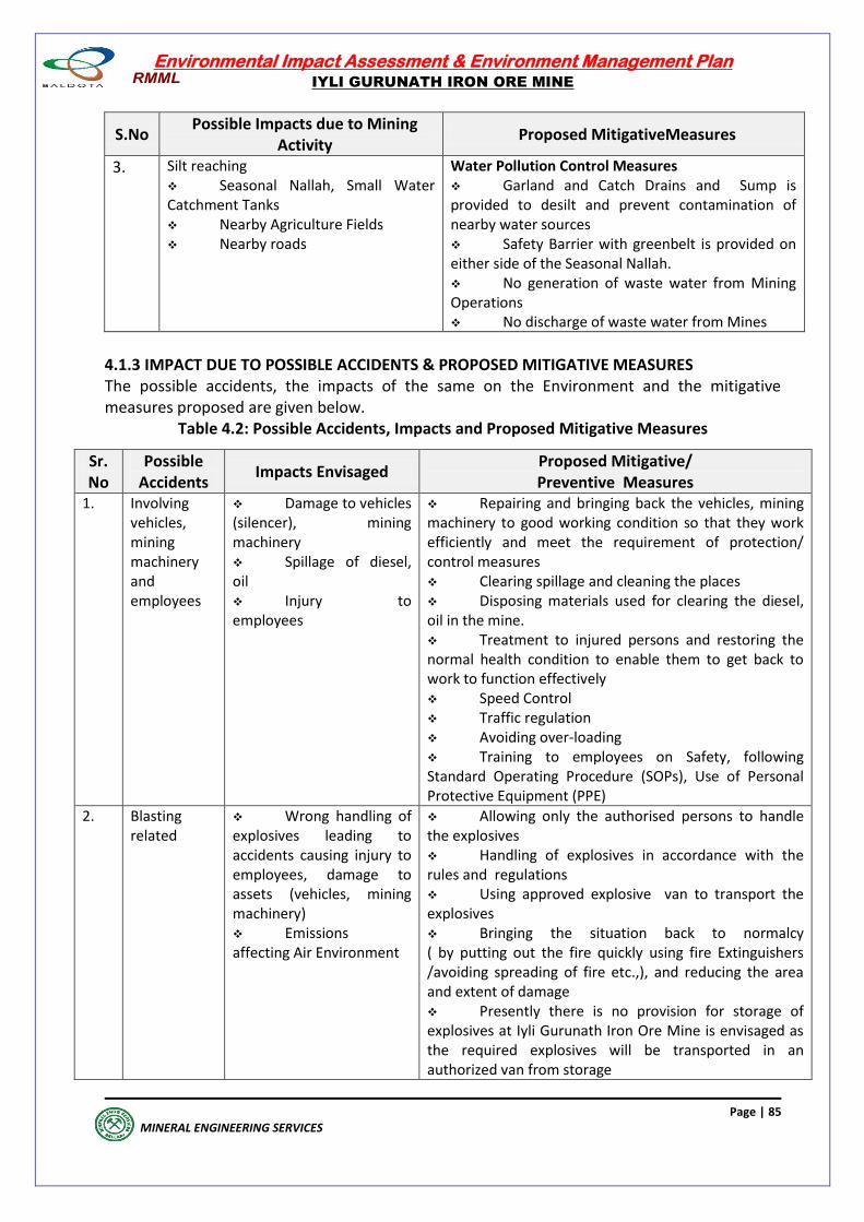
Environmental Impact Assessment & Environment Management Plan
IYLI GURUNATH IRON ORE MINE
Page | 85
MINERAL ENGINEERING SERVICES
S.No Possible Impacts due to Mining
Activity Proposed MitigativeMeasures
3. Silt reaching Seasonal Nallah, Small Water Catchment Tanks Nearby Agriculture Fields Nearby roads
Water Pollution Control Measures Garland and Catch Drains and Sump is provided to desilt and prevent contamination of nearby water sources Safety Barrier with greenbelt is provided on either side of the Seasonal Nallah. No generation of waste water from Mining Operations No discharge of waste water from Mines
4.1.3 IMPACT DUE TO POSSIBLE ACCIDENTS & PROPOSED MITIGATIVE MEASURES The possible accidents, the impacts of the same on the Environment and the mitigative measures proposed are given below.
Table 4.2: Possible Accidents, Impacts and Proposed Mitigative Measures
Sr. No
Possible Accidents
Impacts Envisaged Proposed Mitigative/ Preventive Measures
1. Involving vehicles, mining machinery and employees
Damage to vehicles (silencer), mining machinery Spillage of diesel, oil Injury to employees
Repairing and bringing back the vehicles, mining machinery to good working condition so that they work efficiently and meet the requirement of protection/ control measures Clearing spillage and cleaning the places Disposing materials used for clearing the diesel, oil in the mine. Treatment to injured persons and restoring the normal health condition to enable them to get back to work to function effectively Speed Control Traffic regulation Avoiding over-loading Training to employees on Safety, following Standard Operating Procedure (SOPs), Use of Personal Protective Equipment (PPE)
2. Blasting related
Wrong handling of explosives leading to accidents causing injury to employees, damage to assets (vehicles, mining machinery) Emissions affecting Air Environment
Allowing only the authorised persons to handle the explosives Handling of explosives in accordance with the rules and regulations Using approved explosive van to transport the explosives Bringing the situation back to normalcy ( by putting out the fire quickly using fire Extinguishers /avoiding spreading of fire etc.,), and reducing the area and extent of damage Presently there is no provision for storage of explosives at Iyli Gurunath Iron Ore Mine is envisaged as the required explosives will be transported in an authorized van from storage
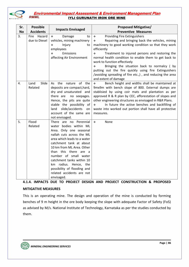
Environmental Impact Assessment & Environment Management Plan
IYLI GURUNATH IRON ORE MINE
Page | 86
MINERAL ENGINEERING SERVICES
Sr. No
Possible Accidents
Impacts Envisaged Proposed Mitigative/ Preventive Measures
3. Fire Hazard due to Diesel
Damage to vehicles, mining machinery Injury to employees Emissions affecting Air Environment
Providing Fire Extinguishers Repairing and bringing back the vehicles, mining machinery to good working condition so that they work efficiently Treatment to injured persons and restoring the normal health condition to enable them to get back to work to function effectively Bringing the situation back to normalcy ( by putting out the fire quickly using fire Extinguishers /avoiding spreading of fire etc.,) , and reducing the area and extent of damage
4. Land Slide Related
As the nature of the deposits are compact,hard, dry and unsaturated and there are no seepages. Hence, the pits are quite stable the possibility of land slide/accidents on account of the same are not envisaged.
Bench height and widths shall be maintained at 9mx9m with bench slope of 800. External dumps are stablisied by using coir mats and plantation as per approved R & R plan by CEC, afforestation of slopes and other engineering structures as envisaged in R&R Plans. In future the active benches and backfilling of waste into worked out portion shall have all protective measures.
5. Flood Related
There are no Perennial water bodies within ML Area. Only one seasonal nallah cuts across the ML area which leads to a water catchment tank at about 10 km from ML Area. Other than this there are a number of small water catchment tanks within 10 km radius. Hence, the possibility of flooding and related accidents are not envisaged.
None
4.1.4. IMPACTS DUE TO PROJECT DESIGN AND PROJECT CONSTRUCTION & PROPOSED
MITIGATIVE MEASURES
This is an operating mine. The design and operation of the mine is conducted by forming
benches of 9 m height in the ore body keeping the slope with adequate Factor of Safety (FoS)
as advised by M/s. National Institute of Technology, Karnataka as per the studies conducted by
them.
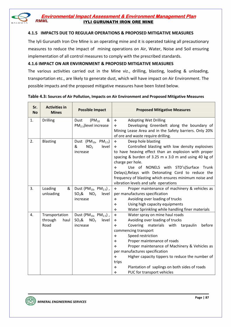
Environmental Impact Assessment & Environment Management Plan
IYLI GURUNATH IRON ORE MINE
Page | 87
MINERAL ENGINEERING SERVICES
4.1.5 IMPACTS DUE TO REGULAR OPERATIONS & PROPOSED MITIGATIVE MEASURES
The Iyli Gurunath Iron Ore Mine is an operating mine and it is operated taking all precautionary
measures to reduce the impact of mining operations on Air, Water, Noise and Soil ensuring
implementation of all control measures to comply with the prescribed standards.
4.1.6 IMPACT ON AIR ENVIRONMENT & PROPOSED MITIGATIVE MEASURES
The various activities carried out in the Mine viz., drilling, blasting, loading & unloading,
transportation etc., are likely to generate dust, which will have impact on Air Environment. The
possible impacts and the proposed mitigative measures have been listed below.
Table 4.3: Sources of Air Pollution, Impacts on Air Environment and Proposed Mitigative Measures
Sr. No
Activities in Mines
Possible Impact Proposed Mitigative Measures
1. Drilling Dust (PM10 & PM2.5)level increase
Adopting Wet Drilling Developing Greenbelt along the boundary of Mining Lease Area and in the Safety barriers. Only 20% of ore and waste require drilling.
2. Blasting Dust (PM10, PM2.5) & NO2 level increase
Deep hole blasting Controlled blasting with low density explosives to have heaving effect than an explosion with proper spacing & burden of 3.25 m x 3.0 m and using 40 kg of charge per hole. Use of NONELS with STD’s(Surface Trunk Delays),Relays with Detonating Cord to reduce the frequency of blasting which ensures minimum noise and vibration levels and safe operations
3. Loading & unloading
Dust (PM10, PM2.5) , SO2& NO2 level increase
Proper maintenance of machinery & vehicles as per manufactures specification Avoiding over loading of trucks Using high capacity equipments Water Sprinkling while handling finer materials
4. Transportation through haul Road
Dust (PM10, PM2.5) , SO2& NO2 level increase
Water spray on mine haul roads Avoiding over loading of trucks Covering materials with tarpaulin before commencing transport Speed restriction Proper maintenance of roads Proper maintenance of Machinery & Vehicles as per manufactures specification Higher capacity tippers to reduce the number of trips Plantation of saplings on both sides of roads PUC for transport vehicles
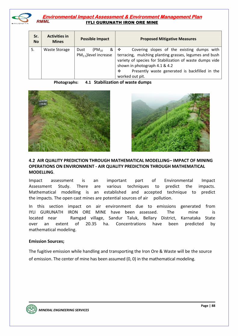
Environmental Impact Assessment & Environment Management Plan
IYLI GURUNATH IRON ORE MINE
Page | 88
MINERAL ENGINEERING SERVICES
Sr. No
Activities in Mines
Possible Impact Proposed Mitigative Measures
5. Waste Storage Dust (PM10 & PM2.5)level increase
Covering slopes of the existing dumps with terracing, mulching planting grasses, legumes and bush variety of species for Stabilization of waste dumps vide shown in photograph 4.1 & 4.2 Presently waste generated is backfilled in the worked out pit.
Photographs: 4.1 Stabilization of waste dumps
4.2 AIR QUALITY PREDICTION THROUGH MATHEMATICAL MODELLING– IMPACT OF MINING OPERATIONS ON ENVIRONMENT - AIR QUALITY PREDICTION THROUGH MATHEMATICAL MODELLING.
Impact assessment is an important part of Environmental Impact Assessment Study. There are various techniques to predict the impacts. Mathematical modelling is an established and accepted technique to predict the impacts. The open cast mines are potential sources of air pollution.
In this section impact on air environment due to emissions generated from IYLI GURUNATH IRON ORE MINE have been assessed. The mine is located near Ramgad village, Sandur Taluk, Bellary District, Karnataka State over an extent of 20.35 ha. Concentrations have been predicted by mathematical modeling. Emission Sources;
The fugitive emission while handling and transporting the Iron Ore & Waste will be the source
of emission. The center of mine has been assumed (0, 0) in the mathematical modeling.
Environmental Impact Assessment & Environment Management Plan
IYLI GURUNATH IRON ORE MINE
Page | 89
MINERAL ENGINEERING SERVICES
Emission Rates;
The emissions in this case have been computed using empirical factor given in Indian Mining and
Engineering Journal. The details of emissions computed from mining operations are as given
below.
Current Max Production ( 975000 tpa) and development ( 263250tpa) : 1238250 tpa
Total handling/ hr taking 300 maximum working days and maximum 8 hours operation.
1238250 / 300 days X 8 hr/d = 516 t/hr
Rate of emission being 23.6 kg/hr for handling 1000t/hr the emission rate shall be
516 X 23.6kg/hr /1000 = 12.18kg/hr
Or 3.383 gm/sec
The above emission is for the uncontrolled environment for controlled environment by taking
proper mitigative measures the emission rate will be 3.383/3=1.128gm/sec
ii) Emission Source Coordinates
The center of mine was assumed (0, 0) in the mathematical modeling
Mathematical Model Used for Prediction of Net Concentration
In the present case ISCST (Industrial Source Complex-Short Term ISC-3) model has been used to
predict the impacts. This ISC model for area sources uses the steady state Gaussian plume
equation for a continuous source. The model was developed by Envitrans.
The model has following specialties
Simulates dispersion from single / multiple area / line /volume sources
Allows calculations to be made at a user specified regular rectangular/radial grid or at specified special receptors
Provides estimates of concentrations for any averaging time period for the entire period of input meteorology.
Allows calculations to be underwritten for source groups as selected by the user
Uses Pasquill-Gifford or Briggs Dispersion Curves (for urban areas) as selected by the user, to derive the plume spread parameters
Adjusts dispersion curves to account for user specified information on aerodynamic roughness
Adjusts for wind speed variation with height, using user specified default urban/rural power law coefficients
Environmental Impact Assessment & Environment Management Plan
IYLI GURUNATH IRON ORE MINE
Page | 90
MINERAL ENGINEERING SERVICES
Simulates dispersion from buoyant, non-buoyant point sources, non-buoyant area, non-buoyant volume sources and non-buoyant line sources
Simulates dry deposition using a simple tilted plume model with user specified reflection coefficients
Simulates building effects
Can include the effects of exponential decay
Uses Briggs’ 1975 plume rise algorithm to calculate plume height
The ground level concentration at a receptor located downwind of all or a portion of the source
area is given by a double integral in the upwind (x) and crosswind (y) directions as:
QAK VD y
x = -------- ------- exp [-0.5(-------) 2 dy] dx (2)
2 Us x y z y y
where,
QA = Area source emission rate (mass per unit area per unit time)
K = units scaling coefficient
V = Vertical term.
D = Decay term as a function of x
y, z = standard deviation of lateral and vertical concentration distribution (m)
Us = mean wind speed at release height
where X(R), Y(R) are receptor point coordinates and X(S) and Y(S) are source coordinates and
WD is wind angle from north.
where X(R), Y(R) are receptor point coordinates and X(S) and Y(S) are source coordinates and
WD is wind angle from north.
VERTICAL TERM
The vertical term includes the effects of source elevation, receptor elevation, plume rise,
limited mixing in vertical and gravitational settling and dry deposition of particulates (with
diameters greater than about 0.1 micron).
In the present case effects on ambient air concentrations due to gravitational settling and dry
deposition have been neglected. The vertical term without deposition effects is given by:
He2 n-1 (2n Hm - He)2 (2n Hm+ He)2
V = (1 + ) exp- ------- + exp - ------------------ + exp ----------------- (3)
2z2 i=1 2z2 2z2
Environmental Impact Assessment & Environment Management Plan
IYLI GURUNATH IRON ORE MINE
Page | 91
MINERAL ENGINEERING SERVICES
where,
H = effective release height of emissions (plume rise + physical stack height)
Hm = Mixing height
= reflection coefficient
The infinite series term in equation accounts for the effects of restrictions on vertical plume
growth at the top of mixing layer. Complete reflection from earth surface has been assumed
( = 1). For number of sources more than one simulation is done for each individual source and
then added. In order to Calculate y and z for various receptor points for given wind direction
following equations are used.
x = -(X(R) - X(S)) Sin (WD) - (Y(R) - Y(S)) Cos (WD) (4)
y = (X(R) - X(S)) Cos (WD) - (Y(R) - Y(S)) Sin (WD) (5)
where X(R), Y(R) are receptor point coordinates and X(S) and Y(S) are source coordinates and
WD is wind angle from north.
DISPERSION COEFFICIENTS
Equations that approximately fit the Pasquill-Gifford curves (Turner, 1970) are used to
calculate y and z in meters for rural area. The equations used to calculate y are of the form
y = 465.11628 (x) tan (TH) (6)
where,
TH = 0.017453293 [c-d ln (x)] (7)
The equation used to calculate z is of the form:
y = axb (8)
where down wind distance x is in kilometers and z is in meters.
The hourly meteorological data has been generated at the site and the same has been used in
the predictions. The hourly wind speed, temperature, direction and stabilities have been used.
The hourly data was available for the months of March-2019 to May- 2019.
The Pasquill Gifford stability classification divides atmospheric stability into six classes based on
solar insolation / cloud cover conditions. Ambient air quality standards promulgated by Central
Pollution Control Board (CPCB) for different areas are as
Environmental Impact Assessment & Environment Management Plan
IYLI GURUNATH IRON ORE MINE
Page | 92
MINERAL ENGINEERING SERVICES
Area Concentration (g/m3)
PM10 SO2 NO2
Residential and Rural 100 80 80
The above standards are for a sampling period of 24 hours.
iii) METEOROLOGICAL CONDITIONS USED IN PREDICTIONS
The hourly meteorological data has been generated at the site and the same has been used in
the predictions. The hourly wind speed, temperature, direction and stabilities have been used.
The hourly data was available for the months of March, April and May, 2019.
iv) ATMOSPHERIC STABILITY
Many alternative models are developed by different authors to relate y and z with down
wind distance x under different atmospheric stability conditions. Unfortunately none of these
have been found to be comprehensive enough to be applicable under all types of topographic
and meteorological conditions. On the basis of available information, “Pasquill Gifford” stability
classification system for study area has been followed. This classification is built in the
model.The Pasquill Gifford stability classification divides atmospheric stability into six classes
based on solar insolation / cloud cover conditions.
vi) PLAN AND FRAME WORK OF COMPUTATIONS SELECTION OF LOCATIONS The locations have been selected around the mining area covering an area of 10 km radius
from centre of mining block.
PLAN OF COMPUTATION
The emission rate, dispersion coefficients and other input data being now available it was
planned to compute the following:
- The 24 hourly averaged incremental concentration with hourly data for the representative
months of Summer Season, 2019
- The identification of grid point having peak concentration for the incremental values.
Preparation of isopleths of different averaging periods and seasons
vii) RESULTS AND DISCUSSIONS
Peak 24 Hourly Incremental Concentrations
As mentioned earlier peak incremental 24 hourly PM10 concentrations have been computed
using hourly meteorological data. The isopleths of various concentrations have also been
drawn and these are given in MES/DWG/AP/21-21. The lower isopleths lower than 1.5 g/m3
is not shown in the drawing for better representation of isopleths.
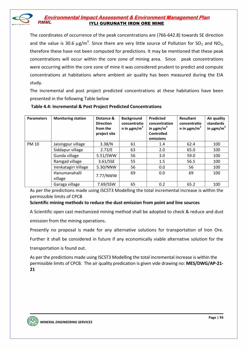
Environmental Impact Assessment & Environment Management Plan
IYLI GURUNATH IRON ORE MINE
Page | 93
MINERAL ENGINEERING SERVICES
The coordinates of occurrence of the peak concentrations are (766-642.8) towards SE direction
and the value is 30.6 g/m3. Since there are very little source of Pollution for SO2 and NO2,
therefore these have not been computed for predictions. It may be mentioned that these peak
concentrations will occur within the core zone of mining area. Since peak concentrations
were occurring within the core zone of mine it was considered prudent to predict and compute
concentrations at habitations where ambient air quality has been measured during the EIA
study.
The incremental and post project predicted concentrations at these habitations have been
presented in the following Table below
Table 4.4: Incremental & Post Project Predicted Concentrations
As per the predictions made using ISCST3 Modelling the total incremental increase is within the permissible limits of CPCB Scientific mining methods to reduce the dust emission from point and line sources
A Scientific open cast mechanized mining method shall be adopted to check & reduce and dust
emission from the mining operations.
Presently no proposal is made for any alternative solutions for transportation of Iron Ore.
Further it shall be considered in future if any economically viable alternative solution for the
transportation is found out.
As per the predictions made using ISCST3 Modelling the total incremental increase is within the permissible limits of CPCB. The air quality predication is given vide drawing no: MES/DWG/AP-21-21
Parameters Monitoring station Distance & Direction from the project site
Background concentration in µgm/m
3
Predicted concentration in µgm/m
3
Controlled emissions
Resultant concentration in µgm/m
3
Air quality standards in µgm/m
3
PM 10 Jaisingpur village 3.38/N 61 1.4 62.4 100
Siddapur village 2.73/E 63 2.0 65.0 100
Gunda village 5.51/SWW 56 3.0 59.0 100
Ramgad village 3.61/SSE 55 1.5 56.5 100
Venkatagiri Village 5.30/NNW 56 0.0 56 100
Hanumanahalli village
7.77/NWW 69 0.0 69 100
Garaga village 7.69/SSW 65 0.2 65.2 100
Environmental Impact Assessment & Environment Management Plan
IYLI GURUNATH IRON ORE MINE
Page | 94
MINERAL ENGINEERING SERVICES
4.2.1 AIR QUALITY PREDICTION –IMPACT OF TRAFFIC ON ENVIRONMENT
The off site traffic will be resulting from movement of trucks in and out of the Mine. The entire
transportation of Iron ore will be through trucks. The vehicles, trucks, will comply with the
standards prescribed by CPCB and will be regularly checked for PUC certificate. Since blasting
is done with low density explosives, the blasted Iron Ore is in the form of boulders to suit the
crusher located at plant site. Thus, generation of fines during blasting is very limited.
However, the broken Iron Ore will be adequately covered with tarpaulin before
commencement of transportation to control dust during transportation. Thus the impact of
traffic on air quality impact is minimal.
4.3 IMPACT OF NOISE LEVEL & VIBRATION ON ENVIRONMENT AND PROPOSED MITIGATIVE
MEASURES
The impact of noise and vibration due to various mining activities including the operation and
movement of HEMM & Vehicles can have direct impact on human beings as well as on fauna.
Noise pollution by mining activities is mainly because of drilling, blasting, excavation, handling
and transportation of Iron Ore and waste materials. The various operations carried out, which
could increase the Noise levels & Vibrations in the area of operation and the surrounding area,
are listed below with appropriate mitigative measures mentioned against each to reduce the
noise level.
Table 4.5: Sources of Noise & Vibrationand Proposed Mitigative Measures
Sr. No
Activities in Mines
ProposedMitigative Measures
1. Drilling No drilling during the night time Providing protective devices like earplugs and earmuffs to the workmen in noise prone zones in the mine.
2. Blasting Avoiding blasting during temperature inversions Avoiding secondary blasting with proper spacing & burden and stemming No blasting during the night time Controlled blasting with low density explosives to have heaving effect than an explosion with proper spacing & burden of 3.0
m x 3.5 m and using 60 kg of charge per hole . Use of NONELS with STDs (Surface Trunk Delays), Relays with Detonating Cord to reduce the frequency of blasting which ensures minimum noise and vibration levels and safe operations. Ensuring higher stemming column than the burden to avoid blown out shots. Stemming column of 3m with deck loading to reduce the noise levels Providing protective devices like earplugs and earmuffs to the workmen in noise prone zones in the mine
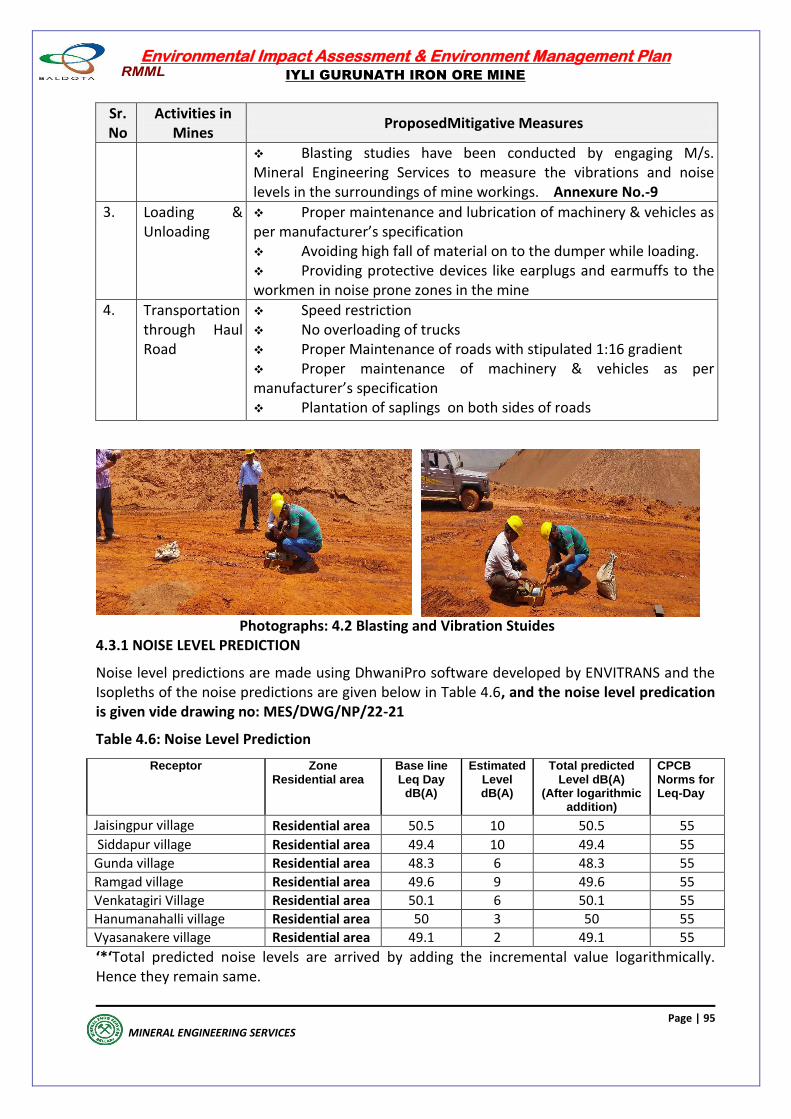
Environmental Impact Assessment & Environment Management Plan
IYLI GURUNATH IRON ORE MINE
Page | 95
MINERAL ENGINEERING SERVICES
Sr. No
Activities in Mines
ProposedMitigative Measures
Blasting studies have been conducted by engaging M/s. Mineral Engineering Services to measure the vibrations and noise levels in the surroundings of mine workings. Annexure No.-9
3. Loading & Unloading
Proper maintenance and lubrication of machinery & vehicles as per manufacturer’s specification Avoiding high fall of material on to the dumper while loading. Providing protective devices like earplugs and earmuffs to the workmen in noise prone zones in the mine
4. Transportation through Haul Road
Speed restriction No overloading of trucks Proper Maintenance of roads with stipulated 1:16 gradient Proper maintenance of machinery & vehicles as per manufacturer’s specification Plantation of saplings on both sides of roads
Photographs: 4.2 Blasting and Vibration Stuides 4.3.1 NOISE LEVEL PREDICTION
Noise level predictions are made using DhwaniPro software developed by ENVITRANS and the Isopleths of the noise predictions are given below in Table 4.6, and the noise level predication is given vide drawing no: MES/DWG/NP/22-21
Table 4.6: Noise Level Prediction
Receptor
Zone Residential area
Base line Leq Day
dB(A)
Estimated Level dB(A)
Total predicted Level dB(A)
(After logarithmic addition)
CPCB Norms for Leq-Day
Jaisingpur village Residential area 50.5 10 50.5 55
Siddapur village Residential area 49.4 10 49.4 55
Gunda village Residential area 48.3 6 48.3 55
Ramgad village Residential area 49.6 9 49.6 55
Venkatagiri Village Residential area 50.1 6 50.1 55
Hanumanahalli village Residential area 50 3 50 55
Vyasanakere village Residential area 49.1 2 49.1 55
‘*‘Total predicted noise levels are arrived by adding the incremental value logarithmically. Hence they remain same.
Environmental Impact Assessment & Environment Management Plan
IYLI GURUNATH IRON ORE MINE
Page | 96
MINERAL ENGINEERING SERVICES
4.4 IMPACTS ON WATER AND PROPOSED MITIGATIVE MEASURES
There is no perennial surface water source passing through the Mining Lease Area or in the
surrounding area. One seasonal nallah is cutting across the ML which joins a water catchment
tank in the buffer zone.The possible impacts on water and the proposed mitigative measures
are given below.
Table 4.7 : Impacts on Water Environment and Proposed Mitigative Measures
S.No Activity Possible Impact Proposed Mitigative Measures
1. Dust suppression
Excess water with suspended solids reaching nearby seasonal nallah passing through the ML Area
Optimum use of water for sprinkling
2. Stacking of waste
Erosion of waste dump by rainwater
As the wastes & ore generated are non toxic, non-acidic and do not contain any heavy metal, the possible pollutant in the water is suspended solid, derived from erosions within the mining area and dumps. The potential impact on the surface water quality is likely due to higher load of suspended solids
Boulder wall at the foot of the dump Garland drain around the dump yard to divert water to sedimentation tank / pond for settling of suspended solids. Covering slopes of the dumps with intercalated soil , mulching and planting grasses, legumes and bush variety of species to prevent erosion
3. Mining Rainwater carrying sediments from the Mine Area to the nearby seasonal nallah/outside the ML Area
Garland drains to divert rain water to sedimentation pond for settling of suspended solids Construction of Check Dams to arrest suspended solids. Collecting the rainwater in a sump at the bottom of the Mine Pit to settle the suspended solid particles Use of water collected in the Mine Pit for water sprinkling and greenbelt development No generation of industrial waste water from Mining Operations
4. Ground Water Intersection
Their is no proposal to take mine workings below water table
Not applicable.
Environmental Impact Assessment & Environment Management Plan
IYLI GURUNATH IRON ORE MINE
Page | 97
MINERAL ENGINEERING SERVICES
4.5 SOLID WASTE MANAGEMENT
At present the waste generated shall be about 75,000 tonnes/ annum which shall be used for
backfilling of the worked out section of mine pit. In this mine, the ore to waste ratio is 1:0.15
After backfilling the top end slopes of the backfilled benches shall be consolidated using
plantation and providing engineering structures to control erosion of dump material.
To prevent dump run off during rainy season, grass seeds will be spread, gully plugs, settling
pits will be constructed at critical points, and Desiltation will be carried out every year during
dry season. RMML has been constructed toe wall, Garland drains and at different places LBCD
-54, LWCD - 45 & BWCD- 60 check dams outside the lease.
As per the approved R & R plans it is suggested the dump wise measures are to be taken and
the details of the dumps is as follows: In active dumps: The EID-1, EID-2 and EID-3 are encroached parts of inactive dumps, ID-1, ID-2 and ID-3
respectively. EID-1 and EID-2 have found encroached due to joint survey sketch (shifting of
lease boundary) and EID-3 slided and gone outside the lease area. All ID,EID & AD1 dumps
are stabilized. Therefore, no bio-engineering measures have been suggested. Damaged
surface runoff management structures may be repaired and strengthened. Silt settling
tanks may be constructed if silt is going into nallas /channels. The measures of stabilization
of active/inactive dumps may be treated with toe walls, silt settling tanks & garland drains,
coir matting etc., AD1: This dump is Inactive as on today and covers an area of 1.09 ha. Averaging slope
of the dump is 25° and average dump height is 30 m. Toe wall TW1(310 m length) has been
constructed with 1 m top width, 2 m bottom width and 3 m height constructed in RR stone
masonry. Garland drain is constructed below the toe wall for a length of GD1-400 m with 2
m top width, 1m bottom width and 1m height. Coir matting and enrichment plantation for
afforestation of dump area. Active Dump: At present there is active dump. Generated waste will backfilled in mined out
area of Block A.
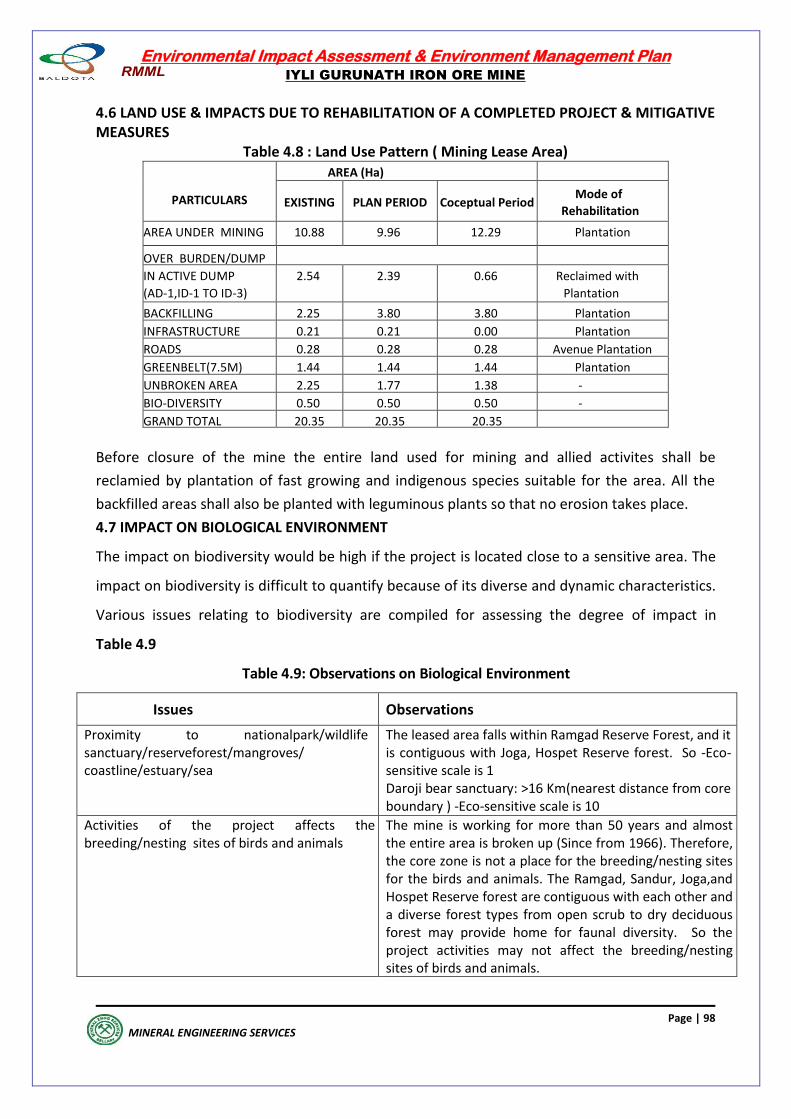
Environmental Impact Assessment & Environment Management Plan
IYLI GURUNATH IRON ORE MINE
Page | 98
MINERAL ENGINEERING SERVICES
4.6 LAND USE & IMPACTS DUE TO REHABILITATION OF A COMPLETED PROJECT & MITIGATIVE MEASURES
Table 4.8 : Land Use Pattern ( Mining Lease Area)
PARTICULARS
AREA (Ha)
EXISTING PLAN PERIOD Coceptual Period Mode of
Rehabilitation
AREA UNDER MINING 10.88 9.96 12.29 Plantation
OVER BURDEN/DUMP
IN ACTIVE DUMP
(AD-1,ID-1 TO ID-3)
2.54 2.39 0.66 Reclaimed with
Plantation
BACKFILLING 2.25 3.80 3.80 Plantation
INFRASTRUCTURE 0.21 0.21 0.00 Plantation
ROADS 0.28 0.28 0.28 Avenue Plantation
GREENBELT(7.5M) 1.44 1.44 1.44 Plantation
UNBROKEN AREA 2.25 1.77 1.38 -
BIO-DIVERSITY 0.50 0.50 0.50 -
GRAND TOTAL 20.35 20.35 20.35
Before closure of the mine the entire land used for mining and allied activites shall be
reclamied by plantation of fast growing and indigenous species suitable for the area. All the
backfilled areas shall also be planted with leguminous plants so that no erosion takes place.
4.7 IMPACT ON BIOLOGICAL ENVIRONMENT
The impact on biodiversity would be high if the project is located close to a sensitive area. The
impact on biodiversity is difficult to quantify because of its diverse and dynamic characteristics.
Various issues relating to biodiversity are compiled for assessing the degree of impact in
Table 4.9
Table 4.9: Observations on Biological Environment
Issues Observations
Proximity to nationalpark/wildlife sanctuary/reserveforest/mangroves/ coastline/estuary/sea
The leased area falls within Ramgad Reserve Forest, and it is contiguous with Joga, Hospet Reserve forest. So -Eco-sensitive scale is 1 Daroji bear sanctuary: >16 Km(nearest distance from core boundary ) -Eco-sensitive scale is 10
Activities of the project affects the breeding/nesting sites of birds and animals
The mine is working for more than 50 years and almost the entire area is broken up (Since from 1966). Therefore, the core zone is not a place for the breeding/nesting sites for the birds and animals. The Ramgad, Sandur, Joga,and Hospet Reserve forest are contiguous with each other and a diverse forest types from open scrub to dry deciduous forest may provide home for faunal diversity. So the project activities may not affect the breeding/nesting sites of birds and animals.
Environmental Impact Assessment & Environment Management Plan
IYLI GURUNATH IRON ORE MINE
Page | 99
MINERAL ENGINEERING SERVICES
Located near an area populated by rare or endangered species.
There is no rare/endangered plant species recorded within the core and buffer areas (Table 3.23). In buffer area few remnant key stone Ficus species found in the villages backyard / sacred grows.(Table 3.23) Similarly fauna’s mammals (Table 3.24), common leopard under schedule I species. Reptiles (Table 3.25), Indian rock python, Cobra are rare and also listed under Schedule-I. Birds (Table 3.27), Indian peafowl are rare and listed in Schedule I. Butterfly (Table 3.28), Crimson rose are listed in Schedule I.
Proposed project restricts access to water holes for wildlife
No wildlife corridors or migratory routes for wildlife lies within the core area. Thus project does not restrict access to waterholes for wildlife
Proposed mining project impact on surface water quality that also provides water to wildlife
There is no effluent discharge from the mine. There is no runoff water from pit, since mining pit did not reach ground water table so far. However, precipitation in Ramgad area is also very low, and runoff shall be controlled by check-dam at low lying areas. Further, PP also constructed rocky /concrete wall to prevent water and soil erosion into the low lying areas and surrounding forest.
Proposed mining project could increase siltation that would affect near by biodiversity area
Siltation within the mining area is well controlled by providing check dams, gully plugs, garland drains, retaining walls. The dumps are protected against erosions by mulching, simultaneous vegetation growth over inactive dump slopes, covering the vulnerable slopes with immediate geo-textile matting. Further the final discharge water from the ML area is subjected to sedimentation and filtration before its discharge to natural drainage and thus the siltation in the water is reduced to a large extent and there shall be no effect on nearby bio-diversity areas.
Risk of fall/slip or cause death to wild animals due to project activities
There is no wildlife corridor or migratory route for wildlife within the core ML area. Therefore, there are less chances of Wildlife entering into the ML area. However, as per the requirement proper fencing shall be provided surrounding the pit area preventing any approach of wild animals into the area and also a retaining wall is provided surrounding the waste dump to arrest any landslide, Waste dump is also stabilized by concurrent afforestation. Further watch & ward is also provided to prevent any such incidence.
The project releases effluents into a water body that also supplies water to wild life
No effluents are released from the mine. The mine shall never reach the depth of ground water table in the lease.
Mining project affects the forest-based livelihood/any specific forest product on which local livelihood depends
There is no report on forest dependency such as forest products by local community for livelihood.
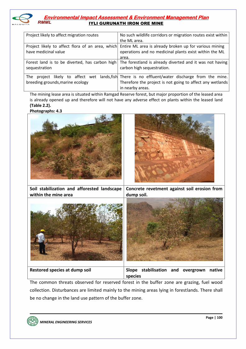
Environmental Impact Assessment & Environment Management Plan
IYLI GURUNATH IRON ORE MINE
Page | 100
MINERAL ENGINEERING SERVICES
Project likely to affect migration routes No such wildlife corridors or migration routes exist within the ML area.
Project likely to affect flora of an area, which have medicinal value
Entire ML area is already broken up for various mining operations and no medicinal plants exist within the ML area.
Forest land is to be diverted, has carbon high sequestration
The forestland is already diverted and it was not having carbon high sequestration.
The project likely to affect wet lands,fish breeding grounds,marine ecology
There is no effluent/water discharge from the mine. Therefore the project is not going to affect any wetlands in nearby areas.
The mining lease area is situated within Ramgad Reserve forest, but major proportion of the leased area is already opened up and therefore will not have any adverse effect on plants within the leased land (Table 2.2). Photographs: 4.3
Soil stabilization and afforested landscape within the mine area
Concrete revetment against soil erosion from dump soil.
Restored species at dump soil Slope stabilisation and overgrown native species
The common threats observed for reserved forest in the buffer zone are grazing, fuel wood
collection. Disturbances are limited mainly to the mining areas lying in forestlands. There shall
be no change in the land use pattern of the buffer zone.
Environmental Impact Assessment & Environment Management Plan
IYLI GURUNATH IRON ORE MINE
Page | 101
MINERAL ENGINEERING SERVICES
There may be some local impacts due to mining and creation of approach roads. However,
these effects are minor, temporary and are easily reversible with a proper management plan.
4.7.1 WILDLIFE CONSERVATION PLAN
Conservation of nature and natural resources involves proper management of natural wealth,
biological wealth and the habitats that sustain these resources. The need for conservation,
preservation, and management of biological diversity arises because of threats to natural
terrestrial and aquatic ecosystems by anthropogenic activities. In the present project, threats
may arise as a result of developmental activities in the buffer zone. As mentioned in the
MoEF&CC guidelines, eco-sensitive zones need to be identified around the protected area,
which act as a wildlife corridor or as a shock absorber.
The likely disruptive activities include road construction, mining, and dumping of excavated
material and human population pressure on land and biological resources of the sanctuary.
The mine lease area does not fall in either protected area or Wildlife Sanctuary and the mine
located in Ramgad reserved forest, leased area, which is already opened up, may cause fewer
impacts on the surrounding reserve forest. In spite of this, we are hereby suggesting a
biodiversity conservation and management plan for the region with the following objectives in
mind:
Sustainable development of natural ecosystems and areas which may hold potentially
important species from the conservation and/or economic significance;
Preservation of natural habitats in the core and buffer zone and identification of areas
that require special attention;
Special efforts for in-situ or ex-situ conservation of rare/endangered/threatened (RET)
plant species;
Mitigation of biotic and/or abiotic pressures/influences on the habitats;
To improve habitat conditions by taking up afforestation with local species of fruit
yielding species, which attract faunal diversity and soil conservation measures;
To create awareness regarding conservations, and ensure people’s participation in the
conservation efforts.
The following areas require special attention with reference to conservation and management
of flora and fauna:
Mining and its buffer zone
Development of ex-situ area for conservation of keystone plant species
The reserve forest should be free from fire, fuel wood collection, poaching, invasion of weeds,
grazing pressure etc., which are the main limiting factors affecting wildlife habitats and their
corridors directly.
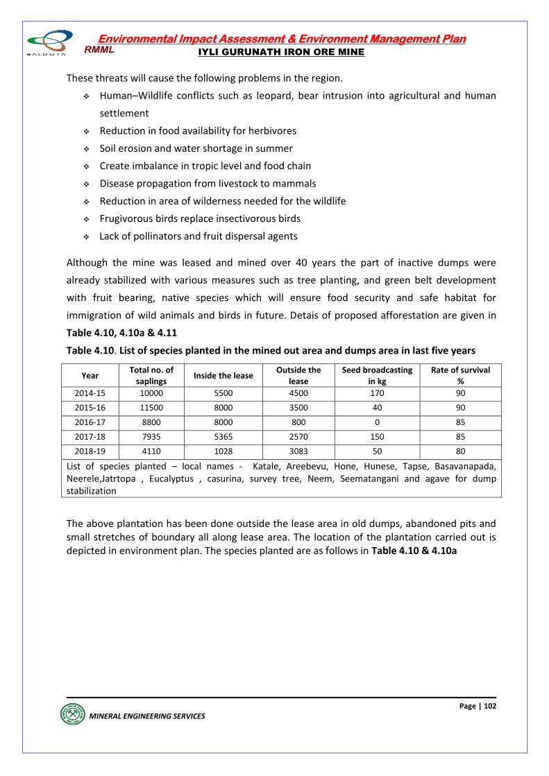
Environmental Impact Assessment & Environment Management Plan
IYLI GURUNATH IRON ORE MINE
Page | 102
MINERAL ENGINEERING SERVICES
These threats will cause the following problems in the region.
Human–Wildlife conflicts such as leopard, bear intrusion into agricultural and human
settlement
Reduction in food availability for herbivores
Soil erosion and water shortage in summer
Create imbalance in tropic level and food chain
Disease propagation from livestock to mammals
Reduction in area of wilderness needed for the wildlife
Frugivorous birds replace insectivorous birds
Lack of pollinators and fruit dispersal agents
Although the mine was leased and mined over 40 years the part of inactive dumps were
already stabilized with various measures such as tree planting, and green belt development
with fruit bearing, native species which will ensure food security and safe habitat for
immigration of wild animals and birds in future. Detais of proposed afforestation are given in
Table 4.10, 4.10a & 4.11
Table 4.10. List of species planted in the mined out area and dumps area in last five years
Year Total no. of
saplings Inside the lease
Outside the lease
Seed broadcasting in kg
Rate of survival %
2014-15 10000 5500 4500 170 90
2015-16 11500 8000 3500 40 90
2016-17 8800 8000 800 0 85
2017-18 7935 5365 2570 150 85
2018-19 4110 1028 3083 50 80
List of species planted – local names - Katale, Areebevu, Hone, Hunese, Tapse, Basavanapada, Neerele,Jatrtopa , Eucalyptus , casurina, survey tree, Neem, Seematangani and agave for dump stabilization
The above plantation has been done outside the lease area in old dumps, abandoned pits and small stretches of boundary all along lease area. The location of the plantation carried out is depicted in environment plan. The species planted are as follows in Table 4.10 & 4.10a
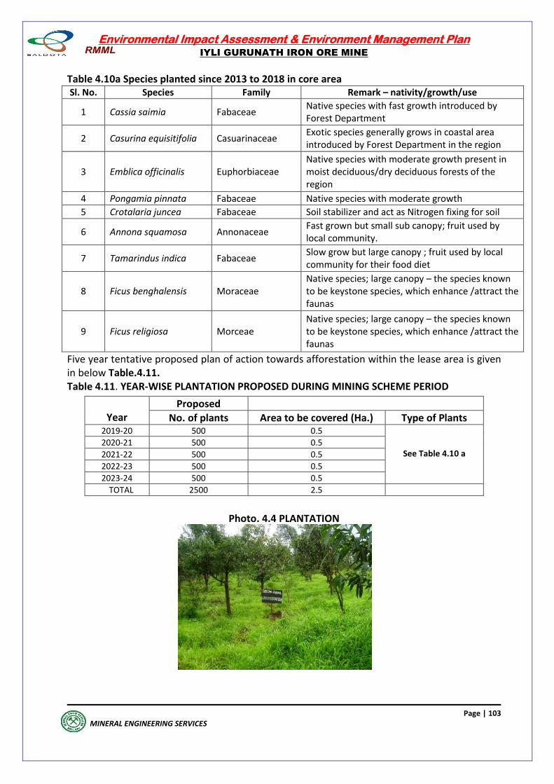
Environmental Impact Assessment & Environment Management Plan
IYLI GURUNATH IRON ORE MINE
Page | 103
MINERAL ENGINEERING SERVICES
Table 4.10a Species planted since 2013 to 2018 in core area Sl. No. Species Family Remark – nativity/growth/use
1 Cassia saimia Fabaceae Native species with fast growth introduced by Forest Department
2 Casurina equisitifolia Casuarinaceae Exotic species generally grows in coastal area introduced by Forest Department in the region
3 Emblica officinalis Euphorbiaceae Native species with moderate growth present in moist deciduous/dry deciduous forests of the region
4 Pongamia pinnata Fabaceae Native species with moderate growth
5 Crotalaria juncea Fabaceae Soil stabilizer and act as Nitrogen fixing for soil
6 Annona squamosa Annonaceae Fast grown but small sub canopy; fruit used by local community.
7 Tamarindus indica Fabaceae Slow grow but large canopy ; fruit used by local community for their food diet
8 Ficus benghalensis Moraceae Native species; large canopy – the species known to be keystone species, which enhance /attract the faunas
9 Ficus religiosa Morceae Native species; large canopy – the species known to be keystone species, which enhance /attract the faunas
Five year tentative proposed plan of action towards afforestation within the lease area is given in below Table.4.11. Table 4.11. YEAR-WISE PLANTATION PROPOSED DURING MINING SCHEME PERIOD
Photo. 4.4 PLANTATION
Year
Proposed
No. of plants Area to be covered (Ha.) Type of Plants 2019-20 500 0.5
See Table 4.10 a
2020-21 500 0.5
2021-22 500 0.5
2022-23 500 0.5
2023-24 500 0.5
TOTAL 2500 2.5
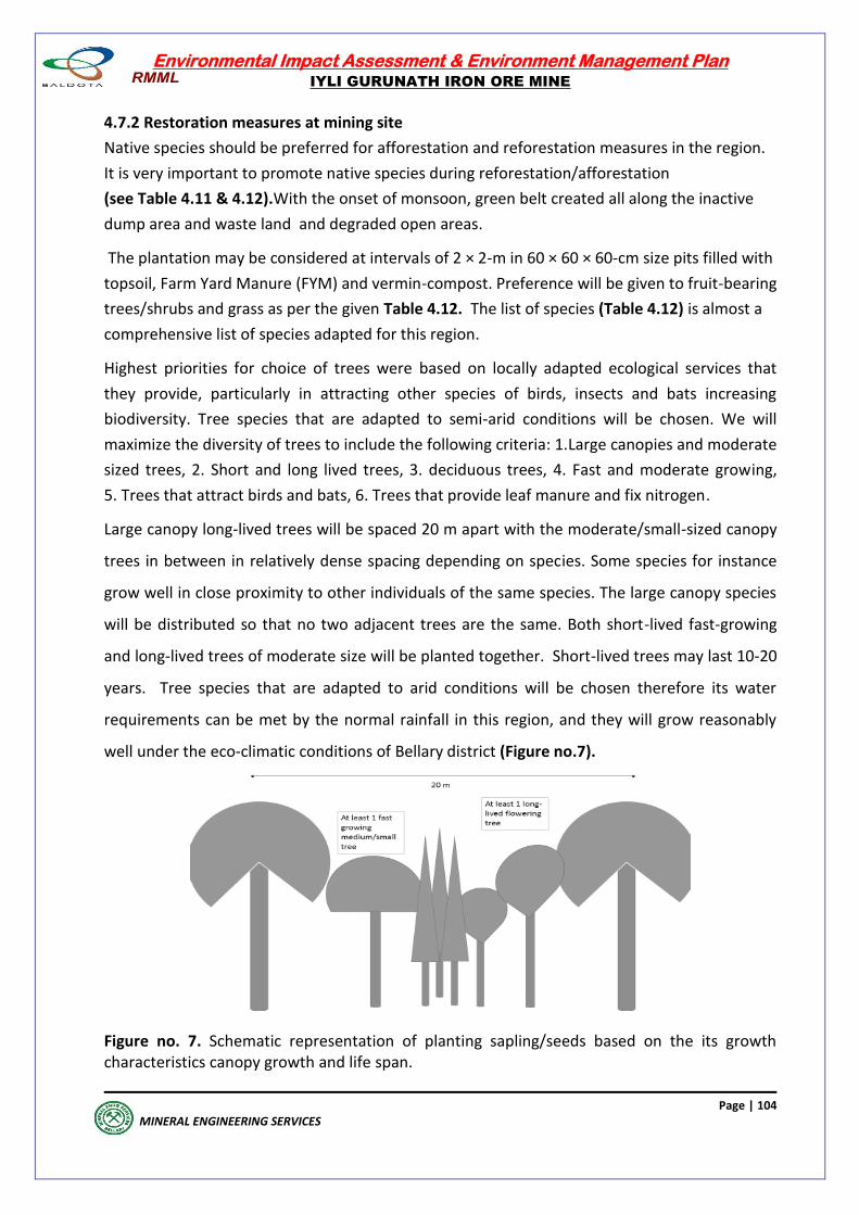
Environmental Impact Assessment & Environment Management Plan
IYLI GURUNATH IRON ORE MINE
Page | 104
MINERAL ENGINEERING SERVICES
4.7.2 Restoration measures at mining site
Native species should be preferred for afforestation and reforestation measures in the region.
It is very important to promote native species during reforestation/afforestation
(see Table 4.11 & 4.12).With the onset of monsoon, green belt created all along the inactive
dump area and waste land and degraded open areas.
The plantation may be considered at intervals of 2 × 2-m in 60 × 60 × 60-cm size pits filled with
topsoil, Farm Yard Manure (FYM) and vermin-compost. Preference will be given to fruit-bearing
trees/shrubs and grass as per the given Table 4.12. The list of species (Table 4.12) is almost a
comprehensive list of species adapted for this region.
Highest priorities for choice of trees were based on locally adapted ecological services that
they provide, particularly in attracting other species of birds, insects and bats increasing
biodiversity. Tree species that are adapted to semi-arid conditions will be chosen. We will
maximize the diversity of trees to include the following criteria: 1.Large canopies and moderate
sized trees, 2. Short and long lived trees, 3. deciduous trees, 4. Fast and moderate growing,
5. Trees that attract birds and bats, 6. Trees that provide leaf manure and fix nitrogen.
Large canopy long-lived trees will be spaced 20 m apart with the moderate/small-sized canopy
trees in between in relatively dense spacing depending on species. Some species for instance
grow well in close proximity to other individuals of the same species. The large canopy species
will be distributed so that no two adjacent trees are the same. Both short-lived fast-growing
and long-lived trees of moderate size will be planted together. Short-lived trees may last 10-20
years. Tree species that are adapted to arid conditions will be chosen therefore its water
requirements can be met by the normal rainfall in this region, and they will grow reasonably
well under the eco-climatic conditions of Bellary district (Figure no.7).
Figure no. 7. Schematic representation of planting sapling/seeds based on the its growth characteristics canopy growth and life span.
Environmental Impact Assessment & Environment Management Plan
IYLI GURUNATH IRON ORE MINE
Page | 105
MINERAL ENGINEERING SERVICES
During the non-monsoon season, the dust spreads in the mining area due to mining operations
such as excavation, loading of ore and transportation. Along the mine haulage roads, tree belts
are created for dust absorption and also serve as an acoustic barrier for minimizing the noise
level, besides improving the aesthetic look of the lease area.
The species will be chosen based on CPCB ‘guideline for development of green belt - 2000’.
On either side of these roads, over a width of 5 m at 2 x 2-m spacement, broad leaved tree
species (see Table 4.2) will be planted in pits.
The size of these pits will be 60 x 60 x 60-cm; filled with top soil, farm yard manure and
compost. Pits will be dug in staggered manner from row to row. During the initial years of
establishment of avenue plants, in the intermediate space between two plants, tall cuttings of
Glyricidia will be planted, while a leguminous crop is improving the site conditions, to act as
shady plant. Besides, Glyricidia flowers also attract sun-birds and bees.
Tall cuttings and healthy one-year old seedlings of broad-leaved species will be preferred for
road-side plantation and for tree belt of two rows around the infrastructure. The existing
miscellaneous tree vegetation will be undisturbed. Selection of tree species for habitat
improvement will be carefully chalked out so that adequate supply of food and safe shelter to
wild animals and birds are ensured.
Young plantations need to be properly tended for obtaining uniform growth and better survival
rate. During the first year itself, there are chances of casualty due to heavy downpour, wind
damage, etc. Adequate number of seedlings will be kept ready in stacks for gap filling. For the 5
year period, all maintenance works of the plantations will be carried out. In case of dump area
plantations, terraces will be repaired along with gully plugging for preventing rill formation.
In addition to this, landslides will be contained by stone pitching; check dams and terrace
benches will be regularly monitored for de-siltation. Organic fertilizer, vermin-compost and
FYM will be used along with bio-pesticides. Weeding, soil working, and mulching will be carried
out as per necessity.
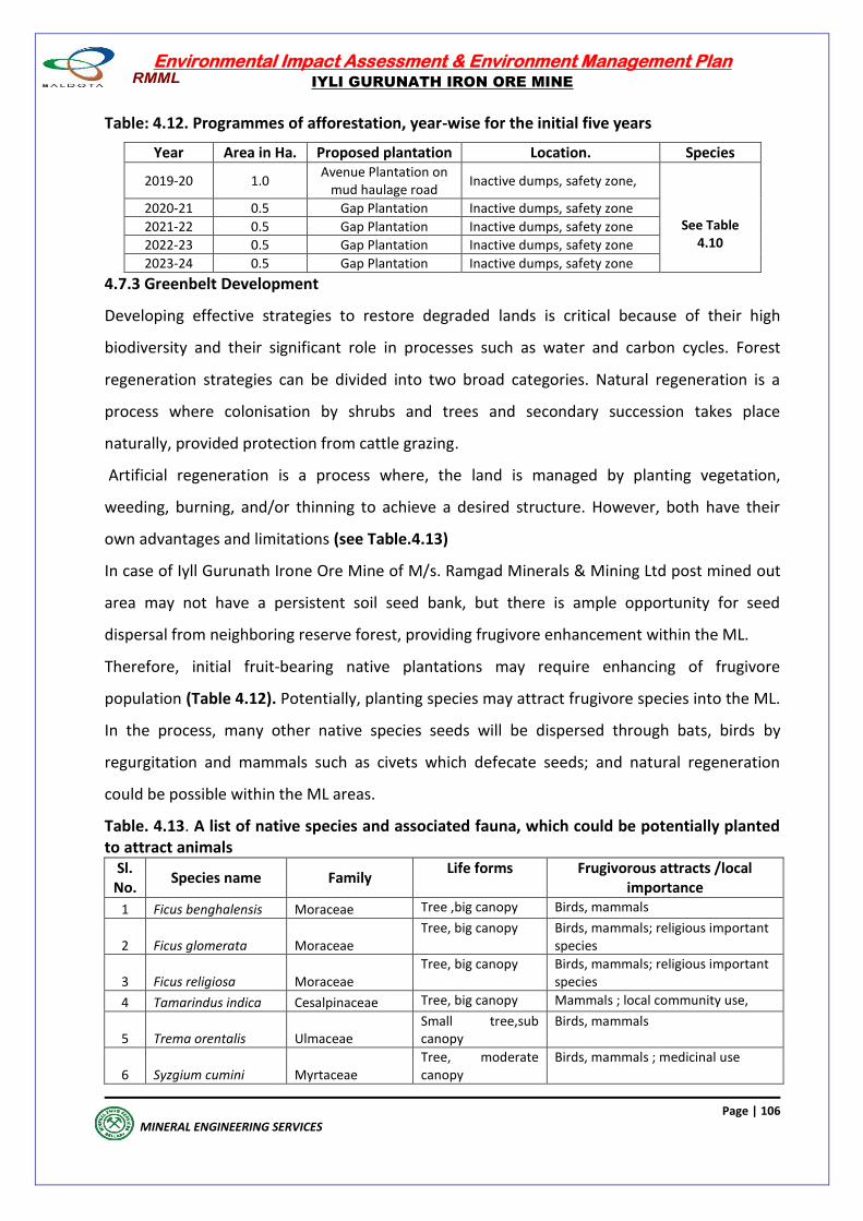
Environmental Impact Assessment & Environment Management Plan
IYLI GURUNATH IRON ORE MINE
Page | 106
MINERAL ENGINEERING SERVICES
Table: 4.12. Programmes of afforestation, year-wise for the initial five years
Year Area in Ha. Proposed plantation Location. Species
2019-20 1.0 Avenue Plantation on
mud haulage road Inactive dumps, safety zone,
See Table 4.10
2020-21 0.5 Gap Plantation Inactive dumps, safety zone
2021-22 0.5 Gap Plantation Inactive dumps, safety zone
2022-23 0.5 Gap Plantation Inactive dumps, safety zone
2023-24 0.5 Gap Plantation Inactive dumps, safety zone
4.7.3 Greenbelt Development
Developing effective strategies to restore degraded lands is critical because of their high
biodiversity and their significant role in processes such as water and carbon cycles. Forest
regeneration strategies can be divided into two broad categories. Natural regeneration is a
process where colonisation by shrubs and trees and secondary succession takes place
naturally, provided protection from cattle grazing.
Artificial regeneration is a process where, the land is managed by planting vegetation,
weeding, burning, and/or thinning to achieve a desired structure. However, both have their
own advantages and limitations (see Table.4.13)
In case of Iyll Gurunath Irone Ore Mine of M/s. Ramgad Minerals & Mining Ltd post mined out
area may not have a persistent soil seed bank, but there is ample opportunity for seed
dispersal from neighboring reserve forest, providing frugivore enhancement within the ML.
Therefore, initial fruit-bearing native plantations may require enhancing of frugivore
population (Table 4.12). Potentially, planting species may attract frugivore species into the ML.
In the process, many other native species seeds will be dispersed through bats, birds by
regurgitation and mammals such as civets which defecate seeds; and natural regeneration
could be possible within the ML areas.
Table. 4.13. A list of native species and associated fauna, which could be potentially planted to attract animals
Sl. No.
Species name Family Life forms Frugivorous attracts /local
importance
1 Ficus benghalensis Moraceae Tree ,big canopy Birds, mammals
2 Ficus glomerata Moraceae Tree, big canopy Birds, mammals; religious important
species
3 Ficus religiosa Moraceae Tree, big canopy Birds, mammals; religious important
species
4 Tamarindus indica Cesalpinaceae Tree, big canopy Mammals ; local community use,
5 Trema orentalis Ulmaceae Small tree,sub canopy
Birds, mammals
6 Syzgium cumini Myrtaceae Tree, moderate canopy
Birds, mammals ; medicinal use
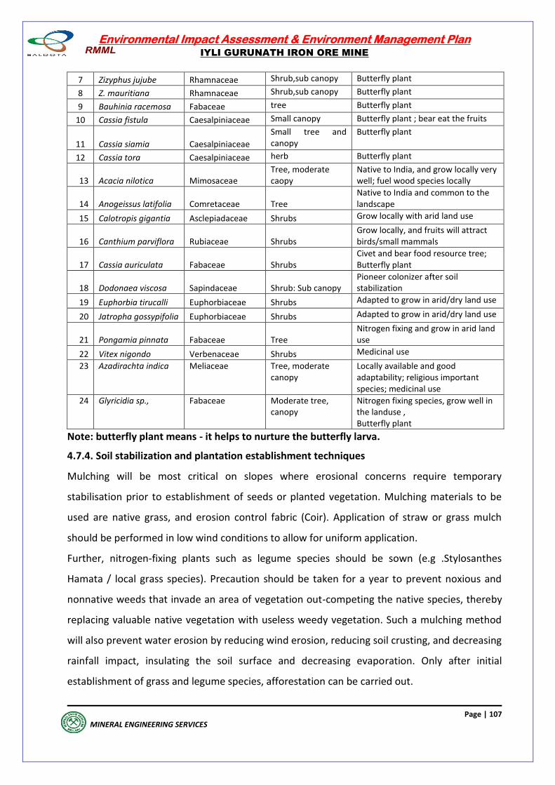
Environmental Impact Assessment & Environment Management Plan
IYLI GURUNATH IRON ORE MINE
Page | 107
MINERAL ENGINEERING SERVICES
7 Zizyphus jujube Rhamnaceae Shrub,sub canopy Butterfly plant
8 Z. mauritiana Rhamnaceae Shrub,sub canopy Butterfly plant
9 Bauhinia racemosa Fabaceae tree Butterfly plant
10 Cassia fistula Caesalpiniaceae Small canopy Butterfly plant ; bear eat the fruits
11 Cassia siamia Caesalpiniaceae
Small tree and canopy
Butterfly plant
12 Cassia tora Caesalpiniaceae herb Butterfly plant
13 Acacia nilotica Mimosaceae Tree, moderate caopy
Native to India, and grow locally very well; fuel wood species locally
14 Anogeissus latifolia Comretaceae Tree Native to India and common to the landscape
15 Calotropis gigantia Asclepiadaceae Shrubs Grow locally with arid land use
16 Canthium parviflora Rubiaceae Shrubs Grow locally, and fruits will attract birds/small mammals
17 Cassia auriculata Fabaceae Shrubs Civet and bear food resource tree; Butterfly plant
18 Dodonaea viscosa Sapindaceae Shrub: Sub canopy Pioneer colonizer after soil stabilization
19 Euphorbia tirucalli Euphorbiaceae Shrubs Adapted to grow in arid/dry land use
20 Jatropha gossypifolia Euphorbiaceae Shrubs Adapted to grow in arid/dry land use
21 Pongamia pinnata Fabaceae Tree Nitrogen fixing and grow in arid land use
22 Vitex nigondo Verbenaceae Shrubs Medicinal use
23 Azadirachta indica Meliaceae Tree, moderate canopy
Locally available and good adaptability; religious important species; medicinal use
24 Glyricidia sp., Fabaceae Moderate tree, canopy
Nitrogen fixing species, grow well in the landuse , Butterfly plant
Note: butterfly plant means - it helps to nurture the butterfly larva.
4.7.4. Soil stabilization and plantation establishment techniques
Mulching will be most critical on slopes where erosional concerns require temporary
stabilisation prior to establishment of seeds or planted vegetation. Mulching materials to be
used are native grass, and erosion control fabric (Coir). Application of straw or grass mulch
should be performed in low wind conditions to allow for uniform application.
Further, nitrogen-fixing plants such as legume species should be sown (e.g .Stylosanthes
Hamata / local grass species). Precaution should be taken for a year to prevent noxious and
nonnative weeds that invade an area of vegetation out-competing the native species, thereby
replacing valuable native vegetation with useless weedy vegetation. Such a mulching method
will also prevent water erosion by reducing wind erosion, reducing soil crusting, and decreasing
rainfall impact, insulating the soil surface and decreasing evaporation. Only after initial
establishment of grass and legume species, afforestation can be carried out.
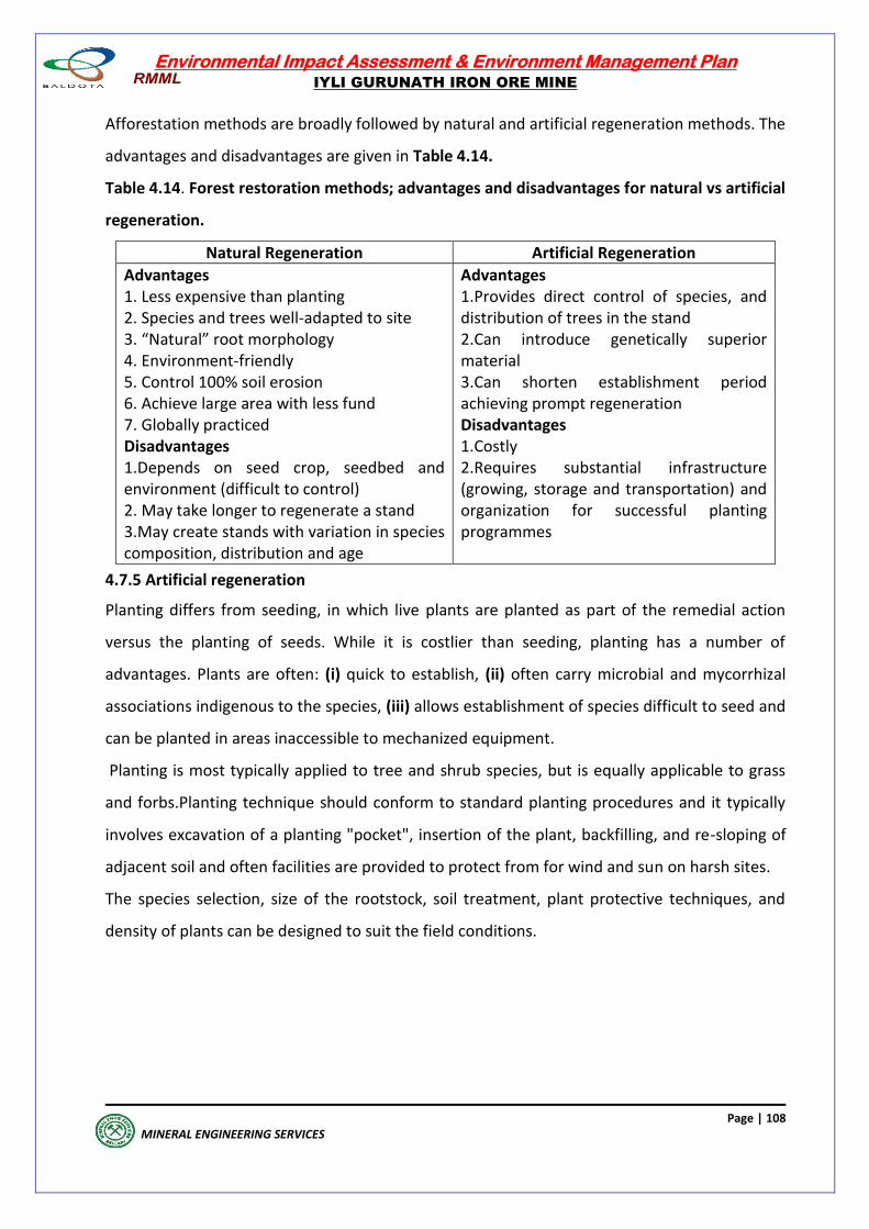
Environmental Impact Assessment & Environment Management Plan
IYLI GURUNATH IRON ORE MINE
Page | 108
MINERAL ENGINEERING SERVICES
Afforestation methods are broadly followed by natural and artificial regeneration methods. The
advantages and disadvantages are given in Table 4.14.
Table 4.14. Forest restoration methods; advantages and disadvantages for natural vs artificial
regeneration.
Natural Regeneration Artificial Regeneration
Advantages 1. Less expensive than planting 2. Species and trees well-adapted to site 3. “Natural” root morphology 4. Environment-friendly 5. Control 100% soil erosion 6. Achieve large area with less fund 7. Globally practiced Disadvantages 1.Depends on seed crop, seedbed and environment (difficult to control) 2. May take longer to regenerate a stand 3.May create stands with variation in species composition, distribution and age
Advantages 1.Provides direct control of species, and distribution of trees in the stand 2.Can introduce genetically superior material 3.Can shorten establishment period achieving prompt regeneration Disadvantages 1.Costly 2.Requires substantial infrastructure (growing, storage and transportation) and organization for successful planting programmes
4.7.5 Artificial regeneration
Planting differs from seeding, in which live plants are planted as part of the remedial action
versus the planting of seeds. While it is costlier than seeding, planting has a number of
advantages. Plants are often: (i) quick to establish, (ii) often carry microbial and mycorrhizal
associations indigenous to the species, (iii) allows establishment of species difficult to seed and
can be planted in areas inaccessible to mechanized equipment.
Planting is most typically applied to tree and shrub species, but is equally applicable to grass
and forbs.Planting technique should conform to standard planting procedures and it typically
involves excavation of a planting "pocket", insertion of the plant, backfilling, and re-sloping of
adjacent soil and often facilities are provided to protect from for wind and sun on harsh sites.
The species selection, size of the rootstock, soil treatment, plant protective techniques, and
density of plants can be designed to suit the field conditions.
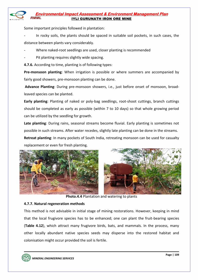
Environmental Impact Assessment & Environment Management Plan
IYLI GURUNATH IRON ORE MINE
Page | 109
MINERAL ENGINEERING SERVICES
Some important principles followed in plantation:
- In rocky soils, the plants should be spaced in suitable soil pockets, in such cases, the
distance between plants vary considerably.
- Where naked-root seedlings are used, closer planting is recommended
- Pit planting requires slightly wide spacing.
4.7.6. According to time, planting is of following types:
Pre-monsoon planting: When irrigation is possible or where summers are accompanied by
fairly good showers, pre-monsoon planting can be done.
Advance Planting: During pre-monsoon showers, i.e., just before onset of monsoon, broad-
leaved species can be planted.
Early planting: Planting of naked or poly-bag seedlings, root-shoot cuttings, branch cuttings
should be completed as early as possible (within 7 to 10 days) so that whole growing period
can be utilized by the seedling for growth.
Late planting: During rains, seasonal streams become fluvial. Early planting is sometimes not
possible in such streams. After water recedes, slightly late planting can be done in the streams.
Retreat planting: In many pockets of South India, retreating monsoon can be used for casualty
replacement or even for fresh planting.
Photo.4.4 Plantation and watering to plants
4.7.7. Natural regeneration methods
This method is not advisable in initial stage of mining restorations. However, keeping in mind
that the local frugivore species has to be enhanced; one can plant the fruit-bearing species
(Table 4.12), which attract many frugivore birds, bats, and mammals. In the process, many
other locally abundant native species seeds may disperse into the restored habitat and
colonisation might occur provided the soil is fertile.
Environmental Impact Assessment & Environment Management Plan
IYLI GURUNATH IRON ORE MINE
Page | 110
MINERAL ENGINEERING SERVICES
4.7.8 Post-Plantation Care
This will include the following measures: Protection from grazing, fires and human pressure (minimum 10 years)
Watering at least once a week during dry spells
Organic fertilizer and manuring
Weeding thrice in the first year and twice a year, during the subsequent two years and
soil working
Plugging and mulching
Protection from pests
This post-plantation care is undertaken at least for three years after the plantation.
Pruning: Removal of side branches of lower one-third height is called pruning. It should
be done between saplings to pole stage.
Thinning: Removal of extra plants is called thinning. To maintain proper space between
trees, judicious thinning is done. Exotic or invasive species such as Prosopis juliflora,
Parthenium spp, Lantana camara and Chromolenia sp., should be removed from the
afforested land use.
Plan for Reduction of Impact on Fauna
Totally stopping mining or any other related activity during the nights
Avoiding totally blasting operations
Avoid using high beam lights, higher decibel honks within and outside the ML, which
may indirectly affect the resident wildlife. Light focusing should be towards the ML
area.
Deep pits and artificial water holes should be fenced within the ML area, which will
avoid wildlife accidents.
A strict wildlife vigilance team to avoid any poaching and illegal activity.
Liaison with forest officials through telephone on sighting of such animals around the
ML & illegal cutting of forests, prevention of forest fires
Providing sufficient number of water holes in the buffer zone forests along with salt
licks as per the requirement of forest officials
Construction of watchtowers located within ML area and appointment of anti-poaching
guards to watch movement of wild animals, to prevent any poaching and also
trespassers, observing for any forest fires and informing the same to the forest
department officials.
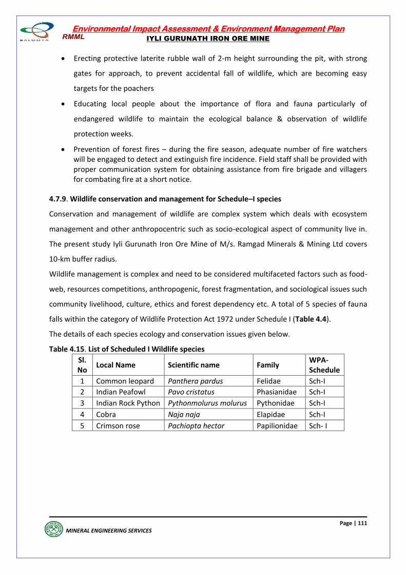
Environmental Impact Assessment & Environment Management Plan
IYLI GURUNATH IRON ORE MINE
Page | 111
MINERAL ENGINEERING SERVICES
Erecting protective laterite rubble wall of 2-m height surrounding the pit, with strong
gates for approach, to prevent accidental fall of wildlife, which are becoming easy
targets for the poachers
Educating local people about the importance of flora and fauna particularly of
endangered wildlife to maintain the ecological balance & observation of wildlife
protection weeks.
Prevention of forest fires – during the fire season, adequate number of fire watchers will be engaged to detect and extinguish fire incidence. Field staff shall be provided with proper communication system for obtaining assistance from fire brigade and villagers for combating fire at a short notice.
4.7.9. Wildlife conservation and management for Schedule–I species
Conservation and management of wildlife are complex system which deals with ecosystem
management and other anthropocentric such as socio-ecological aspect of community live in.
The present study Iyli Gurunath Iron Ore Mine of M/s. Ramgad Minerals & Mining Ltd covers
10-km buffer radius.
Wildlife management is complex and need to be considered multifaceted factors such as food-
web, resources competitions, anthropogenic, forest fragmentation, and sociological issues such
community livelihood, culture, ethics and forest dependency etc. A total of 5 species of fauna
falls within the category of Wildlife Protection Act 1972 under Schedule I (Table 4.4).
The details of each species ecology and conservation issues given below.
Table 4.15. List of Scheduled I Wildlife species
Sl. No
Local Name Scientific name Family WPA-Schedule
1 Common leopard Panthera pardus Felidae Sch-I
2 Indian Peafowl Pavo cristatus Phasianidae Sch-I
3 Indian Rock Python Pythonmolurus molurus Pythonidae Sch-I
4 Cobra Naja naja Elapidae Sch-I
5 Crimson rose Pachiopta hector Papilionidae Sch- I
Environmental Impact Assessment & Environment Management Plan
IYLI GURUNATH IRON ORE MINE
Page | 112
MINERAL ENGINEERING SERVICES
4.8 IMPACT ON SOCIETY/PUBLIC
4.8.1 ECONOMY
Impact on human habitations
4.8.1 a) Displacement of population in the core mining area.
Population has not been displaced because of mining lease. Mining lease is in forest area.
Mining proponent has not bought land from any farmers. No farmer has become land less
because of selling his land to project proponent.
4.8.1 b) Impact on population in buffer zone.
The population of buffer zone is characterized by poor farmers from the lower socioeconomic
strata. More than 55 percent of the population in buffer zone belongs to socially disadvantaged
groups like SC and ST communities. More than 30 percent of the households in buffer zone do
not have agriculture land. Cultivation depends upon rain and vagaries of weather. Population in
buffer zone is mainly dependent upon agriculture and dry crop cultivation. A majority of
households depend on meager income, mainly from agriculture. Mining has rejuvenated the
village economy increasing household income from non-agriculture sector.
In fact, infrastructure development and mining activity in buffer zone is able to provide jobs
not only for locals, but also for migrant workers outside the state.
Already, the state and the central government have been implementing many rural
development and welfare programs. In addition to these programs, the mining proponent has
also been spending funds on various welfare schemes to speed-up the process of
socioeconomic development.
Therefore, the impact of mining activity on the village economy as well as on the
socioeconomic development of population will be positive. This can be inferred by the money
spent on various developmental activities during years 2011-20 by the mining proponent under
corporate social responsibility
Lessee has spent amount to the tune of Rs 584.2 lakhs, on various welfare programs during
2011-20.
The lessee has spent Rs 74.56 lakh on health care like installing RO plant with PPP model, eye
screening camps and operation camp, Jaipur foot camp, awareness program on health and
sanitation, health camps in adopted villages, support for sanitation like construction of toilets,
support for wellbeing activities like yoga programme at Hospet and blood donation drive to
donate to blood bank in Koppal district.
The lessee has spent Rs 117.66 lakhs on promoting education and training programs like
distribution of notebooks to school students, extending support in higher education for poor
students on case to case basis, create awareness to reduce school dropouts, provide support to
improve school infrastructure (furniture, Learning chart and playing equipments), special
tuition classes for 10th standard students at Danapura, Hanumanahally, Jaishingpura,
Environmental Impact Assessment & Environment Management Plan
IYLI GURUNATH IRON ORE MINE
Page | 113
MINERAL ENGINEERING SERVICES
Srungarathota, Halavarti and Basapura through hiring teachers for 4 months, smart class
projector with content for Government schools and digital education for Senior citizens.
The lessee has spent Rs 14.19 lakhs on promotion of special education like computer training in
Hospet and in adopted villages, tailoring trainings in Hospet and in adopted villages and
training on spoken English, beautician, driving, & other skills.
Lessee has sent Rs 8.23 lakhs on ensuring environmental sustainability and ecological balance
programs like tree plantation and awareness programmes through AIR.
The lessee has spent Rs 2.47 lakhs for promoting gender equality and empowering women
programs like formation and strengthening of SHGs and awareness program on women
empowerment.
Lessee has spent Rs 9.59 lakhs on protection of national heritage, art and culture development
programs like Hampi Utsav for protection of National heritage site, support for rural handicraft
etc. Lessee has spent Rs 15.32 lakhs on development of HUDA Park in MJ Nagar, and AHB Road
development (streetlight maintenance) and Park maintenance.
Mining proponent has spent Rs. 282.60 lakhs in support of NGOs like Khula asman and other
NGO for different activities
Lessee has spent Rs. 57.06 lakhs in supporting Goshala for animal welfare.
The welfare programs by the mining authority have brought major changes in the
community and in the individual lifestyles. They have been listed below. The list is not
complete and mutually exclusive.
The dependency on agriculture has declined,
Because of mining, employment in non-agriculture sector has increased many fold,
The literacy rates have increased,
Money circulation has increased,
Living costs have increased,
Individual aspirations have increased, and
Infrastructural facilities like transport and communication have improved because of
mining.
There are some aspects which have not changed because of iron ore mining activity. They are
listed below:
Water quality has not been affected,
Human settlements have not been disturbed,
Common property resources, in particular, grazing land have not been declined,
Land holdings are being divided among family members, but not due to mining activity,
and Females have not been immensely benefited in the economic growth story of the
area.Negative impact: The traditional agrarian economy slowly is being replaced by the
service and industrial economy.
Environmental Impact Assessment & Environment Management Plan
IYLI GURUNATH IRON ORE MINE
Page | 114
MINERAL ENGINEERING SERVICES
4.8.2 Pollution. Air, water and soil pollutions are in acceptable limits. There is no land degradation in the buffer zone.
4.8.3 Livelihood - The positive impact is better job and business. It is estimated that about 200 persons have been engaged in the mining related activities like
wage workers and transporting ore by tippers. In addition, service activities like petty shops like
eateries and tea vendors, garages to maintain tippers and other mining equipment, and other
service activities is able to generate more than 300 jobs for male as well as females.
Of the 17 villages in buffer zone, more than half are depending upon mining by owning tippers
and by hiring drivers to transport ore by tippers.
According to the SECC 2011, about 10 per cent of the total households in rural areas of Ballari
district are depending upon monthly salary, 4 per cent from government or public sector
establishments and 6 per cent from private sector establishments. The percentage of
households living on alms is negligible (0.09 per cent).
Accordingly, 27 percent of the total males are engaged in agriculture sector as cultivators and
laborers. Twenty-eight per cent of the total males are working in other occupations Of all
males, 14 per cent working in mining dependent activities like mine workers, truck drivers,
cleaners, garage workers, petty shop owners.
4.8.4 Economy. Local economy has become vibrant after the mining and other activities. The villages have been
rejuvenated because of money flow and monetization of village economy due to mining and
non-agricultural activity. According to the SECC 2011, 10 per cent of rural households in Ballari
district are having salaried jobs in the Government or public or private organizations.
With regard to monthly income, 72 per cent of households have monthly income of less than
5,000 rupees, 20 per cent between 5000 and less than 10,000 rupees, and 8 per cent more
than 10,000 rupees.
4.8.5 Infrastructure. In general, the lessee is not responsible in developing infrastructure facilities in their lease
area, but is indirectly involved in developing infrastructure facilities in the district of Ballari
through their contributions to the state Government for developing infrastructure facilities in
the district.In addition, the project proponent is directly developing infrastructure facilities by
spending huge money. During 2011 to 2020, lessee has spent Rs 372.8 lakh in support of
environmental sustainability, ecological balance, NGOs and Goshalas, and in protection of
national heritage, art and culture and public infrastructure development.
4.8.6 Impact on the cropping pattern and the crop production in the buffer zone.
It is observed from the informal meetings, focus group discussions and in-depth interviews that
the cropping pattern has not been changed and there is no crop loss because of mining.
Environmental Impact Assessment & Environment Management Plan
IYLI GURUNATH IRON ORE MINE
Page | 115
MINERAL ENGINEERING SERVICES
4.8.7 Compensation for loss of land and crops.
There are no cases of payment of compensation for loss of crops.
4.8.8 Impact on the community resources such as grazing land.
There is no negative impact on the common property resources because of mining activity
Mitigation measures
The following mitigating measures are being considered for implementation. The list is not
exhaustive, but only suggestive. Proper budget plan will be provided for some of the activities
by the mining proponent.
Bore-well sinking, laying of pipe lines and supply of drinking water to villagers,
Construction and renovation of schools and hospitals,
Laying and maintenance of village roads,
Construction of houses for economically and socially weaker sections,
Construction and renovation of temples,
Self-employment program (such as tailoring, wire netting, doll making, cane furniture,
etc.) for women members of SHGs,
Vocational training schools for general or self employment,
Afforestation or tree plantation, either fruit bearing or timber or any forest plant,
Adoption of Sub-Center or Primary Health Center or Community Health Center,
Health, safety and medical facilities like first aid and basic medicines provided by their
medical facility.
Education & Training (transport facility for students, supply of school uniform,
notebooks, dictionaries and shoes for school and college students),
Direct employment for locals for both skilled and unskilled workers,
Indirect employment by hiring trucks from owners in mining area' and
Recreation facilities like sports, social and cultural programs.
4.8.9. RAINWATER HARVESTING
Naturally no rain water acculmates in the lease area. The ground water level in this terrain is
very deep and is around 560mAMSL leavel. All the rain water flows from hill slopes and does
not accumulate till it reaches the lower levels .Rainwater harvesting pit and stone masonry are
constructed at suitable place, the retaining walls, check dams, gully plugs drains are cleaned
and desilted periodically , particularly after monsoon to keep them fully functional all the
times.
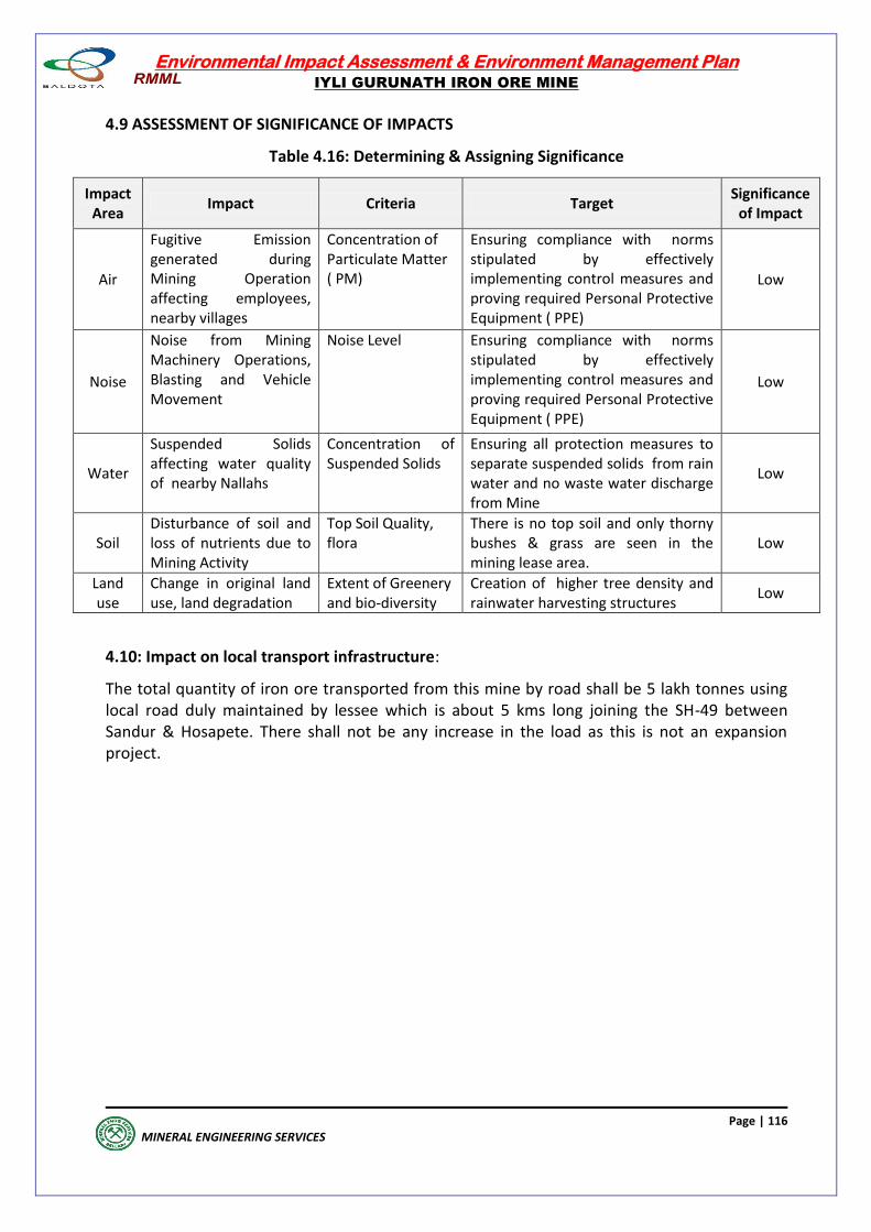
Environmental Impact Assessment & Environment Management Plan
IYLI GURUNATH IRON ORE MINE
Page | 116
MINERAL ENGINEERING SERVICES
4.9 ASSESSMENT OF SIGNIFICANCE OF IMPACTS
Table 4.16: Determining & Assigning Significance
Impact Area
Impact Criteria Target Significance
of Impact
Air
Fugitive Emission generated during Mining Operation affecting employees, nearby villages
Concentration of Particulate Matter ( PM)
Ensuring compliance with norms stipulated by effectively implementing control measures and proving required Personal Protective Equipment ( PPE)
Low
Noise
Noise from Mining Machinery Operations, Blasting and Vehicle Movement
Noise Level Ensuring compliance with norms stipulated by effectively implementing control measures and proving required Personal Protective Equipment ( PPE)
Low
Water
Suspended Solids affecting water quality of nearby Nallahs
Concentration of Suspended Solids
Ensuring all protection measures to separate suspended solids from rain water and no waste water discharge from Mine
Low
Soil Disturbance of soil and loss of nutrients due to Mining Activity
Top Soil Quality, flora
There is no top soil and only thorny bushes & grass are seen in the mining lease area.
Low
Land use
Change in original land use, land degradation
Extent of Greenery and bio-diversity
Creation of higher tree density and rainwater harvesting structures
Low
4.10: Impact on local transport infrastructure:
The total quantity of iron ore transported from this mine by road shall be 5 lakh tonnes using local road duly maintained by lessee which is about 5 kms long joining the SH-49 between Sandur & Hosapete. There shall not be any increase in the load as this is not an expansion project.
Environmental Impact Assessment & Environment Management Plan
IYLI GURUNATH IRON ORE MINE
Page | 117
MINERAL ENGINEERING SERVICES
ANALYSIS OF ALTERNATIVES
(TECHNOLOGY & SITE)
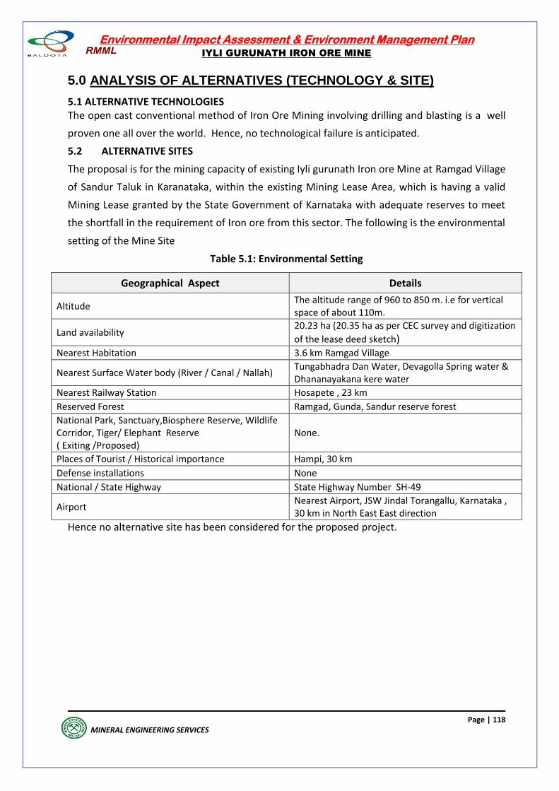
Environmental Impact Assessment & Environment Management Plan
IYLI GURUNATH IRON ORE MINE
Page | 118
MINERAL ENGINEERING SERVICES
5.0 ANALYSIS OF ALTERNATIVES (TECHNOLOGY & SITE)
5.1 ALTERNATIVE TECHNOLOGIES The open cast conventional method of Iron Ore Mining involving drilling and blasting is a well
proven one all over the world. Hence, no technological failure is anticipated.
5.2 ALTERNATIVE SITES
The proposal is for the mining capacity of existing Iyli gurunath Iron ore Mine at Ramgad Village
of Sandur Taluk in Karanataka, within the existing Mining Lease Area, which is having a valid
Mining Lease granted by the State Government of Karnataka with adequate reserves to meet
the shortfall in the requirement of Iron ore from this sector. The following is the environmental
setting of the Mine Site
Table 5.1: Environmental Setting
Geographical Aspect Details
Altitude The altitude range of 960 to 850 m. i.e for vertical space of about 110m.
Land availability 20.23 ha (20.35 ha as per CEC survey and digitization
of the lease deed sketch) Nearest Habitation 3.6 km Ramgad Village
Nearest Surface Water body (River / Canal / Nallah) Tungabhadra Dan Water, Devagolla Spring water & Dhananayakana kere water
Nearest Railway Station Hosapete , 23 km
Reserved Forest Ramgad, Gunda, Sandur reserve forest
National Park, Sanctuary,Biosphere Reserve, Wildlife Corridor, Tiger/ Elephant Reserve ( Exiting /Proposed)
None.
Places of Tourist / Historical importance Hampi, 30 km
Defense installations None
National / State Highway State Highway Number SH-49
Airport Nearest Airport, JSW Jindal Torangallu, Karnataka , 30 km in North East East direction
Hence no alternative site has been considered for the proposed project.
Environmental Impact Assessment & Environment Management Plan
IYLI GURUNATH IRON ORE MINE
Page | 119
MINERAL ENGINEERING SERVICES
ENVIRONMENTAL MONITORING
PROGRAM
Environmental Impact Assessment & Environment Management Plan
IYLI GURUNATH IRON ORE MINE
Page | 120
MINERAL ENGINEERING SERVICES
ENVIRONMENTAL MONITORING PROGRAMME
6.0 GENERAL
The monitoring and evaluation of the management measures envisaged are critical activities in
implementation of the proposed project. Monitoring involves periodic checking to ascertain
whether activities are performed according to the plan. This provides necessary feedback for
project management to check the efficacy of environmental performance. The purpose of the
environmental monitoring plan is to ensure that the envisaged purpose of the project is
achieved and accrues desired benefit.
To ensure the effective implementation of the proposed mitigation measures, the broad
objectives of monitoring plan are:
To evaluate the performance of mitigation measures proposed in the EMP.
To evaluate the adequacy of Environmental Impact Assessment
To suggest improvements in environmental management plan, if required To enhance environmental quality.
To undertake compliance monitoring of the proposed project operation.
A separate department, the "Environment Management Department (EnMD) has been
constituted to carry out day to day environmental monitoring/ inspection requirements at the
project site.
6.1 TECHNICAL ASPECTS
6.1.1 METHODOLOGIES
Environmental monitoring is required to know the Quality of Ambient Air, Water and Noise
Levels during the operation phase of the proposed project and take required corrective
measures, in case of any non-compliance with the norms stipulated by regulatory authorities.
The methodologies adopted for environmental monitoring will be in accordance with the CPCB
guidelines.
Environmental Monitoring is being done as per National Ambient Air Quality Monitoring
Series: Naaqs/2003-04, Guidelines for Ambient Air Quality Monitoring, Central Pollution
Control Board, April, 2003, Guidelines For The Measurement Of Ambient Air Pollutants Central
Pollution Control Board May, 2011, Minars/27/2007-08, Guidelines For Water Quality
Monitoring, Pollution Control Board Methods of Monitoring and Analysis Annex IV of
guidelines. Planned monitoring program to evaluate the effectiveness of various / specific
aspects of technological / mitigation measures.
Monitoring shall be conducted by the environmental management cell by engaging a lab
recognized by MoEF&CC.
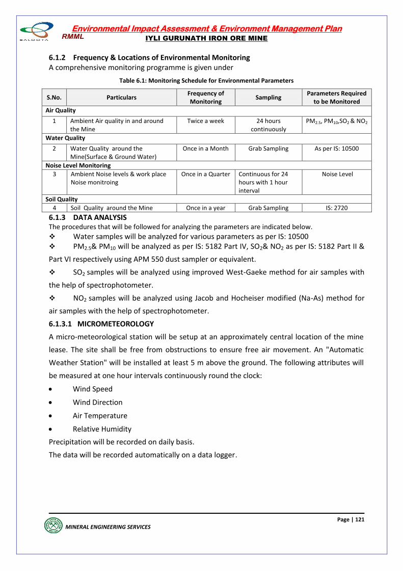
Environmental Impact Assessment & Environment Management Plan
IYLI GURUNATH IRON ORE MINE
Page | 121
MINERAL ENGINEERING SERVICES
6.1.2 Frequency & Locations of Environmental Monitoring A comprehensive monitoring programme is given under
Table 6.1: Monitoring Schedule for Environmental Parameters
S.No. Particulars Frequency of Monitoring
Sampling Parameters Required
to be Monitored
Air Quality
1 Ambient Air quality in and around the Mine
Twice a week 24 hours continuously
PM2.5, PM10,SO2 & NO2
Water Quality
2 Water Quality around the Mine(Surface & Ground Water)
Once in a Month Grab Sampling As per IS: 10500
Noise Level Monitoring
3 Ambient Noise levels & work place Noise monitroing
Once in a Quarter Continuous for 24 hours with 1 hour interval
Noise Level
Soil Quality
4 Soil Quality around the Mine Once in a year Grab Sampling IS: 2720
6.1.3 DATA ANALYSIS The procedures that will be followed for analyzing the parameters are indicated below.
Water samples will be analyzed for various parameters as per IS: 10500 PM2.5& PM10 will be analyzed as per IS: 5182 Part IV, SO2& NO2 as per IS: 5182 Part II &
Part VI respectively using APM 550 dust sampler or equivalent.
SO2 samples will be analyzed using improved West-Gaeke method for air samples with
the help of spectrophotometer.
NO2 samples will be analyzed using Jacob and Hocheiser modified (Na-As) method for
air samples with the help of spectrophotometer.
6.1.3.1 MICROMETEOROLOGY
A micro-meteorological station will be setup at an approximately central location of the mine
lease. The site shall be free from obstructions to ensure free air movement. An "Automatic
Weather Station" will be installed at least 5 m above the ground. The following attributes will
be measured at one hour intervals continuously round the clock:
Wind Speed
Wind Direction
Air Temperature
Relative Humidity
Precipitation will be recorded on daily basis.
The data will be recorded automatically on a data logger.
Environmental Impact Assessment & Environment Management Plan
IYLI GURUNATH IRON ORE MINE
Page | 122
MINERAL ENGINEERING SERVICES
6.1.3.2 Ambient Air Quality
Ambient air quality will be monitored at 8 locations on a regular basis. The number of stations
may be increased if directed by Karnataka State Pollution Control Board (KSPCB) or the
Regional Office of MoEFCC. The locations shall be within the mine lease and at varying
distances both up-wind and down-wind w.r.t. the ML and associated facilities. The locations
shall be selected in consultation with the Regional Officer of KSPCB. Selected parameters of
National Ambient Air Quality Norms [PM10, PM2.5, SO2 & NO2,] shall be monitored. 24 hourly
samples shall be collected twice a week at all the stations.
6.1.3.3 Work Zone Air Quality
Work-zone quality shall be monitored at various strategic locations (mine faces, crushing plant,
loading-unloading points, Screening plant, haulage road. 8 hourly samples shall be collected at
each of the locations twice a month.
6.1.3.4 Ground water levels
Water levels in wells at varying distances all around the project area shall be monitored every-
month.
6.1.3.5 Surface and Ground water quality
Surface water samples shall be collected from Tayammakolla Spring and ponds at villages.
Samples shall be collected once a month. The parameters listed in IS: 2296 shall be monitored.
Ground water samples shall be collected at varying distances wrt the mine site. Eight stations
at village Siddapura, Bhavihalli, Jaisinghpura, Venkatagiri, Kallahalli, Ramgad, Gunda,
Hanumanhalli, and Nagalapura & Garaga shall be set up. Samples will be collected once a
month. The parameters listed in IS: 10500 shall be monitored.
6.1.3.6 Ambient Noise
Ambient noise levels shall be monitored at all the locations where ambient air quality has been
carried out during EIA study. In addition, ambient noise levels shall also be monitored at
villages along the transportation route. Noise levels shall be recorded at one hour intervals
continuously for 24 hours at each of the locations once in a season. The frequency of
monitoring may be altered if directed by the concerned statutory authorities.
6.1.3.7 Work zone Noise
Work-zone noise levels shall be monitored at various strategic locations (mine faces, crushing
plant, loading-unloading points, mine workshop(s), mine office, etc.).
Additional locations may be covered if directed by concerned statutory authorities (KSPCB,
MoEFCC, and DGMS). Noise levels shall be recorded at one hour intervals continuously for 8
hours at each of the locations once a month.
Environmental Impact Assessment & Environment Management Plan
IYLI GURUNATH IRON ORE MINE
Page | 123
MINERAL ENGINEERING SERVICES
6.1.3.8 Occupational health and safety
An Occupational Health Centre (OHC) for Iyli Gurunatha Iron Ore Mine shall be established. A
systematic programme for medical check-up at regular intervals will be followed at the
Occupational Health Centre (OHC) for all workers to ascertain any changes in health condition
due to the working conditions. All workmen employed in hazardous working conditions will be
provided with adequate personnel safety appliances.
6.1.3.9 Plantation and green belt development
Green belt development vis-a-vis safety zone management and progressive plantation in and
around the project site shall be developed. The data on area of green cover, survival rate etc.
shall be compiled for periodic review.
Annual plans for tree plantation with specific number of trees to be planted shall
be made. The fulfillment of the plan shall be monitored by the EnMD every six
months.
A plan for post plantation care will be reviewed in every monthly meeting. Any
abnormal death rate of planted trees shall be investigated.
Watering of the plants, manuring, weeding will be carried out for minimum 5 years.
6.1.3.10 SOCIO-ECONOMIC DEVELOPMENT
RMML's CSR activities are expected to play a significant role in the peripheral development of
the region. The project will improve the infrastructure & economic conditions leading to
overall socio economic development of the region. The communities, which are likely to be
benefited by the project, are thus one of the key stakeholders for the mining project. RMML
has planned structured interactions with the community to disseminate the measures taken by
RMML and also to elicit suggestions for overall improvement for the development of the area.
6.1.4 REPORTING SCHEDULE
After completion of analysis, the results of analysis will be sent to Karnataka State Pollution
Control Board on a monthly basis and MoEF&CC & CPCB on a six-monthly basis. Copies of the
reports will be maintained at the Mine and will be made available to the concerned inspecting
authorities like Indian Bureau of Mines (IBM) etc.
6.1.5 EMERGENCY PROCEDURE As there is no point source of emission and no generation of any industrial effluent, the
possibility of emission/waste water discharge exceeding the norm & leading to emergency
situation is not envisaged.
Environmental Impact Assessment & Environment Management Plan
IYLI GURUNATH IRON ORE MINE
Page | 124
MINERAL ENGINEERING SERVICES
6.1.6 DETAILED BUDGET & PROCUREMENT SCHEDULES
The budgetary allocation for Environmental monitoring is Rs 8 lakhs per annum. A third party
accredited by MoEF&CC shall be engaged to monitor all the environmental parameters. Hence,
no procurement of any monitoring equipment is required.
Half yearly compliance report in respect of stipulated prior environmental clearance terms &
conditions are being submitted on 1st June and 1st Dec of each calendar year to MoEF&CC,
Bengaluru Office.
Environmental Impact Assessment & Environment Management Plan
IYLI GURUNATH IRON ORE MINE
Page | 125
MINERAL ENGINEERING SERVICES
Environmental Monitoring Programme
Environmental Issue/
Impacts
Mitigation Measure Approximate Location
Responsibility
1. Meteorology Meteorological parameters through a continuously monitoring
system.
Near Mine office
E&L
2. Ambient Air Quality Ambient Air Quality with respect to RPM, SO2, NOx shall be
monitored
1 control station in upwind side and remaining stations in downwind side w.r.t quarries and external dumps
E&L / EMD
3. Work zone Air Quality Work zone Air Quality with respect to RPM, SO2, NOx shall be
monitored
At loading/unloading point near quarry & main haul road
E&L / EMD
4. Ambient Noise Periodic measurement with Noise meter At nearest villages/settlements alongside the lease E&L
5. Work zone Noise levels Periodic measurement with Noise meter At loading/unloading point near quarry & main haul road E&L
6. Surface Water Quality Changes in surface water quality will be monitored by water
quality analysis.
In the up-stream and down stream w.r.t. the lease
E&L
7. Ground Water Quality Changes in ground water quality will be monitored through
water quality analysis.
Changes in ground water quality will be monitored in the up- gradient and down gradient w.r.t. the mine
E&L
8. Solid Waste generation,
OB dumping & backfilling
Overburden generated during mining operations will be either
dumped in pre-identified dumping area/ external dumps or will b
backfilled within the exhausted quarry areas.
External dumps / Backfilled areas
Mine manager/
Surveyors / Safety Officer
9. Slope failure
Regular examination will be carried out to look for slope failure on
open cast mine faces, ore and overburden benches etc.
External dumps / Backfilled areas / Quarry benches/ Fines dump
Mine manager/
Surveyors / Safety Officer
10. Ground vibration and
blasting.
Regular testing and inspection of blasting operations in work
zone will be carried out with respect to noise, fly rock throw,
vibration, dust and fume generation.
Drilling & blasting sites
Mine manager/ Safety
Officer
11.Maintenance of Storm
Water Drainage System
The drains will be periodically cleared to maintain storm water
flow.
Drainage network within the lease area. Civil Maint. Dept.,
12.Green Belt and
progressive afforestation
Progressive afforestation, green belt development &
maintenance of safety zone.
Planting trees in the open area Horticulture
Department/ EMD
13.Occupational Health Health check up, Training Workers at Mine site, workshop, siding, crusher house & other units in the premises.
Plant Medical Unit
14.Socio-economic
Development
Structured interactions with the community
Stake Holders Personnel Dept. /EMD
Note: EMP = Environmental Management Plan, EMD = Environment Management Division E&L. = Environmental & Lease Deptt., CSR = Corporate Social Responsibility,

Environmental Impact Assessment & Environment Management Plan
IYLI GURUNATH IRON ORE MINE
Page | 126
MINERAL ENGINEERING SERVICES
ADDITIONAL STUDIES
Environmental Impact Assessment & Environment Management Plan
IYLI GURUNATH IRON ORE MINE
Page | 127
MINERAL ENGINEERING SERVICES
ADDITIONAL STUDIES 7.0 ADDITIONAL STUDIES
7.1 PUBLIC CONSULTATION
This EIA & EMP Report has been prepared in compliance with the EIA Notification dated 14th
September 2006 and the Terms of Reference (ToR) issued by the Ministry of Environment,
Forests & Climate Change (vide letter No SIA/KA/MIN/28893/2018 dated 14th Sep, 2018) . The
input on various mining parameters, mining lease area, production levels, mining technology,
waste generation, handling & storing etc. have been taken from the scheme of mining
approved by Indian Bureau of Mines, for the preparation of the EIA Report. After completing
the process of public consultation, the proceedings of the same, as recorded by Karnataka
Pollution Control Board will be incorporated along with proposed action plan with the budget,
to comply with points raised by the public with respect to Environmental Aspects, in the Final
EIA Report. Then the Final EIA Report will be submitted for appraisal by the Expert Appraisal
Committee of SEIAA to get the Environmental Clearance for the project for production of iron
ore @ 0.975 million tonnes per annum (mtpa) within the existing Mining Lease Area of 20.23
Ha (20.35 Ha as per CEC survey and digitization of the lease deed sketch)under the provisions
of EIA notification,2006.
7.2 RISK ASSESSMENT Iyli gurunath iron ore mine has developed the managment system to accomplish the objectives
set out in the health and safety policies. It is oriented towards the provison and maintaince of a
healthy and safe and sustainable work environment and satisfaction of the stake holders, in
accoradance with legisation, provision of adequate training to ensure competent staff and
pro-actively reducing the risk of accidents or environmental issues. The existing/proposed
operations, storage and handling of raw materials have been studied to identify & assess the
Risks (Hazards) and prepare Emergency Preparedness and Response Plan & Disaster
Management Plan for natural calamities. Based on the Hazard Identification and Analysis, the
major emergency scenarios have been predicted to estimate the consequence of failure.
In the proposed open-cast mining operations at Iyli Iron Ore Mine, the following Risks are
identified and shown as under
1. Pit slope failure.
2. Waste Dump slope failure
3. Danger due to storage and handling of explovises
4. Fly rocks from blasting operations
5. Water Inundation
6. Action Plan to Prevent fire
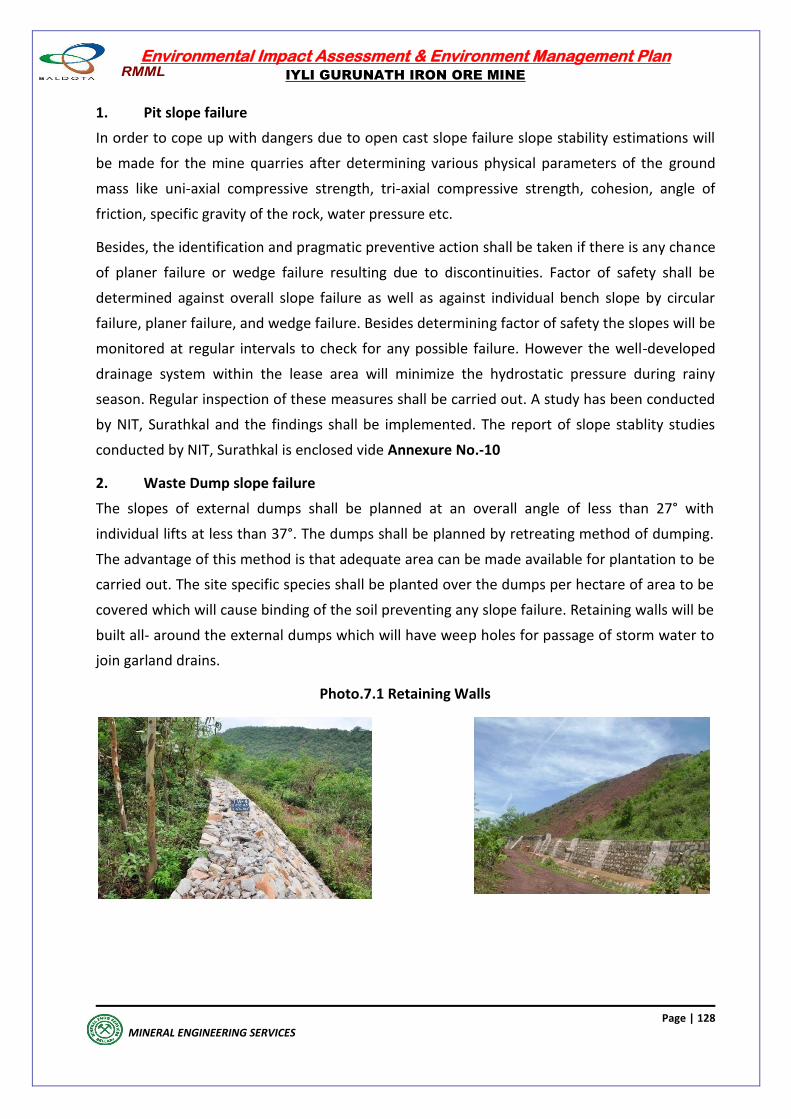
Environmental Impact Assessment & Environment Management Plan
IYLI GURUNATH IRON ORE MINE
Page | 128
MINERAL ENGINEERING SERVICES
1. Pit slope failure
In order to cope up with dangers due to open cast slope failure slope stability estimations will
be made for the mine quarries after determining various physical parameters of the ground
mass like uni-axial compressive strength, tri-axial compressive strength, cohesion, angle of
friction, specific gravity of the rock, water pressure etc.
Besides, the identification and pragmatic preventive action shall be taken if there is any chance
of planer failure or wedge failure resulting due to discontinuities. Factor of safety shall be
determined against overall slope failure as well as against individual bench slope by circular
failure, planer failure, and wedge failure. Besides determining factor of safety the slopes will be
monitored at regular intervals to check for any possible failure. However the well-developed
drainage system within the lease area will minimize the hydrostatic pressure during rainy
season. Regular inspection of these measures shall be carried out. A study has been conducted
by NIT, Surathkal and the findings shall be implemented. The report of slope stablity studies
conducted by NIT, Surathkal is enclosed vide Annexure No.-10
2. Waste Dump slope failure
The slopes of external dumps shall be planned at an overall angle of less than 27° with
individual lifts at less than 37°. The dumps shall be planned by retreating method of dumping.
The advantage of this method is that adequate area can be made available for plantation to be
carried out. The site specific species shall be planted over the dumps per hectare of area to be
covered which will cause binding of the soil preventing any slope failure. Retaining walls will be
built all- around the external dumps which will have weep holes for passage of storm water to
join garland drains.
Photo.7.1 Retaining Walls
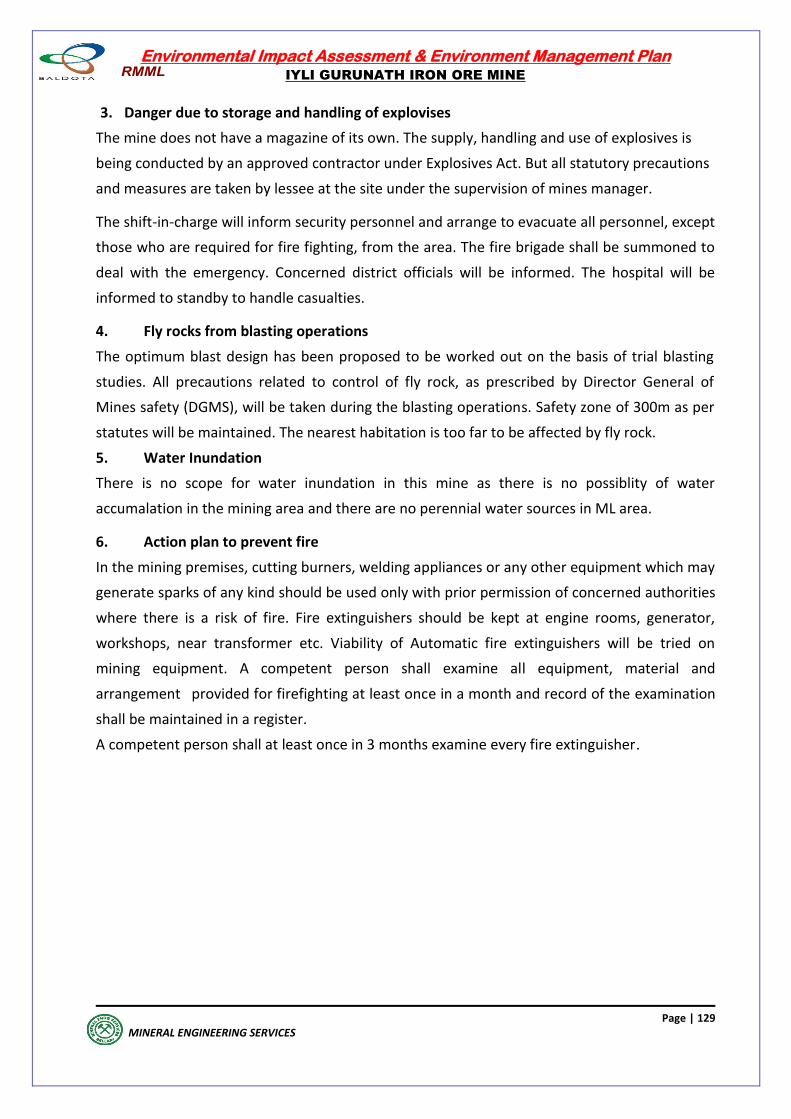
Environmental Impact Assessment & Environment Management Plan
IYLI GURUNATH IRON ORE MINE
Page | 129
MINERAL ENGINEERING SERVICES
3. Danger due to storage and handling of explovises
The mine does not have a magazine of its own. The supply, handling and use of explosives is
being conducted by an approved contractor under Explosives Act. But all statutory precautions
and measures are taken by lessee at the site under the supervision of mines manager.
The shift-in-charge will inform security personnel and arrange to evacuate all personnel, except
those who are required for fire fighting, from the area. The fire brigade shall be summoned to
deal with the emergency. Concerned district officials will be informed. The hospital will be
informed to standby to handle casualties.
4. Fly rocks from blasting operations
The optimum blast design has been proposed to be worked out on the basis of trial blasting
studies. All precautions related to control of fly rock, as prescribed by Director General of
Mines safety (DGMS), will be taken during the blasting operations. Safety zone of 300m as per
statutes will be maintained. The nearest habitation is too far to be affected by fly rock.
5. Water Inundation
There is no scope for water inundation in this mine as there is no possiblity of water
accumalation in the mining area and there are no perennial water sources in ML area.
6. Action plan to prevent fire
In the mining premises, cutting burners, welding appliances or any other equipment which may
generate sparks of any kind should be used only with prior permission of concerned authorities
where there is a risk of fire. Fire extinguishers should be kept at engine rooms, generator,
workshops, near transformer etc. Viability of Automatic fire extinguishers will be tried on
mining equipment. A competent person shall examine all equipment, material and
arrangement provided for firefighting at least once in a month and record of the examination
shall be maintained in a register.
A competent person shall at least once in 3 months examine every fire extinguisher.
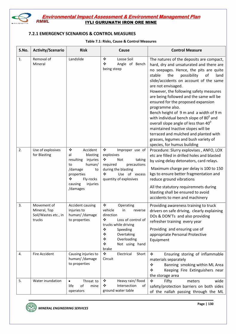
Environmental Impact Assessment & Environment Management Plan
IYLI GURUNATH IRON ORE MINE
Page | 130
MINERAL ENGINEERING SERVICES
7.2.1 EMERGENCY SCENARIOS & CONTROL MEASURES
Table 7.1: Risks, Cause & Control Measures
S.No. Activity/Scenario Risk Cause Control Measure
1. Removal of Mineral
Landslide Loose Soil Angle of Bench being steep
The natures of the deposits are compact, hard, dry and unsaturated and there are no seepages. Hence, the pits are quite stable the possibility of land slide/accidents on account of the same are not envisaged. However, the following safety measures are being followed and the same will be ensured for the proposed expansion programme also. Bench height of 9 m and a width of 9 m with individual bench slope of 800 and overall slope angle of less than 400 maintained Inactive slopes will be terraced and mulched and planted with grasses, legumes and bush variety of species, for humus building
2. Use of explosives for Blasting
Accidental blasting resulting injuries to human/ /damage to properties Fly-rocks causing injuries /damages
Improper use of explosives Not taking required precautions during the blasting Use of excess quantity of explosives
Procedure: Slurry explovises , ANFO, LOX etc are filled in drilled holes and blasted by using delay detonators, card relays.
Maximum charge per delay is 100 to 150 kgs to ensure better fragmentation and reduce ground vibrations
All the statutory requiremnets during blasting shall be ensured to avoid accidents to men and machinery
3. Movement of Mineral, Top Soil/Wastes etc., in trucks
Accident causing injuries to human/ /damage to properties
Operating vehicle in reverse direction Loss of control of trucks while driving Speeding Overtaking Overloading Not using hand brake
Providing awareness training to truck drivers on safe driving, clearly explaining DOs & DON’Ts and also providing refresher training every year
Providing and ensuring use of appropriate Personal Protective Equipment
4. Fire Accident Causing injuries to human/ /damage to properties
Electrical Short Circuit
Ensuring storing of inflammable materials separately Banning smoking within ML Area Keeping Fire Extinguishers near the storage area
5. Water inundation Threat to life of mine operators
Heavy rain/ flood Intersection of ground water table
Fifty meters wide safety/protection barriers on both sides of the nallah passing through the ML
Environmental Impact Assessment & Environment Management Plan
IYLI GURUNATH IRON ORE MINE
Page | 131
MINERAL ENGINEERING SERVICES
S.No. Activity/Scenario Risk Cause Control Measure
Damage to mining machinery/ trucks
Area and erection of protective bund with wide green belt Development of proper surface drainage system Checking the condition of bunds against breaching, obstructions in the normal drainage flow During heavy rain, inspection of vulnerable points, surface drainage flow, effectiveness of the safety measures and reporting deficiencies to the Mine Manager Providing a deep sump in the Mine Pit and pumping out excess water , after sedimentation for afforestation works, dust control etc.
7.2.2. EMERGENCY PREPAREDNESS & RESPONSE PLAN
7.2.2.1 OBJECTIVES OF EMERGENCY PREPAREDNESS & RESPONSE PLAN
The Emergency Preparedness and Response Plan is aimed to ensure safety of life, protection of
environment, protection of equipment and restoration of production in this same order of
priorities. For effective implementation of Emergency Preparedness and Response Plan, it is
widely circulated and personnel are trained through mock drills.
To tackle the consequences of a major emergency inside the mine, an Emergency Preparedness
and Response Plan has been formulated.
The objective of the Emergency preparedness and Response Plan is to make use of the
combined resources of the Mine and the outside services to achieve the following.
Control and bring the emergency situation to a safe condition
Safeguard employees
Effect the rescue and medical treatment of causalities
Minimize damage to property and the environment
Secure the affected areas
Preserve subsequent records and equipment for subsequent enquiry to identify the
cause and circumstances leading to emergency.
Environmental Impact Assessment & Environment Management Plan
IYLI GURUNATH IRON ORE MINE
Page | 132
MINERAL ENGINEERING SERVICES
7.2.2.2 EMERGENCIES
The emergencies that could be envisaged in the Mine are as follows:
Fire
Water Inundation
Blasting of Explosives
Landslide
7.2.2.3 EMERGENCY ORGANIZATION
The Emergency Organization is having a senior executive, who has control over the affairs of
the Mine, designated as Site Controller. Normally the Mine Manager is the Site Controller.
There is an Emergency Control Centre (ECC), which is the location of the Site Controller during
emergency.
The team under Incident Controller consists of Emergency Coordinators who are responsible
for fire fighting, rescue, rehabilitation, transport and support services. Shift in-charge is the
reporting Officer, who will bring the incident to the notice of the Incident Controller and the
Site Controller.
7.2.2.4 EMERGENCY COMMUNICATION
Whoever notices an emergency situation such as fire, growth of fire, landslide, explosion etc.,.
will inform Shift Incharge, who in turn will inform the emergency situation to the Incident
Controller and the Site Controller. Site Controller will verify the situation from the Incident
Controller or the shift incharge and will take a decision about implementing on Site Emergency.
Simultaneously, the emergency warning system will be activated on the instructions of the Site
Controller.
7.2.2.5 RESPONSIBILITIES DURING EMERGENCY
Site Controller Responsibilities
On receiving information about emergency the Site Controller will take charge of ECC and the
situation and will assess the magnitude of the situation on the advice of Incident Controller and
will decide on
Whether affected area needs to be evacuated
Whether personnel who are at assembly points need to be evacuated
Declaration of Emergency
Announcement by public address system about location of emergency
Continuous review of possible development and assessment of the situation in
consultation with Incident Controller and Emergency Coordinators
Environmental Impact Assessment & Environment Management Plan
IYLI GURUNATH IRON ORE MINE
Page | 133
MINERAL ENGINEERING SERVICES
Deployment of personnel of rescue, rehabilitation, transport, fire brigade, medical and
other designated mutual support systems locally available for meeting emergencies
Evacuation from affected areas, if the situation is likely to go out of control informs to
District Emergency Authority, Police, and Hospital and seeks their intervention and help
Communication to DGMS, KSPCB and other statutory authorities
Making a public statement if necessary
Maintaining record of events in chronological order and preparing an investigation
report and preserving evidences
On completion of on site Emergency and restoration of normalcy, orders for all clear
signal.
Incident Controller Responsibilities
Assembling the Emergency Coordinators
Directing operations within the affected areas with the priorities for safety of
personnel, minimizing damage to the Environment and loss of materials
Directing the shutting down of the Mine Operation and evacuation of employees from
the areas likely to be adversely affected by the emergency
Providing advice and information to the Fire and Security Personnel and the local Fire
Services as and when they arrive.
Ensuring that all non-essential workers / staff of the affected areas evacuated to the
appropriate assembly points and the areas are searched for causalities
Preservation of evidence so as to facilitate any enquiry into the cause and
circumstances, which caused or escalated the emergency.
Providing tools and safety equipments to the team members
Keeping in touch with all the Emergency Coordinators and advising them regarding the
method of control to be used
Keeping the Site Controller of Emergency informed of the progress being made
Emergency Coordinator (Rescue, Fire Fighting) Responsibilities
On knowing about emergency, rushing to Emergency Control Centre
Helping the Incident Controller in containment of the emergency
Guiding the fire fighting crew and security personnel
Organizing shifting of the firefighting facilities to the emergency site, if required.
Taking guidance of the Incident Controller for fire fighting as well as assessing the
requirements of outside help.
Environmental Impact Assessment & Environment Management Plan
IYLI GURUNATH IRON ORE MINE
Page | 134
MINERAL ENGINEERING SERVICES
Arranging to control the traffic at the Mine Entry Point and the incident area / directing
the security personnel to the incident site to take part in the emergency operations
under his guidance and supervision.
Evacuating the people in the affected and nearby areas as advised by Site Controller
Searching for casualties and arranging proper aid for them
Deciding which paths the evacuated persons should follow
Maintaining law and order in the area, and if necessary seeks the help of police.
Arranging for safety equipments for the members
Emergency Coordinator (Medical, Mutual Aid, Rehabilitation, Transport and Communication)
Responsibilities
Organizing medical treatment to the injured and if necessary shifting of the injured to
nearby hospitals
Mobilizing extra medical help from outside, if necessary
Keeping a list of qualified first aiders of the Plant and seeking their assistance
Maintaining first aid and medical emergency requirements
Making sure that all safety equipments are made available to the emergency team
Assisting Site Controller with necessary data and coordinating the emergency activities
Assisting Site Controller in updating emergency plan
Liaising with Site Controller / Incident Controller.
Ensuring availability of necessary cash for rescue / rehabilitation and emergency
expenditure.
Controlling rehabilitation of affected areas after emergency.
Making available diesel, petrol for transport vehicles engaged in emergency operation
Emergency Coordinator (Essential Services) Responsibilities
Assisting Site Controller and Incident Controller
Maintaining essential services like Diesel Generator, Water, Power Supply for lighting
Ensuring availability of adequate quantities of protective equipment and other
emergency materials, spares etc.

Environmental Impact Assessment & Environment Management Plan
IYLI GURUNATH IRON ORE MINE
Page | 135
MINERAL ENGINEERING SERVICES
7.2.2.6. EMERGENCY FACILITIES
Emergency Control Centre
Mine Manager Room is identified as Emergency Control Centre. The following information and
equipment are available at the Emergency Control Centre (ECC).
Telephone
Emergency lamp / torchlight
Plan indicating locations of hazard inventories, assembly points, rescue location
vulnerable zones, and escape routes.
Hand Tools, Wind Direction, Wind Velocity Indications
Public Address Megaphone, Hand bell, Telephone Directories.
Address with Telephone Numbers of Emergency Coordinators
Important addresses, telephone numbers such as experts from outside, government
agencies, neighboring industries etc.
Fire Fighting Facilities
The details of fire fighting facilities maintained at the Mine are
Carbon dioxide
DCP
Soda acid type
Fire buckets
Emergency Medical Facilities
Gas masks and general first aid materials for dealing with fire burns etc. will be maintained in
the first aid centre as well as in the emergency control room. Private medical practitioners help
will be sought or Government Hospital will be approached for emergency help, if required.
Apart from Mine first aid facilities, external facilities will be augmented. Names of Medical
Personnel, Medical facilities available nearby is maintained and will be updated regularly.
Necessary specific medicines for emergency treatment of burns will be maintained.The help of
nearby Mines in this regard will be taken on mutual support basis.
7.2.2.7 EMERGENCY ACTIONS & EMERGENCY WARNING
Communication of emergency has been made familiar to the personnel inside the Mine.
Evacuation of Personnel
In the event of an emergency, unconnected personnel will have to escape to assembly point. If
necessary, persons will be evacuated by rescue teams.

Environmental Impact Assessment & Environment Management Plan
IYLI GURUNATH IRON ORE MINE
Page | 136
MINERAL ENGINEERING SERVICES
All Clear Signal
At the end of emergency, after discussing with Incident Controller and Emergency
Coordinators, the Site Controller will order an all clear signal.
7.3 DISASTERS
A disaster is catastrophic situation in which suddenly, people are plunged into helplessness and
suffering and as a result, need protection, clothing, shelter, medical and social care and other
necessities of life. Disasters from natural phenomena like earthquakes, cyclones, storms,
floods, landslides etc., are considered here.
There can be no set criteria for assessing the gravity of a disaster in the abstract it depends to a
large extent on the physical, economic and social environment in which it occurs. What would
be considered a major disaster in developing country, will be equipped to cope with the
problems involved, and may not mean more than temporary emergency elsewhere.
However all disasters bring in their wake similar consequences that call for immediate action,
whether at the local, national or international level, for the rescue and relief of the victims.
This includes the search for the dead and injured, medical and social care, removal of the
debris, the provision of temporary shelter for the homeless food, clothing and medical
supplies, and the rapid reestablishment of essential services.
The disasters due to natural phenomena are to be handled in a proper manner with the help of
local administration immediately on occurrence. Further supports required, depending upon
the severity, are to be provided by District/State/National Level Authorities.
The resources available in the mine will be extended to the maximum possible extent by the
project proponent in the event of occurrence of any such natural disasters to provide rescue,
first aid, ambulance service, medicines, shelter & food, to the affected people.
7.4 OCCUPATIONAL HEALTH & SAFETY
As no additional construction of any civil structures are envisaged in this mine, the
Occupational Health and Safety related issues are restricted to operational stage only. The
existing practices with regard to Occupational Health & Safety will be ensured for the existing
mining operations.
The Occupational Health and Safety (OHS) Plan aims to
ensure that all known safety factors are taken into account in the operation and
maintenance of HEMM and trucks
allocate sufficient resources to maintain safe and healthy conditions at work place
ensure that adequate OHS knowledge is imparted to all employees
Environmental Impact Assessment & Environment Management Plan
IYLI GURUNATH IRON ORE MINE
Page | 137
MINERAL ENGINEERING SERVICES
provide necessary protective equipment and safety appliances and ensure their proper
use
make the employees aware of the mine operations and the potential hazards
train the employees to take preventive steps in a proactive manner and execute the
work safely and understand occupational health issues
review all operations and methods of work for making necessary changes from the
safety point of view in the light of experience and up to date knowledge
provide appropriate facilities for first aid and prompt treatment of injuries and illness at
work
ensure that adequate publicity is given to OHS matters
ensure proper precautions are taken to prevent fire and provide appropriate fire
fighting facilities
publish instructions and notices in the local language to employees
prepare safe operating procedure for all operations
ensure regular inspection by a competent person at regular intervals for identifying any
deviations in safety and occupational health related matters
provide relaxation facilities to workers with good ventilation & air circulation
ensure Good Housekeeping practices
provide enclosure for noise generating sources
isolate diesel and explosives storage areas
rotate employees in specific areas to avoid continuous exposure
7.4.1 OCCUPATIONAL HEALTH RISKS
The principal Occupational Health Risks associated with are likely incidence of tuberculosis,
silicosis, hearing loss, accidents due to inundation of mine working pits, fire and slope failure.
The order of severity on health status of workers in mining is tuberculosis, silicosis, respiratory
diseases and hearing loss.
7.4.2 PRECAUTIONARY MEASURES
a. Dust
As dust is a major pollutant, that can cause a heath disorder, the following precautionary
measures are followed.
Sprinkling of water on the haul roads and working places
Maintenance of the mining machinery and vehicles used as per the manufactures
specifications to ensure their efficient operation
Ensuring use of Personal Protective Equipment like respiratory masks, ear plugs,
helmet, safety shoes by the employees
Environmental Impact Assessment & Environment Management Plan
IYLI GURUNATH IRON ORE MINE
Page | 138
MINERAL ENGINEERING SERVICES
Development of wide green belt proposed to attenuate the spread of dust and also the
noise generated from mining operations
b. Noise
Workmen and staff exposed to higher sound levels will be provided with ear plugs/mufflers of
approved type by DGMS to guard them against any hearing impairment and Controlled Blasting
Technique is being followed to ensure noise and vibration levels are within limits.
c. Injuries
By ensuring that all employees are following safe operating procedure and using the required
Personal Protective Equipment, the risk of injuries due to accidents can be prevented.
7.4.3 PERSONAL PROTECTIVE EQUIPMENT (PPE)
The following Personal Protective Equipment (PPE) are provided to the Mine employees
Industrial Safety Helmets
Zero power plain goggles with cut type filters on both ends
Cylindrical type earplugs/Earmuffs
Industrial safety shoes with steel toe
7.4.4 TRAINING
All the workers are being given initial vocational training (Induction) as per the statute to make
them familiar with their jobs covering the occupational hazards involved, need to use Personal
Protective Equipment, following safe operating procedures and the safety precautions to be
taken while doing their jobs. Awareness programme for the workers on work related health
hazard, HIV prevention etc are being conducted. They are also being given refresher training as
per statute after completing one year of service.
7.4.5 OCCUPATIONAL HEALTH SURVEILLANCE
Impact of mining on health is assessed by the trained doctor in occupational health and the
tests conducted include general health checkup, spirometry, audiometry and vision test in
addition to X-ray and ECG examination.
In order to evaluate the impacts on mining on the health of workers, baseline health studies is
being carried out on every worker at the time of joining duty. Medical examinations will be
conducted for employees every year.
Environmental Impact Assessment & Environment Management Plan
IYLI GURUNATH IRON ORE MINE
Page | 139
MINERAL ENGINEERING SERVICES
7.4.6 PIT SAFETY COMMITTEE
The pit safety committee headed by Mines Manager consists of
Mines Manager - 1
Geologist - 1
Mine Foreman - 1
Mining Engineer/Environmental officer - 1
Company Doctor - 1
Workers - 2
The Safety Committee functions are
Ensuring remedial measures against the unsafe conditions and practices in the mine as
pointed out by the workmen, or Inspectors or otherwise brought to the notice of the
committee
Planning safety and health measures including related codes of practice and making
appropriate recommendations before commencement of any new section of the mine or
introduction of any new mining technique
Ensuring investigation of accidents that take place in the Mine and making appropriate
recommendations
Ensuring meeting atleast once in 30 days to consider the matters placed before it and
any other matter that may be raised by the members and making such recommendations as it
may deem fit
Serving as a forum of communication on safety and occupational health matters
7.4.7 FIRE PROTECTION
The details of fire fighting equipments provided are Carbon dioxide, DCP, Soda acid type, Fire
buckets. Regular inspection of Fire Extinguishers to ensure replacement of refills and the
working condition of the extinguishers are being ensured.
7.4.8 BUDGET
An annual budget of Rs 3.31 lakhs has been allocated for safety and occupational health
activities.
Environmental Impact Assessment & Environment Management Plan
IYLI GURUNATH IRON ORE MINE
Page | 140
MINERAL ENGINEERING SERVICES
7.5 SOCIAL IMPACT ASSESSMENT
The local areas are getting benefited by way of generation of employment opportunities,
increased demand for local products and services. There is an overall improvement in the
income level of the local people.
The proposed expansion of the Mine capacity will provide employment for around 300 people
by both direct employment which include skilled and semi-skilled and indirect employment, in
contractual works & transport. Priority will be given to locals for Semi-Skilled and Unskilled
workers.
There will be an enhancement of educational and medical standards of people in the study
area. There will be generally positive and beneficial impacts by way of economic
improvements, transportation, and business generation. There will be an overall upliftment of
socio-economic status of people in the area.
7.6 R & R ACTION PLAN
This proposal is for the existing mining operations under EIA notifiaction, 2006 no additional
procurement of land is involved. There is no habitation in the Mining Lease Area. Hence, no
Rehabilitation & Resettlement Plan is required.
7.7 Care and Maintenance during Temporary Discontinuance
a) Precautions to be taken
An emergency plan for the situation of temporary discontinuance due to court order or due
to statutory requirements or any other unforeseen circumstances may indicate measures of
care, maintenance and monitoring of status of discontinued mining operations expected
to re-open in near future.
Although no temporary closure is planned or expected, the following protective measures
would be taken to deal with the unforeseen circumstances which may be created due to
temporary closure of the mine.
i) All heavy earthmoving mining machineries deployed in various blocks of Iyli Gurunath
Iron ore mine will be withdrawn and brought to the safe place so that these do not get
buried due to bench collapse, if any, and get damaged during discontinuance. These will be
subjected to preventive maintenance.
ii) The entries to the pits in various blocks will be fenced off with display of notice boards
at the fence prohibiting entry into the pits by unauthorized persons.
iii) Pit boundaries would be fenced and high berms will be provided to prevent cattle’s entering the pit.At the entrance and strategic points in the mine areas, sentries and watchman would be deployed to guard the sensitive/important mine area, explosive magazine and other sensitive stores and services. They would be provided with mobile phones/ walky - talkies to contact mine authorities/police/fire station etc. for help during emergency.

Environmental Impact Assessment & Environment Management Plan
IYLI GURUNATH IRON ORE MINE
Page | 141
MINERAL ENGINEERING SERVICES
v) The mine area would be kept well illuminated during night time. vi) Audible warning sirens would be established at strategic points to be used during
emergency so that prompt help can be received from proper sources and protective measures
are immediately taken by all personnel available.
vii) Managerial, supervisory and competent persons of the mine would be engaged elsewhere in other mines of the company as per the needs b) Economic repercussions of closure of mine and manpower retrenchments. Manpower
retrenchment, compensation to be given, socio-economic repercussions and remedial
measures consequent to the closure of mines should be described, specifically stating the
following:
It is too early to discuss the socio-economic repercussions and remedial measures consequent
to the closure of mines. However, the labours are from surrounding areas that are basically
agricultural labours. In case of closure, they will go back to their family occupation.
i) Number of local residents employed in the mine, status of the continuation family
occupation and scope of joining the occupation back :
Most of the workers are from the surrounding areas who were basically depending upon on
agriculture activity. In case of closure, they will go back to their family occupation.
ii) Compensation given or to be given to the employees connecting with sustenance of
himself and their family members:
As they are daily wage employees, they will get compensation as per the government rules.
iii) Satellite occupations connected to the mining industry number of persons engaged
therein continuance of such business after mine closes:
There can be no satellite occupation connected to the mining industry.
iv) Continued engagement of employees in the rehabilitated status of mining lease area and
any other remnant activities:
Not Applicable.
Environmental Impact Assessment & Environment Management Plan
IYLI GURUNATH IRON ORE MINE
Page | 142
MINERAL ENGINEERING SERVICES
PROJECT BENEFITS
Environmental Impact Assessment & Environment Management Plan
IYLI GURUNATH IRON ORE MINE
Page | 143
MINERAL ENGINEERING SERVICES
PROJECT BENEFITS
8.1 SOCIO- ECONOMIC DEVELOPMENT
The ML area is barren private land without any large size trees which gives shelter and fodder
to wildlife. With the massive afforestation proposed for this ML area covering more than 20 ha,
with indigenous species including fruit and flower varieties, it promotes immigration of
avifauna into this area.
No Rehabilitation or Resettlement is involved and it is a forest land and there are no human
settlements or PAPs within the ML area which requires Rehabilitation and Resettlement. There
are 17 main villages which fall within the buffer zone with a total population of 56,465. Due to
the proposed mining activity, no significant adverse changes are visualized in the traditional
way of life of the people residing in the villages in the buffer zone.
This mine shall provide employment for about 300 people by both direct and indirect
employment which includes mine officials, skilled, semi skilled and unskilled labour and indirect
employment, in contractual works & transport. Preference is given to local people for
employment.
During the period between 2011-12 to 2018-19 the lessee spent Rs.584.2 lakhs towards health
care, sanitation, safe drinking water, education, gender equality, empowering women,
environmental sustainbility, ecological balance, public infrastructure, support for sports , NGO's
and animal welfare activities. The same activities shall continue and annual budget of Rs.18
lakhs. The itemwise contribution of lessee towards socio-economic development of bufferzone
villages is given table 8.1
Thus, this project is expected to yield a positive impact on the socio-economic environment of
the region. It helps in sustainable development of this area including further development of
physical & social infrastructural facilities. Also by this increased production of Iron ore, the
country achieves the revenue in terms of taxes on Iron ore production and exchequer revenue
for the State in terms of royalty etc.
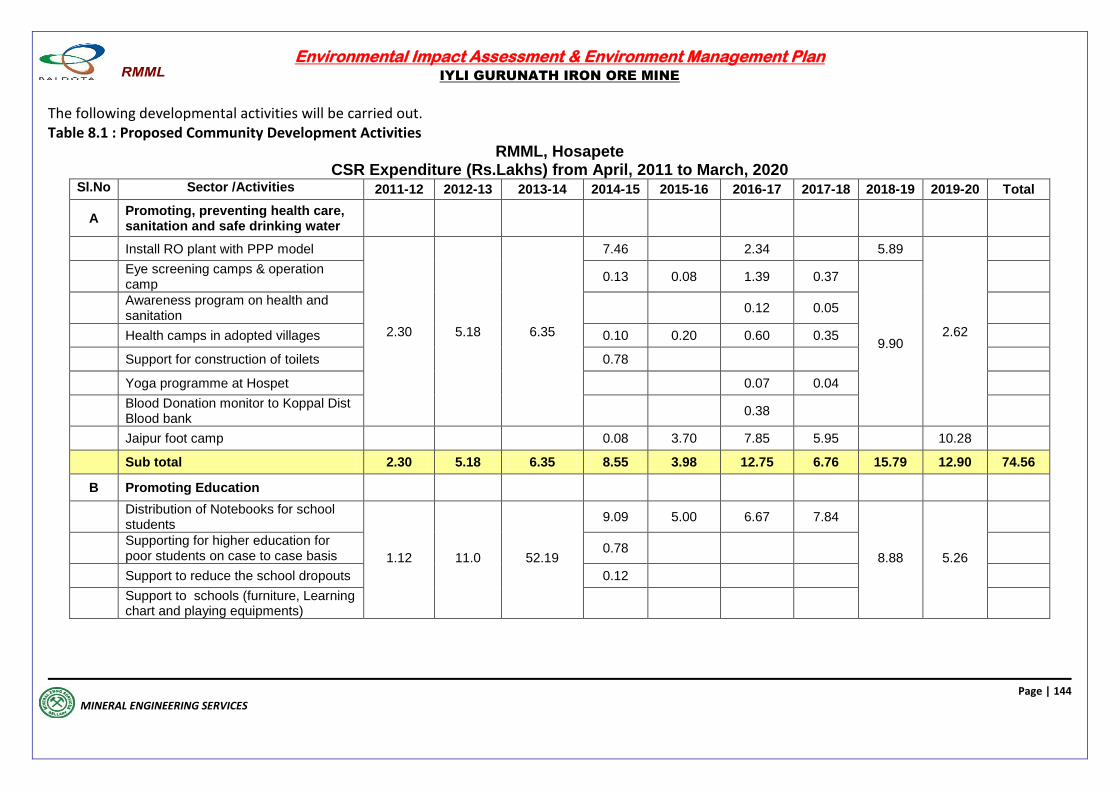
Environmental Impact Assessment & Environment Management Plan
IYLI GURUNATH IRON ORE MINE
Page | 144
MINERAL ENGINEERING SERVICES
The following developmental activities will be carried out. Table 8.1 : Proposed Community Development Activities
RMML, Hosapete CSR Expenditure (Rs.Lakhs) from April, 2011 to March, 2020
Sl.No Sector /Activities 2011-12 2012-13 2013-14 2014-15 2015-16 2016-17 2017-18 2018-19 2019-20 Total
A Promoting, preventing health care, sanitation and safe drinking water
Install RO plant with PPP model
2.30 5.18 6.35
7.46 2.34 5.89
2.62
Eye screening camps & operation camp
0.13 0.08 1.39 0.37
9.90
Awareness program on health and sanitation
0.12 0.05
Health camps in adopted villages 0.10 0.20 0.60 0.35
Support for construction of toilets 0.78
Yoga programme at Hospet 0.07 0.04
Blood Donation monitor to Koppal Dist Blood bank
0.38
Jaipur foot camp 0.08 3.70 7.85 5.95 10.28
Sub total 2.30 5.18 6.35 8.55 3.98 12.75 6.76 15.79 12.90 74.56
B Promoting Education
Distribution of Notebooks for school students
1.12 11.0 52.19
9.09 5.00 6.67 7.84
8.88 5.26
Supporting for higher education for poor students on case to case basis
0.78
Support to reduce the school dropouts 0.12
Support to schools (furniture, Learning chart and playing equipments)
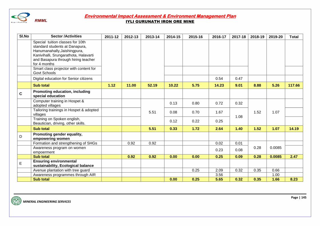
Environmental Impact Assessment & Environment Management Plan
IYLI GURUNATH IRON ORE MINE
Page | 145
MINERAL ENGINEERING SERVICES
Sl.No Sector /Activities 2011-12 2012-13 2013-14 2014-15 2015-16 2016-17 2017-18 2018-19 2019-20 Total
Special tuition classes for 10th standard students at Danapura, Hanumanahally,Jaishingpura, Kanivihalli, Srungarathota, Halavarti and Basapura through hiring teacher for 4 months
Smart class projector with content for Govt Schools
Digital education for Senior citizens 0.54 0.47
Sub total 1.12 11.00 52.19 10.22 5.75 14.23 9.01 8.88 5.26 117.66
C Promoting education, including special education
Computer training in Hospet & adopted villages
5.51
0.13 0.80 0.72 0.32
1.52 1.07
Tailoring trainings in Hospet & adopted villages
0.08 0.70 1.67
1.08
Training on Spoken english, Beautician, driving, other skills.
0.12 0.22 0.25
Sub total 5.51 0.33 1.72 2.64 1.40 1.52 1.07 14.19
D Promoting gender equality, empowering women
Formation and strengthening of SHGs 0.92 0.92 0.02 0.01
0.28 0.0085
Awareness program on women empoerment
0.23 0.08
Sub total 0.92 0.92 0.00 0.00 0.25 0.09 0.28 0.0085 2.47
E Ensuring environmental sustainability, Ecological balance
Avenue plantation with tree guard 0.25 2.09 0.32 0.35 0.66
Awareness programmes through AIR 3.56 1.00
Sub total 0.00 0.25 5.65 0.32 0.35 1.66 8.23
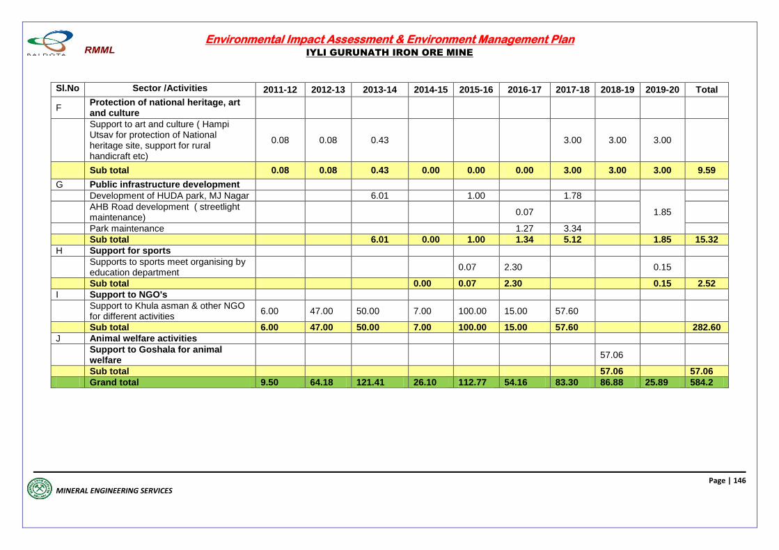
Environmental Impact Assessment & Environment Management Plan
IYLI GURUNATH IRON ORE MINE
Page | 146
MINERAL ENGINEERING SERVICES
Sl.No Sector /Activities 2011-12 2012-13 2013-14 2014-15 2015-16 2016-17 2017-18 2018-19 2019-20 Total
F Protection of national heritage, art and culture
Support to art and culture ( Hampi Utsav for protection of National heritage site, support for rural handicraft etc)
0.08 0.08 0.43 3.00 3.00 3.00
Sub total 0.08 0.08 0.43 0.00 0.00 0.00 3.00 3.00 3.00 9.59
G Public infrastructure development
Development of HUDA park, MJ Nagar 6.01 1.00 1.78
1.85
AHB Road development ( streetlight maintenance)
0.07
Park maintenance 1.27 3.34
Sub total 6.01 0.00 1.00 1.34 5.12 1.85 15.32
H Support for sports
Supports to sports meet organising by education department
0.07 2.30 0.15
Sub total 0.00 0.07 2.30 0.15 2.52
I Support to NGO's
Support to Khula asman & other NGO for different activities
6.00 47.00 50.00 7.00 100.00 15.00 57.60
Sub total 6.00 47.00 50.00 7.00 100.00 15.00 57.60 282.60
J Animal welfare activities
Support to Goshala for animal welfare
57.06
Sub total 57.06 57.06
Grand total 9.50 64.18 121.41 26.10 112.77 54.16 83.30 86.88 25.89 584.2

Environmental Impact Assessment & Environment Management Plan
IYLI GURUNATH IRON ORE MINE
Page | 147
MINERAL ENGINEERING SERVICES
8.2 ENVIRONMENTAL BENEFITS
Post Mining, out of the total Mining Lease Area 20.35 ha, the greenery will be over an extent
20.23 ha (20.35 ha as per CEC survey and digitization of the lease deed sketch)
Medical assistance;
Health camps in the buffer zone villages are organised for eye screening, jaipur foot camp,
awareness programme on health and sanitation and blood donation camps
Primary education;
So far, the mining authorities are providing transport facility for students, supply of school uniform, notebooks, dictionaries and shoes for school and college students. The mining authorities are also repairing school buildings. This policy continues with adequate budgetary support.
In order to improve the educational activities in the area, following assistance will be
provided.
Repair/Rebuilding of village schools;
Institution of scholarships and prizes;
Encouraging pre-primary school education; and
Supporting adult education programs.
Rural water supply;
Drinking water is being provided to villagers and the same will be continued with
budget allocation.
Training of self employment groups
In order to improve the skill and self employment of locals, following promotional
activities may be taken up.
Tailoring/embroidery classes for women.
Orientation programs for self-employment in collaboration with District Industries
Centre and Rural Development Agencies.
The local people especially the women from the downtrodden community and women
self help group are involved in afforestation, in the nursery development and avenue
plantation programmes, developing fruit orchid, fodder farms and in vocational training
for tailoring, embroidery, other cottage industries etc. Women, especially the tribal folk,
in the neighboring villages will be provided with sewing machines. Classes are
conducted to teach sewing, embroidery, doll making by employing qualified teachers.
For this an amount of Rs. One lakh per year has been provided in the budget.
Youth shall be given technical vocational training so that they can get employment in
service sector as technicians or in self-employment schemes.
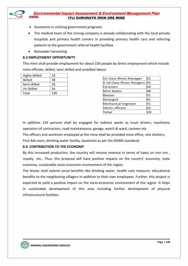
Environmental Impact Assessment & Environment Management Plan
IYLI GURUNATH IRON ORE MINE
Page | 148
MINERAL ENGINEERING SERVICES
Assistance in utilizing government programs
The medical team of the mining company is already collaborating with the local private
hospitals and primary health centers in providing primary health care and referring
patients to the government referral health facilities.
Rainwater harvesting
8.3 EMPLOYMENT OPPORTUNITY
This mine shall provide employment for about 150 people by direct employment which include
mine officials, skilled, semi skilled and unskilled labour
In addition 150 persons shall be engaged for indirect works as truck drivers, machinery
operators of contractors, road maintainance, garage, watch & ward, canteen etc
The officers and workmen employed at the mine shall be provided mine office, rest shelters,
First Aid room, drinking water facility, lavatories as per the DGMS standards
8.4 CONTRIBUTION TO THE ECONOMY
By this increased production, the country will receive revenue in terms of taxes on iron ore ,
royalty etc., Thus, this proposal will have positive impacts on the country’ economy, state
economy, sustainable socio-economic environment of the region.
The lessee shall extend social benefits like drinking water, health care measure, educational
benefits to the neighboring villagers in addition to their own employees. Further, this project is
expected to yield a positive impact on the socio-economic environment of the region. It helps
in sustainable development of this area including further development of physical
infrastructural facilities.
Highly Skilled 10
Skilled 38
Semi skilled 26
Un-Skilled 56
Total 130
Ist Class Mines Manager 01
II nd Class Mines Mangers 02
Foremen 04
Mine Mates 08
Blaster 01
Geologist 01
Mechanical Engineer 01
Admin officers 02
Total 20
Environmental Impact Assessment & Environment Management Plan
IYLI GURUNATH IRON ORE MINE
Page | 149
MINERAL ENGINEERING SERVICES
ENVIRONMENTAL
MANAGEMENT PLAN
Environmental Impact Assessment & Environment Management Plan
IYLI GURUNATH IRON ORE MINE
Page | 150
MINERAL ENGINEERING SERVICES, 2020
ENVIRONMENTAL MANAGEMENT PLAN
9.1 OBJECTIVE
The major objective and benefit of utilizing Environmental Impact Assessment in project
planning stage itself, is to prevent avoidable losses of environmental resources and values.
Environmental Management includes protection / mitigation / enhancement measures as
well as suggesting post project monitoring programme.
The industrial development in the study area needs to be intertwined with judicious
utilization of non-renewable resources and within the limits of permissible assimilative
capacity. The assimilative capacity of the study area is the maximum amount of pollution load
that can be discharged in the environment without affecting the designated use and is
governed by dilution, dispersion, and removal of possible pollutants generated during the
operation. The Environment Management Plan (EMP) is required to ensure sustainable
development. Hence it needs to be an all encompassive plan for which the Industries,
Government, Regulating agencies and more importantly the population of the study area
need to extend their cooperation and contribution.
The Environmental Management Plan will address the possible impacts on the environmental
attributes in the region viz., air quality, water quality, land use, ecology and public health and
the control measures that will be put in place to protect the Environment in and around the
study area.
The Management Action Plan aims at controlling pollution at the source level to the
maximum possible extent with the available and affordable technology followed by treatment
measures before they are discharged.
Environmental Management Plan aims at the preservation of ecosystem by considering the
pollution abatement facilities at the inception stage. For the proposed expansion of Iron Ore
Mine, the pollution abatement has become an integral part of planning and design.
9.2 ENVIRONMENTAL MANAGEMENT PLAN
The Environmental Impact Assessment revealed that the study area has not been affected
adversely and is likely to get new economical fillip.
The Iyli Iron Ore Mine is an operating Mine and it is operated taking all precautionary
measures to reduce the impact of mining operations on Air, Water, Noise and Soil and
ensuring all control measures to comply with the prescribed standards.
The proposed production of Iron Ore within the exiting ML Area will be carried out following
the same method of mining, viz., open cast conventional type of mining, which involves
drilling and blasting. The precautionary and control measures which are practised now, will be
continued for the expansion program also.
Environmental Impact Assessment & Environment Management Plan
IYLI GURUNATH IRON ORE MINE
Page | 151
MINERAL ENGINEERING SERVICES, 2020
Proposal for reclamation of land affected by abandoned quarries and other
mining activities
Land restoration and reclamation is very much essential in any mining industry. Due to mining
activity in this area, there will be change in the ground profile in the form of pit and dump
areas.
The ore bearing area will be mechanically mined-out upto the ultimate pit limit maintaining
maximum depth of 131 m in 14 benches with due consideration for slope stability. The
wastes generated constituting of BHQ and clays, is initially dumped on the surface with
stabilization efforts and presently backfilled into the worked out Portion of the exhausted pit
workings.
The land use details as on date and upto conceptual period is shown in conceptual plan At
conceptual stage, the ML area shall be covered by a pit of total area 20.23 ha (20.35 ha as per
CEC survey and digitization of the lease deed sketch)i.e about 64% of ML worked to a
maximum depth of about 75 m, out of this about 3.800 ha i.e. with the wastes generated and
afforested. The balance pit area shall be converted into a rainwater catchment reservoir.
Which becomes a rain water harvesting structure. Further 1.44 ha of ML area shall be
covered with green belt which reduces the soil erosions and increases aesthetics. The
reservoir area will be fenced off and a parapet wall shall be constructed with proper passage
facility surrounding the pit to prevent accidental fall. The afforestation work done shall leave
a congenial environment for immigration of avi-fauna by including the fruit and flower
bearing shady trees and also by provision of drinking water in the abandoned pit. It shall
improve aesthetic beauty of the area.
Further, regular environmental monitoring will be conducted during life of the mine in the
project site and in the surroundings to maintain the pollutants level from the mining activity
within the permissible limits.
9.2.1 AIR POLLUTION CONTROL
Use of Wet Drilling Maintaining of teeth of Drill bits and Excavators in sharp condition
Vent of adequate height for Air Compressors run on diesel
Spraying of water on haulage roads regularly
Regular maintenance of Mining Equipment, Machinery & all Vehicles as per the
manufactures recommendations to minimize the emissions
Maintenance of haul roads regularly
Ensuring permanent blacktopped approach roads to the ML area
Environmental Impact Assessment & Environment Management Plan
IYLI GURUNATH IRON ORE MINE
Page | 152
MINERAL ENGINEERING SERVICES, 2020
Use of higher capacity hydraulic excavators to eliminate the mechanical loader
required for loading of broken rock formed by drilling and blasting and to reduce
the dust generation
Transport of Iron ore to plant using heavy duty dumpers, minimizing the number of
trips to reduce pollution load
Not allowing overloading of Iron ore while transporting outside the ML area
Speed restrictions for the transport vehicles
Ensuring PUC certificates for all the vehicles entering Mines by monitoring at the
entry point
Providing thick greenbelt along the boundary of ML area and the sides of the roads
to absorb gases emitted by vehicles.
9.2.2 WASTEWATER MANAGEMENT No generation of wastewater from the mining operation
Treatment of domestic wastewater generated from the mines in septic tank
followed by dispersion trench
Provision of boulder walls for the waste dump to arrest erosions
Provision of garland drains around the dump yard and diversion of water to
sedimentation sump to separate the soil particles
Connecting the drains along the roads to sedimentation sump to separate the soil
particles
Conversion of mined out pit (as and when it happens) into rainwater harvesting
reservoir
The wastes and ore generated are non toxic, no heavy metals area present and also
non-acidic. The possible pollutants in the water are the suspended solids which are
derived from erosions within the mining areas and dumps. Rainwater directly falling
over the pit area will be allowed to settle in the pit itself thereby helping in
groundwater recharge. During the rainy season, the pumped out water from the pit
is passed through settling pit to remove the solid suspensions, such that clear water
shall leave the M L area.
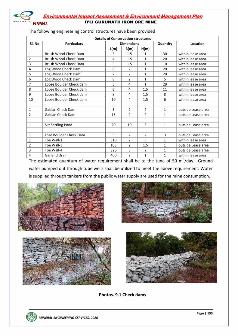
Environmental Impact Assessment & Environment Management Plan
IYLI GURUNATH IRON ORE MINE
Page | 153
MINERAL ENGINEERING SERVICES, 2020
The following engineering control structures have been provided
Details of Conservation structures
Sl. No Particulars Dimensions Quantity Location
L(m) B(m) H(m)
1 Brush Wood Check Dam 3 1.5 1 30 within lease area
2 Brush Wood Check Dam 4 1.5 1 20 within lease area
3 Brush Wood Check Dam 5 1.5 1 10 within lease area
4 Log Wood Check Dam 6 2 1 20 within lease area
5 Log Wood Check Dam 7 2 1 20 within lease area
6 Log Wood Check Dam 8 2 1 5 within lease area
7 Loose Boulder Check dam 5 4 1 29 within lease area
8 Loose Boulder Check dam 6 4 1.5 11 within lease area
9 Loose Boulder Check dam 8 4 1.5 8 within lease area
10 Loose Boulder Check dam 10 4 1.5 6 within lease area
1 Gabian Check Dam 5 2 2 1 outside Lease area
2 Gabian Check Dam 15 2 2 1 outside Lease area
1 Silt Settling Pond 20 10 3 1 outside Lease area
1 Lose Boulder Check Dam 5 2 2 3 outside Lease area
1 Toe Wall-1 310 2 3 1 within lease area
2 Toe Wall-3 105 2 1.5 1 outside Lease area
3 Toe Wall-4 320 3 2 1 outside Lease area
4 Garland Drain 400 2 1 1 within lease area
The estimated quantum of water requirement shall be to the tune of 50 m3/day. Ground
water pumped out through tube wells shall be utilized to meet the above requirement. Water
is supplied through tankers from the public water supply are used for the mine consumption.
Photos. 9.1 Check dams
Environmental Impact Assessment & Environment Management Plan
IYLI GURUNATH IRON ORE MINE
Page | 154
MINERAL ENGINEERING SERVICES, 2020
9.2.3 NOISE POLLUTION CONTROL
The ambient noise levels will be ensured to less than 75 dBA during daytime & less than
70 dBA during night time by taking all required measures.
Use of low density explosives for blasting operations to give a heaving effect than an
explosion
Following Controlled blasting technique. Blasting explosives using Nonel detonators
with millisecond delays and detonating cord to reduce dust generation. Noise levels
and ground vibrations.
Restricting the blasting operations to noon times to avoid the periods of
temperature inversions
Ensuring higher stemming column than the burden to avoid blown out shots.
Stemming column of 3m with deck loading to reduce the noise levels & fly rock
generation
Regulating charge per delay (40 kg of explosive charge per delay) to ensure PPV of
less than 5 mm/sec at 500m
Placing of Guards in all directions before blasting to prevent unauthorized entry into
the mine area
Careful planning, supervision and execution of each blasting
Providing protective devices like acoustic wool, earplugs and earmuffs to the
workmen in noise prone zones in the mine
Limiting the speed of trucks within the mine boundary to 15 Kmph.
Regular maintenance of mining equipment, machinery & all vehicles as per the
manufactures recommendations to minimize the Noise level
Ensuring use of equipments of reputed make, as per OSHAS standards on Noise
levels
9.2.4 PROTECTIVE MEASURES FOR GROUND VIBRATIONS/AIR BLAST CAUSED BY BLASTING:
Slurry explovises, ANFO, LOX etc are filled in drilled holes and blasted by using delay detonators, cord relays.
Maximum charge per delay is 100 to 150 kgs to ensure better fragmentation and reduce ground vibrations.
All the statutory requiremnets during blasting shall be ensured to avoid accidents to men and machinery these type of controlled blasting operation shall have a heaving effect than an explosion reducing the noise levels, ground vibrations, air blasts and ejection of fly rocks.
Environmental Impact Assessment & Environment Management Plan
IYLI GURUNATH IRON ORE MINE
Page | 155
MINERAL ENGINEERING SERVICES, 2020
9.2.5 SOLID & HAZARDOUS WASTE MANAGEMENT
Using intercalated red soil removed for the erection of bunds along safety barriers
developed on both sides of the nallah and the road passing through the ML Area and
along the boundary of the ML Area for afforestation.
No generation of hazardous waste
No generation of waste containing leachable toxic material & heavy metals
Boulder wall and garland drain around the active dump area
Terracing, mulching, planting grasses, legumes and bush variety of species, on the
inactive slopes to prevent erosion
Concurrent back filling using generated waste to reclaim & afforest the mined out portion of the pit
No hazardous waste is getting generated from the Mine. As the mining machinery and
vehicles are engaged on contract basis, no workshop has been provided within the Mining
Lease Area. The machinery and the vehicles are maintained by the Contractor in workshop
located outside the ML Area. The same arrangement will continue for the expansion proposal
also.
9.2.6 WILDLIFE CONSERVATION, GREENBELT DEVELOPMENT / AFFORESTATION
Afforestation of the mined out and other available areas which are not fragmented
but are degraded due to mining activity is the main component of re-vegetation process to
mitigate the negative impacts of the mining on environment. Afforestation may lead
to restoration of the ecosystem relatively to pre-mining period. There is no proposal of afforestation in the backfilled area during the plan period. Whereas in
the bench-wise Afforestation will be carried out during the conceptual period as per
suggestions given in the approved R & R plans. Biodiversity Conservation Plan: We have preserved 0.5 Ha extent of the land area on north eastern side of the lease area
for establishment of Biodiversity Conservation and the area is marked on the land use plan
of approved R & R Plan.
9.3 EMP Budget
a. EMP Cost.
CER expenditure and Environmental Monitoring : Rs. 46.27 lakhs /annum
CSR expenditure : Rs. 144.39 Lakhs /annum
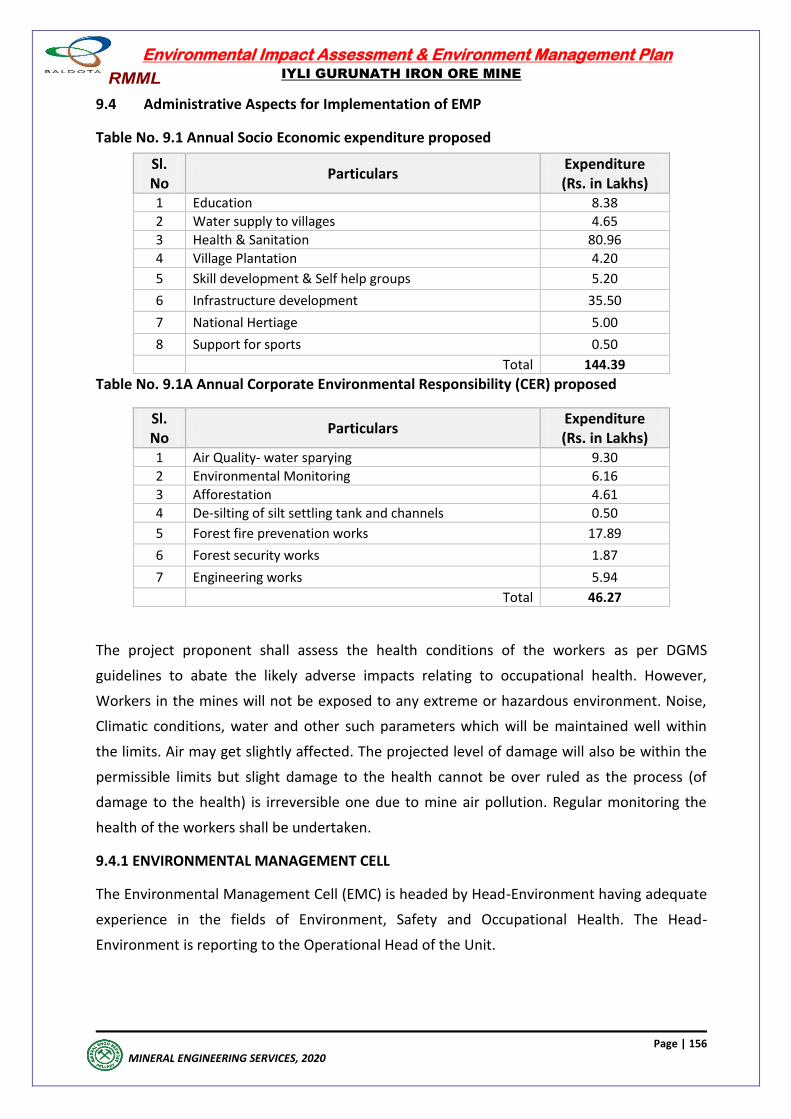
Environmental Impact Assessment & Environment Management Plan
IYLI GURUNATH IRON ORE MINE
Page | 156
MINERAL ENGINEERING SERVICES, 2020
9.4 Administrative Aspects for Implementation of EMP
Table No. 9.1 Annual Socio Economic expenditure proposed
Sl. No
Particulars Expenditure (Rs. in Lakhs)
1 Education 8.38
2 Water supply to villages 4.65
3 Health & Sanitation 80.96
4 Village Plantation 4.20
5 Skill development & Self help groups 5.20
6 Infrastructure development 35.50
7 National Hertiage 5.00
8 Support for sports 0.50
Total 144.39
Table No. 9.1A Annual Corporate Environmental Responsibility (CER) proposed
Sl. No
Particulars Expenditure (Rs. in Lakhs)
1 Air Quality- water sparying 9.30
2 Environmental Monitoring 6.16
3 Afforestation 4.61
4 De-silting of silt settling tank and channels 0.50
5 Forest fire prevenation works 17.89
6 Forest security works 1.87
7 Engineering works 5.94
Total 46.27
The project proponent shall assess the health conditions of the workers as per DGMS
guidelines to abate the likely adverse impacts relating to occupational health. However,
Workers in the mines will not be exposed to any extreme or hazardous environment. Noise,
Climatic conditions, water and other such parameters which will be maintained well within
the limits. Air may get slightly affected. The projected level of damage will also be within the
permissible limits but slight damage to the health cannot be over ruled as the process (of
damage to the health) is irreversible one due to mine air pollution. Regular monitoring the
health of the workers shall be undertaken.
9.4.1 ENVIRONMENTAL MANAGEMENT CELL
The Environmental Management Cell (EMC) is headed by Head-Environment having adequate
experience in the fields of Environment, Safety and Occupational Health. The Head-
Environment is reporting to the Operational Head of the Unit.
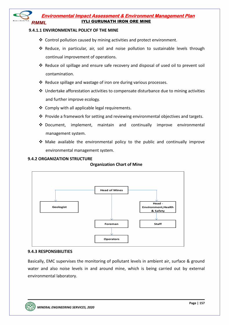
Environmental Impact Assessment & Environment Management Plan
IYLI GURUNATH IRON ORE MINE
Page | 157
MINERAL ENGINEERING SERVICES, 2020
9.4.1.1 ENVIRONMENTAL POLICY OF THE MINE
Control pollution caused by mining activities and protect environment.
Reduce, in particular, air, soil and noise pollution to sustainable levels through
continual improvement of operations.
Reduce oil spillage and ensure safe recovery and disposal of used oil to prevent soil
contamination.
Reduce spillage and wastage of iron ore during various processes.
Undertake afforestation activities to compensate disturbance due to mining activities
and further improve ecology.
Comply with all applicable legal requirements.
Provide a framework for setting and reviewing environmental objectives and targets.
Document, implement, maintain and continually improve environmental
management system.
Make available the environmental policy to the public and continually improve
environmental management system.
9.4.2 ORGANIZATION STRUCTURE Organization Chart of Mine
9.4.3 RESPONSIBILITIES
Basically, EMC supervises the monitoring of pollutant levels in ambient air, surface & ground
water and also noise levels in and around mine, which is being carried out by external
environmental laboratory.
Operators
Staff
Geologist
Head of Mines
Head -
Environment,Health
& Safety
Foreman
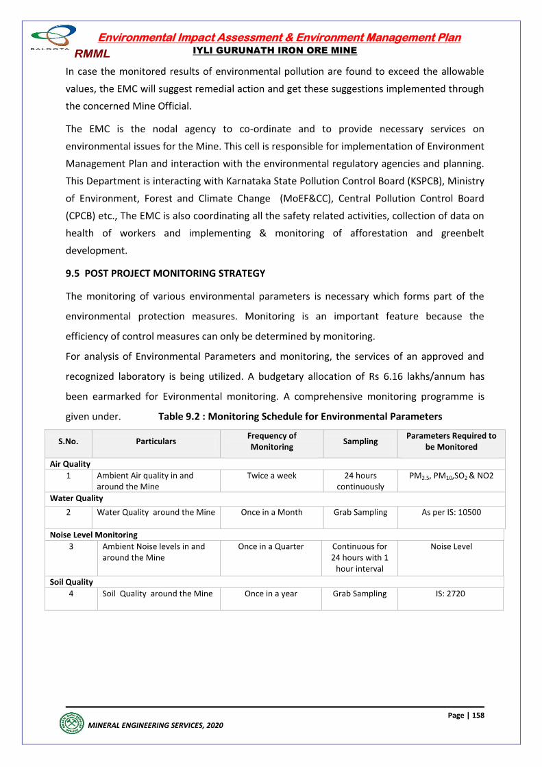
Environmental Impact Assessment & Environment Management Plan
IYLI GURUNATH IRON ORE MINE
Page | 158
MINERAL ENGINEERING SERVICES, 2020
In case the monitored results of environmental pollution are found to exceed the allowable
values, the EMC will suggest remedial action and get these suggestions implemented through
the concerned Mine Official.
The EMC is the nodal agency to co-ordinate and to provide necessary services on
environmental issues for the Mine. This cell is responsible for implementation of Environment
Management Plan and interaction with the environmental regulatory agencies and planning.
This Department is interacting with Karnataka State Pollution Control Board (KSPCB), Ministry
of Environment, Forest and Climate Change (MoEF&CC), Central Pollution Control Board
(CPCB) etc., The EMC is also coordinating all the safety related activities, collection of data on
health of workers and implementing & monitoring of afforestation and greenbelt
development.
9.5 POST PROJECT MONITORING STRATEGY
The monitoring of various environmental parameters is necessary which forms part of the
environmental protection measures. Monitoring is an important feature because the
efficiency of control measures can only be determined by monitoring.
For analysis of Environmental Parameters and monitoring, the services of an approved and
recognized laboratory is being utilized. A budgetary allocation of Rs 6.16 lakhs/annum has
been earmarked for Evironmental monitoring. A comprehensive monitoring programme is
given under. Table 9.2 : Monitoring Schedule for Environmental Parameters
S.No. Particulars Frequency of Monitoring
Sampling Parameters Required to
be Monitored
Air Quality
1 Ambient Air quality in and around the Mine
Twice a week 24 hours continuously
PM2.5, PM10,SO2 & NO2
Water Quality
2 Water Quality around the Mine
Once in a Month Grab Sampling As per IS: 10500
Noise Level Monitoring
3 Ambient Noise levels in and around the Mine
Once in a Quarter Continuous for 24 hours with 1
hour interval
Noise Level
Soil Quality
4 Soil Quality around the Mine
Once in a year Grab Sampling IS: 2720

Environmental Impact Assessment & Environment Management Plan
IYLI GURUNATH IRON ORE MINE
Page | 159
MINERAL ENGINEERING SERVICES, 2020
9.6 Occupational Safety and Health Plan
9.6.1 Safety & health policy of the mine
Iyli Mine is committed to achieve zero accident level.
Provide adequate steps towards safety and health of the employees by
implementing the provisions of Mines Act, Rules & Regulations made there under.
Plan and design Operations and systems to eliminate or materially reduce mining
hazards.
Take proactive steps to identify hazards, assess risk levels and implement control
measures.
Train and Retrain all employees to improve safety skills and ensure safe work
practices.
Train employees for improvement of work skill, communication skills and to develop
leadership qualities.
Continual improvement of safe work practices.
Document, implement, maintain and continually improve its Safety and Health
Management System.
Organize appropriate forums with employees’ representatives for joint
consultations on safety matters and secure their motivation and commitment in
safety management.
Monitor the implementation of safety plans at regular intervals.
9.6.2 OCCUPATIONAL HEALTH
9.6.2.1 Hearing impairment
The most significant occupational health hazard is noise induced hearing loss. But there are
no reported cases of hearing loss due to noise pollution as per the observation of local
doctors. However, mining proponent has been conducting periodic health checkup by in-
house medical team for any hearing impairment for mining workers. This is according to
occupational health plan policy and such policy will continue as long as mining is in operation.
9.6.2.2 Skin diseases
According to local doctors, about 3.2 per cent of the patients have suffered from skin diseases
because of lack of personal hygiene rather than dust pollution due to miming activity. The
mining proponent has taken enough precautionary measures to minimize the dust pollution.
However, mining proponent has conducting periodic health checkup by in-house medical
team to detect any skin elegies for mining workers and the population, especially school
children. This is according to health plan policy and such policy will continue as long as mining
is in operation.
Environmental Impact Assessment & Environment Management Plan
IYLI GURUNATH IRON ORE MINE
Page | 160
MINERAL ENGINEERING SERVICES, 2020
9.6.2.3 Eye diseases
According to local doctors, about 2.6 per cent of the patients have suffered from eye related
problems. The eye infections are not related to dust pollution due to miming activity, but are
mostly due to infection. The mining proponent has taken adequate precautionary measures
to minimize the dust pollution. However, mining proponent has been conducting periodic
health checkup by in-house medical team for eye diseases among mining workers and school
children. This is according to health plan policy and such policy will continue as long as mining
is in operation.
9.6.2.4 Job stress because of working in accident prone mining environment
The job stress is being observed to be low because of incentives like providing food in work
place and weekly holidays and recreational facilities. This is according to health plan policy
and such policy will continue as long as mining is in operation.
9.6.2.5 Respiratory diseases
Iron ore does not contain and toxic elements. Hence, the possibility of any health hazards due
to toxic elements does not arise. The most significant occupational health is lung diseases due
to inhalation of dust. However, management is taking enough care to minimize these
occupational health hazards.
The percentage of pneumonia episodes is very negligible (0.05 per cent). The percentage of
Asthma or Bronchitis is high (4.7 per cent). This is high percentage is because of other vices
like consumption of tobacco and alcohol, especially among males. There are few cases of
hearing loss mostly associated with old age.
The number of skin allergies cases (3.2 per cent) is not very high. However, mining proponent
has been conducting periodic health checkup by in-house medical team for any respiratory
infections among mining workers and villagers. This is according to health plan policy and
such policy will continue as long as mining is in operation.
9.6.2.6 Materials like asbestos, silica, chrome dust etc. are hazardous to mine workers.
The above hazardous materials are not used on the mine site. However, mining proponent
has been taking special care not to use any health hazards material either for contraction or
for other use. This is according to health plan policy and such policy will continue as long as
mining is in operation.
9.6.3 OCCUPATIONAL SAFETY
1) Provision of rest shelter for mine workers with facilities of drinking water.
Rest room with drinking water and toilets facilities with water for wash are provided on the
work site for all workers.
Environmental Impact Assessment & Environment Management Plan
IYLI GURUNATH IRON ORE MINE
Page | 161
MINERAL ENGINEERING SERVICES, 2020
2) Awareness of safety and ensure using personal protective equipments
(PPE) by workers.
All workers are made aware of safety measures to be followed on the work site. The
awareness programs have been conducted by professionals who have graduated in the
industrial safety. All the workers are given helmet, gum boots, working shoes and working
dress. These equipments are replaced periodically.
3) Regular maintenance of testing equipment.
The safety and testing equipments are maintained regularly.
4) Periodic medical examination of all workers.
Health check-ups are carried out by the in-house medical team regularly. This is according to
health plan policy and such policy will continue as long as mining is in operation.
5) Safety measures of risk assessment in underground mining.
Only surface mining is being carried out.
6) Conduct of mock drill.
Mock drill is regularly conducted, especially for fire safety.
7) Safe storage of handling of explosives.
Explosives are in the custody of responsible high ranking officer
9.7 Socioeconomic Conditions of the region, Plan
9.7.1 Medical assistance
Health, medical and safety facilities have been developed by the mining proponent ever since
the mining is in operation.
Medical assistance for needy people is provided by conducing regular medical check-up for
workers and villagers in the buffer zone.
The annual budget is regularly provided. Such policy will continue as long as mining is in
operation. This is according to health plan policy of the company.
9.7.2 Primary education
Budgetary provision has been made for educational scheme/assistance to the needy people
by providing tran0sport facility for students and supply of school uniform, notebooks,
dictionaries and shoes for school and college students. Special coaching classes for poor and
needy students are also organized. This will be continued with adequate annual budgetary
support.
9.7.3 Animal husbandry
Animal husbandry is not been included in the welfare programs. Special assistant for Goshalas
is also planned. It will be considered with proper budgetary allocation in the course of time.
Environmental Impact Assessment & Environment Management Plan
IYLI GURUNATH IRON ORE MINE
Page | 162
MINERAL ENGINEERING SERVICES, 2020
9.7.4 Rural water supply
Drinking water is provided by installing RO pants to villagers and the same will be continued
with annual budget allocation.
9.7.5 Agriculture improvement
Water is being supplied for irrigation. It is also proposed to supply high yielding varieties of
coconut, areca nut and cashew nut plants to supplement households' income. This welfare
program will be continued in the future.
9.7.6 Vocational training
Vocational courses like computer training, tailoring, training in spoken English, training in
beautician, driving lessons and other skills for male and female youth was carried out in the
past. This is the most important welfare program to counter unemployment and therefore, it
will continue in future with appropriate budget allocation.
9.7.7 Assistance in utilizing government programs.
The medical team of the mining company is already collaborating with the local heath sub-
centers and primary health centers in providing primary health care and referring patients to
the government health facilities. Students are provided with books and provided financial
assistance and special coaching classes to make them pass in merit. This policy will be pursued
in future with appropriate budget allocation.
9.7.8 Employment
The mining proponent has been giving high priority to employ the local skilled and unskilled
workers and hiring trucks from owners in mining area. The same policy will be continued in
future.
9.7.9 Communication
Villages are well connected with main roads leading to Taluka or distinct headquarters.
Mining proponent is providing street light fixtures to Panchayats. Such policies will be
continues in the coming years.
Environmental Impact Assessment & Environment Management Plan
IYLI GURUNATH IRON ORE MINE
Page | 163
MINERAL ENGINEERING SERVICES, 2020
EXECUTIVE SUMMARY
Environmental Impact Assessment & Environment Management Plan
IYLI GURUNATH IRON ORE MINE
Page | 164
MINERAL ENGINEERING SERVICES, 2020
EXECUTIVE SUMMARY
10.0 INTRODUCTION
10.1 PROJECT PROPONENT
The Iyli Gurunath Iron Ore Mine is owned by M/s.Ramgad Minerals and Mining Limited,
Hosapete. This is an operating mine located in Ramgad village, Sandur taluk, Ballari district
Karnataka. Ramgad Minerals and Mining Limited has always stood for the high quality and
they obtained IS/ISO 9001:2015 (Quality Management certification).
10.1.2 PROJECT PROFILE
Iyli Gurunath Iron Ore Mining Lease was granted 1st in the year 1966 and further renewed
perodically and is valid upto 23.02.2026. The lessee has obtained all the required statutory
clearances for an annual production of 0.5 MTPA of Iron Ore. This iron ore forms a feed for
various steel /pelletisation plants through e-auction process
10.1.3 Scope of the study
The lessee had obtained environmental clearance for the production of 0.975 MTPA under
the provisions of EIA notification, 1994. But now the lessee has been asked to seek fresh
Environmental Clearance under the provisions of EIA notification, 2006. Accordingly the
lessee had applied for TOR from SEIAA, Karnataka and obtained the same.Subsequently the
lessee had applied for amendment in ToR to increase the production of 0.975 MTPA of iron
ore from 0.5 mtpa which has been approved by SEIAA. The lessee has engaged services of
M/s.Mineral Engineering Services, Ballari who are accredited EIA consultants by NABET (QCI)
for collection of baseline data and preparation of EIA & EMP for conducting public hearing by
Karnataka State Pollution Control Board(KSPCB), Bengaluru.
10.1.4 Project Description
Iyli Gurunath Iron Ore Mine is located in Ramgad block of Sandur Range Forest over an extent
of 20.23 Ha & 20.35 Ha ( as per CEC Sketch). The mining lease falls in topo sheet no. D43 E8
(OLD.No.57-A8), the latitude and longitude limits are N 150 09' 15.41'' to 150 09' 39.08'' and E
760 26' 26.7 '' to 760 26' 47.86'' respectively. Highest elevation of ML is 960 m above MSL and
Lowest elevation is 850 m above MSL.
The project is located at 15 kms from Sandur town and 23 kms from Hosapete. The nearest
airport is at Vidhyanagar, Torangallu at a distance of 30 kms. The nearest State Highway
between Sandur and Hosapete runs at a distance of 5 kms from the mine lease.
Environmental Impact Assessment & Environment Management Plan
IYLI GURUNATH IRON ORE MINE
Page | 165
MINERAL ENGINEERING SERVICES, 2020
10.1.5 Geology
10.1.5.1 Regional Geology
The Ballari- Hosapete region covers part of highly folded metamorphosed Dharwarian
formations (archean) of Karnataka state. The hill ranges and the valleys in the region
constitute the "Sandur Synclinorium"with axial end of NW-SE to NNW-SSE. The strata have
been tightly folded into isoclinals, anticlinals and synclines in the Synclinorium.
10.1.5.2 Local Geology
The various litho units exposed in the area are part of the Ramanamalai, Deogiri and
Yeshwantnagar formations of lower units of the stratigraphic sequence of the Sandur
Synclinorium. The geological mapping and exploration in the leasehold area established the
various lithounits as furnished below:
Laterite
Hematitic Iron Ore (Friable), Hematitic Siliceous Iron Ore
Shale/Phylite
Banded Hematite Quartzite /Chert (BHQ /BHC)
The area is characterized by the absence of any mapable fold or fault. The overall structural
set up of the area is marked by tightly isoclinals folds with strike directions NW-SE, while dip
generally varies from 80° to 85° NE.
The Iyli Gurunath lease hold has insitu ore deposit in the upper part of North-Eastern slope of
the Ramgad hill range. The ore occurs generally below a capping of laterite Hematitic Iron ore
(Friable) and Hematitic Siliceous Iron ore. It is apparent from field observations that the ore
body is formed by leaching of silica and iron ore in BHQ/BHC in the form of iron ore Fe
content in the ore is contributed prominently by hematite. In Hematitic Siliceous iron ore the
silica in the ore is contributed predominantly due to presence of quartz/chert in the gangue
and Fe in the ore is contributed predominantly by presence of hematite and subordinate to
minor amounts of maghematite. These are formed by volcano sedimentary process.
The Hematitic Iron ore having a length of 540 m average width varying from 20 to 150 m and
the average depth is 80 - 100 m. Hematitic Siliceous Iron ore is below the friable iron ore. The
base of the Hematitic iron ore & Hematitic Siliceous iron ore has been established by diamond
core drilling and RC drilling. The quality of the iron ore is in this lease area is varying between
56 to 66% Fe. Overall Lumps and fines ratio is 13: 87 (Lumps +10mm, Fines -10 mm).
The Hematitic Siliceous iron ore normally occurs in transition zone of friable iron ore and in
depth with grades varying 35% Fe to 45% Fe. The Hematitic siliceous ore is characterized by
hematite and cherty minerals as gangue. The presence of Hematitic Siliceous Ore with 35% Fe
(Min) as per the latest threshold value of minerals notification dated 25/04/2018, all the
resources has been assessed upto the threshold value.
Environmental Impact Assessment & Environment Management Plan
IYLI GURUNATH IRON ORE MINE
Page | 166
MINERAL ENGINEERING SERVICES, 2020
10.1.6 MINING OPERATION
TECHNOLOGY & MINING PROCESS
Mining Method: Open Cast Mining The current Method of Mining, as explained below, will be continued for the future
operations also.
Mining operation is carried out by fully mechanized opencast method with deep hole drilling
and blasting utilizing Heavy Earth Moving Machinary (HEMM). The diameter of drill hole is
110 mm. The depth of the hole is 10m. Wagon drills in conjunction with Portable Diesel Air
Compressor are used for drilling. Since the formations are soft, only 20% of the waste and ore
require drilling.
10.2 Descrpition of Environment
10.2.1 Study Area The study area of 10 kms radius is considered around the mining lease as buffer zone, the
study period for baseline data collection was from Mar-19 to May-19 which is the summer
season. Environment setting of the project site is given below
10.2.2 Environmental Componets
The following environmental attributes have been included in the EIA study as part of baseline data Site Specific Micrometeorological Data (hourly readings from core zone) on wind
speed & direction (wind roses), temperature, humidity. There was no rainfall during
monitoring period.
Ambient Air Quality Monitoring at 8 Stations on 24-hourly basis, for 2 days in a week
for 13 weeks in a month during the season for the parameters PM2.5, PM10, for Heavy Metals
analysis in Particulates, S02, NO2, CO, Ozone, Benzene and Benzo(a)pyrene
Noise Level Measurements at 8 noise monitoring stations for Leq, Lday and Lnight values
once in the season
Water Quality Monitoring by grab sampling once in a season for
Surface Waters (5 locations)
Ground Waters (10 Locations)
Soil Quality Monitoring at 8 locations once in the study period for
Textural & Physical Parameters
Nutrients
Land use pattern based on Satellite Imagery
Biotic Attributes (twice in the study period) for
Flora-Core & Buffer Zones Fauna-Core & Buffer Zones
Environmental Impact Assessment & Environment Management Plan
IYLI GURUNATH IRON ORE MINE
Page | 167
MINERAL ENGINEERING SERVICES, 2020
Socio-Economic Profile, based on 2011-Census and Survey 2019 for Total Population I Household Size I Age Gender Composition S.C I S.T Literacy Level Occupational Structure 10.2.3 Methodology of collection of baseline data
For Baseline data collection services of environmental laboratory of M/s. Mineral Engineering
Services, Ballari have been engaged who are duly recognised by MoEF&CC, GOI, New Delhi.
10.2.3.1 Micro meteorology
Micro meteorology and Micro climatic parameters have been recorded by installing a
Weather Monitoring Station.
10.2.3.2 Ambient Air Quality
For Ambient air quality 8 stations have been fixed covering 7 villages and 1 core zone covering
all the directions, the frequency of monitoring is 2 days/ week for 3 months and the
parameters covered were as per cpcb naaqs guidelines.
The statistical analysis of Ambient Air Quality is as follows, the maximum values of S02, NO2,
PM10 & PM 2.5 in the core zone are observed to be 13, 23, 77 & 44 ug/m3. All the
parameters including CO, Pb, and 03 as per NAAQS are monitored and monitoring results
compared to AAQS are observed to be well within the limits.The maxiumum values in buffer
zone villages also were well within the permissble limits.
10.2.3.3 Noise Levels
For noise quality 8 stations including one station in core zone and 7 in buffer zone villages
were monitored and Leq during day & night are observed. The Leq value during day in the
core zone is observed as 56.1 dB (A) and in night 41.0 dB(A) and monitoring results when
compared to Noise Quality Standards are well within limits. The Leq values in buffer zone
during day and night were found to be ranging from 48.3 dBA to 50.5 dBA and 41.2 dBA to
42.7 dBA respectively. Monitoring results when compared to Noise Quality Standards are well
within limits.
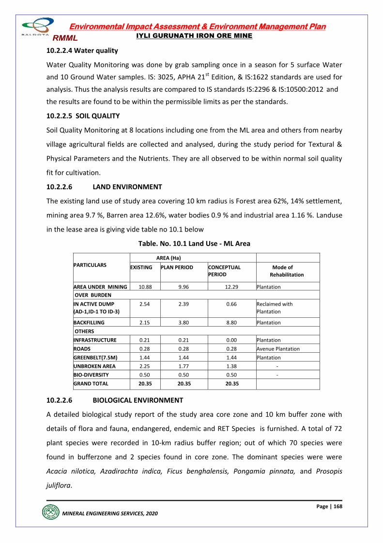
Environmental Impact Assessment & Environment Management Plan
IYLI GURUNATH IRON ORE MINE
Page | 168
MINERAL ENGINEERING SERVICES, 2020
10.2.2.4 Water quality
Water Quality Monitoring was done by grab sampling once in a season for 5 surface Water
and 10 Ground Water samples. IS: 3025, APHA 21st Edition, & IS:1622 standards are used for
analysis. Thus the analysis results are compared to IS standards IS:2296 & IS:10500:2012 and
the results are found to be within the permissible limits as per the standards.
10.2.2.5 SOIL QUALITY
Soil Quality Monitoring at 8 locations including one from the ML area and others from nearby
village agricultural fields are collected and analysed, during the study period for Textural &
Physical Parameters and the Nutrients. They are all observed to be within normal soil quality
fit for cultivation.
10.2.2.6 LAND ENVIRONMENT
The existing land use of study area covering 10 km radius is Forest area 62%, 14% settlement,
mining area 9.7 %, Barren area 12.6%, water bodies 0.9 % and industrial area 1.16 %. Landuse
in the lease area is giving vide table no 10.1 below
Table. No. 10.1 Land Use - ML Area
PARTICULARS
AREA (Ha)
EXISTING PLAN PERIOD CONCEPTUAL PERIOD
Mode of
Rehabilitation
AREA UNDER MINING 10.88 9.96 12.29 Plantation
OVER BURDEN
IN ACTIVE DUMP
(AD-1,ID-1 TO ID-3)
2.54 2.39 0.66 Reclaimed with
Plantation
BACKFILLING 2.15 3.80 8.80 Plantation
OTHERS
INFRASTRUCTURE 0.21 0.21 0.00 Plantation
ROADS 0.28 0.28 0.28 Avenue Plantation
GREENBELT(7.5M) 1.44 1.44 1.44 Plantation
UNBROKEN AREA 2.25 1.77 1.38 -
BIO-DIVERSITY 0.50 0.50 0.50 -
GRAND TOTAL 20.35 20.35 20.35
10.2.2.6 BIOLOGICAL ENVIRONMENT
A detailed biological study report of the study area core zone and 10 km buffer zone with
details of flora and fauna, endangered, endemic and RET Species is furnished. A total of 72
plant species were recorded in 10-km radius buffer region; out of which 70 species were
found in bufferzone and 2 species found in core zone. The dominant species were were
Acacia nilotica, Azadirachta indica, Ficus benghalensis, Pongamia pinnata, and Prosopis
juliflora.
Environmental Impact Assessment & Environment Management Plan
IYLI GURUNATH IRON ORE MINE
Page | 169
MINERAL ENGINEERING SERVICES, 2020
There are 15 species of mammals were recorded within the 10-km radius of which one
arboreal mammal – Squirrel, Bonnet Macaque, and Hanuman Langur and remaining were
ground dwellers. The carnivorous’ Leopard, omnivorous Mongoose and Jackal, wolf were
hinted by rural communities. The most common species sighted by us and local communities
are Indian hare, Rats, Wild boar. 18 reptile species were recorded within the buffer areas, of
which, 11 species of snakes and 7 species of lizards were recorded. 4 species of frogs were
reported within various habitats ranging from Agricultural field, scrub jungle,
Totally, 49 species of birds were recorded within habitats ranging from Agricultural field to
scrub thorny forest. About 47 species were resident locally. Out of these, 1 species were
locally migratory and 1 was vulnerable species.
10.2.2.6 SOCIO -ECONOMIC STATUS
No Rehabilitation or Resettlement is involved and it is a forest land and there are no human
settlements or PAPs within the ML area which require Rehabilitation and Resettlement. There
are 17 main villages which fall within the buffer zone with a total population of 56,465. Due to
the proposed mining activity, no significant adverse changes are visualized in the traditional
way of life of the people residing in the villages of buffer zone.
This mine shall provide employment for about 300 people by both direct employment which
include mine officials, skilled, semi skilled and unskilled labour and indirect employment, in
contractual works & transport. Preference is given to local people for employment.
During the period between 2011-12 to 2019-20 the lessee spent Rs.584.2 lakhs towards
health care, sanitation, safe drinking water, education, gender equality, empowering women,
environmental sustainbility, ecological balance, public infrastructure, support for sports ,
NGO's and animal welfare activities. The same activities shall continue and annual budget of
Rs.17 lakhs.
10.3 ANTICIPATED ENVIRONMENTAL IMPACTS AND MITIGATION MEASURES
10.3.1 GENERAL
The Iyli Gurunath Iron Ore Mine is an operating Mine and it is operated taking all
precautionary measures to reduce the impact of mining operations on Air, Water, Noise and
Soil and ensuring all control measures to comply with the prescribed standards.
The proposed production of iron ore @ 0.975MTPA within the exiting ML Area will be carried
out following the same method of mining, viz., open cast conventional type of mining, which
involves drilling and blasting.
Environmental Impact Assessment & Environment Management Plan
IYLI GURUNATH IRON ORE MINE
Page | 170
MINERAL ENGINEERING SERVICES, 2020
The precautionary and control measures which are practiced now, will be continued with
increased protective measures.
The impact of change of land use will be positive only, as portion of abandoned pit is partly
backfilled and afforested and balance portion is left as water reservoir beneficial to local
villagers.
Development of green belt along the boundary of ML Area, will ensure a better environment
compared to the one that existed at pre-mining stage.
10.3.2 AIR ENVIRONMENT
The maximum uncontrolled PM10 emission level due to proposed mining operations like
production and transport of iron ore & waste generation, predicted by using the software are
observed to be well within the limits and does not exceed 100 g/m3. The dust is not
containing harmful free silica. The sources of dust emissions are drilling, blasting, loading,
transport operations.
To minimize dust deposition, roads will be graded and maintained regularly. All the loaded
trucks will be covered with tarpaulin to avoid spillage enroute and speed limits are enforced.
Dust suppression measures are undertaken through regular water spray, wet drilling, low
density explosives with controlled blasting giving heaving effect than explosion. Iron ore is
transported from mine to buyers with high capacity dumpers which reduces the number of
trips. Wide green belts shall be developed surrounding the mining area. Regular maintenance
of equipment as per manufacturer’s specification is done to minimize the fugitive emissions.
PUC is undertaken for the transport vehicles.
10.3.3 WATER ENVIRONMENT
There is no perennial surface water source passing through the lease area or nearby. The
estimated quantum of water requirement shall be 50 m3/day, met by bore well water.
The wastes and ore generated are nontoxic, no heavy metals are present. The possible
pollutants in the water is the suspended solids which are derived from erosions within the
mining areas, dumps controlled by sedimentation.
Oil spillage from maintenance of machinery controlled by grease trap. Rainwater directly
falling over the pit area will be allowed to settle in the settling tank thereby helping in
groundwater recharge. During rainy season, the water is collected in the settling tank
provided to remove the solid suspensions in the runoff water.
Environmental Impact Assessment & Environment Management Plan
IYLI GURUNATH IRON ORE MINE
Page | 171
MINERAL ENGINEERING SERVICES, 2020
Under R & R scheme approved by ICFRE the lessee has contructed 60 numbers of Brush wood
check dams, 45 nos of Logwood check dams, 54 nos of loose boulder check dams to allow
settling of solid particles. In addition the lessee has completed 2 Nos of Gabion Check Dams
and one Stone machinery check dam and 3 nos of loose boulder check dam outside the ML
area.
10.3.4 NOISE ENVIRONMENT
Maximum noise is produced from operation of earth moving m/c’s & movement of dumpers
and operation of drilling machines. Noise levels are reduced during blasting by the use of low
density explosives with maximum charge per hole as 40 Kg to give a heaving effect than an
explosion and by adopting Controlled blasting technique, Restricting the blasting operations
to noon times, Ensuring higher stemming column than the burden, avoiding secondary
blasting with proper design of spacing & burden, Limiting the speed of trucks within the mine
boundary to 20 Kmph. By following controlled blasting technique, ground vibrations, noise
levels, fly rock ejections and air blasts are minimized. Regular maintenance of mining
equipment, machinery & all vehicles as per the manufacturers recommendations to minimize
the Noise generation and providing wide green belt surrounding ML boundary.
10.3.5 IMPACT DUE TO GROUND VIBRATION EFFECTS FROM BLASTING OPERATIONS &
CONTROL MEASURES
Possible impacts due to vibrations are on the nearest habitation located at 3200 m distance,
Blasting vibration studies have been conducted to know the ground vibration levels and air
blast. It has been found that the vibration levels even at 100m distance from blast site the
values are within permissible limits.
10.3.6 IMPACT ON BIOLOGICAL ENVIRONMENT
There are no wildlife sanctuaries and National wildlife parks within the study area. The ML
area is a forest land. Since there exists some schedule 1 fauna in this forest, a wildlife
conservation plan with budgetary provisions of Rs 5.0 lakhs per year is prepared by the lessee
to assist local forest department. In the green barrier of 7.5 m along the ML boundary, three
rows of tree saplings are to be planted within the dugout pits filled with a mixture of manure
and soil.
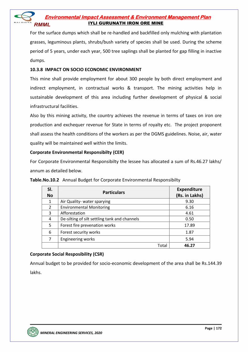
Environmental Impact Assessment & Environment Management Plan
IYLI GURUNATH IRON ORE MINE
Page | 172
MINERAL ENGINEERING SERVICES, 2020
For the surface dumps which shall be re-handled and backfilled only mulching with plantation
grasses, leguminous plants, shrubs/bush variety of species shall be used. During the scheme
period of 5 years, under each year, 500 tree saplings shall be planted for gap filling in inactive
dumps.
10.3.8 IMPACT ON SOCIO ECONOMIC ENVIRONMENT
This mine shall provide employment for about 300 people by both direct employment and
indirect employment, in contractual works & transport. The mining activities help in
sustainable development of this area including further development of physical & social
infrastructural facilities.
Also by this mining activity, the country achieves the revenue in terms of taxes on iron ore
production and exchequer revenue for State in terms of royalty etc. The project proponent
shall assess the health conditions of the workers as per the DGMS guidelines. Noise, air, water
quality will be maintained well within the limits.
Corporate Environmental Responsibilty (CER)
For Corporate Environmental Responsibilty the lessee has allocated a sum of Rs.46.27 lakhs/
annum as detailed below.
Table.No.10.2 Annual Budget for Corporate Environmental Responsibilty
Sl. No
Particulars Expenditure (Rs. in Lakhs)
1 Air Quality- water sparying 9.30
2 Environmental Monitoring 6.16
3 Afforestation 4.61
4 De-silting of silt settling tank and channels 0.50
5 Forest fire prevenation works 17.89
6 Forest security works 1.87
7 Engineering works 5.94
Total 46.27
Corporate Social Resposibility (CSR)
Annual budget to be provided for socio-economic development of the area shall be Rs.144.39
lakhs.
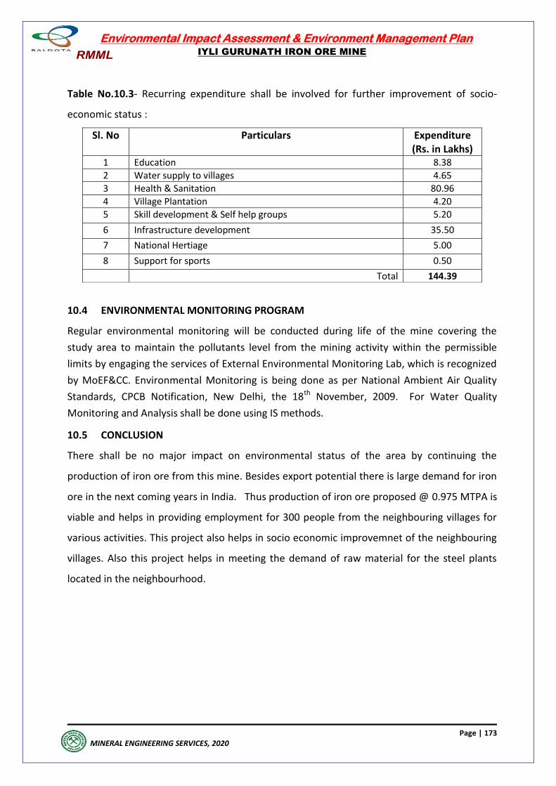
Environmental Impact Assessment & Environment Management Plan
IYLI GURUNATH IRON ORE MINE
Page | 173
MINERAL ENGINEERING SERVICES, 2020
Table No.10.3- Recurring expenditure shall be involved for further improvement of socio-
economic status :
Sl. No Particulars Expenditure (Rs. in Lakhs)
1 Education 8.38
2 Water supply to villages 4.65
3 Health & Sanitation 80.96
4 Village Plantation 4.20
5 Skill development & Self help groups 5.20
6 Infrastructure development 35.50
7 National Hertiage 5.00
8 Support for sports 0.50
Total 144.39
10.4 ENVIRONMENTAL MONITORING PROGRAM
Regular environmental monitoring will be conducted during life of the mine covering the
study area to maintain the pollutants level from the mining activity within the permissible
limits by engaging the services of External Environmental Monitoring Lab, which is recognized
by MoEF&CC. Environmental Monitoring is being done as per National Ambient Air Quality
Standards, CPCB Notification, New Delhi, the 18th November, 2009. For Water Quality
Monitoring and Analysis shall be done using IS methods.
10.5 CONCLUSION
There shall be no major impact on environmental status of the area by continuing the
production of iron ore from this mine. Besides export potential there is large demand for iron
ore in the next coming years in India. Thus production of iron ore proposed @ 0.975 MTPA is
viable and helps in providing employment for 300 people from the neighbouring villages for
various activities. This project also helps in socio economic improvemnet of the neighbouring
villages. Also this project helps in meeting the demand of raw material for the steel plants
located in the neighbourhood.
Environmental Impact Assessment & Environment Management Plan
IYLI GURUNATH IRON ORE MINE
Page | 174
MINERAL ENGINEERING SERVICES, 2020
DISCLOSURE OF
CONSULTANTS ENGAGED
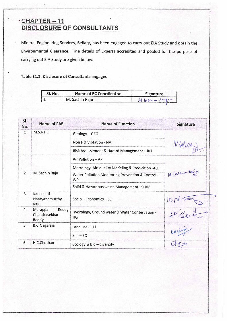
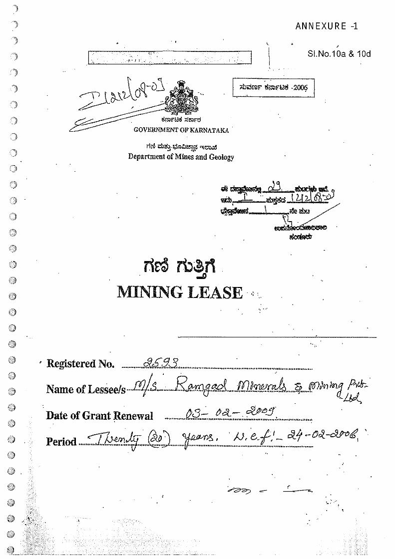
I
?iE$ tt~ii-D
* I
~ d_
MINING LEASE
Registered No. 93 ~Name of LesSeC!s..12/&......R€~fl9 ~vrw≥z4
Date of Grant Renewal
~
Period ~.a..4JC S
r
H.;:;, SI.No.lOa & lOd
4,~z~r rL3W -2006 1
GOVERNMENT OF KARNiTAICA
Department of Mines and Geology
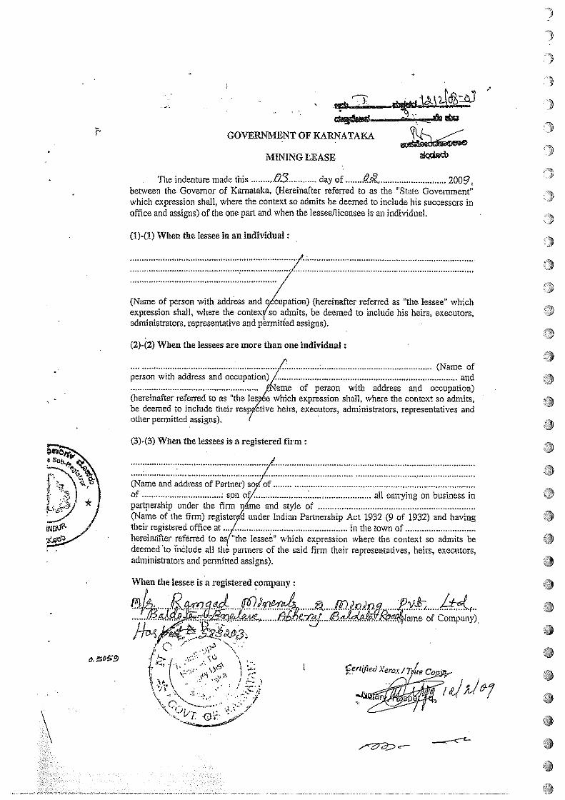
I
GOVERI’IMENT OF KARNATAKA~~,
MINING LEASE
The indenture made this 0.3 day of 2009.between the Governor of Karnataka, (Hereinafter referred to as the ‘State Government”which expression shall, where the context so admits be deemed to include his successors inoffice and assigns) of the one part and when the lessee/licensee is an individual.
(U-U) When the lessee in an individual
(Name of penon with addiess and~Zion) (hereinafter referred as “the lessee’ whichexpression shall, where the contex so admits, be deemed to include his heirs, executors,administrators, representative and permitted assigns).
(2)-(2) When the lessees are more than one individual:
I (Name ofperson with address and occupation) / and
,fName of person with address and occupation)(hereinafter referred to as “the lesØe which expression shall, where the context so admits,be deemed to include their respy&ive heirs, executors, administrators, representatives andother permitted assigns). -
~3)-(3) When the lessees is a registered firm:
(Name and address of Partner) so ofof ~ oV all carrying on business inpat-tnership under the firm r)áme and style of(Name of the firm) registerp’d under Indian Partnership Act 1932 (9 of 1932) and havingtheir registered office at .../ in the town ofhereinafter ref&red to aq”the lesse&’ which expression where the context so admits bedeemed to ihôlude all the partners of the said firm their representatives, heirs, executors,administrators and pennitted assigns).
When the lessee is a registered company:
F . -\
> L“~ .,~‘j ~ J
\ ~
Cerflj7ed Xerox I
9
9
.9a/thy
C—
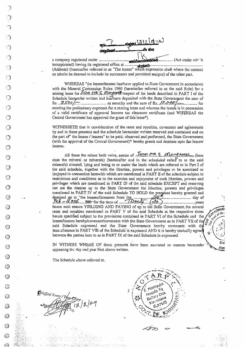
a company registered under ~ (Act under wh~ ‘hincorporated) having its registered office at .tcJ~~(Address) (hereinafter referred to as “The lessee” which expression shall where the contextso admits be deemed to include its successors and permitted assigns) of the other part.
WHEREAS “the lessee/lessees has/have applied to State Government in acco~tIancewith the Mineral Coricessiqn Rtiles 1960 (hereinafter referred to as the said Rule) for amining lease for.~Y1 9&E.JV~J6!~htspect of the lands described in PART I of theSchedule hbre nder written and hñs/have deposited with the State Governs ot the sum ofRs~ as security and the sum of Rs..JP z~. formeeting the preliminary expenses for a mining lease and whereas the lessee is in possessionof a valid certificate of approval Income tax clearance certificate (arid WHEREAS theCentral Government has approved the grant of this lease9.
WITNESSETH that in consideration of the rents and royalties. covenants and ag~eernentsby and in these presents and the schedule hereunder written reserved and contained and onthe part of” the lessee / lessees” to be paid, observed and performed, the State Government(with the approval of the Central Government~’ hereby wants and dethises upto the lessee?lessees.
All those the mines beds veins, seems of ~2~Y’~ c...n rn~*c~_,. (herestate the mineral or minerals) (hereinafter and in the scheduled refers to as the saidminerals) situated, lying and being in or under the lands which are refentd to in Part I ofthe said schedule, together with the liberties, powers and privileges to be exercised or(enjoyed in connection herewith which are mentioned in PART II of the schedule subject torestrictions and conditions as to the exercise and enjoyment of such liberties, powers andprivileges which are mentioned in PART UT of the said schedule EXCEPT and reservingout are the demise up to the State Government the liberties, powers and privilegesmentioned in PART IV of the said Schedule TO HOLD the prei~ises hereby granted anddenised up to “the lessees/licensees from the day of~ 206—for the term of ~ years
hence next ensure YIELDING AND PAYING of up to the State Government. the severalrents and royalties mentioned in PART V of the said Schedule at the respective timesherein specified subject to the provisions contained in PART VI of the Schedule and thelessee/lessees hereby/covenant/covenants with the State Government as in PART VII of thsaid Schedule expressed and the State Government hereby covenants with thlesse.zfiessees in PART VIII of the Scheduld is expressed AND it is hereby inutuaflybetween the parties here to as in PART IX of the said Schedule in expressed:
IN WITNESS WHERE OF these presents have been excetned in mannerappearing thc day and year first above written.
The Schedule above referred to.
7
oU
C)
Ur)
hereunder
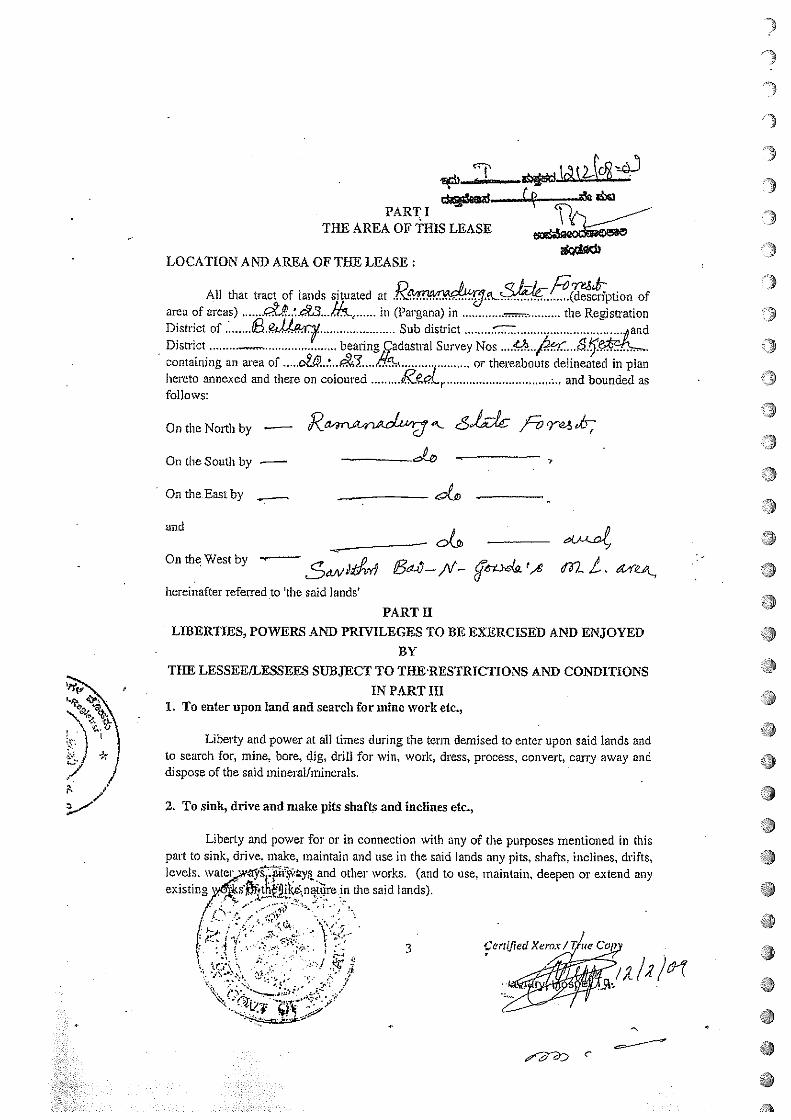
2
.3
PART ITHE AREA OF THiS LEASE
3LOCATION AN]) AREA OF THE LEASE:
Al] that tract of lands situated at .Ra~7a du~ ~~ption ofarea of areas) 42t&..’LcZ3 in (Pargana) in ~ the Regis~ationDistrict of ~.eJI44y Sub district CE andDistrict —_ beanng,çadastral Survey Nos a.~s~tA__Th.containing an area of o2~ or thereabouts delineated in planhereto annexed and there on coloured and bounded asfollows:
On the No~b by — ~- side /~On the South by —
QntheEastby
and
On the West by ~A fli I
hereinafter referred to ‘the said lands’
PART IILIBERTIES, POWERS AND PRIVILEGES TO BE EXERCISED AND ENJOYED
BYTIlE LESSEE/LESSEES SUBJECT TO THERESTRICTIONS AND CONDITIONS
IN PART III1. To enter upon land and search for minc ~vork etc.,
Liberty and power at all times during the term demised to enter upon said lands and
~,) * ) to search for, mine, bore, dig, drill for win, work, dress, process, convert, carry away andJ / dispose of the said mineral/minerals.
1’2. To sink, drive and make pits shafts and inclines etc.,
Liberty and power for or in connection with any of the purposes mentioned in thispart to sink, drive. make, maintain and use in the said lands any pits, shafts, inclines, drifts,levels, water ~7Z~~y,s and other works. (and to use, maintain, deepen or extend anyexisting,y~Øth~ik~ nat~re in the said lands)
I IG~j..r’ ~ ~t~_ /I “ ‘ — 3 (.cruJiedXeror/T ice Cop
t ~
aaa
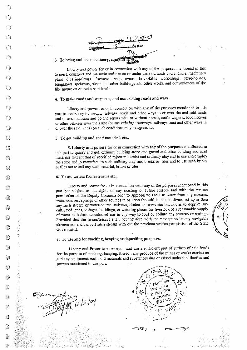
3. To bring and use machinery, equi
Liberty and power for or in connection with any of the. pmposes mentioned in thisto erect, construct and maintain and use on or under the said lands and engines, machineryplant drcssim~-t1oors, furnaces, coke ovens, brick-Icilns work-shops. store-houses,bungalows. godowns, sheds and other buildings and other works and conveniences of thelike nature on o, under said lands.
4. To make roads and ways etc., and use existing roads and ways.
Liberty and power for or in connection with any of the purposes mentioned in thispart to make any tranways, railways, roads and other ways in or over the and said landsand to use, maintain and go and repass with or without horses, cattie wagons, locomotivesor other vehicles over the same (or any existing traniways, railways road and other ways inor over the said lands) on such conditions may be agreed to.
5. To get building and road materials etc.,
5. Liberty and powers for or in connection with any of the purposes mentioned inthis part to quarry and get, ordinary building stone and gravel and other building and roadmaterials (except that of specified mjnor minerals) and ordinary clay and to use and employthe same and to manufacture such ordinary clay into bricks or tiles and to use such bricksor tiles not to sell any such material, bricks or tiles.
6. To use waters from streams etc.,
Liberty and power for or in connection with any of the purposes mentioned in thispart but subject to the rights of any existing or future lessees and with the writtenpetmission of the Deputy Commissioner to appropriate and use water from any sweams,water-courses, springs or other sources in or upon the said lands and divert, set up or damany such stream or water-course, culverts, drains or reservoirs but not as to deprive anycultivated lands, villages, buildings, or watering places for livestock of a reasonable supplyof water as before accustomed nor in any way to foul or pollute any streams or springs,Provided that the lessee/lessees shall not interfere with the navigation in any navigablestreams nor shall divert such sutam with out the previous written permission of the StateGovernment. -
7. To use and for stacking, heaping or depositing purposes.
Liberty and Power to enter upon and use a sufficient part of surface of said landsfort he purpose of stocking, heaping, thereon any produce of the mines or works carried onand any equipment, earth and materials and substances dug or raised under the liberties andpowers mentioned in this part.
I ~
4
3
C—
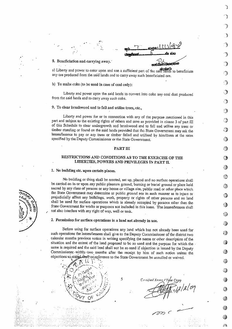
.3
•~•• ______
~ ~_L~_a &u
8. Beneficiation and carrying away.’
a) Liberty and power to enter upon and use a sufficient part of the sai~~~ 10 beneficiateany ore produced from the said lands and to carry away such bencficiated ore.
b) To make coke (to be used in case of coal only):
Liberty and power upon the said lands to convert inl.o coke any coal dust producedfrom the said lands and to carry away such coke.
9. To clear brushwood and to fell and utilise trees, etc.,
Liberty and power for or in connection with any of the purpose mentioned in thispart and subject to the existing rights of others and save as provided in clause 3 of pant Illof this Schedule to clear undergrowth and brushwood and to fell and utilise any trees ortimber standing or found on the said lands provided that the State Government may ask thelessee/lessees to pay or any trees or timber felled and utilised by him/them at the ratesspecified by the Deputy Commissioner or the State Government.
PART HI
RESTRICTIONS AND CONDITIONS AS TO TIlE EXERCISE OP TI-lBLIBERTIES, POWERS AND PRIVILEGES IN PART H.
1. No building etc. upon certain places.
4)
4)
4)
a4)
a
S
4)
.4)
4)
No building or thing shall be erected, set up, placed and no surface operations shallbe carried on in or upon any public pleasure ground, burning or burial ground or place heldsacred by any class of persons or any house or village site, public road or other place whichthe State Government may determine as public ground nor in such manner as to injure orprejudicially affect any buildings, work, property or rights of other persons and no landshall be used for surface operations which is already occupied by persons other than theState Government for works or purposes not included in this lease. The lessee/Jessees shallnot also interfere with any right of way, well or tank. -
2. Permission for ~judace operations in a land not already in use.
Before using for surface operations any land which has not already been used forsuch operations the lessee/lessees shall give to the Deputy Commissioner of the district twocalendar months previous notice in writing specifying the name or other description of thesituation and the extent of the land proposed to be so used and the purpose for which the -
same is required and the said land shall not be so used if objection is issued by the DeputyCommissioner. within~ lwo months after the receipt by him of such notice unless theobjcctions-so-st4t~~frafl--on.~ferencc to the State Government be annulled or waived,
~~ ) ~ 5 Cr’n/iedXrror/fl,p Co y
4-
:.:*.:.*:.Z.:.~.
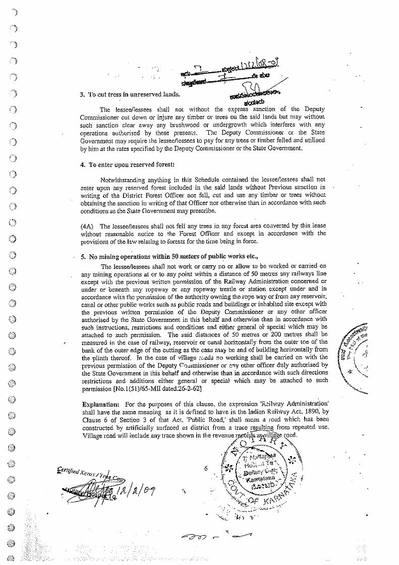
3. To cut tress in unreserved lands.a-
The lessee/lessees shall not without the express sanction of the DeputyCommissioner cut down or injure any timber or trees on the said lands but may withoutsuch sanction clear away any brushwood or undergrowth which interferes with anyoperations authorised by these presents. The Deputy Commissioner or the StateGovenimern may require the lessee/lessees to pay for any trees or timber felled and utilisedby him at the rates specified by the Deputy Commissioner or the State Government.
4. To enter upon reserved forest:
Notwithstanding anything in this Schedule contained the lessee/lessees shall notenter upon any reserved forest included in the said lands without Previous sanction inwriting of the District Forest Officer nor fell, cut and use any timber or trees withoutobtaining the sanction in writing of that Officer nor otherwise than in accordance with suchconditions as the State Government may prescribe.
~4A~ The lessee/lessees shall not fell any trees in any forest area converted by this leasewithout reasonable notice to the Forest Officer and except in accordance with theprovisions of the law relating to forests for the time being in force.
5. No mining operations within 50 meters of public works etc.,
The lessee/lessees shall not work or carry no or allow to be worked or carried onany mining operations at or to any point within a distance of 50 metres any railways lineexcept with the previous written permission of the Railway Administration concerned orunder or beneath any ropeway or any ropeway trestle or station except under and inaccordance wita the permission of the authority owning the rope way or from any reservoir,canal or other public works such as public roads and buildings or inhabited site except withthe previous written permission of the Deputy Commissioner or any other officerauthorised by the State Government in this behalf and otherwise than in accordance withsuch instructions, restrictions and conditions and either general ol- special which may beattached to such permission. The said distances of 50 metres or 200 metres shall bemeasured in the case of railway, reservoir or canal horizontally from the outer toe of thebank of the outer edge of the cutting as the case may be and of building horizontally from /~ ~‘! ~
the plinth thereof. In the case of village z~;ads no working shall be carried on with theprevious permission of the Deputy Coatrnissiorier or any other officer duly aizthorised bythe State Government in this behalf and otherwise than in accordance with such directions ‘~, -l~ \~
restrictions and additions either general or special which may be attached to suchpermission [No.1(5 1)/65-ME dated.26-2-62)
Explanation: For the purposes of this clause, the expiflsion ‘Railway Administration’shall have the same meaning as it is defined to have in the Indian Railway Act, 1890, byClause 6 of Section 3 of that Act, ‘Public Road,’ shall mean a road which has beenconstructed by artificially surfaced as district from a trace 5~lt~ng from repeated use.Village road will include any trace shown in the revenue
V /7~~~ \ e. - ‘
6 L ~cs~jr:tT~ \t~jWL I at1tf~~ \J —.
/1/1/6-7.Qf~ t<~
• -in -c -
•C
U
~ ~ ,
ad.
I
r
6. Facilities for adjoining Government licenses and leases.
The lessee/lessees shall allow existing and future holders of Government licenses orlenses over any land which is comprised in or adjoins or is reached by the land held by thelessee/lessees reasonable facilities of access thereto.
PRO V~ED THAT no substantial hindrance or interference shall be caused by such holderof licenses or leases to the operations of the lessee/lessees under these presents and thelessee/lessees shall be entitled to compensation as may be mutually agreed upon betweenthe lessee/lessees under these presents and fair compensation (as may be mutually agreedupon or in the event of disagreement as may be decided by.the State Govei-ninent) shall bemade to the lessee/lessees by reason of the exercise of this liberty.
The lessee/lessees shall not appoint / let any child labourers to work in the mines,failing which action will be initiated to cancell / deteimined the mining lease.
PART IV
LIBERTIES, POWERS AN)) PRIVILEGES RESERVED TO THE STATEGOVERNMENT
1. To work other minerals.
Liberty and power for the State Government or any lessee/licensee or personsauthorised by it in that behalf to enter into and upon the said lands and to search for, win.work, dig, get raise, dress, process, convert and carry away any minerals other than thesaid minerals and any other substances, and for the those purposes to sink, drive, make,erect, construct, maintain and use such pits, shafts inclines, drifts, levels and other lines,waterways, ainvays, water courses, drains, reservoirs, engines, machinery, plant buildings,canals, trarnways, railways and other work and conveniences as may be deemed necessaryor convenient;
Provided that in the exercise of such liberty and power no substantial hindrance orinterference shall be caused to with the liberties powers and privileges of the lessee/lesseesunder these presents and that the lessee/lessees shall be entitled to such fair compensationas may be mutually agreed upon or in the event or disagreement as may be decided by theState Government ~hall be made to the lessee/lessee fot all loss or damage sustained by thelessee/lessees by reason or in consequences, of the exercise of such liberty and power.
2. To make railways and roads.
Liberty and power to the State Government or any lessee or person authorised by itiii that behalf to enter into and upon the said lands and to make upon over or through thesame any.xall~ia~’frarnways or pipelines for any purpose other than those mentioned inPart-Jl~oi thèsë ~resents ~d to get from the said lands stones, gravel, earth and other
~ it 1..,.
7
/ /\. C’ ‘~—.——~L5:’/
€W ~/“
aa
I
I
‘I
Ce’emned Kern. 1th~/e1
C aa
materials for making, maintaining and ras ways, tramways, and roads or anyexisting railways and roads and to go and times with or without horses, cattle,or other animals carts, wagns, carriage, locomotives, or other vehicles over or along anysuch railways, trarnways, roads, lines, and other ways for all purposes and as occasionsmay require provided that in the exercise of such liberty and power by such other lessee orperson, no substantial hindrance or interference shall be caused to or with the libertiespowers and privileges withihe lessee/lessees under these presents and that faircompensation (as may be mutually agreed upon or in the event of disagreemesit as may bedecided by the State Government) shall be made to the lessee/lessees for all loss or damageby substantial hindrance or interference shall be caused to or with the exercise by suchlessee or person of such liberty and power.
PARTYRENTS AND ROYALTIES RESERVED BY THIS LEASE
1. To pay dead rent or royalty whichever is greater:
That lessee shall pay for every year except the first year of the lease dead rent asspecified in clause 2 of the part. Provided that where the holder of such mining leasebecomes liabk under section 9 of the Act, to pay royalty for any mineral removed orconsumed by him or by his agent, manager, employee, contactor sub-lease from the leasedarea, lie shall be liable to pay either such royalty or the dead rent in respect of the area,whichever is higher.
2. Rate and mode of payment of dead rent:
Subject to the provision of Clause 1 of the Part, during the subsistence of the leasethe lessee/lessees shall pay to the State Government annual dead rent for the lands demisedand descr bed in part-I of this Schedule, the rate for the time being specified in the thirdschedule to the Act in such manner, as may be, specified in this behalf by the StateGovernment.
4,
(Here insert the manner in which and the time atwatcr rate should be paid)
3. Rate and mode of Payment of royalty:
Subject to the provision of Clause I of this part, the lessee/lessees shall during thesubsistence of this lease pay to the State Govertunent at such tin~s and in such manner as
C)
U
C)a ~ ‘I..
SI.No.
2.3.
5.
which the dead rent, surface rent am
qf’/~1Afr~7
the. State Government may prescribe royalty in respect of orals removed byhim/them from the leased area at the rate for the time be~Jilied in the Second 1Schedule to the Mines and Mineral (Regulation and Development) Act. 1957.
(3-A). The lessee/lessees shall not remove any ores of minerals from the leased area exceptunder and in accordance with the conditions or a permit issued by the Dii-cctor of Minesand C3eology in Kamatul~n in payment hy the lessee/lessees of the royalty clue on the ores orminerals.
4. Paymeist ol’ surface rent. anti water rate
The lessee/lessees shall pay tent and water rate the Stale Government in respect ofall part of the surface of the said lands which shafl from time to time be oecu ied or~sedby the lessee/lessees under the anti oritv of these presc.nt at time rate of Rs. . ~6~/r—respectively per annttm per hectare of the area so occupied or used and so in proportion forany area less than a hectare during the perod from the coinmencenwnl of sttch occupationor use until the area shall cease to be so occupied or used and shall as far as possible restorethe surface land so used to its original condition. Surface rent mid witler rate shall he paid aas herein before detailed in Clause (2), PROVIDED THAT no such rent/water rate shall bepayable in respect of the occupation antI use of the area comprised in any roads or ways towhich the public have full right of access.
5. ~cal and other cessecs and taxes as prevalent in •..ee~L/~,j~District.
PART VI
PROVISIONS RELATING TO THE ItEN1’S ANt) lUfl’ALTIES
Rent and royalties to be tree from deduction etc.,
The rent water rate and royalties mentioned in P~gi V of this Selwtitile. shall be paidflee from any deductions to the State Government us .cj.ø~4k,.16%J4 md in suelttnannei as the State Government may prescribe l’RO~IDBl) ALWAYS ~nul it is hereby) agreed that Rs the balance standing to the erecli t of thelessee/lessees on account of the deposit macto by hini’tliem as a lessee/lessees over an areawhich included the said tinxls sltalt 1w retained and accepted by tlw State (lovernillent in
a satisfaction of the itmnts and royalties mentioned itt Part V utiti I the~’ reach thai :unount.IS
2. lInde of computation of royalty.
For dir puipose ol compiiutt~ the said royalties the le.sec.’hessees shall keep it acorrect account of the an ieral/minerals produced and dispatched the at c,attut as well :is theweight of the mineral/minerals iii stock or in the process of ox1 ‘nt iii.tv b~ uhecl;cd by aity(Nfictr authorised by the Ceitual or a Slate ()oventriient.
0)
‘a....:.:.: ...:::.:.: . .:.::.::~:~:. r S:.: .:::~.. ::.
Certified Xem.r /
q.
C
(Here specify the mode of anivi~s-zce/icesat pits mouth of mineral/minerals)
3, Course of action if rents and roy~U~dre not paid in time.
Should any rent, royalty or other sums due to the State Government under the termsand conditions of these presents be not paid by the lessee/lessees within the prescribedtime, the same may be recovered together with simple interest due there on at the i-ate oftwenty four percent per annum on a certificate ofluch officer as may be specified by theState Government by general or special order in the same manner as an at-rear of landrevenue.
PART Vii
THE COVENANTS OF THE LESSEE/LESSEES
1. Lessees to pay rents, royalties, Taxes, etc.
The lessee/lessees shall pay the rents and royalties reserved by this lease at suchtime and in the manner provided in PART V and VI of these presents and also may anddischarge all taxes, rates assessments and impositions whatsoever being in the nature ofpublic demands which shall from time to time be charged, assessed or imposed by theauthority of the Central andState Government upon or in respect of the premises and worksof the lessee/lessees in common with other premises and works of alike nature exceptdemands for land revenues.
2. To maintain and keep boundary marks in good order.
The lessee/lessees shall at his/their own expenses erect and at all times maintain andkeep in repair boundary marks and pillars according to the demarcation to be shown in theplan annexed to this lease/lessees. Such marks order and pillars shall be sufficiently clear ofthe shrubs and other obstructions as to allow easy identifications.
3. To commence oper4tions within a year and work in a worlwian Jike manner.
The lessee/licensee shall commence operation within a year froni the date ofexecution of the lease and shall thereafter at all times during the continuance of this lease,search for, win, work and develop the said minerals without voluntary intermission in askilful and workman like manner and prescribed under clause 12 hereihafter without doingor perinirbng to be done any unnecessary or avoidable damage to the surface of the saidlands or the drops, buildings, structures, or other property for the puiposes of this clause,operation shall include the erection of machinery laying of a tramway or construction of aroad in connection with the mine. -
4. To indemniry Government against all claims.
The lessee/lessees shall make andpay such reasonable Satisfaction & compensationas may be assessed by lawful authority in uccorchince on the subject
::t j~’:
-F.-’
- ‘fl-: ---
r
/
1~
for all damage, irijuty.th disturbance which may be done by~of thepowers granted by this lease and shall indemnify and keep in emnified fully andcompletely State Government against all claims which may be made by any person orpersons in respect of any such damage, injuiy or disturbance and all costs and expenses inconnection therewith.
5. To secure and keep in good condition pits shafts etc.,
The lessee/lessees shall during the subsistence of this lease well and sufficientlysecure and keep open with timber or other durable means all pits shafts and that may bemade or used on the said land make and maintain sufficient fences to the satisfaction of theState Government round every such pit. shaft or working whether the same is abandoned ornot & shall during the same period keep all working in the said lands, excdpt such as maybe abandoned assessable free from water and foul air as far as possible.
6. To strengthen and support the Mines to necessary extent
The lessee/lessees shall strengthen and support to the satisfaction of the Railwayadministration concerned or the State Government, as the case any be: any part of themine which in its opinion requires such strengthening or support for the safety of anyrailway, reservoirs, canal, road and any other public works or structures.
7. To allow inspection of working.
The lessee/lessees shall allow any officer authorised by the central Government drthe State Government in that behalf to enter upon the premises including any buildings,excavation or land comprised in the lease for the purpose of inspecting, examining,surveyingprospecting and making plans there of sampling and collecting any data and thBlessee/lessees shall with proper person employed buy the lessee/lessees and acquaintedwith the mines and works effectually assist such officer, agents, servants and workmen inconducting every such inspection and shall afford them all facilities, information connectedwith the working of the mines which they may reasonably require and also shall and willconform to and observe all orders and regulations which the Central or State Governmentsas the result of such inspection of otherwise may from time to time deem fit to impose.
S. To report accidents.
The lessee/lessees shall without delay send to the Deputy Commissioner/Director ofMines and Geology a report of any accident causing death or serious bodily injury orserious injury to property or.seriously affection or endangering life or prdperty which mayoccur in the course of the operation under this lease.
9. To report discovery of’ otlici- minerals.
The le~see/l-t~sees. shall report to the State Government. the discovery in the leasedarea of~in the lease within sixty days of such discovery alongwith full and position of each such find. If any mineral not
)
9
9
I
.9
I
9
I
V
II
c
0
0
U
UC)
specified ifl We lease is discover& ‘a the lessee/lessees shall not win and.dispose of such mineral unless such md~ncluded in the lease or a separate lease isobtained therefore.
JO. To ICeep records and account regarchng productioit and employees dc:
The lessee/lessees shall at all times during the said term keep or cause to he kept atan ollice to he siluided araB or near he said lands correct and intelligible books ofaccounts which shall contai ii accurate cadres showing from time to time.
(1) QuantitY antI quality of the said mineru!/ minerals realised from the said lands;
(2) Quantity oh the various qualities of the ores heneficiated or converted. (for examplecoal converted into coke)
(3) Quatittties of tho various qualities of the said mineral/minerals sold and exportedseparate1 V.
(4) Qttatttitie~: ol’ tIle ‘ariouS ClutLIllies of the said mineral/,minerals otherwise disposedot an the it uniter anal purpose of such disposaL
(5) The prices and all cider particulars of all sates of the said aiineralfrninerals.
(6) The number of persons employed in the mines of works or upon the said landsspeci Mug nationality, qualifications and pay of the rechnical personnel.
(7) Such nthcr feds, particulars and circumstances as the Central or the State(Joverninents may from time to time required and shall also furnish flee of chargeto such officers and at such times as the ceniral and State Governments mayappoints, true dud correct abstracts of all or any such books of accounts and suchinformut~on and returns to all or any of the matters aforesaid as the StateGovermnents may prescribed and shall at all reasonable tikes allow such officers asthe Centnd Government of State Government shall in that behalf appoint~ to enterinto attn have access to the said officers for the purposes of examining andinspecting he said books of aceouuts. plans and records and to make copies thereofandmake extracts there from.
4t1;
ii. ‘ro ma iii taut plaits etc., . V~?s ,t’~/ ;~
The lessee/lessees shall at all times during the said term maintain at the mtne.offie (correct. intelligible. up to-date complete plans sections of the mines in the said lands. The * ~shall show all the operations workings. and all the trenches, pits and drillings made by th ~him/theta in the coui~e of operations carried on by him/theni under the lease, faults and\other disturbances encountered and geological data and all such plans and sections shall heamended an filled up by and from actual surveys to be made~ ~ttrpo5eS at the end of
/t/~
~-
•1
twelve months or nay period specified &0n time to time and the~inrnishfr~ of charge to the Central and State Governments true and correct ~ø~)f such plansand section whenever required. Accurate records of all trenches pits and drillings shallshow: -
(a) The sub—soil and strata through which they pass(h) Any minerals encountered.
(c) Any other matter of interest and all data required by the Central and StateGovernment From time to time.
The lessee/lessees shall allow any Officer of the Central or the Stale Governmentsauthorised in this behalf by the Central Government, to. inspect the same at all reasonabletimes, He/they shall also stipply when asked for by the State Governrnentf the CoalControllerl the Director/General Geological Survey of India/the Corftrollcr Indiun l3tireauof Mines, a composite plan of the area showing thickness dip, inclination. etc. of all theseams as also the quantity of reserves quality wise.
I IA. The lessee shall pay a wage not less than the minimum wage prescribed by theCentral or State Government from time to time.
1IB. The lessee shall comply with provisions of the Mines Act. 1952 and rules made
tiC. The lessee shall lake measures for the protection of environment like planthtg oftrees. reclamation of land. use of pollution control devices; and such othermeasures as may be prescribed by the Central or state Government from time totime at his own expenses.
I ID. The lessees shall pay compensation to the occupier of the and on the date andin the manner laid down in these rules.
I IE. The lessee shall in the matter of employment give preference to the tribals andto the persons who become displaced because of the taking up of miningoperations.
12. Act 67 of 1957:
The lessee/lessees shall be bound by such rules may be issued from time to time bythe Government of India under Section 18 of the Mines and Minerals (Regulations andDevelopment) Act, 1957 (Act 67 of 1957) aad shall not carry on mining or other operatiohunder the said lease in any way other than as prescribed under these rules.
the-under.)
)
)
!i~)
4,
4,4,
I
*
/q
~%~t:r Q~
13 t~~ñfied Xem.v /
C-
lAith!
13. To provide weighing macMire:
- - Unless specifically exempted by the State Coy lessee/lessees shall
provide and at all time keep at or near fe pit head or each of the pit heads at- which the saidminerals shall be brought to bank a properly constructed and efficient weighing machineand shall weigh or cause to be weighed thereon all the said minerals from time to timebrought to bank sold exported and converted and also the converted products shall at theclose of each day cause the total weights. ascertained by such means of the said minerals,ores products raised1 sold, exported and converted during the previous twenty-four hours tobe entered in the aforesaid books of accounts, The lessee/lessees shall permit the StateGovernment at all times during the said term to employ mid persons or persons to bepresent at the weighing of the said minerals as aforesaid and to keep accounts thereof andto check the accounts kept by the lessee/lessees. The lessee/lessees shall give fifteen daysprevious notice in writing to the Director of Mines and Geology of every such measuring orweighing in order that he or some officer in his behalf may be present thereat.
14. To allow test of weighing machine:
The lessee/lessees/shall allow’ any person or persons appointed in that behalf by theState Government at any time or times during the said term to examine and test everyweighting machine to be provided and kept as afore-said and the weights used there with inorder to ascertain whether the same respectively are correct and in-good repair and order ifupon any such examination or testing any such weighting machine of weights shall befound incorrect or out of repair or order the State Government may require that the samebe adjusted, repaired and put in order by and at the expenses of the lessee/lessees and ifsuch requisition be not complied with within fourteen days after the same shall have beenmade, the State Government may cause such weighing machLne or weights to be adjusted,repair and put in order and the expense of so doing shall be paid by the lessee/lessees to theState Government on demand and if upon any such examination or testing as aforesaid anyerror shall be discovered in any weighing machine or weights to the prejudice of the StateGovernment such error shall be regarded as having existed for three calendar monthsprevious to the discovery thereof or from the last occasion of so examining and testing thesame weighing machine and weights in c.n~ze such occasion shall be within such period ofthree mouths and the said rent and :—~yalty shall be paid anti accounted for accordingly.
15. To pay compensation for injury to third parties:
The lessee/ lessees shall make any pay reasonable satisfaction and compensation forall damage. injury or disturbance of person or property Whit ~~bLjlr%ne by or on these
/ -.‘-‘, -
A’~
~~;: c~.a
7
F
4;
c_
)
)part of the lessee/lessees in exercise of the liberties and power~ shallat all times have harmless and keep indemnified the State Governme,~~~&nd against allsuits, claims and demands which may be brought made by any person in respect of anysuch damage, injury or disturbance.
16. Not to obstruct working of other minerals.
The lessee/lessees will exercise the liberties and powers hereby granted in such amatter as to offer no unnecessary or reasonable avoidable obstitictions or interruption to thedevelopment and working within the said lands of any minerals not included in this leaseand shall at all times afford to the Central and State Government and to the holders ofprospecting licenceor mining leases in respect of any such minerals or any such mineralswithin any land adjacent to the said lands as the case may be reasonable means of accessand safe and convenient passage upon and across the said lands to such minerals for thepurpose of getting working, developing and carrYing away the same provided that thelessee/lessees shall receive reasonable compensation for any damage or injury whichhe/they may sustain by reason or in consequence of the use of such passage by suchlessee/lessees or holders of prospecting licences.
17. Transfers of lease:
I. The lessee/lessees shall not, without the previous consent in writing of the StateGovernment, which in the case of a mining lease in respect of any mineral specified in thefirst Schedule to the Act shall not be given except after previous approval of the CentralGovernment:
a) assign, subject, mortgage or in any other manner, transfer the mining lease orany right, title or interest therein or
b) enter into or make any arrangement, contract or understanding whereby thelessee/lessees will or may be directly or indirectJy financed to a substantialextent by or under which the lessees operations or undertakings will or may besubstantially controlled by any person or body of persons other than thelessee/lessees -
ProvQded that the State Government ihall not give its written consent unless:
a) the lessee has furnished an affidavit along with his application for transfer ofthe mining lease speci~iñg therein the amount that he has already taken or
proposes to take as consideration from the transferee.
b) the transfer of the mining lease is to b& made to a person 01- body directly
undet~k~iatio~s
• ~~,\~N\”’.\- •--1~-~. ‘ ..tO1 N ~
• iç~e )_fl5 ~ifi~x~xfl/~or
‘7
(2) Without prejudice to the above p~~~f1essees may subject to thecondition specified in the proviso to Rule 35 of ~es, transfer this lease or any right,title or interest therein, to a person who has filed and affidavit stating that he has filed uptodate income tax returns, paid income tax assessed in him and paid the income tax on thebasis bf self assessment as provided in the Income tax Act 1961 (43 of 1961) on paymentof live hundred rupees to the State Governmeffl. -
Provided that the lessee/lessees shall make available to the transferee the original orcertified copies of all plans of abandoned workings in the area and in a belt meters widesurrounding it.
Provide further that where the Mortgage is an institution or a Bank or a Corporationspecified in Schedule V it shall not be necessary for any such institution Bank ofCorporation to meet with the requirement relating income tax.
(3) The State Government may by order in writing. determine the least at any timeif the lessee/lessees has/have in the opinion of the State Government committed a reach ofany of the above provisions or has/have transferred the lease or any right. litle or interesttherein otherwise than in accordance with clause(2):
Provided that ito such order shall be made without giving the lessee/lessees areasonable Opportunity stating his/their case.
Th. Not to be financed or controlled by a Trust, Corporation Firm or person.
The lease shall not be controlled and the lessee/lessees shall not allow themselves tobe controlled by any Trust, Syndicate, Corporation. Firm or person except with the writtenconsent of the Central Government. The lessee/lessees shall not enter into or make anyarrangement compact or understanding whereby the lessee/lessees will or may he directlyor indirectly financed by or under wInch the lessee/lessees operations or undertaking~ viillor may be untried on directly or indirectly by or for the benefit of or subject to the controlof any Trusi, Syndicate, Corporation. Finn of person unless with the written sanction giver~~_~.prior to such arrangement compact or understanding being entered into or made ofCentral Government and any or every such arrangement compact or understamling as~afort-said entered into or made with such sanction as aforesaid) shall only be entered intotor.made a~d shall always b sub~eci to an express vondiuon binding upon the other party ofparties thereto that on the occasion of state: of emergency of which the President if India in.his discretiou shall be the solo judge it shall he terminable if so required itt ~vriting, by the—State Government and shall in the event ol any such rcqttisition being made be forthwiththereafter determined by the lessee/lessees accordingly.
flay
19. Lessee shall deposit any additional~
Whenever the security deposit of Rs.lO,000/- or any part t~ere~~~ further sumhereafter deposited with the State Government in replenishment thereof shall be forfeitedor applied by the Central or State Government pursuant to the power hereinafter declared inthat behalf the lessee/lessees shall deposit with the State Government such further sum asmay be sufficient with the unappropriated pan hereof to bring the amount in deposit withthe State Government tip to the sum of Rs. 10.000/.
20. Delivery of working in good order to State Government after determination oflease.
The lessee/lessees shall at the expiration or sooner determination of the said terra oras renewal thereof deliver up to the State Government all mines, pits shafts inclines driftslevels, waterways, airways, and other works now existing or hereafter to be sunk or madeon or under the said lands except such as have been abandoned with the sanction of theGovernment and in an ordinary and fair course of working all engines machines plant,buildings. structures, other works and convenience which at the commencement of the saidterm were upon or under the said lands and all such machinery set up by the lessee/lesseesbelow ground which cannot be removed without causing inju;y to the mines or worksunder the said lands (except such of [he same as may with the sanction of the StateGovernment have become discussed) and all buildings and structures of bricks or stoneerected by the lessee/lessees above ground level in good repair order and condition and fitin all respects for further working of the said mines and the said minerals,
21. Right of pre-emption
a) The State Government shall from time to time and all times during the saidterm have the right (to be exercised by notice in writing to thelessee/lessees) of pre-emption of the said minerals (and afl products thereof)lying in 01’ upon the said lands hereby demised or elsewhere under thecontrol of the lessee/lessees and the lessee/lessees shall with all possibleexpedition deliver all mineral or products or minerals purchased by the StateGovernment under the power conferred by this provision in the quantities atthe times in the manner and at the place specified in the notice exercisingthe said right.
b) Should the i’ight of pre-emption confen’ed by this present provision beexercised and a vessel chartered to carry the minerals or products thereofprocured on behalf of the State Government or the Cemi’al Government bedetained on demurrnge at the port of loading the lessee/lessees shall pay theamount due to causes beyond the control of the lessee/lessees.
/~%~.“-‘-‘~. ~c’~’7o/ •‘:~c~’Th~çk
‘7
C-
4,
4,
.9
.9
4,
4,
.4,
lb4,
C L J~j3~/
c) The pnce to be paid for all minerals or rod~~nerals ~ken in pm-• einption by the State Government exe~j~~ t ~e rights hereby conferred
shall be the fair market price prevaTfl~iat the time of pre-emptionPROVIDED THAT in order to assist in arriving at the said fair market pricethe lessee/lessees shall if so required furnish to the State Government for theconfidential information of the Government particulars of the quantities,descriptions and prices of the said minerals of products thereof sold to othercustomers and of charters entered into for freight carriage of the same andshall produce to such officer or officers as maybe directed by the StateGovernment original or authenticated copies of contracts and chanterparties entered into for the sale of freightage of such minerals of products.
d) in the event of the existence of a state or war of emergency (of whichexistence of President of India shall be the sole judge anda.nodficadon tothis effect in the Gazette of India shall be conclusive proof) the StateGovernment with the consent of the Central Government shall from time totime and all times Suring the said term have the right (to be exercised by anotice in writing to the lesseeliessees) forthwith ~ake possession and controlof the works, plant, machinery and premises of the lessee/lessees on or inconnection with the said lands or operations under this lease and during suchpossession or control the lessee/lessees shall conform to and obey alldirection given by or on behalf of the Central Government or StateGovernment regarding to use of employment of such works, pIax~ts,premises and minerals. PROVIDED THAT fair compensation which shallbe determined in default of agreement by the State Government shall bepaid to the lessee/lessees for all loss or damage sustained by hint/them byreason or in consequence of the exercise of the powers conferred by thisclause and PROVIDED ALSO that the exercise of such powers shall not
determine the said term hereby granted or effect the terms and provisions ofthese presents -further that may be necessary -to give effect to the provisionsof this clause.
22. Employment of Foreign National
The lessee/lessees shall not employ, in connection with the mining operations anyperson who is not an Indian national except with the previous approval of CentralGovernnmera
is -.
23. Recovery of expenses incurred by the State Governntent
If any of the works dr matters which in accordance with the covenants in that behalfhereinbefore contained are to be carried or performed by the lessee/lessees be not so carriedout or performed within the time specified in that behalf, the State Government. may causethe same to be carried out or perfonned and the lessee/lessees shall pay the StateGovernment on demand all expenses which shall be incurrcd iii such carrying out orperformance of the same and the decision of the State Government as to such expensesshall be final.
24. Furnishing of Geophysical data
The lessee/lessees shall furnish-(a) all geophysical ~ata relating to mining fields orengineering and ground water surveys, such as anomaly maps, sections, plans, structures,contour maps, Jogging, collected by him/ them dating the course or mining operations tothe Dirthtor General, Geological Survey of India, Calcutta.
(b) all information pertaining to investigations of radio active minerals coUected byhim/them during the course of mining operations to the Secretary, Department of AtomicEnergy, New Delhi.
Data or information referred to above shall be furnished every year reckoned fromthe date of commencement of the period of the mining lease.
PART VIII
The Covenants of the State Government
1. Lessee/Lessees may hold and enjoy rights quietly
The lessee/lessees paying the rents, water rate and royalties here by reserve andobserving and performing all the covenants and agreements herein contained and on thepart of the lessee/lessces to be observed and performed shall and may quietly hold andenjoy the rights and premises hereby demised for and during the term hereby grantedwithout any unlawful interruption from the State Government, or any person rightfullyclaiming underit.
2. Acquisition of lands of third parties and compensation thereof
If in accordance with the provision of Clause 4 of Part VII of this Schedule thelessee/lessees shall offer to pay to an occupier of the surface of any part of the said landscompensation for and damage or injury which may arise from the proposed operations, ofthe lessee/lesseesj&*ke.~said occupier shall refuse his consent to be exercise of the rightand powers~t~ ~ta~e Government and demised to the lessee/lessees by thesepresent~ t1~ ~ ee/lq~e~ ‘sh~il report the matter to the State Government and shall
“t~Q / ~ .I ~ \~:
) ~) I c;~rtped4,’ .,~ i - ~~~/JI’)V~-fl4 /
-\: . ~~ccq.1
4,
~:. I
,
deposits with it the amount offered as c us ii’ the Central/State Governmentare satisfied that the amount of compensation s fair and reasonable or if it is not sosatisfied and the lessee/lessees shall have deposited with it such further amount as the Stateand central Governments shall consider fair and reasonable, the State Government shallorder the occupier to allow the lessee/lessees to enter the land and to carry otit suchoperations as nitty he necessary for the purpose of this lease. In assassin the amount of suchcompensation the State Government shall be guided by the principles of the LandAcquisition Act.
3. To renew
The mining lease is renewable in tenns of the Provisions of the Act and the rulesmade there under.
Provided that the State Government thay for reasons to be recorded in writingreduce the area applied for.
If the lease is in respect of minerals specified in the First Schedule to the Act,renewal will be subject to the prior approval of the Central Government.
If the lessee/lessees be desirous of taking a renewal lease of the premises herebydemised or of any part or parts of them for a further term from the expiration of the termhereby granted and is otherwise eligible. he/ they shall prior to the expiration of the lastmentioned term give to the State Government 12 calendar months previous notice inwriting and shall pay the rents, rates qnd royalties hereby reserved and shall observe andperform the several covenants and agreements herein contained and on the part of thelessee/lessees to be observed and performed up to the expiration of the term herebygranted. The State Government on receipt of application for renewal, shall consider it inaccordance with the provisions of the Act and the rules made thereunder and shall passorders as it deems fit. If renewal is granted the State Government will at the expense of thelessee/lessees and upon his executing and delivering to the State Government if required acounter part thereof execute and deliver to the lessee/~pssees a renewed lease of the saidpremises or part thereof for the further lenn of~ years at such rents, rates, ~and i’oyalties and on such terms and subject to such rents, rates and royalties and on such ~terms and subject to such covenants and agreements, including this present covenant to ¶~renew as shall be accordance with the Mineral Concession Rules, 1960, applicable to *
(Name of Mineral on the day next following theExpiration of the terms tereby granted).
4. Liberty to determine the lease:
The lessee/lessees may at any time determine this lease by giving not less than 12calendar moitlis notice in writing to the State Government or to such officer, or authorityas the Stan’ Government may specify in this behalf and upon the expiration of such noticeprovided that the lessee/lessees shall upon such expiration render and pay all rents, waterrates, royalties compensation for damages and other moi~y~’whjch may then be due and
C
rp .t~(9C)CC4’1.?b.
~ ~ ~~rr
payable under these presents to the lessor or any other person~deliverup these presents to the State Government the lease and the said te~~~the liberties,powers and privileges hereby granted shall absolutely cease and determine but withoutprejudice to any rght or remedy of the lessor in respect of any breach of any of thecovenants of agreements contained in these presents.
a, The State Government may on an application made by the lessee permit him tosurrender one or more minerals from his lease which is for a group of mineralson the ground that deposits of that mineral have since exhausted or depleted tosuch an extent that it is no longer possible to work the. mineral economically,subjcct to the condition that the lessee-
1. Obstructions to Inspection
h. Makes an application for such suñender of mineral at least six months beforethe intended date of surrender; and
a. Gives an undertaking that he will not cause any hindrance in the working of themineral so surrendered by any other person who is subsequently granted amining lease for that mineral.
5. Refund of security deposit
On such date as the State Government may elect within twelve calendar monthsafter the determination 9f this lease or of any renewal thereof, the amount of the securitydeposit paid in respect of this lease and then remaining in deposit with the StateGovernthent and not required to be applied to any of the purposes mentioned in this leaseshall be refunded to the lessee/lessees. No interest shall run on the security deposit.
PART IX
General Provisions
In case the lessee/lessees or his/their transferee/assignee does/do not allow entry orinspection by the Officers authorised by the Central or State Government under clauses (i),U) or (1) of sub-rule (I) rule 27 of said Rules, the Slate Government shall give notice in.writing to the lessee/lessees requiring himJthem to show cause within such time as may bespecified in the notice why the lease should not be determined’and his/their security depositforfeited; and if the lessee/lessees fails/fail to show cause within the aforesaid time to thesatisfaction of the State Government. the State Government may determine the lease andforfeit the whole or putt of the security deposit
2. Penalty En ease of default in payment of royalty and hreaeh covenants
If the lessee/lessees or his/their transferee or assignee makes/make any default inpayment of rent o~,yst~1~ ~r oyalty as iequntd b~ Section 9 of the AGt of rent oi
‘7~2l
~-fl) e
9
9
9
I
9a
ZT ~ I U
ti.
commits a breach of any of the conditions and covenants other than thosecovenant (1) above, the State Government shalt give nodce to the lessee/lesseeshim/them to pay the rent water rate, royalty or remedy the breach, as the case may be,within sixty days from the date of receipt of the notice and if the rent, water and royalty arenot paid or the breach is not remedied within such period, the State Government maywithout prejudice to any proceedings that may be taken against him/them, determine thelease and forfeit the whole or part of the security deposit.
3. Penalty for repeated breaches of covenants
In cases of repeated breaches of covenants and agreements by the lessee)lessees forwhich notice has been given by the State Government in accordance with clauses (I) and(2) aforementioned on earlier occasion, the State Government without giving any furthernotice may impose such penalty not exceeding twice the amount of annual dead rentspecified in Clause 2, Part V.
4. Failure to fulfill the terms of leases due to “Force Majeure”
Failure on the part of the lessee/lessees to fulfill any of the terms and conditions of[his lease shall not give the Central or State Government any claim against thelessee/lessees or be deemed a breach of this lease, In so far as such failure is considered bythe said Government to arise from force majeure, and if through force majeitre thefulfillment by the lessee/lessees of any of the terms and conditions of this lease be delayed,the periods and such delay shall be added to the period fixed by this lease. In this clause theexpression “Force Majeure” means Act of God, war, insurrection, riot, civil commotion,strike, tide, storm, tidal wave flood, lightning, explosion, tire, earthquake and anyotherhappening wnich the lessee/lessees could not reasonably prevent of control.
5. Lessee/Lessees to remove his/their properties on the expiry of lease:
The lessee/lessees having first paid and discharged rents, rates and royalties payableby virtue of these Presents may at the expiration or sooner determination of the said term orwithin six calendar months thereafter (unless the lease shall be determined under clauses I ~ ~ /and 2 of this Part and in this case at any time mit less than three calendar months not morethan six calendar months after such determination) take down and remove for his/their own ~ *benefit or any engines, machinery plant he~tdings, structures, ft-anmways, railway and,otherworks, erections and conveniences wlüch may have been erected/set up or placed by thelessee/lessees in or upon the said lands and which the lessee/lessees is/are not bound todeliver to the State Government under clause 20 of Part VII of this Schedule and which theState Government slial I not desire to purchase.
6. Forfeiture of property left more than six months after determination of lease
If at the end of six calendar months after the expiration or sooner determination ofthe said tenn under the provision contained in clause:~ ~f this Schedulebecome effective there shall remain in or upon the- si mary plant.
C-
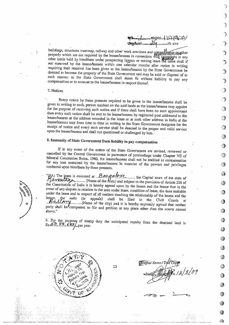
buildings, structures tramway, railway and other work elections and~properly which are not required by the lessee/lessees in connection win oEe~~~ns in anyother lands held by hinilthem under prospecting ]i~nce or mining lease The same shall ifnot removed by the lessee/lessees within one calendar months after no ice in writingrequiring their removal has been given to the lessee/lessees by the State Government bedeemed to become the property of the State Government and may be sold or disposal of insuch manner as the State GoVernment shall deem fit without liability to pay anycompensation or to account to the lessee/lessees in respect thereof.
7. Notices
Every notice by these presents required to be given to the lessee/lessees shall begiven in writing to such, person resident on the said lands as the lessee/lessees may appointfor the purpose of receiving such notice and if there shall have been no such appointmentthen every such notico shall be sent to be lessee/lessees by registered post addressed to thelessee/lessees at the address recorded in the lease or at such other address in India at thelessee/lessees may from time to time in writing to the State Government designate for thereceipt of notice and ever~ such seryice shall be deemed to the proper and valid serviceupon the lessee/lessees and shall not questioned or challenged by him.
8. Immunity of State Government from liability to pay compensation
If in any event of the orders of the State Government are revised,, reviewed orcancelled by the Central Government in pursuance of proceedings under Chapter VII ofMineral Concession Rules, 1960, the lessee/lessees shall not be entitled to compensationfor any loss sustained by the lessee/lessees In exercise of the powers and privilegesconfentd upon him/them by these presents.
H~) The vase is executed at ..B.a~ ~ Capital town of the state of
(Name of the Mate) and subject to the provision of Article 226 ofthe Constitution of India it is hereby agreed upon by the lessee and the lessor that in theevent of any dispute in relation to the area under lease, condition of lease, the dues realiableunder the lease and in respect of all matters touching the relationship of the less~e and theles or, ~c suits (or appeals) shall be filed in the Civil Courts at a
(Name of the city) and it is hereby expressly agreed that neitherparty shall be competent to file and petition at any place other than the courts namedabove.
9. For the purpos of stamp duty the anticipated royalty from the demised land is~year. - a
I
23
C’
*•*• ::. •. aa
~Tflfl~cIXeroxt
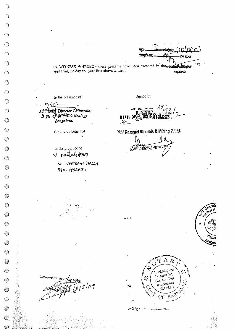
CN
-~~--cL(’ t~Qt~-~
LN WITNESS WHEREOF these presents have been executed~appearing the day and yem st above written.
In the presence of
Aitreefor (Minerals)~.pri 0~M?GdIY& Geology
for and on behalf of
In the presence of
\J .N$Lk49i~
‘1 . *LLfl
Rio- 1-tosPET
/0-7
* C *
24
Signed by
WY.
~~~aihgid MinerMs & Mihing P. Ltd~
Le, flied Xeror /
c
Wi~~a~a_&ØcI~
1957drs~~tao~ ~tototh€e)o l0~e~a3~e)obC,
Designed and Developed by C- DAC ACTS Puns.
7/13,1
Department of Stamps arid Registration
~E3Thc~,
!s~ n~d~ eo~ thJ~on~ 4M~d~ èje eiz~o.d~ e~tdR ~4€~b11 6b500.00 ~rW~ ~it~ thw~,o~ ~c~ñ ~d~•~
06/02/2039
çE’B l%~tit3~
a
a
~2
lb
Lba
I~DlWII~flhI
Print Date & true: 06-02-20G9 04:58:14 PM
d~~eto~a4:1212
&~d ~&bo3,e b~o~ C&0Z-2009 &th 04:07:46 PMT~o8,~~&e’~dJDOM
r~N ~fl~~—$
f
I
~: da 4,• 1 ~eod[t te~ 153370D3
2 t~j3on4ir 810D0
S 20500
4 a~d 5500
5 r~&~ 100W
t~3~: 15~515.00
~; ~cct~d~ eo8 ~th~h ~ &~o~% e1P4Z~zsd
~4~o~o88@ ~ad ~auornt~~~i4vz,r6
cl’ ~O.a ~a?~)Th~E ~rSre~tth, ñr~ i&Tt ?ja ~ ,a.j~5~
I.
*b
—r-~2c
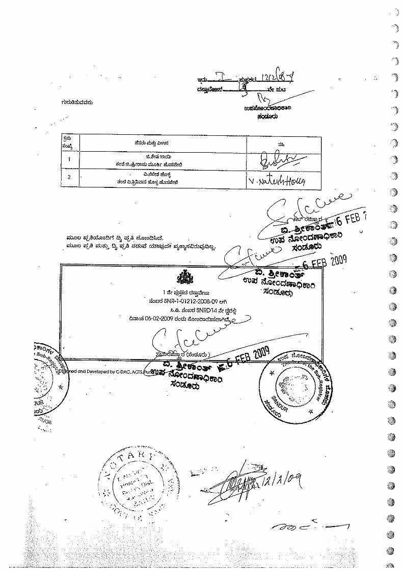
~~J -
e~t’sxZt~~)J)8E ~it~&~S
1)
2&a~%~E~
)
•1
.7 :‘ — I/ -
—I~_\ —
~ .‘~‘4 \ C; \.~-\c’ ,i~i ,-i
\. ‘L~ ~‘
Afl•I •y~
—~ C —~
II
flL. ~
i~n’ o5j~o~r~ ~ath2e) e~ifi S3t thS3d oboz
1 ~Se ~dyi~’d d~bs~ozd SNR-1-01212-2005-Q9 &~
~ ~oa~d$NI?D14 k
05-02-2009 doth ~
and Dovelopod by C.OAC.
I
I
a
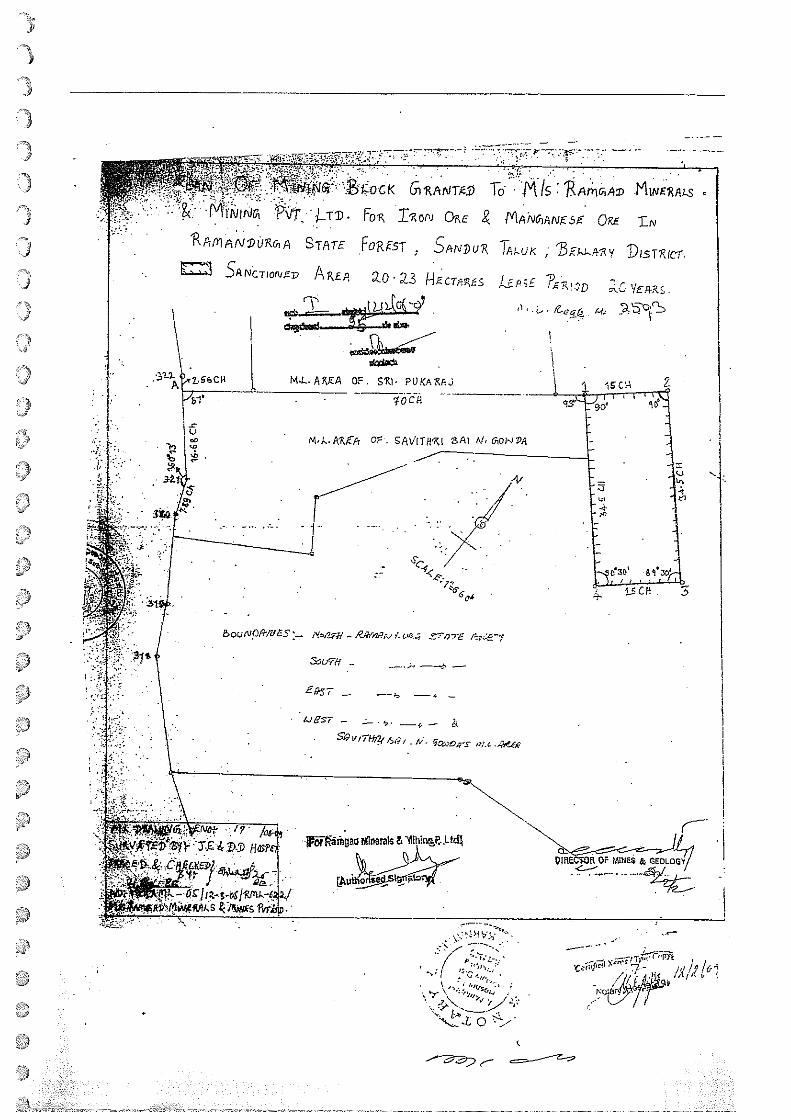
~.~~7J/ L2/i/~1—
o
I:’
~pii~~I~~
ar~‘-iv‘fl~
?~
—t——————
-
L.3’%r~Le~C.at’~,n-
709
2rnv)~nd‘t~Sdovflv•—rw
-~
E cc—:z‘~
H395tA4\
JJ)~i~Lc,~!)401VI
~sdTfSY~’L~fr]~Z0tb’flva~~17~S
N]p-a~Q1c~nJwoAIw~~~O~‘°~I~°dJ--1.:~Lc4
CV~UJtt~f~~/t4~JcVY1NV’~LtXJ)19O~~9N4N%4---
As!~-~--,cr1S———~~-44__~.~__.L
~o-gfl~N~WV
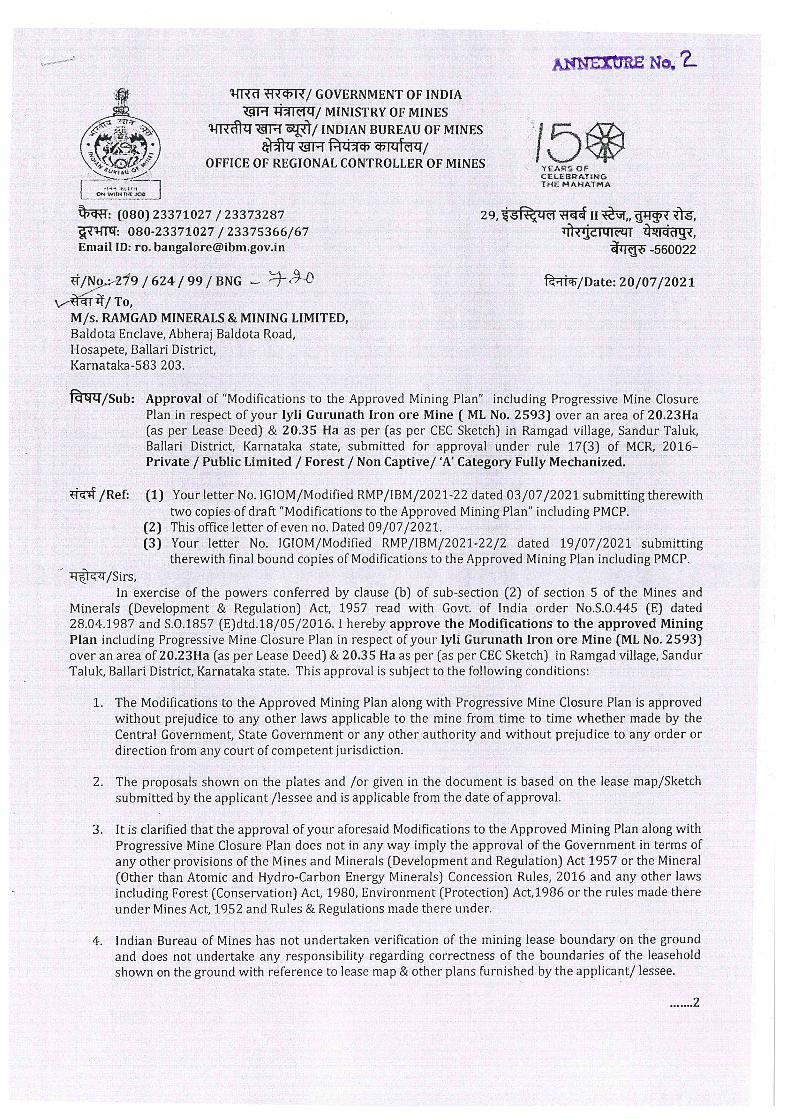
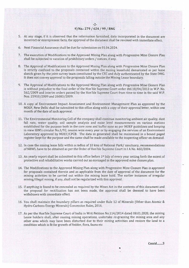
/ Fax 080-25586321 __________ 25581383. 25589112a~e& / E-mail ho~kspcb.gov.in
I Website : http:I/kspcb.gov.in
~wX~ ~o c’ NKarnataka State Pollution Control Board
“zoxsogt~”, loot 5de ~z~fl*, ~So.49, t4tVr2~fbV, doñ4.ad - 560 001, d~wea~, ttd~
“Parisara Bhavana”, 1st to 5th Floor, #49, Church Street, Bengaluru -560001, Karnataka, INDIAI/BY REGD. POST WITH ACK. DUE/I
30 t~thR2O19No. PCB/1 791M1N1CF0120 18,1 DATED:
ADD~’NDUM.
Sub: Extension of validity of the Consent for Operation (CFO) under the Water(Prevention & Control of Pollution) Act, 1974, and the Air (Prevention & Controlof Pollution) Act, 1981, to carryouE iron oremining of capacity 0.50 MMTPA atML No. 2593, Ramgad Village, Sandur Tàluk, Béllary fli~ië~by MIs. lyli
• Gurunath Iron Ore Mines of MIs. Ramgad Minerals & Mining Limited. - reg.
R~fr1rThirc~ffi~~onsent for Operation (CFO) Order No. AW-305984, dated:04.07.2017.
2. CEC concurrence letter No. 2-75ICECISC/2018Pt.V dated 05.03.2018.3. Indusrty request letter dtd: 06.03.2018.
• 4. Proceedings of Consent Committee Meeting held on 06.04.2018.5. Addendum issued by the Board vide order No. PCBIMINICFO/
2018-19/1675, dtd: 29.06.2018.6. Indusrty letter No. RMML/IG1OM/KSPCB/CFO/20 18-19/01 dtd: 18.01.2019.7. RO, Bèllàry letter No. KSPCBIRO(BLY)/MinesI2O 18-19/1457, dtd:
08.02.2019.8.. Industry letter No. RMML/IGIOM/KSPCB-5E00612018-19/01 dtd:
22.02.2019.9. Proceeding of CCM held on 2 1.03.2019.
The Board has issued Consent for Operation to lyli Gurunath Iron Ore Mines of MIs.Ramgad Minerals & Mining Limited, to carryout Iron ore mining of capacity 0.32MMTPA at ML No. 2593, Ramgad Village, Sandur Taluk, Bellary District vide ret(1) forthe period up to 31.03.2019 (Co-terminus with IBM validity). Later, as per the CECconcurrence letter vide ref(2) and also based on the request of mining authorities, theBoard Office issued addendum vide ref(5) for enhancement of Iron Ore mining from 0.32MMTPA to 0.50 MMTPA for the period up to 31.03.2019 (Corterminus~with CECconcurrence letter).
Now, the mining authorities have requested the Board Office to extend the validity of theconsent order for the period up to 30.06.2022 vide ref(6) as they have obtained renewed.
:___.IBM_approvalZletter_for...Review_an&updation of Mining_plan_inc1uding_p~ogr~jyemii~ing p an o. 279I624199IBNG/73 dated 11.01.2019 for the period up to 01.04.2024.
21-
a,~ mU AVOID USE OF P CS- BE ECO FRIENDLY
The Regional Officer, Ballari vide ref(7) has forwarded the request submitted by themining authorities and has informed that the mining authorities have not provided thedownhill conveyor transportation system as per the consent condition. The RegionalOfficer, Ballari has recommended that request for extension of the consent validity forthe period up to 30.06.2022 can be decided after detailed deliberation in the consentcommittee.
In the meanwhile, the mining authorities have submitted a request vide ref(8) to removethe clause of installing downhill conveyor system and stated that, as per Hon’bleSupreme Court order dated: 21.03.2017, it has been stated that the Mine lease (CategoryA & B) with production capacity of 1.0 MMTPA or more, having lease period more than8 years or more should install Downhill Conveyor System. In this case, the productioncapacity is less than 1.0 MMTPA and the lease period is less than 8 years. As per theHon’ble Supreme Court order dated 21.03.2017, the implementation of the DownhillConveyor System may not arise.
In view of the above, the subject was placed before the CCM held on 21.03.2019 and thecommittee recommended to extend the validity of CFO for the period up to 30.06.2022.
Hence, the following Order.
ORDER
In view of the CCM proceedings dtd: 21.03.2019. In the Consent for Operation (CFO)Order issued vide reference (1) and Addendum issued vide ref(5) above, the validity isfruther extended for the period up to 30.06.2022.
The other terms & conditions in the CFO orders issued vide reference (1) and Addendumvide ref(5) remains unaltered.
For and on behalf of the KSPCB
SENIOR ENVIRONMENTAL OFFICER (I/c).
To:
MIs. lyli Gurunath Iron Ore Mines of MIs. Ramgad Minerals & Mining Limited.,ML No. 2593, Ramgad Village,Sandur Taluk,Bellary District.
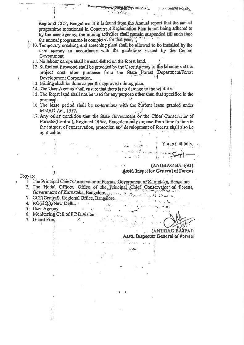
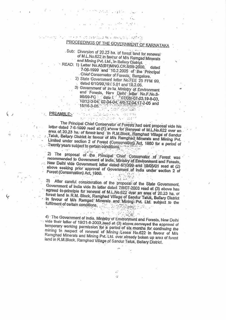
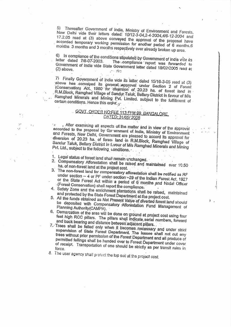
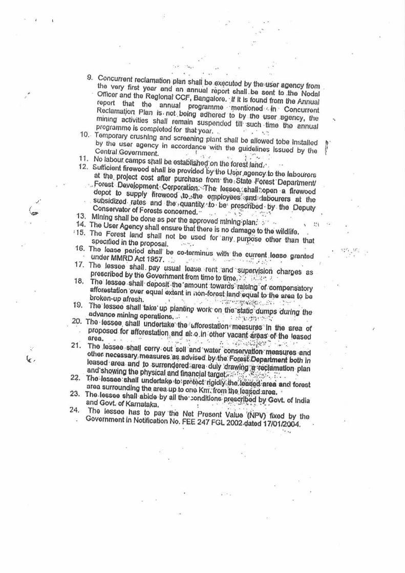
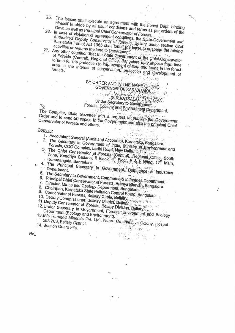
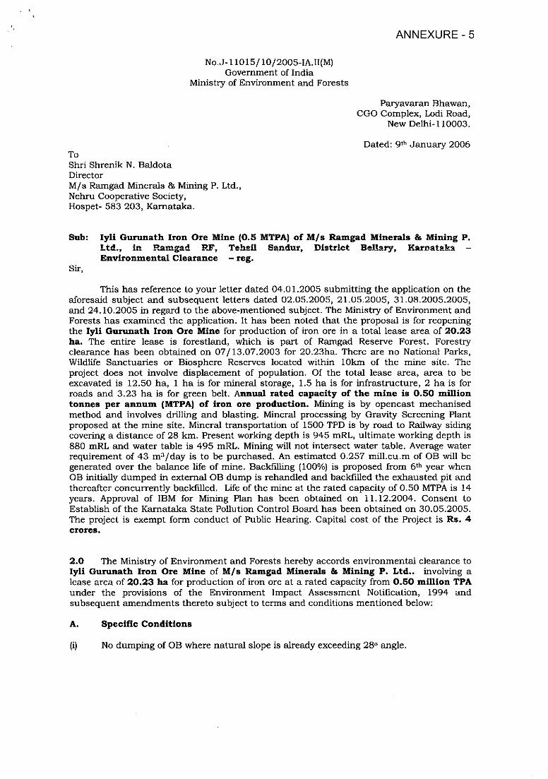
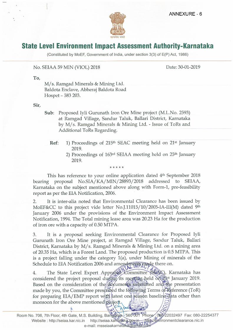
tState Level Environment Impact Assessment Authority-Karnataka
(Constituted by MoEF, Government of India, under section 3(3) of E(P) Act, 1986)
No. SEIAA 59 MIN (VIOL) 2018 Date: 30-01-2019
To,M/s. Ramgad Minerals & Mining Ltd.Baldota Enclave, Abheraj Baldota RoadHospet — 583 203.
Sir,
Sub: Proposed lyli Gurunath Iron Ore Mine project (M.L.No. 2593)at Ramgad Village, Sandur Taluk, Ballari District, Karnatakaby M/s. Ramgad Minerals & Mining Ltd. - Issue of ToRs andAdditional ToRs Regarding.
Ref: 1) Proceedings of 215th SEAC meeting held on 21St January2019.
2) Proceedings of 163rd SEIAA meeting held on 25th January2019.
*****
This has reference to your online application dated 4th September 2018bearing proposal No.SIA/KA/MIN/28893/2018 addressed to SEIAA,Karnataka on the subject mentioned above along with Form-I, pre-feasibilityreport as per the ETA Notification, 2006.
2. It is inter-alia noted that Environmental Clearance has been issued byMoEF&CC to this project vide letter No.J.11015/10/2005-IA-III(M) dated 9th
January 2006 under the provisions of the Environment Impact AssessmentNotification, 1994. The Total mining lease area was 20.23 Ha for the productionof iron ore with a capacity of 0.50 MTPA
3. It is a proposal seeking Environmental Clearance for Proposed lyliGurunath Iron Ore Mine project, at Ramgad Village, Sandur Taluk, BallariDistrict, Karnataka by M/s. Ramgad Minerals & Mining Ltd. on a mining areaof 20.35 Ha, which is a Forest Land. The proposed production is 0.5 MTPA. Thisis a project falling under the category 1(a), under Mining of minerals of theSchedule to EIA Notification 2006 and amc there on.
4. The State Level Expert A1 ,, Karnataka hasconsidered the project proposal di ;t January 2019.Based on the consideration of presentationmade by you, the Committee i ~nce (ToR)for preparing EIA/EMP report ta other thanmonsoon for the above mentioi
Room No. 706, 7th Floor, 4th Gate, MS. Building, Bai ~32497 Fax: 080-22254377Website : http://seiaa.kar.nic.in http://seiaa.. ‘ironmentclearance.nic.in
e-mail: msseiaakarm
State Level Environment Impact Assessment Authority-Karnataka(Constituted by MoEF, Government of India under section 3(3) of E(P) Act, 1986)
SEIAA 59 MIN (VIOL) 2018 Proposed lyli Gurunath Iron Ore Mine projectof M s.Ramgad Minerals & Mining Ltd
5. The SEIAA Karnataka after due consideration of the relevant documentssubmitted by the project proponent, and the recommendation of the SEAC havein its meeting held on 25th January 2019 and decided to accord the StandardTerms pf• Reference (TOR) along with additional Terms~ of R~ference, inaccordance with the provisions of Environmental Impact AssessmentNotification-2006 and its subsequent amendments made there on.
1. Year-wise production details inception of the mine be given, clearlystating the highest production achieved in any one year prior to 1994, ifapplicable. It may also be categorically informed whether there had beenany increase in production after the ETA Notification 1994 came intoforce, w.r.to. the highest production achieved prior to 1994.
2. A copy of the document in support of the fact that the Proponent is therightful lessee of the mine should be given.
3. All documents including approved mine plan, ETA and public hearingshould be compatible with one another in terms~of the mine lease area,production levels, waste generation and its management and miningtechnology and should be in the name of the lessee,
4. All corner coordinates of the mine lease area, superimposed on a HighResolution Imagery! Topo sheet, topographic sheet,-geomorphology andgeology of the area should be provided. Such an Imagery of theproposed area should clearly show the land use and other ecologicalfeatures of the study area (core and buffer zone).
5. Information should be provided in Survey of India Topo sheet in 1:50,000scale indicating geological map of the area, geomorphology of landforms of the area, existing minerals and mining history of the area,important water bodies, streams and rivers and soil characteristics.
6. Details about the land proposed for mining activities should be givenwith information as to whether mining conforms to the land use policy ofthe State; land diversion for mining should have approval from Stateland use board or the concerned authority.
7. It should be clearly stated whether the lessee/proponent Company has awell laid down Environment Policy approved by its Board of Directors?If so, it may be spelt out in the EIA Report with description of theprescribed operating process/procedures to bring into focus anyinfringement/deviation/violation of the environmental or forest norms/conditions? The hierarchical system or administrative order of theCompany to deal with the environmental issues and for ensuringcompliance with the EC conditions may also be given. The system ofreporting of non-compliances / vh ‘ ~ental norms to theBoard of Directbrs of the Co~ [ersor stakeholdersat large, may alsp be detail~
8. Issues relating to Mine idy in case ofunderground mining cast mining,blasting study etc. shouldi measuresin each case should also
2
State Level Environment Impact Assessment Authority-Karnataka(Consthuted by MoEF, Govermnent of India under setion 3(3) of E(P) Act 1986)
SEIAA 59 MIN (VIOL) 2018 Proposed lyli C’,urunath Iron Ore Mine projectof M s Ramgad Minerals & Mining Ud
9. The study area will comprise of 10 km zone around the mine lease fromlease periphery and the data contained in the ETA such as wastegeneration etc should be for the life of the mine / lease period.
10. Land use of the study area delineating forest area, agricultural land,grazing land, wildlife sanctuary, national park, migratory routes offauna, water bodies, human settlements and other ecological featuresshould be indicated. Land use plan of the mine lease area should beprepared to encompass preoperational, operational and post operationalphases and submitted. Impact, if any, of change of land use should begiven.
11. Details of the land for any Over Burden Dumps outside the mine lease,such as extent of land area, distance from mine lease, its land use, R&Rissues, if any, should be given.
12. A Certificate from the Competent Authority in the State ForestDepartment should be provided, confirming the involvement of forestland, if any, in the project area. In the event of any contrary claim by theProject Proponent regarding the status of forests, the site may beinspected by the State Forest Department along with the Regional Officeof the Ministry to ascertain the status of forests, based on which, theCertificate in this regard as mentioned above be issued. In all such cases,it would be desirable for representative of the State Forest Department toassist the Expert Appraisal Committees.
13. Status of forestry clearance for the broken up area and virgin forestlandinvolved in the Project including deposition of net present value (NPV)and compensatory afforestation (CA) should be indicated. A copy of theforestry clearance should also furnished.
14. Implementation status of recognition of forest rights under theScheduled Tribes and other Traditional Forest Dwellers (Recognition ofForest Rights) Act, 2006 should be indicated.
15. The vegetation in the RF / PF areas in the study area, with necessarydetails, should be given.
16. A study shall be got done to ascertain the impact of the Mining Project onwildlife of the study area and details furnished. Impact of the project onthe wildlife in the surrounding and any other protected area andaccordingly detailed mitigative measures required, should be workedout with cost implications and submitted.
17. Location of National Parks, Sanctuaries, Biosphere Reserves, WildlifeCorridors, Tiger/Elephant Reserves/(existing as well as proposed), ifany, within 10 km of the mine lease should be clearly indicated,supported by a location map duly authenticated by Chief WildlifeWarden. Necessary clearance, as such projects dueto proximity of the ecological] toned above,should be obtained from the Chief WildlifeWarden under the Wildlife rnished.
18. A detailed biological study buffer zone(10 km radius of the periph carried out.Details of flora an.d fauna, ~pecies dulyauthenticat d, separately for furnished
3
State Level Environment Impact Assessment Authority-Karnataka(Constituted by MoEF Government of India under section 3(3) of E(P) Act, 1986)
SEIAA 59 MIN (VIOL) 2018 Proposed lyli Gurunath Iron Ore Mine projectof M s.Ramgad Minerals & Mining Ltd
based on such primary field survey, clearly indicating the Schedule ofthe fauna present. In case of any scheduled I fauna found in the studyarea, the necessary plan along with budgetary provisions for theirconservation should be prepared in consultation with State Forest andWildlife Department and details furnished. Necessary allocation of fundsfor implementing the same should be made as part of the project cost.
19. Proximity to Areas declared as ‘Critically Polluted’ or the Project areaslikely to come under the ‘Aravali Range’, (attracting court restrictions formining operations), should also be indicated and where so required,clearance certifications from the prescribed Authorities, such as the SPCBor State Mining Department should be secured and furnished to theeffect that the proposed mining activities could be considered.
20. Similarly, for coastal Projects, A CRZ map duly authenticated by one ofthe authorized agencies demarcating LTL. HTL, CRZ area, location of themine lease w.r.t CRZ, coastal features such as mangroves, if any, shouldbe furnished. (Note: The Mining Projects falling under CRZ would alsoneed to obtain approval of the concerned Coastal Zone ManagementAuthority).
21. R&R Plan/compensation details for the Project Affected People (PAP)should be furnished While preparing the R&R Plan, the relevantState/National Rehabilitation & Resettlement Policy should be kept inview. In respect of SCs /STs and other weaker sections of the society inthe study area, a need based sample survey, family-wise, should beundertaken to assess their requirements, and action programmesprepared and submitted accordingly, integrating the sectoralprogrammes of line departments of the State Government. It may beclearly brought out whether the village(s) located in the mine lease areawill be shifted or not. The issues relating to shifting of Village(s)including their R&R and socio-economic aspects should be discussed inthe report.
22. One season (non-monsoon) [i.e. March-May (Summer Season); October-December (post monsoon season) ; December-February (winterseason)]primary baseline data on ambient air quality as per CPCBNotification of 2009, water quality, noise level, soil and flora and faunashall be collected and the AAQ and other data so compiled presenteddate-wise in the ETA and EMP Report. Site-specific meteorological datashould also be collected. The location of the monitoring stations shouldbe such as to represent whole of the study area and justified keeping inview the pre-dominant downwind direction and location of sensitivereceptors. There should be at least one monitoring station within 500 mof the mine lease in the pre-dominant direction. Themineralogical composition of PMIO, tould begiven.
23. Air quality modelling should be c~the project on the air quality of thethe impact of movement of vehidetails of the model used and inshould be provided. The air quality
State Level Environment Impact Assessment Authority-Karnataka(Constituted by MoEF, Government of India under seclion 3(3) of EQ’) Act, 1986)
SEIAA 59 MIN (VIOL) 2018• Proposed lyli Ourunath Iron Ore Mine projectof M s.Ramgad Minerals & Mining Ltd
map clearly indicating the location of the site, location of sensitivereceptors, if any, and the habitation The wind roses showing predominant wind direction may also be indicated on the map.
24. The water requirement for the Project, its availability and source shouldbe furnished A detailed water balance should also be provided. Freshwater requirement for the Project should be indicated.
25. Necessary clearance from the Competent Authority for drawl of requisitequantity of water for the Project should be provided.
26. Description of water conservation measures proposed to be adopted inthe Project should be given. Details of rainwater harvesting proposed inthe Project if any, should be provided.
27. Impact of the project on the water quality, both surface and groundwatershould be assessed and necessary safeguard measures, if any required,should be provided.
28. Based on actual monitored data, it may clearly be shown whetherworking will intersect groundwater. Necessary data and documentationin this regard may be provided. In case the working will intersectgroundwater table, a detailed Hydro Geological Study should—beundertaken and Report furnished. The Report inter-alia, shall includedetails of the aquifers present and impact of mining-activities-on-theseaquifers. Necessary permission from Central Ground Water Authorityfor working below ground water and for pumping of ground watershould also be obtained and copy furnished.
29. Details of any stream, seasonal or otherwise, passing through the leasearea and modification / diversion proposed, if any, and the impact of thesame on the hydrology should be brought out.
30. Information on site elevation, working depth, groundwater table etc.Should be provided both in AMSL and bgl. A schematic diagram mayalso be provided for the same.
31. A time bound Progressive Greenbelt Development Plan shall beprepared in a tabular form (indicating the linear and quantitativecoverage, plant species and time frame) and submitted, keeping in mind,the same will have to be executed up front on commencement of theProject. Phase-wise plan of plantation and compensatory afforestationshould be charted clearly indicating the area to be covered underplantation and the species to be planted. The details of plantation alreadydone should be given. The plant species selected for green belt shouldhave greater ecological value and should be of good utility value to thelocal population with emphasis on local and native species and thespecies which are tolerant to pollution.
32. Impact on local transport infrastructuxa4aa~ to the Project should beindicated. Projected increase in ~ult of the Project inthe present road—network— the Project area)should be worked out, . of handling theincremental load. A ~astructure, ifcontemplated (including mcies such asState Government) shoub shall conductImpact of Transportation Guidelines.
5
State Level Envirom-nent Impact Assessment Authority-Karnataka(Constituted by MoEF, Government of India under section 3(3) of E(P) Act, 1986)
SEIAA 59 MIN (VIOL) 01 Proposed lyli Gurunath Iron Ore Mine projectof M s.Ramgad Minerals & Mining Ltd
33. Details of the onsite shelter and facilities to be provided to the mineworkers should be included in the ETA Report.
34. Conceptual post mining land use and Reclamation and Restoration ofmined out areas (with plans and with adequate number of sections)should be given in the ETA report.
35. Occupational Health impacts of the Project should be anticipated and theproposed preventive measures spelt out in detail. Details of preplacement medical examination and periodical medical examinationschedules should be incorporated in the EMP. The project specificoccupational health mitigation measures with required facilitiesproposed in the mining area may be detailed.
36. Public health implications of the Project and related activities for thepopulation in the impact zone should be systematically evaluated andthe proposed remedial measures should be detailed along withbudgetary allocations.
37. Measures of socio economic significance and influence to the localconmiunity proposed to be provided by the Project Proponent should beindicated. As far as possible, quantitative dimensions may be given withtime frames for implementation.
38. Detailed environmental management plan (EMP) to mitigate theenvirorunental impacts which, should inter-alia include the impacts ofchange of land. use, loss of agricultural and grazing land, if any,occupational health impacts besides other impacts specific to theproposed Project.
39. Public Hearing points raised arid commitment of the Project Proponenton the same along with time bound Action Plan with budgetaryprovisions to implement the sa rile should be provided and alsoincorporated in the final EIA/EMP Report of the Project.
40 Details of litigation pending against the project, if any, with direction/order passed by any Court of Law against the Project should be given.
41. The cost of the Project (capital cost and recurring cost) as well as the costtowards implementation of EMP should be clearly spelt out.
42. A Disaster management Plan shall be prepared and included in theEIA/EMP Report.
43. Benefits of th Project if the Project is implemented should be spelt out.The benefits of the Project shall clearly indicate environmental, social,economic, employment potential, etc.
44. Besides the above, the below mentioned general points are also to befollowed:
a) Executive Summary of the ETA! EMPb) All documents to be properly
page numbering.c) Where data are presented
period in which the dataindicated
d) Project Proponent shall eiwater, air, soil, noise etc.
State Level Environment Impact Assessment Authority-Karnataka(Constituted by MoEF Government of India under section 3(3) of EQ’) Act, 1986)
SEIAA 59 MIN (VIOL) 2018 Proposed lyli Gurunath Iron Ore Mine projectof M $ Ramgad Minerals & Mining Ltd
laboratories. All the original analysis! testing reports should beavailable during appraisal of the Project
e) Where the documents provided are in a language other than English,an English translation should be provided
f) The Questionnaire for environmental appraisal of mining projects asdevised earlier by the Ministry shall also be filled and submitted.
g) While preparing the EIA report, the instructions for the Proponentsand instructions for the Consultants issued by MoEF & CC vide O.M.No. J-11013/41/2006-IA.II(I) dated 4th August, 2009, which areavailable on the website of this Ministry, should be followed
h) Changes, if any made in the basic scope and project parameters (assubmitted in Form-I and the PFR for securing the TOR) should bebrought to the attention of MoEF & CC with reasons for suchchanges and permission should be sought, as the TOR may also haveto be altered. Post Public Hearing changes in structure and content ofthe draft EJA/EMP (other than modifications arising out of the P.H.process) will entail conducting the PH again with the reviseddocumentation.
i) As per the circular no. J-11011/618/2010-IA.II(I) dated 30.5.2012,certified report of the status of compliance of the conditionsstipulated in the environment clearance for the existing operations ofthe project, should be obtained from the Regional Office of Ministryof Environment, Forest and Climate Change, as may be applicable.
j) The EIA report should also include(i) Surface plan of the area indicating contours of main
topographic features, drainage and mining area,(ii) Geological maps and sections and(iii) Sections of the mine pit and external dumps, if any, clearly
showing the land features of the adjoining area.
Additional TOR’s:
1) The measures to mitigate dust settlement on the vegetation may bedetailed and submitted.
2) Details of measures that can be taken to reduce the dust depositedalready on the vegetation may be worked out and submitted.
3) Measures that are to be taken to stabalise the dump slopes to avoidraincuts which were noticed during the inspection may be detailed andsubmitted.
4) Measures that are to be taken to mitigate dust menance from mineralsstock may be detailed and submitted.
5) All mitigation measures should be generationrehandling of the wastes and
The consultants involved EMP shall haveaccreditation with Quality C ition Board ofEducation and Training (QCI/ ide a certificatein this regard in the FIA/EMP provided byother Organization(s)/Laborato~ ovals etc, shallbe indicated in th report.
7
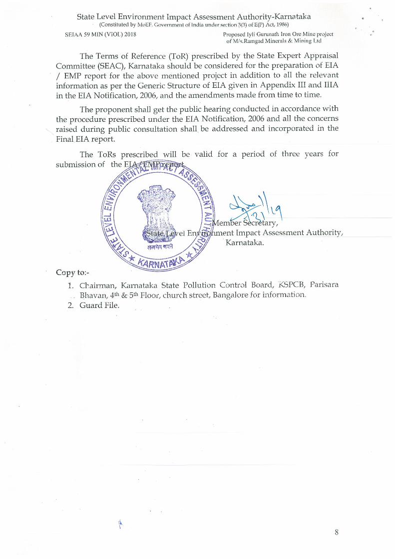
State Level Environment Impact Assessment Authority-Karnataka(Constituted by MoEF Government of India under section 3(3) of E(P) Act 1986)
SEIAA 59 MIN (Vl0Ij 2018 Proposed lyli Gurunatit Iron Ore Mine projectof M s.RaTngad Minerals & Mining Ltd
The Terms of Reference (T0R) prescribed by the State Expert AppraisalCommittee (SEAC), Karnataka should be considered for the preparation of EIA/ EMP report for the above mentioned project in addition to all the relevantinformation as per the Generic Structure of EIA given in Appendix III and lilAin the ETA Nofification, 2006, and the amendments made from time to time.
The proponent shall get the public hearing conducted in accordance withthe procedure prescribed under the ETA Notification, 2006 and all the concernsraised during public consultation shall be addressed and incorporated in theFinal ETA report.
The ToRs prescribed will be validsubmission of the
Copy to:
for a period of three years for
‘em’er Scrtary,ent Impact Assessment Authority,Karnataka.
1. Cbairman, Karnataka State Pollution Control Board, KSPCB, ParisaraBhavan, 4th & 5th Floor, church street, Bangalore for information.
2. Guard File.
—‘ c~
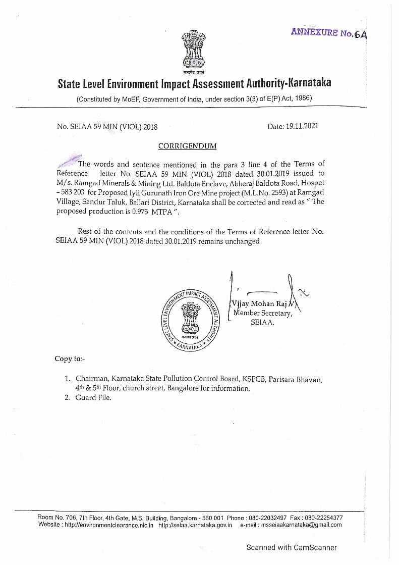
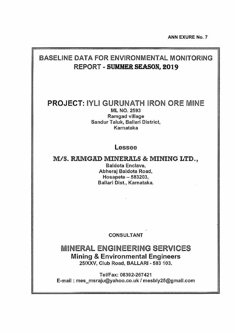
ANN EXURE No. 7
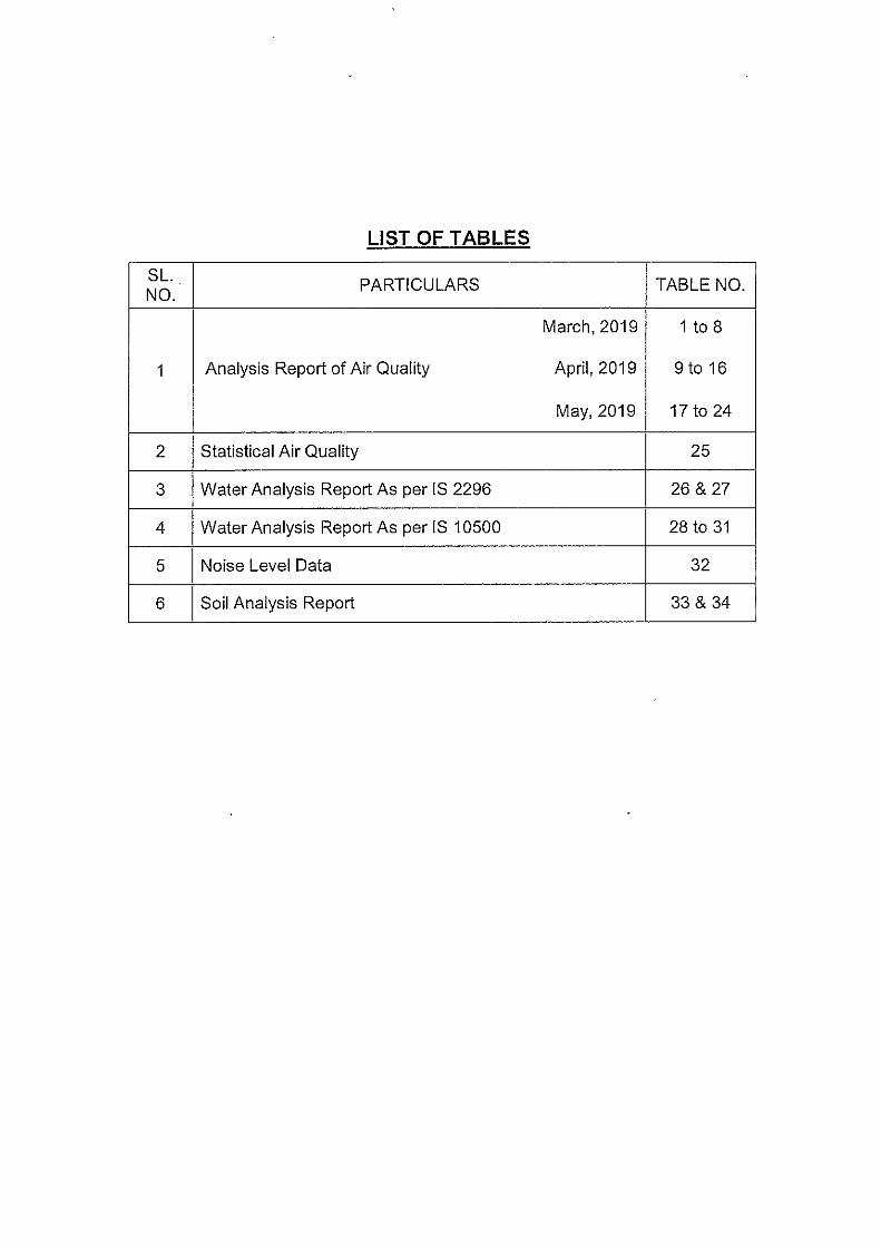


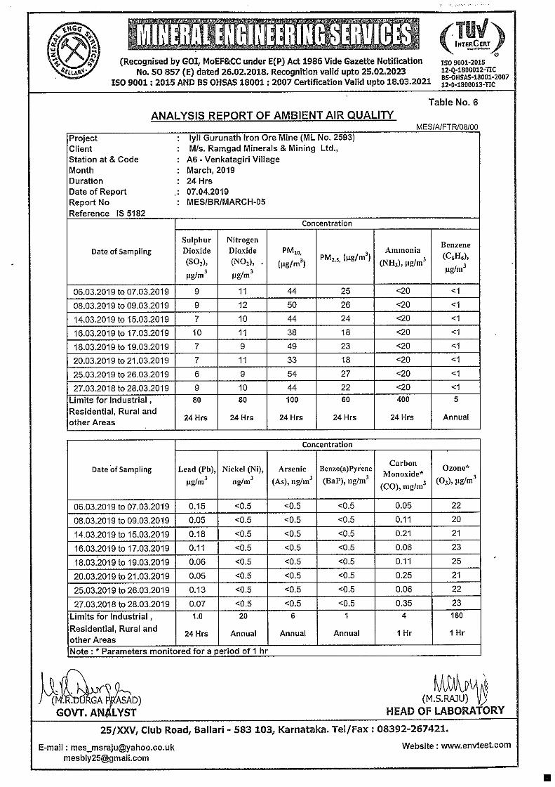


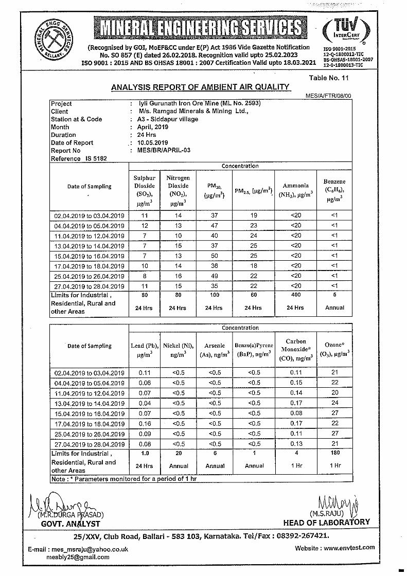

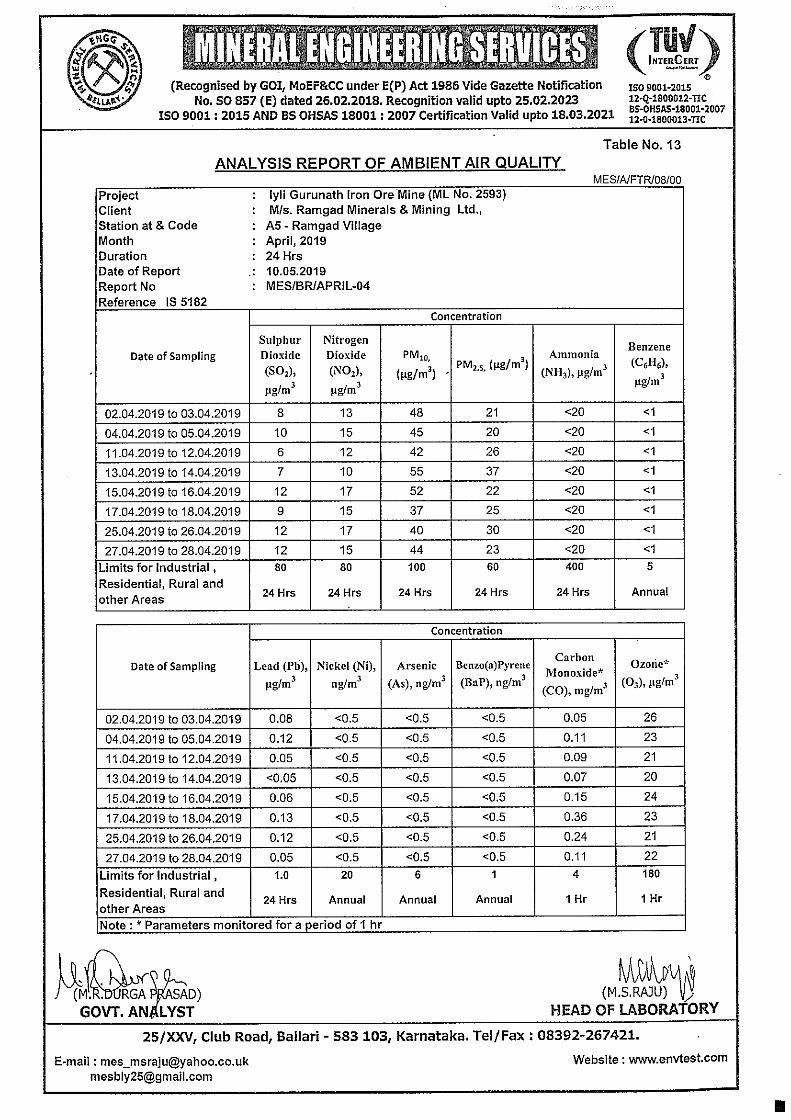


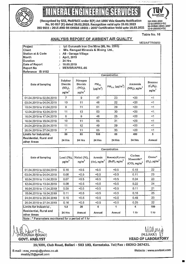


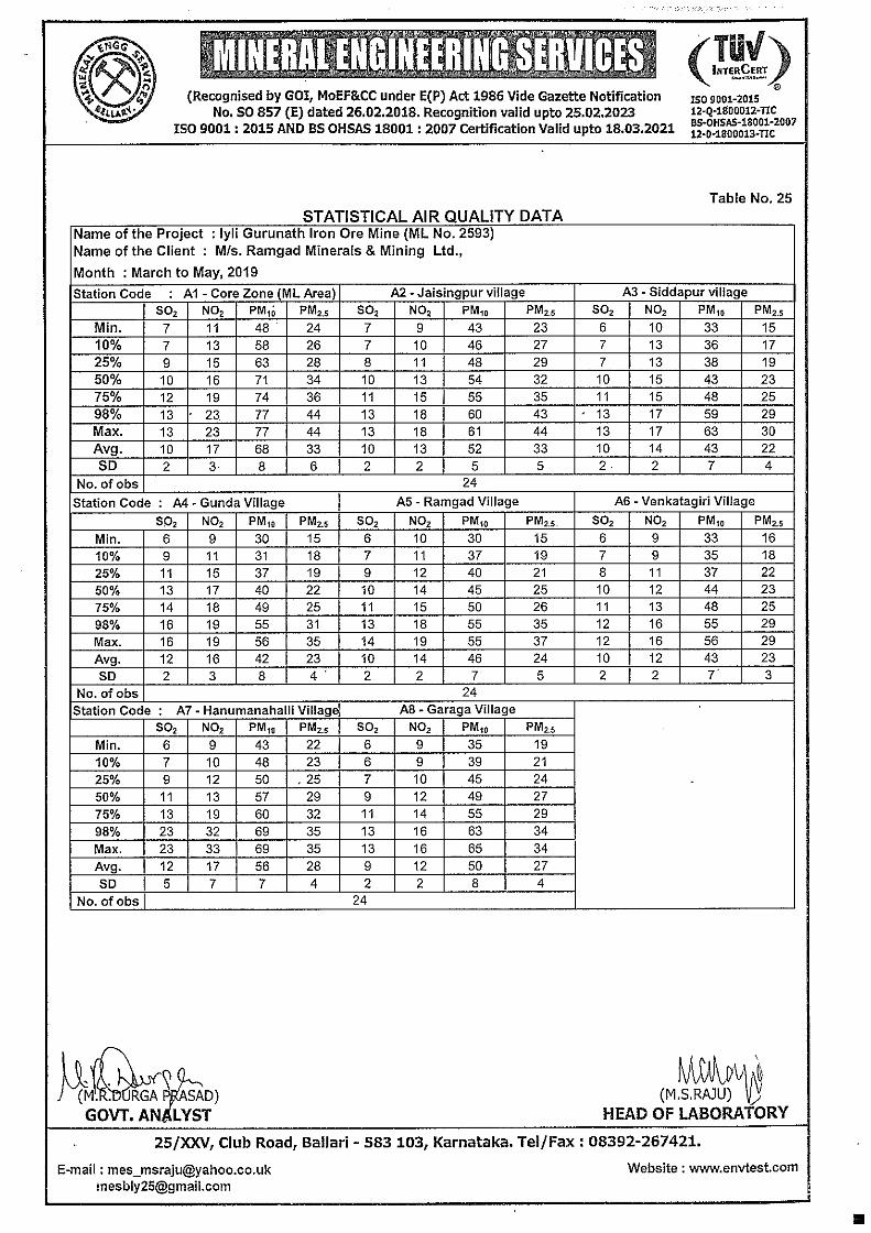
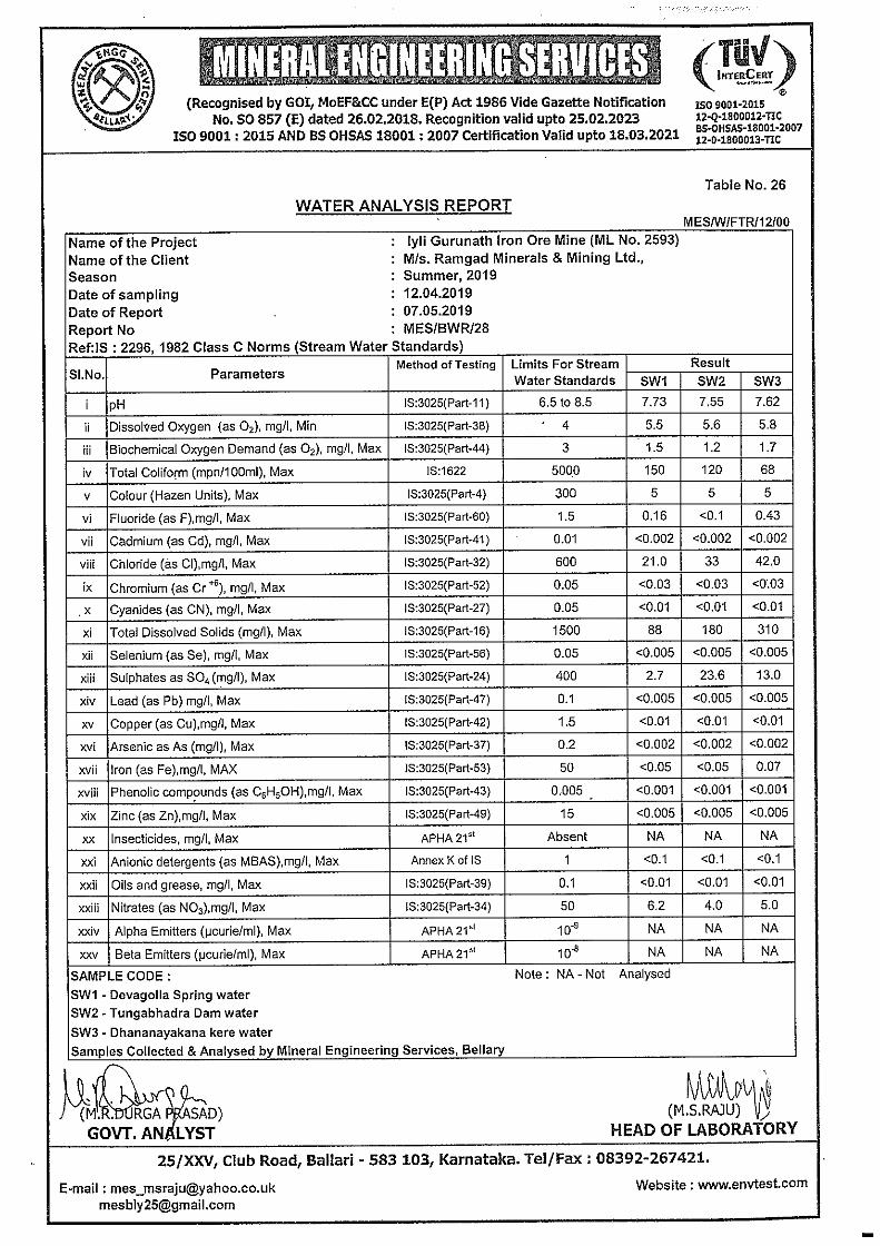
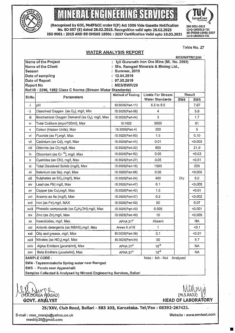
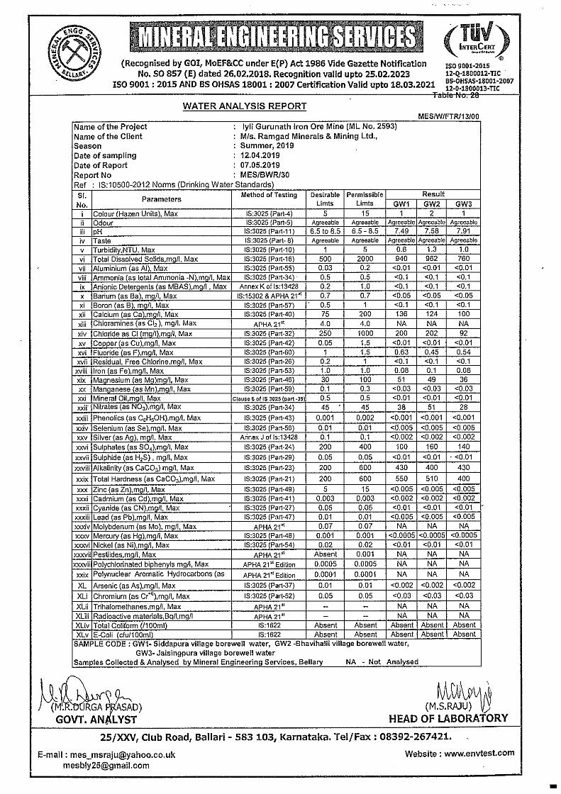
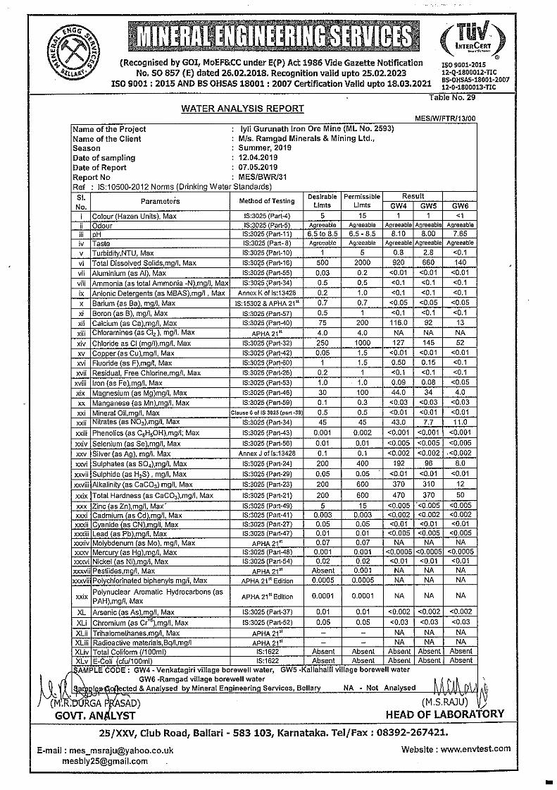
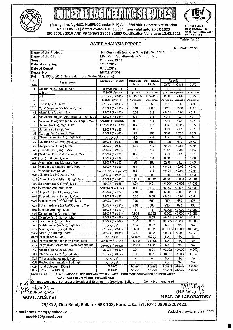
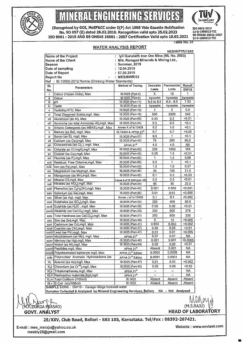
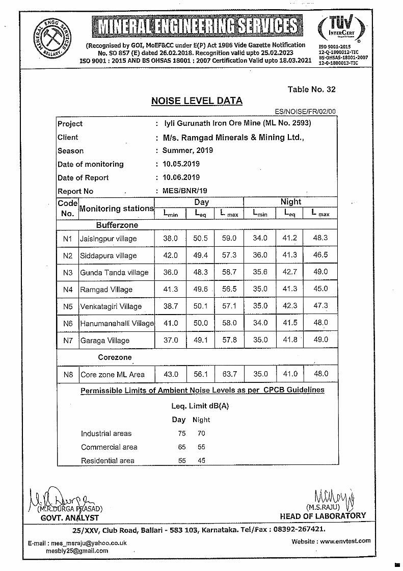
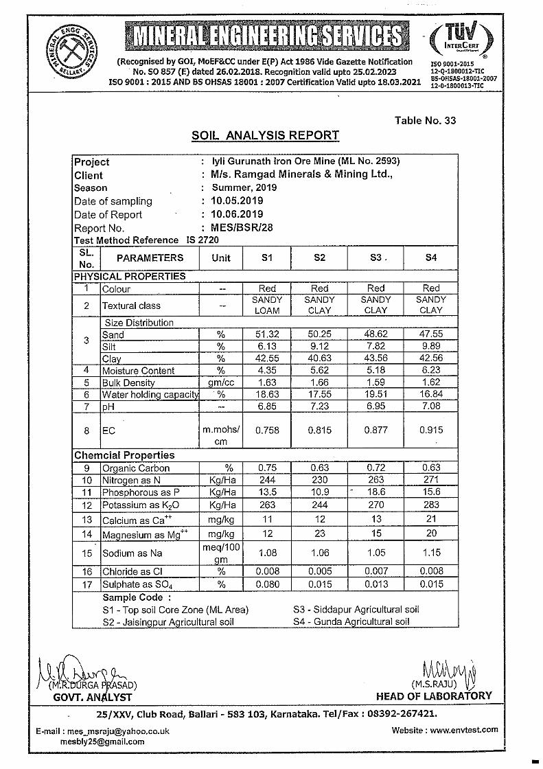
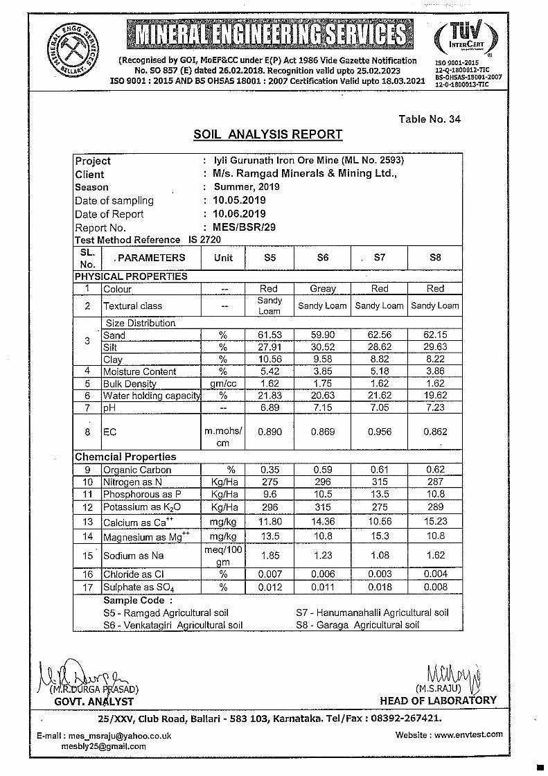
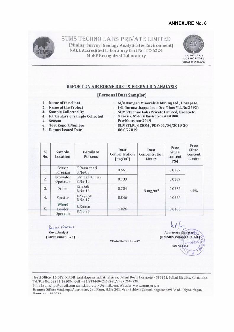
ANNEXURE No. 8
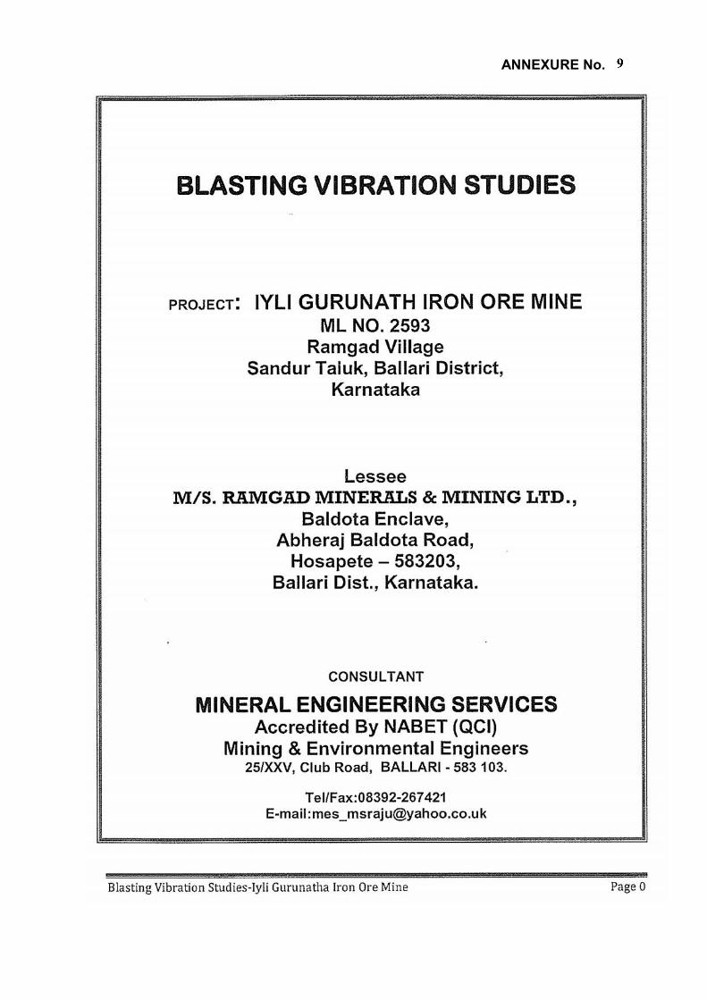
ANNEXURE No.
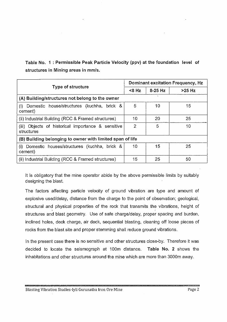
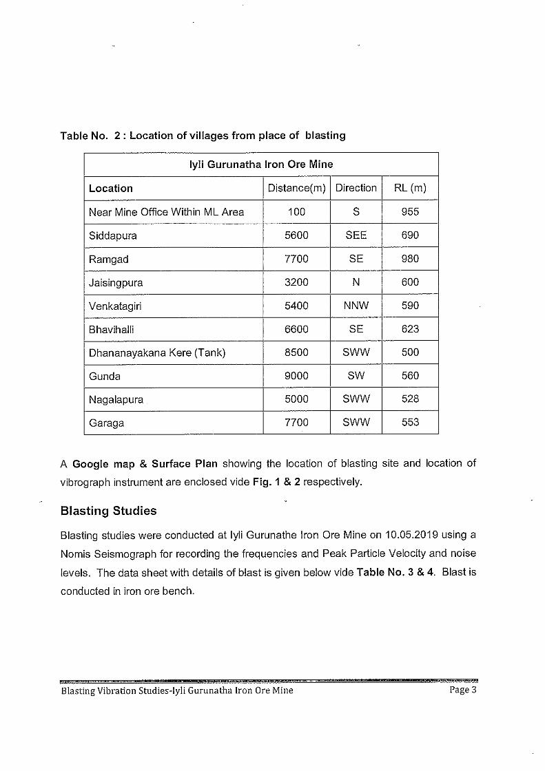
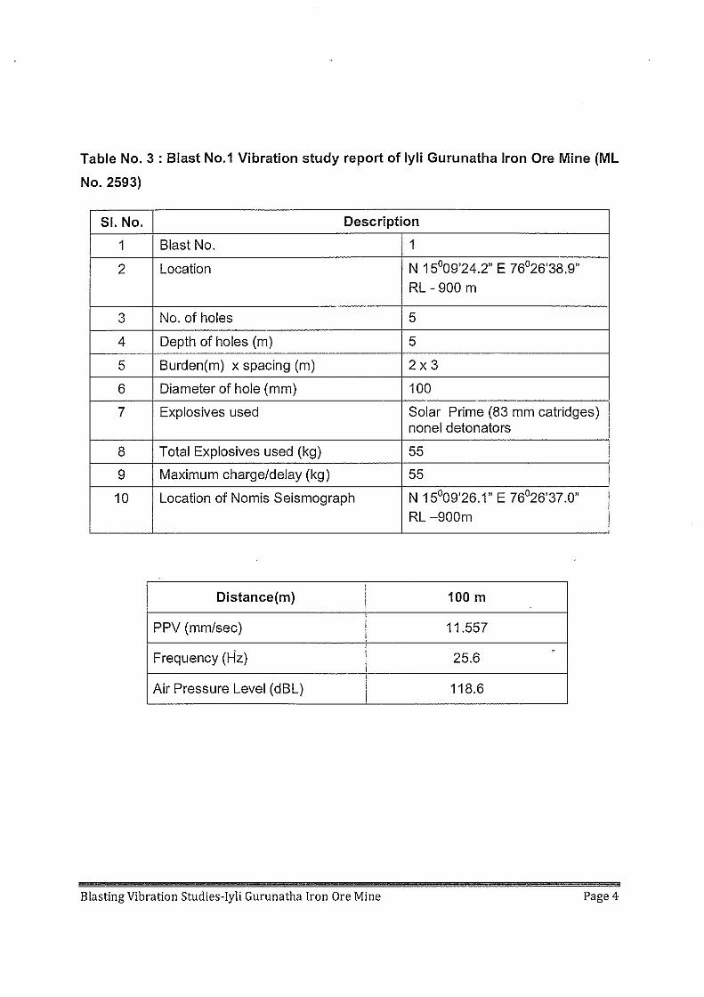
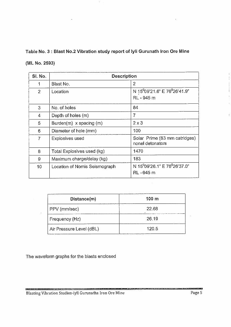
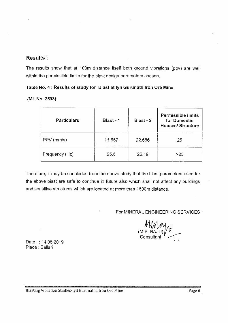
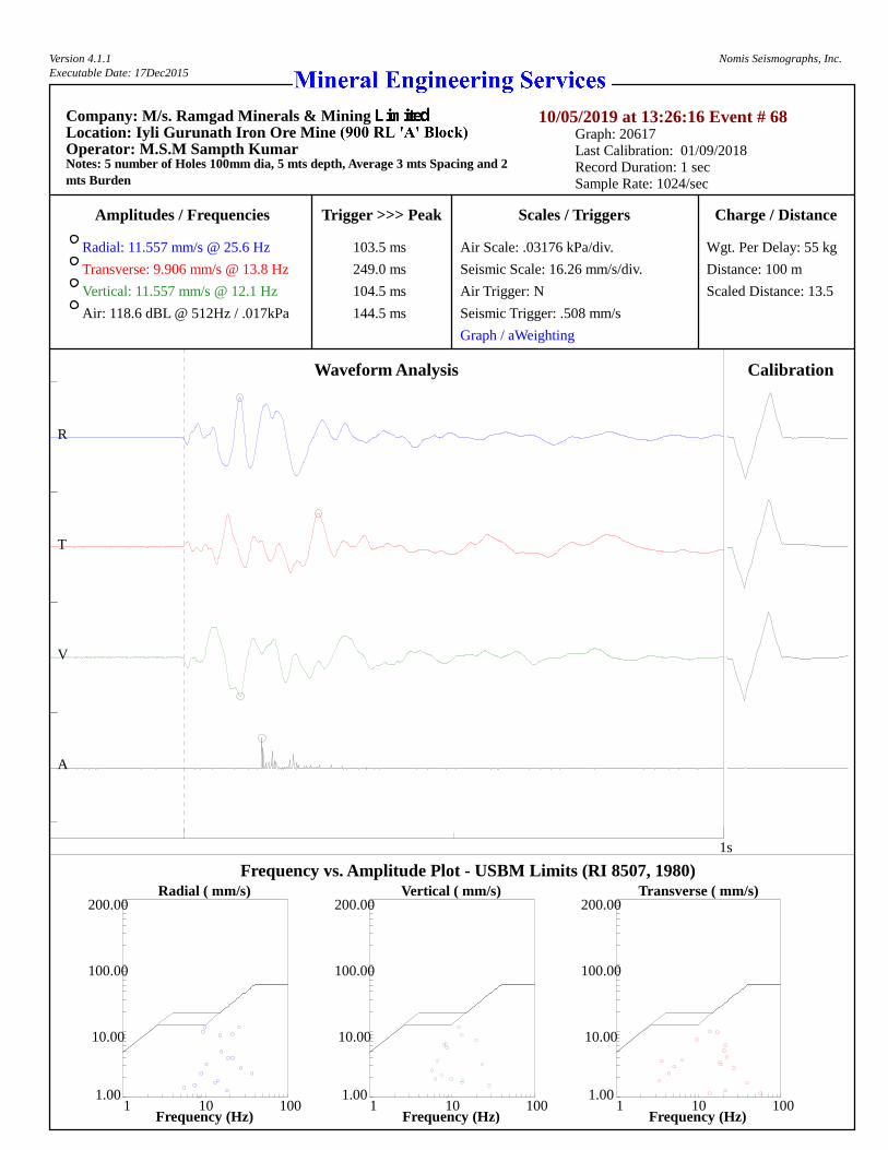
Version 4.1.1Executable Date: 17Dec2015
Nomis Seismographs, Inc.
Company: M/s. Ramgad Minerals & MiningLocation: Iyli Gurunath Iron Ore MineOperator: M.S.M Sampth KumarNotes: 5 number of Holes 100mm dia, 5 mts depth, Average 3 mts Spacing and 2mts Burden
10/05/2019 at 13:26:16 Event # 68Graph: 20617Last Calibration: 01/09/2018Record Duration: 1 secSample Rate: 1024/sec
Amplitudes / Frequencies Trigger >>> Peak Scales / Triggers Charge / Distance
Wgt. Per Delay: 55 kg
Distance: 100 m
Scaled Distance: 13.5
Radial: 11.557 mm/s @ 25.6 Hz
Transverse: 9.906 mm/s @ 13.8 Hz
Vertical: 11.557 mm/s @ 12.1 Hz
Air: 118.6 dBL @ 512Hz / .017kPa
Air Scale: .03176 kPa/div.
Seismic Scale: 16.26 mm/s/div.
Air Trigger: N
Seismic Trigger: .508 mm/s
Graph / aWeighting
Waveform Analysis
1s
R
T
V
A
103.5 ms
249.0 ms
104.5 ms
144.5 ms
Calibration
Frequency vs. Amplitude Plot - USBM Limits (RI 8507, 1980)Radial ( mm/s) Vertical ( mm/s) Transverse ( mm/s)
Frequency (Hz) Frequency (Hz) Frequency (Hz)
10.00 10.00 10.00
100.00 100.00 100.00
200.00 200.00 200.00
1.00 1.00 1.001 1 110 10 10100 100 100
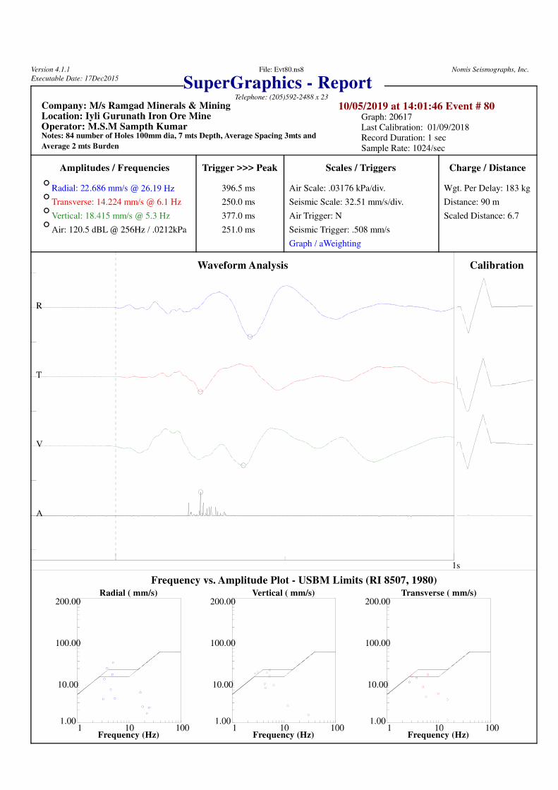
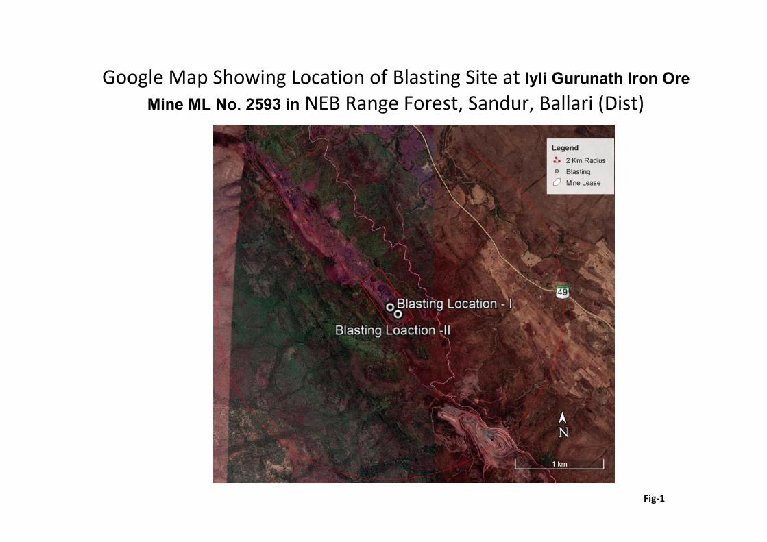
Google Map Showing Location of Blasting Site at Iyli Gurunath Iron OreMine ML No. 2593 in NEB Range Forest, Sandur, Ballari (Dist)
Fig-1
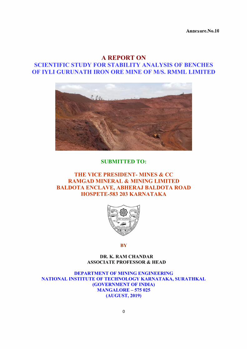
0
A REPORT ONSCIENTIFIC STUDY FOR STABILITY ANALYSIS OF BENCHES
OF IYLI GURUNATH IRON ORE MINE OF M/S. RMML LIMITED
SUBMITTED TO:
THE VICE PRESIDENT- MINES & CCRAMGAD MINERAL & MINING LIMITED
BALDOTA ENCLAVE, ABHERAJ BALDOTA ROADHOSPETE-583 203 KARNATAKA
BY
DR. K. RAM CHANDARASSOCIATE PROFESSOR & HEAD
DEPARTMENT OF MINING ENGINEERINGNATIONAL INSTITUTE OF TECHNOLOGY KARNATAKA, SURATHKAL
(GOVERNMENT OF INDIA)MANGALORE – 575 025
(AUGUST, 2019)
1
ACKNOWLEDGEMENTS
The Principal Investigator is grateful to the Director, National Institute of Technology
Karnataka, Surathkal (Govt. of India) for permitting to take up the project.
Thanks to the management of M/S. Ramgad Mineral & Mining Limited for sponsoring this
consultancy Project. Thaks to Dri. K. Madhusudana- Vice President (Mines &CC), Sri. M.
Satya Prakash- AGM (Mines), Sri.V.V.N. Raju- Manager (Geology) and other officers and
staff of Lyli Mine for extending their help in carrying out filed investigations.
Help rendered by Mr. M. Sashi Kiran, M.Tech Student, Ms. Gayathri- Lab Assiatnt and other
supporting staff of Department of Mining Engineering, NITK-Surathkal, in carrying out
laboratory experiments is acknowledged.
Dr. K. Ram Chandar August 06, 2019
NITK - SurathkalPrincipal InvestigatorConsultancy Project Code: TC/MN//JB/37
2
INDEX
1. INTRODUCTION
a. Collection of Samples
b. Geology
2. LABORATORY INVESTIGATIONS
3. MODELING STUDIES
Case1: Single bench of 9m height with a slope angle of 80°
Case2: Multiple benches with 9m height and 9m width with 80º slope angle
Case3: Multiple benches with 9m height and 4m width with 80º slope angle representing
high wall condition
Case4: Single bench of 9m height with a slope angle of 75°
Case5: Multiple benches with 9m height and 9m width with 75º slope angle
Case6: Multiple benches with 9m height and 4m width with 75º slope angle representing
high wall condition
Case 7: Stability Analysis of Dumps
4. CONCLUSIONS & RECOMMENDATIONS
3
INTRODUCTION
Ramgad Mineral & Mining Limited is operating Lyli Gurunath Iron Ore Mine in Ramgad
village, Sandur taluk, Bellari District of Karnataka. The mine management wanted to assess the
stability of slopes and keeping in view the safety of working areas, to meet the legal
requirements and also for future expansion of the project. So, they approached the Principal
Investigate at NITK with a request to carry out scientific study to assess the stability of slopes
and dumps in Lyli Gurunath Iron Ore Mine.
A field visit was made to the project site on 17th June-2019. A reconnaissance survey was done
in order to assess the stability of benches and dumps. Details of present bench configuration and
future plans for highwall dimensions etc., were discussed with the mine officials. A broad view
of the mine is shown in Fig. 1.1. Fig. 1.2 shows the close view of the benches. All the benches
were found to be instable conditions, at some places there are multiple joint sets and they are
almost parallel to the bench face (Fig. 1.3). Some top benches consists of soft formation (Fig.
1.4).
Collection of Samples
Natures of the rock mass is assessed to some extent using a schmidt hammer at different
locations (Fig. 1.5). Samples were collected from different locations in different benches.
Suitable boulders were collected and systematic sampling number is given (Fig. 1.6). All the
collected samples were packed into gunny bags for transportation to the laboratory at NITK,
Surathkal (Fig.1.7).
Further, the waste rock is disposed outside the mine area/ partially back filled (Fig. 1.8). Each
deck height is 30m and there can be maximum of 3 decks. As dump angle should not exceed
angle of repose, so an attempt was made at the site to find angle of repose of the dumping
material (Fig. 1.9).
4
1.1(A)
1.1(B)
FIG. 1 A BROAD VIEW OF THE LYLI GURUNATH IRON ORE MINE
5
1.2(A)
1.2(B)
FIG. 2 A CLOSE VIEW OF BENCHES IN LYLI MINE
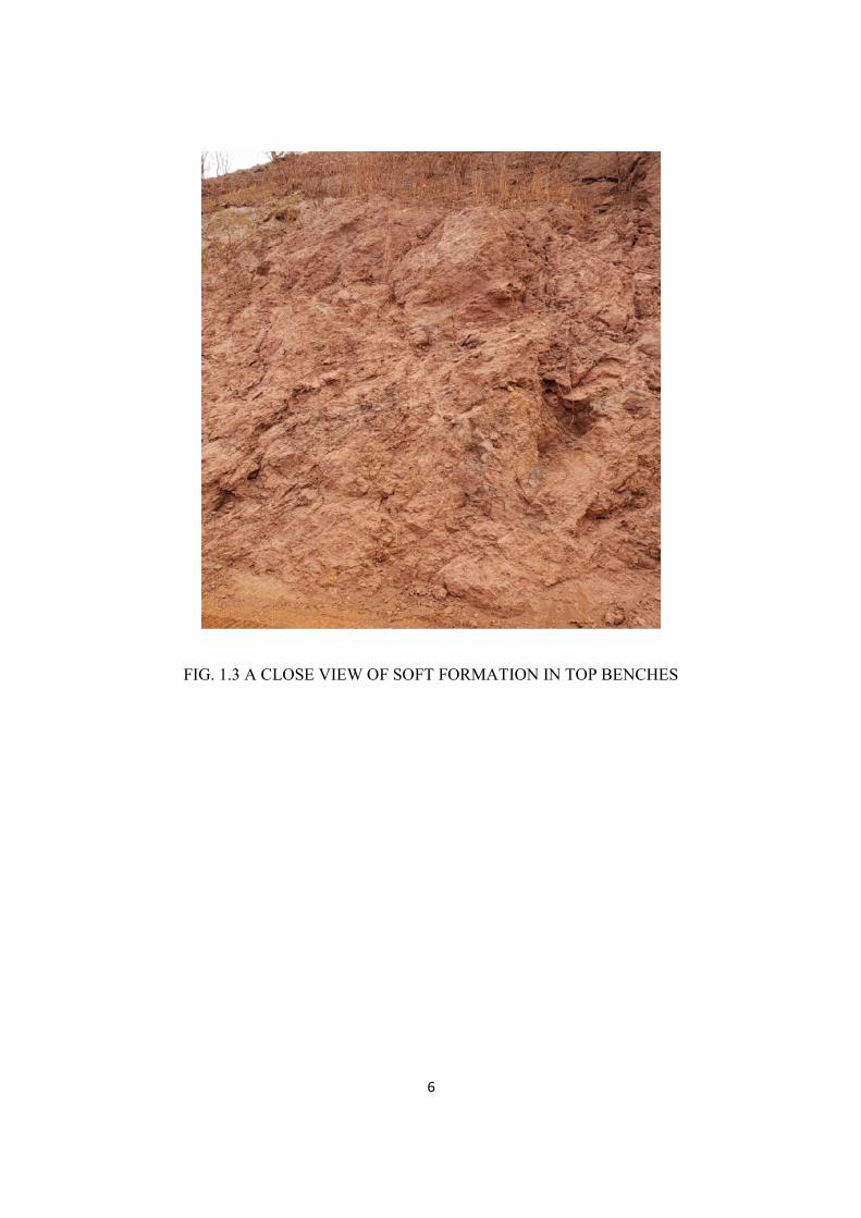
6
FIG. 1.3 A CLOSE VIEW OF SOFT FORMATION IN TOP BENCHES
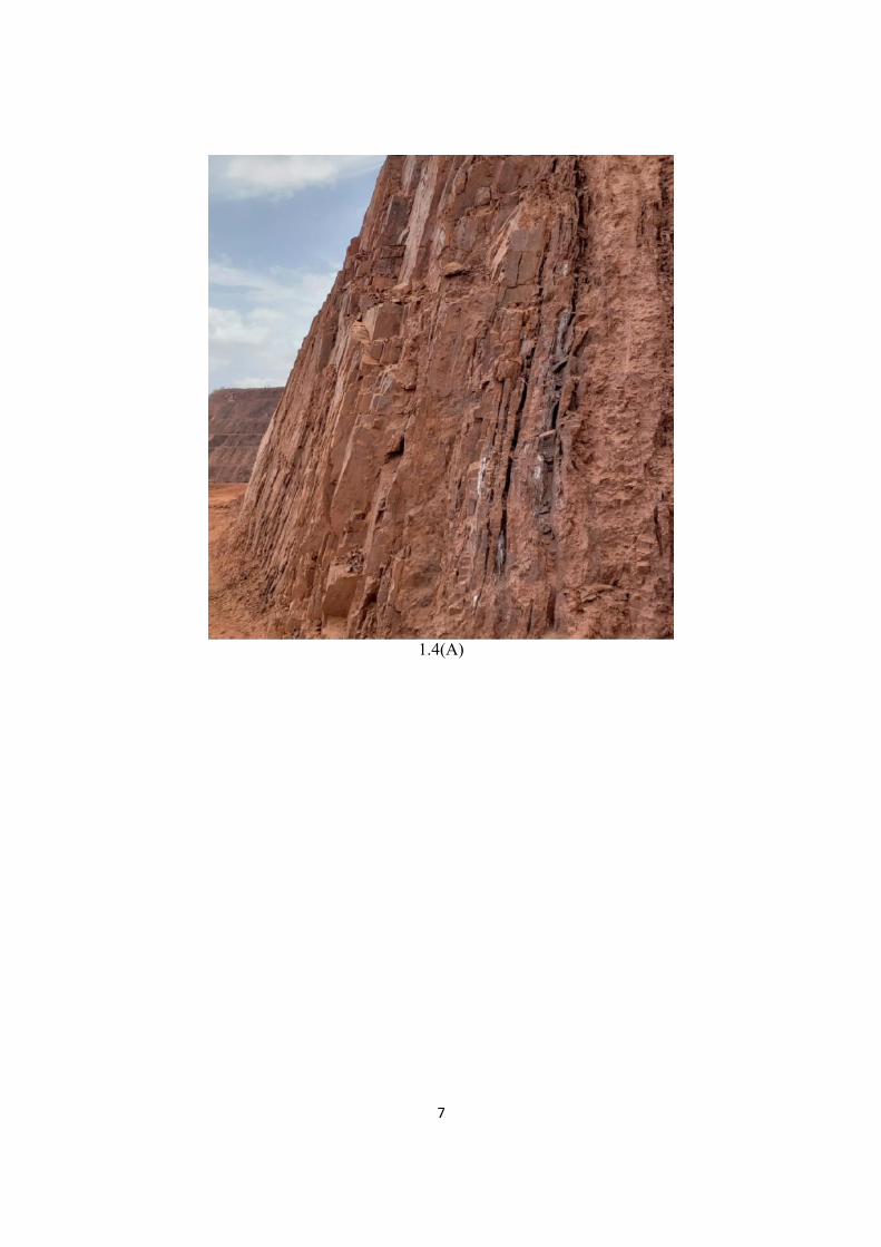
7
1.4(A)
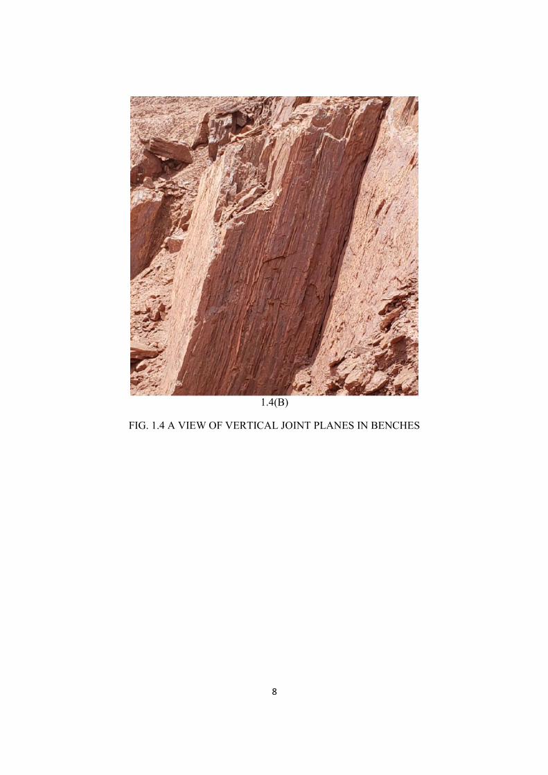
8
1.4(B)
FIG. 1.4 A VIEW OF VERTICAL JOINT PLANES IN BENCHES
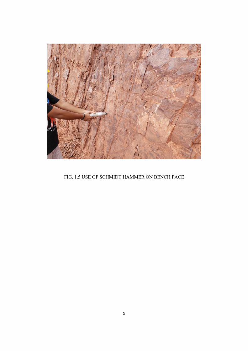
9
FIG. 1.5 USE OF SCHMIDT HAMMER ON BENCH FACE
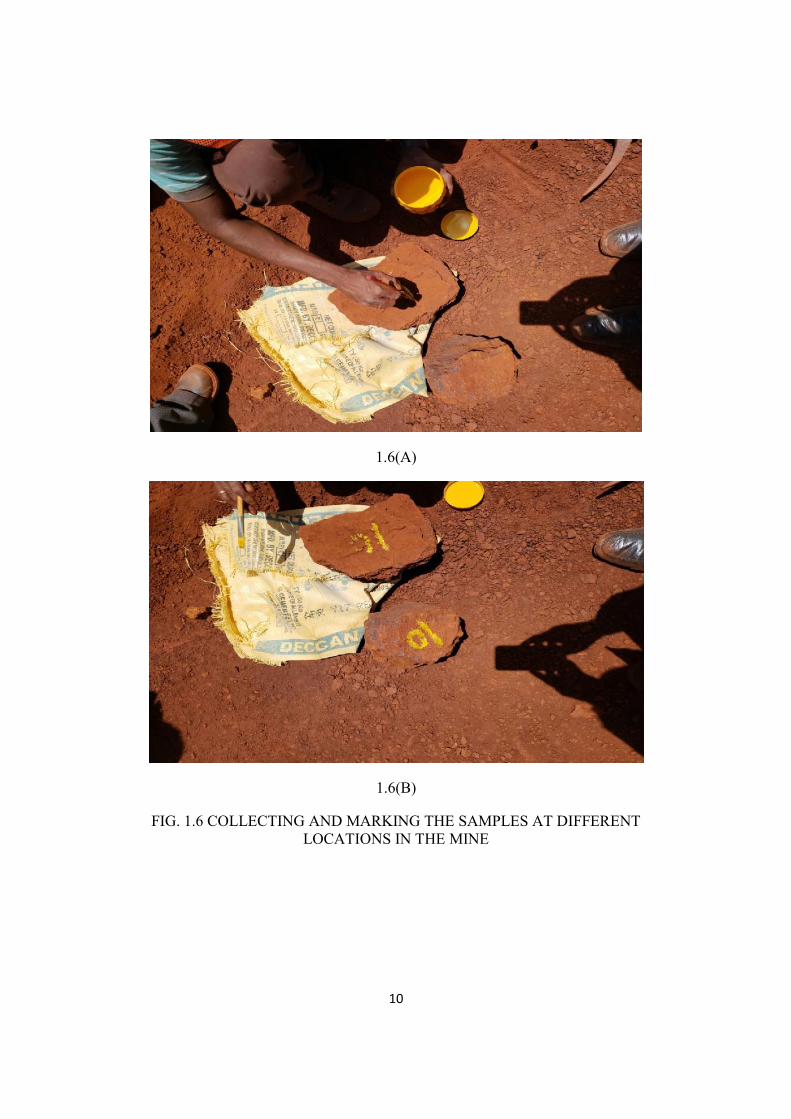
10
1.6(A)
1.6(B)
FIG. 1.6 COLLECTING AND MARKING THE SAMPLES AT DIFFERENTLOCATIONS IN THE MINE
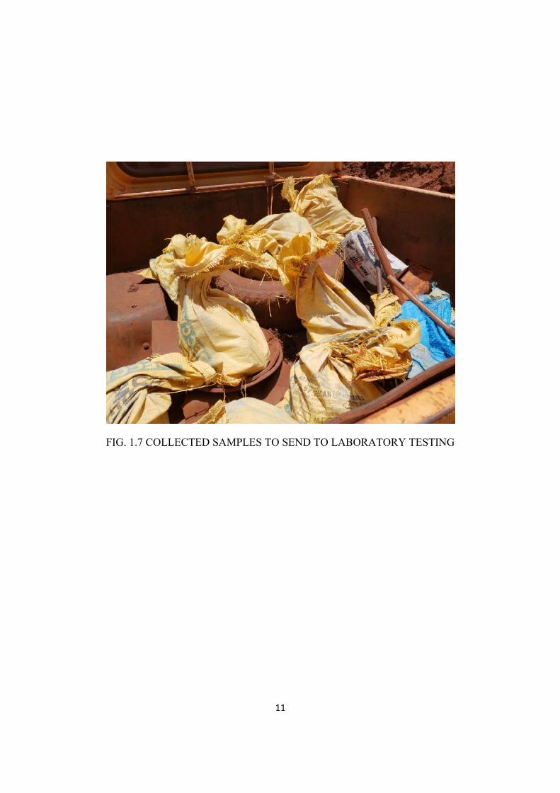
11
FIG. 1.7 COLLECTED SAMPLES TO SEND TO LABORATORY TESTING
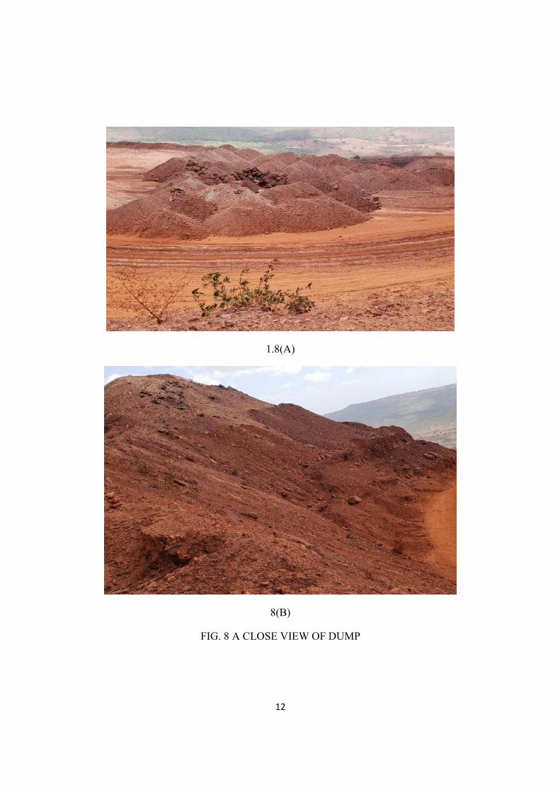
12
1.8(A)
8(B)
FIG. 8 A CLOSE VIEW OF DUMP
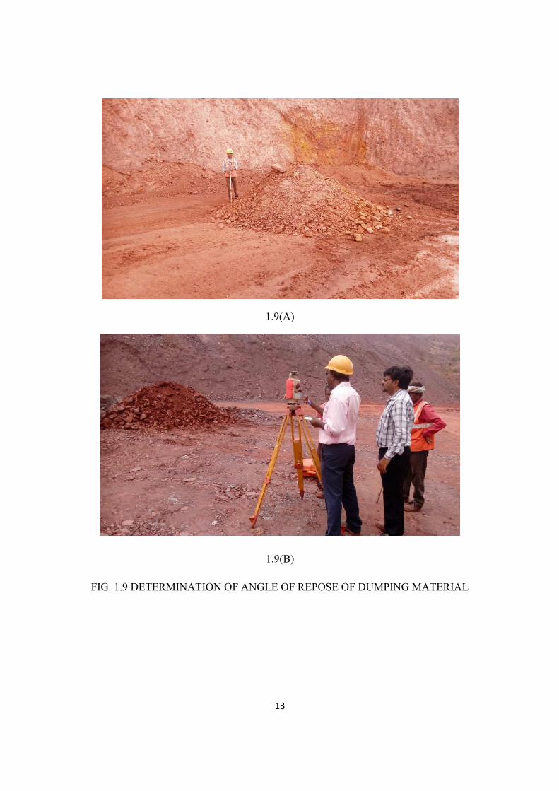
13
1.9(A)
1.9(B)
FIG. 1.9 DETERMINATION OF ANGLE OF REPOSE OF DUMPING MATERIAL
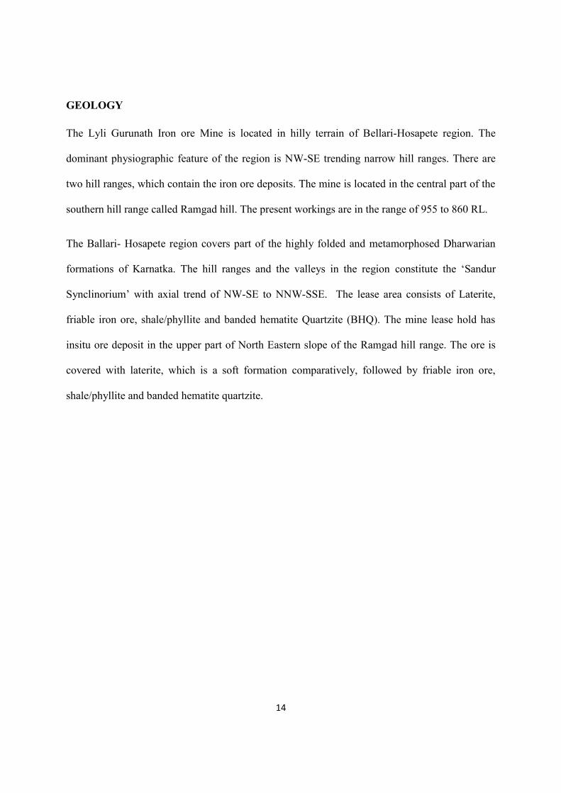
14
GEOLOGY
The Lyli Gurunath Iron ore Mine is located in hilly terrain of Bellari-Hosapete region. The
dominant physiographic feature of the region is NW-SE trending narrow hill ranges. There are
two hill ranges, which contain the iron ore deposits. The mine is located in the central part of the
southern hill range called Ramgad hill. The present workings are in the range of 955 to 860 RL.
The Ballari- Hosapete region covers part of the highly folded and metamorphosed Dharwarian
formations of Karnatka. The hill ranges and the valleys in the region constitute the ‘Sandur
Synclinorium’ with axial trend of NW-SE to NNW-SSE. The lease area consists of Laterite,
friable iron ore, shale/phyllite and banded hematite Quartzite (BHQ). The mine lease hold has
insitu ore deposit in the upper part of North Eastern slope of the Ramgad hill range. The ore is
covered with laterite, which is a soft formation comparatively, followed by friable iron ore,
shale/phyllite and banded hematite quartzite.
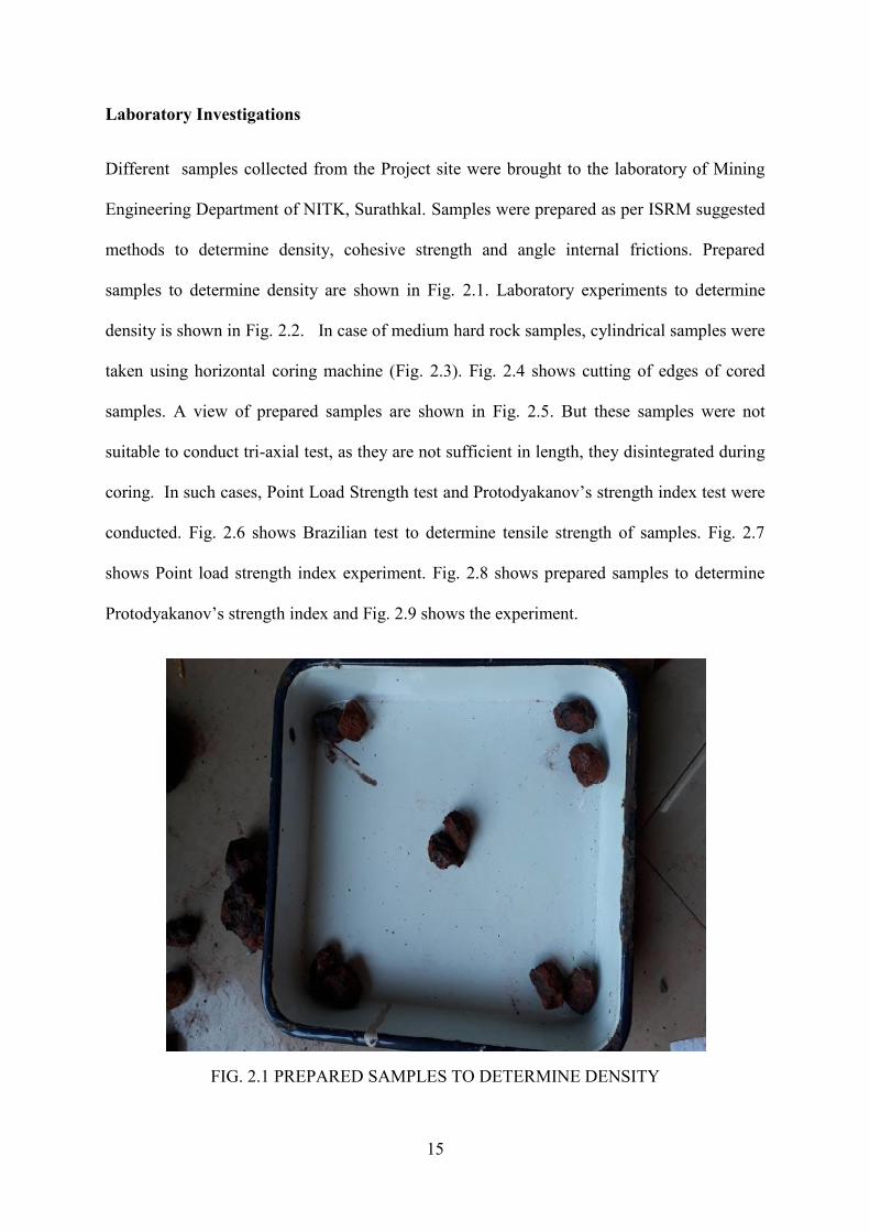
15
Laboratory Investigations
Different samples collected from the Project site were brought to the laboratory of Mining
Engineering Department of NITK, Surathkal. Samples were prepared as per ISRM suggested
methods to determine density, cohesive strength and angle internal frictions. Prepared
samples to determine density are shown in Fig. 2.1. Laboratory experiments to determine
density is shown in Fig. 2.2. In case of medium hard rock samples, cylindrical samples were
taken using horizontal coring machine (Fig. 2.3). Fig. 2.4 shows cutting of edges of cored
samples. A view of prepared samples are shown in Fig. 2.5. But these samples were not
suitable to conduct tri-axial test, as they are not sufficient in length, they disintegrated during
coring. In such cases, Point Load Strength test and Protodyakanov’s strength index test were
conducted. Fig. 2.6 shows Brazilian test to determine tensile strength of samples. Fig. 2.7
shows Point load strength index experiment. Fig. 2.8 shows prepared samples to determine
Protodyakanov’s strength index and Fig. 2.9 shows the experiment.
FIG. 2.1 PREPARED SAMPLES TO DETERMINE DENSITY
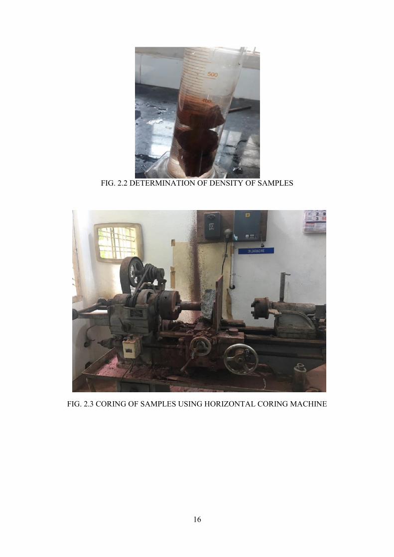
16
FIG. 2.2 DETERMINATION OF DENSITY OF SAMPLES
FIG. 2.3 CORING OF SAMPLES USING HORIZONTAL CORING MACHINE
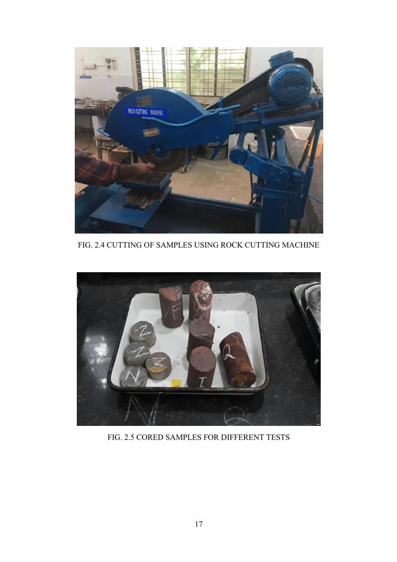
17
FIG. 2.4 CUTTING OF SAMPLES USING ROCK CUTTING MACHINE
FIG. 2.5 CORED SAMPLES FOR DIFFERENT TESTS
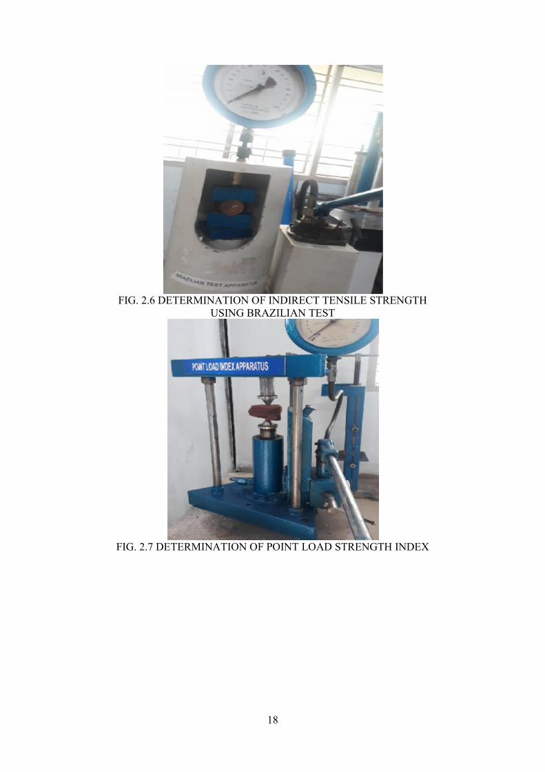
18
FIG. 2.6 DETERMINATION OF INDIRECT TENSILE STRENGTHUSING BRAZILIAN TEST
FIG. 2.7 DETERMINATION OF POINT LOAD STRENGTH INDEX
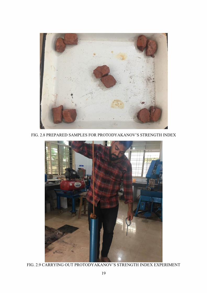
19
FIG. 2.8 PREPARED SAMPLES FOR PROTODYAKANOV’S STRENGTH INDEX
FIG. 2.9 CARRYING OUT PROTODYAKANOV’S STRENGTH INDEX EXPERIMENT

20
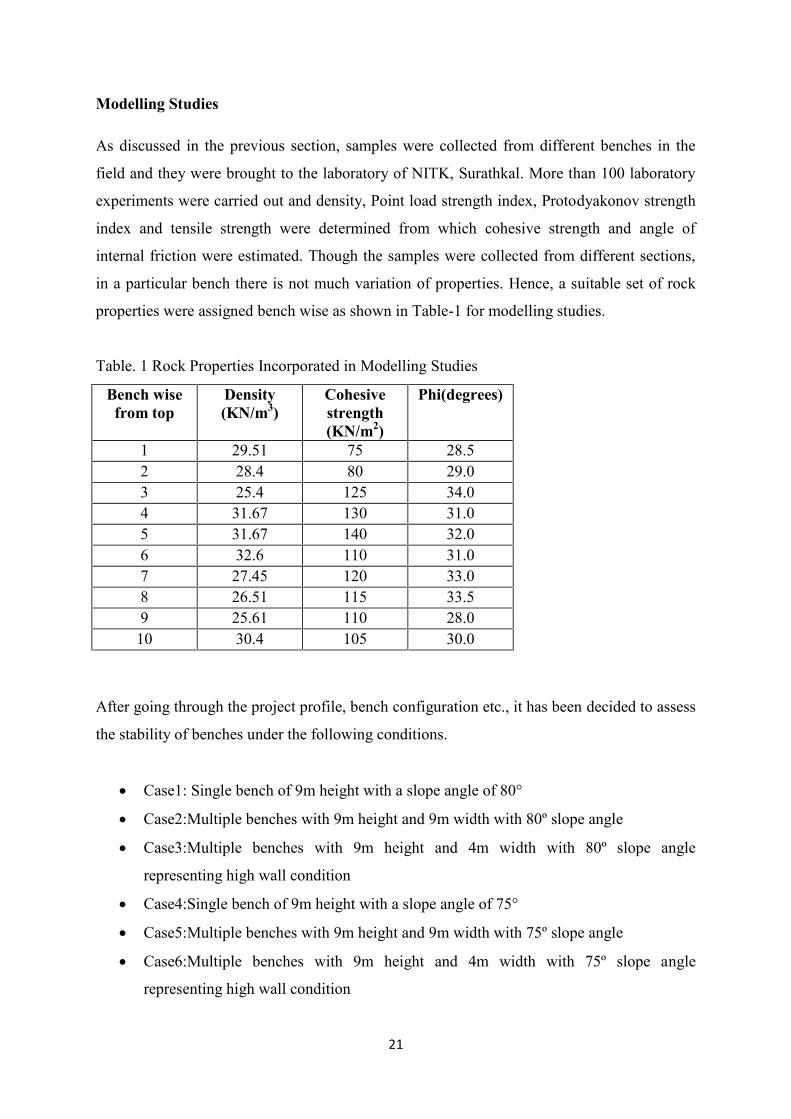
21
Modelling Studies
As discussed in the previous section, samples were collected from different benches in the
field and they were brought to the laboratory of NITK, Surathkal. More than 100 laboratory
experiments were carried out and density, Point load strength index, Protodyakonov strength
index and tensile strength were determined from which cohesive strength and angle of
internal friction were estimated. Though the samples were collected from different sections,
in a particular bench there is not much variation of properties. Hence, a suitable set of rock
properties were assigned bench wise as shown in Table-1 for modelling studies.
Table. 1 Rock Properties Incorporated in Modelling Studies
Bench wisefrom top
Density(KN/m3)
Cohesivestrength(KN/m2)
Phi(degrees)
1 29.51 75 28.52 28.4 80 29.03 25.4 125 34.04 31.67 130 31.05 31.67 140 32.06 32.6 110 31.07 27.45 120 33.08 26.51 115 33.59 25.61 110 28.010 30.4 105 30.0
After going through the project profile, bench configuration etc., it has been decided to assess
the stability of benches under the following conditions.
Case1: Single bench of 9m height with a slope angle of 80°
Case2:Multiple benches with 9m height and 9m width with 80º slope angle
Case3:Multiple benches with 9m height and 4m width with 80º slope angle
representing high wall condition
Case4:Single bench of 9m height with a slope angle of 75°
Case5:Multiple benches with 9m height and 9m width with 75º slope angle
Case6:Multiple benches with 9m height and 4m width with 75º slope angle
representing high wall condition
22
Case 1: Stability Analysis of Single Bench of 9m Height with 80º Slope Angle
Slope stability analysis is first carried out with a single bench configuration of 9m height and
80° slope angle with the lowest values of rock properties among all the benches. Single
bench, under circular failure has resulted in 1.881 FOS with Bishop’s method and 1.715 with
Janbu’s method (Fig. 3.1 & 3.2). This is a very safe condition, plane failure will yielded a
FOS of 7.507 With 75º plane angle under Bishop’s method and Janbu’s method (Fig. 3.3 &
3.4). In the above condition, the failure plane angle is reduced to 70 º, which yielded a FOS
of 3.280 for Bishop and Janbu’s methods (Fig. 3.5 & 3.6).
During rainy season, the saturation level of rock mass goes up resulting increased density and
pore pressure which may influence the stability of slopes. So, by increasing the density
marginally, the entire above case is reassessed under wet condition. The FOS was found to be
1.759 and 1.60 for circular failure condition with Bishop and Janbu’s method (Figs. 3.7
&3.8). Similarly under plane failure condition Bishop and Janbu’s methods resulted a FOS of
6.838 for 75 º failure plane angle (Figs. 3.9 & 3.10) and 3.0 FOS for 70º failure plane angle
(Figs. 3.11 & 3.12).
All the above conditions FOS values show very stable condition of every individual bench.
FIG.3.1 FOS OF A SINGLE BENCH UNDER CIRCULAR FAILUREWITH BISHOP’S METHOD
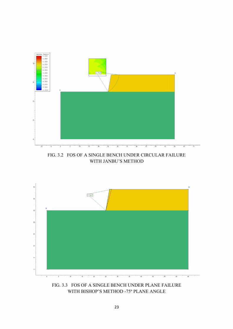
23
FIG. 3.2 FOS OF A SINGLE BENCH UNDER CIRCULAR FAILUREWITH JANBU’S METHOD
FIG. 3.3 FOS OF A SINGLE BENCH UNDER PLANE FAILUREWITH BISHOP’S METHOD -75º PLANE ANGLE
23
FIG. 3.2 FOS OF A SINGLE BENCH UNDER CIRCULAR FAILUREWITH JANBU’S METHOD
FIG. 3.3 FOS OF A SINGLE BENCH UNDER PLANE FAILUREWITH BISHOP’S METHOD -75º PLANE ANGLE
23
FIG. 3.2 FOS OF A SINGLE BENCH UNDER CIRCULAR FAILUREWITH JANBU’S METHOD
FIG. 3.3 FOS OF A SINGLE BENCH UNDER PLANE FAILUREWITH BISHOP’S METHOD -75º PLANE ANGLE
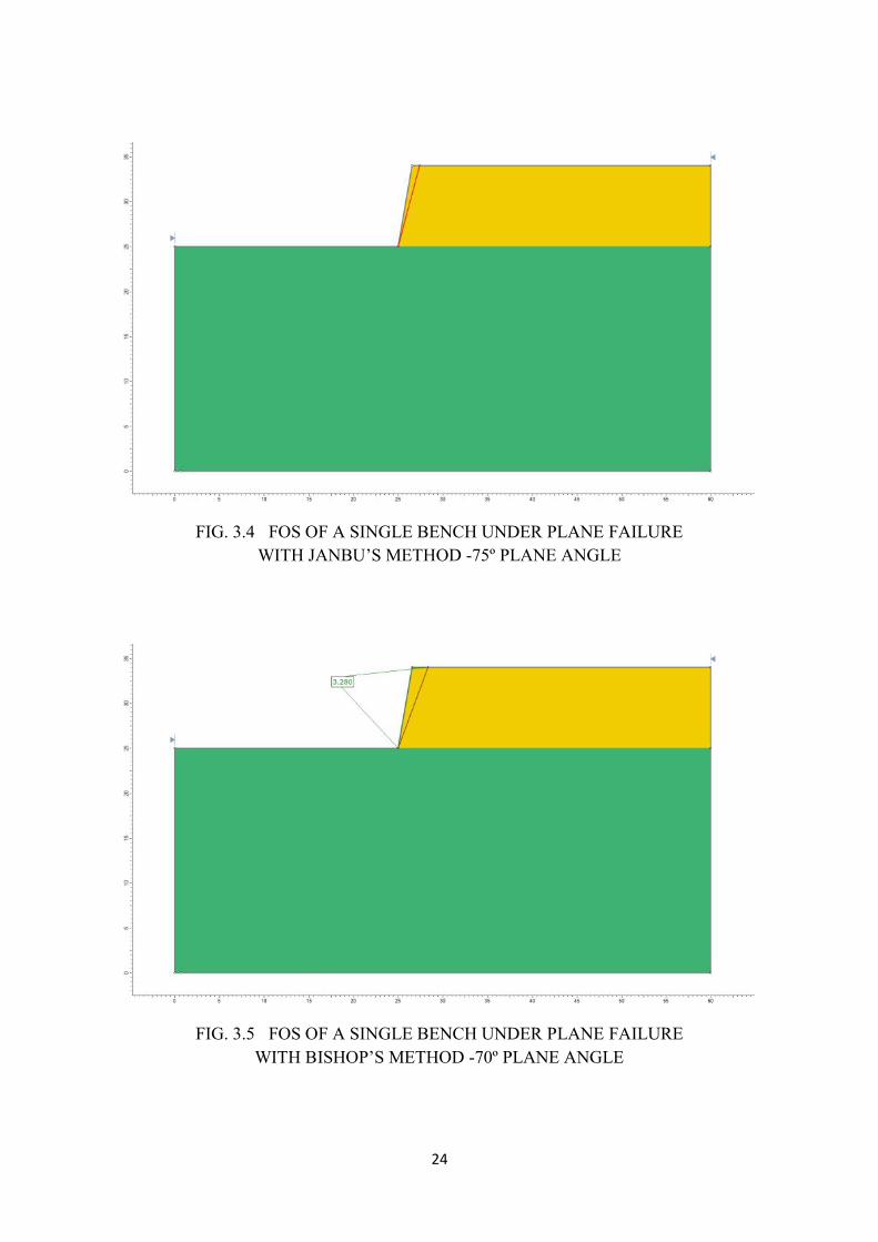
24
FIG. 3.4 FOS OF A SINGLE BENCH UNDER PLANE FAILUREWITH JANBU’S METHOD -75º PLANE ANGLE
FIG. 3.5 FOS OF A SINGLE BENCH UNDER PLANE FAILUREWITH BISHOP’S METHOD -70º PLANE ANGLE
24
FIG. 3.4 FOS OF A SINGLE BENCH UNDER PLANE FAILUREWITH JANBU’S METHOD -75º PLANE ANGLE
FIG. 3.5 FOS OF A SINGLE BENCH UNDER PLANE FAILUREWITH BISHOP’S METHOD -70º PLANE ANGLE
24
FIG. 3.4 FOS OF A SINGLE BENCH UNDER PLANE FAILUREWITH JANBU’S METHOD -75º PLANE ANGLE
FIG. 3.5 FOS OF A SINGLE BENCH UNDER PLANE FAILUREWITH BISHOP’S METHOD -70º PLANE ANGLE
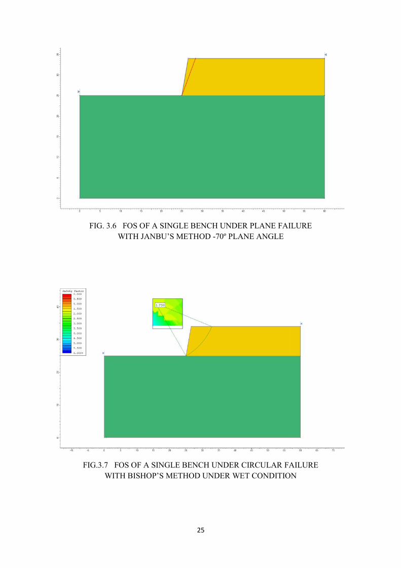
25
FIG. 3.6 FOS OF A SINGLE BENCH UNDER PLANE FAILUREWITH JANBU’S METHOD -70º PLANE ANGLE
FIG.3.7 FOS OF A SINGLE BENCH UNDER CIRCULAR FAILUREWITH BISHOP’S METHOD UNDER WET CONDITION
25
FIG. 3.6 FOS OF A SINGLE BENCH UNDER PLANE FAILUREWITH JANBU’S METHOD -70º PLANE ANGLE
FIG.3.7 FOS OF A SINGLE BENCH UNDER CIRCULAR FAILUREWITH BISHOP’S METHOD UNDER WET CONDITION
25
FIG. 3.6 FOS OF A SINGLE BENCH UNDER PLANE FAILUREWITH JANBU’S METHOD -70º PLANE ANGLE
FIG.3.7 FOS OF A SINGLE BENCH UNDER CIRCULAR FAILUREWITH BISHOP’S METHOD UNDER WET CONDITION
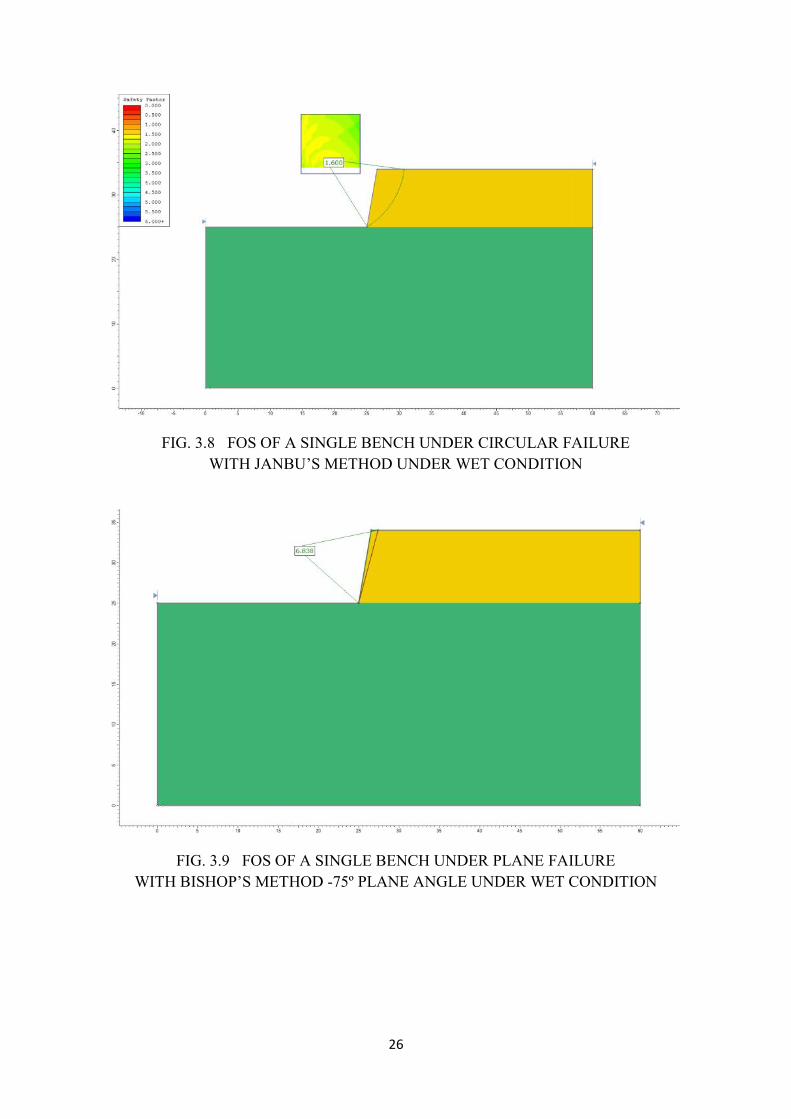
26
FIG. 3.8 FOS OF A SINGLE BENCH UNDER CIRCULAR FAILUREWITH JANBU’S METHOD UNDER WET CONDITION
FIG. 3.9 FOS OF A SINGLE BENCH UNDER PLANE FAILUREWITH BISHOP’S METHOD -75º PLANE ANGLE UNDER WET CONDITION
26
FIG. 3.8 FOS OF A SINGLE BENCH UNDER CIRCULAR FAILUREWITH JANBU’S METHOD UNDER WET CONDITION
FIG. 3.9 FOS OF A SINGLE BENCH UNDER PLANE FAILUREWITH BISHOP’S METHOD -75º PLANE ANGLE UNDER WET CONDITION
26
FIG. 3.8 FOS OF A SINGLE BENCH UNDER CIRCULAR FAILUREWITH JANBU’S METHOD UNDER WET CONDITION
FIG. 3.9 FOS OF A SINGLE BENCH UNDER PLANE FAILUREWITH BISHOP’S METHOD -75º PLANE ANGLE UNDER WET CONDITION
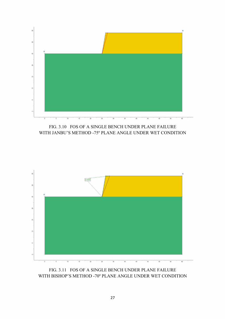
27
FIG. 3.10 FOS OF A SINGLE BENCH UNDER PLANE FAILUREWITH JANBU’S METHOD -75º PLANE ANGLE UNDER WET CONDITION
FIG. 3.11 FOS OF A SINGLE BENCH UNDER PLANE FAILUREWITH BISHOP’S METHOD -70º PLANE ANGLE UNDER WET CONDITION
27
FIG. 3.10 FOS OF A SINGLE BENCH UNDER PLANE FAILUREWITH JANBU’S METHOD -75º PLANE ANGLE UNDER WET CONDITION
FIG. 3.11 FOS OF A SINGLE BENCH UNDER PLANE FAILUREWITH BISHOP’S METHOD -70º PLANE ANGLE UNDER WET CONDITION
27
FIG. 3.10 FOS OF A SINGLE BENCH UNDER PLANE FAILUREWITH JANBU’S METHOD -75º PLANE ANGLE UNDER WET CONDITION
FIG. 3.11 FOS OF A SINGLE BENCH UNDER PLANE FAILUREWITH BISHOP’S METHOD -70º PLANE ANGLE UNDER WET CONDITION
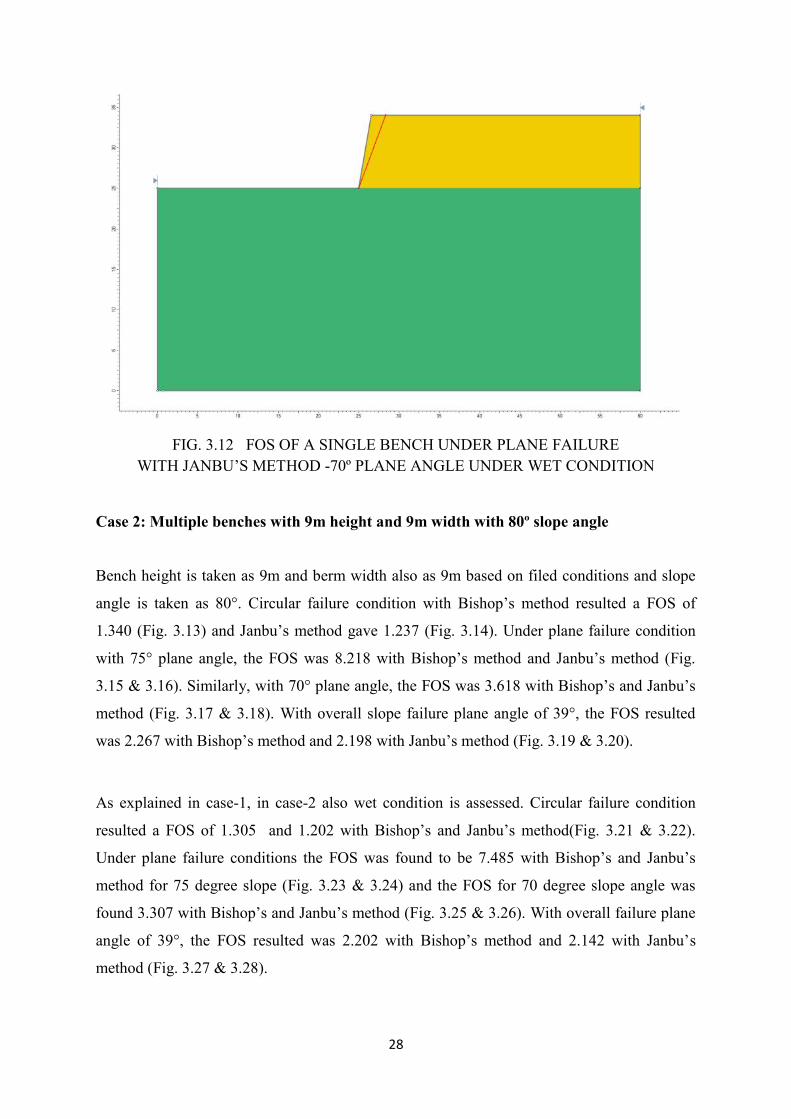
28
FIG. 3.12 FOS OF A SINGLE BENCH UNDER PLANE FAILUREWITH JANBU’S METHOD -70º PLANE ANGLE UNDER WET CONDITION
Case 2: Multiple benches with 9m height and 9m width with 80º slope angle
Bench height is taken as 9m and berm width also as 9m based on filed conditions and slope
angle is taken as 80°. Circular failure condition with Bishop’s method resulted a FOS of
1.340 (Fig. 3.13) and Janbu’s method gave 1.237 (Fig. 3.14). Under plane failure condition
with 75° plane angle, the FOS was 8.218 with Bishop’s method and Janbu’s method (Fig.
3.15 & 3.16). Similarly, with 70° plane angle, the FOS was 3.618 with Bishop’s and Janbu’s
method (Fig. 3.17 & 3.18). With overall slope failure plane angle of 39°, the FOS resulted
was 2.267 with Bishop’s method and 2.198 with Janbu’s method (Fig. 3.19 & 3.20).
As explained in case-1, in case-2 also wet condition is assessed. Circular failure condition
resulted a FOS of 1.305 and 1.202 with Bishop’s and Janbu’s method(Fig. 3.21 & 3.22).
Under plane failure conditions the FOS was found to be 7.485 with Bishop’s and Janbu’s
method for 75 degree slope (Fig. 3.23 & 3.24) and the FOS for 70 degree slope angle was
found 3.307 with Bishop’s and Janbu’s method (Fig. 3.25 & 3.26). With overall failure plane
angle of 39°, the FOS resulted was 2.202 with Bishop’s method and 2.142 with Janbu’s
method (Fig. 3.27 & 3.28).
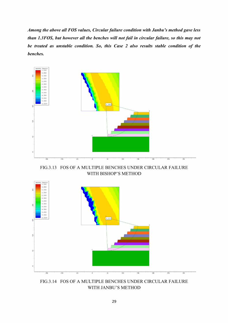
29
Among the above all FOS values, Circular failure condition with Janbu’s method gave less
than 1.3FOS, but however all the benches will not fail in circular failure, so this may not
be treated as unstable condition. So, this Case 2 also results stable condition of the
benches.
FIG.3.13 FOS OF A MULTIPLE BENCHES UNDER CIRCULAR FAILUREWITH BISHOP’S METHOD
FIG.3.14 FOS OF A MULTIPLE BENCHES UNDER CIRCULAR FAILUREWITH JANBU’S METHOD
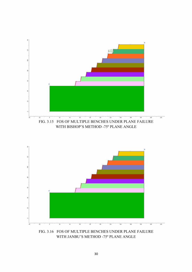
30
FIG. 3.15 FOS OF MULTIPLE BENCHES UNDER PLANE FAILUREWITH BISHOP’S METHOD -75º PLANE ANGLE
FIG. 3.16 FOS OF MULTIPLE BENCHES UNDER PLANE FAILUREWITH JANBU’S METHOD -75º PLANE ANGLE
30
FIG. 3.15 FOS OF MULTIPLE BENCHES UNDER PLANE FAILUREWITH BISHOP’S METHOD -75º PLANE ANGLE
FIG. 3.16 FOS OF MULTIPLE BENCHES UNDER PLANE FAILUREWITH JANBU’S METHOD -75º PLANE ANGLE
30
FIG. 3.15 FOS OF MULTIPLE BENCHES UNDER PLANE FAILUREWITH BISHOP’S METHOD -75º PLANE ANGLE
FIG. 3.16 FOS OF MULTIPLE BENCHES UNDER PLANE FAILUREWITH JANBU’S METHOD -75º PLANE ANGLE
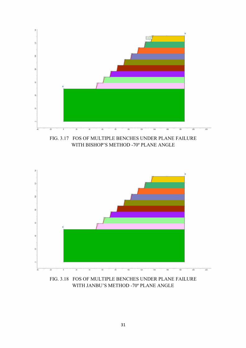
31
FIG. 3.17 FOS OF MULTIPLE BENCHES UNDER PLANE FAILUREWITH BISHOP’S METHOD -70º PLANE ANGLE
FIG. 3.18 FOS OF MULTIPLE BENCHES UNDER PLANE FAILUREWITH JANBU’S METHOD -70º PLANE ANGLE
31
FIG. 3.17 FOS OF MULTIPLE BENCHES UNDER PLANE FAILUREWITH BISHOP’S METHOD -70º PLANE ANGLE
FIG. 3.18 FOS OF MULTIPLE BENCHES UNDER PLANE FAILUREWITH JANBU’S METHOD -70º PLANE ANGLE
31
FIG. 3.17 FOS OF MULTIPLE BENCHES UNDER PLANE FAILUREWITH BISHOP’S METHOD -70º PLANE ANGLE
FIG. 3.18 FOS OF MULTIPLE BENCHES UNDER PLANE FAILUREWITH JANBU’S METHOD -70º PLANE ANGLE
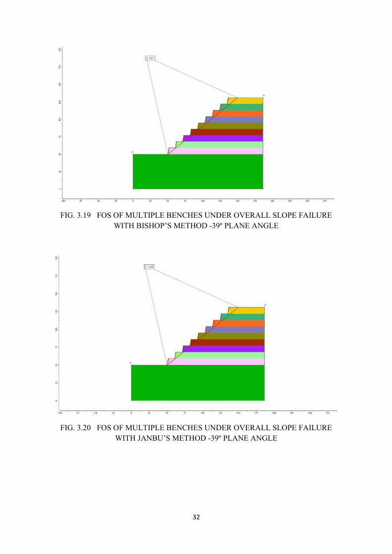
32
FIG. 3.19 FOS OF MULTIPLE BENCHES UNDER OVERALL SLOPE FAILUREWITH BISHOP’S METHOD -39º PLANE ANGLE
FIG. 3.20 FOS OF MULTIPLE BENCHES UNDER OVERALL SLOPE FAILUREWITH JANBU’S METHOD -39º PLANE ANGLE
32
FIG. 3.19 FOS OF MULTIPLE BENCHES UNDER OVERALL SLOPE FAILUREWITH BISHOP’S METHOD -39º PLANE ANGLE
FIG. 3.20 FOS OF MULTIPLE BENCHES UNDER OVERALL SLOPE FAILUREWITH JANBU’S METHOD -39º PLANE ANGLE
32
FIG. 3.19 FOS OF MULTIPLE BENCHES UNDER OVERALL SLOPE FAILUREWITH BISHOP’S METHOD -39º PLANE ANGLE
FIG. 3.20 FOS OF MULTIPLE BENCHES UNDER OVERALL SLOPE FAILUREWITH JANBU’S METHOD -39º PLANE ANGLE
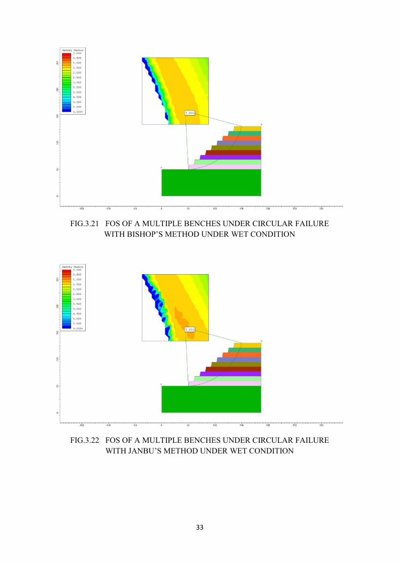
33
FIG.3.21 FOS OF A MULTIPLE BENCHES UNDER CIRCULAR FAILUREWITH BISHOP’S METHOD UNDER WET CONDITION
FIG.3.22 FOS OF A MULTIPLE BENCHES UNDER CIRCULAR FAILUREWITH JANBU’S METHOD UNDER WET CONDITION
33
FIG.3.21 FOS OF A MULTIPLE BENCHES UNDER CIRCULAR FAILUREWITH BISHOP’S METHOD UNDER WET CONDITION
FIG.3.22 FOS OF A MULTIPLE BENCHES UNDER CIRCULAR FAILUREWITH JANBU’S METHOD UNDER WET CONDITION
33
FIG.3.21 FOS OF A MULTIPLE BENCHES UNDER CIRCULAR FAILUREWITH BISHOP’S METHOD UNDER WET CONDITION
FIG.3.22 FOS OF A MULTIPLE BENCHES UNDER CIRCULAR FAILUREWITH JANBU’S METHOD UNDER WET CONDITION

34
FIG. 3.23 FOS OF MULTIPLE BENCHES UNDER PLANE FAILUREWITH BISHOP’S METHOD -75º PLANE ANGLE UNDER WET CONDITION
FIG. 3.24 FOS OF MULTIPLE BENCHES UNDER PLANE FAILUREWITH JANBU’S METHOD -75º PLANE ANGLE UNDER WET CONDITION
34
FIG. 3.23 FOS OF MULTIPLE BENCHES UNDER PLANE FAILUREWITH BISHOP’S METHOD -75º PLANE ANGLE UNDER WET CONDITION
FIG. 3.24 FOS OF MULTIPLE BENCHES UNDER PLANE FAILUREWITH JANBU’S METHOD -75º PLANE ANGLE UNDER WET CONDITION
34
FIG. 3.23 FOS OF MULTIPLE BENCHES UNDER PLANE FAILUREWITH BISHOP’S METHOD -75º PLANE ANGLE UNDER WET CONDITION
FIG. 3.24 FOS OF MULTIPLE BENCHES UNDER PLANE FAILUREWITH JANBU’S METHOD -75º PLANE ANGLE UNDER WET CONDITION
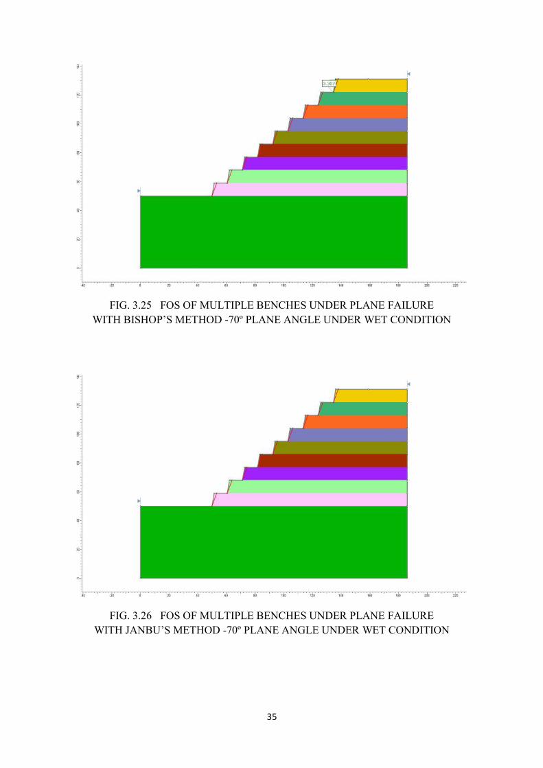
35
FIG. 3.25 FOS OF MULTIPLE BENCHES UNDER PLANE FAILUREWITH BISHOP’S METHOD -70º PLANE ANGLE UNDER WET CONDITION
FIG. 3.26 FOS OF MULTIPLE BENCHES UNDER PLANE FAILUREWITH JANBU’S METHOD -70º PLANE ANGLE UNDER WET CONDITION
35
FIG. 3.25 FOS OF MULTIPLE BENCHES UNDER PLANE FAILUREWITH BISHOP’S METHOD -70º PLANE ANGLE UNDER WET CONDITION
FIG. 3.26 FOS OF MULTIPLE BENCHES UNDER PLANE FAILUREWITH JANBU’S METHOD -70º PLANE ANGLE UNDER WET CONDITION
35
FIG. 3.25 FOS OF MULTIPLE BENCHES UNDER PLANE FAILUREWITH BISHOP’S METHOD -70º PLANE ANGLE UNDER WET CONDITION
FIG. 3.26 FOS OF MULTIPLE BENCHES UNDER PLANE FAILUREWITH JANBU’S METHOD -70º PLANE ANGLE UNDER WET CONDITION
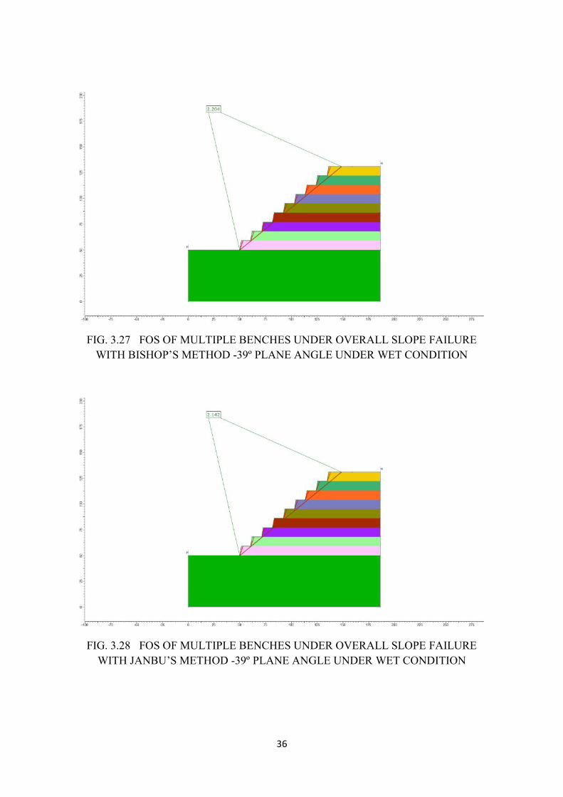
36
FIG. 3.27 FOS OF MULTIPLE BENCHES UNDER OVERALL SLOPE FAILUREWITH BISHOP’S METHOD -39º PLANE ANGLE UNDER WET CONDITION
FIG. 3.28 FOS OF MULTIPLE BENCHES UNDER OVERALL SLOPE FAILUREWITH JANBU’S METHOD -39º PLANE ANGLE UNDER WET CONDITION
36
FIG. 3.27 FOS OF MULTIPLE BENCHES UNDER OVERALL SLOPE FAILUREWITH BISHOP’S METHOD -39º PLANE ANGLE UNDER WET CONDITION
FIG. 3.28 FOS OF MULTIPLE BENCHES UNDER OVERALL SLOPE FAILUREWITH JANBU’S METHOD -39º PLANE ANGLE UNDER WET CONDITION
36
FIG. 3.27 FOS OF MULTIPLE BENCHES UNDER OVERALL SLOPE FAILUREWITH BISHOP’S METHOD -39º PLANE ANGLE UNDER WET CONDITION
FIG. 3.28 FOS OF MULTIPLE BENCHES UNDER OVERALL SLOPE FAILUREWITH JANBU’S METHOD -39º PLANE ANGLE UNDER WET CONDITION
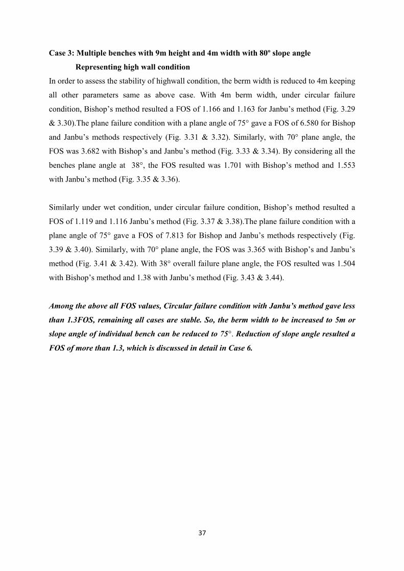
37
Case 3: Multiple benches with 9m height and 4m width with 80º slope angle
Representing high wall condition
In order to assess the stability of highwall condition, the berm width is reduced to 4m keeping
all other parameters same as above case. With 4m berm width, under circular failure
condition, Bishop’s method resulted a FOS of 1.166 and 1.163 for Janbu’s method (Fig. 3.29
& 3.30).The plane failure condition with a plane angle of 75° gave a FOS of 6.580 for Bishop
and Janbu’s methods respectively (Fig. 3.31 & 3.32). Similarly, with 70° plane angle, the
FOS was 3.682 with Bishop’s and Janbu’s method (Fig. 3.33 & 3.34). By considering all the
benches plane angle at 38°, the FOS resulted was 1.701 with Bishop’s method and 1.553
with Janbu’s method (Fig. 3.35 & 3.36).
Similarly under wet condition, under circular failure condition, Bishop’s method resulted a
FOS of 1.119 and 1.116 Janbu’s method (Fig. 3.37 & 3.38).The plane failure condition with a
plane angle of 75° gave a FOS of 7.813 for Bishop and Janbu’s methods respectively (Fig.
3.39 & 3.40). Similarly, with 70° plane angle, the FOS was 3.365 with Bishop’s and Janbu’s
method (Fig. 3.41 & 3.42). With 38° overall failure plane angle, the FOS resulted was 1.504
with Bishop’s method and 1.38 with Janbu’s method (Fig. 3.43 & 3.44).
Among the above all FOS values, Circular failure condition with Janbu’s method gave less
than 1.3FOS, remaining all cases are stable. So, the berm width to be increased to 5m or
slope angle of individual bench can be reduced to 75°. Reduction of slope angle resulted a
FOS of more than 1.3, which is discussed in detail in Case 6.
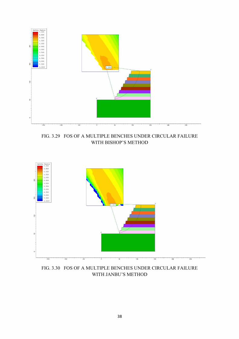
38
FIG. 3.29 FOS OF A MULTIPLE BENCHES UNDER CIRCULAR FAILUREWITH BISHOP’S METHOD
FIG. 3.30 FOS OF A MULTIPLE BENCHES UNDER CIRCULAR FAILUREWITH JANBU’S METHOD
38
FIG. 3.29 FOS OF A MULTIPLE BENCHES UNDER CIRCULAR FAILUREWITH BISHOP’S METHOD
FIG. 3.30 FOS OF A MULTIPLE BENCHES UNDER CIRCULAR FAILUREWITH JANBU’S METHOD
38
FIG. 3.29 FOS OF A MULTIPLE BENCHES UNDER CIRCULAR FAILUREWITH BISHOP’S METHOD
FIG. 3.30 FOS OF A MULTIPLE BENCHES UNDER CIRCULAR FAILUREWITH JANBU’S METHOD

39
FIG. 3.31 FOS OF MULTIPLE BENCHES UNDER PLANE FAILUREWITH BISHOP’S METHOD -75º PLANE ANGLE
FIG. 3.32 FOS OF MULTIPLE BENCHES UNDER PLANE FAILUREWITH JANBU’S METHOD -75º PLANE ANGLE
39
FIG. 3.31 FOS OF MULTIPLE BENCHES UNDER PLANE FAILUREWITH BISHOP’S METHOD -75º PLANE ANGLE
FIG. 3.32 FOS OF MULTIPLE BENCHES UNDER PLANE FAILUREWITH JANBU’S METHOD -75º PLANE ANGLE
39
FIG. 3.31 FOS OF MULTIPLE BENCHES UNDER PLANE FAILUREWITH BISHOP’S METHOD -75º PLANE ANGLE
FIG. 3.32 FOS OF MULTIPLE BENCHES UNDER PLANE FAILUREWITH JANBU’S METHOD -75º PLANE ANGLE
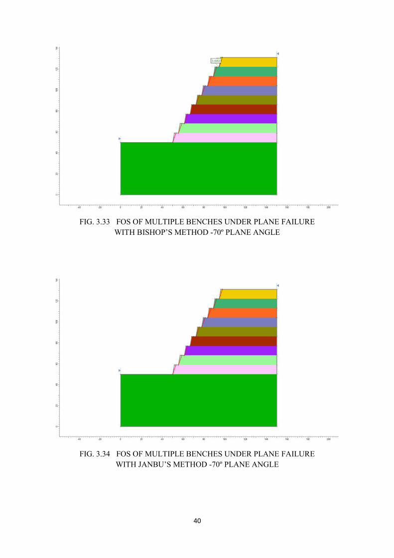
40
FIG. 3.33 FOS OF MULTIPLE BENCHES UNDER PLANE FAILUREWITH BISHOP’S METHOD -70º PLANE ANGLE
FIG. 3.34 FOS OF MULTIPLE BENCHES UNDER PLANE FAILUREWITH JANBU’S METHOD -70º PLANE ANGLE
40
FIG. 3.33 FOS OF MULTIPLE BENCHES UNDER PLANE FAILUREWITH BISHOP’S METHOD -70º PLANE ANGLE
FIG. 3.34 FOS OF MULTIPLE BENCHES UNDER PLANE FAILUREWITH JANBU’S METHOD -70º PLANE ANGLE
40
FIG. 3.33 FOS OF MULTIPLE BENCHES UNDER PLANE FAILUREWITH BISHOP’S METHOD -70º PLANE ANGLE
FIG. 3.34 FOS OF MULTIPLE BENCHES UNDER PLANE FAILUREWITH JANBU’S METHOD -70º PLANE ANGLE
41
FIG. 3.35 FOS OF MULTIPLE BENCHES UNDER OVERALL SLOPE FAILUREWITH BISHOP’S METHOD -39º PLANE ANGLE
FIG. 3.36 FOS OF MULTIPLE BENCHES UNDER OVERALL SLOPE FAILUREWITH JANBU’S METHOD -39º PLANE ANGLE
41
FIG. 3.35 FOS OF MULTIPLE BENCHES UNDER OVERALL SLOPE FAILUREWITH BISHOP’S METHOD -39º PLANE ANGLE
FIG. 3.36 FOS OF MULTIPLE BENCHES UNDER OVERALL SLOPE FAILUREWITH JANBU’S METHOD -39º PLANE ANGLE
41
FIG. 3.35 FOS OF MULTIPLE BENCHES UNDER OVERALL SLOPE FAILUREWITH BISHOP’S METHOD -39º PLANE ANGLE
FIG. 3.36 FOS OF MULTIPLE BENCHES UNDER OVERALL SLOPE FAILUREWITH JANBU’S METHOD -39º PLANE ANGLE
42
FIG.3.37 FOS OF A MULTIPLE BENCHES UNDER CIRCULAR FAILUREWITH BISHOP’S METHOD UNDER WET CONDITION
FIG.3.38 FOS OF A MULTIPLE BENCHES UNDER CIRCULAR FAILUREWITH JANBU’S METHOD UNDER WET CONDITION
42
FIG.3.37 FOS OF A MULTIPLE BENCHES UNDER CIRCULAR FAILUREWITH BISHOP’S METHOD UNDER WET CONDITION
FIG.3.38 FOS OF A MULTIPLE BENCHES UNDER CIRCULAR FAILUREWITH JANBU’S METHOD UNDER WET CONDITION
42
FIG.3.37 FOS OF A MULTIPLE BENCHES UNDER CIRCULAR FAILUREWITH BISHOP’S METHOD UNDER WET CONDITION
FIG.3.38 FOS OF A MULTIPLE BENCHES UNDER CIRCULAR FAILUREWITH JANBU’S METHOD UNDER WET CONDITION
43
FIG. 3.39 FOS OF MULTIPLE BENCHES UNDER PLANE FAILUREWITH BISHOP’S METHOD -75º PLANE ANGLE UNDER WET CONDITION
FIG. 3.40 FOS OF MULTIPLE BENCHES UNDER PLANE FAILUREWITH JANBU’S METHOD -75º PLANE ANGLE UNDER WET CONDITION
43
FIG. 3.39 FOS OF MULTIPLE BENCHES UNDER PLANE FAILUREWITH BISHOP’S METHOD -75º PLANE ANGLE UNDER WET CONDITION
FIG. 3.40 FOS OF MULTIPLE BENCHES UNDER PLANE FAILUREWITH JANBU’S METHOD -75º PLANE ANGLE UNDER WET CONDITION
43
FIG. 3.39 FOS OF MULTIPLE BENCHES UNDER PLANE FAILUREWITH BISHOP’S METHOD -75º PLANE ANGLE UNDER WET CONDITION
FIG. 3.40 FOS OF MULTIPLE BENCHES UNDER PLANE FAILUREWITH JANBU’S METHOD -75º PLANE ANGLE UNDER WET CONDITION
44
FIG. 3.41 FOS OF MULTIPLE BENCHES UNDER PLANE FAILUREWITH BISHOP’S METHOD -70º PLANE ANGLE UNDER WET CONDITION
FIG. 3.42 FOS OF MULTIPLE BENCHES UNDER PLANE FAILUREWITH JANBU’S METHOD -70º PLANE ANGLE UNDER WET CONDITION
44
FIG. 3.41 FOS OF MULTIPLE BENCHES UNDER PLANE FAILUREWITH BISHOP’S METHOD -70º PLANE ANGLE UNDER WET CONDITION
FIG. 3.42 FOS OF MULTIPLE BENCHES UNDER PLANE FAILUREWITH JANBU’S METHOD -70º PLANE ANGLE UNDER WET CONDITION
44
FIG. 3.41 FOS OF MULTIPLE BENCHES UNDER PLANE FAILUREWITH BISHOP’S METHOD -70º PLANE ANGLE UNDER WET CONDITION
FIG. 3.42 FOS OF MULTIPLE BENCHES UNDER PLANE FAILUREWITH JANBU’S METHOD -70º PLANE ANGLE UNDER WET CONDITION
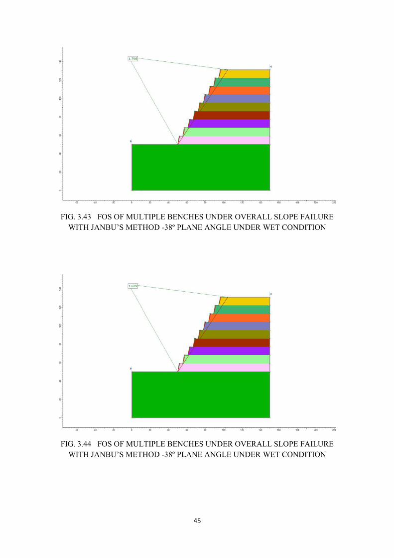
45
FIG. 3.43 FOS OF MULTIPLE BENCHES UNDER OVERALL SLOPE FAILUREWITH JANBU’S METHOD -38º PLANE ANGLE UNDER WET CONDITION
FIG. 3.44 FOS OF MULTIPLE BENCHES UNDER OVERALL SLOPE FAILUREWITH JANBU’S METHOD -38º PLANE ANGLE UNDER WET CONDITION
45
FIG. 3.43 FOS OF MULTIPLE BENCHES UNDER OVERALL SLOPE FAILUREWITH JANBU’S METHOD -38º PLANE ANGLE UNDER WET CONDITION
FIG. 3.44 FOS OF MULTIPLE BENCHES UNDER OVERALL SLOPE FAILUREWITH JANBU’S METHOD -38º PLANE ANGLE UNDER WET CONDITION
45
FIG. 3.43 FOS OF MULTIPLE BENCHES UNDER OVERALL SLOPE FAILUREWITH JANBU’S METHOD -38º PLANE ANGLE UNDER WET CONDITION
FIG. 3.44 FOS OF MULTIPLE BENCHES UNDER OVERALL SLOPE FAILUREWITH JANBU’S METHOD -38º PLANE ANGLE UNDER WET CONDITION
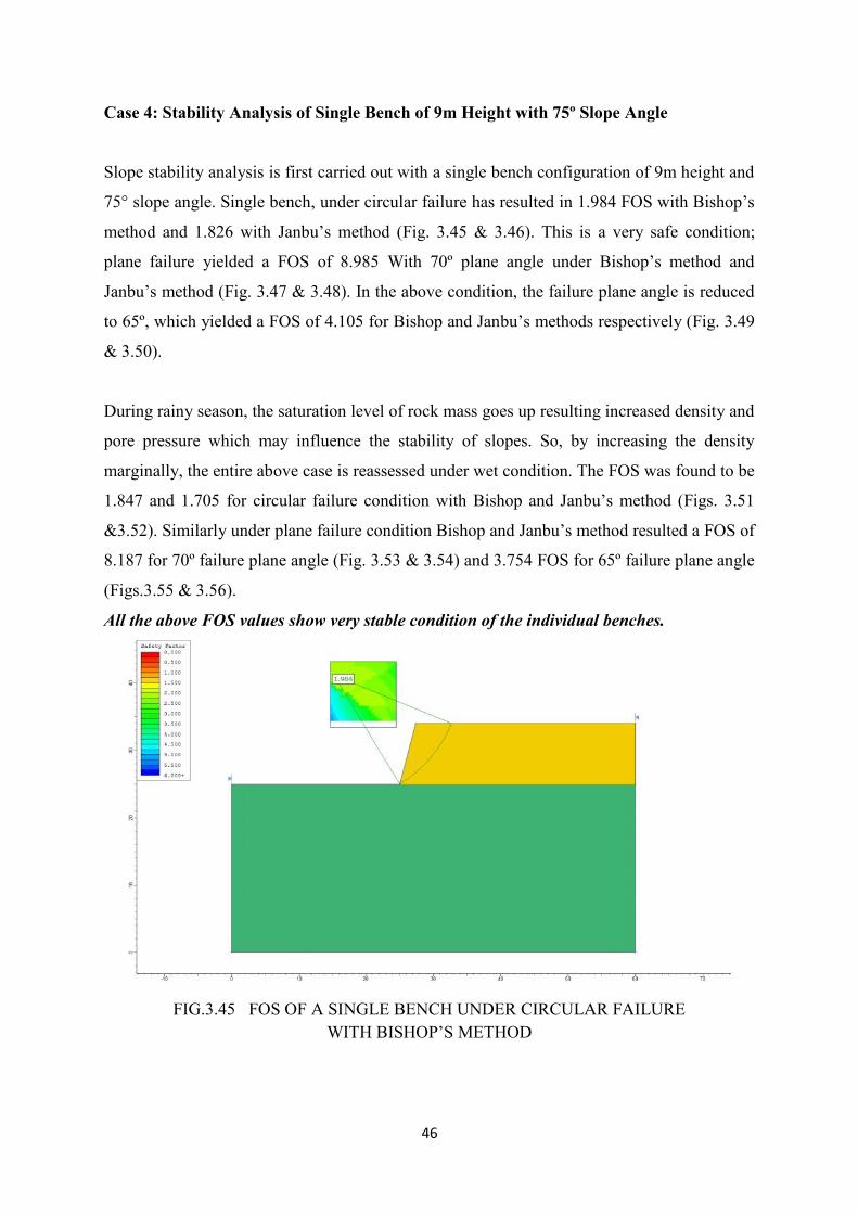
46
Case 4: Stability Analysis of Single Bench of 9m Height with 75º Slope Angle
Slope stability analysis is first carried out with a single bench configuration of 9m height and
75° slope angle. Single bench, under circular failure has resulted in 1.984 FOS with Bishop’s
method and 1.826 with Janbu’s method (Fig. 3.45 & 3.46). This is a very safe condition;
plane failure yielded a FOS of 8.985 With 70º plane angle under Bishop’s method and
Janbu’s method (Fig. 3.47 & 3.48). In the above condition, the failure plane angle is reduced
to 65º, which yielded a FOS of 4.105 for Bishop and Janbu’s methods respectively (Fig. 3.49
& 3.50).
During rainy season, the saturation level of rock mass goes up resulting increased density and
pore pressure which may influence the stability of slopes. So, by increasing the density
marginally, the entire above case is reassessed under wet condition. The FOS was found to be
1.847 and 1.705 for circular failure condition with Bishop and Janbu’s method (Figs. 3.51
&3.52). Similarly under plane failure condition Bishop and Janbu’s method resulted a FOS of
8.187 for 70º failure plane angle (Fig. 3.53 & 3.54) and 3.754 FOS for 65º failure plane angle
(Figs.3.55 & 3.56).
All the above FOS values show very stable condition of the individual benches.
FIG.3.45 FOS OF A SINGLE BENCH UNDER CIRCULAR FAILUREWITH BISHOP’S METHOD
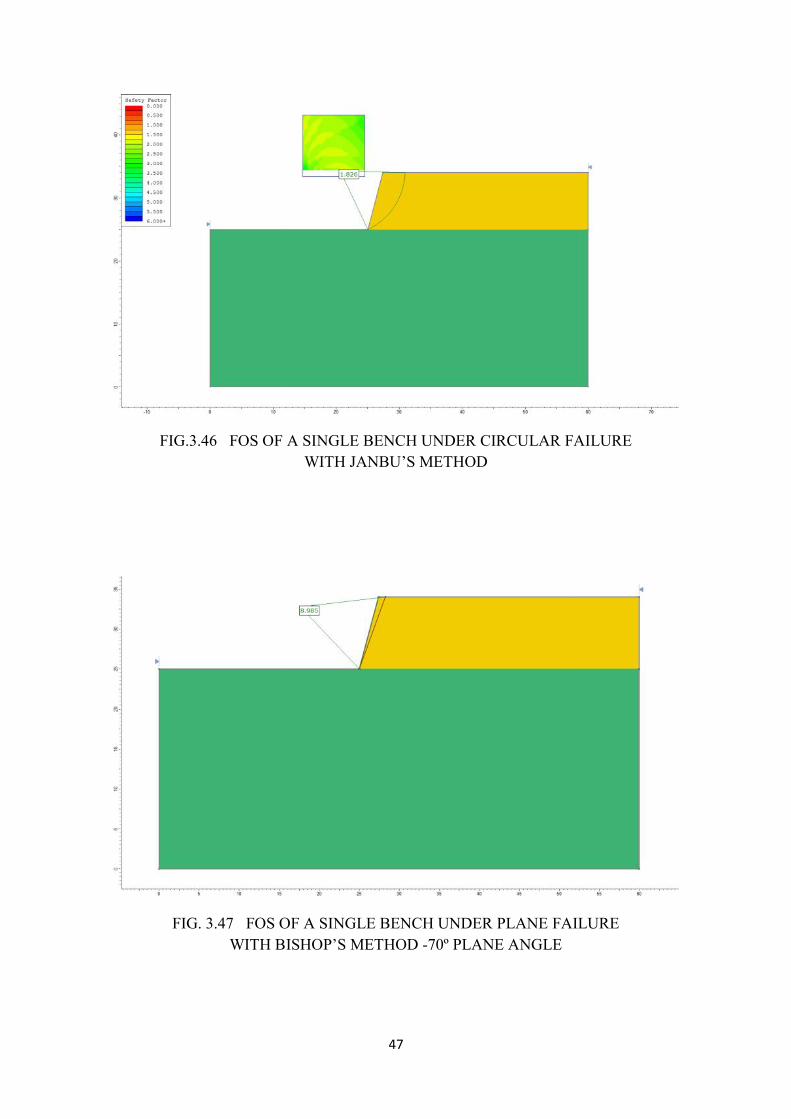
47
FIG.3.46 FOS OF A SINGLE BENCH UNDER CIRCULAR FAILUREWITH JANBU’S METHOD
FIG. 3.47 FOS OF A SINGLE BENCH UNDER PLANE FAILUREWITH BISHOP’S METHOD -70º PLANE ANGLE
47
FIG.3.46 FOS OF A SINGLE BENCH UNDER CIRCULAR FAILUREWITH JANBU’S METHOD
FIG. 3.47 FOS OF A SINGLE BENCH UNDER PLANE FAILUREWITH BISHOP’S METHOD -70º PLANE ANGLE
47
FIG.3.46 FOS OF A SINGLE BENCH UNDER CIRCULAR FAILUREWITH JANBU’S METHOD
FIG. 3.47 FOS OF A SINGLE BENCH UNDER PLANE FAILUREWITH BISHOP’S METHOD -70º PLANE ANGLE
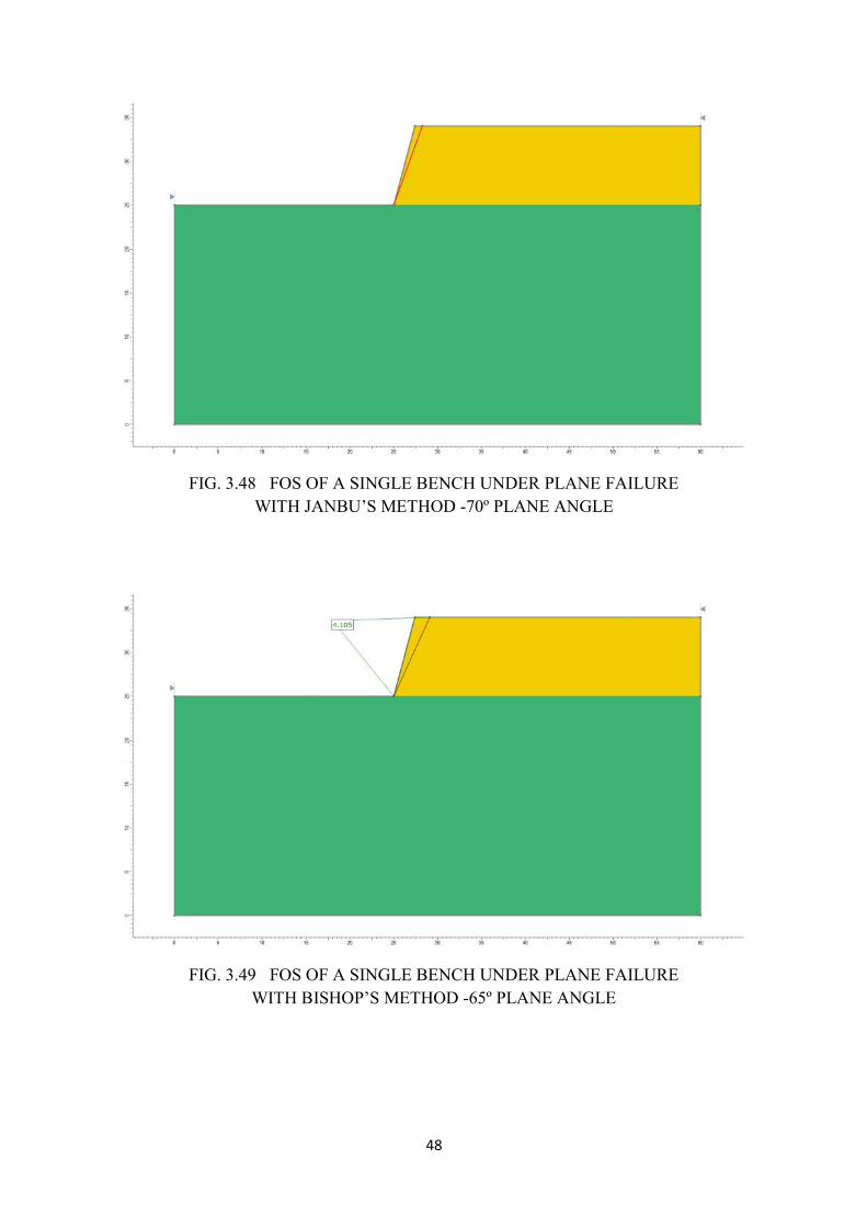
48
FIG. 3.48 FOS OF A SINGLE BENCH UNDER PLANE FAILUREWITH JANBU’S METHOD -70º PLANE ANGLE
FIG. 3.49 FOS OF A SINGLE BENCH UNDER PLANE FAILUREWITH BISHOP’S METHOD -65º PLANE ANGLE
48
FIG. 3.48 FOS OF A SINGLE BENCH UNDER PLANE FAILUREWITH JANBU’S METHOD -70º PLANE ANGLE
FIG. 3.49 FOS OF A SINGLE BENCH UNDER PLANE FAILUREWITH BISHOP’S METHOD -65º PLANE ANGLE
48
FIG. 3.48 FOS OF A SINGLE BENCH UNDER PLANE FAILUREWITH JANBU’S METHOD -70º PLANE ANGLE
FIG. 3.49 FOS OF A SINGLE BENCH UNDER PLANE FAILUREWITH BISHOP’S METHOD -65º PLANE ANGLE
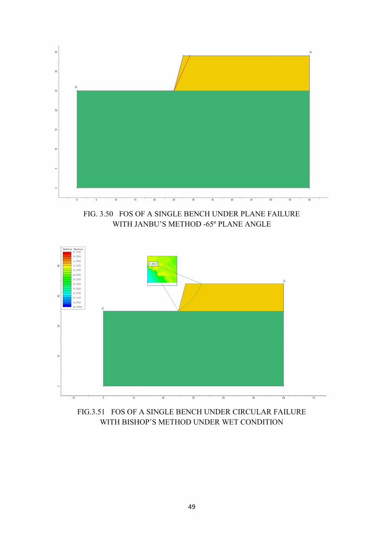
49
FIG. 3.50 FOS OF A SINGLE BENCH UNDER PLANE FAILUREWITH JANBU’S METHOD -65º PLANE ANGLE
FIG.3.51 FOS OF A SINGLE BENCH UNDER CIRCULAR FAILUREWITH BISHOP’S METHOD UNDER WET CONDITION
49
FIG. 3.50 FOS OF A SINGLE BENCH UNDER PLANE FAILUREWITH JANBU’S METHOD -65º PLANE ANGLE
FIG.3.51 FOS OF A SINGLE BENCH UNDER CIRCULAR FAILUREWITH BISHOP’S METHOD UNDER WET CONDITION
49
FIG. 3.50 FOS OF A SINGLE BENCH UNDER PLANE FAILUREWITH JANBU’S METHOD -65º PLANE ANGLE
FIG.3.51 FOS OF A SINGLE BENCH UNDER CIRCULAR FAILUREWITH BISHOP’S METHOD UNDER WET CONDITION

50
FIG.3.52 FOS OF A SINGLE BENCH UNDER CIRCULAR FAILUREWITH JANBU’S METHOD UNDER WET CONDITION
FIG. 3.53 FOS OF A SINGLE BENCH UNDER PLANE FAILUREWITH BISHOP’S METHOD -70º PLANE ANGLE UNDER WET CONDITION
50
FIG.3.52 FOS OF A SINGLE BENCH UNDER CIRCULAR FAILUREWITH JANBU’S METHOD UNDER WET CONDITION
FIG. 3.53 FOS OF A SINGLE BENCH UNDER PLANE FAILUREWITH BISHOP’S METHOD -70º PLANE ANGLE UNDER WET CONDITION
50
FIG.3.52 FOS OF A SINGLE BENCH UNDER CIRCULAR FAILUREWITH JANBU’S METHOD UNDER WET CONDITION
FIG. 3.53 FOS OF A SINGLE BENCH UNDER PLANE FAILUREWITH BISHOP’S METHOD -70º PLANE ANGLE UNDER WET CONDITION
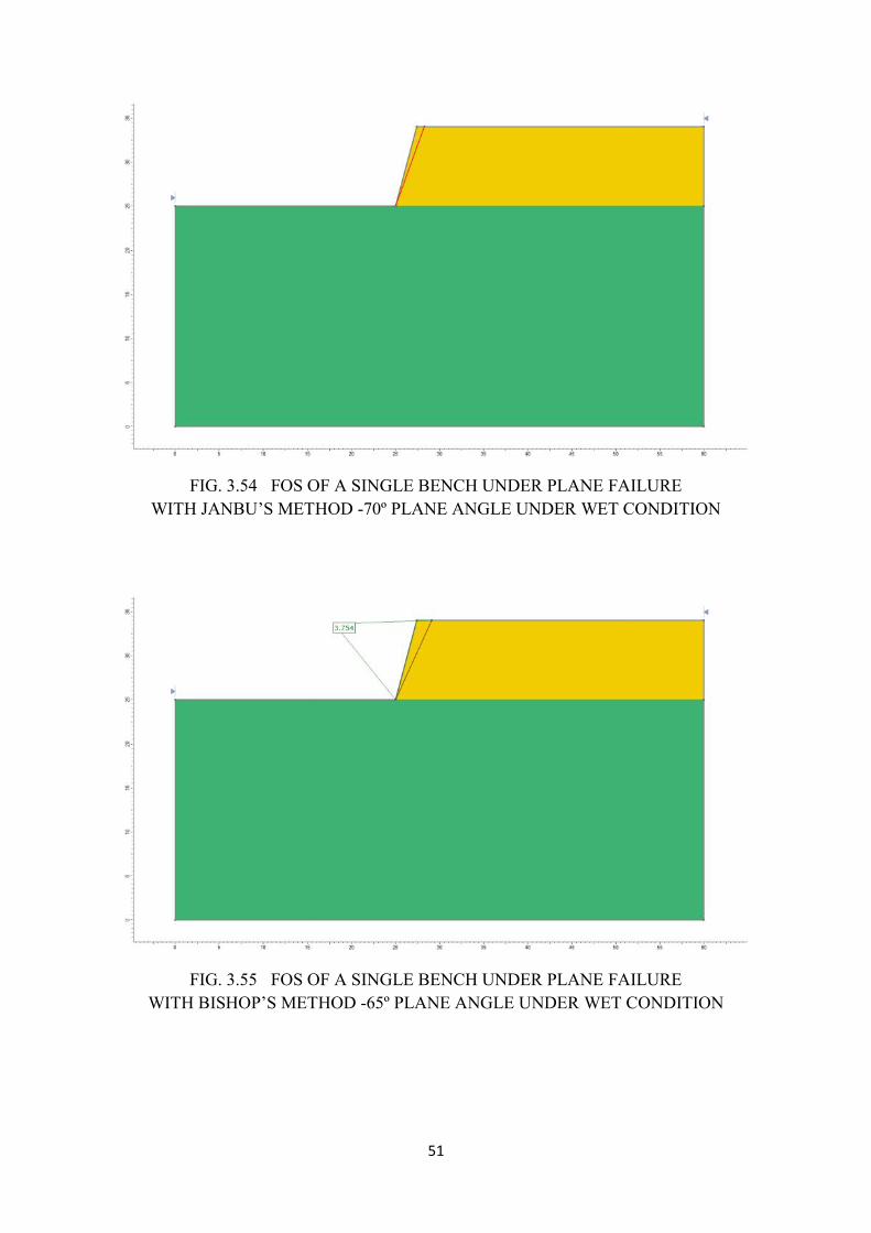
51
FIG. 3.54 FOS OF A SINGLE BENCH UNDER PLANE FAILUREWITH JANBU’S METHOD -70º PLANE ANGLE UNDER WET CONDITION
FIG. 3.55 FOS OF A SINGLE BENCH UNDER PLANE FAILUREWITH BISHOP’S METHOD -65º PLANE ANGLE UNDER WET CONDITION
51
FIG. 3.54 FOS OF A SINGLE BENCH UNDER PLANE FAILUREWITH JANBU’S METHOD -70º PLANE ANGLE UNDER WET CONDITION
FIG. 3.55 FOS OF A SINGLE BENCH UNDER PLANE FAILUREWITH BISHOP’S METHOD -65º PLANE ANGLE UNDER WET CONDITION
51
FIG. 3.54 FOS OF A SINGLE BENCH UNDER PLANE FAILUREWITH JANBU’S METHOD -70º PLANE ANGLE UNDER WET CONDITION
FIG. 3.55 FOS OF A SINGLE BENCH UNDER PLANE FAILUREWITH BISHOP’S METHOD -65º PLANE ANGLE UNDER WET CONDITION
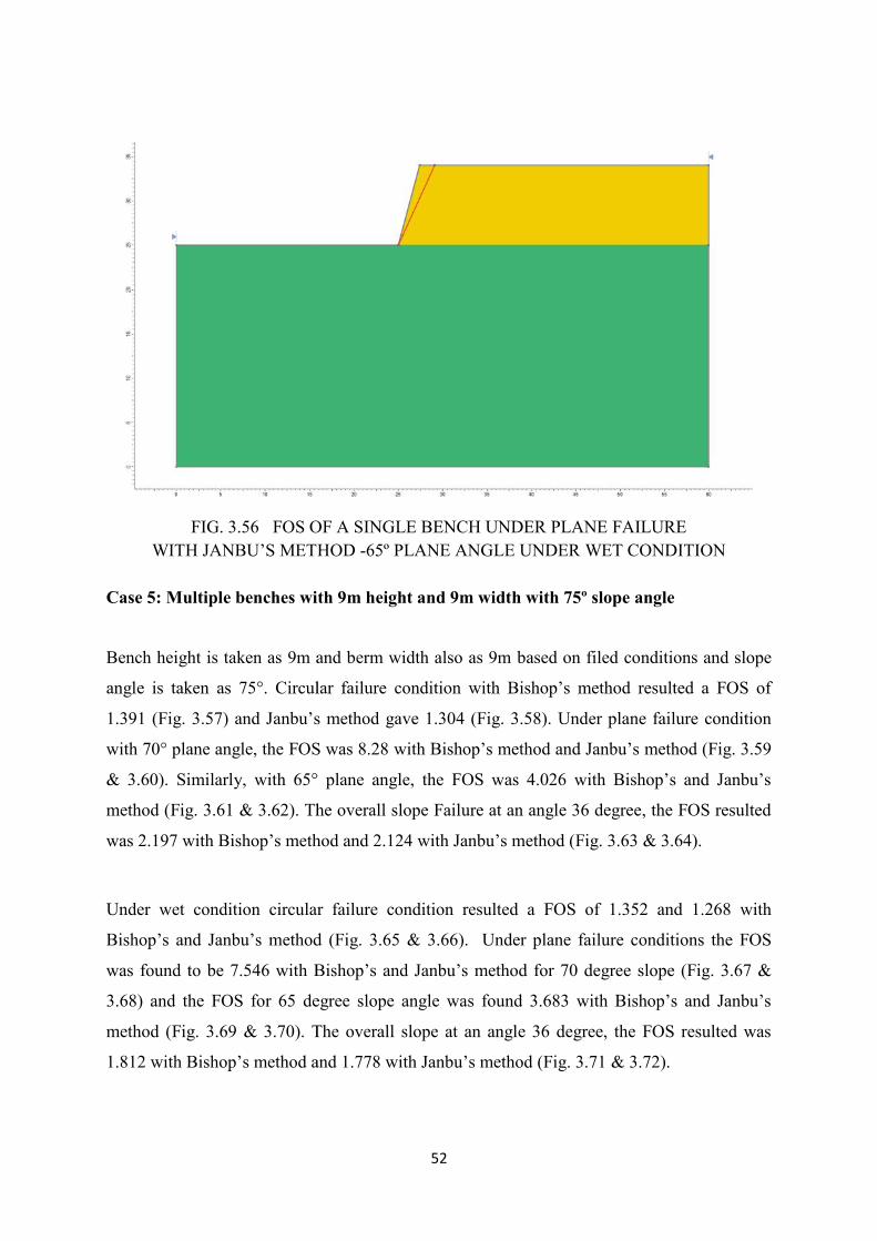
52
FIG. 3.56 FOS OF A SINGLE BENCH UNDER PLANE FAILUREWITH JANBU’S METHOD -65º PLANE ANGLE UNDER WET CONDITION
Case 5: Multiple benches with 9m height and 9m width with 75º slope angle
Bench height is taken as 9m and berm width also as 9m based on filed conditions and slope
angle is taken as 75°. Circular failure condition with Bishop’s method resulted a FOS of
1.391 (Fig. 3.57) and Janbu’s method gave 1.304 (Fig. 3.58). Under plane failure condition
with 70° plane angle, the FOS was 8.28 with Bishop’s method and Janbu’s method (Fig. 3.59
& 3.60). Similarly, with 65° plane angle, the FOS was 4.026 with Bishop’s and Janbu’s
method (Fig. 3.61 & 3.62). The overall slope Failure at an angle 36 degree, the FOS resulted
was 2.197 with Bishop’s method and 2.124 with Janbu’s method (Fig. 3.63 & 3.64).
Under wet condition circular failure condition resulted a FOS of 1.352 and 1.268 with
Bishop’s and Janbu’s method (Fig. 3.65 & 3.66). Under plane failure conditions the FOS
was found to be 7.546 with Bishop’s and Janbu’s method for 70 degree slope (Fig. 3.67 &
3.68) and the FOS for 65 degree slope angle was found 3.683 with Bishop’s and Janbu’s
method (Fig. 3.69 & 3.70). The overall slope at an angle 36 degree, the FOS resulted was
1.812 with Bishop’s method and 1.778 with Janbu’s method (Fig. 3.71 & 3.72).
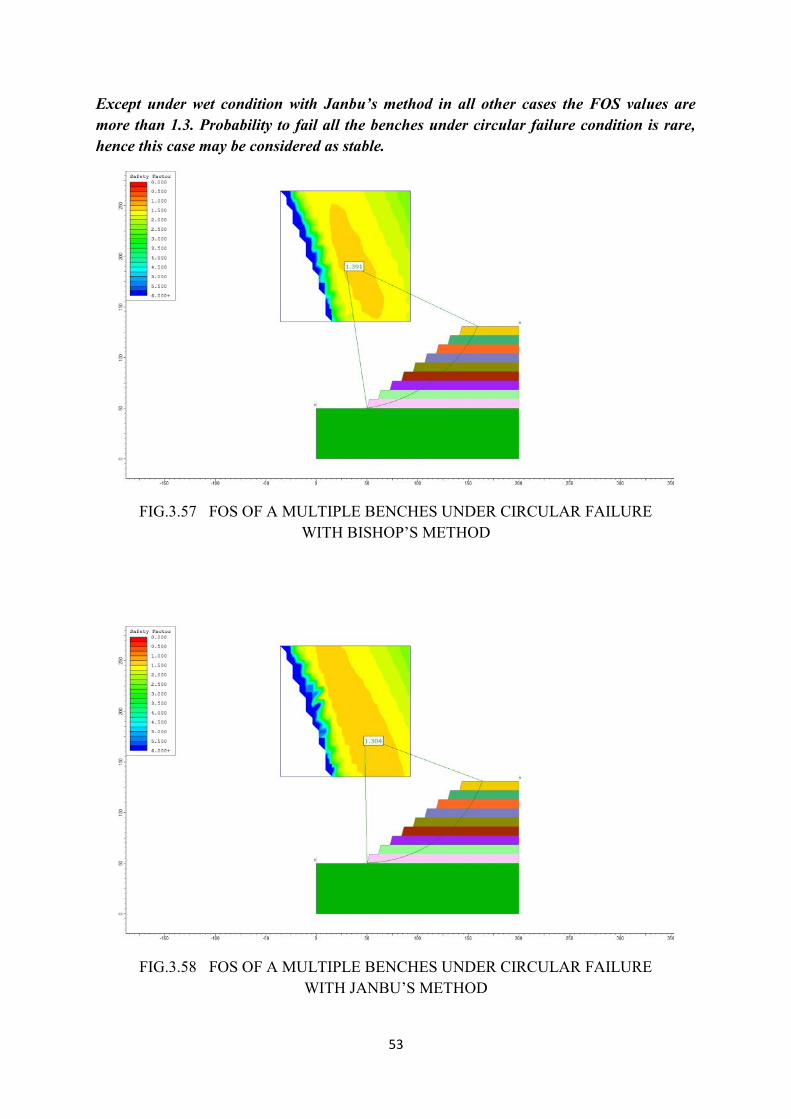
53
Except under wet condition with Janbu’s method in all other cases the FOS values aremore than 1.3. Probability to fail all the benches under circular failure condition is rare,hence this case may be considered as stable.
FIG.3.57 FOS OF A MULTIPLE BENCHES UNDER CIRCULAR FAILUREWITH BISHOP’S METHOD
FIG.3.58 FOS OF A MULTIPLE BENCHES UNDER CIRCULAR FAILUREWITH JANBU’S METHOD
54
FIG. 3.59 FOS OF A MULTIPLE BENCHES UNDER PLANE FAILUREWITH BISHOP’S METHOD -70º PLANE ANGLE
FIG. 3.60 FOS OF A MULTIPLE BENCHES UNDER PLANE FAILUREWITH JANBU’S METHOD -70º PLANE ANGLE
54
FIG. 3.59 FOS OF A MULTIPLE BENCHES UNDER PLANE FAILUREWITH BISHOP’S METHOD -70º PLANE ANGLE
FIG. 3.60 FOS OF A MULTIPLE BENCHES UNDER PLANE FAILUREWITH JANBU’S METHOD -70º PLANE ANGLE
54
FIG. 3.59 FOS OF A MULTIPLE BENCHES UNDER PLANE FAILUREWITH BISHOP’S METHOD -70º PLANE ANGLE
FIG. 3.60 FOS OF A MULTIPLE BENCHES UNDER PLANE FAILUREWITH JANBU’S METHOD -70º PLANE ANGLE
55
FIG. 3.61 FOS OF A MULTIPLE BENCHES UNDER PLANE FAILUREWITH BISHOP’S METHOD -65º PLANE ANGLE
FIG. 3.62 FOS OF A MULTIPLE BENCHES UNDER PLANE FAILUREWITH JANBU’S METHOD -65º PLANE ANGLE
55
FIG. 3.61 FOS OF A MULTIPLE BENCHES UNDER PLANE FAILUREWITH BISHOP’S METHOD -65º PLANE ANGLE
FIG. 3.62 FOS OF A MULTIPLE BENCHES UNDER PLANE FAILUREWITH JANBU’S METHOD -65º PLANE ANGLE
55
FIG. 3.61 FOS OF A MULTIPLE BENCHES UNDER PLANE FAILUREWITH BISHOP’S METHOD -65º PLANE ANGLE
FIG. 3.62 FOS OF A MULTIPLE BENCHES UNDER PLANE FAILUREWITH JANBU’S METHOD -65º PLANE ANGLE
56
FIG. 3.63 FOS OF MULTIPLE BENCHES UNDER OVERALL SLOPE FAILUREWITH BISHOP’S METHOD -35º PLANE ANGLE
FIG. 3.64 FOS OF MULTIPLE BENCHES UNDER OVERALL SLOPE FAILUREWITH JANBU’S METHOD -35º PLANE ANGLE
56
FIG. 3.63 FOS OF MULTIPLE BENCHES UNDER OVERALL SLOPE FAILUREWITH BISHOP’S METHOD -35º PLANE ANGLE
FIG. 3.64 FOS OF MULTIPLE BENCHES UNDER OVERALL SLOPE FAILUREWITH JANBU’S METHOD -35º PLANE ANGLE
56
FIG. 3.63 FOS OF MULTIPLE BENCHES UNDER OVERALL SLOPE FAILUREWITH BISHOP’S METHOD -35º PLANE ANGLE
FIG. 3.64 FOS OF MULTIPLE BENCHES UNDER OVERALL SLOPE FAILUREWITH JANBU’S METHOD -35º PLANE ANGLE
57
FIG.3.65 FOS OF A MULTIPLE BENCHES UNDER CIRCULAR FAILUREWITH BISHOP’S METHOD UNDER WET CONDITION
FIG.3.66 FOS OF A MULTIPLE BENCHES UNDER CIRCULAR FAILUREWITH JANBU’S METHOD UNDER WET CONDITION
57
FIG.3.65 FOS OF A MULTIPLE BENCHES UNDER CIRCULAR FAILUREWITH BISHOP’S METHOD UNDER WET CONDITION
FIG.3.66 FOS OF A MULTIPLE BENCHES UNDER CIRCULAR FAILUREWITH JANBU’S METHOD UNDER WET CONDITION
57
FIG.3.65 FOS OF A MULTIPLE BENCHES UNDER CIRCULAR FAILUREWITH BISHOP’S METHOD UNDER WET CONDITION
FIG.3.66 FOS OF A MULTIPLE BENCHES UNDER CIRCULAR FAILUREWITH JANBU’S METHOD UNDER WET CONDITION
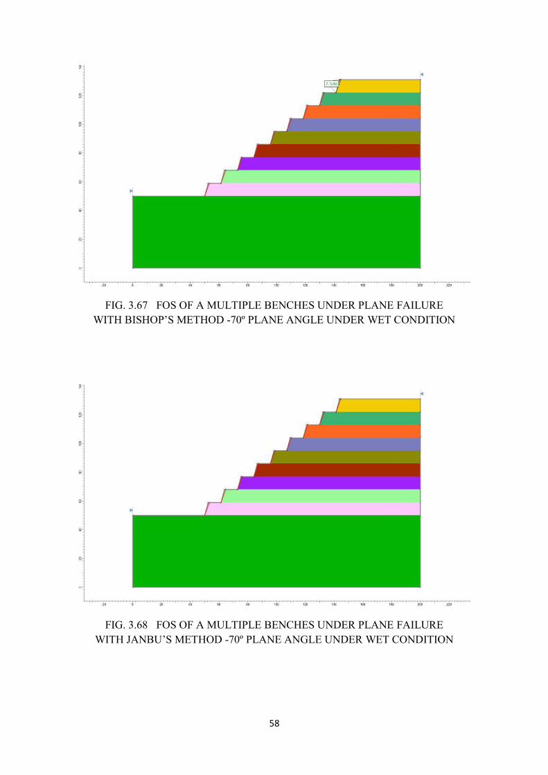
58
FIG. 3.67 FOS OF A MULTIPLE BENCHES UNDER PLANE FAILUREWITH BISHOP’S METHOD -70º PLANE ANGLE UNDER WET CONDITION
FIG. 3.68 FOS OF A MULTIPLE BENCHES UNDER PLANE FAILUREWITH JANBU’S METHOD -70º PLANE ANGLE UNDER WET CONDITION
58
FIG. 3.67 FOS OF A MULTIPLE BENCHES UNDER PLANE FAILUREWITH BISHOP’S METHOD -70º PLANE ANGLE UNDER WET CONDITION
FIG. 3.68 FOS OF A MULTIPLE BENCHES UNDER PLANE FAILUREWITH JANBU’S METHOD -70º PLANE ANGLE UNDER WET CONDITION
58
FIG. 3.67 FOS OF A MULTIPLE BENCHES UNDER PLANE FAILUREWITH BISHOP’S METHOD -70º PLANE ANGLE UNDER WET CONDITION
FIG. 3.68 FOS OF A MULTIPLE BENCHES UNDER PLANE FAILUREWITH JANBU’S METHOD -70º PLANE ANGLE UNDER WET CONDITION
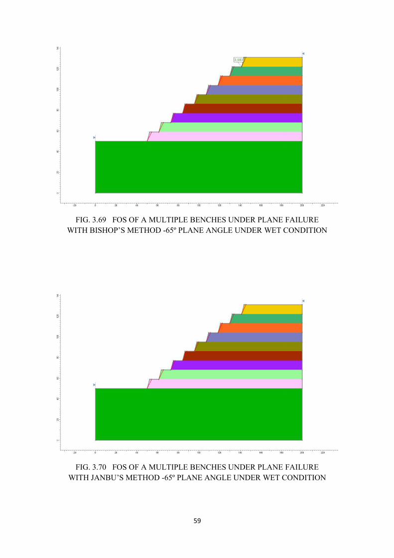
59
FIG. 3.69 FOS OF A MULTIPLE BENCHES UNDER PLANE FAILUREWITH BISHOP’S METHOD -65º PLANE ANGLE UNDER WET CONDITION
FIG. 3.70 FOS OF A MULTIPLE BENCHES UNDER PLANE FAILUREWITH JANBU’S METHOD -65º PLANE ANGLE UNDER WET CONDITION
59
FIG. 3.69 FOS OF A MULTIPLE BENCHES UNDER PLANE FAILUREWITH BISHOP’S METHOD -65º PLANE ANGLE UNDER WET CONDITION
FIG. 3.70 FOS OF A MULTIPLE BENCHES UNDER PLANE FAILUREWITH JANBU’S METHOD -65º PLANE ANGLE UNDER WET CONDITION
59
FIG. 3.69 FOS OF A MULTIPLE BENCHES UNDER PLANE FAILUREWITH BISHOP’S METHOD -65º PLANE ANGLE UNDER WET CONDITION
FIG. 3.70 FOS OF A MULTIPLE BENCHES UNDER PLANE FAILUREWITH JANBU’S METHOD -65º PLANE ANGLE UNDER WET CONDITION
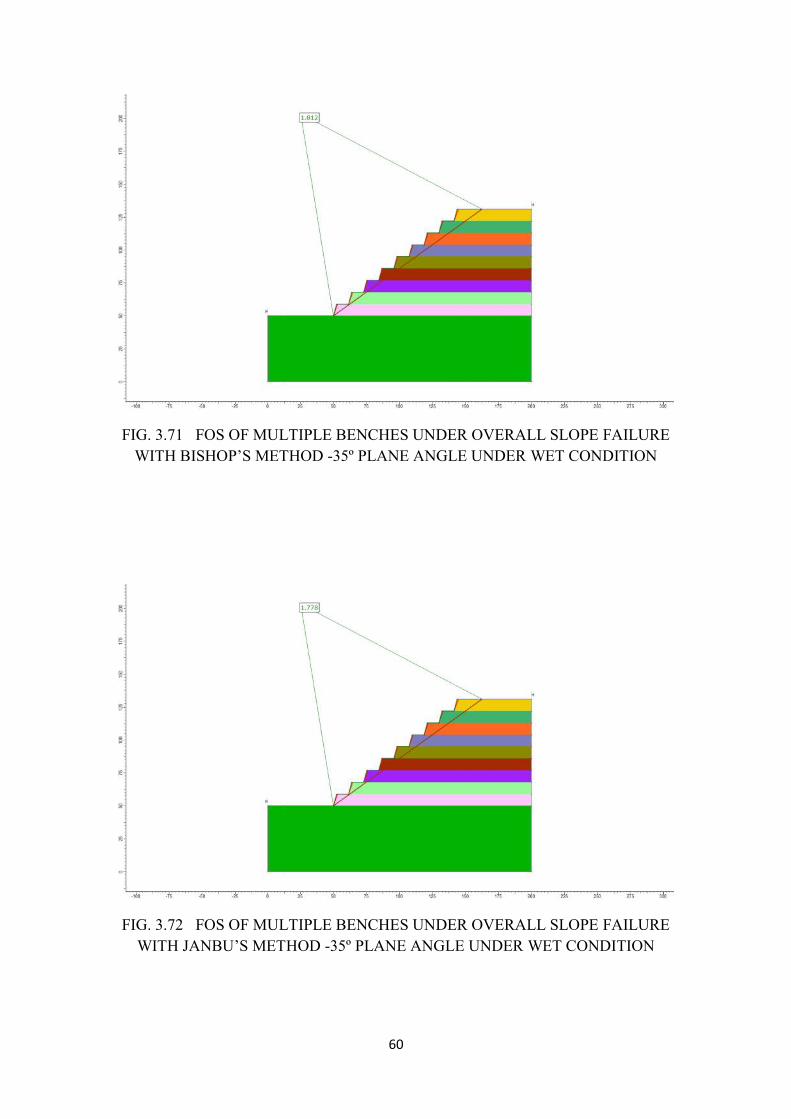
60
FIG. 3.71 FOS OF MULTIPLE BENCHES UNDER OVERALL SLOPE FAILUREWITH BISHOP’S METHOD -35º PLANE ANGLE UNDER WET CONDITION
FIG. 3.72 FOS OF MULTIPLE BENCHES UNDER OVERALL SLOPE FAILUREWITH JANBU’S METHOD -35º PLANE ANGLE UNDER WET CONDITION
60
FIG. 3.71 FOS OF MULTIPLE BENCHES UNDER OVERALL SLOPE FAILUREWITH BISHOP’S METHOD -35º PLANE ANGLE UNDER WET CONDITION
FIG. 3.72 FOS OF MULTIPLE BENCHES UNDER OVERALL SLOPE FAILUREWITH JANBU’S METHOD -35º PLANE ANGLE UNDER WET CONDITION
60
FIG. 3.71 FOS OF MULTIPLE BENCHES UNDER OVERALL SLOPE FAILUREWITH BISHOP’S METHOD -35º PLANE ANGLE UNDER WET CONDITION
FIG. 3.72 FOS OF MULTIPLE BENCHES UNDER OVERALL SLOPE FAILUREWITH JANBU’S METHOD -35º PLANE ANGLE UNDER WET CONDITION
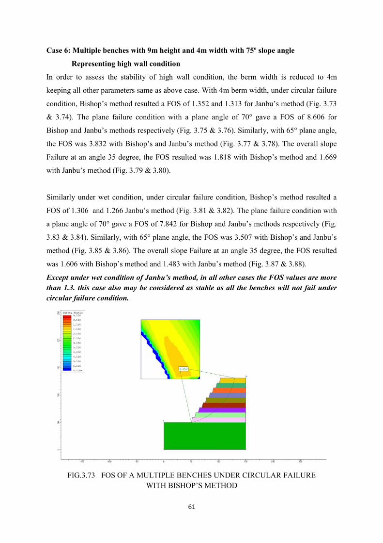
61
Case 6: Multiple benches with 9m height and 4m width with 75º slope angle
Representing high wall condition
In order to assess the stability of high wall condition, the berm width is reduced to 4m
keeping all other parameters same as above case. With 4m berm width, under circular failure
condition, Bishop’s method resulted a FOS of 1.352 and 1.313 for Janbu’s method (Fig. 3.73
& 3.74). The plane failure condition with a plane angle of 70° gave a FOS of 8.606 for
Bishop and Janbu’s methods respectively (Fig. 3.75 & 3.76). Similarly, with 65° plane angle,
the FOS was 3.832 with Bishop’s and Janbu’s method (Fig. 3.77 & 3.78). The overall slope
Failure at an angle 35 degree, the FOS resulted was 1.818 with Bishop’s method and 1.669
with Janbu’s method (Fig. 3.79 & 3.80).
Similarly under wet condition, under circular failure condition, Bishop’s method resulted a
FOS of 1.306 and 1.266 Janbu’s method (Fig. 3.81 & 3.82). The plane failure condition with
a plane angle of 70° gave a FOS of 7.842 for Bishop and Janbu’s methods respectively (Fig.
3.83 & 3.84). Similarly, with 65° plane angle, the FOS was 3.507 with Bishop’s and Janbu’s
method (Fig. 3.85 & 3.86). The overall slope Failure at an angle 35 degree, the FOS resulted
was 1.606 with Bishop’s method and 1.483 with Janbu’s method (Fig. 3.87 & 3.88).
Except under wet condition of Janbu’s method, in all other cases the FOS values are morethan 1.3. this case also may be considered as stable as all the benches will not fail undercircular failure condition.
FIG.3.73 FOS OF A MULTIPLE BENCHES UNDER CIRCULAR FAILUREWITH BISHOP’S METHOD
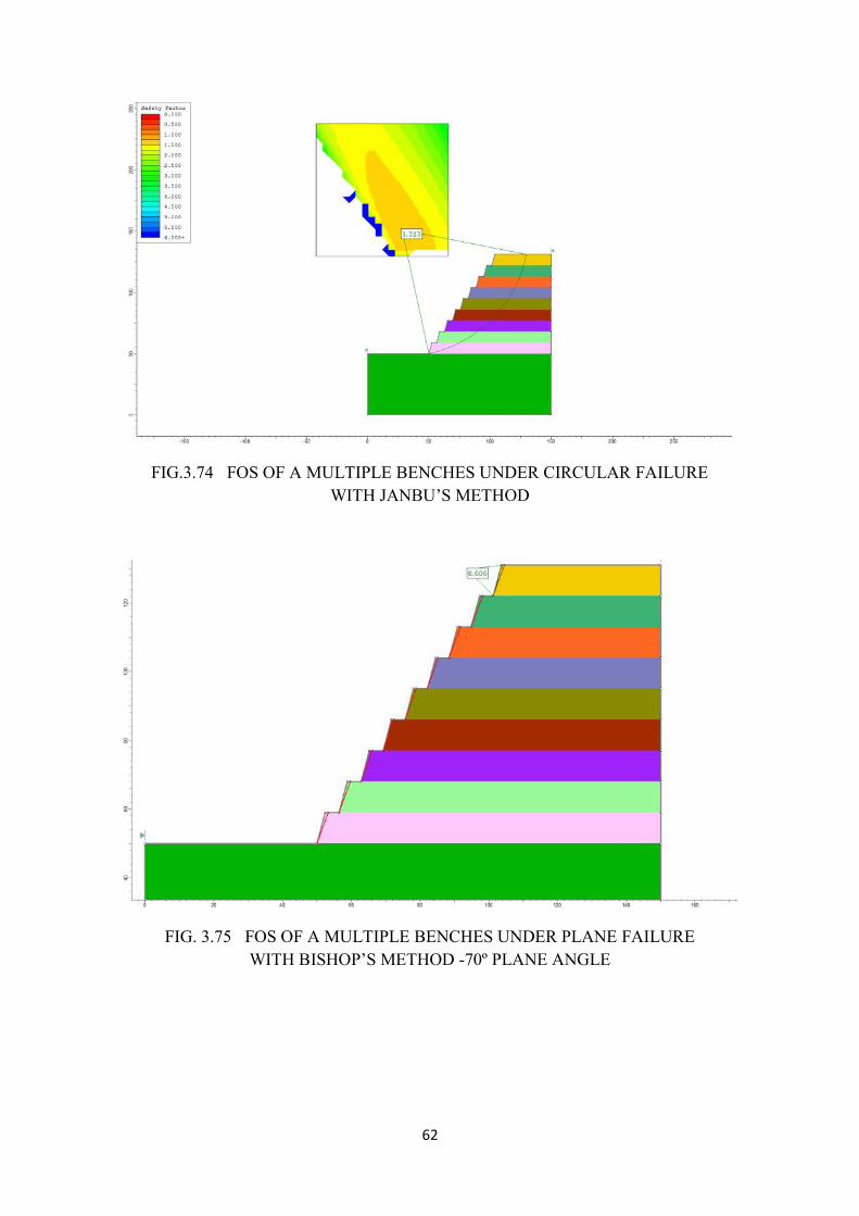
62
FIG.3.74 FOS OF A MULTIPLE BENCHES UNDER CIRCULAR FAILUREWITH JANBU’S METHOD
FIG. 3.75 FOS OF A MULTIPLE BENCHES UNDER PLANE FAILUREWITH BISHOP’S METHOD -70º PLANE ANGLE
62
FIG.3.74 FOS OF A MULTIPLE BENCHES UNDER CIRCULAR FAILUREWITH JANBU’S METHOD
FIG. 3.75 FOS OF A MULTIPLE BENCHES UNDER PLANE FAILUREWITH BISHOP’S METHOD -70º PLANE ANGLE
62
FIG.3.74 FOS OF A MULTIPLE BENCHES UNDER CIRCULAR FAILUREWITH JANBU’S METHOD
FIG. 3.75 FOS OF A MULTIPLE BENCHES UNDER PLANE FAILUREWITH BISHOP’S METHOD -70º PLANE ANGLE
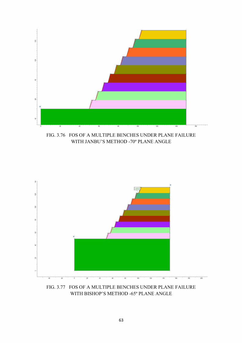
63
FIG. 3.76 FOS OF A MULTIPLE BENCHES UNDER PLANE FAILUREWITH JANBU’S METHOD -70º PLANE ANGLE
FIG. 3.77 FOS OF A MULTIPLE BENCHES UNDER PLANE FAILUREWITH BISHOP’S METHOD -65º PLANE ANGLE
63
FIG. 3.76 FOS OF A MULTIPLE BENCHES UNDER PLANE FAILUREWITH JANBU’S METHOD -70º PLANE ANGLE
FIG. 3.77 FOS OF A MULTIPLE BENCHES UNDER PLANE FAILUREWITH BISHOP’S METHOD -65º PLANE ANGLE
63
FIG. 3.76 FOS OF A MULTIPLE BENCHES UNDER PLANE FAILUREWITH JANBU’S METHOD -70º PLANE ANGLE
FIG. 3.77 FOS OF A MULTIPLE BENCHES UNDER PLANE FAILUREWITH BISHOP’S METHOD -65º PLANE ANGLE
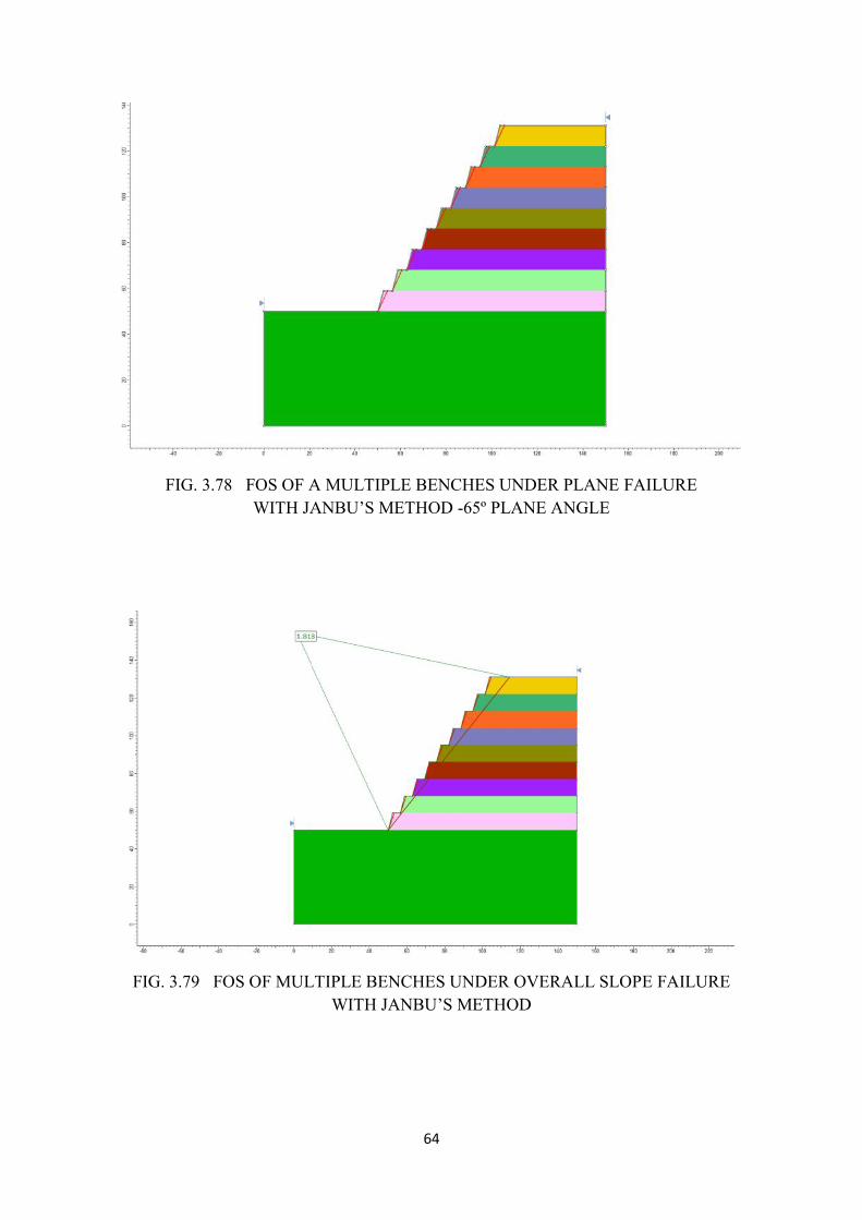
64
FIG. 3.78 FOS OF A MULTIPLE BENCHES UNDER PLANE FAILUREWITH JANBU’S METHOD -65º PLANE ANGLE
FIG. 3.79 FOS OF MULTIPLE BENCHES UNDER OVERALL SLOPE FAILUREWITH JANBU’S METHOD
64
FIG. 3.78 FOS OF A MULTIPLE BENCHES UNDER PLANE FAILUREWITH JANBU’S METHOD -65º PLANE ANGLE
FIG. 3.79 FOS OF MULTIPLE BENCHES UNDER OVERALL SLOPE FAILUREWITH JANBU’S METHOD
64
FIG. 3.78 FOS OF A MULTIPLE BENCHES UNDER PLANE FAILUREWITH JANBU’S METHOD -65º PLANE ANGLE
FIG. 3.79 FOS OF MULTIPLE BENCHES UNDER OVERALL SLOPE FAILUREWITH JANBU’S METHOD
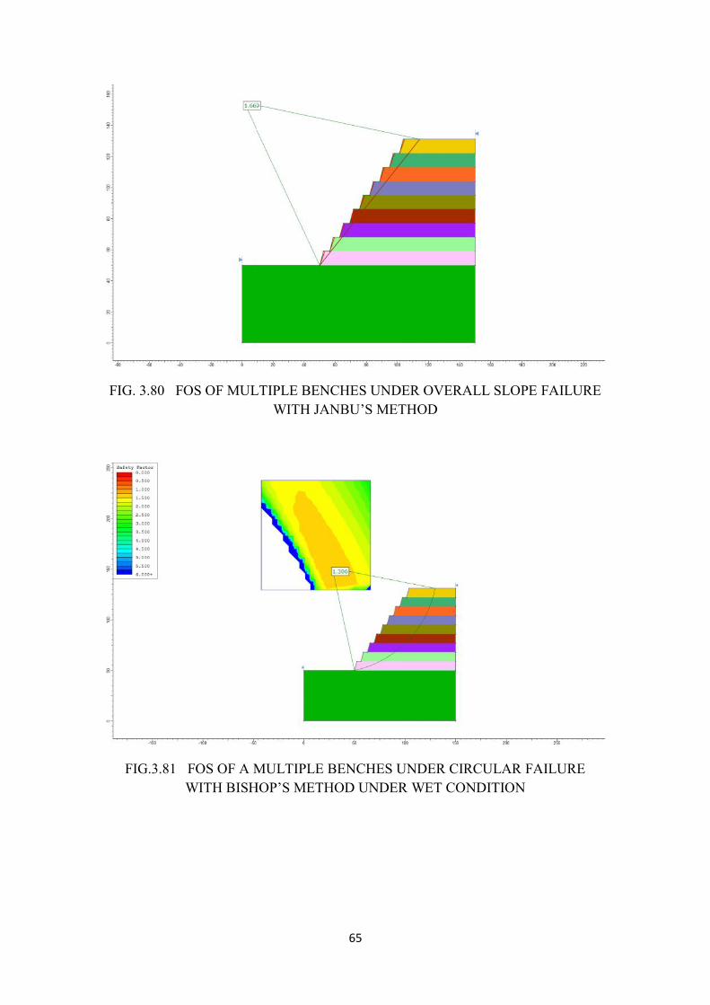
65
FIG. 3.80 FOS OF MULTIPLE BENCHES UNDER OVERALL SLOPE FAILUREWITH JANBU’S METHOD
FIG.3.81 FOS OF A MULTIPLE BENCHES UNDER CIRCULAR FAILUREWITH BISHOP’S METHOD UNDER WET CONDITION
65
FIG. 3.80 FOS OF MULTIPLE BENCHES UNDER OVERALL SLOPE FAILUREWITH JANBU’S METHOD
FIG.3.81 FOS OF A MULTIPLE BENCHES UNDER CIRCULAR FAILUREWITH BISHOP’S METHOD UNDER WET CONDITION
65
FIG. 3.80 FOS OF MULTIPLE BENCHES UNDER OVERALL SLOPE FAILUREWITH JANBU’S METHOD
FIG.3.81 FOS OF A MULTIPLE BENCHES UNDER CIRCULAR FAILUREWITH BISHOP’S METHOD UNDER WET CONDITION
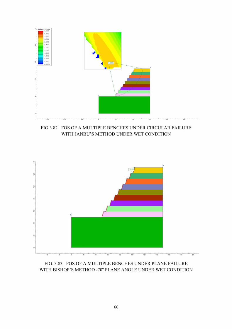
66
FIG.3.82 FOS OF A MULTIPLE BENCHES UNDER CIRCULAR FAILUREWITH JANBU’S METHOD UNDER WET CONDITION
FIG. 3.83 FOS OF A MULTIPLE BENCHES UNDER PLANE FAILUREWITH BISHOP’S METHOD -70º PLANE ANGLE UNDER WET CONDITION
66
FIG.3.82 FOS OF A MULTIPLE BENCHES UNDER CIRCULAR FAILUREWITH JANBU’S METHOD UNDER WET CONDITION
FIG. 3.83 FOS OF A MULTIPLE BENCHES UNDER PLANE FAILUREWITH BISHOP’S METHOD -70º PLANE ANGLE UNDER WET CONDITION
66
FIG.3.82 FOS OF A MULTIPLE BENCHES UNDER CIRCULAR FAILUREWITH JANBU’S METHOD UNDER WET CONDITION
FIG. 3.83 FOS OF A MULTIPLE BENCHES UNDER PLANE FAILUREWITH BISHOP’S METHOD -70º PLANE ANGLE UNDER WET CONDITION
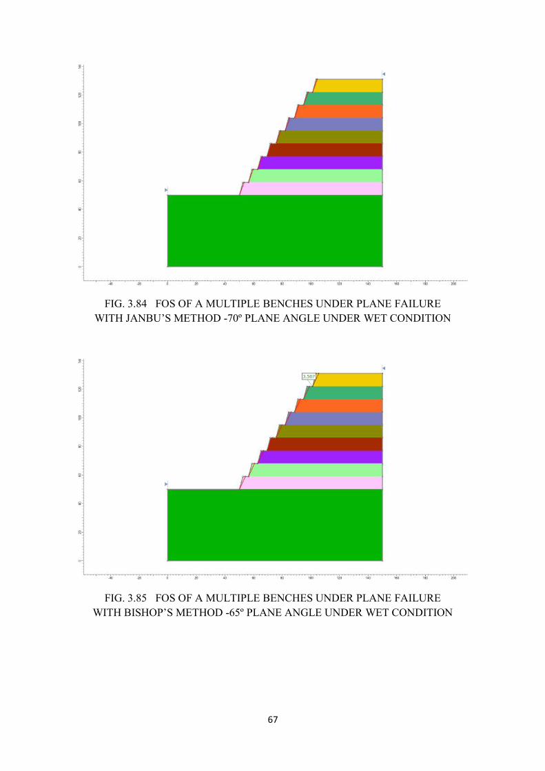
67
FIG. 3.84 FOS OF A MULTIPLE BENCHES UNDER PLANE FAILUREWITH JANBU’S METHOD -70º PLANE ANGLE UNDER WET CONDITION
FIG. 3.85 FOS OF A MULTIPLE BENCHES UNDER PLANE FAILUREWITH BISHOP’S METHOD -65º PLANE ANGLE UNDER WET CONDITION
67
FIG. 3.84 FOS OF A MULTIPLE BENCHES UNDER PLANE FAILUREWITH JANBU’S METHOD -70º PLANE ANGLE UNDER WET CONDITION
FIG. 3.85 FOS OF A MULTIPLE BENCHES UNDER PLANE FAILUREWITH BISHOP’S METHOD -65º PLANE ANGLE UNDER WET CONDITION
67
FIG. 3.84 FOS OF A MULTIPLE BENCHES UNDER PLANE FAILUREWITH JANBU’S METHOD -70º PLANE ANGLE UNDER WET CONDITION
FIG. 3.85 FOS OF A MULTIPLE BENCHES UNDER PLANE FAILUREWITH BISHOP’S METHOD -65º PLANE ANGLE UNDER WET CONDITION
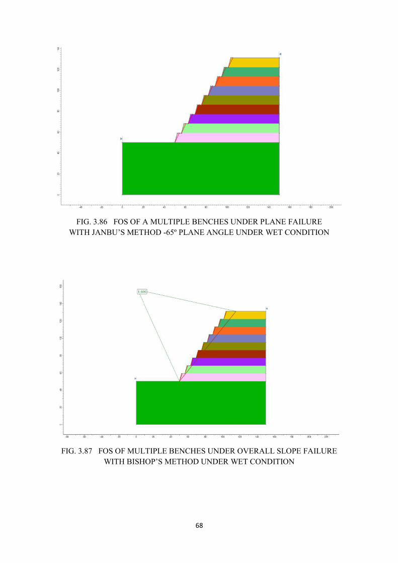
68
FIG. 3.86 FOS OF A MULTIPLE BENCHES UNDER PLANE FAILUREWITH JANBU’S METHOD -65º PLANE ANGLE UNDER WET CONDITION
FIG. 3.87 FOS OF MULTIPLE BENCHES UNDER OVERALL SLOPE FAILUREWITH BISHOP’S METHOD UNDER WET CONDITION
68
FIG. 3.86 FOS OF A MULTIPLE BENCHES UNDER PLANE FAILUREWITH JANBU’S METHOD -65º PLANE ANGLE UNDER WET CONDITION
FIG. 3.87 FOS OF MULTIPLE BENCHES UNDER OVERALL SLOPE FAILUREWITH BISHOP’S METHOD UNDER WET CONDITION
68
FIG. 3.86 FOS OF A MULTIPLE BENCHES UNDER PLANE FAILUREWITH JANBU’S METHOD -65º PLANE ANGLE UNDER WET CONDITION
FIG. 3.87 FOS OF MULTIPLE BENCHES UNDER OVERALL SLOPE FAILUREWITH BISHOP’S METHOD UNDER WET CONDITION
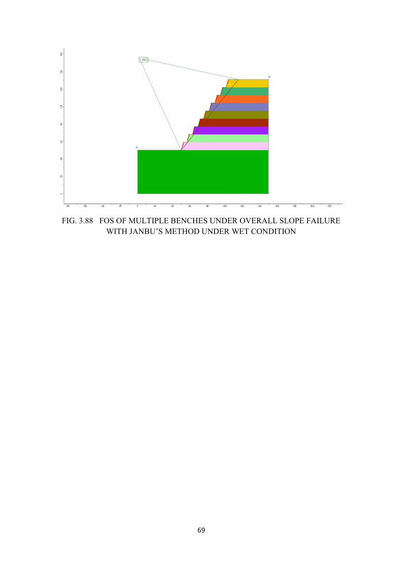
69
FIG. 3.88 FOS OF MULTIPLE BENCHES UNDER OVERALL SLOPE FAILUREWITH JANBU’S METHOD UNDER WET CONDITION
69
FIG. 3.88 FOS OF MULTIPLE BENCHES UNDER OVERALL SLOPE FAILUREWITH JANBU’S METHOD UNDER WET CONDITION
69
FIG. 3.88 FOS OF MULTIPLE BENCHES UNDER OVERALL SLOPE FAILUREWITH JANBU’S METHOD UNDER WET CONDITION
70
Table 2A Summary of the FOS values with bench slope angle 80°
S.No Condition BenchHeight(m)
BenchWidth(m)
SlopeAngle(degrees)
FailurePlaneAngle(degrees)
FOS -Dry FOS -Wet
Bishop Janbu Bishop Janbu
1 Single bench9m circular 9 9 80 - 1.881 1.715 1.759 1.6
2 Single bench9m -plane 9 9 80 75 3.28 3
3 Single bench9m -plane 9 9 80 70 7.507 6.838
4 Multiplebenches-9-circular 9 9 80 1.34 1.237 1.305 1.202
5 Multiplebenches-9-plane 9 9 80 75 8.218 7.485
6 multiplebenches-9-plane 9 9 80 70 3.618 3.307
7 Overall slopeangle 9 9 80 2.267 2.198 2.204 2.142
8 Multiplebenches-9-circular 9 4 80 1.166 1.163 1.119 1.116
9 Multiplebenches-9-plane 9 4 80 75 8.58 7.813
10 Multiplebenches-9-plane 9 4 80 70 3.682 3.365
11 Overall slopeangle 9 4 80 1.701 1.553 1.504 1.38
71
Table 2B Summary of the FOS values with bench slope angle 75°
S.No Condition BenchHeight(m)
BenchWidth(m)
SlopeAngle(degrees)
FailurePlaneAngle(degrees)
FOS- Dry FOS -Wet
Bishop’s Janbu’s Bishop’s Janbu’s
1 Singlebench 9mcircular 9 9 75 1.984 1.826 1.847 1.705
2 Singlebench 9m -plane 9 9 75 70 4.105 3.754
3 Singlebench 9m -plane 9 9 75 65 8.985 8.187
4 Multiplebenches-9-circular 9 9 75 1.391 1.304 1.352 1.268
5 Multiplebenches-9-plane 9 9 75 70 8.28 7.546
6 Multiplebenches-9-plane 9 9 75 65 4.026 3.683
7 Overallslope angle 9 9 75 2.197 2.214 1.812 1.778
8 Multiplebenches-9-circular 9 4 75 1.352 1.313 1.306 1.266
9 Multiplebenches-9-plane 9 4 75 70 8.606 7.842
10 Multiplebenches-9-plane 9 4 75 65 3.832 3.502
11 Overallslope angle 9 4 75 1.818 1.669 1.606 1.483
72
Dump Stability Analysis
The dump consists of different material and each deck/terrace is 5 to 10m height with 10m
width. Field experiments shows that the angle of repose varying between 28° and 34°, so for
modelling purpose the dump slope angle is taken as 28°. 5 decks were considered with
different properties, lower values are given to top decks compared to top decks, as more
consolidation takes place at bottom. Different values assigned to each deck are given in
Table. 3. FOS values of respective cases are given in Table. 4.
Table. 3 Dump material Properties Considered for Stability analysis
Deck No.from Top tobottom
Dry Density(kN/cu.m)
Wet Density(kN/cu.m)
Cohesion(kN/sq.cm)
Angle ofInternal Friction(Degrees)
1 29.51 32.46 75 28.52 28.40 31.24 80 29.03 25.61 28.17 110 28.04 32.60 35.86 110 31.05 26.51 29.16 115 33.56 27.45 30.19 120 33.0
Table. 4. Summary of FOS values dump
S.No.
No. ofDecks
DeckHeight
BermWidth
SlopeAngle
FOS- Dry FOS- Wet
Bishop Janbu Bishop Janbu
1 5 10 10 28 2.636 2.453 2.563 2.392
Circular failure condition under dry condition with Bishop’s method resulted a FOS of 2.636
(Fig. 3.89) and Janbu’s method gave 2.453 (Fig. 3.90). Under wet condition the FOS values
are 2.563 and 2.392 for Bishop’s and Janbu’s methods respectively (Figs. 3.91 & 3.92). in all
cases, the FOS values are more than 2, indicating very safe condition.
73
FIG.3.89 FOS OF DUMP UNDER CIRCULAR FAILURE WITH BISHOP’S METHOD-DRY CONDITION
FIG.3.90 FOS OF DUMP UNDER CIRCULAR FAILURE WITH JANBU’S METHOD-DRY CONDITION
73
FIG.3.89 FOS OF DUMP UNDER CIRCULAR FAILURE WITH BISHOP’S METHOD-DRY CONDITION
FIG.3.90 FOS OF DUMP UNDER CIRCULAR FAILURE WITH JANBU’S METHOD-DRY CONDITION
73
FIG.3.89 FOS OF DUMP UNDER CIRCULAR FAILURE WITH BISHOP’S METHOD-DRY CONDITION
FIG.3.90 FOS OF DUMP UNDER CIRCULAR FAILURE WITH JANBU’S METHOD-DRY CONDITION
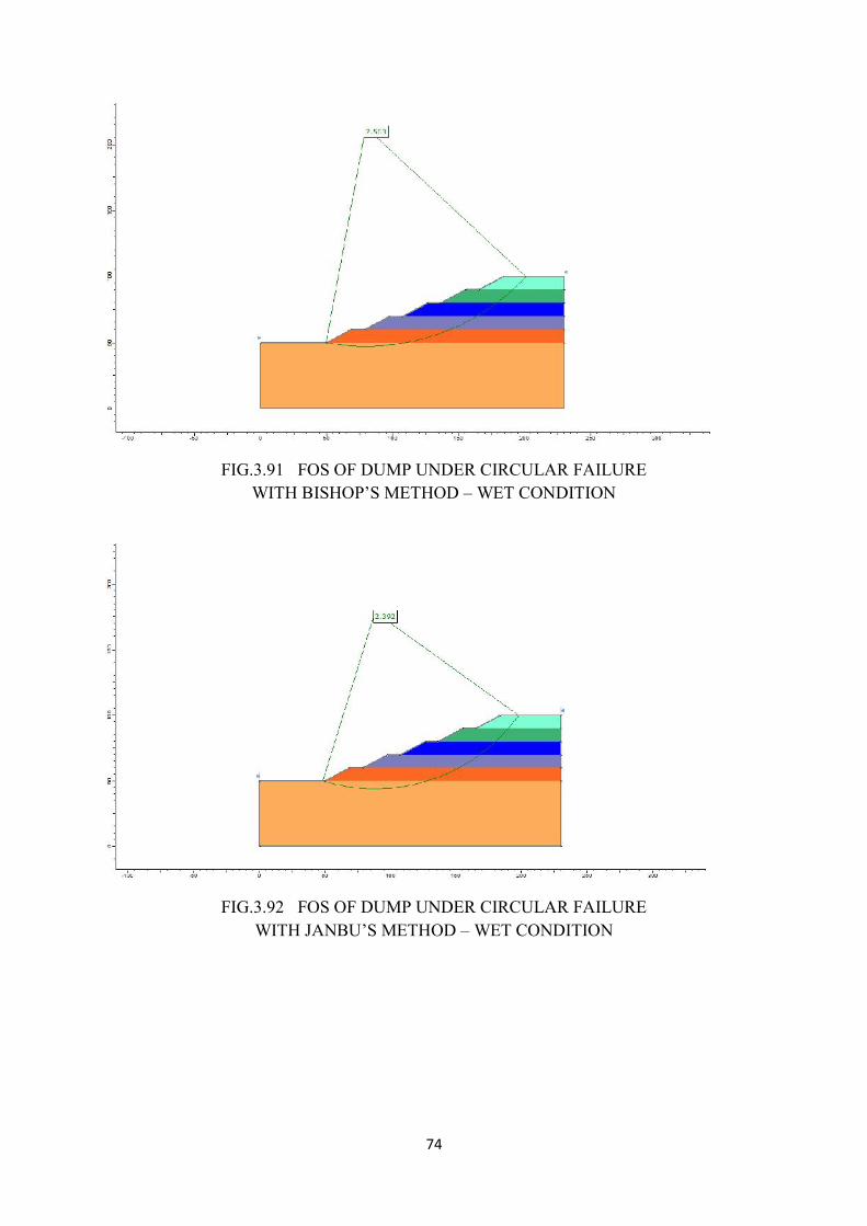
74
FIG.3.91 FOS OF DUMP UNDER CIRCULAR FAILUREWITH BISHOP’S METHOD – WET CONDITION
FIG.3.92 FOS OF DUMP UNDER CIRCULAR FAILUREWITH JANBU’S METHOD – WET CONDITION
74
FIG.3.91 FOS OF DUMP UNDER CIRCULAR FAILUREWITH BISHOP’S METHOD – WET CONDITION
FIG.3.92 FOS OF DUMP UNDER CIRCULAR FAILUREWITH JANBU’S METHOD – WET CONDITION
74
FIG.3.91 FOS OF DUMP UNDER CIRCULAR FAILUREWITH BISHOP’S METHOD – WET CONDITION
FIG.3.92 FOS OF DUMP UNDER CIRCULAR FAILUREWITH JANBU’S METHOD – WET CONDITION
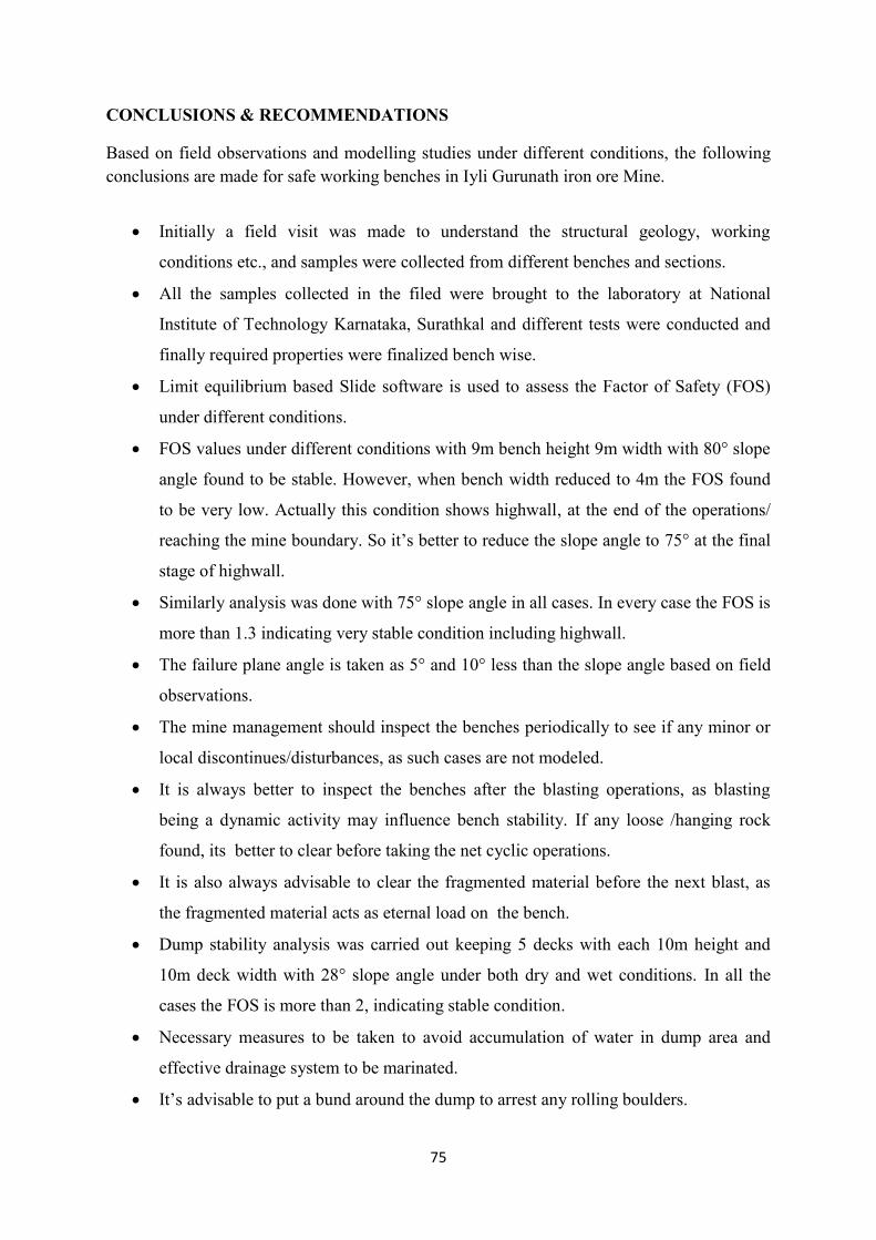
75
CONCLUSIONS & RECOMMENDATIONS
Based on field observations and modelling studies under different conditions, the followingconclusions are made for safe working benches in Iyli Gurunath iron ore Mine.
Initially a field visit was made to understand the structural geology, working
conditions etc., and samples were collected from different benches and sections.
All the samples collected in the filed were brought to the laboratory at National
Institute of Technology Karnataka, Surathkal and different tests were conducted and
finally required properties were finalized bench wise.
Limit equilibrium based Slide software is used to assess the Factor of Safety (FOS)
under different conditions.
FOS values under different conditions with 9m bench height 9m width with 80° slope
angle found to be stable. However, when bench width reduced to 4m the FOS found
to be very low. Actually this condition shows highwall, at the end of the operations/
reaching the mine boundary. So it’s better to reduce the slope angle to 75° at the final
stage of highwall.
Similarly analysis was done with 75° slope angle in all cases. In every case the FOS is
more than 1.3 indicating very stable condition including highwall.
The failure plane angle is taken as 5° and 10° less than the slope angle based on field
observations.
The mine management should inspect the benches periodically to see if any minor or
local discontinues/disturbances, as such cases are not modeled.
It is always better to inspect the benches after the blasting operations, as blasting
being a dynamic activity may influence bench stability. If any loose /hanging rock
found, its better to clear before taking the net cyclic operations.
It is also always advisable to clear the fragmented material before the next blast, as
the fragmented material acts as eternal load on the bench.
Dump stability analysis was carried out keeping 5 decks with each 10m height and
10m deck width with 28° slope angle under both dry and wet conditions. In all the
cases the FOS is more than 2, indicating stable condition.
Necessary measures to be taken to avoid accumulation of water in dump area and
effective drainage system to be marinated.
It’s advisable to put a bund around the dump to arrest any rolling boulders.

76
Dump strengthening measures to be taken continuously like growing some vegetation.
Any modeling study assumes the rock is homogeneous to some extent and assigns the
properties to analyze the slopes and dumps. But in reality the rock is non-
homogeneous, and there could be many other discontinuities as the benches progress,
or any other factor which is not included in the study may lead to failure of
benches/dumps. In such cases regular monitoring/physical inspection of benches to be
done and the Principal Investigator is not responsible for any failure of bench/dump
happens due to such unforeseen conditions.
RMML
Environmental Impact Assessment & Environment Management Plan
IYLI GURUNATH IRON ORE MINE
Page | 1
MINERAL ENGINEERING SERVICES, 2020
Appendix-I
COVERAGE OF TOR
RMML
Environmental Impact Assessment & Environment Management Plan
IYLI GURUNATH IRON ORE MINE
Page | 2
MINERAL ENGINEERING SERVICES, 2020
Itemwise Compliance Status of TORs issued by State Level Environment Imapct Assessment Authority- Karnataka (SEAC) vide letter no.SIA/KA/MIN/28893/2018 dated 14th Sep, 2018
for Iyli Gurunath Iron Ore Mine
TOR No.
TOR Point TOR Complinance / Reference in EIA Report
1.
Year –wise production details since 1994 should be given, clearly stating the highest production achieved in any one year perior to 1994. It may also be categorically informed whether there had been any increase in production after the EIA Notification 1994 came into force, w.r.t. the higest production achieved prior to 1994.
Para 2.1 ( page 15 )
2.
A copy of the document in support of the fact that the Proponent is the rightful lease of the mine should be given.
Lease deed enclosed vide Annexure No-1.
3.
All documents including approved mine plan, EIA and Public Hearing should be compatible with one another in terms of the mine lease area, production levels, waste generation and its management, mining technology etc. and should be in the name of the lessee.
All documents are compatible and are in the name of lessee
4.
All corner coordinates of the mine lease area, superimposed on a High Resolution Imagery / topo sheet, topographic sheet, geomorphology and geology of the area should be provided. Such an Imagery of the proposed area should clearly show the land use and other ecological features of the study area (Core and buffer zone).
Chapter-1, Drawing Nos. 01,02,03 & 04
5.
Information should be provided in Survey of India Topsheet in 1:50,000 scale indicating geological map of the area, geomorhphology of land forms of the area, existing minerals and mining history of the area, important water bodies, streams and rivers and soil characteristics.
Chapter -1 (Page -10-13) Chapter-2 (Page -15 to 24 )
6.
Details about the land proposed for mining activities should be given with information as to whether mining conforms to the land use policy of the State land diversion for mining should have approval from State land use Board of the concerned authority.
All the lease area falls in Ramgad block of Sandur Range forset and lessee has taken approval under F(c) Act 1980 Refer (Annexure. No-4)
7.
It should be clearly stated whether the porponenet Company has a well laid down Environment Policy approved by its Board of Directors? If so, it may be spelt out in the EIA Report with description of the prescribed operating process/procedures to bring into focus any infringement /deviation/violation of
The lessee has a well laid out environmental policy the details are given vide para 9.4.3 (page no 157) The compliance of EC conditions are ensured by the committee formed under Environmental policy of the lessee
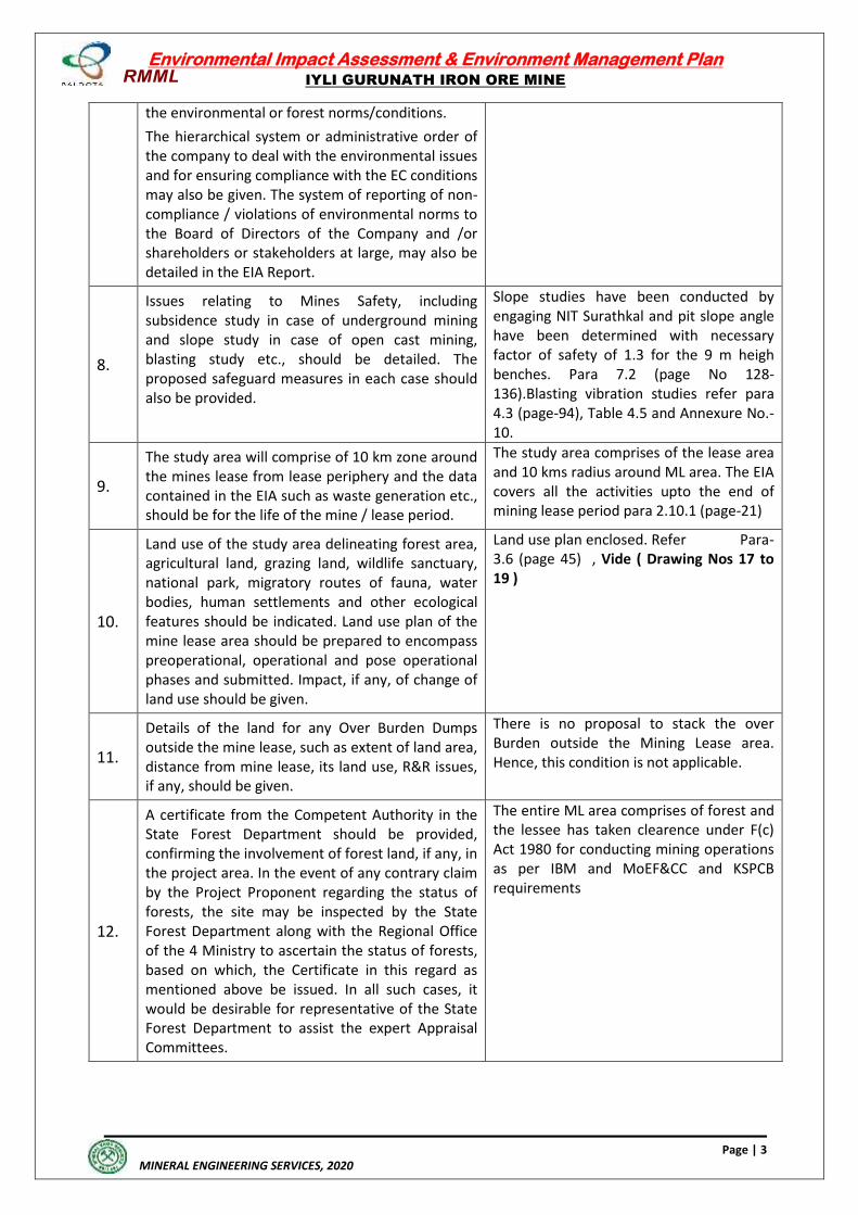
RMML
Environmental Impact Assessment & Environment Management Plan
IYLI GURUNATH IRON ORE MINE
Page | 3
MINERAL ENGINEERING SERVICES, 2020
the environmental or forest norms/conditions.
The hierarchical system or administrative order of the company to deal with the environmental issues and for ensuring compliance with the EC conditions may also be given. The system of reporting of non-compliance / violations of environmental norms to the Board of Directors of the Company and /or shareholders or stakeholders at large, may also be detailed in the EIA Report.
8.
Issues relating to Mines Safety, including subsidence study in case of underground mining and slope study in case of open cast mining, blasting study etc., should be detailed. The proposed safeguard measures in each case should also be provided.
Slope studies have been conducted by engaging NIT Surathkal and pit slope angle have been determined with necessary factor of safety of 1.3 for the 9 m heigh benches. Para 7.2 (page No 128-136).Blasting vibration studies refer para 4.3 (page-94), Table 4.5 and Annexure No.-10.
9.
The study area will comprise of 10 km zone around the mines lease from lease periphery and the data contained in the EIA such as waste generation etc., should be for the life of the mine / lease period.
The study area comprises of the lease area and 10 kms radius around ML area. The EIA covers all the activities upto the end of mining lease period para 2.10.1 (page-21)
10.
Land use of the study area delineating forest area, agricultural land, grazing land, wildlife sanctuary, national park, migratory routes of fauna, water bodies, human settlements and other ecological features should be indicated. Land use plan of the mine lease area should be prepared to encompass preoperational, operational and pose operational phases and submitted. Impact, if any, of change of land use should be given.
Land use plan enclosed. Refer Para-3.6 (page 45) , Vide ( Drawing Nos 17 to 19 )
11.
Details of the land for any Over Burden Dumps outside the mine lease, such as extent of land area, distance from mine lease, its land use, R&R issues, if any, should be given.
There is no proposal to stack the over Burden outside the Mining Lease area. Hence, this condition is not applicable.
12.
A certificate from the Competent Authority in the State Forest Department should be provided, confirming the involvement of forest land, if any, in the project area. In the event of any contrary claim by the Project Proponent regarding the status of forests, the site may be inspected by the State Forest Department along with the Regional Office of the 4 Ministry to ascertain the status of forests, based on which, the Certificate in this regard as mentioned above be issued. In all such cases, it would be desirable for representative of the State Forest Department to assist the expert Appraisal Committees.
The entire ML area comprises of forest and the lessee has taken clearence under F(c) Act 1980 for conducting mining operations as per IBM and MoEF&CC and KSPCB requirements
RMML
Environmental Impact Assessment & Environment Management Plan
IYLI GURUNATH IRON ORE MINE
Page | 4
MINERAL ENGINEERING SERVICES, 2020
13.
Status of forestry clearance for the broken up area and virgin forestland involved in the project including deposition of net present value (NPV) and compensatory afforestation (CA) should be indicated. A copy of the forestry clearance should also be furnished.
Yes
14.
Implementation status of recognition of forest rights under the Scheduled Tribes and other Traditional Forest Dwellers (Recognition of Forest Rights) Act, 2006 should be indicated.
Not applicable
15. The vegetation in the RF/PF area in the study area, with necessary details, should be given.
Refer para 3.7 (Page.No 46)
16.
A study shall be got done to ascertain the impact of the Mining Project on wildlife of the study area and details furnished. Impact of the project on the wildlife in the surrounding and any other protected area and accordingly, detailed mitigative measures required, should be worked out with cost implications and submitted.
Chapter-4 ,Para 4.7 (page.no. 98- 111)
17.
Location of National Parks, Sanctuaries, Biospher Reserves, Wildlife Corridors, Ramsar Site Tiger. Elephant Reserves / (existing as well as proposed), if any, within 10km of the mine lease should be clearly indicated, supported by a location map duly authenticated by Chief Wildlife Warden. Necessary clearance, as may be applicable to such projects due to proximity of the ecologically sensitive areas as mentioned above, should be obtained from the Standing Committee of National Board of Wildlife and copy furnished.
Not applicable.
18.
A detailed biological study of the study area [core zone and buffer zone (10km radius of the periphery of the mine lease)] shall be carried out. Details of flora and fauna, endangered, endemic and RET Species duly authenticated, separately for core and buffer zone should be furnished based on such primary field survey, clearly indicating the Schedule of the fauna present. In case of any scheduled-I fauna found in the study area, the necessary plan along with budgetary provisions for their conservation should be prepared in consultation with State Forest and Wildlife Department and details furnished. Necessary allocation of funds for implementing the same should be made as part of the project cost.
Chapter-3. para 3.7 , (page.no.46-63) and chapter-4 para 4.7.2 to 4.7.9 (page.no 104 to 111)
19.
Proximity to Areas declared as ‘Critically polluted’ or the Project area likely to come uner the ‘Aravali Range’, (attracting court restrictions for mining operations), should also be indicated and where so required, clearance certifications from the
The Mining Lease area does not fall under Critically Polluted Area or Aravali Range. Hence, this condition is not applicable.
RMML
Environmental Impact Assessment & Environment Management Plan
IYLI GURUNATH IRON ORE MINE
Page | 5
MINERAL ENGINEERING SERVICES, 2020
prescribed Authorities, such as the SPCB or State Mining Dept. Should be secured and furnished to the effect that the proposed mining activities could be considered.
20.
Similarly, for coastal Projects, A CRZ map duly authenticated by one of the authorized agencies demarcating LTL. HTL, CRZ area. Location of the mine lease w.r.t CRZ, coastal features such as mangroves, if any, should be furnished. (Note: The Mining Projects falling under CRZ would also need to obtain approval of the concerned Coastal Zone Management Authority).
The Mining Lease area does not fall under any Coastal Regulation Zone (CRZ). Hence, this condition is not applicable.
21.
R&R Plan / Compensation details for the Project Affected People (PAP) should be furnished. While preparing the R&R Plan, the relevant State / National Rehabilitation & Resettlement Policy should be kept in view. In respect of SCs/STs and other weaker sections of the society in the study area, a need based sample survey, family-wise, should be undertaken to assess their requirements, and action programmes prepared and submitted accordingly, integrating the sectoral programmes of line departments of the State Government. It may be clearly brought out whether the village(s) located in the mine lease area will be shifted or not. The issues relating to shifting of village(s) including their R&R and socio-economic aspects should be discussed in the Report.
No R & R issue is involved. In the study area, a need based sample survey, family-wise was carried out to assess their requirements of SCs /STs and other weaker sections of the society. The action plan programme prepared and included in the EIA Report. No shifting of villages located in the Mining lease area is required as the proposal is for existing Mine.
22.
One season (non-monsoon) [i.e. March-May (summer Season); October-December (post monsoon season); December – February (winter season)] primary baseline data on ambient air quality as per CPCB Notification of 2009, water quality, Noise level, soil and flora and fauna shall be collected and the AAQ and other data so complied presented date-wise in the EIA and EMP Report. Site – specific meteorological data should also be collected. The location of the monitoring stations should be such as to represent whole of the study area and justified keeping in view the pre-dominate downwind direction and location of sensitive receptors. There should be at least one monitoring station within 500m of the mine lease in the pre-dominant downwind direction. The mineralogical composition of PM10, Particularly for free silica, should be given.
One season data [Mar -May-2019 (Summer season)] on ambient air quality as per CPCB Notification of 2009, water quality, noise level, soil and flora and fauna has been collected and date wise data presented in the EIA Report. Site-specific meteorological data has also been collected and included in the EIA Report. The location of monitoring stations has been finalized to represent whole of the study area, keeping in view the pre-dominant downwind direction and location of sensitive receptors. One monitoring station is located within 500 m of the mine lease in the predominant downwind direction. The details of mineralogical composition of PM10, particularly for free silica are also presented in the EIA Report. Vide Annexure No.-8.
RMML
Environmental Impact Assessment & Environment Management Plan
IYLI GURUNATH IRON ORE MINE
Page | 6
MINERAL ENGINEERING SERVICES, 2020
23.
Air quality modeling should be carried out for prediction of impact of the project on the air quality of the area. It should also take into account the impact of movement of vehicles for transportation of mineral. The details of the model used and input parameters used on a modeling should be provided. The air quality contours may be shown on a location map clearly indicating the location of the site, location of sensitive receptors, if any, and the habitation. The wind roses showing pre-dominant wind direction may also be indicated on the map.
Refer Chapter-4, Para 4.2 (page.no. 88 to 94)
24.
The water requirement for the Project, its availability and source should be furnished. A detailed water balance should also be provided. Fresh water requirement for the Project should ne indicated.
The fresh and total water requirement for the capacity of Mine is 50 m3/day. The source is the bore well available in the company land available adjacent to Mining Lease area.
25.
Necessary clearance from the Competent Authority for drawl of requisite quality of water for the Project should be provided.
The project proponent shall apply to compenent authority and shall obtain permission for drawing ground water
26.
Description of water conservation measures proposed to be adopted in the Project should be given. Details of rainwater harvesting proposed in the Project, if any, should be provided.
Refer Chapter-4 Para 4.4 ,page.no 96
27.
Impact of the Project on the water quality, both surface and groundwater, should be assessed and necessary safeguard measures, if any required, should be provided.
Refer Chapter-4, Para 4.4 , page.no 96
28.
Based on actual monitored data, it may clearly be shown whether working will intersect groundwater. Necessary data and documentation in this regard may be provided. In case the working will interest groundwater table, a detailed Hydro Geological Study should be undertaken and Report furnished. The Report inter-alia, shall include details of the aquifers present and impact of mining activities in these aquifers. Necessary permission from Central Ground Water Authority for working below ground water and for pumping of ground water should also be obtained and copy furnished.
Chapter-3, para 3.5.4.1 (page.no 42 )
29.
Details of any stream, seasonal or otherwise, passing through the lease area and modification / diversion proposed, if any, and the impact of the same on the hydrology should be
No seasonal Nallah passing through the lease.
30.
Information on site elevation, working depth, groundwater table etc, Should be provided both in AMSL and BGL. A schematic diagram may also be provided for the same.
Chapter-3, para.3.5.4 (page.no 42)
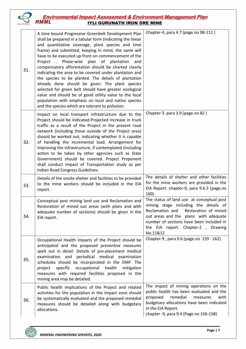
RMML
Environmental Impact Assessment & Environment Management Plan
IYLI GURUNATH IRON ORE MINE
Page | 7
MINERAL ENGINEERING SERVICES, 2020
31.
A time bound Progressive Greenbelt Development Plan shall be prepared in a tabular form (indicating the linear and quantitative coverage, plant species and time frame) and submitted, keeping in mind, the same will have to be executed up front on commencement of the Project . Phase-wise plan of plantation and compensatory afforestation should be charted clearly indicating the area to be covered under plantation and the species to be planted. The details of plantation already done should be given. The plant species selected for green belt should have greater ecological value and should be of good utility value to the local population with emphasis on local and native species and the species which are tolerant to pollution.
Chapter-4, para 4.7 (page.no 98-111 )
32.
Impact on local transport infrastructure due to the Project should be indicated.Projected increase in truck traffic as a result of the Project in the present road network (including those outside of the Project area) should be worked out, indicating whether it is capable of handling the incremental load. Arrangement for improving the infrastructure, if contemplated (including action to be taken by other agencies such as State Government) should be covered. Project Proponent shall conduct Impact of Transportation study as per Indian Road Congress Guidelines.
Chapter-3. para 3.9 (page.no 82 )
33.
Details of the onsite shelter and facilities to be provided to the mine workers should be included in the EIA report.
The details of shelter and other facilities for the mine workers are provided in the EIA Report. chapter-9, para 9.6.3 (page.no 160)
34.
Conceptual post mining land use and Reclamation and Restoration of mined out areas (with plans and with adequate number of sections) should be given in the EIA report.
The status of land use at conceptual post mining stage including the details of Reclamation and Restoration of mined out areas and the plans with adequate number of sections have been included in the EIA report. Chapter-2 , Drawing No.11&12
35.
Occupational Health impacts of the Project should be anticipated and the proposed preventive measures spelt out in detail. Details of pre-placement medical examination and periodical medical examination schedules should be incorporated in the EMP. The project specific occupational health mitigation measures with required facilities proposed in the mining area may be detailed.
Chapter-9 , para 9.6 (page.no 159 - 162)
36.
Public health implications of the Project and related activities for the population in the impact zone should be systematically evaluated and the proposed remedial measures should be detailed along with budgetary allocations.
The impact of mining operations on the public health has been evaluated and the proposed remedial measures with budgetary allocations have been indicated in the EIA Report. chapter -9, para 9.4 (Page no 156-158)
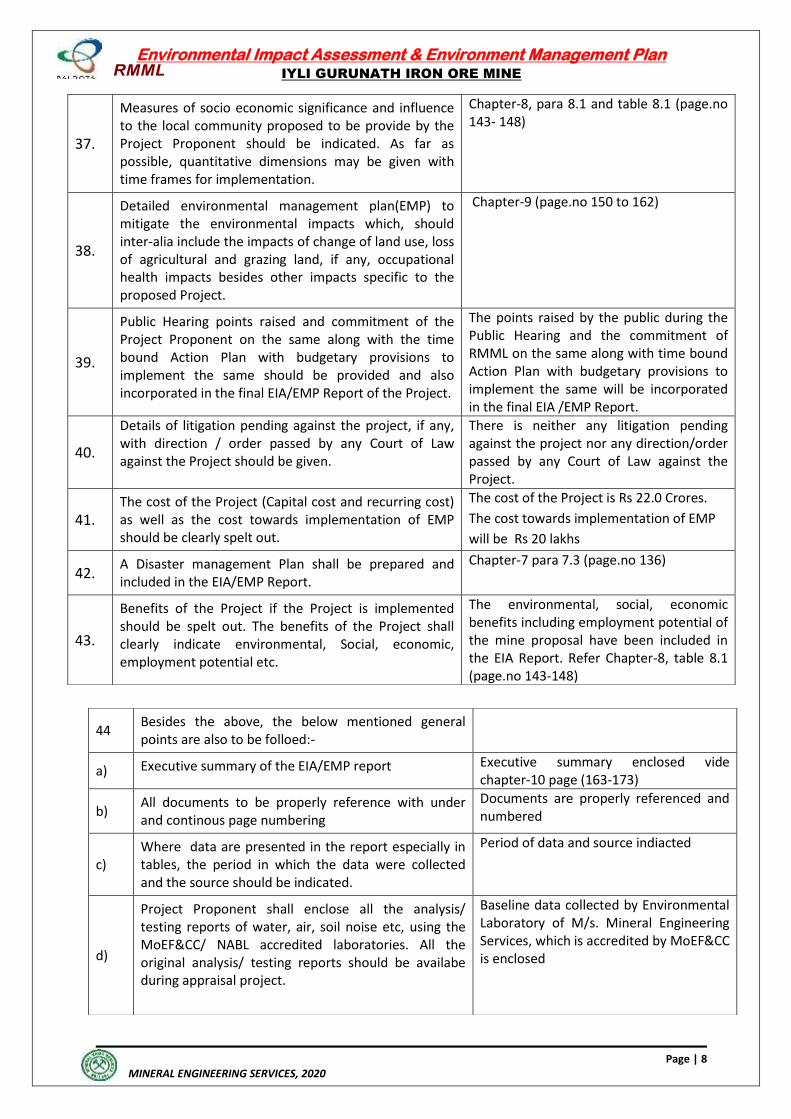
RMML
Environmental Impact Assessment & Environment Management Plan
IYLI GURUNATH IRON ORE MINE
Page | 8
MINERAL ENGINEERING SERVICES, 2020
37.
Measures of socio economic significance and influence to the local community proposed to be provide by the Project Proponent should be indicated. As far as possible, quantitative dimensions may be given with time frames for implementation.
Chapter-8, para 8.1 and table 8.1 (page.no 143- 148)
38.
Detailed environmental management plan(EMP) to mitigate the environmental impacts which, should inter-alia include the impacts of change of land use, loss of agricultural and grazing land, if any, occupational health impacts besides other impacts specific to the proposed Project.
Chapter-9 (page.no 150 to 162)
39.
Public Hearing points raised and commitment of the Project Proponent on the same along with the time bound Action Plan with budgetary provisions to implement the same should be provided and also incorporated in the final EIA/EMP Report of the Project.
The points raised by the public during the Public Hearing and the commitment of RMML on the same along with time bound Action Plan with budgetary provisions to implement the same will be incorporated in the final EIA /EMP Report.
40.
Details of litigation pending against the project, if any, with direction / order passed by any Court of Law against the Project should be given.
There is neither any litigation pending against the project nor any direction/order passed by any Court of Law against the Project.
41.
The cost of the Project (Capital cost and recurring cost) as well as the cost towards implementation of EMP should be clearly spelt out.
The cost of the Project is Rs 22.0 Crores.
The cost towards implementation of EMP
will be Rs 20 lakhs
42. A Disaster management Plan shall be prepared and included in the EIA/EMP Report.
Chapter-7 para 7.3 (page.no 136)
43.
Benefits of the Project if the Project is implemented should be spelt out. The benefits of the Project shall clearly indicate environmental, Social, economic, employment potential etc.
The environmental, social, economic benefits including employment potential of the mine proposal have been included in the EIA Report. Refer Chapter-8, table 8.1 (page.no 143-148)
44 Besides the above, the below mentioned general points are also to be folloed:-
a) Executive summary of the EIA/EMP report Executive summary enclosed vide chapter-10 page (163-173)
b) All documents to be properly reference with under and continous page numbering
Documents are properly referenced and numbered
c) Where data are presented in the report especially in tables, the period in which the data were collected and the source should be indicated.
Period of data and source indiacted
d)
Project Proponent shall enclose all the analysis/ testing reports of water, air, soil noise etc, using the MoEF&CC/ NABL accredited laboratories. All the original analysis/ testing reports should be availabe during appraisal project.
Baseline data collected by Environmental Laboratory of M/s. Mineral Engineering Services, which is accredited by MoEF&CC is enclosed
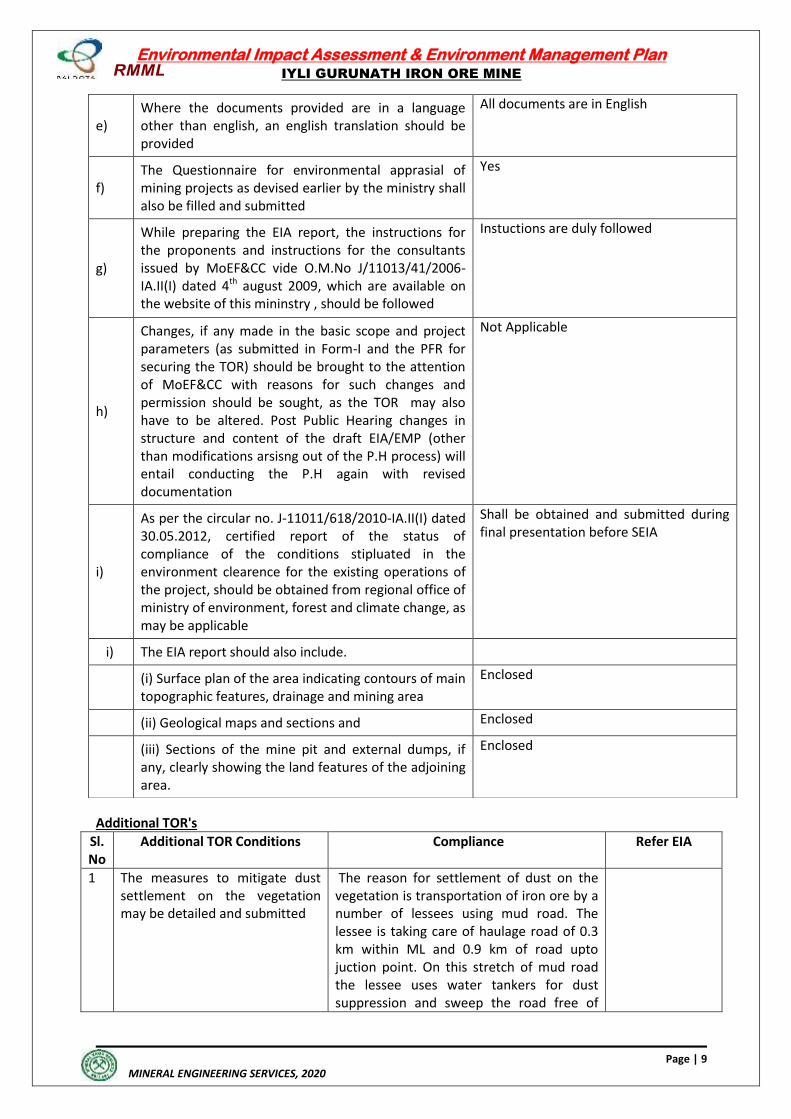
RMML
Environmental Impact Assessment & Environment Management Plan
IYLI GURUNATH IRON ORE MINE
Page | 9
MINERAL ENGINEERING SERVICES, 2020
Additional TOR's
Sl. No
Additional TOR Conditions Compliance Refer EIA
1 The measures to mitigate dust settlement on the vegetation may be detailed and submitted
The reason for settlement of dust on the vegetation is transportation of iron ore by a number of lessees using mud road. The lessee is taking care of haulage road of 0.3 km within ML and 0.9 km of road upto juction point. On this stretch of mud road the lessee uses water tankers for dust suppression and sweep the road free of
e) Where the documents provided are in a language other than english, an english translation should be provided
All documents are in English
f) The Questionnaire for environmental apprasial of mining projects as devised earlier by the ministry shall also be filled and submitted
Yes
g)
While preparing the EIA report, the instructions for the proponents and instructions for the consultants issued by MoEF&CC vide O.M.No J/11013/41/2006-IA.II(I) dated 4th august 2009, which are available on the website of this mininstry , should be followed
Instuctions are duly followed
h)
Changes, if any made in the basic scope and project parameters (as submitted in Form-I and the PFR for securing the TOR) should be brought to the attention of MoEF&CC with reasons for such changes and permission should be sought, as the TOR may also have to be altered. Post Public Hearing changes in structure and content of the draft EIA/EMP (other than modifications arsisng out of the P.H process) will entail conducting the P.H again with revised documentation
Not Applicable
i)
As per the circular no. J-11011/618/2010-IA.II(I) dated 30.05.2012, certified report of the status of compliance of the conditions stipluated in the environment clearence for the existing operations of the project, should be obtained from regional office of ministry of environment, forest and climate change, as may be applicable
Shall be obtained and submitted during final presentation before SEIA
i) The EIA report should also include.
(i) Surface plan of the area indicating contours of main topographic features, drainage and mining area
Enclosed
(ii) Geological maps and sections and Enclosed
(iii) Sections of the mine pit and external dumps, if any, clearly showing the land features of the adjoining area.
Enclosed
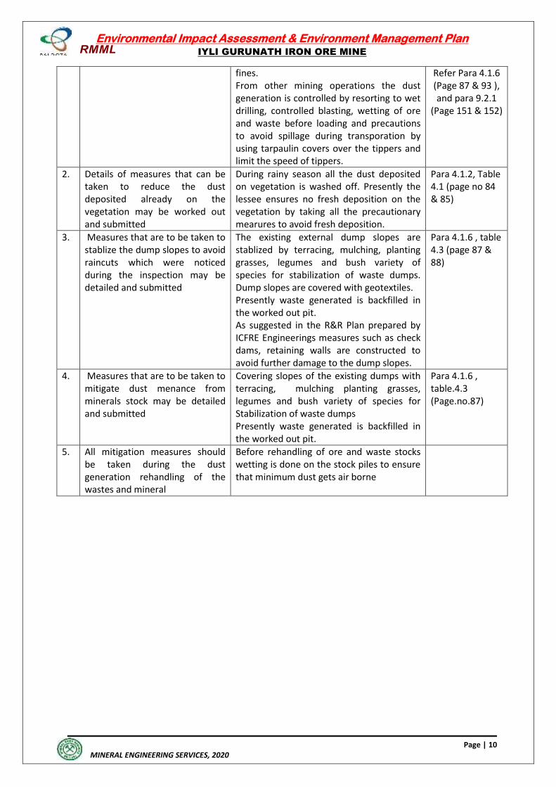
RMML
Environmental Impact Assessment & Environment Management Plan
IYLI GURUNATH IRON ORE MINE
Page | 10
MINERAL ENGINEERING SERVICES, 2020
fines. From other mining operations the dust generation is controlled by resorting to wet drilling, controlled blasting, wetting of ore and waste before loading and precautions to avoid spillage during transporation by using tarpaulin covers over the tippers and limit the speed of tippers.
Refer Para 4.1.6 (Page 87 & 93 ), and para 9.2.1
(Page 151 & 152)
2. Details of measures that can be taken to reduce the dust deposited already on the vegetation may be worked out and submitted
During rainy season all the dust deposited on vegetation is washed off. Presently the lessee ensures no fresh deposition on the vegetation by taking all the precautionary mearures to avoid fresh deposition.
Para 4.1.2, Table 4.1 (page no 84 & 85)
3. Measures that are to be taken to stablize the dump slopes to avoid raincuts which were noticed during the inspection may be detailed and submitted
The existing external dump slopes are stablized by terracing, mulching, planting grasses, legumes and bush variety of species for stabilization of waste dumps. Dump slopes are covered with geotextiles. Presently waste generated is backfilled in the worked out pit. As suggested in the R&R Plan prepared by ICFRE Engineerings measures such as check dams, retaining walls are constructed to avoid further damage to the dump slopes.
Para 4.1.6 , table 4.3 (page 87 & 88)
4. Measures that are to be taken to mitigate dust menance from minerals stock may be detailed and submitted
Covering slopes of the existing dumps with terracing, mulching planting grasses, legumes and bush variety of species for Stabilization of waste dumps Presently waste generated is backfilled in the worked out pit.
Para 4.1.6 , table.4.3 (Page.no.87)
5. All mitigation measures should be taken during the dust generation rehandling of the wastes and mineral
Before rehandling of ore and waste stocks wetting is done on the stock piles to ensure that minimum dust gets air borne
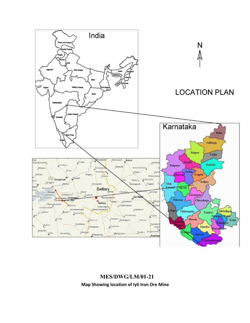
Map Showing location of Iyli Iron Ore Mine
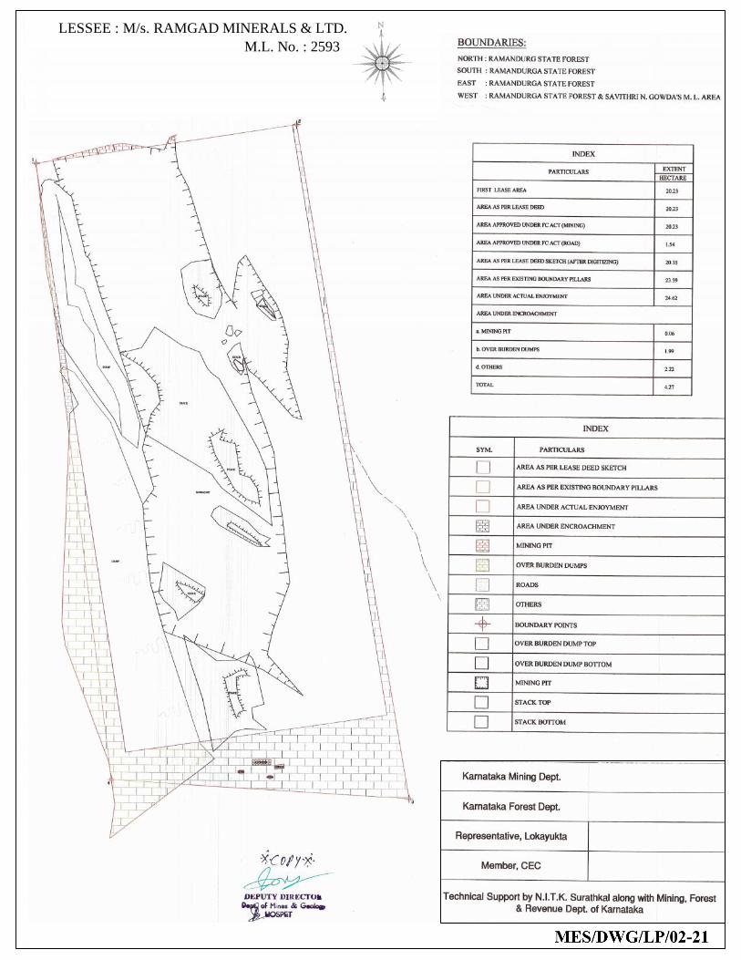
LESSEE : M/s. RAMGAD MINERALS & LTD.M.L. No. : 2593
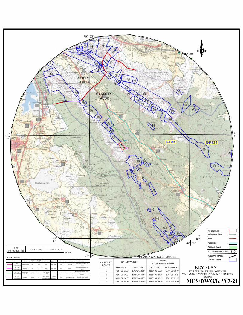
15°05'
76° 25'
15°10'
76° 25'
1
2
34
D
REFTOPOSHEET No D43E8 (57A/8) D43E12 (57A/12)
15°10'
15°05'
SW1
A
UML
B
N
ML AREA GPS CO-ORDINATES
LATITUDE LONGITUDE LATITUDE LONGITUDE1 N15° 09' 33.8" E76° 26' 26.8" N15° 09' 29.4" E76° 26' 30.4"
2 N15° 09' 39.0" E76° 26' 34.9" N15° 09' 34.6" E76° 26' 38.5"
3 N15° 09' 20.6" E76° 26' 47.7" N15° 09' 16.2" E76° 26' 51.4"
4 N15° 09' 15.4" E76° 26' 39.5" N15° 09' 11.0" E76° 26' 43.1"
BOUNDARY POINTS
DATUM WGS 84 DATUM INDIAN BANGLADESH
IYLI GURUNATH IRON ORE MINEM/s. RAMGAD MINERALS & MINING LIMITED.,
HOSPET
KEY PLAN
DETAILSLENGTH
(m)WIDTH
(m)TERRAIN QUALITY CONDITION TYPE OF ROAD SHARING LEASES
RO(100% traffic)
Internal Road 300 7.5 Hilly Mud Road Good InternalExclusively used by this
mine
R1 A-B(100% traffic)
ML Gate toJunction
point900 8 Hilly Mud Road Good Forest
Exclusively used by thismine
R2 B-C(100% traffic)
Junction toSH-49
5710 10Plain terrain
Tar roadTar & Mud Good Mine Users
Exclusively used by othersmines present in this
cluster
R3 C-D(100% traffic)
SH-49TowardsHospet
9000 12Plain terrain
Concrete roadCementConcrete
Good State HighwayExclusively used by others
mines present in thiscluster
PART
Road Details
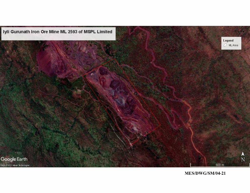
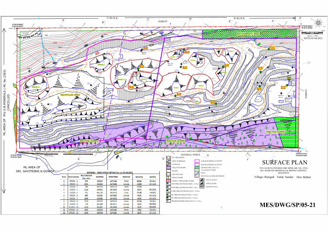
OFFICE
955.192
DGROOM
CANTEEN
955.199
BM
D
U
M
P
D
U
M
P
896.44
FIRST AID
VIEW POINT
0 M50 M
SCALE: 1:1000
9
3
7
.
7
7
9
3
6
.
9
2
9
3
6
.
3
8
9
3
7
.
2
0
9
3
6
.
4
0
9
3
6
.
2
6
9
3
5
.
9
0
9
3
6
.
0
8
1
2
4
9
3
7
.
5
5
2
FOR
EST
FOREST
BC
E
F
F'E'
C'
B'
A
A'
D
D'
ML AREA O
F M
\s S.B.M
IN
ERALS ( M
L N
o 2393)
ML AREA OF
SRI. SAVITRIBAI.N.GOWDA
TS1
954.712
TS11
858.973
W
/
B
-
1
GP8
GP6
G
P
5
G
P
4
G
P
3
G
G'
L'
L
9
2
0
9
1
0
8
9
0
8
7
0
860
850
840
830
'A' BLOCK 'B' BLOCK
TOEWALL15°09'33.74156"
76°26'26.70630"
15°09'39.08842"
76°26'34.95361"
15°09'20.80687"
76°26'47.86249"
3
15°09'15.41213"
76°26'39.41449"
CAN
CELLED
TW-1
GARLAND DRAIN
9
0
0
9
1
0
153-LBCD
151-L
W
C
D
152-LW
CD
1
5
4
-
L
W
C
D
155
1
5
6
1
5
7
1
5
8
1
5
9
-
B
W
C
D
1
6
0
1
6
1
162
8
9
0
MOBILE CRUSHING &SCREENING PLANT
VIEWPOINT
880.34
880.066
878.525
876.84871.261
867.38
867.562
863.455
861.423
859.781859.072
950.49
950.47
950.97949.97
950.31950.38
958.51961.82
857.91
858.62
945.60945.94
934.84933.86
932.99931.15929.46928.90928.17927.37925.81
897.81899.84900.46901.69902.91904.10904.42905.36907.59
908.88
911.47
914.53915.89
919.23920.96922.38
924.50
926.94
931.43
928.87894.82
949.56
949.06 948.97 948.94948.36
947.64
948.91
938.15
954.72
955.20
955.55
933.86939.05
945.59
947.48
949.59
901.96
942.05
955.75
955.46
955.89
955.36
955.22
954.44
947.62
948.44 948.76948.55
947.77
950.30
949.93
946.67
937.12
938.27938.42
940.75941.00
941.60941.82
942.82943.55
952.16
952.58952.78
953.00
952.62952.50
951.13950.28
934.06931.12
930.78
929.71
932.90933.70
933.67
924.23924.61
926.21928.07
938.48 939.06
919.69925.84
906.95916.38
929.67929.86
925.27
922.63
923.19 923.49923.87
929.70
929.25
938.54
936.38
919.64 920.46
938.64
865.91
868.21
869.61
872.77
873.70874.38 875.28
878.18 881.88
887.03
889.26 895.57
945.18
919.22
898.19
943.43
942.27
873.82
906.35
918.45
916.40
916.74916.14
915.09
913.63916.12
918.33
912.43
908.39
912.51912.79
912.73
903.48
891.66
930.20
934.38
936.57 934.48
906.49
906.50
914.51
906.53
953.31
GEOMATTING (2012-13)
IBH/RC12
944.50
IBH/RC1
892.50
IBH/ RC5
899.00
IBH/RC10
933.50
IBH/RC11
954.00
IBH/RC2
IBH/RC3
IBH/RC4
IBH/ RC6
IBH/ RC7
IBH/ RC9
878.50
IBH/ RC13
906.50
930.00
911.00
939.00
938.00
952.00
IBH/RC8
919.00
IBH-1
933.00
IBH-3
907.00
IBH-2
907.00
IBH-4
IBH-5
IBH-6
899.00
893.00
892.00
IBH-7
913.00
IBH-8
898.00
IBH-10
911.00
IBH-9
930.00
IBH-11
938.00
IBH-12
920.00
IBH-1
3
952.00
IBH-14
952.00
IBH-16
954.00
IBH-1
7
940.00
IBH-19
877.33
IBH-15
921.00
IBH-18
872.50
872.87 873.41
878.96
877.02
873.25
873.30
873.58
878.61
876.12873.87 875.11
875.04
878.51
883.89885.38
887.16
889.52
885.34
891.26
891.99895.09
891.31
886.40 897.62
891.58
884.82
885.26
881.00877.04
884.41 885.57 885.39
886.58
899.64
899.66
899.86 898.08
897.28
898.26
887.42
889.64
891.29
891.78
891.78
897.6
0
898.0
4
900.19
903.31
901.03
900.61
901.78904.66
904.44
905.04 904.17
903.7
3
902.
16
909.29909.10
912.74911.94
913.14
911.9
0
908.
48
905.37 916.70
918.2
2
922.84
927.20
920.2
1
920.17920.89
920.69920.23
919.95
929.39
928.21
928.01
928.72
928.00
935.93
940.53
939.99
940.2
2
940.7
9
942.16
944.41
952.85
951.7
3
950.88
954.74
954.85
880.64
884.45
886.53
891.56
890.95
894.36
894.53900.14
903.24
902.58
905.68910.66
909.62
914.68
916.84916.78
915.85
917.10
911.68
905.27
903.64
904.18
885.47
893.19
902.75
905.71
889.71
888.66
889.27
887.83
882.89884.01
888.11883.73
953.95
948.67
BACKFILLED AREA
898.33
C.ORE
W
/
B
-
2
GENERAL INDEX
MINE WORKINGS
CONTOUR
NALA
INACTIVE DUMPS
ROADS
SECTION LINE
BENCH MARK
935.03
900
A A'
OFFICE / INFRASTRUCTURES
BM
M L BOUNDARY 1 2
DTH DRILLED HOLES (2004) - 13 No.s
DTH DRILLED HOLES (2007) - 6 No.s
CORE DRILLED HOLES (2015) - 19 No.s
NBH\1
GEOMATTING (2012-13)7.5 m SAFETY ZONE
PARAPET WALL
GULLY PLUGS
CHECK DAMSC
D
2
G
P
1
TOE WALL & GARLAND DRAIN
RC DRILLED HOLES (2016) - 13 No.s
DTH-1
SURFACE PLANIYLI GURUNATH IRON ORE MINE (ML NO. 2593)M/s. RAMGAD MINERALS & MINING LIMITED.,
HOSAPETE
Village: Ramgad Taluk: Sandur Dist: Ballari
DATE:01.04.2021
IBH-1
IBH/RC-1
RC - 21
RC - 22
RC -23
RC -24
RC -17
RC -16
RC -19
RC -18
RC -15
RC -20
RC -14
RC -25
891.00
885.00
878.00
899.00
886.00
888.00
904.00
892.00
940.00
925.00
955.00
912.00
RC DRILLED HOLES (2021) - 12 No.sRC-14 TO RC-25
EID2
EIP1
EIP2
EID1
A BLOCK MINING ACTIVITY
B BLOCK MINING ACTIVITY
E
6
5
5
0
0
0
E
6
5
5
2
0
0
E
6
5
5
4
0
0
N
1
6
7
6
0
0
0
N
1
6
7
6
2
0
0
N
1
6
7
6
2
0
0
N
1
6
7
6
0
0
0
E
6
5
5
2
0
0
E
6
5
5
0
0
0
N
1
6
7
6
1
0
0
E
6
5
5
3
0
0
E
6
5
5
1
0
0
E
6
5
4
9
0
0
N
1
6
7
6
3
0
0
N
1
6
7
6
1
0
0
N
1
6
7
6
3
0
0
E
6
5
4
9
0
0
E
6
5
5
1
0
0
E
6
5
5
3
0
0
N
1
6
7
6
4
0
0
N
1
6
7
6
5
0
0
N
1
6
7
6
6
0
0
N
1
6
7
6
6
0
0
N
1
6
7
6
5
0
0
N
1
6
7
6
4
0
0
E
6
5
5
4
0
0
PBH-1 PBH-2PBH-3
PBH-4
PBH-5 PBH-6
STOCK -4
STOCK-7
STOCK-12 STOCK-10
STOCK-2
STOCK-9
STOCK-6
STOCK-5
STOCK-1STOCK-8
STOCK-3
STOCK-11
INACTIVE DUMPS
INACTIVE DUMPS
INACTIVE DUMPS
ADDITIONAL AREA NOT
TO BE UTILIZED
FOR MINING
PROPOSED BORE HOLES 2021-22 - 6 No.sPBH-1 TO 6
UPL
UPL
BIO-DIVERSITY AREA
UPL
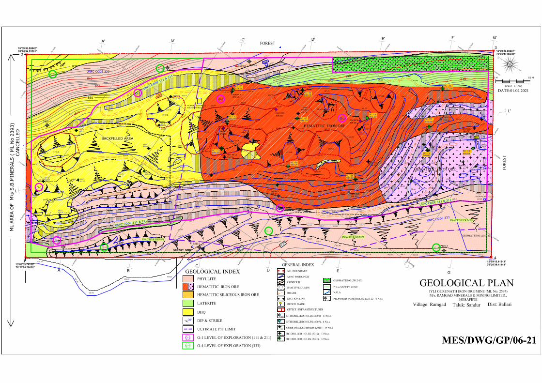
78°
76°
78°
78°
OFFICE
955.192
DGROOM
CANTEEN
955.199
BM
D
U
M
P
D
U
M
P
896.44
FIRST AID
VIEW POINT
0 M 50 M
SCALE: 1:1000
9
3
7
.
7
7
9
3
6
.
9
2
9
3
6
.
3
8
9
3
7
.
2
0
9
3
6
.
4
0
9
3
6
.
2
6
9
3
5
.
9
0
9
3
6
.
0
8
1
2
4
9
3
7
.
5
5
2
FOR
EST
FOREST
B
C
E
F
F'
E'
C'
B'
A
A'
D
D'
ML AREA O
F M
\s S.B.M
IN
ERALS ( M
L N
o 2393)
TS1
954.712
TS11
858.973
W
/
B
-
1
G
G'
L'
L
9
2
0
9
1
0
8
9
0
8
7
0
860
850
840
830
3
CAN
CELLED
9
0
0
9
1
0
8
9
0
MOBILE CRUSHING &SCREENING PLANT
VIEWPOINT
880.34
880.066
878.525
876.84871.261
867.38
867.562
863.455
861.423
859.781859.072
950.49
950.47
950.97949.97
950.31950.38
958.51961.82
857.91
858.62
945.60945.94
934.84933.86
932.99931.15929.46928.90928.17927.37925.81
897.81899.84900.46901.69902.91904.10904.42905.36907.59
908.88
911.47
914.53915.89
919.23920.96922.38
924.50
926.94
931.43
928.87
949.56
949.06 948.97 948.94948.36
947.64
948.91
938.15
954.72
955.20
955.55
933.86939.05
945.59
947.48
949.59
901.96
942.05
955.75
955.46
955.89
955.36
955.22
954.44
947.62
948.44 948.76948.55
947.77
950.30
949.93
946.67
937.12
938.27938.42
940.75941.00
941.60941.82
942.82943.55
952.16
952.58952.78
953.00
952.62952.50
951.13950.28
934.06931.12
930.78
929.71
932.90933.70
933.67
924.23924.61
926.21928.07
938.48 939.06
919.69925.84
906.95916.38
929.67929.86
925.27
922.63
923.19 923.49923.87
929.70
929.25
938.54
936.38
919.64 920.46
938.64
865.91
868.21
869.61
872.77
873.70874.38 875.28
878.18 881.88
887.03
889.26 895.57
945.18
919.22
898.19
943.43
942.27
873.82
906.35
918.45
916.40
916.74916.14
915.09
913.63916.12
918.33
912.43
908.39
912.51912.79
912.73
903.48
891.66
930.20
934.38
936.57 934.48
906.49
906.50
914.51
906.53
953.31
GEOMATTING (2012-13)
IBH/RC12
944.50
IBH/RC1
892.50
IBH/ RC5
899.00
IBH/RC10
933.50
IBH/RC11
954.00
IBH/RC2
IBH/RC3
IBH/RC4
IBH/ RC6
IBH/ RC7
IBH/ RC9
878.50
IBH/ RC13
906.50
930.00
911.00
939.00
938.00
952.00
IBH/RC8
919.00
IBH-1
933.00
IBH-3
907.00
IBH-2
907.00
IBH-4
IBH-5
IBH-6
899.00
893.00
892.00
IBH-7
913.00
IBH-8
898.00
IBH-10
911.00
IBH-9
930.00
IBH-11
938.00
IBH-12
920.00
IBH-1
3
952.00
IBH-14
952.00
IBH-16
954.00
IBH-1
7
940.00
IBH-19
877.33
IBH-15
921.00
IBH-18
872.50
BIO-DIVERCITY
872.87 873.41
878.96
877.02
873.25
873.30
873.58
878.61
876.12873.87 875.11
875.04
878.51
883.89885.38
887.16
889.52
885.34
891.26
891.99895.09
891.31
886.40 897.62
891.58
884.82
885.26
881.00877.04
884.41 885.57 885.39
886.58
899.64
899.66
899.86 898.08
897.28
898.26
887.42
889.64
891.29
891.78
891.78
897.6
0
898.0
4
900.19
903.31
901.03
900.61
901.78904.66
904.44
905.04 904.17
903.7
3
902.
16
909.29909.10
912.74911.94
913.14
911.9
0
908.
48
905.37 916.70
918.2
2
922.84
927.20
920.2
1
920.17920.89
920.69920.23
919.95
929.39
928.21
928.01
928.72
928.00
935.93
940.53
939.99
940.2
2
940.7
9
942.16
944.41
952.85
951.7
3
950.88
954.74
954.85
880.64
884.45
886.53
891.56
890.95
894.36
894.53900.14
903.24
902.58
905.68910.66
909.62
914.68
916.84916.78
915.85
917.10
911.68
905.27
903.64
904.18
885.47
893.19
902.75
905.71
889.71
888.66
889.27
887.83
882.89884.01
888.11883.73
953.95
948.67
BACKFILLED AREA
898.33
STOCK
C.ORE
STOCK
STOCK
STOCK
STOCK
STOCK
STOCK
STOCK
STOCK
STOCK
W
/
B
-
2
GENERAL INDEX
MINE WORKINGS
CONTOUR
NALA
INACTIVE DUMPS
ROADS
SECTION LINE
BENCH MARK
935.03
900
A A'
OFFICE / INFRASTRUCTURES
BM
M L BOUNDARY1 2
DTH DRILLED HOLES (2004) - 13 No.s
DTH DRILLED HOLES (2007) - 6 No.s
CORE DRILLED HOLES (2015) - 19 No.s
NBH\1
GEOMATTING (2012-13)
7.5 m SAFETY ZONE
RC DRILLED HOLES (2016) - 13 No.s
DTH-1
GEOLOGICAL PLANIYLI GURUNATH IRON ORE MINE (ML No. 2593)M/s. RAMGAD MINERALS & MINING LIMITED.,
HOSAPETEVillage: Ramgad Taluk: Sandur Dist: Ballari
DATE:01.04.2021
GEOLOGICAL INDEX
HEMATITIC IRON ORE
PHYLLITE
LATERITE
BHQ
ULTIMATE PIT LIMIT
DIP & STRIKE78°
IBH-1
IBH/RC-1
HEMATITIC SILICEOUS IRON ORE
RC - 21
RC - 22
RC -23
RC -24
RC -17
RC -16
RC -19
RC -18
RC -15
RC -20
RC -14
891.00
885.00
878.00
899.00
886.00
888.00
904.00
892.00
940.00
925.00
955.00
912.00
RC DRILLED HOLES (2021) - 12 No.sRC-14 TO RC-25
PBH-5 PBH-6
PROPOSED BORE HOLES 2021-22 - 6 No.sPBH-1 TO PBH-6
G-1 LEVEL OF EXPLORATION (111 & 211)G-1
G-4 LEVEL OF EXPLORATION (333)G-4
G-1
G-1
G-1
G-1
G-1
G-1
G-4
G-4
G-4
G-4
G-4
RC -25
E
6
5
5
0
0
0
E
6
5
5
2
0
0
E
6
5
5
4
0
0
N
1
6
7
6
0
0
0
N
1
6
7
6
2
0
0
N
1
6
7
6
2
0
0
N
1
6
7
6
0
0
0
E
6
5
5
2
0
0
E
6
5
5
0
0
0
N
1
6
7
6
1
0
0
E
6
5
5
3
0
0
E
6
5
5
1
0
0
E
6
5
4
9
0
0
N
1
6
7
6
3
0
0
N
1
6
7
6
1
0
0
N
1
6
7
6
3
0
0
E
6
5
4
9
0
0
E
6
5
5
1
0
0
E
6
5
5
3
0
0
N
1
6
7
6
4
0
0
N
1
6
7
6
5
0
0
N
1
6
7
6
6
0
0
N
1
6
7
6
6
0
0
N
1
6
7
6
5
0
0
N
1
6
7
6
4
0
0
E
6
5
5
4
0
0
U
N
F
C
C
O
D
E
3
3
3
UNFC CODE 333
PBH-4
U
N
F
C
C
O
D
E
1
1
1
&
2
1
1
U
N
F
C
C
O
D
E
1
1
1
&
2
1
1
U
N
F
C
C
O
D
E
1
1
1
&
2
1
1
15°09'33.74156"
76°26'26.70630"
15°09'39.08842"
76°26'34.95361"
15°09'20.80687"
76°26'47.86249"
15°09'15.41213"
76°26'39.41449"
INACTIVE DUMPSINACTIVE DUMPS
INACTIVE DUMPS
HEMATITIC IRON ORE
HEMATITIC IRON ORE
PBH-1 PBH-2PBH-3
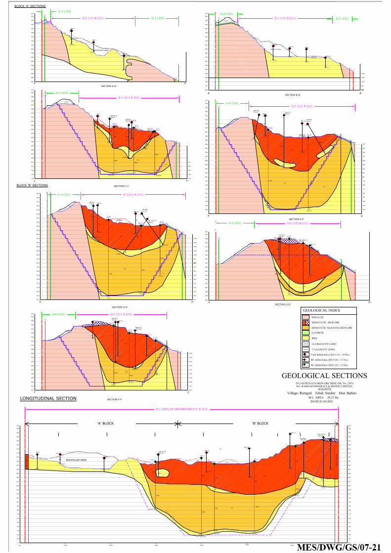
B B'
SECTION B-B'
C
SECTION C-C'
C'
E
SECTION E-E'
E'
F
F'
SECTION F-F'
DUMP
A
DUMP
DD'
SECTION A-A'
SECTION D-D'
A'
820
829
838
847
856
865
874
883
892
901
910
919
928
937
946
955
964
970
820
829
838
847
856
865
874
883
892
928
910
919
937
946
955
970
964
820
829
838
856
865
874
883
892
901
910
919
928
937
946
955
964
970
820
838
856
847
865
874
883
892
901
910
919
928
937
946
955
820
829
838
847
856
874
865
901
883
892
928
910
919
937
946
955
829
964
970
820
838
847
856
865
874
883
892
901
910
919
928
937
946
955
964
970
ML
7.5
ML
7.5
ML
ML
7.5
7.5
ML
ML
7.5
7.5
ML
ML
7.5
ML
7.5
ML
7.5
ML
7.5
ML
7.5
838
820
829
847
856
865
847
874
883
892
901
910
919
928
937
946
955
964
970
SECTION G-G'
ML
7.5
ML
970
111
108.00 m
GEOLOGICAL INDEX
PHYLLITE
HEMATATIC IRON ORE
LATERITE
BHQ
ULTIMATE PIT LIMIT
111
111
111
G
DUMP
G'
7.5 m SAFETY ZONE
BLOCK 'A' SECTIONS
BLOCK 'B' SECTIONS
7.5
IBH/RC3
910
DUMP
DUMP
93.00 m
IBH/RC8
919.00
78.00 m
IBH/RC10
933.489
83.00 m
IBH/RC11
954.00
IBH12/RC12
944.50
76.00 m
892.387
IBH/RC1
72.00 m
400m
820
829
838
865
856
874
883
892
901
919
928
IBH-17
946
937
HIO
UN
FC C
OD
E 21
1
955
111
964
970
820
847
829
838
856
865
874
901
883
892
910
919
928
937
946
955
IBH-5
964
Bh
27.00 M
IBH-10
IBH-14
'A' BLOCK 'B' BLOCK
74.00 M
17.00 M
0m
100m 200m 300m 600m
500m
700m
A B C D E F G
LONGITUDINAL SECTION
ML ML
7.5
7.5
UN
FC C
OD
E 21
1
50.00 M
211
IBH/RC10
933.489
78.00 m
HIO
Bh
IBH12/RC12
944.596
108.00 m
LLo
HIO
Bh
211
211
Core drilled holes (2013-15) - 19 No.s
RC drilled holes (2015-16) - 13 No.s
BD
BD
BD
88.00 m
115.00 M
70.00 M
82.00 M
52.00 M
40.00 M
IBH/ RC5 (P)
880.00
IBH/RC2
IBH/ RC13
906.50
928.00
IBH/RC4
911.00
938.00
IBH/ RC7
IBH/ RC6
IBH/ RC9
939.00
901
952.00
50.00 M
IBH/ RC13
906.50
HIO
HIO
HIO
HIO
HIO
HIO
HIO
HIO
HIO
HIO
HIO
Bh
Bh
Bh
Bh
Bh
Bh
Bh
Bh
Bh
Bh
Bh
28.50 M
IBH-4
IBH-6
30.00 M
25.50 M
IBH-7
IBH-8
IBH-9
35.00 M
61.50 M
58.50 M
IBH-12
43.00 M
IBH-11
43.00 M
IBH-13
802
811
802
811
IBH-15
35.00 M
44.00 M
LLo
42.00 M
HIO
64.50 M
IBH-16
HIO
HIO
HIO
HIO
HIO
19.50 M
HIO
30.00 M
IBH-2
IBH-3
IBH-4
802
30.00 M
IBH-10
43.00 M
61.50 M
IBH-12
829
IBH-14
74.00 M
64.50 M
IBH-17
IBH-19
30.00 M
Bh
Ph
IBH-18
20.00 M
IBH-1
IBH/RC-1
IBH-3
IBH-1
BACKFILLED AREA
BACKFILLED AREA
STOCK
STOCK
19.50 M
899.00
STOCK
STOCK
STOCK
STOCK
STOCK
STOCK
STOCK
820
829
838
RC-21
RC-22
105.00 M
101.00 M
96.00 M
RC-24
170.0 M
RC-17
148.0 M
RC-16
RC-19
RC-18
171.00 M
73.00 m
RC-25
RC-15
129.00 m
811
802 802
811
811
802 802
811
802
820
829
838
739
847
856
811
802 802
811
820
829
838
847
856
865
874
811
802
820
829
838
847
856
865
874
883
811
802
802
121.00 m
811 811
802
BACKFILLED AREA
RC-14
RC-14 to RC-25
110.0 M
158.00 M
793
784
793
784
793
784
775
766
757
748
739
730
721
793
784
775
766
757
748
739
730
793
784
775
766
757
748
739
730
793
784
775
766
757
748
739
730
721
HEMATATIC SILICEOUS IRON ORE
793
784
775
766
757
748
739
730
721
712
793
784
775
766
757
748
730
721
720
847
HIO
HSIO
HSIO
HSIO
Bh
Bh
Bh
HSIO
Bh
HSIO
HSIO
Bh
HSIO
HSIO
Bh
Bh
Bh
HSIO
HSIO
RC-20
107.00 m
HSIO
Bh
PBH- 1
105.00 M
HIO
HSIO
Bh
PBH- 5
HSIO
Bh
PBH- 4
HSIO
Bh
Bh
PBH- 8
158.00 M
HSIO
HIO
HIO
HIO
PBH- 10
107.00 m
HSIO
HIO
170.00 M
148.00 M
Bh
RC drilled holes (2021-22) - 12 No.s
211
111
211
111
111
211
111
211
211
211
211
891.00
885.00
RC-23
878.00
899.00
886.00
888.00
904.00
892.00
940.00
925.00
912.00
955.00
775 775
GEOLOGICAL SECTIONSIYLI GURUNATH IRON ORE MINE (ML No. 2593)M/s. RAMGAD MINERALS & MINING LIMITED.,
HOSAPETEVillage: Ramgad Taluk: Sandur Dist: Ballari
M.L. AREA 20.23 Ha DATE:01.04.2021
G-1 (111 & 211) G-1 (111 & 211)
G-1 (111 & 211)
G-1(111 & 211)
G-1 (111 & 211)
G-1 (111 & 211)
G-1 (111 & 211)
G-4 (333)
G-4 (333)
G-4 (333)
G-4 (333)
G-4 (333)
G-4 (333)
G-4 (333)
G-4 (333)
G-4 (333)
G-1 LEVEL OF EXPLORATON (111 & 211)
111
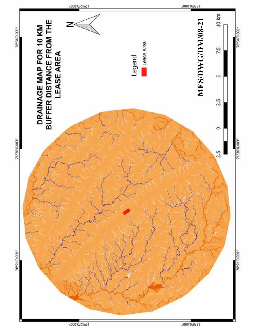
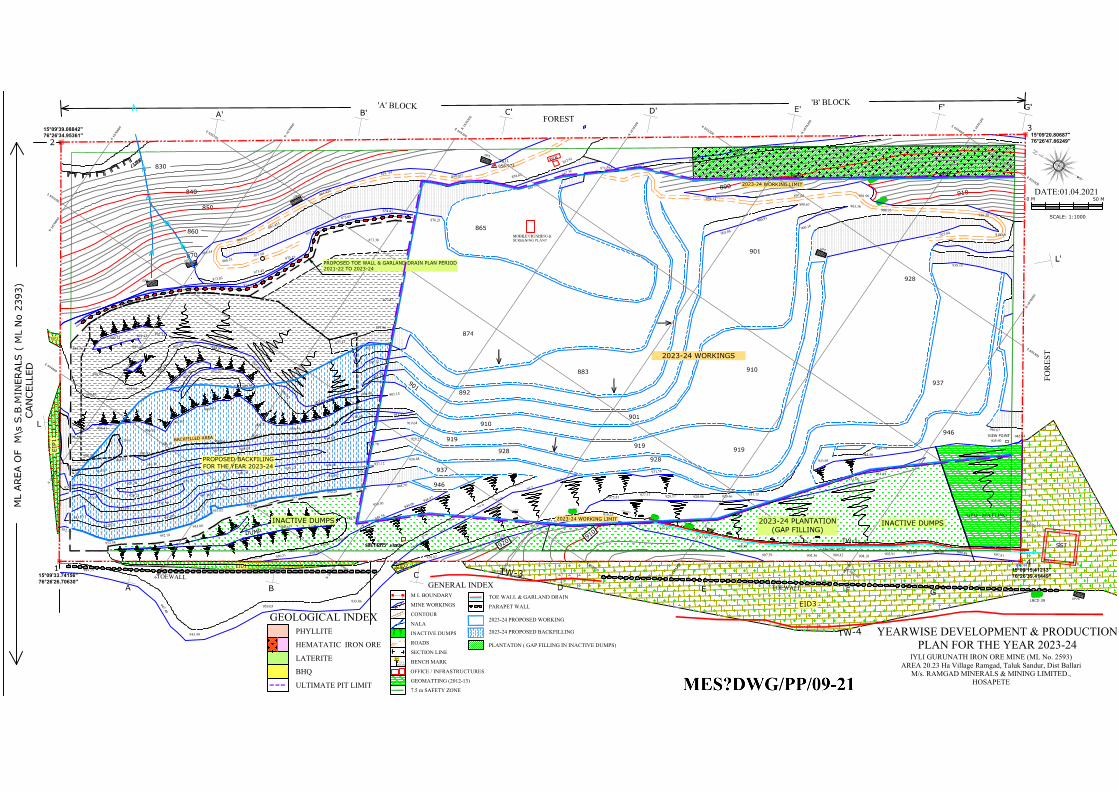
EID2
EIP1
EIP2
EID1
EID3
PLANTATIOND
U
M
P
896.44
VIEW POINT
0 M50 M
SCALE: 1:1000
9
3
8
.
7
9
9
3
7
.
7
7
9
3
6
.
9
2
9
3
6
.
3
8
9
3
7
.
2
0
9
3
6
.
4
0
9
3
6
.
2
6
9
3
5
.
9
0
9
3
6
.
0
8
1
2
4
9
3
7
.
5
5
2
FOR
EST
FOREST
B
C
E
F
F'
E'
C'
B'
A
A'
D
D'
ML AREA O
F M
\s S.B.M
IN
ERALS ( M
L N
o 2393)
TS11
858.973
W
/
B
GP26
G
P
7
GP6
G
P
5
G
P
4
G
P
3
G
G'
L'
L
9
2
0
9
1
0
8
9
0
8
7
0
860
850
840
830
'A' BLOCK 'B' BLOCK
TOEWALL
TOEWALL
3
CAN
CELLED
TW-1
SST
GARLAND DRAIN
9
0
0
9
1
0
TW
-4
LBCD 39
153-LBCD
T
W
-3
151-L
W
C
D
152-LW
CD
1
5
4
-
L
W
C
D
155 1
5
6
1
5
7
1
5
8
1
5
9
-
B
W
C
D
1
6
0
1
6
1
162
8
9
0
MOBILE CRUSHING &SCREENING PLANT
GEO - MATTING
IYLI GURUNATH IRON ORE MINE (ML No. 2593)AREA 20.23 Ha Village Ramgad, Taluk Sandur, Dist Ballari
M/s. RAMGAD MINERALS & MINING LIMITED.,HOSAPETE
DATE:01.04.2021
892
9
0
1
910
919
928
937
946
YEARWISE DEVELOPMENT & PRODUCTIONPLAN FOR THE YEAR 2023-24
MINE WORKINGS
CONTOUR
NALA
INACTIVE DUMPS
ROADS
SECTION LINE
BENCH MARK
935.03
900
A A'
OFFICE / INFRASTRUCTURES
BM
M L BOUNDARY1 2
GEOMATTING (2012-13)
7.5 m SAFETY ZONE
PARAPET WALL
TOE WALL & GARLAND DRAIN
954.712
TS-1
2023-24 WORKING LIMIT
BACKFIL
LED
AREA
874
901
919
928
910
919
937
880.34
880.066
878.525
876.84871.261
867.38
867.562
863.455
861.423
859.781859.072
950.49
950.47
950.97949.97
950.31950.38
958.51961.82
857.91
858.62
945.60945.94
934.84933.86
932.99931.15929.46928.90928.17927.37925.81
897.81899.84900.46901.69902.91904.10904.42905.36907.59
908.88
911.47
914.53915.89
919.23920.96922.38
924.50
926.94
931.43
928.87894.82 894.18
949.56
949.06 948.97
948.91
938.15
933.86939.05
945.59
947.48
949.59
901.96897.65
948.44 948.76
950.30
943.95944.56
949.19
946.67
894.34
906.41
906.93
906.52
913.57 914.03
914.24937.12
938.27938.42
940.75941.00
941.60941.82
942.82
943.55
952.16
952.58952.78
953.00
952.62952.50
951.13950.28
934.06931.12
930.78
929.71
932.90933.70
933.67
924.23924.61
926.21928.07
923.74
922.63
923.19 923.49923.87
868.44
865.39
916.10915.64
915.07914.09
914.16
881.41
862.12
876.98
873.16868.25
871.68
872.71
873.65
929.70929.25
938.48
873.82873.43
910.97
912.95908.15
906.64905.74
906.46
874.43
876.21
888.95
891.94
885.56
888.46
873.83874.66
910.63
877.87
877.96
898.67 903.36
919.69903.06
900.91
906.16
925.84
906.95916.38
919.64
914.42
931.58
877.47885.37
895.22
903.72
905.15904.60
907.95
908.93
908.21
902.07
904.32
902.9
8892.2
4
892.50 894.21
897.85
900.62
902.69
906.10
891.45
890.75 891.42 892.21
873.38
2023-24 WORKING LIMIT
901
928
946
PROPOSED BACKFILING
FOR THE YEAR 2023-24
865
883
2023-24 WORKINGS
E
6
5
5
0
0
0
E
6
5
5
2
0
0
E
6
5
5
4
0
0
N
1
6
7
6
0
0
0
N
1
6
7
6
2
0
0
N
1
6
7
6
2
0
0
N
1
6
7
6
0
0
0
E
6
5
5
2
0
0
E
6
5
5
0
0
0
N
1
6
7
6
1
0
0
E
6
5
5
3
0
0
E
6
5
5
1
0
0
E
6
5
4
9
0
0
N
1
6
7
6
3
0
0
N
1
6
7
6
1
0
0
N
1
6
7
6
3
0
0
E
6
5
4
9
0
0
E
6
5
5
1
0
0
E
6
5
5
3
0
0
N
1
6
7
6
4
0
0
N
1
6
7
6
5
0
0
N
1
6
7
6
6
0
0
N
1
6
7
6
6
0
0
N
1
6
7
6
5
0
0
N
1
6
7
6
4
0
0
E
6
5
5
4
0
0
15°09'33.74156"
76°26'26.70630"
15°09'39.08842"
76°26'34.95361"
15°09'20.80687"
76°26'47.86249"
15°09'15.41213"
76°26'39.41449"
PROPOSED TOE WALL & GARLAND DRAIN PLAN PERIOD
2021-22 TO 2023-24
INACTIVE DUMPS
INACTIVE DUMPS
2023-24 PLANTATION
(GAP FILLING)
GEOLOGICAL INDEX
HEMATATIC IRON ORE
PHYLLITE
LATERITE
BHQ
ULTIMATE PIT LIMIT
PLANTATON ( GAP FILLING IN INACTIVE DUMPS)
2023-24 PROPOSED WORKING
2023-24 PROPOSED BACKFILLING
GENERAL INDEX
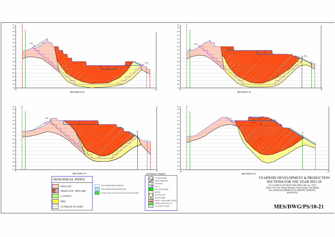
PLANTATON ( GAP FILLING IN INACTIVE DUMPS)
E
SECTION E-E'
E'D
SECTION D-D'
D'
820
829
838
847
856
865
874
883
892
901
910
919
928
937
946
955
964
970
820
829
838
847
856
865
874
883
892
901
910
919
928
937
946
955
964
970
7.5
ML
ML
7.5
ML
7.5
ML
7.5
111
DUMP
BD
UPL
UPL
UPL
UPL
UPL
2023-24 PROPOSED WORKING
2023-24 PROPOSED BACKFILLING
F F'
SECTION F-F'
820
829
838
847
856
865
874
883
892
901
910
919
928
937
946
955
964
970
ML
ML
7.5
7.5
111
DUMP
BD
UPL
UPL
820
829
838
847
856
865
874
883
892
901
910
919
928
937
946
955
964
970
SECTION G-G'
ML
7.5
ML
111
G G'
211
BD
UPL
V
V
V
V
V
V
GEOLOGICAL INDEX
HEMATATIC IRON ORE
PHYLLITE
LATERITE
BHQ
ULTIMATE PIT LIMIT
IYLI GURUNATH IRON ORE MINE (ML No. 2593)AREA 20.23 Ha Village Ramgad, Taluk Sandur, Dist Ballari
M/s. RAMGAD MINERALS & MINING LIMITED.,HOSAPETE
YEARWISE DEVELOPMENT & PRODUCTIONSECTIONS FOR THE YEAR 2023-24MINE WORKINGS
CONTOUR
NALA
INACTIVE DUMPS
ROADS
SECTION LINE
BENCH MARK
935.03
900
A A'
OFFICE / INFRASTRUCTURES
BM
M L BOUNDARY1 2
GEOMATTING (2012-13)
7.5 m SAFETY ZONE
954.712
TS-1
GENERAL INDEX
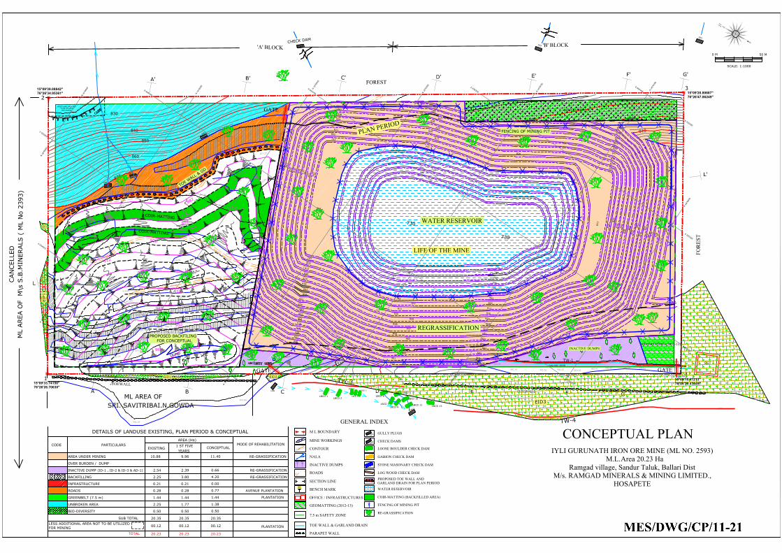
BIO-DIVERCITY
D
U
M
P
896.44
0 M50 M
SCALE: 1:1000
9
3
6
.
2
6
9
3
5
.
9
0
9
3
6
.
0
8
1
2
4
FOR
EST
FOREST
BC E
F
F'
E'
C'
B'
A
A'
D
D'
ML AREA O
F M
\s S.B.M
IN
ERALS ( M
L N
o 2393)
ML AREA OF
SRI. SAVITRIBAI.N.GOWDA
G
P
1
3
GP8
GP6
G
P
5
G
P
4
G
P
2
G
P
1
C
H
E
C
K
D
A
M
G
G'
L'
L
9
2
0
8
9
0
8
7
0
860
850
840
830
'A' BLOCK 'B' BLOCK
TOEWALL
TOEWALL
3
CAN
CELLED
TW-1
SST
GARLAND DRAIN
9
0
0
9
1
0
TW
-4
LBCD 13
LBCD 8
LBCD 10
LBCD 11
LBCD 6
LBCD 7
LBCD 9
LBCD 3
LBCD 4
LBCD 5
LBCD 1
LBCD 2
T
W
-3
1
6
1
162
880.34
880.066
878.525
863.455
861.423
859.781
950.49
950.47
950.97949.97
950.31950.38
958.51961.82
897.81899.84900.46901.69902.91904.10904.42905.36907.59
908.88
924.50
926.94
931.43
928.87894.82 894.18
948.91
933.86939.05
945.59
947.48
949.59
948.44
938.27938.42
940.75941.00
941.60941.82
942.82943.55
952.16
952.58952.78
953.00
952.62952.50
951.13950.28
934.06931.12
930.78
929.71
932.90933.70
933.67
924.23924.61
926.21928.07
925.27
922.63
923.19 923.49923.87
865.91
868.21
869.61
872.77
873.70874.38
873.82
906.35
918.45
916.40
916.74916.14
915.09
913.63916.12
918.33
912.43
908.39906.49
906.50
914.51
906.53
GEOMATTING (2012-13)
872.87 873.41
878.96
877.02
873.25
873.30
873.58
878.61
876.12873.87 875.11
875.04
878.51
880.64
884.45
886.53
891.56
890.95
894.36
894.53900.14
903.24
902.58
905.68910.66
909.62
914.68
916.84916.78
915.85
917.10
911.68
885.47
893.19
902.75
889.71
888.66
889.27
887.83
STOCK
STOCK
W
/
B
-
2
EID2
EIP1
EIP2
EID1
EID3
7
8
4
8
2
0
8
2
9
8
3
8
8
5
6
8
6
5
8
7
4
8
8
3
8
9
2
9
0
1
9
1
0
9
1
9
9
2
8
9
3
7
8
1
1
8
4
7
7
9
3
8
0
2
8
0
2
7
9
3
8
1
1
8
2
0
8
2
9
8
3
8
8
4
7
7
3
0
7
3
9
7
4
8
7
5
7
7
6
6
7
7
5
7
8
4
8
2
0
8
2
9
8
3
8
8
5
6
8
6
5
8
7
4
8
8
3
8
9
2
9
0
1
8
1
1
8
4
7
7
9
3
8
0
2
7
3
9
7
4
8
7
5
7
7
6
6
7
7
5
7
8
4
8
0
2
7
9
3
8
1
1
8
2
0
8
2
9
8
3
8
8
4
7
8
5
6
8
6
5
7
3
9
7
4
8
7
5
7
7
6
6
7
7
5
7
8
4
8
2
0
8
2
9
8
3
8
8
5
6
8
6
5
8
7
4
8
8
3
8
9
2
9
0
1
8
1
1
8
4
7
7
9
3
8
0
2
7
3
0
8
1
1
8
2
0
8
2
9
8
3
8
8
4
7
8
5
6
8
6
5
8
7
4
8
8
3
8
9
2
9
1
9
8
2
0
8
2
9
8
3
8
8
4
7
8
5
6 8
6
5
8
7
4
8
8
3
8
9
2
9
0
1
9
1
0
8
2
0
9
2
8
9
3
7
9
4
6
9
5
5
9
4
6
9
1
0
9
1
0
8
0
2
7
9
3
8
1
1
8
2
0
8
2
9
8
3
8
8
4
7
8
5
6
8
6
5
8
5
6
GENERAL INDEX
MINE WORKINGS
CONTOUR
NALA
INACTIVE DUMPS
ROADS
SECTION LINE
BENCH MARK
935.03
900
A A'
OFFICE / INFRASTRUCTURES
BM
M L BOUNDARY1 2
GEOMATTING (2012-13)
7.5 m SAFETY ZONE
PARAPET WALL
TOE WALL & GARLAND DRAIN
LOOSE BOULDER CHECK DAM
GABION CHECK DAM
STONE MASONARY CHECK DAM
LOG WOOD CHECK DAM
GULLY PLUGS
CHECK DAMSC
D
2
G
P
1
PROPOSED TOE WALL ANDGARLAND DRAIN FOR PLAN PERIOD
EXISTING
1 ST FIVE
YEARS
CONCEPTUAL
MODE OF REHABILITATION
AREA UNDER MINING 10.88 9.96 RE-GRASSIFICATION
OVER BURDEN / DUMP
2.54 2.39 RE-GRASSIFICATION
BACKFILLING 2.25 3.80 RE-GRASSIFICATION
INFRASTRUCTURE 0.21 0.21
ROADS 0.28 0.28 AVENUE PLANTATION
GREENBELT (7.5 m) 1.44 1.44
UNBROKEN AREA 2.25 1.77
BIO-DIVERSITY 0.50 0.50
20.35 20.35 20.35
DETAILS OF LANDUSE EXISTING, PLAN PERIOD & CONCEPTUAL
AREA (Ha)
SUB TOTAL
CODE PARTICULARS
PLANTATION
INACTIVE DUMP (ID-1 , ID-2 & ID-3 & AD-1)
11.40
0.66
4.20
0.00
0.77
1.44
1.38
0.50
LIFE OF THE MINE
PLAN PERIODFENCING OF MINING PIT
8
8
2
8
9
2
902
9
1
2
922
932
942
952
962
REGRASSIFICATION
C
O
IR
-M
A
TTIN
G
C
O
IR
-M
A
TTIN
G
WATER RESERVOIR
COIR-MATTING (BACKFILLED AREA)
FENCING OF MINING PIT
RE-GRASSIFICATION
GATE
GATEGATE
E
6
5
5
0
0
0
E
6
5
5
2
0
0
E
6
5
5
4
0
0
N
1
6
7
6
0
0
0
N
1
6
7
6
2
0
0
N
1
6
7
6
2
0
0
N
1
6
7
6
0
0
0
E
6
5
5
2
0
0
E
6
5
5
0
0
0
N
1
6
7
6
1
0
0
E
6
5
5
3
0
0
E
6
5
5
1
0
0
E
6
5
4
9
0
0
N
1
6
7
6
3
0
0
N
1
6
7
6
1
0
0
N
1
6
7
6
3
0
0
E
6
5
4
9
0
0
E
6
5
5
1
0
0
E
6
5
5
3
0
0
N
1
6
7
6
4
0
0
N
1
6
7
6
5
0
0
N
1
6
7
6
6
0
0
N
1
6
7
6
6
0
0
N
1
6
7
6
5
0
0
N
1
6
7
6
4
0
0
E
6
5
5
4
0
0
ADDITIONAL AREA NOT
TO BE UTILIZED
FOR MINING
15°09'33.74156"
76°26'26.70630"
15°09'39.08842"
76°26'34.95361"
15°09'20.80687"
76°26'47.86249"
15°09'15.41213"
76°26'39.41449"
LESS ADDITIONAL AREA NOT TO BE UTILIZED
FOR MINING
00.12 00.12 00.12
TOTAL
20.23 20.23 20.23
PLANTATION
INACTIVE DUMPS
WATER RESERVOIR
PROPOSED BACKFILING
FOR CONCEPTUAL
T
O
E
W
A
L
L
&
G
D
CONCEPTUAL PLANIYLI GURUNATH IRON ORE MINE (ML NO. 2593)
M.L.Area 20.23 HaRamgad village, Sandur Taluk, Ballari Dist
M/s. RAMGAD MINERALS & MINING LIMITED.,HOSAPETE
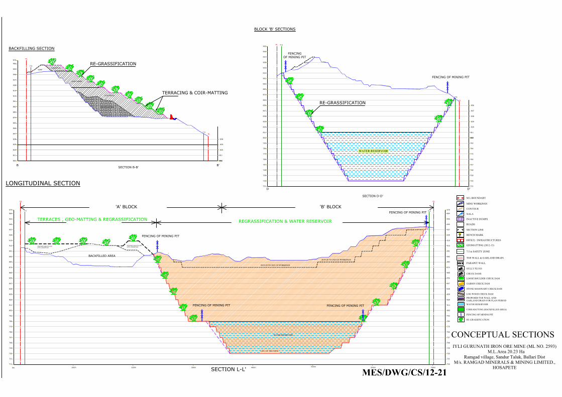
847
970
910
400m
820
829
838
865
856
874
883
892
901
919
928
946
937
955
964
970
820
847
829
838
856
865
874
901
883
892
910
919
928
937
946
955
964
'A' BLOCK 'B' BLOCK
0m
100m 200m 300m 600m
500m
700m
LONGITUDINAL SECTION
ML ML
7.5
7.5
739
802
811 811
802
BACKFILLED AREA
793
784
775
766
757
748
739
730
721
712
793
784
775
766
757
748
730
721
720
2019-20 TO 2023-24 WORKINGS
2019-20 TO 2023-24 WORKINGS
PROPOSED BACKFILLING
UPTO CONCEPTUAL
LIFE OF THE MINE
SECTION L-L'
WATER RESERVOIR
FENCING OF MINING PIT
FENCING OF MINING PIT
FENCING OF MINING PIT
FENCING OF MINING PIT
REGRASSIFICATION & WATER RESERVOIR
TERRACES , GEO-MATTING & REGRASSIFICATION
B B'
SECTION B-B'
DUMP
820
829
838
847
856
865
874
883
892
928
910
919
937
946
955
970
964
ML
ML
7.5
7.5
901
802
811
802
811
802
BACKFILLED AREA
820
829
838
DD'
SECTION D-D'
820
838
856
847
865
874
883
892
901
910
919
928
937
946
955
7.5
ML
ML
7.5
BLOCK 'B' SECTIONS
DUMP
829
811
802 802
811
802
820
829
838
847
856
793
784
775
766
757
748
739
730
721
793
784
775
766
757
748
739
730
721
BACKFILLING SECTION
FENCING OF MINING PIT
FENCING
OF MINING PIT
TERRACING & COIR-MATTING
RE-GRASSIFICATION
RE-GRASSIFICATION
WATER RESERVOIR
PLAN PERIOD
LEASE PERIOD
CONCEPTUAL
PROPOSED BACKFILLING
UPTO CONCEPTUAL
CONCEPTUAL SECTIONSIYLI GURUNATH IRON ORE MINE (ML NO. 2593)
M.L.Area 20.23 HaRamgad village, Sandur Taluk, Ballari Dist
M/s. RAMGAD MINERALS & MINING LIMITED.,HOSAPETE
MINE WORKINGS
CONTOUR
NALA
INACTIVE DUMPS
ROADS
SECTION LINE
BENCH MARK
935.03
900
A A'
OFFICE / INFRASTRUCTURES
BM
M L BOUNDARY1 2
GEOMATTING (2012-13)
7.5 m SAFETY ZONE
PARAPET WALL
TOE WALL & GARLAND DRAIN
LOOSE BOULDER CHECK DAM
GABION CHECK DAM
STONE MASONARY CHECK DAM
LOG WOOD CHECK DAM
GULLY PLUGS
CHECK DAMSC
D
2
G
P
1
PROPOSED TOE WALL ANDGARLAND DRAIN FOR PLAN PERIOD
WATER RESERVOIR
COIR-MATTING (BACKFILLED AREA)
FENCING OF MINING PIT
RE-GRASSIFICATION
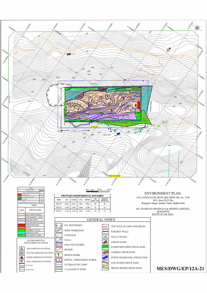
1
2
3
4
ML AREA O
F M
\s S.B.M
IN
ERALS
ML AREA OF
SRI. SAVITRIBAI.N.GOWDA
GENERAL INDEX
MINE WORKINGS
CONTOUR
NALA
INACTIVE DUMPS
ROADS
BENCH MARK
935.03
900
OFFICE / INFRASTRUCTURES
BM
M L BOUNDARY1 2
9
4
0
9
2
0
9
1
0
8
9
0
8
7
0
860
850
840
830
TW2
TW1
FO
REST AREA
FOREST AREA
FOREST AREA
0 M 100 M 200 M50 M
ULTIMATE PIT LIMIT
AIR SAMPLING STATIONS
60 M LINE
500 M LINE
WATER SAMPLING STATIONS
NOISE SAMPLING STATIONS
G
D
3
G
D
3
GD3
7.5 m SAFETY ZONE
SOIL SAMPLING STATIONS
ENVIRONMENTALMONITORING STATIONS
60 M LIN
E
500 M LIN
E
ENVIRONMENT PLANIYLI GURUNATH IRON ORE MINE ML No. 2593
M.L Area 20.23 Ha,Ramgad village, Sandur Taluk, Ballari Dist
M/s. RAMGAD MINERALS & MINING LIMITED.,HOSAPETE
DATE:01.04.2021
8
9
0
8
7
0
860
850
840
830
9
0
0
9
1
0
9
2
0
C
D
GP26
GP25
GP24
GP23
GP22
GP20
GP21
G
P
1
6
G
P
1
5
GP14
G
P
1
3
GP8
SMCD
GCD - 2
TW
-4
LBCD 37
LBCD 36
LBCD 35
LBCD 33
LBCD 34
LBCD 32
LBCD 31
LBCD 30
LBCD 38
LBCD 29
LBCD 28
LBCD 39
LBCD 18
LBCD 19
LBCD 20
LBCD 27
LBCD 21LBCD 22
LBCD 23
LBCD 26
GCD-1
LBCD 24
LBCD 25
LBCD 15
LBCD 16
LBCD 17
LBCD 14
LBCD 13
LBCD 8
LBCD 10
LBCD 11
LBCD 6
LBCD 7
LBCD 9
LBCD 4
LBCD 5
LBCD 1
LBCD 2
GP8
G
P
7
GP6
G
P
5
G
P
4
G
P
3
G
P
2
G
P
1
C
H
E
C
K
D
A
M
TOEWALL
TOEWALL
TW-1
GARLAND DRAIN
TW
-4
T
W
-3
SST
LOOSE BOULDER CHECK DAM
GABION CHECK DAM
STONE MASONARY CHECK DAM
LOG WOOD CHECK DAM
PARAPET WALL
GULLY PLUGS
CHECK DAMSC
D
2
G
P
1
TOE WALL & GARLAND DRAIN
LBCD
151-LWCD
152-LWCD
L
W
C
D
B
W
C
D
LWCD
L
B
C
D
LWCD
L
B
C
D
LWCD
LWCD
LWCD
BRUSH WOOD CHECK DAM
EID2
EIP1
EIP2
EID1
EID3
950
940
930
9
0
0
8
0
0
8
0
0
900
800
7
0
0
7
0
0
7
5
0
7
0
0
HECTAREEXTENTPARTICULARS
INDEX
b. OVER BURDEN DUMPS
a. MINING PIT
AREA UNDER ENCROACHMENT
0.06
d. OTHERS
TOTAL
1.99
2.22
4.27
BIO-DIVERSITY AREA
GEO-MATTING
AREA UNDER MINING
OVER BURDEN / DUMP
INACTIVE DUMP
INFRASTRUCTURE
ROADS
GREENBELT (7.5 m)
UNBROKEN AREA
INDEX
CODE
PARTICULARS
EXISTING BACKFILLING
BIO-DIVERSITY AREA
OFFICE
955.192
DGROOM
CANTEEN
955.199
BM
D
U
M
P
896.44
FIRST AID
VIEW POINT
BACKFILLED AREA
P
R
O
P
O
S
E
D
B
A
C
K
F
I
L
L
I
N
G
A
R
E
A
UPL
A1
N
N
N
N
N
N
GW1
S1
A1
GW1
N
S1
AN
MINING AREA
8
5
0
9
0
0
7
5
0
LBCD 3
SW1
8
5
5
8
6
0
8
6
5
8
7
0
8
7
5
9
4
0
9
0
5
8
0
5
8
1
0
8
1
5
8
2
0
8
2
58
3
0
8
3
5
8
4
0
8
4
5
8
5
0
60 M LINE
500 M LINE
E
6
5
5
0
0
0
E
6
5
5
2
0
0
E
6
5
5
4
0
0
N
1
6
7
6
0
0
0
N
1
6
7
6
2
0
0
N
1
6
7
6
2
0
0
N
1
6
7
6
0
0
0
E
6
5
5
2
0
0
E
6
5
5
0
0
0
N
1
6
7
6
1
0
0
E
6
5
5
3
0
0
E
6
5
5
1
0
0
E
6
5
4
9
0
0
N
1
6
7
6
3
0
0
N
1
6
7
6
1
0
0
N
1
6
7
6
3
0
0
E
6
5
4
9
0
0
E
6
5
5
1
0
0
E
6
5
5
3
0
0
N
1
6
7
6
4
0
0
N
1
6
7
6
5
0
0
N
1
6
7
6
6
0
0
N
1
6
7
6
6
0
0
N
1
6
7
6
5
0
0
N
1
6
7
6
4
0
0
E
6
5
5
4
0
0
E
6
5
5
2
0
0
E
6
5
5
4
0
0
E
6
5
5
6
0
0
E
6
5
5
8
0
0
E
6
5
6
0
0
0
E
6
5
5
0
0
0
E
6
5
5
2
0
0
E
6
5
5
4
0
0
E
6
5
5
6
0
0
E
6
5
5
8
0
0
E
6
5
6
0
0
0
E
6
5
4
8
0
0
E
6
5
4
6
0
0
E
6
5
4
4
0
0
E
6
5
4
2
0
0
E
6
5
4
2
0
0
E
6
5
4
4
0
0
E
6
5
4
6
0
0
E
6
5
4
8
0
0
N
1
6
7
6
8
0
0
N
1
6
7
7
0
0
0
N
1
6
7
7
2
0
0
N
1
6
7
7
4
0
0
N
1
6
7
7
6
0
0
N
1
6
7
7
8
0
0
N
1
6
7
7
8
0
0
N
1
6
7
7
6
0
0
N
1
6
7
7
4
0
0
N
1
6
7
7
2
0
0
N
1
6
7
7
0
0
0
N
1
6
7
6
8
0
0
N
1
6
7
6
6
0
0
N
1
6
7
6
4
0
0
N
1
6
7
6
4
0
0
N
1
6
7
6
2
0
0
N
1
6
7
6
2
0
0
N
1
6
7
6
0
0
0
N
1
6
7
6
0
0
0
INACTIVE DUMPS
INACTIVE DUMPS
INACTIVE DUMPS
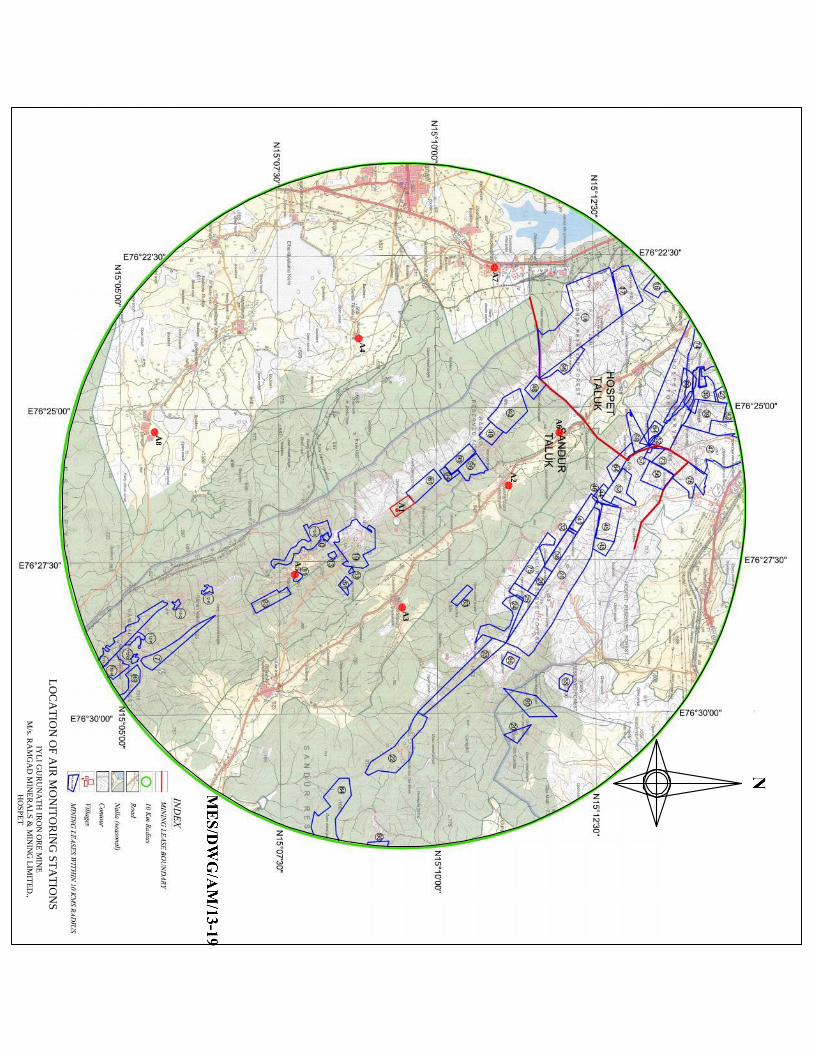
A1
A3
A2
A6
A7
A4
A8
A5
IYL
I GU
RU
NA
TH
IRO
N O
RE
MIN
EM
/s. RA
MG
AD
MIN
ER
AL
S &
MIN
ING
LIM
ITE
D.,
HO
SPE
T
LO
CA
TIO
N O
F A
IR M
ON
ITO
RIN
G ST
AT
ION
S
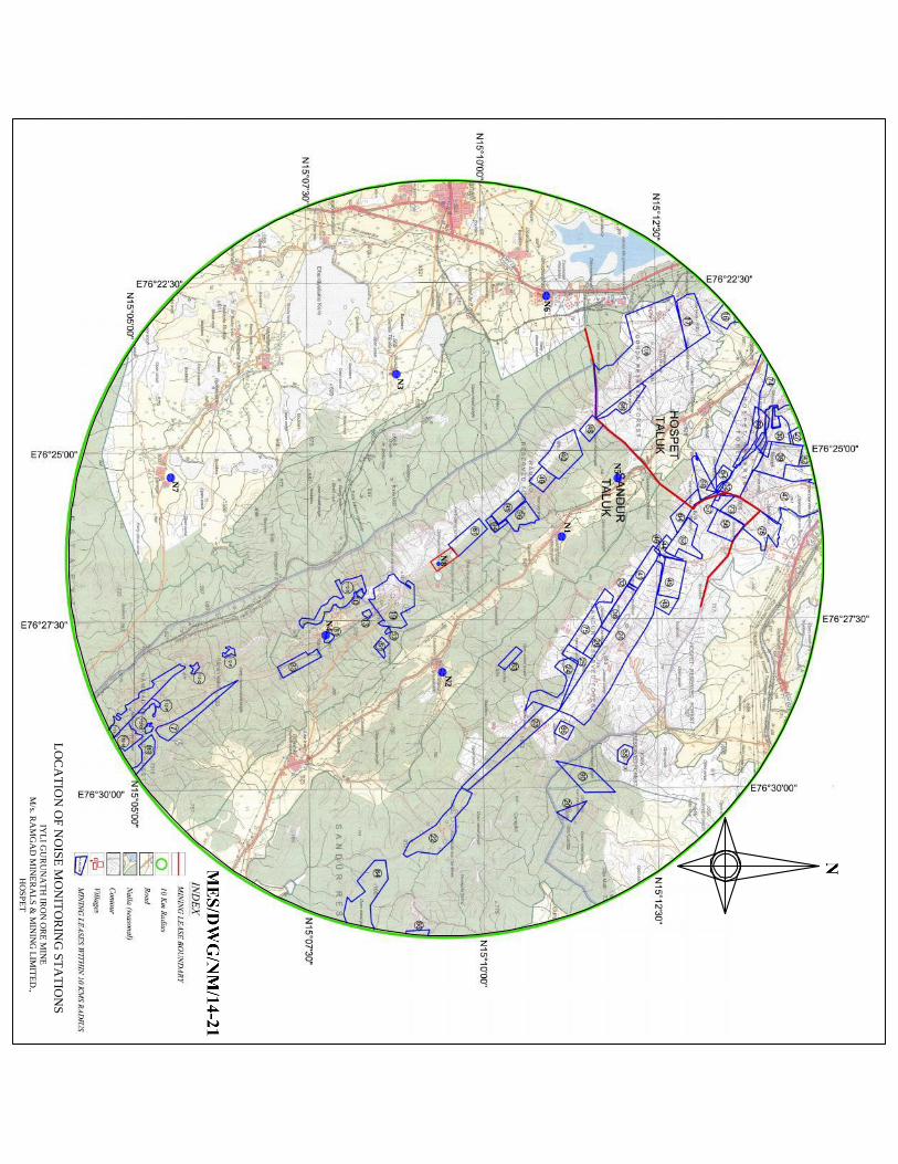
N8
N2
N1
N5
N6
N3
N7
N4
IYL
I GU
RU
NA
TH
IRO
N O
RE
MIN
EM
/s. RA
MG
AD
MIN
ER
AL
S &
MIN
ING
LIM
ITE
D.,
HO
SPE
T
LO
CA
TIO
N O
F N
OISE
MO
NIT
OR
ING
STA
TIO
NS
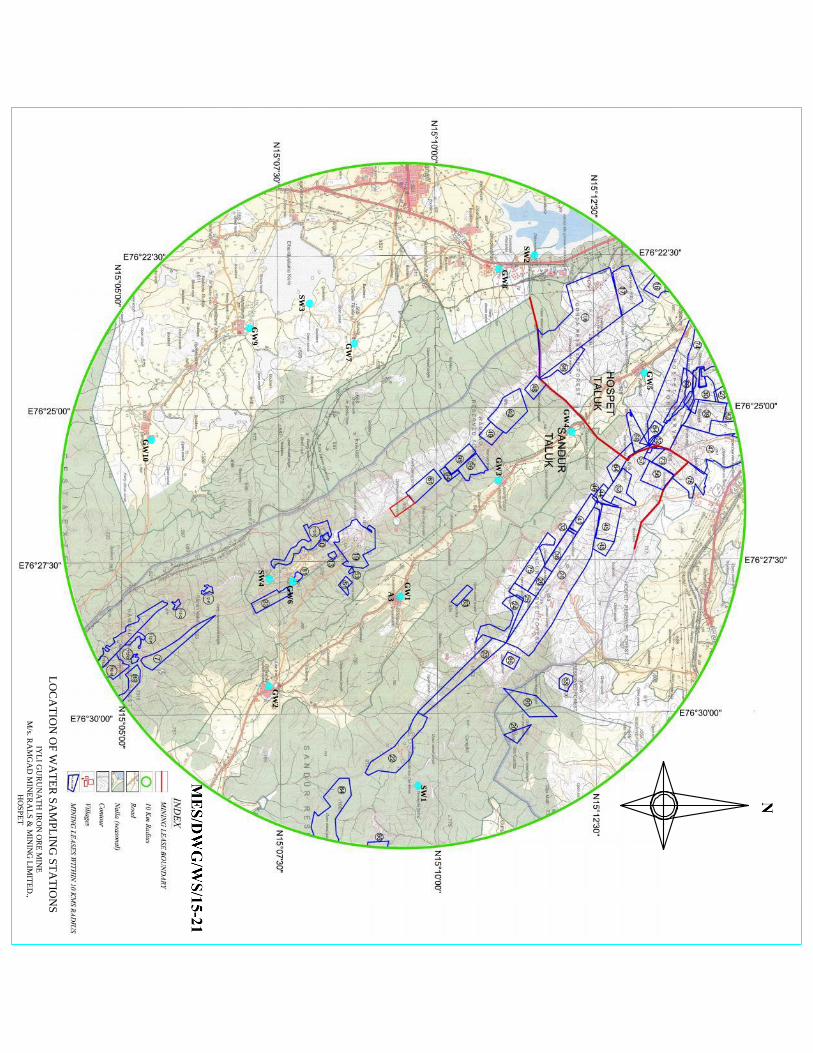
SW1
SW2
SW3
SW4
GW
2
GW
1
GW
3G
W8
GW
7
GW
10
GW
6
GW
4
GW
5
GW
9
A3
IYL
I GU
RU
NA
TH
IRO
N O
RE
MIN
EM
/s. RA
MG
AD
MIN
ER
AL
S &
MIN
ING
LIM
ITE
D.,
HO
SPE
T
LO
CA
TIO
N O
F W
AT
ER
SA
MPL
ING
STA
TIO
NS
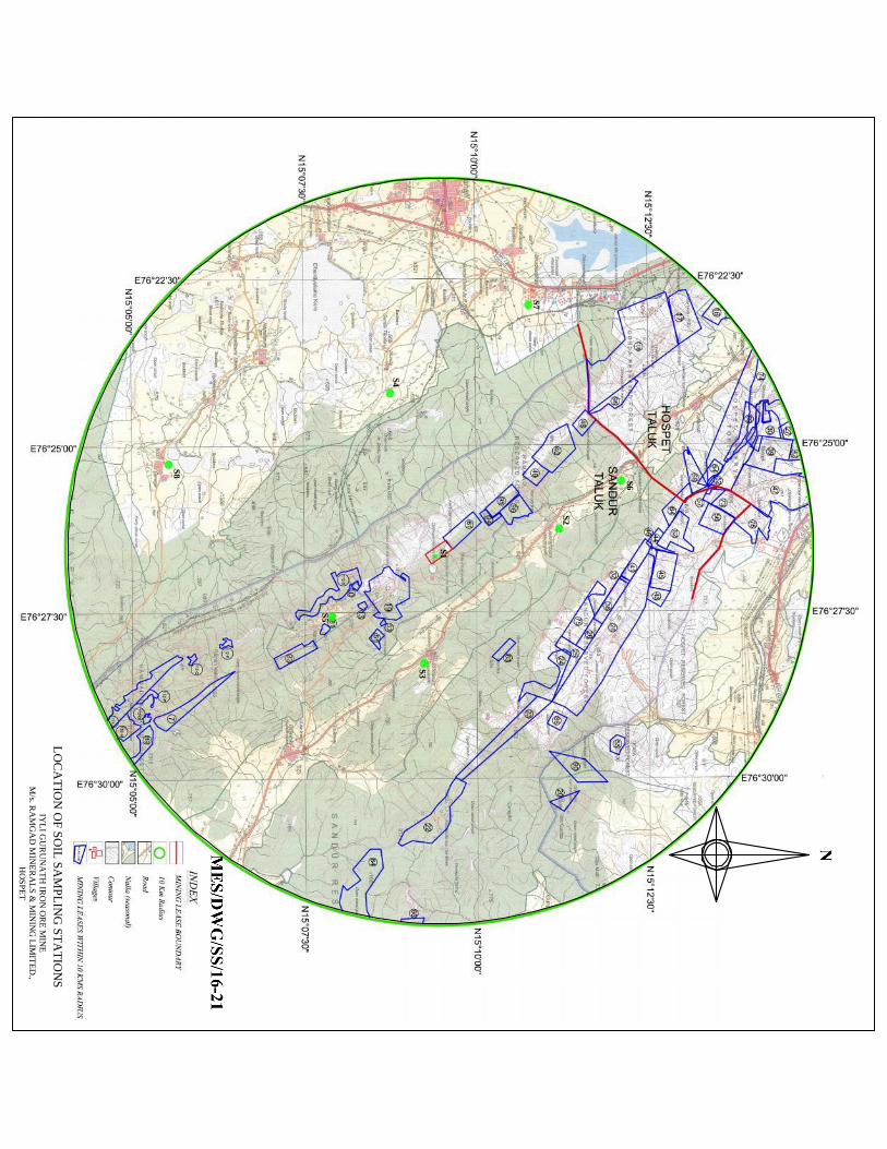
S1
S3
S2
S6
S7
S4
S8
S5
IYL
I GU
RU
NA
TH
IRO
N O
RE
MIN
EM
/s. RA
MG
AD
MIN
ER
AL
S &
MIN
ING
LIM
ITE
D.,
HO
SPE
T
LO
CA
TIO
N O
F S
OIL
SAM
PL
ING
ST
AT
ION
S
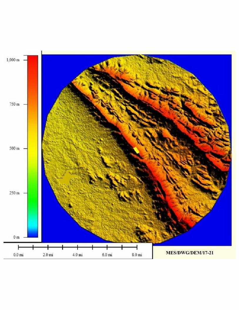
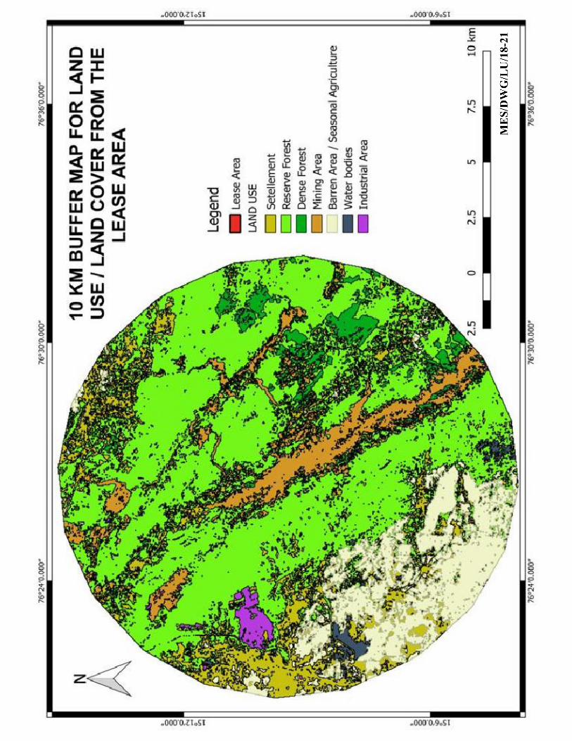
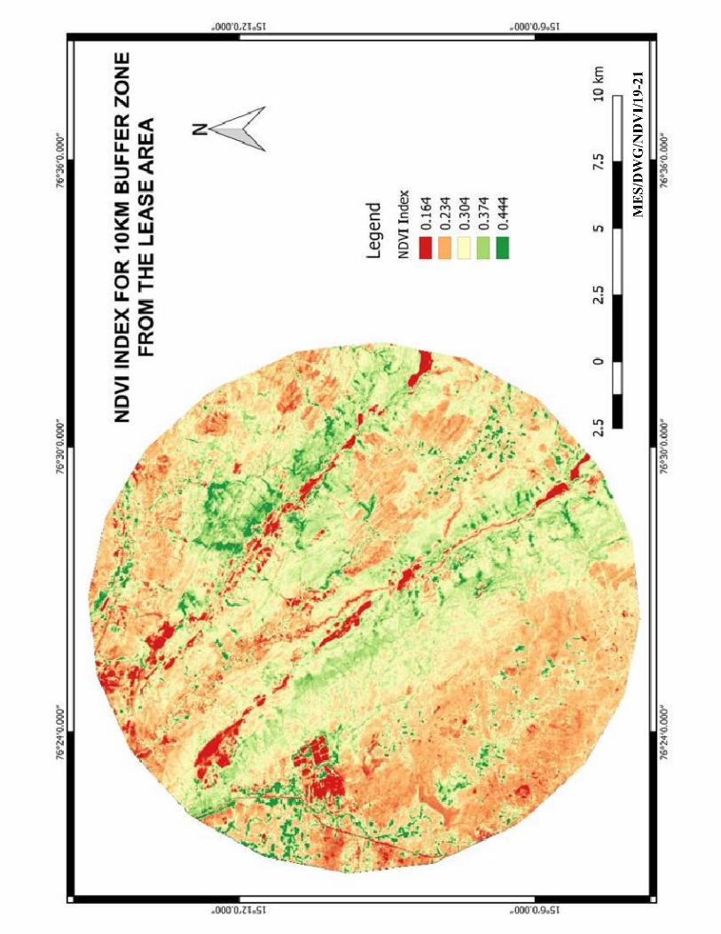
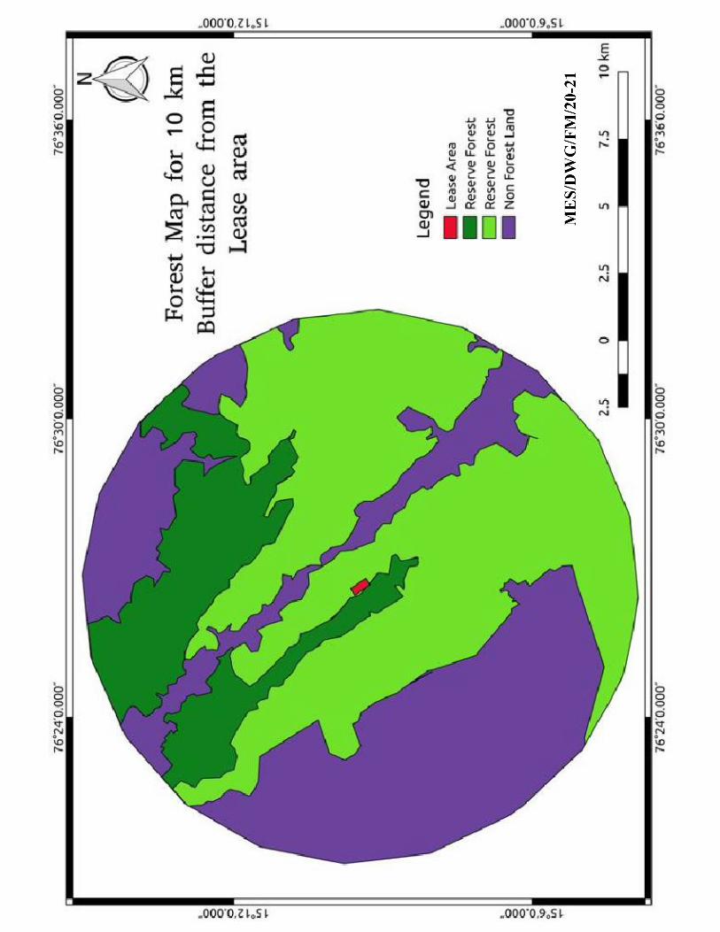
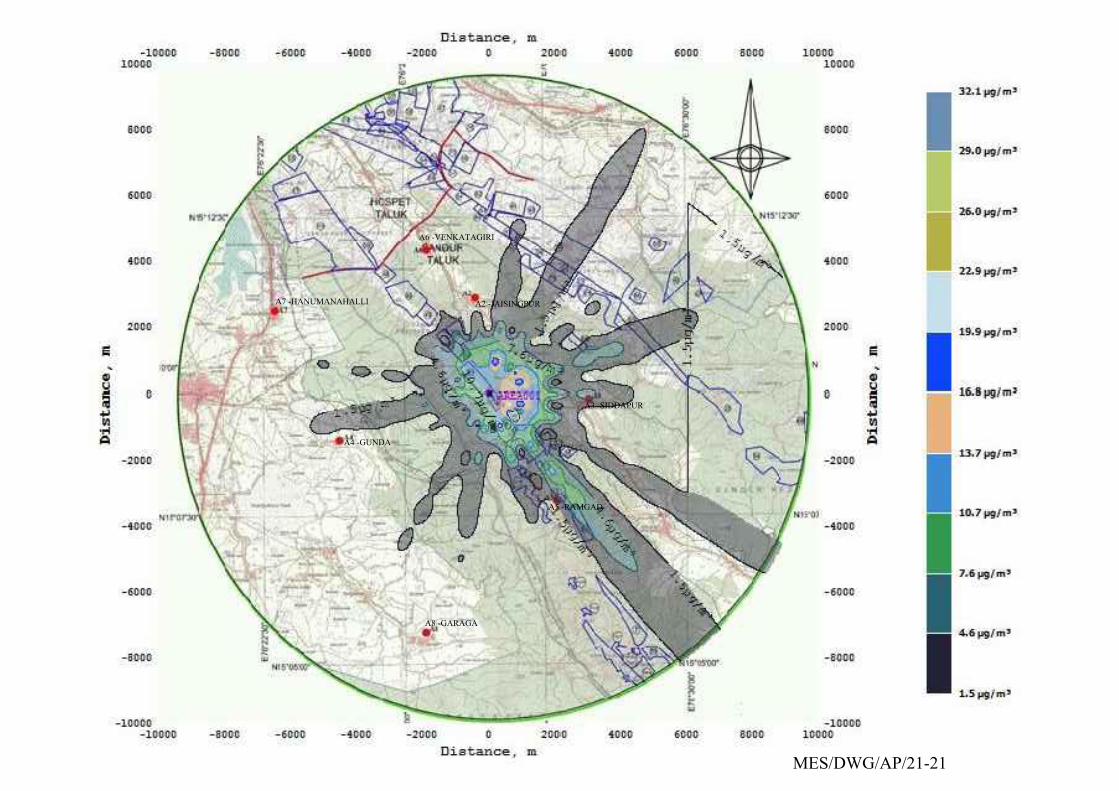
A8 -GARAGA
A2 -JAISINGPUR
A3 -SIDDAPUR
A5 -RAMGAD
A6 -VENKATAGIRI
A7 -HANUMANAHALLI
A4 -GUNDA
MES/DWG/AP/21-21
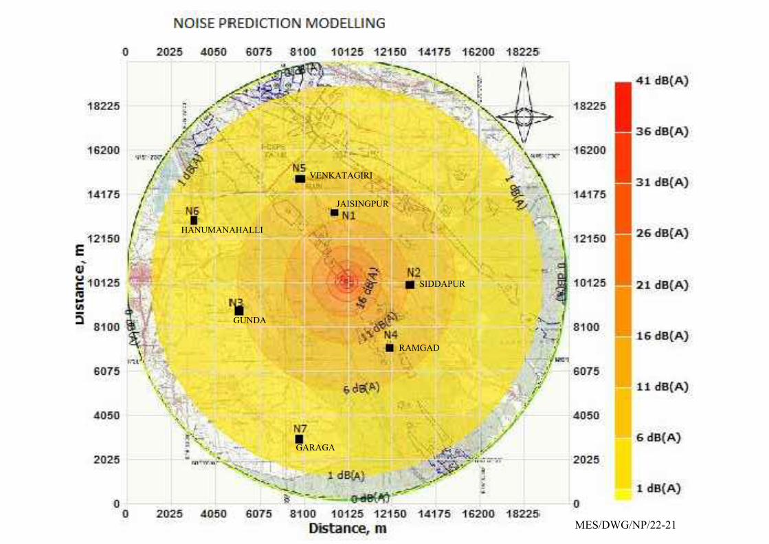
JAISINGPUR
SIDDAPUR
RAMGAD
VENKATAGIRI
HANUMANAHALLI
GARAGA
GUNDA
MES/DWG/NP/22-21