Embed Size (px)
Citation preview
Persidangan Pengarah-Pengarah Ukur 9-10 Disember 2013, Bandar Hilir, Melaka
Ms 1 dr 14
KERTAS KERJA 1
Tajuk : Blue Ocean Strategy (BOS) Between Jupem And Metmalaysia On Sea Level Monitoring
Oleh : YBhg. Dato’ Sr Mohd Noor bin Isa Pengarah Ukur Bahagian (Pemetaan)
Persidangan Pengarah-Pengarah Ukur 9-10 Disember 2013, Bandar Hilir, Melaka
Ms 2 dr 14
Blue Ocean Strategy (BOS) Between Jupem and Metmalaysia On Sea Level Monitoring
By
YBhg. Dato’ Mohd Noor bin Isa Dr. Azhari bin Mohamed & Sim Ching Yen
Mapping Division Department of Survey and Mapping Malaysia (JUPEM)
Abstract
The National Blue Ocean Strategy (NBOS) is an approach inspired by the Honourable Prime Minister Dato’ Sri Najib Tun Razak for the success of the government's transformation program. The thinking and working culture in NBOS will help the government to find new ideas and innovative ways to improve the well-being of Malaysians. Among the main characteristics of the NBOS is to produce innovative and creative ideas by improving efficiency of government delivery system to the people with minimum cost and using existing resources but produce high-impact output. In this regard, the Geodetic Working Group (GWG) which was established under the National Spatial Data Mapping Committee or Jawatankuasa Pemetaan dan Data Geospatial Negara (JPDSN) has embarked on the Blue Ocean Strategy (BOS) through a collaboration with the Malaysia Meteorological Department (MetMalaysia) and other agencies in tidal observations and sea monitoring. BOS initiative between JUPEM, MetMalaysia and other agencies, which began in 2010 has achieved significant milestones which includes producing and publishing the relationship between chart datum and datum level, upgrading of thirteen (13) tidal gauge stations JUPEM to telemetry system which has SMS alert functionality that could be integrated into the National Tsunami Early Warning System, creating tidal data sharing mechanism and finally organising tidal training and workshops. This paper will give a brief summary of these initiatives that have been taken by JUPEM in order for the success of the Government Transformation Programme.
Persidangan Pengarah-Pengarah Ukur 9-10 Disember 2013, Bandar Hilir, Melaka
Ms 3 dr 14
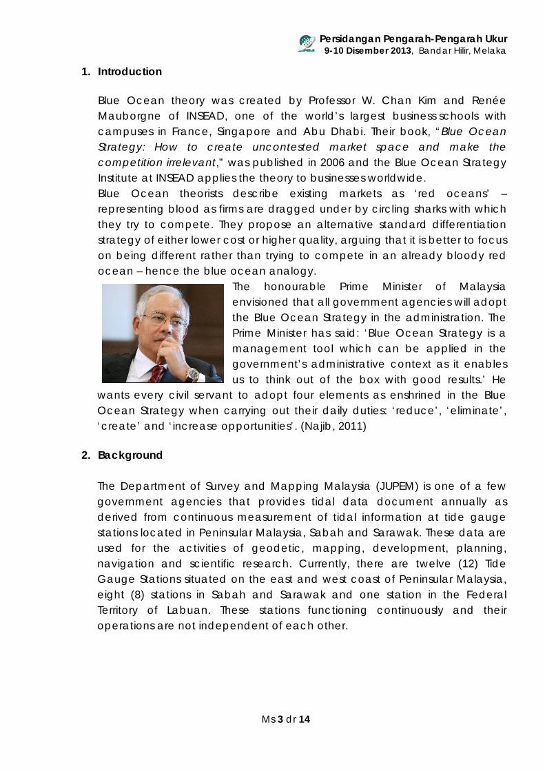
1. Introduction Blue Ocean theory was created by Professor W. Chan Kim and Renée Mauborgne of INSEAD, one of the world’s largest business schools with campuses in France, Singapore and Abu Dhabi. Their book, “Blue Ocean Strategy: How to create uncontested market space and make the competition irrelevant,” was published in 2006 and the Blue Ocean Strategy Institute at INSEAD applies the theory to businesses worldwide. Blue Ocean theorists describe existing markets as ‘red oceans’ – representing blood as firms are dragged under by circling sharks with which they try to compete. They propose an alternative standard differentiation strategy of either lower cost or higher quality, arguing that it is better to focus on being different rather than trying to compete in an already bloody red ocean – hence the blue ocean analogy. The honourable Prime Minister of Malaysia
envisioned that all government agencies will adopt the Blue Ocean Strategy in the administration. The Prime Minister has said: ‘Blue Ocean Strategy is a management tool which can be applied in the government’s administrative context as it enables us to think out of the box with good results.’ He
wants every civil servant to adopt four elements as enshrined in the Blue Ocean Strategy when carrying out their daily duties: ‘reduce’, ‘eliminate’, ‘create’ and ‘increase opportunities’. (Najib, 2011)
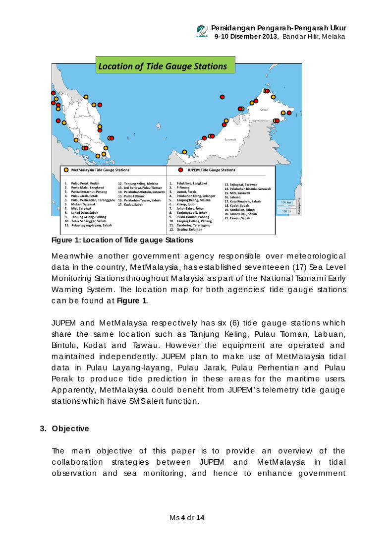
2. Background The Department of Survey and Mapping Malaysia (JUPEM) is one of a few government agencies that provides tidal data document annually as derived from continuous measurement of tidal information at tide gauge stations located in Peninsular Malaysia, Sabah and Sarawak. These data are used for the activities of geodetic, mapping, development, planning, navigation and scientific research. Currently, there are twelve (12) Tide Gauge Stations situated on the east and west coast of Peninsular Malaysia, eight (8) stations in Sabah and Sarawak and one station in the Federal Territory of Labuan. These stations functioning continuously and their operations are not independent of each other.
Persidangan Pengarah-Pengarah Ukur 9-10 Disember 2013, Bandar Hilir, Melaka
Ms 4 dr 14
Figure 1: Location of Tide gauge Stations
Meanwhile another government agency responsible over meteorological data in the country, MetMalaysia, has established seventeeen (17) Sea Level Monitoring Stations throughout Malaysia as part of the National Tsunami Early Warning System. The location map for both agencies’ tide gauge stations can be found at Figure 1. JUPEM and MetMalaysia respectively has six (6) tide gauge stations which share the same location such as Tanjung Keling, Pulau Tioman, Labuan, Bintulu, Kudat and Tawau. However the equipment are operated and maintained independently. JUPEM plan to make use of MetMalaysia tidal data in Pulau Layang-layang, Pulau Jarak, Pulau Perhentian and Pulau Perak to produce tide prediction in these areas for the maritime users. Apparently, MetMalaysia could benefit from JUPEM’s telemetry tide gauge stations which have SMS alert function.
3. Objective The main objective of this paper is to provide an overview of the collaboration strategies between JUPEM and MetMalaysia in tidal observation and sea monitoring, and hence to enhance government
Sarawak
Sabah
MetMalaysia Tide Gauge Stations JUPEM Tide Gauge Stations
1. Pulau Perak, Kedah2. Porto Malai, Langkawi3. Pantai Kerachut, Penang4. Pulau Jarak, Perak5. Pulau Perhentian, Terengganu6. Mukah, Sarawak7. Miri, Sarawak8. Lahad Datu, Sabah9. Tanjung Gelang, Pahang10. Teluk Sepanggar, Sabah 11. Pulau Layang-layang, Sabah
12. Tanjung Keling, Melaka13 . Jeti Berjaya, Pulau Tioman14. Pelabuhan Bintulu, Sarawak15. Pulau Labuan16. Pelabuhan Tawau, Sabah17. Kudat, Sabah
1. Teluk Ewa, Langkawi2. P.Pinang3. Lumut, Perak4. Pelabuhan Klang, Selangor5. Tanjung Keling, Melaka6. Kukup, Johor7. Johor Bahru, Johor8. Tanjung Sedili, Johor9. Pulau Tioman, Pahang10. Tanjung Gelang, Pahang11. Cendering, Terengganu12. Getting, Kelantan
13. Sejingkat, Sarawak14. Pelabuhan Bintulu, Sarawak15. Miri, Sarawak16. Labuan 17. Kota Kinabalu, Sabah18. Kudat, Sabah19. Sandakan, Sabah20. Lahad Datu, Sabah21. Tawau, Sabah
Location of Tide Gauge Stations
Persidangan Pengarah-Pengarah Ukur 9-10 Disember 2013, Bandar Hilir, Melaka
Ms 5 dr 14
delivery systems to the people, involving minimum cost, using existing resources and produce high-impact output.
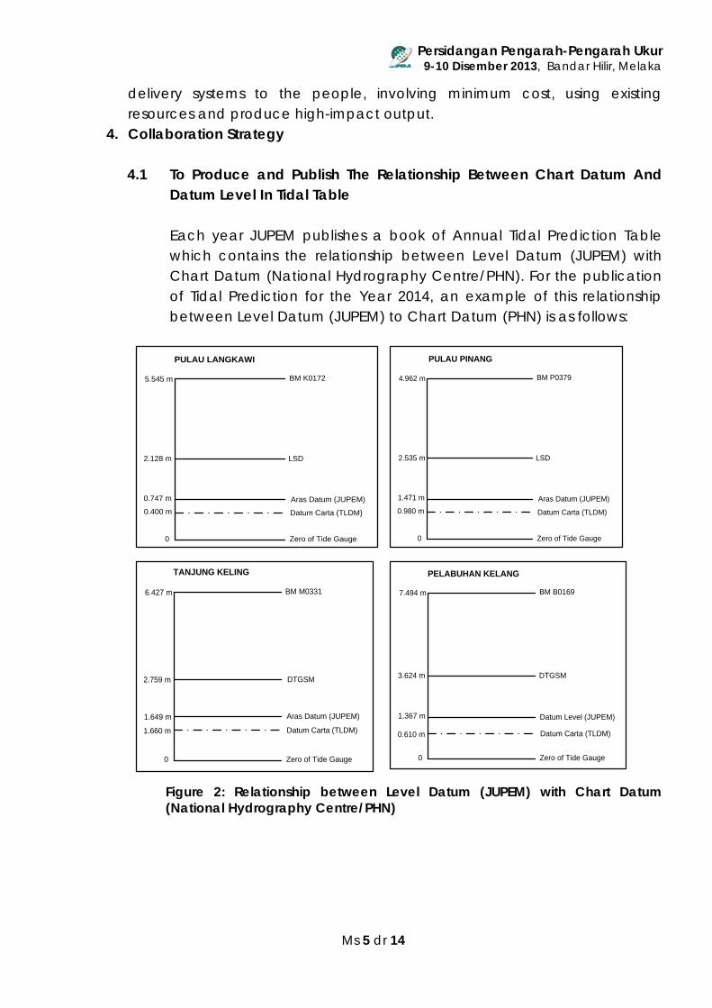
4. Collaboration Strategy 4.1 To Produce and Publish The Relationship Between Chart Datum And
Datum Level In Tidal Table
Each year JUPEM publishes a book of Annual Tidal Prediction Table which contains the relationship between Level Datum (JUPEM) with Chart Datum (National Hydrography Centre/PHN). For the publication of Tidal Prediction for the Year 2014, an example of this relationship between Level Datum (JUPEM) to Chart Datum (PHN) is as follows:
Figure 2: Relationship between Level Datum (JUPEM) with Chart Datum (National Hydrography Centre/PHN)
Zero of Tide Gauge0
0.400 m
0.747 m
5.545 m BM K0172
Aras Datum (JUPEM)
Datum Carta (TLDM)
PULAU LANGKAWI
LSD2.128 m
Zero of Tide Gauge0
0.980 m
1.471 m
4.962 m BM P0379
Aras Datum (JUPEM)
Datum Carta (TLDM)
PULAU PINANG
LSD2.535 m
Zero of Tide Gauge0
1.660 m
1.649 m
6.427 m BM M0331
Aras Datum (JUPEM)
Datum Carta (TLDM)
TANJUNG KELING
DTGSM2.759 m
Zero of Tide Gauge0
0.610 m
1.367 m
7.494 m BM B0169
Datum Level (JUPEM)
Datum Carta (TLDM)
DTGSM3.624 m
PELABUHAN KELANG
Persidangan Pengarah-Pengarah Ukur 9-10 Disember 2013, Bandar Hilir, Melaka
Ms 6 dr 14
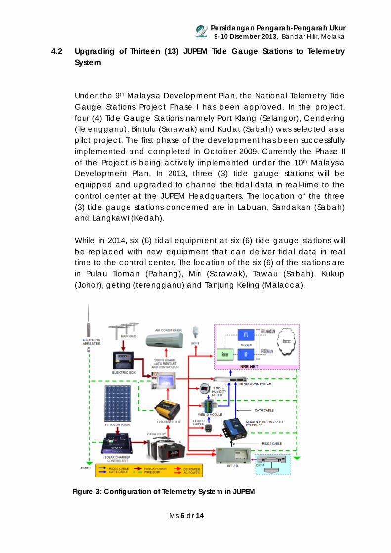
4.2 Upgrading of Thirteen (13) JUPEM Tide Gauge Stations to Telemetry System
Under the 9th Malaysia Development Plan, the National Telemetry Tide Gauge Stations Project Phase I has been approved. In the project, four (4) Tide Gauge Stations namely Port Klang (Selangor), Cendering (Terengganu), Bintulu (Sarawak) and Kudat (Sabah) was selected as a pilot project. The first phase of the development has been successfully implemented and completed in October 2009. Currently the Phase II of the Project is being actively implemented under the 10th Malaysia Development Plan. In 2013, three (3) tide gauge stations will be equipped and upgraded to channel the tidal data in real-time to the control center at the JUPEM Headquarters. The location of the three (3) tide gauge stations concerned are in Labuan, Sandakan (Sabah) and Langkawi (Kedah). While in 2014, six (6) tidal equipment at six (6) tide gauge stations will be replaced with new equipment that can deliver tidal data in real time to the control center. The location of the six (6) of the stations are in Pulau Tioman (Pahang), Miri (Sarawak), Tawau (Sabah), Kukup (Johor), geting (terengganu) and Tanjung Keling (Malacca).
Figure 3: Configuration of Telemetry System in JUPEM
Persidangan Pengarah-Pengarah Ukur 9-10 Disember 2013, Bandar Hilir, Melaka
Ms 7 dr 14
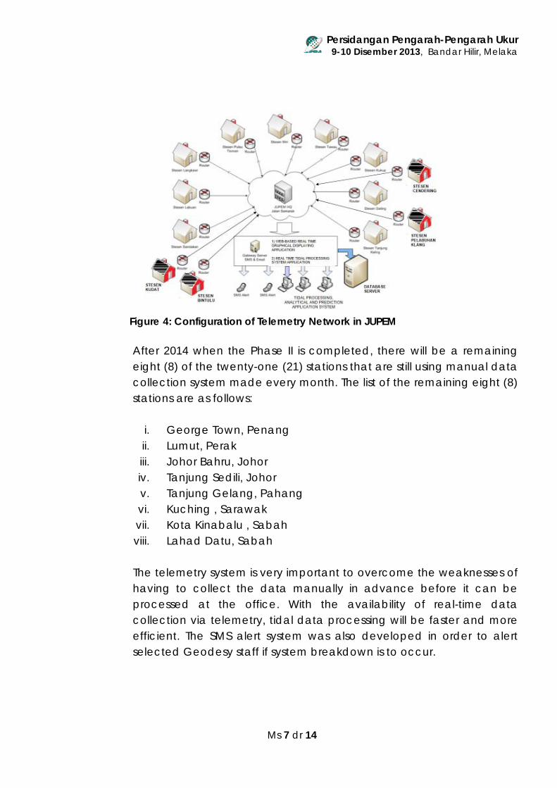
Figure 4: Configuration of Telemetry Network in JUPEM After 2014 when the Phase II is completed, there will be a remaining eight (8) of the twenty-one (21) stations that are still using manual data collection system made every month. The list of the remaining eight (8) stations are as follows:
i. George Town, Penang ii. Lumut, Perak iii. Johor Bahru, Johor iv. Tanjung Sedili, Johor v. Tanjung Gelang, Pahang vi. Kuching , Sarawak vii. Kota Kinabalu , Sabah viii. Lahad Datu, Sabah
The telemetry system is very important to overcome the weaknesses of having to collect the data manually in advance before it can be processed at the office. With the availability of real-time data collection via telemetry, tidal data processing will be faster and more efficient. The SMS alert system was also developed in order to alert selected Geodesy staff if system breakdown is to occur.
Persidangan Pengarah-Pengarah Ukur 9-10 Disember 2013, Bandar Hilir, Melaka
Ms 8 dr 14
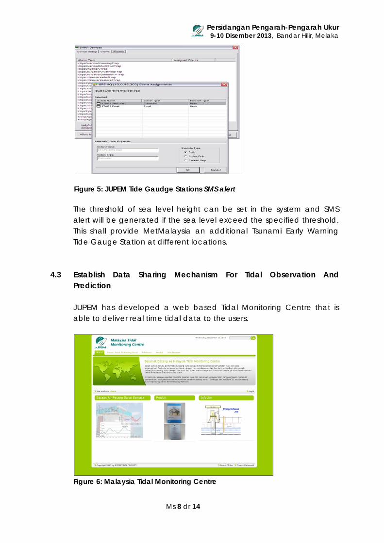
Figure 5: JUPEM Tide Gaudge Stations SMS alert
The threshold of sea level height can be set in the system and SMS alert will be generated if the sea level exceed the specified threshold. This shall provide MetMalaysia an additional Tsunami Early Warning Tide Gauge Station at different locations.
4.3 Establish Data Sharing Mechanism For Tidal Observation And
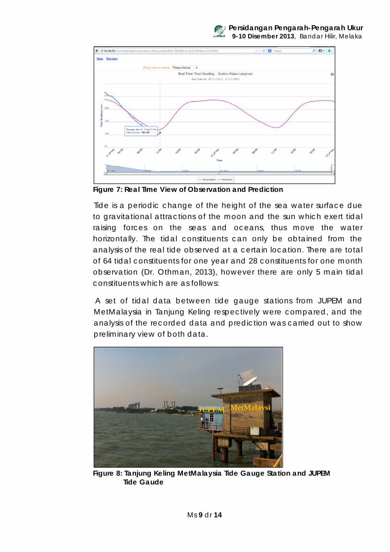
Prediction JUPEM has developed a web based Tidal Monitoring Centre that is able to deliver real time tidal data to the users.
Figure 6: Malaysia Tidal Monitoring Centre
Persidangan Pengarah-Pengarah Ukur 9-10 Disember 2013, Bandar Hilir, Melaka
Ms 9 dr 14
Figure 7: Real Time View of Observation and Prediction
Tide is a periodic change of the height of the sea water surface due to gravitational attractions of the moon and the sun which exert tidal raising forces on the seas and oceans, thus move the water horizontally. The tidal constituents can only be obtained from the analysis of the real tide observed at a certain location. There are total of 64 tidal constituents for one year and 28 constituents for one month observation (Dr. Othman, 2013), however there are only 5 main tidal constituents which are as follows:
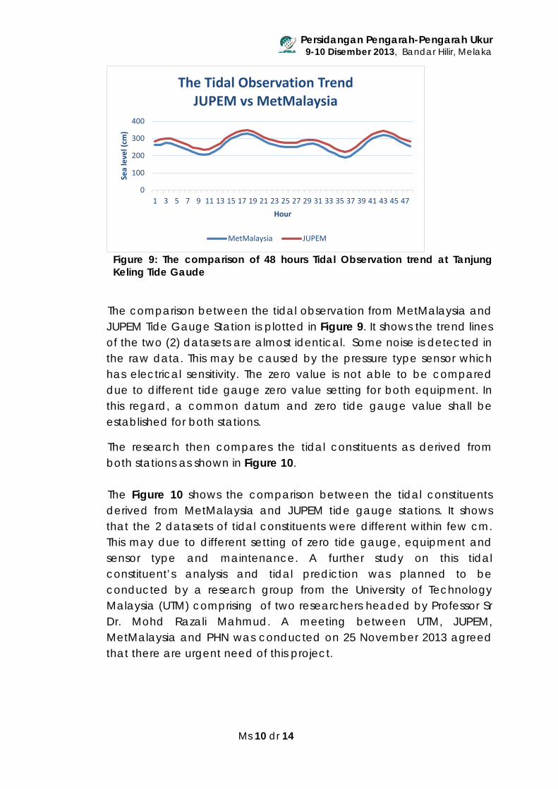
A set of tidal data between tide gauge stations from JUPEM and MetMalaysia in Tanjung Keling respectively were compared, and the analysis of the recorded data and prediction was carried out to show preliminary view of both data.
Figure 8: Tanjung Keling MetMalaysia Tide Gauge Station and JUPEM Tide Gaude
MetMalaysi
JUPEM
Persidangan Pengarah-Pengarah Ukur 9-10 Disember 2013, Bandar Hilir, Melaka
Ms 10 dr 14
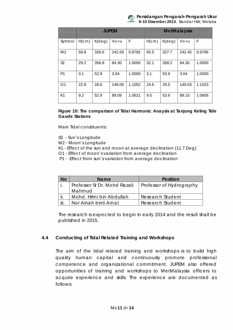
Figure 9: The comparison of 48 hours Tidal Observation trend at Tanjung Keling Tide Gaude
The comparison between the tidal observation from MetMalaysia and JUPEM Tide Gauge Station is plotted in Figure 9. It shows the trend lines of the two (2) datasets are almost identical. Some noise is detected in the raw data. This may be caused by the pressure type sensor which has electrical sensitivity. The zero value is not able to be compared due to different tide gauge zero value setting for both equipment. In this regard, a common datum and zero tide gauge value shall be established for both stations.
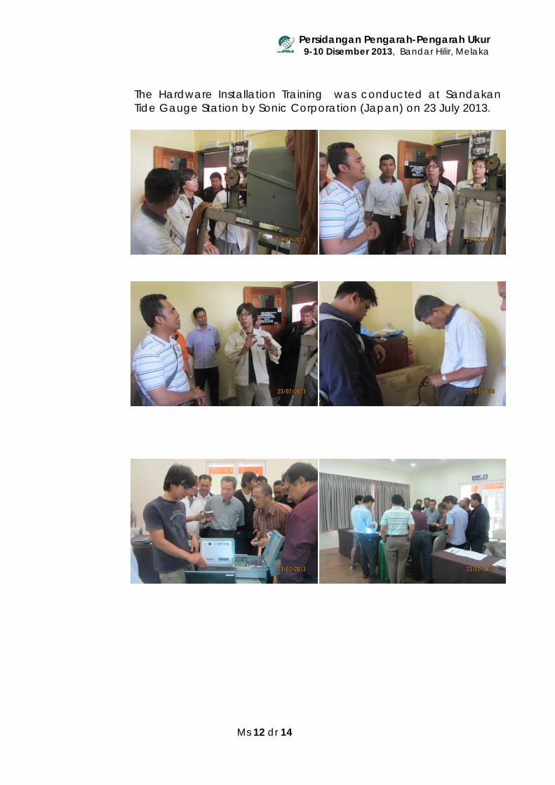
The research then compares the tidal constituents as derived from both stations as shown in Figure 10. The Figure 10 shows the comparison between the tidal constituents derived from MetMalaysia and JUPEM tide gauge stations. It shows that the 2 datasets of tidal constituents were different within few cm. This may due to different setting of zero tide gauge, equipment and sensor type and maintenance. A further study on this tidal constituent’s analysis and tidal prediction was planned to be conducted by a research group from the University of Technology Malaysia (UTM) comprising of two researchers headed by Professor Sr Dr. Mohd Razali Mahmud. A meeting between UTM, JUPEM, MetMalaysia and PHN was conducted on 25 November 2013 agreed that there are urgent need of this project.
0
100
200
300
400
1 3 5 7 9 11 13 15 17 19 21 23 25 27 29 31 33 35 37 39 41 43 45 47
Sea
leve
l (cm
)
Hour
The Tidal Observation Trend JUPEM vs MetMalaysia
MetMalaysia JUPEM
Persidangan Pengarah-Pengarah Ukur 9-10 Disember 2013, Bandar Hilir, Melaka
Ms 11 dr 14
JUPEM MetMalaysia
Symbol H(cm) K(deg) Vo+u F
H(cm) K(deg) Vo+u F
M2 59.8 326.6 242.59 0.9782
65.5 327.7 242.45 0.9786
S2 29.2 356.8 84.30 1.0000
32.1 358.2 84.30 1.0000
P1 3.1 52.9 3.04 1.0000 3.1 53.9 3.04 1.0000
O1 22.8 28.6 149.09 1.1052
24.6 29.5 149.03 1.1023
K1 9.2 52.9 89.09 1.0621
9.5 53.9 89.15 1.0605
Figure 10: The comparison of Tidal Harmonic Anaysis at Tanjung Keling Tide Gaude Stations Main Tidal constituents: S2 - Sun’s Longitude M2 - Moon’s Longitude K1 - Effect of the sun and moon at average declination (11.7 Deg) O1 - Effect of moon’s variation from average declination
P1 - Effect from sun’s variation from average declination
No Name Position i. Professor Sr Dr. Mohd Razali
Mahmud Professor of Hydrography
ii. Mohd. Hilmi bin Abdullah Research Student iii. Nor Ainah binti Amat Research Student
The research is expected to begin in early 2014 and the result shall be published in 2015.
4.4 Conducting of Tidal Related Training and Workshops The aim of the tidal related training and workshops is to build high quality human capital and continuously promote professional competence and organizational commitment. JUPEM also offered opportunities of training and workshops to MetMalaysia officers to acquire experience and skills. The experience are documented as follows:
Persidangan Pengarah-Pengarah Ukur 9-10 Disember 2013, Bandar Hilir, Melaka
Ms 12 dr 14
The Hardware Installation Training was conducted at Sandakan Tide Gauge Station by Sonic Corporation (Japan) on 23 July 2013.
Persidangan Pengarah-Pengarah Ukur 9-10 Disember 2013, Bandar Hilir, Melaka
Ms 13 dr 14
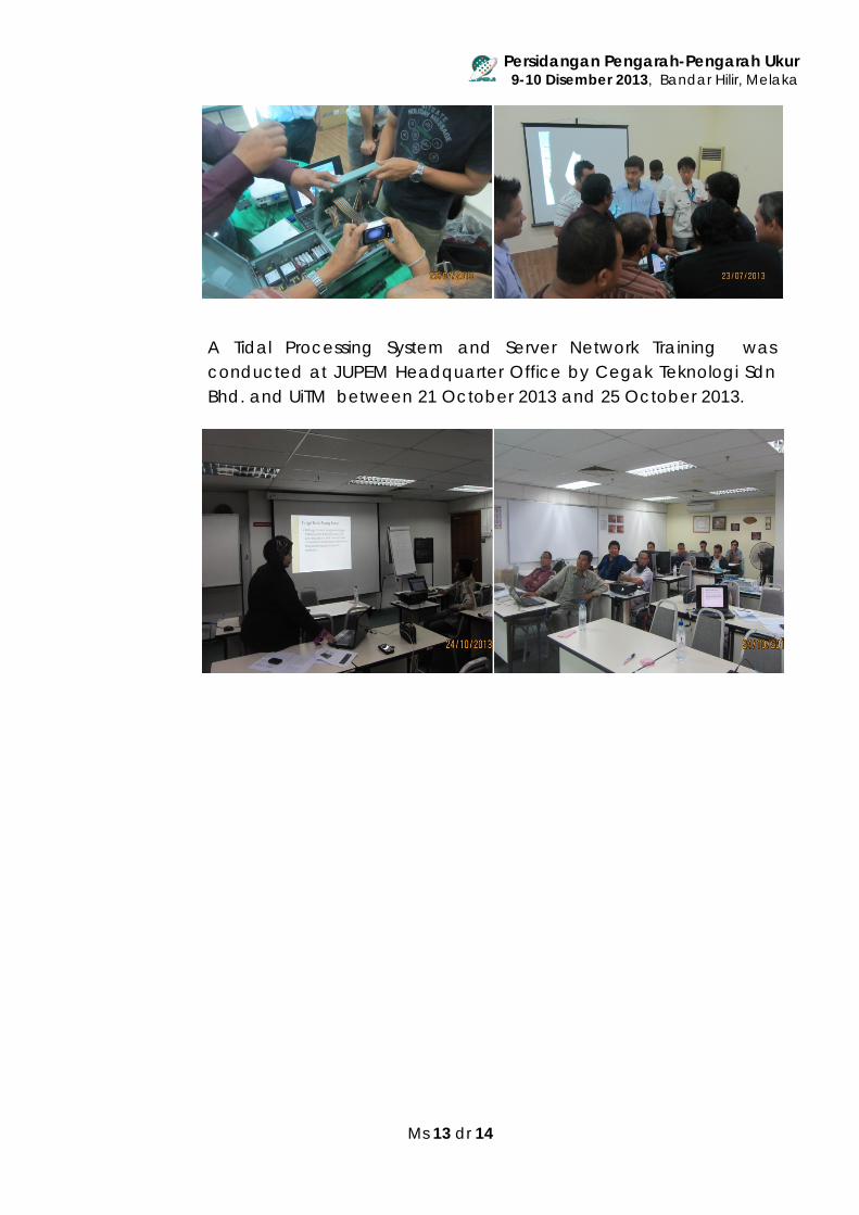
A Tidal Processing System and Server Network Training was conducted at JUPEM Headquarter Office by Cegak Teknologi Sdn Bhd. and UiTM between 21 October 2013 and 25 October 2013.
Persidangan Pengarah-Pengarah Ukur 9-10 Disember 2013, Bandar Hilir, Melaka
Ms 14 dr 14
5. Conclusion
The Honourable Prime Minister of Malaysia has envisioned that all government agencies will adopt the Blue Ocean Strategy in the administration and management of their respective entities. JUPEM is fully committed in helping to achieve this. The Blue Ocean Strategy will be established between JUPEM and METMalaysia through tidal data observation project and this could be the first initiative to oversee the implementation of the Blue Ocean Strategy as spearheaded byJUPEM. Innovation, which is the hallmark of the Blue Ocean Strategy, has always been the priority of administration and management in JUPEM. Innovative thinking and practice will be part of the culture in JUPEM. The embodiment of the culture will enable us to achieve outstanding performance and generate output exponentially rather than incrementally. The Government Transformation Programme has outlined several agendas in National Key Result Areas which needs to be achieved. JUPEM uses National Blue Ocean Strategy to achieve the target areas such as working together to reduce cost and the building of geodetic infrastructure for the people. In the implementation of this strategy, JUPEM will co-operate and collaborate with MetMalaysia. The joint effort between departments will benefit the people and brought progress to the nation.


