Embed Size (px)
Citation preview
ST-610 (FAA)
NEW YORK, NEW YORK
NEW YORK, NEW YORK
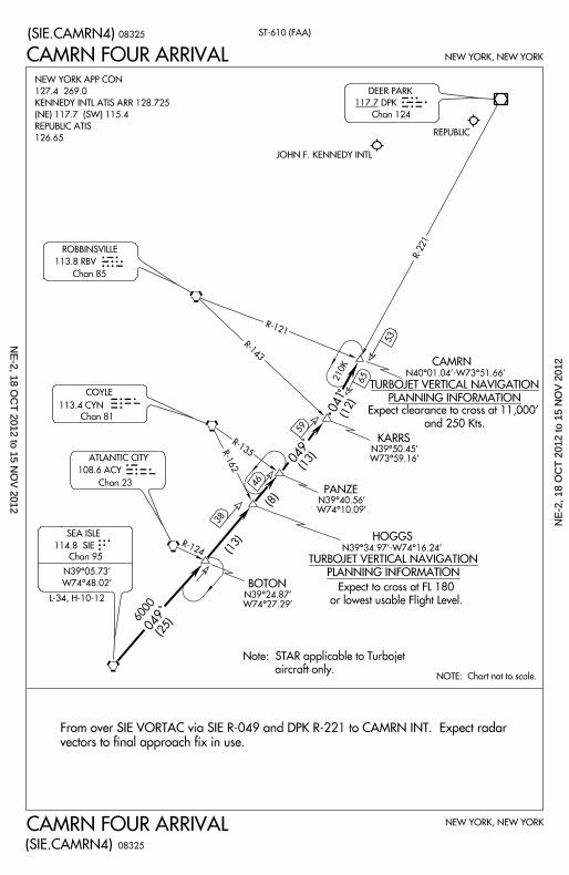
CAMRN FOUR ARRIVAL
(SIE.CAMRN4)
(SIE.CAMRN4)
117.7 DPK
Chan 124
DEER PARK
CAMRN FOUR ARRIVAL
R-124
R-162
R-135
R-143
R-121
6000 (25)
(13)
(8)
(13)
(12)
R-221
JOHN F. KENNEDY INTL
REPUBLIC
113.8 RBV
Chan 85
ROBBINSVILLE
113.4 CYN
Chan 81
COYLE
114.8 SIE
Chan 95
N39^05.73’
W74^48.02’
SEA ISLE
N39^24.87’W74^27.29’
BOTON
N39^40.56’W74^10.09’
PANZE
N39^50.45’W73^59.16’
KARRS
Note: STAR applicable to Turbojet
aircraft only.
From over SIE VORTAC via SIE R-049 and DPK R-221 to CAMRN INT. Expect radar
vectors to final approach fix in use.
NOTE: Chart not to scale.
041
38
46
59
53
210K
N40^01.04’ -W73^51.66’
HOGGS
N39^34.97’ -W74^16.24’
TURBOJET VERTICAL NAVIGATION
PLANNING INFORMATION
CAMRN
TURBOJET VERTICAL NAVIGATION
PLANNING INFORMATIONExpect clearance to cross at 11,000’
and 250 Kts.
Expect to cross at FL 180
or lowest usable Flight Level.
108.6 ACY
Chan 23
ATLANTIC CITY
RBV
CYNACY
SIE
049
049
DPK
08325
08325
NEW YORK APP CON
127.4 269.0
KENNEDY INTL ATIS ARR 128.725
(NE) 117.7 (SW) 115.4
REPUBLIC ATIS
126.65
L-34, H-10-12
65
NE
-2, 18 OC
T 2012 to 15 N
OV
2012N
E-2
, 18
OC
T 2
012
to 1
5 N
OV
201
2
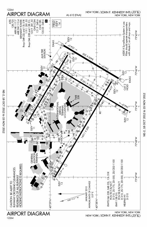
(JFK)JOHN F. KENNEDY INTLNEW YORK /AIRPORT DIAGRAM12264
NEW YORK, NEW YORK
12264NEW YORK / JOHN F. KENNEDY INTL (JFK)
GENERAL
AVIATION
TERMINAL
QH
QGQF
13R
PD
PC
PB
P
Q
Q
AB
G
Y
G
H
8400 X 200
224.0^
SB
133.9^
Q
C
CA
13L
UA
V V
VA
W
WA
10000 X 150
B
R
S
SC
SD
S
134.0^
R
A
B
U
U
VV
PA
P
P
P
MC
N MB
MA
NANB
NC
A
A
A
B
B
LA
L
L
K
A
A
B
B
H
11351 X 150Y
Y
H Z
K
K
KB
4L
044.0^
314.0^
31L 4R
044.0^
14511 X 200
KE
Q
J
Z
Z
TB
TA
A
T
B A
S
TT
R
B
Z Z
Y
FA
F
22L
31R
224.0^
314.0^
F
ZA
C
C
D
W
CD
CC
CB
DA
B
E
D
B
A
CE
A
E
FB22R
ZAE
ECCH
FB C
KA
KCKE
PPF
MD
J
JAJB
QB
PE
M
YA
YA
AB
TWR 338
ELEV13
CAT 2 HOLD
ELEV12
EMAS
EMAS
ELEV12
E
AUX FIRE STATION
ELEV12
CB
ELEV11
FIRESTATION
QD
EA
197
ELEV12
ELEV13
FB
AIRPORT DIAGRAM AL-610 (FAA) NEW YORK, NEW YORK
ASDE-X Surveillanc
e System in use.
Pilots should oper
ate transponders
with Mode C on al
l twys and rwys.
H
H
H
W
H
H
73^49’W73^48’W
73^45’W
40^38’N
73^46’W
40^39’N
VAR 13 .2 ^ W
73^47’W
ATIS
128.725
ARR NE 117.7
ARR SW 115.4
KENNEDY TOWER
Rwys 04R-22L and
13L-31R
119.1 281.55
Rwys 04L-22R and
13R-31L
123.9 281.55
GND CON
121.9 348.6
CLNC DEL
135.05 348.6
D
CAUTION: BE ALE
RT TO
RUNWAY CROSSI
NG CLEARANCES
.
READBACK OF ALL
RUNWAY
HOLDING INSTRUC
TIONS IS REQUIR
ED.
INTERNATIONAL
ARRIVAL TERMINAL
U.S CUSTOMS
V
LL
QC
H
AB
Y
J
N
M
YA
KG
JANUARY 2010
ANNUAL RATE OF
CHANGE
0.0^ E
FIELD ELEV 14
ELEV12
CD
KF
KD
X X
SA
RWYS 04L-22R, 04
R-22L, 13L-31R
PCN 90 F/B
/W/T
D-210, 2S-1
75, 2D-550, 2D/2D
2-1100
RWY 13R-31L
PCN 98 R/B
/W/T
D-210, 2S-1
75, 2D-550, 2D/2D
2-1100
HELIPAD H1
D-210
NE
-2, 18 OC
T 2012 to 15 N
OV
2012N
E-2
, 18
OC
T 2
012
to 1
5 N
OV
201
2
M1
M1
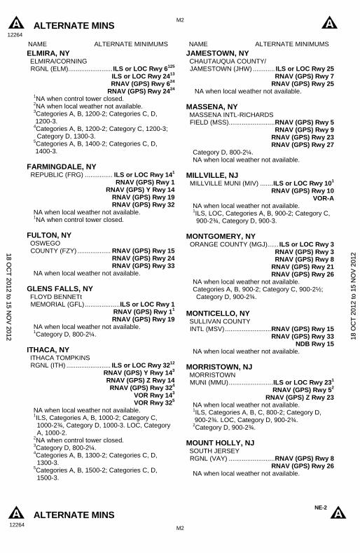
ALTERNATE MINS 12264
ALTERNATE MINS 12264
NE-2
NAME ALTERNATE MINIMUMS NAME ALTERNATE MINIMUMS
ANDOVER, NJ AEROFLEX- ANDOVER (12N) .................. RNAV (GPS) Rwy 3
VOR-A NA when local weather not available. Category A, 1000-2.
ATLANTIC CITY, NJ ATLANTIC CITY INTL (ACY) .......................... ILS or LOC Rwy 131
ILS or LOC/DME Rwy 311 RADAR-12
RNAV (GPS) Rwy 42 RNAV (GPS) Y Rwy 132
RNAV (GPS) Rwy 222 RNAV (GPS) Y Rwy 312
VOR/DME Rwy 222 VOR Rwy 42
VOR Rwy 132 VOR Rwy 312
1ILS, Category E, 700-2½. LOC, Category E, 800-2½.
2Category E, 800-2½.
BELMAR/FARMINGDALE, NJ MONMOUTH EXECUTIVE (BLM) ............ RNAV (GPS) Rwy 14
RNAV (GPS) Rwy 32 VOR-A
NA when local weather not available.
BINGHAMTON, NY GREATER BINGHAMTON/EDWIN A. LINK FIELD (BGM) .............. ILS or LOC Rwy 161
ILS or LOC Rwy 3412 RNAV (GPS) Rwy 102 RNAV (GPS) Rwy 162 RNAV (GPS) Rwy 282 RNAV (GPS) Rwy 342
VOR Rwy 102 VOR/DME Rwy 282
1NA when control tower closed. 2NA when local weather not available.
CALDWELL, NJ ESSEX COUNTY (CDW) ... RNAV (GPS) Rwy 412
RNAV (GPS) Rwy 1012 RNAV (GPS) Rwy 2223
1Category B, 900-2; Category C, 900-2½; Category D, 1000-3.
2NA when local weather not available. 3Category B, 900-2; Category C, 900-2½.
CORTLAND, NY CORTLAND COUNTY- CHASE FIELD (N03) ................... VOR or GPS-A Categories A, B, 1100-2, Categories C, D, 1100-3.
DANSVILLE, NY DANSVILLE MUNI (DSV)............. RNAV (GPS)-A
RNAV (GPS) Rwy 14 RNAV (GPS) Rwy 18
NA when local weather not available. Category A, 1300-2; Category B, 1500-2; Category C, 1500-3.
DUNKIRK, NY CHAUTAUQUA COUNTY/ DUNKIRK (DKK) ................................ VOR Rwy 6
VOR Rwy 24 Category D, 900-2¾.
NAME ALTERNATE MINIMUMS NAME ALTERNATE MINIMUMS
INSTRUMENT APPROACH PROCEDURE CHARTS
IFR ALTERNATE AIRPORT MINIMUMS
Standard alternate minimums for non-precision approaches are 800-2 (NDB, VOR, LOC, TACAN, LDA,VORTAC, VOR/DME, ASR or WAAS LNAV); for precision approaches 600-2 (ILS or PAR). Airports withinthis geographical area that require alternate minimums other than standard or alternate minimums withrestrictions are listed below. NA - means alternate minimums are not authorized due to unmonitored facility orabsence of weather reporting service. Civil pilots see FAR 91. IFR Alternate Airport Minimums: Ceiling andVisibility Minimums not applicable to USA/USN/USAF. Pilots must review the IFR Alternate AirportMinimums Notes for alternate airfield suitability.
18 OC
T 2012 to 15 N
OV
2012 1
8 O
CT
201
2 to
15
NO
V 2
012
M2
M2
ALTERNATE MINS 12264
ALTERNATE MINS 12264
NE-2
NAME ALTERNATE MINIMUMS NAME ALTERNATE MINIMUMS
ELMIRA, NY ELMIRA/CORNING RGNL (ELM) ........................ ILS or LOC Rwy 6125
ILS or LOC Rwy 2413 RNAV (GPS) Rwy 624
RNAV (GPS) Rwy 2424 1NA when control tower closed. 2NA when local weather not available. 3Categories A, B, 1200-2; Categories C, D, 1200-3. 4Categories A, B, 1200-2; Category C, 1200-3; Category D, 1300-3.
5Categories A, B, 1400-2; Categories C, D, 1400-3.
FARMINGDALE, NY REPUBLIC (FRG) ............... ILS or LOC Rwy 141
RNAV (GPS) Rwy 1 RNAV (GPS) Y Rwy 14
RNAV (GPS) Rwy 19 RNAV (GPS) Rwy 32
NA when local weather not available. 1NA when control tower closed.
FULTON, NY OSWEGO COUNTY (FZY) .................. RNAV (GPS) Rwy 15
RNAV (GPS) Rwy 24 RNAV (GPS) Rwy 33
NA when local weather not available.
GLENS FALLS, NY FLOYD BENNETt MEMORIAL (GFL) ................... ILS or LOC Rwy 1
RNAV (GPS) Rwy 11 RNAV (GPS) Rwy 19
NA when local weather not available. 1Category D, 800-2¼.
ITHACA, NY ITHACA TOMPKINS RGNL (ITH) ........................ ILS or LOC Rwy 3212
RNAV (GPS) Y Rwy 143 RNAV (GPS) Z Rwy 14 RNAV (GPS) Rwy 324
VOR Rwy 143 VOR Rwy 325
NA when local weather not available. 1ILS, Categories A, B, 1000-2; Category C, 1000-2¾, Category D, 1000-3. LOC, Category A, 1000-2.
2NA when control tower closed. 3Category D, 800-2¼. 4Categories A, B, 1300-2; Categories C, D, 1300-3.
5Categories A, B, 1500-2; Categories C, D, 1500-3.
JAMESTOWN, NY CHAUTAUQUA COUNTY/ JAMESTOWN (JHW) ............ ILS or LOC Rwy 25
RNAV (GPS) Rwy 7 RNAV (GPS) Rwy 25
NA when local weather not available.
MASSENA, NY MASSENA INTL-RICHARDS FIELD (MSS) ......................... RNAV (GPS) Rwy 5
RNAV (GPS) Rwy 9 RNAV (GPS) Rwy 23 RNAV (GPS) Rwy 27
Category D, 800-2¼. NA when local weather not available.
MILLVILLE, NJ MILLVILLE MUNI (MIV) ....... ILS or LOC Rwy 101
RNAV (GPS) Rwy 10 VOR-A
NA when local weather not available. 1ILS, LOC, Categories A, B, 900-2; Category C, 900-2¾, Category D, 900-3.
MONTGOMERY, NY
ORANGE COUNTY (MGJ) ...... ILS or LOC Rwy 3 RNAV (GPS) Rwy 3 RNAV (GPS) Rwy 8
RNAV (GPS) Rwy 21 RNAV (GPS) Rwy 26
NA when local weather not available. Categories A, B, 900-2; Category C, 900-2½; Category D, 900-2¾.
MONTICELLO, NY SULLIVAN COUNTY INTL (MSV) ......................... RNAV (GPS) Rwy 15
RNAV (GPS) Rwy 33 NDB Rwy 15
NA when local weather not available.
MORRISTOWN, NJ MORRISTOWN MUNI (MMU) ........................ ILS or LOC Rwy 231
RNAV (GPS) Rwy 52 RNAV (GPS) Z Rwy 23
NA when local weather not available. 1ILS, Categories A, B, C, 800-2; Category D, 900-2¾. LOC, Category D, 900-2¾. 2Category D, 900-2¾.
MOUNT HOLLY, NJ SOUTH JERSEY RGNL (VAY) ......................... RNAV (GPS) Rwy 8
RNAV (GPS) Rwy 26 NA when local weather not available.
18 OC
T 2012 to 15 N
OV
2012 1
8 O
CT
201
2 to
15
NO
V 2
012
M3
M3
ALTERNATE MINS 12264
ALTERNATE MINS 12264
NE-2
NAME ALTERNATE MINIMUMS NAME ALTERNATE MINIMUMS
NEW YORK, NY JOHN F. KENNEDY INTL (JFK) ......................... ILS or LOC Rwy 22L1
ILS Rwy 22R1 ILS Rwy 4L1 ILS Rwy 4R1
ILS or LOC Rwy 13L1 ILS or LOC Rwy 31L1 ILS or LOC Rwy 31R1
VOR or GPS Rwy 13L/R, 1000-3 ILS1, 700-2.
LA GUARDIA (LGA) .............. ILS or LOC Rwy 41
ILS or LOC Rwy 133 ILS or LOC Rwy 222
LDA-A4
LOC Rwy 314
RNAV (GPS)-B4
RNAV (GPS) Y Rwy 44
RNAV (GPS) Rwy 134 RNAV (GPS) Y Rwy 224
RNAV (GPS) Rwy 314 VOR/DME-G4 VOR/DME-H4
VOR-F5
VOR Rwy 44 1ILS, Categories A, B, C, 700-2; Category D, 700-2¼. LOC, Category D, 800-2¼.
2ILS, Category D, 700-2¼; LOC, Category D, 800-2¼.
3ILS, Categories A, B, 800-2; Category C, 800-2¼; Category D, 800-2½. LOC, Category C, 800-2¼; Category D, 800-2½. 4Category D, 800-2¼.
5Categories A, B, 1000-2; Categories C, D, 1000-3.
LONG ISLAND MAC ARTHUR (ISP) ............. ILS or LOC Rwy 61
ILS or LOC Rwy 241 RNAV (GPS) Rwy 6
RNAV (GPS) Rwy 15R RNAV (GPS) Rwy 24
RNAV (GPS) Rwy 33L NA when local weather not available. 1NA when control tower closed.
NEWARK, NJ NEWARK LIBERTY INTL (EWR) ....................... ILS or LOC Rwy 4L15
ILS or LOC Rwy 4R1 ILS or LOC Rwy 111
ILS or LOC Rwy 22L1 ILS or LOC Rwy 22R1 RNAV (GPS) Rwy 4L2
RNAV (GPS) Y Rwy 4R2 RNAV (GPS) Rwy 112
RNAV (GPS) Z Rwy 22L2 RNAV (GPS) Rwy 22R2
VOR/DME Rwy 22L3 VOR/DME Rwy 22R3
VOR Rwy 114
1ILS, Categories A, B, C, 800-2; Category D, 900-3. LOC, Category D, 900-3.
2Category D, 900-3. 3Categories A,B, 900-2; Category C, 900-3; Category D, 1000-3.
4Categories A, B, 1000-2; Categories C, D, 1000-3. 5NA when tower closed.
NEWBURGH, NY STEWART INTL (SWF) ......... ILS or LOC Rwy 91
ILS or LOC Rwy 271 VOR Rwy 272
1ILS, Categories C, D, 700-2. 2Category D, 800-2¼.
NIAGARA FALLS, NY NIAGARA FALLS INTL (IAG).......................... ILS or LOC Rwy 28R ILS, Category D, 800-2½; LOC, Category D, 800-2½.
PENN YAN, NY
PENN YAN (PEO) ................. RNAV (GPS) Rwy 1 Categories A, B, 900-2; Category C, 900-2¼; Category D, 900-2½.
NA when local weather not available.
POUGHKEEPSIE, NY DUTCHESS COUNTY (POU) .................. RNAV (GPS) Rwy 61
RNAV (GPS) Rwy 242
VOR-A1 VOR/DME Rwy 61
VOR/DME Rwy 242 NA when local weather not available. 1Category D, 800-2¼. 2Category C, 800-2¼; Category D, 800-2½.
18 OC
T 2012 to 15 N
OV
2012 1
8 O
CT
201
2 to
15
NO
V 2
012
M4
M4
ALTERNATE MINS 12264
ALTERNATE MINS 12264
NE-2
NAME ALTERNATE MINIMUMS NAME ALTERNATE MINIMUMS
ROCHESTER, NY GREATER ROCHESTER INTL (ROC) ........................... ILS or LOC Rwy 41
ILS or LOC Rwy 221 ILS or LOC Rwy 282 RNAV (GPS) Rwy 43
RNAV (GPS) Rwy 103 RNAV (GPS) Rwy 223 RNAV (GPS) Rwy 253 RNAV (GPS) Rwy 284
VOR Rwy 43 VOR/DME Rwy 43
1ILS, Category D, 700-2¼. LOC, Category D, 800-2¼.
2ILS, Categories A,B,C, 800-2; Category D, 800-2¼. LOC, Category D, 800-2¼.
3Category D, 800-2¼. 4Category C, 800-2¼; Category D, 800-2½.
ROME, NY GRIFFISS INTL (RME) ....... ILS or LOC Rwy 3312
RNAV (GPS) Rwy 153 RNAV (GPS ) Rwy 333
NA when local weather not available. 1NA when control tower closed. 2ILS, Categories A, B, 700-2; Category C, 800-2; Category D, 800-2½. LOC, Category D, 800-2½.
3Category D, 800-2½.
SARANAC LAKE, NY ADIRONDACK RGNL (SLK) ............ ILS or LOC/DME Z Rwy 233
RNAV (GPS) Rwy 54 RNAV (GPS) Rwy 94
RNAV (GPS) Rwy 233
VOR/DME Rwy 53 VOR Rwy 92
1Category A, 1100-2; Category B, 1200-2; Categories C, D, 1200-3.
2Categories A, B, 1500-2; Categories C, D, 1500-3. 3Category A, B, 1000-2, Categories C, D, 1000-3. 4Category A, 900-2, Category B, 1000-2, Categories C, D, 1000-3.
SHIRLEY, NY
BROOKHAVEN (HWV) ........ RNAV (GPS) Rwy 6 RNAV (GPS) Rwy 15
RNAV (GPS) Y Rwy 24 RNAV (GPS) Z Rwy 24
RNAV (GPS) Rwy 33 VOR Rwy 6
NA when local weather not available.
SOMERVILLE, NJ SOMERSET (SMQ) .......................... VOR Rwy 8 NA when local weather not available.
SUSSEX, NJ SUSSEX (FWN) ................. RNAV (GPS) Rwy 31
VOR-A2 NA when local weather not available. 1Categories A, B, 900-2; Category C, 900-2½. 2Categories A, B, 1400-2; Category C, 1400-3.
TETERBORO, NJ TETERBORO (TEB) .............. ILS or LOC Rwy 61
ILS RWY 191 RNAV (GPS) Y Rwy 63
RNAV (RNP) Z Rwy 6, 800-2¼ VOR/DME-A2 VOR/DME-B2
VOR/DME Rwy 63 VOR Rwy 244
1ILS, Categories A,B, 800-2; Category C, 800-2¼; Category D, 900-2¾. LOC, Category C, 800-2¼; Category D, 900-2¾.
2Categories A,B, 1000-2; Categories C,D, 1000-3. 3Category C, 800-2¼; Category D, 900-2¾. 4Categories B,C,D, 1000-3.
TRENTON, NJ TRENTON MERCER (TTN) ................... ILS or LOC Rwy 623
NDB Rwy 613
RNAV (GPS) Rwy 163
RNAV GPS) Rwy 343
RNAV (GPS) Z Rwy 63
RNAV (GPS) Z Rwy 243
VOR or GPS-A 1NA when control tower closed. 2Categories A, B, C, D, 700-2. 3NA when local weather not available.
WATERTOWN, NY WATERTOWN INTL (ART) ............................. ILS or LOC Rwy 71
RNAV (GPS) Rwy 72 RNAV (GPS) Rwy 103 RNAV (GPS) Rwy 283
VOR Rwy 72 1ILS, Categories A, B, C, 700-2; Category D 700-2¼. LOC, Category D, 800-2¼.
2Category D, 800-2¼. 3NA when local weather not available.
WELLSVILLE, NY WELLSVILLE MUNI ARPT, TARANTINE FIELD (ELZ) ........................ RNAV (GPS) Rwy 10
RNAV (GPS) Rwy 28 VOR-A1
NA when local weather not available. 1Categories A, B, 1100-2; Categories C, D, 1100-3.
18 OC
T 2012 to 15 N
OV
2012 1
8 O
CT
201
2 to
15
NO
V 2
012
M5
M5
ALTERNATE MINS 12264
ALTERNATE MINS 12264
NE-2
NAME ALTERNATE MINIMUMS NAME ALTERNATE MINIMUMS
WESTHAMPTON BEACH, NY FRANCIS S. GABRESKI (FOK) .............. ILS or LOC Rwy 2412
RNAV (GPS) Rwy 6 RNAV (GPS) Rwy 24
NA when local weather not available. 1NA when control tower closed. 2Category D, 700-2.
WHITE PLAINS, NY WESTCHESTER COUNTY (HPN) .................. ILS or LOC Rwy 161
ILS or LOC Rwy 34 NDB Rwy 1623
RNAV (GPS) Y Rwy 16 RNAV (GPS) Y Rwy 34
VOR/DME-A2 NA when local weather not available. 1ILS, Categories A, B, C, D, 700-2. 2NA when control tower closed. 3Category D, 800-2¼.
WILDWOOD, NJ CAPE MAY COUNTY (WWD) ............... RNAV (GPS) Rwy 10
RNAV (GPS) Rwy 19 VOR-A
NA when local weather not available.
18 OC
T 2012 to 15 N
OV
2012 1
8 O
CT
201
2 to
15
NO
V 2
012
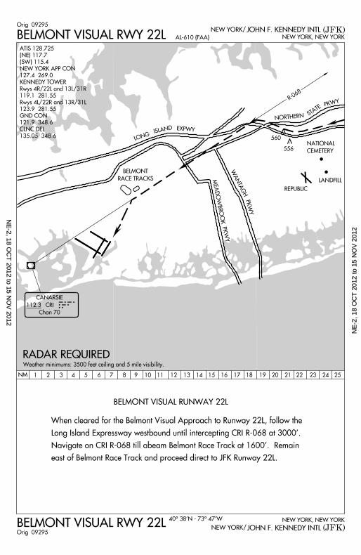
BELMONT VISUAL RUNWAY 22L
BELMONT VISUAL RWY 22L
BELMONT VISUAL RWY 22L NEW YORK, NEW YORK
NEW YORK, NEW YORK
(JFK)
(JFK)
NEW YORK/
NEW YORK/
AL-610 (FAA)
40^ 38’N - 73^ 47’W
JOHN F. KENNEDY INTL
JOHN F. KENNEDY INTLOrig 09295
Orig 09295
REPUBLIC
LANDFILL
NATIONAL
CEMETERY
556
560
CANARSIE
CRI
Chan 70
CRI
R-068
LONG
ISLANDEXPWY
NORTHERNSTATE
NM 1 2 3 4 5 6 7 8 9 10 11 12 13 14 15 16 17 18 19 20 21 22 23 24 25
MEADOWBROOK
PKWY
PKWY
WANTAGH
112.3
BELMONT
RACE TRACKS
When cleared for the Belmont Visual Approach to Runway 22L, follow the
Long Island Expressway westbound until intercepting CRI R-068 at 3000’.
Navigate on CRI R-068 ti l l abeam Belmont Race Track at 1600’. Remain
east of Belmont Race Track and proceed direct to JFK Runway 22L.
RADAR REQUIREDWeather min imums: 3500 feet ce i l ing and 5 mi le v is ib i l i ty .
ATIS 128.725
(NE) 117.7
(SW) 115.4
NEW YORK APP CON
127.4 269.0
KENNEDY TOWER
Rwys 4R/22L and 13L/31R
119.1 281.55
Rwys 4L/22R and 13R/31L
123.9 281.55
GND CON
121.9 348.6
CLNC DEL
135.05 348.6
PKWY
NE
-2, 18 OC
T 2012 to 15 N
OV
2012N
E-2
, 18
OC
T 2
012
to 1
5 N
OV
201
2
BETTE THREE DEPARTURENEW YORK, NEW YORK
(BETTE3.BETTE)NEW YORK/ JOHN F. KENNEDY INTL (JFK)
*
*
03023
BETTE THREE DEPARTURE SL-610 (FAA) NEW YORK, NEW YORK
(BETTE3.BETTE)(JFK)JOHN F. KENNEDY INTLNEW YORK/
03023
T
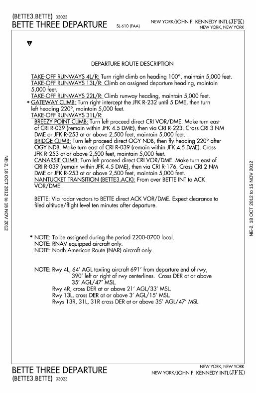
DEPARTURE ROUTE DESCRIPTION
TAKE-OFF RUNWAYS 4L/R: Turn right climb on heading 100^, maintain 5,000 feet.
TAKE-OFF RUNWAYS 13L/R: Climb on assigned departure heading, maintain
5,000 feet.
TAKE-OFF RUNWAYS 22L/R: Climb runway heading, maintain 5,000 feet.
GATEWAY CLIMB: Turn right intercept the JFK R-232 until 5 DME, then turn
left heading 220^, maintain 5,000 feet.
TAKE-OFF RUNWAYS 31L/R:
BREEZY POINT CLIMB: Turn left proceed direct CRI VOR/DME. Make turn east
of CRI R-039 (remain within JFK 4.5 DME), then via CRI R-223. Cross CRI 3 NM
DME or JFK R-253 at or above 2,500 feet, maintain 5,000 feet.
BRIDGE CLIMB: Turn left proceed direct OGY NDB, then fly heading 220^ after
OGY NDB. Make turn east of CRI R-039 (remain within JFK 4.5 DME). Cross
JFK R-253 at or above 2,500 feet, maintain 5,000 feet.
CANARSIE CLIMB: Turn left proceed direct CRI VOR/DME. Make turn east of
CRI R-039 (remain within JFK 4.5 DME), then via CRI R-176. Cross CRI 2 NM
DME or JFK R-253 at or above 2,500 feet, maintain 5,000 feet.
NANTUCKET TRANSITION (BETTE3.ACK): From over BETTE INT to ACK
VOR/DME.
BETTE: Via radar vectors to BETTE direct ACK VOR/DME. Expect clearance to
fi led altitude/fl ight level ten minutes after departure.
NOTE: To be assigned during the period 2200-0700 local.
NOTE: RNAV equipped aircraft only.
NOTE: North American Route (NAR) aircraft only.
NOTE: Rwy 4L, 64’ AGL taxiing aircraft 691’ from departure end of rwy,
390’ left or right of rwy centerlines. Cross DER at or above
35’ AGL/47’ MSL.
Rwy 4R, cross DER at or above 21’ AGL/33’ MSL.
Rwy 13L, cross DER at or above 3’ AGL/15’ MSL.
Rwys 13R, 31L, 31R cross DER at or above 35’ AGL/47’ MSL.
NE
-2, 18 OC
T 2012 to 15 N
OV
2012N
E-2
, 18
OC
T 2
012
to 1
5 N
OV
201
2
N
Cross JFK R-253
at or above 2500’
maintain 5000’
JFK4.5 DME
CRI 2 DME
BREEZY POINT
CLIMB
BRIDGE CLIMBCANARS
IE CLIMB
JFK
5
GATEWAY
CLIMB
*
CRI
R-176
R-232
R-253
R-223
R-039
100^
220^
220^
083^FL 180
(143)
QUBISTAFFY
EBONY
TUSKY
KANNI WHALE
VITOL DOVEY
JOBOCN40^07.0
0’W67^00.0
0’H-10
YAHOON41^04.1
6’W69^44.7
7’H-10
BRADD
ALLEX
TOPPS
WITCH
MARTNN42^34.8
6’W73^16.2
3’
JUDDS
MERITN41^22.9
2’W73^08.2
5’L-33-34
GREKI
HAPIE
BETTE
NOTE: Chart not t
o scale.
NOTE: To be assig
ned during the peri
od
2200-0700 l
ocal.
115.9 JFK
Chan 106
116.2 ACK
Chan 109
117.4 PUT
Chan 121PUTNAM
117.1 ENE
Chan 118
114.9 HFD
Chan 96
112.3 CRI
Chan 70
N40^36.75’
W73^53.67’
BOSTON
112.7 BOS
Chan 74
N42^21.45’
W70^59.37’
BRIDGE
N40^34.09’
W73^52.98’
414 OGYO G Y
KENNEDY
NANTUCKET
J F K
A C K
P U TB O S
KENNEBUNK
E N E
HARTFORD
H F D
CANARSIE
C R I
BETTE THREE DEPARTURE
BETTE THREE DEPARTURE
SL-610 (FAA)
(BETTE3.BETTE)
(BETTE3.BETTE)
N41^47.00’
W67^00.00’
H-11
C R I 3 D M E
*
11237
11237
TAKEOFF MINIMUM
S:
Rwys 4L, 4R, 13L,
22L, 22R: STANDA
RD.
Rwy 13R: 300-2 or
STANDARD wth m
inimum
climb 220’ per m
ile to 300’
Rwys 31L, 31R: 18
00-3 or STANDARD
with
minimum climb 2
40’ per mile to 240
0’
N43^25.54’-W70^3
6.81’
N41^38.08’
W73^06.34’
L-33-34
N41^07.00’
W67^00.00’
H-10-11
L-34
N41^38.47’-W72^3
2.85’
L-33-34, H-10-12
L-33-34, H-10-11-
12
N41^57.33’-W71^5
0.65’ L-33-34, H-10-11-
12
N41^16.91’-W70^0
1.60’
L-33, H-10-12
N41^28.80’
W73^18.85’
L-33-34, H-10-12
N40^37.97’-W73^4
6.28’
L-33-34, H-10-12
(JFK)NEW YORK, NEW YORK
JOHN F. KENNEDY INTLNEW YORK /
(JFK)
NEW YORK, NEW YORK
JOHN F. KENNEDY INTLNEW YORK /
L-32, H-11-12
N40^33.55’
W73^00.70’
L-34N40^23.1
9’W72^58.9
6’
L-34
L-33-34
H-10-11-12
N42^41.00’
W70^52.77’
N47^32.00’
W 67^46.00’ N45^20.4
1’W67^44.3
2’H-11
N47^22.40’
W67^18.23’
H-11
N44^54.14’
W67^09.39’
H-11
N43^33.90’
W67^00.00’
H-11
N44^25.00’
W67^00.00’
H-11
N43^09.00’
W67^00.00’
H-11
N42^38.00’
W67^00.00’
H-11
N42^11.87’
W67^00.00’
H-11
ATIS 128.725 CLNC DEL
135.05 348.6
NEW YORK DEP CO
N135.9 35
3.750 (NARRATIVE ON F
OLLOWING PAGE)
NE
-2, 18 OC
T 2012 to 15 N
OV
2012N
E-2
, 18
OC
T 2
012
to 1
5 N
OV
201
2
CATEGORY
APP CRS
Rwy Idg
TDZE
Apt Elev028^
A
NEW YORK APP CON
(JFK)NEW YORK/
NEW YORK, NEW YORK
127.4 269.0
NA
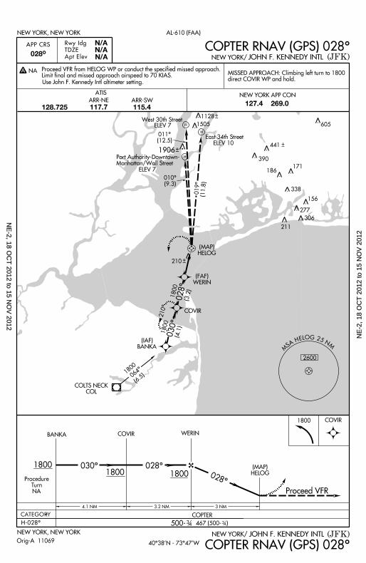
COPTER RNAV (GPS) 028^
(JFK)NEW YORK/NEW YORK, NEW YORK
COPTER RNAV (GPS) 028^
500- 467 (500- )H-028^ 3 4 3 4
COPTER
MS A H E L O G 2 5 N
M
2600
1800
COVIR
H
H
H
BANKA COVIR WERIN
1800 1800030^ 028^
028^
4 .1 NM 3 .2 NM 3 NM
1800 COVIR
(MAP)HELOG
(FAF)WERIN
(MAP)HELOG
Proceed VFR
030^1800
( IAF)BANKA
028^ (3.2)
COLTS NECKCOL
064^1800
(6.5)
019^ (11.8)
011^(12.5)
010^(9.3)
210^
210
West 30th Street
East 34th Street
N/AN/A
N/A
Use John F. Kennedy Int l a l t imeter set t ing.
MISSED APPROACH: Cl imbing le f t turn to 1800direct COVIR WP and hold.
1800
(4.1)
JOHN F. KENNEDY INTL
JOHN F. KENNEDY INTL
ELEV 7
ELEV 7
ELEV 10
AL-610 (FAA)
Port Author i ty-Downtown-Manhat tan/Wal l Street
ATIS
128.725 ARR-NE ARR-SW
117.7 115.4
Proceed VFR f rom HELOG WP or conduct the speci f ied missed approach.L imi t f ina l and missed approach a i rspeed to 70 KIAS.
Or ig-A 11069 40^38’N - 73^47’W
1128
1505
1906441
390
171186
605
211
306
277
156
ProcedureTurn
NA
338
NE
-2, 18 OC
T 2012 to 15 N
OV
2012N
E-2
, 18
OC
T 2
012
to 1
5 N
OV
201
2
NEW YORK, NEW YORK
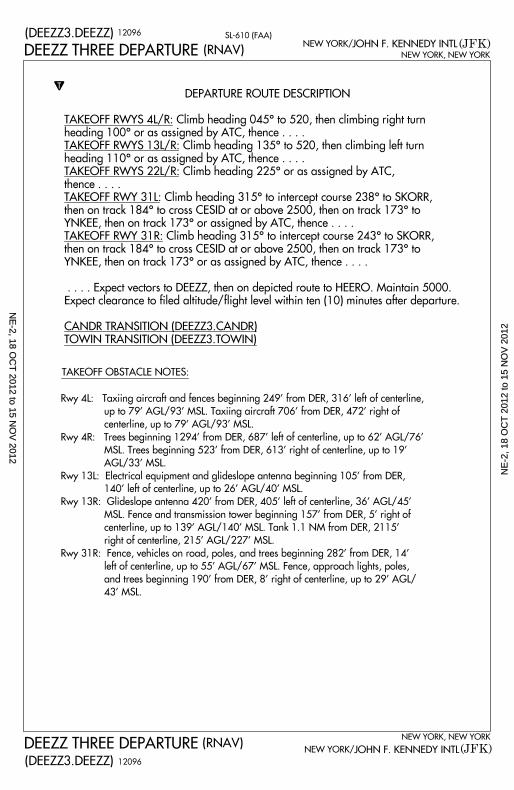
(DEEZZ3.DEEZZ)NEW YORK/ JOHN F. KENNEDY INTL (JFK)
SL-610 (FAA)
NEW YORK, NEW YORK
(DEEZZ3.DEEZZ)(JFK)JOHN F. KENNEDY INTLNEW YORK/
T
(RNAV)
(RNAV)
TAKEOFF OBSTACLE NOTES:
Rwy 4L: Taxiing aircraft and fences beginning 249’ from DER, 316’ left of centerl ine,
up to 79’ AGL/93’ MSL. Taxiing aircraft 706’ from DER, 472’ r ight of
centerl ine, up to 79’ AGL/93’ MSL.
Rwy 4R: Trees beginning 1294’ from DER, 687’ left of centerl ine, up to 62’ AGL/76’
MSL. Trees beginning 523’ from DER, 613’ r ight of centerl ine, up to 19’
AGL/33’ MSL.
Rwy 13L: Electr ical equipment and gl ideslope antenna beginning 105’ from DER,
140’ left of centerl ine, up to 26’ AGL/40’ MSL.
Rwy 13R: Glideslope antenna 420’ from DER, 405’ left of centerl ine, 36’ AGL/45’
MSL. Fence and transmission tower beginning 157’ from DER, 5’ r ight of
centerl ine, up to 139’ AGL/140’ MSL. Tank 1.1 NM from DER, 2115’
r ight of centerl ine, 215’ AGL/227’ MSL.
Rwy 31R: Fence, vehicles on road, poles, and trees beginning 282’ from DER, 14’
left of centerl ine, up to 55’ AGL/67’ MSL. Fence, approach l ights, poles,
and trees beginning 190’ from DER, 8’ r ight of centerl ine, up to 29’ AGL/
43’ MSL.
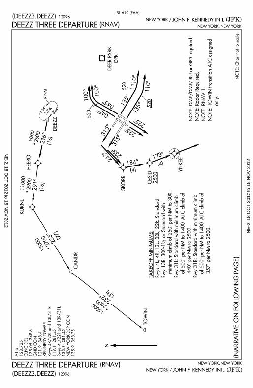
DEEZZ THREE DEPARTURE
DEEZZ THREE DEPARTURE
DEPARTURE ROUTE DESCRIPTION
TAKEOFF RWYS 4L/R: Climb heading 045^ to 520, then climbing right turn
heading 100^ or as assigned by ATC, thence . . . .
TAKEOFF RWYS 13L/R: Climb heading 135^ to 520, then climbing left turn
heading 110^ or as assigned by ATC, thence . . . .
TAKEOFF RWYS 22L/R: Climb heading 225^ or as assigned by ATC,
thence . . . .
TAKEOFF RWY 31L: Climb heading 315^ to intercept course 238^ to SKORR,
then on track 184^ to cross CESID at or above 2500, then on track 173^ to
YNKEE, then on track 173^ or assigned by ATC, thence . . . .
TAKEOFF RWY 31R: Climb heading 315^ to intercept course 243^ to SKORR,
then on track 184^ to cross CESID at or above 2500, then on track 173^ to
YNKEE, then on track 173^ or as assigned by ATC, thence . . . .
. . . . Expect vectors to DEEZZ, then on depicted route to HEERO. Maintain 5000.
Expect clearance to fi led altitude/fl ight level within ten (10) minutes after departure.
CANDR TRANSITION (DEEZZ3.CANDR)
TOWIN TRANSITION (DEEZZ3.TOWIN)
12096
12096
NE
-2, 18 OC
T 2012 to 15 N
OV
2012N
E-2
, 18
OC
T 2
012
to 1
5 N
OV
201
2
N
(DEEZZ3.DEEZZ)
(DEEZZ3.DEEZZ)(JFK)
NEW YORK, NEW YORK
JOHN F. KENNEDY INTLNEW YORK /
(JFK)
NEW YORK, NEW YORK
JOHN F. KENNEDY INTLNEW YORK /
(NARRATIVE ON F
OLLOWING PAGE)
(RNAV)
(RNAV)
12
ATIS 128.725 CLNC DEL
135.05 348.6
GND CON
121.9 348.6
KENNEDY TOWE
R
Rwys 4R/22L and
13L/31R
119.1 281.55
Rwys 4L/22R and
13R/31L
123.9 281.55
NEW YORK DEP
CON
135.9 353.75
SL-610 (FAA)
NOTE: Chart not
to scale.
NOTE: DME/DME/IR
U or GPS required.
NOTE: Radar Requ
ired.
NOTE: RNAV 1.
NOTE: TOWIN trans
ition ATC assigned
only.
TAKEOFF MINIMUM
S:
Rwys 4L, 4R, 13L,
22L, 22R: Standar
d.
Rwy 13R: 300-1
or Standard with
minimum climb o
f 250’ per NM to 30
0.
Rwy 31L: Standard
with minimum clim
b
of 500’ per NM to
1400. ATC climb o
f
440’ per NM to 2
500.
Rwy 31R: Standard
with minimum clim
b
of 500’ per NM to
1400. ATC climb o
f
357’ per NM to 2
500.
DEEZZ THREE DEPARTURE
DEEZZ THREE DEPARTURE
324^144^
9 NM230K
225^
225^
HEERO
KURNL
DEEZZ
CANDR
TOWIN
SKORR
YNKEE
DEER PARK
DPK
315^
315^
045^
045^
100^
100^
135^
135^110^
110^
2600 296^ (16)
8000*
11000 2900 291^ (16)*
150002700
253^(27)
*
2600232^
(33)
*15000
184^173^
(4)
(4)
520
520
520
243^
238^
CESID 2500
12096
12096
NE
-2, 18 OC
T 2012 to 15 N
OV
2012N
E-2
, 18
OC
T 2
012
to 1
5 N
OV
201
2
T
DEPARTURE ROUTE DESCRIPTION
GREKI THREE DEPARTURE
GREKI THREE DEPARTURE(GREKI3.GREKI)
(GREKI3.GREKI)
NEW YORK, NEW YORK
NEW YORK, NEW YORK
JOHN F. KENNEDY INTL (JFK)
JOHN F. KENNEDY INTL (JFK)NEW YORK/
NEW YORK/
SL-610 (FAA)
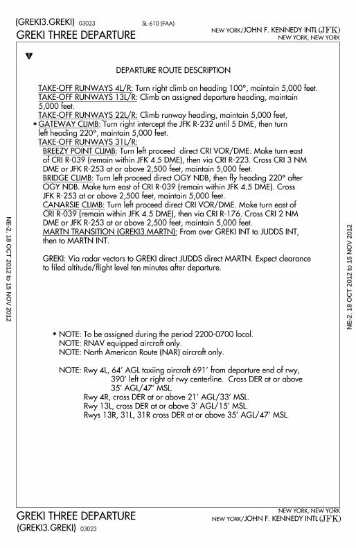
TAKE-OFF RUNWAYS 4L/R: Turn right climb on heading 100^, maintain 5,000 feet.
TAKE-OFF RUNWAYS 13L/R: Climb on assigned departure heading, maintain
5,000 feet.
TAKE-OFF RUNWAYS 22L/R: Climb runway heading, maintain 5,000 feet,
GATEWAY CLIMB: Turn right intercept the JFK R-232 until 5 DME, then turn
left heading 220^, maintain 5,000 feet.
TAKE-OFF RUNWAYS 31L/R:
BREEZY POINT CLIMB: Turn left proceed direct CRI VOR/DME. Make turn east
of CRI R-039 (remain within JFK 4.5 DME), then via CRI R-223. Cross CRI 3 NM
DME or JFK R-253 at or above 2,500 feet, maintain 5,000 feet.
BRIDGE CLIMB: Turn left proceed direct OGY NDB, then fly heading 220^ after
OGY NDB. Make turn east of CRI R-039 (remain within JFK 4.5 DME). Cross
JFK R-253 at or above 2,500 feet, maintain 5,000 feet.
CANARSIE CLIMB: Turn left proceed direct CRI VOR/DME. Make turn east of
CRI R-039 (remain within JFK 4.5 DME), then via CRI R-176. Cross CRI 2 NM
DME or JFK R-253 at or above 2,500 feet, maintain 5,000 feet.
MARTN TRANSITION (GREKI3.MARTN): From over GREKI INT to JUDDS INT,
then to MARTN INT.
GREKI: Via radar vectors to GREKI direct JUDDS direct MARTN. Expect clearance
to fi led altitude/fl ight level ten minutes after departure.
*
*
03023
03023
NOTE: To be assigned during the period 2200-0700 local.
NOTE: RNAV equipped aircraft only.
NOTE: North American Route (NAR) aircraft only.
NOTE: Rwy 4L, 64’ AGL taxiing aircraft 691’ from departure end of rwy,
390’ left or right of rwy centerline. Cross DER at or above
35’ AGL/47’ MSL.
Rwy 4R, cross DER at or above 21’ AGL/33’ MSL.
Rwy 13L, cross DER at or above 3’ AGL/15’ MSL.
Rwys 13R, 31L, 31R cross DER at or above 35’ AGL/47’ MSL.
NE
-2, 18 OC
T 2012 to 15 N
OV
2012N
E-2
, 18
OC
T 2
012
to 1
5 N
OV
201
2
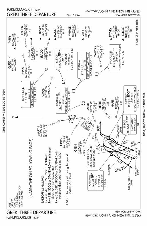
CRI
R-176
R-039
R-223
R-253
C R I 3 D M E
220
100^
JFK4.5 DME
CRI 2 DME
CANARSIE
CLIMB
BRIDGE CLIMB
BREEZY POINT
CLIMB
Cross JFK R-253
at or above 2500’
maintain 5000’
115.9 JFK
Chan 106KENNEDY
112.3 CRI
Chan 70
CANARSIE
BRIDGE
414 OGYO G Y
R-232
IRC GREKI
JUDDS
057^FL 180
(13)
V39-419
005^FL 180
(57)
MARTN N42^34.86’
W73^16.23’
MERIT BETTE
HAPIE
N41^22.92’
W73^08.25’
L-33-34
NOTE: Chart not t
o scale.
NOTE: To be assig
ned during the peri
od 22
00-0700 local.
116.2 ACK
Chan 109
NANTUCKET
A C KYAHOO
JOBOCDOVEY
N40^07.00’
W67^00.00’
H-10
VITOL
WHALEKANNI
N41^47.00’
W67^00.00’
H-11
N41^04.16’
W69^44.77’
H-10
TUSKYEBONY
TAFFYQUBIS
ALLEX BRADD
TOPPS
114.9 HFD
Chan 96
HARTFORD
117.1 ENE
Chan 118
KENNEBUNK
WITCH
117.4 PUT
Chan 121
112.7 BOS
Chan 74BOSTONH F DE N E
B O S
PUTNAMP U T
J F KGATEWA
YCLIMB
N40^34.09’
W73^52.98’
SL-610 (FAA)
(GREKI3.GREKI)
(GREKI3.GREKI)
220^
N40^36.75’
W73^53.67’
GREKI THREE DEPARTURE
GREKI THREE DEPARTURE
*
*
11237
11237
N41^38.08’
W73^06.34’
L-33-34
N41^07.00’
W67^00.00’
H-10-11
L-34
N41^28.80’
W73^18.85’
L-33-34, H-10-12
N41^38.47’-W72^3
2.85’
L-33-34, H-10-12
N42^21.45’
W70^59.37’
L-33-34, H-10-11-
12
N41^57.33’-W71^5
0.65’ L-33-34, H-10-11-
12
N41^16.91’-W70^0
1.60’
L-33, H-10-12
N40^37.97’-W73^4
6.28’
L-33-34, H-10-12
JFK
5
(JFK)NEW YORK, NEW YORK
JOHN F. KENNEDY INTLNEW YORK /
(JFK)
NEW YORK, NEW YORK
JOHN F. KENNEDY INTLNEW YORK /
N43^25.54’-W70^3
6.81’
L-32, H-11-12
N40^33.55’
W73^00.70’
L-34
N40^23.19’
W72^58.96’
L-34
L-33-34
H-10-11-12
N42^11.87’
W67^00.00’
H-11
N42^38.00’
W67^00.00’
H-11
N43^33.90’
W67^00.00’
H-11
N44^54.14’
W67^09.39’
H-11
N47^22.40’
W67^18.23’
H-11
N47^32.00’
W67^46.00’
N44^25.00’
W67^00.00’
H-11
N43^09.00’
W67^00.00’
H-11
N45^20.41’
W67^44.32’
H-11
N42^41.00’
W70^52.77’
TAKEOFF MINIMUM
S:
Rwys 4L, 4R, 13L,
22L, 22R: STANDA
RD.
Rwy 13R: 300-2 or
STANDARD with m
inimum
climb 220’ per m
ile to 300’.
Rwys 31L, 31R: 18
00-3 or STANDARD
with
minimum climb
240’ per mile to 240
0’.
ATIS 128.725 CLNC DEL
135.05 348.6
NEW YORK DEP CO
N135.9 35
3.750
(NARRATIVE ON F
OLLOWING PAGE)
N
NE
-2, 18 OC
T 2012 to 15 N
OV
2012N
E-2
, 18
OC
T 2
012
to 1
5 N
OV
201
2
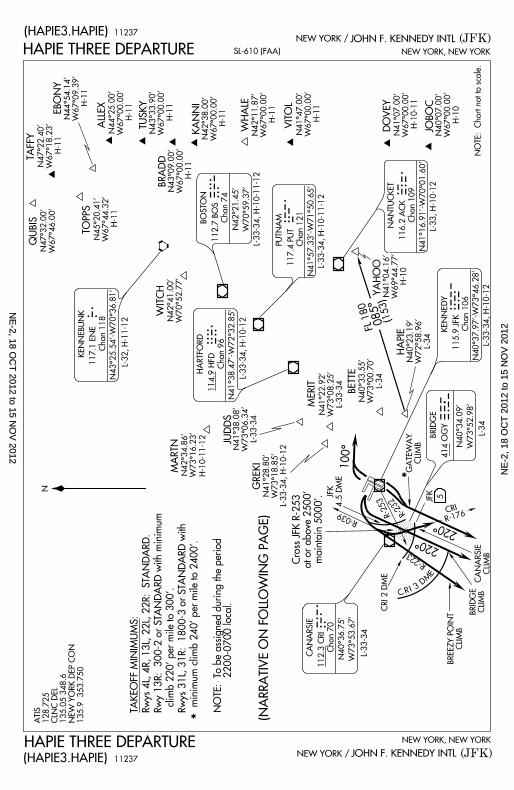
HAPIE THREE DEPARTURE NEW YORK, NEW YORK
JOHN F. KENNEDY INTL (JFK)SL-610 (FAA)
NEW YORK/
(HAPIE3.HAPIE)
NEW YORK, NEW YORK
JOHN F. KENNEDY INTLNEW YORK/ (JFK)HAPIE THREE DEPARTURE
(HAPIE3.HAPIE)
T
DEPARTURE ROUTE DESCRIPTION
*
*
03135
03135
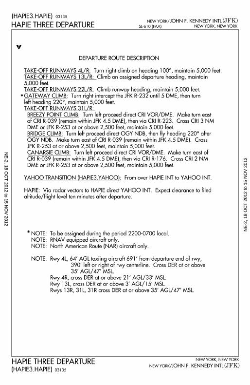
TAKE-OFF RUNWAYS 4L/R: Turn right climb on heading 100^, maintain 5,000 feet.
TAKE-OFF RUNWAYS 13L/R: Climb on assigned departure heading, maintain
5,000 feet.
TAKE-OFF RUNWAYS 22L/R: Climb runway heading, maintain 5,000 feet.
GATEWAY CLIMB: Turn right intercept the JFK R-232 until 5 DME, then turn
left heading 220^, maintain 5,000 feet.
TAKE-OFF RUNWAYS 31L/R:
BREEZY POINT CLIMB: Turn left proceed direct CRI VOR/DME. Make turn east
of CRI R-039 (remain within JFK 4.5 DME), then via CRI R-223. Cross CRI 3 NM
DME or JFK R-253 at or above 2,500 feet, maintain 5,000 feet.
BRIDGE CLIMB: Turn left proceed direct OGY NDB, then fly heading 220^ after
OGY NDB. Make turn east of CRI R-039 (remain within JFK 4.5 DME). Cross
JFK R-253 at or above 2,500 feet, maintain 5,000 feet.
CANARSIE CLIMB: Turn left proceed direct CRI VOR/DME. Make turn east of
CRI R-039 (remain within JFK 4.5 DME), then via CRI R-176. Cross CRI 2 NM
DME or JFK R-253 at or above 2,500 feet, maintain 5,000 feet.
YAHOO TRANSITION (HAPIE3.YAHOO): From over HAPIE INT to YAHOO INT.
HAPIE: Via radar vectors to HAPIE direct YAHOO INT. Expect clearance to fi led
altitude/fl ight level ten minutes after departure.
NOTE: To be assigned during the period 2200-0700 local.
NOTE: RNAV equipped aircraft only.
NOTE: North American Route (NAR) aircraft only.
NOTE: Rwy 4L, 64’ AGL taxiing aircraft 691’ from departure end of rwy,
390’ left or right of rwy centerline. Cross DER at or above
35’ AGL/47’ MSL.
Rwy 4R, cross DER at or above 21’ AGL/33’ MSL.
Rwy 13L, cross DER at or above 3’ AGL/15’ MSL.
Rwys 13R, 31L, 31R cross DER at or above 35’ AGL/47’ MSL.
NE
-2, 18 OC
T 2012 to 15 N
OV
2012N
E-2
, 18
OC
T 2
012
to 1
5 N
OV
201
2
R-176
R-223
R-039
R-253 R-232 CRI
C R I 3D
M
E
CRI 2 DME
BREEZY POINT
CLIMB
BRIDGE CLIMBCANARS
IECLIMB
GATEWAY
CLIMB
5JFK
JFK4.5 DME
Cross JFK R-253
at or above 2500’ maintain
5000’.
220^
220^
100^
NOTE: Chart not t
o scale.
NOTE: To be assi
gned during the pe
riod 2
200-0700 local.
085^FL 180
(153)
QUBISTAFFY
EBONY
TOPPS
ALLEX
BRADD
TUSKY
KANNI
WITCH
MARTN
WHALE VITOLN41^47.0
0’W67^00.0
0’H-11
YAHOO N41^04.16’
W69^44.77’
H-10
DOVEY JOBOCN40^07.0
0’W67^00.0
0’H-10
HAPIE
BETTE
HAPIE THREE DEPARTURE SL-610 (FAA)
(HAPIE3.HAPIE)
HAPIE THREE DEPARTURE(HAPIE3.HAPIE)
117.4 PUT
Chan 121
112.7 BOS
Chan 74BOSTON
PUTNAMP U T
116.2 ACK
Chan 109
NANTUCKET
114.9 HFD
Chan 96
HARTFORD
117.1 ENE
Chan 118
KENNEBUNK
GREKI
JUDDS
112.3 CRI
Chan 70
CANARSIE
N42^34.86’
W73^16.23’
B O S
E N E
H F D
A C K
C R IMERIT
N41^22.92’
W73^08.25’
L-33-34
115.9 JFK
Chan 106KENNEDY
BRIDGE
414 OGY
N40^34.09’
W73^52.98’
O G YJ F K
N40^36.75’
W73^53.67’
11237
11237
*
*
N41^38.08’
W73^06.34’
L-33-34
N41^07.00’
W67^00.00’
H-10-11
L-34
N43^25.54’-W70^3
6.81’
N41^28.80’
W73^18.85’
L-33-34, H-10-12
L-33-34, H-10-12
N42^21.45’
W70^59.37’
L-33-34, H-10-11-
12
N41^57.33’-W71^5
0.65’ L-33-34, H-10-11-
12
N41^16.91’-W70^0
1.60’
L-33, H-10-12
N40^37.97’-W73^4
6.28’
L-33-34, H-10-12
(JFK)NEW YORK, NEW YORK
JOHN F. KENNEDY INTLNEW YORK /
(JFK)
NEW YORK, NEW YORK
JOHN F. KENNEDY INTLNEW YORK /
L-32, H-11-12 N40^23.1
9’W72^58.9
6’L-34
N40^33.55’
W73^00.70’
L-34
L -33-34
H-10-11-12
N42^41.00’
W70^52.77’
N47^32.00’
W67^46.00’
N45^20.41’
W67^44.32’
H-11
N44^54.14’
W67^09.39’
H-11
N47^22.40’
W67^18.23’
H-11
N44^25.00’
W67^00.00’
H-11
N43^33.90’
W67^00.00’
H-11N43^09.0
0’W67^00.0
0’H-11
N42^38.00’
W67^00.00’
H-11
N42^11.87’
W67^00.00’
H-11
TAKEOFF MINIMUM
S:
Rwys 4L, 4R, 13L,
22L, 22R: STAND
ARD.
Rwy 13R: 300-2 or
STANDARD with m
inimum
climb 220’ per mil
e to 300’.
Rwys 31L, 31R: 18
00-3 or STANDARD
with
minimum climb 24
0’ per mile to 2400
’.
ATIS 128.725 CLNC DEL
135.05 348.6
NEW YORK DEP CO
N135.9 35
3.750 (NARRATIVE ON F
OLLOWING PAGE)
N41^38.47’-W72^3
2.85’
N
NE
-2, 18 OC
T 2012 to 15 N
OV
2012N
E-2
, 18
OC
T 2
012
to 1
5 N
OV
201
2
10000 X 150 22L
22R
13L
H
H
H197
66
80
172
10899
V
A
A
P
P
TWR
338
13R
14511 X 200
P
P
4L4R
A 31L
158
A 5
31R
11351 X 150
H
8400X 200
H
X
ELEV
CATEGORY B C DA
R-209
TELEX INT
I-TLK 7.7
KENNEDY
115.9 JFK
Chan 106
JFK
258^
078^
RADAR REQUIRED
1500GS 3.00^
TCH 58
1800 1500
TELEX INT
I-TLK 7.7
I -TLK
1.7
1 .5 NM 2 .5 NM
600 4000 DPK
680-2680-1667 (700-1 ) 667 (700-2)
680-1 667 (700-1)
680/24
218/18
667 (700- )
205 (300- )
12
3 4
3 4
S-ILS 13L
S-LOC 13L
CIRCLING
9095111.5
52135^
13 13
T
A
ALSF-2
NEW YORK, NEW YORK
NEW YORK, NEW YORK
(JFK)
(JFK)
JOHN F. KENNEDY INTL
JOHN F. KENNEDY INTL
NEW YORK /
NEW YORK /
AL-610 (FAA)
13
135^ 4.4 NMfrom FAF
315^
CAXUN INT
I-TLK 6.1
135^
APP CRS
Rwy Idg
TDZE
Apt ElevChan
LOC/DME I -TLK
R-078
CAXUN INT
I-TLK 6.1
R-193
12
40^38’N - 73^47’W
1351500
(1.5)
LOCALIZER 111.5
I -TLK
Chan 52
LA GUARDIA
113.1 LGA
Chan 78
605
171186
156277
306
390
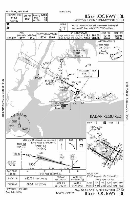
MISSED APPROACH: Cl imb to 600 then c l imbing le f t
turn to 4000 d i rect to DPK VOR/DME and hold.
ILS or LOC RWY 13L
ILS or LOC RWY 13LAmdt 16B 12096
667 (700-1 )
1801501209060Knots
Min:Sec
FAF to MAP 4.4 NM
4:24 2:56 2:12 1:46 1:28
1 .9 NM
I -TLK
3.6
441
A
DEER PARK
DPK
117.7
Chan 124
DKPMISSED APCH FIX
211
MS A J F K 2 5 N M
090^
180^
2000
2800D
680/60
667 (700-1 ) 14
680-1 12
12
1128
1505
1906
441
CLNC DELGND CONNEW YORK APP CON KENNEDY TOWER
Rwys 4R/22L and 13L/31R
Rwys 4L/22R and 13R/31L
119.1 281.55123.9 281.55
ATIS
127.4 269.0121.9348.6
135.05348.6
(ARR-NE) (ARR-SW)
128.725 117.7 115.4
HIRL al l Rwys
TDZ/CL Rwys 4R, 13L, 31R and 22L
TDZE 13
VGSI and ILS g l idepath not co inc ident
(VGSI Angle 2.75/TCH 66) .
NE
-2, 18 OC
T 2012 to 15 N
OV
2012N
E-2
, 18
OC
T 2
012
to 1
5 N
OV
201
2
10000 X 150 22L
22R
13L
H
H
H197
66
80
172
10899
V
A
A
P
P
TWR
338
13R
14511 X 200
P
P
4L4R
A 31L
158
A 5
31R
11351 X 150
H
8400X 200
H
X
R-2833000
283^
(15.1)
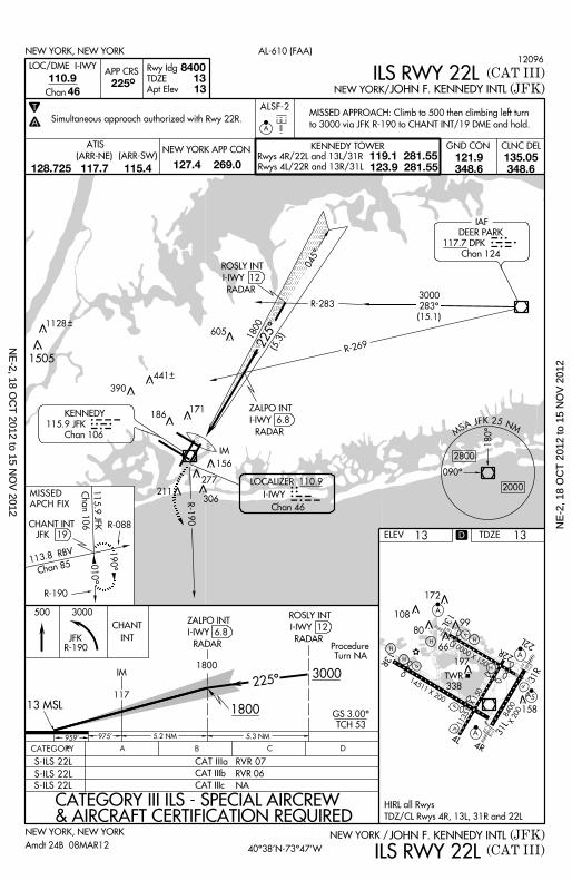
DEER PARK
117.7 DPK
Chan 124
IAF
KENNEDY
115.9 JFK
Chan 106
LOCALIZER 110.9
I - IWY
Chan 46
R-190
180^
2800
2000
090^
MS A J F K 2 5 N M
ZALPO INT
I- IWY 6.8
RADAR
ROSLY INT
I- IWY 12
RADAR
(5.3)
1800
225^
045^
IM
010^
190^
CHANT INT
JFK 19
R-190
R-269
DPK
605
390
306
277
211
171
156
R-088
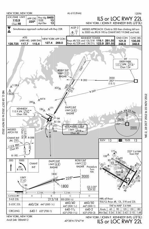
(JFK)JOHN F. KENNEDY INTLNEW YORK /
AL-610 (FAA)
MISSED APPROACH: Cl imb to 500 then c l imbing le f t turn
to 3000 v ia JFK R-190 to CHANT INT/19 DME and hold.
ILS or LOC RWY 22L
D
GS 3.00
1800
640-2627 (700-2)
640-1
213/18
NEW YORK, NEW YORK
CHANT
INT
225^
ZALPO INT
I- IWY 6.8
RADAR
12
IM
I - IWY
5 .2 NM
460/40447 (500- )
460/50447 (500-1)3
4
ELEV
(JFK)JOHN F. KENNEDY INTL
13
FAF to MAP 5.4 NM
ILS or LOC RWY 22LNEW YORK /
8400110.9
225^
T
A
13 13
46
NEW YORK, NEW YORK
Rwy Idg
TDZE
Apt Elev
APP CRS
Chan
LOC/DME I - IWY
ALSF-2
A
CATEGORY B CA
3000
TCH 53
5 .3 NM
627 (700-1 )640-1 627 (700-1)
460/24 447 (500- )
200 (200- )
12
S-ILS 22L
CIRCLING
500 3000
ROSLY INT
I- IWY 12
RADAR
0 .2
1.4
S-LOC 22L
225^ 5.4 NMfrom FAF
1801501209060Knots
Min:Sec 5:24 3:36 2:42 2:10 1:48
441
186
115.9 JFKChan 106
113.8 RBV
Chan 85
MISSED
APCH FIX
D
1128
1505
Procedure Turn
NA
JFKR-190
CLNC DELGND CONNEW YORK APP CON KENNEDY TOWER
Rwys 4R/22L and 13L/31R
Rwys 4L/22R and 13R/31L
119.1 281.55123.9 281.55
ATIS
127.4 269.0121.9348.6
135.05348.6
(ARR-NE) (ARR-SW)
128.725 117.7 115.4
HIRL al l Rwys
TDZ/CL Rwys 4R, 13L, 31R and 22L
13TDZE
40^38’N-73^47’WAmdt 24B 08MAR12
12096
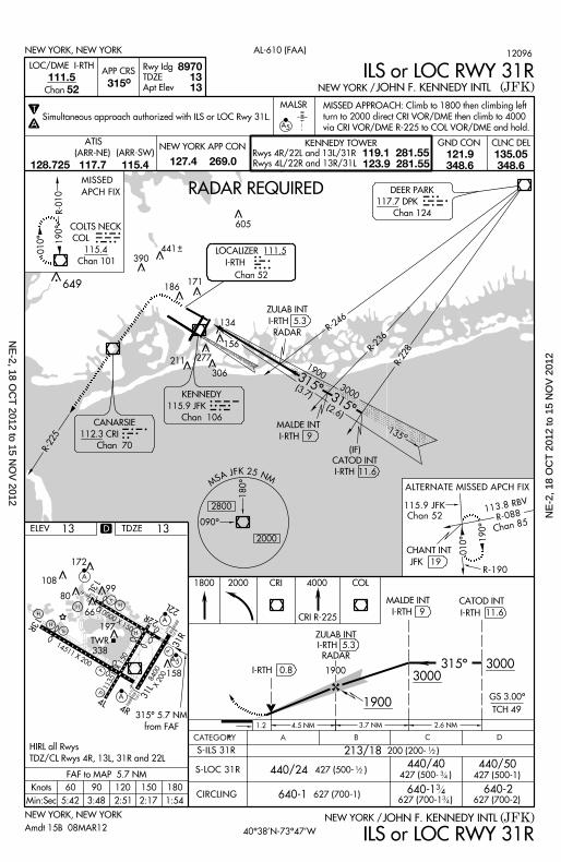
Simul taneous approach author ized wi th Rwy 22R.
1800
34
34
NE
-2, 18 OC
T 2012 to 15 N
OV
2012N
E-2
, 18
OC
T 2
012
to 1
5 N
OV
201
2
10000 X 150 22L
22R
13L
H
H
H197
66
80
172
10899
V
A
A
P
P
TWR
338
13R
14511 X 200
P
P
4L4R
A 31L
158
A 5
31R
11351 X 150
H
8400X 200
H
X
ELEV
11248
111.35 315^ 13 13
T
A
CATEGORY B C DA
1800GS 3.00^
TCH 48
ZACHS INT
JFK 11.7
2000
5 .4 NM 6 .8 NM
640-1 627 (700-1 )
640-2627 (700-2)
427 (500-1 )
640-1 627 (700-1)
213/40 200 (200- )
1801501209060Knots
Min:Sec
FAF to MAP 5.4 NM
5:24 3:36 2:42 2:10 1:48
R-190010^
190^
JFK
500
MS A J F K 2 5 N M
090^
180^2000
2800
111.35
135^
DPK
315^ 5.4 NM
from FAF
LOC I -MOH
APP CRS
Rwy Idg
TDZE
Apt Elev
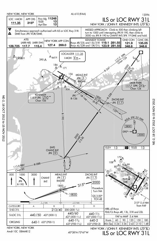
(JFK)JOHN F. KENNEDY INTLNEW YORK /NEW YORK, NEW YORK
NEW YORK, NEW YORK AL-610 (FAA)
NEW YORK / JOHN F. KENNEDY INTL (JFK)
1000 3000
S-ILS 31L
S-LOC 31L
CIRCLING
2000048^
(15.8)
ZACHS INT
JFK 11.7(6.8)
315^1800LR-144KENNEDY
115.9 JFK
Chan 106
I-MOH
IAF
DEER PARK
117.7 DPK
Chan 124
2000228^
(19.5)
R-228
113.8 RBV
Chan 85
R-088
315^1800
CHANT
13
INT
(IAF)
CHANT INT
JFK 19
440 /50 427 (500-1)
Procedure
Turn NA
MEALS INT
RADAR
JFK 5
JFK
R-136
MEALS INT
JFK 5
RADAR
306
277
186
171
156
390
MISSED APPROACH: Cl imb to 500 then c l imbing le f t
turn to 1000 unt i l in tercept ing JFK R-190, then c l imb to
3000 v ia JFK R-190 to CHANT INT/JFK 19 DME and hold.
ILS or LOC RWY 31L
ILS or LOC RWY 31L
427 (500-1 )
440/60 1
2
440-1 12
IMOH441
211
D
1906
JFK
R-190
CLNC DELGND CONNEW YORK APP CON KENNEDY TOWER
Rwys 4R/22L and 13L/31R
Rwys 4L/22R and 13R/31L
119.1 281.55123.9 281.55
ATIS
127.4 269.0121.9348.6
135.05348.6
(ARR-NE) (ARR-SW)
128.725 117.7 115.4
HIRL al l Rwys
TDZ/CL Rwys 4R, 13L, 31R and 22L
TDZE 13
117.7 DPK
Chan 124
R-247
40^38’N-73^47’WAmdt 10C 08MAR12
12096
34
34
34
14
Simul taneous approach author ized wi th ILS or LOC Rwy 31R.
DME from JFK VOR/DME.
NE
-2, 18 OC
T 2012 to 15 N
OV
2012N
E-2
, 18
OC
T 2
012
to 1
5 N
OV
201
2
10000 X 150 22L
22R
13L
H
H
H197
66
80
172
10899
V
A
A
P
P
TWR
338
13R
14511 X 200
P
P
4L4R
A 31L
158
A 5
31R
11351 X 150
H
8400X 200
H
X
1900
(3.7)
R-236
LOCALIZER 111.5
I-RTHIRTH
315^
135
Chan 52
MALDE INT
I -RTH 9
CATOD INT
11.6I-RTH
315^3000
(2.6)
ZULAB INT
I-RTH 5.3
RADAR
306
277
171
156
( IF)
134
390
441
186
211
R-246
R-228
MALSR
315^111.5 13
1352
8970
T
A A 5
NEW YORK, NEW YORK
(JFK)JOHN F. KENNEDY INTLNEW YORK /
AL-610 (FAA)
Chan
APP CRS
Rwy Idg
TDZE
Apt Elev
LOC/DME I -RTH ILS or LOC RWY 31R
MISSED APPROACH: Cl imb to 1800 then c l imbing le f t
turn to 2000 d i rect CRI VOR/DME then c l imb to 4000
v ia CRI VOR/DME R-225 to COL VOR/DME and hold.
CATEGORY B C DA
12
1900GS 3.00^
TCH 49
1900
CATOD INT
11.6I-RTH
2 .6 NM3 .7 NM4 .5 NM
213/18
440/24440/40
640-1640-1 640-2
200 (200- )
427 (500- )427 (500- )
627 (700-1)627 (700-1 ) 627 (700-2)
CIRCLING
S-LOC 31R
S-ILS 31R
1800 4000 COL
315^ 5.7 NM
from FAF
NEW YORK, NEW YORK (JFK)JOHN F. KENNEDY INTLNEW YORK /
12
315^
CRI R-225
30003000
CRI
MALDE INT
I-RTH 9
1801501209060Knots
Min:Sec
FAF to MAP 5.7 NM
5:42 3:48 2:51 2:17 1:54
ZULAB INT
I-RTH 5.3
RADAR
ILS or LOC RWY 31R
1 .2
I -RTH 0.8
2000
440/50427 (500-1)
ELEV 13
MS M
2800
2000
090^
180^
A J F K 2 5 N
RADAR REQUIRED
KENNEDY
115.9 JFK
Chan 106CANARSIE
112.3 CRI
Chan 70
DEER PARK
117.7 DPK
Chan 124
D
R-225
010^
190^
R-190
115.9 JFK
Chan 52
JFK 19
ALTERNATE MISSED APCH FIX
113.8 RBVR-088
Chan 85
010^
190^R-010
M ISSED
APCH FIX
605
649
CLNC DELGND CONNEW YORK APP CON KENNEDY TOWER
Rwys 4R/22L and 13L/31R
Rwys 4L/22R and 13R/31L
119.1 281.55123.9 281.55
ATIS
127.4 269.0121.9348.6
135.05348.6
(ARR-NE) (ARR-SW)
128.725 117.7 115.4
HIRL al l Rwys
TDZ/CL Rwys 4R, 13L, 31R and 22L
TDZE 13
CHANT INT
40^38’N-73^47’WAmdt 15B 08MAR12
12096
34
34
34
Simul taneous approach author ized wi th ILS or LOC Rwy 31L.
COLCOLTS NECK
COL
115.4
Chan 101
NE
-2, 18 OC
T 2012 to 15 N
OV
2012N
E-2
, 18
OC
T 2
012
to 1
5 N
OV
201
2
10000 X 150 22L
22R
13L
H
H
H197
66
80
172
10899
V
A
A
P
P
TWR
338
13R
14511 X 200
P
P
4L4R
A 31L
158
A 5
31R
11351 X 150
H
8400X 200
H
X
ELEV
11351
CATEGORY B C DA
2000
1500GS 3.00^
TCH 57
R-062
116.6 CMK
Chan 113242^
062^
R-187
LOCALIZER 110.9
I -HIQ
Chan 46
KENNEDY
115.9 JFK
Chan 106
MS A J F K 2 5 N M
090^
180^2000
2800
110.9
46045^ 12
13
T
A
1500
045^
3000
400/60388 (400-1 )
640-2627 (700-2)
14
640-1627 (700-1 ) 3 4
S-ILS 4L
S-LOC 4L
CIRCLING 640-1 627 (700-1)
400/50 388 (400-1)
212/40 200 (200- ) 3 4
045^ 4.4 NMfrom FAF
ILS RWY 4L
ILS RWY 4L
NEW YORK, NEW YORK
NEW YORK, NEW YORK
(JFK)
(JFK)
JOHN F. KENNEDY INTL
JOHN F. KENNEDY INTL
NEW YORK /
NEW YORK /
AL-610 (FAA)
13
JFK
2000
DUFFY
INT
4 .4 NM
3 4
DUFFY INT
JFK 14.8045^
1500
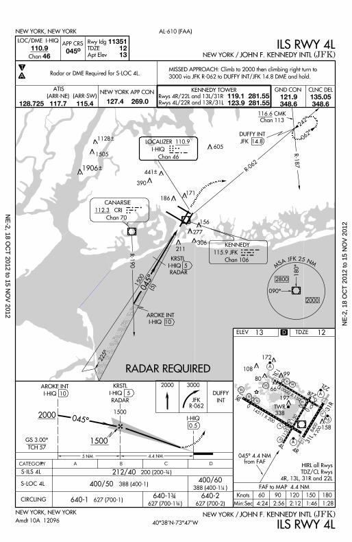
MISSED APPROACH: Cl imb to 2000 then c l imbing r ight turn to
3000 v ia JFK R-062 to DUFFY INT/JFK 14.8 DME and hold.
IHIQ
Rwy Idg
TDZE
Apt Elev
APP CRS
Chan
LOC/DME I -HIQ
5 NM
I -HIQ
(5)
225^
RADAR
AROKE INT
R-190
I -HIQ 10
RADAR REQUIRED
0.5
1801501209060Knots
Min:Sec
FAF to MAP 4.4 NM
4:24 2:56 2:12 1:46 1:28
AROKE INT
I-HIQ 10
Radar or DME Required for S-LOC 4L.
Amdt 10A 12096
KRSTL
I -HIQ 5
KRSTL
I -HIQ 5
RADAR
605
441
390
306
277
186171
156
CRI CANARSIE
112.3 CRI
Chan 70
211
D
1128
1505
1906
JFKR-062
CLNC DELGND CONNEW YORK APP CON KENNEDY TOWER
Rwys 4R/22L and 13L/31R
Rwys 4L/22R and 13R/31L
119.1 281.55123.9 281.55
ATIS
127.4 269.0121.9348.6
135.05348.6
(ARR-NE) (ARR-SW)
128.725 117.7 115.4
HIRL al l Rwys
TDZ/CL Rwys
4R, 13L, 31R and 22L
TDZE 12
40^38’N-73^47’W
NE
-2, 18 OC
T 2012 to 15 N
OV
2012N
E-2
, 18
OC
T 2
012
to 1
5 N
OV
201
2
10000 X 150 22L
22R
13L
H
H
H197
66
80
172
10899
V
A
A
P
P
TWR
338
13R
14511 X 200
P
P
4L4R
A 31L
158
A 5
31R
11351 X 150
H
8400X 200
H
X
ELEV
CATEGORY B C DA
540/50
640-1 627 (700-1 )
540/60
640-2627 (700-2)
213/18 200 (200- )
540/24 527 (600- )
640-1 627 (700-1)
12
3 4
3 4
2000
1500GS 3.00^
TCH 53
1500
IM
078^
258^
8400109.5
32045^ 13
13
T
A
IM
R-078
ALSF-2
A
I -JFK
1.6 045^
045^ 4.4 NM
from FAF
FAF to MAP 4.4 NM
Knots
Min:Sec 4:24
60
2:56
90 120
2:12 1:46
150 180
1:28
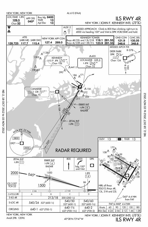
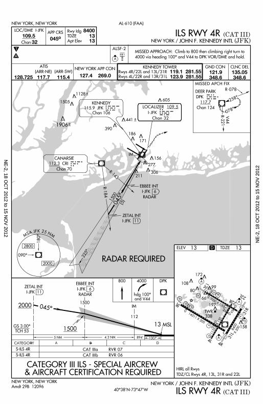
(JFK)JOHN F. KENNEDY INTLNEW YORK /
ILS RWY 4R
NEW YORK, NEW YORK
CIRCLING
S-LOC 4R
S-ILS 4R
4000800 DPK
5 NM 0.1
(JFK)JOHN F. KENNEDY INTLNEW YORK /
ILS RWY 4R
AL-610 (FAA)NEW YORK, NEW YORK
Chan
APP CRS
Rwy Idg
TDZE
Apt Elev
R-143
13
LOC/DME I -JFK
R-184
ZETAL INT
I-JFK 11
1500
(5)
RADAR REQUIRED
ZETAL INT
I -JFK 11
hdg 100^and V44
EBBEE INT
I-JFK 6
RADAR
EBBEE INT
I-JFK 6
RADAR
527 (600-1) 527 (600-1 ) 14
Amdt 29B 12096
12
045^
225^
180^
090^
2000
2800
MS A J F K 2 5 N M
R-221 V44
112.3 CRI
CANARSIE
Chan 70
LOCALIZER 109.5
I -JFK
Chan 32
KENNEDY
115.9 JFK
Chan 106
MISSED APPROACH: Cl imb to 800 then c l imbing r ight turn to
4000 v ia heading 100^ and V44 to DPK VOR/DME and hold.
MISSED APCH FIX
DEER PARK
DPK
117.7
Chan 124
DKP605
441
390
306
277
211
186 171
156
D
1128
1505
1906
CLNC DELGND CONNEW YORK APP CON KENNEDY TOWER
Rwys 4R/22L and 13L/31R
Rwys 4L/22R and 13R/31L
119.1 281.55123.9 281.55
ATIS
127.4 269.0121.9348.6
135.05348.6
(ARR-NE) (ARR-SW)
128.725 117.7 115.4
HIRL al l Rwys
TDZ/CL Rwys 4R,
13L, 31R and 22L
TDZE 13
4 .3 NM
40^38’N-73^47’W
NE
-2, 18 OC
T 2012 to 15 N
OV
2012N
E-2
, 18
OC
T 2
012
to 1
5 N
OV
201
2
10000 X 150 22L
22R
13L
H
H
H197
66
80
172
10899
V
A
A
P
P
TWR
338
13R
14511 X 200
P
P
4L4R
A 31L
158
A 5
31R
11351 X 150
H
8400X 200
H
X
ELEV
CATEGORY B C DA
2000
1500GS 3.00^
TCH 53
IMDH1500
5 NM 903 ’ 1007 ’
13
8400109.5
32045^
13 13
T
A
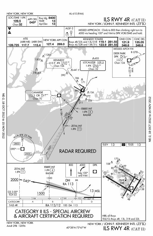
(CAT II)ILS RWY 4R(JFK)JOHN F. KENNEDY INTLNEW YORK, NEW YORK
(CAT II)ILS RWY 4R(JFK)JOHN F. KENNEDY INTL
AL-610 (FAA)NEW YORK, NEW YORK
APP CRS
Rwy Idg
TDZE
Apt ElevChan
S- ILS 4R
LOC/DME I -JFK
113
MSL
CATEGORY II ILS - SPECIAL AIRCREW& AIRCRAFT CERTIFICATION REQUIRED
13
ZETAL INT
I-JFK 11
EBBEE INT
I-JFK 6
RADAR
Amdt 29B 12096
ALSF-2
A
MISSED APPROACH: Cl imb to 800 then c l imbing r ight turn to
4000 v ia heading 100^ and V44 to DPK VOR/DME and hold.
NEW YORK /
NEW YORK /
4000800 DPK
hdg 100^and V44
RA
100 DA 113
078^
258^
IM
R-143
R-184
ZETAL INT
I-JFK 11
1500
(5)
RADAR REQUIRED
EBBEE INT
I-JFK 6
RADAR
045^
225^
180^
090^
2000
2800
MS A J F K 2 5 N M
R-221 V44
112.3 CRI
CANARSIE
Chan 70
LOCALIZER 109.5
I -JFK
Chan 32
KENNEDY
115.9 JFK
Chan 106
DEER PARK
DPK
117.7
Chan 124
DKP605
441
390
306
277
211
186
171
156
D
1128
1505
1906
RA 113/12
CLNC DELGND CONNEW YORK APP CON KENNEDY TOWER
Rwys 4R/22L and 13L/31R
Rwys 4L/22R and 13R/31L
119.1 281.55123.9 281.55
ATIS
127.4 269.0121.9348.6
135.05348.6
(ARR-NE) (ARR-SW)
128.725 117.7 115.4
HIRL al l Rwys
TDZ/CL Rwys 4R, 13L, 31R and 22L
TDZE 13
4 .3 NM
045^
40^38’N-73^47’W
MISSED APCH FIX
R-078
NE
-2, 18 OC
T 2012 to 15 N
OV
2012N
E-2
, 18
OC
T 2
012
to 1
5 N
OV
201
2
10000 X 150 22L
22R
13L
H
H
H197
66
80
172
10899
V
A
A
P
P
TWR
338
13R
14511 X 200
P
P
4L4R
A 31L
158
A 5
31R
11351 X 150
H
8400X 200
H
X
CATEGORY B C DA
ELEV
CAT I I Ia RVR 07
CAT I I Ib RVR 06
8400109.5
32045^
13 13
ILS RWY 4R (CAT III)
(JFK)JOHN F. KENNEDY INTLNEW YORK, NEW YORK
13
NEW YORK, NEW YORK AL-610 (FAA)
ILS RWY 4R (CAT III)(JFK)JOHN F. KENNEDY INTLChan
APP CRS
Rwy Idg
TDZE
Apt Elev
S-ILS 4R
S-ILS 4R
LOC/DME I -JFK
CATEGORY III ILS - SPECIAL AIRCREW& AIRCRAFT CERTIFICATION REQUIRED
Amdt 29B 12096
T
A
ALSF-2
A
MISSED APPROACH: Cl imb to 800 then c l imbing r ight turn to
4000 v ia heading 100^ and V44 to DPK VOR/DME and hold.
NEW YORK /
NEW YORK /
4000800 DPK
hdg 100^and V44
078^
258^
IM
R-143
R-184
ZETAL INT
I-JFK 11
1500
(5)
RADAR REQUIRED
EBBEE INT
I-JFK 6
RADAR
045^
225^
180^
090^
2000
2800
MS A J F K 2 5 N M
R-221 V44
112.3 CRI
CANARSIE
Chan 70
LOCALIZER 109.5
I -JFK
Chan 32
KENNEDY
115.9 JFK
Chan 106
DEER PARK
DPK
117.7
Chan 124
DKP605
441
390
306
277
211
186
171
156
D
1128
1505
1906
CLNC DELGND CONNEW YORK APP CON KENNEDY TOWER
Rwys 4R/22L and 13L/31R
Rwys 4L/22R and 13R/31L
119.1 281.55123.9 281.55
ATIS
127.4 269.0121.9348.6
135.05348.6
(ARR-NE) (ARR-SW)
128.725 117.7 115.4
HIRL al l Rwys
TDZ/CL Rwys 4R, 13L, 31R and 22L
TDZE 13
2000
1500GS 3.00^
TCH 53
IM1500
5 NM 894 ’ 1007 ’
MSL13
ZETAL INT
I-JFK 11
EBBEE INT
I-JFK 6
RADAR
4 .3 NM
045^
112
40^38’N-73^47’W
R-078
MISSED APCH FIX
NE
-2, 18 OC
T 2012 to 15 N
OV
2012N
E-2
, 18
OC
T 2
012
to 1
5 N
OV
201
2
10000 X 150 22L
22R
13L
H
H
H197
66
80
172
10899
V
A
A
P
P
TWR
338
13R
14511 X 200
P
P
4L4R
A 31L
158
A 5
31R
11351 X 150
H
8400X 200
H
X
RADAR REQUIRED
ELEV
CATEGORY B C DA
1500GS 3.00^
TCH 58
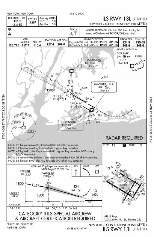
TELEX INT
I-TLK 7.7
S-ILS 13L
13
1800DH
150 DA 163
CATEGORY II ILS-SPECIAL AIRCREW& AIRCRAFT CERTIFICATION REQUIRED
NEW YORK, NEW YORK (JFK)JOHN F. KENNEDY INTLNEW YORK /
(CAT II)ILS RWY 13L
(CAT II)
1 .5 NM 1106 ’2007 ’
CLNC DEL
9095
GND CON
111.5
52Chan 135^
13 13
T
A
NEW YORK APP CON KENNEDY TOWER
Rwys 4R/22L and 13L/31R
Rwys 4L/22R and 13R/31L
119.1 281.55123.9 281.55
ALSF-2
ILS RWY 13L
NEW YORK, NEW YORK
(JFK)JOHN F. KENNEDY INTLNEW YORK /
AL-610 (FAA)
ATIS
127.4 269.0
600 4000 DPK
MSL
13151
Rwy Idg
TDZE
Apt Elev
APP CRS
LOC/DME I -TLK
CAXUN INT
I-TLK 6.1
1500135^
Amdt 16B 12096
MISSED APPROACH: Cl imb to 600 then c l imbing le f t
turn to 4000 d i rect to DPK VOR/DME and hold.
4 .1 NM
RA
A
TELEX INT
I-TLK 7.7
KENNEDY
115.9 JFK
Chan 106
JFK
258^
078^315^
CAXUN INT
I-TLK 6.1
R-078
1351500
(1.5)
LOCALIZER 111.5
I -TLK
Chan 52
LA GUARDIA
113.1 LGA
Chan 78
605
171186
156277
306
390
441
DEER PARK
DPK
117.7
Chan 124
DKPMISSED APCH FIX
211
R-209 R-193
D
1128
1505
1906
RA 151/16
NOTE: 99’ hangar abeam Rwy threshold 855’ le f t o f Rwy center l ine.
NOTE: 18’ fence abeam Rwy threshold 526’ r ight of Rwy center l ine.
NOTE: 43’ l ight 691’ af ter Rwy threshold 691’ r ight of Rwy center l ine, NW tax iway
B/U/V intersect ion.
NOTE: 58’ antenna and bui ld ing 1530’ af ter Rwy threshold 806’ le f t o f Rwy center l ine.
NOTE: 88’ hangar 4192’ af ter Rwy threshold 990’ le f t o f Rwy center l ine.
121.9348.6
135.05348.6
(ARR-NE) (ARR-SW)
128.725 117.7 115.4
HIRL al l Rwys
TDZ/CL Rwys 4R, 13L, 31R and 22L
TDZE 13
VGSI and ILS g l idepath not co inc ident
(VGSI Angle 2.75/TCH 66) .
40^38’N-73^47’W
MS A J F K 2 5 N M
090^
180^
2000
2800
NE
-2, 18 OC
T 2012 to 15 N
OV
2012N
E-2
, 18
OC
T 2
012
to 1
5 N
OV
201
2

10000 X 150 22L
22R
13L
H
H
H197
66
80
172
10899
V
A
A
P
P
TWR
338
13R
14511 X 200
P
P
4L4R
A 31L
158
A 5
31R
11351 X 150
H
8400X 200
H
X
CATEGORY B C DA
1800GS 3.00^
TCH 53
IM
891 ’ 5 .2 NM 5 .3 NM
S-ILS 22L
ILS RWY 22L
NEW YORK, NEW YORK (JFK)JOHN F. KENNEDY INTLNEW YORK /
Procedure Turn NA
(CAT II)
CATEGORY II ILS - SPECIAL AIRCREW& AIRCRAFT CERTIFICATION REQUIRED
13 MSL
959 ’
100 DA 113
ELEV
8400110.9
225^
T
A
13 13
30001800
500 3000
46
ILS RWY 22L
NEW YORK, NEW YORK
(JFK)JOHN F. KENNEDY INTLNEW YORK /
AL-610 (FAA)
13
Rwy Idg
TDZE
Apt Elev
APP CRS
Chan
LOC/DME I - IWY
225^
ZALPO INT
I- IWY 6.8
RADAR
ROSLY INT
I- IWY 12
RADAR
(CAT II)
DH
RA
ALSF-2
A
MISSED APPROACH: Cl imb to 500 then c l imbing le f t turn
to 3000 v ia JFK R-190 to CHANT INT/19 DME and hold.
113
R-2833000
283^
(15.1)
DEER PARK
117.7 DPK
Chan 124
IAF
LOCALIZER 110.9
I - IWY
Chan 46
R-190
180^
2800
2000
090^
MS A J F K 2 5 N M
ZALPO INT
I- IWY 6.8
RADAR
ROSLY INT
I- IWY 12
RADAR
(5.3)
1800
225^
045^
IM
010^
190^
CHANT INT
JFK 19
R-190
R-269
DPK
1505
605
441
390
306
277
211
186171
156
R-088
KENNEDY
115.9 JFK
Chan 106
MISSED
APCH FIX
115.9 JFKChan 106
113.8 RBV
Chan 85
D
CHANT
INT
1128
RA 113/12
JFKR-190
CLNC DELGND CONNEW YORK APP CON KENNEDY TOWER
Rwys 4R/22L and 13L/31R
Rwys 4L/22R and 13R/31L
119.1 281.55123.9 281.55
ATIS
127.4 269.0121.9348.6
135.05348.6
(ARR-NE) (ARR-SW)
128.725 117.7 115.4
HIRL al l Rwys
TDZ/CL Rwys 4R, 13L, 31R and 22L
TDZE 13
40^38’N-73^47’W
Simul taneous approach author ized wi th Rwy 22R.
12096
Amdt 24B 08MAR12
NE
-2, 18 OC
T 2012 to 15 N
OV
2012N
E-2
, 18
OC
T 2
012
to 1
5 N
OV
201
2
10000 X 150 22L
22R
13L
H
H
H197
66
80
172
10899
V
A
A
P
P
TWR
338
13R
14511 X 200
P
P
4L4R
A 31L
158
A 5
31R
11351 X 150
H
8400X 200
H
X
R-2833000
283^
(15.1)
DEER PARK
117.7 DPK
Chan 124
IAF
LOCALIZER 110.9
I - IWY
Chan 46
R-190
180^
2800
2000
090^
MS A J F K 2 5 N M
ZALPO INT
I- IWY 6.8
RADAR
ROSLY INT
I- IWY 12
RADAR
(5.3)
1800
225^
045^
IM
010^
190^
CHANT INT
JFK 19
R-190
R-269
DPK
1505
605
441
390
306
277
211
186171
156
R-088
8400110.9
225^
T
A
13 1346
ILS RWY 22L
NEW YORK, NEW YORK
(JFK)JOHN F. KENNEDY INTLNEW YORK/
AL-610 (FAA)
Rwy Idg
TDZE
Apt Elev
APP CRS
Chan
LOC/DME I - IWY (CAT III)
ALSF-2
A
MISSED APPROACH: Cl imb to 500 then c l imbing le f t turn
to 3000 v ia JFK R-190 to CHANT INT/19 DME and hold.
ELEV
IM
ILS RWY 22L(JFK)JOHN F. KENNEDY INTL
13
(CAT III)
NEW YORK /
CATEGORY B C DA
1800 GS 3.00^
TCH 53
1800
975 ’ 5 .2 NM 5 .3 NM
S-ILS 22L
500 3000
NEW YORK, NEW YORK
225^
CATEGORY III ILS - SPECIAL AIRCREW& AIRCRAFT CERTIFICATION REQUIRED
S-ILS 22L
13 MSL
959 ’
117
S-ILS 22L
KENNEDY
115.9 JFK
Chan 106
MISSED
APCH FIX
115.9 JFKChan 106
113.8 RBV
Chan 85
CAT I I Ia
CAT I I Ib
CAT I I Ic
RVR 07
RVR 06
NA
D
CHANT
INT
1128
JFKR-190
CLNC DELGND CONNEW YORK APP CON KENNEDY TOWER
Rwys 4R/22L and 13L/31R
Rwys 4L/22R and 13R/31L
119.1 281.55123.9 281.55
ATIS
127.4 269.0121.9348.6
135.05348.6
(ARR-NE) (ARR-SW)
128.725 117.7 115.4
HIRL al l Rwys
TDZ/CL Rwys 4R, 13L, 31R and 22L
TDZE 13
40^38’N-73^47’W
Procedure Turn NA
ROSLY INT
I- IWY 12
RADAR
ZALPO INT
I- IWY 6.8
RADAR
Simul taneous approach author ized wi th Rwy 22R.
12096
Amdt 24B 08MAR12
3000
NE
-2, 18 OC
T 2012 to 15 N
OV
2012N
E-2
, 18
OC
T 2
012
to 1
5 N
OV
201
2
10000 X 150 22L
22R
13L
H
H
H197
66
80
172
10899
V
A
A
P
P
TWR
338
13R
14511 X 200
P
P
4L4R
A 31L
158
A 5
31R
11351 X 150
H
8400X 200
H
X
ELEV
CATEGORY B C DA
T
A
3000
1900 GS 3.00^
TCH 59
5 .7 NM
MATTR
I-JOC 5
RADAR
1900
460/60
640-1
460-1
640-2
447 (500-1 )
627 (700-1 )
447 (500-1 )
627 (700-2)640-1
460/50
263/40 250 (300- )
627 (700-1)
447 (500-1)1
2
12
S-ILS 22R
S-LOC 22R
CIRCLING
ILS RWY 22R
NEW YORK, NEW YORK
NEW YORK, NEW YORK
(JFK)JOHN F. KENNEDY INTLNEW YORK /
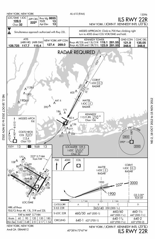
CORVT
I-JOC 10.1
RADAR
LOC/DME
LOC/DME I -JOC
Chan
222^
5 .1 NM
CORVT
I-JOC 10.1
RADAR
190^
010^
R-010
MS A J F K 2 5 N M
090^
180^
KENNEDY
115.9 JFK
Chan 106
LOCALIZER 109.5
I -JOC
Chan 32
RADAR REQUIRED
8655109.5
222^ 13 13
32
222^ 5.7 NMfrom FAF
700 4000 COL
ILS RWY 22R(JFK)JOHN F. KENNEDY INTLNEW YORK /
AL-610 (FAA)
13 2000
2800
222^
042^
APP CRS
Rwy Idg
TDZE
Apt Elev
1900 (5.1)
MATTR
I-JOC 5
RADAR
MISSED APPROACH: Cl imb to 700 then c l imbing r ight
turn to 4000 d i rect COL VOR/DME and hold.
1801501209060Knots
Min:Sec
FAF to MAP 5.7 NM
5:42 3:48 2:51 2:17 1:54
COLTS NECK
COL
115.4
Chan 101
COL
605
441
390
306
277
211
186171
156
D
1505
1128
1906
83MISSED APCH
FIX
CLNC DELGND CONNEW YORK APP CON KENNEDY TOWER
Rwys 4R/22L and 13L/31R
Rwys 4L/22R and 13R/31L
119.1 281.55123.9 281.55
ATIS
127.4 269.0121.9348.6
135.05348.6
(ARR-NE) (ARR-SW)
128.725 117.7 115.4
HIRL al l Rwys
TDZ/CL Rwys 4R, 13L, 31R and 22L
TDZE 13
40^38’N-73^47’W
12096
Amdt 2A 08MAR12
Simul taneous approach author ized wi th Rwy 22L.
34
14
34
34
NE
-2, 18 OC
T 2012 to 15 N
OV
2012N
E-2
, 18
OC
T 2
012
to 1
5 N
OV
201
2
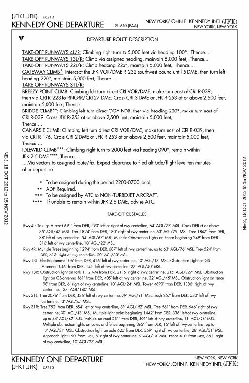
KENNEDY ONE DEPARTURE
KENNEDY ONE DEPARTURE
(JFK)
(JFK)NEW YORK, NEW YORK
NEW YORK, NEW YORK
JOHN F. KENNEDY INTL
JOHN F. KENNEDY INTLNEW YORK/
NEW YORK/
SL-610 (FAA)
T
*
** *
** *
*
*
*
TAKE-OFF OBSTACLES:
Rwy 4L: Taxi ing Ai rcraf t 691’ f rom DER, 390’ le f t or r ight of rwy center l ine, 64’ AGL/77’ MSL. Cross DER at or above
35 ’ AGL/47’ MSL. Tree 1824’ f rom DER, 180’ r ight of rwy center l ine, 63’ AGL/79’ MSL. Tree 1847’ f rom DER,
88 ’ le f t o f rwy center l ine, 54’ AGL/67’ MSL. Mul t ip le Obstruct ion L ights on Fence beginning 249’ f rom DER,
316’ le f t o f rwy center l ine, 10’ AGL/22’ MSL.
Rwy 4R: Mul t ip le Trees beginning 1294’ f rom DER, 687’ le f t o f rwy center l ine, up to 63’ AGL/76’ MSL. Tree 524’ f rom
DER, 613’ r ight of rwy center l ine, 20’ AGL/33’ MSL.
Rwy 13L: Elec Equipment 106’ f rom DER, 416’ le f t o f rwy center l ine, 10’ AGL/17’ MSL. Obstruct ion L ight on GS
Antenna 1046’ f rom DER, 141’ le f t o f rwy center l ine, 27’ AGL/40’ MSL.
Rwy 13R: Obstruct ion l ight on tank 1.12 NM from DER, 2116’ r ight of rwy center l ine, 215’ AGL/227’ MSL. Obstruct ion
l ight on GS antenna 361’ f rom DER, 405’ le f t o f rwy center l ine, 32’ AGL/45’ MSL. Obstruct ion l ight on fence
98 ’ f rom DER, 6 ’ r ight of rwy center l ine, 10’ AGL/24’ MSL. Tower 4690’ f rom DER, 1386’ r ight of rwy
center l ine, 127’ AGL/140’ MSL.
Rwy 31L: Tree 2076’ f rom DER, 436’ le f t o f rwy center l ine, 79’ AGL/91’ MSL. Bush 257’ f rom DER, 530’ le f t o f rwy
center l ine, 13’ AGL/25’ MSL.
Rwy 31R: Tree 752’ f rom DER, 654’ le f t o f rwy center l ine, 39’ AGL/ 52’ MSL. Tree 561’ f rom DER, 646’ r ight of rwy
center l ine, 30’ AGL/43’ MSL. Mul t ip le l ight poles beginning 1442’ f rom DER, 336’ le f t o f rwy center l ine,
up to 44’ AGL/67’ MSL. Vehic le on road 281’ f rom DER, 501’ le f t o f rwy center l ine, 15’ AGL/26’ MSL.
Mul t ip le obstruct ion l ights on poles and fence beginning 365’ f rom DER, 15’ le f t o f rwy center l ine, up to
17 ’ AGL/31’ MSL. Obstruct ion l ight on pole 625’ f rom DER, 359’ r ight of rwy center l ine, 28’ AGL/31’ MSL.
Approach l ight 190’ f rom DER, 8 ’ r ight of rwy center l ine, 5 ’ AGL/18’ MSL. Fence 410’ f rom DER, 352’ r ight
o f rwy center l ine, 10’ AGL/23’ MSL.
DEPARTURE ROUTE DESCRIPTION
TAKE-OFF RUNWAYS 4L/R: Climbing right turn to 5,000 feet via heading 100^, Thence....
TAKE-OFF RUNWAYS 13L/R: Climb via assigned heading, maintain 5,000 feet, Thence....
TAKE-OFF RUNWAYS 22L/R: Climb heading 225^, maintain 5,000 feet, Thence....
GATEWAY CLIMB : Intercept the JFK VOR/DME R-232 southwest bound unti l 5 DME, then turn left
heading 220^, maintain 5,000 feet, Thence....
TAKE-OFF RUNWAYS 31L/R:
BREEZY POINT CLIMB: Climbing left turn direct CRI VOR/DME, make turn east of CRI R-039,
then via CRI R-223 to RNGRR/CRI 27 DME. Cross CRI 3 DME or JFK R-253 at or above 2,500 feet,
maintain 5,000 feet, Thence....
BRIDGE CLIMB : Climbing left turn direct OGY NDB, then via heading 220^, make turn east of
CRI R-039. Cross JFK R-253 at or above 2,500 feet, maintain 5,000 feet,
Thence....
CANARSIE CLIMB: Climbing left turn direct CRI VOR/DME, make turn east of CRI R-039, then
via CRI R-176. Cross CRI 2 DME or JFK R-253 at or above 2,500 feet, maintain 5,000 feet,
Thence....
IDLEWILD CLIMB : Climbing right turn to 2000 feet via heading 090^, remain within
JFK 2.5 DME , Thence....
. . . .Via vectors to assigned route/f ix. Expect clearance to f i led alt i tude/f l ight level ten minutes
after departure.
To be assigned during the period 2200-0700 local.
ADF Required.
To be assigned by ATC to NON-TURBOJET AIRCRAFT.
I f unable to remain within JFK 2.5 DME, advise ATC.
**
***
****
*
08213(JFK1.JFK)
08213(JFK1.JFK)
NE
-2, 18 OC
T 2012 to 15 N
OV
2012N
E-2
, 18
OC
T 2
012
to 1
5 N
OV
201
2
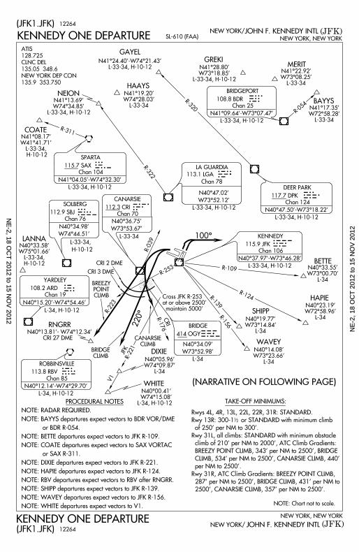
CRIR-176
R-039
R-223
R-253
220^
100^
CRI 2 DME
CANARSIECLIMB
BRIDGECLIMB
SHIPP
DIXIE
115.9 JFK
Chan 106
KENNEDY
112.3 CRI
Chan 70
CANARSIE
BRIDGE
414 OGY
N40^34.09’
W73^52.98’
L-34
R-109
R-124
OGY
R-139
R-156
R-221JFK
V1
WHITE
NOTE: Chart not to scale.
TAKE-OFF MINIMUMS:
113.8 RBV
Chan 85
115.7 SAX
Chan 104
SPARTA
108.8 BDR
Chan 25
117.7 DPK
Chan 124
GREKIMERIT
N41^22.92’W73^08.25’
L-33-34
BRIDGEPORT BDR
SAX
LANNA
108.2 ARD
Chan 19
YARDLEY
N40^15.20’ -W74^54.46’
ARD
ROBBINSVILLE RBV
DEER PARK DPK113.1 LGA
Chan 78
LA GUARDIA LGA
BAYYSN41^17.35’
W72^58.28’L-33-34
GAYEL
HAAYSNEION
COATE
R-054
R-320
R-322
R-311
BETTE
HAPIE
WAVEY
CRI
KENNEDY ONE DEPARTURE
KENNEDY ONE DEPARTURE
(JFK)
(JFK)NEW YORK, NEW YORK
NEW YORK, NEW YORK
JOHN F. KENNEDY INTL
JOHN F. KENNEDY INTLNEW YORK/
NEW YORK/
SL-610 (FAA)
JFKN40^36.75’
W73^53.67’
CRI 3 DME
N41^09.64’ -W73^07.47’
L-33-34, H-10-12
N41^28.80’W73^18.85’
L-33-34, H-10-12
N40^37.97’ -W73^46.28’
L-33-34, H-10-12
12
112.9 SBJ
Chan 76
SOLBERG SBJN40^34.98’
W74^44.51’
Rwys 4L, 4R, 13L, 22L, 22R, 31R: STANDARD.
Rwy 13R: 300-1 or STANDARD with minimum cl imb
of 250’ per NM to 300’ .
Rwy 31L, al l c l imbs: STANDARD with minimum obstacle
c l imb of 210’ per NM to 2000’, ATC Cl imb Gradients:
BREEZY POINT CLIMB, 343’ per NM to 2500’ , BRIDGE
CLIMB, 534’ per NM to 2500’ , CANARSIE CLIMB, 440’
per NM to 2500’ .
Rwy 31R, ATC Cl imb Gradients: BREEZY POINT CLIMB,
287’ per NM to 2500’, BRIDGE CLIMB, 431’ per NM to
2500’ , CANARSIE CLIMB, 357’ per NM to 2500’ .
RNGRR
BREEZYPOINT
CLIMB
N41^24.40’ -W74^21.43’L-33-34, H-10-12
PROCEDURAL NOTES
NOTE: RADAR REQUIRED.
NOTE: BAYYS departures expect vectors to BDR VOR/DME
or BDR R-054.
NOTE: BETTE departures expect vectors to JFK R-109.
NOTE: COATE departures expect vectors to SAX VORTAC
or SAX R-311.
NOTE: DIXIE departures expect vectors to JFK R-221.
NOTE: HAPIE departures expect vectors to JFK R-124.
NOTE: RBV departures expect vectors to RBV after RNGRR.
NOTE: SHIPP departures expect vectors to JFK R-139.
NOTE: WAVEY departures expect vectors to JFK R-156.
NOTE: WHITE departures expect vectors to V1.
12264
(NARRATIVE ON FOLLOWING PAGE)
Cross JFK R-253 at or above 2500’ mainta in 5000’
N40^12.14’ -W74^29.70’
L-34, H-10-12
N41^19.20’W74^28.03’
L-33-34N41^13.69’
W74^34.85’L-33-34, H-10-12
N41^08.17’W41^41.71’
L-33-34, H-10-12
N40^33.58’W75^01.66’
L-33-34,H-10-12
N40^05.96’W74^09.87’
L-34
N40^00.41’ W74^15.08’L-34, H-10-12
N40^14.08’W73^23.66’
L-34
N40^19.77’W73^14.84’
L-34
N40^23.19’W72^58.96’
L-34
N40^33.55’W73^00.70’
L-34
N40^47.50’ -W73^18.22’
L-33-34, H-10-12
N40^47.02’
W73^52.12’
L-33-34, H-10-12
L-33-34
N41^04.05’ -W74^32.30’
L-33-34, H-10-12
L-33-34,
H-10-12
L-34, H-10-12
N40^13.81’ - W74^12.34’CRI 27 DME
(JFK1.JFK)
12264(JFK1.JFK)
ATIS
128.725
CLNC DEL
135.05 348.6
NEW YORK DEP CON
135.9 353.750
NE
-2, 18 OC
T 2012 to 15 N
OV
2012N
E-2
, 18
OC
T 2
012
to 1
5 N
OV
201
2
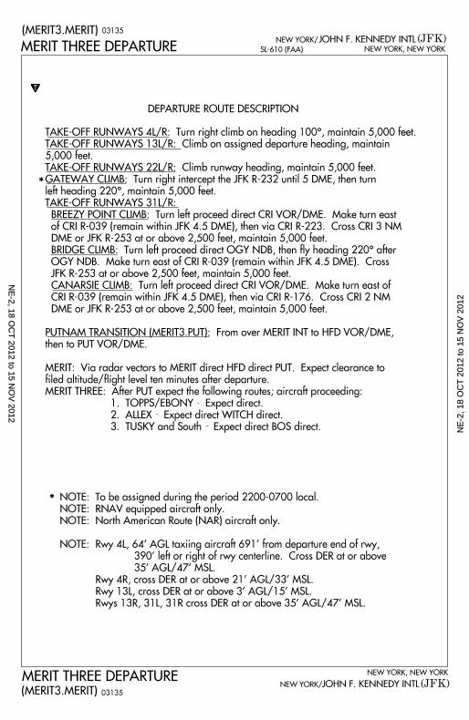
MERIT THREE DEPARTURE NEW YORK, NEW YORK
JOHN F. KENNEDY INTL (JFK)SL-610 (FAA)
NEW YORK/
(MERIT3.MERIT)
NEW YORK, NEW YORK
JOHN F. KENNEDY INTLNEW YORK/ (JFK)MERIT THREE DEPARTURE
(MERIT3.MERIT)
T
DEPARTURE ROUTE DESCRIPTION
*
*
03135
03135
TAKE-OFF RUNWAYS 4L/R: Turn right climb on heading 100^, maintain 5,000 feet.
TAKE-OFF RUNWAYS 13L/R: Climb on assigned departure heading, maintain
5,000 feet.
TAKE-OFF RUNWAYS 22L/R: Climb runway heading, maintain 5,000 feet.
GATEWAY CLIMB: Turn right intercept the JFK R-232 until 5 DME, then turn
left heading 220^, maintain 5,000 feet.
TAKE-OFF RUNWAYS 31L/R:
BREEZY POINT CLIMB: Turn left proceed direct CRI VOR/DME. Make turn east
of CRI R-039 (remain within JFK 4.5 DME), then via CRI R-223. Cross CRI 3 NM
DME or JFK R-253 at or above 2,500 feet, maintain 5,000 feet.
BRIDGE CLIMB: Turn left proceed direct OGY NDB, then fly heading 220^ after
OGY NDB. Make turn east of CRI R-039 (remain within JFK 4.5 DME). Cross
JFK R-253 at or above 2,500 feet, maintain 5,000 feet.
CANARSIE CLIMB: Turn left proceed direct CRI VOR/DME. Make turn east of
CRI R-039 (remain within JFK 4.5 DME), then via CRI R-176. Cross CRI 2 NM
DME or JFK R-253 at or above 2,500 feet, maintain 5,000 feet.
PUTNAM TRANSITION (MERIT3.PUT): From over MERIT INT to HFD VOR/DME,
then to PUT VOR/DME.
MERIT: Via radar vectors to MERIT direct HFD direct PUT. Expect clearance to
filed altitude/fl ight level ten minutes after departure.
MERIT THREE: After PUT expect the following routes; aircraft proceeding:
1. TOPPS/EBONY Expect direct.
2. ALLEX Expect direct WITCH direct.
3. TUSKY and South Expect direct BOS direct.
-
-
-
NOTE: To be assigned during the period 2200-0700 local.
NOTE: RNAV equipped aircraft only.
NOTE: North American Route (NAR) aircraft only.
NOTE: Rwy 4L, 64’ AGL taxiing aircraft 691’ from departure end of rwy,
390’ left or right of rwy centerline. Cross DER at or above
35’ AGL/47’ MSL.
Rwy 4R, cross DER at or above 21’ AGL/33’ MSL.
Rwy 13L, cross DER at or above 3’ AGL/15’ MSL.
Rwys 13R, 31L, 31R cross DER at or above 35’ AGL/47’ MSL.
NE
-2, 18 OC
T 2012 to 15 N
OV
2012N
E-2
, 18
OC
T 2
012
to 1
5 N
OV
201
2
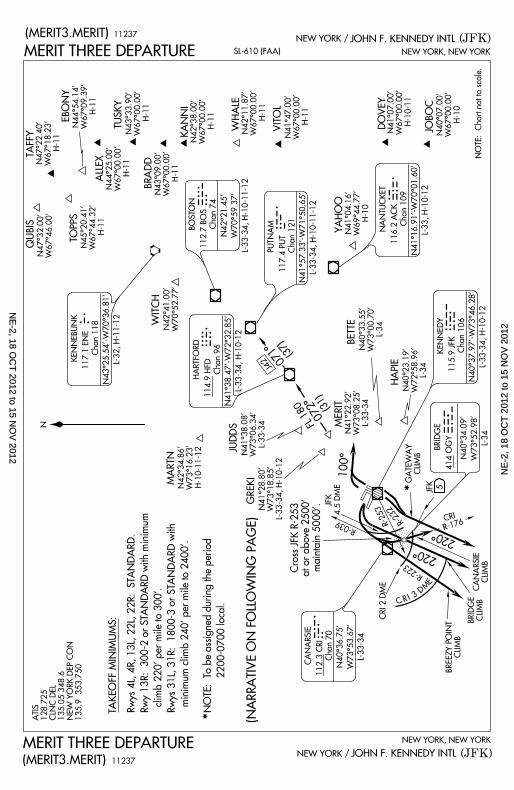
TAKEOFF MINIMUM
S:
Rwys 4L, 4R, 13L,
22L, 22R: STAND
ARD.
Rwy 13R: 300-2 or
STANDARD with m
inimum
climb 220’ per mil
e to 300’.
Rwys 31L, 31R: 18
00-3 or STANDARD
with
minimum climb 24
0’ per mile to 2400
’.
NOTE: To be assi
gned during the pe
riod
2200-0700
local.
R-176
R-223
R-039
R-253 R-232 CRI
C R I 3D
M
E
CRI 2 DME
BREEZY POINT
CLIMB
BRIDGE CLIMBCANARS
IECLIMB
GATEWAY
CLIMB
5JFK
JFK4.5 DME
Cross JFK R-253
at or above 2500’ maintain
5000’.
220^
220^
100^
112.3 CRI
Chan 70
CANARSIE
BRIDGE
414 OGY
NOTE: Chart not t
o scale.
TAFFY
EBONY
TUSKY
KANNI
WHALE VITOLN41^47.0
0’W67^00.0
0’H-11
DOVEY JOBOC N40^07.00’
W67^00.00’
H-10
QUBIS
ALLEX
BRADD
TOPPS
114.9 HFD
Chan 96
HARTFORD
117.1 ENE
Chan 118
KENNEBUNK
WITCH
117.4 PUT
Chan 121
112.7 BOS
Chan 74BOSTON
H F D
E N E
B O S
PUTNAMP U T
116.2 ACK
Chan 109
NANTUCKET
A C K
YAHOO
115.9 JFK
Chan 106KENNEDY
O G YJ F K
HAPIE
BETTE
MERITN41^22.9
2’W73^08.2
5’L-33-34
072^FL 180
(31)
071^(37)
J42
GREKI
JUDDS
MARTN
MERIT THREE DEPARTURE(MERIT3.MERIT)
MERIT THREE DEPARTURE
(MERIT3.MERIT)
C R I
*
*
11237
11237
N41^04.16’
W69^44.77’
H-10
N40^34.09’
W73^52.98’
L-34
N41^07.00’
W67^00.00’
H-10-11
N41^38.08’
W73^06.34’
L-33-34
N42^21.45’
W70^59.37’
L-33-34, H-10-11-
12
N41^28.80’
W73^18.85’
L-33-34, H-10-12
N41^57.33’-W71^5
0.65’ L-33-34, H-10-11-
12
N41^16.91’-W70^0
1.60’
L-33, H-10-12
N40^37.97’-W73^4
6.28’
L-33-34, H-10-12
SL-610 (FAA)
(JFK)NEW YORK, NEW YORK
JOHN F. KENNEDY INTLNEW YORK /
(JFK)
NEW YORK, NEW YORK
JOHN F. KENNEDY INTLNEW YORK /
N40^33.55’
W73^00.70’
L-34
N40^23.19’
W72^58.96’
L-34
N40^36.75’
W73^53.67’
L-33-34
N43^25.54’-W70^3
6.81’
L-32, H-11-12
N42^34.86’
W73^16.23’ H-10-11-
12
N42^41.00’
W70^52.77’
N47^32.00’
W67^46.00’
N47^22.40’
W67^18.23’
H-11
N44^54.14’
W67^09.39’
H-11N45^20.4
1’W67^44.3
2’H-11
N44^25.00’
W67^00.00’
H-11N43^33.9
0’W67^00.0
0’H-11
N43^09.00’
W67^00.00’
H-11
N42^38.00’
W67^00.00’
H-11
N42^11.87’
W67^00.00’
H-11
(NARRATIVE ON F
OLLOWING PAGE)
ATIS 128.725 CLNC DEL
135.05 348.6
NEW YORK DEP CO
N135.9 35
3.750
N41^38.47’-W72^3
2.85’
L-33-34, H-10-12
N
NE
-2, 18 OC
T 2012 to 15 N
OV
2012N
E-2
, 18
OC
T 2
012
to 1
5 N
OV
201
2
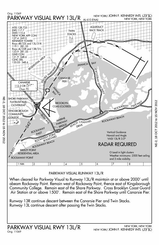
1 NM 2 3 4 5 6 7 8
PARKWAY VISUAL RUNWAY 13L/R
When cleared for Parkway Visual to Runway 13L/R maintain at or above 2000’ until
abeam Rockaway Point. Remain west of Rockaway Point, thence east of Kingsborough
Community College. Remain east of the Shore Parkway. Cross Brooklyn Coast Guard
Air Station at or above 1500’. Remain east of the Shore Parkway until Canarsie Pier.
Runway 13R continue descent between the Canarsie Pier and Twin Stacks.
Runway 13L continue descent after passing the Twin Stacks.
RADAR REQUIRED
Vert ica l Guidance
Navaid and Angle
VASI 13L/R 3.0^
O Lead- in l ight c lusters
Weather min imums: 2500 feet ce i l ing
and 3 mi le v is ib i l i ty .
FLATBUSH AVE
ROCKAWAY POINT BOULEVARD
ROCKAWAY BEACH
KINGSBOROUGH
COMMUNITY
COLLEGE
R-223
043
ROCKAWAYINLET
MARINE
PARKWAY
BRIDGE
BROOKLYN
CGAS (CLOSED)JAMAICA
BAY
041
B E A C H C H A N N E L
DRIVE
ROCKAWAY BEACH
ROCKAWAY F R E E W
AY
CANARSIE
PIER
JAMAICA BAYC
RO
SS
BA
Y
PA
RK
WA
Y
RESIDENTIAL AREA
SH
OR E
P A
R KW
AY
TWIN
STACKS
AQUEDUCT
RACE TRACK
SHORE PARKWAY
FLATBUSH AVE
CLOVERLEAF
CANARSIE
112.3 CRI
Chan 70
CRI
(JFK)PARKWAY VISUAL RWY 13L/R NEW YORK, NEW YORK
JOHN F. KENNEDY INTLNEW YORK/
(JFK)AL-610 (FAA)PARKWAY VISUAL RWY 13L/R
JOHN F. KENNEDY INTLNEW YORK, NEW YORK
NEW YORK/
BREEZY POINT
RESIDENTIAL AREA
ROCKAWAY POINT
Orig 11069
Orig 11069
ATIS 128.725(NE) 117.7(SW) 115.4NEW YORK APP CON127.4 269.0KENNEDY TOWERRwys 4R/22L and 13L/31R119.1 281.55Rwys 4L/22R and 13R/31L123.9 281.55GND CON121.9 348.6CLNC DEL135.05 348.6
NE
-2, 18 OC
T 2012 to 15 N
OV
2012N
E-2
, 18
OC
T 2
012
to 1
5 N
OV
201
2
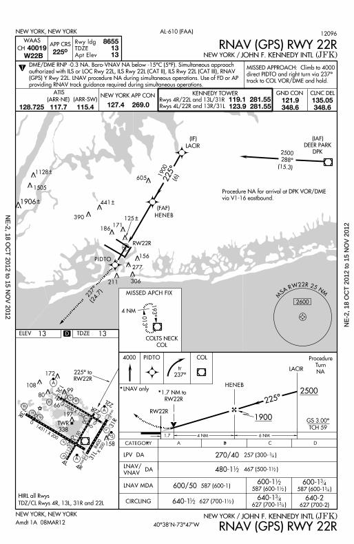
10000 X 150 22L
22R
13L
H
H
H197
66
80
172
10899
V
A
A
P
P
TWR
338
13R
14511 X 200
P
P
4L4R
A 31L
158
A 5
31R
11351 X 150
H
8400X 200
H
X
CATEGORY B C DA
NEW YORK, NEW YORK (JFK)JOHN F. KENNEDY INTLNEW YORK /
RNAV (GPS) RWY 22R
225^ to
RW22R
600/50
480-1
640-2627 (700-2)
LNAV MDA
CIRCLING
RW22R
627 (700-1 )
640-1
467 (500-1 )
640-1 627 (700-1 )
4000
LACIR
ELEV
T
NEW YORK, NEW YORK
(JFK)JOHN F. KENNEDY INTLNEW YORK /
AL-610 (FAA)
13
APP CRS
RNAV (GPS) RWY 22R225^
Rwy ldg
TDZE
Apt Elev
86551313
COL
12
12
587 (600-1)587 (600-1 )
600-1 587 (600-1 )
600-1 12
12
12
12
1 .7
2500
1900
225^
GS 3.00^
TCH 59
PIDTO
4 NM
LNAV/
VNAV DA
HENEB
LPV DA 270/40 257 (300- )
WAAS
40019CH
W22B
6 NM
M
S A R W 2 2 R 2 5 NM
2600
RW22R
LACIR
193^
013^
COLTS NECK
COL
225^
( IAF)
DEER PARK
DPK
4 NM
(FAF)
HENEB
PIDTO
Procedure NA for arr iva l at DPK VOR/DME
via V1-16 eastbound.
2500
288^
(15.3)1900
(6)
( IF)
125
MISSED APCH FIX
237^(24.7)
605
441
390
306
277
211
186171
156
D
1128
1505
1906
t r
237^
Procedure
Turn
NA
CLNC DELGND CONNEW YORK APP CON KENNEDY TOWER
Rwys 4R/22L and 13L/31R
Rwys 4L/22R and 13R/31L
119.1 281.55123.9 281.55
ATIS
127.4 269.0121.9348.6
135.05348.6
(ARR-NE) (ARR-SW)
128.725 117.7 115.4
HIRL al l Rwys
TDZ/CL Rwys 4R, 13L, 31R and 22L
TDZE 13
40^38’N-73^47’W
LNAV only*1.7 NM to
RW22R*
Amdt 1A 08MAR12
12096
MISSED APPROACH: Cl imb to 4000
direct PIDTO and r ight turn v ia 237^
track to COL VOR/DME and hold.
DME/DME RNP -0.3 NA. Baro-VNAV NA below -15^C (5^F). Simul taneous approach
author ized wi th ILS or LOC Rwy 22L, ILS Rwy 22L (CAT I I ) , ILS Rwy 22L (CAT I I I ) , RNAV
(GPS) Y Rwy 22L. LNAV procedure NA dur ing s imul taneous operat ions. Use of FD or AP
provid ing RNAV t rack guidance requi red dur ing s imul taneous operat ions.
34
34
34
34
34
NE
-2, 18 OC
T 2012 to 15 N
OV
2012N
E-2
, 18
OC
T 2
012
to 1
5 N
OV
201
2
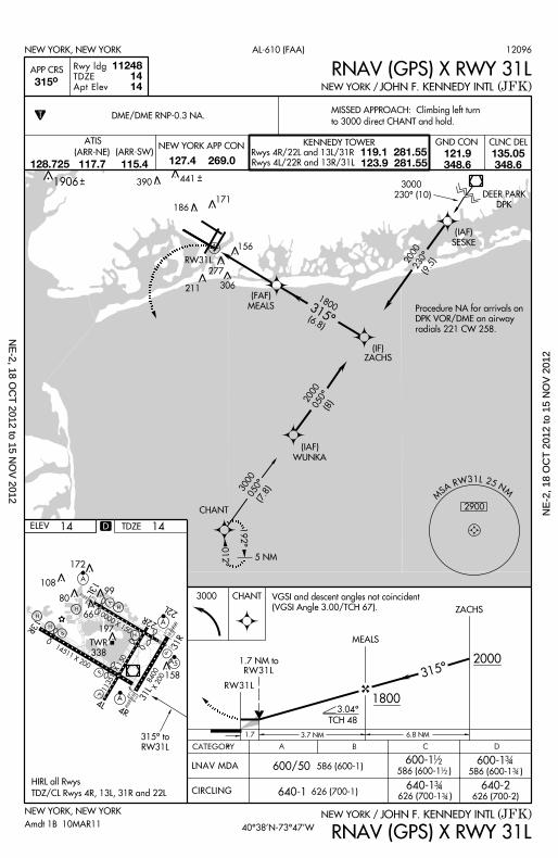
10000 X 150 22L
22R
13L
H
H
H197
66
80
172
10899
V
A
A
P
P
TWR
338
13R
14511 X 200
P
P
4L4R
A 31L
158
A 5
31R
11351 X 150
H
8400X 200
H
X
CATEGORY B C DA
NEW YORK, NEW YORK (JFK)JOHN F. KENNEDY INTLNEW YORK /
600/50
640-2626 (700-2)
LNAV MDA
CIRCLING
1800
MEALS
1 .7 3 .7 NM
315^
6 .8 NM
640-1
ZACHS
ELEV
T
NEW YORK, NEW YORK
(JFK)JOHN F. KENNEDY INTLNEW YORK /
AL-610 (FAA)
14
APP CRS 315^
Rwy ldg
TDZE
Apt Elev
586 (600-1 )
112481414
CHANT
DEER PARK
DPK
(IAF)
SESKE
(IAF)
WUNKA
315^
5 NM
012^
192^
3000050^
(7.8)
1800
(6.8)
2000050^ (8)
3000 CHANT
2000
586 (600-1)600-1
586 (600-1 )
600-1 12
12
3 4
3 4
(FAF)
MEALS
2000230^
(9.5)
1 .7 NM to
RNAV (GPS) X RWY 31L
RNAV (GPS) X RWY 31L
3 .04^
TCH 48
RW31L
RW31L
626 (700-1)640-1
626 (700-1 )
306
171
156
315^ to
RW31L
390
DME/DME RNP-0.3 NA.
3 43 4
( IF)ZACHS
Procedure NA for arr iva ls on
DPK VOR/DME on a i rway
radia ls 221 CW 258.
MISSED APPROACH: Cl imbing le f t turn
to 3000 d i rect CHANT and hold.
277
RW31L
186
211
12096
Amdt 1B 10MAR11
D
1906
40^38’N-73^47’W
VGSI and descent angles not co inc ident
(VGSI Angle 3.00/TCH 67) .
TDZE 14
3000
230^ (10)
HIRL a l l Rwys
TDZ/CL Rwys 4R, 13L, 31R and 22L
CLNC DELGND CONNEW YORK APP CON KENNEDY TOWER
Rwys 4R/22L and 13L/31R
Rwys 4L/22R and 13R/31L
119.1 281.55123.9 281.55
ATIS
127.4 269.0121.9348.6
135.05348.6
(ARR-NE) (ARR-SW)
128.725 117.7 115.4
441
2900
M
S A R W 3 1 L 2 5 NM
NE
-2, 18 OC
T 2012 to 15 N
OV
2012N
E-2
, 18
OC
T 2
012
to 1
5 N
OV
201
2
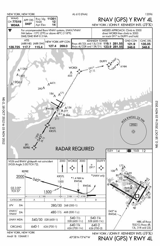
10000 X 150 22L
22R
13L
H
H
H197
66
80
172
10899
V
A
A
P
P
TWR
338
13R
14511 X 200
P
P
4L4R
A 31L
158
A 5
31R
11351 X 150
H
8400X 200
H
X
REPRE
RW04L
1.4 NM to
RW04L
LNAV only
NEW YORK, NEW YORK (JFK)JOHN F. KENNEDY INTLNEW YORK /
045^ to
RW04L
540/50
640-1
528 (600-1 )
640-2626 (700-2)
LNAV MDA
CIRCLING
528 (600-1)540-1 540-1
528 (600-1 )
12
12
3 4
3 4
626 (700-1 )
640-1 3 4
3 4
LNAV/
VNAV
DA
CATEGORY B C DA
280/50 268 (300-1)
480-1 12 468 (500-1 ) 1
2
ELEV
T
NEW YORK, NEW YORK
(JFK)JOHN F. KENNEDY INTLNEW YORK /
AL-610 (FAA)
14
APP CRS
MS A R W 0 4 L 2 5 N
M
2900
RADAR REQUIRED
Rwy ldg
TDZE
Apt Elev
113511214
REPRE
WORDI
DUFFY 244^
064^
RW04L
4 NM
045^
KRSTL
(FAF)
605
306
277
186 171
156
WAAS
77519CH
W04A 045^
GS 3.00^
TCH 57
2000
1500
045^ **KRSTL
(IF)
1500 (6.1)
6 .1 NM
390
441
211
RNAV (GPS) Y RWY 4L
RNAV (GPS) Y RWY 4L
For uncompensated Baro-VNAV systems, LNAV/VNAV
NA below -15^C (5^F) or above 48^C (118^F).
DME/DME RNP-0.3 NA.
626 (700-1)
LPV DA
D
1128
1505
1906
CLNC DELGND CONNEW YORK APP CON KENNEDY TOWER
Rwys 4R/22L and 13L/31R
Rwys 4L/22R and 13R/31L
119.1 281.55123.9 281.55
ATIS
127.4 269.0121.9348.6
135.05348.6
(ARR-NE) (ARR-SW)
128.725 117.7 115.4
HIRL al l Rwys
TDZ/CL Rwys 4R,
13L, 31R and 22L
2000 WORDI 3000
tr 091^
DUFFY
3 NM
1500
40^38’N-73^47’WAmdt 1B 10MAR11
12096
TDZE 12
091^
(7.1)
VGSI and RNAV gl idepath not co inc ident
(VGSI Angle 3.00/TCH 72) .
14
1 .4 NM
MISSED APPROACH: Cl imb to 2000
d i rect WORDI then c l imb to 3000
on t rack 091^ to DUFFY and hold.
NE
-2, 18 OC
T 2012 to 15 N
OV
2012N
E-2
, 18
OC
T 2
012
to 1
5 N
OV
201
2
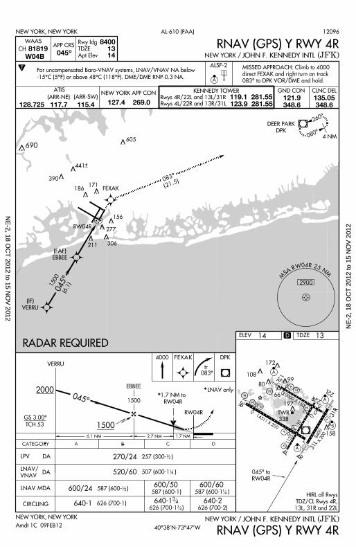
10000 X 150 22L
22R
13L
H
H
H197
66
80
172
10899
V
A
A
P
P
TWR
338
13R
14511 X 200
P
P
4L4R
A 31L
158
A 5
31R
11351 X 150
H
8400X 200
H
X
ELEV
8400 13 14
T ALSF-2
NEW YORK, NEW YORK
NEW YORK, NEW YORK
(JFK)
(JFK)
JOHN F. KENNEDY INTL
JOHN F. KENNEDY INTL
NEW YORK /
NEW YORK /
AL-610 (FAA)
14
APP CRS
Rwy Idg
TDZE
Apt Elev045
045^ to
RW04R
507 (600-1 )
587 (600- )600/24
640-1
12
640-2626 (700-2)
LNAV MDA
CIRCLING
FEXAK
4 NM
260^
080^
DEER PARK
DPK
RADAR REQUIRED
A
690
045^
(FAF)
EBBEE
^
RW04R
LNAV/
VNAV
DA
605
306
277
211
186171
156
WAAS
81819CH
W04B
CATEGORY B C DA
VERRU
EBBEE
GS 3.00^
TCH 53
2 .7 NM
2000
1500
RW04R
1.7 NM to
RW04R*
LNAV only*045^
257 (300- ) 12
14
1500 (6.1)
390
441
6 .1 NM
626 (700-1) 640-1626 (700-1 )
34
34
RNAV (GPS) Y RWY 4R
RNAV (GPS) Y RWY 4R
LPV DA
(IF)
VERRU
D
CLNC DELGND CONNEW YORK APP CON KENNEDY TOWER
Rwys 4R/22L and 13L/31R
Rwys 4L/22R and 13R/31L
119.1 281.55123.9 281.55
ATIS
127.4 269.0121.9348.6
135.05348.6
(ARR-NE) (ARR-SW)
128.725 117.7 115.4
HIRL al l Rwys
TDZ/CL Rwys 4R,
13L, 31R and 22L
M
S A R W 0 4 R 2 5 NM
2900
Amdt 1C 09FEB12
12096
4000 DPKFEXAK
tr 083^
520/60
270/24
40^38’N-73^47’W
1500
For uncompensated Baro-VNAV systems, LNAV/VNAV NA below
-15^C (5^F) or above 48^C (118^F). DME/DME RNP-0.3 NA.
TDZE 13
083^
(21.5)
1 .7 NM
600/50587 (600-1)
600/60587 (600-1 ) 1
4
MISSED APPROACH: Cl imb to 4000
d i rect FEXAK and r ight turn on t rack
083^ to DPK VOR/DME and hold.
NE
-2, 18 OC
T 2012 to 15 N
OV
2012N
E-2
, 18
OC
T 2
012
to 1
5 N
OV
201
2
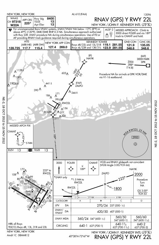
10000 X 150 22L
22R
13L
H
H
H197
66
80
172
10899
V
A
A
P
P
TWR
338
13R
14511 X 200
P
P
4L4R
A 31L
158
A 5
31R
11351 X 150
H
8400X 200
H
X
012^
RW22L
CHANT
192^
5 NM
225^
( IAF)
DEER PARK
DPK
FOLER
2000
288^(14.8)
246
1800 (6)
MISSED APCH FIX
T
NEW YORK, NEW YORK
(JFK)JOHN F. KENNEDY INTLNEW YORK /
AL-610 (FAA)
APP CRS 225
Rwy ldg
TDZE
Apt Elev
84001313
^
ALSF-2
A
WAAS
97318CH
W22A
NEW YORK, NEW YORK
225^ to
RW22L
ELEV 13
(JFK)JOHN F. KENNEDY INTLNEW YORK /
560/24
420/50
640-2627 (700-2)
LNAV MDA
CIRCLING640-1
560/50 560/60
640-1
LNAV/
VNAVDA
270/24
CATEGORY B C DA
RW22L
1.5 NM to
RW22L
ZALPO
3000
NAYIK
CHANT
1 .5 3 .9 NM
2000
1800
*LNAV only*
GS 3.00^
TCH 53
225^
FOLER
6 NM
407 (500-1)
547 (600-1)
12257 (300- )
547 (600- ) 12
547 (600-1 )
189^
605
441
390
306
277
211
186171
156
627 (700-1)
RNAV (GPS) Y RWY 22L
RNAV (GPS) Y RWY 22L
( IF)
NAYIK
(FAF)
ZALPO
LPV DA
D
1128
1505
1906
99
Procedure
Turn
NA
tr
189^
CLNC DELGND CONNEW YORK APP CON KENNEDY TOWER
Rwys 4R/22L and 13L/31R
Rwys 4L/22R and 13R/31L
119.1 281.55123.9 281.55
ATIS
127.4 269.0121.9348.6
135.05348.6
(ARR-NE) (ARR-SW)
128.725 117.7 115.4
HIRL al l Rwys
TDZ/CL Rwys 4R, 13L, 31R and 22L
TDZE 13
VGSI and RNAV gl idepath not co inc ident
(VGSI Angle 3.00/TCH 66) .
40^38’N-73^47’W
M
S A R W 2 2 L 2 5 NM
2900
Amdt 1C 08MAR12
12096
MISSED APPROACH: Cl imb to
3000 d i rect FOLER and v ia 189^
track to CHANT and hold.
For uncompensated Baro-VNAV systems, LNAV/VNAV NA below -13^C (8^F) or
above 49^C (120^F). DME/DME RNP-0.3 NA. Simul taneous approach author ized
wi th Rwy 22R. LNAV procedure NA dur ing s imul taneous operat ions. Use of FD or
AP provid ing RNAV t rack guidance requi red dur ing s imul taneous operat ions.
14
34
34627 (700-1 )
Procedure NA for arr iva ls at DPK VOR/DME
via V1-16 eastbound.
NE
-2, 18 OC
T 2012 to 15 N
OV
2012N
E-2
, 18
OC
T 2
012
to 1
5 N
OV
201
2
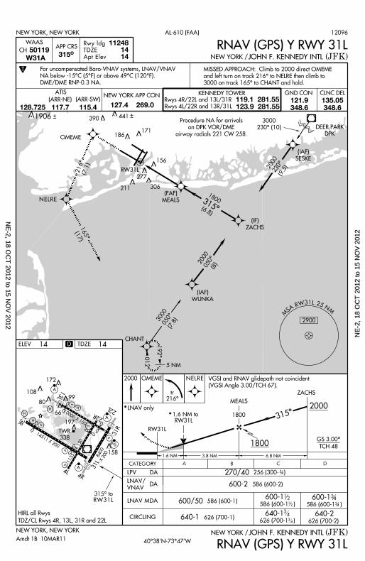
10000 X 150 22L
22R
13L
H
H
H197
66
80
172
10899
V
A
A
P
P
TWR
338
13R
14511 X 200
P
P
4L4R
A 31L
158
A 5
31R
11351 X 150
H
8400X 200
H
X
NEW YORK, NEW YORK (JFK)JOHN F. KENNEDY INTLNEW YORK /
600/50LNAV MDA
CIRCLING 640-1
2000 OMEME
ELEV
NEW YORK, NEW YORK
(JFK)JOHN F. KENNEDY INTLNEW YORK /
AL-610 (FAA)
14
APP CRS 315^
Rwy ldg
TDZE
Apt Elev
586 (600-1 )
112481414
CHANT
OMEME
DEER PARK
DPK
(IAF)
SESKE
(IAF)
WUNKA
3000
230^ (10)
315^
5 NM
012^
192^
3000050^
(7.8)
1800
(6.8)
2000050^ (8)
600-2
586 (600-1)600-1
586 (600-1 )
600-1 12
12
3 43 4
(FAF)
MEALS
2000230^
(9.5)
NELRE
NELRE
RW31L
RW31L315^ to
RNAV (GPS) Y RWY 31L
RNAV (GPS) Y RWY 31L
LNAV/
VNAV DA
306
277
171
156
CATEGORY B C DA
1800
MEALS
3 .8 NM 6 .8 NM
LNAV only** 1 .6 NM to
RW31L
RW31L
315^
ZACHS
2000
270/40 256 (300- ) 3 4
586 (600-2)
626 (700-1)
WAAS
50119CH
W31A
390
186
640-2 626 (700-2)
640-1 626 (700-1 )
34
34
LPV DA
D
tr216^
211
1906
CLNC DELGND CONNEW YORK APP CON KENNEDY TOWER
Rwys 4R/22L and 13L/31R
Rwys 4L/22R and 13R/31L
119.1 281.55123.9 281.55
ATIS
127.4 269.0121.9348.6
135.05348.6
(ARR-NE) (ARR-SW)
128.725 117.7 115.4
HIRL al l Rwys
TDZ/CL Rwys 4R, 13L, 31R and 22L
Amdt 1B 10MAR11
12096
For uncompensated Baro-VNAV systems, LNAV/VNAV
NA below -15^C (5^F) or above 49^C (120^F).
DME/DME RNP-0.3 NA.
MISSED APPROACH: Cl imb to 2000 d i rect OMEME
and lef t turn on t rack 216^ to NELRE then c l imb to
3000 on t rack 165^ to CHANT and hold.
TDZE 14
40^38’N-73^47’W
2900
MS A R W 3 1 L 2 5 N
M
1800
GS 3.00^
TCH 48
Procedure NA for arr iva ls
on DPK VOR/DME
airway radia ls 221 CW 258.
VGSI and RNAV gl idepath not co inc ident
(VGSI Angle 3.00/TCH 67) .
1 .6 NM
216^ (7.1)
165^(17)
( IF)
ZACHS
441
T
NE
-2, 18 OC
T 2012 to 15 N
OV
2012N
E-2
, 18
OC
T 2
012
to 1
5 N
OV
201
2
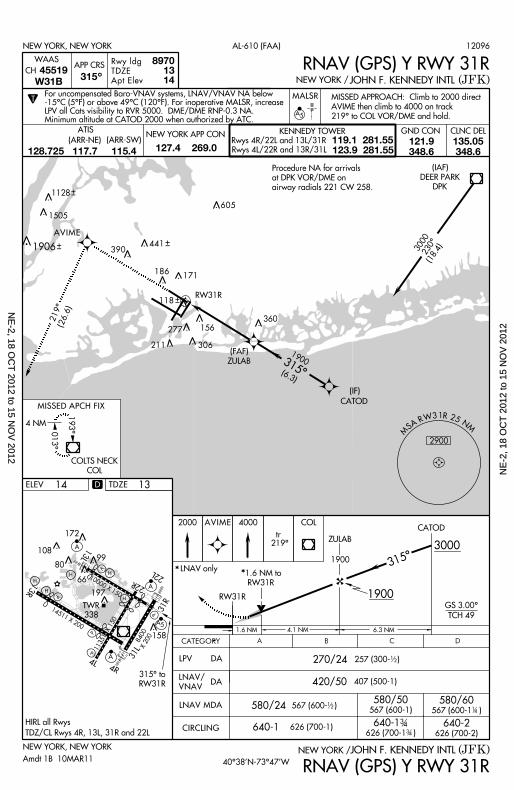
10000 X 150 22L
22R
13L
H
H
H197
66
80
172
10899
V
A
A
P
P
TWR
338
13R
14511 X 200
P
P
4L4R
A 31L
158
A 5
31R
11351 X 150
H
8400X 200
H
X
M
S A R W 3 1 R 2 5 NM
2900
RW31R
360
315^
(FAF)
ZULAB1900
(6.3)
CATOD
156
(IF)
CATEGORY B C D
(JFK)
A
NEW YORK, NEW YORK
580/24
640-2626 (700-2)
LNAV MDA
CIRCLING
RW31R
626 (700-1 )
640-1 3 43 4
640-1
CATOD
14
COLTS NECK
COL
567 (600-1 )1
2
420/50
567 (600- )580/50 580/60
567 (600-1) 14
193^
013^
4 NM
1.6 NM to
RW31R
4 .1 NM
3000
1900
LNAV only
GS 3.00^
TCH 49
6 .3 NM
*
LNAV/
VNAV
DA
315^
270/24 257 (300- ) 12
407 (500-1)
MISSED APCH FIX
JOHN F. KENNEDY INTL
315^ to
RW31R
ELEV
NEW YORK /
306
277
211
171
626 (700-1)
RNAV (GPS) Y RWY 31R
*
LPV DA
118
D
AVIME
230^(18.4)
( IAF)
DEER PARK
DPK
3000
T
NEW YORK, NEW YORK
(JFK)JOHN F. KENNEDY INTLNEW YORK /
AL-610 (FAA)
APP CRS 315
Rwy ldg
TDZE
Apt Elev
89701314
MALSR
A 5
^
WAAS
45519CH
W31B
605
441390
186
RNAV (GPS) Y RWY 31R
1128
1505
1906
CLNC DELGND CONNEW YORK APP CON KENNEDY TOWER
Rwys 4R/22L and 13L/31R
Rwys 4L/22R and 13R/31L
119.1 281.55123.9 281.55
ATIS
127.4 269.0121.9348.6
135.05348.6
(ARR-NE) (ARR-SW)
128.725 117.7 115.4
HIRL al l Rwys
TDZ/CL Rwys 4R, 13L, 31R and 22L
For uncompensated Baro-VNAV systems, LNAV/VNAV NA below -15^C (5^F) or above 49^C (120^F). For inoperat ive MALSR, increaseLPV al l Cats v is ib i l i ty to RVR 5000. DME/DME RNP-0.3 NA. Min imum al t i tude at CATOD 2000 when author ized by ATC.
MISSED APPROACH: Cl imb to 2000 d i rect
AVIME then c l imb to 4000 on t rack
219^ to COL VOR/DME and hold.
Amdt 1B 10MAR11
12096
13TDZE
40^38’N-73^47’W
ZULAB
1900
2000 COLAVIME 4000
tr 219^
1 .6 NM
219^(26.6)
Procedure NA for arr iva ls
at DPK VOR/DME on
a i rway radia ls 221 CW 258.
NE
-2, 18 OC
T 2012 to 15 N
OV
2012N
E-2
, 18
OC
T 2
012
to 1
5 N
OV
201
2
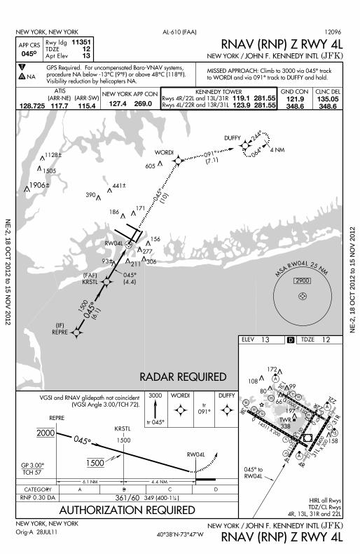
10000 X 150 22L
22R
13L
H
H
H197
66
80
172
10899
V
A
A
P
P
TWR
338
13R
14511 X 200
P
P
4L4R
A 31L
158
A 5
31R
11351 X 150
H
8400X 200
H
X
REPRE
RW04L
NEW YORK, NEW YORK (JFK)JOHN F. KENNEDY INTLNEW YORK /
045^ to
RW04L
ELEV
NEW YORK, NEW YORK
(JFK)JOHN F. KENNEDY INTLNEW YORK /
AL-610 (FAA)
13
APP CRS
RADAR REQUIRED
Rwy ldg
TDZE
Apt Elev
113511213
WORDI
DUFFY 244^
064^
RW04L
4 NM
045^
605
306
277
186171
156
045^
GP 3.00^
TCH 57
2000
1500
045^
KRSTL
1500 (6.1)
6 .1 NM
390
441
091^
(7.1)
211
RNAV (RNP) Z RWY 4L
RNAV (RNP) Z RWY 4L
MISSED APPROACH: Cl imb to 3000 v ia 045^ t rack
to WORDI and v ia 091^ t rack to DUFFY and hold.
T
A NA
GPS Required. For uncompensated Baro-VNAV systems,
procedure NA below -13^C (9^F) or above 48^C (118^F).
Vis ib i l i ty reduct ion by hel icopters NA.
4 .4 NM
1500
361/60
CATEGORY B C DA
RNP 0.30 DA 349 (400-1 ) 14
3000 WORDI
tr 045^
DUFFY
93
(FAF)
KRSTL
(IF)
REPRE
045^ (10)
D
1128
1505
1906
045^
(4.4)
t r
091^
CLNC DELGND CONNEW YORK APP CON KENNEDY TOWER
Rwys 4R/22L and 13L/31R
Rwys 4L/22R and 13R/31L
119.1 281.55123.9 281.55
ATIS
127.4 269.0121.9348.6
135.05348.6
(ARR-NE) (ARR-SW)
128.725 117.7 115.4
HIRL al l Rwys
TDZ/CL Rwys
4R, 13L, 31R and 22L
TDZE 12
VGSI and RNAV gl idepath not co inc ident
(VGSI Angle 3.00/TCH 72) .
Or ig-A 28JUL11
12096
AUTHORIZATION REQUIRED
40^38’N-73^47’W
M
S A R W 0 4 L 2 5 NM
2900
NE
-2, 18 OC
T 2012 to 15 N
OV
2012N
E-2
, 18
OC
T 2
012
to 1
5 N
OV
201
2
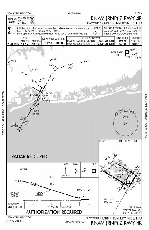
10000 X 150 22L
22R
13L
H
H
H197
66
80
172
10899
V
A
A
P
P
TWR
338
13R
14511 X 200
P
P
4L4R
A 31L
158
A 5
31R
11351 X 150
H
8400X 200
H
X
ELEV
8400 13 13
ALSF-2
NEW YORK, NEW YORK
NEW YORK, NEW YORK
(JFK)
(JFK)
JOHN F. KENNEDY INTL
JOHN F. KENNEDY INTL
NEW YORK /
NEW YORK /
AL-610 (FAA)
13
APP CRS
Rwy Idg
TDZE
Apt Elev045
045^ to
RW04R
VERRU
4 NM
260^
080^
DEER PARK
DPK
RADAR REQUIRED
A
690
045^
(FAF)
EBBEE
^
RW04R
4000
VERRU
EBBEE
PIYIY DPK
GP 3.00^
TCH 53
4 .4 NM
2000
1500
RW04R
045^
1500 (6.1)( IF)
6 .1 NM
RNAV (RNP) Z RWY 4R
RNAV (RNP) Z RWY 4R
T
A NA
419/50
CATEGORY B C DA
RNP 0.30 DA 406 (500-1)
1500
tr 045^
MISSED APPROACH: Cl imb to 4000
via 045^ t rack to PIYIY and v ia 091^
track to DPK VOR/DME and hold.
GPS Required. For uncompensated Baro-VNAV systems, procedure NA
below -13^C (9^F) or above 48^C (118^F).
For inoperat ive ALSF-2, increase RNP 0.30 DA al l Cats v is ib i l i ty to 1 . 12
PIYIY 091^
(18.1)
605
441
390
306
277
211
186171
156
045^ (7)
045^ (4.4)
D
t r
091^
CLNC DELGND CONNEW YORK APP CON KENNEDY TOWER
Rwys 4R/22L and 13L/31R
Rwys 4L/22R and 13R/31L
119.1 281.55123.9 281.55
ATIS
127.4 269.0121.9348.6
135.05348.6
(ARR-NE) (ARR-SW)
128.725 117.7 115.4
HIRL al l Rwys
TDZ/CL Rwys 4R,
13L, 31R and 22L
TDZE 13
Orig-A 28JUL11
12096
AUTHORIZATION REQUIRED
40^38’N-73^47’W
M
S A R W 0 4 R 2 5 NM
2900
NE
-2, 18 OC
T 2012 to 15 N
OV
2012N
E-2
, 18
OC
T 2
012
to 1
5 N
OV
201
2
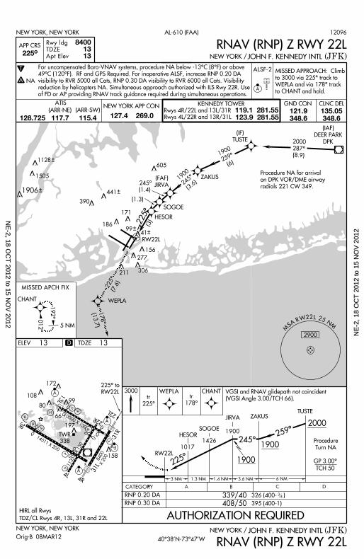
10000 X 150 22L
22R
13L
H
H
H197
66
80
172
10899
V
A
A
P
P
TWR
338
13R
14511 X 200
P
P
4L4R
A 31L
158
A 5
31R
11351 X 150
H
8400X 200
H
X
012^
M
S A R W 2 2 L 2 5 NM
2900
RW22L
CHANT
192^
5 NM
(IAF)
DEER PARK
DPK
MISSED APCH FIX
NEW YORK, NEW YORK
(JFK)JOHN F. KENNEDY INTLNEW YORK /
AL-610 (FAA)
APP CRS 225^
Rwy ldg
TDZE
Apt Elev
84001313
ALSF-2
A
NEW YORK, NEW YORK
225^ to
RW22L
ELEV 13
(JFK)JOHN F. KENNEDY INTLNEW YORK /
RW22L
ZAKUS
3000
TUSTE
CHANT
2000
GP 3.00^
TCH 50
259^
WEPLA
6 NM
RNAV (RNP) Z RWY 22L
RNAV (RNP) Z RWY 22L
T
A NA
Procedure NA for arr iva l
on DPK VOR/DME ai rway
radia ls 221 CW 349.
Procedure
Turn NA
JIRVA
SOGOEHESOR
1017
1426
1900
3 .6 NM3 NM
408/50
339/40
CATEGORY B C DA
326 (400- )RNP 0.20 DA
RNP 0.30 DA 395 (400-1)
34
SOGOE
HESOR
WEPLA
ZAKUS
(IF)
TUSTE
(FAF)
JIRVA
2000
287^
(8.9)1900
259^(6)
1900245^
(3.6)
225^
245^
225^
605
441
390
306
277
211
186
171
156
9941
178^(13.7)
225^(7.6)
(3)
245^
(1.4)
D
1128
1505
1906
(1.3)
1 .3 NM 1 .4 NM
t r
225^
tr
178^
CLNC DELGND CONNEW YORK APP CON KENNEDY TOWER
Rwys 4R/22L and 13L/31R
Rwys 4L/22R and 13R/31L
119.1 281.55123.9 281.55
ATIS
127.4 269.0121.9348.6
135.05348.6
(ARR-NE) (ARR-SW)
128.725 117.7 115.4
HIRL al l Rwys
TDZ/CL Rwys 4R, 13L, 31R and 22L
VGSI and RNAV gl idepath not co inc ident
(VGSI Angle 3.00/TCH 66) .
TDZE 13
Orig-B 08MAR12
12096
AUTHORIZATION REQUIRED
1900
1900
40^38’N-73^47’W
MISSED APPROACH: Cl imb
to 3000 v ia 225^ t rack to
WEPLA and v ia 178^ t rack
to CHANT and hold.
For uncompensated Baro-VNAV systems, procedure NA below -13^C (8^F) or above
49^C (120^F). RF and GPS Required. For inoperat ive ALSF, increase RNP 0.20 DA
vis ib i l i ty to RVR 5000 a l l Cats, RNP 0.30 DA v is ib i l i ty to RVR 6000 a l l Cats. Vis ib i l i ty
reduct ion by hel icopters NA. Simul taneous approach author ized wi th ILS Rwy 22R. Use
of FD or AP provid ing RNAV t rack guidance requi red dur ing s imul taneous operat ions.
NE
-2, 18 OC
T 2012 to 15 N
OV
2012N
E-2
, 18
OC
T 2
012
to 1
5 N
OV
201
2
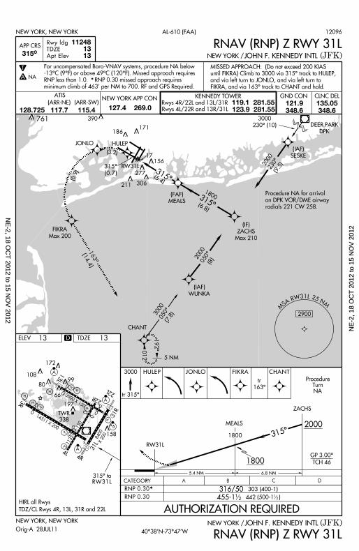
10000 X 150 22L
22R
13L
H
H
H197
66
80
172
10899
V
A
A
P
P
TWR
338
13R
14511 X 200
P
P
4L4R
A 31L
158
A 5
31R
11351 X 150
H
8400X 200
H
X
NEW YORK, NEW YORK (JFK)JOHN F. KENNEDY INTLNEW YORK /
ELEV
NEW YORK, NEW YORK
(JFK)JOHN F. KENNEDY INTLNEW YORK /
AL-610 (FAA)
13
APP CRS 315^
Rwy ldg
TDZE
Apt Elev
112481313
CHANT
DEER PARK
DPK
(IAF)
SESKE
(IAF)
WUNKA
3000
230^ (10)
315^
5 NM
012^
192^
3000050^
(7.8)
1800
(6.8)
2000050^ (8)
2900
(FAF)
MEALS
2000230^
(9.5)
RW31L
RW31L315^ to
RNAV (RNP) Z RWY 31L
RNAV (RNP) Z RWY 31L
MS A R W 3 1 L 2 5 N
M
1800
MEALS
5 .4 NM 6 .8 NM
GP 3.00^
TCH 46
RW31L
315^
ZACHS
2000
CATEGORY B C DA
RNP 0.30
316/50
455-1
303 (400-1)
442 (500-1 )12
12
3000 HULEP
tr 315^
JONLO FIKRA
1800
(IF)
ZACHS
Max 210
HULEPJONLO
( 3 . 2 )
( 8. 9 )
163^(14.4)
306
277
211
186171
156
FIKRA
Max 200
Procedure NA for arr iva l
on DPK VOR/DME ai rway
radia ls 221 CW 258.
RNP 0.30 *
315^(5.4)
315^
(0.7)
D
390
ProcedureTurn
NA
tr
163^
CHANT
17
MISSED APPROACH: (Do not exceed 200 KIAS
unt i l FIKRA) Cl imb to 3000 v ia 315^ t rack to HULEP,
and v ia le f t turn to JONLO, and v ia le f t turn to
FIKRA, and v ia 163^ t rack to CHANT and hold.
761
CLNC DELGND CONNEW YORK APP CON KENNEDY TOWER
Rwys 4R/22L and 13L/31R
Rwys 4L/22R and 13R/31L
119.1 281.55123.9 281.55
ATIS
127.4 269.0121.9348.6
135.05348.6
(ARR-NE) (ARR-SW)
128.725 117.7 115.4
HIRL al l Rwys
TDZ/CL Rwys 4R, 13L, 31R and 22L
TDZE 13
Orig-A 28JUL11
12096
AUTHORIZATION REQUIRED
40^38’N-73^47’W
T
A NA
For uncompensated Baro-VNAV systems, procedure NA below
-13^C (9^F) or above 49^C (120^F). Missed approach requi res
RNP less than 1.0. RNP 0.30 missed approach requi res
min imum cl imb of 463’ per NM to 700. RF and GPS Required.*
NE
-2, 18 OC
T 2012 to 15 N
OV
2012N
E-2
, 18
OC
T 2
012
to 1
5 N
OV
201
2
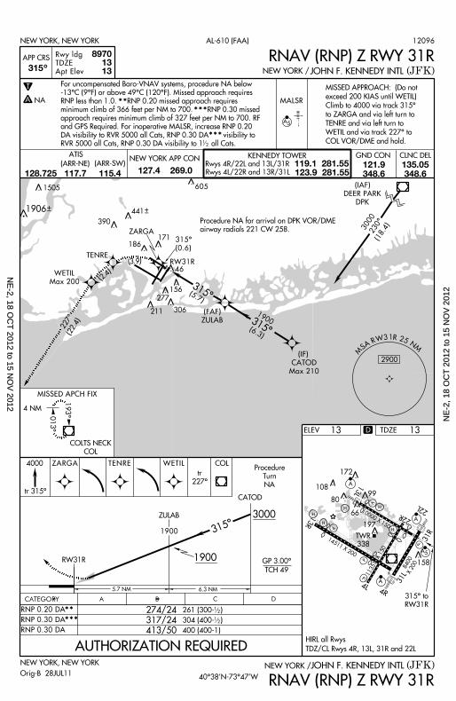
10000 X 150 22L
22R
13L
H
H
H197
66
80
172
10899
V
A
A
P
P
TWR
338
13R
14511 X 200
P
P
4L4R
A 31L
158
A 5
31R
11351 X 150
H
8400X 200
H
X
M
S A R W 3 1 R 2 5 NM
2900
315^
(JFK)NEW YORK, NEW YORK
RW31R
ZULAB
4000
CATOD
13
COLTS NECK
COL
193^
013^4 NM
COL
5 .7 NM
3000
1900 GP 3.00^
TCH 49
6 .3 NM
ZARGA
315^
MISSED APCH FIX
JOHN F. KENNEDY INTL
315^ to
RW31R
ELEV
NEW YORK /
NEW YORK, NEW YORK
(JFK)JOHN F. KENNEDY INTLNEW YORK /
AL-610 (FAA)
APP CRS 315
Rwy ldg
TDZE
Apt Elev
89701313
MALSR
A 5
^
T
A NA
RNAV (RNP) Z RWY 31R
RNAV (RNP) Z RWY 31R
RNP 0.30 DA 413/50 400 (400-1)
317/24
274/24
CATEGORY B C DA
261 (300- )
304 (400- )
12
12
TENRE
ZARGA
WETIL
Max 200
( 3 . 9 )
( 2 . 4 )
Procedure NA for arr iva l on DPK VOR/DME
airway radia ls 221 CW 258.
46
441
390
306
277
211
186171
156
1900
tr 315^
TENRE WETIL
227^(22.4)
3000 230^
(18.4)
1900
(6.3)
RW31R
(IAF)
DEER PARK
DPK
(IF)
CATOD
Max 210
(FAF)
ZULAB
315^(5.7)
*****RNP 0.20 DA
RNP 0.30 DA
315^
(0.6)
D
1906
605
Procedure
Turn
NA
Orig-B 28JUL11
12096
tr
227^
1505
CLNC DELGND CONNEW YORK APP CON KENNEDY TOWER
Rwys 4R/22L and 13L/31R
Rwys 4L/22R and 13R/31L
119.1 281.55123.9 281.55
ATIS
127.4 269.0121.9348.6
135.05348.6
(ARR-NE) (ARR-SW)
128.725 117.7 115.4
HIRL al l Rwys
TDZ/CL Rwys 4R, 13L, 31R and 22L
TDZE 13
AUTHORIZATION REQUIRED
40^38’N-73^47’W
MISSED APPROACH: (Do not
exceed 200 KIAS unt i l WETIL)
Cl imb to 4000 v ia t rack 315^
to ZARGA and v ia le f t turn to
TENRE and v ia le f t turn to
WETIL and v ia t rack 227^ to
COL VOR/DME and hold.
12
*****
***
For uncompensated Baro-VNAV systems, procedure NA below
-13^C (9^F) or above 49^C (120^F). Missed approach requi res
RNP less than 1.0. RNP 0.20 missed approach requi res
minimum cl imb of 366 feet per NM to 700. RNP 0.30 missed
approach requi res min imum cl imb of 327 feet per NM to 700. RF
and GPS Required. For inoperat ive MALSR, increase RNP 0.20
DA v is ib i l i ty to RVR 5000 a l l Cats, RNP 0.30 DA v is ib i l i ty to
RVR 5000 a l l Cats, RNP 0.30 DA v is ib i l i ty to 1 a l l Cats.
NE
-2, 18 OC
T 2012 to 15 N
OV
2012N
E-2
, 18
OC
T 2
012
to 1
5 N
OV
201
2
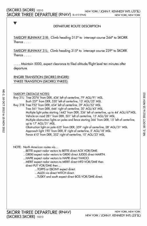
SL-610 (FAA)
(JFK)(SKORR3.SKORR)
NEW YORK, NEW YORK
JOHN F. KENNEDY INTLNEW YORK /
(JFK)(SKORR3.SKORR)
(RNAV) NEW YORK, NEW YORK
JOHN F. KENNEDY INTLNEW YORK /
DEPARTURE ROUTE DESCRIPTION
T
NOTE: North American routes via...
. . .BETTE expect radar vectors to BETTE direct ACK VOR/DME.
. . .GREKI expect radar vectors to GREKI direct JUDDS direct MARTN.
. . .HAPIE expect radar vectors to HAPIE direct YAHOO.
. . .MERIT expect radar vectors to MERIT direct HFD VOR/DME then
direct PUT VOR/DME then...
. . .TOPPS or EBONY expect direct.
. . .ALLEX via direct WITCH direct.
. . .TUSKY and south expect direct BOS VOR/DME direct.
TAKEOFF OBSTACLE NOTES:
Rwy 31L: Tree 2076’ from DER, 436’ left of centerl ine, 79’ AGL/91’ MSL.
Bush 257’ from DER, 530’ left of centerl ine, 13’ AGL/25’ MSL.
Rwy 31R: Tree 752’ from DER, 654’ left of centerl ine, 39’ AGL/52’ MSL.
Tree 561’ from DER, 646’ r ight of centerl ine, 30’ AGL/43’ MSL.
Mult iple l ight poles start ing 1442’ from DER, 336’ left of centerl ine, up to 44’ AGL/67’MSL.
Vehicle on road 281’ from DER, 501’ left of centerl ine, 15’ AGL/26’ MSL.
Mult iple obstruction l ights on poles and fence start ing 366’ from DER, 15’ left of centerl ine,
up to 17’ AGL/31’ MSL.
Obstruction l ight on pole 625’ from DER, 359’ r ight of centerl ine, 28’ AGL/31’ MSL.
Approach l ight 190’ from DER, 8’ r ight of centerl ine, 5’ AGL/18’ MSL.
Fence 410’ from DER, 352’ r ight of centerl ine, 10’ AGL/23’ MSL.
SKORR THREE DEPARTURE
SKORR THREE DEPARTURE
(RNAV)
TAKEOFF RUNWAY 31R: Climb heading 315^ to intercept course 244^ to SKORR.
Thence . . . .
TAKEOFF RUNWAY 31L: Climb heading 315^ to intercept course 239^ to SKORR.
Thence . . . .
. . . . Maintain 5000, expect clearance to fi led altitude/fl ight level ten minutes after
departure.
RNGRR TRANSITION (SKORR3.RNGRR):
YNKEE TRANSITION (SKORR3.YNKEE):
10210
10210
NE
-2, 18 OC
T 2012 to 15 N
OV
2012N
E-2
, 18
OC
T 2
012
to 1
5 N
OV
201
2
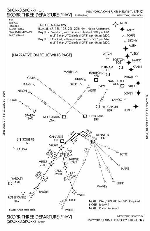
SL-610 (FAA)
(JFK)(SKORR3.SKORR)
(RNAV) NEW YORK, NEW YORK
JOHN F. KENNEDY INTLNEW YORK /
(JFK)(SKORR3.SKORR)
(RNAV) NEW YORK, NEW YORK
JOHN F. KENNEDY INTLNEW YORK /
(NARRATIVE ON FOLLOWING PAGE)
NOTE: Chart not to scale.
V1
R-311
R-322
R-320
R-055
R-054
173^
NEION
HAPIE
R-109
R-124
R-139
R-156METSS
YNKEE
DIXIE
GREKI
WAVEY
SKORR
CESID
315^
*
*
GAYEL
HAAYS
COATE
BAYYS
MERIT
WHITE
LANNA
SHIPP
BETTE
SPARTASAX
SOLBERG
SBJ
CANARSIE
CRI
YARDLEY
ARD
ROBBINSVILLE
RBV
BRIDGEOGY
KENNEDYJFK
BRIDGEPORT
BDR
DEER PARK
DPKLA GUARDIA
LGA
ALLEX
BRADD
DOVEY
EBONY
JOBOC
JUDDS
KANNI
MARTN
QUBIS
TAFFY
TOPPS
TUSKY
VITOL
WHALE
WITCH
YAHOO
NANTUCKETACK
HARTFORDHFD
BOSTONBOS
PUTNAMPUT
RNGRR
(4)
2500
2500
*
25001300
*
NOTE: DME/DME/IRU or GPS Required.
NOTE: RNAV 1.
NOTE: Radar Required.
239^
315^
CRIR-223
226^
226^
184^
(4)
(3)
(24)
25001700
25001300
25001500
TAKEOFF MINIMUMS:
Rwys 4L, 4R, 13L, 13R, 22L, 22R: NA - Noise Abatement.
Rwy 31R: Standard, with minimum climb of 500’ per NM
to 513 then ATC cl imb of 276’ per NM to 2500.
Rwy 31L: Standard, with minimum climb of 500’ per NM
to 513 then ATC cl imb of 276’ per NM to 2500.
V1
R-221
244^
SKORR THREE DEPARTURE
SKORR THREE DEPARTURE
10210
10210
ATIS
128.725
CLNC DEL
135.05 348.6
NEW YORK DEP CON
135.9 353.75
NE
-2, 18 OC
T 2012 to 15 N
OV
2012N
E-2
, 18
OC
T 2
012
to 1
5 N
OV
201
2
TAKEOFF MINIMUMS AND (OBSTACLE) DEPARTURE PROCEDURES 12292
L1
NE-2
TAKEOFF MINIMUMS AND (OBSTACLE) DEPARTURE PROCEDURES 12292
L1
T T
T T
AKRON, NY AKRON (9G3) ORIG 81050 (FAA)
TAKEOFF MINIMUMS: Rwys 7, 25, 300-1.
ALBANY, NY ALBANY INTL (ALB) AMDT 12 11237 (FAA)
TAKEOFF MINIMUMS: Rwy 10, 300-1 or std. w/min. climb of 365' per NM to 600. Rwy 28, 300-1¾ or std. w/min. climb of 458' per NM to 700.
DEPARTURE PROCEDURE: Rwy 10, climb heading 110° to 2000 before turning north. Rwy 19, climb heading 191° to 1400 before proceeding on course. Rwy 28, climb heading 281° to 2000 before proceeding on course.
INSTRUMENT APPROACH PROCEDURE CHARTS
IFR TAKEOFF MINIMUMS AND (OBSTACLE) DEPARTURE PROCEDURES Civil Airports and Selected Military Airports
ALL USERS: Airports that have Departure Procedures (DPs) designed specifically to assist pilots in avoiding obstacles during the climb to the minimum enroute altitude , and/or airports that have civil IFR takeoff minimums other than standard, are listed below. Takeoff Minimums and Departure Procedures apply to all runways unless otherwise specified. Altitudes, unless otherwise indicated, are minimum altitudes in MSL.
DPs specifically designed for obstacle avoidance are referred to as Obstacle Departure Procedures (ODPs) and are described below in text, or published separately as a graphic procedure. If the (Obstacle) DP is published as a graphic procedure, its name will be listed below, and it can be found in either this volume (civil), or the applicable military volume, as appropriate. Users will recognize graphic obstacle DPs by the term "(OBSTACLE)" included in the procedure title; e.g., TETON TWO (OBSTACLE). If not specifically assigned a departure procedure (i.e.,ODP, SID, or radar vector) as part of an IFR clearance, an ODP may be required to be flown for obstacle clearance, even though not specifically stated in the IFR clearance. When doing so in this manner, ATC should be informed when the ODP being used contains a specified route to be flown, restrictions before turning, and/or altitude restrictions.
Graphic DPs designed by ATC to standardize traffic flows, ensure aircraft separation and enhance capacity are referred to as "Standard Instrument Departures (SIDs)". SIDs also provide obstacle clearance and are published under the appropriate airport section. ATC clearance must be received prior to flying a SID.
CIVIL USERS NOTE: Title 14 Code of Federal Regulations Part 91 prescribes standard takeoff rules and establishes takeoff minimums for certain operators as follows: (1) Aircraft having two engines or less - one statute mile. (2) Aircraft having more than two engines - one-half statute mile. These standard minima apply in the absence of any different minima listed below.
MILITARY USERS NOTE: Civil (nonstandard) takeoff minima are published below. For military takeoff minima, refer to appropriate service directives.
NAME TAKEOFF MINIMUMS NAME TAKEOFF MINIMUMS
ALBANY, NY (CON'T) ALBANY INTL (ALB)
NOTE: Rwy 1, trees beginning 1163’ from DER, on and right of centerline, up to 100’ AGL/367’ MSL. Trees beginning 2109’ from DER, 222’ left of centerline, up to 100’ AGL/370’ MSL. Chimney on building 1095’ from DER, 574’ right of centerline, 35’ AGL/314’ MSL. Rwy 19, trees beginning 2510’ from DER, 984’ right of centerline, up to 100’ AGL/394’ MSL. Rwy 10, trees beginning 117’ from DER, 341’ right of centerline, up to 100’ AGL/510’ MSL. Trees beginning 589’ from DER, 81’ left of centerline, up to 100’ AGL/437’ MSL. Road beginning 304’ from DER, 499’ left of centerline, up to 15’ AGL/315’ MSL. Rwy 28, trees beginning 555’ from DER, 458’ right of centerline, up to 100’ AGL/534’ MSL. Trees beginning 149’ from DER, 313’ left of centerline, up to 100’ AGL/506’ MSL. Light poles beginning 330’ from DER, 476’ left of centerline, up to 20’ AGL/311’ MSL. Light pole 892’ from DER, 587’ right of centerline, 20’ AGL/312’ MSL. Building 694’ from DER, 669’ left of centerline, 35’ AGL/325’ MSL. Building 1037’ from DER, 543‘ right of centerline, 35’ AGL/323’ MSL. Building 280’ from DER, 408’ left of centerline, 32’ AGL/292’ MSL. Electrical equipment 23’ from DER, 427’ right of centerline, 4’ AGL/280’ MSL. Terrain 1029’ from DER, 595’ left of centerline, 319’ MSL.
T
18 OC
T 2012 to 15 N
OV
2012 1
8 O
CT
201
2 to
15
NO
V 2
012
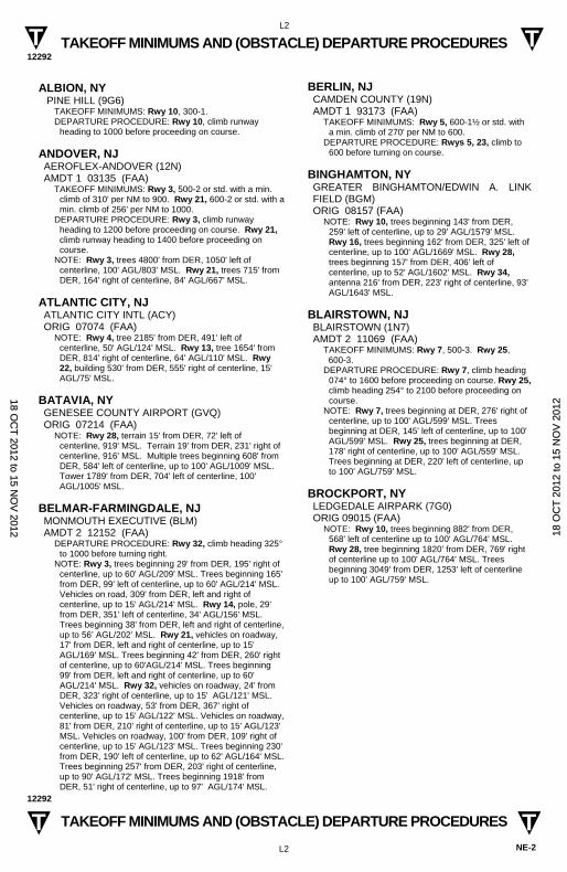
TAKEOFF MINIMUMS AND (OBSTACLE) DEPARTURE PROCEDURES 12292
L2
NE-2
TAKEOFF MINIMUMS AND (OBSTACLE) DEPARTURE PROCEDURES 12292
L2
T T
T T
ALBION, NY PINE HILL (9G6)
TAKEOFF MINIMUMS: Rwy 10, 300-1. DEPARTURE PROCEDURE: Rwy 10, climb runway
heading to 1000 before proceeding on course.
ANDOVER, NJ AEROFLEX-ANDOVER (12N) AMDT 1 03135 (FAA)
TAKEOFF MINIMUMS: Rwy 3, 500-2 or std. with a min. climb of 310' per NM to 900. Rwy 21, 600-2 or std. with a min. climb of 256' per NM to 1000.
DEPARTURE PROCEDURE: Rwy 3, climb runway heading to 1200 before proceeding on course. Rwy 21, climb runway heading to 1400 before proceeding on course.
NOTE: Rwy 3, trees 4800' from DER, 1050' left of centerline, 100' AGL/803' MSL. Rwy 21, trees 715' from DER, 164' right of centerline, 84' AGL/667' MSL.
ATLANTIC CITY, NJ ATLANTIC CITY INTL (ACY) ORIG 07074 (FAA)
NOTE: Rwy 4, tree 2185' from DER, 491' left of centerline, 50' AGL/124' MSL. Rwy 13, tree 1654' from DER, 814' right of centerline, 64' AGL/110' MSL. Rwy 22, building 530' from DER, 555' right of centerline, 15' AGL/75' MSL.
BATAVIA, NY GENESEE COUNTY AIRPORT (GVQ) ORIG 07214 (FAA)
NOTE: Rwy 28, terrain 15' from DER, 72' left of centerline, 919' MSL. Terrain 19' from DER, 231' right of centerline, 916' MSL. Multiple trees beginning 608' from DER, 584' left of centerline, up to 100' AGL/1009' MSL. Tower 1789' from DER, 704' left of centerline, 100' AGL/1005' MSL.
BELMAR-FARMINGDALE, NJ MONMOUTH EXECUTIVE (BLM) AMDT 2 12152 (FAA)
DEPARTURE PROCEDURE: Rwy 32, climb heading 325° to 1000 before turning right.
NOTE: Rwy 3, trees beginning 29' from DER, 195' right of centerline, up to 60' AGL/209' MSL. Trees beginning 165' from DER, 99' left of centerline, up to 60' AGL/214' MSL. Vehicles on road, 309' from DER, left and right of centerline, up to 15' AGL/214' MSL. Rwy 14, pole, 29’ from DER, 351’ left of centerline, 34' AGL/156' MSL. Trees beginning 38' from DER, left and right of centerline, up to 56’ AGL/202’ MSL. Rwy 21, vehicles on roadway, 17' from DER, left and right of centerline, up to 15' AGL/169' MSL. Trees beginning 42' from DER, 260' right of centerline, up to 60'AGL/214' MSL. Trees beginning 99' from DER, left and right of centerline, up to 60' AGL/214' MSL. Rwy 32, vehicles on roadway, 24' from DER, 323' right of centerline, up to 15' AGL/121' MSL. Vehicles on roadway, 53' from DER, 367' right of centerline, up to 15' AGL/122' MSL. Vehicles on roadway, 81' from DER, 210' right of centerline, up to 15' AGL/123' MSL. Vehicles on roadway, 100' from DER, 109' right of centerline, up to 15' AGL/123' MSL. Trees beginning 230' from DER, 190' left of centerline, up to 62' AGL/164' MSL. Trees beginning 257' from DER, 203' right of centerline, up to 90' AGL/172' MSL. Trees beginning 1918' from DER, 51' right of centerline, up to 97' AGL/174' MSL.
BERLIN, NJ CAMDEN COUNTY (19N) AMDT 1 93173 (FAA)
TAKEOFF MINIMUMS: Rwy 5, 600-1½ or std. with a min. climb of 270' per NM to 600.
DEPARTURE PROCEDURE: Rwys 5, 23, climb to 600 before turning on course.
BINGHAMTON, NY GREATER BINGHAMTON/EDWIN A. LINK FIELD (BGM) ORIG 08157 (FAA)
NOTE: Rwy 10, trees beginning 143' from DER, 259' left of centerline, up to 29' AGL/1579' MSL. Rwy 16, trees beginning 162' from DER, 325' left of centerline, up to 100' AGL/1669' MSL. Rwy 28, trees beginning 157' from DER, 406' left of centerline, up to 52' AGL/1602' MSL. Rwy 34, antenna 216' from DER, 223' right of centerline, 93' AGL/1643' MSL.
BLAIRSTOWN, NJ BLAIRSTOWN (1N7) AMDT 2 11069 (FAA)
TAKEOFF MINIMUMS: Rwy 7, 500-3. Rwy 25, 600-3. DEPARTURE PROCEDURE: Rwy 7, climb heading
074° to 1600 before proceeding on course. Rwy 25, climb heading 254° to 2100 before proceeding on course.
NOTE: Rwy 7, trees beginning at DER, 276' right of centerline, up to 100' AGL/599' MSL. Trees beginning at DER, 145' left of centerline, up to 100' AGL/599' MSL. Rwy 25, trees beginning at DER, 178' right of centerline, up to 100' AGL/559' MSL. Trees beginning at DER, 220' left of centerline, up to 100' AGL/759' MSL.
BROCKPORT, NY LEDGEDALE AIRPARK (7G0) ORIG 09015 (FAA)
NOTE: Rwy 10, trees beginning 882' from DER, 568' left of centerline up to 100' AGL/764' MSL. Rwy 28, tree beginning 1820' from DER, 769' right of centerline up to 100' AGL/764' MSL. Trees beginning 3049' from DER, 1253' left of centerline up to 100' AGL/759' MSL.
18 OC
T 2012 to 15 N
OV
2012 1
8 O
CT
201
2 to
15
NO
V 2
012
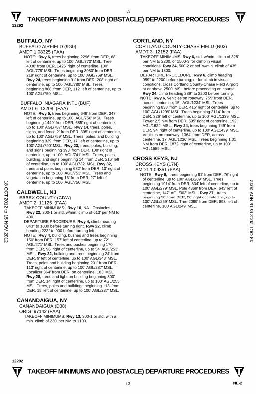
TAKEOFF MINIMUMS AND (OBSTACLE) DEPARTURE PROCEDURES 12292
L3
NE-2
TAKEOFF MINIMUMS AND (OBSTACLE) DEPARTURE PROCEDURES 12292
L3
T T
T T
BUFFALO, NY BUFFALO AIRFIELD (9G0) AMDT 1 08325 (FAA)
NOTE: Rwy 6, trees beginning 2296' from DER, 68' left of centerline, up to 100' AGL/770' MSL. Tree 4038' from DER, 1425' right of centerline, 100' AGL/779' MSL. Trees beginning 3080' from DER, 219' right of centerline, up to 100' AGL/769' MSL. Rwy 24, trees beginning 91' from DER, 208' right of centerline, up to 100' AGL/780' MSL. Trees beginning 868' from DER, 112' left of centerline, up to 100' AGL/750' MSL.
BUFFALO NIAGARA INTL (BUF) AMDT 6 12208 (FAA)
NOTE: Rwy 5, trees beginning 649’ from DER, 347’ left of centerline, up to 100’ AGL/756’ MSL. Trees beginning 1449’ from DER, 685’ right of centerline, up to 100’ AGL/787’ MSL. Rwy 14, trees, poles, signs, and fence 2’ from DER, 395’ right of centerline, up to 100’ AGL/759’ MSL. Trees, poles, and building beginning 329’ from DER, 17’ left of centerline, up to 100’ AGL/790’ MSL. Rwy 23, trees, poles, building, and signs beginning 393’ from DER, 108’ right of centerline, up to 100’ AGL/741‘ MSL. Trees, poles, building, and signs beginning 14’ from DER, 216’ left of centerline, up to 100’ AGL/732’ MSL. Rwy 32, trees and poles beginning 632’ from DER, 10’ right of centerline, up to 100’ AGL/753’ MSL. Trees and vegetation beginning 16’ from DER, 27’ left of centerline, up to 100’ AGL/756’ MSL.
CALDWELL, NJ ESSEX COUNTY (CDW) AMDT 2 11125 (FAA)
TAKEOFF MINIMUMS: Rwy 10, NA - Obstacles. Rwy 22, 300-1 or std. w/min. climb of 613' per NM to 400.
DEPARTURE PROCEDURE: Rwy 4, climb heading 043° to 1000 before turning right. Rwy 22, climb heading 223° to 900 before turning left.
NOTE: Rwy 4, building, bushes and trees beginning 150' from DER, 157' left of centerline, up to 72' AGL/271' MSL. Trees and bushes beginning 170' from DER, 96' right of centerline, up to 54' AGL/253' MSL. Rwy 22, building and trees beginning 24' from DER, 9' left of centerline, up to 100' AGL/343' MSL. Trees, poles and building beginning 201' from DER, 113' right of centerline, up to 100' AGL/287' MSL. Localizer 364' from DER, on centerline, 183' MSL. Rwy 28, trees and light on building beginning 300' from DER, 14' right of centerline, up to 100' AGL/255' MSL. Trees, poles and buildings beginning 113' from DER, 15' left of centerline, up to 100' AGL/237' MSL.
CANANDAIGUA, NY CANANDAIGUA (D38) ORIG 97142 (FAA)
TAKEOFF MINIMUMS: Rwy 13, 300-1 or std. with a min. climb of 230' per NM to 1100.
CORTLAND, NY CORTLAND COUNTY-CHASE FIELD (N03) AMDT 3 12152 (FAA)
TAKEOFF MINIMUMS: Rwy 6, std. w/min. climb of 328' per NM to 2200, or 1500-3 for climb in visual conditions. Rwy 24, 500-2 or std. w/min. climb of 435' per NM to 1800.
DEPARTURE PROCEDURE: Rwy 6, climb heading 059° to 2200 before turning; or for climb in visual conditions: cross Cortland County-Chase Field Airport at or above 2500' MSL before proceeding on course. Rwy 24, climb heading 239° to 2200 before turning.
NOTE: Rwy 6, vehicles on roadway, 755' from DER, across centerline, 15' AGL/1234' MSL. Trees beginning 838' from DER, 415' right of centerline, up to 100' AGL/1299' MSL. Trees beginning 2114' from DER, 326' left of centerline, up to 100' AGL/1339' MSL. Tower 2.5 NM from DER, 595' right of centerline, 192' AGL/1624' MSL. Rwy 24, trees beginning 749' from DER, 94' right of centerline, up to 100' AGL1439' MSL. Vehicles on roadway, 1364' from DER, across centerline, 17' AGL/1236' MSL. Trees beginning 1.01 NM from DER, 1872' right of centerline, up to 100' AGL1559' MSL.
CROSS KEYS, NJ CROSS KEYS (17N) AMDT 1 09351 (FAA)
NOTE: Rwy 9, trees beginning 81' from DER, 76' right of centerline, up to 100' AGL/289' MSL. Trees beginning 1914' from DER, 834' left of centerline, up to 100' AGL/279' MSL. Pole 4369' from DER, 643' left of centerline, 147' AGL/303' MSL. Rwy 27, trees beginning 50' from DER, 20' right of centerline, up to 100' AGL/259' MSL. Tree 2099' from DER, 893' left of centerline, 100 AGL/249' MSL.
18 OC
T 2012 to 15 N
OV
2012 1
8 O
CT
201
2 to
15
NO
V 2
012
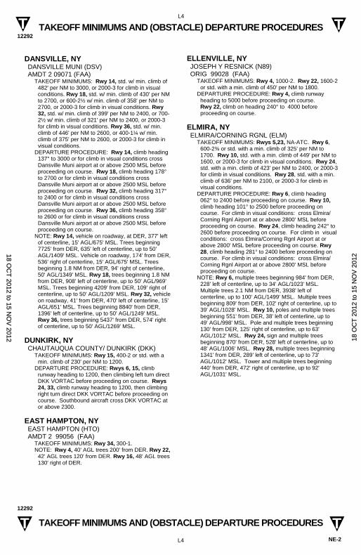
TAKEOFF MINIMUMS AND (OBSTACLE) DEPARTURE PROCEDURES 12292
L4
NE-2
TAKEOFF MINIMUMS AND (OBSTACLE) DEPARTURE PROCEDURES 12292
L4
T T
T T
DANSVILLE, NY DANSVILLE MUNI (DSV) AMDT 2 09071 (FAA)
TAKEOFF MINIMUMS: Rwy 14, std. w/ min. climb of 482' per NM to 3000, or 2000-3 for climb in visual conditions. Rwy 18, std. w/ min. climb of 430' per NM to 2700, or 600-2½ w/ min. climb of 358' per NM to 2700, or 2000-3 for climb in visual conditions. Rwy 32, std. w/ min. climb of 399' per NM to 2400, or 700-2½ w/ min. climb of 321' per NM to 2400, or 2000-3 for climb in visual conditions. Rwy 36, std. w/ min. climb of 446' per NM to 2600, or 400-1¼ w/ min. climb of 375' per NM to 2600, or 2000-3 for climb in visual conditions.
DEPARTURE PROCEDURE: Rwy 14, climb heading 137° to 3000 or for climb in visual conditions cross Dansville Muni airport at or above 2500 MSL before proceeding on course. Rwy 18, climb heading 178° to 2700 or for climb in visual conditions cross Dansville Muni airport at or above 2500 MSL before proceeding on course. Rwy 32, climb heading 317° to 2400 or for climb in visual conditions cross Dansville Muni airport at or above 2500 MSL before proceeding on course. Rwy 36, climb heading 358° to 2600 or for climb in visual conditions cross Dansville Muni airport at or above 2500 MSL before proceeding on course.
NOTE: Rwy 14, vehicle on roadway, at DER, 377' left of centerline, 15' AGL/675' MSL. Trees beginning 7725' from DER, 635' left of centerline, up to 50' AGL/1409' MSL. Vehicle on roadway, 174' from DER, 536' right of centerline, 15' AGL/675' MSL. Trees beginning 1.8 NM from DER, 94' right of centerline, 50' AGL/1349' MSL. Rwy 18, trees beginning 1.8 NM from DER, 908' left of centerline, up to 50' AGL/969' MSL. Trees beginning 4209' from DER, 109' right of centerline, up to 50' AGL/1209' MSL. Rwy 32, vehicle on roadway, 41' from DER, 470' left of centerline, 15' AGL/651' MSL. Trees beginning 8840' from DER, 1396' left of centerline, up to 50' AGL/1249' MSL. Rwy 36, trees beginning 5437' from DER, 574' right of centerline, up to 50' AGL/1269' MSL.
DUNKIRK, NY CHAUTAUQUA COUNTY/ DUNKIRK (DKK)
TAKEOFF MINIMUMS: Rwy 15, 400-2 or std. with a min. climb of 230' per NM to 1200.
DEPARTURE PROCEDURE: Rwys 6, 15, climb runway heading to 1200, then climbing left turn direct DKK VORTAC before proceeding on course. Rwys 24, 33, climb runway heading to 1200, then climbing right turn direct DKK VORTAC before proceeding on course. Southbound aircraft cross DKK VORTAC at or above 2300.
EAST HAMPTON, NY EAST HAMPTON (HTO) AMDT 2 99056 (FAA)
TAKEOFF MINIMUMS: Rwy 34, 300-1. NOTE: Rwy 4, 40' AGL trees 200' from DER. Rwy 22,
42' AGL trees 120' from DER. Rwy 16, 48' AGL trees 130' right of DER.
ELLENVILLE, NY JOSEPH Y RESNICK (N89) ORIG 99028 (FAA)
TAKEOFF MINIMUMS: Rwy 4, 1000-2. Rwy 22, 1600-2 or std. with a min. climb of 450' per NM to 1800.
DEPARTURE PROCEDURE: Rwy 4, climb runway heading to 5000 before proceeding on course. Rwy 22, climb on heading 240° to 4000 before proceeding on course.
ELMIRA, NY ELMIRA/CORNING RGNL (ELM)
TAKEOFF MINIMUMS: Rwys 5,23, NA-ATC. Rwy 6, 600-2¾ or std. with a min. climb of 325' per NM to 1700. Rwy 10, std. with a min. climb of 449' per NM to 1600, or 2000-3 for climb in visual conditions. Rwy 24, std. with a min. climb of 423' per NM to 2400, or 2000-3 for climb in visual conditions. Rwy 28, std. with a min. climb of 636' per NM to 2100, or 2000-3 for climb in visual conditions.
DEPARTURE PROCEDURE: Rwy 6, climb heading 062° to 2400 before proceeding on course. Rwy 10, climb heading 101° to 2500 before proceeding on course. For climb in visual conditions: cross Elmira/Corning Rgnl Airport at or above 2800' MSL before proceeding on course. Rwy 24, climb heading 242° to 2600 before proceeding on course. For climb in visual conditions: cross Elmira/Corning Rgnl Airport at or above 2800' MSL before proceeding on course. Rwy 28, climb heading 281° to 2400 before proceeding on course. For climb in visual conditions: cross Elmira/Corning Rgnl Airport at or above 2800' MSL before proceeding on course.
NOTE: Rwy 6, multiple trees beginning 984' from DER, 228' left of centerline, up to 34' AGL/1023' MSL. Multiple trees 2.1 NM from DER, 3938' left of centerline, up to 100' AGL/1499' MSL. Multiple trees beginning 809' from DER, 102' right of centerline, up to 39' AGL/1028' MSL. Rwy 10, poles and multiple trees beginning 551' from DER, 38' left of centerline, up to 49' AGL/998' MSL. Pole and multiple trees beginning 130' from DER, 125' right of centerline, up to 63' AGL/1012' MSL. Rwy 24, sign and multiple trees beginning 870' from DER, 528' left of centerline, up to 48' AGL/1006' MSL. Rwy 28, multiple trees beginning 1341' from DER, 289' left of centerline, up to 73' AGL/1012' MSL. Tower and multiple trees beginning 440' from DER, 472' right of centerline, up to 92' AGL/1031' MSL.
18 OC
T 2012 to 15 N
OV
2012 1
8 O
CT
201
2 to
15
NO
V 2
012
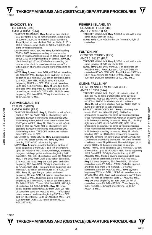
TAKEOFF MINIMUMS AND (OBSTACLE) DEPARTURE PROCEDURES 12292
L5
NE-2
TAKEOFF MINIMUMS AND (OBSTACLE) DEPARTURE PROCEDURES 12292
L5
T T
T T
ENDICOTT, NY TRI-CITIES (CZG) AMDT 4 10154 (FAA)
TAKEOFF MINIMUMS: Rwy 3, std. w/ min. climb of 515’ per NM to 1700 or 700-2 with min. climb of 242 to 2000 or 1600-2 ½ for climb in visual conditions. Rwy 21, std. w/ min. climb of 604’ per NM to 2100 or 900-3 with min. climb of 470 to 2200 or 1600-2½ for climb in visual conditions.
DEPARTURE PROCEDURE: Rwy 3, climb heading 036° to 2000 before proceeding on course or for climb in visual conditions: cross Tri-Cities airport at or above 2300 before proceeding on course. Rwy 21, climb heading 216° to 2200 before proceeding on course or for climb in visual conditions: cross Tri-Cities airport at or above 2300 before proceeding on course.
NOTE: Rwy 3, tree 1' from DER, 418' left of centerline, 78' AGL/907' MSL. Multiple trees and train on tracks beginning 163' from DER, 56' left of centerline, up to 110' AGL/1469' MSL. Multiple trees and tower beginning 1699' from DER, 259' right of centerline, up to 106' AGL/915' MSL. Rwy 21 , multiple trees, pole and tower beginning 51' from DER, 63' left of centerline, up to 84' AGL/1473' MSL. Multiple trees beginning 751' from DER, 73' right of centerline, up to 86' AGL/1175' MSL.
FARMINGDALE, NY REPUBLIC (FRG) AMDT 6 10154 (FAA)
TAKEOFF MINIMUMS: Rwy 1, 200 -1¼ or std. w/ min. climb of 207’ per NM to 300, or alternatively, with standard TAKEOFF minimums and a normal 200’/NM climb gradient, takeoff must occur no later than 1300’ prior to DER. Rwy 32, 300 -1¾ or std. w/ min. climb of 213’ per NM to 400, or alternatively, with standard TAKEOFF minimums and a normal 200’/NM climb gradient. TAKEOFF must occur no later than 1500’ prior to DER.
DEPARTURE PROCEDURE: Rwy 1, climb heading 013° to 700 before turning left. Rwy 32, climb heading 326° to 700 before turning right.
NOTE: Rwy 1, fence. elevator, buildings, tanks and trees beginning 3' from DER, 194' left of centerline, up to 69' AGL/144' MSL. Stack, chimneys, antennas, hangars, buildings, poles and trees beginning 144' from DER, 246' right of centerline, up to 80' AGL/155' MSL. Tank 5912' from DER, 1427' left of centerline, 139' AGL/235' MSL. Rwy 14, road, pole, and trees beginning 182' from DER, 24' right of centerline, up to 70' AGL/120' MSL. Poles and trees beginning 534' from DER, 97' left of centerline, up to 74' AGL/124' MSL. Rwy 19, sign, hangar, poles, and trees beginning 78' from DER, 14' right of centerline, up to 65' AGL/115' MSL. Buildings, poles, and trees beginning 182' from DER, 71' left of centerline, up to 75' AGL/125' MSL. Tower 2454' from DER, 318' right of centerline, 84' AGL/142' MSL. Rwy 32, fence, poles, and trees beginning 146' from DER, 23' right of centerline, up to 69' AGL/139' MSL. Traffic signal, poles, antenna, and trees beginning 330' from DER, 124' left of centerline, up to 72' AGL/142' MSL. Tank 1.35 NM from DER, 1122' left of centerline, 107' AGL/297' MSL.
FISHERS ISLAND, NY ELIZABETH FIELD (0B8) AMDT 2 98337 (FAA)
TAKEOFF MINIMUMS: Rwy 7, 300-1 or std. with a min. climb of 300' per NM to 300.
NOTE: Rwy 7, 15' AGL bunker 25' from DER, right of centerline.
FULTON, NY OSWEGO COUNTY (FZY) AMDT 1 01137 (FAA)
TAKEOFF MINIMUMS: Rwy 6, 300-1 or std. with a min. climb gradient of 270' per NM to 900.
NOTE: Rwy 6, hill 1400' from DER, on centerline 50' AGL/549' MSL. Rwy 15, trees 1700' from DER, on centerline 85' AGL/560' MSL. Rwy 24, trees 1350' from DER, on centerline 60' AGL/517' MSL. Rwy 33, road 400' from DER, on centerline 15' AGL/462 MSL.
GLENS FALLS, NY FLOYD BENNETT MEMORIAL (GFL) AMDT 1 10350 (FAA)
TAKEOFF MINIMUMS: Rwy 1, std. w/ min. climb of 385' per NM to 2500 or 2000-3 for climb in visual conditions. Rwy 12, std. w/ min. climb of 304' per NM to 1800 or 2000-3 for climb in visual conditions.
Rwy 30, std. w/ min. climb of 345' per NM to 2500 or 2000-3 for climb in visual conditions.
DEPARTURE PROCEDURE: Rwy 1, climbing right turn to 2500 direct GANSE (GF) LOM before proceeding on course. For climb in visual conditions: cross Floyd Bennett Memorial Airport at or above 2200 MSL before proceeding on course. Rwy 12 , climbing right turn to 1800 direct GANSE (GF) LOM before proceeding on course. For climb in visual conditions: cross Floyd Bennett Memorial Airport at or above 2200 MSL before proceeding on course. Rwy 19 , climb heading 192° to 1400 before proceeding on course. Rwy 30 , climbing left turn to 2500 direct GANSE (GF) LOM before proceeding on course. For climb in visual conditions: cross Floyd Bennett Memorial Airport at or above 2200 MSL before proceeding on course.
NOTE: Rwy 1, trees beginning 1185' from DER, 65' left of centerline, up to 88' AGL/503' MSL. Trees beginning 1423' from DER, 24' right of centerline, up to 88' AGL/535' MSL. Multiple towers beginning 5140' from DER, 5' left of centerline, up to 69' AGL/498' MSL. Rwy 12, trees beginning 852' from DER, 115' left of centerline, up to 77' AGL/416' MSL. Vehicles on road and trees beginning 378' from DER, 3' right of centerline, up to 80' AGL/429' MSL. Rwy 19, trees beginning 703' from DER, 121' left of centerline, up to 65' AGL/454' MSL. Bush and trees beginning 73' from DER, 46' right of centerline, up to 77' AGL/456' MSL. Rwy 30, trees beginning 89' from DER, 20' left of centerline, up to 93' AGL/458' MSL. Trees beginning 1281' from DER, 32' right of centerline, up to 89' AGL/472' MSL.
18 OC
T 2012 to 15 N
OV
2012 1
8 O
CT
201
2 to
15
NO
V 2
012
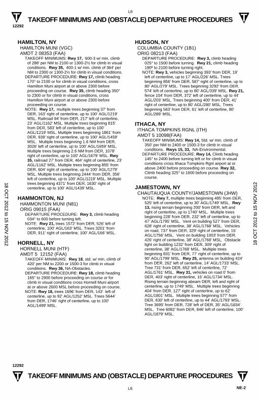
TAKEOFF MINIMUMS AND (OBSTACLE) DEPARTURE PROCEDURES 12292
L6
NE-2
TAKEOFF MINIMUMS AND (OBSTACLE) DEPARTURE PROCEDURES 12292
L6
T T
T T
HAMILTON, NY HAMILTON MUNI (VGC) AMDT 2 08353 (FAA)
TAKEOFF MINIMUMS: Rwy 17, 600-3 w/ min. climb of 288' per NM to 2100 or 1300-2½ for climb in visual conditions. Rwy 35, 400-1 w/ min. climb of 364' per NM to 2300 or 1300-2½ for climb in visual conditions.
DEPARTURE PROCEDURE: Rwy 17, climb heading 170° to 2100 or for climb in visual conditions, cross Hamilton Muni airport at or above 2300 before proceeding on course. Rwy 35, climb heading 350° to 2300 or for climb in visual conditions, cross Hamilton Muni airport at or above 2300 before proceeding on course.
NOTE: Rwy 17, multiple trees beginning 37' from DER, 163' right of centerline, up to 100' AGL/1219' MSL. Railroad 94' from DER, 217' left of centerline, 23' AGL/1162' MSL. Multiple trees beginning 815' from DER, 583' left of centerline, up to 100' AGL/1219' MSL. Multiple trees beginning 1861' from DER, 939' right of centerline, up to 100' AGL/1459' MSL. Multiple trees beginning 1.6 NM from DER, 3026' left of centerline, up to 100' AGL/1659' MSL. Multiple trees beginning 2.6 NM from DER, 1078' right of centerline, up to 100' AGL/1679' MSL. Rwy 35, railroad 27' from DER, 464' right of centerline, 23' AGL/1162' MSL. Multiple trees beginning 855' from DER, 604' right of centerline, up to 100' AGL/1279' MSL. Multiple trees beginning 2444' from DER, 356' left of centerline, up to 100' AGL/1219' MSL. Multiple trees beginning 4371' from DER, 1630' right of centerline, up to 100' AGL/1439' MSL.
HAMMONTON, NJ HAMMONTON MUNI (N81) ORIG 09015 (FAA)
DEPARTURE PROCEDURE: Rwy 3, climb heading 034° to 600 before turning left.
NOTE: Rwy 21, trees 1572' from DER, 526' left of centerline, 100' AGL/163' MSL. Trees 3201' from DER, 911' right of centerline, 100' AGL/166' MSL.
HORNELL, NY HORNELL MUNI (HTF) AMDT 5 12152 (FAA)
TAKEOFF MINIMUMS: Rwy 18, std. w/ min. climb of 420' per NM to 2200 or 1500-3 for climb in visual conditions. Rwy 36, NA-Obstacles.
DEPARTURE PROCEDURE: Rwy 18, climb heading 165° to 2900 before proceeding on course or for climb in visual conditions cross Hornell Muni airport at or above 2600 MSL before proceeding on course.
NOTE: Rwy 18, trees 1696' from DER, 143' left of centerline, up to 92' AGL/1252' MSL. Trees 5644' from DER, 1746' right of centerline, up to 100' AGL/1499' MSL.
HUDSON, NY COLUMBIA COUNTY (1B1) ORIG 08213 (FAA)
DEPARTURE PROCEDURE: Rwy 3, climb heading 025° to 1500 before turning. Rwy 21, climb heading 190º to 2100 before turning right.
NOTE: Rwy 3, vehicles beginning 393' from DER, 19' left of centerline, up to 17' AGL/226' MSL. Trees beginning 856' from DER, 587' right of centerline, up to 80' AGL/279' MSL. Trees beginning 3292' from DER, 574' left of centerline, up to 80' AGL/339' MSL. Rwy 21, fence 104' from DER, 372' left of centerline, up to 44' AGL/203' MSL. Trees beginning 400' from DER, 41' right of centerline, up to 80' AGL/280' MSL. Trees beginning 563' from DER, 61' left of centerline, 80' AGL/289' MSL.
ITHACA, NY ITHACA TOMPKINS RGNL (ITH) AMDT 5 10098(FAA)
TAKEOFF MINIMUMS: Rwy 14, Std. w/ min. climb of 350' per NM to 2400 or 1500-3 for climb in visual conditions. Rwys 15, 33, NA-Environmental.
DEPARTURE PROCEDURE: Rwy 14, Climb heading 145° to 2400 before turning left or for climb in visual conditions cross Ithaca Tompkins Rgnl airport at or above 2400 before proceeding on course. Rwy 32, Climb heading 325° to 1600 before proceeding on course.
JAMESTOWN, NY CHAUTAUQUA COUNTY/JAMESTOWN (JHW)
NOTE: Rwy 7, multiple trees beginning 495' from DER, 525' left of centerline, up to 30' AGL/1749' MSL. Rwy 13, rising terrain beginning 200' from DER, left and right of centerline, up to 1740' MSL. Multiple trees beginning 228' from DER, 232' left of centerline, up to 47' AGL/1795' MSL. Vent on building 527' from DER, 628' right of centerline, 38' AGL/1768' MSL. Vehicles on road, 737' from DER, 329' right of centerline, 15' AGL/1756' MSL. Vent on building 1003' from DER, 426' right of centerline, 38' AGL/1768' MSL. Obstacle light on building 1232' from DER, 309' right of centerline, 38' AGL/1768' MSL. Multiple trees beginning 831' from DER, 77' right of centerline, up to 90' AGL/1799' MSL. Rwy 25, antenna on building 424' from DER, 262' left of centerline, 14' AGL/1733' MSL. Tree 731' from DER, 652' left of centerline, 72' AGL/1761' MSL. Rwy 31, vehicles on road 0' from DER, 403' right of centerline, 15' AGL/1734' MSL. Rising terrain beginning abeam DER, left and right of centerline, up to 1749' MSL. Multiple trees beginning 404' from DER, 127' right of centerline, up to 62' AGL/1801' MSL. Multiple trees beginning 577' from DER, 630' left of centerline, up to 44' AGL/1793' MSL. Tree 3695' from DER, 728' left of DER, 35' AGL/1834' MSL. Tree 6082' from DER, 846' left of centerline, 100' AGL/1879' MSL.
18 OC
T 2012 to 15 N
OV
2012 1
8 O
CT
201
2 to
15
NO
V 2
012
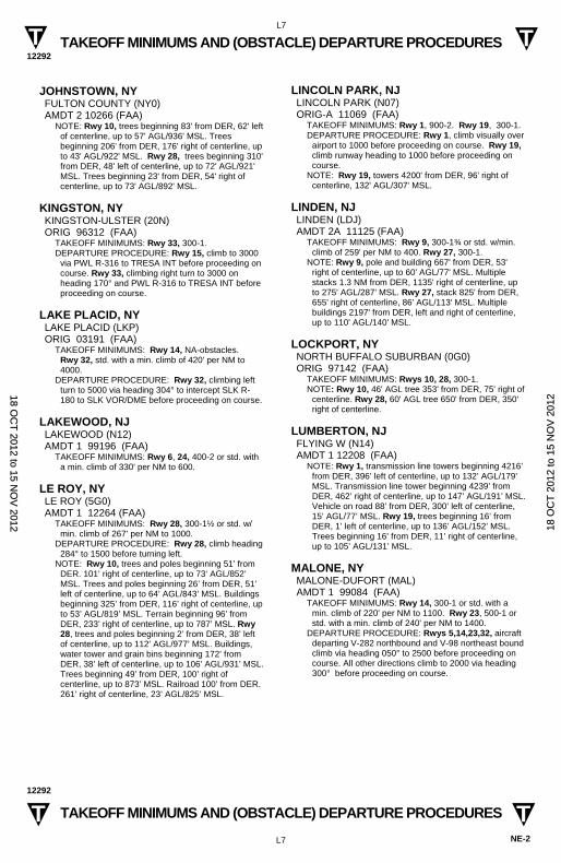
TAKEOFF MINIMUMS AND (OBSTACLE) DEPARTURE PROCEDURES 12292
L7
NE-2
TAKEOFF MINIMUMS AND (OBSTACLE) DEPARTURE PROCEDURES 12292
L7
T T
T T
JOHNSTOWN, NY FULTON COUNTY (NY0) AMDT 2 10266 (FAA)
NOTE: Rwy 10, trees beginning 83' from DER, 62' left of centerline, up to 57' AGL/936' MSL. Trees beginning 206' from DER, 176' right of centerline, up to 43' AGL/922' MSL. Rwy 28, trees beginning 310' from DER, 48' left of centerline, up to 72' AGL/921' MSL. Trees beginning 23' from DER, 54' right of centerline, up to 73' AGL/892' MSL.
KINGSTON, NY KINGSTON-ULSTER (20N) ORIG 96312 (FAA)
TAKEOFF MINIMUMS: Rwy 33, 300-1. DEPARTURE PROCEDURE: Rwy 15, climb to 3000
via PWL R-316 to TRESA INT before proceeding on course. Rwy 33, climbing right turn to 3000 on heading 170° and PWL R-316 to TRESA INT before proceeding on course.
LAKE PLACID, NY LAKE PLACID (LKP) ORIG 03191 (FAA)
TAKEOFF MINIMUMS: Rwy 14, NA-obstacles. Rwy 32, std. with a min. climb of 420' per NM to 4000.
DEPARTURE PROCEDURE: Rwy 32, climbing left turn to 5000 via heading 304° to intercept SLK R-180 to SLK VOR/DME before proceeding on course.
LAKEWOOD, NJ LAKEWOOD (N12) AMDT 1 99196 (FAA)
TAKEOFF MINIMUMS: Rwy 6, 24, 400-2 or std. with a min. climb of 330' per NM to 600.
LE ROY, NY LE ROY (5G0) AMDT 1 12264 (FAA)
TAKEOFF MINIMUMS: Rwy 28, 300-1½ or std. w/min. climb of 267’ per NM to 1000.
DEPARTURE PROCEDURE: Rwy 28, climb heading 284° to 1500 before turning left.
NOTE: Rwy 10, trees and poles beginning 51’ from DER. 101’ right of centerline, up to 73’ AGL/852’ MSL. Trees and poles beginning 26’ from DER, 51’ left of centerline, up to 64’ AGL/843’ MSL. Buildings beginning 325’ from DER, 116’ right of centerline, up to 53’ AGL/819’ MSL. Terrain beginning 96’ from DER, 233’ right of centerline, up to 787’ MSL. Rwy 28, trees and poles beginning 2’ from DER, 38’ left of centerline, up to 112’ AGL/977’ MSL. Buildings, water tower and grain bins beginning 172’ from DER, 38’ left of centerline, up to 106’ AGL/931’ MSL. Trees beginning 49’ from DER, 100’ right of centerline, up to 873’ MSL. Railroad 100’ from DER. 261’ right of centerline, 23’ AGL/825’ MSL.
LINCOLN PARK, NJ LINCOLN PARK (N07) ORIG-A 11069 (FAA)
TAKEOFF MINIMUMS: Rwy 1, 900-2. Rwy 19, 300-1. DEPARTURE PROCEDURE: Rwy 1, climb visually over
airport to 1000 before proceeding on course. Rwy 19, climb runway heading to 1000 before proceeding on course.
NOTE: Rwy 19, towers 4200' from DER, 96' right of centerline, 132' AGL/307' MSL.
LINDEN, NJ LINDEN (LDJ) AMDT 2A 11125 (FAA)
TAKEOFF MINIMUMS: Rwy 9, 300-1¾ or std. w/min. climb of 259' per NM to 400. Rwy 27, 300-1.
NOTE: Rwy 9, pole and building 667' from DER, 53' right of centerline, up to 60' AGL/77' MSL. Multiple stacks 1.3 NM from DER, 1135' right of centerline, up to 275' AGL/287' MSL. Rwy 27, stack 825' from DER, 655' right of centerline, 86' AGL/113' MSL. Multiple buildings 2197' from DER, left and right of centerline, up to 110' AGL/140' MSL.
LOCKPORT, NY NORTH BUFFALO SUBURBAN (0G0) ORIG 97142 (FAA)
TAKEOFF MINIMUMS: Rwys 10, 28, 300-1. NOTE: Rwy 10, 46' AGL tree 353' from DER, 75' right of
centerline. Rwy 28, 60' AGL tree 650' from DER, 350' right of centerline.
LUMBERTON, NJ FLYING W (N14) AMDT 1 12208 (FAA)
NOTE: Rwy 1, transmission line towers beginning 4216’ from DER, 396’ left of centerline, up to 132’ AGL/179’ MSL. Transmission line tower beginning 4239’ from DER, 462’ right of centerline, up to 147’ AGL/191’ MSL. Vehicle on road 88’ from DER, 300’ left of centerline, 15’ AGL/77’ MSL. Rwy 19, trees beginning 16’ from DER, 1’ left of centerline, up to 136’ AGL/152’ MSL. Trees beginning 16’ from DER, 11’ right of centerline, up to 105’ AGL/131’ MSL.
MALONE, NY MALONE-DUFORT (MAL) AMDT 1 99084 (FAA)
TAKEOFF MINIMUMS: Rwy 14, 300-1 or std. with a min. climb of 220' per NM to 1100. Rwy 23, 500-1 or std. with a min. climb of 240' per NM to 1400.
DEPARTURE PROCEDURE: Rwys 5,14,23,32, aircraft departing V-282 northbound and V-98 northeast bound climb via heading 050° to 2500 before proceeding on course. All other directions climb to 2000 via heading 300° before proceeding on course.
18 OC
T 2012 to 15 N
OV
2012 1
8 O
CT
201
2 to
15
NO
V 2
012
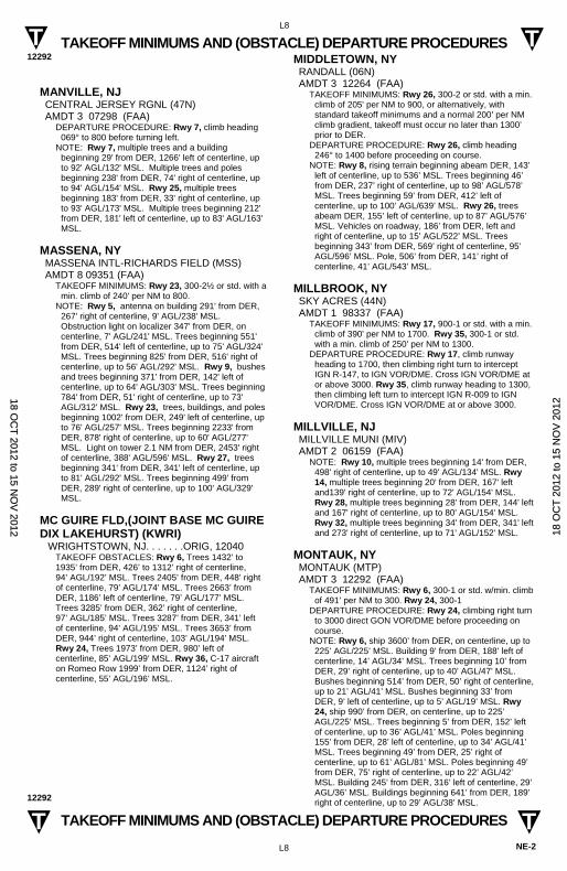
TAKEOFF MINIMUMS AND (OBSTACLE) DEPARTURE PROCEDURES 12292
L8
NE-2
TAKEOFF MINIMUMS AND (OBSTACLE) DEPARTURE PROCEDURES 12292
L8
T T
T T
MANVILLE, NJ CENTRAL JERSEY RGNL (47N) AMDT 3 07298 (FAA)
DEPARTURE PROCEDURE: Rwy 7, climb heading 069° to 800 before turning left.
NOTE: Rwy 7, multiple trees and a building beginning 29' from DER, 1266' left of centerline, up to 92' AGL/132' MSL. Multiple trees and poles beginning 238' from DER, 74' right of centerline, up to 94' AGL/154' MSL. Rwy 25, multiple trees beginning 183' from DER, 33' right of centerline, up to 93' AGL/173' MSL. Multiple trees beginning 212' from DER, 181' left of centerline, up to 83' AGL/163' MSL.
MASSENA, NY MASSENA INTL-RICHARDS FIELD (MSS) AMDT 8 09351 (FAA)
TAKEOFF MINIMUMS: Rwy 23, 300-2½ or std. with a min. climb of 240' per NM to 800.
NOTE: Rwy 5, antenna on building 291' from DER, 267' right of centerline, 9' AGL/238' MSL. Obstruction light on localizer 347' from DER, on centerline, 7' AGL/241' MSL. Trees beginning 551' from DER, 514' left of centerline, up to 75' AGL/324' MSL. Trees beginning 825' from DER, 516' right of centerline, up to 56' AGL/292' MSL. Rwy 9, bushes and trees beginning 371' from DER, 142' left of centerline, up to 64' AGL/303' MSL. Trees beginning 784' from DER, 51' right of centerline, up to 73' AGL/312' MSL. Rwy 23, trees, buildings, and poles beginning 1002' from DER, 249' left of centerline, up to 76' AGL/257' MSL. Trees beginning 2233' from DER, 878' right of centerline, up to 60' AGL/277' MSL. Light on tower 2.1 NM from DER, 2453' right of centerline, 388' AGL/596' MSL. Rwy 27, trees beginning 341' from DER, 341' left of centerline, up to 81' AGL/292' MSL. Trees beginning 499' from DER, 289' right of centerline, up to 100' AGL/329' MSL.
MC GUIRE FLD,(JOINT BASE MC GUIRE DIX LAKEHURST) (KWRI) WRIGHTSTOWN, NJ. . . . . . .ORIG, 12040
TAKEOFF OBSTACLES: Rwy 6, Trees 1432’ to 1935’ from DER, 426’ to 1312’ right of centerline, 94’ AGL/192’ MSL. Trees 2405’ from DER, 448’ right of centerline, 79’ AGL/174’ MSL. Trees 2663’ from DER, 1186’ left of centerline, 79’ AGL/177’ MSL. Trees 3285’ from DER, 362’ right of centerline, 97’ AGL/185’ MSL. Trees 3287’ from DER, 341’ left of centerline, 94’ AGL/195’ MSL. Trees 3653’ from DER, 944’ right of centerline, 103’ AGL/194’ MSL. Rwy 24, Trees 1973’ from DER, 980’ left of centerline, 85’ AGL/199’ MSL. Rwy 36, C-17 aircraft on Romeo Row 1999’ from DER, 1124’ right of centerline, 55’ AGL/196’ MSL.
MIDDLETOWN, NY RANDALL (06N) AMDT 3 12264 (FAA)
TAKEOFF MINIMUMS: Rwy 26, 300-2 or std. with a min. climb of 205' per NM to 900, or alternatively, with standard takeoff minimums and a normal 200’ per NM climb gradient, takeoff must occur no later than 1300’ prior to DER.
DEPARTURE PROCEDURE: Rwy 26, climb heading 246° to 1400 before proceeding on course.
NOTE: Rwy 8, rising terrain beginning abeam DER, 143’ left of centerline, up to 536’ MSL. Trees beginning 46’ from DER, 237’ right of centerline, up to 98’ AGL/578’ MSL. Trees beginning 59’ from DER, 412’ left of centerline, up to 100’ AGL/639’ MSL. Rwy 26, trees abeam DER, 155’ left of centerline, up to 87’ AGL/576’ MSL. Vehicles on roadway, 186’ from DER, left and right of centerline, up to 15’ AGL/522’ MSL. Trees beginning 343’ from DER, 569’ right of centerline, 95’ AGL/596’ MSL. Pole, 506’ from DER, 141’ right of centerline, 41’ AGL/543’ MSL.
MILLBROOK, NY SKY ACRES (44N) AMDT 1 98337 (FAA)
TAKEOFF MINIMUMS: Rwy 17, 900-1 or std. with a min. climb of 390' per NM to 1700. Rwy 35, 300-1 or std. with a min. climb of 250' per NM to 1300.
DEPARTURE PROCEDURE: Rwy 17, climb runway heading to 1700, then climbing right turn to intercept IGN R-147, to IGN VOR/DME. Cross IGN VOR/DME at or above 3000. Rwy 35, climb runway heading to 1300, then climbing left turn to intercept IGN R-009 to IGN VOR/DME. Cross IGN VOR/DME at or above 3000.
MILLVILLE, NJ MILLVILLE MUNI (MIV) AMDT 2 06159 (FAA)
NOTE: Rwy 10, multiple trees beginning 14' from DER, 498' right of centerline, up to 49' AGL/134' MSL. Rwy 14, multiple trees beginning 20' from DER, 167' left and139' right of centerline, up to 72' AGL/154' MSL. Rwy 28, multiple trees beginning 28' from DER, 144' left and 167' right of centerline, up to 80' AGL/154' MSL. Rwy 32, multiple trees beginning 34' from DER, 341' left and 273' right of centerline, up to 71' AGL/152' MSL.
MONTAUK, NY MONTAUK (MTP) AMDT 3 12292 (FAA)
TAKEOFF MINIMUMS: Rwy 6, 300-1 or std. w/min. climb of 491’ per NM to 300. Rwy 24, 300-1
DEPARTURE PROCEDURE: Rwy 24, climbing right turn to 3000 direct GON VOR/DME before proceeding on course.
NOTE: Rwy 6, ship 3600’ from DER, on centerline, up to 225’ AGL/225’ MSL. Building 9’ from DER, 188’ left of centerline, 14’ AGL/34’ MSL. Trees beginning 10’ from DER, 29’ right of centerline, up to 40’ AGL/47’ MSL. Bushes beginning 514’ from DER, 50’ right of centerline, up to 21’ AGL/41’ MSL. Bushes beginning 33’ from DER, 9’ left of centerline, up to 5’ AGL/19’ MSL. Rwy 24, ship 990’ from DER, on centerline, up to 225’ AGL/225’ MSL. Trees beginning 5’ from DER, 152’ left of centerline, up to 36’ AGL/41’ MSL. Poles beginning 155’ from DER, 28’ left of centerline, up to 34’ AGL/41’ MSL. Trees beginning 49’ from DER, 25’ right of centerline, up to 61’ AGL/81’ MSL. Poles beginning 49’ from DER, 75’ right of centerline, up to 22’ AGL/42’ MSL. Building 245’ from DER, 316’ left of centerline, 29’ AGL/36’ MSL. Buildings beginning 641’ from DER, 189’ right of centerline, up to 29’ AGL/38’ MSL.
18 OC
T 2012 to 15 N
OV
2012 1
8 O
CT
201
2 to
15
NO
V 2
012
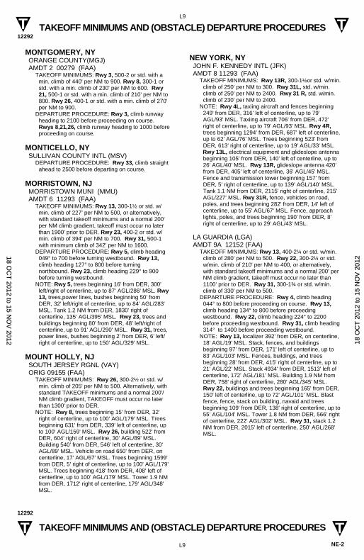
TAKEOFF MINIMUMS AND (OBSTACLE) DEPARTURE PROCEDURES 12292
L9
NE-2
TAKEOFF MINIMUMS AND (OBSTACLE) DEPARTURE PROCEDURES 12292
L9
T T
T T
MONTGOMERY, NY ORANGE COUNTY(MGJ) AMDT 2 00279 (FAA)
TAKEOFF MINIMUMS: Rwy 3, 500-2 or std. with a min. climb of 440' per NM to 900. Rwy 8, 300-1 or std. with a min. climb of 230' per NM to 600. Rwy 21, 500-1 or std. with a min. climb of 210' per NM to 800. Rwy 26, 400-1 or std. with a min. climb of 270' per NM to 900.
DEPARTURE PROCEDURE: Rwy 3, climb runway heading to 2100 before proceeding on course. Rwys 8,21,26, climb runway heading to 1000 before proceeding on course.
MONTICELLO, NY SULLIVAN COUNTY INTL (MSV)
DEPARTURE PROCEDURE: Rwy 33, climb straight ahead to 2500 before departing on course.
MORRISTOWN, NJ MORRISTOWN MUNI (MMU) AMDT 6 11293 (FAA)
TAKEOFF MINIMUMS: Rwy 13, 300-1½ or std. w/min. climb of 227’ per NM to 500, or alternatively, with standard takeoff minimums and a normal 200' per NM climb gradient, takeoff must occur no later than 1900' prior to DER. Rwy 23, 400-2 or std. w/min. climb of 394' per NM to 700. Rwy 31, 500-1 with minimum climb of 342' per NM to 1600.
DEPARTURE PROCEDURE: Rwy 5, climb heading 049° to 700 before turning westbound. Rwy 13, climb heading 127° to 800 before turning northbound. Rwy 23, climb heading 229° to 900 before turning westbound.
NOTE: Rwy 5, trees beginning 16' from DER, 300' left/right of centerline, up to 87' AGL/286' MSL. Rwy 13, trees,power lines, bushes beginning 50' from DER, 32' left/right of centerline, up to 84' AGL/283' MSL. Tank 1.2 NM from DER, 1830' right of centerline, 135' AGL/395' MSL. Rwy 23, trees and buildings beginning 80' from DER, 48’ left/right of centerline, up to 91' AGL/290' MSL. Rwy 31, trees, power lines, bushes beginning 2' from DER, 6' left/right of centerline, up to 150' AGL/329' MSL.
MOUNT HOLLY, NJ SOUTH JERSEY RGNL (VAY) ORIG 09155 (FAA)
TAKEOFF MINIMUMS: Rwy 26, 300-2½ or std. w/ min. climb of 205' per NM to 500. Alternatively, with standard TAKEOFF minimums and a normal 200'/NM climb gradient, TAKEOFF must occur no later than 1300' prior to DER.
NOTE: Rwy 8, trees beginning 15' from DER, 32' right of centerline, up to 100' AGL/179' MSL. Trees beginning 631' from DER, 339' left of centerline, up to 100' AGL/159' MSL. Rwy 26, building 522' from DER, 604' right of centerline, 30' AGL/89' MSL. Building 540' from DER, 546' left of centerline, 30' AGL/89' MSL. Vehicle on road 650' from DER, on centerline, 17' AGL/67' MSL. Trees beginning 1599' from DER, 5' right of centerline, up to 100' AGL/179' MSL. Trees beginning 418' from DER, 408' left of centerline, up to 100' AGL/179' MSL. Tower 1.9 NM from DER, 1712' right of centerline, 179' AGL/348' MSL.
NEW YORK, NY JOHN F. KENNEDY INTL (JFK) AMDT 8 11293 (FAA)
TAKEOFF MINIMUMS: Rwy 13R, 300-1½or std. w/min. climb of 250' per NM to 300. Rwy 31L, std. w/min. climb of 250' per NM to 2400. Rwy 31 R, std. w/min. climb of 230' per NM to 2400.
NOTE: Rwy 4L, taxiing aircraft and fences beginning 249' from DER, 316' left of centerline, up to 79' AGL/93' MSL. Taxiing aircraft 706' from DER, 472' right of centerline, up to 79' AGL/93' MSL. Rwy 4R, trees beginning 1294' from DER, 687' left of centerline, up to 62' AGL/76' MSL. Trees beginning 523' from DER, 613' right of centerline, up to 19' AGL/33' MSL.
Rwy 13L, electrical equipment and glideslope antenna beginning 105' from DER, 140' left of centerline, up to 26' AGL/40' MSL. Rwy 13R, glideslope antenna 420' from DER, 405' left of centerline, 36' AGL/45' MSL. Fence and transmission tower beginning 157' from DER, 5' right of centerline, up to 139' AGL/140' MSL. Tank 1.1 NM from DER, 2115' right of centerline, 215' AGL/227' MSL. Rwy 31R, fence, vehicles on road, poles, and trees beginning 282' from DER, 14' left of centerline, up to 55' AGL/67' MSL. Fence, approach lights, poles, and trees beginning 190' from DER, 8' right of centerline, up to 29' AGL/43' MSL.
LA GUARDIA (LGA) AMDT 9A 12152 (FAA)
TAKEOFF MINIMUMS: Rwy 13, 400-2¼ or std. w/min. climb of 280' per NM to 500. Rwy 22, 300-2¼ or std. w/min. climb of 210' per NM to 400, or alternatively, with standard takeoff minimums and a normal 200' per NM climb gradient, takeoff must occur no later than 1100' prior to DER. Rwy 31, 300-1¾ or std. w/min. climb of 330' per NM to 500.
DEPARTURE PROCEDURE: Rwy 4, climb heading 044° to 800 before proceeding on course. Rwy 13, climb heading 134° to 800 before proceeding westbound. Rwy 22, climb heading 224° to 2200 before proceeding westbound. Rwy 31, climb heading 314° to 1400 before proceeding westbound.
NOTE: Rwy 13, localizer 392' from DER, on centerline, 18' AGL/19' MSL. Stack, fences, and buildings beginning 97’ from DER, 171' left of centerline, up to 83' AGL/103' MSL. Fences, buildings, and trees beginning 28' from DER, 415' right of centerline, up to 21' AGL/22' MSL. Stack 4934' from DER, 1513' left of centerline, 172' AGL/181' MSL. Building 1.9 NM from DER, 758' right of centerline, 280' AGL/345' MSL. Rwy 22, buildings and trees beginning 165' from DER, 150' left of centerline, up to 72' AGL/101' MSL. Blast fence, fence, stack on building, navaid and trees beginning 109' from DER, 138' right of centerline, up to 55' AGL/104' MSL. Tower 1.8 NM from DER, 566' right of centerline, 222' AGL/302' MSL. Rwy 31, stack 1.2 NM from DER, 2015' left of centerline, 250' AGL/268' MSL.
18 OC
T 2012 to 15 N
OV
2012 1
8 O
CT
201
2 to
15
NO
V 2
012
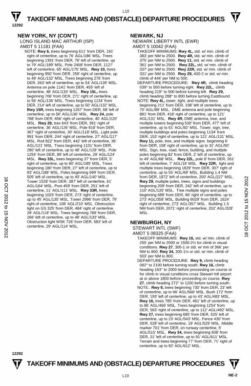
TAKEOFF MINIMUMS AND (OBSTACLE) DEPARTURE PROCEDURES 12292
L10
NE-2
TAKEOFF MINIMUMS AND (OBSTACLE) DEPARTURE PROCEDURES 12292
L10
T T
T T
NEW YORK, NY (CON'T) LONG ISLAND MAC ARTHUR (ISP) AMDT 5 11181 (FAA)
NOTE: Rwy 6, trees beginning 611' from DER, 191' right of centerline, up to 76’ AGL/186’ MSL. Trees beginning 1391' from DER, 76' left of centerline, up to 79' AGL/189' MSL. Pole 2458' from DER, 1127' left of centerline, 65' AGL/175' MSL. Rwy 10, trees beginning 950' from DER, 259' right of centerline, up to 49' AGL/132' MSL. Trees beginning 276' from DER, 263' left of centerline, up to 54' AGL/139' MSL. Antenna on pole 1141' from DER, 455' left of centerline, 48' AGL/133’ MSL. Rwy 15L, trees beginning 706' from DER, 271' right of centerline, up to 56' AGL/136' MSL. Trees beginning 1134' from DER, 214' left of centerline, up to 50' AGL/132' MSL. Rwy 15R, trees beginning 1267' from DER, 68' left of centerline, up to 56' AGL/136' MSL. Rwy 24, pole 788' from DER, 656' right of centerline, 40' AGL/120' MSL. Rwy 28, tree 643' from DER, 391' right of centerline, 36' AGL/126' MSL. Pole 918' from DER, 367' right of centerline, 30' AGL/118' MSL. Light pole 991' from DER, 244' right of centerline, 27' AGL/117’ MSL. Rod 822’ from DER, 442’ left of centerline, 36' AGL/121' MSL. Trees beginning 1101' from DER, 280' left of centerline, up to 48’ AGL/128’ MSL. Pole 1254’ from DER, 89' left of centerline, 29' AGL/124' MSL. Rwy 33L, trees beginning 37' from DER, 5' right of centerline, up to 80' AGL/185' MSL. Trees beginning 180' from DER, 27' left of centerline, up to 83' AGL/188' MSL. Poles beginning 699' from DER, 505' left of centerline, up to 40' AGL/140' MSL. Tower 1528' from DER, 387' left of centerline, 61' AGL/164' MSL. Post 459' from DER, 251' left of centerline, 11' AGL/111' MSL. Rwy 33R, trees beginning 1025' from DER, 273' right of centerline, up to 45' AGL/135' MSL. Tower 2996' from DER, 79' right of centerline, 108' AGL/210' MSL. Obstruction light on GS 325' from DER, 484' right of centerline, 28' AGL/118' MSL. Trees beginning 789' from DER, 266' left of centerline, up to 48' AGL/133' MSL. Obstruction light WSK 726' from DER, 583' left of centerline, 29' AGL/114' MSL.
NEWARK, NJ NEWARK LIBERTY INTL (EWR) AMDT 5 10042 (FAA)
TAKEOFF MINIMUMS: Rwy 4L, std. w/ min. climb of 383' per NM to 2500. Rwy 4R, std. w/ min. climb of 375' per NM to 2500. Rwy 11, std. w/ min. climb of 361' per NM to 2500. Rwy 22L, std. w/ min. climb of 337' per NM to 2500. Rwy 22R, std. w/ min. climb of 331' per NM to 2500. Rwy 29, 400-2 or std. w/ min. climb of 444' per NM to 500.
DEPARTURE PROCEDURE: Rwy 4R, climb heading 039° to 500 before turning right. Rwy 22L, climb heading 219° to 500 before turning left. Rwy 29, climb heading 288° to 800 before turning Eastbound.
NOTE: Rwy 4L, tower, light, and multiple trees beginning 211' from DER, 198' left of centerline, up to 70' AGL/89' MSL. DME antenna and pole beginning 881' from DER, 418' right of centerline, up to 121' AGL/131' MSL. Rwy 4R, DME antenna, tree, and multiple towers beginning 530' from DER, 477' left of centerline, up to 61' AGL/82' MSL. Tower, sign, tree, multiple buildings and poles beginning 1134' from DER, 153' right of centerline, up to 121' AGL/131' MSL. Rwy 11, pole, tree, and multiple signs beginning 6' from DER, 158' right of centerline, up to 31' AGL/50' MSL. Sign, tree, road, fence, building, and multiple poles beginning 82' from DER, 2' left of centerline, up to 49' AGL/68' MSL. Rwy 22L, pole 8' from DER, 261' left of centerline, 7' AGL/16' MSL. Rwy 22R, light and multiple trees beginning 1829' from DER, 307' right of centerline, up to 55' AGL/69' MSL. Building 1.4 NM from DER, 1872' left of centerline, 200' AGL/227' MSL. Rwy 29, multiple poles, trees, signs and buildings beginning 209' from DER, 242' left of centerline, up to 110' AGL/120' MSL. Tree multiple signs and poles beginning 689' from DER, 66' right of centerline, up to 273' AGL/358' MSL. Building 6029' from DER, 1624' right of centerline, 273' AGL/357' MSL. Building 1.5 NM from DER, 2071' right of centerline, 202' AGL/328' MSL.
NEWBURGH, NY STEWART INTL (SWF) AMDT 5 08325 (FAA)
TAKEOFF MINIMUMS: Rwy 16, std. w/ min. climb of 255’ per NM to 2000 or 1500-2½ for climb in visual conditions. Rwy 27, 300-1 or std. w/ min of 366’ per NM to 800. Rwy 34, 300-1¼ or std. w/ min. climb of 503’ per NM to 800.
DEPARTURE PROCEDURE: Rwy 9, climb heading 092° to 2100 before turning south. Rwy 16, climb heading 163° to 2000 before proceeding on course or for climb in visual conditions cross Stewart Intl airport at or above 1800 before proceeding on course. Rwy 27, climb heading 272° to 1200 before turning south.
NOTE:. Rwy 9, trees beginning 730' from DER, 23' left of centerline, up to 66' AGL/566' MSL. Bush 172' from DER, 193' left of centerline, up to 43' AGL/483' MSL. Rwy 16, trees 785' from DER, 461' left of centerline, up to 86' AGL/466' MSL. Trees beginning 1254' from DER, 563' right of centerline, up to 112' AGL/492' MSL. Rwy 27, trees beginning 685' from DER, 525' left of centerline, up to 23' AGL/543' MSL. Fence 430' from DER, 528' left of centerline, 19' AGL/529' MSL. Middle marker 701' from DER, on runway centerline, 5' AGL/515' MSL. Rwy 34, trees beginning 608' from DER, 21' left of centerline, up to 91' AGL/611' MSL. Terrain and trees beginning 77' from DER, 71' right of centerline, up to 92' AGL/612' MSL.
18 OC
T 2012 to 15 N
OV
2012 1
8 O
CT
201
2 to
15
NO
V 2
012
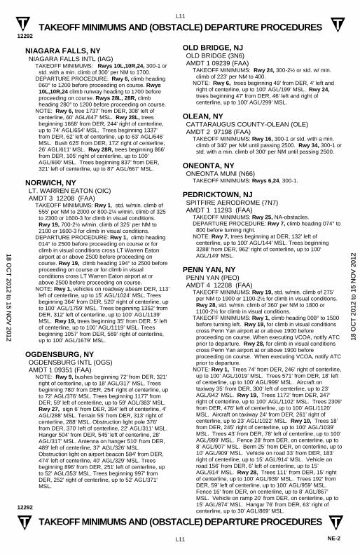
TAKEOFF MINIMUMS AND (OBSTACLE) DEPARTURE PROCEDURES 12292
L11
NE-2
TAKEOFF MINIMUMS AND (OBSTACLE) DEPARTURE PROCEDURES 12292
L11
T T
T T
NIAGARA FALLS, NY NIAGARA FALLS INTL (IAG)
TAKEOFF MINIMUMS: Rwys 10L,10R,24, 300-1 or std. with a min. climb of 300' per NM to 1700.
DEPARTURE PROCEDURE: Rwy 6, climb heading 060° to 1200 before proceeding on course. Rwys 10L,10R,24 climb runway heading to 1700 before proceeding on course. Rwys 28L, 28R, climb heading 280° to 1200 before proceeding on course.
NOTE: Rwy 6, tree 1737' from DER, 308' left of centerline, 60' AGL/647' MSL. Rwy 28L, trees beginning 1668' from DER, 244' right of centerline, up to 74' AGL/654' MSL. Trees beginning 1337' from DER, 62' left of centerline, up to 63' AGL/646' MSL. Bush 625' from DER, 172' right of centerline, 26' AGL/611' MSL. Rwy 28R, trees beginning 866' from DER, 105' right of centerline, up to 100' AGL/690' MSL. Trees beginning 837' from DER, 321' left of centerline, up to 87' AGL/667' MSL.
NORWICH, NY LT. WARREN EATON (OIC) AMDT 3 12208 (FAA)
TAKEOFF MINIMUMS: Rwy 1, std. w/min. climb of 555’ per NM to 2000 or 800-2¼ w/min. climb of 325 to 2300 or 1600-3 for climb in visual conditions. Rwy 19, 700-2½ w/min. climb of 325’ per NM to 2100 or 1600-3 for climb in visual conditions.
DEPARTURE PROCEDURE: Rwy 1, climb heading 014° to 2500 before proceeding on course or for climb in visual conditions cross LT Warren Eaton airport at or above 2500 before proceeding on course. Rwy 19, climb heading 194° to 2500 before proceeding on course or for climb in visual conditions cross LT Warren Eaton airport at or above 2500 before proceeding on course.
NOTE: Rwy 1, vehicles on roadway abeam DER, 113’ left of centerline, up to 15’ AGL/1024’ MSL. Trees beginning 364’ from DER, 520’ right of centerline, up to 100’ AGL/1759’ MSL. Trees beginning 1352’ from DER, 312’ left of centerline, up to 100’ AGL/1139’ MSL. Rwy 19, trees beginning 35’ from DER. 5’ left of centerline, up to 100’ AGL/1119’ MSL. Trees beginning 1057’ from DER, 569’ right of centerline, up to 100’ AGL/1679’ MSL.
OGDENSBURG, NY OGDENSBURG INTL (OGS) AMDT 1 09351 (FAA)
NOTE: Rwy 9, bushes beginning 72' from DER, 321' right of centerline, up to 18' AGL/317' MSL. Trees beginning 780' from DER, 254' right of centerline, up to 72' AGL/376' MSL. Trees beginning 1177' from DER, 59' left of centerline, up to 59' AGL/383' MSL. Rwy 27, sign 6' from DER, 394' left of centerline, 4' AGL/288' MSL. Terrain 55' from DER, 313' right of centerline, 288' MSL. Obstruction light pole 376' from DER, 370' left of centerline, 22' AGL/311' MSL. Hanger 504' from DER, 545' left of centerline, 28' AGL/317' MSL. Antenna on hanger 510' from DER, 489' left of centerline, 37' AGL/326' MSL. Obstruction light on airport beacon 584' from DER, 474' left of centerline, 40' AGL/329' MSL. Trees beginning 896' from DER, 251' left of centerline, up to 52' AGL/353' MSL. Trees beginning 997' from DER, 252' right of centerline, up to 52' AGL/371' MSL.
OLD BRIDGE, NJ OLD BRIDGE (3N6) AMDT 1 09239 (FAA)
TAKEOFF MINIMUMS: Rwy 24, 300-2½ or std. w/ min. climb of 223' per NM to 400.
NOTE: Rwy 6, trees beginning 49' from DER, 4' left and right of centerline, up to 100' AGL/199' MSL. Rwy 24, trees beginning 47' from DER, 46' left and right of centerline, up to 100' AGL/299' MSL.
OLEAN, NY CATTARAUGUS COUNTY-OLEAN (OLE) AMDT 2 97198 (FAA)
TAKEOFF MINIMUMS: Rwy 16, 300-1 or std. with a min. climb of 340' per NM until passing 2500. Rwy 34, 300-1 or std. with a min. climb of 300' per NM until passing 2500.
ONEONTA, NY ONEONTA MUNI (N66)
TAKEOFF MINIMUMS: Rwys 6,24, 300-1.
PEDRICKTOWN, NJ SPITFIRE AERODROME (7N7) AMDT 1 11293 (FAA)
TAKEOFF MINIMUMS: Rwy 25, NA-obstacles. DEPARTURE PROCEDURE: Rwy 7, climb heading 074° to
800 before turning right. NOTE: Rwy 7, trees beginning at DER, 132' left of
centerline, up to 100' AGL/144' MSL. Trees beginning 3288' from DER, 962' right of centerline, up to 100' AGL/149' MSL.
PENN YAN, NY PENN YAN (PEO) AMDT 4 12208 (FAA)
TAKEOFF MINIMUMS: Rwy 19, std. w/min. climb of 275’ per NM to 1900 or 1100-2½ for climb in visual conditions. Rwy 28, std. w/min. climb of 360’ per NM to 1800 or
1100-2½ for climb in visual conditions. TAKEOFF MINIMUMS: Rwy 1, climb heading 008° to 1500
before turning left. Rwy 19, for climb in visual conditions cross Penn Yan airport at or above 1900 before proceeding on course. When executing VCOA, notify ATC prior to departure. Rwy 28, for climb in visual conditions cross Penn Yan airport at or above 1900 before proceeding on course. When executing VCOA, notify ATC prior to departure.
NOTE: Rwy 1, Trees 74’ from DER, 246’ right of centerline, up to 100’ AGL/1019’ MSL. Trees 571’ from DER, 18’ left of centerline, up to 100’ AGL/999’ MSL. Aircraft on taxiway 35’ from DER, 300’ left of centerline, up to 23’ AGL/942’ MSL. Rwy 19, Trees 1172’ from DER, 347’ right of centerline, up to 100’ AGL/1102’ MSL. Trees 2309’ from DER, 476’ left of centerline, up to 100’ AGL/1120’ MSL. Aircraft on taxiway 24’ from DER, 261’ right of centerline, up to 23’ AGL/1022’ MSL. Rwy 10, Trees 18’ from DER, 245’ right of centerline, up to 100’ AGL/1039’ MSL. Trees 43’ from DER, 78’ left of centerline, up to 100’ AGL/999’ MSL. Fence 28’ from DER, on centerline, up to 8’ AGL/907’ MSL. Berm 25’ from DER, on centerline, up to 10’ AGL/909’ MSL. Vehicle on road 33’ from DER, 183’ right of centerline, up to 15’ AGL/914’ MSL. Vehicle on road 156’ from DER, 6’ left of centerline, up to 15’ AGL/914’ MSL. Rwy 28, Trees 111’ from DER, 15’ right of centerline, up to 100’ AGL/939’ MSL. Trees 192’ from DER, 59’ left of centerline, up to 100’ AGL/959’ MSL. Fence 16’ from DER, on centerline, up to 8’ AGL/867’ MSL. Vehicle on ramp 20’ from DER, on centerline, up to 15’ AGL/874’ MSL. Hangar 76’ from DER, 63’ right of centerline, up to 30’ AGL/869’ MSL.
18 OC
T 2012 to 15 N
OV
2012 1
8 O
CT
201
2 to
15
NO
V 2
012
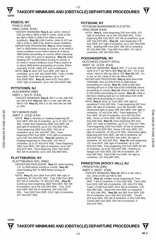
TAKEOFF MINIMUMS AND (OBSTACLE) DEPARTURE PROCEDURES 12292
L12
NE-2
TAKEOFF MINIMUMS AND (OBSTACLE) DEPARTURE PROCEDURES 12292
L12
T T
T T
PISECO, NY PISECO (K09) ORIG 12208 (FAA)
TAKEOFF MINIMUMS: Rwy 4, std. w/min. climb of 539’ per NM to 2800 or 600-3 w/min. climb of 316’ per NM to 4500 or 2000-3 for climb in visual conditions. Rwy 22,1100-3 w/min. climb of 473’ per NM to 3100 or 2000-3 for climb in visual conditions.
DEPARTURE PROCEDURE: Rwy 4, climb heading 045° to 4500 before turning on course, or for climb in visual conditions cross Piseco airport at or above 3600 before proceeding on course. When executing VCOA, notify ATC prior to departure. Rwy 22, climb heading 225° to 3500 before turning on course, or for climb in visual conditions cross Piseco airport at or above 3600 before proceeding on course. When executing VCOA, notify ATC prior to departure.
NOTE: Rwy 4, trees 343’ from DER, 192’ right of centerline, up to 100’ AGL/2244’ MSL. Trees 1.8 NM from DER, 2104‘ left of centerline, up to 100’ AGL/2500’ MSL. Rwy 22, trees 4152’ from DER, 1433’ right of centerline, up to 100’ AGL/2520’ MSL.
PITTSTOWN, NJ ALEXANDRIA (N85) AMDT 1 92175 (FAA)
TAKEOFF MINIMUMS: Rwy 8, 400-1 or std. with 400' per NM to 900. Rwy 13, 300-1 or std. with 460' per NM to 700. Rwy 31, 600-1 or std. with 340' per NM to 1200.
SKY MANOR (N40) AMDT 2 12152 (FAA)
NOTE: Rwy 7, vehicles on roadway beginning 38' from DER, 283' left of centerline, up to 15' AGL/ 574' MSL. Power lines beginning 2008' from DER, left and right of centerline, up to 122' AGL/652' MSL. Trees beginning 2550' from DER, 756' left of centerline, up to 100' AGL/657' MSL. Trees beginning 4763' from DER, 1716' right of centerline, up to 100' AGL/699' MSL. Rwy 25, vehicles on roadway beginning 51' from DER, 375' left of centerline, up to 15' AGL/574' MSL. Trees beginning 1965' from DER, 139' right of centerline, up to 100' AGL/679' MSL. Trees beginning 2261' from DER, 961' left of centerline, up to 100' AGL/659' MSL.
PLATTSBURGH, NY PLATTSBURGH INTL (PBG)
DEPARTURE PROCEDURE: Rwy 17, climb heading 172° to 2500 before turning on course. Rwy 35, climb heading 352° to 2800 before turning on course.
NOTE: Rwy 17, tree 1844' from DER, 966' right of centerline, 87' AGL/237' MSL. Tree 2289' from DER, 937' left of centerline, 75' AGL/222' MSL. Rwy 35, numerous trees beginning 1602' from DER, 501' left of centerline, up to 63' AGL/293' MSL. Tree, 2270' from DER, 944' left of centerline, 104' AGL/334' MSL. Tree 2035' from DER, 1014' right of centerline, 107' AGL/307' MSL.
POTSDAM, NY POTSDAM MUNI/DAMON FLD (PTD) ORIG 09295 (FAA)
NOTE: Rwy 6, trees beginning 229' from DER, 122' right of centerline, up to 100' AGL/569' MSL. Trees beginning 926' from DER, 322' left of centerline, up to 100' AGL/579' MSL. Rwy 24, trees beginning 776' from DER, 370' right of centerline, up to 100' AGL/559' MSL. Building 549' from DER, 395' left of centerline, 40' AGL/509' MSL. Tree 846' from DER, 471' left of centerline, 100' AGL/559' MSL.
POUGHKEEPSIE, NY DUTCHESS COUNTY (POU) AMDT 1A 11125 (FAA)
TAKEOFF MINIMUMS: Rwy 6, 500 - 2 ½ or std. w/min. climb of 277' per NM to 600. Rwy 15, 400 - 1¾ or std. w/min. climb of 346' per NM to 700. Rwy 33, 400 - 1½ or std. w/ min. climb of 242' per NM to 500.
DEPARTURE PROCEDURE: Rwy 6,climb direct IGN VOR/DME, then via IGN R-070 to 2000 before proceeding on course. Rwy 15, climb to 600 then climbing left turn to 1000 direct IGN VOR/DME before proceeding on course. Rwy 24, climb to 2000 via IGN R-250 before proceeding on course. Rwy 33, climb to 600 then climbing right turn to 1000 direct IGN VOR/DME before proceeding on course.
NOTE: Rwy 6, fence 12' from DER, 305' right of centerline 5' AGL/165' MSL. Trees beginning 283' from DER, 48' right of centerline, up to 89' AGL/467' MSL. Obstruction light on tower 369' from DER, 400' right of centerline, 74' AGL/234' MSL. Trees beginning 777' from DER, 30' left of centerline, up to 93' AGL/442' MSL. Fence 12' from DER, 305' right of centerline, 24' AGL/165' MSL. Rwy 15, trees beginning 283' from DER, 137' right of centerline, up to 117' AGL/417' MSL. Trees beginning 1253' from DER, 19' left of centerline, up to 94' AGL/528' MSL. Fence 229' from DER, 253' right of centerline, 24' AGL/174' MSL. Obstruction lights beginning 494' from DER, 160' left of centerline, 58' AGL/218' MSL. Pole 5291' from DER, 28' right of centerline, 40' AGL/310' MSL. Rwy 33, trees beginning 231' from DER, 168' right of centerline, up to 104' AGL/323' MSL. Trees beginning 229' from DER, 83' left of centerline, up to 84' AGL/334' MSL. Antenna on hangar 124' from DER, 332' left of centerline, 39' AGL/189' MSL. Tank 6796' from DER, 35' right of centerline, 110' AGL/360' MSL.
PRINCETON (ROCKY HILL), NJ PRINCETON (39N) AMDT 2 06327 (FAA)
TAKEOFF MINIMUMS: Rwy 10, 300-2 or std. with a min. climb of 340' per NM to 600.
NOTE: Rwy 10, multiple terrain beginning 61' from DER, 7' left of centerline, 0' AGL/168' MSL. Tank 1462' from DER, 699' left of centerline, 130' AGL/270' MSL. Tower 1.5 NM from DER, 1013' left of centerline, 175' AGL/460' MSL. Road 400' from DER, on centerline, 17' AGL/184' MSL. Rwy 28, tree 565' from DER, 634' left of centerline, up to 100' AGL/219' MSL. Terrain 154' from DER, 253' left of centerline, 0' AGL/128' MSL. Terrain 390' from DER, 554' left of centerline, 0' AGL/132' MSL.
18 OC
T 2012 to 15 N
OV
2012 1
8 O
CT
201
2 to
15
NO
V 2
012
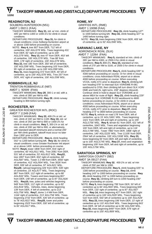
TAKEOFF MINIMUMS AND (OBSTACLE) DEPARTURE PROCEDURES 12292
L13
NE-2
TAKEOFF MINIMUMS AND (OBSTACLE) DEPARTURE PROCEDURES 12292
L13
T T
T T
READINGTON, NJ SOLBERG-HUNTERDON (N51) AMDT 1 09211 (FAA)
TAKEOFF MINIMUMS: Rwy 31, std. w/ min. climb of 405' per NM to 1400 or 1300-2½ for climb in visual conditions.
DEPARTURE PROCEDURE: Rwy 31, for climb in visual conditions; cross Solberg-Hunterdon airport at or above 1300 before proceeding on course.
NOTE: Rwy 4, tree 907' from DER, 712' left of centerline, 100' AGL/279' MSL. Trees beginning 431' from DER, 82' right of centerline, up to 100' AGL/279' MSL. Rwy 13, tree 47' from DER, 453' left of centerline, 100' AGL/279' MSL. Tree 88' from DER, 178' right of centerline, 100' AGL/279' MSL. Rwy 22, tree 185' from DER, 350' left of centerline, 100' AGL/299' MSL. Trees beginning 103' from DER, 95' right of centerline, up to 100' AGL/299' MSL. Rwy 31, trees beginning 372' from DER, 40' left of centerline, up to 100' AGL/378' MSL. Tree 257' from DER, 441' right of centerline, 100' AGL/299' MSL.
ROBBINSVILLE, NJ TRENTON-ROBBINSVILLE (N87) AMDT 1 92009 (FAA)
TAKEOFF MINIMUMS: Rwy 29, 300-1 or std. with a min. climb of 280' per NM to 400.
DEPARTURE PROCEDURE: Rwy 29, climb runway heading to 800 before turning right.
ROCHESTER, NY GREATER ROCHESTER INTL (ROC) AMDT 7 11349 (FAA)
TAKEOFF MINIMUMS: Rwy 22, 400-2¾ or std. w/min. climb of 240' per NM to 1100. Rwy 10, std. w/min. climb of 250' per NM to 900 or 1000-2½ for climb in visual conditions. Rwy 7, 300-1¾ or std. w/min. climb of 206' per NM to 900, or alternatively, with standard takeoff minimums and a normal 200' per NM climb gradient, takeoff must occur no later than 1300' prior to DER.
DEPARTURE PROCEDURE: Rwy 4, climb heading 042° to 1200 before turning left. Rwy 10, for climb in visual conditions: cross Greater Rochester Intl airport at or above 1400 before proceeding on course.
NOTE: Rwy4, tower 1806' from DER, 816' right of centerline, 60' AGL/611' MSL. Tree 2081' from DER, 531' left of centerline, 53' AGL/612' MSL. Rwy22, tree 1997' from DER, 832' right of centerline, 68' AGL/587' MSL. Tower 2.2 NM from DER, 3550' right of centerline, 412' AGL/934' MSL. Tree 3026' from DER, 935' left of centerline, 97' AGL/621' MSL. Rwy28, railroad beginning 326' from DER, 539' right of centerline, 23' AGL/577' MSL. Trees beginning 887' from DER, 112' right of centerline, up to 88' AGL/632' MSL. Towers and trees beginning 807' from DER, 148' left of centerline, up to 87' AGL/626' MSL. Rwy10, tree, poles and vehicles beginning 949' from DER, 112' right of centerline, up to 82' AGL/616' MSL. Vehicles, trees, dome beginning 139' from DER, 4' left of centerline, up to 213' AGL/756' MSL. Rwy7, dome 1.4 NM from DER, 1164' right of centerline, 213' AGL/756' MSL. Trees beginning 2732' from DER, 426' left of centerline, up to 78' AGL/622' MSL. Rwy25, tower and poles beginning 1523' from DER, 330' left of centerline, up to 82' AGL/617' MSL.
ROME, NY GRIFFISS INTL (RME) AMDT 1 10098 (FAA)
DEPARTURE PROCEDURE: Rwy 15, climb heading 147º to 1000 before turning left. Rwy 33, climb heading 327° to 1400 before turning right.
NOTE: Rwy 15, trees beginning 2306' from DER, 405' left of centerline, up to 92' AGL/590' MSL.
SARANAC LAKE, NY ADIRONDACK RGNL (SLK) AMDT 7 12264 (FAA)
TAKEOFF MINIMUMS: Rwy 5, standard w/ min. climb of 265’ per NM to 4300, or 2500-3 for climb in visual conditions. Rwy 9, 800-2¼. Rwy 23, standard w/ min. climb of 270’ per NM to 3100, or 2500-3 for climb in visual conditions.
DEPARTURE PROCEDURE: Rwy 5, climb heading 049° to 4300 before proceeding on course. Or for climb in visual conditions: cross Adirondack RGNL airport at or above 4000 before proceeding on course. When executing VCOA, notify ATC prior to departure. Rwy 9, climbing left turn heading 079° to intercept SLK VOR/DME R-081 eastbound to 3700, then climbing left turn direct SLK VOR/DME and hold (N, right turns, 159° degrees inbound). Continue climb in hold to depart SLK VOR/DME at or above MEA for route of flight. Rwy 23, climb heading 229° to intercept SLK VOR/DME R-232 westbound to 4600 before proceeding on course, or for climb in visual conditions: cross Adirondack RGNL airport at or above 4000 before proceeding on course. When executing VCOA, notify ATC prior to departure. Rwy 27, climb heading 273° to 3600 before proceeding on course.
NOTE: Rwy 5, vehicle on road 178’ from DER, left of centerline, up to 15’ AGL/1691’ MSL. Trees beginning 1421’ from DER, left and right of centerline, up to 100’ AGL/1756’ MSL. Rwy 9, terrain 61’ from DER, 421’ left of centerline, 1643’ MSL. Trees and vegetation beginning 100’ from DER, left and right of centerline, up to 116’ AGL/1789’ MSL. Tower 7982’ from DER, 1868’ right of centerline, 140’ AGL/2225’ MSL. Tree 11105’ from DER, 2564’ left of centerline, 100’ AGL/1938’ MSL. Rwy 23, trees beginning 93’ from DER, left and right of centerline, up to 100’ AGL/1745’ MSL. Rwy 27, trees and vegetation beginning 109’ from DER, left and right of centerline, up to 100’ AGL/1756’ MSL.
SARATOGA SPRINGS, NY SARATOGA COUNTY (5B2) AMDT 3A 09127 (FAA)
TAKEOFF MINIMUMS: Rwy 32, 400-2¾ or std. w/ min climb of 250' per NM to 1000.
DEPARTURE PROCEDURE: Rwy 5, climb heading 025° to 1300 before proceeding on course. Rwy 14, climb heading 143° to 1000 before proceeding on course. Rwy 23, climb heading 233° to 1000 before proceeding on course. Rwy 32, climbing left turn to 2200 heading 230° before proceeding on course.
NOTE: Rwy 5, trees beginning 799' from DER, 50' left of centerline up to 84' AGL/503' MSL. Trees beginning 849' from DER, 133' right of centerline, up to 87' AGL/507' MSL. Rwy 14, trees beginning 427' from DER, 161' right of centerline up to 100' AGL/529' MSL. Trees beginning 516' from DER, 550' left of centerline up to 100' AGL/529' MSL. Rwy 23, trees beginning 196' from DER, 13' right of centerline up to 110' AGL/544' MSL. Trees beginning 843' from DER, 34' left of centerline up to 96' AGL/530' MSL. Rwy 32, trees beginning 8497' from DER, 579' right of centerline up to 100' AGL/809' MSL.
18 OC
T 2012 to 15 N
OV
2012 1
8 O
CT
201
2 to
15
NO
V 2
012
TAKEOFF MINIMUMS AND (OBSTACLE) DEPARTURE PROCEDURES 12292
L14
NE-2
TAKEOFF MINIMUMS AND (OBSTACLE) DEPARTURE PROCEDURES 12292
L14
T T
T T
SCHENECTADY, NY SCHENECTADY COUNTY (SCH) AMDT 4 97114 (FAA)
TAKEOFF MINIMUMS: Rwy 4, 300-1 or std. with a min. climb of 220' per NM to 600. Rwy 28, 1200-2 or std. with a min. climb of 240' per NM to 2000.
NOTE: Rwy 4, 459' trees 80' from DER, 470' left of centerline.
SENECA FALLS, NY FINGER LAKES RGNL (0G7) ORIG 09127 (FAA)
TAKEOFF MINIMUMS: Rwy 1, 300-2 or std. w/ min. climb of 275' per NM to 1000.
NOTE: Rwy 1, trees, vehicle on road and tower beginning 401' from DER, 407' right of centerline, up to 306' AGL/756' MSL. Trees and pole beginning 571' from DER, 332' left of centerline, up to 73' AGL/528' MSL. Rwy 19, trees and building beginning 238' from DER, 294' right of centerline, up to 68' AGL/557' MSL. Building, trees, poles, bushes and vehicle on road beginning 189' from DER, 270' left of centerline, up to 57' AGL/556' MSL.
SHIRLEY, NY BROOKHAVEN (HWV) ORIG 07130 (FAA)
TAKEOFF MINIMUMS: Rwys 6, 33, NA-Noise abatement.
NOTE: Rwy 15, trees beginning 173' from DER, 376' right of centerline, up to 60' AGL/124' MSL. Trees beginning 40' from DER, 281' left of centerline, up to 60' AGL/124' MSL. Rwy 24, trees beginning 199' from DER, 497' left of centerline, up to 60' AGL/148' MSL. Trees beginning 604' from DER, 597' right of centerline, up to 60' AGL/133' MSL.
SIDNEY, NY SIDNEY MUNI (N23) AMDT 4 09071 (FAA)
TAKEOFF MINIMUMS: Rwy 7, std. with a min. climb of 328' per NM to 2500 or 1600-3 for climb in visual conditions. Rwy 25, 700-1.
DEPARTURE PROCEDURE: Rwy 7, climb heading 071° to 2500 before proceeding on course, for climb in visual conditions: Cross Sidney Muni airport at or above 2500 MSL before proceeding on course. Rwy 25, climb heading 251° to 2000 before proceeding on course.
NOTE: Rwy 7, trees and vehicle on road beginning 379' from DER, 22' left of centerline, up to 200' AGL/2039' MSL. Trees and terrain beginning 1844' from DER, 17' right of centerline, up to 100' AGL/1779' MSL. Rwy 25, trees beginning 867' from DER, 45' left of centerline, up to 100' AGL/1679' MSL. Trees and vehicle on road beginning 57' from DER, 82' right of centerline, up to 100' AGL/1539' MSL.
SKANEATELES, NY SKANEATELES AERO DROME (6B9) ORIG 81218 (FAA)
TAKEOFF MINIMUMS: Rwys 10,28, 300-1.
SOMERVILLE, NJ SOMERSET (SMQ) AMDT 3 08353 (FAA)
TAKEOFF MINIMUMS: Rwys 8, 17, 26, 35, NA-Environmental. Rwy 12, std. w/ min. climb of 400' per NM to 1000 or 700-3 w/ min. climb of 285' per NM to 1400, or 1100-2½ for climb in visual conditions. Rwy 30, std. w/ min. climb of 500' per NM to 600 or 300-2 or min. climb of 205' per NM to 1600, or 1100-2½ for climb in visual conditions.
DEPARTURE PROCEDURE: Rwy 12, climb heading 122° to 1000 before proceeding on course or for climb in visual conditions cross Somerset Airport at or above 1100 before proceeding on course. Rwy 30, climb heading 302° to 1300 before proceeding on course or for climb in visual conditions cross Somerset Airport at or above 1100 before proceeding on course.
NOTE: Rwy 12, trees beginning at DER, 345' left of centerline, up to 100' AGL/219' MSL. Trees beginning 600' from DER, left to right of centerline, up to 100' AGL/219' MSL. Trees beginning 3188' from DER, left to right of centerline, up to 100' AGL/279' MSL.Rwy 30, trees beginning at DER, 85' right of centerline, up to 100' AGL/199' MSL. Trees beginning at DER, 110' left of centerline, up to 99' AGL/199' MSL. Trees beginning 1451' from DER, left to right of centerline, up to 100' AGL/199' MSL. Trees beginning 2748' from DER, 1147' left of centerline, up to 100' AGL/259' MSL.
SOUTH BETHLEHEM, NY SOUTH ALBANY (4B0) ORIG 09099 (FAA)
TAKEOFF MINIMUMS: Rwy 1, 300-1¾ or std. w/ min. climb of 290' per NM to 600. Rwy 19, std. w/ min. climb of 415' per NM to 2000 or 1700-1½ for climb in visual conditions.
DEPARTURE PROCEDURE: Rwy 1, climb heading 008° to 2000 before proceeding on course. Rwy 19, climb via heading 188° to 2000 or for climb in visual conditions; cross South Albany airport at or above 1700 before proceeding on course. Do not exceed 180 knots until crossing South Albany airport on course.
NOTE: Rwy 1, vehicles on road beginning 315' from DER, left to right of centerline, up to 15' AGL/234' MSL. Vehicles on road 17' from DER, 467' left of centerline, 15' AGL/224' MSL. Trees 523' from DER, 425' right of centerline, up to 100' AGL/299' MSL. Stacks 1.3 NM from DER, 1522' right of centerline, 195' AGL/435' MSL. Rwy 19, trains beginning 23' from DER, left and right of centerline, 23' AGL/318' MSL.
STORMVILLE, NY STORMVILLE (N69) ORIG 86072 (FAA)
TAKEOFF MINIMUMS: Rwy 6, 1200-1. Rwy 24, 300-1. DEPARTURE PROCEDURE: Rwy 6, climbing left turn
direct IGN VOR/DME, cross IGN VOR/DME at or above 2000. Rwy 24, climbing right turn direct IGN VOR/DME, cross IGN VOR/DME at or above 2000.
18 OC
T 2012 to 15 N
OV
2012 1
8 O
CT
201
2 to
15
NO
V 2
012
TAKEOFF MINIMUMS AND (OBSTACLE) DEPARTURE PROCEDURES 12292
L15
NE-2
TAKEOFF MINIMUMS AND (OBSTACLE) DEPARTURE PROCEDURES 12292
L15
T T
T T
SUSSEX, NJ SUSSEX (FWN) AMDT 2 82357 (FAA)
TAKEOFF MINIMUMS: Rwy 3, 700-1. Rwy 21, 500-1.
DEPARTURE PROCEDURE: Rwy 3, climb runway heading to 1200, then climbing right turn to 3000 direct SAX VORTAC, then climb on course. Rwy 21, climb runway heading to 1500, then climb on course.
SYRACUSE, NY SYRACUSE HANCOCK INTL (SYR) AMDT 7 98001 (FAA)
DEPARTURE PROCEDURE: Rwy 10, climb runway heading to 1500 before turning southbound. Rwy 15, climb runway heading to 2800 before turning southbound. Rwy 28, climb runway heading to 1100 before turning southbound. Rwy 33, climb runway heading to 1000 before turning southbound.
TETERBORO, NJ TETERBORO (TEB) AMDT 7 11293 (FAA)
TAKEOFF MINIMUMS: Rwy 1, 400-2¼ or std. w/min. climb of 294' per NM to 500. Rwy 6,300-1½ or std. w/min. climb of 263' per NM to 400. Rwy 19, 600-2¼ or std. w/min. climb of 352' per NM to 700. Rwy 24, 300-1¼ or std. w/min. climb of 442' per NM to 500.
DEPARTURE PROCEDURE: Rwy 1, climbing right turn heading 040° to 900 before proceeding on course. Rwy 6, climbing left turn heading 040° to 900 before proceeding on course. Rwy 19, climb heading 195° to 900 then climbing right turn on BWZ VORTAC R-104 to 2000 before proceeding on course. Rwy 24, climb heading 240° to 1500 before proceeding on course.
NOTE: Rwy 1, vent on hangar, buildings, and trees beginning 195' from DER, 548' left of centerline, up to 73' AGL/82' MSL. Poles and trees beginning 903' from DER, 136' right of centerline, up to 44' AGL/53' MSL. Building 5900' from DER, 1519' left of centerline, 160' AGL/224' MSL. Building 2.1 NM from DER, 787' right of centerline, 249' AGL/314' MSL. Rwy 6, sign, poles, buildings, and trees beginning 235' from DER, 10' left of centerline, up to 106' AGL/115' MSL. Building, poles, and trees beginning 335' from DER, 101' right of centerline, up to 92' AGL/101' MSL. Stack 1.2 NM from DER, 654' right of centerline, 230' AGL/240' MSL. Rwy 19, vent on building and trees beginning 215' from DER, 1' left of centerline, up to 77' AGL/86' MSL. Blast fence, poles, and trees beginning 185' from DER, 117' right of centerline, up to 83' AGL/92' MSL. Tower 1.9 NM from DER, 1646' right of centerline, 500' AGL/51 0' MSL. Rwy 24, sign and trees beginning 3347' from DER, 535' right of centerline, up to 125' AGL/134' MSL. Trees 5303' from DER, 1915' right of centerline, up to 100' AGL/309' MSL.
TICONDEROGA, NY TICONDEROGA MUNI (4B6) ORIG 98113 (FAA)
TAKEOFF MINIMUMS: Rwy 20, 800-2 or std. with a min. climb of 330' per NM to 1200.
DEPARTURE PROCEDURE: Rwy 2, climb runway heading to 3800 before proceeding on course. Rwy 20, climbing left turn to 2400 via heading 165° before proceeding on course.
TOMS RIVER, NJ ROBERT J. MILLER AIR PARK (MJX) ORIG 07270 (FAA)
NOTE: Rwy 6, trees beginning 116' from DER, 2' left of centerline, up to 52' AGL/121' MSL. Trees beginning 333' from DER, 163' right of centerline, up to 60' AGL/169' MSL. Rwy 24, tree 1338' from DER, 730' right of centerline, 31' AGL/120' MSL.
TRENTON, NJ TRENTON MERCER (TTN)
TAKEOFF MINIMUMS: Rwy 16, 300-1. DEPARTURE PROCEDURE: Rwy 6, climb runway
heading to 750 before turning east. Rwy 24, climb runway heading to 400 before turning.
VINCENTOWN, NJ RED LION (N73) AMDT 1 09071 (FAA)
NOTE: Rwy 5, trees 1095' from DER, 90' left of centerline, 100' AGL/149' MSL. Trees 1816' from DER, 864' right of centerline, 100' AGL/159' MSL. Trees 2242' from DER, 41' right of centerline, 100' AGL/159' MSL. Rwy 23, trees 24' from DER, 373' right of centerline, 100' AGL/150' MSL. Trees 178' from DER, 185' right of centerline, 100' AGL/159' MSL. Trees 85' from DER, 139' right of centerline, 100' AGL/150' MSL.
VINELAND, NJ KROELINGER (29N) AMDT 1 94062 (FAA)
TAKEOFF MINIMUMS: Rwys 10, 28, 300-1.
WATERTOWN, NY WATERTOWN INTL (ART) AMDT 1 11321 (FAA)
TAKEOFF MINIMUMS: Rwy 7, 300-1½ or std. w/min. climb of 231' per NM to 700, or alternatively, with standard takeoff minimums and a normal 200' per NM climb gradient, takeoff must occur no later than 2100' prior to DER. Rwy 10, 300-1¼ or std. w/min. climb of 306' per NM to 700.
DEPARTURE PROCEDURE: Rwy 10, climb heading 090° to 1000 before turning right.
NOTE: Rwy 7, road and trees beginning 540' from DER, 33' left of centerline, up to 100' AGL/559' MSL. Trees beginning 787' from DER, 97' right of centerline, up to 100' AGL/405' MSL. Rwy 10, trees beginning 536' from DER, 62' right of centerline, up to 100' AGL/532' MSL. Trees beginning 1827' from DER, 204' left of centerline, up to 100' AGL/382' MSL. Rising terrain beginning 5573' from DER, 1148' right of centerline, up to 569' MSL. Rwy 28, trees beginning 620' from DER, 2' right of centerline, up to 100' AGL/409' MSL. Trees beginning 784' from DER, 1' left of centerline, up to 100' AGL/391' MSL.
WEEDSPORT, NY WHITFORDS (B16) ORIG 96284 (FAA)
TAKEOFF MINIMUMS: Rwys 1, 10, 19, 28, 300-1.
WELLSVILLE, NY WELLSVILLE MUNI AIRPORT, TARANTINE FIELD (ELZ)
DEPARTURE PROCEDURE: Rwys 10,28, climb runway heading to 2500 before proceeding on course.
18 OC
T 2012 to 15 N
OV
2012 1
8 O
CT
201
2 to
15
NO
V 2
012
TAKEOFF MINIMUMS AND (OBSTACLE) DEPARTURE PROCEDURES 12292
L16
NE-2
TAKEOFF MINIMUMS AND (OBSTACLE) DEPARTURE PROCEDURES 12292
L16
T T
T T
WEST MILFORD, NJ GREENWOOD LAKE (4N1) AMDT 2 12040 (FAA)
TAKEOFF MINIMUMS: Rwy 6, std. w/min. climb of 260’ per NM to 1700; or, 1300 - 2½ for climb in visual conditions. Rwy 24, 500 - 2½ ;or, 1300 - 2½ for climb in visual conditions.
DEPARTURE PROCEDURE: Rwy 6, climb heading 061° to 1700 before proceeding on course, or for climb in visual conditions: cross Greenwood Lake Airport at or above 1900' MSL before proceeding on course. When executing VCOA, notify ATC prior to departure. Rwy 24, climb heading 241° to 1800 before proceeding on course, or for climb in visual conditions: cross Greenwood Lake Airport at or above 1900' MSL before proceeding on course. When executing VCOA, notify ATC prior to departure.
NOTE: Rwy 6, trees beginning 18' from DER, across centerline, up to 100' AGL/1284' MSL. Rwy 24, trees beginning 3' from DER, across centerline, up to 100' AGL/1191' MSL.
WESTHAMPTON BEACH, NY FRANCIS S. GABRESKI (FOK) AMDT 2 12152 (FAA)
TAKEOFF MINIMUMS: Rwy 6, 300-1¾ or std. w/ min. climb of 230' per NM to 400, or alternatively, with standard takeoff minimums and a normal 200' per NM climb gradient, takeoff must occur no later than 2000' prior to DER.
NOTE: Rwy 1, terrain and trees beginning 6' from DER, 129' left of centerline, up to 33' AGL/107' MSL. Trees beginning 1007' from DER, 677' right of centerline, up to 29' AGL/98' MSL. Rwy 6, trees 1285’ from DER, 720' left of centerline, up to 36' AGL/105' MSL. Pole 2027' from DER, 987' right of centerline, 85' AGL/161' MSL. Transmission line tower 1.3 NM from DER, 2432' left of centerline, 71' AGL/301' MSL. Rwy 15, trees beginning 1053' from DER, 496' left of centerline, up to 50' AGL/79' MSL. Trees beginning 977' from DER, 204' right of centerline, up to 51' AGL/90' MSL. Rwy 19, poles, buildings, and trees beginning 270' from DER, 219' left of centerline, up to 57' AGL/88' MSL. Trees 6' from DER, 358' right of centerline, up to 17' AGL/66' MSL. Rwy 24, sign, building, and trees beginning 37' from DER, 251' left of centerline, up to 75' AGL/115' MSL. Bushes and trees beginning 6' from DER, 299' right of centerline, up to 12' AGL/61' MSL.
Rwy 33, terrain beginning 53' from DER, 407' left of centerline, up to 67' MSL. Terrain, runway end identifier light, and trees beginning 52' from DER, 97' right of centerline, up to 29' AGL/103' MSL.
WHEELER-SACK AAF (KGTB) FORT DRUM, NY . . . . . . . . . . . AMDT 5, 09239
Rwy 15, Standard with minimum climb of 250 ft/NM to 3100.
Rwy 21, Standard with minimum climb of 250 ft/NM to 3100.
DEPARTURE PROCEDURE: Rwy 26, Climb hdg 263° to 1400 before turning left.
TAKEOFF OBSTACLES: Rwy 3: Trees 100’ AGL/ 759’ MSL, 2467’ from DER, 896’ left of centerline. Rwy 8: Trees 62’ AGL/747’ MSL, 441’ from DER, 524’ right of centerline. Trees 62’ AGL/747’ MSL, 1887’ from DER, 125’ right of centerline. Fence line 11’ AGL/696’ MSL, 314’ from DER, 367’ right of centerline. Rwy 15: Trees 60’ AGL/747’ MSL, 1402’ from DER, 535’ left of centerline. Rwy 26: Trees 42’ AGL/717’ MSL, 1293’ from DER, 614’ right of centerline. Trees 13’ AGL/688’ MSL, 186’ from DER, 463’ right of centerline. Rwy 33: Trees 47’ AGL/710’ MSL, 1224’ from DER, 609’ right of centerline.
WHITE PLAINS, NY WESTCHESTER COUNTY (HPN) AMDT 6 08213 (FAA)
TAKEOFF MINIMUMS: Rwy 29, 200-1½ or std. w/ min. climb of 230' per NM to 700, or alternatively, with standard takeoff minimums and normal 200'/NM climb gradient, takeoff must occur no later than 1900' prior to DER.
NOTE: Rwy 11, trees beginning 170' from DER, left and right of centerline, up to 96' AGL/526' MSL. Terrain 140' from DER, 248' left of centerline, 0' AGL/392' MSL. Rwy 16, windsock and trees beginning 309' from DER, 187' left of centerline, up to 101' AGL/510' MSL. Trees beginning 1005' from DER, 90' right of centerline, up to 127' AGL/436' MSL. Poles 3433' from DER, 604' left of centerline, up to 105' AGL/510' MSL. Terrain 273' from DER, 515' left of centerline, 0' AGL/387' MSL. Rwy 34, windsock 167' from DER, 282' right of centerline, 26' AGL/456' MSL. Trees 612' from DER, 560' left of centerline, up to 81' AGL/491' MSL. Trees beginning 2011' from DER, 751' right of centerline, up to 104' AGL/504' MSL. Obstruction light on DME 605' from DER, 263' right of centerline, 20' AGL/454' MSL. Rwy 29, trees beginning 6' from DER, 14' right of centerline, up to 103' AGL/593' MSL. Pole and trees beginning 425' from DER, 228' left of centerline, up to 108' AGL/488' MSL. Tank 1.19 NM from DER, 751' right of centerline, 86' AGL/599' MSL. Pole 212' from DER, 485' right of centerline, 23' AGL/417' MSL.
18 OC
T 2012 to 15 N
OV
2012 1
8 O
CT
201
2 to
15
NO
V 2
012
TAKEOFF MINIMUMS AND (OBSTACLE) DEPARTURE PROCEDURES 12292
L17
NE-2
TAKEOFF MINIMUMS AND (OBSTACLE) DEPARTURE PROCEDURES 12292
L17
T T
T T
WILDWOOD, NJ CAPE MAY COUNTY (WWD) AMDT 3 06215 (FAA)
TAKEOFF MINIMUMS: Rwy 10, 300-2 or std. with a min. climb of 260' per NM to 500.
DEPARTURE PROCEDURE: Rwy 19,climb heading 190° to 700 before turning left.
NOTE: Rwy 1, multiple trees beginning 212' from DER, 187' left of centerline, up to 72' AGL/86' MSL. Multiple trees beginning 169' from DER, 314' right of centerline, up to 42' AGL/59' MSL. Road 197' from DER 240' right of centerline, 15' AGL/30' MSL. Road 265' from DER, on runway centerline, 15' AGL/29' MSL. Rwy 10, multiple trees beginning 42' from DER, 262' left of centerline, up to 60' AGL/77' MSL. Multiple trees beginning 1004' from DER, 441' left of centerline, up to 77' AGL/94' MSL. Tower 1.52 NM from DER, 643' left of centerline, 309' AGL/84' MSL. Rwy 19, multiple trees beginning 669' from DER, 397' left of centerline, up to 73' AGL/90' MSL. Multiple trees beginning 1010' from DER, 46' right of centerline, up to 62' AGL/90' MSL. Fence 80' from DER, 507' right of centerline, 18' AGL/30' MSL. Rwy 28, multiple trees beginning 74' from DER, 460' left of centerline, up to 70' AGL/84' MSL. Multiple trees beginning 1235' from DER, 496' right of centerline, up to 74' AGL/88' MSL.
WILLIAMSON/SODUS, NY WILLIAMSON-SODUS (SDC) AMDT 1 08213 (FAA)
TAKEOFF MINIMUMS: Rwy 10, 300-2 or std. w/ min. climb of 427’ per NM to 700.
NOTE: Rwy 10, trees beginning 26' from DER, 296' right of centerline, up to 76' AGL/625' MSL. Trees beginning 257' from DER, 310' left of centerline, up to 56' AGL/655' MSL. Vehicles on roadway, 339' from DER, 377' right of centerline, 15' AGL/451' MSL. Pole 360' from DER, 122' left of centerline, 29' AGL/448' MSL. Pole 362' from DER, 85' right of centerline, 31' AGL/450' MSL. Silo 409' from DER, 466' left of centerline, 40' AGL/459' MSL. Antenna 1.5 NM from DER, 662' left of centerline, 100' AGL/659' MSL. Antenna 1.6 NM from DER, 400' left of centerline, 106' AGL/715' MSL. Rwy 28, trees beginning abeam DER, 188' left of centerline, up to 110' AGL/549' MSL. Trees beginning 72' from DER, 266' right of centerline, up to 93' AGL/522' MSL. Building 204' from DER, 271' right of centerline, 12' AGL/441' MSL. Fence 312' from DER, 59' left of centerline, 6' AGL/435' MSL. Pole 338' from DER, 271' left of centerline, 32' AGL/461' MSL. Vehicles on roadway 357' from DER, 382' left of centerline, 15' AGL/460' MSL. Building 497' from DER, 339' left of centerline, 21' AGL/450' MSL.
WOODBINE, NJ WOODBINE MUNI (OBI) AMDT 2 09239 (FAA)
NOTE: Rwy 1, trees beginning 182' from DER, 284' left of centerline up to 100' AGL/134' MSL. Trees beginning 38' from DER, 290' right of centerline up to 100' AGL/144' MSL. Train 387' from DER, 596' left of centerline up to 23 ' AGL/57' MSL. Rwy 13, trees beginning 4' from DER, 277' left of centerline up to 100' AGL/134' MSL. Trees beginning 2395' from DER, 865' right of centerline up to 100' AGL/134' MSL. Rwy 19, trees beginning 4' from DER, 284' left of centerline up to 100' AGL/129' MSL. Trees beginning 178' from DER, 212' right of centerline up to 100' AGL/124' MSL. Rwy 31, trees beginning 261' from DER, 529' right of centerline up to 100' AGL/144' MSL. Trees beginning 107' from DER, 288' left of centerline up to 100' AGL/144' MSL. Railroad 900' from DER left to right 23' AGL/63' MSL.
WURTSBORO, NY WURTSBORO-SULLIVAN COUNTY (N82) AMDT 1 03135 (FAA)
TAKEOFF MINIMUMS: Rwys 5,9,14,18,27,32,36, NA-obstacles. Rwy 23, std. with a min. climb of 388' per NM to 2100.
DEPARTURE PROCEDURE: Rwy 23, climb via heading 228° to 2100 before proceeding on course.
NOTE: Rwy 23, numerous trees 6594' from DER, 2150' right of centerline, 100' AGL/793' MSL to 100' AGL/957' MSL. 18 O
CT
2012 to 15 NO
V 2012
18
OC
T 2
012
to 1
5 N
OV
201
2
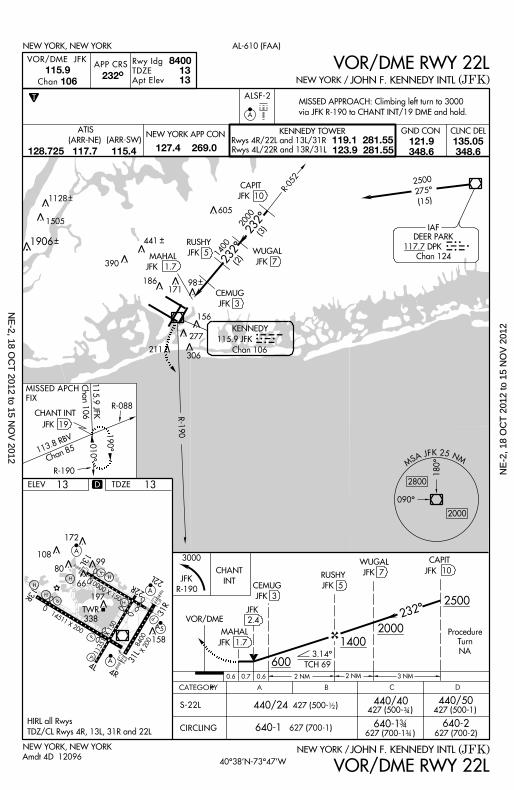
10000 X 150 22L
22R
13L
H
H
H197
66
80
172
10899
V
A
A
P
P
TWR
338
13R
14511 X 200
P
P
4L4R
A 31L
158
A 5
31R
11351 X 150
H
8400X 200
H
X
190^
010^
R-190KENNEDY
115.9 JFK
Chan 106
232^
R-052
IAF
DEER PARK
117.7 DPK
Chan 124
DPK
CAPIT
JFK 10
WUGAL
JFK 7
RUSHY
JFK 5
CEMUG
JFK 3
MAHAL
JFK 1.7
232^2000
1400
(3)
(2)
98
JFKMISSED APCH
FIX
113.8 RBV
Chan 85
115.9 JFKChan 106
R -190
R-088
2500
275^
(15)605
441
390
306
277
211
186171
156
APP CRS
8400 13 13
Rwy Idg
TDZE
Apt Elev
T
232^106Chan
115.9
NEW YORK, NEW YORK
(JFK)JOHN F. KENNEDY INTLNEW YORK /
AL-610 (FAA)
VOR/DME JFK VOR/DME RWY 22L
ALSF-2
A
MISSED APPROACH: Cl imbing le f t turn to 3000
v ia JFK R-190 to CHANT INT/19 DME and hold.
ELEV
NEW YORK, NEW YORK
13
CEMUG
JFK 3
Amdt 4D 12096
CATEGORY B C DA
3 4
12
3 4
3 4
2500
2000
1400
600
Procedure
Turn
NA
TCH 69
CAPIT
VOR/DME
JFK 10
MAHAL
2.4
1.7
JFK
JFK
3000
232^
440/24 440/40 440/50
640-1 640-1 640-2
427 (500- )427 (500- ) 427 (500-1)
627 (700-1)627 (700-1 ) 627 (700-2)
CIRCLING
S-22L
2 NM 3 NM
(JFK)JOHN F. KENNEDY INTLNEW YORK /
CHANT
INTRUSHY
JFK 5
WUGAL
JFK 7
VOR/DME RWY 22L
0 .6 0 .7 0 .6 2 NM
D
1128
1505
1906
JFK
R-190
CLNC DELGND CONNEW YORK APP CON KENNEDY TOWER
Rwys 4R/22L and 13L/31R
Rwys 4L/22R and 13R/31L
119.1 281.55123.9 281.55
ATIS
127.4 269.0121.9348.6
135.05348.6
(ARR-NE) (ARR-SW)
128.725 117.7 115.4
HIRL al l Rwys
TDZ/CL Rwys 4R, 13L, 31R and 22L
CHANT INT
JFK 19
TDZE 13
40^38’N-73^47’W
MS A J F K 2 5 N M
090^
180^
2800
2000
3.14^
NE
-2, 18 OC
T 2012 to 15 N
OV
2012N
E-2
, 18
OC
T 2
012
to 1
5 N
OV
201
2
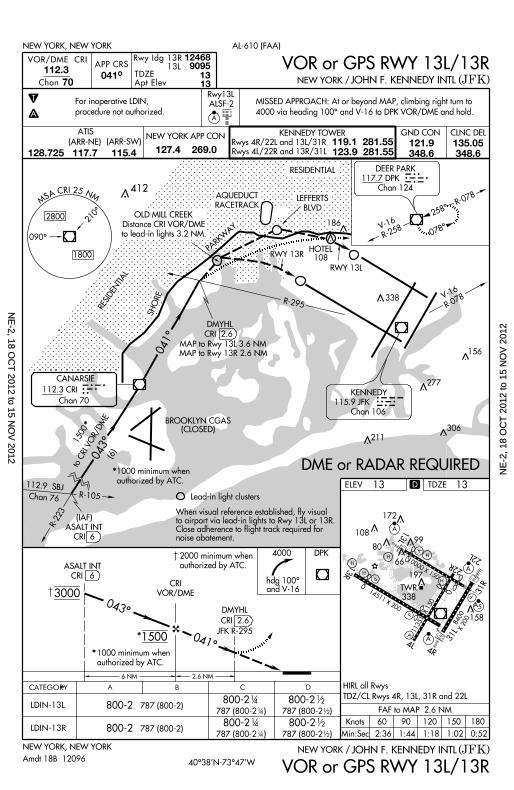
10000 X 150 22L
22R
13L
H
H
H197
66
80
172
10899
V
A
A
P
P
TWR
338
13R
14511 X 200
P
P
4L4R
A 31L
158
A 5
31R
11351 X 150
H
8400X 200
H
X
ELEV
CATEGORY B C DA
306
R-223
R-105
(IAF)
ASALT INT
CRI 6
APP CRS
9095TDZEApt Elev
112.3
Chan 041^
T
A
ALSF-2
13 13
70
3000
1500
2000 min imum when
author ized by ATC.
6 NM 2 .6 NM
LDIN-13L
LDIN-13R
800-2
800-2
800-2
800-2
787 (800-2 ) 787 (800-2 )
787 (800-2 ) 787 (800-2 )
800-2 787 (800-2)
800-2 787 (800-2)
14
14
14
14
12
12
12
12
CRI
VOR/DME
4000 DPK
1801501209060Knots
Min:Sec
FAF to MAP 2.6 NM
2:36 1:44 1:18 1:02 0:52
KENNEDY
115.9 JFK
Chan 106
R-258V-16
258^
078^
DEER PARK
117.7 DPK
Chan 124
DPK
V-16
R-078R-295
RWY 13R
RESIDENTIAL
PARKWAY
041^
043^
BROOKLYN CGAS(CLOSED)
When v isual reference establ ished, f ly v isualto a i rpor t v ia lead- in l ights to Rwy 13L or 13R.Close adherence to f l ight t rack requi red fornoise abatement .
Lead- in l ight c lusters
MS A C R I 2 5 N M
210^
090^
2800
1800HOTEL
108
RWY 13L
NEW YORK, NEW YORK
NEW YORK, NEW YORK
(JFK)
(JFK)
JOHN F. KENNEDY INTL
JOHN F. KENNEDY INTL
NEW YORK /
NEW YORK /
AL-610 (FAA)
13
CANARSIE
112.3 CRI
Chan 70
CRI
OLD MILL CREEK
Distance CRI VOR/DME
to lead- in l ights 3.2 NM.
SHORE
AQUEDUCT
RACETRACKLEFFERTS
BLVD
RESIDENTIAL
VOR/DME CRI
12468Rwy Idg 13R 13L
ASALT INT
CRI 6
Rwy13L
1500to CRI VOR/DME
(6)
*
1000 min imum when
author ized by ATC.
*
*
1000 min imum when
author ized by ATC.*
043^
041^
VOR or GPS RWY 13L/13R
VOR or GPS RWY 13L/13RAmdt 18B 12096
DMYHL
CRI 2.6
JFK R-295
MISSED APPROACH: At or beyond MAP, c l imbing r ight turn to
4000 v ia heading 100^ and V-16 to DPK VOR/DME and hold.
DMYHL
MAP to Rwy 13L 3.6 NM
MAP to Rwy 13R 2.6 NM
CRI 2.6
hdg 100^and V-16
277
186
156
412
For inoperat ive LDIN,
procedure not author ized.
DME or RADAR REQUIRED
R-078
A
338
211
D
CLNC DELGND CONNEW YORK APP CON KENNEDY TOWER
Rwys 4R/22L and 13L/31R
Rwys 4L/22R and 13R/31L
119.1 281.55123.9 281.55
ATIS
127.4 269.0121.9348.6
135.05348.6
(ARR-NE) (ARR-SW)
128.725 117.7 115.4
HIRL al l Rwys
TDZ/CL Rwys 4R, 13L, 31R and 22L
TDZE 13
40^38’N-73^47’W
112.9 SBJ
Chan 76N
E-2, 18 O
CT
2012 to 15 NO
V 2012
NE
-2, 1
8 O
CT
201
2 to
15
NO
V 2
012
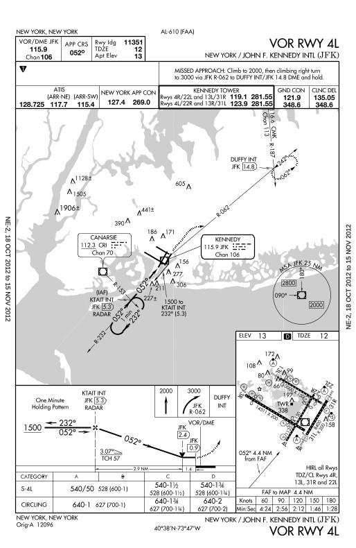
10000 X 150 22L
22R
13L
H
H
H197
66
80
172
10899
V
A
A
P
P
TWR
338
13R
14511 X 200
P
P
4L4R
A 31L
158
A 5
31R
11351 X 150
H
8400X 200
H
X
13ELEV
CATEGORY B C DA
1500
One Minute
Hold ing Pat tern
232^
052^
3000
CIRCLING
540-1
640-1 640-2
528 (600-1 )
627 (700-1 ) 627 (700-2)640-1 627 (700-1)
540/50 528 (600-1)1
2
12
3 4
3 4
NEW YORK, NEW YORK (JFK)JOHN F. KENNEDY INTLNEW YORK /
VOR RWY 4L
2000
1 .4
052^
S-4L540-1
528 (600-1 )
3 4
3 4
APP CRS 115.9
Chan 052^
T
106
NEW YORK, NEW YORK
(JFK)JOHN F. KENNEDY INTLNEW YORK /
AL-610 (FAA)
VOR/DME JFK VOR RWY 4LRwy Idg
TDZE
Apt Elev
113511213
DUFFY
INT
JFK
2.4
3.07^
TCH 57
VOR/DME
JFK
0.9052^ 4.4 NM
from FAF
1801501209060Knots
Min:Sec
FAF to MAP 4.4 NM
4:24 2:56 2:12 1:46 1:28
2 .9 NM
1500 toKTAIT INT
232^ (5.3)
052^ 232^1 min
062^
242^
R-187
R-062
DUFFY INT
JFK 14.8
116.6 CMKChan 113R-232
052^
MS A J F K 2 5 N M
090^
180^
2800
2000
KENNEDY
115.9 JFK
Chan 106
JFK
CANARSIE
112.3 CRI
Chan 70
CRIR-153
605
306
277
186 171
156
390
MISSED APPROACH: Cl imb to 2000, then c l imbing r ight turn
to 3000 v ia JFK R-062 to DUFFY INT/JFK 14.8 DME and hold.
KTAIT INT
JFK 5.3
RADAR
(IAF)
KTAIT INT
JFK 5.3
RADAR
Orig-A 12096
441
211
D
1128
1505
1906
227
JFKR-062
CLNC DELGND CONNEW YORK APP CON KENNEDY TOWER
Rwys 4R/22L and 13L/31R
Rwys 4L/22R and 13R/31L
119.1 281.55123.9 281.55
ATIS
127.4 269.0121.9348.6
135.05348.6
(ARR-NE) (ARR-SW)
128.725 117.7 115.4
HIRL al l Rwys
TDZ/CL Rwys 4R,
13L, 31R and 22L
12TDZE
40^38’N-73^47’W
NE
-2, 18 OC
T 2012 to 15 N
OV
2012N
E-2
, 18
OC
T 2
012
to 1
5 N
OV
201
2
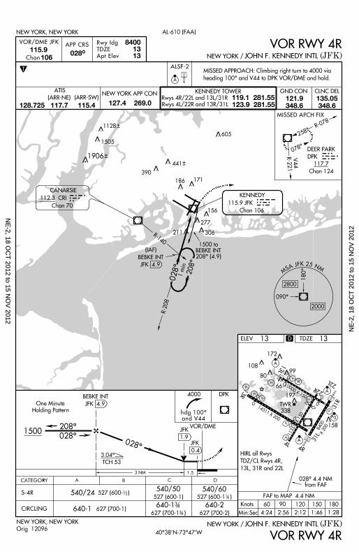
10000 X 150 22L
22R
13L
H
H
H197
66
80
172
10899
V
A
A
P
P
TWR
338
13R
14511 X 200
P
P
4L4R
A 31L
158
A 5
31R
11351 X 150
H
8400X 200
H
X
ELEV
APP CRS 115.9
Chan 028^
T
106
1500
One Minute
Hold ing Pat tern
208^
028^
VOR/DME
4000
CIRCLING
540/50
640-1 640-2627 (700-1 ) 627 (700-2)
640-1 627 (700-1)
540/24
3 4
3 4
18015012060
Min:Sec
NEW YORK, NEW YORK
NEW YORK, NEW YORK
(JFK)
(JFK)
JOHN F. KENNEDY INTL
JOHN F. KENNEDY INTL
NEW YORK /
NEW YORK /
AL-610 (FAA)
13
VOR/DME JFK VOR RWY 4R
VOR RWY 4R
Rwy Idg
TDZE
Apt Elev
13 13
1500 toBEBKE INT208^ (4.9)
( IAF)
BEBKE INT
JFK 4.9
1 .5
BEBKE INT
JFK 4.9
3.04^
TCH 53
028^
S-4R540/60
527 (600-1 )
Or ig 12096
258^
078^
028^
208^1 min
R-140
8400
3 NM
DPK
hdg 100^and V44
527 (600- ) 12
527 (600-1) 14
MISSED APPROACH: Cl imbing r ight turn to 4000 v ia
heading 100^ and V44 to DPK VOR/DME and hold.
R-078
R-221 V44
R-208
JFK
0.4
028^ 4.4 NMfrom FAF
90Knots
FAF to MAP 4.4 NM
4:24 2:56 2:12 1:46 1:28
CANARSIE
112.3 CRI
Chan 70
CRI
JFK
1.9
CATEGORY B C DA
ALSF-2
A
KENNEDY
115.9 JFK
Chan 106
DEER PARK
DPK
117.7
Chan 124
MISSED APCH FIX
DPK605
441
390
306
277
211
186 171
156
D
1128
1505
1906
CLNC DELGND CONNEW YORK APP CON KENNEDY TOWER
Rwys 4R/22L and 13L/31R
Rwys 4L/22R and 13R/31L
119.1 281.55123.9 281.55
ATIS
127.4 269.0121.9348.6
135.05348.6
(ARR-NE) (ARR-SW)
128.725 117.7 115.4
HIRL al l Rwys
TDZ/CL Rwys 4R,
13L, 31R and 22L
TDZE 13
40^38’N-73^47’W
MS A J F K 2 5 N M
090^
180^
2800
2000
NE
-2, 18 OC
T 2012 to 15 N
OV
2012N
E-2
, 18
OC
T 2
012
to 1
5 N
OV
201
2
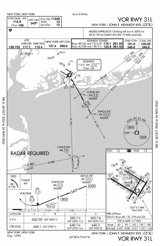
10000 X 150 22L
22R
13L
H
H
H197
66
80
172
10899
V
A
A
P
P
TWR
338
13R
14511 X 200
P
P
4L4R
A 31L
158
A 5
31R
11351 X 150
H
8400X 200
H
X
3000
CHANT
INT
ELEV
CATEGORY B C DA
APP CRS
Rwy Idg
TDZE
Apt Elev
115.9
Chan 343^
106
13
VOR/DME JFK
VOR RWY 31L
(JFK)JOHN F. KENNEDY INTLNEW YORK /NEW YORK, NEW YORK
VOR RWY 31LNEW YORK / JOHN F. KENNEDY INTL (JFK)
AL-610 (FAA)NEW YORK, NEW YORK
112481313
T
560/50 547 (600-1)560-1
547 (600-1 )
560-1 547 (600-1 )
12
12
3 43 4
640-1 627 (700-1)627 (700-1 )
3 43 4
640-1 640-2627 (700-2)
S-31L
CIRCLING
Orig 12096
RADAR REQUIRED
113.8 RBV
Chan 85
010^
190^
R-190
R -088
CHANT INT
JFK 19
R-163
343^1800
(5)
MS A J F K 2 5 N M
090^
180^
2800
2000
117.7 DPK
Chan 124 117.7 DPKChan 124JFKKENNEDY
115.9 JFK
Chan 106
R-245
R-234
1801501209060Knots
Min:Sec
FAF to MAP 4.7 NM
4:42 3:08 2:21 1:53 1:34
343 4.7 NMfrom FAF
2500
1800
TCH 55
5 NM3 .9 NM0 .8
343^
0 .3 0 .5
3.01^
VOR/DME
JFK
1.3
MISSED APPROACH: Cl imbing le f t turn to 3000 v ia
JFK R-190 to CHANT INT/JFK 19 DME and hold.
JFK
0.5
JFK 5.2
RADAR
LOKOE INT
JFK 10.2
RADAR
JAMCA INT
JFK 5.2
RADAR
JFK 10.2
RADARLOKOE INT
JAMCA INT
306
277
211
186171
156
390
441
D
JFKR-190
1906
CLNC DELGND CONNEW YORK APP CON KENNEDY TOWER
Rwys 4R/22L and 13L/31R
Rwys 4L/22R and 13R/31L
119.1 281.55123.9 281.55
ATIS
127.4 269.0121.9348.6
135.05348.6
(ARR-NE) (ARR-SW)
128.725 117.7 115.4
HIRL al l Rwys
TDZ/CL Rwys 4R, 13L, 31R and 22L
TDZE 13
40^38’N-73^47’W
NE
-2, 18 OC
T 2012 to 15 N
OV
2012N
E-2
, 18
OC
T 2
012
to 1
5 N
OV
201
2
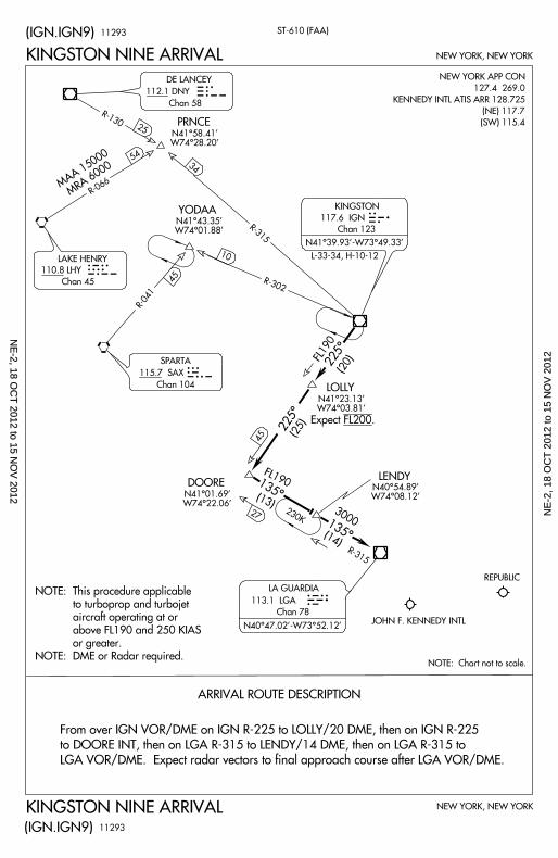
ST-610 (FAA)
NEW YORK, NEW YORK
NEW YORK, NEW YORK
JOHN F. KENNEDY INTL
NOTE: Chart not to scale.
N41^43.35’W74^01.88’
YODAA
N41^23.13’W74^03.81’
LOLLY
N40^54.89’W74^08.12’
LENDY
N41^01.69’W74^22.06’
DOORE
113.1 LGA
Chan 78
LA GUARDIA
KINGSTON NINE ARRIVAL
(IGN.IGN9)
(IGN.IGN9)
KINGSTON NINE ARRIVAL
3000
(14)
R-315
135^
135^
45
27
225^
115.7 SAX
Chan 104
SPARTA
117.6 IGN
Chan 123
KINGSTON
N41^39.93’ -W73^49.33’
R-041
10
R-302
225^
IGN
SAX
LGA
L-33-34, H-10-12
R-315
FL190 (20)
FL190
(13)
45
ARRIVAL ROUTE DESCRIPTION
34
(25)
112.1 DNY
Chan 58
DE LANCEY
110.8 LHY
Chan 45
LAKE HENRY
R-066
R-130
25
54
MAA 15000MRA 6000
NEW YORK APP CON
127.4 269.0
KENNEDY INTL ATIS ARR 128.725
(NE) 117.7
(SW) 115.4
From over IGN VOR/DME on IGN R-225 to LOLLY/20 DME, then on IGN R-225
to DOORE INT, then on LGA R-315 to LENDY/14 DME, then on LGA R-315 to
LGA VOR/DME. Expect radar vectors to final approach course after LGA VOR/DME.
230K
11293
11293
NOTE: This procedure applicable
to turboprop and turbojet
aircraft operating at or
above FL190 and 250 KIAS
or greater.
NOTE: DME or Radar required.
Expect FL200.
N41^58.41’W74^28.20’
PRNCE
N40^47.02’ -W73^52.12’
REPUBLIC
NE
-2, 18 OC
T 2012 to 15 N
OV
2012N
E-2
, 18
OC
T 2
012
to 1
5 N
OV
201
2
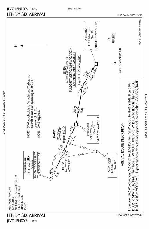
ST-610 (FAA)
NEW YORK, NEW YORK
NEW YORK, NEW YORK
REPUBLIC
JOHN F. KENNED
Y INTL
109.6 STW
Chan 33
N40^59.75’-W74^5
2.14’
111.6 LVZ
Chan 53
N41^16.37’-W75^4
1.37’
HARTY
NOTE: Chart not t
o scale.
NLENDY SIX ARRIVAL
LENDY SIX ARRIVAL
(LVZ.LENDY6)
(LVZ.LENDY6)
117.5 FJC
Chan 122
WILKES-BARRE N41^09.1
8’
W75^19.88’JENNO
4000 (18)
2900
(34)
2000 (14)135^
R-315
109^
R-305125^ (11)
23
125^ (11)
124^
N40^54.89’-W7
4^08.12’
LENDY
TURBOJET VERTIC
AL NAVIGATION PLANNIN
G INFORMATION
R-022
L V Z
S T W
F J C
STILLWATER
ALLENTOWN
NEW YORK APP CO
N
127.4 269.0
KENNEDY INTL A
TIS ARR 128.725
(NE) 117.7 (SW) 1
15.4
REPUBLIC ATIS
126.65
L-30-33-34, H-10-1
2
R -049
230K
N41^04.27’
W75^05.39’
Expect FL210.
11293
11293
ARRIVAL ROUTE D
ESCRIPTION
From over LVZ VO
RTAC on LVZ R-12
4 to JENNO, then S
TW R-305 to HARTY
INT, then STW
R-305 to STW VOR
/DME, then from ST
W VOR/DME on ST
W R-109 to LENDY
, then on LGA
R-315 to LGA VOR
/DME. Expect rada
r vectors to final ap
proach course after
LGA VOR/DME.
NOTE: STAR appl
icable to Turbojet a
nd Turboprop
aircraft cap
able of operating at
250K or
greater at
FL190.
NOTE: DME requir
ed.
305^
Expect FL190 and 2
50K.
113.1 LGA
Chan 78
LA GUARDIA
N40^47.02’-W73^5
2.12’
L G A
NE
-2, 18 OC
T 2012 to 15 N
OV
2012N
E-2
, 18
OC
T 2
012
to 1
5 N
OV
201
2
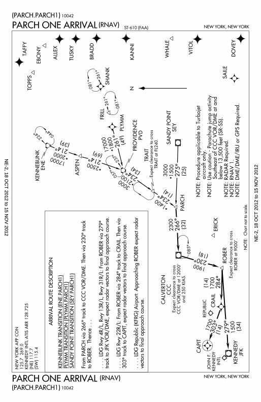
NEW YORK, NEW YORK
NEW YORK, NEW YORKST-610 (FAA)
NOTE: Chart not t
o scale.
N
(PARCH.PARCH1)
PARCH ONE ARRIVAL
PARCH ONE ARRIVAL(PARCH.PARCH1)
(RNAV)
(RNAV)
*
224^ 044^
*
17000
2000
(39)
214^
ASPEN
2500
*
214^(69)
057^237^
FRILLSHANK
261^
081^
081^
261^
*170001800
(49)261^
30002100
(34)
*234^
PLYMM
KENNEBUNK
ENE
PROVIDENCE
PVD
1400
(14)
*
TRAIT
234^
275^3000 1500 (25)
SANDY POINT
SEY
SAILE
DOVEY
VITOL
WHALE
KANNIBRADDTUSKYALLEX
EBONY
TAFFYTOPPS
PARCH
NEW YORK APP
CON
125.7 269.0
KENNEDY INTL A
TIS ARR 128.725
(NE) 117.7
(SW) 115.4
ERICK266^2300
(32)
1900
(18)
230^
REPUBLIC
085^
CALVERTON
CCC
Expect clearance
to cross
TRAIT at FL240.
Expect clearance
to cross
CCC VOR/DME a
t 12000’
and 250 KIAS.
284^1700(14)
279^ 1500 (34)
303^
KENNEDY
JFK
(14)
1700
ROBER
CRAIL
CAPIT
Expect clearance
to cross
ROBER at 9000’.
10042
10042
JOHN F.
KENNEDY
INTL
ARRIVAL ROUTE D
ESCRIPTION
KENNEBUNK TRAN
SITION (ENE.PARC
H1)
PLYMM TRANSITIO
N (PLYMM.PARCH1
)
SANDY POINT TRA
NSITION (SEY.PAR
CH1)
From PARCH via 26
6^ track to CCC VO
R/DME. Then via 2
30^ track
to ROBER. Thence
. . .
. . . . LDG Rwy 4R/
L, Rwy 13R/L, Rwy
31R/L: From ROB
ER via 279^
track to JFK VOR/D
ME, expect radar v
ectors to final appr
oach course.
. . . . LDG Rwy 22R
/L: From ROBER v
ia 284^ track to CR
AIL. Then via
303^ track to CAPI
T, expect radar vec
tors to final approa
ch course.
. . . . LDG Republic
(KFRG) Airport: Ap
proaching ROBER e
xpect radar
vectors to final app
roach course.
NOTE: Procedure
applicable to Turb
ojet a
ircraft only.
NOTE: Use cautio
n - Parachute jum
p activity S
outheast of CCC
VOR/DME at and
below 13,5
00 feet (SR-SS).
NOTE: RADAR Re
quired.NOTE: R
NAV 1.NOTE: D
ME/DME/IRU or G
PS Required.
NE
-2, 18 OC
T 2012 to 15 N
OV
2012N
E-2
, 18
OC
T 2
012
to 1
5 N
OV
201
2
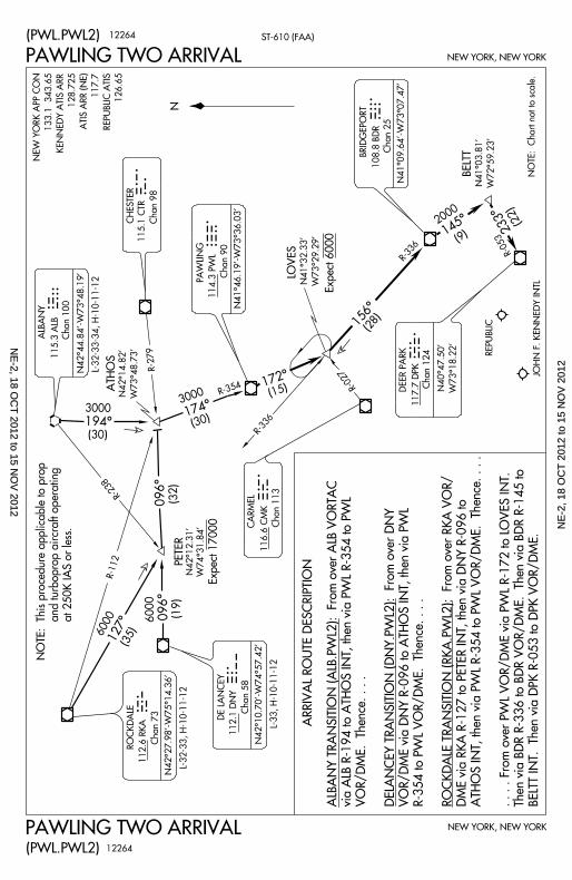
PAWLING TWO ARRIVAL
PAWLING TWO ARRIVAL
ST-610 (FAA)(PWL.PWL2)
(PWL.PWL2)
NEW YORK, NEW YORK
NEW YORK, NEW YORK
6000 (35)
6000
(19)(32)
3000
(30)
R-279
R-336
R-027
(28)
R-336
2000
(9)
R-053
(22)
127^
096^096^
194^174^
156^
145^
REPUBLIC
JOHN F. KENNED
Y INTL
116.6 CMK
Chan 113CARMEL
108.8 BDR
Chan 25
N41^09.64’-W73^0
7.47’
BRIDGEPORT
117.7 DPK
Chan 124 N40^47.50’
W73^18.22’DEER PA
RK
112.1 DNY
Chan 58
N42^10.70’-W74^5
7.42’
DE LANCEY
115.3 ALB
Chan 100ALBANY
CHESTER
115.1 CTR
Chan 98
112.6 RKA
Chan 73
N42^27.98’-W75^1
4.36’
ROCKDALE
N42^44.84’-W73^4
8.19’
N41^32.33’
W73^29.29’LOVES
N41^03.81’
W72^59.23’
BELTT
N42^14.82’
W73^48.73’ATHOS
PETER
NOTE: Chart not t
o scale.
114.3 PWL
Chan 90
N41^46.19’-W73^3
6.03’
PAWLING
N
D P K
C M K
R K A
D N Y
A L B
C T R
P W L
B D R
12264
12264
L-32-33-34, H-10-1
1-12
R-238
L-32-33, H-10-11-
12
3000
(30)
(15)R-354172^
233^
N42^12.31’
W74^31.84’
R -112
ARRIVAL ROUTE D
ESCRIPTION
ALBANY TRANSIT
ION (ALB.PWL2):
From over ALB VO
RTAC
via ALB R-194 to A
THOS INT, then via
PWL R-354 to PWL
VOR/DME. Thence
. . . .
DELANCEY TRANS
ITION (DNY.PWL2):
From over DNY
VOR/DME via DNY
R-096 to ATHOS IN
T, then via PWL
R-354 to PWL VOR
/DME. Thence. . . .
ROCKDALE TRANS
ITION (RKA.PWL2):
From over RKA V
OR/
DME via RKA R-127
to PETER INT, then
via DNY R-096 to
ATHOS INT, then vi
a PWL R-354 to PW
L VOR/DME. Thenc
e. . . .
. . . . From over PWL
VOR/DME via PWL
R-172 to LOVES I
NT.
Then via BDR R-33
6 to BDR VOR/DME
. Then via BDR R-
145 to
BELTT INT. Then v
ia DPK R-053 to DP
K VOR/DME.
NOTE: This proce
dure applicable to
prop
and turbop
rop aircraft operati
ng
at 250K IA
S or less.
NEW YORK APP CO
N
133.1 343.65
KENNEDY ATIS A
RR
128.725
ATIS ARR (NE)
117.7
REPUBLIC ATIS
126.65
Expect 17000
Expect 6000
L-33, H-10-11-12
NE
-2, 18 OC
T 2012 to 15 N
OV
2012N
E-2
, 18
OC
T 2
012
to 1
5 N
OV
201
2
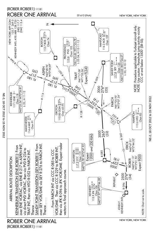
NEW YORK, NEW YORK
NEW YORK, NEW YORKST-610 (FAA)
NOTE: Chart not t
o scale.
N
115.9 JFK
Chan 106KENNEDY
117.2 CCC
Chan 119
117.1 ENE
Chan 118
N40^37.97’-W73^4
6.28’
N40^55.78’-W72^4
7.93’
CALVERTON
KENNEBUNK
N43^25.54’-W70^3
6.81’
ASPEN
HAMPTON
113.6 HTO
Chan 83
GROTON
110.85 GON
Chan 45 (Y)
14
28
J F K
C C C
E N E
P V D
H T O
G O N
(ROBER.ROBER1)
ROBER ONE ARRIVAL
ROBER ONE ARRIVAL(ROBER.ROBER1)
SANDY POINT
117.8 SEY
Chan 125
R-044
217^
FL 180
(39)
FL 180
(69)
213^
R-057
NEW YORK APP
CON
125.7 269.0
KENNEDY INTL A
TIS ARR 128.725
(NE) 117.7
(SW) 115.4
114.4 MHTMANCHE
STER
Chan 91
R -114
R-128
R-033
3000
(34)
232^
ERICKN40^47.0
1’
W72^44.52’
R-260
ROBERN40^41.1
3’
W73^01.96’
R-052
TRAIT
N41^17.08’
W71^55.06’
232^(14)
3000
3000
(25)276^
PARCHN41^05.9
5’
W72^07.24’
R -309
265^ (32)
R-085
L-33, H-10-12
L-32, H-11-12
3000
229^(18)
3000
REPUBLIC
JOHN F.
KENNEDY INTL
R-0962500
(34)276^
N41^10.05’-W71^3
4.57’
112.7 BOS
Chan 74BOSTONB O S
116.2 ACK
Chan 109
NANTUCKET
A C K
11181
11181
N42^48.96’
W70^54.69’
N41^43.46’-W71^2
5.78’
PROVIDENCE
PVD
Chan 103
115.6 L-33-34, H-10-11
-12
ARRIVAL ROUTE D
ESCRIPTION
M H TKENNEBU
NK TRANSITION (E
NE.ROBER1): From
over ENE VORTAC
, via ENE R-217 to
ASPEN INT,
via direct PVD VOR
TAC, then via PVD
R-234 to
TRAIT INT, then vi
a HTO R-052 to PA
RCH INT.
Thence . . . .
SANDY POINT TRA
NSITION (SEY.ROB
ER1): From
over SEY VOR/DM
E via SEY R-276 to
PARCH INT.
Thence . . . .
. . . . From PARCH I
NT via CCC R-085 t
o CCC
VOR/DME. Then vi
a CCC R-229 to RO
BER INT,
then via JFK R-096
to JFK VOR/DME.
Expect radar
vectors to final app
roach course.
NOTE: Procedure a
pplicable to Turboje
t aircraft only.
NOTE: Use caution
- Parachute jump
activity vicinity
CCC at and
below 13500’ (SR-
SS).Expect 9
000
Expect 12000 and 250 KIA
S
Expect FL240
NE
-2, 18 OC
T 2012 to 15 N
OV
2012N
E-2
, 18
OC
T 2
012
to 1
5 N
OV
201
2


