Embed Size (px)
Citation preview

LA NORIA: A HYDROLOGIC TECHNOLOGY OF YUCATÁN
BY
NINA E. WILLIAMS, B.S.
A thesis submitted to the Graduate School
in partial fulfillment of the requirements
for the degree
Master of Arts
Major Subject: Anthropology
New Mexico State University
Las Cruces, New Mexico
December 2013

ii
“La Noria: A Hydrologic Technology of Yucatán,” a thesis prepared by Nina Elvira
Williams in partial fulfillment of the requirements for the degree, Master of Arts, has
been approved and accepted by the following:
___________________________________________________________________
Louis Reyes
Interim Dean of the Graduate School
___________________________________________________________________
Rani Alexander
Chair of the Examining Committee
___________________________________________________________________
Date
Committee in charge:
Dr. Rani Alexander, Chair
Dr. William Walker
Dr. Michael DeMers

iii
ACKNOWLEDGMENTS
I wish to thank my advisor Dr. Rani Alexander for her encouragement and
support in pursuing my research on noria technology. I cannot imagine making it
through the Masters program successfully without her guidance and patience through
the editorial process. I thank Dr. William Walker and Dr. Michael DeMers for their
suggestions and critiques. I wish to acknowledge Dr. Hector Hernandez for sharing
his data and knowledge of Hacienda San Pedro Cholul. Also, I thank the owners and
managers of the haciendas and churches that allowed me to collect my data and
complete my research. Lastly, a special thanks to my mother, Dr. Susan Lachica for
being my cheerleader and inspiration through the years, and all the years to come.

iv
VITA
Nina Elvira Williams Born in Port Chester, New York November 4, 1985
Education
2003 Westhill High School
Stamford, Connecticut
2008 University of New Mexico
B.S. in Anthropology
Albuquerque, New Mexico
Experience
2012 Archaeology Technician
Lincoln National Forest
2013 Archaeology Technician
SWCA Environmental Consultants
2013 Research Assistant
Department of Anthropology,
New Mexico State University
Professional Organizations
2011 Society of American Archaeology
2011 Lambda Alpha Anthropology Honors Society
Presentations
Williams, Nina
2012 La Noria: A Hydrologic Technology in Yucatán presented at the Society of
American Archaeology (SAA) in Memphis, TN.
2012 La Noria: A Hydrologic Technology in Yucatán presented at the El Paso
Archaeological Society, El Paso Museum in El Paso, TX.
2012 La Noria: A Hydrologic Technology in Yucatán presented at the Graduate
Research and Arts Symposium (GRAS) at in Las Cruces, NM.
Field of Study: Anthropology

v
ABSTRACT
This paper addresses the changes to the noria platform and to noria technology
of north-central Yucatán. I question whether personal preference influenced
differentiation of the technology or if specific utilitarian activities dictated more
standardization through time. I use statistical analysis to determine if there is equal
variance among the noria openings and platforms. By comparing three different
property types (haciendas, ranchos, and conventos) the data indicates the noria
opening is standardized and the noria wheel did not change until the development of
new technologies in the early twentieth century. The platform shows differentiation;
therefore, their design was influenced by their activity set. The noria as a technology
experienced little change through the centuries and proved to be efficient while the
platform went through periods of decorative styling and considered a prestigious
feature, most common at haciendas.

vi
TABLE OF CONTENTS
LIST OF TABLES ................................................................................................. viii
LIST OF FIGURES ................................................................................................. ix
CHAPTER 1: INTRODUCTION ............................................................................1
CHAPTER 2: TECHNOLOGICAL DIFFERENTIATION ....................................4
Technological Differentiation of the Noria ..................................................5
Architectural Design ....................................................................................8
CHAPTER 3: HISTORY OF THE NORIA ..........................................................11
Yucatán Landscape ....................................................................................17
Sixteenth to the Twentieth Century ...........................................................18
CHAPTER 4: QUESTIONS, DATA AND METHODS .......................................28
Research Questions ....................................................................................28
Data ............................................................................................................29
Methods......................................................................................................35
CHAPTER 5: ARCHITECTURAL CONTEXT OF THE NORIA .......................38
Conventos ..................................................................................................38
Ranchos ......................................................................................................50
Haciendas ...................................................................................................61
CHAPTER 6: ANALYSIS ....................................................................................77
Noria Opening ............................................................................................81

vii
Platform......................................................................................................85
CHAPTER 7: DISCUSSION .................................................................................89
CHAPTER 8: CONLUSIONS ...............................................................................92
APPENDICES ........................................................................................................94
Appendix A: Raw Data Table ....................................................................95
Appendix B: Site Inventory ........................................................................96
GLOSSARY ..........................................................................................................165
REFERENCES .....................................................................................................166

viii
LIST OF TABLES
Table Page
1. User groups and activities ....................................................................................7
2. Sites in the Yaxcopoil Region............................................................................31
3. Sites in the Valladolid Region ...........................................................................32
4. Survey Means of Variables ................................................................................76
5. Survey Means of Property and Shape Variables ................................................77
6. Test for Normality, Noria Length and Width ....................................................80
7. ANOVA F-values for the Noria Opening ..........................................................83
8. Wilcoxon Chi-Square Values for Noria Opening Length ..................................83
9. Test for Normality, Platform Area and Volume ................................................84
10. ANOVA F-values for the Platform ..................................................................87
A1. Excel Spreadsheet for SAS Program Analysis .............................................104
ix
LIST OF FIGURES
Figure Page
1.1. Location Map of Norias ....................................................................................2
2.1. Noria ...............................................................................................................14
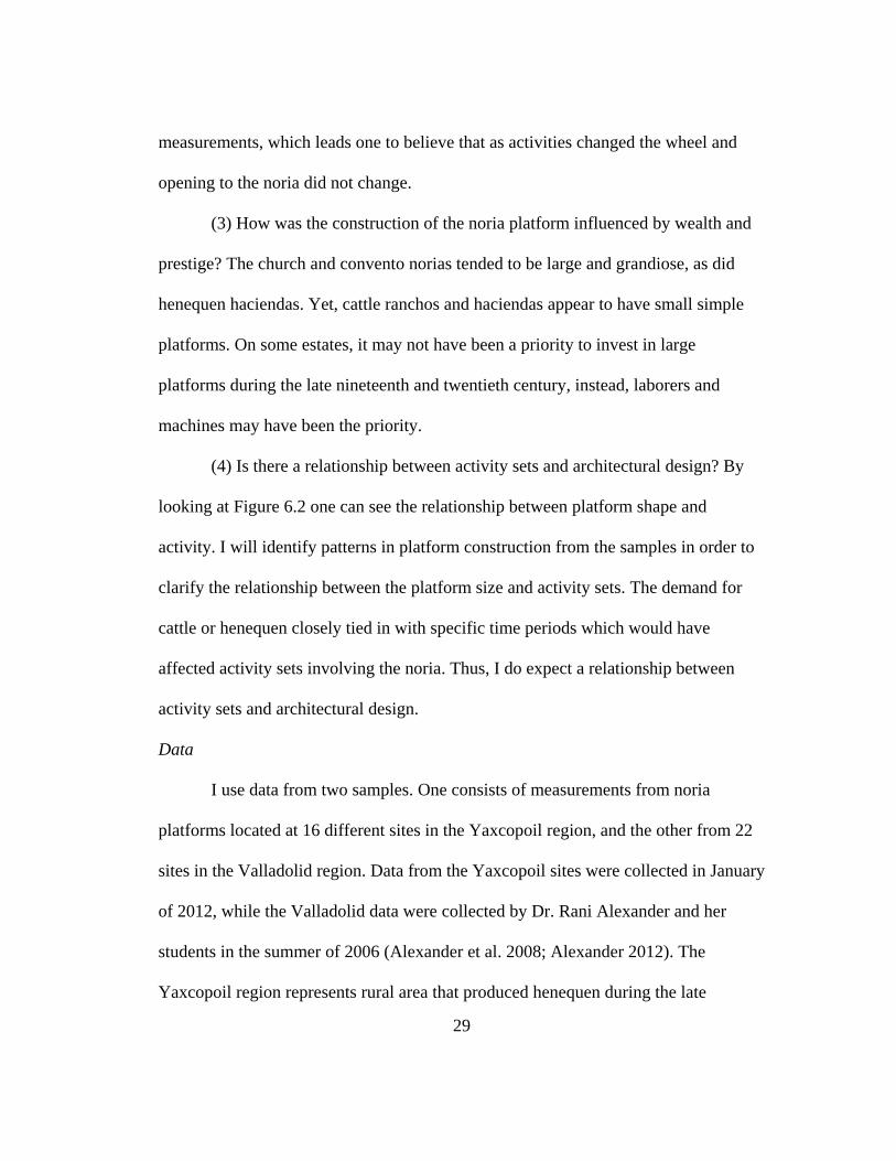
5.1. Ramp of noria platform at Mama....................................................................40
5.2. Noria Opening at Mama ..................................................................................40
5.3. Water tanks at Mama, surrounded by decorative perimeter wall ...................41
5.4. Within the noria opening at Iglesias de Tecoh ................................................42
5.5. Water tank at Iglesias de Tecoh ......................................................................43
5.6. Noria Platform Wall facing West ...................................................................43
5.7. Noria opening at Ex-Convento de San Francisco, Oxkutzcab ........................45
5.8. Water tank at Oxkutzcab .................................................................................45
5.9. Noria platform at Oxkutzcab ..........................................................................46
5.10. Church of Ebtun, from the southside ............................................................48
5.11. Noria of Ebtun ...............................................................................................48
5.12. Rejollada Acetunchen of Ebtun ....................................................................49
5.13. Site map of Ebtun..........................................................................................49
5.14. Main house of Hacienda San Diego..............................................................51
5.15. Water troughs at San Diego ..........................................................................52
5.16. Site Map of San Diego ..................................................................................52
5.17. Noria platform at Hacienda Haymil ..............................................................54
5.18. Archway to the corrals ..................................................................................54

x
5.19. Site Map of Haymil .......................................................................................55
5.20. Platform I with Adam Kaeding and Gastón Medina ....................................56
5.21. Water trough and corral at Santa Maria ........................................................57
5.22. Noria at Santa Maria .....................................................................................57
5.23. Site Map of Santa Maria ...............................................................................58
5.24. Noria at Suytun .............................................................................................60
5.25. Site Map of Suytun .......................................................................................61
5.26. Noria platform at San Antonio Cucul ...........................................................63
5.27. Noria gears at San Antonio Cucul ................................................................63
5.28. Water tank at San Antonio Cucul .................................................................64
5.29. Aqueducts leading to the fields at San Antonio Cucul .................................64
5.30. Noria I platform with decorative columns at Yaxcopoil ..............................66
5.31. Noria II platform with motorized pump........................................................67
5.32. Aqueducts from Noria II platform ................................................................67
5.33. Residential pool/water tank, water extracted from the first noria platform ..67
5.34. Noria I opening at Dzibikak ..........................................................................69
5.35. Water tank I at Dzibikak ...............................................................................69
5.36. Series of aqueducts at Dzibikak ....................................................................70
5.37. Cacao Noria ..................................................................................................71
5.38. L-shaped noria opening at Cacao ..................................................................72
5.39. Water tank I at Cacao ....................................................................................73
5.40. Water tank II at Cacao ..................................................................................74

xi
6.1. Bar graph of all noria openings (width and length) ........................................77
6.2. Bar graph of all platforms (surface area and volume) ....................................78
6.3. Box plot of noria width expressing normality ................................................80
6.4. ANOVA box plots of noria length ..................................................................82
6.5. ANOVA box plots of noria width ...................................................................82
6.6. ANOVA box plots of platform surface area ...................................................86
6.7. ANOVA box plots of platform volume ..........................................................86
B.1. Noria at Tixcacacupul ....................................................................................97
B.2. West side of convent behind the church in Tixcacacupul ..............................97
B.3. Site map of Tixcacacupul ...............................................................................98
B.4. Church of Chichimila .....................................................................................99
B.5. Site map of Chichimila .................................................................................100
B.6. Noria opening at Tekit..................................................................................101
B.7. Noria platform at Hacienda Xkatbe .............................................................102
B.8. Wall of main house at Xkatbe ......................................................................103
B.9. Site Map of Xkatbe ......................................................................................103
B.10. Noria of Puhula ..........................................................................................105
B.11. House arch of Puhula .................................................................................105
B.12. Site Map of Puhula .....................................................................................106
B.13. Hacienda Xcumsuc, arc and main entrance ...............................................107
B.14. Main House of Hacienda Xcumsuc ............................................................108
B.15. Windmill over noria at Xcumsuc ...............................................................108

xii
B.16. Site Map of Xcumsuc .................................................................................109
B.17. Noria at Hacienda San Jose ........................................................................110
B.18. Interior of the noria ....................................................................................111
B.19. Site Map of San Jose ..................................................................................112
B.20. Noria at Hacienda San Rafael ....................................................................113
B.21. House at the hacienda .................................................................................114
B.22. Site Map of San Rafael ...............................................................................114
B.23. Decorative doorway of the main house at Hacienda San Juan ..................115
B.24. Ramp leading to the noria ..........................................................................116
B.25. Site Map of San Juan ..................................................................................117
B.26. Noria at Hacienda Xkoben .........................................................................118
B.27. Main House at Xkoben ...............................................................................119
B.28. Site Map of Xkoben ...................................................................................120
B.29. Main house platform at Hacienda Chebalam .............................................121
B.30. Site Map of Chebalam ................................................................................122
B.31. Noria at Chebalam ......................................................................................123
B.32. Noria at Kolopna ........................................................................................124
B.33. Natural pools, hultun or sarteneja at Kolopna ............................................125
B.34. Site Map of Kolopna ..................................................................................126
B.35. Main house at Chimdznot ..........................................................................127
B.36. Noria at Chimdznot ....................................................................................128
B.37. Site map of Chimdznot ...............................................................................129

xiii
B.38. Noria platform at Kochila ..........................................................................130
B.39. Water trough in front of the main house at Kochila ...................................131
B.40. Site Map of Kochila ...................................................................................131
B.41. Noria of Santa Cruz ....................................................................................133
B.42. Site map of Santa Cruz ...............................................................................134
B.43. Main house of Sucil....................................................................................135
B.44. Water trough of Sucil .................................................................................136
B.45. Site map of Sucil ........................................................................................137
B.46. Noria opening at Kancabchen ....................................................................138
B.47. Water tank at Kancabchen ..........................................................................139
B.48. Ramp to noria at Kancabchen ....................................................................139
B.49. Noria opening at San Pedro Cholul ............................................................141
B.50. Water tank at San Pedro Cholul .................................................................142
B.51. On left, Cenote Opening adjacent to Platform, on right, Modern Tank .....142
B.52. Noria wheels at Tebec ................................................................................144
B.53. Water tank at Tebec ....................................................................................144
B.54. Aqueduct leading to bebedero (cattle trough) ........................................... 145
B.55. Noria opening at San Antonio Xpip ...........................................................146
B.56. Water tank at San Antonio Xpip ................................................................147
B.57. Noria platform with original stonework exposed .......................................147
B.58. Noria Opening at Ochil ..............................................................................149
B.59. Water tank at Ochil ....................................................................................150

xiv
B.60. Ramp of noria platform at Ochil ................................................................150
B.61. Noria opening at Sihunchen .......................................................................152
B.62. Large water tank at Sihunchen ...................................................................153
B.63. Small water tank at Sihunchen ...................................................................153
B.64. Noria opening at Kantoyna ........................................................................154
B.65. Water tank at Kantoyna ..............................................................................155
B.66. Main house at Kantoyna .............................................................................155
B.67. Noria opening at Ticopo .............................................................................157
B.68. Water tank at Ticopo ..................................................................................157
B.69. Servant Quarters on noria platform at Ticopo ............................................158
B.70. Chapel at Hacienda Muchucux ..................................................................160
B.71. Main house and noria .................................................................................160
B.72. Site Map of Muchucux ...............................................................................161
B.73. Chapel and main house at San Jose Canto .................................................163
B.74. Noria at San Jose Canto .............................................................................163
B.75. Site Map of San Jose Canto ........................................................................164

1
Thesis Statement
La Noria: A Hydrologic Technology of Yucatán
Nina Williams
Department of Anthropology, New Mexico State University
My goal is to investigate the technological variation of the noria
(waterwheel), a hydrologic mechanism introduced to the Yucatán after the sixteenth
century Spanish invasion. I intend to explore the changes to the technology,
particularly the architectural components that make up the platform and its opening
for the waterwheel. A noria, typically, has a large stone platform with a ramp,
stairway, and a well-shaft in the center of the platform that provides access to
groundwater. Over the opening a small waterwheel is used to extract water using
animal traction where it is then channeled to a water tank or cattle troughs (Figure
2.1).
The noria integrates a hydrologic technology with an architectural feature that
can exhibit the design preferences of its owner. I intend to draw attention to the
platform design and ascertain whether it was a utilitarian or a prestige item, and
determine if user group activities influenced the platform morphology. I want to
understand if the display of one’s prestige took precedence over production. I
hypothesize that (1) there is differentiation among noria platforms influenced by user
group activities; (2) the noria opening is standardized, indicating little change to its
mechanical components; and (3) since hacienda norias are large and grandiose, they
are clearly prestige items. By identifying patterns in platform construction from the
various sites, one can also identify the relationship between the platform size and
activities performed. Activities that would have influenced platform design include
indigo dye production, cattle raising, sugar and henequen production.
2
First, this study will address variation in noria design and functionality using
Schiffer’s theoretical framework of technological differentiation (Schiffer 1992;
2002; 2004). Second, I will discuss the background and historical events associated
with the introduction and spread of the noria to Yucatán. Third, I will discuss the data
and methods where my total sample of 38 noria platforms were found at sites in
northwestern and central Yucatán predominantly near small pueblos surrounding
Mérida and Valladolid.
Figure 1.1 Location Map of Norias
Regarding my data, I use a comparative sample of sites approximately 162 km
(100 miles) west of Merida in the Valladolid region (Alexander et al. 2008). The data

3
collected surrounding Merida I designated as the Yaxcopoil region (Figure 1.1). I will
discern any differences in the construction of the noria platforms by comparing the
area and volume of the platform and length and width of the noria opening. Graphs of
the data will be generated and interpreted as either supporting or nullifying my
hypotheses. The analysis will involve the comparison of site type (e.g., convents and
haciendas) with the size of its associated noria. These findings provide insight into the
various communities and their user groups during different time periods and
information about how technological transfer reengineered Yucatán’s landscape.
I expected my analysis to show that the Yaxcopoil and Valladolid regions
have a high level of standardization in the noria opening while the platforms have a
high level of differentiation due to personal preference. This would signify little to no
change to the noria mechanism, and that the platform changes due to owner’s
preference. The results of my statistical analysis indicated standardization of the noria
opening, and major variation in architectural design of the platform. Wealth and
status were important factors that strongly influenced the size of the platform. The
location of the platform on the property also indicated a link to wealth and prestige.
This look into the various properties of norias in Yucatán can broaden one’s
understanding of noria architecture through its many centuries of use. The diversity
among these structures may help one understand specific activities of different user
groups linked to each site and how noria form and function has changed since the
sixteenth century.

4
Chapter 2: Technological Differentiation
Technologic differentiation is an approach to the study of archaeological
materials that was formulated by Michael Schiffer. Specifically, it explains how
technologies change by focusing on people-artifact relationships through performed
activities (Schiffer 2002; 2008). In this section I will use Schiffer’s technological
differentiation framework to explain the redesign of the noria platform that occurred
at different sites throughout northern Yucatán during the sixteenth through the
twentieth centuries. As a result, one could infer how social interactions in society
influenced changes in technology.
Because the overarching framework is behavioral, I will approach this topic
by focusing on the technological and architectural components, while I attempt to
clarify how and why this approach would help address changes to the noria platform.
Since there were few mechanical components available for comparison, I focus on the
platform architecture. Although, I touch upon the life history of the noria and user-
group interactions, I intend to draw attention to the social processes that influenced
the platform design to ascertain 1) whether the platform was solely utilitarian or non-
utilitarian and decorative in its design, 2) whether the noria opening was standardized,
and 3) how these features contributed to the maintenance and reuse of the structure.
Technological differentiation is the process of change to a technology’s
functional variants transferred from one community to another and influenced by
social factors that can dictate its performance characteristics (Schiffer 2002: 1148). In
other words, one may start out with a simple utilitarian technology, but it eventually
changes in design and use over time through the process of technology transfer. The

5
transformation of the noria platform into different sizes and shapes is associated
directly with the user’s activities.
Six different phases that model the change of technology are transfer,
experimentation, redesign, replication, acquisition, and use (Schiffer 2002, 2008:824-
826). Information transfer is the learning process of the recipient community that has
provided this new idea via word of mouth or through hands-on examination of the
technology. The experimentation phase involves testing the technology and applying
it to perform specific activities. Redesign is the specialization process that weighs the
performance characteristics, i.e., the ability of an object to be used in a specific
activity. During this stage personal preference may influence the size and shape of
technologic changes. Replication is the manufacturing and distribution of the
technology to others in and outside of the community. When the technology is
acquired, the recipient community adopts it and eventually puts it to use. The phases
Schiffer (2002, 2004) focused on in his writings are the early stages of technological
differentiation, primarily how the technology was transferred. This section, however,
will explain the production and development of the noria, focusing on its functional
variants.
Technological Differentiation of the Noria
Noria technology lasted for centuries in Yucatán from the time of the Spanish
Conquest (1511-1546) to the early twentieth century. The geomorphology of north
central Yucatán is unique compared to central Mexico or the Guatemala highlands.
There is little running water found on the surface; therefore, access to underground
water was crucial when establishing a community or household. Often, wells and
noria platforms were built over cenotes (natural sinkholes, with an opening to an

6
aquifer) to access water. Thus, norias became important structures, designed and
administered by Spanish clergymen but built and used by the Maya. Religious
structures such as churches and conventos (monasteries) and their norias were often
built of stone from the Maya ruins. The stones from the ruins were squared and did
not require shaping making it easy for reuse in Spanish structures (Roman Kalisch
2009: 8-9). During this era, large-scale production of dyes and cattle were introduced
to the peninsula, these were the activities that caused a change in the noria’s
functionality.
The noria’s life history is a fine-tuned behavioral chain of events that connects
the technology with a sequence of specific activities. The Spaniards and the Maya
performed various activities such as raising cattle and Mediterranean-style gardening
that influenced design changes to the noria. For example, the noria platform was first
established at conventos and estancias (private ranches) in the New World. Convento
norias provided water for an extended household made up of Franciscan clergymen
and staff. There were as many as 380 conventos in New Spain by the 1550s
(Clendinnen 2003: 47). Clergymen used the Maya population as labor for various
enterprises and consequently taught laborers how to use the noria. With the
knowledge of Spanish technologies, larger scale production was possible, extending
beyond the conventos.
While clergymen were acquiring lands, other Spanish entrepreneurs were
building estancias. These estancias were producers of indigo dye also known as añil
(Patch 2003: 564). From 1560, Mayan subjects extracted the blue dye from
leguminous plants of the genus Indigofera, which provided a hefty income to Spanish
estancias in the late sixteenth century (Patch 1993). Maya workers would pump the
7
water into vats to steep the plants and extract the dye. Production of indigo did not
last long due to the serious health problems associated with the fermentation process
and was banned in 1581 (Patch 1993: 34).
Estancias maintained a small full-time staff of foremen and ranch hands to
attend to the cattle (Farriss 1984: 34). Pilas (tanks) that were once used as
fermentation vats were converted to hold water for cattle. The word estancia became
interchangeable with rancho, and most estancias were used to produce cattle in the
seventeenth and eighteenth centuries (Patch 1993). Añil production was restarted in
the 1700s with records of export out of Yucatán (Contreras Sanchez 1996); however,
the level of production was on a smaller scale and did not last. By the nineteenth
century most estancias switched from indigo production to raising cattle. Cattle were
economically viable while human populations were increasing.
Table 1. User groups and activities
User Groups Activity Year
Spanish Clergy Extended household (gardens, cattle, consumption) 1500s +
Estancia Workers Indigo production and Cattle Raising 1500s +
Rancho Workers Cattle Raising 1600s - 1900s +
Hacienda Workers Agricultural production and Cattle Raising 1821- 1900s +
Henequen Workers Henequen production 1855- 1900s +
Tourists Heritage tourism 1900s- Present
Table 1 lists the common user groups of the noria in Yucatán from the 1500s
to the present. These groups performed activities that were associated with specific

8
periods of time, many lasting for centuries. The cattle industry was associated with
ranchos and haciendas, which was the longest lasting activity that co-occurred with
other forms of production such as indigo and agriculture. Rancho workers were few
in number since cattle raising was not a labor intensive activity, but large parcels of
land were important for grazing (Evans 2007: 38). Ranchos that had, for example,
1,000 cattle, needed to pump on average twelve thousand gallons of water per day
(Rasby and Walz 2011). After 1821, a significant shift from cattle to monocropping
of henequen and sugar opened up haciendas to new technologies. Henequen and
sugar haciendas required a large work force to attend to the new machines, like the
steam-powered engines and boilers. Due to the various activities that were associated
with the hacienda, the workers needed to be more versatile. Less time was needed
pumping water, and workers could then contribute to the processing and shipping of
products.
User groups gained more responsibilities over time, starting with the noria,
tending to cattle, and eventually being operators of steam and gas-powered machines.
Today, some haciendas have turned into tourist attractions transforming the noria tank
into swimming pools, and using the noria to provide water for gardens and other
decorative features, or completely discontinuing the noria’s use for extracting water
in order to recreate the environment for tourism.
Architectural Design
Architectural design is a process whereby social groups make choices
concerning several recurrent sets of activities. McGuire and Schiffer (1983) focused
on the activity sets of production, use and maintenance of the built environment. With
each activity set, people attempted to maximize certain goals. Because these activity

9
sets were interdependent, it was impossible in the design process to maximize all
goals simultaneously. Moreover, maximization of one goal was usually achieved at
the expense of others. Thus, the design process could be viewed as a series of
compromises between goals (McGuire and Schiffer 1983:278). As societies became
more differentiated, the activity sets and their attendant goals became increasingly
associated with different social units. The goals of use can be separated into utilitarian
and symbolic functions, which delineate space for the performance of activities and
mediate between people and their environment (McGuire and Schiffer 1983: 280).
Known as a behavioral chain or flow model, “Design theory can show how artifacts
allow actors within cultural behavioral systems to adapt in their environments”
(Schiffer 2008; Hayden 1998). Although the behavioral framework incorporates both
architecture and objects in order to explain technologic change, there are some
distinctions between objects and architecture that should be mentioned. Since the
noria technology has an architectural foundation and specialized function regarding
production, it is not simply a tool or technology. The noria integrates a hydrologic
technology with architectural features that can express the design preferences of its
owner.
The idea that objects can be broken down into practical and prestige items
begs the question, where do we draw the line? Since the noria platform tended to
incorporate utilitarian and decorative features in the architecture of the platform, a
model that includes architectural design is needed. Also, it is important to break down
the design process, because why would the owners prefer one design over another? In
response, it would seem that depending on the activity set, people tend to maximize
certain goals. For certain goals one must consider the time, labor, and cost of masonry
10
versus the overall benefit of the structure (Alexander 2003; McGuire and Schiffer
1983). Thus estate owners who could afford elaborate design features would
understandably expand beyond utilitarian use of the noria platform, dissociated from
production and market demands.
Design features of the platform refer to the overall shape, size, and placement
of the structure. Rectangular and circular noria platforms are the two shapes that are
represented in my sample. Size was quite variable but placement was typically
adjacent to the hacienda’s main house or corrals. Some of the platforms were
observed to have large pilasters on either side of the ramp or repeatedly along the
perimeter walls. These features were found at conventos and haciendas and for that
reason; there is no strict association with one site type. The ramps were common for
platforms that originally had animal-powered norias; stairs were incorporated into the
platforms also but were not a major focal point.
The noria platform was built using a variety of materials such as limestone,
metal, and mortar, while the noria wheel was made of wood with rope and ceramic
vessels attached. Eventually, the wood was reinforced with metal and the ropes and
ceramic vessels were replaced by metal buckets and attachments. All these materials
deteriorated at different rates; the exposure to various microenvironments may have
hastened or retarded certain agents such as rust or fungal decay (Schiffer 1996). For
instance, the wooden components of the noria needed to be replaced every five years,
but once the motorized pumps or windmills were installed, maintenance costs
decreased while production increased (Reynolds 1983: 287). These new hydrologic
technologies would benefit hacienda owners greatly, and the reuse of the noria
platform for the new machines helped reduce costs. Many haciendas changed to

11
diesel or gasoline-powered motorized pumps in the twentieth century to expand
production, while others that produced on a small scale simply maintained
production, and did not switch technologies.
A concept that may shed light on this development of maintaining old
technologies is called a “technology shelf” (as cited in Greene 2008) that discusses
the parallel of newer and older technologies existing at the same time. The technology
shelf is helpful in explaining why a technology does not advance on a single front,
and why less ‘efficient’ devices such as hand mills could coexist with water-powered
machines. Greene (1999, 2008) believes that lack of knowledge is what prevents
people from acquiring new technologies. He goes on to explain how invention and
innovation rarely led to a technology’s use, but rather use led to invention and
innovation of the technology. It is correct to assume that users are innovative when an
activity calls for it, but if there is no innovation that should not suggest ignorance of a
technology’s existence. In this case, the lack of knowledge is not the reason for the
noria wheel lasting longer at some sites. The lack of necessity and the costliness of
the new mechanisms prevented the switch over to motorized pumping technology,
especially in the early phases of adoption, since not all communities participated in
large scale production.
With the data collected, including the measurements of the noria platforms,
one can apply these frameworks to showcase how user group activities contributed to
the variation found at the different sites. Also, analysis of norias shows how
architectural design was a trade-off between maximizing production and prestige.
Since elites were the ones in control, they were able to dictate how and where the
noria platforms were built. The noria technology was found most commonly at sites

12
that needed an abundant supply of water for cattle, fruit orchards or other forms of
production. It was not common for the noria to be in communities that lacked large
scale production. Pueblos were the exception, as norias could be found in the town
plazas to provide water for the community. Therefore, by observing those sites with
changes to the noria, or even the replacement of its technology, there was a drive to
maximize production. Those sites that were not driven to maximize but merely
maintain production were still adequate producers for their local economy.

13
Chapter 3: History of the Noria
A noria, also known as a Persian waterwheel or sakia, is a direct lifting device
used to collect water. Work animals are attached to a pole that circles a central axis,
turning the center, horizontal wheel (Figure 2.1). The edge of the wheel lines up at a
90-degree angle with the main vertical wheel. The main wheel contains spokes that
connect to the frame of the horizontal wheel, which causes the main wheel to turn. A
chain of pots or buckets (at equally distributed points) are attached by ropes to the
circumference of the main wheel. This chain is suspended on the wheel in order to
reach depths of over 10 meters to collect water. As the wheel turns, the water is raised
to form a continuous bucket elevator (Fraenkal 1986). The water collected pours into
a basin, typically located within the central portion of the vertical wheel. From the
basin, the water is led through a series of aqueducts to its final destination, which
could be an animal trough, water tank or fruit orchard. Since the technology is
dependent on work animals, such as burros or oxen, it provides a reliable method of
extracting water with little to no human energy expended (Reynolds 1984). Although
the noria is mechanically adequate for extracting water, it has two drawbacks: water
spillage from the buckets, and the friction drag caused when the buckets scoop up
water (Fraenkal 1986:42).

14
Figure 2.1. Noria (Echino 2007).
Some advantages of a noria are its simple mechanized wheel used to extracted
water that would otherwise be collected by hand. The amount of time used to collect
the water decreases dramatically along with the man-power necessary to collect
enough water for activities associated with irrigation and raising livestock. The noria
is a machine and a technology that existed for centuries prior to Spanish use, but this
structure is not to be confused with the water wheel used in mills to grind grain in
Europe as early as the first century A.D. and in China during the second century A.D.
It is unclear whether the waterwheel was created independently or spread from the
West, but by the ninth century most western monasteries had at least one water mill
(Reynolds 1983: 110). In Europe, mills were highly profitable both to the great
monasteries and to entrepreneurs (Gies and Gies 1994:89). The belief in manual labor
and self-sufficiency was important for monasteries especially those isolated from the
world. Milling was a great way for abbeys to abandon the monotony of grinding

15
grains by hand and increase time for study and prayer (Reynolds 1983: 109-110). The
noria, on the other hand, had a simpler history and use pattern throughout the various
regions that acquired the technology.
Noria technology was not commonly discussed in ancient texts, which made it
difficult for scholars to ascertain the origin of the first noria. For example,
Mesopotamia was thought to be the first civilization to create the water wheel, but
scholars later believed the texts were referring to an instrument used for watering
(Schiøler 1973). Reynolds (1983) believes the noria originated in India during the
fourth century B.C. The first written and archaeological evidence was found in Rome
and Greece, establishing the use of the noria during the third century B.C. (Oleson
2000). Throughout the centuries, the noria spread through China, Northern Africa,
and eventually into Spain. Caravans from China to Persia began in 106 B.C.,
traveling through either Samarkand or Bactria to Merv, south of the Aral Sea,
continuing through what is now Iraq, and eventually into the Roman Empire. The
Persian Gulf and the Red Sea became part of a sea route between Greece and India
during the first three centuries A.D. (Gies and Gies 1994:84). Trade was one of the
main reasons for foreign technologies to spread, contributing to hydraulic technology
advancement in many regions of the world.
Certain communities, such as monasteries and convents, utilized the
technology. Regarded as a prestige feature, the noria became an aesthetically pleasing
technology among the clergy. As the construction of monasteries spread throughout
Europe, the Middle East and India, the monasteries may have contributed to the

16
overall spread of noria technology. The goal of advancing and spreading technology
in Europe’s Middle Ages was hindered when the water wheel became associated only
with aesthetics. The technology was not efficiently utilized for production. Cost of
materials to build the noria outweighed the cost of laborers to collect water, which in
turn lowered the number of norias and their potential for production (Reynolds 1984).
Geography and environment also helped the noria spread in areas with heavy rainfall
but eventually, the noria was adopted in drier climates providing water to those
communities and their irrigation fields.
Although norias were believed to be established early in Rome and Greece,
those found in Spain were built on a smaller scale and adopted from Northern Africa
(Gies and Gies 1994). New devices such as dams, canals, drainage tunnels, and
water-lifting machines helped widen the variety of crops, intensify cultivation in Arab
rural settlements, and increase city growth (Gies and Gies 1994:102). Like other
elements of Islamic civilization, new forms of agriculture were spread from Baghdad
westward, through Egypt, Tunisia and Morocco, reaching Europe via Muslim Spain
throughout the High Middle Ages (AD 1000-1300). Some of the techniques, notably
irrigation works, were quickly imitated in Christian Europe whose southern regions
also adopted the cultivation of cotton, rice, sugarcane, and citrus fruits. By the end of
the Middle Ages, many of these crops were successfully transplanted to the Americas
(Gies and Gies 1994:103).
In the New World, noria technology appeared with the first European
settlements established in the Caribbean. At the archaeological site of Las Coles in

17
the Dominican Republic, for example, fragments of an arcaduce or waterwheel jar
were found, dating back to the late fifteenth century (Deagan and Cruxent 2002). This
site, associated with La Isabela, “America’s first European town,” was located near
fresh water from the Bajabonico River, and potentially serviced the settlement for
artisanal, industrial and agricultural activities (Deagan and Cruxent 2002: 57). The
availability of water sources played a major role in how the Spanish adapted the noria
technology to the Yucatán. To understand how the technology was implemented, one
must first understand the geophysical landscape of the northwest region of Yucatán.
Yucatán Landscape
The geomorphology of the Yucatán Peninsula consists of a limestone platform
that extends 75,000 km2. This karst morphology is predominantly calcium carbonate
(CaCO3), which is highly permeable to water where underground canals and cenotes
(sinkholes that reached the water table) are formed (Beach 1998; López 2008). With a
highly permeable surface, subterranean drainage tends to leave the ground surface
rather dry and with few rivers or streams. Subterranean caverns collect drainage that
merges with fresh water from the water table. The water table also coincides with the
rise and fall of the tides, which can impact the water level within a cenote
(Scarborough 2003). A cenote or tz’onot, a Mayan word meaning “natural well of
water,” has a complex hydrologic system that, in brief, provides an adequate water
supply to whole communities (Lopez 2008). Collection of water from these
underground watersheds was a community-wide activity. Areas in the southern Maya
lowlands, such as Tikal, used irrigation canals and aqueducts for agriculture but the

18
watersheds in the north were not conducive to this practice (Scarborough 2003:100).
Water collection was more labor intensive and required that agricultural production
be closer to a water source. The majority of food production relied on rainfall, which
made year round production difficult in the dry northwestern region of the Yucatán
peninsula.
Sixteenth to the Twentieth Century
Initially, the Spaniards conquered the New World for its riches, precious
metals, and slaves but found the Yucatán was limited in all three. As a result, many
encounters the Spanish had with the Maya along the Yucatán coast, involved trading
items such as wax, honey, indigo, salt, textiles and cacao (Patch 1993: 31-32). The
Spanish Conquest was an arduous process that lasted nearly 35 years in Yucatán due
to the dense vegetation, dispersed settlements, and unrelenting resistance from the
Maya. Maya resistance broke down when the most powerful lord in the province,
Tutal Xiu of Mani, converted to Christianity, and, hence, was persuaded to join the
Spaniards in overtaking the rest of the Yucatán lords (Clendinnen 2003).
While cattle ranchos (ranches) and mining developments monopolized land
and labor in Central Mexico, colonization in Yucatán progressed at a slower rate. The
spread of disease reduced the local populations. Epidemics of smallpox, measles,
influenza and other various diseases affected local populations every few decades
until the nineteenth century (Farriss 1984; Patch 1993). Local populations struggled
to recover from recurring epidemics and famine.

19
In the early sixteenth century, conventos and churches were the first religious
structures erected in the New World (Andrews 1991). The Catholic missionization of
Yucatán began with the arrival of eight Franciscan friars in 1544, during the final
stages of the Spanish Conquest. They established the first conventos in Campeche
and Mérida in 1545 and began their missionary activities in the rural areas with the
founding of a third convento in Mani in 1547 (Andrews 1991). The Spaniards built
the conventos close to the cenotes to establish control of the water resource for that
area. The noria platform was built directly over the smaller cenotes. This may have
contributed to the large size and scale of the platforms since cenotes can vary in size
and depth. Platforms varied in size and shape at different convents. Many conventos
were built higher than the surrounding structures in a community. As the conventos
were being erected, the Maya were forced to congregate in large pueblos in order for
the Spaniards to facilitate control and conversion, also known as congregación
(Restall 1997: 172). A system to ensure control and tribute flowed from the local
populations was implemented, the encomienda.
The encomienda was established early on to protect and supervise the Maya
populations while collecting tribute in the form of goods and services. This was an
indirect way of governing the people and providing a steady income and prestige for
Spaniards (Bakewell 2008:87; Farriss 1984:39). Many of the encomiendas assigned
between 1541 and 1545 were not associated with the previous indigenous political
territories, and, as such, triggered political change that broke down the indigenous
provinces (Alexander 2004). During the early onset of Spanish political power, the

20
Church employed Maya workers to construct churches as a form of obligatory labor.
Though textiles and food were acceptable, any surplus that was received by
authorities was sold or traded for other goods (Sherman 1979; Patch 1993). One of
the first products that came out of the encomienda system in Yucatán was indigo dye.
Indigo production had its early roots in the Mayan culture prior to Spanish contact. In
northern Yucatán, indigo was produced from about A.D. 300-A.D. 1500 (Patch 1993;
Arnold et al. 2008). Indigo was used for ritual practices, murals and pottery. The
Maya combined the plant and mineral, palygorskite, to create the pigment most
commonly referred to as “Maya Blue” (Arnold et al. 2008). Once Spaniards decided
to produce indigo dye, a large surplus was required to compete in the world market.
Norias were needed to haul out the water and the pilas were used as holding tanks to
extract the dye. However, the production of the dye did not last. The Maya became
sick from the toxic vapors released, and this caused the conventos to complain to the
land owners and the government for ill treatment in which case most of the indigo
production ended (Beeson 1964; Bakewell 2004; Patch 1993). Afterward, their
presence was still needed at the estancias once the Spanish switched focus and started
increasing their number of cattle to sustain the Spanish population. Indigo dye
production was banned in 1581, and other forms of production were popularized in
the area.
Beyond the convents, Spanish accumulated lands to establish ranchos and
estancias. Spanish landowners and convents participated in cattle raising and meat
production to appease the Spanish appetite (Patch 1993). Conventos and wealthy

21
landowners acquired land to raise larger herds of cattle on the unoccupied lands close
to the city of Mérida. The Spanish population increased from about 1,500 people at
the end of the sixteenth century to about 4,000-5,000 by the end of the seventeenth
century, generating an increasing demand for meat, which, in turn, stimulated the
expansion of the cattle industry (Patch 1993:115-116). With the increase in cattle
came the increased need for water. Cattle consume anywhere from five to twenty
gallons of water per day depending on size and daily temperature (Rasby and Walz
2011). Without a noria, cattle could easily die of thirst especially since cattle
populations could reach into the thousands on a single ranch. Although the ranches
housed many cattle, only a small number of workers were needed to run the ranches.
This changed when additional cash crops were produced, hence, the ranchos were
converted into prominent haciendas.
Alexander (1997) conducted research on cattle hacienda architecture and its
relationship to prestige and production in central Yucatán. Her research provided a
good model for linking the noria to a typical location, site type and architectural
investment. In the Yaxcabá region, there were signs of architectural change linked to
economic transitions in the marketplace from 1750-1821. Alexander (1997: 332)
argued that variation in hacienda size and architectural elaboration was contingent
upon the entrepreneurial strategies pursued by the estate owners as well as the
organization of production on a hacienda.
The noria was the most essential feature at cattle haciendas in the Yaxcabá
region, usually located adjacent to the central corral and casa principal. The masonry
structures that were erected at the haciendas and at the different sites were expensive

22
to produce. Wealth and prestige may have contributed to many of the masonry
structures erected, but there were also close associations with the architecture and the
hacienda’s level of production (Alexander 2003). In some cases, masonry
architecture, especially the noria, functioned to provide the necessary infrastructure
for intensification of production. Hence, variation in the size, arrangement, and
facilities reflected the production and labor requirements of the specific goods the
hacienda produced (Bracamonte y Sosa 1988; Alexander 2003: 199). Alexander
(1997: 342) used a statistical regression model that tested the relationship between
variables; for example, the site size and production capacity, and architectural
investment and production capabilities. She found that the architecture of haciendas
and privately owned ranchos likely functioned as infrastructure for production that
enhanced the prestige of an owner (Alexander 2003: 206). The maximization of
production and wealth was important for many of the hacendados. They did not limit
the construction of grandiose architecture to one purpose but many in order to
increase the wealth of their estate.
At the turn of the nineteenth century, transition to larger scale agricultural
production increased demand for labor, therefore, hacendados created a position
referred to as a lunero (Farriss 1984: 56). Luneros were typically Maya workers that
received a parcel of land to cultivate from the estate’s property in exchange for labor
or a share of the crop; every Monday they were required to work on the estate
(Rugeley 1996; Rivero 2003). The Maya became increasingly dependent on the
hacendados for work and resources. Hacendados were responsible for paying church
taxes for every worker. As church and state taxes increased, workers were expected to

23
pay back the hacendados. A series of loans and advances created a system of debt
peonage for the Maya workers and bound them to the haciendas. This resulted in
various forms of resistance and protest. Fleeing from the haciendas, tax evasion, land
invasions and cattle rustling characterized Maya resistance (Pineda 1991).
Hacendados viewed the Maya population as lazy and malevolent, increasing tensions
up until the Caste War of 1847. Even after the war, the development of the monocrop
industry in sugar and henequen further perpetuated the strain on Maya and elite
relations through the remainder of the nineteenth and into the twentieth century
(Pineda 1991). During the late nineteenth century the henequen market took hold of
the Yucatán and transformed the hacienda into an industrial capitalist enterprise.
Henequen and sugar estates also relied on noria technology to provide water for
processing the sugar and henequen.
Henequen, a form of agave, was cultivated and processed by extracting the
fibers to produce rope and twine, a basic commodity used by farmers. The henequen
industry exemplified economic growth and differed from the classic agricultural
productions of earlier nineteenth century haciendas (Evans 2007). Wealthy
hacendados purchased lands prior to the development of henequen plantations and
drew in workers by increasing the job market. Haciendas grew, processed and
shipped the henequen fibers, thus monopolizing the henequen market. Processing the
fibers by hand was very time consuming and hard on the workers (Alston et al. 2009).
Time constraints placed additional pressures on workers and plantation owners since
the fibers had to be processed within 24-48 hours; otherwise the leaves dried and

24
ruined the batch. For decades, the government encouraged inventors to develop a
machine that could process the fibers quickly and efficiently. Heavy machinery was
needed to mash, strip and refine the fibers to reduce manual labor. In 1855, rasper
technology was created in Yucatán (Spenser 1991; Wells 1991).
A decade after implementing the rasper, land acquisition for henequen
increased by 50 percent. Livestock and mixed crop plantations, including sugar and
maize were subsequently replaced by henequen plantations (Loewe 2010). Capitalism
became the driving force of the haciendas in Yucatán. In the early twentieth century
at the start of World War I, the henequen industry was at its height. It was likely that
workers migrated from throughout the Yucatán peninsula, Cuba and Asia to partake
in Yucatán’s henequen economy (Spenser 1991: 223; Wells 1991: 132).
The expansion of Yucatán haciendas created a large labor force bound by debt
to the estates in the late half of the nineteenth and into the twentieth century. Though
the market experienced a downturn in 1884, acquisition of land by the elite did not
cease (Wells 1991). The late nineteenth century was a time of increasing Mayan
unrest due to abusive conditions of debt peonage and elite mismanagement.
Fluctuating henequen prices and misappropriations of funds by hacienda owners
caused a number of haciendas to claim bankruptcy when the market became
unreliable. Consequently, the Yucatán government increased support for their
workers and unions, gaining their trust in order to use their labor for increasing
industrial production. During this surge of industry, Yucatán gained major
recognition in the early twentieth century (Spenser 1991). These heightened periods

25
of economic boom also lead to technological advancements, with the introduction of
various new hydrologic technologies, such as the windmill in the mid-nineteenth
century.
The windmill is a simple technology built upon a solid foundation with low-
cost mechanization (Fraenkal 1986). It is a source of renewable energy that was
commonly used throughout history. Ancient Hindu texts suggest that windmills were
utilized as early as 400 B.C. for pumping water. Recorded accounts of windmills
came from areas in Pakistan, Afghanistan and other Middle Eastern countries
approximately A.D. 600 (Sorensen 1991). A consequence of these technological
developments catapulted the expansion of European control throughout the world.
The need to develop a hydrologic technology that could pump continuously or
with less reliance on animal labor was influenced by the United States. The windmill
was patented in the 1850s and spread from the United States to Mexico as an
alternative method to extract groundwater in the 1880s (Baker 1985). Newer models
of the windmill used lighter steel blades and were more efficient in capturing the
wind, and in the late nineteenth century, they helped support the increase in
production for agriculture and domesticates (Mathew 2006). In Yucatán, windmills
were typically placed over the noria on the platform, where the energy produced from
the wind was used to pump the water out of the cenotes and pozos (wells). But large
scale haciendas did not have to depend solely on wind to pump water; motorized
pumps became quite popular as early as the 1860s (Evans 2007). In the Yucatán,
motorized pumps are not commonly used until the 1900s.

26
With the development of motorized pumps, the noria became obsolete by the
1910s. Small pozos that were once used for simple extraction were being pumped.
Motorized pumps work by creating suction, or a vacuum, that uses the atmospheric
pressure to lift the water up and out of the well or cenote (Klenek 1997). The jet-
pump was created in 1858 by a Frenchman named Henri Giffard. His invention was
powered by high pressure steam to generate the suction for pumping; it is the most
common pump for shallow wells. A submersible pump worked best for lower depths
and delivered high capacities of water, but these are fueled by gasoline (McDermott
and Greisinger 2003). Once haciendas started implementing this technology, there
were times when the water source was over-pumped and resulted in a dry well; this
became a major problem for hacendados. They began looking in surrounding areas,
some far from the original water source, to drill and create an additional well.
Subsequently, when that water source was depleted, the process repeated itself
(Gelting 1995). Usually when a well was drained it gradually filled back up, though it
took time depending on its size, depth and the amount of permeable rock within the
well. Many haciendas that had extremely high production of henequen resorted to
drilling or further expanding in order to monopolize other water sources in the area.
Interestingly, henequen crops did not require additional water. Production of
henequen relied entirely on rain water, though the first processing centers for
henequen required large amounts of water for the boilers that powered the steam
engines. By 1861, the boilers were heated by wood or coal burning furnaces located
in the machine house. As a result, exports rose from 112,911 bales in 1880 to close to

27
one million bales by 1915 (Wells 1982: 229). The steam engine and the raspadora
(rasper) machine caused the initial spike in exports in 1856. The rasper striped the
fibers from the leaves quickly which were then hung and sun-dried before being
pressed and shipped (Rivero 2003). The problem was the seven-year wait until the
henequen plants were ready for harvest along with the fluctuations in world market
demand. The last major demand for natural fibers was during World War II. Those
haciendas that only invested in the cash crop economy had the greatest loss when
henequen twine was eventually replaced by synthetic fibers after World War II,
predominantly in the 1960s and 1970s. World production and consumption then
declined steadily through the decades (Brannon 1991). During the twentieth century,
many towns surrounding Mérida declined in their level of production due to a number
of environmental disasters that devastated crops and with the depopulation of the
smaller towns. Technology that once drove these haciendas was replaced by
technological developments in the cities (Brannon 1991).
Ironically, the future well-being of Yucatan’s rural dwellers probably will have
much less to do with their relationship to the land, because most will leave it. It
is the city, where the new master—technology—resides, that represents
opportunity and freedom [Brannon 1991: 249].
Haciendas today are neglected, owned by foreigners or transformed into tourist
destinations. However, evidence of a once thriving community can be found in the
ruins of the plantations and the noria platforms left behind.

28
Chapter 4: Questions, Data and Methods
My contention is that the Yaxcopoil and Valladolid regions (see Figure 1.1)
will have a high level of standardization in the noria opening, while the platforms will
have a high level of differentiation due to owner’s expression of prestige. I explore
the structural components influenced by specific user groups during times when
production was shifting and expanding. In this section will discuss my research
questions, data and methods used for the analysis. I outline what questions are to be
addressed and how the analysis will attempt to answer those questions. My samples
are small but provide a good representation of norias in the Yucatán. I outline what
variables are to be used and what I expect from my analysis. My findings show how
hydrologic technology was influenced by user activities.
Research Questions
My research questions and expectations are as follows:
(1) Are there differences regarding the platform morphology among the cattle
ranches, henequen haciendas and churches/conventos? I expect differentiation among
the site types since activities and production changed through time. Change in
activities would cause change to the platform’s morphology providing the owner with
their preferred design that would maximize production for a specific activity set.
(2) Are the noria openings standardized? The noria openings should not have
significant differences in their measurements and expect little to no change of the
mechanical mechanism of the noria. Many of the noria openings have similar
29
measurements, which leads one to believe that as activities changed the wheel and
opening to the noria did not change.
(3) How was the construction of the noria platform influenced by wealth and
prestige? The church and convento norias tended to be large and grandiose, as did
henequen haciendas. Yet, cattle ranchos and haciendas appear to have small simple
platforms. On some estates, it may not have been a priority to invest in large
platforms during the late nineteenth and twentieth century, instead, laborers and
machines may have been the priority.
(4) Is there a relationship between activity sets and architectural design? By
looking at Figure 6.2 one can see the relationship between platform shape and
activity. I will identify patterns in platform construction from the samples in order to
clarify the relationship between the platform size and activity sets. The demand for
cattle or henequen closely tied in with specific time periods which would have
affected activity sets involving the noria. Thus, I do expect a relationship between
activity sets and architectural design.
Data
I use data from two samples. One consists of measurements from noria
platforms located at 16 different sites in the Yaxcopoil region, and the other from 22
sites in the Valladolid region. Data from the Yaxcopoil sites were collected in January
of 2012, while the Valladolid data were collected by Dr. Rani Alexander and her
students in the summer of 2006 (Alexander et al. 2008; Alexander 2012). The
Yaxcopoil region represents rural area that produced henequen during the late

30
nineteenth century. Areas south of this region produced sugarcane due to richer and
moister soils (Patch 1993). The Valladolid region had smaller scale ranching
communities compared to the Yaxcopoil region. Many of the sites started by raising
livestock but changed through time, eventually performing other activities such as
henequen and sugar production.
Tables 2 and 3 show the sites and site types with a brief description of each
noria platform in the Yaxcopoil and Valladolid regions. For both regions there are a
total of 16 haciendas, 18 ranchos and 7 conventos. There is some uncertainty when
labeling the site type since many of the cattle ranchos eventually became henequen
haciendas. Some haciendas built additional norias specifically for the steam-powered
machines for processing henequen. The older noria would still provide water for the
cattle and orchards while water from the newer noria would contribute to the
machines.
Norias that were built outside of the convento walls were still managed by the
clergymen. For example, Mama had a noria within the walls of the convento and
directly outside accessible to the community. I decided to include the community
norias as convento norias since many were built in plazas located in close proximity
to the conventos and churches. The sample of norias from conventos and churches is
small, six total but may be enough for analysis.
In both regions, norias or multiple norias are found at the various sites. The
time periods associated with the sites are from the late sixteenth century to the late
twentieth century. Many of the platforms, both circular and rectangular in shape were

31
associated with corrals, a water tank, cattle troughs and aqueducts. Those norias that
were not associated with cattle were those found at the processing centers of the
henequen haciendas. They were built later to contribute to the more specialized
needed of haciendas.
Table 2. Sites in the Yaxcopoil Region
The Yaxcopoil data was collected by using a 100-meter fiberglass tape
measure, an HTC HD2 smart phone with 5 megapixel camera, and notebook. I
attempted to visit sites closest to Merida; however, many of them had removed or
destroyed their norias. The convent route (Carretera 18) led me to many different
sites. The haciendas, however, were more accessible than the conventos. Also, access
Site Site Type Description
San Antonio Cucul Henequen Hacienda Circular platform with water tank attached
Kancabchen Henequen Hacienda Rectangular platform, attached to casa
Yaxcopoil Henequen Hacienda Rectangular, for pool/orchards, by main casa
Yaxcopoil (larger noria) Henequen Hacienda Rectangular, For orchards (and boilers?)
Mama Church/Convento Circular platform, for community
Dzibikak Henequen Hacienda Rectangular platform with two norias and tanks
San Pedro Cholul Henequen Hacienda Rectangular platform design, for cattle
Tebec Hacienda Rectangular platform, attached to casa
Iglesias de Tecoh Church/Convento Rectangular platform, on low foundation
San Antonio Xpip Hacienda Circular platform, attached to casa
Oxkutzcab Church/Convento Circular platform
Ochil Henequen Hacienda Circular platform, small platform and tank
Cacao Henequen Hacienda Rectangular platform attached to casa
Sihunchen Henequen Hacienda Rectangular platform, above foundation
Kantoyna Hacienda Rectangular, noria for main casa and corrals
Ticopo Hacienda Rectangular, for main casa, and corrals

32
to sites such as, San Pedro Cholul, Tebec, Ticopo and the churches/conventos
required permission from the land owners or property managers. Property managers
were cooperative and helpful and gave brief histories about the peaks and pitfalls of
production in the 1900s.
Table 3. Sites in the Valladolid Region
Some difficulties involved collecting measurements from irregularly-shaped
platforms or those attached to the casa principal where they did not have distinctive
Site Property Descriptions
Chebalam Cattle Rancho Rectangular platform near the casa and bebederos
Chichimila Chuch/Convento Rectangular platform near convento/church
Chimdzonot Cattle Rancho Circular platform with water tank detached
Ebtun Church/Convento Rectangular platform with water tank
Kolopna Cattle Rancho Rectangular platform with no water tank
San Jose Cattle Rancho Rectangular platform with small tank attached
Santa Cruz Cattle Rancho Circular platform with water tank adjacent
Xcumsuc Cattle Rancho Circular platform, extension of patio, no tank
Sucil Cattle Rancho Rectangular platform near casa, no water tank
San Juan Cattle Rancho Circular platform with a series of aqueducts
Haymil Cattle Rancho Circular platform far from the corral
Kochila Cattle Rancho Circular platform is next to cenote
Muchucux Sugar Hacienda Rectangular shaped platform, multiple bebederos
Puhula Cattle Rancho Circular platform in between bebederos and casa
Santa Maria Cattle Rancho Rectangular platform, surrounded by bebederos
San Diego Cattle Rancho Rectangular platform, degraded, adjacent to casa
San Jose Canto Henequen Hacienda Rectangular platform with water tank on south side
San Rafael Cattle Rancho Circular platform, far from casa, lead to bebederos
Suytun Cattle Rancho Rectangular platform, leading to the bebederos
Tixcacalcupul Church/Convento Rectangular shaped platform, water tank?
Xkatbe Cattle Rancho Circular platform, large bebedero, far from casa
Xkoben Cattle Rancho Rectangular platform, small tank, large platform

33
boundaries. At Cacao, the platform had multiple heights, and the larger water tank
was built at a later date. In addition, the platform was cramped with a noria, well, and
smaller water tank located within a few meters of each other. Generally, measuring
the height of the water tanks was a daunting task, especially those that were
overgrown with vegetation (vines, cacti, etc.) (Figure B.10. in Appendix). Many of
the noria platforms that were not restored were gradually falling apart. According to
the local people, weeds, bushes and trees eventually would engulf the platforms after
two years’ time if they are not regularly maintained. As a result, this made it difficult
to take accurate measurements because of the overgrowth and soil accumulation at
many of the sites. Soil accumulation at the bottom of the water tanks was excessive at
the sites that were neglected such as Sihunchen and the church in Tecoh. Locating the
bottom of the tank was nearly impossible due to the unknown layers of vegetation;
however, the dimensions of the platform and the noria opening are accurate. At a
majority of the sites, vegetation consisted of Ceiba trees and Acacia trees, mostly
saplings, since many of the sites were neglected for only a few years. These trees
have thorns, which makes it difficult to get around them without a machete. The
guides at Cacao and Sihunchen both had machetes which made taking measurements
easier.
Sites that did not have a casa principal located adjacent to the henequen
processing area still maintained very similar layouts. Many of the haciendas in both
samples raised cattle, and the noria and water tank were located adjacent to the corral
that had direct aqueducts leading to the bebedero (cattle trough). For example,

34
Kantoyna, Cacao, Tebec, and Ticopo all had very similar platforms. Cisterns were an
additional water storage method used at sites such as San Pedro Cholul, Yaxcopoil,
and Iglesia de Tecoh. Roof water drained into these cisterns. San Pedro Cholul used a
water tower to store extra water; however, it was not built until the 1950s and was
subsequently abandoned ten years later (Héctor Hernández Alvarez, personal
communication 2012).
Haciendas that were altered for tourism created a problem for my research due
to the destruction of the noria platforms. The noria was typically removed from those
haciendas, which were converted into spas and restaurants; the water tank was
converted into a swimming pool or garden. In two instances, I had trouble finding a
hacienda that had the original platform intact. Hacienda Teya (north of Mérida) and
Santa Maria (in Mérida) destroyed their norias in order to extend the space on the
platform for aesthetic purposes.
In preparation for the statistical analysis I grouped these sites by site type:
cattle ranchos, henequen haciendas, and churches/conventos, then compared the
dimensions (height, length and width) of the platforms and the noria openings. The
data was placed in a Microsoft Excel spreadsheet and used to create a program in
Statistical Analysis System (SAS) with the sites placed in rows and the dimensions in
columns. I designate each user group with a number from 1 to 3 in order to perform
an Analysis of Variance (ANOVA), which will make all the comparison of the three
site types to each measurement or dependant variable. The results will indicate
whether there is equality of the means of the three site types.
35
Analytical Methods
I use inferential statistical analysis and examine the data to look for
relationships between the site type and measurement variables. I want to know if the
platform morphology is similar or different among the user groups at the three
different types of sites. The user groups were those who used the noria technology
directly during specific periods of production. I also intend to determine if the noria
opening was standardized among the various user groups.
The measurement variables (dependent variables) I use surface area and
volume of the noria platform and the width and length for the noria opening. These
measurement variables are dependent upon the site type variables (independent
variables). The three site types are: haciendas, ranchos and conventos/churches. Data
from the Yaxcopoil and Valladolid region create an appropriate sample size overall,
but the data may not be normally distributed among the group variables. If this is the
case I will need to do a transformation. If the transformation does not normalize the
distribution then I will use a non-parametric test such as the Kruskal-Wallis test that
will use a series of rankings to determine if at least one variable is different or not
(Sheskin 1997).
An ANOVA is the comparison of more than two sample means that test
whether the means are equal or not equal (Mann 2007), which can be expressed as:
H0: µ1 = µ2 = µ3 (All sample means are equal)
H1: At least one sample mean is not equal

36
For my measurement variables, platform and noria opening dimensions are
separated by property type. The three property types correspond to the user group
types mentioned in Chapter 2. Variables are organized as follows: my null hypothesis
is the mean of Hacienda openings (HO) that are equal to the mean of Rancho
openings (RO) that are equal to the mean of Convento openings (CO). The expression
for the null and alternative hypothesis for the noria opening is:
H0: HO = RO = CO (The means are all equal)
HA: Not all means equal
I expect that I will fail to reject the null hypothesis for the noria opening. This
means that the technology was standardized across each site type. Standardization
would indicate few differences in the mechanical components of the noria, until
motorized machines were placed on noria platforms.
I have different expectations for the platform’s morphology. The ANOVA test
for the platform will follow the same format for the null and alternative hypothesis;
however, I expect to reject my null hypothesis. My null hypothesis is the mean of
Hacienda platforms (HP) are equal to the mean of Rancho platforms (RP) that are
equal to the mean of Convento platforms (CP). The expression for the null and
alternative hypothesis for the noria platform is:
H0: HP = RP = CP
HA: Not all means are equal
I expect to reject the null hypothesis for the noria platform which would
indicate a significant difference in at these one of the site types. I expect the hacienda

37
platforms to have a significant difference from the convento platforms because of the
greater emphasis on grandiose architecture associated with prestige at haciendas.
Rancho platforms tend to be large, but the level of variation in size and shape at
hacienda norias is much greater, therefore, I expect the results to express this
variation.
Further inferences will be drawn as I explore my data. If I fail to reject my
null hypothesis then I can conclude there is standardization among noria platforms. If
I reject the null hypothesis, a preference for architectural prestige was the driving
force of noria design. Either way, it will demonstrate what influenced the noria’s
morphology—the owner or the activity.

38
Chapter 5: Architectural Context of the Noria
This chapter provides an inventory of the life histories among the three user
groups. I discuss 12 noria platforms from the Yaxcopoil and Valladolid regions in
Yucatán. For each platform I include images, measurements and descriptions of each
noria in order to have a better understanding of what analyses are possible with the
available data. The remaining site inventories can be found in Appendix B. The
chapter is broken down by user groups (conventos, ranchos, haciendas). For each user
group I chose the most representative platforms, ranging in size, shape and location
on the properties. The 38 total noria platforms were recorded in and surrounded the
city of Mérida and Valladolid. About half of the sites are located within the old
henequen-producing region that extended as far as 80 km from Mérida (Batllori et al.
2000). Many of the properties were neglected, others were maintained for tourism.
Overall, the measurements and information collected represented the various life
histories of the noria platform that influenced the communities and production.
Conventos
The norias of conventos tend to have the longest life histories since they were
some of the first structures the Spanish built in Yucatán after the Spanish conquest.
Both Oxkutzcab and Ebtun established conventos as early as the sixteenth century.
The dates of establishment for Mama and Tecoh are unclear but were likely built in
the early seventeenth century. Areas enclosed by the tall perimeter walls contained
small gardens and areas for livestock, also small wells or basins that held water were
for the community. These convento norias were chosen because they were still

39
occupied and maintained. The platform and noria opening were clearly visible in the
images and had strong connection to the community. All of the conventos today are
used for the community congregation, but many of the noria platforms are not
currently utilized.
Mama
20˚28’42.66”N, 89˚21’51.15”W
Noria: 1.473m x 3.073m inside, 3.175m x 4.343m outside
Noria Platform: 12.497m diameter, 39.26m circumference
Height on left side of ramp: 1.424m, right side of ramp 2.438m
Water tanks: 10.033m x 2.426m, depth .71m, width of wall .254m
Outer perimeter wall: 17.374m x 13.69m
Mama’s noria platform is located on the northeast side of the church/ex-
convent of San Francisco in the center of town, 76 km (47 miles) southeast of Merida.
The platform was built in the seventeenth century; it is circular, over two meters tall
with a large ramp and tall columns on either side. It has a small staircase on the north
side and a partitioned water tank to the west of the platform. The platform is isolated
from the convento located outside of the convent walls; it was likely a source of water
for the community and livestock. There have been no restoration efforts but the
wooden waterwheel was removed and a metal grate was placed over the opening. The
platform is neglected, with traces of graffiti and garbage scattered within its perimeter
wall. There are decorative aspects, columns all along the platform and the perimeter
wall.

40
Figure 5.1. Ramp of noria platform at Mama
Figure 5.2. Noria Opening at Mama
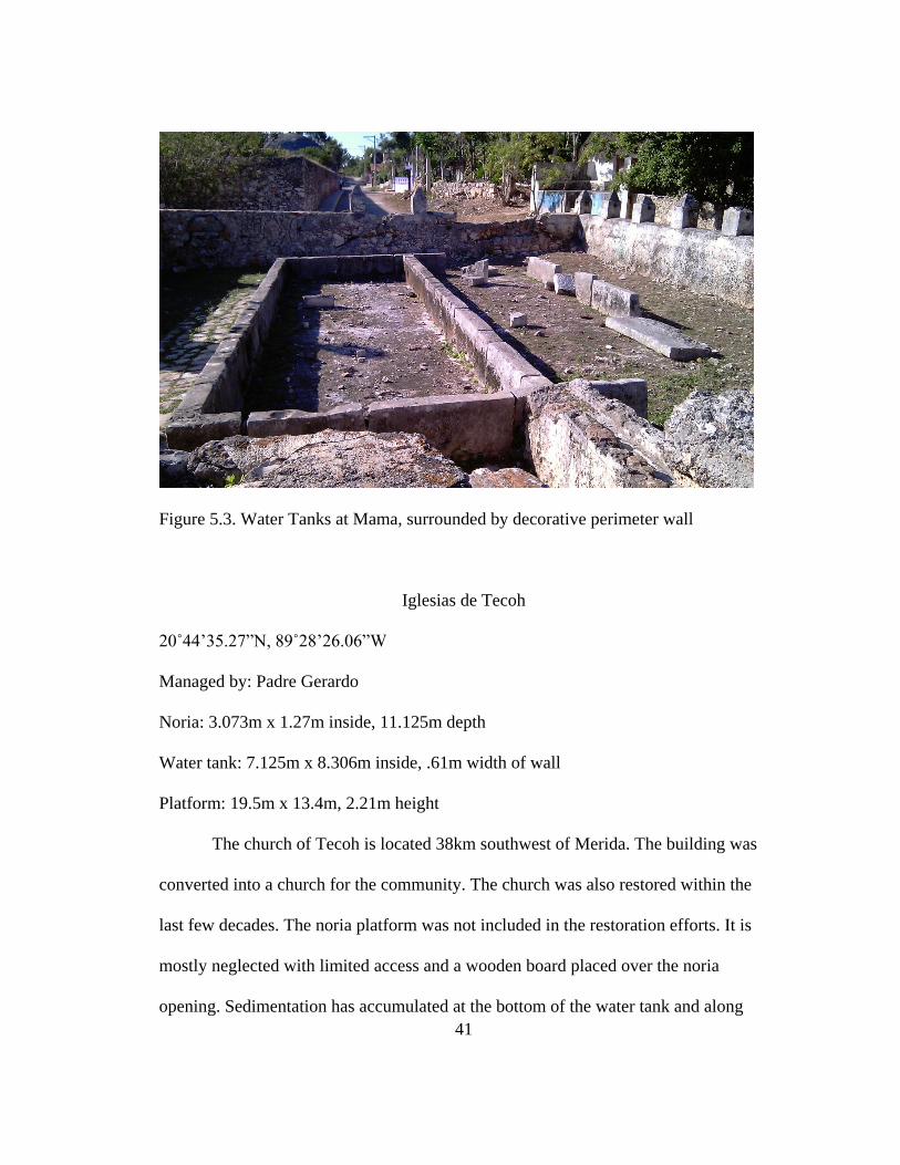
41
Figure 5.3. Water Tanks at Mama, surrounded by decorative perimeter wall
Iglesias de Tecoh
20˚44’35.27”N, 89˚28’26.06”W
Managed by: Padre Gerardo
Noria: 3.073m x 1.27m inside, 11.125m depth
Water tank: 7.125m x 8.306m inside, .61m width of wall
Platform: 19.5m x 13.4m, 2.21m height
The church of Tecoh is located 38km southwest of Merida. The building was
converted into a church for the community. The church was also restored within the
last few decades. The noria platform was not included in the restoration efforts. It is
mostly neglected with limited access and a wooden board placed over the noria
opening. Sedimentation has accumulated at the bottom of the water tank and along

42
the top of the platform. The soil and sediment pores over the platform to the ground
surface, closest to the church. The noria is completely dry, possibly due to over
pumping, and no other structural components are left from the noria. When it was a
convento, the community had to get their water from a small cistern on the east side
of the building. The cistern collected rain water that emptied into a small basin at the
base of the convento. Similar to other conventos, the property is surrounded by a tall
perimeter wall.
Figure 5.4. Within the Noria Opening at Iglesias de Tecoh

43
Figure 5.5. Water Tank at Iglesias de Tecoh
Figure 5.6. Noria Platform Wall facing West

44
Oxkutzcab, Convento de San Francisco
20˚18’10.08”N, 89˚25’1.17”W
Managed by: Padre Jose Ivan Gonzalez
Second in charge: Gonzalo Pinzon (in seminary)
Noria: 2.438m x 3.696m outside, .42m width of wall, 20.422m depth
Water tank: 12.116m x 8.18m outside, 1.676m depth
Platform: 13.462m diameter
The convento of San Francisco is the site farthest south of Merida, located
approximately 104 km away in Oxkutzcab. It was established in 1581 by Friar
Cristbol de Rivera and completed in the 1690s. Padre Gonzalez kept the noria
platform intact for cultural and aesthetic purposes. It is a circular platform with the
water tank extending out to the south. The platform has a large ramp although the
platform is not very high. It is still used to extract water but the wooden wheels were
removed. Padre Gonzalez is making plans to convert the water tank into a pool for the
children. He worked hard to restore the convento and repaired portions for Sunday
school classes. Padre Gonzalez also created a garden in the back of the property;
repainted the outside, and renovated certain portions of the church.

45
Figure 5.7. Noria Opening at Ex-Convento de San Francisco, Oxkutzcab
Figure 5.8. Water Tank at Oxkutzcab

46
Figure 5.9. Noria Platform at Oxkutzcab
Ebtun
20˚39’47.04”N, 88˚15’28.92”W
Managed by: Father Jose Gonzalez Ibán
Noria Opening: .98m x 2.86m
Platform: 6.18m x 7.36m, height – 1.5m
Ebtun is located along the old Highway 180, Merida - Valladolid, 14 km east
of Valladolid. The village belongs to the municipality of Valladolid. It has been
occupied continuously since it was founded as a congregation in the mid-sixteenth
century. There is no natural water source for the village except for Actunchen cave.
North of the church is a large rectangular noria platform, isolated from the other

47
buildings in Ebtun. There does not appear to be a water tank or troughs close to the
noria but there is a lot of secondary vegetation and degradation of the platform
(Alexander et al. 2008:33-34).
This is the oldest structure and largest in the village, except for the noria. The
stone on the north gate of the churchyard is marked with the date of 1567, but the
front entrance is dated 1720. The sanctuary area on the lower parts of the wall of the
nave is seventeenth century due to the thickness and shape of its construction. North
of the main entrance of the structure exists semicircular formations of natural stone
and painted white which normally has a cross (Alexander et al. 2008:34-35). A series
of rooms runs north of the shrine which originally formed a rectory with three arches.
The northern part of this structure has collapsed, revealing the fourth modern area
inside. East of the parish house are the remains of a ramp and a stone alignment. To
the south of the sanctuary there is another room. This fourth appears to be a late
additional structure, clearly a different type from the central sanctuary, especially
visible along the east wall of the church. South of this room is a semicircular wall
used as an ossuary (Alexander et al. 2008:35).

48
Figure 5.10.Church of Ebtun from the South Side (Alexander et al. 2008:Figure 3.2).
Figure 5.11. Noria of Ebtun (Alexander et al. 2008:Figure 3.8).

49
Figure 5.12. Rejollada Actunchen of Ebtun (Alexander et al. 2008:Figure 3.11).
Figure 5.13. Site Map of Ebtun. Drawing by Mathew Punke and Rani Alexander
(Alexander et al. 2008:Figure 3.5)
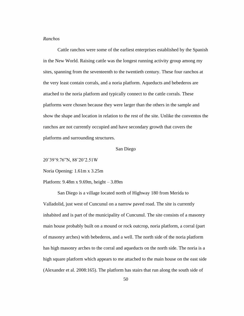
50
Ranchos
Cattle ranchos were some of the earliest enterprises established by the Spanish
in the New World. Raising cattle was the longest running activity group among my
sites, spanning from the seventeenth to the twentieth century. These four ranchos at
the very least contain corrals, and a noria platform. Aqueducts and bebederos are
attached to the noria platform and typically connect to the cattle corrals. These
platforms were chosen because they were larger than the others in the sample and
show the shape and location in relation to the rest of the site. Unlike the conventos the
ranchos are not currently occupied and have secondary growth that covers the
platforms and surrounding structures.
San Diego
20˚39’9.76”N, 88˚20’2.51W
Noria Opening: 1.61m x 3.25m
Platform: 9.48m x 9.69m, height – 3.89m
San Diego is a village located north of Highway 180 from Merida to
Valladolid, just west of Cuncunul on a narrow paved road. The site is currently
inhabited and is part of the municipality of Cuncunul. The site consists of a masonry
main house probably built on a mound or rock outcrop, noria platform, a corral (part
of masonry arches) with bebederos, and a well. The north side of the noria platform
has high masonry arches to the corral and aqueducts on the north side. The noria is a
high square platform which appears to me attached to the main house on the east side
(Alexander et al. 2008:165). The platform has stairs that run along the south side of

51
the main house. The walls of the main house are about 4.5 meters in height; the
platform of the windmill is at the same height of the walls of the main house which is
adjacent to the platform. Also adjacent to the west side of the house is a small pen or
albarrada. West of the main house is a rectangular structure with a masonry staircase.
This is a residence for the butler. Just north of the house is another well, a distinctive
cement circle. The north side of the rancho is bordered by a large corral of masonry
and the north entrance has conical points (Alexander et al. 2008:165-166).
Figure 5.14. Main house of Hacienda San Diego (Alexander et al. 2008:Figure 4.40).
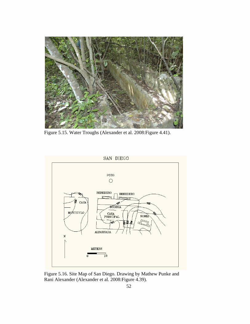
52
Figure 5.15. Water Troughs (Alexander et al. 2008:Figure 4.41).
Figure 5.16. Site Map of San Diego. Drawing by Mathew Punke and
Rani Alexander (Alexander et al. 2008:Figure 4.39).

53
Haymil
20˚40’58.97”N, 88˚26’3.61”W
Owner: Tuz Family
Noria Opening: 2.87m x 3.22m
Platform: 11.74 diameter, height - .69m
Haymil is located about 14 km north of Highway 180 Merida - Valladolid by
the west entrance of Kaua. The property is owned by Luisa Reyes Tuz Chan and her
husband but originally owned by his great-grandfather, Felipe Tuz. Haymil is a
hacienda, but the owners live in various perishable structures outside of the main
house (Alexander et al. 2008:197). Many of the facilities on the estate still exist,
including the windmill, arcades, corrals, and two platforms. The noria is located on a
circular platform with delimited colonial masonry, and an access ramp. It is still in
use, located on the edge of a large cenote. The cenote has limited access due to a
barricade to prevent livestock from falling in. The hacienda contains several corrals,
some built of masonry and other earthworks (Alexander et al. 2008:197-198). The
pens are located below the platforms that are the basis for the residential structures.
Haymil is also a pre-Hispanic site with many mounds to the south. It is noted that one
of them, a temple of three stages, has been systematically looted. Platform 1 was
originally a modified pre-Hispanic structure on all sides by a masonry wall colonial
(2 m). Stairwell access and arches were constructed. This platform also has four
arches. In the western part of the masonry wall of the platform is a trough, part of a
low and adjacent corral. Platform 2 is located to the south of the platform 1 and is

54
also modified by colonial masonry along the walls. Also on the west side there is a
small bebedero in a portion of the corral (Alexander et al. 2008:198).
Figure 5.17. Noria Platform at Hacienda Haymil (Alexander et al. 2008:Figure 4.64).
Figure 5.18. Archway to the Corrals (Alexander et al. 2008:Figure 4.65).

55
Fig
ure
5.1
9. S
ite
Map
of
Hay
mil
. D
raw
ing b
y M
athew
Punke
and R
ani
Ale
xan
der
(A
lexan
der
et a
l. 2
008:F
igure
4.6
3).

56
Figure 5.20. Platform I with Adam Kaeding and Gastón Medina (Alexander et al.
2008:Figure 4.66).
Santa Maria
20˚32’30.51”N, 88˚31’49.95”W
Noria Opening: .973m x 1.7m
Platform: 7.87m x 8.37m, height – 1.29
Santa Maria is a ranch located south of Chan Kom on a white single lane road.
Currently uninhabited and is not used for breeding livestock. It is part of the Chan
Kom community that has modern houses. The rancho has a large noria platform with
a square platform and a network of troughs. Two long troughs are aligned to the sides
of the platform and an L-shaped trough is located inside the corral. A shrine with the
image of San Antonio de Padua is adjacent to the noria’s access. No other large
masonry structures are found on the property (Alexander et al. 2008:247).

57
Figure 5.21. Water Trough and Corral at Santa Maria (Alexander et al. 2008:
Figure 4.114).
Figure 5.22. Noria at Santa Maria (Alexander et al. 2008:Figure 4.115).

58
Figure 5.23. Site Map of Santa Maria. Drawing by Mathew Punke and Rani
Alexander (Alexander et al. 2008:Figure 4.116).
Suytun
20˚30’32.02”N, 88˚18’2.72”W
Noria Opening: 2.65m x 4.6m
Platform: 18.85m x 22.51m, height – 2.74m
Suytun is located southwest of Tixcacalcupul on the white road, the Sacbe
southern Yaxuna-Coba. Currently Suytun belongs to someone in Cancun. It was sold
by Don Julio, the original owner of Tixcacalcupul, before his death three years ago.
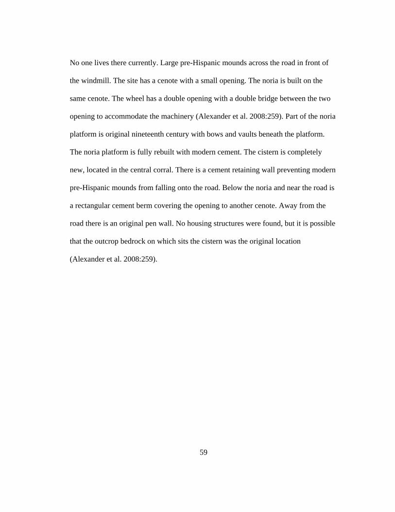
59
No one lives there currently. Large pre-Hispanic mounds across the road in front of
the windmill. The site has a cenote with a small opening. The noria is built on the
same cenote. The wheel has a double opening with a double bridge between the two
opening to accommodate the machinery (Alexander et al. 2008:259). Part of the noria
platform is original nineteenth century with bows and vaults beneath the platform.
The noria platform is fully rebuilt with modern cement. The cistern is completely
new, located in the central corral. There is a cement retaining wall preventing modern
pre-Hispanic mounds from falling onto the road. Below the noria and near the road is
a rectangular cement berm covering the opening to another cenote. Away from the
road there is an original pen wall. No housing structures were found, but it is possible
that the outcrop bedrock on which sits the cistern was the original location
(Alexander et al. 2008:259).

60
Fig
ure
5.2
4. N
ori
a of
Suytu
n (
Ale
xan
der
et
al. 2008:F
igure
4.1
25).

61
Figure 5.25. Site Map of Suytun. Drawing by Mathew Punke and Rani Alexander
(Alexander et al. 2008:Figure 4.126).
Haciendas
Haciendas were the latest installment of mass production that occurred in
Yucatán. Three of the four sites were processing henequen. San Antonio Cucul did
not process henequen and produced on a smaller scale, likely due to its location in

62
Merida. Most of these sites have been restored with the exception of Cacao. All the
haciendas had at minimum a main house, noria platform, and corrals. Most of the
agricultural fields are seen from the platforms with aqueducts leading from the noria
to the fields. The haciendas in this sample have unique decorative features and unique
life histories influenced by the owners’ economic and social prowess. These four sites
exhibit differences in an owner’s priority regarding crop production. Crops and cattle
may have been a priority at one point but then henequen production took over a large
portion of the hacienda water resources and space on the property.
San Antonio Cucul (established in 1795)
Latitude: 21˚1’28.92”N Longitude: 89˚36’10.17”W
Noria: 1.50m x 2.80m, 8-10m deep
Platform: 13.32m diameter, height - 2.03m
Smaller platform on the south side: 4.63m x 5.56m
Water tank: 10.20m x 10.20m (.90m width of wall) and 2.15m in depth
The hacienda is found in north-central Mérida where is remains surrounded by
modern residences. The noria platform is circular, separated from the main house,
located close to the fields. Mechanical wheel components are intact on top of the
platform (restored). Hacienda San Antonio has a single noria platform with aqueducts
leading to agricultural plots; forming a grid of aqueducts to the south. Corrals are to
the north, and the noria and agricultural fields are on the west side of the property
towards the entrance. The main entrance to the property is on the south side and a
well can be seen in the front lawn upon entering into the hacienda; it is decorative.

63
There is also a well in between the main house and guest house but is not restored.
Most of the hacienda was restored for tourism and is well maintained.
Figure 5.26. Noria platform at San Antonio Cucul
Figure 5.27. Noria Gears at San Antonio Cucul

64
Figure 5.28. Water tank at San Antonio Cucul
Figure 5.29. Aqueducts leading to the fields at San Antonio Cucul

65
Yaxcopoil (established in 1600s and reestablished in 1913 [for henequen])
20˚44’35.69”N, 89˚43’18.98”W
Managed by Mario Huchim-Tun
Noria I for pool/fields platform height: 2.03m
Noria I opening: 2.36m x 1.02m, outer edges 3.06m x 1.77m
Platform I: 27.432m x 10.058m
Platform II: 13.36m x 11.303m
Water tank II: 7.34m x 15.80m, depth 1.66m (took 4 hours to fill up)
Noria II Opening: 3.08m x 3.94m outer edge, 2.46m x 3.25m inside edge, depth 17m
Yaxcopoil was built in the seventeenth century, starting out as a cattle rancho
and orchard and eventually adding a henequen processing center in the late nineteenth
century. Noria I was the first noria platform built and used for the orchards, fountains
and a swimming pool. The platform is rectangular with a series of aqueducts heading
east towards the fields and south towards the swimming pool/ holding tank. I
originally assumed water was extracted from the noria to provide for the livestock,
but the cistern (under the porch) was used to water the animals. It was collected from
the roof and traveled though canals into the cistern under the porch. The mechanical
components for Noria I were removed and replaced by a motorized pump placed at
the bottom. A windmill was also installed at some point during the early twentieth
century. Currently, the pump is still used to provide water to the horses on the
property. Decorative columns are present along the perimeter of the platform but the
platform does not have a ramp for easy animal access.

66
Directly south of Noria I is the larger noria, Noria II. It is a rectangular
platform currently used to water the orchards to the south. The water pump was
installed in 1917; 5 years after henequen production began. In 1913, henequen
production was in full swing at Yaxcopoil and did not end until 1984; marked by
carved dates on the outside of the main processing building. Before the machinery
was installed, henequen was hand-striped and dried by fire in the 1800s. The
henequen processing center is on the west side of the property, the main house is to
the north and the norias are to the south, while the orchards and agricultural plots
continue further south.
Figure 5.30. Noria I Platform with decorative columns at Yaxcopoil

67
5.31. Noria II Platform with 5.32. Aqueducts from Noria II platform
motorized pump
Figure 5.33. Residential pool/ Water Tank, water taken from the first Noria Platform

68
Dzibikak “fire writing” (established in 1600s)
20˚54’1.76”N, 89˚47’38.16”W (at Noria I)
Noria I (older): 3.99m x 2.85m, (depth same as Noria II), width of wall .24m
Noria II (newer): 3.937m x 3.17m, depth 9.271m
Water tank I: 11.042m x 12.776m, depth 1.727m
Water tank II: 14.148m x 13.69m, depth 1.60m
Platform: 24.13m x 23.47m, height 1.73m
Originally owned by G-Canton, during the henequen boom
Dzibikak is an older hacienda, producing a maize surplus for export in the mid
to late seventeenth century (Patch 1995), then converting to henequen production in
the late nineteenth century. It is located approximately 24.5 km southwest of Merida.
This hacienda is very unique, it is the only platform in the sample with two separate
noria openings on a large platform and two separate water tanks. One water tank is on
the platform while the other is found on the other side of the property, 130 meters to
the east. When the owner first bought the property there was a large iron pipe that led
from noria II to the water tank on the far side of the property. This water tank is
located south of the henequen processing center. The processing center and the
workers chapel are located in the northeast corner of the property. The water may
have contributed to the steam-powered engines needed to process the henequen
during the henequen boom. The worker’s quarters to the west of the noria platform
while the main house is on the north side. The entire property has a perimeter wall
with an additional wall enclosure surrounding the henequen processing area.

69
Figure 5.34. Noria I Opening at Dzibikak
Figure 5.35. Water Tank I at Dzibikak

70
Fig
ure
5.3
6. S
erie
s of
Aqued
uct
s at
Dzi
bik
ak
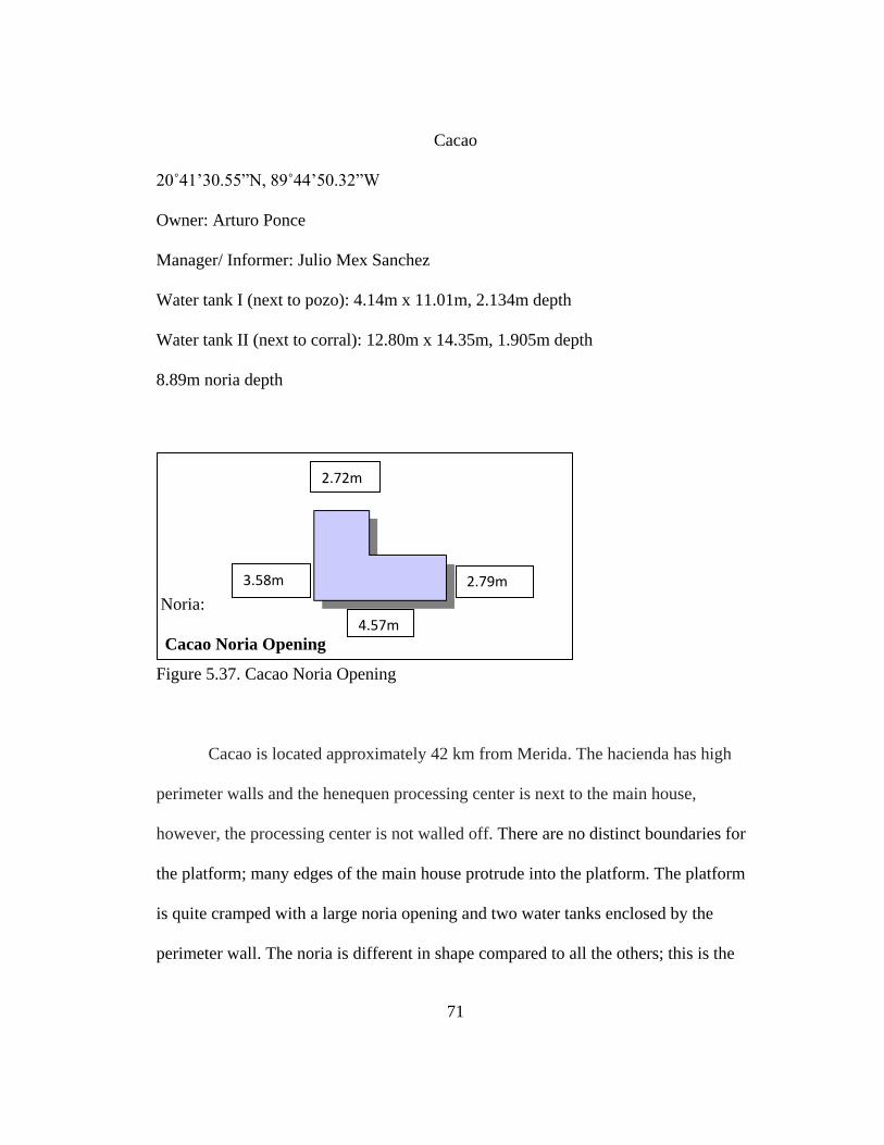
71
Cacao
20˚41’30.55”N, 89˚44’50.32”W
Owner: Arturo Ponce
Manager/ Informer: Julio Mex Sanchez
Water tank I (next to pozo): 4.14m x 11.01m, 2.134m depth
Water tank II (next to corral): 12.80m x 14.35m, 1.905m depth
8.89m noria depth
Noria:
Cacao Noria Opening
Figure 5.37. Cacao Noria Opening
Cacao is located approximately 42 km from Merida. The hacienda has high
perimeter walls and the henequen processing center is next to the main house,
however, the processing center is not walled off. There are no distinct boundaries for
the platform; many edges of the main house protrude into the platform. The platform
is quite cramped with a large noria opening and two water tanks enclosed by the
perimeter wall. The noria is different in shape compared to all the others; this is the
2.72m
4.57m
3.58m 2.79m

72
only L-shaped noria in my sample. A small cistern was used to supply water to the
town, but two large water tanks were used for production. The hacienda needed to
supply water to the cattle, various aggregates, the henequen processing center and
townspeople. The cattle corral is currently a soccer field and is quite large. The
owners seemed most concerned with protecting their water source. Hurricanes Hector
in 1986 and Giberto in 1988 stopped henequen production, knocking over and
destroying windmills and other machinery that contributed to the henequen industry.
During times of production the hacienda put a lot of pressure on the Maya population.
The population was always small; therefore, workers had to be shipped in to work.
The hacienda would force the community to work days and nights to keep up with
production of the henequen twine and other aggregates from the orchards (Julio Mex
Sanchez, personal communication, 2012).
Figure 5.38. L-shaped Noria Opening at Cacao

73
Figure 5.39. Water Tank I at Cacao

74
Figure 5.40. Water Tank II at Cacao
The Relationship between User Groups
Among the three user groups the life history of the noria has many similarities
and differences. Some similarities, for example, show consistency in placing the
corrals or cattle troughs close to the noria platform. It provided a consistent water
source for raising cattle and in most cases, the main house was adjacent to the corrals.
Those noria platforms isolated from the main house and corrals would utilize a series
of aqueducts to transport water not just to the corrals but agricultural fields and
orchards.
Some differences were among the conventos with the use of norias for their
aesthetic and utilitarian aspects. I found Mama the most unique due to the low
decorative perimeter walls, and easy access for the community. Many other

75
conventos located in small villages protected their water resource and would siphon
out water for the community. Haciendas had similar tactics. Hacienda owners built
large walls around their properties while ranchos remained open and exposed. At
these sites one can see the relationship through the architecture design.
There is some indication of the relationship the property owners had with their
community. Some of the highest walls were located on properties where resources
were not shared adequately with the community and work hours were long and
tenuous. These properties provide background into a world of hard labor but also lead
one to understand how the noria platform provided for the three user groups and
various sites throughout north-central Yucatán.

76
Chapter 6: Analysis
The purpose of the analysis is to determine if the platform and noria openings
have equal variance. If the noria openings have equal means then this suggests
standardization of the technological components of the noria wheel. If the platform is
not standardized then the owner would have influenced any differentiation. I clarify
the step-by-step process and results generated from the ANOVA and non-parametric
tests performed on the variables. First, I show the variables, their means and standard
deviation. Second, I explain the results for the width and length of the noria opening,
and, lastly, present the results for the platform analysis. Once the output is generated
the results suggest that the noria opening is standardized while the platform shows
differentiation.
Table 4. Survey Means of Variables
Variable # Mean Standard Deviation
Noria Opening Width 41 1.69 0.1039
Noria Opening Length 41 3.03 0.1214
Noria Depth 41 4.84 1.0468
Water Tank Width 41 4.29 0.7126
Water Tank Length 41 5.66 0.9161
Water Tank Depth 41 0.65 0.141
Platform Width 41 10.57 0.9435
Platform Length 41 12.83 1.3803
Platform Area (m2) 41 376.58 64.7474
Platform Volume (m3) 41 292.17 63.793
Platform Height 41 1.56 0.1252
Reciprocal of Noria Opening Width 41 0.69 0.0423
Log of Platform Area 35 5.78 0.128
Log of Platform Volume 35 5.33 0.1638

77
The number of observations is consistent except for the last two variables.
There are fewer observations for the platform area and volume due to missing data
and because platforms contained more than one noria opening (Dzibikak). These two
variables also had the largest mean and standard deviation. Below are the number of
properties, property types, and shapes of the noria platforms.
Table 5. Survey Means of Property and Platform Shape
Variable Level # Mean Standard Deviation
Property Convento 7 0.1707 0.0594
Property Hacienda 16 0.3902 0.0771
Property Rancho 18 0.439 0.0785
Shape Circular 15 0.375 0.0775
Shape Rectangular 25 0.625 0.0775
The bar graphs (Figure 6.1, 6.2) show a majority of the ranchos with longer
noria openings while conventos have the widest noria openings. The platforms are
clearly larger among the haciendas. These differences should appear in the results for
the analysis. Though most of the noria openings are somewhat consistent, there is a
clear trend with the platform measurements. In order to support my assumption, the
means would need to be the same for the noria openings and different for the
platforms.

78
Fig
ure
6.1
. B
ar G
raph o
f al
l N
ori
a O
pen
ing f
or
Wid
th a
nd L
ength
(in
met
ers)

79
Fig
ure
6.2
. B
ar G
raph o
f al
l P
latf
orm
s fo
r S
urf
ace
Are
a (m
2)
and V
olu
me
(m3)
Co
nve
nto
s

80
Noria Opening
The measurement variable used for the ANOVA is the width of the noria
opening while the Kruskal-Wallis test was used for the noria length. I perform a
univariate procedure to determine if the variables are normally distributed. For each
property group I find that the hacienda noria width and convento noria length are not
normal. Transformations are tested on both variables, but I find that only the noria
width is successfully transformed. Taking the reciprocal of the width is effective for
all property types, but no transformation works successfully for the noria length.
Table 6. Test for Normality, Noria Length and Width
Test for Normality
Test Measurement
Variable
Property
Variable
P-Value
Shapiro-Wilk
Noria Width
(Transformation used)
Hacienda .1011
Rancho .0712
Convento .2917
Noria Length
Hacienda .1395
Rancho .4512
Convento .0465
In the output for the ANOVA procedure, the dependent variables are grouped
by property type shown in box plots in order to see the distribution of the mean,

81
median and the overall number in the sample. In Figure 6.4, haciendas have the
largest sample mean and median among the three property types. Conventos come in
second while ranchos have the lowest mean and median. The overall number
expressed for Pr > F is .3348. The F-value for the ANOVA is greater than .05, which
means I fail to reject the null hypothesis.
The Kruskal-Wallis or Wilcoxon procedure is performed on the length
variable in lieu of the ANOVA. I find that there is no significant deviation from the
proposed null hypothesis, or, in other words, the property types have equal means.
The Pr>Chi-Square (similar to the F probability) is .7735, which means I fail to reject
the null hypothesis.
Figure 6.3. ANOVA boxplots of noria width

82
Figure 6.4. Wilcoxon boxplots of noria length
The box plots illustrate the variation between variables for the noria opening
among the three property types: conventos, ranchos, and haciendas. The box plots
show the mean, median and overall distribution of the variable (maximum, minimum
and quartile ranges). In Figure 6.4, the conventos have a wide distribution but the
mean is still very close to the hacienda and ranchos. In Figure 6.5, the ranchos show a
wide distribution while the conventos have a greater mean in length for the noria
opening. The haciendas in length and width have the greatest level of standardization.
Overall, the noria width and length express standardization among all the property
types.

83
Table 7. ANOVA F-values for the Noria Opening Width
ANOVA Procedure
Variable F-Value Pr > F
Noria Width 1.13 .3348
Table 8. Wilcoxon Chi-Square values for Noria Opening Length
Wilcoxon Procedure
Variable Chi-Square Pr > Chi-Square
Noria Length .5137 .7735
The null hypothesis indicates that all the means for each user group are equal.
This suggests that there is little variation among the mechanical components of the
noria, and therefore little variation to the noria opening. The results indicate that the
F-value and chi-square value have probabilities higher than .05 for the width and
length of the noria opening; hence, I fail to reject my null hypothesis.
Platform
The noria platform comes in two shapes: circular and rectangular. Twenty-
eight of the platforms are rectangular and fifteen are circular. Not all the circular
platforms are detached from the casa principal, some are decorative features
positioned in the patio. Whether the noria is added later on or incorporated into the
construction of the main house, the best way to analyze the platforms is by

84
calculating the platforms’ volume and surface area to determine whether there are
differences between the various platforms.
The null hypothesis states that all means of the three user groups are equal,
but I expect that at least one mean will be different; thus, I reject the null hypothesis.
To determine the equality of means for the platforms the same process is used from
noria opening analysis. A univariate procedure is carried out in order to determine
normality. I find that both the volume and area of the platform are not normal; as a
result, I transform both variables by taking their log. Both variables subsequently
exhibit a normal distribution for all three user groups after the second univariate
procedure is run. The next step is to use the ANOVA procedure.
Table 9. Test for Normality, Platform Area and Volume
Test Measurement
Variable
Property
Variable P-Value
Shapiro-Wilk
Platform Surface Area
(Transformation used)
Convento .5332
Rancho .2860
Hacienda .4124
Platform Volume
(Transformation used)
Convento .4824
Rancho .1197
Hacienda .9188
The box plots below further illustrate the differentiation among the variables.
The platform area shows well distributed ranges for all the properties, but the rancho

85
shows two outliers on both ends of its distribution. The hacienda, as mentioned
earlier, has the largest mean and overall range in surface area. Platform volume shows
just one outlier for the rancho and a larger distribution in range for all of the property
types. The hacienda has the largest mean of the three properties.
Figure 6.5. ANOVA box plots of platform surface area

86
Figure 6.6. ANOVA box plots of platform volume
The surface area expressed in the ANOVA shows a difference in means,
especially among the haciendas. Conventos and ranchos have similar means, but the
haciendas are much larger than the other two property types. The results for platform
volume are similar, with the haciendas having the highest mean among the three
properties. The Pr > F for surface area is .0016 while volume is .0067. The p-value
for the F-test is less than .05, which means I reject the null hypothesis.

87
Table 10. ANOVA F-values for the Platform
ANOVA Procedure
Variable F-Value Pr > F
Platform Area 7.93 .0016
Platform Volume 5.87 .0067
The null hypothesis indicates that all means are equal for the three property
types. I find that the p-values for platform area and volume are below .05; therefore, I
reject the null hypothesis. I assumed that the platforms would exhibit differentiation
due to the personal preference of the owner, and overall the platforms show
differentiation, especially among the haciendas. These are strategies employed by the
owners to use architectural size as an expression of prestige.

88
Chapter 7: Discussion
The discussion ties together the results from the analysis and the research
questions. I find that the results support all four of my research questions: (1) Is the
noria opening standardized? (2) Is the platform morphology different between user
groups? (3) How were noria platforms influenced by wealth and prestige? (4) What is
the connection between architectural design and activity sets? My results show that
the noria opening does not vary among ranchos, conventos or haciendas, which would
indicate standardization. Second, the platform morphology coincides with changes in
activity and production, and the hacienda platforms have the greatest differentiation.
Third, my results show noria platforms influenced by wealth and prestige are larger,
and have more decorative features commonly associated with haciendas. Finally, the
level of production and personal preference of property owners are the key influences
in architectural design in relation to the activities performed.
The noria opening shows little variation among the covento, rancho and
hacienda user groups. Width and length are the same throughout the sites, which
suggest that the noria technology and the wooden wheel components do not change.
Those norias that have large or unique openings (Cacao) use two wheels instead of
one, which show up as an outlier in my sample. Major change occurred during the
henequen boom when the adoption of motorized pumps caused an increase in water
extraction and production. Although this new technology was introduced, it did not
affect the dimensions of the noria opening.

89
The differences in platform morphology are most evident in the hacienda user
group. Results show the hacienda platforms are larger in area and volume than the
convent and rancho platforms. Changes in production and owner preference drove
changes in the platform morphology. These changes are most apparent at haciendas
with evidence of large scale production in the nineteenth century compared to
haciendas established in the early twentieth century.
Personal preference and prestige had a significant effect on the size of the
noria platform among user groups. There were differences in shape, decorative
motifs, and location of the platform. These characteristics regarding architectural
setting were reflected in wealth and production strategies (Alexander 2003). Those
platforms sharing the same foundation as the main house or attached to the main
house increased the value of the facilities. Architecture was an investment, a sign of
wealth. Although the noria platform was a utilitarian feature, incorporation of the
platform into the construction of the main house as an extension, was a decorative or
aesthetic addition. The value of the main house was increased, and water could be
used not just for utility but for recreation.
The variation between haciendas built before and during the henequen boom
was quite evident. Additions to the property in order to incorporate henequen
production on the haciendas altered the property’s aesthetics. Some owners decided to
build the henequen processing plants across the street like Ticopo and Kantoyna but
most were added onto the property with the addition of another machine house,
administration building, noria, water tank and chapel (Dzibikak). Many of the

90
haciendas were strongly influenced by wealth and status. When haciendas were first
constructed, the owners created platforms to suit their current production needs, but
once production of henequen increased, the need for water increased. This triggered
the building of additional platforms and water tanks, but they were not built for
aesthetics. Instead, these additional components served to expand the hacienda’s
productive capacity.
My analysis shows there is a relationship between activities and architectural
design. What could be concluded from the data are that haciendas that originally
raised cattle and then started producing sugar or henequen required more water than
simple cattle ranchos and conventos; however, haciendas and ranchos have a similar
platform design. Bebederos typically surrounded the noria platform or had aqueducts
that led to the bebederos nearby. The main house was close to the noria platform and
corrals, and all the cattle ranches and several of the haciendas shared this same
property layout. This implies that the architectural layouts of cattle ranches were
standardized, and suggests that the activity of cattle raising influenced the
architectural design of cattle ranchos and eventually henequen and sugar haciendas.
With the design of ranchos preceding most haciendas, the idea of keeping the water
source close to areas of production continued.
Conventos had decorative aspects but were used on a smaller scale for gardens
and livestock. The results indicate the platform means for conventos were slightly
larger on average than ranchos. Since conventos used less water than ranchos,
prestige was a factor in building the noria platforms, but nowhere near the scale of the

91
haciendas. Mama is believed to be one of the earliest conventos along the convent
route. It was likely constructed in the first wave of convent building in the mid-to-late
sixteenth century but is the only convento platform to have decorative pilasters
surrounding the platform. These details would allow one to visualize the transition of
platforms constructed for prestige, then utility, and back to prestige all within 400
years of use.

92
Chapter 8: Conclusion
My goal was to investigate the technological variation of the noria as a
hydrologic structure introduced to the Yucatán after the Spanish Conquest. I explored
the changes to the technology that made up the noria platform and was able to
determine what parts of the noria platform were influenced by prestige. By
identifying patterns in platform construction from the various sites, I identified the
relationship between the platform size and activities performed. I found that prestige
took precedence over production for haciendas. As the demand grew for certain
products like henequen and sugar, many properties morphed into manufacturing
complexes. After this study, I concluded that the noria opening did not undergo
significant morphological changes, but the platform showed variation that suggested
that prestige was an influential factor.
In order to improve upon my analysis in the future I would address problems
with normalizing the data, by taking additional measurements of the noria platforms
from haciendas, ranchos and conventos in the Merida-Valladolid region. Also, a
larger sample of haciendas and ranchos from other regions would supplement my
current data. Re-testing the data with a larger sample would determine if platform
differentiation was common in north-central Yucatan and if the noria opening was
only standardized for this region.
Rather than concentrate on design, perhaps the next step in my research may
be to focus on water storage capacity and the amount of water that could be pumped
per unit time from the noria. Future research may also involve comparing the water

93
tank size to the level of yield from the different haciendas. It would be interesting to
know if the size of the tank was related to the maximum yield of aggregates produced
at a site or if new technologies, such as the windmill and diesel pump, were more
economical.
Other questions I have involve specific times and dates when changes in
technology and productive capacity occurred. General time frames for changes in
production are known, but a more personalized account of each site would be an
ethnohistoric contribution to my study. Some individuals who once worked at these
prominent haciendas are still alive and could describe the relationship between the
hacendado and the laborers and their impact on the community. Since the noria is a
forgotten technology among local communities, working backward from present to
past could be another approach in understanding (1) the role that hydrologic
technologies played in these Yucatán communities; and (2) how hydrologic systems
changed since the adoption of the noria technology. Technological transfer is a
process that takes time—time for a community to mix performance characteristics
and redesign a noria to function efficiently (Schiffer 2002).

APPENDIX
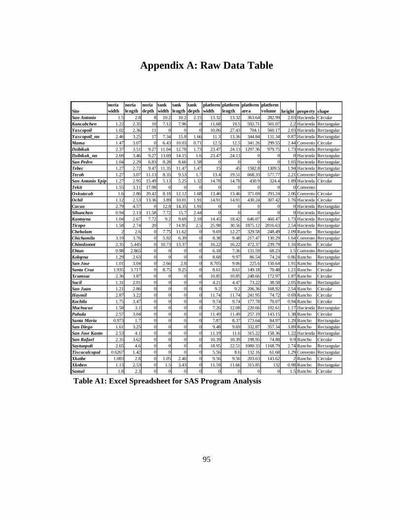
95
Appendix A: Raw Data Table
Site
noria
width
noria
length
noria
depth
tank
width
tank
length
tank
depth
platform
width
platform
length
platform
area
platform
volume height property shape
San Antonio 1.5 2.8 8 10.2 10.2 2.15 13.32 13.32 363.64 282.99 2.03 Hacienda Circular
Kancabchen 1.22 2.35 10 7.12 7.96 0 11.68 19.5 592.71 501.07 2.2 Hacienda Rectangular
Yaxcopoil 1.02 2.36 11 0 0 0 10.06 27.43 704.1 560.17 2.03 Hacienda Rectangular
Yaxcopoil_nn 2.46 3.25 17 7.34 15.8 1.66 11.3 13.36 344.84 131.34 0.87 Hacienda Rectangular
Mama 1.47 3.07 0 6.43 10.03 0.71 12.5 12.5 341.26 299.55 2.44 Convento Circular
Dzibikak 2.37 3.51 9.27 11.04 12.78 1.73 23.47 24.13 1297.36 979.75 1.73 Hacienda Rectangular
Dzibikak_nn 2.69 3.46 9.27 13.69 14.15 1.6 23.47 24.13 0 0 0 Hacienda Rectangular
San Pedro 1.04 2.29 6.83 8.28 8.66 1.58 0 0 0 0 1.65 Hacienda Rectangular
Tebec 1.27 2.72 9.47 11.35 11.47 1.47 15 45 1582.8 1309.5 1.94 Hacienda Rectangular
Tecoh 1.27 3.07 11.13 8.35 9.53 1.7 13.4 19.51 668.33 577.77 2.21 Convento Rectangular
San Antonio Xpip 1.27 2.95 15.49 5.13 5.25 1.32 14.78 14.78 430.9 324.4 1.89 Hacienda Circular
Tekit 1.55 3.11 17.98 0 0 0 0 0 0 0 0 Convento
Oxkutzcab 1.6 2.86 20.42 8.18 12.12 1.68 13.46 13.46 371.69 293.24 2.06 Convento Circular
Ochil 1.12 2.53 13.36 3.89 10.01 1.91 14.91 14.91 430.24 307.42 1.76 Hacienda Circular
Cacao 2.79 4.57 0 12.8 14.35 1.91 0 0 0 0 0 Hacienda Rectangular
Sihunchen 0.94 2.13 11.58 7.72 15.7 2.44 0 0 0 0 0 Hacienda Rectangular
Kantoyna 1.04 2.67 7.72 9.2 9.69 2.18 14.45 18.42 646.07 460.47 1.73 Hacienda Rectangular
Ticopo 1.58 2.74 20 7 14.95 2.5 25.98 30.56 1875.12 2016.63 2.54 Hacienda Rectangular
Chebalam 2 2.6 0 7.75 11.62 0 9.69 12.27 329.58 248.49 2.09 Rancho Rectangular
Chichamila 3.19 3.76 0 5.92 6.39 0 8.38 9.48 217.47 130.29 1.64 Convento Rectangular
Chimdzonot 2.35 5.445 0 10.73 13.37 0 16.22 16.22 472.37 239.79 1.16 Rancho Circular
Ebtun 0.98 2.865 0 0 0 0 6.18 7.36 131.59 68.23 1.5 Convento Rectangular
Kolopna 1.29 2.63 0 0 0 0 8.68 9.97 86.54 74.24 0.86 Rancho Rectangular
San Jose 1.01 3.04 0 2.66 2.8 0 8.705 9.06 225.6 150.64 1.91 Rancho Rectangular
Santa Cruz 1.935 3.717 0 8.75 9.25 0 8.61 8.61 149.18 70.48 1.21 Rancho Circular
Xcumsuc 2.36 3.87 0 0 0 0 10.85 10.85 248.66 172.97 1.87 Rancho Circular
Sucil 1.31 2.01 0 0 0 0 4.21 4.47 73.22 38.58 2.05 Rancho Rectangular
San Juan 1.21 2.86 0 0 0 0 9.2 9.2 206.36 168.92 2.54 Rancho Circular
Haymil 2.87 3.22 0 0 0 0 11.74 11.74 241.95 74.72 0.69 Rancho Circular
Kochila 1.75 3.47 0 0 0 0 9.74 9.74 177.78 70.07 0.94 Rancho Circular
Muchucux 1.58 3.1 0 0 0 0 7.26 12.08 220.66 102.61 1.17 Hacienda Rectangular
Puhula 2.57 3.04 0 0 0 0 11.49 11.49 257.19 143.15 1.38 Rancho Circular
Santa Maria 0.973 1.7 0 0 0 0 7.87 8.37 173.64 84.97 1.29 Rancho Rectangular
San Diego 1.61 3.25 0 0 0 0 9.48 9.69 332.87 357.34 3.89 Rancho Rectangular
San Jose Kanto 2.53 4.1 0 0 0 0 11.19 11.6 315.22 158.36 1.22 Hacienda Rectangular
San Rafael 2.35 3.62 0 0 0 0 10.39 10.39 198.95 74.88 0.9 Rancho Circular
Suytunpolt 2.65 4.6 0 0 0 0 18.95 22.51 1080.33 1168.79 2.74 Rancho Rectangular
Tixcacalcupul 0.6267 1.42 0 0 0 0 5.56 8.6 132.16 61.68 1.29 Convento Rectangular
Xkatbe 1.083 2.8 0 1.05 2.46 0 9.56 9.56 203.63 143.62 2 Rancho Circular
Xkoben 1.13 2.53 0 1.5 3.43 0 11.59 11.66 315.85 132 0.98 Rancho Rectangular
Samal 1.8 2.3 0 0 0 0 0 0 0 0 1.5 Rancho Circular Table A1: Excel Spreadsheet for SAS Program Analysis

96
Appendix B: Site Inventory
Tixcacalcupul Convento
20˚32’6.36”N, 88˚16’11.37”W
Tixcacalcupul is located south of Chichimila and Tekom on a paved highway.
This is a big urban town. The church is managed by Father Miguel Santos, part of the
Chichimila parish. The church is at the forefront in the square, and in the back is the
convento and noria. There are two lots that border on the north and south side of the
convento and a portion between the convento. The noria is a semicircular platform
not currently in use, located on the east side of the convent (Alexander et al.
2008:89).
The church resembles that of Cuncunul, with its two towers and corridors on
the top, but Tixcacalcupul has a great convento at the back. The windows on the north
and south entrances reveal massive construction of interior walls and passages which
runs on top of the nave on the sacristy. On the north side there were a series of rooms
with porches, extending to the convent in part behind the sacristy. Today they are
destroyed, and modern masonry construction and a storage room took its place. On
the south side there is another row of rooms with niches. The convent was originally a
large row of small rooms in the east and west corridors. The church is dedicated to
Santiago and a stone threshold with the date 1773 inscribed (Alexander et al.
2008:89-90).
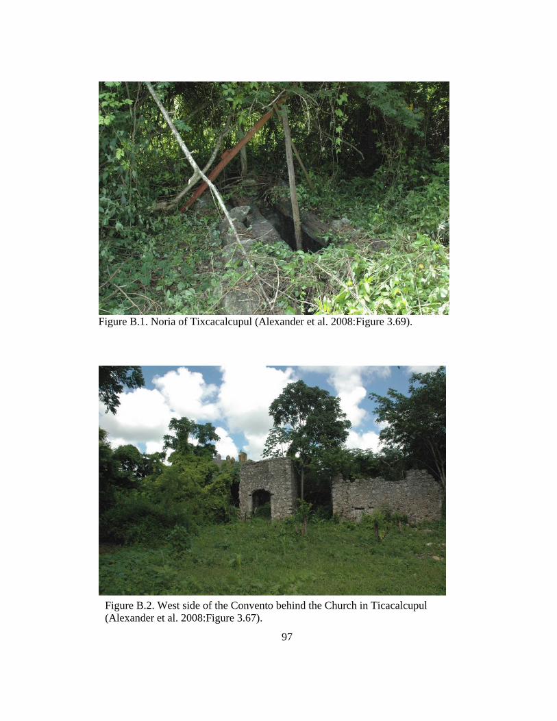
97
Figure B.1. Noria of Tixcacalcupul (Alexander et al. 2008:Figure 3.69).
Figure B.2. West side of the Convento behind the Church in Ticacalcupul
(Alexander et al. 2008:Figure 3.67).

98
Figure B.3. Site Map of Tixcacacupul. Drawing by Mathew Punke and Rani
Alexander (Alexander et al. 2008:Figure 3.70).
Chichimila Convento
20˚37’46.34”N, 88˚13’0.82”W
Chichimila is located 7 km south of Valladolid on a paved road. This is a big
urban town. The church is a structure with a convento in the back, inhabited and

99
maintained by Father Miguel Santos. The church is massive and the facade resembles
that of Tixcacalcupul. The outer walls have many corridors throughout. The sanctuary
at the back is intact. It has a noria, originally on a circular platform but is currently
square. The water tank is attached and has been painted blue and modified to form a
pool, but is currently unused. The ossuary is located in the southern part of the
sanctuary, and the rectory with arcades, currently habitable and modernized, is
located on the north side of the convento. The convent has several rooms, with some
modern modifications (Alexander et al. 2008:108).
Figure B.4. Church at Chichimila (Alexander et al. 2008:Figure 3.89).

100
Fig
ure
B.5
. S
ite
Map
of
Chic
him
ila.
Dra
win
g b
y M
athew
Punke
and R
ani
Ale
xan
der
(A
lexan
der
et
al. 2008:F
igure
3.9
3).

101
Tekit (playground)
20˚32’2.19”N, 89˚20’0.43”W
Noria: 2.273m x 3.823m outside
Width of wall .356m
Depth: 17.983m
Height of noria opening: 1.092m
The noria of Tekit is located 70 km from Merida, in the center of town just
outside of the church on the plaza. There is no platform only the noria opening is
present. Currently, the noria is located in a playground which is covered with a grate.
It goes quite deep, but has no water at the bottom. It is unclear if the noria opening
was ever associated with a platform. This noria was likely communal, possibly
established before the Spanish arrived.
Figure B.6. Noria opening at Tekit

102
Rancho Xkatbe
20˚36’15.51”N, 88˚18’2.51”W
Xkatbe is located south of Cuncunul just off the road on the way to Tekom.
Currently belongs to the Cuncunul community. The noria platform is separated from
the main house. The platform is circular with a single circular staircase to the east.
The noria opening itself is twofold. The noria platform has aligned troughs on its
edge, and is curved to conform to the platform. It was previously used for corn and
cattle. The house is a masonry structure built on an apsidal platform with two
staircases to the east. It is located southwest of the well. No one cultivates the area
today (Alexander et al. 2008:182).
Figure B.7. Noria Platform at Hacienda Xkatbe (Alexander et al. 2008:Figure 4.49).
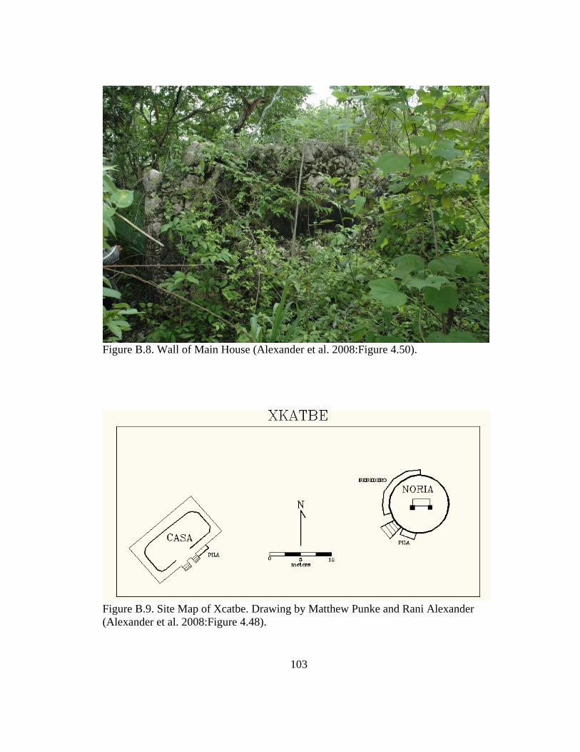
103
Figure B.8. Wall of Main House (Alexander et al. 2008:Figure 4.50).
Figure B.9. Site Map of Xcatbe. Drawing by Matthew Punke and Rani Alexander
(Alexander et al. 2008:Figure 4.48).

104
Rancho Puhula
20˚37’20.83”N, 88˚23’37.61”W
Puhula is located adjacent to the south side of Highway 180 Merida-
Valladolid, just east of Kaua. The buildings on the property are in ruins and
crumbling. Existing structures include a noria on a high platform with two staircases,
extending out to the north and to the southwest. The platform is circular, just
northeast of the main house. To the north of the platform there is a large tank with
aqueducts. The fountain has a carved figure on one side that is either running or
swimming. It also has what looks like a snake which extends out, made of cement
stucco. The main house is located within a masonry yard accessible to the east.
Beyond the troughs and north of the corral is a masonry house with a small apse
bridge over the feeders. Just north of the house there is another corral with
deteriorated limestone covering the ground (Alexander et al. 2008:191).

105
Figure B.10. Noria of Puhula (Alexander et al. 2008:Figure 4.58).
Figure B.11. House Arch (Alexander et al. 2008:Figure 4.59).

106
Figure B.12. Site Map of Puhula. Drawing by Mathew Punke and Rani Alexander
(Alexander et al. 2008:Figure 4.57).
Hacienda Xcumsuc
20˚41’50.66”N, 88˚17’31.88”
Hacienda Xcumsuc is located west of Pixoy, by following the train tracks one
finds a dirt road reduced to a single lane. It is located adjacent to communal lands of
Pixoy, Ebtun and the Electric Company. The noria is built over the cenote. The noria
platform is circular and has remains of a windmill but the masonry and platform are

107
quite old (Alexander et al. 2008:147). The hacienda was last rebuilt in 1968, the date
inscribed on the main entrance of the house is July 27, 1968, "Xcunzuc." The corrals
are modern masonry, as well as most of the house. Corrals and cattle troughs are
substantial. The main house has two enclosed structures, two courtyards and
corridors, one of which had arches. Bebederos are located in front of the main house
and also in the corrals next to the noria. North of the main yard there is another corral
with a house and warehouses in the northeast corner. The site is not currently
occupied by residents or livestock (Alexander et al. 2008:147).
Figure B.13. Hacienda Xcumsuc, Arc and Main Entrance (Alexander et al.
2008:Figure 4.22).

108
Figure B.14. Main House of Hacienda Xcumsuc (Alexander et al. 2008:4.23).
Figure B.15. Windmill over Noria (Alexander et al. 2008:Figure 4.24).

109
Figure B.16. Site Map of Xcumsuc. Drawing by Mathew Punke and Rani Alexander
(Alexander et al. 2008:Figure 4.21).

110
Hacienda San Jose
20˚37’22.84”N, 88˚28’2.11”W
Hacienda San Jose is located north of Highway 180 Merida - Valladolid, with
Kaua to the west. The property currently belongs to the community of Kaua. The
hacienda has a noria situated on a platform with an access ramp. The noria has a
double opening indicating that the machinery had two wheels. It is connected to the
corrals on the north side and a network of troughs. South and adjacent to the noria
platform are the remnants of a house with masonry foundations, although no wall
survived (Alexander et al. 2008:212).
Figure B.17. Noria at Hacienda San Jose (Alexander et al. 2008:Figure 4.77).

111
Fig
ure
B.1
8. In
teri
or
of
the
Nori
a (A
lexan
der
et
al. 2008:F
igure
4.7
8).

112
Figure B.19. Site Map of San Jose. Drawing by Mathew Punke and Rani Alexander
(Alexander et al. 2008:Figure 4.76).
Hacienda San Rafael
20˚38’6.30”N, 88˚29’38.53”W
Hacienda San Rafael is located just west (about 1 km) of the road Chan Kom,
Highway 180 south of Merida - Valladolid. Currently, the owners of San Rafael live
in Merida. There are remnants of modern structures on the grounds, but the site has
been abandoned for some time. The estate consists of a round noria platform which

113
has a double opening and a central corral. It contains a water tank, and troughs that
extend out to the west. The masonry home is quadrangular on one side and apsidal on
the other (Alexander et al. 2008:215).
Figure B.20. Noria at Hacienda San Rafael (Alexander et al. 2008:Figure 4.81).

114
Figure B.21. Main House at the Hacienda (Alexander et al. 2008:Figure 4.82).
Figure B.22. Site Map of San Rafael. Drawing by Mathew Punke and Rani Alexander
(Alexander et al. 2008:Figure 4.79).

115
Hacienda San Juan
20˚38’3.4”N, 88˚25’6.37”W
San Juan is located north of Kauai on a one-way road. It is currently owned by
Mr. Chan of Kaua. The site consists of a round noria platform with a windmill placed
over the noria opening. The windmill is very unstable and not currently in use. It has
a ramp for access on the east side and the wheel is connected to an aqueduct that
leads to a bebedero in the corral. There are column carvings on the noria platform,
along the perimeter of the platform. The main house is very large, separated from the
platform. The house has two stories and very high ceiling and decorative elements in
the doorway (Alexander et al. 2008:218).
Figure B.23. Decorative Doorway of the Main House at Hacienda San Juan
(Alexander et al. 2008:Figure 4.84).

116
Fig
ure
B.2
4. R
amp l
eadin
g t
o t
he
Nori
a (A
lexan
der
et
al. 2008:F
igure
4.8
5).

117
Figure B.25. Site Map of San Juan. Drawing by Mathew Punke and Rani Alexander
(Alexander et al. 2008:Figure 4.83).
Hacienda Xkoben
20˚36’15.83”N, 88˚24’36.16”W
Owned by: Guillermo Pech
Xkoben is located southeast of Kaua, on a side dirt road. The hacienda is
currently owned by Guillermo Pech, who lives on Kauai. The site consists of a noria
with a high masonry platform isolated from the main house, attached to the adjacent
corral. It is rectangular in shape, with a staircase leading to the south and an

118
additional corral. There are extensive earthworks surrounding but missing corrals
decorated arches. The house is built of rectangular masonry. The house has been
modified for more of its modern occupation (it has a cardboard roof). Another side of
this house is a modern poultry trough currently in use - made of cement - for livestock
(Alexander et al. 2008:221).
Figure B.26. Noria at Hacienda Xkoben (Alexander et al. 2008:Figure 4.86).

119
Fig
ure
B.2
7. M
ain H
ouse
at
Xkoben
(A
lexan
der
et
al. 2008:F
igure
4.8
8).

120
Figure B.28. Site Map of Xkoben. Drawing by Mathew Punke and Rani Alexander
(Alexander et al. 2008:Figure 4.89).
Hacienda Chebalam
20˚32’49.83”N, 88˚24’56.95”W
Chebalam is a modern small community located south of Kaua, and southwest
of Tzeal. The people there currently founded the settlement after the Revolution in
place of the old hacienda. Remnants of the hacienda, especially the masonry walls

121
have created many streets and structures in town. The noria platform is located on the
west side of the property, a rectangular platform and water tank connected on the east
side of the structure. Aqueducts lead from the platform to the bebederos on the north
side of the main house. The wheel is constructed over the mouth of the cenote and the
water level is very deep, 20m + (Alexander et al. 2008:229). South of the central
square is a rectangular platform that once was the base of the main house. The main
house has access stairs on each side. Modern foundation of the house, now
abandoned, is at the center of the platform. To the east of the house there is a tank and
many yards of masonry. There is a tank on the east side near the noria and south of
the main house there is an old cistern. South of the main house is a large chapel that
was part of the estate, now it is used for pigs (Alexander et al. 2008:229).
Figure B.29. Main House Platform at Hacienda Chebalam (Alexander et al.
2008:Figure 4.96).

122
Fig
ure
B.3
0. N
ori
a at
Cheb
alam
(A
lexan
der
et
al. 2008:F
igure
4.9
8).

123
Figure B.31. Site Map of Chebalam. Drawing by Mathew Punke and
Rani Alexander (Alexander et al. 2008:Figure 4.93).
Hacienda Kolopna
20˚29’44.83”N, 88˚19’8.08”W

124
Location: Kolopna is located southwest of Tixcacalcupul on a white one lane
road. It is currently inhabited and used for breeding pigs and poultry. The ranch is
owned by John Canché of Valladolid. The main house has poles for walls where the
masonry has collapsed and has a thatched roof. The cenote has a small opening in a
depression and another opening to the south. The cenote shore is delimited by a wall,
and delimits a walled corral beside the noria (Alexander et al. 2008:253). The noria is
placed on a quadrangular platform with secondary vegetation and old makeshift
structures present on the platform. Main house is situated on a rectangular platform
with a modern staircase in place of the original. The house is a masonry structure,
currently occupied, with a thatched roof. There is a modern bathroom and pigpens
made of wood located to the north. In front of the main house there are two small
natural pools called haltunes or sartenejas (Alexander et al. 2008:253).
Figure B.32. Noria at Kolopna (Alexander et al. 2008:Figure 4.119).

125
Fig
ure
B.3
3. N
atura
l P
ools
, H
altu
n o
r S
arte
nej
a at
Kolo
pna
(Ale
xan
der
et
al. 2008:F
igure
4.1
21).

126
Figure B.34. Site Map of Kolopna. Drawing by Mathew Punke and Rani Alexander
(Alexander et al. 2008:Figure 4.122).
Hacienda Chimdznot
20˚30’47.03”N, 88˚25’8.52”W
Chimdzonot is located south of Tzael and Chebalam, on a single lane dirt
road. Chimdznot is currently inhabited by seven families. Currently it is private
property of one of the inhabitants. They have built an observation tower and are
trying to create a reserve for deer. The cenote has a limestone shore, and is protected
by a cement wall and wire (Alexander et al. 2008:274). The noria is located through
the grand opening of the cenote, on the other side the well. The noria is located on a

127
circular platform 2 m high with an adjacent water tank that was turned into a trough.
The site had a trough adjacent to the north side and the house access to water has
deteriorated. There is a partial masonry yard between the main house and the noria,
currently used for cattle. The corrals are subsidiary, located to the east. The main
house is a masonry structure with three rooms, the roof has fallen, and one side has
the debris (Alexander et al. 2008:274).
Figure B.35. Main House at Chimdznot (Alexander et al. 2008:Figure 4.141).

128
Fig
ure
B.3
6. N
ori
a at
Chim
dzn
ot
(Ale
xan
der
et
al. 2008:F
igure
4.1
42).

129
Figure B.37. Site Map of Chimdzonot. Drawing by Mathew Punke and Rani
Alexander (Alexander et al. 2008:Figure 4.141).
Hacienda Kochila
20˚32’39.37”N, 88˚32’10.68”W
Hacienda Kochila is located 3 or 4 kilometers northeast of Tixcacalcupul on
dirt road. The site is currently uninhabited and unused. The cenote has a small
opening. The noria has a double opening to accommodate the machinery atop a large
platform. East of the house is a big noria with a circular platform and access ramp
which lies to the edge of a small cenote. The pillars of the wheel have decorative
concrete chips or rajueleados. The main house is a small masonry structure
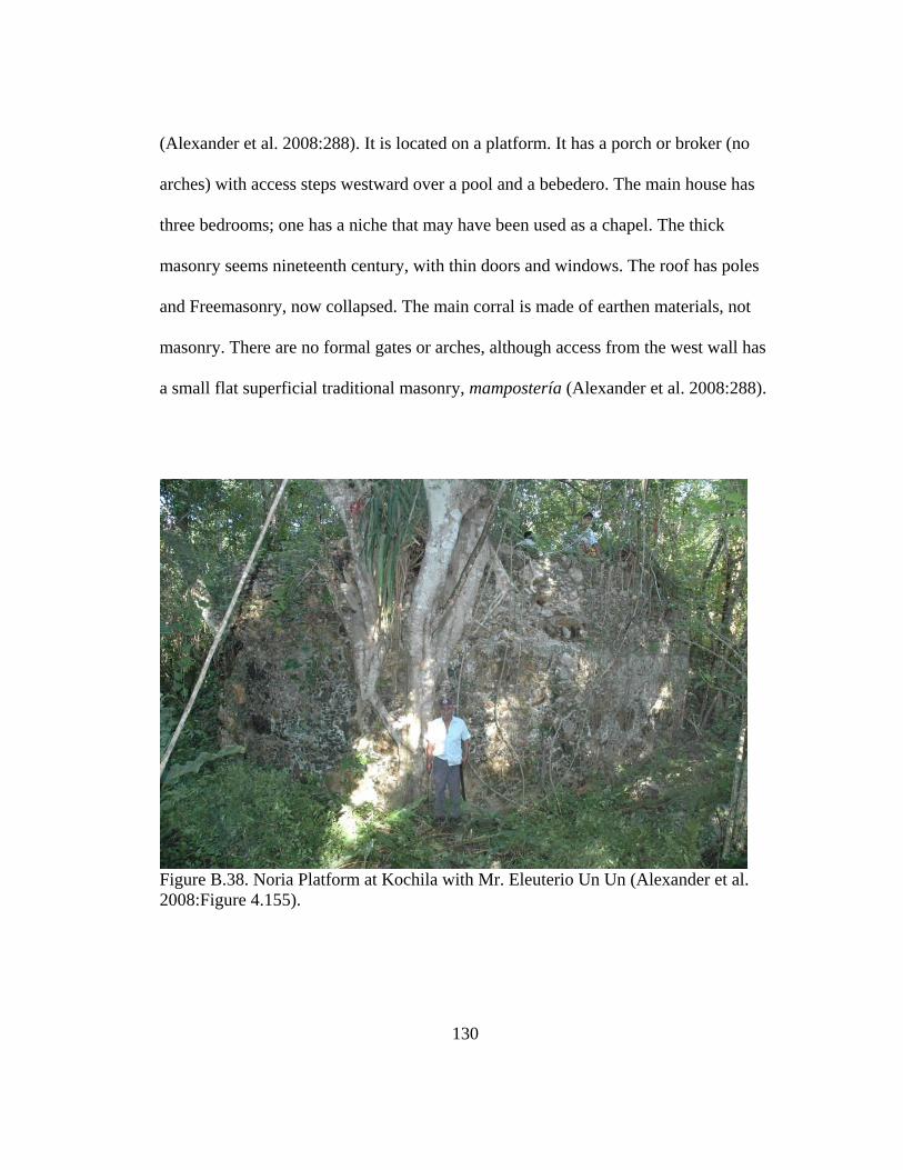
130
(Alexander et al. 2008:288). It is located on a platform. It has a porch or broker (no
arches) with access steps westward over a pool and a bebedero. The main house has
three bedrooms; one has a niche that may have been used as a chapel. The thick
masonry seems nineteenth century, with thin doors and windows. The roof has poles
and Freemasonry, now collapsed. The main corral is made of earthen materials, not
masonry. There are no formal gates or arches, although access from the west wall has
a small flat superficial traditional masonry, mampostería (Alexander et al. 2008:288).
Figure B.38. Noria Platform at Kochila with Mr. Eleuterio Un Un (Alexander et al.
2008:Figure 4.155).

131
Figure B.39. Water Trough in front of the Main House at Kochila (Alexander et al.
2008:Figure 4.157).
Figure B.40. Site Map of Kochila. Drawing by Mathew Punke and Rani Alexander
(Alexander et al. 2008:Figure 4.158).
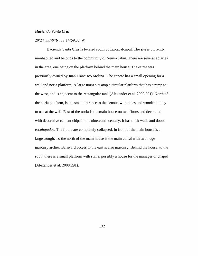
132
Hacienda Santa Cruz
20˚27’55.79”N, 88˚14’59.32”W
Hacienda Santa Cruz is located south of Tixcacalcupul. The site is currently
uninhabited and belongs to the community of Neuvo Jabin. There are several apiaries
in the area, one being on the platform behind the main house. The estate was
previously owned by Juan Francisco Molina. The cenote has a small opening for a
well and noria platform. A large noria sits atop a circular platform that has a ramp to
the west, and is adjacent to the rectangular tank (Alexander et al. 2008:291). North of
the noria platform, is the small entrance to the cenote, with poles and wooden pulley
to use at the well. East of the noria is the main house on two floors and decorated
with decorative cement chips in the nineteenth century. It has thick walls and doors,
escalopadas. The floors are completely collapsed. In front of the main house is a
large trough. To the north of the main house is the main corral with two huge
masonry arches. Barnyard access to the east is also masonry. Behind the house, to the
south there is a small platform with stairs, possibly a house for the manager or chapel
(Alexander et al. 2008:291).

133
Fig
ure
B.4
1. N
ori
a of
San
ta C
ruz
(Ale
xan
der
et
al. 2008:F
igure
4.1
62).

134
Figure B.42. Site Map of Santa Cruz. Drawing by Mathew Punke and Rani Alexander
(Alexander et al. 2008:Figure 4.159).
Hacienda Sucil
20˚34’46.06”N, 88˚17’10.82”W
Hacienda Sucil is located southwest of Tekom along the road to Chuilub. The
property is privately owned by Don Carlos Castillo who currently has 50 heads of
cattle. The ranch has a noria and a well under the windmill. The noria is located

135
behind the house on a rectangular platform with a small tank attached to the south
side of the platform. The property has a large masonry main house, probably built
after the Revolution. It consists of a central corridor and various rooms that anchor
each side. The central corral has troughs in the front. The estate has an elaborate
series of troughs to "wash feet" through which the cattle are taken to wash and bathe
their feet to get rid of ticks. The corral is masonry with peaks at the gate, no bows
(Alexander et al. 2008:295).
Figure B.43. Main House at Sucil (Alexander et al. 2008:Figure 4.166).

136
Fig
ure
B.4
4. W
ater
Tro
ugh a
t S
uci
l (A
lexan
der
et
al. 2008:F
igure
4.1
67).

137
Figure B.45. Site Map of Sucil. Drawing by Mathew Punke and Rani Alexander
(Alexander et al. 2008:Figure 4.164).

138
Kancabchen (established in 1921)
21˚5’7.13”N, 89˚22’54.94”W
Height of the platform: 2.20m
Noria opening: 2.35m x 1.22m
Outer width: 4.28m x 3.05m
Water tank: 7.12m x 7.96m (design was slightly altered for the tourists, turned into a
pool) Depth: Approx. 1 m.
Passed through two families Gamboa and Ponce Garcia
Kancabchen is a newer hacienda located 24 km (15 miles) northeast of
Merida. It was built in 1921, in hopes of the henequen market picking back up, but it
did not. The noria platform is connected to the main house and has a small water tank
that provided water to the agricultural plots. Its water tank is very small and
converted into a swimming pool. The noria wheel was removed and the opening is
covered by a grate. Currently, the platform is surrounded by trees and the aqueducts
were removed, but would have led to the agricultural plots. The main house is in the
center of the property with the stables to the south, and the dairy farm (added within
the last 10 years) to the west. The rest of the property was restored for tourism and
special events. Kancabchen also operates as a zoo, ranch and casino.

139
Figure B.46. Noria opening at Kancabchen
Figure B.47. Water tank at Kancabchen

140
Figure B.48. Ramp to noria at Kancabchen
San Pedro Cholul (established in 1600s)
21° 1'47.52"N, 89°33'0.60"W
Noria: 1.88m x 3.048m outside length, 1.04m x 2.286m inside, depth 6.833m
Water tank: 8.66m x 8.28m, depth 1.575m
Platform: width of wall .965m, height 1.65m
San Pedro is 8.7 km from the center of Merida and operated primarily as a
henequen hacienda. Dr. Hector Hernandez (2010) estimates the site was established
in the seventeenth century, which means there were many stages of transition from
cattle ranching to monocropping. The noria platform is located to the east of the main
house and in-between the two, abutting the platform, is a cenote that is exposed and
very deep. The platform does not have distinguishable edges due to years of sediment

141
build up. It appears to be rectangular in shape but quite small. The hacienda has the
residential and henequen processing building very close together, while the servant
quarters were found outside of the hacienda. The corral is south of the main house
and the noria platform. The property had a chapel south of the corrals, to the north
and west of main house was the administration house and guest house. Directly north
of the main house was the henequen processing area. A cistern (Figure 3.20.) was
built in 1950 next to the noria platform and corrals but the site was completely
abandoned in 1960.
Figure B.49. Noria opening at San Pedro Cholul

142
Figure B.50. Water tank at San Pedro Cholul
Figure B.51. On left, cenote opening adjacent to platform, on right, modern tank

143
Hacienda Tebec
20˚50’33.07”N, 89˚42’29.15”W
Family Loret Mola
Noria: 3.137m x 4.547m, depth 9.474m
Noria Wheel: 1.626m diameter, 5.108m circumference (inner wheel), 1.747m
diameter, 5.488m circumference (outer wheel)
Water tank: 11.354m x 11.468m, depth 1.473m
Platform: 45m x 15m, height 1.943m
Tebec is located in a small village with a main road from Uman leading
directly to the hacienda, approximately 24 km from central Merida. The noria
platform extends out from the main house to the south and is quite large. It is one of
the few sites that still have the wooden wheels intact. It has a modern pump within
the noria, a small windmill over a well opening on the northwest side of the platform
and a fountain closest to the main house. The water tank is to the northeast, adjacent
to the platform/patio area. The corrals surrounding the patio are to the south and the
large aggregate fields are farther south but still within the perimeter wall. All the
aqueducts lead to the cattle troughs; there are no signs that aqueducts extend much
farther from the platform. Work houses and a chapel are located in the entry to the
hacienda, north of the main house. Currently, small residences surround the perimeter
wall and there is no evidence of henequen production. The Mola family still
maintains the property and plan to open it up to the public, but as of now, the property
remains private.

144
Figure B.52. Noria wheels at Tebec
Figure B.53. Water tank at Tebec

145
Figure B.54. Aqueduct leading to bebedero (cattle trough)
Tekit, Hacienda San Antonio Xpip
20˚33’40.52”N, 89˚21’35.45”W
Owner: Jose Eduardo Alonzo
Manager: Faostono Chul Cun Encurgado (AKA “Guapo”)
Noria: 3.658m x 1.981m outside, .356m width of noria wall, .775m height of noria
Depth: 15.494m
Water tank: 5.13m x 5.245m inside, 1.32m depth
Platform: 14.783m diameter of platform, 1.89m height
Hacienda Xpip is found 70 km southeast of Merida and is being reestablished
for tourism. The noria platform is circular with a water tank branching off the
platform to the south. The foundation of the noria platform was kept intact and there

146
are no major alterations to the architecture. A windmill was placed above the noria
opening in order to pump water for the current owners. The water tank was converted
into a pool with a small pool house built on the far south side of the pool. The noria
platform is connected to the main house. It is unclear exactly where the corrals and
aggregates were originally located. The entire property was being reworked. Small
cottages and animal coops were built to the south and west of the main house.
Figure B.55. Noria opening at San Antonio Xpip

147
Figure B.56. Water tank at San Antonio Xpip
Figure B.57. Noria platform with original stonework exposed

148
Hacienda San Pedro Ochil
20˚38’53.90”N, 89˚43’5.57”W
Owner: Tirsoc Corvantes
Manager: Angel Moo
Noria: 2.527m x 1.118m, .38m noria wall, .787m height of noria, 13.36m depth
Water tank: 3.886m x 10.008m, 1.905m depth
Platform: 14.707m x 14.91m outside, 1.76m height
Hacienda Ochil is located about 50 km south of Merida. Originally established
as a rancho it was converted into a henequen hacienda during the henequen boom.
The noria platform is surprisingly small in size for being the main noria platform.
Located behind the main house, the water tank is also small. There may have been
another noria on the property since the size of the water tank did not seem sufficient
to support production for a large hacienda. The platform is located behind the casa
principal, which may have been a water source strictly for cattle early on. The noria
opening is extremely narrow, making it difficult to place the wooden gears within.
Much of the hacienda was restored to draw in tourists, keeping many features
unchanged such as the platform, the cattle troughs and henequen rail tracks and carts
previously used to transport henequen fibers throughout the property, from
processing, to drying and eventually shipping. The hacienda has gone through
restoration and renovations in order to accommodate tourism, special events and two
museums.

149
Figure B.58. Noria Opening at Ochil
Figure B.59. Water tank at Ochil

150
Figure B.60. Ramp of noria platform at Ochil
Hacienda Sihunchen
20˚41’36.41”N, 89˚40’51.29”W
Owner: Eduardo Espinoza
Informer: Jose Castillo Ayala
Noria: 2.54m x 2.235m outside, .65m width of wall, 11.58m depth
Water tank #1 (large): 15.70m x 7.72m, +2.44m depth
Water tank #2 (small): 3.05m x 3.61m, 1.63m depth
Sihunchen is located 40 km from Merida. Originally the hacienda had 5
corporate owners. The property was eventually left with one family, the Espinozas.
For the past ten years the property has been neglected by the family. The hacienda

151
was strictly a henequen processing center, built to handle large quantities of
henequen, and water for the machines. The water tank was the largest of compared to
many other sites. Main house, administrative building and chapel surround the noria.
The noria platform is incorporated into the architecture of the other buildings which
makes it difficult to isolate and measure. The platform for the noria is small but the
water tank is large. This hacienda was pumping large quantities of water for the
steam-powered machines. There was also a smaller tank near the residence. The
platform was very crowded by other structures such as the casa principal and chapel.
The water tank took up most of the space. The processing area was on the northeast
side of the hacienda.

152
Figure B.61. Noria opening at Sihunchen

153
Figure B.62. Large water tank Figure B.63. Small water tank
Hacienda Kantoyna
21˚6’34.97”N, 89˚31’40.29”W
Owner: Timothy Dwight
Manager: Teresa Uh Ramos
Noria Opening: 1.65m x 3.277m, .305m width of wall, 7.72m depth
Platform: 14.45m x 18.415m, 1.727m height
Water tank: 9.195m x 9.69m inside, 2.184m depth, .56m width of wall attached to
platform, 1.016m width of wall

154
Kantoyna is located about 20 miles north of Merida. Kantoyna like many of
the other haciendas began with cattle and expanded as a henequen hacienda. The
noria platform is near the main house but attached to the servant quarters or a workers
building. Corrals and bebederos are to the south side of the main house and the
platform is connected to the bebederos through a series of aqueducts. The henequen
processing center was built later, about 70 meters west of the main house and the
workers chapel 150 meters south. The hacienda is somewhat neglected. At some point
a windmill was placed over the noria in order to extract water. The water tank is
extremely large and adjacent to the corral. The community of Kantoyna is extremely
small, which likely decreased in population after the hacienda was abandoned.
Figure B.64. Noria opening at Kantoyna

155
Figure B.65. Water tank at Kantoyna
Figure B.66. Main house at Kantoyna

156
Hacienda Ticopo
20˚53’23.72”N, 89˚26’22.43”W
Owner: Jorge Arcila
Noria: 4.04m x 2.88m, .648m width of wall, .19m height of wall, 20.00m depth
Platform: 25.984m x 30.556m, 2.54m height
Water tank: 14.95m x 7.00m, 2.50m depth
Ticopo is located 23 km east of Merida that began as a cattle ranch and
eventually produced henequen. The noria platform is attached to the main house with
the corral on the north side. The henequen processing center is across the field in
front of the main house that had a long iron pipe connecting the noria in the
processing center to the water tank on the platform. The water level in the noria is
low and if the processing center was providing water to the water tank for the cattle
and aggregates than this noria has been low for nearly a century. Two hurricanes
(Gilberto in 1988 and Isidoro in 2002) destroyed the servant quarters located on top
of the noria platform. Jorge Arcila (Personal communication 2012) explained that
once nylon was introduced, the henequen hacienda died out in town. From the noria
platform the corral, orchards and henequen plantation are visible. The noria wheel
was removed long ago since the owner is only aware of the motorized pump placed
near the bottom of the noria.

157
Figure B.67. Noria Opening at Ticopo
Figure B.68. Water tank at Ticopo

158
Fig
ure
B.6
9. S
ervan
t Q
uar
ters
on N
ori
a P
latf
orm
at
Tic
opo

159
Hacienda Muchucux
20˚38’57.57”N, 88˚27’12.74”W
Hacienda Muchucux is located east of Tohobku, north of the Valladolid
Highway 180, and west of Kauai. The estate belongs to Don Lucio of Tulum. The
estate has a property manager that lives in Tohobku. Currently, the caretaker looks
after the livestock. The buildings are crumbling because the livestock are not
arranged in various corrals; they walk in corridors of the house. The noria platform is
adjacent to the east side of the house and has a rectangular tank and a round basin,
aqueducts running in front and the back towards a row of breeding rabbits. Currently,
the platform is accessible with a windmill for pumping water and a staircase on the
east side (Alexander et al. 2008:208).
A chapel is located outside the main arc of the corral. In the back of the main
house is a series of boxes used to raise rabbits. An aqueduct provides water to them.
There is another rectangular tank in the back and a bread oven adjacent to the western
corridor on the north side of the house. The main yard is made of masonry and has a
ramp and a 'chute' on the north side, used for herding cattle. The main arches are
decorated but the only access is through the two conical pillars. To the north and west
of the main house is the foundation of the chimney which has collapsed, the structure
was destroyed by Hurricane Gilbert (Alexander et al. 2008:208-209).

160
Figure B.70. Chapel at Hacienda Muchucux (Alexander et al. 2008:Figure 4.74).
Figure B.71. Main House and Noria (Alexander et al. 2008:Figure 4.75).

161
Figure B.72. Site Map of Muchucux. Drawing by Mathew Punke and Rani Alexander
(Alexander et al. 2008:Figure 4.72).
Hacienda San Jose Canto
20˚42’54.63”N, 88˚27’50.02”W
Owned by: Simon Camal family
San Jose Canto is located north of San Francisco near Tinum. It is north of the
highway bridge over Valladolid-Merida, and right on the road. Currently the property

162
is in the hands of managers, Simon Camal’s grandchildren, who are in the process of
selling it to someone in Cancun. Simon Camal bought this Spanish property after the
revolution. The hacienda is well maintained. The main house is habitable, everything
works. The owner says it was a henequen hacienda (Alexander et al. 2008:233).
A cenote is located between about 50 and 100 m east of noria platform. The
noria is adjacent to the main house. The noria is located on the same platform of the
main house and the chapel, and is located south and adjacent to the chapel. A corral is
adjacent to the east side the chapel. An aqueduct runs south of the noria. Bebederos
are located in the yard adjacent to the main house and the chapel platform; these are
fed by aqueducts that run under the structure. The main house is located on the
platform and is in the shape of an "L", a series of rooms with a corridor, the courtyard
behind apsidal separate structures, and a chapel isolated outside the corridor and front
patio (Alexander et al. 2008:233-234). It has high ceilings, building masonry and
some decorative details on the threshold. The structure closest to the road is a
powerhouse or a workers house, with employee housing and barracks, and indications
of modifications to the doors. You see a line of three structures, the first and latter are
of masonry and rectangular, 3m high, with doors completed and then modified.
Aligned structures north of the main gate are the powerhouse. This was a two-story
building that has basement stairs leading to the first floor in the eastern and western
quarters (Alexander et al. 2008:233).
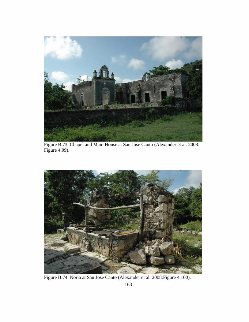
163
Figure B.73. Chapel and Main House at San Jose Canto (Alexander et al. 2008:
Figure 4.99).
Figure B.74. Noria at San Jose Canto (Alexander et al. 2008:Figure 4.100).

164
Figure B.75. Site Map of San Jose Canto. Drawing by Mathew Punke and Rani
Alexander (Alexander et al. 2008:Figure 4.102).
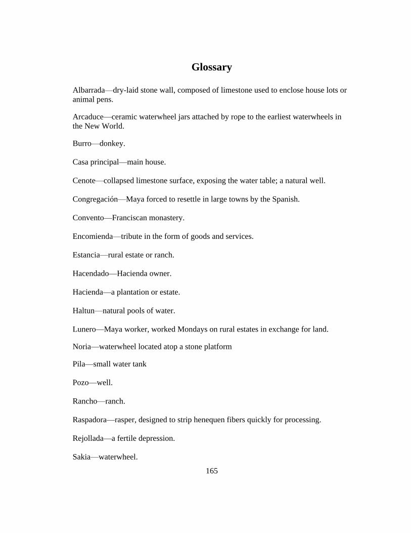
165
Glossary
Albarrada—dry-laid stone wall, composed of limestone used to enclose house lots or
animal pens.
Arcaduce—ceramic waterwheel jars attached by rope to the earliest waterwheels in
the New World.
Burro—donkey.
Casa principal—main house.
Cenote—collapsed limestone surface, exposing the water table; a natural well.
Congregación—Maya forced to resettle in large towns by the Spanish.
Convento—Franciscan monastery.
Encomienda—tribute in the form of goods and services.
Estancia—rural estate or ranch.
Hacendado—Hacienda owner.
Hacienda—a plantation or estate.
Haltun—natural pools of water.
Lunero—Maya worker, worked Mondays on rural estates in exchange for land.
Noria—waterwheel located atop a stone platform
Pila—small water tank
Pozo—well.
Rancho—ranch.
Raspadora—rasper, designed to strip henequen fibers quickly for processing.
Rejollada—a fertile depression.
Sakia—waterwheel.

166
References Cited
Alexander, Rani T.
1997 Haciendas and Economic Change in Yucatán: Entrepreneurial Strategies in
the Parroquia de Yaxcabá, 1775-1850. Journal of Archaeological Method and
Theory, 4(3): 331-351.
2003 Architecture, Haciendas, and Economic Change in Yaxcabá, Yucatán,
Mexico. Ethnohistory 50(1):191-220.
2004 Yaxcabá and the Caste War of Yacatán. University of New Mexico Press,
Albuquerque.
2010 Agrarian Ecology in Yucatán, AD 1450-2000. SAR Advanced Seminar,
Colonial and Postcolonial Change in Mesoamerica: Archaeology as
Historical Anthropology, Santa Fe, New Mexico.
2012 Prohibido Tocar este Cenote: the archaeological basis for the Titles of
Ebtun. International Journal of Historical Archaeology 16(1):1-24.
Alexander, Rani T., José D. Cruz, Adam Kaeding, Ruth M. Cervantes, Matthew
Punke and Susan Kepecs
2008 La Arqueologia Historica en los Pueblos de Ebtun, Cuncunul, Kaua, Tekom,
y Tixcacalcupul, Yucatán, Mexico. Paper presented to the Consejo de
Arqueologia, Instituto Nacional de Anthropologia e Historia, Mexico, D.F.
Alston, Lee J., Shannan Mattiace, and Tomas Nonnenmacher
2009 Coercion, Culture and Contracts: Labor and Debt on Jenequen Haciendas in
Yucatán, Mexico, 1870-1915. Journal of Economic History 69(1):104-137.
Andrews, Anthony P.
1991 The Rural Chapels and Churches of Early Colonial Yucatán and Belize: An
Archaeological Perspective. In Colombian Conquests, Volume 3, the Spanish
Borderlands in Pan-American Perspective. Edited by D.H. Thomas.
Smithsonian Institution Press, Washington and London.
Arnold, Dean E., Branden, Jason R., Williams, Patrick R., Feinman, Gary M. and J.P.
Brown.
2008 The First Direct Evidence for the Production of Maya Blue: Rediscovery of
a Technology. American Antiquity 82: 151-164.
Baker, T. Lindsey.
1985 A Field Guide to American Windmills. University of Oklahoma Press,
Norman, Oklahoma.
Bakewell, Peter
2004 A History of Latin America. Blackwell Publishing, Malden, MA.

167
Batllori, Eduardo, Federico Dickinson, Ana Garcia, Manuel Martin, Ivan Gonzalez,
Miguel Villasuso, and Jose Luis Febles
2000 Socioecological Regions of the Yucatán Peninsula. In Population,
Development and Environment on the Yucat n Peninsula: From Ancient
Maya to 2030. Edited by W. Lutz, L. Prieto, and W. Sanderson. International
Institute for Applied Systems Analysis, Laxenburg, Austria.
Beach, Timothy
1998 Soil Constraints on Northwest Yucatán, Mexico: Pedoarchaeology and
Maya Subsistence at Chunchucmil. Geoarchaeology 13(8): 759-791.
Beeson, Kenneth H.
1964 Indigo Production in the Eighteenth Century. The Hispanic American
Historical Review 44(2): 214-218.
Berdan, Frances F., Marilyn A Masson, Janine Gasco, and Michael E Smith
2003 An International Economy. In The Postclassic Mesoamerican World. Edited
by M.E. Smith and F.F. Berdan. The University of Utah Press, Salt Lake City.
Bracamonte y Sosa, Pedro
1988 Haciendas y Ganado en el Noroeste de Yucatán, 1800-1850. Historia
Mexicana 37(4): 613-639.
Brannon, Jeffery T.
1991 Yucatecan Political Economy in Broader Perspective. In Land, Labor, &
Capital in Modern Yucatan: Essays in Regional History & Political Economy.
Edited by J.T. Brannon & G.M. Joseph. The University of Alabama Press,
Tuscaloosa.
Chevalier, Francois.
1964 Land and Society in Colonial Mexico. University of California Press,
Berkley and Los Angeles.
Clendinnen, Inga
2003 Ambivalent Conquests Maya and Spaniard in Yucatan, 1517-1570, Second
Edition. Cambridge University Press, Cambridge.

168
Contreras Sanchez, Alicia del C.
1996 Capital Comercial y Colorantes en la Nueva España, segunda mitad del
siglo XVIII. Universidad Autonoma de Yucatan, El Colegio de Michoacan,
Zamora, Michoacan,.
Deagan, Kathleen and Jose Maria Cruxent
2002 Archaeology at La Isabela, America’s First European Town. Yale
University Press, New Haven and London.
Drennan, Robert D.
2010 Statistics for Archaeologists, a Common Sense Approach, Second Edition.
Springer Science+Business Media, LLC, New York, New York.
Dunning, Nicholas, Beach, Timothy, Farrell, Pat, and Sheryl Luzzadder-Beach
1998 Prehispanic Agrosystems and Adaptive Regions in the Maya Lowlands.
Culture and Agriculture, Vol. 20:2.
Echino, Cuenca de Vera.
2007 Norias de Sangre. Web page,
http://echino.files.wordpress.com/2007/12/noria-home-planetnl.jpg accessed
January 22, 2013.
WordPress.com
Evans, Sterling D.
2007 Bound in Twine: The History and Ecology of the Henequen-Wheat Complex
for Mexico and the American and Canadian Plains, 1880-1950.Texas A&M
University Press, College Station.
Farriss, Nancy M.
1984 Maya Society under Colonial Rule: The Collective Enterprise of Survival.
Princeton University Press, Princeton, New Jersey.
Fraenkal, Peter
1986 Water Lifting Devices. Food and Agriculture Organization of the United
Nations.
Gelting, Richard J.
1995 Water and Population in the Yucatán Peninsula. International Institute for
Applied Systems Analysis (WP-95-87).

169
Gies Frances and Joseph
1994 Cathedral, Forge, and Waterwheel: Technology and Invention in the Middle
Ages. HarperCollins Publishers, New York.
Greene, Kevin
1999 V. Gordon Childe and the Vocabulary of Revolutionary Change. Antiquity
73: 97-109.
2008 Historiography and Theoretical Approaches. In the Oxford Handbook of
Engineering and Technology in the Classical World. Edited by J.P. Oleson.
Oxford University Press, New York.
Hayden, Brian
1998 Practical and Prestige Technologies: the Evolution of Material Systems.
Journal of Archaeological Method and Theory 5:1-55.
Hernández Álvarez, Héctor A., Lilia F. Souza and Mario Zimmerman
2010 Proyecto Arqueología História en La Hacienda San Pedro Cholul.
Unpublished Ph.D. dissertation, Facultad de Ciencias Antropológicas,
Universidad Autónoma de Yucatán.
Jaccard, James and Michael Becker
2002 Statistics for the Behavioral Sciences, Fourth Edition. Wadsworth
Publishing, California.
Klenek, Thomas
1997, May 1. How it Works: Water Well Pump. Popular Mechanics 66.
Loewe, Ronald
2010 Maya or Mestizo?: Nationalism, Modernity and its Discontents. University
of Toronto Press, Toronto.
Lopez, Luis Alberto M.
2008 Underwater Archaeological Exploration of the Mayan Cenotes. Museum
International 60(4): 100-110.
Mann, Prem S.
2007 Introductory Statistics. John Wiley & Sons, Inc., Danvers, Massachusetts.

170
Mathew, Sathyajith
2006 Wind Energy: Fundamentals, Resource Analysis and Economics. Springer:
Berlin, Heidelberg, New York.
McDermott, Tom and Dave Greisinger
2003 Where in the Well it all starts: Residential Water Pumps. Water
Conditioning and Purification 2: 97-99.
Oleson, John Peter
2000 Water-Lifting. In Handbook of Ancient Water Technology, Technology and
Change in History. Edited by Ö. Wikander. Leiden, Brill.
Patch, Robert W.
1993 Maya and Spaniard in Yucatán, 1648-1812. Stanford University Press,
Stanford, California.
Pineda, Jose Arturo G.
1991 Everyday Forms of Mayan Resistance: Cattle Rustling in Northern Yucatan,
1821-1847. In Land, Labor, & Capital in Modern Yucatan: Essays in
Regional History & Political Economy. Edited by J.T. Brannon & G.M.
Joseph. The University of Alabama Press, Tuscaloosa.
Rapoport, Amos
1980 Vernacular architecture and the cultural determinants of form. In Buildings
and society: essays on the social development of the built environment, edited
by A.D. King. Routledge & Kegan Paul, London.
Rasby, Rick J. and Troy M. Walz
2011 Water Requirements for Beef Cattle. NebGuide:G2060. Lincoln Extension
Publications. University of Nebraska, Lincoln.
Restall, Matthew
1997 The Maya World: Yucatec Culture and Society 1550-1850. Stanford
University Press, California.
Reynolds, Terry S.
1983 Stronger than a Hundred Men: A History of the Vertical Water Wheel. The
John Hopkins University Press, Baltimore.

171
Rivero, Piedad Peniche
2003 From Milpero and Lunero to Henequenero: A transition to Capitalism in
Yucatán, Mexico. In The Lowland Maya Area: Three Millennia at the
Human-Wildland Interface. Edited by S. Fedick, M. Allen, J. Jimnez-Osornio,
& A. Gomez-Pompa. Haworth Press, Inc., Binghamton, New York.
Roman Kalisch, Manuel Arturo
2009 La Edificación de Conventos Franciscanos en el Siglo XVI en Yucatán.
Palapa, 4(2): 5-19.
Rugeley, Terry
1996 Yucatán's Maya Peasantry and the Origins of the Caste War. University of
Texas Press, Austin.
Scarborough, Vernon L.
2003 The Flow of Power: Ancient Water Systems and Landscapes. School of
Advanced Research Press, Santa Fe, New Mexico.
Schiffer, Michael B.
1992 Technological Perspectives on Behavioral Change. The University of
Arizona Press, Tucson & London.
1996 Formation Processes of the Archaeological Record. University of Utah
Press, Salt Lake City.
2001 Toward an Anthropology of Technology. In Anthropological Perspectives
on Technology. Edited by M. B. Schiffer. University of New Mexico Press,
Albuquerque.
2002 Studying Technological Differentiation: The Case of 18th-Century Electrical
Technology. American Anthropologist 104(4):1148-1151.
2004 Studying Technological Change: A Behavioral Perspective. World
Archaeology 36(4): 579-585.
2008 Expanding Ethnoarchaeology: Historical Evidence and Model-Building in
the Study of Technological Change. In the Oxford Handbook of Engineering
and Technology in the Classical World. Edited by J.P. Oleson. Oxford
University Press, New York.
Schiffer, Michael B. and James M. Skibo
1997 The Explanation of Artifact Variability. American Antiquity 62(1): 27-50.

172
Schiffer, Michael B., James M. Skibo, Janet L. Griffitts, Kacy L. Hollenback, and
William A. Longacre.
2001 Behavioral Archaeology and the Study of Technology. American Antiquity
66(4):729-738.
Sherman, William L.
1979 Forced Native Labor in Sixteenth-Century Central America. University of
Nebraska Press, Lincoln and London.
Schiøler, Thorkild
1973 Roman and Islamic Water Lifting Devices. In Acta historica scientiarum
naturalium et medicinalium, Volume 28. Odense Universitetsforlag.
Sheskin, David J.
1997 Handbook of Parametric and Nonparametric Statistical Procedures. CRC
Press LLC, Baca Raton, Florida.
Sorensen, Bent
1995 Progress in Wind Energy Utilization. Annual Review of Energy and
Environment 20: 288-328.
Spenser, Daniela
1991 Workers against Socialism? Reassessing the Role of Urban Labor in
Yucatan. In Land, Labor, & Capital in Modern Yucatan: Essays in Regional
History & Political Economy. Edited by J.T. Brannon & G.M. Joseph. The
University of Alabama Press, Tuscaloosa.
Thomas, David H.
1986 Refiguring Anthropology: First Principles of Probability and Statistics.
Wavelan Press, Inc., Long Grove, Illinois.
Wells, Allen
1982 Family Elites in a Boom-and-Bust Economy: The Molinas and Peons of
Porfirian Yucatan. The Hispanic American Historical Review 62(2): 224-253.
1991 From Hacienda to Plantation: The Transformation of Santo Domingo
Xcuyum. In Land, Labor, & Capital in Modern Yucatan: Essays in Regional
History & Political Economy. Edited by J.T. Brannon & G.M. Joseph. The
University of Alabama Press, Tuscaloosa.


