Embed Size (px)
Citation preview
Land cover in Upper Egypt assessed using regional and globalland cover products derived from MODIS imagery
DOUGLAS O. FULLER†, MICHAEL S. PARENTI‡, ADEL M. GAD§, and JOHN C. BEIER‡,¶
‡ Leonard and Jayne Abess Center for Ecosystem Science and Policy, University of Miami, CoralGables, FL 33124, USA§ Ain Shams University, Faculty of Science, Entomology Department, Abbassia Square, Cairo11566, Egypt¶ Department of Epidemiology and Public Health, Miller School of Medicine, University of Miami,Miami, FL 33136 USA
AbstractIrrigation along the Nile River has resulted in dramatic changes in the biophysical environment ofUpper Egypt. In this study we used a combination of MODIS 250 m NDVI data and Landsatimagery to identify areas that changed from 2001–2008 as a result of irrigation and water-levelfluctuations in the Nile River and nearby water bodies. We used two different methods of timeseries analysis -- principal components (PCA) and harmonic decomposition (HD), applied to theMODIS 250 m NDVI images to derive simple three-class land cover maps and then assessed theiraccuracy using a set of reference polygons derived from 30 m Landsat 5 and 7 imagery. Weanalyzed our MODIS 250 m maps against a new MODIS global land cover product (MOD12Q1collection 5) to assess whether regionally specific mapping approaches are superior to a standardglobal product. Results showed that the accuracy of the PCA-based product was greater than theaccuracy of either the HD or MOD12Q1 products for the years 2001, 2003, and 2008. However,the accuracy of the PCA product was only slightly better than the MOD12Q1 for 2001 and 2003.Overall, the results suggest that our PCA-based approach produces a high level of user andproducer accuracies, although the MOD12Q1 product also showed consistently high accuracy.Overlay of 2001–2008 PCA-based maps showed a net increase of 12 129 ha of irrigatedvegetation, with the largest increase found from 2006–2008 around the Districts of Edfu and KomOmbo. This result was unexpected in light of ambitious government plans to develop 336 000 haof irrigated agriculture around the Toshka Lakes.
KeywordsMODIS NDVI; Upper Egypt; irrigated vegetation; time series analysis; Toshka Lakes; MOD12Q1
1. IntroductionIn the hyper-arid desert of Upper Egypt, annual rainfall is typically negligible (Bastawesy etal. 2008) and irrigation from the Nile River is generally the only water source to sustainpermanent agriculture and other forms of primary production. Besides increasing cropcoverage and regional photosynthetic activity, irrigation can produce changes in local andregional climatic conditions (Sen Roy et al. 2010), may lead to soil salinization (Thomasand Middleton 1994), and create new habitats for vectors associated with diseases such as
†Corresponding author: Department of Geography and Regional Studies, University of Miami, Coral Gables, FL 33124-2221, USA.
NIH Public AccessAuthor ManuscriptRemote Sens Lett. Author manuscript; available in PMC 2013 January 1.
Published in final edited form as:Remote Sens Lett. 2012 January 1; 3(2): 171–180. doi:10.1080/01431161.2011.551847.
NIH
-PA Author Manuscript
NIH
-PA Author Manuscript
NIH
-PA Author Manuscript
schistosomiasis, malaria, Rift Valley Fever (RVF) and West Nile Virus (WNV) (Harrus andBaneth 2005). The Egyptian government has implemented various large-scale watermanagement and diversion schemes to stabilise water delivery for irrigation, including thecompletion of the Aswan High Dam in 1968, which created Lake Nasser, and the Toshkaspillway that flooded the Toshka Depression and created four new lakes in 2001 (Bastawesyet al. 2008). These major water bodies created incentives and opportunities for newirrigation schemes, most notably the creation of new canals that were intended to produce336 000 ha of new irrigated area around the Toshka Lakes to increase crop production andmove people to the region (Lonergan and Wolf 2001).
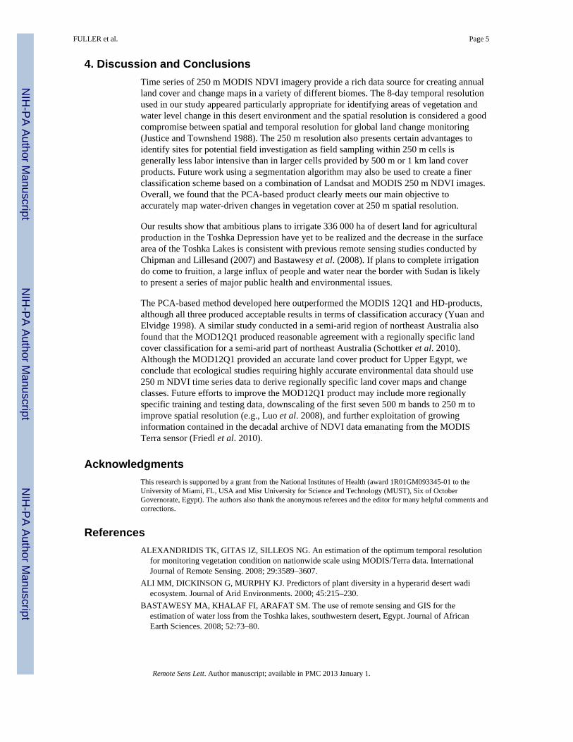
Our study area (figure 1) contains few land cover types relative to more humid regions andphotosynthetic activity that is limited by irrigation and lake water levels; thus the areaprovides a simple case to evaluate land cover maps using different sources of multitemporal,multi-resolution vegetation index imagery. Upper Egypt receives almost no rainfall withmonthly evaporation rates ranging from 115–300 mm from winter to summer when dailymaximum temperatures typically exceed 45°C (Bastawesy et al. 2008). The vegetation ofthe study area is concentrated along the Nile north of Aswan and consists of intensive sugarand some cotton cultivation, particularly around the Districts of Edfu and Kom Ombo(figure 1). In less intensively managed areas along the margins of Lake Nasser, Ali et al.(2000) reported the presence of riparian phreatophytic vegetation characterized by Tamarixnilotica and therophytes such as Glinus lotoides mixed with wetland species such as Typhadomingensis. This semi-natural vegetation tends to be found on moist alluvial soils and isintensively grazed (Ali et al. 2000). With changes in lake levels over the past decade,particularly in the Toshka Depression, wetlands have contracted or disappeared in someareas (Bastawesy et al. 2008).
Recently, there has been growing interest in using remote sensing to monitor the changes inopen water and irrigated areas associated with new and existing irrigation activities in UpperEgypt. For example, Chipman and Lillesand (2007) used imagery from the ModerateResolution Imaging Spectroradiometer (MODIS) and data from a laser altimeter todocument changes in the lake levels in the Toshka Depression. Bastawesy et al. (2008) usedimagery from the Advanced Spaceborne Thermal Emission and Reflection Radiometer(ASTER) and Système Pour l’Observation de la Terre (SPOT) imagery to document waterloss in these same water bodies. Elewa et al. (2010) used Landsat Enhanced ThematicMapper Plus (ETM+) imagery to identify geologic faults near the Toshka Lakes whereaquifer exploitation may be feasible. Here, we utilize a combination of MODIS and Landsatimagery to map water-driven changes in the vegetation covering most of southern Egypt,northern Sudan, and including Lake Nasser, The Toshka Depression, Aswan and majorirrigation areas around the Districts of Edfu and Kom Ombo to the north of Aswan City(figure 1).
Consistent with other studies that have shown high temporal resolution imagery (< 10 dayrepeat interval) for monitoring managed vegetation (Alexandridis et al. 2008), we utilized 8-day MODIS 250 m Normalized Difference Vegetation Index (NDVI) imagery to identifyirrigated and riparian vegetation, barren desert and water bodies on an annual basis. Suchimage composites should be well-suited for desert environments such as Upper Egypt,which has low cloud cover throughout the year and frequent, short-term changes inirrigation status through the control of irrigation canals and pumping stations. The majoraims of the study, therefore, were to develop an operational mapping approach usingregional, coarse-resolution optical imagery from 250 m MODIS NDVI imagery to detectchanges in vegetation from 2001–2008, and to compare these results with a new MODISglobal land cover product, MOD12Q1 version 5 (Friedl et al. 2010). In this way, our studycontributes to a growing array of studies that evaluate the utility and accuracy of different
FULLER et al. Page 2
Remote Sens Lett. Author manuscript; available in PMC 2013 January 1.
NIH
-PA Author Manuscript
NIH
-PA Author Manuscript
NIH
-PA Author Manuscript
MODIS products (e.g., Heiskanen 2008, Vancutsem et al. 2010, Wang et al. 2010). We areunaware of any previous studies that have systematically evaluated the MOD12Q1 globalland cover product in an arid environment and compared it with approaches that useregionally specific training and testing data.
2. Data and MethodsWe obtained 2001–2008 version 5 MOD09Q1 250 m 8-day reflectance imagery for MODISbands 1 (620–670 nm) and 2 (841–876 nm) covering Upper Egypt fromhttps://wist.echo.nasa.gov/api/. These data were used to create a temporal sequence of 8-dayNDVI images, which were re-projected to a UTM coordinate system, to produce a highertemporal resolution product than the standard 16-day MODIS 250 m NDVI product(MOD13Q1). Thus, each year in our time series contained 46 NDVI composite imagessufficient to evaluate change in vegetation cover based on annual phenological patterns. Weapplied two different time series methods to the 8-day NDVI composites: standardisedprincipal components analysis (PCA) and harmonic decomposition (HD). Both methodshave been used to analyze NDVI time series, reduce data volumes to simplify analysis ofphenological patterns and remove image noise by eliminating high frequency componentsassociated with cloud cover, atmospheric effects or sensor calibration issues (Eklundh andSingh 1993, Roerink et al. 2000). Standardised PCA produces a set of images that define arotation of the original images in such a way that new axes are orthogonal and point in thedirection of decreasing order of the variances (Eklundh and Singh 1993). HD produces a setof amplitude and phase images that correspond to the underlying frequencies present in theraw time series and is analogous to temporal Fourier analysis although it uses exact calendardates of the images and can use irregularly spaced observations unlike Fourier analysis.Both methods were implemented in Earth Trends Modeler, which is available in the IdrisiTaiga version (Eastman 2009). Readers unfamiliar with these techniques are referred toEklundh and Singh (1993) and Roerink et al. (2000) for further information.
A set of eight Landsat 5 TM and Landsat 7 ETM+ images (table 1) obtained from the USGeological Survey (http://glovis.usgs.gov/) was used to develop training areas and performclassification accuracy assessments. The Landsat imagery allowed identification of threeclearly distinguishable land cover types: irrigated vegetation (IV), desert areas and openwater. Two images were used to develop training polygons that were entered into a back-propagation neural network (BPNN) classifier and five additional images were used todevelop a set of validation polygons that were used in subsequent classification accuracyassessment. Although we did not use randomly sampled validation polygons, the number ofvalidation pixels (table 1) appeared sufficient to provide a representative sample (Foody2009).
Both the PCA and HD image outputs were treated analogously to single image bands instandard multispectral image classification and were entered into the BPNN. For the PCAimages, we varied the inputs experimentally to include the first four, six and eight principalcomponents and for the HD images we input the first four amplitude and four phase images.The BPNN parameters including image inputs, iterations, hidden layers, and layer nodeswere adjusted experimentally until qualitatively acceptable classifications were produced forsubsequent quantitative analysis using the error matrix. Two summary classificationstatistics were calculated, Cramer’s V, which ranges from zero for no agreement to 1 forperfect agreement, and percentage correctly classified (PCC).
To evaluate these products against a standard, global product, we included the MODISyearly land cover product (MOD12Q1, collection 5) in our analysis. This 500 m product isbased on a regression tree method applied to MODIS bands 1–7 and other inputs such as
FULLER et al. Page 3
Remote Sens Lett. Author manuscript; available in PMC 2013 January 1.
NIH
-PA Author Manuscript
NIH
-PA Author Manuscript
NIH
-PA Author Manuscript
land surface temperature, albedo and texture and is produced from 32-day average valuesfrom original 8-day products, which reduces missing data from cloud cover (Friedl et al.2010). From MOD12Q1, we selected the International Geosphere-Biosphere Programme(IGBP) classification scheme, which appeared most appropriate for our study region, and weaggregated the classes to produce a new three-class map consistent with our classification.The accuracy of the simplified MOD12Q1 IGBP was then evaluated alongside theregionally specific PCA- and HD-based products.
3. ResultsExperiments varying the inputs to the BPNN revealed that the most realistic land coverclassifications were produced using the first four principal components for the PCA-basedinputs and a combination of the first four amplitudes and two phase images from the HD-based inputs. Additional PCA or HD products tended to result in highly erroneous maps thathad low levels of training accuracy. We found that a three-layer BPNN including one hiddenlayer parameterized with 10,000 iterations, a learning rate of 0.01, a momentum factor of 0.5and sigmoid constant of 1.0 produced the best classification results. The PCC and Cramer’sV values showed that the accuracy of the three different land cover products wascomparable for 2001 and 2003; whereas PCC and Cramer’s V (97.8 and 0.976, respectively)revealed that the PCA-based classification produced the highest accuracy for 2008 (table 2).The PCA-based classification worked particularly well for areas of intensive irrigatedvegetation. This high level of accuracy suggests that the version 5 MODIS 250 mreflectance product provides a highly consistent source of information about the desert landsurface that is largely free of atmospheric and directional reflectance effects. Nonetheless,for the three classification methods some errors were apparent. In all cases, the largest errorsinvolved the vegetation class, in which small patches of vegetation were classified as desert.For example, this error ranged from 0.072 for the 2008 PCA classification to 0.210 for the2008 MOD12Q1 product. Visual inspection of the classified images revealed that many ofthese omissions related to small areas of semi-natural riparian vegetation or small, isolatedirrigated areas, which suggests that small features visible in the Landsat TM and ETM+scenes were sometimes missed in the 250 m MODIS product and the coarser 500 mMOD12Q1 product (figures 2 & 3). However, commission errors were generally quitesmall, ranging from 0.000 for the open water class in the PCA-based 2001 classification to0.120 in the HD-based 2008 classification.
Generally, sources of disagreement between the MOD12Q1 and PCA-based productsappeared along the margins of major water bodies in which inundated areas such as smallislands or the shoreline were sometimes classified as vegetation. Figure 2 shows both theMODIS PCA based classification and the MOD12Q1 for 2008 and reveals areas ofagreement and disagreement for the whole study area. The HD based product is not shownas it produced lower classification accuracies than either the PCA or MOD12Q1 products(table 2). The finer scale MODIS PCA product correctly identified water-desert boundaries,while the MOD12Q1 appeared to confuse these areas around Lake Nasser (see figures 2 &3) as riparian or irrigated vegetation. In addition, the PCA-based product correctly identifieda substantial area of newly irrigated land to the east of Kom Ombo district, which representsthe largest area of expanded irrigation over the period of our study. Notwithstanding minorsources of error related to omissions, the accuracy of the PCA-based product suggests thatthis approach is sufficient for operational monitoring of water-driven changes in vegetationcover. Overlay of the 2001 and 2008 maps derived from the PCA-based method reveal amodest increase in irrigated vegetation from 2001–2008 (12 129 ha), with most of thisobserved as extensions of existing irrigated areas around Edfu and Kom Ombo (figure 3).
FULLER et al. Page 4
Remote Sens Lett. Author manuscript; available in PMC 2013 January 1.
NIH
-PA Author Manuscript
NIH
-PA Author Manuscript
NIH
-PA Author Manuscript
4. Discussion and ConclusionsTime series of 250 m MODIS NDVI imagery provide a rich data source for creating annualland cover and change maps in a variety of different biomes. The 8-day temporal resolutionused in our study appeared particularly appropriate for identifying areas of vegetation andwater level change in this desert environment and the spatial resolution is considered a goodcompromise between spatial and temporal resolution for global land change monitoring(Justice and Townshend 1988). The 250 m resolution also presents certain advantages toidentify sites for potential field investigation as field sampling within 250 m cells isgenerally less labor intensive than in larger cells provided by 500 m or 1 km land coverproducts. Future work using a segmentation algorithm may also be used to create a finerclassification scheme based on a combination of Landsat and MODIS 250 m NDVI images.Overall, we found that the PCA-based product clearly meets our main objective toaccurately map water-driven changes in vegetation cover at 250 m spatial resolution.
Our results show that ambitious plans to irrigate 336 000 ha of desert land for agriculturalproduction in the Toshka Depression have yet to be realized and the decrease in the surfacearea of the Toshka Lakes is consistent with previous remote sensing studies conducted byChipman and Lillesand (2007) and Bastawesy et al. (2008). If plans to complete irrigationdo come to fruition, a large influx of people and water near the border with Sudan is likelyto present a series of major public health and environmental issues.
The PCA-based method developed here outperformed the MODIS 12Q1 and HD-products,although all three produced acceptable results in terms of classification accuracy (Yuan andElvidge 1998). A similar study conducted in a semi-arid region of northeast Australia alsofound that the MOD12Q1 produced reasonable agreement with a regionally specific landcover classification for a semi-arid part of northeast Australia (Schottker et al. 2010).Although the MOD12Q1 provided an accurate land cover product for Upper Egypt, weconclude that ecological studies requiring highly accurate environmental data should use250 m NDVI time series data to derive regionally specific land cover maps and changeclasses. Future efforts to improve the MOD12Q1 product may include more regionallyspecific training and testing data, downscaling of the first seven 500 m bands to 250 m toimprove spatial resolution (e.g., Luo et al. 2008), and further exploitation of growinginformation contained in the decadal archive of NDVI data emanating from the MODISTerra sensor (Friedl et al. 2010).
AcknowledgmentsThis research is supported by a grant from the National Institutes of Health (award 1R01GM093345-01 to theUniversity of Miami, FL, USA and Misr University for Science and Technology (MUST), Six of OctoberGovernorate, Egypt). The authors also thank the anonymous referees and the editor for many helpful comments andcorrections.
ReferencesALEXANDRIDIS TK, GITAS IZ, SILLEOS NG. An estimation of the optimum temporal resolution
for monitoring vegetation condition on nationwide scale using MODIS/Terra data. InternationalJournal of Remote Sensing. 2008; 29:3589–3607.
ALI MM, DICKINSON G, MURPHY KJ. Predictors of plant diversity in a hyperarid desert wadiecosystem. Journal of Arid Environments. 2000; 45:215–230.
BASTAWESY MA, KHALAF FI, ARAFAT SM. The use of remote sensing and GIS for theestimation of water loss from the Toshka lakes, southwestern desert, Egypt. Journal of AfricanEarth Sciences. 2008; 52:73–80.
FULLER et al. Page 5
Remote Sens Lett. Author manuscript; available in PMC 2013 January 1.
NIH
-PA Author Manuscript
NIH
-PA Author Manuscript
NIH
-PA Author Manuscript
CHIPMAN JW, LILLESAND TM. Satellite-based assessment of the dynamics of new lakes insouthern Egypt. International Journal of Remote Sensing. 2007; 28:4365–4379.
EASTMAN, R. IDRISI: The Taiga Edition. Clark Labs, Clark University; Worcester, MA, USA:2009.
EKLUNDH L, SINGH A. A comparative analysis of standardised and unstandardised PrincipalComponents Analysis in remote sensing. International Journal of Remote Sensing. 1993; 14:1359–1370.
ELEWA HH, FATHY RG, QADDAH AA. The contribution of geographic information systems andremote sensing in determining priority areas for hydrogeological development, Darb el-Arbain area,Western Desert, Egypt. Hydrogeology Journal. 2010; 18:1157–1171.
FOODY GM. Sample size determination for image classification accuracy assessment. InternationalJournal of Remote Sensing. 2009; 30:5273–5291.
FRIEDL MA, SULLA-MENASHE D, TAN B, SCHNEIDER A, RAMANKUTTY N, SIBLE A,HUANG X. MODIS collection 5 global land cover: Algorithm refinements and characterization ofnew datasets. Remote Sensing of Environment. 2010; 114:168–182.
HARRUS S, BANETH G. Drivers for the emergence and re-emergence of vector-borne protozoal andbacterial diseases. International Journal for Parasitology. 2005; 35:1309–1318. [PubMed:16126213]
HEISKANEN J. Evaluation of global land cover data sets over the tundra-taiga transition zone innorthernmost Finland. International Journal of Remote Sensing. 2008; 29:3727–3751.
JUSTICE CO, TOWNSHEND JRG. Selecting the spatial resolution of satellite sensors required forglobal monitoring of land transformations. International Journal of Remote Sensing. 1988; 9:187–236.
LONERGAN S, WOLF AT. Moving water to move people–The Toshka project in Egypt–A waterforum contribution. Water International. 2001; 26:589–596.
LUO Y, TRISHCHENKO AP, KHLOPENKOV KV. Developing clear-sky, cloud and cloud shadowmask for producing clear-sky composites at 250-meter spatial resolution for the seven MODISland bands over Canada and North America. Remote Sensing of Environment. 2008; 112:4167–4185.
ROERINK GJ, MENETI M, VERHOEF W. Reconstructing cloudfree NDVI composites using Fourieranalysis of time series. International Journal of Remote Sensing. 2000; 21:1911–1917.
SEN ROY S, MAHMOOD R, QUINTANAR AI, GONZALEZ A. Impacts of irrigation on dry seasonprecipitation in India. Theoretical and Applied Climatology. 201010.1007/s00704-010-0338-z
SCHOTTKER B, PHINN S, SCHMIDT M. How does the global Moderate Resolution ImagingSpectroradiometer (MODIS) Fraction of Photosynthetically Active Radiation (FPAR) productrelate to regionally developed land cover and vegetation products in a semi-arid Australiansavanna? Journal of Applied Remote Sensing. 2010; 4:Art. No. 043538.
THOMAS, DSG.; MIDDLETON, NJ. Desertification: Exploding the Myth. London: Wiley; 1994. p.194
VANCUTSEM C, CECCATO P, DINKU T, CONNOR SJ. Evaluation of MODIS land surfacetemperature data to estimate air temperature in different ecosystems over Africa. Remote Sensingof Environment. 2010; 114:449–465.
WANG KC, LIANG S, SCHAAF CL, STRAHLER AH. Evaluation of moderate resolution imagingspectroradiometer land surface visible and shortwave albedo products at FLUXNET sites. Journalof Geophysical Research-Atmospheres. 2010; 15:D17107.
YUAN D, ELVIDGE C. NALC Land cover change detection pilot study: Washington, D.C. areaexperiments. Remote Sensing of Environment. 1998; 66:166–178.
FULLER et al. Page 6
Remote Sens Lett. Author manuscript; available in PMC 2013 January 1.
NIH
-PA Author Manuscript
NIH
-PA Author Manuscript
NIH
-PA Author Manuscript
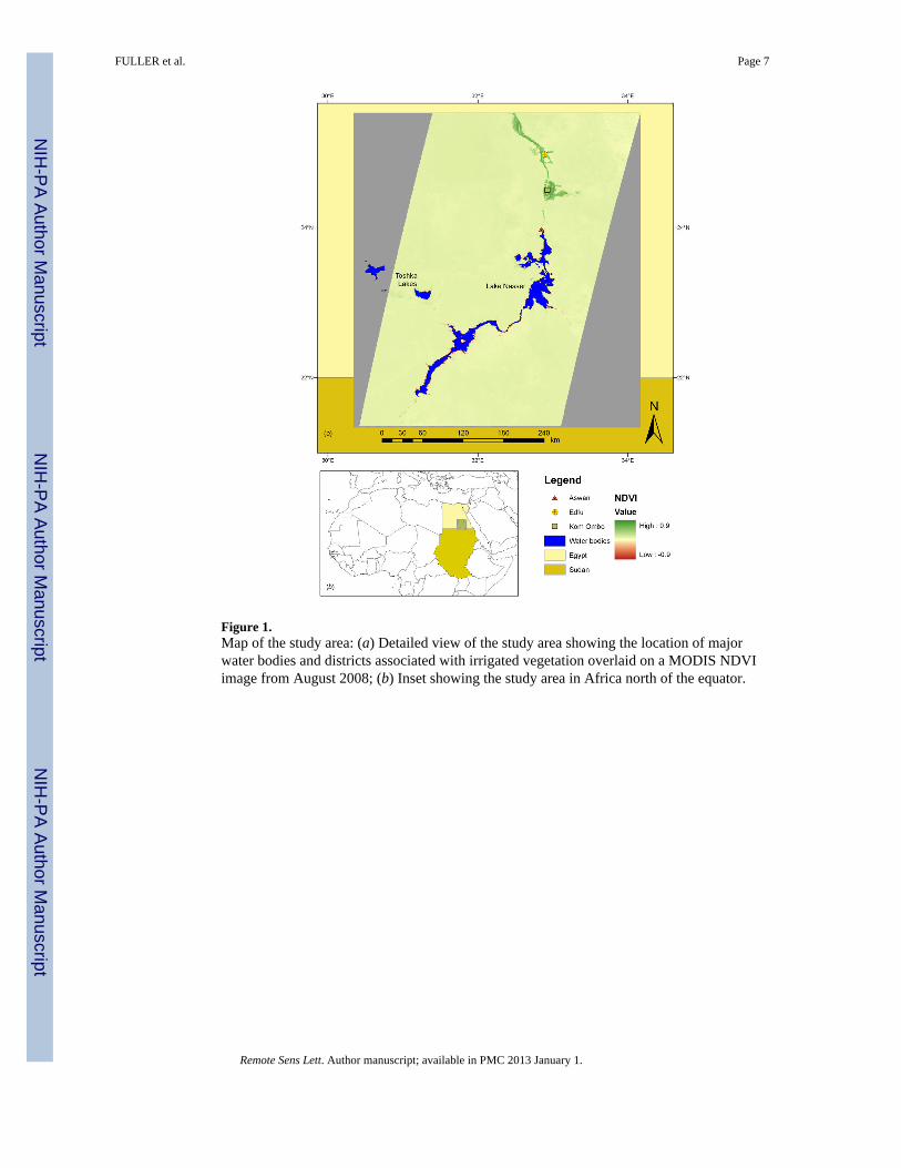
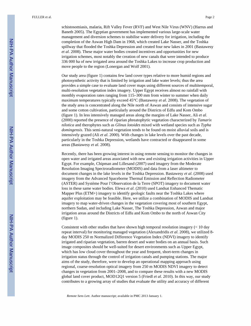
Figure 1.Map of the study area: (a) Detailed view of the study area showing the location of majorwater bodies and districts associated with irrigated vegetation overlaid on a MODIS NDVIimage from August 2008; (b) Inset showing the study area in Africa north of the equator.
FULLER et al. Page 7
Remote Sens Lett. Author manuscript; available in PMC 2013 January 1.
NIH
-PA Author Manuscript
NIH
-PA Author Manuscript
NIH
-PA Author Manuscript
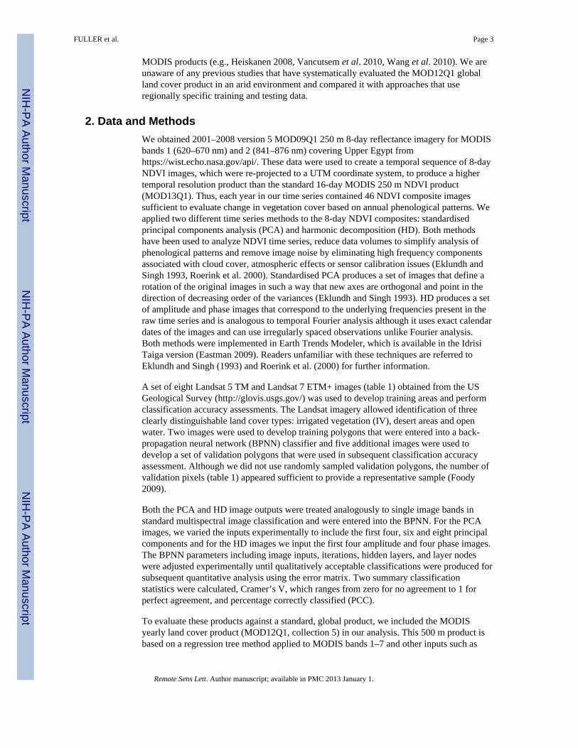
Figure 2.2008 MODIS land cover maps for Upper Egypt derived from different sources for the studyarea: (a) 250 m PCA-based classification; (b) 500 m MOD12Q1 classification; (i) and (ii)indicate areas around Kom Ombo and Edfu Districts and around one of the lakes in theToshka Depression, respectively, displayed in figure 3 below.
FULLER et al. Page 8
Remote Sens Lett. Author manuscript; available in PMC 2013 January 1.
NIH
-PA Author Manuscript
NIH
-PA Author Manuscript
NIH
-PA Author Manuscript
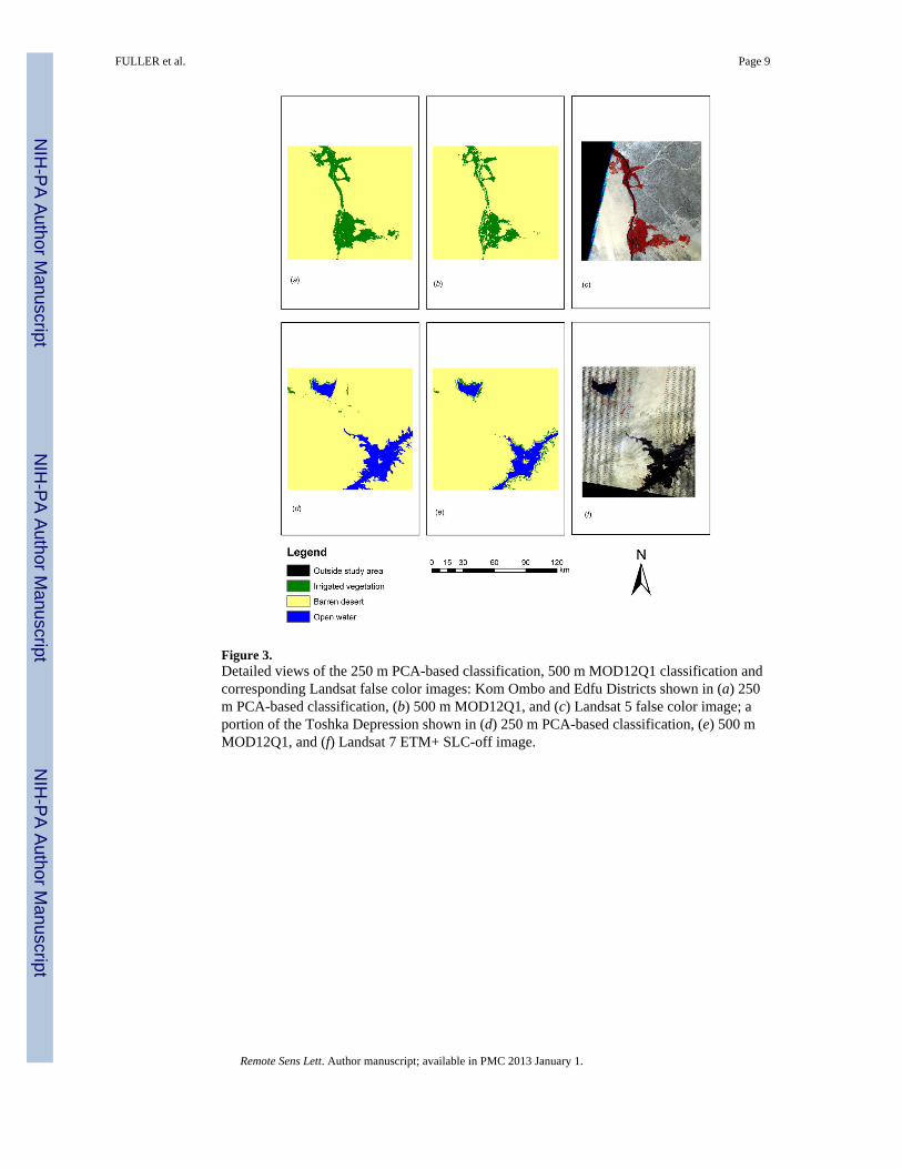
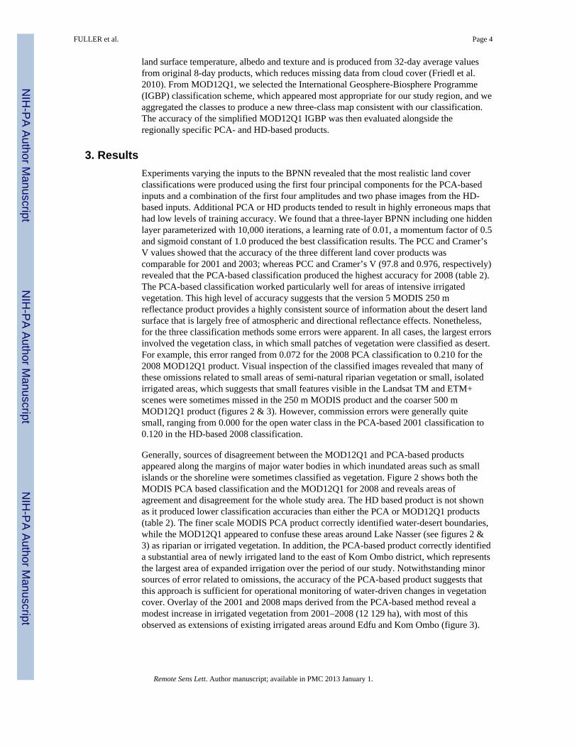
Figure 3.Detailed views of the 250 m PCA-based classification, 500 m MOD12Q1 classification andcorresponding Landsat false color images: Kom Ombo and Edfu Districts shown in (a) 250m PCA-based classification, (b) 500 m MOD12Q1, and (c) Landsat 5 false color image; aportion of the Toshka Depression shown in (d) 250 m PCA-based classification, (e) 500 mMOD12Q1, and (f) Landsat 7 ETM+ SLC-off image.
FULLER et al. Page 9
Remote Sens Lett. Author manuscript; available in PMC 2013 January 1.
NIH
-PA Author Manuscript
NIH
-PA Author Manuscript
NIH
-PA Author Manuscript

NIH
-PA Author Manuscript
NIH
-PA Author Manuscript
NIH
-PA Author Manuscript
FULLER et al. Page 10
Table 1
Landsat 5 TM and 7 ETM+ images used for training set development and validation of images classified usingPCA and HD time series methods. For Landsat 7 images, scan line corrector (SLC) status is indicated.
Image Path/Row Satellite/SLC Status Date Use(s)
174/43 Landsat 7/On 16-Nov-2001 Training
174/43 Landsat 5 27-Sep-2003 Training and validation
174/43 Landsat 5 30-Jan-2009 Training
174/43 Landsat 7/Off 12-Jun-2008 Validation
174/42 Landsat 5 30-Jan-2009 Validation
174/44 Landsat 5 30-Jan-2009 Validation
175/44 Landsat 7/Off 02-Mar-2009 Validation
175/44 Landsat 7/On 13-Apr-2001 Validation
Remote Sens Lett. Author manuscript; available in PMC 2013 January 1.

NIH
-PA Author Manuscript
NIH
-PA Author Manuscript
NIH
-PA Author Manuscript
FULLER et al. Page 11
Table 2
Classification accuracies of different map products derived from MODIS imagery based on validationpolygons derived from Landsat 5 and 7 imagery: Two regional products, based on principal componentsanalysis (PCA), and harmonic decomposition (HD) and a global product, MOD12Q1 collection 5.
Year Classification Percentage Correctly Classified (PCC) Cramer’s V Number of validation pixels
2001 PCA 97.8 0.948
4796HD 97.2 0.925
MOD12Q1 97.6 0.944
2003 PCA 99.7 0.970
16347HD 98.3 0.854
MOD12Q1 99.3 0.951
2008 PCA 97.8 0.967
6780HD 90.1 0.840
MOD12Q1 92.4 0.879
Remote Sens Lett. Author manuscript; available in PMC 2013 January 1.


