Embed Size (px)
Citation preview

at SciVerse ScienceDirect
Applied Geography 34 (2012) 595e605
Contents lists available
Applied Geography
journal homepage: www.elsevier .com/locate/apgeog
Land use rationales in desert fringe agriculture
Laura Vang Rasmussen*, Anette Reenberg 1
Department of Geography and Geology, University of Copenhagen, Øster Voldgade 10, DK-1350 Copenhagen K, Denmark
Keywords:Land cover changesLand use decisionsSahel
* Corresponding author. Tel.: þ45 35322427; fax: þE-mail addresses: [email protected] (L.V. Rasmussen), a
1 Tel.: þ45 35322427; fax: þ45 35322501.
0143-6228/$ e see front matter � 2012 Elsevier Ltd.doi:10.1016/j.apgeog.2012.03.005
a b s t r a c t
Population growth has often been suggested to explain field expansion in Sahelian land use systems. Yetrecent research increasingly acknowledges that villagers do not necessarily enlarge their fields asa response to increased food requirements. This paper suggests that drivers such as population growthshould be connected to land cover changes by taking villagers’ individual land use decisions into account.The links between drivers, individual land use decisions and land cover changes are explored in a smallvillage in northern Burkina Faso, Yomboli, for the period 1956e2010. The analysis is based onmeasurements of the cultivated area, participant observation, interviews and questionnaires. Threewaves of land cover changes are identified: field expansion between 1956 and 1991; field contractionfrom 1991 to 1995; and field expansion and contraction between 1995 and 2010. The results showshifting links between drivers, individual land use decisions and land cover outcomes throughout theperiod. The paper argues that villagers’ earlier decisions on field enlargement have primarily beenpropelled by the driver of population growth, whilst recent decisions seem to be more influenced byindividual rationales than general drivers of change. Moreover, the results show that villagers’ decisionson field size are not solely economic judgements of cost and benefit. Rather, their decisions are anchoredin three broad categories of rationality: economic, ecological and sociocultural rationality. This does notimply that villagers are economically ignorant, but that the concept of rationality assumes differentmeanings in a Sahelian context. The findings demonstrate as well the shifting influence of theserationalities as economic rationality has been replaced by sociocultural rationality over the last decade.
� 2012 Elsevier Ltd. All rights reserved.
Introduction
In the Sahelian region, common understandings of the causes ofland cover change are dominated by simplifications (Thomas &Sporton, 1997). For decades, sweeping generalizations abouta vicious circle of land degradation and land expansionprompted bypopulation pressure and low rainfall have been used to describe themain trajectories of change (PANA du Burkina Faso, 2007; Reynoldset al., 2007; Stephenne & Lambin, 2001). However, in recentresearch, the complexity of Sahelian land change processes hasincreasingly been recognized (Mortimore, 2006; Rasmussen,Rasmussen, Reenberg, & Proud, 2012), supported by evidencefromempirical case studies (Nielsen & Reenberg, 2010b; Rasmussen& Reenberg, 2012). These studies challenge single-factor explana-tions of land cover change such as population growth and landdegradation. It has, for example, been acknowledged that althoughfood requirements increase or yields decline, Sahelian villagers donot necessarily expand the field area (Reenberg, 2009). Hence, land
45 [email protected] (A. Reenberg).
All rights reserved.
cover changes should rather be attributed to complex interactionsbetween the triple exposures of population pressure, climate vari-ability and globalization.
The land use/land cover change community has, on the onehand, made significant conceptual advances by analysing landcover change in relation to underlying and proximate driving forces(e.g. GLP, 2005; Lambin & Geist, 2006; Turner, Lambin, & Reenberg,2007). On the other hand, it has also been stressed that the indi-vidual land use decision making plays an important role in landcover change processes (Lambin, Geist, & Ellis, 2007; Mena, Walsh,Frizzelle, Xiaozheng, & Malanson, 2011). Such recognitions call forapproaches that try to reconcile the notion of ‘drivers of changes’with a more agent-oriented notion of ‘decision makers’. In thistheoretical context, it hasmost often been assumed that individualsmake rational land use decisions based on the available informa-tion, obligations and expectations (Lambin, Geist, & Lepers, 2003)of an economic, sociocultural or ecological nature. This perspectivemay be further refined to consider how the influence of theserationales changes in the face of different external exposures of theland system. When trying to explain villagers’ behaviour and landuse decisions, concepts like adaptive capacity (Adger et al., 2007),risk management, profit maximization, indigenous knowledge,

L.V. Rasmussen, A. Reenberg / Applied Geography 34 (2012) 595e605596
ethnic tradition and range of choice (Kull, 1998; White, 1961) have,for example, been brought into play. In various ways theseapproaches contain a perspective of rationality in their analysis. Byemploying such approaches, it is assumed that it makes sense toconsider peasants in the desert fringe as rational.
This paper investigates the interplay between large scale drivingforces, individual land use decisions and the resulting land coverchanges. The paper will specifically investigate how a ‘rationalvillager’ can be characterized and how land cover changes may beinterpreted when they are explored through the lenses of ratio-nality. In order to do this, the following questions are addressed inthe small Sahelian village of Yomboli in Northern Burkina Faso:
� What land cover changes occurred during the period1955e2010?
� How can these land cover changes be linked to individualrationales and large scale driving forces?
� What are the main objectives when villagers decide to expand,decrease or maintain the size of the field area,2 and do theseobjectives correspond to specific forms of rationality of aneconomic, sociocultural or ecological nature?
� Has there been a temporal shift in the importance of thesespecific forms of land use rationality?
The paper will try to merge remote sensing and social science inthe analysis of land cover changes as suggested by Rinku (2006),Roy Chowdhury and Moran (2012) and Roy Chowdhury and Turner(2006). The paper starts with a brief methodological overview andan introduction to the case village, followed by an analysis orga-nized around three themes. Firstly, we analyse land cover changesthat occurred in Yomboli during the period 1955e2010. Secondly,we explore villagers’ current and previous land use decisions(expansion, contraction or maintenance of the field area). Thirdly,we identify the possible links between observed land coverchanges, individual land use decisions, alterations in large scaledriving forces and the rationales that underpin villagers’ currentand previous land use decisions.
Individual land use decisions vs. large scale driving forces
When individuals make decisions on field expansion orcontraction, those decisions are likely to be influenced by a widerange of factors (Miller et al., 2009). An emerging science of landchange acknowledges that individual land use decisions may beunderpinned by individual rationales as well as broader drivingforces (Roy Chowdhury, 2010). Understanding observed land coverchanges therefore requires insight into individual aims and ratio-nalities as well as these large scale driving forces.
Individual land use decisions: different forms of rationality
Approaches that seek to understand the individual land usedecision process range from the rational decision making of neo-classical economics to household, gender, class and other dimen-sions common to the social and behavioural sciences (Lambin et al.,2003). In these approaches the concept of rationality takes differentforms, as briefly summarized below. In line with Cleveland andSoleri (2007) and Blaikie et al. (1997) we take our point of
2 The field area is defined as the area harvested by villagers. In this paper, landcover changes refer to the spatial pattern and quantity of changes in the field area.As the possibilities of intensification in Yomboli are very limited due to lack ofaccess to mineral fertilizers and water for irrigation, land use changes related tointensification are not addressed here.
departure in three broad categories: economic, sociocultural, andecological rationality.
Economic rationalityEconomic models of individuals’ land use decisions are based on
the assumption that peasants act to maximize outcomes. Forexample, Bates (1976) argues that “the consistent preference formore income over less strongly shapes behaviour”. Peasants arethus assumed to apply their endowments of capital and especiallylabour to land in such a way as to maximize outcomes (Kremer &Lock, 1993). In relation to labour, the Russian economist Chaya-nov asserts, however, the importance of differentiating betweensmall peasant families and capitalist farms (Chayanov, 1966). Thedistinguishing feature of peasant agriculture lies in the pivotal roleof household labour, which cannot be calculated in terms of marketwage rates and the profits and losses of a capitalist firm (Netting,1993). Chayanov does not argue that peasant families maximizeprofits, but that they regularly make decisions designed to maxi-mize gains and minimize costs. The small peasant continues to addlabour to the production process even if the marginal returns toa unit of labour are very low. As the peasant does not impute somewage costs to unpaid family labour, Chayanov argues that thebehaviour reflects choices that make rational economic sense in thefamily farm context. In this vein, he also highlights that due to thelack of stimulus from large urban markets, peasants reduce theirlabour to that necessary for household consumption.
A basic assumption of Chayanov’s model is that no opportunityto work outside the household for wages exists. This premise is,however, often violated in a Sahelian context, as dry season wagework is common.
Accordingly, an economically rational peasant is assumed tomake decisions based on the trade-off between opportunity costsversus probable benefits of leaving rural areas contra performingfarming activities. It is worth noting that Chaynov’s model as wellas purely economic conceptualisations of farming underpinprominent theoretical lines of thought concerning land use change,for example von Thunen’s model, Boserup and Bilsborrow andOgendo (Robinson, 2004).
Ecological rationalityNetting (1993) has contributed to an alternative view of small
peasant rationality by challenging the assumption of peasants aseither economically irrational or economically rational. While heshares the assumption about individual utility maximization, hesees utility maximization as modified by the tendency for indi-vidual peasants to include the family and wider community in theirperception of utility. The peasants thereby prefer to manageresources for the common good. Thus, he emphasizes that a certainecological rationality may underpin land use decisions. Toledo(1990) argues as well that peasants adopt ecologically rationalsurvival mechanisms that guarantee an uninterrupted flow ofgoods, materials and energy from ecosystems. This is also the casefor several anthropological contributions to human ecology, such asRappaport (1971). In this context, a use-value rationality is adopted,which in practical terms is represented by a multi-use strategy thatmaximizes the variety of goods produced in order to provide basichousehold requirements throughout the year. A key property of thismulti-use strategy is variety, in geographical, ecological and bio-logical terms. It is worth emphasizing that there may be a certainoverlap between sociocultural and ecological rationality as culturaltraditions may be based on indigenous ecological wisdom.
Sociocultural rationalityIn part a response to the economic rationality viewpoint, the
sociocultural rational farmer perspective rejects the assumption

L.V. Rasmussen, A. Reenberg / Applied Geography 34 (2012) 595e605 597
that peasants always compare output obtained from one activitywith gains from investments in other activities. Vanclay (1993)points out that some aspects of peasants’ actions must be consid-ered legitimate even though an economic benefit is not gained. Hesuggests going beyond an economic rationality concept byacknowledging that peasants may maximize their benefits throughethnic traditions (Kiome & Stocking, 1995). By highlighting theproblem of regarding those peasants as ignorant, he rejects theprevious assumption of culture and economy as dichotomous (Stein& Wilson, 1993). In many earlier studies of agricultural develop-ment, villagers’ decision-making processes have been seen asinfluenced by ethnic traditions, social status and preferences (Berry,1993; Claude et al., 1991; Mazzucato & Niemeijer, 2002; Snyder,1996). But the conclusions derived from these studies, statingthat traditional cultural knowledge may be a limitation to ‘rational’development, are now being challenged. The perception of peas-ants as culture-bound and irrational has thus changed in recentyears, and a number of studies have now shown how decisionsbased on ethnic traditions may lead to progress (van den Breemer,Drijver, & Venema, 1995; Richards, 1985).
Cross-cutting objectivesLand use decisions made by peasants are assumed to be
anchored in one or more of the three forms of rationality(economic, ecological and sociocultural) outlined above. However,these rationalities can be further differentiated into two maincross-cutting assumptions about peasant behaviour: the risk-minimizing peasant and the optimizing peasant.
As stressed by Ellis (1988), peasants make decisions under highlevels of uncertainty both natural (e.g. weather hazards anddiseases) and socio-economic (e.g. market fluctuations). Peasantsare therefore assumed to exhibit risk aversion in their decisionmaking. Likewise, Lipton (1968) disputes the optimizing approachby arguing that the existence of uncertainty and risk erodes thetheoretical basis of the optimizing peasant model. He states thatpeasants are, of necessity, risk averse, because they have to securetheir household needs from their current production or face star-vation. Hence, there is no room to aim for higher income levels bytaking risky decisions. Mirroring the previously mentioned ideas ofChayanov, Boserup (1975) argues as well that the behaviour ofsubsistence farmers differs from commercial ones. Subsistencefarmers respond more to household consumption than marketdemand and thereby seek to minimize risk to household needs, notmaximize gains (Turner & Fischer-Kowalski, 2010).
Specifically related to dryland regions, peasants minimize risksby diversifying their activities rather than intensifying theirproduction (Batterbury & Warren, 2001). The diversification isincreasingly connected to off-farm activities like seasonal migra-tion. When peasants embrace off-farm activities, they aim atgenerating cash that can be used to enhance food security in thehousehold (Mortimore & Adams, 2001). However, peasants mayalso seek to minimize risk in their land use decisions. Abdoulayeand Sanders (2006) assert that peasants strive to produce asmuch of their own food production as possible and to avoid beingdependent on market purchases. They have shown how farmers inNiger continue to produce millet beyond the point at which theirmarginal cost of production of millet is equal to the market price asthis enables the farmers to feel more food secure and less depen-dent upon purchases to achieve their consumption goals.
Contrastingly, the ‘optimizing peasant’ model ignores the effecton household behaviour of the uncertainty and risk involved inpeasant production. The optimizing peasant model may be under-stood in terms of profit maximization as well as utility maximiza-tion. In earlier work by e.g. Schultz (1964), the peasant productionmode was aligned with the ‘economic man’, described as profit
maximization behaviour, by arguing that peasants are efficient inresource allocation. Economic work on peasant behaviour has,however, evolved along the line of criticisms of a purely profitmaximization approach when describing the optimizing peasant(Mendola, 2005). In this vein, Simon’s (1982) concept of satisficingbehaviour should bementioned, as he regards it as an alternative tothe unrealistic optimizing capacity attributed to ‘economic man’.Decision-makers are viewed as considering only a limited numberof alternatives and choosing one that is broadly satisfactory ratherthan optimal, which reflects a ‘bounded rationality’ (see also Pred,1967). These lines of thought have later influenced behaviouralgeography (Strauss, 2008). Moreover, the existence of trade-offsbetween profit maximization and other household goals has beenrecognized. The utility maximization approach encompasses, forexample, the dual nature of peasants as both families and enter-prises, thereby taking account of the consumption side of peasantdecisions. This model conceives of peasant decisions as decisionsmade by converting purchased goods and services as well as ownresources into use values. Thus, the peasants are assumed tomaximize utility through the consumption of all availablecommodities (e.g. home-produced goods, market-purchased goodsand leisure) (Scoones & Toulmin, 1995).
Large scale driving forces
A large body of recent theoretical literature addressing land usechange processes prefers to analyse changes in relation to a numberof proximate and underlying drivers that operate across a range ofspatial scales (Lambin & Geist, 2006). Such approaches do not taketheir point of departure in the individual land use agent. Proximatedrivers are defined as human activities or immediate actions at thelocal level, while underlying drivers are fundamental forces, such ashuman population dynamics or agricultural policies. Underlyingdrivers underpin local actions and operate at the local, national orglobal level. Some drivers are ‘slow variables’ that work gradually,whereas others are ‘fast variables’ that change rapidly, e.g. inconnection with events such as a drought or an economic crisis(Lambin & Geist, 2006).
In a Sahelian context, conceptualisations of main drivers havefocussed on single-factor causation, and underlying drivers such aspopulation pressure (see e.g. Boserup, 1965; Malthus, 1970) andclimate variability (Olsson, Eklundh, & Ardo, 2005) have beensuggested. Laying these narratives to rest as a universal descriptionof causalities has thus proven difficult despite new evidence doc-umenting that there is no simple link between population growthand expansion of field area (Reenberg, 2009). Recent literature has,for example, emphasized a number of economic, social or politicaldrivers that underpin individual land use decisions beyond what isimplicitly assumed in Boserup’s simple model of population drivenland use changes (Brookfield, 2001; Stone, 2001). These studiesargue that when a farming system becomes part of a larger setting,new variables are introduced, which may override the possibleeffects of population growth. Market access can, for example, playa significant role in land use changes (Birch-Thomsen, Reenberg,Mertz, & Fog, 2010; Netting, Stone, & Stone, 1993). For the Sahel,Reenberg (2009) suggests three main drivers: population growth,climate variability and globalization.
A framework for analysing land cover change
In order to further refine our understanding of observed landcover change, we apply a conceptual framework that acknowledgesthe significance of individual human agents as well as large scaledriving forces. The need to refine existing approaches to land coverchange has been highlighted, for example, in relation to the

L.V. Rasmussen, A. Reenberg / Applied Geography 34 (2012) 595e605598
prevailing ‘proximate underlying’ framework (Geist, 2006). The‘proximate underlying’ framework has most prominently beenused in analyses of tropical deforestation, whereas experience withthe explicit application of the framework in other types of landcover change is more limited. A thorough evaluation of theapproach has not been reached (Geist, 2006). It has, however, beenpinpointed that modifications of the ‘proximate underlying’frameworkmay be needed as most alterations to land cover are theresult of individual human decision making. The significance ofhuman agents has thus been acknowledged, but their full incor-poration into the ‘underlying proximate’ framework has not yetoccurred. This may be due to the fact that individual land usedecisions are included as one of many proximate drivers and arethus not ascribed primacy in the analysis of land cover changes. Inline with Roy Chowdhury and Turner (2006), we propose a frame-work in which land cover changes are explored through an ‘indi-vidual agent-large scale driving forces’ binary (Fig. 1). While Geistand Lambin (2002) use the term (proximate) driver for individualland use decisions, the proposed framework applies the term driveronly to broader structural forces that are largely external to andbeyond the management of the individual villager: in other words,those forces that control the larger rural economy or that differ-entially empower and constrain villagers’ decisions. The frameworkthus recognizes that focussing on large scale driving forces orindividual decisions alone may lead to inadequate understandingsof land cover change (Miller et al., 2009; Roy Chowdhury, 2010).
The case area
The study was carried out in a small village (Yomboli) with 1040inhabitants located in the Oudalan province of northern BurkinaFaso. The nearest meteorological station is in Gorom-Gorom. Therainy season lasts aboutfivemonths, fromMay toSeptember, and themean annual rainfall for the period 1955e2010 was about 450 mm.The area is, however, characterized by high inter-annual variabilitywith an inter-annual coefficient of variation calculated to be 30%.
Agricultural and pastoral production are the main sources ofsustenance for the population in Yomboli and the land use system
Large scale driving forces
Population pressureClimate variability
Globalization
Rationalities
EconomicSociocultural
Ecological
Aims
OptimizationRisk-minimization La
Individual decision making agents
Structures
Fig. 1. A framework of the interplay between large scale drivers of change, individual lan
can be characterized in brief as a combination of cultivated fieldsand pastures. The village is situated on a longitudinal EasteWestoriented dune that is superimposed on a pediplain cut by tempo-rary river valleys. The dunes occasionally make barriers acrossnatural drainage structures and create more or less temporarylakes (in French: mare) (Reenberg, Nielsen, & Rasmussen, 1998).The main crops are pearl millet and sorghum, while cowpeas aregrown to a lesser extent. Villagers in Yomboli distinguish betweentwo main locations of their fields: the dune and other locations(which include the pediplain, the piedmont and the border of themare). The majority of the fields are located on the sandy soils onthe dune, where millet is cultivated as the sole crop. The soils onthe pediplain, the piedmont and the border of the mare are loamierand the fields are characterized by mixed cropping of sorghum andmillet.
Since 1984 all land has been considered state property due tothe Agrarian and Land Reorganization (RAF) (McCauley, 2003). Theidea was to give ‘land to the worker’ through usufruct rights,enabling those currently working on the land to use it and benefitfrom it (Nielsen & Reenberg, 2010a; McCauley, 2003). Anyoneseeking access to land must in theory apply for use rights from thestate, but on the other hand, it is widely recognized that localcommunities tend to regard themselves as the true owners of theirland by virtue of their ancestral rights (Ouedraogo, 2005). Thus, it isthe heads of household who are responsible for distributing land toextended family members, and an effect of this system is thesubdivision of plots. Villagers who were born in the village have inprinciple free access to establish fields on uncultivated orunclaimed land. Villagers without entitlement to land throughlineage can have land assigned through the village chief or borrowland from other villagers.
Cropping activities and pastoralism are traditionally integrated,the most important links being income, feed and manure (see e.g.Petit, 2003). The use of livestock manure sustains soil fertility, andcrop residues provide feed for livestock during the dry season(Claude et al., 1991). Moreover, villagers engage in circularmigration, whilst working for development projects is another off-farm strategy of importance. Abidjan, Côte d’Ivoire, surpassed
nd use decisions Land cover change
d use decisions and the resulting land cover changes in Sahelian land use systems.
L.V. Rasmussen, A. Reenberg / Applied Geography 34 (2012) 595e605 599
Ghana and Saudi Arabia as the major migration destination in the1970s and has remained so ever since, despite unrest in Côted’Ivorie since 2002 (Nielsen & Reenberg, 2010a). After the cropharvest in November, a large proportion of the men depart onmigration to work as security guards or to engage in smallcommerce.
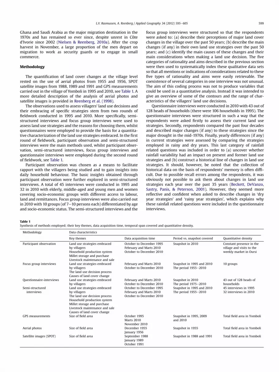
Methodology
The quantification of land cover changes at the village levelrested on the use of aerial photos from 1955 and 1956, SPOTsatellite images from 1988, 1989 and 1991 and GPS measurementscarried out in the village of Yomboli in 1995 and 2010, see Table 1. Amore detailed description of the analysis of aerial photos andsatellite images is provided in Reenberg et al. (1998).
The observations used to assess villagers’ land use decisions andtheir embracing of specific strategies stem from two rounds offieldwork conducted in 1995 and 2010. More specifically, semi-structured interviews and focus group interviews were used toassess land use strategies and the reasons for choosing them, whilstquestionnaires were employed to provide the basis for a quantita-tive characterization of the land use strategies embraced. In the firstround of fieldwork, participant observation and semi-structuredinterviews were the main methods used, whilst participant obser-vation, semi-structured interviews, focus group interviews andquestionnaire interviews were employed during the second roundof fieldwork, see Table 1.
Participant observation was chosen as a means to facilitaterapport with the villagers being studied and to gain insights intodaily household behaviour. The basic insights obtained throughparticipant observation were further explored in semi-structuredinterviews. A total of 45 interviews were conducted in 1995 and32 in 2010 with elderly, middle-aged and young men and womencovering socio-economic groups with different access to labour,land and remittances. Focus group interviews were also carried outin 2010 with 10 groups (of 7e10 persons each) differentiated by ageand socio-economic status. The semi-structured interviews and the
Table 1Synthesis of methods employed; their key themes, data acquisition time, temporal span
Methodology Data characteristics
Key themes Data acquisitio
Participant observation Land use strategies embracedby villagersHousehold production systemMillet storage and purchaseLivestock maintenance and sale
October to DecFebruary and MOctober to Dec
Focus group interviews Land use strategies embracedby villagersThe land use decision processCauses of land cover change
February and MOctober to Dec
Questionnaire-interviews Land use strategies embracedby villagers
February and MOctober to Dec
Semi-structuredinterviews
Land use strategies embracedby villagersThe land use decision processHousehold production systemMillet storage and purchaseLivestock maintenance and saleCauses of land cover change
October to DecFebruary and MOctober to Dec
GPS measurements Size of field area October 1995Marts 2010November 201
Aerial photos Size of field area December 195January 1956
Satellite images (SPOT) Size of field area September 198January 1989October 1991
focus group interviews were structured so that the respondentswere asked to: (a) describe their perceptions of major land coverchanges in the village over the past 50 years; (b) describe the mainchanges (if any) in their own land use strategies over the past 50years; and (c) identify the main causes of these changes and theirmain considerations when making a land use decision. The fivecategories of rationality and aims described in the previous sectionwere then used to systematically index these qualitative data setsso that all mentions or indications of considerations related to thesefive types of rationality and aims were easily retrievable. Thecoexistence of several categories in one interview was not unusual.The aim of this coding process was not to produce variables thatcould be used in a quantitative analysis. Instead it was intended togive an overview of some of the contours and the range of char-acteristics of the villagers’ land use decisions.
Questionnaire interviewswere conducted in 2010with 43 out of128 heads of households (there were 106 households in 1995). Thequestionnaire interviews were structured in such a way that therespondents were asked firstly to assess their current land usestrategies. Secondly, respondents compared the past four decadesand described major changes (if any) to these strategies since themajor drought in the mid-1970s. Finally, yearly differences (if any)in current strategies were assessed by comparing the strategiesemployed in rainy and dry years. This last category of rainfallrelated questions was included in order to (a) uncover whetherrainfall variability had an impact on present and former land usestrategies and (b) construct a historical line of changes in land usestrategies. It should, however, be noted that the collection ofhistorical data on the basis of respondents’ memory is often diffi-cult. Due to possible recall errors among the respondents, it wasobviously not possible to ask them about changes in land usestrategies each year over the past 35 years (Beckett, DeVanzo,Sastry, Panis, & Peterson, 2001). However, they seemed morereflective and confident when asked to describe changes in ‘dryyear strategies’ and ‘rainy year strategies’, which explains whythese rainfall related questions were included in the questionnaireinterviews.
covered and quantitative density.
n time Period vs. snapshot covered Quantitative density
ember 1995arts 2010ember 2010
Snapshot in 2010 Constant presence in thevillage and visits to theweekly market in Oursi
arts 2010ember 2010
Snapshot in 1995 and 2010The period 1955e2010
10 groups
arts 2010ember 2010
Snapshot in 2010The period 1975e2010
43 out of 128 heads ofhouseholds
ember 1995arts 2010ember 2010
Snapshot in 1995 and 2010The period 1955e2010
45 interviews in 199532 interviews in 2010
0
Snapshot in 1995, 2009and 2010
Total field area in Yomboli
5 Snapshot in 1955 Total field area in Yomboli
8 Snapshot in 1988 and 1991 Total field area in Yomboli

L.V. Rasmussen, A. Reenberg / Applied Geography 34 (2012) 595e605600
Results and discussion
Observed land cover changes in Yomboli during the period1956e2010
Fig. 2a and b show the location of the field area within theterritory of Yomboli over the last six decades. A substantial real-location of fields is revealed. From 1956 to 1988 the field areaexpanded, primarily on the dune north of the mare. Yet during thesame period, villagers abandoned southern fields on the pediplain.Since 1991 the location of fields has shifted southwards again andreversed the trend of abandoning the pediplain fields. Villagersexplained the recultivation of the pediplain as being due todifferent yield potentials in different locations with varying rainfallamounts. Since it was impossible to predict the rainfall amount, aswas often mentioned, villagers preferred to sow fields on both thedune and the pediplain. The pediplain fields were most productivein years with adequate rainfall but also had the highest risk ofproduction failure in very dry years, whereas millet cultivated onthe dune was more resistant to low rain. This new flexibility of fieldlocationwaswell demonstrated in themore scattered field patternsin 2009 and 2010 (Fig. 2b).
During the GPS measurements it became clear that the sowedarea differed widely from the field area as villagers in generalpreferred to sow as big an area as possible. In cases of labourshortage they tended to use only the more productive sites withinthe fields, so that instead of leaving a whole field uncultivated theyinvested their labour in small parcels. The practice of sowing allfields implied that fields were permanently sowed and no regular
Fig. 2. Land cover pattern of Yomboli in 1956, 1988, 1991, 1995, 2009 and 2010. Field limimeasurements (1995, 2009 and 2010).
fallow system was observed. Scattered fields have also beenobserved in other Sahelian villages (Graef & Haigis, 2001).
The total field acreage in Yomboli more than doubled from 1956to 1991 (Fig. 3), which corresponded to the immediate expectationsof common responses to population growth. More surprising wasthe reversed trend from 1991. The expansion of the fields stoppedand total field acreage in 2010 was half of what it had been in 1991.In summary, three main waves of land cover changes were thusidentified; (1) A period of land expansion lasting from1956 to 1991;(2) Contraction of the field area during the period 1991e1995; (3) Adecade of fluctuations occurring between 1995 and 2010.
Large scale driving forces during three waves of land cover changes
The main large scale driving forces in Yomboli during the threewaves of land cover changes were explored by drawing on thenotion of multiple exposures (Liechenko & O’Brien, 2010; Reenberg,2009), more specifically, the changes in population pressure,globalization and climate variability.
Although no official demographic statistics were available atvillage level, population growth occurred throughout the period inthe Sahel (Raynaut, 2001). Accordingly, it is reasonable to assumethat this was also the case in Yomboli. In the first wave between1956 and 1991, the rising population was, in fact, considered byvillagers to be the main reason for the field expansion. Villagersemphasized that population growth meant increased householdsize as well as more households in Yomboli. The increased house-hold size was mirrored in the land use pattern by the broadening ofexisting field boundaries (where possible) and cultivation of one or
ts were mapped from aerial photos (1956), satellite images (1988 and 1991), and GPS

0
100
200
300
400
500
600
700
800
1956 1988 1991 1995 2009 2010
Ha
Fig. 3. The total field acreage in Yomboli in 1956, 1988, 1991, 1995, 2009 and 2010. Thefield limits were determined on the basis of interpretation of aerial photos (1956),SPOT satellite images (1988 and 1991) and GPS measurements (1995, 2009 and 2010).
L.V. Rasmussen, A. Reenberg / Applied Geography 34 (2012) 595e605 601
more plots at different locations. The greater number of householdsimplied field expansion on the dune as new households could onlyobtain access to land through the village chief, who allocated smalldune plots, whichwere cleared and used for cultivation. During thisfirst wave of land cover changes, the village of Yomboli was movedfrom the pediplain to the dune in order to reduce the distance towater resources. This happened around 1970. In 1990 the villagewas moved back to the pediplain as it occupied toomuch cultivableland on the dune. However, villagers reported an abundance of landin Yomboli throughout the period.
Whereas the rising population explained most of the fieldexpansion seen between 1956 and 1991, this was not the case in theearly 1990s as continued population growth was accompanied bya declining field area. The average field area per person declinedfrom 0.58 ha in 1995 to 0.33 ha in 2010. Intensification would bea plausible explication for this decline but there was no evidence ofsignificant yield increases or adaptation of new technologies. Onthe contrary, villagers reported declining yields. Although theharvest met only five months (on average) of the households’ foodrequirements even in the rainiest years, villagers did not work theland more intensively by increasing the number of working hoursper person or involving more people. In light of the substantialpopulation growth in Yomboli, allocating more people per hectarewould nevertheless have been a reasonable strategy. These obser-vations implied that field acreage may not be as closely tied topopulation patterns as classical scholars once assumed. Instead,Yomboli seemed to be more influenced by the arrival of develop-ment projects and the construction of a cereal bank promoted byFAO in 1989, which provided villagers with millet on credit or athighly subsidized prices. Such economic changes weremediated byinstitutional factors and policies that were influenced by globalfactors (Lambin et al., 2003). Hence, these new drivers of change,which emerged during the second wave, can be associated with theexposure to globalization. This tendency is also observable in manyother rural communities in the northern Sahel (Atampugre, 1997).
During the third wave of land use changes, villagers emphasizedthe increasing unpredictability of the rainy season. This was
Table 2Land cover trends, individual rationales and aims and main large scale driving forces ap
Period Land cover trends Individual rationalities Indiv
1956e1991 Expansion of field area Economic Opti1991e1995 Contraction of field area Economic Risk
1995e2010 Expansion and contractionof field area
EconomicSociocultural
Risk
confirmed by a rainfall dataset from the meteorological station inGorom-Gorom that showed greater inter-annual rainfall variabilityin the late 1990s and early 2000s, which is a general trend seenelsewhere in the Sahel (Proud & Rasmussen, 2010). Rainfall vari-ability was thus a major concern in this third period. Moreover,population pressure was also a prominent driver of change. Allhouseholds were recorded in 2010, and comparison with pop-ulation enumeration done in 1995 by Reenberg et al. (1998) showedthat Yomboli had had an annual population growth rate of 1.6%since then. It must, however, be emphasized that the collected dataare two snapshots in time that tell us little about the dynamics inthe intervening period. Finally, globalization acted as a driver aswell, as villagers were e.g. highly concerned about varying milletand livestock prices. Out-migration to Abidjan was embraced byvillagers, but it was not a response to scarce land resources assuggested by Bilsborrow and Geores (1994). On the contrary,villagers reported an abundance of land, and it was often statedthat: “the dune is big enough for everybody”.
It should, however, be noted that villagers reported low soilfertility. The land cover changes during this period can thus notonly be ascribed to population pressure.
Shifting rationalities in Yomboli during three waves of land coverchanges?
Table 2 outlines the main large scale driving forces and ratio-nales which have underpinned villagers’ land use decisions duringthe three identified waves of land cover change.
A period of field expansion: 1956e1991It was apparent during the first wave of land cover changes that
individual land use decisions were closely tied to large scale drivingforces. Villagers’ decisions were significantly propelled by pop-ulation growth and the resulting bigger household size. Impor-tantly, household size was mentioned as the major determinant offield size in all of the 32 semi-structured interviews. According tothe villagers, the larger households implied increased foodrequirements as well as additional labour. With increased foodrequirements, villagers became highly focused on securing foodproduction and avoiding dependency on market purchases. Theyclearly expressed that food security was their main objective whencultivating the fields. Despite the fact that food security isincreasingly related to risk minimization in the scientific literature,no villagers thought of the period as a risky and uncertain time.Contrastingly, there had been a stimulus to increase production.This was very surprising as the period included major droughts inthe 1970s and 1980s, but villagers simply did not expect the majordroughts to hit after the relatively wet decades of the 1950s and1960s. The respondents explained that they invested all theirlabour in the fields in order to optimize the millet production.
Moreover, economic rationality may also explain villagers’ landuse decisions. Villagers considered the marginal benefit of addi-tional children. It was for example stated: “In that period morechildren meant more labour; we could cultivate large fields as wewere not hungry and we had to fulfil the food requirements”. Thus,villagers acquired additional land to make sure that child labour
parent in Yomboli during the period 1956e2010.
idual cross-cutting objectives Large scale driving forces
mization: Food security for humans Population growthminimization: Food security for livestock Population growth
Globalizationminimization: Food security for livestock Population growth
Globalization Climatic variability

L.V. Rasmussen, A. Reenberg / Applied Geography 34 (2012) 595e605602
was used as efficiently as possible. They did not enlarge their fieldsin order to manage risks.
A period of field contraction: 1991e1995In the second wave, a cereal bank was constructed in Yomboli,
which provided the villagers with cheap millet. As subsistenceneeds could be secured through the bank, fields were abandoned.The period was characterized by a declining field area, but nohouseholds gave up cereal cultivation altogether. They all main-tained a small cultivated plot on the field. The practice of sustaininga small plot was not related to human food security; villagerswanted to ensure that they had some crop residues as feed forlivestock during the dry season. These findings show that the aim offarming thereby moved beyond food security for the family. Thisshifting objective was expressed by the interviewees in three ways:(1) Cultivating many fields was hard work; it was not worth theeffort when millet could be bought very cheaply; (2) Other sourcesof income became not just increasingly important, but alsoa necessity in this period; (3) Provision of fodder for livestock wasa major concern as one never knew whether there was enough.
The earlier emphasis on fields as providers of millet grains forhuman consumption was replaced by the recognition that fieldshad a dual purpose: they also provided crop residues that could beused for livestock feed. The new perception of crop residues as themost important output and millet grains as a by-product cannot beexplained in solely economic terms. If Nettings’ (1993) argumentthat peasants do not imputewage costs to family labour is accepted,a rough comparison can be made between the economic value of1 hamillet production and 1 ha crop residues without taking labourallocation into account. It should, however, be noted that villagersin fact gain both the value of millet grains and crop residues. Milletyields were in the order of 200e400 kg, which compares fairly wellwith values reported in the literature (Krogh, 1997) and by theagricultural extension office in Gorom-Gorom. As a 100 kg bag ofmillet was said to cost around 15,000e25,000 FCFA in the mid-1990s, the value of 1 ha millet is estimated to be 30,000e100,000FCFA when the reported yield is taken into account. This valuemay then be compared with the price of crop residues from 1 ha,which ranged between 15,000 and 40,000 FCFA. The higher value ofmillet grains indicates that villagers’ preference for crop residuesmight be better explained by the ‘risk minimizing peasant model’than the ‘optimizing peasant model’. The significance of riskminimization was also emphasized in the focus group interviews:with the severe livestock losses during the droughts in mind,a small cultivated plot with crop residues offered some security ina highly risky and uncertain environment for fodder resources.
Although risk minimization underpinned villagers’ land usedecisions, it did not influence their engagement in off-farm activ-ities. The villagers explained that their previous dependency oncultivation had simply been replaced by a dependency on cashincome. Thus, they did not pursue off-farm activities in order tobecome involved in activities with different risk profiles or becauseit was a less risky activity than cultivation. Instead, the argumentseemed to be more closely related to the ‘optimizing peasant’
Table 31995e2010 land use decisions vs. yearly rainfall conditions.
Land use decisions Fraction of villagers taking the decis
Dry years Expansion 7%Decrease 44%No change 49%
Rainy years Expansion 72%Decrease 5%No change 23%
model as villagers explained that they migrated in order to gain‘something’ and that it was more profitable than staying in thevillage. These findings are in conflict with the common image in thescientific literature of West African farmers who minimize risk bydiversifying income through off-farm activities (see e.g. Mortimore& Adams, 2001; Scheffran, Marmer, & Sow, 2012).
As shown above, villagers’ arguments for maintaining a smallcultivated plot were anchored in risk minimization. In contrast,their arguments for the general tendency to abandon fields duringthe period indicated economic rationality e albeit of a differentform than what was seen in the previous period. The previousconsiderations of marginal benefits of additional child labour werenow replaced by a wish to lessen the workload during the growingseason in order to maximize returns from labour investments lateron. Surprisingly, many villagers did not relate the abandoning offields to a “surplus” of labour that potentially could be used forother tasks during the growing season.Within their households thetotal number of labourers engaged in cultivation remained thesame, but each individual worked fewer hours a day and less hardduring each hour. According to the interviewees, the main reasonfor employing this strategy was that it gave them more energy toengage in other activities during the dry season and in agriculturalactivities the following year. Although the abandoning of fieldsindicates economic rationality, it can be questioned whether or notthese land use decisions reflect the ‘optimizing peasant’. One mayargue that the ‘optimizing peasant’ would work during the wholeyear instead of preferring leisure over agricultural work in thegrowing season.
Finally, villagers also mentioned the field location with refer-ence to economical rationality. Recultivation of the dune wasexplained by villagers as a strategy to ensure the best possibleoutcome from their labour input.
A period of field expansion and contraction: 1995e2010During the third wave of land use changes, there was no
tendency to either expand or contract fields. Contrastingly, villagersembraced different land use decisions from year to year. Thequestionnaire interviews revealed that in dry years, 49% of therespondents preferred to keep the field area constant, whilst 44%abandoned their fields (Table 3). The remaining 7% enlarged theirfields. As opposed to dry years, the land use decisions appearedmore uniform in rainy years as there was a clear tendency toenlarge fields (72% of the respondents).
Since some respondents maintained their field area and othersabandoned fields in dry years, the main rationales of each group ofrespondents needed to be explored. The fraction of villagers whomaintained their field area argued that they preferred to stay inYomboli and postpone migration until after the harvest, as theyusually did. But with insufficient rain theywould cultivate less hardand thereby be able to ‘build up energy for the approaching off-farm activities and next years’ agricultural work. As in theprevious period, these considerations about the maximization ofreturns later in the year mirrored economic rationality. However,the villagers also expressed that they prayed for more rain. By
ion Rationalities Cross-cutting rationalities
Economic Risk minimization: Food security for livestockEconomicSociocultural
Risk minimization: Food security for livestock
Sociocultural Risk minimization: Food security for livestock

L.V. Rasmussen, A. Reenberg / Applied Geography 34 (2012) 595e605 603
wishing to stay in Yomboli and cultivate the fields, they signalleda sense of hope and individuality to the other villagers, it was oftenexplained. Thus, to some extent, the villagers responded passivelyto the changing rainfall conditions.
It may be argued that their focus on hope and individualityreflected sociocultural rationality.
When looking at the fraction of villagers who abandoned theirfields, the main rationales at stake were slightly different.Respondents reported that insufficient rain in August wouldprobably ruin the millet plants and it was therefore not worth theeffort to continue the hard agricultural work. They could just aswell abandon the fields and leave for labour migration before theharvest. These villagers also pieced together their decisions byincorporating thoughts on the economic feasibility of theiractions. These arguments resembled the reasons for abandoningfields that were put forward in the second period of land usechanges.
Turning to the rainy years, the tendency to expand field acreagewas driven by reasons of prestige and may thus be associated withsociocultural rationality. A large well-cultivated field and moreimportantly, a big harvest showed superiority to neighbouringhouseholds, the villagers explained. Surprisingly, this was the soleargument mentioned for field enlargements. This finding runscontrary to common expectations of field expansion as a responseto population pressure, low yields or as an individual decision takento maximize profit. Importantly, villagers seemed more eager toemphasize the prestige and status they would gain if they were notforced to sell livestock in order to buy food. They were fully awarethat this was probably not the most profitable labour investment,but as it enabled them to gain this prestige, it was the preferredstrategy.
Similarly to the previous period and in dry as well as rainy years,all respondents emphasized the value of crop residues. Theirargument for doing so was likewise the same: ‘it is necessary intimes with uncertain fodder conditions’. Accordingly, the riskminimizing peasant model most likely explains the maintenance ofsmall cultivated fields, while the engagement in off-farm activitiesshould instead be attributed to the optimizing peasant model.
It should, however, be noted that the division into dry year landuse decisions and rainy year land use decisions became moreblurred if the previous year had been very dry. This was for exampleseen in 2009 and 2010. As 2010 was a rainy year, agriculturalexpansion was expected to take place. But due to very dry condi-tions in 2009, many youngmenwere forced to go on transhumancetowards Mali and Niger in order to find pasture and water for theanimals. The extremely dry conditions triggered lengthening ofboth routes and duration, and the men stayed away for longer anddid not return until AugusteSeptember the following year. Hence,there was a lack of labour in Yomboli in 2010, especially during thelabour-intensive weeding. This constrained the possibilities of fieldenlargements despite the good rain. In addition, villagers empha-sized that when the animals had been away for so long, fields werenot properly supplied with manure and it was thus not worth theeffort to cultivate. These conditions reflect a situation in which theinfluence from a single driver, a drought, has overruled the usualtendency to make individual land use decisions anchored insociocultural rationality in rainy years.
Conclusion
The common views of Sahelian field expansion triggered bypopulation growth fail to account for the rationales in villagers’land use decisions. This paper goes beyond that notion by sug-gesting a framework that takes the individual land use agent intoaccount. Three waves of land cover changes were identified in
Yomboli: field expansion between 1956 and 1991; field contractionfrom 1991 to 1995; and field expansion and contraction between1995 and 2010. This provided a basis for an analysis of the linksbetween large scale drivers, individual land use decisions and theresulting land cover changes, as well as an exploration of possibleshifts in those links.
Four main conclusions can be derived from the empirical find-ings of this study:
1. Villagers’ decisions on field size were not based solely oneconomic judgements of cost and benefit. On the contrary, landuse decisions were anchored in two broad rationality cate-gories: economic and sociocultural rationality. Surprisingly,ecological rationality was not prominent.
2. The influence from different rationalities has shifted during thethree waves. Economic rationality underpinned individual landuse decisions during the first two waves of land cover changes,but it was accompanied by sociocultural rationality in the thirdwave.
3. The aim of farming moved beyond food production during thesecond wave as fodder security for livestock overruled theimportance of food security for humans. Villagers do notintensify crop production, and it has been shown that theyminimize risk by maintaining a small field with crop residues.Contrastingly, the engagement in off-farm activities is notexplained by risk minimization. The common image in thescientific literature of West African farmers who minimize riskby diversifying income through off-farm activities may thus bemisleading.
4. The interplay between large scale driving forces, individualland use decisions and the resulting land cover changes hasbeen altered. Earlier land cover changes were primarilypropelled by the driver of population growth, whilst recentland cover changes seem to be more influenced by individualrationales than by large scale driving forces. For example, fieldexpansion during the last decade was undertaken for indi-vidual reasons of prestige rather than influenced by populationgrowth and globalization.
In light of the results obtained, this work calls for a refined focuson the reconciliation of large scale driving forces, individual landuse decisions and the resulting land cover changes. The resultsshow that by including the ultimate agents of land use change, theindividuals, in the analysis, we may enhance our understanding ofland cover changes in the Sahel. Acknowledging this must thus bea first step for researchers if Sahelian land cover changes are to befully understood. Moreover, the results have some important policyimplications. Possible interventions should recognize that duringthe last decade there has been a shift in the rationales thatunderpin villagers’ land use decisions. Thus, field expansion asa strategy to enhance food security for humans must not unre-servedly be assumed to be the most prominent characteristic ofSahelian villagers.
Acknowledgements
The field research was funded by a grant from the DANIDA-FFU,09-001KU, and contributes to the ERC project Waterworlds. Thestudy was part of the project: A region wide assessment of landsystem resilience and climate robustness in the agricultural front-line of Sahel (LASYRE). Detailed information on scientific coordi-nation and funding is available on the LASYRE web site: http://www.lasyre.dk. We thank the villagers of Yomboli. Very helpfulcomments given by two anonymous reviewers are gratefullyacknowledged.

L.V. Rasmussen, A. Reenberg / Applied Geography 34 (2012) 595e605604
References
Abdoulaye, T., & Sanders, J. H. (2006). New technologies, marketing strategies andpublic policy for traditional food crops: millet in Niger. Agricultural Systems, 90,272e292.
Adger, N., Agrawala, S., Mirza, M. M. Q., Conde, C., O’Brien, K., Pulhin, J., et al. (2007).Assessment of adaptation practices, options, constraints and capacity. InM. L. Parry, O. F. Canziani, J. P. Palutikof, P. J. van der Linden, & C. E. Hanson(Eds.), Climate change 2007: Impacts, adaptation and vulnerability. Contribution ofworking group II to the fourth assessment report of the intergovernmental panel onclimate change (pp. 717e743). Cambridge: Cambridge University Press.
Atampugre, N. (1997). Aid, NGOs and grassroots development: Northern BurkinaFaso. Review of African Political Economy, 24, 57e73.
Bates, R.H. (1976).Rural responses to industrialization. NewHaven:YaleUniversityPress.Batterbury, S., & Warren, A. (2001). The African Sahel 25 years after the great
drought: assessing progress and moving towards new agendas and approaches.Global Environmental Change-Human and Policy Dimensions, 11, 1e8.
Beckett, M., DeVanzo, J., Sastry, N., Panis, C., & Peterson, C. (2001). The quality ofretrospective dataean examination of long-term recall in a developing country.Journal of Human Resources, 36, 593e625.
Berry, S. (1993). No condition is permanent. The social dynamics of agrarian change insub-Saharan Africa. The University of Wisconsin Press.
Bilsborrow, R. E., & Geores, M. (1994). Population change and agricultural intensi-fication in developing countries. In L. Arizpe, M. P. Stone, & D. C. Major (Eds.),Population and environments. Rethinking the debate (pp. 171e207). Boulder:Westview Press.
Birch-Thomsen, T., Reenberg, A., Mertz, O., & Fog, B. (2010). Continuity and change:spatiotemporal land use dynamics on Bellona Island, Solomon Islands.Singapore Journal of Tropical Geography, 31, 27e40.
Blaikie, P., Brown, K., Stocking, M., Tang, L., Dixon, P., & Sillitoe, P. (1997). Knowledgein action: local knowledge as a development resource and barriers to itsincorporation in natural resource research and development. AgriculturalSystems, 55, 217e237.
Boserup, E. (1965). The conditions of agricultural growth. London: Earthscan Publi-cations Ltd.
Boserup, E. (1975). The impact of population growth on agricultural output. TheQuarterly Journal of Economics, 89, 257e270.
van den Breemer, J. P. M., Drijver, C. A., & Venema, L. B. (1995). Local resourcemanagement in Africa. Chichester: John Wiley.
Brookfield, H. (2001). Intensification, and alternative approaches to agriculturalchange. Asia Pacific Viewpoint, 42, 181e192.
Chayanov, A. (1966). The theory of the peasant economy. Homewood, Illinois: Irwin/American Economics Association.
Claude, J., Grouzis, M., Milleville, P., Fauck, R., Chevallier, P., Langlois, M., et al. (1991).Un espace sahelien: la mare d’Oursi, Burkina Faso (1st ed.). Paris: ORSTOM.
Cleveland, D., & Soleri, D. (2007). Farmer knowledge and scientist knowledge insustainable agricultural development: ontology, epistemology and praxis. InP. Sillitoe (Ed.), Local science vs global science. Approaches to indigenous knowl-edge in international development. Berghahn Books.
Ellis, F. (1988). Peasant economics. Farm households and agrarian development.Cambridge: Cambridge University Press.
Geist, H. J. (2006). Our earth’s changing land: An encyclopedia of land-use and land-cover change. Greenwood Press.
Geist, H. J., & Lambin, E. F. (2002). Proximate causes and underlying driving forces oftropical deforestation. BioScience, 52, 143e150.
GLP. (2005). Science plan and implementation strategy. IGBP Report No.53/IHDPReport No.19. Stockholm: IGBP Secretariat.
Graef, F., & Haigis, J. (2001). Spatial and temporal rainfall variability in the Sahel andits effects on farmers’ management strategies. Journal of Arid Environments, 48,221e231.
Kiome, R. M., & Stocking, M. (1995). Rationality of farmer perception of soil erosion:the effectiveness of soil conservation in semi-arid Kenya. Global EnvironmentalChange, 5, 281e295.
Kremer, A. R., & Lock, C. (1993). Where food is capital: labour allocation in cerealsproduction, N.W. Mali. Agricultural Systems, 41, 197e213.
Krogh, L. (1997). Field and village nutrient balances in millet cultivation in northernBurkina Faso: a village case study. Journal of Arid Environments, 35, 147e159.
Kull, C. A. (1998). Leimavo revisited: agrarian land-use change in the highlands ofMadagascar. Professional Geographer, 50, 163e176.
Lambin, E. F., & Geist, H. J. (2006). Land-use and land-cover change. Local processesand global impacts. Berlin: Springer.
Lambin, E. F., Geist, H. J., & Ellis, E. (2007). Causes of land-use and land-coverchange. In C. J. Cleveland (Ed.), Encyclopedia of earth. Washington D.C: Envi-ronmental Information Coalition, National Council for Science and theEnvironment.
Lambin, E. F., Geist, H. J., & Lepers, E. (2003). Dynamics of land-use and land-coverchange in tropical regions. Annual Review of Environment and Resources, 28,205e241.
Liechenko, R., & O’Brien, K. L. (2010). Environmental change and globalization: Doubleexposures. Oxford: University Press.
Lipton, M. (1968). The theory of the optimising peasant 1. Journal of DevelopmentStudies, 4, 327e351.
McCauley, J. F. (2003). Plowing ahead: the effects of agricultural mechanization onland tenure in Burkina Faso. Journal of Public and International Affairs, 14, 2e27.
Malthus, T. R. (1970). An essay on the principle pf population (1798) and a summaryview of the principle of population (1830). London: Penguin Books.
Mazzucato, V., & Niemeijer, D. (2002). Population growth and the environment inAfrica: local informal institutions, the missing link. Economic Geography, 78,171e193.
Mena, C. F., Walsh, S. J., Frizzelle, B. G., Xiaozheng, Y., & Malanson, G. P. (2011). Landuse change on household farms in the Ecuadorian Amazon: design andimplementation of an agent-based model. Applied Geography, 31, 210e222.
Mendola, M. (2005). Farm household production theories: a review of ‘institutional’and ‘behavioural’ responses. Asian Development Review, 24, 49e68.
Miller, D., Schwarz, G., Sutherland, L.-A., Morrice, J., Aspinall, R., Barnes, A., et al.(2009). Changing land use in rural ScotlandeDrivers and decision-making. Scot-tish Government.
Mortimore, M. (2006). What are the issues? Have the issues changed? InM. Møllegaard (Ed.), Natural resource management in SaheleLessons learnt.Proceedings of the 17th Danish Sahel Workshop, 6e7 November 2006 (pp. 10e18)Copenhagen: ReNED.
Mortimore, M. J., & Adams, W. M. (2001). Farmer adaptation, change and ‘crisis’ inthe Sahel. Global Environmental Change, 11, 49e57.
Netting, R. M. (1993). Smallholder, householders. Farm families and the ecology ofintensive, sustainable agriculture. Stanford: Stanford University Press.
Netting, R. M., Stone, G. D., & Stone, M. P. (1993). Agricultural expansion, intesni-fication, and market participation among the Kofyar, Jos Plateau, Nigeria. InB. L. Turner, II, G. Hyden, & R. W. Kates (Eds.), Population growth and agriculturalchange in Africa. Gainesville: University Press of Florida.
Nielsen, J. O., & Reenberg, A. (2010a). Cultural barriers to climate change adaptation:a case study from Northern Burkina Faso. Global Environmental Change-Humanand Policy Dimensions, 20, 142e152.
Nielsen, J. O., & Reenberg, A. (2010b). Temporality and the problem with singlingout climate as a current driver of change in a small West African village. Journalof Arid Environments, 74, 464e474.
Olsson, L., Eklundh, L., & Ardo, J. (2005). A recent greening of the Saheletrends,patterns and potential causes. Journal of Arid Environments, 63, 556e566.
Ouedraogo, H. M. G. (2005). The land policy process in Burkina: Experience in buildinga national consensus on access to land. LandNet West Africa ANGOC & ILC.
PANA du Burkina Faso. (2007). Programme National d’adaptation de la variabilité etaux changements climatiques. Burkina Faso: Ministère de l’environment et ducadre du vie.
Petit, S. (2003). Parklands with fodder trees: a Fulbe response to environmental andsocial changes. Applied Geography, 23, 205e225.
Pred, A. (1967). Behavior and location. Foundations for a geographic and dynamiclocation theory. Lund: C.W.K. Gleerup.
Proud, S. R., & Rasmussen, L. V. (2010). The influence of seasonal rainfall upon Sahelvegetation. Remote Sensing Letters, 2, 241e249.
Rappaport, R. A. (1971). The flow of energy in an agricultural society. ScientificAmerican, 225, 116e136.
Rasmussen, L. V., Rasmussen, K., Reenberg, A., & Proud, S. (2012). A systemdynamics approach to land use changes in agro-pastoral systems on the desertmargins of Sahel. Agricultural Systems, 107, 56e64.
Rasmussen, L. V., & Reenberg, A. (2012). Collapse and recovery in Sahelian agro-pastoral systems: rethinking trajectories of change. Ecology and Society, 17(1).
Raynaut, C. (2001). Societies and nature in the Sahel: ecological diversity and socialdynamics. Global Environmental Change-Human and Policy Dimensions, 11, 9e18.
Reenberg, A. (2009). Embedded flexibility in coupled human-environmentalsystems in the Sahel: talking about resilience. In K. Hastrup (Ed.), The ques-tion of resilience. Social response to climate change (pp. 132e158).
Reenberg, A., Nielsen, T. L., & Rasmussen, K. (1998). Field expansion and reallocationin the Saheleland use pattern dynamics in a fluctuating biophysical and socio-economic environment. Global Environmental Change, 8, 309e327.
Reynolds, J. F., Smith, D. M. S., Lambin, E. F., Turner, B. L., II, Mortimore, M.,Batterbury, S. P. J., et al. (2007). Global desertification: building a science fordryland development. Science, 316, 847e851.
Richards, P. (1985). Indigenous agricultural revolution. London: Hutchinson.Rinku, R. C. (2006). Landscape change in the Calakmul Biosphere Reserve, Mexico:
modeling the driving forces of smallholder deforestation in land parcels.Applied geography, 26, 129e152.
Robinson, G. (2004). Geographies of agriculture. Globalisation, restructuring andsustainability. Pearson, Prentice Hall.
Roy Chowdhury, R. (2010). Differentiation and concordance in smallholder land usestrategies in southern Mexico’s conservation frontier. Proceedings of theNational Academy of Sciences, 107, 5780e5785.
Roy Chowdhury, R., & Moran, E. F. (2012). Turning the curve: a critical review ofKuznets approaches. Applied Geography, 32, 3e11.
Roy Chowdhury, R., & Turner, B. L. (2006). Reconciling agency and structure inempirical analysis: smallholder land use in the Southern Yucatan, Mexico.Annals of the Association of American Geographers, 96, 302e322.
Scheffran, J., Marmer, E., & Sow, P. (2012). Migration as a contribution to resilienceand innovation in climate adaptation: social networks and co-development inNorthwest Africa. Applied Geography, 33, 119e127.
Schultz, T. W. (1964). Transforming traditional agriculture. New Haven: YaleUniversity Press.
Scoones, I., & Toulmin, C. (1995). Socio-economic dimensions of nutrient cycling inagropastoral systems in dryland Africa. In J. M. Powell (Ed.), Livestock andsustainable nutrient cycling in mixed farming systems of sub-Saharan Africa (pp.353e369). ILCA.

L.V. Rasmussen, A. Reenberg / Applied Geography 34 (2012) 595e605 605
Simon, H. (1982). Models of bounded rationality. Cambridge, MA: MIT Press.Snyder, K. A. (1996). Agrarian change and land-use strategies among Iraqw farmers
in northern Tanzania. Human Ecology, 24, 315e340.Stein, H., & Wilson, E. J. (1993). The political economy of Robert Bates:
a critical reading of rational choice in Africa. World Development, 21,1035e1053.
Stephenne, N., & Lambin, E. F. (2001). A dynamic simulation model of land-usechanges in Sudano-sahelian countries of Africa (SALU). Agriculture Ecosystems& Environment, 85, 145e161.
Stone, G. D. (2001). Theory of the square chicken: advances in agricultural inten-sification theory. Asia Pacific Viewpoint, 42, 163e180.
Strauss, K. (2008). Re-engaging with rationality in economic geography: behav-ioural approaches and the importance of context in decision-making. Journal ofEconomic Geography, 8, 137e156.
Thomas, D. S. G., & Sporton, D. (1997). Understanding the dynamics of social andenvironmental variability: the impacts of structural land use change on the
environment and peoples of the Kalahari, Botswana. Applied Geography, 17,11e27.
Toledo, V. M. (1990). The ecological rationality of peasant production. InM. A. Altieri, & S. B. Hecht (Eds.), Agroecology and small farm development (pp.53e60). Boca Raton: CRC Press.
Turner, B. L., & Fischer-Kowalski, M. (2010). Ester Boserup: an interdisciplinaryvisionary relevant for sustainability. Proceedings of the National Academy ofSciences, 107, 21963e21965.
Turner, B. L., Lambin, E. F., & Reenberg, A. (2007). Land change science specialfeature: the emergence of land change science for global environmental changeand sustainability. Proceedings of the National Academy of Sciences of the UnitedStates of America, 105, 20666e20671.
Vanclay, J. K. (1993). Saving the tropical forest: needs and prognosis. AMBIO, 22,225e231.
White, G. F. (1961). The choice of use in resource-management. Natural ResourcesJournal, 1, 23e40.


