Embed Size (px)
Citation preview
A S O C I A Ţ I A G E O M O R F O L O G I L O R D I N R O M Â N I A
REVISTA DE GEOMORFOLOGIE
16
2 0 1 4
REVISTA DE GEOMORFOLOGIE / JOURNAL OF GEOMORPHOLOGY
Editori/Editors: Prof. univ. dr. Petru URDEA – Președintele A.G.R., Universitatea de Vest, Timișoara
Prof. univ. dr. Florina GRECU – Universitatea din București
Colegiul de redacţie/Editorial board:
Prof. dr. Iuliana ARMAȘ, Universitatea din Bucureşti
Dr. Lucian BADEA, Institutul de Geografie, Bucureşti
Prof. dr. Dan BĂLTEANU, Universitatea din Bucureşti
Prof. dr. Chaonki BENABBAS, Universitatea Constantine, Algeria
Prof. dr. Costică BRÂNDUŞ, Universitatea „Ştefan cel Mare”, Suceava
Prof. dr. Doriano CASTALDINI, Universitatea din Modena, Italia
Prof. dr. Bogdan MIHAI, Universitatea din Bucureşti
Conf. dr. Noômène FEHRI, Universitatea de la Manouba, Tunisie
Prof. dr. Morgan de DAPPER, Universitatea din Gand, Belgia
Prof. dr. Francesco DRAMIS, Universitatea Roma 3, Roma, Italia
Prof. dr. Eric FOUACHE, Universitatea Paris, Sorbonne, Franţa
Prof. dr. Paolo Roberto FEDERICI, Universitatea din Pisa, Italia
Prof. dr. Mihai IELENICZ, Universitatea din Bucureşti
Prof. dr. Ion IONIŢĂ, Universitatea „Al. I. Cuza”, Iaşi
Prof. dr. Aurel IRIMUŞ, Universitatea „Babeş-Bolyai”, CIuj-Napoca
Prof. dr. Nicolae JOSAN, Universitatea din Oradea
Prof. dr. Ion MAC, Universitatea „Babeş-Bolyai”, Cluj-Napoca
Prof. dr. Kosmas PAVLOPOULOS, Universitatea din Atena, Grecia
Prof. dr. Dan PETREA, Universitatea „Babeş-Bolyai”, Cluj-Napoca
Prof. dr. docent Grigore POSEA, Universitatea „Spiru Haret”, Bucureşti
Prof. dr. Ioan POVARĂ, Institutul de Speologie, Bucureşti
Prof. dr. Maria RĂDOANE, Universitatea „Ştefan cel Mare” Suceava
Prof. dr. Nicolae RĂDOANE, Universitatea „Ştefan cel Mare”, Suceava
Prof. dr. Contantin RUSU, Universitatea „Al. I. Cuza”, Iaşi
Dr. Maria SANDU, Institutul de Geografie, Bucureşti
Prof. dr. Victor SOROCOVSCHI, Universitatea „Babeş-Bolyai”, Cluj-Napoca
Prof. dr. Leonidas STAMATOPOULOS, Universitatea din Patras, Grecia
Prof. dr. Virgil SURDEANU, Universitatea „Babeş-Bolyai”, Cluj-Napoca
Prof. dr. Emil VESPREMEANU, Universitatea din Bucureşti
Colectivul de editare/Editorial Team (Vol. 16/2014)
Florina GRECU (redactor şef / Editor-in-Chief), Marta JURCHESCU (redactor şef adjunct / Vice Editor-in-Chief), Gabriela
IOANA-TOROIMAC (redactor şef adjunct / Vice Editor-in-Chief), Nicolae CRUCERU (secretar de redacţie / Editorial Secretary),
Iuliana ARMAŞ, Sandu BOENGIU, Roxana CUCULICI, Robert DOBRE, Carmen DRAGOTĂ, Dorina ILIEŞ, Oana IONUŞ,
Daniel IOSIF, Ioan-Aurel IRIMUŞ, Anca MUNTEANU, Olimpiu POP, Mircea VOICULESCU, Liliana ZAHARIA
Şos. Panduri, 90-92, Bucureşti – 050663, România,
Telefon/Fax: (0040) 021.410.23.84, E-mail: [email protected],
Librărie online: http://librărie-unibuc.ro,
Centrul de vânzare: Bd. Regina Elisabeta, nr. 4-12, Bucureşti,
Tel. (0040) 021.314.35.08/2125, Web: www.edit.unibuc.ro
Tehnoredactare: Meri Pogonariu
Coperta: Nicolae Cruceru, Meri Pogonariu
ISSN 1453-5068
REVISTA DE GEOMORFOLOGIE/
JOURNAL OF GEOMORPHOLOGY
VOL. 16 2014
C U P R I N S / C O N T E N T S
Ar t i c o l e / P ape r s
Florina GRECU, Gabriela IOANA-TOROIMAC, Paola MOLIN, Francesco DRAMIS
River channel dynamics in the contact area between the Romanian Plain and the Curvature
Subcarpathians / 5
Roxana VĂIDEAN, Dănuţ PETREA Dendrogeomorphological reconstruction of past debris flow activity along a forested torrent
(Retezat Mountains) / 17
Abdelkader ABDELLAOUI, Rongying LAI, Mostafia BOUGHALEM
GEMAS : une application Visual C# pour la gestion automatisée du découpage de l’espace
en mailles régulières géoréférencées / 25
Andreea Maria VÂTCA, Ioan Aurel IRIMUŞ, Sanda ROŞCA
Landslide susceptibility in Zalău Municipality / 37
Laurenţiu ARTUGYAN, Petru URDEA
Using Spontaneous Potential (SP) as a Geophysical Method for Karst Terrains Investigation
in Mărghitaş Plateau (Banat Mountains, Romania) / 45
Costică BRÂNDUŞ, Claudiu GAMAN
Aspects regarding the evolution of slope processes in the Izvoru Alb – Bicaz territory
(Neamţ County) during 2005 – 2014. / 55
Mirela VASILE, Alfred VESPREMEANU-STROE, Răzvan POPESCU
Air versus ground temperature data in the evaluation of frost weathering and ground
freezing. Examples from the Romanian Carpathians / 61
Mostafia BOUGHALEM, Abdelkader ABDELLAOUI, Kacem MOUSSA
Variabilité spatiale de l'infiltrabilité sur les versants marneux de l’Isser-Tlemcen (Algérie) / 71
Remus PRĂVĂLIE, Romulus COSTACHE
The potential of water erosion in Slănic River basin / 79
4
Brahim NOUIBAT, Ali REDJEM, Florina GRECU
Analysis of natural hazards in urban areas: The city of Bou Saada as a case study in Algeria
/ 89
Vasile LOGHIN, George MURĂTOREANU, Eduard PĂUNESCU
Geomorphosites in the Ialomiţa Subcarpathians / 99
Miscellanea
Le XXXe Colloque National de Géomorphologie. Relevance de la géomorphologie pour la
société: réalisations et perspectives, Orşova, le 29-31 Mai 2014
(Daniel IOSIF) / 107
17th Joint Geomorphological Meeting “The geomorphology of natural hazards: mapping,
analysis and prevention”, Liege, June 30 – July 3, 2014
(Anca MUNTEANU) / 109
2nd International Conference "Water resources and wetlands", September 11-13, 2014
Tulcea (Romania)
(Gabriela IOANA-TOROIMAC) / 111
International Symposium on SEASONAL SNOW AND ICE, Lahti, Finland, 28 May–1 June
2012
(Anca MUNTEANU) / 112
Recenzii / Reviews
Virgil GÂRBACEA (2013) – Relieful de glimee, Presa Universitară Clujeană (Florina
GRECU) / 113
Revista de geomorfologie vol. 16, 2014, pp. 37-44
Landslide susceptibility in Zalău Municipality
Andreea Maria VÂTCA, Ioan Aurel IRIMUŞ, Sanda ROŞCA
Abstract. Due to the city’s geographical context and human intervention, landslides occur in Zalău Municipality on
extended areas. With a medium reactivation potential, some of these processes repeatedly affect dwellings, elements of
infrastructure or agricultural terrains. The main purpose of this paper is to identify and locate the landslide prone areas
from Zalău based on the landslide susceptibility assessment performed with the help of the semi-quantitative method
included in the Governmental Decision 447/2003 – Mapping methodology and content of landslide and flood risk maps.
The estimation of the value and the geographical distribution for each susceptibility coefficient was performed
separately for the lithologic, geomorphologic, structural, hydrologic and climatic, hydrogeologic, seismic, sylvic and
anthropic factors. Using GIS techniques, the thematic maps representing the contribution of each factor to landslide
occurrence and evolution were used to determine the map of average susceptibility coefficient. The validation was
achieved by comparing the results with the location of active landslides identified in the field and through cartographic
analysis of topographic maps and satellite images. Identifying landslide prone areas is a necessary stage in the process
of landslide prevention and mitigation of negative effects.
Keywords: landslide, susceptibility, Zalău, GIS, validation rate
1. Introduction
Landslides are mass movement processes affecting
the stability of slopes and included in the category
of geomorphologic hazards. In Zalău municipality
there are both areas affected by landslides and areas
susceptible to landslide activity. The landslide
causes in this urban area are related both to natural
processes and anthropic activities.
2. Data and methodology
The objectives of this paper are represented by
landslide identification and landslide susceptibility
mapping in Zalău built-up area, using the semi-
quantitative method described by the legislative
document H.G. 447/2003 and GIS techniques.
Several thematic maps were created considering
the landslide susceptibility coefficients and the
contribution of each factor to landslide activation
and evolution led to the final map of the average
hazard coefficient.
Susceptibility refers to spatial probability or to
what extent a territory is prone to a specific extreme
phenomenon and is based on the presence of a set of
known causing factors or the history of events
affecting a specific area (Crozier & Glade, 2005,
Irimuş et al, 2005, Rădoane & Rădoane, 2006). It
can be represented through various classes
describing the occurrence probability which
characterises a specific territory (Surdeanu, 1998,
Irimuş, 2006, Măguţ, 2013).
The susceptibility assessment of any process can
be performed by applying a variety of spatial
analysis models using GIS techniques, which
statistically or heuristically combine causing factors
represented through thematic maps and the map
describing the spatial distribution of the analysed
process (Fabbri et al., 2003; Guzzetti et al., 2006;
Rossi et al., 2009; Kouli et al., 2010 cited by Măguţ,
2013). This can also be achieved directly through
expert opinion, when experts use mapped
inventories of the process or previous knowledge
related to causing factors and the studied area in
order to delineate hazard zones (Van Westen et al.,
1999; Cardinali et al., 2002, cited by Măguţ, 2013,
Fell et al., 2008, Petrea et al., 2014).
Landslide susceptibility research has recently
been represented by a series of scientific papers
applying this type of analysis among which Manea
& Surdeanu (2012) and Măguţ et al. (2012) have
analysed the landslide susceptibility at administrative
level.
The landslide susceptibility assessment was done
using the semi-quantitative method described in the
Romanian legislation H.G. 447/2003 – Mapping
methodology and content of landslide and flood risk
Andreea Maria VÂTCA, Ioan Aurel IRIMUŞ & Sanda ROŞCA
38
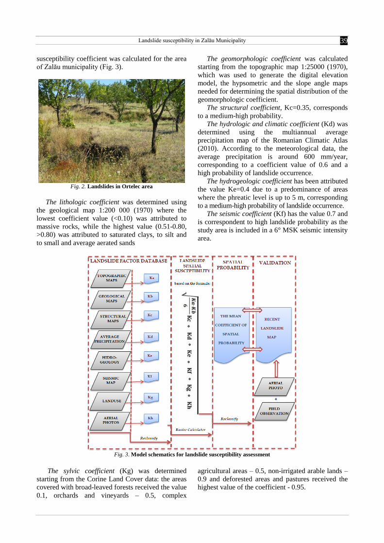
maps, including a series of work stages illustrated in
Figure 3: data base generation for the landslide
susceptibility coefficients, susceptibility assessment
and validation of results using the map of active
landslides.
Using GIS techniques, the thematic maps
representing the contribution of each factor
(coefficient) to landslide activation and evolution
were generated. The estimation of value and spatial
distribution of each coefficient was made
individually for the lithologic, geomorphologic,
structural, hydrologic and climatic, hydrogeologic,
seismic, sylvic and anthropic factors. These were
eventually used to generate the map of the average
hazard coefficient.
3. Results and discussion
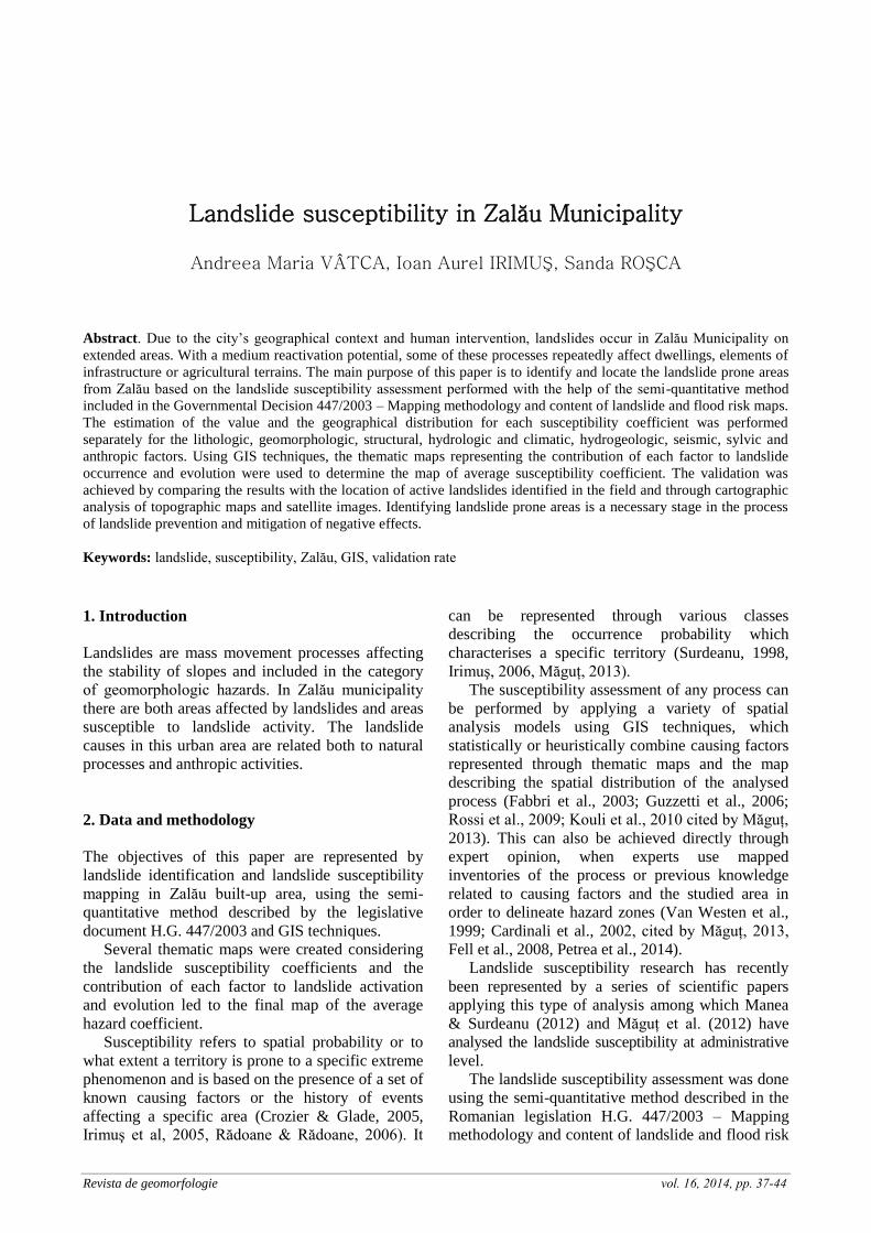
Zalău Municipality, the capital city of Sălaj County,
is located at the contact of the Meseş Mountains
with Silvaniei Hills in the southern part of the Zalău
Depression (Fig.1). The administrative territory of
Zalău has a total area of 90.09 km², including the
settlement Stâna which is located south-eastern from
the Meseş (Nicoară & Puşcaş, 1999). The
municipality is limited to the south-east by the steep
slope of Măgura Stânii (716 m), to the east by
Peringaru Hill, to the north by Ceacău Hill (410 m),
to the south-west by Labului Hill (403 m) and to the
west by Zalău Vest Hill (400 m).
Fig. 1. Geographic location of study area
The study area has the form of a depression
which is crossed from south to north by the Zalău
River. The territory on the right side of the valley
includes the north-western steep slopes of the Meseş
with streams cutting down into friable Neogene
sediments. The territory on the left side of the Zalău
Valley has a wavy landscape with rounded hills
being fragmented by streams with longitudinal profiles
having a smaller slope angle (Popşe et al., 2010).
The fluvial topography, which includes
floodplains, terraces and alluvial fans, is
characterised by sedimentary formations found on
vast areas. These are represented by marls, sand and
gravel, with local clays, conglomerates and
sandstones. All these sediments are
geomorphologically susceptible to downslope
movement through landslide processes. The slopes
flanking the Zalău River and its tributaries have
been constantly being affected by gravitational
processes, including landslides (Mac and Hosu,
2010).
The cause leading to landslide activation in
Zalău Municipality is related both to natural
conditions and anthropic activities. Thus, one of the
areas affected by landslides is the neighbourhood
Ortelec. The landslide causing factors in this area
are represented by water accumulation in the clay
strata as well as the clay exploitation performed by
SC Cemacon SA. Although a variety of measures
have been undertaken over the years, including
giving up the water pipe of the water distributor SC
Publiserv SA, the building of taluses by Cemacon,
these were not able to prevent a landslide affecting
10 Ha. This landslide caused damages to the road
(Porolissum Street) connecting Zalău and Ortelec
(DJ 191C) and the water tanks used for supplying
the neighbourhoods Brădet and Stadion (Fig. 2).
3.1 Susceptibility coefficients
Using the method described in the H.G. 447/2003
and the factorial coefficients, the average
Landslide susceptibility in Zalău Municipality
39
susceptibility coefficient was calculated for the area
of Zalău municipality (Fig. 3).
Fig. 2. Landslides in Ortelec area
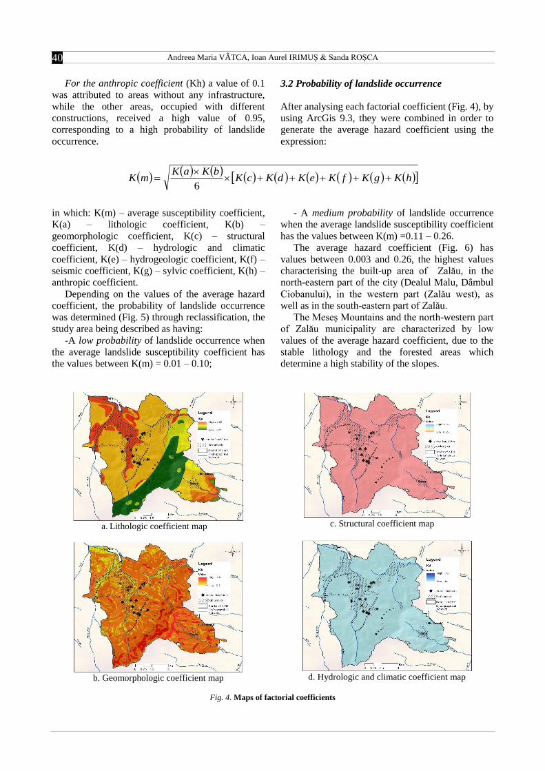
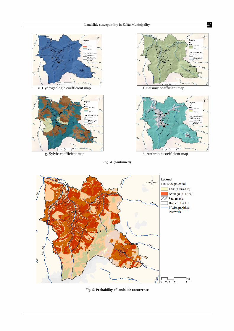
The lithologic coefficient was determined using
the geological map 1:200 000 (1970) where the
lowest coefficient value (<0.10) was attributed to
massive rocks, while the highest value (0.51-0.80,
>0.80) was attributed to saturated clays, to silt and
to small and average aerated sands
The geomorphologic coefficient was calculated
starting from the topographic map 1:25000 (1970),
which was used to generate the digital elevation
model, the hypsometric and the slope angle maps
needed for determining the spatial distribution of the
geomorphologic coefficient.
The structural coefficient, Kc=0.35, corresponds
to a medium-high probability.
The hydrologic and climatic coefficient (Kd) was
determined using the multiannual average
precipitation map of the Romanian Climatic Atlas
(2010). According to the meteorological data, the
average precipitation is around 600 mm/year,
corresponding to a coefficient value of 0.6 and a
high probability of landslide occurrence.
The hydrogeologic coefficient has been attributed
the value Ke=0.4 due to a predominance of areas
where the phreatic level is up to 5 m, corresponding
to a medium-high probability of landslide occurrence.
The seismic coefficient (Kf) has the value 0.7 and
is correspondent to high landslide probability as the
study area is included in a 6° MSK seismic intensity
area.
Fig. 3. Model schematics for landslide susceptibility assessment
The sylvic coefficient (Kg) was determined
starting from the Corine Land Cover data: the areas
covered with broad-leaved forests received the value
0.1, orchards and vineyards – 0.5, complex
agricultural areas – 0.5, non-irrigated arable lands –
0.9 and deforested areas and pastures received the
highest value of the coefficient - 0.95.
Andreea Maria VÂTCA, Ioan Aurel IRIMUŞ & Sanda ROŞCA
40
For the anthropic coefficient (Kh) a value of 0.1
was attributed to areas without any infrastructure,
while the other areas, occupied with different
constructions, received a high value of 0.95,
corresponding to a high probability of landslide
occurrence.
3.2 Probability of landslide occurrence
After analysing each factorial coefficient (Fig. 4), by
using ArcGis 9.3, they were combined in order to
generate the average hazard coefficient using the
expression:
in which: K(m) – average susceptibility coefficient,
K(a) – lithologic coefficient, K(b) –
geomorphologic coefficient, K(c) – structural
coefficient, K(d) – hydrologic and climatic
coefficient, K(e) – hydrogeologic coefficient, K(f) –
seismic coefficient, K(g) – sylvic coefficient, K(h) –
anthropic coefficient.
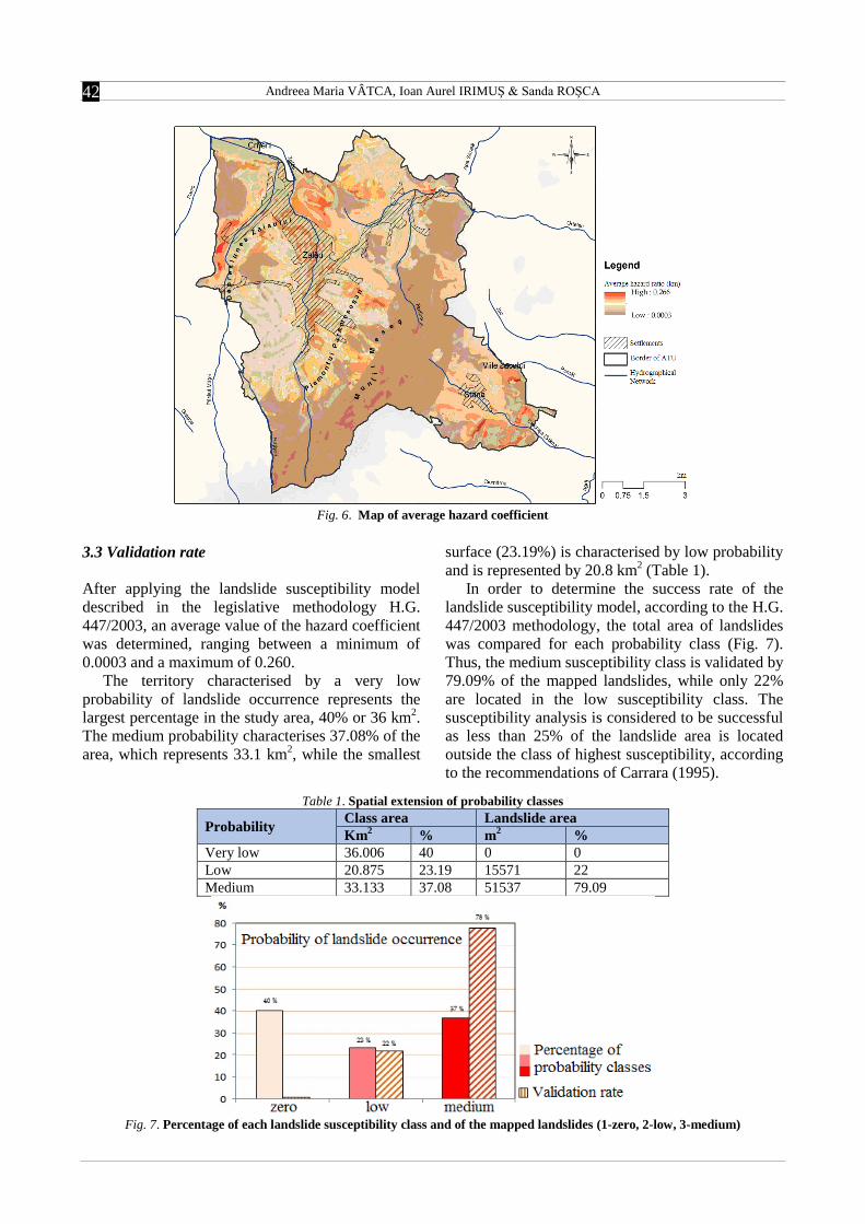
Depending on the values of the average hazard
coefficient, the probability of landslide occurrence
was determined (Fig. 5) through reclassification, the
study area being described as having:
-A low probability of landslide occurrence when
the average landslide susceptibility coefficient has
the values between K(m) = 0.01 – 0.10;
- A medium probability of landslide occurrence
when the average landslide susceptibility coefficient
has the values between K(m) =0.11 – 0.26.
The average hazard coefficient (Fig. 6) has
values between 0.003 and 0.26, the highest values
characterising the built-up area of Zalău, in the
north-eastern part of the city (Dealul Malu, Dâmbul
Ciobanului), in the western part (Zalău west), as
well as in the south-eastern part of Zalău.
The Meseş Mountains and the north-western part
of Zalău municipality are characterized by low
values of the average hazard coefficient, due to the
stable lithology and the forested areas which
determine a high stability of the slopes.
a. Lithologic coefficient map
b. Geomorphologic coefficient map
c. Structural coefficient map
d. Hydrologic and climatic coefficient map
Fig. 4. Maps of factorial coefficients
hKgKfKeKdKcKbKaK
mK
6
Landslide susceptibility in Zalău Municipality
41
e. Hydrogeologic coefficient map f. Seismic coefficient map
g. Sylvic coefficient map h. Anthropic coefficient map
Fig. 4. (continued)
Fig. 5. Probability of landslide occurrence
Andreea Maria VÂTCA, Ioan Aurel IRIMUŞ & Sanda ROŞCA
42
Fig. 6. Map of average hazard coefficient
3.3 Validation rate
After applying the landslide susceptibility model
described in the legislative methodology H.G.
447/2003, an average value of the hazard coefficient
was determined, ranging between a minimum of
0.0003 and a maximum of 0.260.
The territory characterised by a very low
probability of landslide occurrence represents the
largest percentage in the study area, 40% or 36 km2.
The medium probability characterises 37.08% of the
area, which represents 33.1 km2, while the smallest
surface (23.19%) is characterised by low probability
and is represented by 20.8 km2 (Table 1).
In order to determine the success rate of the
landslide susceptibility model, according to the H.G.
447/2003 methodology, the total area of landslides
was compared for each probability class (Fig. 7).
Thus, the medium susceptibility class is validated by
79.09% of the mapped landslides, while only 22%
are located in the low susceptibility class. The
susceptibility analysis is considered to be successful
as less than 25% of the landslide area is located
outside the class of highest susceptibility, according
to the recommendations of Carrara (1995).
Table 1. Spatial extension of probability classes
Probability Class area Landslide area
Km2
% m2
%
Very low 36.006 40 0 0
Low 20.875 23.19 15571 22
Medium 33.133 37.08 51537 79.09
Fig. 7. Percentage of each landslide susceptibility class and of the mapped landslides (1-zero, 2-low, 3-medium)
Landslide susceptibility in Zalău Municipality
43
As a result, the model and the factors included in
the analysis successfully illustrate the situation from
the field, as most of the mapped landslides are
located in the areas with the highest susceptibility.
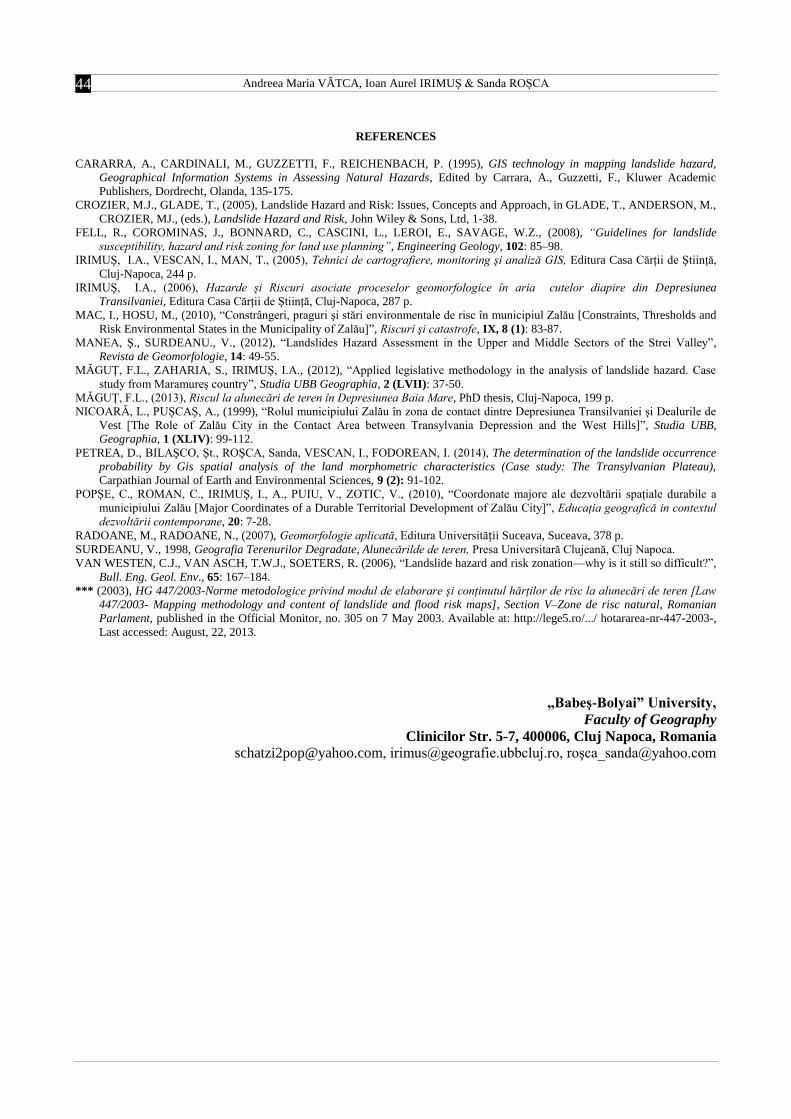
The areas with active landslides from Zalău
Municipality, which are associated with
geomorphologic risk situations, include: the right
slope of the Meseş Valley in the neighbourhoods
Brădet and Stadion, Gheorghe Lazăr Street, the
Central Park, the cemetery, the Courthouse; the
right slope of the Zalău Valley in the Ortelec
neighbourhood (water tanks, clay quarry), the
People’s Park, Traian-Vişinilor area, Dumbrava II
area. All these territories are included in the medium
susceptibility area (Fig. 8).
Fig. 8. Map of active landslides, classified on landslide susceptibility intervals
The landslides in Ortelec neighbourhood have
visible effects in Zalău (Fig.8), mainly affecting the
road infrastructure and the built-up area. Covering
approximately 10 hectares, these landslides and
have also affected agricultural terrains, water tanks,
as well as the connecting road DJ 191C (Porolissum
Street). Landslides of similar intensity affected also
the Brădet and Stadion neighbourhoods, from the
Meseş foothills.
4. Conclusions
Applying the semi-quantitative methodology, the
landslide susceptibility in the Zalău built-up area
has been determined and confirmed by previously
mapped landslides. The medium probability of
landslide occurrence was validated by 79.09% of the
landslides mapped in the field, while the areas with
low probability include only 22% of them, thus the
model has a good success rate. In the low and
medium susceptibility classes the average hazard
coefficient ranges between 0.003 and 0.026 in the
north-eastern part of the city (Dealul Malu, Dâmbul
Ciobanului), in the western part (Zalău west), as
well as in the south-eastern part of Zalău.
Acknowledgments
This paper is made and published under the aegis of
the Research Institute for Quality of Life, Romanian
Academy as a part of programme co-funded by the
European Union within the Operational Sectorial
Programme for Human Resources Development
through the project for Pluri and interdisciplinary in
doctoral and post-doctoral programmes Project
Code: POSDRU/159/1.5/S/141086.
Andreea Maria VÂTCA, Ioan Aurel IRIMUŞ & Sanda ROŞCA
44
REFERENCES
CARARRA, A., CARDINALI, M., GUZZETTI, F., REICHENBACH, P. (1995), GIS technology in mapping landslide hazard,
Geographical Information Systems in Assessing Natural Hazards, Edited by Carrara, A., Guzzetti, F., Kluwer Academic
Publishers, Dordrecht, Olanda, 135-175.
CROZIER, M.J., GLADE, T., (2005), Landslide Hazard and Risk: Issues, Concepts and Approach, in GLADE, T., ANDERSON, M.,
CROZIER, MJ., (eds.), Landslide Hazard and Risk, John Wiley & Sons, Ltd, 1-38.
FELL, R., COROMINAS, J., BONNARD, C., CASCINI, L., LEROI, E., SAVAGE, W.Z., (2008), “Guidelines for landslide
susceptibility, hazard and risk zoning for land use planning”, Engineering Geology, 102: 85–98.
IRIMUŞ, I.A., VESCAN, I., MAN, T., (2005), Tehnici de cartografiere, monitoring şi analiză GIS, Editura Casa Cărţii de Ştiinţă,
Cluj-Napoca, 244 p.
IRIMUŞ, I.A., (2006), Hazarde şi Riscuri asociate proceselor geomorfologice în aria cutelor diapire din Depresiunea
Transilvaniei, Editura Casa Cărţii de Ştiinţă, Cluj-Napoca, 287 p.
MAC, I., HOSU, M., (2010), “Constrângeri, praguri şi stări environmentale de risc în municipiul Zalău [Constraints, Thresholds and
Risk Environmental States in the Municipality of Zalău]”, Riscuri şi catastrofe, IX, 8 (1): 83-87.
MANEA, Ş., SURDEANU., V., (2012), “Landslides Hazard Assessment in the Upper and Middle Sectors of the Strei Valley”,
Revista de Geomorfologie, 14: 49-55.
MĂGUŢ, F.L., ZAHARIA, S., IRIMUŞ, I.A., (2012), “Applied legislative methodology in the analysis of landslide hazard. Case
study from Maramureş country”, Studia UBB Geographia, 2 (LVII): 37-50.
MĂGUŢ, F.L., (2013), Riscul la alunecări de teren în Depresiunea Baia Mare, PhD thesis, Cluj-Napoca, 199 p.
NICOARĂ, L., PUŞCAŞ, A., (1999), “Rolul municipiului Zalău în zona de contact dintre Depresiunea Transilvaniei şi Dealurile de
Vest [The Role of Zalău City in the Contact Area between Transylvania Depression and the West Hills]”, Studia UBB,
Geographia, 1 (XLIV): 99-112.
PETREA, D., BILAŞCO, Şt., ROŞCA, Sanda, VESCAN, I., FODOREAN, I. (2014), The determination of the landslide occurrence
probability by Gis spatial analysis of the land morphometric characteristics (Case study: The Transylvanian Plateau),
Carpathian Journal of Earth and Environmental Sciences, 9 (2): 91-102.
POPŞE, C., ROMAN, C., IRIMUŞ, I., A., PUIU, V., ZOTIC, V., (2010), “Coordonate majore ale dezvoltării spaţiale durabile a
municipiului Zalău [Major Coordinates of a Durable Territorial Development of Zalău City]”, Educaţia geografică in contextul
dezvoltării contemporane, 20: 7-28.
RADOANE, M., RADOANE, N., (2007), Geomorfologie aplicată, Editura Universității Suceava, Suceava, 378 p.
SURDEANU, V., 1998, Geografia Terenurilor Degradate, Alunecărilde de teren, Presa Universitară Clujeană, Cluj Napoca.
VAN WESTEN, C.J., VAN ASCH, T.W.J., SOETERS, R. (2006), “Landslide hazard and risk zonation—why is it still so difficult?”,
Bull. Eng. Geol. Env., 65: 167–184.
*** (2003), HG 447/2003-Norme metodologice privind modul de elaborare şi conţinutul hărţilor de risc la alunecări de teren [Law
447/2003- Mapping methodology and content of landslide and flood risk maps], Section V–Zone de risc natural, Romanian
Parlament, published in the Official Monitor, no. 305 on 7 May 2003. Available at: http://lege5.ro/.../ hotararea-nr-447-2003-,
Last accessed: August, 22, 2013.
„Babeş-Bolyai” University,
Faculty of Geography
Clinicilor Str. 5-7, 400006, Cluj Napoca, Romania


