Embed Size (px)
Citation preview

Late 18th century drought-induced sand duneactivity, Great Sand Hills, Saskatchewan
S.A. Wolfe, D.J. Huntley, P.P. David, J. Ollerhead, D.J. Sauchyn, andG.M. MacDonald
Abstract: Geomorphic evidence and optical ages from seven locations indicate that widespread dune activity occurredwithin the last 200 years in the Great Sand Hills region of southwestern Saskatchewan. Optical ages (n = 36) define aninterval of dune activity bracketed by the earliest age of back ridges in the Seward sand hills (185 ± 8 years) and theaverage age of stabilized dune heads (about 105 years). During this interval, parabolic dunes were active in all areasstudied. These ages indicate that the most recent interval of activity was initiated about AD 1800, and continued at alevel higher than present for approximately 80 years. The most likely cause of dune activation was lower-than-averageprecipitation (relative to 1960–1991 values) through the 1700s, culminating in drought in the late 1700s, as evidencedin dendroclimatic records from the Cypress Hills and from the Rocky Mountain foothills. Dunes affected by such cli-matically induced regional activity require many decades to restabilize. Historical observations show that dunes in thisarea have been restabilizing throughout the 20th century. For the southern Canadian Prairies, a region with serious con-cerns about the implications of global warming, this study highlights the sensitivity of sand dunes to drought and cu-mulative moisture stress.
Résumé: Des preuves géomorphologiques et des âges optiques de sept emplacements indiquent qu’il y eut une activitégénéralisée des dunes au cours des 200 dernières années dans la région des Great Sand Hills du sud de la Saskatche-wan. Des âges optiques (n = 36) définissent un intervalle d’activité des dunes encadré par l’âge de la plus précoce deschaînes arrière dans les collines de sable Seward (185 ± 8 ans) et l’âge moyen des crêtes de dunes stabilisées (environ105 ans). Au cours de cet intervalle, des dunes paraboliques étaient actives dans toutes les régions étudiées. Ces âgesindiquent que l’intervalle d’activité le plus récent a débuté vers AD 1800 et a continué à un niveau supérieur au niveauactuel pour environ 80 ans. La cause la plus probable d’activation des dunes était des précipitations inférieures à lamoyenne (par rapport à 1960–1991) tout au cours des années 1700, culminant dans la sécheresse de la fin des années1700, tel que démontré dans les données dendroclimatologiques provenant des collines Cyprès et des contreforts desRocheuses. Des dunes affectées par une telle activité régionale induite par le climat ont besoin de plusieurs décenniespour se stabiliser de nouveau. Des observations historiques montrent que les dunes de cette région se sont stabiliséestout au cours du 20e siècle. Pour les Prairies canadiennes méridionales, une région pour laquelle le réchauffement pla-nétaire pose de grandes inquiétudes, cette étude souligne la sensibilité des dunes de sable à la sécheresse et au stresshygrométrique cumulatif.
[Traduit par la Rédaction] Wolfe et al. 117
Introduction
Stabilized and partly stabilized sand dunes occur acrossthe Great Plains of the United States and Canada. With therecognition that many were active in the Holocene (Formanet al. 1992; Madole 1994; Holliday 1995; Muhs andHolliday 1995; Muhs et al. 1997a, 1997b; Muhs and Wolfe1999), these dune areas have received considerable attention.Chronologies from these studies have been constructedthrough 14C dating of buried soils, which records ages ofdune stability, and through thermoluminescence and opticaldating of dune sands, which record ages of dune activity.These reconstructions reveal a close association between ep-isodes of past eolian activity and drought intervals recordedin dendrochronological and paleolimnological records (e.g.,Stockton and Meko 1983; Fritz et al. 1994; Laird et al.1996). In addition, modelling studies show that even a mod-est increase in aridity can reactivate stabilized sand duneswithin much of this region (Muhs and Maat 1993; Wolfe
Can. J. Earth Sci. 38: 105–117 (2001) © 2001 NRC Canada
105
DOI: 10.1139/cjes-38-1-105
Received May 1, 2000. Accepted July 7, 2000.Published on the NRC Research Press Web site onDecember 18, 2000.Paper handled by Associate Editor R. Gilbert.
S.A. Wolfe.1 Geological Survey of Canada, 601 Booth St.,Ottawa, ON K1A 0E8, Canada.D.J. Huntley. Department of Physics, Simon FraserUniversity, Burnaby, BC V5A 1S6, Canada.P.P. David. Départmente de géologie, Université deMontréal, Montréal, QC H3C 3J7, Canada.J. Ollerhead. Department of Geography, Mount AllisonUniversity, 144 Main St., Sackville, NB E4L 1A7, Canada.D.J. Sauchyn.Department of Geography, University ofRegina, Regina, SK S4S 0A2, Canada.G.M. MacDonald. Department of Geography and OrganismicBiology, Ecology, and Evaluation, University of California,Los Angeles, CA 90095–1524, U.S.A.
1Corresponding author (e-mail: [email protected]).

1997). Therefore, dune fields on the Great Plains are ex-tremely sensitive to climatic variability, and the potential forreactivation of stabilized dunes is high, even without climat-ically induced warming (Muhs and Holliday 1995; Lemmenet al. 1998).
On the Canadian Prairies, scattered and mostly stabilizedsand dunes are widespread throughout the dry subhumidarea called the Palliser Triangle (Fig. 1). Radiocarbon datingis difficult because of the limited organic matter in theseeolian deposits. However, with recent developments in opti-cal dating, it is possible to estimate the time since sedimentwas last exposed to sunlight and thereby develop a chronol-ogy of past eolian activity (e.g., Huntley and Lian 1999).
Preliminary optical dating studies based upon eight sam-ples from seven locations in the Palliser Triangle were firstundertaken by Wolfe et al. (1995), who suggested that themost recent period of widespread dune activity occurredwithin the last 200 years. This present paper further docu-ments the temporal and spatial extent of this last major pe-riod of regional dune activity, based on optical ages of sandsfrom natural blowout exposures and from shallow pits withinmostly stabilized dunes. The timing of this activity is com-pared with moisture trends reconstructed from dendro-climatic records, to determine a probable climatic cause.
The southern Canadian Prairies is a region where seriousconcerns exist regarding the implications of global warming.Sand dunes hold strong potential for defining the impacts ofpast drought events in this region, as they represent a climat-ically sensitive component of the prairie landscape (Muhsand Wolfe 1999) and are good geo-indicators of surfacemoisture resources (Vance and Wolfe 1996). This studyhighlights the sensitivity of sand dunes in this importantrangeland agricultural area to drought and cumulative mois-ture stress.
Study area
Dune activityThe Great Sand Hills is the largest contiguous dune occur-
rence on the Canadian Prairies (David 1977). It is sur-rounded by several smaller dune fields (Fig. 1), whichtogether constitute the Great Sand Hills region and occupy atotal area of more than 2000 km2. Dune sands are derivedfrom glaciofluvial, glaciolacustrine, and deltaic sediments(David 1977) deposited during the retreat of the LaurentideIce Sheet approximately 13 000 BP. Consequently, the sedi-ment supply for dune fields in this region is finite, and duneactivity is controlled by the availability of sand rather thanby replenishment of source sediments (cf. Muhs and Wolfe1999). Variations in climate influence the availability ofsand by affecting moisture conditions and vegetation cover.
The Great Sand Hills region is characterized by a dry sub-humid climate. Precipitation (~300 mm·a–1) amounts to onlyabout 60% of potential evapotranspiration (~500 mm·a–1) inan average year, and 40% or less in drought years such as1987 and 1988 (Environment Canada 1995). Most dunes inthe region are presently stabilized by vegetation; less than1% of the area of dune sands is presently active. Vance andWolfe (1996) related dune activity in subhumid and semiaridenvironments to moisture availability. They suggested thatlocal reactivation of stabilized dunes may require drought
conditions for months or years, whereas regional dunereactivation requires durations of several years to decades.Despite the increased aridity that occurred over much of theCanadian Prairies in the late 1980s, the duration of droughtconditions was insufficient to promote widespread dune re-activation (Wolfe 1997).
During the late Holocene, sand-dune activity on the south-ern Canadian Prairies varied with changing aridity and ac-companying vegetation cover. David (1971) and Wolfe et al.(2000) have reported at least five episodes of late Holocenedune activity between approximately 3700 and 400 BP inthe Brandon sand hills of southwestern Manitoba, resultingfrom dryness in an otherwise humid to subhumid climate. Inthe Great Sand Hills region, Wolfe et al. (1995) showed thatsand dunes were active during the last millennium and par-ticularly the last 200 years; possible periods of dune stabilityoccurred around 2600 BP and between approximately AD1400 and 1700.
Dune morphologyAll sand dunes in the Great Sand Hills region are of the
parabolic type (David 1998). Figure 2 shows the morphol-ogy of a typical parabolic dune in this area. The slip face isconvex downwind in plan view, and the wings, where devel-oped, point upwind. Generally, the wing ridges rise evenlytoward the head, whereas the low area between the wings isdeflated. This deflation depression is commonly eroded to amore resistant substrate. A back ridge, where present, con-nects the wings around the deflation depression to form theupwind extension of the dune. The back ridge is typically alow, arcuate sand accumulation, generally concave down-wind and with an uneven crest line (Figs. 2, 4e). Because itis produced by multidirectional winds removing sand fromthe deflation depression, it is absent from parabolic dunesthat develop under unidirectional winds (David 1988). Accu-mulation of this sand begins with the initiation of dune ac-tivity and continues until the upwind portion of the deflationdepression is stabilized by vegetation. Back ridges delineatethe farthest upwind position of individual dunes and, wheredune activity has been triggered by a climatic shift to morearid conditions, can be significant chronological and mor-phological markers (David et al. 1999).
Many dunes in areas of high local water tables in theGreat Sand Hills region contain parallel, even-crested ridgesbetween their wings (Fig. 2). Termed “dune-track ridges”(David 1998), these are either arcuate, sometimes slightlysinuous or irregular ridges that connect the wings. Well-developed examples are found in the Seward sand hills(Fig. 4e), where the water table fluctuates close to theground surface. Dune-track ridges develop when a period ofdune migration is interrupted by more humid intervals thatpromote vegetation growth around the base of the dune,while the rest of the dune remains active (David 1998). Witha return to more arid conditions, the dune migrates down-wind and a low, vegetated ridge (lower than the correspond-ing back ridge) may remain at the former back base line ofthe dune. The even crest line of the ridge reflects the limit towhich vegetation invaded the back slope of the dune. Dune-track ridges record only short-term climatic fluctuations,since any significant climate change would stabilize the en-tire dune, as is now widely observed throughout the region.
© 2001 NRC Canada
106 Can. J. Earth Sci. Vol. 38, 2001

In light of this previous work, the ages of dune-trackridges within a particular dune should postdate the basal ageof the back ridge and should become successively youngerdownwind (David et al. 1999). Sand deposited on the backslope, head, or slip face of a dune should, in turn, postdatethe age of the dune-track ridges, as these are typically the fi-nal portions of a dune to stabilize.
Dendroclimatic recordsThe Great Sand Hills region lies within the mixed-grass
prairie and therefore supports no tree species useful forlong-term climatic reconstruction. However, two dendro-climatic data sets from outside the region provide recon-structed total annual precipitation records for the last 300–500 years. The first is an annual precipitation reconstructionfor the period AD 1505–1992, developed by Case and Mac-Donald (1995) fromPinus flexilis James along the RockyMountains foothills of southwestern Alberta (Alberta foot-hills). This record correlates well with the Swift Current in-strumental precipitation record. The second data set is anannual precipitation reconstruction for the period AD 1682–1994, obtained by Sauchyn and Beaudoin (1998) fromPiceaglaucaalbertiana in the Cypress Hills, about 75 km south ofthe Great Sand Hills.
The reconstructed precipitation record of Case and Mac-Donald (1995) is based on the correlations of three ring-width chronologies to total annual (August–July) precipita-tion, averaged from the Fort Macleod and Calgary climatestations (Fig. 1). The climate of the Alberta foothills is tran-sitional between prairie and cordilleran, and the historicalannual precipitation typically ranges from 510 to 610 mm.Using a calibration period of 1905–1987 (n = 82), a regres-sion model was constructed that produced an adjusted R2 of0.45 (Case and MacDonald 1995). Sauchyn and Beaudoin(1998) used mean monthly data for the period 1941–1994from Maple Creek, 25 km north of the Cypress Hills. Theyregressed August–July total precipitation against standard-ized ring widths and obtained an adjusted R2 of 0.37 (n =45). These reconstructions are discussed in this paper, be-cause they provide the link between the optical ages of dunesands and past periods of drought; methodologies for eachreconstruction are provided in the original references.
Methods
SamplingSamples were collected for optical dating in several local-
ities, both from natural exposures (blowouts) and from shal-
© 2001 NRC Canada
Wolfe et al. 107
Fig. 1. Location of the Great Sand Hills region (inset) and sample sites in southwestern Saskatchewan.

low pits dug on the surface of stabilized dunes (Figs. 1, 3,4), to obtain a regional perspective on the last major periodof dune activity. Because of the palimpsest nature of eoliandeposits (cf. David 1998), samples were only collected fromdunes with recognized morphology and internal structure, sothat the geological relevance of the optical ages was known.The stratigraphy and sedimentology of each site was de-scribed to establish the origin and geomorphic significanceof the deposits and to avoid bioturbated sites. Modern sam-ples were collected from two active sand surfaces to test theability of the optical dating method to give “zero” ages.
Blowout exposures were sampled in seven older dune de-posits at depths of 3.0–8.0 m below the modern surface(Fig. 3). Of the eleven samples collected from these sites,eight were dune-sand deposits, two were sheet-sand deposits(94-81, 94-82), and one was a basal (eolian–shallow lacus-trine) sand (SW6-01). A bison bone was collected from theupper surface of the basal sand deposit for radiocarbon dat-ing.
Near-surface samples were collected from 23 pits dug0.5–1.5 m into eight stabilized dunes (Figs. 1, 4). Sampleswere collected from the dune heads, back slopes, backridges, and dune-track ridges of stabilized dunes, and fromactive surfaces of modern blowouts (Fig. 4) to estimate thelast period of eolian activity. Sample sites were locatedwithin stabilized dune fields; dunes selected for sampling
were considered morphologically representative of surround-ing dunes.
Optical datingOptical dating determines the time elapsed since mineral
grains were last exposed to sunlight. General descriptionscan be found inRadiation Measurements(Vol. 27(5/6),1997), Aitken (1998), and Huntley and Lian (1999). Thisstudy used sand-sized K-feldspar grains with 1.4 eV (infra-red) excitation and measurement of the 3.1 eV (violet) emis-sion (Ollerhead et al. 1994; Huntley and Clague 1996),except that the 95-series of samples were measured using asimilar apparatus with a higher light-collection efficiency(Baril 1997). A typical example of the additive-dose data isshown in David et al. (1999, see Fig. 4). All aliquots, exceptsome used for control, were heated prior to measurement for16 h at 120°C; a 5 day, 140°C preheat on one sample (SW6-01) produced no difference in the equivalent dose (Table 1).
Three of the grain separates were analyzed for potassium,and the fractions of the grains that were actually K-feldsparwere determined using a scanning electron microscope.From these, values of 13.8 ± 1.2% K for SW6-01, 13.2 ±1.4% K for 94-32, and 13.0 ± 0.8% K for 94-37 were deter-mined (Huntley and Baril 1997). Since the maximum con-tent possible is 14% K, a value of 13 ± 0.5% K was used to
© 2001 NRC Canada
108 Can. J. Earth Sci. Vol. 38, 2001
Fig. 2. Schematic diagram of a stabilized parabolic dune with a back ridge and dune-track ridges (adapted from Wolfe and David1997). Terminology for sand dunes in the Great Sand Hills region follows that of Wolfe and David (1997), David (1998), and David etal. (1999).

calculate the dose rate from the potassium within the grains.The calculated total dose rates are given in Table 1.
Uncontrolled systematic errors may cause the optical agesto be too high by 20 years and (or) too low by 5–15%. Be-cause these errors operate in opposite directions, they willpartially cancel each other. The effects may completely can-cel for samples about 200 years old. For much older sam-ples, the true ages may be as much as 15% larger thancalculated. See Appendix A for a more thorough discussionon the accuracy of the optical ages.
Dendroclimatic recordsThe total annual (August–July) precipitation reconstruc-
tions of tree-ring chronologies from the Alberta foothills(Case and MacDonald 1995) and the Cypress Hills (Sauchyn
and Beaudoin 1998) were used to examine past moisturevariability in the region. The annual precipitation records, aswell as calculated 3-year and 5-year running means, werecompared to the precipitation record at Swift Current usingPearson’s pairwise correlations. Swift Current was usedsince it is the nearest climate station to the Great Sand Hillsregion with long-term continuous data. “Dry periods” weredetermined from the 5-year running mean records and weredefined by intervals with a precipitation total of more thanone standard deviation below the 1961–1990 mean. Thiscomparison of a subset of the data to the complete set re-duces the statistical bias caused by using standard deviation.The first standard deviation of this 30-year period was used,as it permits comparison of past dry periods to the recenthistorical record (cf. Stockton and Meko 1983). As this ap-
© 2001 NRC Canada
Wolfe et al. 109
Fig. 3. Stratigraphic sections and optical ages from sites in the Great Sand Hills region.

© 2001 NRC Canada
110 Can. J. Earth Sci. Vol. 38, 2001
proach uses a 5-year running mean rather than annual data,it provides a conservative definition of dry periods by reduc-ing the influence of single-year droughts. Long-term trendsin moisture balance were also determined from the instru-mental and reconstructed records by calculating percent cu-mulative departures from the mean annual precipitation.This helps reveal decade- to century-scale trends that maynot be as evident in annual or running-mean records. Theapproach of summing the successive annual departures re-sults in each record beginning and ending at the respectivemean precipitation value.
Results
Ages
Stratigraphic sections – BurstallThe Burstall section occupies the south wall of a 10 m
deep by 50 m long blowout through the head and back slopeof a stabilized parabolic dune (Fig. 4a). An optical age of4190 ± 200 years was obtained from K-feldspar grains in abasal unit of grey unoxidized sand at a depth of 6.5 m(Fig. 3). The uppermost portion of the basal sand containsmany lithic artifacts and bone fragments ofBison bison, plus
Fig. 4. Aerial photographs of study sites in the Great Sand Hills region with sample locations and numbers identified: (a) Burstall sandhills (NAPL A21003-41, 43, 54, 56, taken in 1967); (b) northwest Great Sand Hills (photo by S.A. Wolfe, taken in Sept. 1994);(c) Westerham sand hills (NAPL A17661-121, taken in 1961); (d) Bigstick sand hills (NAPL A7611-56, taken in 1946); (e) Sewardsand hills (NAPL A21004-63, taken in 1969). Notation after sample numbers: M, modern; DH, dune head; BS, backslope; DT, dune-track ridge; BR, back ridge. Open arrows indicate direction(s) of dune-building winds. Black areas in Fig. 4e are ponds behind dunesand between ridges, indicating high water levels at the time of the photograph.

oxidized and iron-cemented root casts, indicating a period ofsurface stability with vegetation cover. The bones yielded acalibrated radiocarbon age (cf. Stuiver and Reimer 1993) of2750 257
102−+ calendar years before present (S-3553), whereas
projectile points found within the blowout were of PelicanLake type (dated at ca. 2000 BP).
Overlying the basal sand is a 1.5–2.0 m thick unit of hori-zontally stratified sand (Fig. 3). This unit, interpreted as an
eolian sheet-sand deposit, yielded optical ages of 307 ±21 years at a depth of 5.5 m and 252 ± 17 years at a depth of3.7 m (Table 2B). The top of this unit contains oxidized rootcasts similar to the underlying basal deposit, indicating thatthe surface of the sheet sand was vegetated less than250 years ago.
The unit overlying the sheet sand contains inclined lami-nations indicative of toeset, foreset, and topset bedding of
© 2001 NRC Canada
Wolfe et al. 111
SampleNo.
Watercontent∆a
K (±5%)
Wholesample Surroundings
U(µg·g–1)
Th(±0.1 µg·g–1)
Dose rate(±0.13 Gy·ka–1)
Equivalentdose (Gy)
SW1-02b 0.037 1.15 1.12 0.77±0.04 — 2.49 0.17±0.03SW2-02b 0.062 1.43 1.41 1.30±0.04 — 2.93 0.32±0.02SW3-02b 0.044 1.28 1.29 0.97±0.04 2.9 2.73 0.25±0.01SW4-01b 0.048 1.39 1.40 0.96±0.04 — 2.83 1.82±0.15SW4-02b 0.063 1.38 1.38 0.97±0.04 3.1 2.78 2.57±0.11SW5-01b 0.068 1.49 1.45 1.08±0.04 — 2.64 0.57±0.02SW6-01b 0.07 1.36 1.37 1.28±0.04 4.1 2.60 10.7±0.8
10.9±0.3c
2.00d 10.8±0.9d
SW6-02b 0.051 1.35 1.34 1.12±0.04 — 2.85 0.48±0.0294-23 0.054 1.18 — 0.86±0.05 — 2.70 0.23±0.0194-30e 0.054 1.49 1.54 1.34±0.06 — 3.15 0.387±0.01594-31e 0.060 1.49 1.50 1.22±0.06 — 3.08 0.288±0.01594-32e 0.067 1.50 1.43 1.36±0.06 3.5 3.13 0.363±0.01994-33e 0.057 1.48 1.50 1.33±0.06 — 3.13 0.295±0.01594-34e 0.063 1.48 1.47 1.12±0.06 — 3.02 0.460±0.01994-35e 0.065 1.55 1.56 1.21±0.06 — 3.12 0.390±0.01094-36e 0.048 1.47 1.43 1.28±0.06 — 3.11 0.542±0.01994-37e 0.070 1.48 1.48 1.35±0.06 3.9 3.11 0.523±0.01594-38e 0.058 1.42 1.56 1.11±0.06 — 2.99 0.477±0.02694-39e 0.062 1.45 1.49 1.34±0.06 — 3.10 0.426±0.02594-40e 0.055 1.39 1.54 1.17±0.06 — 2.99 0.351±0.01994-41e 0.049 1.39 — 1.06±0.09 — 3.08f 0.052±0.01494-50 0.045 1.23 1.23 1.03±0.05 — 2.79 0.36±0.0294-51 0.040 1.15 1.14 0.90±0.05 — 2.66 0.28±0.0294-70 0.003 1.28 1.23 0.93±0.06 — 2.79f –0.01±0.0294-71 0.030 1.40 1.25 1.02±0.06 — 2.95 0.27±0.0294-81 0.047 1.39 1.30 1.05±0.07 3.2 2.83 0.87±0.0594-82 0.063 1.37 1.38 1.15±0.07 — 2.86 0.72±0.0494-83 0.042 1.33 1.37 1.02±0.07 — 2.82 0.46±0.0195-01 0.035 1.59 1.57 1.07±0.08 — 2.88 0.33±0.0195-02 0.035 1.55 1.59 1.12±0.09 — 2.87 0.41±0.0295-03 0.035 1.55 1.55 1.14±0.09 — 2.88 0.37±0.0195-04 0.035 1.59 1.59 1.00±0.08 3.0 2.85 0.33±0.0195-07 0.035 1.18 1.20 1.01±0.09 — 2.74 0.32±0.0195-08 0.035 1.31 1.27 1.00±0.08 2.9 2.84 0.43±0.0195-10e 0.035 1.48 1.51 1.16±0.09 — 3.07 0.553±0.01695-11e 0.035 1.49 1.49 1.13±0.09 3.1 3.04 0.562±0.016
Note: The first potassium column is for potassium in the actual sample; the second is for a mixture of material collected from within 30 cmabove and below the sample. Th contents, where not shown, were calculated using a Th/U ratio determined from the other samples. Thegrain size selected was 180–250µm for all samples, except SW5-01, SW6-01, 95-01, 95-02, 95-03, and 95-04, for which it was 90–125µm.
a∆ = (mass of water) / (dry mass); uncertainty is ± 0.02 for all samples, except SW6-01, for which it is ± 0.03.bPreliminary values reported by Wolfe et al. (1995) and revised herein.c5 day preheat at 140°C.dQuartz grains: 2 day preheat at 150°C, 2.41 eV (green) excitation.eData for dose rate and equivalent dose rate published previously by David et al. (1999).fDose rate used was that which would be applicable if the sample had been buried 0.5 m.
Table 1. Water content, potassium (K), uranium (U), thorium (Th), dose rate (in greys per thousand years), and equivalentdoses (in greys) for the samples.

dune sand (Fig. 3). Foresets represent slip-face deposits,whereas overlying topsets are meso-bed forms that accumu-lated across the top of the dune. This unit is capped by a unitof subhorizontally bedded sand, about 1 m thick. The lower-most toeset deposit yielded an age of 163 ± 7 years at 3.2 mdepth, and the base of the overlying foreset yielded a similarage of 168 ± 9 years at 3.0 m depth. An age of 92 ± 7 years,obtained from a depth of 0.5 m on the head of a stabilizedparabolic dune about 700 m north of this section (Fig. 4a),provides an estimate of the timing of stabilization.
In summary, basal sand was deposited at least 4000 yearsago in the Burstall sand hills and the area was subsequentlyoccupied by people around 2750 calendar years before pres-ent, by which time the local surface was vegetated. Eoliansheet sand was deposited between 250 and 300 years ago,with vegetation again covering the surface after this interval.Sand-dune activity in the past 165–170 years resulted ineolian deposition over the formerly vegetated surface. Stabi-lization occurred as recently as 90 years ago.
Other stratigraphic sectionsSix other exposures were investigated within parabolic
dunes at Tunstall, Bigstick, Seward, and Great sand hills(Fig. 1). At all sites, active blowouts had exposed sedimentsunderlying the base of the dunes. These lower sediments,similar in texture to the overlying dune sands, were grey incolour and contained root casts stained and cemented withiron oxide. Buried soil was only observed at Bigstick(Fig. 3). The absence of buried soil may be due either toweak soil development on stabilized dunes or to the erosionof stabilized surfaces during dune reactivation. All datedsamples were collected from inactive slip-face deposits, con-tained more than 99.5% sand, were well sorted, and hadmean grain sizes of fine sand (125–250µm). These sandswere damp, with moisture contents ranging from 3.7 to 6.8%by weight and averaging 5.4% (Table 1, first six samples).
The ages of dune activity at these sites ranged from 930 ±50 to 68 ± 12 years (Fig. 3, Table 2). The ages indicate thatmany presently stabilized sand dunes in the Great Sand Hillsregion were active in the last millennium and as recently asthe last century.
Stabilized sand dunes – Seward sand hillsThe most detailed chronology was obtained from the
Seward sand hills (Fig. 1), an area of well-developed para-bolic dunes with well-defined back ridges and dune-trackridges (Fig. 4e). A detailed description of the study site andthe ages obtained is provided by David et al. (1999). All ofthe ages from these shallow-pit samples occur within the last200 years (Table 2D). The oldest age (174 ± 8 years) fromthe dune-track ridges is from the one closest to the backridge of Dune 2. As expected, those of the remaining dune-track ridges are successively younger downwind, toward theback slope of Dune 2 (117 ± 7 years). An age of 109 ± 8years from a dune section 500 m north of Dune 2 is alsoconsistent with the expectation that the ridges are older thanthe stabilized dunes. The ages obtained from Dune 1 and theback ridge of Dune 2 do not follow expectations. Thosefrom Dune 1 may date minor depositional events, possiblycorrelating with droughts (ca. 95 and 120 years ago) that oc-curred after initial ridge formation. Those from Dune 2 (the
© 2001 NRC Canada
112 Can. J. Earth Sci. Vol. 38, 2001
SiteSampleNo.
Sampledepth(m)
Age (years,before AD1995)
(A) Zero-age samples (dune sands)Burstall sand hills 94-70 0–0.02 –4±7b
Seward sand hills 94-41a 0–0.02 17±5b
(B) Stratigraphic sections (dune sands)Tunstall sand hills SW1-02c 6.0 68±12Seward sand hills SW2-02c 8.0 109±8Bigstick sand hills SW3-02c 4.0 91±5Central Great Sand Hills SW4-01c 3.0 640±60Central Great Sand Hills SW4-02c 6.0 930±50Northwest Great Sand Hills SW5-01c 4.0 216±11Burstall sand hills SW6-02c 3.0 168±9Burstall sand hills 94-81 5.5 307±21Burstall sand hills 94-82 3.7 252±17Burstall sand hills 94-83 3.2 163±7
(C) Stratigraphic sections (basal sands)Burstall sand hills SW6-01c 6.5 4120±350
4190±200d,e
5400±600f
(D) Seward sand hills (dune sands)Dune 1 BR1g 94-30a 0.5 123±6Dune 1 DT2 94-31a 0.5 94±6Dune 1 DT3 94-32a 0.5 116±7Dune 1 DT4 94-33a 0.5 94±6Dune 1 DT5 94-34a 0.5 152±8Dune 2 BR1 94-35a 0.5 125±5Dune 2 BR1 95-10a 1.0 180±8Dune 2 BR1 95-11a 1.5 185±8Dune 2 DT2 94-36a 0.5 174±8Dune 2 DT3 94-37a 0.5 168±7Dune 2 DT4 94-38a 0.5 160±10Dune 2 DT5 94-39a 0.5 137±9Dune 2 BS6 94-40a 0.5 117±7
(E) Other stabilized dunesWesterham BR1 94-50 0.5 129±9Westerham DH1 94-51 0.5 105±8Burstall DH1 94-71 0.5 92±7Bigstick DH1 94-23 0.5 85±5Bigstick DH1 95-07 0.6 117±6Bigstick BR1 95-08 0.7 151±5NW GSH DH1 95-01 0.75 115±5NW GSH BR1 95-02 0.9 143±9NW GSH BR1 95-03 0.75 129±6NW GSH DH1 95-04 1.0 116±5
aData published previously by David et al. (1999).bDose rate used was that which would be applicable if the sample had
been buried 0.5 m.cPreliminary values reported by Wolfe et al. (1995) and revised herein.d5 day preheat at 140°C.eIf corrected for anomalous fading using the model described by Aitken
(1985, see Appendix E), and the fading data given in Table A1 of theAppendix for this sample, the age becomes 4760 ± 330 years.
fQuartz grains.gDH, dune head; BS, backslope; BR, back ridge; DT, dune-track ridge.
Table 2. Locations, depths, and optical ages of the samples.
smaller of the two dunes) date the formation of the dune-track ridges (David et al. 1999).
Ages of basal deposits from the back ridge of Dune 2 pro-vide the most reliable estimate of the onset of eolian activityin this area. Samples collected at depths of 1.0 and 1.5 myielded ages of 180 ± 8 and 185 ± 8 years, respectively.Ages obtained from other stratigraphic sections (e.g., 216 ±11 years) cannot be ascribed to the onset of renewed eolianactivity because they are in a basal position and only indi-cate that dune activity also occurred in the area prior to200 years ago. Thus, ages obtained from the Seward sandhills provide the earliest evidence of large-scale reneweddune activity, at about 185 years ago, with most of the dunemorphology having formed between 175 and 110 years ago.
Other stabilized dunesShallow-pit samples from stabilized dunes in the Burstall,
Westerham, Bigstick, and northwestern Great sand hills(Fig. 4) yielded ages ranging from 151 to 85 years (Ta-ble 2E). Ages from the back ridges at these location wereobtained from shallow pits to determine the most recent timeof dune activity, rather than the onset of activity, which isobtained from basal deposits. In all cases, sand at the dunehead was deposited about 30 years after sand in the backridge (Table 2E), reinforcing the expectation that dune headsare typically the last parts of the dunes to stabilize.
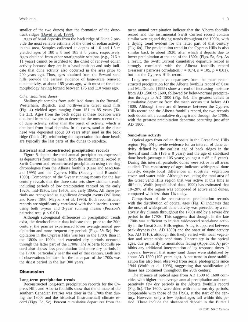
Historical and reconstructed precipitation recordsFigure 5 depicts the total annual precipitation, expressed
as departures from the mean, from the instrumental record atSwift Current and reconstructed precipitation using tree-ringchronologies from the Alberta foothills (Case and MacDon-ald 1995) and the Cypress Hills (Sauchyn and Beaudoin1998). Comparison of the 5-year running means for the lastcentury reveals that the three data sets show similar trends,including periods of low precipitation centred on the early1920s, mid-1930s, late 1950s, and early 1960s. All these pe-riods are recognized as significant drought events (Williamsand Rowe 1986; Maybank et al. 1995). Both reconstructedrecords are significantly correlated with the historical recordusing both 5-year and 3-year running means (Pearson’spairwise test, p ≤ 0.01).
Although subregional differences in precipitation trendsexist, the dendroclimatic data indicate that, prior to the 20thcentury, the prairies experienced lower average annual pre-cipitation and more frequent dry periods (Figs. 5b, 5c). Pre-cipitation in the Cypress Hills was less in the 1700s than inthe 1800s or 1900s and extended dry periods occurredthrough the latter part of the 1700s. The Alberta foothills re-cord also shows less precipitation and more dry periods inthe 1700s, particularly near the end of that century. Both setsof observations indicate that the latter part of the 1700s wasthe driest period in the last 300 years.
Discussion
Long-term precipitation trendsReconstructed long-term precipitation records for the Cy-
press Hills and Alberta foothills show that the climate of thesouthern Canadian Prairies was drier in the 1700s than dur-ing the 1800s and the historical (instrumental) climate re-cord (Figs. 5b, 5c). Percent cumulative departures from the
mean annual precipitation indicate that the Alberta foothillsrecord and the instrumental Swift Current record containsimilar wetting and drying trends throughout the 1900s, witha drying trend evident for the latter part of that century(Fig. 6a). The precipitation trend in the Cypress Hills is alsosimilar back to about 1920, after which it departs due tolower precipitation at the end of the 1800s (Figs. 5b, 6a). Asa result, the Swift Current cumulative departure record isstrongly correlated with the Alberta foothills record(Pearson’s pairwise correlation,r = 0.74,n = 105,p = 0.01),but not the Cypress Hills record.
Long-term cumulative departures from the mean recon-structed precipitation for the Alberta foothills record of Caseand MacDonald (1995) show a trend of increasing moisturefrom AD 1500 to 1600, followed by below-normal precipita-tion through to AD 1800 (Fig. 6a). The greatest deficit incumulative departure from the mean occurs just before AD1800. Although there are differences between the CypressHills record and the Alberta foothills record, the two recordsboth document a cumulative drying trend through the 1700s,with the greatest precipitation departure occurring just afterAD 1800.
Sand-dune activityOptical ages from eolian deposits in the Great Sand Hills
region (Fig. 6b) provide evidence for an interval of dune ac-tivity defined by the earliest age of back ridges in theSeward sand hills (185 ± 8 years) and the age of stabilizeddune heads (average = 105 years; youngest = 85 ± 5 years).During this interval, parabolic dunes were active in all areasstudied. This consistency of ages indicates widespread duneactivity, despite local differences in substrate, vegetationcover, and water table. Although evaluating the total area ofthe Great Sand Hills region that was active at this time isdifficult, Wolfe (unpublished data, 1999) has estimated that10–20% of the region was composed of active sand dunes,compared with less than 1% today.
Comparison of the reconstructed precipitation recordswith the distribution of optical ages (Fig. 6) indicates thatthe onset of widespread dune activity was preceded by a rel-atively dry climate throughout the 1700s and by a severe dryperiod in the 1790s. This suggests that drought in the late1700s was sufficient to initiate widespread sand-dune activ-ity in the Great Sand Hills region. A lag is apparent betweenpeak dryness (ca. AD 1800) and the onset of dune activity(ca. AD 1810), although this likely varied with local vegeta-tion and water table conditions. Uncertainty in the opticalages, due primarily to anomalous fading (Appendix A) pro-hibits any additional interpretation of lag response times. Itappears, however, that many sand dunes were stabilized byabout AD 1890 (105 years ago). A net trend in dune stabili-zation has also been observed from aerial photographs since1944 (Wolfe et al. 1995), suggesting that stabilization ofdunes has continued throughout the 20th century.
The absence of optical ages from AD 1500 to 1600 coin-cides with higher than average annual precipitation and com-paratively few dry periods in the Alberta foothills record(Fig. 5c). The 1600s were drier, with numerous dry periods,comparable with those of the l790s, at the start of the cen-tury. However, only a few optical ages fall within this pe-riod. These include the sheet-sand deposit in the Burstall
© 2001 NRC Canada
Wolfe et al. 113

sand hills (307 ± 21 to 252 ± 17 years) and a stratigraphicsection in the northwestern Great Sand Hills (216 ±11 years; Fig. 3). This suggests that, although the 1600s and1700s may have been relatively dry, sand dunes remainedstable due to accumulated moisture from the previous pe-riod. Alternatively, eolian sands may simply have been re-worked by subsequent activity, leaving little older materialin situ.
Recent trendsIt is unlikely that the drought of the 1790s would have
been sufficient to initiate widespread sand-dune activity in-dependent of antecedent climatic conditions. This droughtwas preceded by several dry periods and lower than averageprecipitation throughout the 1700s, resulting in cumulativedrying in the region and increased susceptibility to dune ac-tivity. By comparison, the historic droughts of the 1930s and
© 2001 NRC Canada
114 Can. J. Earth Sci. Vol. 38, 2001
Fig. 5. Historical and reconstructed annual precipitation trends (August–July), depicted as departures from the mean: (a) 104 year (AD1886–1990), 5-year running mean precipitation from the instrumental record at Swift Current, Saskatchewan; (b) 312 year (AD 1682–1994) dendroclimatic reconstruction of 5-year running mean precipitation from the Cypress Hills uplands (after Sauchyn and Beaudoin1998); (c) 487 year (AD 1505–1992) dendroclimatic reconstruction of 5-year running mean precipitation from the Alberta foothills (af-ter Case and MacDonald 1995). Also shown are mean precipitation values for each century and the entire record; horizontal dashedline signifies the threshold for dry periods, defined as one standard deviation below the 1961–1990 mean; bold line segments signifydry periods.

1980s were insufficient to initiate the degree of dune activitythat occurred in the 1800s. At most, these recent droughtscaused minor increases in the area of bare sand on dunesthat were already partly active. The 1900s appear to havebeen sufficiently moist to preserve stabilized dunes and con-tinue the process of stabilization in previously active duneareas (Wolfe et al. 1995).
Reconstruction of past precipitation, as reconstructed fromCase and MacDonald (1995), suggests that the average an-nual precipitation occurring in the last century (431 mm) isroughly equivalent to that for the last 500 years (435 mm;Fig. 5). Within the instrumental climate record, however,
there has been a slight decrease in annual precipitation onthe Canadian Prairies between 1948 and 1992, while temper-atures have risen by a statistically significant 0.9°C (Envi-ronment Canada 1995). Annual precipitation at SwiftCurrent has decreased by about 45 mm over the last century,with precipitation during the May–July growing season de-clining by 33 mm (Judiesch and Cutforth 1996). This sug-gests that the present trend may be toward decreasedmoisture availability on the southern Canadian Prairies.Given such conditions, the present level of dune activitymay have reached a minimum, and future trends could be ei-ther a maintenance of present levels or increased activity.
© 2001 NRC Canada
Wolfe et al. 115
Fig. 6. Summary of moisture trends and optical ages: (a) Long-term moisture trends for the southern Canadian Prairies derived fromtree-rings and instrumental records (seeFig. 5) and depicted as percent cumulative departures from the mean; (b) Optical age determi-nations from stabilized dunes and stratigraphic sections in the Great Sand Hills region, the shaded area indicating the period of wide-spread dune activity; uncontrolled systematic errors may cause the optical ages to be too high by 20 years and (or) too low by 5–15%(see Appendix A).

However, there would have to be a longer term shift towardincreased aridity than has so far occurred to produce a returnto widespread sand-dune activity in the region.
Conclusions
Severe drought in the late 1700s, preceded by at least acentury of below-average precipitation, resulted in wide-spread sand-dune activity over much of the Great Sand Hillsregion. Synchronous dune activity began in the early 1800sand resulted in the formation or reactivation and migrationof parabolic dunes. It is suggested that cumulative dryingwas responsible for both the comparatively rapid onset ofdune activity and its regional extent. Had a drought of simi-lar magnitude occurred during a comparatively moist period,it would not likely have triggered the same amount of duneactivity.
Following formation or reactivation, dunes remained fullyactive for about 80 years. Stabilization began in the late1800s and has continued throughout the 20th century, de-spite periodic drought intervals. Although regional reactiva-tion of sand dunes may require several decades, the presenttrend toward a warmer, drier climate suggests that the regioncould experience a shift in the future from continued stabili-zation to increased levels of dune activity.
Acknowledgments
Don Lemmen, Sonya Utting, and Susan Ball assisted withsample collection for optical age determinations. Bisonbones collected from the Burstall site were identified byBrian Kooyman of the University of Calgary, while lithic ar-tifacts were identified by Stanley Mathison of MountainView, Alberta. Samples for optical age determinations werecarefully prepared, treated, and measured by GeorgeMorariu. Financial support by the Natural Sciences and En-gineering Research Council of Canada and the National Sci-ence Foundation (U.S.A.) are gratefully acknowledged. Thispaper benefitted from critical reviews by Don Lemmen,Cheryl McKenna Neuman, Willem Vreeken, Lynda Dredge,and Erica Kotler, and from editing by Bob Davie.
References
Aitken, M.J. 1985. Thermoluminescence dating. Academic Press,London.
Aitken, M.J. 1998. An introduction to optical dating. Oxford Uni-versity Press, Oxford, U.K.
Baril, M.R. 1997. Optical dating of tsunami deposits. M.Sc. thesis,Simon Fraser University, Burnaby, B.C.
Case, R.A., and MacDonald, G.M. 1995. A dendroclimatic recon-struction of annual precipitation on the western Canadian Prai-ries since A.D. 1505 fromPinus flexilis James. QuaternaryResearch,44: 267–275.
David, P.P. 1971. The Brookdale road section and its significancein the chronological studies of dune activities in the BrandonSand Hills of Manitoba.In Geoscience studies in Manitoba.Edited by A.C. Tarnock. Geological Association of Canada,Special Paper 9, pp. 293–299.
David, P.P. 1977. Sand dune occurrences of Canada: a theme andresource inventory study of eolian landforms of Canada. Indianand Northern Affairs Canada, National Parks Branch, Ottawa.Contract No. 74-230.
David, P.P. 1988. The coeval eolian environment of the ChamplainSea Episode.In The late Quaternary development of the Cham-plain Sea basin.Edited byN.R. Gadd. Geological Association ofCanada, Special Paper 35, pp. 291–305.
David, P.P. 1998. Eolian processes and landforms.In Geomorphicsystems of the Palliser Triangle, southern Canadian Prairies: de-scription and response to changing climate. Geological Surveyof Canada, Bulletin 521, pp. 25–39.
David, P.P., Wolfe, S.A., Huntley, D.J., and Lemmen, D.S. 1999.Activity cycle of parabolic dunes based on morphology andchronology from Seward sand hills, Saskatchewan.In Holoceneclimate and environmental change in the Palliser Triangle.Edited byD.S. Lemmen and R.E. Vance. Geological Survey ofCanada, Bulletin 534, pp. 223–238.
Environment Canada. 1995. The state of Canada’s climate: moni-toring variability and change. State of the Environment ReportNo. 95-1.
Forman, S.L., Goetz, A.F.H., and Yuhas, R.H. 1992. Large-scalestabilized dunes on the High Plains of Colorado: understandingthe landscape response to Holocene climates with aid of imagesfrom space. Geology,20: 145–148.
Fritz, S.C., Engstrom, D.R., and Haskell, B.J. 1994. ‘Little IceAge’ aridity in the North American Great Plains: a high-resolution reconstruction of salinity fluctuations from DevilsLake, North Dakota, U.S.A. The Holocene,4: 69–73.
Holliday, V.T. 1995. Late Quaternary stratigraphy of the SouthernHigh Plains. In Ancient peoples and landscapes.Edited byE. Johnson. Museum of Texas Tech University, Lubbock, Tex.,pp. 289–313.
Huntley, D.J., and Baril, M.R. 1997. The K-content of the K-feldspars being measured in optical dating or in thermo-luminescence dating. Ancient TL,15: 11–13.
Huntley, D.J., and Clague, J.J. 1996. Optical dating of tsunami-laidsands. Quaternary Research,46: 127–140.
Huntley, D.J., and Lian, O.B. 1999. Using optical dating to deter-mine when a sediment was last exposed to sunlight.In Holoceneclimate and environmental change in the Palliser Triangle.Edited byD.S. Lemmen and R.E. Vance. Geological Survey ofCanada, Bulletin 534. pp. 211–222.
Judiesch, D., and Cutforth, H. 1996. Weather trends at Swift Cur-rent: what’s been going on for the last century. Semiarid PrairieAgricultural Research Centre, Swift Current, Sask., ResearchNewsletter No. 20, pp. 1–2.
Laird, K.R., Fritz, S.C., Maasch, K.A., and Cumming, B.F. 1996.Greater drought intensity and frequency before AD 1200 in thenorthern Great Plains, USA. Nature,384: 552–554.
Lemmen, D.S., Vance, R.E., Campbell, I.A., David, P.P., Pennock,D.J., Sauchyn, D.J., and Wolfe, S.A. 1998. Geomorphic systemsof the Palliser Triangle, southern Canadian Prairies: descriptionand response to changing climate. Geological Survey of Canada,Bulletin 521.
Madole, R.F. 1994. Stratigraphic evidence of desertification in thewest-central Great Plains within the past 1000 yr. Geology,22:483–486.
Maybank, J., Bonsal, B., Jones, K., Lawford, R., and O’Brien, E.G.1995. Drought as a natural disaster. Atmosphere-Ocean,33:195–222.
Muhs, D.R., and Holliday, V.T. 1995. Evidence of active dune sandon the Great Plains in the 19th century from accounts of earlyexplorers. Quaternary Research,43: 232–237.
Muhs, D.R., and Maat, P.B. 1993. The potential response of eoliansands to greenhouse warming and precipitation reduction on theGreat Plains of the U.S.A. Journal of Arid Environments,25:351–361.
© 2001 NRC Canada
116 Can. J. Earth Sci. Vol. 38, 2001

© 2001 NRC Canada
Wolfe et al. 117
Muhs, D.R., and Wolfe, S.A. 1999. Sand dunes of the northernGreat Plains of Canada and the United States.In Holocene cli-mate and environmental change in the Palliser Triangle.Editedby D.S. Lemmen and R.E. Vance. Geological Survey of Canada,Bulletin 534, pp. 183–197.
Muhs, D.R., Stafford, T.W., Jr., Swinehart, J.B., Cowherd, S.C.,Mahan, S.A., Bush, C.A., Madole, R.F., and Maat, P.B. 1997a.Late Holocene eolian activity in the mineralogically mature Ne-braska Sand Hills. Quaternary Research,48: 162–176.
Muhs, D.R., Stafford, T.W., Jr., Been, J., Mahan, S.A., Burdett, J.,Skipp, G., and Muhs Rowland, Z. 1997b. Holocene eolian activ-ity in the Minot dune field, North Dakota. Canadian Journal ofEarth Sciences,34: 1442–1459.
Ollerhead, J., Huntley, D.J., and Berger, G.W. 1994. Luminescencedating of sediments from Buctouche Spit, New Brunswick. Ca-nadian Journal of Earth Sciences,31: 523–531.
Sauchyn, D.J., and Beaudoin, A.B. 1998. Recent environmentalchange in the southern Canadian prairies. The Canadian Geogra-pher,42: 337–353.
Stockton, C.W., and Meko, D.M. 1983. Drought recurrence in theGreat Plains as reconstructed from long-term tree-ring records.Journal of Climate and Applied Meteorology,22: 17–29.
Stuiver, M., and Reimer, P.J. 1993. Extended14C database and re-vised CALIB 3.014C age calibration program. Radiocarbon,35:215–230.
Vance, R.E., and Wolfe, S.A. 1996. Geological indicators of waterresources in semi-arid environments: southwestern interior ofCanada. In Geoindicators: assessing rapid environmentalchanges in earth systems.Edited byA.R. Berger and W.J. Iams.A.A. Balkema, Rotterdam, pp. 251–263.
Williams, G.D.V., and Rowe, K. 1986. Agricultural drought.In Anapplied climatology of drought in the Prairie Provinces. Atmo-spheric Environment Service, Canadian Climate Centre, ReportNo. 86-4.
Wolfe, S.A. 1997. Impact of increased aridity on sand dune activityin the Canadian Prairies. Journal of Arid Environments,36:421–432.
Wolfe, S.A., and David, P.P. 1997. Canadian landforms example –34. Parabolic dunes: examples from the Great Sand Hills, south-western Saskatchewan. The Canadian Geographer,41: 207–213.
Wolfe, S.A., Huntley, D.J., and Ollerhead, J. 1995. Recent and lateHolocene sand dune activity in southwestern Saskatchewan.InCurrent research 1995-B. Geological Survey of Canada,pp. 131–140.
Wolfe. S.A., Muhs, D.R., David, P.P., and McGeehin, J.P. 2000.Chronology and geochemistry of late Holocene eolian depositsin the Brandon Sand Hills, Manitoba, Canada. Quaternary Inter-national,67: 61–74.
Appendix A. Accuracy of the optical ages
The two sand samples collected from the active surfacesfor zero-age determinations came from the easternmost endof blowout dunes, on the assumption that grains transportedto this location would have locally undergone comparativelylong transport distances and exposure times to sunlight.Sample locations would be equivalent to the head of the par-abolic dune depicted in Fig. 2. The uppermost surface grainswere collected from dry, active ripples, and we feel confi-dent that the grains collected were recently transported,rather than being older deposits that were newly exposed by
surface erosion. The ages were –4 ± 7 years (94-70) and 17± 5 years (94-41) (Table 2A).
Such zero-age testing is an essential component of a dat-ing program. A non-zero age can indicate that the samplewas not adequately exposed to sunlight before burial, or itmay suggest that further development of laboratory tech-niques is needed. We are uncertain which applies here, asfew studies have been done in the time scale of a decade ortwo. However, it has been shown that the state in which asample is left after a sunlight exposure is dependent on thelight spectrum during that exposure (Huntley and Clague1996). In that case, full sunlight exposure left electrons intraps that were sampled during the measurements for opticalage determinations using 1.4 eV excitation with K-feldspars.The same effect would lead to a non-zero age using the tech-nique used here. Dune samples from two other regions havegiven similar non-zero ages by this technique. We thereforeconclude that all the optical ages in this paper may be af-fected by a zero-age error, possibly as high as 20 years. Nocorrection for this has been made, because the exact value isunknown and is likely to be variable. For ages greater than1000 years, this “zero-age error” will be inconsequential.
Anomalous fading tests were conducted on samples 94-38, SW4-01, and SW6-01. The ratios of intensities for dif-ferent delay times between irradiation and measurements areshown in Table A1. The data indicate the presence of fadingfrom which, based on the tunnelling model described byAitken (1985), we predict that all our ages could be lower(younger) than the true ages by 5–15%. The exact amountdepends on the age and the time elapsed between laboratoryirradiation and final measurement; the latter ranged from 4to 49 days but was typically 2 weeks. The same fading coef-ficient accounts for the K-feldspar age being lower than anoptical age obtained from quartz for SW6-01 (Table 2C).
The implication of the anomalous fading measurements,and the difference between the quartz and feldspar ages ob-tained for sample SW6-01, is that all the feldspar ages arealmost certainly affected by anomalous fading. We have notattempted to make corrections for this because an estab-lished procedure for doing so has not yet been developed.The results of the fading measurements (Table A1), com-bined with the current theory of anomalous fading (Aitken1985) and the difference between the quartz and feldsparages obtained for sample SW6-01, show that the true agesare 5–15% higher than calculated for these samples.
SampleNo. Delay time ratios
Intensityratios
94-38 12 days / 2 days 0.956±0.01594-38 118 days / 2 days 0.925±0.019SW4-01 119 days / 2 days 0.926±0.019SW6-01 1001 days / 22 days 0.953±0.016
Note: Preheat was 16 h at 120°C for all samples, exceptSW6-01, for which it was 7 days at 140°C.
Table A1. Results of anomalous fading tests, show-ing the ratio of luminescence intensities for differentdelay times between irradiation and measurement.


