Embed Size (px)
Citation preview

Late Weichselian and Holocene seismostratigraphy and depositionalhistory of the Gulf of Riga, NE Baltic Sea
ARKADY TSYRULNIKOV, IGOR TUULING, VOLLI KALM, TIIT HANG AND TOM FLODÉN
Tsyrulnikov, A., Tuuling, I., Kalm, V., Hang, T. & Flodén, T. 2012 (October): Late Weichselian and Holoceneseismostratigraphy and depositional history of the Gulf of Riga, NE Baltic Sea. Boreas, Vol. 41, pp. 673–689.10.1111/j.1502-3885.2012.00257.x. ISSN 0300-9483.
The Lateglacial and postglacial sequence in the northern Gulf of Riga is sedimentologically subdivided into ninedistinctive layers. In the seismo-acoustic sequence these layers are correlated with seven seismic/acoustic units,which largely reflect different stages in the development of the Baltic Sea. A uniform layer of the Late Weichseliantill, a layer of waterlain glacial diamicton (WGD), a varved succession of the Baltic Ice Lake, a brackish-water/freshwater sandy/silty clay of Yoldia Sea, a FeS-rich layer of Ancylus Lake and discordantly bedded sand of theLitorina Sea and present-day gyttja are revealed both in sediment cores and in acoustic recordings. In general, thelateral extent of the distinguished sediment layers is gradually shrinking upwards in the Quaternary sequencetowards the deepest, central depression of the gulf. Two distinguished regional discontinuities divide the Late-glacial and postglacial sediment sequence into three allounits: glacial diamicton deposits in the lower part;ice-proximal WGD, glaciolacustrine and postglacial lake/marine deposits in the middle; and brackish-watermarine deposits in the uppermost part of the sequence. The presented detailed seismostratigraphic subdivision ofthe Quaternary sediment sequence of the Gulf of Riga permits a correlation/comparison with similar sequencesacross the Baltic Sea and in other former glaciated basins.
Arkady Tsyrulnikov (e-mail: [email protected]), Igor Tuuling (e-mail: [email protected]), Volli Kalm (e-mail:[email protected]) and Tiit Hang (e-mail: [email protected]), Institute of Geology, University of Tartu, Ravila 14A,EE-50411 Tartu, Estonia; Tom Flodén (e-mail: [email protected]), Department of Geology and Geochemistry,Stockholm University, SE-106 91 Stockholm, Sweden; received 17th February 2011, accepted 9th February 2012.
The Gulf of Riga (GoR) is a semi-closed bay east of thenorthern Baltic Proper, with a surface area of about16 300 km2 and an average water depth of 26 m(Fig. 1). The bay is separated from the Baltic in theform of an elongated, up to 170-km-long and 130-km-wide embayment-depression between the Estonianislands of Saaremaa and Muhu in the NW and theLatvian mainland in the SE. Based on the depth gradi-ent differences, an imaginary line from Cape Kolka inthe west to the area around the Estonian–Latvianborder in the east (Fig. 1) divides the gulf into a shal-lower northwestern (0.2–3 m km-1) and a deeper south-eastern (3.5 m km-1) part (Tsyrulnikov et al. 2008).Thus, an area up to 30–65 km wide in the northwesternpart of the gulf offshore Saaremaa reaches only about30 m in depth, whereas a similar depth in the southeast-ern part along the Latvian coast occurs as soon as8–9 km off the shoreline. With the exception of the IrbeStrait, the sea floor in the gulf deepens everywheretowards its central depression around Ruhnu Island.This island is a bedrock elevation separating thedeepest gulf area into two, NW–SE-elongated parts,each 40–50 m in depth.
The current bathymetry of the gulf reflects largely theerosion by the Riga ice stream (Central Latvian glacierlobe), as its central depression contours well along thetill surface of the Late Weichselian glaciation (Kalmet al. 2006; Tsyrulnikov et al. 2008). The till surface,widely exposed around the near-shore, shallow-water
areas (Juškevics & Talpas 1997), is covered by a gradu-ally thickening succession of Lateglacial to Holocenesediments towards the centre of the gulf. A change fromglacial to glaciolacustrine sedimentation occurred inthis area after the glacier retreat from the Valdemarpils(Sakala in Estonian) marginal zone, c. 13 000 14C a BP(Savvaitov & Veinbergs 1999) or c. 14 100 cal. 14C a BP(age of the Sakala zone in Kalm 2006).
The first data on the distribution of Lateglacial andHolocene deposits in the GoR were based on the sam-pling performed both offshore and onshore along itscoastal area (Kessel 1976, 1980; Lutt 1987); these werefollowed by studies by Kalnina et al. (1999) andKalnina (2001), and by an extensive seismo-acousticprofiling carried out by the Estonian–Swedish team inthe Estonian (northern) half of the gulf (Fig. 1). In2004, Lateglacial and postglacial sediments weresampled (Fig. 1).
Apart from a preliminary interpretation of theseismo-acoustic profiles from 1995 (Tsyrulnikov et al.2004) and a pilot study of the five most interestingsediment cores (Kalm et al. 2006; Fig. 1), the seismo-acoustic and coring data of the Swedish–Estonianstudies, in particular their comparison and correlation,have not been much discussed and are largely unpub-lished. In this paper, all available seismo-acoustic andcoring data, their description, interpretation and corre-lation are discussed and summarized for the first time,in order to describe the depositional history of the GoR.
bs_bs_banner
DOI 10.1111/j.1502-3885.2012.00257.x © 2012 The AuthorsBoreas © 2012 The Boreas Collegium

To promote and enhance the possibility of correlatingthe Quaternary sediments across the Baltic Sea, we alsoapplied an allostratigraphical approach in subdividingLateglacial and postglacial sediments in the GoR.
Materials and methods
In 1995, a seismic reflection profiler was run onboardR/V ‘Strombus’ simultaneously with a low-frequencyecho sounder at 4 kHz to investigate the geology of theEstonian part of the GoR. In all, about 1000 km ofseismic lines were shot to obtain a regular set, mainly ofnorth–south seismic lines 5 km apart (Fig. 1). Based onthe acoustic signature variations in the 4-kHz echo-sounder profiles, six preliminary units were distin-guished in the Quaternary sediments of this area(Tsyrulnikov et al. 2004).
Based on that knowledge, eight additional, E–W-and NW–SE-oriented profiles (over 600 km) were shotonboard R/V ‘Fyrbyggaren’ in 2004 (Fig. 1) for furtherseismo-acoustic subdivision and correlation of Quater-nary deposits. To support the correlation between theseismic data and Lateglacial/postglacial sediments, 13cores were taken by means of a piston (Kullenberg)corer (Table 1). The coring sites were preliminarilylocated and finally selected based on the profiles shot in1995 and 2004, respectively, according to the followingcriteria: (i) all acoustically different sedimentary unitsdiscussed in Tsyrulnikov et al. (2004) were representedin the cores, and (ii) boundaries between these unitswere penetrable using a 6-m-long piston corer.
The pulse of a low-frequency echo sounder at 4 kHzeasily penetrated the Lateglacial and postglacial lacus-trine and marine sediments but was largely reflected
Fig. 1. Bathymetric map of the Gulf of Riga. 1. Seismo-acoustic lines: (a) shot in 1995, (b) shot in 2004. 2. Ice-marginal zones: PL = Palivere;PN = Pandivere–Neva; SK = Sakala. 3. Cores: (a) described first in Kalm et al. 2006), (b) additional, described for this study. 4. Sections ofprofiles displayed in Figs 3–9. 5. Distribution of the WGD layer.
674 Arkady Tsyrulnikov et al. BOREAS

from the upper surface of the underlying glacial till.The presence of a ubiquitous till layer between thebedrock surface and Lateglacial sediments was fol-lowed in the seismic recordings at the frequency rangeof 250–500 Hz. The vertical resolution in the 4-kHzprofiles, which with a time-sweep of 0.5 s were dis-played either on an EPC precision graphic recorder(profiles from 1995) or as a PC display using the Meri-Data software sview (profiles from 2004), was about5 cm. In sediment thickness calculations, the com-monly used seismic wave velocity for the Lateglacialand postglacial sediments in the Baltic Sea of1500 m s-1 was applied (Flodén 1980; Noormets &Flodén 2002a).
All the cores were first subjected to detailed macro-scopic descriptions of textures, lamination, characterof lamination boundaries and colour (Munsell scale),and to lithostratigraphic interpretation. Then, by jux-taposing and comparing the lithological descriptionswith the nearby acoustic recordings, the seismostrati-graphic subdivision of the Lateglacial and postglacialsediments of the GoR was worked out. The strikingand widespread changes in the seismic signatures,caused by variations in the acoustic impedance, revealforemost the lithological, and thus the sedimentaryenvironment (influx of different terrigenous compo-nents, salinity, redox potential, content of organicmatter etc.), changes throughout the geological historyof the Baltic Sea.
Ubiquitous discontinuity surfaces that were dis-tinctive both in the lithological sections and in theseismic recordings were considered as allostrati-graphic boundaries reflecting significant changes inthe depositional environment during the Lateglacialand postglacial history of the GoR. By making use ofgeological-palaeogeographical data from the Estonianmainland (Kalm & Kadastik 2001; Veski et al. 2005;Kalm 2006), offshore GoR (Kiipli et al. 1993;Juškevics & Talpas 1997; Kalnina et al. 1999; Kalnina2001) and the central Baltic Sea (Björck 1999;
Winterhalter 2001; Noormets & Flodén 2002a, b)an event-stratigraphic interpretation of the seismo-acoustic data was performed.
Lithostratigraphy
On the basis of the description and comparison of allsediment cores, a generalized lithological section of theLateglacial to Holocene sediments was compiled forthe northern part of the GoR (Fig. 2). Some details ofour preliminary conclusions (Kalm et al. 2006: table 2)were reinterpreted, as the additional cores (Fig. 1)revealed new layers/boundaries and complementedthickness data of the previously distinguished units.Thus the subdivision and indexation of the distin-guished lithological units (sediment layers) were alsochanged, particularly in the previously poorly recov-ered middle part of the sediment succession. For con-venience and better understanding, the units in Kalmet al. (2006), their positions/extensions and indexes,are also shown in the new lithostratigraphic scheme(Fig. 2).
The vertical extent, that is, the total thickness of thesection (Fig. 2), was drawn by combining all availablethickness data of every sediment layer in differentcores. However, according to the low-frequency echo-sounder recordings, the thickness values of the sedi-ment layers between the cores can outnumber thosegiven in the generalized section (Fig. 2).
In total, nine major sediment layers (layers A–I,Fig. 2) were distinguished in the Late Weichselian toHolocene sequence in the northern GoR.
Layer A (thickness >91 cm) is the lowermost sedi-ment layer, penetrated partially (91 cm) in core 8(Fig. 1; layers A1 and A2, Fig. 3A). It consists of amassive, matrix-supported, plastic, dark grey clayeydiamicton with a few pebbles and pieces of gravel. Inthe upper half, the diamicton becomes graduallysandier with a 5-cm-thick gravelly zone. The lower,
Table 1. Cores used in this study, with location (see Fig. 1) coordinates, water depth and recovery.
Core no. Latitude (WGS84) Longitude (WGS84) Water depth (m) Recovery (m)
3 58°16.99’ 24°25.08’ 8 2.204 58°13.99’ 24°19.07’ 10 2.985 57°56.59’ 23°50.24’ 28 5.206 57°56.06’ 23°45.80’ 30 5.117 57°59.91’ 23°21.75’ 32 4.858 57°59.95’ 23°26.31’ 32 2.809 58°00.02’ 23°30.07’ 40 5.19
10 58°00.11’ 23°32.19’ 38 5.3311 58°06.17’ 22°55.14’ 22 4.8712 58°17.16’ 23°20.54’ 23 3.4213 58°18.38’ 23°34.92’ 21 3.6914 57°54.84’ 23°00.20’ 34 3.2715 57°51.76’ 22°15.34’ 22 3.69
Late Quaternary seismostratigraphy of the Gulf of Riga, NE Baltic Sea 675BOREAS

Fig. 2. Generalized section of the Late Weichselian and Holocene deposits in the northern part of the Gulf of Riga. Dashed-line arrows andindexes in brackets show the extent and indexes of the sediment layers described in the pilot study (Kalm et al. 2006). TR, E and SD =transitional, erosional and sharp discontinuity types of contact, respectively. For a description of acoustic units see Table 2.
676 Arkady Tsyrulnikov et al. BOREAS

clayey part of the layer (Fig. 2; A1, Fig. 3A) is inter-preted to represent deposition from the last groundedglacier, corresponding to the Valdemarpils/Sakala orthe following Pandivere–Neva oscillation. The sandy-gravelly till in the upper part (Fig. 2; A2, Fig. 3A)reflects the beginning of deglaciation and the drainageof some meltwater under the glacier.
Layer B is 60 cm thick. On the basis of lithologicalsections from additional cores 14 and 15 (Fig. 1), twoaspects in our earlier description of the basal part ofcore 8 (Kalm et al. 2006) are reinterpreted: (i) formersubunits B1 and B2 (Kalm et al. 2006) are separated,that is, a new sediment layer C was distinguishedbetween them; (ii) former subunit B1 is distinguished asa separate lithological entity B (Fig. 2).
Thus, the up to 60-cm-thick layer B in core 8 is madeup of four distinctive sublayers, which upwards in thesection appear as: (B1) gravelly diamicton (till) (18 cm);
(B2) sandy diamicton (till) (11 cm); (B3) package of afew thin (0.4–1.2 cm) laminas/layers of brownishmassive clay and grey clayey-sandy diamicton (9 cm);(B4) brown massive clay (22 cm) (Fig. 2; B1–B4,Fig. 3A). The sandy and gravelly tills (B1 and B2) areinterpreted to reflect the deglaciation period of the lastice cover. Alternating layers of clayey-sandy diamictonand massive clays (B3) reflect a gradual transition toice-free bottom sedimentation. Subaqueous clayey sedi-ments (B4) reflect the end of the ice decoupling period.
The clays in sublayer B4 (Fig. 3A) are rather similarto the clayey matrix described earlier onshore (Kalm &Kadastik 2001) in the waterlain glacial diamicton(WGD), but they contain no WGD-distinctive gravellyparticles. Therefore we do not exclude that sublayer B4might have been formed simultaneously with the over-lying WGD layer (C), however at a far greater distancefrom the ice margin.
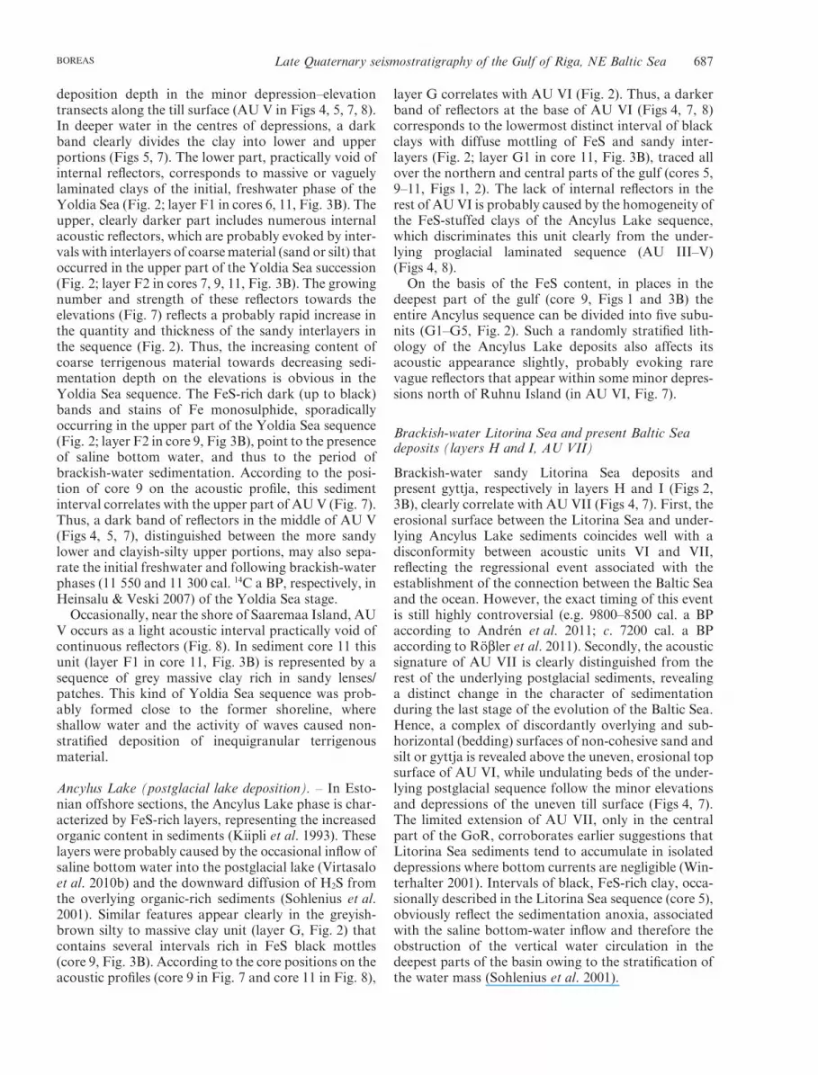
Fig. 3. A, B. Photographs of the most characteristic lithological units (layers A–I) and their stratigraphic interpretation (BIL = Baltic Ice Lake;YS = Yoldia Sea; AL = Ancylus Lake; LS = Litorina Sea; PLS = post-Litorina Sea) and some lithological features (S = sandy interlayer;DS = dropstone) described in various cores and discussed in the text.
Late Quaternary seismostratigraphy of the Gulf of Riga, NE Baltic Sea 677BOREAS

Layer C (>177 cm) was not described in our pilotstudy (Kalm et al. 2006) because the selected cores werenot deep enough or/and because of its restricted distri-bution. Thus, layer C was partially sampled only in twoadditional cores, 14 (117 cm) and 15 (177 cm), in thewestern part of the gulf (Figs 1, 2). It is made up ofbrown up to dark brown massive clay with dispersedsilt (core 14) that may contain rare gravel grains andhalf-rounded granitic clasts (core 15, Fig. 3A). Verysimilar sediments were earlier distinguished as a WGDunit on the nearby islands of Saaremaa and Hiiumaa(Kalm & Kadastik 2001). Thus, unit C is interpreted asthe WGD; that is, it consists of sediments deposited insubaqueous conditions, mostly through the active andcontinuous basal melt-out from the floating ice.
Layer D (>400 cm) was sampled in cores 3 (220 cm),4 (298 cm), 8 (123 cm), 12 (330 cm), 14 (181 cm) and 15(182 cm) (Figs 1, 2). It unites two former units ofvarved clays (B2 and C in Kalm et al. 2006), as theformer B2 with indistinct varve-like lamination wasreinterpreted as representing the first layer of the BalticIce Lake (BIL) sediments (C in Kalm et al. 2006; layer
D, Fig. 2). It is made up of alternating couplets of siltyand clayey layers forming annual varves. The colour ofthe sediments varies from grey to brown (Fig. 3A, B).Distinctive brownish intervals occasionally occur insome cores (e.g. core 12, Fig. 3A). Varves are graduallythinning upwards: from 5.5-cm-thick rhythmic cou-plets of distinct clay (3–5 cm) and silt (0.5–2.5 cm)layers in the lower part to only 2-cm-thick couplets inthe upper part of layer D (Fig. 2; cores 12 and 15,Fig. 3A). Occasional microlaminae within silty parts ofthe varves were described in the basal part of this layer(core 12, Fig. 3A). The coarse-grained material foundsporadically in the lower part of layer D (core 15,Fig. 3A) was probably rafted by ice (‘dropstones’).Layer D represents a typical seasonal/rhythmicsequence of proximal varves of the BIL.
Layer E (>400 cm) is described for the first time inthis study. It was sampled in additional cores 6(289 cm), 7 (250 cm) and 13 (369 cm). Lack of thissubstantial portion of sediment in our preliminarylithostratigraphy (Kalm et al. 2006: table 2) causedmisinterpretation of some previous units, particularly
Fig. 3. Continued
678 Arkady Tsyrulnikov et al. BOREAS

of their geological context with respect to the generaldeglaciation history of the region. Thus, the formationhistory of some units from Kalm et al. (2006) is revisedas they are relocated upwards in the new generalizedsection (Fig. 2).
Layer E is made up of greyish-brown clays, includingless than 2-cm-thick vague varves with negligible siltylayers (core 6, Fig. 3A, B). The entire layer E representsannual varves that were subsequently deposited in amore distal position, gradually continuing the rhythmicsequence of the BIL.
Layer F (>400 cm) was sampled in cores 5 (210 cm),6 (222 cm), 7 (237 cm), 9 (136 cm), 10 (276 cm) and 11(336 cm) (Figs 1, 2). It is made up of greyish-brownmassive or vaguely laminated clay with reddish-brownsilty and sandy interlayers (0.1–1 cm), which are par-ticularly distinct and high in numbers in the lower partof layer (F1, Fig. 2). The upper, vaguely laminated part(F2) contains rare black stripes or stains ofFe-monosulphide (FeS) (core 9, Fig. 3B). Exception-ally, in core 11 (about 25 m b.s.l., Fig. 1) F1 appears asa massive layer of clay with sandy/silty lenses/patches(core 11, Fig. 3B).
The occurrence of a larger number of reddish-brownsilty-sandy interlayers at the base of layer F, that is atits contact with layer E (core 6, Fig. 3B), obviouslymarks the lowering of the water level associated withthe basin drainage, indicating the end of the BIL stage(between 11 565 and 11 545 cal. 14C a BP according toAndrén et al. 2002). Thus, the sandy-clayey lower andthe vaguely laminated FeS-rich upper parts of layer F,namely the layers F1 and F2, probably indicate thefreshwater and the brackish-water stages of the YoldiaSea, respectively (Fig. 2).
Layer G (>370 cm) was penetrated in cores 5(260 cm), 9 (369 cm), 10 (225 cm) and 11 (151 cm)(Figs 1, 2). It consists of grey to greyish-brown massivesilty clays, often with distinct intervals of black, irregu-lar bands and stains of FeS. On the basis of the latterintervals, layer G can be occasionally, in the deeperpart of the gulf, divided into five distinct sublayersG1–G5 (Fig. 2; core 9 in Fig. 3B). In most sedimentcores, however, these intervals become unclear, as thedark bands and stains of FeS are less numerous andscattered irregularly all over layer G. Nevertheless, thestriking interval of dark FeS-rich clay (G1 in core 11,Fig. 3B) at the base of layer G (Fig. 2) is distinguishableeverywhere. The occasional intervals with bands andstains of FeS within postglacial lacustrine sediments area typical feature indicating deposits of the AncylusLake stage (Kiipli et al. 1993; Winterhalter 2001;Andrén et al. 2011).
Layer H can reach over 50 cm in thickness. It occursas the uppermost thin sediment unit in cores 7 (5 cm), 8(5 cm), 11 (3 cm), 12 (2 cm), 13 (2 cm) and 15 (10 cm)(Figs 1, 2). Exceptionally, in core 5, slightly south ofKihnu Island (Fig. 1), it is about 50 cm thick. Layer H
is represented by olive grey to brown sand and silt witha black FeS-rich interlayer of clay (2–4 cm) in itsmiddle part (Fig. 2). Sediment unit H discordantlyoverlies the older units, in our case the BIL in cores 8,12 and 15 (Fig. 3A), the Yoldia Sea in cores 7 (Fig. 3B)and 13, or Ancylus Lake in cores 5 and 11. In thedevelopment of the Baltic Sea, the olive grey sandy siltis typical sediment of the Litorina Sea stage, which setin with an extensive regression and widespread erosion(Kiipli et al. 1993; Veski et al. 2005).
Layer I is 32 cm thick. It consists of massive, looseorganic mud (gyttja), which is greenish-black in thelower half and becomes brownish, highly organic-richat the top of the layer. The layer was discovered only incores 9 (14 cm) and 10 (32 cm) from the deepest part ofthe gulf (Fig. 1), where it rests discordantly on theAncylus Lake sediments (core 9, Fig. 3B). This layerrepresents the post-Litorina Sea mud of the Baltic Sea.
Seismo-acoustic data
Owing to the varying geometry, intensity and densityof the seismic reflectors, the low-frequency echo-sounder recordings reveal a picture in which homoge-neous, uniformly coloured lighter/darker stripes withrare internal reflectors alternate with slightly or inten-sively layered and reflected darker bands (Fig. 4). Inall, seven acoustically contrasting units were distin-guished, the characteristics of which are summarized inTable 2. The thicknesses of the solitary bands/stripes,and thus also of the distinguished acoustic units inpostglacial sediments (units III–VIII), vary dependinglargely on the relief, that is, on the minor depressionsand elevations of the underlying till surface. Further-more, together with the thickness change, the acousticsignature in these units may also vary to some extent(Table 2; Figs 4–8). Owing to sparse sampling and tothe fact that most of the layers were sampled onlypartially, similar thickness changes were practically notidentified in the sediment cores. Therefore, the acousticdata supplement considerably our knowledge aboutthickness variations in the sedimentary layers des-cribed above.
Acoustic unit I (AU I) appears in the 4-kHz echo-sounder profiles always as the lowermost, greyish-blackand non-layered zone with no penetration of the acous-tic impulse (Figs 4–9). In high-frequency (250–500 Hz)seismic profiles, this unit has a scattered and chaoticinternal seismic pattern with rare reflectors above thebedrock surface (Fig. 4C). The top of this ubiquitousunit forms one of the strongest seismic reflectors in theQuaternary sequence (TS in Fig. 4C) and is clearlyvisible in all low-frequency echo-sounder recordings asthe upper limit of AU I (Figs 4–9). Its undulating char-acter reveals minor, variably shaped and successivelyplaced elevations and depressions along this surface.
Late Quaternary seismostratigraphy of the Gulf of Riga, NE Baltic Sea 679BOREAS

Often these depressions/elevations occur as elongated(channel- or ridge-like) features (Tsyrulnikov et al.2008), reaching over 20 km in length, 0.5 km in widthand about 30 m in depth or height.
According to the seismic data, the thickness of AU Imay reach more than 30 m in channel-like depressionsof the bedrock surface (Fig. 4C). The uppermost partof this unit was sampled in core 8 (Figs 1, 3A, 5) andinterpreted as Weichselian till (Fig. 2; layers A and B,Fig. 3A).
Acoustic unit II (AU II) was distinguished and fol-lowed only in the northwestern part of the gulf betweenCape Kolka and Saaremaa Island (Fig. 1). In theacoustic recordings, this unit always rests between AUI (glacial till) and the overlying AU III as a ratherhomogeneous, grey, acoustic interval, occasionallywith some internal darker and blurred reflector-likefeatures (Fig. 6A, B). Normally, its contact with theunderlying till surface is rather even. However, becauseof the undulating upper boundary the thickness of thisunit is very variable, reaching a maximum of 9 m. TheAU II unit was recovered in cores 14 and 15 (Fig. 6)and described as the WGD layer (Fig. 2; layer C in core
15, Fig. 3A). The mainly grey, homogeneous hue of thisunit (Fig. 6) is obviously caused by the sporadicallyoccurring coarse-grained material (gravel, graniteclasts) (Fig. 2; layer C in core 15, Fig. 3A) that nor-mally scatters the acoustic signal.
Acoustic unit III (AU III) rests either on the acous-tically impenetrable AU I (Figs 4, 5, 7, 8) or on thehomogeneous AU II (Fig. 6) and appears as the lower-most clearly layered interval in the acoustic recordings.Its acoustic signature consists of alternating dark bandsof numerous, very closely spaced strong acoustic reflec-tors and lighter homogeneous stripes without or withrare internal reflectors (e.g. Fig. 5). Commonly, thisunit might be divided into a darker lower and lighterupper part (Figs 4, 5, 7, 8). Except for the near-shoreareas, where usually glacial till (AU I) crops out on thesea floor, AU III is spread everywhere and its thicknessvaries normally from 6 to 9 m, reaching up to 20 m inthe centre of the deepest depressions. AU III wassampled in cores 3, 4, 8 (Figs 1, 5), 12, 14 and 15(Figs 1, 6) and interpreted as the distinctly varved low-ermost part of the BIL deposits (Fig. 2; layer D in cores12 and 15, Fig. 3A).
Fig. 4. Section of acoustic profile 04–02 (A) and its interpretation (B), showing the succession and internal reflector configuration of most ofthe acoustic units (AU) discussed in the text; red lines mark regional disconformities on the boundaries of the distinguished allounits (AF). C.The same section on the seismic profile: AU I = layer of Weichselian till; TS = its undulating uppermost surface; CH = occasionalchannel-/valley-like structure in the bedrock surface (BS). For location of the section see Fig. 1. This figure is available in colour athttp://www.boreas.dk.
680 Arkady Tsyrulnikov et al. BOREAS

Tab
le2.
Dis
ting
uish
edac
oust
icun
its
and
thei
rch
arac
teri
stic
feat
ures
.
Aco
usti
cun
itSe
ism
ic/a
cous
tic
sign
atur
eB
eddi
ng,d
istr
ibut
ion
and
posi
tion
ofth
eun
itT
hick
ness
AU
VII
Dar
kgr
eyis
hin
terv
alw
ith
subh
oriz
onta
l,cl
osel
ysp
aced
para
llel
refle
ctor
sth
atar
eon
lapp
ing
the
undu
lati
ngre
flect
ors
ofth
eun
derl
ying
unit
s.
Upp
erm
ost
unit
wit
hpa
ralle
lbe
ddin
g;ov
erlie
sdi
scon
form
ably
unde
rlyi
ngun
its
arou
ndm
inor
depr
essi
ons
alon
gth
eti
llsu
rfac
ein
the
deep
erpa
rts
ofth
egu
lf.
Abs
ent
onm
inor
elev
atio
nsal
ong
the
till
surf
ace;
upto
9m
,exc
epti
onal
ly27
m,t
hick
inth
ede
epes
tde
pres
sion
s.
AU
VI
Uni
form
lyco
lour
edlig
hter
and
dark
erba
nds
wit
hra
rein
tern
alre
flect
ors
alte
rnat
ing
wit
hsl
ight
lyor
inte
nsiv
ely
laye
red
dark
erba
nds
wit
hnu
mer
ous
refle
ctor
s.
Lig
htin
terv
alm
ostl
yvo
idof
refle
ctor
s;a
few
dark
erst
ripe
sm
ayap
pear
clos
eto
its
bott
oman
dto
p.
Bed
ded
sequ
ence
rest
ing
conf
orm
ably
onth
eun
dula
ting
top
surf
ace
ofA
UI
orA
UII
,w
idel
ydi
stri
bute
din
and
arou
ndth
ece
ntra
ldep
ress
ion
ofth
egu
lf;
late
rald
istr
ibut
ions
ofth
eun
its
shri
nkup
war
dsth
esu
cces
sion
.
Usu
ally
,doe
sno
tex
ceed
25m
,ho
wev
er,u
pto
40m
inde
epes
tde
pres
sion
s.
Nor
mal
ly4–
6m
,re
ache
s15
m.
AU
VG
reyi
shin
terv
aldi
vide
dby
ast
rong
stri
pein
the
min
orde
pres
sion
sal
ong
the
till
surf
ace;
addi
tion
alre
flect
ors
appe
arto
war
dsm
inor
elev
atio
nsw
here
this
unit
wed
ges
grad
ually
out.
Nor
mal
ly3.
5–5
m,
reac
hes
10m
.
AU
IVL
ight
hom
ogen
eous
inte
rval
wit
ha
few
thin
and
wea
kin
ner
band
sof
clos
ely
spac
edre
flect
ors.
Nor
mal
ly3.
5–5
m,
reac
hes
7m
.
AU
III
Dar
kba
nds
ofcl
osel
ysp
aced
refle
ctor
sal
tern
atin
gw
ith
light
erst
ripe
sw
itho
utor
wit
hra
rere
flect
ors.
Nor
mal
ly6–
9m
,re
ache
sup
to20
m.
AU
IIH
omog
eneo
usgr
eyac
oust
icin
terv
alw
ith
som
eoc
casi
onal
dark
eran
dbl
urre
dre
flect
or-l
ike
feat
ures
.N
on-l
ayer
edun
iton
top
ofA
UI;
occu
rslo
cally
only
inth
ew
este
rnpa
rtof
the
gulf
.
Var
ying
,rea
ches
upto
9m
AU
IIm
pene
trab
lefo
r4-
kHz
acou
stic
impu
lse
unit
wit
hhe
avily
undu
lati
ngup
per
surf
ace;
asc
atte
red
and
chao
tic
seis
mic
sign
atur
ein
the
250–
500
Hz
seis
mic
profi
les.
Ubi
quit
ous
non-
bedd
edlo
wer
mos
tun
iton
top
ofth
ebe
droc
kor
onth
eE
mia
nSe
ade
posi
ts.
Nor
mal
ly1–
10m
,loc
ally
mor
eth
an30
m.
Late Quaternary seismostratigraphy of the Gulf of Riga, NE Baltic Sea 681BOREAS

Acoustic unit IV (AU IV) rests everywhere conform-ably on AU III and is separated from it by one of thestrongest and darkest acoustic signature bands in thewhole of the postglacial sedimentary succession (Figs 4,5, 7, 8). Compared with the underlying, reflector-richAU III unit, AU IV appears on the profiles as a muchlighter, rather homogeneous interval with a few thinand weak inner bands of closely spaced reflectors(Figs 4, 5, 7, 8). The thickness of this unit normallyvaries from 3.5 to 5 m, reaching up to 10 m in thecentres of minor depressions. It is widely distributedaround the gulf, missing only in the shallow near-shoreareas where AU I, AU II or AU III crop out on the seafloor (Figs 5, 6). AU IV was sampled in cores 6, 7(Fig. 5) and 13 and is interpreted as distally varvedclays of the BIL (Fig. 2; layer E in core 6, Fig. 3A, B).
Acoustic unit V (AU V) unites the upper and lowerparts of the formerly recognized acoustic layers IV and
V (in Kalm et al. 2006), as, according to complex analy-sis of all available acoustic and lithological data, thisinterval should be treated as a separate acoustic unit.Thus, being composed of a set of vague and closelyspaced reflectors, this greyish interval obtains a dis-tinctly darker shade compared with the acoustic unitsbelow and above it (see Fig. 7).
Unit AU V overlies AU IV everywhere conformably.It is widely distributed around Ruhnu Island in thecentral part of the gulf but occurs also in the deepestnear-shore depressions along the till surface (Figs 4, 5,7, 8). In general, the seismic signature and greyish hueof AU V are highly varying, being clearly dependent onundulations in the till surface. In the central part ofdeeper depressions, a dark and striking stripe dividesthis unit into two distinct parts (Fig. 7). The lower,lighter part is practically void of internal reflectors; theupper one, however, clearly has a darker hue owing to
Fig. 5. Section of acoustic profile 95–29a(A) and its interpretation (B), showing aminor elevation along the till surface andthe acoustic units sampled in cores 7 and8. For location of the section see Fig. 1.This figure is available in colour at http://www.boreas.dk.
Fig. 6. Section of acoustic profile 95–31(A) and its interpretation (B), showing thestructure and the homogeneous, greyacoustic signature of the WGD layer (AUII) sampled in core 15. For location of thesection see Fig. 1. This figure is availablein colour at http://www.boreas.dk.
682 Arkady Tsyrulnikov et al. BOREAS

the numerous internal reflectors. Towards the tops ofelevations, the upper part gradually wedges out andbecomes darker, as the reflectors inside it becomestronger and more accentuated (Fig. 7). In places, inthe near-shore depressions, AU V may occur as a lightacoustic interval practically void of continuous reflec-tors (Fig. 8). The thickness of this unit normally variesbetween 3.5 and 5 m, reaching up to 10 m in the deepestdepressions. AU V was covered by cores 5–7 (Figs 1, 5),9 (Figs 1, 7), 10 and 11 (Figs 1, 8), and is interpreted asthe clayey sequence of the Yoldia Sea (Fig. 2; layer F incores 6, 7, 9, 11, Fig. 3A, B).
Acoustic unit VI (AU VI) is widely distributed in thecentral part of the gulf, but occasionally occurs also inthe deepest near-shore depressions. It rests everywhere
conformably on the darker greyish AU V, being sepa-rated from it by a distinct band of closely spaced par-allel reflectors (Fig. 7). The latter boundary normallybecomes darker and thus more accentuated above theslopes of the minor depressions. AU VI is largely voidof reflectors; however, a few darker bands of reflectorsoccur close to the bottom and top of this unit (Fig. 7).The thickness of AU VI is normally between 4 and 6 m,although it increases gradually towards the minordepressions in the till surface. Thus, similarly to AU III,AU IV and AU V, the thickest portions of this unit (upto 15 m) occur in the middle of these depressions. Fur-thermore, the seismic signature and general hue of AUVI are distinctly dependent on its thickness, that is, onits position above the minor depression–elevation
Fig. 7. Section of acoustic profile 95–29b(A) and its interpretation (B), showingthe thickness and acoustic signaturechanges in AU III–AU VII along theundulating till surface along a minorelevation–depression transect and theacoustic interval sampled in core 9. Redline marks the disconformity between AUVI and AU VII. For location of thesection see Fig. 1. This figure is availablein colour at http://www.boreas.dk.
Fig. 8. Section of acoustic profile 95–12(A) and its interpretation (B), showing theacoustic signatures of AU III–AU VI inthe near-shore area and the acoustic inter-val penetrated by core 11. For location ofthe section see Fig. 1. This figure is avail-able in colour at http://www.boreas.dk.
Late Quaternary seismostratigraphy of the Gulf of Riga, NE Baltic Sea 683BOREAS

transects (Fig. 7). Therefore, in some profiles AU VImay occur as a greyish-white interval without any clearinternal reflectors (Fig. 8). This unit was sampled incores 5, 9 (Figs 1, 7), 10 and 11 (Figs 1, 8) and is cor-related with the homogeneous FeS-mottled claysequence of Ancylus Lake (Fig. 2; layer G in core 9,Fig. 3B).
Acoustic unit VII (AU VII) is the uppermost acous-tic unit. It was distinguished in and around the minordepressions in the central part of the gulf, where it maydiscordantly overlie all six underlying acoustic units. Inthe acoustic profiles it appears as a unit with a darkgreyish colour that is obviously caused by the abun-dance of very closely spaced, subhorizontal and parallelreflectors (Figs 4, 7). If AU VII reaches more than6.5 m in thickness, normally gas-rich sediments impen-etrable for the acoustic pulse appear at its bottom(Figs 4, 7). Therefore, the maximum thickness of AUVII (up to 9 m) was measured in the (250–500 Hz)seismic recordings. AU VII was penetrated by cores 5,9 (Fig. 7) and 10 and correlated with the acousticallyindivisible sediments of the Litorina and post-LitorinaSea (layers H and I, Fig. 2; I in core 9, Fig. 3B). Con-tinuous disconformity between AU VI and AU VII(core 9, Figs 3B, 7) corresponds to the regional ero-sional surface that formed in this region during theregression at the beginning of the Litorina Sea stage.Numerous closely spaced, parallel reflectors in this unit(Figs 4, 7) are obviously produced by intercalatingsandy, clayey and muddy layers that are typical of theLitorina and post-Litorina sequence (layers H and I,Fig. 2).
Allostratigraphic subdivision
Differences between the lithological descriptions andgeneralized lithological sections presented in our earlierpilot study (Kalm et al. 2006) and in the present paper(i.e. the number of distinguished lithological units, theirthicknesses, lithological details, etc.) reveal a variablecomplex of Lateglacial and postglacial sediments inthe northern part of the GoR. Thus, similar small-scale lithological variability complicates considerablythe correlation of Lateglacial and postglacial sedimentsbetween different regions of the Baltic Sea. Thisproblem can, to some extent, be mitigated by an allos-tratigraphic approach, which in recent years has beenincreasingly applied in various districts around theBaltic Sea (Rijsdijk et al. 2005; Virtasalo et al. 2005,2007, 2010a; Räsänen et al. 2009).
Thus, instead of local lithological details and units,the main focus in the allostratigraphic subdivision is onstriking discontinuity surfaces that reflect importantevents and changes in the history of the Baltic Sea andcan be followed at the regional scale. In trying to cor-relate different discontinuity surfaces across the BalticSea, we have to consider that: (i) owing to the complexglacio-isostatic pattern, best expressed in contrastinguplift rates or even in opposite land movementsbetween the northern and southern parts of the BalticSea, the extent and even the existence of various trans-gressional and regressional events in different regionsof the sea may differ considerably; (ii) when relyingonly on seismo-acoustic data, one has to consider theequipment parameters, foremost the frequency band
Fig. 9. Section of acoustic (A) and seismic (B) recordings of profile 04–07 demonstrating a ridge-like glacial relief feature (R) along theundulating till surface (TS) buried under the Lateglacial and postglacial deposits (lpg), and a channel-like (CH) feature in the bedrock surface(BS) filled in with glacial deposits (AU I). For location of the section see Fig. 1. This figure is available in colour at http://www.boreas.dk.
684 Arkady Tsyrulnikov et al. BOREAS

employed, as the details in the recorded seismic signa-tures may differ considerably.
Two regional discontinuity surfaces can be followedboth in seismo-acoustic recordings (Fig. 4) and in sedi-mentary cores (Fig. 2). These enabled three allounits tobe distinguished in the northern part of the GoR(Table 3). The lower one, between lithological layers Band C (AU I and AU II), separates Lateglacial tillsediments (Allounit 1) from glacilacustrine and post-glacial ones. The regional discontinuity between litho-logical layers G and H (AU VI and AU VII), whichmarks the onset of the Litorina Sea, divides the glaci-olacustrine and postglacial lacustrine/marine sedimentsinto two allounits (Table 3). Thus, Allounit 2 containsthe pre-Litorina Sea deposits, and Allounit 3, the Lito-rina Sea to present Baltic Sea deposits.
Comparison of allostratigraphic boundaries andunits in the Lateglacial and postglacial sediments of thenorthern GoR with these of the Archipelago Sea, SWof Finland (Virtasalo et al. 2007, 2010a), reveals a greatsimilarity. Both regional discontinuity surfaces fol-lowed in the northern GoR divide the alloformationsalso in the Archipelago Sea. Thus, the B/C and G/Hboundaries in the northern GoR (Fig. 2) would respec-tively coincide with the lower boundary of the Drags-fjärd Alloformation and with the boundary betweenthe Korppoo and Nauvo alloformations in the Archi-pelago Sea. Unlike in the Archipelago Sea, in the north-ern GoR we could not find any evidence of adiscontinuity surface from the ice recession to thedrainage of Ancylus Lake, which separates the Drags-fjärd and Korppoo alloformations in the ArchipelagoSea. The latter boundary obviously marks some localepisodic event (Virtasalo et al. 2010a) and thereforeprobably has rather restricted extension.
Late Weichselian to Holocene depositionalhistory of the Gulf of Riga
On the basis of the distinctive and widespread discon-tinuity surfaces, the entire section can first be dividedinto three portions, allounits, which are followed in the
GoR and other areas inside and outside the Baltic Sea.Thus, the allostratigraphic approach allows us to con-sider the basal till or diamicton (layers A–B, AU I), theintermediate ice-proximal WGD, glaciolacustrine andpostglacial lake/marine deposits (layers C–G, AUII–AU VI) and the uppermost brackish-water marinedeposits (layers H–I, AU VII) as the first-order unitsrepresenting the main stages in the development of theBaltic Sea region, traceable at the regional scale. Thevarying lithology, as well as the rapidly changing thick-nesses and the wedging out of the lithological unitsinside the distinguished allounits, reflects the complexLateglacial and postglacial history of the GoR inaccordance with the melting of the Scandinavian IceSheet with the corresponding glacio-isostatic reboundand evolving of the Baltic Sea in front of the retreatingice margin.
Diamicton of the Late Weichselian glaciation(layers A–B, AU I)
On the basis of the shape, bathymetry and orientationof the GoR, as well as of the bedrock elevation divid-ing its central part, Tsyrulnikov et al. (2008) con-cluded that the main depression of the gulf has beenlargely eroded by NW–SE-advancing Pleistocene icestreams. The retreating Late Weichselian glaciers leftbehind a till layer (layers A and B, Fig. 2), which cor-responds to AU I and covers an erosional, slightlyundulating bedrock surface all over the study area(Figs 4C, 9B). Sediment layers A and B reflect agradual ice retreat, enabling us to follow the transitionbetween the deposits of the grounded glaciers andice-free bottom sediments. Oscillation and meltwaterdrainage at the bottom of the ice shaped the upper,irregular surface and thus caused the undulating thick-ness (1–10 m) of AU I (Figs 4C, 9C). However, morethan 30-m-thick channel- and ridge-like features ofvarious sizes and shapes appear locally along this layer(Figs 4C, 9C). They obviously represent various elon-gated glacial or glaciofluvial relief forms (valleys,eskers, drumlins, etc.; Tsyrulnikov et al. 2008), wellknown on the mainland.
Table 3. Allostratigraphic units.
Baltic sea development stage Lithostratigraphic unit in Table 2 Acoustic unit Allostratigraphic unit
Post-Litorina I AU VII Allounit 3Litorina Sea HAncylus Lake G AU VI Allounit 2Yoldia Sea F AU VBaltic Ice Lake E AU IV
D AU IIIIce recession C AU IILate Weichselian Glaciation B AU I Allounit 1
A
Late Quaternary seismostratigraphy of the Gulf of Riga, NE Baltic Sea 685BOREAS

WGD, glaciolacustrine and postglacial lake/marinedeposits (layers C–G, AU II–AU VI)
Ice recession and WGD deposition. – Continuous sub-aqueous basal meltout from floating ice, debris flows,dumping and grounding caused deposition of theWGD, which in the lithological section (Fig. 2; layerC in core 15, Fig. 3A), as well as in the acousticrecordings (AU II, Fig. 5), is distinguished only in thenorthwestern part of the gulf (Fig. 1). The limited dis-tribution of the WGD sediments obviously reflects itsrelation to the Pandivere and Palivere ice-marginalzones, located nearby on the Sõrve Peninsula (Fig. 1).Similarly, the WGD layer was earlier described in thePandivere and Palivere end-moraine zones on Saare-maa and Hiiuma islands (Kalm & Kadastik 2001).Thus, we suggest that continuous deposition of theWGD occurred during the stagnation of the position ofthe ice margin. A smooth transition from the WGDunit to the overlying glaciolacustrine clays (core 15,Fig. 3A) reflects a gradual change towards cyclic sedi-mentation in the proglacial lake.
The Baltic Ice Lake (glaciolacustrine deposition). – TheBaltic Ice Lake (BIL) phase with clearly laminatedvarved clays is distinguished in the lithological sectionin layers D and E (Fig. 2; cores 6, 12 and 15, Fig. 3A,B). The distinct gradation from thicker and coarse-grained proximal varves to thinner and fine-graineddistal varves upwards in these units reflects normalsedimentation in a proglacial lake with a graduallyretreating glacier, where at each point studied proximalconditions gradually change to more distal conditions.
In the acoustic recordings the BIL stage is clearlyvisible in the two lowermost, clearly laminated unitsAU III and AU IV (Table 2; Figs 4, 5, 7, 8). Thegradual retreat, possibly with shorter advancing pulsa-tions, of the ice margin and the replacement of theproximal varves by distal varves upwards in the sectionare revealed by the changes and variations in the hue(darkness) of these units. This could be because theproximal varves are more liable to evoke reflectorsbecause of their distinct lithological and thus acousticheterogeneity caused by rather thick silty (summer)layers.
Thus, owing to the numerous dense strong reflectors,the interval with proximal varves (layer D) (Figs 2, 3A)acquires in the acoustic recordings a distinctly darkerhue with rare alternating thin and lighter stripes (AU III,Figs 4, 5, 7, 8). The distal varves, in contrast, appearupwards in the section (layer E in Fig. 2 and in Figs 3A,B) as a lighter interval with a few weak inner reflectors(AU IV, Figs 4, 5, 7, 8). This reflects unambiguously ahigher lithological homogeneity, that is, a lower amountof the sandy-silty component in the distal varves.
The interval with strong reflectors that in placesoccur between AU III and AU IV (Figs 4, 5, 7, 8) was
probably not penetrated by any of the sampling cores.However, we suggest that it might be associated eitherwith the increase in the coarse component in the varves,owing to the short re-advance of the glacier, or with theinterlayers of massive clay containing dispersed grainsof coarser material. Such clays, lithologically differingdistinctly from the rest of the BIL deposits (varvedclays), and thus with greater potential for creatingseismic reflectors, were sometimes described within theBIL sequence in the nearby Pärnu Bay area (Hang et al.2010). A similar distinctively strong reflector within theBIL sequence was earlier described in the NorthCentral Baltic Sea and supposedly correlated with are-advance or a surge of the ice margin (Winterhalter2001).
The origin of the distinct reddish-brown intervalsoccurring in varved clays (core 12, Fig. 3A) is not clear.However, they may indicate either occasional surges,which carried the reddish material that the glacierswashed out from Devonian bedrocks into the BIL,or/and periods of toxidation of bottom sedimentsowing to the mixing of the water mass. The gradualincrease in the thickness of the BIL sequence (AU IIIand AU IV) towards the centres of the minor depres-sions, followed along most of the acoustic lines (e.g.Figs 7, 8), shows that the accumulation rate andamount of sediments at that stage were clearly depend-ent on the bottom topography of the lake.
Yoldia Sea (postglacial brackish-water/freshwaterdeposition). – A slightly darker band of closely spaced,weak reflectors in the lowermost part of AU V (Figs 4,5, 7, 8) is obviously evoked by occasional sandy-siltyinterlayers close to the bottom of sediment layer F(Fig. 2; core 6, Fig. 3B). The presence of coarse-grainedmaterial just above the distal varves of the BIL (AU IV;layer E, Fig. 2) points to significant changes in the sedi-mentary environment: a rapid lowering of the waterlevel (i.e. a much shallower sedimentary environment);and an abruptly increased influx of terrigenous materialinto the basin. Both of these facts can be linked to thecatastrophic drainage of the BIL between 11 565 and11 545 cal. 14C a BP (Andrén et al. 2002), when a rapidsea-level drop opened large areas to intensive landerosion. According to Talviste (1988) and Veski et al.(2005), the cataclysmic regression lowered the waterlevel in the Pärnu area, in the northeastern part of theGoR, by approximately 24–25 m. This remarkabledrainage event, triggered by the opening of the connec-tion with the world ocean as a result of the ice-marginretreat in south-central Sweden (Svensson 1991), isassociated with the onset of the Yoldia Sea (between11 565 and 11 545 cal. 14C a BP in Andrén et al. 2002).
The greyish-brown massive or vaguely laminated clayof the Yoldia Sea stage (Fig. 2; layer F in cores 6, 7, 9,11, Fig. 3A, B) has a distinctly different appearance onthe acoustic records, with respect to its position and
686 Arkady Tsyrulnikov et al. BOREAS
deposition depth in the minor depression–elevationtransects along the till surface (AU V in Figs 4, 5, 7, 8).In deeper water in the centres of depressions, a darkband clearly divides the clay into lower and upperportions (Figs 5, 7). The lower part, practically void ofinternal reflectors, corresponds to massive or vaguelylaminated clays of the initial, freshwater phase of theYoldia Sea (Fig. 2; layer F1 in cores 6, 11, Fig. 3B). Theupper, clearly darker part includes numerous internalacoustic reflectors, which are probably evoked by inter-vals with interlayers of coarse material (sand or silt) thatoccurred in the upper part of the Yoldia Sea succession(Fig. 2; layer F2 in cores 7, 9, 11, Fig. 3B). The growingnumber and strength of these reflectors towards theelevations (Fig. 7) reflects a probably rapid increase inthe quantity and thickness of the sandy interlayers inthe sequence (Fig. 2). Thus, the increasing content ofcoarse terrigenous material towards decreasing sedi-mentation depth on the elevations is obvious in theYoldia Sea sequence. The FeS-rich dark (up to black)bands and stains of Fe monosulphide, sporadicallyoccurring in the upper part of the Yoldia Sea sequence(Fig. 2; layer F2 in core 9, Fig 3B), point to the presenceof saline bottom water, and thus to the period ofbrackish-water sedimentation. According to the posi-tion of core 9 on the acoustic profile, this sedimentinterval correlates with the upper part of AU V (Fig. 7).Thus, a dark band of reflectors in the middle of AU V(Figs 4, 5, 7), distinguished between the more sandylower and clayish-silty upper portions, may also sepa-rate the initial freshwater and following brackish-waterphases (11 550 and 11 300 cal. 14C a BP, respectively, inHeinsalu & Veski 2007) of the Yoldia Sea stage.
Occasionally, near the shore of Saaremaa Island, AUV occurs as a light acoustic interval practically void ofcontinuous reflectors (Fig. 8). In sediment core 11 thisunit (layer F1 in core 11, Fig. 3B) is represented by asequence of grey massive clay rich in sandy lenses/patches. This kind of Yoldia Sea sequence was prob-ably formed close to the former shoreline, whereshallow water and the activity of waves caused non-stratified deposition of inequigranular terrigenousmaterial.
Ancylus Lake (postglacial lake deposition). – In Esto-nian offshore sections, the Ancylus Lake phase is char-acterized by FeS-rich layers, representing the increasedorganic content in sediments (Kiipli et al. 1993). Theselayers were probably caused by the occasional inflow ofsaline bottom water into the postglacial lake (Virtasaloet al. 2010b) and the downward diffusion of H2S fromthe overlying organic-rich sediments (Sohlenius et al.2001). Similar features appear clearly in the greyish-brown silty to massive clay unit (layer G, Fig. 2) thatcontains several intervals rich in FeS black mottles(core 9, Fig. 3B). According to the core positions on theacoustic profiles (core 9 in Fig. 7 and core 11 in Fig. 8),
layer G correlates with AU VI (Fig. 2). Thus, a darkerband of reflectors at the base of AU VI (Figs 4, 7, 8)corresponds to the lowermost distinct interval of blackclays with diffuse mottling of FeS and sandy inter-layers (Fig. 2; layer G1 in core 11, Fig. 3B), traced allover the northern and central parts of the gulf (cores 5,9–11, Figs 1, 2). The lack of internal reflectors in therest of AU VI is probably caused by the homogeneity ofthe FeS-stuffed clays of the Ancylus Lake sequence,which discriminates this unit clearly from the under-lying proglacial laminated sequence (AU III–V)(Figs 4, 8).
On the basis of the FeS content, in places in thedeepest part of the gulf (core 9, Figs 1 and 3B) theentire Ancylus sequence can be divided into five subu-nits (G1–G5, Fig. 2). Such a randomly stratified lith-ology of the Ancylus Lake deposits also affects itsacoustic appearance slightly, probably evoking rarevague reflectors that appear within some minor depres-sions north of Ruhnu Island (in AU VI, Fig. 7).
Brackish-water Litorina Sea and present Baltic Seadeposits (layers H and I, AU VII)
Brackish-water sandy Litorina Sea deposits andpresent gyttja, respectively in layers H and I (Figs 2,3B), clearly correlate with AU VII (Figs 4, 7). First, theerosional surface between the Litorina Sea and under-lying Ancylus Lake sediments coincides well with adisconformity between acoustic units VI and VII,reflecting the regressional event associated with theestablishment of the connection between the Baltic Seaand the ocean. However, the exact timing of this eventis still highly controversial (e.g. 9800–8500 cal. a BPaccording to Andrén et al. 2011; c. 7200 cal. a BPaccording to Röbler et al. 2011). Secondly, the acousticsignature of AU VII is clearly distinguished from therest of the underlying postglacial sediments, revealinga distinct change in the character of sedimentationduring the last stage of the evolution of the Baltic Sea.Hence, a complex of discordantly overlying and sub-horizontal (bedding) surfaces of non-cohesive sand andsilt or gyttja is revealed above the uneven, erosional topsurface of AU VI, while undulating beds of the under-lying postglacial sequence follow the minor elevationsand depressions of the uneven till surface (Figs 4, 7).The limited extension of AU VII, only in the centralpart of the GoR, corroborates earlier suggestions thatLitorina Sea sediments tend to accumulate in isolateddepressions where bottom currents are negligible (Win-terhalter 2001). Intervals of black, FeS-rich clay, occa-sionally described in the Litorina Sea sequence (core 5),obviously reflect the sedimentation anoxia, associatedwith the saline bottom-water inflow and therefore theobstruction of the vertical water circulation in thedeepest parts of the basin owing to the stratification ofthe water mass (Sohlenius et al. 2001).
Late Quaternary seismostratigraphy of the Gulf of Riga, NE Baltic Sea 687BOREAS

Conclusions
A complex lithological and seismo-acoustic study ofLateglacial and postglacial sediments in the northernGoR has allowed nine distinctive layers to be lithologi-cally distinguished and correlated with seven seismic/acoustic units. A regular set of seismo-acoustic profileshas enabled estimation of the distribution and thick-nesses of sedimentary units and also of some deposi-tional and environmental characteristics of sedimentsover a large area.
The depression in the bedrock holding the GoR wasto a great extent gouged and levelled by the activity ofPleistocene glaciers. The omnipresent till layer is eitherexposed on the bottom in the shallow near-shore areasor covered by younger sediments in the deep parts ofthe gulf. It is 1–10 m thick, but can reach more than30 m in the bedrock valleys; channel- or ridge-likeglacial relief forms.
An up to 9-m-thick sediment unit, covering the tilllayer between the Sõrve Peninsula and Cape Kolka, iscorrelated with the WGD deposits earlier reported onthe nearby islands.
The rest of the sediment sequence reflects well allstages in the development of the Baltic Sea, whereas thethicknesses and bedding configuration of AU III to AUVI (from the BIL to Ancylus Lake) clearly follow theundulations, that is, elevations and depressions on thesurface of the Late Weichselian till. Therefore, the post-glacial sediment layers are usually thicker and morecomplete in the centres of depressions and liable to thinand wedge out towards the elevations.
The distinct gradation from the proximal (layer D,AU III) to distal (layer E, AU IV) succession of glaci-olacustrine varved clays, normally 10–15 m thick, inchannel-like depressions up to 30 m thick, reflects sea-sonal differences in sedimentation in the BIL and thegradual retreat of the ice margin. The postglacialYoldia Sea stage (layer F, AU V), with the initial fresh-water (F1) and the following brackish-water (F2)phase, is reflected in a 3.5–5 m thick sandy/silty clayeysuccession. Following this, lacustrine clay of theAncylus Lake stage (layer G, AU VI) normally formsa 4–6 m thick layer. Exceptionally, in channel-likedepressions the thickness of Yoldia Sea and AncylusLake layers may reach up to 15 m. The subhorizontallybedded, latest sediment interval, from the Litorina Seato the present Baltic Sea (layers H and I, AU VII),overlies the older sediment units with an erosional dis-conformity that reflects a rapid regressional eventrelated to the establishment of the connection betweenthe Baltic Sea and the world ocean. The distribution ofLitorina to post- Litorina sandy and muddy organic-rich sediments is strictly limited to deep bottom depres-sions, where their thickness may reach up to 9 m.
Differences between the generalized lithological sec-tions based on the first 5 pilot cores (Kalm et al. 2006:
Table 2) and all available 15 cores reveal distinctivevariability, and thus complexity in correlating theLateglacial and postglacial sediments in the BalticSea, even in this very restricted area. An allostrati-graphic approach (i.e. distinctive discontinuity surfacesbetween lithological layers B/C and G/H) enables Late-glacial till (layers A–B), pre-Litorina Baltic Sea (layersC–G) and Litorina to present Baltic Sea (layers H–I)allounits to be distinguished in the northern GoR.Both of these allostratigraphic boundaries markingdiscontinuity surfaces can be followed, and thus corre-lated, outside the gulf in the northern Baltic.
Acknowledgements. – This research was financially supported by theEstonian Science Foundation (Grants 6992 and 9107) and the Esto-nian Research Council (Grant SF 0180048 s08). We thank the crewsof the R/V ‘Strombus’ and the R/V ‘Fyrbyggaren’ for their assistanceand cooperation onboard, respectively in 1995 and 2004. Both sets ofcomments by the reviewers J. Virtasalo and T. van Weering were veryuseful in improving the manuscript.
References
Andrén, T., Lindeberg, G. & Andrén, E. 2002: Evidence of the finaldrainage of the Baltic Ice Lake and the brackish phase of theYoldia Sea in glacial varves from the Baltic Sea. Boreas 31, 226–238.
Andrén, T., Björck, S., Andrén, E., Conley, D., Zillén, L. & Anjar, J.2011: The development of the Baltic Sea Basin during the last 130ka. In Harff, J., Björck, S. & Hoth, P. (eds.): The Baltic Sea Basin,75–97. Springer, Berlin.
Björck, J. 1999: Event stratigraphy for the last Glacial–Holocenetransition in eastern middle Sweden. Quaternaria A 6, 48 pp.
Flodén, T. 1980: Seismic stratigraphy and bedrock geology of thecentral Baltic. Contributions in Geology 35, 240 pp.
Hang, T., Kohv, M., Pai, K. & Tuvikene, T. 2010: Proglacial varvesindicate the stagnation of ice terminus during the formation ofPandivere–Neva ice marginal formations in eastern Baltic. InLorenz, S. & Lampe, R. (eds.): Ice, Water, Humans – QuaternaryLandscape Evolution in the Peribaltic Region: 12th Annual Meetingof the INQUA Peribaltic Working Group, 28–29. Greifswald,Germany.
Heinsalu, A. & Veski, S. 2007: The history of the Yoldia Sea inNorthern Estonia: palaeoenvironmental conditions and climaticoscillations. Geological Quarterly 51, 295–306.
Juškevics, V. & Talpas, A. 1997: Explanatory note to the map (scale1:200 000). In Seglinš, V. & Kajak, K. (eds.): The Map of theQuaternary Deposits of the Gulf of Riga, Geological Survey ofLatvia and Geological Survey of Estonia, 39 pp. State GeologicalSurvey of Latvia, Riga.
Kalm, V. 2006: Pleistocene chronostratigraphy in Estonia, southeast-ern sector of the Scandinavian glaciation. Quaternary ScienceReviews 25, 960–975.
Kalm, V. & Kadastik, E. 2001: Waterlain glacial diamicton along thePalivere ice-marginal zone on the West Estonian Archipelago,Eastern Baltic Sea. Proceedings of the Estonian Academy of Sci-ences, Geology 50, 114–127.
Kalm, V., Tsurylnikov, A., Hang, T., Tuuling, I. & Flodén, T. 2006:Late Weichselian and Holocene sediments and their acoustic signa-tures in the northeastern part of the Gulf of Riga. Baltica 19, 51–57.
Kalnina, L. 2001: Middle and Late Pleistocene environmental changerecorded in the Latvian part of the Baltic Sea basin. Quaternaria A9, 173 pp.
Kalnina, L., Juškevics, V. & Stiebrinš, O. 1999: Palyhostratigraphyand composition of Late Glacial and Holocene deposits from theGulf of Riga, Eastern Baltic Sea. In Andren, T. (ed.): Proceedingsof the Conference The Baltic Past, Present and Future. QuaternariaA 7, 55–62.
688 Arkady Tsyrulnikov et al. BOREAS

Kessel, H. 1976: Läänemere põhjasetete vanus. Eesti Loodus 3, 155–160.
Kessel, H. 1980: The age of the bottom deposits from the West-Estonian Archipelago of the Baltic Sea. Proceedings of the EstonianAcademy of Sciences, Geology 29, 17–23.
Kiipli, T., Liivrand, E., Lutt, J., Pirrus, R. & Rennel, G. 1993: Pin-nakate. In Lutt, J. & Raukas, A. (eds.): Eesti Selfi Geoloogia,76–103. Academy of Science of Estonia, Tallinn.
Lutt, J. 1987: Sedimentation in Pärnu Bay. Proceedings of the Esto-nian Academy of Sciences, Geology 36, 166–173.
Noormets, R. & Flodén, T. 2002a: Glacial deposits and Late Weich-selian ice sheet dynamics in the north-eastern Baltic Sea. Boreas 31,36–56.
Noormets, R. & Flodén, T. 2002b: Glacial deposits and ice-sheetdynamics in the north-central Baltic Sea during the last deglacia-tion. Boreas 31, 362–377.
Räsänen, M., Auri, J., Huitti, J., Klap, A. & Virtasalo, J. 2009: Ashift from lithostratigraphic to allostratigraphic classification ofQuaternary glacial deposits. GSA Today 19, 4–10.
Rijsdijk, K., Passhier, S., Weerts, H., Laban, C., van Leeuwen, R. &Ebbing, J. 2005: Revised Upper Cenozoic stratigraphy of theDutch sector of the North Sea Basin: towards an integrated lithos-tratigraphic, seismostratigraphic and allostratigraphic approach.Geologie en Mijnbouw 84, 129–146.
Röbler, D., Moros, M. & Lemke, F. 2011: The Littorina transgres-sion in the southwestern Baltic Sea: new insights based on proxymethods and radiocarbon dating of sediment cores. Boreas 40,231–241.
Savvaitov, A. & Veinbergs, I. 1999 : Linkuva stage of the last glacia-tion in Latvia. In Lukševics, E., Stinkulis, G. & Kalnina, L. (eds.):The Fourth Baltic Stratigraphical Conference, Problems andMethods of Modern Regional Stratigraphy, Abstracts, 99–100. Uni-versity of Latvia, Riga.
Sohlenius, G., Emenis, K.-C., Andrén, E., Andrén, T. & Kohly, A.2001: Development of anoxia during the Holocene fresh–brackishwater transition in the Baltic Sea. Marine Geology 177, 221–242.
Svensson, N.-O. 1991: Late Weichselian and early Holocene shoredisplacement in the central Baltic Sea. Quaternary International 9,7–26.
Talviste, P. 1988: Pärnu ümbruse geoloogilise arengu mudel. IX EestiGeotehnika Konverents, Teesid, 49–50.
Tsyrulnikov, A., Tuuling, I., Flodén, T. & Hang, T. 2004: Subdivi-sion of the Quaternary succession in the northern part of the Gulfof Riga, based on the high-resolution seismo-acoustic data. InPuura, I., Tuuling, I. & Hang, T. (eds.): The Eighth Marine Geo-logical Conference, The Baltic. 132 pp. University of Tartu, Tartu.
Tsyrulnikov, A., Tuuling, I. & Hang, T. 2008: Streamlinedtopographical features on and offshore the Gulf of Riga as evi-dence of Late Weichselian glacial dynamics. Geological Quarterly52, 81–89.
Veski, S., Heinsalu, A., Klassen, V., Kriiska, A., Lõugas, L., Poska,A. & Saluäär, U. 2005: Early Holocene coastal settlements andpalaeoenvironment on the shore of the Baltic Sea at Pärnu, south-western Estonia. Quaternary International 130, 75–85.
Virtasalo, J. J., Kotilainen, A. T. & Räsänen, M. E. 2005: Holocenestratigraphy of the Archipelago Sea, northern Baltic Sea: the defi-nitions and descriptions of the Dragsfjärd, Korppoo and NauvoAlloformations. Baltica 18, 83–97.
Virtasalo, J., Kotilainen, A., Räsänen, M. & Ojala, A. 2007: Late-glacial and post-glacial deposition in a large, low relief, epiconti-nental basin: the northern Baltic Sea. Sedimentology 54, 1323–1344.
Virtasalo, J., Kotilainen, A. & Räsänen, M. 2010a: Definitions ofTrollskär Formation and Sandön Formation in the ArchipelagoSea, northern Baltic Sea. Bulletin of the Geological Society ofFinland 82, 63–68.
Virtasalo, J., Löwemark, L., Papunen, H., Kotilainen, A. &Whitehouse, M. 2010b: Pyritic and baritic burrows and microbialfilaments in postglacial lacustrine clays in the northern Baltic Sea.Journal of the Geological Society, London 167, 1185–1198.
Winterhalter, B. 2001: The BASYS coring site in the North CentralBaltic Sea Basin – a geological description. Baltica 14, 9–17.
Late Quaternary seismostratigraphy of the Gulf of Riga, NE Baltic Sea 689BOREAS


