Embed Size (px)
Citation preview

L I F E O N T H E B AY A STEWARDSHIP GUIDE FOR EASTERN GEORGIAN BAY

1
Table of Contents
Introduction to the Eastern Georgian Bay Stewardship Guide 4 A Brief Natural and Cultural History of Eastern Georgian Bay 6 How to Use the Eastern Georgian Bay Stewardship Guide 16 Worksheets and Action Plans
1. Getting to Know Your Property 19
2. Before and During Construction on Land 23
3. Before and During Construction on Water 33
4. Your Drinking Water 39 a. Water Runoff Management 40 b. Surface Water 47 c. Private Wells 48
5. Your Wastewater and Septic System 53 6. Water Based Recreation 65
7. Gardening and Landscaping 73
a. Natural Buffers and Shoreline Access 74 b. Trees and Plants on your Property 78 c. Nutrients 89 d. Water Efficiency 95
8. Your Garbage 101 9. Storage and Proper Handling of Fuels, Pesticides and Other Household Chemicals 107
10. Living with Wildlife 119
a. Species at Risk 124 Glossary 129
Thewasconapp Thepub Aut GleGreJohAnd ArtwYan CovLauBlueGrePete
Printe Printe
e Stewardship Gs used as a modsequently, sect
propriate permis
e Eastern Georgblished by the G
hors:
nda Clayton, Geeg Mason, Georn Mason
drew Promaine,
work: ng Huang
ver photos: ura Fullerton- Gee Flag Iris.
eg Mason- Mooner Burtch- Yout
ed on recycled paper
ed in Canada
Guide for the Lakdel for the writinions have beension.
gian Bay Stewareorgian Bay Bio
eorgian Bay Biogian Bay Biosph
Georgian Bay I
eorgian Bay, Le
n River h Summit Stude
.
ke Huron Coastng this manual, a reproduced wit
rdship Manual isosphere Reserv
osphere Reservhere Reserve
Islands Nationa
eopard Frog,
ents
Thatline and th the
s ve
ve
al Park
2
ank Yo We are grateorganization Steering ComGlenda ClaytWendy CoopBob DuncansRandy FrencGreg MasonEric McIntyrePenny PeppeRebecca PolAndrew Prom
u!eful for the supns in preparing
mmittee: ton, Georgian B
per, Georgian Bson, Georgian B
ch, French Plan, Georgian Bay e, Eastern Georerell, Sans Soucllock, Georgian maine, Georgian
pport received g this manual.
Bay Biosphere Ray Land Trust Bay Associationning Services Biosphere Res
rgian Bay Stewaci and CopperhBay Biosphere
n Bay Islands N
from many ind
Reserve
n
erve ardship Councilead Cottage AsReserve ational Park
dividuals and
ssociation

We a
A
are grateful for
Assistance for this pro by the Ministry of N
Canada O
the support re
oject was provided atural Resources
Ontario Agreem
Thaeceived from th
ment
3
ank Yohe following or
u!
rganizations in
the production
n of this guide
.

Eastern Georgian Bay Stewardship Guide
4
Introduction Background In 1991, Ontario farmers developed the Environmental Farm Plan (EFP) to address the environmental concerns arising from agricultural production. Since then it has became the basis for the Lake Huron Stewardship Guide, a program for the Huron-Bruce shorelines and the Bruce Peninsula. Following the success of that program, the Canadian Committee for the Lake Huron Bi-national Partnership expanded the program to take in other areas of the Lake Huron Basin. The Eastern Georgian Bay Stewardship Guide is patterned after this program but is tailored to the unique ecological and community characteristics of Eastern Georgian Bay by addressing the risks, challenges and benefits of living along or near the coastal region. What is the purpose of the Eastern Georgian Bay Stewardship Guide?
The objective of the Eastern Georgian Bay Stewardship program is to support healthy ecosystems through the care and protection of our shorelines and our water, both ground and surface water. This book will guide you through an environmental assessment of your property. The Guide will help you see your property and your actions in a new way. It asks you to think about your land, the buildings and structures on your land, and how your actions affect the larger landscape. It asks you to rate how you affect the environment and water quality around your property. Finally, it recommends resources to further your understanding of ways of maintaining your property in order to decrease the risks to precious natural resources.
The Guide has two sections – an Introduction to the Natural and Cultural History of Eastern Georgian Bay and Worksheets & Action Plans. As you complete the worksheets, you will learn what you are doing right, and where you can modify your actions to help protect our natural environment. The worksheets provide basic background information, helpful tips and recommend resources to further your understanding on each topic. By taking steps to protect your shoreline and water quality, you are making a wise investment as a property owner. You will also help preserve Ontario’s natural legacy for future generations. No individual can single-handedly solve the issue of water quality or environmental deterioration but collectively we can make a difference.

Eastern Georgian Bay Stewardship Guide
5
Is this Guide for you?
This Guide is intended for residents, cottagers and property owners along the eastern shore of Georgian Bay from Port Severn in the south to Killarney in the north. The focus is on the communities and landscapes west of Highways 400 and 69, coastal Georgian Bay and the adjacent lakes. This area encompasses the Georgian Bay Biosphere Reserve, a UNESCO designated area committed to sustainable development and conservation.

6
A Brief Natural and Cultural History of Eastern Georgian Bay Physical Geography The Lake Huron/Georgian Bay watershed and shoreline contains some very significant cultural and ecologically rich features and places, the result of thousands of years of evolution, glacial activity and human development. The following is a brief description of how this landscape came to be
Along the eastern shore of Georgian Bay lie the 30,000 islands, the largest freshwater archipelago in the world. Georgian Bay is one of the three basins that make up Lake Huron, the fifth largest freshwater lake on the planet. Over two hundred kilometres long, Georgian Bay is almost the same size as Lake Ontario and is big enough to be one of the world's 20 largest lakes. Georgian Bay is separated from the rest of Lake Huron by the Bruce Peninsula to the west and Manitoulin Island to the north. It is often referred to as the sixth Great Lake and is noticeably different from Lake Huron in terms of landscape and ecology. It even creates its own weather, waves, and currents. The characteristic Georgian Bay landscape was shaped by the sheets of ice that covered the entire Great Lakes Basin 70,000 years ago. The glaciers advanced in four major lobes, following the depressions in which the Great Lakes now sit. These lobes extended well beyond the present lakes. In southern Ontario, the three major lobes were associated with the Ontario, Erie and Huron basins and smaller lobes advanced out of Georgian Bay and the Lake Simcoe lowlands.
About 10,500 year ago, the melting glaciers formed Lake Algonquin, which covered the areas of the present Lake Michigan, Lake Huron and Georgian Bay. It drained through the French and Mattawa river valleys. This outlet was formed when the French and Mattawa valleys, which had been depressed
about 200 metres by the glaciers, became free of ice. During the initial stages of this outflow to the east, a small lake remained in each of the Michigan, Huron and Georgian Bay basins. Over a few thousand years, as the melting increased, these small lakes grew in size to form one large lake known as Lake Nipissing.
About 6,000 years ago, the waters of Lake Nipissing drained through three different outlets, the French-Mattawa valleys, the Mississippi, and Lake St. Clair. Uplift in the northeast caused the flow in the French River Valley to be reversed. Eventually the St. Clair route became the only outlet for Lake Nipissing leading to the drainage of all the Great Lakes down the St. Lawrence Valley and the shape of the lakes we know today. The Great Lakes Basin continues to rise at a rate of 7.5 cm every 100 years.
The glaciers also shaped our landscape as soil was scraped from some areas and glacial till deposited in other areas. The rocks were scoured and polished. Depressions were left that formed lakes and wetlands. The result is our unique landscape of barren rocks, shallow soils and gently rolling ridges. Most of the rocks we admire along the coast today are gneiss, which were formed one billion years ago during a series of mountain building events which baked, squeezed, stretched and twisted the rock. These colourful metamorphic rocks are the eroded remains of those mountains. Today, the land along Lake Huron and Georgian Bay continues to undergo change, incorporating recreational and residential land uses and activities. For more information: Shaped by the West Wind by Clare Campbell. 2005, UBC Press.

7
Local Ecology: Our Natural Neighbourhood
Georgian Bay’s cobalt blue waters, windswept pines and smooth gneiss rocks captivate both visitors and residents. The beauty of our landscape is renowned through the works of many artists including the Group of Seven. It is a place where people enjoy being outdoors. Ecologically speaking, we live in a rich and diverse neighbourhood. With 30,000 plus islands, over 5,000 kilometres of shoreline, rock barrens, mixed forests, hundreds of lakes and a wealth of wetlands, the eastern Georgian Bay coast has a remarkable variety of habitat and wildlife. The coastal wetlands of Georgian Bay are among the highest quality on the Great Lakes and provide important nesting areas for birds, turtles, and amphibians. This area is recognized as one of the most biologically diverse regions in the province and is globally recognized as a UNESCO world biosphere reserve. The appeal of retreating to water for rest and relaxation is increasing in popularity. Year round rather than seasonal use of properties is becoming more common. We need to be aware of how our activities and behaviour affect our natural neighbourhood. As individuals and communities our actions can help maintain and restore habitat. Taking care of the health of our land and water is important for the well being of wildlife and future generations. Taking the time to create your own stewardship action plan is an excellent first step.
Getting to Know Your Natural Neighbourhood Georgian Bay is famous for its islands. From the outer reefs and islets, to the larger forested islands and mainland areas, there are a range of ecological functions. This diversity of islands also supports a number of important habitats that contribute to the many unique and special species on eastern Georgian Bay.
Eastern Foxsnake (Endangered) credit Gary Allen

8
Important Habitats • Wetlands are the filter between land and water. They act as
water purifiers, cleaning surface and groundwater before it enters Georgian Bay. There are four types of wetlands found in our area: swamp, marsh, bog and fen. This mixture of wetlands provides diverse habitats. It is estimated that more than 2/3 of all lake species reproduce in wetlands and the near shore areas, including birds, fish, reptiles and amphibians. Coastal wetlands provide nesting sites for many colonial nesting birds (e.g. herons, terns and gulls).
• Shorelines of the coast and inner islands can provide habitat
for uncommon plant species such as Virginia Meadow Beauty and Carolina Yellow-eyed Grass. These plants are referred to as Atlantic Coastal species and, as the name implies, are normally found along the eastern seaboard. In eastern Georgian Bay they are found in undisturbed areas with gently sloping sand and gravely shorelines where seasonal water level changes naturally occur. Sun exposed cobble beaches and rocky shores provide excellent habitat for reptiles, such as Common Map Turtle (Special Concern), Northern Watersnake and the Eastern Foxsnake (Endangered).
• Vernal Pools or spring ponds are temporary pools of water.
They may vary in size but are often quite small. Vernal pools are found in low lying areas and hold water primarily in the spring and sometimes in the fall. Since they lack fish predators, they become essential in the reproduction of many species of amphibians and insects.
Rock barrens and rock outcrops are found throughout the biosphere reserve. Only a limited number of plants and animals can survive in these harsh conditions, cycles of heat, cold and drought. Low growing plants such as lichens and Common Juniper are typical species. Stunted White Pine and Red Oak are also found. Birds like the Prairie Warbler and the Common Nighthawk favour these areas. Despite the name, the Common Nighthawk is now considered to be a threatened species. Ontario’s only lizard, the Five-lined Skink (Special Concern), are also concentrated in these areas.
• Large mixed forests are found on the
large inner islands and shoreline. These areas tend to have deeper soils and support tree species such as Sugar Maple, American Beech, Hemlock, and Yellow Birch. The large trees hold water, reduce erosion, and build soil. The forested areas influence the local climate by providing shade, increasing humidity and reducing winds. This area retains large areas of forests, and as a result, interior forest species such as the Red-shouldered Hawk and the Pileated Woodpecker are found here. The forests also provide habitat for White-tailed Deer, Black Bear, Eastern Wolf (Special Concern) and Fishers.
For more information on which species at risk rely on these habitats, please go to Section 10.
Take Action Would you like to Adopt a Wetland? Contact Georgian Bay Forever to find out how you can assist in wetland research on Georgian Bay at www.georgianbayforever.org
Please leave rocks in their natural location.

9
Where do we fit in? Broad Scale: a Watershed Perspective What is a Watershed? A watershed is the entire land/water area that drains into a body of water such as an ocean, lake, river, or pond. The boundaries of a watershed are formed by the highest points in the landscape— they are like the edges of a bathtub or sink—any water that falls within it will drain into the same water body. On its journey downwards, the water within a watershed can pass through different landscape features such as streams, rivers, lakes, bogs and marshes. The Lake Huron/Georgian Bay watershed forms part of the larger Great Lakes-St. Lawrence Watershed. The first step in protecting aquatic ecosystems is to better understand your place in this watershed. Become familiar with local natural features and understand how they function in relation to this watershed and to aquatic health. Why should you be concerned? YOU live in the Georgian Bay Watershed. Your actions and those of your neighbours affect the aquatic health of this watershed.

10
Georgian Bay’s 30,000 Islands
Where Are You Located? The Outer Islands • Generally relatively small, low islands (less than 1
hectare.) • Exposed to ice, wind and water erosion • Vulnerable to high water levels • Low level of biodiversity Habitat Types • Bedrock shoreline • Rock Barrens Typical Species • Limited plant species, e.g. lichens • Cold water fish species including Lake Trout • Colonial nesting birds, e.g. gulls, terns and cormorants Human Influence • Generally limited impact, minimal use by recreational
boaters/fishers. • Some outer islands are being developed. • Colonial nesting birds are susceptible to disturbance by
people and their pets during nesting season.

11
Georgian Bay’s 30,000 Islands
Where Are You Located? (continued) The Intermediate Islands • Medium sized (1-5 hectares.) • Sheltered by outer islands • Provide “stepping stones” for migrating species • Higher level of biodiversity Habitat Types • Wetlands including small marshes (typically on lee side)
spring ponds and small “perched” bogs (rocky depressions filled with sphagnum moss)
• Bedrock/cobble and small natural sand beaches • Rock outcrops/barrens • Some forest cover Typical Species • Tree species such as White Pine and Red Oak. • Some small to medium sized mammals including Raccoon,
Porcupine and Red Fox • Common amphibians such as American Toad and Green
Frog and numerous reptile species including endangered Spotted Turtles and Eastern Foxsnakes
• Many species of song and shoreline birds, e.g. Pine Warbler, Tree Swallow, Spotted Sandpiper
Human Influence • Increasing level of impact from cottage development, boat
traffic and recreational camping.
Credit Parks Canada
12
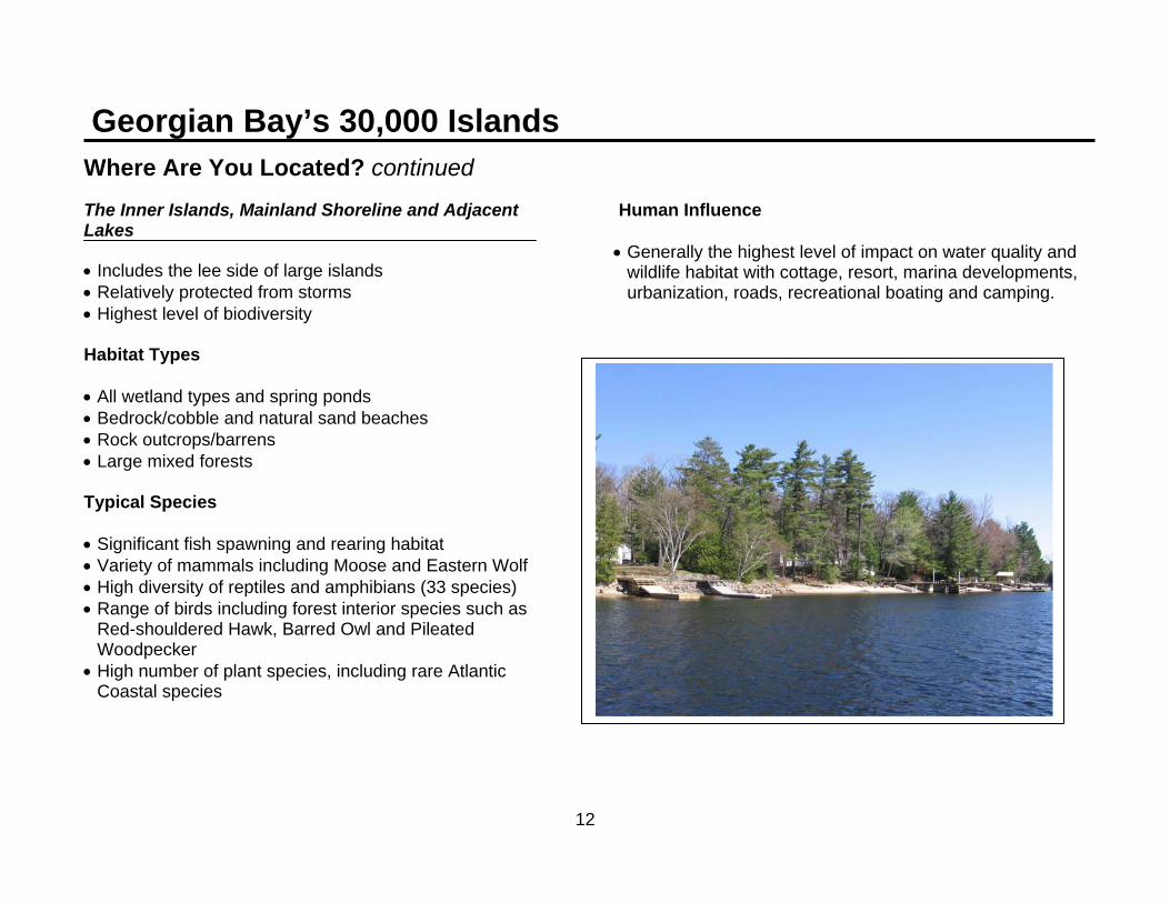
Georgian Bay’s 30,000 Islands
Where Are You Located? continued The Inner Islands, Mainland Shoreline and Adjacent Lakes • Includes the lee side of large islands • Relatively protected from storms • Highest level of biodiversity Habitat Types • All wetland types and spring ponds • Bedrock/cobble and natural sand beaches • Rock outcrops/barrens • Large mixed forests Typical Species • Significant fish spawning and rearing habitat • Variety of mammals including Moose and Eastern Wolf • High diversity of reptiles and amphibians (33 species) • Range of birds including forest interior species such as
Red-shouldered Hawk, Barred Owl and Pileated Woodpecker
• High number of plant species, including rare Atlantic Coastal species
Human Influence • Generally the highest level of impact on water quality and
wildlife habitat with cottage, resort, marina developments, urbanization, roads, recreational boating and camping.
13
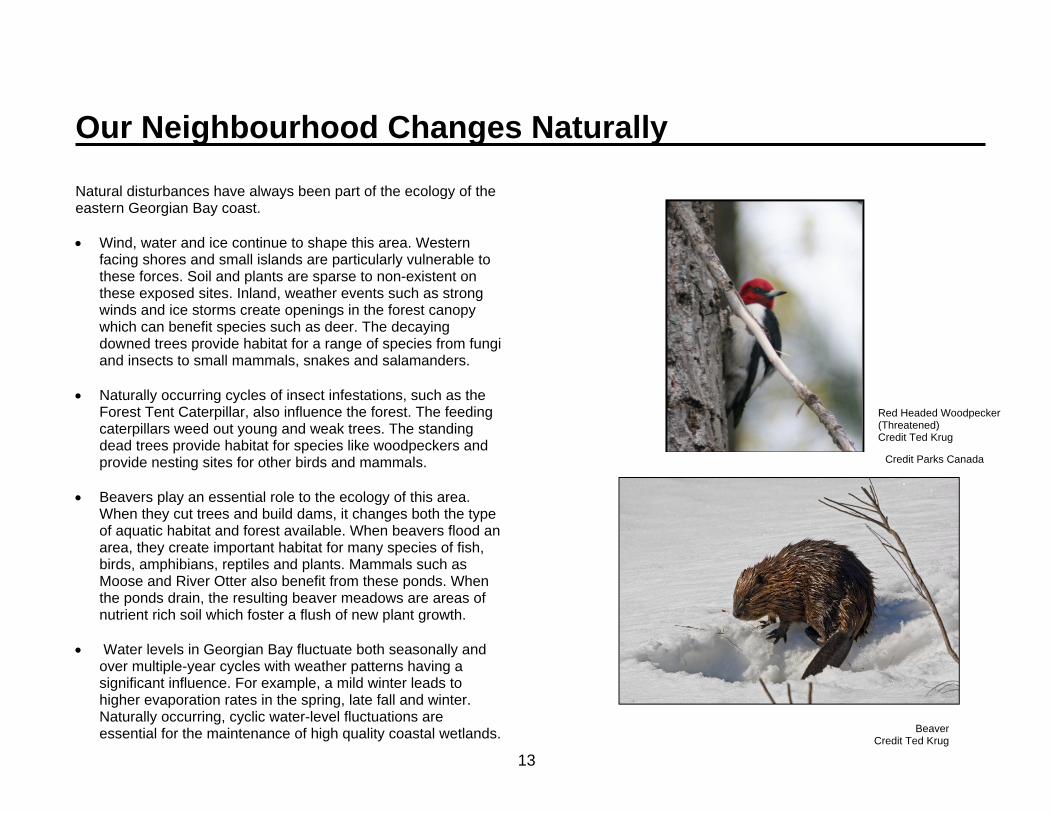
Our Neighbourhood Changes Naturally Natural disturbances have always been part of the ecology of the eastern Georgian Bay coast. • Wind, water and ice continue to shape this area. Western
facing shores and small islands are particularly vulnerable to these forces. Soil and plants are sparse to non-existent on these exposed sites. Inland, weather events such as strong winds and ice storms create openings in the forest canopy which can benefit species such as deer. The decaying downed trees provide habitat for a range of species from fungi and insects to small mammals, snakes and salamanders.
• Naturally occurring cycles of insect infestations, such as the
Forest Tent Caterpillar, also influence the forest. The feeding caterpillars weed out young and weak trees. The standing dead trees provide habitat for species like woodpeckers and provide nesting sites for other birds and mammals.
• Beavers play an essential role to the ecology of this area.
When they cut trees and build dams, it changes both the type of aquatic habitat and forest available. When beavers flood an area, they create important habitat for many species of fish, birds, amphibians, reptiles and plants. Mammals such as Moose and River Otter also benefit from these ponds. When the ponds drain, the resulting beaver meadows are areas of nutrient rich soil which foster a flush of new plant growth.
• Water levels in Georgian Bay fluctuate both seasonally and
over multiple-year cycles with weather patterns having a significant influence. For example, a mild winter leads to higher evaporation rates in the spring, late fall and winter. Naturally occurring, cyclic water-level fluctuations are essential for the maintenance of high quality coastal wetlands.
Red Headed Woodpecker (Threatened) Credit Ted Krug
Beaver Credit Ted Krug
Credit Parks Canada

14
Past & Present Human Influences Although eastern Georgian Bay retains many of the qualities of a wilderness area, this landscape has changed as a result of human behaviour. Historical impacts of Aboriginal people were minor and limited to areas around their seasonally used camps. • The first significant landscape changes began in the mid
1800’s with extensive logging. By the early 1900’s much of this area was deforested. High intensity fires were common since much of the slash was left on the ground. These fires damaged the shallow soils and led to increased erosion. The forests that we see today are secondary growth.
• Commercial fishing followed a similar history to the logging
industry. In the late 1800’s approximately two million pounds of fish (White Fish, Yellow Pickerel and Lake Trout) were harvested per year in Georgian Bay. By 1960, the harvest was reduced to 98 thousand pounds. Unsustainable harvests and the introduction of sea lamprey led to decline of commercial fishing in Georgian Bay.
• The “cottage industry” began in the late 1800’s and continues
to grow in eastern Georgian Bay. Recreational boating, camping and fishing are also popular activities. This has led to an increase in habitat loss and fragmentation as more buildings, roads and trails are constructed. Species that are particularly sensitive to habitat fragmentation include Eastern Wolf (Special Concern), Lynx, Red-Shouldered Hawk, and several species of reptiles. Development can restrict the natural movement patterns of wildlife leading to isolated populations that are vulnerable to a number of stresses including in-breeding. Other impacts associated with recreational and residential property development include the discharge of sewage and other forms of pollution, an increase in non-native species, and the death of wildlife by pets,
vehicles and boats. Island ecosystems can be particularly vulnerable to human disturbance. A number of bird species, such as loons, herons and terns will not nest successfully when people frequent an area.
• There are now more than 160 non-native species in the Great
Lakes. Many of these species have been introduced by ocean going ships dumping ballast water into the Great Lakes. Invasive species lack natural predators and may displace some native species. They can also bring foreign diseases that negatively impact native species. Once established, invasive species can be very expensive to control.
• Climate change is a natural phenomenon but we are
responsible for accelerating the rate of change. Some species will prosper in our area with warmer conditions and others will be negatively impacted. Greater and more frequent extreme weather events are predicted. The effect of global warming on water levels is unclear; some experts predict lower water levels while others indicate it may result in higher water levels. Any changes in water levels beyond historical norms will result in a loss of wetland habitat and potential shoreline erosion problems.
FYI
For more information on climate change and the predicted impacts for Ontario, please go to www.gogreenontario.ca

15
Past & Present Human Influences (continued) • Recreational and commercial boating also impacts water
quality with combustion residues from marine engines, oil and gasoline spills, and the discharge of contaminated water into the Bay.
• Excessive algae episodes, which are sometimes but not always associated with human impact, have occurred in areas such as Sturgeon Bay. The presence of blue-green algae means that contact with the water is not safe. Remediation can require many years to accomplish, can be very expensive and may not produce the desired results.
• In comparison with the lower Great Lakes, Lake Huron and Georgian Bay have relatively good water quality. In the past, people were comfortable taking water directly from Georgian Bay; however, it is recommended that all drinking water be treated. The greatest threat to drinking water safety comes from tiny microbes, including bacteria, viruses and parasites found in human and animal waste. Future increases in the number of homes, cottages, marinas and boats on Georgian Bay may reduce water quality, especially in confined inner bays and near shore areas. Water quality is jeopardized by nutrient leaching from septic systems, shoreline erosion, runoff from fertilizers, herbicides and pesticides on lawns, and spills of solvents or other toxic materials. Taking the steps outlined in Worksheets #2-9 will help maintain good water quality which is crucial for our health and the continued safe enjoyment of the waters of Georgian Bay.

16
How to use the Eastern Georgian Bay Stewardship Guide
The Worksheets & Action Plans
This section includes ten worksheets to help you evaluate your activities on your property. Pick only the worksheets that apply to your property. Read the introductory page and rate the topics that apply to you in the right hand column. For topics that don’t apply, write the letters ‘NA’ (not applicable) in the rating box. If you don’t know how you rate, mark the box with a question mark to remind yourself to get the necessary information. For each topic, there are four descriptions of either natural conditions or current situations. Each has a number rating:
4 (Best) 3 (Good) 2 (Fair) 1 (Poor)
The Best (or 4) rating describes conditions that protect the environment and water quality or have the lowest potential for environmental damage. The Poor (or 1) rating describes conditions that have the highest potential to affect the environment negatively and which require remediation. Note the condition that best describes your property. If you rank 1 or 2, mark that number in the matching box at the right hand side of the worksheet. The purpose of this rating system is not to tally the numbers in the right-hand column, but to identify areas in
need of improvement. A rating of 1 or 2 indicates areas of your property management in need of improvement to reduce the potential for environmental damage and water contamination. These are the topic areas you should address in an Action Plan. An Action Plan form is found at the end of each worksheet section. Often, the information in columns 4 and 3 can indicate how to improve your practices. As well, you can consult the Resources List at the end of each worksheet to find more information for developing your Action Plan. Remember, this is YOUR Action Plan. It must suit you and your property. NOTES: Bold, italic type indicates conditions that may violate provincial legislation. Federal laws or municipal bylaws may also apply. Contact your local municipal government office for more information.

17
Example of a completed worksheet question:
Topic Best 4 Good 3 Fair 2 Poor 1
Your RatingAVOID ATTRACTING NUISANCE WILDLIFE
1. Food and waste
scraps
All food/waste (including pet food and bird seed) is stored indoors in rodent/bear proof containers. Recyclables are rinsed and stored. Waste is taken to sanitary landfill. Compost is properly maintained. BBQ is cleaned and stored in a secure area
Garbage is temporarily stored outside, but in rodent/bear proof containers. Waste is taken to sanitary landfill.
Empty food and drink containers are rinsed. Garbage is stored in sealed containers in an out building. Waste is taken to sanitary landfill.
Compost is improperly maintained, or rodent/bear proof containers are not used. Waste is improperly disposed.
Example of a completed action plan: Topic Number
Workshop Theme
My Rating Short-term Action Long-term Action
Living with Wildlife Topic 4
Food waste and scraps
2 Research options for composting and bear proof storage of garbage.
Purchase and properly install or build a bear proof garbage container or store garbage in a sealed container in a basement. Recyclables are stored in a secure fashion. Composting is carefully managed.
2

18
The Physical and Cultural Landscape: A Resource List For more information…. Conservation and Stewardship • Fisheries and Oceans Canada
867 Lakeshore Road Burlington, ON L7R 4A6 [email protected]
• Ministry of Natural Resources Parry Sound 7 Bay Street Parry Sound P2A 1S4 705-746-4201 www.mnr.gov.on.ca
• Ontario Stewardship www.ontariostewardship.org
• Living by Water
www.livingbywater.ca
• Muskoka Watershed Council 705- 645-7393 www.muskokaheritage.org/watershed
• Georgian Bay Biosphere Reserve Inc. www.gbbr.ca
• Invading Species 1-800-563-7711 www.invadingspecies.com
• Georgian Bay Islands National Park
www.pc.gc.ca/pn-np/on/georg/index
Books: • Dobson. C., and Beck, G.G. 1999. Watersheds. Willowdale,
ON: Firefly Books Ltd. Water Quality • North Bay Parry Sound District Health Unit
70 Joseph Street Parry Sound P2A 2G5 705-746-5801 www.healthunit.biz
Cultural History Ontario Public Libraries • Search their website to find your local library:
www.culture.gov.on.ca/english/culdiv/library
• West Parry Sound District Museum 17 George Street Parry Sound www.wpsdm.com 705-746-5365
Books: • Barry, James, Georgian Bay, The Sixth Great Lake, 1978,
Boston Mills Press

19
Worksheet #1 - Getting to Know Your Property Why should you be concerned?
• In “cottage country”, you are your own WATER QUALITY STEWARD!
• Upstream practices WILL affect your property.
• Provincial regulations and municipal bylaws are
designed to protect our shorelines and waterways, and these may restrict how you may use your property.
• A property’s soil and landforms can influence water
quality. Your development and use can also affect the environmental quality of your property, which may impact your enjoyment of it.
What you can do.
1. You or your legal representative can contact your local municipality or the local Ministry of Natural Resources office to learn of any alteration restrictions (especially shorelines) and how these may affect any future property projects.
2. Talk with long-time residents to learn more about how
the property may be affected by natural processes and potential hazards.
3. Consider making a map of your property. Identify
physical and environmental characteristics such as soil type and depth, vegetation communities, ponding areas and learn how these can affect the vulnerability of your property to natural hazards and contribute to a healthy ecosystem on and off your property. Accept these natural conditions and modify your activities accordingly to protect yourself, your property and your shoreline. Sound difficult? We’ll help you do it.
4. Determine if current services (e.g. water and sewage)
are adequate for your planned/intended use of the property.
5. Look beyond your property boundaries with a view to
identifying the potential for erosion and the contamination of surface water and groundwater.

20
Making a Map of Your Property Why make a map? A map will help you understand the natural characteristics of your property and how your development and use of your property may affect them. Sometimes a small change in your actions is all that is needed to avoid problems. A map may help you identify any potential risks to water quality and ensure property use is compatible with legal restrictions. It is an important tool for the future management of your property. You could draw your map on standard graph paper or better still, enlarge a copy of the survey of your property or download an image from an on-line map provider such as Google Earth or Microsoft Live Earth. What should you include on your map? 1. Natural Features
o Wetlands, streams and ponding areas o naturally vegetated areas including type of plants
(trees, shrubs, etc.) o rock outcrops o aquatic areas with boulders or aquatic plants.
2. Proposed or Existing Structures
o cottage, home and other buildings o orientation of all living spaces (sunlight/shadows) o docks and boathouse o roads, driveways, parking and/or other impervious
surfaces o sewage system leaching bed, outhouses
o foundation drains and outlets, all drinking wells (including dry or abandoned wells) or location of surface water intake
o eaves trough drains and direction of drainage from them
o sump pump drains/swimming pool backwash drain/area used for swimming pool or hot tub drainage water
o dog house/dog run o hazardous materials storage (paints, solvents, etc.)
and any underground or aboveground storage tanks of fuel oil, gasoline, or other petroleum product
o any buried cables or underground infrastructure including fuel tanks. .
3. Landscaped Features o trees, flower beds, vegetable garden(s) or any
cultivated area(s) o area for snow piles and snowmelt.
4. Legal Considerations
o Municipal zoning o Property setbacks, conservation easements,
environmentally sensitive areas, floodplain restrictions, shoreline road allowances and right-of-ways. Environmentally Sensitive Areas (ESA) are designated zones of valuable ecological features or habitat that need special protection due to its surrounding landscape, wildlife or historical value.
Be careful about where you think your property ends. Government retains ownership of land to the high water mark. Erection of fences or other obstructions below this point is illegal.
Tip

MMaking aa Map of Your PPropert
21
ty (exampple)

22
Resource List Getting to Know Your Property
For more information…. Environment Canada Edgett, R. 1995. Buyers Guide to Shoreline Property: Great Lakes and St. Lawrence River. Conservation Association of Ontario/Environment Canada: Burlington, ON. Fisheries and Oceans Canada The Shore Primer- Ontario Edition www.dfo-mpo.gc.ca Ontario Ministry of Environment Public Information Centre 135 St. Clair Ave. West, Toronto, ON M4V 1P5 1-800-565-4923 www.ene.gov.on.ca Muskoka Watershed Council 9 Taylor Road, Box 482, Bracebridge ON P1L 1T8 (705) 645-7393 Fax (705) 645-7888 www.muskokaheritage.org West Parry Sound Geography Network Maps available of West Parry Sound District www.wpsgn.ca Local Municipal Office See Telephone Blue Pages

23
Worksheet #2 - Before and During Construction on Land Use this worksheet to assess potential opportunities and constraints regarding construction. Why should you be concerned? • Your property is part of a larger landscape, so any
project you undertake may not only affect your immediate neighbours, but also have important consequences for land and water farther away.
• There may be existing legislation, regulations, and
zoning that affect your project plans. Check with your municipal office and MNR office to ensure that your project is permissible.
• You should ensure that your project is completely
contained within your property. Often, property lines are not readily apparent or often contain covenants with the Crown, easements and/or rights of way. Check or have a lawyer check with the Land Registry Office for your area to see if your property has any of these constraints that may affect where you may build.
• Many lots on Georgian Bay have, or had, an Original
Shore Road Allowance which means you may not own the waterfront.
• Shorelines and lake bottoms along the shore are
protected under Federal legislation such as the Fisheries Act. Under this legislation, the onus falls upon shoreline property owners to ensure that they do not “harmfully alter, disrupt, or destroy” fish habitat.
What you can do. 1. Make a plan including an inventory of existing plants,
features, and structures. Include a photo log of your property from different angles. This may help your planning in the off season. Strive to minimize your impact on existing trees and other natural features.
2. Start early and be organized. The permitting process may take more than several months.
3. Protect yourself: keep records, including permit applications. These can be useful if disputes should arise with agencies or neighbours in the future.
4. Ensure that all construction wastes are properly
managed.
5. Be a land steward: contact your local MNR office if you witness or observe shoreline alteration or potential environmental damage. You can call the MNR toll-free reporting line (24 hours, 7 days a week) or for anonymity, contact Crime Stoppers. See Resources list for information.

Be
*Thes
PER 1.
PRE 2a)
exfepr
2b)
imcoexfepr
efore an
se conditions may vio
Topic
RMITS AND REG
Knowledge andunderstanding oapplication process
EPARING A SITE
Knowledge of xisting natural eatures of the roperty
Knowledge of tmpact of onstruction on xisting natural eatures of the roperty
nd Duri
olate provincial legisla
B
GULATIONS
d of
Planning bbefore wo Check witmunicipala permit is
E PLAN Thorough natural fealong-term levels.
the Proposed not harm sfeatures.
ng Con
ation or municipal by-l
Best 4
begins the year ork is to begin.
th local ity to determine ifs required.
understanding oatures, including history of water
construction will sensitive natural
nstructio
laws.
Good
f
of Identificationand/or sensitfeatures or a
Awareness opotential for cimpact and ptaken.
24
on on L
d 3
of existing tive natural reas.
Gn
of the construction
precautions
Apim
Make sure you rlegal survey of yyou begin constrboundaries are o
Tip
F
and: Ho
Fair 2
General idea of exnatural features.
Awareness of the potential for constmpact.
review an updatedyour property beforuction. Property often difficult to fin
YI The Ontarthat “No pliving memRisk in Onthreatenedshall damalisted on tendangere
ow do y
2
No plaExpec *Necenot ob
xisting No knnaturasensit
truction
*Disrefor coNo pr
d, ore
nd.
rio Endangered Sperson shall, kill, hmber of a speciesntario List as an ed species; Sectioage or destroy thhe Species at Rised or threatened
you rate
Poor 1
anning involved.ct immediate start
essary permits abtained.
owledge of existial features or tive areas.
egard of potentiaonstruction imparecautions taken
Species Act, Sectharm, harass, caps that is listed on textirpated, endanon 10-1 states thae habitat of a spesk in Ontario List species”
e?
Your Rating
t.
are
ng
al act. n.
ion 9- 1 states pture or take a the Species at gered or
at “No person ecies that is as an

25
Topic Best 4 Good 3 Fair 2 Poor 1
Your Rating
PREPARING A SITE PLAN continued 3. Size and location
of various activity areas
Intensively used areas and paths are concentrated and located away from water’s edge, away from steep slopes, and behind vegetation (if available). Paths follow natural contours. AND proposed construction areas are cognizant and respectful of where neighbours have located their existing structures/activity areas.
Intensively-used areas are not near surface water but in locations that might cause erosion, affect natural water courses, and/or affect areas of vegetation.
Intensively-used areas are near surface water, in locations which will result in erosion, and will significantly diminish natural standing vegetation. AND no thought is given to the impact of structure and/or activity area on neighbours.
4. Wind and Sun
Where possible, habitable structures are sheltered by existing vegetation so as to provide a sun shelter and resultant cooling. Permanent residences are situated to benefit from passive solar gain in winter.
Where possible, habitable structures are located in areas with minimal shelter but where native tree species for wind and sun protection are planned.
No consideration given to location of structures relative to wind and sun protection.
Hire qualified contractors who will respect your land and your plans; use written contracts to clearly outline responsibilities and expectations.
Tip

26
Topic Best 4 Good 3 Fair 2 Poor 1
Your Rating
DURING CONSTRUCTION 5. Minimize erosion
and/or compaction
Project area is divided into smaller projects and done sequentially.
Only the area necessary for the project is cleared.
Large areas are cleared but vegetation is restored.
Entire property is cleared at once.
Where it exists, a buffer strip of natural vegetation as wide as possible (greater than 30 metres) is retained along shoreline.
Project site requires minimal removal of trees and shrubs in buffer strip.
Most vegetation in buffer strip is maintained but undercutting of limbs and clearing of underbrush occurs in large areas.
Buffer strip is bulldozed and vegetation is completely removed.
Project does not interfere with existing surface runoff patterns.
Project interferes minimally with existing surface runoff patterns.
Project interferes with existing surface runoff patterns.
Disturbed areas are replanted as quickly as possible with native species.
Disturbed areas are replanted as quickly as possible with non-invasive species.
Bare soil is covered immediately with burlap and/or mulch.
Bare soil is left exposed.
Use of machinery is minimal. AND machinery used is appropriate to job size.
Machinery is used but some measures are taken to utilize existing cleared corridors.
Machinery is used and new corridors through vegetation are cut for convenience.
Heavy machinery is used excessively with significant clearing of vegetation.
Protect all soil/sand piles from erosion and avoid construction during heavy rains.
Tip
Place straw bales around vulnerable features such as wetlands and between sand/dirt piles and shorelines. Heavy duty silt fencing can trap and kill snakes. It should only be used if maintained in an upright position.
Tip

27
Topic Best 4 Good 3 Fair 2 Poor 1
Your Rating
DURING CONSTRUCTION continued 6. Location of
construction facilities and access
All construction materials are stored away from downspout openings, AND well back from the shoreline or watercourse (preferably 30 metres or 100 feet).
All construction materials are stored away from downspout openings.
Only hazardous construction materials are stored away from downspout openings, open water or any watercourse.
Construction materials are stored without regard to runoff patterns.
Concentrate and restrict vehicle access to minimize site disturbance and soil compaction.
Vehicle access is kept away from steep edges, shorelines, slopes, or other sensitive areas.
Concern about compaction is limited to septic leaching bed.
Vehicles are parked or driven throughout site.
Toilet facilities are available.
Toilet facilities are not available.
Shoreline and watercourse features are not interfered with by the location of facilities and access.
*Location of facilities and access interfere with shoreline and watercourse features.
*These conditions may violate provincial legislation or municipal by-laws.
A “Working in Massasauga Habitat” DVD is available from www.gbbr.ca. Please ensure that construction companies working on your property are aware of this resource.
Tip
Massasauga (Threatened) Credit Toronto Zoo

28
Topic Best 4 Good 3 Fair 2 Poor 1
Your Rating
DURING CONSTRUCTION continued 7. Protecting existing
features
Check if there is a municipal by-law that protects the trees on your property. Design or plan accordingly.
Develop a plan or design first and then check if there is a municipal bylaw that protects the trees on your property. Proceed accordingly.
*Cut trees down on your property without checking if a municipal tree-cutting bylaw exists.
Protect trees from damage caused by digging and heavy machinery.
AND remove no trees for construction
Protect trees from damage caused by digging and heavy machinery,
AND clearly mark those trees that need to be felled to avoid unnecessary tree removal.
Trees are not protected during construction but any damage incurred is immediately and appropriately handled.
Damage to tree trunks, limbs and roots is left unattended.
Soil grade is not altered AND soil around trees is not compacted.
Soil grade is not altered within 3 metres (10 feet) of dripline of any trees to be preserved AND there is minimal soil compaction near dripline.
Soil grade is partially altered in sections within dripline AND/OR materials are stored within the dripline for limited periods.
Soil grade level with the dripline is permanently altered from pre-construction level. AND/OR soil is compacted around trees.
Septic bed, well(s) and environmentally sensitive features such as wetlands are protected, AND distance requirements are respected.
Septic bed, well(s) and environmentally sensitive features such as wetlands are protected from construction activity.
Septic bed and well are protected from construction activity.
*Distance requirements are not considered in protected septic bed, wells or environmentally sensitive features.
*These conditions may violate provincial legislation or municipal by-laws.
Plan to be on site any time trees are to be removed.
Tip

29
Topic Best 4 Good 3 Fair 2 Poor 1
Your Rating
DURING CONSTRUCTION continued 8. Purchasing and
location of soil or fill
No use of off-site soil or fill.
Limited use of off-site soil and/or fill, AND awareness of the source of soil or fill, AND no excess or unnecessary fill is used, AND approval is obtained.
Limited use of off-site soil and/or fill, AND no awareness of the source of soil or fill, AND approval is obtained.
Excessive use of off-site soil or fill, *OR fill is dumped in any fill-regulated area such as a shoreline.
9. Blasting
No blasting of rock. Limited blasting is completed. AND blasting mats are used. AND blasted rock is not placed in wetlands or in the near shore area.
Multiple blasts are completed. OR blast rock is dumped in any fill-regulated area such as a shoreline.
10. Construction Materials Local non-hazardous
materials used where possible,
AND obtained in a responsible and appropriate manner.
Non-hazardous materials used where possible, AND no use of oil-based paints or varnishes.
Minimal use of hazardous materials where necessary.
Hazardous materials are used, AND/OR materials sourced unnecessarily from far away or from environmentally damaging production practices.
*These conditions may violate provincial legislation or municipal by-laws.
Know where your topsoil or fill is coming from – it may bring contaminants and invasive species onto your property.
Tip
The volume of rock displaced by blasting is 2-3 times greater than in its original state.
FYI

30
Topic Best 4 Good 3 Fair 2 Poor 1
Your Rating
DURING CONSTRUCTION continued 10. Construction
Waste Your local municipality is contacted before construction to learn how to properly sort and dispose of construction waste. AND it is ensured that contractors dispose of waste appropriately.
Reputable waste removal/disposal company is hired to remove and appropriately dispose of all hazardous waste.
Care is taken prevent paint or solvents from getting into waste water or septic system or open surface water.
*Waste material or excess fill is dumped into open surface water *OR waste material is burned (including in burn barrels).
Waste containers are clearly labelled and waste materials are recycled where possible.
Waste containers are clearly labelled.
Waste is not sorted and recycling of material is not a priority.
Absolutely no concrete or construction wash water flows into open surface water, towards trees or into septic system.
* Concrete or construction wash water flows into open surface water or is drained into septic systems.
*These conditions may violate provincial legislation or municipal by-laws.
Paint (any kind) is a hazardous substance. Take unwanted paint to your local hazardous waste depot or return to the place of purchase. It is illegal to pour paints or thinners into runoff channels or surface water. Inform your painting contractor of your need for compliance.
Tip

31
Resources List Before and During Construction on Land
For more information…. Building Permits
• Local municipality’s Chief Building Official (CBO) See Blue Pages
• Ministry of Municipal Affairs and Housing Building and Development Branch 777 Bay St. 2nd floor Toronto, ON M5G 2E5 (T): 416.585.6666 (F): 416.585.7531
• Ontario Building Code (OBC) • regulates design, construction, operation, &
maintenance of on-site septic systems and new building/structure construction
www.obc.mah.gov.on.ca email: [email protected] Burning
• Before you burn grass and debris…Brochure. Ministry of Natural Resources. 5 pp. ISBN 0-7729-5716-9.
• Open Burning. Information Sheet. Ministry of Environment (MOE). PIBS 631b.
Landscape Design
• Stevens, J. (ed.) 1994. Living Near the Water: Environment Design for Shoreline Properties. Burnstown, Ontario: General Shore Publishing House.
• Henderson, C.L. et al. 2000. Landscaping for Wildlife and Water Quality. St.Paul, Minnesota: Department of Natural Resources.
• The Living by Water Project www.livingbywater.ca
Resource Violations Reporting
• CRIME STOPPERS at 1-800-222-8477. (1-800-222-TIPS) • MNR toll-free reporting line: 1-877-847-7667
Environmentally Safe Building
• Ontario Centre for Green Building Design and Development www.greenbuildingontario.ca
Construction Wastes
• Local municipality See Blue Pages

32
Action Plan Worksheet #2 - Before and During Construction on Land Any ratings of 1 or 2 indicate areas where your construction project may need to be changed to reduce the potential for environmental damage and water contamination. Use the information from the worksheet and the resource section to help analyze your potential problems and decide what you can do to solve or control them. Remember, this is YOUR Action Plan. It must suit you and your property. Topic Number
Workshop Theme
My Rating Short-term Action Long-term Action
4 Wind and Sun 1 Identify where and which native tree species you will plant to gain protection from wind/sun and allow for winter solar gain.
Purchase, plant and care for trees, particularly their watering needs.

33
Worksheet #3 - Before and During Construction on Water Use this worksheet to assess opportunities and constraints for planned construction in the water. Why should you be concerned? • Your shore line is part of a larger landscape. This “ribbon of life” where the water meets the land provides vital habitat for many wildlife species including spawning areas for fish. Any project you do may not only affect you and your immediate neighbours but also impact people and wildlife farther away. • The water level of Georgian Bay fluctuates greatly. With a change in wind direction, water levels can fluctuate 20 centimetres in less than two hours. Seasonal changes from historic high to low have, over a couple of decades, swung almost two metres. It is prudent to keep these facts in mind when planning to build. • Under low water conditions, much of your shoreline may actually be dry lakebed. Almost all lakebed is owned by the Crown including these dry portions. You should confirm ownership before starting construction. • Shorelines and lake beds along the shore are protected under the Federal Fisheries Act. It is your responsibility to ensure that you do not “harmfully alter, disrupt, or destroy” fish habitat. Offenders may be substantially fined or face criminal charges and be required to restore the shore line to its previous state. Shorelines are also protected by the Public Lands Act ; boathouses or docks with crib structures over 161 sq ft, all dredging, filling and shoreline stabilization require work permits. The MNR reviews applications to ensure the protection of wildlife and provincially significant wetlands.
What you can do. 1. Make a plan. Include weed beds, gravel and rock areas, old
crib and dock ruins. 2. Realize that shoreline alterations can have a negative impact
on fish and other wildlife that use the lake.
3. Before making any alterations, to your shoreline such as building, repairing or renovating a dock or boathouse: → Contact your municipality to determine if you need a
building permit. → Contact the MNR to determine if you require a work permit
(issued under the Public Lands Act) → Contact the Federal Department of Fisheries and Oceans
for advice relating the impact of your project on fish habitat and applicability of their “Operational Statement” to your project. (See Resources List at end of this section.)
4. Protect yourself. Keep records and copies of permits.
5. If you must build a dock, please consult The Dock Primer- Ontario Edition produced by the Department of Fisheries and Oceans.
6. Be a land and water steward. Keep the shoreline in its natural
condition. Fish and other aquatic life need weed and rock beds. Natural shorelines also reduce the risk of erosion and, as a result, help protect water quality.
7. Gales and storms blow through this latitude beginning in late
August to November. It is wise to estimate how these storms might affect your docks and boathouses and plan accordingly.

34
Before and During Construction on Water: How do you rate?
Topic Best 4 Good 3 Fair 2 Poor 1
Your Rating
PERMITS AND REGULATIONS 1. Knowledge and
understanding of application process
Planning begins the year before work is to begin. Check with local municipality and provincial and federal authorities respecting permit requirements.
No planning involved and an immediate start expected.
No permit obtained.
PREPARING A SITE PLAN 2a) Knowledge of
shore and underwater features of the site
Thorough knowledge of all natural features, including history of water levels.
Identification of sensitive natural areas.
General idea of natural features.
No knowledge of natural features or sensitive features.
2b) Knowledge of
effect of work on natural features.
Construction done in a manner that has the least impact on sensitive and important aquatic features and accounts for water level fluctuations.
Aware of impacts and some precautions taken into consideration. Construction is of primary concern.
Aware of potential impact but construction goes ahead. Few precautions taken.
No knowledge of how construction will affect sensitive and important aquatic features and no attempt is made to minimize impacts.
Work done in or around the water must not result in the ‘Harmful Alteration, Disruption or Destruction (HADD) of fish habitat. Contact your local MNR office or Fisheries and Oceans Canada if you are planning a construction project along your waterfront.
FYI
35
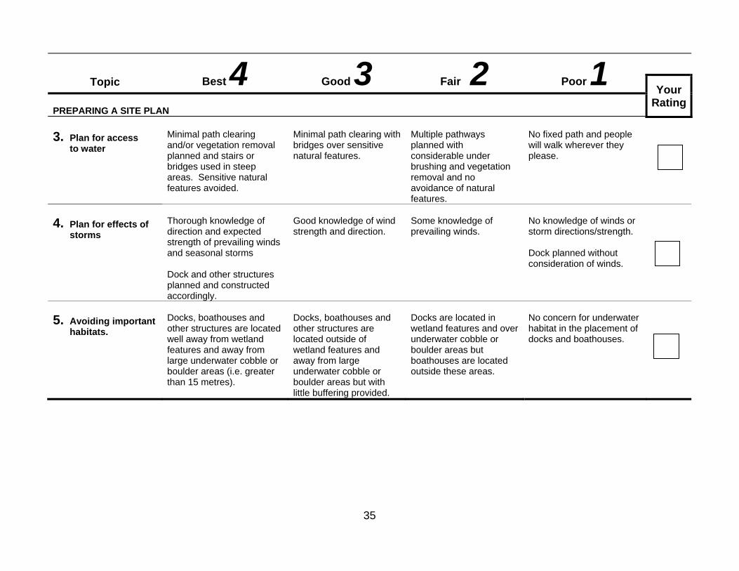
Topic Best 4 Good 3 Fair 2 Poor 1
Your Rating
PREPARING A SITE PLAN 3. Plan for access
to water
Minimal path clearing and/or vegetation removal planned and stairs or bridges used in steep areas. Sensitive natural features avoided.
Minimal path clearing with bridges over sensitive natural features.
Multiple pathways planned with considerable under brushing and vegetation removal and no avoidance of natural features.
No fixed path and people will walk wherever they please.
4. Plan for effects of
storms
Thorough knowledge of direction and expected strength of prevailing winds and seasonal storms Dock and other structures planned and constructed accordingly.
Good knowledge of wind strength and direction.
Some knowledge of prevailing winds.
No knowledge of winds or storm directions/strength. Dock planned without consideration of winds.
5. Avoiding important
habitats.
Docks, boathouses and other structures are located well away from wetland features and away from large underwater cobble or boulder areas (i.e. greater than 15 metres).
Docks, boathouses and other structures are located outside of wetland features and away from large underwater cobble or boulder areas but with little buffering provided.
Docks are located in wetland features and over underwater cobble or boulder areas but boathouses are located outside these areas.
No concern for underwater habitat in the placement of docks and boathouses.
36
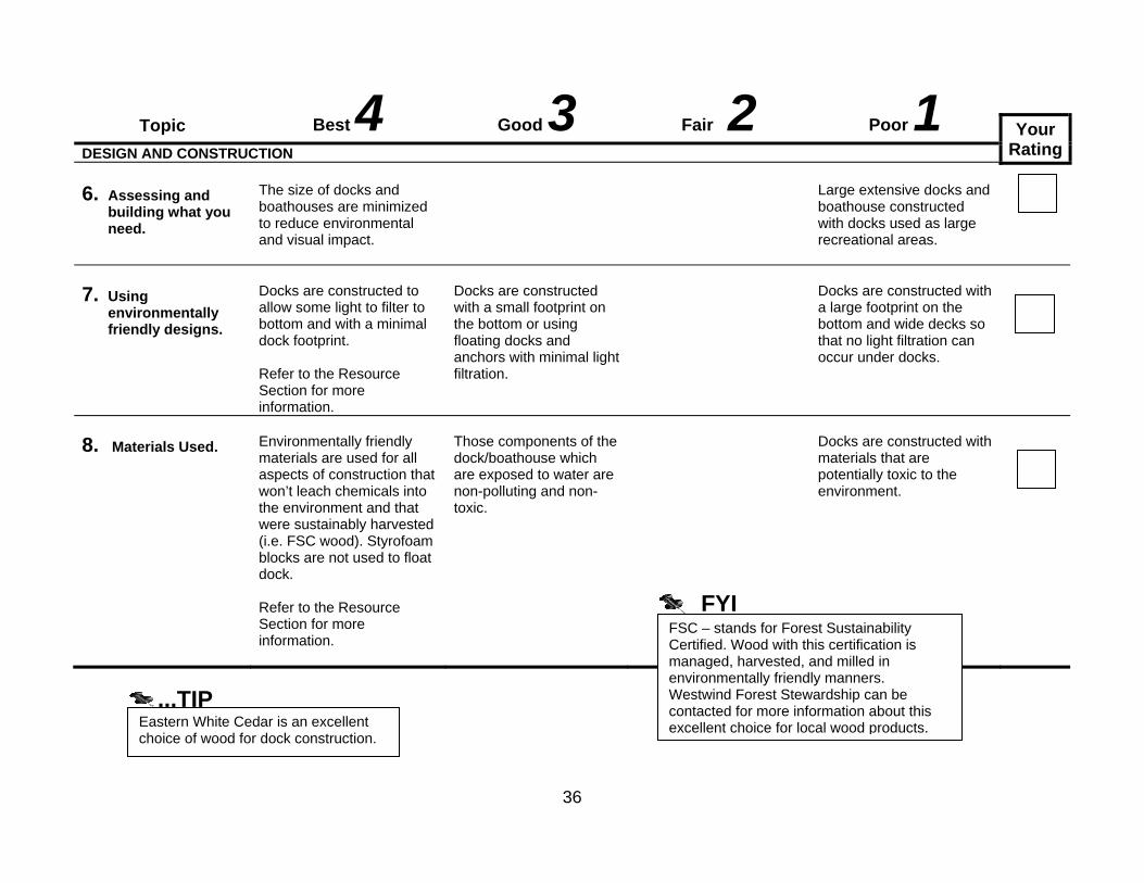
Topic Best 4 Good 3 Fair 2 Poor 1
Your RatingDESIGN AND CONSTRUCTION
6. Assessing and
building what you need.
The size of docks and boathouses are minimized to reduce environmental and visual impact.
Large extensive docks and boathouse constructed with docks used as large recreational areas.
7. Using
environmentally friendly designs.
Docks are constructed to allow some light to filter to bottom and with a minimal dock footprint. Refer to the Resource Section for more information.
Docks are constructed with a small footprint on the bottom or using floating docks and anchors with minimal light filtration.
Docks are constructed with a large footprint on the bottom and wide decks so that no light filtration can occur under docks.
8. Materials Used.
Environmentally friendly materials are used for all aspects of construction that won’t leach chemicals into the environment and that were sustainably harvested (i.e. FSC wood). Styrofoam blocks are not used to float dock. Refer to the Resource Section for more information.
Those components of the dock/boathouse which are exposed to water are non-polluting and non-toxic.
Docks are constructed with materials that are potentially toxic to the environment.
FSC – stands for Forest Sustainability Certified. Wood with this certification is managed, harvested, and milled in environmentally friendly manners. Westwind Forest Stewardship can be contacted for more information about this excellent choice for local wood products.
FYI
Eastern White Cedar is an excellent choice of wood for dock construction.
...TIP

37
Resource List Before and During Construction on Water
For more information…. • Fisheries and Oceans Canada
28 Waubeek Street Parry Sound, ON P2A 1B9 Tel: (705) 746-2196 Fax: (705) 746-4820 Email: [email protected] Factsheets/Leaflets: Working Around Water? Factsheet #13: “What you should know about Fish Habitat and Fluctuating Water Levels on the Great Lakes The Dock Primer; The Shore Primer; The Fish Habitat Primer- Ontario Edition Working in and Around Water www.dfo-mpo.gc.ca/oceans-habitat/
• Living by Water
www.livingbywater.ca • Muskoka Watershed Council:
Tel (705) 645-7393 www.muskokaheritage.org
• Muskoka Water Web:
www.muskokawaterweb.ca
Locating High Water Mark • Municipal Office – see Blue Pages
• Registered Land Surveyor – see Yellow Pages
Forest Sustainability Certified Wood • Westwind Forest Stewardship
www.westwindforest.ca Work Permits • Ontario Ministry of Natural Resources
7 Bay Street, Parry Sound P2A 1S4 Tel: (705)746-4201 Fax. (705)746-8828 www.mnr.gov.on.ca/en/Business/CrownLand/
• Municipal Office – see Blue Pages

38
Action Plan Worksheet #3 - Before and During Construction on Water Any ratings of 1 or 2 indicate areas where your property management needs to be changed to reduce the potential for environmental damage. Use the information from the worksheet and the resource section to help analyze your potential problems and decide what you can do to solve or control them. Remember, this is YOUR Action Plan. It must suit you and your property. Topic Number
Workshop Theme
My Rating Short-term Action Long-term Action
3 Plan for access to water
2 Identify where paths can be consolidated or removed especially those near sensitive natural features, e.g. stream edge
Reduce the number of paths and replant previously cleared areas with native plants.

39
Your Drinking Water

40
4a Water Runoff Management Use this worksheet to assess how well your property minimizes the potential for water runoff and property damage. Why should you be concerned? • Surfaces such as roofs, paved areas, bare soil, and
sloped lawns all contribute to the volume of water runoff because they impede water infiltration into the ground.
• Runoff carries soil, pet wastes, salt, pesticides, fertilizers, oil and grease, fuels, leaves, litter and other possible pollutants into streams, ponds, wetlands, lakes and oceans.
• Water that flows into storm drains or ditches is transported and discharged eventually into Georgian Bay, untreated.
• Polluted water runoff degrades the lake, rivers, and wetlands. Soil makes the water murky and damages fish habitat. Nutrients such as phosphorus encourage algae that can crowd out other aquatic life and change the chemistry of the water.
• Water runoff is not only a problem for water quality. It can also flow into basements and cause extensive property damage including erosion, slope instability, flooding, decreased property value and disrupt recreation.
• Without vegetation at the shoreline, contaminants flow directly into the lake.
What you can do. 1. Minimize the amount of water runoff from your property
by reducing “hard surfaced” areas such as paved paths or driveways. Consider using water permeable materials for driveways and pathways.
2. Do not locate any impermeable surface near the shoreline or next to any water course.
3. Foundation tiles should not be in erosion-prone areas.
4. Reduce the amount of potential pollutants on your property that can be carried by water runoff by minimizing hard surfaces and encouraging the absorption of storm water within your property boundaries.

41
4a Water Runoff Management
Topic Best 4 Good 3 Fair 2 Poor 1
Your Rating
SURFACES 1. Surface
permeability
All driving/parking/walking and patio surfaces are water permeable, AND gravel and woodchips are used to surface walkways. Minimal compaction.
Porous paving such as interlocking bricks used to surface driveway and lanes. Additional parking spaces are not paved.
Paved surfaces are located far from any water course.
All paths, parking, driveways, and outdoor patios are paved, regardless of nearness to watercourse, AND walking surfaces not restricted to paths. Foot-traffic compaction throughout.
2. Extent of
impervious surfaces and slope
Driveway is minimal and follows natural contours of the landscape, AND there are no other impervious/compacted areas.
Driveway is minimal but does not follow natural contours.
Driveway extensive but follows natural contours.
Extensive driveway and surfaced areas that does not follow natural contours, OR compacted and/or paved surfaces run straight down slope.

42
Topic Best 4 Good 3 Fair 2 Poor 1
Your Rating
SURFACES continued 3. Areas of bare soil
No areas of bare soil.
Grass or non-invasive groundcover planted immediately to prevent erosion.
Non-invasive groundcover planted immediately to prevent erosion.
Bare soil left uncovered and unplanted.
Temporary bare areas are mulched, AND straw bales, diversion ditches and silt fences* used to trap sediment.
Some areas are mulched to prevent erosion.
No regard given to sediment loss through runoff.
All plant beds have minimum 8 cm (3 in) depth of mulch.
Plant beds have 2.5 – 5.0 cm (1-2 in) depth of mulch.
Most plant beds are mulched to a depth of 2.5 cm (1 inch).
No plant beds are mulched.
*See advisory note regarding the use of heavy duty silt fencing at http://www.massasauga.ca/pub_docs/Advisory_silt_fence.pdf
Cover newly-seeded lawns lightly with straw mulch to a cover of 50% to prevent erosion.
Tip
Eastern Hog-nosed Snake (Threatened) Note the distinctive up-turned nose. Credit Jeremy Rouse

43
Topic Best 4 Good 3 Fair 2 Poor 1
Your Rating
POTENTIAL POLLUTANTS 4. Car washing
Cars and trucks taken to commercial carwash or spray booth.
Cars and trucks are occasionally washed at commercial car wash.
Cars, trucks, or other items are washed on a lawn or gravel driveway.
Cars, trucks, or other items are washed on a driveway, street, or other paved area.
5. Fuelling of
vehicles
Never fuel vehicles, including lawnmowers, ATV’s, snowmobiles, etc. near waterways.
Vehicles are fuelled regardless of their proximity to a waterway.
6. Application and
use of fertilizers, de-icers and salts, pool and other outdoor chemicals
Spills are cleaned up immediately, AND applications are delayed until after rain.
Spills are cleaned up immediately on paved surfaces.
Spills are not cleaned up, OR applications are not delayed to avoid rain.
7. Grass clippings,
leaves and other yard wastes
Grass clippings, leaves, and other yard wastes are swept off paved surfaces and away from water flow routes, OR leaves and other yard wastes are composted.
Leaves and other yard wastes are left to compost on site.
Leaves and other yard wastes are collected in appropriate containers and left for municipal collection.
Grass clippings, leaves and other yard wastes are left on driveways, streets, and other paved areas to be carried off by stormwater, OR yard waste is burned on-site.
To avoid sending dirty, soapy water into a water course or lake, wash your car on the lawn, or better yet, take it to a commercial car wash or spray booth where the dirty water goes to the treatment plant.
Tip
Ensure that your winter snow pile is not close to any shoreline or water course. Melt water may cause erosion and contamination.
Tip
44
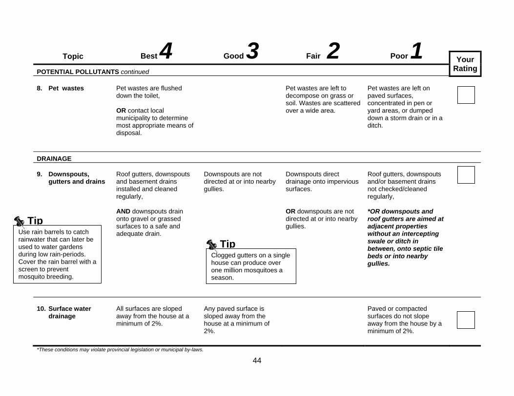
Topic Best 4 Good 3 Fair 2 Poor 1
Your Rating
POTENTIAL POLLUTANTS continued 8. Pet wastes
Pet wastes are flushed down the toilet, OR contact local municipality to determine most appropriate means of disposal.
Pet wastes are left to decompose on grass or soil. Wastes are scattered over a wide area.
Pet wastes are left on paved surfaces, concentrated in pen or yard areas, or dumped down a storm drain or in a ditch.
DRAINAGE
9. Downspouts,
gutters and drains
Roof gutters, downspouts and basement drains installed and cleaned regularly, AND downspouts drain onto gravel or grassed surfaces to a safe and adequate drain.
Downspouts are not directed at or into nearby gullies.
Downspouts direct drainage onto impervious surfaces. OR downspouts are not directed at or into nearby gullies.
Roof gutters, downspouts and/or basement drains not checked/cleaned regularly, *OR downspouts and roof gutters are aimed at adjacent properties without an intercepting swale or ditch in between, onto septic tile beds or into nearby gullies.
10. Surface water
drainage
All surfaces are sloped away from the house at a minimum of 2%.
Any paved surface is sloped away from the house at a minimum of 2%.
Paved or compacted surfaces do not slope away from the house by a minimum of 2%.
*These conditions may violate provincial legislation or municipal by-laws.
Clogged gutters on a single house can produce over one million mosquitoes a season.
TipUse rain barrels to catch rainwater that can later be used to water gardens during low rain-periods. Cover the rain barrel with a screen to prevent mosquito breeding.
Tip

45
Resource List
Water Runoff Management For more information….
General Shoreline Information • Living by Water website: www.livingbywater.ca • Muskoka Watershed Council:
(705) 645-7393 www.muskokaheritage.org/watershed/watershedindicators.asp#Stormwater Management
Flood Protection • Municipal Office – see Blue Pages • Ministry of Natural Resources (MNR) – see Blue Pages for local 1-800-667-1940 • Fisheries and Oceans Canada (DFO)
1-800-667-3355
Locating High Water Mark • Municipal Office – see Blue Pages • Registered Land Surveyor – see Yellow Pages Shoreline Restoration • Centre for Sustainable Watersheds: www.watersheds.ca Soil Bioengineering • Ontario Ministry of the Environment www.on.ec.gc.ca/doc/cut_factsheets/soil-bioeng-e.html • Ontario’s Stream Rehabilitation Manual. 2002. M. Heaton, R. Grillmayer, J. Imhof. Belfountain, Ontario. www.ontariostreams.on.ca/online.htm

46
Worksheet #4 b & c – Your Drinking Water Why should you be concerned? • Even though water in the Great Lakes appears highly
abundant, reducing our water consumption and eliminating contamination are important. Residential sources of contamination may include coliform bacteria from an ineffective septic system or run-off from chemicals applied to a lawn.
• Wells which pump water from aquifers below the ground can provide a clean and safe supply of water; however, if a well is not constructed or maintained properly, or if a contaminant is spilled within the capture zone of a well, the quality of the water supply could be at risk.
• Contaminating your water source can harm you, your family or
nearby families.
• It is much easier and cheaper to prevent contamination than to try and clean it up. Treating contaminated water, constructing a new well or getting water from another source is inconvenient and expensive.
• When water is at risk of contamination, it threatens not only
your health, but the ecosystem's health as well. Whether you use a private well, surface water or a municipal system, everyone plays a role in source water protection.
What you can do. 1. Manage both your water source and water run-off carefully.
This will help reduce pollution, improve your family’s health, and help to ensure that we all have good clean water available.
2. Make sure the water you drink and the groundwater that
supplies your well are protected from contamination. Test your water regularly in spring and fall, and after all periods of heavy rainfall.
3. Know the location of your septic system and those of your
neighbours.
4. Understand the proper operation and maintenance of your septic system to ensure that your septic system is working effectively. See notes in section 4 Your Wastewater and Septic for more information. Encourage your neighbours to do the same.
5. Question the wisdom of using chemical fertilizers on your
property. Handle fertilizers and other potential contaminants carefully.
6. Contact a licensed well professional or your Health Unit to
assist with items that get a “2” or “1” rating in this worksheet.

47
4b Private Water from Surface Water
Topic Best 4 Good 3 Fair 2 Poor 1
Your Rating
LOCATION OF WATER PICK-UP
1. Position of water pickup in relation to shore and bottom.
Pick up is in water at least three metres deep, 0.5 metres off bottom and away from boat traffic areas and shore.
Pick up is in ankle deep water near shore, on bottom and close to shore and boat traffic areas.
2. Distance of water
pickup from potential source of contamination.
Greater than 90 m (300 ft)
45 – 90 m (150 – 300 ft)
30 – 40 m (100-150 ft)
Less than 30 m (100 ft)
3. Water testing
Your drinking water is tested for bacteria more than three times a year (including once in the spring) and more than once a year for other impurities AND bacteria and other tests (health related) always meet Ontario Drinking Water Standards.
Water tested three times a year for bacteria and once a year for other impurities
AND bacteria, and other tests (as needed) usually meet Ontario Drinking Water Standards on the first test and always on the second test (the follow-up check) if first test fails.
Water tested less than three times a year for bacteria and not tested for other impurities.
Water is not tested, OR does not meet Ontario Drinking Water Standards on first test or on second test (follow-up check).

48
#4c Private Well Water Supply: How do you rate?
Topic Best 4 Good 3 Fair 2 Poor 1
Your Rating
LOCATION OF WELL 1. Position of water
well in relation to potential sources of contamination
Upslope from all sources of contamination, AND all surface water moves away from well.
Upslope from, or level with any source of contamination, AND surface water runoff does not reach well.
Level with most sources of contamination, AND some surface water runoff may reach well.
Downslope from any source of contamination so that surface water reaches well, OR water ponds at and around well.
2. Distance from well
to potential sources of contamination
Greater than 90 metres (300 ft)
• 24-90 m (76-300 ft)** (drilled well) • 47-90 m (151-300 ft) (bored/dug well)
• 15-23 m (50-75 ft)** (drilled well) • 30-46 m (100-150 ft) (bored/dug well)
• *Less than 15 m (50 ft) (drilled well) OR • *Less than 30 m (100 ft) (bored/dug well)
** Note: Drilled wells must have at least 6 metres (20 ft) of watertight casing below ground level. If less than 6 m (20 ft), treat well as a bored/dug well.
CONDITION OF WELL 3. Condition of
Casing
Good condition. No defects visible, AND checked annually by certified inspector.
No defects visible, AND checked every one to two years by certified inspector.
No holes or cracks visible, AND checked every three years or more by certified inspector.
Holes or cracks visible, OR, can hear water running into well, OR never inspected.
*These conditions may violate provincial legislation or municipal by-laws.
Always maintain as great a distance as you can between a potential contaminant source and wells or surface water.
Tip

49
Topic Best 4 Good 3 Fair 2 Poor 1
Your Rating
CONDITION OF WELL continued 4. Condition of well
cap
Excellent condition, commercially manufactured, vermin proof, and tightly secured.
Fair condition, commercially manufactured, vermin proof, and tightly secured.
Commercially manufactured, vermin proof cap is loose or needs repair.
No commercially manufactured vermin proof cap.
5. Condition of well
venting
Screened vent in excellent repair.
Screened vent in good repair.
Well vented but not screened.
No well vent.
6. Condition of
surface material around well casing
Surface material raised above normal ground level beside well casing, AND no space between well casing and surrounding surface material.
No settling of the surface material around well casing, AND no space between well casing and surrounding surface material.
Can see settling of surface material around well casing, AND no space between well casing and surrounding surface material.
Can see settling of surface material around well casing, AND/OR visible space between well casing and surrounding surface material.
7. Casing Depth
More than 45 m (150 ft) below ground level.
31-45 m (101-150 ft) below ground level.
15-30 m (50-100 ft) below ground level.
Less than 15 M (50 ft),
OR no casing.
8. Casing height
above ground level
40 cm (16 in) or more above normal ground level.
*Less than 40 cm (16 in) above normal ground level, in pit or in basement.
9. Age of well
Less than 20 years old.
Less than 40 years old.
40-60 years old.
More than 60 years old.
*These conditions may violate provincial legislation or municipal by-laws.

50
Topic Best 4 Good 3 Fair 2 Poor 1
Your Rating
MANAGEMENT OF PRIVATE WELL WATER SUPPLY 10. Type of well
Drilled. - Casing terminates above ground, approved well cap.
Drilled. - Casing terminates in a well pit.
Sand point.
Bored or dug.
11. Backflow
prevention
Anti-backflow devices (such as check valves and vacuum breakers) installed on all faucets with hose connections, AND air gap of at least 15 cm (6 in) maintained.
Anti-backflow devices installed on some faucets with hose connections, AND air gap of at least 15 cm (6 in) maintained.
No anti-backflow devices, AND air gap of at least 15 cm (6 in) maintained.
No anti-backflow devices, OR air gap not maintained.
12. Unused or
abandoned wells
No unused or abandoned wells.
Unused wells capped, properly protected and maintained, AND abandoned wells properly plugged and sealed.
*Unused wells not capped or protected, OR abandoned wells not properly plugged and sealed.
13. Water testing
Water tested for bacteria more than three times a year (including once in the spring) and once a year for other impurities. AND bacteria and other tests (health related) always meet Ontario Drinking Water Standards.
Water tested three times a year for bacteria and once a year for other for other impurities.
AND bacteria and other tests (as needed) usually meet Ontario Drinking Water Standards on the first test and always on the second test (the follow-up check) if first test fails.
Water tested less than three times a year for bacteria and not tested for other for other impurities.
Water is not tested, OR does not meet Ontario Drinking Water Standards on first test or on second test (follow-up check).
*These conditions may violate provincial legislation or municipal by-laws.
Your local Health Unit is a valuable resource in helping you manage the quality of your drinking water. Ask your neighbours what their tests reveal.
Tip
Your local Health Unit provides you with sample bottles and conducts free testing for bacteria. Simply drop off bottles at the closest Health Unit for testing.
Tip

51
Resource List
Private Well Water Supply For more information…. Ontario Ministry of Health and Long-Term Care MOHLTC INFOline Toll-free: 1-800-268-1154 www.health.gov.on.ca North Bay Parry Sound Health Unit 70 Joseph Street Parry Sound P2A 2G5 705-746-5801 www.healthunit.biz Free water testing available. Contact the local Health Unit for these Information Sheets: • Get Acquainted with Your Well • Keeping You Well Informed • Pathogens and Your Well Water • Putting Your Well Water to the Test • Choosing a Water Treatment System • Disinfection Instruction Sheet • Keeping Your Well Water Safe to Drink (Poster) Private Testing Well Wise Centre Rural Well Owner Test Package: $50 Tests for a wide range of contaminants www.wellwise.ca
Ontario Ministry of Environment Public Information Centre135 St. Clair Ave. West, Toronto, ON M4V 1P5 Toll-free: 1-800-565-4923 www.ene.gov.on.ca Factsheets: • Green Facts: Important Facts About Water Well Construction
PIBS no. 3788e01, 2003 • Green Tips: Managing Your Water Well in Times of Shortage
PIBS no. 3784e, 1999 • Green Facts: The Protection of Water Quality in Bored and Dug Wells
PIBS no. 3962e01, 2003 • Green Facts: The Protection of Water Quality in Drilled Wells
PIBS no. 396e01, 2003 • The Protection of Water Quality in Jetted or Driven Point Wells
PIBS no. 4505e, 2003 Videotapes: • Well Aware - A Well Owner’s Guide Publications: • Information on the Use of Home Water Treatment Devices • Ontario Regulation 903 (Water Wells). This regulation governs how wells must be constructed in Ontario. It includes construction standards, distances required from contaminant sources, and licensing requirements for well contractors
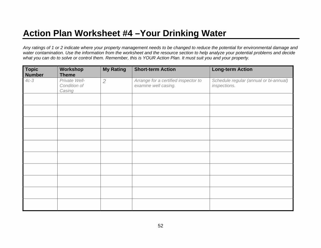
52
Action Plan Worksheet #4 –Your Drinking Water Any ratings of 1 or 2 indicate where your property management needs to be changed to reduce the potential for environmental damage and water contamination. Use the information from the worksheet and the resource section to help analyze your potential problems and decide what you can do to solve or control them. Remember, this is YOUR Action Plan. It must suit you and your property. Topic Number
Workshop Theme
My Rating Short-term Action Long-term Action
4c-3 Private Well- Condition of Casing
2 Arrange for a certified inspector to examine well casing.
Schedule regular (annual or bi-annual) inspections.

53
Your Wastewater & Septic System

54
Worksheet #5 – Your Wastewater & Septic System
Use this worksheet to determine whether household water is treated safely on your property. Why should you be concerned? • In urban areas, household wastewater is treated at a
treatment plant before it is discharged into the lake. • In rural areas, people use a septic tank or similar system to
treat household wastewater. All the water that flows down your drains ends up in your septic system. It must be able to safely handle all of it to prevent contamination of ground and surface water.
• Your septic system could be a source of contamination to the
environment and to your family and neighbours. Household wastewater contains disease-causing bacteria and viruses, household chemicals, and excess nutrients. All of these contaminants can cause serious health problems.
• If your home treatment system has to handle too much
wastewater, it will not be as effective and may prematurely fail. Increased use of water, through additional appliances or a second bathroom, will increase the load on your septic system.
• Guests from areas with municipal sewage systems might not
fully appreciate the need to restrict what is flushed into the septic system and to limit the amount of water they use.
• Not only can septic system failure be highly inconvenient, it
can also be very expensive. In addition, new regulations and higher standards may mean that the system may have to be replaced instead of being repaired or upgraded.
What you can do. Maintain your septic system in good condition 1. Make sure your septic system is large enough to meet your
needs. Look for ways to reduce the amount of wastewater that enters the septic system. Effluent from sump pumps and roof drains should not go into the septic system.
2. Keep your septic system in good repair. Pump your septic
tank regularly (every 3 – 5 years for year-round homes and 5-8 years for seasonal use properties.
3. Ask for a professional assessment of the condition of your
septic system at each pumping. Include an inspection of the tank.
4. Do not allow machinery, ATV’s or snowmobiles to cross the
leaching bed. If snow is compacted, the leaching bed can freeze and the tank overflow.
5. Maintain non-woody plants on top of your leaching bed but
don’t allow trees and shrubs to close to the bed or tank. Some trees have roots that search a long way for water which can cause your leaching bed to become plugged.
6. Consider installing new innovative technologies with
enhanced sewage treatments and that reduce the nutrient load to the environment. These can be particularly effective on small lots with little soil.

55
Your Wastewater & Septic System What you can do. Maintain your septic system in good condition (con’t) 7. Keep and maintain records on your septic system such as
Building Permits, pump-out records, maintenance records etc. These may be useful when you have to sell your property.
8. Facilities such as outhouses, composting and chemical toilets
can be effective and environmentally responsible. Contact your local Health Unit or municipality to learn more.
Watch what goes into your septic system 1. Your septic tank requires live bacteria to function properly.
Many substances will kill bacteria. Never put fats or oils, paints, gasoline or antifreeze, drain and toilet bowl cleaners, feminine hygiene products, diapers, condoms, plastics, kitchen waste (coffee grounds, egg shells), cigarette filters into the septic system.
2. Control and significantly reduce the use of detergents and
household bleaches. Heavy use of bleaches will kill the microbes that make a septic work. Phosphates in detergents can eventually make its way into surrounding water bodies causing excessive plant and algae growth.
3. Human waste from a person on chemotherapy can kill the
bacterial action in a septic system. You may find you have to pre-pump your septic system and pump the system after the chemotherapy treatments are completed.
4 Caution guests that the system can not be used like they might in a town or city. Water conservation and watching what goes down the drain are important actions to ensure your septic system functions properly. Problem signs include your system backing up, foul odours, effluent on the surface, soggy ground in the leaching bed, system freezing, toilet and drains gurgling or draining slowly.

56
Wastewater & Septic Systems: How do you rate?
Topic Best 4 Good 3 Fair 2 Poor 1
Your Rating
QUANTITY OF WASTEWATER 1. Efficient water use
affects septic function
Conservative water use (less than 180 litres/40 gal. per person per day).
Moderate water use (180-270 litres/40-60 gal. per person per day).
High water use (271-360 litres/61-80 gal. per person per day).
Very high water use (greater than 360 litres/80 gal. per person per day).
2. Fixtures and
maintenance
Water-conserving fixtures throughout house, AND fixtures are inspected regularly, AND leaks fixed immediately.
Some water-conserving fixtures throughout house, AND some fixtures are inspected regularly, AND some leaks are fixed immediately.
No water-conserving fixtures in house, OR fixtures are not inspected regularly. Problems are fixed when found. AND some leaks are fixed immediately.
No water-conserving fixtures, OR leaks are not fixed immediately.
QUALITY OF WASTEWATER 3. Solid waste
No use of garbage disposal unit in kitchen sink.
Moderate use of garbage disposal unit in kitchen sink.
Daily use of garbage disposal unit in kitchen sink.
4. Dissolved waste
Minimal use of environmentally unfriendly household detergents and cleaners (0.2 litres or 1 cup per week), AND no disposal of household solvents and cleaning agents into plumbing system.
Careful use of household detergents and cleaners (0.5 litres or 1 pint per week), AND minimal disposal of household solvents and cleaning agents into plumbing system.
Moderate use of household detergents and cleaners (1 litre or 1 quart per week), OR moderate disposal of household solvents and cleaning agents into plumbing system.
High use of household detergents and cleaners (4 litres or 1 gal. per week), OR frequent disposal of household solvents and cleaning agents into plumbing system.
Install faucet aerators and use low-flow shower heads.
Tip
Using less water helps your septic field perform better.
Tip

57
Topic Best 4 Good 3 Fair 2 Poor 1
Your Rating
QUALITY OF WASTEWATER continued 5. Water softener
discharge
Water softener does not discharge to septic tank.
Water softener discharges to septic tank but the system is properly designed to accommodate discharge water.
Water softener discharges into septic tank not designed to accommodate discharge water.
6. Grease and oils
No disposal of household grease or oils into plumbing system.
Minimal disposal of household grease or oils into plumbing system and oil and grease wiped from cooking utensils before washing.
Moderate disposal of household grease or oils into plumbing system, OR no attempt to reduce disposal of grease and oil from household.
Frequent disposal of household grease or oils into plumbing system.
WASTEWATER TREATMENT SYSTEM 7. Design and
construction
Has Building Permit or Certificate of Approval, AND system adequately sized, AND system installed by a licensed installer.
*No Building Permit or Certificate of Approval, OR system not sized according to regulatory requirements, OR system not installed by a licensed installer.
*These conditions may violate provincial legislation or municipal by-laws.
All septic systems eventually need replacing but with proper maintenance your system can last 15 years or longer - even with year-round use.
Tip Don’t park or drive any vehicle or any heavy equipment on the leaching bed of your septic system.
Tip

58
Topic Best 4 Good 3 Fair 2 Poor 1
Your Rating
WASTEWATER TREATMENT SYSTEM continued 8. Knowledge of
septic system
Excellent knowledge of overall septic system size, location, and operation.
Good knowledge of overall septic system size, location, and operation.
Limited knowledge of overall septic system size, location, and operation.
No knowledge of overall septic system size, location, and operation.
LOCATION OF WASTEWATER SYSTEM 9. Distance from
wastewater treatment system to nearest surface water
Greater than 150 m (500 ft)
61 – 150 m (200 – 500 ft)
9-60 m (30-199 ft) for: • septic tank • leaching bed • holding tank • other treatment unit
*Less than 9m (30 ft) for: • septic tank • leaching bed • holding tank • other treatment unit
10. Distance from
wastewater treatment system to a well
Greater than 90 m (300 ft)
For leaching bed or holding tank:
• 24-90 m (76-300 ft) (drilled well) • 47-90 m (151-300 ft) (bored/dug well)
For leaching bed or holding tank:
• 15-23 m (50-75 ft) (drilled well) • 30-46 m (100-150 ft) (bored/dug well) For septic tank or other treatment unit:
• 15-23 m (50-75 ft) (drilled well) • 15-46 m (50-150 ft) (bored/dug well)
*For leaching bed or holding tank:
• less than 15 m (50 ft) (drilled well) • less than 30 m (100 ft) (bored/dug well) For septic tank or other treatment unit:
• less than 15 m (50 ft) (all wells)
*These conditions may violate provincial legislation or municipal by-laws.
Always maintain as great a distance as you can between a potential contaminant source and wells or surface water.
Tip

59
Topic Best 4 Good 3 Fair 2 Poor 1
Your Rating
COLLECTION OF WASTEWATER 11. Source and amount
All wastewater is collected for treatment, AND there is no loss of wastewater that should be treated, AND no clear water is collected and directed to the septic system, AND no clear water enters the septic system by infiltration through joints, access ports, etc.
*Some wastewater does not reach septic system because of leaks, OR some wastewater is diverted away from the septic system, OR clear water is getting into the septic system.
WASTEWATER TREATMENT SYSTEM 12. Subsurface
distribution of wastewater (septic or other treatment systems)
Pressure or dosed distribution to leaching bed.
Gravity-fed distribution to leaching bed.
*Drainage directly into septic field, with no septic tank OR piped to anywhere but a septic or other approved treatment system.
*These conditions may violate provincial legislation or municipal by-laws.
To keep your septic system operating at peak performance, don’t let unnecessary clear water enter the system. This means fixing leaks and conserving water.
Tip All downspouts should be diverted away from sewage system disposal areas. An average size home will deposit 11 400 litres (3000 gallons) of water onto the ground after an 8 centimetre (3 inch) rain storm.
Tip

60
Topic Best 4 Good 3 Fair 2 Poor 1
Your Rating
PRETREATMENT SYSTEM 13. Septic tank
Two compartment tank, AND septic tank checked by a qualified inspector every three years and pumped as required. AND good maintenance -baffles and tank checked, and no leaks.
Two compartment tank, AND septic tank checked by a qualified inspector every four to five years and pumped as required, AND some maintenance, and no leaks.
Single compartment tank, OR septic tank checked by a qualified inspector every six to ten years and pumped as required, OR no maintenance, but no leaks.
Single compartment tank, OR seldom pumped out - last time more than ten years ago, OR no maintenance, no checks, and leaks from tank.
14. Other treatment
system
Regular maintenance program followed, AND no mechanical failures, AND loaded at rate below design capacity.
Regular maintenance program followed, AND no mechanical failures, AND loaded at rate near design capacity.
Regular maintenance program not followed, OR occasional failures (once every two years).
No maintenance program, OR frequent system failure, OR system overloaded.
15. Holding tank - no leaching bed
connected
Capacity is higher than design requirements, AND tanks checked -no leaks AND working alarm system.
Capacity meets design requirements, AND tanks checked -no leaks AND working alarm system.
Loaded at design capacity. OR tanks not checked for leaks OR alarm system not working.
*Capacity does not meet recommended guidelines, OR leaks and overflow from tank, OR no alarm system.
*These conditions may violate provincial legislation or municipal by-laws.
OR

61
Topic Best 4 Good 3 Fair 2 Poor 1
Your Rating
PRETREATMENT SYSTEM continued 16. Leaching bed
location
Located more than:
• 5 m (16½ft) from any building or structure. • 3 m (10 ft) from any property line.
Located at:
• 5 m (16½ft) from any building or structure. • 3 m (10 ft) from any property line.
*Located less than:
• 5 m (16½ft) from any building or structure. • 3 m (10 ft) from any property line.
17. Leaching bed
surface water drainage
Surface water drains away from leaching bed area.
Surface water drains onto leaching bed area.
18. Depth to water
table or bedrock from trench bottom
More than 1.8 m (6 ft).
0.9-1.8 m (3-6 ft).
*Less than 0.9 m (3 ft).
19. Leaching bed
loading (visual inspection)
Soil always firm, AND no odours.
Ground is seldom wet, or spongy, AND no odours.
Ground is frequently wet, or spongy, OR odours noticed occasionally.
Ground is always wet or spongy, OR strong odours noticed frequently, *OR pooling or bubbling of wastewater noticeable on surface.
HAULED SEWAGE 20. Disposal of
pumpage from septic tanks, other treatment systems, and holding tanks
Regulated, certified disposal by a licensed hauler.
*Disposal is not done by a licensed hauler.
*These conditions may violate provincial legislation or municipal by-laws.

62
Topic Best 4 Good 3 Fair 2 Poor 1
Your Rating
21. Outhouse Location The outhouse is at least nine metres from a watercourse (lake, river, stream), unless in a designated restricted area or a municipal by-law indicates a great distance AND the bottom of the pit shall be at least 1 m above the high ground-water table AND sides of the pit are reinforced to prevent collapse. AND soil is placed around the base of the privy to a height of at least 15 cm above the ground level. AND the pit is surrounded on all sides and on its bottom by not less than 60 cm of solid or leaching bed fill.
Outhouse is located less than nine metres from a watercourse. OR is within 1 m of the groundwater table. Or has less than 60 cm of solid or leaching bed fill on all sides and bottom.
22. Outdoor Showers Outdoor shower drains into a grey water pit or septic system.
Outdoor shower does not drain into a grey water pit or septic system.
Georgian Bay is not a bath tub. Do not use soap or shampoo, even biodegradable ones, in freshwater lakes.
FYI

63
Resource List Wastewater & Septic Systems
For more information….
Ontario Ministry of Agriculture, Food and Rural Affairs Agricultural Information Contact Centre at 1-877-424-1300 www.omafra.gov.on.ca Publications: • Septic Smart, 1999 (with Ontario Soil and Crop Improvement Ass.) 519- 826-4214 www.ontariosoilcrop.org Factsheets/Leaflets: • Care and Maintenance of a Rural Septic Tank System (order no. 93-081) Ontario Ministry of Municipal Affairs and Housing Booklets: • A Guide to Operating and Maintaining Your Septic System, 1999 • Septic Smart: New Ideas for Household Septic Systems on Difficult Sites, 1999 www.obc.mah.gov.on.ca • Ontario Building Code Part 8
Ontario On-site Wastewater Association Leaflets: •Ontario On-site Sewage Systems Do’s and Don’ts Guide Canada Mortgage and Housing Corporation www.cmhc-schl.gc.ca Factsheets/Leaflets: •Your Septic System •Ontario Rural Wastewater Centre •Household Guide to Water Efficiency Muskoka Watershed Council Caring for Your Septic System Stormwater Management www.muskokaheritage.org/watershed Additional Resources Your local Health Unit also has information or will be able to provide you with assistance. Check the Yellow Pages for licensed septic system installers or call your local municipal office, public health office or Ministry of Environment office for a list of qualified professionals.

64
Action Plan Worksheet #5 – Wastewater & Septic Systems Any ratings of 1 or 2 indicate where your property management needs to be changed to reduce the potential for environmental damage and water contamination. Use the information from the worksheet and the resource section to help analyze your potential problems and decide what you can do to solve or control them. Remember, this is YOUR Action Plan. It must suit you and your property.
Topic Number
Workshop Theme
My Rating Short-term Action Long-term Action
2 Quantity of Wastewater
2 Inspect and repair all leaking water fixtures.
Purchase and install water-conserving fixtures

65
Water-based Recreation

66
Worksheet #6 –Water-based Recreation Use this worksheet to learn about enjoying your waterfront property in a sustainable fashion. Why should you be concerned? • Nearness to the Bay or waterfront is probably the reason why
you purchased your property so it is important that everyone do their part to ensure water quality is safe for all.
• Fuels, wastewater and other hazardous or toxic chemicals
associated with motorized recreational watercraft can contaminate the lake, destroying fish habitat and making the water unsuitable for use.
• Invasive species are easily transported between water bodies
and can quickly invade, out-competing native species and destroying ecosystems and causing property damage.
• Waves from the wake of motorized recreational watercraft can
cause shoreline and channel erosion and damage water nesting areas.
What you can do. 1. Operate an engine-less water-craft such as a canoe or kayak,
or use a 4-stroke or E-Tec engine boat. 2. Reduce boat wake and its effects on shorelines, channels and
aquatic nesting areas by decreasing your speed on the water. 3. Rinse off your craft (with water) every time it is hauled out of
the water. This will prevent invasive species from being transported and spreading to other water bodies and water courses.
4. Never dispose of waste (including fish guts) in the water.
Dispose of them properly on land. 5. Don’t expand your beach by removing vegetation and/or
dumping sand. 6. If possible, don’t build docks or boathouses since they
damage sensitive ecosystems along shorelines. Use a public boat launch or marina instead or if you must build a dock, ensure that you follow the guidelines outlined on worksheet three.
7. Remember to treat our waterways with the care in winter. Do
not fuel recreational vehicles while on the ice or near a waterway. If you enjoy winter recreation, don’t forget to bring back your garbage with you for proper disposal.
Common Loon with chick Credit Ted Krug

67
Water-based Recreation: How do you rate?
Topic Best 4 Good 3 Fair 2 Poor 1
Your Rating
BOATING 1 Boat engine and
maintenance
Boat/water-craft does not have an engine.
Boat has a four-stroke engine that meets or exceeds emissions standards,
OR use an electric motor on board with a battery* and an outboard propeller.
Boat has a modern direct injection two-stroke engine.
Boat has an older two-stroke engine.
Boat has a portable fuel container that is filled far from any open water.
Boat is refuelled on board but great care is used to prevent spills or overfilling. Any spills are cleaned up immediately.
Little care is taken to prevent fuel from getting into open water.
No care is taken to prevent fuel from getting into open water,
*OR fuel is dumped into open water.
Bilge is cleaned out at an approved local marina bilge pump-out service.
Disposable cloths are used for cleaning bilge. These and any fuels from inside the bilge are properly disposed of at the local hazardous waste facility.
Bilge cleaners (including biodegradable ones) are rarely used.
Bilge pumps are used regardless if the bilge water is contaminated,
OR bilge is cleaned without regard to the potentially hazardous nature of bilge fluids.
2 On-board waste
All garbage is kept on board in a designated area until it can be properly disposed of or recycled back on land.
Food scraps are rarely thrown overboard,
AND plastic waste is never thrown overboard.
*Black and/or grey water is discharged into the lake or water body instead of an approved pump-out facility.
*These conditions may violate provincial legislation or municipal by-laws.
Check your engine regularly for any leaks, including the fuel line, clamps and filters.
Tip
Keep a tray under the battery to catch any acid spills.
Tip

68
Topic Best 4 Good 3 Fair 2 Poor 1
Your Rating
BOATING 3 Boat use
Within 150 metres(500 feet) of shore, means taken to reduce wake from watercraft,
AND turn off propellers when in shallow waters to avoid stirring up lake bottom and disturbing vegetation/wildlife.
Within 30 metres (100 feet) of shore, speed of any power-driven boats reduced to 10 km/h (5.4 knots or 6.2 mph).
No consideration given to the noise your craft makes, OR boat near nesting birds or other wildlife near or on the shore, *OR operate motor craft at any speed regardless of the distance from shore.
4 Water-craft launching and hauling
Water-craft and trailer are not stored in the water, AND when launching the water-craft, trailer is submerged for as little time as possible. AND water-craft and trailer are checked for any plants/wildlife/fish that may be clinging to the water-craft or trailer. Rinse if possible.
Water-craft and trailer are stored in the water during use period, AND water-craft and trailer are checked for any plants/wildlife/fish that may be clinging to the water-craft or trailer.
Water-craft and/or trailer sits in water for longer than use period, OR clinging plants/ wildlife/ fish are not removed from water-craft or trailer, and disposed of properly.
*These conditions may violate provincial legislation or municipal by-laws.
Take any oils or boat craft fluids to your marina or local municipal hazardous waste collection site. See Worksheet 9
Tip
The speed limit and the type of water-crafts permissible on a water body can be changed. Petition your municipality to apply to the Ministry of Natural Resources for a change in designation under the Ontario Boating Restrictions Regulations.
Tip

69
Topic Best 4 Good 3 Fair 2 Poor 1
Your Rating
FISHING 5 Permits and
regulations
Fishing license obtained, AND check with your nearest MNR office for local catch regulations, AND are familiar with the Recreational Fishing Regulations Summary,
*No fishing license obtained, OR quota is exceeded.
6 Fishing Equipment
Non-toxic alternatives to lead fishing sinkers and jigs are used. AND when possible, fish from the shore or by non-motorized boats.
Use lead based sinkers and jigs.
ACTIVITIES ALONG THE SHORE 6 Minimizing
disturbance
Never remove or move wildlife or natural artefacts such as logs, vegetation, shells, or nests, AND access along the shoreline is minimal
Natural artefacts or wildlife are seldom removed or moved. Access shoreline or trails using designated paths, AND keep to the trail to avoid trampling.
Access shoreline or trails using several locations,
Plants, wildlife or other natural elements are removed or disturbed
No Release of Bait It is illegal to release any live bait or dump the contents of a bait bucket, including the water, into any waters or within 30 m of any waters.
FYI
Protect aquatic life by properly disposing of monofilament fishing line
Tip
A single lead sinker or jig contains enough lead to kill a Common Loon or other waterbird.
FYI

70
Topic Best 4 Good 3 Fair 2 Poor 1
Your Rating
ACTIVITIES ALONG THE SHORE
7. Camping/Picnicking Camp/picnic in established sites or set up on a durable surface, e.g. rock AND dispose of waste properly: • Use existing latrines or
bury human waste in a “cathole” 50m from water. Burn or bury toilet paper.
• Carry out food scraps. • Washing and
wastewater is dumped at least 30m from water.
• “Stoop and scoop” and carry out pet wastes.
Camp/picnic without consideration of landscape and vegetation. AND wastes are left on site AND soap/wastewater enters surface water.
8. Campfire safety Do not have campfires. Check weather conditions
and local fire bans before starting a campfire AND always exercise caution with fires. Build in existing fire rings and minimize size of fire.
Check weather conditions and local fire bans before starting a campfire.
Ignite an outdoor fire without consideration of bylaws or restrictions, OR burn wood products or wood covered or soaked in hazardous chemicals.
Teach children to respect the natural environment. Encourage them to help with recycling and conservation. Help them understand how our actions influence the world around us.
Tip
Treat our waterways with care in winter. Make sure your garbage is packed out and keep human wastes away from water sources. When approaching the shoreline on a snowmobile, use existing trails to protect vegetation.
Tip

71
Resource List
Water-based Recreation For more information…. Boating Information
• Don’t Rock the Boat (10 Tips on Better Boating). Brochure. Ministry of Natural Resources. ISBN 0-7729-5776-2.
• The Enviro-Boater Guide: A Guide to Environment-friendly
Boating. 1995. Canadian Power and Sail Squadrons. www.cps-ecp.ca
• Office of Boating Safety- Transport Canada
1-800-267-6687 www.tc.gc.ca/marinesafety/debs/obs/menu
• The Ontario Marine Operators Association - Eco rated
marinas 1-888-547-6662 www.omoa.com/clean_marine.asp.
• Top tips for green boating
www.discoverboating.ca/resources/greenboating Fishing
• Recreational Fishing Regulations Summary- Ministry of Natural Resources. www.mnr.gov.on.ca/en/Business/LetsFish/index
• Lead Free Fishing Information-Canadian Wildlife Service
www.cws-scf.ec.gc.ca/
General Cottage Life • Take the Plunge: Stewardship of Ontario’s Waters
Federation of Ontario Cottagers’ Associations (FOCA) 239 McRae Dr. Toronto, ON M4G 1T7 (T): 416-429-0444 (F): 416-429-4944 e-mail: [email protected] www.foca.on.ca
• Waterfront Living, The Living by Water Project –Ontario The Land Owner Resource Centre Box 599, 5524 Dickinson St. Manotick ON (T): 613-692-3571
Credit Ted Krug

72
Action Plan Worksheet #6- Water-based Recreation
Any ratings of 1 or 2 indicate areas where your water/shoreline management needs improvement to reduce the potential for environmental damage. Use the information from the worksheet and the resource section to help analyze your potential problems and decide what you can do to solve or control them. Remember, this is YOUR Action Plan. It must suit you and your property. Topic Number
Workshop Theme
My Rating Short-term Action Long-term Action
1 Boat engine and maintenance
2 Research four-stroke engines and electric motor options
Purchase fuel efficient, low emission engine.
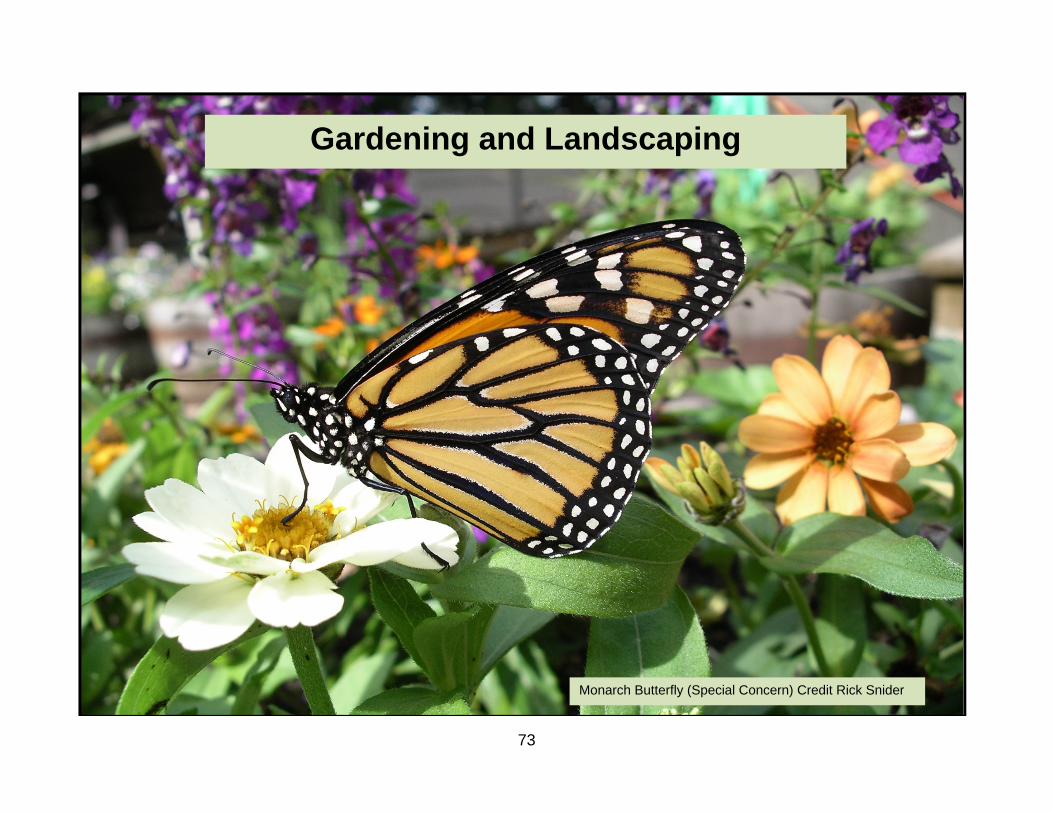
73
Gardening and Landscaping
Monarch Butterfly (Special Concern) Credit Rick Snider

74
Gardening and Landscaping
Worksheet #7a - Natural Buffers and Shoreline Access Use this worksheet to learn about living with natural buffer areas. Why should you be concerned? • A buffer is an area of natural vegetation that runs along
the shoreline or stream. It extends from the high water mark to the water’s edge.
• Natural buffers can include wetlands, beaches, forest
corridors, and any native vegetation along the shoreline or bank.
• A naturally vegetated shoreline supports a wide variety
of plants and animal life. Ninety percent of all lake life is born, raised and fed in the area where land and water meet.
• Natural buffers not only protect the stability of the
shoreline but they protect water quality by filtering and purifying water before it enters a watercourse.
• In order to visually or physically access water, people
sometimes remove all or part of a buffer. This activity weakens the buffer’s ability to protect against erosion or poor water quality. This leads to the degradation of ecological function. It can also lead to disputes with neighbours and criminal charges if fish habitat is harmed.
What you can do.
1. Maintain your shoreline in its natural pre-developed state. In some cases, your natural shoreline may be bedrock.
2. Restore vegetative buffers where they have previously been removed or degraded. Look at nearby undisturbed sites to determine which plant species are found at the shore.
3. Minimize the number of water access points. Do not locate access ways through environmentally sensitive areas (ESA’s).

75
Natural Buffers and Shoreline Access: How do you rate?
Topic Best 4 Good 3 Fair 2 Poor 1
Your Rating
1 Disturbance to the
buffer
Buffer is not traversed to provide access to water.
There is only a small designated path through the buffer.
Buffer is traversed but vegetation is allowed to re-establish naturally, OR breaks are concentrated in one area.
Buffer mostly broken or non-existent. Vegetation cleared and prevented from re-establishing.
2 Size of buffer
Buffer is greater than 50m wide and in environmentally sensitive areas (ESA’s), buffer is 150m wide.
Buffer is at least 50m wide.
Buffer is less than 50m wide.
There is no buffer present. Grass/lawn extends to property limit.
3 Composition of
buffer
Buffer contains only native vegetation and natural bedrock.
Buffer contains mostly native vegetation, natural bedrock and some non-invasive, introduced species.
Buffer has some native vegetation and mostly non-invasive introduced species.
Buffer has no native vegetation and mostly invasive and/or non-invasive introduced species.
4 Property
maintenance
Aware of any especially sensitive buffers, including wetlands, ESA’s, Areas of Natural and Scientific Interest (ANSI) and active in protecting them.
Aware of any especially sensitive buffers, including wetlands, ESA, ANSI and plans to protect them.
Aware of any especially sensitive buffers including wetlands, ESA, ANSI. No plans to protect them.
No awareness of any especially sensitive buffers including wetlands, ESA, ANSI and no plans to protect them.
All trees, woody debris and leaves are left in place with no alterations.
Vegetation alterations are limited to pruning branches from trees to provide visibility.
Trees removed to provide visibility are concentrated in one area. Other vegetation is not removed.
Trees are removed throughout to provide visibility.

76
Resource List Natural Buffers and Shoreline Access
For more information…. Fisheries and Oceans Canada The Shore Primer, Ontario Edition www.dfo-mpo.gc.ca/regions/central/pub/shore-rivages-on/04-eng.htm Muskoka Water Web www.muskokawaterweb.ca/8/8.1/shorelines.htm
The Great Blue Heron is one of many species of wildlife that benefit from a natural shoreline. Credit Kenton Otterbein

77
Action Plan Worksheet # 7a- Natural Buffers and Shoreline Access Any ratings of 1 or 2 indicate areas where your property management needs to be improved to reduce the potential for environmental damage. Use the information from the worksheet and the resource section to help analyze your potential problems and decide what you can do to solve or control them. Remember, this is YOUR Action Plan. It must suit you and your property. Topic Number
Workshop Theme
My Rating Short-term Action Long-term Action
3 Composition of buffer
2 Identify non-native plant species in the buffer zone.
Remove non-native plants and replace with native plants

78
Gardening and Landscaping
Worksheet #7b – Trees and Plants on Your Property Why should you be concerned? • Native trees and plants provide food and shelter for wildlife.
Their presence is critical to the health of our ecosystems and watersheds.
• Native plants have evolved as part of a greater ecological community. They are well adapted to local conditions and generally have few disease or insect problems. Using native species helps to integrate your property into the greater landscape.
• Tree and shrub roots anchor the soil and prevent erosion.
• Trees remove carbon dioxide, one of the main gases involved
in climate change, from the atmosphere. They also help to improve the quality of the air that we breathe by absorbing and storing many air pollutants.
• Trees can reduce your energy bill. Deciduous trees can be
strategically planted to provide shade from the summer sun. Similarly, in winter, coniferous trees on the north or west side, can provide shelter from cold winds.
• Trees add value to a property. They not only help to create an
established feeling in a neighbourhood or property, they also improve the appearance.
• Invasive plant species are often difficult to eradicate and may
introduce disease.
• Extensive lawns reduce biodiversity and require more maintenance than native species
What you can do. 1. Protect existing trees from insect and disease infestation and
physical damage from machinery or weather events. 2. Identify mature and rare trees that you want to protect and
include these in a long-term management plan.
3. Protect our forests! Reduce the spread of serious forest pests such as Emerald Ash Borer by not importing firewood from other regions.
4. Choose native plants. They are best suited to local conditions.
Learn about the plant community in which you live, and select plants from a reputable nursery.
5. Never plant invasive plants on your property and
understand what invasive species already exist in your area.
6. Know your soil type and depth. Most areas along eastern
Georgian Bay have very shallow soils. Choose your plants accordingly.
7. Reduce your lawn area to only what is needed for particular
activities and keep it as far as possible from any water-body or shoreline.
8. Use low-maintenance plants that don’t require watering or
fertilizing.

79
Trees and Plants on Your Property: How do you rate?
Topic Best 4 Good 3 Fair 2 Poor 1
Your Rating
TREE ECOLOGY 1 Understanding and
appreciation for the role of trees in ecosystem health
Proper instructions followed when planting trees, AND tree species selected to suit existing site conditions, AND priority given to native species.
Trees planted following proper instructions, AND tree species selected to suit existing site conditions.
Non-invasive, exotic species are planted.
No consideration given to tree ecology in selection of new trees, OR invasive species are planted.
Stable but dead trees are left in place to provide habitat. Only hazard trees are felled and left to rot in place, AND trees that overhang the water or fall into the water are left in place.
Both standing and hazard dead trees are felled and left to rot in place.
Some wood is left to rot and provide habitat while some is removed.
All felled wood is removed from your property, AND trees are removed from the water.
Trees and shrubs on slopes or near water are protected and never removed.
Only some trees (e.g., hazard trees) are removed from slopes and near water.
Many trees are removed from slopes and water’s edge.
All natural vegetation is removed from the majority of your property *OR tree limbs that overhang water ways or shores are cut.
*These conditions may violate provincial legislation or municipal by-laws.

80
Topic Best 4 Good 3 Fair 2 Poor 1
Your Rating
TREE MANAGEMENT 2 Tree maintenance
and care
All trees are protected against injury, and potential diseases, AND no healthy trees are removed.
Trees in shoreline and watercourse buffers are protected, AND no healthy trees are removed.
Trees are not protected, OR some healthy trees are removed.
Lot is generally cleared.
Branch pruning is done properly and at the right time to provide lake views.
Branch pruning is irregular but is done properly.
Trees are pruned carelessly or without regard for tree health and vigour.
Trees are watered properly and regularly for a minimum of three years after planting. AND mulch is properly piled at least 3 inches away from tree trunk.
Trees are watered during hot, dry periods for the first three years after planting. AND mulch is properly piled at least 3 inches away from tree trunk.
Trees are watered irregularly, AND mulch is properly piled at least 3 inches away from tree trunk.
Watering is inadequate during the first three years following planting, OR mulch is piled too close to the tree trunk, causing damage to bark.
3 Knowledge of issues
related to tree health
Have knowledge of potential insect and disease problems in your area, AND a certified arborist is hired to assess tree health and development and to develop a long-term management plan.
A certified arborist is hired to assess tree health and development and to develop a long-term management plan.
Existing trees are checked periodically for disease or insect infestation.
No consideration is given to tree health or insect problems in your area.
If necessary, ensure trees are properly staked after planting and that stakes are removed after 2 years.
Tip
Protect trees during construction by ensuring that there is no disturbance within the dripline.
Tip
Never pile mulch too close to the trunk of a tree. This can damage the bark, possibly girdling and killing the tree.
Tip

81
Topic Best 4 Good 3 Fair 2 Poor 1
Your Rating
TREE MANAGEMENT continued 4 Tree root system
Tree rooting zone has adequate soil volume and conditions appropriate for the tree species selected.
Tree rooting zone is adequate but may need supplemental feeding.
Tree rooting zone is not less than 60% of appropriate volume and may require supplemental watering during dry spells.
Soil volume and growing conditions of rooting zone are inadequate for the tree species selected.
5 Plant selection and
control
No invasive plants on property.
No new planting of invasive plants. AND measures taken to eliminate existing invasive plants.
No new planting of invasive plants.
Continued use of invasive plants.
Complete eradication and proper disposal of existing invasive plants on your property.
Long-term management plan for the eradication of existing invasive plants.
Short-term management plan for the eradication of existing invasive plants.
No attempts to eradicate invasive plants.
Match tree and plant selection to your soil conditions, AND use only native plants.
Tree and plant selection suits local soil and climate conditions, AND non-invasive plants selected.
Occasional addition of nutrients to support non-invasive plants.
Tree and plant selection does not suit local soil and climate conditions.
Cues for proper species selection can be gained by looking at nearby native plants that are thriving in the same conditions as your property.
Tip
Be aware of the source of new plants when purchasing and ensure they are infection-free before planting.
Tip
At the Nursery: what you should ask… 1. What native, local plants do you have? 2. Are they nursery grown or harvested from the wild? 3. Is there potential for invasion? 4. How can you control or eradicate it if necessary? 5. What are the nutrient and water requirements?
Tip

82
Topic Best 4 Good 3 Fair 2 Poor 1
Your Rating
6 Garden monitoring
Regular checks to ensure that invasive species have not established in gardens, AND once spotted, invasive plants are immediately disposed of in an appropriate manner.
Regular checks to ensure that invasive species are not established in gardens.
Occasional checks to ensure that invasive species are not established in gardens, OR once spotted, invasive plants are immediately disposed of in an inappropriate manner.
No checks to ensure that invasive species are not established in gardens, OR once spotted, invasive plants are not disposed.
7 Lawns
No traditional lawn.
Lawn is limited to area over the septic bed with no use of pesticides, fertilizers or irrigation.
Lawn is kept to a minimum size and at a maximum distance from the shoreline.
Much of property is given over to lawn, OR lawn is used to the water’s edge.
Learn about appropriate alternative groundcovers from local experts and plant them, AND encourage local nurseries to stock native groundcovers.
Allow for a mix of native and non-invasive plants that tolerate some mowing and drought.
Non-invasive plants used that tolerate some mowing and drought.
Species used require extensive use of irrigation, and fertilizer. OR use of invasive species.
During hot, dry weather, allow grasses to go dormant.
Tip
If planting a traditional lawn with a non-native grass, choose a grass that is hardy, pest resistant and non-invasive.
Tip

83
Resource List Trees and Plants on Your Property
For more information…. General Tree and Plant Advice Local Ministry of Natural Resources office (see Blue Pages) Ontario Forestry Association www.oforest.on.ca Management Forest Tax Incentive program Contact local Ministry of Natural Resources Office www.mnr.gov.on.ca Parry Sound-Muskoka Stewardship Council www.ontariostewardship.org/councils/parrysound-muskoka Ontario Woodlot Association www.ont-woodlot-assoc.org The Forest Gene Conservation Association www.fgca.net The Society for Ecological Restoration (Ontario Chapter) - Native Plant Resource Guide. Order online: www.serontario.org Muskoka Heritage Foundation Native Plant Sale (spring) 9 Taylor Road, Box 482 Bracebridge ON P1L 1T8 705 645 7393 www.muskokaheritage.org
Planting for Nature Ministry of Natural Resources Information Centre, Toronto (T): 416-314-2225 • Landscaping for Wildlife. Booklet. • Shrubs for Wildlife. Pamphlet. Low Maintenance Lawns and Gardens Ministry of the Environment www.ene.gov.on.ca/en/land/pesticides/greenAlternatives.php Peterborough Green Up www.greenup.on.ca Invasive Species Canadian Wildlife Federation www.cwf-fcf.org Ontario Federation of Hunters and Anglers- Invading Species www.invadingspecies.com Books Deacon, G. 2006. Green Tips: How to Save Money and the Planet. Toronto, ON: Green Living Enterprises. Rubin, C. 1990. How to get your Lawn and Garden off Drugs: Pesticide-free Gardening for a Healthier Environment. Madeira Park, BC: Harbour Publishing.

84
Dangerous Beauty: the problem with invasive species
Be aware of the plant that can grow anywhere… A well-intentioned ‘gift’ from a friend or neighbour may end up taking over your garden and spreading into nearby plant communities where it can have a disastrous impact on the health of the ecosystem. Being invasive depends on site conditions. It is possible that a well-contained plant in your garden may run rampant in a friend’s garden. Never accept or give plants if you are unsure. The following is a partial list of invasive plants that are of concern in Ontario. AVOID THE USE OF THESE PLANTS!
Name: Coronilla varia Common name: Crown vetch Colours: Light rose flowers, medium green leaves. Size: Can reach 2 m (6.5 ft). Type: Perennial vine
Name: Aegopodium podagraria Common name: Goutweed Colours: Insignificant white flowers, medium green or variegated leaves Size: Height 15 cm (6 in). Type: Common groundcover

85
Dangerous Beauty: the problem with invasive species
Name: Vinca minor Common name: Periwinkle Colours: Violet-blue flowers, dark, glossy green leaves. Size: Height 10 cm (4 in). Type: Common groundcover
Name: Polygonum cuspidatum Common name: Japanese knotweed Colours: Light white to pale pink tufts, medium green leaves. Size: 75 cm to 1.8 m (2 ½ to 6 ft) Type: Perennial
Name: Lunaria annua Common name: Silver Dollar Colours: Medium pink flowers, medium green leaves. Size: 30 to 90 cm (1 to 3 ft) Type: Biennial
Name: Phragmites australis Common name: Common reed Colours: Bonze-purple tufts, light green leaves. Size: 2 to 4 m (6.5 to 13 ft), can grow up to 8 m (26 ft). Type: Perennial grass

86
Dangerous Beauty: the problem with invasive species
Additional Plants to Avoid Trees • Norway maple (Acer platanoides) • Scots pine (Pinus sylvestris) Plants • Chives (Allium Schoenoprasum) • Sedums
Shrubs • Japanese barberry (Berberis thunbergii) • Oriental bittersweet (Celastrus orbiculatus • European highbush cranberry (Viburnum opulus)
Name: Hesperis matronalis Common name: Dame’s Rocket Colours: Medium pink or light blue flowers, medium green leaves. Size: Height 75 cm (30 in), spread 60 cm (24 in). Type: Upright perennial
Name: Hedera helix Common name: Common English Ivy Colours: Dark green, glossy leaves. Occasionally, white striations visible along veins. Size: Height 10 m (30 ft), spread 5 m (15 ft) Type: Vigorous, evergreen self-clinging climber or groundcover

87
Alternatives to cosmetic pesticides Ontario's cosmetic pesticides ban took effect April 22, 2009. The requirements of the ban are detailed in Ontario Regulation 63/09 and the Pesticides Act, which was amended by the Cosmetic Pesticides Ban Act, 2008.
Pesticides cannot be used for cosmetic purposes on lawns, vegetable and ornamental gardens, patios, driveways, cemeteries, and in parks and school yards. There are no exceptions for pest infestations (insects, fungi or weeds) in these areas, as lower risk pesticides, biopesticides and alternatives to pesticides exist. More than 250 pesticide products are banned for sale and over 95 pesticide ingredients are banned for cosmetic uses.
What you can do
Successful landscapes rely on preventative measures and careful monitoring, just like your health. Timely effort saves you time and hassle later on and your garden will thank you for it!
• Try old-fashioned remedies for pests, such as borax sprinkled around ant nests, insecticidal soap for sap-suckering insects, and baking soda or sulphur for fungal diseases.
• To make plants less appetizing, use a garlic spray (10 cloves of garlic in 1 litre (4 cups) of water and heated for 5 minutes.
• Bring in reinforcements. Create suitable habitat for birds that will eat insect pests.
How to have a healthy, low-maintenance lawn • In hot, dry weather allow grass to become dormant. Water 7-
12 millimetres (0.25-0.5 inches) every two or three weeks. Grass will look brown but it is dormant, not dead.
• Encourage deep rooting by watering infrequently but
thoroughly. Your lawn only needs 2.5 centimetres of water per week.
• Mow when the grass is as dry as possible and leave your
grass at least 8 centimetres (3 inches) long. This encourages root growth and lessens moisture loss. Leave grass clippings on the lawn and you can increase soil fertility by up to 50%.
• Aerating your lawn improves rooting conditions. • If you do use a fertilizer, choose a slow-release product. The
nutrients are released slowly, preventing ‘lawn burn’ and water contamination.
• Remove unwanted plants from lawn by hand using long
handled tools. It is easier to remove weeds when the ground is damp. Alternatively, pour boiling water or white vinegar over the exposed roots of unwanted plants.
• Spread a layer of natural mulch 8-10 centimetres (3-4 inches)
thick over your garden. This will prevent weed seeds from germinating.
• Appropriately dispose of invasive plants. Check the
Resources List for information on the control of invasive species.

88
Action Plan Worksheet # 7b- Trees and Plants On Your Property Any ratings of 1 or 2 indicate areas where your plant selection and use needs improving to reduce the potential for environmental damage. Use the information from the worksheet and the resource section to help analyze your potential problems and decide what you can do to solve or control them. Remember, this is YOUR Action Plan. It must suit you and your property. Topic Number
Workshop Theme
My Rating Short-term Action Long-term Action
7 Lawns 2 Identify areas of lawn that will be naturalized. Research native plants that are suitable for the area.
Plant native plants and reduce lawn to minimum size.

89
Gardening and Landscaping
Worksheet #7c – Nutrients
Use this worksheet to learn about the importance of nutrients in the landscape. Why should you be concerned? • Nutrients have an important and beneficial role in plant
growth and soil amendments. As plant roots take up nutrients from the soil over time, the soil may become depleted, resulting in less vigorous plant and lawn growth.
• Over-application of fertilizers can result in fertilizer running
off the garden or lawn. This can contaminate both groundwater and surface water and encourage algae and algal blooms.
• Our activities both inland and along the shoreline affect the
nutrient-loading of our rivers and lakes. • We can all potentially contribute to harmful eutrophication,
which will reduce water quality and possibly affect our use of the water.
What you can do.
1. Test to find out the nutrient level in your soil before adding
any nutrients.
2. Effectively manage nutrients in an environmentally responsible manner.
3. Reduce your nutrient application volume.
4. Plant species of shrubs and plants that require little or no fertilizing.
N-P-K Nitrogen (N) for leaf development and vivid green color.
Phosphorous (P) for root growth.
Potassium (K) for root development and disease resistance.
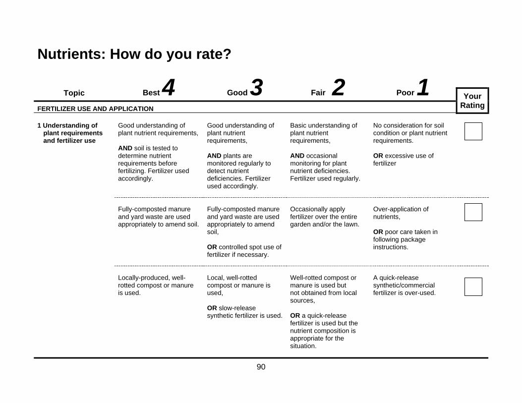
90
Nutrients: How do you rate?
Topic Best 4 Good 3 Fair 2 Poor 1
Your Rating
FERTILIZER USE AND APPLICATION 1 Understanding of
plant requirements and fertilizer use
Good understanding of plant nutrient requirements, AND soil is tested to determine nutrient requirements before fertilizing. Fertilizer used accordingly.
Good understanding of plant nutrient requirements, AND plants are monitored regularly to detect nutrient deficiencies. Fertilizer used accordingly.
Basic understanding of plant nutrient requirements, AND occasional monitoring for plant nutrient deficiencies. Fertilizer used regularly.
No consideration for soil condition or plant nutrient requirements. OR excessive use of fertilizer
Fully-composted manure and yard waste are used appropriately to amend soil.
Fully-composted manure and yard waste are used appropriately to amend soil, OR controlled spot use of fertilizer if necessary.
Occasionally apply fertilizer over the entire garden and/or the lawn.
Over-application of nutrients, OR poor care taken in following package instructions.
Locally-produced, well-rotted compost or manure is used.
Local, well-rotted compost or manure is used, OR slow-release synthetic fertilizer is used.
Well-rotted compost or manure is used but not obtained from local sources, OR a quick-release fertilizer is used but the nutrient composition is appropriate for the situation.
A quick-release synthetic/commercial fertilizer is over-used.

2 Ap
an
COM 3 Co
pr
*Thes
NEVER cospecies unsure that thseeds prescompostinkill the root
Tip
Topic
pplication practind water access
MPOST MANAG
omposting ractices
se conditions may vio
ompost invasive nless you are here are no sent and that g will effectively t system.
B
ices s
Nutrient aminimum feet) from intakes, stcourses, AND a pevegetatedthan 3 mewide runs of nutrientany well, wstream or AND checheavy rainthunderstoforecast fohours follo
EMENT Householdrodent pro AND comis monitorregularly, AND comon-site.
olate provincial legisla
Best 4
application is a of 30 metres (100 wells, water treams and water
ermanently d buffer, greater etres (10 feet) between the aret application and water intake, water course,
ck to ensure that n or orms are not or at least 24 owing application
d compost is oof,
post compositionred and mixed
post is used
ation or municipal by-l
Good
0
r
ea
.
Nutrient applis a minimummetres (100 wells, water istreams and courses, AND check theavy rain orthunderstormforecast for ahours followiapplication.
n
Compost commonitored anregularly, AND composon-site.
laws.
91
d 3
lication m of 30 feet) from intakes, water
to ensure that r
ms are not at least 24 ng
Nm(wa
mposition is nd mixed
st used
Hwc
Fair 2Nutrient applicatiominimum of 30 me100 feet) from we
water intakes, streand watercourses
Household compowaste is sent to locomposting facility
Composting inKeep compost cashes and browoften. Never comproducts (includbread). Locate ctravel ways. If y
• Considecompos
• Composgrass, le
Tip
2
on is a etres ells, eams s.
Fertilizmanuror satuslopesoff is l *OR cmetrewells,streamcours
ostable ocal y.
Compcompo
n Black Bear Haclean and odour fren material, e.g. leavmpost meat, fish, oiing products made
compost well away you have problemser using an electric ster or use an indoost only yard waste oeaves).
Poor 1
zer, compost or re applied to frozurated soils, or os where surface rikely,
closer than 30 es (100 feet) to , water-intakes, ms and water ses.
postable material osted.
bitat e by using lime, woves, as well as turnil, grease or dairy with milk such as from house and beyou may: fence around your
or worm composteroutdoors (e.g. cut
Your Rating
en n run-
not
ood ning
ear
r r.

92
Topic Best 4 Good 3 Fair 2 Poor 1
Your Rating
4 Water features and ponds
There is no artificial water feature or pond on the property.
Water feature and landscaping are designed to minimize the amount of light falling on water feature, AND water is continuously moving in water feature. AND water feature is located as far from waterways or open natural water as possible.
Water feature is located as far from waterways or open natural water as possible.
Indiscriminate design, placement and chemical treatment of artificial water features.
If you are experiencing problems with algae in your water feature or pond, be sure to properly diagnose the cause of the problem before attempting treatment.
Tip
Test your soil for nitrogen, phosphorous and potassium levels before adding nutrients. Contact a soil testing lab for more details on soil sampling. See the Yellow Pages for a listing near you.
Tip

93
Resource List Nutrients
For more information…. Organizations Composting Council of Canada (T): 1-877-571-GROW www.compost.org Ontario Horticultural Association www.gardenontario.org Montreal Botanical Garden (Fertilizers and Soil Amendments) www2.ville.montreal.qc.ca/jardin/en/info_verte/fertilisation/besoins_ nutritifs.htm North Shore Recycling Program (Compost) www.nsrp.bc.ca/naturalyard/composting.html
People Local Master Gardener representative (T): 905-309-3959 Local Horticultural Society Books Smillie, J. and G. Gershuny. 1999. The Soul of Soil (4th Ed.) White River Junction, Vermont: Chelsea Green Publishing Company. ISBN 1-890132-31-4 Soil Testing For a soil testing lab near you, see the Yellow Pages

94
Action Plan Worksheet # 7c- Nutrients Any ratings of 1 or 2 indicate areas where your management of nutrients need some changes to reduce the potential for environmental damage. Use the information from the worksheet and the resource section to help analyze your potential problems and decide what you can do to solve or control them. Remember, this is YOUR Action Plan. It must suit you and your property. Topic Number
Workshop Theme
My Rating Short-term Action Long-term Action
1 Understanding of plant requirements and fertilizer use
2 Research plant nutrient requirements and test soil nutrient levels.
Monitor nutrient deficiencies and apply natural fertilizers only when necessary.

95
Gardening and Landscaping
Worksheet #7d – Water Efficiency
Use this worksheet to learn about water efficiency in the landscape. Why should you be concerned? • There is a limited supply of fresh, clean water. • If groundwater is used at a rate faster than it can be
replenished by the water cycle, severe shortages and damage to aquatic systems may result.
• Whether your drinking water comes from a private or a
municipal system, we’re all pulling water from the same source. Both surface and well water require energy to treat and pump.
What you can do. 1. Calculate how much water you use in your landscaping
and gardening. On-line water calculators are available at www.on.ec.gc.ca. Purchase a rain gauge to monitor how much water your yard receives.
2. Choose proper equipment that is water efficient, such as soaker hoses rather than sprinklers. Keep equipment in good condition.
3. Consider plants that grow well in local conditions without irrigation.
4. Divert downspouts into screened rain barrels and use to water your plants. .

96
Landscape Water Efficiency: How do you rate?
Topic Best 4 Good 3 Fair 2 Poor 1
Your Rating
WATER MANAGEMENT AND USE 1 Knowledge of water
use in the landscape
Water use is monitored regularly and steps are taken to improve efficiency.
Water use is monitored on occasion.
Water use is not monitored.
Hoses, facets etc are regularly monitored for leaks. Leaks are fixed immediately.
Leaks are repaired only when they become a problem.
Leaks are not repaired.
2 Irrigation equipment
type
No irrigation equipment used.
Irrigation equipment applies water to plant rooting area only (e.g., drip system).
Low-level sprinkler system or mobile sprinkler head.
Fixed sprinkler head.
3 Irrigation design
System is properly designed and sized for the size of the garden or landscaped area.
Irrigation system too large for the garden area.
No ponding of irrigation water.
Water ponds briefly but then infiltrates soil.
Irrigation water ponds but does not run off the property.
Water runoff along the surface and into any underground drains.

97
Topic Best 4 Good 3 Fair 2 Poor 1
Your Rating
WATER MANAGEMENT AND USE continued 4 Watering your plants
Watering schedule is adjusted according to rainfall, stage of plant development, use of water gauges, and plant appearance.
Watering schedule is sometimes adjusted according to rainfall, stage of plant development, use of water gauges, and plant appearance.
Monitored watering limited to when establishing new plants.
Watering is not adjusted according to rainfall, stage of plant development, use of water gauges, and plant appearance.
Water only in the early morning to reduce the chance of fungal disease on plants
Water only in the early morning or early evening.
Water only in the late evening, thereby increasing the chance of fungal disease.
Water during the hottest hours of the day.

98
Resource List Landscape Water Efficiency
For more information…. Peterborough Green Up Factsheet: Low Water Gardens www.greenup.on.ca/index Muskoka Watershed Council Factsheet: Healthy Lawns and Garden Naturally www.muskokaheritage.org/watershed/watershedpublications York Regional Municipality Water Efficiency Today… Water for Tomorrow www.water4tomorrow.com City of Toronto Water Efficiency Plan www.toronto.ca/watereff/plan.htm

99
Action Plan Worksheet # 7d- Landscape Water Efficiency Any ratings of 1 or 2 indicate areas of your landscape management that require changes to reduce the potential for environmental damage. Use the information from the worksheet and the resource section to help analyze your potential problems and decide what you can do to solve or control them. Remember, this is YOUR Action Plan. It must suit you and your property. Topic Number
Workshop Theme
My Rating Short-term Action Long-term Action
4-a Watering Your Plants
2 Research water needs of your plants and purchase a water gauge.
Water schedule always adjusted according to rainfall and plants requirements.

100

101
Worksheet #8 – Your Garbage
Use this worksheet to learn about how you can help manage your garbage. Why should you be concerned? • The millions of tonnes of garbage produced in our
communities every year quickly fill up existing landfill sites. • It is increasingly difficult to find new landfill sites as no one
wants to live near one.
• If a municipality’s landfill site is full and a new nearby location cannot be obtained, residents must pay more to have their waste transported elsewhere.
• Recycling saves natural resources, energy and water by using
already manufactured items instead of more natural resources.
• Durable products may initially be more expensive but they are
generally a better investment in the long run and they stay out of landfill sites longer.
• Leachate from landfill sites may contaminate groundwater. • Open burning of garbage in barrels, woodstoves, fireplaces,
outdoor furnaces or open pits releases a large number of pollutants. Burning of garbage at home, cottage and farm is one of the largest known sources of dioxins and furans in Ontario.
• Some people throw medications into the garbage or flush
them down the toilet or the sink. These practices may have a harmful effect on the environment, since chemical components in the drugs may be added to the soil or water and may eventually find their way into our drinking water.
What you can do. 1. Consider how you can generate less garbage. If you are a
seasonal resident, please remember that good recycling practices should continue even while you are on vacation.
2. Recycle effectively. Contact your local municipality to learn what items can be recycled in your community and how you should prepare them for recycling (i.e. rinse, bundle, and sort).
3. Inform yourself of initiatives and companies that are
redesigning products, packaging, and manufacturing processes to reduce waste. Support them through your purchasing power.
4. Compost food and yard wastes.
5. Use refillable and reusable containers and products as much as possible and purchase durable products that won’t need short-term replacement.
6. Watch for Hazardous Waste Disposal Days in your community. Encourage your local municipality to have them and support recycling programs. Many items such as paint, batteries, printer ink cartridges can be returned to the place of purchase for proper disposal or recycling.
7. Return your unused and expired medications to your
pharmacist for disposal for you or alternatively, help you find information about where to dispose of them.

102
Your Garbage: How do you rate?
Topic Best 4 Good 3 Fair 2 Poor 1
Your Rating
MINIMIZING THE WASTE THAT COMES ‘IN’ 1 Purchases
Instead of buying, borrow, rent or share any items possible, OR purchase used items.
Purchase or use only what you need and avoid accumulating unused products.
Purchase more than is necessary, AND recycle as much as possible, including donating items.
Purchase more than is necessary, OR throw unwanted items into regular household garage.
Preference given to items that are durable, reusable, and/or recyclable and can be recycled locally. AND take-out or disposable food/beverage containers are seldom used.
Preference given to items that are durable, reusable, and/or recyclable and can be recycled locally.
Disposable or single serving items purchased even when alternatives available AND minimal effort made to recycle or reuse.
Frequently purchase disposable, or single serving items, OR no effort to recycle or reuse.
Choose items that have no packaging, AND always re-use carry-out grocery bags or tote bag.
Choose items that have minimal packaging, OR always re-use carry-out grocery bags or tote bag.
Choose items with packaging that is recyclable in your municipality.
No consideration given to product packaging, OR plastic carry-out bags are accepted and then discarded.
Items that bear the EcoLogo symbol are manufactured in a way that minimizes the use of hazardous by-products.
Tip
Use your purchasing power to help minimize waste and protect water quality.
Tip

103
Topic Best 4 Good 3 Fair 2 Poor 1
Your Rating
MINIMIZING THE WASTE THAT GOES ‘OUT’ 2 Re-using and
recycling
Reduce the number of items you use.
Reuse as many items as possible.
Recycle as many items as possible.
Garbage is taken to local landfill.
Both sides of a sheet of paper are used, AND all paper is recycled.
Both sides of a sheet of paper are used, OR all paper is recycled.
Most paper is recycled and all paper purchased contains some recycled content.
Paper is not recycled.
Check with local municipality to learn what items are recyclable and how they should be prepared for recycling, AND comply with all applicable recycling practices in your community. AND all hazardous materials are disposed of properly.
Most recyclable items are recycled.
Little or no attempt made to participate in local recycling programs, *OR waste is burned / a burn barrel is used. *OR hazardous wastes are put into regular garbage.
Food scraps and yard wastes are properly composted regularly, on site.
Food scraps and yard wastes are composted occasionally OR a garborator or garbage disposal is used.
Food scraps or yard wastes are thrown in regular household garbage
*These conditions may violate provincial legislation or municipal by-laws.
To reduce packaging, buy larger volumes (more product for less packaging) bulk or concentrated products.
Tip

104
Resource List Your Garbage
For more information…. Waste Reduction Ontario Ministry of Environment (MOE) 416-323-4321 1-800-565-4923 www.ene.gov.on.ca • Be a Garbage Transformer. Brochure. For children aged 9-11.
PIBS 1013b.
• Closing the Loop: The 3Rs of Waste Management. Booklet. ISBN 0-7729-6931-0. PIBS 1012b.
• Ontario’s Waste Reduction Action Plan: Backgrounder. Information sheet. PIBS 1600b.
• The Road to a Conserver Society. Booklet. PIBS 1630b. • The Waste Reduction Office. Information sheet. PIBS 1717e. • Your Seven Day Waste Reduction Diary. Booklet. PIBS 2189e. • A Down-to-Earth Guide to Composting and Vermicomposting in
Environmental Living: Protecting the Environment…in Your Lawn and Garden. Vol.2. ISBN 0-7778-1070-0, PIBS 2316e
• Environmental Living: Protecting the Environment…in Your Home.
Vol. 1. ISBN 0-7778-1069-7, PIBS 2315e
Recycling Facilities • Local municipality (see Blue Pages) Waste Burning • Local municipality about regulations (see Blue Pages) • www.burnbarrel.org • New York State Department of Health
www.health.state.ny.us/nysdoh/environ/trash.htm • Canadian Centre for Pollution Prevention
www.c2p2online.com • Great Lakes Trash and Open Burning Website
www.openburning.org Ecological Labeling Environmental Choice Program c/o TerraChoice Environmental Marketing 1280 Old Innes Road, Suite 801 Ottawa, Ontario K1B 5M7 Call toll-free: 1-800-478-0399 fax: 613-247-2228 www.environmentalchoice.com

105
Action Plan Worksheet # 8- Your Garbage Any ratings of 1 or 2 indicate areas where your management of garbage needs some changes to reduce the potential for environmental damage. Use the information from the worksheet and the resource section to help analyze your potential problems and decide what you can do to solve or control them. Remember, this is YOUR Action Plan. It must suit you and your property. Topic Number
Workshop Theme
My Rating Short-term Action Long-term Action
1-a Purchases 2 Research which items are recycled locally. Purchase reusable travel mugs, shopping bags, water bottle, etc.
Reduce waste produced by your household. Make informed decisions when purchasing packaged items and ensure materials are recycled.

106

107
Worksheet #9 - Storage & Proper Handling of Fuels, and other Typical Household Chemicals Use this worksheet to learn about best management of fuels and chemicals. Why should you be concerned? • Petroleum products contain toxic compounds, such as
benzene, which can cause cancer. • Some toxic chemicals are colourless and odourless and
can go undetected in water.
• Contaminated water or soil greatly devalues land property and is very expensive to clean-up. Clean-up may not even be possible in some cases.
• A property owner may be held liable for contaminating any
water source. • Vapours from some chemicals such as fuels can ignite or
cause explosions. • Pesticides have been found in amounts below the
tolerance levels set by the government in Ontario’s drinking water. We don’t know the effects of repeated exposure to very small amounts over a long period of time. Chronic health problems may not appear for many years.
What you can do. 1. Educate yourself about alternative non-toxic or lower
toxicity chemicals to suit your purposes.
2. Avoid storing chemicals. Buy only the amount you need and make sure you have a safe storage area. Contact your local municipality to learn how you can dispose of empty chemical containers and rinse water safely.
3. Never store fuel or any chemical on your property where it may come in contact with water.
4. Read and follow instructions carefully. Note if weather conditions can affect application.
5. Never pour chemical leftovers down the drain, storm sewer, storm drain or into open water.
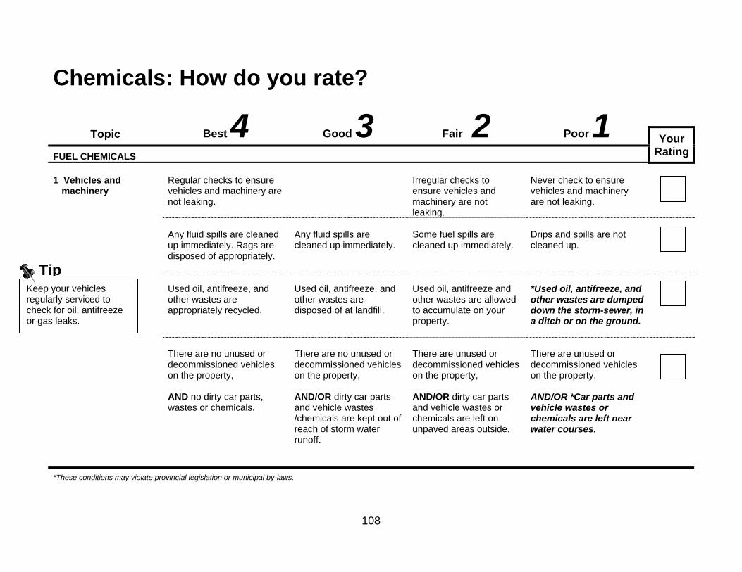
108
Chemicals: How do you rate?
Topic Best 4 Good 3 Fair 2 Poor 1
Your Rating
FUEL CHEMICALS 1 Vehicles and
machinery
Regular checks to ensure vehicles and machinery are not leaking.
Irregular checks to ensure vehicles and machinery are not leaking.
Never check to ensure vehicles and machinery are not leaking.
Any fluid spills are cleaned up immediately. Rags are disposed of appropriately.
Any fluid spills are cleaned up immediately.
Some fuel spills are cleaned up immediately.
Drips and spills are not cleaned up.
Used oil, antifreeze, and other wastes are appropriately recycled.
Used oil, antifreeze, and other wastes are disposed of at landfill.
Used oil, antifreeze and other wastes are allowed to accumulate on your property.
*Used oil, antifreeze, and other wastes are dumped down the storm-sewer, in a ditch or on the ground.
There are no unused or decommissioned vehicles on the property, AND no dirty car parts, wastes or chemicals.
There are no unused or decommissioned vehicles on the property, AND/OR dirty car parts and vehicle wastes /chemicals are kept out of reach of storm water runoff.
There are unused or decommissioned vehicles on the property, AND/OR dirty car parts and vehicle wastes or chemicals are left on unpaved areas outside.
There are unused or decommissioned vehicles on the property, AND/OR *Car parts and vehicle wastes or chemicals are left near water courses.
*These conditions may violate provincial legislation or municipal by-laws.
Keep your vehicles regularly serviced to check for oil, antifreeze or gas leaks.
Tip

109
Topic Best 4 Good 3 Fair 2 Poor 1
Your Rating
FUEL STORAGE 2 Portable fuel storage
All fuel is used up regularly so that storage is not required anywhere on the property.
A minimal amount of fuel is stored in safe, approved, original-sale, and clearly labelled containers, AND liquid fuel containers have a spout to prevent spills.
Fuel is stored in safe, approved, original-sale, and clearly labelled containers.
Fuels are stored in unmarked, open or unapproved containers.
Distance between petroleum storage and nearest surface water is greater than 150 metres (500 feet).
Distance between petroleum storage and nearest surface water is 61-150 metres (200-500 feet).
Distance between petroleum storage and nearest surface water is 30-60 metres (100-199 feet).
*Distance between petroleum storage and nearest surface water is less than 30 metres (100 feet).
Distance between petroleum storage and well(s) is greater than 90 metres (300 feet).
Distance between petroleum storage and well(s) is 24-90 metres (76-300 feet) for a drilled well, OR 47-90 metres (151-300 feet) for a bored/dug well.
Distance between petroleum storage and well(s) is 15-23 metres (50-75 feet) for a drilled well, OR 30-46 metres (100-150 feet) for a bored/dug well.
*Distance between petroleum storage and well(s) is less than 15 metres (50 feet) for a drilled well, OR less than 30 metres (100 feet) for a bored/dug well.
*These conditions may violate provincial legislation or municipal by-laws.

110
Topic Best 4 Good 3 Fair 2 Poor 1
Your Rating
ABOVE GROUND FUEL TANK STORAGE 3 Gasoline and diesel
fuel tanks
No fuel tanks are present above or below ground anywhere on the property.
All tanks are made of steel and have a protective, anti-corrosive coating, AND are ULC approved.
*Steel tank with no protective coating, OR fibreglass tank, OR not ULC approved.
Tanks are regularly checked for leaks.
Tanks are tested monthly for leaks.
Tanks are not checked for leaks.
The water table is located more than 3 metres (10 feet) below the surface, under the fuel tank.
The water table is located consistently 1.5 metres (5 feet) to 3 metres (10 feet) below the surface.
The water table is located consistently less than 1.5 metres (5 feet) below the surface.
Inactive tanks are decommissioned and properly removed.
Inactive tanks are abandoned.
Tanks sites are checked for contamination. If found, it is immediately reported.
Tanks sites are not checked for contamination, OR if found, not immediately reported.
*These conditions may violate provincial legislation or municipal by-laws.
If a spill or leak occurs, report it immediately to the Spills Action Centre at the MOE by calling: 1-800-268-606
Tip

111
Topic Best 4 Good 3 Fair 2 Poor 1
Your Rating
ABOVE GROUND FUEL TANK STORAGE continued 4 Heating oil tanks
All types of tank(s) are located more than 3 metres (10 feet) from any building.
Tank(s) with a capacity of less than 2500 litres (550 gallons) are located 3 metres (10 feet) or less from any building.
Fuel tank is located inside a building,
*OR tank(s) with a capacity of greater than 2500 litres (550 gallons) are located less than 1.5 metres (5 feet) from a building.
Tanks are ULC approved, monitored for leaks, and proper vent pipe used, AND protective coating maintained.
*Tanks are not ULC approved,
OR monitored for leaks,
OR no vent pipe used,
OR protective coating not maintained.
Tank less than 5 years old.
Tank less than 10 years old.
Tank less than 20 years old.
Tank more than 25 years old,
OR age of tank unknown.
Fuel delivery system between fuel storage and appliance is installed by a registered contractor and inspected annually for leaks.
*Fuel delivery system between fuel storage and appliance is not installed by a registered contractor,
OR not inspected annually for leaks.
*These conditions may violate provincial legislation or municipal by-laws.
If you have underground storage of fuel, you are not in compliance with regulations.
Tip

112
Topic Best 4 Good 3 Fair 2 Poor 1
Your Rating
HOUSHOLD CLEANERS AND NON-FUELS 5. Cleaning products
All household cleaning products are non-toxic and non-harmful to humans, AND minimal quantities are used.
Most household cleaning products are non-toxic and non-harmful to humans.
Typical chemical cleaners are used properly, AND minimal quantities are used.
No consideration given to a product’s toxicity, OR more than is necessary is used.
6. Total amount non-
fuel chemicals stored
No chemicals stored any time.
Chemicals are not stored longer than immediate use period.
Small amount of chemicals stored for longer than immediate use period.
Large quantities of chemicals stored for longer than immediate use period.
7. Distance from
chemical storage to nearest water source
Greater than 150 metres (500 feet).
60-150 metres (200-500 feet).
30 -60 metres (100-199 feet).
Less than 30 metres (100 feet).
8. Distance from
chemical storage to well
Greater than 90 metres (300 feet).
23–90 metres for a drilled well (76-300 feet), OR 46-90 metres for a bored/dug well (151-300 ft).
15-23 metres for a drilled well (50-76 feet), OR 30 -45 metres for a bored/dug well (100-150 feet).
Less than 15 metres for a drilled well (50 feet), OR less than 30 metres for a bored well (100 feet).
9. Chemical solution
mixing
Chemicals are mixed in well ventilated area, on an impervious surface, and far from any open drain or open water source.
Chemicals are not mixed in well ventilated area, OR surface is not impervious, OR mix far from any open drain or open water source.

113
Topic Best 4 Good 3 Fair 2 Poor 1
Your Rating
HOUSHOLD CLEANERS AND NON-FUELS continued 10. Chemical storage
area and containers
Stored in a water-proof, locked cabinet or storage container. The container itself stored in a garage or shed with a concrete floor that does not contain any drains.
Stored in a garage or shed with a concrete floor that does not contain any drains.
Stored with human or animal food, OR stored in residence, OR stored in a garage or shed with a concrete floor that contains drains.
Sill installed in cabinet to contain any spills.
No sill installed in cabinet.
No sill installed in cabinet. AND garage or shed has floor drain that leads to surface water source, etc.
Garage or shed is well ventilated to outside.
Garage or shed is not ventilated to outside.
Emergency numbers are posted nearby.
No emergency numbers are posted nearby.
All chemicals are in clearly marked containers.
Containers not labelled.
Chemicals are used before the expiration date.
Chemicals not stored or used beyond expiration date.
*These conditions may violate provincial legislation or municipal by-laws.

114
Topic Best 4 Good 3 Fair 2 Poor 1
Your Rating
HOUSHOLD CLEANERS AND NON-FUELS continued 11. Return, rinsing
and disposal of chemical containers
Use of returnable or refillable containers, AND rinse water is used as per label instructions.
Triple or pressure rinsed containers or empty bags taken to municipal landfill. AND rinse water is used as per label instructions.
Appropriate disposal of triple/pressure rinsed containers. BUT rinse water is allowed into septic system or storm drain.
*Inappropriate disposal of un-rinsed containers including burning them.
12. Emergency plan
and clean up equipment for spills
Emergency plan easily accessible, outlining actions to be taken in case of spill, leak, fire or explosion, AND cleanup equipment available.
Emergency plan easily accessible, outlining actions to be taken in case of spill, leak, fire or explosion.
Emergency phone numbers posted nearby, AND general plan in case of emergency.
*No emergency plan prepared, OR no spill cleanup equipment ready nearby.
DISPOSAL OF ANY CHEMICALS 13. Disposal of
hazardous chemicals or materials
No unused vehicle batteries stored on the property.
Vehicle batteries are stored on the property.
Expired household batteries are taken to a hazardous waste facility or a retail store that safely collects expired batteries.
Expired household batteries are thrown in the regular garbage and taken to a landfill.
Expired household batteries are not disposed of.
Disposal is unnecessary because appropriate amount of chemical purchased and used up.
Leftover hazardous substances are given to others in proper and clearly labelled containers for their appropriate use as soon as possible.
Chemical waste is properly disposed of at a hazardous waste facility.
*Hazardous substances are poured down the drain, on the ground burned, or taken to a landfill.
If you have leftover chemicals such as paint or turpentine, ask your neighbours or friends if they need it for a current project or return it to a store that collects used paints.
Tip

115
Storage & Handling of Chemicals Typical Hazardous Household Chemicals: (Taken directly from Home-A-Syst, 1997) Household Waste • Ash/sludge from burned household waste • Light bulbs/lamps (contain mercury) • Waste motor oil • Plastic wraps and containers (hazardous only when burned) • Pesticide or solvent containers • Empty containers from other product categories listed here Clothing and Fabric Care Products • Mothballs • Dry-cleaning fluids • Spot removers (solvent based) • Shoe-leather polishes Hobby and Recreation Products • Artist paints and solvents • Charcoal lighter fluid • Strong acids/bases* • Bottled gas • Household batteries (may contain mercury or cadmium) Pesticides • General use and ‘restrictive use’ pesticides • Old and/or unwanted pesticides
Building/Wood Cleaners and Repair Products Any building and wood cleaners with the following ingredients:
• wood polishes • products for wood floor and panel cleaning
Building and equipment maintenance products:
• Strong acids/bases* • Lead-based paint • Oil/alkyd paints and primers • Marine and exterior paints containing
mercury and/or pesticides • Aerosol paint products • Stains and finishes • Roof coatings and sealants • Rust removers • Silicon and other lubricants • Adhesive removers • Paint and finish preparation products • Adhesives (glues, caulk) • Wood-preserving products • Products for brush or spray-gun
cleaning • Water repellents for wood and cement • Solvents such as those used in
degreasers, paint thinners, stains and varnishes
Vehicle Maintenance Chemicals • Antifreeze, oil and grease, transmission fluid • Solvents for oil and grease removal/disposal • Engine/car parts cleaners such as carburetor and brake cleaner • Paints and paint preparation products • Lead acid batteries • Tire cleaners • Rust removers • Ignition wire dryer • Gasket removers • Aerosol paint and primer products NOTE: * A strong acid/base can be identified by noting if there is a hazard warning label that recommends using skin protection or to avoid breathing in vapours or aerosol mists. Also, if the product is intended for commercial use or if is intended to manage difficult stains or dirt on hard surfaces.

116
Resource List Storage & Handling of Chemicals
For more information…. Hazardous Product Disposal Stewardship Ontario- Municipal Hazardous or Special Waste (MHSW) Program • Find the nearest disposal site/store by entering your
postal code. www.dowhatyoucan.ca Environmentally Responsible Cleaning Tips • Environmental Cleaning Solutions
www.housekeeping.about.com
• The Renewable Planet www.therenewableplanet.com
Alternatives to Pesticides See Worksheet #7b Abandoned Vehicles Local municipal office (see Blue Pages)
Fuel Tanks
• Technical Standards and Safety Authority (TSSA) 14th Floor - Centre Tower, 3300 Bloor St. W., Toronto, ON M8X 2Z4 (T): 416-734-3347 Toll-free: 1-877-682-8772 (F): 416-231-7525 www.tssa.org
Fuel Oil Regulation Code • Ontario Petroleum Contractor’s Association (OPAC)
705-735-9467 www.opcaonline.org
• Provide assistance in finding a petroleum equipment mechanic (PM2)
Spills Ministry of Environment (MOE) • Spills Action Centre 1-800-268-6060
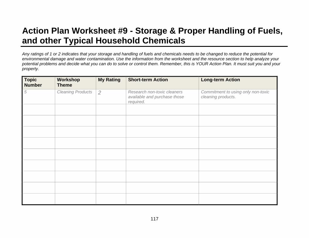
117
Action Plan Worksheet #9 - Storage & Proper Handling of Fuels, and other Typical Household Chemicals Any ratings of 1 or 2 indicates that your storage and handling of fuels and chemicals needs to be changed to reduce the potential for environmental damage and water contamination. Use the information from the worksheet and the resource section to help analyze your potential problems and decide what you can do to solve or control them. Remember, this is YOUR Action Plan. It must suit you and your property. Topic Number
Workshop Theme
My Rating Short-term Action Long-term Action
5 Cleaning Products 2 Research non-toxic cleaners available and purchase those required.
Commitment to using only non-toxic cleaning products.

118

119
Worksheet #10 – Living with Wildlife Use this worksheet to learn about living alongside wild nature. Why should you be concerned? • It is important to accommodate wildlife on your property,
just as much as the wind-swept pine and the colourful gneiss, they’re part of the reason why you enjoy the setting of your home or property.
• Ensure that wildlife doesn’t become a safety concern
preventing you from enjoying your property (e.g. bears). • Learn about local wildlife; they can be very beneficial
and even in-directly decrease your property maintenance, costs and efforts (e.g., songbirds can decrease insect pest populations).
• Protecting local wildlife is key to a healthy ecosystem
and watershed. • There is incredible wildlife diversity along lakeshores and
other watercourses however this coastal biodiversity is increasingly threatened by human activities and development.
What you can do. 1. Protect natural habitats and species that depend on
specialized conditions. 2. Ensure that any buildings or structures on your property
are appropriately built and sealed to prevent wildlife from entering.
3. Learn about Species-at-Risk and take a proactive role in
protecting these species and their habitats. Take actions to expand the quality of their habitat in the landscape whenever possible.
4. See the landscape as an integrated whole and support
initiatives that connect areas together. 5. Provide space and resources for wildlife in specific areas
so that they don’t become a nuisance.
6. Work with neighbours to ensure contiguous habitat areas along shorelines and watercourses.

120
Living with Wildlife: How do you rate?
Topic Best 4 Good 3 Fair 2 Poor 1
Your Rating
RESOURCES FOR WILDLIFE 1. Familiarity with
local wildlife
Thorough understanding of wildlife in Georgian Bay, and their seasonal patterns, OR continually seek to learn how you can provide habitat for local wildlife, especially species-at-risk.
Good understanding of wildlife in the Georgian Bay area and their seasonal patterns
Basic familiarity with local wildlife, AND/OR general idea of wildlife seasonal patterns
No knowledge, OR no consideration for wildlife on your property, OR immediately take action to exterminate without sufficient knowledge.
2. Wildlife habitat
planning
Development and implementation of a wildlife habitat plan that enhances habitat resources for desired wildlife, AND plan seeks to link habitat on property with the larger landscape using ecological corridors.
No formal plan exists but property management includes wildlife habitat enhancement, AND property management links habitat on property with the larger landscape using ecological corridors.
Property provides some wildlife habitat that is protected and preserved.
Property is managed with no regard to wildlife habitat requirements.
Trees, shrubs and other plants on your property provide for food for birds, butterflies and other wildlife.
Bird seed is available but other animals are kept out of feeders. Feeders are only used from Nov. 1 - April 1.
Birds are expected to forage elsewhere beyond your property.
Bird feeders are readily accessed by other animals.
To learn about species at risk in your area, go to: www.gbbr.ca
Tip
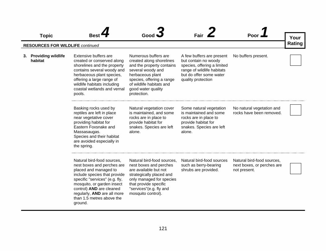
121
Topic Best 4 Good 3 Fair 2 Poor 1
Your Rating
RESOURCES FOR WILDLIFE continued 3. Providing wildlife
habitat
Extensive buffers are created or conserved along shorelines and the property contains several woody and herbaceous plant species, offering a large range of wildlife habitats including coastal wetlands and vernal pools.
Numerous buffers are created along shorelines and the property contains several woody and herbaceous plant species, offering a range of wildlife habitats and good water quality protection.
A few buffers are present but contain no woody species, offering a limited range of wildlife habitats but do offer some water quality protection
No buffers present.
Basking rocks used by reptiles are left in place near vegetative cover providing habitat for Eastern Foxsnake and Massasaugas. Species and their habitat are avoided especially in the spring.
Natural vegetation cover is maintained, and some rocks are in place to provide habitat for snakes. Species are left alone.
Some natural vegetation is maintained and some rocks are in place to provide habitat for snakes. Species are left alone.
No natural vegetation and rocks have been removed.
Natural bird-food sources, nest boxes and perches are placed and managed to include species that provide specific "services" (e.g. fly, mosquito, or garden insect control) AND are cleaned regularly, AND are all more than 1.5 metres above the ground.
Natural bird-food sources, nest boxes and perches are available but not strategically placed and only managed for species that provide specific "services"(e.g. fly and mosquito control).
Natural bird-food sources such as berry-bearing shrubs are provided.
Natural bird-food sources, next boxes, or perches are not present.

122
Topic Best 4 Good 3 Fair 2 Poor 1
Your Rating
AVOID ATTRACTING NUISANCE WILDLIFE continued
4. Food and waste scraps
All food/waste (including pet food and bird seed) is stored indoors in rodent/bear proof containers. Recyclables are rinsed and stored. Waste is taken to sanitary landfill. Compost is properly maintained. BBQ is cleaned and stored in a secure area.
Garbage is temporarily stored outside, but in rodent/bear proof containers. Waste is taken to sanitary landfill.
Empty food and drink containers are rinsed. Garbage is stored in sealed containers in an out building. Waste is taken to sanitary landfill.
Compost is improperly maintained, or rodent/bear proof containers are not used. Waste is improperly disposed.
5. Preventing unwanted browsing of plants
Never use plastic or metal mesh (e.g. chicken wire) to cover plants as it entangles wildlife. If necessary, plants are covered with burlap and trees are protected with light coloured pipe.
PET MANAGEMENT
6. Controlling access
Cats are kept indoors. Dogs are kept on a leash or in a run. All pets have up-to-date vaccinations.
Cats are belled and kept on a leash.
Pets are allowed outside unleashed, but are supervised.
Pets are allowed to roam freely outside and are unsupervised.
Cats can be disastrous for young birds and other wildlife including Ontario’s only lizard, the five-lined skink. Keep your cat indoors.
Take Action

123
DEALING WITH NUISANCE WILDLIFE Control measures for nuisance wildlife are regulated by provincial legislation. Contact the Ontario Ministry of Natural Resources if you have any questions or concerns regarding nuisance wildlife. Managing the interactions between wildlife and residents are a challenge. But the significant contribution that residents are making toward the conservation of biodiversity is key to preserving our natural landscape and protecting the quality of our water. FOUND A WILD ANIMAL IN DISTRESS? First be certain that the animal is truly injured or abandoned. Some species act injured to lure predators away from their nest or young. A young animal may appear to be abandoned but could just be temporarily unattended by its parents. Your presence may keep the parents from returning. This is often the case with fawns which are left while their mother is nearby feeding. And although it is sometimes hard to accept, your removal of that animal may deprive predators of a natural food source. If you decide that an animal truly needs help, please call for advice first. Some injured animals could be dangerous while others simply don’t need help. The Ministry of Natural Resources or an animal rehabilitation centre can offer advice on how to best resolve the situation. Do not attempt to treat the animal yourself. The sooner it receives professional help, the greater the chance of it being returned to its natural habitat. It is also illegal in Ontario to keep native species without proper licensing. Leave wild animals, including snakes and turtles, alone and never feed them.
White-tailed Deer Credit Ted Krug

124
WHAT IS A "SPECIES AT RISK”? A species at risk is any native plant or animal that is at risk of extinction or of disappearing from our province. One third of Canada’s species at risk are found in Ontario (180 plus species) and over 30 of those species are found in eastern Georgian Bay. For several of these species, this area is essential for their survival. The entire Ontario population of the plant Branched Bartonia is found in Parry Sound and Muskoka. For species such as Engelmann’s Quillwort, Eastern Foxsnake and the Massasauga, this area provides a significant portion of their range. Just as we define our community as the place where we live and work, areas such as wetlands and mixed forests with their associated plant and animal species help define natural communities. Some species like the Least Bittern, occupy only marshes while others, like the Eastern Wolf, use a number of different habitats. Each species has its own niche or role in these natural communities. Animals like the Eastern Foxsnake and Massasauga help control rodent populations. The Chimney Swift and Common Nighthawk are efficient insect predators. The loss of even one species can have a ripple effect in the community and indicates a stress in that environment. This is why maintaining biodiversity is important for the overall health of our natural community. Take the time to learn about the species at risk in your area. The worksheets and the action plan that you are developing can help benefit species at risk.
THE ENDANGERED SPECIES ACT
The Endangered Species Act (2007) deals with the protection and recovery of species at risk in Ontario.
If a species is identified as an endangered or threatened species on Ontario’s Species at Risk list, it is illegal to kill, harm, harass, capture, remove, collect, buy, sell, lease, trade or offer to buy, sell, lease or trade one of its members.
Maximum fines of $250,000 for individuals, and up to $1 million for corporations are applicable.
Please report your sightings of species at risk on the Georgian Bay Biosphere Reserve’s web site www.gbbr.ca or to: Species at Risk Biologist Ministry of Natural Resources 7 Bay St. Parry Sound P2A 1S4 705-746-4201
Common Nighthawk (Threatened) Credit Ted Krug
Branched Bartonia (Threatened)
Credit Jeremy Rouse

125
Who is at Risk in Your Neighbourhood? Think of the types of habitat in your neighbourhood- are you surrounded by forest or rock outcrops with juniper shrubs? Do you have a wetland nearby? This chart is a guide to some of the species at risk that may find the area where you live essential for their survival. You can help their survival by leaving as much of your property as possible in its natural state. For more information on species at risk in Parry Sound and Muskoka, including range maps, please go to www.gbbr.ca
Endangered (E) A species facing imminent extirpation or extinction. Threatened (T) A species that is likely to become endangered if limiting factors are not reversed. Special Concern (SC) A species that has characteristics that makes it particularly sensitive to human activities or natural events.
Type of Habitat Important for: Your Actions Rock barrens
Common Nighthawk (T) Eastern Foxsnake (E) Massasauga (T) Five-lined Skink (SC) Eastern Milksnake (SC) Eastern Hog-nosed Snake (T)
Leave rocks in their natural place. They provide important cover for reptiles and areas to regulate their body temperatures. Keep dogs on a leash.
Mixed forest Red-headed Woodpecker (SC) Bald Eagle (E) * nesting sites near water Eastern Wolf (SC) Eastern Hog-nosed Snake (T)
Limit the number of trees that are cut. If safe to do so, leave dead trees standing. If you must cut a dead tree, try to leave some logs to slowly decay at the edge of your property. Create brush and leaf piles rather than burning them. Refer to section Seven Trees and Plants on Your Property
Wetlands Massasauga (T) Blanding’s Turtle (T) Northern Ribbonsnake (SC) Spotted Turtle (E) Eastern Hog-nosed Snake (T) Branched Bartonia (E) Snapping Turtle (SC
Do not fill in wetlands. These areas are essential for the survival of many species.
Coastal Wetlands Northern Ribbonsnake (SC) Massasauga (T) Eastern Foxsnake (E) Blanding’s Turtle (T) Spotted Turtle (E) Stinkpot Turtle (T) Northern Map Turtle (SC) Least Bittern (T)
Do not add fill or alter the natural shoreline. These areas are essential for the survival of many species. Refer to Section Seven Natural Buffers and Shoreline Access and Section Six Water-based Recreation for guidelines.
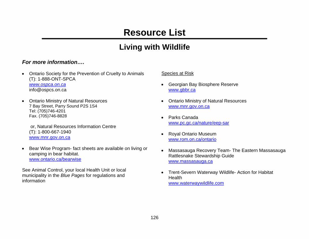
126
Resource List Living with Wildlife
For more information…. • Ontario Society for the Prevention of Cruelty to Animals
(T): 1-888-ONT-SPCA www.ospca.on.ca [email protected]
• Ontario Ministry of Natural Resources
7 Bay Street, Parry Sound P2S 1S4 Tel: (705)746-4201 Fax. (705)746-8828
or, Natural Resources Information Centre (T): 1-800-667-1940 www.mnr.gov.on.ca • Bear Wise Program- fact sheets are available on living or
camping in bear habitat. www.ontario.ca/bearwise
See Animal Control, your local Health Unit or local municipality in the Blue Pages for regulations and information
Species at Risk • Georgian Bay Biosphere Reserve
www.gbbr.ca
• Ontario Ministry of Natural Resources www.mnr.gov.on.ca
• Parks Canada www.pc.gc.ca/nature/eep-sar
• Royal Ontario Museum www.rom.on.ca/ontario
• Massasauga Recovery Team- The Eastern Massasauga Rattlesnake Stewardship Guide www.massasauga.ca
• Trent-Severn Waterway Wildlife- Action for Habitat
Health www.waterwaywildlife.com

127
Action Plan Worksheet #10 -Living with Wildlife Any ratings of 1 or 2 indicate that your management of wildlife should be changed to reduce the potential for environmental damage. Use the information from the worksheet and the resource section to help analyze your potential problems and decide what you can do to solve or control them. Remember, this is YOUR Action Plan. It must suit you and your property. Topic Number
Workshop Theme
My Rating Short-term Action Long-term Action
4 Food waste and scraps
2 Research options for composting and bear proof storage of garbage.
Purchase and properly install or build a bear proof garbage container or store garbage in a sealed container in a basement. Recyclables are stored in a secure fashion. Composting is carefully managed.

128

129
Glossary
Abandoned well: A well that has been permanently plugged and sealed. Air gap: An air space (open space) between the hose or faucet and the level of liquid. This is one way to prevent backflow of liquids into a well or water supply. ANSI (Area of Natural and Scientific Interest): Areas identified by the Ministry of Natural Resources as containing natural landscapes or features that have been identified as having life or earth science values related to protection, scientific study, education and natural heritage appreciation. Such designation helps to protect representative and special natural areas, plants and animals. Anti-backflow device: Check valve, vacuum breaker or other mechanical device that prevents liquids from flowing backwards through a water supply pipe to a well or surface water source. Also called an anti-back siphoning device. Approved containers: A portable container made of metal or other material that has been approved for use by the Underwriter’s Laboratories of Canada (ULC), the Canadian Standards Association (CSA), or Transport Canada. An approved container must have a certification label such as jerricans-CTC-5L, BTC-5L, ICC-5L, DOT-5L, TC-5L. Aquifer: An underground layer of rock and sand that stores water, and which lies above a layer of clay or other impermeable material that does not allow the water to flow to lower depths. Aquifers can be present at various depths depending on the location of the impermeable material. They are an important source for wells.
Backflow: The unwanted reverse flow of liquids in a piping system. Baffles: Inlet and outlet devices in a septic tank, designed to reduce the transfer of solids to the leaching bed. They also prevent fats, oils, and grease from discharging to the leaching bed. They increase the amount of solids retained, prevent plugging of inlets and outlets, and prevent rapid flow of wastewater through the tank. Beach: A band of variable width, typically of sandy material located adjacent to the lake. The sand is deposited and removed by the action of waves and currents. Bilge: The lowest part inside a boat’s hull or frame where water, fuel, oil and other hazardous chemicals can collect. Biodegradable: The ability of a substance or material to break down into harmless substances. Boat wake: The wave(s) that spreads behind a boat as it moves forward through the water. Bog: A highly acidic type of wetland that is fed by precipitation and is characterized by peat-filled depressions, sphagnum moss mats, and low shrubs. Bored well: Large diameter well constructed by using specialized earth boring equipment. Casing material is usually concrete or corrugated steel. These wells are typically 60 to 90 cm (24-36 in) in diameter. Buffer: An area of natural vegetation that runs along the shoreline, stream or bluff. It extends from the high water mark to

130
the water’s edge. Also referred to as a buffer strip, filter strip or riparian zone. Building permit: A municipally-issued document that regulates construction and enforces Building Code compliance. Burn barrels: Open burning of household waste in barrels that results in very high levels of toxic chemicals emitted in the smoke. Certified Arborist: A professional trained in the planting, care and maintenance of individual trees and a current member of the International Society of Arboriculture. Clear water infiltration: Entry into a septic system by water that does not need treatment, such as rainwater or sump pump. Coastal Feature: A distinctive or characteristic element or part of the coastal landscape. Coastal wetland: Areas that are permanently or temporarily submerged, or saturated for at least part of the year. Unlike upland wetlands, coastal wetlands don’t transition into drier communities. Coliform organisms: Harmful bacteria usually found in polluted water. If they are found in a water sample, it indicates that the water may not be safe for drinking or food preparation. Compaction (soil): Compression of soil that decreases the spaces between soil particles. This hinders the movement of air and water into and through the soil. Consequently the soil holds less water and surface runoff, and erosion occurs. Soil compaction may be caused by ongoing pedestrian traffic, one time or ongoing vehicular traffic, construction equipment or the storage of materials. Conifer/Coniferous: An evergreen tree or shrub that bears cones and has needle or scale-like leaves. Examples include pine, spruce, cedar, juniper, and fir.
Conservation easement: A legally binding agreement not to develop part of a property, but to leave it "natural" permanently or for some designated period of time. The property still belongs to the landowner, but restrictions are placed both on the current landowner and on subsequent landowners. The easement becomes part of the land deed so that all future property owners are bound by the terms of the easement. Contaminant source: Anything which can cause pollution. Septic systems, stored pesticides, fuels, pet wastes, furnace oil, paints and cleaners are all possible contaminant sources. Contaminants may be colourless and/or odourless. Contiguous: Connecting without a break. Crown land: Publicly owned land, typically under the jurisdiction of the provincial and/or federal government and administered on behalf of the people. Design capacity: The total daily sanitary sewage flow that the septic system is designed to handle. The Ontario Building Code (OBC) determines wastewater flows. Dioxins: A group of chlorinated organic chemicals with similar chemical structures. Dioxins have no uses. They are formed unintentionally and released as by-products of human activities such as waste incineration, fuels combustion, chlorine bleaching of pulp and paper, or pesticide manufacturing. Natural processes such as forest fires and volcanoes also form them. Drainage pattern: The network of water courses (streams and rivers) that drain a watershed(s) into a lake or water body. Drilled well: Well not dug or driven. These wells are normally 10 to 20 cm (4 to 8 in) across. Dripline: The outer extent of a tree’s branches. The dripline is used as a rule-of-thumb, indicating the extent of a tree’s root system, though most roots in fact extend beyond the dripline.

131
Dug well: Large-diameter well often constructed by power shovel, back-hoe or by hand. E-coli: Harmful bacteria that comes from human and animal feces. If E-coli is found in drinking water, it is not safe for drinking, food preparation or bathing. Water with any levels of E-coli should not be used for any purpose. Ecological corridor: An area of vegetation, typically linear that is similar to or the same as wildlife habitat areas, which allows wildlife to move between habitat areas. The size of the corridor determines its effectiveness as a safe means of travel. Ecosystem: A complex, natural system created and maintained by the interaction and interdependency between all living organisms and their particular environment. Any action taken at any level in this interacting system has a potential domino effect on every other organism or element within the ecosystem. Emissions standards: Emission standards limit the amount of pollution that can be released into the atmosphere from sources such as industry, power plants, vehicles and small equipment such as lawn mowers. Energy audit: A thorough assessment of how much energy a building uses, as determined by an energy audit professional. It pin-points the areas where the building is losing energy, and includes suggestions on how to improve energy efficiency. EnerGuide: A rating system developed by Natural Resources Canada that helps consumers compare the energy efficiency of appliances and buildings. Energy Star: An internationally recognized symbol for energy efficiency. In Canada, the international Energy Star symbol is monitored and promoted by Natural Resources Canada’s Office of Energy Efficiency. Erosion: Movement and loss of soil caused by wind or water (rain, surface water runoff, or direct contact with a water body).
ESA (Environmentally Sensitive Area): Designation given to an area with valuable ecological features or habitat that need special protection due to its surrounding landscape, wildlife or historical value. Evaporation: The conversion from a liquid to a gas. For example, the process of rainwater becoming water vapour (clouds). Exotic (plant): An exotic species (also known as an introduced species) is an organism that is not indigenous to the place where it is found and that has been accidentally or deliberately transported to its location by human activity. Exotic species can often be damaging to the ecosystem to which they have been introduced. Faucet aerator: A round case at the mouth of the faucet that contains a mesh-like disk, through which the water flows. Low-flow faucet aerators save water as well as any energy used to heat that water. Fen: A peat land where the water table is at or close to the surface and water drainage is very slow. It is dominated by sedges, mosses, and some grasses. Trees are few and are typically coniferous and stunted. Fens are rare in southern Ontario. Fill: Material that is brought from elsewhere and added to the existing landscape, such as soil, gravel, sand or loam. Floodplain: The area adjacent to a water body or water course that if flooded during high water levels. Often this occurs following snowmelt or an extreme rainfall event. Forest corridor: a linear remnant of a forest community. It is too narrow to be viable as habitat but can have the important role of connecting other larger isolated or separate areas of forests, creating the effect of contiguous forest. This allows animals and other species to travel through disturbed landscapes in relative safety.

132
Four-stroke engine: Boat engine constructed similarly to that of a car. Its emissions are cleaner, it is quieter, more durable and has better fuel economy than a two-stroke engine. Furans: A family of chemicals that are formed during combustion. They are extremely toxic. Garborator: A type of garbage disposal system installed in the kitchen drain, allowing food scraps into the municipal water or septic system. Great Lakes – St. Lawrence Watershed: One of three primary watersheds in the province of Ontario. The other two primary watersheds are the Hudson’s Bay and the Nelson River Watersheds. Grey water: wastewater from household uses such as dishwashing or bathing. Groundwater: Fresh water that has seeped through the soil and rock on the earth’s surface and naturally collects forming a reservoir, the top of which is referred to as the water-table. This water supplies wells and springs and is the source of most people’s drinking water. Habitat: The environment that provides what an organism requires for survival and reproduction. Hazard land: An area prone to flooding or erosion such as properties located within a floodplain, on beaches, or subject to high winds or wave activity. Includes features such as quickly-draining sandy soils or sinkholes. Hazard tree: A tree or any component of a tree that has sufficient structural infirmity to be identified as having a high risk of falling and causing personal or property damage.
Hazardous wastes: Substances that can be dangerous to humans or animals and that must be disposed of in a manner that does not pollute groundwater. Health Unit: A provincial health agency that administers health promotion and disease prevention programs through local offices. There are 36 Health Units in Ontario. Herbaceous: Non-woody plant material or vegetation. An herbaceous plant goes dormant or dies back every year. Impervious: Not allowing water or other substance to pass through. Infiltration: Allowing water or other substances to pass through pores or spaces in a material(s). Invasive species: A plant, animal or aquatic organism which typically spreads quickly and may be difficult to control or eradicate. These species are of concern because they can be detrimental to other species and threaten ecosystems. Landfill: A site specially engineered for the permanent disposal of solid waste on land, constructed so that it will reduce hazard to public health and safety. Leachate: Liquids that have percolated through soil and carry contaminants. Leaching bed (trench type): Consists of trenches of buried distribution pipe. Each pipe is set in a bed of stone in a trench. Wastewater leaves the septic tank and flows through the distribution pipe into the soil through perforations in the pipe. Leaching bed loading: Refers to the volume of wastewater in relation to the capacity of the leaching bed. Increased household water use can overload the system.

133
Legal Non-Conforming: Buildings or structures which existed before the current municipal zoning by-law was passed. When existing uses do not conform to the regulations in a new zoning by-law, their prior legal existence ensures their continuation as a lawful use. This means that some variations of use can legally exist without requiring an amendment to the zoning by-law. Legislation: Law or set of laws made by a law-making body. Also referred to as Statutes or Acts. Marsh: A type of wetland that is periodically or permanently flooded. It is characterized by non-woody emergent vegetation such as cat-tails, rushes, reeds, grasses, and sedges. Vegetation ranges from shrubs in drier areas to floating-leafed or submerged plants in open water. Mulch: Loose, organic materials such as woodchips, bark, and straw, or a mixture thereof. When applied around a plant, mulch protects the plant, suppresses weeds and retains moisture. Re-apply as mulch breaks down over time. Municipal by-laws: Local legislation enacted to consider natural heritage, land use, environmental protection and hazard policies. Native vegetation: A cumulative term to describe any and all plants that are adapted to and occur naturally in a specific location. Also referred to as indigenous. Natural process: A series of changes or actions that occur within an ecosystem to maintain its health or regulation. Non-invasive: A plant with a low potential to spread quickly or become difficult to control or eradicate. Local native plants are typically not invasive. Normal high water mark: The level or elevation along the shore that marks the boundary of the lake bed, which signifies the boundary of the government’s ownership. Also known as the upper controlled water elevation.
Nuisance or Problem wildlife: Any wildlife that causes damage to your property or is a potential threat to health and safety. Official Plan: A municipal policy document that outlines basic principles to guide future development within an area. These documents are available at the municipal office or community library. Ontario Drinking Water Standards: The minimum water quality standards set by the Ontario Ministry of the Environment to protect public health. It is advisable that drinking water meets these standards. Passive solar heating/ lighting: The natural heating/ lighting of buildings or rooms by capture of direct sunlight. Buildings can be designed with large windows in south-facing walls and small windows in north-facing walls, to reduce the need for electricity and fossil fuel energy as a source of heat and light. Pesticide (cosmetic): A general term used to describe any chemical or biological agent used in a non-farming context to kill plant or animal pests. Herbicides, insecticides, fungicides, bactericides, etc., are all types of pesticides. Portable fuel container: A portable container made of metal or other material that has been approved for use by the Underwriter’s Laboratories of Canada (ULC), the Canadian Standards Association(CSA), or Transport Canada to transport and store fuel. Pressure or Dosed distribution: A septic system that utilizes a pump to load shallow, rapidly-changing, distribution lines in doses. Prevailing wind: Wind that blows most frequently.

134
Public Lands Act: Legislation protects the integrity of public lands and waters for all citizens of Ontario. It requires that property owners obtain work permits for activities on shore lands adjacent to navigable waters. Regulation: A binding rule of law. Regulations are not made by Parliament but rather by persons or bodies that have received authority from Parliament to do so. Right-of-way (includes Easements): A legal agreement that confers on an individual, company or municipality the right to partially restrict an owner’s use of those portions of land use a landowner’s property in some way. It also therefore affected by the right of way/easement. Right of ways are typically registered on the certificate of title to the property and are automatically transferred from one owner to another as the land is sold. They remain on the title until the holder of the easement discharges their rights from the certificate of title. Riparian Area: The transition zone from aquatic to a terrestrial habitat that exists near and along the bank of a natural watercourse or water body (e.g., river, stream, or lake). It is rich in density, diversity, and productivity of plant and animal species. Runoff: Snow melt or rain that flows overland rather than infiltrates through the soil/rock Sand point wells/ driven wells: Wells constructed by driving assembled lengths of pipe into the ground. These wells are usually smaller in diameter (5 centimetres or less) and less than 15 metres (50 feet) deep. They can be installed in loose soils, such as sand. Seiche: The combination of wind set-up and sudden changes in atmospheric pressure creates this short-term, oscillating standing wave. The height of the surface water decreases with each oscillation until the surface level stabilizes. Impact on coastal features such as wetlands is minimal.
Sensitive natural feature: An environmental element of the landscape that is readily affected by or responsive to external influences or change. Septic system: Consists of a tank to settle the solids out of the wastewater, followed by a leaching bed in which the wastewater is treated and distributed into the soil. Septic tank: A watertight vault in which sanitary sewage is collected to remove scum, grease, and solids from the liquid without the addition of air. This is where solids settle and anaerobic digestion of the sanitary sewage takes place. Silt fence: A temporary barrier stretched across an area to trap sediment and prevent runoff water from moving it off-site during construction. Sinker: Small metal weight, traditionally made of lead, that is attached to fishing lines and is part of the lure. Lead sinkers are not-permissible in some water bodies and alternatives such as brass, tungsten, steel, and bismuth are used instead. Soil compaction: Reduced pore space in the soil due to human or equipment traffic. Compaction makes it difficult for water to infiltrate and for roots to penetrate the soil. Soil depth: The depth of soil influences the potential for groundwater contamination. Deeper soils are typically more effective at filtering out contaminants before they can reach groundwater. Soil grade: The elevation of the ground surface. Grade may also refer to the steepness or slope of the surface.

135
Soil type: The material(s) that a soil is made of affect its ability to percolate water and other substances (including pollutants). Sand and gravel soils provide the fastest infiltration and therefore increase the potential for groundwater contamination. Conversely, clay soils are slow to allow water to infiltrate and may cause water to runoff the surface rather than infiltrate. This can encourage erosion and surface water contamination. Source Water Protection Plan: A plan devised by the Ontario government to ensure that every watershed in the province has an action plan to protect its water resources. Spawning ground: The place where female fish lay their eggs and males fertilize them. Species-at-Risk: A general term to describe the state of a species population. This term is further organized into five categories of risk: Special Concern, Threatened, Endangered, Extirpated, and Extinct. The usual causes for a species to be at risk include habitat destruction, genetic and reproductive isolation, the suppression of natural occurrences such as fire, environmental contamination, over-harvesting, climate change, disease, and the presence of invasive species. Steward: An individual with a personal commitment to care for the land and the surrounding landscape in order that it may be preserved or enhanced for future generations. Storm sewer: A system of underground pipes (separate from sanitary sewers) that collects and carries only water runoff from building and land surfaces to a discharge point ( such as infiltration basin, receiving stream, treatment plant). Surface water: Any open or exposed body or flow of water including springs, streams, rivers, ponds, lakes, etc.
Survey: A map document made by a licensed surveyor that illustrates and describes the measurements and layout of a parcel of land including its size, boundaries, location, elevations, the dimensions and position of any structures and indicates any easements, rights of ways, etc. Swamp: This is the most diverse type of wetland and it is often flooded in the spring and drains throughout the dry season. It is dominated by shrubs and trees. Unused well: A water well that is not currently used or is used occasionally. All wells regardless of use must be properly maintained or they must be properly abandoned (plugged and sealed). Wastewater: Water of domestic origin, including water-borne waste from kitchen, laundry, and bathrooms. Wastewater treatment plant: Municipal public facilities that treat water that is collected from home, businesses and industry. Watercourse: An open flow of water including a stream, spring, channel or river Water table: The boundary between the saturated soil (where all the soil pore spaces are filled with water) and the unsaturated soil (where soil pore spaces are filled with air, roots, soil organisms and some water). Well cap: A commercially manufactured device used to cover the top of a well casing pipe. This cap prevents surface water, vermin, or solid material from entering the well.

136
Well capture zone: The area of land that replenishes water to a pumped well or a group of wells. Determining the size of a capture zone is complex and expensive. Knowing its area may not be necessary if the entire property is treated as the capture zone for the well(s) and potential contaminant sources are managed properly. Well casing: Steel, fibreglass, plastic pipe or concrete tile, installed when a well is constructed, in order to strengthen the well bore hole so it does not collapse. It also prevents contaminants from entering the well and allows placement of a pump or pumping equipment. Well pit: Lined, shallow excavation around the top of the well casing of a drilled well. Well vent: An opening in the well cap or well seal that makes the air pressure inside the well the same as outside. It also lets gases escape. The vent should always have a screen to prevent dirt, vermin, or other materials from getting into the well. A screened pipe may extend from the vent up above ground level to prevent flooding of the well. Wetlands: Areas that are permanently or temporarily submerged, or saturated for at least part of the year. Wind set-up: A weather phenomenon whereby strong, persistent winds blow over the lake, they can push the water level up at the downwind shore of the lake. Consequently, this causes the water- level to decrease by the same amount at the opposite, upwind shore. The height of the waves increases with the wind; waves as high as 2.5 metres (8 feet) have been recorded on the Great Lakes. This phenomenon is also known as storm surge Zoning: The division of a municipality by legislative regulations into areas (zones) that control the use of the land by specifying the uses allowable for the real property in these areas.


