Embed Size (px)
Citation preview
La Transgiordania nei secoli XII-XIII e le ‘frontiere’ del
Mediterraneo medievale a cura di
Guido Vannini Michele Nucciotti
BAR International Series 23862012
Limina / Limites Archeologie, storie, isole e frontiere nel Mediterraneo (365-1556) 1
Published by
ArchaeopressPublishers of British Archaeological ReportsGordon House276 Banbury RoadOxford OX2 [email protected]
BAR S2386Limina / Limites Archeologie, storie, isole e frontiere nel Mediterraneo (365-1556) 1
La Transgiordania nei secoli XII-XIII e le ‘frontiere’ del Mediterraneo medievale
© Archaeopress and the individual authors 2012
ISBN 978 1 4073 0978 1
Printed in England by CMP (UK) Ltd
All BAR titles are available from:
Hadrian Books Ltd122 Banbury RoadOxfordOX2 7BPEnglandwww.hadrianbooks.co.uk
The current BAR catalogue with details of all titles in print, prices and means of payment is available free from Hadrian Books or may be downloaded from www.archaeopress.com
111
LIMES ARABICUS AND STILL-STANDING BUILDINGSRoberto ParentiPiero Gilento
Università di Siena
Abstract (2008)Limes Arabicus and material structures
Traianus annexed the Nabataen Kingdom to the Roman Empire in 106 AD. This territory became part of the new Provincia Arabia. The construction of the via nova traiana by Claudius Severus, between AD 111 and AD 114, sealed the conquest of the territory, traditionally held to have fallen along with together with the fortalices, lookout towers and quadriburgia. The road and these structures represented the so-called limes arabicus.It is well known, that Romans reused pre-existing structures both from the Iron Age and the Nabataen Age.The network of sites remained in use after the fall of the Roman Empire. There is evidence of frequentation of the quadriburgia during the Byzantine period, with alternating periods of abandonment and new construction during the successive three centuries. The situation on the limes changed again after AD 750, when the Abbasides came to power and moved the capital from Damascus to Baghdad.The complex of buildings of the limes arabicus, in what is now Jordan, is a unique site where different building techniques developed over a relatively short time span and are still well-preserved: ideal conditions for testing out methods of Building Archaeology.New classification and registration technologies, fast and available on-line thanks to an advanced technology database, allow us to process a consider-able amount of data (stratigraphical readings on ortophotoplan and 3D models with photographic renderings of surfaces, characterization of building techniques, chronotypology) and to georeference the site through GoogleMaps and Google Earth.
INTRODUCTION
This article aims to summarize and re-organize the histo-rical-archaeological data of a part of the limes arabicus and above all to present a new methodological approach based on the study of buildings, to determine the evolution of building techniques and the transmission of knowledge and skills. The analysed buildings are situated in the area that corresponds to the south-easternmost boundary match of the Roman Empire, modern-day Jordan1_.The tradition of scholarship that has dealt with the limes arabicus, its evolution and above all the structures within it is now firmly established. Significant research projects, particularly those developed in the 1970s and ‘80s, attai-ned important results. The area, part of which is today within the Hashemite Kingdom of Jordan, has always been an object of study, where early aerial surveys and, later, wide-scale field surveys were carried out. Numerous exca-vations also served to flesh out field survey data. However, recent studies focusing specifically on the architecture have been relegated to a secondary role, with the exception of a few cases involving large towns, perhaps due to the diffi-culty of comparison with the results achieved by Creswell regarding the early Islamic architecture (Creswell 1969, Creswell and Allan 1989). This fact seems incongruous with the outstanding conditions of conservation of many of the buildings which formed the limes arabicus.Nonetheless, we will here present the initial results of a new methodological approach based on direct observa-tions (necessarily sporadic and brief, due to the newness of the discipline and the limited duration of missions) of architecture, which has much in common with the working instruments of archaeological field research (typological
1 _The following article is part of the research project ‘Building Archaeology in Jordan’ of the Architectural Archaeology Laboratory of the University of Siena, directed by Prof. Roberto Parenti and with the collaboration of Italian Ministry of Foreign Affairs and the Department of Antiquities of Jordan.
comparisons and stratigraphic analysis). Unfortunately, the traditional literature on architectural complexes in Jor-dan in general, and in particular the buildings of the crucial transitional period from the Roman-Byzantine world to the Proto-Islamic world (despite some recent acquisitions), is still far from meeting an acceptable standard of recording of building characteristics and, even more so, of publi-cation of data that might aid in comprehension (through analytical comparisons) of the surrounding areas.In particular, given that studying the evolution of the bu-ilding techniques is above all a question of chronology, what instrument could better provide reliable information on the relative chronology of various parts and help to specify the features of the building techniques used than stratigraphic analysis of architectural complexes that un-derwent multiple phases of construction over the course of their inhabited existences? The determination of homoge-neous parts will allow us to more accurately document the characteristics of masonry and of more complex construc-tion systems, in order to compile a valid chrono-typologi-cal sequence, first for the entire architectural complex and later for geologically similar areas. The Building Archae-ology, after nearly thirty years of experiences in highly di-versified European contexts, appears in this case to be the most appropriate discipline for obtaining useful and often previously-unknown information from these buildings.In fact, stratigraphic analysis of elevated structures, along with a work strategy aimed at creating chrono-typologies, in the specific Jordanian case, can provide important re-sults about structures which, due to their stratigraphic complexity, conditions of conservation and degree of de-cipherability, are surely an unicum. Another advantage is that initial analysis can be made without excavations, thus enormously increasing the quantity of observations that can be made with an equal amount of effort. Therefore, the creation of a chrono-typology of building techniques (walls, openings, roofing systems and ceilings and buil-
La Transgiordania nei secoli XII-XIII e le “frontiere” del Mediterraneo medievale, a cura di G. Vannini e M. Nucciotti , BAR, Oxford, 2012
Trans - Jordan In 12Th and 13Th cenTurIes and The ‘FronTIers’ oF MedIeval MedITerranean
112
ding materials), at least for geologically homogeneous areas, could become a key to interpretation and a very use-ful instrument for a period (3rd-9th century AD) of tran-sformation and changes (continuity of or divergence from Roman building techniques) of primary importance for the history of the entire Mediterranean area.
THE LIMES
The term limes is closely linked to the history of the ex-pansion of the Roman Empire. Ancient sources help us to understand what a limes was in antiquity (Isaac 1988). The main meanings associated with this word are “road” or “street”; the word limes identified the main infrastructure built by the Roman army as a means for penetrating and connecting conquered territories2. A great many sources3 identify the term limes as “border line”, a physically de-termined limit that protected conquered territories, and later, especially in the 3rd and 4th century AD epigraphic sources, the word limes can be recognized as referring to a border district administered by a dux4.
In border areas, the Roman army was organised in limites, i.e. systems of fortifications connected by roads along a established border delimited by rivers or natural ridges, or by artificial obstacles (ditches and fences).
After the rapid expansion of Rome in the 1st century AD, which gave it control over most of Western Europe and part of the Near East, Roman borders on both sides of the Empire were subject to significant pressure from the out-side due to the invasions of the 3rd century. One of first important acts to stabilize the borders was carried out by Emperors at the beginning of the 2nd century AD, in particular Trajan (98-117) and by Hadrian (117-138) who regularized the control of the vast territory inhabited by heterogeneous populations. The borderlines (roads, fences or walls), protected by permanent forts and guarded by full-time troops, represented the farthest edge of the Empi-re’s control over provincial territories. A second important reorganization of the boundaries took place at the end of the III century by Emperor Diocletian, who also enacted a comprehensive reorganization of government administra-tive systems.It is not easy to define and give a concise meaning to the word limes, especially because it is a word that can be used in different contexts. One of the first researchers who tri-ed to precisely define the concept of limes was Theodor Mommsen (Mommsen 1908). On the basis of an etymolo-gical study of the word, the German philologist hypothe-
2 For example in Velleio II, 120 we read.’…arma infert quae arcuisse pater et patria contenti erant; penetrat interius, aperit limites, vastat agros, urit domos, fundit obvios…’3 ‘…in plurimis locis, in quibus barbari non fluminibus sed limiti bus dividuntur, stipitibus magnis in modum muralis saepis funditus iactis atque conexis barbaros separavit…’ from SHA vita Hadr. 12. In this case the word limites clearly has the meaning of fortified border.4 ‘Partho quippe ultra Tigrim redacto, Dacia restituta, porresti usque ad Danubii caput Germaniae Raetiaeque limitibus…’, Pan. Lat. (V) 3,3. According to B. Isaac, the use of the passive of ‘porrigo’ can suggest in this case the idea of an ‘area’ rather than a ‘line’.
sized that a limes would always have had a dual structure consisting of two boundaries, one internal and the other external. Although this definition looked at the concept of limes in a broad sense and did not refer to any speci-fic locations in the Roman Empire, many scholars have used Mommsen’s definition, creating a working model and projecting it onto particular cases as starting point for field surveys of the borders of some Roman provinces.
LOCATION AND STRUCTURE OF THE LIMES ARA-BICUS: CURRENT STATE OF STUDY
At the beginning of the 20th century, a series of important surveys were carried out in the Near East. The Princeton Archaeological Expedition to Syria, led by the American H.C. Butler (Butler et alii 1930), the German expedition by R.E. Brünnow and A. von Domaszewski and the French Mission Archéologique en Arabie by the religiouses Jaus-sen and Savignac (Jaussen and Savignac 1922), and even earlier the expedition led by Alois Musil who, between 1896 and 1901, collected important archaeological and anthropological evidence (Musil 1907-1908), are indica-tors of Western powers’ interest in the territories of the de-clining Ottoman Empire. The survey of the Roman Provin-ce of Arabia by R.E. Brünnow and A. von Domaszewski (Brünnow and Von Domaszewski 1904-1906), who inve-stigated the area between Bosra (in modern-day Syria) and Ma ân (mid-southern area of modern-day Jordan) without reaching the extreme south of the region, identified two limites running more or less parallel to a north-south di-rection: the region’s most important road, the via nova ab mare rubro usque ad confiniis Syriae, (which followed the King’s Highway, a road that was also used by Nabataen people and connected Madaba, Rabba, Shawbak and Pe-tra) was established to be the internal boundary. The exter-nal boundary was set east of the via nova traiana, along a line of desert which ran from Amman - passing through al-Qastal (despite its name, the current structure is a large 8th century Umayyad palace) and the legionary camp of Udruh - to Ma ân, and was identified by the two explorers due to the presence of lookout towers, legionary camps and forts such as Qasr Bshîr, el-Lejjun, Jurf al-Darawish and Da’janiya which were part of the so-called “central sector” of the limes (Parker 1986). The internal line of li-mes also presented fortified areas and lookout points, and both were linked by a system of minor roads.
This survey served as the basis for later archaeological re-search in the region.
Archaeological surveys of nearby Syrian and Palestinian borderlines had confirmed the hypothesis of the existen-ce of a “double limes” in this area as well. In fact, aerial surveys of Syria by A. Poidebard (Poidebard 1925-1932) during the 1930s had highlighted a widespread and well-developed system of fortifications extending from the Euphrates to Hauran. Based on the results of this survey, the French scientist hypothesized a similar situation to that previously found by Brünnow and von Domaszewski in
113
r. parenTI, p. gIlenTo : “lIMes arabIcus” and sTIll-sTandIng buIldIngs
Jordan; in fact, he individuated a limes intérieur made up of caravan roads protected by forts, and a limes extérieur established by military roads and checkpoints external to commercial roads.A third scholar, M. Gichon (Gichon 1967, 35-64), during archaeological survey expeditions in the Negev desert, proved that the limes Palestinae, which developed from the era of Flavius until the Diocletian period, was made up of military installations that included old fortified caravan roads from the Nabataen period. Earlier, Glueck (Glueck 1934-1951) had shown how the Romans, at the time of the annexation of the Province, had reused sites already occupied by Nabataen people; in a region such as modern Jordan, the presence of water automatically determines the location and thus the continuity of utilization of a site.The guideline provided by this type of study was therefo-re - up until the end of the 1960s - to consider the limes arabicus as a defensive system physically constituted by a double fortified line, for the purpose of controlling and blocking incursions by desert tribes. The “nomadic thre-at” was, according to many archaeologists (Parker 1992) and Near East scholars, a frequent and persistent problem along the Province boundary, from the time of the annexa-tion of the Provincia Arabia in AD 1065, until the end of the 6th century. Thus, the raison d’être of the limes ara-bicus, and of the entire extensive system of towers, forts and legionary camps, was to monitor and regulate the flow of nomadic peoples passing through Arabia towards Sinai and the Mediterranean Basin.
G.W. Bowersock (Bowersock 1976, 219-229) made a si-gnificant contribution to a new reading of limes in Arabia in the mid-1970s.He focused on field surveys of Roman and Byzantine ar-chaeological sites in modern-day Jordan. His initial objec-tion to studies on limes in Arabia was aimed at scholars who wanted to recycle the general model of the double limes, in a context such as the Near East which was very specific in terms of both history and geographical confor-mation. He drew a clear distinction between the limites lo-cated in desert areas, such as Arabia and Africa, and those of imperial border zones in Europe. Some particular contexts have demonstrated that in African border areas it is possible to speak of interrelation among Romans and local populations. These peoples sometimes formed alliances with the Romans and actively assisted in controlling border areas. A comparison with data emer-ging from the study of the North African limes indicates that some crudely-built forts surrounded by autochtho-nous settlements found near Ghemines in S/W Cyrenai-ca (Goodchild 1951, 131-144), have been interpreted as checkpoints that served to protect the main road leading to the coastal cities of Pentapolis. In Tripolitania a vast zone in which limitanei and native fortified settlements made up much of the defensive boundary was investigated (Go-odchild, Ward-Perkins 1949, 81-95). The defensive system south of Algeria, on the other hand, has been highlighted in 5 The official annexation of the Arabia Province occurred in AD 106, but strong interference in the Nabataen kingdom by the Roman Empire had already begun under Pompey in 63 BC.
two different areas divided by a fossatum: the stable settle-ment zone was protected by a line of fortifications, while the more external zone was protected by nomadic Saharan tribes (Baradez 1949, 130-149). The most interesting con-clusion arising from proposed data is that the concept of limes in the Roman world, and in particular the concept of limes arabicus, regards not only archaeological eviden-ce (roads, forts, towers, etc.) which may yet offer further cues for research if utilized properly, but also the various political strategies employed by Rome in its conquests: an ongoing process of alliances, pacts and clearly-defined spheres of influence.Several authors have contributed to the study of the meaning of limes arabicus. We have already mentioned Bowersock (Bowersock 1976).6 His interpretation of the concept of limes refers in particular to considerations of the limes arabicus as “…a whole region originated in the east and precisely as a result of the special conditions of the frontier there”, a result, then, of adaptation to the spe-cific environmental, historic and social conditions of that region.Another archaeologist who contributed greatly to the stu-dy of the limes arabicus is Samuel Thomas Parker (Par-ker 1986).7 His interpretation again picks up the general theory of a limes with a primary function of monitoring and controlling nomadic desert tribes, but the military fun-ction is closely linked to diplomatic/political and, above all, economic one, serving to control crucial natural re-sources: water and seasonal pasture land.Another interpretation of limes arabicus comes from Isaac (Isaac 1988)8. After a very clear and well-developed review of the written sources from antiquity, the scholar attempts to define and understand the meaning from a philological point of view and concludes that he considers the limes as an elaborate structure, a “system” linking architectu-ral structures to road infrastructures; without which limes could not exist. Another author who has provided a rather original voice in the debate is David F. Graf (Graf 1997).9 In his opinion, the limes arabicus could not have been conceptually conceived as a protective fortified structure because it would have had too many unguarded areas open to transit by nomadic tribes. He suggests that the main role of these structures was first and foremost economic and social, considering the structures of the limes as “imperial tentacles” geared towards extending economic power into
6 Since the Roman concept of limes was certainly in origin that of a fortified line, it is legitimate to assume that this new sense of limes as a whole region originated in the east and precisely as a result of the special conditions of the frontier there’. Bowersock 1976.7 Monitoring and control of Arab movements. Diplomacy. Control of natural resources (water and seasonal pastorage). Parker 1986.8 Mapping and dating forts without considering the road-network is an unstructured procedure which cannot lead to an understanding of the system’. Isaac 1992.9 Of course no single interpretation can suffice to explain the location and function of all the forts in the frontier zone, but the hypothesis that they served a military purpose, to ward off all nomadic raids, apparently lacks the elements of a synchronized road system necessary for it to gain any credibility. Many of the forts along the Arabian frontier may only represent similar imperial tentacles extending into the desolate countryside to exploit the agricultural and pastoral potential of the region’ Graf 1997.
Trans - Jordan In 12Th and 13Th cenTurIes and The ‘FronTIers’ oF MedIeval MedITerranean
114
areas not yet exploited for agriculture and grazing.The situation improved at the end of 1970s, thanks to data provided by an increasing number of excavations, field and aerial surveys led by D.L. Kennedy (Kennedy and Bewley 2004) which allowed for the creation of more planimetric maps, and architectural and epigraphic surveys that gathe-red more precise information on certain sites. Of particular note, for example, the decade of research carried out at Umm al-Jimal (De Vries 1998), and the extensive survey of the entire central sector of the limes arabicus (Parker 1987) which was part of the Limes Arabicus Project, an broad research project focusing on the central sector which, in addition to field surveys, included the el-Lejjun legionary camp excavation and targeted stratigraphic sam-pling in the Qasr Bshir quadriburgium.
EPIGRAPHIC EVIDENCE AND ARCHAEOLOGICAL SOURCES
What has been said up to this point indicates that the study of the limes arabicus is still open to the development of issues and interpretations that may further enrich debate.
In this second part, we will try to examine material sources, such as epigraphs and data from archaeological excavations and field surveys, which we have begun to ve-rify through direct observation. In fact, we have defined some specific case studies of archaeological sites located in different areas of Jordan.
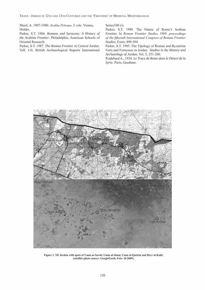
In particular we dealt with sites located in two geographi-cal zones: the north-eastern belt (Figure 1) and the Wadi Mujib area (Figure 2). The former comprises four sub-re-gions (the Azraq Oasis, the Southern Hauran, the Northern Steppe and the Basalt desert) geo-morphologically distin-ct, but having in common the widespread use of volcanic basalt as a building material. The second zone was chosen in order to examine the situation of a geomorphological-ly and climatically very different area, the Wadi Mujib, a strategic zone as it provided access to the Dead Sea and the West.Examination of epigraphic evidence was accompanied by an initial survey of the walls. Partial results of these crosschecked studies led us to reflect on the nature of the limes arabicus and especially on many of the architectural structures of which it is composed: burgi, quadriburgia, towers and more complex residential buildings.Epigraphic evidence provides very important chronologi-cal markers (fossil markers) (Parenti 1988, 280-304) to aid in dating architectural structures. Naturally, epigraphs or any other written evidence must be analysed critically and with great care. In sites that were continually inhabited, reused material is fundamental. In many cases, perfectly-preserved epigraphs were reused as simple building ma-terials, and thus de-contextualized from their original si-tuations; there are also cases of readings and illustrations of epigraphs now lost or unavailable. In the end, given the complexity of the building history of many constructions, if the section of wall contextual to the epigraph is not per-
fectly documented, it may be difficult to link information from the epigraph to that part of the building.The aggregate of the available epigraphic documentation shows that the first phase of construction of the system of defence took place during the final years of the Anto-nini period and, mainly, during the Severi dynasty.10 For example, epigraphic study of two best-known and best-documented fortified sites located in the northern part of the limes arabicus, Qasr al-Azraq11 and Qasr al-Hallābāt, where many epigraphs were found (Kennedy 2004, 96-102; Parker 1986, 30-32; Arce 2007, 325-344) leads to the conclusion that there was continuity of use of the site from the first half of the 2nd century to the beginning of the 3rd century AD. For Qasr al-Azraq, the dating is less certain, because sources tell of an inscription, today lost, datable to a very broad period (AD 138-222), while other still-extant epigraphs datable to between AD 273 and AD 326/333. The construction of Qasr al-Hallābāt is even more compli-cated, as one epigraph surely dates to AD 213, but recent studies still in progress are providing more updated infor-mation about the site (Arce 2007, 325-344 and information communicated at this conference). In the same zone and dating to the same chronological period on the basis of archaeological and epigraphical data, are Qasr al-Uwaynid and Qasr al-Aseykhim; the positions of these building and the importance of Wadi as-Sirhan (south-east of the Azraq Oasis), show that the extensive construction activity recor-ded represents an exceptional effort to protect the region during the first half of the 3rd century AD.Other epigraphic evidence, dating to between the end of the 3rd and the beginning of the 4th centuries AD, show an intense building and rebuilding activity in strategic are-as of the limes precisely during the fundamental period of administrative and military re-organization of the province under Diocletian. Epigraphs from this period have been found at Qasr Bshir (297-304),12 Deyr al-Kahf (306) and at Qasr al-Azraq (326-333).During the re-organization effected by Diocletian and Constantine, it is evident that particular attention was gi-ven to reinforcing such crucial areas as Wadi as-Sirhan and the Azraq Oasis. Epigraphic sources have helped to deter-mine that said protection was required due to the rebellion of Mavia, a Saracen queen, who, like Zenobia a century earlier (AD 269), broke an alliance with Rome after her husband’s death. Mavia converted to Aryanism in 373, and
10 Severi interest in the Near East is well documented by material sources: two extensive phases of road building and renovation were carried out in the Arabian Province: one in 194 and the other between 200 and 202. Kennedy 1980, 883.11 Azraq: JRS 61 (1971) 241 (a Latin inscription reports the castle renovation between 326 and 333, [inc]uria vetustate [parietu]m ruina conlapsam); Hallābāt: Princeton Arch. Exp. Syria III. A.12 Engraved on an architrave at the entrance door is the following epigraphy datable between 293 and 305 A.D.: OPTIMIS MAXIMISQUE PRINCIPIBUS NOSTRIS GAIO AURELIO VALERIO DIOCLETIANO PIO FELICI INVICTO AUGUSTO ET MARCO AURELIO VALERIO MAXIMIANO PIO FELICI INVICTO AUGUSTO ET FLAVIO VALERIO CONSTANTIO ET GALERIO VALERIO MAXIMIANONOBILISSIMUS CAESARIBUS CASTRA PRAETORI MOBENI A FUNDAMENTIS AURELIUS ASCLEPIADES PRAESES PROVINCIAE ARABIAE PERFICI CURAVIT.CIL III: 14, 149.
115
r. parenTI, p. gIlenTo : “lIMes arabIcus” and sTIll-sTandIng buIldIngs
this coincides almost precisely with evidences found in the buildings of Umm al-Jimal13 and Deyr al-Kahf.14
These sites were again reinforced and fortified around 411 in conjunction with an invasion of Arab peoples, while the latest datable fortification in Roman Arabia, again from the Qasr al-Hallābāt site, dates to 529 or 555 (Kennedy 2004, 100). From this brief analysis of written sources and archaeological evidence, it is clear that the traditional me-aning of limes as a fortified boundary only partially serves to define and identify a border zone, thus demonstrating how complex the construction situation is, and to what extent the life of these structure has yet to be clarified. Let us consider the area south of Hauran - the last ferti-le zone on the bordering on the inhospitable Basalt De-sert. The relatively favourable climatic conditions of this zone allowed for intensive exploitation of the territory for agriculture and pastureland, thus enabling the continuous habitation of these sites from prehistoric times to the pre-sent day. The presence of farms, villages and small towns, surely dating from the Nabataen period to the first Islamic period, is well documented.Umm al-Quttein is one of the best-documented examples of this continuity of habitation. Again in this case, epi-graphs are of primary importance. Ten Nabataen epigraphs (Kennedy 2004, 81-86) have been found on the site, and one may well date to the period of the last Nabataen king (Rabbele II, AD 71-106). Other epigraphs in Latin and Greek date to between the 3rd and the 4th centuries AD, while pottery provides more precise information about the habitation of the site during the early Islamic period. Ac-cording to D.L. Kennedy, after the first and well-documen-ted Nabataen occupation between the 1st and 2nd centuries AD, with Roman annexation the place became a military outpost, probably housing an auxiliary regiment. Surveys have not yet provided good results regarding this period, as the hypothesized fort was completely obliterated by the Late Roman city during the 3rd-4th centuries. Moreover, the modern city almost perfectly overlays the ancient one.
Umm al-Jimal is the largest city south of Hauran and has a very interesting continuity of habitation, about which archaeological excavations and extensive territorial sur-veys provided very important information during the early 1970s.15 Archaeological excavations unearthed the small Nabataen village later occupied during the Early Roman period, adjacent to the Late Roman/Early Islamic site. Once again, in this case epigraphs have been very important chronological markers for the construction history of the site. The inscription on the so-called Gate of Commodus gives us a very precise chronological period (AD 177-180) on which to base indications, although this epigraph does raise some problematic questions. Two other epigraphs, no longer in situ but which were re-utilized in subsequent
13 A very well-preserved Latin epigraph reused as architrave in a later church, datable to 371 A.D. (see below). Another epigraph, found in the courtyard of a house south of the western gate, mentioning the foundation of a castle, dates to 412-413 A.D.14 A Latin inscription is on the Eastern facade of the southern wall, dating to between 367 and 375 A.D.15 For Umm al-Jimal see above D. Vries 1998.
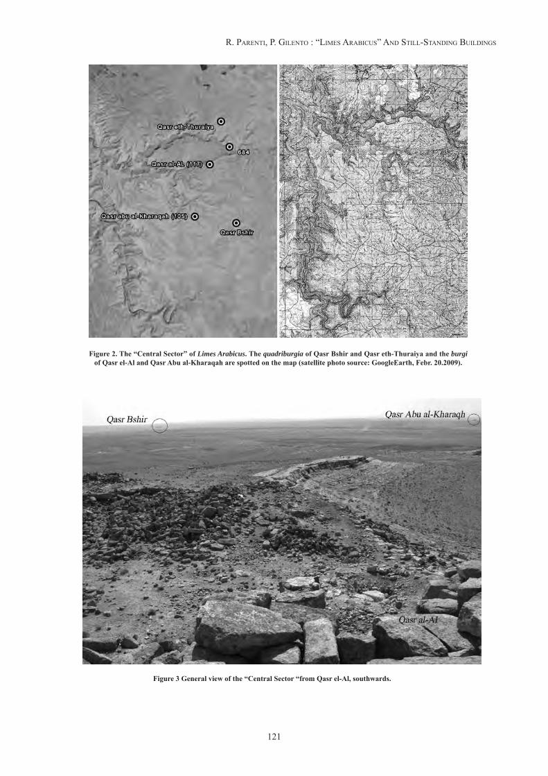
buildings, tell us about construction activities in the city at the end of the IV century. Both epigraphs are in Latin, one dating to 368 (Kennedy 2004, 88-89) and referring to a tower, and the other dating to 371 (Kennedy 2004, 88-91) and mentioning the construction of a “burgu[s] ex fun-damento mano”. The continuity of habitation of this site is again well-documented by both epigraphs and material from archaeological digs, for the Ghassanid and Umayyad periods as well.As for the so-called “central sector of the limes”, whe-re the Wadi Mujib drainage basin originates, the context is completely different from that of the north-east sector of Jordan. In fact, it was not a densely populated zone; settlements are scattered and often on high ground, taking advantage of the morphological features of the territory, which descends from 900 meters above sea level to the Dead Sea; there is little epigraphic evidence from the area. Moreover, precise excavations have been carried out only in circumscribed zones, so archaeological data is limited. More detailed information comes from field surveys effec-tuated by the Parker team for the Limes Arabicus Project. Let us consider a few of the buildings in this area of Jor-danian territory: Qasr Bshir, Qasr Abu al-Kharaqah, Qasr el-Al and Qasr eth-Thuraiya (Figure 3). The situation ap-pears much more complicated than bibliographic sources would suggest. It seemed immediately evident upon initial analysis of the walls that the wall stratigraphy added much information to data from previous archaeological excava-tions. For example, at Qasr Bshir, excavation data16 led to the hypothesis that the site had surely been settled prior to the Roman period, as suggested by structures that are no longer extant but traces of which are still partially visible on the ground, along with more recent walls, and in the Western wall of the Tetrarchic fort, large blocks, comple-tely different from the rest of the building techniques utili-zed in the structure, lead to the hypothesis of re-utilization of a previous structure.
Qasr Bshir itself is a Tetrarchic fort, but its continuity of use is a key to reading the building and understanding the history of the surrounding landscape. Excavations finds suggested a continuity running from the Byzantine pe-riod to the Umayyad period. The standing structures show the high degree of re-utilization of the site, and further analysis of the walls will surely confirm this. A similar cir-cumstance can be found at another site, Qasr eth-Thuraiya. The site is larger and more complicated than bibliographic sources indicate (Parker 1986). Very different building techniques are visible, showing greater complexity of con-16 Six small sample digs were done: two in 1982 and four in 1985 within the sphere of the Limes Arabicus Project, with the primary goals of determining the history and the occupation of the site and which type of garrison had occupied it, and above all comparing information from the excavation of the fort with that from the el-Lejjun legionary camp. During the field survey, many Nabataen and Iron Age materials were also found.The date of the fort’s foundation is on the entrance inscription, raising no doubts as to the years between AD 293 and 305; this dating is confirmed by dig data and by field survey data, which, also testify to an initial abandonment of the site during the late 5th and early 6th centuries AD, and a reoccupation during the Umayyad period. The Iron Age and Nabataen surface finds prove an occupation prior to the Roman period.
Trans - Jordan In 12Th and 13Th cenTurIes and The ‘FronTIers’ oF MedIeval MedITerranean
116
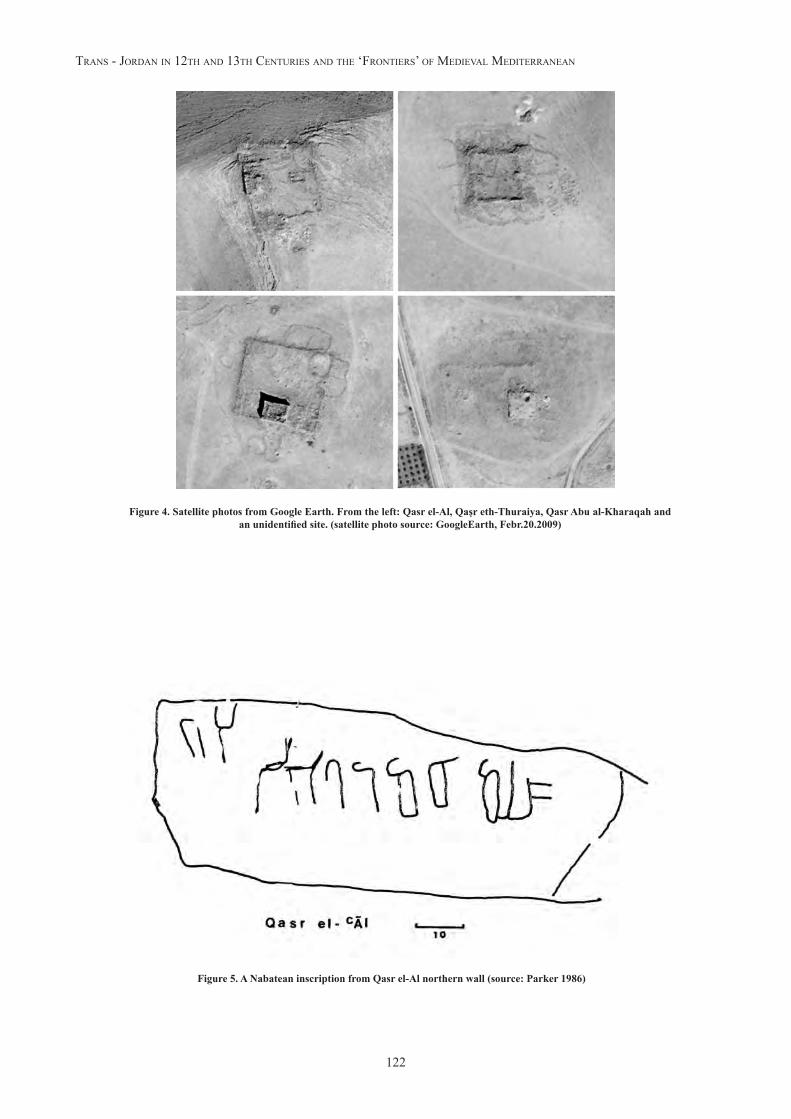
struction than would be found in a building considered Tetrarchic. Qasr eth-Thuraiya was included in a territorial re-organization carried out during the tetrarchy, and field surveys date it to between the end of the III and the middle of the IV centuries,17 but other findings date to the Ayub-bid/Mamluk period.Regarding the sites of Qasr Abu al-Kharaqah and Qasr el-Al, the literature mentions lookout towers. But in this case as well, it is clear even upon simple observation of the structure that these two sites cannot be considered mere lookout towers.18 Both sites present structures formed by a building with sides measuring between 16 and 20 meters long, almost surely on two levels, internally adjacent to a large enclosure to which other internal rooms are linked (Figure 4). This type of construction is quite common in this area, but is difficult to date due to the lack of a spe-cific study of the structures and the near-total absence of epigraphic sources. However, pottery found on the surface indicate a settlement as far back as the Iron Age. A par-ticular case is Qasr el-Al, on the northern wall of which an engraved Nabataen inscription provides an important terminus post quem. (Figure 5)S.T. Parker (Parker 1986) established, on the basis of pot-tery found on the surface, that these two sites were founded during the Iron Age, occupied by Nabataens and then brought into the widespread system of limes. Pottery finds date to the early Byzantine period, 4th-5th century. The Romans probably re-utilized these sites as rest stops and visual links between different locations. It is interesting that no traces from the Early Islamic period have been found on this high-ground site. This is a very important indicator of the nature of occupation of the territory at the advent of Islam. The relative peacefulness of the territory that came with its conquest by the first Islamic families meant that there was no necessity to occupy high-ground sites with strictly strategic functions.
Looking through this brief list of archaeological sites it becomes clear that even before the establishment of the Provincia Arabia, the situation in the region was complex, with various types of defensive structures that the Romans simply occupied and adapted. Applying a specific working strategy for these sites may provide us with more detailed information to improve our understanding of the history of these buildings. Studying these “minor structures” may offer a point of departure for important reflection on the history and nature of the limes. Structures that were re-utilized over time, sometimes wi-thout excessive modifications and sometimes with signifi-cant ones, and adapted for different needs. A more in-depth study of these sites, and their construction techniques in particular, can provide us with small pieces of information to insert into the larger picture of the history of the limes arabicus. In fact, the limes may no longer be considered as a border zone but, on the contrary, as an important point
17 A interesting coin dated to Costantinus II (AD 337-340) was found. Parker 1986, 50.18 The more appropriate term to define these structures formed of a tower, an enclosure and rooms along the enclosure would be burnus; see also Aföldi, 47 f.
of social, political and cultural exchange and experiences, not only among the Romans and Arabic peoples, but also among nomadic desert populations. This situation genera-ted a highly complex construction tradition that is still to-day, at least in part, recognizable in buildings constructed in these zones.
STILL-STANDING BUILDINGS AND PROBLEMS OF WALL CHARACTERIZATION AND CHRONOLOGY
In a 1995 article, S.T. Parker Parker 1995, 251-260), deals with the problem of interpretation and dating of buildings, Forts and Fortresses, located on the limes arabicus. Al-though Jordan possesses the best-preserved construction in the Roman and Byzantine panorama, lack of excavation campaigns (except for a few sites) or specific targeted stu-dies meant that, at least until the late 1970s, these buildings presented significant problems regarding chronology.
Nevertheless, Parker, in light of new and more detailed in-formation, attempted to draw up a typology of forts from the Roman and Byzantine period located in Jordan. In his view, one of the most critical hindrances to comprehension of a building is the complexity due to successive recon-structions: “the extant plan may well reflect several periods of later rebuilding that may be difficult to disentangle”.
This assertion is one to keep in mind. The Jordanian situa-tion as regards archaeological complexes with still-stan-ding buildings (and there are a great many) is characteri-zed by a very evident stratigraphic complexity (based on the last thirty years of study of the distinct constructive acts that characterize the current situation of a building). This complexity is not an obstacle to understanding a bu-ilding, but if well sorted out, constitutes the key to reading and may precede excavations. In fact, elevated structures have been considered rather unreliable as sources of in-formation by recent generations of archaeologists. In the Jordanian case, however, where many structures present well-conserved elevated structures (large surfaces and lit-tle transformation for at least ten centuries), stratigraphic reading of the elevated structures and the creation of typo-logies tied to the construction sphere – i.e., the Building Archaeology – can provide excellent results in terms of knowledge of these buildings, and thus also contribute to a deeper understanding of the limes arabicus.Of course, determining the chronology of building structu-res using the aggregate of pre-existing information is desi-rable, and surveys, digs, epigraphs and inscriptions and bu-ilding typologies are, without doubt, sources we cannot do without. In every single case, the Building Archeology can help – by offering largely new observations as far as the Jordanian situation is concerned - to improve our ability to more precisely determine the dates of the construction and the transformation of buildings and to develop instruments that are applicable in a much wider range of situations than the individual architectural complexes analysed. For example the diachronic development of a building could be identified through the relative chronologies, that
117
r. parenTI, p. gIlenTo : “lIMes arabIcus” and sTIll-sTandIng buIldIngs
is by studying how it relates to anterior, contemporary and posterior features, identifiable on a wall surface as well as in the three-dimensional structure of the building. Even without certain dating elements, such as epigraphs or excavation finds (in any case useful when available), it is possible to determine a typological seriation of bu-ilding systems, techniques and materials which, with an appropriate number of samples, could help enormously in determining the absolute chronology. Relative chronologies, then, in the absence of clearly dated contexts as in many of the Jordanian cases, can be used as fossil guides for better comprehension of the history of the limes arabicus, suggesting new perspectives for a re-reading of architectural complexes and their surrounding landscapes, beginning with the material structure and the study of building techniques.Building techniques change and evolve more or less slowly (in other geographical areas we have noticed that variations are directly proportionate to increasing demand for new buildings), so recording the characteristics of a significant number of constructions through the study of building techniques is a fundamental step towards under-stand a building’s history.The characteristics of the workmanship of individual buil-ding elements, how they were finished with tools, the lay-ing of cornerstones and panels, what type of mortar was used if any, and the size of each individual component of the wall, are all elements that can be easily and quickly documented. The drawing up of abacuses in which the-se indispensable elements for characterizing the building systems of geological homogeneous areas are arranged in chronological order is an important objective, if we want to verify already-available information or propose new in-terpretative hypotheses.Characterizing a masonry wall and defining different buil-ding techniques in order to determine the construction hi-story of buildings entails a complete reversal of the usual approach to understanding architecture, but can be extre-mely productive even when the remains of walls are partial or not yet visible.This article presents a way to consider some still-open questions, and above all proposes new work and research methodologies that utilize stratigraphic reading of eleva-ted structures as an indispensable tool for better understan-ding of a building.The line of research proposed here is even more effective in a territory like Jordan, where climatic conditions and the morphology of the territory make intensive and continuo-ing excavations problematic.Nor do classical architectural studies based on typological and stylistic comparisons prove to be suitable, due to the complexity of the buildings themselves, and because it is now clear that simple typological comparisons - which do not consider variations occurring over time – provide only partial and often misleading results regarding the construc-tion and functional history of a building. For example, the dated but fundamental essay by James Lander (Lander 1984) based its comparisons almost totally on building plans.
A comprehensive review of the stratigraphical readings performed up to now will be the subject of another publi-cation, but initial, in some cases partial, results can already be presented.Close examination of the typology of the quadriburgia, a Tetrarchic architectural complex, shows that protruding towers were almost always built after completion of the curtain walls. Three of the corner towers of Qasr Bshir may have been built during a construction phase (a wal-led enclosure was constructed first for safety reasons and then, one or two seasons later, the towers were added), but the fourth tower was inserted through modification of the upper part of a lateral entrance (Figure 6). How should this be interpreted? Surely the original plan was modified, but in order to move from a relative chronology to an abso-lute chronology, it is necessary to more fully explore the building techniques. The oldest building element of the entire complex is, of course, the main entrance with an epigraph on the architrave, made with perfectly squared and levelled blocks that suggest the utilization of speciali-zed masons. This tower-entrance serves to support the first two-to-three rows of the entire perimeter. The rows are made with stone blocks that are much larger than the other materials utilized. On the western side, we hypothesize that they may have come from the demolition of an older building, but they may also have responded to the need to build the elements, interpreted as horse mangers, inserted within the thickness of the wall, with an individual verti-cally set stone as a base. All of these walls are characte-rized by the presence of mortar, probably with lime as a binder. (Figure 7)As far as we know, the use of mortar with a binder is not traditional in Nabataen or Iron Age walls, which utilized soil or clay to level and fill the gaps between rows.Was this technological innovation introduced by Roman workers, as hypothesized in other areas of the Roman Pro-vinces (Camporeale 2004)?
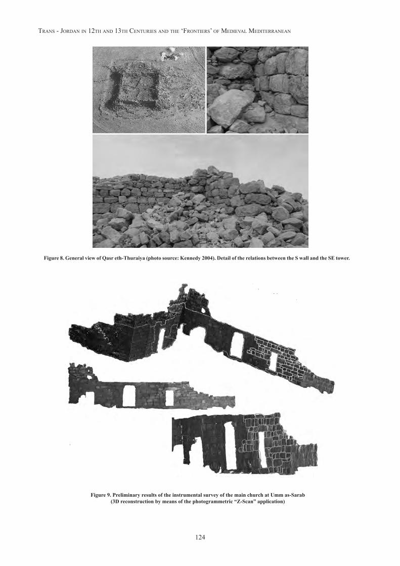
Currently we are unable to assert with certainty that the use of mortar in Qasr Bshir is the most ancient example in Jordan, as it is a late example and because until now such observations have been lacking. Certainly the introduction of the use of mortar had a widespread and lasting impact. Mosaic affixers, external and internal plasters and decora-tions for buildings in the south of Hauran, waterproofing for cisterns and the characteristic mortars of Umayyad buildings (one based on limestone with large amounts of carbon residues and the other with plaster as a binder) are just a few examples we can note in the architecture of subsequent centuries.Another building not far from Qasr Bshir, pertaining to the typology of the quadriburgia, Qasr eth-Thuraiya, seems at first glance to have been built using two main building techniques, but the most unusual aspect is that in this bu-ilding the south-eastern corner tower seems to have been built prior to the rectangular enclosure (Figure 8). In this case, as in Qasr Bshir, there are several possible interpre-tations, one of which is that the enclosure may have been built around a pre-existing building.
Trans - Jordan In 12Th and 13Th cenTurIes and The ‘FronTIers’ oF MedIeval MedITerranean
118
With these types of observations, the entire schema of buil-dings thought to be part of the limes in this region (fortali-ces, forts, lookout towers), should be re-evaluated, becau-se the in synchrony presence of the structures in different historical periods (some buildings have existed since the Iron Age) will have to be compared with their frequenta-tion, which is not always known for all historical periods. In the other area, south Hauran, the presence of mortar is much more limited due to the reduced availability of lime-stone. But traces of its use are present: in Umm al-Jimal, religious buildings (churches) used it as setting mortar for walls and mosaics. It is also found on other surfaces, both as decoration (visible traces on many buildings, including the tower of the “Barracks”), and as a sealant for seams (probably to impede leakage of earth used for setting blocks in walls) and cisterns.The evolution of diatonics present in walls from different construction periods seems more promising. Diatonic walls and orthostats pertain to classical tradition (Martin 1965), but during the various construction phases of many buildings in volcanic basalt area sites, an evolution in their utilization has been documented. We are not yet able to precisely determine an absolute chronology (probably 4th-8th century), but we have a good relative seriation (one pattern is older than another because both were utilized in the same building but in different construction phases) and widespread use in Umayyad walls. Comparison with VIII-XI-century Andalusian masonry (Selleria a soga y tizòn iregular de época emiral, de época califal y de época taifa, see Civantos 2004) appears to be interesting.
RECORDING CRITERIA AND AVAILABILITY OF DATA
In this innovative method of studying the limes arabicus, which will be developed in coming years in collaboration with the Department of Antiquities of Jordan, given that extensive territories and numerous sites are involved, the best strategy seems to be to utilize tools made available by new technologies to the greatest possible advantage. Foremost among them are those that aid in the localiza-tion of sites. Jordanian territory has always been a very fertile ground for aerial surveys, given the nearly total vi-sibility of the sites. An instrument like Google Earth now allows us to clearly identify archaeological sites and to ge-oreference them in photographic-quality maps (the error in geographical coordinates inherent to the Google Earth application can be overcome through double surveying of the positions of discernable points of the buildings using a simple GPS). At this point we have two possibilities. The first is to enter all information regarding topography, sur-veys, completed excavations, bibliography and a database of photos of a large number of sites into a new-generation static on-line database. Such a collection of on-line data can also be made available to the next Jordan GIS MEGA J. The second possibility has to do with the successive phase of field work. An architectural survey will invol-ve a smaller amount of sites. Remote sensing techniques based on specialised hi-tech photogrammetry equipment
will yield 2D and 3D CAD plans as well as 3D vector re-production of the walls (Figure 9). Vectorialized 3D wall surfaces will be generated, on which all necessary analyses can be successively carried out (stratigraphical readings, characterization of dimensions, finishes and workmanship, the presence of facings, results of archaeometric analyses, etc.). Once processed, the data will be readily available on-line. As the plug-ins for 3D drawing in a 3D GIS are still in the testing phase, only currently-available GIS used for recording information on vertical wall bases can be used at present, such as the SICaR - the evolution of the GIS de-veloped for documenting restoration work on the leaning tower of Pisa and now utilized by the Italian Ministry of Cultural Heritage and Activities.This strategy can provide excellent results as the number of analysed sites increases, creating a database that is re-adily available and consultable and, above all, one that can be updated by expert users even from a distance, as it is on-line and can thus be managed by different research groups.This working strategy will be put to the test in 2009-2010 by the “Building Archaeology in Jordan” research group from the Building Archaeology Laboratory of the Univer-sity of Siena, along with the Department of Antiquities of Jordan, at the Umm as-Sarab site in north Jordan, an exem-plary project in the development of a new type of field work carried out using new computer technologies.
CONCLUSIONS
Construction in the Mid-East is characterized by extre-mely long-term continuity of skills and techniques. Al-though field documentation is in need of methodological updating, there is no doubt that many areas of Jordan are marked by topographical continuity between Nabataen bu-ildings (in some cases from the Iron Age, 12th-9th century BC) and those built by the Romans and later reused by the Byzantines, Ghassanids and Umayyads (7th-8th century AD), leaving us a wealth of information that must now be properly decoded. Said continuity naturally concerns materials, but also workmanship and the use of particular constructive systems, with few technical innovations. The continuity, or rather the slow evolution of building systems (the laying and sectioning of walls, the construction sy-stems of certain types of buildings and apertures, roofing systems – for example the diaphragm arch -, tools used for finishing, etc.) can easily be ascertained for the long period between the end of the III century and the mid-7th century, with some periods of increased building activity and others of preservation of the existing structures.The walls are a testimony to the strong stonecutting tradi-tion that has always characterized these geographical are-as, where stone was readily available. Refined, Hellenized Nabataen culture carried on this tradition, later flanked by the orderly Roman architectural tradition that brought in-novative models, schemas, techniques and materials that spread and blended with Middle-Eastern material cultu-re. No single influence predominated over the others, but rather, they melded with one another, creating along the
119
r. parenTI, p. gIlenTo : “lIMes arabIcus” and sTIll-sTandIng buIldIngs
limes a fertile ground for experimentation and above all evolution of forms and construction techniques. With the arrival of Islam in the mid-7th century and the advent of the first caliphal dynasty of the Umayyad (AD 660-750), the situation underwent rapid change in the first half of the VIII century. There was great demand for new buildings (mosques and minarets, and “palaces” or qusur, newly built or adaptations of old buildings) but some alre-ady-confirmed typologies continued to be utilized (thermal baths were transformed into hammams, but the distribution and functions of the rooms remained the same.) The incre-ased demand was met with the arrival of skilled Byzantine workers (as is well documented), as well as Armenians and probably Sasanids, who brought “new” material such as bricks or chalk-based mortar and new shapes of openings (such as the pointed arch), and new construction methods for the vaulted roofs.Following this evolution, analysing multi-layered archi-tectural complexes, documenting the features of construc-tion systems and creating a chronological Atlas means creating a new instrument which, at the very least, can aid tremendously in the study of Jordanian sites. But it may also offer opportunities to investigate the continuity, or ra-ther the evolution, of classical construction systems, in a context where continuity seems already ascertained, and to hypothesize new paths of transmission to Western Europe through the process of the Islamization of Spain.
BIBLIOGRAPHYArce, I. 2007. Qaşr al-Hallābāt: Continuity and Changefrom the Roman-Byzantine to the Umayyad Period. SHAJ, 325-344.Bowersock, G.W. 1971. A Report on Arabia Provincia,JRS 61, 219-242.Bowersock, G. W. 1975. The Greek-Nabataean bilingual inscription at Ruwafa, Saudi Arabia. In Le monde grec: Hommages à Claire Preaux, 513-522. Brussels.Bowersock, G.W. 1976. Limes Arabicus. Harvard Studies in Classical Philology, Vol. 80, 219-229.Bowersock, G. W. 1983. Roman Arabia, Cambridge, MA, 1983.Butler, H.C. et alii 1930. The Princeton University Archaeological Expeditions to Syria in 1904-5 and 1909. LeydenBrünnow R., Domaszewski, A. 1904-1909. Die Provincia Arabia. 3 voll. Strassburg, Trübner.Camporeale, S. 2004. Tecniche edilizie in pietra nellaMauretania Tingitana tra l’epoca mauretana e romana.Osservazioni sulle apparecchiature e utilizzo della malta. Archeologia dell’Architettura IX, 195-205.Civantos, J.M. 2004. Proposta preliminare di sistematizzazione delle tecniche costruttive d’al-Andalus nel territorio di Ilbira-Granada (Andalusia-Spagna). Archeologia dell’Architettura, IX, 207-220.Creswell, K.A.C. 1969. Early Muslim Architecture, I-II. Oxford.Creswell, K.A.C. with a contribution by J.W. Allan, 1989. A Short Account of Early Muslim Architecture. El Cairo.
De Vries, B.1985. Urbanisation in the Basalt Region ofNorth Jordan in Late Antiquity: The Case of Umm el-Jimal. In A. Hadidi (ed.), Studies in the History and Archaeologyof Jordan II, 249-56. Amman, Department of Antiquities of Jordan.De Vries, B. 1986. Umm el-Jimal in the First Three Centuries A.D, in P. Freeman and D. Kennedy, eds., The Defense of the Roman and Byzantine East. British Archaeological Reports, International Series 297, 227-41. Oxford, B.A.R..D. Vries B., 1998. Umm el-Jimal, A frontier Town and its Landscape in Northern Jordan, Voll. I-II.Gaube, H. 1974. An Examination of the ruins of Qasr Burqu. Ann. D.A.J. 19, 93-100.Glueck, N. 1934-1951. Explorations in Eastern Palestine. 4 vols. AASOR.Graf , D.F. 1978. The Saracens and the Defense of the Arabian Frontier. Bulletin of the American Schools of Oriental Research, No. 229. (Feb.,1978), 1-26.Graf, D. F. 1989. Rome and the Saracens: re-assessing the nomadic menace. In T. Fahd (ed.), L ‘Arabie preislamique et son environnement historique et culturel, 341-400.Leiden. Graf, D.F. 1997. The “Via Militaris in Arabia”. Dumbarton Oaks Papers, Vol. 51, 271-281.Isaac, B. 1988. The meaning of the terms Limes and Limitanei. The Journal of Roman Studies, Vol. 78, 125-147.Jaussen, RR.PP.A. and Savignac, R. 1922. Mission Archéologique en Arabie. Paris (Réédition Le Caire-1997).Kennedy, D. L. 1980. The frontier Policy of SeptimiusSeverus: new evidence from Arabia. 12th Congress:883.1980.Kennedy, D.L., 1982. Archaeological Explorations on the Roman Frontier in North-East Jordan. The Roman and Byzantine military installations and road network on the ground and from the air, BAR International Series 134.Kennedy, D.L. (edited by) 1996. The Roman Army in the East. Ann ArborKennedy, D.L. 2004. The Roman Army in Jordan, Council for British Research in the Levant. London.Kennedy D.L. e Bewley R. 2004. Ancient Jordan from the Air. London.Lander, J. 1984. Roman Stone Fortifications. Variationand Change from the First Century A.D. to the Fourth.British Archaeological Reports International Series 206.Martin, R. 1965. Manuel d’Architecture greque. I. Materiaux et Techniques. Paris.Mommsen, Theodor 1908. Der Begriff des Limes. Westdeutsche Zeitschrift 13: 134-43.=Pp. 456-64 : (‘ Es scheint den Limes-forschern wenig zum Bewusstsein gekommen zu sein, dass der Limes seinem Wesen nach bei allen sonst möglichen Verschiedenheiten, eine irgendwie markierte zweifache Grenze, eine äussere und eine innere fordert’) in vol. 5/2 of Gesammelte Schriften. Berlin, Weidmannsche.Mordechai, G. 1967. The Negev Frontier, in Israel and her Vicinity in Roman and Byzantyne Periods, 35-64. Tel-Aviv: Tel- Aviv University.
Trans - Jordan In 12Th and 13Th cenTurIes and The ‘FronTIers’ oF MedIeval MedITerranean
120
Musil, A. 1907-1980. Arabia Petraea. 3 vols. Vienna,Holder.Parker, S.T. 1986. Romans and Saracens: A History of the Arabian Frontier. Philadelphia, American Schools of Oriental Research.Parker, S.T. 1987. The Roman Frontier in Central Jordan. Voll. I-II, British Archaeological Reports International
Series340 (i).Parker, S.T. 1989. The Nature of Rome’s Arabian Frontier. In Roman Frontier Studies 1989. proceedings of the fifteenth International Congress of Roman Frontier Studies, Exter, 498-504.Parker, S.T. 1995. The Tipology of Roman and Byzantine Forts and Fortresses in Jordan. Studies in the History and Archaeology of Jordan, Vol. 5, 251-260.Poidebard A., 1934. Le Trace de Rome dans le Désert de la Syrie. Paris, Geuthner.
Figure 1. NE Jordan with spots of Umm as-Sarab, Umm al-Jimal, Umm al-Quttein and Deyr al-Kahf.(satellite photo source: GoogleEarth, Febr. 20.2009).
121
r. parenTI, p. gIlenTo : “lIMes arabIcus” and sTIll-sTandIng buIldIngs
Figure 2. The “Central Sector” of Limes Arabicus. The quadriburgia of Qasr Bshir and Qasr eth-Thuraiya and the burgi of Qasr el-Al and Qasr Abu al-Kharaqah are spotted on the map (satellite photo source: GoogleEarth, Febr. 20.2009).
Figure 3 General view of the “Central Sector “from Qasr el-Al, southwards.
Trans - Jordan In 12Th and 13Th cenTurIes and The ‘FronTIers’ oF MedIeval MedITerranean
122
Figure 5. A Nabatean inscription from Qasr el-Al northern wall (source: Parker 1986)
Figure 4. Satellite photos from Google Earth. From the left: Qasr el-Al, Qaşr eth-Thuraiya, Qasr Abu al-Kharaqah and an unidentified site. (satellite photo source: GoogleEarth, Febr.20.2009)

123
r. parenTI, p. gIlenTo : “lIMes arabIcus” and sTIll-sTandIng buIldIngs
Figure 6. Qasr Bshir, detail of the SW tower, with the stratigraphic relation between the main wall and the tower wall with a little door.
Figure 7. Detail of the mortar found at Qasr Bshir. Photos are taken from the eastern section of the main wall.
Trans - Jordan In 12Th and 13Th cenTurIes and The ‘FronTIers’ oF MedIeval MedITerranean
124
Figure 8. General view of Qasr eth-Thuraiya (photo source: Kennedy 2004). Detail of the relations between the S wall and the SE tower.
Figure 9. Preliminary results of the instrumental survey of the main church at Umm as-Sarab (3D reconstruction by means of the photogrammetric “Z-Scan” application)


![Linea verde: il limes senza legge ('Limes Without Law: the Green Line') [ITA]](https://img.pdfslide.net/doc/110x75/63146fb8fc260b71020f9033/linea-verde-il-limes-senza-legge-limes-without-law-the-green-line-ita.jpg)