Embed Size (px)
Citation preview

LINKING ECOSYSTEM SERVICES TO ESTUARY
RESTORATION AT THE GERMAN NORTH SEA COAST
Johann Krebs Federal Waterways and Shipping Administration
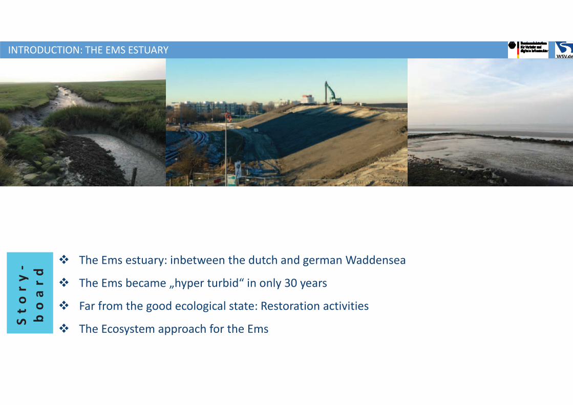
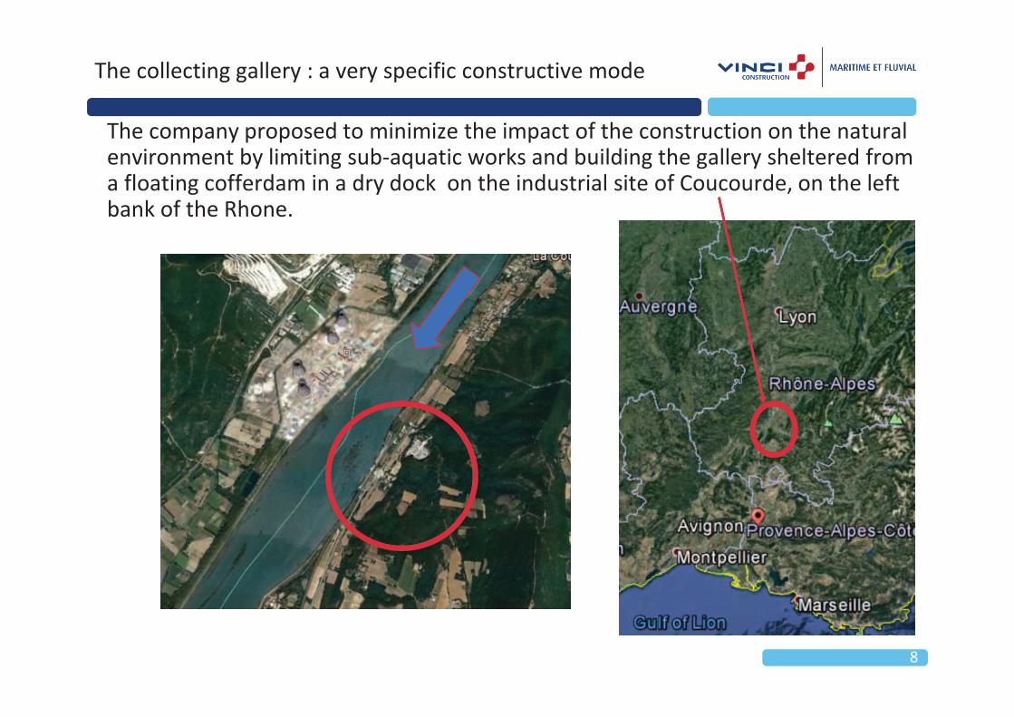
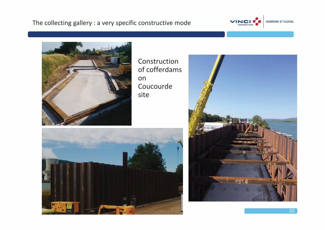
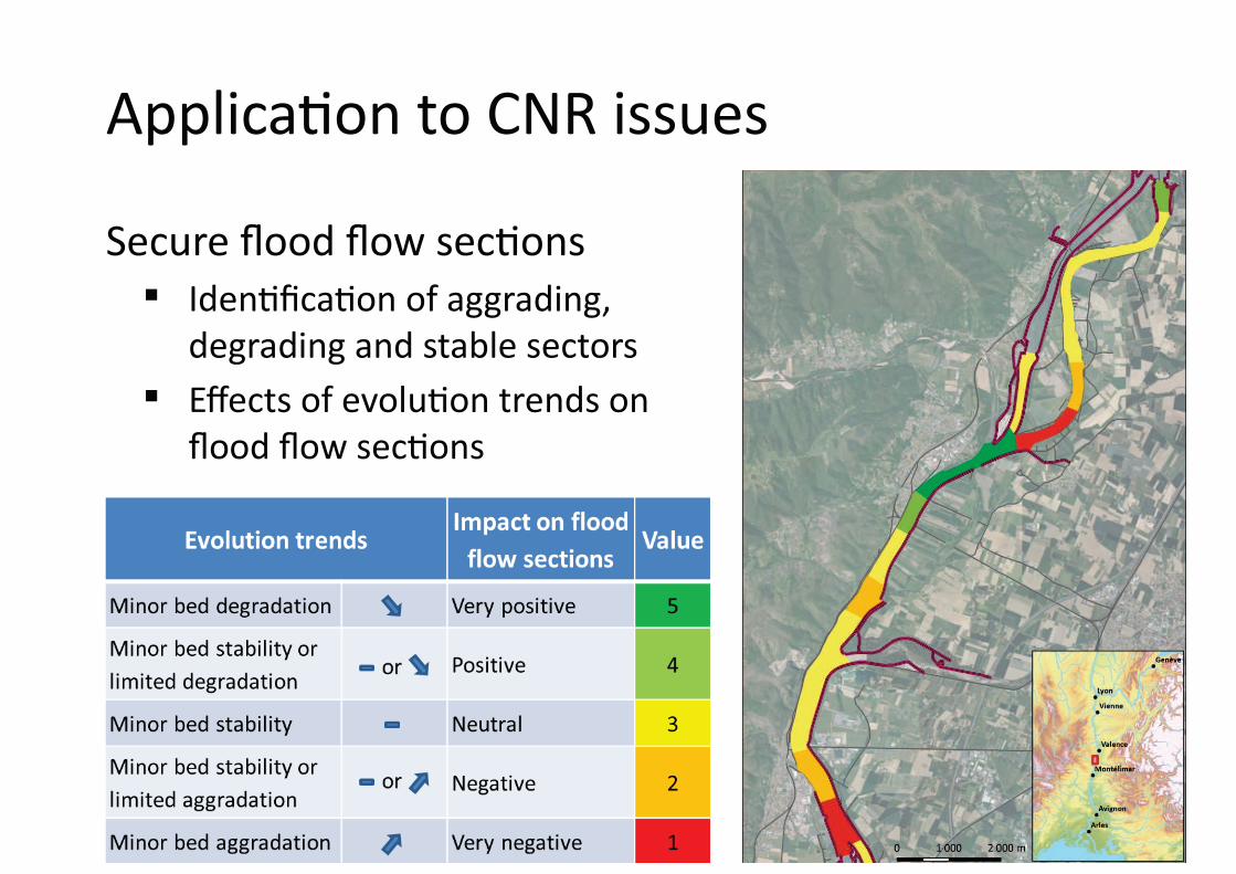
v The Ems estuary: inbetween the dutch and german Waddensea
v The Ems became „hyper turbid“ in only 30 years
v Far from the good ecological state: Restoration activities
v The Ecosystem approach for the Ems
St
or
y-
bo
ar
d
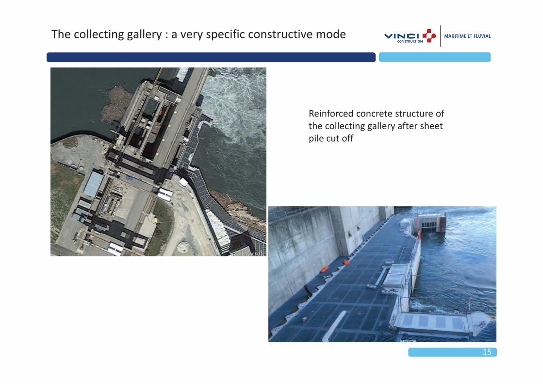
EMS
INTRODUCTION: THE EMS ESTUARY
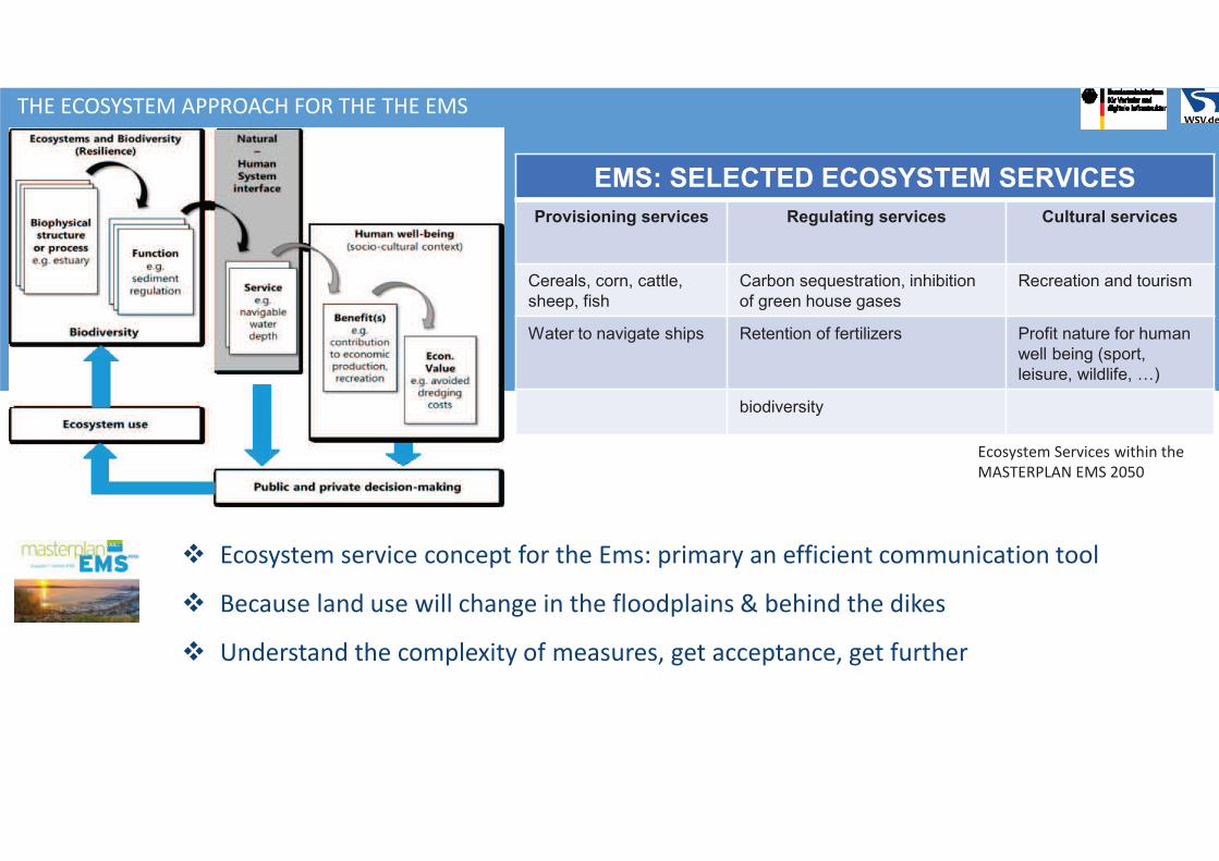
v Ecosystem service concept for the Ems: primary an efficient communication tool
v Because land use will change in the floodplains & behind the dikes
v Understand the complexity of measures, get acceptance, get further
THE ECOSYSTEM APPROACH FOR THE THE EMS
EMS: SELECTED ECOSYSTEM SERVICES
Provisioning services Regulating services Cultural services
Cereals, corn, cattle,
sheep, fish
Carbon sequestration, inhibition
of green house gases
Recreation and tourism
Water to navigate ships Retention of fertilizers Profit nature for human
well being (sport,
leisure, wildlife, …)
biodiversity
Ecosystem Services within the
MASTERPLAN EMS 2050
THE ECOSYSTEM APPROACH FOR THE THE EMS
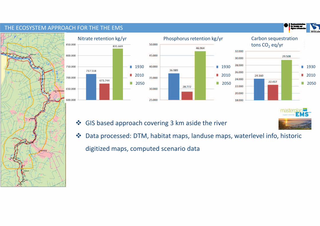
v GIS based approach covering 3 km aside the river
v Data processed: DTM, habitat maps, landuse maps, waterlevel info, historic
digitized maps, computed scenario data
Nitrate retention kg/yr Phosphorus retention kg/yr Carbon sequestration
tons CO2 eq/yr
1930
2010
2050
1930
2010
2050
1930
2010
2050
THE ECOSYSTEM APPROACH FOR THE THE EMS
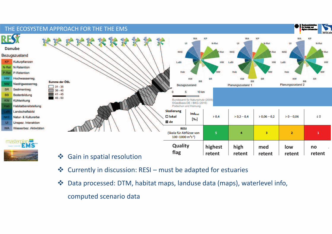
v Gain in spatial resolution
v Currently in discussion: RESI – must be adapted for estuaries
v Data processed: DTM, habitat maps, landuse data (maps), waterlevel info,
computed scenario data
Danube
Quality
flag highest
retent
high
retent
med
retent
low
retent
no
retent
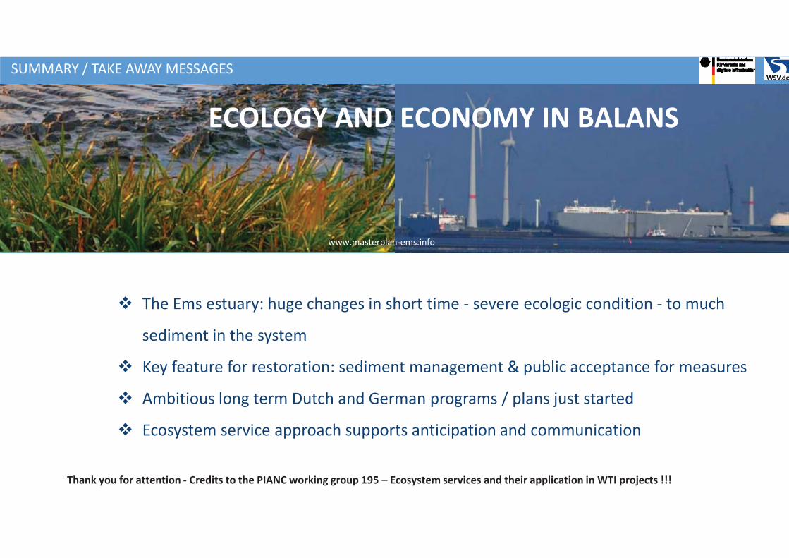
v The Ems estuary: huge changes in short time - severe ecologic condition - to much
sediment in the system
v Key feature for restoration: sediment management & public acceptance for measures
v Ambitious long term Dutch and German programs / plans just started
v Ecosystem service approach supports anticipation and communication
SUMMARY / TAKE AWAY MESSAGES
ECOLOGY AND ECONOMY IN BALANS
www.masterplan-ems.info
Thank you for attention - Credits to the PIANC working group 195 – Ecosystem services and their application in WTI projects !!!
Burton Suedel1, Joe Gailani1, and Jeff Corbino2
1US Army Corps of Engineers, Engineer Research and
Development Center, Vicksburg, MS, USA
2US Army Corps of Engineers, New Orleans District, New
Orleans, Louisiana, USA
STRATEGIC PLACEMENT OF DREDGED MATERIAL
FROM RIVERINE ENVIRONMENTS FOR RESTORING
MARSH HABITAT
BUILDING STRONG®
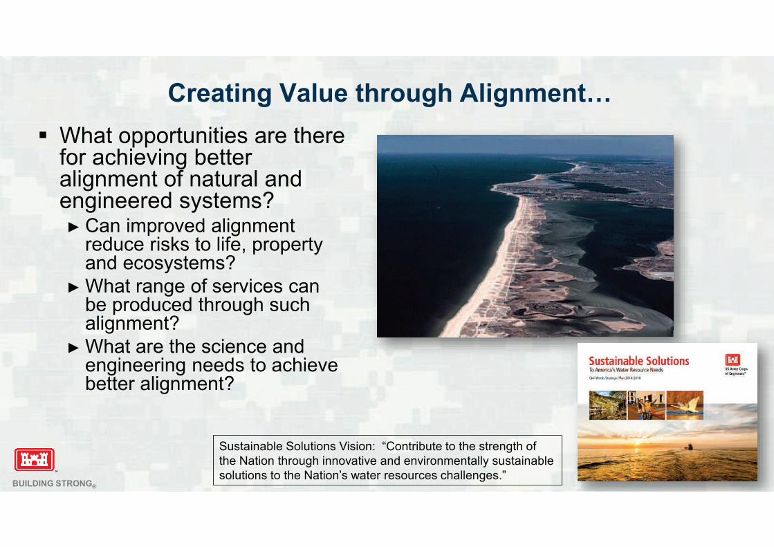
Creating Value through Alignment…
What opportunities are there for achieving better alignment of natural and engineered systems?
Can improved alignment reduce risks to life, property and ecosystems?
What range of services can be produced through such alignment?
What are the science and engineering needs to achieve better alignment?
Sustainable Solutions Vision: “Contribute to the strength of
the Nation through innovative and environmentally sustainable
solutions to the Nation’s water resources challenges.”
BUILDING STRONG®
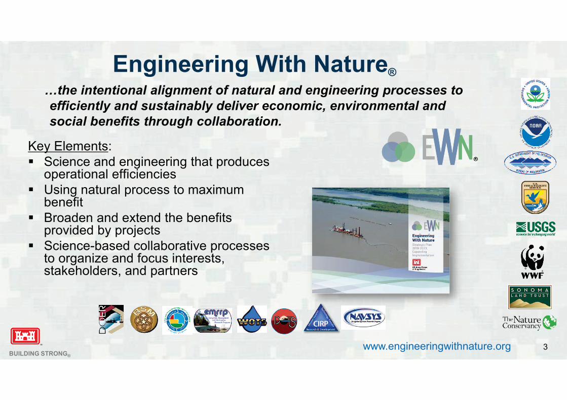
Engineering With Nature®
…the intentional alignment of natural and engineering processes to
efficiently and sustainably deliver economic, environmental and
social benefits through collaboration.
Key Elements:
Science and engineering that produces operational efficiencies
Using natural process to maximum benefit
Broaden and extend the benefits provided by projects
Science-based collaborative processes to organize and focus interests, stakeholders, and partners
www.engineeringwithnature.org 3
BUILDING STRONG®
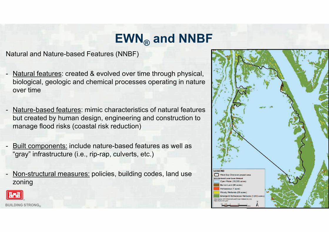
EWN® and NNBFNatural and Nature-based Features (NNBF)
- Natural features: created & evolved over time through physical,
biological, geologic and chemical processes operating in nature
over time
- Nature-based features: mimic characteristics of natural features
but created by human design, engineering and construction to
manage flood risks (coastal risk reduction)
- Built components: include nature-based features as well as
“gray” infrastructure (i.e., rip-rap, culverts, etc.)
- Non-structural measures: policies, building codes, land use
zoning
BUILDING STRONG®
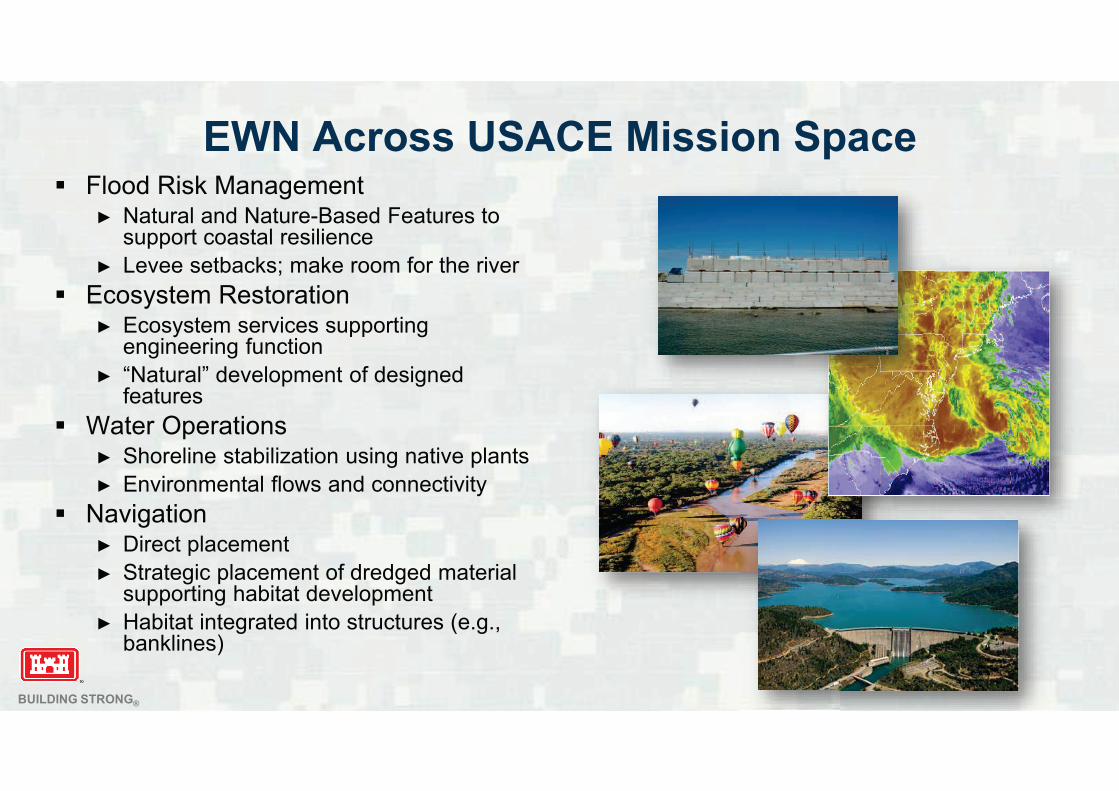
EWN Across USACE Mission SpaceFlood Risk Management
Natural and Nature-Based Features to support coastal resilience
Levee setbacks; make room for the river
Ecosystem RestorationEcosystem services supporting engineering function
“Natural” development of designed features
Water OperationsShoreline stabilization using native plants
Environmental flows and connectivity
NavigationDirect placement
Strategic placement of dredged material supporting habitat development
Habitat integrated into structures (e.g., banklines)
BUILDING STRONG®
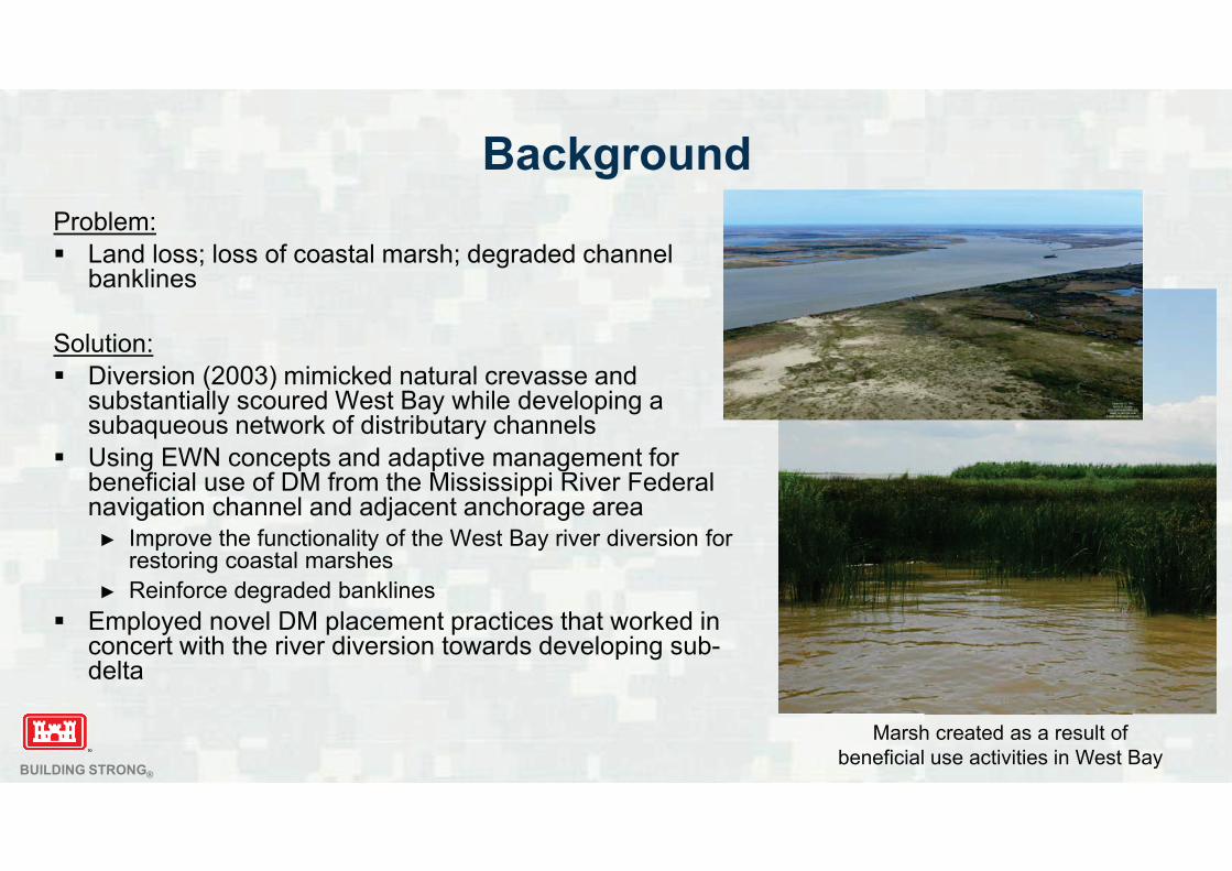
Background
Problem:
Land loss; loss of coastal marsh; degraded channel banklines
Solution:
Diversion (2003) mimicked natural crevasse and substantially scoured West Bay while developing a subaqueous network of distributary channels
Using EWN concepts and adaptive management for beneficial use of DM from the Mississippi River Federal navigation channel and adjacent anchorage area
Improve the functionality of the West Bay river diversion for restoring coastal marshes
Reinforce degraded banklines
Employed novel DM placement practices that worked in concert with the river diversion towards developing sub-delta
Marsh created as a result of
beneficial use activities in West Bay
BUILDING STRONG®
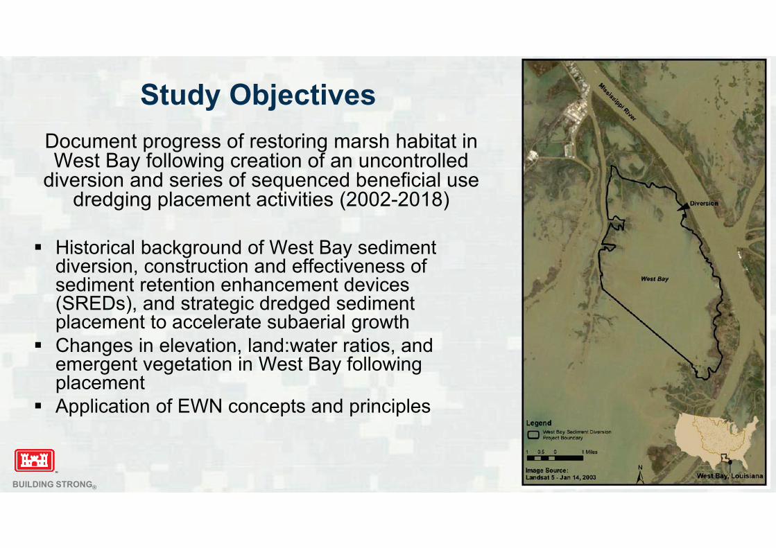
Study Objectives
Document progress of restoring marsh habitat in West Bay following creation of an uncontrolled
diversion and series of sequenced beneficial use dredging placement activities (2002-2018)
Historical background of West Bay sediment diversion, construction and effectiveness of sediment retention enhancement devices (SREDs), and strategic dredged sediment placement to accelerate subaerial growth
Changes in elevation, land:water ratios, and emergent vegetation in West Bay following placement
Application of EWN concepts and principles
BUILDING STRONG®
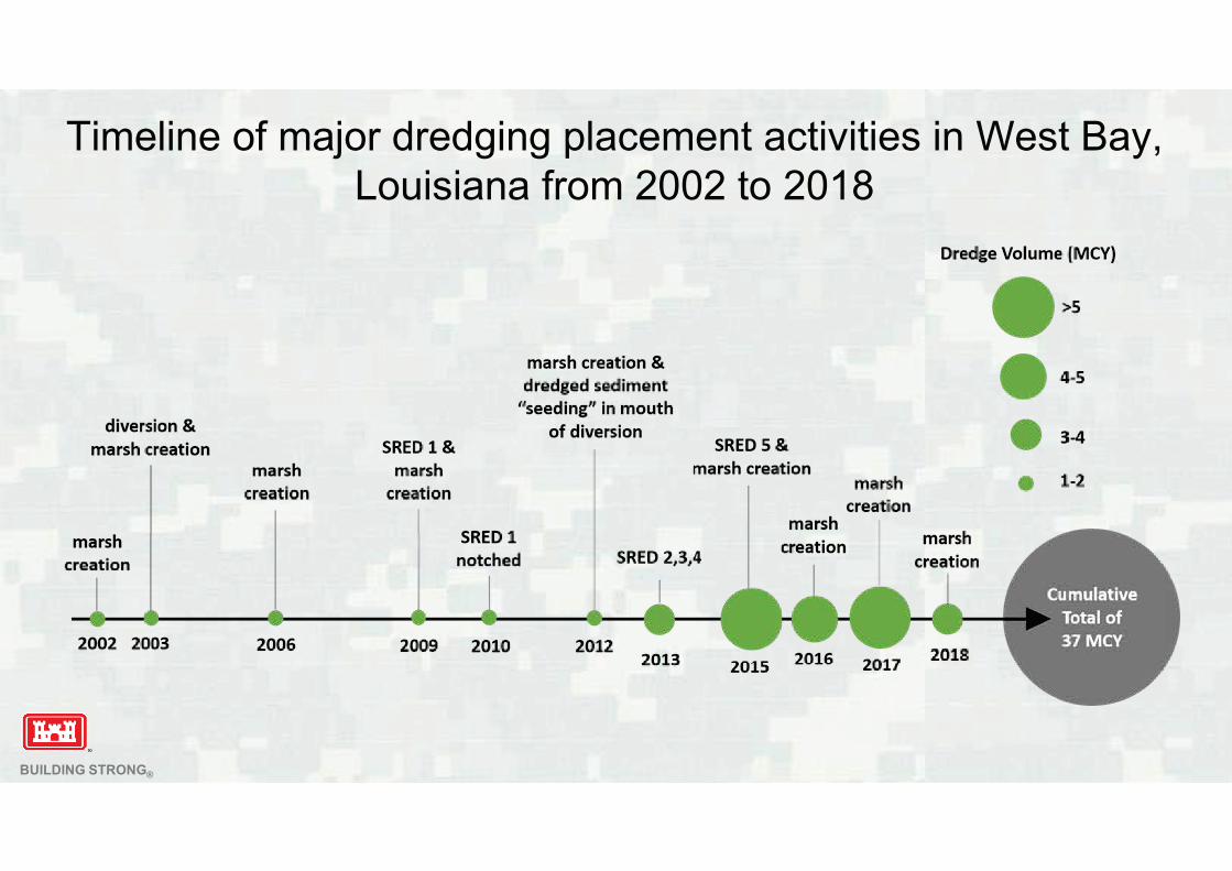
Timeline of major dredging placement activities in West Bay,
Louisiana from 2002 to 2018
BUILDING STRONG®
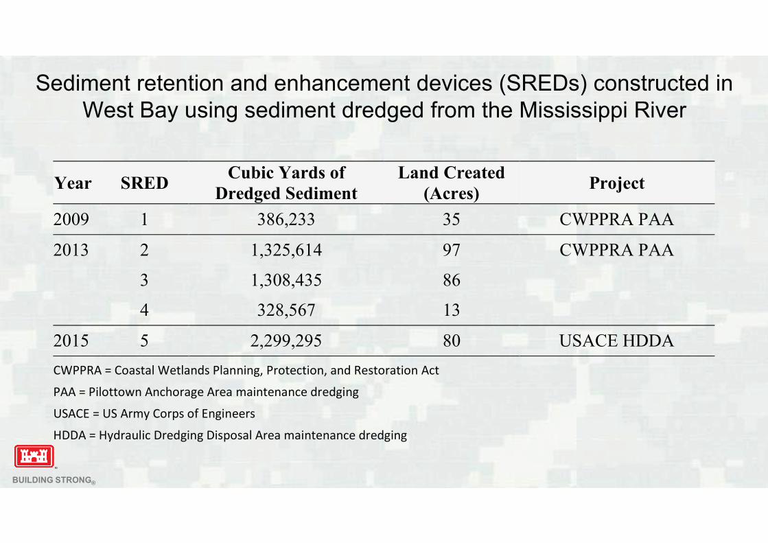
Sediment retention and enhancement devices (SREDs) constructed in
West Bay using sediment dredged from the Mississippi River
Year SREDCubic Yards of
Dredged Sediment
Land Created
(Acres)Project
2009 1 386,233 35 CWPPRA PAA
2013 2 1,325,614 97 CWPPRA PAA
3 1,308,435 86
4 328,567 13
2015 5 2,299,295 80 USACE HDDA
CWPPRA = Coastal Wetlands Planning, Protection, and Restoration Act
PAA = Pilottown Anchorage Area maintenance dredging
USACE = US Army Corps of Engineers
HDDA = Hydraulic Dredging Disposal Area maintenance dredging
BUILDING STRONG®
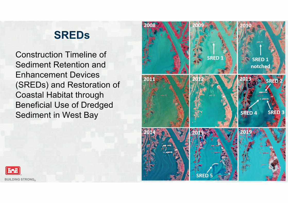
SREDs
Construction Timeline of
Sediment Retention and
Enhancement Devices
(SREDs) and Restoration of
Coastal Habitat through
Beneficial Use of Dredged
Sediment in West Bay
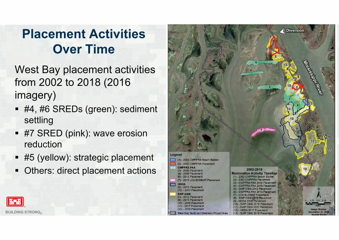
BUILDING STRONG®
West Bay placement activities
from 2002 to 2018 (2016
imagery)
#4, #6 SREDs (green): sediment
settling
#7 SRED (pink): wave erosion
reduction
#5 (yellow): strategic placement
Others: direct placement actions
Placement Activities
Over Time
BUILDING STRONG®
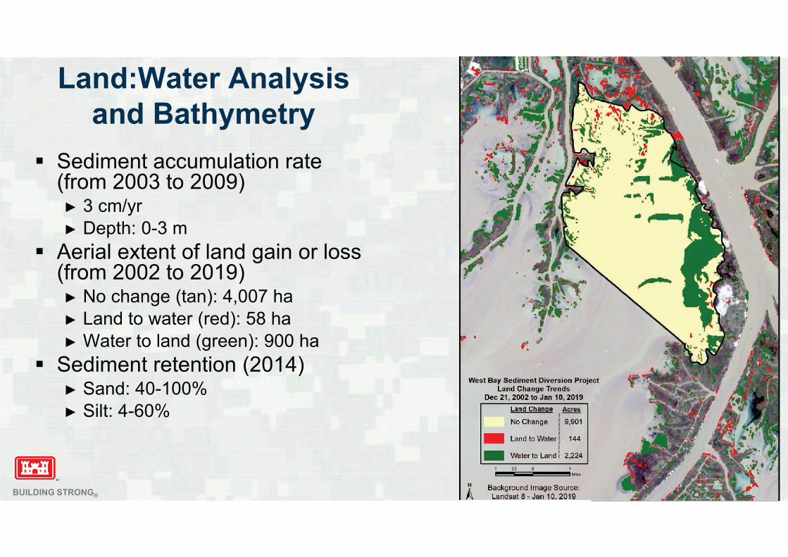
Sediment accumulation rate (from 2003 to 2009)
3 cm/yr
Depth: 0-3 m
Aerial extent of land gain or loss (from 2002 to 2019)
No change (tan): 4,007 ha
Land to water (red): 58 ha
Water to land (green): 900 ha
Sediment retention (2014)Sand: 40-100%
Silt: 4-60%
Land:Water Analysis
and Bathymetry
BUILDING STRONG®
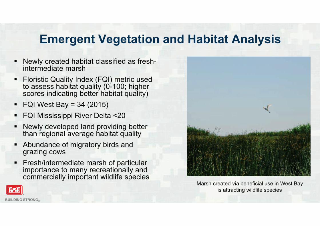
Emergent Vegetation and Habitat Analysis
Newly created habitat classified as fresh-intermediate marsh
Floristic Quality Index (FQI) metric used to assess habitat quality (0-100; higher scores indicating better habitat quality)
FQI West Bay = 34 (2015)
FQI Mississippi River Delta <20
Newly developed land providing better than regional average habitat quality
Abundance of migratory birds andgrazing cows
Fresh/intermediate marsh of particular importance to many recreationally andcommercially important wildlife species
Marsh created via beneficial use in West Bay
is attracting wildlife species
BUILDING STRONG®
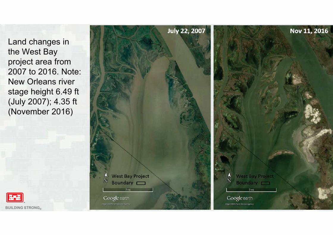
Land changes in
the West Bay
project area from
2007 to 2016. Note:
New Orleans river
stage height 6.49 ft
(July 2007); 4.35 ft
(November 2016)
BUILDING STRONG®
Summary
Direct and strategic placement of dredged material both contributing to project success
Restoring wetlands
Shoring up banklines
Successful EWN applications via strategic placement and SREDs
Maintaining safe navigation
Promote better understanding of how beneficial use of dredged sediment from riverine environments can restore ecosystem function and improve bankline stability using EWN concepts
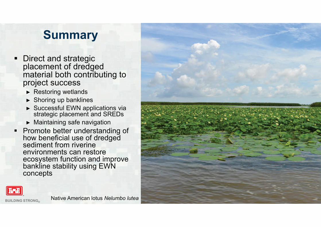
Native American lotus Nelumbo lutea
BUILDING STRONG®
Questions?
Burton C. SuedelUS Army Engineer Research and
Development Center
Vicksburg, MS, USA
���������������� ��������� �������� ���
�������������������������
������� ��
�������� !"�#�� ���$������%���%&��%'"���!����%���'�����&%��%����(�#�������$����)���
�*��!+!�,!���!�"�-�������$�,��!�,�.�
� /012"��������������&'��!$�#�����(��!,�3�� ���$��!,��!��!."����"�(�����
,!! 4����!��(�&%'%�%!��&'��!$�'��5!��$�!����-�,!��(�%'��!�����$�+�5!
� /016"�#�����(����)��"��������(�%&�"��((!&�!$�).� ����� ���� 4�&����%�!���
)'�,��%����)�."�+���%�5�'%�!��)�� !�"��!7!��'�7!��!'��5����$!$�%�&'�$%�5���
&����%�!����%-�)'�& %�5���!�!�����&!������!����)���
� /016"����������������&���!$�('��$%�5���$�$��5!����'.������5��%7!��
&���!���"�&'��%�5���8�' #����%�����9%'�(���2�,!! �4�20�7!��!'�����)'!����
)!���"�,��!����%�5��7!����!�&�!$"��%5�%(%&�����!������%7!�$�!$5%�5��!!$!$
� /01:"�&�+)%���%����(������������������"�'�,���%�(�''���$��!$�&!$�
,��!����--'.�(��+����%� %�5�5'�&%!���'!$����!*�!�$!$�$���5���&��$%�%����
�����!��%7!����%�!�%������-!4��!7!�!��!���%&�%���������%--%�5���$�)��%�!��
�����$�!����%��+!���%��-��&�%&!;
� �!�%5������-!���%���'����!���'$����!�'% !'.����)!�!*&!!$!$"�!%��!�
� �!5�'��'.�$�!�����'�,����!��&���5!�"����
� �&&��%���''.�< ��$�-��!��%�''.�&�������-�%&�''.�< )!&���!��(�!*��!+!�
+!�!���'�5%&�'"��.$��5��-�%&�'�����&!���5��-�%&�!7!���
� ���5!���!-�!�!����%� �����)��%�!��"�'%(!"�-��-!��.���$���!�!�7%���+!���
� #������$�,��!�,�.���5��%���%����+�.�,%���������!�5��!����!��!�%'%!�&!�
�(���!%��%�(������&���!���$��-!���%���
� (���&��%�7!��+!���%�����)!�8���%(%!$"���!�=&������(�%��&�%��>��!!$����)!�
��$!�����$��
��7%5��%�5��� ���5%�5� '%+��!�
� ����� !&��#����!���%-�'�)�'� '%+��!��&�%���%�%�%��%7!"��!���-�%��/01?
� �%+�������%�!��,��!�!��"�����!�5��$�-��&�%&!���$�-��7%$!��!&��%&�'���--��������!$�&%�5�!+%��%���"� �������������� ������������������������������� �������� ��$�-��+��%�5�%��!5���!$���'��%����
� #����!���%-�'!$�).������
� ������� ����!����%���'�����&%��%����(�#�������$����)���4���!����%���'����)��������!��>�����&%��%��4���!����%���'����%�%+!�#%'���>�����&%��%��4��'��$����!�,�.����!����%���'4��+������!%5��� !���!4�����-!�����!$5%�5�����&%��%��4�����-!����!��#�������5��%���%��4���$����%���!��(����%�!���5%�!!�%�5"��&%!�&!���$��!&���'�5.
� ���!������@0����!����5��%���%������7!��%5�!$��-���� ��������
� ���-�AA��7&'%+��!B-%��&B��5
�!!$�(��������7!.
� /01:�5�-����'.�%��).���7%5��%�5��� ���5%�5� '%+��!�-����!���%$!��%(%!$�
��'�& ��(�$���������!�&���!C�!�&!���(�%��&�%��������-��!��%�'�)���%!�����
8���%(.%�5�%�7!��+!���%��%+-��7%�5�&'%+��!D�!�%'%!�&!
� ���7!.���!�!(��!�$!7!'�-!$���$�-%'��!$����5���!���%5�D'!7!'�$�������
&�������$�&���!C�!�&!���(�!*��!+!�,!���!��!7!���
� �7!���������'.�$�+�5!"�&'!��D�-���$��$$%�%���'�+�%��!���&!�&����"�
)����'�����!�&���!C�!�&!���(�&'����!�"�$�,��%+!���$�$!'�.�
� ���%$!���,%$!��%���!�"�(���!*�+-'!���!���'!��(�,���%�5��.��!+�
� �!��'���(��+���!����7!.�,%''�)!���!$�%������55�!5��!�(��+���
��'.4 %�$%7%$��'�-�������,��!�,�.�$����,%''�)!� !-�����%&�'.�&��(%$!��%�'

����������������
��+)!����(��!-���!$�!*��!+!�!7!���
� 26��!�-���!�����$��!B����5!��%��100E��!�-���!��).�!�$�/01F
� G��!�-��$!������$�!*-!�%!�&!$����!*��!+!�!7!���
� G�$%$�����%$!��%(.���-���%&�'���!7!��"�)���2��(���!�!����!��!'!���
���!$����%�&�!��!�%����!�(�!C�!�&.��(��!7!�!�&��$%�%���
� /?��!�-��$!�����!-���!$�+��!������:0�!*��!+!�!7!����%������'
� �!��%'�����2G�%�$%7%$��'�!7!����,!�!�-��7%$!$�).�/0��!�-��$!����H?�
�!�-��$!����$%$�����.!��-��7%$!�$!��%'�����%�$%7%$��'�!7!���I
� ��!�!����$!��%'��,!�!�-��7%$!$������!��!+�%�%�5�!7!���"�
�!�-��$!���>�&�++!������55!�����!�!�,!�!�=+��!��(���!���+!>�%B!B�
�%+%'��������!�%�$%7%$��'�!7!�����!-���!$
� � � � �� ��
�%�$
��7!�
�7!���--%�5
�%5���%7!��('�,�
�*��!+!�&�'$
��%�(�''
J�,��%7!��('�,
�!��,�7!A$���5��
��5
�!$%+!��������-���
������������������������������������������� !����������������"�
� � � � �� ��
�%�$
��7!�
�7!���--%�5
�%5���%7!��('�,�
�*��!+!�&�'$
��%�(�''
J�,��%7!��('�,
�!��,�7!A$���5��
��5
�!$%+!��������-���
������������������������������������������� !����������������"�
���$��!"��!'��%7!'.�
(!,��!�-���!�����
'�,�('�,"��!��,�7!
��$ $���5��"�!�&B��
�%�$�K�+����
(�!C�!��'.��!-���!$�
%���!4��'���,�7!�
&��$%�%������$
��%�(�''
#�����������������������$���%�
��������$����$�&�������'(
� ����������� )*
� +�!������,��������� *
� !�- �.������,�������� !*
� �.�- /�������,�������� ��*
� 0�/�������,��������� )*
� 1������������������ �*
'��������2��������3������������������2��&
����%���������������������������$���%�'
� +�4 �5���� /*
� 4 �5����6 4 ��5��� )*
� 4 ��5����6 4 �%������ *
� 4 �6 4 ��%������� �*
� 0�4 ��%������ !*
� ����3�������� )*
� �����33����7��� 8*
���&'����!"�)���
$!'�.����$�
$�,��%+!���%''�
�!-���!$
2@L��!�-���!��
%�7�'7!���&'����!�
�(�/@����������
+��!
�%((%&�'�����
C����%(.�&�����
�(�&'����!���$�
$!'�.��M�;
� � � � �� �� � � .� .� ��
�%�%&�'
�%5�%(%&���
��$!���!
�����%5�%(%&���
�����--'%&�)'!
��3��������2���������������������������$���%���*�������������2��&"�
M)���?0L�
�!�-���!��
&���%$!����!�
!((!&��=�%5�%(%&����
���5�!��!�>
#������35���%�2����3���������9����%�����������
#����'
� +�4 �5���� *
� 4 �5����6 4 ��5��� .*
� 4 ��5����6 4 �%������ 8*
� 4 �6 4 ��%������� .*
� 0�4 ��%������ �*
� ����3�������� ��*
� �����%�2�� *
��3��������2���������'�
� �����33����7�� *
� ������2�������� ��*
� ��������� .*
� ��2��������� ��*
� #�������� 8*
���.��!�-���!��
%$!��%(%!$�&'����!��
���$!'�.��)������
$�+�5!
20L��!�-���!��
&���%$!����!�!�
&��������)!�
=�%5�%(%&�������
5�!��!�>
� � �� � .� �� !�
�!%�5�!*-!�%!�&!$�+��!��(�!�
��-�!&!$!��!$����!*&!-�%���'�!7!��
����%�5��!'-!$�+%�%+%�!�!((!&��
��,���%�5�,��'$���7!��!'-!$
���!����� !��'$!���,!�!��'����((!&�!$
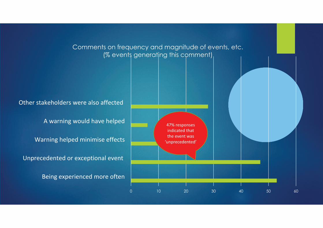
#�%%�����������:����&�����%�2����������������5����;�
�*��������2��������2��������%%���"
� � �� � .� �� !�
�!%�5�!*-!�%!�&!$�+��!��(�!�
��-�!&!$!��!$����!*&!-�%���'�!7!��
����%�5��!'-!$�+%�%+%�!�!((!&��
��,���%�5�,��'$���7!��!'-!$
���!����� !��'$!���,!�!��'����((!&�!$
#�%%�����������:����&�����%�2����������������5����;�
�*��������2��������2��������%%���"
@6L��!�-���!��
%�$%&��!$������
��!�!7!���,���
=��-�!&!$!��!$>

� � �� � .� �� !�
�!%�5�!*-!�%!�&!$�+��!��(�!�
��-�!&!$!��!$����!*&!-�%���'�!7!��
����%�5��!'-!$�+%�%+%�!�!((!&��
��,���%�5�,��'$���7!��!'-!$
���!����� !��'$!���,!�!��'����((!&�!$
#�%%�����������:����&�����%�2����������������5����;�
�*��������2��������2��������%%���"
?2L��!�-���!��
�%5�'%5����������%��
�.-!��(�!7!���%��
)!%�5�!*-!�%!�&!$�
+��!�(�!C�!��'.�
@6L��!�-���!��
%�$%&��!$������
��!�!7!���,���
=��-�!&!$!��!$>
���%�5!�&.�-'��
����%�5��.��!+
�%� ����!��+!���
���-��&!$��!��
20L��!�-��$!����
��7!���
��������� %��
-'�&!����$!�'�,%���
!*��!+!�!7!����
���%�5!�&.�-'��
����%�5��.��!+
�%� ����!��+!���
���-��&!$��!��
20L��!�-��$!����
��7!���
��������� %��
-'�&!����$!�'�,%���
!*��!+!�!7!����
��'.�?�
�!�-��$!���������(�
26���7!��''����!!�
-��&!$��!��%��
-'�&!
���%�5!�&.�-'��
����%�5��.��!+
�%� ����!��+!���
���-��&!$��!��
�� !���+!�+!���5!��M
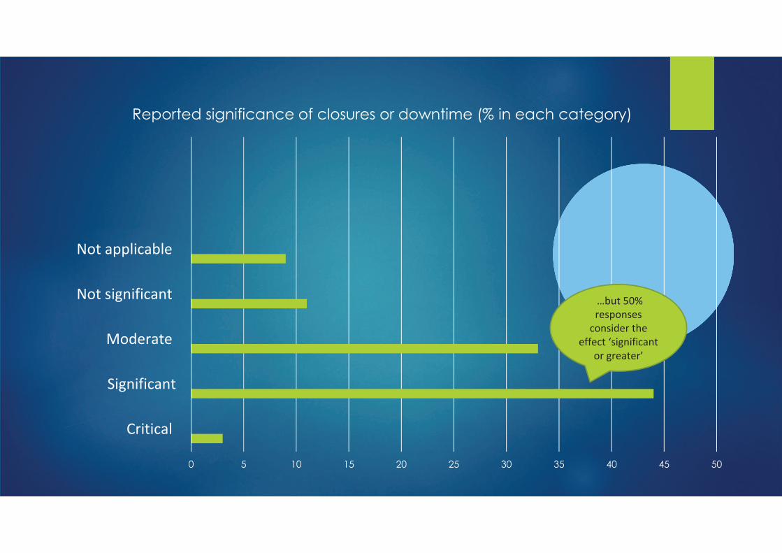
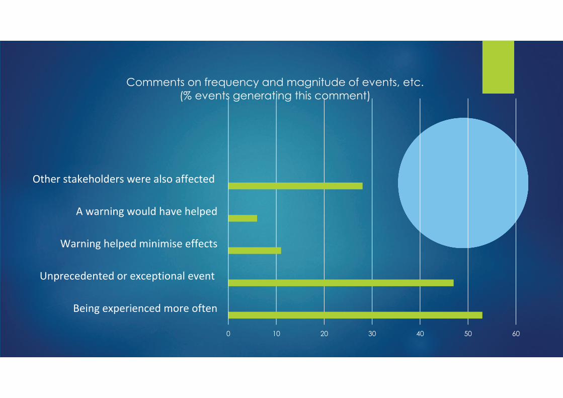
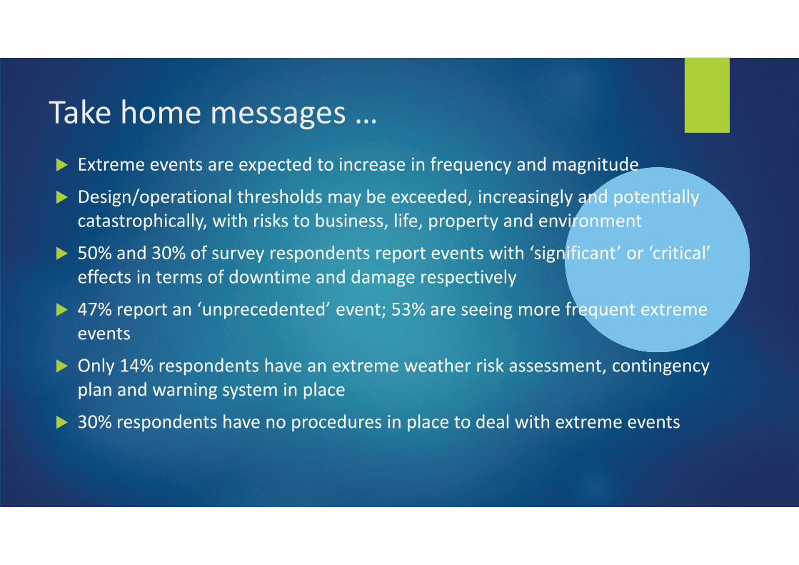
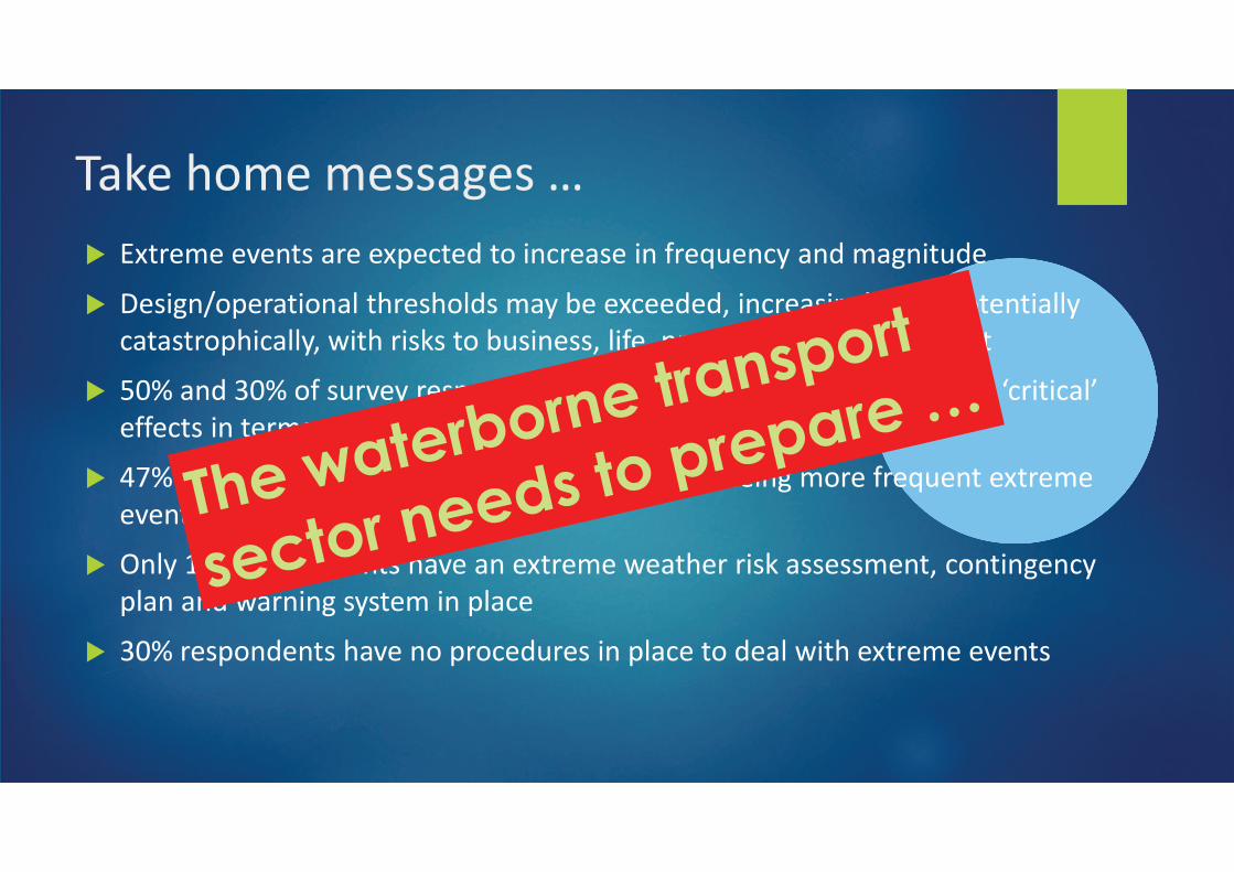
� �*��!+!�!7!������!�!*-!&�!$����%�&�!��!�%��(�!C�!�&.���$�+�5�%��$!
� �!�%5�A�-!���%���'����!���'$��+�.�)!�!*&!!$!$"�%�&�!��%�5'.���$�-��!��%�''.�
&�������-�%&�''."�,%����%� �����)��%�!��"�'%(!"�-��-!��.���$�!�7%���+!��
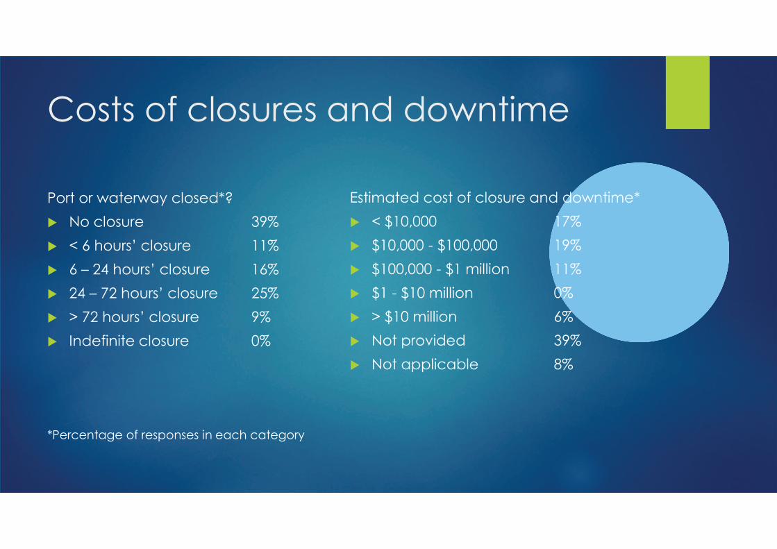
� ?0L���$�20L��(����7!.��!�-��$!�����!-����!7!����,%���=�%5�%(%&���>����=&�%�%&�'>�
!((!&���%���!�+���(�$�,��%+!���$�$�+�5!��!�-!&�%7!'.�
� @6L��!-�������=��-�!&!$!��!$>�!7!��4�?2L���!��!!%�5�+��!�(�!C�!���!*��!+!�
!7!���
� ��'.�1@L��!�-��$!������7!����!*��!+!�,!���!���%� ����!��+!��"�&���%�5!�&.�
-'�����$�,���%�5��.��!+�%��-'�&!
� 20L��!�-��$!������7!����-��&!$��!��%��-'�&!����$!�'�,%���!*��!+!�!7!����
�� !���+!�+!���5!��M
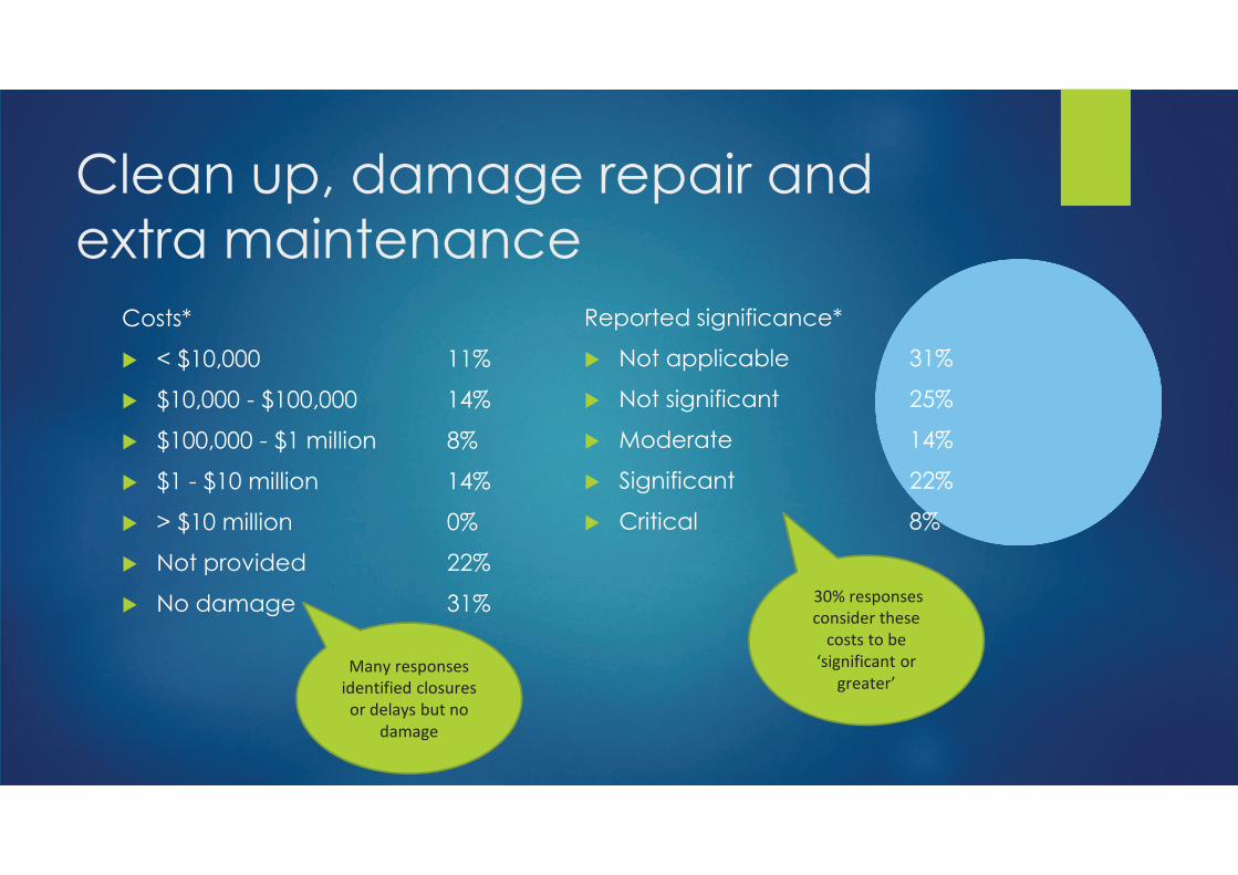
� �*��!+!�!7!������!�!*-!&�!$����%�&�!��!�%��(�!C�!�&.���$�+�5�%��$!
� �!�%5�A�-!���%���'����!���'$��+�.�)!�!*&!!$!$"�%�&�!��%�5'.���$�-��!��%�''.�
&�������-�%&�''."�,%����%� �����)��%�!��"�'%(!"�-��-!��.���$�!�7%���+!��
� ?0L���$�20L��(����7!.��!�-��$!�����!-����!7!����,%���=�%5�%(%&���>����=&�%�%&�'>�
!((!&���%���!�+���(�$�,��%+!���$�$�+�5!��!�-!&�%7!'.�
� @6L��!-�������=��-�!&!$!��!$>�!7!��4�?2L���!��!!%�5�+��!�(�!C�!���!*��!+!�
!7!���
� ��'.�1@L��!�-��$!������7!����!*��!+!�,!���!���%� ����!��+!��"�&���%�5!�&.�
-'�����$�,���%�5��.��!+�%��-'�&!
� 20L��!�-��$!������7!����-��&!$��!��%��-'�&!����$!�'�,%���!*��!+!�!7!����

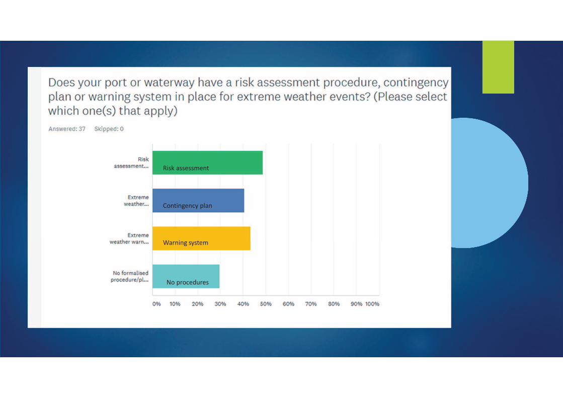
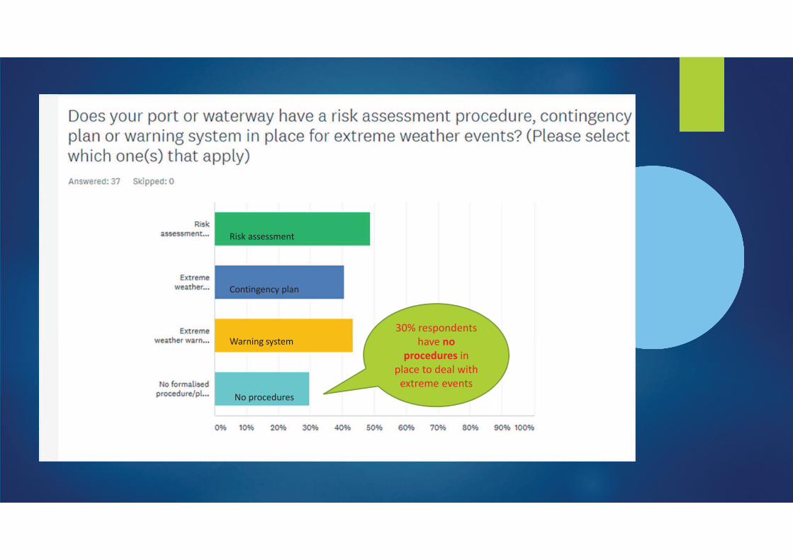
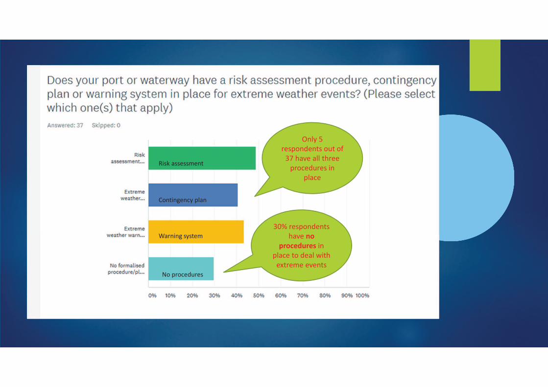
#'!��!��!'-����)���$!����!����7!.�)��!����
%�&'�$!�+��!�%�'��$�-�������$�,��!�,�.�M
���
���-��AA,,,B���7!.+�� !.B&�+A�A�� �*��!+!�!���!��7!���
�����5'!�=���7!.+�� !. �� �!*��!+!�,!���!��!7!���>
�!�'�� �(��,��$�����!&!%7%�5�.�����!�-���!�"�,�%&��,%''��!+�%��&��(%$!��%�'�

���� ��(���'%��!�%�5N
����������������
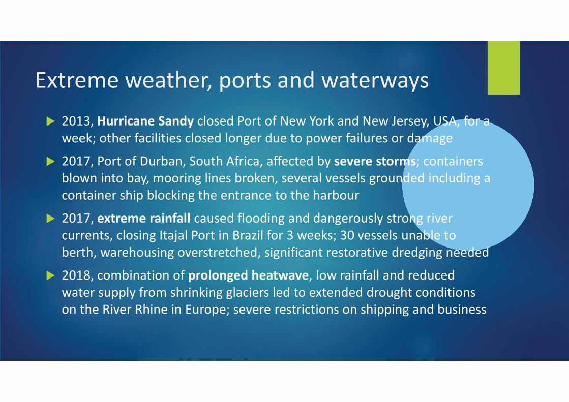
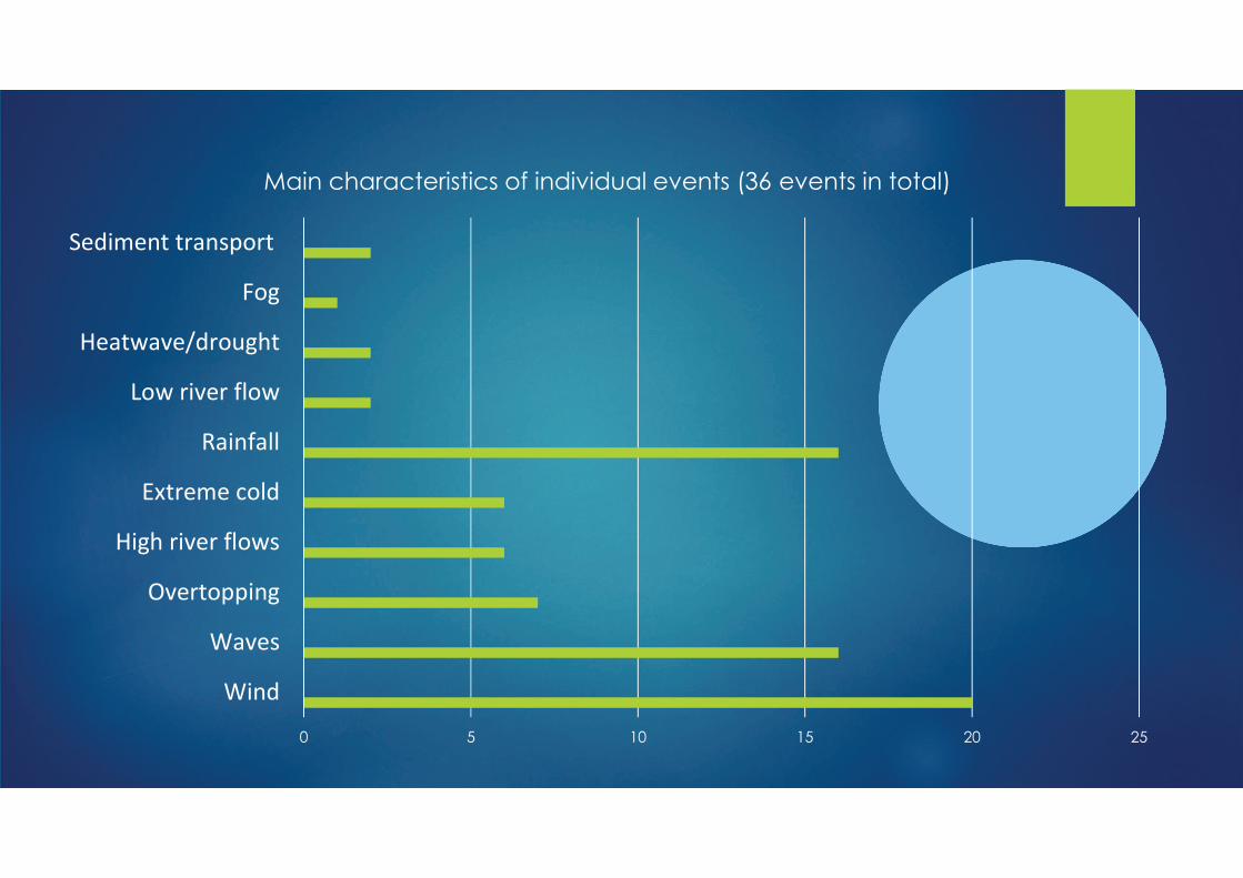
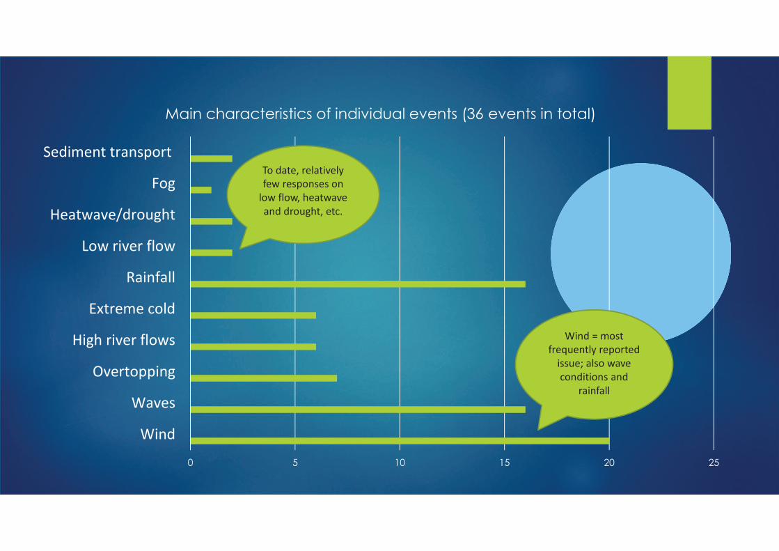
Accommodating climate change
uncertainties in option selection, design
and investment for resilient waterborne
transport infrastructure, up to and beyond
2050
Authors :
Laure Herbert, Jan Brooke, Monica A. Altaminaro
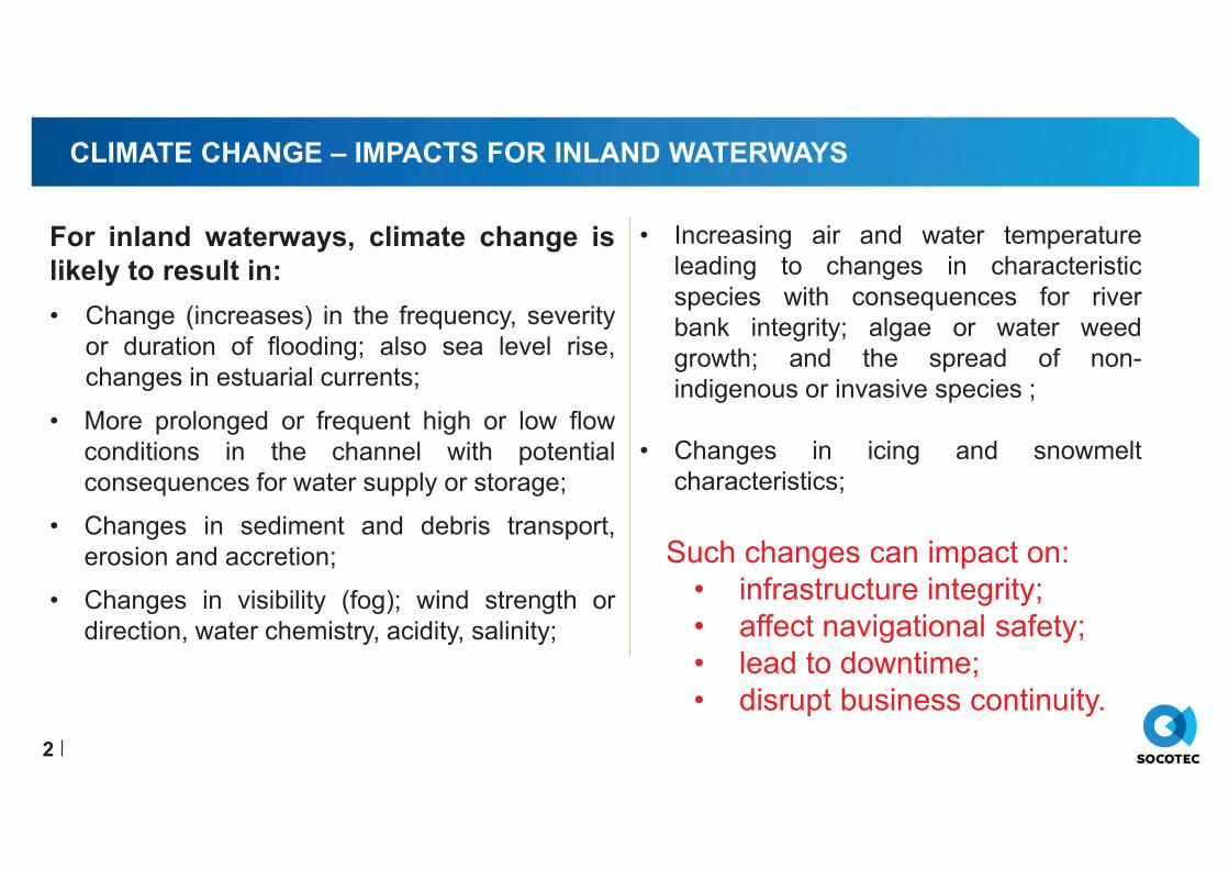
CLIMATE CHANGE – IMPACTS FOR INLAND WATERWAYS
2
For inland waterways, climate change is
likely to result in:
• Change (increases) in the frequency, severity
or duration of flooding; also sea level rise,
changes in estuarial currents;
• More prolonged or frequent high or low flow
conditions in the channel with potential
consequences for water supply or storage;
• Changes in sediment and debris transport,
erosion and accretion;
• Changes in visibility (fog); wind strength or
direction, water chemistry, acidity, salinity;
• Increasing air and water temperature
leading to changes in characteristic
species with consequences for river
bank integrity; algae or water weed
growth; and the spread of non-
indigenous or invasive species ;
• Changes in icing and snowmelt
characteristics;
Such changes can impact on:
• infrastructure integrity;
• affect navigational safety;
• lead to downtime;
• disrupt business continuity.
CLIMATE CHANGE UNCERTAINTIES – WHY AND WHAT IS THE IMPACT?
3
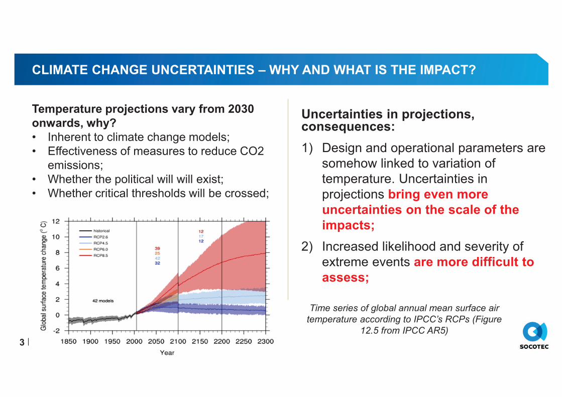
Time series of global annual mean surface air
temperature according to IPCC’s RCPs (Figure
12.5 from IPCC AR5)
Temperature projections vary from 2030
onwards, why?
• Inherent to climate change models;
• Effectiveness of measures to reduce CO2
emissions;
• Whether the political will will exist;
• Whether critical thresholds will be crossed;
Uncertainties in projections, consequences:
1) Design and operational parameters are
somehow linked to variation of
temperature. Uncertainties in
projections bring even more
uncertainties on the scale of the
impacts;
2) Increased likelihood and severity of
extreme events are more difficult to
assess;
CLIMATE CHANGE UNCERTAINTIES – WHAT DOES IT MEAN?
Return period : what will a 1:100 year event
look like in 30 years time?
Þ What is the impact into design/resilience
of infrastructure
Þ What/when is the impact in adaptation
needs?
Return period : what will a monthly event look
like in 30 years time?
Þ What is the impact in operations?
Þ What/when is the impact in adaptation
needs?
4
What if the ‘unthinkable’ happens: what would the consequences be?
How long before the benefits of adaptation measures are realised?
Þ Introduce uncertainties into
infrastructure design, adaptation
and investment decision making,
Þ Need to be able to accommodate
these uncertainties;
CLIMATE CHANGE UNCERTAINTIES – ACCOMMODATE THESE UNCERTAINTIES
Understand the vulnerability of the asset
/operations to a range of Climate Scenarios
To deal with uncertainties, take into account :
• A range of scenarios : from most likely to
worst case scenarios.
• The likelihood of more frequent/severe
extreme events.
Understand critical thresholds : how the
projected changes could affect the critical
infrastructure?
• Define acceptable risk;
• Understand existing/future adaptive
capacity adequate;
• Seek flexible adaptation measures;
• Understand the cost and
consequences of inactions;
How : Vulnerability Assessment –
PIANC WG 178 guidance comprises a
four stages framework
5
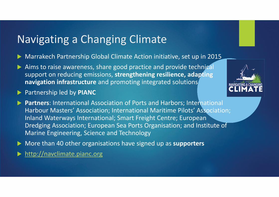
CLIMATE CHANGE UNCERTAINTIES – ADAPTATION PATHWAY
6
Þ Prepare an adaptation pathway
• Seek flexible and adaptive solutions;
• Likely to be phased;
• Operations require greater level of
contingency or redundancy;
• Resilient infrastructure with adequate
adaptation capacity and flexibility;
• Infrastructure and operations should be
designed to « fail gracefuly » rather than
catastrophically;
Adaptive management is an important
concept in effective climate change
adaptation.
To reduce the risk of maladaptation.
ie: implementing a measure that proves
inadequate or excessive. Do not want to
lock in to a single climate change
scenario
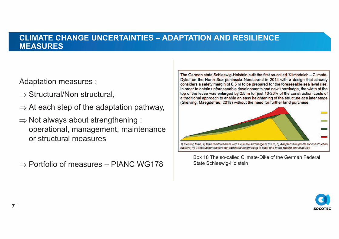
CLIMATE CHANGE UNCERTAINTIES – ADAPTATION AND RESILIENCEMEASURES
Adaptation measures :
Þ Structural/Non structural,
Þ At each step of the adaptation pathway,
Þ Not always about strengthening :
operational, management, maintenance
or structural measures
Þ Portfolio of measures – PIANC WG178
7
Box 18 The so-called Climate-Dike of the German Federal
State Schleswig-Holstein
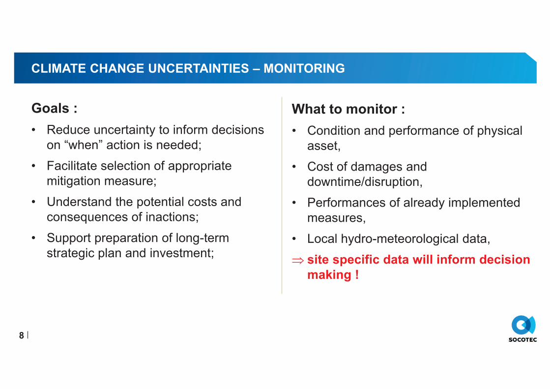
CLIMATE CHANGE UNCERTAINTIES – MONITORING
Goals :
• Reduce uncertainty to inform decisions
on “when” action is needed;
• Facilitate selection of appropriate
mitigation measure;
• Understand the potential costs and
consequences of inactions;
• Support preparation of long-term
strategic plan and investment;
8
What to monitor :
• Condition and performance of physical
asset,
• Cost of damages and
downtime/disruption,
• Performances of already implemented
measures,
• Local hydro-meteorological data,
Þ site specific data will inform decision
making !
CLIMATE CHANGE UNCERTAINTIES – UNCERTAINTY AND INVESTMENT
Uncertainty related considerations :
• Cost of inaction to be understood
• Monitoring outcomes to help decisions
about “when” to invest => acceptable
risk thresholds to be defined
• Use of discount rate potentially increase
the risk of maladaptation
• Conventional cost-benefit assessment
or net present value calculations may
not adequately reflect the complexity of
climate change
• Multi criteria, decision tree analysis can
help avoid maladaptation
9
CLIMATE CHANGE UNCERTAINTIES – TAKE HOME MESSAGE
• Understand your asset and
operations;
• Assess the vulnerability for a range
of scenarios;
• Use sensitivity analysis;
• Seek flexible and adaptive solutions;
• Explore less conventional
assessment and evaluation
methods;
• Understand the costs and
consequences of inaction;
• Prepare adaptation pathway plan;
• Avoid maladaptation;
• Monitor and adapt;
• Expect the unexpected!
10
������ ������ ��������� ��� ����� ����������������� ������
��������
������ �� ���� �!"����#���$!��%
��&�'�(��)���*++��),*'
)-���,.����*+�),*'�/ +0*'
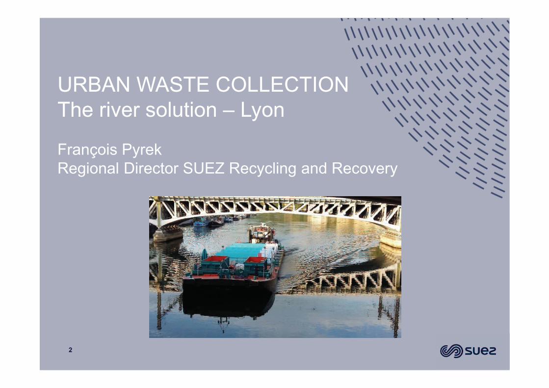
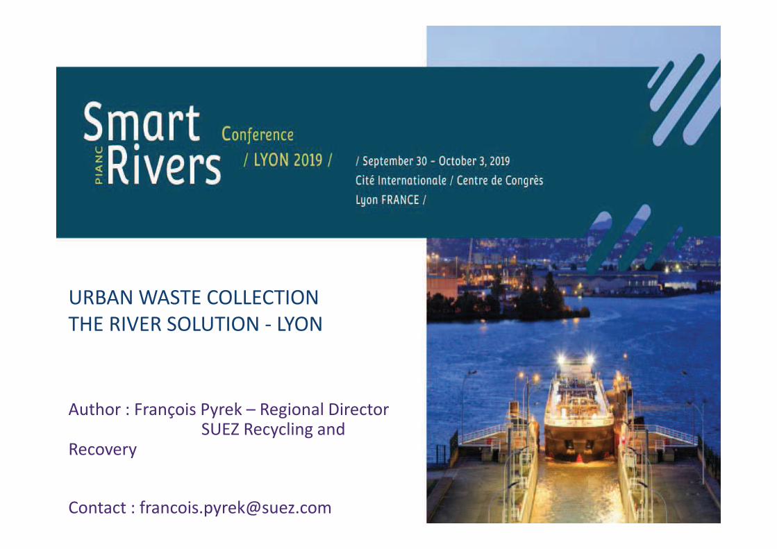
URBAN WASTE COLLECTION
The river solution – Lyon
2
François Pyrek
Regional Director SUEZ Recycling and Recovery
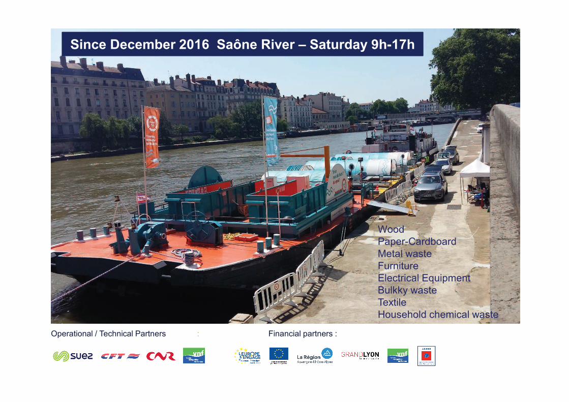
Wood
Paper-Cardboard
Metal waste
Furniture
Electrical Equipment
Bulkky waste
Textile
Household chemical waste
Since December 2016 Saône River – Saturday 9h-17h
Operational / Technical Partners : Financial partners :
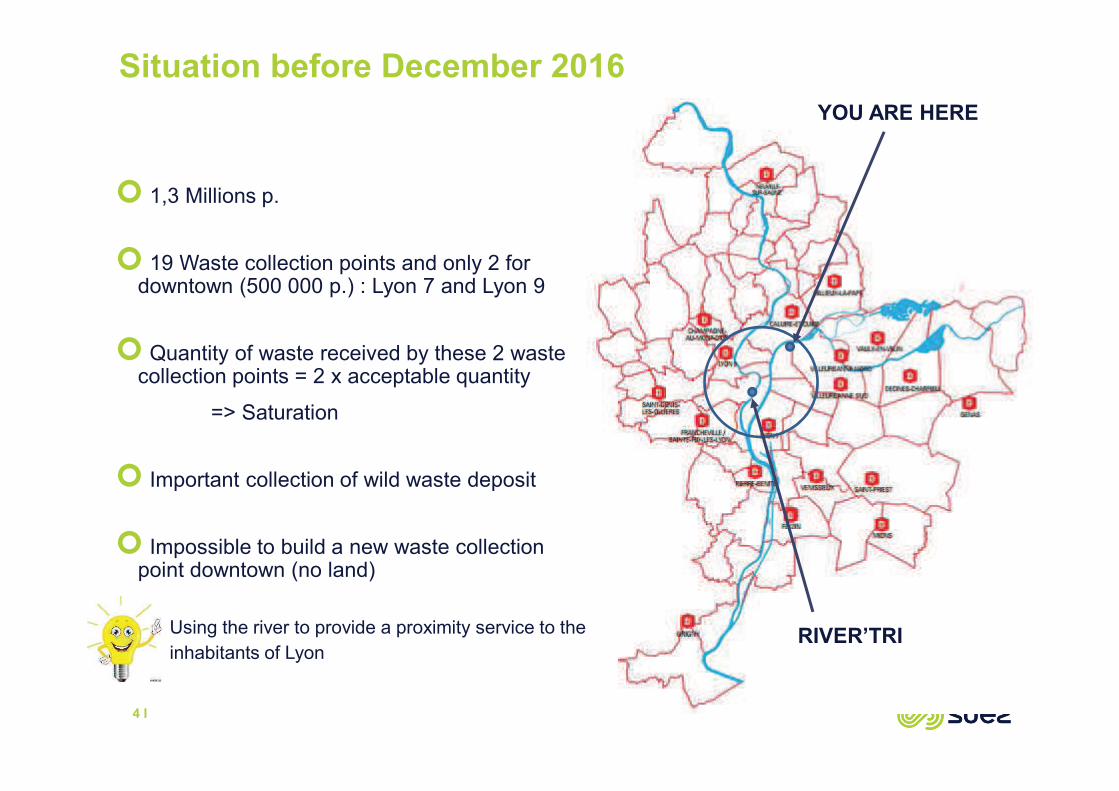
Situation before December 2016
4 I
Using the river to provide a proximity service to the
inhabitants of Lyon
� 1,3 Millions p.
� 19 Waste collection points and only 2 for downtown (500 000 p.) : Lyon 7 and Lyon 9
� Quantity of waste received by these 2 waste collection points = 2 x acceptable quantity
=> Saturation
� Important collection of wild waste deposit
� Impossible to build a new waste collection point downtown (no land)
YOU ARE HERE
RIVER’TRI
Building the partnership : a key success factor
5 I
� 4 technical partners committed in the Project :
o SUEZ : Leader of the consortium ; Waste recycling and recovery operator
o CFT : River transportation operator
o CNR : France leading producer of 100% renewable electricity
o VNF : the french navigation authority responsible for the management of the majority of
France inland waterways
� 5 financial partnerships the Project (Budget = 2,4 M€ over 2 years experimentation) :
o European Union
o ADEME
o VNF
o Auvergne-Rhône-Alpes region
o Métropole de Lyon
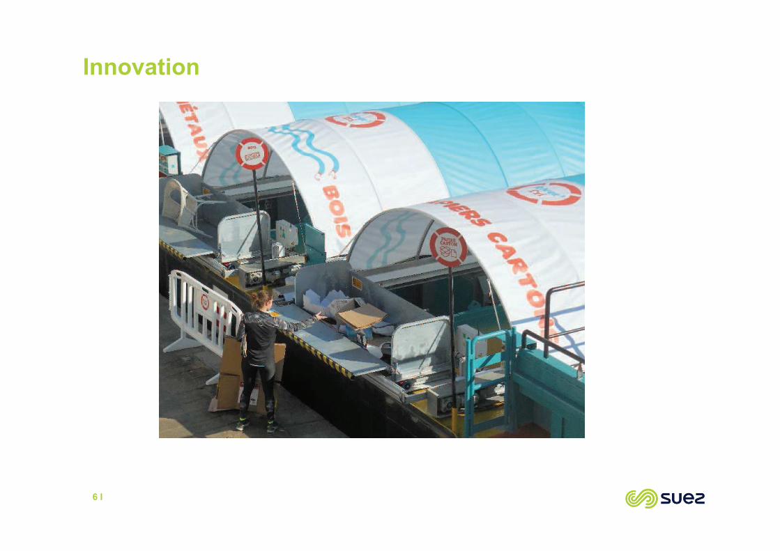
Innovation
6 I
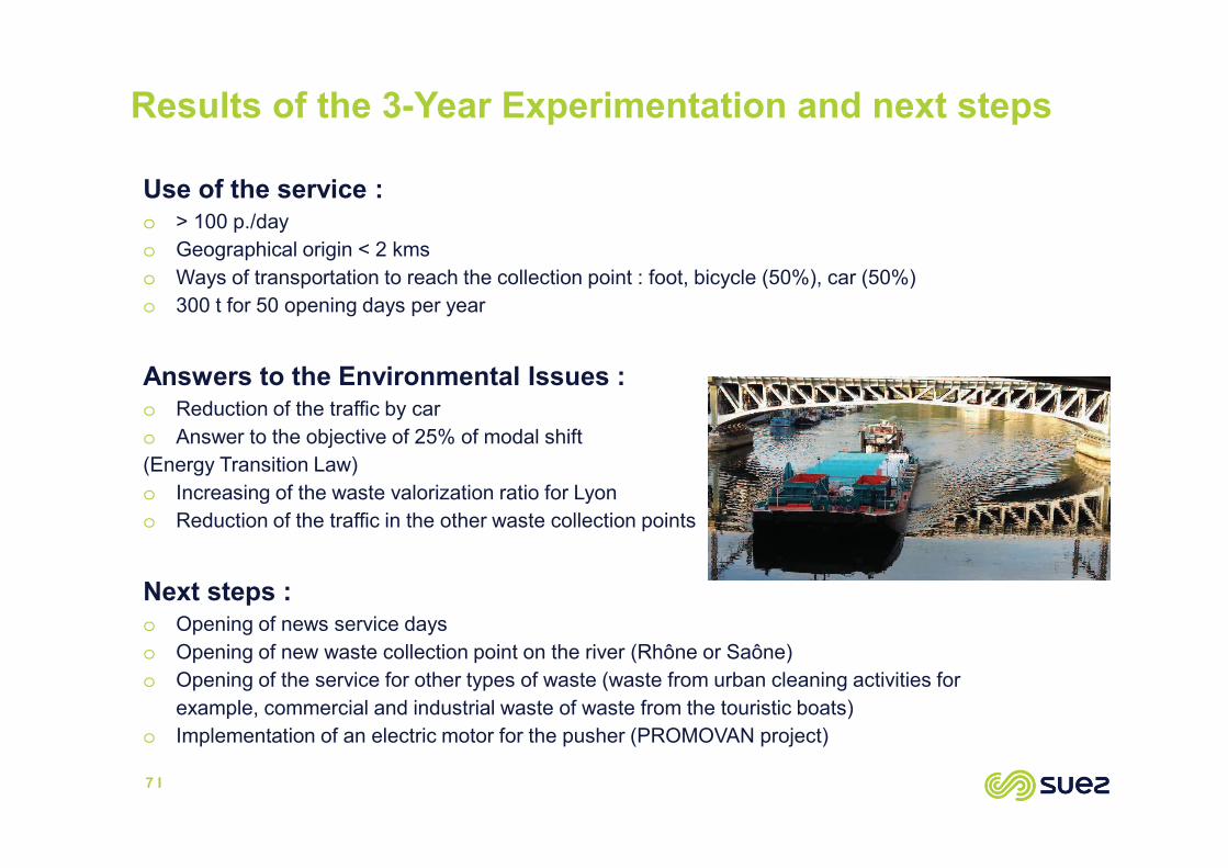
Results of the 3-Year Experimentation and next steps
7 I
Use of the service :o > 100 p./day
o Geographical origin < 2 kms
o Ways of transportation to reach the collection point : foot, bicycle (50%), car (50%)
o 300 t for 50 opening days per year
Answers to the Environmental Issues :o Reduction of the traffic by car
o Answer to the objective of 25% of modal shift
(Energy Transition Law)
o Increasing of the waste valorization ratio for Lyon
o Reduction of the traffic in the other waste collection points
Next steps :o Opening of news service days
o Opening of new waste collection point on the river (Rhône or Saône)
o Opening of the service for other types of waste (waste from urban cleaning activities for
example, commercial and industrial waste of waste from the touristic boats)
o Implementation of an electric motor for the pusher (PROMOVAN project)
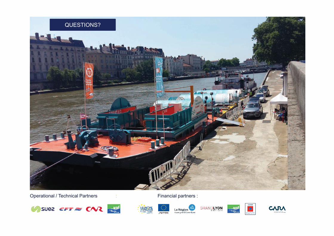
QUESTIONS?
Operational / Technical Partners : Financial partners :

������������� ���������
���������������������
�������
������������� ���� ��!" �������
��!�����#�
$���%� ���������� ���&����! !'��
����������������� ������������ �

��%%!�(
����!�)������*�#� +!## �"��!��� ! ���#�'
�����""���� ''!""��(�!)��(#+���*���� #������)�%���
� �"�#�� ! �%!� ��**���"���# ���� ' �� #�������
,
���&���"��!���
-
!%*!����( �*�!�)������
����!�)������*�#�+!##�"��!��� ! ���#�'
����!�)������ *�#�+!##�"��!��� ! ���#�'

����!�)������*�#�+!##�"��!��� ! ���#�'
.
����!�)������ *�#�+!##�#!��%+"�/�� #�������
�� #�#�� '�*#�)��!"�"�%� �!�(�� #������� #
����!�)������*�#�+!##�"��!��� ! ���#�'
0
�+��!�� '+�� ��+"��*���
*�#�+!##��+! ���1
����!�)������*�#�+!##�"��!��� ! ���#�'
2
���� ��! ���*���*�#�+!##�#%!��3(!
#� '�"!��� #������� 1�����#�!""��
��""���� ''!""��(4
���##���������#"��!���������"(� *�� ��*
����/�#�� '�!%5!�����/���*���
�"������!"'���+#4
���##�++�����3(����� �����#��������
!3�)�����"������!"'���+#4
���*'���+#
�����""���� ''!""��(�!)��(#+���*���� #������)�%���
��)� ��#"��!��� ! ���#�/+�#���5����� #������� �*���%!� �"�%� �#�*���
+��&�����6�����#+���!"���� �6��#��%3� � '3���#+���!"�7��%!�� �! �
#�3%!�� �1��8#4
� !������ 5���#�� #������� �!���3��� �����������/�#�� '1������
3�� '� '!������ !"#�"����!��� #4
� #+����3(+���!#��� �����%�����#5�����%+! (9�����#�����)�"�+!
� �)!��)�#�"���� 5� ��'�!�� '!""����� #��!� �#�*���+��&���5 !%�"(�
� � )��� %� �!"�� #��!� �#
� �+��!�� '�� #��!� �#�*����(����"������+"! �4
� �������(�� #��!� �#
:
�����""���� ''!""��(�!)��(#+���*���� #������)�%���
�����%+! (+��+�#����%� �%�7�����%+!���*����� #������� � ��� !���!"
� )��� %� �3("�%��� '#�3�!6�!���1��8#! �3��"�� '���'!""��(#��"�����*��%
!*"�!�� '��**���!%� !��(���8� ���� ��#���!"#����*��������5� ���"�*�
3! 8�*������ �4
;

�����""���� ''!""��(�!)��(#+���*���� #������)�%���
<
+"! #�*��**���!%#��6�����*�����
�� #������� �*����� �����#��������
� #�������
�*��**���!%#
�
��������
#���
=>
�����""���� ''!""��(�!)��(#+���*���� #������)�%���

�����""���� ''!""��(�!)��(#+���*���� #������)�%���
==
�/���*���*"�!�� '��**���!%#
*��%�����(���8�*���
��������#���
�����""���� ''!""��(�!)��(#+���*���� #������)�%���
=,
*"�!�� '��**���!%#+!��3��1�� �����������#���! �
����!�)�������!%�%�����! =>>8%! �."��8#4
�����""���� ''!""��(�!)��(#+���*���� #������)�%���
=-
��#���� � ' ! �'��� �� '��� �%3��,
��**���!%

�����""���� ''!""��(�!)��(#+���*���� #������)�%���
=.
��#���� � '
! �
'��� �� '
��� �%3��
=��**���!%
�����""���� ''!""��(�!)��(#+���*���� #������)�%���
=0
��� *������� �����#���������*
�����""���� ''!""��(!*���#����
+�"�����**

� �"�#�� #�
�!� ��**���"���#�
&� ���� 3��1�� ���3�����**���!%#�
=2
���#&� ���� ��6����#��**���"���)��
1��8#3�*���+�%+� '������ 1!���
� #�����**���!%#

����������������������������
=:
������������� ���������
���������������������
�������
������������� ���� ��!" �������
��!�����#�
$���%� ���������� ���&����! !'��
����������������� ������������ �
��%%!�(
����!�)������*�#� +!## �"��!��� ! ���#�'
�����""���� ''!""��(�!)��(#+���*���� #������)�%���
� �"�#�� ! �%!� ��**���"���# ���� ' �� #�������
,

���&���"��!���
-
!%*!����( �*�!�)������
����!�)������*�#�+!##�"��!��� ! ���#�'
����!�)������ *�#�+!##�"��!��� ! ���#�'
����!�)������*�#�+!##�"��!��� ! ���#�'
.
����!�)������ *�#�+!##�#!��%+"�/�� #�������
�� #�#�� '�*#�)��!"�"�%� �!�(�� #������� #

����!�)������*�#�+!##�"��!��� ! ���#�'
0
�+��!�� '+�� ��+"��*���
*�#�+!##��+! ���1

����!�)������*�#�+!##�"��!��� ! ���#�'
2
���� ��! ���*���*�#�+!##�#%!��3(!
#� '�"!��� #������� 1�����#�!""��
��""���� ''!""��(4
���##���������#"��!���������"(� *�� ��*
����/�#�� '�!%5!�����/���*���
�"������!"'���+#4
���##�++�����3(����� �����#��������
!3�)�����"������!"'���+#4
���*'���+#

�����""���� ''!""��(�!)��(#+���*���� #������)�%���
��)� ��#"��!��� ! ���#�/+�#���5����� #������� �*���%!� �"�%� �#�*���
+��&�����6�����#+���!"���� �6��#��%3� � '3���#+���!"�7��%!�� �! �
#�3%!�� �1��8#4
� !������ 5���#�� #������� �!���3��� �����������/�#�� '1������
3�� '� '!������ !"#�"����!��� #4
� #+����3(+���!#��� �����%�����#5�����%+! (9�����#�����)�"�+!
� �)!��)�#�"���� 5� ��'�!�� '!""����� #��!� �#�*���+��&���5 !%�"(�
� � )��� %� �!"�� #��!� �#
� �+��!�� '�� #��!� �#�*����(����"������+"! �4
� �������(�� #��!� �#
:

�����""���� ''!""��(�!)��(#+���*���� #������)�%���
�����%+! (+��+�#����%� �%�7�����%+!���*����� #������� � ��� !���!"
� )��� %� �3("�%��� '#�3�!6�!���1��8#! �3��"�� '���'!""��(#��"�����*��%
!*"�!�� '��**���!%� !��(���8� ���� ��#���!"#����*��������5� ���"�*�
3! 8�*������ �4
;
�����""���� ''!""��(�!)��(#+���*���� #������)�%���
<
+"! #�*��**���!%#��6�����*�����
�� #������� �*����� �����#��������

� #�������
�*��**���!%#
�
��������
#���
=>
�����""���� ''!""��(�!)��(#+���*���� #������)�%���
�����""���� ''!""��(�!)��(#+���*���� #������)�%���
==
�/���*���*"�!�� '��**���!%#
*��%�����(���8�*���
��������#���

�����""���� ''!""��(�!)��(#+���*���� #������)�%���
=,
*"�!�� '��**���!%#+!��3��1�� �����������#���! �
����!�)�������!%�%�����! =>>8%! �."��8#4

�����""���� ''!""��(�!)��(#+���*���� #������)�%���
=-
��#���� � ' ! �'��� �� '��� �%3��,
��**���!%
�����""���� ''!""��(�!)��(#+���*���� #������)�%���
=.
��#���� � '
! �
'��� �� '
��� �%3��
=��**���!%

�����""���� ''!""��(�!)��(#+���*���� #������)�%���
=0
��� *������� �����#���������*
�����""���� ''!""��(!*���#����
+�"�����**
� �"�#�� #�
�!� ��**���"���#�
&� ���� 3��1�� ���3�����**���!%#�
=2
���#&� ���� ��6����#��**���"���)��
1��8#3�*���+�%+� '������ 1!���
� #�����**���!%#

����������������������������
=:
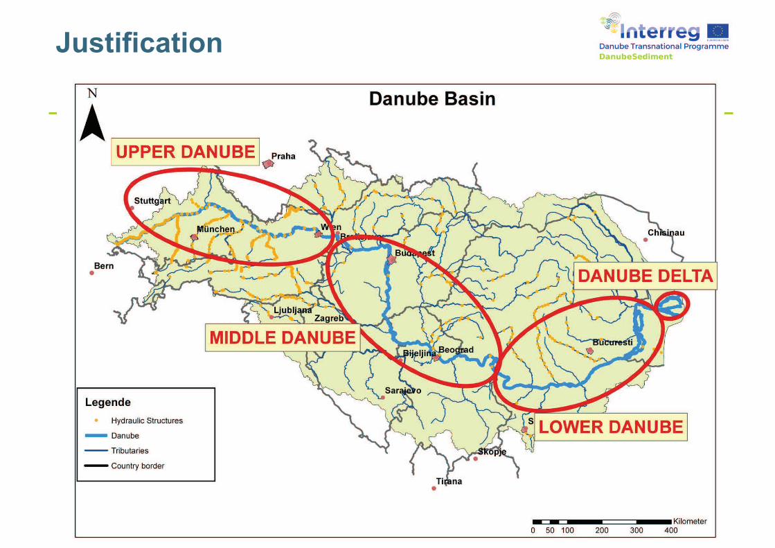
Justification
2
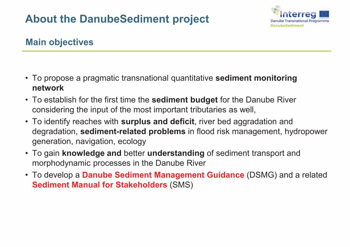
Main objectives
• To propose a pragmatic transnational quantitative sediment monitoring
network
• To establish for the first time the sediment budget for the Danube River
considering the input of the most important tributaries as well,
• To identify reaches with surplus and deficit, river bed aggradation and
degradation, sediment-related problems in flood risk management, hydropower
generation, navigation, ecology
• To gain knowledge and better understanding of sediment transport and
morphodynamic processes in the Danube River
• To develop a Danube Sediment Management Guidance (DSMG) and a related
Sediment Manual for Stakeholders (SMS)
About the DanubeSediment project
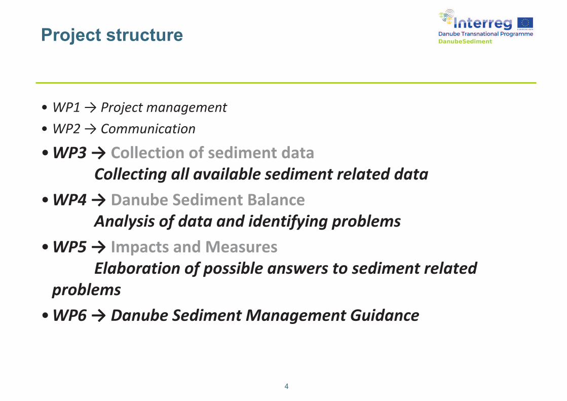
Project structure
4
• WP1 → Project management
• WP2 → Communication
• WP3 → Collection of sediment data
Collecting all available sediment related data
• WP4 → Danube Sediment Balance
Analysis of data and identifying problems
• WP5 → Impacts and Measures
Elaboration of possible answers to sediment related
problems
• WP6 → Danube Sediment Management Guidance
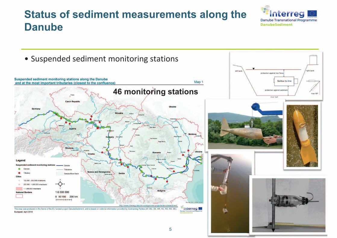
Status of sediment measurements along the
Danube
5
• Suspended sediment monitoring stations
46 monitoring stations
Duna-menti helyzetkép
6
Duna-menti helyzetkép
• Görgetett hordalékmérő állomások
7
The status of sediment monitoring and
recommendations for development
• Collection of different
sediment monitoring techniques
on the Danube
• Good practices
• Recommendations for the
good practices of sediment
monitoring techniques
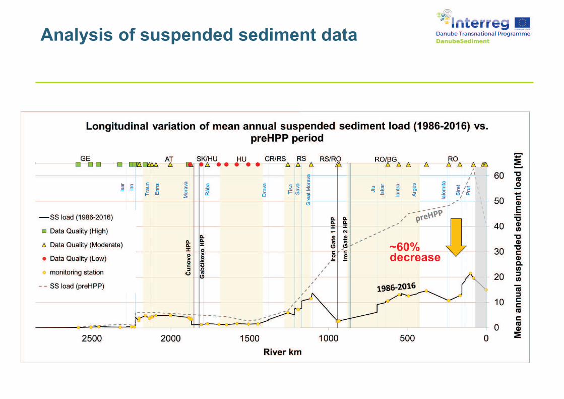
Analysis of suspended sediment data
~60% decrease
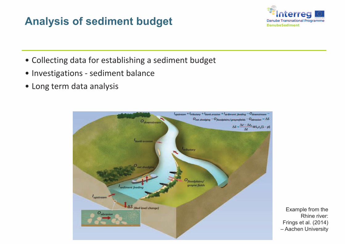
Analysis of sediment budget
• Collecting data for establishing a sediment budget
• Investigations - sediment balance
• Long term data analysis
Example from the
Rhine river:
Frings et al. (2014)
– Aachen University
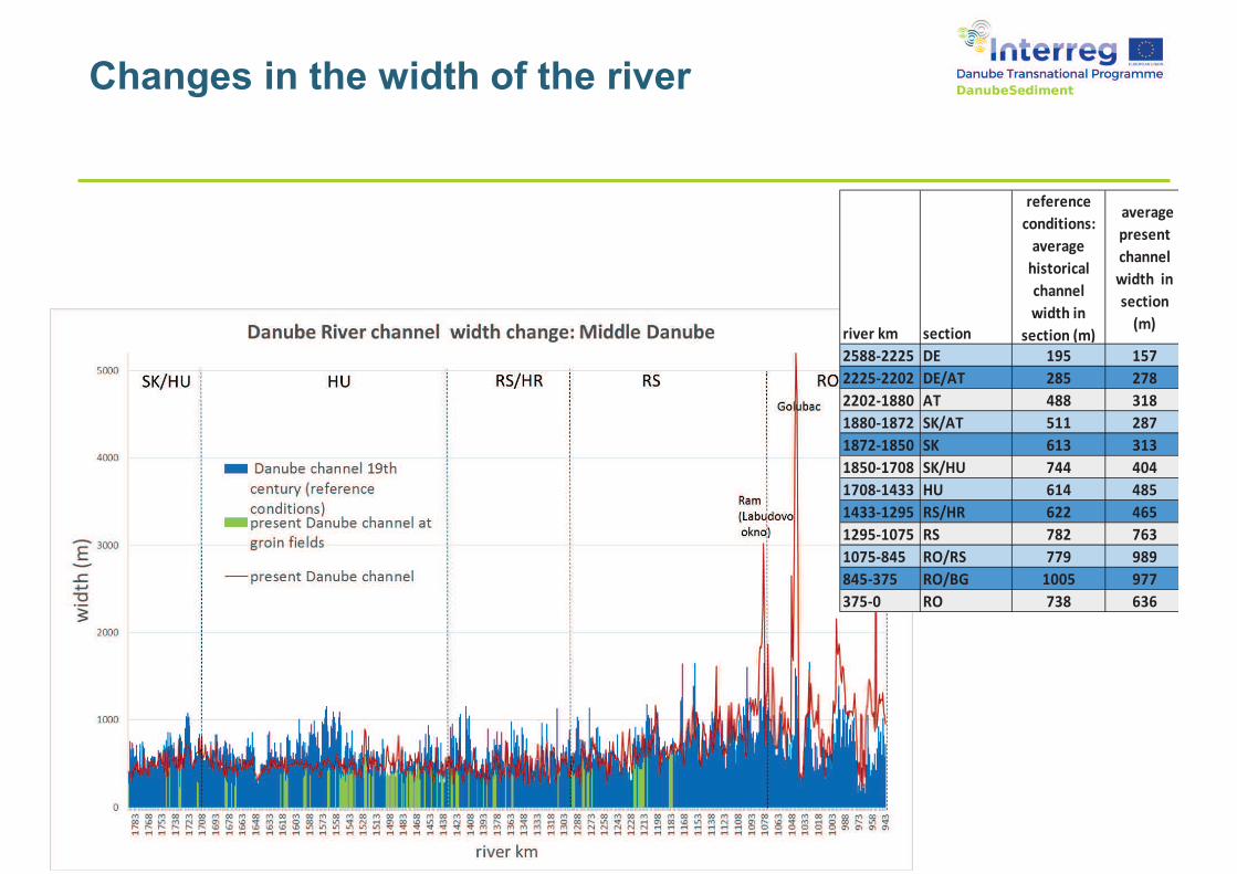
Changes in the width of the river
river km section
reference
conditions:
average
historical
channel
width in
section (m)
average
present
channel
width in
section
(m)
2588-2225 DE 195 157
2225-2202 DE/AT 285 278
2202-1880 AT 488 318
1880-1872 SK/AT 511 287
1872-1850 SK 613 313
1850-1708 SK/HU 744 404
1708-1433 HU 614 485
1433-1295 RS/HR 622 465
1295-1075 RS 782 763
1075-845 RO/RS 779 989
845-375 RO/BG 1005 977
375-0 RO 738 636
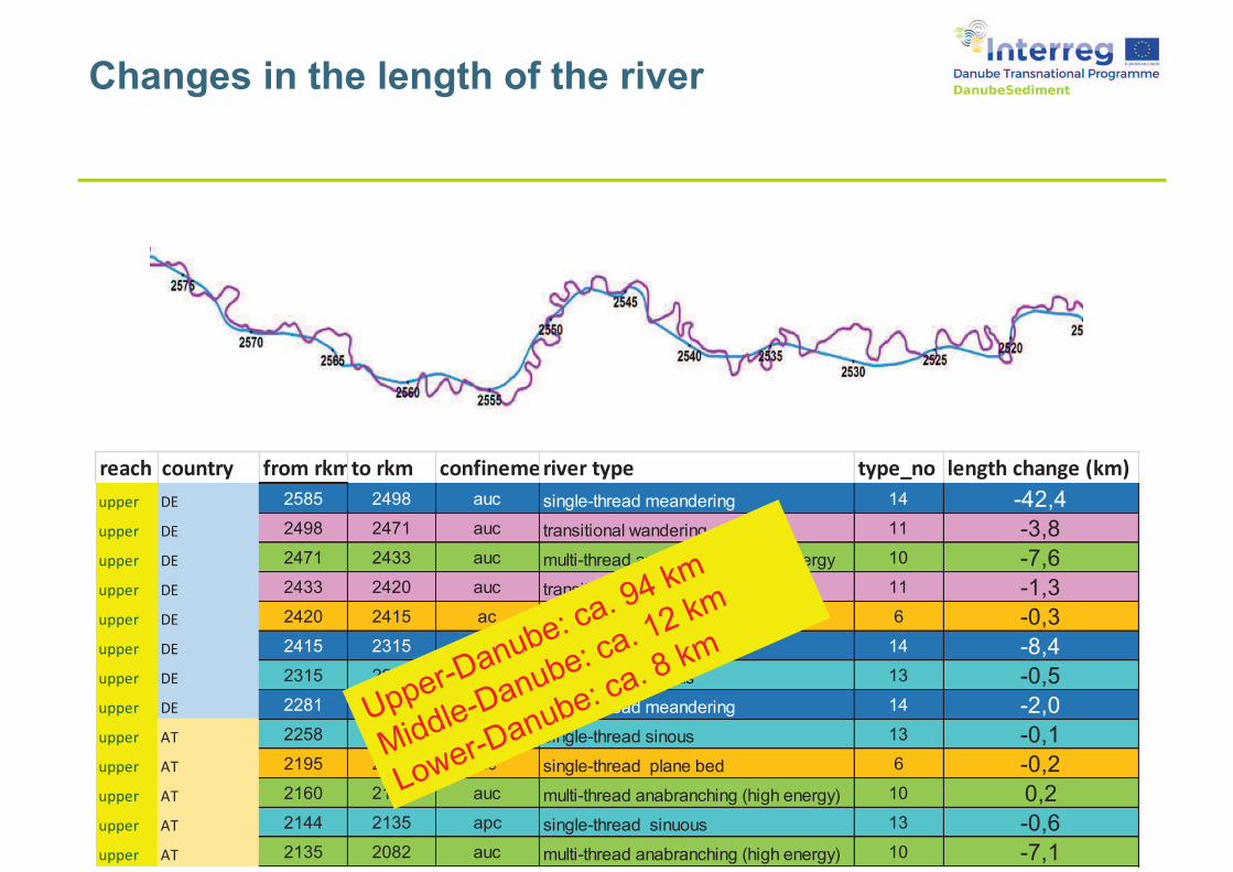
Changes in the length of the river
reach country from rkmto rkm confinementriver type type_no length change (km)
upper DE 2585 2498 auc single-thread meandering 14 -42,4
upper DE 2498 2471 auc transitional wandering 11 -3,8
upper DE 2471 2433 auc multi-thread anabranching (high energy 10 -7,6
upper DE 2433 2420 auc transitional wandering 11 -1,3
upper DE 2420 2415 ac single-thread plane bed 6 -0,3
upper DE 2415 2315 apc single-thread meandering 14 -8,4
upper DE 2315 2281 auc single-thread sinous 13 -0,5
upper DE 2281 2258 auc single-thread meandering 14 -2,0
upper AT 2258 2195 apc single-thread sinous 13 -0,1
upper AT 2195 2160 ac single-thread plane bed 6 -0,2
upper AT 2160 2144 auc multi-thread anabranching (high energy) 10 0,2
upper AT 2144 2135 apc single-thread sinuous 13 -0,6
upper AT 2135 2082 auc multi-thread anabranching (high energy) 10 -7,1
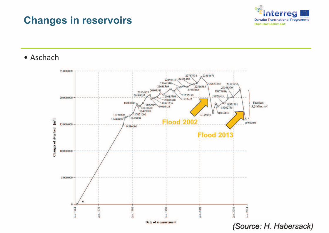
Changes in reservoirs
• Aschach
(((((Sourcecece: H. Habersack)
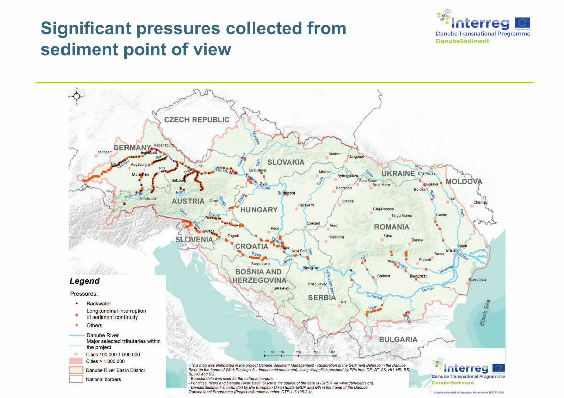
Significant pressures collected from
sediment point of view
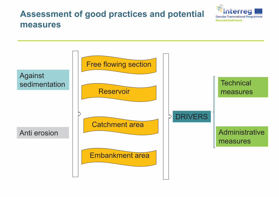
Against
sedimentation
Anti erosionCatchment area
Reservoir
Free flowing section
Embankment area
Technical
measures
Administrative
measures
DRIVERS
Assessment of good practices and potential
measures
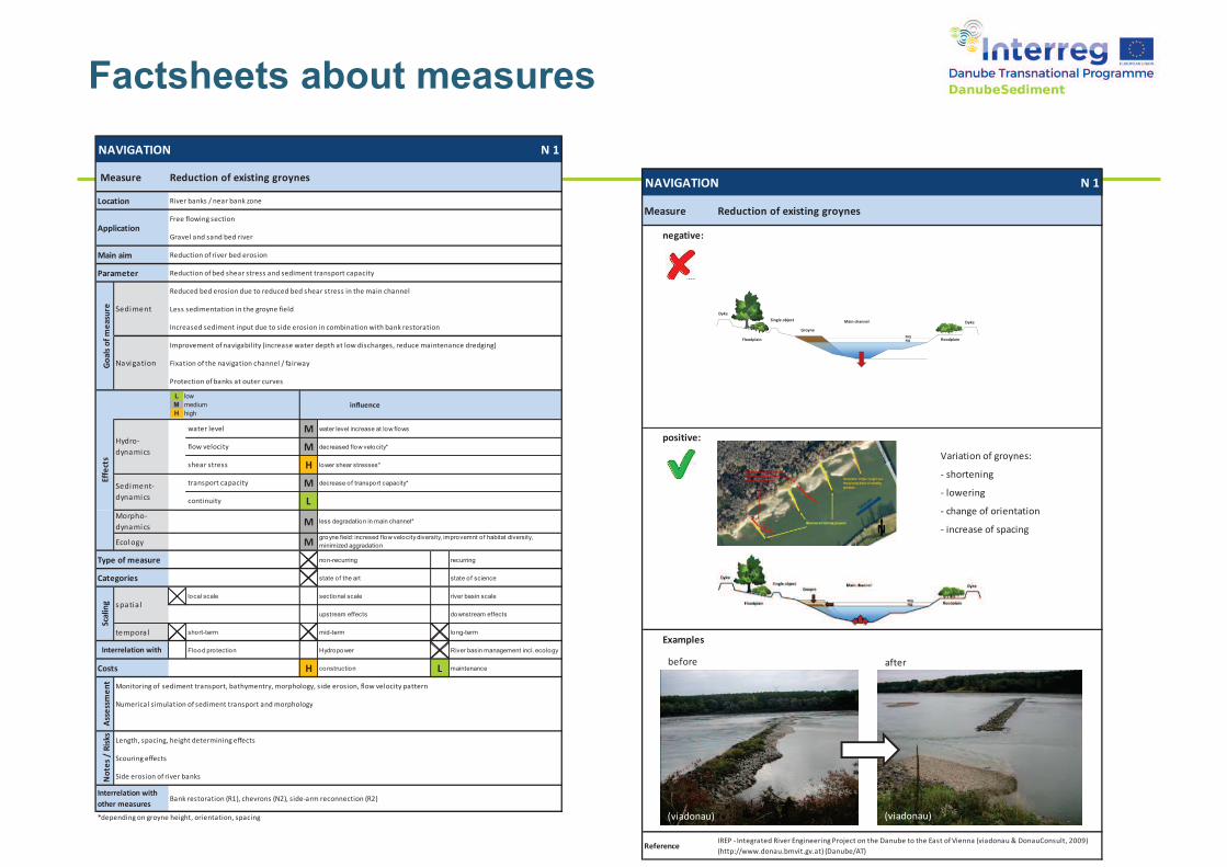
Factsheets about measures
NAVIGATION N 1
Location River banks / near bank zone
Free flowing section
Gravel and sand bed river
Main aim Reduction of river bed erosion
Reduction of bed shear stress and sediment transport capacity
water level M water level increase at low flows
flow velocity M decreased flow velocity*
shear stress H lower shear stresses*
transport capacity M decrease of transport capacity*
continuity L
Morpho-
dynamicsM less degradation in main channel*
Ecology M
Type of measure non-recurring recurring
state of the art state of science
local scale sectional scale river basin scale
upstream effects downstream effects
temporal short-term mid-term long-term
Flood protection Hydropower River basin management incl. eco logy
H construction L maintenance
Monitoring of sediment transport, bathymentry, morphology, side erosion, flow velocity pattern
Numerical simulation of sediment transport and morphology
Length, spacing, height determining effects
Scouring effects
Bank restoration (R1), chevrons (N2), side-arm reconnection (R2)
Sediment-
dynamics
Eff
ect
s
groyne field: incresed flow velocity diversity, improvemnt of habitat diversity,
minimized aggradation
Ass
ess
me
nt
No
tes
/ R
isk
s
Side erosion of river banks
Interrelation with
other measures
*depending on groyne height, orientation, spacing
Categories
Sca
lin
g spatia l
Interrelation with
Costs
Improvement of navigability (increase water depth at low discharges, reduce maintenance dredging)
Fixation of the navigation channel / fairway
Protection of banks at outer curves
influence
Hydro-
dynamics
Measure Reduction of existing groynes
Application
Parameter
Go
als
of
me
asu
re Sediment
Reduced bed erosion due to reduced bed shear stress in the main channel
Less sedimentation in the groyne field
Increased sediment input due to side erosion in combination with bank restoration
Navigation
L low
M medium
H high
NAVIGATION N 1
negative:
positive:
Variation of groynes:
- shortening
- lowering
- change of orientation
- increase of spacing
Examples
Measure Reduction of existing groynes
ReferenceIREP - Integrated River Engineering Project on the Danube to the East of Vienna (viadonau & DonauConsult, 2009)
(http://www.donau.bmvit.gv.at) (Danube/AT)
Groyne
Main channel Dyke
Dyke
Single object
Floodplain floodplainMQNQ
before after
(viadonau) (viadonau)

Danube Sediment Management Guidance
• Statement of problems and needs
• Suggestions for improved monitoring and data
management
• Sediment budget
• Practical measures
• Key question –
Significant Water Management Issue
• Recommendations
Sediment Manual for Stakeholders
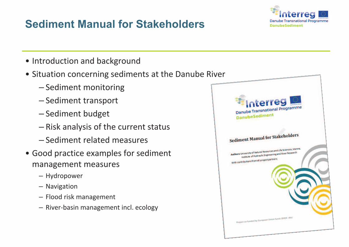
• Introduction and background
• Situation concerning sediments at the Danube River
– Sediment monitoring
– Sediment transport
– Sediment budget
– Risk analysis of the current status
– Sediment related measures
• Good practice examples for sediment
management measures
– Hydropower
– Navigation
– Flood risk management
– River-basin management incl. ecology
�������� �������� ������������ ���������������������������� ����������� ��
���� !"�� ���#$%�$�$" &���&�����!"�'�$!������('� �!���!()�
�����������
���� ��� �� �����
��������� �� �� ������� ����� ������ ��� � ������������� �������������������������������������������������
��������
� ������ � !
� �"#������ ����$��%&
� ��������� #'�������($�)����������*��������$��%&
+,�)! �!#�-���� .�������� ��������� /������������ ��������� ���� ��*�������������$
0!�1��������� �������!�1��� ������� ������
�����
����������������� ��������������������� �� ��
������������
���
.���2����2���� 2/�������
�� �� ��
����
!� �"�#��������������� �����������
��������������3��������������
������������������2���������� ��������
��������
4���������.�����������
�������������������������
�����������������2���������������������
����������
���������/������2�������
������������������������������������
�������������
���� ���������������������������2
��������������������������������������
�����-�
5��������������*�����������������������
���������������������������������������������������-�
��������
*��������6�7������� ����
������������������������������������������������������ ���������
���������2��������������������������
�����������6�.��-�����������/����������
�����������������������������������������������������-�
�����������������
$��#���� ���� �����
%�� �� ������� �� ������
����������8�������
������ ���������������������������������������������2����������9 7���������������������������������������������9 .��� ��������������������������������������-������������������� ���������� ���:�������������
&��#����'���������� �' ������ (��������)����
� %��� ������������������� ;������ �����������������������������-�������������������
4���������������9 /�������������������������������������������������� ����������������������������������� ������-����������������
*�����������������9 ������������������������������������������������������*<������5������-���������=>����*������������7������������� �0,
�.����������������
�����������
����������8�������
� 8������������������������� ;����������� ����-��� ����������������������
� 5���������������������;������������������������;���
� ���������������������������������=���������������������$,
� 7��-�������������������
� ��������������������������������������-������
8�������8�������
� 8��������������������=�����������������������������������;���,���������������;������;��
� 5�(� ���������������������-�������������������������������������������������������������������-�
� *��� �����������������������? ������������������������;���������;��
*�#� � ������������� '�+�*�� '����� �,�(��#���
������������
��������� ������ �������� =7����2-��#@# � �? #'0��0,
A� ���� ����������B��
& ���� �+�% ��� ���&���' � ��
��������� ���
8���������� (����� �����8���������� (����� �����
A�2���� ���������
A�2���� �������� �� ���
������������������ ����
& ���� �+�-#����.������#��/ ���
7�� �������������������������7����2�����������
.��� ��-�����������C��2�������������� 7����������������
D�����:������������������������E���F������������������GC��F���������������������� �������������
7��2 2��������������������� ��������
7����2�����������������������������������������������������������������$
������������
H-#����.�����������������������
�� #!
A����-� �����I�JK
0!�$LLL��J����)�����! $'#!��J������
�� #0
�� #'
�������� #'
������� #@6� �
���������������������� #L2� #"
C��2��������������
�� #'
������������
-#����.�����������������������
��������������� �������
����������������������������������������
�����������������������������
���������������������������� ����
��� �� �������������������� ������
����������������������������
�������������� ������?���������������������������������� �������������������������
��������������������������
� !��������������������
"� ��������������� ���
��# $�����"%&"
������������
.���� ��- ���������
A2���������
4�������
-#����.�����������������������
/������������ 3������2���:������������������:�������������������
$�������������01�� �� ��2$� ����'������������������'� 3����� ��'��� �
� ������������������������������� ��������������������������� �����
=������ ������ ����������,� ����2-��#'@"��� �����! $ ��J������������
������������������ ����������������-���5 ����2������� #'� ������������������
�������������
1�� ������ � ���������
M���� ��� ���� ��� M���� ��� ������������������ ��� ���������� ����
���:������� ��� ���:�����������
%�� ������ ���� �����
M���� ��� ���� ��� M���� ��� ��������
��������� ��� ��������� ����
)�������4*5 �4�� ��)����
7����������� %�����2.��� ����
7�������� ��� ���
.���� ��-����������
%��� ���
%�����.��� ����
D���6�����*�-������
7���������
3������
A�����$28��� ���
61*578�,94$
� 8�������27����-������������ �)�!�-�������������������������=#L�-�����8<�,� L�-������� ��-�������������=8<�,� >�����8����������C�5*�����������
7��� ��� #@
������������
C�������������������$����/����������������������������� ����������������=���������������,$
� ��������������������� =������������-�,���������������������������6�����������������=�������� �����6����������-���������������������,
� 5�(� ����������������������������������-��������������������������������$
� D�����:������3��;�����C���������������;���������;���=����:����������������������������������������������,
� ����������3��������C��������������������������
3������������
� 7�����������������6������������=�������������������� ���������,
� 5�(� ��������������������������6�(�������= �������������������,
% ����'��#���04 �����'�%��� �2
�������������
%��� ���� ��5�������7��-������5������������������������������������������-������$
� ������������ ����������(������������������������ #�2� #!
9 3���� �����������������������������������������������������$
9 ��������������������������������������������������������������$
8������� �����6�7��-�����������������������9 L������������6�����������������9 "������������������4>D�9 #���������������4��������3��-�9 #����������������/3�.9 ��������
�������������������������������������� �����
������ ����� %����� � #0
����������� �� � #'
� !����������������������:��� ������" 1�����������������������������
� �����������������������������������������������������������
� 8������������������ ������������������������������������ ���������������������� �L 1
)� ������ ��� �:
�������������
.� ����N>*C%�������������������.����*���������3��;��
��OL)�! �L)�#2�"#��� ��$����P��������$��������2/��27���Q�#��#�� ��������8<7�.�8
���$� ����2�����������$�����$��������$���
$������
7����������������� M���� 8��
������������ ��� �����
������� ������������
����� �� ���������
�����������������
������� �
��������� ��� �������� !"#� ����������!$�"#���" $!%�&�
��'��
�"�&(�
��)"&��!�&��'�*"+��& $��,����"
� ��-�"-&++!�".���'&��+!"-&�/012
� ��-� !"��,�/3�'&�&��4$&"�+�5
/1���'� ��!-��& -�&+
� 1167$��,�*!'&.8 �8&�* �&�* �
�"�&(�
++�&+�-�"-&�"!"8� �
� ��*��+&"!"8��,�9��'+
� � !"�&" "-&��,��4:$ ��" �!8 :�"�-�"'!:�"+
� �;+�, -!�!:&+�+ ,&��
� !"�8� �+��,���&�+��'�
� �" ��+!+��,���)"&��!�&��<&'�&����:�"+
� �44�!- :�"���� ��!++�&+
� +&-��&�9��'�9�*�+&-:�"+
� $ !"� !"���&�8� � "�&&'�, !�* �
�"�&(�
� ���$&��!-�$& +��&$&"�+
� ����&��*!�����'��8� 4�!-�<� ��=��>'>�!-��!+�� �?
� �$4�&$&"� ���$& +��&$&"�+�<�� �;+��&��!���! ��
�!�!+!�"+��& $+
��>'>�!-��!+�� � �&��!���! ���!�!+!�"+��& $+
��'��$��4����8!- �� " ��+!+
�" ��+!+��,���'� ��!-��& -�&+�!"�1�+�&4+�
� � � -�&�!@ :�"��,�-�"����� "'��&+4�"+&�� �! <�&+
� ������������� ��������������� ����
� '&":A- :�"� "'�� "7!"8��,�'!+���< "-&+
� ������������ ������������������������
� �$4 �!+�"��,�< ���$&��!-�+���&�+�,� $!"8�& -��4&�!�'
� ������������������������
��'��$��4����8!- �� " ��+!+
�&A"!:�"��,��& -�&+�*!�����$�8&"&��+�<&� �!���+
� ���!"8�&!��&��B'!+���<&'C����B�"'!+���<&'C�4&�!�'+
� ��&��$!'5��"8��&�$�4&�!�'
�!+:"-:�"�<&�*&&"�!"!: �� 'D�+�$&"�+� "'�-���&"��
+&'!$&"��'�" $!-+
�44�!- :�"���� ��!++�&+
�&-��&�9��'�9�*�+&-:�"+
� '&":A- :�"��,� 88� '!"8#�
'&8� '!"8� "'�+� <�&�+&-���+
� �E&-�+��,�&����:�"���&"'+��"�
9��'�9�*�+&-:�"+
�44�!- :�"���� ��!++�&+
� !"� !"���&�8� � "�&&'�, !�* �
� � @ �'�F�&����:�"���&"'+��"���&�, !�* ��&(�&"�
� ���"&� <!�!���F��&!8����,��"'&��7&&��-�& � "-&
� �!+7�F�"�".-�$4�! "-&��,�8� � "�&&'�$!"!$�$�'&4��
�44�!- :�"���� ��!++�&+
� !"� !"���&�8� � "�&&'�, !�* �
� �
�&+���+�G�&(4&-� :�"+
��)"&��!�&��'!�!'&'�!"�1�+&8$&"�+�'�*"+��& $��,����"
� �&�*&&"�� )"&��!�&�� "'�+H�&��!�&��-�"9�&"-&+
� ��*�+&'!$&"���� "+4���
� �$&���+�B�&&,+C� "'��!�&�<&'�+!"��+!����&+�� !"!"8���&�, !�* �
� �&�*&&"�+H�&��!�&�� "'���'H-�&��!�&��-�"9�&"-&+
� � !"�!"9�&"-&��,�+&'!$&"��+��!-!"8
� � � "-&'�+&'!$&"���� "+4����!"�$!'5��"8��&�$
� ��*"+��& $��,���'H-�&��!�&��-�"9�&"-&
� ��<+� ": ��* �&�� "'�+&'!$&"��!"4��+�,��$���!<�� �!&+
� �� '� ���&'�-!"8��,���&�+��4&
� �88� ' :�"���&"'+�!"��&+&���!�+
�&+���+�G�&(4&-� :�"+
�4&-!A-�<&� �!����,���&�&����& -�I�*!���,&*�-�$$�"�
,& ���&+�
� ��&� ���+� <!�!����,��& '� -&� "'�� !�� -&
� "9�&"-&��,��!�&�.�� !"!"8�+���-���&+�!"�<�4 ++&'��& -�&+
� �88� ' :�"�'�*"+��& $�<�4 ++&'��& -�&+
� �4+��& $�< �� 8&+���$ D��� 88� ' :�"�<���� ��!"8�
+&'!$&"��&� -� :�"�- 4 -!��
�&+���+�G�&(4&-� :�"+
��� '&���!+!�"����!"-��'&����&��!++�&+
� �&+��� :�"��,�+&'!$&"��'�" $!-+��"�<�4 ++&'��& -�&+
� � $�8 �&+��&�! <!�!���!$4 -�&'�<���4+��& $�'&4�+!:�"
� �'D�+�$&"�+����8� � "�&&'�, !�* �
� � " 8&$&"���,�-� �+&�+&'!$&"�+�8&"&� �&'�<��'�&'8!"8�
�4&� :�"+
�4&� :�" �� 44�!- :�"+
� '&":,��4�!��� �& +����$�"!���� J&�� �$ D���9��'
� ��!'&� 'D�+�$&"�+��,���&�8� � "�&&'�, !�* �
� ��- �&�+�!� <�&� �& +�,���'�&'8&.+4�!��'�$4!"8
Author : Villalba, SebastiánHidrovía SA
Arcelus, AlejandroNardín, Alejandro CARU
Use of hydrodynamic models for
decision-making in dredging works.
Uruguay River waterway case (Argentina)
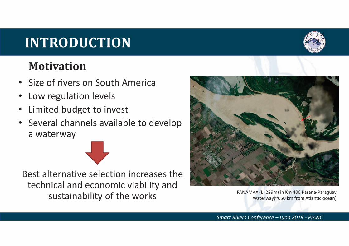
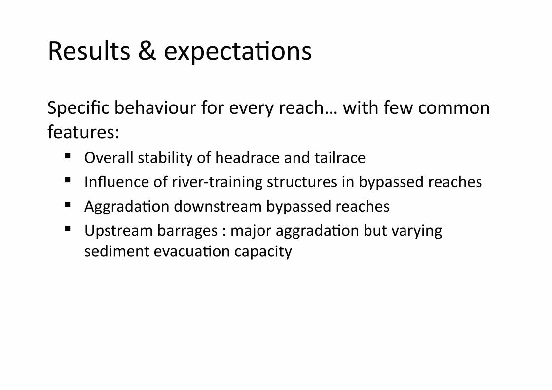
INTRODUCTION
Motivation
Smart Rivers Conference – Lyon 2019 - PIANC
• Size of rivers on South America
• Low regulation levels
• Limited budget to invest
• Several channels available to develop a waterway
Best alternative selection increases the technical and economic viability and
sustainability of the worksPANAMAX (L=229m) in Km 400 Paraná-Paraguay
Waterway(~650 km from Atlantic ocean)
Smart Rivers Conference – Lyon 2019 - PIANC
INTRODUCTION
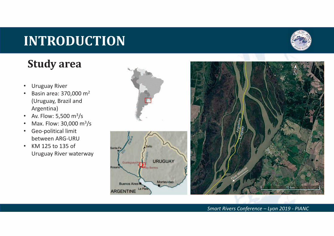
Study area
• Uruguay River
• Basin area: 370,000 m2
(Uruguay, Brazil and
Argentina)
• Av. Flow: 5,500 m3/s
• Max. Flow: 30,000 m3/s
• Geo-political limit
between ARG-URU
• KM 125 to 135 of
Uruguay River waterway
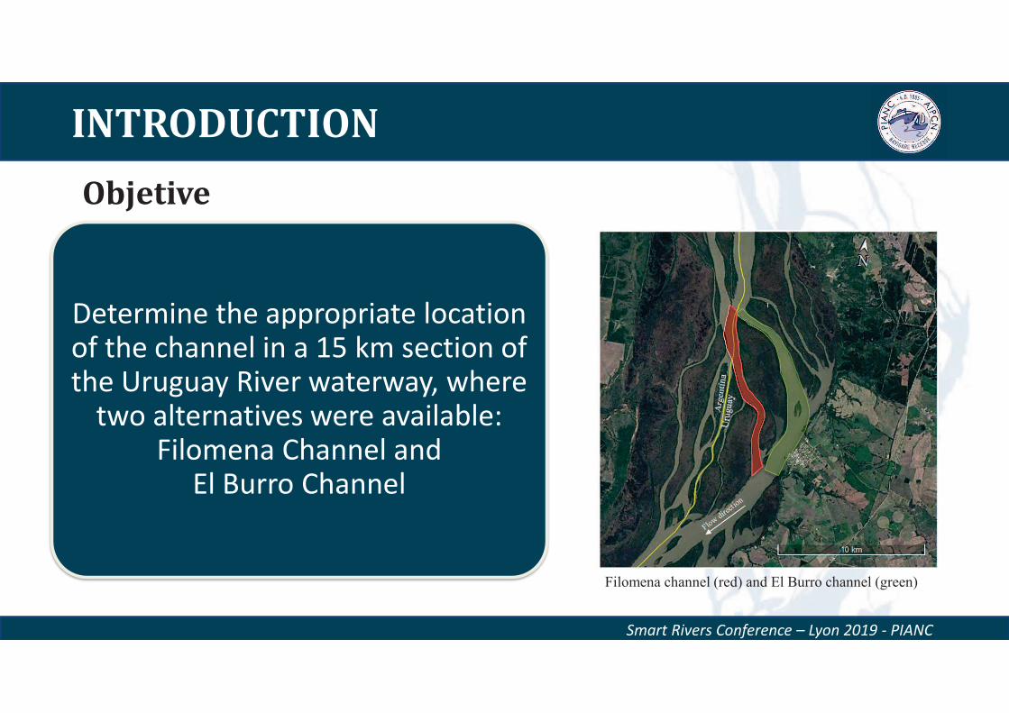
INTRODUCTION
Objetive
Smart Rivers Conference – Lyon 2019 - PIANC
Determine the appropriate location of the channel in a 15 km section of the Uruguay River waterway, where
two alternatives were available: Filomena Channel and
El Burro Channel
Filomena channel (red) and El Burro channel (green)
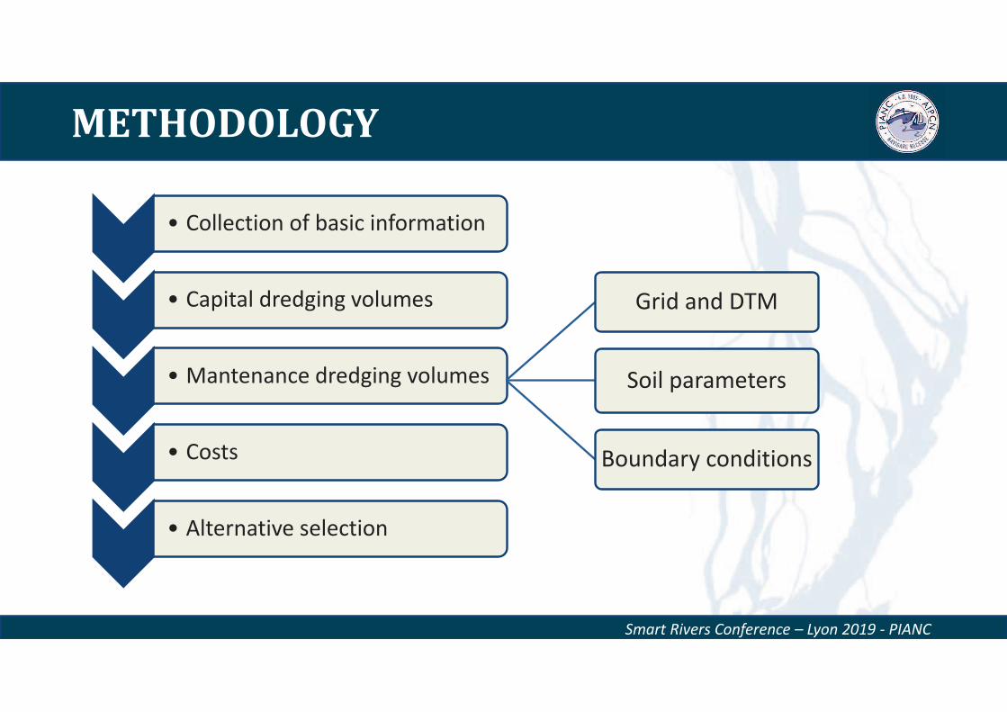
METHODOLOGY
Smart Rivers Conference – Lyon 2019 - PIANC
• Collection of basic information
• Capital dredging volumes
• Mantenance dredging volumes
• Costs
• Alternative selection
Grid and DTM
Soil parameters
Boundary conditions
METHODOLOGY
Smart Rivers Conference – Lyon 2019 - PIANC
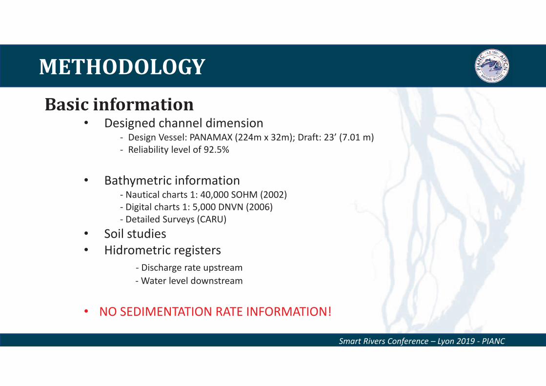
• Designed channel dimension- Design Vessel: PANAMAX (224m x 32m); Draft: 23’ (7.01 m)
- Reliability level of 92.5%
• Bathymetric information- Nautical charts 1: 40,000 SOHM (2002)
- Digital charts 1: 5,000 DNVN (2006)
- Detailed Surveys (CARU)
• Soil studies
• Hidrometric registers
- Discharge rate upstream
- Water level downstream
• NO SEDIMENTATION RATE INFORMATION!
Basic information
METHODOLOGY
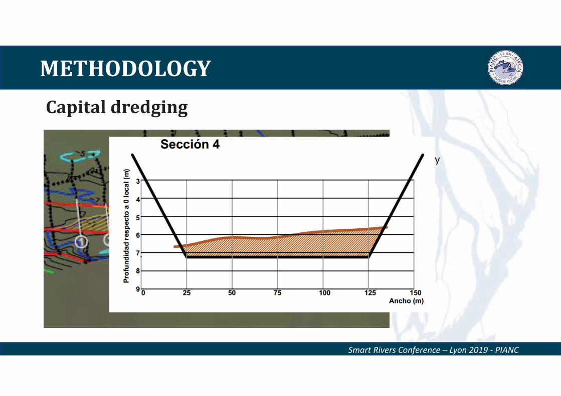
Capital dredging
Smart Rivers Conference – Lyon 2019 - PIANC
• Detailed surveys
• Channel design geometry
METHODOLOGY
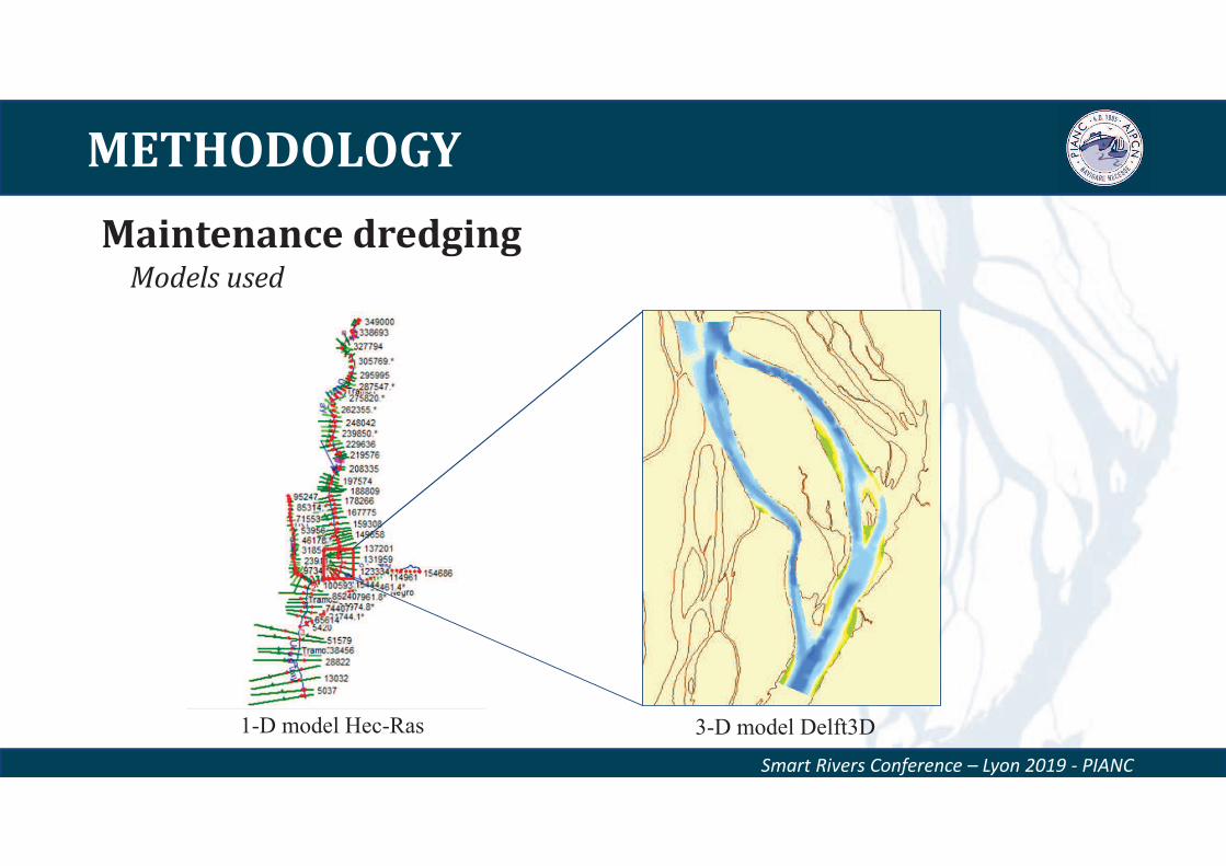
Maintenance dredging
Smart Rivers Conference – Lyon 2019 - PIANC
1-D model Hec-Ras 3-D model Delft3D
Models used
METHODOLOGY
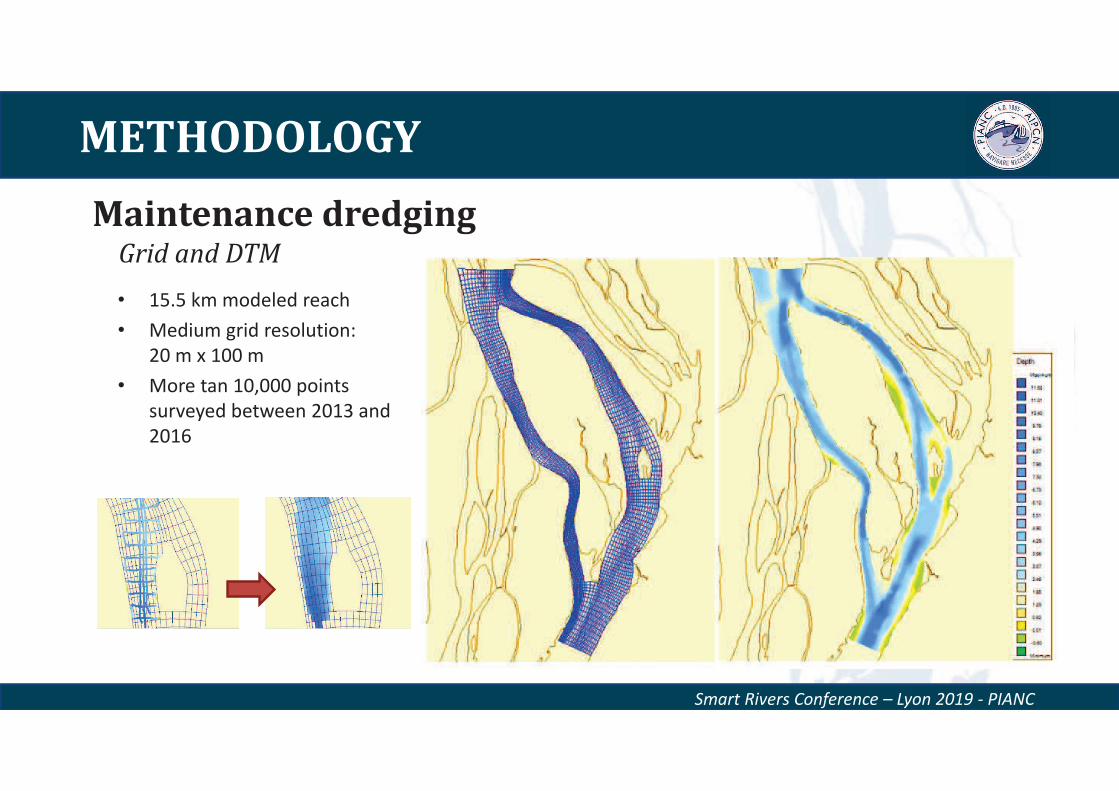
Smart Rivers Conference – Lyon 2019 - PIANC
• 15.5 km modeled reach
• Medium grid resolution:
20 m x 100 m
• More tan 10,000 points
surveyed between 2013 and
2016
Grid and DTM
Maintenance dredging
METHODOLOGY
Smart Rivers Conference – Lyon 2019 - PIANC
• Sedimentological equations used by the
model were valid to the modelled river
reach (L. Van Rijn)
• Medium grain size 280 μm
• Variable Manning number in the
section
Parameters
Maintenance dredging
METHODOLOGY
Smart Rivers Conference – Lyon 2019 - PIANC
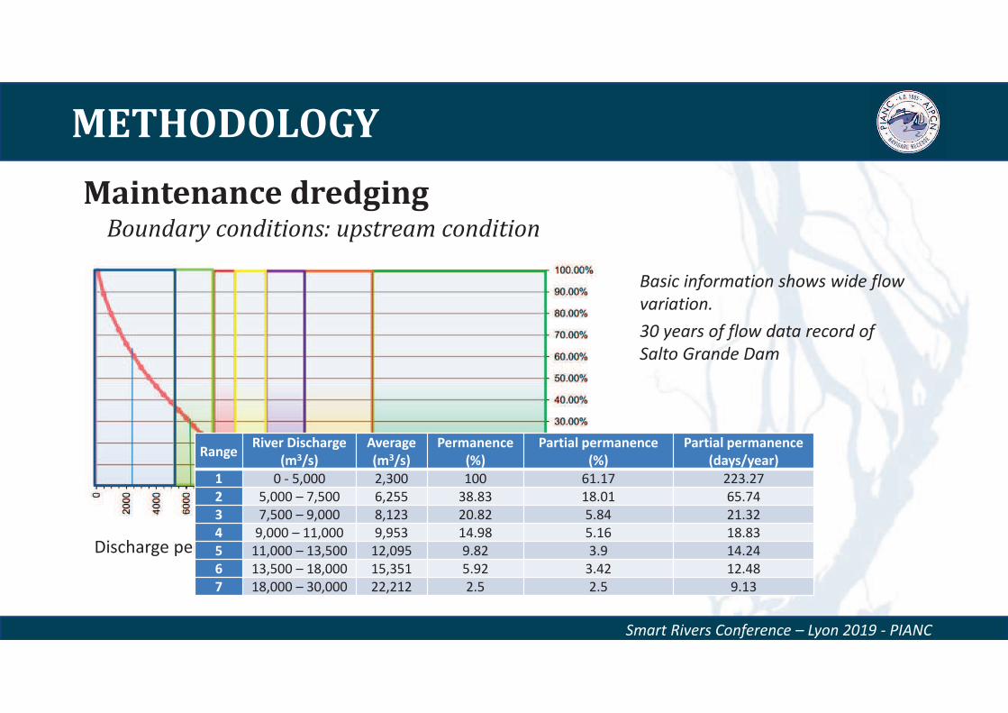
Basic information shows wide flow
variation.
30 years of flow data record of
Salto Grande Dam
Boundary conditions: upstream condition
Discharge permanence curve
RangeRiver Discharge
(m3/s)
Average
(m3/s)
Permanence
(%)
Partial permanence
(%)
Partial permanence
(days/year)
1 0 - 5,000 2,300 100 61.17 223.27
2 5,000 – 7,500 6,255 38.83 18.01 65.74
3 7,500 – 9,000 8,123 20.82 5.84 21.32
4 9,000 – 11,000 9,953 14.98 5.16 18.83
5 11,000 – 13,500 12,095 9.82 3.9 14.24
6 13,500 – 18,000 15,351 5.92 3.42 12.48
7 18,000 – 30,000 22,212 2.5 2.5 9.13
Maintenance dredging
METHODOLOGY
Smart Rivers Conference – Lyon 2019 - PIANC
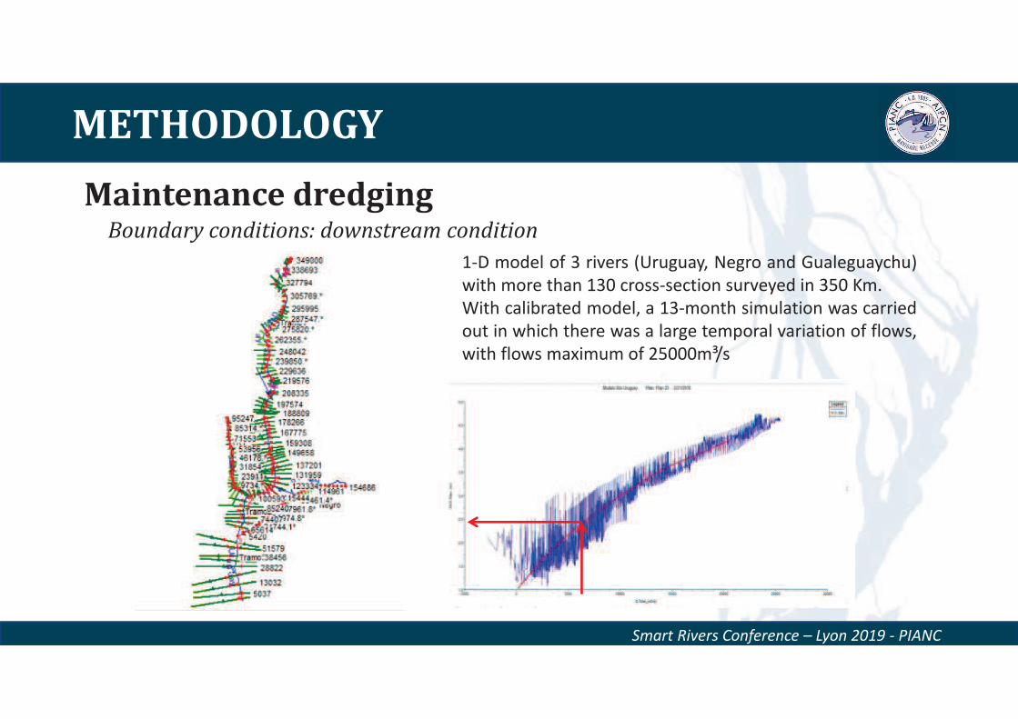
1-D model of 3 rivers (Uruguay, Negro and Gualeguaychu)
with more than 130 cross-section surveyed in 350 Km.
With calibrated model, a 13-month simulation was carried
out in which there was a large temporal variation of flows,
with flows maximum of 25000m³/s
Boundary conditions: downstream condition
Maintenance dredging
METHODOLOGY
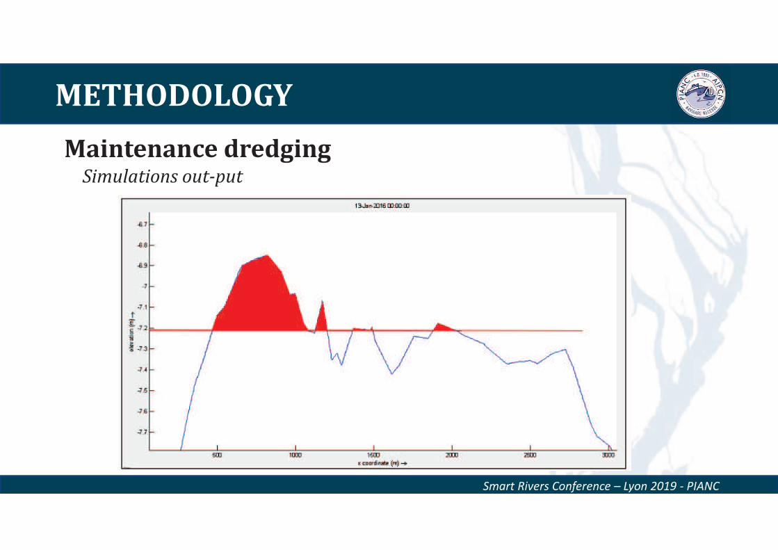
Smart Rivers Conference – Lyon 2019 - PIANC
Longitudinal
Transversal
Maintenance dredging Simulations out-put
METHODOLOGY
Smart Rivers Conference – Lyon 2019 - PIANC
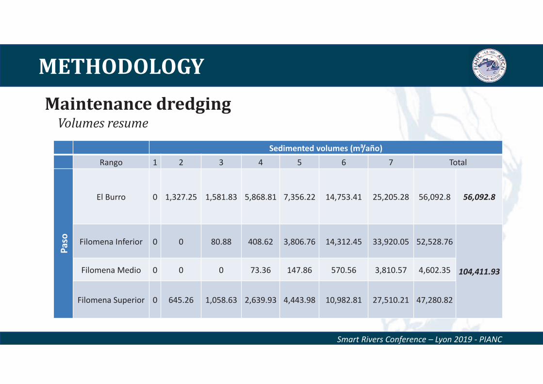
Sedimented volumes (m³/año)
Rango 1 2 3 4 5 6 7 Total
Pa
so
El Burro 0 1,327.25 1,581.83 5,868.81 7,356.22 14,753.41 25,205.28 56,092.8 56,092.8
Filomena Inferior 0 0 80.88 408.62 3,806.76 14,312.45 33,920.05 52,528.76
104,411.93Filomena Medio 0 0 0 73.36 147.86 570.56 3,810.57 4,602.35
Filomena Superior 0 645.26 1,058.63 2,639.93 4,443.98 10,982.81 27,510.21 47,280.82
Maintenance dredging Volumes resume
RESULTS
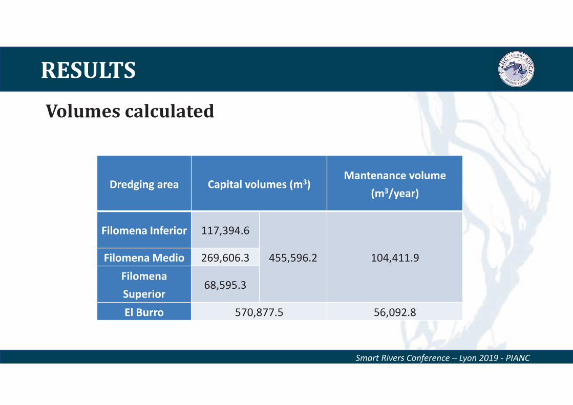
Volumes calculated
Smart Rivers Conference – Lyon 2019 - PIANC
Dredging area Capital volumes (m3)Mantenance volume
(m3/year)
Filomena Inferior 117,394.6
455,596.2 104,411.9Filomena Medio 269,606.3
Filomena
Superior68,595.3
El Burro 570,877.5 56,092.8
RESULTS
Costs
Smart Rivers Conference – Lyon 2019 - PIANC
0 5 10 15 20 25
Co
st
Year
Costs per alternative
El Burro
Filomena
33%
The most cost-effective alternative was El Burro Channel
Net present value
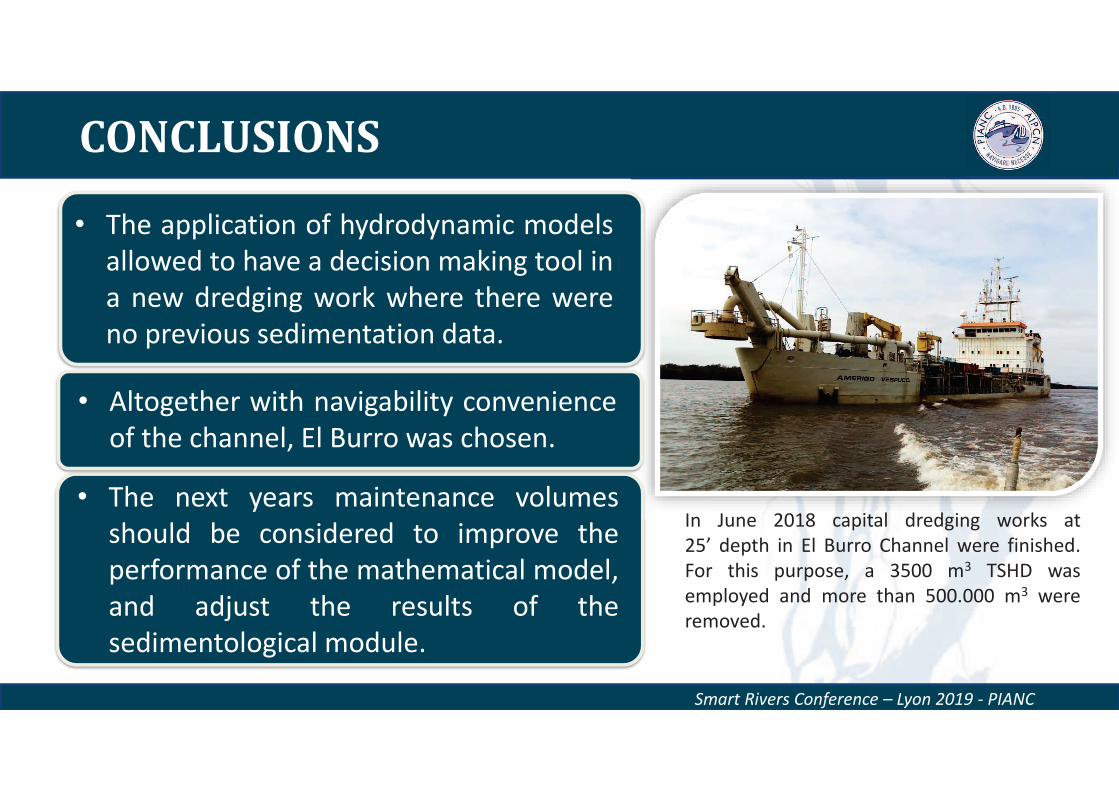
CONCLUSIONS
Smart Rivers Conference – Lyon 2019 - PIANC
In June 2018 capital dredging works at
25’ depth in El Burro Channel were finished.
For this purpose, a 3500 m3 TSHD was
employed and more than 500.000 m3 were
removed.
• The application of hydrodynamic models
allowed to have a decision making tool in
a new dredging work where there were
no previous sedimentation data.
• The next years maintenance volumes
should be considered to improve the
performance of the mathematical model,
and adjust the results of the
sedimentological module.
• Altogether with navigability convenience
of the channel, El Burro was chosen.

Thank you very much for
your attention!
Questions?
Smart Rivers Conference – Lyon 2019 - PIANC
Gensheng ZHAO
Paul VISSER
SEDIMENT TRANSPORT IN MIDDLE AND LOWER
YANGTZE RIVER AFTER THREE GORGES DAM,
CHINA
September 11, 2019
2
Contents
• Introduction
• River Regime
• Field Survey
• Numerical Model
• Conclusions
3
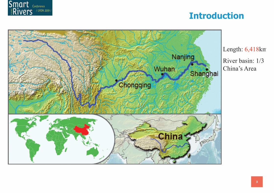
Length: 6,418km
River basin: 1/3
China’s Area
Introduction
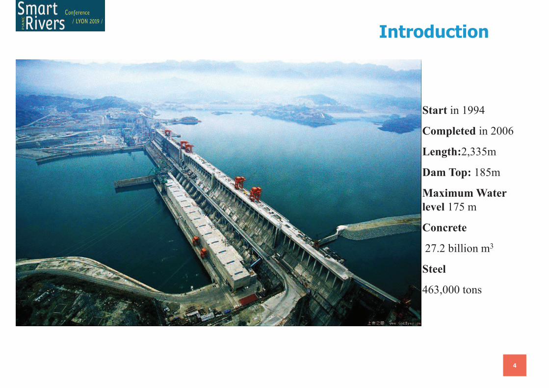
4
Start in 1994
Completed in 2006
Length:2,335m
Dam Top: 185m
Maximum Water
level 175 m
Concrete
27.2 billion m3
Steel
463,000 tons
Introduction
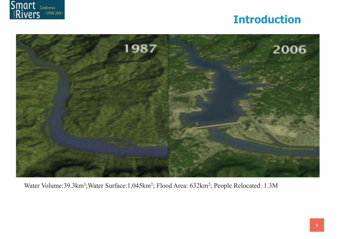
5
Water Volume:39.3km3;Water Surface:1,045km2; Flood Area: 632km2; People Relocated: 1.3M
Introduction
6
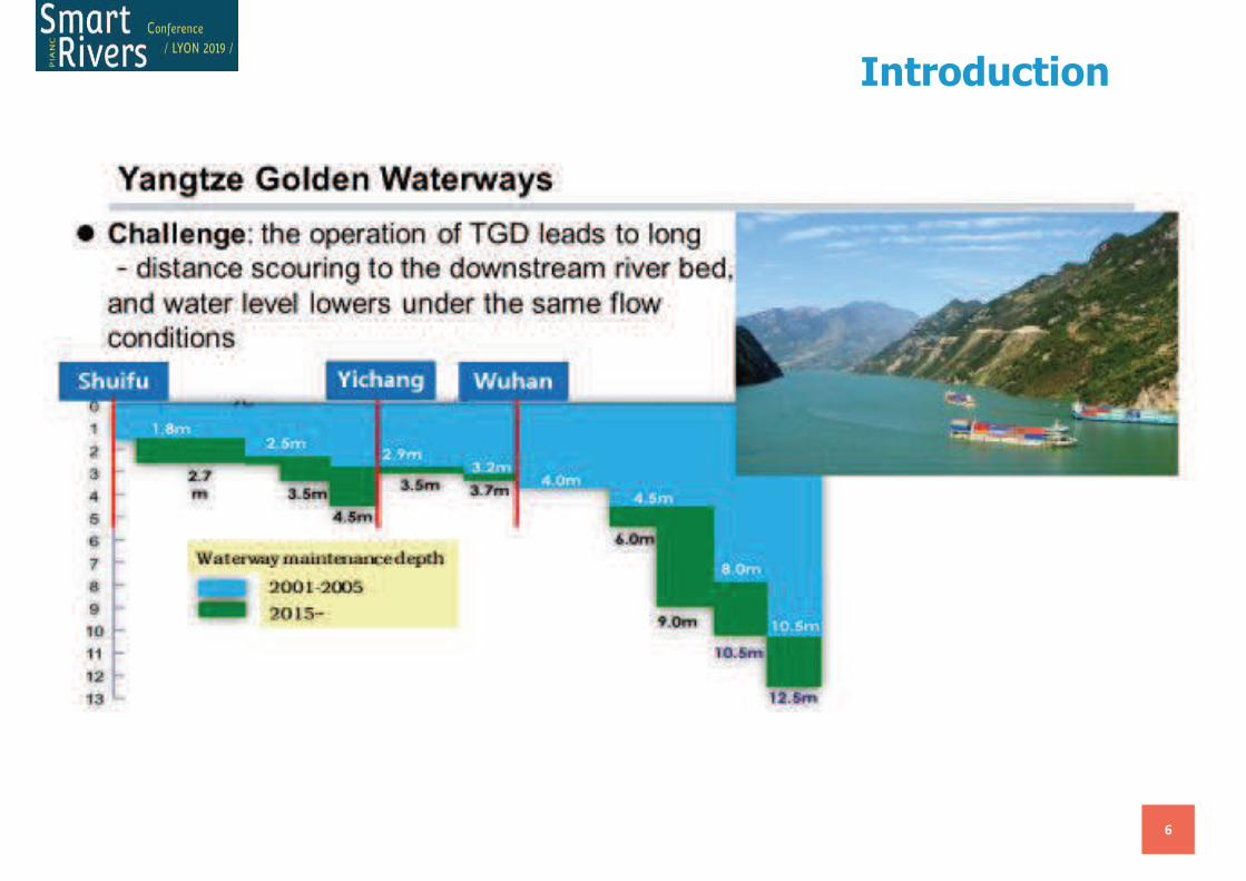
Introduction
7
0
5000
10000
15000
20000
25000
30000
35000
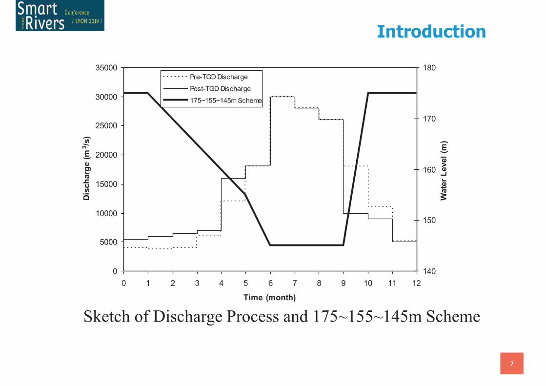
0 1 2 3 4 5 6 7 8 9 10 11 12
Time (month)
Dis
ch
arg
e (
m3/s
)
140
150
160
170
180
Wate
r L
evel
(m)
Pre-TGD Discharge
Post-TGD Discharge
175~155~145m Scheme
Sketch of Discharge Process and 175~155~145m Scheme
Introduction
September 11, 2019
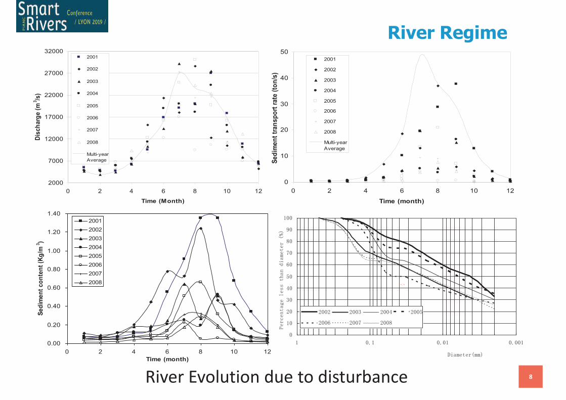
8River Evolution due to disturbance
2000
7000
12000
17000
22000
27000
32000
0 2 4 6 8 10 12
Time (Month)
Dis
ch
arg
e (
m3/s
)
2001
2002
2003
2004
2005
2006
2007
2008
Multi-year
Average
0
10
20
30
40
50
0 2 4 6 8 10 12
Time (month)
Se
dim
en
t tr
an
sp
ort
ra
te (
ton
/s)
2001
2002
2003
2004
2005
2006
2007
2008
Multi-year
Average
0.00
0.20
0.40
0.60
0.80
1.00
1.20
1.40
0 2 4 6 8 10 12
Time (month)
Se
dim
en
t c
on
ten
t (K
g/m
3)
2001
2002
2003
2004
2005
2006
2007
2008
River Regime
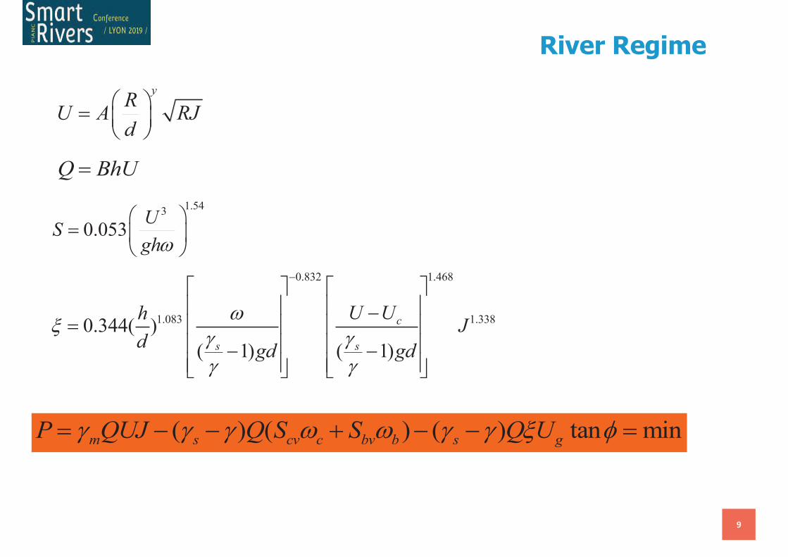
9
( ) ( ) ( ) tan minm s cv c bv b s gP QUJ Q S S Q Ug g g w w g g x f= - - + - - =
Q BhU=
yR
U A RJd
æ ö= ç ÷è ø
1.543
0.053U
Sghw
æ ö= ç ÷
è ø0.832 1.468
1.083 1.3380.344( )
( 1) ( 1)
c
s s
U UhJ
dgd gd
wx
g gg g
-é ù é ùê ú ê ú-
= ê ú ê úê ú ê ú- -ê ú ê úë û ë û
River Regime
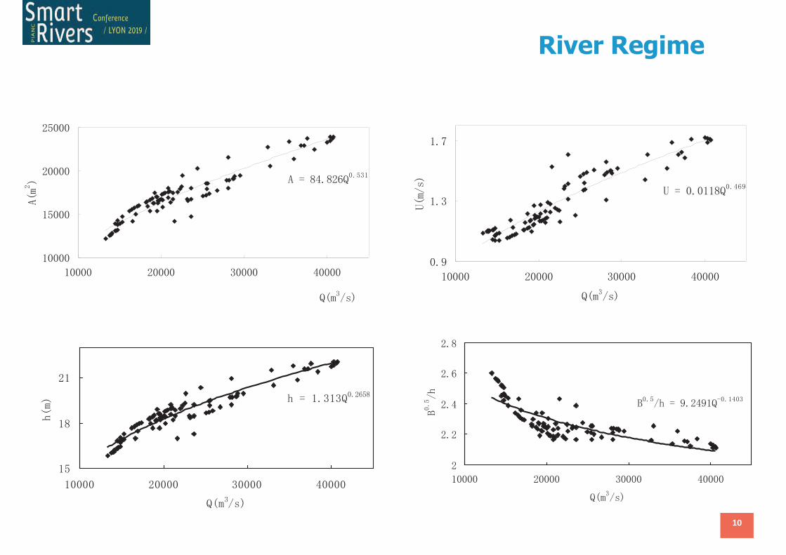
10
River Regime

11
Thalweg and topography of Shashi Reach in October, 2001
Juzhang River
Chenjiawan
Taipingkou
Hudu River
Zhanghe River
Dike
N
Thalweg
40m
Waterside
35m
30m
25m
20m
Legend
15m
2km10
Scale
Xuetang Shoal
Shashi City
Guanyinji
Beizha
Erlangji
Liudaxiangji
0m
5m
10m
Sanbatan Shoal
Field Survey
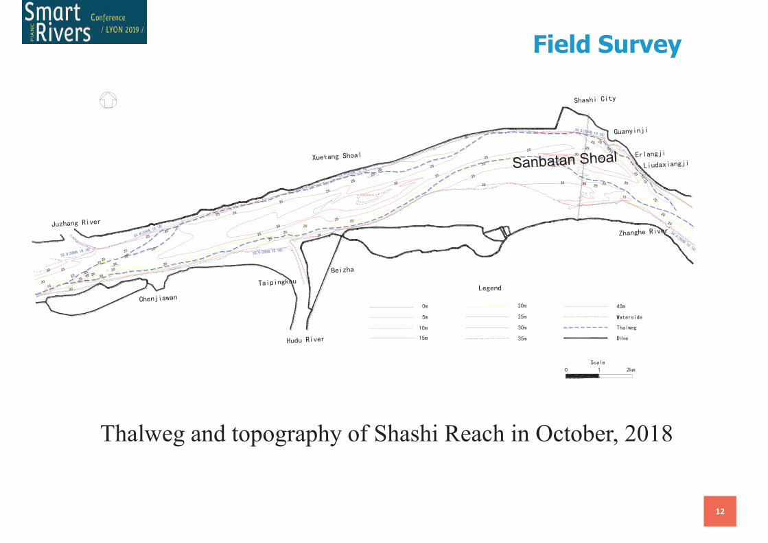
12
Thalweg and topography of Shashi Reach in October, 2018
Sanbatan Shoal
Field Survey
13
Hukou
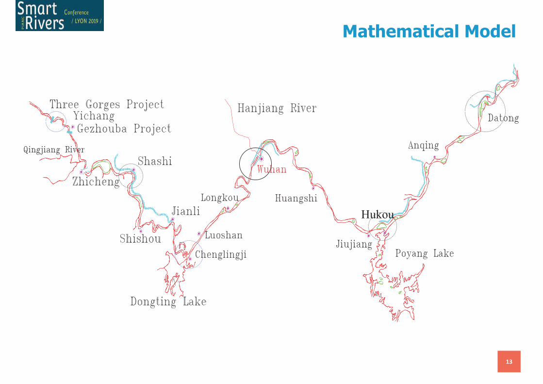
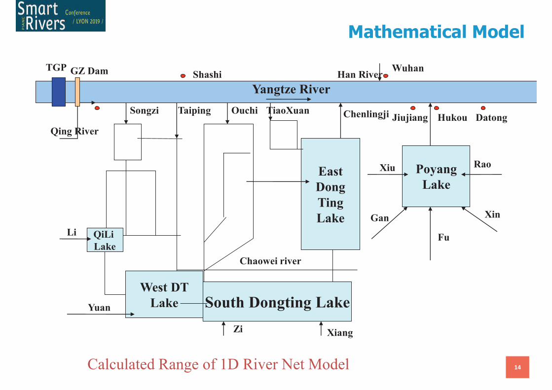
Mathematical Model
14
QiLi
Lake
West DT
Lake South Dongting Lake
East
Dong
Ting
Lake
Poyang
Lake
Qing River
Taiping Ouchi
Chaowei river
Chenlingji Jiujiang Hukou
ShashiWuhan
Han River
Datong
Xiu
Gan
Fu
Xin
Rao
XiangZi
Yuan
Li
TGP
Yangtze River
GZ Dam
Songzi TiaoXuan
Calculated Range of 1D River Net Model
Mathematical Model
September 11, 2019
15
0
0.2
0.4
0.6
0.8
1
1.2
Pre-
TGD
10 20 30 40 50 60 70 80 90 100
Time (Year)
Sed
imen
t C
on
ten
t (K
g/m
3)
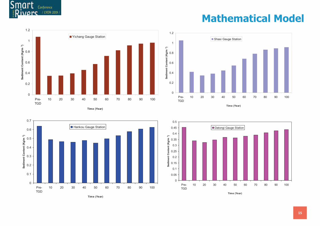
Yichang Gauge Station
0
0.2
0.4
0.6
0.8
1
1.2
Pre-
TGD
10 20 30 40 50 60 70 80 90 100
Time (Year)
Sed
imen
t C
on
ten
t (K
g/m
3)
Shasi Gauge Station
0
0.1
0.2
0.3
0.4
0.5
0.6
0.7
Pre-
TGD
10 20 30 40 50 60 70 80 90 100
Time (Year)
Sed
imen
t C
on
ten
t (K
g/m
3)
Hankou Gauge Station
0
0.05
0.1
0.15
0.2
0.25
0.3
0.35
0.4
0.45
0.5
Pre-
TGD
10 20 30 40 50 60 70 80 90 100
Time (Year)
Sed
imen
t C
on
ten
t (K
g/m
3)
Datongi Gauge Station
Mathematical Model
16
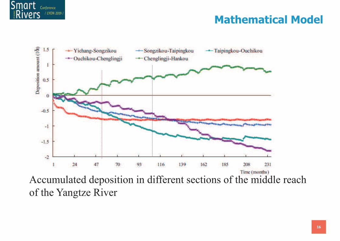
Accumulated deposition in different sections of the middle reach
of the Yangtze River
Mathematical Model
17
-0.5
-0.45
-0.4
-0.35
-0.3
-0.25
-0.2
-0.15
-0.1
-0.05
0
0 10 20 30 40 50 60 70 80 90 100
Time (Year)
Co
mu
lati
ve D
eg
rad
ati
on
an
d A
gg
rad
ati
on
(B
illi
on
ton
s)
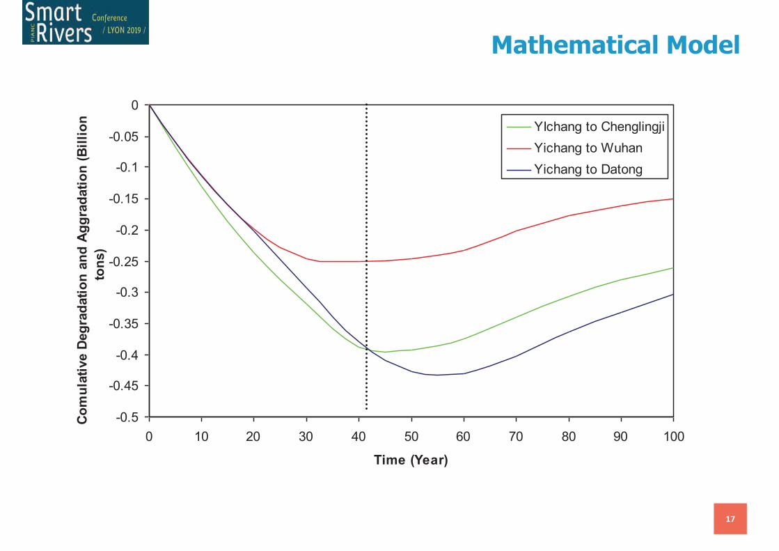
YIchang to Chenglingji
Yichang to Wuhan
Yichang to Datong
Mathematical Model
September 11, 2019
18
Numerical Model
Conclusions
19
• TGD Gives Large disturbance to the Yangtze River system
• River Regime in the middle of Yangtze River Changes a lot in Post-
TGD
• Yangtze River will get a new equilibrium in the long term (100
years)
20
Thanks for your attention!
Merci!
Riparian zone recovery following the
large-scale removal of bank protection in
a large impounded and navigable river
Tom Buijse, Clara Chrzanowski, Gertjan Geerling, Marc Weeber (Deltares)
Martijn Dorenbosch (Bureau Waardenburg)
Bart Peters (Bureau Drift)
Jan Joost Bakhuizen, Frans Kerkum (Rijkswaterstaat)
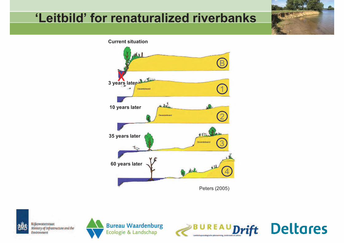
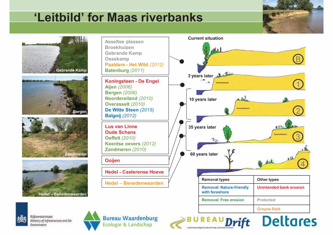
‘Leitbild’ for renaturalized riverbanks
10 years later
3 years later
35 years later
60 years later
Current situation
B
1
2
3
4
Peters (2005)
x
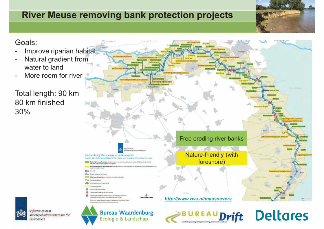
River Meuse removing bank protection projects
http://www.rws.nl/maasoevers
Free eroding river banks
Goals:- Improve riparian habitat
- Natural gradient from
water to land
- More room for river
Total length: 90 km
80 km finished
30%
Nature-friendly (with
foreshore)
Monitoringproject
‘Renaturalized riverbanks River Meuse 2008-2017’
1) Which factors drive bank erosion in the River Meuse?
2) Which monitoring is necessary to
- Estimate erosion rates
- Assess ecological improvement
Guidance for water managers to
- Implement
- Optimize
- Monitor
- Manage
the removal of bank protection
for nature
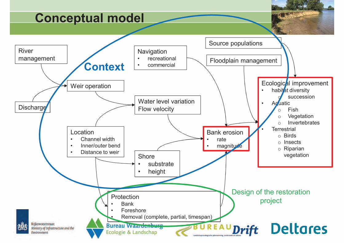
River
management
Discharge
Weir operation
Location• Channel width
• Inner/outer bend
• Distance to weir
Water level variation
Flow velocity
Shore
• substrate
• height
Navigation• recreational
• commercial
Protection• Bank
• Foreshore
• Removal (complete, partial, timespan)
Bank erosion• rate
• magnitude
Ecological improvement• habitat diversity
o succession
• Aquatic
o Fish
o Vegetation
o Invertebrates
• Terrestrial
o Birds
o Insects
o Riparian
vegetation
Floodplain management
Source populations
Conceptual model
Design of the restoration
project
Context
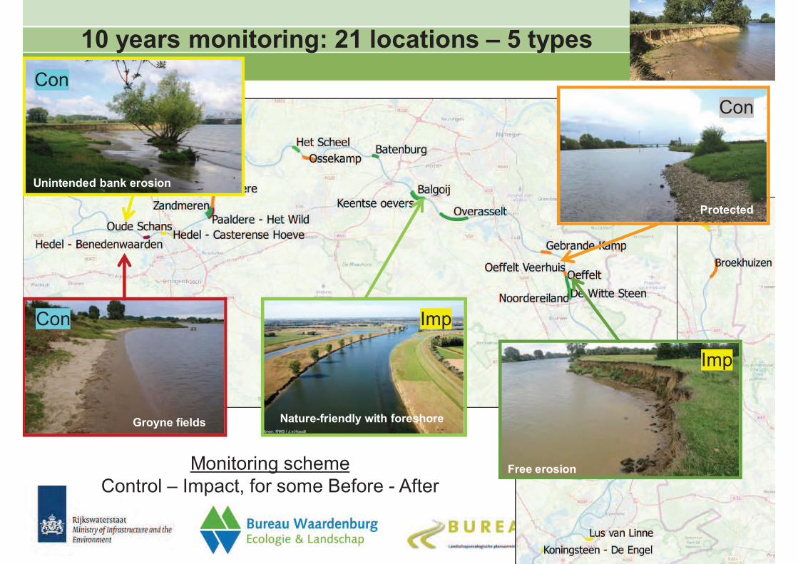
10 years monitoring: 21 locations – 5 types
Nature-friendly with foreshore
Free erosion
Unintended bank erosion
Protected
Groyne fields
Monitoring scheme
Control – Impact, for some Before - After
Con
Imp
ImpCon
Con
Monitoring programme
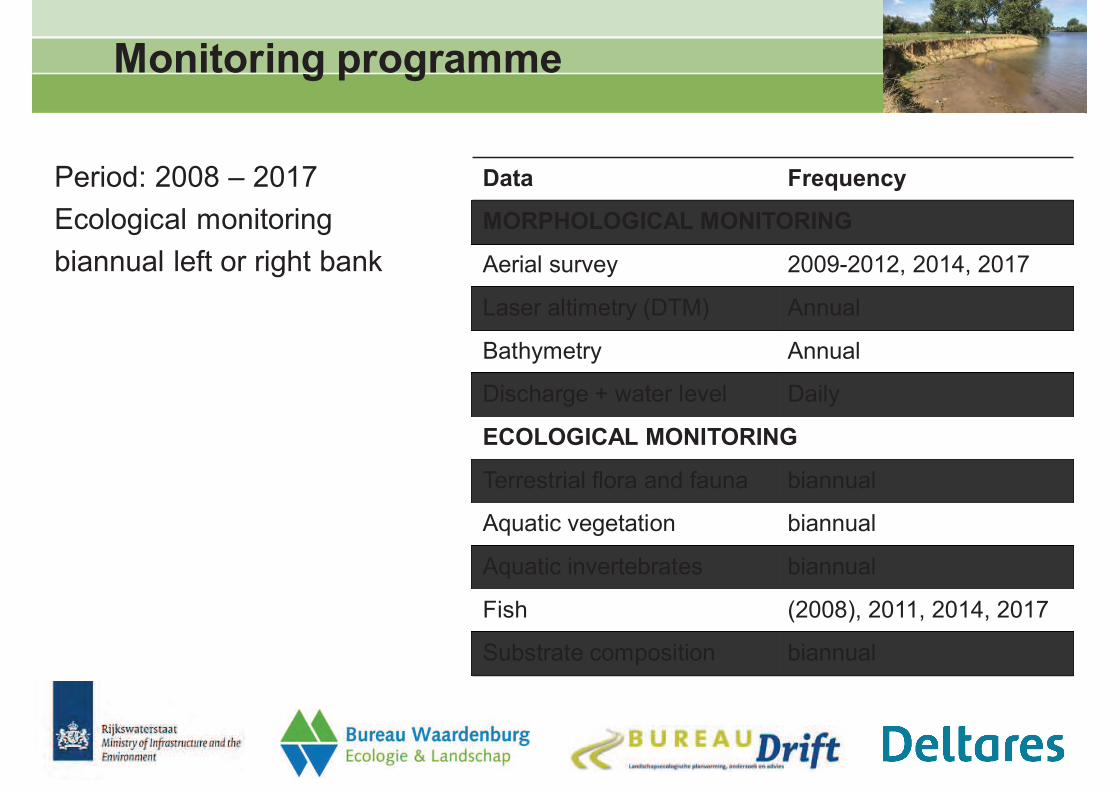
Period: 2008 – 2017
Ecological monitoring
biannual left or right bank
Data Frequency
MORPHOLOGICAL MONITORING
Aerial survey 2009-2012, 2014, 2017
Laser altimetry (DTM) Annual
Bathymetry Annual
Discharge + water level Daily
ECOLOGICAL MONITORING
Terrestrial flora and fauna biannual
Aquatic vegetation biannual
Aquatic invertebrates biannual
Fish (2008), 2011, 2014, 2017
Substrate composition biannual
Context: water level variation
impounded river Meuse
0
5
10
15
20
25
30
35
40
45
50
0 50 100 150 200 250
Wa
ter
Leve
l(N
AP,
m)
river (km Dutch part of the River Meuse)
50 m3/s, 268 d/yr
125 m3/s, 184 d/yr
250 m3/s, 107 d/yr
500 m3/s, 45 d/yr
1000 m3/s, 8 d/yr
1500 m3/s, 2 d/yr
2000 m3/s, 1x/5yr
Discharge; exceedance (d/yr)
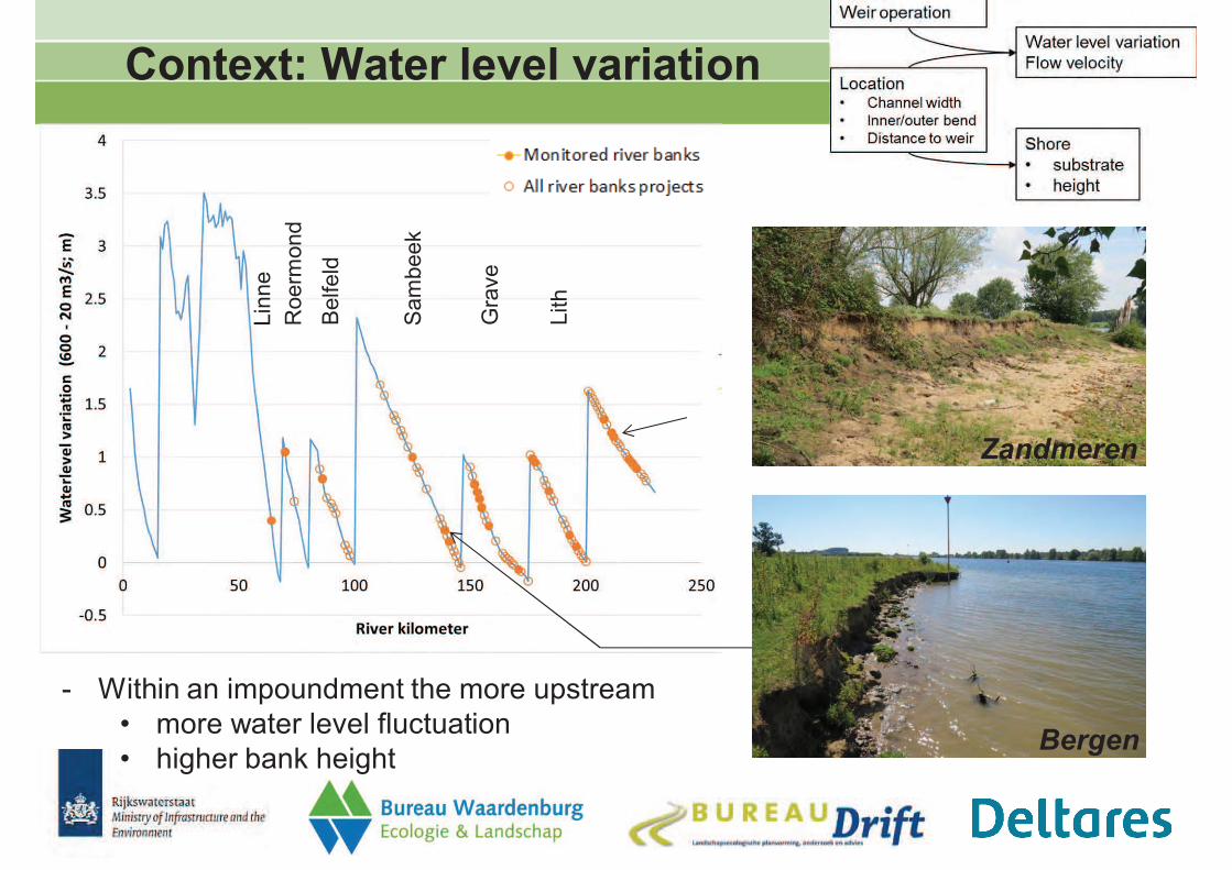
Context: Water level variation
- Within an impoundment the more upstream
• more water level fluctuation
• higher bank height
Belfeld
Sam
beek
Gra
ve
Lith
Roerm
ond
Lin
ne
Bergen
Zandmeren
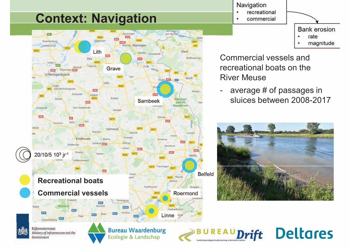
Context: Navigation
Commercial vessels and
recreational boats on the
River Meuse
- average # of passages in
sluices between 2008-2017
Recreational boats
Commercial vessels
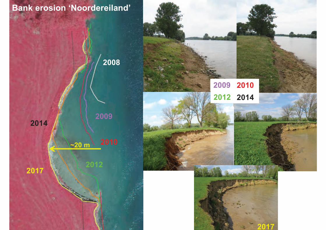
Oevererosie Noordereiland
2009
2008
2009
2010
2012
2014
2017
2009
2012
2010
Bank erosion ‘Noordereiland’
2014
2017
~20 m
Asseltse plassen
Broekhuizen
Gebrande Kamp
Ossekamp
Paaldere - Het Wild (2012)
Batenburg (2011)
Koningsteen - De Engel
Aijen (2006)
Bergen (2006)
Noordereiland (2010)
Overasselt (2010)
De Witte Steen (2015)
Balgoij (2012)
Lus van Linne
Oude Schans
Oeffelt (2010)
Keentse oevers (2012)
Zandmeren (2010)
Ooijen
Hedel - Casterense Hoeve
Hedel – Benedenwaarden
10 years later
3 years later
35 years later
60 years later
Current situation
Removal types Other types
Removal: Nature-friendly
with foreshore
Unintended bank erosion
Removal: Free erosion Protected
Groyne field
B
1
2
3
4
‘Leitbild’ for Maas riverbanks
Zandmeren
Bergen
Gebrande Kamp
Hedel – Benedenwaarden

• General improvement in the River
Meuse
• Similar bank types show different
signals
• Variation between years
• Time-lag after restoration
Characteristic species for the Water Framework Directive
Subset 1: Even years
Aquatic vegetation
Subset 2: Uneven years
Protected
Free eroding
Unintended bank erosion
Nature-friendly with foreshoreGroyne fields
Av
era
ge
#o
fch
ara
cte
risti
c
sp
ecie
sfo
rri
verb
an
kty
pe
Av
era
ge
#o
fch
ara
cte
risti
c
sp
ecie
sfo
rri
verb
an
kty
pe
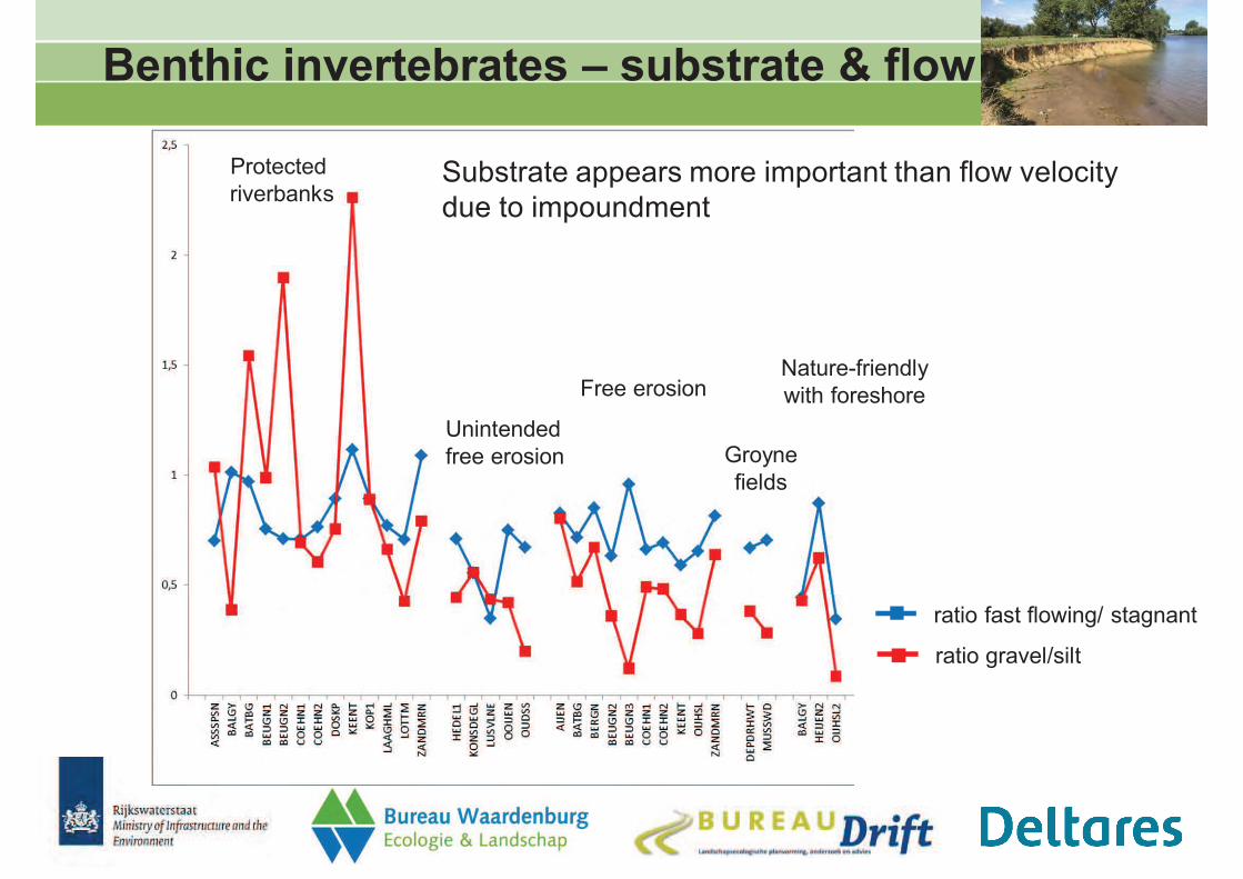
Benthic invertebrates – substrate & flow
Protected
riverbanks
Unintended
free erosion
Free erosion
Groyne
fields
Nature-friendly
with foreshore
Substrate appears more important than flow velocity
due to impoundment
ratio gravel/silt
ratio fast flowing/ stagnant
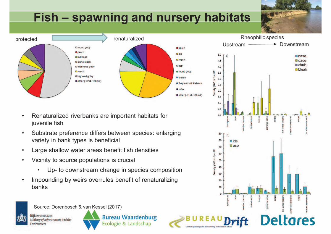
Fish – spawning and nursery habitats
Source: Dorenbosch & van Kessel (2017)
• Renaturalized riverbanks are important habitats for
juvenile fish
• Substrate preference differs between species: enlarging
variety in bank types is beneficial
• Large shallow water areas benefit fish densities
• Vicinity to source populations is crucial
• Up- to downstream change in species composition
• Impounding by weirs overrules benefit of renaturalizing
banks
protected renaturalizedUpstream Downstream
Rheophilic species
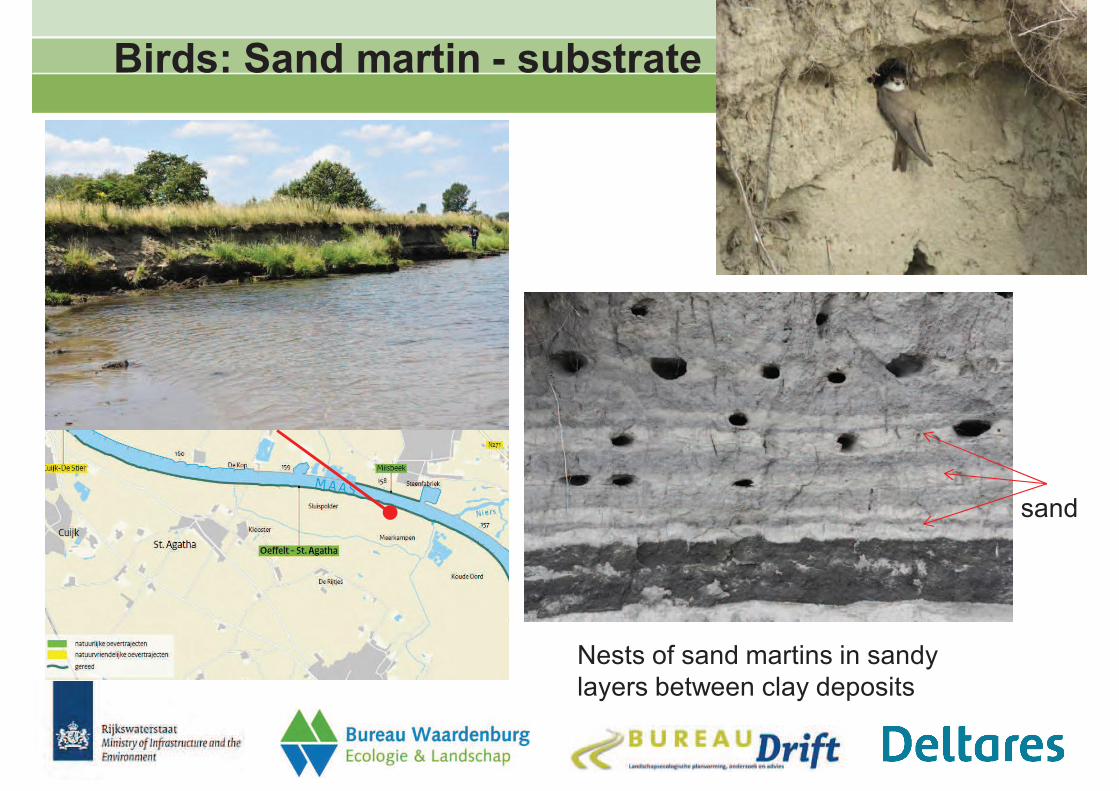
Birds: Sand martin - substrate
sand
Nests of sand martins in sandy
layers between clay deposits
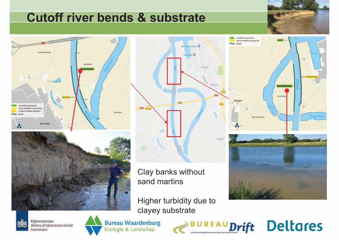
Cutoff river bends & substrate
Clay banks without
sand martins
Higher turbidity due to
clayey substrate
Conclusions
• Morphology: most sites in initial succession state of bank erosion
• Increased habitat diversity of riparian zone
• Location of riverbank plays a crucial role for erosion rate
• Water level fluctuation, bank height & intensity of navigation
• Flow velocity, channel width, inner/outer bend, substrate
• Ecology: both aquatic and terrestrial biota benefit
• Impoundment and navigation constrain aquatic ecology (rheophily, densities)
• Fish: rapid response
• Aquatic vegetation: water body dominates, time-lag
• Benthic invertebrates: substrate dictates community
• Characteristic terrestrial biota (e.g. sand martin)
• 10 year monitoring may sound long …
• … but many factors influence development (location, design)
• BACI monitoring yielded improved understanding, but no hard statistical
conclusions due to the diversity in local conditions
Guidance for water managers
Implementation & design optimization
- Choice of location
• Water fluctuation: location within impoundment
• Soil composition of the banks
• Up- or downstream: source populations
- Based on (desired) erosion depth into the floodplain
• Extend of removing bank protection
Monitoring
- Comparability of types and locations
- Continuity (long-term succession, time-lag)
- Morphological development of shallow areas
Floodplain management
- Formulate quality requirements for floodplains and riparian zones
������� � ����� �������
���������������������������
�� ������������������������
����������������
��������� �������������!�������"�����
�������������#$����������%���&�'������
(�)��� � �*(!�"*�" �((!+�",+�
�-��! "** ",-�"�./��+.+'�"�.
��-0(!+* "*�+-+-��* !��1�
��*,�*!+-'�,�(/�-�2" ��3(�"*�
� �*(!�"*�" �((!+�",+�
�-��! "** ",-�"�./��+.+'�"�.��-0(!+* "*�+-+-
��* !��1���*,�*!+-'�,�(/�-�2" ��3(�"*�
������������������ ��� ����������
����� ������ �������
� ��������#�� �� �))������� ���������/���������� ���4)����������
� �����������4)�����������������������)/���������)����
» "���5�(�������������������/�������"�������������6776
» "���6������)������������)��������)���!�����'�������6778
� !��������������������������(��������))�����
� �*(!�"*�" �((!+�",+�
�-��! "** ",-�"�./��+.+'�"�.��-0(!+* "*�+-+-
��* !��1���*,�*!+-'�,�(/�-�2" ��3(�"*�
�� ������ ��� �� �������� ��
������������������ ��� �����������
*�����������))�����
�������������������
-���))�����9
� ��������������
� ������� �)�����
� :������� �:)�������
� 3����)����;�������
� +))����������
� +����������
� '��������� 9
� "�����)�������9
� (��-"��"���'56<
� �*(!�"*�" �((!+�",+�
�-��! "** ",-�"�./��+.+'�"�.��-0(!+* "*�+-+-
��* !��1���*,�*!+-'�,�(/�-�2" ��3(�"*�
�������� ��� ���������� �����
������ ����������� �������
(��������� ��������= ������� ����� ���4
= ��������� ��#�����#��� ���4
���)/������� ��)����= ���4� >)����� ����?��������
= ������� >���������?��������
�����������������= ���� ������ ��� ��)���� ������
= ����� #���#������ ������
� �*(!�"*�" �((!+�",+�
�-��! "** ",-�"�./��+.+'�"�.��-0(!+* "*�+-+-
��* !��1���*,�*!+-'�,�(/�-�2" ��3(�"*�
�������� ��� ���������� �����
������ ����������� �������
� ��������6776
� ������� �����@���A�
� (������������� ��4�
� *������ �)������
����������#���
� '�������6778
� ������� �����@���A�
� �����)��� ����
� �����)������
����������#���
"���5��������/�������"����
"���6�)��� !������������
� �*(!�"*�" �((!+�",+�
�-��! "** ",-�"�./��+.+'�"�.��-0(!+* "*�+-+-
��* !��1���*,�*!+-'�,�(/�-�2" ��3(�"*�
�������� ��� ���������� �����
������ ����������� �������
"���5��������/�������"����
"���6�)��� !������������
� �*(!�"*�" �((!+�",+�
�-��! "** ",-�"�./��+.+'�"�.��-0(!+* "*�+-+-
��* !��1���*,�*!+-'�,�(/�-�2" ��3(�"*�
�������� ��� ����������
���� � � �������������� �����
� �*(!�"*�" �((!+�",+�
�-��! "** ",-�"�./��+.+'�"�.��-0(!+* "*�+-+-
��* !��1���*,�*!+-'�,�(/�-�2" ��3(�"*�
���� � � �������������� �����
��������
+�;�������= )������ ������� ���)/������� ��)����= ����������������)����#������� #����
���4)���������
= )������������#�����#���� ���4= ������� �����@������� �����������
��������= ����� ���������4��� �����= ������� ������������ ��� �����������
*���������= ������������ �6776/ 677B= �����������677A/ 6757
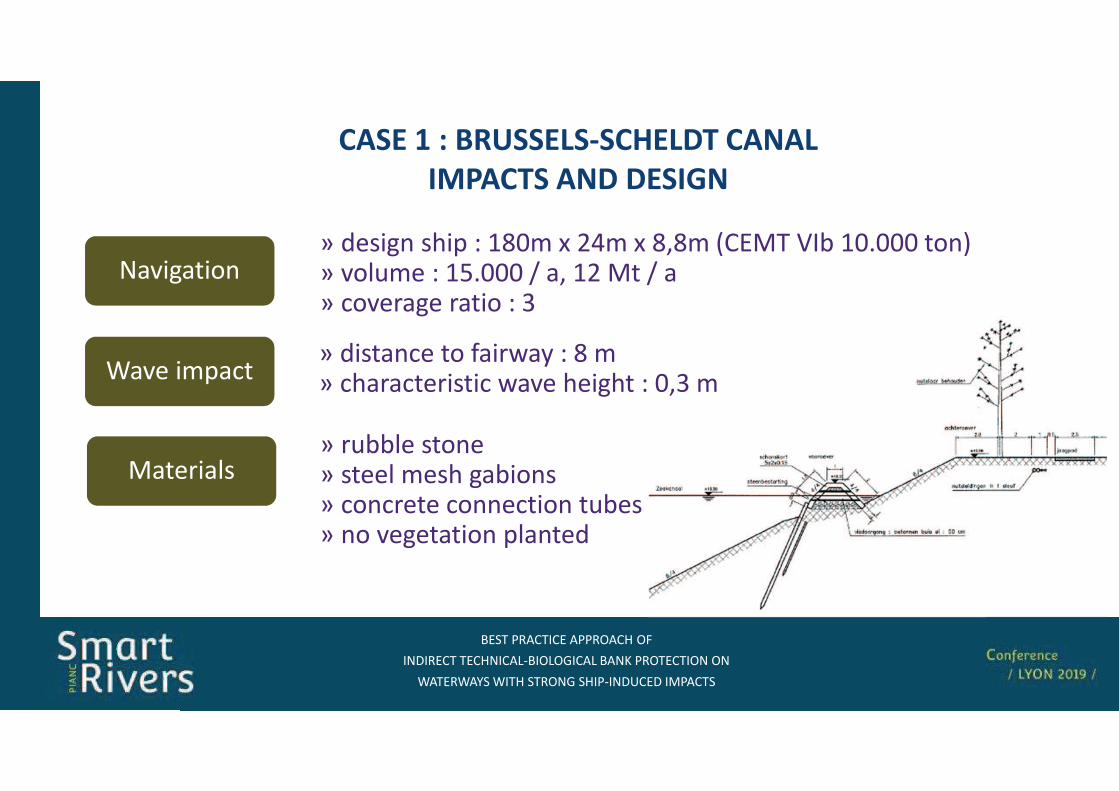
� �*(!�"*�" �((!+�",+�
�-��! "** ",-�"�./��+.+'�"�.��-0(!+* "*�+-+-
��* !��1���*,�*!+-'�,�(/�-�2" ��3(�"*�
���� � � �������������� �����
������� ��� ������
3��������= ������ �����= ��������� �������= ������������������ �����= ������������ )������
-���������= ���������) �5<7�:6C�:<�<�%" 3* �� 57D777���&= �������5AD777E��563�E�= �������� ������8
������)���= �������� �� #�������<�= �������������� ���������� �7�8�
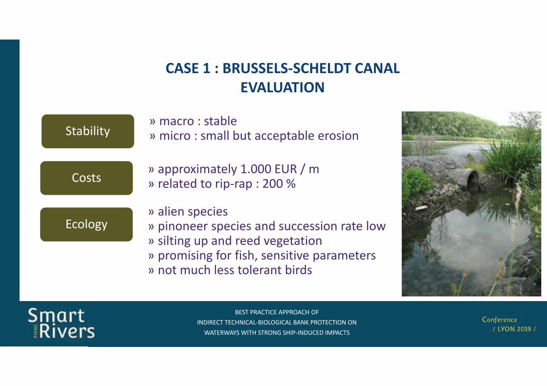
� �*(!�"*�" �((!+�",+�
�-��! "** ",-�"�./��+.+'�"�.��-0(!+* "*�+-+-
��* !��1���*,�*!+-'�,�(/�-�2" ��3(�"*�
���� � � �������������� �����
����������
"����= �))��:������� 5D777 2!E�= ������� �� ��)/��)�677F
������= ������)�����= )��������)�������� ���������� ���� ���= ������� �)��� ��������������= )�������� #�� #������������� )���������= ��� ���� ���� �������������
���������= ������������= ������������������)����� �������
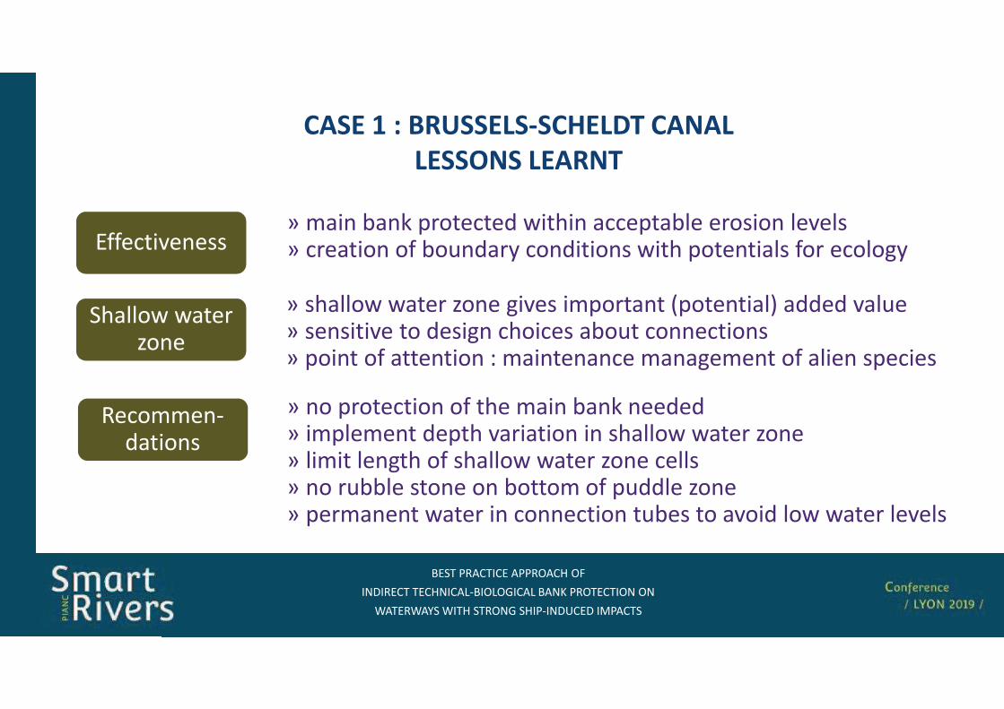
� �*(!�"*�" �((!+�",+�
�-��! "** ",-�"�./��+.+'�"�.��-0(!+* "*�+-+-
��* !��1���*,�*!+-'�,�(/�-�2" ��3(�"*�
���� � � �������������� �����
������� ������
!�������/�������
= ��)����������#����������4������= ��)��������)�������������������������@���= ������������#������������@��������= ����������������������#)�����@���= )���������������������������������������������������
##����������= �������4)������������������)������������������= ���������#����������������������)���������#���������
������� �����@���
= ������������@����������)������%)��������&����������= ����������������������������������������= )�����#��������������������������������#������)�����
� �*(!�"*�" �((!+�",+�
�-��! "** ",-�"�./��+.+'�"�.��-0(!+* "*�+-+-
��* !��1���*,�*!+-'�,�(/�-�2" ��3(�"*�
�������� ��� ����������
���� � � ����� ����� �� �����
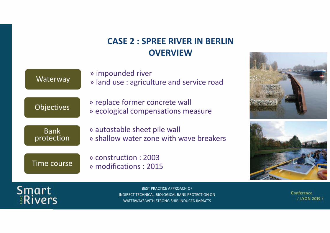
� �*(!�"*�" �((!+�",+�
�-��! "** ",-�"�./��+.+'�"�.��-0(!+* "*�+-+-
��* !��1���*,�*!+-'�,�(/�-�2" ��3(�"*�
���� � � ����� ����� �� �����
��������
+�;�������= ��)���� #����� ������������= ���������� ���)��������� �������
���4)���������
= ���������� �����)��� ����= ������� �����@������� ��������4���
��������= ��)������ �����= ������� ������������ ��� �����������
*���������= ������������ �6778= ����#�������� �675A
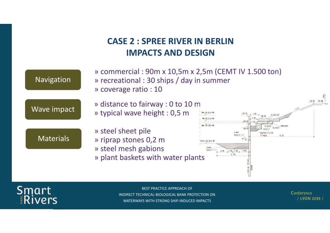
� �*(!�"*�" �((!+�",+�
�-��! "** ",-�"�./��+.+'�"�.��-0(!+* "*�+-+-
��* !��1���*,�*!+-'�,�(/�-�2" ��3(�"*�
���� � � ����� ����� �� �����
������� ��� ������
3��������= ����������)���= ��)��) ������ 7�6�= ��������� �������= )�������4������� �����)�����
-���������= �����������G7�:57�A�:6�A�%" 3*� 5DA77���&= ������������ �87���)� E��� ��������= �������� ������57
������)���= �������� �� #�������7�� 57�= ��)���� ���������� �7�A�
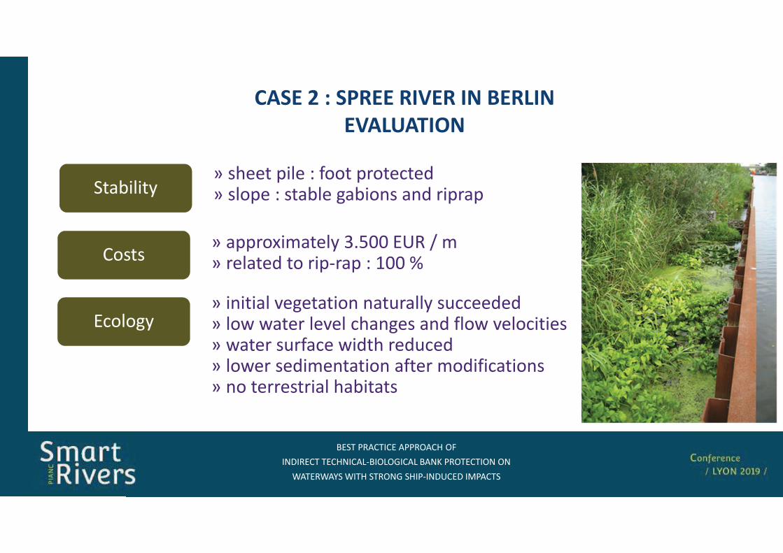
� �*(!�"*�" �((!+�",+�
�-��! "** ",-�"�./��+.+'�"�.��-0(!+* "*�+-+-
��* !��1���*,�*!+-'�,�(/�-�2" ��3(�"*�
���� � � ����� ����� �� �����
����������
"����= �))��:������� 8DA77 2!E�= ������� �� ��)/��)�577F
������= ������� ���������� ��������� ���������= ����������������������� #�������������= ��������#��� ����� �������= ����� ������������� �#��� ����#��������= ������������� ��������
���������= �����)��� �#��� )��������= ���)� ������� ������� ��� ��)��)
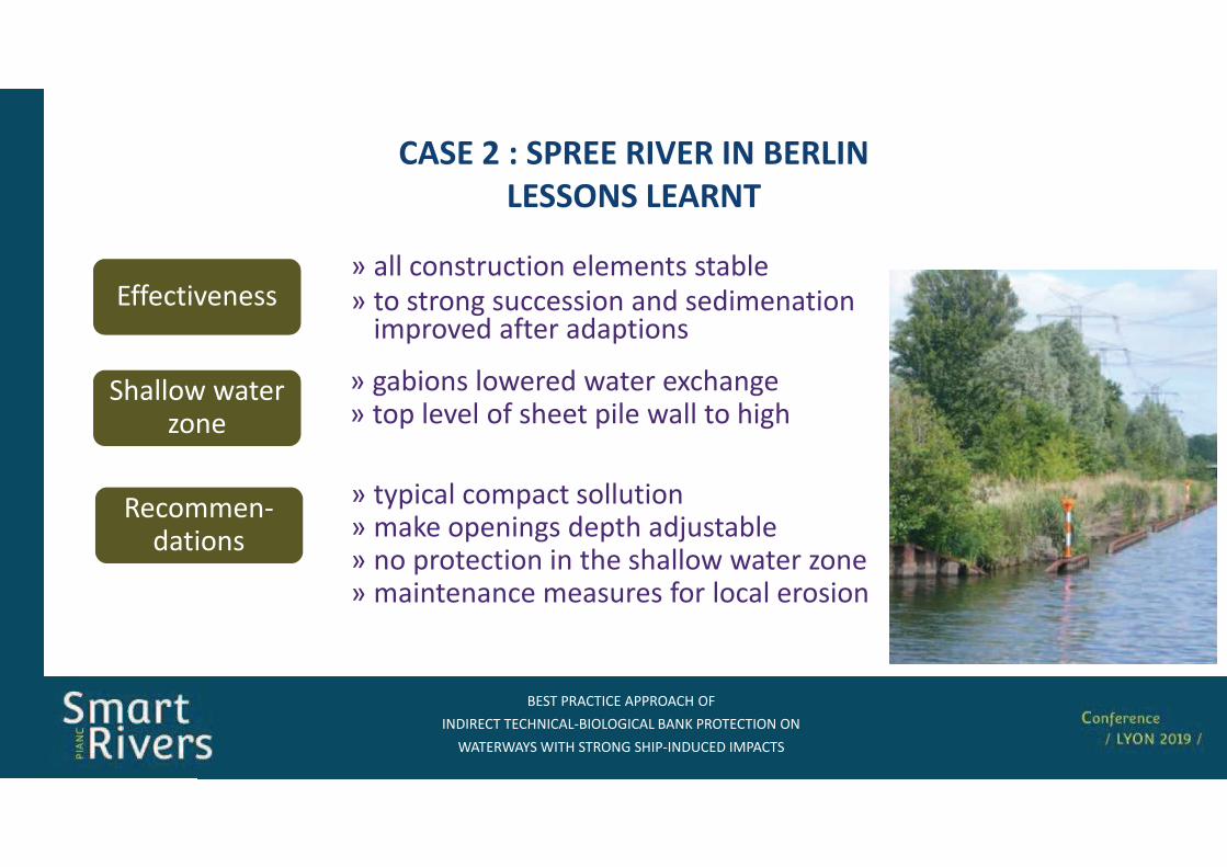
� �*(!�"*�" �((!+�",+�
�-��! "** ",-�"�./��+.+'�"�.��-0(!+* "*�+-+-
��* !��1���*,�*!+-'�,�(/�-�2" ��3(�"*�
���� � � ����� ����� �� �����
������� ������
= ��)���� ���)������������= ��4��)������ ��)�� ��;�������= ��)��������� ����� ������� �����@���= ������������������� #�� ����� �������
= ��� ������������ �������� ������
= �� ���������������� ��� ��������������)����� �#��� ���)�����
= ������� ������� ������:������= ��)������#�����)��� ���� �� ����
!�������/�������
##����������
������� �����@���

� �*(!�"*�" �((!+�",+�
�-��! "** ",-�"�./��+.+'�"�.��-0(!+* "*�+-+-
��* !��1���*,�*!+-'�,�(/�-�2" ��3(�"*�
���������������
������� � ��� �������� ��������
� �����������������)����������)�����
������������#����������������������������������
� ������)����%���)/�����������������������������������&�
���4)��)������%���������������������4�������������&���
#������������%����������������������&
� 3������������#�������#������������������
� ���)�������������;���������#���������������������)�������������
� �*(!�"*�" �((!+�",+�
�-��! "** ",-�"�./��+.+'�"�.��-0(!+* "*�+-+-
��* !��1���*,�*!+-'�,�(/�-�2" ��3(�"*�
����� �������
����������������������������� �����������������������������D �������H���������������D��
����������������
��������� �������������!�������"������������������#$����������%���&�'��������������D��������H���D��
��� �������� �������� ��
�������� ������������������ ��� ���������� ��
��������� ���� ������ ����������� �������
������������������� ����� ������������ �����������������������������
�������� ����
������� ���!����"� �� �����#���������� �������$ ��������
�%%& ��#'���($))#"��"��* $��#&(���+��
(")�&,�&��,�#"-)�)"-�+�-$%.��&%&��-$%��$+��
�#&)"-)�&+�&+� $)"# $/�
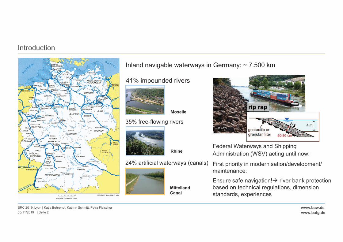
|
www.baw.de
www.bafg.de
Introduction
SRC 2019, Lyon | Katja Behrendt, Kathrin Schmitt, Petra Fleischer
Seite 230/11/2019
Inland navigable waterways in Germany: ~ 7.500 km
Moselle
41% impounded rivers
Rhine
35% free-flowing rivers
Mittelland
Canal
24% artificial waterways (canals)
Federal Waterways and Shipping
Administration (WSV) acting until now:
First priority in modernisation/development/
maintenance:
Ensure safe navigation!� river bank protection
based on technical regulations, dimension
standards, experiences
© BAW
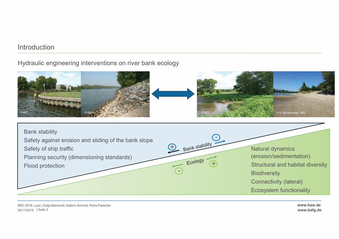
|
www.baw.de
www.bafg.de
Introduction
SRC 2019, Lyon | Katja Behrendt, Kathrin Schmitt, Petra Fleischer
30/11/2019
Hydraulic engineering interventions on river bank ecology
Diversity
Neobiota
Bank stability
Safety against erosion and sliding of the bank slope
Safety of ship traffic
Planning security (dimensioning standards)
Flood protection
Natural dynamics
(erosion/sedimentation)
Structural and habitat diversity
Biodiversity
Connectivity (lateral)
Ecosystem functionality
-
+
-+
Seite 3
© BfG © BAW © A. Sundermeier, BfG© BfG
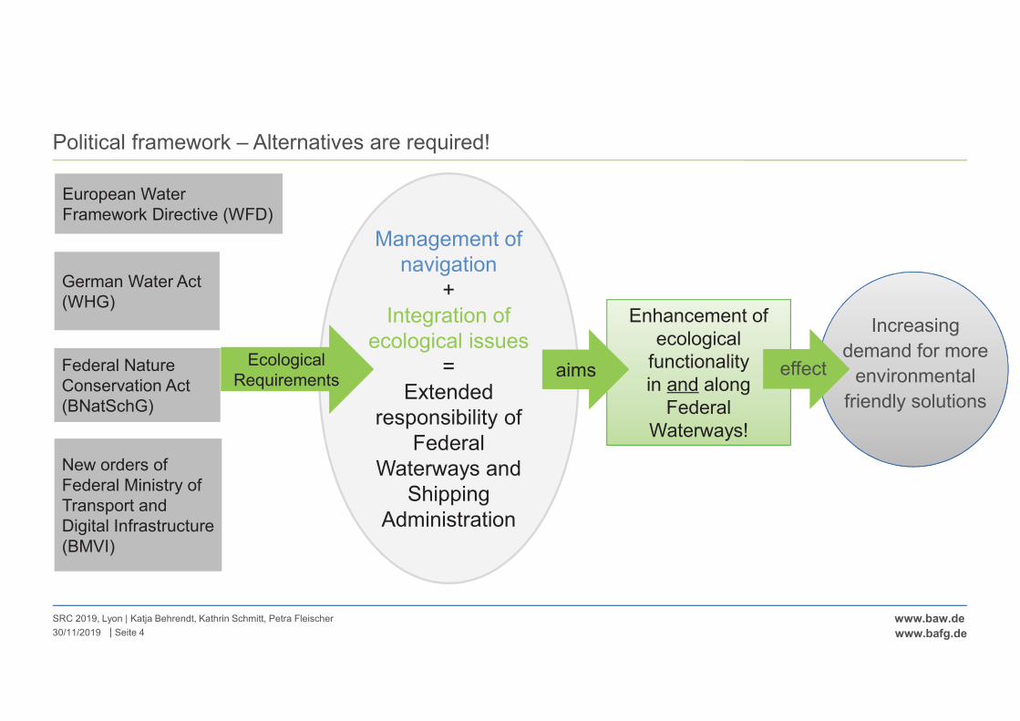
|
www.baw.de
www.bafg.de
Political framework – Alternatives are required!
SRC 2019, Lyon | Katja Behrendt, Kathrin Schmitt, Petra Fleischer
Seite 430/11/2019
Management of
navigation
+
Integration of
ecological issues
=
Extended
responsibility of
Federal
Waterways and
Shipping
Administration
European Water
Framework Directive (WFD)
German Water Act
(WHG)
Federal Nature
Conservation Act
(BNatSchG)
Ecological
Requirements
Enhancement of
ecological functionality
in and along
Federal
Waterways!
aims
New orders of
Federal Ministry of
Transport and
Digital Infrastructure
(BMVI)
Increasing
demand for more
environmental
friendly solutions
effect
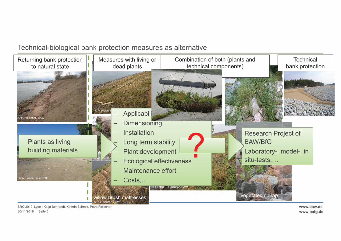
|
www.baw.de
www.bafg.de
Technical-biological bank protection measures as alternative
30/11/2019
SRC 2019, Lyon | Katja Behrendt, Kathrin Schmitt, Petra Fleischer
Seite 5
Returning bank protection
to natural state
© A. Sundermeier, BfG
© P. Fleischer, BAW
Measures with living or
dead plants
precultivated plant mats
willow brush mattresses© P. Fleischer, BAW
© K. Behrendt, BfG
© P. Fleischer, BAW
Combination of both (plants and
technical components)
reed gabions
vegetated rip rap
© 4 Fotos: P Fleischer, BAW
Technical
bank protection
© BAW
Research Project of
BAW/BfG
Laboratory-, model-, in
situ-tests,…
− Applicability
− Dimensioning
− Installation
− Long term stability
− Plant development
− Ecological effectiveness
− Maintenance effort
− Costs,…
?Plants as living
building materials
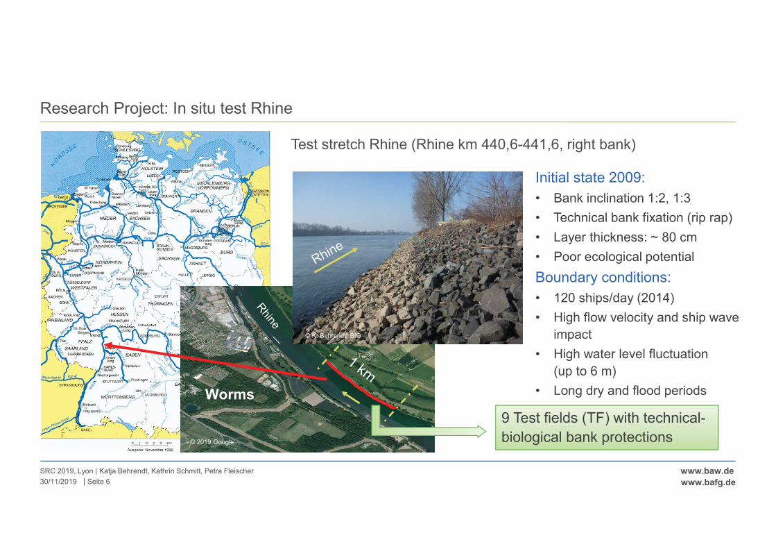
|
www.baw.de
www.bafg.de
Research Project: In situ test Rhine
SRC 2019, Lyon | Katja Behrendt, Kathrin Schmitt, Petra Fleischer
Seite 630/11/2019
Test stretch Rhine (Rhine km 440,6-441,6, right bank)
Initial state in 2009
Initial state 2009:
• Bank inclination 1:2, 1:3
• Technical bank fixation (rip rap)
• Layer thickness: ~ 80 cm
• Poor ecological potential
Boundary conditions:
• 120 ships/day (2014)
• High flow velocity and ship wave
impact
• High water level fluctuation
(up to 6 m)
• Long dry and flood periodsWorms
9 Test fields (TF) with technical-
biological bank protections
© K. Behrendt, BfG
© 2019 Google
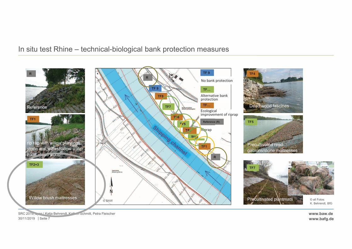
|
www.baw.de
www.bafg.de
In situ test Rhine – technical-biological bank protection measures
30/11/2019
SRC 2019, Lyon | Katja Behrendt, Kathrin Schmitt, Petra Fleischer
Seite 7
TF 9
TF 9
TF…
Reference (R)
TF7
TF5
TF2+3
TF4
TF1
TF6
TF8
+��0�1�2����� �
$����� 3��0�12����� �
TF…
"����� ���� �2�3�������� 2�2
R
R
# 2�2������������
© BAW
Reference
R
rip rap with willow plantings,
stone wall with shallow water
zone, dead wood,
dead wood
TF1
TF2+3
Willow brush mattresses
Dead wood fascines
TF4
Precultivated reed
gabions/stone mattresses
TF5
Precultivated plantmats
TF7
© all Fotos:
K. Behrendt, BfG
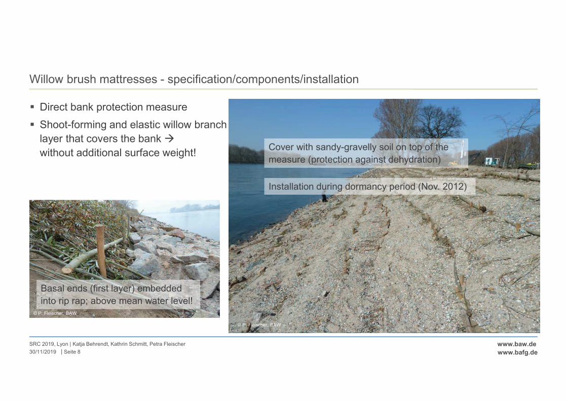
|
www.baw.de
www.bafg.de
Willow brush mattresses - specification/components/installation
� Direct bank protection measure
� Shoot-forming and elastic willow branch
layer that covers the bank �
without additional surface weight!
30/11/2019
SRC 2019, Lyon | Katja Behrendt, Kathrin Schmitt, Petra Fleischer
Seite 8
© K. Behrendt, BfG
Living branches of
indigenous and site
adapted willow trees/shrubs secured to the
soil by stakes
and crossbars
12/2011
Cover with sandy-gravelly soil on top of the
measure (protection against dehydration)
Installation during dormancy period (Nov. 2012)
© P. Fleischer, BAW
Basal ends (first layer) embedded
into rip rap; above mean water level!© P. Fleischer, BAW
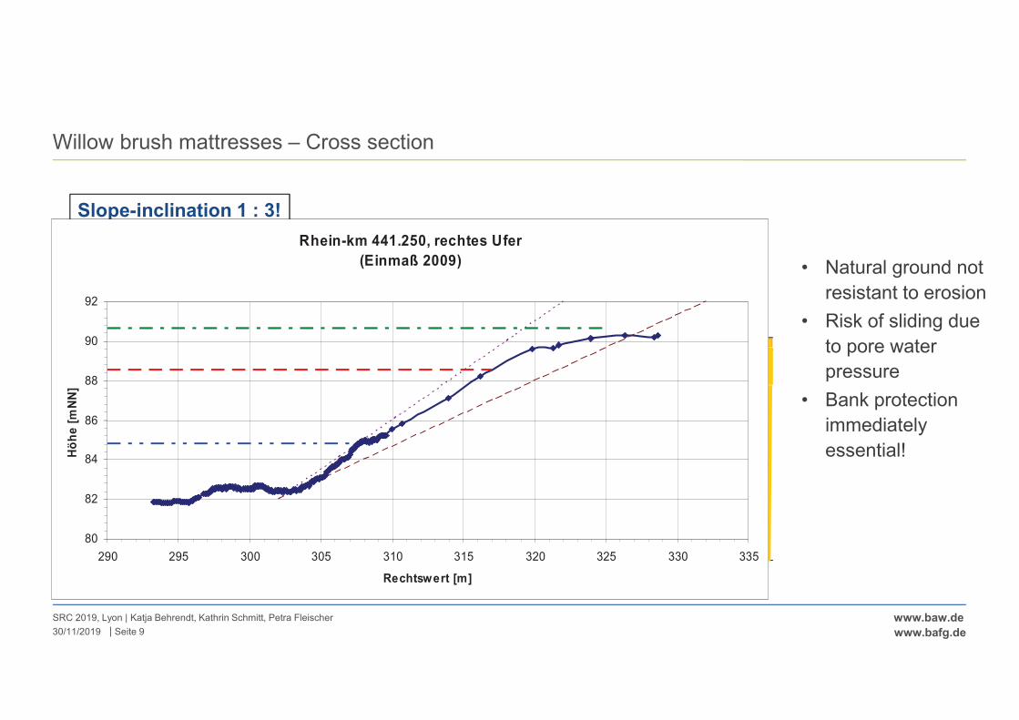
|
www.baw.de
www.bafg.de
Willow brush mattresses – Cross section
SRC 2019, Lyon | Katja Behrendt, Kathrin Schmitt, Petra Fleischer
Seite 930/11/2019
• Natural ground not
resistant to erosion
• Risk of sliding due
to pore water
pressure
• Bank protection
immediately
essential! GLW
MI/ HNWLI
MII/ HNWLII
Rip rap maintained
(below MWL)
Willow brush mattresses
(above MWL)
Slope stability is ensured by roots
No surface weight!
MWL
Slope-inclination 1 : 3!
120 vessels per day!MWL = mean water levelHNWL= highest navigable water level
© P. Fleischer, BAW
Rhein-km 441.250, rechtes Ufer
(Einmaß 2009)
80
82
84
86
88
90
92
290 295 300 305 310 315 320 325 330 335
Rechtswert [m]
Hö
he
[m
NN
]
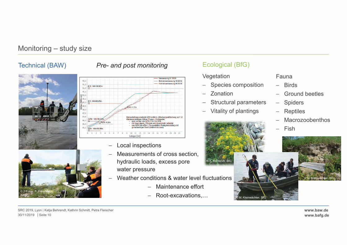
|
www.baw.de
www.bafg.de
Monitoring – study size
SRC 2019, Lyon | Katja Behrendt, Kathrin Schmitt, Petra Fleischer
Seite 1030/11/2019
Technical (BAW) Pre- and post monitoring
− Local inspections
− Measurements of cross section,
hydraulic loads, excess pore
water pressure
− Weather conditions & water level fluctuations
− Maintenance effort
− Root-excavations,…© 2 Fotos: P. Fleischer,
BAW
Fauna
− Birds
− Ground beetles
− Spiders
− Reptiles
− Macrozoobenthos
− Fish
Ecological (BfG)
Vegetation
− Species composition
− Zonation
− Structural parameters
− Vitality of plantings
© M. Kleinwächter, BfG
© K. Behrendt, BfG
© M. Kleinwächter, BfG
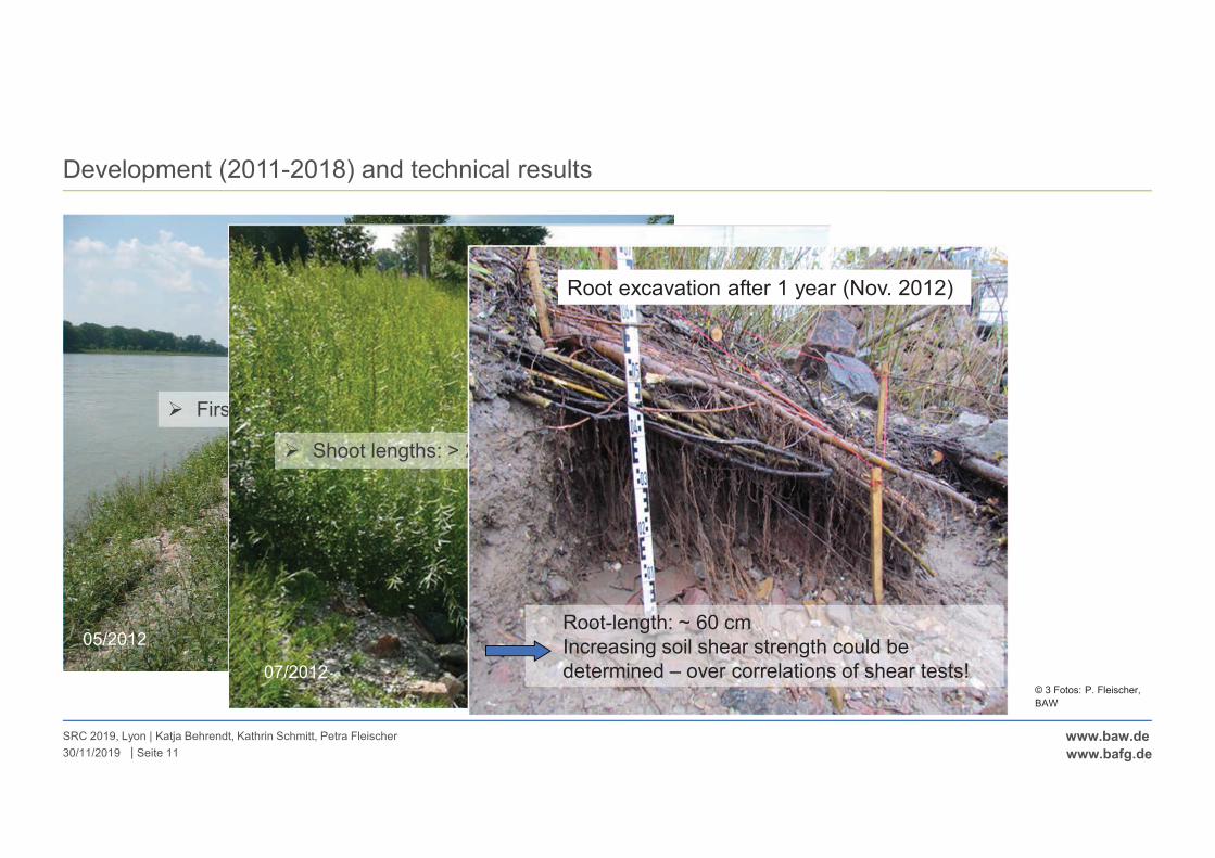
|
www.baw.de
www.bafg.de
Development (2011-2018) and technical results
SRC 2019, Lyon | Katja Behrendt, Kathrin Schmitt, Petra Fleischer
Seite 1130/11/2019
05/2012
� First sprouts alongside the cross-bars
� Shoot lengths: > 2 m
07/2012
Root-length: ~ 60 cm
Increasing soil shear strength could be
determined – over correlations of shear tests!
Root excavation after 1 year (Nov. 2012)
© 3 Fotos: P. Fleischer,
BAW
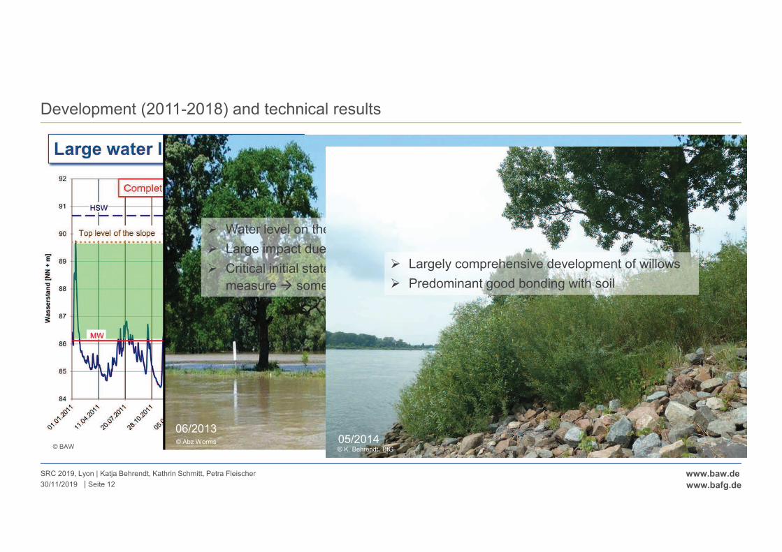
|
www.baw.de
www.bafg.de
Development (2011-2018) and technical results
SRC 2019, Lyon | Katja Behrendt, Kathrin Schmitt, Petra Fleischer
Seite 1230/11/2019
© BAW
� Water level on the top of the slope (MWL + 4m)!
� Large impact due to floating forces, currents, waves!
� Critical initial state: local soil erosion/local instability of
measure � some repair work necessary
06/2013© Abz Worms 05/2014
� Largely comprehensive development of willows
� Predominant good bonding with soil
© K. Behrendt, BfG
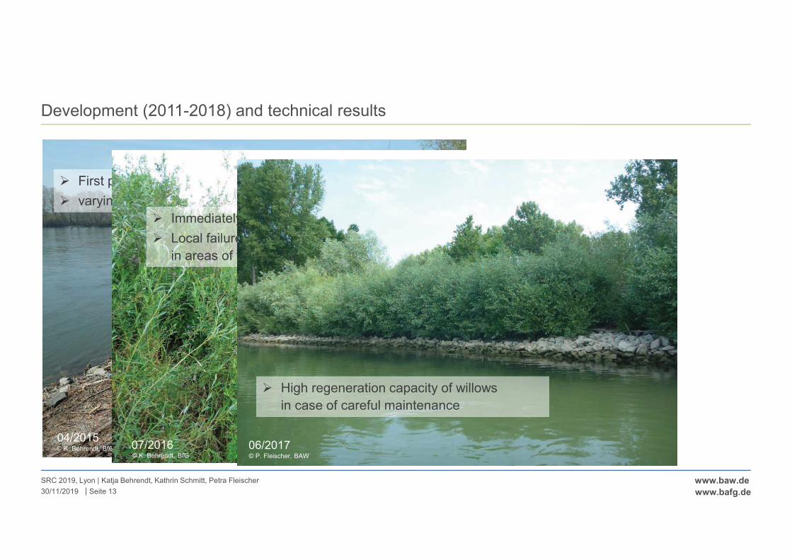
|
www.baw.de
www.bafg.de
Development (2011-2018) and technical results
SRC 2019, Lyon | Katja Behrendt, Kathrin Schmitt, Petra Fleischer
Seite 1330/11/2019
04/2015
� First pruning in february 2015
� varying pruning intensity
Pruning area
Growth area
© K. Behrendt, BfG 07/2016
� Immediately after pruning long period of flooding
� Local failures of willows, local erosion especially
in areas of total pruning
© K. Behrendt, BfG
06/2017
� High regeneration capacity of willows
in case of careful maintenance
© P. Fleischer, BAW
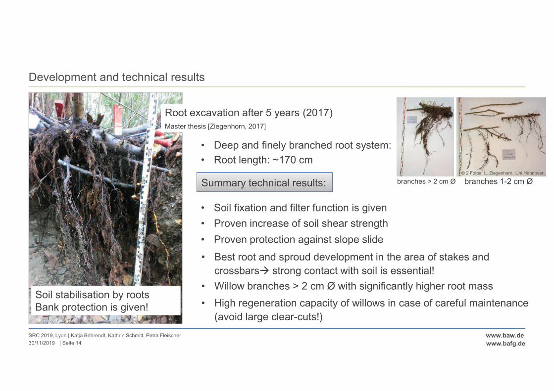
|
www.baw.de
www.bafg.de
Development and technical results
SRC 2019, Lyon | Katja Behrendt, Kathrin Schmitt, Petra Fleischer
Seite 1430/11/2019
Root excavation after 5 years (2017)
Master thesis [Ziegenhorn, 2017]
Soil stabilisation by roots
Bank protection is given!
• Deep and finely branched root system:
Summary technical results:
• Soil fixation and filter function is given
• Proven increase of soil shear strength
• Proven protection against slope slide
• Best root and sproud development in the area of stakes and
crossbars� strong contact with soil is essential!
• High regeneration capacity of willows in case of careful maintenance
(avoid large clear-cuts!)
• Root length: ~170 cm
©P. Fleischer, BAW
branches > 2 cm Ø branches 1-2 cm Ø
• Willow branches > 2 cm Ø with significantly higher root mass
© 2 Fotos: L. Ziegenhorn, Uni Hannover
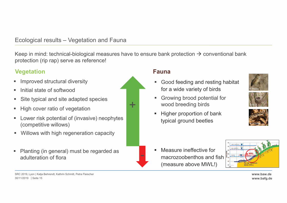
|
www.baw.de
www.bafg.de
Ecological results – Vegetation and Fauna
SRC 2019, Lyon | Katja Behrendt, Kathrin Schmitt, Petra Fleischer
Seite 1530/11/2019
Keep in mind: technical-biological measures have to ensure bank protection � conventional bank
protection (rip rap) serve as reference!
+
Vegetation
� Improved structural diversity
� Initial state of softwood
� Site typical and site adapted species
� High cover ratio of vegetation
� Lower risk potential of (invasive) neophytes
(competitive willows)
� Willows with high regeneration capacity
-� Planting (in general) must be regarded as
adulteration of flora
© Pastor
© BCE
© Lindsey
Fauna
� Good feeding and resting habitat
for a wide variety of birds
� Growing brood potential for
wood breeding birds
� Higher proportion of bank
typical ground beetles
� Measure ineffective for
macrozoobenthos and fish
(measure above MWL!)
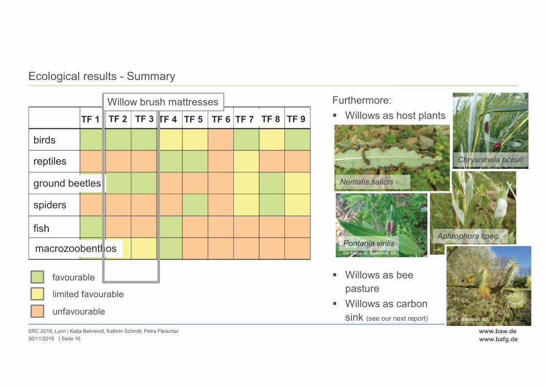
|
www.baw.de
www.bafg.de
Ecological results - Summary
SRC 2019, Lyon | Katja Behrendt, Kathrin Schmitt, Petra Fleischer
Seite 1630/11/2019
favourable
limited favourable
unfavourable
VF 1 VF 2 VF 3 VF 4 VF 5 VF 6 VF 7 VF 8 VF 9
Vögel
Reptilien
Laufkäfer
Spinnen
Fische
MZB
birds
reptiles
ground beetles
spiders
fish
macrozoobenthos
TF 9TF 8TF 7TF 6TF 5TF 4TF 3TF 2TF 1
Willow brush mattresses Furthermore:
� Willows as host plants
Chrysomela populi
Nematis salicis
Pontania virilisAphrophora spec.
©4 Fotos: K. Behrendt, BfG
� Willows as bee
pasture
� Willows as carbon
sink (see our next report) © K. Behrendt, BfG
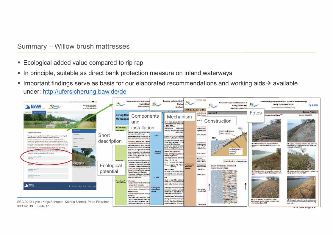
|
www.baw.de
www.bafg.de
Summary – Willow brush mattresses
SRC 2019, Lyon | Katja Behrendt, Kathrin Schmitt, Petra Fleischer
Seite 1730/11/2019
� Ecological added value compared to rip rap
� In principle, suitable as direct bank protection measure on inland waterways
� Important findings serve as basis for our elaborated recommendations and working aids� available
under: http://ufersicherung.baw.de/de
Short
description
Ecological
potential
Components
and
installation
MechanismConstruction
Fotos

|
www.baw.de
www.bafg.de
Outlook
SRC 2019, Lyon | Katja Behrendt, Kathrin Schmitt, Petra Fleischer
Seite 1830/11/2019
See next presentation!
Bernhard Soehngen & Kathrin Schmitt: „First steps towards a best practice
approach for the selection of technical-biological bank protections“
Research on technical-biological bank protections will provide promising approaches for the ecological
development of German Federal Waterways and also…..
… in the international context!
Input of our findings into PIANC InCom Working Group 128 „ Alternative Bank Protection Methods for
Inland Waterways“ Willow brush mattresses as one Fact File
Fact File Collection as a basis for the development of decision-making
tools (best practice approach)
© 2 Fotos: K. Behrendt, BfG
� Long-term monitoring of the test stretch to verify first results
� New BfG-research project „Be connect – Biodiversity and ecological connectivity of riverbank habitats“
� further ecological studies on willow brush mattresses
Federal Institute of Hydrology, Germany
56068 Koblenz
www.bafg.de
Federal Waterways Engineering and Research Institute
76187 Karlsruhe
www.baw.de
Thank you for your attention!

Bernhard Söhngen Federal Waterways Engineering and Research Institute (BAW), Germany Katja Behrendt & Kathrin Schmitt Federal Institute of Hydrology (BfG), Germany Tetsunori Inoue Port and Airport Research Institute, Japan
FIRST STEPS TOWARDS A BEST PRACTICE
APPROACH FOR THE SELECTION OF TECHNICAL-
BIOLOGICAL BANK PROTECTIONS - STATUS AND
FINDINGS OF PIANC INCOM WG 128
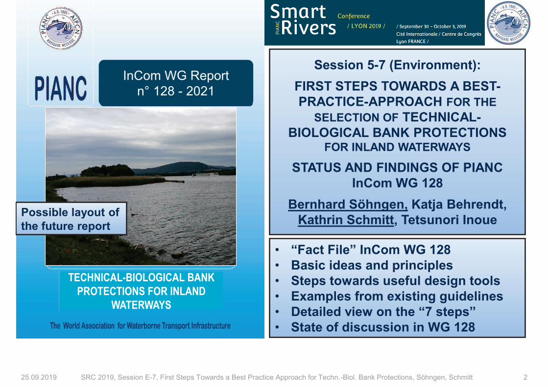
25.09.2019 SRC 2019, Session E-7, First Steps Towards a Best Practice Approach for Techn.-Biol. Bank Protections, Söhngen, Schmitt 2
InCom WG Report
n° 128 - 2021
TECHNICAL-BIOLOGICAL BANK
PROTECTIONS FOR INLAND
WATERWAYS
Session 5-7 (Environment):
FIRST STEPS TOWARDS A BEST-
PRACTICE-APPROACH FOR THE
SELECTION OF TECHNICAL-
BIOLOGICAL BANK PROTECTIONS FOR INLAND WATERWAYS
STATUS AND FINDINGS OF PIANC
InCom WG 128
Bernhard Söhngen, Katja Behrendt,
Kathrin Schmitt, Tetsunori Inoue
• “Fact File” InCom WG 128
• Basic ideas and principles
• Steps towards useful design tools
• Examples from existing guidelines
• Detailed view on the “7 steps”
• State of discussion in WG 128
Possible layout of
the future report
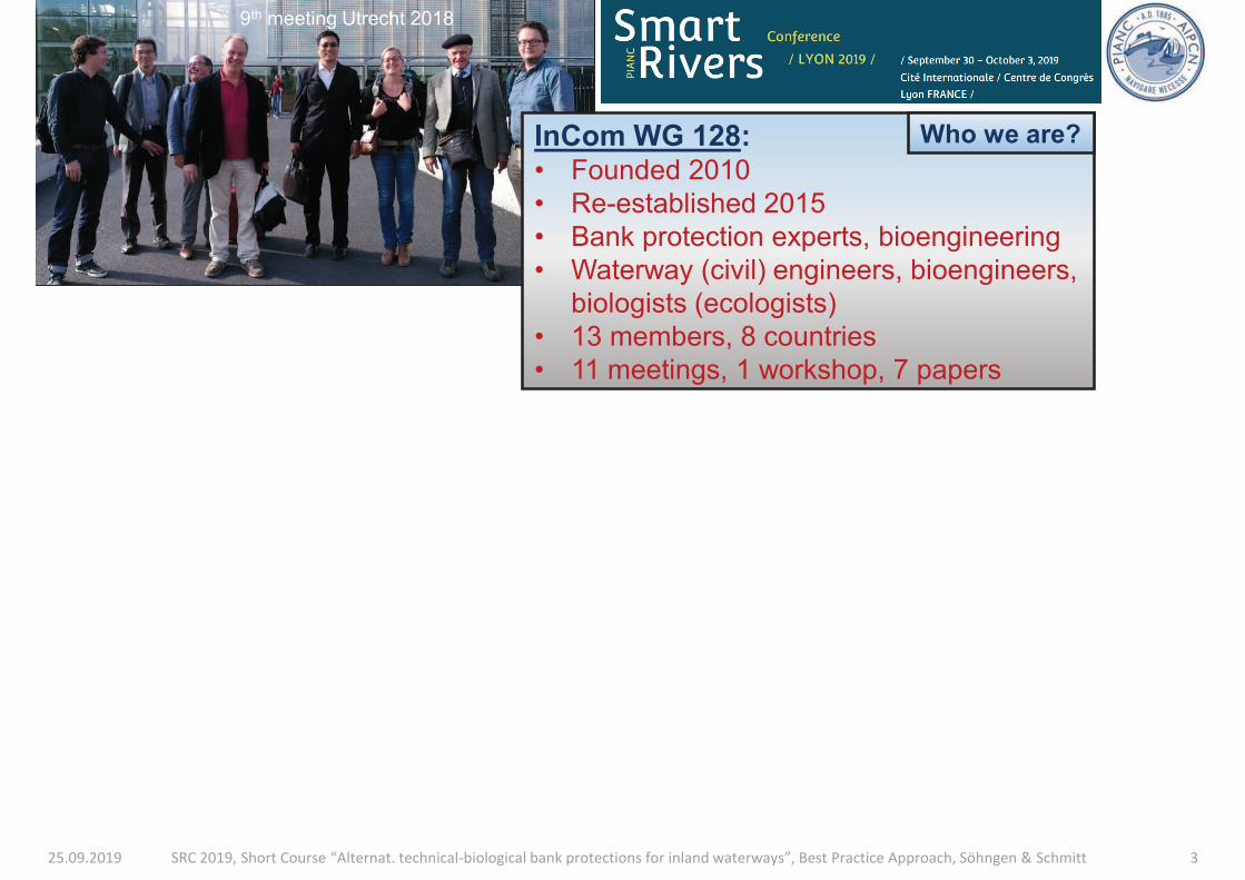
25.09.2019 SRC 2019, Short Course “Alternat. technical-biological bank protections for inland waterways”, Best Practice Approach, Söhngen & Schmitt 3
9th meeting Utrecht 2018
InCom WG 128: • Founded 2010
• Re-established 2015
• Bank protection experts, bioengineering
• Waterway (civil) engineers, bioengineers,
biologists (ecologists)
• 13 members, 8 countries
• 11 meetings, 1 workshop, 7 papers
Who we are?
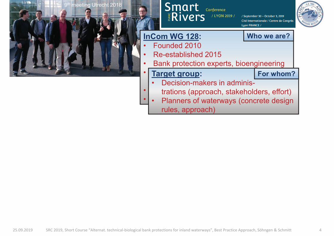
25.09.2019 SRC 2019, Short Course “Alternat. technical-biological bank protections for inland waterways”, Best Practice Approach, Söhngen & Schmitt 4
9th meeting Utrecht 2018
InCom WG 128: • Founded 2010
• Re-established 2015
• Bank protection experts, bioengineering
• Waterway (civil) engineers, bioengineers,
biologists (ecologists)
• 13 members, 8 countries
• 11 meetings, 1 workshop, 7 papers
Who we are?
Target group: • Decision-makers in adminis-
trations (approach, stakeholders, effort)
• Planners of waterways (concrete design
rules, approach)
For whom?
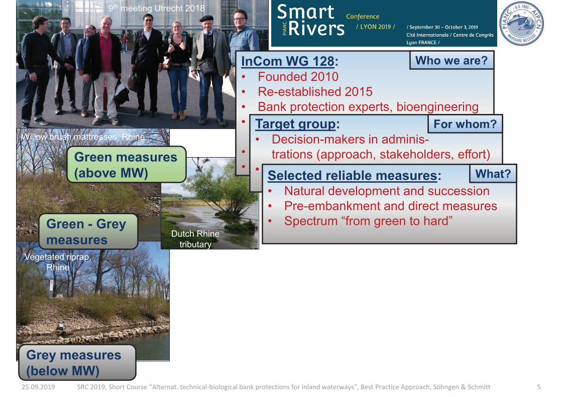
25.09.2019 SRC 2019, Short Course “Alternat. technical-biological bank protections for inland waterways”, Best Practice Approach, Söhngen & Schmitt 5
9th meeting Utrecht 2018
Vegetated riprap,
Rhine
Willow brush mattresses, Rhine
Grey measures
(below MW)
Dutch Rhine
tributary
Green measures
(above MW)
Green - Grey
measures
InCom WG 128: • Founded 2010
• Re-established 2015
• Bank protection experts, bioengineering
• Waterway (civil) engineers, bioengineers,
biologists (ecologists)
• 13 members, 8 countries
• 11 meetings, 1 workshop, 7 papers
Who we are?
Target group: • Decision-makers in adminis-
trations (approach, stakeholders, effort)
• Planners of waterways (concrete design
rules, approach)
For whom?
Selected reliable measures: • Natural development and succession
• Pre-embankment and direct measures
• Spectrum “from green to hard”
What?
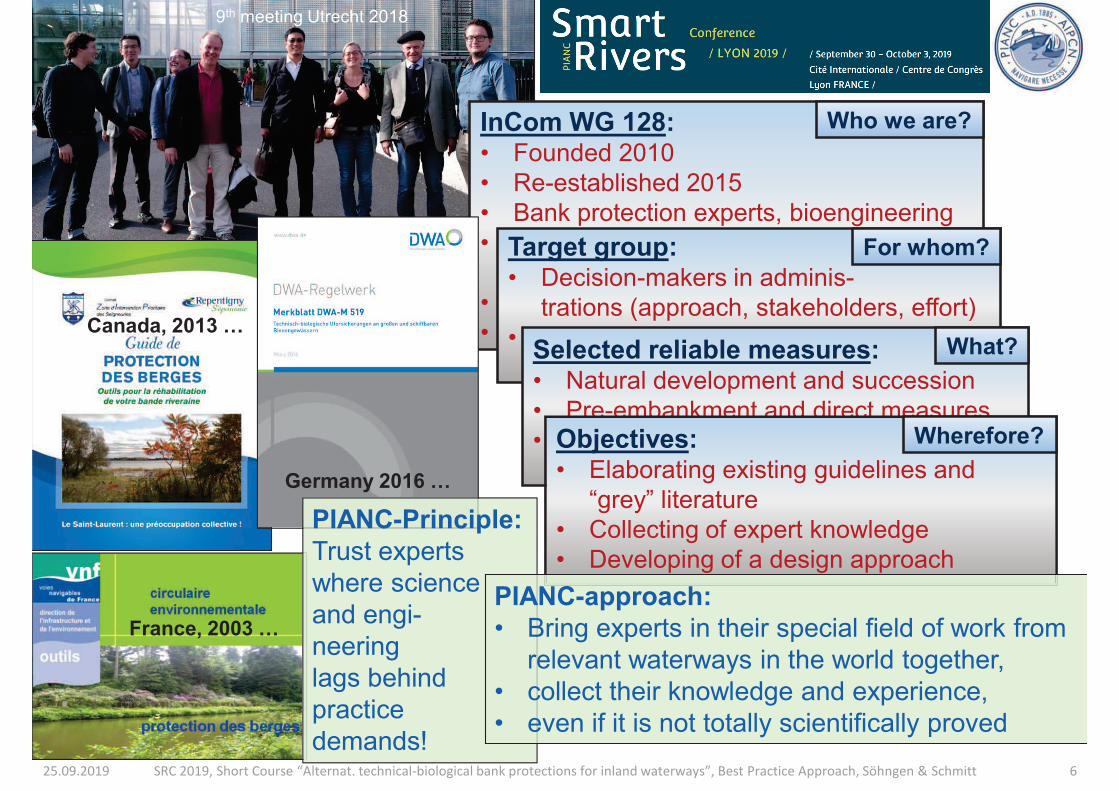
25.09.2019 SRC 2019, Short Course “Alternat. technical-biological bank protections for inland waterways”, Best Practice Approach, Söhngen & Schmitt 6
9th meeting Utrecht 2018
InCom WG 128: • Founded 2010
• Re-established 2015
• Bank protection experts, bioengineering
• Waterway (civil) engineers, bioengineers,
biologists (ecologists)
• 13 members, 8 countries
• 11 meetings, 1 workshop, 7 papers
Who we are?
Target group: • Decision-makers in adminis-
trations (approach, stakeholders, effort)
• Planners of waterways (concrete design
rules, approach)
For whom?
Selected reliable measures: • Natural development and succession
• Pre-embankment and direct measures
• Spectrum “from green to hard”
What?
Objectives: • Elaborating existing guidelines and
“grey” literature
• Collecting of expert knowledge
• Developing of a design approach
Canada, 2013 …
France, 2003 …
Germany 2016 …
PIANC-Principle:
Trust experts
where science
and engi-
neering
lags behind
practice
demands!
PIANC-approach:
• Bring experts in their special field of work from
relevant waterways in the world together,
• collect their knowledge and experience,
• even if it is not totally scientifically proved
Wherefore?
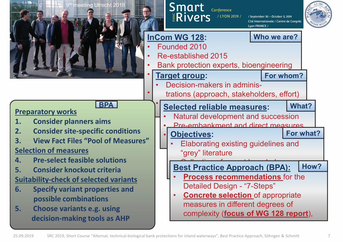
25.09.2019 SRC 2019, Short Course “Alternat. technical-biological bank protections for inland waterways”, Best Practice Approach, Söhngen & Schmitt 7
9th meeting Utrecht 2018
InCom WG 128: • Founded 2010
• Re-established 2015
• Bank protection experts, bioengineering
• Waterway (civil) engineers, bioengineers,
biologists (ecologists)
• 13 members, 8 countries
• 11 meetings, 1 workshop, 7 papers
Who we are?
Target group: • Decision-makers in adminis-
trations (approach, stakeholders, effort)
• Planners of waterways (concrete design
rules, approach)
For whom?
Selected reliable measures: • Natural development and succession
• Pre-embankment and direct measures
• Spectrum “from green to hard”
What?
Objectives: • Elaborating existing guidelines and
“grey” literature
• Collecting of expert knowledge
• Developing of a rational design approach
For what?
Best Practice Approach (BPA): • Process recommendations for the
Detailed Design - “7-Steps”
• Concrete selection of appropriate
measures in different degrees of
complexity (focus of WG 128 report),
How?
BPA
Preparatory works
1. Consider planners aims
2. Consider site-specific conditions
3. View Fact Files “Pool of Measures”
Selection of measures
4. Pre-select feasible solutions
5. Consider knockout criteria
Suitability-check of selected variants
6. Specify variant properties and
possible combinations
5. Choose variants e.g. using
decision-making tools as AHP
BPA
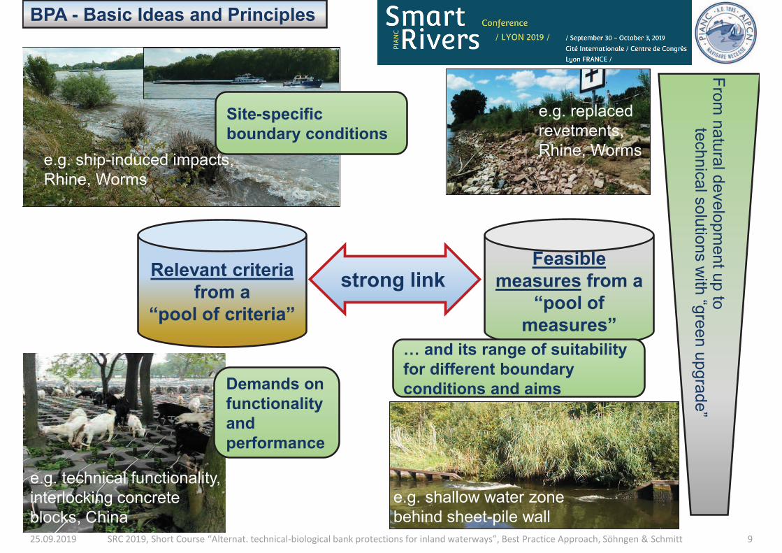
25.09.2019 SRC 2019, Short Course “Alternat. technical-biological bank protections for inland waterways”, Best Practice Approach, Söhngen & Schmitt 9
BPA - Basic Ideas and Principles
Relevant criteria
from a
“pool of criteria”
Feasible
measures from a
“pool of
measures”
strong link
e.g. replaced
revetments,
Rhine, Worms
e.g. shallow water zone
behind sheet-pile wall
Fro
m n
atu
ral d
evelo
pm
en
t up to
te
chnic
al s
olu
tions w
ith “g
reen u
pgra
de”
Site-specific
boundary conditions
… and its range of suitability
for different boundary
conditions and aims
e.g. ship-induced impacts,
Rhine, Worms
Demands on
functionality
and
performance
e.g. technical functionality,
interlocking concrete
blocks, China
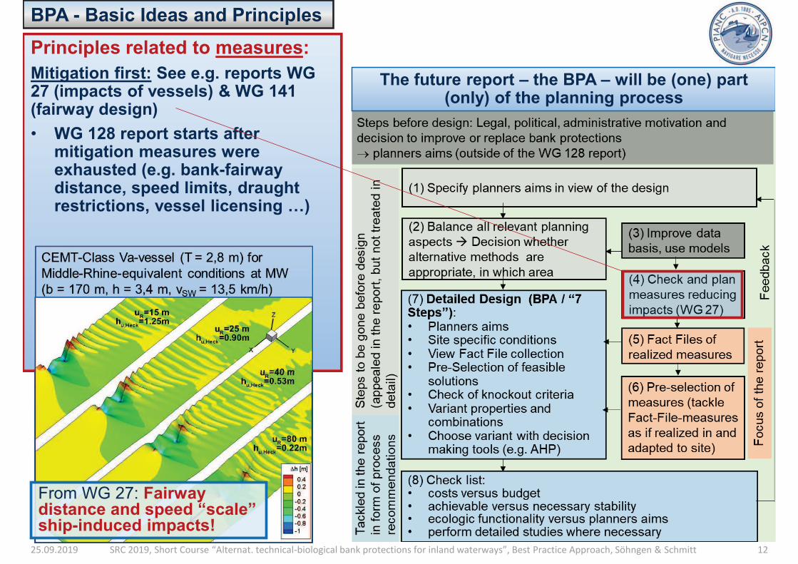
25.09.2019 SRC 2019, Short Course “Alternat. technical-biological bank protections for inland waterways”, Best Practice Approach, Söhngen & Schmitt 12
Principles related to measures:
Mitigation first: See e.g. reports WG 27 (impacts of vessels) & WG 141 (fairway design)
• WG 128 report starts after mitigation measures were exhausted (e.g. bank-fairway distance, speed limits, draught restrictions, vessel licensing …)
The future report – the BPA – will be (one) part (only) of the planning process
BPA - Basic Ideas and Principles
From WG 27: Fairway distance and speed “scale” ship-induced impacts!
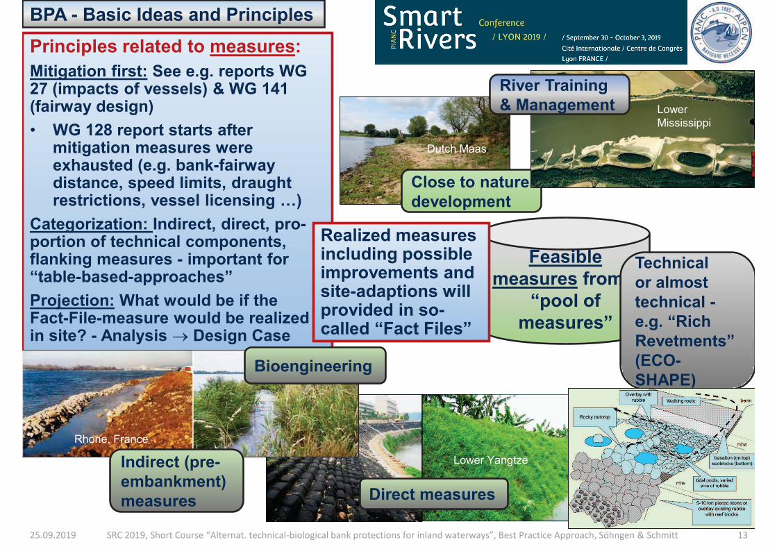
25.09.2019 SRC 2019, Short Course “Alternat. technical-biological bank protections for inland waterways”, Best Practice Approach, Söhngen & Schmitt 13
BPA - Basic Ideas and Principles
Feasible
measures from a
“pool of
measures”
Dutch Maas
Close to nature
development
Lower Yangtze
Direct measures
Lower
Mississippi
River Training
& Management
Principles related to measures:
Mitigation first: See e.g. reports WG 27 (impacts of vessels) & WG 141 (fairway design)
• WG 128 report starts after mitigation measures were exhausted (e.g. bank-fairway distance, speed limits, draught restrictions, vessel licensing …)
Categorization: Indirect, direct, pro-portion of technical components, flanking measures - important for “table-based-approaches”
Projection: What would be if the Fact-File-measure would be realized in site? - Analysis ® Design Case
Rhone, France
Bioengineering
Indirect (pre-
embankment)
measures
Technical
or almost
technical -
e.g. “Rich
Revetments”
(ECO-
SHAPE)
Realized measures including possible improvements and site-adaptions will provided in so-called “Fact Files”
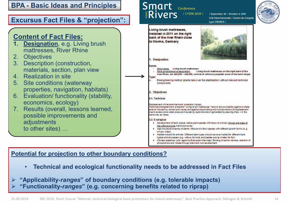
25.09.2019 SRC 2019, Short Course “Alternat. technical-biological bank protections for inland waterways”, Best Practice Approach, Söhngen & Schmitt 14
BPA - Basic Ideas and Principles
Excursus Fact Files & “projection”:
Content of Fact Files: 1. Designation, e.g. Living brush
mattresses, River Rhine 2. Objectives 3. Description (construction,
materials, section, plan view 4. Realization in site 5. Site conditions (waterway
properties, navigation, habitats) 6. Evaluation/ functionality (stability,
economics, ecology) 7. Results (overall, lessons learned,
possible improvements and adjustments to other sites) …
Potential for projection to other boundary conditions?
• Technical and ecological functionality needs to be addressed in Fact Files
Ø “Applicability-ranges” of boundary conditions (e.g. tolerable impacts) Ø “Functionality-ranges” (e.g. concerning benefits related to riprap)
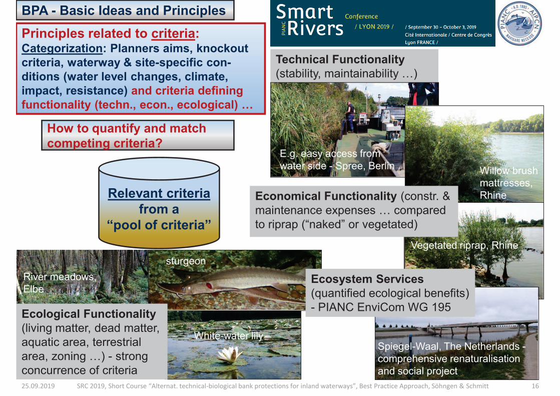
25.09.2019 SRC 2019, Short Course “Alternat. technical-biological bank protections for inland waterways”, Best Practice Approach, Söhngen & Schmitt 16
BPA - Basic Ideas and Principles
Relevant criteria
from a
“pool of criteria”
Principles related to criteria: Categorization: Planners aims, knockout
criteria, waterway & site-specific con-
ditions (water level changes, climate,
impact, resistance) and criteria defining
functionality (techn., econ., ecological) …
Technical Functionality
(stability, maintainability …)
E.g. easy access from
water side - Spree, Berlin
How to quantify and match
competing criteria?
Willow brush
mattresses,
Rhine
Vegetated riprap, Rhine
Economical Functionality (constr. &
maintenance expenses … compared
to riprap (“naked” or vegetated)
River meadows,
Elbe
sturgeon
White-water lily
Ecological Functionality
(living matter, dead matter,
aquatic area, terrestrial
area, zoning …) - strong
concurrence of criteria
Spiegel-Waal, The Netherlands -
comprehensive renaturalisation
and social project
Ecosystem Services
(quantified ecological benefits)
- PIANC EnviCom WG 195
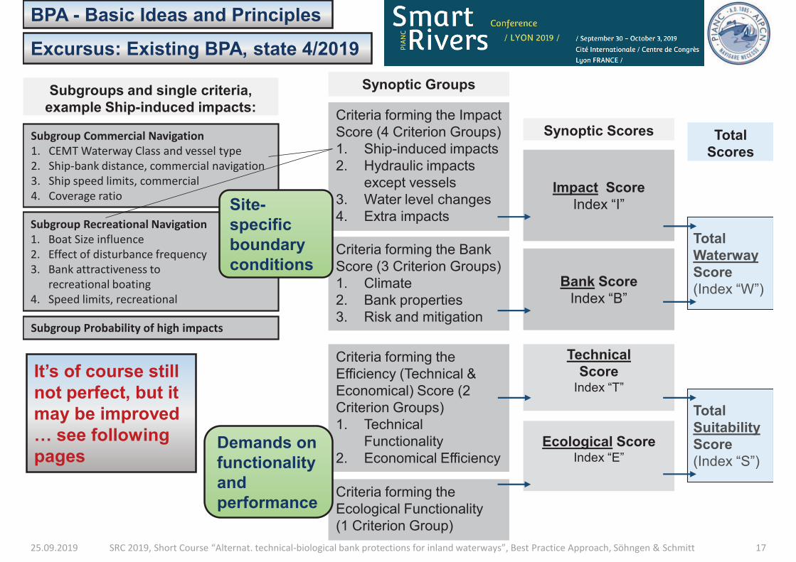
25.09.2019 SRC 2019, Short Course “Alternat. technical-biological bank protections for inland waterways”, Best Practice Approach, Söhngen & Schmitt 17
BPA - Basic Ideas and Principles
Excursus: Existing BPA, state 4/2019
Criteria forming the Impact
Score (4 Criterion Groups)
1. Ship-induced impacts
2. Hydraulic impacts
except vessels
3. Water level changes
4. Extra impacts
Criteria forming the
Efficiency (Technical &
Economical) Score (2
Criterion Groups)
1. Technical
Functionality
2. Economical Efficiency
Criteria forming the
Ecological Functionality
(1 Criterion Group)
Demands on
functionality
and
performance
Impact Score
Index “I”
Synoptic Scores
Criteria forming the Bank
Score (3 Criterion Groups)
1. Climate
2. Bank properties
3. Risk and mitigation
Bank Score
Index “B”
Total
Waterway
Score
(Index “W”)
Total
Scores
Technical
Score Index “T”
Ecological Score Index “E”
Total
Suitability
Score
(Index “S”)
Synoptic Groups
It’s of course still
not perfect, but it
may be improved
… see following
pages
Subgroup Commercial Navigation
1. CEMT Waterway Class and vessel type
2. Ship-bank distance, commercial navigation
3. Ship speed limits, commercial
4. Coverage ratio
Subgroup Recreational Navigation
1. Boat Size influence
2. Effect of disturbance frequency
3. Bank attractiveness to
recreational boating
4. Speed limits, recreational
Subgroups and single criteria,
example Ship-induced impacts:
Site-
specific
boundary
conditions
Subgroup Probability of high impacts
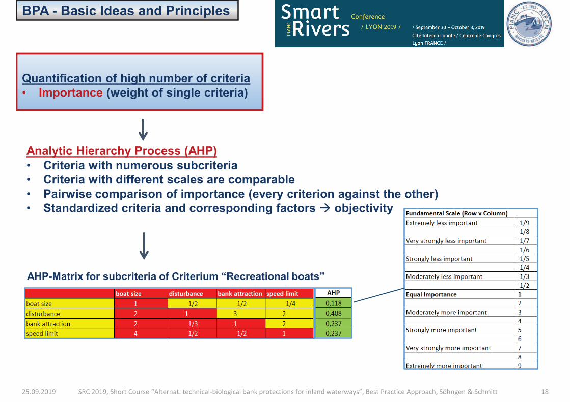
25.09.2019 SRC 2019, Short Course “Alternat. technical-biological bank protections for inland waterways”, Best Practice Approach, Söhngen & Schmitt 18
BPA - Basic Ideas and Principles
Quantification of high number of criteria
• Importance (weight of single criteria)
Analytic Hierarchy Process (AHP)
• Criteria with numerous subcriteria
• Criteria with different scales are comparable
• Pairwise comparison of importance (every criterion against the other)
• Standardized criteria and corresponding factors à objectivity
AHP-Matrix for subcriteria of Criterium “Recreational boats”
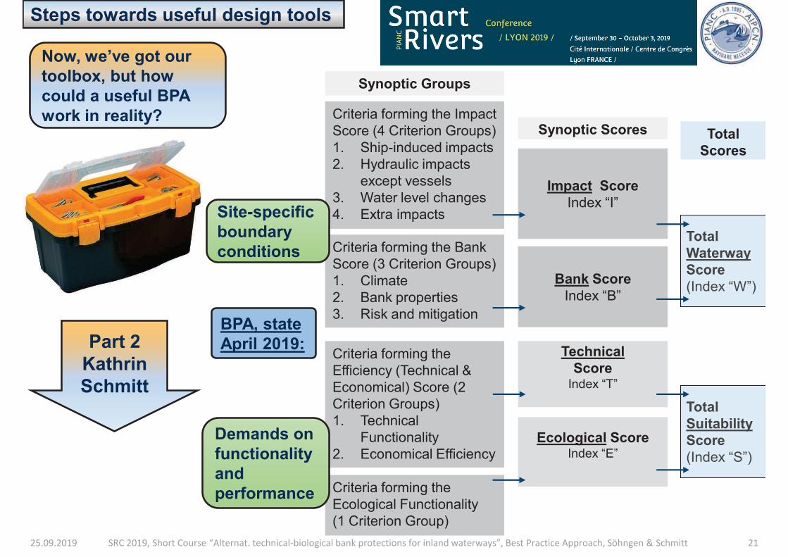
25.09.2019 SRC 2019, Short Course “Alternat. technical-biological bank protections for inland waterways”, Best Practice Approach, Söhngen & Schmitt 21
Criteria forming the Impact
Score (4 Criterion Groups)
1. Ship-induced impacts
2. Hydraulic impacts
except vessels
3. Water level changes
4. Extra impacts
Steps towards useful design tools
BPA, state
April 2019: Criteria forming the
Efficiency (Technical &
Economical) Score (2
Criterion Groups)
1. Technical
Functionality
2. Economical Efficiency
Criteria forming the
Ecological Functionality
(1 Criterion Group)
Demands on
functionality
and
performance
Impact Score
Index “I”
Synoptic Scores
Criteria forming the Bank
Score (3 Criterion Groups)
1. Climate
2. Bank properties
3. Risk and mitigation
Bank Score
Index “B”
Total
Waterway
Score
(Index “W”)
Total
Scores
Technical
Score Index “T”
Ecological Score Index “E”
Total
Suitability
Score
(Index “S”)
Synoptic Groups
Site-specific
boundary
conditions
Now, we’ve got our
toolbox, but how
could a useful BPA
work in reality?
Part 2
Kathrin
Schmitt
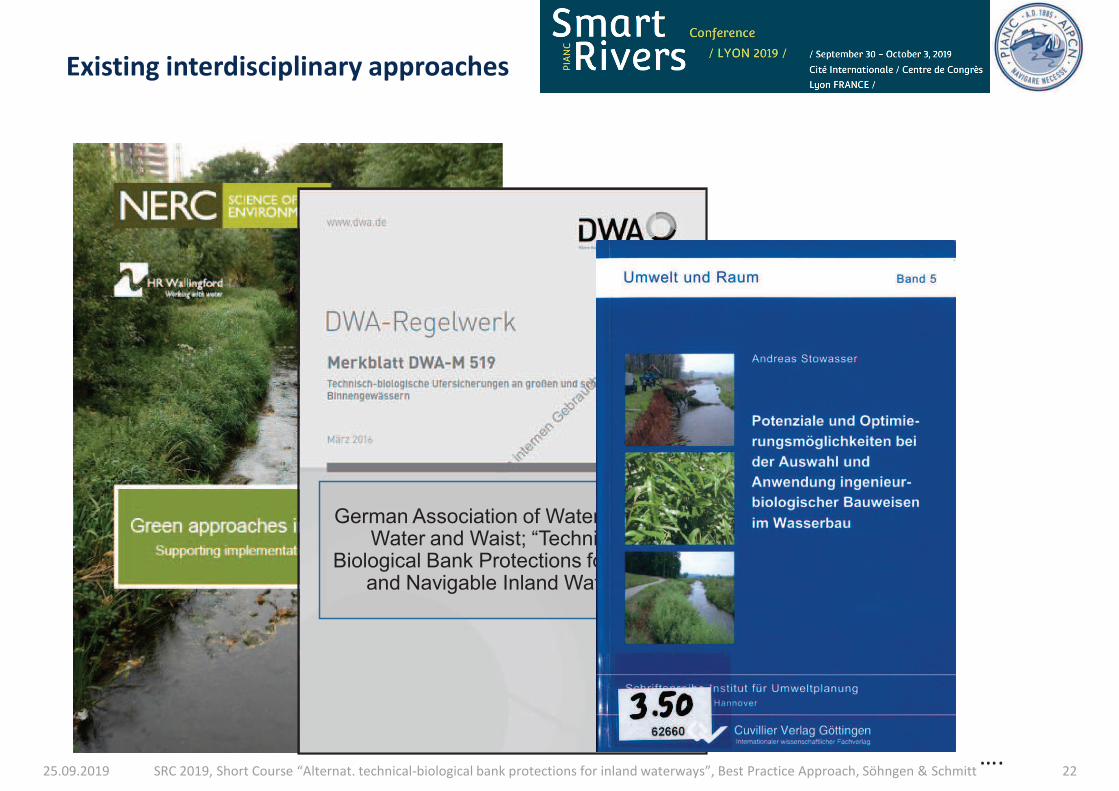
25.09.2019 SRC 2019, Short Course “Alternat. technical-biological bank protections for inland waterways”, Best Practice Approach, Söhngen & Schmitt 22
Existing interdisciplinary approaches
German Association of Water, Waste Water and Waist; “Technical-
Biological Bank Protections for Large and Navigable Inland Waters”
….
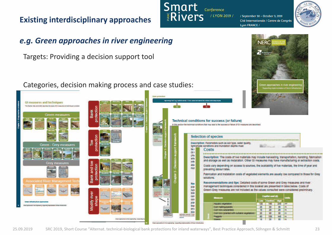
25.09.2019 SRC 2019, Short Course “Alternat. technical-biological bank protections for inland waterways”, Best Practice Approach, Söhngen & Schmitt 23
Existing interdisciplinary approaches
e.g. Green approaches in river engineering
Targets: Providing a decision support tool
Categories, decision making process and case studies:

25.09.2019 SRC 2019, Short Course “Alternat. technical-biological bank protections for inland waterways”, Best Practice Approach, Söhngen & Schmitt 24
Existing interdisciplinary approaches
e.g. Green approaches in river engineering
Targets: Providing a decision support tool
Categories, decision making process and case studies:
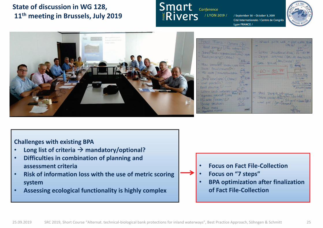
25.09.2019 SRC 2019, Short Course “Alternat. technical-biological bank protections for inland waterways”, Best Practice Approach, Söhngen & Schmitt 25
State of discussion in WG 128,
11th meeting in Brussels, July 2019
• Focus on Fact File-Collection
• Focus on “7 steps”
• BPA optimization after finalization
of Fact File-Collection
Challenges with existing BPA
• Long list of criteria à mandatory/optional?
• Difficulties in combination of planning and
assessment criteria
• Risk of information loss with the use of metric scoring
system
• Assessing ecological functionality is highly complex
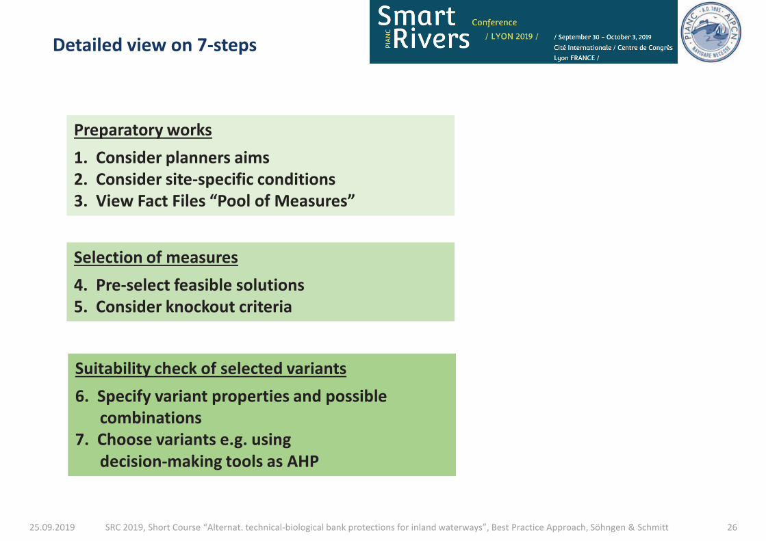
25.09.2019 SRC 2019, Short Course “Alternat. technical-biological bank protections for inland waterways”, Best Practice Approach, Söhngen & Schmitt 26
Detailed view on 7-steps
Selection of measures
4. Pre-select feasible solutions
5. Consider knockout criteria
Preparatory works
1. Consider planners aims
2. Consider site-specific conditions
3. View Fact Files “Pool of Measures”
Suitability check of selected variants
6. Specify variant properties and possible
combinations
7. Choose variants e.g. using
decision-making tools as AHP
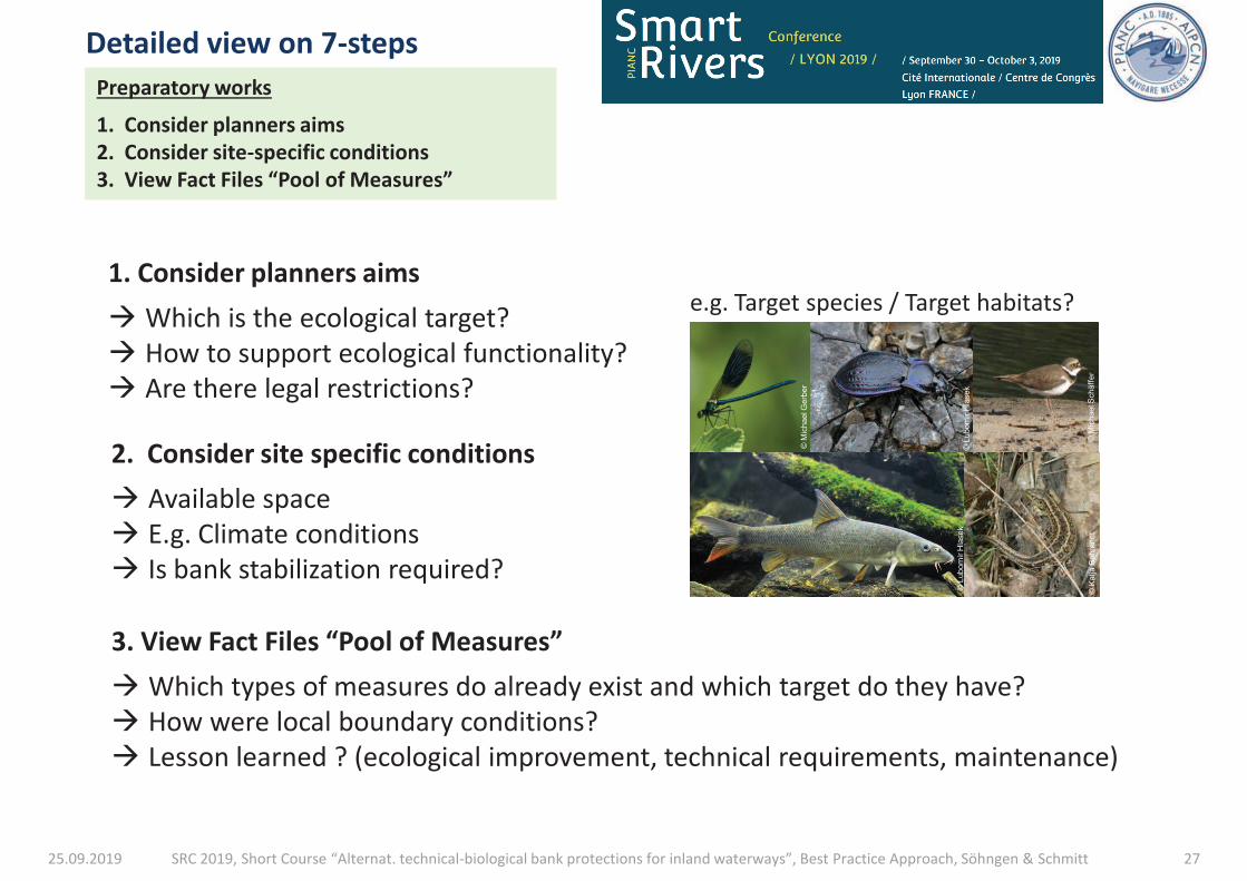
25.09.2019 SRC 2019, Short Course “Alternat. technical-biological bank protections for inland waterways”, Best Practice Approach, Söhngen & Schmitt 27
Preparatory works
1. Consider planners aims
2. Consider site-specific conditions
3. View Fact Files “Pool of Measures”
1. Consider planners aims
à Which is the ecological target?
à How to support ecological functionality?
à Are there legal restrictions?
2. Consider site specific conditions
à Available space
à E.g. Climate conditions
à Is bank stabilization required?
3. View Fact Files “Pool of Measures”
à Which types of measures do already exist and which target do they have?
à How were local boundary conditions?
à Lesson learned ? (ecological improvement, technical requirements, maintenance)
Detailed view on 7-steps
© L
ub
om
ir H
lase
k
e.g. Target species / Target habitats?
© M
ichael G
erb
er
© L
ubom
ir H
lasek
© M
ichael S
chäff
er
© K
atja B
ehre
ndt
© L
ubom
ir H
lase
k
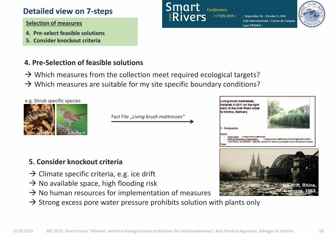
25.09.2019 SRC 2019, Short Course “Alternat. technical-biological bank protections for inland waterways”, Best Practice Approach, Söhngen & Schmitt 28
4. Pre-Selection of feasible solutions
à Which measures from the collection meet required ecological targets?
à Which measures are suitable for my site specific boundary conditions?
5. Consider knockout criteria
à Climate specific criteria, e.g. ice drift
à No available space, high flooding risk
à No human resources for implementation of measures
à Strong excess pore water pressure prohibits solution with plants only
Selection of measures
4. Pre-select feasible solutions
5. Consider knockout criteria
Detailed view on 7-steps
Ice drift, Rhine,
Cologne, 1963
©Söhngen
Fact File „Living brush mattresses“
e.g. Shrub specific species
© Lindsey © Burkhardt
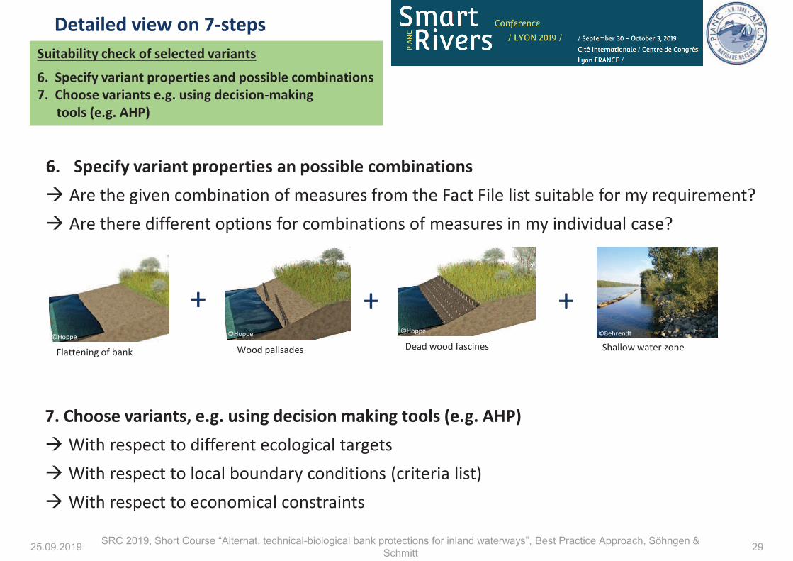
25.09.2019 SRC 2019, Short Course “Alternat. technical-biological bank protections for inland waterways”, Best Practice Approach, Söhngen &
Schmitt 29
Suitability check of selected variants
6. Specify variant properties and possible combinations
7. Choose variants e.g. using decision-making
tools (e.g. AHP)
6. Specify variant properties an possible combinations
à Are the given combination of measures from the Fact File list suitable for my requirement?
à Are there different options for combinations of measures in my individual case?
7. Choose variants, e.g. using decision making tools (e.g. AHP)
à With respect to different ecological targets
à With respect to local boundary conditions (criteria list)
à With respect to economical constraints
Detailed view on 7-steps
+ + +
Flattening of bank Wood palisades Dead wood fascines Shallow water zone ©Hoppe ©Hoppe ©Hoppe ©Behrendt
25.09.2019 SRC 2019, Short Course “Alternat. technical-biological bank protections for inland waterways”, Best Practice Approach, Söhngen &
Schmitt 30
Thank you for
your attention!
Outlook - WG Incom 128
Next meeting in April 2020
To do‘s :
• Finalization of Fact File collection
• Classification of Fact File-Collection as basis
for international exchange of experience
• Final balancing agenda of future report
• Optimization of BPA
����������������� ��������� ������ ��
�� ������������� ��� �����������
������ �������� !�"!���#�!��$�!��!�%&���!��'%
�������������(��� �)���
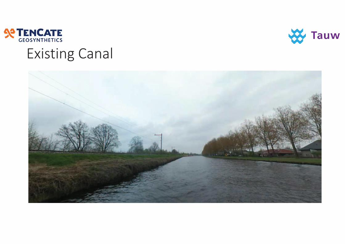
�����������
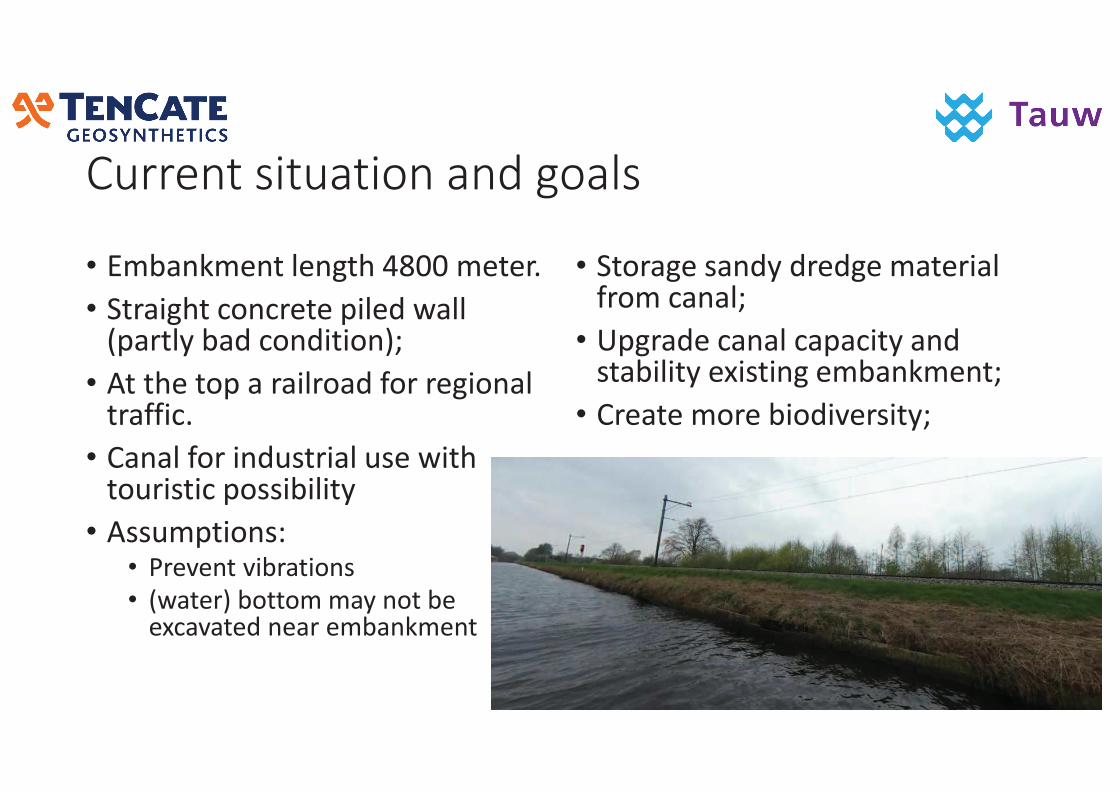
� ��������������������
• �*+$�#*!���,!�"���-.//�*!�!��
• ��$�"���'��'�!�!�0�,!���$,,�10$��,&�+$��'��������23
• �����!���0�$��$�,��$��4����!"���$,���$44�'�
• �$�$,�4�������%���$,��%!�����������%��'�0�%%�+�,��&
• �%%�*0����%�• ��!5!���5�+�$����%
• 1�$�!�2�+����*�*$&�����+!�!6'$5$�!���!$��!*+$�#*!��
• ���$"!�%$��&���!�"!�*$�!��$,�4��*�'$�$,3
• 0"�$�!�'$�$,�'$0$'��&�$���%�$+�,��&�!6�%���"�!*+$�#*!��3
• ��!$�!�*��!�+����5!�%��&3
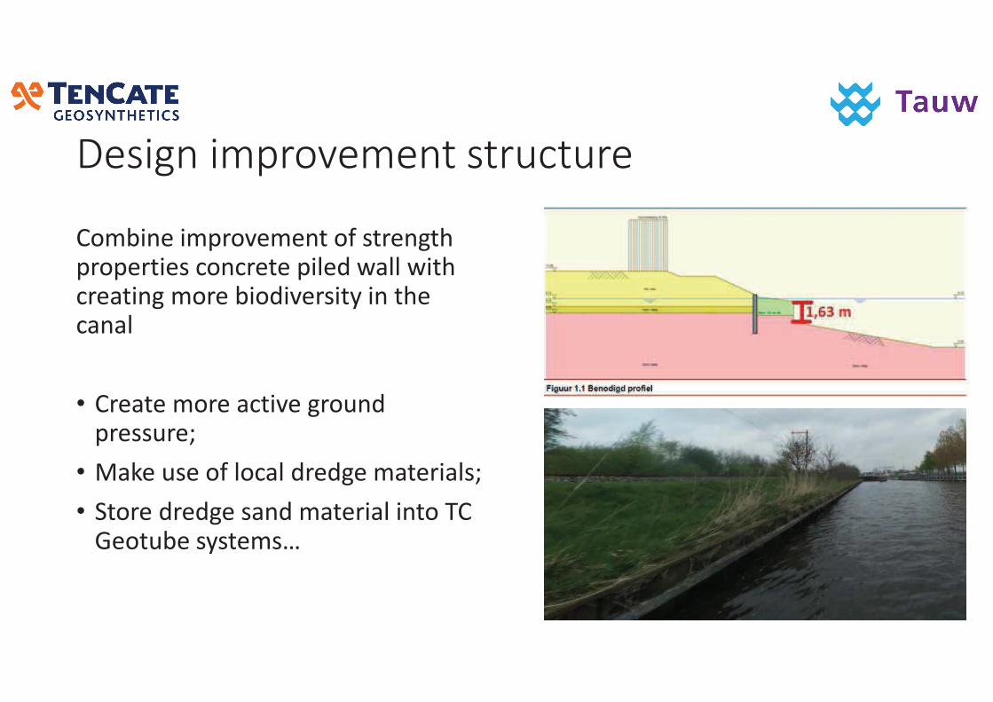
���������� ���������� ���� �
��*+��!��*0��5!*!����4�%��!�"���0��0!���!%�'��'�!�!�0�,!���$,,������'�!$���"�*��!�+����5!�%��&������!�'$�$,
• ��!$�!�*��!�$'��5!�"������0�!%%��!3�
• �$#!��%!��4�,�'$,���!�"!�*$�!��$,%3
• ���!���!�"!�%$���*$�!��$,����������!���+!�%&%�!*%7
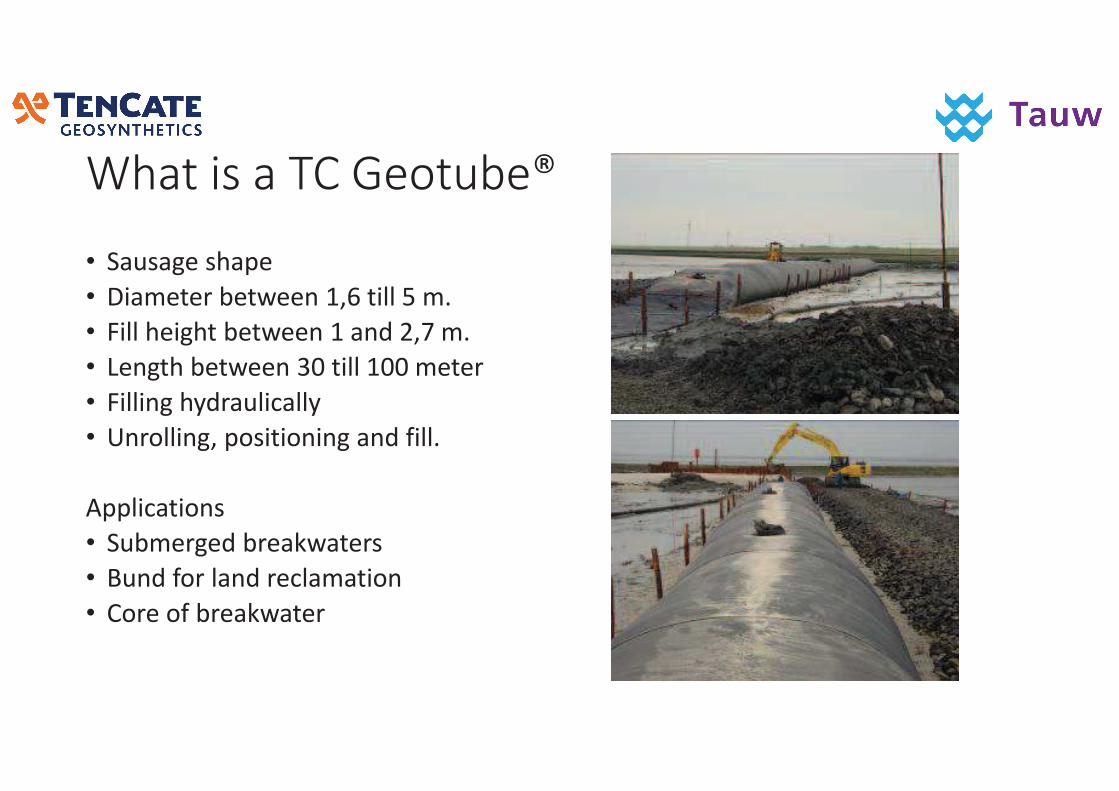
������������������
• $�%$"!�%�$0!
• ��$*!�!��+!��!!��89:���,,�;�*�
• ��,,��!�"���+!��!!��8�$���<9=�*�
• �!�"���+!��!!��>/���,,�8//�*!�!�
• ��,,��"��&��$�,�'$,,&
• ���,,��"9�0�%�������"�$���4�,,�
�00,�'$����%
• �+*!�"!��+�!$#�$�!�%
• �����4���,$����!',$*$����
• ���!��4�+�!$#�$�!�
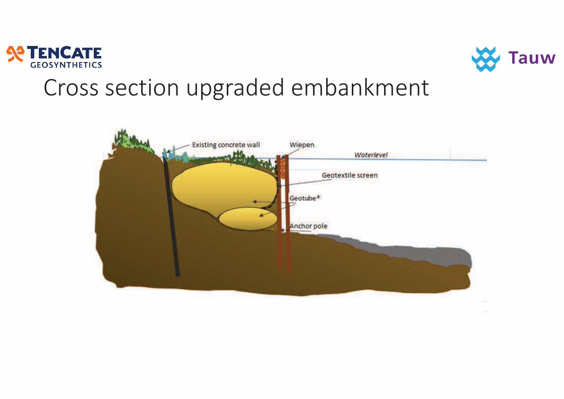
��������������� �������������
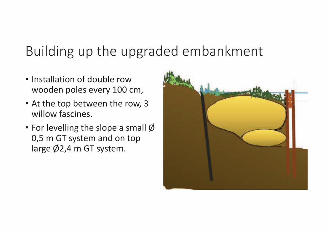
������������������� �������������
• ��%�$,,$������4����+,!���������!��0�,!%�!5!�&�8//�'*9
• �����!���0�+!��!!����!����9�>���,,���4$%'��!%�
• ����,!5!,,��"���!�%,�0!�$�%*$,,�?�/9;�*����%&%�!*�$��������0��,$�"!�?<9-�*����%&%�!*�
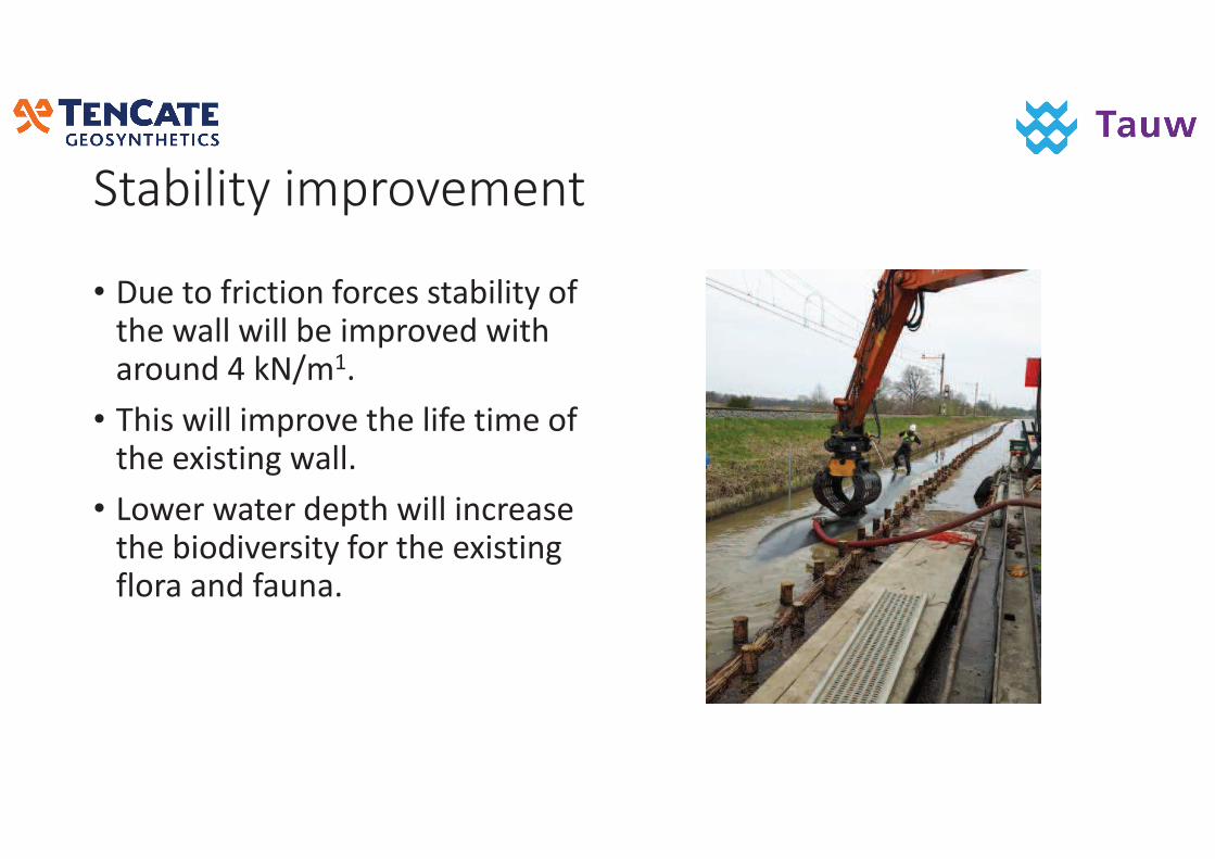
������������ �������
• ��!����4��'�����4��'!%�%�$+�,��&��4���!��$,,���,,�+!��*0��5!�������$������-�#�@*8�
• ���%���,,��*0��5!���!�,�4!���*!��4���!�!6�%���"��$,,�
• ���!���$�!���!0�����,,���'�!$%!���!�+����5!�%��&�4�����!�!6�%���"�4,��$�$���4$��$��
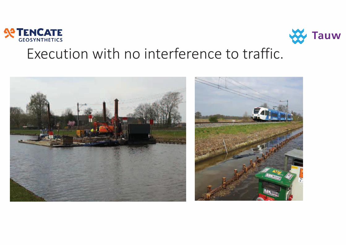
���������� ����������� !� ��������� !!��"
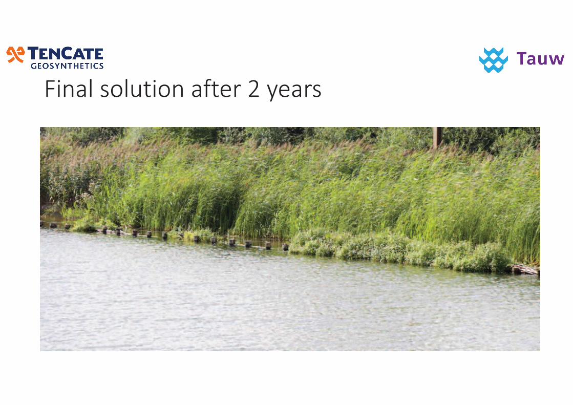
#�������������!�� �$��� �
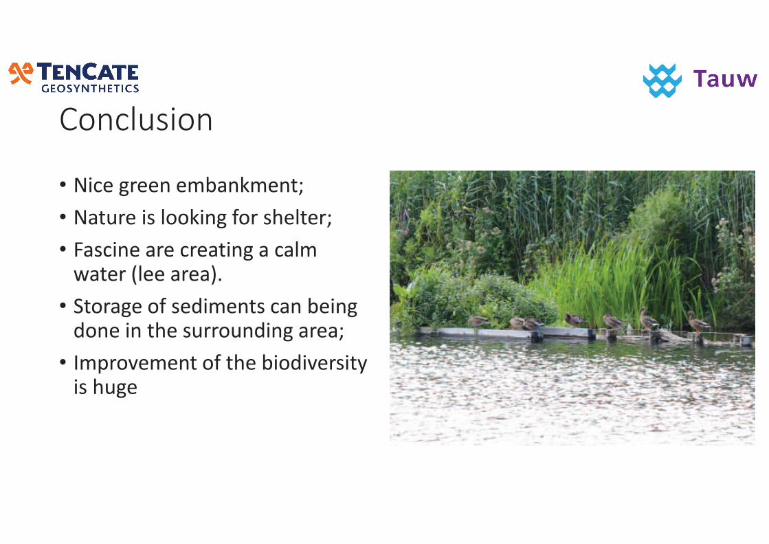
���������
• ��'!�"�!!��!*+$�#*!��3
• �$���!��%�,��#��"�4���%�!,�!�3
• �$%'��!�$�!�'�!$���"�$�'$,*��$�!��1,!!�$�!$2�
• ���$"!��4�%!��*!��%�'$��+!��"����!������!�%���������"�$�!$3
• �*0��5!*!����4���!�+����5!�%��&��%���"!
���������������
• ��A$�����
��%�$5��"+���"
�$��($��!,%#$�!�>=9��!5!��!�9���!��!��!�,$��%
��%�$5�!"+���"B�$���'�*
������������������ �������� �
�����������
������������������������������������� �����������!���"���#��
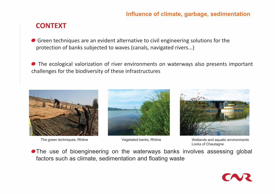
Influence of climate, garbage, sedimentation
�������
��������$���%"�����������&�������!�������&�����$�&�!��� ������� ���!"������'�������
�����$������'�(��)���"(*�$�������+�&���,$���!� ���&� �������&���---.
��� �$�!� �$�! &�!���/����� �' ��&�� ��&��������� �� +����+�0� �!�� �������� ���������
$��!!�� �� '�� ��� (����&�����0 �' ����� ��'�����"$�"���
Wetlands and aquatic environments
Locks of Chautagne
The green techniques, Rhône Vegetated banks, Rhône
The use of bioengineering on the waterways banks involves assessing global
factors such as climate, sedimentation and floating waste
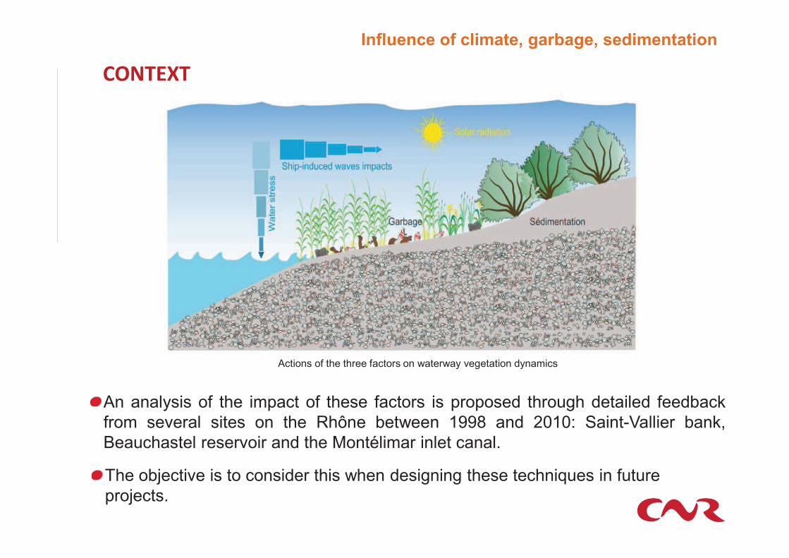
An analysis of the impact of these factors is proposed through detailed feedback
from several sites on the Rhône between 1998 and 2010: Saint-Vallier bank,
Beauchastel reservoir and the Montélimar inlet canal.
The objective is to consider this when designing these techniques in future
projects.
�������
Actions of the three factors on waterway vegetation dynamics
Influence of climate, garbage, sedimentation
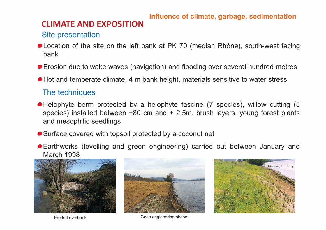
Helophyte berm protected by a helophyte fascine (7 species), willow cutting (5
species) installed between +80 cm and + 2.5m, brush layers, young forest plants
and mesophilic seedlings
Surface covered with topsoil protected by a coconut net
Earthworks (levelling and green engineering) carried out between January and
March 1998
Site presentation
Location of the site on the left bank at PK 70 (median Rhône), south-west facing
bank
Erosion due to wake waves (navigation) and flooding over several hundred metres
Hot and temperate climate, 4 m bank height, materials sensitive to water stress
The techniques
����� ����� ��������
Eroded riverbank Geen engineering phase
Influence of climate, garbage, sedimentation
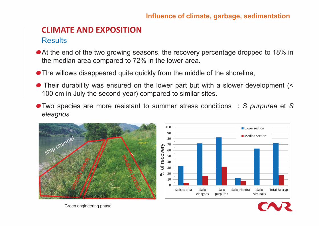
Results
����� ����� ��������
At the end of the two growing seasons, the recovery percentage dropped to 18% in
the median area compared to 72% in the lower area.
The willows disappeared quite quickly from the middle of the shoreline,
Their durability was ensured on the lower part but with a slower development (<
100 cm in July the second year) compared to similar sites.
Two species are more resistant to summer stress conditions : S purpurea et S
eleagnos
Green engineering phase
Phase de génie végétal
% o
f re
covery
Influence of climate, garbage, sedimentation
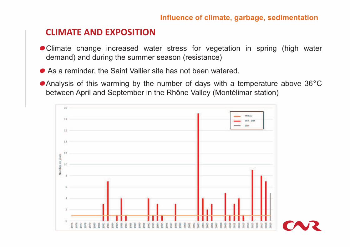
����� ����� ��������
Climate change increased water stress for vegetation in spring (high water
demand) and during the summer season (resistance)
As a reminder, the Saint Vallier site has not been watered.
Analysis of this warming by the number of days with a temperature above 36�C
between April and September in the Rhône Valley (Montélimar station)
Influence of climate, garbage, sedimentation
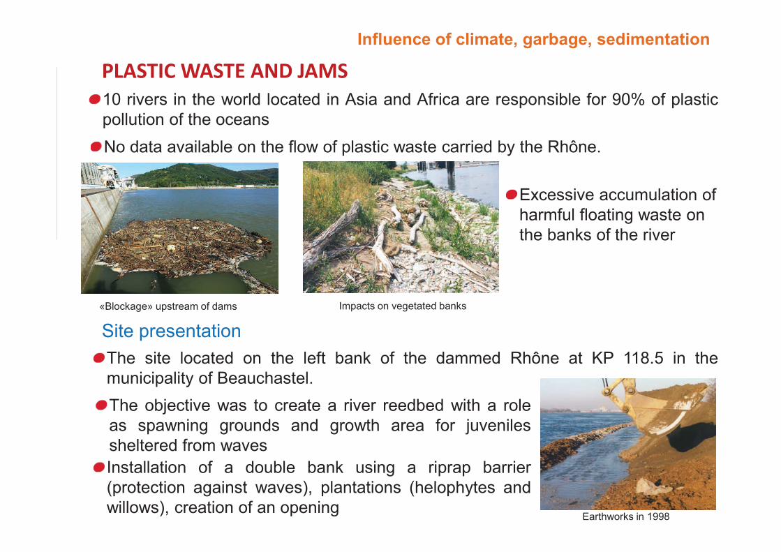
���������� �����
Excessive accumulation of
harmful floating waste on
the banks of the river
No data available on the flow of plastic waste carried by the Rhône.
10 rivers in the world located in Asia and Africa are responsible for 90% of plastic
pollution of the oceans
Site presentation
«Blockage» upstream of dams Impacts on vegetated banks
The objective was to create a river reedbed with a role
as spawning grounds and growth area for juveniles
sheltered from waves
The site located on the left bank of the dammed Rhône at KP 118.5 in the
municipality of Beauchastel.
Installation of a double bank using a riprap barrier
(protection against waves), plantations (helophytes and
willows), creation of an openingEarthworks in 1998
Influence of climate, garbage, sedimentation
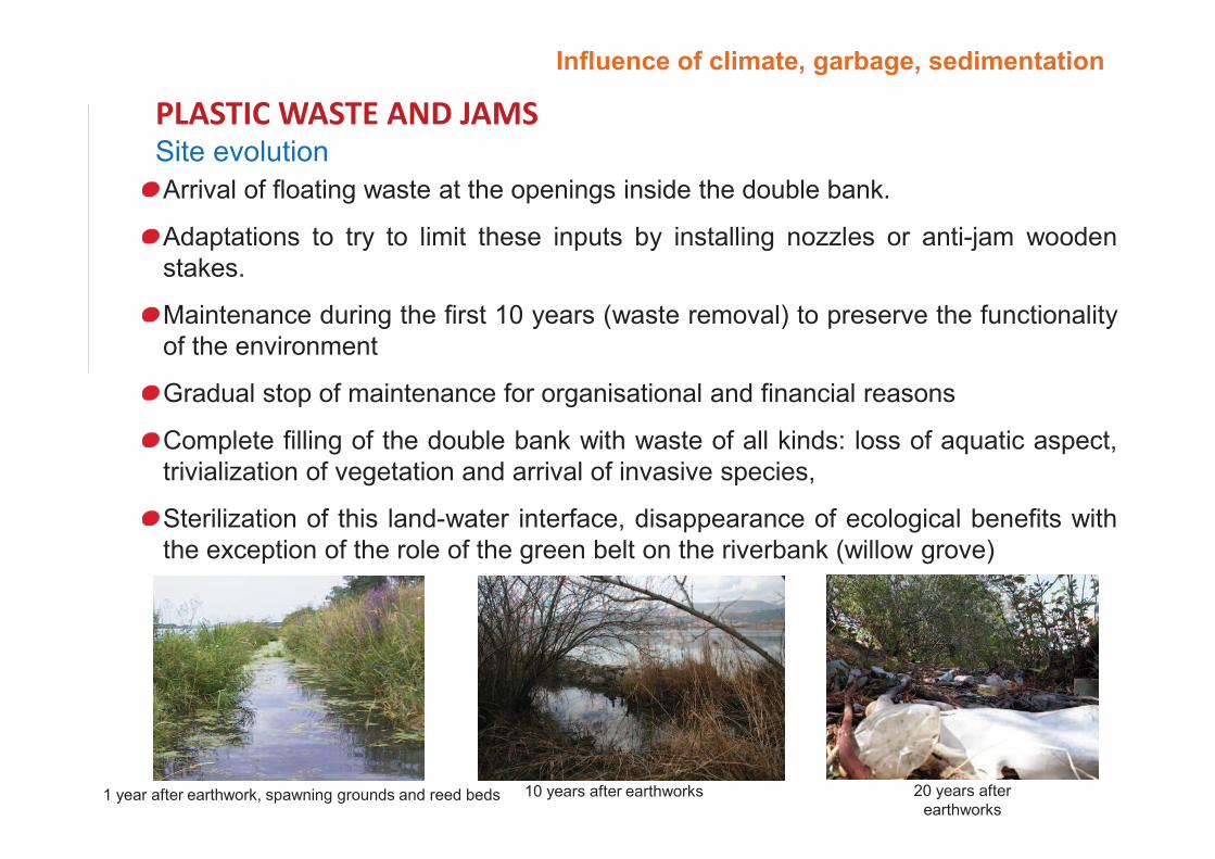
���������� �����
1 year after earthwork, spawning grounds and reed beds 10 years after earthworks 20 years after
earthworks
Site evolution
Arrival of floating waste at the openings inside the double bank.
Adaptations to try to limit these inputs by installing nozzles or anti-jam wooden
stakes.
Maintenance during the first 10 years (waste removal) to preserve the functionality
of the environment
Gradual stop of maintenance for organisational and financial reasons
Complete filling of the double bank with waste of all kinds: loss of aquatic aspect,
trivialization of vegetation and arrival of invasive species,
Sterilization of this land-water interface, disappearance of ecological benefits with
the exception of the role of the green belt on the riverbank (willow grove)
Influence of climate, garbage, sedimentation
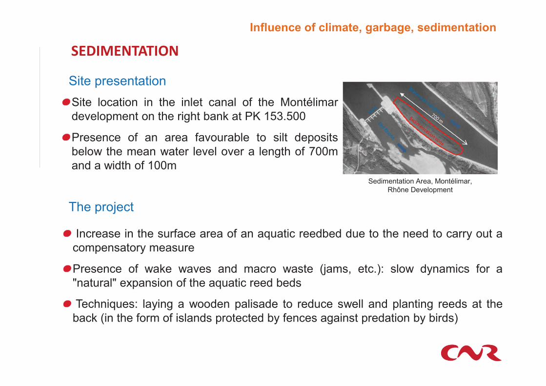
Site location in the inlet canal of the Montélimar
development on the right bank at PK 153.500
Presence of an area favourable to silt deposits
below the mean water level over a length of 700m
and a width of 100m
Site presentation
�����������
The project
Increase in the surface area of an aquatic reedbed due to the need to carry out a
compensatory measure
Presence of wake waves and macro waste (jams, etc.): slow dynamics for a
"natural" expansion of the aquatic reed beds
Techniques: laying a wooden palisade to reduce swell and planting reeds at the
back (in the form of islands protected by fences against predation by birds)
Sedimentation Area, Montélimar,
Rhône Development
Influence of climate, garbage, sedimentation
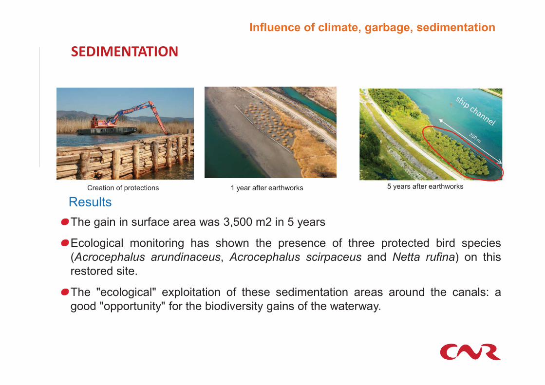
Creation of protections 1 year after earthworks
�����������
The gain in surface area was 3,500 m2 in 5 years
Ecological monitoring has shown the presence of three protected bird species
(Acrocephalus arundinaceus, Acrocephalus scirpaceus and Netta rufina) on this
restored site.
The "ecological" exploitation of these sedimentation areas around the canals: a
good "opportunity" for the biodiversity gains of the waterway.
5 years after earthworks
Influence of climate, garbage, sedimentation
Results
�������������������������
Choice of Mediterranean varieties of salicaceous plants more resistant to dry
climate and performing the same functions: approach of local plant species
Analyze in detail the distribution of species in altimetry, improving soil quality
Be more proactive in supporting vegetation during the first growing seasons:
watering
����� ����� ��������
Site sensitivity analysis: field observations
Integrate these constraints into the design: height of protection, enclosed
environments, continuity of maintenance, choice of more compatible species
(shrubby species)
���������� �����
The "ecological" exploitation of these sedimentation zones on singularities in a
context of developed watercourses is a great opportunity for biodiversity
Ecological engineering techniques can accelerate colonization processes
Need to monitor sedimentary and vegetation changes to avoid raising and then
drying out these reed beds
�����������
The objective is to implement "no regrets" projects
Influence of climate, garbage, sedimentation
Influence of climate, garbage, sedimentation
���� ��� �������� ��������
����������������� ������
�� ���� ������ ����� �������������
����� ������������������
��������������
������� ������������������ �!"�!����#��$�%���&�'��
(��!�����)��*��))����'��+��,���!"�-�&��''�"#
�� ������#������*��(����,�.�/��
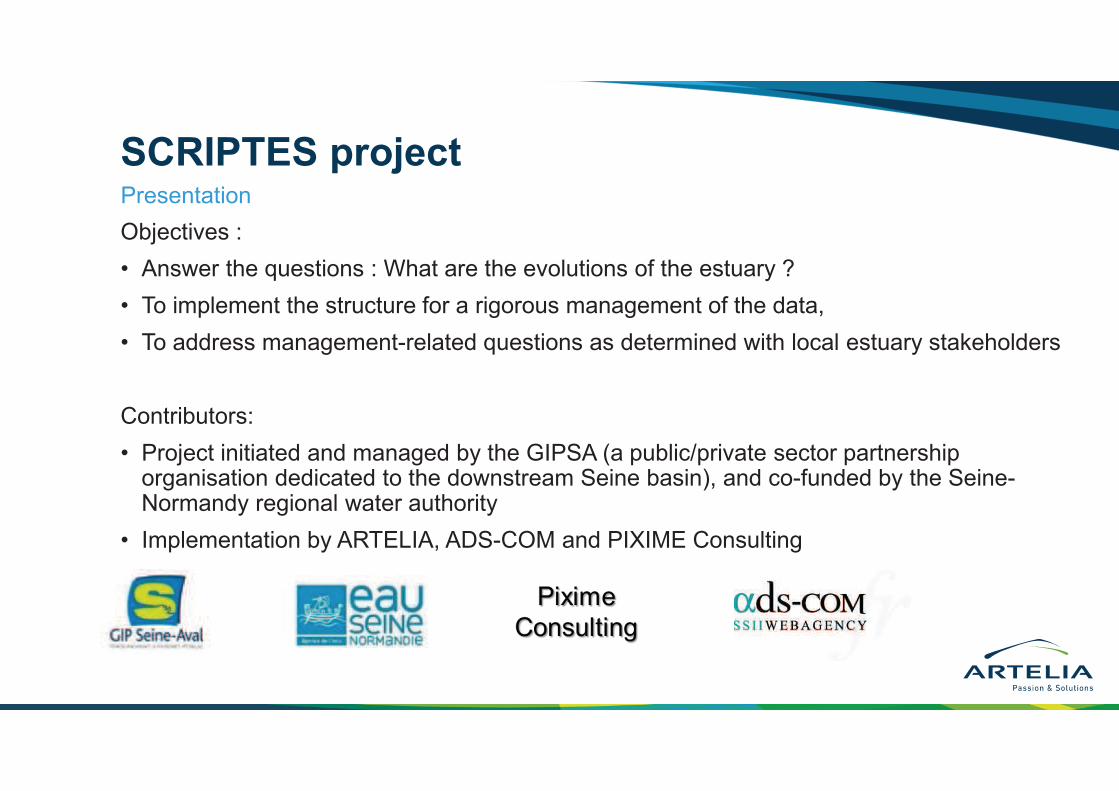
SCRIPTES project
Objectives :
• Answer the questions : What are the evolutions of the estuary ?
• To implement the structure for a rigorous management of the data,
• To address management-related questions as determined with local estuary stakeholders
Contributors:
• Project initiated and managed by the GIPSA (a public/private sector partnership organisation dedicated to the downstream Seine basin), and co-funded by the Seine-Normandy regional water authority
• Implementation by ARTELIA, ADS-COM and PIXIME Consulting
Presentation
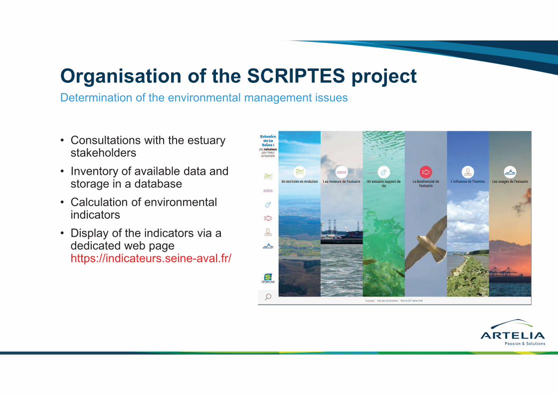
Organisation of the SCRIPTES project
• Consultations with the estuary stakeholders
• Inventory of available data and storage in a database
• Calculation of environmental indicators
• Display of the indicators via a dedicated web page https://indicateurs.seine-aval.fr/
Determination of the environmental management issues
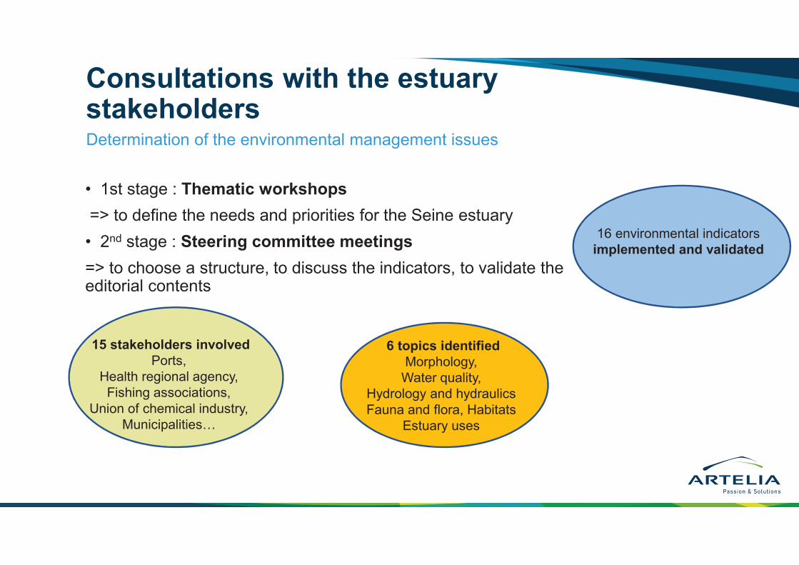
Consultations with the estuary stakeholders
• 1st stage : Thematic workshops
=> to define the needs and priorities for the Seine estuary
• 2nd stage : Steering committee meetings
=> to choose a structure, to discuss the indicators, to validate the editorial contents
Determination of the environmental management issues
6 topics identified
Morphology,
Water quality,
Hydrology and hydraulics
Fauna and flora, Habitats
Estuary uses
15 stakeholders involved
Ports,
Health regional agency,
Fishing associations,
Union of chemical industry,
Municipalities…
16 environmental indicators
implemented and validated
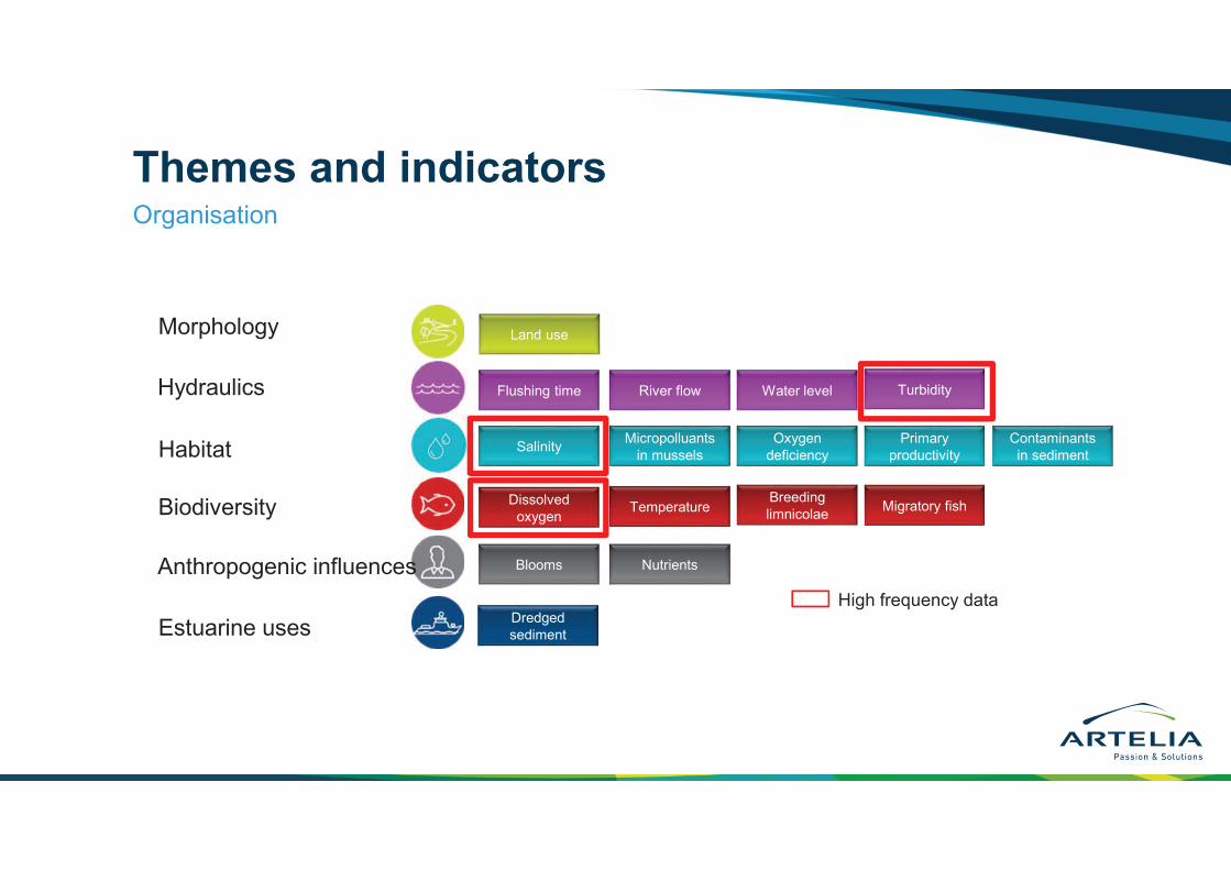
Themes and indicatorsOrganisation
Flushing time
SalinityMicropolluants
in mussels
Oxygen
deficiency
Dissolved
oxygenTemperature
NutrientsBlooms
Water levelRiver flow
Primary
productivity
Turbidity
Migratory fishBreeding
limnicolae
Contaminants
in sediment
High frequency data
Land use
Dredged
sedimentEstuarine uses
Anthropogenic influences
Biodiversity
Habitat
Morphology
Hydraulics
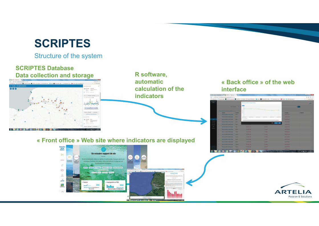
SCRIPTESStructure of the system
« Front office » Web site where indicators are displayed
SCRIPTES Database
Data collection and storage R software,
automatic
calculation of the
indicators
« Back office » of the web
interface
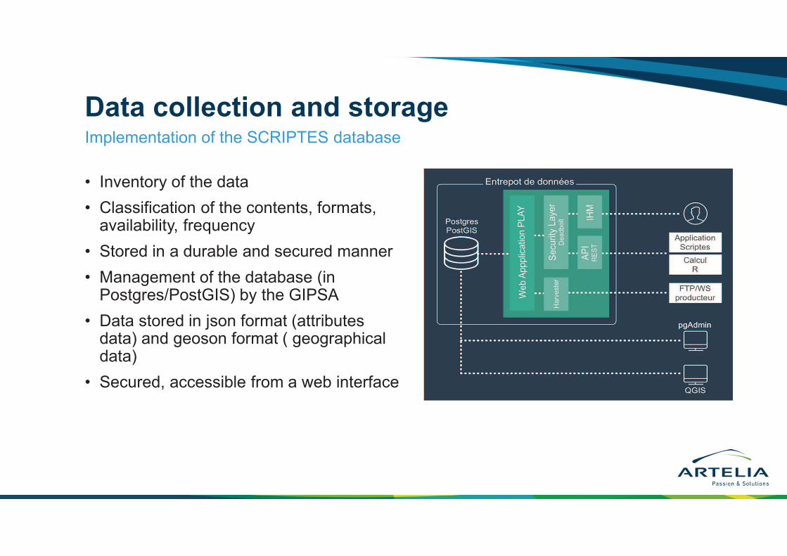
Data collection and storage
• Inventory of the data
• Classification of the contents, formats, availability, frequency
• Stored in a durable and secured manner
• Management of the database (in Postgres/PostGIS) by the GIPSA
• Data stored in json format (attributes data) and geoson format ( geographical data)
• Secured, accessible from a web interface
Implementation of the SCRIPTES database
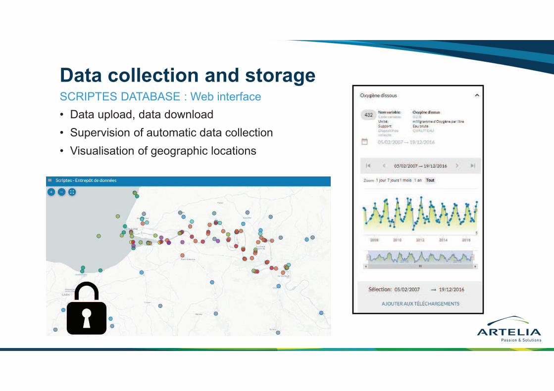
Data collection and storage
• Data upload, data download
• Supervision of automatic data collection
• Visualisation of geographic locations
SCRIPTES DATABASE : Web interface
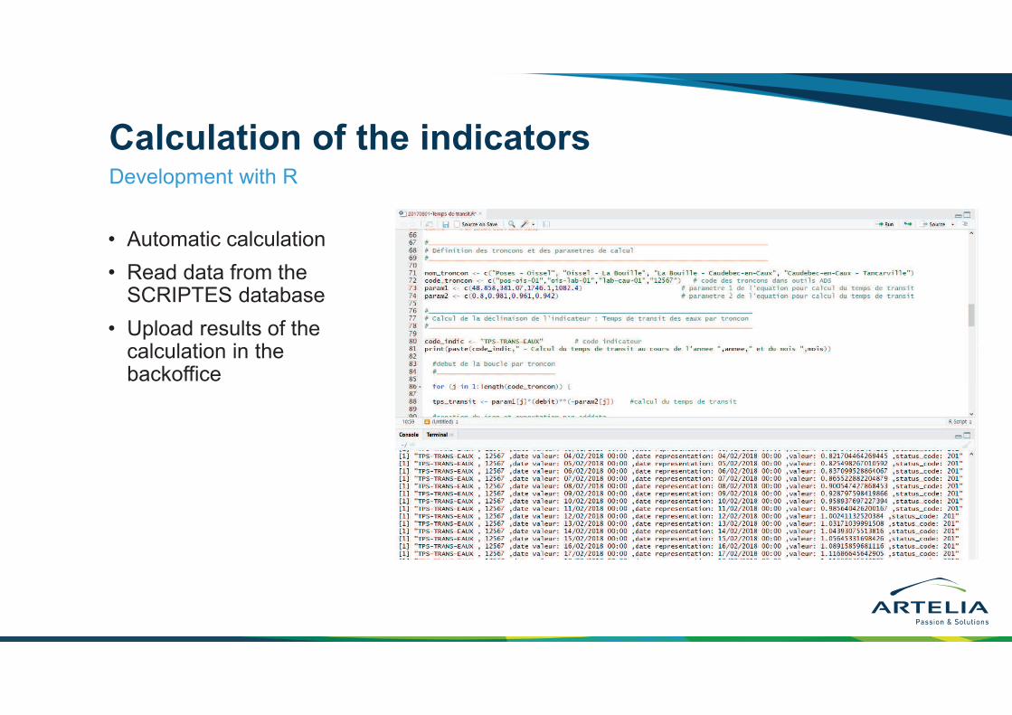
Calculation of the indicators
• Automatic calculation
• Read data from the SCRIPTES database
• Upload results of the calculation in the backoffice
Development with R

Back office
• Creation of the editorial contents
• Validation of the indicators before publications on the front office
• Creation of new indicators
• Interface developed in JavascriptAngular framework
• Reserved for the administrator to manage the contents of the public website (front office)
Structure and functionality
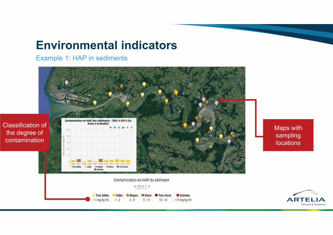
Environmental indicatorsExample 1: HAP in sediments
Classification of
the degree of contamination
Maps with
sampling locations
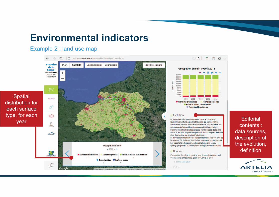
Environmental indicatorsExample 2 : land use map
Editorial
contents : data sources,
description of
the evolution,
definition
Spatial
distribution for each surface
type, for each
year
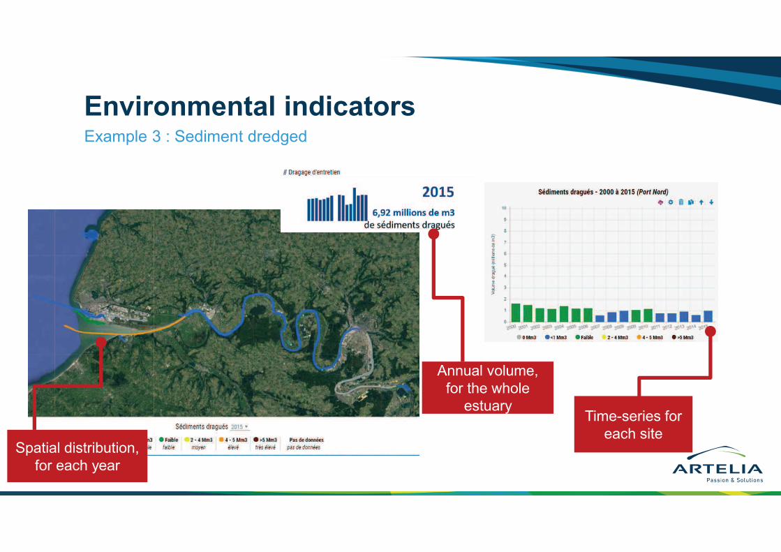
Environmental indicatorsExample 3 : Sediment dredged
Spatial distribution,
for each year
Annual volume,
for the whole estuary
Time-series for
each site
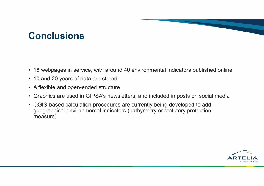
Conclusions
• 18 webpages in service, with around 40 environmental indicators published online
• 10 and 20 years of data are stored
• A flexible and open-ended structure
• Graphics are used in GIPSA’s newsletters, and included in posts on social media
• QGIS-based calculation procedures are currently being developed to add geographical environmental indicators (bathymetry or statutory protection measure)