Embed Size (px)
Citation preview
IWC – WestConnex Stage 3: M4 – M5 Concept Design Plan Review // July 2017 // 349326 // Page 1
ATTACHMENT 2
WestConnex Stage 3 (M4-M5 Link) Concept Design Review Submission
Facilitated by Beca Australia for Inner West Council
July 2017
The following assessment responds to the tasks identified in Council’s brief to Beca Australia to assist Council to review and prepare feedback on the M4-M5 Link Concept Design Plan. Beca facilitated the review which includes: � Collation and review of information and documents provided by WestConnex proponent Sydney
Motorway Corporation (SMC) and Council; � Review of relevant documents in relation to impacts on Inner West Local Government Area in the
following review areas as covered in the M4–M5 Link Concept Plan:
� Preparation of a submission report for the review of the M4–M5 Link Concept Design, incorporating the
comments from Council staff and community submissions. The submission report by Beca has been used as a basis for the preparation of Council’s submission.
The focus of this review is strategic and traffic & transport issues (review areas 1 and 2), whilst the remainder (review areas 3 to 7) are mostly issues raised from the assessment of the Secretary's Environmental Assessment Requirements (SEARs) on the WestConnex M4-M5 Link State Significant Infrastructure Application Report (SSIAR) dated January 2016. Review Area 8 is included to emphasize Council’s view that there have been issues with the consultation process – most notably insufficient details within the Concept Design to allow for a thorough assessment of issues. Council seeks an improved consultation process, with sufficient detail in the forthcoming Environmental Impact Statement (EIS) and all other documents released.
This detailed assessment has assisted the preparation of Inner West Council’s (IWC) submission on the Concept Design Plan, to be submitted to SMC before by the 4 August 2017 exhibition close date. This document is also intended to provides a comprehensive source of information to assist the preparation of IWC’s response on the upcoming M4-M5 Link EIS, expected to be released in late August or early September 2017.
The main sources of background information that feed into this Review are listed below:
WestConnex M4-M5 Link State significant infrastructure application report (SSIAR) – January 2016
The Secretary's Environmental Assessment Requirements (SEARs) for the preparation of an Environmental Impact Statement (EIS)
Feedback from Inner West Council staff members and written information from the community (where available) available) on the Concept Plan.
The WestConnex M4 – M5 Link Concept Design Plan – May 2017, the key document reviewed
City of Sydney – The WestConnex Challenge, Public Summary Report – June 2017 DRAFT, and WestConnex Alternative Proposal – 5 June 2017
The review of specific issues and IWC’s response to these issues are described in the tables below, with the source of each issue indicated by the symbols described in the above table. This allows each issue to be allocated an item number; a reference and description of the source of the issue; background described on the identified issue; and IWC’s response to the issue. In addition to Council’s submission, the feedback on these issues within the table provides detailed comments and requests to SMC for further information should the Concept Design be approved, i.e. IWC’s third-tier position.
1. Strategic Issues 4. Social, Economic, Heritage and Property (construction and operation)
7. Noise and vibration (construction and operation)
2. Traffic and Transport (construction and operation)
5. Air quality (construction and operation)
8. Consultation process
3. Visual impact and urban design 6. Contamination, flooding & water management
IWC – WestConnex Stage 3: M4 – M5 Concept Design Plan Review // July 2017 // 349326 // Page 2
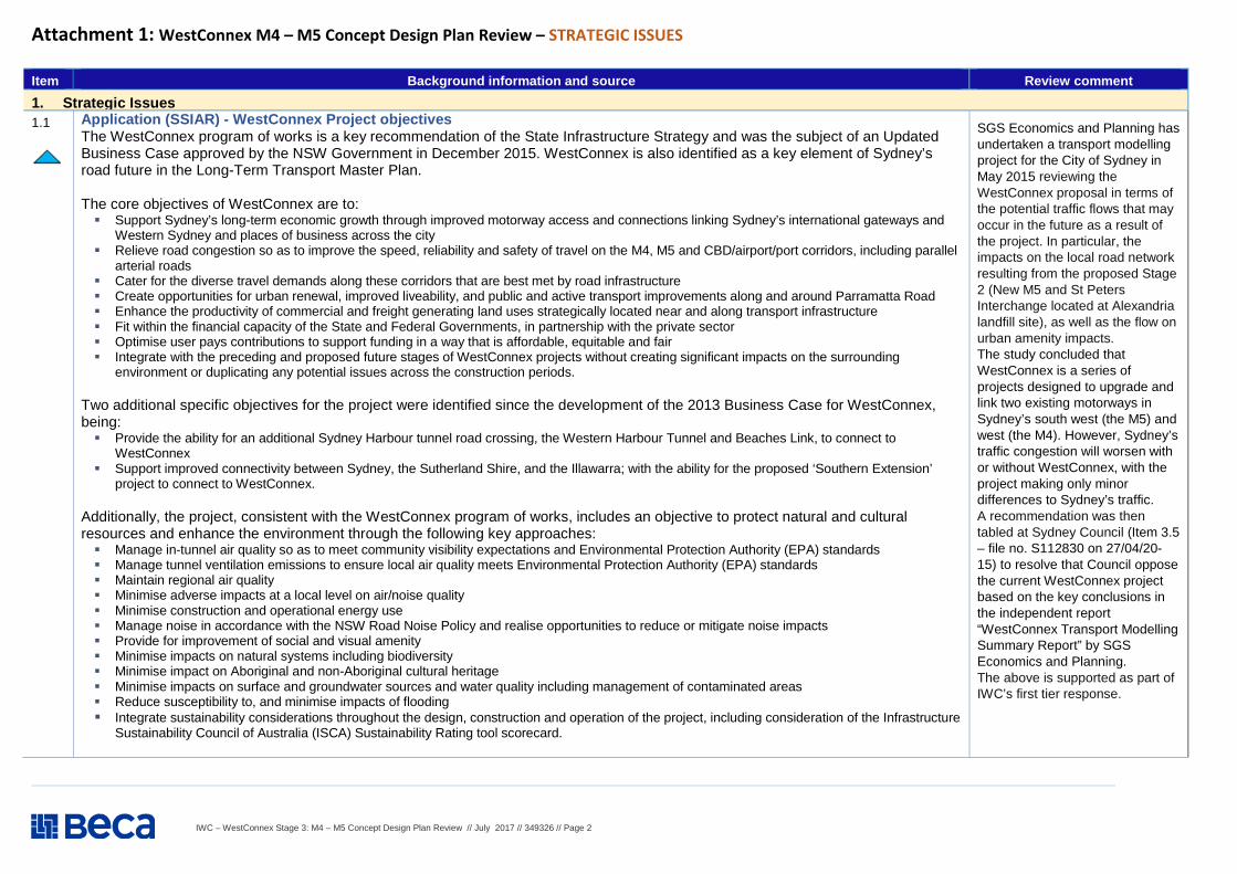
Attachment 1: WestConnex M4 – M5 Concept Design Plan Review – STRATEGIC ISSUES
Item Background information and source Review comment
1. Strategic Issues 1.1
Application (SSIAR) - WestConnex Project objectives The WestConnex program of works is a key recommendation of the State Infrastructure Strategy and was the subject of an Updated Business Case approved by the NSW Government in December 2015. WestConnex is also identified as a key element of Sydney’s road future in the Long-Term Transport Master Plan. The core objectives of WestConnex are to: � Support Sydney’s long-term economic growth through improved motorway access and connections linking Sydney’s international gateways and
Western Sydney and places of business across the city � Relieve road congestion so as to improve the speed, reliability and safety of travel on the M4, M5 and CBD/airport/port corridors, including parallel
arterial roads � Cater for the diverse travel demands along these corridors that are best met by road infrastructure � Create opportunities for urban renewal, improved liveability, and public and active transport improvements along and around Parramatta Road � Enhance the productivity of commercial and freight generating land uses strategically located near and along transport infrastructure � Fit within the financial capacity of the State and Federal Governments, in partnership with the private sector � Optimise user pays contributions to support funding in a way that is affordable, equitable and fair � Integrate with the preceding and proposed future stages of WestConnex projects without creating significant impacts on the surrounding
environment or duplicating any potential issues across the construction periods.
Two additional specific objectives for the project were identified since the development of the 2013 Business Case for WestConnex, being: � Provide the ability for an additional Sydney Harbour tunnel road crossing, the Western Harbour Tunnel and Beaches Link, to connect to
WestConnex � Support improved connectivity between Sydney, the Sutherland Shire, and the Illawarra; with the ability for the proposed ‘Southern Extension’
project to connect to WestConnex.
Additionally, the project, consistent with the WestConnex program of works, includes an objective to protect natural and cultural resources and enhance the environment through the following key approaches: � Manage in-tunnel air quality so as to meet community visibility expectations and Environmental Protection Authority (EPA) standards � Manage tunnel ventilation emissions to ensure local air quality meets Environmental Protection Authority (EPA) standards � Maintain regional air quality � Minimise adverse impacts at a local level on air/noise quality � Minimise construction and operational energy use � Manage noise in accordance with the NSW Road Noise Policy and realise opportunities to reduce or mitigate noise impacts � Provide for improvement of social and visual amenity � Minimise impacts on natural systems including biodiversity � Minimise impact on Aboriginal and non-Aboriginal cultural heritage � Minimise impacts on surface and groundwater sources and water quality including management of contaminated areas � Reduce susceptibility to, and minimise impacts of flooding � Integrate sustainability considerations throughout the design, construction and operation of the project, including consideration of the Infrastructure
Sustainability Council of Australia (ISCA) Sustainability Rating tool scorecard.
SGS Economics and Planning has undertaken a transport modelling project for the City of Sydney in May 2015 reviewing the WestConnex proposal in terms of the potential traffic flows that may occur in the future as a result of the project. In particular, the impacts on the local road network resulting from the proposed Stage 2 (New M5 and St Peters Interchange located at Alexandria landfill site), as well as the flow on urban amenity impacts. The study concluded that WestConnex is a series of projects designed to upgrade and link two existing motorways in Sydney’s south west (the M5) and west (the M4). However, Sydney’s traffic congestion will worsen with or without WestConnex, with the project making only minor differences to Sydney’s traffic. A recommendation was then tabled at Sydney Council (Item 3.5 – file no. S112830 on 27/04/20-15) to resolve that Council oppose the current WestConnex project based on the key conclusions in the independent report “WestConnex Transport Modelling Summary Report” by SGS Economics and Planning. The above is supported as part of IWC’s first tier response.
IWC – WestConnex Stage 3: M4 – M5 Concept Design Plan Review // July 2017 // 349326 // Page 3
WestConnex M4 – M5 Concept Design Plan Review – STRATEGIC ISSUES
Item Background information and source Review comment
1. Strategic Issues 1.2
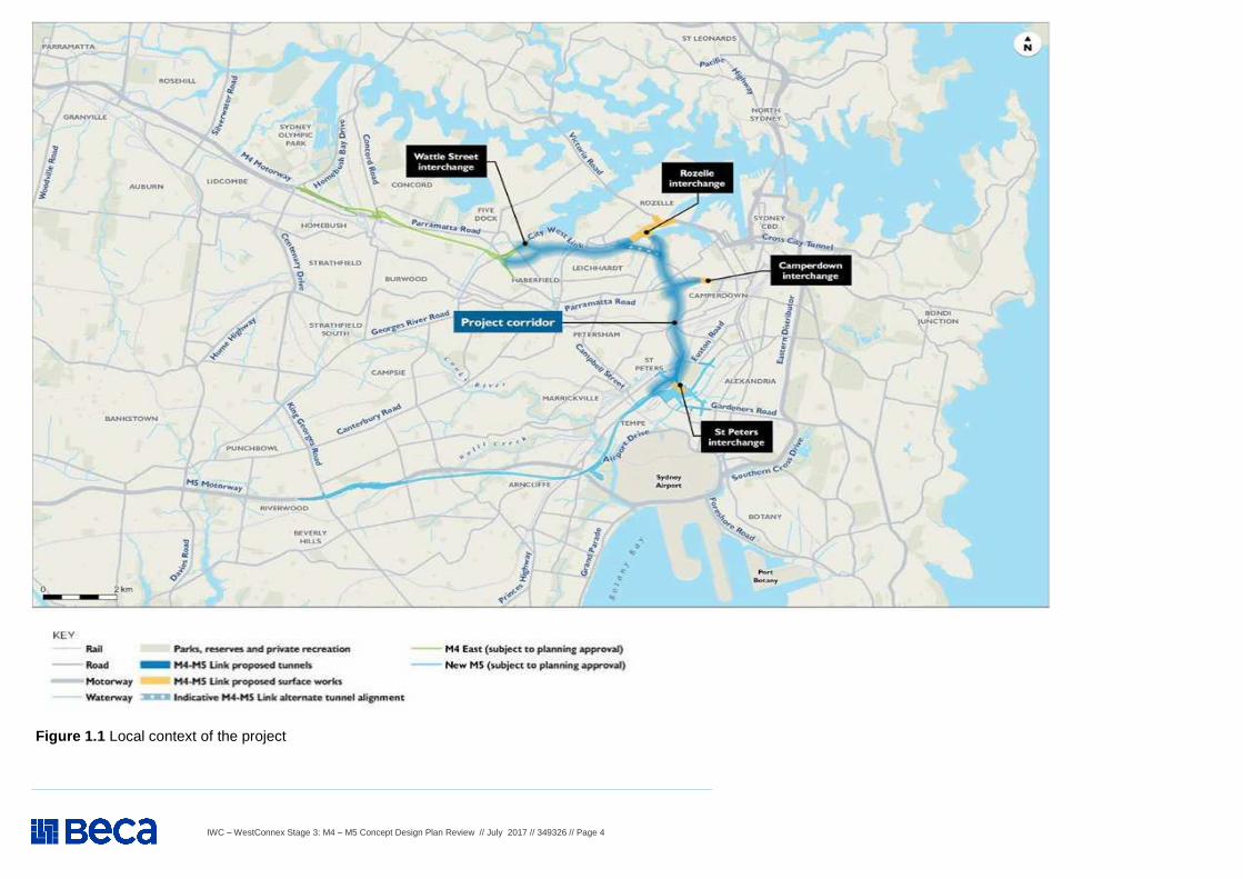
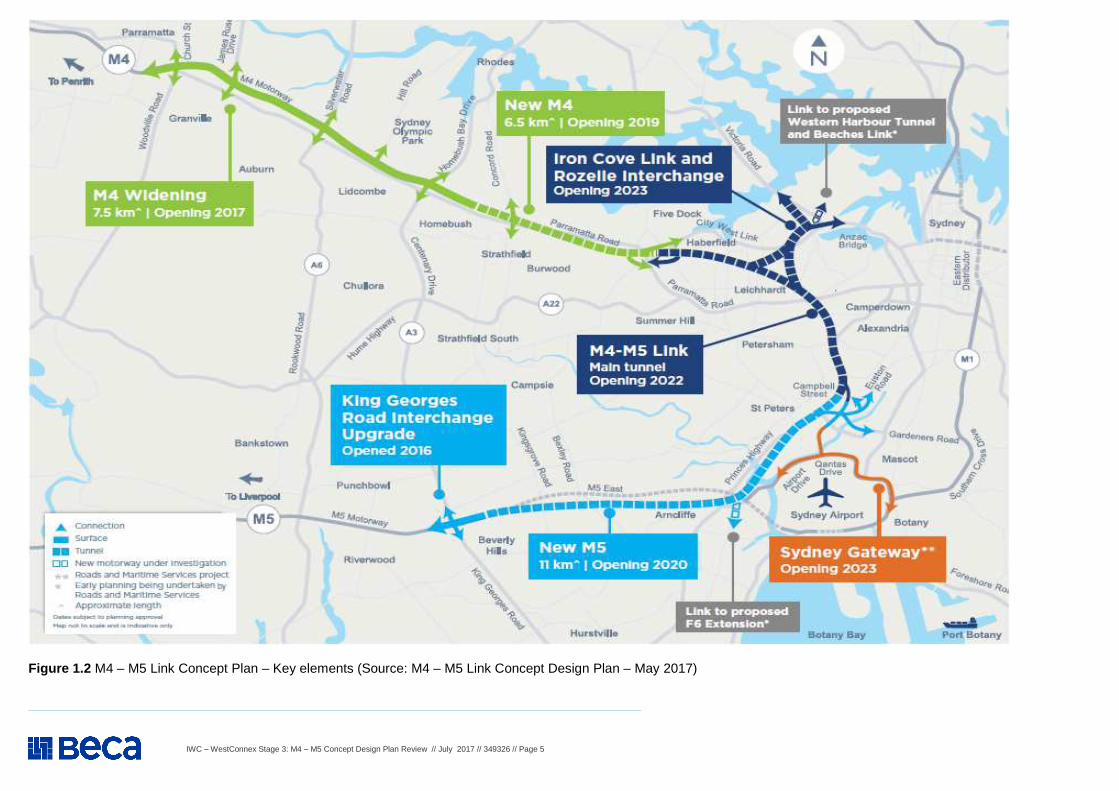
Application (SSIAR) - Project Summary Roads and Maritime Services (Roads and Maritime) propose to construct and operate the M4-M5 Link (the project); which would comprise a new, tolled multi-lane road link between the proposed M4 East at Haberfield and the proposed New M5 at St Peters. The project would span four local government areas including: Ashfield, Leichhardt, Marrickville and Sydney, and would also include interchanges at Rozelle and Camperdown. The location and key features are shown in Figures 1.1 and 1.2 below.
The project is one component of the WestConnex program of works. WestConnex is a 33 kilometre motorway that is intended to link Sydney’s west with the airport and the Port Botany precinct. The WestConnex program of works is proposed to be delivered as a series of projects, each subject to a stand- alone planning assessment and approvals process in accordance with the requirements of the Environmental Planning and Assessment Act 1979 (EP&A Act) and other relevant legislation. Key components of the project include:
� Twin motorway tunnels between the M4 East at Haberfield and the New M5 at St Peters. Each tunnel would
be around 9.2 kilometres in length and would be built to accommodate three lanes of traffic. Each tunnel would integrate with tunnel stubs constructed underground as part of the proposed M4 East at the Wattle Street interchange and proposed New M5.
� A new road interchange at Rozelle at the disused Rozelle Rail Yard, to provide connections to and from the M4-M5 Link with City West Link, Victoria Road and the Anzac Bridge intersection.
� Tunnel stubs to allow for a potential future connection to the Western Harbour Tunnel and Beaches Link (an additional Sydney Harbour Tunnel road crossing) in the vicinity of the Rozelle interchange.
� A new road interchange at Camperdown to provide north and south-bound on and off ramps connecting to Parramatta Road.
� Connections to the St Peters interchange (constructed as part of the proposed New M5), including the construction of the M4-M5 Link southern portal and integration works within the interchange.
� Ancillary infrastructure and operational facilities for electronic tolling, signage (including electronic signage), ventilation structures and systems, fire and life safety systems, and emergency evacuation and smoke extraction infrastructure.
� A motorway control centre that would include operation and maintenance facilities. � New service utilities and modifications to existing service utilities. � Modifications to the surface road network to integrate the new interchanges, including but not limited to the
City West Link, Victoria Road, and Parramatta Road. � Temporary construction ancillary facilities and temporary works to facilitate the construction of the project.
The project would be delivered through a design and construct contract aimed at delivering an innovative, cost effective and environmentally responsive design for the project. The alignment of the project would be located within the project corridor, which forms the basis for the assessment within this document.
SEARS – 3 May 2017 (Application Number - SSI 16 7485) The Desired Performance Outcomes (DPO) points in the SEARS are repeated below and supported by IWC: EIS - Point 2: The project is described in sufficient detail to enable clear understanding that the project has been developed through an iterative process of impact identification and assessment and project refinement to avoid, minimise or offset impacts so that the project, on balance, has the least adverse environmental, social and economic impact, including its cumulative impacts. Requirement 1: The EIS must include, but not necessarily be limited to, the following:
(e) An analysis of any feasible alternatives to the project (Note 3); with Note 3: Alternatives to a project are different projects which would achieve the same project objective(s) including the consequences of not carrying out the project. For example, alternatives to a road project may be a rail project in the same area and alternate routes for the road, or a combination of these alternatives.
(i) A demonstration of how the project design has been developed
to avoid or minimise likely adverse impacts.
IWC understands the EIS will be ready for exhibition in late August or early September 2017 and expects these requirements to be addressed comprehensively. IWC acknowledges that the on and off ramps at Camperdown has been removed from the plan. IWC expressed its support for this modification, largely on the basis of reduced traffic impacts, in its April 2017 submission on the proposed amended SEARs for Stage 3.
IWC – WestConnex Stage 3: M4 – M5 Concept Design Plan Review // July 2017 // 349326 // Page 4
Figure 1.1 Local context of the project
IWC – WestConnex Stage 3: M4 – M5 Concept Design Plan Review // July 2017 // 349326 // Page 5
Figure 1.2 M4 – M5 Link Concept Plan – Key elements (Source: M4 – M5 Link Concept Design Plan – May 2017)
IWC – WestConnex Stage 3: M4 – M5 Concept Design Plan Review // July 2017 // 349326 // Page 6
WestConnex M4 – M5 Concept Design Plan Review – STRATEGIC ISSUES
Item Background information and source Review comment
1. Strategic Issues - Cont. 1.3
Application (SSIAR) - Strategic Context The project is part of the NSW Government’s commitment to deliver WestConnex for Sydney in response to the recommendations from Infrastructure NSW, its State Infrastructure Strategy 2012-2032 (Infrastructure NSW, 2012), the Long-Term Transport Master Plan (Transport for NSW, 2012a) and the State Priorities announced in September 2015. WestConnex also has the potential to be a catalyst for major urban renewal, as identified in the Draft Metropolitan Strategy. In addition, A Plan for Growing Sydney (NSW Government, 2014) presents a vision for Sydney as a strong global city and the nation’s economic and financial powerhouse. It emphasises the need to improve access to major employment hubs and global gateways. The project would deliver on these strategies and plans and would:
� Complete the final stage of WestConnex by providing a new motorway standard
link between the proposed M4 East and New M5 to assist in addressing congested north-south and east-west corridors, including Parramatta Road, the Eastern Distributor, Southern Cross Drive, General Holmes Drive, Princes Highway, King Georges Road, the M5 East Motorway, and the City West Link.
� Facilitate enhanced connectivity with Sydney Airport and Port Botany through the potential future Sydney Gateway, and providing links to Parramatta and Western Sydney
� Reduce travel times and improving reliability � Provide improvements in road safety � Facilitate urban renewal in precincts adjoining the corridor, including The Bays
Precinct, by improving connectivity and local amenity with less traffic noise and vehicle emissions from congested traffic
� Facilitate connections for the potential future Western Harbour Tunnel and Beaches Link.
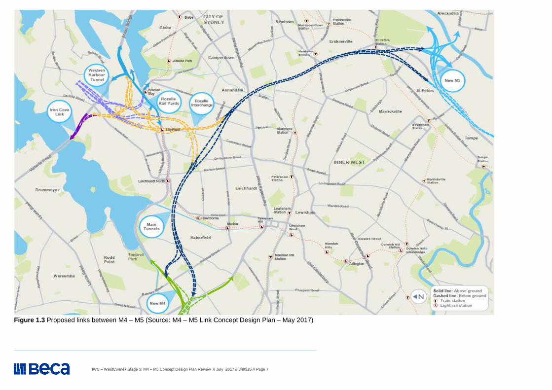
See Figure 1.3 for proposed road links between M4 and M5.
SEARS – 3 May 2017 (Application Number - SSI 16 7485) The Desired Performance Outcomes (DPO) points in the SEARS are repeated below and supported by IWC: Assessment of Key Issues – Point 3 - Requirement 1: The level of assessment of likely impacts must be proportionate to the significance of, or degree of impact on, the issue, within the context of the proposal location and the surrounding environment. The level of assessment must be commensurate to the degree of impact and sufficient to ensure that the Department and other government agencies are able to understand and assess impacts. Assessment of Key Issues – Point 3 - Requirement 2:
(a) demonstrate how potential impacts have been avoided (through design, or construction or operation methodologies);
(b) detail how likely impacts that have not been avoided through design will be minimised, and the predicted effectiveness of these measures (against performance criteria where relevant); and
(c) detail how any residual impacts will be managed or offset, and the approach and effectiveness of these measures
Assessment of Key Issues –Point 3 - Requirement 3
Where multiple reasonable and feasible options to avoid or minimise impacts are available, they must be identified and considered and the proposed measure justified taking into account the public interest.
IWC understands the EIS will be ready for exhibition in late August or early September 2017 and expects these requirements to be addressed comprehensively.
IWC – WestConnex Stage 3: M4 – M5 Concept Design Plan Review // July 2017 // 349326 // Page 7
Figure 1.3 Proposed links between M4 – M5 (Source: M4 – M5 Link Concept Design Plan – May 2017)
IWC – WestConnex Stage 3: M4 – M5 Concept Design Plan Review // July 2017 // 349326 // Page 8
WestConnex M4 – M5 Concept Design Plan Review – STRATEGIC ISSUES
Item Background information and source Review comment
1. Strategic Issues - Cont. 1.4
Application (SSIAR) - Changes to Concept Design Plan since SSIAR – January 2016 Since preparation of the SSIAR in January 2016, preliminary design development and traffic modelling has informed further refinement of the design in the form of a tunnel connection from the southern abutment of the Iron Cove Bridge to the proposed Rozelle interchange (the ‘Iron Cove Link’) - SSIAR Addendum 1. Since then, further developments have been made to the project design and scope (SSIAR Addendum 2). The following design refinements and scope changes have been incorporated for the project:
• Refinement of the Rozelle interchange design to include tunnel connections which extend beyond the boundaries of the Rozelle Rail Yards, including civil construction of stub tunnels linking to a proposed future Western Harbour Tunnel. The interchange design also includes civil construction of infrastructure for, and above-ground ramps into, a proposed future Western Harbour Tunnel as part of the Rozelle interchange;
• Removal of the road interchange at Camperdown; • Realignment of the mainline tunnels; • Amendment of the mainline tunnel configuration from three lanes to four lanes; • Removal of Easton Park from the project construction footprint; and • A description of the revised scope of the separate project to undertake site
management works at part of the former Rozelle Rail Yards has also been included in Addendum 2.
The investment in the M4-M5 Link and other WestConnex projects would facilitate a step change in network performance, enabling delivery of major city shaping improvements and delivering economic growth. As part of the broader WestConnex program of works, the project would support NSW’s major sources of economic activity and provide a strategic response to the currently inadequate, and highly congested, road network.
These changes are reflected in the M4 – M5 Link Concept Design Plan. Comments on these changes are provided under specific items. In April 2017 IWC made a submission on the SSIR Addendum 2 to express the following:
1. Support for removal of traffic interchange at Camperdown, mainly on the basis of reduced traffic impacts
2. Support for realignment of mainline tunnels, mainly because the new route would avoid sensitive land-uses such as Royal Prince Alfred Hospital
3. Moderate opposition to refinement of the Rozelle interchange design as it would expand the area affected by the interchange and possibly interfere with future public transport
4. Strong opposition to increasing the mainline tunnel configuration from three lanes to four as the increased road capacity would add to the cost of the project and generate additional traffic and air emissions
5. Support for removal of Easton Park from the project construction footprint
IWC – WestConnex Stage 3: M4 – M5 Concept Design Plan Review // July 2017 // 349326 // Page 9
WestConnex M4 – M5 Concept Design Plan Review – STRATEGIC ISSUES
Item Background information and source Review comment
1. Strategic Issues - Cont. 1.5
Application (SSIAR) - Freight The Trade and Logistics Report 2011-12 (Sydney Ports Corporation, 2012) indicated that 98 percent of containers imported through Port Botany, and more than 60 percent of exported containers, have their destination or origin in western Sydney. In the absence of any improvements to the network, road freight will continue to be increasingly subject to capacity constraints and peak hour congestion in Sydney, in particular within the M4 Motorway, M5 Motorway, M7 Motorway, M1 and A3 corridors (Sydney Motorways Corporation, 2015)
IWC’s view is that the M4 – M5 Link as proposed will not significantly improve the connectivity to Port Botany, as was one of the original aims of WestConnex. It instead directs trucks to St Peters seven kilometres from Port Botany and then to already congested airport approaches and into residential areas in the inner city. It also threatens major roads including the Anzac Bridge and Western Distributor with significant extra traffic during peak periods.
1.6
Application (SSIAR) - Connectivity Connectivity between major employment centres is critical in supporting the creation of jobs and businesses, particularly the Global Economic Corridor, which spans from Port Botany and Sydney Airport to the Norwest Business Park and Parramatta Central Business District (CBD) via the Sydney and North Sydney CBDs. Sydney’s business task requires good access for workers as well as the distribution of goods and services across the Sydney region, which requires diverse and dispersed transport connections to support growth. Improved connections for workers, and to other centres, suppliers, trades and customers through improvements to the transport network, including the strategic road network, is needed to support the growth of these centres and the Global Economic Corridor.
IWC agrees with the intent of connecting major employment centres, but public transport will remain a faster way to move around and connect people with these centres. It seems that a very small percentage of daily trips in the Sydney region will benefit from the huge cost of connecting the M4 and M5 as proposed in this concept design. IWC’s view is that increasing the capacity and speed of freight train lines to Port Botany should be a serious consideration. It should be included in the planning of the WestConnex M4–M5 Link, as it will significantly reduce pressure on the existing M5.
1.7
Application (SSIAR) - Transport mode -specific strategies Six modal strategies were developed to support the Transport Master Plan and would be considered during the development to ensure integration and connectivity with these transport modes as appropriate. These modal strategies are: � Sydney’s Rail Future; � Sydney’s Light Rail Future; � Sydney’s Bus Future; � Sydney’s Cycling Future; and � Sydney’s Walking Future.
IWC’s view is the proposed M4–M5 Link is favouring the increase of private vehicle use to benefit toll revenue rather than (as intended in the Transport Master Plan) to plan link roads for better freight and service vehicle movements. Further, it seems that the proposed M4–M5 Link between the Rozelle and St Peters interchanges will generate most of its predicted demand locally. This is diminishing the aim of connecting private vehicles from the west to the south-west and Port. The recently opened South-West Rail has been successful as it has usage has increased more than 10 per cent over a year. Increased rail freight is a trend that should be encouraged through improved rail services.
1.8
Application (SSIAR) - WestConnex Business Case In November 2015, the WestConnex Updated Strategic Business Case (Sydney Motorway Corporation, 2015) (the Updated Business Case) was released which updated the business case endorsed by the NSW Government in 2013. The Updated Business Case outlines the need for WestConnex and identifies the process for delivering this major infrastructure initiative, with a Benefit Cost Ratio of 1.71 for the WestConnex program of works, without the wider economic benefits and 1.88 with the broader economic benefits. The estimated capital investment cost for the M4-M5 Link project is $7,247 M.
IWC’s view is that the updated business case has not properly considered the major demand effects of the Western Sydney Airport and Sydney Metro West projects.
IWC – WestConnex Stage 3: M4 – M5 Concept Design Plan Review // July 2017 // 349326 // Page 10
WestConnex M4 – M5 Concept Design Plan Review – STRATEGIC ISSUES
Item Background information and source Review comment
1. Strategic Issues (Cont.) 1.9
Application (SSIAR) - Stakeholder engagement and communication strategy Consultation for the M4–M5 Link will focus on identifying key issues of potential concern to stakeholders, as well as provide clear opportunities for feedback on the project design and its potential benefits and impacts. An M4–M5 Link stage-specific stakeholder engagement and communication strategy will guide consultation with stakeholders and the community during the project’s milestones and construction activities. This strategy will detail how affected communities will be engaged regarding the project and the proposed future stakeholder consultation.
SEARS – 3 May 2017 (Application Number - SSI 16 7485) The Desired Performance Outcomes (DPO) points in the SEARS are repeated below and supported by IWC: Consultation - Point 4 - The project is developed with meaningful and effective engagement during project design and delivery.
Requirement 1: The project must be informed by consultation, including with relevant local, State and Commonwealth government agencies, infrastructure and service providers, and special interest groups (including Local Aboriginal Land Councils, Aboriginal stakeholders, and pedestrian and bicycle user groups), affected landowners, businesses and the community.
Requirement 2: The Proponent must document the consultation process, and demonstrate how the project has responded to the inputs received.
Requirement 3: The Proponent must describe the timing and type of community consultation proposed during the design and delivery of the project, the mechanisms for community feedback, the mechanisms for keeping the community informed, and procedures for complaints handling and resolution. IWC understands the EIS will be ready for exhibition in late August or early September 2017 and expects these requirements to be addressed comprehensively.
1.10
Application (SSIAR) - Construction Construction of the project would occur over a period of around four years and would include (but not be limited to) the following: � Enabling and temporary works, including utilities
relocation, construction power, construction water supply, site establishment, demolition works, property and public transport modifications (if required);
� Construction of the road tunnels, interchanges, intersections and roadside infrastructure; and
� Haulage of spoil generated during tunneling and excavation activities
� Fit-out of the road tunnels and support infrastructure, including ventilation and emergency response systems.
Concern is expressed over increased traffic (both construction and operational) in the area around the Rozelle Interchange. This traffic will impact on local amenity, accessibility and pedestrian/cyclist safety. Additionally, it is highly likely that the construction phases of the M4-M5 Link will extend the duration of the already highly disrupted environment that the Inner West community has been attempting to deal with for the past 3+ years.
IWC – WestConnex Stage 3: M4 – M5 Concept Design Plan Review // July 2017 // 349326 // Page 11
WestConnex M4 – M5 Concept Design Plan Review – STRATEGIC ISSUES
Item Background information and source Review comment
1. Strategic Issues (Cont.) 1.11
Application (SSIAR) - Motorway operational facilities The project would require motorway operation facilities during operation, including but not limited to: motorway control centres, maintenance facilities, ventilation structures and systems, fire and life safety systems, emergency evacuation and smoke extraction infrastructure, and groundwater treatment systems. In determining the size and location of the motorway operation facilities, operational and technical need, existing land use activities, potential environmental impacts and amenity impacts on the surrounding community would be taken into account. The location and size of the motorway operation facilities would be developed as part of determining the preferred project design and would be assessed in the environmental impact statement for the project.
IWC is concerned about the proximity of the Iron Cove Link ventilation facility to adjacent residential areas, particularly on existing medium-density residential developments at and around Balmain Shores and Terry Street. Concerns are also raised about air quality and visual impacts of the ventilation towers on the Rozelle Railyards recreation area. It appears that none of the ventilation stacks have filtration, heightening IWC’s concerns about the impact of emissions on the health of residents around these facilities. Council is also concerned that the additional traffic generated by WestConnex will lead to a decline in regional air quality across Sydney. Emissions include particulates, nitrous oxide, carbon monoxide and other polluting gases. See further details in Item 2.12.
IWC – WestConnex Stage 3: M4 – M5 Concept Design Plan Review // July 2017 // 349326 // Page 12
WestConnex M4 – M5 Concept Design Plan Review – STRATEGIC ISSUES
Item Background information and source Review comment
1. Strategic Issues (Cont.) 1.12
M4 – M5 Concept Plan - Text from Page 2: About WestConnex Sydney’s population is set to grow by more than one million people in the next 10 years. This growing population will result in additional traffic and, by 2031, the road network is expected to cater for an estimated 19 million trips per day. Over the next four years the Government will invest a record $41.5 billion on road and public transport projects to deliver an integrated transport solution for our great city. The traffic growth is not just more people travelling to and from work. It is: � more buses getting people around the city (the largest public transport
carrier in Sydney is buses, accounting for more than 50% of journeys); � tradespeople working across the city; � freight vehicles moving more goods to support the increased population; � people running children to sport and doing their weekly shopping; � couriers and distributors supporting a booming e-commerce industry; and � tourists travelling across our city.
Public transport alone cannot meet these diverse and often unique travel needs. It is unnecessary to view roads and public transport investment as an ‘either-or’ option. Improved road infrastructure is going to remain a critical part of the solution. WestConnex is part of the Australian and NSW governments’ shared vision for supporting Sydney’s growing population. The M4-M5 Link is a critical part of WestConnex. It connects the New M4 and the New M5 and will allow the full benefits of WestConnex to be realised.
Inner West Council’s (IWC) Local Representation Advisory Committee (LRAC) Meeting 13 June 2017: The WestConnex M4 – M4 Link Concept Design exhibition has not only raised content issues for Council, but also process issues. At its 23 May 2017 meeting, Council resolved to write to the Minister for WestConnex about these process issues as summarised below:
1. Item 1: The main issues raised by IWC about the document and exhibition were:
a) Technical issues with the document - Council staff have found the print version is difficult to read and the online version difficult to negotiate on the screen;
b) Lack of availability of print copies of the documen t - as only one print copy of the document is available at Council service centres and in libraries, there is greater reliance on the online version with its difficulties as outlined, and it has been difficult for Council staff and members of the community to obtain additional print copies from SMC;
c) Limited range of matters being consulted on - as per Section 4 of the Concept Design. Council and the community are only being consulted on a limited range of matters and fundamental issues appear to be excluded;
d) Lack of detail about the location of construction s ites - for example, the precise location of cons1rucUon sites and sensitive land uses is not shown on Figure 6.1, so it can't be known if sensitive sites and land uses will be affected by construction activities;
e) Lack of detail about construction & operational tra ffic & parking impacts - without sufficient information on these significant high-impact components of the project the impact of the project cannot be fully assessed;
f) No Concept Design submission close date & overlap w ith exhibition of EIS - indicating SMC is not committed to integrating comments on the Design Plan into the EIS; and
g) Possibility that EIS exhibition will close just pri or to election of new Council - this would preclude the new Inner West Council from considering the EIS.
IWC expects the EIS will be ready for exhibition in late August or early September 2017 and expects these limitations to be addressed comprehensively in the EIS.
IWC – WestConnex Stage 3: M4 – M5 Concept Design Plan Review // July 2017 // 349326 // Page 13
WestConnex M4 – M5 Concept Design Plan Review – STRATEGIC ISSUES
Item Background information and source Review comment
1. Strategic Issues (Cont.) 1.13
M4 – M5 Concept Plan - Section 2 About This Concept Design (page 5) This concept design forms the next stage of consultation and aims to provide the community and other stakeholders with a better understanding of the M4-M5 Link. It presents what is being planned and provides an opportunity for the community and other stakeholders to give feedback. This concept design is based on the most recent information on the M4-M5 Link and includes: � A proposed alignment for the main tunnels, Rozelle Interchange and Iron
Cove Link, as well as indicative tunnel depths for each of the areas; � arranged options for amenity and construction sites; � the proposed location of surface connections and facilities, including
ventilation facilities; � details of active transport (walking and cycling) connections; � draft masterplans for the Rozelle Rail Yards and St Peters, as well as a
concept plan for Victoria Road near the Iron Cove Bridge;
The information is grouped into locations (Newtown/St Peters, Annandale/Camperdown, Leichhardt/Lilyfield, Haberfield/Ashfield, Rozelle) to provide an understanding of what is proposed at each of the key surface locations. Our continuing technical investigations and public consultation on the concept design will result in further improvements.
Inner West Council’s (IWC) Local Representation Advisory Committee (LRAC) Meeting 13 June 2017 (cont.):
2. Item 4: Civilising WestConnex exhibition - In March and April 2017 an exhibition by University of NSW (UNSW) was held by Professor James Weirick. The exhibition shows that with a transit line along WestConnex Stages 1 and 2, 14 stations could be constructed which could act as a catalyst for transit-oriented development. Stage 3 would not need to be constructed. Students were given the task of designing medium-density precincts around the stations. The stations are: Parramatta, Rosehill Newington, Carter Street, Homebush, North Strathfield, Burwood, Haberfield, Rozelle, St Peters, Mascot, Arncliffe, Bardwell Park and Kingsgrove. The stated purpose of the UNSW assignment is: “… to replace cars and trucks in the conduits with high-capacity Metro rail, and transform sites slated for spaghetti road junctions into new fine-grained neighbourhood centred on transit stations.” “… presented as a 21st century remaking of a failed 20th century paradigm – converging inner-city motorways.” Beyond transport infrastructure and development around stations, there are a number of other transport / land-use actions that would need to be undertaken to make the Civilising WestConnex scenario viable. These include transport demand management, programs to improve vehicle occupancies, road and transport pricing, park-and-ride facilities and other appropriate parking measures, public transport interchange improvements and complementary infrastructure for walking and cycling.
IWC understands the EIS will be ready for exhibition in late August or early September 2017 and expects these limitations to be addressed comprehensively in the EIS.
IWC – WestConnex Stage 3: M4 – M5 Concept Design Plan Review // July 2017 // 349326 // Page 14
WestConnex M4 – M5 Concept Design Plan Review – STRATEGIC ISSUES
Item Background information and source Review comment
1. Strategic Issues (Cont.) 1.14
M4 – M5 Concept Plan - Section 3 The M4 – M5 Link (page 8):
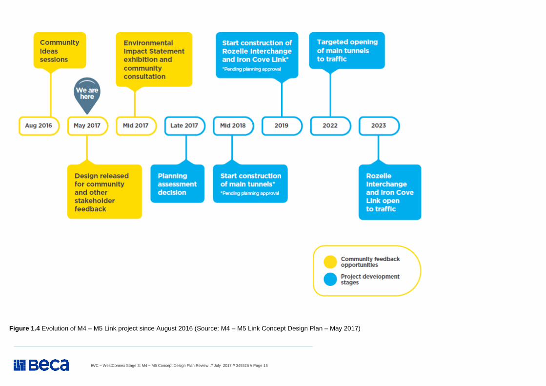
The M4-M5 Link design has continued to evolve since the release of the Updated Strategic Business Case in November 2015. This evolution is based on a combination of design refinement, input from the community and other stakeholders and the results of site investigations such as geotechnical testing. All projects go through this design evolution. It is a normal process that ensures technical investigations and community feedback shape the project design. The design also needs to consider other planned and potential projects in Sydney to ensure we have an integrated transport system that works for everyone. Our technical investigations are continuing and public consultation on this design will result in further changes and improvements. The information provided in this document includes a number of locations currently being considered as potential construction sites. Sydney Motorway Corporation and Roads and Maritime Services will continue to assess these sites and investigate alternative locations. The Environmental Impact Statement (EIS) process will involve further consultation prior to assessment by the Department of Planning and Environment. Pending project approval, the final M4-M5 Link design will be confirmed in 2018. Figure 1.4 details the evolution of the M4-M5 Link project and explains the process by which it will be delivered.
As stated in the Item 1.13 comments above, it is IWC’s view that the opportunities presented in the minutes of the LRAC Meeting of 13 June 2017 be investigated sufficiently in the EIS. IWC should appropriately be engaged during the assessment of these opportunities as part of further planning of the M4–M5 Link. At the 6 December 2016 Council meeting, the recommendations of an Administrator’s minute entitled WestConnex – Traffic in Local Neighbourhoods & Streets and Assessing Stage 3 Impacts were adopted. Accordingly, Council has commissioned a study to assess the operational impacts each stage of WestConnex will have on residential neighbourhoods and streets. The study will recommend appropriate traffic management measures, and Council will advocate to the NSW Government that it fund implementation of these measures prior to any stages of WestConnex opening to traffic. Compliance Currently compliance monitoring for all stages of the WestConnex project is undertaken by a single DP&E WestConnex Compliance Officer. This is not considered to be adequate given the high number of compliance issues raised by construction of the M4 East over the past year and a recent increase in New M5 compliance issues now that construction of this stage of the project is underway. It is requested that this officer also ensures all comments presented to WestConnex on the M4–M5 Link Concept Design Plan need timely and appropriate engagement with IWC and comprehensive feedback to (and liaison with) Council’s WestConnex Community Liaison Forum (WCLF). IWC Meeting of 28 February 2017, Item 1 stated: Council’s Administrator is concerned that the Minister’s response (December 2016) does not include any substantial new commitments to better manage the construction impacts of the project. Council’s Administrator has recently written to the new Minister for WestConnex to relate Council’s position of opposition to WestConnex and preference for public transport solutions to Sydney’s traffic problems. The letter also raises some key WestConnex issues, specifically to the proposed M4 – M5 Link, including:
� Need for enhanced resources for compliance monitoring and enforcement; � A commitment to no M4-M5 Link mid-tunnel construction dive site in the Leichhardt area; � A commitment to funding and implementing traffic calming schemes in areas that will experience increased traffic due to
WestConnex; � Facilitating full access to Roads & Maritime Services traffic modeling data to assist Council to target its traffic calming scheme
plans; � Commitment to dedication of all residual lands from WestConnex to parkland or other community uses; � Implementation of a 40kph school zone along Campbell Street, St Peters near St Peters Public School; and � Retention of rail tracks within Rozelle Rail Yards until corridors for future light rail extensions have been identified and protected.
IWC understands the EIS will be ready for exhibition in late August or early September 2017 and expect these issues to be addressed comprehensively in the EIS.
IWC – WestConnex Stage 3: M4 – M5 Concept Design Plan Review // July 2017 // 349326 // Page 15
Figure 1.4 Evolution of M4 – M5 Link project since August 2016 (Source: M4 – M5 Link Concept Design Plan – May 2017)
IWC – WestConnex Stage 3: M4 – M5 Concept Design Plan Review // July 2017 // 349326 // Page 16
WestConnex M4 – M5 Concept Design Plan Review – STRATEGIC ISSUES
Item Background information and source Review comment
1. Strategic Issues (Cont.) 1.15
M4 – M5 Concept Plan - Section 4 The M4 – M5 Link (page 10):
Purpose of the design consultation
As part of this design consultation, we are seeking feedback from the community and other stakeholders on: � the masterplan for the Rozelle Rail Yards; � the concept plan for the Iron Cove Link; � the future use of the tunnel construction sites; � active transport (walking and cycling) connections; � the architectural design of ventilation facilities; � the architectural design of tunnel entry/exit points; � landscape treatments (i.e. types of trees and plants, open space uses) at Haberfield/Ashfield, Rozelle, Iron Cove,
Leichhardt/Lilyfield and Annandale/Camperdown; � the in-tunnel environment and driver experience.
See comments in Item 1.14 above
1.16
M4 – M5 Concept Plan - Section 5 The M4 – M5 Link (page 12):
We are listening We are working closely with local councils, government agencies, the Greater Sydney Commission, industry, the community and other stakeholders to, where achievable, incorporate their ideas and feedback into the delivery of this city-changing project. Feedback has already helped shape the design of the M4-M5 Link. Key changes that have been influenced by your feedback include:
� removal of the on and off ramps at Camperdown; � removal of Easton Park, Rozelle, Blackmore Oval and Derbyshire Road, Leichhardt as potential construction sites; � consideration of the western end of the Rozelle Rail Yard corridor as a potential tunnel construction site; � an Active Transport Strategy that will improve local pedestrian and cycle networks; and � consultation on the design before consultation on the Environmental Impact Statement (EIS).
We would also like to confirm:
� we are not proposing to change Lilyfield Road, nor will we use it as a heavy vehicle route; and � there is no surface work proposed for Pioneers Memorial Park, Leichhardt.
We are now seeking feedback on the concept design from the community and other stakeholders. You will have a number of opportunities to find out more about the concept design and share your feedback with us prior to the assessment of the EIS. The community and other stakeholders will have further opportunities to give feedback when the EIS is released in mid-2017. EIS submissions will be considered by the Department of Planning and Environment as part of its overall assessment of the project.
See comments in Item 1.14 above
IWC – WestConnex Stage 3: M4 – M5 Concept Design Plan Review // July 2017 // 349326 // Page 17
WestConnex M4 – M5 Concept Design Plan Review – STRATEGIC ISSUES
Item Background information and source Review comment
1. Strategic Issues (Cont.) 1.17
M4 – M5 Concept Plan - Section 6 The M4 – M5 Link (page 14): Construction
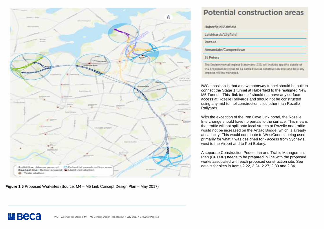
Construction Sites Pending project approval, major construction of the M4-M5 Link would start in 2018 and finish in 2023. While most of the work would take place underground, surface work would take place to build the entries and exits to the tunnel and tunnel support facilities. Several work sites will be required along the alignment to support the construction of the Rozelle Interchange and the main tunnels (refer to Figure 1.5 ). Some of the work sites will house permanent operational facilities. We are working through the site layouts and access arrangements. To inform our approach to the layout, shape and size of the work sites we are using the following principles:
� locate temporary buildings and structures such as offices and amenities so they provide a noise mitigation between the work sites and neighbouring areas;
� ensure temporary buildings and structures do not overshadow neighbouring properties; � locate and design lighting to minimise light spilling from work sites; � locate excavated material away from property boundaries; � locate vehicle access points away from residences; and � and minimise the need for trucks to be in residential areas.
Above-ground work includes drainage, utilities, earthworks, structures and roadworks. Project-wide activities, which will take place at work site offices during standard construction hours, would include design work and office and administration tasks. Surface works The construction hours for surface work on the M4-M5 Link will reflect standard operating hours for major construction sites which are generally Monday to Friday, 7am to 6pm; Saturday, 8am to 1pm; no work on Sundays or public holidays. While most of the surface construction work would be carried out during standard construction hours, some activities would need to be undertaken at night to effectively manage public and construction worker safety; design and quality considerations; and the duration of construction and any associated amenity impacts on the local community.
A significant Stage 3 issue is the location of mid-tunnel construction dive sites and their impacts. For the dive-site in the Leichhardt/Lilyfield area, the Concept Design states that SMC is considering the 7 Darley Road site, but is also investigating the Rozelle Rail Yards (RRY) (western end) as an alternative. For some months, Council has been advocating the RRY site as a potential lower-impact alternative to Darley Road – see Items 2.21 and 2.22.
IWC understands the EIS will be ready for exhibition in late August or early September 2017 and expects confirmation that the RRY site will be the only mid-tunnel construction dive-site construction site in the IWC area. This is to be addressed comprehensively in the EIS.
IWC – WestConnex Stage 3: M4 – M5 Concept Design Plan Review // July 2017 // 349326 // Page 18
WestConnex M4 – M5 Concept Design Plan Review – STRATEGIC ISSUES
Item Background information and source Review comment
1. Strategic Issues (Cont.) 1.18
M4 – M5 Concept Plan - Section 6 The M4 – M5 Link (page 14): Construction – Cont.
Tunnelling The tunnels are likely to be constructed in sections. Excavated material would be brought to the surface, loaded onto trucks and disposed of at approved sites. Acoustic sheds would house the tunnelling work to help protect residents from noise. Tunnelling activities will operate continuously, 24 hours a day, seven days a week. The depth of the tunnels means any potential impact on the properties above is highly unlikely. Once the tunnel alignment is confirmed, residents will be notified if they are within 50 metres of the underground tunnel. They will be provided information to explain the position and depth of the underground tunnel in relation to their property. To give peace of mind to local residents and businesses, all properties within 50 metres of the outer edge of the underground tunnels will be offered a property condition survey before and after construction. This will ensure there is a clear record of the property’s condition before and after construction. Any damage attributed to the project would be repaired at no cost to the property owner. Once the new tunnel is operational, residents above the underground tunnels are unlikely to be able to hear or feel any vibration from the motorway. Minimising noise During construction of the M4-M5 Link, we would continue to monitor noise and work directly with residents to mitigate noise wherever feasible and where appropriate:
� provide noise barriers and acoustic sheds to house tunneling activities; � undertake noisy work during standard construction hours; � ensure all equipment is shut down when not in use and non-tonal reversing beepers used on vehicles; and � ensure there are periods where construction work is not scheduled, to give residents respite from the work.
Utilities
Sydney Motorway Corporation is working with Roads and Maritime Services, Department of Planning and Environment and the Traffic Management Centre to effectively coordinate work associated with utility relocation. We will appoint an external manager to coordinate with these agencies. This approach will assist in mitigating community impact.
See comments in Item 1.17 above
IWC – WestConnex Stage 3: M4 – M5 Concept Design Plan Review // July 2017 // 349326 // Page 19
IWC’s position is that a new motorway tunnel should be built to connect the Stage 1 tunnel at Haberfield to the realigned New M5 Tunnel. This “link tunnel” should not have any surface access at Rozelle Railyards and should not be constructed using any mid-tunnel construction sites other than Rozelle Railyards.
With the exception of the Iron Cove Link portal, the Rozelle Interchange should have no portals to the surface. This means that traffic will not spill onto local streets at Rozelle and traffic would not be increased on the Anzac Bridge, which is already at capacity. This would contribute to WestConnex being used primarily for what it was designed for - access from Sydney’s west to the Airport and to Port Botany.
A separate Construction Pedestrian and Traffic Management Plan (CPTMP) needs to be prepared in line with the proposed works associated with each proposed construction site. See details for sites in Items 2.22, 2.24, 2.27, 2.30 and 2.34.
Figure 1.5 Proposed Worksites (Source: M4 – M5 Link Concept Design Plan – May 2017)
IWC – WestConnex Stage 3: M4 – M5 Concept Design Plan Review // July 2017 // 349326 // Page 20
WestConnex M4 – M5 Concept Design Plan Review – STRATEGIC ISSUES
Item Background information and source Review comment
1. Strategic Issues (Cont.) 1.19
M4 – M5 Link Concept Plan - Section 15 The M4 – M5 Link (page 56): Environmental Impact Statement
Sydney Motorway Corporation is committed to minimising the impact of the project on the local community as much as possible. To ensure all potential benefits are considered and impacts are fully assessed, we will prepare an Environmental Impact Statement (EIS) for the project in line with the Secretary’s Environmental Assessment Requirements, which has issued by the Department of Planning and Environment in March 2016. The EIS will describe how we would manage environmental and community impacts including air quality, noise, vibration and traffic, during both the construction and operation of the M4-M5 Link. It will also include the preferred locations for construction sites. The Department of Planning and Environment will place the EIS on exhibition for community input in 2017. Following exhibition, all submissions will be considered and addressed in a Submissions and Preferred Infrastructure Report (SPIR), which will then be lodged with the NSW Department of Planning and Environment to help inform the Minister for Planning’s decision. If the project is approved, the M4-M5 Link will be constructed and operated in accordance with mitigation measures and safeguards described in the EIS, the SPIR and any conditions of approval issued. The EIS will cover all relevant environmental issues including, but not limited to: Management of excavated material We propose to minimise the volume of excavated material generated and then reuse or recycle at least 95% of uncontaminated excavated material for beneficial purposes, including: � within the project including the Rozelle Rail Yards open space � for environmental and community work outside the project area � site leveling, development and land restoration work outside the project area.
Excavated material that cannot be used on site will be taken by haulage to offsite facilities. The haulage routes are currently being determined to minimise impacts on surrounding residents and businesses and will be detailed in the EIS.
In addition to this, a truck marshalling area (TMA) is being investigated for use during the construction of the M4-M5 Link. The TMA would provide a safe and secure offsite area, complete with amenities, for early arriving trucks to be staged before they are required on site. Noise and vibration A range of mitigation measures would be employed to minimise disruption from noise and vibration to surrounding homes and businesses during construction and operation.
It is anticipated that the M4-M5 Link would reduce noise in some areas because we will be removing traffic from surface roads. Noise impacts resulting from the operation of the M4-M5 Link will be assessed and managed in accordance with the NSW Road Noise Policy, Roads and Maritime Services Road Criteria Guidelines, and Roads and Maritime Services Noise Mitigation Guidelines.
As set out in the application for this project in Item 1.1 above, the project, consistent with the WestConnex program of works, includes an objective to protect natural and cultural resources and enhance the environment through the following key approaches: � Manage in-tunnel air quality so as to meet
community visibility expectations and EPA standards;
� Manage tunnel ventilation emissions to ensure local air quality meets EPA standards;
� Maintain regional air quality; � Minimise adverse impacts at a local level
on air/noise quality; � Minimise construction and operational
energy use; � Manage noise in accordance with the NSW
Road Noise Policy and realise opportunities to reduce or mitigate noise impacts;
� Provide for improvement of social and visual amenity;
� Minimise impacts on natural systems including biodiversity;
� Minimise impact on Aboriginal and non-Aboriginal cultural heritage;
� Minimise impacts on surface and groundwater sources and water quality including management of contaminated areas;
� Reduce susceptibility to, and minimise impacts of flooding;
� Integrate sustainability considerations throughout the design, construction and operation of the project, including consideration of the Infrastructure Sustainability Council of Australia (ISCA) Sustainability Rating tool scorecard.
IWC expects these to be fully addressed in the EIS.
IWC – WestConnex Stage 3: M4 – M5 Concept Design Plan Review // July 2017 // 349326 // Page 21
WestConnex M4 – M5 Concept Design Plan Review – TRAFFIC AND TRANSPORT
Item Background information and source Review comment
2. Traffic and Transport (construction and operation) 2.1
Application (SSIAR) - Connection to the Wattle Street interchange The M4-M5 Link would connect to on- and off- ramps that are to be constructed as part of the future M4 East project, subject to planning approval, which would provide connections for westbound and east bound traffic. The on- and off-ramps constructed as part of the future M4 East, subject to planning approval, would be located between the realigned Wattle Street carriageways between Parramatta Road and Ramsey Street, and would connect to Wattle Street, near Allum Street, and extend to Martin Street, Haberfield in cut and cover tunnels. As part of this project, the connections from the on- and off-ramps at Martin Street would be extended underground to connect to the M4-M5 Link main alignment tunnels. The fitout of the on- and off-ramps constructed as part of the future M4 East project, subject to planning approval, such as lighting, pavement and line marking, would be completed as part of this project.
See Items 2.26 and 2.27
2.2
Application (SSIAR) - The motorway tunnel The twin motorway tunnels between the proposed M4 East and New M5 projects (between Haberfield and St Peters) would be around 9 kilometres in length and would be built to be three lanes wide in the mainline tunnels. The ramps which form the connections to and from the surface roads would be built two lanes wide and operated either as single to two lanes to the merge point in the tunnel, depending on location and demand. The tunnels would have a posted speed limit of 80 kilometres per hour. On- and off-ramps at each end of the project and at the interchanges would include sections of tunnel to provide direct connections from the mainline tunnels to the proposed M4 East, the proposed New M5 and surface roads at Wattle Street, Camperdown and the St Peters interchange. The depth of the tunnel would vary depending on geological constraints and operational design requirements (such as road grade). The shallowest sections of the project are likely to be near the interchanges at Haberfield, Rozelle, Camperdown and St Peters. Tunnel stubs would be provided for connections to the possible future Western Harbour Tunnel and Beaches Link in the vicinity of the future Rozelle interchange. The final tunnel alignment would be determined as part of the design development process.
In the absence of any traffic modelling for Stage 3, it can be assumed that, should Stages 1 and 2 be completed without a link between them, the potential exists for a significant increase in vehicle numbers on local roads in Sydney’s inner western suburbs, negatively impacting quality of life and damaging the existing dense urban fabric in areas such as Haberfield, Rozelle, St Peters and Marrickville. Additionally, should a subterranean link be provided, Council could work with SMC and the State to capitalise on opportunities to provide environmental and public domain improvements to adjacent surface roads such as Parramatta Road and Victoria Road. IWC acknowledges that the on and off ramps at Camperdown has been removed from the plan. This modification was supported by IWC on the basis of avoiding traffic impacts on Camperdown.
IWC – WestConnex Stage 3: M4 – M5 Concept Design Plan Review // July 2017 // 349326 // Page 22
WestConnex M4 – M5 Concept Design Plan Review – TRAFFIC AND TRANSPORT
Item Background information and source Review comment
2. Traffic and Transport (construction and operation) – Cont. 2.3
Application (SSIAR) - Rozelle interchange The Rozelle interchange would be located within the existing Rozelle Rail Yard, and would provide a link between the Sydney Central Business District (CBD) and the mainline tunnels via connections to the City West Link, Victoria Road and Anzac Bridge. The interchange would be constructed to maintain existing connectivity along the surface road network between the City West Link, The Crescent, Victoria Road and the Anzac Bridge. However, the City West Link and The Crescent would be modified to accommodate the interchange with associated modifications to intersections along these roads and approaching surface roads. This would involve improvements to the City West, Link, Victoria Road and Anzac Bridge intersection. The interchange would also be constructed to allow for a connection with the possible future Western Harbour Tunnel and Beaches Link. An alternative route for the mainline tunnel in the vicinity of the interchange would also be investigated further. The final interchange design would be determined as part of the design development process. This includes potential improved connections to the Bays Precinct which would be determined in consultation with Urban Growth NSW
See Items 2.28 to 2.35
2.4
Application (SSIAR) - Camperdown interchange The Camperdown interchange would provide connections to Parramatta Road, in the general vicinity of Ross Street Glebe, for traffic travelling to or from the east of the interchange. No access to the M4-M5 Link for traffic travelling to or from the west of the interchange would be provided. The interchange would be constructed underground in tunnel with ramps rising in cut and cover tunnels to the portals at the surface to provide direct connections to Parramatta Road from the mainline tunnels. Bus lanes on Parramatta Road would be maintained. The interchange would be designed to allow for future public transport improvements, including the ability for Transport for NSW to implement bus improvements or light rail along that section of Parramatta Road in the future. The final interchange design and alignment of the M4-M5 Link tunnels would be determined as part of the design development process, and would take into consideration the potential impacts on surrounding heritage items, the Royal Prince Alfred Hospital and the University of Sydney.
See Items 2.21 to 2.23 IWC acknowledges that the on and off ramps at Camperdown has been removed from the plan. This modification was supported by IWC on the basis of avoiding traffic impacts on Camperdown.
IWC – WestConnex Stage 3: M4 – M5 Concept Design Plan Review // July 2017 // 349326 // Page 23
WestConnex M4 – M5 Concept Design Plan Review – TRAFFIC AND TRANSPORT
Item Background information and source Review comment
2. Traffic and Transport (construction and operation) – Cont. 2.5
Application (SSIAR) - St Peters interchange The M4-M5 Link would connect to the St Peters interchange to enable traffic to travel to and from the western and inner western suburbs of Sydney, the airport precinct and Port Botany. The interchange would provide connections between the project and: � The future Sydney Gateway � Gardeners Road, Mascot � Euston Road at the intersection of Campbell Road, St Peters.
Connections between the project and the New M5 would be provided as direct tunnel connections. The majority of the interchange would be constructed as part of the New M5 project (subject to planning approval), which includes embankments and bridge structures for the above connections, as well as a cut and cover structure beneath Campbell Street and Albert Street to facilitate the construction of the M4-M5 Link southern portal (subject to planning approval). As part of this project, the southern portal, on- and off-ramps to the main alignment tunnels, and a short section of surface roads at the interchange would be constructed.
See Items 2.18 and 2.19
2.6
Application (SSIAR) - Connecting Roads The M4 Motorway and M5 Motorway corridors provide important and strategic access between Sydney’s east and west and south west. The M5 East Motorway in conjunction with the Eastern Distributor also provides improved access between the CBD, the lower North Shore and south-west of Sydney. Key supplementary arterial routes near the project corridor, which also provide important north-south connectivity between the strategic road network, consist of the following: � Route A1 (Pacific Highway) which provides connections between the M1 Motorway at
Wahroonga to the Cahill Expressway � Route A3 (King Georges Road, Roberts Road, Centenary Drive and Homebush Bay
Drive) � Route A6 (extends from Pennant Hills Road/M2 Motorway in the north to Princes
Highway/Heathcote Road in the south and includes Silverwater Road, St Hilliers Road, Rawson Street, Olympic Drive, Joseph Street, Rookwood Road and Fairford Road)
� Route A36 (Princes Highway), which provides connections to the southern section of Route A1, the Sutherland Shire and the NSW south coast.
IWC recognises that the current M2-Eastern Distributor-M5-M7 outer-ring road around Sydney and the M4 direct east-west connection into the inner-city area provides some traffic benefits that could be expected from a ring road. IWC’s alternative proposal would create an inner ring-road that directs traffic from western Sydney to the Port of Botany the Airport, with an improved connection to the south-west. Whilst these ring roads direct traffic around the Sydney CBD and densely developed inner urban areas, they do not direct traffic through these areas.
IWC’s position is to maximize the use of upgrading of existing road connections first, then use parts of WestConnex and then find, test and compare other alternative inner ring road links to establish a better connection to the Port and Airport, and create an improved connection to the south-west.
IWC’s view is that the proposed M4 – M5 Link has not sufficiently been tested and compared to other alternatives or followed the priority steps in the development of the solution as described in Attachment 1.
IWC – WestConnex Stage 3: M4 – M5 Concept Design Plan Review // July 2017 // 349326 // Page 24
WestConnex M4 – M5 Concept Design Plan Review – TRAFFIC AND TRANSPORT
Item Background information and source Review comment
2. Traffic and Transport (construction and operation) – Cont. 2.6 cont.
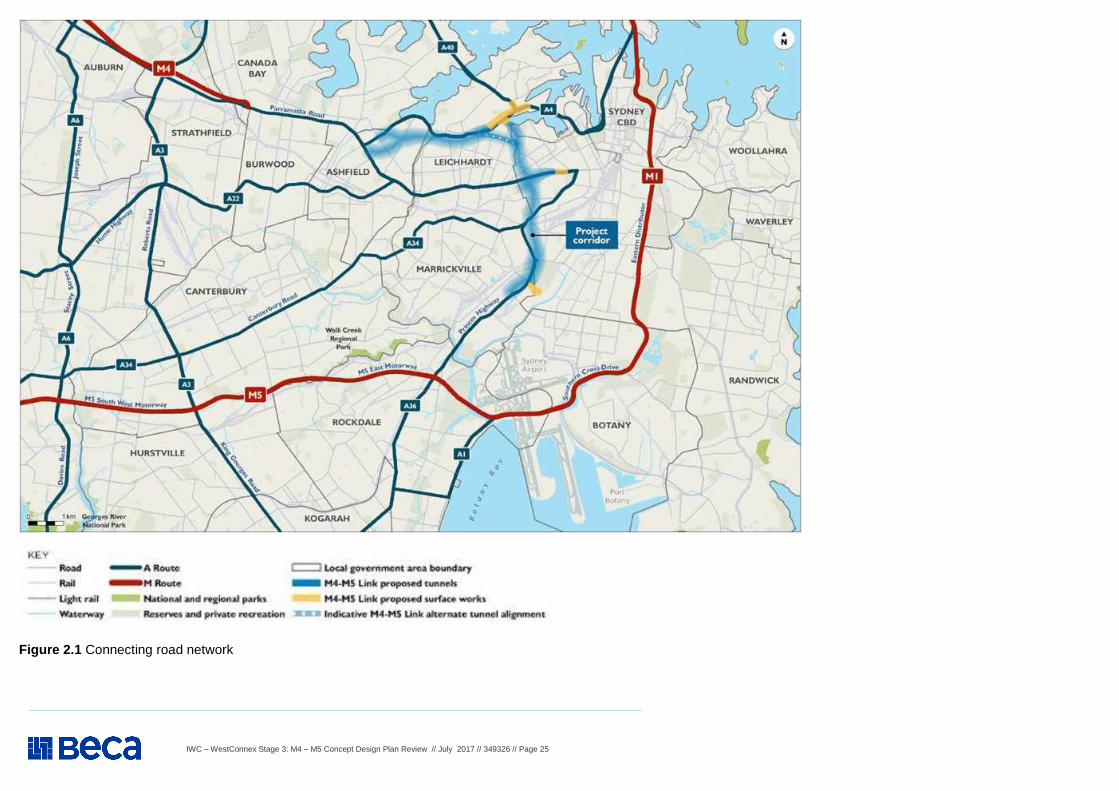
Application (SSIAR) - Connecting Roads (Cont.) The surrounding road network is shown on Figure 2.1. There are a number of challenges that road users and the community encounter on a daily basis in this current road network: � The missing link in the Sydney motorway network’s east-west spine created by
the M4 Motorway terminating at North Strathfield – constraining movements between Sydney’s west, its international gateways and key places of business
� Congestion, low travel speeds and unreliable travel times on the M4 Motorway, M5 East, Parramatta Road and in the Sydney Airport/Port Botany precinct that delay freight, public transport and add cost to business
� Poor urban amenity along Parramatta Road due to heavy traffic volumes and congestion throughout weekdays and on weekends.
In the absence of the improvements to the strategic road network, roads that are already congested are likely to experience worsening congestion by 2031. This includes the M4 Motorway corridor, City West link, Anzac Bridge, Victoria Road and the M1 corridor (in particular, the Harbour Bridge/Tunnel, Eastern Distributor/Southern Cross Drive). In the case of Parramatta Road, east of North Street, the road is forecast to experience an increase of 24 per cent in average weekday vehicles between 2012 and 2031 in the absence of WestConnex (Sydney Motorway Corporation, 2015). Much of the M4 and M5 Motorway corridors, Parramatta Road, City West Link/Anzac Bridge corridor, Victoria Road and the M1 corridor are expected to operate near or above their capacities over all peak periods by 2031 (Sydney Motorway Corporation, 2015). By 2031, congestion would significantly reduce average peak hour speeds on most strategic roads by up to 70 per cent (Sydney Motorway Corporation, 2015). The construction of the proposed M4 East and New M5 projects would assist in addressing future network constraints. However, in the absence of a connection between these corridors, north-south corridors would continue to decline in network performance.
Agree – hence the need for a solution of an inner-ring road to separate through-traffic from local traffic, to channelize traffic destined for Botany Port, Sydney Airport and an improved south-west connection. IWC expects the EIS will address details of the opportunities to enhance the amenity of major roads that may benefit from the M4-M5 Link such as Parramatta Road and Victoria Road. Agree – as set out in Section 2.2 of this document, IWC’s view is that the Stage 3 tunnel should proceed from Haberfield to the realigned New M5 Tunnel. With the exception of the Iron Cove Link portal, this link tunnel should not have any surface access at Rozelle Rail Yards and should not be constructed using any mid-tunnel construction sites other than Rozelle Rail Yards. As the Rozelle Interchange would have no portals to the surface, traffic would not spill onto local streets at Rozelle/Annandale and onto the Anzac Bridge, which is already at capacity. This would mean that WestConnex would be used primarily for what it was designed for - access to Sydney Airport and Port Botany from Sydney’s west. The implementation of new directional signage and changes to existing signage for guidance of drivers and all road users should be investigated in detail. This includes connecting roads and paths to and from new connections to the M4–M5 Link. Draft designs of these directional signs should be provided to IWC and the local community for comment before being finalised.
IWC – WestConnex Stage 3: M4 – M5 Concept Design Plan Review // July 2017 // 349326 // Page 25
Figure 2.1 Connecting road network
IWC – WestConnex Stage 3: M4 – M5 Concept Design Plan Review // July 2017 // 349326 // Page 26
WestConnex M4 – M5 Concept Design Plan Review – TRAFFIC AND TRANSPORT
Item Background information and source Review comment
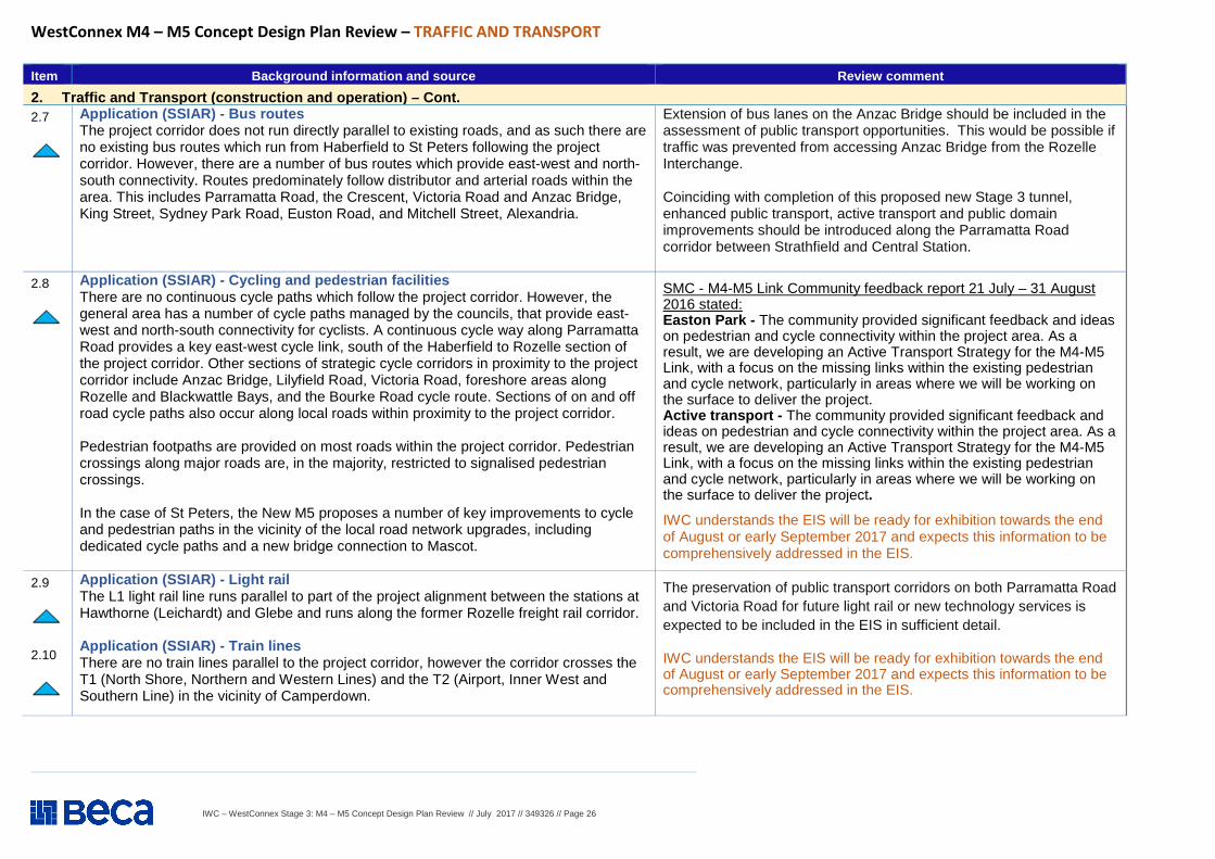
2. Traffic and Transport (construction and operation) – Cont. 2.7
Application (SSIAR) - Bus routes The project corridor does not run directly parallel to existing roads, and as such there are no existing bus routes which run from Haberfield to St Peters following the project corridor. However, there are a number of bus routes which provide east-west and north-south connectivity. Routes predominately follow distributor and arterial roads within the area. This includes Parramatta Road, the Crescent, Victoria Road and Anzac Bridge, King Street, Sydney Park Road, Euston Road, and Mitchell Street, Alexandria.
Extension of bus lanes on the Anzac Bridge should be included in the assessment of public transport opportunities. This would be possible if traffic was prevented from accessing Anzac Bridge from the Rozelle Interchange. Coinciding with completion of this proposed new Stage 3 tunnel, enhanced public transport, active transport and public domain improvements should be introduced along the Parramatta Road corridor between Strathfield and Central Station.
2.8
Application (SSIAR) - Cycling and pedestrian facilities There are no continuous cycle paths which follow the project corridor. However, the general area has a number of cycle paths managed by the councils, that provide east-west and north-south connectivity for cyclists. A continuous cycle way along Parramatta Road provides a key east-west cycle link, south of the Haberfield to Rozelle section of the project corridor. Other sections of strategic cycle corridors in proximity to the project corridor include Anzac Bridge, Lilyfield Road, Victoria Road, foreshore areas along Rozelle and Blackwattle Bays, and the Bourke Road cycle route. Sections of on and off road cycle paths also occur along local roads within proximity to the project corridor. Pedestrian footpaths are provided on most roads within the project corridor. Pedestrian crossings along major roads are, in the majority, restricted to signalised pedestrian crossings. In the case of St Peters, the New M5 proposes a number of key improvements to cycle and pedestrian paths in the vicinity of the local road network upgrades, including dedicated cycle paths and a new bridge connection to Mascot.
SMC - M4-M5 Link Community feedback report 21 July – 31 August 2016 stated: Easton Park - The community provided significant feedback and ideas on pedestrian and cycle connectivity within the project area. As a result, we are developing an Active Transport Strategy for the M4-M5 Link, with a focus on the missing links within the existing pedestrian and cycle network, particularly in areas where we will be working on the surface to deliver the project. Active transport - The community provided significant feedback and ideas on pedestrian and cycle connectivity within the project area. As a result, we are developing an Active Transport Strategy for the M4-M5 Link, with a focus on the missing links within the existing pedestrian and cycle network, particularly in areas where we will be working on the surface to deliver the project.
IWC understands the EIS will be ready for exhibition towards the end of August or early September 2017 and expects this information to be comprehensively addressed in the EIS.
2.9
2.10
Application (SSIAR) - Light rail The L1 light rail line runs parallel to part of the project alignment between the stations at Hawthorne (Leichardt) and Glebe and runs along the former Rozelle freight rail corridor. Application (SSIAR) - Train lines There are no train lines parallel to the project corridor, however the corridor crosses the T1 (North Shore, Northern and Western Lines) and the T2 (Airport, Inner West and Southern Line) in the vicinity of Camperdown.
The preservation of public transport corridors on both Parramatta Road and Victoria Road for future light rail or new technology services is expected to be included in the EIS in sufficient detail.
IWC understands the EIS will be ready for exhibition towards the end of August or early September 2017 and expects this information to be comprehensively addressed in the EIS.
IWC – WestConnex Stage 3: M4 – M5 Concept Design Plan Review // July 2017 // 349326 // Page 27
WestConnex M4 – M5 Concept Design Plan Review – TRAFFIC AND TRANSPORT
Item Background information and source Review comment
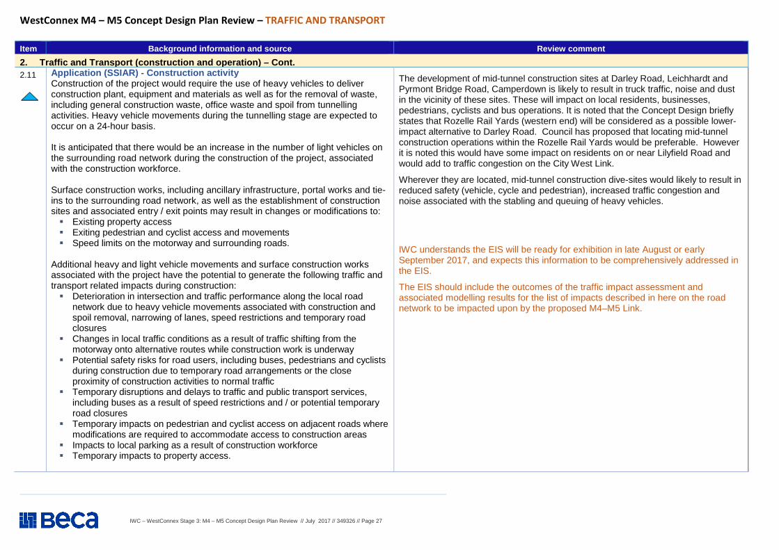
2. Traffic and Transport (construction and operation) – Cont. 2.11
Application (SSIAR) - Construction activity Construction of the project would require the use of heavy vehicles to deliver construction plant, equipment and materials as well as for the removal of waste, including general construction waste, office waste and spoil from tunnelling activities. Heavy vehicle movements during the tunnelling stage are expected to occur on a 24-hour basis. It is anticipated that there would be an increase in the number of light vehicles on the surrounding road network during the construction of the project, associated with the construction workforce. Surface construction works, including ancillary infrastructure, portal works and tie-ins to the surrounding road network, as well as the establishment of construction sites and associated entry / exit points may result in changes or modifications to: � Existing property access � Exiting pedestrian and cyclist access and movements � Speed limits on the motorway and surrounding roads.
Additional heavy and light vehicle movements and surface construction works associated with the project have the potential to generate the following traffic and transport related impacts during construction: � Deterioration in intersection and traffic performance along the local road
network due to heavy vehicle movements associated with construction and spoil removal, narrowing of lanes, speed restrictions and temporary road closures
� Changes in local traffic conditions as a result of traffic shifting from the motorway onto alternative routes while construction work is underway
� Potential safety risks for road users, including buses, pedestrians and cyclists during construction due to temporary road arrangements or the close proximity of construction activities to normal traffic
� Temporary disruptions and delays to traffic and public transport services, including buses as a result of speed restrictions and / or potential temporary road closures
� Temporary impacts on pedestrian and cyclist access on adjacent roads where modifications are required to accommodate access to construction areas
� Impacts to local parking as a result of construction workforce � Temporary impacts to property access.
The development of mid-tunnel construction sites at Darley Road, Leichhardt and Pyrmont Bridge Road, Camperdown is likely to result in truck traffic, noise and dust in the vicinity of these sites. These will impact on local residents, businesses, pedestrians, cyclists and bus operations. It is noted that the Concept Design briefly states that Rozelle Rail Yards (western end) will be considered as a possible lower-impact alternative to Darley Road. Council has proposed that locating mid-tunnel construction operations within the Rozelle Rail Yards would be preferable. However it is noted this would have some impact on residents on or near Lilyfield Road and would add to traffic congestion on the City West Link.
Wherever they are located, mid-tunnel construction dive-sites would likely to result in reduced safety (vehicle, cycle and pedestrian), increased traffic congestion and noise associated with the stabling and queuing of heavy vehicles.
IWC understands the EIS will be ready for exhibition in late August or early September 2017, and expects this information to be comprehensively addressed in the EIS.
The EIS should include the outcomes of the traffic impact assessment and associated modelling results for the list of impacts described in here on the road network to be impacted upon by the proposed M4–M5 Link.
IWC – WestConnex Stage 3: M4 – M5 Concept Design Plan Review // July 2017 // 349326 // Page 28
WestConnex M4 – M5 Concept Design Plan Review – TRAFFIC AND TRANSPORT
Item Background information and source Review comment
2. Traffic and Transport (construction and operation) – Cont. 2.12
Application (SSIAR) - Operation al performance The implementation of the full WestConnex project would improve network efficiency in the inner south western areas of the city and provide better, more reliable access to commercial centres across the city, including to Sydney Airport and Port Botany from the west, thereby adding to Sydney’s transport productivity. As a key component of WestConnex, this project provides a north-south motorway link between the M4 and M5 Motorway corridors and would act as an inner western bypass of the CBD. The key related strategic traffic objectives of the project can be defined as: � Provide an efficient motorway link between M4 and M5 and improve traffic flow on the
motorway network � Enable long term motorway network development, including facilitating new cross-
harbour capacity � Improve accessibility and reliability of commercial vehicle movement in the M4 and M5
Motorway corridors to economic centres, including to Sydney Airport and Port Botany economic zone
� Improve traffic conditions and ease future congestion on the inner western and south western network, including Parramatta Road, supporting urban regeneration and growth
� Improve overall network productivity. Traffic patterns on the existing road network within the project corridor would change as a result of the project. These changes are due to the additional infrastructure provided, tolling and surface network changes. This includes lower traffic volumes and reduced peak congestion on key congested north-south roads. The project would also significantly relieve traffic on existing key east-west roads including M5 East (around 60,000 vehicles per average weekday in 2031), around 19 per cent reduction in traffic volumes on Parramatta Road and reduced volumes on City West Link and Marion Street in Leichardt in 2031. Predicted traffic volumes on this section of the project are around 105,000 per average weekday in 2031. The exception to this is sections of Parramatta Road, east of Glebe Point Road, which would experience an increase in traffic (Sydney Motorway Corporation, 2015). The potential impacts of this increase are subject to further investigations. The project may also, subject to further investigations, lead to the deterioration or improvement of individual intersection performance at existing intersections due to the introduction of new movements in the vicinity of interchanges. Changes to bus, pedestrian and cycle networks may also occur, depending on the final design of the interchanges, which would also require further investigation.
SEARS – 3 May 2017 (Application Number - SSI 16 7485)
The Desired Performance Outcomes (DPO) points in the SEARS are repeated below and supported by IWC: Key Issue SEARs - Point 1 – Traffic and Transport - Network connectivity, safety and efficiency of the transport system in the vicinity of the project are managed to minimise impacts. The safety of transport system customers is maintained. Impacts on network capacity and the level of service are effectively managed. Works are compatible with existing infrastructure and future transport corridors.
Requirement 1: The Proponent must assess construction transport and traffic (vehicle, pedestrian and cyclists) impacts, including, but not necessarily limited to:
(a) considered approach to route identification and scheduling of transport movements, particularly outside standard construction hours;
(b) the number, frequency and size of construction related vehicles (passenger, commercial and heavy vehicles, including spoil management movements);
(c) construction worker parking;
(d) the nature of existing traffic (types and number of movements) on construction access routes (including consideration of peak traffic times and sensitive road users and parking arrangements);
(e) access constraints and impacts on public transport, pedestrians and cyclists;
(f) the need to close, divert or otherwise reconfigure elements of the road, cycle and pedestrian network associated with construction of the project. Where the closure, diversion or reconfiguration are temporary, provide an estimate of the duration of the altered access arrangements; and
(g) the cumulative traffic impacts of other key infrastructure projects preparing for or commencing construction, including but not limited to other stages of WestConnex.
IWC understands the EIS will be ready for exhibition in late August or early September 2017, and expects these requirements to be addressed comprehensively in the EIS.
IWC – WestConnex Stage 3: M4 – M5 Concept Design Plan Review // July 2017 // 349326 // Page 29
WestConnex M4 – M5 Concept Design Plan Review – TRAFFIC AND TRANSPORT
Item Background information and source Review comment
2. Traffic and Transport (construction and operation) – Cont. 2.13
Application (SSIAR) - Proposed further assessments The environmental impact statement would include a construction and operational traffic and transport assessment to identify and assess potential impacts and management measures. The construction traffic study would include identification and assessment of: � Potential traffic and transport impacts on the road network, including consideration of public
transport impacts, as well as pedestrian and cyclist access throughout construction of the project; � Potential cumulative impacts with other stages of the WestConnex project and other major
projects in the vicinity of the project; � An assessment of construction traffic impacts including spoil haulage, route identification,
number, frequency and size of construction related vehicles, the nature of existing traffic, and the need to close, divert or otherwise reconfigure elements of the road network associated with construction of the project;
� Recommendations for construction traffic and transport mitigation measures, including preparation of construction environmental management plans incorporating traffic management plans.
The operational traffic study would identify and assess traffic impacts associated with the project, including an assessment of existing local and regional traffic volumes and traffic patterns against forecast volumes and potential changes to traffic patterns associated with the project. Traffic modelling to be undertaken as part of the operational traffic assessment would be undertaken for the opening year, being the year of completion of the project, and 10 years from the opening date, which would include the completion of the WestConnex program of works. A detailed operational traffic assessment would also include (as a minimum): � An assessment of the “Do Nothing” scenario, i.e. the future impacts of traffic if the project were
not built; � A description of existing and future intersection functionality as a result of the project; � Quantification of Anticipated benefits of improved intersection performance, and Travel times � Direct and indirect operational traffic implications on the local and regional road network, including
freight movements � Identification and assessment of potential operational traffic impacts around interchanges and
required modifications to the existing local road network � Identification and analysis of the performance of key intersections and interchanges during AM
and PM peak periods � Traffic time analysis � An assessment of the impact of tolling on motorways and the surrounding road network based on
the tolling strategy for the program of works � An assessment of impact of the project on road users, including motorists, public transport,
pedestrians and cyclists � Road safety analysis � Recommendations for operational traffic and transport mitigation measures.
SEARS – 3 May 2017 (Application Number - SSI 16 7485)
The Desired Performance Outcomes (DPO) points in the SEARS are repeated below and supported by IWC: Key Issue SEARs - Point 1 – Traffic and Transport – (Cont.)
Requirement 2: The Proponent must model and/or assess the operational transport impacts of the project including, but not necessarily limited to:
a) (a forecast travel demand and traffic volumes (expressed in terms of total numbers and heavy and light vehicle numbers) for the project and the surrounding road, cycle and public transport network, including potential shifts of traffic movements on alternate routes outside the proposal area (such as toll avoidance) and impact of permanent street closures directly attributable to the SSI;
b) travel time analysis; c) performance of key interchanges and intersections by undertaking a level
of service analysis at key locations, for peak periods; d) wider transport interactions (local and regional roads, cycling, public and
freight transport), taking into account the Sydney City Centre Access Strategy, planned future urban release areas such as the Bays Precinct and planned future port activities and uses;
e) the redistribution of traffic and impacts on traffic volumes and levels of service on the road network resulting from changes to the design of the M4-MS Link as modeled in the traffic assessments for the M4 East and New MS projects;
f) induced traffic and operational implications for existing and proposed public transport (particularly with respect to strategic bus corridors and bus routes and permanent closure/relocation of bus stops) and consideration of opportunities to improve public transport;
g) impacts on cyclists and pedestrian access and safety, including on known routes and future proposals such as along Lilyfield Road;
h) opportunities to integrate cycling and pedestrian elements with surrounding networks and within the project; and
i) property and business access and on street parking. The assessment must provide an explanation for the scope of the modelled area, including justification of the nominated boundaries. IWC understands the EIS will be ready for exhibition in late August or early September 2017, and expects these requirements to be addressed comprehensively in the EIS.
IWC – WestConnex Stage 3: M4 – M5 Concept Design Plan Review // July 2017 // 349326 // Page 30
WestConnex M4 – M5 Concept Design Plan Review – TRAFFIC AND TRANSPORT
Item Background information and source Review comment
2 Traffic and Transport (construction and operation) – Cont. 2.14
M4 – M5 Concept Plan - Section 2 The M4 – M5 Link (page 6):
The M4-M5 Link will provide an inner-western bypass of the Sydney Central Business District (CBD). It includes new underground twin tunnels that will link the New M4 tunnels at Haberfield with the New M5 at St Peters (refer to Figure 1.3 below). These connections are known as the main tunnels and once joined, effectively complete the main motorway component of WestConnex. The M4-M5 Link includes an interchange at Rozelle (the Rozelle Interchange) providing connections to the surface road network at City West Link, Victoria Road and ANZAC Bridge. It also includes a new toll-free tunnel connection between the Rozelle Interchange and Victoria Road near the Iron Cove Bridge (the Iron Cove Link). The M4-M5 Link will be built in two stages. The main tunnels will be constructed separately to the Rozelle Interchange and Iron Cove Link, which will allow for completion of the main WestConnex motorway ahead of the original schedule. The main tunnels of the M4-M5 Link are about eight kilometres in length and will link the southern end of the New M4 at Haberfield to the northern end of the New M5 tunnels at St Peters. The scope of work includes:
� twin tunnels, each four-lanes wide linking Haberfield to St Peters; � ramps between the main tunnels and the surface interchange at St Peters; � tunnel stubs so the main tunnels can connect to the Rozelle Interchange and
proposed Western Harbour Tunnel; � ramps between the main tunnels and the surface connection at Wattle Street; � a ventilation facility at St Peters; and � integration with the ventilation facility at Haberfield.
Pending project approval, Sydney Motorway Corporation expects to start construction of the main tunnels in 2018. Once the M4-M5 Link is complete, the WestConnex motorway will include 23 kilometres of underground tunnels. Safety and comfort will be paramount to the driver experience and this has been a key focus during the design phase. Designs for the in-tunnel treatment were included in the respective environmental impact statements of both the New M4 and New M5 tunnels. The in-tunnel treatment for the M4-M5 Link tunnel is still being investigated. Options include lighting features that aid way finding at each decision point throughout the journey.
SMC - M4-M5 Link Community feedback report 21 July – 31 August 2016 stated: Sydney Motorway Corporation (SMC) is carrying out comprehensive traffic modelling to assess the impact of the project across the Sydney metropolitan road network and specifically at the motorway interchange locations in Haberfield, Rozelle and St Peters. The assessment will be included in the Environmental Impact Statement (EIS) and will include:
� Forecast travel demand and traffic volumes for the project and the surrounding road, cycle and public transport network;
� Traffic impacts during construction; � Induced demand (new traffic attracted to use the roads as a result of the new
infrastructure); � Potential changes in traffic on surface roads including potential impacts of toll
avoidance; and � A travel time analysis and analysis of key interchanges and intersection
performance.
IWC requests that consideration of the conclusions in the “WestConnex Transport Modelling Summary Report” by SGS Economics and Planning, May 2015 (and results) be included in the EIS.
IWC – WestConnex Stage 3: M4 – M5 Concept Design Plan Review // July 2017 // 349326 // Page 31
WestConnex M4 – M5 Concept Design Plan Review – TRAFFIC AND TRANSPORT
Item Background information and source Review comment
2 Traffic and Transport (construction and operation) – Cont. 2.15
M4 – M5 Concept Plan - Section 2 The M4 – M5 Link (page 6) – Cont. :
The M4 – M5 Link will:
� connect the neighbourhoods of Annandale and Rozelle by providing a new green link between Bicentennial Park and Easton Park;
� create a major new park on the site of the Rozelle Rail Yards of up to 10 hectares; � reduce traffic on key parts of Victoria Road by up to 50% which would provide opportunities for
improvements to the streetscape between Terry Street and Roberts Road; � ease congestion on local roads allowing for increased use by pedestrians, cyclists and public
transport; � improve access to the Bays Precinct for pedestrians and cyclists; � complete the St Peters Interchange parklands; � complete the WestConnex tunnel network; � provide for future public transport opportunities on key surface roads including Victoria and
Parramatta roads; and � result in a reduction in traffic of up to 25% on Parramatta Road between Haberfield and the
CBD.
Concern is expressed over the potential for increased traffic (both construction and operational) in the area around the Rozelle Interchange. This traffic would impact on local amenity, accessibility and pedestrian/cyclist safety. Additionally, it is highly likely that the construction phases of the M4-M5 Link will extend the duration of the already highly disrupted environment that parts of the IWC area have been enduring for the past 3+ years.
The SMC’s proposal for the M4–M5 Link also has significant impacts for residents and business along Victoria Road, Rozelle, many of which are in the process of having their properties acquired. This impacts both those directly affected and the broader community.
The proposal provides open space within the Rozelle Rail yards site, but provides only limited pedestrian access from the south (Annandale and Leichhardt) via two pedestrian bridges. In order to best serve the community, substantial land bridges should be provided to better link the open space to adjacent suburbs.
2.16
M4 – M5 Concept Plan - Section 4 The M4 – M5 Link (page 10):
Purpose of the design consultation
As part of this design consultation, we are seeking feedback from the community and other stakeholders on: � the masterplan for the Rozelle Rail Yards; � the concept plan for the Iron Cove Link; � the future use of the tunnel construction sites; � active transport (walking and cycling) connections; � the architectural design of ventilation facilities; � the architectural design of tunnel entry/exit points; � landscape treatments (i.e. types of trees and plants, open space uses) at Haberfield/Ashfield,
Rozelle, Iron Cove, Leichhardt/Lilyfield and Annandale/Camperdown; � the in-tunnel environment and driver experience.
The Concept Design’s scant information on designs for Victoria Road does not provide surety about the future of surface treatments for this road post construction of the Iron Cove Link. There needs to be an assurance that these designs will fully seize the opportunity for environmental and traffic safety enhancements rather than simply increase road capacity in Rozelle and across the Inner West.
Mid-tunnel construction sites are likely to result in reduced safety (vehicle, cycle and pedestrian), increased traffic congestion and noise associated with the stabling and queuing of heavy vehicles.
IWC – WestConnex Stage 3: M4 – M5 Concept Design Plan Review // July 2017 // 349326 // Page 32
WestConnex M4 – M5 Concept Design Plan Review – TRAFFIC AND TRANSPORT
Item Background information and source Review comment
2. Traffic and Transport (construction and operation) – Cont. 2.17
M4 – M5 Concept Plan - Section 5 The M4 – M5 Link (page 18): M4 – M5 Link by Location The following information is grouped into locations to provide an understanding of what is happening at each of the key locations for the M4-M5 Link. The specific locations are: � Newtown/St Peters; � Annandale/Camperdown; � Leichhardt/Lilyfield; � Haberfield/Ashfield; and � Rozelle.(Rozelle Rail Yards and Lilyfield Victoria Road and near the Iron
Cove Bridge Newtown/St Peters � The M4-M5 Link will connect with the St Peters Interchange and the New
M5 at St Peters. � The New M5 project, which is currently in construction, has been designed
to enable the M4-M5 Link to connect seamlessly with both the main tunnels and the St Peters Interchange.
� The M4-M5 Link will enable an additional 2.5 hectares of open space above that already committed as part of the New M5 project.
Design features: - A ventilation facility will be located at the St Peters Interchange; and
- An additional 2.5 hectares of open space, bringing the total new open space at St Peters to 8.5 hectares.
Depth of tunnel Newtown/St Peters - Tunnel depth is up to 50 metres below the surface (refer to Figure 8.1 in Concept Plan) Construction dates - Construction will run from 2018 to 2022 (pending approval).
See comments on items to follow for specific locations.
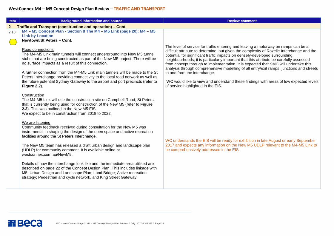
IWC – WestConnex Stage 3: M4 – M5 Concept Design Plan Review // July 2017 // 349326 // Page 33
WestConnex M4 – M5 Concept Design Plan Review – TRAFFIC AND TRANSPORT
Item Background information and source Review comment
2 Traffic and Transport (construction and operation) – Cont. 2.18
M4 – M5 Concept Plan - Section 8 The M4 – M5 Link (page 20): M4 – M5 Link by Location Newtown/St Peters – Cont. Road connections The M4-M5 Link main tunnels will connect underground into New M5 tunnel stubs that are being constructed as part of the New M5 project. There will be no surface impacts as a result of this connection. A further connection from the M4-M5 Link main tunnels will be made to the St Peters Interchange providing connectivity to the local road network as well as the future potential Sydney Gateway to the airport and port precincts (refer to Figure 2.2 ). Construction The M4-M5 Link will use the construction site on Campbell Road, St Peters, that is currently being used for construction of the New M5 (refer to Figure 2.3). This was outlined in the New M5 EIS. We expect to be in construction from 2018 to 2022. We are listening Community feedback received during consultation for the New M5 was instrumental in shaping the design of the open space and active recreation facilities around the St Peters Interchange. The New M5 team has released a draft urban design and landscape plan (UDLP) for community comment. It is available online at westconnex.com.au/NewM5. Details of how the interchange look like and the immediate area utilised are described on page 22 of the Concept Design Plan. This includes linkage with M5; Urban Design and Landscape Plan; Land Bridge; Active recreation strategy; Pedestrian and cycle network, and King Street Gateway.
The level of service for traffic entering and leaving a motorway on ramps can be a difficult attribute to determine, but given the complexity of Rozelle Interchange and the potential for significant traffic impacts on densely-developed surrounding neighbourhoods, it is particularly important that this attribute be carefully assessed from concept through to implementation. It is expected that SMC will undertake this analysis through comprehensive modelling of all entry/exit ramps, junctions and streets to and from the interchange. IWC would like to view and understand these findings with areas of low expected levels of service highlighted in the EIS.
WC understands the EIS will be ready for exhibition in late August or early September 2017 and expects any information on the New M5 UDLP relevant to the M4-M5 Link to be comprehensively addressed in the EIS.
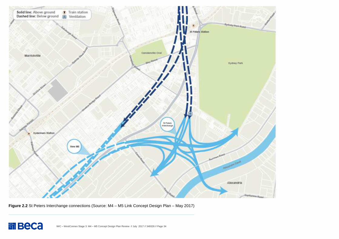
IWC – WestConnex Stage 3: M4 – M5 Concept Design Plan Review // July 2017 // 349326 // Page 34
Figure 2.2 St Peters Interchange connections (Source: M4 – M5 Link Concept Design Plan – May 2017)
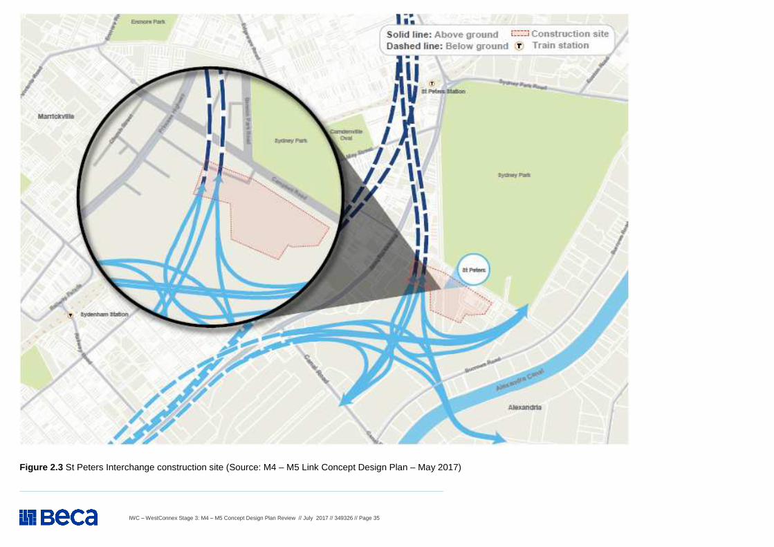
IWC – WestConnex Stage 3: M4 – M5 Concept Design Plan Review // July 2017 // 349326 // Page 35
Figure 2.3 St Peters Interchange construction site (Source: M4 – M5 Link Concept Design Plan – May 2017)
IWC – WestConnex Stage 3: M4 – M5 Concept Design Plan Review // July 2017 // 349326 // Page 36
WestConnex M4 – M5 Concept Design Plan Review – TRAFFIC AND TRANSPORT
Item Background information and source Review comment
2 Traffic and Transport (construction and operation) – Cont. 2.19
M4 – M5 Concept Plan - Section 9 The M4 – M5 Link (page 24): M4 – M5 Link by Location Annandale/Camperdown In November 2016, updated design features for the M4-M5 Link were announced including a main tunnel consisting of four lanes in each direction and the removal of the on and off ramps at Camperdown. Stakeholder feedback was vital to informing this solution with local traffic performance, urban amenity and existing public transport investments also key factors. The updated design features will result in significantly improved daily traffic volumes on Parramatta Road between Haberfield and the CBD (by more than 25% along certain sections) and will streamline the alignment of the main tunnels. It will also allow the project to be delivered in two stages, meaning the main tunnels can potentially open to traffic in 2022. The Rozelle Interchange and the Iron Cove Link will open to traffic within the existing project timeline in 2023. There will be a tunnel construction site in the area between Parramatta Road, Pyrmont Bridge Road and Mallett Street. Design features - No ventilation facilities are proposed for the Annandale/Camperdown area. Depth of tunnel at Annandale/Camperdown - Tunnel depth is up to 65 metres below the surface (refer to Figure 9.1 in Concept Plan). Construction dates - Construction will run from 2018 to 2022 (pending approval).
The development and operation of mid-tunnel construction dive-sites at Darley Road, Leichhardt and Pyrmont Bridge Road, Camperdown would result in truck traffic, noise and dust in the vicinity of these sites. These will negatively affect local residents, businesses, pedestrians, cyclists and bus operations. It is noted the Concept Design briefly states that Rozelle Rail Yards (western end) will be considered as a possible alternative to Darley Road. Council has proposed that locating the dive-site within the Rozelle Rail Yards would be preferable (being a lower-impact option), but recognises there would be some impacts for residents on Lilyfield Road and consequences for traffic congestion on the City West Link.
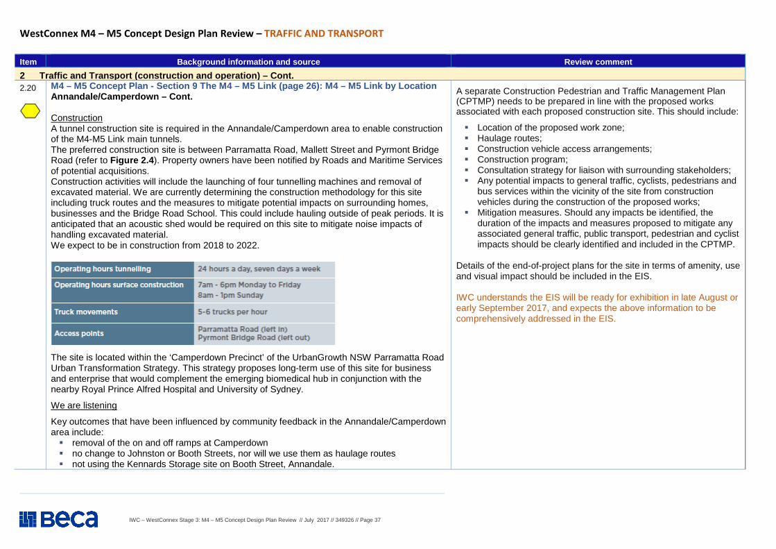
IWC – WestConnex Stage 3: M4 – M5 Concept Design Plan Review // July 2017 // 349326 // Page 37
WestConnex M4 – M5 Concept Design Plan Review – TRAFFIC AND TRANSPORT
Item Background information and source Review comment
2 Traffic and Transport (construction and operation) – Cont. 2.20
M4 – M5 Concept Plan - Section 9 The M4 – M5 Link (page 26): M4 – M5 Link by Location Annandale/Camperdown – Cont. Construction A tunnel construction site is required in the Annandale/Camperdown area to enable construction of the M4-M5 Link main tunnels. The preferred construction site is between Parramatta Road, Mallett Street and Pyrmont Bridge Road (refer to Figure 2.4 ). Property owners have been notified by Roads and Maritime Services of potential acquisitions. Construction activities will include the launching of four tunnelling machines and removal of excavated material. We are currently determining the construction methodology for this site including truck routes and the measures to mitigate potential impacts on surrounding homes, businesses and the Bridge Road School. This could include hauling outside of peak periods. It is anticipated that an acoustic shed would be required on this site to mitigate noise impacts of handling excavated material. We expect to be in construction from 2018 to 2022.
The site is located within the ‘Camperdown Precinct’ of the UrbanGrowth NSW Parramatta Road Urban Transformation Strategy. This strategy proposes long-term use of this site for business and enterprise that would complement the emerging biomedical hub in conjunction with the nearby Royal Prince Alfred Hospital and University of Sydney.
We are listening
Key outcomes that have been influenced by community feedback in the Annandale/Camperdown area include: � removal of the on and off ramps at Camperdown � no change to Johnston or Booth Streets, nor will we use them as haulage routes � not using the Kennards Storage site on Booth Street, Annandale.
A separate Construction Pedestrian and Traffic Management Plan (CPTMP) needs to be prepared in line with the proposed works associated with each proposed construction site. This should include:
� Location of the proposed work zone; � Haulage routes; � Construction vehicle access arrangements; � Construction program; � Consultation strategy for liaison with surrounding stakeholders; � Any potential impacts to general traffic, cyclists, pedestrians and
bus services within the vicinity of the site from construction vehicles during the construction of the proposed works;
� Mitigation measures. Should any impacts be identified, the duration of the impacts and measures proposed to mitigate any associated general traffic, public transport, pedestrian and cyclist impacts should be clearly identified and included in the CPTMP.
Details of the end-of-project plans for the site in terms of amenity, use and visual impact should be included in the EIS. IWC understands the EIS will be ready for exhibition in late August or early September 2017, and expects the above information to be comprehensively addressed in the EIS.
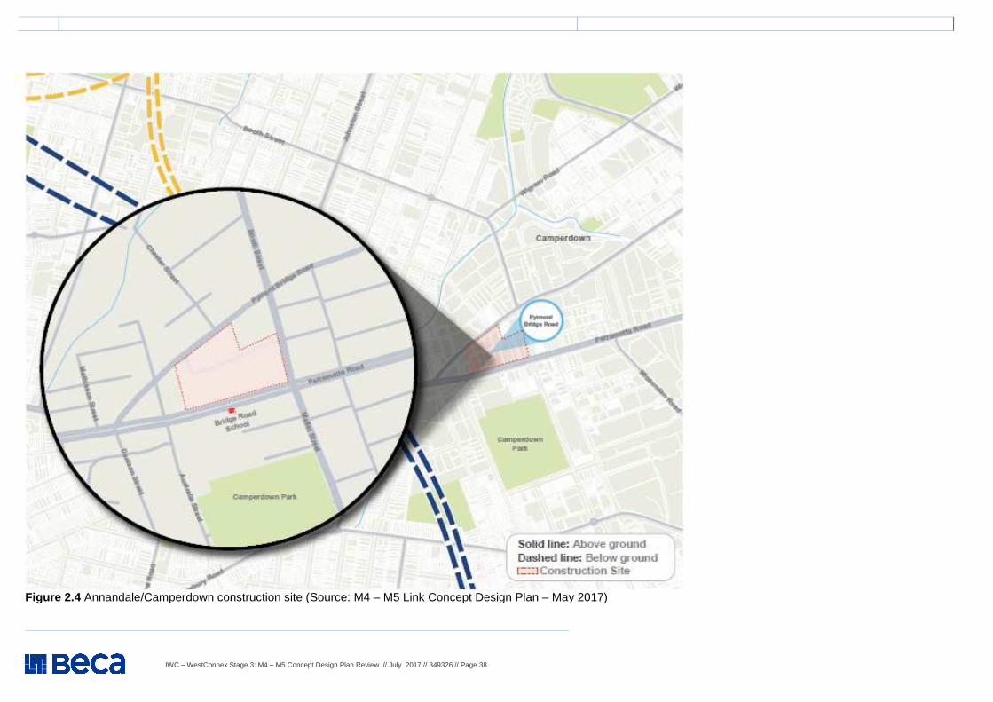
IWC – WestConnex Stage 3: M4 – M5 Concept Design Plan Review // July 2017 // 349326 // Page 38
Figure 2.4 Annandale/Camperdown construction site (Source: M4 – M5 Link Concept Design Plan – May 2017)
IWC – WestConnex Stage 3: M4 – M5 Concept Design Plan Review // July 2017 // 349326 // Page 39
WestConnex M4 – M5 Concept Design Plan Review – TRAFFIC AND TRANSPORT
Item Background information and source Review comment
2 Traffic and Transport (construction and operation) – Cont. 2.21
M4 – M5 Concept Plan - Section 10 The M4 – M5 Link (page 28): M4 – M5 Link by Location Leichhardt/Lilyfield A number of sites are currently being investigated for use as tunnel construction sites. These include a site at 7 Darley Road, which is currently occupied by a commercial business. If selected, the proposed construction site would be assessed in the Environmental Impact Statement (EIS) and would be subject to planning approval. The EIS will include further detail about the proposed use of this site and assess the potential impacts, including traffic impacts and air quality. It will be released for community comment mid-year. When the EIS is released, community members will be able to make a formal submission to be considered by the NSW Department of Planning and Environment as part of its assessment of the project. Design features - No ventilation facilities are proposed for the Leichhardt/Lilyfield area; Depth of tunnel at Annandale/Camperdown - Tunnel depth is up to 50 metres below the surface (refer to Figure 10.1 of the Concept Plan) Construction dates - Construction will run from 2018 to 2022 (pending approval).
See Item 2.39
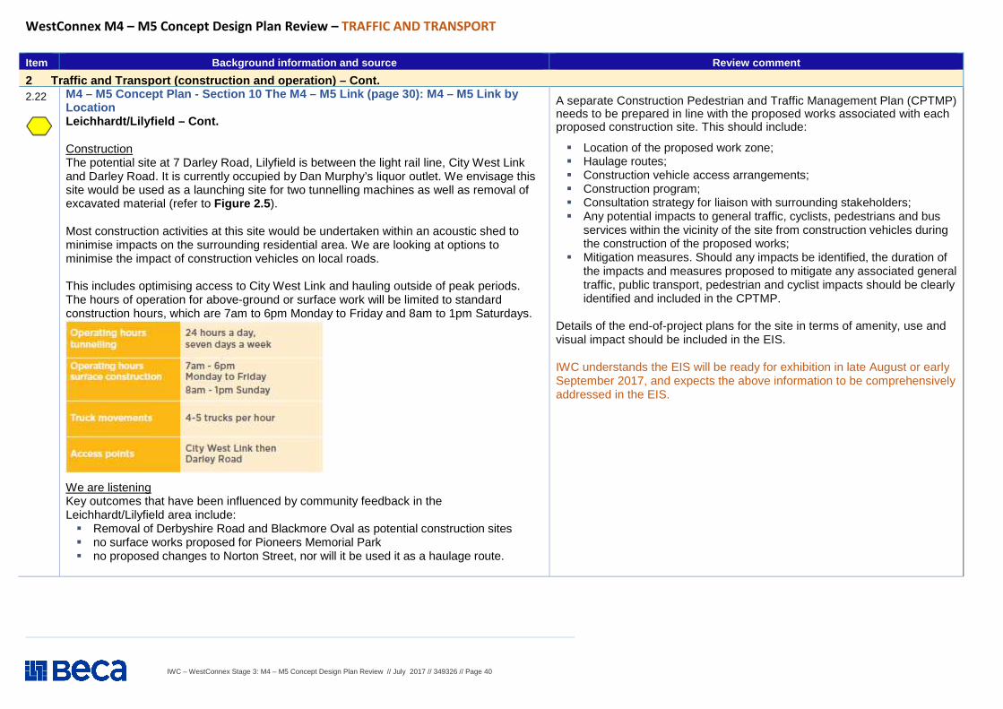
IWC – WestConnex Stage 3: M4 – M5 Concept Design Plan Review // July 2017 // 349326 // Page 40
WestConnex M4 – M5 Concept Design Plan Review – TRAFFIC AND TRANSPORT
Item Background information and source Review comment
2 Traffic and Transport (construction and operation) – Cont. 2.22
M4 – M5 Concept Plan - Section 10 The M4 – M5 Link (page 30): M4 – M5 Link by Location Leichhardt/Lilyfield – Cont. Construction The potential site at 7 Darley Road, Lilyfield is between the light rail line, City West Link and Darley Road. It is currently occupied by Dan Murphy’s liquor outlet. We envisage this site would be used as a launching site for two tunnelling machines as well as removal of excavated material (refer to Figure 2.5 ). Most construction activities at this site would be undertaken within an acoustic shed to minimise impacts on the surrounding residential area. We are looking at options to minimise the impact of construction vehicles on local roads. This includes optimising access to City West Link and hauling outside of peak periods. The hours of operation for above-ground or surface work will be limited to standard construction hours, which are 7am to 6pm Monday to Friday and 8am to 1pm Saturdays.
We are listening Key outcomes that have been influenced by community feedback in the Leichhardt/Lilyfield area include: � Removal of Derbyshire Road and Blackmore Oval as potential construction sites � no surface works proposed for Pioneers Memorial Park � no proposed changes to Norton Street, nor will it be used it as a haulage route.
A separate Construction Pedestrian and Traffic Management Plan (CPTMP) needs to be prepared in line with the proposed works associated with each proposed construction site. This should include:
� Location of the proposed work zone; � Haulage routes; � Construction vehicle access arrangements; � Construction program; � Consultation strategy for liaison with surrounding stakeholders; � Any potential impacts to general traffic, cyclists, pedestrians and bus
services within the vicinity of the site from construction vehicles during the construction of the proposed works;
� Mitigation measures. Should any impacts be identified, the duration of the impacts and measures proposed to mitigate any associated general traffic, public transport, pedestrian and cyclist impacts should be clearly identified and included in the CPTMP.
Details of the end-of-project plans for the site in terms of amenity, use and visual impact should be included in the EIS. IWC understands the EIS will be ready for exhibition in late August or early September 2017, and expects the above information to be comprehensively addressed in the EIS.
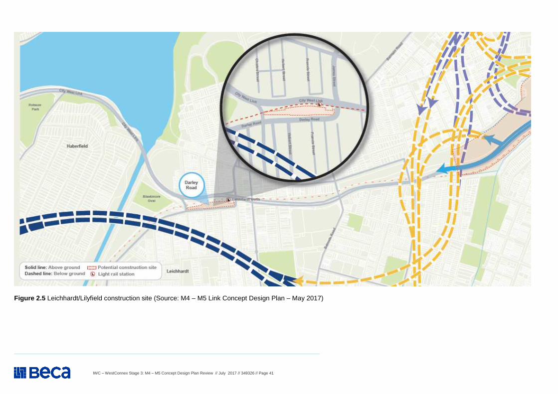
IWC – WestConnex Stage 3: M4 – M5 Concept Design Plan Review // July 2017 // 349326 // Page 41
Figure 2.5 Leichhardt/Lilyfield construction site (Source: M4 – M5 Link Concept Design Plan – May 2017)
IWC – WestConnex Stage 3: M4 – M5 Concept Design Plan Review // July 2017 // 349326 // Page 42
WestConnex M4 – M5 Concept Design Plan Review – TRAFFIC AND TRANSPORT
Item Background information and source Review comment
2 Traffic and Transport (construction and operation) – Cont. 2.23
M4 – M5 Concept Plan - Section 11 The M4 – M5 Link (page 32): M4 – M5 Link by Location Haberfield/Ashfield The M4-M5 Link will tie in with the New M4 project, which is under construction by the CPB Contractors, Samsung C&T Corporation and John Holland Joint Venture (CSJ). The New M4 was designed to accommodate this integration. The M4-M5 Link will need to use the existing New M4 construction sites at Wattle Street and Walker Avenue to finish the integration works. These sites may be used for additional low impact construction work, car parking and amenities. We have developed an urban design plan for the M4-M5 Link, which includes detail on how the worksites will be rehabilitated following construction. Where there is crossover between the New M4 and M4-M5 Link projects, commitments made in the UDLP will be delivered by the contractor appointed to deliver the M4-M5 Link. The M4-M5 Link ventilation facility will be accommodated within the New M4 ventilation facility on the corner of Parramatta Road and Wattle Street. The ventilation facility and surrounding landscaping will be completed by the New M4 project team. Additional work will be carried out within the facility to integrate the M4-M5 Link ventilation requirements. Design features - The ventilation facility will be accommodated within the facility being constructed for the New M4 project. Depth of tunnel at Annandale/Camperdown - Tunnel depth is up to 45 metres below the surface (refer to Figure 11.3 of the Concept Plan). Construction dates - Construction will run from 2018 to 2022 (pending approval).
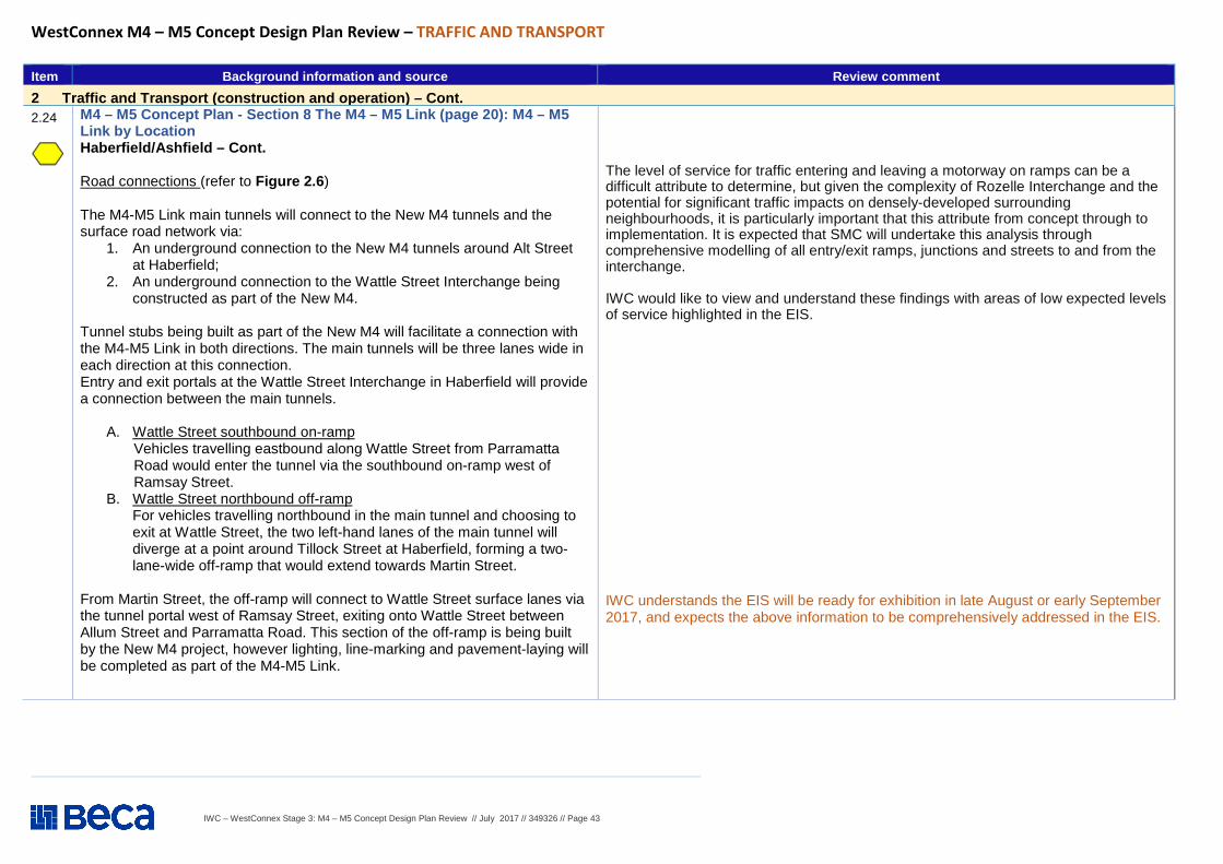
IWC – WestConnex Stage 3: M4 – M5 Concept Design Plan Review // July 2017 // 349326 // Page 43
WestConnex M4 – M5 Concept Design Plan Review – TRAFFIC AND TRANSPORT
Item Background information and source Review comment
2 Traffic and Transport (construction and operation) – Cont. 2.24
M4 – M5 Concept Plan - Section 8 The M4 – M5 Link (page 20): M4 – M5 Link by Location Haberfield/Ashfield – Cont. Road connections (refer to Figure 2.6 ) The M4-M5 Link main tunnels will connect to the New M4 tunnels and the surface road network via:
1. An underground connection to the New M4 tunnels around Alt Street at Haberfield;
2. An underground connection to the Wattle Street Interchange being constructed as part of the New M4.
Tunnel stubs being built as part of the New M4 will facilitate a connection with the M4-M5 Link in both directions. The main tunnels will be three lanes wide in each direction at this connection. Entry and exit portals at the Wattle Street Interchange in Haberfield will provide a connection between the main tunnels.
A. Wattle Street southbound on-ramp Vehicles travelling eastbound along Wattle Street from Parramatta Road would enter the tunnel via the southbound on-ramp west of Ramsay Street.
B. Wattle Street northbound off-ramp For vehicles travelling northbound in the main tunnel and choosing to exit at Wattle Street, the two left-hand lanes of the main tunnel will diverge at a point around Tillock Street at Haberfield, forming a two-lane-wide off-ramp that would extend towards Martin Street.
From Martin Street, the off-ramp will connect to Wattle Street surface lanes via the tunnel portal west of Ramsay Street, exiting onto Wattle Street between Allum Street and Parramatta Road. This section of the off-ramp is being built by the New M4 project, however lighting, line-marking and pavement-laying will be completed as part of the M4-M5 Link.
The level of service for traffic entering and leaving a motorway on ramps can be a difficult attribute to determine, but given the complexity of Rozelle Interchange and the potential for significant traffic impacts on densely-developed surrounding neighbourhoods, it is particularly important that this attribute from concept through to implementation. It is expected that SMC will undertake this analysis through comprehensive modelling of all entry/exit ramps, junctions and streets to and from the interchange. IWC would like to view and understand these findings with areas of low expected levels of service highlighted in the EIS.
IWC understands the EIS will be ready for exhibition in late August or early September 2017, and expects the above information to be comprehensively addressed in the EIS.
IWC – WestConnex Stage 3: M4 – M5 Concept Design Plan Review // July 2017 // 349326 // Page 44
WestConnex M4 – M5 Concept Design Plan Review – TRAFFIC AND TRANSPORT
Item Background information and source Review comment
2 Traffic and Transport (construction and operation) – Cont. 2.25
M4 – M5 Concept Plan - Section 8 The M4 – M5 Link (page 20): M4 – M5 Link by Location Haberfield/Ashfield – Cont. Construction
The construction sites being used for the New M4 project at Wattle Street and Walker Avenue, Haberfield (refer to Figure 2.7 ) will be needed while the two tunnels are integrated and these sites as well as Northcote Street may be used for other low intensity activities such as car parking and amenities. The use of these sites for the M4-M5 Link is subject to planning approval through the EIS process. During construction of the M4-M5 Link, we anticipate that the traffic, pedestrian and cycling arrangements around these sites will be similar to those currently in place. The New M4 project has been designed to enable the connection to M4-M5 Link. This means that surface works such as the realignment of Wattle Street will be undertaken as part of the New M4 project. M4-M5 Link will then connect into the realigned Wattle Street for the on and off ramps to the tunnel. The ventilation facility for the New M4 has also been designed to accommodate the needs of the M4-M5 Link. We are listening
In response to community feedback, the New M4 team is investigating options to return residual land to the community, subject to Roads and Maritime determination to release the land.
Community feedback will be incorporated in an updated UDLP to be published in the coming weeks.
A separate Construction Pedestrian and Traffic Management Plan (CPTMP) needs to be prepared in line with the proposed works associated with each proposed construction site. This should include:
� Location of the proposed work zone; � Haulage routes; � Construction vehicle access arrangements; � Construction program; � Consultation strategy for liaison with surrounding stakeholders; � Any potential impacts to general traffic, cyclists, pedestrians and bus services
within the vicinity of the site from construction vehicles during the construction of the proposed works;
� Mitigation measures. Should any impacts be identified, the duration of the impacts and measures proposed to mitigate any associated general traffic, public transport, pedestrian and cyclist impacts should be clearly identified and included in the CPTMP.
Details of the end-of-project plans for the site in terms of amenity, use and visual impact should be included in the EIS. IWC understands the EIS will be ready for exhibition in late August or early September 2017, and expects the above information to be comprehensively addressed in the EIS.
IWC – WestConnex Stage 3: M4 – M5 Concept Design Plan Review // July 2017 // 349326 // Page 45
Figure 2.6 Haberfield/Ashfield road connections (Source: M4 – M5 Link Concept Design Plan – May 2017)
IWC – WestConnex Stage 3: M4 – M5 Concept Design Plan Review // July 2017 // 349326 // Page 46
Figure 2.7 Haberfield/Ashfield rod connections (Source: M4 – M5 Link Concept Design Plan – May 2017)
IWC – WestConnex Stage 3: M4 – M5 Concept Design Plan Review // July 2017 // 349326 // Page 47
WestConnex M4 – M5 Concept Design Plan Review – TRAFFIC AND TRANSPORT
Item Background information and source Review comment
2 Traffic and Transport (construction and operation) – Cont. 2.26
M4 – M5 Concept Plan - Section 12 The M4 – M5 Link (page 38): M4 – M5 Link by Location, Rozelle Rozelle Rail Yards and Lilyfield The Rozelle Rail Yards site is one of the most significant areas of undeveloped space in the inner city. It is located at the head of Rozelle Bay and is part of the Bays Precinct, an area identified by the NSW Government for urban renewal. The new Rozelle Interchange will be located almost completely underground and will be up to 65 metres below the surface. A key inclusion of the interchange is the creation of up to 10 hectares of new publicly-accessible open space within the Rozelle Rail Yards (refer to Figure 12.1). Following consultation with Inner West Council, the western end of the Rozelle Rail Yard corridor is also being considered as an alternative tunnel construction site to Darley Road. We will continue to assess this site and alternative sites in our efforts to optimise design outcomes while minimising impacts. Design features - Up to 10 hectares of new public open space in the Rozelle Rail Yards; The Rozelle Interchange will be almost completely underground; The Rozelle Rail Yards will house a construction site and a ventilation facility. Depth of tunnel at Annandale/Camperdown - Tunnel depth is up to 65 metres below the surface (refer to Figure 12.3) Construction dates - Construction will run from 2018 to 2023 (pending approval).
See Item 2.38
IWC – WestConnex Stage 3: M4 – M5 Concept Design Plan Review // July 2017 // 349326 // Page 48
WestConnex M4 – M5 Concept Design Plan Review – TRAFFIC AND TRANSPORT
Item Background information and source Review comment
2 Traffic and Transport (construction and operation) – Cont. 2.27
M4 – M5 Concept Plan - Section 12 The M4 – M5 Link (page 40): M4 – M5 Link by Location Rozelle Rail Yards and Lilyfield – Cont. Road Connections The Rozelle Interchange will include:
1. North-south tunnels connecting Victoria Road, the proposed Western Harbour Tunnel and the New M5 at St Peters; (1a) - North-south tunnels connecting the main tunnels to City West Link;
2. East-west tunnels connecting Haberfield and the ANZAC Bridge 3. Iron Cove Link connecting Victoria Road to the ANZAC Bridge 4. Tunnel stubs and ramps that will connect to the proposed Western
Harbour Tunnel and Beaches Link. As shown in Figure 2.8 , the majority of the motorway will be located below the surface to minimise the impact on local streets and communities in the Inner West. The visible features of the motorway at Rozelle will be contained within the disused Rozelle Rail Yards. The Rozelle Interchange would provide connections to the surface road network at City West Link and ANZAC Bridge. The intersection of City West Link and The Crescent would be modified and a new, low-level road bridge structure across Whites Creek will be built. The changes will have the additional benefit of reducing upstream flooding in Whites Creek, which is a longstanding issue in the area. In summary, the following road changes are proposed: � a new intersection on City West Link about 300 metres west of The
Crescent that would provide a new connection between City West Link and the southbound main tunnels that connect to the New M5 at St Peters;
� modification of the intersection at City West Link and The Crescent at Annandale
� modification of the intersection of City West Link and James Craig Road at Rozelle
� realignment, widening and resurfacing of the intersection of Victoria Road and The Crescent and construction of a new bridge at Victoria Road to accommodate a new pedestrian and cycle connection under Victoria Road.
The level of service for traffic entering and leaving a motorway on ramps can be a difficult attribute to determine, but given the complexity of Rozelle Interchange and the potential for significant traffic impacts on densely-developed surrounding neighbourhoods, it is particularly important that this attribute from concept through to implementation. It is expected that SMC will undertake this analysis through comprehensive modelling of all entry/exit ramps, junctions and streets to and from the interchange. IWC would like to view and understand these findings with areas of low expected levels of service highlighted in the EIS.
IWC understands the EIS will be ready for exhibition in late August or early September 2017, and expects the above information to be comprehensively addressed in the EIS.
IWC – WestConnex Stage 3: M4 – M5 Concept Design Plan Review // July 2017 // 349326 // Page 49
Figure 2.8 Rozelle Interchange layout (Source: M4 – M5 Link Concept Design Plan – May 2017)
IWC – WestConnex Stage 3: M4 – M5 Concept Design Plan Review // July 2017 // 349326 // Page 50
WestConnex M4 – M5 Concept Design Plan Review – TRAFFIC AND TRANSPORT
Item Background information and source Review comment
2 Traffic and Transport (construction and operation) – Cont. 2.28
M4 – M5 Concept Plan - Section 8 The M4 – M5 Link (page 42): M4 – M5 Link by Location Rozelle Rail Yards and Lilyfield – Cont. Constructions The Rozelle Rail Yards will be used as the main construction site for the M4-M5 Link (refer to Figure 2.9 ). Construction activities will include launching the tunnelling machines, stockpiling and removal of extracted material, workforce car parking, offices and amenities, as well as infrastructure required to support the construction of the tunnels such as sedimentation ponds We are looking at options to move all heavy construction traffic directly onto City West Link. The final heavy vehicle movement routes will be detailed in the Environmental Impact Statement (EIS), which will be released for public consultation in mid-2017. Construction at the Rozelle Rail Yards site will run from 2018 to 2023. If the project is approved, tunnelling activities would be 24 hours a day, seven days a week and work would largely be underground or within acoustic sheds where they are at surface. Truck movements would occur 24 hours a day, seven days a week.
A separate Construction Pedestrian and Traffic Management Plan (CPTMP) needs to be prepared in line with the proposed works associated with each proposed construction site. This should include:
� Location of the proposed work zone; � Haulage routes; � Construction vehicle access arrangements; � Construction program; � Consultation strategy for liaison with surrounding
stakeholders; � Any potential impacts to general traffic, cyclists,
pedestrians and bus services within the vicinity of the site from construction vehicles during the construction of the proposed works;
� Mitigation measures. Should any impacts be identified, the duration of the impacts and measures proposed to mitigate any associated general traffic, public transport, pedestrian and cyclist impacts should be clearly identified and included in the CPTMP.
Details of the end-of-project plans for the site in terms of amenity, use and visual impact should be included in the EIS. IWC understands the EIS will be ready for exhibition in late August or early September 2017 and expects the above information to be comprehensively addressed in the EIS.
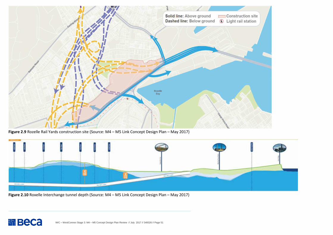
IWC – WestConnex Stage 3: M4 – M5 Concept Design Plan Review // July 2017 // 349326 // Page 51
Figure 2.9 Rozelle Rail Yards construction site (Source: M4 – M5 Link Concept Design Plan – May 2017)
Figure 2.10 Roxelle Interchange tunnel depth (Source: M4 – M5 Link Concept Design Plan – May 2017)
IWC – WestConnex Stage 3: M4 – M5 Concept Design Plan Review // July 2017 // 349326 // Page 52
WestConnex M4 – M5 Concept Design Plan Review – TRAFFIC AND TRANSPORT
Item Background information and source Review comment
3 Traffic and Transport (construction and operation) – Cont. 2.29
M4 – M5 Concept Plan - Section 12 The M4 – M5 Link (page 42): M4 – M5 Link by Location Rozelle Rail Yards and Lilyfield – Cont. What it will look like A masterplan has been developed to guide the design of above ground motorway facilities within Rozelle, while also providing a significant amount of new publicly- accessible open space. It has been developed in line with the following key principles: � To improve connections between Rozelle/Lilyfield and Annandale, to open space and to the harbour � to create opportunities for new open space or community facilities � to achieve better environmental outcomes, particularly in terms of water management.
Key features of the masterplan are: � extended areas of open space for recreation, habitat creation and connection to other areas of open space
and active transport around the Rozelle Rail Yards; � minimise the number of surface roads within the Rozelle Rail Yards. Surface roads within the Rozelle Rail
Yards would include: o a connection to the New M5 in the western part of the park; o the proposed future Western Harbour Tunnel; o entry and exit located next to the City West Link and opposite The Crescent. The majority of this
roadway would be concealed by a pedestrian and cyclist overbridge that would effectively cover these links beneath; and
o connection to ANZAC Bridge in the eastern portion of the park near Victoria Road in a trenched roadway arrangement.
� constructed wetland and dry creek beds to accommodate stormwater within a park environment; � a pedestrian and cycle path system to:
o link the Bay Run and the Greenway to the ANZAC Bridge and the CBD; o link the suburbs of Annandale and Lilyfield; o provide a mostly off-road active transport link along Whites Creek and Easton Park; o provide an off-road active transport network link in the Rozelle Rail Yards open space and connect other
active transport routes; o link to the proposed Lilyfield Road cycleway and future projects in other areas of the Bays Precinct; o link existing areas of open space to communities that have not previously had easy access to those
spaces; � motorway infrastructure including an electrical substation, water treatment facilities and ventilation facility; and � an open space link between Bicentennial Park and Easton Park, via a new land bridge for pedestrians and
cyclists.
The proposal provides open space, within the Rozelle Rail yards site, however it provides only limited pedestrian access from the south (Annandale and Leichhardt) via two pedestrian bridges. In order to best serve the community all bridges should be in the form of land-bridges to better link the open space to adjacent suburbs. Although two bridges are proposed, a third or possibly fourth bridge should be included to maximise walk/cycle connectivity across City West Link, which has traditionally been a major barrier to north-south walk/cycle movements.
Concern is expressed over the proximity of the proposed Iron Cove Link ventilation facility to adjacent residential areas (particularly noting existing medium-density residential developments at and around Balmain Shores and Terry Street). Concern is also expressed about air quality impacts from the proposed ventilation facilities at the Rozelle Rail Yards. The bulk and scale of these facilities will result in a significant visual impact on the proposed recreation area.
It would appear none of the ventilation facilities would have filtration. Given the potential for cumulative air pollution impacts from general traffic and the White Bay cruise ship terminal; these unfiltered emissions could create significant respiratory health problems in the Inner West. Pollution would include particulates, nitrous oxide, carbon monoxide and other polluting gases.
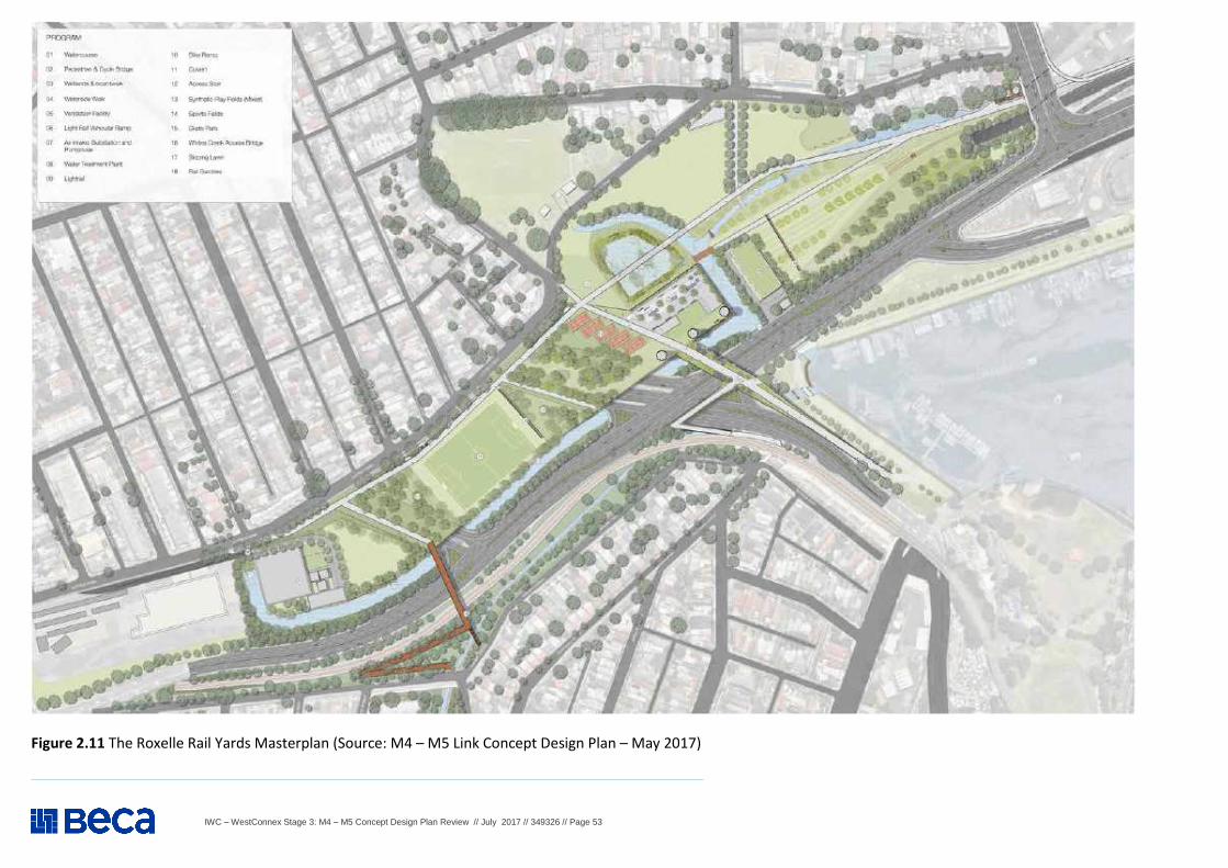
IWC – WestConnex Stage 3: M4 – M5 Concept Design Plan Review // July 2017 // 349326 // Page 53
Figure 2.11 The Roxelle Rail Yards Masterplan (Source: M4 – M5 Link Concept Design Plan – May 2017)
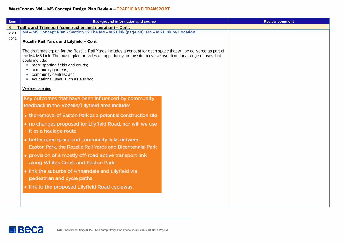
IWC – WestConnex Stage 3: M4 – M5 Concept Design Plan Review // July 2017 // 349326 // Page 54
WestConnex M4 – M5 Concept Design Plan Review – TRAFFIC AND TRANSPORT
Item Background information and source Review comment
4 Traffic and Transport (construction and operation) – Cont. 2.29 cont.
M4 – M5 Concept Plan - Section 12 The M4 – M5 Link (page 44): M4 – M5 Link by Location Rozelle Rail Yards and Lilyfield – Cont. The draft masterplan for the Rozelle Rail Yards includes a concept for open space that will be delivered as part of the M4-M5 Link. The masterplan provides an opportunity for the site to evolve over time for a range of uses that could include: � more sporting fields and courts; � community gardens; � community centres; and � educational uses, such as a school.
We are listening
IWC – WestConnex Stage 3: M4 – M5 Concept Design Plan Review // July 2017 // 349326 // Page 55
WestConnex M4 – M5 Concept Design Plan Review – TRAFFIC AND TRANSPORT
Item Background information and source Review comment
2 Traffic and Transport (construction and operation) – Cont. 2.30
M4 – M5 Concept Plan - Section 13 The M4 – M5 Link (page 48): M4 – M5 Link by Location, Rozelle Victoria Road and other streets near the Iron Cove Bridge Victoria Road will be widened near the Iron Cove Bridge to include tunnel entry and exit points for the Iron Cove Link. There would be a construction site on Victoria Road, between Springside Street and the Iron Cove Bridge. Following construction, there will be pockets of residual land remaining on Victoria Road between Springside Street and the Iron Cove Bridge. Sydney Motorway Corporation and Roads and Maritime Services are open to how this residual land could be used once construction is finished. We are keen to get feedback from the community and other stakeholders about how you would like to see this land used. Some options include children’s play spaces, passive open space, community gardens or outdoor gyms. Design features: � Tunnel exit and entry on Victoria Road near the Iron Cove Bridge; � Trees and an improved streetscape along Victoria Road; � The Iron Cove Link will be entirely underground; � A ventilation facility between the northbound and southbound lanes of
Victoria Road Depth of tunnel at Annandale/Camperdown - Tunnel depth is up to 35 metres below the surface (refer to Figure 13.2 of the Concept Plan) Construction dates - Construction will run from 2018 to 2023 (pending approval).
See Item 2.41 and Figure 2.16
IWC – WestConnex Stage 3: M4 – M5 Concept Design Plan Review // July 2017 // 349326 // Page 56
WestConnex M4 – M5 Concept Design Plan Review – TRAFFIC AND TRANSPORT
Item Background information and source Review comment
2 Traffic and Transport (construction and operation) – Cont. 2.31
M4 – M5 Concept Plan - Section 13 The M4 – M5 Link (page 50): M4 – M5 Link by Location, Rozelle Victoria Road and other streets near the Iron Cove Bridge – Cont. Road Connections The road connections for the Iron Cove Link include entry and exit portals at the southern end of the Iron Cove Bridge. These will connect to the Rozelle Interchange in a two-lane configuration. The Iron Cove Link will provide an underground connection to and from the ANZAC Bridge, and to and from the New M5 via the main tunnels, as shown in Figure 2.12. Key opportunities for the area surrounding the proposed Iron Cove Link entry and exit include: � Iron Cove and the Bay Run are key destinations for locals and visitors to
participate in cultural and recreational activities and there may be opportunities to create better pedestrian and cycle access;
� there is an opportunity to establish a green connection along Victoria Road, between Iron Cove and Rozelle Bay;
� there is an opportunity to establish a green connection along Victoria Road, between Iron Cove and Rozelle Bay;
� there are few marked and signalised crossings on Victoria Road and there may be an opportunity to improve the connection between either side of the road; and
� there is an opportunity to improve the streetscape along Victoria Road from Springside Street to the Iron Cove Bridge, particularly on the southern side, to encourage pedestrian activity in this area.
The Iron Cove Link surfaces on Victoria Road near the southern end of the Iron Cove Bridge. The road will be widened in this location to include the tunnel entry and exit portals. A number of properties will be acquired along the western side of Victoria Road to enable this road widening. All impacted property owners have been notified by Roads and Maritime Services. Preliminary traffic modelling suggests the Iron Cove Link will significantly reduce traffic on Victoria Road and provide an opportunity for revitalisation of the streetscape as well as improved active and public transport outcomes. As such, we have developed a concept design for Victoria Road from the Iron Cove Bridge to Springside Street.
The level of service for traffic entering and leaving a motorway on ramps can be a difficult attribute to determine. However, given the complexity of Rozelle Interchange and the potential for significant traffic impacts on densely-developed surrounding neighbourhoods, it is particularly important that this attribute is assessed comprehensively from concept through to implementation. It is expected that SMC will undertake this analysis through comprehensive modelling of all entry/exit ramps, junctions and streets to and from the interchange. IWC would like to view and understand these findings with areas of low expected levels of service highlighted in the EIS. It is IWC’s view that the proposed Iron Cove Link should be constructed between Iron Cove Bridge and the proposed subterranean junction in Rozelle Rail Yards and resultant spare capacity on Victoria Road should be used to provide enhanced public transport, active transport and public domain improvements. The opportunity should also be seized to use the benefits of less traffic on surface roads to invest in improving amenity on Parramatta Road and Victoria Road, in a way similar to King Street Gateway at St Peters. This should include the investigation of opportunities to reduce traffic flow and retain on-street parking to support local business.
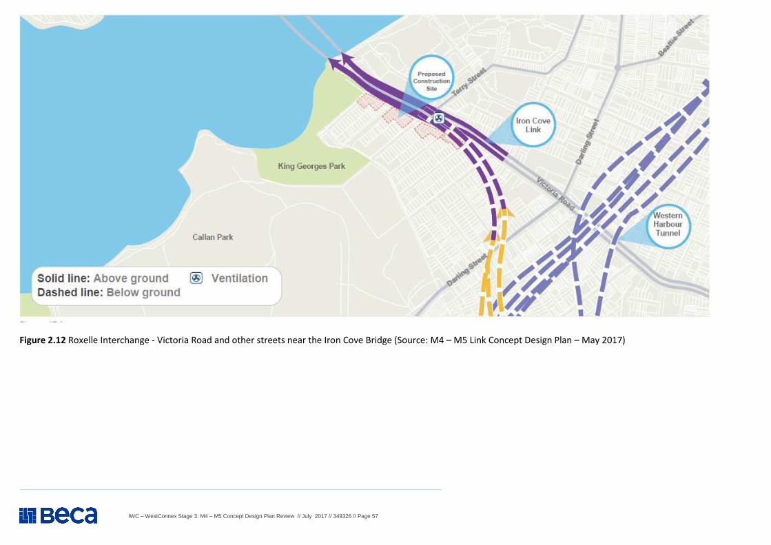
IWC – WestConnex Stage 3: M4 – M5 Concept Design Plan Review // July 2017 // 349326 // Page 57
Figure 2.12 Roxelle Interchange - Victoria Road and other streets near the Iron Cove Bridge (Source: M4 – M5 Link Concept Design Plan – May 2017)
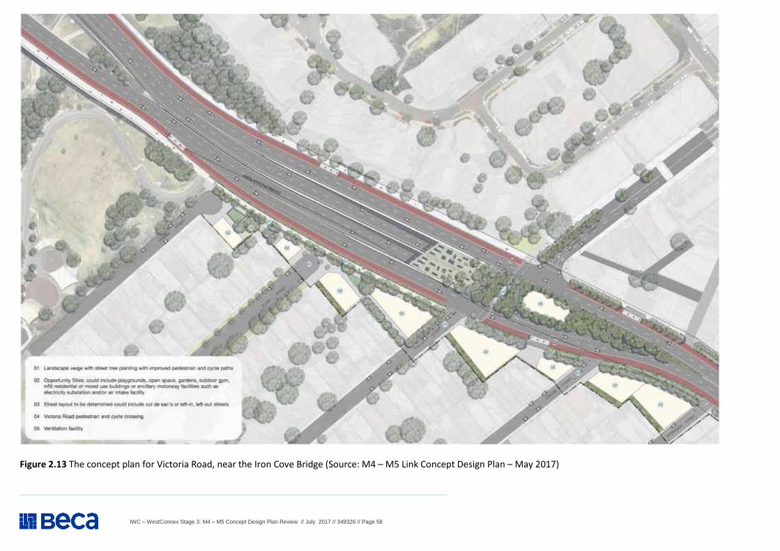
IWC – WestConnex Stage 3: M4 – M5 Concept Design Plan Review // July 2017 // 349326 // Page 58
Figure 2.13 The concept plan for Victoria Road, near the Iron Cove Bridge (Source: M4 – M5 Link Concept Design Plan – May 2017)
IWC – WestConnex Stage 3: M4 – M5 Concept Design Plan Review // July 2017 // 349326 // Page 59
WestConnex M4 – M5 Concept Design Plan Review – TRAFFIC AND TRANSPORT
Item Background information and source
2 Traffic and Transport (construction and operation) – Cont. 2.32
M4 – M5 Concept Plan - Section 13 The M4 – M5 Link (page 50): M4 – M5 Link by Location, Rozelle Victoria Road and other streets near the Iron Cove Bridge – Cont. Construction Construction of the Iron Cove Link will primarily occur from the Rozelle Rail Yards site. Tunnelling machines will be launched from the Rozelle Rail Yards and travel north underground to create the Iron Cove Link tunnels. A construction site will be established at Iron Cove to allow construction of the portals and the realignment of Victoria Road. Some of this space will be used for temporary office accommodation and parking (refer to Figure 2.14 ). During construction, Clubb, Toelle and Callan streets will be converted to cul-de-sacs. Pedestrian and cycle access along Victoria Road will be diverted via Manning Street and connect with the westbound shared path along Victoria Road at the end of Byrnes Street. The construction site at Victoria Road, Rozelle would be operational from mid-2018 to mid-2022. This construction site would operate under normal construction hours, which are 7am to 6pm Monday to Friday and 8am to 1pm Saturdays. We are listening Key outcomes that have been influenced by community feedback in this area include: � Better pedestrian and cycle connections across Victoria Road; � Tree planting on Victoria Road; � locating the Iron Cove Link entry and exit portals west of Terry Street; � links to the dedicated cycle and pedestrian paths at the Bay Run; � consideration of left-in, left-out access and/or cul-de-sacs for key side streets.
A separate Construction Pedestrian and Traffic Management Plan (CPTMP) needs to be prepared in line with the proposed works associated with each proposed construction site. This should include:
� Location of the proposed � Haulage routes; � Construction vehicle access arrangements;� Construction program; � Consultation strategy for liaison with surrounding stakeholders;� Any potential impacts to general traffic, cyclists, pedestrians and bus
services within the vicinitythe construction of the proposed works;
� Mitigation measures. Should any impacts be identified, the duration of the impacts and measures proposed to mitigate any associated general traffic, public transport, pedestrian and cyclist impacts should be clearly identified and included in the CPTMP.
Details of the end-of-project plans for the site in terms of amenity, use and visual impact should be included in the EIS. IWC understands the EIS will be ready for exSeptember 2017, and expects the above information to be comprehensively addressed in the EIS.
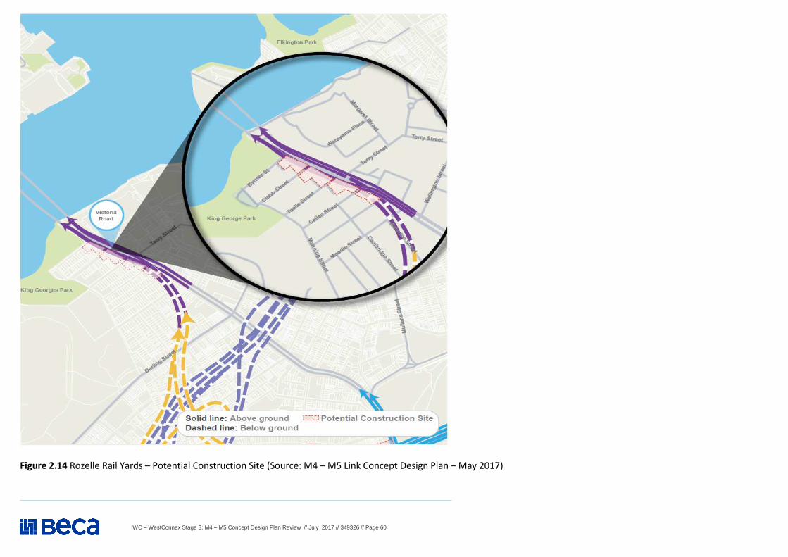
IWC – WestConnex Stage 3: M4 – M5 Concept Design Plan Review // July 2017 // 349326 // Page 60
Figure 2.14 Rozelle Rail Yards – Potential Construction Site (Source: M4 – M5 Link Concept Design Plan – May 2017)
IWC – WestConnex Stage 3: M4 – M5 Concept Design Plan Review // July 2017 // 349326 // Page 61
WestConnex M4 – M5 Concept Design Plan Review – TRAFFIC AND TRANSPORT
Item Background information and source Review comment
2 Traffic and Transport (construction and operation) – Cont. 2.33
S M4 – M5 Concept Plan - ection 13 The M4 – M5 Link (page 52): M4 – M5 Link by Location, Rozelle Victoria Road and other streets near the Iron Cove Bridge – Cont. What it will look like Key inclusions of the concept design for Victoria Road, Rozelle are: � pedestrian and cycle connections across Victoria Road at Terry Street; � reduction of Victoria Road surface lanes to two in each direction to allow for potential
dedicated public transport lanes; � tree planting along Victoria Road; � locating the Iron Cove Link entry and exit portals west of Terry Street; � an active transport corridor next to Victoria Road for dedicated cycle and pedestrian
paths that strengthen links to Iron Cove, the Bay Run and to the broader active transport network;
� water sensitive urban design; and � ancillary motorway facilities next to Victoria Road.
The future residual land along Victoria Road could include: � children’s play spaces; � community gathering spaces; � community gardens; and � small-scale residential development such as new terrace housing.
We are still looking at the long-term access to Victoria Road for the side streets between Springside Street and the Iron Cove Bridge. This could include left-in, left-out turning configurations or cul-de-sacs. We will engage further with local residents about these options.
IWC – WestConnex Stage 3: M4 – M5 Concept Design Plan Review // July 2017 // 349326 // Page 62
WestConnex M4 – M5 Concept Design Plan Review – TRAFFIC AND TRANSPORT
Background information and source Review comment
2 Traffic and Transport (construction and operation) – Cont. 2.34
M4 – M5 Concept Plan - Section 14 The M4 – M5 Link (page 54): Active Transport Network
An Active Transport Plan is being developed as part of the M4-M5 Link. The plan proposes a number of pedestrian and cycle infrastructure upgrades as part of the project. We are working with City of Sydney, the Inner West Council, Transport for NSW, Urban Growth NSW, and Roads and Maritime Services to develop the best routes for proposed new and upgraded pedestrian and cyclist infrastructure. Throughout the corridor, we are taking account of proposed routes and projects that are already underway and any identified missing links in the network. We propose to construct the following additions to the active transport network within the M4-M5 Link corridor (refer to Figure 14.1): � a 250-metre separated cycleway connecting the eastern side of the Rozelle Rail
Yards along Victoria Road to the intersection of Roberts Street; � a 450-metre separated cycleway linking the intersection of Springside Street to the
Iron Cove Bridge and the Bay Run; � an underpass under Victoria Road to connect the Rozelle Rail Yards to the Bays
Precinct; � a one-kilometre path between Victoria Road and the Lilyfield Road Light Rail Depot; � a pedestrian and cycle path on Gordon Street to connect the Lilyfield Road cycleway
to a separated pedestrian and cycle path in the new Rozelle Rail Yards open space; and
� a 300-metre path connecting Easton Park to The Crescent, through the Rozelle Rail Yards.
As part of the already approved New M5 we will also be constructing: � a 1.9 kilometre separated path connecting the intersection of May Street and Bedwin
Road to Bourke Road; and � a 700-metre to one-kilometre shared path linking St Peters Interchange to Campbell
Road.
SMC - M4-M5 Link Community feedback report 21 July – 31 August 2016 stated: Easton Park The community provided significant feedback and ideas on pedestrian and cycle connectivity within the project area. As a result, we are developing an Active Transport Strategy for the M4-M5 Link, with a focus on the missing links within the existing pedestrian and cycle network, particularly in areas where we will be working on the surface to deliver the project. Active transport The community provided significant feedback and ideas on pedestrian and cycle connectivity within the project area. As a result, we are developing an Active Transport Strategy for the M4-M5 Link, with a focus on the missing links within the existing pedestrian and cycle network, particularly in areas where we will be working on the surface to deliver the project. Also, see Items 2.35 to 2.37
IWC understands the EIS will be ready for exhibition tin late August or early September 2017, and expects this information to be comprehensively addressed in the EIS.
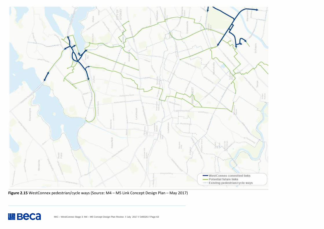
IWC – WestConnex Stage 3: M4 – M5 Concept Design Plan Review // July 2017 // 349326 // Page 63
Figure 2.15 WestConnex pedestrian/cycle ways (Source: M4 – M5 Link Concept Design Plan – May 2017)
IWC – WestConnex Stage 3: M4 – M5 Concept Design Plan Review // July 2017 // 349326 // Page 64
WestConnex M4 – M5 Concept Design Plan Review – TRAFFIC AND TRANSPORT
Item Background information and source Review comment
2 Traffic and Transport (construction and operation) – Cont. 2.35
Feedback from IWC Staff members : Existing bicycle route network
The M4 – M5 Link Concept Design Plan shows “existing cycle and pedestrian paths” as solid red lines on the below map (page 23) and again at page 55. Most of the “existing” paths shown on the map are neither existing nor paths. This incorrect information would be likely to heavily misguide planning of bike/pedestrian connectivity around the interchange by misconstruing the local network to which the Campbell St cycle path would connect. i.e. connectivity at the following locations within the catchment is not adequately addressed: � from Canal Rd/Princes Hwy to Sydenham station; � from Bedwin Rd to Enmore Park/Marrickville Metro; and � across Alexandra Canal at Canal Rd.
How will a bike rider safely proceed in any direction once they reach the end of the Campbell St cycle path at Unwins Bridge Rd or the shared path at Canal Road near the Princes Highway?
Reference to Item 2.34
2.36
Feedback from IWC Staff members: Connectivity from Florence Street to the Campbell S treet cycleway Florence Street is identified as a Council bicycle route but the proposed changes on Campbell Street would require riders to either use the busy travel lanes on Campbell Street or the proposed new footpaths on the southern side. Widening of the proposed footpath to provide a shared path or separated path facility between St Peters Street and Unwins Bridge Road would allow for a safe connection between Florence Street and the Campbell Street cycleway. The shared path treatment or separated path treatment should be consistent with Austroads guidance on appropriate path width (note newly updated Austroads guidance provides specific information on appropriate shared path width based on expected pedestrian and bicycle rider volumes).
Reference to Item 2.34
2.37
Feedback from IWC Staff members: Side street crossings The Campbell Street cycleway and a shared path link on the southern side of Campbell Street should consider shared environment intersection (raised threshold) treatments to provide bicycle path (and footpath) continuity across quiet side streets, including Hutchinson Street, Brown Street and Florence Street.
Reference to Item 2.34
IWC – WestConnex Stage 3: M4 – M5 Concept Design Plan Review // July 2017 // 349326 // Page 65
WestConnex M4 – M5 Concept Design Plan Review – TRAFFIC AND TRANSPORT
Item Background information and source Review comment
2 Traffic and Transport (construction and operation) – Cont. 2.38
Feedback from IWC Staff members : Sporting Infrastructure
Further to earlier comments the opportunity needs to be explored to move the proposed sporting ground west and to try and provide an additional sporting ground with a pavilion centred between the two. Centralising the sporting precinct is important.
Both Sporting grounds need to be multipurpose in terms of their provision. IWC’s planners and still don’t have any idea on population numbers for the Bays from Urban Growth and the Department of Planning. The original figure reported was 16,000 dwellings.
Reference to Item 2.26. IWC is significantly deficient in terms of sporting infrastructure space especially for evening training needs and IWC also supports local school use where there are also deficiencies in physical education facilities.
Should another school be built in the Bays (which IWC should support –subject to population growth figures), there will be increased cumulative impacts.
2.39
Feedback from Leichardt resident : Dive site at Darley Road - The concept design released in May 2017 shows only one of the options in detail, Darley Road. The display of this one site cannot be considered an option but a final choice. The concept plan on page 30 states that “We envisage that this site would be used as a launching site for two tunnelling machines as well as removal of excavated material”. It is obvious that the decision had already been made to use Darley Road prior to the community consultation sessions. At a second consultation session, we again enquired about Darley Road as the best option as it appeared to be the site with the most problems due to its size, access to City-West Link, traffic difficulties, impact on residents, noise, dust, truck movements, proximity to a major intersection with a very steep incline and a multi-million-dollar compensation payable to the private developers. Rozelle Yards - The Bus Museum building within the Bus Depot and the western end of the Rozelle Rail Yards to be bought by State Government for project purposes and these costs to remain within the public purse. � Why would Darley Road be the preferred over The Rozelle Rail Yards or the Bus Museum sites? � It is obvious that Darley Road was the only M4-M5 Link dive site even before the concept plan was issued. As such, it is
certainly not as a result of any community consultation process and to claim otherwise is simply not true. � Only direct access to City-West Link from any dive site, be it the Rozelle Rail Yards or the Bus depot will negate the potentially
catastrophic effects of spoil removal from the Darley Road during the construction of the WestConnex M4-M5 Link. � If Darley Road becomes the dive site, we request that the compensation paid to all parties including to the private developers
of Tdrahhiel (Shane Barr and Robbie Ingham), Woolworths, Endeavour Drinks, Dan Murphy’s, Kerry Chikarovski, Rail Corp and anyone else or any organisation that gains benefit from this, immediately becomes public knowledge.
Reference to Item 2.21 and 2.27. What makes Darley Road the preferred and only documented site on the concept plan given the large number of negative issues it has? Why isn’t the western end of the Rozelle Rail Yards the preferred site? It is an excellent site that would have very little negative impact on the surrounding environment but we have not able to ascertain any substantial reasons for its exclusion. With properly designed entry and exit ramps on the northern side, it would not impact on the functioning of the light rail at all and could provide easy access City-West Link. These ramps would certainly cost far less than the Bus Museum purchase. Why hasn’t the Bus Museum site been part of any documentation as a dive site alternative? What makes this a site that is beyond consideration? We are requesting that the WestConnex design team completely abandon 7 Darley Road as a totally unsuitable dive site and explore the western end of Rozelle Rail Yards as the only suitable dive site if there has to be one, at all.
IWC – WestConnex Stage 3: M4 – M5 Concept Design Plan Review // July 2017 // 349326 // Page 66
WestConnex M4 – M5 Concept Design Plan Review – TRAFFIC AND TRANSPORT
Item Background information and source Review comment
2 Traffic and Transport (construction and operation) – Cont. 2.40
Feedback from local Athletics Centre : Access to King George Park, Rozelle, During Westcon nex Construction - King George Park (KGP) is set in a relatively isolated location being bordered by Callan Park on two sides and the water of Iron Cove on another. As a result, on any given Saturday over 2,000 athletes and parents are required to access KGP from Victoria Road and its adjacent side streets. This results in very heavy traffic to and from the area. As a consequence the parking adjacent to KGP and along the nearby streets is frequently overflowing. It should be noted that KGP is regarded as a “regional
park” and is the most heavily used sporting ground in the local government area resulting in very high use and many
thousand vehicle movements to and from the area each week for the entire year.
It is with concern that we find three items within The Westconnex M4-M5 link Concept plan, pages 48-53, that will have a very heavy impact on the access of families, schools and equipment to KGP: � During construction, Clubb, Toelle and Callan streets will be converted to cul-de-sacs. Pedestrian and cycle access along
Victoria Road will be diverted via Manning Street and connect with the westbound shared path along Victoria Road at the end of Byrnes Street. Leaving the precinct will be just as difficult as vehicles will either have to battle the entering traffic at Springside Street or have to negotiate the hairpin turn from Manning Street to Moodie Street. Neither are options for delivery trucks, minibuses or coaches. Large vehicles are not permitted past the Callan St/Manning St T-intersection as they cannot negotiate a left-hand turn entry into either Springside St or Moodie St.
� The construction site at Victoria Road, Rozelle would be operational from mid-2018 to mid-2022. This construction site would operate under normal construction hours which are 7am to 6pm Monday to Friday and 8am to 1pm Saturdays. A construction site will be established at Iron Cove…. Some of this space will be used for temporary office accommodation and parking. The severe lack of parking experienced during competition and training days will be further compounded by the addition of vehicles from those employed on the project, further impacting on the overall access to KGP. It should be mandatory for all construction, supervisory and office workers to utilise any parking areas within the construction sites. As noted in the WestConnex document.
� We are still looking at the long-term access to Victoria Road for the side streets between Springside Street and the Iron Cove Bridge. This could include left-in, left-out turning configurations or cul-de-sacs. We will engage further with local residents about these options. It appears that the strategy to sacrifice usable resident and park-user access to the KGP precinct in return for ease of access for WestConnex construction may well become a permanent problem.
Reference to Item 2.27.
The Balmain Little Athletics Club would like to formally request a review of the planned road access and traffic flow changes during the Victoria Road/Iron Cove WestConnex construction.
The current proposal outlined in the WestConnex document would make access and the practical use of King George Park near impossible during and after the five-year construction period. This would negatively impact not only our club and local residents but those that utilise it over winter and the many schools and community groups that use it for their events and sports carnivals.
Balmain Little Athletics Club requests an urgent review and a ‘feet on the ground’ appraisal of the laneways earmarked to be the only vehicular access points to and from KGP. It is inconceivable that the strategy outlined would have been presented if an actual site visit had taken place. The access strategy cannot be predicated on the use of maps that in no way represent the inherent vehicular passing and turning problems of the streets in question.
It is essential that safe and adequate access to the King George Park precinct be maintained at all times for both local residents and the many thousands of park goers that utilise this highly prized recreational area year-round. Urgent consultation is required with all stakeholders to achieve this aim.
IWC – WestConnex Stage 3: M4 – M5 Concept Design Plan Review // July 2017 // 349326 // Page 67
WestConnex M4 – M5 Concept Design Plan Review – TRAFFIC AND TRANSPORT
Item Background information and source Review comment
2 Traffic and Transport (construction and operation) – Cont. 2.41
Feedback from local Football Club : King George Park, Rozelle Access – Westconnex Cons truction and Operation - The current proposals for road closures during the four-year construction of Westconnex (and possibly permanently) would effectively prevent vehicular access to the King George park and thus severely hamper use of the park.
The Westconnex M4-M5 link Concept plan includes: Section 13 – Rozelle (refer to Figure 2.14 in Item 2.34:
� During construction, Clubb, Toelle and Callan streets will be converted to cul-de-sacs. Pedestrian and cycle access along Victoria Road will be diverted via Manning Street and connect with the westbound shared path along Victoria Road at the end of Byrnes Street. The construction site at Victoria Road, Rozelle would be operational from mid-2018 to mid-2022. This construction site would operate under normal construction hours which are 7am to 6pm Monday to Friday and 8am to 1pm Saturdays.
� consideration of left-in, left-out access and/or cul-de-sacs for key side streets: We are still looking at the long-term access to Victoria Road for the side streets between Springside Street and the Iron Cove Bridge. This could include left-in, left-out turning configurations or cul-de-sacs. We will engage further with local residents about these options.
The proposal as described would prevent vehicular access to King George Park. This is depicted in Figure 2.15 . In summary:
� Practical access is currently only available via Toelle and Clubb Streets (from Victoria Road). Most people use Clubb St because it is more direct and a layoff lane on Victoria Road makes the left turn easier.
� Byrne St is already a cul-de-sac at Victoria Road. � Springside St, Callan St and their linking cross street McCleer St are all shared zones (10km, give way to
pedestrians). The only route involving these streets is Springside-McCleer-Callan because Manning St is one way southwards (that is, the wrong way) where Springside intersects it. The three streets are effectively one lane because of their narrowness and parked cars (on footpath due to the restrictions). The streets would not function with even a small increase in traffic and certainly not with the volumes generated by use of the field. Gridlock would result.
� Buses (school use) and delivery trucks would not be able to access the park. � Further, the club requests that workers on the Westconnex project be prohibited from parking on and adjacent to
King George Park and Manning St. If this is not done it could consume most or all of the available parking, preventing effective use of the park for sport. Alternative parking for workers needs to be provided.
� The club notes an unfiltered ventilation stack is proposed for the centre of Victoria Road, about 1.5kmm from the park. We are concerned at the prospect of unfiltered exhaust fumes being concentrated and directed to the park, with ensuing adverse health consequences for our players and guests, of all ages.
Reference to Item 2.30 Leichhardt Saints Football Club requests the proposal be reviewed to ensure adequate access to King George Park at all times during any construction and operation of the M4-M5 Iron Cove link.
The proposed road closures would make vehicular access and hence any practical use of King George Park impossible.
Leichhardt Saints Football Club requests the proposal be reviewed to ensure adequate access to King George Park at all times during any construction and operation of the M4-M5 Iron Cove link.
Further, the club requests that workers on the Westconnex project be prohibited from parking on and adjacent to King George Park and Manning St. If this is not done it could consume most or all of the available parking, preventing effective use of the park for sport. Alternative parking for workers needs to be provided.
IWC would appreciate early advice on how access will be maintained both during and after construction.
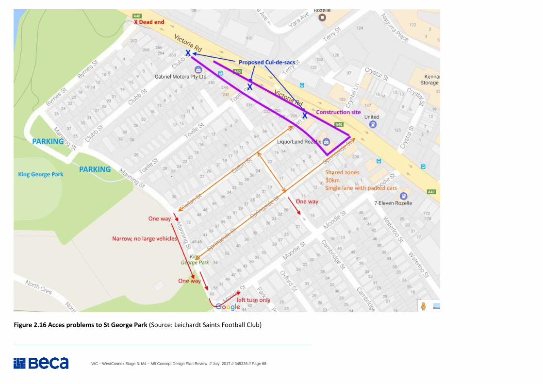
IWC – WestConnex Stage 3: M4 – M5 Concept Design Plan Review // July 2017 // 349326 // Page 68
Figure 2.16 Acces problems to St George Park (Source: Leichardt Saints Football Club)
IWC – WestConnex Stage 3: M4 – M5 Concept Design Plan Review // July 2017 // 349326 // Page 69
WestConnex M4 – M5 Concept Design Plan Review – TRAFFIC AND TRANSPORT
Item Background information and source Review comment
2 Traffic and Transport (construction and operation) – Cont. 2.42
Feedback from Rozelle Public School P&C :
With the vast majority of children attending the School and OOSH living less than 500 metres from the proposed tunnel entrance and exhaust stack on the corner of Victoria Road and Terry Street, and with construction and heavy vehicle traffic on school walking routes and so close to the school, we must express our objections to this development for the following reasons:
� Adverse health, safety, educational, developmental and well-being effects on children due to construction within 5OOm of the school;
� We are also very concerned that construction noise and vibration from trucks, building demolition and tunnelling, and pollution from dust, debris and particulate matter will affect people at the school.
� In addition, we are also concerned that King George Park and Oval will be used as a construction site due to its proximity to the School and the use of this site will impede the children's ability to participate in many School and non-school sporting and exercise related activities;
� Adverse health effects to children due to unfiltered exhaust stacks; and � Road safety hazards to children during and after construction.
Without these important and necessary safeguards put in place, without adequate information, and without specific consultation with us and our community, we must object to the current very vague and potentially disastrous proposals being put forward by SMC.
Reference to Item 2.27. In response, IWC requests:
� A comprehensive and independently audited EIS and traffic plan; � Truck movements be minimised and truck and construction curfews
between 7:00pm and 7:00am within the catchment area; � The installation of sound barriers around the school; � Regular and comprehensive information and notifications by SMC in the
event that noise, dust and air pollution levels and conditions were raised to unsafe levels;
� Independent structural analysis of all School buildings and guarantees to mitigate and compensate for damage to School buildings;
� Current pedestrian crossings be preserved; � Current bus routes and stops on Victoria Road are preserved; � Current cycle paths on Victoria Road are preserved; � A construction exclusion zone of at least 100 metres from the School; � Private transportation be provided and paid by WestConnex to transfer
our children to another suitable sporting area a safe distance away from construction in order that they can attend the School cross country, athletics and swimming carnivals;
� Adequate tunnel safety systems including exhaust stack, dust filtration air conditioning, pedestrian and cycle crossing facilities, safeguards from preventing increased rat runs;
IWC asks that any impacts upon our community are minimised and mitigated, to prevent any deleterious or injurious effects on the health, safety and well-being of our children, and the impact this development will have on their health, safety, well-being, development and education.
IWC – WestConnex Stage 3: M4 – M5 Concept Design Plan Review // July 2017 // 349326 // Page 70
WestConnex M4 – M5 Concept Design Plan Review – VISUAL IMPACT AND URBAN DESIGN
Item Background information and source Review comment
3. Visual impact and urban design 3.1
Application (SSIAR) - Overview The project corridor covers a varied urban environment, comprising several distinct landscape character zones and visual catchments. Haberfield The suburb of Haberfield has a unique visual character which is due to its historic significance as Australia’s first planned garden suburb. The visual importance of the suburb is related to the housing pattern, architecture, and tree-lined streetscapes. Leichhardt / Lilyfield / Rozelle Much of the locality is subject to urban renewal with planning proposals to rezone small isolated industrial sites for higher density residential and mixed uses. Currently, the area is characterised by low to medium density housing with primarily late Victorian and Federation architecture, and scattered examples of interwar period dwellings and intact weatherboard cottages. Within the project corridor is the open space corridor along Hawthorne Canal incorporating Richard Murden Reserve and Blackmore Park. This open space corridor extends southwards as well as to the Sydney Harbour foreshore area to the north. The open space corridor offers pedestrian and cycle connections to the Iron Cove Bay foreshore areas, Sydney Harbour foreshore attractions, and the Sydney CBD. Rozelle Rail Yards and Rozelle Bay Maritime Precinct The Rozelle Rail Yards and the Rozelle Bay maritime precinct are a prominent feature within the project corridor. As the topography is elevated in the area towards Victoria Road, these sites are visible to motorists, pedestrians and cyclists utilising the transport network, though much of the Rozelle Rail Yard is screened by trees and vegetation. Both sites have been identified as new destinations within the Bays Precinct Transformation Plan. The Rozelle rail yards are identified for affordable housing and public spaces and the Rozelle Bay area is identified for commercial, residential, open space uses, together with working harbour industries and on- water recreation facilities.
See comments in Items 3.3 and 3.4
IWC – WestConnex Stage 3: M4 – M5 Concept Design Plan Review // July 2017 // 349326 // Page 71
WestConnex M4 – M5 Concept Design Plan Review – VISUAL IMPACT AND URBAN DESIGN
Item Background information and source Review comment
3. Visual impact and urban design – Cont. 3.2
Application (SSIAR) - Overview – Cont. Glebe / Camperdown The area of Glebe is characterised by Victorian homes, Federation houses, terraces, and cottages, of which a number are heritage listed. This residential development is intermixed with community facilities, open space and transport infrastructure. Key recreational and community features within the project corridor include Bicentennial and Federal Parks, Jubilee Oval, and the Johnstons Creek corridor. The former Harold Park Raceway is also located within the project corridor and is currently being developed for medium density development. The site will provide around 1,250 new residences once complete. The suburbs of Forest Lodge and Camperdown have strong association with the University of Sydney and the Royal Prince Alfred Hospital. The area is dominated by these large sites and their associated uses and infrastructure which dominate the visual character and culture of the area, including university colleges, sporting and recreational spaces, civic buildings, and medical facilities. A number of inner city houses, terraces and apartment complexes are also prominent. There is a large stone retaining wall adjacent to Parramatta Road in Camperdown and the landscaped frontage of the University of Sydney in the vicinity of the proposed surface works for the project. Newtown Newtown supports a dense population and much of the character is defined by the suburbs history and creative culture. The iconic King Street in Newtown has maintained much of its original character and the street, along with many buildings along it, are locally listed heritage items. Sydney Park Sydney Park, located on a former industrial area and landfill at the northern extent of the project corridor, represents a large area of public open space. The area adjacent to the park is a mix of light industrial and residential development. This area will undergo change as part of the New M5 project (if approved), with the closure of the former Alexandria Landfill and acquisition of industrial land along Campbell Road, and the widening of Campbell Road and Euston Road as part of the local road upgrades. Areas of open space and new pedestrian/cycle infrastructure would be provided as part of the St Peters interchange (if approved) which will enhance connectivity to Sydney Park and surrounding suburbs.
See comments in Items 3.3 and 3.4
IWC – WestConnex Stage 3: M4 – M5 Concept Design Plan Review // July 2017 // 349326 // Page 72
WestConnex M4 – M5 Concept Design Plan Review – VISUAL IMPACT AND URBAN DESIGN
Item Background information and source Review comment
3. Visual impact and urban design – Cont. 3.3
Application (SSIAR) - Operations Operation of the project has the potential for the following urban design and visual amenity impacts: � Visual impact of new infrastructure on existing views from residences and surrounding
development including: o The interchanges and tunnel portals; o Surface infrastructure such as ventilation facilities; o Gantries and signs; o Noise mitigation measures, such as noise barriers and noise mounds, if required. The height and
location of any new or modified noise walls (or mounds) would be informed by the future noise impact assessment and would be subject to consideration of the reasonableness and feasibility of such a noise mitigation approach. This would include the consideration of visual impacts and overshadowing;
� Impact to the motorist experience due to visual quality of new motorway infrastructure, structures and elements, and changes to the existing landscape, views and visual characteristics of existing roads
� Impact on the landscape characteristics of existing open spaces adjacent to the project, and views from these spaces
� The removal of mature trees and vegetation, if unavoidable through design � Overshadowing caused by operational surface infrastructure � Impacts to existing pedestrian and cycle pathways adjacent to, along and across the corridor
in particular around the Rozelle interchange where an important cycleway into the city is located
� Landscape character and visual impact associated with future development of The Bays Precinct and other urban renewal projects
� Integration with the urban design of the proposed M4 East and New M5. The visual impacts of the project would be dependent on the design features of the interchanges and other surface infrastructure, landscape treatments and the exploration of opportunities to integrate the surface infrastructure elements with the surrounding features of the area. Design of the portals, the interchange and surface infrastructure would take into consideration their visibility and presence within their context to ensure an appropriate design response. The design of the project would also be guided by the WestConnex Urban Design Framework (Roads and Maritime, 2013a) that has been developed for the broader WestConnex program of works. This framework will ensure a consistent high quality design approach and outcome across all three stages. In addition, the integration of the project at the St Peters interchange would consider the broader urban design for the interchange as well as future uses of the residual space following the completion of construction. This area, located adjacent to Campbell Road, has been nominated for open space and the types of recreational uses would be decided in consultation with Marrickville and City of Sydney Councils.
SEARS – 3 May 2017 – Cont. (Application Number - SSI 16 7485) The Desired Performance Outcomes (DPO) points in the SEARS are listed below as an issue. Key Issue SEARs - Point 7 – Urban Design – The project design complements the visual amenity, character and quality of the surrounding environment. The project contributes to the accessibility and connectivity of communities Requirement 1: The Proponent must: ((a) to (i) as in SEARS): (a) identify the urban design and landscaping aspects of the project and its components to enhance the appearance of ventilation outlets, interchanges, potential connections to the Bays Precinct and transport linkages, tunnel portals, bridges, noise walls, ancillary buildings, and any additional surface infrastructure, 'cut and cover' arrangements; (b) identify measures aimed at improving 'north-south' connectivity between Balmain/Rozelle and Sydney Harbour; (c) Identify measures aimed at preserving the 'east-west' connectivity between White Bay and the Rozelle Rail Yards; (d) consider resulting residual land treatments, and demonstrate how the proposed hard and soft urban design elements of the proposal would be consistent with the existing and desired future character of the area traversed or affected by the proposal; (e) identify opportunities to utilise surplus or residual land, particularly for the provision of community space (passive and recreational) and utilise key structures (such as ventilation outlets) for multiple uses i.e. integration with other structures; (f ) evaluate the visual impacts and urban design aspects of the proposal and its components (such as the ventilation outlets and interchanges) on surrounding areas, taking into consideration the urban and landscape design of the M4 East and New MS Motorways and WestConnex Urban Design Corridor Framework; (g) explore the use of Crime Prevention Through Environmental Design (CPTED) principles during the design development process, including natural surveillance, lighting, walkways, signage and landscape; (h) identify urban design strategies and opportunities to enhance healthy, cohesive and inclusive communities; and (i) describe urban design and landscape mitigation measures, having regard to the urban design and landscape objectives for the proposal. IWC expects this requirement to be comprehensively addressed in the EIS.
IWC – WestConnex Stage 3: M4 – M5 Concept Design Plan Review // July 2017 // 349326 // Page 73
WestConnex M4 – M5 Concept Design Plan Review – VISUAL IMPACT AND URBAN DESIGN
Item Background information and source Review comment
3. Visual impact and urban design – Cont. 3.4
Application (SSIAR) - Proposed further assessments Further assessment of the potential for visual impacts and landscape character impacts along the project corridor would be conducted as part of the environmental impact statement, which would include as a minimum: � Identification of the visual qualities present, including the existing
landscape character of the region, sensitive locations and receivers, catchments and key viewpoints
� An assessment of visual impacts from the construction and operational stages of the project on existing views and landscapes. This includes a review of relevant heritage items
� An assessment of the urban design elements of the project � Identification of urban design mitigation measures, where required.
The design of the project would be in keeping with urban design principles for the project, the WestConnex Urban Design Corridor Framework and the Roads and Maritime Guideline Beyond the Pavement: Urban Design Policy Procedures and Design Principles (Roads and Maritime, 2014), which identifies the following urban design principles regarding road infrastructure: � Contributing to urban structure and revitalisation � Fitting with the built fabric � Connecting modes and communities � Fitting with the landform � Responding to the natural pattern � Incorporating heritage and cultural contexts � Designing roads as an experience in movement � Creating self-explaining road environments � Achieving integrated and minimal maintenance design.
SEARS – 3 May 2017 – Cont. (Application Number - SSI 16 7485) The Desired Performance Outcomes (DPO) points in the SEARS are listed below as an issue. Key Issue SEARs - Point 8 – Urban Design – The project minimises adverse impacts on the visual amenity of the built and natural environment (including public open space) and capitalises on opportunities to improve visual amenity. Requirement 1: The Proponent must assess the visual impact of the project and any ancillary infrastructure on:
(a) views and vistas; (b) streetscapes, key sties and buildings; (c) heritage conservation areas and heritage items including Aboriginal places and environmental
heritage; and (d) the local community (including view loss and overshadowing).
Requirement 2: The Proponent must provide artist impressions and perspective drawings of the project from a variety of locations along and adjacent to the route to illustrate how the project has responded to the visual impact through urban design and landscaping.
The M4 – M5 Link Concept Design Plan together with the masterplans and the draft Urban design and Landscape Plan should be provided as part of the EIS to provide further detail for comment. IWC’s guidelines on visual impact and urban design should be followed closely and SMC should familiarise and apply these guidelines in the development of the EIS. The urban design requirements in the SEARs appear to apply to operational phase of the project and little information about the construction phase. IWC expects the EIS to address both phases equally and sufficiently in terms of visual impact and urban design. Given that the surface area disturbance footprint sites are located in established urban areas and that the temporary construction phase is for at least four years, then it is important that urban design considerations be applied in the development of the EIS for:
� design guidelines for fencing/cladding of construction sites and building and other structures; and
� temporary active transport links and bus stops including suitability and convenience of temporary routes and stops, capacity and safety of temporary facilities.
IWC expects these requirements to be comprehensively addressed in the EIS.
IWC – WestConnex Stage 3: M4 – M5 Concept Design Plan Review // July 2017 // 349326 // Page 74
WestConnex M4 – M5 Concept Design Plan Review – VISUAL IMPACT AND URBAN DESIGN
Item Background information and source Review comment
3. Visual impact and urban design – Cont. 3.5
M4 – M5 Concept Plan - Sections 12 and 13 Rozelle (pages 38 to 53) In terms of visual impact and urban design, the concept plan responds to consultation and further studies and provides:
• indicates surface area disturbance footprints • draft masterplans for Rozelle Rail yards and St. Peters as well as a
concept plan for Victoria Road near Iron Cove Bridge • extends the St. Peters interchange parklands • the plan confirms that there will be no surface work for Pioneer
Memorial Park, Leichhardt and Easton Park, Rozelle, Blackmore Road and Derbyshire Road no longer being required as construction sites
• Rozelle interchange will be fully underground • 3 new ventilation stacks- Rozelle railyards, Iron Cove bridge and St.
Peters • Urban design is further dealt with in the M5 draft Urban Design and
Landscape Plan prepared by the M5 contractor and subject to submissions
Iron Cove Bridge master plan Rozelle rail yards master plan
• up to 10 ha additional open space at Rozelle rail yards with western end being considered as alternative to Darley Street construction site
• potential for western end of Rozelle railyards to be a potential tunnel construction site
• connects the neighbourhoods of Annandale and Rozelle St. Peters concept plan based upon M5 project approval conditions
• additional 2.5 ha open space to supplement M5 open space commitment
• recreation and land bridge to St. Peters open space - conditions of M5 project approval
Iron Cove Bridge masterplan This locality is highly visible and will include landscaped areas and a ventilation stack with areas of residual land which may be developed as open space or other purpose should air and noise quality allow e.g. social or affordable housing. This is a significant landmark/gateway site and it is important that it be given strong urban design and landscaped treatment which also blends with the local character of the area. The provision of an active transport crossing is commended, however, it is important to provide adequate connectivity during the construction phase. Rozelle rail yards The additional open space and detailed master planning of the area is welcomed. On site car parking is considered a desirable inclusion in the master plan. The active transport bridges are a necessity and it is important that they are planned and placed to ensure the most convenient and safe connections to and from the area. See Item 2.29. St Peters The provision of additional open space in this area is welcomed subject to ensuring that there is access other than the active transport bridge to and from the park. This is an essential safety issue.
IWC – WestConnex Stage 3: M4 – M5 Concept Design Plan Review // July 2017 // 349326 // Page 75
WestConnex M4 – M5 Concept Design Plan Review – SOCIAL, ECONOMIC, HERITAGE AND PROPERTY
Item Background information and source Review comment
4. Social, Economic, Heritage and Property (constructi on and operation) 4.1
Application (SSIAR) - Property - Overview The project would span four local government areas including: Ashfield, Leichhardt, Marrickville and Sydney. Land use and existing development within and around the project corridor is predominately urban in nature, containing a mix of residential, commercial, open space and recreational uses. There is little industrial use land within the corridor, with the exception of areas within and adjoining the Rozelle Rail Yards. There are several major transport corridors and infrastructure located in or adjacent to the project corridor, including Parramatta Road, the City West Link, the Inner West Light Rail and the Sydney Trains suburban rail network. A more detailed description of the land uses within the project corridor is provided below. � Residential land: Predominantly low density residential and
general residential, with medium and high density residential land uses located in areas close to public transport and along major roads;
� Open space: Nature reserves, active recreational uses (such as sports grounds) and passive recreational uses are located throughout the project corridor. Key open spaces within the project corridor include Federal Park, Bicentennial Park, Hogan Park Camperdown Memorial Rest Park and Sydney Park;
� Commercial land: Concentrated in the suburbs of Rozelle, Newtown, Camperdown and St Peters, with smaller local centres distributed throughout the project corridor. Commercial uses are typically concentrated along major roads (such as the King Street) and at train stations, alongside medium and high density residential uses. Community facilities, churches, schools, medical and veterinary centres are located along the length of the project corridor.
The Transformation Plan: The Bays Precinct (UrbanGrowth NSW, 2015b) has identified that the redevelopment of the Rail Yards has the potential to reconnect areas to the north and south of the Rail Yards and to improve connections from Lilyfield to the water. Residential and employment areas and public spaces have been identified as potential future uses of the area. The transformation of Rozelle Rail Yards has been identified as a longer- term priority, to be commenced around 2022 and beyond. Parts of Rozelle Rail Yards, located east of the Catherine Street overbridge at Lilyfield, would also be used as part of the approved CBD and South East Light Rail as a maintenance depot.
SEARS – 3 May 2017 – Cont. (Application Number - SSI 16 7485) The Desired Performance Outcomes (DPO) points in the SEARS are listed below as an issue. Key Issue SEARs - Point 9 – Socio-economic, Land-use and Property – The project minimises adverse social and economic impacts and capitalises on opportunities potentially available to affected communities. The project minimises impacts to property and business and achieves appropriate integration with adjoining land uses, including maintenance of appropriate access to properties and community facilities, and minimisation of displacement of existing land use activities, dwellings and infrastructure. Requirement 1: The Proponent must assess social and economic impacts (of all phases of the project) in accordance with the current guidelines (including cumulative ongoing impacts of the proposal). Requirement 2: The Proponent must assess impacts from construction and operation on potentially affected property (including Crown lands), businesses, recreational users and land and water users, including property acquisitions/adjustments, access amenity, relevant statutory rights, and community severance and barrier impacts resulting from the project. Requirement 3: The Proponent must identify opportunities for local centre street revitalisation improvements, pedestrian and cyclist access and connectivity and provision of community and social facilities. Requirement 4: The design and siting of project elements should be located in such a way that functional, contiguous areas of residual land are maximised. The design and siting must consider appropriate land use interfaces (i.e. White Bay) and the social and economic impacts of proposed land uses against alternate land uses. Requirement 5: Where air quality allows, residual land must be designed to positively contribute to additional community uses, public recreation uses and/or affordable or social housing. Passively landscaped areas should not be the default use for residual land. Requirement 6: The Proponent must assess potential impacts on utilities (including communications, electricity, gas, and water and sewerage) and the relocation of these utilities. Requirement 7: Where the project is predicted to affect trunk utilities, the Proponent must undertake a utilities management strategy. The strategy must identify proposed management strategies, including relocations or adjustment of the utilities, and their estimated timing and duration. This strategy must be developed in consultation with the relevant utility owners or providers. Requirement 8. A draft Community Consultation Framework must be prepared identifying relevant stakeholders, procedures for distributing information and receiving/responding to feedback and procedures for resolving stakeholder and community complaints during construction and operation. Key issues that must be addressed in the draft Framework include, but are not limited to: (a) traffic management (including property access, pedestrian access); (b) landscaping/urban design matters; (c) construction activities including out of hours work; and (d) noise and vibration mitigation and management.
IWC expects these requirements to be comprehensively addressed in the EIS.
IWC – WestConnex Stage 3: M4 – M5 Concept Design Plan Review // July 2017 // 349326 // Page 76
WestConnex M4 – M5 Concept Design Plan Review – SOCIAL, ECONOMIC, HERITAGE AND PROPERTY
Item Background information and source
Review comment
4. Social, Economic, Heritage and Property (co nstruction and operation) – Cont.
4.2
Application (SSIAR) – Property Proposed further assessments A detailed assessment of the property and land use issues would be prepared to provide (as a minimum): � The identification of the
local land uses, existing access arrangements and potential property acquisition for both public and private land adjacent to the project
� Assessment of the potential impacts of the project on property, land use (including approved developments and strategic planning initiatives) and access arrangements during construction and operation of the project
� Interaction with other major projects within the project corridor, including other WestConnex projects
� Identification of appropriate management and safeguard measures to minimise these impacts.
There are a number of heritage conservation areas which are potentially directly or indirectly impacted by the project. The SEARs refer to items of heritage significance. It is important that items include not only individual items but also areas as the sum of impacts on individual items is not necessarily the same as impacts upon heritage conservation areas. Consequently, mitigation measures must also be considered such as the area to the north of the Rozelle rail yards.
SEARS – 3 May 2017 – Cont. (Application Number - SSI 16 7485)
The Desired Performance Outcomes (DPO) points in the SEARS are listed below as an issue. Key Issue SEARs - Point 14 – Heritage - The design, construction and operation of the project facilitates, to the greatest extent possible, the long-term protection, conservation and management of the heritage significance of items of environmental heritage and Aboriginal objects and places. The design, construction and operation of the project avoids or minimises impacts, to the greatest extent possible, on the heritage significance of environmental heritage and Aboriginal objects and places. Requirement 1: The Proponent must identify and assess any direct and/or indirect impacts (including cumulative impacts) to the heritage
significance of listed heritage items inclusive of: ((a) to € as in SEARS).
Requirement 2: Where impacts to State or locally significant heritage items are identified, the assessment must: (a) to (g) as in SEARS).
Requirement 3: Where archaeological investigations of Aboriginal objects are proposed these must be conducted by a suitably qualified archaeologist, in accordance with section 1.6 of the Code of Practice for Archaeological Investigation of Aboriginal Objects in NSW (DECCW 2010).
Requirement 4: Where impacts to Aboriginal objects and/or places are proposed, consultation must be undertaken with Aboriginal people in accordance with the current guidelines.
The concept design provides high level indicative areas required for construction. This provides insufficient detail and possibly understates the actual land requirements for the project and resultant impacts. Specific information is sought about the proposed acquisition footprint and the rationale for the groups of properties to be acquired taking into account not only location of construction.eg tunnel entry, road widening but also site offices, laydown areas, construction and storage sheds, worker car parking and truck parking and where significant impacts will occur and cannot be mitigated sufficiently. Construction hours- further explanation is necessary regarding how spoil generated from 24/7 tunnelling activities will be adequately managed and transported given the construction hour limitations for all surface works. It is likely that spoil stockpiles will be required and that there could be pressure to truck spoil during peak hours and outside of construction hours in order to safely manage the likely quantities of spoil. If stockpiling is proposed, then this poses issues with respect to stormwater quality, dust suppression and visual impact. These aspects are of interest to local residents and businesses.
It appears that no consideration has been given to the heritage aspects of the Rozelle Rail Yards site in the M4–M5 Link Concept Design Plan. IWC expects these requirements to be comprehensively addressed in the EIS.
IWC – WestConnex Stage 3: M4 – M5 Concept Design Plan Review // July 2017 // 349326 // Page 77
WestConnex M4 – M5 Concept Design Plan Review – SOCIAL, ECONOMIC, HERITAGE AND PROPERTY
Item Background information and source Review comment
4. Social, Economic, Heritage and Property (co nstruction and operation) – Cont.
4.3
Application (SSIAR) - Social and economic - Overview The majority of the project is in tunnel with localised surface works proposed, with surface works located primarily on publically owned land or land reserved for the project. As such, social interactions with the project are anticipated to be largely confined to areas in the vicinity of surface works and are not categorised to be a key issue for the project.
IWC expects that the commitments made and conditions described in the SSIAR be closely followed-through and comprehensively addressed in the EIS.
4.4
Land use of high social value Land uses of high social value within the project corridor comprise a mixture of facilities, including areas of for passive and active recreation, such as parks, nature reserves and sporting facilities, as well as churches, community halls, child care facilities, the University of Sydney, schools and medical centres, including a hospital.
IWC expects that the commitments made and conditions described in the SSIAR be closely followed-through and comprehensively addressed in the EIS.
4.5
Economic context Sydney is recognised as the economic capital of Australia and its economic output is expected to almost double by 2031. A Plan for Growing Sydney (the Plan), released in December 2014, is the NSW Government’s plan for the future of the Sydney Metropolitan Area over the next 20 years. The Plan provides key directions and actions to guide Sydney’s productivity, environmental management, and liveability, including the delivery of housing, employment, infrastructure and open space. One the goals of the Plan is for Sydney to have a competitive economy with world-class services and transport. The Plan seeks to achieve this goal through the delivery of a number of strategies, which WestConnex would support: � Enhance capacity at Sydney’s gateways and freight networks, by supporting the operation of
Sydney Airport and Port Botany � Expand the Global Economic Corridor, by improving infrastructure and removing bottlenecks to
grow economic activity � Enhance linkages to regional NSW, by improving access to services through improved transport
links to regional NSW � Deliver infrastructure, by preserving future road corridors to support future growth.
IWC expects that the commitments made and conditions described in the SSIAR be closely followed-through and comprehensively addressed in the EIS.
4.6
Areas of commercial and industrial land use There is little industrial land within the project corridor with the exception of areas at Rozelle and Balmain, which support light industrial, port and maritime land uses. However, this area is planned to undergo land use change to support housing, entertainment and open space uses in addition to employment land uses as part of The Bays Precinct. Commercial land is limited to local centres and mixed use areas, and is concentrated in the suburbs of Rozelle, Annandale, Glebe, Camperdown, Newtown and St Peters. Commercial uses are typically concentrated along major roads (such as the Victoria Road, Darling Street, Glebe Point Road, Parramatta Road and King Street) and at train stations, alongside medium and high density residential uses.
IWC expects that the commitments made and conditions described in the SSIAR be closely followed-through and comprehensively addressed in the EIS.
IWC – WestConnex Stage 3: M4 – M5 Concept Design Plan Review // July 2017 // 349326 // Page 78
WestConnex M4 – M5 Concept Design Plan Review – SOCIAL, ECONOMIC, HERITAGE AND PROPERTY
Item Background information and source Review comment
4. Social, Economic, Heritage and Property (co nstruction and operation) – Cont.
4.7
Application (SSIAR) - Social and economic - Potential impacts Potential impacts of the project are not considered to be a key issue given that the project is primarily in-tunnel and surface works are largely on publicly owned land or land already reserved for the project. Nonetheless, potential impacts and benefits of the project are described.
IWC expects that the commitments made and conditions described in the SSIAR be closely followed-through and comprehensively addressed in the EIS.
4.8
Construction Construction of the project has the potential for the following social and economic related impacts: � Impacts associated with property acquisition, including uncertainty for residents and
business owners about the property acquisition process and potential need to relocate
� Disruption to access to private properties, businesses and community facilities � Some increased trade during construction due to customers from the construction
workforce � Impacts associated with acquisition (temporary and / or permanent) of areas of high
social value � Temporary changes to access and potential for traffic delays and disruptions near to
construction work, including for motorists, public transport users, pedestrians and cyclists, commercial and freight transport operators, and emergency services
� Impacts on amenity for local residents, businesses and users of community facilities (including schools) located close to the construction compounds and proposed construction work, as a result of increased dust, noise and traffic from construction activities, including the haulage of spoil material and parking for construction workers
� Temporary disruption to pedestrian and cycle access near construction work, including potential changes along the City West Link, The Crescent, Victoria Road and Parramatta Road
� Potential impacts on road safety for motorists, cyclists and pedestrians near to construction work and construction compounds, particularly at interchange locations
� Direct or indirect impacts on the use of sections of open space, pedestrian and cyclist facilities where surface works would be required. This includes areas near the Rozelle interchange and St Peters interchange, noting that impacts to Sydney Park would be indirect only (e.g. amenity related impacts such as potential construction noise).
IWC expects that the commitments made and conditions described in the SSIAR be closely followed-through and comprehensively addressed in the EIS.
IWC – WestConnex Stage 3: M4 – M5 Concept Design Plan Review // July 2017 // 349326 // Page 79
WestConnex M4 – M5 Concept Design Plan Review – SOCIAL, ECONOMIC, HERITAGE AND PROPERTY
Item Background information and source Review comment
4. Social, Economic, Heritage and Property (co nstruction and operation) – Cont.
4.9
Operation There is the potential for operation of the project to have the following economic and amenity-related benefits: � Improved access, connectivity and reliability for local and regional businesses, freight and
communities � Improved amenity for residents, pedestrians and other users along major roads related to a
reduction in road traffic noise and improved air quality � Opportunities for urban renewal along Parramatta Road and The Bays Precinct � Increased road capacity to service growth in employment lands and residential developments � Improved travel times along local surface roads as a result of a reduction in congestion � Improved freight travel times for vehicles using the project � Improved access to Sydney Airport and Port Botany � Improved accessibility for businesses � Community perceptions about increased severance, cohesion and access � Bypassing of suburbs, which would impact on businesses that rely on trade from passing
vehicles � Amenity impacts to properties close to the project, due to changes in traffic noise, visual
impacts of surface infrastructure and potential changes in air quality � Changes to local access and connectivity near surface roads.
A reduction of heavy vehicle traffic on major arterials would allow traffic to flow more freely, increasing local accessibility and reducing travel times for motorists, pedestrians and cyclists. The project would also provide a continuous motorway-standard service for vehicles travelling to and from greater Sydney and the Sydney Orbital Network, facilitating more efficient movement of freight between centres of important economic activity. This would likely generate productivity benefits for the State economy, as well as other less tangible benefits related to potential increases in regional development. The potential for increased severance, cohesion and access is anticipated to be minor, as the majority of the project would be in tunnel. However, surface components may fragment land and alter accessibility for residents and other users of these areas. Such changes are not expected to result in a significant loss of community cohesion within the area. In removing a portion of traffic from surface roads, the project may have an impact on some businesses that rely on trade from passing vehicles (for example, service stations and fast food outlets). Alterations to traffic flow throughout the local road network may have similar implications for businesses in other suburbs.
IWC expects that the commitments made and conditions described in the SSIAR be closely followed-through and comprehensively addressed in the EIS.
IWC – WestConnex Stage 3: M4 – M5 Concept Design Plan Review // July 2017 // 349326 // Page 80
WestConnex M4 – M5 Concept Design Plan Review – SOCIAL, ECONOMIC, HERITAGE AND PROPERTY
Item Background information and source Review comment
4. Social, Economic, Heritage and Property (co nstruction and operation) – Cont.
4.10
Proposed further assessment A social and economic impact assessment would be undertaken which would consider the potential impacts of the project (beneficial and adverse, as well as direct and indirect), including: � A description of the social and economic profile for the communities and businesses
surrounding the project � An assessment of the potential positive and negative impacts of the project on the social and
economic values of the area during construction and operation � Identification of appropriate management and safeguard measures.
The assessment would consider the Environmental Planning and Impact Assessment Practice Note – Socio- Economic Impact Assessment (Roads and Maritime, 2013c).
IWC expects that the commitments made and conditions described in the SSIAR be closely followed-through and comprehensively addressed in the EIS.
4.11
Application (SSIAR) - Social and economic - Management and safeguard measures Property acquisition All acquisitions would be under the terms of the Land Acquisition (Just Terms Compensation) Act 1991 (NSW) and in accordance with the Land Acquisition Information Guide (Roads and Maritime 2014). Home owners would be supported to obtain alternate independent property valuations in accordance with the Land Acquisition Information Guide. Advertising of the WestConnex Assist counselling program would continue as well as providing first language support for households with English as a second language.
IWC expects that the commitments made and conditions described in the SSIAR be closely followed-through and comprehensively addressed in the EIS.
4.12
Access and connectivity � A community involvement plan would be implemented to provide timely, regular and
transparent information about changes to access and traffic conditions, details of future work programs and general construction progress throughout the construction phase of the project. Information would be provided in a variety of ways including letterbox drops, media releases, Internet site, signage and 24-hour project information line. Local residents, business owners and bus passengers would be notified of traffic management procedures. Ongoing consultation with communities would provide information on planned construction activities, changes to property access, and changes to any bus stop arrangements
� Bus stop, pedestrian and cycle way changes would be advertised locally, including to local social infrastructure providers
� Appropriate signage would be applied to ensure motorists understand how to access local businesses adjacent to construction works.
IWC expects that the commitments made and conditions described in the SSIAR be closely followed-through and comprehensively addressed in the EIS.
IWC – WestConnex Stage 3: M4 – M5 Concept Design Plan Review // July 2017 // 349326 // Page 81
WestConnex M4 – M5 Concept Design Plan Review – SOCIAL, ECONOMIC, HERITAGE AND PROPERTY
Item Background information and source Review comment
4. Social, Economic, Heritage and Property (co nstruction and operation) – Cont.
4.13
Application (SSIAR) - Social and economic - Management and safeguard measures – Cont. Property acquisition All acquisitions would be under the terms of the Land Acquisition (Just Terms Compensation) Act 1991 (NSW) and in accordance with the Land Acquisition Information Guide (Roads and Maritime 2014). Home owners would be supported to obtain alternate independent property valuations in accordance with the Land Acquisition Information Guide. Advertising of the WestConnex Assist counselling program would continue as well as providing first language support for households with English as a second language.
IWC expects that the commitments made and conditions described in the SSIAR be closely followed-through and comprehensively addressed in the EIS.
4.14
Access and connectivity � A community involvement plan would be implemented to provide timely, regular and
transparent information about changes to access and traffic conditions, details of future work programs and general construction progress throughout the construction phase of the project. Information would be provided in a variety of ways including letterbox drops, media releases, Internet site, signage and 24-hour project information line. Local residents, business owners and bus passengers would be notified of traffic management procedures. Ongoing consultation with communities would provide information on planned construction activities, changes to property access, and changes to any bus stop arrangements
� Bus stop, pedestrian and cycle way changes would be advertised locally, including to local social infrastructure providers
� Appropriate signage would be applied to ensure motorists understand how to access local businesses adjacent to construction works.
IWC expects that the commitments made and conditions described in the SSIAR be closely followed-through and comprehensively addressed in the EIS.
4.15
Amenity - Noise and vibration Implement noise treatments at properties in advance of construction (during early works). The potential for at property noise treatments would be investigated and implemented during the pre-construction phase for all properties likely to be significantly impacted by construction noise to reduce the impacts as much as possible.
IWC expects that the commitments made and conditions described in the SSIAR be closely followed-through and comprehensively addressed in the EIS.
4.16
Amenity – Visual The design of the project would be in keeping with urban design principles for the project, the WestConnex Urban Design Corridor Framework and the Roads and Maritime guideline Beyond the Pavement: Urban Design Policy Procedures and Design Principles (Roads and Maritime, 2014). A landscape plan would be prepared and implemented in consultation with the community to ensure the management approach contributes to sustaining community cohesion and identity throughout the construction period.
IWC expects that the commitments made and conditions described in the SSIAR be closely followed-through and comprehensively addressed in the EIS.
IWC – WestConnex Stage 3: M4 – M5 Concept Design Plan Review // July 2017 // 349326 // Page 82
WestConnex M4 – M5 Concept Design Plan Review – SOCIAL, ECONOMIC, HERITAGE AND PROPERTY
Item Background information and source Review comment
4. Social, Economic, Heritage and Property (co nstruction and operation) – Cont.
4.17
Application (SSIAR) - Social and economic - Management and safeguard measures – Cont. Business impacts Businesses impacted by the project would be consulted with to ensure key issues are addressed such as access arrangements, traffic conditions, parking and local supplier opportunities. A 24-hour project information line and website would be maintained to enable business owners and/or operators to receive prompt responses to their concerns, access information and view assistance measures in place during construction related work.
IWC expects that the commitments made and conditions described in the SSIAR be closely followed-through and comprehensively addressed in the EIS.
4.18
Social infrastructure Consultation would continue with all key social infrastructure providers to assist them and their clients in planning for and adapting to the changes expected during the construction period. Notification of any traffic and access changes during construction periods would be provided to emergency services well in advance of the changes occurring.
IWC expects that the commitments made and conditions described in the SSIAR be closely followed-through and comprehensively addressed in the EIS.
IWC – WestConnex Stage 3: M4 – M5 Concept Design Plan Review // July 2017 // 349326 // Page 83
WestConnex M4 – M5 Concept Design Plan Review – SOCIAL, ECONOMIC, HERITAGE AND PROPERTY
Item Background information and source Review comment
4. Social, Economic, Heritage and Property (co nstruction and operation) – Cont.
4.19
Application (SSIAR) - Non-Aboriginal heritage - Overview The project corridor spans several areas of heritage conservation significance and contains a number of locally and state listed heritage items. Many of these areas and items date back to Sydney’s early settlement and industrial and suburban development as indicated in Figure 4.1 .
IWC expects that the commitments made and conditions described in the SSIAR be closely followed-through and comprehensively addressed in the EIS.
4.20
Application (SSIAR) - Non-Aboriginal heritage - Potential impacts Construction There is the potential for direct and indirect impacts to non-Aboriginal heritage items and conservation areas to occur during the construction of the project. Potential construction impacts include: � Physical impact on the item or within the curtilage of the item. This could include permanent
impacts such as the partial or complete demolition of the item to facilitate future operational surface infrastructure and ancillary facilities, or could include temporary impacts to the curtilage of a heritage listed item due to temporary use of the site for compound areas and other temporary facilities
� Structural damage to a heritage item due to vibration and settlement associated with tunneling or surface works
� Temporary impacts on views to or from heritage items and within heritage conservation areas. The project corridor is sufficiently broad to avoid direct impacts on heritage items during the design development process. None of the State heritage listed items would be directly impacted by surface works and ground borne vibration would be managed by strict adherence to limits set to prevent impacts to heritage structures. There is also the potential for additional non-Aboriginal heritage items to be identified during the construction process. These are likely to be archaeological remains of earlier habitation and industrial activities within sections of the project corridor.
IWC expects that the commitments made and conditions described in the SSIAR be closely followed-through and comprehensively addressed in the EIS.
4.21
Operation It is anticipated potential impacts to heritage items are largely contained to the construction stage of the project as a result of direct physical impacts. However, there is the potential for residual direct and indirect impacts to non-Aboriginal heritage items and conservation areas to occur during operation of the project. Potential impacts during operation would include: � Physical impact on the item or within the curtilage of the item as a result of architectural treatment
to buildings for operational noise attenuation � Structural damage due to settlement associated with tunneling works � Permanent changes to views to or from heritage items due to permanent motorway operation
facilities � Permanent alteration to curtilage of a heritage listed item.
Depending on the final location and design of surface infrastructure, there would be opportunity to avoid and / or minimise the potential for permanent operational impacts.
IWC expects that the commitments made and conditions described in the SSIAR be closely followed-through and comprehensively addressed in the EIS.
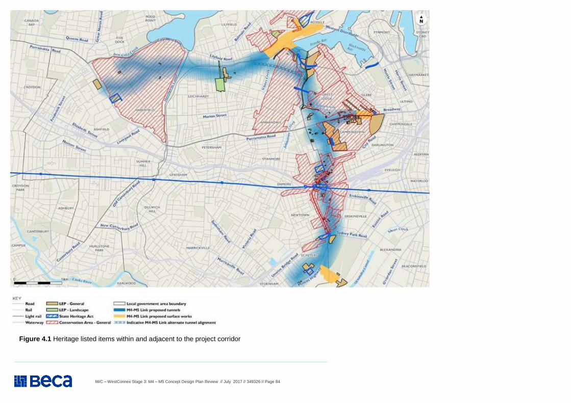
IWC – WestConnex Stage 3: M4 – M5 Concept Design Plan Review // July 2017 // 349326 // Page 84
Figure 4.1 Heritage listed items within and adjacent to the project corridor
IWC – WestConnex Stage 3: M4 – M5 Concept Design Plan Review // July 2017 // 349326 // Page 85
WestConnex M4 – M5 Concept Design Plan Review – SOCIAL, ECONOMIC, HERITAGE AND PROPERTY
Item Background information and source Review comment
4. Social, Economic, Heritage and Property (co nstruction and operation) – Cont.
4.22
Application (SSIAR) - Non-Aboriginal heritage - Proposed further assessment The project would be designed and constructed to avoid and/or minimise any impacts to areas of heritage value wherever feasible, and to avoid direct impacts to items listed on the State Heritage Register. Further investigation of the potential impacts on non-Aboriginal heritage items would be undertaken and presented in the environmental impact statement. This would include: � Updated searches of non-Aboriginal heritage databases and a review of literature relating to
heritage within the project corridor; � An assessment of significance for known State and local heritage items within the project corridor
in accordance with the Burra Charter (ICOMOS, 2013) and the Assessing Heritage Significance, NSW Heritage Manual 2, 2001 (NSW Heritage Office, 2001) and Statements of Heritage Impact, 1996 (NSW Heritage Office, 1996);
� Pedestrian survey of areas around the surface elements, to identify additional buildings or items that may be of heritage significance and may not have been included in LEP listings;
� Assessment of potential impacts to items of local and state heritage significance, including consideration of construction vibration impacts and predictions of settlement associated with tunneling works and permanent impacts such as altered historical arrangements and access, landscapes and vistas, and architectural noise treatments;
� An archaeological assessment, where required, to determine the presence of potential non-Aboriginal archaeological items and the potential impacts as a result of the project. The need for an archaeological assessment would be determined based on the outcomes of the literature review, the investigations detailed above and the nature of the potential impact. It may include archaeological test excavations;
� Consultation with the relevant stakeholders such as the Office of Environment and Heritage and local councils; and
� Management measures to minimise impacts to identified non-Aboriginal heritage values.
IWC expects that the commitments made and conditions described in the SSIAR be closely followed-through and comprehensively addressed in the EIS.
4.23
Application (SSIAR) - Non-Aboriginal heritage - Management and safeguard measures Avoidance of direct impacts on heritage items would be sought during the project corridor design development process. Ground borne vibration would be managed by strict adherence to limits set to prevent impacts to heritage structures. Standard management and safeguard measures would be considered through the design development process for the preferred project design and preparation of the Environmental Impact Statement including the implementation of stop works and referral procedures in the event of unexpected finds of non-Aboriginal heritage items.
IWC expects that the commitments made and conditions described in the SSIAR be closely followed-through and comprehensively addressed in the EIS.
IWC – WestConnex Stage 3: M4 – M5 Concept Design Plan Review // July 2017 // 349326 // Page 86
WestConnex M4 – M5 Concept Design Plan Review – SOCIAL, ECONOMIC, HERITAGE AND PROPERTY
Item Background information and source Review comment
4. Social, Economic, Heritage and Property (co nstruction and operation) – Cont.
4.24
Application (SSIAR) - Aboriginal heritage - Overview The project corridor is located within the traditional country of the Darug (also spelt Dharuk, Dharruk, Dharug and Daruk) language group. Darug territory extended from the Hawkesbury River in the north, to Appin in the south, and west into the Blue Mountains, an area which incorporates some of the oldest archaeological sites in the Sydney region (Attenbrow 2010: 18-19). As to the names and distribution of clans across the Sydney region, very little information on this subject exists.
IWC expects that the commitments made and conditions described in the SSIAR be closely followed-through and comprehensively addressed in the EIS.
4.25
Application (SSIAR) - Aboriginal heritage - Potential impacts Construction Direct or indirect impacts on previously recorded AHIMS sites are not anticipated given the review undertaken did not identify any registered sites within the project corridor. However, there is potential for previously unrecorded Aboriginal sites to be identified and impacted by the project as a result of excavation at surface work locations, particularly in areas of archaeological sensitivity such as tidal estuarine foreshore zones and former tributaries of Port Jackson. The risk of impacts to Aboriginal sites is likely to be low given that most of the project would be located greater than 20 metres below ground. This risk is further mitigated by the disturbed and highly urbanised environment along most of the project corridor.
IWC expects that the commitments made and conditions described in the SSIAR be closely followed-through and comprehensively addressed in the EIS.
4.26
Operation The project would be designed and constructed to minimise the potential for direct and indirect impacts on the known Aboriginal heritage sites, therefore potential direct or indirect impacts on Aboriginal sites are not anticipated during operation. The potential impact on Aboriginal heritage and identification of management measures would be determined during the preparation of the environmental impact statement.
IWC expects that the commitments made and conditions described in the SSIAR be closely followed-through and comprehensively addressed in the EIS.
IWC – WestConnex Stage 3: M4 – M5 Concept Design Plan Review // July 2017 // 349326 // Page 87
WestConnex M4 – M5 Concept Design Plan Review – SOCIAL, ECONOMIC, HERITAGE AND PROPERTY
Item Background information and source Review comment
4. Social, Economic, Heritage and Property (co nstruction and operation) – Cont.
4.27
Application (SSIAR) - Aboriginal heritage - Proposed further assessment An Aboriginal cultural heritage assessment report would be prepared for the project, including completion of at least stage 2 of the Roads and Maritime Procedure for Aboriginal Cultural Heritage Consultation and Investigation (PACHCI) (Roads and Maritime, 2011). The Aboriginal cultural heritage assessment report would include but not be limited to: � An archaeological survey of the project area to identify known and potential Aboriginal objects,
places and cultural values; � A review of relevant plans or diagrams showing the location of the project in relation to known
and potential Aboriginal objects, places or cultural values; � An assessment of significance of known and potential Aboriginal objects, places and cultural
values; � An assessment of known and potential impacts to Aboriginal objects, places and cultural values
resulting from the construction and implementation of the project; � If advancing to Stage 3 of the PACHCI, consultation with the Aboriginal community in accordance
with that guideline. If advancing to Stage 3, consultation with the Aboriginal community would occur in accordance with the Aboriginal Cultural Heritage Consultation Requirements for Proponents (DECCW, 2010a); and
� Identification of mitigation measures required to minimise impacts of the project on Aboriginal cultural heritage.
IWC expects that the commitments made and conditions described in the SSIAR be closely followed-through and comprehensively addressed in the EIS.
4.28
Application (SSIAR) - Aboriginal heritage - Management and safeguard measures Standard management and safeguard measures would be considered through the design development process for the preferred project design and preparation of the Environmental Impact Statement including the implementation of stop works and referral procedures in the event of unexpected finds of Aboriginal heritage items.
IWC expects that the commitments made and conditions described in the SSIAR be closely followed-through and comprehensively addressed in the EIS.
IWC – WestConnex Stage 3: M4 – M5 Concept Design Plan Review // July 2017 // 349326 // Page 88
WestConnex M4 – M5 Concept Design Plan Review – SOCIAL, ECONOMIC, HERITAGE AND PROPERTY
Item Background information and source Review comment
4. Social, Economic, Heritage and Property (co nstruction and operation) – Cont.
4.29
M4 – M5 Concept P lan – Property and handover of infrastructure There are a number of references in the document for example:
� Locate construction vehicle access points away from residences and minimise the need for trucks in residential areas;
� Construction buildings to create noise barrier and lighting spill to be controlled; � Surface work hours standard construction hours; � M4-M5 Link to continue to use Campbell Road M5 construction site; � Removal of on/off ramps at Camperdown; � Construction site between Parramatta Road, Pyrmont Bridge Road and Mallett
Street- truck routes and impacts on Bridge Road School and nearby houses still to be addressed. Likely an acoustic shed will be built to mitigate noise;
� Confirm not using Kennards storage , Booth Street, Annandale or Johnston or Booth Streets as haulage routes;
� 7 Darley Street- possible construction site to be assessed as part of EIS; � Continued use of M4 construction site at Wattle Street and Walker Avenue,
Haberfield; � Construction site and realign Victoria Road.
There are a number of infrastructure items and open space areas which will be developed as part of the project and are likely to be transferred to Council upon completion. Given that Council may take responsibility for maintenance, management and ongoing operation of these items such as the Rozelle Railyards parkland, active transport bridges, lighting, landscaping and fittings, Council requests involvement in accepting detailed design and construction of these items prior to finalisation of detail design. The boundaries of the construction sites such as along Victoria Road adjoin residential properties in some locations. Construction interfaces with residential areas need to manged including ensuring that residential car parking on streets is maintained and that, in the case of the Victoria Road sites where street closures may occur, convenient and safe traffic access is provided for these residents. IWC expects to be engaged in negotiations that will lead to an infrastructure hand-over contract with SMC for all infrastructure that will eventually be owned, maintained and/or managed by IWC. IWC requests background information detail design and an opportunity for input on life-cycle asset management for these infrastructure items prior to the finalization of detail designs. For the Rozelle recreation area, Council expects this will be delivered to Council fully constructed by the NSW Government. All these matters need to be comprehensively addressed in the EIS.
IWC – WestConnex Stage 3: M4 – M5 Concept Design Plan Review // July 2017 // 349326 // Page 89
WestConnex M4 – M5 Concept Design Plan Review – AIR QUALITY
Item Background information and source Review comment
5. Air quality (construction and operation) 5.1
Application (SSIAR) - Monitoring Air quality monitoring stations have also been established to support the proposed M4 East and New M5 projects, and these will also provide information that is relevant to the M4-M5 Link project. Additional project- specific monitoring stations will be established for the project itself.
IWC requests that project-specific air monitoring stations be installed all ventilation outlets, as well as air quality monitoring for the road network - envisaged to be affected by an increase in traffic. This should include:
� CEMP monitoring requirements and management actions, particularly for dust generated from stockpiles / construction sites;
� PM10, PM2.5, CO, NO2 / NOx, VOC’s monitored during baseline and as part of CEMP monitoring requirements during construction and operation. Dust gauges and automatic air quality stations to be considered.
� Monitoring / analysis according to DECC 2005 guidelines and certification for real-time systems, including public access to real-time monitoring data online.
5.2
In-tunnel air quality As vehicles are the primary source of air quality emissions, the level of emissions from the project would be affected by the length of the tunnel(s), its grade and the mix of vehicles travelling through the tunnel. Maintaining a free flow of traffic in the tunnel(s) would also be a significant factor in minimising the emissions generated by vehicles using the project. The NSW Government has appointed an Advisory Committee on Tunnel Air Quality (the Advisory Committee) to review current international best practice and experience from Australian motorway tunnels. The committee will: � Review and set performance standards for road tunnel emissions � Recommend appropriate monitoring, compliance and reporting
mechanisms to support public confidence in the operation of road tunnels
� Provide ongoing advice to the NSW Government on air quality issues. Roads and Maritime Services will consult with the Advisory Committee and other relevant agencies concerning appropriate in-tunnel air quality criteria and to confirm the air quality assessment methodology.
Ongoing in-tunnel ventilation modelling and assessment refer to state and national best practice. No recognition of Tunnel Air Quality Advisory Committee work on international best practice is mentioned. Refer to SEARS below items 2d and 2e specifically:
SEARS – 3 May 2017 – Cont. (Application Number - SSI 16 7485) The Desired Performance Outcomes (DPO) points in the SEARS are listed below as an issue. Key Issue SEARs - Point 2 – Air Quality – The project is designed, constructed and operated in a manner that minimises air quality impacts (including nuisance dust and odour) to minimise risks to human health and the environment to the greatest extent practicable. Requirement 1: The Proponent must undertake an air quality impact assessment (AQIA) for construction and operation of the project in accordance with the current guidelines. Requirement 2: 2. The Proponent must ensure the AQIA also includes the following: ((a) to (k) as in SEARS).
IWC expects that these requirements and guidelines in Item 5.3 be closely followed. All commitments made and conditions described in the SSIAR should be followed-through and comprehensively addressed in the EIS.
5.3
Local air quality – surface roads At a local level, air quality effects would be influenced by the emissions associated with vehicles on surface roads and in tunnels. The reduction in traffic congestion along surface roads has the potential to deliver air quality improvements to areas along key arterial roads. These local effects would be the subject of further investigation.
See Item 5.1 above. Assessment guidelines to include: Approved Methods for the Modelling and Assessment of Air Pollutants in New South Wales (DEC, 2005); Technical Framework – Assessment and Management of Odour from Stationary Sources in NSW (DEC, 2006); In-Tunnel Air Quality (Nitrogen Dioxide) Policy (Advisory Committee on Air Tunnel Air Quality, 2016); Liaison with health risk assessors recommended as per Item 5.6, and The potential impact and mitigation measures to inform a CEMP
IWC – WestConnex Stage 3: M4 – M5 Concept Design Plan Review // July 2017 // 349326 // Page 90
WestConnex M4 – M5 Concept Design Plan Review – AIR QUALITY
Item Background information and source Review comment
5. Air quality (construction and operation) – Cont.
5.4
Local air quality – ventilation facilities The project would require ventilation facilities for the tunnel. Well-designed ventilation facilities are very effective at dispersing tunnel emissions and are expected to be an important component of the final ventilation design solution. The locations of ventilation facilities, including outlets, would be subject to further design development, except for the western portals, which would utilise the ventilation facility that would be constructed as part of the proposed M4 East project at Haberfield. Other ventilation facilities would most likely be located close to the tunnel portals at Rozelle, Camperdown and St Peters.
SEARS – 3 May 2017 – Cont. (Application Number - SSI 16 7485) The Desired Performance Outcomes (DPO) points in the SEARS are listed below as an issue. Key Issue SEARs - Point 3 – Health and Safety – Requirement 1: The Proponent must assess the potential health impacts of the project, in accordance with the current guidelines. Requirement 2: 2. The assessment must: ((a) to (f) as in SEARS). See also comments as per Item 5.3 above
Section 7 of the M4–M5 Link Concept Design maps two of the total four ventilation facilities within the IWC boundary (Wattle Street, Haberfield and St Peters Interchange, St Peters). Specific locations, numbers of outlets and outlet dimensions and aesthetic treatments need to be confirmed. Commitment to no measurable air quality impacts at ground level will need to be justified in the EIS.
Assessment of elevated ventilation impacts to air quality during a full range of climatic conditions would be essential. Plume fate would need to be quantified for these scenarios.
Ambiguity surrounding location and activities for construction site at Leichardt / Lilyfield and therefore potential air quality impacts / mitigation measures.
5.5
Treatment of emissions Air pollution control technology has been used in a limited number of tunnels in a few countries including Norway, Austria, Germany and Japan as well as the M5 East Motorway tunnel trial in Sydney. A range of solutions to manage in-tunnel air quality would be considered during the design of the project including, but not limited to, ventilation (including number, size and position of outlets) and air treatment technologies.
See Items 5.1 to 5.4 above for details of ventilation facilities. IWC expects that the commitments made and conditions described in the SSIAR are followed-through and comprehensively addressed in the EIS.
5.6
Proposed further assessments A detailed air quality and human health risk assessment would be prepared to provide (as a minimum) assessment of the impacts of both construction and operation of the project in comparison with the “Do Nothing” scenario.
The EIS requirements are covered in Section 3 Health and Safety point 2c of the SEARS (as indicated in Item 5.4 above). The air quality modelling outputs undertaken as part of the EIS process would need to align with the specific requirements of the human health assessment. As such, IWC would recommend that independent air quality and health risk assessors be provided by SMC and full consultation be allowed in developing required air quality outcomes this project.
IWC – WestConnex Stage 3: M4 – M5 Concept Design Plan Review // July 2017 // 349326 // Page 91
WestConnex M4 – M5 Concept Design Plan Review – CONTAMINATION, FLOODING & WATER MANAGEMENT
Item Background information and source Review comment
6. Contamination, flooding & water management
6.1
Application (SSIAR) - Soil and Water Quality - Overview Topography The project corridor is low lying, with gentle undulating hills with elevations of up to around 35 metres Australian height datum (AHD). The undulation is most prominent in the section of the project corridor which runs from Haberfield to Rozelle, traversing across small valleys with associated creeks and canals which drain into Sydney Harbour. These waterways include Iron Cove Creek, Hawthorne Canal, Whites Creek, Johnstons Creek and Orphan School Creek.
Within and around the Rozelle Rail Yards is a dense drainage network of roads receiving stormwater runoff (see Item 6.6 for additional comments).
6.2
Soils Soils within the project corridor are identified from the Soil Landscapes of the Sydney 1:100,000 Sheet (Chapman, G.A and Murphy, C.L., 1989). The section of the project corridor between Haberfield and Rozelle, and south to Camperdown, comprises an interchanging mix of Blacktown, soil landscapes. These soil landscapes are Blacktown, Gymea and Disturbed Terrain. The project corridor between Camperdown and connections to St Peters Interchange is predominantly comprised of the Blacktown soil landscape.
It is expected that soils in and around the Rozelle Rail Yards would have low to intermediate erosion risk.
6.3
Geology The Hawkesbury Sandstone extends beneath the Greater Sydney region, forming the basement rock along the proposed M4-M5 Link alignment. The Hawkesbury Sandstone is overlain by the Ashfield Shale between St Peters and Camperdown, and again along the higher topographies in Annandale and Leichhardt. A relatively thin band of Mittagong Formation may be present between the Hawkesbury Sandstone and Ashfield Shale.
6.4
Contamination There are a number of current and former land uses within the project corridor which may have resulted in contamination. These include industry, rail (including maintenance) and service stations. As the development of the design progresses the likelihood that these areas would be affected would be known and approaches to mitigate impacts would be developed. There are eight known contaminated sites within 500 meters of the project corridor listed on the Environment Protection Authority’s Contaminated Land record (EPA, 2014): � White Bay Power Station, Robert Street, Rozelle � Former Unilever Sulphonation Plant Reynolds Street, Rozelle � O’Dea Reserve, Salisbury Lane, Camperdown � Former Tidyburn Facility, 53 Barwon Park Road, St Peters � Alexandra Canal (sediments) � Macdonaldtown Triangle, Burren Street, Eveleigh � Former Service Station, 81 Wilson Street, Newtown � Land adjacent to Former Service Station, 79 Wilson Street, Newtown. The risk posed to the project corridor, and future construction activity, would be assessed as part of future investigations. The project corridor also traverses a number of rail corridors which have the potential to be contaminated by residual contamination or adjacent industrial uses. This includes the Rozelle Rail Yards.
A comprehensive contaminated land assessment is required, as described in the SEARS, Item 6.13 - Soils.
IWC – WestConnex Stage 3: M4 – M5 Concept Design Plan Review // July 2017 // 349326 // Page 92
WestConnex M4 – M5 Concept Design Plan Review – CONTAMINATION, FLOODING & WATER MANAGEMENT
Item Background information and source Review comment
5 Contamination, flooding & water management – Cont .
6.5
Water quality The catchments located within the project are identified in Section 4.8 (Flooding and drainage) of the SSAIR and include the Sydney Harbour and the Cooks River catchments.
The Cooks River Catchment is one of the most urbanised and degraded river systems in Australia. The catchment is home to almost 400,000 people with 130,000 dwellings and around 20,000 businesses. Stormwater has been identified as a key-contributing factor to water quality/quantity problems in the catchment. Present levels of pollutants make it unsafe for swimming, unsuitable for many aquatic species and a health risk for commercial fishing.
Sydney Harbour, together with its foreshores, headlands and tributaries is the city’s largest and most accessible open space and natural area. It is Sydney’s best loved urban space, a national icon, a busy transport corridor and an economic powerhouse for industry, commerce, trade and tourism. Sydney Harbour and its catchment have natural resource assets of national significance. The Environment Protection and Biodiversity Conservation Act (1999) identifies these assets to include three threatened ecological communities, 62 threatened species, 29 migratory species and 48 marine protected species. However, Sydney Harbour receives large pollutant loadings through the stormwater system and sewage overflows. The sediments still carry the toxic legacy of years of industrial discharges. Testing of fish and crustaceans revealed high levels of dioxins that resulted in a complete ban on all commercial fishing in Sydney Harbour in January 2006 (DPI 2012). IWC expects that the commitments made and conditions described in the SSIAR followed-through and comprehensively addressed in the EIS. It is important to IWC that SMC gains a thorough understanding of impacts on water quality as a result of this project.
IWC – WestConnex Stage 3: M4 – M5 Concept Design Plan Review // July 2017 // 349326 // Page 93
WestConnex M4 – M5 Concept Design Plan Review – CONTAMINATION, FLOODING & WATER MANAGEMENT
Item Background information and source Review comment
6 Contamination, flooding & water management – Cont .
6.6
Construction Construction of the project has the potential for the following soil, water and contamination related impacts: � Impacts to water and soils due to spills or leaks of fuels and / or oils from construction plant
and equipment and / or from vehicle / truck incidents � Impacts to water and soils due to spills or leaks of other hazardous substances and
dangerous goods from construction work and / or from vehicle / truck incidents � Exposure of soils during construction resulting in direct erosion impacts. This may lead to
dirty water runoff and sedimentation in local watercourses including Iron Cove Creek, Hawthorne Canal, Whites Creek, Johnston’s Creek, Orphan School Creek and Alexandra Canal, as well as downstream water bodies including Iron Cove, Rozelle Bay and Botany Bay. Sedimentation may also occur on adjacent land
� Generation of a net surplus of spoil as tunneling would comprise of a large component of the project. Construction of a tunnel within the project corridor would likely occur within the Ashfield Shale and Hawkesbury Sandstone geological units
� Interaction with quaternary aged sediments present within the project corridor may include soft clays and organic soils, loose silts and sands. These can pose a constraint to construction for reasons such as instability, low bearing capacity and settlement. These constraints are commonly encountered and established treatment options are available for structures, earthworks and pavements
� Disturbance of contaminated soils, especially if surface work is undertaken within land known to be contaminated, or on land which has been identified as potentially contaminated based on current and historic activities. Disturbance of contaminated soils has the potential to result in offsite pollution
� Exposure of soil containing acid sulfides to oxygen, resulting in the production of sulfuric acid, which may become bioavailable in the environment and affect local aquatic ecosystems, water quality and visual amenity
� Interaction with the former Alexandria Landfill, which would be closed as part of the New M5 project (subject to planning approval). Construction areas for the project would be subject to land forming as part of the New M5, and considerations of any potential interactions with capping, leachate collection or gas collection systems would need to be considered during construction.
A Construction Environmental Management Plan, informed by the findings of the EIS, should be developed by the principal construction contractor, or its representatives. This should include (but not be limited to) methods to prevent / minimise impacts to the receiving environment during construction as per guidelines (e.g. DIPNR, 2004). In particular, sedimentation ponds at Rozelle Rail Yards will need to be sized and designed according to Blue Book Guidelines.
Consideration for construction timing and the impact of seasonal rainfall on the site should be made including ensuring an adequate erosion and sediment control plan (Section 6.2.3 Requirement 6) designed by a IESC-trained practitioner and adequate ‘dirty’ water storage capacity on-site (Section 6.2.1 Requirement 1).
Generation, storage and transfer of potentially contaminated excavated material at Parramatta Rd / Pyrmont Bridge / Mallet Street and Rozelle Rail Yard construction sites.
Particular attention should be paid to the control of potentially contaminated runoff at the Northcote St / Wattle St construction site given the proximity of Iron Cove Creek approximately 300m away and Rozelle Victoria Rd construction. This is given the steep decline and proximity of the Parramatta River - approximately 200m down-gradient. This would include defined separation, storage and treatment between the ‘clean’ (i.e. background urban) stormwater runoff and ‘dirty’ stormwater generated from the site.
Potential tunnel construction site at Rozelle Rail Yard. This will need to be confirmed prior to the EIS for full impact assessment.
IWC – WestConnex Stage 3: M4 – M5 Concept Design Plan Review // July 2017 // 349326 // Page 94
WestConnex M4 – M5 Concept Design Plan Review – CONTAMINATION, FLOODING & WATER MANAGEMENT
Item Background information and source Review comment
7 Contamination, flooding & water management – Cont .
6.7
Operation Potential impacts during operation would include: � Impact to water quality of receiving watercourses due to the discharge of treated groundwater and other waste
waters (such as tunnel wash or deluge system water). The discharge would likely be into a local watercourse, such as Iron Cove Creek, Hawthorne Canal, Whites Creek, Johnston’s Creek, Orphan School Creek, or Alexandra Canal. This could have an impact on the water quality of the receiving waterway, depending on the discharge volumes, treatment and the point of discharge;
� Impact to water quality of receiving watercourses due to increased runoff from roads. This would typically contain oils and greases, petrochemicals and heavy metals as a result of vehicle leaks, operational wear, road wear and atmospheric deposition. Increased flows could also lead to increased potential for scouring of soils and watercourses;
� Spills or leaks of fuels and / or oils from vehicle accidents, or from operational plant and equipment.
Newtown / St Peters, Haberfield, Rozelle Rail Yard and Rozelle Victoria Rd open space areas (Section 8, 11, 12 and 13 of the M4 – M5 Link Concept Design Plan) should seek opportunities for additional water treatment to improve water quality discharged into the stormwater system such as Sustainable Urban Drainage Design.
As per Section 11 of the Concept Design Plan, improvement to Whites Creek flooding issue should be investigated as part of the EIS.
6.8
Proposed further assessments Geotechnical investigations would inform the design of the tunnel and therefore the expected quantities of spoil from tunnelling activities (refer to Section 4.10 of SSAIR for additional information related to resource management and waste). The quantity of spoil would also depend on the tunnelling technique adopted for the project. Spoil management is discussed further in Section 4.10. The environmental impact statement for the project would also include: � Identification of waterways and groundwater systems that may be impacted by the construction and operation
of the project � Assessment of the potential impacts to soil and water, including field investigations � Assessment of the risk of erosion and sedimentation in accordance with Roads and Maritime’s Erosion and
Sedimentation Management Procedure (Roads and Maritime, 2008) � Likely groundwater discharge volumes into local watercourses during construction and operation, and the
associated impacts on water quality. Associated impacts on biodiversity values are considered in Section 5.4. � Assessment of potential settlement along the tunnel alignment and the potential impacts to structures and
infrastructure � Identification of areas of known contamination or with potential contamination (soil and groundwater) that could
be impacted by the project, and the potential impacts associated with the disturbance of these areas. This would be supported by further investigations to identify, quantify and assess the contamination.
Estimates of spoil will form an important component of the CEMP. Avoiding surface storage of disturbed soils is essential, especially for sonic / dispersible soils with high propensity to become dislodged and enter water systems.
These assessments should be conducted according to Section 10, 11 and 13 of the SEARS.
Important links to Biodiversity (Section 6 of the SEARS) should be explored in terms of water quality impacts.
IWC expects that the commitments made and conditions described in the SSIAR are followed-through and comprehensively addressed in the EIS to fully understand the project’s impact on water quality and soils.
IWC – WestConnex Stage 3: M4 – M5 Concept Design Plan Review // July 2017 // 349326 // Page 95
WestConnex M4 – M5 Concept Design Plan Review – CONTAMINATION, FLOODING & WATER MANAGEMENT
Item Background information and source Review comment
6 Contamination, flooding & water management – Cont .
6.9
Application (SSIAR) - Flooding and drainage - Overview The project corridor is located within the Sydney Harbour catchment (specifically, the Parramatta River and Port Jackson sub-catchments) and the Cooks River catchment. However, the majority of surface works would be located in the Sydney Harbour catchment, with only limited works proposed within the Cooks River catchment at the St Peters interchange. Key waterways located within and adjacent to the project corridor are shown on Figure 6.1 . Tributaries of Sydney Harbour located within the project corridor include: � Iron Cove Creek (also known as Dobroyd Canal); runs along part of the northern project corridor boundary at the western
end of the project corridor (tunnel section). Iron Cove Creek drains into Iron Cove � Hawthorne Canal; traverses the project corridor (tunnel section) in the vicinity of Blackmore Park, Leichhardt. Hawthorne
Canal Creek drains into Iron Cove � Whites Creek; traverses the project corridor (at Rozelle interchange) in the vicinity of Rozelle Bay. Whites Creek drains
into Rozelle Bay � Johnston’s Creek; traverses the project corridor (tunnel section) in the vicinity of Harold Park, Annandale. Johnston’s
Creek drains into Rozelle Bay � Orphan School Creek; traverses the project corridor just north of Camperdown interchange. Orphan School Creek drains
into Johnston’s Creek.
In designing Newtown / St Peters and Haberfield and Rozelle Rail Yard and Rozelle Victoria Rd open space areas (Section 8, 11, 12 and 13 Concept Plan), SMC should seek opportunities for additional water storage to improve water quantity discharged into the stormwater system such as Sustainable Urban Drainage Design. For the St Peters area, this would need to also be incorporated into the New M5 UDLP.
6.10
Construction Construction of the project has the potential to result in the flooding impacts: � Changes to local overland flows and existing minor drainage paths through the disruption of existing flow mechanisms,
both of constructed drainage systems or those of overland flow paths � Changes to flooding regimes from construction work and/or from the position of temporary construction infrastructure and
compounds.
SMC will need to assess potential flooding issues a t both the nominated Annandale / Camperdown and Rozelle Rail Yards construction sites, with referen ce to former Leichhardt Council’s Flood Risk Management Study, 2013.
6.11
Operation Operation of the project has the potential to result in the flooding impacts: � Increased impervious surfaces and/or changes to the total catchment area of existing drainage infrastructure due to
surface work at tunnel portals and tie-ins to existing roads. If the capacity of the drainage system is not adequate this could lead to localised flooding. Considerable increases to runoff at these locations could potentially require upgrades to existing drainage infrastructure, and may require additional mitigation measures (such as stormwater drainage basins and the like)
� Potential obstruction to flood flows as a result of new infrastructure or a reduction in flood plain area, which could have an impact downstream flooding behaviour or on nearby existing developments.
Assessment should be conducted according to Section 12 of the SEARS - see Item 6.23. Climate change should be incorporated into the flood modelling scenarios, especially for those sites close to Sydney Harbour and therefore susceptible to tidal surge. Future increased rainfall intensity patterns should also be incorporated. An evaluation of fitness for purpose of current / proposed drainage infrastructure is also needed.
6.12
Proposed further assessments The environmental impact statement for the project would include an assessment of the flooding and drainage impacts associated with the project. � Potential flooding impacts during construction � Potential flooding impacts during the operation of the project. The assessment would consider the 100 year ARI event
and the Probable Maximum Flood (PMF) � Operational drainage infrastructure required to convey stormwater flows � Required alterations to existing road drainage infrastructure in the vicinity of surface work at tunnel portals and tie-ins to
existing roads � Required connections to third party stormwater systems for operational surface ancillary facilities
See climate change comment in Item 6.11.
Assessment should be conducted according to Section 12 of the SEARS - see Item 6.23. IWC expects that the commitments made and conditions described in the SSIAR will be followed-through and comprehensively addressed in the EIS.
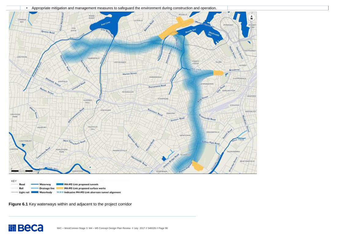
IWC – WestConnex Stage 3: M4 – M5 Concept Design Plan Review // July 2017 // 349326 // Page 96
Figure 6.1 Key waterways within and adjacent to the project corridor
� Appropriate mitigation and management measures to safeguard the environment during construction and operation.
IWC – WestConnex Stage 3: M4 – M5 Concept Design Plan Review // July 2017 // 349326 // Page 97
WestConnex M4 – M5 Concept Design Plan Review – CONTAMINATION, FLOODING & WATER MANAGEMENT
Item Background information and source Review comment
6 Contamination, flooding & water management – Cont .
6.13
Application (SSIAR) - Groundwater - Overview Groundwater along the project corridor is present within the Ashfield Shale and underlying Hawkesbury Sandstone, although the Ashfield Shale is not always present along the project corridor. Groundwater levels within the two main geological units are variable but typically the shape of the regional water table is a subdued reflection of the topography with the water table being deepest beneath hills and shallowest beneath creeks or gullies. While former industrial uses have increased the groundwater contamination potential in the vicinity of St Peters within the project corridor, the potential for groundwater contamination also exists in the vicinity of Rozelle Bay. The edges of Rozelle Bay have been subjected to uncontrolled historical filling of generally gravelly sand but could also contain hazardous materials. The fill material is typically a wedge that increases towards the Harbour. The fill is recharged by direct rainfall and runoff and groundwater from the adjacent Hawkesbury Sandstone. Based on the proximity to Sydney Harbour, groundwater levels around Rozelle Bay would be expected to be around one or two metres below ground level. Groundwater in this area would therefore discharge directly into Sydney Harbour. There is potential that the fill, if hazardous, may have resulted in the contamination of the groundwater in the vicinity of Rozelle.
A comprehensive assessment of groundwater potential impacts and mitigation measures should be conducted according to Section 10 and 11 of the SEARS - see Items 6.21 and 6.22.
Only limited exposure of Wianamatta Group shales occur within the Sydney Coastal region, these aquifers are not well understood in this region. Therefore, they should not necessarily be discounted as unimportant. Council areas with minor exposures of Wianamatta Group shales are in the Sydney region, including Leichhardt.
Particular attention should be paid to contaminated groundwater and site dewatering requirements for the Rozelle Bay Rail Yard site.
IWC expects that the commitments made and conditions described in the SSIAR will be followed-through and comprehensively addressed in the EIS to fully understand the project’s impacts on water quality and soils
6.14
Construction Groundwater is likely to be encountered during construction as tunnelling activities move through the underlying shales and into the Hawkesbury Sandstone. As such, discharge of treated groundwater from tunnel construction work will be required. The rates and magnitude of groundwater infill are anticipated to be similar to other recent tunnelling projects undertaken in the Sydney Basin, including the Eastern Distributor, Cross City Tunnel, and M5 East Motorway tunnels. There is potential for groundwater to be contaminated due to anthropological fill in the areas of St Peters and Rozelle. Groundwater infill will therefore require treatment prior to discharge. It is likely that groundwater encountered by tunnelling activities would be discharged to a local watercourse as surface water. Alternatively, groundwater may be discharged to sewer under a trade waste agreement.
Particular attention should be paid to contaminated groundwater and site dewatering requirements for the Rozelle Bay Rail Yard site.
An assessment of impacts to the surface water environment would be required to demonstrate that there would be no significant deterioration in water quality from treated discharges of potentially contaminated groundwater. Failing this, a trade waste agreement would be required, with both the quantity and quality of the dewatered ground to be provided to the water utility. In this case, opportunities to link the water to a sewer mains at each construction site should be considered.
6.15
Operation Should the final design include a drained tunnel, there is the potential for contaminated groundwater to be intercepted as part of ongoing groundwater inflow. The extent of potential impact, if any, on existing bores, would be considered in the environmental impact statement for the project.
Interaction between groundwater and stormwater are not mentioned in the SEARS. We recommend that a comprehensive assessment of potential changes to water quality be developed as part of the EIS process. This would be based on no connectivity between different aquifer groups and the surface water environment.
IWC – WestConnex Stage 3: M4 – M5 Concept Design Plan Review // July 2017 // 349326 // Page 98
WestConnex M4 – M5 Concept Design Plan Review – CONTAMINATION, FLOODING & WATER MANAGEMENT
Item Background information and source Review comment
6 Contamination, flooding & water management – Cont .
6.16
Proposed further assessments Geotechnical, groundwater, and preliminary contamination investigations would be conducted to inform the design process and the environmental impact statement. These investigations would identify the ground conditions for tunnelling across the project corridor, including further understanding of the hydrogeological conditions (such as water level and quality) and other areas across the project corridor likely to experience increased rates of ingress (such as at interchange locations). The results of these investigations would be used to undertake a groundwater impact assessment, which would consider local and regional hydrology impacts along the length of the project, and would include: � A review of historical data held for local groundwater levels and quality, with consideration of any
supplementary data collected specifically for the project, or other components of the WestConnex program of works
� Estimates of groundwater inflow and the extent of drawdown that would occur, including cumulative impacts of the proposed M4 East and New M5
� Consideration of the Greater Metropolitan Region Groundwater Sources Water Sharing Plan and the NSW Aquifer Interference Policy (Office of Water, 2012b)
� Characterisation of the water quality of groundwater inflows along the tunnel to inform treatment requirements for potential discharge to surface water
� Characterisation of potential mobilisation of saline groundwater, contaminated groundwater and exposure of acid sulfate spoils, and the associated impacts
� Impacts to existing groundwater users, surface water features and groundwater dependent ecosystems
� Identification of management measures during construction and operation.
Assessments to be conducted in accordance with Sections 10 and 11 of the SEARS - see Items 6.21 and 6.22.
IWC – WestConnex Stage 3: M4 – M5 Concept Design Plan Review // July 2017 // 349326 // Page 99
WestConnex M4 – M5 Concept Design Plan Review – CONTAMINATION, FLOODING & WATER MANAGEMENT
Item Background information and source Review comment
6 Contamination, flooding & water management – Cont .
6.17
Application (SSIAR) - Resource management and waste minimisation - Overview Resource management and waste minimisation would be considered throughout various stages of the project from design and construction through to operation. Large quantities of materials would be required for the construction of the project such as concrete, asphalt, steel, gravel, sand, aggregate and road base. This would need to be sourced from quarries, manufactures and suppliers, which would generally be from areas outside the project corridor. Waste associated with the project would be generated from a number of streams including: Excavation waste; Demolition waste; Wastewater; Hazardous waste; Vegetation waste; Liquid waste; Construction waste, and General waste.
These issues should be addressed as part of Section 15 Sustainability and Section 16 Waste of the SEARS- see Items 8.1 and 8.2.
6.18
Construction Impacts associated with resource use and waste generation are likely to be predominantly associated with the construction of the project. These include: � Potential impact on resource availability as a result of resource use requirements for the project. � Generation of waste during construction of the project, including:
o Demolition wastes from existing structures that require removal o Excavated wastes, such as soil and rock, primarily from tunneling and cutting o Depending on the final locations of excavation activities, these wastes are expected to be largely characterized as
Virgin Excavated Natural Material although contaminated spoil may be generated Vegetation waste from the removal of trees, shrubs and ground covers that are unable to mulched and reused within the project
o Packaging materials such as crates, pallets, cartons, plastics and wrapping materials o Surplus construction material and general site reinstatement such as fencing, sediment, concrete, steel, formwork and
sand bags o Site compound waste such as liquid wastes from cleaning, repairing and maintenance, waste from spillages, fuel or oil
waste, effluent from site amenities and general office wastes.
These issues should be addressed as part of Section 15 Sustainability and Section 16 Waste of the SEARS. See Items 8.1 and 8.2.
A remediation action plan should be developed for construction sites, with agreement on objectives / targets for any residual contamination (both legacy and project-related).
6.19
Operation The operation of the project has the following resource use and waste management related impacts: � Generation of wastes from operational maintenance and repair activities required over the life of the project.
The type and volume of wastes generated would be dependent on the nature of the activity, but would predominantly consist of green waste, oil, road materials, as well as contaminated waste resulting from potential fuel spills and leaks;
� Supply of water for the deluge system, which would form part of the fire and life safety system; � Water used as part of the deluge system or for tunnel washing would be captured, and treated using the
groundwater inflow water treatment plant, prior to being discharged into the environment. This is discussed in Section 4.7 of the SSAIR (Soil and water quality);
� Litter generated by road users. With the implementation of standard work practices during routine maintenance and repair activities, the overall impact of operational waste streams and volumes would be minimal.
Mitigation measures for the operational phase will be included in Section 11 Water Quality and Section 16 Waste of the SEARS. See Items 6.22, 8.1 and 8.2.
IWC – WestConnex Stage 3: M4 – M5 Concept Design Plan Review // July 2017 // 349326 // Page 100
WestConnex M4 – M5 Concept Design Plan Review – CONTAMINATION, FLOODING & WATER MANAGEMENT
Item Background information and source Review comment
6 Contamination, flooding & water management – Cont .
6.20
Proposed further assessments The environmental impact statement would provide further details on waste and resource management for the project, including: � Estimates of the quantity of spoil that would be generated � Identification of a management hierarchy to reduce the volume of excess spoil generated by the project, such
as through design, through use within the project, or use in other projects � Identification of the approximate resource requirements for the project, including estimation of the material and
water requirements � Identification of available materials in the region including from quarries, potential material suppliers, and reuse
of materials � Identification of available water supplies in the region and the locality (including recycled water) � Identification of specific waste impacts of the project and the waste management approach � Identification of management and mitigation measures for resource use and waste across the project including
potential spoil re-use and disposal sites and transport impacts. This includes strategies to minimising the export of excavated materials off-site, maximising re-use opportunities and minimising the volume of excavated material disposal to landfill
� Identification of opportunities to use recycled materials provided they are fit for purpose and meet engineering requirements.
IWC expects that the commitments made and conditions described in the SSIAR to be followed-through and comprehensively addressed in the EIS to fully understand the project’s impacts on water quality and soils.
IWC – WestConnex Stage 3: M4 – M5 Concept Design Plan Review // July 2017 // 349326 // Page 101
WestConnex M4 – M5 Concept Design Plan Review – CONTAMINATION, FLOODING & WATER MANAGEMENT
Item Background information and source Review comment
6 Contamination, flooding & water management – Cont .
6.21
SEARS – 3 May 2017 – Cont. (Application Number - SSI 16 7485) The Desired Performance Outcomes (DPO) points in the SEARS are listed below as an issue. Key Issue SEARs - Point 10 – Water Hydrology – Long term impacts on surface water and groundwater hydrology (including drawdown, flow rates and volumes) are minimised. The environmental values of nearby, connected and affected water sources, groundwater and dependent ecological systems including estuarine and marine water (if applicable) are maintained (where values are achieved) or improved and maintained (where values are not achieved). Sustainable use of water resources. Requirement 1: The Proponent must describe (and map) the existing hydrological regime for any surface and groundwater resource (including reliance by users and for ecological purposes) likely to be impacted by the project, including stream orders, as per the FBA.
Requirement 2: The Proponent must prepare a detailed water balance for ground and surface water including the proposed intake and discharge locations, volume, frequency and duration for both the construction and operational phases of the project.
Requirement 3: The Proponent must assess (and model if appropriate) the impact of the construction and operation of the project and any ancillary facilities (both built elements and discharges) on surface and groundwater hydrology in accordance with the current guidelines, including: ((a) to (f) as in SEARs).
Requirement 4: The Proponent must identify any requirements for baseline monitoring of hydrological attributes.
Requirement 5: The assessment must include details of proposed surface and groundwater monitoring.
Requirement 6: The proposed tunnels should be designed to prevent drainage of alluvium in the paleochannels.
Point 10 of the SEARS has implications for the proposed discharge of treated groundwater into the harbour at Rozelle Rail Yard.
Clarification as part of EIS is required that FBA is Framework for Biodiversity Assessment. An initial exercise in planning on footprint / land take and associated riparian buffer distances close to surface waters is recommended.
The water balance assessment should include consideration of construction site demand, opportunities for water recycling / beneficial reuse and dewatering.
Monitoring to include:
� Surface water flow volumes; � Groundwater levels; � Wetland / Sydney Harbour residence times / flushing
potential; � Surface water and groundwater quality; � Existing stormwater runoff quality.
IWC – WestConnex Stage 3: M4 – M5 Concept Design Plan Review // July 2017 // 349326 // Page 102
WestConnex M4 – M5 Concept Design Plan Review – CONTAMINATION, FLOODING & WATER MANAGEMENT
Item Background information and source Review comment
6 Contamination, flooding & water management – Cont .
6.22
SEARS – 3 May 2017 – Cont. (Application Number - SSI 16 7485) The Desired Performance Outcomes (DPO) points in the SEARS are listed below as an issue. Key Issue SEARs - Point 11 – Water – Quality – The project is designed, constructed and operated to protect the NSW Water Quality Objectives where they are currently being achieved, and contribute towards achievement of the Water Quality Objectives over time where they are currently not being achieved, including downstream of the project to the extent of the project impact including estuarine and marine waters (if applicable). Requirement 1: The Proponent must: ((a) to (i) as in SEARS). Requirement 2: The assessment should consider the results of any current water quality studies, as available, in the project catchment.
Groundwater-stormwater connectivity need to be considered as a potential route for contamination transfer.
IWC requests that a list of current studies be provided to the EIS authors. This would include various studies funded by IWC, Office of Water, DPI Water, Sydney Water and other relevant infrastructure applications and holders of ambient water Environmental Protection Licences.
6.23
SEARS – 3 May 2017 – Cont. (Application Number - SSI 16 7485) The Desired Performance Outcomes (DPO) points in the SEARS are listed below as an issue. Key Issue SEARs - Point 12 – Flooding – The project minimises adverse impacts on existing flooding characteristics. Construction and operation of the project avoids or minimises the risk of, and adverse impacts from, infrastructure flooding, flooding hazards, or dam failure. Requirement 1: The Proponent must assess and (model where required) the impacts on flood behaviour during construction and operation for a full range of flood events up to the probable maximum flood (taking into account sea level rise and storm intensity due to climate change) including: ((a) to (k) as in SEARS).
IWC requests clarification for the term ‘minimises’ in respect to flooding impacts.
Climate change should be incorporated into the flood modelling scenarios, especially for those sites close to Sydney Harbour and therefore susceptible to tidal surge.
IWC expects that the requirements in these SEARS will be followed-through and comprehensively addressed in the EIS to fully understand the project’s impacts on water quality and soils.
IWC – WestConnex Stage 3: M4 – M5 Concept Design Plan Review // July 2017 // 349326 // Page 103
WestConnex M4 – M5 Concept Design Plan Review – CONTAMINATION, FLOODING & WATER MANAGEMENT
Item Background information and source Review comment
6 Contamination, flooding & water management – Cont .
6.24
SEARS – 3 May 2017 – Cont. (Application Number - SSI 16 7485) The Desired Performance Outcomes (DPO) points in the SEARS are listed below as an issue. Key Issue SEARs - Point 13 – Soils – The environmental values of land, including soils, subsoils and landforms, are protected. Risks arising from the disturbance and excavation of land and disposal of soil are minimised, including disturbance to acid sulfate soils and site contamination. Requirement 1: The Proponent must verify the risk of acid sulfate soils (Class 1, 2, 3 or 4 on the Acid Sulfate Soil Risk Map) within the area likely to be impacted by, the project. Requirement 2: The Proponent must assess the impact of the project on acid sulfate soils (including impacts of acidic runoff offsite) in accordance with the current guidelines and detail the mitigation measures proposed to minimise potential impacts. Requirement 3: The Proponent must assess whether the land is likely to be contaminated and identify if remediation of the land is required, having regard to the ecological and human health risks posed by the contamination in the context of past, existing and likely (or potential) future land uses. Where assessment and/or remediation is required, the Proponent must document how the assessment and/or remediation would be undertaken in accordance with current guidelines. Requirement 4: The Proponent must assess whether salinity is likely to be an issue and if so, determine the presence, extent and severity of soil salinity within the project area. Requirement 5: The Proponent must assess the impacts of the project on soil salinity and how it may affect groundwater resources and hydrology. Requirement 6: The Proponent must assess the impacts on soil and land resources (including erosion risk or hazard). Particular attention must be given to soil erosion and sediment transport consistent with the practices and principles in the current guidelines. Requirement 7: The Proponent must assess the impact of any disturbance of contaminated groundwater and the tunnels should be carefully designed so as to not exacerbate mobilisation of contaminated groundwater and/or prevent contaminated groundwater flow.
IWC expects that the requirements in these SEARS will be followed-through and comprehensively addressed in the EIS to fully understand the project’s impacts on water quality and soils.
Future land uses to include recreational use for the open spaces to be created as part of the project.
IWC – WestConnex Stage 3: M4 – M5 Concept Design Plan Review // July 2017 // 349326 // Page 104
WestConnex M4 – M5 Concept Design Plan Review – NOISE AND VIBRATION
Item Background information and source Review comment
7 Noise and vibration (construction and operation)
7.1
Application (SSIAR) – Noise and Vibration Overview Due to the urban nature of the project corridor, the predominant noise source contributing to the existing noise environment is road traffic. In the north-western section of the corridor between Haberfield and Rozelle, key noise sources are Parramatta Road and City West Link. In the south-eastern section of the corridor, key noise sources are Parramatta Road, Princes Highway, Sydney Airport, and the T2 (Airport, Inner West and South). T3 (Bankstown) and T4 (Eastern suburbs and Illawarra) railway lines. A wide range of sensitive receivers are located within the project corridor, which include: � Residential properties � Parks and recreational areas, such as Easton Park at Rozelle, Buruwan
Park at Annandale, Federal Park at Glebe, Bicentennial Park at Glebe, and Sydney Park at St Peters
� Education facilities, including indoor and outdoor areas, such as the University of Sydney
� Hospitals, including the Royal Prince Alfred at Camperdown � Places of worship, such as the St Joseph’s Catholic Church at
Camperdown � Aged care facilities.
IWC requests identification of sensitive receivers to be included and assessed in the EIS, with process for evaluating of the sensitivity of these receivers to changing noise and vibration levels. IWC expects that the commitments made and conditions described in these SSAIRs be followed-through and comprehensively addressed in the EIS to fully understand the project’s noise and vibration impacts.
It is noted that the St Peters Interchange construction site is near residential and commercial / office premises. The Concept Design does not include any useful information about specific construction activities for construction sites at Leichardt, Lilyfield, Rozelle and Camperdown. It is therefore not possible to therefore potential noise and vibration impacts and mitigation measures. Detailed information needs to be included in the EIS.
7.2
Construction The construction of the project would likely result in the following noise and vibration issues: � Airborne noise from surface works including at the interchanges at
Rozelle, Camperdown and St Peters; � Airborne noise from construction ventilation systems, ancillary
construction facilities and any open cut sections of the project; � Ground-borne noise from tunneling and piling; � Potential vibration impacts on buildings near to surface works, or buildings
near to, or above, the tunnel alignment. This includes impacts to sensitive equipment located at the Royal Prince Alfred Hospital;
� Construction traffic noise from the use of heavy vehicles and construction equipment;
� Potential vibration impacts on buildings generated by blasting activities, which may be required depending on the geological conditions encountered; and
� Cumulative noise impacts where works with other WestConnex projects or other major projects may overlap. This includes Wattle Street interchange, St Peters interchange, and Sydney Metro.
Section 6 of the Concept Design mentions ‘noisy’ su rface works will generally be undertaken during standard operating hours, which are Mon-Fri 7am – 6pm, Saturday 8am – 1pm. More information is needed noise-generating activities a t night, especially construction vehicle movements to/from dive-sites and the Rozelle Rail Y ards. More information is also needed on appropriate mitigation measures for these. This is requested in Section 4 point 2e of the SEARS (Item 7.5). Section 6 of the Concept Design states that tunnell ing activities will occur continuously, i.e. 24 hours a day, 7 days a week. Mitigation measures for noise abatement, such as works staging and a 50m threshold for resident notification will need to be justified in EIS. A condition or dilapidatio n report is referred to in the Concept Design for pro perties within 50m, but no individual assessment of noise and vibration impacts is identi fied. Section 6 of the Concept Design gives a commitment to noise monitoring during construction. Details on a monitoring plan, thresholds / definiti ons for ‘noisy’ work and stop-work procedure in the event of an exceedance of these is required. Section 6 of the Concept Design states that the efficacy of noise barriers / acoustic sheds for tunnelling activities will be evaluated specifically for the Parramatta Rd / Pyrmont Bridge Rd / Mallet St construction site. Blasting activities are not specifically mentioned in Section 6 of the Concept Design. This matter
IWC – WestConnex Stage 3: M4 – M5 Concept Design Plan Review // July 2017 // 349326 // Page 105
WestConnex M4 – M5 Concept Design Plan Review – NOISE AND VIBRATION
needs to be identified and assessed, with considera tion given to sensitive locations and timing of these works.
Item Background information and source Review comment
7 Noise and vibration (construction and operation) – Cont.
7.3
Operation The project would result in the re-distribution of traffic within the road network surrounding the project, which would change the operational noise environment of existing surface roads. The project is likely to result in localised increases in road traffic noise at the following locations: � Areas adjacent to the proposed interchanges at Rozelle and Camperdown
including the tunnel portals and open cut sections of the project; and � The St Peters Interchange and associated local road connections.
Other sources of operational noise emissions may include ventilation infrastructure the motorway control centre and other surface ancillary infrastructure.
Section 6 Concept Plan states that it is unlikely for residents to be affected by noise and vibration during tunnel operation. Consideration of surface infrastructure servicing tunnels need to be incorporated into the assessment. Section 7 of the Concept Plan shows the locations of four ventilation facilities for the M4-M5 Link - Wattle Street Haberfield (integrated with of M4 East facility), Rozelle Rail Yards, Victoria Road, Rozelle and St Peters Interchange (one of two to be locate at St Peters). No information on noise impacts of these facilities is in the Concept Design. All four facilities are within the IWC area, although the St Peters facility is very close to the IWC border with the City of Sydney.
7.4
Proposed further assessments A detailed noise and vibration assessment would be prepared to provide (as a minimum): � Identification of potentially affected noise and vibration sensitive receivers � Establishment of project specific construction noise management levels � Establishment of construction vibration goals � Identification of out of hours work required during construction � An assessment of noise (airborne and ground-borne) and vibration impacts
from the construction of the project on identified residential and other sensitive receivers (including the Royal Prince Alfred at Camperdown). This includes the potential use of blasting as part of the tunneling methodology (if required)
� An assessment of road traffic noise from the use of heavy vehicles and equipment during the construction of the project
� An assessment of noise from the operation of the project on identified residential and other sensitive receivers at the year of opening and 10 years after opening for the ‘build’ and ‘no build/Do Nothing’ scenarios
� If required, recommendations for feasible and reasonable noise and vibration mitigation measures to be implemented during construction and operation.
It is recommended that noise and vibration testing on high risk plant is undertaken to determine site-specific buffer distances, and management measures implemented to control construction noise and vibration. A complaints procedure for noise nuisance and vibration damage will be required as part of the CEMP.
IWC – WestConnex Stage 3: M4 – M5 Concept Design Plan Review // July 2017 // 349326 // Page 106
WestConnex M4 – M5 Concept Design Plan Review – NOISE AND VIBRATION
Item Background information and source Review comment
7 Noise and vibration (construction and operation) – Cont.
7.5
SEARS – 3 May 2017 – Cont. (Application Number - SSI 16 7485) The Desired Performance Outcomes (DPO) points in the SEARS are listed below as an issue. Key Issue SEARs - Point 4 – Noise and Vibration Amenity – Construction noise and vibration (including airborne noise, ground-borne noise and blasting) are effectively managed to minimise adverse impacts on acoustic amenity. Increases in noise emissions and vibration affecting nearby properties and other sensitive receivers during operation of the project are effectively managed to protect the amenity and well-being of the community. The project is designed, constructed and operated in a manner that minimises air quality impacts (including nuisance dust and odour) to minimise risks to human health and the environment to the greatest extent practicable.
Requirement 1: The Proponent must assess construction and operational noise and vibration impacts in accordance with relevant NSW noise and vibration guidelines. The assessment must address the redistribution of traffic and include consideration of impacts to sensitive receivers (on affected floors of residential buildings), include consideration of sleep disturbance and, as relevant, the characteristics of noise and vibration (for example, low frequency noise). Requirement 2: An assessment of construction noise and vibration impacts which must address ((a) to (f) as in SEARS)
IWC expects that the requirements in these SEARS be followed-through and comprehensively addressed in the EIS to fully the project’s noise and vibration impacts.
Clarification is needed that this requirement applies for both construction and operation phases.
7.6
SEARS – 3 May 2017 – Cont. (Application Number - SSI 16 7485) The Desired Performance Outcomes (DPO) points in the SEARS are listed below as an issue. Key Issue SEARs - Point 5 – Noise and Vibration - Structural – Construction noise and vibration (including airborne noise, ground-borne noise and blasting) are effectively managed to minimise adverse impacts on the structural integrity of buildings and items including Aboriginal places and environmental heritage.
Requirement 1: The Proponent must assess construction and operation noise and vibration impacts in accordance with relevant NSW noise and vibration guidelines. The assessment must include consideration of impacts to the structural integrity and heritage significance of items (including Aboriginal places and items of environmental heritage) Requirement 2: The Proponent must demonstrate that blast impacts are capable of complying with the current guidelines, if blasting is required.
Liaison between heritage, building condition and noise and vibration specialist teams from Council, SMC and relevant NSW Government agencies is recommended.
IWC – WestConnex Stage 3: M4 – M5 Concept Design Plan Review // July 2017 // 349326 // Page 107
WestConnex M4 – M5 Concept Design Plan Review – OTHER KEY ISSUES
Item Background information and source Review comment
8 Other Key Issue - SEARs
8.1
SEARS – 3 May 2017 – Cont. (Application Number - SSI 16 7485) The Desired Performance Outcomes (DPO) points in the SEARS are listed below as an issue. Key Issue SEARs - Point 15 – Sustainability - The project reduces the NSW Government's operating costs and ensures the effective and efficient use of resources. Conservation of natural resources is maximised. Requirement 1: The Proponent must assess the sustainability of the project in accordance with the Infrastructure Sustainability Council of Australia (ISCA) Infrastructure Sustainability Rating Tool and recommend an appropriate target rating for the project. Requirement 2: The Proponent must assess the project against the current guidelines including targets and strategies to improve Government efficiency in use of water, energy and transport.
Sustainability benefits can come from embedding good practices and seizing opportunities early in the planning process. This includes optimising designs, sustainable procurement contracts and early planning for materials re-use and good practice waste disposal in construction. Early engagement with an ISCA accredited assessor is recommended.
8.2
SEARS – 3 May 2017 – Cont. (Application Number - SSI 16 7485) The Desired Performance Outcomes (DPO) points in the SEARS are listed below as an issue. Key Issue SEARs - Point 15 – Waste - All wastes generated during the construction and operation of the project are effectively stored, handled, treated, reused, recycled and/or disposed of lawfully and in a manner that protects environmental values. Requirement 1: The Proponent must assess predicted waste generated from the project during construction and operation, including: ((a0 to (g) as in SEARS). Requirement 2: The Proponent must assess potential environmental impacts from the excavation, handling, storage on site and transport of the waste particularly with relation to sediment/leachate control, noise and dust.
Beneficial reuse and / or treatment of waste material should also be considered e.g. consider suitability of re-using material in open space landscaping.
8.3
SEARS – 3 May 2017 – Cont. (Application Number - SSI 16 7485) The Desired Performance Outcomes (DPO) points in the SEARS are listed below as an issue. Key Issue SEARs - Point 15 – Climate Change Risk - The project is designed, constructed and operated to be resilient to the future impacts of climate change. Requirement 1: The Proponent must assess the risk and vulnerability of the project to climate change in accordance with the current guidelines. Requirement 2: The Proponent must quantify specific climate change risks with reference to the NSW Government's climate projections at 10 km resolution {or lesser resolution if 10 krh projections are not available) and incorporate specific adaptation actions in the design.
The EIS assessment should incorporate the emerging scientific understanding of climate change data. Projections on the impacts of climate change are being made with varying degrees of confidence and accuracy. They are dependent on a range of variables, including carbon emission scenarios and local conditions. Data should be sourced primarily from the Adapt NSW website and NARCLiM data set for consistency.
8.4
SEARS – 3 May 2017 – Cont. (Application Number - SSI 16 7485) The Desired Performance Outcomes (DPO) points in the SEARS are listed below as an issue. Key Issue SEARs - Point 15 – Hazards Requirement 1: The Proponent mllst describe the process for assessing the risk of Iemissions from ventilatipn facilities on aircraft operations taking into consideration the requirements of the Airports Act 1996 {Commonwealth) and the Airport Regulations 1997.
The EIS needs to confirm the guidelines and assessment procedures to be adopted for protection of airspace and controlled activities around Sydney Airport.
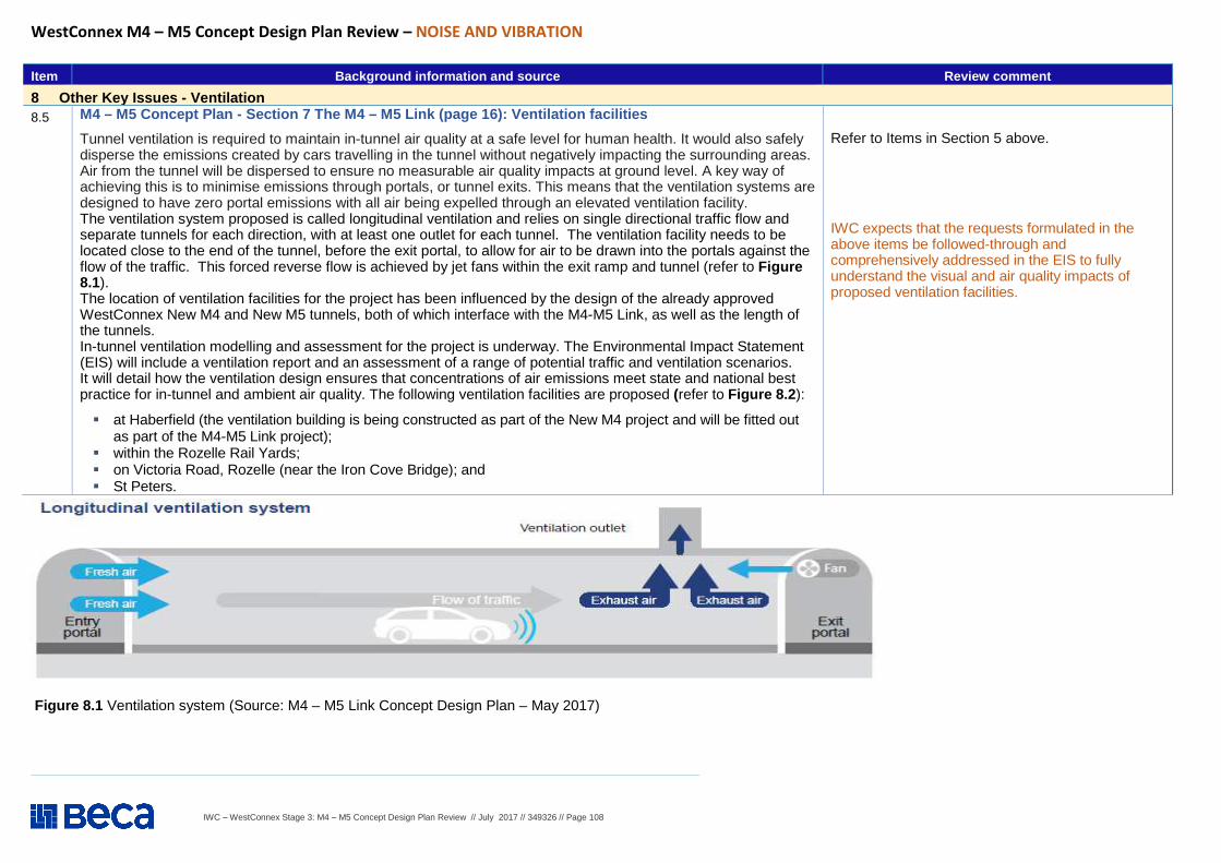
IWC – WestConnex Stage 3: M4 – M5 Concept Design Plan Review // July 2017 // 349326 // Page 108
WestConnex M4 – M5 Concept Design Plan Review – NOISE AND VIBRATION
Figure 8.1 Ventilation system (Source: M4 – M5 Link Concept Design Plan – May 2017)
Item Background information and source Review comment
8 Other Key Issues - Ventilation 8.5
M4 – M5 Concept Plan - Section 7 The M4 – M5 Link (page 16): Ventilation facilities
Tunnel ventilation is required to maintain in-tunnel air quality at a safe level for human health. It would also safely disperse the emissions created by cars travelling in the tunnel without negatively impacting the surrounding areas. Air from the tunnel will be dispersed to ensure no measurable air quality impacts at ground level. A key way of achieving this is to minimise emissions through portals, or tunnel exits. This means that the ventilation systems are designed to have zero portal emissions with all air being expelled through an elevated ventilation facility. The ventilation system proposed is called longitudinal ventilation and relies on single directional traffic flow and separate tunnels for each direction, with at least one outlet for each tunnel. The ventilation facility needs to be located close to the end of the tunnel, before the exit portal, to allow for air to be drawn into the portals against the flow of the traffic. This forced reverse flow is achieved by jet fans within the exit ramp and tunnel (refer to Figure 8.1). The location of ventilation facilities for the project has been influenced by the design of the already approved WestConnex New M4 and New M5 tunnels, both of which interface with the M4-M5 Link, as well as the length of the tunnels. In-tunnel ventilation modelling and assessment for the project is underway. The Environmental Impact Statement (EIS) will include a ventilation report and an assessment of a range of potential traffic and ventilation scenarios. It will detail how the ventilation design ensures that concentrations of air emissions meet state and national best practice for in-tunnel and ambient air quality. The following ventilation facilities are proposed (refer to Figure 8.2 ):
� at Haberfield (the ventilation building is being constructed as part of the New M4 project and will be fitted out as part of the M4-M5 Link project);
� within the Rozelle Rail Yards; � on Victoria Road, Rozelle (near the Iron Cove Bridge); and � St Peters.
Refer to Items in Section 5 above.
IWC expects that the requests formulated in the above items be followed-through and comprehensively addressed in the EIS to fully understand the visual and air quality impacts of proposed ventilation facilities.
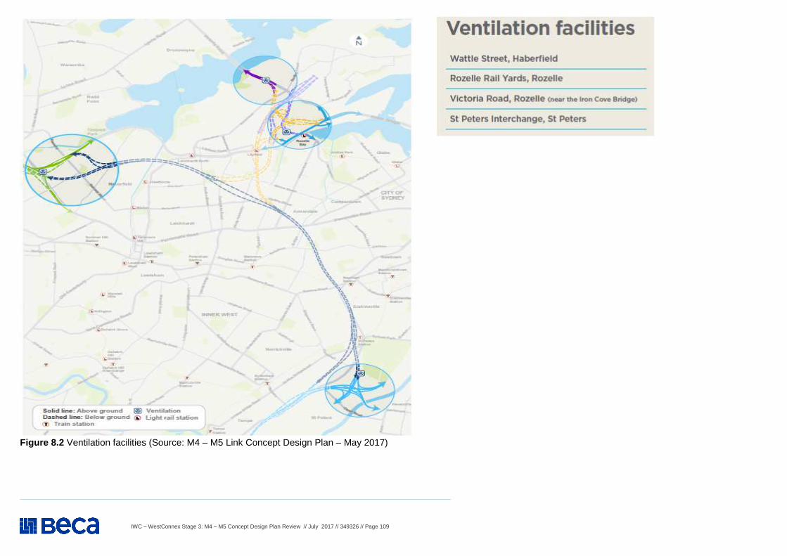
IWC – WestConnex Stage 3: M4 – M5 Concept Design Plan Review // July 2017 // 349326 // Page 109
Figure 8.2 Ventilation facilities (Source: M4 – M5 Link Concept Design Plan – May 2017)

IWC – WestConnex Stage 3: M4 – M5 Concept Design Plan Review // July 2017 // 349326 // Page 110
BLANK PAGE


