Embed Size (px)
Citation preview
Geophys. J . R. mtr. SOC. (1987) 90,245-263
Magnetotelluric soundings in the Canadian Rocky Mountains
V. R. S. Hutton*, D. I. Gough?, G. J. K. Dawes* and J. Travassos* *Department of Geophysics, University of Edinburgh, Mayfield Road, Edinburgh EH9 3JZ, Scotland; Department of Physics, University of Alberta, Edmonton, Alberta T6G 2J1, Canada
Accepted 1986 December 8. Received 1986 November 24; in original form 1985 December 4
Summary. Magnetotelluric soundings have been made at 25 stations in the Rocky Mountain Trench (RMT) and Main Ranges near 53"N, close to the centre of a major conductivity anomaly which had been mapped in a magnetovariation array study. Most stations covered the frequency range 0.01-500 Hz and three stations 0.0002-500 Hz. The resistivity tensor shows low to moderate anisotropy in the RMT, but is strongly 2-D or 3-D in the Rocky Mountains. Apparent resistivities as a function of frequency are displayed in pseudosections along the Trench and along a transverse profile across the RMT and into the Main Ranges. In preparation for 2-D modelling, 1-D inversions have been used to construct resistivity-depth sections satisfying both magnitudes and phases of the MT responses. These show very low resistivities, in the range 1-10S2m, in the upper crust under the RMT and even lower values under the Main Ranges. The latter values give strong confirmation of the Northern Rockies conductor reported by Bingham, Gough & Ingham and are in agreement with models of the conductors fitted to long-period magnetovariation fields by Ingham, Gough & Parkinson. The MT results here reported add some essential depth and resistivity information. I t is suggested- that the conductors beneath the Rocky Mountains Main Ranges and Trench constitute a thickening at the edge of the Canadian Cordilleran Regional (CCR) conductor. Gough has argued that a wide variety of geophysical and geological parameters indicate high temperatures and partial melting in the mantle under the CCR conductor. At the upper crustal depths penetrated in this magnetotelluric study, it is considered more probable that the high conductivity is caused by hot, saline water of mantle origin rather than silicate melt. The CCR in general may have two layers of fluid producing its high conductivity, silicate melt below and saline hot water above.
246 K R. S. Hutton et al.
Key words: magnetotellurics, Canada, Rocky Mountains, geothermal
Introduction
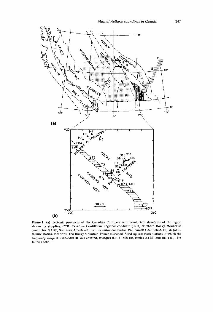
This paper reports part of a programme of investigation of conductive structures in the crust and upper mantle of western Canada, and of their tectonic significance. Prior magneto- variation and magnetotelluric investigations had revealed the presence of a high-conductance layer in the lower crust and uppermost mantle under the Canadian Cordillera (Hyndman 1963; Caner, Cannon & Livingstone 1967; Caner et al. 1969; Cochrane & Hyndman 1970; Camfield, Cough & Porath 1970; Caner 1971; Dragert 1973; Dragert & Clarke 1977). The name Canadian Cordilleran Regional (CCR) conductor (Fig. 1 a) has recently been proposed (Cough 1986) for this layer, whose NE limit, in the latitude range of the present investi- gation, was placed near the Rocky Mountain Trench by Dragert (1973). The present programme began in 1980 with a regional magnetovariation study of southern Alberta and British Columbia by means of a large magnetometer array of low resolution (Cough ef al. 1982). That array further confirmed the presence of the CCR conductor beneath most of southern British Columbia, and located two major anomalies, one of them centred near T h e Jaune Cache (TJC) in the Rocky Mountain Trench at 53"N, and the other striking NE-SW across southern Alberta into British Columbia (SABC in Fig. la). Smaller arrays, with closer spacing between magnetometers and so of higher resolution, were deployed in 1981 to map these two anomalies. Results of the first array study of 1981, centred at TJC, have been reported elsewhere (Bingham, Gough & Ingham 1985). I t was found that the edge of the CCR conductor lay beneath the Main Ranges of the Rocky Mountains rather than the Trench, with a ridge of high conductivity under the mountains. This Northern Rockies (NR) conductive ridge may be regarded as a thickening of the CCR along its NE edge. The CCR and NR conductors are indicated in Fig. l(a).
Magnetometer arrays, as traditionally operated, are effective in mapping conductive structures over large areas but less so in determining their depths (Gough & Ingham 1983). One approach to depth estimation is to use closely spaced magnetotelluric (MT) soundings, preferably with five components, at sites over a structure previously mapped by means of magnetovariation fields. Using this approach, we have made broad-band MT soundings at 25 sites within the conductive structure underlying the Rocky Mountains and Rocky Mountain Trench near 53"N. This paper gives results of those MT soundings and a discussion of the inferred conductive structures.
Geological and tectonic structure of the region
Recent reviews of the tectonic history and structure of the Cordillera have been given by Souther (1970), Monger, Souther & Gabrielse (1972) and Monger & Price (1979). Five tectonic provinces, shown in Fig. l(a), have been recognized in the region. The most north- easterly of these provinces is the Rocky Mountains Belt, made up of carbonate and clastic sediments and crystalline basement rocks, accumulated in a miogeosyncline and ranging in age from Proterozoic to Mesozoic. The mountains were uplifted and compressed from SW to NE in Late Cretaceous and Tertiary time. The Rocky Mountain Trench fault, which bisects the study area, forms the boundary between the Rocky Mountains and the Rocky Mountain Trench (RMT), a linear feature some 2000 km long. The most recent movement on this fault is normal, downthrown on its SW side to form the Trench. The Tintina Fault, which is continuous with the RMT fault to the NW, shows 400 km or more of right-lateral displacement during the last 95 Myr. This and other geological data support the view that
Magnetotelluric soundings in Canada 247
85C 290
(b)
. . -. .- +-A- .- . . -
10 km *-.T7 - .-. 1 L I I 1 : I m.
i i 2 0
0
Figure 1. (a) Tectonic provinces of the Canadian Cordillera with conductive structures of the region shown by stippling. CCR, Canadian Cordilleran Regional conductor; NR, Northern Rocky Mountains conductor; SABC, Southern Alberta-British Columbia conductor. PG, Purcell Geanticline. (b) Magneto- telluric station locations. The Rocky Mountain Trench is shaded. Solid squares mark stations at which the frequency range 0.0002-500 Hz was covered, triangles 0.005-500 Hz, circles 0.125-500 Hz. TJC, Tete Jaune Cache.
248
the RMT marks the edge of the pre-Mesozoic continent near 53" N (Monger & Price 1979; Chamberlain & Lambert 1985).
To the SW of the RMT is the Omineca Crystalline Belt, considered by Souther (1 970) to be the root of Andean type mountains of the Columbian Orogeny; the Intermontane Belt, composed of oceanic crust and island arc rocks; the Coast Plutonic Complex; and the Insular Belt which includes Vancouver Island. The Rocky Mountains Belt is generally agreed to be part of the pre-Mesozoic craton. There is substantial geological and paleomagnetic evidence (Irving 1979) that much of the remainder of the Cordilleran region was added to North America during Mesozoic and early Tertiary time, by accretion and consolidation of oceanic crust, island arcs and small continents (Coney, Jones & Monger 1980). The study area lies across the boundary between the Omineca Belt rocks of the Cariboo Mountains (Fig. 1 b) SW of the Rocky Mountain Trench, and cratonic rocks of the Rocky Mountains Belt.
K R. S. Hutton et al.
The magnetotelluric field work
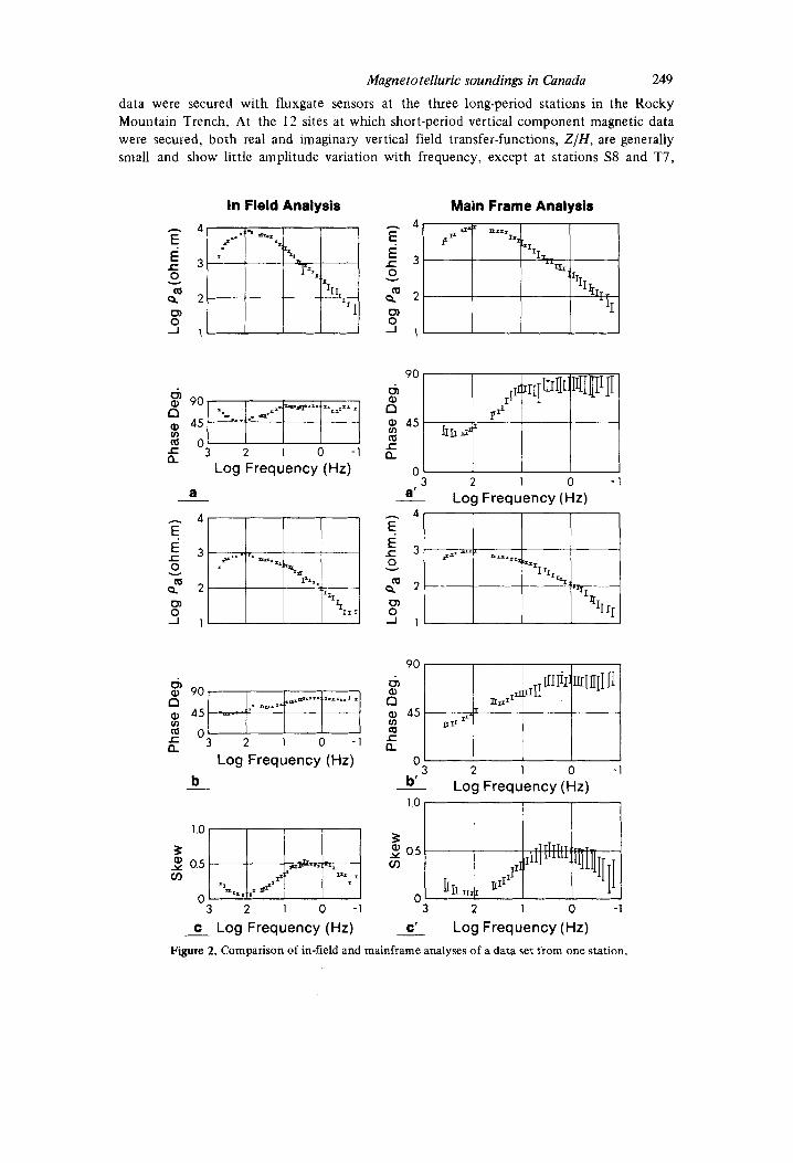
The objective was to obtain depth and electrical conductivity estimates for the highly conductive structures mapped by the magnetovariation array study of Bingham et al. (1985). The MT stations were sited along the Rocky Mountain Trench (RMT) through the centre, near TCte Jaune Cache, of the largest of the closed anomalies in horizontal magnetovariation components; and along two profiles across the RMT and into the Main Ranges of the Rocky Mountains. The observational sites are shown in Fig. l(b), with symbols indicating the sounding bandwidth at each. Circles and triangles represent bandwidths of between 500 Hz and 8 s and between 500 Hz and 200 s, respectively, and large squares show the three sites at which the bandwidth covered the six decades from 500 Hz to 5000 s. The SPAM Mk I real-time data acquisition and analysis system (Dawes 1984), with induction coils as magnetic sensors, was used for the frequency range 500 Hz and 8 s, and longer period data were recorded digitally on magnetic tape, with induction coils or a three-component fluxgate magnetometer. While SPAM had been developed and successfully used during geothermal studies in Tuscany (Hutton et al. 1985), this was the first project which made full use of the in-field processing potential of this system. Not only was the data quality controlled, but the study area, originally limited to the Trench itself, was extended during the field programme following scrutiny of the results of in-field analyses. Pre-amplified signals for three magnetic and two telluric components are input t o a microprocessor, which incorporates a programmable amplifier-filter bank and outputs the accepted data sets and computed results to a cartridge recorder and to a small printer. Rejection criteria (Sule 1985) are applied during both the time-domain and frequency-domain analyses. The system is operated by means of batteries which can be recharged overnight. Fig. 2 shows an example of the output to the field printer, and the output from mainframe computer analysis for comparison. The parameters shown are apparent resistivity and phase, for each of two orthogonal measure- ment directions, and the skew factor (a measure of dimensionality) as functions of period. The later SPAM Mk I1 system provides full tensorial analysis, a remote reference facility and 1-D inversion to resistivity as a function of depth. Readers unfamiliar with MT and MV procedures and parameters are recommended to consult one of such standard texts as Kaufman & Keller (1 98 l) , Parkinson (1 983) or Berdichevsky & Zhdanov (1 984).
Magnetovariation data
Technical problems with the vertical component induction coil limited the acquisition of three-component magnetovariation data at frequencies above 10 Hz. Vertical component
Magnetotelluric soundings in Canada 249
data were secured with fluxgate sensors at the three long-period stations in the Rocky Mountain Trench. At the 12 sites at which short-period vertical component magnetic data were secured, both real and imaginary vertical field transfer-functions, Z / H , are generally small and show little amplitude variation with frequency, except at stations S8 and T7,
In Field Analysis Main Frame Analysis
U Log Frequency (Hz)
a -
Log frequency (Hz) b
~
3 2 1 0 - 1
- c Log Frequency (Hz)
" 3 2 1 0 - 1 a' Log Frequency (Hz)
I I I 3 2 1 0
b' Log Frequency (Hz)
3 2 1 0 - 1
c' Log Frequency (Hz) Figure 2. Comparison of in-field and mainframe analyses of a data set from one station.
920 920 0 2
\H5 I+ tH2 REAL
" 9 1 1
/T4
/T6
I
1 .o H
log P* \"5
Y T1
4
Ys3 \T4
/T6
(a) (b)
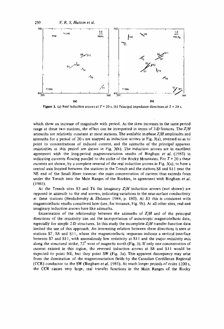
Figure 3. (a) Real induction arrows at T = 20 s. (b) Principal impedance directions at T = 20 s.
T-20s I I I I I
which show an increase of magnitude with period. As the skew increases in the same period range at these two stations, the effect can be interpreted in terms of 3-D features. The Z / H azimuths are relatively constant at most stations. The available in-phase Z/H amplitudes and azimuths for a period of 20 s are mapped as induction arrows in Fig. 3(a), reversed so as to point to concentrations of induced current, and the azimuths of the principal apparent resistivities at this period are shown in Fig. 3(b). The induction arrows are in excellent agreement with the long-period magnetovariation results of Bingham et al. (1985) in indicating currents flowing parallel to the strike of the Rocky Mountains. For T = 20 s these currents are shown, by a complete reversal of the real induction arrows in Fig. 3(a), to have a central axis located between the stations in the Trench and the stations S8 and S11 near the NE end of the Small River traverse: the main concentration of current thus extends from under the Trench into the Main Ranges of the Rockies, in agreement with Bingham et al. (1985).
At the Trench sites S3 and T6 the imaginary Z / H induction arrows (not shown) are opposed in azimuth to the real arrows, indicating variations in the near-surface conductivity at these stations (Berdichevsky & Zhdanov 1984, p. 180). At S3 this is consistent with magnetotelluric results considered later (see, for instance, Fig. 9b). At all other sites, real and imaginary induction arrows have like azimuths.
Examination of the relationship between the azimuths of Z / H and of the principal directions of the resistivity can aid the interpretation of anisotropic magnetotelluric data, especially for simple 2-D structures. In this study the incomplete Z/H transfer function data limited the use of this approach. An interesting relation between these directions is seen at stations S7, S8 and S11, where the magnetotelluric responses indicate a vertical interface between S7 and S11, with anomalously low resistivity at S11 and the major resistivity axis along the structural strike, 72" west of magnetic north (Fig. 3) . If only one concentration of current existed in this region, the reversed induction arrows at S8 and S11 would be expected to point NE, but they point SW (Fig. 3a). This apparent discrepancy may arise from the domination of the magnetovariation fields by the Canadian Cordilleran Regional (CCR) conductor to the SW (Bingham et al. 1985). At much longer periods of order 1200 s, the CCR causes very large, real transfer functions in the Main Ranges of the Rocky
Magnetotelluric soundings in Canada 25 1
Mountains; if it also affects the amplitudes of real transfer functions at the periods of the present study, then the local conductor near S 1 1 may reduce the amplitude of the regional induction arrow without reversing it. The magnetotelluric tensor is more sensitive to local structures of small scale-length. At S 1 1, consequently, the major impedance is very small, and its azimuth lies parallel to strike and perpendicular to the local induction arrows. These features are compatible with a conductive body under S1 1.
Similar superposition of regional and local contributions will produce resultant induction arrows at all sites. At stations S3, T4, T6 and T7 in the Trench and at S1 to the SW of it, the induction arrows are opposed to the regional direction as observed at periods greater than 600 s, and clearly the local effect predominates. Bingham et al. (1 985) show a reversal of the induction arrow at T = 600 s, at their Trench station VAL, towards NE from the regional SW direction. Except at T4 the azimuths of the major apparent-resistivity axes and of the induction arrows coincide, indicating that the central axis of the local current concentration is NE of the Rocky Mountain Trench, as shown by the magnetovariation results of Bingham et al. ( 1 985).
The magnetotelluric responses
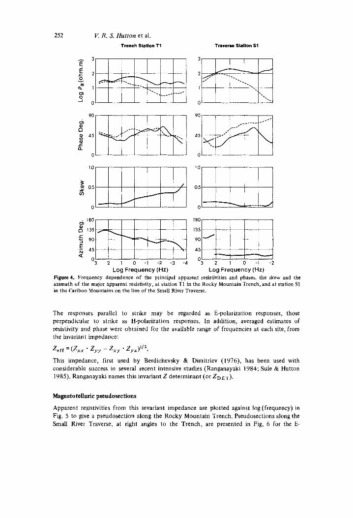
Both magnetovariation and magnetotelluric field data were reprocessed in the Edinburgh main-frame computer with standard tensorial impedance techniques. The agreement between in-field and reprocessed responses, as shown in Fig. 2, suggests that reprocessing and further analysis may be unnecessary in certain studies, for example in nearly 1-D situations or where useful models can be obtained using frequencies less than 100 Hz. In this study full tensorial analysis was necessary because it is intended to proceed to 2-D modelling. Moreover it was possible, during the reprocessing, to apply additional criteria to datasets such as rejection of responses based on the average of a small number of acceptable response estimates. As examples of the reprocessed data, the frequency variations of the magnetotelluric responses in the principal directions are shown in Fig. 4 for station T 1 in the Rocky Mountain Trench, and for station S1 to the SW of the Trench. For clarity the mean values and error estimates have been omitted from Fig. 4, as the data quality can be seen in Figs 2 and 7. At the Trench station the apparent resistivity shows nearly one order of magnitude of anisotropy for frequencies below 1 Hz, and the azimuth of the major impedance at these frequencies is about N 90" E. At S1 the anisotropy exceeds two orders of magnitude and.the azimuth of the major resistivity is about N 25" E. The skew factor at S1 was very low at all frequencies, as was the case at all stations in the Small River traverse except for S8 and S11. At these two stations the skew increased to about 0.5 at frequencies less than 1 Hz, indicating that modelling in three dimensions would be appropriate there. The skew factors for the Holmes River traverse were all indicative of 3-D structures there, stations H2 to H5 showing skews greater than 1. Except at T4 where skews of almost 0.5 were observed at frequencies below 1 Hz, and at T7 and T8, where the skews increased to similar values at about 0.01 Hz, magnetotelluric results from the stations in the Rocky Mountain Trench were all compatible with 2-D structures.
It is intended to attempt to fit 2-D models t o the data after making additional measure- ments at crucial parts of the section. To assist these tasks it was decided to examine the lateral variations along each traverse in a more qualitative manner by means of pseudo- sections and 1 -D resistivity-depth models. The results will provide starting models for the 2-D modelling. For both pseudosections, and sections derived from 1-D inversions, the data from each station were rotated to provide magnetotelluric responses parallel and perpendicular to the strike of the Rocky Mountains and Trench, taken as N 72" E magnetic.
252 K R. S. Hutton et al. Trench Station T1 Traverse Stallon S1
E r 0 Y
Q Q 0) 0 -I
180 180 0, 0" 135 135
$ 90 90
.E 45 45 2 0
O3 2 1 0 -1 -2 -3 -4 3 2 1 0 -1 - 2 Log Frequency (Hz) Log Frequency (Hz)
Figure 4. Frequency dependence of the principal apparent resistivities and phases, the skew and the azimuth of the major apparent resistivity, at station T1 in the Rocky Mountain Trench, and at station S1 in the Cariboo Mountains on the line of the Small River Traverse.
The responses parallel to strike may be regarded as E-polarization responses, those perpendicular to strike as H-polarization responses. In addition, averaged estimates of resistivity and phase were obtained for the available range of frequencies at each site, from the invariant impedance:
Zeff = ( Z X X - z y y - Zxy - zyx)1'2.
This impedance, first used by Berdichevsky & Dimitriev (1976), has been used with considerable success in several recent intensive studies (Ranganayaki 1984; Sule & Hutton 1985). Ranganayaki names this invariant Z determinant (or ZDET).
Magnetotelluric pseudosections
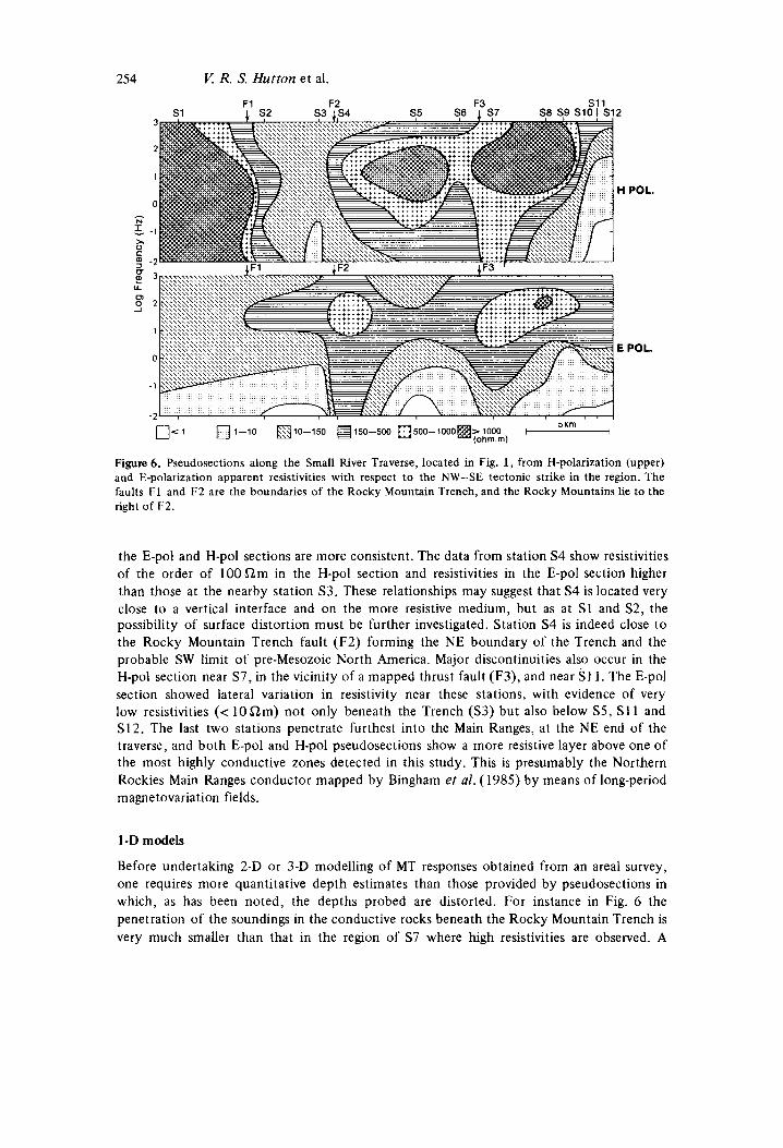
Apparent resistivities from this invariant impedance are plotted against log (frequency) in Fig. 5 to give a pseudosection along the Rocky Mountain Trench. Pseudosections along the Small River Traverse, at right angles to the Trench, are presented in Fig. 6 for the E-
T1 3
Magnetotelluric soundings in Cnnada 253 T2 T3 S3 T4 T5 T6 T7 M1
2
3
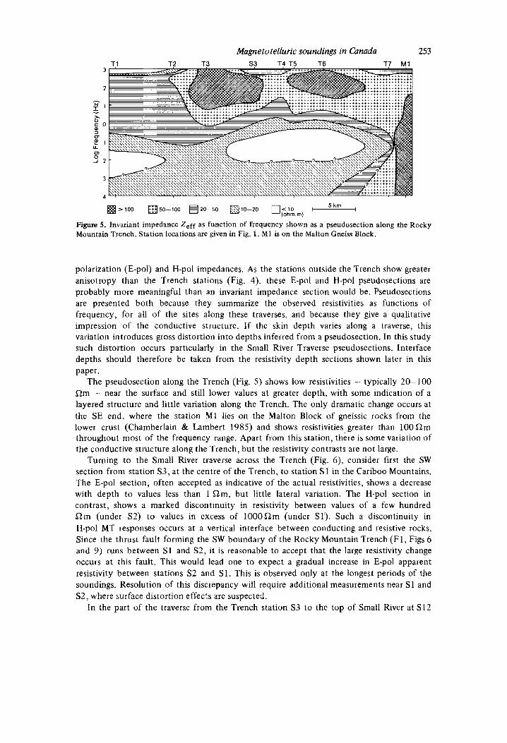
4
Figure 5. Invariant impedance Z,ff as function of frequency shown as a pseudosection along the Rocky Mountain Trench. Station locations are given in Fig. 1. M I is on the Malton Gneiss Block.
polarization (E-pol) and H-pol impedances. As the stations outside the Trench show greater anisotropy than the Trench stations (Fig. 4), these E-pol and H-pol pseudosections are probably more meaningful than an invariant impedance section would be. Pseudosections are presented both because they summarize the observed resistivities as functions of frequency, for all of the sites along these traverses, and because they give a qualitative impression of the conductive structure. If the skin depth varies along a traverse, this variation introduces gross distortion into depths inferred from a pseudosection. In this study such distortion occurs particularly in the Small River Traverse pseudosections. Interface depths should therefore be taken from the resistivity depth sections shown later in this paper.
The pseudosection along the Trench (Fig. 5) shows low resistivities - typically 20-100 Qm - near the surface and still lower values at greater depth, with some indication of a layered structure and little variation along the Trench. The only dramatic change occurs at the SE end, where the station M1 lies on the Malton Block of gneissic rocks from the lower crust (Chamberlain & Lambert 1985) and shows resistivities greater than 100 Qm throughout most of the frequency range. Apart from this station, there is some variation of the conductive structure along the Trench, but the resistivity contrasts are not large.
Turning to the Small River traverse across the Trench (Fig. 6), consider first the SW section from station S3, at the centre of the Trench, to station S1 in the Cariboo Mountains. The E-pol section, often accepted as indicative of the actual resistivities, shows a decrease with depth to values less than 1 Qm, but little lateral variation. The H-pol section in contrast, shows a marked discontinuity in resistivity between values of a few hundred a m (under S2) to values in excess of 100OQm (under Sl) . Such a discontinuity in H-pol MT responses occurs at a vertical interface between conducting and resistive rocks. Since the thrust fault forming the SW boundary of the Rocky Mountain Trench (F 1, Figs 6 and 9) runs between S1 and S2, I t is reasonable to accept that the large resistivity change occurs at this fault. This would lead one to expect a gradual increase in E-pol apparent resistivity between stations S2 and S1. This is observed only at the longest periods of the soundings. Resolution of this discrepancy will require additional measurements near S 1 and S2, where surface distortion effects are suspected.
In the part of the traverse from the Trench station S3 to the top of Small River at S12
254 V. R. S. Hutton et al.
L
H POL.
E POL.
0 < 1 0 1 - 1 0 HlO-150 H150-500 0 5 0 0 - 1 0 0 0 ~ ~ 1 0 0 0 5 km
(ohm m)
Figure 6 . Pseudosections along the Small River Traverse, located in Fig. 1, from H-polarization (upper) and E-polarization apparent resistivities with respect to the NW-SE tectonic strike in the region. The faults I:1 and F2 are the boundaries of the Rocky Mountain Trench, and the Rocky Mountains lie to the right of F2.
the E-pol and H-pol sections are more consistent. The data from station S4 show resistivities of the order of 100Qm in the H-pol section and resistivities in the E-pol section higher than those at the nearby station S3. These relationships may suggest that S4 is located very close to a vertical interface and on the more resistive medium, but as at S1 and S2, the possibility of surface distortion must be further investigated. Station S4 is indeed close to the Rocky Mountain Trench fault (F2) forming the NE boundary of the Trench and the probable SW limit of pre-Mesozoic North America. Major discontinuities also occur in the H-pol section near S7, in the vicinity of a mapped thrust fault (F3), and near S1 1. The E-pol section showed lateral variation in resistivity near these stations, with evidence of very low resistivities (< 10Slm) not only beneath the Trench (S3) but also below S5, S11 and S12. The last two stations penetrate furthest into the Main Ranges, at the NE end of the traverse, and both E-pol and H-pol pseudosections show a more resistive layer above one of the most highly conductive zones detected in this study. This is presumably the Northern Rockies Main Ranges conductor mapped by Bingham et al. (1985) by means of long-period magnetovariation fields.
1 -D models
Before undertaking 2-D or 3-D modelling of MT responses obtained from an areal survey, one requires more quantitative depth estimates than those provided by pseudosections in which, as has been noted, the depths probed are distorted. For instance in Fig. 6 the penetration of the soundings in the conductive rocks beneath the Rocky Mountain Trench is very much smaller than that in the region of S7 where high resistivities are observed. A
Magnetotelluric soundings in Canada 255
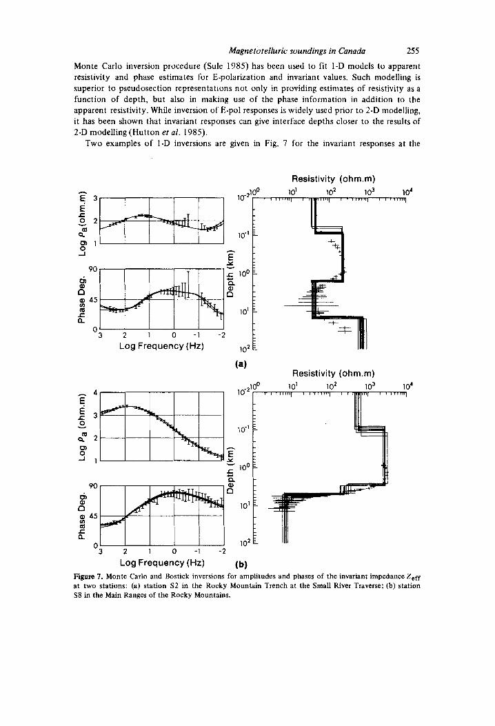
Monte Carlo inversion procedure (Sule 1985) has been used to fit I-D models to apparent resistivity and phase estimates for E-polarization and invariant values. Such modelling is superior to pseudosection representations not only in providing estimates of resistivity as a function of depth, but also in making use of the phase information in addition to the apparent resistivity. While inversion of E-pol responses is widely used prior to 2-D modelling, it has been shown that invariant responses can give interface depths closer to the results of 2-D modelling (Hutton et al. 1985).
Two examples of I-D inversions are given in Fig. 7 for the invariant responses at the
h
E
1 I I I I - 3 2 1 0 -1 -2
Log Frequency (Hz)
- 4 E E r 3
Q 2
J 1
0 Y
m
CJ) 0
h
E Y
Resistivity (0hm.m) 1 0' 1 02 1 o3 10'
10-
lo-'
1 00
10'
1 o2
Y
5 a
(a) Resistivity (0hm.m)
10'
"3 2 1 0 -1 -2
Log Frequency (Hz) (b) Figure 7. Monte Carlo and Bostick inversions for amplitudes and phases of the invariant impedance Z,ff at two stations: (a) station S2 in the Rocky Mountain Trench at the Small River Traverse; (b) station S8 in the Main Ranges of the Rocky Mountains.
256 Trench station S2 and the Small River Traverse station S8, located in the Main Ranges of the Rockies. I n addition to Monte Carlo inversions, in which a layered structure is assumed, modified Bostick (1976) inversions are shown. The two methods of inversion give concordant models. The site S 2 lies near the fault between the Rocky Mountain Trench and the Cariboo Mountains (Fig. lb), and the model shows an average resistivity of about 100 SZm in the top kilometre, with a decrease in resistivity with increasing depth to about 30SZm between 1 and 15 km. Below this conductive upper crust the resistivity rises to several hundreds of a m . The model for station S8 shows a very different variation of resistivity with depth, characteristic of the Rocky Mountains stations, with rock of resistivity about 3000 SZm at depths less than 3 km and a rapid drop in resistivity to less than lOQm near 5 km depth. The thickness of the highly conductive layer is undetermined, but it certainly extends to depths greater than 10 km.
The 1-D inversions of the E-pol MT responses at S2 and S8 are representative of inversions used in constructing the E-pol resistivity-depth section discussed below.
l! R. S. Hutton et al.
Resistivity-depth sections
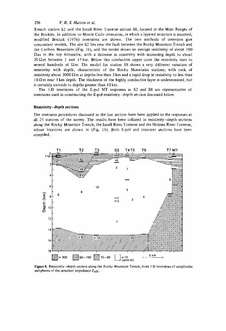
The inversion procedures discussed in the last section have been applied to the responses at all 25 stations of the survey. The results have been collated in resistivity-depth sections along the Rocky Mountain Trench, the Small River Traverse and the Holmes River Traverse, whose locations are shown in (Fig. Ib). Both E-pol and invariant sections have been compiled.
T1 T2 T3 S3 T4T5 T6 T7 M1 T1 T2 T3 S3 T4T5 T6 T7 M1
11
- 6
5 g 10 n
12
14
16
18 m > 3 0 0 g 5 0 - 1 5 0 B 1 0 - 5 0 0 < 1 0 5 km
(0hm.m)
Figure 8. Resistivity-depth section along the Rocky Mountain Trench, from 1-D inversions of amplitudes and phases of the invariant impedance Z,ff.
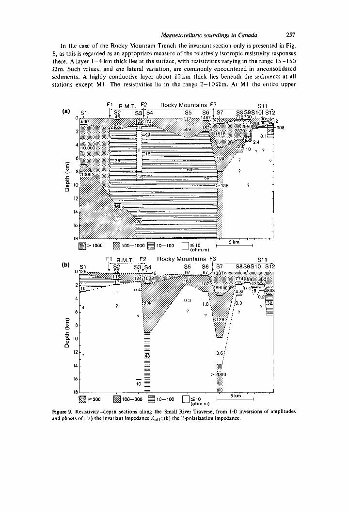
Magnetotelluric soundings in Canada 257
In the case of the Rocky Mountain Trench the invariant section only is presented in Fig. 8, as this is regarded as an appropriate measure of the relatively isotropic resistivity responses there. A layer 1-4 km thick lies at the surface, with resistivities varying in the range 15- 150 S2m. Such values, and the lateral variation, are commonly encountered in unconsolidated sediments. A highly conductive layer about 12 km thick lies beneath the sediments at all stations except Ml . The resistivities lie in the range 2-10Qm. At M1 the entire upper
(a) 0
2
A
6
E 5 8 5 Q 10 n
12
14
16
18 , 5 k m , m > 1 0 0 0 m100-1000 B 1 0 - 1 0 0 0 5 1 0
(0hm.m)
16
18 - 5 km "i H Z 3 0 0 m100-300 ~ ~ ~ - ~ o o nllo -
(0hrn.m) tj U
Figure 9. Resistivity-depth sections along the Small River Traverse, from 1-D inversions of amplitudes and phases of : (a) the invariant impedance Z,ff; (b) the E-polarization impedance.
258
crust is highly resistive. This station lies on the Malton Gneiss Block. Tentative values for the lower crust under the good conductor are provided by the two stations, T1 and T5 at which periods up to 5000 s were recorded. The indicated resistivity is about 20 a m below a depth of 14 krn. Phase data at stations T2 and T3 are compatible with these values.
For the Small River Traverse, where the resistivities are more anisotropic, resistivity- depth sections are presented for both invariant (Fig. 9a) and E-pol (Fig. 9b) responses. The two sections will be discussed together, from SW to NE along the traverse. Station S1, SW of the Rocky Mountain Trench, shows high resistivities in the invariant section, but not in the E-pol section, for reasons which are not yet fully understood: this point has been noted previously with respect to the pseudosections. Moving north-eastward, stations S2 and S3 show resistivities characteristic of the Trench (Fig. 8). The fault F1, between the Cariboo Mountains and the Rocky Mountain Trench, lies between stations S1 and S2, and as noted in the discussion of pseudosections, it is reasonable to associate the change in resistive structure with it. This has been done in the invariant section (Fig. 9a). As in Fig. 8, the sections of Fig. 9 show low resistivities in the upper crust beneath the Rocky Mountain Trench. The fault F2, which bounds the Trench to the NE, may be associated with a marked lateral change in resistive structure between stations S3 and S4 in the E-pol section (Fig. 9b). Confirmation of this lateral variation requires further work, as noted previously. The upper- most 3-4 krn of the crust in the Main Ranges of the Rocky Mountains has resistivities of the order of 300-1000 a m , as shown by the E-pol section, which is usually more reliable for resistivity values. A downward extension of relatively resistive rock occurs between stations S6 and S7, and is probably associated with the thrust fault F3. This structure appears
I/. R. S. Hutton et al.
F3 T1 H1 H2 1 H3 H4 H5
110
~ > l O O O m100-1000 @lO-lOO n.10 1-1 5 km (0hrn.m)
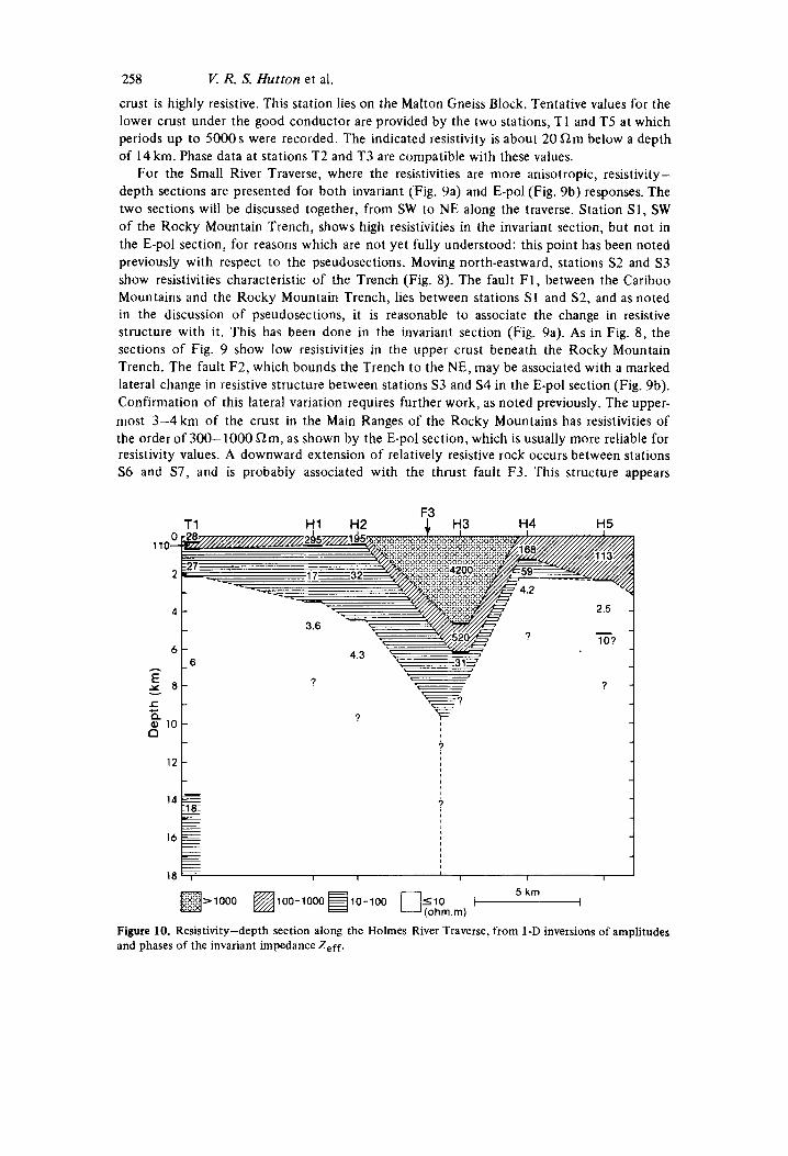
Figure 10. Resistivity-depth section along the Holmes River Traverse, from 1-D inversions of amplitudes and phases of the invariant impedance Z,ff.
Magnetotelluric soundings in Canada 259
prominently in both sections. Both sections also show very low resistivities in the upper crust below a depth of about 2 km, beneath stations S5 and S6 and between S8 and S12. The E-pol section indicates values less than 1 a m in much of this upper crustal conductor, whose thickness cannot be resolved because of the small skin depths. At station S7 the E-pol section indicates a thickness of 4 km for the conductive layer. This single value requires confirmation from future measurements.
The Holmes River stations showed higher skew values and the structures are probably 3-D. For this reason only the invariant models have been compiled in the section shown in Fig. 10. A high-resistivity block is associated with the thrust fault F3, under which moderate resistivities extend into the upper crust, as at the Small River Traverse. A layer of indeterminate thickness and of very low resistivity is again observed under the Trench and Main Ranges at a depth of 2-4 km.
Discussion
Geophysical interpretation of the collation of I-D models in Figs 8-10 is justified only to the extent that the 1-D models approximate, in either resistivities or interface depths, to the true 2-D or 3-D structure. If that approximation is satisfactory, it must still be remembered that uniqueness cannot be claimed for conductive models (Parker 1980; Oldenburg, Whitall & Parker 1984).
Recent studies by Jodicke et al . ( 1 983) and by Sule & Hutton (1986) have shown that a resistivity section such as that in Fig. 8 for the Rocky Mountain Trench traverse can correspond in all essential features to a 2-D model, provided two conditions are satisfied. First, the station spacing must be of the order of a few kilometres or less. Second, the anisotropy of the resistivity must not exceed one decade: Sule (1985) has suggested the use of I-D models of the invariant impedance Zeff for such sections, with bounds on the resistivities and interface depths estimated from 1-D E-pol and H-pol models. Ranganayaki ( I 984) has similarly recommended the use of this invariant, which she denotes Z,,, , and gives a very convincing illustration of a section so modelled in good agreement with a geological section constructed from a set of boreholes.
Comparison of I-D and 2-D models by Hutton er al. (1984) indicates that the former give reasonable values of the layer resistivities, but underestimate interface depths. Caution is necessary in inferring resistivities below any station, at depths greater than the distance between that station and a significant near-surface resistivity contrast.
For the Small River traverse some sites show highly anisotropic MT responses. Topo- graphic effects may contribute to these responses, and will be considered elsewhere, but the anisotropy is assumed to arise mainly from signficant resistivity contrasts near the major geological faults. The E-pol resistivity section probably approximates the true resistivities best, since H-pol MT responses deviate more significantly from the true values near vertical interfaces. Electrical interfaces associated with faults are better located in the invariant section. For the Small River traverse, because of possible surface distortion effects between stations S1 and S4, the invariant and E-pol resistivity sections together are thought to represent the real structures sufficiently to justify interpretation.
In the Holmes River traverse the sites are further apart and some show 3-D MT responses. In consequence only limited modelling can be attempted until additional data become available. Nevertheless the Holmes River and Small River invariant resistivity sections are remarkably similar near the fault F3. This similarity suggests that even with 3-D responses, the Holmes River invariant resistivity section gives meaningful structural information.
260
It is instructive to compare the invariant pseudosection along the Rocky Mountain Trench (Fig. 5 ) with the corresponding invariant resistivity section (Fig. 8), and the E-pol pseudosection (Fig. 6b) and resistivity section (Fig. 9b) along the Small River traverse. Such comparisons illustrate both the utility and the limitations of pseudosections, which give clear indications of compatible resistivity values at neighbouring sites and show lateral variations, while grossly distorting some interface depths.
Cough ( 1 986) has considered the Canadian Cordilleran Regional conductive layer and has shown that it is correlated on the map with a thin (30 km) crust, a thin (40 km) lithosphere, a thick low-velocity layer for long-period shear waves in the upper mantle, and high heat- flow. He has proposed that these correlations indicate high temperatures and partial melting in the uppermost mantle beneath most of the Intermontane and Omineca Belts of the Cordillera between 49" and 54"N. Cough has further used the compositions of recent volcanics extruded in the Cordillera, the regional seismicity and the lithospheric stress field to suggest that there is an upcurrent of mantle circulation under the Intermontane and Omineca Belts, inland of the subduction beneath the coastal region. Similar arguments had been advanced earlier, for partial melting (Cough 1974) and mantle upflow (Cough 1984) under parts of the western United States. The upflows under western United States and western Canada may be parts of an elongated upcurrent which lay beneath the East Pacific Rise before 30 Myr B P , and was then overridden by the continent (Cough 1984, 1986).
Whether or not the large tectonic picture just sketched is correct, the essential point for interpretation of the resistivity sections is the variety of geophysical evidence associating the CCR with high temperatures and partial melting in the upper mantle. The conductor under the Main Ranges of the Rocky Mountains, mapped by Bingham et al. ( 1 985) and shown in the present study to rise to depths of 10 km or less, lies along the edge of the CCR and presumably is related to the regional conductor. Models of the Northern Rockies and CCR conductors have been fitted by Ingham, Cough & Parkinson (1987) to magneto- variation fields at periods of 10 and 25 min. Those models demonstrate that these structures are parts of a single conductor. The Northern Rockies conductor can therefore be regarded as a thickening of the CCR along its northeastern edge.
The resistivity sections (Figs 8-10) show values of 10 52 m-' or less at depths of a few kilometres beneath the Rocky Mountain Trench and even lower values beneath the Rocky Mountains Main Ranges. Under the Trench the low values extend to depths of 15 km or more. Under the Main Ranges the upper crustal rocks are so conductive, with resistivities of 1 S2m or less, that the skin depths are reduced to a few kilometres and the depth extent of the very good conductor cannot be specified. Above the highly conductive rock there is' somewhat more resistive rock near the surface in the Trench, and much more resistive rock in the top few kilometres in the mountains.
High electrical conductivity taken alone can arise in several ways in the Earth's crust. Anelastic deformation processes in the lower crust, or tectonic processes involving the whole crust, may form interconnected accumulations of carbon or of minerals such as magnetite (Stesky & Brace 1973; de Beer, van Zyl & Gough 1982). Shankland (1975) has discussed some of the possibilities. In the present case, however, the conductive structures form part of the large Canadian Cordilleran Regional conductive layer (CCR, Fig. I) , and its edge development under the Rockies; and the CCR conductor is correlated with several geo- physical properties indicative of high temperatures and partial melting in the upper mantle. It would be a remarkable coincidence if the high conductivities in the upper and middle crust, revealed by this study, were not related to the CCR as a whole. I t is more reasonable to relate this region of conductive crust with the CCR to a geothermal origin. It is not, however, proposed that silicate-melt rises close to sea level under the Main Ranges of the
V. R. S. Hutton et al.
Magnetotelluric soundings in Conada 261 Rockies. A more probable fluid there would be hot, saline water of mantle origin. Very low resistivities are observed in geothermal fields in the volcanic zone of the North Island of New Zealand, with values rising by one or two orders of magnitude at the field boundaries. The low resistivities in the geothermal areas result from high temperatures and increased salinity in the ground water. Macdonald & Muffler (1972) report bulk resistivities below 5 !2m for fractured andesite of average porosity 15 per cent, containing saline water at 250°C, in such a geothermal field. Such hot, saline water in fractured rocks of similar porosity could produce the resistivities observed beneath the Main Ranges. It is worth noting that fractures would be expected to extend mainly along strike, and might well contribute to the 2-D resistivity tensors observed on the Small River traverse. Somewhat lower porosities would suffice under the Rocky Mountain Trench. The CCR conductor as a whole may consist of two layers of fluid in interconnected pores and fractures - silicate melt in the upper mantle and lower crust, and saline water higher in the crust. Indeed, saline water from the mantle could be regarded as a melt fraction.
Heat flow observations in the Main Ranges would test the proposed geothermal interpre- tation. Unfortunately the near-surface rocks in these mountains are extensively fractured and groundwater circulation, with considerable vertical component of velocity, makes such measurements very difficult and expensive (T. J. Lewis, private communication). The very good conductor in the sections remains everywhere below the surface level in the Rocky Mountain Trench, so that the hypothetical saline hot-water would not necessarily produce many hot springs. A few such springs are known, but only in numbers which could be ascribed to frictional heating in active faults.
In default of thermal measurements, the electrical data may have to stand alone for a time, as indicator of a geothermal region in the Canadian Rockies. This is not to say that such evidence is weak, however. Fig. 9(b), in particular, resembles resistivity sections in known geothermal areas (Hutton et al. 1985). If cold, fresh water of meteoric origin were displacing hot, saline water near the fault zones, the pattern of resistivities would be much as shown in Figs 9(b) and 10.
Current further field studies, subsequent critical examination of the MT impedance tensors for surface distortion (Zhang, Roberts & Pedersen 1987), and 2-D modelling should clarify the tentative aspects of this study. There is little doubt, however, that a good conductor exists at upper crustal depths under the Rocky Mountain Trench and Main Ranges. Determination of its thickness and its association with deeper conductors are problems for the future.
Acknowledgments
We thank Mr S . Kapotas, Mr R. Fowler and Dr D. McA. McKirdy for their participation in the field work. The field operation was supported by grants to DIG from the Natural Sciences and Engineering Research Council of Canada (NSERC). VRSH and GJKD appreciate the invitation from DIG to participate in this Canadian study and acknowledge the research support he has given them over many years. J T acknowledges the award of a reseach studentship from the Brazilian Research Council. This paper was first drafted during a very productive study leave of DIG spent at the University of Edinburgh, assisted by the Royal Society of London under an exchange agreement with NSERC. He thanks the Royal Society and colleagues in the University of Edinburgh who made him welcome. The authors thank Professor P. Weidelt and Dr H. Jodicke for their helpful comments on the manuscript as originally submitted.
262 References
V. R. S. Hutton et a].
Berdichevsky. M. N. & Dimitriev, V. I. , 1976. Basic principles of interpretation of magnetotelluric sounding curves, in Geoelectric and Geothermal Studies, KAPG Geophys. Monogr., pp. 165-221. ed. Adam, A., Akadelniai Kiado Publ.. Hungary.
Berdichevsky, M . N. & Zhdanov, M. S., 1984. Advanced Theory of Deep Geomagnetic Sounding, Elsevier. Bingham, D. K., Cough, D. 1. & Ingham, M. R . , 1985. Conductive structures under the Canadian Rocky
Bortick, I: X., Jr, 1976. A simple and almost exact method of magnetotelluric analysis (abstract). Work-
Camfield, P. A,, Cough, D. I . & Porath, H.. 1971. Magnetometer array studies in the north-western United
Caner, B., 1971. Quantitative interpretation of geomagnetic depth-sounding data in western Canada,
Caner, B., Cannon, W. H . & Livingstone, C. E., 1967. Geomagnetic depth sounding and upper mantle
Caner, B., Camfield, P. A., Andersen, F. & Niblett, E. R., 1969. A largescale magnetotelluric survey in
Chamberlain, V. E. & Lambert, R. St J . , 1985. Cordilleria, a newly defined Canadian microcontinent,
Mountains, Can. J. Earth Sci., 22,384-398.
shop on Electrical Methods of Geothermal Exploration, Snowbird, Utah.
States and south-western Canada, Geophys. J . R . astr. Soc., 22, 201 -221.
J. geophys. Res., 76,7202-7216.
structure in the cordillera regions of western North America, J. geophys. Res., 72,6335-6351.
western Canada, Can. J. Earth Sci., 6 , 1245-1261.
Nature, 314,707-713. Cochrane. N. A. & Hyndman, R. D., 1970. A new analysis of geomagnetic depth-sounding data from
western Canada, Can. J. Earth Sci., 7 1208-1 21 8. coney, p. J., jones, D. L. & Monger, J. W. H., 1980. Cordilleran Suspect terranes, Nature, 288y 329-333. Dawes, c. J. K., 1984. Short period automatic magnetotelluric (SPAMI system, inA Broadband Tensorial
Magnetotellu,.ic Study in the navale-Radicondoli Geothermal Field - Final Report, ed. Hutton, v. R. s., e ta / . , EEC Report Series EUR A2-031-M.
de B ~ ~ ~ , J. H., van zij], J. s. v. & Gough, D. I., 1982. The Southern Cape conductive belt (South Africa): its composition, origin and tectonic significance, Tectonophys.. 83,205-225.
Dragert, H., 1973. A transfer function analysis of a geomagnetic depth sounding Profile across British Columbia, Can. J. Eurth Sci., 10, 1089-1098.
Draper4 H. & Clarke, G. K. C., 1977: A detailed investigation o f the Canadian Cordillera geomagnetic transition anomaly, J. Geophys., 42, 373-390.
logy and structure, J. geomagn. Geoelectr., Kyoto , 26,105-123. Gough, D. 1.. 1974. Electrical conductivity under western North America in relation to heat flow, seismo-
Cough, D. I . , 1984. Mantle upflow under North America and plate dynamics, Nature, 311,428-432. Cough, D. I . , 1986. Mantle upflow tectonics in the Canadian Cordillera,J. geophys. Res., 91, 1909-1919. Cough, D. I . , Bingham, D. K., Ingham, M. R. & Alabi, A. O., 1982. Conductive structure in southwestern
Canada: a regional magnetometer array study, Gn. J. Earth Sci., 19, 1680-1690. Cough, D. I . & Ingham, M. R., 1983. Interpretation methods for magnetometer arrays, Rev. .Geophys.
Space Phys., 21, 805-827. Hutton, v . R . S . , Dawes, (3. J . K . , Devlin, T. & Roberts, R., 1984. A broadband tensorial magnetotelluric
study on the Travale-Radicondoli geothermal field - Final Report, EEC Report Series, EUR
Hutton, v. R. S., Dawes, G. J. K., Devlin, T. & Roberts, R., 1985. A broadband tensorial magnetotelluric study in the Travale-Radicondoli geothermal field, Geothermics, 14, 645-652.
Hyndman, R. D., 1963. Electrical conductivity inhomogeneities in the Earth’s upper mantle, MSc thesis, University of British Columbia, Vancouver.
Ingham, M. R., Cough, D. I . & Parkinson, W. D., 1987. Models of conductive structure under the Canadian Cordillera, Geophys. J. R. astr. SOC., 88, 477-485.
Irving. E., 1979. Palacopoles and palaeolatitudcs of North America and speculations about displaced terrains, Can. J. Earth Sci., 16,669-694.
Jodicke, H. , Untiedt, J., Olgemann, W., Schulte, L. & Wagenitz, V., J983. Electrical conductivity structure of the crust and upper mantle beneath the Rhenish Massif, in PIateau Uplift, pp. 288- 362. ed. I;uchs, K . , er al., Springer-Verlag, Berlin.
Kaufman, A. A. & Keller, C. V., 1981. The Magnetotelluric SoundingMethod, Elsevier. Macdonald, W. J . P. & Muffler, L. J. P., 1972. Recent geophysical exploration of the Kawerau goetherma1
Monger, J. W. H. & Price, R. A., 1979. Geodynamic evolution of the Canadian Cordillera - progress and
A2-031- UK.
field, North Island, New Zealand, N.Z. J . GI. Geophys., 15, 303-317.
problems, a n . J. Earth Sci., 1 6 , 770-791.
Magnetotelluric soundings in Canada 263 Monger, J . W. H., Souther, J. G. & Gabrielse, H., 1972. Evolution of the Canadian Cordillera - a plate
Oldenburg, D. W., Whittall, K. P. & Parker, R. L., 1984. lnversion of ocean bottom magnetotelluric data
Parker, R. L., 1980. The inverse problem of electromagnetic induction: existence and construction of
Parkinson, W. D., 1983. Introduction to Geomagnetism, Scottish Academic Press. Ranganayaki, R. P., 1984. An interpretive analysis of magnctotclluric data, Geophysics., 49, 1730- 1748. Shankiand, T. J., 1975. Electrical conduction in rocks and minerals: parameters for interpretation, Phys.
Souther, J. G., 1970. Volcanism and its relationship to recent crustal movements in the Canadian
Stesky, R. M. & Brace, W. F., 1973. Electrical conductivity of serpentinized rocks to 6 kilobars, J.
Sule, P. O., 1985. A broadband magnetotelluric study in SE Scotland. PhD thesis, University of
Sule, P. 0. & Hutton, V. R. S., 1986. A broadband magnetotelluric study in SE Scotland - data
Zhang, P., Roberts, R. G. & Pedersen, L. B., 1987. Magnetotelluric strike rules, Geophysics, in press:
tectonic model, Am. J. Sci., 272, 577-602.
revisited, J. geophys. Res., 89, 1829-1833.
solutions based on incomplete data, J. geophys. Res., 85,4421 -4428.
Earth Planet. Int., 10, 209-219.
Cordillera, Can. J. Earth Sci., 7,553-568.
geophys. Res., 78, 7614-7621.
Edinburgh.
acquisition analysis and onedimensional modelling, Ann. Geophys., 4 145 -1 56.


