Embed Size (px)
Citation preview

Mountain Forum
January 2007
Bu l le t in
Managing Mountain Biodiversi ty for Better L ives� Monitoring Biodiversity on the Saharan Slopes of the
High Atlas, Morocco
� Biodiversity Assessment in Lobo-San Juan Mountains
� A Challenge for Environmental Continuity in Italian Mountains
� Maintaining Bio-cultural Diversity in the Andes
� Lessons from Kipahulu Valley, Maui
http://www.mtnforum.org

Mountain Forum Bulletin Volume VII Issue 1, January 2007ISSN 1029-3760
Editor: Elizabeth FoxPublication Coordination Team: Ujol Sherchan, Celine Curi, Prashant Sharma
Design: Payas Chhetri, Trance Creation
Cover photographs (clockwise from right)Kipahulu District, Haleakala National Park, Maui, Hawaii, USA. Photo: Bob Butterfi eld Local children gathering fuel for domestic demand in Ameskar. Photo: Manfred Finckh
Mountain rice harvesters in Lobo, Philippines. Photo: A. M. CaringalUrban centre in the Alps (Val di Rabbi - Stelvio National Park). Photo: Bernardino Romano
Published by the Mountain Forum Secretariat in cooperation with regional nodes in Africa, Asia-Pacifi c, Europe, Latin America and North America.
The opinions expressed by contributors to the Mountain Forum Bulletin are not necessarily those of theMountain Forum Secretariat, regional nodes of Mountain Forum, or any of their host institutions.
Mountain Forum Secretariat reserves the right to edit contributions for the sake of clarity and brevity.

Contents
Editorial 2Managing Mountain Biodiversity for Better LivesFeatures Monitoring Biodiversity on the Saharan Slopes of the High Atlas, Morocco Manfred Finckh, Anna Augustin and Norbert Jürgens Closures: A System of Biodiversity Conservation through Community Participation in the Highlands of Eritrea Vishwambhar Prasad Sati Biodiversity Assessment in Lobo-San Juan Mountains Anacleto M. Caringal Biodiversity Management: Towards Re-establishment of a Protected Areas System in Afghanistan Stephan Fuller A Challenge for Environmental Continuity in Italian Mountains Bernardino Romano, Serna Ciabò and Mauro Fabrizio Maintaining Bio-cultural Diversity in the Andes Sarah-Lan Mathez-Stiefel and Stephan Rist Land Use Change and Biodiversity Conservation in the Venezuelan Páramo: Integrating Farmers’ Perceptions Luis D. Llambí, Julia K. Smith and Maximina Monasterio Lessons from Kipahulu Valley, Maui John Cusick
3
5
7
8
11
13
15
17
Interview Three Decades of Managing Mountain Development in the Himalayan Region – Interview with Dr. James Gabriel Campbell Ujol Sherchan
19
Book Launch Floods in Bangladesh: History, Dynamics and Rethinking the Role of the Himalayas 23Mountain Forum News Asia-Pacifi c Mountain Network InfoAndina – Latin American Mountain Forum North American Mountain Forum Mountain Forum Secretariat
24252628
Member Initiatives Chua-Chua Botanical Gardens Farmer Tantoh Sustainable Harvest of Medicinal Plants - Charting the Beginnings of this Initiative from the Astore Conservancy Athar Ali Khan Empowering Women through Alternative Media for Biodiversity Conservation Rashmi Gangwar Preserving Mountain Biodiversity in the Western Ghats of the Madurai District, Tamil Nadu S. P. Anandan Cross-border Balkans Peace Park Project Antonia Young and Abbey Radis Democratising Forestry in Mexico’s Sierra Norte Ross E. Mitchell Mapping the La Paz-El Alto Foodshed Stephen Taranto and Martina Brimmer Andean Páramo Project: Conserving Biological Diversity Bert De Bievre
30
32
33
34
35
36
37
38
Mountain Partnership Biodiversity and the Mountain Partnership Jane Ross
40
International Mountain Day 2006 The Carpathian Mountains - the Living Heart of Europe Pam McCarthy Centre for Environment Education (CEE) Himalaya Celebrates International Mountain Day Rashmi Gangwar
42
44
Mountain Calendar 2007 47

2 [ Mountain Forum Bulletin January 2007 ]
Editor ia l
Dear Mountain Forum friends,
As always, credit for this issue goes to our valued members based all around the globe for without their help and input this Bulletin would not have been possible.
The theme of the current issue of the Mountain Forum Bulletin is the same as the theme of International Mountain Day 2006: “Managing Mountain Biodiversity for Better Lives”.
This is an excellent opportunity for us to raise awareness about the need to manage mountain biodiversity in a sustainable manner, to highlight promising models, and to build partnerships at all levels to promote biodiversity management that will reduce poverty, improve livelihoods, and protect mountain environments for us all.
“Biodiversity” is an all encompassing term used to describe the variety of all life and natural processes on Earth. The Convention on Biological Diversity defi nes it as “the variability among living organisms from all sources [...] this includes diversity within species, between species and of ecosystems” (Article 2, CBD).
Mountains cover 24 percent of the land surface of our planet. These very diverse regions, stretching from the Equator almost to both poles, are home to 12 percent of the global population. Globally, 26 percent of humankind live in, adjacent, or very close to mountain areas: many in major cities – including Quito, Mexico City, and Tokyo – andalso in towns and cities on all the inhabited continents.
Mountainous regions boast some of the world’s highest peaks, rich faunal and fl oral biodiversity, large glaciers, natural forests and high altitude lakes. Keeping this natural wealth in view, there is an explicit need to pay attention, to protect, conserve and sustain these fragile mountain ecosystems, as well as support the local communities that depend on them. Mountains are not only the storehouses of biodiversity, but are also the reservoirs of indigenous knowledge.
Characterised by a high degree of biological and cultural diversity, for decades, mountains have served as a major destination for recreation and tourism with beautiful landscapes and cultural diversity. These landscapes are unique and important in terms of biodiversity, socio-economic, artistic, spiritual andrecreational aspects
When we discuss mountain biodiversity conservation, we all know that mountains are rich in biodiversity. We all know we have to conserve mountain forests, rivers, alpine meadows, rangeland - habitats of fl ora and fauna - not just for this generation, but also for posterity. The general consensus in conservation circles today is focused on involving local communities or making greater use of traditional/indigenous knowledge in conservation efforts and decision-making, as well as on promotion of transboundary cooperation among two or more countries that share a “biodiversity hotspot” or “large-scale connectivity”, i.e. a “corridor of wildlife movements”, or a “habitat of endangered species”, for instance.
However, the current rapid decline in biodiversity worldwide, and the ever-increasing extent and intensity of many human activities, the objective of halting the decline in biodiversity requires unprecedented efforts in adapting our activities to the needs of natural systems.
On the other hand, as you may be aware, the Mountain Forum Watch, an information service of the Mountain Forum Secretariat, recently reported that more than 52 new species of animals and plants were identifi ed in the mountain forests of Borneo in 2006 alone. The Mountain Forum Watch have also reported that scientists from Germany recently discovered three new species of tiny primates in inaccessible mountains of Madagascar. We already know many fl ora and fauna have become extinct or are on the verge of becoming so, and yet scientists are still discovering new species in mountain areas. This shows how little we know about mountain biodiversity, or even how best to manage it. The fact that so many rhinos have been killed in and around the Chitwan National Park in Nepal in the last two-three years alone shows how diffi cult managing biodiversity conservation canbe - especially if it involves money, politics, and power.
We hope the variety of these articles and case studies provide you with a chance to better understand the importance of mountains and their biodiversity in our daily lives so to pay more attention to issues and problems faced by mountain ecosystems and people living in mountains. After all, our aim is to promote global action towards equitable and sustainable management of mountains for better livelihoods.
With best wishes,
Elizabeth Fox
Your feedback is precious to us. Please write in with your comments to [email protected]. You can also write to us by regular post at the address provided on the back of the Bulletin.

3[ Mountain Forum Bulletin January 2007 ]
Monitoring Biodiversity on the Saharan Slopes of the High Atlas, MoroccoManfred Finckh, Anna Augustin and Norbert Jürgens
The ecosystems of desert fringes and high mountains belong to those forecasted to be subject to drastic climatic change over the next decades. The African continent demands particular attention because its political and socio-economic systems are believed to provide specifi c diffi culties when coping with the impacts of global change processes.
Therefore, the German Ministry for Education and Research (BMBF) fi nances the research initiative BIOTA-Africa, a network of biodiversity observatories across the African continent, organised in different projects. The member project BIOTA-Maroc, a co-initiative of scientists at the University of Hamburg and the Institut Agronomique et Vétérinaire Hassan II in Rabat, monitors biodiversity changes along the gradient of altitude and aridity on the Saharan fringe of the High Atlas Mountainsin Southern Morocco.
Pastoral land use in a changing socio-pol i t ical environmentThe ecological system of the south-central High Atlas region is balanced by a complex arrangement of environmental constraints and sophisticated adaptive land-use strategies. Pastoral resources strongly depend on the quantity and distribution of the precipitation. In addition to this, the productivity of natural rangelands is infl uenced by their grazing
history and the spatio-temporal distribution of grazing intensities. Transhumance is the predominant livestock management system, principally with mixed herds of goats and sheep. With seasonal migrations between mountains and plains, the respective ecosystems are used during the time periods of their highest productivity. The migration times strongly depend on individual or collective decisions of local herders.
The political changes in the 20th century led to a disempowerment of the traditional tribes and fractions of the Berber society. The political institutions of the tribes and fractions had, for hundreds of years, been setting the rules for rangeland management. The loss of these institutions and thus the lack of a locally accepted authority for common land, during the last 50 years have led to resource depletion.
Nowadays, degraded rangelands predominate in the semiarid to arid ecozone between the High Atlas and the Sahara. These fl oristically impoverished steppes are dominated by a small number of grazing-resistant species. Nevertheless, vegetation relics on cemeteries and other traditionally protected sites still give us clues on the original state of the steppes vegetation in the area. The rangelands lost a large part of their original productivity, the ecosystems, therefore, shifted from the steppes to semi-deserts, and the vegetation cover declined dramatically leading to soil erosion.
Crossing the biomes: a transect approachIn the context of BIOTA-Maroc, we assess spatio-temporal vegetation patterns with a multi-scale approach in order to estimate carrying capacity and resilience of these ecosystems and to predict future trends under scenarios of climatic change and increasing anthropogenic pressure.
Along a north-south directed transect of ten test sites, covering the full range from oromediterranean to Saharan ecosystems, we observe small-scale vegetation patterns on permanent plots of 100 m² each. To differentiate between the impacts of land use and climatic variability on vegetation, the experimental design is based on pairs of fenced and unfenced plots. Parameters recorded on the plots comprise species composition and density, and functional traits. Regular censuses show us temporal vegetation changes based on establishment and die-off events.
Correlation of these inventories with homologous meteorological data sets from the GLOWA-IMPETUS-Project allows us to explore species specifi c responses to climatic events and thus to detect hardly noticeable long term changes. Comparisons of fenced and unfenced plots give us information on the actual grazing pressure and temporal aspects of vegetation recovery under enclosure conditions, which will help to outline probable vegetation trends and to model the consequences of future land use and climate change.
Underly ing diversi ty patternsThe transect is characterised by a striking functional dichotomy of the vegetation units. The exclosure experiments in the semiarid Mediterranean and Irano-Turanian vegetation units show signifi cant trends of increasing abundance of chamaephytes and increasing frequency and abundance of perennial grasses. Spatial changes of vegetation pattern indicate the increasing restoration of site specifi c communities. Changes of land use intensity (especially grazing pressure) will change vegetation units in the long run in terms of modifi ed spatial extents and altered fl oristic compositions. These dynamic aspects have to be considered in the architecture of spatially explicit schemes for land use management.
The transition zone between 200 mm and 100 mm of precipitation shows maximal species densities on the 100 m² scale, due to a peak in therophyte diversity. The arid domain of the transect, below the 100 mm isoline, does not present similar dynamics, neither changes in species composition nor shifts in abundance or frequency of perennial plants. Principally driven by erratic rain events, the arid desert ecosystems of the southern part are less susceptible to pastoral degradation than the arid to semiarid steppes in the northern zone. As these steppe ecosystems are at the same time of higher productive value and more vulnerable, special emphasis should be placed on development and implementation of sustainable pastoral land use schemes for them, in order to
Feature
Overage stands of Juniperus thurifera in the M’Goun Mountains. Photo: Manfred Finckh

4 [ Mountain Forum Bulletin January 2007 ]
develop strategies to prevent degradation and desertifi cation processes.
Firewood extract ion: a case studyFirewood extraction is an important factor of land degradation in Morocco, as wood is the most important, and often the only, energy source for a large part of the rural population. In a case study we used different approaches to quantify the impact in the intermontane basin of Taoujgalt: population inquiries, phyto-ecological surveys and measurements of biomass stocked in the villages.
It is the women’s and children’s responsibility to provide for the fi rewood demand of the families. The gathering zones are commons of the respective tribal communities. With an average daily consumption of about 24 kg, an estimated 6,723 tons of fresh plant material are extracted every year in the study area. Mainly shrubbery species such as Artemisia herba-alba are gathered, and for certain uses also the sparse woody Juniperus.
A clear overexploitation can be observed, human pressure here overstraining the available natural resources. Three degradation belts can be differentiated: completely depleted areas around the villages, areas of sparse vegetation used for trespassing to the third belt, areas where suffi cient vegetation resources can still be found.
OutlookWe intend to use the biodiversity monitoring results in the following years to create suitable tools for sustainable land use and resource management under changing environmental and socio-economic conditions. In selected municipalities, we will initiate pilot projects for which, together with our Moroccan partners, we will develop adequate intervention schemes and knowledge transfer formats for participative resource planning processes at the communal level.
Local communities shall be enabled to integrate external scientifi c information and indigenous system knowledge about resource availability and fragility in modern planning processes and management concepts, in order to strengthen their collective identity. In the long run, an enhanced capacity for community determined local resource management seems the best way to optimise ecosystem services and to initiate
endogenous development processes, which help to conserve the fragile environment of arid mountain ecosystems.
Inst i tut ional f rameworkThe BIOTA-Africa network aims to measure and understand the change of biodiversity in order to establish a robust and holistic foundation for the defi nition and implementation of sustainable use and biodiversity conservation in the African continent. BIOTA-Maroc thus is part of a continental network of observatories across Africa and contributes at this scale to improve knowledge of biodiversity mechanisms on African mountain ecosystems. The project works in close partnership with GLOWA-IMPETUS, an integrative watershed study covering the same zone.
Working in a mountain ecosystem on the fringe of the Saharan desert, desertifi cation is a major issue for BIOTA-Maroc. In this context we participate in the European Desert*Net network and aim to cooperate with ROSELT-OSS, a circum-Saharan monitoring scheme. In Morocco, we initiate a cooperation with the UNDP project “Projet de Conservation de la Biodiversité par la Transhumance dans le Versant sud du Haut Atlas” (CBTHA).
LinksBIOTA-Africa: http://www.biota-africa.orgDesert*Net: http://www.desertnet.de/european_dn.htmROSELT-OSS: http://www.roselt-oss.orgCBTHA: http://www.cbtha.maGLOWA-IMPETUS: http://www.impetus.uni-koeln.de
BIOTA-Maroc, BioCentre Klein Flottbek and Botanical Garden, University of Hamburg, Germany can be reached at:mfi [email protected]
Feature
Local children gathering fuel for domestic demand in Ameskar. These species-rich oromediterranean shrublands are important sources for energy supply. Photo: Manfred Finckh
5[ Mountain Forum Bulletin January 2007 ]
Closures: A System of Biodiversity Conservation through Community Participation in the Highlands of Eritrea Vishwambhar Prasad Sati
The highlands of Eritrea constitute about 16 percent (18,648 km²) of the total geographical area, which includes Debub and Maekel zobas and part of Anseba zoba. The land under forest cover is just negligible. Forest depletion dates back to Italian colonists; when they began to convert forestland into agricultural land. Land concessions of circa 90 ha per capita were given to the Italian nationalists in order to clear highland forests for the purpose of converting them into productive agricultural land. Nonetheless, the motive was indeed the cash return from the sale of trees, rather than from the output of cash crops.
This practice continued through the British occupation of Eritrea, wherein a large scale of forestland was tremendously used for agricultural practices. Until 1974, about 55 sawmills and wood processing factories were established in Eritrea. Under Ethiopian occupancy and, thereafter during 30 years of war, forest coverage was reduced by a great extent. In the central highlands, the traditional cutting system of vast numbers of trees for house construction (hidmos) also largely contributed to the destruction of highlands
forest. According to a report by the Ministry of Agriculture (MoA), before the twentieth century, the status of the highlands forest coverage was estimated at about 30 percent of the total landmass. In 1950, it was further reduced to 11 percent, while in 1990, the forest cover again reduced to 0.43 percent. At the very onset of independence, the Eritrean government realised the need for afforestation, at which point in degraded sloppy land the establishment of closures began. Consequently, about 30,945 ha of land in the highlands are now under closures, which accounts for 1.7 percent of the total highlands area.
The State of Eritrea, the world’s youngest country, became an independent nation in 1991 after 30 years of war with Ethiopia. It falls under the Sahel region (also known as the Sub-Sahara region) and is located on the Horn of Africa. Its boundaries are delimited by Ethiopia to the south, Sudan to the northwest, the Red Sea to the north and Djibouti to the east. Eritrea is characterised by dry-cold climate, where weathering, denudation and, consequently, degradation of land are high. Most of the upland is stony barren and infertile. Forest coverage is negligible. Due to the vast amount of land under threat by degradation and with a large percentage of the population affected by this in the uplands of Eritrea, the Eritrean government initiated the establishment of ‘closures’. This rigorously took place after the war (the peak period of the closures’ establishment was from 1993-95) with full involvement of the community people. As a result, the government gained tremendous achievement since the total forest coverage of the country increased by 1.0 percent.
Closures are the areas where intensive afforestation is carried out and is a place where nothing may enter or exit. The main purpose for the establishment of these closures is to conserve biodiversity and to reduce soil erosion within the highlands’ cold-dry fragile landscape. The closures have been categorised into two types, either permanent or temporary. The major activities of the community people involved with the management of permanent closures are demarcation of boundaries by fences, division of the closures into blocks, and to avail of fi re protection equipment from the government. For an unlimited period of time the area is restricted from human activities. Besides conserving nature, the permanent closures provide livelihood options to the community people in terms of fodder, collections of dry wood, wild fruits, medicinal plants and honey. Although the community people possess all the rights to utilise non-timber based forest products, the entire process is strictly monitored and managed so that no one will be able to fl out the rules and regulations. These regulations are framed by a body (village administration), which is constituted by community people. With regards to temporary closures, community people appoint a guard to monitor the closures. In the temporary closures, grazing and the collection of fodder and fi rewood restriction are carried out for a limited period under the supervision of the village administrator.
Feature
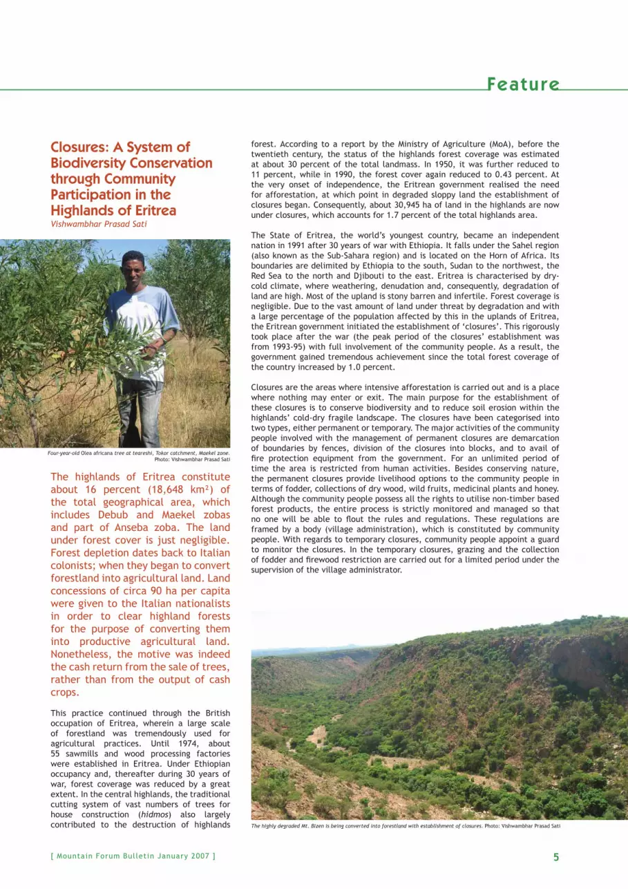
Four-year-old Olea africana tree at teareshi, Tokor catchment, Maekel zone. Photo: Vishwambhar Prasad Sati
The highly degraded Mt. Bizen is being converted into forestland with establishment of closures. Photo: Vishwambhar Prasad Sati

6 [ Mountain Forum Bulletin January 2007 ]
Following independence, the Eritrean government began the establishment of ‘closures’ under the MoA. In 1993, the MoA circulated an order to the village assemblies administrators, in which it is clearly stated that each village must manage at least one ‘closure’. The peoples’ participation was ensured in 1997 with full dedication. Agricultural experts were deputed to the villages in order to initiate discussions with community people to raise awareness and interests towards closures. The Ministry has the following agenda: vegetation recoveries, pastoral reserves, protection of endangered fl ora and fauna, control on run-off, prevention of arable land loss, and increase of underground water potential. Under this process, community people from each village decided which area would be suitable for closure establishment. In order to establish closures, a site must fi rst be identifi ed. Site selection is based on the following facts such
as the distance from settlements, severity of soil erosion and degradation, availability of grazing land (people have to ensure that there is an alternative grassland), the nature of slope (if the slope gradient is high, afforestation will be dense and vice versa), soil depth and fertility (if the soil is fertile and deep, the area will be used for agricultural practices), existing remnant vegetation (closures are suitable in areas where existing remnant vegetation is available), and socio-economic conditions (villagers have to ensure that there is no confl ict on the land within the villages). Upon identifi cation and completion of suitable site(s) for closures, a formal written agreement will be signed between the village and the administrator, who is also a village assembly member in the Zoba administration and head of the sub-zoba (MoA). This agreement will be based upon the size and boundaries of closures, tasks and responsibilities of the community people and the government, and it lays out joint management. The government will provide foodstuffs in exchange for labour carried out by the community people to establish and maintain the closures. The level of people’s participation in Eritrea is high in all respects, particularly in nature conservation such as soil conservation through terrace construction and afforestation, water conservation through construction of small dams and ponds, and conservation of forests through closures. Four years ago, an Olea africana tree was planted in Teareshi, Tokor catchments, Maekel zone. This person is still looking after it. In Eritrea, closures are a peculiar system to conserve biodiversity by means of community participation. Within a short time span, the state gained tremendous success. The total numbers of
closures have reached 111 and the total area under closures is 124,842 ha, which is about 1.0 percent of the country’s total geographical area; a vast area increase in comparison to the time of independence when only 0.43 percent of land was covered by forests. This data, relevant to the success of closures, is not only recorded on the government documents, but was also widely observed during fi eld visits.
Vishwambhar Prasad Sati, PhD is an Associate Professor of Geography at the Eritrea Institute of Technology. He may be contacted by mailing to PO Box 11370, Asmara, Eritrea, N. E. Africa, or by sending an email to [email protected].
Table 1: Zoba area under c losures in Er i t rea
Name of Zoba
Geographical location
No. of closures Area under closures (ha)
%
P T P T Total
Debub Highland 24 16 13,843 1,290 15,133 12.12
Maekel Highland 07 05 4,990 4,500 9,490 7.60
Anseba Highland 09 02 6,258 64 6,322 5.06
Total Highland (a) 40 23 25,091 5,854 30,945 24.78
Anseba Lowland 08 - 1,880 - 1,880 1.50
S. K. Bahri Lowland 20 - 59,932 - 59,932 48.00
Gash-Barka Lowland 10 10 23,435 8,650 32,085 25.70
Total Lowland (b) 38 10 85,247 8,650 93,897 75.22
Total (a+b) 78 33 110,338 14,504 124,842 100
Abbreviation: P stands for permanent and T for temporary.
Source: The author-calculated data (secondary data was collected from the Ministry of Agriculture, Asmara, Eritrea).
Table 1 reveals the number of closures, both permanent and temporary, and their area (in hectares). The number of closures in the highlands is high (63) in comparison to the lowlands where the total number of closures is 48. However, when the area under closures is compared, the lowlands have much more total covered area: 93,897 ha (75.22 percent) opposed to that of the highlands (30,945 ha).
Feature

7[ Mountain Forum Bulletin January 2007 ]
Biodiversity Assessment in Lobo-San Juan MountainsAnacleto M. Caringal
The destruction of natural habitats is widespread in the Philippines. Its implications for biodiversity conservation and sustainability of natural species militate against the efforts to build ecological security for the gene pools and the natural systems of species’ habitats.
Between the years 2000 to 2005, the Batangas State University (BSU) and the Ecosystems Research and Development Bureau (ERDB), a sub entity of the Philippine’s environment and natural resources department, collaborated to generate and integrate information on the status and value of biological and socioeconomic resources; and to determine the extent of ecosystem fragmentation as a basis for interventions for biodiversity conservation in areas within and surrounding Lobo-San Juan Mountains (LSJM). This mountain range lies on the southeastern coast of the Batangas Province and on Luzon island - in the Philippine archipelago made up of some 7,100 islands. The archipelagian setting is considered to be entirely oceanic, formed by the crustal collisions of two plates, a Pacifi c Plate and the South China Sea Plate, with most of the uplift occurring since the beginning of the Miocene. The present landform consists of old, as well as fairly new, oceanic islands formed during the Plio-Pleistocene series of tectonic and volcanic activities.
LSJM, lying between 13°38’8” N latitude and 121°12’6” E longitude, is 140 km south of Manila, the country’s capital, and spans 38 km from east-west and 30 km from north to
south. This mountain range, with Mt. Banoy (1,000 m), Mt. Lobo (1,007 m), Mt. Daguldul (978 m) and numerous coral hills and inland Karst, comprises what is possibly one of the most biodiverse frontiers in the Philippines. The mountains basically consist of volcanic materials from various ages and where the underlying geography is shallow, soft and porous reef limestone, including bushes of corals, shells, algae structure and marls along with volcanic agglomerate, and recently alluvium formation. They intercept an annual precipitation of 172 mm and possess a wealth of biologically diverse, yet fragmented, habitats; fragmentation is caused mainly from beaches, mangrove, dipterocarp, mossy, limestone and semi-deciduous forests.
Endangered keystone speciesAccording to the World Conservation Union’s (IUCN) Red List of Threatened Species, LSJM houses several endangered species, among them are endemic trees: Philippine teak (Tectona philippinensis), dungon (Heritiera sylvatica) and molave (Vitex parvifl ora), which were once used for the construction of giant treasure-ship galleons that plied the Manila-Acapulco route during the 1700s and 1800s. Studies showed the continuing population disappearance of the Philippine teak and dungon in the wild as being the most heavily exploited fl ora tree from southeastern Batangas due to anthropogenic threats to sustain agriculture and other domestic activities. Today, there are as few as 4,300 wild specimens of the Philippine teak and 295 dungon. Along with these vanishing trees are the threatened colony of the Philippine’s endemic giant fruit bat and fl ying-foxes (Acerodon jubatus and Pteropus vampyrus) whose recent survivors are down to only 678 (from 5,000 – 10,000 some 50 years ago). The culprits are subsistence hunting and habitat fragmentation. IUCN considers an animal to be at risk of extinction if its population level is below 2,000.
Flora and fauna accountsAs of 2004, taxonomic diversity of plants accounted for in LSJM was 181 species under 137 genera, and 66 families. Out of these 181 species, eight are fern and fern allies, 27 are monocots and 146 are dicots; 149 species are indigenous to the Philippines, while 32 species were introduced.
There are a total of 96 avifaunal species under 37 families; 31 percent are endemic, 17 percent migratory and 52 percent are resident species; 14 avian species were also identifi ed as common across all habitat types from coastal to mountain. There are 10 species of wild mammals, four of which are bats. Faunal assessment in LSJM also shows that wild fauna is typical for Luzon island and within the whole of the Philippines.
Feature
Mountain rice harvesters in Lobo, Philippines. Photo: A. M. Caringal
Flying foxes in Lobo-San Juan mountains, Philippines. Photo: A. M. Caringal

[ Mountain Forum Bulletin January 2007 ]8
Mountain products A variety of non-timber forest products (NTFPs) are exploited in a sustainable mode by mountain villagers for their perennial small-scale forest-based enterprises, while some others operate under subsistence levels. NTFPs include: organic sweeteners like honey from wild bees (Apis dorsata); crates from tall grasses (Bambusa blumeana); midribs and fi bres from an erect palm (Corypha elata); vine fi bres from siamlata (Ichnocarpus frutescens); rough broom from another erect palm (Arenga pinnat); soft broom from tiger grass (Thysanolaena maxima) and organic hair tonic from woody vines/lianas (Entada phaseolides).
The total monetary contribution of these NTFPs in the Philippine Peso (PhP) during the fi scal year of 2004-2005 amounted to PhP 169,354.40 (equivalent to USD 3,259.23) at the community level and PhP 25,062.87 (USD 770.02) of the household economy. The NTFPs gatherers and processors are household members themselves who have very low level of education; 70 percent of whom have not completed elementary, while only 30 percent have reached high school. Mountain children are able to attend primary education in remote villages of Lobo, however in their current condition they have no more interests to attend schooling. NTFPs sales are means for much needed cash, especially during tight months when money is hard to come by and these sales are utilised entirely for household essentials such as rice, sugar, medicine, cooking oil, powdered milk, detergent, salt, kerosene, fi sh, pork and other pressing necessities.
Windows of oppor tunit ies for better l ivesThere are also long lists of problems besetting the Lobo-San Juan Mountains such as forest fragmentation and fl ooding, and still higher up there is a dire lack of other livelihood opportunities, insuffi cient water supply for both domestic use and crops irrigation, poor road systems and abject poverty. As these problems are intertwined, it can be concluded that strengthening proper mobilisation of support services and institutional linkages could address these issues. The LJSM is an important ecological frontier with inherent mountain capacity to sustain certain uses and small-scale opportunities, therefore, zoning the mountain range into various sustainable uses could be done through local and institutional governance, in such a way that areas identifi ed as not suitable for destructive exploitation must be declared to be protected.
People’s perception analysis done on the mountains and their present state, protection and conservation as well as the relationship existing between communities and environmental factors is extremely high. Findings suggest the need to continuously stir a high level of awareness among the LSJM people through appropriate information, education and communication (IEC) campaigns and interventions. These IEC approaches may come in various forms or modalities to encourage the popular general psyche to a higher plane for better appreciation of “managing mountain biodiversity for better lives”.
Antacleto M. Caringal teaches tropical forestry and agricultural sciences at Batangas State University, Philippines and works as a freelance nature photographer and mountaineer. He can be contacted at [email protected]
Biodiversity Management: Towards Re-establishment of a Protected Areas System in AfghanistanStephan Fuller
In Afghanistan a system of royal hunting reserves and culturally important sites for recreation existed in pre-colonial times. Although some of these became popularised during the post-WWII period as tourism became a signifi cant component of the Afghanistan economy no system of protected areas was established. Beginning in 1972, however (with UNDP funding), an analysis of potential protected areas in Afghanistan was undertaken. The investigators undertook detailed studies of a variety of sites including fl ora and fauna, geology, soils, hydrology etc. Draft management plans for many of the sites (such as Bande Amir) and hunting reserves (Ajar Valley) were produced. More extensive species studies (Marco Polo Sheep) were also carried out in areas such as the Wakhan Corridor.
Unfortunately, the Soviet invasion of Afghanistan in 1979 quickly made it impossible for the project to continue. Although many of the site investigations had resulted in the areas
Fuller at 7400 m Tirich - Mir - Afghan Peaks Behind. Photo: www.fuller-imc.com
Feature

[ Mountain Forum Bulletin January 2007 ] 9
being identifi ed, delineated and categorised as protected areas, most were never legally gazetted under any statute of the day. They were simply “paper parks”.
Original 1970s Protected Areas Proposals
Location Description
Pamir-i-Buzurg Although in relatively good condition due to its inaccessibility and remoteness, the “Big Pamir” Reserve is now being used for grazing large numbers of domestic stock.
Bande Amir In recent years, two of the six lakes, Bande Qumbar and Bande Pudina have experienced temporary dry periods; illegal hunting and fi shing sometimes with explosives have persisted during intervening years; activities such as placing a fl our mill and some dwellings around the lake threaten the beauty and integrity of the national park; and the area is heavily mined.
Ajar Valley The lands in the reserve are now reported to be occupied by some 300 plus families; much of the fl ora in the valley has been depleted by overgrazing of domestic stock and many woody plants have been cut for fuel and building supplies; many hectares of reserve lands have been converted to dryland agriculture.
Ab-i-Estada Originally a proposed waterfowl sanctuary this is a drought effected area and has been dry for several years; no reported fl amingo breeding for several years and Siberian Cranes have not been seen there since the late 1970s.
Dashte Nawar Some small springs dot the largely dry lake bed with pools of water; hunting is reportedly common; nomads occupying the area now presume the lake is their property; construction of mud houses in graveyards in the immediate vicinity of the former shoreline is a serious problem.
Kole Hashmat Khan
Some of the wetland had been reclaimed, which considerably reduced the overall area of the wetland; much of the wetland vegetation has disappeared.
In addition to the 1970s investigations, there have been a number of surveys since the original UNDP project was concluded. This included surveys of wetland areas (1995), important bird areas (1994), endemic bird areas (1998) as well as the results from the WWF Global 200 ecosystem program. There have also been partial reviews of sites important for plant diversity. However, much more detailed work is needed and in many cases this remains diffi cult due to security conditions.
Additional Proposed Protected AreasLocation DescriptionSistan Baluchistan/Hamun-i-Puzak
This drought affected transboundary wetlands area has been dry for nearly a decade although substantial rainfall and snowmelt in the Hindu Kush mountains caused signifi cant fl ooding along the Helmand River in early 2005.
Northwest Afghanistan
There is a longstanding proposal for a wildlife reserve in this area, including twinning with an existing “protected area” in Iran.
Tugitang Mountains
An existing UNDP/GEF project involving improved wildlife management and protected areas development between Turkmenistan and Uzbekistan is underway. This could potentially be expanded southwards into Afghanistan.
Kunduz Province Wildlife Reserve
Originally proposed as an Afghan wildlife management area; it has not been actively or effectively managed. With the active present day interest within Tajikistan for transboundary protected areas the potential of this area has re-emerged.
Takhar Province Wildlife Reserve
With the active interest within Tajikistan for transboundary protected areas the potential of this area has also emerged.
Nuristan Forest These areas of Laghman and Kunar provinces have the richest remaining forests in Afghanistan. Wildlife populations are relatively undisturbed in the Hindu Kush Mountains.
Paktia Forest Relic and endangered conifer and hardwood forests.
Registan Desert Wildlife Reserve
Site which would be representative of the desert ecosystem.
SE Badhakshan Potential wildlife conservation areas.Jalalabad Valley Forests and lakes in the Jalalabad Valley have
been identifi ed to be crucial for migratory waterfowl and the conservation of relict conifer and hardwood tree species.
Many of the additional protected areas that have been identifi ed for the Afghanistan system are in the mountainous border areas and are matched with transboundary sites in adjacent countries. This provides the opportunity for discussions for joint management and cooperation of natural resources. These areas are potential “peace parks”. The most signifi cant international “peace park” opportunity includes the existing and proposed protected areas within the Wakhan Corridor in northeastern Afghanistan.
International co-operation on environmental conservation in this area has been discussed since the early 20th century. Expanding the concept of an international wildlife conservancy into one focused as much on human development needs has taken hold in recent years certainly since the regime change in Afghanistan in 2001-2002. This, in turn, has attracted the attention of the multi- and bilateral donor agencies that are working towards peace and reconciliation in Afghanistan. It is also true that any protected area in Afghanistan will need to involve local communities and be able to deliver pragmatic poverty alleviation and economic development opportunities, in addition to broader wildlife and ecosystem conservation initiatives. This additional aspect of protected areas planning in Afghanistan deserves continuing support.
At the present time UNEP has been the key international agency acting to re-establish the protected areas system and has been funded by the European Union to establish the new National Environmental Protection Agency (NEPA). UNEP and NEPA have placed a high priority on programming related to environmental law and policy as key element of their institutional strengthening work. This culminated in December 2005 with the promulgation
Feature

10 [ Mountain Forum Bulletin January 2007 ]
of a comprehensive Environment Act. Among its salient elements is a framework for biodiversity conservation and a new protected areas system for Afghanistan.
The framework legislation requires the protected areas system to:
� Conserve natural and cultural heritage;� Preserve present and future sustainable development options by conserving, and where necessary restoring representative ecosystems, habitats, natural and cultural features and integrat their management into local and national land use plans; � Ensure sustainable use of natural resources by involving local communities in all activities related to protected areas.
NEPA is now expected to develop an overall protected areas system plan, prioritise protected areas, cooperate with communities, develop site specifi c management plans and implement appropriate zoning systems for each site. Given the present security environment in the country, all the initial work is taking place in the safer areas in the Hindu Kush Mountains.
The Environment Act adopts the internationally recognised categories of protected areas that have been developed and tested world-wide by the IUCN. The Act prescribes a basic process for designating a protected area in consultation with provincial, district and village governments.
UNEP/NEPA have similarly been responsible for assisting the Government of Afghanistan in the accession to and implementation of various Multilateral Environmental Agreements (MEAs) that are important for general environmental conservation purposes. This includes the Convention on Biodiversity (CBD), the Convention to Combat Desertifi cation (UNCCD) and the Framework Convention on Climate Change (UNFCCC). Work has also begun on the completion of the National Biodiversity Strategy and Action Plan (NBSAP). Once developed and adopted this will provide the strategic policy framework for implementation of a protected areas system plan.
Progress towards the re-establishment of a Protected Areas System in the mountains of Afghanistan. Map: IMC
Another important component of the UNEP/NEPA program is the pilot work on Community Based Natural Resources Management (CBNRM). This work includes an explicit link between rural development and conservation objectives. UNEP/NEPA is combining a wide variety of alternative livelihoods projects with the nature conservation activities particularly with respect to the site-specifi c management planning and implementation activities for individual mountain parks and protected areas.
Currently there is a growing number of new donors for mountain protected areas in Afghanistan. This growing momentum for re-building the protected areas system within the country is very encouraging, because it is taking place in a post-confl ict situation where it would not necessarily be identifi ed as a conventional “development” priority. If properly designed the protected areas projects can contribute signifi cantly to the sustainable human development objectives that are at the core of the Afghanistan National Development Strategy.
As a result there has been continuing progress on environmental management improvement in the Hindu Kush Mountains and the NE corner of the country up into the Wakhan Corridor and the Pamir Mountains.
This includes:
� fi eld work underway by the Asian Development Bank (ADB) on management plans for new protected areas in the western Hindu Kush Mountains; � USAID and Wildlife Conservation Society (WCS) in a three-year program to re-survey and develop management plans for many of the pre - 1979 and new sites in the Hindu Kush and Wakhan Corridor; including the Big Pamir Reserve; � the European Union’s integrated watershed development projects within the Amu Darya basin all of which include upland rehabilitation projects and new protected areas; � ADB and WCS funding for work on the “peace park” concept that would link wildlife conservation and community development work among Afghanistan, Pakistan, China and Tajikistan.
Progress on all of these initiatives is very dependent on the security situation in the Hindu Kush remaining stable (and hopefully improving) and there are still many “no-go” areas. However, there is considerable momentum building with the new NEPA taking a leadership role.
Stephen Fuller is a sustainable development and environmental consultant for the International Mountains Consultancy (IMC) in Canada. For further details see: http://www.fuller-imc.com
Feature

11[ Mountain Forum Bulletin January 2007 ]
A Challenge for Environmental Continuity in Italian MountainsBernardino Romano, Serna Ciabò and Mauro Fabrizio
The Italian mountain areas of the Alps and Apennines make up over half of the national territory. Just over 10 million inhabitants reside here in altitudes higher than 600 meters above sea level with a settlement density of over 60 inhabitants per square kilometres.
These same mountains represent approximately 2,400 km² of urban areas, which cover more than 1 percent and are predominately concentrated altitudes in between 600 and800 metres.
The two mountain chains are full of different characteristics and problems, yet they are similar in other ways. Undoubtedly the economies are much stronger and developed in the territory of the Alps. Here, you fi nd transfrontier mountain chains running from west to east for approximately 700 km with a high presence of summer and winter tourism activities for both national and international visitors (more than 150 million estimated visitors per year), whih create high impact on the teritory. Moreover, important productions such as energy, agriculture, forestry, zoology, artisan, and industrial originate in the Alps. The spatial proximity to the most important inhabited zones of northern Italy and central Europe guarantee relevant interests and economic fl ows, which not only nourish economies, but also generate pressure on environmental integrity in many areas that are already seriously compact.
Feature
Urban centre in the Alps (Val di Rabbi - Stelvio National Park). Photo: Bernardino Romano
The Apennines Convent ion and APE - Apennines Park of Europe
Mountains occupy 54 percent of Italy, and as a result mountain-related issues are a priority for this mediterrean country. The Alps and Appenines are high-risk areas from the point of view of environment and hydro-geology, but also in terms of declining populations and the loss of traditions and cultural identity. The south of the country faces problems of depopulation and the onset of desertifi cation due to territorial mismanagement.
Italy has long been engaged in sustainable mountain development, and the International Year of Mountains in 2002 gave impetus to new and existing projects and activities.
On 24 February 2006, a historical event took place as the Italian Apennines mountain range was endowed with a new protection and management instrument following the signing of the Apennines Convention at the political level. The Convention was signed in the city of L’Aquila by representatives from the Ministry of the Environment, the 15 regions concerned – made up of 48 provinces, 2,165 communities, 11 national parks, 41 regional parks, and 52 natural reserves - local authorities, including Mountain Partnership member Unione Nazionale Comuni, Comunità, Enti montani (UNCEM), the Italian Association of Natural Parks, and Legambiente environmental organisation. According to its initiators, the Apennines Convention is the fi rst convention worldwide to focus fully on the role of protected areas.
Read the Apennines Convention at http://www.parks.it/federparchi/ape/conv.appennini.2006.html
To learn more about parks and protected areas visit the Federparchi, the Federation of Italian Parks and Reserves, website: www.parks.it (in Italian, English, French and German).
Read more about APE - Apennines Park of Europe at http://www.legambiente.com/documenti/2004/0503_areeProtette/APE.php or http://www.parks.it/federparchi/ape/
LegambienteAntonio NicolettiNational Director of Protected Areas and Territory Via Salaria 403 - 00199 Rome, Italy
Tel: +39 06 86268354Fax: +39 06 86268319
Email: [email protected]: http://www.legambiente.com

12 [ Mountain Forum Bulletin January 2007 ]
The Apennines is a peninsular mountain chain that runs the length of nearly 1,200 km from northwest to southeast. It conjoins with the Alps at Colle di Cadibona, which is found between the regions of Liguria and Tuscany, and ends in the north of the island of Sicily at Monte Nebrodi and Monte Peloritani. The economic conditions of the Apennines’ territories are extremely different from that of the Alps, also due to the inland latitudinal layout. Over the centuries, in the northern sector of the Apennines, more utilisation - particularly agricultural and forestry related - spread due to morphology that is less harsh than that of the central sector. However, this has likewise entailed a major diffusion and density of the infrastructure with a greater parallel to environmental quality.
The Central Apennines, with higher mountains and more tormented orography, has been self-defended throughout the historical eras and, over the last forty years, is now suffering the worst attacks to its natural integrity. The inclusive naturalness diminishes descending towards the south, then recovers again, in the southern regions of Basilicata and Calabria, at high levels of altitude.
Moreover, in south-central areas the economy of mountainous territories of the Apennines strongly faces diffi cult phenomena that for decades have characterised the zones of South Italy. The mountain creates major logistic problems of accessibility and an endowment of services.
The two Italian mountain systems are therefore two clearly distinct worlds; one on the mountain side for economic conditions and the other a thematic framework. In this sense, there is a level of complexity much higher if you inquire into particular cases, which are often conditioned by local morphology and by historic events.
Yet, instead these two mountain systems make up every comparable reality if you consider the aspect of environmental continuity and the role ecological connectivity that overlay here.
The Alps and the Apennines presently host the majority of fl ora and fauna species at risk of extinction. They also establish the principal reservoirs for biodiversity in the Mediterranean basin (more than 30,000 species appraised solely in the Alps).
The Italian forest areas generally spread over 70,000 km², 23 percent of the national territory, wherein more than 85 percent are found within the Apennines and the Alps. These forests make up practically all of the spatial connections, across which the Italian ecosystems of key eco-biogeographic importance connect with the other European systems - French, Swiss and Austrian Alps, Pyrenees, Cantabric, Slovenian and Balcanic areas – creating one of the most extensive lines of ecological connection within the European continent. At least potentially this area is capable of guaranteeing future survival of fauna species of great importance such as the bear, wolf and lynx, among many other ungulates, meso-mammals and micro-mammals, amphibians, reptiles and birds.
It is interesting to note that Italian bio-permeable areas, areas not containing phenomena of intense activity concerning settlements (of population or of industrial facilities) include forests covering 180,000 km², or 60 percent of the nation, and are located in approximately 72 percent of mountainous areas.
The total Italian natural reserves and parks cover approximately 70,000 km². Of these, about half are found in Alpine or Apennines mountains, accounting for 20 percent of mountains to be protected.
The same areas practically host the totality of water sources from fl uvial water to parts of rivers not extremely polluted. Together all of these represent the custodian of potable water for the entire nation.
The morphological model and settlement interferences are substantially the same for both mountain systems. A series of parallel valley incisions of glacial or fl uvial origin and a separate series of orography blocks run the entire length of the longitudinal arch of the mountain chains. Since prehistoric times, in the valleys there has been condense settlement aggression, along with corresponding lines of transition and exchange. In both mountain chains the highest altitude, with the exception of morphologically inaccessible environments and those occupied by ice, have always played substantially productive roles for hunting, vegetable and mineral research, forestation, pastureland and grazing. These characterise could be defi ned as the “vertical” economy for the mountainous areas.
In various ways, over the course of time this sort of “vertical” economy - more so in the Apennines than within the Alps - has been replaced by another type of economy even more vertical than tourism with the development of winter ski stations and summer activities like trekking and climbing.
Consequently, high altitude settlements have increased notably, both in number and in dimension, and thus there has been an increase in infrastructure connections (roads and sewage systems).
At the same time, there have been large increases even in the “horizontal” economies, which are those linked to low valley territorial resources. These were fi lled by intensive agricultural areas, urbanisation, factories, industries, dams, layers of infrastructure (highways, motorways, train tracks, electroducts), which for the most part are related to the length of fl uvial shafts to the point where the inclinations have been easily permitted.
As a result, a considerable amount of ecological fragmentation has been created between various patches that host the most important mountain ecosystems. Whereas for years you could consider rather diminished actions linked to “vertical” economies for reasons of saturation. However, the same is not
Historical centre and other urbanisation in Apennines (Pacentro e Valle Peligna). Photo: Bernardino Romano
Feature

13[ Mountain Forum Bulletin January 2007 ]
true for actions linked instead to medium and low sectors of the valleys and the plains where there is still a continual increase of soil waste.
The phenomena can be connected within both mountain chains. There is a need to improve accessibility (and, therefore, mobility) between strong urban and productive regions of the country (such as the great fl oodplains and coastlines) and the highlands in order to maintain even standards of “urban” quality life, as well as to avoid relocation and migration toward cities. In turn, there is an urgency to guarantee limited daily commute times, while providing a medium-high level service endowments.
This sort of territorial selection, which is supported by all political sides, will inevitably bring forth the construction of many infrastructures and, consequently, fragmentation of all the most important mountain areas as well as protected areas where they are situated. In the Alps, the great roadways of mobility are predominately oriented from north to south as means of connection between the metropolitan zones of the Padana area (from or relating to the Po Valley, in north-central Italy) and nearby towns. In the Apennines these are principally laid out from east to west in order to connect important, fast lines of coastal traffi c from the Tyrrhenian and the Adriatic Seas. Already in the past, as they will in the future as well, these infrastructures have destroyed habitats and isolated important ecosystems. Most of the time, the majority of them foresee social and economic benefi ts, which are never effectively realised.
One hypothesis that will be diffi cult to attain and affi rm within the collective Italian culture is linked to the fact that mountain life must not, and should not, become the same as life in metropolitan areas. In addition, the two models of development must hold different positions, with advantages and disadvantages. Yet, at the same time, provide the possibility for individuals to be able to carry out choices based on various qualities without necessarily and unwillingly looking for total homogenisation between realities naturally differentiated.
References:WWF. 2006. “Ecoregional Conservation and Biodiversity Vision for the Alps”. WWF Italy.
Gambino R., Romano B. 2004. “Territorial strategies and environmental continuity in mountain systems, the case of the Apennines (Italy)”, in: Harmon D., Worboys G. (Eds), Managing Mountain Protected Areas: challenges and responses for the 21st Century, IUCN, Andromeda.
Romano B., Tamburini G. 2006. “Urban sensibility of landscape structures in Italy: general characteristics and local details, Proceedings of ERSA 2006 Congress”, August 2006 Volos, Greece.
PLANECO: http://www.planeco.orgECONET: http://www.lifeeconet.com
Bernardino Romano, lead author of this article, is an Associate Professor of Land Planning at the Universita’ dell’Aquila in Italy and can be reached at [email protected]
Maintaining Bio-cultural Diversity in the AndesSarah-Lan Mathez-Stiefel and Stephan Rist
In the Andes, biodiversity is intimately linked to human activity through a long history of co-evolution between nature and society. Over several millennia, the Andes have witnessed the transformation of their natural ecosystems by the local populations, who have molded them according to their particular worldviews, knowledge, and practices, developing systems to manage biodiversity that include a wide array of ecosystems and climatic zones and the exploitation of various ecological belts. This has enabled them to diversify access to natural resources along the year and domesticate some of the most important crops for humankind, thus leading to extraordinary levels of agrobiodiversity.
BioAndes, a program based in the Andes working with various partners to link scientifi c and indigenous expertise, focuses on the development of concepts, tools and practices related to the conservation of biodiversity through enhancement of cultural diversity, exploring the possibility of conserving (agro)biodiversity both with and for natural resource users.
The Andes are characterised by very high levels of biodiversity. According to a publication of the Community of Andean Nations (CAN), the fi ve CAN countries - Bolivia, Colombia,
Andean ritual. Photo: Stephan Rist
Feature

14 [ Mountain Forum Bulletin January 2007 ]
Ecuador, Peru, and Venezuela - harbor 25 percent of the world’s biodiversity and are among the 17 countries in the world with the highest biodiversity (CAN, 2003). Besides the vital services provided by natural ecosystems, this diversity is extremely important due to its immediate relevance as an economic basis for Andean countries, in which almost half of the population still lives in rural areas, with livelihoods depending mainly on domesticated and wild species; moreover, in 2001, for instance, biodiversity contributed 20 to 45 percent of total exports from Bolivia, Ecuador and Peru.
In sharp contrast with this biological wealth, Andean populations live under precarious conditions. Besides experiencing discrimination and marginalisation by the colonial power in the past and currently by the dominant classes in their countries, the indigenous peoples of the Andes live in a harsh environment characterised by extreme climatic conditions, low soil fertility, and serious natural resource degradation. In 2003, 54 percent of the total population of the CAN countries was considered to live in poverty; this percentage rises to 80 percent if we look at the rural populations of Bolivia and Ecuador.
As in other parts of the world, important degradation processes are affecting Andean ecosystems. The causes of biodiversity loss in the Andes today are soil erosion, deforestation, overgrazing, demographic increase, high urbanisation rates, pollution caused by the mining industry, and unsustainable water management. These socially rooted causes of biodiversity loss date back to Spanish colonial times, when the traditional structures of the landscapes underwent deep modifi cations. By radically changing existing forms of socio-political organisation and introducing new species and techniques, land use systems were drastically transformed, leading to severe degradation of soils, water bodies, and biodiversity. Such transformations continue to date, but the reasons for degradation, today, are related rather to the dramatic decline of prices for basic food and cash crops, as well as to migration and very high disparities with regard to distribution of and access to agricultural land.
The BioAndes Program was designed to fi ght the loss of biological and cultural diversity in the Andes through an approach that taps sustainable systems of natural resource use such as traditional agricultural practices, organic agriculture, agro-forestry, and ecotourism, as well as strengthens and promotes Andean cultures through the revalorisation of local knowledge and worldviews.
BioAndes is a regional program of the Swiss Agency for Development and Cooperation. Its overall goal is to contribute to the conservation and the economic, socio-cultural, and political valorisation of biodiversity in the Andean regions of Bolivia, Peru, and Ecuador. Activity lines include support for production systems and economic initiatives, capacity building, action-research and knowledge management, and policy dialogue at local, national, and regional levels. As an alternative to a conservationist approach that excludes human populations, BioAndes focuses on sustainable governance of areas that were specifi cally selected outside protected areas, taking into account their importance in terms of bio-cultural diversity. Another innovative characteristic of the program is that it addresses the meso-level of socio-political organisation (municipalities, district governments), which are of strategic importance for actions aiming at conservation of bio-cultural diversity, and a crucial missing link between existing traditional local norms and knowledge and the national regulations that are often inspired by the Convention on Biological Diversity. The Andean states have engaged in a process of decentralisation, promoting policies and legal instruments that aim at strengthening local governments, thus opening a space for the transformation of existing structures. Nevertheless, the presence of intermediate levels of state administration in decision-making processes regarding natural resources and biodiversity is still weak and it is diffi cult to coordinate actions to counter the negative impacts of global change beyond its manifestations at the local level.
The program is executed by a consortium of three local institutions: AGRUCO (a University institute in Bolivia), ETC Andes (a development association in Peru), and EcoCiencia (a ecological studies foundation in Ecuador). Projects are implemented by a wide network of local NGOs, universities, municipalities and other organisations through a competitive fund.
At the heart of the BioAndes Program approach lies the Andean understanding of the intertwining of the material, natural, and spiritual spheres of life, as well as the recognition of the need for a dialogue between different forms of knowledge, i.e. between scientifi c knowledge and indigenous knowledge. Indeed, fi rst experiences have shown that the defi nition of more systematic recommendations for the promotion of ‘bio-cultural areas’ requires implementing such programs more consistently on an integrated research basis, with the objective of better understanding the links between socio-cultural and bio-physical diversity. BioAndes thus has several lines of action research such as the investigation of local norms for biodiversity management, the analysis of actors involved, the study of national strategies for biodiversity conservation and the impact of these strategies, etc.
A further BioAndes research project worth noting aims to investigate how Andean environmental knowledge is transformed, what infl uence such transformation processes have on biodiversity management, and how they are related to socio-cultural processes of personal and collective identity formation. In its articulation of worldviews, ethical values, and uses of biodiversity, indigenous environmental knowledge may indeed give us important insights into the links between cultural and biological diversity. In the Andean highlands, indigenous environmental knowledge is currently undergoing major changes
Cusco terraces. Photo: Mathez Stiefel
Feature

15[ Mountain Forum Bulletin January 2007 ]
Feature
as a result of various opposing forces. On the one hand, as in many other parts of the world, an overall process of erosion of local environmental knowledge can be observed as a consequence of socio-economic factors (the formal education system, the introduction of a market economy, and the weakening of the role of traditional authorities). On the other hand, indigenous communities are purposely revalorising their knowledge: recognising the link between the principles of sustainable development and local knowledge, many communities take up traditional practices that valorise biodiversity, thus strengthening their indigenous collective identities. This is the result of a continuous process of cultural resistance since colonial times, recently enhanced by the emergence of strong social indigenous movements (in Bolivia and Ecuador), the election of the fi rst indigenous president of the Americas in 2005 (in Bolivia), and the activities of organisations that promote the revalorisation of local cultures. To come up with concrete recommendations for the integration of ‘global’ and ‘local’ forms of knowledge and foster the conservation of cultural and biological diversity in the Andes, these processes need to be better understood.
The BioAndes Program refl ects the gradual shift in the fi eld of conservation since the 1990s: it is felt that policies are more sustainable if the link between biodiversity and cultural diversity, is enhanced rather than protect biodiversity from people. The BioAndes approach is based simply on the insight that conservation of bio-cultural diversity through alliances with indigenous and other local organisations representing people living within and/or near territories are crucial to really achieve conservation of (agro)biodiversity. Helping people to create new space for practicing and further developing their ‘traditional’ forms of living is thus a basis for a more comprehensive model of sustainable natural resource use that builds on the enhancement, complementation and innovation of endogenous potential. What is especially promising is the fact that this highly innovative approach to sustainable development is actively supported not only by local communities but also by the national governments of Bolivia, Peru and Ecuador, as well as by the international Community of Andean Nations. Inclusion of representatives of governmental bodies on the Board of BioAndes has helped strengthen the policy dialogue between policy-makers, research institutions and civil society organisations involved in the governance of bio-cultural diversity in the Andes at the meso-level of social organisation.
BioAndes Consor t ium:AGRUCO, Agroecología Universidad Cochabamba (lead agency)Av. Petrolera Km 4 ½ Cochabamba, BoliviaEmail: [email protected]: www.agruco.org
ETC Andes, Ecología Tecnología y Cultura en los AndesCalle Juan Bielovucic 1391, Lince, Lima 14, PeruEmail: [email protected]: www.etcandes.com.pe
EcoCiencia, Fundación Ecuatoriana de Estudios EcológicosCalle Francisco Salazar E14-34 y Av. La Coruña, PO Box 17-12-257Quito, EcuadorEmail: [email protected]: www.ecociencia.org
The Centre for Development and Environment (University of Berne) has been mandated by the Swiss Agency for Development and Cooperation to offer conceptual and methodological support to the member institutions of the BioAndes Consortium. This paper is based on work supported by the Swiss National Centre of Competence in Research (NCCR) North–South: Research Partnerships for Mitigating Syndromes of Global Change.
Centre for Development and EnvironmentSteigerhubelstrasse 3, 3008 Bern, Switzerland.Email: [email protected] [email protected]: www.cde.unibe.ch
Land Use Change and Biodiversity Conservation in the Venezuelan Páramo: Integrating Farmers’ PerceptionsLuis D. Llambí, Julia K. Smith and Maximina Monasterio
In the diverse region of the tropical Andean páramos, threats to ecosystem integrity derive mainly from agriculture and cattle grazing. Approaches to biodiversity conservation have often been based on top-down regulations imposed by government agencies. Implementation of an alternative approach, incorporating local communities in the design of action plans for conservation, was the central objective during the design phase of the Andean Páramo Project. These plans will be executed in a network of key pilot sites along the South American páramos.
Here we report on the experience of the two Venezuelan sites, where the design process involved two complementary strategies: a multidisciplinary analysis of land use change and its threats, and the use of a participatory strategy for the analysis of farmers’ priorities and perceptions. The success of the process was linked to the importance the local population gives to the páramo ecosystem and its environmental services along with our emphasis to establish a constructive dialogue between local and technical views on the environmental consequences of land use change.
Potato cultivation in the páramos, Venezuela. Photo: Julia K. Smith

16 [ Mountain Forum Bulletin January 2007 ]
Páramo biodiversi ty and i ts environmental serv icesThe high tropical ecosystems of the northern Andes above the tree line are locally known as páramos and are among the most diverse high mountain ecosystems in the world. In Venezuela, they occur in the highest parts of the Cordillera de Mérida (above 3,000 m) forming a group of “continental islands”. Even though they occupy a relatively small area in the country (2,661 km²), the Venezuelan páramos harbour an impressive diversity of ecosystems and species. The vegetation is dominated by giant rosettes, shrubs and grasses. Their unique environmental conditions or typical of the cold tropics (night frost alternating with warm temperatures during the day), have infl uenced the evolution of spectacular life forms such as the endemic giant rosettes of the Espeletia complex, which had their centre of origin in the Venezuelan páramos. These environments also provide important ecosystem services including carbon and nutrient accumulation in their soils, landscapes that constitute one of the main tourist attractions in the country, and water provision and regulation. In particular, the high Andean wetlands play a key role in the accumulation and regulation of water, which is of critical importance for irrigation of the intensive agriculture practiced in the inter-Andean valleys.
Land use change and i ts threat to biodiversi ty The local population is made up of farmers established in the region relatively recently (in the last 300 years). The threats to biodiversity derive mainly from potato cultivation and extensive cattle grazing, which form the basis of the local rural economy. The agricultural systems vary along a gradient from semi-traditional fallow systems in the more isolated areas to marked-oriented intensive agriculture highly dependent on agrochemicals and irrigation. Both traditional and intensive farmers depend on grazing areas in the páramos as plowing is done with oxen due to the steep slopes. In recent years, the advance of the agricultural frontier has mainly been driven by relatively large farmers with access to capital rather than to the commonly invoked displacement of relatively poor farmers onto marginal lands. On the other hand, the decrease in forest availability in the agricultural belt has generated an increased dependence on high páramo areas for cattle grazing.
The Andean Páramo Project (Conservation of Biodiversity of the Páramo in the Northern and Central Andes, UNEP-GEF) aims at addressing the most important threats and barriers to páramo conservation, while improving the living conditions of its inhabitants. The project involves the countries with páramo within the Andean Community of Nations: Venezuela, Colombia, Ecuador and Peru. The central component of the design phase was the development of participatory conservation plans in a network of representative sites, which are now starting to be implemented. Their design was based on two complementary strategies: a multidisciplinary evaluation of land use strategies and its threats to conservation; an analysis of farmers’ perceptions of the main problems and threats.Here, we summarise our experience in the two pilot sites selected in Venezuela: Gavidia and Tuñame.
Mult idiscipl inar y evaluat ion of land use strategies and threatsThe analysis was done by a multidisciplinary team coming from diverse backgrounds including ecology, geography, rural development and social medicine. In each site, we carried out a detailed survey of family production units, open interviews, fi eld visits, analysis of panoramic and aerial photographs, participatory mapping, and a literature survey.
In Gavidia, the area directly affected by agriculture occupies 1,242 ha, 18.6 percent of the total catchment area. The agricultural frontier extends up to 3,850 m. The farmers use a semi-traditional fallow system for the commercial cultivation of potato, linked to extensive cattle raising. The cultivation phase lasts two to three years and is followed by a fallow phase generally lasting four to ten years in which a partial restoration of páramos vegetation takes place. Pasture lands extend far into high páramo areas, and in the dry season the animals concentrate in the wetlands. In recent years, the agricultural system has experienced a process of transformation towards intensifi cation with a reduction of fallow times, the installation of an irrigation system and the introduction of new crops like carrots and garlic. This last crop is associated with an expensive technological package of intensive use of agrochemicals, fi nanced by external capitals, even though the whole catchment is included in the Sierra Nevada National Park, where this kind of agriculture in not allowed. The main environmental threats derive from the potential expansion of the agricultural frontier, the indiscriminate increase in agrochemical use, and the maintenance of a relatively ineffi cient system of cattle grazing. In addition, in recent years Gavidia has become more important as a tourist destination, increasing the pressure on páramos areas.
In the case of Tuñame the area used for agriculture occupies 1,201 ha, 47.5 percent of the area included in the pilot site. The agricultural frontier extends to 3,550 m and has been moving up relatively fast in the last ten years (following the construction of a new road). In Tuñame there is a gradient of land use strategies from the valley bottom to the highest areas. In the lowest sector, where producers have access to irrigation, intensive agriculture with two to three cultivation cycles per year is found. In the high area agriculture is practiced with two to three years of fallow and a single cycle per year. The main crop is potato, which is rotated with carrot in places with irrigation. In the high areas, plots incorporated into the cultivation cycle are burnt, a practice which is relatively rare in other Venezuelan páramos. During the dry season these fi res can escape affecting extensive páramo areas. Cattle raising has decreased its importance considerably in recent years. However, a few farmers still keep large herds, which pasture in the high páramos. Most of the páramos in the Páramo, Venezuela. Photo: Luis D. Llambi
Feature

17[ Mountain Forum Bulletin January 2007 ]
Feature
valley are outside protected areas. The main threats to conservation include grazing and burning, contamination by agrochemicals and the continuing expansion of the agricultural frontier.
Par t ic ipatory analysis of local perceptionsThe action plans for conservation and management were designed through a participatory process, which included a series of workshops for the construction of a shared vision for the future, a detailed problem analysis (establishing priorities by consensus and developing problem analysis trees) and the discussion of viable alternatives. The resulting plans were validated in a technical workshop with representatives of the University, regional NGOs and key government agencies, including the Ministry of the Environment and the National Parks Institute.
At both pilot sites the process resulted in the identifi cation of the same core problems by the farmers: degradation and destruction of the páramos (mainly generated by agriculture and grazing), pollution from various sources (agrochemicals and waste water), and the lack of effective coordination and participation by the community. In Gavidia, the increasing impact of tourism was also included. The resulting lines of work proposed in the action plans are: strengthening of local organisations for effective participation (including the consolidation of environmental groups); mitigation of páramos degradation processes (including participatory land zoning and regulation agreements, increased sustainability of agriculture and cattle grazing and promotion of sustainable income generation alternatives); controlling pollution (mainly through the control and effi cient use of agrochemicals).
The main success of the process to design the action plans was the establishment of a constructive dialogue between scientists, farmers and representatives from regional governmental and non-governmental organisations. Interestingly, technical and participatory evaluations of environmental problems and threats were largely in agreement. Farmers in both pilot sites are clearly aware of the link between ecosystem integrity and human welfare and of the threats created by current land use strategies. This seems to be related to the key role of the páramo as a source of irrigation and drinking water and to a recent boom of regional environmental organisations, led in many cases by women. The main challenge for the implementation phase will be to create the conditions for translating local environmental awareness into effective changes in land use strategies. The adoption of these changes will depend on the promotion of economically and technically feasible alternatives and the strengthening of local capacities for the enforcement of environmental regulations and agreements.
Fur ther information Llambí, L.D., Smith, J.K., Pereira, N., Pereira, C., Valero, F., Monasterio, M. y Dávila, M. 2005. “Participatory planning for biodiversity conservation in the High Tropical Andes: are farmers interested?”, Mountain Research and Development 25(3): 200-205.
Learn more about the Andean Páramo Project at http://www.condesan.org/ppa
National Executing Agency (Venezuela): Instituto de Ciencias Ambientales y Ecológicas (ICAE). Facultad de Ciencias, Universidad de Los Andes. Mérida, Venezuela.
Regional Executing Agency: Consorcio para el Desarrollo Sostenible de la Ecoregión Andina (CONDESAN). Centro Internacional de la Papa (CIP). Quito, Ecuador.
The Andean Páramo Project is implemented by the United Nations Environment Program (UNEP) and fi nanced by the Global Environmental Facility (GEF). The project is part of the Regional Biodiversity Strategy of the Andean Community of Nations (CAN).
Lessons from Kipahulu Valley, MauiJohn Cusick
The Hawaiian Islands may not conjure up images of mountain ranges, they are not even on the Mountain Forum list of mountains or massifs, but these islands are both mountainous and biologically diverse. Kipahulu Valley, on the island of Maui, is an excellent example of island diversity from tropical sea level to alpine summits. The valley supports near pristine to severely altered habitat within four ecological zones found only on the highest mountains in the Hawaiian Islands - Mauna Kea (4,205 m), Mauna Loa (4,170 m) and Haleakala (3,055 m). This diversity has earned the valley numerous protected area designations, including National Park, Scientifi c Research Reserve, Wilderness Area, and International Biosphere Reserve.
Descriptions of Kipahulu Valley made by research scientists on a 1967 expedition and elsewhere warrant the strict protected area management strategies regarding access and activities; restrictions that have been in place for over three decades:
Kipahulu District, Haleakala National Park, Maui, Hawaii, USA. Photo: Bob Butterfi eld

18 [ Mountain Forum Bulletin January 2007 ]
“That such an area still remains intact is . . . to my knowledge unmatched anywhere else in (Hawaii) and is a biotic reservoir of tremendous value . . . These communities are like no other, and Kipahulu Valley in this sense offers an opportunity (for scientifi c research) not available elsewhere on the planet.”
The extraordinary biodiversity in Kipahulu is due partly to climatic variation in windward valleys on Haleakala caused by extreme elevational changes and increases in cloud cover. The annual rainfall gradient may vary from 2,000 mm near sea level to 4,000 mm at 1,000 m, while maximum rainfall may exceed 7,620 mm. In mid-elevation areas, dense vegetation makes for one of the most impenetrable valleys in the State of Hawaii.
The coastal zoneThe coastal zone of Kipahulu is characterised by hot and sunny conditions, strong winds, and salt spray. Boulder strewn shorelines at the base of steep cliffs, tide pools, and offshore rocks make up much of the coastline. The disruption of native ecosystems below 500 m by human activity and disturbance by cattle and feral pigs has left biotic communities in a state of constant change. Freshwater ecosystems in lower Kipahulu Valley are also threatened.
The coastal zone vegetation and topography were altered fi rst by Polynesian settlers, but monocultural land use practices in the post-contact period explain the absence of most Polynesian-introduced plant species. Stones used by Hawaiians to construct agricultural terraces, waterways and building foundations were cleared at random for sugar cane and pineapple plantations starting in the 19th century, and bulldozed later for commercial ranching. Pasture and woodlands have replaced most of the archaeological sites in this zone.
Alien tree species introduced in the modern period dominate the woodlands as high as 500 m and pose a serious threat to the native montane rainforest. Disturbance of native vegetation and introduction of alien species, both intentionally and accidentally, have created conditions that favor aggressive alien species. Dense stands of guava (Psidium cattleianum, Psidium guajava), christmas berry (Schinus terebinthifolius), java plum (Syzygium cumini) and mango (Mangifera indica) also provide food and shelter for exotic birds, mongoose (Herpestes auropunctatus), rats (Rattus exulans, Rattus norvegicus, Rattus rattus), mice
(Mus musulus), feral pigs (Sus scrofa), dogs (Canis familiaris) and cats (Felis catus).
The lowland zoneAs a source of alien biota, the lowland zone poses a major problem for the long-term preservation of native rainforest habitat above 1,200 m. The two main reasons why alien species dominate this zone are the greater degree of habitat destruction and disturbance, and more alien species thrive in the wet and warm conditions of lower montane rainforests.
This lowland zone has been developed for agriculture since the pre-contact period. Common alien species are those introduced since the 19th century, the most invasive of which is strawberry guava (Psidium cattleianum) with an elevational range from s90 m to 1,220 m. Primarily dispersed by feral pigs and alien birds, guava establishes dense stands varying from shrubs to large trees that displace native species. Dispersion of guava has led to native habitat loss and the extirpation of several native and endemic plant and animal species.
Introduced grasses form thick mats under native forests and inhibit the growth of native seedlings, posing a threat to the native forest. Another threat to the lowland forest is kahili ginger (Hedychium gardnerianum). An aggressive invader in wet, disturbed sites in the forest understory and along stream channels, kahili ginger grows as high as 2 m in large continuous clumps to 1,220 m. Birds eat the large fl eshy fruits, dispersing seeds over long distances, representing a threat throughout the lowland zone.
The montane rainforestThe montane rainforest is a refuge for over 89 known species of ferns, 290 species of fl owering plants, and four endangered forest birds. One of the most signifi cant botanical features of the Hawaiian Islands is the high rate of endemism. Researchers have identifi ed over 20 endemic woody lobeliad species in Kipahulu Valley, including three endemic genera. The curved, tubular fl owers of certain lobeliad species may have played a signifi cant role in the evolution of nectar feeding Hawaiian honeycreepers and are at risk of becoming extinct along with the native bird population.
Tropical montane rainforests are wet and cool. In Kipahulu Valley, mean monthly relative humidity averages 92.9 percent and mean annual temperature 15°C at 1,550 m, with precipitation recorded in excess of 7,600 mm in the upper montane zone. The 1,000 m lower elevation boundary coincides with the average lifting condensation level caused by the orographic effect. The multi-layered forest is dominated by an upper canopy of fewer koa (Acacia koa) and increasing numbers of ohi‘a (Metrosideros polymorpha), an understory of tree ferns and epiphytic ferns growing on moss-laden tree branches, and a forest fl oor of mosses, sedges and ferns. Ohi‘a continues to dominate the forest canopy to the upper limits of the rainforest.
The montane rainforest between 1,250 m and 2,000 m is “one of the least disturbed in Hawaii that provides an unequal opportunity to preserve an entire, unique, ecosystem almost undisturbed by humans and their activities,” according to national park scientists. Native plant communities in this zone are least disturbed by feral pig rooting and trampling and show the lowest frequencies of alien species.
Montane rainforest plant communities support four endangered forest birds, including one previously thought to be extinct. The Maui nukupu‘u (Hemignathus lucidus affi nis), last recorded
Kipahulu District, Haleakala National Park, Maui, Hawaii, USA. Photo: Bob Butterfi eld
Feature

19[ Mountain Forum Bulletin January 2007 ]
in 1896, was seen in 1967 in an ohi‘a-dominated forest. This sighting in the ohi‘a forest increases conservation possibilities since ohi‘a is the dominant, as well as the least disturbed, forest cover in East Maui. Other endangered forest birds in Kipahulu Valley are the Maui parrotbill (Pseudonestor xanthophrys), crested honeycreeper (Palmeria dolei), and Maui akepa (Loxops cocccineus ochraceus). A checklist includes a total of 13 endemic or indigenous birds.
The infl uence of the dormant volcano, Haleakala, on local climate is dramatic and particularly apparent in the montane rainforest. The lower range of the forest receives abundant precipitation from rain and fog drip in a cloud forest. These conditions support thick undergrowth and trees 35 m high. At the base of the inversion layer, where cold air encounters rising warm air at approximately 1,900 m, trade winds condense moisture and form a band of clouds on windward slopes 50 - 70 percent of the year. Plant morphology refl ects an increase in insolation and decrease in available moisture above the cloud belt, an area where ohi‘a become stunted and koa are completely absent. Shrubland including pukiawe (Styphelia tameiameiae) and ama‘u fern (Sadleria cyatheoides) is abruptly replaced by subalpine grassland (Deschampsia nubigena) at 2,200 m.
The subalpine zoneThe subalpine zone occurs on Maui and Hawaii Island above 1,800 m as a band encircling the windward and leeward summits of Haleakala, Mauna Kea, Mauna Loa, and Hualalai (2,521 m). Median annual rainfall at the head of Kipahulu Valley is still comparatively high for this zone (1,500 - 2,000 mm), with temperatures ranging between 3°C in winter and 21°C in summer. Extreme diurnal temperature fl uctuations of over 10°C affect soil temperature and plant growth and restrict growth to low-lying bunchgrass or tussock-forming grasses.
The subalpine grassland community is considered the highest and least disturbed tussock ecosystem in the State of Hawaii. A researcher described the subalpine zone as “one of the fi nest examples of native Hawaiian grassland with its associated edaphic and climatic factors.”
Erosion is most severe on the steep headwall and trails formed by decades of feral pig and goat activities. These highlands contain the greatest frequency of alien plant species. Alien plants are destabilising agents in the montane bogs and ponds protected within national park boundaries. The destructive capability of feral animals led to the construction of 53 km of cyclone fencing in the 1980s to protect the scientifi c value of the valley ecosystems.
Lessons from Kipahulu val leySustainable development has emerged as part of an effort to ensure human survival in a time of global environmental change. Kipahulu Valley’s protected area status contributes to that effort by providing a location for various stakeholders to monitor ecological and human adaptations that can be disseminated to other protected area managers and adjacent resident communities. In this way, the Hawaiian Islands link environmental conservation of marine and mountain biodiversity and provide lessons for managing human activities everywhere in between.
John Cusick is Assistant Specialist at the University of Hawaii at Manoa Environmental Center, [email protected]
Three Decades of Managing Mountain Development in the Himalayan Region – Interview with Dr. James Gabriel Campbell Ujol Sherchan
Dr. J. Gabriel Campbell is the outgoing Director General of the Kathmandu based International Centre for Integrated Mountain Development (ICIMOD). He is also the current chair of the Mountain Forum Board. Campbell began working in Nepal in the 1970s with community forestry, the Rapti Project, USAID, and The Mountain Institute. He will soon retire from ICIMOD, after seven years there. A cultural anthropologist by training, Campbell was born and raised in India and speaks many regional languages.
MF: Gabriel, can you tell our readers your philosophy, if any, behind “sustainable mountain development”, and how you got started in this fi eld?
Dr. J. Gabriel Campbell (JGC): I guess my mother got me started by giving birth to me in Mussoorie at 6,500 m in the Indian Himalaya. She was carried to the tiny community hospital by four porters in a sedan chair. Later, when I was a teenager and would hike into the mountains for the weekend, I’d meet koilawallahs - porters specialising in carrying charcoal into town. In
Dr. J. Gabriel Campbell. Photo: Elizabeth Fox
Interv iew

20 [ Mountain Forum Bulletin January 2007 ]
JGC: Whenever a people feel that their own community is marginalised and does not have a voice it is not surprising that they feel resentment and want to redress the imbalance. The rulers of Nepal have mostly come from the hills ever since the days of the Kasa Raja when Jumla ruled Nepal for 400 years to Gorkha Raj, which we have been in for the last 250 years. Malaria used to keep the population of the Terai belt low and mostly consisting of indigenous groups such as the Tharu, Rajbhansi, Muslims, Dalits, etc. who are themselves marginalised by other Terai groups. With the population balance having shifted over the last 40 years, there has not been a corresponding shift in political representation. Along with providing a voice for many other under-represented groups, I hope the new democratic systems will provide a more inclusive basis for peoples from the Terai - especially the most vulnerable among them.
MF: Your long association with forestry in Nepal goes back to the ‘70s. Can you tell us about those exciting times when community forestry was kicking to be born?
JGC: I remember my fi rst exposure to community forestry. A USAID agricultural director told me, “We have spent millions on foresters and forestry studies and the forests are still disappearing… maybe we need to fi nd out about the people who use the forest, rather than the trees. Can you do that?”
It was a golden opportunity he gave me to travel around Nepal and fi nd out that, in fact, there were communities all over the country who were protecting and managing their forests even though it was against the law since they were technically the government’s forests. Then there were forest offi cers who understood that local community management was more effective and more benefi cial to the people, forests and country than government management, for example in Sindhupalchowk, in Dang, and all over the country. All of this combined with the beginnings of a worldwide recognition for the critical role of forests for rural development and the alarm of their loss, it was indeed a revolution that was fun to be part of. Progressive forest offi cers and donors came together to support communities, change the laws, and start a whole new way of thinking even though most foresters and politicians predicted that it would only result in greater deforestation.
As you know, Eric Eckholm, in his book “Losing Ground”, published the prediction that the middle hills of Nepal would lose their forests in 25 years. That was 30 years ago. Now there are more and better forests in the hills of Nepal. Confounding all the experts, forests closer to roads and markets are in even better shape than those far away. It is entirely because local communities have taken charge with strong policy and technical support from Nepal’s forest offi cers and civil society. This is an amazing success story that concretely shows that communities are in fact the best managers of their resources if they have a proper policy environment and support.
MF: You were Director of Himalayan Programs at The Mountain Institute (TMI) from 1989 - 1999. Were you involved in the process leading up to the establishment of the Makalu-Barun National Park and Conservation Area (MBNP-CA)?
JGC: All of us on the Asia-TMI team were dedicated to helping create new national parks on both sides of Chomolangma - the proper name for Everest - on both sides of the border. Both of these protected areas are based on the recognition that local mountain peoples are the principal caretakers of the environment and must be its biggest benefi ciaries if they are to maintain this critical role. Both have been successfully established. However, both face challenges to turn them into
fact, it was these porters, who were able to carry double their own weight - over 150 kg - that amazed and intrigued me. What was their life really like? What did they go home to? What did they dream of? Were there any other opportunities for them? How much were they in control of their own life? Was the charcoal they were making leaving the mountains deforested or providing a motivation for them to grow more?
The questions go on. I guess that is why I became an anthropologist and lived for years with simple families in remote mountain villages - I wanted to understand these amazing people and how mountains shaped them, their cultures, and their economies - and how they shaped the mountains in return.
MF: You did your PhD thesis in Anthropology from Jumla district of mid-western Nepal. Looking back, are you surprised that the Maoists were so active there?
JGC: Not at all. Then, Jumla was ten days walk from the nearest road - it is still over 5 days walking - and the poorest rural area I had ever seen in my life. The women had to wash their hair in mud, because they did not have soap. They dreamed of two good meals a day and one new set of clothes a year, but often did not receive them. They woke up at 3 am to climb up to 3,000 m to collect 50 kg of pine needles in order to make poor quality compost for their postage stamp fi elds. The men went to work as coolies in India every winter. They were treated like dirt by most offi cials - although there were some great exceptions like the doctor and his wife who treated everyone with respect and care.
Yet, still they had dreams. They have the richest culture for love songs of anywhere I have ever been. Women who start in arranged marriages usually ended up in marriages of love (urban women decry the practice and the fi ne that goes with it, but it sure made a lot of women have happier lives). They want better lives, and I guess it was not hard for them to follow people who promised that.
MF: In your early career phase, you were also associated with the USAID Rapti project, with a highland-lowland linkage component. Based on that experience, how do you read the current tension that’s playing out in the Terai region of Nepal?
Dr. J. Gabriel Campbell (in the middle), Kyrgyzstan. Photo: Ujol Sherchan
Interv iew

21[ Mountain Forum Bulletin January 2007 ]
Interv iew
viable long term partnerships between local communities and local and state authorities. In Nepal, the Maoist insurgency basically eliminated the role of government; and in the Tibet Autonomous Region of China, the area is so vast and spread out - with diverse sources of economic pressures - that it will take time to harmonise all the elements involved. As always, it will ultimately be up to the local people as to how effectively these parks evolve a sustainable mixture of conservation and livelihoods.
MF: How well did you know some of the foremost conservationists who passed away recently in the chopper crash in Eastern Nepal?
JGC: It is too sad to talk about such a great loss of so many friends at once.
Dr. Harka Gurung was my guru and inspiration. His impeccable scholarship, iconoclastic views, and intense intellectual curiosity nurtured my understanding of Nepal and the Himalaya. We would talk into the wee hours, starting over 30 years ago, until the bottle of whiskey was fi nished. The last time we had the opportunity for this kind of intense interaction was on a fi eld trip to Manang a couple of years ago. We both got to tell stories to the local people at an event in Chame - as always Harka’s tales had the crowd enthralled - and as usual you never knew what embarrassing thing he might say. I came away from that trip with a far deeper understanding of the various Gurung and Manang clans and their intertwined economic and political history. At all times, the depth of his knowledge was astounding, and his compassion for mountain peoples unparalleled in Nepal. There will be no other Harka, but I am sure there will be many young activist scholars who will take up his causes in the future.
I could go on to pay glowing tributes to most of the Nepalis who were on that helicopter. I had also gone on extended fi eld trips with Chandra Gurung, Tirtha Man Maskey, Narayan Poudel, Mingma Sherpa and had met many of the other passengers in offi ces, conferences, and parties in Kathmandu and around the world. They fed me in their homes and I was honoured to welcome them. They taught me that dreams of community based conservation can be turned into a reality in Nepal and moreover, they showed me through their own lives and work how it could actually be done. Their loss is huge. Nevertheless, their impact was also enormous and their ability to train, inspire and enlarge the capacities of thousands of conservationists around the world - especially among the local people in Nepal - was so immense that we do not have to fear their loss. Instead, we need only mourn their passing from our lives, celebrate and support what they have done so much to create.
MF: From the regional perspective, what would you say are some of the biggest constraints, geopolitical or otherwise, to forging regional cooperation for mountain development in the Himalayan region?
JGC: It is amazing for a region in which fi ve of our eight member countries have fought wars over the last forty years that it would be these same countries that came together and formed ICIMOD. This act of cooperative vision predated the signing of some of the Alpine Convention protocols, even though they worked almost 50 years to develop them. Naturally, there are still some geopolitical constraints left over from this history that inhibits the level of cooperation, which could be obtained and would be in everyone’s interests. These mostly relate to data sharing such as classifying hydrological information and geospatial data (maps) as well as with habits of dealing with issues on bilateral terms rather than regional and global.
However, I see a new openness to overcome these constraints, which along with technological breakthroughs such as Google Earth and radar remote sensing (SAR) are starting to provide new platforms for technical cooperation. With some bold leadership, this could translate into a set of Himalayan conventions - or if migrated over to the political arena of SAARC with the addition of Afghanistan and China - a set of SAARC agreements.
MF: How committed did you fi nd the the governements of ICIMOD member countries (Afghanistan, Bangladesh, Bhutan, China, India, Myanmar, Nepal, and Pakistan) toward addressing sustainable mountain development?
JGC: As I said there is a new openness - I would even say eagerness - to address issues on a regional basis. The current concern for climate change has focused attention on the critical role of glaciers and snow in water storage and fl ash fl oods. The rising demand and cost of energy has renewed focus on the importance of Himalayan rivers for hydro-electric generation. Both together will mean that the demand for both small and large, storage based, hydro-electric facilities will mushroom and, in turn, bring with it the need to cooperate on river basin management, early warning systems for fl ash fl oods, and payment for environmental services. To top this off, the galloping growth of our major regional economies - China, India, and Pakistan - and the increased trade that is starting to take off means that major road and rail arteries are no longer dreams, but are being turned into realities. South Asia is looking east and China is looking west in ways that are qualitatively different than ever before.
MF: How do you respond to the criticism that because of ICIMOD’s “apolitical” nature, its advocacy or rights-based work has been weakened?
JGC: It is always good to get criticism and I hope those that feel this way will be the fi rst to step into this perceived gap to provide the more ‘political’ advocacy that they desire. We want empowered mountain voices. However, our role is to provide the knowledge and capacity to enable mountains peoples and organisations to effectively increase their voice and infl uence based on sound knowledge and analysis - both scientifi c and indigenous. Most research on the policy process shows that antagonising policy makers is not a very effective way to change their minds or get them to take the ownership over policies
Co-launching a book at Namche, Nepal. Photo: Ujol Sherchan

22 [ Mountain Forum Bulletin January 2007 ]
that is necessary if they are actually going to be implemented and not just empty rhetoric. ICIMOD’s job is to help provide the information, the knowledge, and the tools that will enable policies in favour of nationalised mountain peoples and their environments to be debated, adopted, embedded and actually carried out.
In a certain sense, all policy change is political - in fact in most European languages the word for policy and politics is the same - but it is political with a small ‘p’. Large ‘P’ issues that concern the nature of the state and are highly sensitive to our regional member countries are not part of our mandate. If ICIMOD were to engage with them, then we would lose our unparalleled access and ability to work with all government and civil society agencies throughout our regional member countries to foster changes that can have huge impacts on peoples’ lives.
MF: What would you say have been your biggest challenges and accomplishments while at ICIMOD?
JGC: It has been an interesting challenge to keep ICIMOD going - let alone growing - during a period of such turbulence in Nepal. Fortunately, with great staff and strong regional and outside donor support, we have in fact grown at the level we set out in our strategic plan fi ve years ago. We now have over 100 professional staff carrying out programmes that are mostly in high demand in the region. Thousands of mountain people have benefi ted or are poised to benefi t from initiatives that have helped to change policy and programmatic landscapes.
Rangelands - which cover almost two-thirds of our western and northern Himalayan region - have suffered from neglect and policies geared more towards forest management or private dairy farming than they have towards the realities of our Himalayan nomads and pastoralists. The co-management approaches we promote are being adapted and taken up in on a wide scale in China, in Bhutan, and in Nepal - and are on the table in the remaining countries.
Everyone thinks bee-keeping is about honey. And if you stuck with the government and private industry sponsored European honey bee (Apis mellifera) that would be true. But if, as we do, you promote the indigenous Himalayan honey bees such as Apis cerana, then you not only produce higher value honey without having to own any land yourself, but you increase the vegetable and fruit production of nearby farmers. In addition, you pollinate
a greater variety of native biological species. Pakistan is so pleased with this approach, and the need is so great, that they have just allocated 6 million dollars of their own money to train over 25,000 households.
We all know that it is the mighty Himalayan rivers that link our countries together and provide the water that literally a billion people downstream depend on for their agriculture and industry. However, there are only some rather narrow bilateral agreements on fl oods and water division between the tributaries of the Indus to deal with the tremendous potential for both benefi t and disaster that these rivers provide. It can be a touchy subject in the region. Yet, it cannot be ignored. ICIMOD has approached this issue from the humanitarian, disaster side, as this provides a common platform for sharing information and setting up new systems of inter-country forecasting and warning. This has linked nicely with all the work we have done with our partners on inventorying the glaciers and glacial lakes, and the fact that these glacial lakes are more and more prone to disastrous outburst fl ash fl oods (glofs).
With a world fi nally awakening to the facts of climate change - which ICIMOD has helped to encourage with its glof work - there is a new and urgent awareness of the need to deal with both river basin management and disaster management on a transboundary, regional basis. ICIMOD is helping this to happen, just as we are helping the countries in the region cooperate on biodiversity management with local communities.
I’m not going to go into all the many ways in which ICIMOD is helping countries in the region share information, cooperate on new policies, and help neglected mountain peoples - especially the mountain women that are the backbone of our mountain economies and families - fi nd better livelihoods and greater voice in decision making. Our ability to provide new tools and new access to information, such as the geo-spatial tools or internet portals or widespread publication distribution, are the heart of what ICIMOD does to address the challenges of remote and isolated mountain communities. We are ultimately a knowledge and capacity sharing centre that exists for our regional member countries. We work entirely through partners. When we get the right partners, and the right fi nancial and policy support, the result has been very satisfying.
MF: Two of the biggest mountain developments, if you will, of the ‘90s were the launch of the Mountain Agenda (Chapter 13 of Agenda 21) at Rio Earth Summit in 1992 and the establishment of Mountain Forum a few years later. As current chair of the Mountain Forum Board, how do you see Mountain Forum evolving?
JGC: Mountain Forum is a unique institution. It is not controlled by governments. It is open to anyone for free, wherein provides support for networking and information sharing in our virtual world of the internet, and links together networks on fi ve continents. And as you note, it has played a key role in helping shape the global mountain agenda at the Johannesburg Summit and the Bishkek Global Mountain Summit in 2002.
I must admit that when I sat at the fi rst organisational meeting hosted by TMI on the top of Spruce Knob Mountain in West Virginia, I was sceptical that something as ephemeral as Mountain Forum would last. I am extraordinarily pleased to fi nd how wrong I was. It has lasted, it has grown, and I think it potentially has a great future. Furthermore, I would like to register, on behalf of all mountain forum members, how grateful we are to the Swiss Government for providing the essential support that has been necessary.
Interv iew
After the earthquake in October 2005, Hilkot, Pakistan. Photo: ICIMOD

23[ Mountain Forum Bulletin January 2007 ]
Book Launch
Floods in Bangladesh: History, Dynamics and Rethinking the Role of the Himalayas
Deforestation and land use practices of Himalayan farmers are commonly blamed for the recurring, devastating monsoon fl oods in the plains of the Ganges and Brahmaputra. The validity of this paradigm has been increasingly questioned. Floods in Bangladesh presents new evidence resulting from a research project on fl oods in Bangladesh in the context of highland-lowland linkages in order to disprove this long-held assertion.
Massive fl oods have occurred regularly before man’s impact on the large river basins began. There is no statistical evidence that the frequency of fl ooding in Bangladesh has increased during the 20th century. There is indication, however, that the inter-annual variation of fl oods are the real extent of big events have increased since 1950. This trend can be related to similar trends in rain fall and discharge patterns.
This book demonstrates that the hydro-meteorological processes in the Himalayas are not the main causes for the fl oods in Bangladesh. The combination of simultaneous discharge peaks of the big rivers, high runoff from the Meghalaya Hills, heavy rainfall, high groundwater tables, and spring tides creates particularly favorable conditions for large-scale fl ooding. Lateral river embankments and the disappearance of natural water storage areas in the lowlands seem to have a signifi cant impact on the fl ooding processes.
There are a number of ideas for the future which I think need to be vigorously explored. One is country chapters. Another is many more local language chapters: Chinese, Urdu, Russian, Thai, Indonesian, Serbian, etc., etc. An additional would be tapping into the biggest mountain interest groups: mountaineers, hikers, private sector tourism, etc. One more is e-marketing of mountain products and services; employment opportunities; crafts; etc. I think that Mountain Forum could grow massively, could become more decentralised, more out of control, and more vibrant - ultimately to link mountain communities themselves to each other.
MF: Where do you see yourself after ICIMOD?
JGC: The short answer is: In the mountains. Working and playing with mountain people. I am not sure how I am going to do that, but I will be happily taking my role as Senior Fellow of The Mountain Institute (TMI) more seriously. I will use the time I gain to be more refl ective, to do more research and writing (though not necessarily an autobiography), and to do more walking and talking in the mountains. I started in the Himalaya - and when my times comes to end, hopefully some decades from now - I cannot think of a better home than the beautiful, awe inspiring, abode of snow that is the Himalaya.
MF: Any parting words for the reader of the Mountain Forum Bulletin?
JGC: Mountain peoples give more to the world than the world gives them. Let’s redress that balance.
Ujol Sherchan is Programme Offi cer at the Mountain Forum Secretariat and can be reached at [email protected]
Did you know that . . .
Bön is the oldest spiritual tradition of Tibet. It antedates Tibetan Buddhism. The origin of the Bönpo lineage is traced to Buddha Tönpa Shenrab (sTon pa gShen rab), who is believed to have taken birth in the land of Tagzig Olmo Lung Ring, whose location remains something of a mystery. His Holiness the Dalai Lama has stressed the importance of preserving the Bön tradition, as representing the indigenous source of Tibetan culture. According to a recent Chinese census, presently about 10 percent of Tibetans are estimated to follow Bön. Followers of Bön are also found in countries such as Bhutan, Nepal, and India.
Source: http://www.tibet.net/cta/bonpo.html
Tibet. Photo: Agustina Barros

[ Mountain Forum Bulletin January 2007 ]24
Accordingly, the myth about deforestation creating big fl oods and the habit of blaming mountain dwellers for the fl ood catastrophes must be abandoned. However, this does not relieve the mountain inhabitants of their responsibility to use and manage the environment sustainably.
The book explores why politicians and engineers perceive monsoon fl oods as the main problem for Bangladesh, the fl ood-affected people are more concerned - besides the devastating tropical cyclones – with lateral river erosion, landlessness and economic survival problems.
Book authors:Thomas Hofer is a mountain expert in the UN Food and Agriculture Organization in Rome. Bruno Messerli is professor emeritus and former director of the Institute of Geography and rector of the University of Bern, Switzerland.
Book information: ISBN 92-808-1121-5450p; US$ 45.00
Order from:United Nations University Press53-70 Jingumae 5 – chomeShibuya-ku, Tokyo 150-8925, Japan
Tel: +81 3 34982811Fax: +81 3 34067345
Email: [email protected]: http://www.unu.edu
Asia-Pacific Mountain Network
Internat ional Mountain Day 2006 celebrat ionAPMN took part in two major events held to celebrate International Mountain Day 2006. The fi rst was a book exhibition by ICIMOD for visitors to the Kathmandu International Mountain Film Festival (KIMFF) held from 7–11 December 2006. APMN encouraged visitors to join the network which will provide a new window o opportunity for mountain fi lm makers to discuss emerging mountain issues.
The second event was a joint ICIMOD-IUCN Book and Technology Fair — ‘Sharing Mountain Knowledge’ — held in conjunction with the Himalaya Tourism Conference 2006 on Mountaineering, Livelihoods and Environment organised by the Nepal Mountaineering Association (NMA) from 11–12 December 2006. APMN organised an information stall at this two-day event and received an overwhelming response from visitors who included students, university professors, development workers and many others with an interest in mountain and environment issues. More than 200 visitors registered as new members of the Asia Pacifi c node of Mountain Forum (APMN).
These two events mark the start of a drive to increase membership through publicity at workshops, conferences and meetings, and through partners.
Staff changes at APMNDr. Zbigniew Mikolajuk, former APMN Project Coordinator and Head of the ICIMOD Information and Knowledge Management Programme, left ICIMOD on 31 October 2006. Dr. A. Beatrice Murray, Senior Editor and Acting Head of the Information Management, Communication and Outreach Division is now Acting APMN Project Coordinator.
Training participants, Kathmandu, Nepal, Photo: Udayan Mishra, APMN
Mountain Forum News
Mountain quote
“As we reach for the stars we neglect the flowers at our feet. But the great age of mammals in the Himalayas need not be over unless we permit it to be. For epochs to come the peaks will still pierce the lonely vistas, but when the last Snow Leopard has stalked among the crags and the last Markhor has stood on a promontory, his ruff waving in the breeze, a spark of life will have gone, turning the mountains into stones of silence.”
- “Stones of Silence” by George B. Schaller
Snow leopard, Mongolia. Photo: Fritz Polking, The Snow Leopard Trust - www.snowleopard.org

25[ Mountain Forum Bulletin January 2007 ]
Mountain Forum News
MFS-APMN training: E-consultation moderation on a Lyris e-platform. On 11 October 2006, APMN supported the Mountain Forum Secretariat (MFS) in a training course on e-consultation moderation for key people associated with the Gender, Energy and Water Network (GEW Net) managed by Centre for Rural Technologies-Nepal (CRT/N). The course, delivered by Ujol Sherchan from MFS, included a hands-on moderation exercise co-facilitated by Udayan Mishra of APMN. The training highlighted the benefi ts of electronic consultations and shared knowledge, and discussed the infrastructure required to operate them.
ContactUdayan MishraAsia-Pacifi c Mountain NetworkICIMODGPO Box 3226Kathmandu, Nepal
Tel: +977-1-500 3222Fax: +977-1-500 3277
Email: [email protected]: http://www.mtnforum.org/apmn
InfoAndina – Latin American Mountain Forum
InfoAndina celebrates the Internat ional Mountain Day ( IMD)The National Working Group of Mountains (GNTM) in Peru celebrated the IMD 2006 with a Seminar in the National Agricultural University of La Molina (UNALM). The celebration was attended by the following persons: Eng. Luis Maezono, UNALM; Mr. Luis Castello, FAO Representative of Peru; Mr. David Hurtado, Ministry of Foreign; and Eng. Magno Meyhuay Montes, Ministry of Agricultureand the members of the GNTM.
For more information (in Spanish): http://www.infoandina.org/foros.shtml?x=6789
InfoAndina, the Latin American node of Mountain Forum, has diseminated an InfoNota elated to the this celebration: http://www.infoandina. org/infonota-ampliado.shtml?x=6804&cmd[58]=i-58- 6f4cecd4868e2a71044260ba425c722c
ContactMiguel SaraviaInfoAndina/CONDESANAv. Molina 1895, La Molina, Lima, Peru
Tel: +51-1-349 6017 ext. 2197Fax: +51-1-317 5326
E-mail: [email protected]: http://www.infoandina.org
Llama in the flood myth of the Indians in Huarochini, Peru
A long time ago the Sun disappeared and the world was dark for fi ve days. The stones knocked against each other. A llama led man, birds and animals to the top of a high mountain. The water fi lled the valleys and covered the hills, except the summit of Villca Coto mountain. The waters receded after fi ve days.
Source: http://www.surrey-hills-llamas.co.uk/about.html
Chimborazo basecamp, Ecuador. Photo: Elizabeth Fox
26 [ Mountain Forum Bulletin January 2007 ]
Mountain Forum News
North American MountainForum
Project updatesBow Valley Mountain ForumThis local community web portal – based on the Mountain Forum model – is growing. We have been meeting with local organisations to raise awareness about the grassroots projects of the Bow Valley Mountain Forum and global Mountain Forum. Response has been positive, and the North American node has been busy following up on leads from these meetings. New collaborations have resulted and these projects will be pursued in 2007. In addition, we will be writing a guide about creating the Bow Valley Mountain Forum so that other interest-groups can learn from our experiences. Some funding from the Mountain Partnership will be dedicated to this task.
New Mountain Tourism Network Preliminary planning has begun for a new mountain tourism network that will serve members of both Mountain Forum and the Mountain Partnership. The network will link a diverse group of experts with communities impacted by tourism and amenity migration to facilitate information-exchange and mutual support. We hope to help people share practical approaches to maintaining sustainable communities, economies and environments in the tourism context. Details will follow as the project evolves.
The mountain tourism network will be led by the North American Mountain Forum with support from the Mountain Partnership Secretariat, and Mountain Culture at The Banff Centre. We anticipate collaboration with the rest of Mountain Forum and a variety of other stakeholders.
If you are interested in receiving regular updates about this project or participating directly, please contact Amy Krause, North American node manager at (+11) 403-762-6477 or email her at [email protected]
Appalachian Trail Mega-Transect Mountain Forum members in North America will be familiar with the Appalachian Trail – a mountainous footpath in the U.S. that stretches some 3,540 km (2,200 miles) between the states of Maine and Georgia. Each year, hikers walk part or all of the trail, which is one of the most biodiverse temperate regions on earth. Now, a group of organisations are hoping to enlist trail-users and professional scientists to monitor the Appalachian Trail for environmental change. The information will be used to help understand how the trail is changing and how best to manage it, but it will also be used to educate the American public
about how environmental changes on the Appalachian Trail affect the nation as a whole. The “Appalachian Mega-Transect” is still in its infancy, but already has support from the National Park Service, US Forest Service, Cornell University, and the National Geographic Society.
For more information, visit the Appalachian Trail Conservancy at http://www.appalachiantrail.org or search for “Appalachian Trail Mega-Transect” online. Recent articles have appeared in the Washington Times (30 December 2006), Houston Chronicle (21 December 2006) and in “E/The Environmental Magazine” (6 December 2006).
Western Mountain InitiativeWhile climate change has only recently become a household term, the US National Park Service (NPS) has been conducting focused research into global change since 1991. The Western Mountain Initiative is a legacy of the NPS Global Change Research Program and now links established climate research programmes in fi ve different western US national parks. The Western Mountain Initiative aims to understand and predict the responses of western mountain ecosystems to climatic variability and change – focusing specifi cally on ecosystem sensitivities, thresholds, resistance, and resilience. An excellent brief article outlining the work of the Western Mountain Initiative was published in the fall of 2006 at http://www.fs.fed.us/psw/cirmount/wkgrps/ecosys_resp/postings/pdf/WMI_Park Science_2006.pdf
Did you know?Madrean Pine Oak Woodlands – Mexico and USADue to the steep relief and resulting micro-climates in mountain regions, mountainous places are some of the most bio-diverse places on earth. The Madrean Pine Oak Woodlands of Mexico are no exception. These woodlands thrive on the mountain ranges of Mexico and in small pockets in the southern United States. In Mexico, about 8 percent of the land cover is Pine Oak Woodland, down from about 21 percent. More than 5,300 species of plants live in this region – that is about 25 percent of all of the plant species in Mexico – and more than half are found nowhere else on earth. There are 328 known species of mammals, 524 species of birds, 384 kinds of reptiles and more than 200 species of amphibians. Between half and two-thirds of this landscape has been lost to logging, burning and grazing as local communities seek to sustain themselves. Today about 6 percent of the remaining Madrean Pine Oak Woodlands enjoy some kind of protection.
A variety of groups are working to sustain the Madrean Pine-Oak Woodlands and their nearby communities including the Fondo Mexicano para la Conservación de la Naturaleza, Pronatura/Pronatura Noreste, the Sierra Madre Alliance, CEMEX and the Sky Island Alliance in the USA.
Milesburn cabin, Appalachian Trail, Pennsylvania, USA. Photo: Jaboobie

27[ Mountain Forum Bulletin January 2007 ]
Mountain Forum News
Upcoming eventsInternational Conference: Women of the MountainsOrem, USA. 7- 10 March 2007Contact: [email protected] Web: http://www.womenofthemountains.org
2007 International Symposium on Medicinal and Nutraceutical Plants Fort Valley, Georgia, USA. 19 - 23 March 2007 Contact: [email protected] More information: http://www.ag.fvsu.edu/Conferences/ishsmanp/ismnp.htm
International Mountain Logging and 13th Pacifi c Northwest Skyline SymposiumCorvallis, Oregon, USA. 1- 6 April 2007 Deadline for abstract: 1 March 2007 Contact: [email protected] Web: http://www.cof.orst.edu/cof/fe/skyline2007/
2007 Annual Meeting of the Association of American GeographersSan Francisco, USA. 17 - 21 April 2007 Contact: [email protected] Web: http://www.aag.org/annualmeetings/SF2007/index.cfm
The New West Summit on Transformation in the Rockies Big Sky, Montana, USA. 6 - 8 June 2007 Contact: [email protected] Web: http://www.newwest.net/index.php/plain/conference/
2007 Banff Mountain FestivalsBanff, Alberta, Canada 27 October - 4 November 2007Contact: [email protected]: http://www.banffcentre.ca/mountainculture/
On the webBiodiversity Hotspotshttp://www.biodiversityhotspots.org
This website is a project of the Center for Applied Biodiversity Science at Conservation International. The attractive site provides detailed briefs about thirty-four different biodiversity hotspots on fi ve continents. Each profi le explains why the site is unique, outlines human impacts on the region, and describes current conservation efforts. The site also hosts an interactive map that allows users to identify where “hotspots” are located on each continent.
Yukon Biodiversity Databasehttp://www.aina.ucalgary.ca/yb/
The Yukon Biodiversity Database contains descriptions of publications and research projects about the biology of Yukon and the Beaufort Sea. It does not include social science research but does include all records from the Arctic Science and Technology Information System (ASTIS) database related to botany, zoology, ecology and environmental protection. The database is not currently comprehensive but accepts new publications at any time.
ContactAmy KrauseNorth American Mountain ForumMountain Culture at The Banff Centre107 Tunnel Mountain DriveBox 1020, Banff, Alberta, Canada T1L 1H5
Tel: +1-403-762 6477Fax: +1-403-762 6277
Email: [email protected]: http://www.mtnforum.org/rn/namf.cfm
Bright view of cairns on mountaintop, Appalachian Trail, New Hampshire, USA. Photo: Lydia Millar
28 [ Mountain Forum Bulletin January 2007 ]
Mountain Forum Secretariat
European Mountain Forum legal ly registered in Savoie, FranceThanks to the leadership and initiative of Dr. Martin Price, Chair of the European Mountain Forum (EMF) Board, the EMF legal registration process in Savoie (France) was recently completed. The Mountain Forum Secretariat (MFS) deeply appreciates the support provided by Dr. Price and the authorities of Savoie in this process which will ensure the continuation of regional operations of Mountain Forum in Europe in collaboration with the Mountain Forum Secretariat, and its regional nodes from Africa, Asia, North America and Latin America.MFS participation at regional and international events: Mountain Forum Secretariat staff represented Mountain Forum, made contacts, and discussed potential collaborations at the following regional and international meetings and events:
� WMPA regional meeting in Himachal Pradesh, Sairopa, Himachal Pradesh, India (10-15 October 2006). The World Mountain People Association (WMPA) works with local and indigenous mountain communities. This meeting was one among a series of regional stakeholder meetings held around the world to inform policy-makers at the global level.
� Regional meeting on “Knowledge Sharing and Management in Mountains of Uttaranchal”, Dehradun, India (3 November 2006). The meeting’s main objectives were to understand the issues that are unique to mountains and which can be enhanced by knowledge sharing, as well as to explore knowledge sharing mechanisms.
� Adelboden Group Bureau Meeting, Rome, Italy (13-14 November 2006). The Adelboden Group is a global initiative promoting Sustainable Agriculture Research and Development (SARD) in mountain regions, sponsored by the Swiss Ministry of Agriculture, France and Japan. The meeting was held, among others, to agree on the Adelboden Group’s work plan for 2007 and on conducting an e-conference in April 2007 with the cooperation of Mountain Forum.
Mountain Forum News
� IUCN/WCPA Mountains Biome Workshop –‘Mountain Connectivity Conservation Management’, Termas de Papallacta, Ecuador (14-17 November 2006). The core aim of this workshop was to discuss how to better protect and restore lands that connect landscape scale mountain ecosystems, and therefore increase the resilience of mountains in the face of climate change.
� Workshop on “Women in ICT: In Search of Identity” by SAP-International and Bellanet-Asia, Kathmandu, Nepal (19-20 December 2006). The goal of the event was to promote quality participation of women in the information and communication technology (ICT) movement of Nepal.
New Mountain Forum Secretar iat staff membersMountain Forum Secretariat is pleased to announce that Ms. Elizabeth Fox has joined the team as Programme Assistant, Information Services. Elizabeth is an American national with eight years of experience in Italy and a Masters degree in Political Science from the University of Rome, “La Sapienza” Italy. She brings several years of work experience in sustainable mountain development. Her primary responsibility will be to maintain and develop the Mountain Forum Online Library and coordinate the bi-annual edition of the Mountain Forum Bulletin.
We are also pleased to introduce Mr. Suman Jaiswal who joined us as an intern. Suman is a Nepali national and has a background in Computer Engineering. He has worked with a number of IT companies in Kathmandu, and brings with him expertise in programming, web development and design. In his time here, he will be working on developing a database of images for our internal (and possibly public) use.
The Mountain Calendar revampedThe Mountain Calendar, maintained jointly by the Mountain Forum Secretariat and the Mountain Partnership Secretariat-FAO, has undergone many improvements over the last few months. To publish events on the Mountain Calendar or to browse the past and upcoming mountain events, please visit http://www.mountainpartnership.org/events/default.asp OR contact: [email protected]
ContactMountain Forum Secretariatc/o ICIMODGPO Box 3226Kathmandu, Nepal
Tel: +977-1-500 3222 Fax: +977-1-500 3277
Email: [email protected]: http://www.mtnforum.org

29[ Mountain Forum Bulletin January 2007 ]
Mountain Forum News
Tragedy in Nepal: Mountain Forum Celebrates and Pays Tribute to FriendsElizabeth Fox
Most Mountain Forum members are aware of and were touched by the loss suffered in the mountain community when 24 persons lost their lives in the mountains of the Taplejung district, eastern Nepal, in the helicopter crash of 23 September 2006.
The Mountain Forum family mourns the loss of these esteemed experts, members and friends – all stalwarts in the conservation movement. Several of them were colleagues and friends to many of you as well. The accident resulted in irreplaceable loss to the nation and world as they were returning from a mission involving the Kanchenjunga Conservation Area. They had traveled there together to a remote Sherpa village to be present for a historic handover of protected area management responsibility of the Kanchenjunga Conservation Area to resident Sherpas and other peoples, the fi rst time the management of a Nepali protected area has been handed over to indigenous peoples. We are deeply saddened by this tragedy.
Tributes to them and their work were immediately posted on the World Wildlife Fund (WWF) homepage as people from around the world reached out to contact WWF, searching for a way to ensure the work of these conservation heros continues in Nepal. http://www.panda.org/news_facts/newsroom/crisis/helicopter_crash_nepal_2006/book_of_condolences/index.cfm
Instantaneously, tributes were posted as well to the IUCN WCPA Mountains Biome website h t t p : / / w w w. m o u n t a i n s - w c p a . o r g /InMemorium.htm.
In this issue of our Bulletin, it is fi tting that we remember and honour our “conservation heroes” who played key roles in a number of efforts to help improve the livelihoods and ecosystems of the Himalaya. The Mountain Forum family shares our profound grief and sorrow with their families, colleagues and friends throughout Nepal and the world. They have set examples and left us legacies, which deserve to be long cherished.
Persons lost aboard Shri Air 9NAHJ� Mr. Gopal Rai, Minister of State of Forests and Soil Conservation and his wife Mrs. Meena Rai� Mr. Sharad Rai, Director General of Department of Forests
� Dr. Damodar Parajuli Secretary of State of Forests and Soil Conservation� Mr. Narayan Poudel Director General of Department of National Parks and Wildlife Conservation� Mr. Pauli Mustonen Charge d’Affaires, Embassy of Finland� Ms. Margaret Alexander Deputy Director - United States Agency for International Development in Nepal� Dr. Bijnan Acharya Program Development Specialist - United States Agency for International Development in Nepal� Mr. Dawa Tshering Chairperson, Kangchenjunga Conservation Area Management Council� Dr. Jill Bowling Schlaepfer Conservation Director, WWF UK� Ms. Jennifer Headley Coordinator – Himalayas/South Asia Programme, WWF UK � Mr. Mingma Norbu Sherpa Managing Director- Eastern Himalayas Program, WWF-US� Mr. Matthew Preece Program Offi cer, WWF US � Dr. Chandra Gurung Country Representative, WWF Nepal � Dr. Harka Gurung Advisor, WWF Nepal � Dr. Tirtha Man Maskey Co-Chair, Asian Rhino Specialist Group� Mrs. Yeshi Choden Lama WWF Nepal � Mr. Vijaya Shrestha Central Committee Member, Federation of Nepalese Chamber of Commerce and Industry� Mr. Hem Raj Bhandari Nepal Television � Mr. Sunil Singh Nepal Television � Captain Klim Kim � Captain Mingma Sherpa � Flight Engineer Valeriy Safronov � Cabin Attendant Guruwar Tandul
Graeme Worboys, Vice Chair, WCPA-Mountains Biome. Photo: Elizabeth Fox

[ Mountain Forum Bulletin January 2007 ]30
Chua-Chua Botanical GardensFarmer Tantoh
During colonial times, the masters and missionaries introduced the art of fl ower planting in Cameroon. This was being done around mission compounds, schools, and churches. School children knew names of fl owers and could even identify them. Our parents took it as a habit and planted some of these fl owers around homes. This also helped as a check and balance for sanitation in communities as bushy places were eliminated to plant not only beautiful, but also useful plants. However, today’s generation believes that fl ower planting is the culture of “white man” (western culture). Moreover, the rapid increase in population of the North West Province (NWP) of Cameroon, particularly in Nkambe, has imposed heavy pressure on arable land. The natives are invading the remaining patches of montane forest in order to cut trees for fuel and farmland. Most useful plants growing underneath this forest are endangered and are gradually disappearing. Water sources are drying out. Birds, insects and other animals migrate away, thus leading to biodiversity loss. If we are not careful, some of the useful plants will most defi nitely disappear in future.
In order to remedy the situation, Save Your Future Association (SYFA) has initiated a project to establish a Botanical Garden (BG) in the town of Nkambe. The garden, which is about 5 ha, is called Chua-Chua BG. The name Chua-Chua derives from a waterfall below the site, which is approximately 30 m high. This waterfall comes from a collection of 13 spring sources that follow a dendritic drainage pattern to form a stream, which divides the garden into two sections. Unfortunately, the volume of this stream has drastically reduced
Students from Technical School of Agriculture, Nkambe visit the Garden.Photo: Farmer Tantoh
Member In i t iat ives
Biodiversity Conservat ion Featured at the Mountain Forum Open House
The Mountain Forum Secretariat (MFS) and Asia-Pacifi c Mountain Network (APMN) located on the premises of the International Centre for Integrated Mountain Development (ICIMOD) in Khumaltar, Lalitpur, co-organised an Open House for Mountain Forum members on 18 January 2007. The programme was an offl ine interaction on topical mountain related themes. The Mountain Forum members, delegates from different organisations, ICIMOD/MFS staffs and other individuals interested in learning about and joining the network participated in the programme. More than 50 participants were present in the half-day event.
The Open House Programme was opened by Dr. Ana Maria Ponce, Executive Secretary, MFS. The programme was then followed by welcome remarks from Dr. Madhav Karki, Deputy Director General-Programmes, ICIMOD and from Dr. A. Beatrice Murray, Acting APMN Coordinator.
The programme featured two guest speakers. The fi rst presentation of the programme was on “Biodiversity conservation beyond boundaries: A landscape approach through partnership” by the invited speaker Dr. Nakul Chettri, Community Biodiversity Specialist, ICIMOD. The paper was co-authored with Ms. Bandana Shakya, Research Associate, Transboundary Biodiversity Management, ICIMOD. The second presentation was on “Community-based biodiversity conservation in Annapurna Conservation Area” by Dr. Siddartha Bajracharya, Member Secretary, National Trust for Nature Conservation (NTNC). Dr. Ekalabya Sharma commented on the papers and the plenary discussion thereafter was moderated by Dr. Madhav Karki. The former presentation highlighted on the role of Transboundary Cooperation through partnership to help countries meet their conservation goals and the second presentation focused on the importance of community-based approach in biodiversity conservation. Both sessions of discussion were active and well participated by the members.
Besides the presentations, the participants were familiarised with the Mountain Forum services which include publications, online library, website and e-conferences. Furthermore, “Certifi cates of Memberships” were distributed to Mountain Forum members.
Briefl y, the programme was successful in organising an interaction among the experts, renowned delegates and the interested members on the mountain related topics of growing concern.
Abstracts of both papers can be read at:http://www.mtnforum.org/apmn/mfoh2007/1-AbstractPaper-session1.pdfhttp://www.mtnforum.org/apmn/mfoh2007/2-AbstractPaper-Session2.pdf
Participants at the Mountain Forum Open House. Photo: Narendra Bajracharya, ICIMOD

31[ Mountain Forum Bulletin January 2007 ]
Member In i t iat ives
due to indiscriminate planting of eucalyptus trees, gardening and buildings all located directly at the in-take area. The garden is an eye-catching project for it is situated along the Bamenda Ring Road.
Project object ive
� Create a botanical garden in order to conserve indigenous and exotic plant species;
� Sensitise the local population on the importance of environmental protection through the creation of lawns and home gardens;
� Fight the prevailing water shortages in Nkambe by means of water catchments protection utilising sustainable agroforestry techniques.
Approach When these problems are considered, it is clear that some actions must be taken with development schemes directed towards establishing botanical gardens. The theme of the World Day of Environment (5 June 2005), “Green cities, Plan for the Planet” has caused a revolution in most big towns of Cameroon like Yaounde, Douala, Limbe etc, to initiate fl ower and tree planting. However, rural areas are still neglected and something needs to be done.
Benef i ts and outcomesThe presence of this garden shall provide the following facilities:
� Environmental education: children will learn fl ower names and be able to identify them through touch;
� People will take photos behind the beautiful colours of the fl owers;
� Some of the plants will be protected for future research purpose;
� Insects will visit the garden and collected nectar will be transformed into honey; hence bee farmers will benefi t indirectly;
� Birds will visit the garden, thus creating biodiversity protection;
� Nkambe town will look more attractive and beautiful to locals and tourists;
� The garden will create employment opportunities to youth and children;
� A nursery will be established to supply the community with seedlings and trees will be planted at the catchment to stabilise the water table.
During the course of the past two months, SYFA began to work at the site (approximately 1/5th of the total area) with youth and children: clearing thick bush, ploughing, and planting a variety of plants and shrubs. The initial phase of the work was done thanks to an in kind donation from Albert Onega (Ohio, USA), the fi rst person to send support (USD 225). Given SYFA received funding, it intends to build all the paths in the garden and pour white gravels, channel pipes for irrigation (seventeen sprinklers exist and materials for drip irrigation, which were received as support from the Warren and Deanna Bowers family of California, USA), build the banks of the stream (canal) to avoid overfl ooding at the peak of the rain season. Currently, since it is the dry season, the volume of the stream has reduced. SYFA also intends to fence in the garden in order to protect against stray
animals, build chairs and local huts, plant more fl owers, shrubs, ornamental palms, grafted fruit trees, plant a lawn round the garden, buy a mower, tools, build fl ower beds out of the garden, and establish a nursery.
Moreover, SYFA is concerned about water pollution caused by the natives who use this stream on a daily basis to wash clothes and household equipment and so on. The dirt and soap pollutes the stream and, since they do it right in the garden, at times it is diffi cult for SYFA to water the plants. This stream is the main source of drinking water, which serves the local population especially those who do not have pipe borne water. Washing clothes also takes place in seven other sites upstream: there vehicles are washed too. The neighbouring villages (Kungi and Konchep) located downstream also suffer from this problem as it affects not only their health, but also that of their livestock. Furthermore, the fresh water ecosystem is disturbed. SYFA has envisaged building a washing point near the garden where the natives could carry water and wash clothes without polluting the water. The soapy water would be channelled into a pit. SYFA intends to construct a large signboard, inside the stream and around catchments, with written slogans such as: “Water! two billion people in dire need of it every day. World Environment Day, 5 June 2003”; “Stop washing clothes and/or vehicles in water sources”; “Water is life”; “Let’s plant more trees around water sources” and so on.
From the start, people have stopped by to admire what little SYFA has done thus far. Recently, SYFA received students from the Technical School of Agriculture of Nkambe. They came to learn how to initiate such a project in other areas. Thus far, three communities have applied to SYFA to initiate botanical gardens (Ndu Sub Division, Babungo in Ndop Plain and Mbengwi in Momo Division, all located in NWP).
SYFA strongly believes that this project can be of interest to promoters of environmental protection worldwide. With a little more support from left and right, SYFA aims for the project to last for one year before it can be self-sustaining. SYFA hopes that this sustainable development project will go a long way to meet up with one of the Millennium Development Goals, which is environmental sustainability. Our environment, our future.
If you are interested in learning more or would like to support SYFA, please contact Farmer Tantoh, Programme Coordinator. He can be reached at:SYFA PO Box 73, NkambeDonga Mantung DivisionNorth West Province Cameroon
Tel: +237 7383370
Email: [email protected]: www.geocities.com/farmertantohsyfa
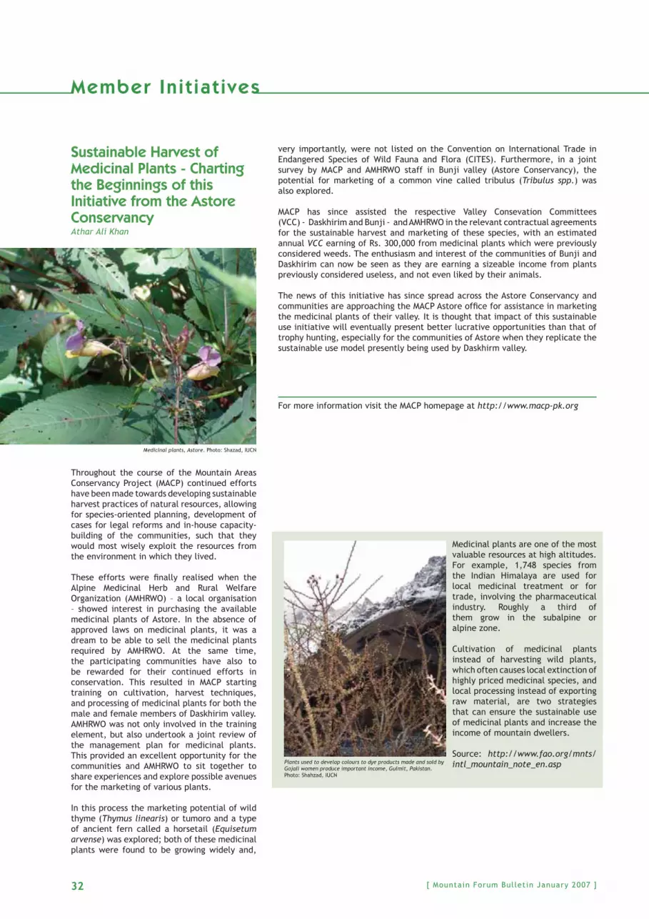
32 [ Mountain Forum Bulletin January 2007 ]
Sustainable Harvest of Medicinal Plants - Charting the Beginnings of this Initiative from the Astore ConservancyAthar Ali Khan
Throughout the course of the Mountain Areas Conservancy Project (MACP) continued efforts have been made towards developing sustainable harvest practices of natural resources, allowing for species-oriented planning, development of cases for legal reforms and in-house capacity-building of the communities, such that they would most wisely exploit the resources from the environment in which they lived.
These efforts were fi nally realised when the Alpine Medicinal Herb and Rural Welfare Organization (AMHRWO) – a local organisation – showed interest in purchasing the available medicinal plants of Astore. In the absence of approved laws on medicinal plants, it was a dream to be able to sell the medicinal plants required by AMHRWO. At the same time, the participating communities have also to be rewarded for their continued efforts in conservation. This resulted in MACP starting training on cultivation, harvest techniques, and processing of medicinal plants for both the male and female members of Daskhirim valley. AMHRWO was not only involved in the training element, but also undertook a joint review of the management plan for medicinal plants. This provided an excellent opportunity for the communities and AMHRWO to sit together to share experiences and explore possible avenues for the marketing of various plants.
In this process the marketing potential of wild thyme (Thymus linearis) or tumoro and a type of ancient fern called a horsetail (Equisetum arvense) was explored; both of these medicinal plants were found to be growing widely and,
very importantly, were not listed on the Convention on International Trade in Endangered Species of Wild Fauna and Flora (CITES). Furthermore, in a joint survey by MACP and AMHRWO staff in Bunji valley (Astore Conservancy), the potential for marketing of a common vine called tribulus (Tribulus spp.) was also explored.
MACP has since assisted the respective Valley Consevation Committees (VCC) - Daskhirim and Bunji - and AMHRWO in the relevant contractual agreements for the sustainable harvest and marketing of these species, with an estimated annual VCC earning of Rs. 300,000 from medicinal plants which were previously considered weeds. The enthusiasm and interest of the communities of Bunji and Daskhirim can now be seen as they are earning a sizeable income from plants previously considered useless, and not even liked by their animals.
The news of this initiative has since spread across the Astore Conservancy and communities are approaching the MACP Astore offi ce for assistance in marketing the medicinal plants of their valley. It is thought that impact of this sustainable use initiative will eventually present better lucrative opportunities than that of trophy hunting, especially for the communities of Astore when they replicate the sustainable use model presently being used by Daskhirm valley.
For more information visit the MACP homepage at http://www.macp-pk.org
Medicinal plants, Astore. Photo: Shazad, IUCN
Member In i t iat ives
Medicinal plants are one of the most valuable resources at high altitudes. For example, 1,748 species from the Indian Himalaya are used for local medicinal treatment or for trade, involving the pharmaceutical industry. Roughly a third of them grow in the subalpine or alpine zone.
Cultivation of medicinal plants instead of harvesting wild plants, which often causes local extinction of highly priced medicinal species, and local processing instead of exporting raw material, are two strategies that can ensure the sustainable use of medicinal plants and increase the income of mountain dwellers.
Source: http://www.fao.org/mnts/intl_mountain_note_en.aspPlants used to develop colours to dye products made and sold by
Gojali women produce important income, Gulmit, Pakistan. Photo: Shahzad, IUCN

33[ Mountain Forum Bulletin January 2007 ]
Member In i t iat ives
Empowering Women through Alternative Media for Biodiversity ConservationRashmi Gangwar
The Nanda Devi Biosphere Reserve (NDBR) spreads over in three districts of the Garhwal hills in the northern Indian state of Uttaranchal in the Central Himalaya. Located in a strategic location, the NDBR is endowed with rich and unique biodiversity. NDBR, covering an area of 5,820 km², received the status of a Biosphere Reserve on 18 January 1988 under UNESCO’s Man and Biosphere (MAB) programme. It is now recognised as a World Heritage Site. NDBR has magnifi cent biological, ecological, and cultural landscape diversity, whose biodiversity is rich and unique not only in India, but also in the Himalaya. The vegetation type, owing to a wide range of variation in altitude, topography and climatic conditions, is also varied.
NDBR is the land of world famous ‘Chipko Movement’ (women hugging trees to stop the axe men from cutting trees). Chipko is an example of a close bond between women and forests. However, during recent times the biodiversity of NDBR, like many other places, has been exposed to various threats. In fact, many plants and animals are threatened or endangered; to name a few: Aconitum heterophyllum, Dactylorhiza hatagirea, Jurinella macrocephala, Maconopsis aculeate, Picrorhiza kurooa, Pleurospermum angelicoides, Polygonatum verticillatum, Rhododendron anthopogon, Suassurea obvallata. Habitat destruction and over exploitation are the major threats. Research and agriculture organisations are developing agro-technologies to cultivate these plants in order to meet increasing demands, as well as to reduce pressures on such species.
The Centre for Environment Education (CEE) has worked extensively with the women, both tribal and non tribal, in 14 selected villages to document indigenous traditional knowledge, which exist in the area and is pertinent to uses and traditional conservation practices of non-timber forest products (NTFPs). Since the literacy rate amongst women is low, CEE utilises alternative media as a tool to raise awareness amongst women of the importance of local biodiversity, its threats, and the role women could play in conserving it.
The women addressed belong to Bhotiya tribe, and the majority of them practice transhumance. Their winter settlements are located outside NDBR. They practice marginal subsistence agriculture, rear cattle for milk and sheep for wool. Agriculture is the primary economic activity, and is characterised by substantial crop diversity with a high degree of self-reliance.
The women’s traditional knowledge of the area was documented through a series of formal and informal meetings with the ‘Mahila Mangal Dals’ as well as with individuals. Women described various traditions and rituals requiring specifi c plant species. For these cultural practices people still conserve many of these particular species. People in mountain areas are God fearing and nature loving. In Garhwal Himalaya there is an immense cultural wealth. Occasionally folk songs are sung that most often describe the area’s natural wealth. Women documented many such songs and reiterated the cultural signifi cance of their area’s valuable fauna and fl ora.
This initiative not only focused on medicinal or therapeutic plants, but also on the lesser known crops. These traditional agricultural practices and crops have been documented. Women described traditional ways of seed selection, a process locally known as ‘Rotyana’. In earlier days, elderly people described the ‘Barhanaja’ (twelve crops) popular tradition, which with the popularisation of hybrid seeds has now become almost extinct.
Therefore, the initiative provided an opportunity for the women, and the community as a whole, to closely interact with scientists, agriculture experts, and leading conservationists of the area. Various kinds of local seed varieties of paddy, maize, kidney beans, millets, which are no longer cultivated - due to switch over to the hybrid varieties - were exhibited. Women appraised the importance of such crop varieties for future conservation programmes in areas like biotechnology. Through such exposures, women and community members learned about cultivation techniques for some plants that are in great demand. They were motivated to adopt these as alternative livelihood resources.
As a result of these interventions, women from these villages have developed a fresh interest in cultivation of species that have a high market demand. Some of the women have even proposed to use part of their agriculture fi elds for cultivating these plants. Whereas others mentioned the possible availability in some villages for community and panchayat land, which can be used for creating herbal farms for these villages. Linkages were developed between local research organisations that disseminate agro-technology and trainings and so forth. The initiative, being a pilot project supported by UNESO, needs further scaling up to ensure further popular participation in local biodiversity and indigenous traditional knowledge conservation.
For further details, please visit www.ceehimalaya.org and/or write to [email protected]
Empowering women, Nanda Devi, India. Photo: CEE Himalaya

34 [ Mountain Forum Bulletin January 2007 ]
Member In i t iat ives
Preserving Mountain Biodiversity in the Western Ghats of the Madurai District, Tamil NaduS. P. Anandan
Long term conservation of mountain biodiversity relies on knowledge of its biodiversity, coupled with integrated efforts to protect and manage this diversity in a sustainable manner. Before ascertaining fundamental biological characteristics, such as genetic strains, species and ecological assemblages present, we must fi rst assess the value of traditional knowledge of indigenous communities living in mountains.
Sound conservation strategies can be initiated in the Western Ghats range of mountains in southern Tamil Nadu, India while identifying valuable biological resources and patterns of resource usage in local and indigenous communities of this mountain ecosystem. As a conservation organisation engaged in documenting fl oral and fauna diversity in Saduragiri Hills of the Western Ghats in Madurai District, the Foundation for Research & Sustainable Development (FRSD) suggests several strategies for the betterment of the local and indigenous communities’ livelihoods; such as the Paliyar tribes - inhabitants of the Western Ghats, a geographically isolated and exploited area.
� Strategies should complement protection measures, whereas indigenous communities utilising mountain resources need to fi nancially benefi t for their efforts to protect mountain ecology.
� Sustainable agro-ecosystems, agro-pastoral systems, and other sustainable land use practices of the tribal community in the Western Ghats can be applied since these practices are based on traditional management techniques.
� Sustainable development of tribal community people (the natural guardians of the mountains) in mountains and in areas adjacent to mountains. Tribes offer prayers and often worship mountain spirits. This can be done only after recalling the tribes back to their natural habitats. Thus, we can restore their cultural identity.
� Restoration techniques of degraded lands and ecological reserves used by tribes in the past. Recreating lost habitats (like tribal huts, hunting posts etc.) will defi nitely contribute to the conservation of biodiversity in the Western Ghats. The huts built by Paliyar tribes in Kodaikanal hills can withstand any climate and the walls of the huts are built using indigenous knowledge.
� Documentation of the traditional tribal practices, fl ora and fauna endemic to Saduragiri Hills, land use practices and ethno botanical knowledge of mountain dwellers, before the British Raj they were under the control of zamindars (land owners). A computerised database in CD ROM format could be created after carrying out proper biological surveys in the Western Ghats. It is obvious that there is a scarcity of biodiversity data for the ecosystems in Saduragiri, Shenbagthoppu, Sethur and other hills in Madurai and Virudhunagar districts of Tamil Nadu, India. Computerised databases will offer several opportunities for professional linkages not only with scientifi c community, but also assist with the updating of the Indian Government’s national biological inventories.
� Restoration of the faith of the Paliyar Tribes in the Western Ghats, especially in spirituality and ecology of sacred groves, forest spirits, through rehabilitation of the forest temples and statues of deities, which are said to guard mountains and forests. Once a month, on full moon days, the tribes in the Saduragiri hills worship the Vanadevada (protective deities of the forests). Sacred groves in the Western Ghats are genetic reservoirs for wild species.
� Initiating steps for communal management of natural resources by the local agrarian communities living in areas adjacent to Saduragiri hills. Tribes who have migrated to plains areas could collaborate with farmers in such activities by utilising traditional knowledge inherited from the Paliyar tribes.
A very rare and endangered medicinal plant (Begonia malabarica) in Kodaikanal Hills, Western Ghats, India. Photo: S. P. Anandan
A rare and sacred tree worshipped by indigenous communities (Hindus and Muslims) in Athi Koil, Western Ghats, India. Photo: S. P. Anandan
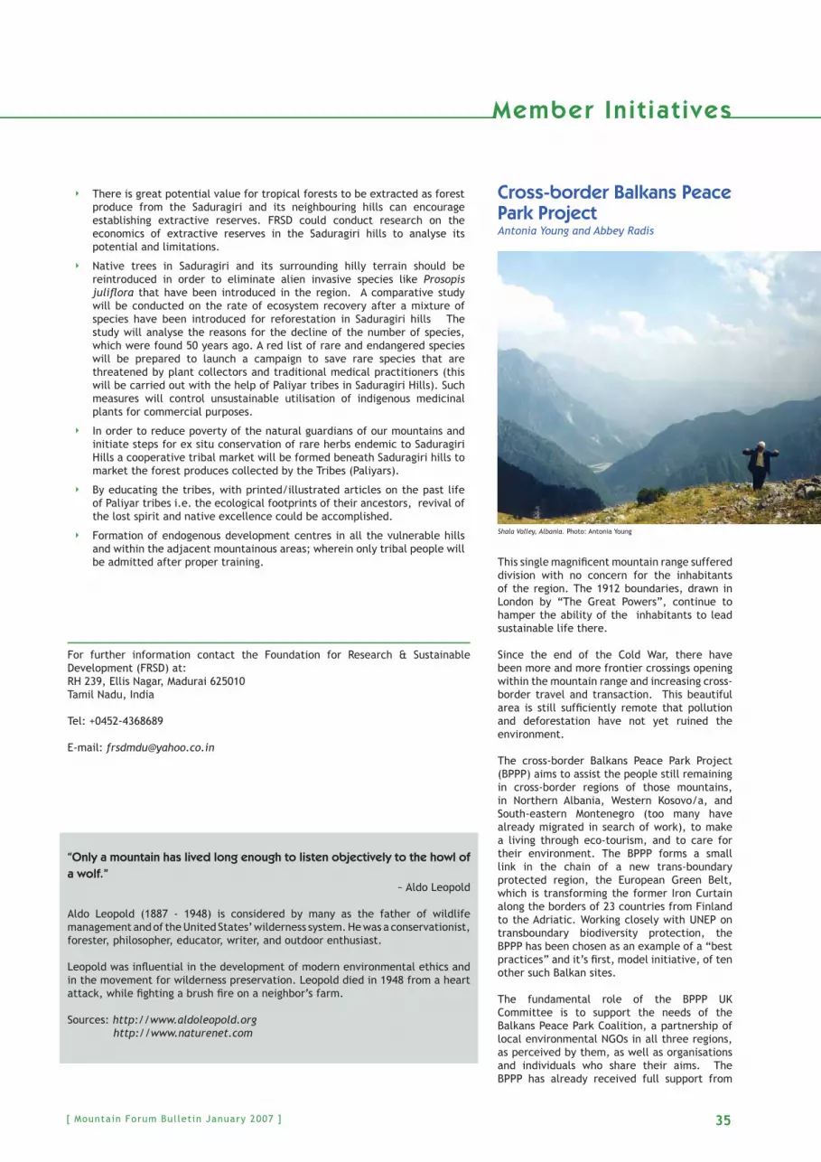
35[ Mountain Forum Bulletin January 2007 ]
Member In i t iat ives
Cross-border Balkans Peace Park Project Antonia Young and Abbey Radis
This single magnifi cent mountain range suffered division with no concern for the inhabitants of the region. The 1912 boundaries, drawn in London by “The Great Powers”, continue to hamper the ability of the inhabitants to lead sustainable life there.
Since the end of the Cold War, there have been more and more frontier crossings opening within the mountain range and increasing cross-border travel and transaction. This beautiful area is still suffi ciently remote that pollution and deforestation have not yet ruined the environment.
The cross-border Balkans Peace Park Project (BPPP) aims to assist the people still remaining in cross-border regions of those mountains, in Northern Albania, Western Kosovo/a, and South-eastern Montenegro (too many have already migrated in search of work), to make a living through eco-tourism, and to care for their environment. The BPPP forms a small link in the chain of a new trans-boundary protected region, the European Green Belt, which is transforming the former Iron Curtain along the borders of 23 countries from Finland to the Adriatic. Working closely with UNEP on transboundary biodiversity protection, the BPPP has been chosen as an example of a “best practices” and it’s fi rst, model initiative, of ten other such Balkan sites.
The fundamental role of the BPPP UK Committee is to support the needs of the Balkans Peace Park Coalition, a partnership of local environmental NGOs in all three regions, as perceived by them, as well as organisations and individuals who share their aims. The BPPP has already received full support from
Shala Valley, Albania. Photo: Antonia Young
� There is great potential value for tropical forests to be extracted as forest produce from the Saduragiri and its neighbouring hills can encourage establishing extractive reserves. FRSD could conduct research on the economics of extractive reserves in the Saduragiri hills to analyse its potential and limitations.
� Native trees in Saduragiri and its surrounding hilly terrain should be reintroduced in order to eliminate alien invasive species like Prosopis julifl ora that have been introduced in the region. A comparative study will be conducted on the rate of ecosystem recovery after a mixture of species have been introduced for reforestation in Saduragiri hills The study will analyse the reasons for the decline of the number of species, which were found 50 years ago. A red list of rare and endangered species will be prepared to launch a campaign to save rare species that are threatened by plant collectors and traditional medical practitioners (this will be carried out with the help of Paliyar tribes in Saduragiri Hills). Such measures will control unsustainable utilisation of indigenous medicinal plants for commercial purposes.
� In order to reduce poverty of the natural guardians of our mountains and initiate steps for ex situ conservation of rare herbs endemic to Saduragiri Hills a cooperative tribal market will be formed beneath Saduragiri hills to market the forest produces collected by the Tribes (Paliyars).
� By educating the tribes, with printed/illustrated articles on the past life of Paliyar tribes i.e. the ecological footprints of their ancestors, revival of the lost spirit and native excellence could be accomplished.
� Formation of endogenous development centres in all the vulnerable hills and within the adjacent mountainous areas; wherein only tribal people will be admitted after proper training.
For further information contact the Foundation for Research & Sustainable Development (FRSD) at: RH 239, Ellis Nagar, Madurai 625010Tamil Nadu, India
Tel: +0452-4368689
E-mail: [email protected]
“Only a mountain has lived long enough to listen objectively to the howl of a wolf.”
~ Aldo Leopold
Aldo Leopold (1887 - 1948) is considered by many as the father of wildlife management and of the United States’ wilderness system. He was a conservationist, forester, philosopher, educator, writer, and outdoor enthusiast.
Leopold was infl uential in the development of modern environmental ethics and in the movement for wilderness preservation. Leopold died in 1948 from a heart attack, while fi ghting a brush fi re on a neighbor’s farm.
Sources: http://www.aldoleopold.org http://www.naturenet.com

[ Mountain Forum Bulletin January 2007 ]36
Member In i t iat ives
both the Kosovo Environment Ministry and United Mission in Kosovo (UNMIK). It has strong links with ministries in Albania, and is developing similar links in Montenegro. Additionally, the Balkans Peace Park has good links with pan-Balkan and international groups.
BPPP UK Committee Chair Antonia Young and her assistant Abbey Radis recently attended a Balkans Peace Park Coalition meeting, which took place in Plav, Montenegro on 14 October 2006. This was a preparatory meeting for their upcoming Regional Conference in Prishtina, Kosovo/a “Balkans Peace Park: Strategic Cooperation between civil society, local authorities and international institutions” held on 15 November 2006. Thus, the aim of the meeting in Plav was to organise and share the tasks and responsibilities among the NGOs for this regional BPPP conference. The meeting was very successful and productive, organised by the ERA Group, a BPPP Coalition Kosovar Partner NGO, and included 21 attendees, with fairly equal attendance from all three regions. The BPPP Coalition member NGOs present at the meeting were “Triton” (MN), “ERA Group” (KS), BPPP UK Committee, “Hajla” (MN), HRID (MN), Alpet Shqiptare (MN), Environmental Center “Valbona” (AL), Information Center for BPP (AL), Aquila (KS), and New Community (AL).
Written minutes and spoken discussion from the meeting on 14 October 2006 were simultaneously translated into three languages: Montenegrin, Albanian, and English, as several interpreters were present at the meeting. Each participant spoke in their native language.
To read more about the project please visit http://www.balkanspeacepark.org
Postcards are available of the Balkans Peace Park please contact Antonia Young at [email protected]
Democratising Forestry in Mexico’s Sierra NorteRoss E. Mitchell
Ecological democracy is a socio-political system that would, in theory, allow for greener and more participatory environmental decision-making. Since little was known about this concept, in 2002, I visited the mountainous regions of southern Mexico to examine civic participation and activism, accessibility to power, distribution of economic benefi ts, environmental changes, land tenure systems, and other socio-environmental indicators. My focus was Oaxaca, one of Mexico’s poorest states and among its top fi ve forest producers with more than 50 percent of the economically active population involved in natural resource extraction. The communities studied were Santa Catarina Ixtepeji and Santa María Yavesía in the Sierra Norte, just north of Oaxaca City.
Ixtepeji is located at 1,880 m with a population of 2,532 (Census 2000). Ixtepeji’s almost 19,000 ha forests were selectively logged by FAPATUX (Tuxtepec Paper Company) under the mistaken notion that remaining pine trees would adequately regenerate after removing the high quality large trees. Ixtepeji regained control of its forest resources in the mid-1980s. Today, logging and silvicultural operations are performed with relatively little ecological damage. Ixtepeji’s forests were certifi ed in 2001 by SmartWood/Rainforest Alliance on behalf of
Joel and Curio, two former local forest authorities of Ixtepeji, Mexico.Photo: Ross E. Mitchell
Did you know that . . .
The Waterton-Glacier International Peace Park across the United States/Canada border was the world’s fi rst international “Peace Park”, formed by the merger of the Waterton Lakes and Glacier National Parks in 1932. The primary purpose of the union was to commemorate a bond of peace and friendship between the two countries. Both parks are declared Biosphere Reserves by UNESCO and their union is recognised as a World Heritage Site.
Although Glacier and Waterton Lakes National Parks are administered by separate countries, they cooperate to manage their natural and cultural resources. The wild plants and animals ignore political boundaries and claim the mountainous terrain on both sides of the border.
Source: http://www.glacierwaterton.com/

37[ Mountain Forum Bulletin January 2007 ]
Member In i t iat ives
the Forest Stewardship Council (FSC). Forest products include timber and non-timber products: ornamental wild plants, wild mushrooms, mineral spring water, pine resin, and provision of ecotourism services. Local women participate and direct many activities. All of these are under the authorisation and supervision of the federal Ministry of Environment and Natural Resources (SEMARNAT). Carefully prepared plans have been produced with the assistance of community forest workers and a professional forester.
In contrast, the mountain community of Yavesía has persistently refused to commercially log its forests for at least 50 years. Yavesía is located at 2,000 meters with a population of 460 (Census 2,000), and shares the same 29,430 ha land base as part of Pueblos Mancomunados, a cluster that includes two other municipalities and fi ve smaller towns. But Yavesía has never been comfortable with this shared land arrangement. Most residents justify their continued struggle to achieve autonomy and about one-third of the land base (9,140 ha) as necessary to protect their forests. Rather than commercial logging, they focus instead on water production, watershed protection, ecotourism, and forest preservation for biodiversity. Whereas, Ixtepeji has decided on sustainable forestry options that include logging and milling, providing benefi ts for all to enjoy, Yavesía is pinning its legal and political hopes on eventual land title. Yavesía’s preferred options of watershed protection, ecotourism, and ecological diversity, according to them, are not compatible with massive logging, sustainable or otherwise. Yavesía residents claim that they are sustainably managing their region, with a long-running forest vigilance system and the development of several innovative plans for nondestructive forest use.
Democracy, on the other hand, is part of everyone’s daily lives in communities like Ixtepeji and Yavesía. Both communities abide by the “usos y costumbres” system. By this system, all capable adult males from the age of 18 until 60 and who are registered citizens participate in community leadership, attend community assemblies, and follow community rules and regulations. Participating in local governance helps build community and maintain traditional practices. One crucial limitation, however, is that most women do not vote, do not participate in community assembly elections, and do not take part in common resource decision-making. By their notable absence in local politics, some would question whether democracy was being achieved. Still, many women are involved in key aspects of daily life such as health and education committees, bottling spring water, and mushroom cooperatives. If we consider democracy as the freedom to participate in decisions regarding livelihood, not only lifestyles, then governance in Ixtepeji and Yavesía seems to be pointed in the right direction. Both communities are working toward more inclusive, ecological management. In both cases, deeply held concerns for the forests are being played out in unique ways. Collective needs are prioritised over individual ones.
This research brings new insight into the meaning of democratic decision-making and environmental management. Environmental policies and structures should not be imposed from above, but must ultimately be built on partnerships with affected communities. Mountain peoples generally depend on nearby natural resources for sustainable livelihoods. It makes sense, then, that social and ecological benefi ts, not just profi ts and jobs, should guide policy and management priorities. More democratic opportunities need to be created and encouraged for all local people, men and women, young and old, new and long-time residents. Instead of limiting local involvement in environmental development schemes to public information sessions and the like, it would do policymakers well to heed their call for meaningful involvement in the actual decisions that have to be made.
ReferencesMitchell, R.E. (2006). “Environmental Governance in Mexico: Two Case Studies of Oaxaca’s Community Forest Sector.” Journal of Latin American Studies. 38(3):519-548.Mitchell, R.E. (2005). “Planting Trees, Building Democracy: Sustainable Forestry in Mexico.” Pp. 95-118 in Environmental Issues in Latin America and the Caribbean, Aldemaro Romero and Sarah West (eds.). Netherlands: Springer.
For more information about this research, please contact Ross E. Mitchell at [email protected]
Mapping the La Paz-El Alto FoodshedStephen Taranto and Martina Brimmer
Mapping the La Paz-El Alto Foodshed is a new initiative underway in the central Bolivian highlands aimed at describing and monitoring the fl ow of food products into and out of the adjacent Andean cities of La Paz and El Alto. The project is being developed by La Paz on Foot (www.lapazonfoot.com), a private organisation dedicated to environmental education and agroecological research in the Central Andes, in conjunction with TROPICO (www.tropico.org), an NGO dedicated to conservation and sustainable development in Bolivia. By applying defi nitions, concepts and research methods used to characterise and monitor watersheds to an urban food system, the project is developing a “foodshed” monitoring system for La Paz and El Alto, Bolivia.
La Paz-El Alto is located on the eastern edge of the Central Andes on the Bolivian altiplano, a broad highland plain that has supported human populations for millennia. Unique to modern food systems, the population of more than two million residents receives many of its food products from small scale farming systems located within 200 km.
The productivity of the small farms that support La Paz-El Alto, their contribution to the quality of life of peasants and indigenous producers and their ecological impacts are highly variable and of uncertain sustainability. While many of the farming systems in the Central Andes have been in operation for thousands of years, at present time wide-spread poverty, declining soil fertility, extreme parcelisation of agricultural plots, inadequate fi re management, water shortages, climate change and (agro)biodiversity loss are emerging as chronic problems in the region (Halloy et al
Farming systems within the city limits of La Paz, Peru. Photo: Stephen Taranto

[ Mountain Forum Bulletin January 2007 ]38
Member In i t iat ives
2005). Moreover, the impacts of global market forces on small scale growers and on consumer expectations at all levels of society render the stability of present-day small farm economies and other aspects of the food system precarious.
From watersheds to foodshedsThe term watershed is commonly used to describe an area of land in which water drains to the lowest point. In a watershed, water moves through a network of drainage pathways converging into streams and rivers, eventually reaching an estuary and the ocean. Watersheds can be large or small, with boundaries following major ridgelines around channels and meeting at the bottom, where water fl ows out of the watershed.
The term foodshed is used to describe the constellation of food systems, from local to global, that provide a specifi c population with food products, each of which moves through diverse production and consumption networks in order to feed people. Kloppenberg et al (2006) have used the concept of the foodshed to describe the fl ow of food products from the area where they have been grown to the place where they are consumed. A foodshed specifi cally refers to a particular population’s complex network of providers and distributors. For example, the LPEAF refers to the diverse food systems that supply La Paz and El Alto populations with food products.
Mapping the La Paz-El Alto Foodshed (LPEAF) will examine the nature of the farming systems that feed La Paz-El Alto and their sustainability in ecological, social and economic terms. The research will identify key indicators for monitoring the LPEAF and will also consider the current and potential economic, social and environmental sustainability of small farms as a dominant force in feeding urban populations. The project will focus on important traditional Andean crops such as quinoa, potato, corn and peanut as well as introduced crops and important vegetable, fruit, meat, and dairy staples.
The LPEAF project is an innovative step towards establishing baseline information on a complex food production and consumption system. The research will develop an integrated understanding of a complex foodshed in such a way that it can be used to assess other foodsheds and their relative sustainability. As Bolivia enters a new phase of development spurred by the exploitation of its abundant natural gas and minerals, it is likely that the traditional small-scale agroecosystems will undergo changes. Many of these changes may be positive, such as the alleviation of the extreme poverty in which most Bolivian farmers live. However, it is important that the relatively low energy-use and high agro-diversity systems that comprise the LPEAF are monitored so that such strengths can be retained. In addition, as climate changes around the world intensify it is crucial that the effects of such changes on agroecosystems in the Central Andes be monitored and farmers supported so that they can respond in such a way that their livelihoods and cultural heritage are preserved.
Describing and monitoring the LPEAF will also provide important information that can be used in educational programs for farmers to consumers to policy-makers, on the complexity, ingenuity and needs of foodsheds and foodshed actors. The feeding of large populations in any part of the world is complex and dynamic. LPEAF research will result in the development of a broad network of actors involved in the foodshed and will permit the establishment of relationships to respond to changes in food systems and foodsheds in Bolivia and the world.
To learn more about the LPEAF project please contact Stephen Taranto at [email protected]
Andean Páramo Project: Conserving Biological DiversityBert De Bievre
Páramo is the Spanish name given to natural, high-altitude grassland in the tropical Andes. Frequently wrapped in a mantle of fog, the páramos are distributed like an archipielago of islands in the highest parts of the Northern and Central Andes. Páramo is a strategic ecoystem on a global and regional scale:
� They have the greatest biological diversity of life forms adapted to living in the unique conditions of tropical cold, such as the frailejon plant (Espeletia sp.);� They contain and protect water sources for an important part of the continent’s rural and urban population;� Their vegetation and soils contain a critical reserve of carbon and organic matter, keys to water and fertility regulation for the production of subsistence crops, and an important carbon sink at the global scale;� They make up an area where numerous peasant and indigenous communities live, and thus represent an area with rich cultural inheritance.
However, the páramos are increasingly threatened: agriculture, livestock and forestation have expanded into these higher and more fragile ecological zones. Several areas are threatened by gold mining.
The project “Conservation of the Biodiversity of the Páramo in the Northern and Central Andes”, better known as “Proyecto Páramo Andino” has now initiated its activities in its full size phase.
Ecological reserve of El Angel, Northern Ecuador. Photo: Proyecto Paramo Andino

39[ Mountain Forum Bulletin January 2007 ]
Member In i t iat ives
The project is funded by the Global Environment Facility (GEF), and the implementing agency is the United Nations Environment Programme (UNEP).
The lead executing agency is the Consortium for Sustainable Development of the Andean Ecoregion CONDESAN, a division of the International Potato Center. In each of the participating countries: Venezuela, Colombia, Ecuador and Peru (the Andean countries that have páramos), a National Executing Agency takes the lead. Those are respectively the Instituto de Ciencias Ambientales y Ecológicas of the Universidad de los Andes (Venezuela), the Instituto Alexander von Humboldt (Colombia), the Fundación EcoCiencia (Ecuador), the Instituto de Montaña (Perú). Two international universities, University of Wisconsin and University of Amsterdam, support the project with technical assistance.
Work has started in each of the 10 project intervention sites, on the basis of agreements with local partners and stakeholders, aiming at the design and implementation of sustainable management plans for each of the sites. Immediately work will start on the other project components: policy and advocacy (the search for formal and non-formal policy options at all scales: local, national and Andean), training of stakeholders related to the páramos ecosystem, communication and creation of awareness of the importance of páramos within the urban and rural population in general, and replication.
The Andean Páramo Project functions under the auspices of the Regional Biodiversity Strategy for the Tropical Andean Countries, approved by the Council of Andean Ministries of External Affairs on 7 July 2002 (Decision 523), an initiative taken by the Secretary General of the Andean Community in coordination with the Andean Committee of Environmental authorities (CAAAM).
Please visit the renewed website at http://www.condesan.org/ppa
For more information contact Bert De Bievre, Regional Project Coordinator, [email protected]
Governments worldwide have promised to save biodiversi ty by 2010. Countdown 2010 helps them move from words to act ion.
Countdown 2010 is a powerful network of active partners working together towards the 2010 biodiversity target. Each partner commits additional efforts to tackle the causes of biodiversity loss. The secretariat – hosted by the World Conservation Union’s Regional Offi ce for Europe – facilitates and encourages action, promotes the importance of the biodiversity target and assesses progress towards 2010. An assembly of all partners meets annually to review the overall direction of Countdown 2010. In its implementation, Countdown 2010 is guided by a core Advisory Board.
Countdown 2010 was launched at the stakeholder conference “Sustaining Livelihoods and Biodiversity: Attaining the 2010 Target in the European Biodiversity Strategy” in Malahide, Ireland in 2004. This conference resulted in the Message of Malahide, which today forms the foundation of the European Commission’s Biodiversity Communication.
Currently, the powerful European network is made up of 170 members. Countdown 2010 is gaining worldwide momentum: new hubs in Africa, Asia and Latin America engage stakeholders to save biodiversity by 2010.
Partnership of Countdown 2010 is open to governments, local authorities, civil society, and private sector organisations which demonstrate a clear commitment to contribute toward the achievement of the 2010 biodiversity target.
To learn more please visit: http://www.countdown2010.net or send and email to Wiebke Herding at: [email protected]
Countdown 2010 SecretariatIUCN – The World Conservation UnionRegional Offi ce for Europe (ROfE)Boulevard Louis Schmidt 641040 Brussels, Belgium
Tel: +32 (0) 2 739 03 20Fax: +32 (0) 2 732 94 99
Some native crops of the BioAndes program: corn (Zea mays). Photo: Claire Nicklin

40 [ Mountain Forum Bulletin January 2007 ]
Biodiversity and the Mountain PartnershipJane Ross
By improving the management of mountain biodiversity we contribute towards achieving the UN Millennium Development Goals (MDGs) of eradicating extreme hunger and poverty as well as the necessity of working together to protect our common environment
Mountains under threatWhether we live at sea level or the highest elevations, we are connected to mountains and affected by them in more ways than we can imagine. Mountains provide most of the world’s freshwater, harbour an extraordinary variety of plants and animals, and are precious reservoirs of biological diversity for food, medicine, timber and recreation. Mountains are also home to at least one in ten people with diverse cultures that are rich in traditions, knowledge and languages.
Although mountains are among the world’s greatest storehouses of biodiversity, the growing demand for water, the consequences of global climate change, the growth in tourism,
the effects of armed confl ict and the pressures of industry, mining and agriculture in a world of increased globalisation threaten the extraordinary web of life that mountains support. These threats are causing rapid - and in cases irreversible - changes to mountain environments and to mountain people, amongst the world’s poorest and hungriest. Indeed, according to a FAO study on vulnerability in mountains, as many as 245 million rural mountain people in developing and transition countries are at risk of, or actually experiencing, hunger and food insecurity. Managing mountain biodiversity is therefore key if we are to combat the scourges of hunger and poverty and achieve the Millennium Development Goals (MDGs).
Par tnerships for act ionAround the world, action is already being taken to protect, manage and sustain biodiversity in mountains. The setting up of protected areas, the designation of conservation landscapes and the Payment for Environmental Services (PES) - are just some of the actions that are helping to conserve the biodiversity of mountain environments and to meet human needs now and in the future. Managing mountain biodiversity is not insurmountable. But it cannot be tackled alone. It requires working side by side - with development agencies, decisionmakers, civil society, scientists, the private sector, governments and, of course, mountain communities themselves. And it requires coordinated action on many fronts - political, social and environmental.
We have a great opportunity and an important context in which to enhance this cooperation and stimulate networking in order to harness our collective energies to promote the management of biodiversity in mountain regions. It is the Mountain Partnership - an evolving global network of countries, intergovernmental organisations and civil society on fi ve continents - which is committed to bettering lives and livelihood opportunities and improving environments in the world’s mountains.
The Partnership offers a framework for cooperation, a platform for advocacy and information exchange and a forum to help partners promote dialogue within and across regions to maintain and preserve mountain biodiversity.
The Mountain Partnership was launched in 2002, the same year that the parties to the Convention on Biological Diversity (CBD) pledged to achieve a signifi cant reduction in the current rate of biodiversity loss by the year 2010. The subsequent CBD work programme on mountain biodiversity, adopted at the 7th Conference of the Parties (COP 7) in 2004, aims to establish ‘regional and transboundary collaboration and the establishment of cooperative agreements’.
Mountain Par tnership
Nepal. Photo: A. Mihich, FAO
Brazil. Photo: A. Mihich, FAO

41[ Mountain Forum Bulletin January 2007 ]
Mountain Par tnership
Ecuador. Photo: A. Mihich, FAO
It also recommends strengthening collaboration with the Mountain Partnership and regional conventions on mountains for conservation, sustainable use and the fair and equitable distribution of benefi ts.
Mountain to mountain cooperat ionSince then, an increasing number of collaborative activities on biodiversity relevant to the CBD have taken place within the framework of the Mountain Partnership. Following the Second Global Meeting of the Mountain Partnership (Cusco, Peru, November 2004) and the long-standing interest of many members for the exchange between mountain parks at the regional and global level, a series of face-to-face meetings and e-consultations organised and managed by the Mountain Forum have brought members together to share information on regional conventions, to learn from other models of development and exchange experiences in biodiversity management and use in the Andes, Carpathians, Balkans, Caucasus, European Alps and the Hindu Kush Himalaya.
Conservation of global mountain biodiversity within the context of the Mountain Partnership, however, was signifi cantly boosted in 2006 at the ‘Gran Paradiso National Park and Sagarmantha National Park Twinning Programme Startup Workshop’ (10-14 October, Cogne, Italy). There, representatives of Gran Paradiso, the oldest national park in Italy, launched a partnership with the Sagarmatha National Park in Nepal to explore future technical cooperation and the exchange of professional training and scientifi c knowledge. Both parks are the highest in their respective regions and noted for their outstanding biodiversity. They also face the opportunities and challenges of harnessing tourism so that it benefi ts and protects mountain people, livelihoods and environments, while at the same time satisfying the desires of tourists.
Organised by Mountain Partnership members, the European Academy (EURAC), the International Centre for Integrated Mountain Development (ICIMOD) and the United Nations Environment Programme (UNEP), with the support of the Italian Ministry of Environment and EURO COOPERATION, the meeting also welcomed participants from government agencies, international bodies, NGOs, academic and research institutes, local organisations, donors, development agencies and the private sector. The event culminated in the adoption of the Cogne Declaration for International Mountain Parks Twinning Programme (MPTP) - a landmark regional agreement between signifi cant mountain parks in Europe and Asia which promises to serve as a model instrument for biodiversity management in these regions and beyond.
The initial phase of the International Mountain Parks Twinning Programme will emphasise the facilitation and exchange of know-how between the Gran Paradiso and Sagarmantha, including: technical cooperation on implementing a National Park and Buffer Zone land-use zoning system; management of natural resources and collaboration in long-term monitoring of biodiversity (especially major ungulates and their predators); promotion of good governance, sustainable development and innovations;cooperation on the improvement of local livelihoods through ecological and cultural tourism; promotion of conservation education and applied research and the development of visitor information and interpretation; and capacity-building and training of park staff and local communities.
All people, wherever they live, share responsibility for protecting mountain biodiversity, but it is mountain people who are the primary guardians of these irreplaceable global
assets. Indeed, cultural traditions, knowledge and values of mountain communities are crucial for the sound and sustainable management of mountain biodiversity. Importantly, the Cogne Declaration recognises the need for balancing conservation and economic development especially for people dependent on national parks and the social, cultural and traditional values of mountain communities.
The International Mountain Parks Twinning Programme involves the Gran Paradiso National Park and the Sagarmatha National Park as initial partners. But the involvement of additional actors and international organisations will be welcomed so as to further strengthen cooperation, partnerships and impact at the regional and inter-regional level. Importantly, the Cogne Declaration acknowledges that this international sharing of experiences and the Twinning Programme contributes not only to the Convention of Biodiversity (CBD), especially the COP-7 decision on mountain biodiversity (2004), but also that it will be developed within the framework of the Mountain Partnership and will contribute to the development of its Biodiversity Initiative. This initiative - a defi ned focus area of work - is due to be launched after International Mountain Day (11 December 2006) whose theme is ‘Managing Mountain Biodiversity for Better Lives’.
For further information, contact Jane Ross, Communications Offi cer, Mountain Partnership Secretariat at: [email protected]

42 [ Mountain Forum Bulletin January 2007 ]
Internat ional Mountain Day 2006
The Carpathian Mountains - the Living Heart of EuropePam McCarthy
“The Carpathians of Central and Eastern Europe are among the world’s richest regions in terms of biodiversity and pristine landscapes,” said Achim Steiner, head of the UN Environment Programme, recently to mark the opening of a three-day meeting of ministers and experts. Representatives from the seven European nations sharing the Carpathian mountains came together at the fi rst Conference of Parties of the Carpathian Convention, held in Kyiv 11-13 December 2006, where they agreed upon their future work-plan. This important meeting was launched on International Mountain Day, marking the theme “Managing Mountain Biodiversity for Better Lives”.
ANPED (the Northern Alliance for Sustainability) is co-ordinating a project to promote public participation and support the effective implementation of the Carpathian Convention. The project seeks to build and develop engagement with civil society, thereby ensuring that the Convention’s implementation is relevant and effective in the region. The ANPED project works to strengthen the credibility, trust, and understanding between stakeholders and decision-makers, in hopes that by demonstrating the benefi ts of public participation, the principle will be incorporated as an essential part of the on-going implementation of the Convention. ANPED and its members in the region were also active in protecting and promoting the cultural heritage and traditional knowledge of the Carpathian mountains.
The ANPED project activities began with stakeholder roundtable consultation events in each of the seven Carpathian countries. These events brought together a wide range of stakeholders, and worked with them to identify their concerns and priorities for the Convention. The consultations also focused on recommendations for the Convention, and guidance for decision-makers, to ensure the Convention remained practical, relevant and useful for stakeholders. Other activities sought to stimulate interest and practical activities in each country.
Being part of the aims of the project, ANPED was also able to support stakeholder participation in order to fully participate in the fi rst Conference of Parties. Prior to the meeting, ANPED provided some information, guidance and capacity building so to assist with facilitation of formal interventions by the stakeholders for the offi cial meeting. The aim was to highlight the impact and assistance stakeholders can provide to support the effective implementation of the Convention.
ANPED also facilitated and supported contributions to the Stakeholder’s message segment for the Ministerial part of the meeting. Mr Ivan Rybaruk from All Ukraine ‘Hutsulschina’ Association spoke about the role the Hutsul ethnic group currently plays in protecting the Carpathians mountains, and how they would like to develop co-operation with the Carpathian Convention in the future. On behalf of ANPED, Ms Monika Ochwat, from the League of Nature Protection (Poland), spoke with reference to how civil society is active in practical actions to strengthen sustainable development in the Carpathian mountains, and how civil society can provide a keen, willing and capable partner for the success of the Convention.
At the close of the offi cial COP meeting, ANPED hosted an event entitled ‘The Carpathians - the Living Heart of Europe’ to present and celebrate the unique and rich cultural and environmental diversity of the Carpathians. Activities included an exhibition and demonstration of traditional handicrafts, cultural traditions and regional products from across the Carpathian region, presented by local stakeholders. There was also a welcome from a representative of one of the many Carpathian ethnic/cultural groups explaining why their local culture is so important for them, and why they see direct links between the culture and the environmental protection of the Carpathian mountains. This was followed by traditional music from the Carpathians and demonstrations of traditional dances. Frits Schlingemann, Director of UNEP, Regional Offi ce of Europe, which acts as the Interim Secretariat for the Carpathian Convention, also made a short speech about the role and importance of civil society, and the contribution of heritage and culture to the work of the Convention.
Working with local people and communit iesThe Carpathians are one of Europe’s largest mountain ranges, and a unique and natural treasure of great beauty and ecological value. However, they are also home to some 16 - 18 million people who live and work in communities across the region. For the Carpathian Convention to have a real and lasting impact, people from these communities must be at the heart of activities to protect and promote the Carpathian Mountains, their cultures and ecosystems.
If the Carpathian Convention engages effectively with local people and stakeholders it is more likely to achieve successful and effective implementation in the region by:
� increasing its credibility and relevance;� securing support from key groups, sectors and communities; � building trust between local people and decision-makers at the local, regional, national and international levels.
The Convention will need to establish ways to reach out, inform and involve civil society in its work, projects and decision-making.
The culture and her i tage of the Carpathian region The Carpathian countries are still rich in genuine cultural diversity, in crafts and skills, and traditional forms of agriculture and land management. Cultural heritage is a real part of local life and people are proud of their traditions and ethnic heritage. Changes since 1989 have also allowed for a re-emergence of ethnic identity, heritage and traditions. Local communities are now restoring and promoting their own traditional cultures, bringing real benefi ts to local economies.
However, many elements of traditional culture are now threatened. The on-going economic transition and the development of infrastructure for mass tourism is bringing dramatic and detrimental change to the region. The new fl owering of cultural heritage may be short-lived before it is swamped by ‘western’ mass consumer culture.
The Carpathian Convention has a key role to play in valuing and promoting the importance of this unique cultural heritage, and the contribution it can make to the environmental protection and social development of the Carpathian Mountains. The Convention can and should offer practical assistance and space to enable existing cultures to survive and fl ourish.

43[ Mountain Forum Bulletin January 2007 ]
Internat ional Mountain Day 2006
Photographs clockwise from top left:
Ivan’s Speech. Photo: Yuri Wasidlow
Ivan and Musicians. Photo: Istvan Sido
Monika Ochwat speech. Photo: Istvan Sido
Frits and Tamara speech. Photo: Pam McCarthy
Carpathian Celebration dance. Photo: Pam McCarthy

[ Mountain Forum Bulletin January 2007 ]44
Centre for Environment Education (CEE) Himalaya Celebrates International Mountain Day Rashmi Gangwar
In its efforts to highlight the importance of mountain areas and to draw global attention to the problems faced by mountain regions, CEE Himalaya celebrated International Mountain Day (IMD) on 11 December 2006 at the Town Hall of Lagama, Uri, in the Baramulla district of Jammu and Kashmir (J&K). This region was hit by the devastating 2005 earthquake. It suffered heavy loss of lives and property. The area is ecologically fragile, and lies in seismically active zone. CEE Himalaya is involved in strengthening and providing support to local communities for their sustainable livelihoods. Besides recent post-earthquake rescue and rehabilitation efforts, CEE Himalaya has been working in Kashmir, for the past fi ve years, on creating environmental awareness. CEE Himalaya has helped the J&K Sate Department of Education to publish “green” textbooks, which comply with the verdict of the Supreme Court to make environmental education compulsory.
To celebrate IMD 2006, CEE Himalaya organised a one-day seminar, wherein 50 people from the villages of Bugna, Lachhipora, Lagama, Noorkhah and Uri in Baramulla district of Kashmir participated with great enthusiasm. Village people, offi cials of the J&K Forests, Geology and Mining Departments and NGOs working on earthquake rehabilitation in the area attended the event. This years theme was “Managing Mountain Biodiversity for Better Lives”.
The celebration featured several guest speakers: Mr. G. A. Malak, Divisional Forest Offi cer, Jehlum Valley Forest Division, Baramulla as the chief guest; Md. Amin, Range Offi cer, Uri; Mr. Gh. Hassan Teli, Range Offi cer, Uri; and Md. Rafi q Hussain, Sarpanch, Noorkhah-Bugna.
International Mountain Day Celebrations in Uri, Kashmir, India. Photo: CEE Himalaya
Internat ional Mountain Day 2006
ANPED Carpathian working groupANPED is a network of NGOs, with a membership throughout Europe and North America. It has active members in all of the countries of the Carpathian region. To facilitate and support the involvement of the membership and partner organisations, in the implementation of the Carpathian Convention, a special Carpathian Convention working group has been set up within ANPED. We are committed to the sustainable development of the region in ways that will protect the culture and environment; to preserve what must be preserved, and to bring change were change is needed. The ANPED members and partners active in the project are the Institute of Environmental Policy, Czech Republic; CEEWEB, Hungary; Polish Green Net and League of Nature Protection Poland; Pro Conventia Carpatica Association and UNESCO ProNatura, Romania; SOSNA, Slovakia; Young Researchers of Serbia, Serbia; ‘Our Home’ Association Ukraine, Environment People and Law, Ukraine and Green Dossier, Ukraine.
For further information about ANPED and the Carpathian Convention please visit: http://www.anped.org or http://www.carpathianconvention.org/index.htm or write to Pam McCarthy at [email protected]
Deser t fest ival
The celebration of Tabaski (Eid-ul-Adha) is the Muslim feast of the sheep in the mountain desert of northern Niger. During the festival there is a camel race and a horse race. This population leads a nomadic life, relying essentially on camel and goats from which they take milk, meat and skins used in the production of local handicrafts.
Tabaski festival in Niger. Photo: Sani Malam Karami

45[ Mountain Forum Bulletin January 2007 ]
In his welcome address, Mr. Sanjeev Arora of CEE Himalaya gave a brief presentation on CEE Himalaya’s role in imparting environmental education to the masses, as well as on livelihood support with specifi c reference to mountains.
Dr. Kh. Nripendra Singh of CEE Himalaya discussed the importance of the IMD 2006 in relation to the livelihood in the region, with focus on mountain biodiversity and highlighting the endemic species of the Himalaya, and the importance of the great array of diversity of plants, animals and micro-organisms that fl ourish in the mountains.
Md. Rafi q Hussain, Sarpanch of Noorkhah-Bugna Village raised concerns about over-grazing which deteriorates the mountain ecosystem, mining of Gypsum in Noorkhah-Bugna leading to water pollution and deteriorating public health in the area, stone quarrying, and illegal timber extraction and subsequent deforestation. He requested the concerned government departments to look into the matter and help save the environment and safeguard the interests of the local people.
Mr. Joy Kumar of Agha Khan Foundation spoke of the rehabilitation work done by the organisation. He cited an example of Shahdara village of Uri Tehsil, which has two mountain ranges on either side of the village. One range has no vegetation while the other is covered with lush green, dense forest. On the bare side villagers faced several problems like landslides, soil erosion etc., while on the other side of the peak, where the mountain is dense with forest cover, there are no such problems. Hence, Mr. Kumar called upon the people to carry out mass afforestation to save the mountains.
Md. Amin discussed various projects undertaken by the Forest Department in Uri and requested participants’ cooperation in order to help their work to protect and conserve mountain biodiversity. Mr. Gh. Hassan Teli, on the other hand, blended religion with the present natural resources utilisation practices.
Mr. G. A. Malak brought the audience’s attention to the fact that mountains are being destroyed for short term gains without thinking of the future generations. He added that the global increase in temperature is a serious concern for the mountains and explained how mountains contribute to the overall economy and development of Kashmir through agriculture, fi shery, and tourism. Finally, he granted that while people need to utilise mountain resources, extreme care shuld be taken to preserve mountain ecosystems.
Mr. Malak addressed the issue of Gypsum and lime mining, and said that it is a government policy to extract minerals from the mountains. However, he recognised that some guidelines were not taken into consideration in the present context, such as locality of choice (minimum of 10 km away from inhabited areas) and others. The three concerned Departments of Mining, Forests, and Revenue need to sit together and work out the modalities for the same. Finally, he informed the participants that the Forest Department in collaboration with the district administration had made the necessary arrangements to provide timber to the earthquake affected people of the region.
In conclusion, the need to sensitise mountain dwellers and the concerned government departments to conserve mountain biodiversity for better health and livelihood was emphasised. Participants gained insightful information concerning their quality of life and survival.
To read more about CEE Himalaya, please visit http://www.ceehimalaya.org or send an email to Ms. Rashmi Gangwar at [email protected]
Internat ional Mountain Day 2006
“We have the power to keep the earth’s unfragmented habitats intact in order to ensure the survival of species, the fl ow of rivers, the protection of water catchments, and the provision of clean air. Restoring and protecting the habitats that link protected areas is a way of greatly increasing the ability of wild species to move in adaptation to climate change. This is a small but priceless step for the future of our planet and our own wellbeing. We need to think big to secure the future for biological diversity.”
- Graeme Worboys, Vice Chair Mountains Biome IUCN-WCPA
Over 50 participants from 17 countries met at the Mountain Connectivity Conservation Management workshop from 14 to 17 November 2006, in Papallacta, Ecuador. The meeting concluded with the Papallacta Declaration, in which participants pledged their commitment to work with all relevant stakeholders in order to engage in connectivity conservation in and around mountain regions of the world, for the benefi t of Earth and humanity. The workshop was organised by the WCPA Mountains Biome group. This network consists of more than 500 mountain experts from around the world.
The full Papallacta Declaration can be read on page 46.
To learn more about the WCPA Mountains Biome workshop visit the network’s website: http://mountains-wcpa.org/Quito.htm.
Or see the Mountain Connectivity Conservation Management website:http://conservat ionconnect iv i ty.org/index.htm
For further information, please contact Graeme Worboys, Vice Chair of the WCPA Mountains Biome, at g.worboys bigpond.com
Field trip to Páramos of Guamani in the Cayambe-Coca Ecological Reserves, Ecuador. Photo: Elizabeth Fox

46 [ Mountain Forum Bulletin January 2007 ]
The Papallacta Declaration Mountains provide freshwater to more than half of humanity and are major centres of global biological and cultural diversity and sources of inspiration and spirituality. Maintaining the integrity of mountain ecosystems is vital for the well-being of current and future generations. Yet mountains have low resilience and high vulnerability, and are therefore under serious threat from land transformation, infrastructure development, environmental degradation and climate change.
The maintenance and restoration of ecosystem integrity requires landscape-scale conservation. This can be achieved through systems of core protected areas that are functionally linked and buffered in ways that maintain ecosystem processes and allow species to survive and move, thus ensuring that populations are viable and that ecosystems and people are able to adapt to land transformation and climate change. We call this proactive, holistic, and long-term approach connectivity conservation. Connectivity conservation in and around mountain areas is essential to achieve the goals of the Programmes of Work on Protected Areas and on Mountain Biological Diversity adopted by the 7th Conference of Parties to the Convention on Biological Diversity (Kuala Lumpur, Malaysia, February 2004) and the Plan of Implementation of the World Summit on Sustainable Development (Johannesburg, South Africa, September 2002).
Accomplishing these goals requires the support, involvement, cooperation and leadership of people who live and recreate in, derive economic benefi t from, manage, study, gain spiritual inspiration from, and appreciate mountain environments. Therefore, we urge communities, governments at all levels, non-governmental and intergovernmental organisations, businesses, religious groups, and academic and research institutions to take coordinated action to engage in connectivity conservation in and around mountain regions. This will ensure that mountains continue to supply ecosystem services and many other benefi ts to humanity, including:
� the ability for ecological, hydrological, social and economic systems to respond to climate change;� reliable supplies of water and renewable energy;
� reduced risks of downstream natural disasters;� effective responses to local, regional and global impacts of habitat fragmentation and species loss, particularly in protected areas;� the alleviation of poverty and the promotion of more sustainable economic activity;� cultural diversity, spiritual and community values;� shared understanding and peaceful cooperation across internal and international boundaries.
We, the participants at the Workshop on Mountain Connectivity Conservation Management (Termas de Papallacta, Ecuador, November 2006) commit ourselves to working with all relevant stakeholders to engage in connectivity conservation in and around the mountain regions of the world, for the benefi t of our planet and humanity.
You can download the declaration at http://conservationconnectivity.org/downloads/PapallactaDeclaration.htm
Participants at the Mountain Connectivity Conservation Management workshop in Ecuador. Photo: WCPA Mountains Biome

47[ Mountain Forum Bulletin January 2007 ]
Mountain Calendar 2007
The upcoming events listed below were brought to our attention by Mountain Forum members as well as event organisers. If you have information on a mountain related event, please send the information to the Mountain Calendar via the submittal form at:http://www.mountainpartnership.org/events/c-newevent.asp
For many of these events, more detailed descriptions are available on the Mountain Partnership website: http://www.mountainpartnership.org/events/default.asp. Many thanks to all the contributors for sharing this information with the Mountain Forum community.
Mountain Forum is not responsible for any changes in the programmes. Please contact the event organisers for the latest information.
Januar y 4 - 7 January 20072nd International Conservation Photography Symposium Lindau, Germany Contact: [email protected] Web: http://www.wunderwelten.org
15 - 16 January 2007Periglacial and Paraglacial Processes and Environments, Past, Present and Future London, UK Contact: [email protected] Web: http://www.geolsoc.org.uk/template.cfm? name=Periglacial_and_Paraglacial
16 - 18 January 2007International Conference on Sustainable Development in Confl ict Environments: Challenges and Opportunities Kathmandu, Nepal Contact: [email protected] Web: http://www.ceci.ca/eng/information/activities/2006_17aug_conf.htm
23 - 27 January 2007International Dialogue on Science and Practice in Sustainable Development: Linking Knowledge with Action Chiang mai, Thailand Contact: [email protected] Web: http://www.sustdialogue.org/index.htm
Februar y14 - 17 February 2007OROBIE FILM FESTIVAL - Ist International Festival of Documentaries Bergamo, ItalyContact: [email protected]
March 7 - 10 March 2007International Conference: Women of the Mountains Orem, USAContact: [email protected] Web: http://www.womenofthemountains.org
19 - 23 March 20072007 International Symposium on Medicinal and Nutraceutical Plants Fort Valley, Georgia, USA Contact: [email protected] Web: http://www.ag.fvsu.edu/Conferences/ishsmanp/ismnp.htm
Apri l1 - 6 April 2007International Mountain Logging and 13th Pacifi c Northewest Skyline Symposium Corvallis, Oregon, USA Contact: [email protected] Web: http://www.cof.orst.edu/cof/fe/skyline2007/
16 - 20 April 2007Rethinking Protected Areas in a Changing World St. Paul, Minnesota, USA Contact: [email protected] Web: http://www.georgewright.org
16 - 22 April 2007The Second International Symposium on Ecological Restoration Santa Clara City, Cuba Contact: [email protected] Web: http://www.eclogicalrestoration.info/meetings.asp
17 - 21 April 20072007 Annual Meeting of the Association of American Geographers San Francisco, USA Contact: [email protected] Web: http://www.aag.org/annualmeetings/SF2007/index.cfm
May3 - 4 May 2007IGU Seminar on Biogeography and Biodiversity Srinagar, IndiaContact: [email protected]
22 - 25 May 200722nd Himalaya-Karakoram-Tibet Workshop Hong Kong, China Deadline for abstract: 31 March 2007Contact: [email protected] Web: http://147.8.150.91/HKT22_1st.htm
June4 - 8 June 200729th International Conference on Alpine Meteorology Chambéry, France Deadline for abstract: 20 January 2007Contact: [email protected] Web: http://www.cnrm.meteo.fr/ICAM2007/index.php?page=fi rst_circular.html
5 - 8 June 2007ESEE 2007: Integrating Natural and Social Sciences for Sustainability Leipzig, Germany Deadline for abstract: 1 July 2007Contact: esee2007@fu-confi rm.de Web: http:// www.esee-leipzig2007.org

48 [ Mountain Forum Bulletin January 2007 ]
5 - 8 June 2007International Symposium on Geography: Environment and Culture in the Mediterranean Region Antalya, TurkeyContact: [email protected] Web: http://geomed2007.balikesir.edu.tr
6 - 8 June 2007The New West Summit on Transformation in the Rockies Big Sky, Montana, USA Contact: [email protected] Web: http://www.newwest.net/index.php/plain/conference/
August27 - 30 August 2007Workshop: Glaciers in Watershed and Global Hydrology Obergurgl/Oetztal, AustriaContact: [email protected] Web: http://www.ees.su.se/obergurgl2007
September 9 - 12 September 2007Parks, Peace and Partnerships Conference Alberta, Canada Deadline for abstract: 30 March 2007Contact: [email protected] Web: http://www.peaceparks2007.org
10 - 13 September 2007The Fourth International Conference on Debris-Flow Hazards Mitigation: Mechanics, Prediction, and Assessment Chengdu, ChinaContact: [email protected] Web: http://4thdfhm.imde.ac.cn/
17 - 21 September 2007International Conference: Natural Hazards and Natural Disturbances in Mountain Forests Trento, Italy Deadline for abstract: 15 March 2007Contact: [email protected] Web: http://www.sisef.it/sisef/iufro.php
November 12 - 15 November 2007International Symposium on Mitigative Measures Against Snow Avalanches Egilsstadir, IcelandContact: vfi @vfi .is Web: http://www.igsoc.org/symposia/VFI2007_1stCirc.pdf
23 - 25 November 2007III International Mountain Congress Estoril, PortugalDeadline for abstract: 9 June 2007Contact: [email protected]
Please update your contact information!
Dear Mountain Forum member,
Please update your contact information by visiting http://www.mtnforum.org/mem/update.cfm or by notifying the regional offi ce nearest to you as per the list below: Africa Node ManagerAfrican Mountain Forumc/o African Highlands InitiativeICRAF UgandaPlot 13, Binyayomba, off Luthuli, BugolobiPO Box 26416Kampala, Uganda Tel: +256-41-220 607/2Fax: +256-41-223 242
Email: [email protected] Web: http://www.mtnforum.org/rn/amf.cfm
Asia-Pacifi cNode ManagerAsia-Pacifi c Mountain NetworkICIMODGPO Box 3226Kathmandu, Nepal
Tel: +977-1-500 3222Fax: +977-1-500 3277
Email: [email protected] Web: http://www.mtnforum.org/rn/apmn.cfm
EuropeEuropean Mountain Forum
Email: [email protected] Web: http://www.mtnforum.org/rn/emf.cfm
To contact the European Mountain Forum by post, fax or phone, please contact the Mountain Forum Secretariat at the address provided on the back cover of this Bulletin.
Latin AmericaNode ManagerInfoAndina/CONDESANInternational Potato Center (CIP)Apartado Postal 1558, Lima 12, Peru
Tel: +51-1-349 6017 ext. 2197Fax: +51-1-317 5326
Email: [email protected]: http://www.mtnforum.org/rn/infoandina.cfm
North AmericaNode ManagerNorth American Mountain ForumMountain Culture at The Banff Centre107 Tunnel Mountain DriveBox 1020, Banff, Alberta, Canada T1L 1H5
Tel: +1-403-762 6477Fax: +1-403-762 6277
Email: [email protected] Web: http://www.mtnforum.org/rn/namf.cfm
Mountain Calendar 2007

Supporting Institutions
� Food and Agriculture Organizat ion of the United Nat ions
Swiss Agency for Development and Cooperat ion
Host Institutions and Partners
Bel lanet
Consorcio para el Desar rol lo Sostenible de la Ecor región Andina
European Mountain Forum
Internat ional Centre for Integrated Mountain Development
Internat ional Potato Center
The Banff Centre
The Mountain Inst i tute
World Agroforestr y Centre
Kipahulu District, Haleakala National Park, Maui, Hawaii, USA. Photo: Bob Butterfi eld