Embed Size (px)
Citation preview
1
Mapping migrant territories as topological deformations of space
Nishat Awan (Corresponding author)
Phil Langley
Acknowledgements:
This article forms part of PhD research carried out at the University of Sheffield funded by the Arts and Humanities
Research Council, UK.
Nishat Awan and Phil Langley work collaboratively as openkhana. The software described in this article will be published on the website openkhana.net in 2012.
Nishat Awan is a Lecturer at University of Sheffield. Her research interests include the politics and representation of
migratory spaces, geo-politics and alternative architectural practice. She is co-author of, Spatial Agency
(forthcoming Routledge, 2011) and co-editor of Trans-Local-Act (aaa-peprav, 2011). She has worked in architectural practice for a number of years and holds a PhD in Architecture from the University of Sheffield, UK.
Phil Langley is an architect and computational designer based in London and a PhD candidate at University of
Sheffield. His research focuses on the interface between digital design techniques and architectural practice. He has collaborated with architects and designers, developing interactive software for installations and websites.
2
Mapping migrant territories as topological deformations of space
Our research uses the concept of ‘territories’ to describe the production of migrant space. The article describes a
project based in London where the everyday practice of walking is used to map migrant territories, which are
conceptualised as dispersed and overlapping, causing topological deformations to the actual lived space. We
interrogate these deformations through focusing on the micro-scale and the everyday, mapping them as ‘scapes’
and ‘spheres’. Using specific computational techniques we transform the original walks into an architectural tool for
investigating the fluctuations and flows of the contemporary city. In doing so, we approach territories from two
distinct angles: from the geopolitical perspective of territories seen as the product of the interplay of politics, power
and space, and from the biological perspective of territories seen as the primal need of all animals, including humans, for space and a certain distinction from their environment and from others.
Keywords: territories, topological deformations, spheres, mapping, walking, artificial neural networks
3
Mapping migrant territories as topological deformations of space
Our research uses the concept of ‘territories’ to describe the production of migrant space. In so doing, we approach
territories from two distinct angles: from the geopolitical perspective of territories seen as the product of the
interplay of politics, power and space, and from the biological perspective of territories seen as the primal need of
all animals including humans, for space and a certain distinction from their environment, and from others. We
conceptualise these migrant territories as dispersed and overlapping, causing topological deformations to the actual
lived space, and we interrogate these deformations through focusing on the micro-scale and the everyday, mapping
them as ‘scapes’ (Appadurai, 1996), ‘spheres’ (Sloterdijk, 1998; 1999; 2004) and ‘umwelt’. (von Uexküll, 1926). We
use the concept of ‘spatial deformations’ to refer to the way space, subjectivity and politics influence each other and
are co-produced, foregrounding issues of belonging and inclusion. Each person’s inhabitation of space has certain
effects, opening up moments of agency and affect in city-space. The mapping of these territories is linked to an
understanding of such processes as being produced through our bodily practices (Grosz, 1995). We therefore start
mapping at the level of bodily detail using various techniques, including photographing, conversations, walking, and
then finally using computational methods to map the topological relations of and between the territories that emerge
in these practices. In doing this, we try to keep the poetic and political dimensions of the original walks and conversations: we try not to lose their subjective qualities.
In our desire to think territories as both political and biological we chose to use the everyday practice of walking-
together as a method because reality is never the same for two people and the street on which we walk is very
different from the one others may walk and experience. Both the act of walking itself, and its later mapping and
analysis, were a way of trying to discover how the reality of a space that we were highly familiar with differed from
person to person. The walks occurred on a single street in north-east London where a large number of Turks and
Kurds live. Here the use of walking also seemed appropriate as the street is the site of regular protests by Kurdish
groups in the area; it is thus already a highly charged activity, being used regularly to mark out and traverse
territories. In our walks with Kurds and Turks we became acutely aware of how different their experiences of the
street were; where one saw a building that housed a community organisation, another saw a hotbed of ‘terrorist
activity’.1 We realised that the way political territories affect the personal territories of those in the diaspora is
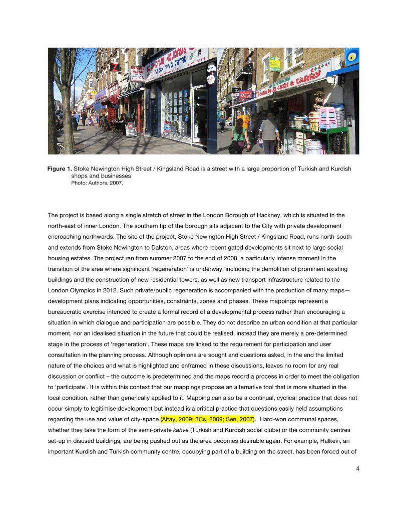
through this always already fragmented point of view, and any attempt at mapping migrant territories needed to account for this deformation of space through regional, political and other affiliations. [Fig. 1]
4
Figure 1. Stoke Newington High Street / Kingsland Road is a street with a large proportion of Turkish and Kurdish shops and businesses Photo: Authors, 2007.
The project is based along a single stretch of street in the London Borough of Hackney, which is situated in the
north-east of inner London. The southern tip of the borough sits adjacent to the City with private development
encroaching northwards. The site of the project, Stoke Newington High Street / Kingsland Road, runs north-south
and extends from Stoke Newington to Dalston, areas where recent gated developments sit next to large social
housing estates. The project ran from summer 2007 to the end of 2008, a particularly intense moment in the
transition of the area where significant ‘regeneration’ is underway, including the demolition of prominent existing
buildings and the construction of new residential towers, as well as new transport infrastructure related to the
London Olympics in 2012. Such private/public regeneration is accompanied with the production of many maps—
development plans indicating opportunities, constraints, zones and phases. These mappings represent a
bureaucratic exercise intended to create a formal record of a developmental process rather than encouraging a
situation in which dialogue and participation are possible. They do not describe an urban condition at that particular
moment, nor an idealised situation in the future that could be realised, instead they are merely a pre-determined
stage in the process of ‘regeneration’. These maps are linked to the requirement for participation and user
consultation in the planning process. Although opinions are sought and questions asked, in the end the limited
nature of the choices and what is highlighted and enframed in these discussions, leaves no room for any real
discussion or conflict – the outcome is predetermined and the maps record a process in order to meet the obligation
to ‘participate’. It is within this context that our mappings propose an alternative tool that is more situated in the
local condition, rather than generically applied to it. Mapping can also be a continual, cyclical practice that does not
occur simply to legitimise development but instead is a critical practice that questions easily held assumptions
regarding the use and value of city-space (Altay, 2009; 3Cs, 2009; Sen, 2007). Hard-won communal spaces,
whether they take the form of the semi-private kahve (Turkish and Kurdish social clubs) or the community centres
set-up in disused buildings, are being pushed out as the area becomes desirable again. For example, Halkevi, an
important Kurdish and Turkish community centre, occupying part of a building on the street, has been forced out of
5
its premises through large-scale rent increases and the building itself converted to ‘loft-style’ apartments. Ironically,
the parts of the building that Halkevi occupied remain empty. The type of walking and mapping practice that we are
describing is therefore a political act that seeks to valorise the neglected and overlooked narratives of the city and is
conceived in opposition to the developmental maps described above. Our mappings aim to become tools that could be used within an alternative and participatory planning process.
New tools for mapping migrant space
The migrant is by condition political, both due to past events and present realities and any mapping of diasporic
territory therefore needs to engage with the ways in which the geopolitical realities of other places are inscribed on
to the bodily practices of the migrant. Using walking-with as a technique allowed us to privilege the personal and the
political, and we conceptualised it as a way of mapping ‘micro-territories’ that form, dissolve and overlap around us
all, influenced by our specific circumstances and spatial politics. They can be considered as a kind of field or sphere
of influence, overlapping, constricting and merging as we encounter different people and places. We mapped these
fluctuating ‘diasporic territories’ by carrying out walks with people who have differing, sometimes highly opposing
political views. The juxtaposition and overlaying of these walks produced a representation of migrant territory that
was also a way of taking what were highly individual points of view (the mapping of personal territories) and
representing them collectively through mapping affiliative or political territories. Whilst walking together we carried
out informal interviews along the individualised trajectories of those we walked with (Anderson, 2004; Precarias a la
derivas, 2004). We spoke together about the neighbourhood, and in particular about the street, exchanging
experiences about the different places we frequented and the people we knew. The walks were therefore
performative, acted out within the public space of the street, and any representation of them needed to convey their
spatial, durational and experiential logic.2 Our mapping techniques also gave importance to small-scale details and
events, mixing this close looking with specific architectural strategies, including computational methods. The
question of technology interests us—how is it possible to use new technologies without fetishising the technique
and without losing the poetic and personalised quality of a method of working that privileges the subjective and the
narrational. The use of computational methods was also an attempt to transform walking, which is viewed within a
certain tradition as an artistic practice, into a specific architectural tool that could be reused in another setting.3 Such
techniques allow for a level of generality and repetition to be inserted into what is a highly subjective process. Here
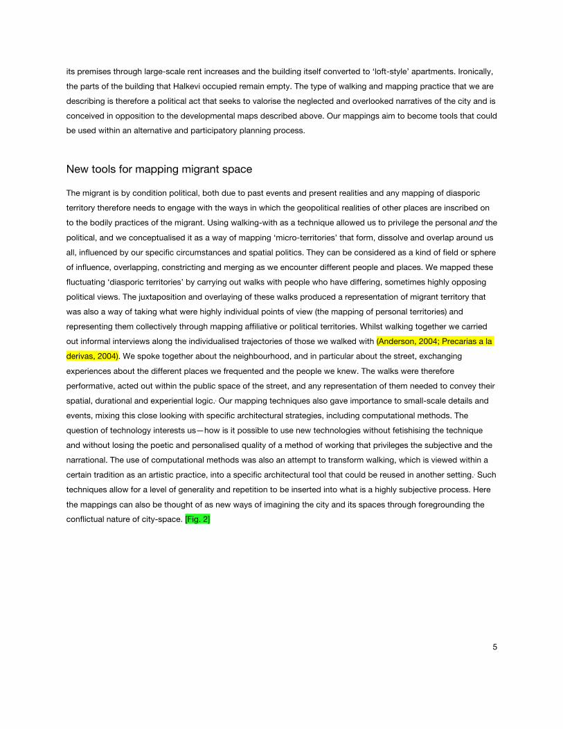
the mappings can also be thought of as new ways of imagining the city and its spaces through foregrounding the conflictual nature of city-space. [Fig. 2]
6
Figure 2. Mapping of a walk with a Kurdish activist who organises many of the protests on the high street. The map recorded the places she frequented, which are colour coded according to type Image: Authors, 2007.
Proposed as both a methodology and a resource, our maps are intended to contribute to an open, web-based
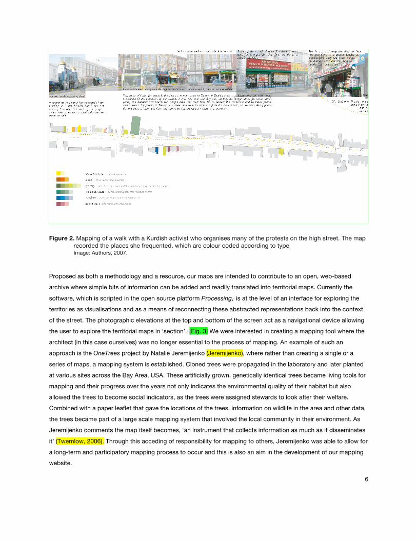
archive where simple bits of information can be added and readily translated into territorial maps. Currently the
software, which is scripted in the open source platform Processing,4 is at the level of an interface for exploring the
territories as visualisations and as a means of reconnecting these abstracted representations back into the context
of the street. The photographic elevations at the top and bottom of the screen act as a navigational device allowing
the user to explore the territorial maps in ‘section’.5 [Fig. 3] We were interested in creating a mapping tool where the
architect (in this case ourselves) was no longer essential to the process of mapping. An example of such an
approach is the OneTrees project by Natalie Jeremijenko (Jeremijenko), where rather than creating a single or a
series of maps, a mapping system is established. Cloned trees were propagated in the laboratory and later planted
at various sites across the Bay Area, USA. These artificially grown, genetically identical trees became living tools for
mapping and their progress over the years not only indicates the environmental quality of their habitat but also
allowed the trees to become social indicators, as the trees were assigned stewards to look after their welfare.
Combined with a paper leaflet that gave the locations of the trees, information on wildlife in the area and other data,
the trees became part of a large scale mapping system that involved the local community in their environment. As
Jeremijenko comments the map itself becomes, ‘an instrument that collects information as much as it disseminates
it’ (Twemlow, 2006). Through this acceding of responsibility for mapping to others, Jeremijenko was able to allow for
a long-term and participatory mapping process to occur and this is also an aim in the development of our mapping website.
7
Figure 3. Screenshots from the web interface designed to explore each walk in section with the ability to overlay walks. The elevational photographs at the top and bottom are used as navigation Image: Authors, 2009.
Neural Territories
A practice of collective mapping of migrant space that emphasises the relations between different people’s
territories, and the way in which they affect each other, required a shift in thinking: from the Euclidean space of
normative architectural practice to a different kind of space, one that is heterogenous, multiple and communicative.6
Starting in Euclidean space, a representation of the street as a standard map, our walking practice provided spatial
‘inputs’: what shop do you use, which cafe do you go to? In addition, this simple information was enriched with
time—when do you use that shop, when do you go for coffee? This small step – adding information about time to
that about space - already moved us beyond the Euclidean. However, the question here is not simply about how to
map 4D information, instead the dimension of time implies the overlapping and intersecting of spatial occupancy
and appropriation. In order to map the fluctuations of someone’s territory, we needed to move away from ideas
around 3D or even 4D systems, and into a relational or topological space. This can be understood as the removal of
Euclidean metrics - instances are no longer defined through orders of magnitude (1, 2, 3…) – and their replacement
by 'relations' - convergence, continuity, connectedness. The map no longer simply indicates which shop someone
went to and when, instead it starts to show a field of influence, how certain events or the presence and absence of
certain people and places changes the mapped territory. In this sense, the mappings move into a topological space of possibilities and the mapping tool becomes propositional.
8
For example, whilst walking with a young Turkish man who worked as a waiter in a local café, we walked past the
community centre Halkevi; he commented that he did not like walking on the same side of the street as the building
in which the centre was housed, and claimed that the Turkish secret police were operating there. In another walk
with a Kurdish woman, the mosque was a place to go into only on certain specified days. It was clear that both
these places and various others have their own field of influence, which affect certain people but not others, and
that they not only act independently but also influence each other.
In order to create a map that is also able to respond in such ways to people, places and events, we used the
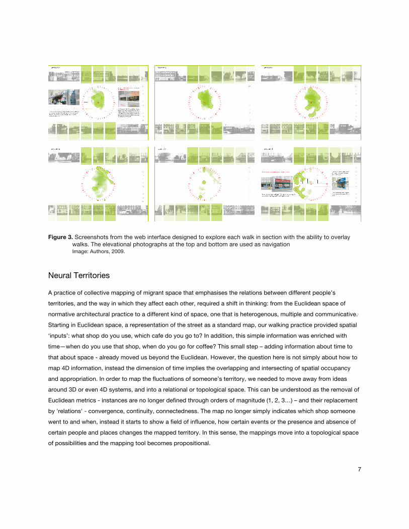
technique of Artificial Neural Networks [ANN].7 ANNs are mathematical models inspired by the structure and
functional aspects of biological neural networks, where the transmission of information through synapses and
neurons in the brain is represented by nodes and connections within a computational system that is able to process
inputs and create outputs. [Fig. 4] Usually such programmes are used to model complex relationships and patterns
in datasets, typically being used for classification, for example in face recognition software. There are a range of
different types of neural networks that vary in topological organisation, and consequently in the transmission of
data. For this project, we developed a specific ANN derived from ‘The Self Organising map’ [SOM] (Kohonen, 2001),
which is typically a 2 dimensional map of n dimensional inputs. In cognitive and computational science, the SOM is
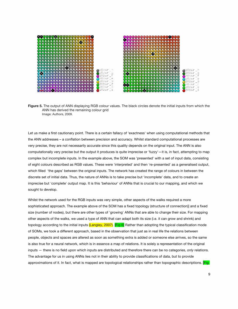
used as a tool for categorisation, a simple example is its use in determining a colour range as RGB values. [Fig. 5]
The basic algorithmic principle consists of two stages, training and calibration. The first stage involves the training of
the network with a limited range of inputs (in this case sample RGB values). The second, calibration, is carried out
through the classification of further, discrete input data into the trained map, for example by using further RGB input values and identifying the colour 'zone' into which these are mapped.
Figure 4. An ANN is a group of interconnected nodes that transmit information across a computational system Image: Authors, 2009.
9
Figure 5. The output of ANN displaying RGB colour values. The black circles denote the initial inputs from which the ANN has derived the remaining colour grid Image: Authors, 2009.
Let us make a first cautionary point. There is a certain fallacy of 'exactness' when using computational methods that
the ANN addresses – a conflation between precision and accuracy. Whilst standard computational processes are
very precise, they are not necessarily accurate since this quality depends on the original input. The ANN is also
computationally very precise but the output it produces is quite imprecise or 'fuzzy'—it is, in fact, attempting to map
complex but incomplete inputs. In the example above, the SOM was 'presented' with a set of input data, consisting
of eight colours described as RGB values. These were 'interpreted' and then 're-presented' as a generalised output,
which filled ‘the gaps’ between the original inputs. The network has created the range of colours in between the
discrete set of initial data. Thus, the nature of ANNs is to take precise but 'incomplete' data, and to create an
imprecise but 'complete' output map. It is this 'behaviour' of ANNs that is crucial to our mapping, and which we sought to develop.
Whilst the network used for the RGB inputs was very simple, other aspects of the walks required a more
sophisticated approach. The example above of the SOM has a fixed topology (structure of connection)] and a fixed
size (number of nodes), but there are other types of 'growing' ANNs that are able to change their size. For mapping
other aspects of the walks, we used a type of ANN that can adapt both its size (i.e. it can grow and shrink) and
topology according to the initial inputs (Langley, 2007). [Fig 6] Rather than adopting the typical classification mode
of SOMs, we took a different approach, based in the observation that just as in real life the relations between
people, objects and spaces are altered as soon as something extra is added or someone else arrives, so the same
is also true for a neural network, which is in essence a map of relations. It is solely a representation of the original
inputs — there is no field upon which inputs are distributed and therefore there can be no categories, only relations.
The advantage for us in using ANNs lies not in their ability to provide classifications of data, but to provide
approximations of it. In fact, what is mapped are topological relationships rather than topographic descriptions. [Fig
10
7]
Figure 6. Diagrammatic example of a 2D ANN, with a fixed topology, responding to input data in the form of x,y coordinates in 2D space Image: Authors, 2009.
Figure 7. Diagrammatic example of three 2D growing ANNs with different adaptive topological structures responding to the same input data Image: Authors, 2009.
Our ANN was thus developed to create a ‘relational map’ of each person’s walk, the input data being a quasi-
spatial/temporal point cloud that was generated from the initial walks and conversations. BY comparing different
walks in a relational map, it became possible to analyse the significance of difference or similarity, rather than merely
its existence because the sensitivity of the network to even very small changes in the input data meant that we were
able to address the proximate scales of everyday life. Using the walks as input also gave a level of lived accuracy to
11
the original information, which can be contrasted to the technical accuracy of some other mapping systems. Unlike
the recent use of technologies such as GPS tracking, this way of gathering information is grounded in actual
experience. Most GPS systems map to a 2 - 1.5m accuracy and in the space of a street, for example in London
where Victorian pavements are generally 2m wide, it is the difference between being inside or outside. The politics
and poetics of those two meters is what we tried to map through our walking. To walk with someone means to
spend time with them - it is also an ethical choice; the use of GPS, a military technology, keeps a distance and
brings back the detached perspective of the traditional cartographer (Petrescu, 2007; Holmes, 2004). But, in a
similar way to the video-essays of film-maker, Ursula Biemann, we do not reject the technological but try to use it in
a critical manner. Biemann’s (2002, 2008) use of different technologies and the layering and overcoding of narrative,
data and interviews creates a representational style that allows a topic or an issue to be addressed from multiple
perspectives. We also adopted this approach of layering information and sought to represent the walks in a way that
did not flatten, but opens up points of access and possibility, especially as different mappings are overlaid and
varied trajectories can be traced from one person’s territory to another. The tracing, understanding and
multiplication of these agencies described as spatial deformations is central to the architectural purpose of the
mappings we produce. They go beyond simple descriptions of physical space to describe the complex processes
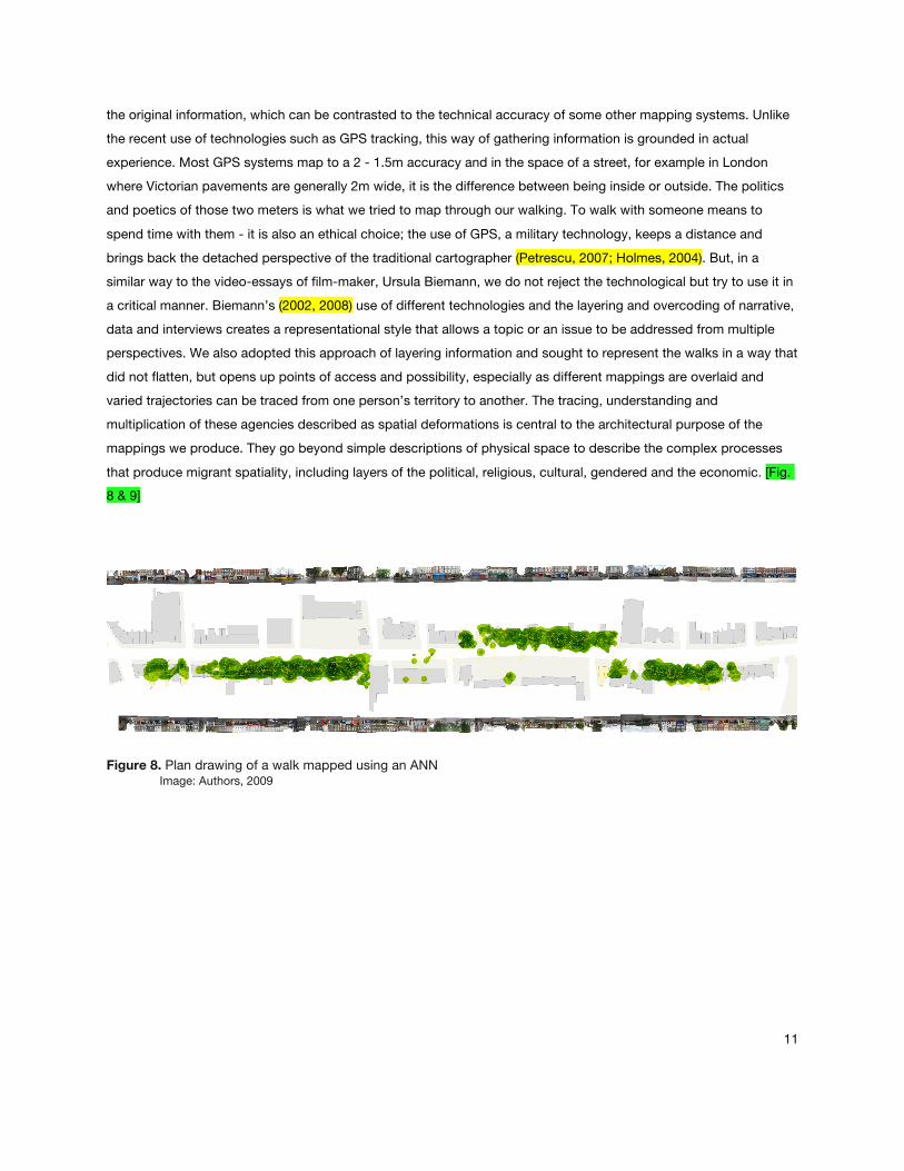
that produce migrant spatiality, including layers of the political, religious, cultural, gendered and the economic. [Fig. 8 & 9]
Figure 8. Plan drawing of a walk mapped using an ANN Image: Authors, 2009
12
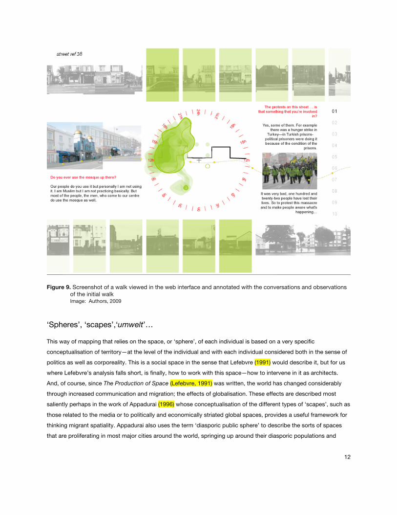
Figure 9. Screenshot of a walk viewed in the web interface and annotated with the conversations and observations of the initial walk Image: Authors, 2009
‘Spheres’, ‘scapes’,‘umwelt’…
This way of mapping that relies on the space, or ‘sphere’, of each individual is based on a very specific
conceptualisation of territory—at the level of the individual and with each individual considered both in the sense of
politics as well as corporeality. This is a social space in the sense that Lefebvre (1991) would describe it, but for us
where Lefebvre’s analysis falls short, is finally, how to work with this space—how to intervene in it as architects.
And, of course, since The Production of Space (Lefebvre, 1991) was written, the world has changed considerably
through increased communication and migration; the effects of globalisation. These effects are described most
saliently perhaps in the work of Appadurai (1996) whose conceptualisation of the different types of ‘scapes’, such as
those related to the media or to politically and economically striated global spaces, provides a useful framework for
thinking migrant spatiality. Appadurai also uses the term ‘diasporic public sphere’ to describe the sorts of spaces
that are proliferating in most major cities around the world, springing up around their diasporic populations and
13
fulfilling particular cultural and social needs. He gives examples of Turkish guest workers watching Turkish films in
Germany, or Pakistani cab drivers in Chicago listening to sermons recorded in mosques in Pakistan and Iran.
Through these examples Appadurai is writing of the particular types of spaces that are associated with migrant
populations. It is interesting that both these examples occur in enclosed spaces, whether it is the domestic space of
the home or its extension within the private car. How can these types of spaces be re-conceptualised and
represented in the space of a street beyond enclosed walls, where there is the opportunity for an active overlapping
of appropriated space? What possibilities for interaction between diverse groups can this provide? We suggest that
another definition of the word ‘sphere’ is required, one that moves away from Habermasian notions of the ‘public
sphere’ (Habermas, 1989), to another conceptualisation which could be useful for both thinking and representing diasporic territories.
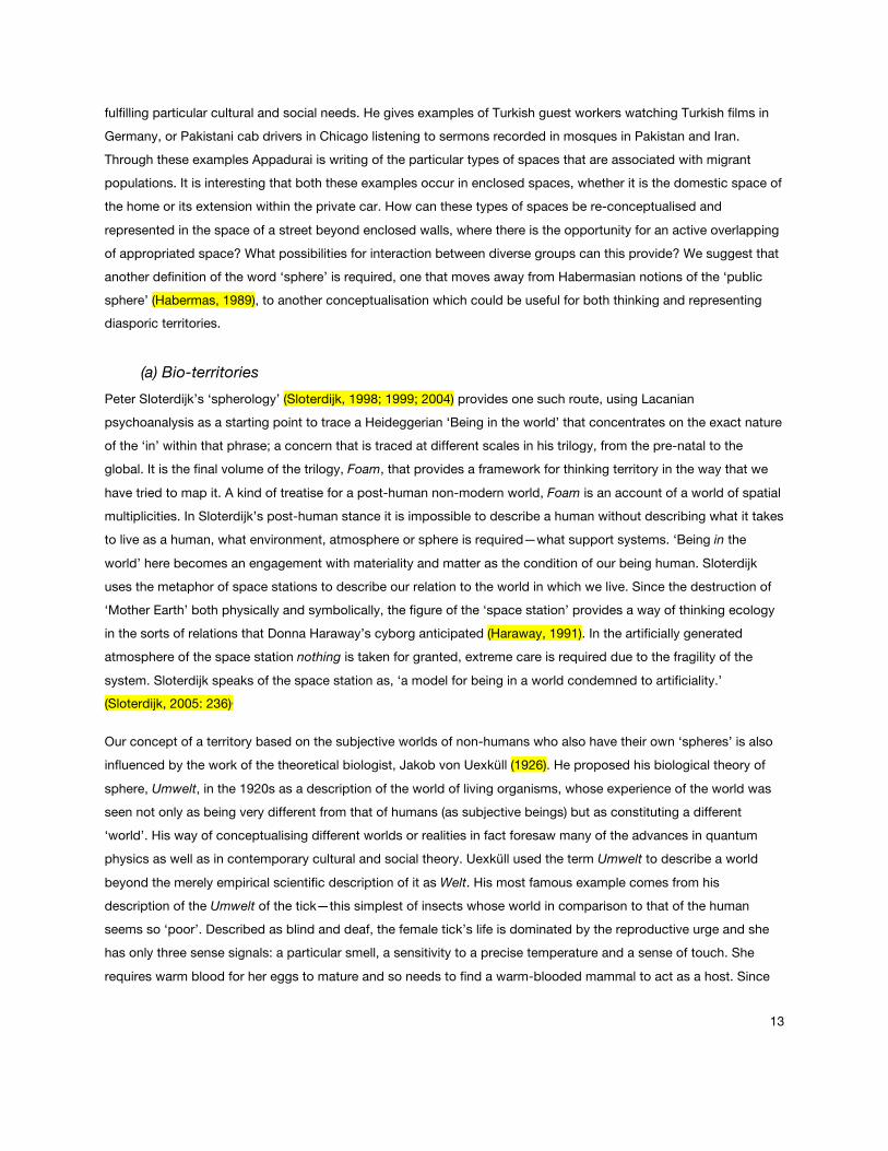
(a) Bio-territories
Peter Sloterdijk’s ‘spherology’ (Sloterdijk, 1998; 1999; 2004) provides one such route, using Lacanian
psychoanalysis as a starting point to trace a Heideggerian ‘Being in the world’ that concentrates on the exact nature
of the ‘in’ within that phrase; a concern that is traced at different scales in his trilogy, from the pre-natal to the
global. It is the final volume of the trilogy, Foam, that provides a framework for thinking territory in the way that we
have tried to map it. A kind of treatise for a post-human non-modern world, Foam is an account of a world of spatial
multiplicities. In Sloterdijk’s post-human stance it is impossible to describe a human without describing what it takes
to live as a human, what environment, atmosphere or sphere is required—what support systems. ‘Being in the
world’ here becomes an engagement with materiality and matter as the condition of our being human. Sloterdijk
uses the metaphor of space stations to describe our relation to the world in which we live. Since the destruction of
‘Mother Earth’ both physically and symbolically, the figure of the ‘space station’ provides a way of thinking ecology
in the sorts of relations that Donna Haraway’s cyborg anticipated (Haraway, 1991). In the artificially generated
atmosphere of the space station nothing is taken for granted, extreme care is required due to the fragility of the
system. Sloterdijk speaks of the space station as, ‘a model for being in a world condemned to artificiality.’ (Sloterdijk, 2005: 236)8
Our concept of a territory based on the subjective worlds of non-humans who also have their own ‘spheres’ is also
influenced by the work of the theoretical biologist, Jakob von Uexküll (1926). He proposed his biological theory of
sphere, Umwelt, in the 1920s as a description of the world of living organisms, whose experience of the world was
seen not only as being very different from that of humans (as subjective beings) but as constituting a different
‘world’. His way of conceptualising different worlds or realities in fact foresaw many of the advances in quantum
physics as well as in contemporary cultural and social theory. Uexküll used the term Umwelt to describe a world
beyond the merely empirical scientific description of it as Welt. His most famous example comes from his
description of the Umwelt of the tick—this simplest of insects whose world in comparison to that of the human
seems so ‘poor’. Described as blind and deaf, the female tick’s life is dominated by the reproductive urge and she
has only three sense signals: a particular smell, a sensitivity to a precise temperature and a sense of touch. She
requires warm blood for her eggs to mature and so needs to find a warm-blooded mammal to act as a host. Since
14
she cannot see her sense of smell guides her: as a mammal approaches giving off the scent of butyric acid, which
our sweat contains, the tick senses her chance and drops from her elevated position. If she has, indeed, managed
to land on a mammal, she will know this through her sensitivity to the exact 37 degrees temperature of mammalian
blood, and her sense of touch will guide her to a suitable place in which to burrow into the skin. Uexküll prefaces
this account of the tick’s world with a description of the same place as humans would perceive it, an idyllic meadow
full of colour and smell and sound. In comparison the tick’s world seems so meagre. But as Giorgio Agamben has
pointed out, in ways that we humans couldn’t come close to understanding, the tick’s world is full of richness: ‘Yet
the tick is immediately united to these three elements in an intense and passionate relationship the likes of it we
might never find in the relationships that bind man to his apparently much richer world. The tick is this relationship; she lives only in it and for it.’ (Agamben, 2004: 47)
What would a map of this world of the tick look like? Would it have three colours only, one for each of its three
senses? Is it even possible to map the subjective world of an animal? A pair of architects from New York,
Terraswarm, have attempted such a mapping of the visual world of a pigeon (Twemlow, 2006). The harnessing of
pigeon flight for the use of humans has a long history, but Terraswarm are attempting something different. They try
to apprehend the city from the pigeon’s point of view as part of a flock in flight, technologically a highly ambitious
undertaking, which is not yet perfected. A tiny camera is strapped to the pigeon’s chest and they are set free. The
mapping of their movements – created from what is recorded by the cameras that the pigeons wear - is carried out
in the context of the ‘Brooklyn Pigeon Wars’, where the birds are trained to fly high above the rooftops, their
encounter in the sky merging the flocks in an intricate performance that results in ‘disoriented’ birds joining the
opposing flock. It seems the pigeon owners have an understanding of flock behaviour, planning strategies to win
birds from different flocks. Terraswarm also seeks to understand flock behaviour through computer models
developed by the games designer Craig Reynolds (Reynolds, 1987; 2001), but it seems these models do not draw
on the observational knowledge of the pigeon coop owners gained through years of experience. The desire to use
science and technology fails to valorise other ways of knowing, and in some ways Terraswarm do not manage to
explore the pigeons’ relationship to their context. This context does of course consist of all the environmental
mappings that Terraswarm made: wind direction, local flight paths, the Earth’s magnetic field, but it also includes
the humans that must have formed some sort of relationship with the birds, and what of the relations the birds may
make in the sky? Does flock behaviour only ever consist of the kinetics of ‘separation, alignment and cohesion’,9
what of the reasons for these movements? Homing pigeons are also highly territorial birds, ready to defend their
‘patch’, but this urge to territorialise is not constant, it waxes and wanes according to the pigeon’s life cycle,
affected by age, season etc. All these factors form part of the subjective world, the Umwelt of the pigeons.
These were the types of questions related to ‘bio-territories’ that we wanted to address in our own mapping practice
– HOW?, but of course whilst mapping the territories of humans. For this the political needed to also be foregrounded, especially because of the contested nature of the street we had chosen to map.
15
(b) Political Territories
We therefore found it necessary to take a detour through contemporary territorial research in order to interrogate the
relationship between power, politics and space, and how the representation of space motivated by politics is used
as a means of exerting power. On a global and political scale, territory cannot be uncoupled from its representation
and this point has been made especially successfully and dramatically in the context of Palestine/Israel, in the work
of Eyal Weizman and Rafi Segal. The need for territorial research within the discipline of architecture seems to be
fundamentally connected with the need to address conflict as a base condition. Much of the work is predicated on
the fragmentation of the notion of ‘territory’—with the slow demise of the nation-state, globalised power structures
and the state of constant war in which we now live, territory as a self-contained, discrete entity has fragmented into
what has been referred to as an ‘archipelago’ or in the plural as ‘territories’ (Franke, Keenan, & Weizman, 2005). The
analogy of the archipelago is useful as it keeps the notion of a level of containment and isolation, but adds to it
connections and relations that are the result of exterior power applied from above, without the knowledge or
consent of the majority. The concept of ‘archipelago’ thus refers to a dual condition, the fragmentation of sovereign
power and the rise of extra-territorial powers. The fragmented islands of territory of an archipelago have fluid and
temporal boundaries unlike the traditional notion of territory which is conceived as a bounded entity with clearly defined borders.
The importance of territories as a concept also reveals itself in other situations in which conflict is present but where
it does not necessarily manifest itself in the violence of war. Ursula Biemann’s video essays, in particular, focus on
the biopolitics of territories and networks, and on how their production is performed socially through the politics of
labour, gender and mobility. In her work the question of territory is explicitly linked to the corporeal. Biemann’s video
essay, Sahara Chronicle, is part of her wider curatorial project, The Maghreb Connection (Biemann & Holmes, 2006).
In the video she follows the journey that thousands of Africans take through Sub-Saharan Africa to the Maghreb in
the hope of a passage to Europe. She has commented that her work is an attempt to show the other side of this
journey than the usual story seen in Europe of failed passage and capsized boats. In contrast, the beginning of the
journey is full of hope and a sense of excitement. Her video traces the network of people and places that allow this
passage to occur, a recasting of Castells’ concept of the ‘network society’ that describes the world of global finance
(Castells, 1996), to the tribal structures of the nomadic Tuareg of the Sahara. It is also a reaction against the isolated event-based take of the popular media to an understanding of migration as a condition.
The video also reveals the different ways of conceptualising territory, from the boundedness it is afforded in the
West, to the right to pan-African mobility that the continent’s inhabitants enjoyed until recently. Biemann makes the
point that the Schengen agreement that made possible a Europe without borders also curtailed free movement in
Africa by outsourcing European border security to the Maghreb (Biemann, November 2007). The construction of
territory in Africa is therefore intimately connected to European power, but this power is also subverted and
deterritorialised to a certain extent by the mobility of the Tuareg. They have historically been the natural passage
providers between the southern and northern parts of Africa and the artificial split of their territory across four
different countries by the colonial powers has left them in a state of limbo. They are by condition transnational and
16
this makes their position ideal for facilitating the transit of others across the Sahara. In the clandestine movement of
lines criss-crossing the vast desert, political territories are made and remade and the unsympathetic borders drawn
by the receding European powers are rendered at least momentarily ineffectual. Biemann relates the deals that are
struck for this passage, whether it is the money handed over to the Tuareg by the would-be migrants, or the diesel
bought by local authorities in exchange for returning the unsuccessful migrants back across the desert. There is a
parallel economic network shadowing the movement of bodies across distances and together these different trajectories constitute what could be characterised as a shifting migrant territory.
How can these two very different ways of conceptualising political territories – archipelago and trajectory - become
useful in our mapping of a rather nondescript London street? Whilst it is easy to see the formidable workings of
political power in places like Palestine, it is harder to imagine its work in a placid street where everyone seems able
to go quietly about their business. It is therefore a matter of trying to unravel the intricate network of people and
places that lead to power and the formation of political territories and the effect that the state and extraterritorial
powers can have on the lives of those caught up in their wake. This was demonstrated time and again by the
differing accounts of the same place recounted by the different people we walked with. The place from which the
Kurds especially spoke was never a bounded, secure place, never a nation-state, and we were aware that our attempts to conceptualise migrant territory should also account for this other perspective.
Our project to map migrant territories was primarily an attempt to expand the representational practices of
architecture and urbanism. Consequently, we also aim to expand the practice of mapping outwards to not only
include the planning of spaces, but also the social and political aspects of the production of space. The project
started with an understanding of migrant spatiality as inherently territorial, bringing with it the conflicts, nostalgias
and attachments of another place. Sloterdijk’s concept of ‘spheres’ allowed us to conceptualise these issues as
being immediately spatial, imagined as ‘personal territories’ or ‘spatial envelopes’. Conceptualising ‘bio-territories’
allowed us to include the non-anthropocentric, non-human perspectives of pigeons and ticks. These were included
as part of an attempt to move away from the standards and conventions of representation, which in our own
mappings was done through foregrounding subjective experience and through the use of computational techniques,
making representations that privileged topological relations over topographic connections. The political perspectives
just discussed were, therefore, included in order to facilitate more radical conceptions of space, representation and
territorialisation. Political territories of migration and conflict add a further perspective that shows how the formation
of territories is always related to questions of power and appropriation, and foregrounds the very different ways of
conceptualising territories across cultures. In addressing the question of territory at the level of locality, our project
concedes that the description of place is always related to the formation of territories, and in a highly diverse place
like London, the many different ways of conceptualising territories beyond their bounded description needs to be
addressed – the archipelagoes and trajectories of elsewhere also find their echoes in the reterritorialisation of space by migrants in London.
17
Mapping migrant territories as topological deformations of space
In this attempt at mapping migrant space we have privileged the METHOD OF WALKING-WITH, using it as a tool for
a corporeal mapping of ‘personal territories’ that cause topological deformations to the actual lived space of the
street, of affecting and being affected by our surroundings, our politics, our subjectivity. These spatial deformations
were mapped using computational methods that allowed us to move beyond the conventions of traditional
architectural representation, which restricts the spatial to the Euclidean space of x-, y- and z-axes. The use of ANNs
allowed us to switch to a type of representation that rather than mapping instances, mapped relations, overlaps and
intensities, by allowing the territories of different people at different times to communicate and to connect topologically according to their particular spatial politics.
In addition, the developmental context in which we were operating, and in opposition to which we have tried to
create an alternative planning tool, demanded a form of representation that could somehow mediate between the
representational space of local government development plans and the lived, actual space of the walks. They
needed to bring these other experiences to the planning table as equally legitimate and having their own authority.
We are now working on a web-based application that will allow others to use the technique we have developed to
map their own neighbourhoods. It will allow people to upload spatial, time-based information and conversations
onto the website, which will synthesise the data into territorial maps. Our aim, of eventual relinquishing of control
over the mapping through the web-based application in development, allows a shifting of spatial agency10 from the professionalised space of architects and developers to that of the everyday user.
18
Reference List
3Cs: Counter Cartographies Collective. (2009). Retrieved June 2011, http://www.countercartographies.org/.
Agamben, G. (2004). The open: Man and animal (K. Attell, Trans.). Stanford: Stanford University.
Altay, C. (2009). In search of spatial practice. Lines of Flight research group. University of Sheffield, School of Architecture, http://linesofflight.wordpress.com/2009/12/14/seminar-12-in-search-of-spatial-practice/.
Anderson, J. (2004). Talking whilst walking: A geographical archaeology of knowledge. Area, 36(3), 254-261.
Appadurai, A. (1996). Modernity at large: Cultural dimensions of globalisation. Minneapolis: University of Minnesota Press.
Awan, N., Schneider, T. & Till, J. (2011). Spatial agency: Other ways of doing architecture. London: Routledge.
Biemann, U. (2002). Remotely sensed: A topography of the global sex trade. Feminist Review, 70, 75-88.
----, (November 2007). The Maghreb Connection. III International Symposium Art Critics in a Global World. Symposium organised by ACCA, Museum of Contemporary Art, Barcelona, Spain.
Biemann, U., & Holmes, B. (Eds.). (2006). The Maghreb connection: Movements of life across North Africa. Barcelona: Actar.
Biemann, U., & Lundström, J.-E. (Eds.). (2008). Mission reports, artistic practice in the field: Ursula Biemann video works 1998-2008. Bristol: Arnolfini.
Careri, F. (2003). Walkscapes: Walking as an aesthetic practice (S. Piccolo & P. Hammond, Trans.). Barcelona: Editorial Gustavo Gili.
Castells, M. (1996). The rise of the network society: Vol 1. Cambridge, MA: Blackwell.
Derix, C. (2004). Building a synthetic cognizer. Paper presented at the MIT Design Computational Cognition Conference, Cambridge, MA.
Franke, A., Keenan, T., & Weizman, E. (2005). Archipelago of exception: Sovereignties of extraterritoriality. Paper presented at the Centre for Contemporary Culture, Barcelona.
Grosz, E. (1995). Space, time and bodies. In Space, time and perversion: Essays on the politics of bodies (pp. 83-103). London: Routledge.
Habermas, J. (1989). The structural transformation of the public sphere: An inquiry into a category of bourgeois society (T. Burger w. F. Lawrence, Trans.). Cambridge: Polity.
Haraway, D. J. (1991). Simians, cyborgs and women: The reinvention of nature. London: Free Association.
Holmes, B. (2004). Drifting through the grid: Psychogeography and imperial infrastructure. Springerin. Retrieved Dec 2009, http://www.springerin.at/dyn/heft_text.php?textid=1523&lang=en;
Jeremijenko, N. OneTrees: An information environment. http://www.nyu.edu/projects/xdesign/onetrees/.
Kohonen, T. (2001). Self-organizing maps (Third Edition ed.). Berlin: Springer.
19
Langley, P. (2007). Meta cognitive mappings: growing neural networks for a generative urbanism. University of East London.
Lefebvre, H. (1991). The production of space (D. Nicholson-Smith, Trans.). Oxford: Basil Blackwell.
Petrescu, D. (Ed.). (2006). Altering practices: Feminist politics and poetics of space. London: Routledge.
Petrescu, D. (2007). The indeterminate mapping of the common. field: 1(1), 88-96.
Precarias a la derivas. (2004). A drift through the circuits of feminised precarious work. Feminist Review, 77(1), 157-161.
Processing. Retrieved June 2011, http://processing.org/
Rendell, J. (Ed.). (2000). Gender, Space and Architecture. London: Routledge.
Reynolds, C. W. (1987). Flocks, herds, and schools: A distributed behavioral model. Computer Graphics, 21(4) (SIGGRAPH '87 Conference Proceedings), 25-34.
----, (2001). Boids: Background and update. Retrieved June 2011, http://www.red3d.com/cwr/boids/.
Sen, J. (2007). Other worlds, other maps: Mapping the unintended city. In Mogel, L., & Bhagat, A. (Eds.), An atlas of radical cartography. LA: The Journal of Aesthetics and Protest Press.
Sloterdijk, P. (1998). Sphären: Blasen: Vol. 1. Frankfurt am Main: Suhrkamp.
----, (1999). Sphären: Globen: Vol. 2. Frankfurt am Main: Suhrkamp.
----, (2004). Sphären: Schäume: Vol. 3. Frankfurt am Main: Suhrkamp.
Sloterdijk, P. (2005). Foreword to a theory of spheres. In M. Ohanian & J. C. Royoux (Eds.), Cosmograms (pp. 233-240). New York: Lukas and Sternberg.
Twemlow, A. (2006). Bark to bytes. In J. Abrams & P. Hall (Eds.), Else/Where: Mapping new cartographies of networks and territories. Minneapolis: University of Minnesota Design Institute.
von Uexküll, J. (1926). Theoretical biology (D. L. Mackinnon, Trans.). London: Kegan Paul.
20
1 Halkevi, Kurdish and Turkish community centre has been a place of political and cultural solidarity between Kurds and left-
wing Turks since it was established in 1984. It is an important centre in the organisation of the Kurdish diaspora across Europe. Some Turkish nationalists view the centre with suspicion due to its open support of the Kurdish struggle for self-determination.
2 The use of walking as a means of understanding the city has a long tradition from the Situationist dérive to more purposeful walks. For example, the feminist group Precarias a la derivas, use walking as a way of seeing the city through another perspective, of creating solidarity with others. They walked with women in Madrid who like them were employed in a range of ‘precarious’ employment in order to explore issues related to economy, labour and working conditions (Precarias a la derivas, 2004). In geography this technique has also been used as ‘talking whilst walking’, a way of exploring the inter-relations between people, place and time (Anderson, 2004).
3 Careri (2003) gives a detailed history of walking and discusses it as a specifically aesthetic practice.
4 Processing is an open source programming language and environment initiated by Ben Fry and Casey Reas whilst at MIT Media Lab (Processing).
5 Future iterations of the software will incorporate the scripts that generate the maps themselves, allowing users to directly create and store their own maps.
6 Feminist critiques of architecture have explored ways of ‘multiplying’ the restricted Euclidean space of normative architectural practice (Petrescu, 2006; Rendell, 2000).
7 The specific type of ANN used is a 'Self-Organising Map' [SOM], based on the algorithms developed by Teuvo Kohonen (Kohonen, 2001). ANN's have been used in an architectural context previously, typically in mapping ‘real world’ spatial information. For example, Centre for Evolutionary Computing and Architecture [CECA], based at University of East London have carried out a number of projects, notably (Derix, 2004). Typically, such algorithms are used for pattern recognition in images or language.
8 Jeremijenko’s project, mentioned earlier, is very close to this model of thinking where plants and animals are taken seriously as actors in our world—her trees are in fact mapping their own ‘bio-territory’ (Jeremijenko).
9 These are the three behavioural properties given to each ‘boid’ or flock member by Reynolds (Reynolds).
10 For an introduction to the concept of ‘spatial agency’ as it sits within architectural and urban practice, see (Awan, 2011).


