Embed Size (px)
Citation preview
AN ABSTRACT OF THE THESIS OF
Mark S. McCutcheon for the degree of Master of Science in GeologyPresented on September 19, 2003.Title: Stratigraphy and Sedimentology of the Middle Eocene Cowlitz Formationand Adjacent Sedimentary and Volcanic Units in the Longview-Kelso Area,Southwest Washington.
Alan R. Niem
Geologic mapping of the Longview-Kelso area and the measurement and
description of a composite 650-meter thick stratigraphic section of the Cowlitz Formation
(Tc) in Coal Creek using bio-, magneto-, litho-, and sequence stratigraphy reveals a
complex interplay of Cowlitz micaceous, lithic arkosic shelf to tidal/estuarine to delta
plain facies associations, and Grays River basalt lava flows and interbedded basalt
volcaniclastics from nearby Grays River eruptive centers (e.g., Mt. Solo and Rocky
Point). The lower 100 meters of the Coal Creek section (informal unit 1, Chron 18r)
consists of micaceous, lithic arkosic sandstone and siltstone and minor coals, was
deposited as part of a highstand system tract (HST) at the base of 3rd order cycle number
3. This unit consists of four dominantly tidal shoaling-upward arkosic sandstone
parasequences reflecting upper shoreface to delta plain depositional environments. The
overlying unit 2 (Chron 18n) is defined by abundant Grays River basalt volcaniclastic
interbeds that intertongue with Cowlitz lithic arkoses. This unit represents the latter part
of 3rd order cycle 3, and consists of mostly fining- and thinning-upward parasequences of
middle shoreface to delta plain successions of an aggradational to transgressive
parasequence set. Near the top of unit 2 is a maximum marine flooding surface
depositing lower shoreface lithic arkosic sandstone to shelf siltstones over upper
shoreface micaceous lithic arkose. Unit 3 comprises 3rd order cycle 4 (Chron 17r), a
lowstand system tract, and consists of 6 mostly fining- and thinning-upward
parasequences of lower shoreface to delta plain facies associations. A parasequence or
erosional boundary at the base of unit 5 (Chron 17r) consists of submarine channel-fill
scoured into underlying micaceous siltstones, produced during a lowstand system tract
(LST) of 3rd order cycle 5. This deep marine channel-fill sequence is overlain by thinly-
bedded to laminated overbank distal turbidites and hemipelagic siltstones that define the
top of the Coal Creek section. These 5 informal units in Coal Creek lithologically and
chronologically correlate to 5 similar informal units defined by Payne (1998) in the type
section of Cowlitz Formation in Olequa Creek near Vader -30 km to the north.
Middle Eocene Grays River Volcanics of the study area are mapped as two
separate units: a lower unit over 150 meters thick in places, consisting of subaerial
basaltic flows and invasive flows (Tgvl), intrusions (Tgvis and Tgvid), and
volcaniclastics (Tgvsl); and an upper unit consisting of commonly mollusk-bearing,
shallow marine basaltic sedimentary interbeds that intertongue with the Cowlitz
Formation (Tgvs2), particularly Cowlitz unit 2 of the Coal Creek section. These
volcaniclastic deposits are intrabasinal, derived from volcanic highlands to the west and
northwest, and local phreatomagmatic tuff cones. The lower Grays River volcaniclastic
unit typically overlies Grays River flows in the study area and is divided into 5 informal
facies. Geochemically, Grays River flows in the study area fall within normal parameters
(3 to 4% TiO2 and high iron tholeiitic basalts). However, basalt flows and bedded
scoriaceous breccias near Rocky Point are anomalously low in TiO2 and are considered in
this study to be a separate volcanic subunit (Rocky Point Basalts), time equivalent to and
interfingering with Grays River lavas, but may represent mixing with shallower western
Cascade calc-alkaline magma. Over 60 younger Grays River dikes intrude the Cowlitz
Formation in Coal Creek. A dike low in the Coal Creek section is dated at 40 ± 0.36 Ma,
and an invasive flow at Mt. Solo is dated at 36.98 ±.78 Ma. Volcanics capping the hills
east of the Cowlitz River are chemically distinct as slightly younger western Cascade
basaltic andesite flows, and two dikes east of the river are chemically distinct as western
Cascade andesite
Overlying Grays River Volcanics and Cowlitz Formation in much of the study
area, are clayey and commonly tuffaceous siltstones and silty sandstones, possibly of the
late Eocene-early Oligocene Toutle Formation, a new unit to this area. The Toutle
Formation is a mixture of wave and stream reworked micaceous and arkosic Cowlitz
Formation and fresh silicic pyroclastic ash and pumice from the active western Cascade
arc.

An angular unconformity separates the Paleogene Grays River Volcanics, Cowlitz
Formation, and Toutle Formation from the early to middle Miocene Columbia River
Basalt Group. Based on lithology, geochemistry, stratigraphic relationships, and
magnetic polarity, 6 individual Columbia River Basalt flows have been mapped in this
study. The three lower Grande Ronde flows are of normal polarity and Ortley low MgO
chemical composition. The lowermost flow (N2 Ortley #1) is absent in the Columbia
Heights area, low MgO, about 10 meters thick and consists of pillow-palagonite
sequences in the upper quarry on Mt. Solo. Aphyric N2 Ortley flow #2 is over 35 meters
thick with well-developed upper and lower colonnade, and of intermediate MgO. N2
Ortley flow #3 is pillow-palagonite in the Storedahl Quarry and low MgO. A -4-meter
thick tuffaceous overbank siltstone and basalt conglomeratic channel interbed separates
the three low MgO Ortley flows from the overlying high MgO N2 Grande Ronde Sentinel
Bluffs flow. A single exposure of well-developed large colonnade with sparse 1 cm
labradorite laths, and reddish oxidized soil, defines the N Sand Hollow flow of the
Frenchman Springs Member of the Wanapum Formation. The overlying Pomona
Member is mapped based on previous work by other authors.
Pliocene gravels and arkosic sand of the Troutdale Formation form upland terrace
deposits up to 100 meters thick in southern parts of the study area, and represent the
uplifted paleo-thalweg and overbank flood deposits of the downcutting, antecedent
ancestral Columbia River. Well-rounded clasts are a mixture of extrabasinal granitic and
metamorphic quartzite, and intrabasinal porphyritic basaltic andesite, dacite, and basalt
from the western Cascades and Columbia River Basalts. Troutdale terrace gravels grade
northward into contemporaneous volcanic pebble and cobble gravel terrace deposits
produced along the ancestral Cowlitz River that are dominantly composed of porphyritic
andesite gravel and volcanic sand from the western Cascades. Lower terraces along the
Cowlitz River were deposited by the late Pleistocene Missoula Floods. All of these
unconsolidated to semiconsolidated gravels and sands are prone to landslides, and the
Aldercrest-Banyon landslide, the second worst landslide disaster in American history,
occurred in the Troutdale Formation gravels.
After eruption of the Grays River Volcanics and deposition of the Cowlitz
Formation, the forearc underwent a period of transtension in the late-middle Eocene
related to magmatic upwelling and reorganization of the subducting Farallon Plate. This
event produced a northwest-trending set of oblique slip normal faults, along which Grays
River dikes intruded. Starting in the early Miocene the region underwent a
transpressional event, reactivating many of the northwest-trending faults, and producing
the Columbia Heights Anticline, Hazel Dell Syncline, the Coal Creek Fault, and the
Kelso Fault Zone. The paleotopography resulting from this event was stream eroded to a
nearly flat plain before emplacement of the Columbia River Basalts, which are nearly
horizontal today. Continued offset along the northwest-trending fault set has also offset
the Columbia River Basalts. Continued oblique slip post-Miocene broad arching of the
Coast Range and downcutting by the Columbia and Cowlitz Rivers has resulted in
Pliocene and Pleistocene terraces, and produced an east-west fault set that offsets all
earlier structural features.
© by Mark S. McCutcheonSeptember 19, 2003All Rights Reserved
Stratigraphy and Sedimentology of the Middle Eocene Cowlitz Formation and AdjacentSedimentary and Volcanic Units in the Longview-Kelso Area,
Southwest Washington
ByMark S. McCutcheon
A THESIS
Submitted to
Oregon State University
In partial fulfillment ofthe requirements for the
degree of
Master of Science
Presented September 19, 2003Commencement June, 2004
Master of Science thesis of Mark S. McCutcheon presented on September 19, 2003.
APPROVED
-,7
Major Professor, representing Geology
Chair of the Department of Geosciences
I understand that my thesis will become part of the permanent collection of OregonState University libraries. My signature below authorizes release of my thesis toany reader upon request.
Mark S. McCutcheon, Author
ACKNOWLEDGEMENTS
I am grateful for the financial support offered for this study by Dave Pauli and
George Sharp of Weyerhaeuser Corporation that made this study possible. I am also
thankful for the financial and geologic assistance for obtaining thin sections,
geochemistry, well logs, and landslide locations, that was provided by Karl Wegmann
and Dr. Tim Walsh of the Washington Department of Natural Resources. Thanks
also go to Wendy Niem for computer advice and assistance above and beyond the call
of duty, and reading the second draft of this thesis. And of course, without the
wisdom and experience of my thesis advisor Dr. Alan Niem (professor emeritus) in
the field and the classroom, this project would not be nearly as comprehensive. I am
also thankful to Dr. Niem for not giving up on me through some challenging times.
Appreciation also goes to several other people who contributed valuable and
vital data to this study. Molluscan assemblage identification and interpretation
provided by Dr. Elizabeth Nesbitt of the University of Washington Burke Museum
proved to be invaluable. I would also like to thank Dr. Reed Glasmann for x-ray
diffraction data of clay and other minerals and review of the thesis, Dr. Bob Lillie of
Oregon State University for his review of the thesis and enlightenment in the
classroom, Dr. Charles Langford, professor of Sociology and Oregon State University
for taking on the (likely larger than expected) role of being my fourth committee
member and reviewing the thesis, Dr. Robert Duncan, professor of the College of
Oceanic and Atmospheric Sciences at Oregon State University for Ar40/Ar39
radiometric dating of a basalt sample, Dr. Estella Leopold of the University of
Washington for running palynology samples, Dr. Jeff Meyers of Western Oregon

University for important information regarding fossil leaves, Russ Evarts of the
USGS for an enlightening day in the field, and Dr. Robert Bentley, professor emeritus
of Central Washington University for opening my eyes to new ideas regarding
emplacement of the Columbia River Basalts.
I would like also to state my appreciation to Dr. Kenneth Hamblin and Dr.
Keith Rigby of Brigham Young University, and Dr. Richard Moyle, Dr. Adolf
Yonkee, and Dr. Sidney Ashe of Weber State University for taking me under their
wings. Moral support from former fellow students Derik Kleibacker and Drew
Eriksson and many others was much appreciated. I would also like to express my
appreciation to the many public school teachers (who chose me to be a part of their
classroom as a substitute teacher), staff, and students who gave me reason to hold my
head high, and kept my bills paid. Most importantly, I would like to thank my family.
The moral and financial support from my mother Maurine, and my brother Alan is
appreciated beyond words. I would also like to thank my brother for the many trips
to the observatory, mountains, and coast that sparked and maintained my interest in
science. I also need to mention my outrageous German Shepherd, Lucy. I doubt a
dog has ever played a more important role in a person's life.
TABLE OF CONTENTS
Page
INTRODUCTION
OBJECTIVES .............................................................................1
LOCATION AND ACCESS .............................................................2
REGIONAL GEOLOGIC SETTING AND STRATIGRAPHY .....................2
PREVIOUS WORK ......................................................................11
METHODS OF INVESTIGATION ....................................................15
STRATIGAPHY AND LITHOFACIES OF THE COAL CREEK SECTION OFTHE COWLITZ FORMATION
INTRODUCTION ........................................................................19
LITHOFACIES AND DESCRIPTIONS ..............................................20
UNIT 1 ...........................................................................23UNIT 2 ...........................................................................37UNIT 3 ...........................................................................58UNIT 4 ...........................................................................65UNIT 5 ...........................................................................68
DEPOSITIONAL ENVIRONMENTS ................................................72
PETROGRAPHY ........................................................................97
LITHIC ARKOSES AND CARBONACEOUS STRATA ................99UPPER GRAYS RIVER VOLCANICLASTIC INTERBEDS..........111
X- RAY DIFFRACTION .............................................................114
SEQUENCE STRATIGRAPHY AND CORRELATION TO THECOWLITZ TYPE SECTION ..........................................................120
TABLE OF CONTENTS (continued)
PageTOUTLE FORMATION?
INTRODUCTION ........................................................................129
LOCAL STRATIGRAPHY AND THICKNESS ..................................... 131
LITHOLOGY AND OUTCROP CHARACTERISTICS ...........................135
PETROGRAPHY ........................................................................142
X-RAY DIFFRACTION ................................................................144
DEPOSITIONAL ENVIRONMENTS ................................................ 149
VOLCANICS
GRAYS RIVER VOLCANICS .........................................................151
AGE ...............................................................................154DISTRIBUTION AND STRATIGRAPHY ..................................156PETROLOGY ....................................................................164
GRAYS RIVER FLOWS ............................................. 164DIKES ...................................................................169LOWER VOLCANICLASTICS .....................................172GEOCHEMISTRY ....................................................186
DEPOSITIONAL ENVIRONMENTS AND PALEOGEOGRAPHICRECONSTRUCTION ...........................................................190
WESTERN CASCADE BASALTIC ANDESITE ..................................196
GEOCHEMISTRY ..............................................................197LITHOLOGY AND PETROGRAPHY ......................................197
WESTERN CASCADE ANDESITE DIKES .........................................199
GEOCHEMISTRY AND FIELD CHARACTERISTICS .................199PETROGRAPHY ...............................................................200
COLUMBIA RIVER BASALT GROUP .............................................203
INTRODUCTION .............................................................. 203LOCAL DISTRIBUTION......................................................204GRANDE RONDE STRATIGRAPHY .......................................206
TABLE OF CONTENTS (continued)
Page
FLOW UNITS CORRELATION AND GEOCHEMISTRY..............208LITHOLOGY AND PETROGRAPHY ......................................214INTERBEDS AND CONTACT RELATIONS .............................222
TROUTDALE FORMATION AND PLIOCENE ANDESITIC TERRACEGRAVELS
INTRODUCTION .....................................................................229
LOCAL DISTRIBUTION AND LITHOLOGY ...................................230
QUATERNARY UNITS
PLEISTOCENE-HOLOCENE TERRACES ........................................234
LANDSLIDES ..........................................................................235
MT. ST. HELENS LAHAR, MAY 18th , 1980 .....................................238
HOLOCENE AND LATE PLEISTOCENE ALLUVIUM .......................239
STRUCTURAL GEOLOGY
INTRODUCTION ......................................................................241
LOCAL STRUCTURE .................................................................243
COLUMBIA HEIGHTS ANTICLINE AND HAZED DELLSYNCLINE ..................................................................... 245N 50-70 W-TRENDING FAULTS ..........................................249COAL CREEK FAULT ......................................................256EAST-WEST-TRENDING FAULTS ......................................259NORTH-SOUTH-TRENDING FAULTS..................................260KELSO FAULT ZONE ......................................................264KALAMA STRUCTURE ZONE ...........................................268
HYDROCARBON POTENTIAL ............................................................274
POTENTIAL LOCAL HYDROCARBON GENERATION .....................276
TABLE OF CONTENTS (continued)
Page
POTENTIAL LOCAL HYDROCARBON RESERVOIRS ......................278
POTENTIAL STRATIGRAPHIC AND STRUCTURAL TRAPS .............280
GEOLOGIC HAZARDS ......................................................................284
GEOLOGIC HISTORY ....................................................................... 290
CONCLUSIONS ............................................................................... 297
REFERENCES .................................................................................306
APPENDICES ................................................................................. 315
APPENDIX I: MACROFOSSIL IDENTIFICATION ........................316
APPENDIX II: MAGNETIC POLARITY OF BASALT SAMPLES........319
APPENDIX III: VOLCANIC GEOCHEMISTRY ..............................320
APPENDIX IV: POINT COUNTS ................................................324
APPENDIX V: CHEMISTRY OF METHANE SAMPLE .....................325
APPENDIX VI: MT. SOLO 40AR/'`BAR RADIOMETRIC DATE .............326
LIST OF FIGURES
Figure Page
1. Boundary and location of the study area, southwest Washington .....................3
2. Location of the study area, in the forarc basin of the Cascadia subduction zone....4
3. Regional geologic map of Eocene and Oligocene sedimentary and volcanicunits of southwest Washington and northwest Oregon (Modified from Payne,1998; Walsh et at., 1987; and Robertson, 1997) ........................................6
4. Southwest Washington to northwest Oregon stratigraphic correlation chart(Modified from Payne, 1998 and Kleibacker, 2001) ...................................9
5. Profile of onshore-offshore depositional environments and lithofacies waterdepths (modified from Payne, 1998) ....................................................22
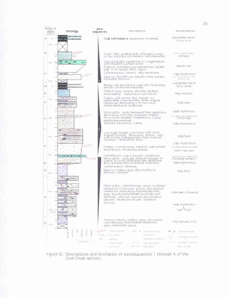
6. Descriptions and interpretations of parasequences 1 through 4 of the CoalCreek section ...............................................................................26
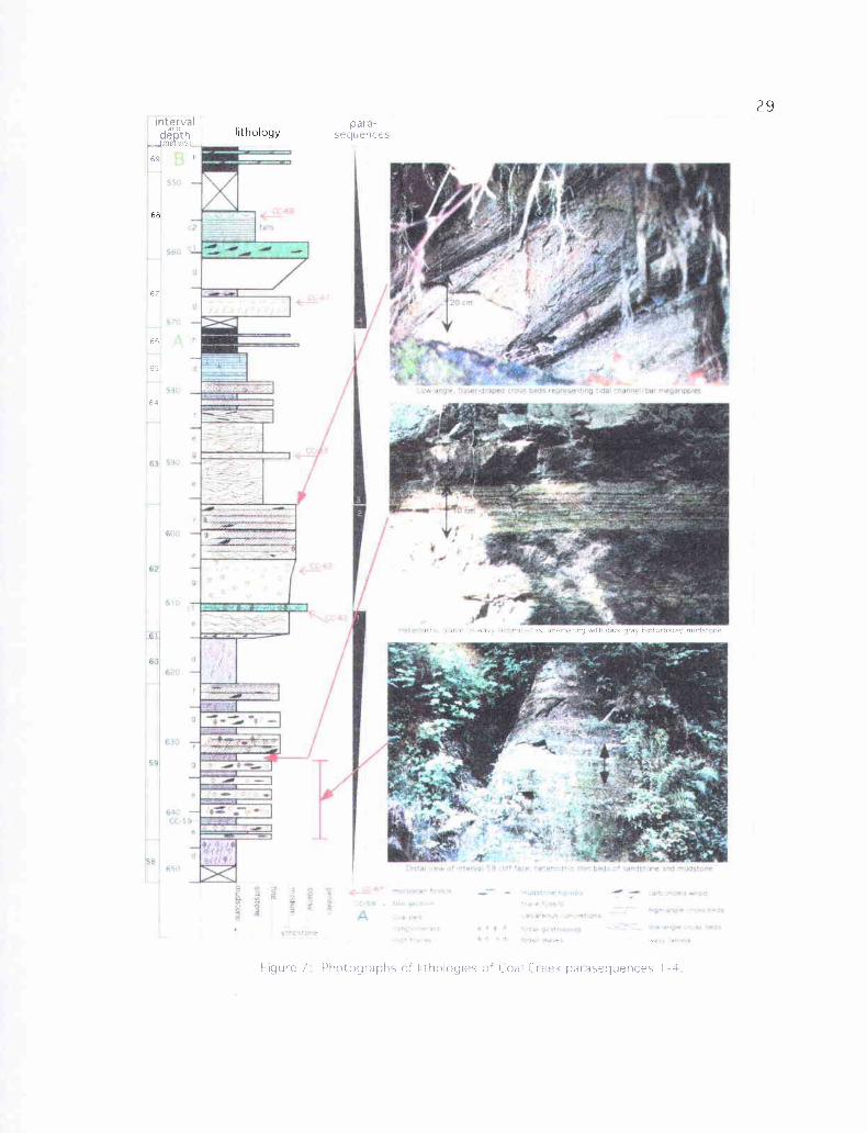
7. Photographs of lithologies of Coal Creek parasequences 1 through 4 .............29
8. More photographs of lithologies of Coal Creek parasequences 1 through 4......35
9. Descriptions and interpretations of parasequences 5 through 7 of the CoalCreek section ..............................................................................40
10. Photographs of lithofacies c2 from the northern part of the Coal Creeksection, graded beds of basaltic sandstone to siltstone .............................41
11. Photographs of lithologies of parasequences 5 through 8 .........................42
12. Descriptions and interpretations of parasequences 8 through 11 of the CoalCreek section............................................................................50
13. Photographs of lithologies of parasequences 9 through 12 ........................55
14. Descriptions and interpretations of parasequences 12 and 13 of the CoalCreek section ............................................................................57
15. Descriptions and interpretations of parasequences 14 through 17 of the CoalCreek section ............................................................................59
16. Photographs of lithologies of parasequences 14 through 17 ......................60
LIST OF FIGURES (continued)
Figure Page
17. Descriptions and interpretations of the top part of the Coal Creek section......66
18. Photographs of distal turbidites from near the top of the Coal Creek section...67
19. Unique characteristics of clastic tidal deposits recording tide fluctuationcycles in tidal megaripple and tidal rhythmite facies ...............................75
20. Estuarine sediment grain size in present day Willapa Bay, southwestWashington.............................................................................. 86
21. Sandstone classification ternary diagrams plotting several Coal Creeksamples of varying lithology ...........................................................98
22. Photomicrographs of Coal Creek section lithofacies g, massive, well-sortedmicaceous, arkosic sandstones with <5% Grays River basalt clasts............100
23. Photomicrographs of basalt-lithic samples of lithofacies g or j ..................102
24. Photomicrographs of sandstones of lithofacies f, flaser-draped sigmoidalmega-ripples of a tidal channel or tidal bar .........................................105
25. Photomicrographs of sandstones of lithofacies e (tidal rhythmites)............ 108
26. Photomicrographs of lithofacies k and h of the Coal Creek section............110
27. Photomicrographs of Grays River shallow marine volcaniclastic interbeds(Tgvs2) within the Coal Creek section ..............................................112
28. X-ray diffraction pattern of the <15.tm fraction of Coal Creek sectionsample CC-22d .........................................................................116
29. X-ray diffraction pattern of the <2µm fraction of Coal Creek sectionsample CC-22d .........................................................................116
30. X-ray diffraction pattern of the <2µm fraction of Coal Creek sectionsample CC-48 ...........................................................................117
31. X-ray diffraction pattern of the <15µm fraction of Coal Creek sectionsample CC-80 ...........................................................................117
32. X-ray diffraction pattern of the <2gm fraction of Coal Creek sectionsample CC-80 ...........................................................................118
LIST OF FIGURES (continued)
Figure Page
33. X-ray diffraction pattern of the <2 tm fraction of Coal Creek sectionsample CC-79 ...........................................................................119
34. Coal Creek - Germany Creek - Olequa Creek correlation diagram ............ 124
35. Paleogeographic reconstruction of the Toutle Formation showingdepositional environments and unconformable stratigraphic relationshipwith underlying Cowlitz Formation (modified from Payne, 1998) ..............132
36. Thin-bedded to laminated, clay-rich siltstones and fine-grained sandstonesof the Toutle Formation facies 2, at Site 49 atop Columbia Heights............137
37. Unusual trace fossils of uncertain origin in tuffaceous, clayey siltstones ofthe Toutle Formation at Site 49 .......................................................138
38. Sandstones and siltstones of the Toutle Formation exposed in theheadscarp of a landslide at Site 59 ...................................................140
39. Cross-bedded tuffaceous arkosic sandstones of Toutle Formationlithofacies 3 .............................................................................141
40. Photomicrographs of Toutle Formation sandstones and siltstones ..............143
41. X-ray diffraction pattern of the <2µm fraction of Toutle Formation samplefrom Site 60 .............................................................................145
42. X-ray diffraction pattern of the <15 tm fraction of Toutle Formationsample from Site 60 ....................................................................146
43. X-ray diffraction pattern of the <2µm fraction of Toutle Formation samplefrom Site 49 .............................................................................147
44. X-ray diffraction pattern of the <15µ.m fraction of Toutle Formationsample from Site 49 ....................................................................148
45. Residual wavelength-filtered gravity anomaly map and volcanic geologymap superimposed to show relationship of shallow crustal features andsurface geology. The large anomaly centered on Grays River Volcanicsmay be the eruptive center ............................................................153
46. Magnetic polarity stages and Ar40/Ar39 age-diagram of Grays RiverVolcanics, showing age progression toward the present day northeast.........155
LIST OF FIGURES (continued)
Figure Page
47. Time stratigraphic chart of geologic units within the study area .................158
48. Grays River flows in the Terra Firma Quarry on the south side of Mt. Solo... 159
49. Quarry at Site 7, on the south side of Mt. Solo, illustrating the interminglingof Grays River lava (Tvgl) and associated lower Grays River autoclasticbreccia (Tgvsl) .........................................................................161
50. Grays River basalt intrusions into the Cowlitz Formation ........................163
51. Photomicrographs of Grays River flows from the south side of Mt. Solo......167
52. Photomicrographs of Grays River flows from near the Cowlitz River(Rocky Point Volcanics) ...............................................................168
53. Photomicrographs of a Grays River dike from Coal Creek (CC-44)............171
54. Photomicrographs of Lower Grays River Volcaniclastic from Mt. Solo.......177
55. Lower Grays River Volcaniclastics from Site 9 (Carrolls I-5 exit) ..............181
56. Photomicrographs of two Lower Grays River Volcaniclastics from Site 14and Site 5 ................................................................................184
57. Na2O + K2O and FeO/MgO vs. SiO2 plots of Irvine and Barager (1971)and Miyashiro (1974) for Grays River Volcanics, western CascadeBasaltic Andesite, and western Cascade Andesite .................................187
58. TiO2 and FeO vs. SiO2 Plots for Grays River Volcanics, western CascadeBasaltic Andesite, and western Cascade Andesite .................................188
59. Paleogeographic reconstruction of Grays River Volcanics and CowlitzFormation tidal and supratidal fades associations .................................191
60. Photomicrographs of western Cascade Basaltic Andesite flows ................198
61. Photomicrographs of western Cascade Andesite from east of the CowlitzRiver .....................................................................................201
LIST OF FIGURES (continued)
Figure Page
62: Grande Ronde basalt flows in the Storedahl and Sons Quarry, nearEufaula ..................................................................................207
63. Composite section of Columbia River Basalts and interbeds in the maparea .......................................................................................209
64. TiO2 and P2O5 vs. MgO for Grande Ronde Basalt flows 1-4. ColumbiaRiver Basalt rectangular fields of Beeson and others (1989) and ReidelAnd others (1989) are shown for TiO2 vs. MgO ..................................211
65. TiO2 vs. P2O5 plot for Grande Ronde Basalts. Rectangular fields ofBeeson and others (1989) and Reidel and others (1989) are shown............212
66. Ortley flow #1 photograph from a quarry on Mt. Solo, and Ortleyflow #1 photomicrograph from the Storedahl and Sons Quarry (BC-3)........216
67. Ortley flow #2 photograph from the West Side Quarry and contact withunderlying Toutle Formation, and photomicrograph of flow #2 from thelower colonnade in the Storedahl and Sons Quarry ...............................218
68. Photomicrographs of Ortley flow #3, and Sentinel Bluffs flow #4 ..............221
69. Interbed between Ortley flow #2 and #3 in the Storedahl and Sons Quarry ...224
70. Contorted interbed between Ortley flow #2 and #3 in the West SideQuarry showing possible invasive relationship, and interbed betweenOrtley flow #3 and Sentinel Bluffs Flow #4 in the Storedahl and SonsQuarry ...................................................................................225
71. Two facies of the interbed between Ortley flow #3 and Sentinel Bluffsflow #4 in the Storedahl and Sons Quarry ..........................................227
72. Headscarp of the Aldercrest-Banyon landslide exposing gravels andsands of the Troutdale Formation, and close up photograph of andesiteterrace gravels (Ttr) ....................................................................232
73. Portion of southwest Washington State Geologic Map by Walsh andPhillips (1987), showing system of northwest-trending oblique slipfaults and folds .........................................................................250
LIST OF FIGURES (continued)
Figure Page
74. DEM (digital elevation model) image of the Longview-Kelso area(courtesy Phil Dinterman of the USGS) .............................................251
75. East-west trending faults from Site 49 in Toutle Formation clayeysiltstones .................................................................................261
76. More east-west trending faults from Site 49 in Toutle Formation clayeysiltstones .................................................................................262
77. N 20 W faults exposed at Site "IS" in Coal Creek interval 22 along CoalCreek Road ..............................................................................263
78. Exposures of the Kelso Fault Zone at Site 9 (Carrolls 1-5 exit) ..................265
79. N 30 W normal fault in the Kelso Fault Zone juxtaposing the westernCascade Basaltic Andesite unit and Lower Grays River Volcaniclasticat Site 9 ..................................................................................267
80. Structure of northwest and central part of the Newport-Inglewood faultzone and southwestern shelf of the Los Angeles basin (Modified fromHarding (1971) ........................................................................ 272
81. Property damage and headscarp of the Aldercrest-Banyon landslide..........288
STRATIGRAPHY AND SEDIMENTOLOGY OF THE MIDDLE EOCENECOWLITZ FORMATION AND ADJACENT SEDIMENTARY AND VOLCANICUNITS IN THE LONGVIEW-KELSO AREA, SOUTHWEST WASHINGTON
INTRODUCTION
Objectives
Among the objectives of this study was to interpret the sequence stratigraphy,
depositional environments, ages, paleocurrent dispersal patterns, and provenances of the
Cowlitz Formation. In addition, sedimentary facies within the Cowlitz Formation (e.g.,
separate volcaniclastic units, delta plain arkosic and micaceous sandstones, siltstones, and
coals, tidal flat, estuarine, and delta front sandstones) were to be identified and correlated.
Another objective was to interpret the local and regional stratigraphic relationship
between the Cowlitz Formation strata and adjacent Eocene and Miocene volcanic units.
The Cowlitz Formation in the Longview-Kelso area was to be correlated to the five units
and several facies described in the type section by Payne (1998) to the north, and the two
Cowlitz units defined by Robertson (1997) in the producing Mist Gas Field to the south
in northwest Oregon. Another objective, using petrography and x-ray diffraction analysis,
was to determine the diagenetic history of the Cowlitz sandstones in order to evaluate the
reservoir potential (porosity and permeability) of the unit and define potential source
rocks and their thermal maturation. With the above data, the hydrocarbon potential of the
area was to be assessed.
Another objective was to reconstruct the sequential structural history of the area
and interpret this history in a regional structural and tectonic framework. Individual
Columbia River Basalt flows in the area were to be resolved, separated, and mapped
2using magnetic polarity, geochemistry, lithology, petrography, and stratigraphic
relationships. Also, a geologic map (-80 mi) of the Longview-Kelso area at 1:24,000
scale was to be produced and drafted on computer, as well as a composite stratigraphic
column of the Cowlitz Formation in Coal Creek. Finally, the natural hazard potential of
the area was assessed, especially given the devastating Aldercrest/Banyon landslide that
occurred within the map area in 1998.
Location and Access
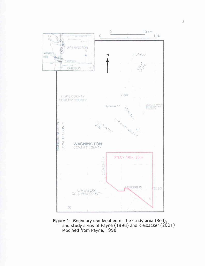
The thesis area includes the cities of Longview and Kelso and the low-lying
stream dissected hills to the north and northwest in southwest Washington, a total area of
approximately 195 km2 (-80 mi) (Figure 1, Plate 1). Other communities within the area
are Eufaula, Coal Creek, Lexington, Ostrander, Pleasant Hill, and Tucker. Major
topographic features include the Cowlitz and Columbia Rivers, the Coal Creek, Clark
Creek, and Hazel Dell Creek drainages, Eufaula Heights (west of Coal Creek), Columbia
Heights (east of Coal Creek and west of the Cowlitz River), and the isolated hill Mt. Solo.
Access to this lushly vegetated and hilly area is provided by Interstate 5, numerous paved
highways and county roads, Willamette Industries logging roads, private driveways, and
streams. Good exposures of the Cowlitz Formation and associated volcanic units occur
in Coal Creek during low summer discharge, and along a 16-kilometer (-10 mile) stretch
of Interstate 5.
Regional Geologic Setting and Stratig_raphy
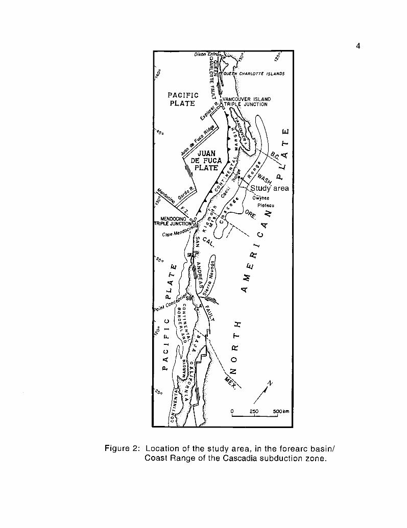
The thesis area lies between the Cascade calc-alkaline volcanic arc and forearc
(Figure 2) and, as part of an active subduction zone complex, contains structures and
iNaSHi1 rrhr l ,
Willa
Ms i
-46i
DREGON,
IL.EWS,r COUNT Y'(ZVJL!TZ- ooui rr
V
3
JCw,,-rr NIV: i0r.7 $M) i vrrr +ra . V
5
ECSO
3.9
10 Km
Hvderwood
WASHINGTON(' )1Ail 11 ri JNT'v
Vadea
OREGON;lJl liMB A l ,()UNT'
N
Figure 1: Boundary and location of the study area (Red),and study areas of Payne (1998) and Kleibacker (2001)Modified from Payne, 1998.
4
PACIFIC-4 VANCOUVER ISLAND
PLATE ' TRIP E JUNCTIONe . ellay
I9s, V-/ 1 N \ \ \ W
e I
-GStudy' area'PA / /illo
MENDOCINO
0 hee
Plateau
R, cam"
IPLTRE JUNCTION°/
Cope Mead°aI
0 250 500km
Figure 2: Location of the study area, in the forearc basin/Coast Range of the Cascadia subduction zone.
QUEEN
5
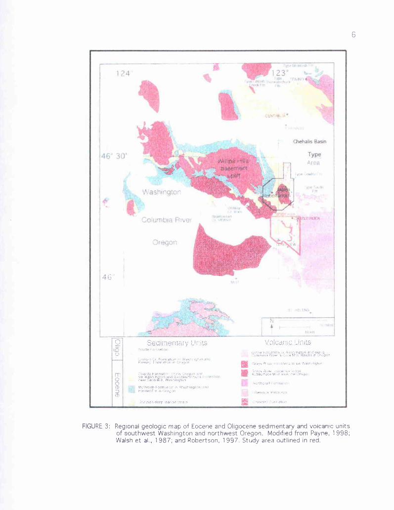
Tertiary and Quaternary units that reflect a complex geologic history. Previous regional
or reconnaissance geologic maps of the Longview-Kelso area (e.g., Livingston, 1966;
Walsh and Phillips, 1987) include volcanic and sedimentary rocks ranging in age from
early-late Eocene to middle Miocene (Figure 3). The oldest rocks of the Oregon and
Washington Coast Ranges are the early to middle Eocene Siletz River Volcanics of
northwest Oregon and the equivalent Crescent Formation of southwest Washington
(Wells, 1981), with an average K-Ar age of -49 Ma (Duncan, 1982), but range up to 59
Ma (Niem personal communication, 2003). These lower to middle Eocene units are
collectively termed the Siletzia Terrain and form the 10- to 20-kilometer thick volcanic
basement of the region. This terrain is composed of tholeiitic to alkalic breccias and
pillow basalts to local subaerial flows with minor interbeds of deep-marine basaltic
sandstone and siltstone. These thick volcanic piles may be the accreted remnants of an
oceanic seamount province on the subducting Farallon oceanic plate, produced by
eruption along an oceanic ridge possibly associated with the very early stages of
Yellowstone hot spot volcanism (Duncan, 1982). In this view, the plate was accreted to
the North American margin by middle Eocene. Alternatively, these oceanic basalt
volcanics may have formed by in situ mafic volcanism associated with rifting of a
pullapart marginal basin, due to the oblique subduction between the Farallon and North
American Plates, possibly along a leaky transform fault (Wells et al., 1984; Snavely,
1987; Ryu and Niem, 1992). After emplacement of the oceanic crust, and clogging of the
early-middle Eocene subduction zone by this buoyant oceanic seamount province in the
middle-late Eocene, a new subduction zone formed farther to the west,
1194'
I
I=
Columbia Rive(
Oregon
Basin
Type
46
aecirnentary units VQtcJ1;: iUntsRap,t d{u! yl!?,1f.llirih,i AI'/W .:.';'I5 x1 fja5dll n
K.asey Former-',- n
TCC)CD
m
.-O'1 FUfnl:itl :I ;' nV,SW Wflsmin 'IGn ana .h'n nll""l: 1`.il'hyear .,en[r a°Fa, Wish.riytun
Mc,ntosn Furmato-.-,r. n; W°d)hlllglI. r :n:Hamlet Fm m Uyon
;P:.!:znan deep ^arwe ,, - 1':l
S'ibsulace M'SI a-es SW ')re.ac.I'
" F11t i 1.
lam.,,F Voll )..,
7
near the position of the present outer continental shelf (Wells et al., 1984; Wells and
Coe, 1985; Snavely, 1987; Armentrout, 1987).
As a result of continued oblique subduction in the late Eocene, this soft collision
plate tectonic boundary in southwest Washington became a zone of north-south
transcurrent faulting and subsequent Reidel shear, resulting in clockwise rotation of small
discrete crustal blocks and development of northwest-trending conjugate faults (Wells
and Coe, 1985; Armentrout, 1987). Paleomagnetic evidence from Eocene to Miocene
sedimentary and volcanic rocks of the Oregon and Washington Coast Ranges indicates
that more than 30 to 75 degrees of clockwise tectonic rotation has occurred by this
process with a possible pivot point in southwest Washington (Simpson and Cox, 1977;
Wells and Coe, 1985; Wells et al., 1998; Prothero and others, 2002). Early to middle
Eocene uplift associated with this accretion and shear rotation produced a structural high,
with Crescent Formation in its core, due to basement uplift in the Willapa Hills area,
producing the first major unconformity (sequence boundary) in southwest Washington
(Armentrout, 1987).
A deep forearc basin about 640 km long, extending from northwest Washington to
southwest Oregon, formed east of the subduction zone in late-middle Eocene time due to
crustal extension and subsidence (Niem and Niem, 1984). More than 2,100 in of
shallow- and deep-marine sediments and local mafic volcanics accumulated within this
forearc basin during the middle to late Eocene. The southern part of the basin in Oregon
began to fill with deltaic and submarine fan facies of the Tyee Formation (Ryu and others,
1992). Concurrently, in southwest Washington, deep-marine slope mudstones and minor
8
turbidite-deltaic sandstones of the McIntosh Formation were deposited. Those
sediments appear to onlap the older Crescent Volcanics in the Willapa Hills area,
suggesting that there the basement rocks formed either a paleo-bathymetric or subaerial
high (Niem and Niem, 1984; Moothart, 1992; Payne, 1998; Stanley et al., 1994).
Approximately 3,500 in of high TiO2 and Fe2O3 Tillamook Volcanics in
northwest Oregon and slightly younger Grays River Volcanics in southwest Washington
were erupted in the forearc during late-middle and late Eocene time from -36.8 to -45
Ma (Niem and Niem, 1985). These flows are interpreted to have been erupted by
coalescing submarine mafic shield volcanoes that built up above wave base to become
subaerial oceanic islands. The lower flows of these volcanic piles are locally tholeiitic
submarine breccias and pillow basalts, but in some areas differentiate upward into
subaerial plagioclase- and augite-phyric, platy, basaltic andesites, andesites, and some
dacites and associated dikes (Rarey, 1985; Mumford, 1988). These volcanic edifices and
oceanic islands subsequently subdivided the late-middle Eocene forearc basin into
smaller basins in which 1,000 in of deep marine mudstone and minor micaceous, arkosic
sandstones of the Yamhill and Hamlet Formations (in northwest Oregon) and the
McIntosh Formation (in southwest Washington) were deposited (Niem and Niem, 1984)
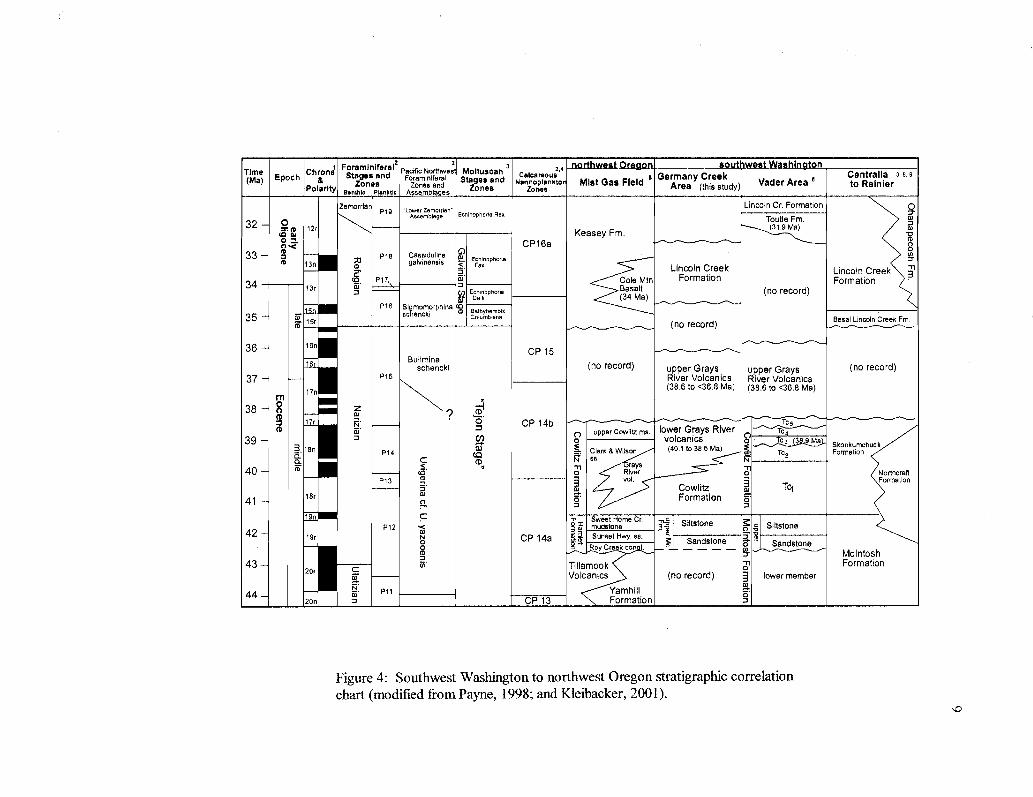
(Figure 4).
Prograding over these largely deeper marine sediments and volcanics in the late-
middle Eocene (late Narizian), are the 1,300 to 1,500 in (4,300 to 5,000 ft) of deltaic,
micaceous, sandstones, siltstones, mudstones, and coals of the Cowlitz Formation. These
sediments were deposited as the southern extension of a much wider late Eocene
t Foraminiferalz2
3 northwest Oregon sout hwest Washin tonTime(Ma) Epoch
Chrona8 Stages and
Pacific NortnweForaminieral
MolluscanStages and
z,a
Nanno lankto Mi t G Fi ldGermany Creek
V d A a
Centralia 3,8,9
Polarity Zones Zones and Zonesp
Zoness as e Area (this study) a er rea to Rainier
Banthic Plankec Assemble es
ZemorrlarP19 'towerZemornen
Lincoln Cr. Formation pAssemblage Echinophohe Rex
Toutle Fm32
.
Sts M12rK F
a)easey m.
o CP16a33 -
M 13nP18 Cassldullne
galvinensistt< EF nophorla
w
Lincoln Creek Lincoln Creek 334
cg P17 Cole Mtn Formation Formation3r (n Echtnophor;a Basalt (no record)
Cult (34 Me)P18 Slggmomorphlna
35to
15rschencki m aerhybembix
Coiumbiena(no record)
Basal Lincoln Creek Fm
36 16nCP 15
srBullmina
schenckl (no record) upper Grays upper Grays (no record)
37 P15 River Volcanics River Volcanics17n
(38.6 to <36.8 Ma) (38.6 to <36.8 Ma)rn
38 m17 ? CP 14b
n) c) upper cowlitz ms. lower Grays River T`439 -3 l an
: of volcanics40.1 to 38.6 Me)(
F9 Ma3 Skookumchuck
a P14 C fv`
Clark & Wilson6b.
Tcz Formation
40- N (O' O.n Rlraysver
oo
NorthcraftP13 m vol.
Cowlitz TciFormation
41 18rFormation
19n
P12
C TP m
Sweet Home Cr.mudstone 3R Siltstone c Slltstbne
42 39ro CP 14a Sunset Hwy. sa.
S SandstoneO
nd nS t0 Roy creek con t. a s o eMcIntosh
43 - m Tillamook c FormationVolcanics (no record) lower memberat
N' Ptt - Yam hill44eon - CP 13 Formation
Figure 4: Southwest Washington to northwest Oregon stratigraphic correlationchart (modified from Payne, 1998; and Kleibacker, 2001).
0))
10
deltaic system, the Puget Group, that filled the northeastern part of the 640 km long
forearc basin (Buckovic, 1979). The Skookumchuck Formation of the Chehalis Basin 25
km (-15 mi, Figure 3) to the north and northeast of the Longview-Kelso area is the
largely non-marine equivalent of the Cowlitz Formation (Buckovic, 1979; Johnson and
others, 1997). Petrologic and heavy mineral studies of the Cowlitz sandstones indicate a
granitic and metamorphic provenance, including the Idaho Batholith (Olbinski, 1983;
Nelson, 1985; Farr, 1989; Robertson, 1997; Payne, 1998). Concurrent with progradation
of the Cowlitz delta/estuary were continued mafic eruptions of overlapping shield
volcanoes in the forearc, forming the largely subaerial Grays River Volcanic lavas and
intrusions in the Washington forearc, and the slightly later (late Eocene) eruptions of
more andesitic Goble Volcanics from the emerging western Cascade calc-alkaline are to
the east. In the study area, the bulk of Grays River Volcanics underlies the Cowlitz
Formation, with interfingering Grays River volcaniclastics and local dikes. However,
Payne (1998) and Kleibacker (2001) identified younger Grays River Volcanic subaerial
lavas overlying the Cowlitz Formation north of the study area.
The tuffaceous marine and marginal marine Keasey, Pittsburg Bluff, Scappoose, and
Smuggler Cove Formations of northwest Oregon and the Lincoln Creek Formation and
Toutle Formations of southwest Washington unconformably overlie the Cowlitz
Formation. These tuffaceous forearc deep and shallow marine sedimentary units were
derived from wave- and current-reworked silicic explosive volcanic ash falls and flows
erupted in the developing calc-alkaline western Cascade arc during late Eocene to
11
Oligocene time (Niem and Niem, 1984). Thick subaerial basalt flows of the middle
Miocene Columbia River Basalt Group (Grande Ronde, Frenchman Springs, and
Pomona) overlie with angular unconformity many of the sedimentary and volcanic
Paleogene units in the area, suggesting renewed backarc mafic volcanic tectonism in early
to middle Miocene time. The Oregon and Washington Coast Ranges were gently folded,
tilted and rotated from late-middle Miocene to the present due to ongoing subduction of
the Juan de Fuca oceanic plate beneath the North America continental plate, and the
northward translation of western Oregon and southern Washington Coast Ranges against
the Vancouver Island buttress (Wells et al., 1998).
Previous Work
The first paleontological and stratigraphic investigation in southwest Washington
was undertaken by C.E. Weaver (1912). In that report, Weaver named the Cowlitz
Formation for a 60-meter section of Eocene siltstone and sandstone at the "Big Bend"
locality along the Cowlitz River. In 1937, Weaver published a comprehensive report on
the Tertiary stratigraphy of the area, and expanded his 1912 definition of the Cowlitz to
include 1,300 in (4,000 ft) of upper Eocene predominantly shallow- marine fossiliferous
sandstone, siltstone and coals along Olequa Creek near Vader, Washington. This
comprehensive report also included several reconnaissance maps, measured sections, and
a list of molluscan fossil localities, including a more than 59-meter (1870 ft.) section of
Coal Creek (Weaver, 1937; Nesbitt, 1995).
Warren and Norbisrath (1946) formalized the Tertiary stratigraphy of the upper
Nehalem River basin in northwest Oregon. Their report and the preceding
12
reconnaissance geologic map (Warren and others, 1945) differentiated three distinct
groups of rocks: the Eocene Tillamook and Goble Volcanics, several late Eocene to
middle Miocene marine units, and the middle Miocene Columbia River Basalts. They
also divided the Cowlitz Formation in northwest Oregon into four informal members: 1) a
basal conglomerate, 2) a lower shale member, 3) a sandstone member, and 4) an upper
shale member.
Henriksen (1956) modified Weaver's (1912, 1937) original definition of the
Cowlitz Formation by including 1,600 in (5,250 ft) of bathyal mudstone and minor
arkosic sandstone at the base of the type Cowlitz Formation in southwest Washington.
He called this mudstone the Stillwater Creek Member, and named the overlying
sandstone the Olequa Creek Member. In 1981, Wells on his regional geologic map of
Willapa Hills restricted the type Cowlitz Formation in the Willapa Hills to a sequence of
upper Narizian sandstones and coals corresponding to the Olequa Creek section as
originally defined by Weaver (1912). Wells renamed the underlying deep-marine
mudstone of Henriksen's Stillwater Creek Member the McIntosh Formation (Figure 4).
In this study the Cowlitz Formation is a predominantly sandstone unit, as defined by
Weaver in 1937, and the formation is a mappable, lithologically distinct unit.
Payne (1998) in a detailed study of the Cowlitz and McIntosh Formations in the
type section along Olequa and Stillwater Creeks retained Wells's nomenclature, but
subdivided the Cowlitz Formation into five informal mappable lithostratigraphic units.
The basal unit 1 consists of multiple prograding parasequences of shoreface, wave
dominated, lithic-arkosic sandstones (unit 1A), and coal bearing deltaic plain facies (unit
13
1B). Unit 2 is composed of thickening- and coarsening-upward storm-dominated,
hummocky shelf to delta front arkosic sandstone parasequences, and outer shelf deep
marine siltstones and mudstones. This unit also contains several Grays River basaltic,
volcaniclastic interbeds and thick basaltic, fossiliferous sandstones. Unit 3 is in a slightly
unconformable contact (i.e., sequence boundary) with the lower shallow marine portion
of unit two, and consists of thinning- and fining-upward subtidal, intertidal, and delta
plain facies, with minor basaltic volcaniclastic interbeds associated with the coals. Unit 4
consists of wave dominated shoreface arkosic sandstone and bioturbated mudstone.
These first four units comprise 10 coarsening-upward parasequences of a retrogradational
set. Unconformably overlying unit 4, unit 5 consists of deep marine, well-laminated
micaceous siltstone, thin-bedded arkosic turbidites, and thick submarine channel arkosic
sandstone with mudstone rip-up clasts, and slump-folded and soft-sediment deformed
intervals.
The nomenclature of igneous rock units in southwest Washington has also had a
long history. The Goble Volcanics mapped by Henriksen (1956) and Wells (1981) in the
Longview and Kelso area were subsequently renamed Grays River Volcanics by Phillips
(1987) based on geochemical and age differences of these forearc mafic volcanics with
the more calc-alkaline andesitic Goble Volcanics of the nearby western Cascades.
Many graduate students (Timmons, 1981; Jackson, 1983; Shaw, 1986; Kenitz,
1997) at Portland State University working under Dr. R.O. Van Atta, Dr. Paul Hammond,
and Dr. R.E. Thorns have done detailed stratigraphic and paleontological investigations of
the Cowlitz Formation in Washington and Columbia counties of northwest Oregon.
14
Other graduate students under the guidance of Dr. A.R. Niem at Oregon State
University (Olbinski, 1983; Nelson, 1985; Rarey, 1986; Mumford, 1988; Robertson,
1997; Payne, 1998; Kleibacker, 2001; Eriksson, 2002) have mapped and described the
Cowlitz Formation and adjacent volcanic and sedimentary Eocene units in northwest
Oregon and southwest Washington.
Livingston (1966), in a detailed report of the ferruginous bauxite potential of the
Longview-Kelso area, produced a detailed geologic map of part of the thesis area at
1:40,000 scale. Areas west and northwest of the cities of Longview and Kelso, including
Coal Creek, were mapped at a more generalized scale of 1:62,500. No distinction was
made between the Columbia River Basalt flow units on the map. Wells (1981), in a
reconnaissance map of the Willapa Hills that included the western part of the map area,
subdivided the Columbia River Basalts into Grande Ronde, Frenchman Springs, and
Pomona. In addition, some Grays River Volcanic units were mapped as part of the
Cowlitz Formation by Livingston (1966), and a distinction was not made between Grays
River flow units and volcaniclastic units. Walsh and Phillips (1987) on a regional map of
1:250,000 scale, later modified Livingston's (1966) maps to include these Cowlitz
volcanic units within the Grays River Volcanics. Livingston (1966) described and
mapped several large regional faults and folds as part of an analysis of the structural
features of the area. He explained the various orientations of beds in Coal Creek as the
result of several east-west trending anticlines and synclines, as Weaver had done in 1937.
15
Methods of Investigation
Most of the fieldwork conducted for this study was accomplished during the
summer months of 1997 and 1998. During that time, a preliminary geologic map of the
Longview-Kelso area was created using United States Geological Survey 7.5-minute
quadrangle topographic maps, Willamette Industries logging road maps, a 1997 road map
of Longview, Kelso, and surrounding communities, 1993 aerial photographs at 1:12,000
scale provided by GeoResources Inc., and SLAR and DEM digital imagery (provided by
the USGS). Older geologic maps produced by Livingston (1966), and Walsh and Phillips
(1987) were used as a guide to the geology of the area. A detailed 1:24,000 scale
computerized geologic map (with cross sections) has since been produced using the
program Canvas version 6 (Deneba Software) with USGS 7.5 minute topographic maps
serving as the base, including all of the Kelso quadrangle, the eastern half of the Coal
Creek quadrangle, and a portion of the northeast corner of the Rainier, Oregon
quadrangle (Plate 1). Additional subsurface data from Cowlitz County water well logs
provided by Karl Wegmann of the Washington Department of Natural Resources was
useful in creating this geologic map and cross sections. Field mapping also included
sampling volcanic and sedimentary units for petrographic, geochemical, paleontological,
and paleomagnetic studies to be conducted later in the laboratory.
Much of the summer of 1997 was also spent traversing the bed of Coal Creek in
order to produce detailed field descriptions of the 650-meter thick Coal Creek
stratigraphic section of the Cowlitz Formation. Unusually low flow conditions in the
summer of 2000 exposed much of the creek bed that had been previously inaccessible.
The section was measured using a Jacob staff and Abney level along approximately 7 km
16
(-4.5 miles) of the creek, beginning at the SW 1/4 of the SE 1/4 of Sec. 10, T 8 N, R 3 W,
and ending at the SW 1/4 of the SW 1/4 of Sec. 27, T 9 N, R 3 W (Plates 1 and 2). During
this measured traverse, detailed descriptions of lithologies, sedimentary structures,
macrofaunal assemblages, and structural features were made. Over 150 samples of
Cowlitz Formation arkosic sandstone, siltstone, and coal units, and Grays River
volcaniclastic interbeds and intrusions were collected. Over 30 macrofaunal assemblages
were collected from this stratigraphic section, and 21 were sent to Elizabeth Nesbitt of
the Burke Museum of the University of Washington for identification and
paleoenvironmental analysis (see Appendix I). Coal Creek sedimentary samples were
brought back to the laboratory, and using lithologic and grain-size charts, the color, grain-
size, sorting, rounding, bedding, and ichnofabric were described. Macrofossils (mollusk
and plant fossils) and trace (ichno) fossils proved to be important in interpreting
depositional environments of the Coal Creek section beds.
Nineteen volcanic samples of Grays River Volcanics and Columbia River Basalts
were spatially oriented in the field and collected for magnetic polarity measurements
using a portable fluxgate magnetometer (see Appendix II). Twenty nine volcanic
samples were analyzed by XRF (X-ray fluorescence) for major and trace element
geochemistry (Appendix III) by Dr. Peter Hooper at Washington State University's
GeoAnalytical Laboratory, Pullman, through financial assistance from the Washington
Department of Natural Resources (Tim Walsh and Karl Wegmann). Twelve are Grays
River Volcanics, 3 are western Cascade basaltic andesite, 2 are western Cascade andesite,
and 12 are Columbia River Basalts (see Appendix III, Figures 57, 58, 64, 65, and Plate
1). Thirty thin sections were prepared from volcanic samples in the study area by San
17
Diego Petrographic (5 Grays River flows or intrusions, 14 Grays River volcaniclastics, 3
western Cascade basaltic andesite flows, 2 western Cascade andesite intrusions and
possibly one flow, and 6 Columbia River Basalts). One Grays River volcaniclastic
interbed from Coal Creek was impregnated with blue dye to assist in estimating porosity,
since it is such a common lithology in the Coal Creek section. One Grays River flow
sample was submitted to Dr. Robert Duncan of the College of Oceanic and Atmospheric
Science, Oregon State University, Corvallis for Ar40/Ar39 incremental-heating age using a
laser-fusion mass spectrometer (Appendix VI).
Laboratory work on Paleogene sedimentary rocks in the study area (Cowlitz and
Toutle Formations) included preparation of 21 thin sections by San Diego Petrographic
for determination of composition, rounding, sorting, porosity, diagenetic history, and
provenance using a Nikon petrographic binocular microscope. Nineteen are of Cowlitz
Formation arkosic and mixed arkosic-volcanic sandstones and siltstones from the Coal
Creek section, and 2 of Toutle Formation clayey siltstones (see locations on Plate 1).
Four hundred points were counted in 4 Cowlitz Formation thin sections and categorized
into 16 variables (Appendix IV). Two thin sections were impregnated with blue dye to
facilitate visual porosity and permeability estimates. Identification of clay and silt-size
mineral grains forming the matrix of 6 sandstones and siltstones (including Grays River
volcaniclastic interbeds) was accomplished using a Phillips Automated X-ray
Diffractometer (XRD) by Dr. Reed Glasmann of the Geosciences Department, Oregon
State University, Corvallis. Additionally, one gas sample from a well along Coal Creek
was collected for determination of the origin (biogenic or thermogenic) of the natural gas
(see Appendix V), and fossil leaves were studied by Dr. Jeff Myers or Western Oregon

University to help determine age and depositional environment of Toutle Formation18
strata.
STRATIGRAPHY AND LITHOFACIES OF THE COAL CREEKSECTION OF THE COWLITZ FORMATION
19
Introduction
Weaver (1937) in a molluscan fossil study, measured and described nearly 590
meters of thick sandstones, siltstones, carbonaceous shales, and coals of the middle to late
Eocene Cowlitz Formation, along the approximately 7 km length of the lower part of
Coal Creek. The entire thickness of this section was traversed by Weaver (moving down-
section and upstream in the creek) between SW 1/4 of the SE 1/4 of Sec. 10, T 8 N, R 3 W
and NE 1/4 of the SW 1/a of Sec. 2, T 8 N, R 3 W, a horizontal distance of 2.5 km. Strata
in this part of the section dip between 8 and 25 degrees to the southwest and strike
northwest-southeast. Northward, over the next 2 km of creek, bed orientation changes to
gently dip to the north and northwest (<10 degrees unless near a fault). Weaver
interpreted this -135 degree change in dip orientation to be due to a large northeast-
trending anticline, with beds dipping more steeply near the axis. He also incorporated
about 1000 feet (-308 meters) of additional strata in the measured section along this 2 km
traverse of the northern limb of the anticline (now moving upsection) within his
stratigraphic column based on stratigraphic position, rather than lithologic correlation.
Smaller-scale changes in dip orientation along the northern 4 km of creek were also
interpreted by Weaver as resulting exclusively from minor anticlinal and synclinal folds.
A different interpretation is being proposed in this study. Rather than an
anticlinal axis, the increase in dip, varying orientation of beds, and large fracture sets near
the base of the section are explained by a major northwest-trending transpressional fault
(Coal Creek Fault, Plates 1 and 2, see structure section), up to the north, with
20approximately 100 in of vertical and right lateral offset. Concurrent with the change in
strike and dip of bedding across this structure, Cowlitz Formation subunits change to
include lithologies (e.g., thick mudstones) not encountered while moving down-section in
the southern part of the creek. In addition to anticlinal and synclinal folds, small faults
with local drag have been discovered in the creek that account for many of the small-
scale changes in strike and dip, and that produce several repeated sections within the
creek (see Plate 2). Accounting for these faults and folds, the total thickness of section
north of the Coal Creek fault is approximately 150 meters, with an additional 60 meters
added to the base of Weaver's section for a total thickness of -650 meters (Plate 2).
The Coal Creek section was measured and described for this study during portions
of the summer months of 1997 and 1998. Unusually low flow conditions during July of
2000 exposed most of the creek bed, allowing study of several intervals that were
previously inaccessible. Intervals described in this section were numbered as they were
encountered while walking the creek from south to north (Plate 2). Intervals 0 to 57 were
described while traversing down-section and up-stream south of the Coal Creek Fault,
intervals 58 to 93 represent the shallow-dipping, folded, and faulted section north of the
Coal Creek Fault (Plate 1, cross section C-C'). The complex structure of this northern
section, and the meandering nature of the creek, resulted in some horizons being
encountered several times (e.g., coal A in intervals 66, 82, and 88, correlated in Plate 2)
while moving up and down through a relatively small part of the total section.
Lithofacies and Descriptions
Coal Creek and its tributaries have eroded through overlying Oligocene (?) and
Miocene sedimentary and volcanic units, exposing a nearly continuous -650-meter
21
section of the middle to upper Eocene Cowlitz Formation. This section is intruded by
numerous northwest-southeast trending late Eocene Grays River dikes (Plates land 2).
Eleven lithofacies (a through k) occur within this stratigraphic section, many repeatedly,
representing a variety of lower-shoreface to delta plain depositional environments within
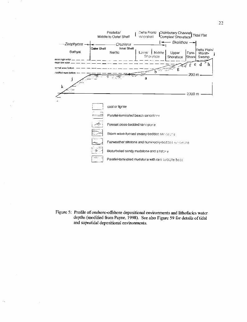
a tide-dominated deltaic system (Figure 5):
(a) heterolithic, micro-cross laminated, light gray, arkosic siltstone lenses or thin beds
alternating with wavy-laminated, dark gray, silty mudstone; a combination of shelfal
mudstone and lower shoreface siltstone (shelf to shoreface transition, Cruziana
ichnofacies), (b) hummocky to swaley lenticular beds of well-sorted, fine- to medium-
grained arkosic, micaceous sandstone with low-angle (<15 degrees) cross-laminations
(middle shoreface, Cruziana ichnofacies), (c I) thick-bedded to massive, poorly-sorted,
basaltic pebble conglomerate, breccia, and coarse basaltic sandstone of Grays River
Volcanic composition, commonly containing shallow-marine molluscan fossil
assemblages (storm-lag, wave reworked volcaniclastic debris flows, or minor
transgressions) and (c2) thin-bedded to laminated, graded Gray River basalt
volcaniclastics with substantial basaltic siltstone interbeds (representing volcanic debris
flow deposits into bay or estuary), (d) massive, planar-laminated, or mottled and heavily
bioturbated mudstone, silty mudstone, or siltstone with abundant carbonaceous debris
(quiet-water bay), (e) heterolithic, thin-bedded to laminated, cyclically alternating grayish
orange arkosic micaceous sandstone, and drapes of gray carbonaceous and micaceous
siltstone to mudstone (tidal rhythmites), (f) tangential to sigmoidal, high-angle (>15
degrees) cross-beds in medium- to coarse-grained grayish orange arkosic micaceous
sandstone with gray, flaser-bedded foresets rich in mica and carbonaceous debris
22
Prodeltal Delta Front/ iDistributary Channel ITidal FlatMiddle to Outer Shelf innersiielf Complex/ Shoreface
-Zoophycos Cruziana (- SkolithosOuter Shelf Inner Shelf Delta Plain/Bathyal Neritic Lo::er I fvtiddle Upper Fore- Marsh-
Sore face Shoreface Shore Swampmean high water --- ---,-
f e d hnormal wave bottom ------------ -- --5,
g-200 m
-2000 m
coal or lignite
Parallel-laminated beach sandstone
Foreset cross-bedded sandstone
Storm wave-formed swaley-bedded san =
Fairweather siltstone and hummocky-be _'ed _a-
Bioturbated sandy mudstone and siltste e
Parallel-laminated mudstone with rare turbi ?e ba c
Figure 5: Profile of onshore-offshore depositional environments and lithofacies waterdepths (modified from Payne, 1998). See also Figure 59 for details of tidaland supratidal depositional environments.
23
(prograding tidal bar or channel), (g) massive- to parallel-bedded, well- sorted,
medium- to coarse-grained arkosic sandstone (delta front sand, shoal, or beach), (h)
carbon-rich mudstone to siltstone, carbonaceous shale, and coal (delta plain, supratidal
swamp), (i) high-angle cross-beds in moderately well-sorted medium to coarse arkosic
sandstone, lacking flaser drapes (distributary or tidal channel), (j) massive deep marine
channel sandstones, and (k) thinly-laminated shelf to lower shoreface overbank distal
turbidites.
Detailed Stratig_raphy and Descriptions
Based upon southwest dip and structure, the stratigraphically lowest interval of
the Cowlitz Formation exposed in Coal Creek, interval 58 (NE 1/4 of the SW 1/a of Sec. 2,
T 8 N, R 3 W, Figure 6, Plate 2), occurs upstream of approximately 15 meters of cover,
immediately north of the Coal Creek Fault, forming a very low gradient stream bed along
several meters of creek. This interval (lithofacies d) is the lowest unit in a coarsening and
thickening-upward parasequence, and consists of hackly fractured, medium gray, silty,
micaceous mudstone with poorly defined bedding planes, that weathers into a series of
1.5-2 cm wide fragments. Whole carbonized leaves and twig fragments are common,
with minor possible fossil insect fragments. Ovoid calcareous concretions 1-2 cm wide
and vertical burrows are common. The hackly mudstone of interval 58 is in sharp contact
with the lowest sandstone bed of interval 59, a nearly horizontal cliff-former along -800
meters of creek (Figures 6, 7b and c). This heterolithic interval, unique in the Coal Creek
section, consists of -20 meters of 0.3-1.2 meter thick, brownish, laminated sandstone
(lithofacies e) alternating cyclically with 0.4-1.5 meter thick dark gray mudstone and
siltstone (lithofacies d). Micaceous, arkosic sandstone interbeds are fine- to medium-
24grained, moderately well-sorted, and wavy- to planar-laminated. Individual laminae
are 1 mm to 2 cm thick, commonly graded, and defined by carbonaceous and micaceous
drapes less than 1-mm thick. Sedimentary structures within the sandstone beds include
abundant micro-cross laminations, clastic dikes, 1-2 cm wide ovoid mudstone and
siltstone rip-up clasts, and 3-4 cm diameter calcareous concretions. The sandstone unit 2
meters above the base of this interval is highly concretionary, averaging 5-10 per square-
meter of outcrop. Vertical Skolithos burrows to ichnofabric 1 (Droser and Bottjer, 1986),
averaging 0.5-2 cm in diameter and several centimeters long are common, and are
commonly infilled with the darker gray mudstone and siltstone of the adjacent interbeds,
producing a wavy and indistinct contact.
Siltstone to mudstone interbeds range from dark to medium gray with abundant
carbonaceous organic material. Burrows are common in most beds, ranging from
ichnofabric 3-5, giving the beds a mottled appearance (petrology sample cc-59). Within
the upper 10 meters of interval 59, sandstone interbeds become coarser-grained, thicker,
and more common, with abundant mudstone, siltstone, and carbonaceous mudstone rip-
up clasts. Large, angular pieces of carbonaceous plant debris several centimeters in
diameter are more common, and the wavy and micro-cross laminations grade into low-
angle trough cross-beds with flaser-drapes (lithofacies f). These drapes are carbonaceous
and micaceous and form mud couplets between sandstone beds, and reactivation surfaces
on the foresets. The uppermost sandstone bed in interval 59 is trough to sigmoidally
cross-bedded with 0.5-meter thick mud-draped foresets. Large (2-cm wide) Skolithos
burrows and coalified woody material become more common upward in this interval.
25Interval 60 (Figure 6) is in sharp contact with the trough cross-bedded
uppermost sandstone unit of interval 59. This dark to medium gray hackly mudstone to
silty mudstone (lithofacies d) is 7.1 meters thick. Bioturbation to ichnofabric 4 and
fracturing have destroyed all primary sedimentary structures, resulting in a massive,
mottled appearance. This interval grades imperceptibly upward into interval 61 (Figure
6), 1 meter of highly fractured, medium-grained, micaceous, arkosic, organic-rich
siltstone. Color ranges from medium brown to medium gray, with abundant carbonized
leaf and twig fragments. Burrows to ichnofabric 5 have destroyed original laminations.
Interval 61 grades upward to the heterolithic lowermost unit of interval 62, a
three-meter thick series of cyclically alternating beds of planar to micro-cross laminated
fine-grained sandstone and siltstone, and highly carbonaceous laminated mudstone
(lithofacies e, Figure 8c). Toward the base, laminations and beds are wavy and range in
thickness from 1 mm to 5 cm. Sandstone interbeds are moderately well-sorted, fine to
coarse-grained, grayish orange, micaceous arkoses, and many are lenticular. Micro-cross
laminations are common with flaser bedding defined by extremely organic-rich 1-mm
thick dark gray or brown mudstone drapes. These ripple- laminated sandstone beds are
separated by 1-cm thick, organic-rich mudstone drapes. Sandstone and siltstone beds are
intensely bioturbated (ichnofabric 5) in places by burrows. The contact between these
beds is bioturbated and gradational. Toward the top, micro-cross laminated sandstone
interbeds are thicker and coarser with steeper foresets. Planar sandstone interbeds of the
lower portion grade upward to become nested sandstone lenses a few centimeters thick
and less than 1-meter across.
:N
dEt
IHL
a('`
'
interval%6-it h;me ersj_
69
67
66
65
64
63
62
fit
60
I
descriptions
sandstone interbeds
Cyclic, thin, grad td beds of basaltic congl.to fine siltstone dominant), well indurated
w ssiearedtcoalitiesdiwoodo conglomerate
Massive, coarsening-upward arkosic sandsthigh % of basaltic-ethic clasts.Carbonaceous, basaltic, silty mudstoneMassive, fgssiliferous, basaltic-lithic sandstAbundant burrows.
Blpcky sub-bituminous coal with micaceous,arkkos c sandstone inter eds.Medium gray, muddy siltstone, lackingbioturbation Carbonized root traces.Friable, well sorted, fine, trough- tosigmoidally cross-bedded, flaser-draped,sandstone alternating with burrowedplanar-laminated mudstone.
Heterolithic, ripple-laminated fine sandstonealternating with silty mudstone drapes.Micro-cross bedded. Fossiliferous coarsesandstone interbedSparsely micaceous, friable
Low-angle trough cross-beds with mud-draa ed toresets. Micaceous arkosic, verywell sorted. Carb n ceous plant materialcommon. Heterolithic base.
Friable, concretionary, massive, well sorted,fossiliferous, micaceous arkose.
Fossiliferous, coarse basaltic sandstoneHeterolithic. c clIicallV alt r.atin beds ofanadncarbonac ous laminated mucisCarbonaceous siltstoneDark to medium gray silty rudstone,Burrows common.
Heterolithic, concretionary, wavy- to planar-laminated, micaceous, arkosic bioturbatedsandstone alternating rhythmically withgray, heavily bioturbated mudstone andsiltstone Interval coarsens and thickensupward Mudstone rip-ups, Skolithosburrows
Massive, hackly. mediwn gray, micaceousconcretionary, bioturbated mudstone,with carbonized leaves
interpretation
supratidal marsh(splay sand(
- ::a .11101- 1j,estuary
beach/har
tidal rhythmitesere
(Stoi f'i-Ids)
supratidal marsh(splay sands)
bay/estuary
tidal bars
tidal rhythmitesea -so,ena ass 5laaestorm-lag)m
tidal rhythmites
tidal bars
tidal rhythmites
delta front sand
reua Saeoa as r(flooding surface-)
tidal rhythmites
bay mud
tidal bars/channels
tidal rhythmites
hay&mud
bay/ estuary rnud
Figure 6: Descriptions and lithofacies of parasequences 1 through 4 of theCoal Creek sertinn
27Scoured into the upper surface of lithofacies e (interval 62) is a 1-meter thick
concretionary, highly indurated and calcite cemented, fossiliferous, coarse-grained
basaltic sandstone of lithofacies c 1 that marks the base of parasequence 2 (Figure 6). The
sandstone is massive, poorly-sorted, coarse- to medium-grained, with sub-angular
basaltic clasts and a minor (< 10%) micaceous, arkosic component. Molluscan fossils
(nearly a coquina in places) of the Turritella-Solena assemblage (macrofaunal sample cc-
62), including the thick-shelled species Venericardia clarki (some to 10 cm), Turritella
uvasana stewarti, Pitar californiana, and Polinices nuciformis (Nesbitt, personal
communication, 1999), are disarticulated, fragmented, and worn. Vertical Skolithos or
Thalassinoides burrows 2-cm wide and 10-cm long, filled with dark brown sandstone, are
rare.
Abruptly overlying this coarse-grained volcanic sandstone is 7 meters of
concretionary, friable, medium-grained, well-sorted, massive, micaceous, arkosic
sandstone. Bedding is evident in the form of a few horizons of carbonaceous plant
fragments. Calcareous spherical concretions range from 2 to 5 cm in diameter, with as
many as 10 per square-meter of outcrop. From 5 to 7 meters above the base, this unit
becomes coarser-grained and more fossiliferous with abundant Acutostrea idriaensis
oysters (Acutostrea assemblage) mixed with several species of the Turritella-Solena
assemblage.
In sharp contact with the coarse-grained sandstone beneath, is a 1.5-meter thick
heterolithic unit of alternating thin beds of micro-cross laminated fine to medium-grained
micaceous, arkosic sandstone and ripple-laminated carbonaceous mudstone and siltstone
28(lithofacies e). Carbonized leaf fragments and coalified plant debris are rare.
Carbonaceous, finer-grained interbeds consist of ripple-laminated, dark gray, monolithic
mudstone and siltstone. The top of this unit grades upward to a 7-meter thick sequence
of relatively low-angle tangential cross-beds with mud-draped foresets (Figure 7a). This
uppermost portion of parasequence 2 is light to medium brown, very well-sorted, medium
sandstone devoid of any noticeable trace fossils, mollusks, concretions, or mudstone rip-
ups. Cross-bed sets are lenticular and range from 0.3-0.7 meter thick. Mud-drapes are 1-
3 mm thick, dark gray to black, and are most concentrated on the lower foresets,
becoming progressively thinner and less distinct upward within each cross-bedded lense.
A carbonaceous shale interbed exists half way through this cross-bedded unit.
Several lithofacies (including cI, d, e, and f) from the two underlying
parasequences are repeated in parasequence 3; however, this parasequence terminates
with coals in its uppermost beds (lithofacies h, Figure 6), and is therefore a fining- and
thinning-upward succession. This succession also differs from parasequences 1 and 2 in
that lateral changes in lithofacies across several kilometers can be correlated (Plate 2).
The upper coal A of parasequence 3 (intervals 66, 82a, and 88) is a marker bed along
nearly the entire northern half of Coal Creek, allowing for confident placement of units
within the stratigraphic column.
Interval 63, and its correlative intervals 82b (section #3) and 86 (section #4), form
the base of parasequence 3. Interval 63 consists of 12 meters of heterolithic (lithofacies
e), ripple-laminated sandstone (70%) alternating with silty mudstone (30%), with a 1-
meter thick-bedded, basaltic, coarse-grained, fossiliferous sandstone (lithofacies c 1) 7
wti
T_
Vw 910 ttjseY-aoP? cocs ergs rr-Piesent!P0.! STH^ ?nnf megenppr:
ML'
brim W o/,)MVf S:);IM' cI; txMNtf!yFR!:brq>N 4,aiFl Ontl fMTIJOSIOwR
yC.9 Ili r.nnwoRe sa .caenyv .aaritiYr.a '
IpW rayc.
fuuef! LODE
^4gWb' qw tedi
M. aijles wozh
lithologyinterval para-depth sequences
69
67
66
65
64
Jr , ., , , n ia*ed ss a [.rnTr,n3 N,tb aar q- b oturbared moist-
Figure 7 Photographs of lithologies of Coal Creek paiasequeices 1-4
30meters from the base (Figure 6, Plate 2). Contact with the underlying tangentially
cross-bedded, mud-draped upper sandstone unit of interval 62 is abrupt. The sandstone
component of this heterolithic facies is fine-grained, arkosic, sparsely micaceous, friable,
well-sorted, pale yellowish brown, and ripple laminated and micro-cross bedded
throughout. Individual sandstone beds range in thickness from 2 mm to 20 cm, and are
lenticular over several meters. The mudstone component of this interval forms thin,
discontinuous, ripple- to wavy-laminated drapes between cross-bed sets, and as armor on
the foresets. Muddy laminae are less than 5-mm thick, dark yellowish brown, and nearly
devoid of the carbonized leaves and twigs of similar lithofacies lower in the stratigraphic
section. The 1-meter thick fossiliferous, dark brown, basalt volcaniclastic interbed is
poorly-sorted, with subangular to rounded clasts ranging in size from fine- to coarse-
grained sand. Color is dark brown, weathering to light brown. Molluscan fossils of the
Turritella-Solena assemblage (two species of Pitar and Pachydesma aragoensis) are
abundant and relatively unbroken or worn (macrofaunal sample CC-63).
Interval 63 correlates to interval 82b, 2 km to the northwest (section #3, Plate 2),
which consists of heterolithic, ripple- to wavy- to planar-laminated, fine-grained arkosic
sandstone, siltstone, and mudstone beds (lithofacies e). Siltstone laminae are micaceous
and arkosic, pale yellowish brown, and mottled due to intense bioturbation to ichnofabric
5, particularly in the upper 3 meters, contrasting with the lithologically similar, but less
bioturbated siltstone interbeds of interval 63. The correlative interval 86 (section #4,
Plate 2), approximately 0.7 km northwest of outcrops of interval 82b, consists of ten
meters of heterolithic wavy- to low-angle trough cross-bedded medium sandstone,
31
alternating with beds of highly carbonaceous mudstone and siltstone (lithofacies e).
Interval 86 also contains sparse molluscan fossil shells of the Turritella-Solena
assemblage (macrofaunal sample CC-86) including Venericardia clarki, Siphonalia
sopenahensis, and Polinices nuciformis, and abundant burrows.
In gradational contact with the uppermost heterolithic beds of interval 63 is the
lowermost of three sandstone beds of interval 64. This 2-meter thick interval consists of
relatively low-angle trough cross-bedded, friable, well-sorted, fine-grained arkosic
sandstone beds alternating with medium gray planar-laminated mudstone interbeds. One
to two mm thick, wavy laminae of silt, carbonaceous shale, or mudstone occur as drapes
on individual foresets or interbeds between sandstone lenses. Near the top, intermittent
laminae of lignitic coal or carbonaceous shale, with 0.25-0.3-meter thick, fine-grained
trough cross-bedded micaceous, arkosic sandstone alternating with carbonaceous
sandstone or siltstone. Color on weathered surfaces ranges from grayish orange to very
pale grayish orange. Overlying this sandstone, separating it from the overlying sandstone
unit, is a 0.5-meter thick bed of massive medium gray silty mudstone, mottled by
intensive bioturbation to ichnofabric 4-5 (lithofacies d).
The overlying arkosic sandstone is scoured into the mudstone interbed and
consists of tangential to sigmoidal cross-beds lacking mud-draped foresets (lithofacies f
or i). Beds are lenticular and several meters in length, with foreset laminae 1-2 cm thick
defined by concentrations of mica. The sandstone is micaceous and arkosic, medium
orange gray, well-sorted, medium-grained, and moderately friable. Another mottled,
gray silty mudstone interbed (lithofacies d) separates this sandstone from the uppermost
32unit of interval 64, a 2-meter thick, sigmoidally cross-bedded, well-sorted, micaceous
arkose (lithofacies f). Most of this sandstone unit is relatively clean, medium-grained,
and grayish orange, consisting of 3 or 4 nested megaripple sets separated by 2-cm thick
sandstone interbeds. The uppermost portion is coarser-grained, and has abundant 1-cm
thick dark brown, carbonaceous mudstone interbeds. Well preserved flame structures,
load casts, clastic dikes, and convoluted bedding are common. Discoid calcareous
concretions up to 2-meters in diameter occur near the top of this interval, forming
convenient stepping stones across the creek.
The uppermost cross-bedded and concretionary unit of interval 64 is in sharp
contact with interval 65, 4.5 meters of medium gray, muddy siltstone with little or no
bioturbation (lithofacies d). The upper meter of this interval forms an underclay for
interval 66 (with root traces), 3.5 meters of coal and carbonaceous shale (coal A) with
micaceous, arkosic sandstone interbeds (lithofacies h) that form the cap of fining- and
thinning-upward parasequence 3. This interval (lithofacies h) consists of three nearly 1-
meter thick resistant, blocky-weathered sub-bituminous coals. Separating the coal beds
are coarse-grained, thin beds of wavy-laminated and micro-cross bedded, poorly-sorted,
micaceous, arkosic sandstones, dark colored due to a high percentage of disseminated
carbonaceous plant debris.
The correlative stratigraphic intervals of these coal beds with underlying
carbonaceous siltstone (intervals 66 and 65 respectively, section #1, Plate 2) are intervals
82a (section #3) with underlying siltstone unit possibly covered) 1.75 km to the
northwest, and intervals 88 and 87 (section #4), 2.5 km to the northwest (Plate 2). These
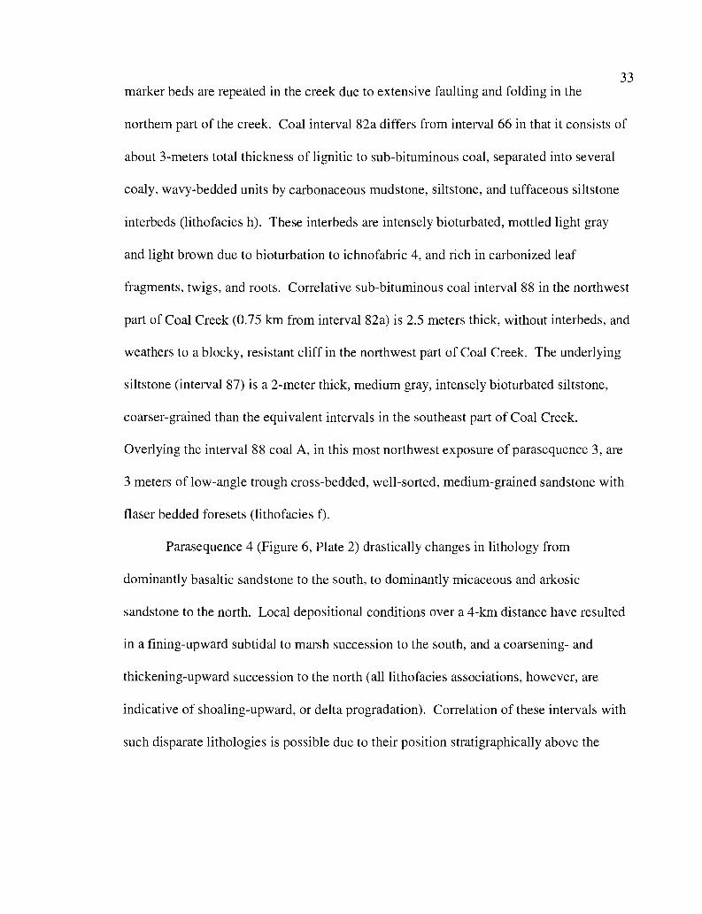
33
marker beds are repeated in the creek due to extensive faulting and folding in the
northern part of the creek. Coal interval 82a differs from interval 66 in that it consists of
about 3-meters total thickness of lignitic to sub-bituminous coal, separated into several
coaly, wavy-bedded units by carbonaceous mudstone, siltstone, and tuffaceous siltstone
interbeds (lithofacies h). These interbeds are intensely bioturbated, mottled light gray
and light brown due to bioturbation to ichnofabric 4, and rich in carbonized leaf
fragments, twigs, and roots. Correlative sub-bituminous coal interval 88 in the northwest
part of Coal Creek (0.75 km from interval 82a) is 2.5 meters thick, without interbeds, and
weathers to a blocky, resistant cliff in the northwest part of Coal Creek. The underlying
siltstone (interval 87) is a 2-meter thick, medium gray, intensely bioturbated siltstone,
coarser-grained than the equivalent intervals in the southeast part of Coal Creek.
Overlying the interval 88 coal A, in this most northwest exposure of parasequence 3, are
3 meters of low-angle trough cross-bedded, well-sorted, medium-grained sandstone with
flaser bedded foresets (lithofacies f).
Parasequence 4 (Figure 6, Plate 2) drastically changes in lithology from
dominantly basaltic sandstone to the south, to dominantly micaceous and arkosic
sandstone to the north. Local depositional conditions over a 4-km distance have resulted
in a fining-upward subtidal to marsh succession to the south, and a coarsening- and
thickening-upward succession to the north (all lithofacies associations, however, are
indicative of shoaling-upward, or delta progradation). Correlation of these intervals with
such disparate lithologies is possible due to their position stratigraphically above the
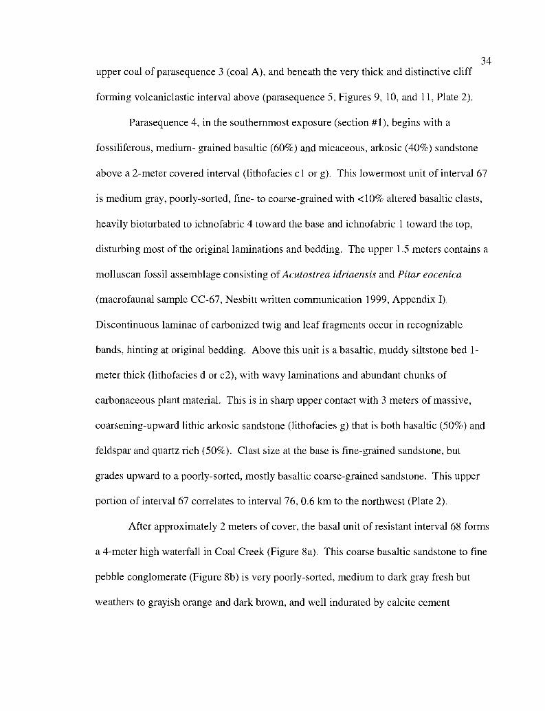
34upper coal of parasequence 3 (coal A), and beneath the very thick and distinctive cliff
forming volcaniclastic interval above (parasequence 5, Figures 9, 10, and 11, Plate 2).
Parasequence 4, in the southernmost exposure (section #1), begins with a
fossiliferous, medium- grained basaltic (60%) and micaceous, arkosic (40%) sandstone
above a 2-meter covered interval (lithofacies c 1 or g). This lowermost unit of interval 67
is medium gray, poorly-sorted, fine- to coarse-grained with <10% altered basaltic clasts,
heavily bioturbated to ichnofabric 4 toward the base and ichnofabric 1 toward the top,
disturbing most of the original laminations and bedding. The upper 1.5 meters contains a
molluscan fossil assemblage consisting of Acutostrea idriaensis and Pitar eocenica
(macrofaunal sample CC-67, Nesbitt written communication 1999,Appendix I),
Discontinuous laminae of carbonized twig and leaf fragments occur in recognizable
bands, hinting at original bedding. Above this unit is a basaltic, muddy siltstone bed 1-
meter thick (lithofacies d or c2), with wavy laminations and abundant chunks of
carbonaceous plant material. This is in sharp upper contact with 3 meters of massive,
coarsening-upward lithic arkosic sandstone (lithofacies g) that is both basaltic (50%) and
feldspar and quartz rich (50%). Clast size at the base is fine-grained sandstone, but
grades upward to a poorly-sorted, mostly basaltic coarse-grained sandstone. This upper
portion of interval 67 correlates to interval 76, 0.6 km to the northwest (Plate 2).
After approximately 2 meters of cover, the basal unit of resistant interval 68 forms
a 4-meter high waterfall in Coal Creek (Figure 8a). This coarse basaltic sandstone to fine
pebble conglomerate (Figure 8b) is very poorly-sorted, medium to dark gray fresh but
weathers to grayish orange and dark brown, and well indurated by calcite cement
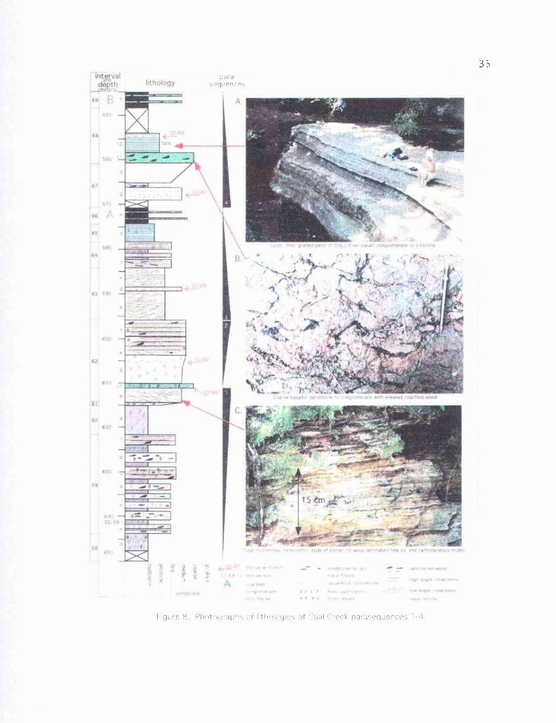
interkthology
-'U
A
5',
p.56
r.
- -
60
C.
par asequences
figure 8 Photographs of hthologies of Coal Creek paiasequences 1--a
36(lithofacies c I). A unique feature of this unit is the randomly oriented and apparently
sheared pieces of bituminous-grade carbonaceous plant material. Individual pieces have
a central body of thicker (5-15 cm) carbonized plant material, with 1 to 3 branches a few
centimeters long in random orientations. These appear to be preserved primary
structures, perhaps carbonaceous flame structures with associated load casts (Figure 8b).
The bulk of interval 68, well exposed in the face of the waterfall, consists of cyclic,
graded basalt volcaniclastic beds ranging in thickness from a few mm to 30 cm in the
thickest bed (lithofacies c2, Figure 8a). Thicker beds are fine pebble conglomerate or
coarse-grained sandstone at the scoured bases, grading upward to a fine-grained basaltic
sandstone or siltstone. Thinner laminae, in turn, grade upward from fine-grained
sandstone at the base to fine basaltic siltstone at the top. Color ranges from dark to light
gray when fresh, and weathers to light brown. Approximately 1 meter from the top of
this interval is a 0.3-meter thick basaltic siltstone bed with abundant brackish water
articulated Corbicula cowlitzensis bivalves (macrofaunal sample CC-68, Nesbitt written
communication 1999, Appendix I).
Farther upstream, after about 4 meters of cover, interval 69, a 3-meter thick unit,
consists of resistant, sub-bituminous, blocky coal (coal B, Plate 2) with carbonaceous
sandstone and silty sandstone interbeds (lithofacies h) that cap parasequence 4. Brownish
resistant sandstone interbeds are basalt-volcaniclastic, well-indurated by calcite cement,
and poorly-sorted, with subrounded clasts ranging from fine to coarse sand-size (largest
clast is 3 mm), and are the stratigraphically lowest units containing euhedral greenish
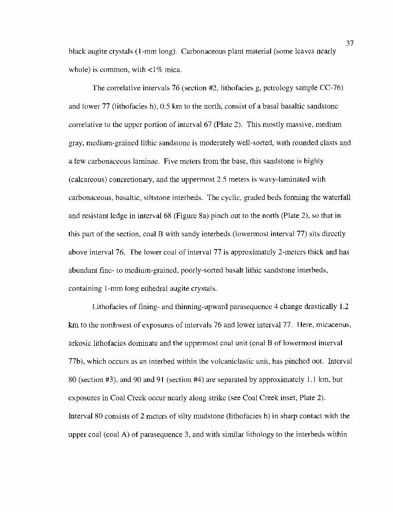
37
black augite crystals (1-mm long). Carbonaceous plant material (some leaves nearly
whole) is common, with <1% mica.
The correlative intervals 76 (section #2, lithofacies g, petrology sample CC-76)
and lower 77 (lithofacies h), 0.5 km to the north, consist of a basal basaltic sandstone
correlative to the upper portion of interval 67 (Plate 2). This mostly massive, medium
gray, medium-grained lithic sandstone is moderately well-sorted, with rounded clasts and
a few carbonaceous laminae. Five meters from the base, this sandstone is highly
(calcareous) concretionary, and the uppermost 2.5 meters is wavy-laminated with
carbonaceous, basaltic, siltstone interbeds. The cyclic, graded beds forming the waterfall
and resistant ledge in interval 68 (Figure 8a) pinch out to the north (Plate 2), so that in
this part of the section, coal B with sandy interbeds (lowermost interval 77) sits directly
above interval 76. The lower coal of interval 77 is approximately 2-meters thick and has
abundant fine- to medium-grained, poorly-sorted basalt lithic sandstone interbeds,
containing 1-mm long euhedral augite crystals.
Lithofacies of fining- and thinning-upward parasequence 4 change drastically 1.2
km to the northwest of exposures of intervals 76 and lower interval 77. Here, micaceous,
arkosic lithofacies dominate and the uppermost coal unit (coal B of lowermost interval
77b), which occurs as an interbed within the volcaniclastic unit, has pinched out. Interval
80 (section #3), and 90 and 91 (section #4) are separated by approximately 1.1 km, but
exposures in Coal Creek occur nearly along strike (see Coal Creek inset, Plate 2).
Interval 80 consists of 2 meters of silty mudstone (lithofacies h) in sharp contact with the
upper coal (coal A) of parasequence 3, and with similar lithology to the interbeds within
38
the coal. The mudstone is dark to medium gray, hackly, sparsely bioturbated, and
contains minor fragments of carbonized leaves and twigs.
Ten meters of cover separate the lower mudstone of interval 80 from the 4-meter
thick upper sandstone (lithofacies f). The base is massive, coarse-grained, micaceous,
and arkosic with a high percentage (-30%) of basalt and rounded siltstone clasts. The
lower half of this unit is very poorly-sorted, light olive gray when fresh to dark yellowish
orange when weathered, and contains discontinuous laminae of carbonaceous plant
material and abundant unidentifiable calcareous molluscan shell fragments. The upper
two meters is low-angle trough-cross bedded, with abundant mica and carbonaceous
debris defining individual foresets, and contains abundant calcareous concretions,
Together, intervals 90 and 91 are 15 meters thick (section #4, Plate 2), consisting
of a lower coarse-grained fossiliferous sandstone bed (interval 90, lithofacies c1,
Acutostrea idriaensis macrofaunal sample CC-90, Nesbitt written communication 1999,
Appendix I) and a thick overlying muddy siltstone (interval 91, lithofacies d). The lower
sandstone is coarse-grained, massive, poorly-sorted, micaceous, and arkosic with 20-30%
rounded basalt-lithic clasts. Abundant Acutostrea idriaensis oyster shells exclusively
occur in this bed (Nesbitt, written communication 1999, Appendix 1). The overlying
interval 91 is nearly 13 meters thick and grades imperceptibly upward from a micaceous,
arkosic, mostly massive silty mudstone to a siltstone. Color ranges from light to dark
gray, with abundant carbonaceous plant material and no noticeable trace fossils.
Parasequence 5 (Figure 9, Plate 2) perhaps should not be considered a true
parasequence, but rather an interfingering Grays River volcaniclastic basaltic debris or
39hyperconcentrated flow deposit within the deltaic Cowlitz Coal Creek section. It
consists of up to 35 meters of multiple basaltic, matrix supported breccias,
conglomerates, and coarse-grained sandstones (lithofacies c 1) and interbedded basaltic
siltstones (lithofacies c2, Figure 10, geologic map unit Tvgs2, Plate 1), with minor
micaceous, arkosic sandstone interbeds up to a few meters thick. This distinctive unit is
used to correlate the southern (upper) part of the Coal Creek section with the northern
(lower) part of the section, across the Coal Creek Fault (Plate 2, Coal Creek inset map
and cross section C-C').
Intervals 53 (lower) and 54 (section #1, Figures 9 and l lc) are the
stratigraphically lowest units in the southern Coal Creek section (included in section #1
with the correlative intervals 70, 71, 72, and 73 for the purpose of simplifying the Coal
Creek section diagram, plate 2), and consist of about 25 meters of basaltic sandstone
(petrology sample CC-53b), and graded beds of basaltic conglomerate to siltstone
(petrology sample CC-54) with numerous thin interbedded basalt lithic, micaceous,
arkosic sandstones. Portions of the pebbly debris flow deposit beds are breccias with
angular to subrounded basaltic clasts in matrix support, with euhedral augite crystals
ranging in diameter from 0.5 to 5 mm. Coarse sandstone to conglomerate intervals have
large (1-3 cm) wide flattened carbonaceous mudstone rip-ups. Color ranges from dark
gray to brownish gray when fresh, but weathers to light brownish gray. Interval 53
contains a molluscan fossil assemblage 0.6-meters thick of abundant (coquina in places)
Acutostrea idriaensis oysters, with one Pitar eocenica specimen obtained (macrofaunal
sample CC-53, Nesbitt written communication 1999, Appendix I). Numerous units
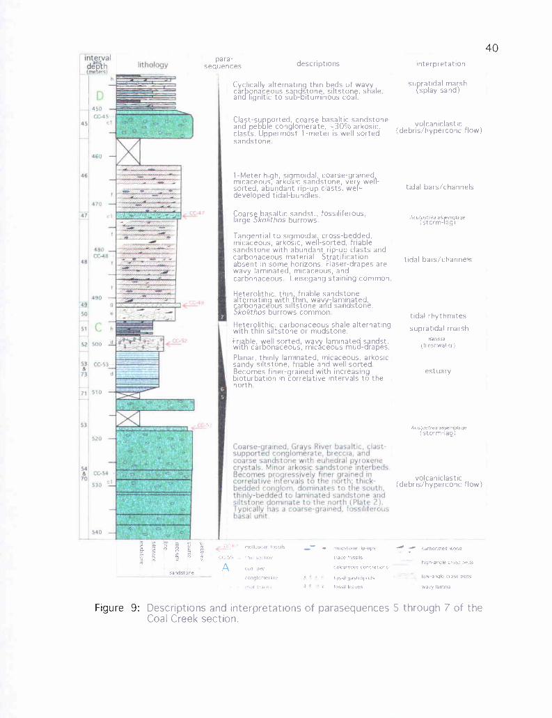
intervaldepthtj.I efcl
450
CC.4545
;7
470 -H
480CC-48
48
444.10
St ,52 500
71 510
5,'u
54
70
lithology
Coarse-gratned. Grays River basalticclast-supported conglomerate, breccia,
a,
ndcoarse sandstone with euhedral pyroxenecrystals Minor arkosic sandstone interbedsBecomes progressively finer grained rncorrelative intervals to the north: thick-bedded ronglorn, dominates to the south.thinly-bedded to laminated sandstone and;iltstone dominate to the north (Plate 2).Typically has a coarse-grained, fossiliferousBasal unit
460
o'
Figure 9:
para-sequences descriptions interpretation
Cyclically alternating thin beds of wavycar Qnaceous sandstone , siltstone, shale,and lignitic to sub-bituminous coal.
Clast-supported, coarse basaltic sandstoneand pebble conglomerate, -30% arkosic.clasts. Uppermost 1-meter is well sortedsandstone
1 -Meter high, sigmoidal, coarse-grainedmicaceous, arkosic sandstone, very well-sorted, abundant rip-up clasts, well-developed tidal-bundles.
Coarse basaltic sandst., fossiliferous,large Skolithos burrows.
Tangential to sigmoidal cross-bedded,micaceous, arkosic, well-sorted, friablesandstone with abundant rip-up clasts andcarbonaceous material. Stratificationabsent in some horizons. Flaser-drapes arewavy laminated, micaceous, andcarbonaceous Leisegang staining common
Heterolithic, thin friable sandstonealt rnating with thin, wa -lami ated,car%onaceous siltstone ar d sandstoneSkolithos burrows common
Heterplithic carbonaceous shale alternatingwith thin silistone or mudstone.Friable, well sorted, wavy laminated
rapes.with car onaceous, mic ceous mud rapes.Planar, thinly laminated, micaceous, arkosicsandy siltstone, friable and well sorted.Becomes finer-grained with increasingbioturbation in correlative intervals to thenorth
su ratidal marshsplay sand)
volcanic lastic(debris/hyperconc flow)
tidal bars/channels
AcutvsteaasW m (age(storm-lag
tidal bars/channels
tidal rhythmites
supratidal marshBatissa
(freshwater)
estuary
Acu{ostrea assemblagestorm-lag)
volcaniclastic(debris/hyperconc flow)
0
a
ra
sandstone
Descriptions and interpretationsCoal Creek section.
carhonrzed wnnd
high-angle cross beds
low-angle cross beds
wa:y lamina
5 through 7 of the
molluscan fossils
CC 59 thin s r it
-a I bed
conglomerate
I'll; traces
A
i.l -(: nuds[one (ip-ups
trace fossils
calcareous concietlom
fossil gasti Pod,
fossil leaves
of parasequences
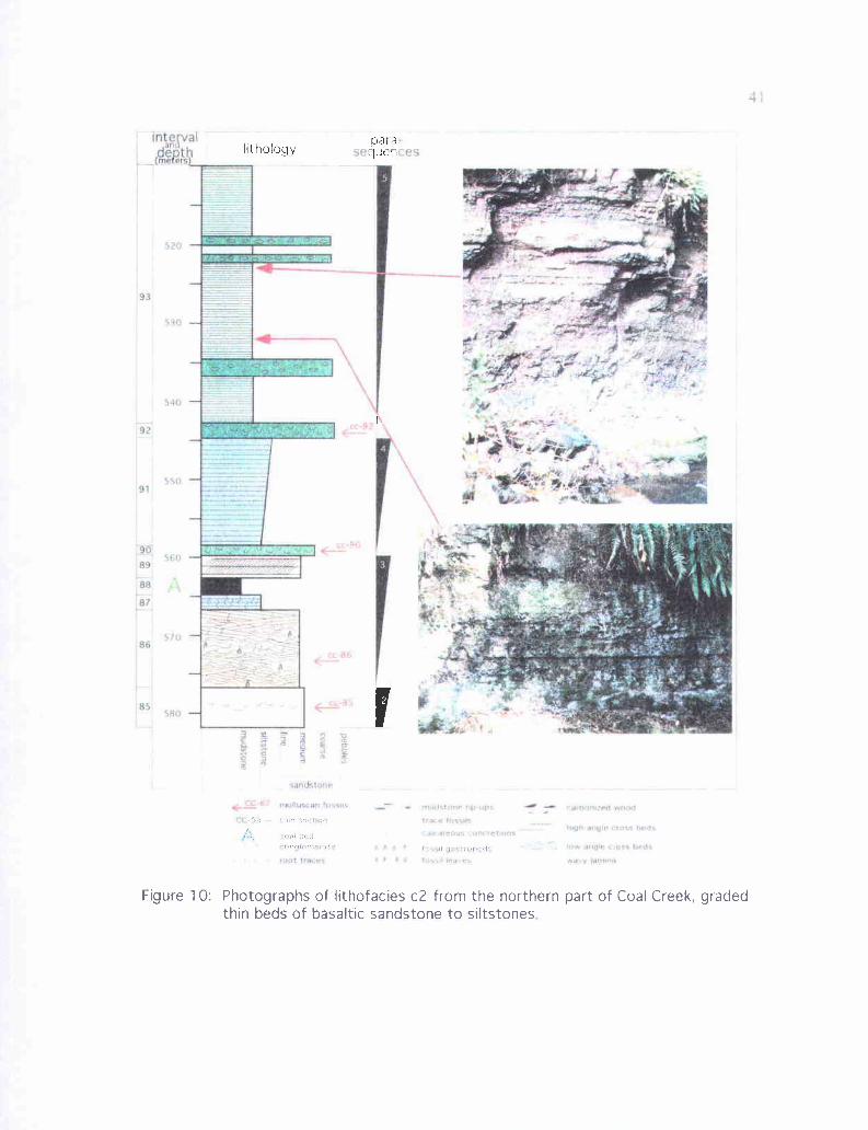
4;
II
4.-6? fKIR.VLepnc h'Hq+lns
se tes-
ery!14Stone';{ .iiy - EµtinriwilLwadtialptc7uK#LOa,y.ggnsla
4i a r .w :.s { xss
S r , s rostip'pea Kr,rock ?fiKP
tV9R5MAl0.SfA5: beds
ra,.A ,ae, :. bed%Won. NIfNM1
intervallithology quer
1
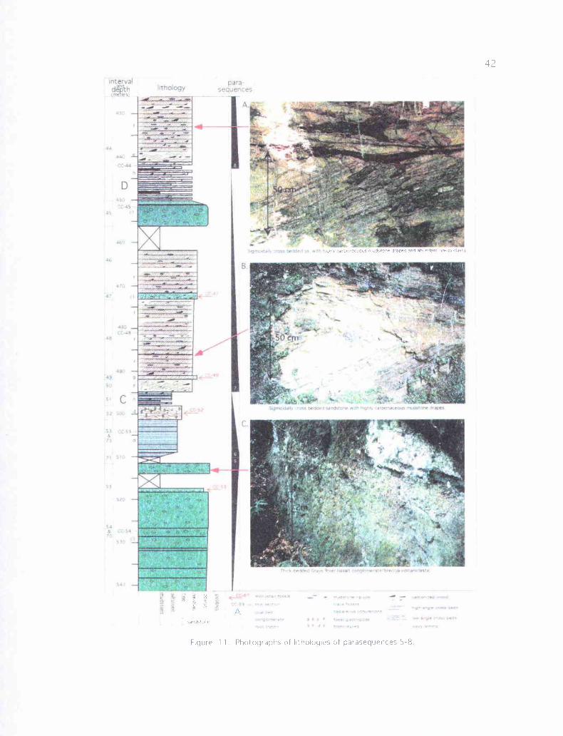
M Ia
isI
I
III .
fit
I'
I_
tl I
ofI
I-
I
NI
ta-
R .'h J)
Il
'Nl
ghry ar 7 na!eons m,rtl>one drapes and ahcndant no-up cas
p
Figure 1 1 . Photographs of Irthologies of parasequences 5-8
43within interval 54 are similar in lithology to that described for interval 68 (lithofacies
c2), cyclic, graded bedding of basaltic conglomerate to siltstone with minor wavy-
laminated siltstone beds up to 3 meters thick.
Micaceous, arkosic interbeds, particularly common in intervals 53 and 54, are
typically heterolithic, with thin sandstones alternating with thin mudstones and siltstone
interbeds (lithofacies e). Sandstone interbeds up to 1-meter thick are lenticular, well-
sorted, medium-grained, commonly ripple micro-cross bedded, contain <10% basalt lithic
fragments and mudstone rip-ups, and range in color from light gray to medium orange
gray. Mudstone and siltstone interbeds are medium brownish gray, wavy- to ripple-
laminated, and rich in carbonized leaf and twig fragments. Flame structures of dark
mudstone intruding into overlying sandstone interbeds are common and suggest rapid
loading of sand on hydroplastic mud.
Interval 70, exposed nearly 2.1 km north of intervals 53 and 54, consists of
approximately 30 meters of extremely poorly-sorted, clast supported, basaltic pebble to
cobble conglomerate, with interbedded poorly-sorted basaltic breccias (similar to interval
53, Figure l lc). Largest basaltic clasts are cobble-sized (5-6 cm). This interval is well
indurated with white sparry calcite cement; fractures are filled with white coarsely
crystalline calcite. Bedding is on the order of one to several meters, defined by fine-
grained sandstone or siltstone interbeds a few centimeters thick. Color is dark to medium
gray when fresh, weathering to medium or dark brown. Euhedral augite crystals up to
0.5-cm long are common throughout, especially concentrated in the basalt breccia
interbeds. Interval 77 (0.5 km north if interval 70, section #2, Plate 2) is similar but with
44finer basaltic conglomerate or sandstone near the base. Basaltic siltstone interbeds
(lithofacies c2, petrology sample CC-77) occur near the base, with very fine-grained silt
in some beds. The base of interval 77 is a 1-meter thick bed of coarse-grained sand with
disarticulated and fragmented Acutostrea idriaensis oyster valves (macrofaunal sample
CC-77, Nesbitt written communication 1999, Appendix I). The base of the correlative
thick basalt volcaniclastic unit 1.3 km to the northwest has a similar basaltic fossil rich
horizon (interval 81, macrofaunal sample CC-81, section #3, Plate 2), scoured into the
tangentially cross-bedded upper sandstone of parasequence 4 (interval 80). It is fine- to
medium-grained basaltic sandstone with disarticulated and broken shells of the shallow
marine Turritella-Solena molluscan fossil assemblage of Nesbitt (written communication,
1999). Overlying this bed is nearly 30 meters of cyclically alternating coarse-grained
basalt volcaniclastic conglomerates interbedded with fine-grained sandstone and siltstone
(lithofacies cl and c2, interval 79, similar to interval 93, Figure 1Oa and b). Coarse-
grained beds are 0.5 to 2-meters thick with finer- grained interbeds averaging 0.3-meters
thick. Interval 79 is dominated by laminated micaceous siltstones near the base and
pebble conglomerates toward the top.
The correlative section farthest to the northwest (section #4), interval 93 (Figure
10a and b), also has a basal fossiliferous unit (interval 92, macrofaunal sample CC-92) of
very coarse-grained basaltic sandstone to pebble conglomerate, 2-meters thick, scoured
into the underlying siltstones of parasequence 4 (interval 9 1). Molluscan fossils consist
exclusively of the shallow-marine bivalve Glycymeris sagittata (Nesbitt written
communication 1999, Appendix I). Overlying this bed is interval 93, the northernmost
45interval exposed in Coal Creek, where this Eocene unit is in unconformable contact
with an overlying Grays River flow. This sequence consists of 35 meters of planar- to
wavy-laminated fine basaltic siltstone (lithofacies c2) with interbedded conglomerates
(petrology sample CC-93) up to 2-meters thick containing euhedral augite crystals.
Overlying the thick basalt volcaniclastic intervals (parasequence 5) throughout the
section are the relatively fine-grained, micaceous, arkosic sandstones in the lower interval
of parasequence 6 (Plate 2). The southernmost exposure in Coal Creek is upper interval
53 and its nearly lithologically identical correlative interval 73 (combined in Figure 11
and Plate 2). These intervals consist of 3 mm to 1 cm planar-laminated, micaceous,
arkosic, well-sorted, fine-grained, friable, and grayish orange sandstone (foreshore
lithofacies g). Concentrations of mica and carbonaceous debris define internal
stratification. The correlative interval 75 (and the uppermost 2 meters of interval 77,
section #2), exposed 0.5 km to the north of interval 73, is a light gray, mottled, muddy,
micaceous, arkosic siltstone (lithofacies d), with -10% basaltic clasts, bioturbated to
ichnofabric 5. Another 0.4 km to the northwest, correlative interval 78 is also an
intensely bioturbated light gray siltstone containing 5 cm diameter spherical calcareous
concretions.
In gradational contact with interval 53 (in the southernmost interval of
parasequence 6, Figures 9 and 11) is interval 52, a 3-meter thick, well-sorted, friable,
wavy-laminated and micro-cross-bedded, fine- to medium-grained, light orange brown,
micaceous, and arkosic sandstone. Foresets within the micro-cross laminations are
defined by highly micaceous and carbonaceous laminae. Well-preserved whole
46carbonized leaves are common in the interbeds, as are articulated freshwater Batissa
newberri bivalves (macrofaunal sample CC-52, Nesbitt written communication, 1999).
Capping parasequence 6 is interval 51, 3 meters of black, extremely carbonaceous shale
and coal (coal C) and siltstone (lithofacies h) in gradational contact with interval 52.
Parasequence 7 is a -54-meter thick progradational shoreface succession (Figures
9 and 11). The lowermost interval 50 is heterolithic (lithofacies e), 3-meters thick, and
consists of 2-5 cm thick micaceous, arkosic sandstone beds alternating with 1-10 mm
thick, wavy-laminated carbonaceous siltstone and fine-grained sandstone. Sandstone
interbeds are medium- to coarse-grained, well-sorted, friable, and range from light gray
to moderate yellowish brown with pervasive liesegang limonite staining. Bioturbation by
vertical Skolithos burrows 2-cm in diameter and several cm long to ichnofabric 1, sparse
unidentifiable molluscan shell fragments, and large chunks of coalified wood are
common. The wavy-laminated, fine-grained sandstone to siltstone interbeds are dark
yellowish brown and have large pieces of carbonized leaves and twigs, and abundant,
larger that average (2-3 mm) biotite and lesser muscovite flakes.
Interval 49 is in abrupt scoured contact with interval 50 and consists of medium to
coarse- grained, poorly-sorted, micaceous, yellowish brown, arkosic sandstone with
approximately 10% basalt lithic fragments, and 10% flattened clasts of carbonaceous
plant debris. Fossiliferous shell hash is common, but fragmental beyond identification
(macrofaunal sample CC-49, Nesbitt personal communication, 1999). Interval 48 is an
18-meter thick sandstone dominated by flaser-draped, 0.3-1 meter high tangential to
sigmoidal cross-beds (lithofacies f, Figures 9 and 11), but massive in places (lithofacies
47g). Sandstone foresets are micaceous, arkosic, medium-grained, well-sorted, friable,
and contain abundant mudstone rip-up clasts and carbonized plant material. Color is light
brownish gray weathering to grayish orange, with dark yellowish orange liesegang
staining common in some intervals, forming evenly spaced bands resembling bedding.
Foresets are typically 0.5-1 cm thick, mudstone flaser-bedded, with wavy carbonaceous
and highly micaceous mudstone and siltstone laminae (petrology sample CC-48). Beds
with steeper sigmoidal foresets are relatively clean, with little dark carbonaceous plant
material on the foresets. This interval coarsens slightly in the upper 5 meters, with some
contorted foresets due to slumping.
A 1.5-meter thick coarse basalt volcaniclastic sandstone (interval 47, lithofacies
cl) with broken Acutostrea idriaensis oyster valves separates the lower cross-bedded
interval and the overlying coarser-grained sigmoidally cross-bedded interval 46. This
micaceous, arkosic sandstone interval, with cross-beds to 1-meter high is well-sorted and
friable, ranging from medium- to coarse- grained. Color is light grayish orange
weathering to dark yellowish orange. Flaser-bedding is defined by extremely micaceous
and dark gray carbonaceous mudstone and siltstone drapes on individual arkosic
sandstone foresets and also between cross-bed sets.
After approximately 6 meters of cover is a 5-meter thick basalt volcaniclastic
(interval 45, Figures 9 and 11, Plate 2), poorly-sorted coarse-grained sandstone and
conglomerate (lithofacies cl, petrology sample CC-45) with -30% arkosic grains. The
lower 3 meters is a dark olive gray, well-indurated, calcite-cemented, extremely poorly-
sorted, framework-supported, ledge-forming conglomerate. Basalt clasts are well-
48rounded and up to 0.5 cm in diameter. The uppermost meter is fairly well-sorted,
massive, basaltic sandstone.
In sharp contact with interval 45 is the lower 9 meters of interval 44, a coal-
bearing sequence that caps parasequence 7, composed of cyclically alternating 0.3-meter
thick beds of carbonaceous sandstone (petrology sample CC-44), carbonaceous siltstone,
carbonaceous shale, and coal seams (coal D, lithofacies h). Sandstones and siltstones are
micaceous, arkosic, well-sorted, wavy- to micro-cross laminated, and typically grayish
orange. Small (<1 cm) rounded mudstone and carbonaceous shale rip-up clasts and
carbonized wood debris are common throughout. Individual coal seams are lignitic to
sub-bituminous, and 6-7 cm thick.
Parasequence 8 is another set of thinning- and fining-upward lithofacies
terminating in a coal (coal E, Figure 12, Plate 2). The lowermost 2 meters, near the
middle of interval 44, are heterolithic with brownish sandstone alternating with grayish
muddy siltstone (lithofacies e). The lithology is similar to that described for the base of
parasequence 7 (interval 50). Abundant carbonized leaf and twig fragments with mica
are common in finer sandstone interbeds. Wavy bedding, micro-cross laminations, and
mudstone rip-up clasts, are common throughout. Silty, organic-rich (carbonaceous)
interbeds are bioturbated to ichnofabric 4. This lithology grades upward into
approximately 13 meters of sigmoidally cross-bedded medium to coarse-grained
micaceous, arkosic sandstone with highly carbonaceous and micaceous mudstone-draped
foresets up to 1.3-meters high. Mudstone couplets define the tidal bundles (lithofacies f,
Figure 11 a). Carbonaceous mudstone rip-up clasts range from a few millimeters to a
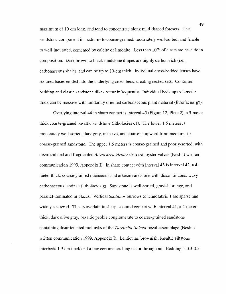
49maximum of 10-cm long, and tend to concentrate along mud-draped foresets. The
sandstone component is medium- to coarse-grained, moderately well-sorted, and friable
to well-indurated, cemented by calcite or limonite. Less than 10% of clasts are basaltic in
composition. Dark brown to black mudstone drapes are highly carbon-rich (i.e.,
carbonaceous shale), and can be up to 10-cm thick. Individual cross-bedded lenses have
scoured bases eroded into the underlying cross-beds, creating nested sets. Contorted
bedding and clastic sandstone dikes occur infrequently. Individual beds up to 1-meter
thick can be massive with randomly oriented carbonaceous plant material (lithofacies g?).
Overlying interval 44 in sharp contact is interval 43 (Figure 12, Plate 2), a 3-meter
thick coarse-grained basaltic sandstone (lithofacies cl). The lower 1.5 meters is
moderately well-sorted, dark gray, massive, and coarsens-upward from medium- to
coarse-grained sandstone. The upper 1.5 meters is coarse-grained and poorly-sorted, with
disarticulated and fragmented Acutostrea idriaensis fossil oyster valves (Nesbitt written
communication 1999, Appendix I). In sharp contact with interval 43 is interval 42, a 4-
meter thick, coarse-grained micaceous and arkosic sandstone with discontinuous, wavy
carbonaceous laminae (lithofacies g). Sandstone is well-sorted, grayish orange, and
parallel-laminated in places. Vertical Skolithos burrows to ichnofabric 1 are sparse and
widely scattered. This is overlain in sharp, scoured contact with interval 41, a 2-meter
thick, dark olive gray, basaltic pebble conglomerate to coarse-grained sandstone
containing disarticulated mollusks of the Turritella-Solena fossil assemblage (Nesbitt
written communication 1999, Appendix 1). Lenticular, brownish, basaltic siltstone
interbeds 1-5 cm thick and a few centimeters long occur throughout. Bedding is 0.3-0.5
1
Figure of
410
420
lithologypara-
sequences interpretationdesci iptions
Massive mediu i to oarse rirained ss. withabundant black sandstone p-up clasts.Lower massive sandsst. ith abundant carbupper trouqq cross- edged medium san st.With extremely abundant mudst. rip-ups.Amalgamated tangential to sigmoidalcross-bedded medium to coarse-grained ss.Flaser-bedded with carbonaceous shaledefining mudstone couplets.Heterolithic alternating thin beds of finesandstone and carbonaceous silty mudstalso w-an le trough cross-beds withmudstone capes.Sub-bituminous coal and Garb shaleHeterolithic, wavy-laminated sandstonewith (laser mudstone or muddy siltstonedrapes. Burrows common.
Massive concretionary, medium-grained.very well-sorted arkosic sandstone.Abundant burrows of Skolithos ichnofacies
Heteroiithic, well-sorted, medium-grained,concretionary, wavy-bedded and micro-cross laminated sandstone withcarbonaceous mudstone drapes.Thicken- upwar from heterool chic base tolow-angle troug , to sigmoida cross-beds.
Heterolithic, poorly defined ss and siltstClean sub-bituminous coal.Massive light gray silty mudstoneMassive medium-grained fossiliferous as.,with carb. plant fragments including leavesMassive basaltic pebble conglomerate/ss.Mas ive to weakly trough cross-bedded,pa se o itge well-s1bsted sandstoneburr.9ggasa
tic p bble contoneCCate with lenticularbasatc siltstone inierbeds. Skonthos.Well-sorted medium to coarse-grained sswith discontinuous wavy carbonaceouslaminae. Vertical Skolithos burrows.Coarse grained basaltic sands[., moderatelywell-sorted at base.
9
ci
Sigmoidaily cross-bedded medium tocoarse-grained micaceous, arkosic sandsthighly carbonaceous and micaceousmudstone drapes. Well-defined nested setsand tidal-bundles, abundant mudst. rip-upclasts and carbonaceous chunks, alsoslump-folding and elastic., dikes.Heterolithic medium arko-ic sandstonealternating with gray muddy siltstone.Abundant carb, sparse mudstone rip ups.
shoal/bar
lagoona,
(sr,storearm asiagern)[age
-
tidal bar/channel
tidal rhythmitessupratidal marsh
tidal rhythmites
bar /shoal
tidal channel
tidal rhythmites
supratidal marsh
do ut C ore., 11111'rIaq'
storm lag
distributary mouth bai
beach/shoal-arena Soe,-a as5nwiage
storm-lag,
beach/shoal4:,rontrea i 0344
(storm-lag)
tidal bars/channels
tidal rhythmites
sanCZC OnP '. "a - wz z
12: Descriptions and interpretations parasequences 8 through 11 of theCoal Creek section.
51
meters thick with poorly developed low-angle trough cross-bedding in places
(Lithofacies f to g).
Interval 40 is in sharp contact with interval 41. This interval is 5-meters thick,
and consists of massive to faintly trough cross-bedded, medium-grained, well-sorted,
micaceous, and arkosic sandstone. Discontinuous carbonaceous laminae and sparse
Skolithos-type burrows occur throughout. Overlying this unit in sharp scoured contact is
another basaltic pebble conglomerate, medium-grained, and 2-meters thick. This unit is
unique in having a bimodal grain-size distribution of 0.5 mm medium-grained sand and
pebble-sized (0.3 cm diameter) conglomerate clasts. The unit is also unfossiliferous, and
has no trace fossils, bedding, laminations, or grading. The overlying interval 38 is a 2-
meter thick, medium-grained, micaceous and arkosic, light grayish orange sandstone.
The oyster fossil Acutostrea idriaensis is common, with rare Pitar eocenica bivalves,
(macrofaunal sample CC-38, Nesbitt written communication 1999, Appendix I).
Coalified wood and carbonized leaves and twigs are found throughout. This unit is
overlain by a massive light gray silty mudstone and a 0.6-meter thick clean sub-
bituminous coal (coal E) with very few clastic particles (lithofacies h).
Parasequence 9 (Figure 12) fines- and thins-upward and includes interval 37 and
the lower portion of interval 36. The lowermost three meters are heterolithic, consisting
of alternating, poorly defined beds of sandstone and siltstone (lithofacies e). Throughout
this interval, sandstone beds dominate and are invariably wavy-bedded and micro-cross
laminated with carbonaceous mudstone-draped foresets. Sandstone beds are 1-10 cm
thick, micaceous and arkosic, pale yellowish orange to dark yellowish orange and well-
52sorted, with beds ranging from fine- to medium-grained. Spherical calcareous
concretions up to 5-cm in diameter are common throughout. Micro-cross laminated
sandstone beds with very little mudstone component grade upward into sandstone beds
with a high percentage of mudstone and micaceous drapes. Laminae range from 0.5 mm
on the foresets to 1-cm thick between sandstone lenses. This lithology gradually changes
upward over the next 9 meters into thicker sandstone beds with low-angle (<10 degrees)
trough cross-beds, and thicker mudstone-drapes. Near the top of this heterolithic
sequence, higher-angle trough cross-beds and thick (1-5 cm) wavy-laminated mudstone
drapes dominate (lithofacies f). This grades upward into a 9-meter thick, massive
sandstone (lithofacies g) that appears to be in gradational contact with the underlying
flaser-draped cross-beds. This unit is highly concretionary, medium- to coarse-grained,
friable, and well-sorted with abundant large burrows of the Skolithos ichnofacies. The
lowermost lithologic unit of interval 36 is an 8-meter thick wavy-laminated, heterolithic
facies that consists of wavy-bedded, micro-cross laminated, fine- to medium-grained
sandstone with abundant 1-mm thick flaser mud-drapes on 1-2 cm high foresets
(lithofacies e). Sandstone beds range in thickness from 5 cm to 1 meter, are light gray
weathering to grayish orange, moderately well-sorted, and defined by 1-cm thick wavy-
bedded micro-cross laminated mudstone or muddy siltstone drapes which are dark gray,
micaceous, and rich in carbonized leaf fragments. This lithology gradually becomes
coarser-grained upward and passes into a medium-grained sandstone, with thicker
sandstone interbeds and higher amplitude and higher angle cross-bedding, with thicker
silty mudstone drapes. The upper meter is cyclically bedded 0.3-meter thick medium-
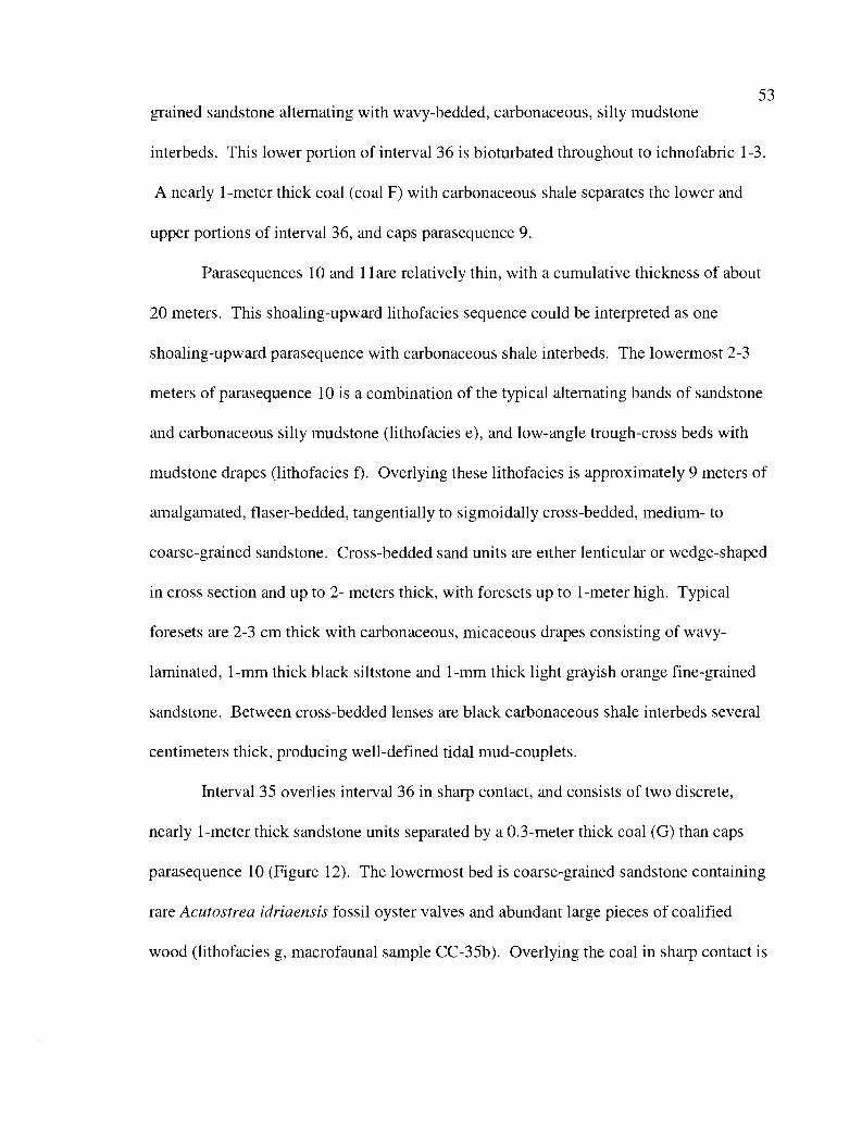
53grained sandstone alternating with wavy-bedded, carbonaceous, silty mudstone
interbeds. This lower portion of interval 36 is bioturbated throughout to ichnofabric 1-3.
A nearly 1-meter thick coal (coal F) with carbonaceous shale separates the lower and
upper portions of interval 36, and caps parasequence 9.
Parasequences 10 and l Tare relatively thin, with a cumulative thickness of about
20 meters. This shoaling-upward lithofacies sequence could be interpreted as one
shoaling-upward parasequence with carbonaceous shale interbeds. The lowermost 2-3
meters of parasequence 10 is a combination of the typical alternating bands of sandstone
and carbonaceous silty mudstone (lithofacies e), and low-angle trough-cross beds with
mudstone drapes (lithofacies f). Overlying these lithofacies is approximately 9 meters of
amalgamated, flaser-bedded, tangentially to sigmoidally cross-bedded, medium- to
coarse-grained sandstone. Cross-bedded sand units are either lenticular or wedge-shaped
in cross section and up to 2- meters thick, with foresets up to 1-meter high. Typical
foresets are 2-3 cm thick with carbonaceous, micaceous drapes consisting of wavy-
laminated, 1-mm thick black siltstone and 1-mm thick light grayish orange fine-grained
sandstone. Between cross-bedded lenses are black carbonaceous shale interbeds several
centimeters thick, producing well-defined tidal mud-couplets.
Interval 35 overlies interval 36 in sharp contact, and consists of two discrete,
nearly 1-meter thick sandstone units separated by a 0.3-meter thick coal (G) than caps
parasequence 10 (Figure 12). The lowermost bed is coarse-grained sandstone containing
rare Acutostrea idriaensis fossil oyster valves and abundant large pieces of coalified
wood (lithofacies g, macrofaunal sample CC-35b). Overlying the coal in sharp contact is
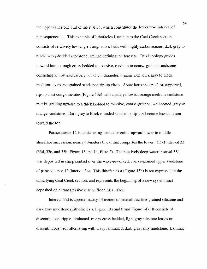
54the upper sandstone unit of interval 35, which constitutes the lowermost interval of
parasequence 11. This example of lithofacies f, unique to the Coal Creek section,
consists of relatively low-angle trough cross-beds with highly carbonaceous, dark gray to
black, wavy-bedded sandstone laminae defining the foresets. This lithology grades
upward into a trough cross-bedded to massive, medium to coarse-grained sandstone
consisting almost exclusively of 1-5 cm diameter, organic rich, dark gray to black,
medium- to coarse-grained sandstone rip-up clasts. Some horizons are clast-supported,
rip-up clast conglomerates (Figure 13c) with a pale yellowish orange medium sandstone
matrix, grading upward to a thick bedded to massive, coarse-grained, well-sorted, grayish
orange sandstone. Dark gray to black rounded sandstone rip-ups become less common
toward the top.
Parasequence 12 is a thickening- and coarsening-upward lower to middle
shoreface succession, nearly 40-meters thick, that comprises the lower half of interval 33
(33d, 33c, and 33b, Figure 13 and 14, Plate 2). The relatively deep-water interval 33d
was deposited in sharp contact over the wave-reworked, coarse-grained upper sandstone
of parasequence 12 (interval 34). This lithofacies a (Figure 13b) is not expressed in the
underlying Coal Creek section, and represents the beginning of a new system tract
deposited on a transgressive marine flooding surface.
Interval 33d is approximately 14 meters of heterolithic fine-grained siltstone and
dark gray mudstone (Lithofacies a, Figure 13a and b and Figure 14). It consists of
discontinuous, ripple-laminated, micro-cross bedded, light gray siltstone lenses or
discontinuous beds alternating with wavy laminated, dark gray, silty mudstone. Laminae
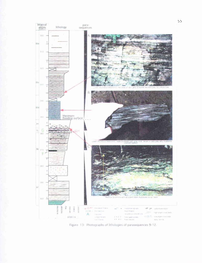
III
Ti
W-1
4.f
'A
0 l
ft-T
, n l
rwm
- -
-rk
rn-.
! .i-
C EL
IS-
VI A
y
C n m1
`° N
d'
Fy
k
11°
56vary in thickness from 0.5 mm to nearly 1 cm. Horizontal bioturbation of the Cruziana
ichnofacies is negligible, locally to ichnofabric 1. Light gray siltstone lenses have dark
gray silty mudstone-draped foresets. Lenses tend to be symmetrical, with ripple foresets
showing multiple current directions. Siltstone laminae are highly micaceous. Darker
silty mudstone interlaminations are sparsely and finely micaceous, and are more laterally
continuous than the fine-grained siltstone lenses, traceable over several meters.
Interval 33d grades upward into interval 33c, a heterolithic facies consisting of
alternating continuous thin beds of light gray siltstone and very fine-grained sandstone,
and dark gray silty mudstone (lithofacies a, Figure 13a and 14). Siltstone and fine-
grained sandstone beds are wavy and range from 1-7 cm in thickness, coarser-grained
beds are commonly highly micaceous and carbonaceous. Thicker and more continuous
siltstone or very fine-grained sandstone beds have mud-draped hummocky and swaley
internal cross-stratification. Mudstone drapes and laminations contain more silt, larger
mica flakes, and larger pieces of carbonized plant material than interval 33d. This
lithology grades upward into interval 33b, a low angle cross-bedded, hummocky and
swaley fine-grained sandstone sequence nearly 15-meters thick (lithofacies b). Beds
range from 0.3-0.5 meters in thickness. Sandstone laminae are 1-2 cm thick, parallel- to
wavy-laminated, and defined by concentrations of mica and carbonaceous mudstone
drapes. This sandstone is pale yellowish brown and weathers to dark yellowish orange,
and is well-sorted and friable, with abundant Thalassinoides burrows. This hummocky-
and swaley-bedded sandstone is in sharp, scoured contact with 14 meters of thick-bedded
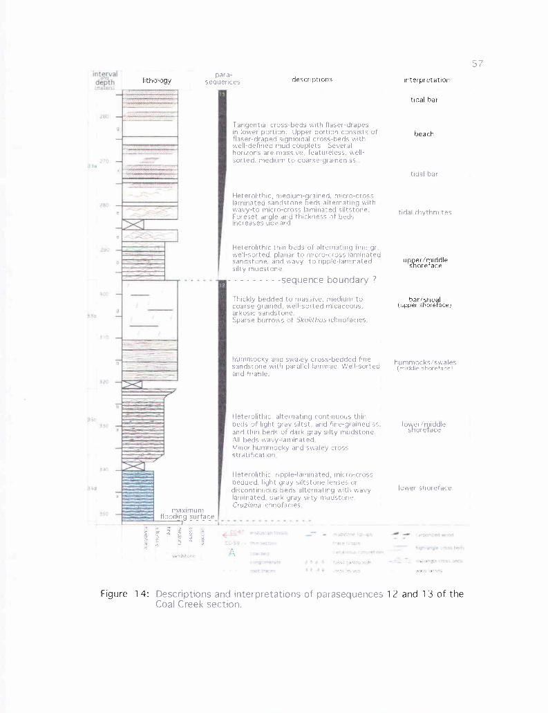
1I
'Intervald 11d
dL&OUth
200
rso
w1a
) f4
3N
L
$ An
bad.
}59
Y 17
A
CC'f7rtWwzih Ine114 r - - noOiE,w 16 N vCA.,iaAL'C 5N tMOCfettNr S:AU'4`SII I
IIIu y e otrhs+df
tarGk ' Vt } Y 4 f5^ iSsft.O.'S¢ aF L1a C2L adts
root.: .+e. s.. * o an ar:r wrtiy fr..lr
para-sequences
Tangential cross-beds with (laser-drapesin lower portion. Upper portion consists offlaser-draped sigmoidal cross-beds withwell-defined mud couplets Severalhorizons are massive, featureless, well-sorted, medium to coarse-gi ained ss
Heterolithic, medium-grained, micro-crosslaminated sandstone beds alternating withwavy-to micro-cross laminated siltstoneForeset angle and thickness of bedsincreases upward.
Heterolithic thin beds of alternating tine-grwell-sorted, planar to micro-cross laminatedsandstone, and wavy- to ripple-laminatedsilty mudstone
- - - - - - - - -sequence boundary ?
Thickly bedded to massive, medium tocoarse grained. well-sorted micaceous.arkosic sandstoneSparse burrows of Skolithos ichnofacies
hummocky and swaley cross-bedded finesandstone with parallel laminae. Well-sortedand friable.
Heterolithic, alternating continuous thinbeds of light gray siltst and fine-grained ssand thin beds of dark gray silty mudstoneAll beds wavy-laminatedMinor hummocky and swaley crossstratification
Heterolithic. ripple-laminated, micro-crossbedded, light gray siltstone lenses ordiscontinuous beds alternating with wavy-laminated, dark gray silty mudstoneCruziana ichnofacies
maximumflooding surface
.d' >1D'
tidal bar
tidal rhythmites
hummocks/swales(middle shoreface)
to er/ iddleshoreface
lower shoreface
Descriptions and interpretations of parasequencesCoal Creek section.
lithology descriptions nterpretat on
tidal bar
beach
upper/riddleshore ace
bar/shoal(upper shoreface)
Figure 14: 12 and 13 of the
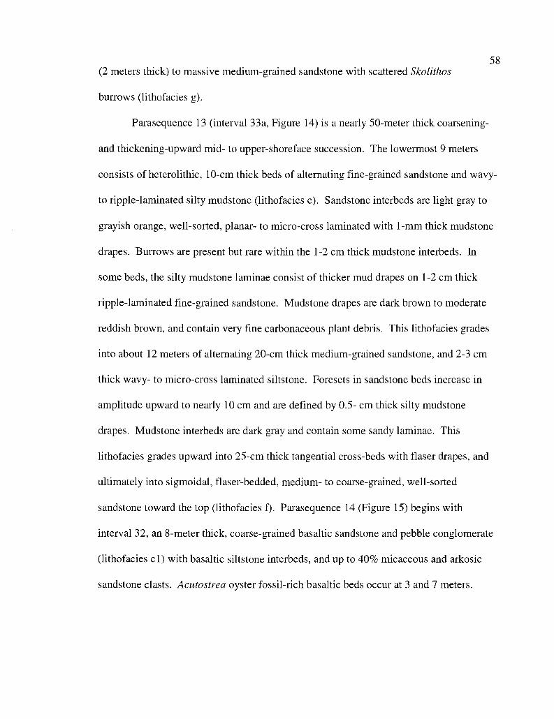
58(2 meters thick) to massive medium-grained sandstone with scattered Skolithos
burrows (lithofacies g).
Parasequence 13 (interval 33a, Figure 14) is a nearly 50-meter thick coarsening-
and thickening-upward mid- to upper-shoreface succession. The lowermost 9 meters
consists of heterolithic, 10-cm thick beds of alternating fine-grained sandstone and wavy-
to ripple-laminated silty mudstone (lithofacies e). Sandstone interbeds are light gray to
grayish orange, well-sorted, planar- to micro-cross laminated with 1-mm thick mudstone
drapes. Burrows are present but rare within the 1-2 cm thick mudstone interbeds. In
some beds, the silty mudstone laminae consist of thicker mud drapes on 1-2 cm thick
ripple-laminated fine-grained sandstone. Mudstone drapes are dark brown to moderate
reddish brown, and contain very fine carbonaceous plant debris. This lithofacies grades
into about 12 meters of alternating 20-cm thick medium-grained sandstone, and 2-3 cm
thick wavy- to micro-cross laminated siltstone. Foresets in sandstone beds increase in
amplitude upward to nearly 10 cm and are defined by 0.5- cm thick silty mudstone
drapes. Mudstone interbeds are dark gray and contain some sandy laminae. This
lithofacies grades upward into 25-cm thick tangential cross-beds with flaser drapes, and
ultimately into sigmoidal, flaser-bedded, medium- to coarse-grained, well-sorted
sandstone toward the top (lithofacies f). Parasequence 14 (Figure 15) begins with
interval 32, an 8-meter thick, coarse-grained basaltic sandstone and pebble conglomerate
(lithofacies cl) with basaltic siltstone interbeds, and up to 40% micaceous and arkosic
sandstone clasts. Acutostrea oyster fossil-rich basaltic beds occur at 3 and 7 meters.
conec43h
distal ,dal bat
Low angle traugh cross-bedd$ed: sandst.with on? defined flaserbeddin
Bun aand mundane arbsMR..
Coarse basalUC sands. and pebble congl.with basaltic s,ltsrone rterteds. Sparselyfossilftrous mth large component of
uossosddetl-permost part .s trough
para-sequences descriptions interpretation
28
30
29
Cliff-forming medium-grained as., massiveto parallel-bedded, light gray, well sorted,medium grained, dominantly arkosic bedsseparated by low-angle cross-beddedsandstone. Up to 30% basalt clastsRare burrows
Lignite to sub-bituminous coal with carb.shale, mudstone, siltstone, and tuffaceoussiltstone interbeds.Low-angle slgmoidal cross-beds withconvolute bedding. Well-sorted mediumarkose with flaser-bedding poorlydeveloped or absent. Skolithos Ichnotacles
Burrowed siltstone grading into low-angle trough cross-bedded arkosicsiltstone and sandstone with Skolithos
supratidal marsh
tidal bar/channel
tidal rhythmitesSparsely fossiliferous nested slgmoldalcross-bed sets, with interbeds of highlycarbonaceous, heterolrthic, wavy-beddedsandstone and carbonaceous siltstone tomudstone
1 -meter high sigmoidal cress-beds withcarbonaceous mudstone drapes.Coarse-grained basaltic ss, with scouredbase, -40% arkose.
Heterolithic fine sandstone and siltstonewith wavy laminations of light to mediumgray silty mudstone with interbeds ofhummocky and swaley siltstone and sandstBurrows common
Heterolithic, sandstone with mud-drapesBurrowed siltstoneSparsely fossiliferous, moderately-sorted,fine- to medium-gr., micaceous arkosic asand poorly-sorted basaltic sandstone.
Lovy f qle trough cross-bedded sandstoneand siltstone lterna In with thinsiltstone or silty mudstone interbeds.Highly fossiliferous basaltic sandstone andcon lomerate. Indistinct bedding, largeSkoi7thos ichnofacies burrows.
tidal bar/channel
tidal rhythmitestidal bar/channeltidal rhythmites
tidal bar/channelMyrrlus
(storm-lag)
hummocky/swaley(mid-shoreface)
tidal rhythmites
hummocky/swaley(mid-shoreface)
lower shorface
rlurnmooky/swaley(mid-shoreface)
pobnn esmrella Solena assemblagetidal rhythmites
teharr,telra Solena asserr'bage
(flooding surface)
distal tidal bar
4, ur cyst yea assem Ing,
flooding surface)
glz r,"1 el
SanOSiOne
f I ,,s,il ea vF v. a r'3
Figure 15: Descriptions and interpretations of parasequences 14 througirr17 of theCoal Creek section.

L
25
'C.
Irthologypara-
sequences
A
,y
f iqure 16 PhR>( :xar,It)F1 of II t FI oloUie or uara', euLr nce', 1 -1 1
'i
61
The upper interval 31 is in sharp contact with the underlying basalt pebble
conglomerate and coarse-grained basaltic sandstone of interval 32, and is 5 meters of
low-angle (5-10 degrees) trough cross-bedded sandstone with poorly defined flaser-
bedding. Individual cross-bedded lenses are up to 0.3-meters thick, poorly-sorted and
dominantly fine-grained, with <10% brown or gray basalt-lithic clasts and <1% lighter
colored pumice clasts. Siltstone drapes on bottomsets and foresets are light gray, fine-
grained, typically Imm to 5cm thick, and contain abundant carbonized plant material.
Some finer-grained sandstone interbeds are bioturbated to ichnofabric 4. Coarser-grained
sandstone lenses have vertical Skolithos burrows from 0.5-2 cm wide and up to 0.3 meter
long. Some individual siltstone laminae are highly carbonaceous, with incidence
increasing upward.
After 5 meters of cover is parasequence 15, the lowermost beds consisting of
intervals 29 and 30 (Figures 15, 16b and c, Plate 2), two highly fossiliferous basalt
volcaniclastic conglomerates and sandstones that total 4-meters in thickness. Interval 29
is a richly fossiliferous fine pebble conglomerate to coarse-grained gray basaltic
sandstone with over 20 species (collected for this study) of the normal marine (subtidal)
Turritella-Solena assemblage (macrofaunal sample CC-29, Figure 16b). Bivalves are
disarticulated but not broken or worn to any great extent. Bedding is indistinct but
averages nearly 0.3 meters in thickness as indicated by fossil concentrations. This
interval is medium to dark gray, poorly-sorted, and up to 40% arkosic sandstone.
Skolithos burrows 2.5-cm wide and over 20 cm long are common. Interval 30 overlies 29
in gradational contact and is distinguished by very abundantAcutostrea idriaensis fossil
62oyster valves, with a minor component of the mussel shell Mytilus sp. (macrofaunal
sample CC-30, Figure 16b). The upper 3 meters of Parasequence 15 consists of low-
angle (<10 degree) cross-bedded sandstone and siltstone, alternating with darker thin
siltstone or silty mudstone interbeds and drapes. The Sandstone component is dark
yellowish orange to moderate yellowish brown, well-sorted, with the 1-mm thick foresets
or wavy laminae commonly bioturbated to ichnofabric 4. Silty mudstone drapes are light
gray to medium dark gray with highly abundant carbonaceous material and mica.
The lower 7 meters of parasequence 16 consists of interbeds of generally
coarsening-upward sparsely fossiliferous, moderately well-sorted, fine- to medium-
grained, micaceous, arkosic sandstone, and poorly-sorted basalt volcaniclastic coarse-
grained sandstones and conglomerates. Interval 27 has two beds containing Turritella
uvasana (macrofaunal samples CC-27b, CC-27c, Nesbitt written communication 1999,
Appendix I), and several beds with unidentifiable shell material (one bed contains a well-
preserved shark tooth). Near the top of parasequence 16 is a 2-meter thick bed of
intensely bioturbated siltstone (lithofacies d), mottled to ichnofabric 5, that coarsens-
upward to fine-grained gray sandstone. Capping parasequence 16 is interval 26, 2 meters
of heterolithic, 0.5-5 cm thick micro-cross bedded to massive, medium- to coarse-
grained, micaceous, arkosic sandstone alternating with 0.5 cm thick wavy-laminated light
gray siltstone to silty mudstone (lithofacies e). Sandstone interbeds contain <20% basalt
clasts, and broken bivalve fossil shells of Polinices nuciformis (Nesbitt written
communication 1999, Appendix I)
63Parasequence 17 is approximately 45 meters of generally coarsening- and
thickening-upward lithofacies (Figure 15). The lower 23 meters (interval 25), is a
combination of fine-grained heterolithic siltstone and fine arkosic sandstone of lithofacies
e, and hummocky and swaley siltstones and sandstones of lower shoreface lithofacies b.
The sandstone component of lithofacies e is fine-grained, micro-cross laminated, and
grayish orange, with sparse burrows (ichnofabric 1). These fine-grained sandstone to
siltstone intervals are interrupted by wavy laminations of light to medium gray silty
mudstone with a minor component of carbonaceous plant debris and mica. Units of
Lithofacies b within this interval are very low-angle hummocky and swaley cross-bedded
fine-grained sandstone. Stratification is defined by very thin (<lmm) laminae of
carbonaceous and micaceous detritus.
The uppermost heterolithic 5 meters of interval 25 is abruptly overlain (and
scoured into) by 2 meters of massive, friable, coarse-grained basaltic sandstone of
interval 24. Sandstone composition is dominantly basaltic, but contains up to 40%
micaceous and arkosic (i.e., quartz and feldspar) components, producing a uniform light
to medium gray color. Broken and worn valves of the mussel Mytilus are common
(macrofaunal sample CC-24, Figure 15).
Interval 24 forms the base of a nearly 10-meter high cliff, exposing the bulk of
interval 23, illustrating the relationship between lithofacies e and f. The beds 3 or 4
meters above the contact with interval 24 are medium- to coarse-grained arkosic
sandstone with trough to sigmoidal cross-beds. Foresets can be over 1-meter high, and
draped with extremely carbonaceous shaley laminae, in which entire carbonized leaves
64can be distinguished. Alternating with this lithofacies (f) is heterolithic lithofacies e.
Sandstone interbeds are massive to wavy-bedded, grayish orange, and a few centimeters
to 0.3-meters thick. This facies alternates with very carbonaceous, medium to dark gray,
wavy-laminated siltstone to carbonaceous shale. The middle portion of this interval has 4
nested sigmoidal cross-bed sets, each 1-meter high. Shelly fossil debris is more prevalent
toward the bottom, carbonaceous drapes and beds become thicker and more prevalent
toward the top, and overall grain-size increases slightly upward.
Interval 22, exposed upstream in Coal Creek from a significant slide, is composed
of four lithofacies. The lowermost 0.5 meter consists of mottled light and medium gray
siltstone, bioturbated (including spreiten), and has abundant 3-4 cm nearly spherical
calcareous concretions (Lithofacies d). The next 2.5 meters consists of low-angle trough
cross-bedded, micaceous, arkosic fine-grained sandstone (lithofacies e, petrology sample
CC-22b). Lenses are up to 10-cm high, and consist of uniform 1-mm thick, gray,
parallel-laminated foresets. Grayish brown vertical Skolithos burrows are common. This
grades upward into relatively low-angle sigmoidal cross-beds up to 1-meter high (that
mark the base of parasequence 18) with some convolute bedding, in grayish brown, well-
sorted, medium-grained sandstone, in which flaser bedding is not well defined
(lithofacies i?). Overlying the sandstone is nearly 3 meters of lignitic to sub-bituminous
coal and carbonaceous shale (coal H) interbedded with light gray silty and tuffaceous
mudstone (Figure 15). This interval is poorly exposed in Coal Creek, but is well exposed
along a 40-meter long road cut on Coal Creek Road, about 0.3 km to the northwest of the
creek exposure (SE 1/4 of the NW 1/4 of Sec. 11, T 8 N, R 3 W).
65Overlying the upper coal of parasequence 18 is a 21-meter thick cliff-forming
sandstone (interval 21, Figures 15 and 16a) that differs in lithology from all lower
intervals. This interval consists of parallel bedded, light gray, well-sorted, medium-
grained, dominantly micaceous and arkosic sandstone beds 10-80 cm thick, separated by
several centimeters of wavy-bedded, light gray, fine-grained sandstone. The sandstone is
basalt-lithic, with up to 30% volcanic clasts (basalt and pumice) giving the interval its
gray color. Beds are massive, with only a few flakes of carbonaceous plant debris; some
beds containing <30% rounded and flattened, medium gray mudstone rip-up clasts, which
in turn contain up to 50% sand-size basalt or arkosic fragments.
Interval 21 is overlain by interval 20 (Figures 17 and 18). It is heterolithic,
consisting of thin alternating laminae, 1-10 mm thick, of fine-grained sandstone, and
muddy siltstone (lithofacies k). Sandstone interlaminations are micaceous and arkosic,
fine-grained, dark yellowish orange, and parallel- to wavy-laminated. Siltstone
interlaminations are fine-grained, medium to dark gray, 1-3 mm thick, and rich in
carbonaceous plant debris and fine mica, commonly producing flame structures into
overlying sandstone laminae.
This lithofacies is overlain by about 3 meters of micaceous, arkosic siltstone
(lithofacies a), that is intensely bioturbated to a mottled medium gray and grayish brown
(ichnofabric 5). This interval is abruptly overlain by heterolithic wavy-laminated
siltstone and fine-grained sandstone that grades-upward into planar-laminations
remarkably uniform in thickness (1-3 mm) and continuous over several meters
(lithofacies k, Figure 18b). Sandstone laminae are grayish orange, fine-grained, and well-
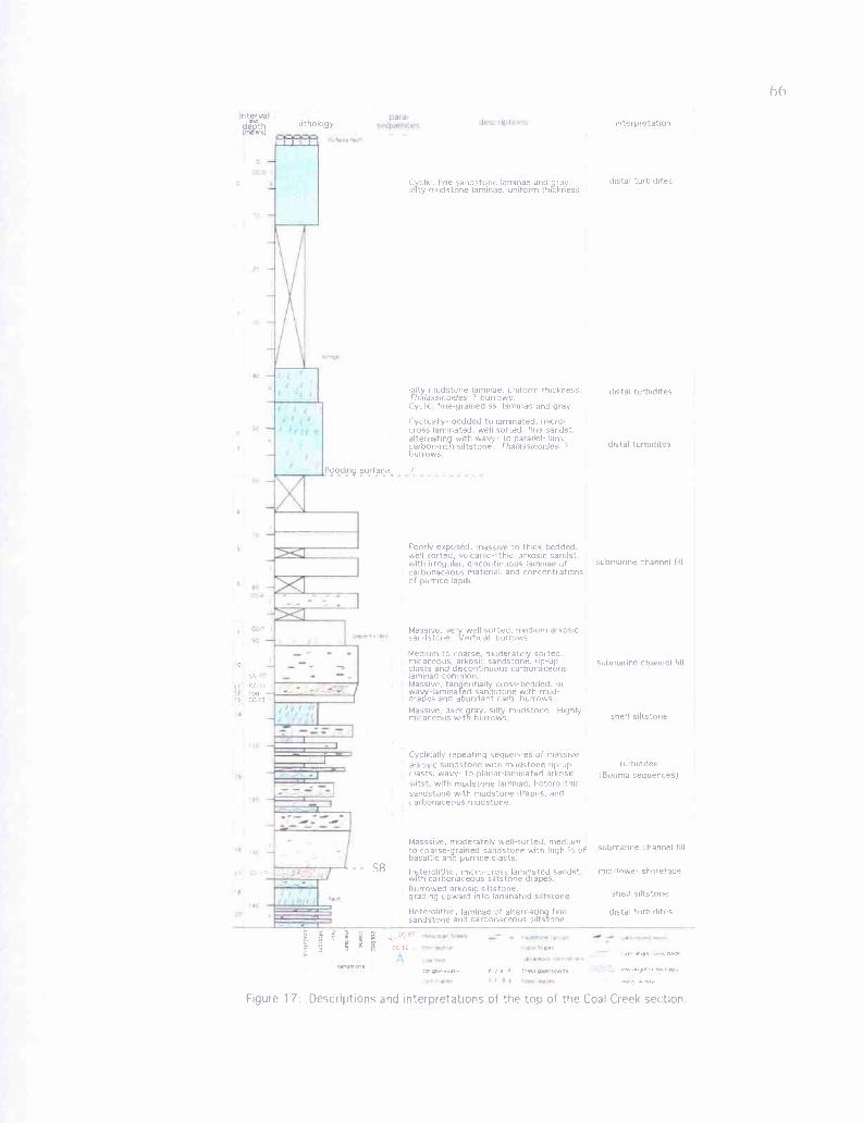
11,,
II.
a!
nterva
cc 0
0
cc2 003 c.C 3
lithology interpretation
flooding surface,
SB
Cyc lir_, fine sandstone larninae and graysilty mudstone laminae. uniform thickness
silty mudstone laminae, uniform thicknessrhalassrnoides 7 burrows.Cyclic fine-grained ss laminae and gray
Cyclically- bedded to laminated. micro-cross laminated, well sorted, fine sandstalternating with wavy- to parallel- lamcarbon-rich siltstone. rhalassinoides ?
burrows
Poorly exposed. massive to thick-bedded,well sorted, volcanic-lithic, arkosic sandstwith irregular, discontinuous laminae ofcarbonaceous material, and concentrationsof pumice lapilli
distal twbidites
distal turtndites
distal turbidites
submarine channel fill
Massive, very well sorted, medium arkosicsandstone Vertical burrows
Medium to coarse, moderately sorted,micaceous, arkosic sandstone, rip-upclasts and discontinuous carbonaceouslaminae commonMassive, tanggentially cross-bedded, orwavy -laminated sandstone with mud-drapes and abundant carb burrows.Massive, dark ray, silty mudstone Highlymicaceous with burrows
Cyclically repeating sequences of massivearkosic sandstone with mudstone rip-upclasts, wavy- to planar-laminated arkosicsiltst with mudstone laminae, heterolithicsandstone with mudstone drapes, andcarbonaceous mudstone
submarine channel fill
shelf siltstone
turhidites(Bouma sequences)
submarine channel fill
rnid'lowei shoreface
shelf sdtstone
Heterolithic, laminae of alternating fine distal turbiddessandstone and carbonaceous siltstone..
Masssive, moderately well-suited, mediumto coarse-grained sandstone with high Ci ofbasaltic and pumice clasts.
Heterolithic, micro-cross animated sandstwith carbonaceous siltstone drapesBurrowed arkosic siltstone,grading upward into laminated sdtstone
.ai ylor^.+er R } ! + ss pasiropns
figure 17: Descriptions and interpretations of the too of the Coal Creek section
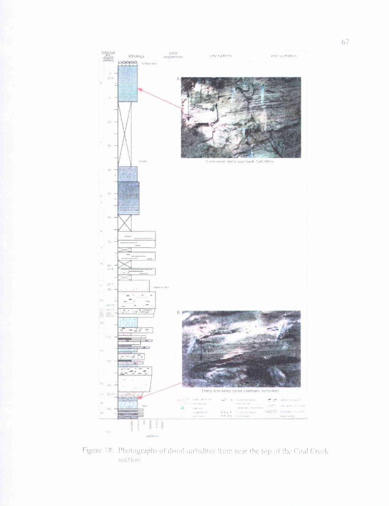
LUtlinxx
3t"lI IAflf PS
..Kr
desrr pt15 Ie,! , etarlrn
I arnmated distal overbank turbidites
Thinly laminated distal overhank turhidites
T iur!rrI a f:r rtill : ! ! ilk ; h!rhi°_l (hr
68
sorted. Medium gray siltstone laminae are consistently 1-mm thick, well-sorted, and
contain finely disseminated carbonaceous material. These lithologies grade upward into
interval 17 (petrology sample CC-17), where sandstone laminations thicken to 2 cm,
grain size coarsens to medium sand with micro-cross laminations, and individual dark
gray carbonaceous siltstone drapes thicken to 4 mm. The top 20 cm have mudstone-
draped foresets in lenticular sandstone beds (up to 5-cm thick), which in places are
invaded by 1-2 cm wide sub-horizontal burrows filled with medium to coarse-grained
sandstone from the overlying interval 16. Lithology of interval 16 is similar to interval
21, but not as well-sorted. This lithic arkosic sandstone is scoured into the underlying
interval 17, and is light gray, micaceous, and feldspathic with -40% basalt clasts and
-5% rounded pumice clasts. Dark gray mudstone to siltstone rip-up clasts, carbonaceous
wood chunks, and bivalve fossil shell fragments are common. The entire 8-meter interval
(lithofacies j) is massive with thin, discontinuous carbonaceous laminae.
Interval 15 overlies interval 16 in sharp contact, and consists of repeating
sequences of sandstone, siltstone, and mudstone. The lowermost 4 meters is a massive,
medium- to coarse-grained, arkosic, micaceous, and dark yellowish orange sandstone.
Discontinuous bands of rounded carbonaceous mudstone clasts, and dark gray mudstone
rip-ups occur throughout, as well as infrequent burrows. This bed is sharply overlain by
1 meter of grayish orange siltstone (dominantly) with alternating beds of siltstone and
wavy carbonaceous mudstone laminae. This grades upward into heterolithic, alternating
5-10 cm beds of grayish orange, medium-grained sandstone, and medium to dark gray,
69
carbon-rich siltstone to fine-grained sandstone. Overlying this facies is 1 meter of
carbonaceous mudstone. The next nine meters repeats these sequences several times.
From 100 to 65-meters depth (cover in the stream and small faults make exact
thickness determination impossible) massive coarse-grained sandstones of lithofacies j
dominate. Interval 14 is 4-meters thick, overlying the uppermost sandstone of interval 15
in sharp contact, and is a massive, light to medium gray, highly micaceous, extensively
bioturbated, arkosic, shelfal siltstone (mottled to ichnofabric 4-5). This is abruptly
overlain by interval 13, a 1.8-meter thick medium- to coarse-grained, massive, arkosic
sandstone (lithofacies j, petrology sample CC-13), which grades upward into combined
intervals 12 and 11. The lower meter consists of a heterolithic sequence of alternating,
wavy laminations of 1-mm to 1-cm thick medium-grained sandstone, and 1-3 mm thick
wavy-laminated carbonaceous mudstone (petrology sample CC-11). This grades upward
into a medium- to coarse-grained, moderately well-sorted micaceous and arkosic
sandstone, mostly massive with discontinuous laminations of carbonaceous material.
Carbonaceous mudstone rip-ups and large pieces of carbonized leaves are common.
Intervals 12 and 11 grade upward into interval 10, very coarse-grained sandstone
to fine-grained pebble conglomerate (petrology sample CC-10). This 8-meter thick
interval is light gray, -50% micaceous lithic arkose, -40% rounded to subangular pumice
lapilli, -5% basalt lithic fragments, and -5% greenish, angular clay rip-up clasts. Beds
average nearly 1-meter thick, as indicated by very discontinuous dark carbonaceous
laminae. Intervals 8 and 9 together are a 6-meter wide amygdaloidal peperite dike of
Grays River composition (not shown in the stratigraphic column) that intruded between
70exposures of intervals 10 and 7. Interval 7 is a massive, very well-sorted, medium-
grained, sparsely micaceous, arkosic sandstone (petrology sample CC-7). No evidence of
bedding, molluscan assemblages, or trace fossils are apparent in the upper 4 meters.
Vertical burrows to ichnofabric 1 are found in the lower meter.
The overlying intervals 6, 5, and 4 (Figure 17) are exposed in largely inaccessible
and lushly vegetated cliffs several meters to the side of the lower part of Coal Creek,
where it widens to a flood plain. Bedrock exposures in the creek itself are unavailable
due to 100% cover by rounded Columbia River Basalt boulders originating from a
landslide upstream. As a result, these poorly exposed, dominantly micaceous and arkosic
sandstone intervals are incompletely described and unsatisfactorily understood. Toward
the base, informal interval 6 (petrology sample CC--6) is moderately well-sorted coarse-
grained sandstone with a low percentage of basalt- and pumiceous- lithic clasts.
Irregular, wavy, discontinuous laminae of carbonaceous plant debris, and concentrations
of pumice lapilli are common throughout. Toward the top of these intervals, moderately
well-sorted, medium- to coarse-grained sandstone with pebbly pumice lapilli dominate.
Pervasive yellowish brown liesegang limonite staining gives the upper portion the
appearance of parallel bedding.
The upper 50 to 60 meters consists of thin, cyclically-bedded to cyclically-
laminated, massive to micro-cross laminated fine-grained sandstone alternating with
wavy- to planar-laminated carbonaceous siltstone. The lithology is very similar in the
lower portion (intervals 3 and 2) to the cyclically-bedded lithofacies e of several
previously described intervals, and much like the sandstone and siltstone of the sandy
interbeds of interval 59, and the upper 2 meters of interval 18. Heterolithic interval 3 is
71
fine-grained, grayish orange, well-sorted sandstone, micro-cross laminated, with light
gray siltstone drapes. Sandstone interbeds are moderately bioturbated to ichnofabric 3,
average about 10-cm thick, and can be lenticular with low-angle trough cross-beds.
Grading upward into interval 2, sandstone beds thin to <2 cm, and the angle of the
foresets decreases. Gray silty mudstone interlaminae become uniformly 2-3 mm thick.
In outcrop, interval 2 has a thinly-striped appearance due to the uniformity of lamina
thickness.
Interval 2 grades into interval 1(Figures 17 and 18), where coarser laminae
become fine silty sandstone. Scattered trough cross-beds up to 7-cm thick with siltstone
drapes occur in this interval. Minor vertical Thalassinoides? burrows to ichnofabric 1
occur in intervals 3, 2, and 1. Approximately 25 meters of cover downstream from the
Eufaula Rd. Bridge separate interval 1 and the similar but more indurated interval 0
(petrology sample CC-0, Figure 18a), which is highly fractured and terminates in a high
angle fault against down-dropped Miocene Columbia River Basalt. This is the
stratigraphically highest part of the Cowlitz Formation exposed in Coal Creek.

72
Depositional Environments
Together, intervals 58, 59, 60, and the lower 4 meters of 62 at the base of the Coal
Creek section constitute parasequence 1, a coarsening- and thickening-upward, upper-
shoreface succession approximately 45-meters thick (Figure 6, Plate 2). The base of the
sequence is an intensely bioturbated silty mudstone (interval 58, lithofacies d), with
abundant carbonaceous plant material in the form of whole carbonized leaves, and twig
and insect fragments, indicating deposition in a marginal marine setting (bay or estuary),
rather than deep marine mud (outer shelf/upper slope). This is overlain by interval 59, a
heterolithic, micro-cross and wavy-laminated, well-sorted, medium-grained, micaceous,
arkosic sandstone with mudstone rip-up clasts, chunks of carbonized wood, and tidally
formed carbonaceous mudstone-drapes, alternating cyclically with heavily bioturbated,
carbonaceous mudstones.
This coarsening- and thickening-upward parasequence is consistent with
progressively higher-energy tidal currents affecting a slightly shallower quiet-water
protected bay/estuary setting. Thinly-laminated sandstone interbeds (tidal rhythmites)
may represent the higher energy currents of spring tides; the thinner bioturbated mudstone
interbeds may represent lower-energy deposition during neap tides. Planar- and wavy-
laminated sandstone interbeds of lithofacies e coarsen- and thicken-upward in this
interval, grading into lithofacies f. From -632 to 622 meters, coarser and thicker
sandstone beds dominate with 0.5-meter high trough cross-beds, more abundant and
larger rip-up clasts, and flaser mud-drapes defining tidal bundles. Similar lithofacies
associations in the recent Mont Saint-Michel Bay, France are interpreted by Nio and
73
Yang (1991) to form by tidal sandbars prograding into a distributary bay or estuary,
along the delta front of a tide-dominated delta. These lithofacies associations could
alternatively have been formed by recurring minor deltaic fans breaking through a
distributary levee (distributary splays) into a quiet bay environment. The presence of
mudstone rip-up clasts in the sandstone beds of this parasequence is support for this
hypothesis.
The uppermost 10 meters consists of mostly micaceous, arkosic, flaser-bedded,
upper shoreface to marginal marine lithofacies. The lower massive, intensely bioturbated
silty mudstone (interval 60, lithofacies d), immediately above the uppermost tidal-bar
sand of interval 59, is also interpreted to have formed in a quiet-water bay/estuary setting.
Burrows of the Skolithos ichnofacies, and the abundant carbonaceous plant fragments,
are consistent with this interpretation. This massive silty mudstone grades upward into
interval 61, an arkosic siltstone, indicating transition to a slightly higher current energy
environment.
Interval 61 siltstone then grades upward into the lower heterolithic beds of
interval 62, consisting of alternating planar- to wavy-bedded, fine- to medium-grained
sandstone, and ripple-laminated carbonaceous siltstone and massive mudstone
(lithofacies e). This lithology is common in the type Cowlitz Formation (Payne, 1998)
and in exposures north and west of Coal Creek described by Kleibacker (2001), and is
consistent with a tidal rhythmite sequence as described by Nio and Yang (1991) in Mont
Saint-Michel Bay, France. These characteristic vertically stacked, thinly ripple-laminated
beds are interpreted to have formed in intertidal to subtidal mud-flats, and record tidal

74fluctuation cycles. Micro-cross bedded ripple-laminated sandstone interbeds are
produced during the relative high energy of tidal ebb and flood current reversals, and the
mud drapes below and above (a mud-couplet) represent the two slack-water stages during
a flood-ebb cycle (Figure 19, and 8c).
Scoured into the underlying micaceous and arkosic heterolithic facies is a 1-meter
thick, coarse-grained, highly fossiliferous, basalt volcaniclastic sandstone (lithofacies cl)
that marks the base of parasequence 2. The fossils are dominantly of the normal-marine
(shallow subtidal) Turritella-Solena molluscan fossil assemblage, but there is a minor
component of the Acutostrea (oyster) assemblage of shallow water embayments or
estuaries, and Mytilus (mussels washed off intertidal rocks). These shells are thick and
robust, and are found in this coarse-grained basaltic sandstone disarticulated, fragmented,
and partly rounded. Nesbitt (written communication, 1999) interprets such deposits as
storm wave-generated shell-lag deposits. Large storm wave events, or possibly even
tsunamis, could periodically wash in coarse-grained volcanic sediment and associated
shallow marine shelly organisms from the nearby, eroding Grays River volcanic
headlands and possible seastacks to the southwest, into the mouths of the Cowlitz deltaic
tidal estuaries. This high-energy pulse would overwhelm normal deltaic sedimentation,
and deposit a coarse-grained basaltic sand or pebble or gravel conglomerate, with robust-
shelled, rocky intertidal mollusks, and normal-marine mollusks, broken and jumbled
together. Another possibility is that catastrophic volcanic events occurring in the nearby
Grays River volcanic edifice(s) produced debris flows and large waves that washed both
volcanic sediment and robust shells into the arkosic Cowlitz delta/estuary. Nesbitt
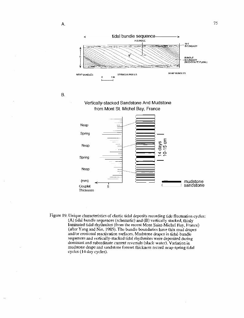
/5
E tidal bundle sequenceA BUNDLE
NEAP BUNDLES
B.
SPRING BUNDLES0 1M
NEAP BUNDLES
Vertically-stacked Sandstone And Mudstonefrom Mont St. Michel Bay, France
Neap
Spring
Neap
Spring
Neap
(mm) FCoupletThickness
T
5
mudstonesandstone
Figure 19. Unique characteristics of clastic tidal deposits recording tide fluctuation cycles:(A) tidal bundle sequences (schematic) and (B) vertically stacked, thinlylaminated tidal rhythmites (from the recent Mont Saint-Michel Bay, France)(after Yang and Nio, 1985). The bundle boundaries have thin mud drapesand/or erosional reactivation surfaces. Mudstone drapes in tidal-bundlesequences and vertically-stacked tidal rhythmites were deposited duringdominant and subordinate current reversals (slack-water). Variation inmudstone drape and sandstone foreset thickness record neap-spring tidalcycles (14 day cycles).
76
(written communication, 1999) has also suggested that such molluscan fossil rich beds
overlying tidal or delta plain facies may represent minor onlaps (marine flooding
surfaces). The presence of these same beds in the study areas of Payne (1998) and
Kleibacker (2001) to the north indicates that they form in response to basin wide changes
in sea level.
Overlying the coarse-grained basaltic sandstone in interval 62 is a massive,
friable, well-sorted, micaceous and arkosic sandstone unit 7-meters thick. This interval
has few discernable primary sedimentary structures other than a few carbonaceous
laminae, and a sparse Turritella-Solena assemblage near the top. A well-sorted, massive
sandstone suggests extensive reworking by waves, and may result from wave-reworked
distributary mouth- or tidal-bars such as those present in the Cowlitz age-equivalent
Eocene Coaledo strata in southwest Oregon (Chan and Dott, 1986). Such delta-front
sands are deposited seaward of active distributary mouth bars (or tidal bars) and
sometimes reworked by waves and longshore current into a shoal. A similar (and
possibly correlative) delta-front sand/beach occurs in the same stratigraphic position
within parasequence 2, nearly 3 km to the northwest in Coal Creek (interval 85, section
#4, Plate 2). If this unit and the overlying coal are correlative to intervals 85 and 88, it is
evidence for a north-northwest trending delta front at the time, a hypothesis consistent
with the general west-southwest trending average paleocurrent vector of cross-beds in
Coal Creek.
77The overlying 8 meters of dominantly tangentially cross-bedded, flaser-draped
sandstone caps parasequence 2. The lower 1-meter of this bedset consists of cyclically
alternating thin beds of sandstone and carbonaceous mudstone (lithofacies e), interpreted
as tidal rhythmites. This facies grades upward into higher-energy 0.3-0.7 meter thick
cross-bedded sandstone with mud-drapes of lithofacies f. These are interpreted as
prograding megaripples in a tidal channel or tidal sandbar with mud-draped reactivation
surfaces, and upper and lower mud-couplets, producing tidal bundles. This association of
tidal rhythmites underlying, or grading into, sub-tidal channel or bar prograding
megaripples is common within the Coal Creek section.
Parasequence 3 repeats many of the lithofacies described in underlying intervals.
However, rather than being capped by cross-bedded, and flaser-bedded sandstone, this
upper shoreface to delta-plain succession terminates in a coal (coastal supratidal swamp)
at (or very near) the top, and lateral changes in lithofacies across several kilometers of
delta front can be studied in this shoaling-upward parasequence. The upper coal (coal A)
is a marker bed along nearly the entire northern half of Coal Creek, allowing for confident
correlation and placement of units within the stratigraphic column.
Parasequence 3 is a fining- and thinning-upward progradational parasequence,
including thin-bedded heterolithic lithofacies e toward the base, grading upward into
thicker trough cross-bedded sandstone of lithofacies f. Unlike the lower parasequences,
this sequence is overlain by fining- and thinning-upward mudstone and siltstone of
lithofacies h and capped in a coal (Plate 2). This represents a supratidal delta plain marsh,
and the coarse sandstone interbeds are likely thin levee splay deposits. Lithofacies within
78parasequence 3 can be correlated over 3 km, and show lateral changes in depositional
environments from south to north (Plate 2, see Coal Creek stratigraphic section of text).
Interval 63 at the base of parasequence 3 is a heterolithic facies consisting of very
fine-grained, micro-cross bedded sandstone with discontinuous wavy-laminated mud
drapes (lithofacies e). These interbedded mudstone laminae, while containing enough
finely disseminated organic component to make it dark gray in color, do not contain
larger carbonized fragments of leaves or twigs. This interval may be a lower energy,
deeper, quieter water equivalent of the tidal rhythmites described in the underlying
interval 62. It is finer-grained, and the mud-drapes lack fragmental organic debris,
possibly because it had settled out of suspension in shallower water (likely tidal flats)
closer to the source. The lower percentage of mud could likewise result from suspended
mud particles settling out in tidal flats. The basalt-volcaniclastic interbed of lithofacies
c 1 is finer-grained than the similar unit in interval 62, and contains thinner-shelled
bivalves (including two species of Pitar and Pachydesma aragoensis) that are less
fragmented and rounded (e.g., below wave base). Lithofacies above this fossiliferous bed
remain unchanged from those below, indicating that this may represent storm wave lag,
not a minor marine flooding surface.
The correlative interval 82b, 2.1 km to the northwest (section #3) is slightly
coarser-grained than interval 63, thicker-bedded, and the basalt volcaniclastic pinches out
to the north (Plate 2). Correlative interval 86 (section #4), 0.6 km north of 82b is coarser
still, with broken and disarticulated, wave transported molluscan fossils of the shallow
subtidal Turritella-solena assemblage. These features could indicate decreasing water
79depth and higher energy conditions to the north at this time. The upper coal (coal A)
maintains a constant relative thickness over this distance, but sandstone splay interbeds in
interval 66 (section #1), and mudstone interbeds in interval 82a (section #3) are not
present in interval 88 farthest to the north (section #4).
Overlying interval 63 (in the southernmost exposure of parasequence 3, section
#1) is interval 64, three tangentially to sigmoidally cross-bedded sandstone units with
flaser-bedded foresets, separated by thin mudstones of lithofacies d. These are inferred to
be separate progradations of increasingly higher-energy megaripples of a tidal sandbar or
subtidal channel (indicated by thickness and higher angle of foresets). Parasequence 3
terminates in a delta plain succession consisting of an underlying siltstone (lithofacies d
or h), and a coal with fine- to coarse-grained interbeds representing marsh/swamp muds
and sand deposited from progradation of interdistributary crevasse splays or large storm
events that breach the larger distributary channel levees.
Parasequence 4 is a shoaling-upward, upper-shoreface to delta-plain succession,
with varying lithologies resulting from the complex interplay of dominantly basaltic sand
and pebbly gravel influx to the south, derived from local eroding Grays River shield
volcanoes, and normal deltaic deposition of micaceous and arkosic sediment to the north.
The southernmost exposures (intervals 67, 68, and 69, section #1) are a mostly fining-
upward sequence, with offshore shallow-marine bioturbated sandstone at the base grading
upward into subaerial coaly delta-plain facies. The lowermost medium-grained, largely
basalt-lithic, poorly-sorted, fossiliferous sandstone is interpreted to be another storm-
wave generated shell-lag deposit. The association of the oyster Acutostrea idriaensis and
80Pitar eocenica suggests this unit was deposited in a shallow water open embayment
(Nesbitt written communication, 1999) or estuary, a conclusion also supported by the
fine-grained tidal rhythmite sequence immediately above. The overlying coarsening-
upward sandstone culminating in a well-sorted, coarse-grained arkosic sandstone with
abundant large pieces of coalified wood suggests a prograding distributary mouth channel
or tidal sandbar reworked by wave action.
The overlying basaltic, cyclically-bedded sandstone and siltstone, with interbeds
containing articulated and unworn Corbicula cowlitzensis, a brackish water bivalve
(Nesbitt written communication 1999, Appendix I), indicates that this upper portion of
parasequence 4 was deposited in a protected bay/estuarine environment. Individual
graded lithic sandstone beds could have been produced by pulses of volcaniclastic
sediments entering the bay, estuary, or lagoon, possibly from storm events associated with
flooding from a basaltic source, with the finer basaltic siltstone at the top of each bed
resulting from suspended particles settling out with time. Alternatively, these could be
basaltic tidal rhythmites, the siltstones settling out of suspension during slack-water
stages between ebb and flood tide. This fining-upward parasequence terminates in sub-
bituminous coal B (supratidal freshwater marsh) with coarse-grained basaltic overbank
levee splay or storm wave-generated sandstone interbeds. The individual cyclic beds of
interval 68 with in-situ, thin-shelled, articulated brackish water Corbicula clams, as well
as the overlying interbedded coal, indicates that these multiple basaltic beds were
deposited over a substantial period of time, as opposed to a single volcanic debris-flow
flood event. The correlative basaltic interval 76 to the north lacks the cyclic sandstones
81
and siltstones, suggesting the protected, quiet-water tidal flat/bay/estuary environment
of interval 68 was limited to the south. Here, well-sorted medium-grained basaltic
sandstone with planar bedding suggests reworking of the sand by waves into a barrier bar,
or distributary mouth bar.
The northernmost exposure of this correlated parasequence 4 (section #4) begins
with a storm-generated (or marine transgressive), coarse-grained, fossiliferous basaltic
unit (interval 90) with broken valves ofAcutostrea idriaensis, that is possibly correlative
to the similar lithofacies of the lower part of interval 67 in the southernmost exposure
(section #1). Above this, interval 91 (section #4), and lower interval 80 (section #3), are
protected bay deposits of well-laminated mudstone and micaceous, arkosic siltstone. The
upper 4 meters of interval 80, with large-scale flaser-bedded trough cross-beds and
unidentifiable shell hash shows that, in this part of the delta sequence, a tidal channel
and/or sandbar prograded into the bay or estuary.
Parasequence 5 (Plate 2) consists of interbedded thick basaltic breccias,
conglomerates, sandstones, and siltstones that mark the lowermost beds of a -140 meter
section that contains abundant basaltic interbeds, likely correlative to informal unit 2 of
the type Cowlitz Formation section as described by Payne (1998). At the base of this
sequence in each Coal Creek section (#1-4, Plate 2) is a fossiliferous bed of basaltic
sandstone or pebble conglomerate (except for interval 70 where it is likely covered). This
represents a high-energy pulse of coarse volcanic sediment entering the length of the delta
front or estuary, perhaps the result of large waves produced during the initial intrabasinal
phase of the explosive basaltic Grays River volcanic activity, that would deposit up to 35
82
meters of volcanic sediment (parasequence 5, Figures 9 and 10) over the mostly
micaceous and arkosic extrabasinal deltaic facies of underlying intervals (parasequences
1-4, Plate 2, Figures 6, 7, and 8). These locally derived basaltic sediments, including
some conglomerates with angular to subrounded cobble-sized clasts in matrix support, are
interpreted as catastrophic, hyperconcentrated flood/debris flow deposits entering the
estuary from a nearby explosive volcanic high (Figure 59). The angular, matrix supported
breccia interbeds of Grays River basalt composition, with euhedral pyroxenes, suggests
that the eruptive center may have been near the southern Coal Creek exposures. Such
interbeds could have originated from near Mt. Solo (Plate 1), where quarry and roadcut
exposures of thick Grays River breccias of identical lithology commonly occur
intermingled with columnar autoclastic basalt dikes, sills, and subaerial flows.
Changes in lithofacies of this parasequence (5) to the north are expressed as a
decrease in grain size and thickness of the conglomerates, breccias, and coarse-grained
sandstones (lithofacies cl, correlative sections #2, #3, and #4, Plate 2), and an increase in
fine-grained basaltic sandstones and siltstones (lithofacies c2). Beds with conglomerate
at the base grading upward to siltstone resemble divisions a and d of the Bouma turbidite
sequence. A similar sequence in the type Cowlitz section at Vader 10 km to the north (at
the base of informal unit 2, lithofacies 2f of Payne, 1998) was interpreted as debris flow
deposits produced in an inner neritic setting. He concluded that such units might be
records of a series of explosive air fall and base-surge eruptive events that abruptly
entered the shallow-marine arkosic sandstone to mudstone environments. Such volcanic
surges upon entering water of an appropriate depth, would rapidly deposit the coarser-
83
grained gravel component, and the finer-grained component would settle out over a
period of time (similar to the process described for interval 68). Over a period of time,
several eruptive pulses would produce cyclic, graded basaltic beds with coarse-grained
scoured bases and an overlying drape of fine-grained particles that slowly settled out of
suspension. The preponderance of very fine-grained basaltic siltstone in the northernmost
exposures of this volcanic interval, with fewer conglomeratic interbeds, could be
explained as deposits produced farther away from the southern Mt. Solo Grays River
eruptive source, in deeper (subtidal) or calmer water. The Glycymeris saggitata
pelecypod found in the basaltic conglomerate of interval 92, according to Nesbitt (written
communication, 1999), indicates a shallow subtidal marine environment.
Parasequence 6 is a micaceous, arkosic shoaling- and fining-upward succession
(Figure 9), the lower part of which can be correlated across 3 km due to its position
immediately above the thick volcaniclastic intervals of parasequence 5 (section #1-4,
Plate 2). This parasequence in its southernmost exposures (section #1) is well-sorted and
medium-grained, with parallel laminations of both heavy minerals, and micaceous
carbonaceous material, characteristics of beach or bar deposits where wave-reworking
and wave action in the swash zone produces the characteristic sorting and planar-laminae.
This deposit is likely a wave-reworked distributary mouth bar or subtidal bar, deposited
seaward of an active distributary channel.
Correlative intervals to the north and west (sections #2 and #3, Plate 2) are finer-
grained and extensively bioturbated, suggesting deposition in a protected bay/estuary.
Alternatively these could be offshore middle- to lower-shoreface bioturbated siltstones
84
formed below wave base. In gradational contact with the southernmost interval 53 is a
wavy-laminated, micro-cross bedded fine-grained arkosic sandstone containing well preserved
carbonized leaves and the fresh-water bivalve Batissa newberri (Nesbitt written
communication 1999, Appendix 1) grading upward into an extremely carbonaceous interval of
shale, carbonaceous siltstone, and thin coal (coal Q. These features indicate a fresh water
delta-plain depositional environment, such as a supratidal marsh, where periodic overbank
flooding events would produce the wavy- and micro-cross laminated ripple interbeds.
Parasequence 7 is a generally shoaling-upward succession produced largely by
prograding tidal sandbars or subtidal channel sequences along the front of a tide-dominated
delta lobe or estuary. The parasequence begins with interval 50 (Figure 9), a carbon-rich
heterolithic facies abruptly overlying the uppermost supratidal marsh and crevasse splay
succession of parasequence 6. This wavy-laminated bioturbated bedset of alternating
sandstone and carbonaceous fine-grained sandstone and siltstone is a sequence of tidal
rhythmites (lithofacies e). The thickness and coarse grain-size of the sandstone interbeds, and
the large Skolithos ichnofacies burrows, suggest a high-energy, shallow-marine tidal
environment. A likely scenario is deposition immediately bayward of a prograding tidal bar or
tidal delta at an estuary mouth, where tidal current energy is sufficient to carry coarse sand, but
not strong enough to produce the characteristic large megaripples of lithofacies f. This is
overlain by interval 49, another poorly-sorted storm wave-generated broken and disarticulated,
unidentifiable shell-lag deposit.
Tangential and sigmoidal, flaser-bedded, tidal channel or tidal bar sandstones typically
overlie tidal rhythmites throughout the Coal Creek section. Parasequence 7 is an excellent
85
example of a tidal bar or subtidal channel progradation into a tidal flat or estuary (similar to
modem Willapa Bay, Washington (Figure 20). Fine-grained intertidal rhythmites (interval 50)
grade upward into the higher-energy facies of tangentially cross-bedded medium-grained
sandstone of interval 48 (large tidal megaripples), further grading into higher-angle
sigmoidally cross-bedded coarser sandstone, with soft-sediment slump deformation, larger and
more abundant mudstone rip-up clasts, and coalified wood debris (interval 46). A 1.5-meter
thick basaltic, coarse-grained, bed occurs at the base of the coarse-grained interval 46 (interval
47) that is rich in fossil shells of the Acutostrea assemblage. This may represent the shell lag
at the base of the subtidal channel that produced interval 46, a relationship observed in the
recent deposits of Willapa Bay (Clifton et al, 1989).
Overlying these arkosic and micaceous tidal lithofacies is another poorly-sorted basalt
volcaniclastic coarse-grained sandstone and matrix-supported conglomerate (interval 45),
likely produced by channelized hyperconcentrated flow from a nearby volcanic edifice. The
lack of molluscan assemblages associated with this unit, or any sign of bioturbation or grading
suggests that this surge may have been initially subaerial, with little reworking by wave or
tidal processes. The top of parasequence 7 is a heterolithic facies (lower interval 44)
consisting of thin interbeds of coal, siltstone, and mudstone (coal D) that can be interpreted in
two ways. These beds could be a series of thin, fine-grained interdistributary crevasse levee
splays periodically flowing into a supratidal marsh in the estuary or bay, depositing micro-
cross laminated overbank arkosic sandstone or siltstone depending on the severity of the flood
event. Rounded pieces of carbonaceous plant debris and mudstone rip-up clasts, and thin coal
seams, support this model.
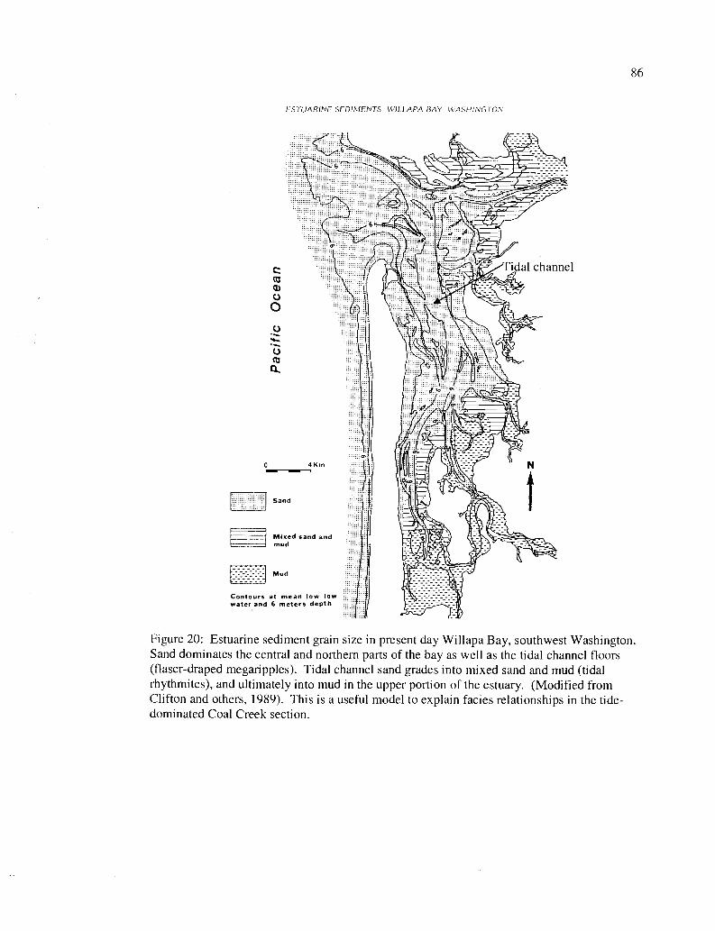
86
ESTUARINE SEDIMENTS. WILLAPA 13AY WASHINGTON
Figure 20: Estuarine sediment grain size in present day Willapa Bay, southwest Washington.Sand dominates the central and northern parts of the bay as well as the tidal channel floors(flaser-draped megaripples). Tidal channel sand grades into mixed sand and mud (tidalrhythmites), and ultimately into mud in the upper portion of the estuary. (Modified fromClifton and others, 1989). This is a useful model to explain facies relationships in the tide-dominated Coal Creek section.
87
Alternatively, this cyclically bedded interval could be interpreted as unusually
carbonaceous intertidal rhythmites, with mud-drapes composed largely of carbonized
plant debris. Their position beneath the tangentially cross-bedded and flaser-bedded
sandstones of the upper portion of interval 44 (Figure 11) supports this tidal flat model.
No molluscan fossils were found to allow discrimination between fresh, brackish, or
shallow marine water depositional environments.
Parasequence 8 (Figure 12, Plate 2) is another fining- and thinning-upward
sequence representing another progradation of tidal sandbars or subtidal channels, and
ultimately a supratidal marsh, into an estuarine environment (Figure 59). Such shoaling-
upward sequences culminating in a tidal channel or bar sand, beach, or marsh, and then
overlain by shallow marine facies of the next parasequence could represent minor
transgressions caused by third-order eustatic sea level change. It may also represent
fourth-order apparent sea level change produced by distributary channel switching,
allowing for a few meters of subsidence by compaction of the underlying intertidal to
supratidal fine-grained sediment before deposition of coarse sand is again concentrated in
that area.
The lower beds of parasequence 8 constitute a two-meter thick, heterolithic,
cyclic, relatively coarse-grained and carbon-rich intertidal rhythmite sequence (the
carbonaceous beds of lower interval 44 could also be part of this parasequence). This
protected intertidal facies grades upward into relatively low-angle, flaser-bedded trough
88
cross-beds, and ultimately into nested, high-amplitude sigmoidal cross-beds. A similar
lithologic parasequence was described by Payne (1998) in the uppermost part of his
informal unit 3 (location 11 e) of the type Cowlitz Formation. The uppermost portion of
interval 44 consists of an amalgamated subtidal channel-fill sequence with flaser-draped
foresets and wavy mud- or carbonaceous shale-draped reactivation surfaces. Payne
interpreted the dominant paleocurrent direction (southwest in the case of Coal Creek
sediments) to reflect the dominant ebb tides, whereas the few cross-beds trending
northeast resulted from weaker flood-tides. The part of this Coal Creek sequence that
lacks cross-bedding is a massive, well-sorted arkosic sandstone with chunks of
carbonaceous wood, that was likely produced by local reworking of tidal bar sand by
wave action into offshore bars or shoals.
This interval is overlain by alternating thick beds of poorly-sorted and commonly
fossiliferous, coarse-grained, basaltic sand or basaltic pebble conglomerate (intervals 43,
41, and 39), and well-sorted, planar-laminated to massive micaceous, medium-grained
arkosic sandstones (intervals 42, 40, and 38). The massive to planar-bedded arkosic
sandstone intervals represent distributary mouth bars or tidal bars in a tide-dominated
delta, reworked by wave-action and longshore current into shoals or barrier bars fronting
the tidal flat/estuary. Large Skolithos burrows, prevalent in high-energy shoreface
environments, support this interpretation. The thick, massive to wavy-bedded basaltic
pebble conglomerates or coarse-grained sandstones represent a temporary influx of
coarser-grained sediment via storm-waves (or possibly minor marine transgressions) into
this shallow marine environment. Parasequence 8 is capped by a carbon-rich, silty,
89
basaltic-lithic mudstone to siltstone underclay with minor root-traces and twigs, and an
overlying 1-2 meter thick clean, sub-bituminous coal (coal E, lithofacies h, Figures 12
and 13), reflecting progradation of a coastal marsh over the barrier bar facies.
Parasequence 9 (Figures 12 and 13) is an upper-shoreface succession consisting in
large part of lithofacies e and g. The lower tidal rhythmite sequence coarsens- and
thickens-upward with more abundant and steeper cross-beds. The middle well-sorted
sandstone is another example of a wave-reworked delta-front sand with Skolithos
burrows. The upper part of parasequence 9 consists of a lower coarsening- and
thickening-upward heterolithic and cyclically-bedded sandstone with carbonaceous
mudstone interbeds. This is a progressively higher energy (shoaling-upward) sequence of
tidal rhythmites produced by a prograding tidal bar or tidal channel, capped by a
supratidal marsh (coal F).
Parasequences 10 and 11 (Figures 12 and 13) together constitute two shoaling-
upward parasequences, or could alternatively be considered one thinning- and fining-
upward parasequence with coal and carbonaceous shale interbeds. The tidal bar sequence
immediately overlying parasequence 9 consists of coarsening- and thickening-upward,
flaser-bedded, megaripples (parasequence 10) with flaser-bedding composed of
disseminated carbonaceous plant debris rather than mudstone or siltstone. Carbonaceous
shale interbeds suggest proximity to a source of abundant plant material. This
parasequence is capped by a storm wave-generated coarse-grained arkosic sandstone
containing broken and disarticulated lag of Acutostrea idriaensis, and large pieces of
carbonized wood and capped by a thin upper coal (coal G). These carbonaceous layers
90may alternatively be thick concentrations of plant debris deposited during flood events,
and do not represent the subaerial supratidal swamp cap of a parasequence. Parasequence
11 overlying the thin coal consists of extremely carbonaceous flaser-bedded megaripples,
with a high percentage of nearly black sandstone rip-up clasts, with a large amount of
disseminated carbonaceous matter, and black sandstone foresets. This grades upward into
a coarser, more massive sandstone unit with the percentage of rip-up clasts decreasing
upward, representing another distributary or barrier bar reworked by wave action and/or
extensive bioturbation.
Parasequence 12 is a nearly 40-meter thick coarsening- and thickening-upward
shelf to middle shoreface succession, the first deposits above a maximum marine flooding
surface (Figure 13 and 14, Plate 2). The lithofacies of underlying parasequences are
representative of shallower water upper-shoreface to delta-plain depositional
environments, predominantly upper-shoreface (lithofacies c-g). Overlying these
lithofacies in sharp contact with beach or barrier bar interval 34 (parasequence 11), are
heterolithic, ripple-laminated fine-grained siltstones and mudstones with burrows of the
Cruziana-ichnofacies (lithofacies a, interval 33d, Figure 13b). This grades upward into
thicker, coarser-grained, and more continuous sandstone beds with steeper foresets,
alternating with thinner ripple-laminated mudstones (lithofacies a, interval 33c, Figure
13a) and ultimately into arkosic hummocky and swaley bedded sandstone of interval 33b.
These thickening- and coarsening-upward lithofacies associations are similar to those
parasequences described by Kleibacker (2001) from the Cowlitz Formation northwest of
Coal Creek, and also in the Cretaceous Price River Formation of the Book Cliffs in Utah
91
(Van Wagoner et al., 1992), where these fine-grained, storm ripple-generated
lithofacies were interpreted as forming in relatively deep water during a sea level rise
over a lower system tract (HST, parasequences 1 - 12). The dominantly symmetrical
ripples result from the oscillatory motion produced by wave currents of the lowermost
reaches of storm-wave base. This lithofacies grades upward into amalgamated
hummocky and swaley cross-bedded fine-grained sandstone with carbonaceous
fairweather mudstone and siltstone drapes (lithofacies b, lower interval 33b) of the
middle shoreface. These also form by strong oscillatory motion of storm-wave base, as
storm waves impinge on the ocean floor at depths greater that those reached by
fairweather wave base (Chan and Dott, 1986). A similar shoaling-upward parasequence
in the Eocene lower Coaledo Formation of southwest Oregon was described by Chan and
Dott (1986). Overlying these lower- to middle-shoreface, wave-dominated facies is a
massive to thick-bedded, well-sorted sandstone with Skolithos burrows, consistent with
an upper shoreface, wave-reworked and burrowed delta front sand or a shoal/sandbar.
This immediate juxtaposition of upper shoreface over middle shoreface may indicate the
presence of a sequence boundary at this horizon, in a similar stratigraphic position to one
described by Payne (1998)(see sequence stratigraphy section of text), or may simply
result from shoreface progradation.
Parasequence 13 (interval 33a, Figure 14) is an excellent example of finer-grained
micro-cross laminated sandstone interbeds of tidal rhythmites (lithofacies e) gradually
coarsening- and thickening-upward, with steeper foresets, as tidal wave energy (due to
tidal bar progradation) increases from bottom to top. This succession ultimately grades
92upward into tidally formed flaser-bedded, sigmoidal cross-beds (megaripples or sand
waves) of a subtidal sand bar or tidal channel. Massive sandstone bar or shoal intervals,
particularly near the top, are due to reworking by wave-action or bioturbation. The
uppermost sigmoidal cross-beds lack flaser-drapes. This could be due to deposition near
the relatively high-energy axis of the main channel, where strong tidal currents prevent
deposition of slack-water mud-drapes.
The overlying poorly-sorted basalt-volcaniclastic pebble to cobble conglomerate
of parasequence 14 contains two shell hash horizons with Acutostrea idriaensis oysters,
and likely represent subtidal-channel fill as observed in Willapa Bay (supporting the
above subtidal channel hypothesis), produced during a minor marine transgression.
Alternatively, this could be a wave-reworked supratidal distributary or river channel of
the upper delta plain filled with basaltic debris from a volcanic hyperconcentrated flood
event. Overlying this thick basalt volcaniclastic is a lower arkosic, trough-cross bedded,
mud-draped unit (interval 3 1). The lower trough cross-bedded interval has the typical
features of lithofacies f, but the sandstone component is fine-grained, and the foresets are
very low-angle (< 10 degrees), indicating deposition some distance from the active tidal-
channel.
Highly fossiliferous coarse-grained basaltic sandstone and fine pebble
conglomerate of parasequence 15 overlies the tidal facies of interval 31, and represents
yet another minor marine transgression. Contact between these lithofacies is unknown
due to approximately 5 meters of cover. Interval 29 (Figures 15 and 16c) is an extremely
fossil-rich, basaltic, coarse sandstone and pebble conglomerate containing over 20 species
93
(collected for this study alone) of the molluscan Turritella-Solena assemblage
(Appendix I). Lithic clasts are subangular to subrounded, indicating some degree of
transport before final deposition, possibly in a tidal channel, explaining the concentration
of a variety of mollusks. The bivalves are disarticulated, but not excessively broken or
worn, indicating that the sediment was transported a greater distance than the molluscan
fossils. Very thin-shelled and fragile bivalves such as razor clams (Solena columbiana)
are disarticulated but not broken. Overlying interval 29 in gradational contact is interval
30 (Figure 15 and 16b), a 2-meter thick coarse basaltic sandstone with abundant,
disarticulated and worn valves of Acutostrea idriaensis oyster shells with minor Mytilus
sp. mussel shells, apparently a transported soft-sediment embayment oyster assemblage,
with a lesser component of tough-shelled, rocky shore intertidal bivalves mixed in.
Parasequence 16 repeats these lithofacies (and may be a repeat section produced by a
hidden fault).
Parasequence 17 is a coarsening- and thickening-upward mid-shoreface to delta-
plain succession, culminating in tidal channel/rhythmite facies (Figures 15 and 16). The
lower -23 meters of this 45-meter thick parasequence consists of a fine-grained
heterolithic facies, where siltstones and very fine arkosic sandstones are interbedded with
drapes of dark, silty mudstone. This lithofacies is interbedded with fine-grained
hummocky and swaley cross-bedded sandstone of the middle-shoreface, allowing for two
interpretations of the heterolithic interbeds. They could be mid- to upper-shoreface
extensions of the tidal rhythmite facies, seaward of the main prograding barrier sand-bar,
an interpretation supported by the shallow water Mytilus-rich bed (likely a storm wave
94deposit) and tidal-megaripples (flaser-draped, lithofacies f) immediately above.
Alternatively, they could represent the transition from lower- to middle-shoreface, and be
the shoreward, higher energy version of lithofacies a. Lack of carbonaceous debris in the
fair-weather mudstone interbeds supports this hypothesis.
Interval 23 and lower interval 22 consist of 20 meters of alternating sigmoidally
cross-bedded sandstones with highly carbonaceous mudstone to carbonaceous shale
drapes (lithofacies f), and heterolithic wavy-bedded sandstone alternating with silty
mudstone to carbonaceous shale. These facies are exposed in a nearly 10-meter cliff
section (interval 23), and illustrate the close relationship between these two alternating
lithofacies. Tidal rhythmites are the lower-energy version of the same depositional
system as the tidal sandbars or tidal channel, possibly produced by tidal currents strong
enough to move sand size particles, but insufficient energy for the production of
megaripples or sand waves (more distal from the tidal channel). It is possible that
megaripples are produced when sediment influx into the delta or estuary is high (flood
events), and heterolithic facies are produced when influx is lower. The most likely
possibility is that this interval shows the relationship between tidal flats (tidal rhythmites,
lithofacies e) and the tidal channel meandering through the tidal flat (flaser-draped
megaripples of lithofacies d, see Figure 20).
Parasequence 18 is fining- and thinning-upward and consists of 10 meters of
sigmoidally cross-bedded, medium-grained sandstone with little or no flaser bedding, that
could represent either the main axis of the subtidal channel (lithofacies f), or a supratidal
distributary channel in the upper part of the delta plain (lithofacies i). Evidence for the
95
latter interpretation is the association of this facies with the thick upper coal and
carbonaceous shale (coal H), becoming an interbed of the coal 0.5 km to the north in a
roadcut along Coal Creek Rd. (SE 1/a of the NW 1/4 of Sec. 11, T 8 N, R 3 W).
Interval 21 is a unique lithological unit in the Coal Creek section, and the
depositional environment is uncertain. Individual beds are parallel and well-sorted, many
with a high percentage of mudstone rip-up clasts. These features have throughout the
section consistently been associated with delta front sands reworked by wave-action into
a shoal, seaward of the active tidal channel or prograding tidal sandbars. Finer-grained,
wavy-laminated interbeds could be the result of wave action during high tide on a beach
with heavy tidal influence.
Intervals 20, 18, and 17 are relatively deep water facies overlying another marine
flooding surface at the top of interval 21, consisting of distal turbidites (lithofacies k) and
extensively bioturbated shelf to lower shoreface siltstones. Interval 20 and the upper two
meters of interval 17 contain remarkably uniform parallel laminations of fine sandstone
and siltstone representing distal turbidites (similar facies occur in intervals 3 through 0).
Intervals 16 through 4 consist of massive to thick-bedded medium- to coarse-grained
dominantly arkosic sandstone containing abundant and large mudstone rip-up clasts and
rounded chunks of carbonaceous material. Similar massive sandstones with large and
abundant mudstone rip-up clasts at a similar stratigraphic horizon were described by
Payne (1998) from the type Cowlitz Formation stratigraphic section as submarine channel
sandstones carved into underlying strata at the base of a lowstand system tract. Interval
15 consists of these massive sandstones with rip-up clasts, but also includes fine-grained
96sandstone, siltstone, and carbonaceous mudstone interbeds that are interpreted as deep-
water Bouma sequences.
Intervals 3-0 (Figures 17 and 18) exhibit lithofacies that are uncommon in the
lower intervals of the Coal Creek section, and reflect either a rapid transgressive flooding
surface, or a return to fine-grained turbidite sedimentation when the underlying submarine
channel was abandoned. Interval 3 is similar to laminated beds of lithofacies e, where it
occurs beneath thicker-bedded lithofacies e, and low-angle cross-beds of lithofacies f.
This uppermost portion of the section is heterolithic and unusual in that the sandstone
component is massive to low-angle, and low amplitude, trough cross-beds that become
thinner, finer, and more uniform upward, to resemble the lithology of interval 18 and the
laminated sandstone interbeds of interval 59 (associated with tide dominated upper
shoreface successions). These uppermost intervals are unusual in thickness and
uniformity for lithofacies e, and may therefore represent deep-water distal turbidites.
97
Petrography
Seventeen thin sections were prepared from Cowlitz Formation samples collected
from the Coal Creek section (Plate 2), and an additional two were collected from the "IS"
roadcut in interval 22 along Coal Creek Road (location on Plate 1). These samples were
chosen for petrographic study, in part, because they represent the widest variety of
lithologic types constituting the Coal Creek section. The samples were also chosen for
the purpose of studying the provenance and diagenetic history of the arkosic Cowlitz
Formation micaceous sandstones and siltstones, and interbedded basaltic conglomerates,
lithic sandstones, and siltstones of the upper Grays River sedimentary unit (Tgvs2, Plates
1 and 2). Thin section study helps to also evaluate the reservoir potential (e.g., porosity
and pore types) of clean, well-sorted, friable arkosic sandstones. To this goal, three thin
section samples, representing the three most common Cowlitz Formation sandstone
lithologies in the study area, were impregnated with blue dye to aid in the estimation of
both porosity and relative permeability of the sandstone beds in the Coal Creek section.
Four lithic arkoses and arkoses were point counted (thin sections CC-7, CC-17, CC-48,
and CC-53b, Appendix IV) in order to more precisely determine the composition of
Cowlitz Formation arkoses within the study area.
Sediment compositions in the Coal Creek section are the result of a complex
interplay of mostly extrabasinal micaceous, arkosic deltaic sandstones and micaceous
siltstones of the Cowlitz Formation, and less abundant basaltic (lithic) sandstones and
pebble conglomerates derived from nearby forearc Grays River volcanic highlands and
(possible) seamounts. Arkosic sandstone beds in the study area are rarely without some
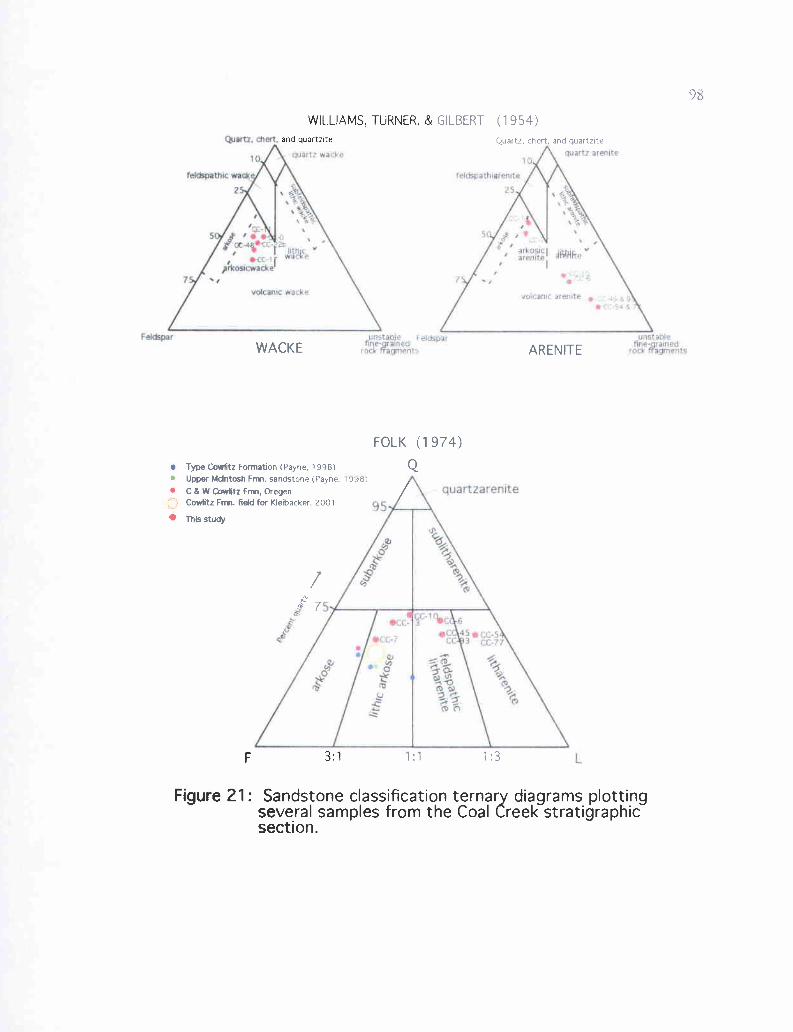
rainracrrn'rrr
quart? arenpre
?elSpathsc wadri
quart: wa
FscSpar
95-
quartzar enite
L
GILBERT (1954)Quartz, chert, and quartzite
(F'ayne. 1998)
lti
WILLIAMS, TURNER, &
and quartzite
F 3:1
Figure 21: Sandstone classification ternary diagrams plottingseveral samples from the Coal Creek stratigraphicsection.
WACKE ARENITE
Type Cowlitz Formation (Payne, 1998)Upper McIntosh Fmn. sandstone (Paynn
C & W Cowlitz Frm, OregenCowlitz Fnn. field for Kleibacker, 2001
FOLK (1974)
Q
99
rounded basaltic clasts, and most Grays River volcaniclastic beds throughout the study area
have at least a minor micaceous, arkosic component. Grays River volcaniclastic interbeds, in
the Coal Creek section (Tgvs2) in particular, contain a high arkosic mineral component (10-
50%). Rare pure arkosic or pure basaltic volcaniclastic beds in the Coal Creek section are
considered here to be end members of a compositional series, in which nearly every
combination of the two sediment compositional types occurs. Sandstones and siltstones with
less than 50% basaltic component (but more than 25% basaltic fragments) are considered
lithic arkoses of the Cowlitz Formation (map unit Tc, Plates 1 and 2). Those with more than
50% basalt lithics are included in the Upper Grays River Volcaniclastic unit (map unit Tgvs2,
Plates 1 and 2). Arkosic lithics are more than 75% feldspar, quartz, and mica. Several lithic
arkosic arenites, wackes, and Grays River volcaniclastic beds are plotted on ternary diagrams
based on the classification schemes of Williams and others (1954) and Folk (1974)(Figure
21).
Lithic arkoses and carbonaceous strata
Massive to poorly bedded sandstones possibly representing lowstand submarine
channels (lithofacies j), or wave-reworked delta front sands (lithofacies g) are common in the
upper 300 meters of the Coal Creek section. Five thin sections from these lithofacies were
prepared, and one sample (CC-7) was impregnated with blue dye and point counted (Figure
22b, Appendix IV). Thin section sample CC-13 (Figure 22a), illustrating composition typical
for these lithofacies when a relatively small percentage (<10%) of basaltic clasts are present, is
well-sorted, and classifies as an arkosic arenite in the classification of Williams and others
(1954) and lithic arkose in Folk's (1974) classification
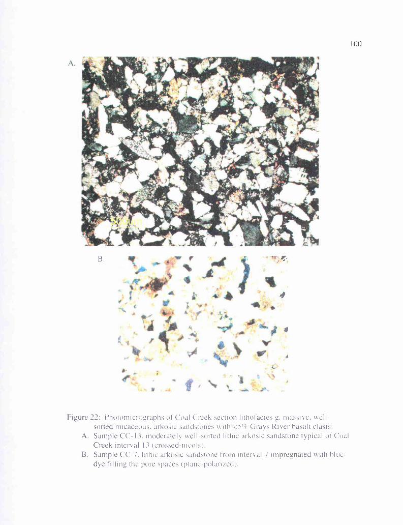
It 'are- r
ttA k v
44
B.
4
Figure 22: Photomicrographs of Coal Creek section lithotacies g, massive. well-sorted micaceous. arkosic sandstones vith <S'," Grays River hasalt clasts
A. Sample CC- 13, moderately "ell sorted lithic ar kosic sandstone typical of CoalCreek interval 13 (crossed-111C01")
B. Sample CC-7, lithic arkosic sandstone from interval 7 impregnated with hlue-dye tilling the pore spaces (plane-polartied)
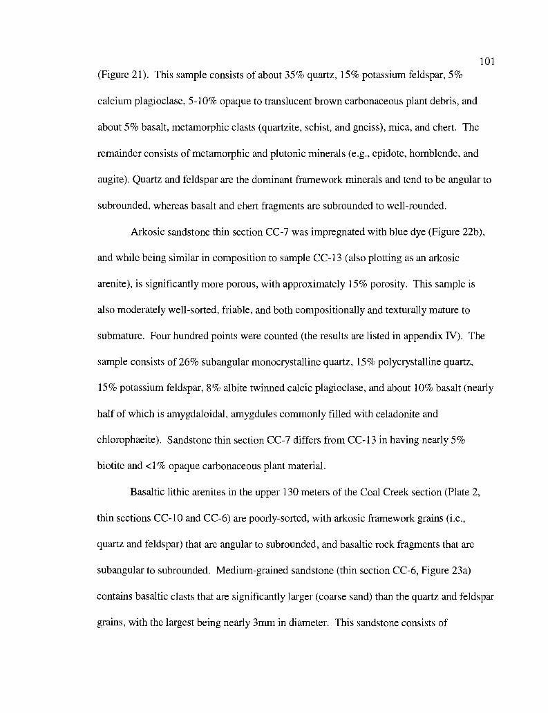
101
(Figure 21). This sample consists of about 35% quartz, 15% potassium feldspar, 5%
calcium plagioclase, 5-10% opaque to translucent brown carbonaceous plant debris, and
about 5% basalt, metamorphic clasts (quartzite, schist, and gneiss), mica, and chert. The
remainder consists of metamorphic and plutonic minerals (e.g., epidote, hornblende, and
augite). Quartz and feldspar are the dominant framework minerals and tend to be angular to
subrounded, whereas basalt and chert fragments are subrounded to well-rounded.
Arkosic sandstone thin section CC-7 was impregnated with blue dye (Figure 22b),
and while being similar in composition to sample CC-13 (also plotting as an arkosic
arenite), is significantly more porous, with approximately 15% porosity. This sample is
also moderately well-sorted, friable, and both compositionally and texturally mature to
submature. Four hundred points were counted (the results are listed in appendix IV). The
sample consists of 26% subangular monocrystalline quartz, 15% polycrystalline quartz,
15% potassium feldspar, 8% albite twinned calcic plagioclase, and about 10% basalt (nearly
half of which is amygdaloidal, amygdules commonly filled with celadonite and
chlorophaeite). Sandstone thin section CC-7 differs from CC-13 in having nearly 5%
biotite and <1% opaque carbonaceous plant material.
Basaltic lithic arenites in the upper 130 meters of the Coal Creek section (Plate 2,
thin sections CC-10 and CC-6) are poorly-sorted, with arkosic framework grains (i.e.,
quartz and feldspar) that are angular to subrounded, and basaltic rock fragments that are
subangular to subrounded. Medium-grained sandstone (thin section CC-6, Figure 23a)
contains basaltic clasts that are significantly larger (coarse sand) than the quartz and feldspar
grains, with the largest being nearly 3mm in diameter. This sandstone consists of
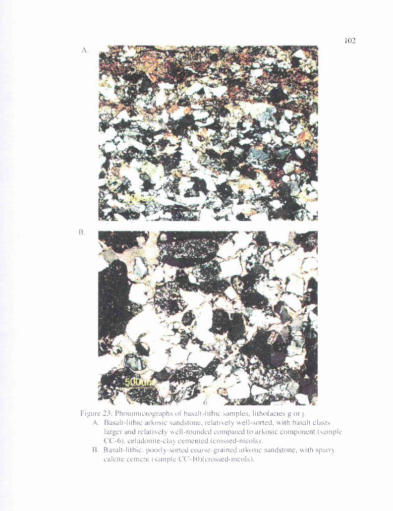
—
I
A.
Figure 23: Photomicrographs of hasalt-lithic samples, lithofacies g or- i.A. Basalt-lithic arkosic sandstone, relatively well-sorted, with basalt class,
larger and relatively well-rounded compared to arkosic component (sampleCC-6), celadonite-clay cemented (crossed-nicols).
B Basalt-lithic, poorly-sorted coarse-grained arkosic sandstone, with sparrycalcite cement (sample CC-10)(crossed-nicols)
3.
103
approximately 25% quartz (both mono- and polycrystalline), 5% potassium feldspar (1:1
ratio of orthoclase and microcline), 5% albite twinned calcic plagioclase, and about 5%
quartzite. Just less than 50% of the sample consists of volcanic lithic clasts, 35% of which
are highly altered aphyric basalt or contain randomly oriented plagioclase microlites, 20% is
pilotaxitic basalt, and 5% consists of pumice lapilli. The remainder of the sample consists
of carbonaceous mudstone clasts and chert. Sandstone CC-10 (Figure 23b) is a poorly-
sorted, coarse-grained sandstone to fine pebble conglomerate and classifies as a (borderline)
lithic arkose in Folk's (1974) classification and a volcanic arenite in Williams and others
(1954) classification. Framework grains include approximately 30% monocrystalline
quartz, 5% polycrystalline quartz, 10% potassium feldspar, 5% calcic plagioclase, and
minor mica (<1%), schist, and gneiss. About 25% of the sample consists of basalt clasts
with randomly oriented plagioclase microlites in an aphyric matrix, and 25% basalt with
pilotaxitic flow texture of plagioclase microlites, about 10% of which is amygdaloidal. The
remainder of the framework grains are mostly metamorphic quartzite and white chert, and
the sample is well-cemented with sparry calcite.
All thin section samples of lithofacies g and j show some degree of alteration of
volcanic and feldspar clasts, compaction of ductile minerals, and a cement rind that can be
either smectite clay or sparry calcite. Porosity varies greatly. Sample CC- 13 (Figure 22a)
shows a relatively high degree of compaction, whereas sample CC-7 (Figure 22b) shows
little compaction, with a high degree of tangential contacts between brittle subangular
quartz and feldspar grains. Due to compaction and smectite clay cement rimming the
grains, little primary intergranular porosity or pore throat spaces remain in most samples of
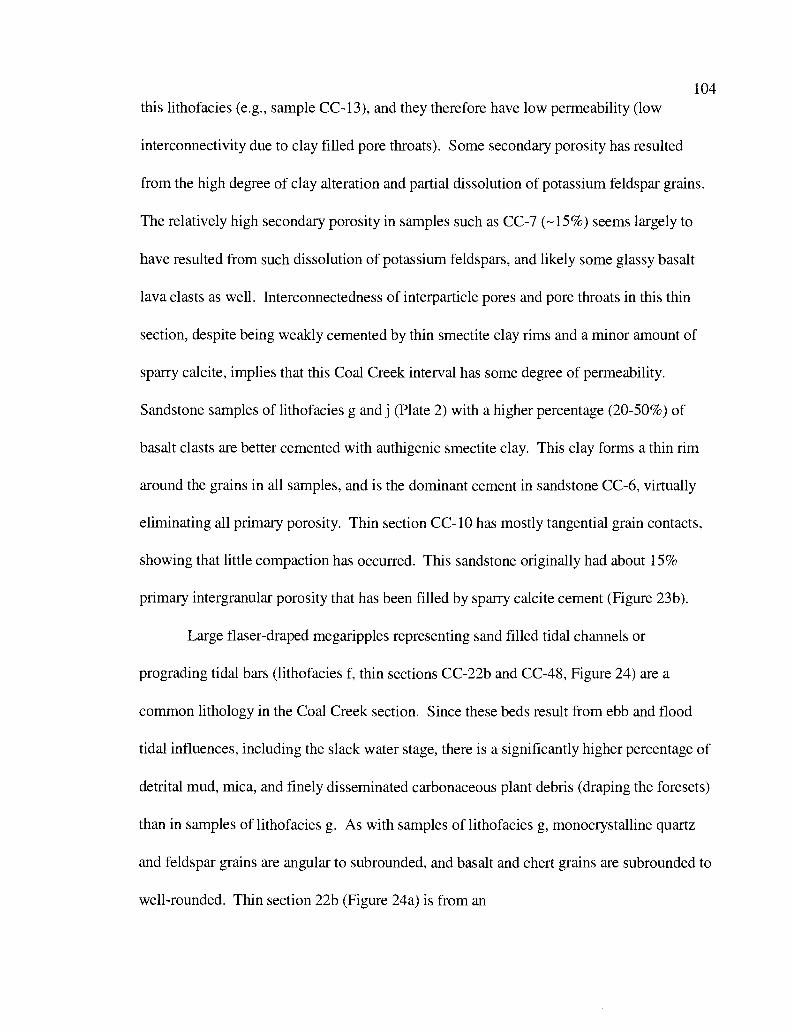
104
this lithofacies (e.g., sample CC- 13), and they therefore have low permeability (low
interconnectivity due to clay filled pore throats). Some secondary porosity has resulted
from the high degree of clay alteration and partial dissolution of potassium feldspar grains.
The relatively high secondary porosity in samples such as CC-7 (-15%) seems largely to
have resulted from such dissolution of potassium feldspars, and likely some glassy basalt
lava clasts as well. Interconnectedness of interparticle pores and pore throats in this thin
section, despite being weakly cemented by thin smectite clay rims and a minor amount of
sparry calcite, implies that this Coal Creek interval has some degree of permeability.
Sandstone samples of lithofacies g and j (Plate 2) with a higher percentage (20-50%) of
basalt clasts are better cemented with authigenic smectite clay. This clay forms a thin rim
around the grains in all samples, and is the dominant cement in sandstone CC-6, virtually
eliminating all primary porosity. Thin section CC-10 has mostly tangential grain contacts,
showing that little compaction has occurred. This sandstone originally had about 15%
primary intergranular porosity that has been filled by sparry calcite cement (Figure 23b).
Large flaser-draped megaripples representing sand filled tidal channels or
prograding tidal bars (lithofacies f, thin sections CC-22b and CC-48, Figure 24) are a
common lithology in the Coal Creek section. Since these beds result from ebb and flood
tidal influences, including the slack water stage, there is a significantly higher percentage of
detrital mud, mica, and finely disseminated carbonaceous plant debris (draping the foresets)
than in samples of lithofacies g. As with samples of lithofacies g, monocrystalline quartz
and feldspar grains are angular to subrounded, and basalt and chert grains are subrounded to
well-rounded. Thin section 22b (Figure 24a) is from an
I
24: Photomicrographs of sandstones of lithotacies f, flaser-drapedsigmoidal meganpples of a tidal channel or tidal bar (crossed-nicols).
A. Mud and carbon-rich foreset of a I-meter thick flaser drape (CC-22b).13 Foreset from a megaripple of interval 48 (C('-48) Note compacted muscov ite
flake and high percentage of dark carbonaceous plant debris
106
approximately 20-cm thick sigmoidal sandstone bed in Coal Creek (not from the IS
outcrop on Coal Creek Road where this same interval is better exposed), that has -1-cm
thick flaser-draped foresets. This sample is moderately well-sorted and consists of about
35% quartz (30% monocrystalline and 5% polycrystalline), 5% mica, 15% clay and
chlorite flakes combined, 10% carbonaceous plant debris, 10% potassium feldspar, 5%
albite twinned calcic plagioclase, 10% basalt lava fragments, and -7% chert, classifying
as a micaceous arkosic wacke (Figure 21). Thin section CC-48 (Figure 24b) is from a 1-
meter high, flaser-draped, sigmoidally cross-bedded, medium-grained sandstone. Four
hundred points were counted, and the results are listed in appendix IV. About 40% of the
sample consists of (mainly) monocrystalline quartz, 10% carbonaceous plant material,
and 14% altered basalt clasts. This composition is similar to samples of lithofacies g and
j, but with a higher percentage of mica and carbonaceous plant material constituting up to
50% of the flaser-drapes, classifying as a carbonaceous arkosic/volcanic wacke (Figure
21). In both these samples, feldspars and volcanic fragments are clay altered, and chlorite
and clay have formed pseudomatrix in flaser-draped laminae. Ductile contorted micas
and chlorite show a substantial amount of compaction between the quartz and feldspar
grains. Thin section CC-22b is weakly cemented with smectite clay, and porosity and
permeability are near zero. Thin section CC-48 is compacted to a lesser degree, and is
well indurated by both greenish brown smectite clay and sparry calcite cement.
Lithofacies e (represented by thin sections CC-17 and CC-11) is a heterolithic
tidal rhythmite facies produced in a bay or estuarine setting, characterized by alternating
thin beds or laminae of wavy- or micro-cross laminated, fine- to medium-grained
107
sandstone, and drapes of carbonaceous and micaceous laminae or thin beds of darker gray
claystone. This lithofacies represents a lower energy depositional environment than
lithofacies f and g, and as such, has a higher percentage of mudstone, mica, and
carbonaceous plant debris. Lithofacies e also has a lower percentage (typically < 5%) of
larger basalt clasts.
Both samples are micro-cross laminated, with thin sandstone beds averaging
about 2cm in thickness, and framework quartz and feldspar grains that are subangular to
subrounded. Dark foreset laminae are silty mudstone, containing arkosic silt-sized clasts
in an abundant clay matrix. Four hundred points were counted in thin section CC-17
(Figure 25a, Appendix IV). The composition is similar to CC-11, and consists of about
40% quartz (35% monocrystalline), 11% biotite, 5% muscovite, 13% potassium feldspar
(nearly all orthoclase), 6% albite twinned calcic plagioclase, 15% contorted carbonaceous
plant debris along laminae, and about 10% clay matrix, classifying as an arkosic wacke
(Figure 21). This sample was also impregnated with blue dye, and has less than 5%
porosity. Thin section CC-11 (Figure 25b) has a higher percentage of biotite (-15%), and
only about 5% brownish clay matrix. Flaser-draped laminae are up to 70% carbonaceous
plant debris, and nearly pure coal (fusane) laminae occur intermittently. Potassium
feldspars (mainly orthoclase) in this lithofacies are highly altered, some completely to
clay, and all feldspar grains have at least a thin rim of clays. Compaction is relatively
high in these samples, warping and contorting the biotite, and most biotites are partly to
completely altered to greenish chlorite. Carbonaceous laminae have been squeezed
between grains in place to become a pseudomatrix.
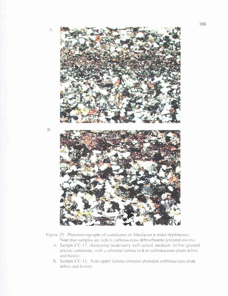
1?
108
ob4
7_Ilk Zwt %x
B.
Figure 25: Photomicrographs of sandstones of lithofacies e (tidal rhythmites).Note that samples are rich in carbonaceous debris/hiotite (crossed-nicols)
A Sample CC-17, illustrating moderately well-sorted, medium- to fine-grainedarkosic sandstone, with a siltstone lamina rich in carbonaceous plant debrisand hiotite.
B Sample CC- I I Note upper lamina contains abundant carbonaceous plantdebris and hiotite
109
Intervals 0 through 2 of the Coal Creek section (constituting the upper -45 meters,
Plate 2) have a unique lithology. The depositional environment is uncertain, but could
represent distal (deeper water) tidal rhythmites (lithofacies e), or more likely shelfal
turbidites (lithofacies k). This lithology consists of 0.5-2-mm thick, fine-grained sandstone
laminae alternating with dark colored carbonaceous and micaceous 0.5-2-mm thick clayey
siltstone laminae (thin section CC-0, Figure 26a). Sandstone laminae consist of about 40%
quartz (-35% monocrystalline and 5% polycrystalline), 15% biotite, 5% muscovite, 10%
potassium feldspar (mostly orthoclase), 5% plagioclase, 10% nearly opaque carbonaceous
plant debris, 5% basalt lava (mostly randomly oriented plagioclase microlites) and about
10% clay matrix. Carbonaceous siltstone laminae consist of about 40% monocrystalline
quartz, 20% biotite, 10% muscovite, 10% potassium feldspar, 5% plagioclase, and 15%
carbonaceous material. Some dark laminae are more than 70% biotite and carbonaceous
plant material. This sample classifies overall as a micaceous, carbonaceous arkosic wacke
(Figure 21). An unusual feature of interval 0 of the Coal Creek section is that the grain size
is commonly larger in the muddy, carbonaceous drapes. Thin section CC-0 is calcite
cemented, but clay mineral alteration products and carbonaceous plant material, due to
compaction, have formed pseudomatrix. Ductile micas are bent and contorted due to
compaction during burial.
One thin section was prepared of a coal/carbonaceous shale bed exposed in the
roadcut on Coal Creek Road, with lithology typical for lithofacies h of the Coal Creek
section (IS coal, Figure 26b). This coal consists of wavy laminae of opaque black charcoal
(plant fusane or inertinite) and some wavy laminae of translucent reddish vitrinite.
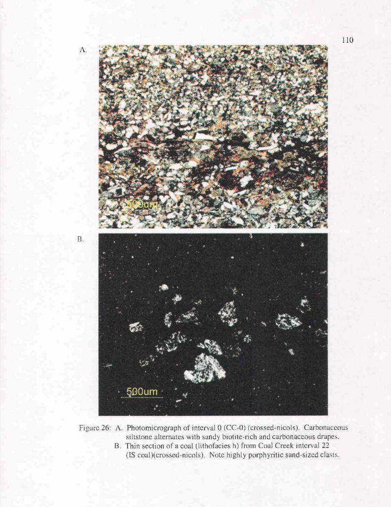
- -=
--,
.—
Figure 26: A. Photomicrograph of interval 0 (CC-0) (crossed-nicols). Carbonaceoussiltstone alternates with sandy biotite-rich and carbonaceous drapes.
B. Thin section of a coal (lithofacies h) from Coal Creek interval 22(IS coal)(crossed-nicols). Note highly porphyritic sand-sized clasts.
111
There is also a component (-10%) of arkosic siltstone, and one thin lamina containing
medium- to coarse-grained, subangular to subrounded clasts of highly plagioclase
porphyritic volcanic lithic sand. In the roadcut, this coal bed is associated with several
silicic, tuffaceous interbeds, so the porphyritic clasts may also be derived from a western
Cascade source. The lithology of these clasts is similar to that found in Cascade-derived
basaltic andesite and andesite within the study area.
Upper Grays River Volcaniclastic Interbeds (Tgvs2)
Over fifteen beds of Grays River volcaniclastics of 1-meter thickness or greater
occur as interbeds of the arkosic Cowlitz Formation within the Coal Creek stratigraphic
section (Plate 2), particularly in informal unit 2. The thickest volcaniclastic at the base of
unit 2 has a maximum thickness of nearly 35 meters. These units range from siltstone to
cobble-bearing, grain-supported, gravel conglomerates, and commonly contain shallow-
marine to freshwater fossil molluscan assemblages. In fact, about 90% of fossil
assemblages collected for this study were found in Coal Creek intervals that are greater
than 60% basalt clasts. Grays River basalt clasts with a pilotaxitic flow texture of
plagioclase microlites are also present to some degree in nearly all dominantly arkosic or
carbonaceous beds of the Cowlitz Formation in the study area. Likewise, interbeds of
arkosic Cowlitz Formation sandstone and siltstone occur throughout the area in the Lower
Grays River Volcaniclastic unit (Tgvs 1) that underlies most of the dominantly arkosic
Cowlitz Formation in the area, and also occur in the thick Upper Grays River
Volcaniclastic interbeds in the Coal Creek section (Tgvs2).
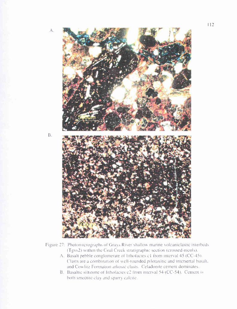
r
A
B.
Figure 27: Photomicrographs of Grays River shallow marine volcaniclastic interheds(Tgvs2) within the Coal Creek stratgraphic section (crossed-nicols)
A Basalt pehhle conglomerate of lithotacies cl from interval 45 (CC-45).Clasts are a combination of well-rounded pilotaxitic and intersertal hasalt,and Cowlitz Formation arkosic clasts. Celadonite cement dominates.
B. Basaltic siltstone of lithotacies c2 from interval 54 (CC-54). Cement ishoth smectite clay and spare calcite
113
Basalt conglomerate samples (CC-45 and CC-93, lithofacies cl) are poorly-sorted
and consist of well-rounded to subangular framework clasts that are a mixture of
pilotaxitic, massive, and scoriaceous basalt up to 0.5 cm in diameter. These samples also
contain up to 30% micaceous, arkosic minerals (quartz, feldspar, and mica), and classify
as feldspathic litharenites in Folk's (1974) classification, and volcanic arenite in Williams
and others (1954) classification (Figure 21). They consist of about 10% quartz
(dominantly monocrystalline, but some clasts are polycrystalline), <I% mica (biotites are
altered to pleochroic green chlorite), 10% potassium feldspar, 5% plagioclase, and about
60% basalt lava clasts (50% with intersertal texture and scoriaceous, and 10%
pilotaxitic). A high degree of clay alteration has occurred in these samples. Thin section
CC-45 (Figure 27a) is tightly cemented with smectite clay, and most basaltic clasts have
at least a thin rim of clay alteration. Augite phenocrysts within basaltic clasts are altered
to brownish clay. This sample was also impregnated with blue dye, showing that most of
the porosity is due to small fractures, but some is due to secondary dissolution and
alteration of augite. Thin section CC-93 is highly clay altered, with approximately 20%
of the clasts nearly dissolved away. Many of the resulting pore spaces are filled with
clay. Vesicle space in the scoriaceous clasts and much of the altered clay matrix is filled
with or replaced by sparry calcite cement.
Basaltic sandy siltstone samples (CC-54 and CC-77c, lithofacies c2) are well
indurated and thinly-laminated. Lighter laminae consist of a higher percentage of calcite
cement, and darker laminae have less calcite cement and more silt-sized basaltic clasts.
This facies consists of 60-70% basalt clasts with intersertal texture, and about 10%
114
monocrystalline quartz derived from the extrabasinal Cowlitz Formation arkosic source.
These sandstones classify as litharenite in Folk's (1974) classification and as volcanic
arenite in the classification of Williams and others (1954)(Figure 21). The extent of clay
alteration can be high (CC-54, Figure 27b) or low (CC-77c), and sparry calcite cement
varies from about 15% (CC-54) to approximately 30% (CC-77c), explaining why this
lithofacies is resistant and cliff-forming within the creek (particularly interval 68 where it
forms a four-meter high waterfall, see Figure 8a). Thin section CC-77c contains <1%
calcareous broken shell fragments.
X-ray Diffraction
Three micaceous arkosic sandstones of the Cowlitz Formation and one Grays
River basalt volcaniclastic interbed from the Coal Creek stratigraphic section were
analyzed by Dr. Reed Glasmann at Oregon State University by x-ray diffraction to further
illustrate the mineralogy and diagenetic history of the Paleogene sedimentary rocks in the
study area. Among these samples were flaser-draped tidal megaripples from interval 22
(sample CC-22d, lithofacies f), and flaser-draped tidal rhythmites from interval 48
(sample CC-48, lithofacies e). The <15 µm fraction shows strong peaks (intensity) for
quartz, muscovite, and anorthite (feldspar of volcanic origin) as expected for the Cowlitz
Formation (Figure 28), illustrating the Rocky Mountain provenance of these sediments.
A peak for calcite also indicates that sample C-22d is somewhat calcite cemented, as seen
in several thin sections of this lithofacies. A fairly strong peak (2,000 to 3,000 counts) for
chamosite (iron-rich chlorite) in sample 22d shows that some of the larger size fraction
consists of altered biotite, as would be expected from the flaser-draped foresets of the
115
megaripples. For the clay fraction (<2gm), sample 22d (Figure 29), and CC-48 (Figure
32) show strong peaks for smectite, as expected from the degree of clay-rim cementation
observed in thin section. CC-22d shows a fairly strong peak (5,000 counts) for chlorite,
whereas sample CC-48 shows a much stronger peak (-7,000 count). This is a result of
the higher percentage of flaser-draped micaceous mudstone in lithofacies e, often
representing 50% or more of the sample. Biotite in the drapes has altered to chlorite. The
iron-rich smectite (nontronite) is a low temperature smectite, suggesting that the Cowlitz
Formation sediments in Coal Creek have not undergone much geothermal heating, or
flash point heating by Grays River intrusions. This also suggests that thermal maturation
of source rocks in the area may be low. Sample CC-80 is from a relatively clean
sandstone (low percentage of flaser-draped carbonaceous mud and mica). The <15µm
fraction for this sample (Figure 30) shows strong peaks for quartz, muscovite,
montmorillonite and chamosite (chlorite). The clay fraction is relatively high in
montmorillonite (Figure 31).
The Grays River basalt volcaniclastic sample from interval 79 (CC-79), for the
<15µm fraction, shows a comparatively weak peak for quartz, and a comparatively high
peak for anorthite, suggesting that this interbed has a very small Cowlitz Formation
micaceous, arkosic extrabasinal component. The <2µm clay fraction (Figure 33) shows a
high peak for iron-rich smectite, and essentially no chlorite. The lack of chlorite (altered
biotite) also illustrates the low component of micaceous arkose, and the lack of tidal slack
water influence.
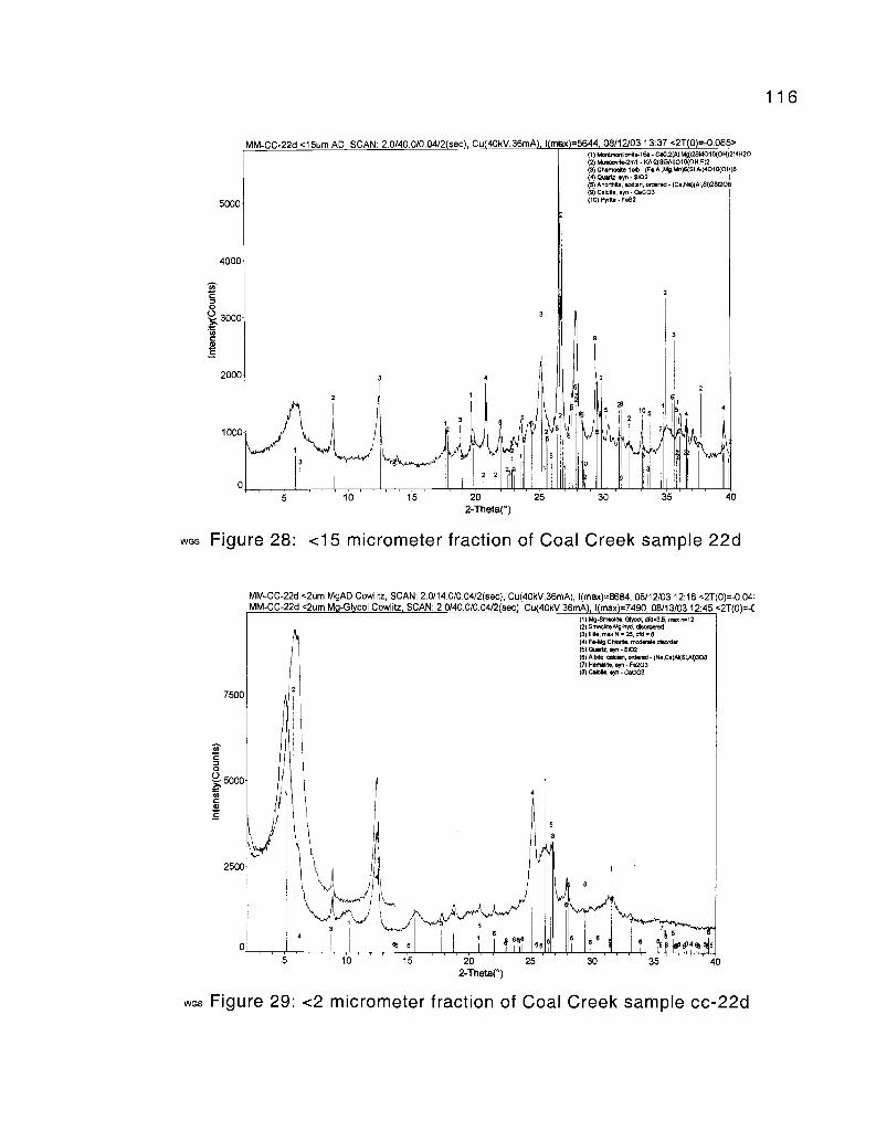
116
5000
4000
0
2
2000
1000
WGS
2
10 15
3
2
15
-425
93
2
5
it
21 1
24
11 1, 1 ' ii 111 mu(m 111
30 35 40
Figure 28: <15 micrometer fraction of Coal Creek sample 22d
MM-CC-22d <15um AD SCAN: 2.0/40.0/0.04/2 sec Cu 40kV,36mA 1 mex =5644 08/12/03 13:37 <2T(O)=-0.08 >(1) Mont orinannr/58 - CoO.2(AI,M9)2SI4010(OH)214H20(2) Muscwfe-2m1 - KA12(Si3AI)0(0(OH,F)2 1
(3) Chamoets-1 db - (F.,AI,Mg,Mn)6(SI,AI)4010(OH)8(4) 0usrtz, syn - 5102
1
(5) Anonht, ecdlan, ordered - (Ca.Ns)(AI,Si)2S1208(9) Calcite, syn - C,C03(10) Pyrhe - FSS2
3
MM-CC-22d <2um MgAD Cowlitz, SCAN: 2.0/14.0/0.04/2(sec), Cu(40kV,36mA), I(max)=8684, 08/12/03 12:16 <2T(0)=-0.04:MM-CC-22d <2um Mg-Glycol Cowlitz, SCAN: 20/40,0/0.04/2(sec) Cu 40kV 36mA I max =7490 08/13/03 12:45 <2T(0)=-C
(1) Mg-Smactha, Gyod, dfd-3.5, mss n-12(2) Smxtde Mg-hyd, disordered( 3 ) mas N - 25, dfd e 8(4) Fe-M9 Chlorite, Moderate disorder(5) Quedz, syn - Si02(6) Albite, celden, ordered - (Ne,Ce)AI(SIAI)308(7) Herrabts, 8yn - Fe203(8) Caldt , vin - CaC03
75001
25001
0
4
6eA
10 15 20 252-Theta(°)
es 5 I 435 40
WGS Figure 29: <2 micrometer fraction of Coal Creek sample cc-22d
2-Theta(°)
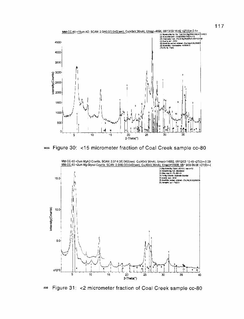
MM-CC-80 <15um AD, SCAN: 2 0/40 0/004/2(sec) Cu(40kV 36rnA) I(max)=4695 08/13/03 15:42 <2T(0)=-0.1>
4500
4000
3500
3000c0
2500
cc 2000
WGS
1500
1000
500
0
1
5
5 6
M
(1) Mo borillonae-15a- CaO.2(Ai,My)2s14010(OH)214H20(2) MwwNte-2m1 - KAR(S13AI)O10(OH,F)2 1
(3) CMnwdte-loih - (Fe,AI,Mg,Mn(6(SI,AI)4010(OH)8(4) Owriz, syn - SI02 I
(5) AnorthIe, eodlan, Ordered - (Ce,Ne)(AI,Si)25120(6) Mlcroctne, Intermediate - KNSI308(10) Pyrite - F.S2
25
0
30
2
5
10
r'Yvll
3i35
Figure 30: <15 micrometer fraction of Coal Creek sample cc-80
15.0
5.0
x1043
MM-CC-80 <2um MgAD Cowlitz, SCAN: 2.0/14.0/0.04/2(sec), Cu(40kV,36mA), I(max)=14882, 08/12/03 10:49 <2T(0)=-0.03-MM-CC-80 <2um Mg-Glycol Cowlitz, SCAN: 2.0140.0/0.04/2sec Cu 40kV 36mA I max =13908, 08/13/03 09:06 <2T(0)=-C
(I) M5-Smectie, Glycol, dfd=3.5, tram n=12(2) Smedlte ", disordered(3)IYXe,maxN=25,dfd=8(4) Fe-Mg Chlorite, moderate disorder(5) Quartz, syn - S102(6) Anorth6e, sodian, ordered - (Ce,Na)(AI,Si)2S1208(8) Hematite, syn - Fe203 I
5 r 10 15
8 °
20 25
2-Theta(°)
6
30
117
VGS Figure 31: <2 micrometer fraction of Coal Creek sample cc-80
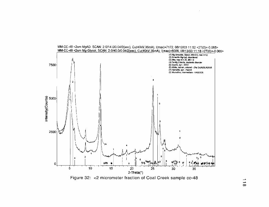
7500
MM-CC-48 <2um MgAD, SCAN: 2.0/14.0/0.04/2(sec), Cu(40kV,36mA), I(max)=7172, 08/12/03 11:52 <2T(0)=-0.065>MM-CC-48 <2um Mg-Glycol, SCAN: 2.0/40.010.04/2 sec , Cu 40kV 36mA), 1 max =6009, 08/13/03 11:18 <2T 0 =-0.065>
(1) Mg-Smectite, Glycol, d?d=3.5, max n=12(2) Smectite Mg-hyd, disordered(3) IIIfte, max N = 25, did = 8(4) Fe-Mg Chlorite, moderate disorder(5) Quartz, syn - S102(6) Albfte, calcian, ordered - (Na,Ca)AI(Si,AI)308(7) Hematite, syn - Fe203(9) Microcline, intermediate - KAISi3O8
1
5
2500
1
r-45
3 "4M"'r
9 r 73 53
69% a 9 T 66
66 6 9 a08611
10 15 20 25 30 35
2-Theta(°)
Figure 32: <2 micrometer fraction of Coal Creek sample cc-48
CO
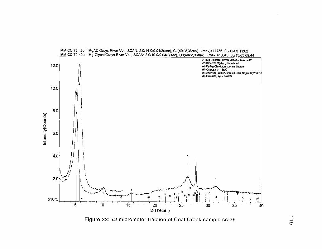
MM-CC-79 <2um MgAD Grays River Vol., SCAN: 2.0114.0/0.04/2(sec), Cu(40kV,36mA), I(max)=11756, 08/12/03 11:02MM-CC-79 <2um Mg-Glycol Grays River Vol., SCAN: 2.0/40.0/0.04/2(sec , Cu(40kV,36mA), I(max =10048, 08/13/03 09:44
(1) Mg-Smectfte, Glycol, did=3.5, max n=12(2) Smectibe PAg-hyd, disordered
12.0 (4) Fe-Mg CMbr a moderate disorder(5) Quartz, syn - Si02(6) Anorthlte, sodian, ordered - (Ca,Na)(AI,Si)2Si20t(8) Hematite, syn - Fe203
10.0
8.0d
6.0d
4.W
2.0
2
1
1
4
5
4
1
68 6
6 ffi8 t 8 6 88
6666 6
5 4
10 15 20 25 30 35 402-Theta(°)
Figure 33: <2 micrometer fraction of Coal Creek sample cc-79
ea
Sequence Stratig_raphy and Correlation to the Cowlitz Type Section120
Sequence stratigraphy is the study of genetically related facies within a
framework of chronostratigraphically significant surfaces (Van Wagoner et al., 1992).
Before sequence stratigraphy was understood, most studies were based on
lithostratigraphic rather than time stratigraphic correlation. This relatively new (within
the last ~20 years) approach to studying sedimentary rock successions, places
sedimentary units into a hierarchical classification of progressively thicker
chronostratigraphic units (representing increasing duration of deposition) that includes,
laminae, lamina sets, beds, bedsets, parasequences, parasequence sets, and sequences
(Van Wagoner et al., 1992). Such units are cyclic and result from relative changes or
fluctuations in sea level, and are classified according to the magnitude (scale and
duration) of the cycles (i.e., 3rd 2nd and 1st order cycles). A sequence as defined by
Mitchum (1977) is a relatively conformable succession of strata that are genetically
related, and bounded by unconformities or their correlative conformities. Boundaries
between sequences occur during periods of relative falls in sea level, and the
unconformity produced (the sequence boundary) separates facies that are unrelated to
each other both physically and temporally. However, seaward in the deeper parts of the
basin a conformity may exist between sequences. Such sequences can be subdivided
based on transgressive surfaces and maximum flooding surfaces, and are composed of
multiple parasequences forming parasequence sets.
A parasequence (typically tens of meters thick) is defined as a set of beds that are
genetically related and relatively conformable, and bounded by marine flooding surfaces
(Van Wagoner et al., 1992). Parasequences have been defined in a variety of marine and
121
nonmarine depositional settings including shelf, estuarine, tidal, beach, and coastal plain
(Van Wagoner, 1985). Vertical facies associations within parasequences, either
coarsening- and thickening- or fining- and thinning-upward, are interpreted by Van
Wagoner et al. (1992) to represent progradational bedsets deposited in shoaling-upward
depositional environments, which are abruptly overlain by the basal marine flooding
surface of the next parasequence. A parasequence set is a succession of genetically
related parasequences that form a characteristic stacking pattern, and are typically
bounded by major marine flooding surfaces. The stacking pattern can be: 1)
progradational, where each parasequence in the set can becomes thicker and coarser
upward, or thinner and finer upward, 2) retrogradational, where parasequences become
thinner and finer upward, or 3) aggradational, where subsidence keeps pace with
sedimentation rate and relatively little change in bed thickness and coarseness occurs
upward. Both parasequences and parasequence sets form in response to relatively rapid
increases in water depth related either to eustatic and/or local tectonic basinal changes.
Each depositional sequence between sequence boundaries can also be divided into
stratigraphic units known as systems tracts which consist of a parasequence set, and are
defined as a linkage of contemporaneous depositional systems. Such systems tracts can
be lowstand (LST), transgressive (TST), highstand (HST), or shelf margin (SMST),
depending on whether they form during relatively low water, increasing water depth, or
high water respectively during a depositional cycle.
Sequence stratigraphic analyses have been applied to the study of sedimentary
units within the Tertiary Cascadia forearc basin of southwest Washington and northwest
Oregon by Armentrout (1987), Ryu and Niem (1992), as well as graduate students from
122
Oregon State University (Payne, 1998; Kleibacker, 2001). Armentrout (1987) defined
four unconformity-bounded sequences in the Tertiary formations of southwest
Washington. These sequences are second order megacycles (-5 to 50 m.y. in duration)
separated by three tectonically controlled regional sequence boundaries (unconformities
representing relative sea level fall resulting from regional forearc tectonics). The
McIntosh and Cowlitz Formations, as well as the Grays River Volcanics, were included
by Armentrout (1987) in his 2nd order sequence II, between regional unconformities 4 and
3, which is estimated to be 6 m.y. in duration. Payne (1998) in his study of the type
Cowlitz Formation section in Olequa Creek, further divided the -1000-meter thick
middle Eocene McIntosh Formation and 1,240-meter thick late-middle Eocene Cowlitz
Formation collectively into five 3rd order cycles that ranged from 1 to 5 m.y. in duration
with some radiometric dating and microfossil control. He was able to determine these
durations by calculating the average sedimentation rate of a -1400 meter section
spanning the base of the upper McIntosh Formation to near the middle of the Cowlitz
Formation (in his informal unit 3). The sequence boundary between the upper and lower
McIntosh Formation was correlated to the eustatic sequence boundary of Haq et al.
(1987) at 42.5 Ma, and the upper boundary was determined by dating a tuff bed in unit 3
at 38.9 Ma. This produced an average sedimentation rate of 39 cm/1000 yrs. Similarly,
Kleibacker (2001) determined an average sedimentation rate of 22 cm/1000 yrs in the
Cowlitz Formation of his Germany Creek section by using the 42.5 Ma eustatic sequence
boundary at the base, and a Grays River lava flow dated at 39.36 Ma at the top. Using
the average of these two findings of -30 cm/1000 yrs (and the known durations of
magnetic chrons, Figure 46) the Coal Creek section likely took -2 m.y. to be deposited.
123
In this study, short-term thinning- and fining-upward, and coarsening-and
thickening-upward (shoaling-upward) cycles define 4th order parasequences (of -100,000
year duration) that stack to form 3rd order regional sequences (Cowlitz Formation cycles
3, 4, and 5 of Payne, 1998) of 1 to 5 m.y. duration. Lithologically, the Coal Creek
stratigraphic section of this study correlates well to the type section of the Cowlitz
Formation as described by Payne (1998) in Olequa Creek near Vader (Figure 34).
Informal unit 1 of the Cowlitz type section contains multiple coal beds in its upper 100
meters, which are immediately overlain by -30 meters of Grays River basalt
volcaniclastic representing the base of Payne's unit 2. Unit 2 also contains multiple
interbeds of basalt volcaniclastic throughout. The same general stratigraphy and
lithology occurs deep in the Coal Creek section, where at least 2 thick coals (coals A and
B) immediately underlie a -35-meter thick Grays River Basalt volcaniclastic interbed
(Tgvs2). Overlying this thick volcaniclastic are multiple basalt pebble conglomerate and
coarse-grained sandstone interbeds, as well as thick shallow marine arkosic sandstone
sequences, similar to Payne's informal unit 2. This similarity in lithology suggests that
the lower -340 meter portion of the Coal Creek section is lithologically correlative to
informal units 1 and 2 of the type section as described by Payne (1998). Overlying units
1 and 2 of the type section is Payne's unit 3, characterized by abundant tidal sandstone
facies and coals. The same general lithology occurs in the Coal Creek section from -310
to 145 meters depth.
In the type Cowlitz Formation section, the shallow marine to coastal plain facies
of unit 3 is overlain by about 160 meters of the comparatively deep-water facies of unit 4.
Except for the nearly 10 meters of lower shoreface to shelf beds of intervals 20, 18, and
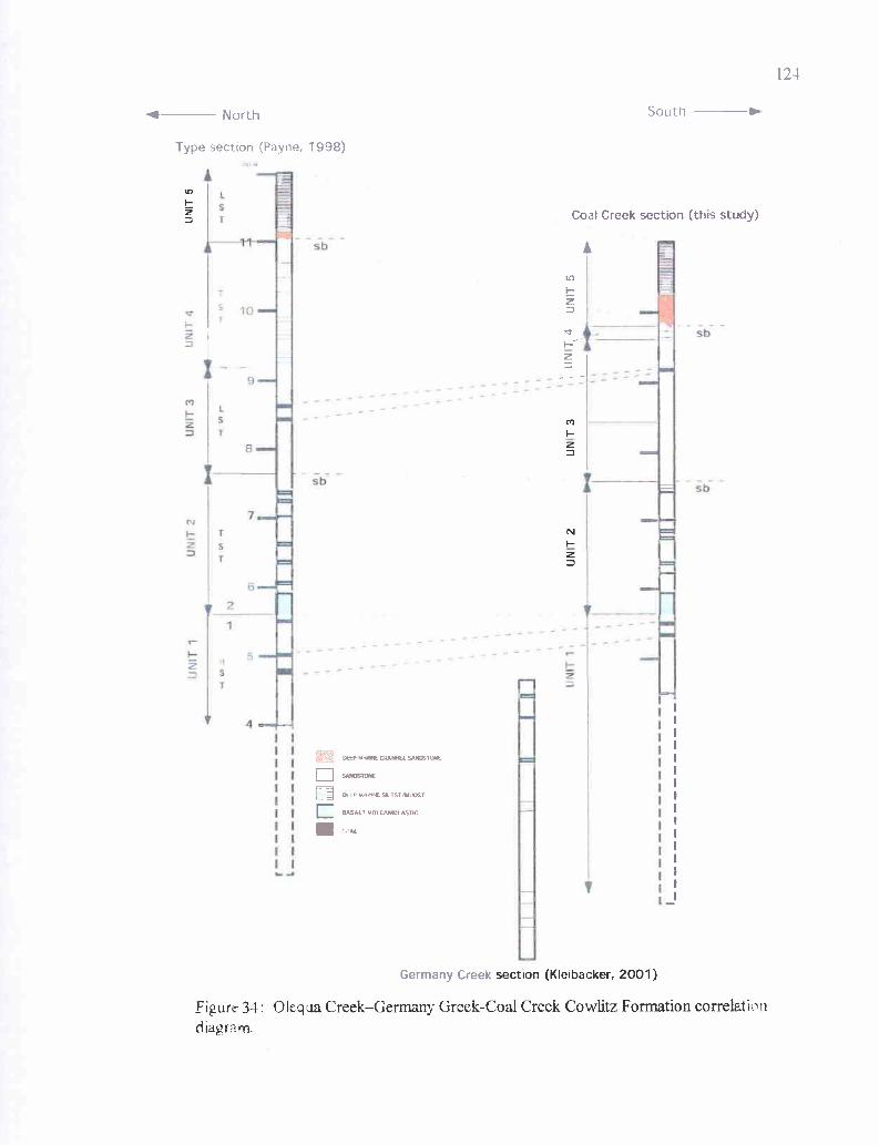
1
T 4
sb
r
10
T
f North
Type section (Payne, 1998)
A
Germany Creek
Coal Creek section (this study)
section (Kleibacker, 2001)
Figure 34: Ofequa Creek-Germany Greek-Coal Creek Cowlitz Formation correlationdiagram.
aDEEP VARINE CNAMFL SANDSTONE
SANDSTONE
rl p P MA-C SATST/MUOST
BASALT VOLCAMRASTICC
125
17, this thick deeper marine facies overlying Payne's unit 3 does not occur in the Coal
Creek section, indicating that unit 4 is only poorly represented in Coal Creek. However,
overlying these deep marine facies of unit 4 in the type section is unit 5, consisting of
about 30 meters of submarine channel sandstone facies consisting of massive to thickly-
bedded sandstones with abundant mudstone rip-up clasts. Payne interpreted these as
grain-flow and high concentration turbidites. This is abruptly overlain by fine-grained,
even, thin-bedded prodelta overbank turbidites. The same lithologic sequence occurs in
the Coal Creek section. Massive to very thickly bedded sandstones of intervals 16
through 4 are overlain by thin-bedded, well-laminated turbidites of intervals 3 through 0.
As stated previously, based on lithologic similarities and stratigraphic position, it
is inferred that the lower -I 10 meters of the Coal Creek section is correlative to the upper
portion of Payne's informal unit 1 (unit 1B) of the type Cowlitz Formation stratigraphic
section. This 3rd order sequence of cycle III is progradational, consisting of four
shoaling-upward parasequences occurring near the top of a high stand systems tract. This
parasequence set consists of shoaling shallow marine and lower delta plain to tidal flat
facies successions, with parasequences 1 and 2 consisting of coarsening- and thickening-
upward bedsets, and parasequences 2 and 3 consisting of fining-upward tidal successions
terminating in Coals A and B respectively (refer to the Coal Creek stratigraphic section,
Plate 2, and depositional environments section for more detailed descriptions).
Parasequences 1 and 2 represent only minor sea level fluctuations from estuary/bay to
tidal rhythmites and tidal channels to delta front shallow marine sands. However,
shallow marine oysters immediately overlying coals at the top of parasequence 4
indicates a marine flooding surface occurs there.
126
The uppermost coal of unit 1(coal B or its shallow marine estuarine time
equivalent units to the north, Plate 2) throughout the Coal Creek section is abruptly
overlain by highly fossiliferous basalt sandstone and pebble conglomerate containing the
shallow marine Turritella-Solena assemblage, which is then overlain by a thick Grays
River basalt volcaniclastic. This same relationship occurs in the type section of the
Cowlitz Formation, with the basalt volcaniclastic containing shallow marine molluscan
shell-lag of the Turritella-Tivelina assemblage, representing a marine flooding surface
that defines the base of unit 2. This 3rd order sequence is the uppermost part of Payne's
(1998) cycle III, and in Coal Creek consists of at least 9 shoaling upward parasequences
representing an aggradational to retrogradational parasequence set. Five parasequences
(6 through 10) fine upward and terminate in coals (C through G). Lower portions of
these parasequences are coarsening-upward tidal channel/tidal flat to delta front sand
successions. Each Grays River basalt volcaniclastic bed containing marine fossils likely
represents minor flooding surfaces (short lived transpressional events) if overlying beds
represent deeper water facies, and storm wave or tsunami lag if lithofacies above and
below are the same. Near the top of unit 2 (at nearly 350-meters depth) is a maximum
flooding surface placing lower shoreface heterolithic ripple-laminated siltstone and
mudstone stratigraphically above probable distributary channel or distributary mouth bar
sandstones. This is the stratigraphically lowest major flooding surface in the Coal Creek
section. Over the next 40 meters of section parasequence 12 coarsens- and thickens-
upward, and ultimately grades-upward into middle shoreface storm wave-produced
swaley and hummocky sandstones.
127
A sequence boundary likely occurs at approximately 296-meters depth, where
massive to thickly-bedded delta front bioturbated sandstones immediately underlie the
middle shoreface sandstone of parasequence 13 (see Figure 14). This is the same
stratigraphic position of a sequence boundary described by Payne (1998) in the Cowlitz
Formation type section. Above this sequence boundary, lithofacies again become
dominantly shallow subtidal to tidal, and correlate to Payne's 3rd order, low stand cycle 4,
(tide-dominated unit 3). This unit consists of multiple shoaling-upward parasequences.
From -295 to -255 meters parasequence 13 thickens- and coarsens-upward, transitioning
from mid shoreface to tidal channels or tidal bars to beach. From -255 to -220 meters,
small onlaps (minor flooding surfaces) result in basaltic deposits with abundant shallow
marine fossil assemblages overlain by tidal rhythmite facies. This shallow subtidal to
distal tidal bar or channel succession (parasequences 14, 15, and 16) is abruptly overlain
by another major marine flooding surface, depositing low- to mid-shoreface storm wave
hummocky bedded fine-grained sandstones and fair-weather siltstones over tidal
rhythmites. Over the next -40 meters, this parasequence (number 17) shoals to tidal
rhythmite and tidal channel facies. The overlying parasequence 18 is capped by
supratidal marsh coal H, with interbedded tuffs that correlates well in lithology and
stratigraphic position to Payne's (1998) unit 3 coal seam C. A marine flooding surface
immediately overlies this upper coal, which is in turn abruptly overlain by deeper marine
turbidites and fine-grained sandstones and siltstones of intervals 20, 18, and 17, which
may correlate to the upper beds of Payne's (1998) unit 4 (a transgressive systems tract of
cycle 4).
128
Scoured into the upper surface of interval 17 is the beginning of about 135 meters
of massive to thickly-bedded sandstone with abundant large mudstone rip-up clasts and
rounded chunks of carbonaceous plant debris (e.g., logs). Intermittent siltstone and
mudstone interbeds are common in the lower portion but uncommon in the upper portion
of this interval. This massive sandstone sequence is in turn abruptly overlain by thinly-
laminated, deep-water, distal turbidites of intervals 3, 2, 1, and 0. This succession is
similar to the top of the type Cowlitz Formation section described by Payne (1998).
Intervals 18 and 20 again are deep marine facies that may be the lithologic equivalents of
Payne's unit 4, that immediately underlie a sequence boundary defined by the overlying
channel sandstone facies and prodelta turbidites of lowstand unit 5 (3rd order cycle 5).
Toutle Formation ?129
Introduction
The Oligocene Toutle Formation, exposed at several localities in southwest
Washington, is variable in thickness, lithology, and environment of deposition throughout
its outcrop distribution. Toutle Formation in the type area, 18 km east of Olequa in the
Washington Cascades, consists of a lower 60-meter thick marine member, and an upper
100-meter thick non-marine fluvial member (May, 1980). The lower member is in
unconformable contact with the underlying Hatchet Mountain Volcanics (basaltic
andesite that unconformably overlies the Cowlitz Formation). This member, based on
microfossils and molluscan fossil assemblages, was deposited in nearshore subtropical
marine conditions (May, 1980). A Galvinian (upper Eocene to lower Oligocene)
molluscan assemblage characterizes the lower member, and is within the Echinophoria
dalli and Echinophoria fax zones of Armentrout (1973) within the Refugian foraminiferal
stage (May, 1980). The upper member was formed in fluvial, lacustrine, or swampy
depositional environments (May, 1980), and might be within the Echinophoria fax zone
to the Echinophoria rex zone of the Galvinian, within the Zemorrian foraminiferal stage
(34 to 31 Ma)(May, 1980).
Payne (1998) in a masters thesis study, -25 km ('-16 mi) north of this study area
near Vader, Washington, split the Toutle Formation into three informal units based on his
measured section in Olequa Creek: 1) a fluvial valley-fill sequence -105 meters thick
(unit A), 2) a marginal marine sequence -85 meters thick (unit B), and 3) an upper fluvial
sequence -75 meters thick (unit C), for a total of approximately 265 meters. Payne's
(1998) unit A is possibly correlative to the upper fluvial member of the type Toutle
130
Formation of Roberts (1958) to the east in the western Cascades based on lithologic
similarities, stratigraphic position, and radiometric age of a dated tuff bed (approximately
32 Ma). Payne's unit A consists of numerous shallow channels filled with cross-bedded,
tuffaceous, moderately-sorted, feldspathic volcanic-litharenites. These cross-beds are
lined with black carbonaceous plant debris including roots and carbonized logs. Imprints
of leaves are also common. These channels are interbedded with friable, faintly cross-
bedded, clay-rich arkosic sandstone containing little mica. Unit A also contains abundant
sandy, clayey, carbonaceous siltstone with clay interbeds. Also common are blue-gray
tuffaceous siltstones and pumice lapilli tuff beds. The possibly correlative type Toutle
Formation section -18 km (- 11 mi) to the east consists mostly of volcanic sandstones
and tuffs with interbedded massive siltstones and lesser coal beds toward the top.
Payne's (1998) unit B consists of clay-rich sandy siltstone, clay-rich silty sandstone,
tuffaceous mudstone, and volcanic arkosic sandstone. Toutle Formation unit C is
dominantly tuffaceous sandstone and siltstone with a high percentage of carbonized
woody material. Coarse-grained volcanic sandstone to pebble conglomerate lenses are
also abundant.
The Toutle Formation in the study area of Payne (1998) immediately overlies a
basin-wide unconformity that marks the top of the Cowlitz Formation, produced by a
relative sea-level fall (i.e., a sequence boundary). The Toutle Formation was
subsequently produced as part of a lowstand systems tract, with non-marine fluvial
sandstones incised into the deep marine siltstones of the Cowlitz Formation (Payne,
1998). Therefore, much of the lower portion of the Toutle Formation consists of incised
valley-fill, with clasts consisting of a mixture of stream- and wave-reworked deltaic
131
Cowlitz Formation derived from tectonically uplifted and eroding Cowlitz micaceous
arkoses, and silicic tuffaceous pyroclastic derived from the active western Cascade calc-
alkaline volcanic arc. The incised-valley, meandering fluvial bar (rather than upper
shoreface) depositional environment of the tuffaceous sandstones of the lower and upper
units of the Toutle Formation in Olequa Creek to the north, was suggested by Payne
(1998). This model is based on fining- and thinning-upward parasequences, filled
channels, moderate-sorting, carbonized root-traces in growth position, coalified logs,
abundant leaf imprints, and unidirectional high-angle trough cross-beds. Finer-grained,
thinly-bedded to laminated clayey siltstones, mudstones, and interbedded tuffs and coal
with abundant carbonized and imprinted plant material were interpreted as fluvial
overbank floodplain deposits. Such fine-grained lithologies and facies associations
suggest a broad floodplain (with meandering river channels) with the associated buildup
of swampy plant debris. This floodplain was occasionally inundated by volcanic ash
from the western Cascades in the form of airfall tuffs, and at times channelized
debris/hyperconcentrated flows (Figure 35).
Local Toutle Formation Stratigraphy and Thickness
Within the study area, outcrops of tuffaceous, clayey sandstone, siltstone, and
minor claystone of the Toutle Formation may occur stratigraphically above exposures of
the Cowlitz Formation and Grays River volcaniclastics in Coal Creek, Clark Creek, Hazel
Dell Creek, and also on Mt. Solo and the hills northeast of Kelso (Plate 1).
Unfortunately, the possible contact between the Oligocene Toutle Formation and
underlying middle and upper Eocene sedimentary and volcanic units was not discovered
in outcrop anywhere within the study area. Although some of the Toutle Formation is
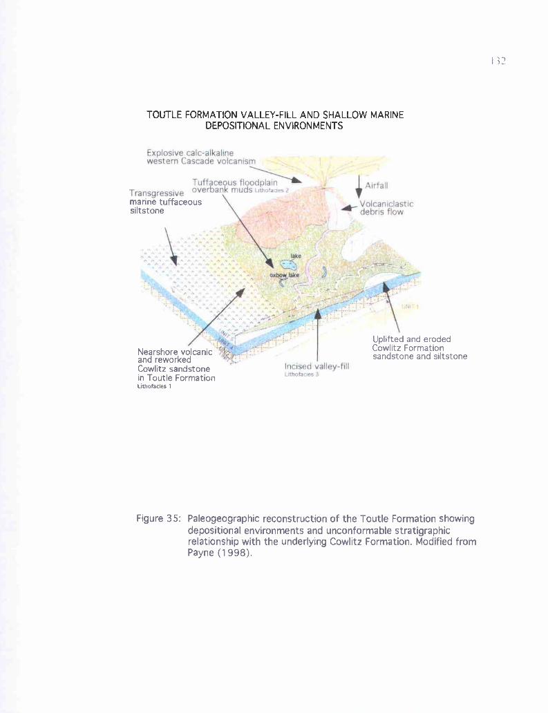
Explosive cafe-alkaflnewestern Cascade volcanism
Transgressive
.'l
ArirfallTuff ceous floodplainoverbank muds LRnoraaes2
+. a-AGt M9F 4{ rAA A r ^' i 1 w' w
l k,. ,_ ea
ll. ^ ^ .w ." 5
^ « S.sw w +. .., A' h A \ 0 lake
,'A w .. w w A n CTS' _ , 'w!www_ A w ' M ^ r^ A ..1`~-_S ..qttel..
}Aa:, Xy.
Incised valley-fillUmotaaes:3
Volcaniclasticdebris flow.
0' _11
UNl T 1
Uplifted and erodedCowlitz Formationsandstone and siltstone
marine tuffaceoussiltstone
Nearshore volcanicand reworkedCowlitz sandstonein Toutle FormationLithofades 1
Figure 35: Paleogeographic reconstruction of the Toutle Formation showingdepositional environments and unconformable stratigraphicrelationship with the underlying Cowlitz Formation. Modified fromPayne (1998).
133
arkosic and micaceous (resembling Cowlitz Formation beds, and accounting for previous
mapping as Cowlitz Formation by other authors in the study area), several consistent
lithologic characteristics allow differentiation of these formations in the field. Potential
outcrops of the Toutle Formation are nearly universally lighter in color than the more
orange or brown Cowlitz Formation arkosic beds and gray siltstone, ranging from nearly
white to light tan or buff. Local orange, reddish, or brownish coloration generally can be
attributed to staining by overlying iron oxide-rich soils leached from the Columbia River
Basalt Group. Toutle Formation samples have abundant clay, even coarse-grained
sandstones are commonly clay-rich. Samples are more weakly lithified than Cowlitz
Formation sandstones and siltstones, and even the hardest samples are easily crushed or
broken apart by hand, and due to the high smectite clay content, usually hold the new
shape when compressed. Most of these semiconsolidated outcrops have abundant open
burrows created by modern beetles, crickets, and wasps, as the soft sediment is easy for
them to burrow through. Hand samples, even when wet, have noticeably lower specific
gravity than Cowlitz Formation samples, resulting largely from the high clay content, but
also from the relatively high percentage of pumice clasts in some samples, and relatively
little cement. No samples collected are well indurated; all are either friable and/or clayey
(many samples have the consistency of sandy chalk). The few molluscan fossils
collected (invariably molds that rapidly crack and disintegrate when dry) and some trace
fossils (unusual downwarping of laminae, see Figures 36 and 37) are unlike those
described in the Cowlitz Formation in Coal Creek. Within the study area, plant fossils
from the Cowlitz Formation are carbonized, whereas Toutle Formation leaves and other
plant debris are nearly always (with the exception of one bed at Site 49) imprints or
134
molds with the carbonaceous organic material leached away. Three common
characteristics of the Cowlitz Formation in Coal Creek: flaser-mud drapes, invasion by
Grays River dikes and sills, and interbeds of highly molluscan fossiliferous, shallow
marine Grays River volcaniclastic beds do not occur in the Toutle Formation.
Toutle Formation outcrops with the characteristics described above occur widely
throughout the low hilly terrain stratigraphically beneath unconformably overlying
Miocene Columbia River Basalts in the central and northern parts of the study area,
apparently reaching a maximum thickness of 500 to 600 feet (-155 to 186 meters).
Stratigraphically lower exposures (the lowermost -30 to 40 meters) dominantly consist of
massive, clayey, tuffaceous siltstone, and appear to be shallow marine, based on sparse
molluscan molds (found only at Site 124, and years ago in an outcrop of "Olequa Clay"
behind a house in Clark Creek, as described by the homeowner). Higher elevation
outcrops of the upper portion of the Toutle Formation are commonly trough cross-
bedded, channel-fill, clay rich arkosic sandstones, with overbank thinly bedded and
laminated tuffaceous sandy siltstone with claystone and thin sandstone lenses. Three
generalized lithofacies are recognized for this study: 1) mostly massive to thinly
laminated, tuffaceous, clayey, bioturbated siltstone with sparse molluscan fossils (mostly
the lower section, and may correlate to Payne's Toutle Formation marine unit B), 2)
thinly bedded to laminated clayey siltstone and fine-grained arkosic sandstone with
abundant leaf and twig imprints, almost entirely lacking carbonaceous material, and 3)
cross-bedded, tuffaceous, highly friable, clayey, micaceous, arkosic sandstone,
occasionally lined with dark gray or brown mudstone laminae (may correlate to Payne's
upper unit C of his Toutle Formation).
135
Lithology and Outcrop Characteristics
Lithofacies 1, 2, and 3 occur throughout the area mapped as possible Toutle
Formation in Plate 1. Most exposures occur as road cuts or excavations behind new
houses, and are typically 3 meters or less in stratigraphic thickness, many are 1 meter or
less. The thickest exposure occurs at Site 49 (NE 1/4 of the NW 1/a of Sec. 5, T 8 N, R 2
W) where approximately 10 meters are exposed along a curved roadcut about 200 feet
long on Columbia Heights Road North (Plate 1, Figure 36). Nearly 8 meters of
continuous exposure occurs in the headscarp of a small 1997 landslide at Site 59 (NW 1/a
of Sec. 31, T 9 N, R 3 W, Plate 1, Figure 38). Unfortunately, no exposures are
continuous enough or of sufficient thickness to allow much detailed analysis of vertical
facies changes or sequence stratigraphic analysis. In addition, due to the lack of
induration of this unit, grasses and other vegetation quickly cover all new exposures.
Lithofacies 1 is most distinctive in its monotony and lack of well-preserved
sedimentary structures in outcrop. This in part represents actual lithologic features, but is
in part an artifact of poor exposure. Exposures range from massive to thinly-laminated,
and are light colored, tuffaceous, clay-rich, and finely micaceous. Those sedimentary
structures that do occur include micro-cross and wavy laminations, typically about 0.5-
cm thick in both clayey sandstone and siltstone. The majority of outcrops of this
lithofacies lack stratification and are mottled gray, tan, or buff. Mottling appears to be
due in most cases to bioturbation (Sites 54, 105, 109, 113, 115, 116, 120, and 124). Site
54 (The West Side Quarry, SE 1/a of Sec. 4, T 8 N, R 2 W) includes vertical burrows 3-cm
wide filled with coarse-grained tuffaceous sandstone. Sites 110 and 124 (SW 1/a of the
NE 1/a of the SE 1/a of Sec. 35, R 3 W, T 9 N) have abundant sub-vertical, mudstone-lined
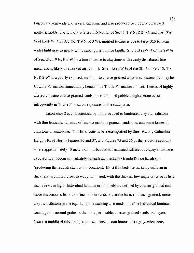
136
burrows -1-cm wide and several cm long, and also produced two poorly preserved
mollusk molds. Particularly at Sites 116 (center of Sec. 6, T 8 N, R 2 W), and 109 (SW
'/4 of the NW 1/4 of Sec. 36, T 9 N, R 3 W), mottled texture is due to large (0.5 to 1-cm
wide) light gray to nearly white subangular pumice lapilli. Site 113 (SW '/a of the SW 1/4
of Sec. 24, T 9 N, R 3 W) is a fine siltstone to claystone with evenly distributed fine
mica, and is likely a reworked air fall tuff. Site 115 (NW '/ of the SE 1/4 of Sec. 18, T 8
N, R 2 W) is a poorly exposed, medium- to coarse-grained arkosic sandstone that may be
Cowlitz Formation immediately beneath the Toutle Formation contact. Lenses of highly
altered volcanic coarse-grained sandstone to rounded pebble conglomerate occur
infrequently in Toutle Formation exposures in the study area.
Lithofacies 2 is characterized by thinly-bedded to laminated clay-rich siltstone
with thin lenticular laminae of fine- to medium-grained sandstone, and some lenses of
claystone or mudstone. This lithofacies is best exemplified by Site 49 along Columbia
Heights Road North (Figures 36 and 37, and Figures 75 and 76 of the structure section)
where approximately 10 meters of thin-bedded to laminated tuffaceous clayey siltstone is
exposed in a roadcut immediately beneath dark reddish Grande Ronde basalt soil
(producing the reddish stain at this location). Most thin beds (remarkably uniform in
thickness) are micro-cross to wavy-laminated, with the thickest low-angle cross-beds less
than a few cm high. Individual laminae or thin beds are defined by coarser-grained and
more micaceous siltstone or fine arkosic sandstone at the base, and finer-grained, more
clay-rich siltstone at the top. Limonite staining also tends to define individual laminae,
forming rims around grains in the more permeable, coarser-grained sandstone layers.
Near the middle of this stratigraphic sequence discontinuous, dark gray, micaceous
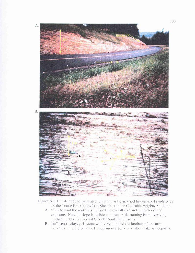
r
Q
Figure 36: Thin-bedded to laminated. clay-rich siltstones and tine-grained sandstonesof the Toutle Em (lacics ?) at Site 49 atop the Columbia Heights Anticline
A View tov aid the noiif cst illustraunI-I o cull site and character of theexposure Note dipslope landslide and iron oxide stamirig from overlyingleached, reddish. rcwrked Grande Rondc basalt soils.
B Tuffaceous, clavev siltstonc ith ci' thin beds or laminae of uniformthickness. interprcred to be f loodtl,rin mcrhank or shallo lake silt deposits.
• -• -- • •-w- • —•
______
• •- ,
•_;—.
• —
Figure 37: Unusual trace Iossils of UHLertai 1 origin in clayey sill stones of theTootle Formation at Site 49. I here structures, unique in the study area, consist ofdowii arped siltstone laminae hich tend to bend underlvtng laminae near thecontact. Over IU() of these trace fossils were seen in the upper 10 meters of thisstratigraphic sequence, and v arv from 10 to ?O cm wide and 5 to 15 cm deep
t4
I
J1
139
siltstone lenses only a few cm to 1 meter in length occur. Samples from this location are
dominantly light in color, with the consistency of sandy chalk or diatomite (although no
diatoms were found despite many attempts). One year after this outcrop was described
for this study, the detail of the sedimentary structures had weathered away.
Site 49 is also characterized by abundant leaf imprints (with very little
carbonaceous material), especially in the lower 10 meters. These leaf species are broad
and undivided, characteristic of the more tropical climate that persisted through the
Eocene and into the early Oligocene (Jeff Myers Western Oregon University,
paleobotanist, personal communication, 2002). Unique features of this exposure are trace
fossils of uncertain origin that consist of downwarped laminae up to 20 cm wide and 15
cm deep (Figure 37). These depressions often truncate underlying laminae, but in all
cases underlying laminae are bent downward near the contact with the depression,
commonly becoming tangential to it.
Lithofacies 3 is characterized by light colored, clay-rich, tuffaceous, trough cross-
bedded sandstone, with current direction toward the southwest. These deposits may
represent point bar channel-fill sequences exemplified by the landslide headscarp
exposure at Site 59 (Figure 38). Here, medium- to coarse-grained arkosic and sparsely
micaceous, unidirectional trough cross-bedded clay-rich arkosic sandstone at the base of
the exposure grades upward through finer-grained sandstone into 2 meters of micro-
cross-bedded and wavy-laminated clayey siltstone and fine sandstone of lithofacies 2
(Figure 38b). Coarser-grained sandstone beds at the base are commonly lined with dark
gray or brown mudstone or sandstone with some disseminated carbonaceous debris.
Similar channel-fill sandstone sequences occur elsewhere in the study area. Site 33 (S 1/2
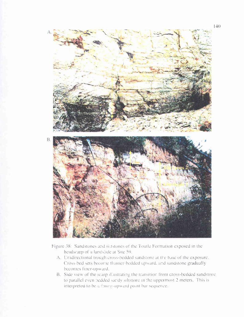
•
'3—-• - •t
• •v•'—_•'
-. 7r-
Pt -.
• •
I4(
ad
F12urc 38: Sandstones and siltstones uI the foutle Formation exposed in theheadscarp of a landslide at Site 59
A [nidirectional tiou_rh doss-hedded sandstone at the hale of the exposureCioss-hed sets heconic thinner-hedded upMaid, anti sandstone graduallyhccomes Ii ner-up'\ aid
B Side'ie\,k of the scarp iilustrating the transition from cross-hedded sandstoneto parallel even bedded sand. siltstone in the uppermost 2 meters. This isinterpreted to he a I nine upmaid point hill se(luence.
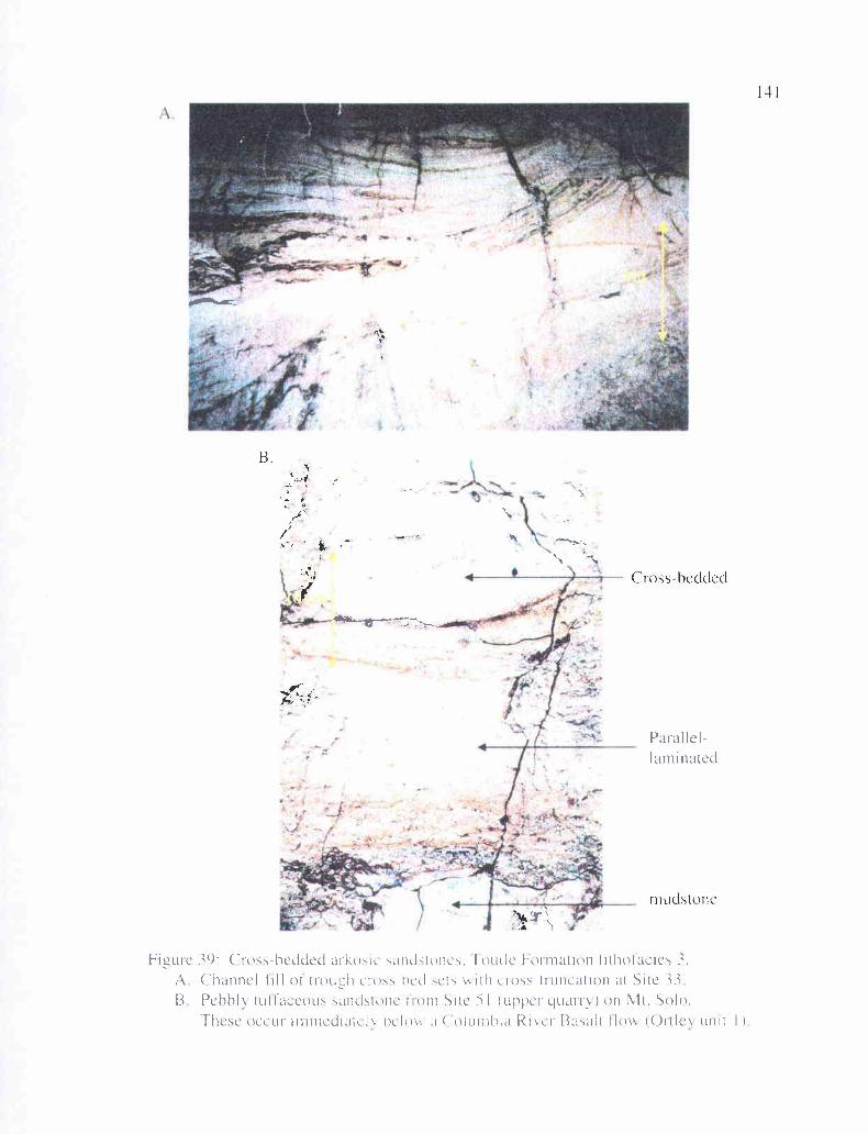
J;
Cross-hedded
mudstonc
14
Parallel-laminated
Figure 39: Croshccided arkosic sandstone,,, 1outIc Formation lithofacies 3.A Channel -till oi' trou1-'h cross-hcd ,cts It 11 cross-truncation at Site 3313 Pchhl, tuI f accous sandstone 1 ron1 Site i I (ulphcr quarry ) on Mt. Solo.
These occur immediatcl hclo\ a ('olurnhia Ricl Basalt Ilo\\ (Ortics unit I)
142
of Sec. 12, T 8 N, R 3 W, Figure 39a) contains similar nested cross-bed sets in a roadcut
on 50th Avenue, also with paleocurrent direction toward the southwest. At Site 51 (NW
1/4 of Sec. 25, T 8 N, R 3 W), immediately beneath Miocene Columbia River Basalt
(Ortley flow unit #1) on Mt. Solo, tuffaceous sandstone to pebbly volcanic conglomerate
occurs, also with paleocurrent direction toward the southwest (Figure 39b).
Petrography
Toutle Formation sandstones and siltstones differ substantially from Cowlitz
Formation samples is some aspects of composition. Toutle Formation samples display a
much higher percentage of pumice, chert, and clay alteration products. Most samples
consist of 50% or more of these three components. As a result, quartz, feldspars and
micas of extrabasinal origin (i.e., reworked Cowlitz Formation grains) are reduced in
abundance. In addition, the clay rim and sparry calcite cements that surround grains in
Cowlitz Formation thin sections are nearly lacking entirely from Toutle Formation
samples, as are calcareous molluscan fossil fragments. Also greatly reduced in
percentage are the pilotaxitic and amygdaloidal Grays River basalt clasts so common in
Cowlitz Formation clastic sediments. Carbonaceous plant fragments are also greatly
reduced in abundance or lacking. Most of these compositional differences may
alternatively be due to extensive weathering, leaching, and alteration of these exposures.
Thin section from Site 60 (NE 1/a of the SE 1/4 of Sec. 30, T 9 N, R 2 W, Figure
40a) is from a thinly-bedded to laminated sample of lithofacies 2, consisting of coarse- to
fine-grained sandstone with sparsely bioturbated siltstone laminae. This sample consists
of approximately 50% chert, 20% reworked Cowlitz Formation clasts (-10% quartz, 9%
plagioclase feldspar, 1% mica), 10% pumice (mostly long-tube), 5% basalt, and 10-15%
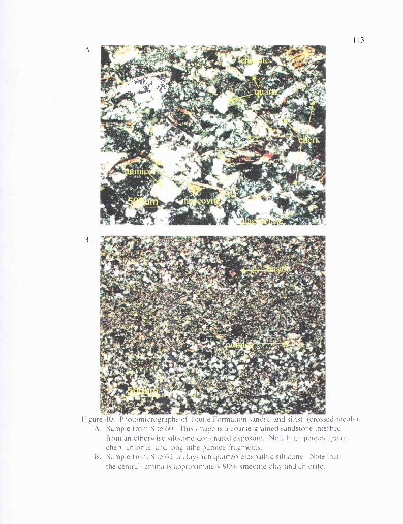
143
igure 40: Photomicrographs of butte Formation sandst. and siltst. (crossed nicolsA. Sample from Site 60. This Image is a coarse-grained sandstone interbed
from an otherwise siltstone-dominated exposure. Note high percentage ofchest, chlorite, and long-tube pumice fragments.
B. Sample from Site 62, a clay-rich yuartzoteldspathic siltstone. Note thatthe central lamina is approximately 901Ir smectite clay and chlorite.
144
clay. Biotite has mostly been altered to chlorite, and smectite clay forms a thin rim
around some clasts. Some pumice fragments have been altered to greenish smectite. The
high percentage of chert is likely due to altered silicic volcanic fragments of western
Cascade origin. Evidence for this can be seen in some pumice grains that have been
partially altered to chert, but some may originate from altered dacite.
Thin section from Site 62 (SE 1/a of Sec. 26, T 9 N, R 3 W) is from a thinly-
laminated, sparsely bioturbated, quartzofeldspathic, micaceous, clayey siltstone. This
locality also produced well-preserved leaf impressions and, like many Toutle Formation
exposures, is the site of a landslide, due to high clay content and poor induration. This
thin section (Figure 40b) consists of approximately 60-70% smectite or sericite clay, 20%
quartz, 5% plagioclase feldspar, and the remainder mica and lithic clasts.
X-ray diffraction
Two Toutle Formation samples were analyzed by x-ray diffraction to help
identify mineral composition, and help unravel the diagenetic history. The sample from
Site 60 (Figures 41 and 42), a clayey siltstone shows strong quartz and muscovite peaks
in the <15 tm fraction. Some chlorite is also present, but the sample is very low in
feldspar relative to Cowlitz Formation samples. The sample from Site 49 is much the
same (Figures 43 and 44), but has slightly more chlorite. The clay fraction (<2µm) for
these samples is rich in smectite, illite, and chlorite, illustrating the high percentage of
clay that gives much of this formation its clayey character, makes it prone to landslides.
Figure 40 shows this high clay content in thin section.
MM-Site 60 <2um MgAD Cowlitz Toutle OR, SCAN: 2.0/14.0/0.04/2(sec), Cu(40kV,36mA), 1(max)=4370, 08/13/03 15:43MM-Site 60 <2um Mg-Glycol Cowlitz, SCAN: 2.0/40.0/0.04/2 sec , Cu 40kV,36mA , I max =4563, 08/13/03 10:32
(1) Mg-Smectite, Glycol, dfd=3.5, max n=12(2) Smectite Mg-hyd, disordered(3)Mite, maxN=25,dfd=8(4) Fe-Mg Chlorite, moderate disorder(5) Quartz, syn - S102(6) Anorthtte, sodian, ordered - (Ca,Na)(AI,Si)2SI208(8) Hematite, syn - Fe203(10) Microcline, Intermediate - KAISi3O8
10 15 20 25 30 35 40
2-Theta(°)
Figure 41: < 2 micrometer fraction of Toutle Formation from Site 60.
12.0
10.0
8.0
6.0
MM-Site60 <15um AD, SCAN: 2.0/40.0/0.04/2 sec , Cu 40kV 36mA I max )=11661,08/12/0314:14<2T(O)=-0.1>(1) Montmorillonite-15a - CaO.2(AI,Mg)2Si4O10(OH)214H20(2) Muscovite-2m1 - KAI2(Si3AI)O10(OH,F)2(3) Chamosite-1 olb - (Fe,AI, Mg,Mn)6(Si,AI)4010(OH)8(4) Quartz, ayn - Si02(5) Anorth@e, sodian, ordered - (Ca,Na)(AI,Si)23i208(6) Microcline, intermediate - KAISi3O8 i
3
3
4.0
2.0
x10^3
3
2 3
1
v5
5i i i 'rail Ru i
5
2 3
2
24 2
21 6-1 t tip 6III 6,[jflqjjjjjj!- ----`-- -
4
rr r-i t r
5 10 15 20 25 30 35 402-Theta(°)
Figure 42: < 15 micrometer fraction of Toutle Formation from Site 60.
MM-Site 49 <2um MgAD Cowlitz, SCAN: 2.0/14.0/0.04/2(sec), CU(40kV,36mA), I(max)=7087, 08/13/03 15:43 <2T(0)=0.01>MM-Site 49 <2um Mg-Glycol Cowlitz, SCAN: 2.0/40.0/0.04/2 sec Cu 40kV,36mA , I max =5915, 08/13/03 11:54 <2T(0)=0.(
7500
11
(1) Mg-Smectite, Glycol, dfd=3.5, max n=12(2) Smectite Mg-hyd, disordered(3) /lute, max N = 25, dfd = 8(4) Fe-Mg Chlorite, moderate disorder(5) Quartz, syn - Si02(6) Anorthite, sodian, ordered - (Ca,Na)(AI,Si)2Si208(8) Hematite, syn - Fe203(10) Microcllne, intermediate - KAIS1308
5ti
2500
1
0
10
6 s 86 6
86s 10 6
6 5
11 1W 10 0 !1
1 10 0 {b 10 0
15 20 25 30 35 402-Theta(°)
Figure 43: < 2 micrometer fraction of Toutle Formation from Site 49.
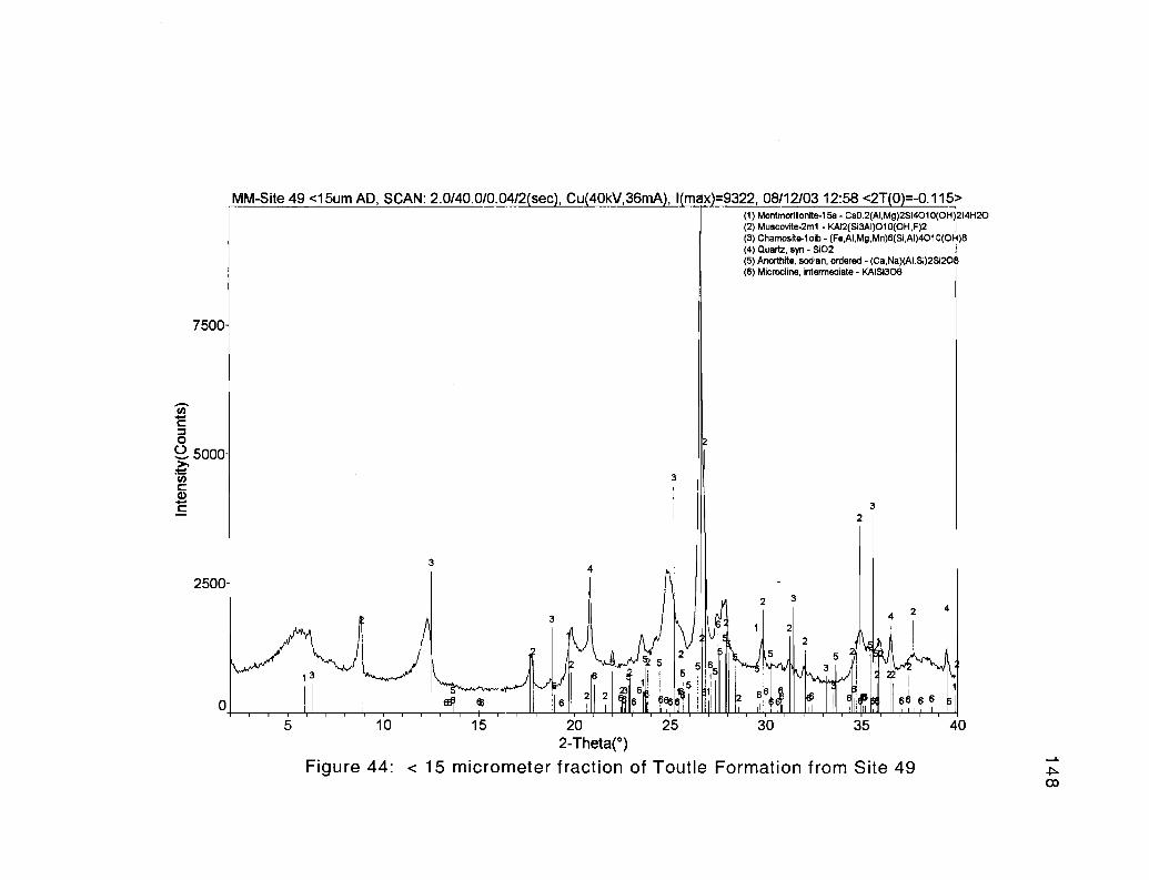
MM-Site 49 <15um AD, SCAN: 2.0/40.0/0.04/2 sec , Cu 40kV,36mA , I max =9322, 08/12/03 12:58 <2T(O)=-O. 115 >(1) Montmorillonite-15a - CaO.2(AIMg)2Si4O1 O(OH)214H2O(2) Muscovite-2m1 - KAI2(Si3AI)010(OH,F)2(3) Chamosite-loib - (Fe,AI,Mg,Mn)6(SI,AI)4010(OH)8(4) Quartz, syn - S102 i
(5) Anorthie, sodian, ordered - (Ca,Na)(AI,Si)2Si208(6) Microcline, intermediate - KAIS1308
7500
z
3
3
2500
3
3
4
0
1
3
24 2 4
+w,w' " 5 1 65 39
;3 6
23 6LJ i
1
2 26 1 2 tb 6 6 6 6
10 15 20 25 30 35 40
2-Theta(°)
Figure 44: < 15 micrometer fraction of Toutle Formation from Site 49
149
Depositional Environments
Fluvial channel-fill, micaceous, arkosic litharenites and lithic wackes of the
Toutle Formation (lithofacies 3) were likely deposited as part of a meandering river
system. The best evidence of this interpretation is found at Site 59 (Figure 38), where
unidirectional, moderately-sorted, trough cross-bedded sandstones gradually thin and fine
upward. This sequence terminates in approximately 2 meters of tuffaceous, parallel-
bedded siltstones and fine-grained sandstones of lithofacies 2 that likely represent fluvial
overbank and floodplain deposits, or top of a point bar. Further evidence for this
interpretation are the lithofacies 2 mudstone lenses and abundant leaf imprints at Sites 49
and 62, where sandy tuffaceous siltstones contain sandstone lenses. These fine-grained,
plant fossil-rich facies with associated meandering channel-fill facies suggests a broad
coastal floodplain environment including high sinuosity rivers and possibly shallow lakes
on the floodplain, where frequent explosive western Cascade silicic volcanic eruptions
would periodically inundate the area with air fall tuffs and debris/hyperconcentrated
pumiceous flows (Figure 35).
A shallow marine or estuarine depositional environment is indicated for some
exposures of the Toutle Formation, particularly in the stratigraphically lower outcrops in
the study area (lithofacies 1), as suggested by poorly preserved pelecypod molds, and
mudstone-lined burrows. It is interesting to note that locations with abundant leaf
imprints lack molluscan fossils and tubular burrows. Those containing molluscan fossils
and/or burrows do not have associated leaf imprints. These features as well as the point
bar sequences differentiate shallow marine from non-marine lithofacies. As shown in
Figure 35, these tuffaceous nearshore marine siltstones and fine-grained sandstones can
150
be thought of as upper to middle shoreface, wave-reworked Cowlitz Formation sand and
silt, supplying the arkosic and micaceous component of the Toutle Formation. The
incised valley (produced by a relative sea level fall) with meandering channel-fill sands
and plant fragment-rich overbank siltstones may have been contained in the study area by
the remaining topographic volcanic highs to the northwest and southeast that originally
resulted in deposition of tide-dominated, estuarine sediment of the middle Eocene
Cowlitz Formation prior to the sea level fall in the late Eocene/early Oligocene.
151
VOLCANICS
Grays River Volcanics
During the late-middle and late Eocene, nearly 3,500 meters of Grays River
Volcanics in southwest Washington and Tillamook Volcanics in northwest Oregon were
erupted into the forearc basin of Cascadia. These high-titanium tholeiitic units are
petrologically and chemically similar (Rarey, 1986; Kenitz, 1997), but can be
distinguished based on location, stratigraphic position, and age, with Tillamook flows
ranging in age from 46 to 42.5 Ma, and the younger Grays River flows ranging from 42.4
to 36.8 Ma. These flows erupted from several volcanic centers, producing coalescing
submarine tholeiitic basalt shield volcanoes that eventually built up above sea level to
become oceanic islands. The lower flows consist of high TiO2 and Fe2O3 tholeiitic
submarine hyaloclastite and pillow basalts and subaerial tholeiitic basalt, but differentiate
upward to become plagioclase- and augite-phyric, platy, subaerial basaltic andesites,
andesites, and some dacites in the subaerial upper portion (Rarey, 1986; Mumford, 1988).
Both units are characterized by plagioclase microlites arranged into a pilotaxitic (sub-
parallel) flow texture, in a black, glassy groundmass (Nelson, 1985; Berkman, 1990;
Payne, 1998; Kleibacker, 2001).
Eruption of both Tillamook and Grays River lavas may be due to middle to late
Eocene right-lateral shear and tensional opening of the forearc basin, resulting from
changes in the relative motion of the Farallon and North American Plates (Armentrout,
1987). The volcanic edifices produced in this way subdivided the forearc into smaller
basins (Niem and others, 1992), into which nearly 2,500 meters of marine and marginal
marine mudstones, siltstones, and deltaic sandstones with interbedded volcanic units were
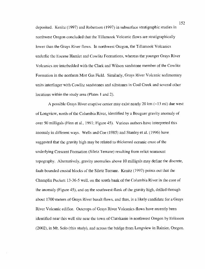
152
deposited. Kenitz (1997) and Robertson (1997) in subsurface stratigraphic studies in
northwest Oregon concluded that the Tillamook Volcanic flows are stratigraphically
lower than the Grays River flows. In northwest Oregon, the Tillamook Volcanics
underlie the Eocene Hamlet and Cowlitz Formations, whereas the younger Grays River
Volcanics are interbedded with the Clark and Wilson sandstone member of the Cowlitz
Formation in the northern Mist Gas Field. Similarly, Grays River Volcanic sedimentary
units interfinger with Cowlitz sandstones and siltstones in Coal Creek and several other
locations within the study area (Plates 1 and 2).
A possible Grays River eruptive center may exist nearly 20 km (- 13 mi) due west
of Longview, north of the Columbia River, identified by a Bouguer gravity anomaly of
over 50 milligals (Finn et al., 1991; Figure 45). Various authors have interpreted this
anomaly in different ways. Wells and Coe (1985) and Stanley et al. (1996) have
suggested that the gravity high may be related to thickened oceanic crust of the
underlying Crescent Formation (Siletz Terrane) resulting from relict seamount
topography. Alternatively, gravity anomalies above 10 milligals may define the discrete,
fault-bounded crustal blocks of the Siletz Terrane. Kenitz (1997) points out that the
Champlin Puckett 13-36-5 well, on the south bank of the Columbia River in the core of
the anomaly (Figure 45), and on the southwest flank of the gravity high, drilled through
about 1700 meters of Grays River basalt flows, and thus, is a likely candidate for a Grays
River Volcanic edifice. Outcrops of Grays River Volcanics flows have recently been
identified near this well site near the town of Clatskanie in northwest Oregon by Eriksson
(2002), in Mt. Solo (this study), and across the bridge from Longview in Rainier, Oregon.
4G
30
iLl
153
124
47'
4 6°
123`
EOCENE AND OI IGOCFNF vOLI;AF,II; ! if it ;Goble volcanics
Grays Hiker volcunics
Northuraft Forrr lti)n
I Ilamook Volcan,cs
Crescent F o: matronChamplin Puckett 13-30-5 ell
Figuic 45: IZc,idual ielength filtered giaity .uluIUaly map and volcanic gcologvneap ,upcrimposed to ,hove relationship of shalloti cl Ustal features and surlacc gcologvThe large anomaly (A) centered on Riser \ olcanic, may he the eruptivecenter Modified from I'avnc. I9O5: Finn ct if . 11)()I: and Walsh and I'hillip,, I'- 7
All LGALS
A localized gravity anomaly of this magnitude may be the result of a combination of
these factors.
Age
154
Kleibacker (2001) postulated in his master's thesis that in the area immediately to
the north and west of the study area, two separate Grays River volcanic piles occur,
separated by an intra-formational unconformity that he dated at about 39 Ma. In
Germany Creek (-6km northwest of the study area), subaerial Grays River basalt flows
conformably overlie the middle Eocene Cowlitz Formation, and were 40Ar/39Ar dated at
about 40 Ma. A Grays River basalt dike intruding interval 44 of the Coal Creek section
was dated by Irving et al. (1996) to be about 40 Ma, similar to Grays River dikes in
Kleibacker's (2001) thesis area (Figure 46), beneath the unconformity. Payne (1998)
describes a younger subaerial Grays River subunit from Abernathy and Bebe Mountains
10 km farther to the north, that overlies the older Grays River unit. This younger unit
was 40Ar/39Ar dated at between 36.85 and 38.64 Ma, and is the same age as and
continuous with the upper flow unit in Kleibacker's thesis study area. 40Ar/39Ar dates
reported by Payne (1998) from this upper Grays River subunit show a general decrease in
age toward the northeast. Regionally 40Ar/39Ar radiometric dates of the Tillamook and
Grays River Volcanics from northwest Oregon and southwest Washington show an age
progression from southwest to northeast (Figure 46), possibly showing a northeastward
progression of the tensional regime within the forearc basin from 42.4 to 36.8 Ma.
However, an 40Ar/39Ar date of 36.98 ±.78 Ma acquired for this study from Site 7 on Mt.
Solo does not fit this age progression model, indicating that Grays River volcanism in the
study area occurred over a 3 million year period from -40 to -37 Ma.
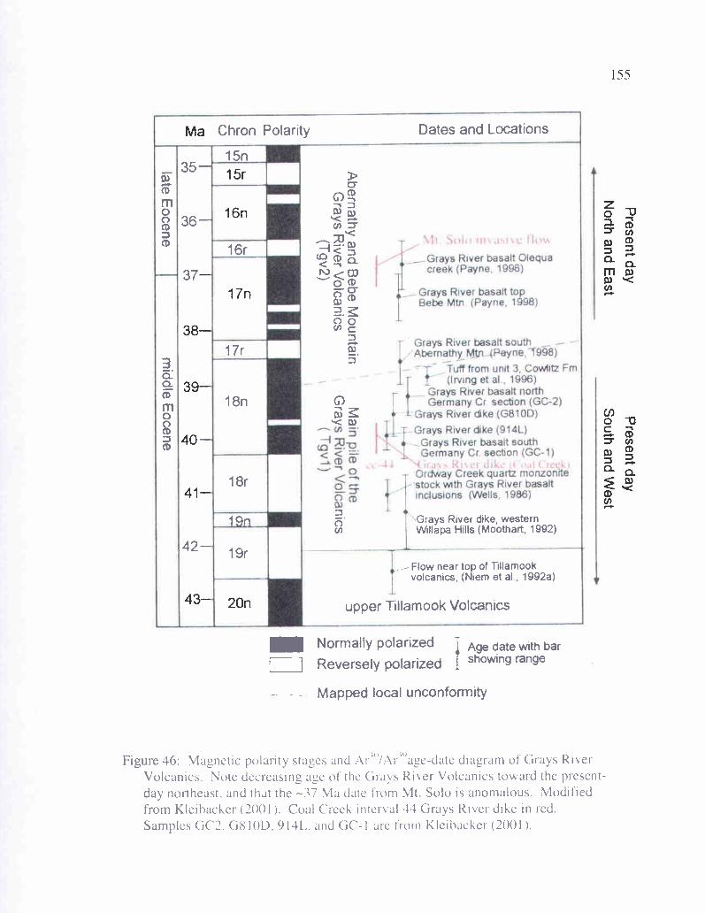
r--Grays River basalt Olequa
creek (Payne, 1998)
Grays River basalt topBebe Mtn (Payne, 1998)
Grays River basalt southAbernathy Mtn (Payne, _T998)
T Tuff from unit 3, Cowlitz Fm(-Irving et al , 1996)
Ordway Creek quartz monzonitestock with Grays River basaltinclusions (Wells. 1986)
Grays River basalt northGermany Cr section (GC-2)
Grays River dike (G810D)
Grays River dike (914L)Grays River basalt southGermany Cr section (GC-1)
Solo InvasiveC
hron
Pol
arity
Dat
es
and
Loca
tions
15n
35-
0
CD
m0
G) 0
36-
D U-T
16r
CD
< -S
37 o C
O6
noC
17r
n3
3a
a(D
m
8n )
0
'< 03
CD
18r
14n
Gra
ys
Riv
er
dike
,
wes
tern
cn Will
apa
Hill
s
(Moo
thar
t,
1992
)
42-
19r
Flo
w
near
top of T
illam
ook
volc
anic
s,
(Nie
m
et al,
1992
a)
uppe
r
Till
amoo
k
Vol
cani
cs
Nor
mal
ly
pola
rized
Age
date
with
bar
Rev
erse
ly
pola
rized I show
ing
rang
e
- Map
ped
loca
l
unco
nfor
mity
Present day
Present day
North and E
astS
outh and West
L
U,
Tl-
c(01
coI
II
II
co(r)
MM
O&
4IR
T 0
Figure 46: Magnetic polarity stages and Ar4 /Ar age-date diagram of Grays RiverVolcanics. Note decreasing age of the Grays River Volcanics toward the present-day northeast, and that the -37 Ma date from Mt. Solo is anomalous. Modifiedfrom Kleibacker (2001). Coal Creek interval 44 Grays River dike in red.Samples GC2. G8I OD, 914L. and GC- I are from Kleibacker (2001).
156
Distribution and Stratigraphy
Volcanic rock units of Grays River chemical composition occur in many parts of
the study area (Plate 1). Subaerial Grays River flows (map unit Tgv 1) are exposed in
three locations on or near the margin of the Cowlitz River. Exposures occur in roadcuts
along a 0.6 km stretch of the southern portion of Columbia Heights Road (N 1/2 of Sec.
27, T 8 N, R 2 W, Site la), and in cuts along the railroad tracks on the west bank of the
Cowlitz River (Site lb, S 1/2 of Sec. 22, T 8 N, R 2 W). Poor exposures also occur in cuts
along West Side Highway (Sec. 15, T 8 N, R 2 W), east of the Beacon Hill housing
subdivision. Excellent exposures of columnar Grays River flows occur on the east bank
of the Cowlitz River in railroad cuts and roadcuts in the north and west sides of the two
small hills known as Rocky Point (Sites 2 and 4, SW 1/4 of Sec. 14, T 8 N, R 2 W, Plate
1). Another good exposure is in the Terra Firma Quarry on the southwest flank of Mt.
Solo (E 1/2 of Sec. 26, T 8 N, R 3 W, "FQ" samples). Grays River flows are also exposed
in three small fault-controlled hills (Plate 1), rising above the alluvium in parts of Sec. 13
and24,T8N,R3W,andSec. 18 and 19,T8N,R2W.
Shallow marine (and in part subaerial) basaltic Grays River breccia and basalt
conglomerates (map unit Tgvsl, Plate 1) occur overlying and interfingering with the
subaerial flow unit (Tgv l) in lower elevation areas in the eastern part of Mt. Solo (Sites 6
and 7, Sec. 24, 25, and 26, T 8 N, R 3 W), along Pacific Way in a large roadcut beneath
the power lines (Site 32, NW 1/4 of Sec. 13, T 8 N, R 3 W), in thick deposits on both the
west and east sides of the Cowlitz River, and at elevations reaching 700 feet in the
Columbia Heights area. This breccia/conglomerate Grays River Volcanic unit is faulted
against Cowlitz sandstone and western Cascade basaltic andesite flows in the northern-
157
and southern-most exposures at Site 9 (Carrolls 1-5 exit) along Old Pacific Highway
(N 1/2 of Sec. 12, T 7 N, R 2 W, "CR" samples). Particularly good exposures occur at Site
7 in the eastern part of Mt. Solo, Site 32 along Pacific Way, a roadcut at Site 105 (NW 1/a
of Sec. 3, T 8 N, R 2 W), a roadcut along Interstate 5 at Rocky Point (Site 5, SW 1/4 of
Sec. 14, T 8 N, R 2 W), and a large roadcut along Main Street in Kelso (Site 14, SW 1/a
Sec. 26, T 8 N, R 2 W).
Younger shallow marine, mollusk-bearing Grays River volcaniclastic
conglomerate, sandstone, and siltstone interbeds within the Cowlitz Formation (map unit
Tgvs2) are well exposed in both Coal Creek and Clark Creek (see Plates 1 and 2, and
descriptions in the Coal Creek section of this text), but sparsely represented in exposures
of the Cowlitz Formation elsewhere (one example in Site 77 near Ostrander). Younger
Grays River dikes (map unit Tgvid) and two Grays River sills (map unit Tgvis) occur in
Cowlitz Formation sandstones and siltstones in Coal Creek, and invasively intermingled
with Grays River volcaniclastics on the south side of Mt. Solo (particularly Site 7).
Throughout the study area, a consistent relationship exists between the four Grays
River units (Figure 47). At the base is the Grays River subaerial flow unit (Tgvl), well
exposed in the Terra Firma Quarry at the base of Mt. Solo where a minimum of 20 meters
of basalt flow occurs. Approximately 15 meters of dark gray massive to blocky basalt
flows are overlain by about 5 meters of channelized, matrix-supported, subrounded to
rounded, porphyritic boulder-cobble conglomerate (base of Tgvs 1, Figure 48a), with the
largest clast (near the upper right-center of the photograph) measuring approximately 3-4
meters in diameter. Grays River flows in this quarry also contain a nearly 10-meter
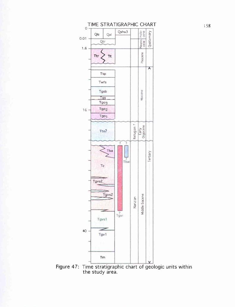
tr
G
TgvsI
Tba
Tgv
Tgv1
TIME STRATIGRAPHIC CHART0
0.01
1.6
40
QIS
Tmv
Figure 47: Time stratigraphic chart of geologic units withinthe study area.
i93
o 0
0Q
fV W
N12 Q N C W
Nar
z a
nR
efug
an
7
M d
dle
Eoc
ene
tarr
y0
aoce
neP
oce
neIle
istc
cene
Ter
t ary
-Q
uate
rnar
y
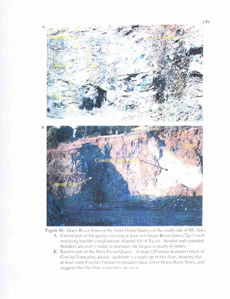
•0V -
-f4,
a
'•'
jt_ --
-——,— S
__tt__—-_ - -
;.
H1--'1. -1
—
—
—'- — - .'—
— -. — —
- •.'p p
I-
4.
15')
Figure 48: Grays River flows in the Terra Firma Quarry on the south side of Mt SoloA. Central part of the yuarr showing, at least two Grays River flows (Tgv I ) with
overlying bouldercun2 lonicratc channel -till o f I'g,.sI. Several weII -roundedboulders are over I meter in diameter, the largest is nearly 4 meters.
B. Eastern part of the Terra Firma Quarry A lai age (20-meter diameter) block ofCowliti Formation arkosic sandstone r5 caught-up in this flow. showing_ thatat least some Cowlit/ Formation predates these lower Grays River flows. andsuggests that the Ilow r" pu.,,rhl in' a iC
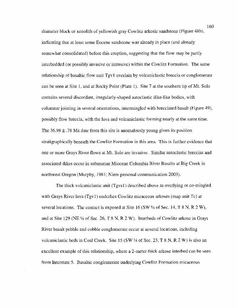
160diameter block or xenolith of yellowish gray Cowlitz arkosic sandstone (Figure 48b),
indicating that at least some Eocene sandstone was already in place (and already
somewhat consolidated) before this eruption, suggesting that the flow may be partly
interbedded (or possibly invasive or intrusive) within the Cowlitz Formation. The same
relationship of basaltic flow unit Tgv 1 overlain by volcaniclastic breccia or conglomerate
can be seen at Site 1, and at Rocky Point (Plate 1). Site 7 at the southern tip of Mt. Solo
contains several discordant, irregularly-shaped autoclastic dike-like bodies, with
columnar jointing in several orientations, intermingled with brecciated basalt (Figure 49),
possibly flow breccia, with the lava and volcaniclastic forming nearly at the same time.
The 36.98 ±.78 Ma date from this site is anomalously young given its position
stratigraphically beneath the Cowlitz Formation in this area. This is further evidence that
one or more Grays River flows at Mt. Solo are invasive. Similar autoclastic breccias and
associated dikes occur in submarine Miocene Columbia River Basalts at Big Creek in
northwest Oregon (Murphy, 1981; Niem personal communication 2003).
The thick volcaniclastic unit (Tgvs 1) described above as overlying or co-mingled
with Grays River lava (Tgvl) underlies Cowlitz micaceous arkoses (map unit Tc) at
several locations. The contact is exposed at Site 16 (SW 1/4 of Sec. 14, T 8 N, R 2 W),
and at Site 129 (NE 1/4 of Sec. 26, T 8 N, R 2 W). Interbeds of Cowlitz arkose in Grays
River basalt pebble and cobble conglomerate occur at several locations, including
volcaniclastic beds in Coal Creek. Site 15 (SW 1/a of Sec. 23, T 8 N, R 2 W) is also an
excellent example of this relationship, where a 2-meter thick arkose interbed can be seen
from Interstate 5. Basaltic conglomerate underlying Cowlitz Formation micaceous
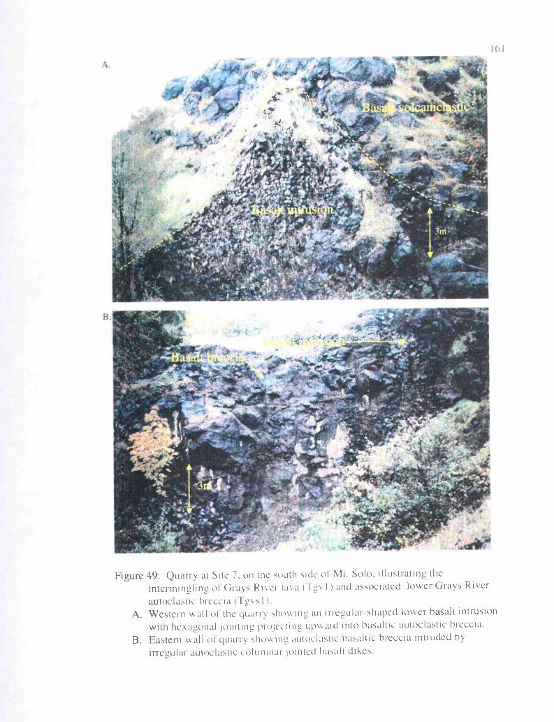
A.
0.{
' w "rI
6i~
Figure 49: Quarry at Site 7, on the south side of Mt Solo, illustrating the
intermingling ol'Grass River lava ('l gv I ) and associated lower Grays Riverautoclastic hreccia llevs I )
A. Western wall of the quarry showing an irregular-shaped lower basalt intrusionwith hexagonal jointing p1oiccting upmard into basaltic autoclastic hreccia
B. Eastern wall of quarry shoe ing autoclastic basaltic hreccia intruded byirregular autoclastic columnar jointed basalt dikes
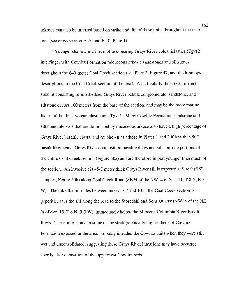
162arkoses can also be inferred based on strike and dip of these units throughout the map
area (see cross section A-A' and B-B', Plate 1).
Younger shallow marine, mollusk-bearing Grays River volcaniclastics (Tgvs2)
interfinger with Cowlitz Formation micaceous arkosic sandstones and siltstones
throughout the 640-meter Coal Creek section (see Plate 2, Figure 47, and the lithologic
descriptions in the Coal Creek section of the text). A particularly thick (-35 meter)
subunit consisting of interbedded Grays River pebble conglomerate, sandstone, and
siltstone occurs 100 meters from the base of the section, and may be the more marine
facies of the thick volcaniclastic unit Tgvs 1. Many Cowlitz Formation sandstone and
siltstone intervals that are dominated by micaceous arkose also have a high percentage of
Grays River basaltic clasts, and are shown as arkose in Plates 1 and 2 if less than 50%
basalt fragments. Grays River composition basaltic dikes and sills intrude portions of
the entire Coal Creek section (Figure 50a) and are therefore in part younger than much of
the section. An invasive (?) -5-7 meter thick Grays River sill is exposed at Site 9 ("IS"
samples, Figure 50b) along Coal Creek Road (SE 1/4 of the NW 1/4 of Sec. 11, T 8 N, R 3
W). The dike that intrudes between intervals 7 and 10 in the Coal Creek section is
peperitic, as is the sill along the road to the Storedahl and Sons Quarry (NW '/a of the NE
1/4 of Sec. 15, T 8 N, R 3 W), immediately below the Miocene Columbia River Basalt
flows. These intrusions, in some of the stratigraphically highest beds of Cowlitz
Formation exposed in the area, probably intruded the Cowlitz units when they were still
wet and unconsolidated, suggesting these Grays River intrusions may have occurred
shortly after deposition of the uppermost Cowlitz beds.
7..
—
'P3
I.
I'.
i
Figure 50: Grays Ricr hisult intrusions into the Co" lit! Formation (Tgvid andTgvis).A Nearly vertical 0-meter wide Grays River dike intruding interval 21 in Coal
Creek. Over 60 such dikes, most trending northwest, intrude the CowlitzFormation only in ('oal Crcek Note L-W fault offsetting the dike.
B Roadcut along Coal Creek Road (Site "IS") exposing a Grays River sill Note
the displacement of overl'vin1-1 tuff and coal beds, suggesting a possibleinvasive relationship This offset could also he entirely due to faulting.
lo .vz *,t
is .0
164
Petrology
Seventeen thin sections were produced from Grays River Volcanics samples
collected in the study area. These samples were selected because they illustrate the range
in mineralogy and texture of the four Grays River units (thin section locations are
identified in Plate 1). Three thin sections are Grays River basaltic lava flows (Tgvl; Sites
la, 2a, and 7). Nine thin sections are from the thick, partly subaerial lower volcaniclastic
unit (Tgvs1; Sites 5, 6, 7a, 7b, 14, 15, CR-2, CR-7, and FQ clast). Four thin sections are
from the shallow marine Grays River basalt volcaniclastic unit interbedded with Cowlitz
Formation arkoses described in the Coal Creek section (Tgvs2; CC-45, 54, 77, and 93).
One thin section was made from a dike intruding interval 44 in the Coal Creek section
(Tgvid; CC-44). Eleven Grays River Volcanics samples were analyzed with financial
assistance from Karl Wegmann of the Washington Department of Natural Resources for
major oxide and trace element geochemistry using x-ray fluorescence (XRF) by the
Washington State University GeoAnalytical Laboratory (Appendix III). Six of these
samples are from the Grays River subaerial basalt flows (Tgvl; Sites lb, 2a, 7c, 7d, 63,
and 101). Two samples are from the partly terrestrial lower volcaniclastic unit (Tgvsl;
Site 5 and FQ clast). Three samples are from dike intrusions into the Cowlitz Formation
in Coal Creek (Tgvid; CC-9, 44, and 63).
Grays River Flows
Grays River basalt flows in the Longview-Kelso area appear to be largely
subaerial, and can be either massive or show well-developed columnar jointing. Flows at
the Terra Firma Quarry at the base of Mt. Solo, and Site lb, are massive to columnar-
jointed. Those at Sites la, 2, and 4 are mostly columnar jointed, and are medium to dark
165
gray, but weather to medium brown or medium brownish orange. No individual flow
in the area can be studied from top to bottom in its entirety, so flow thickness cannot be
precisely ascertained, but they are at least several meters thick. Flows seem to be
dominantly sheet-like, but individual flows cannot be traced laterally for much distance,
so some may be partly channelized or intracanyon. At Site lb, nearly horizontal joints
are likely boundaries between flows (flow joints). Toward the north of this outcrop and
slightly upsection, the flow top becomes amygdaloidal (vesicles filled with both calcite
and zeolite), suggesting one of the flows is over 10-meters thick. No instance of reddish
oxidized flow tops or paleosols as observed by Payne (1998) and Kleibacker (2001) in
younger Grays River flows were observed in the study area.
Fresh hand samples are typically augite-, olivine-, and labradorite-phyric, but are
less commonly microphyric to aphyric. Feldspar glomerophenocrysts consisting of
several labradorite feldspars range in size up to nearly 2 mm, but average less than 1 mm.
Individual euhedral augite phenocrysts can reach 5 mm, but are more typically nearly 1
mm. Weathered and often clay-altered olivine phenocrysts are rounded and appear
brownish or greenish in hand sample. The most highly porphyritic hand samples are
-30% visible phenocrysts and -60% black glassy groundmass consisting of aligned
plagioclase microlites (pilotaxitic flow texture).
One sample was chosen to represent each of the three major exposures of Grays
River Volcanics flows within the study area, and thin sectioned for petrographic study;
Site 7 (Mt. Solo), Site la (the core of the Columbia Heights Anticline, Plate 1), and Site
2a (Rocky Point, east of the Cowlitz River). Site 7 flows are intermingled with flow
breccia and may represent the transition from basal autoclastic flow breccia to the basalt
166
flow itself. These are sparsely porphyritic, with nearly 75% of the sample consisting
of greenish clay altered groundmass with sub-aligned lath-like plagioclase microlites, and
small and less abundant augite microlites that average 100-200 micrometers (Figure 51a).
Labradorite glomerophenocrysts average 1-2 mm and commonly include augite and
olivine phenocrysts of similar size (figure 5 lb). About 5% of Site 7 flows consists of
albite-twinned plagioclase laths, 2-3% altered olivine/augite microlites, 8% large
phenocrysts or glomerophenocrysts of labradorite, and 9% glomerophenocrysts of augite.
Augite crystals are commonly equant and have brown clay-altered margins.
Subaerial basalt flows from Site la are highly porphyritic, and have a clay altered
groundmass constituting about 75% of the sample, containing randomly oriented
plagioclase microlites and globular opaque ilmenite. Larger phenocrysts comprise about
25% of the sample, augite accounting for 15% (Figure 52a), labradorite accounting for
10%, and a minor -3% amount of olivine. Secondary white sparry calcite fills
microfractures and accounts for about I% of the total sample. Augite phenocrysts are
equant, fractured, and have partially resorbed margins, as do some of the plagioclase
microlites and larger labradorite phenocrysts. Both of these minerals form abundant
glomerophenocrysts throughout the flow. Site 2a (Figure 52b) from Rocky Point
contains phenocrysts set in a pilotaxitic groundmass consisting of aligned plagioclase
microlites (100-200 micrometers), and smaller interstitial augites, olivines, and opaque
ilmenite crystals averaging about 50 micrometers (together constituting about 80% of the
sample). Larger labradorite phenocrysts, commonly forming glomerophenocrysts several
mm in diameter (Figure 52b), constitute about 16-17% of the basalt. The remainder is
iddingsite-altered olivine phenocrysts. Only one sizeable augite occurs in this sample,
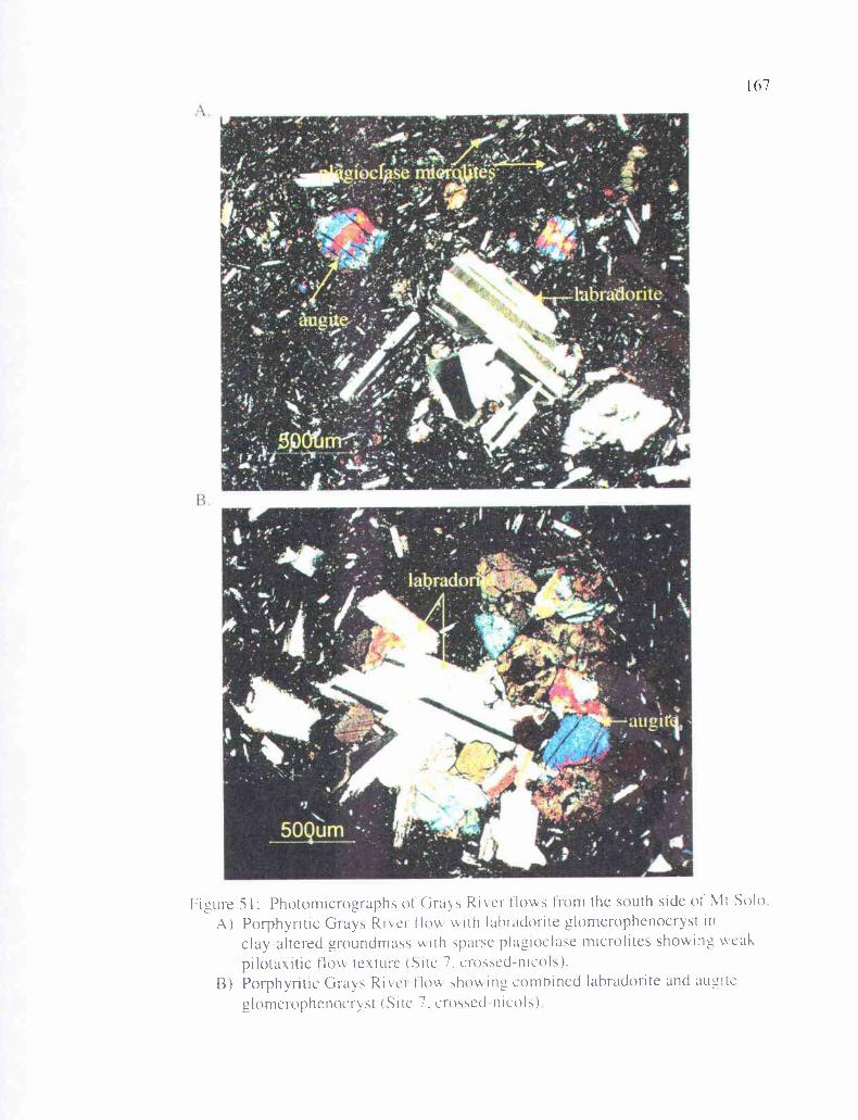
13
Figure 5 1: Photomicrographs of Grays River flows from the south side of Mt SoloA) Porphyritic Grays River Ilo\A with lahradorite glomerophenocryst in
clay-altered groundmass tiith sparse plagioclase microlites showing wcakpilotaxitic flow texture (Site 7. crossed-nicols).
B) Porphyritic Grays River ilo,.v showing combined labradorite and augitcglomerophenocryst (Site 7. crossed-nicols)
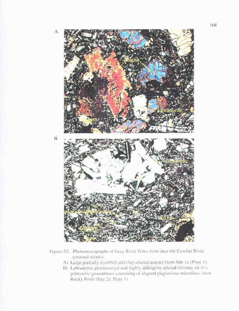
.4
168
Figure 52: Photomicrographs of Gia River flows tom near the Cowlitz Riser(crossed-nicols).
A) Large partially resorhed and clay-altered augites from Site la (Plate I ).
B) Lahradoi to glomeroci vst and highly iddingsite-altered olivines set in apilotaxitic groundmass consisting of aligned plagioclase microlites. Iron]Rocky Point (Site 2a, Plate I )
169
equant with altered margins. These Grays River basalt flows are similar in most
respects petrographically to Grays River flows described by Payne (1998) and Kleibacker
(2001), except that Longview-Kelso area flows are apparently not texturally
differentiated from top to bottom as described in Payne's m.s. thesis area -10 km to the
north.
Dikes
Over 30 basalt dikes and two sills of Grays River basalt were mapped along Coal
Creek and roadcuts adjacent to the creek (Plate 1, and Coal Creek inset Plate 2), where
they intruded perpendicular to the bedding of Cowlitz Formation micaceous arkoses or
marine Grays River volcaniclastics. The dikes (of normal polarity according to the
fluxgate portable magnetometer) range in width from 0.5 to 6 meters, and are generally
sub-parallel, trending between N 40 W and N 60 W. Dikes less than 0.3 meters across
were not mapped. They are largely parallel to, and commonly associated with, the
dominant northwest-trending joint and fault pattern in the creek. Many dike outcrops
have well-developed sub-vertical slickensides on their planar margins. These intrusive
bodies generally parallel the strike of Cowlitz Formation beds in the creek, and dip at
right angles to the dip of the sedimentary beds. If these Cowlitz beds were returned to
their original horizontal position, the dikes would have to have been emplaced vertically,
and were later tilted (5-30 degrees) along with the beds into which they intruded to their
present orientation. As previously mentioned, the basalt dike intruding between intervals
7 and 10 in the Coal Creek section is peperitic (consisting of basalt with fragments of
medium-grained micaceous, arkosic sandstone), and may have been emplaced shortly
after deposition of these beds when they were still wet and unconsolidated, also applying
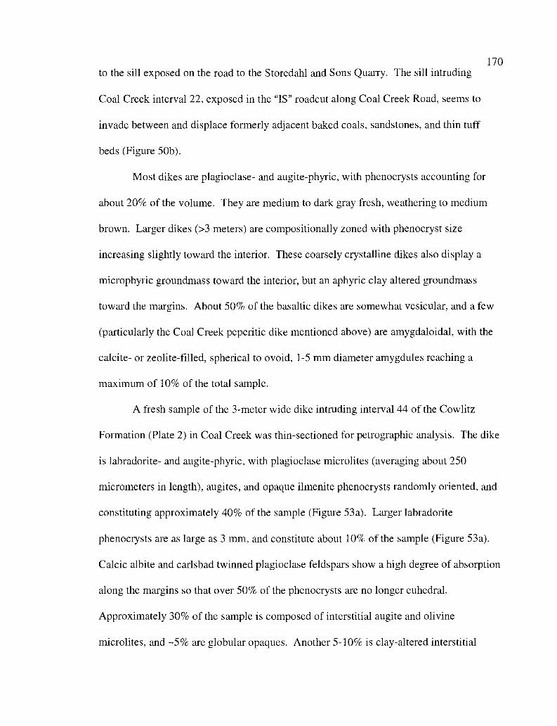
170
to the sill exposed on the road to the Storedahl and Sons Quarry. The sill intruding
Coal Creek interval 22, exposed in the "IS" roadcut along Coal Creek Road, seems to
invade between and displace formerly adjacent baked coals, sandstones, and thin tuff
beds (Figure 50b).
Most dikes are plagioclase- and augite-phyric, with phenocrysts accounting for
about 20% of the volume. They are medium to dark gray fresh, weathering to medium
brown. Larger dikes (>3 meters) are compositionally zoned with phenocryst size
increasing slightly toward the interior. These coarsely crystalline dikes also display a
microphyric groundmass toward the interior, but an aphyric clay altered groundmass
toward the margins. About 50% of the basaltic dikes are somewhat vesicular, and a few
(particularly the Coal Creek peperitic dike mentioned above) are amygdaloidal, with the
calcite- or zeolite-filled, spherical to ovoid, 1-5 mm diameter amygdules reaching a
maximum of 10% of the total sample.
A fresh sample of the 3-meter wide dike intruding interval 44 of the Cowlitz
Formation (Plate 2) in Coal Creek was thin-sectioned for petrographic analysis. The dike
is labradorite- and augite-phyric, with plagioclase microlites (averaging about 250
micrometers in length), augites, and opaque ilmenite phenocrysts randomly oriented, and
constituting approximately 40% of the sample (Figure 53a). Larger labradorite
phenocrysts are as large as 3 mm, and constitute about 10% of the sample (Figure 53a).
Calcic albite and carlsbad twinned plagioclase feldspars show a high degree of absorption
along the margins so that over 50% of the phenocrysts are no longer euhedral.
Approximately 30% of the sample is composed of interstitial augite and olivine
microlites, and -5% are globular opaques. Another 5-10% is clay-altered interstitial
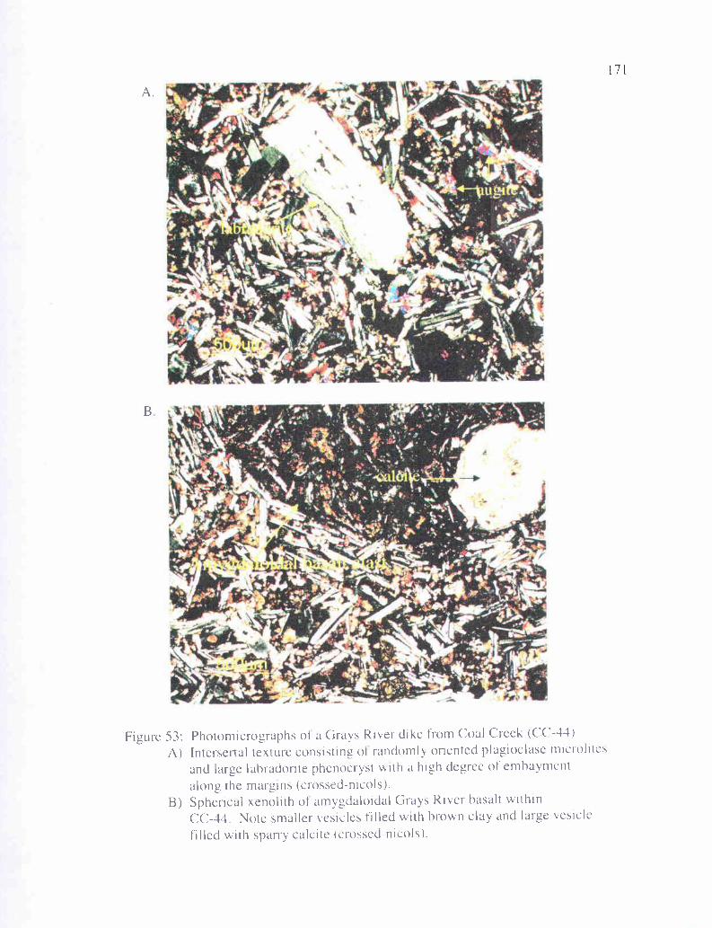
A.
B
Figure 53: Photomicrographs of a Grays River dike from Coal Creek (CC-44)A) Intersertal texture consisting of randomly oriented plagioclase microlites
and large labradorite phenocryst with a high degree of embaymentalong the margins (crossed-nicols).
B) Spherical xenolith of amygdaloidal Grays River basalt withinCC-44. Note smaller vesicles filled with brown clay and large vesicle
filled with sparry calcite (crossed-nicols).
172
groundmass between crystals. Large augite phenocrysts with embayed margins
constitute about 1%. This sample also contains well-rounded amygdaloidal xenoliths of
older Grays River basalt flows that have pilotaxitic flow texture (Figure 53b). The dikes
are petrographically like the subaerial Grays River basalt flows except they lack the
pilotaxitic flow texture of aligned plagioclase microlites. Large vesicles are filled with
calcite, smaller vesicles are filled with brown chlorophaeite clay.
Lower Volcaniclastics
The Lower Grays River Volcaniclastic unit (Tgvs 1, Plate 1) varies in lithology
throughout the study area from basaltic breccia to pebble-boulder conglomerates and
basaltic sandstones, and at Site 105 (Plate 1) is interbedded with western Cascade-derived
lithic pumice lapilli tuffs. These tuffs are thinly bedded and contain spherical
accretionary lapilli. Five facies of this unit are recognized within the study area: 1)
fluvial channel-fill clast- or matrix-supported, cobble to boulder conglomerates, 2) very
poorly-sorted debris flow deposits derived from en mass movement of volcanic material,
3) hyperconcentrated flow deposits consisting of moderately- to poorly-sorted, massive to
thickly-bedded volcanic breccia to cobble conglomerate, 4) scoriaceous hyaloclastite base
surge deposits from phreatomagmatic eruptive centers (e.g., Rocky Point and Mt. Solo),
and 5) basal autoclastic flow breccias intruded by irregular basalt dikes. At Mt. Solo this
unit conformably overlies, and is partially interbedded with flows of Grays River
composition (facies 5). It also conformably underlies, and is partially interbedded with
micaceous lithic arkosic sandstones and siltstones of the middle Eocene Cowlitz
Formation (facies 3). The occurrence of micaceous Cowlitz Formation arkose interbeds
in this unit shows that it is also in part shallow marine. Similar (but mostly younger)
173
Grays River volcaniclastics north and west of the study area do not contain as high
percentage of scoriaceous clasts as those from the study area (Kleibacker, 2001). The
thickness of Tgvs 1 also widely varies throughout the study area. In the vicinity of Mt.
Solo, an up-thrown fault block, the unit has a minimum thickness of 350 feet (-110
meters). Over 500 feet (-150 meters) of basaltic conglomerate and underlying Grays
River flows have been uplifted in the southern core of the Columbia Heights Anticline
(Plate 1, cross section A-A'). East of the Cowlitz River, within and north of the city of
Kelso, roughly 200 feet (70 meters) is exposed beneath conformably overlying arkoses of
the Cowlitz Formation. An unknown thickness of this unit is covered by Quaternary
alluvium of the Columbia and Cowlitz Rivers beneath the cities of Longview and Kelso.
The wide variation in thickness of this unit in the study area, and the apparent lack
of thick exposures of this volcaniclastic unit in the thesis areas of Payne (1998) and
Kleibacker (2001) to the north, indicates that it is highly localized. The thickest and
coarsest-grained deposit seems to lie along an axis that generally trends along a line from
Mt. Solo toward the Columbia Heights suburb of Longview, and Rocky Point (Plate 1).
The unit apparently rapidly thins toward the northwest and southeast. If this thick partly
subaerial volcaniclastic is correlative to the thickest mollusk-bearing shallow marine
basalt volcaniclastic unit in Coal Creek (Tgvs2, Plate 2), which has similar lithology, then
it has thinned to roughly 100 feet (30 meters) in that direction. If it is not correlative to
Tgvs2, then it has either pinched out in that direction or underlies 2000 feet (-650
meters) of Cowlitz Formation. Toward the southeast, the deposit is at least 10 meters
thick where it is faulted into the large roadcut at the Carrolls I-5 exit (Site 9).
174
Maximum clast size of the basalt cobble-boulder conglomerate portion of
Tgvsl decreases toward the northeast, and upsection. In the Terra Firma Quarry on the
southwest flank of Mt. Solo, in the paleo-channels in the upper part of the cliff face
(facies 1, Figure 48a), several boulders are over 1 meter in diameter, and the largest is 3-4
meters. Paleocurrent direction based on the cross sectional shape of the channel would
have been toward the east-northeast (nearly directly into the cliff face), suggesting a
substantial paleo-topographic high was toward the west (where the gravity anomaly
occurs, Figure 45). At the small canyon in the west half of Sec. 22, T 8 N, R 2 W (low in
the section), well-rounded, large clasts are over 10 cm, and the largest clast is 30 cm
(facies 2 or 3). At Site 123 (SW 1/4 of Sec. 16, T 8 N, R 2 W), elongate basaltic boulders
nearly 1 meter in diameter are widely scattered in a matrix of well-rounded basalt cobbles
a few centimeters in diameter (facies 2). At Site 105 (NW 1/a of Sec. 3, T 8 N, R 3 W),
average clast size has decreased to 3 cm, with the largest 8 cm (facies 3). A sufficient
amount of time to deposit 1-3 meter-thick air fall tuffs had to elapse between these
individual hyperconcentrated flows. At Site 9 (along Old Pacific Highway, Carrolls I-5
exit) the largest clast size is about 6 cm. No clasts over 3 cm were found in the high
elevation exposures of this unit.
Grays River volcaniclastic natural outcrops in the study area (i.e., Mt. Solo) are
typically cliff-formers since they are well-indurated due to extensive calcite cement.
Roadcuts or railroad cuts are slow to weather relative to less indurated Cowlitz Formation
sandstones and form prominent cliffs (e.g., roadcuts at Sites 5, 7, 9, 14, and 33).
Outcrops are highly fractured with some degree of alteration. Clasts typically have a
175
weathered rind, and spaces and fractures are commonly filled with limonite and
manganese oxide, or with calcite, analcime (Site 7), or zeolite.
The only exposures of true volcaniclastic breccia, containing few or no rounded
clasts (and no arkosic component in places), are the two quarries on the south side of Mt.
Solo (facies 5). Here, massive and poorly sorted breccias of angular porphyritic basalt
are intermingled with columnar-jointed Grays River flows and irregularly shaped
intrusions. At Site 7 (Figure 49), columnar jointed projections (irregular dikes) of Grays
River basalt of various shapes, sizes, and angles intrude the breccia. The variety of
shapes, including the curvature, and in places the open honeycomb nature of some of the
columnar bodies, indicates that these are not intruding previously fractured or faulted
older volcaniclastic breccias that were already in place. It is more likely that these are
basal or top flow breccias, produced at the same time as the lavas, which then injected
autoclastic dikes and irregular intrusions into the flow breccia pile. Basaltic clasts at Site
7 are very angular, and some are nearly 0.5 meter in diameter. Fragments can be
plagioclase- or augite-phyric, aphanitic, vesicular, or amygdaloidal. Breccias can be
either clast- or matrix-supported, with the matrix consisting of smaller fragments of
porphyritic and aphyric basalt and euhedral plagioclase (labradorite) and augite. Some
euhedral augite crystals are over 1-cm long. Breccias higher in the section and farther
east on Mt. Solo (e.g., Site 6) have a substantial percentage of stream reworked
subrounded clasts and grade into poorly-sorted cobble conglomerate, possibly indicating
a transition from a debris flow or lahar (facies 2) to hyperconcentrated fluvial flows
(facies 3). Fractures, pore spaces, and amygdules at these locations are dominantly filled
with white analcime and zeolite. Elsewhere on Mt. Solo, sparry calcite is more common
or the dominant fracture- and void-filling mineral. Both breccias and conglomerates
of this unit are typically massive, or bedding is thicker than the height of the outcrop,
characteristics of both debris flows and the lower portion of thick hyperconcentrated
flows.
176
A roadcut exposure where 38th Street in Longview is cut through the eastern part
of Mt. Solo (Site 6), consists of highly fractured, dark gray, monotonous, non-graded,
somewhat sorted (lacking significantly larger than average clasts), massive to thickly-
bedded volcaniclastic basalt hyperconcentrated flow (facies 3) to phreatomagmatic surge
deposits (facies 4). Many clasts are sub-rounded, enough for this part of the unit to be
considered a stream-reworked, poorly-sorted, clast-supported volcanic conglomerate,
rather than a volcanic flow breccia. However, the high percentage of scoriaceous clasts
indicates a phreatomagmatic origin for most clasts. This exposure is transitional between
the two facies, and may represent reworked older phreatomagmatic clasts. Fracture sets
may be crude bedding. Like Site 7, Site 6 contains euhedral augite crystals, some nearly
1 cm long, and abundant scoriaceous clasts. Two km to the northwest, the large roadcut
beneath the power lines (Site 32) has virtually the same lithology, but is laterally
discontinuous, with the nature of the contact with adjacent units uncertain. This could be
a block faulted into the Cowlitz Formation, or a channelized hyperconcentrated flow.
Three thin sections of the basalt volcaniclastics from Mt. Solo were studied: two
from Site 7, and one from Site 6 (Plate 1). Samples from Site 7 are from the scoriaceous
conglomerate/breccia portion of the unit. They consist of subrounded to well-rounded
porphyritic basaltic clasts of varying basalt lithologies (Figure 54a). About 70% are
amygdaloidal (scoriaceous) with abundant spherical vesicles filled with greenish fibrous
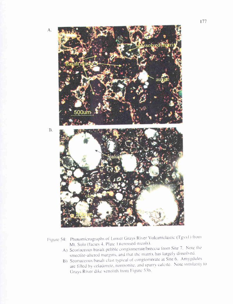
Figure 54: Photomicrographs of' Lower Grays River Volcaniclastic (Tgsl) Iron'Mt. Solo (facies 4. Plate I )(crossed-nicols).
A) Scoriaceous Basalt pebble conglomerate/breccia from Site 7. Note the
smectite-altered margins. and that the matrix has largely dissolved.
B) Scoriaceous hasalt clast typical of conglomerate at Site 6. Amygdules
are filled by celadonite, nontronite, and sparry calcite. Note similarity to
Grays River dike yenofrth from Figure 5Th.
178
clay, likely celadonite and nontronite. About 20% of the sample consists of much
darker, rounded, porphyritic basalt clasts, with nearly opaque clay-altered basaltic glass
groundmass. Many plagioclase phenocrysts have been altered to brownish clay, which
also fills the vesicles in the basalt clasts. Augite phenocrysts are still largely unaltered.
Another -10% consists of relatively unaltered pilotaxitic and aphyric basalt clasts, with
aligned albite twinned plagioclase microlites still largely intact. Some clasts are highly
altered, and some sparry calcite (<1%) fills the pore spaces. Much of the calcite that
originally filled the pore spaces has been dissolved, leaving about 10% pore space.
Green, fibrous celadonite or nontronite clay lines voids and rims all clasts as a
widespread cement that has destroyed much of the primary porosity and permeability.
In thin section, Site 6 is also a scoriaceous basalt conglomerate/breccia (Figure
54b). Approximately 90% of the subrounded clasts are scoriaceous or amygdaloidal,
some vesicles filled with calcite (-10%), some filled with smectite clay (-20%), the rest
rimmed with fibrous nontronite or celadonite clay but otherwise empty. About 90% of
the sample as a whole is brownish due to extensive clay alteration. A few pilotaxitic lava
clasts are identifiable. This thin section from Site 6 contains a small (-5%) component of
arkose (i.e., angular monocrystalline quartz, mica, potassium feldspar), suggesting this
thick basaltic volcaniclastic, despite being stratigraphically lower than most of the
Cowlitz Formation in the area, is coeval with this formation rather than pre-dating it.
This conclusion is supported by the large arkosic xenolithic Cowlitz block within Grays
River flows at the Terra Firma Quarry, and the arkose interbed at Site 15. The arkosic
clasts, in addition to the scoriaceous clasts, indicate that this could be a
hyperconcentrated channelized flow entering the deltaic environment, reworking older
179
basalt phreatomagmatic and lava flow clasts and mixing in Cowlitz micaceous arkose.
Alternatively, arkosic clasts and older flows could have been incorporated into a deposit
from a phreatomagmatic eruption occurring in place within the delta front.
Basalt lava clasts from Site 6 appear to have undergone a period of diagenetic
alteration before emplacement, since few sodic plagioclase feldspar clasts of Cowlitz
Formation origin are altered, but most (more calcic) plagioclase phenocrysts within the
Grays River clasts are highly altered. This, along with the rounding and poor sorting of
the basalt clasts, suggests that the clasts had been transported by stream some distance
prior to deposition, perhaps in a hyperconcentrated flow. Some augites are completely
altered to brownish clay, others have only an altered clay rind. This
conglomerate/breccia is a collection of volcanic clasts of different textural maturity.
Three Grays River basalt pebble to cobble conglomerates are exposed at Site 9
("CR" samples) at the Carrolls 1-5 exit on Old Pacific Highway, at both the north (CR-1
and 2) and south (CR- 13) ends of this 100-meter long roadcut that exposes three north-
south trending faults (part of the Kelso Fault Zone, Plate 1). Another volcaniclastic unit
faulted into this outcrop is CR-7. This pumiceous lapilli tuff/pebble conglomerate is
massive, light to medium gray, and highly fractured with substantial alteration and
spheroidal weathering. Basaltic Grays River exposures have fractures filled with white
zeolite and calcite and, especially in thin section CR-1, abundant manganese oxide.
These poorly-sorted conglomerates (facies 3) are mainly basaltic sand matrix supported,
with clasts typically cobble-sized, but some are over 10 cm in diameter. Most clasts are
rounded to subrounded. The outcrop at the south end of the roadcut is similar, but has a
higher percentage of coarse-grained basaltic sandstone-sized clasts, and graded bedding
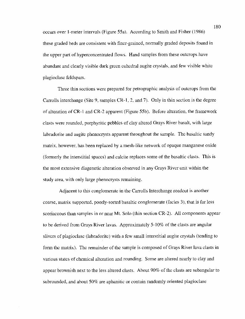
180
occurs over 1-meter intervals (Figure 55a). According to Smith and Fisher (1986)
these graded beds are consistent with finer-grained, normally graded deposits found in
the upper part of hyperconcentrated flows. Hand samples from these outcrops have
abundant and clearly visible dark green euhedral augite crystals, and few visible white
plagioclase feldspars.
Three thin sections were prepared for petrographic analysis of outcrops from the
Carrolls interchange (Site 9, samples CR-1, 2, and 7). Only in thin section is the degree
of alteration of CR-1 and CR-2 apparent (Figure 55b). Before alteration, the framework
clasts were rounded, porphyritic pebbles of clay altered Grays River basalt, with large
labradorite and augite phenocrysts apparent throughout the sample. The basaltic sandy
matrix, however, has been replaced by a mesh-like network of opaque manganese oxide
(formerly the interstitial spaces) and calcite replaces some of the basaltic clasts. This is
the most extensive diagenetic alteration observed in any Grays River unit within the
study area, with only large phenocrysts remaining.
Adjacent to this conglomerate in the Carrolls Interchange roadcut is another
coarse, matrix supported, poorly-sorted basaltic conglomerate (facies 3), that is far less
scoriaceous than samples in or near Mt. Solo (thin section CR-2). All components appear
to be derived from Grays River lavas. Approximately 5-10% of the clasts are angular
slivers of plagioclase (labradorite) with a few small interstitial augite crystals (tending to
form the matrix). The remainder of the sample is composed of Grays River lava clasts in
various states of chemical alteration and rounding. Some are altered nearly to clay and
appear brownish next to the less altered clasts. About 90% of the clasts are subangular to
subrounded, and about 50% are aphanitic or contain randomly oriented plagioclase
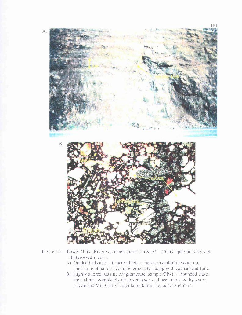
A
fl?t--
. I
&
1;
r
iml-
B
Figure 55: Lower Grays River oIcaniclastlcs tram Site 9 55h is a photomicrographwith (crossed-nicols)A) Graded heds about I-metci thick at the south end of the outcrop.
consisting of hasaltic conglomerate alternating with coarse sandstone.B) Highly altered basaltic conglomerate (sample CR-I ). Rounded clasts
have almost completely dissolved away and been replaced by sparrycalcite and MnO. only larger lahradorite phenocrysts remain.
182
microlites, and about 50% display pilotaxitic flow texture of plagioclase microlites,
augite, and opaque ilmenite. About 25% are scoriaceous. Both sparry calcite cement
(especially around the larger clasts) and fibrous clay rim cement are present in this
sample. Thin section CR-7 is a reworked pumiceous basaltic tuff, containing -40%
pumice clasts, and only about 10% of the basalt clasts are pilotaxitic. This unit is also
clay cemented and contains hydrothermal vein quartz, and some black carbonaceous
plant debris occurs.
Outcrops of thick-bedded basalt pebble to boulder conglomerate and breccia in
the Columbia Heights area are variable in lithology. Exposures lower in the section are
generally coarser-grained or have larger maximum-sized clasts. The two small canyons
mentioned earlier to the south and west of Beacon Hill (Sec. 15 and 22, T 8 N, R 2 W)
expose coarse-grained, relatively unaltered, poorly-sorted basaltic cobble to boulder
conglomerates with clasts approaching 1 meter in diameter (facies 2). Farther to the
north at Site 43 (SE 1/4 of the SW 1/a of Sec. 33, T 9 N, R 2 W), Site 44 (SW 1/4 of the SE
1/a of Sec. 33, T 9 N, R 2 W), and Site 37 (E 1/2 of Sec. 3, T 8 N, R 2 W) grain size
averages nearly 1 cm (facies 3). These outcrops are in various states of weathering, the
most altered being Site 37, where clasts are very light tan due to clay alteration. The
Tgvsl outcrop at the highest elevation in the study area is Site 22, exposed in a small
gully on the side of Columbia Heights Road. This light brown conglomerate exposure is
nearly completely altered to clays.
A very thick-bedded, 10-meter high roadcut on Main Street near downtown Kelso
(Site 14) appears indistinguishable from similar exposures described above; highly
fractured and spheroidally weathered, poorly-sorted, matrix supported
183
conglomerate/breccia, massive with abundant alteration, and large euhedral augite
clasts (facies 3). One thin section was produced from this location (Figure 56a), and it
classifies as a basalt wacke and, unlike the other exposures, this has a substantial arkosic
component. About 15% is monocrystalline quartz, 5% polycrystalline quartz, --6%
potassium feldspar, 3% sodic plagioclase and/or labradorite, 1% mica (both muscovite
and biotite flakes), 2% clinopyroxene, 1% quartzite, 1% chert, 25% silt-sized basaltic
matrix, 10% pilotaxitic basalt, and 30% randomly oriented basalt. Approximately 30%
of basalt clasts are scoriaceous. The arkosic minerals are angular to subangular; the
relatively less resistant basaltic clasts are subrounded to well-rounded, very poorly-
sorted, and compositionally immature, but texturally mature (i.e., moderately rounded
and lack of detrital clay matrix). Some basaltic clasts are heavily altered, nearly entirely
to smectite clay. Potassium feldspars (orthoclase) are also highly altered to sericite mica,
and the cement is exclusively clay. Like Mt. Solo samples, this sample is important
because, being 1/3 arkosic in composition, it demonstrates the co-existence of
extrabasinal Cowlitz micaceous arkoses and intrabasinal Grays River volcanic sources.
This deposit could have been produced by hyperconcentrated flows that entered the
deltaic environment upstream, mixing basaltic and micaceous arkosic components as it
moved.
Nearly 2 km north of Site 14 on the east side of Interstate 5 is Site 15 (facies 3),
which appears in outcrop to be lithologically similar to Site 14. However, at this site
there is a 2-meter thick micaceous arkosic sandstone interbed near the base. Thin section
shows this to be a poorly-sorted, fine basaltic pebble conglomerate with a high
percentage of arkosic minerals. In thin section, most rounded clasts that appear to basalt
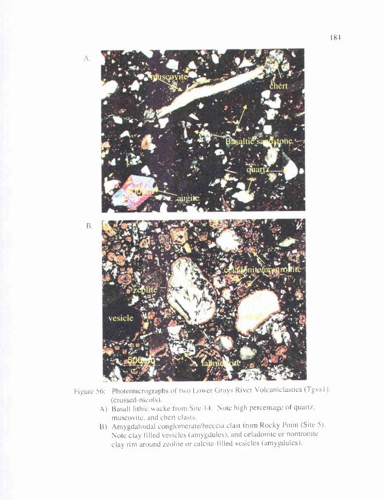
if
B
Figure 56: Photomicrographs of two Lowei Grays River Volcaniclastics (TgvsI ).(crossed-nicols).
A) Basalt lithic wacke born Site 14 Note high percentage of quart/.muscovite, and chert clasts.
B) Amygdaloidal conglomerate/hreccia clast from Rocky Point (Site 5).Note clay filled vesicles (amygdules), and celadonite or nontroniteclay rim around zeolite or calcite-filled vesicles (amygdules).
185
in hand sample have a micaceous arkosic component contained within them, as if
they are rounded clasts of a lithology similar to Site 14 (i.e., the clasts are rounded basalt
lithic sandstone rather than basalt). This sample is composed of -15% monocrystalline
quartz, 5% polycrystalline quartz, 1% mica (mostly muscovite), <1% clinopyroxene, 5%
potassium feldspar, 1% plagioclase, 3% chert, 3% carbonaceous plant material, and 60%
rounded clasts of fine-grained arkosic and basaltic sandstone. The sample is poorly-
sorted, compositionally immature, and clay cemented.
A roadcut along 1-5 through the eastern part of Rocky Point (Site 5) is a
lithologically unique example of Grays River volcaniclastics. These are
phreatomagmatic hyaloclastites (facies 4) that appear mottled light brownish gray and
dark gray. The light colored portion are moderately-sorted, rounded vesicular basalt
clasts that are fairly uniform in size, from 0.5 cm to 1.5 cm. In thin section these are
apparently calcite and zeolite filled scoriaceous clasts (Figure 56b). The entire outcrop is
highly weathered, with the phenocrysts altered to such an extent that no calcic plagioclase
feldspars remain. Some augite crystals are also heavily altered to brownish clay.
Secondary pore and vesicle filling varies. A thin greenish clay rim surrounds all grains
and partly infills all pores. About 15% of remaining pore space is filled with sparry
calcite, 75% with greenish smectite or celadonite clay, and 10% with white zeolite.
Intergranular primary porosity is roughly 15%. Most pore throats are filled with greenish
clay, suggesting low effective porosity and permeability in these tightly cemented
volcaniclastics. This basalt volcaniclastic consisting exclusively of scoriaceous clasts,
with no arkosic component or clasts of Grays River flows, is evidence that the two small
hills that form Rocky Point are phreatomagmatic volcanic centers (cinder cones) erupting
186
into the shallow marine environment. A roadcut on the west side of Rocky Point near
the train tunnel exposes red basaltic cinders, suggesting part of the eruption may have
been subaerial.
Geochemistry
Eleven Grays River Volcanic samples were analyzed for major oxide and trace
element geochemistry (with financial assistance from Tim Walsh and Karl Wegmann of
the Washington Department of Natural Resources) by the Washington State University
GeoAnalytical Laboratory using x-ray fluorescence (XRF, Appendix III). Of these, 3 are
basalt dikes intruding the Cowlitz Formation in Coal Creek (Tgvid), 3 are Grays River
flows (Tgv 1), 2 are from the Lower Grays River Volcaniclastic unit (Tgvs 1), and three
are ambiguous as to whether they are invasive flows or intrusive dikes. All of these
samples were crushed and the freshest non-amygdaloidal chips were handpicked and
cleaned to ensure the most accurate results. SiO2 content ranges from 42.71% to 50.34%.
The 42.71% result from a dike intruding Coal Creek interval 44 likely represents an
altered or weathered specimen, 46.54% should probably represent the low end (Figures
57 and 58). Total alkalis (K2O + Na2O) range from 2.25% to 4.5%, averaging 3.44%.
TiO2 varies widely from 1.4% to 4.1%, with anomalously low TiO2 flows (varying from
1.4% to 1.9%) occurring only near Rocky Point (Sites lb, 2a, and 5, Figure 58),
suggesting that these samples represent a localized flow that combines geochemical
features of Grays River basalt and Cascade-derived basaltic andesite. Elsewhere Grays
River samples vary from 2.8% to 4.1%. Total FeO varies from 10.5% to 17.5% with the
lower readings from near Rocky Point and a clast from the Terra Firma Quarry, and the
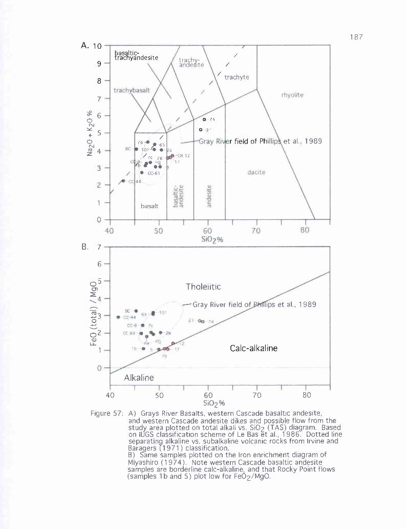
0r'J
. 9
S
tra h.-andeSite
-CR-1217
bas Itic-tracnyandesite
0 74
0 21
r field of Phi
Calc-alkaline
/trachyte
7
0' 60N" 50Nz`°
4
3
7d-,63
10,14 0''7c 76--+ FQ
CC-63
44
basalt
0
B. 7
6
05Cn
-,4
`°30
2
u.
Alkaline
et al., 1989
Tholeiitic
Gray River field of ips et al., 1989
40 50 60 70 80Si02%
Figure 57: A) Grays River Basalts, western Cascade basaltic andesite,and western Cascade andesite dikes and possible flow from thestudy area plotted on total alkali vs. Si02 (TAS) diagram. Basedon TUGS classification scheme of Le Bas et at., 1986. Dotted lineseparating alkaline vs. subalkaline volcanic rocks from Irvine andBaragers (1971) classification.B) Same samples plotted on the Iron enrichment diagram ofMiyashiro (1974). Note western Cascade basaltic andesitesamples are borderline calc-alkaline, and that Rocky Point flows(samples 1 b and 5) plot low for Fe02/MgO.
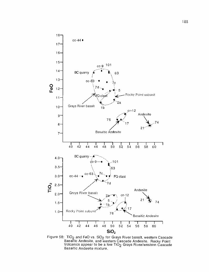
188
18--1
17-I
16-
cc-9 101
BC quarry
cc-4,3 .I 7d
1 0 -
9 -
8 -
7 -
4 . 0 -
3 . 5 -
3 . 0 -1
Grays River basalt
63
,--5
Qcyst/ ?' -Rocky Point subunit
1b
Basaltic Andesite
Andesite
21
40 42 44 46 48 50 52 54 56 58 60
..._."marBC quarry
9-. 101
3
cc-44 -9cc-63 ,
-FQ clast
Rocky Point subunit76
Grays River basaltcr-12
Andesite
2 ' ''-V 74
Basaltic Andesite
1
40 42 44 46 48 50 52 54 56 58 60
S102
Figure 58: TiO2 and FeO vs. SiO2 for Grays River basalt, western CascadeBasaltic Andesite, and western Cascade Andesite. Rocky PointVolcanics appear to be a low T02 Grays River/western CascadeBasaltic Andesite mixture.
cr-12
189highest reading from a Coal Creek dike (CC-44) at 17.5% (again, likely due to
alteration or weathering, Figure 58).
Using Irvine and Barager's (1971) classification (Figure 57), all but samples 7d
and BC clast (from Mt. Solo) plot as subalkaline basalt. Site 7d plots as alkaline basalt
and CC-44 is marginally alkaline. Note that all but CC-44 and BC clast plot within the
Grays River field as defined by Phillips et al. (1989). This is likely the result of some
degree of alteration or weathering in those samples. The iron enrichment diagram of
Miyashiro (1974) show that all but four of the samples (BC clast, CC-44, Site lb, and
Site 5) plot within the field of Phillips et al. (1989) as tholeiitic basalts. The BC clast and
CC-44 are tholeiitic basalts that plot slightly lower in Si02 than the Phillips et al. fields.
On both diagrams, samples from the study area tend to plot lower than average for Si02.
On both FeO and Ti02 vs. Si02 diagrams (Figure 58), Grays River samples
generally plot near each other, and are separate from western Cascade basaltic andesite
and western Cascade andesite flows and intrusions within the study area. Grays River
samples are relatively higher in FeO and lower in Si02 than the other volcanic units, and
typically higher in Ti02. However, flows and volcaniclastics from the vicinity of Rocky
Point (Sites la, 2b, and 5) plot significantly lower in Ti02, and relatively low in FeO than
other Grays River units. Given this geochemical difference, and that Rocky Point
appears to be an isolated phreatomagmatic eruptive center, Grays River Volcanic deposits
associated with Rocky Point should be considered a separate relatively low TiO2 and FeO
subunit of Grays River Volcanics (or possibly a separate unit entirely), occurring only in
the study area.
190
Grays River Volcaniclastic Depositional Environments and Paleo egeoographic
Reconstruction
Eocene sedimentary rock units in the Longview-Kelso area of southwest
Washington are the result of a complex interplay of extrabasinal micaceous, arkosic
Cowlitz Formation deltaic/estuarine sediment derived from a Rocky Mountain source
(e.g., the Idaho Batholith), and intrabasinal basalt flows and basaltic volcaniclastics
derived from nearby Grays River volcaniclastic highlands. Most Coal Creek lithic
arkoses have at least a minor component of Grays River basalt clasts, and most Grays
River volcaniclastic units have a component of mica, quartz, and feldspar clasts (see
petrography section). The position of the study area on the southeast flank of the gravity
anomaly presumed to be the Grays River shield volcano (Figure 45) suggests that at the
time of deposition of the Cowlitz Formation deltaic sediments, volcanic highlands would
have dominated the area immediately to the west, with a smaller Rocky Point volcanic
pile to the east (Figure 59). Dominant paleocurrent direction in Cowlitz Formation
sigmoidal cross-beds in Coal Creek is toward the southwest. Allowing for some (up to
45 degrees) post-Eocene clockwise tectonic rotation of Cowlitz Formation strata, the
ancestral Columbia River (source for Cowlitz sediment) was locally flowing from the
north or northeast. This scenario is as expected given that the course of the ancestral
Columbia River would have been deflected toward the south or southwest, due to the
volcanic high (Figure 45).
In the study area, the main distributary channels and tidal channels would have
been oriented south southwest-north northeast before tectonic rotation, with a Grays
River high to the west. Delta front sands would have prograded toward the south and
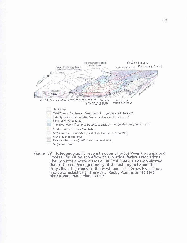
Hyperconcentrated/
Gras Fiver Highlandsdebris flows
slAd
U
Cowlitz Estuary
Supratidal Marsh Distributary Channel
Mt. Solo Volcanic Centerlnvasive Grays River Flow Barner Bar Rocky PointCCowlIitz Formation Volcanic Center(Coal Creek Section)
Barrier Bar
Tidal Channel Sandstone (Flaser-draped megaripples, lithofacies f)
Tidal Rythmites (Heterolithic Sandst. and mudst , lithofacies e)Bay Mud (lithofacies d)Supratidal Marsh (Coal & carbonaceous shale w/ interbedded tuffs, lithofacies h)
Cowlitz Formation undifferentiated
Grays River Volcaniclastic (Tgvsl, basalt conglom & breccia)Grays River Basalt FlowsMcIntosh Formation (Shelfal siltstone/mudstone)Grays River Dike
Figure 59: Paleogeographic reconstruction of Grays River Volcanics andCowlitz Formation shoreface to supratidal facies associations.The Colwitz Formation section in Coal Creek is tide-dominateddue to the confined geometry of the estuary between theGrays River highlands to the west, and thick Grays River flowsandyvolcaniclastics to the east. Rocky Point is an isolatedphreatomagmatic cinder cone.
192
southwest, in the direction of the Mist Gas Field. Surrounding the tidal channels
(lithofacies f) were extensive tidal flats, an environment similar to modern Willapa Bay
(Figure 20), depositing the mud flaser-draped cross-beds of lithofacies f, the tidal
rhythmites of lithofacies e, and micaceous bay muds of lithofacies d. Toward the
northeast and between distributary channels were extensive supratidal marshes producing
the coals of the Coal Creek section (lithofacies h, Figures 20 and 59).
The basaltic fraction of Cowlitz micaceous arkoses deposited in the environments
described above has two plausible origins. It could be the result of nearby Grays River
volcanic detritus entering the Eocene Columbia River immediately upstream and adjacent
to the delta via tributary streams, debris flows, or hyperconcentrated flows derived from
the adjacent erupting volcanic highlands to the southwest (and possibly Rocky Point to
the east). In addition, mixing of deltaic micaceous arkosic sediments and Grays River
basaltic sediments could have resulted from strong tidal currents, storm wave surges, or
(less common) tsunamis entering the delta or estuary, mixing micaceous arkose with
offshore basaltic sands and gravels. Offshore volcanic highland sources for basaltic
sediment have been verified in this study because of several small Grays River basalt
tongues and storm wave-lag, recorded throughout the Coal Creek section, deposited
shallow marine fossils and associated coarse-grained shallow marine basaltic sediment
(Tgvs2) over arkosic tidal facies and delta front sands. Most basalt clasts mixed with
Cowlitz micaceous arkoses are well-rounded grains of Grays River basalt lava fragments
rather than scoriaceous clasts, suggesting some Grays River highland source upstream.
Periods of larger influxes of fresher basaltic sediment in the form of
hyperconcentrated or debris flows into the area are apparent based on the thick, poorly-
193
sorted, matrix-supported basalt pebble, cobble, and boulder conglomerates and
breccias of the Lower Grays River Volcaniclastic unit (Tgvs 1). These debris flows,
derived from the nearby volcanic highlands (Figure 59), would have catastrophically
rushed downslope and into the ancestral Columbia River deltaic mouth, mixing with the
river and estuarine water to become channelized hyperconcentrated flows, and enter the
delta via distributary channels where mixing with extrabasinal micaceous arkosic
sediment occurred. Hyperconcentrated flows in the study area are massive to thick-
bedded and consist of subrounded to well-rounded basalt lava clasts with variable
amounts of scoriaceous clasts, and contain a percentage of mica, quartz, and feldspar
from a Cowlitz extrabasinal source. High energy debris flow deposits occur in the study
area, consisting of much larger basalt boulders in a poorly-sorted matrix of coarse basalt
sand and well-rounded to angular, pebble to cobble-size clasts (e.g., Site 123). These
deposits represent catastrophic volcanic or tropical flood events, possibly from a local
source such as the eruptive center of which Mt. Solo is a remnant.
These periods of heavy influx of Grays River volcaniclastic sands and gravels into
the deltaic/estuarine environment via debris and hyperconcentrated flows occurred before
the bulk of the Cowlitz Formation in the area had been deposited. The thick (up to 600
feet) Tgvs 1 unit, where exposed, occurs stratigraphically beneath the Cowlitz Formation
(Plate 1, cross sections A-A' and B-B'). These deposits are thickest along a northeast-
southwest axis from the Columbia Heights/Rocky Point area toward Mt. Solo. The large
paleo-channel cross section exposed in the Terra Firma Quarry on the south flank Mt.
Solo containing clast-supported boulder conglomerate with several clasts over 1-meter in
diameter (facies 1, Figure 48a), has a paleocurrent orientation directly out of or into the
194
cliff, toward the northeast or southwest. Mt. Solo appears to be an upfaulted remnant
of a growing volcanic eruptive center based on the autoclastic breccia and associated
basalt intrusions. The boulder conglomerate channel-fill shows that there was
considerable topographic relief toward the west, in the direction of the gravity high. This
could then have been the source of this thick Tgvs 1 volcaniclastic deposit, flushed into
the basin by a series of hyperconcentrated flows toward the northeast. Once deposited,
this thick volcaniclastic pile would have effectively channelized the ancestral Columbia
River into an incised valley between the volcaniclastic pile and Rocky Point, and the
Grays River highlands to the west. Cross section A-A' shows this relationship, and
explains why over 2000 feet of Cowlitz Formation was deposited in the Coal Creek area,
but very little was deposited in the Columbia Heights area, or at least little remains after
late Eocene uplift (folding and faulting) and erosion. The 35-meter thick volcaniclastic
unit low in the Coal Creek Cowlitz Formation section at the base of unit B (Plate 2) likely
represents the shallow marine equivalent of these catastrophic volcanic pulses.
The large (-20 meter diameter) block of micaceous, arkosic Cowlitz Formation
caught up in a Grays River flow exposed in the Terra Firma Quarry (Figure 48b) is
evidence of an invasive relationship between this flow and older Cowlitz Formation
arkosic micaceous sandstones. From west to east on Mt. Solo, Grays River units range
from lower invasive and subaerial flows, into an autoclastic upper flow breccia with lava
dikes, which then grades into phreatomagmatic scoriaceous deposits, which further grade
into hyperconcentrated flood deposits with a substantial component of Cowlitz arkose.
All this evidence supports the model of a (possibly isolated) growing volcanic edifice,
195
with lava flows entering the sea, causing massive steam (phreatomagmatic)
explosions and some flows invading the underlying sediment (Figure 59).
Predominantly scoriaceous, and in places red oxidized, volcaniclastics from
Rocky Point indicate that this is an isolated phreatomagmatic to subaerial eruptive center
(Rocky Point subunit). Furthermore, basaltic flows and hyaloclastites from this site are
anomalously low in Ti02 (refer to Figure 58), indicating a different magmatic source than
the other Grays River units, or possibly mixing with magmas of a western Cascade
source. Rocky Point was, thus, likely an isolated cinder cone erupting into the water
saturated delta. All of this evidence combined allows for a plausible paleogeographic
reconstruction (Figure 59). Grays River Volcanic highs or shield volcanoes exist to the
north and west of the study area. Debris flows, and (more commonly) hyperconcentrated
floods in this tropical Eocene setting would periodically rush downslope and into the
deltaic incised estuarine depositional environment of the arkosic Cowlitz Formation. The
distributary channels of the ancestral Columbia River mouth, and their associated
estuarine tidal channels and tidal bars, would have been surrounded by tidal flats, and
supratidal swamps landward. In such areas as Mt. Solo, the Terra Firma Quarry, and
possibly the IS roadcut along Coal Creek Road, Grays River basalt flows invaded wet
and unconsolidated Cowlitz sediments, and in the case of Mt. Solo, displaced and
transported a house-size block of Cowlitz micaceous, arkosic sandstone. Mt. Solo,
initially a center of phreatomagmatic activity, eventually built up to include subaerial
flows, hyperconcentrated flows, and at least one large channel flowing down the side of
the edifice toward the northeast. Erupting into this setting to the east was the Rocky
196
Point cinder cone, a phreatomagmatic eruptive center producing dominantly
scoriaceous (red and black) cinders.
Western Cascade Basaltic Andesite
High hilly topography east of the Cowlitz River within the study area is due to the
erosional resistance of a minimum of 600 feet (- 180 meters) of western Cascade Basaltic
Andesite (map unit Tba, Plate 1). This thick volcanic unit was assigned to the Goble
Volcanics by Livingston in 1966, as part of a 1500-meter thick, westward-thinning wedge
of late Eocene/early Oligocene lava overlain by younger Tertiary sedimentary rock in
northwest Oregon, and overlying and possibly interfingering with the Eocene Cowlitz
Formation in the Longview and Kelso area and northwest Oregon. However, a problem
with assigning these flows to the Goble Volcanics on the southwest Washington side of
the Columbia River has developed in recent years. According to Evarts and Swanson
(1994) and Evarts (2002), the overlying Tertiary marine sedimentary formations (e.g.,
Keasey and Pittsburg Bluff Formations), which define the stratigraphic position of this
volcanic unit in northwest Oregon, do not extend east of the Columbia River. Therefore,
on the Washington side the top of this mafic volcanic unit is impossible to define, and
instead becomes just the lower part of a thick pile of Tertiary, volcanic arc flows that
underlie the majority of the western slope of the southwest Washington Cascade Range.
Lacking the overlying marine sedimentary units, this unit is considered here to be the
basal part of late Eocene-Oligocene, western Cascade arc derived basaltic andesite that is
partly correlative to the Goble Volcanics of northwest Oregon (Evarts, 2002).
197
Geochemistry
Geochemistry samples were taken of this unit in the hills above Ostrander (Sites
17 and 76, just east of the Kelso quadrangle, Plate 1) and from a portion of a flow down-
faulted into the long roadcut on Old Pacific Highway at the Carrolls interchange (CR-12,
Site 9, Plate 1). The samples plot as basaltic andesite in Irvine and Barager's (1971)
classification, chemically distinct from the Grays River Volcanics in containing a slightly
higher percentage of S102 (Figures 57 and 58). However, these flows fall within the
broad Grays River field as defined by Phillips and others (1998). In Miyashiro's (1974)
iron enrichment diagram these samples straddle the line between tholeiitic and calc-
alkaline compositions (Figure 57b). Due to the chemical and lithologic differences
between these flows and those of the Grays River Volcanics within the study area,
particularly the low TiO2 (1.2% to 1.5%) and FeO values (8.5% to 8.9%, Figure 58), they
are treated here as separate units. These samples are geochemically (and petrologically)
consistent with the lower SiO2 samples of the basaltic andesite unit described by Evarts
from the Deer Island, Oregon quadrangle (2002). FeO and TiO2 percentages are
consistent with those of Goble/Cole Mtn. basalts as described by Rarey (1986) in
northwest Oregon. The possibility exists that these higher elevation flows east of the
Cowlitz River are stratigraphically higher flows in a chemically differentiated Grays
River sequence, but unlikely given the low TiO2 values and other similarities with
basaltic andesite/Goble/Cole Mtn. samples as described above.
Lithology and Petrography
Columnar jointed basaltic andesite flows within the study area are typically
spheroidally weathered and altered, but the three sample locations mentioned above
.alm
J
Figu11 60:A)
A
Photomicrographs of basaltic andesite flows (Tha, Plate 1).Site 17, porphyritic with a high percentage of plagioclase microlites,and large iddingsite-altered oliNine phenocrysts (crossed-nicols)Site 9 (Sample CR-I2). pilotaxitic flow texture around altered oli,,ine,(crossed-nicols ).
199
produced useful fresh samples. Like the Grays River basalts, these basaltic andesite
augite- and plagioclase-phyric flows are also olivine-phyric (similar to basaltic andesite
flows described by Evarts, 2002), with some phenocrysts over 5 mm in length. In the
weathered exterior of the basaltic andesite outcrops, the olivine crystals are weathered
away. In thin section (Figure 60a) Site 17 is noticeably more porphyritic than Grays
River basalt samples, with larger olivines, and consists of about 80% flow-aligned
(pilotaxitic), albite-twinned plagioclase (labradorite). About 5% is untwinned feldspar,
and 10% unaltered euhedral augite crystals, small relative to Grays River clinopyroxenes,
and not glomeroporphyritic. Large (1-2mm) iddingsite-altered olivines constitute about
10% of the sample. This flow does not have true groundmass, but is instead almost
entirely phyric. Site 76 shows virtually the same lithology, but olivines are slightly more
altered, some almost entirely dissolved away. Plagioclase feldspars in Site 76 are not
flow-aligned, and augites are larger and more abundant. Sample CR-12 from Site 9 is
similar overall (Figure 60b) but has pilotaxitic texture, with flow-aligned plagioclase and
altered olivines up to 3 mm long.
Western Cascade Andesite Dikes
Geochemistry and Field Characteristics
Two parallel dikes and an apparent small flow in Sec. 25, T 9 N, R 2 W (Sites 21
and 74, Plate 1) were chemically analyzed and plot as significantly more silicic (SiO2
values range from 58.6% to 59%) and slightly more alkaline (i.e., higher total NaO +
K2O values ranging from 5.2% to 5.8%) in the Irvine and Barager (1971) diagram,
plotting as calc-alkaline andesites (Figure 57a). In the iron enrichment diagram of
Miyashiro (1974), the dikes plot as higher in SiO2 and away from both Grays River
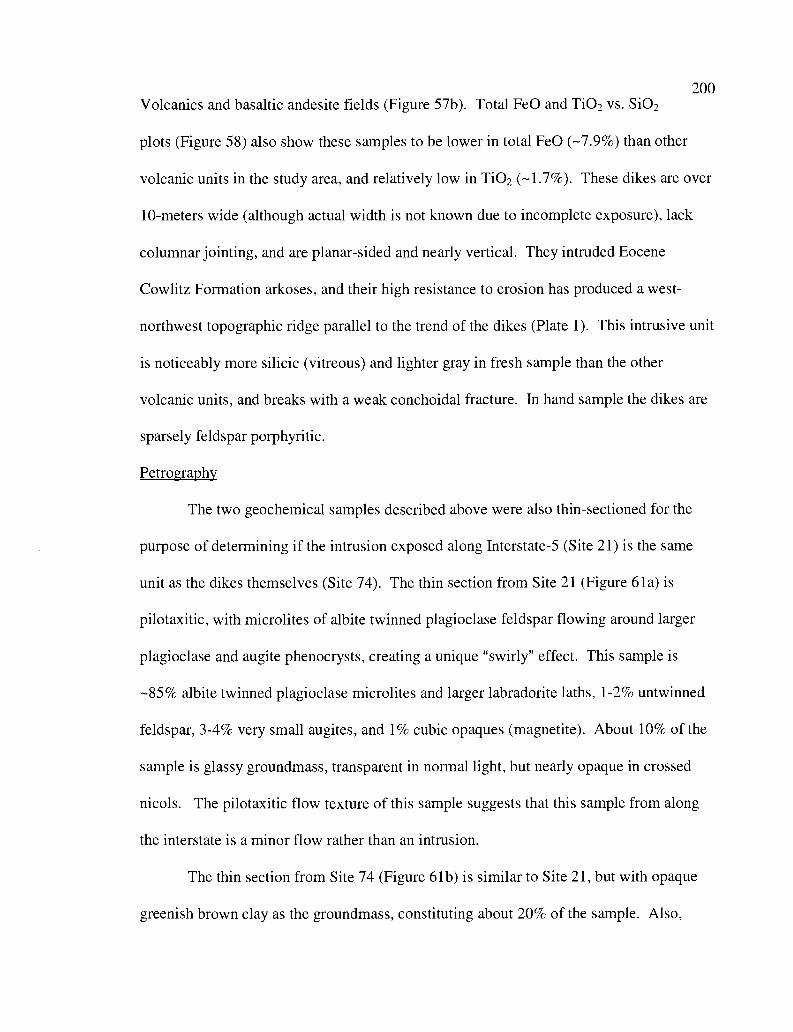
200Volcanics and basaltic andesite fields (Figure 57b). Total FeO and TiO2 vs. S102
plots (Figure 58) also show these samples to be lower in total FeO (-7.9%) than other
volcanic units in the study area, and relatively low in TiO2 (-1.7%). These dikes are over
10-meters wide (although actual width is not known due to incomplete exposure), lack
columnar jointing, and are planar-sided and nearly vertical. They intruded Eocene
Cowlitz Formation arkoses, and their high resistance to erosion has produced a west-
northwest topographic ridge parallel to the trend of the dikes (Plate 1). This intrusive unit
is noticeably more silicic (vitreous) and lighter gray in fresh sample than the other
volcanic units, and breaks with a weak conchoidal fracture. In hand sample the dikes are
sparsely feldspar porphyritic.
Petrography
The two geochemical samples described above were also thin-sectioned for the
purpose of determining if the intrusion exposed along Interstate-5 (Site 21) is the same
unit as the dikes themselves (Site 74). The thin section from Site 21 (Figure 61a) is
pilotaxitic, with microlites of albite twinned plagioclase feldspar flowing around larger
plagioclase and augite phenocrysts, creating a unique "swirly" effect. This sample is
-85% albite twinned plagioclase microlites and larger labradorite laths, 1-2% untwinned
feldspar, 3-4% very small augites, and 1% cubic opaques (magnetite). About 10% of the
sample is glassy groundmass, transparent in normal light, but nearly opaque in crossed
nicols. The pilotaxitic flow texture of this sample suggests that this sample from along
the interstate is a minor flow rather than an intrusion.
The thin section from Site 74 (Figure 61b) is similar to Site 21, but with opaque
greenish brown clay as the groundmass, constituting about 20% of the sample. Also,
B.
Figure 61: Photomicrographs of andesite unit (Tai) from east of the Cowlitz RiciA) Site 21 along Interstate-, Pilotaxitic texture suggests this may he a
small andesite llMk (crossed-nicols).B) Site 74 andesite dike Note randomly oriented plagioclase microlitcs
and large lahradorite glonierophenocryst (crossed-nicols).

about 75% of the sample is randomly oriented plagioclase microlites and larger
labradorite phenocrysts. One to four percent of the sample consists of small augites
randomly scattered throughout the groundmass. One 3-mm diameter augite and
labradorite glomerocryst occurs in this thin section. About 1% consists of cubic or
globular opaque magnetite.
202
Columbia River Basalt Group203
Introduction
The Columbia River Basalt Group (CRB) is a thick sequence of tholeiitic flood-
basalts that erupted from fissures on the Columbia Plateau in parts of northeast Oregon,
southeast Washington, and western Idaho in the early to late Miocene (Taubeneck, 1970).
These eruptions produced approximately 200,000 km3 of basalt (Swanson and Wright,
1978), covering an area of about 163,700 km2 (Tolan et al., 1989). Due to the large
volume of these flood basalts, some were able to flow out of the Columbia Plateau, and
down the drainage of the ancestral Columbia River, a path not substantially different
from the present Columbia River Gorge, and into western Oregon (as far south as Salem)
and southwest Washington. Most Columbia River Basalt units were confined to the
Columbia Plateau (Beeson and Moran, 1979), but some flows (initially erupted hundreds
of miles to the east) reached the Miocene coastline. Here, the lavas formed submarine
basalt piles, and invaded the Tertiary coastal sediment, forming invasive dikes and sills,
and in places emerged again at the surface in localized marine eruptive centers (Beeson et
al., 1979; Rarey, 1986; Reidel and others, 1989). Three Columbia River Basalt units
reached as far west as southwest Washington and northwest Oregon; the Grande Ronde
Basalt, the Frenchman Springs Member of the Wanapum Basalt, and the Pomona
Member of the Saddle Mountain Basalt.
The early to middle Miocene Grande Ronde Basalt Formation (-15.6-16.5 Ma) is
typically aphanitic, and was erupted during two normal and two reversed polarity
intervals, which from oldest to youngest are R1, N1, R2, and N2. According to Reidel et
al. (1989), these basalts have a narrow compositional range, with 52-57 normalized
204weight percentage of SiO2, and MgO ranging from 3-6 normalized weight percent.
They are also enriched in FeO and incompatible elements relative to mid-ocean ridge
basalts (MORB). Six units of Grande Ronde Basalt reached west of the Cascades (Reidel
and others, 1989). From oldest to youngest these units are: the Wapshilla Ridge unit
(R2), Grouse Creek unit (R2), Ortley unit (N2), Umtanum unit (N2), Winter Water unit
(N2), and the Sentinel Bluffs unit (N2). The middle Miocene Frenchman Springs Member
of the Wanapum Basalt Formation (15.3 Ma) is divided into six major units which
include at least 21 different flows (Beeson and Tolan, 1985), of which only 11 separate
flows of the Ginkgo and Sand Hollow units reached the Pacific Coast (Beeson and others,
1989; Reidel and others, 1989). These flows are usually sparsely plagioclase-phyric.
The late Miocene Pomona member of the Saddle Mountains Basalt Formation (-12 Ma)
is typically glomeroporphyritic and only one flow (confined to the Columbia River paleo-
channel) reached southwest Washington. All of these Columbia River Basalt units can be
differentiated by varying abundance of major elements, particularly MgO, TiO2, and P2O5
(Reidel and others, 1989).
Local Distribution
Within the study area, Columbia River Basalt outcrops and deeply weathered red
soils occur at several locations, including elevations above 300 feet on Mt. Solo, where
flows occur above the Toutle (?) Formation. Here, a basalt flow is well exposed with a
pillow base in a quarry (Site 51, E'/2 of Sec 25, T 8 N, R 3 W), and overlying flows
occur as reddish soils and as slide blocks. Above 600 feet, Grande Ronde basalt flows
underlie the high elevation part of Columbia Heights area, and their resistance to erosion
is largely responsible for the high topography. In one large quarry (Site 54, the West
205Side Quarry near the center of Sec. 4, T 8 N, R 2 W), red oxidized soil horizons, and
basalt slide blocks allowed for mapping and study of the flow distribution in that area.
Erosional remnants of weathered Columbia River Basalt flows (reddish soils) cap the
hills 2 to 5 km west and northwest of the Columbia Heights area above 600 feet.
Resistance to erosion of these basalt flows is again largely responsible for the high
topography of these isolated hills (Plate 1).
Excellent, fresh exposures of the four lowest flows in the study area, and
interbeds between them, are found in both the north and south walls of the Storedahl and
Sons Quarry (NW 1/4 of the NE 1/a of Sec. 15, T 8 N, R 3 W) near Eufaula, where
stratigraphy and approximate thickness of the Grande Ronde Basalt flows was
determined (Figures 62 and 63). Other good exposures of the Grande Ronde Basalts in
the general area west of Coal Creek can be found along Highway 4 in the N 1/2 of Sec. 15,
T 8 N, R 3 W, in and around the small community of Eufaula (Sec 10, R 8 N, T 3 W),
and in the steep cliffs immediately west of Coal Creek. Other Grande Ronde exposures
occur in road cuts and in a small quarry (Site 104, E 1/2 of Sec. 28, T 9 N, R 3 W) along
the northernmost part of Coal Creek Road within the study area. No exposures were
found in the northeast portion of the study area, or anywhere east of the Cowlitz River.
Frenchman Springs and Pomona basalt flows are not well exposed in the study
area west of Coal Creek due to extensive deep weathering to red soils. One Frenchman
Springs outcrop just west of the study area consists of large uniform colonnade with
sparse labradorite laths approximately 1 cm long. They are mapped (Plate 1) based on
better exposures to the west of the study area and reddish soils within the study area, and
were mapped into the study area by Wells (1981).
206Grande Ronde Stratigraphy
For this study, Grande Ronde Basalt flow units were identified and distinguished
by geochemistry, petrography and field characteristics, and magnetic polarity. Once
these distinctions were made, areas where outcrops were poor or lacking were
extrapolated from known outcrops, and mapped based on soil color, elevation, and unit
thickness. Characteristics of sedimentary interbeds (e.g., cobble conglomerate or
tuffaceous siltstone) were also useful tools in flow identification and correlation. Over 30
hand samples were collected for lithologic and geochemical study in the laboratory; many
were oriented in the field for determination of normal or reverse polarity using the
portable fluxgate magnetometer. Six samples from the Grande Ronde stratigraphic
section in the Storedahl and Sons Quarry were chosen for petrographic analysis, and sent
to San Diego Petrographics for thin sectioning, for the purpose of describing the local
Grande Ronde stratigraphy. From oldest to youngest these are BC-1, BC-4, BC-5, BC-8,
BC-10, and BC-13 (Figures 62 and 63). Six samples from these same Grande Ronde
flow units in the quarry (as well as 7 other samples from the study area, for a total of 13)
were chosen for major oxide and trace element geochemistry (Appendix III).
The geochemical and fluxgate polarity analysis of a sample from the only really
good exposure in the Columbia Heights area (Site 54, the West Side Quarry) was
important in that identification of the stratigraphically lowest unit in this area would
allow mapping of that area once the Grande Ronde stratigraphy was established.
Similarly Site 51, the lowest flow on Mt. Solo (also the only good outcrop in that area),
was chemically analyzed and its magnetic polarity was determined for correlation to the
known stratigraphic section in the Storedahl and Sons Quarry. In the Columbia River
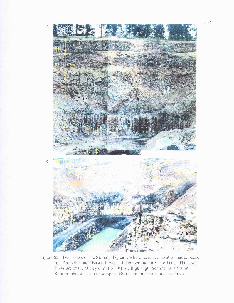
a-..
-
.,'. ' '.-'•.-.-
i .—.
-.
r
.4 .4—
1:'I
A
B.
..s
Figure 62: Two views of the StoredahI Quarry where recent excavation has exposedtour Grande Ronde Basalt flows and their sedimentarv interheds. The Iower ?flows are of the Ortley unit. flow #4 is a high M20 Sentinel Bluffs unit.Stratigraphic location of samples (BC) Irom this exposure are shown.
207
IF
P r
.0
208Basalt-dominated area west of Coal Creek, four other samples were prepared for
chemical analysis, three near Eufaula (Sites, 102a, 102b, and 103), and one from the
small quarry at Site 104 (Plate 1). Sites 63 and 101 were chemically analyzed to
determine if this unit was Columbia River Basalt, as it appeared in hand sample, or Grays
River Basalt as mapped by Wells (1981). High titanium and other characteristics (e.g.,
augite and plagioclase phenocrysts) suggest that it is a Grays River flow or sill (Plate 1,
Figures 58 and 64).
Flow Units Correlation and Geochemistry
Using all available data (geochemistry, field characteristics, and magnetic
polarity) 6 individual Columbia River Basalt flow types have been identified and mapped
within the study area (Plate 1). They are 3 N2 low MgO Ortley flows, overlain by one N2
high MgO Sentinel Bluffs flow, and possibly Frenchman Springs and Pomona flow units.
Figure 63 is a composite section of the six flow units, and the flow unit to which each
rock sample number is assigned. Using stratigraphic position, normal magnetic polarity,
and geochemical similarity, the lowest Ortley flow in the Storedahl and Sons Quarry, the
lowest Ortley aphyric flow on Mt. Solo, and the Ortley flow beneath the thin interbed in
the small quarry near the town of Eufaula are correlative (Sample BC-1, Site 51, and
Site102a respectively, Plate 1), and the lowest flow in the area (Flow #1). The next
Ortley flow #2 (the thickest one in the Storedahl and Sons Quarry), is represented by BC-
4 (at the bottom of the flow), BC-5 (at the top of the flow), the lower flow in the West
Side Quarry (Site 54), and the thick Ortley flow above the interbed at Site 102(b) near
Eufaula. Aphyric N2 Ortley Flow #3 chemical samples BC-8 and BC-10, near the top of
the cliffs in the Storedahl and Sons Quarry correlate to Site 104 in the northwest corner of
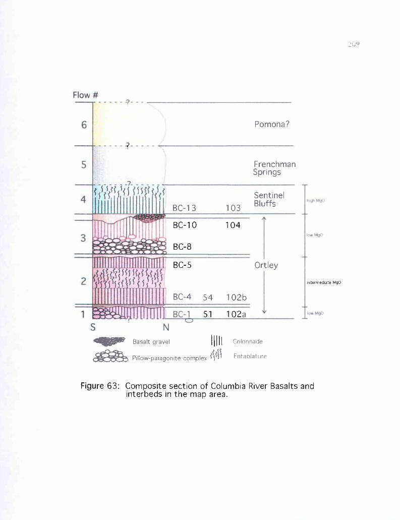
Flow #
I
higil Mg.
low. MgD.BC-1
rV l
Colonnade
Fntahlati ira
Pomona?
FrenchmanSprings
j5;s;i s S 5 S Sentinel
BC-13 103 Bluffs
Ortley
4RIOW Basalt gravel
BC-4 54 102b
fiPillow-palagonite complex j{fS
BC-10 104
BC-8
BC-5
intermediate MgO
51 102
Figure 63: Composite section of Columbia River Basalts andinterbeds in the map area.
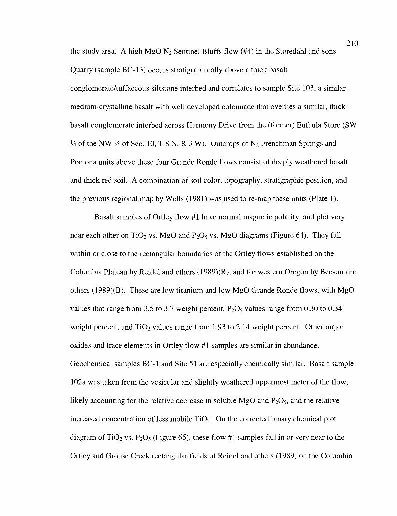
210the study area. A high MgO N2 Sentinel Bluffs flow (#4) in the Storedahl and sons
Quarry (sample BC-13) occurs stratigraphically above a thick basalt
conglomerate/tuffaceous siltstone interbed and correlates to sample Site 103, a similar
medium-crystalline basalt with well developed colonnade that overlies a similar, thick
basalt conglomerate interbed across Harmony Drive from the (former) Eufaula Store (SW
1/4 of the NW 1/a of Sec. 10, T 8 N, R 3 W). Outcrops of N2 Frenchman Springs and
Pomona units above these four Grande Ronde flows consist of deeply weathered basalt
and thick red soil. A combination of soil color, topography, stratigraphic position, and
the previous regional map by Wells (1981) was used to re-map these units (Plate 1).
Basalt samples of Ortley flow #1 have normal magnetic polarity, and plot very
near each other on TiO2 vs. MgO and P2O5 vs. MgO diagrams (Figure 64). They fall
within or close to the rectangular boundaries of the Ortley flows established on the
Columbia Plateau by Reidel and others (1989)(R), and for western Oregon by Beeson and
others (1989)(B). These are low titanium and low MgO Grande Ronde flows, with MgO
values that range from 3.5 to 3.7 weight percent, P2O5 values range from 0.30 to 0.34
weight percent, and TiO2 values range from 1.93 to 2.14 weight percent. Other major
oxides and trace elements in Ortley flow #1 samples are similar in abundance.
Geochemical samples BC-1 and Site 51 are especially chemically similar. Basalt sample
102a was taken from the vesicular and slightly weathered uppermost meter of the flow,
likely accounting for the relative decrease in soluble M90 and P2O5, and the relative
increased concentration of less mobile TiO2. On the corrected binary chemical plot
diagram of TiO2 vs. P2O5 (Figure 65), these flow #1 samples fall in or very near to the
Ortley and Grouse Creek rectangular fields of Reidel and others (1989) on the Columbia
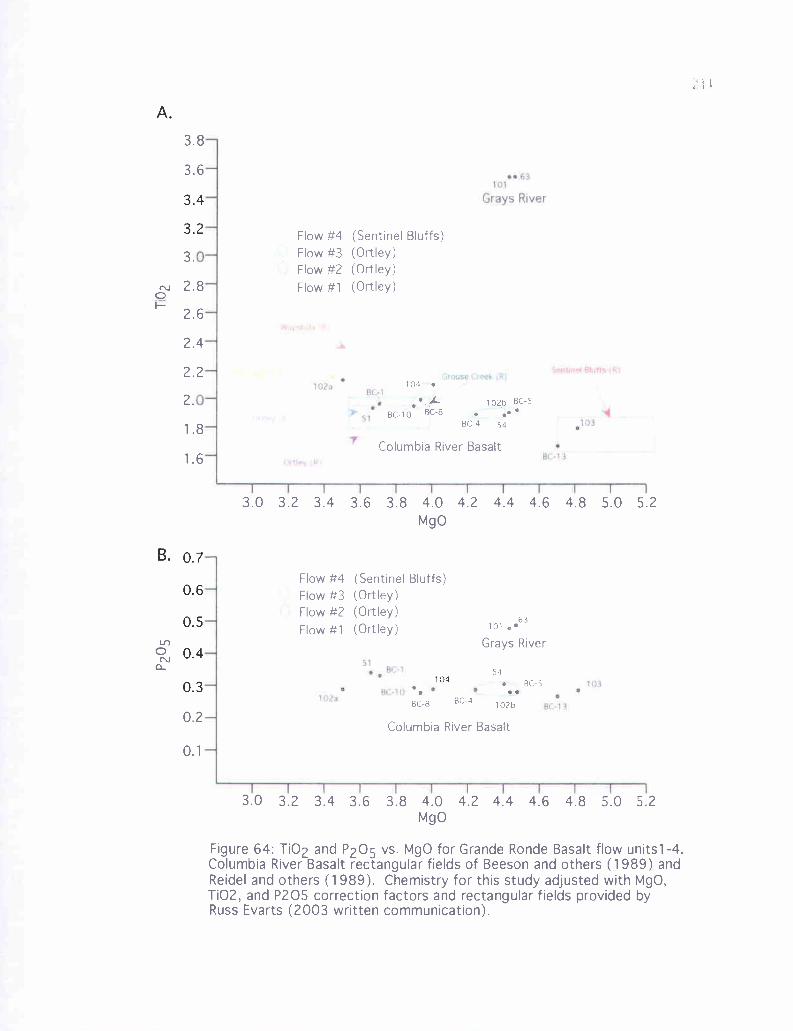
I
;63
Grays River
0
N411-u: la
0
Gruse:Creek R1S n1 rm4 6q,rf5.(a%
Hca3
.A
ap
I
iO
9C-',l
I TT T
Flow #4 (Sentinel Bluffs)Flow #3 (Ortley)Flow #2 (Ortley)Flow #1 (Ortley)
104
LBC-10 BC-8
102b BC-5
54BC-4
Columbia River Basalt
Flow #4 (Sentinel Bluffs)Flow #3 (Ortley)Flow #2 (Ortley)Flow #1 (Ortley)
BC-8
101 e
Grays River
63
54
BC-5
102bBC-4
Columbia River Basalt
3.4
3.2
B. 0.7
0.6
0.5
0.4
0.3
i. b
3.6
3.
2.8
2.6
2.4
2.2
2.
1.8
1.6
3.0 3.2 3.4 3.6 3.8 4.0 4.2 4.4 4.6 4.8 5.0 5.2MgO
0.2
0.1
3.0 3.2 3.4 3.6 3.8 4.0 4.2 4.4 4.6 4.8 5.0 5.2MgO
Figure 64: Ti02 and P205 vs. MgO for Grande Ronde Basalt flow units 1-4Columbia River Basalt rectangular fields of Beeson and others (1989) andReidel and others (1989). Chemistry for this study adjusted with MgO,Ti02, and P205 correction factors and rectangular fields provided byRuss Evarts (2003 written communication).
BC-8
BC 10
102BC(
Wapshilla Ridge (B
d
,f--l(
Winter Water (B)/
Umtanum (B)
Grouse Creek (R)
Grouse Creek (B)sX03
u e
Sentinel Bluffs (R)1.75- L Ortley (B)
1.7Ortley (R)
BC-
0.32 0.36
05 vs. Ti02 nde basaltal variations in westernOregon Colu (Reidel and
102a
bZ*0
9,1
S9,1
(?J)
(9)
2.2
2.2
2.1 5
2.1
2.05
2.0
1.9
1.85
1.8
Beeson and others (1989)Reidel and others (1989)
000
0.26 0.28 0.30 0.34 0.38 0.40 0.42P205
Figure 65: P2 for Grande Ro samples (shifted)(Rectang es show geochemic for CRB units Oregon (Beeson and others, 1989),
and for the mbia Plateau others, 1989).
weathered vesicularflow tops
213Plateau and by Beeson and others (1989) for western Oregon. Since Grouse Creek is
reversely polarized, and Ortley is normally polarized, it is concluded that this lower flow
is an Ortley unit flow.
All basalt samples taken from Ortley flow #2 have normal magnetic polarity, and
plot near each other on both TiO2 vs. MgO and P2O5 vs. MgO diagrams (Figure 64). This
flow is low TiO2 but intermediate MgO, with values ranging from 4.2% to 4.5%. P2O5
values range from 0.28% to 0.30%, and TiO2 values range from 1.89% to 1.92%. Other
major oxides and trace elements in Ortley flow #2 are similar (Appendix III). It is
interesting to note that on both of these binary chemical plots, there is far less chemical
difference between Site 54b, Site 102b, and BC-5 (widely separated from each other),
than there is between the bottom and top of the same flow (comparing BC-4 and BC-5).
This may be due to chemical differentiation of the flow. On the TiO2 vs. P2O5 diagram
(Figure 65), these samples plot near the Ortley and Grouse Creek fields established by
Beeson and others (1989), and Reidel and others (1989). On the MgO vs. TiO2 diagram
(Figure 64a) these samples plot in similar positions, but anomalously higher in MgO than
either Ortley or Grouse Creek. Since the polarity is normal and the overlying flow (#3)
also plots near the Ortley field, it seems likely that despite relative enrichment in MgO,
this is an intermediate MgO Ortley unit flow.
All basalt samples collected from Ortley flow #3 have normal magnetic polarity,
and have less variation in MgO than the other flows analyzed (Figure 64). They are also
low MgO and low TiO2. MgO ranges from 3.78% to 3.90%, P2O5 ranges from.322% to
.340%, and TiO2 from 2.052% to 2.211%. Values for other major oxides and
minor elements are similar, especially BC-8 and BC-10 since they represent the bottom
214and top of the same flow in the Storedahl and Sons Quarry, respectively (Figures 62
and 63). However, BC-8 and BC-10 are greatly enriched in Ba (nearly 600 ppm) versus
site 104 from the same flow (220 ppm). These three samples cluster together on TiO2 vs.
MgO and P2O5 vs. MgO diagrams, and in or very near the corrected Ortley and Grouse
Creek fields on both TiO2 vs. MgO and T102 vs. P2O5 (Figures 64 and 65). This also
appears to be an aphyric Ortley unit flow, because these samples have normal polarity,
and not reversed, as the Grouse Creek flows are. These three N2 Ortley flows are
separated from the overlying high MgO Sentinel Bluffs flow by a 3- to 4-meter thick
basalt conglomerate/tuffaceous siltstone interbed (described in the CRB interbeds
section). Both samples from flow #4 have normal polarity and cluster together, and away
from the other samples on the TiO2 vs. MgO, P2O5 vs. MgO, and TiO2 vs. P2O5 diagrams.
High MgO values range from 4.3 1% to 4.58%, P2O5 ranges from.313% to.334%, and
TiO2 ranges from 1.773% to 1.898%. On all diagrams, this unit lies in or just below the
high MgO field for Sentinel Bluffs.
Lithology and Petrography
Geochemistry and magnetic polarity were the main tools used to correlate and
identify the Grande Ronde flows in the study area. Lithologic and textural characteristics
of individual flows in outcrop and thin section helped in additional verification of flow
identities. Some widely spaced flows with the same chemistry and polarity varied
considerably in field characteristics. These differences are the result of vertical variation
within a single flow (entablature top vs. colonnade bottom, vesicular vs. non-vesicular),
whether the flow entered a body of water (e.g., pillow lava), and effect of
paleotopography on flow thickness.
215The upper four meters of flow #1 (low MgO, Ortley unit, sample BC-1) were
exposed in the lowest portion of the Storedahl and Sons Quarry (Figure 62b) only during
the summer of 1999, before it flooded, and was eventually filled in 2001. As a result, the
total thickness of this unit is not known, but it overlies Cowlitz Formation arkosic
sandstone and an invasive Grays River sill that are exposed along the access road to this
quarry. Exposures of this lowermost flow in this quarry were in part massive, and in part
poorly developed colonnade, dark gray, aphanitic, and moderately vesicular. The
uppermost meter of this flow is also exposed at Site 102a, beneath a thin silty
sedimentary interbed in an outcrop at the entrance to the quarry (unnamed) on Harmony
Drive near Eufaula. Here, even the freshest samples are lighter in color (medium gray)
than in the Storedahl and Sons Quarry due to minor weathering or alteration, and were of
marginal usefulness for chemical analysis. At this location, the flow is also aphyric with
sparse transparent plagioclase microlites about 0.25 mm long, and nearly 30% of the rock
body consists of vesicles. On Mt. Solo, this basal N2 Ortley flow and the overlying
carbonaceous siltstone interbed are exposed in a 50-meter long Quarry (Site 51, Figure
66), where it forms a -7-meter thick lava delta, consisting of basalt pillows in the lower
half and poorly developed subaerial colonnade above. The flow is up to 30% vesicular,
and aphyric to sparsely plagioclase-phyric, similar to exposures in the Storedahl and Sons
Quarry and along Harmony Drive. In thin section (Figure 66b), this flow exhibits
intersertal texture consisting of randomly oriented plagioclase microlites and augite in a
black glassy groundmass. The sample is nearly 50% black opaque glassy groundmass
(sideromelane), 40% calcic plagioclase (labradorite), -8% small augite microlites, and
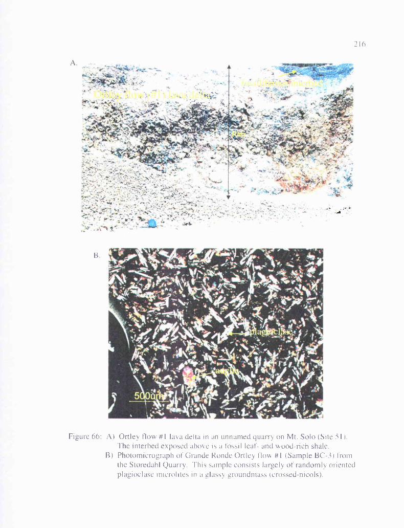
'`1
.i
- ;r t 1
",firls;
a:
B
Figure 66: A) Ort ley flow #1 lava delta in an unnamed quarry on Mt. Solo (Site i 1).The interhed exposed above is a fossil leaf- and wood-rich shale.
B) Photomicrograph of Grande Ronde Ortley flow #1 (Sample BC-3) fromthe Storedahl Quarry. This sample consists largely of randomly orientedplagioclase microlites in a glassy groundmass (crossed-nicols).
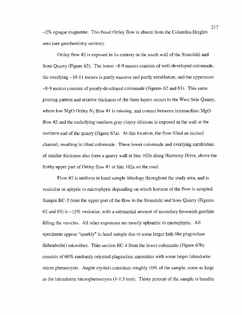
217-2% opaque magnetite. This basal Ortley flow is absent from the Columbia Heights
area (see geochemistry section).
Ortley flow #2 is exposed in its entirety in the south wall of the Storedahl and
Sons Quarry (Figure 62). The lower -8-9 meters consists of well-developed colonnade,
the overlying -10-11 meters is partly massive and partly entablature, and the uppermost
-8-9 meters consists of poorly-developed colonnade (Figures 62 and 63). This same
jointing pattern and relative thickness of the three layers occurs in the West Side Quarry,
where low MgO Ortley N2 flow #1 is missing, and contact between intermediate MgO
flow #2 and the underlying medium gray clayey siltstone is exposed in the wall at the
northern end of the quarry (Figure 67a). At this location, the flow filled an incised
channel, resulting in tilted colonnade. These lower colonnade and overlying entablature
of similar thickness also form a quarry wall at Site 102b along Harmony Drive, above the
frothy upper part of Ortley flow #1 at Site 102a on the road.
Flow #2 is uniform in hand sample lithology throughout the study area, and is
vesicular or aphyric to microphyric depending on which horizon of the flow is sampled.
Sample BC-5 from the upper part of the flow in the Storedahl and Sons Quarry (Figures
62 and 63) is -15% vesicular, with a substantial amount of secondary brownish goethite
filling the vesicles. All other exposures are mostly aphanitic to microphyric. All
specimens appear "sparkly" in hand sample due to some larger lath-like plagioclase
(labradorite) microlites. Thin section BC-4 from the lower colonnade (Figure 67b)
consists of 60% randomly oriented plagioclase microlites with some larger labradorite
micro phenocrysts. Augite crystals constitute roughly 10% of the sample, some as large
as the labradorite microphenocrysts (1-1.5 mm). Thirty percent of the sample is basaltic
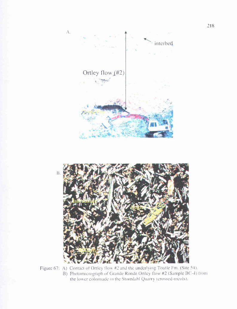
Is
inteIbed
<"a
Ortley flow 1#2)Ji
Figure 67: A) Contact of Ortley tlo\,\, #2 and the underlying Tootle Fm. (Site 54)B) Photomicrograph of Grande Ronde Ortley flow #2 (Sample BC-4) from
the lower colonnade in the Storedahl Quarry (crossed-nicols).
r::
219glass groundmass (tachylite/sideromelane), and 1-2% is white sparry calcite filling
the cracks. Thin section BC-5 from the upper colonnade contains few vesicles and has
about 15% pore space. Approximately fifty-five percent consists of randomly oriented
plagioclase microlites and microphenocrysts of labradorite, and 30% micro-
glomerocrysts of augite, unusually uniform in size.
Flow #3 is a low MgO flow of N2 Ortley composition (see geochemistry section).
Exposures in both the north and south walls of the Storedahl and Sons Quarry show
approximately 6-7 meters of elongate basalt pillows 1-3 meters long with radial jointing
in a yellow palagonite clay matrix constituting a lava delta (BC-8, Figure 62).
Gradationally overlying this is about 8 meters of variously poorly- or well-developed
colonnade with vesicular upper portion (BC-10, Figure 62). Within this quarry wall, the
pillow palagonite complex thins to the west and abruptly pinches out near the west wall,
apparently representing the western extent of the 6-7 meter deep body of water (lake or
river) in which the pillow basalts formed. Exposure in the north wall shows the opposite,
the pillow structures pinch out abruptly to the east, putting further constraints on the
paleogeography of this lake or river. This uppermost Ortley unit flow in the Storedahl
and Sons Quarry has substantial paleotopography preserved on its upper surface (Figure
62). Since no soil or basalt gravel horizon is apparent, just horizontal tuffaceous
laminated mudstone fill, this feature is more likely the wavy irregular upper surface of
the flow (i.e., pressure ridges), rather than a product of subsequent erosion before
deposition of the tuffaceous interbed. Site 104 in the northwest corner of the study area
along Coal Creek Road exposes only about 5 meters of well-developed, uniform-sized
basalt columns of Ortley flow #3.
220Hand samples are dark gray and appear largely aphyric. Some larger (0.5
mm) plagioclase microphenocrysts are visible. BC-8 samples have a somewhat glassy
luster, likely the product of rapid chilling in water, producing a tachylite glassy rind.
Thin section BC-8 consists of -80% dense, dark basaltic glass (tachylite or sideromelane,
Figure 68a), and -10% pore space (microvesicles). About 10% is randomly oriented
plagioclase (labradorite), and 1% augite. Thin section BC-10 is largely the same, but
contains 10-20% less basalt glass and larger augite crystals.
The uppermost flow exposed in the Storedahl and Sons Quarry (sample BC-13,
Figures 62 and 63), and in the town of Eufaula (Site 103, Plate 1) geochemically plots in
or close to the high MgO Sentinel Bluffs field (Figures 64 and 65), and consists of 1 to 5
meters of colonnade in its lower portion and up to 5 meters of entablature in its upper
portion. Due to erosional upper contact with Troutdale gravels, the total thickness of this
flow is not exposed in the study area, and is therefore not known. A maximum of 4
meters is exposed in the quarry, and 2 meters exposed at Site 103 in the town of Eufaula.
In both locations, the lower colonnade is mostly spheroidally weathered and light gray,
and fresh samples occur only within the remnant cores. Samples appear microphyric to
medium-crystalline due to a high percentage of larger plagioclase microlites. A unique
feature of this N2 high MgO flow is the 0.5-1 mm micro-vesicles (diktytaxitic texture)
that account for about 5% of the sample. In thin section, these vesicles are very nearly
circular, and therefore, not likely a secondary weathering feature. Thin section BC-13
(Figure 68b) consists of about 70% randomly oriented, white, albite twinned plagioclase
(labradorite) laths, 20% smaller augite (-50-100 micrometers), and the remainder
consists of -3% basaltic glass, magnetite, and some secondary white sparry calcite.
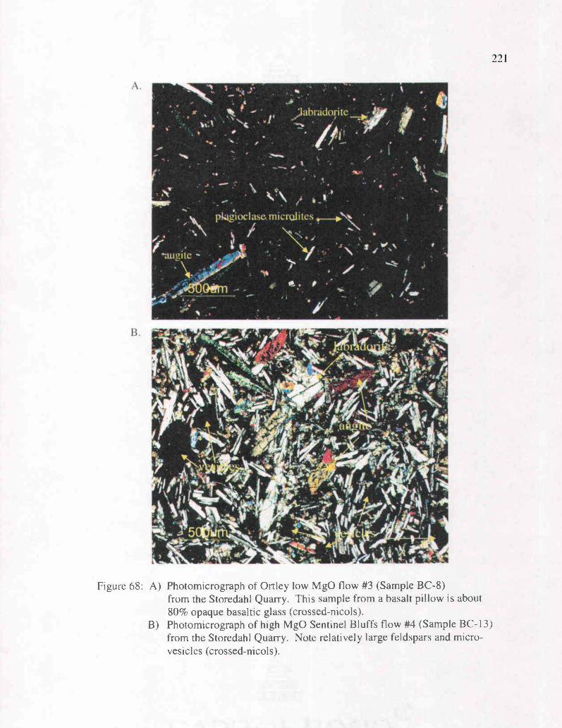
..r
;Iabradorrtc0
pk 6o, roelase,niicrolites
e e l,
1 1 " ..
. .
Figure 68: A) Photomicrograph of Ortley low MgO flow #3 (Sample BC-8)from the Storedahl Quarry. This sample from a basalt pillow is about80% opaque basaltic glass (crossed- ni cot s).
B) Photomicrograph of high MgO Sentinel Bluffs flow #4 (Sample BC-13)from the Storedahl Quarry. Note relatively large feldspars and micro-vesicles (crossed-nicols).
222Interbeds and Contact Relations
At least three interbeds occur within the study area between the four N2 Grande
Ronde Basalt flows that are locally traceable between outcrops (Plate 1). The interbed
between Ortley unit flows #1 and #2 has a consistent lithology between widely scattered
outcrops. In the Storedahl and Sons Quarry (Figure 62) this interbed consists of
approximately 1.5 meters of dark gray to black, carbon rich, massive, hackly mudstone to
silty mudstone. Bedding, when present, is indistinct. This mudstone is highly indurated
and fracture ranges from hackly to nearly conchoidal. The interbed in the same
stratigraphic position (above flow #1 and below flow #2) on Mt. Solo (Site 51, Figure
66a) is a well-stratified brown to medium gray shale or silty mudstone containing
abundant carbonaceous debris in the form of carbonized twigs, roots, whole leaves, and
flattened logs (apparently burned in one case). This interbed varies from two to three
meters thick (although the entire thickness was not exposed) and is micro-cross laminated
in places. At Site 102, this interbed separates the highly vesicular lower Ortley flow #1
(102a) and the lower colonnades of 102b, and is a carbonaceous siltstone with a baked
and blackened upper surface. The plant species, sedimentary structures, and fine-grained
nature of this unit suggest a low energy, lacustrine or swampy depositional environment.
The thicker interbed between Ortley flows #2 and #3 is exposed in the Storedahl
and Sons Quarry and in the West Side Quarry in the Columbia Heights area (Site 54,
Figure 67a). In the Storedahl and Sons Quarry (Figure 62), this interbed is well exposed
immediately beneath the pillows of the lava delta of Ortley flow #3 (BC-8, Figure 69a).
The bed thickness varies from 1 to 3 meters, and consists of distinct upper and lower
lithologies. The lower -1 meter ranges from gray tuffaceous silty clay to dark gray,
223
extremely carbon-rich, silty mudstone. This lower portion of the interbed contains
abundant leaf and twig material, and some flattened branches and roots, possibly a
paleosol. The upper 1-2 meters is a massive to micro-cross laminated, basaltic,
tuffaceous, and carbonaceous siltstone, with a high percentage of clay. The uppermost
0.3 meter is a coarse basaltic breccia to palagonitized hyaloclastite, produced by steam
explosion and basalt fragmentation along the advancing front of the basalt delta. In
Figure 69b, glassy pillow rinds and yellow-brown hyaloclastite (fragmented basalt)
between the pillows have been altered to yellow brown palagonite.
In the West Side Quarry (Site 54) this interbed between Ortley flows #2 and #3
shows a different contact relationship. Here, parallel beds within the sedimentary unit are
contorted, and undulate to conform to the irregular upper top of the flow (Figure 70a).
Another unique feature is that it is the lower (rather that the upper) 0.3 meter of the
interbed that is dark gray or black. This relationship is similar to baked contacts
described by Eriksson (2002) and Dr. Robert Bentley (emeritus professor at Central
Washington University, personal communication, 2000), as first theorized by Beeson et
al. (1979). It appears that in wet or marshy areas of Oregon and Washington during the
middle Miocene, Columbia River Basalts invaded the relatively unconsolidated
sediments to produce invasive intrusive bodies. In places along the Miocene coastline,
the lava re-erupted at local volcanic centers along the coastline and shelf. Bentley
(personal communication, 2000) has suggested the Columbia River Basalts invaded wet
and semiconsolidated sediments, and carried the sediments along the top of the flow as a
raft, baking the base and contorting the bedding. This theory explains this contact
relationship in the West Side Quarry.
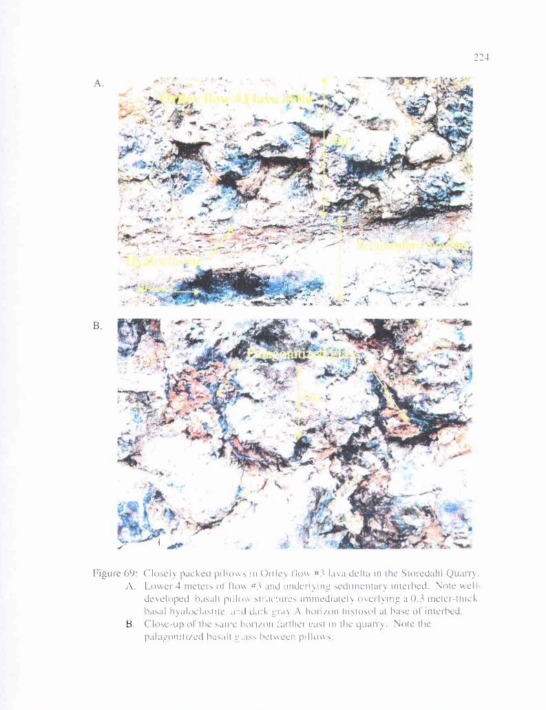
- I 4a
: -.
sc'.'C)r
-.
- --a a'
-• •' c-C- r
S
—
,.-'F 7'-
S.- -
/
/
• IL
,4It
-I--— (
r.
Closely packed prllov in Ortlev IloAw #3 lava delta in the Storedahl QuarrylAmer-1 meters of floc #3 and undei"mg sedimentary interhed. Note tielI-de%eloped basalt pilk ,tructures immediately omerlyng a O A meter-thickbasal hyalocla,titc, and clack cirv .A-horiron hi.stosol at base of interhed.Close-up of the same' hor rion Iarther cast in the quarry. Note thepala,-,onitired ha,alt class hcmccn pillow,
A.
B.
Figure 09:A.
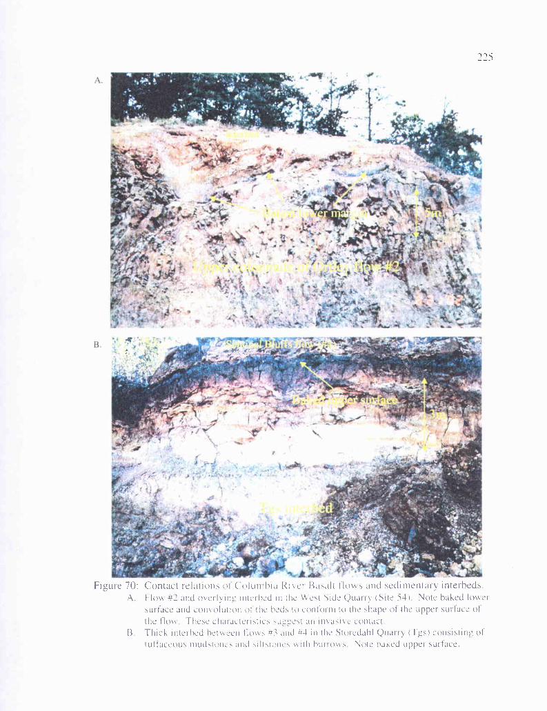
Figure 70: Contact relations of Columbia Rivet Basalt flows and sedimentary interbedsA Flow #2 and meilBtug interhed in the Vvest Side Quarry (Site 54 Note baked lower
surface and convolution of the beds to contorni to the shape of the upper surface ofthe flow These chatactcristics suggest an masive contact
13 Thick inierhed between flues #3 and #4 in the Stotedahl Quarry ags) consisting oftuffaceous mudstunes and ,ilt.tunes vs ith burrow', 'Vote baked upper surface.

226The uppermost interbed between low MgO Ortley flow #3 and high MgO
Sentinel Bluffs (flow #4) is the thickest and most variable in the study area (map unit
Tgs, Plate 1). In the south wall of the Storedahl and Sons Quarry (Figures 62 and 70b)
this interbed varies in thickness from 0 to about 5 meters, and individual horizons can be
traced throughout the quarry walls. The lower meter is a very light gray tuffaceous
siltstone with abundant carbonaceous plant debris, especially root traces (a subaerial
paleosol). The next 0.5 to 1 meter is a light to medium gray, basaltic, tuffaceous, silty to
sandy mudstone with abundant sub-vertical burrows and carbonized root traces, in places
comprising a high percentage of the exposure (Figure 71 a). This bed acts as
discontinuous underclay for a thin (-10 cm) black lignitic coal bed preserved in small
paleo-depressions. The overlying gray floodplain mudstone is 1-2 meters thick, very
light brown or gray, basaltic, tuffaceous, clayey mudstone/siltstone, again with abundant
carbonized root traces. Ten to twenty cm thick bands of yellow orange iron oxide
staining also characterize this interval. In most exposures in the quarry this tuffaceous
bed is overlain by a 0.3 to 0.5-meter thick gray mudstone beneath a 0.5 to 1- meter thick
tuffaceous, clayey siltstone with root traces. The uppermost 0.5 to 1 meter is a highly
carbonaceous, tuffaceous A-horizon paleosol, baked by the overlying Sentinel Bluffs
flow.
The majority of this interbed in the north wall of the Storedahl and Sons Quarry is
similar to the south wall. However, this mudstone/paleosol interbed becomes a basalt
conglomerate in the easternmost part of the wall and in exposures just to the north
(Figure 71b), where it is a channelized pebble and cobble basaltic conglomerate with a
maximum thickness of 5 meters. All clasts observed are Columbia River Basalt. This
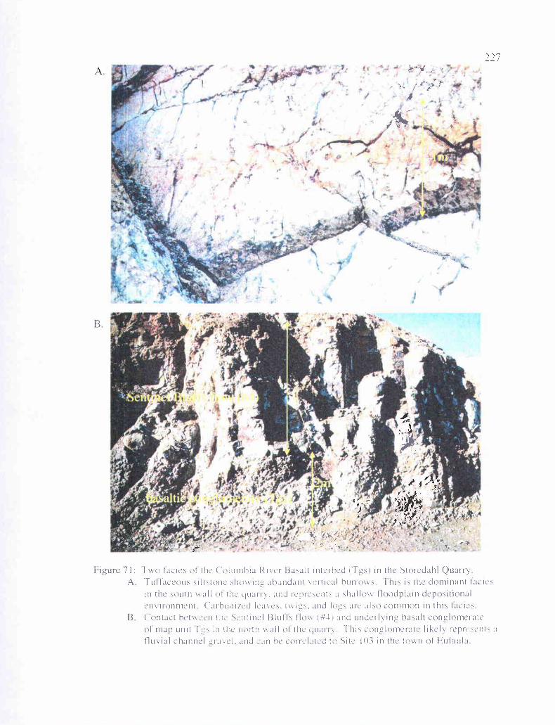
:-
/ifi
B
-'V
Figure 71: Two lacier of the (olumhiu klier Basalt intcrhed (Tsl in the Storedahl QuarryA TuiIaceouJ silttonc shy e inc ahundani crncal hurroMs 1111', is the dominant facie
in the south wall of the yuairv. and IC Icsents a shallow Iloodplain depositionalenMtonment ('arhoniied Icavcs, and loees aic also common in this lacier
B Contact hethkeen the ticntinel 131u11s Ilovk (#4 and underpin" hasalt conglomerateof map unit I in the notch vk all of the clu.tnv -1 his conglomerate like) represents al1uMal channeliael, and Lan he correlated to Site lll; in the tov n of EuI tula
228fluvial channelized deposit is moderately well-sorted and rounded, clast supported,
and relatively unconsolidated, with cobble clast size averaging about 4 cm. This
channelized conglomeratic facies of this interbed is also present beneath the high MgO
Sentinel Bluffs flow at Site 103 across Harmony Road from the Eufaula Store in the town
of Eufaula. This interbed is consistently found beneath the Sentinel Bluffs flow and
above the Ortley #3 flow, and is extrapolated to exist in some form throughout the study
area, and is mapped as such (Plate 1). Lithofacies in this unit seem consistent with a
depositional environment consisting of a substantial fluvial channel and adjacent
floodplain with stagnant-water lakes or coaly marshes. The basalt clasts are too
weathered for geochemical analysis, but are likely derived from the underlying Ortley #3
flow.
229
TROUTDALE FORMATION AND PLIOCENE ANDESITIC TERRACE GRAVELS
Introduction
The Portland Basin, which began to form in the middle Miocene and continued to
subside into the Pliocene, filled with fluvial and lacustrine sediments transported
westward through the Cascade calc-alkaline volcanic arc and into the forearc basin by the
ancestral Columbia River (Beeson and others, 1989). This sediment mixed with lesser
amounts of sediment derived from local tributaries draining surrounding volcanic
highlands to produce the Troutdale Formation, as first described by Hodge (1938). This
unit consists dominantly of well-rounded, light colored pebbles and cobbles of quartzite,
granite, and schistose metamorphic rocks (derived from an extrabasinal source, most
likely the Rocky Mountains of Montana and Idaho), but also contains some clasts of
Columbia River Basalt, and more volcanic silicic material derived from the western
Cascades.
In the type area for the Troutdale Formation, near Troutdale, Oregon (east of
Portland) the unit consists of three sediment types: basalt clast conglomerate, arkosic
sandstone, and vitric sandstone (Hodge, 1938). The vitric sandstone consists of poorly-
sorted, coarse-grained, palagonitized hyaloclastic debris, similar in composition to
Pliocene basaltic andesite flows in the Columbia River Gorge (Beeson and others, 1989).
The lithic arkosic sandstone contains some Columbia River Basalt and western Cascade
clasts, but is otherwise similar to the Cowlitz Formation in composition, with quartz,
feldspar, mica, and metamorphic and granitic clasts of extrabasinal origin. Recentwork
by Howard (2002) and Evarts (2002), in mapping the Deer Island Quadrangle 20 miles
southeast of the study area, shows that the Troutdale Formation consists of two
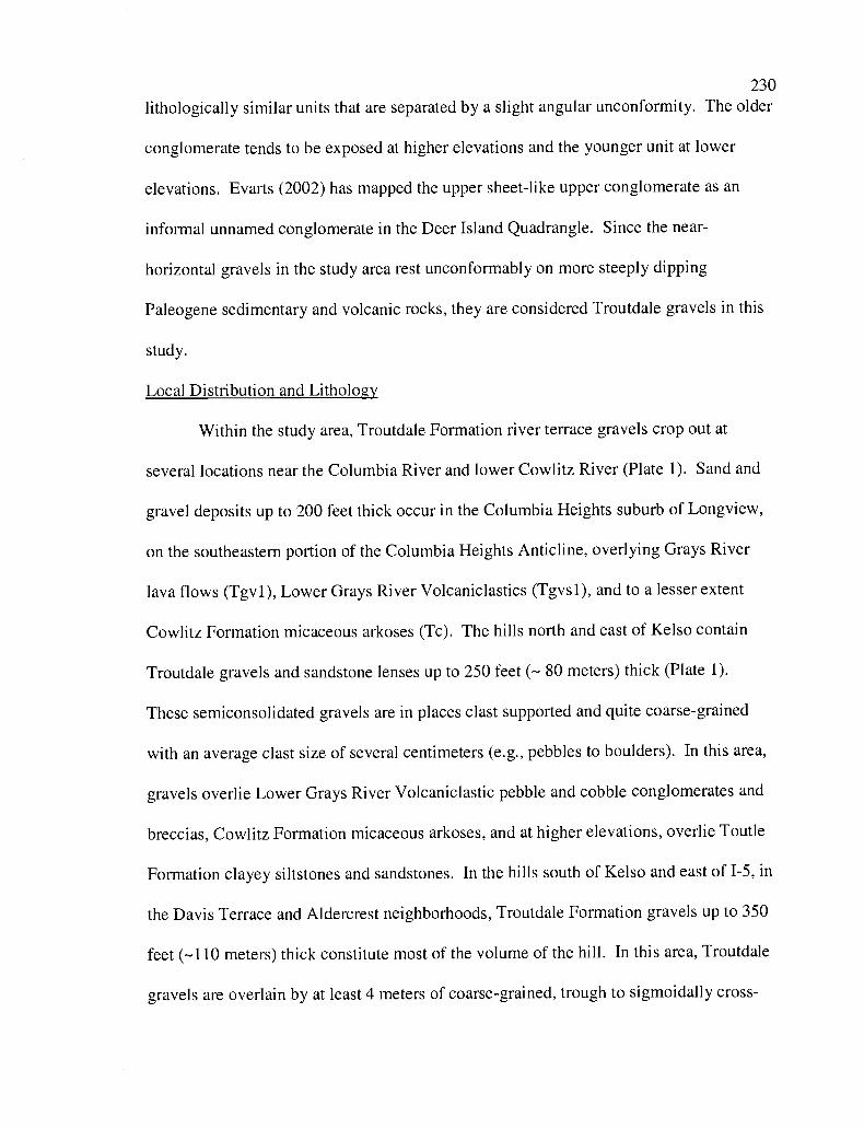
230
lithologically similar units that are separated by a slight angular unconformity. The older
conglomerate tends to be exposed at higher elevations and the younger unit at lower
elevations. Evarts (2002) has mapped the upper sheet-like upper conglomerate as an
informal unnamed conglomerate in the Deer Island Quadrangle. Since the near-
horizontal gravels in the study area rest unconformably on more steeply dipping
Paleogene sedimentary and volcanic rocks, they are considered Troutdale gravels in this
study.
Local Distribution and Lithology
Within the study area, Troutdale Formation river terrace gravels crop out at
several locations near the Columbia River and lower Cowlitz River (Plate 1). Sand and
gravel deposits up to 200 feet thick occur in the Columbia Heights suburb of Longview,
on the southeastern portion of the Columbia Heights Anticline, overlying Grays River
lava flows (Tgvl), Lower Grays River Volcaniclastics (Tgvsl), and to a lesser extent
Cowlitz Formation micaceous arkoses (Tc). The hills north and east of Kelso contain
Troutdale gravels and sandstone lenses up to 250 feet (- 80 meters) thick (Plate 1).
These semiconsolidated gravels are in places clast supported and quite coarse-grained
with an average clast size of several centimeters (e.g., pebbles to boulders). In this area,
gravels overlie Lower Grays River Volcaniclastic pebble and cobble conglomerates and
breccias, Cowlitz Formation micaceous arkoses, and at higher elevations, overlie Toutle
Formation clayey siltstones and sandstones. In the hills south of Kelso and east of 1-5, in
the Davis Terrace and Aldercrest neighborhoods, Troutdale Formation gravels up to 350
feet (-110 meters) thick constitute most of the volume of the hill. In this area, Troutdale
gravels are overlain by at least 4 meters of coarse-grained, trough to sigmoidally cross-
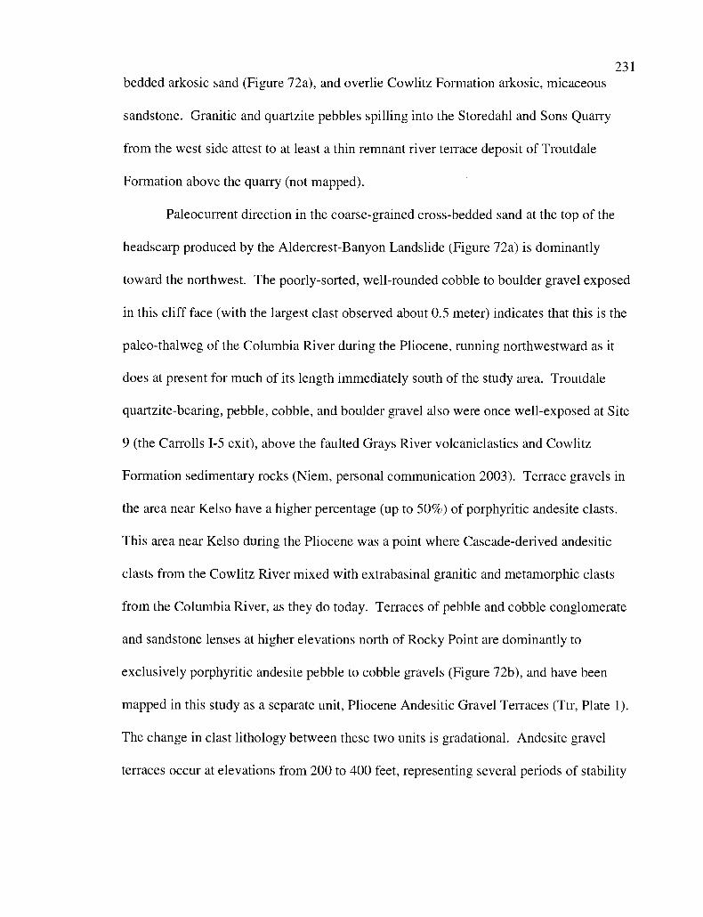
231
bedded arkosic sand (Figure 72a), and overlie Cowlitz Formation arkosic, micaceous
sandstone. Granitic and quartzite pebbles spilling into the Storedahl and Sons Quarry
from the west side attest to at least a thin remnant river terrace deposit of Troutdale
Formation above the quarry (not mapped).
Paleocurrent direction in the coarse-grained cross-bedded sand at the top of the
headscarp produced by the Aldercrest-Banyon Landslide (Figure 72a) is dominantly
toward the northwest. The poorly-sorted, well-rounded cobble to boulder gravel exposed
in this cliff face (with the largest clast observed about 0.5 meter) indicates that this is the
paleo-thalweg of the Columbia River during the Pliocene, running northwestward as it
does at present for much of its length immediately south of the study area. Troutdale
quartzite-bearing, pebble, cobble, and boulder gravel also were once well-exposed at Site
9 (the Carrolls 1-5 exit), above the faulted Grays River volcaniclastics and Cowlitz
Formation sedimentary rocks (Niem, personal communication 2003). Terrace gravels in
the area near Kelso have a higher percentage (up to 50%) of porphyritic andesite clasts.
This area near Kelso during the Pliocene was a point where Cascade-derived andesitic
clasts from the Cowlitz River mixed with extrabasinal granitic and metamorphic clasts
from the Columbia River, as they do today. Terraces of pebble and cobble conglomerate
and sandstone lenses at higher elevations north of Rocky Point are dominantly to
exclusively porphyritic andesite pebble to cobble gravels (Figure 72b), and have been
mapped in this study as a separate unit, Pliocene Andesitic Gravel Terraces (Ttr, Plate 1).
The change in clast lithology between these two units is gradational. Andesite gravel
terraces occur at elevations from 200 to 400 feet, representing several periods of stability
-A
s-bolded
B.
Ij
Figure 72: A. Headscarp of the Aldercrest-Banyon Landslide. The lower --20 metersconsists of Troutdale cohhle to small boulder ora'el with mostly granitic and quartzitemetamorphic clasts derived trom the Rocky Mountains. The upper 4-5 meters consist ofarkosic cross-bedded sand. This is the Pliocene thalweg of the ancestral Columbia Riper.B. Locally derived Pliocene gravel terrace deposit from east of the Cowlitz River (Ttr)Note that nearly all rounded pehhle and cohhle-sized clasts consist of well-roundedwestern Cascade andesite (usually porphviitic). I hese terraces are contemporaneouswith Troutdale gravels hut were produced by the ancestral Cowlitz River, with a westernCascade source for the sediment
232

233in the Cowlitz River valley between periods of uplift and downcutting over a prolonged
period of time.
QUATERNARY UNITS234
Quaternary units within the study area include Pleistocene through Holocene sand
and gravel terraces at elevations of 50 to 150 feet along the Cowlitz and Coweeman
Rivers, landslide deposits occurring within several Tertiary map units, alluvium along
major rivers and streams, and Mt. St. Helens lahar deposits of May, 1980 along the
Cowlitz River. Recent landslide mapping by Karl Wegmann of the Washington
Department of Natural Resources in the Kelso and Rainier quadrangles was generously
offered and used to assist in this study, and many (especially smaller) slides mapped in
the study area particularly are a result of his work (Plate 1). In addition, the work of
Roberts (1958) on the Pleistocene terraces in the area was relied upon heavily for this
study.
Pleistocene-Holocene Terraces
Matrix supported cobble and pebble gravels produce terraces along most of the
length of the Cowlitz and Coweeman Rivers in the study area (map unit Qtr, Plate 1).
Particularly widespread deposits occur at housing developments in section 22, 23, and 27
of T 9 N, R 2 W and in the Pleasant Hill housing development area in section 2 of T 8 N,
R 2 W and sections 26, 27, 35 and 36 of T 9 N, R 2 W. Much of Interstate 5 is also built
on these flat, raised terraces (Plate 1). They are erosional remnants left as the Cowlitz
River downcut due to broad regional uplift of the Coast Range. In the study area these
deposits consist of thick-bedded, matrix to clast supported, pebble and boulder polymict
gravels up to 150 feet thick, with coarse-grained sandstone matrix. Well-rounded pebble
and cobble clasts, as well as coarse-grained sand clasts, consist of western Cascade
porphyritic andesite and aphanitic Columbia River Basalt or western Cascade basaltic
andesite. A minor component consists of granitic and metamorphic (mostly quartzite)
clasts.
235
A plausible explanation for this coarse-grained, matrix-supported unit that
contains extrabasinal granitic and metamorphic clasts well up into the Cowlitz drainage is
that these are deposits of the cataclysmic outburst floods of Lake Missoula (Roberts,
1958). The floods were produced by a series of failed ice dams (producing large lakes in
Montana on the Missoula River behind them) during periods of glacial retreat, and
flowed down the Columbia River drainage. Hydraulic constriction in the relatively
narrow lower part of the Columbia River valley just south of the study area could have
produced ponding of the floodwater in the Portland Basin (Evarts, 2002). In that area
gravels were deposited as bedload, and fine-grained silts were deposited as slack-water
suspension. In the study area, the coarse lithic sand and poorly-sorted, rounded gravel
comprising the terraces are interpreted to be bedload deposited as these flood waters
rushed up the Cowlitz River, as the Columbia River rounded the bend at Longview and
Kelso (Waitt, 1994). Radiocarbon dating places most of these floods, possibly as many
as 100, between 15.5 and 12.7 Ka. Boulders as large as 3 meters in diameter composed
of extrabasinal rock types were rafted as ice-bound erratics into the Portland basin
(Wilkinson and others, 1946).
Landslides
Landslides were recognized on aerial photographs and topographic maps by
scarps and hummocky topography. Landslides occurring in several different Tertiary
bedrock units and terrace deposits are common features throughout the study area (map
unit Qls, Plate 1), and are particularly common in the unconsolidated to loosely
236
consolidated Troutdale Formation gravels (including the 1999 Aldercrest-Banyon
Landslide, Figure 81). Landslides are also particularly common in the Toutle Formation,
which being poorly consolidated and having a high percentage of clay matrix is
particularly prone to slumping (Plate 1). A roadcut at Site 49 along Columbia Heights
Road North in the Toutle Formation (NE 1/4 of the NW 1/4 of Sec. 5. T 8 N, R 2 W) began
to slide along the dip slope almost immediately after being bulldozed (which removed
support of the toe of the slide). Slides in both the Toutle Formation and the Cowlitz
Formation commonly include pronounced headscarps where they have included the
overlying Miocene Grande Ronde Basalts of the Columbia River Basalt Group. Much of
the apparent tectonically produced fault structure throughout the study area may be the
result of such large translational slides. The east-west trending faults at Site 49 display
rotation of adjacent blocks relative to the fault plane, and faults within meters of each
other have opposite senses of motion (some are reverse and some are normal). These
features are commonly associated with landslides on the Oregon coast and elsewhere in
the Pacific Northwest (Niem personal communication, 2003).
Particularly large-scale landslides occur in the Columbia Heights area, where the
resistant, nearly horizontal Grande Ronde Basalt flows capping the hill have allowed
oversteepening of the surrounding slopes. One large translational landslide in sections 9
and 16 of T 8 N, R 2 W trends southeastward and has produced a large bowl-shaped
valley and prominent Grande Ronde head scarp. This slide has transported large
semiconsolidated blocks of Toutle Formation, and likely some Cowlitz Formation arkosic
sandstone blocks some distance. Another Columbia Heights slide trends northeastward
in sections 32 and 33 of T 9 N, R 3 W and section 4 of T 8 N, R 3 W (Plate 1), and has
237
also produced a prominent Columbia River Basalt scarp, and a pronounced hummocky
toe on which is built a trailer park community. The toe undoubtedly temporarily dammed
Hazel Dell Creek immediately after the slide event. This landslide also has numerous
ponds and closed contours just beneath the headscarp (and farther downslope) and a
substantial slide block about 200 feet long of Grande Ronde Basalt at the N'/2 of the NW
1/4 of Sec. 4. Smaller slides occur around the periphery of the Grande Ronde erosional
remnant that caps the Columbia Heights area, and it is likely that many of the Columbia
River Basalt cliffs in the Columbia Heights area are landslide headscarps. J-shaped
("pistol butt") tilted tree bases, and soils with chaotic mixtures of red weathered Grande
Ronde blocks and tan Toutle Formation blocks are common.
Another large translational landslide occurs between Clark Creek and the lower
portion of Coal Creek. This slide occupies an area of about 3 km2 and also includes
prominent Columbia River Basalt scarps on the east side, as well an numerous ponds and
closed contours of a hummocky topography. The IS roadcut along Coal Creek Road
(Figure 77, Plate 1) may be part of this extensive slide and marks its northernmost
boundary in the Coal Creek drainage. The segment of Coal Creek road at the slide has
been rebuilt several times, and the toe in Coal Creek is loaded with basalt boulder riprap.
The faults in this exposure are listric and have an unusual orientation (more north-
trending) for faults in Coal Creek beds. They may be landslide slip planes. Large
isolated Columbia River Basalt blocks occur on Niemi Road (NW 1% of Sec. 14, T 8 N, R
3 W), and here deep soils are mottled red and tan from slide blocks of weathered CRB
and Toutle Formation respectively. Roadcuts and natural exposures on the west side of
Clark Creek are composed of clayey, fractured blocks of Toutle Formation where the toe
238
of the landslide has overridden Cowlitz Formation arkoses and basaltic siltstone and
sandstone of the Upper Grays River Volcaniclastic unit (Tgvs2), interbedded within
Cowlitz Formation micaceous arkoses.
Another substantial translational landslide occurs north of Raglund Road in Goose
Hollow. Jumbled blocks of Toutle Formation sandy siltstones occur in the toe of this
slide along Raglund Road (E 1/2 of Sec. 35, and W 1/2 of Sec. 36, T 9 N, R 3 W). A much
smaller landslide occurs at the S 1/i of Sec. 26, T 9 N, R 3 W where a new housing
subdivision was built during the summer months of 1999 and 2000 in a bowl-shaped
drainage slope uphill from Coal Creek Road. Multiple landslides occur in the Cowlitz
Formation, Toutle Formation, and Troutdale Formation gravels and sandstones in the
southeast part of the study area, east of Interstate 5 (Plate 1). In the Davis
Terrace/Aldercrest area (more detailed description in the geologic hazards section), most
Troutdale gravels have slumped to some degree, and reactivated slides occurring within
previous Pleistocene landslides are also common. Bowl-shaped drainages occur
throughout this area along 1-5. No less than 35 slides occur in the hilly area north of
Kelso, south of Ostrander, and east of Rocky Point (Plate 1). Most of these are small-
scale surficial slope failures without well-defined headscarps or toes.
Mt. Helens lahar deposit, May 181h, 1980
Lahar or pyroclastic debris flow deposits from the May 18th, 1980 eruption of Mt.
St. Helens (Qshu3) occur in scattered remnants along the Cowlitz River particularly on
the inside of meanders. At least 15 separate deposits occur in the study area, and a large
berm pile produced by dredging of the Cowlitz River near its confluence with the
Columbia River occurs on the Cowlitz River's east bank just out of the map area. This
239lahar entered the Cowlitz River drainage from the South Fork of the Toutle River -20 km
to the north of the study area. Drainage of the Cowlitz River was blocked at the town of
Castle Rock where tremendous damage occurred as a result of the lahar. The lahar
entered the Columbia River at the mouth of the Cowlitz River and produced a pyroclastic
delta that blocked the shipping channel for weeks. Within the study area Mt. St. Helens
deposits, most of which are less than a few meters thick, consist mostly of poorly-sorted,
massive gray mixtures of andesitic to dacitic boulder and cobble gravel and pumice lapilli
suspended in fine gray volcanic ash (glass shards and crystal matrix). A. Niem (OSU
professor emeritus, personal communication, 2003) noted that the lahar had mixed with
river water and had become hyperconcentrated slurries with 2 to 3 meter standing waves
near the Carrolls 1-5 exit south of Kelso on the Columbia River.
Holocene and Late Pleistocene Alluvium
Alluvium of Holocene and Pleistocene age (Qal) form thick flat lying
unconsolidated deposits in local drainages within the study area including Coal Creek,
Clark Creek, and Delameter Creek in the west half of the area, and in the east half of the
area in tributaries of the Cowlitz River, including Hazel Dell, Ostrander, and Coweeman
Creeks (Qal, Plate 1). Both the Cowlitz and Columbia Rivers have alluvium in the form
of gravel, sand, silt, and wood, which according to local well logs range from 10 to 200
feet in thickness. Most of the vast, alluvium-filled valley around Mt. Solo is part of the
historical flood plain and paleochannel of the Columbia River. Dams on the Columbia
River today prevent major flooding of the lower Columbia River region. Local marshy
and swampy areas are the sites of organic-rich mud and silt deposition today, including
meandering streams that wind through much of Longview north and south of Mt. Solo.
240
Another swampy area is along the Cowlitz River east and south of the Pleasant Hill
community built on late Pleistocene terraces. Lake Sacajawea (in the middle of
downtown Longview, Plate 1) is a dredged oxbow lake nearly 2 miles long that likely
was formerly a part of a meander of the Columbia or Cowlitz River. It was dredged in
order to construct a protective levee that stretches along the length of Longview to protect
against flooding.
241
STRUCTURAL GEOLOGY
Introduction
The Coast Range Province, in which the study area lies, began its complex
structural history with the accretion of the oceanic Siletzia Terrane in the early-middle
Eocene (Wells et al., 1984). This volcanic terrane, termed the Crescent Formation in
Washington and the Siletz River Volcanics in Oregon, consists of tholeiitic to alkalic,
subaqueous pillow lava and breccia to subaerial basalt flows, and may have originated as
remnants of an oceanic seamount province. It could have alternatively been erupted
nearly in place as a result of rifting due to oblique subduction of the Farallon Plate
beneath the North American Plate along a leaky transform fault (Wells et al., 1984;
Snavely, 1987; Ryu and Niem, 1992). After emplacement of this thick, buoyant volcanic
pile in western Washington and Oregon, the early-middle Eocene subduction zone was
clogged and forced to jump westward to near the edge of the Eocene continental margin.
Because of the oblique subduction and northeast motion of the Farallon Plate relative to
the North American Plate, a northeast-southwest transpressional and transtensional
wrench tectonic stress regime with associated dextral shear was formed, controlling the
dominant trend of regional faults, folds, and uplift in the Oregon and Washington Coast
Range.
Oblique subduction has caused the Siletzia Terrane (the basement rocks of the
region) to fracture into several discrete crustal blocks up to 30 km wide, bounded by
northwest-trending dextral shear zones (Wells and Coe, 1985). This dextral shear of
242basement blocks, and overlying sedimentary and volcanic units, has produced varying
degrees of clockwise rotation of crustal blocks in the Cascadia volcanic arc of
Washington and Oregon. According to Simpson and Cox (1977), paleomagnetic studies
show that as much as 75 degrees of clockwise rotation has occurred is some middle
Eocene blocks of the Oregon Coast Range. Wells and Coe (1985) demonstrated much
less rotation (approximately 22 degrees) in the Washington Coast Range. Substantially
higher rotation (- 103 degrees) in the Cowlitz Formation has been suggested by
Kleibacker (2001) and Prothero and others (2001) for the area immediately to the north of
this study. Wells and Coe have also suggested that these clockwise rotations could be the
result of shear coupling along transcurrent fault zones. Such shear is the result of partial
coupling of the forearc (Coast Range) with the obliquely subducting Farallon Plate
(Rarey, 1986), and the relative movement of adjacent blocks is accommodated by
secondary conjugate shear sets (Riedel shear) which rotate in response to the external
shear couplet (Wells and Coe, 1985). In parts of northwest Oregon, northwest-trending
conjugate shears occur with oblique right-lateral shear (Olbinski, 1983; Peterson, 1984;
Nelson, 1985; Rarey, 1985; Niem and others, 1992). Rarey (1986) suggested that this
shear-coupling model can explain much of the present structure of the Oregon and
Washington Coast Range. Northwest-trending right-lateral faults would be the dominant
expression of simple dextral shear, and northeast-trending left-lateral faults result from
Reidel shears that have accommodated the clockwise rotation.
Continuation of northeastward oblique subduction and simple dextral shear
produced a dominant northeast-southwest tensional fault system along which the Eocene
243Grays River Volcanics may have erupted, and also produced tension on the overlying
Eocene sedimentary units. In the late-early Miocene, a compressional period of
deformation began in the Coast Range producing a series of folds and reverse
(transpressional) faults (Wells and Coe, 1985). Compression and oblique dextral shear
along northwest-trending faults continued throughout the Miocene, uplifting and
deforming the Columbia River Basalt Group in the Coast Range (Armentrout, 1987).
Compressional uplift in the form of oblique slip wrench faulting and folding continues
today (i.e., continued uplift of the Oregon Coast Range producing coastal terraces, and
oblique slip reverse faulting such as the Corvallis Fault, and the Portland Hills Fault
consisting of an anticline bordered by a reverse fault to the northeast) (Wong and others,
2001).
Local Structure
General
The structural geology of the study area, like all of southwest Washington, is
complex, consisting of folds and faults with wide ranges in the extent of deformation, and
produced by tensional and compressional forces acting in several directions, and at
different periods of geologic time. Two features dominate the structure of the study area:
1) two parallel northwest-trending folds, the Columbia Heights Anticline and the Hazel
Dell Syncline, likely resulting from the same compressional (or transpressional) event,
and 2) a prominent northwest-trending system of faults (Plate 1). These features
combined with the down-cutting of the Columbia and Cowlitz Rivers, have led to the
exposure of older units (middle Eocene Grays River Volcanics, map units Tgv 1 and
244Tgvsl) in the core of the Columbia Heights Anticline. These stratigraphically lowest
volcanic units are also exposed at the base of Mt. Solo, an isolated up-thrown fault block
surrounded by Quaternary alluvium of the Columbia River (Plate 1). The Cowlitz River,
Coal Creek, and Clark Creek have eroded down to expose the Eocene Cowlitz Formation
(Tc) and the interbeddded younger Grays River volcaniclastics (Tgvs2). Younger units
such as the Miocene Columbia River Basalt flows and the Troutdale gravels (deposits of
the thalweg of the Pliocene Columbia River, map unit Ttr) are still largely horizontal, but
have undergone considerable broad uplift, attesting to the ongoing tectonic activity of the
area through the Neogene.
Eocene and Oligocene (?) Volcanic units east of the Cowlitz River (e.g., Grays
River Volcanics and western Cascade basaltic andesite) generally dip from 5 to 35
degrees to the east or east-southeast, making the west-facing slopes of the hills anti-dip
slopes (cross section A-A', Plate 1). Middle Eocene and Oligocene units in the hills
containing the Columbia Heights Anticline generally dip away from the axis by 5 to 30
degrees, and toward the axis of the Hazel Dell Syncline by 5 to 15 degrees. It is
important to note that Columbia River Basalts throughout the area are nearly flat-lying.
Beds on Mt. Solo gently dip about 5 degrees to the northwest. Cowlitz Formation beds
exposed in the southern third of Coal Creek dip relatively steeply (from 5 to 30 degrees)
toward the southwest, gently toward the north in the middle third of the creek, and gently
(0 to 15 degrees) southwest in the northern third (Plate 1). In several Coal Creek
intervals, local dip increases steeply due to drag along faults. The northern-central part of
the study area consists of beds of varying orientation, related to minor faults and folds.
245Determination of faults and folds in this lushly vegetated area relied primarily
on exposures of fault planes in creek beds, or in railroad or road cuts, but also on
repetition of beds, field reconnaissance of lineations on aerial photographs, topographic
maps, side-looking airborne radar (SLAR) images, and digital elevation model (DEM)
images and grouping of consistent attitudes of beds into fault blocks. Some strike and dip
data on bed orientations collected by Livingston in the mid-1960's were collected from
exposures that are no longer accessible or no longer exist. Many of Livingston's bed
attitudes have been incorporated into this study. Some of the apparent structure (e.g.,
fault trends) of the study area may be the result of unidentified landslides. This study,
and recent work by Karl Wegmann of the Washington Department of Natural Resources
(personal communication, 2002), has resulted in mapping dozens of slides within the area
(Plate 1), particularly prominent in the clayey and loosely-consolidated Oligocene Toutle
Formation (?), and the largely unconsolidated thick gravels of the Pliocene Troutdale
Formation. Landslides are also common in the Cowlitz Formation (see natural hazards
section).
Columbia Heights Anticline and Hazel Dell Syncline
Field work conducted for this study has further corroborated the existence of the
northwest-trending Columbia Heights Anticline, and the adjacent and parallel Hazel Dell
Syncline, first mapped by Livingston in 1966. Evidence for these structures consists of
fairly consistent strikes and dips of Eocene and Oligocene (?) units in the limbs of each
structure, and of the position and orientation of units within each fold of a known
stratigraphic sequence (i.e., older Grays River Volcanic units in the core of the anticline).
246Since the older units occur along the axis of each structure in their southeastern-most
exposures, both structures may plunge somewhat toward the northwest (Plate 1).
Alternatively, this apparent plunge may simply be an artifact of topography, older units
exposed at lower elevation area along the Cowlitz River. The relative position of the
Cowlitz Formation and underlying Lower Grays River Volcaniclastic unit in the
southeastern part of the Hazel Dell Syncline indicates a plunge to the northwest. Another
indication is that dips toward the axis of the syncline are angled slightly to the northwest.
The northwest orientation and position of Hazel Dell Creek is likely due to these folds.
The eastward dip of pre-Pliocene units east of the Cowlitz River may be a
continuation of the northeast dipping limb of the Columbia Heights Anticline west of the
river. Beds in the northeastern limb (those that are reliably not the result of slope-failure)
tend to dip more east than northeast. If better resolution were possible, the orientations
on opposite sides of the river might not differ substantially. Resolution of true strike and
dip is poor west of the river because beds there consist of Lower Grays River
Volcaniclastics (Tgvsl) which are largely massive. Also, the N 75 E dip of the anticline
limb (essentially a dip-slope) would require only a slight eastward bend in order to
conform to dips east of the river. Bed orientations across the Cowlitz River from the
Hazel Dell Syncline are more problematic, and may indicate a hidden fault beneath the
alluvium of the river (see Kalama Structure Zone section).
Some constraints can be put on the timing of these large folds. Referring to cross-
sections A-A' and B-B' (Plate 1), Eocene and Oligocene units (Cowlitz Formation, Grays
River Volcanics, and Toutle Formation) within the Columbia Heights Anticline are
247
substantially tilted, whereas the Miocene Grande Ronde Basalts are nearly horizontal,
and therefore overlie the older Tertiary strata in angular unconformity. This same pattern
occurs throughout the study area where Columbia River Basalt flows occur. Thick
Columbia River Basalt flow units west of Coal Creek (e.g., in the Storedahl and Sons
Quarry, Figure 62) are within 5 degrees of horizontal, apparently unaffected by the more
intense deformation of the underlying middle Eocene Cowlitz Formation in Coal Creek.
The same is true of the erosional remnants of Columbia River Basalts that cap the hills
east of Coal Creek. Incomplete exposure of Columbia River Basalts, and shallow dip of
underlying Paleogene sediments on Mt. Solo make it difficult to determine if angular
unconformity exists there. The interbed above Ortley flow #1 (Figure 66) is not
perceptibly tilted. Although stratigraphically lower Grande Ronde Basalt flows differ in
present elevation from -600 feet (180 meters) to nearly sea-level, this broad post-late
Miocene Columbia River Basalt differential uplift has resulted in very little tilting of the
basalt.
The absence of the lowermost Ortley flow #1 above the Columbia Heights
Anticline could indicate that broad differential uplift had already begun in this area at the
time of emplacement of the lower flow. This could have resulted in an erosional
paleotopographic high that directed the lowermost Ortley flow around it. Because of the
lack of good bedding surfaces for strike and dip in the lower Grays River Volcaniclastic
unit in the Columbia Heights Anticline, it is difficult to determine if this deformation had
begun between the time of deposition of the Cowlitz Formation and Grays River
volcaniclastics, and the overlying Toutle Formation. Evidence collected along Coal
248
Creek, and in the Hazel Dell Syncline is also inconclusive as to whether angular
unconformity exists between the Cowlitz and Toutle Formations, or if the broad-scale
folding and faulting in the area occurred entirely after deposition of both units. The latter
is more likely since large-scale compressional deformation of these units in the region
had not begun until the early Miocene. Cowlitz Formation dikes in Coal Creek do not
occur in the overlying Toutle Formation, but no evidence was found to indicate if this
unconformity is angular.
The N 30 W orientation of the axis of these folds is an unusual trend for the area.
Gentle folds within the strata of Coal Creek are oriented east-west, apparently resulting
from north-south (post-rotational) compression. Other small folds to the north and west
of the study area are oriented N 45-70 W. The Arkansas Anticline in Arkansas Creek
between Abernathy & Bebe Mountains described by Kleibacker (2001) in the adjacent
thesis area to the north, trends approximately N 50 W, and is interpreted to be the
eastward extension of the Willapa Hills uplift described by Payne (1998) and Wells and
Coe (1985), which does not affect the Longview-Kelso area. Major northwest-trending
faults in the study area, and areas to the north and west, trend more westerly (Figure 73,
see northwest fault section). Two structures in the study area that trend in similar
directions are the Coal Creek Fault trending N 40-45 W, and the Kelso Fault system
trending N 20-25 W. The possible relationships between these structures will be
described in later sections.
249N 50-70 W-Trending Faults
Northwest-trending faults, in addition to the large-scale northwest folding
described above, are prominent structural features in the study area (Plate 1).
Deformation from this faulting, which trends N 50-70 W, can be found in all geologic
units in the study area older than the Pliocene Troutdale gravels, suggesting they formed
in the late Miocene. Northwest-trending lineations are prominent on topographic maps,
aerial photographs, and SLAR and DEM images (Figure 74) and have had great influence
on the orientation of drainage systems in the immediate area. These faults in the study
area are extensions of a much larger system of northwest-southeast trending faults
occurring throughout southwestern Washington (Wells and Coe, 1985, Figure 73) and
northwest Oregon (Niem and others, 1992; Meyer and Niem, 2002), related to oblique
subduction and differential clockwise rotation of small crustal blocks in the Coast Range.
From south to north, this system of faults in the Longview-Kelso area change orientation
to progressively trend more westerly (Figure 73, Plate 1). The Abernathy Fault just west
of the study area trends N 20 W, and two unnamed faults farther east trend N 45 W.
Throughout the thesis area they range from N 50 W in the Eufaula Fault, N 52 W in the
Rottweiler Fault, to N 60 W in the Goose Hollow Fault (Plate 1). Northward in the study
area of Kleibacker (2001), the Germany Creek and Loper Creek Faults trend N 65 W.
These faults appear to be a system of splays dispersing stresses into several smaller
oblique slip, right-lateral faults, rather than one or two as is the case 3 km to the
northwest where these splays converge (Figure 73).
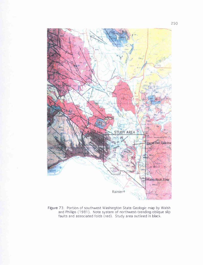
Figure 73: Portion of southwest Washington State Geologic map by Walshand Phillips (1981). Note system of northwest-trending oblique slipfaults and associated folds (red). Study area outlined in black.
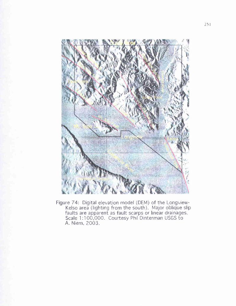
I,
Figure 74: Digital elevation model (DEM) of the Longview-Kelso area (lighting from the south). Major oblique slipfaults are apparent as fault scarps or linear drainages.Scale 1:100,000. Courtesy Phil Dinterman USGS toA. Niem, 2003.
252For this study, northwest trending faults mapped by Livingston (1966), and
later by Wells (1981), have been extended based on exposures of fault planes and joint
systems discovered in Coal Creek, and new measurements of orientations found
throughout the map area (Plate 1). In addition, several smaller-scale faults (< 30 meters
of offset) and fractures were documented, particularly along Coal Creek, where hundreds
of small faults with centimeters of offset, most normal but some reversed, occur along
with thousands of fractures of this orientation. Coal Creek has also exposed more than 60
late-middle Eocene Grays River basalt dikes that have intruded along both faults and
fractures ranging from nearly east-west to N 75 W, but most are close to N 60 W (Plate
1). Most other fresh exposures show this system of faults, suggesting that if exposures
were better, this northwest signature would be seen as pervasive throughout.
With the exception of the major fault bounding Mt. Solo to the north (Mt. Solo
Fault, Figure 74, Plate 1, cross section B-B') all major faults of this northwest orientation
within the study area are up to the north. The next major fault to the north, the Eufaula
Fault, juxtaposes Columbia River Basalt to the south against fine arkosic sandstone of the
Cowlitz Formation to the north (Plate 1). This represents at least 20 meters of offset.
The next major northwest fault to the north (excluding the N 40 W Coal Creek fault
described in the next section) is the Rottweiler Fault, also up to the north, which causes
several unusual steep strikes and dips within Coal Creek, and produces a 30+ meter
repeat section of some intervals of the Coal Creek stratigraphic section (cross section C-
C'). The discovery of this fault in Coal Creek also allowed extrapolation of this fault
system to include a set of small northwest-trending faults offsetting middle Miocene
253
Grande Ronde Basalt flows above the Columbia Heights Anticline. The next large
fault to the north, the Goose Hollow Fault, juxtaposes Grande Ronde Basalt against
clayey siltstones of the Toutle Formation, an offset of at least 20 meters. This fault
appears to die out to the southeast. All other northwest-trending faults documented for
this study are up to the north, but Kleibacker (2002) described the Germany Creek and
Loper Faults in his study area to the north as being up to the south. This post-Columbia
River Basalt stair-stepping of fault blocks upward to the north, culminating in the block
north of the Goose Hollow Fault, explains the progressive increase in elevation of the
Columbia River Basalt flows in the area toward the northeast, accounting for their
differential uplift. The south to north progressive up-faulting of blocks, then stepping
down again in Kleibacker's study area, suggests that the entire system of northwest-
trending splays is a complex northwest-trending horst. Likewise, the valley north and
west of Mt. Solo can be described as a small pull-apart graben (Plate 1, cross-section B-
B').
There is evidence of both extension and compression within this wrench fault
system. The northwest-trending middle Eocene Grays River dikes intruding the Cowlitz
Formation in Coal Creek, ranging from 0.3 to over 6-meters wide and largely paralleling
the larger faults in the area, are viewed as resulting from late Eocene extensional forces.
Normal faults associated with extension are thought to provide a low-pressure route for
lava to rise toward the surface. Since most faults of this trend in Coal Creek are normal,
this is a reasonable explanation. Slickensides on the margins of these dikes (faults) show
a minor oblique-slip component, but are largely vertical. Today this would indicate
254tension in the direction of N 30 E and S 30 W. However, some northwest-trending
faults in the study area are reverse, and a regional pattern of anticlines and synclines
(indicating compression) trend northwest and nearly parallel adjacent normal faults
(Figure 73). Clearly, this fault system is also associated with compressional forces. The
Goose Hollow Syncline, affecting Cowlitz Formation and Grays River volcaniclastic beds
in the northern half of Coal Creek, almost exactly parallels both the Rottweiler and Goose
Hollow Faults (Plates 1 and 2). This fold pattern indicates that the northwest-trending
fault set is also associated with a compressional stress regime, despite the evidence from
most of the Coal Creek normal faults and extensional dikes.
A reasonable explanation for these fault data is that a normal fault horst and
graben system produced by an earlier extensional regime in middle to late Eocene,
occurring prior to folding or reverse faulting and producing the Grays River dikes in Coal
Creek, was later reactivated in late-middle Miocene by a compressional wrench tectonic
regime acting in a N 20-40 E direction, producing the dozens of folds, and many of the
reverse and normal faults that trend N 50-70 W. Since most northwest-trending faults are
normal, many were not reactivated in the later compressional event(s). The initial
tensional event in the middle to late Eocene, perhaps related to the magmatic inflation
and distension of the oceanic crust and eruption of the Grays River Volcanics, may have
determined the general orientation and location of the faults, joints, and dikes that would
later become the northwest-trending fault system reactivated during Miocene
compression and extension associated with wrench tectonic faulting. This pattern of late-
middle Eocene northwest-trending horst and graben faulting followed by late-middle
255Miocene to Pliocene reactivation and clockwise rotation in a wrench system also
occurs in the Mist Gas Field (Niem personal communication, 2003).
Evidence also exists within the study area for right-lateral shear along these faults.
Many Coal Creek dikes show evidence of a horizontal, as well as vertical component to
the offset, confirmed by non-vertical slickensides. These also show that the horizontal
component of the northwest-trending faults is right-lateral. Slickensides on other small
faults in the creek and elsewhere show more horizontal component than vertical. This
pattern is similar to the northwest-trending simple dextral shear described by Rarey
(1986). In this model, the northeast-trending fault in the north-central part of the map
area near the headwaters of Hazel Dell Creek (Plate 1), and several faults with similar
northeast trends described by Kleibacker (2001), could be explained as Riedel shears
formed by these northwest-trending oblique-slip faults in a wrench tectonic system
(Payne, 1998; Kleibacker, 2001). Lack of a substantial number of these northeast-
trending faults in the Longview-Kelso area could be evidence that not much rotation has
taken place there. Additional evidence for this is in the southwest-trending paleocurrent
directions recorded in Coal Creek and elsewhere in the study area, averaging S 50 W. If
clockwise rotation of even 45 degrees had occurred, the original paleocurrent direction
prior to rotation would have been from the north or northwest, an unlikely scenario given
Eocene paleogeographic reconstructions. If rotations described by Kleibacker (2001)
immediately to the north (-103 degrees) applied to the Coal Creek section, original
paleocurrent direction would have been from the west-northwest, a seemingly impossible
paleogeographic model given deltaic models for the Cowlitz Formation and the thick pile
256of Grays River Volcanics in that direction. This field evidence is in contrast to recent
paleomagnetic studies of the Cowlitz Formation and Grays River Volcanics (Wells and
Coe, 1985; Prothero and others, 2001). If in fact not much rotation has occurred in the
Longview-Kelso area, but significantly more has occurred just a few km to the north in
Kleibacker's study area, small block rotation could explain the northeast (rather than
northwest) trend of the Grays River dikes in Germany Creek, a clockwise difference of
-110 degrees from the study area. The similarity of fault and fold directions throughout
the immediate area, and between the two areas, makes this substantial difference in
rotation, especially over such a short distance, unlikely. More likely is the scenario that
dikes in Kleibacker's area resulted from northwest-southeast late-middle Eocene
extension along conjugate faults related to Riedel shear, but resulted from magma
upwelling and distension in the study area, perhaps related to its possible position on the
flank of the Grays River volcanic edifice.
Coal Creek Fault
The abrupt change in strike and dip directions of middle Eocene Cowlitz
Formation beds in Coal Creek, from a southwest dip averaging about 20 degrees to a
north dip averaging 2-5 degrees at the S 1/2 of Sec. 2, T 8 N, R 3 W was interpreted by
Weaver (1937) and Livingston (1966) as resulting from an anticlinal axis at that location.
Weaver, while traversing the creek from south to north, measured and described
approximately 2000 feet (-610 meters) of Cowlitz Formation while moving downsection
through the southwest-dipping southern third of the creek. After crossing what he
considered to be the axis of an asymmetrical anticline, he began measuring upsection, and
257
included these units within the stratigraphic section he had already measured,
correlating units based on stratigraphic position within the measured section, rather than
by stratigraphic correlation. Abrupt changes in dip in the northern two-thirds of the creek
were also interpreted as being related to synclines and anticlines.
A different interpretation is being proposed here. While traversing the creek from
south to north for this study (Plate 2), it was noted that the nearly flat-lying, cliff-forming
Cowlitz sandstones and siltstones north of Weaver's anticlinal axis are of a unique
lithology not encountered in the -600 meter measured Cowlitz section south of the
anticlinal axis. These beds represent stratigraphic intervals lower in section than the
lowest beds encountered south of the change in dip. The location in the creek where the
change in dip occurs is also highly fractured and faulted, with a dominant trend toward
the northwest. Cowlitz sandstone and siltstone units in the 100 meters of creek bed south
of the major change in dip, besides being highly fractured, also change strike and dip
frequently, with a dip of 40 degrees toward the southeast right at the edge of the fault (the
steepest recorded in the creek). Given that 1) beds close to the structure cannot be
correlated across the structure, 2) the change in bed orientation is sudden and severe, not
gradual and decreasing toward the axis as would be expected from an anticline, and 3)
beds immediately to the south of the structure are highly fractured and faulted, this
structure is considered here to be a northwest-trending reverse fault that is up to the north.
Further evidence for this interpretation is that a thick volcaniclastic interval in Coal
Creek near the base of the southern section is again encountered moving upward through
the northern section (Plate 2, cross section C-C').
258
Much evidence for this major fault exists beyond Coal Creek. Abrupt changes
in dip similar to those described in Coal Creek exist along the projected trend of the fault
at Site 68 (up N 50th Avenue beneath the power lines, NE 1/4 of the SW 1/a of Sec. 12, T 8
N, R 3 W, Plate 1). This is within a probable modern landslide block that moved slightly
downhill en mass (i.e., translational slide and left bedding largely in tact). At SE 1/a of NE
1/ of Sec. 13, T 8 N, R 3 W, Livingston (1966) mapped a fault plane of this orientation
and along trend toward the southeast, with the fault plane dipping 60 degrees toward the
northeast (Plate 1). Two fault-controlled blocks in parts of Sec. 13 and 24, R 3 W, T 8 N,
and Sec. 18 and 19, R 2 W, T 8 N trend in this direction and are adjacent to the projected
fault plane beneath Columbia River alluvium. In addition, the trend of this fault projects
along the southwest limb of the Columbia Heights Anticline, suggesting that this quite
linear feature may be fault-controlled.
The Coal Creek Fault is part of the extensive deformational event that largely
occurred before emplacement of the Miocene Columbia River Basalts, as it does not
offset these flows in the study area. The N 40 W orientation of this structure is similar to
the trend of the Columbia Heights Anticline and Hazel Dell Syncline, indicating that all
of these features could have resulted from the same compressional or wrench tectonic
event. The Coal Creek Fault could be the western expression of the same forces that
folded units to the east. The Columbia Heights Anticline bordered by the Coal Creek
Fault to the south is in some ways analogous to the relationship between the Portland
Hills Anticline bound by the Portland Hills Fault to the north (Wong and others, 2001).
In this view, the block north of the Coal Creek Fault in Coal Creek is part of the same
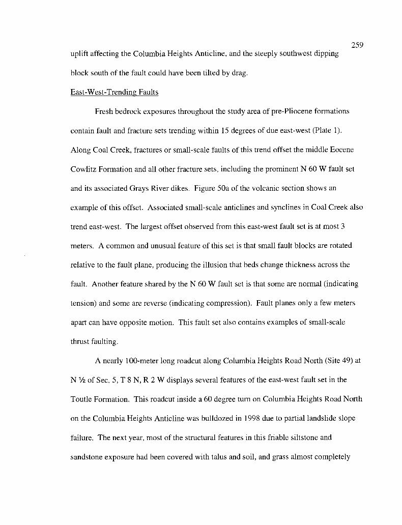
259uplift affecting the Columbia Heights Anticline, and the steeply southwest dipping
block south of the fault could have been tilted by drag.
East-West-Trending Faults
Fresh bedrock exposures throughout the study area of pre-Pliocene formations
contain fault and fracture sets trending within 15 degrees of due east-west (Plate 1).
Along Coal Creek, fractures or small-scale faults of this trend offset the middle Eocene
Cowlitz Formation and all other fracture sets, including the prominent N 60 W fault set
and its associated Grays River dikes. Figure 50a of the volcanic section shows an
example of this offset. Associated small-scale anticlines and synclines in Coal Creek also
trend east-west. The largest offset observed from this east-west fault set is at most 3
meters. A common and unusual feature of this set is that small fault blocks are rotated
relative to the fault plane, producing the illusion that beds change thickness across the
fault. Another feature shared by the N 60 W fault set is that some are normal (indicating
tension) and some are reverse (indicating compression). Fault planes only a few meters
apart can have opposite motion. This fault set also contains examples of small-scale
thrust faulting.
A nearly 100-meter long roadcut along Columbia Heights Road North (Site 49) at
N 1/2 of Sec. 5, T 8 N, R 2 W displays several features of the east-west fault set in the
Toutle Formation. This roadcut inside a 60 degree turn on Columbia Heights Road North
on the Columbia Heights Anticline was bulldozed in 1998 due to partial landslide slope
failure. The next year, most of the structural features in this friable siltstone and
sandstone exposure had been covered with talus and soil, and grass almost completely
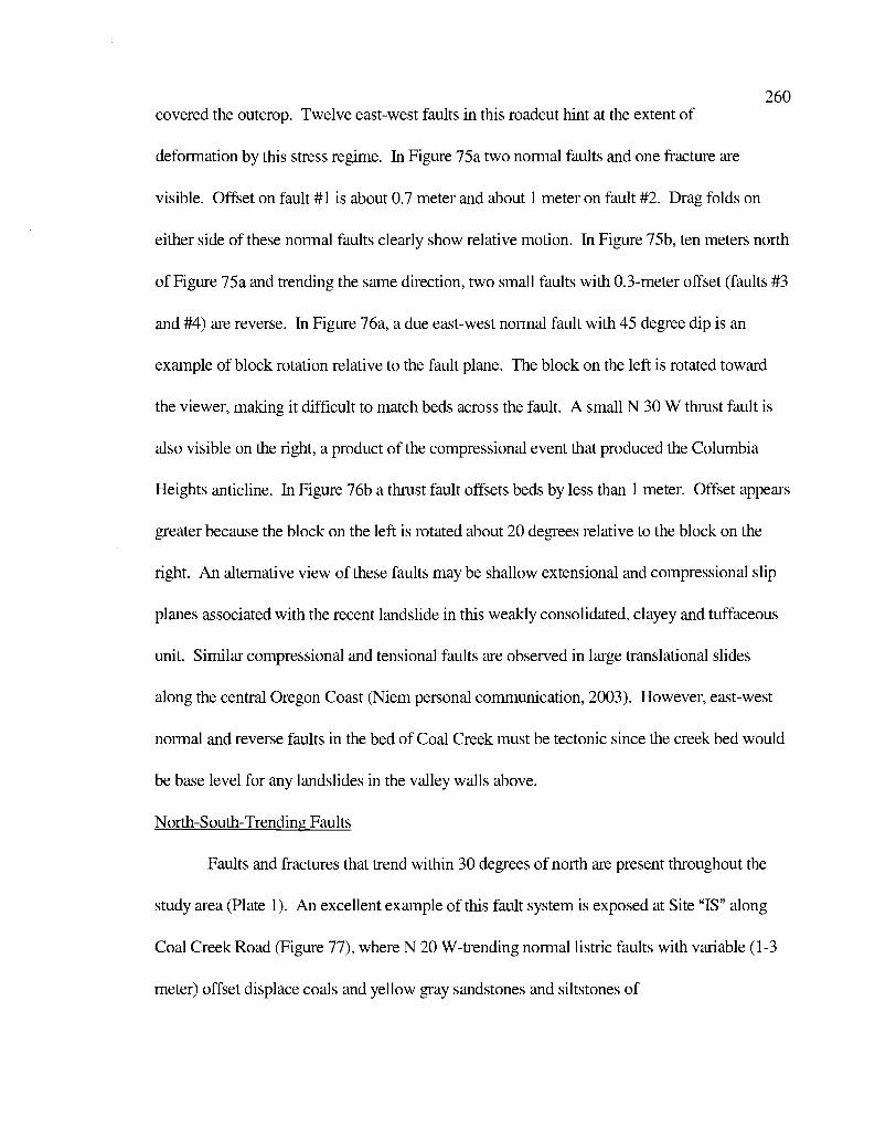
260covered the outcrop. Twelve east-west faults in this roadcut hint at the extent of
deformation by this stress regime. In Figure 75a two normal faults and one fracture are
visible. Offset on fault #1 is about 0.7 meter and about 1 meter on fault #2. Drag folds on
either side of these normal faults clearly show relative motion. In Figure 75b, ten meters north
of Figure 75a and trending the same direction, two small faults with 0.3-meter offset (faults #3
and #4) are reverse. In Figure 76a, a due east-west normal fault with 45 degree dip is an
example of block rotation relative to the fault plane. The block on the left is rotated toward
the viewer, making it difficult to match beds across the fault. A small N 30 W thrust fault is
also visible on the right, a product of the compressional event that produced the Columbia
Heights anticline. In Figure 76b a thrust fault offsets beds by less than 1 meter. Offset appears
greater because the block on the left is rotated about 20 degrees relative to the block on the
right. An alternative view of these faults may be shallow extensional and compressional slip
planes associated with the recent landslide in this weakly consolidated, clayey and tuffaceous
unit. Similar compressional and tensional faults are observed in large translational slides
along the central Oregon Coast (Niem personal communication, 2003). However, east-west
normal and reverse faults in the bed of Coal Creek must be tectonic since the creek bed would
be base level for any landslides in the valley walls above.
North-South-Trending Faults
Faults and fractures that trend within 30 degrees of north are present throughout the
study area (Plate 1). An excellent example of this fault system is exposed at Site "IS" along
Coal Creek Road (Figure 77), where N 20 W-trending normal listric faults with variable (1-3
meter) offset displace coals and yellow gray sandstones and siltstones of
0
2
Figure 75: East-west trending faults from Site 49 in Toutle Formation clayey siltstones.A. Two normal faults trending N 80 W with offsets of l meter or less.B. Two reverse faults trending N 80 W with offset of less than 1 meter,
located ahout 10 meters north of faults #1 and #2 (could he slump related).
A.
Figure 76: East-west trending faults from Site 49 in Toutle Formation clayey siltstones.A. A due east-west trending normal fault with ahout 1 meter of offset. Note
anticlinal drag fold in the right hlock, and rotation of the left block.B. Thrust fault illustrating drag and rotation of the block on the left. Note slope
failure in the far left part of the photograph. These may all he slump relatedstructures.
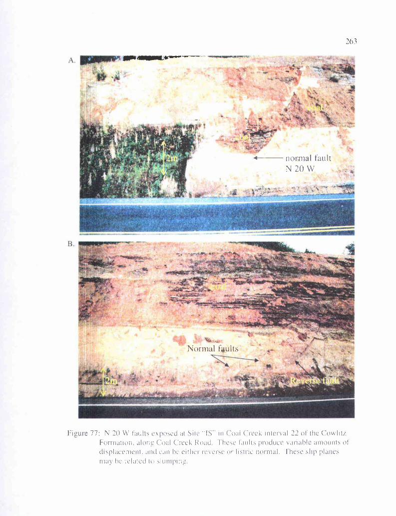
B.
n
j 1
rL-
ti
'1.
C" r
v
r rd=...tis ftro s . l
Mfr
r '+.r.lt1
n z
1
k, ' \
'.
26 3
- normal faultN20W
Figure 77: N 2O W Taints cxposcd at Sitc '-IS-- in Coal Creel. inter%al 22 of the C'owliti.Formation, alonw Coal Creel. Road here Iault produce nimble amounts ofdisplacement, and can he eithci icvcnc of listnc normal. -Ihese slip planesmay he related to slunpn
264interval 22 of the Coal Creek section (Plate 2), as well as a Grays River basalt sill.
Alternatively, since this roadcut is part of an active landslide, these fractures may be listric
shallow slip planes associated with the slide.
Kelso Fault Zone
At Site 9, a 100-meter long roadcut on Old Pacific Highway (the Carrolls 1-5 exit at
the center of Sec 12, T 7 N, R 2 W), three major and several minor faults and fractures occur
with this northward trend, juxtaposing Grays River, Cowlitz Formation, and western Cascade
basaltic andesite units that must have originally had tens of meters vertical separation. This
outcrop with its north-trending faults has been included as part of the Kelso Fault Zone, which
has created a linear fault scarp along 1-5 in the southeastern corner of the study area, trending
N 20 W (Plate 1, Figure 74). These faults have both normal and right-lateral strike-slip
components, and many are difficult to decipher. It is clear that the beds and fault planes
within this outcrop have undergone a considerable degree of deformation and alteration. The
three north-trending faults and one east-west fault have been labeled 1 through 4 from north to
south for this discussion.
Fault #1 (Figure 78a) consists of two fault splays that join at the top of the outcrop,
with a near vertical wedge of Cowlitz Formation in between. The fault splay to the north has
the more substantial offset of the two, trending N 20 E, the fault splay to the south trends N 20
W. The block to the north of this fault exposure consists of nearly horizontal thick beds of
highly altered dark gray to grayish brown basaltic conglomerate (Tgvs 1, thin section CR-l,
Figure 55b of volcanic section); the block to the south consists of nearly vertical yellow gray,
clean, friable Cowlitz micaceous arkose. The wedge caught
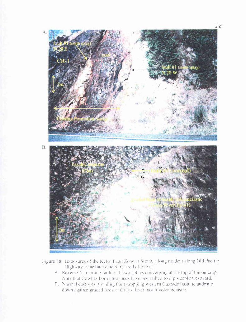
A.,
!7
4Ss
Nt741 is
v d.a,j-wry,»;,
r
ia1 -̂ r :q,c ti fw
}
r o
v
.-.a
U
£
101
ko.
.
Figure 78: Exposures of the Keko Fault lone at Site 9. a long roadcut along Old PacificHighway, near Interstate 5 i ('airoll5 I- exit).
A. Reverse N-trending fault vv ith t' ,plays converging at the top of' the outcrop.Note that Cow lit/ I-ornuiticn hcd5 havc been tilted to dip steeply westward.
B. Normal east-vest trcndime fault dioppim_ cstern Cascade basaltic andesitedown against graded bed,, OI C;iavS River basalt ulcaniclastic
266between the fault splays consists of a 2-meter thick light colored tuff, a 2-meter thick
coal, and a dark gray basaltic sandstone dipping 65+ degrees toward the west.
Slickensides in these faults are nearly vertical, but show an oblique-slip component (80
degree rake). Throughout the study area, the Grays River volcaniclastics unit north of the
fault consistently occurs stratigraphically lower than Cowlitz Formation micaceous
arkoses and coals, indicating this is oblique-slip fault is largely reverse. The steep dip of
the Cowlitz Formation beds also indicates drag due to compressional deformation.
Fault #2 occurs about 10 meters south of fault #1 and trends N 30 W with a dip of
75 degrees toward the east-northeast. This fault consists of three main sub-parallel
splays, and juxtaposes highly altered, light gray pumiceous and basaltic tuff/breccia
(Tgvs1, thin section CR-7) against an altered, well-bedded basaltic sandstone (Tgvs2 ?)
near the base. These relationships do not provide strong evidence as to relative motion of
the two blocks. However, the oxidized reddish colored basaltic sedimentary unit south of
the fault has been folded into a broad asymmetrical anticline, with an axis trending nearly
due north, and this fold contains several small, nearly vertical faults and shear zones
trending northward, indications that the fault resulted from compression from the
direction of S 60 W. Fault #3 (Figure 79) juxtaposes the highly altered east-dipping limb
of the anticline of Grays River basaltic sediments against a down-dropped block of the
western Cascade basaltic andesite unit (thin section CR-12). This fault trends N 30 E and
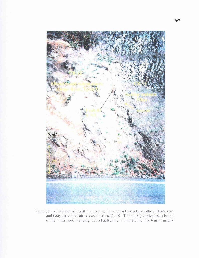
? -'.
'
4-
I
;..aa "c it
•I
C
I g
-•
2(i 7
Figure 79: N 30 E normal tacit jurap) Irig the +cstern Cascade basaltic andesite unitand Grays River hasalt wicaniclastic at Site 9 1 his nearly Vertical fault is partof the north-south trendinL Kcl,o Fault tone. v rth offset here of tens of meters
srr
.y
Y
f
268dips slightly to the east, a relationship that suggests a normal fault. A fault breccia
defines the fault plane on the east side. Fault #4 (Figure 78b) is this outcrop trends nearly
east-west, and is a very low-angle (33 degrees) normal fault juxtaposing western Cascade
basaltic andesite to the north against well-bedded Grays River basaltic
conglomerate/sandstone to the south. This south block probably consists of the same unit
as the block between fault #2 and #3, and therefore, the basaltic andesite block is down-
dropped between faults #3 and #4. This -100-meter wide complex of high-angle faults
and drag folds at the interchange suggests this is a major fault zone trending N 20 W that
might have controlled the north-south course of the ancestral Columbia River, and mark
the tectonic boundary of the subaerial western Cascades volcanic arc on the east, and the
Coast Range Paleogene forearc deltaic sedimentary units on the west.
Kalama Structure Zone
Several authors in recent years have proposed that a complex major north-
northwest-trending structural zone transects the crust beneath the lower Columbia River
Valley (Pezzopane and Weldon, 1993; Blakely and others, 1995; Wells and others, 1998;
Evarts, 2002) based on the incongruity of geologic features on either side of the river.
This shear zone, termed the Kalama Structural Zone, is believed to be part of a set of
north-south shear structures that has accommodated northward translation of the Oregon
and Washington Coast Range relative to the Cascade arc due to oblique subduction
during the Tertiary. Evarts (2002) in his recent description of the Deer Island quadrangle
-20 km to the south of the study area, noted that strikes and dips vary across the proposed
structure which is buried in a north-northwest orientation beneath the Columbia River,
269and that a southward-plunging anticlinal structure in the area has an anomalous
orientation for the southwestern Cascade Range.
One of the purposes of this study was to evaluate the possibility that this north-
south structural feature has affected the geology of the Longview-Kelso area, because the
trend of the structure (and the Columbia River) is toward the study area. Evidence
neither confirms nor denies the existence of this structure in the study area, but there is
much evidence to support it. The N 20 W trend of the Kelso Fault Zone (Plate 1), and the
fact that this system and its associated fault scarp are parallel to the Columbia River,
strongly suggests that it is part of the Kalama Structure Zone. In addition, this fault
system trends directly toward the Cowlitz River Valley, which trends northward. The
thick Grays River volcaniclastic exposure at Site 14 (near the southern end of the Cowlitz
River in the SW 1/a of Sec. 26, T 8 N, R 2 W) is fractured and possibly faulted with a
trend of N 20 W. The west side of the Cowlitz River is very straight, particularly the
resistant Grays River basalt flows (unit Tgvl, Plate 1) near Kelso. Bedding east of the
Cowlitz River consistently dips eastward in contrast to the highly variable dips west of
the river. This dip direction is slightly different than the dip in the northeast limb of the
Columbia Heights Anticline, but substantially different than the southwest dipping limb
of the Hazel Dell Syncline. In addition, the synclinal axis cannot be confidently
extrapolated across the river. Miocene Columbia River Basalt flows occur only west of
the river, and the arc-derived, western Cascade basaltic andesite flow unit occurs only
east of the river (Plate 1). The western Cascade andesite dikes in the northeast corner of
270the study area (W'/2 of Sec. 25, T 9 N, R 2 W) also do not extend across the river west
of this north-south fault zone, suggesting additional structural control of the river's course.
There are also many reasons to doubt that a large-scale structure is hidden beneath
the Cowlitz River. The east dip of Cowlitz Formation and Grays River volcaniclastic units
east of the river is similar to that of the northeast limb of the Columbia Heights Anticline.
Cross section A-A' does not require a structural feature there to make sense, just a small
shift in dip eastward. Similar Cowlitz Formation and Grays River units occur directly
across the river from each other with rare exception, and the Toutle Formation occurs on
both sides. The Kelso Fault Zone is similar in trend to the Columbia Heights Anticline and
Hazel Dell Syncline, and the Coal Creek Fault. This coupled with the fact that the
slickensides in the Kelso Fault Zone are mostly vertical, implies that all 3 faults may be part
of the same pre-Miocene Columbia River Basalt compressional (transpressional) event.
This does not preclude the Kelso Fault Zone from being a northern extension of the Kalama
Structural Zone, and in fact, may show that the Columbia Heights Anticline and Hazel Dell
Syncline are related to the Kalama Structural Zone. Importantly, other than the north-
trending fractures at Site 14 (Plate 1) in Kelso, there is a striking lack of north-trending
faults or fractures in scattered exposures along the Cowlitz River. If such a structure exists,
Rocky Point (projecting into this structural zone) should have a strong imprint of north-
trending structures, but instead, fracture sets there are largely east-west trending.
The Columbia Heights Anticline and Hazel Dell Syncline are located at the
termination of two major fault systems within the study area and the surrounding region; the
N 50 W to N 70 W fault system and the north-trending Kelso Fault Zone (part of the
271
Kalama Structure Zone). The large anticline and syncline are oriented 15 degrees to the
northwest of the Kelso Fault Zone, 10 degrees northeast of the Coal Creek Fault, and 20
degrees (average) from the northwest-trending faults. Since the northwest-trending fault
system dies out near Columbia Heights, and little evidence exists of the Kalama Structure
Zone north of Kelso, the study area is clearly an area of transition from one fault set to
another. Motion on the Kalama Structure Zone has been determined by Evarts (2002) and
others to be an oblique-slip fault system with right-lateral offset, resulting from oblique
subduction and wrench-style deformation. In addition to the normal component of the
offset in the three north-trending faults at Site 9, there is also a strike slip component (with
rake angles as low as 60 degrees). Based on drag folds on these faults, and the known
stratigraphic sequence of units in the area, these faults appear to be reverse (transpressional),
as is the similar-trending Coal Creek Fault.
Similar structures with similar orientations occur in Southern California as a result
of wrench faulting (Figure 80). Here, right-lateral oblique-slip faults with reverse normal
components are associated with folds trending less than 30 degrees to the northwest of the
main fault, more often within 15 to 20 degrees. A similar pattern occurs in wrench tectonic
settings in New Zealand and Venezuela where right-lateral wrench faults produce a series of
en echelon folds with angles of 30 degrees or less. Small-scale east-west folds in Coal
Creek (Plates 1 & 2) are oriented 30 degrees clockwise to the northwest-trending faults
through this area. Indeed, theoretical and clay models predict that compression and
associated folding would occur at the same angles found in the study area in a north-
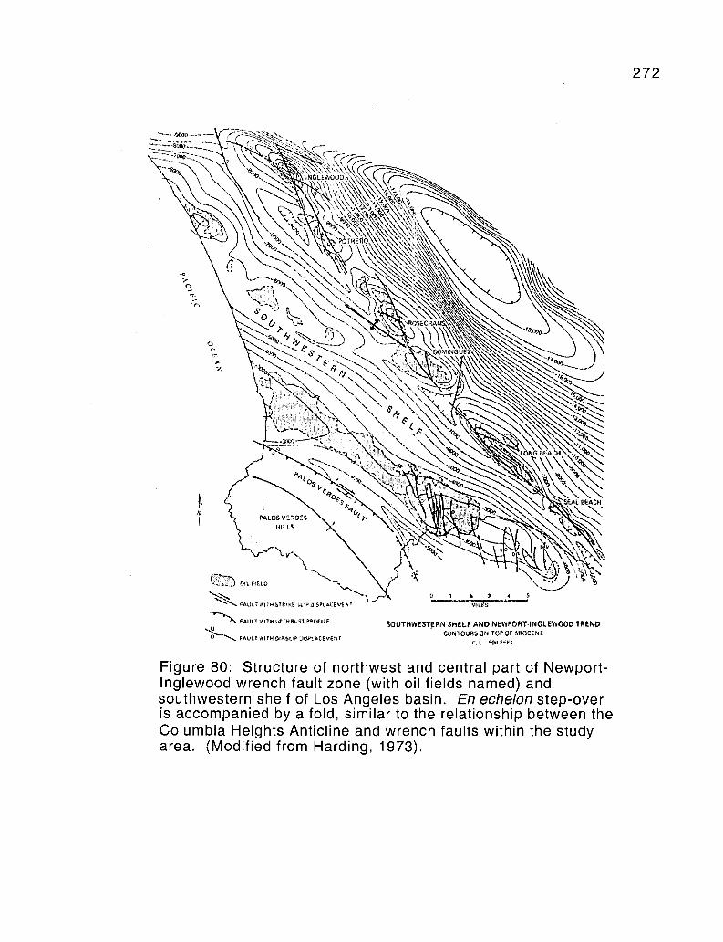
272
",!L FIELD
'`r AULTWITH ST81 ,tna,. wtTAULT WITH aP 1
0 `1 FAULT WITH CIP-} SPLACEVENT
SOUTHWESTERN SHELF AND NEWPORT. NGLEWOODTREND' QURS ON TOP OP MIOCENE
CI. tw Uer
Figure 80: Structure of northwest and central part of Newport-Inglewood wrench fault zone (with oil fields named) andsouthwestern shelf of Los Angeles basin. En echelon step-overis accompanied by a fold, similar to the relationship between theColumbia Heights Anticline and wrench faults within the studyarea. (Modified from Harding, 1973).
273
trending, right-lateral fault system. For most wrench-fault experiments with clay, the
angle between en echelon fold axes and the wrench fault is near 30 degrees, folds that form
later during deformation have lower angles (Wilcox and others, 1973). By extrapolation
from models, the axes of en echelon (right-handed when in association with right-lateral
faults) should be at low angles (<30 degrees) in a counter clockwise direction.
Since the Kalama Structure Zone terminates in the southeast corner of the study
area, the compressive force of northwest Oregon pushing into southwest Washington along
this oblique-slip zone must be accommodated some other way. The series of northwest-
trending faults in the study area and in the adjacent study area of Kleibacker (2001) to the
north are also right-lateral oblique-slip faults, and could accommodate this motion. In this
view, the study area is a step-over zone, where the Kalama Structure Zone essentially bends
westward and splays into at least 7 smaller right-lateral wrench faults. This bend in the fault
system could also explain why the Columbia Heights anticline and Hazel Dell Syncline
(and the associated Coal Creek Fault) are positioned where they are, an area of concentrated
compressional tectonic strain produced by the bend in the fault system. It is interesting to
note that the Columbia River travels in nearly a straight line southeast of the study area
because it follows the Kalama Structure Zone. At Longview and Kelso where the fault
bend/stepover occurs, the river also bends westward following a nearly straight line that
parallels the major northwest faults in the area (Plate 1). A similar pattern occurs in
Southern California (Figure 80) along the Newport-Inglewood trend where an en echelon
step-over is associated with a fold of similar orientation and scale, and also splays into at
least 3 smaller faults.
HYDROCARBON POTENTIAL274
With over 2000 feet (-650 meters) of potential Cowlitz Formation reservoir
sandstone, coal methane gas source beds, structural traps, and seals, and a location
approximately 16 km (-10 mi) northeast of the producing Mist Gas Field, the study area
is a worthy target for future natural Gas exploration. Since first being drilled in 1979 by
a joint venture between Northwest Natural Gas, Diamond Shamrock, and Reichold
Energy Corporation (Olmstead, 1982), 70 BCF (billion cubic feet) of natural gas have
been commercially produced from the Cowlitz Formation in the Mist field, worth an
estimated $125 million. In the area of the Mist Gas Field specifically, natural gas was
generated from deep-sea mudstones of the underlying Eocene Hamlet Formation, and to a
lesser extent from carbonaceous mudstones, siltstones, and coal seams of the Cowlitz
Formation itself. Carbon and oxygen isotopes suggest that the methane in the Mist Gas
Field is both biogenically and thermogenically generated (Armentrout and Suek, 1985).
The portion of the methane that was thermally produced is likely sourced from the
Hamlet Formation and at least part of the overlying Cowlitz Formation in the
hydrocarbon generation window, based on depth of burial and the local geothermal
gradient (Armentrout and Suek, 1985). Much of the methane may also have originated
from strata in the deeper Astoria or Nehalem basins, which are downdip, allowing gas
migration updip into the Nehalem Arch where the Mist field is located. Flash heating by
Eocene intrusions may also have generated gas (Stormberg, 1991).
The main reservoir for methane at the Mist Gas Field is the Clark and Wilson
sandstone member of the Cowlitz Formation. These delta front reservoir sandstones can
have permeabilities of up to 2 Darcies and porosity of 30 to 40% (Niem and others, 1992;
275
Robertson, 1997). In the field, upper Cowlitz Formation deep-marine mudstone and
deep-marine tuffaceous Keasey Formation siltstone act as overlying stratigraphic seals.
Hydrocarbons migrating laterally and upward are also stopped by normal fault traps
developed in the late Eocene. In order for permeable sandstone to be an effective gas
reservoir, there should be a four-way closure, typically defined by 2 to 4 impermeable
fault planes. At the Mist Gas Field such traps occur as fault planes that define a series of
horsts and grabens in the area that cut across the Nehalem arch. Gas is also trapped in
small drag folded anticlines associated with these faults. These structures are commonly
with northeast- and east-west-trending faults, that in northwest Oregon are secondary to
the principal northwest-trending oblique-slip faults (Eriksson, 2002). These structures
are along trend with the northwest-trending Portland Hills Fault Zone (Niem and Niem,
2002).
In the subsurface the arkosic C & W (Clark and Wilson) reservoir sandstone and
the overlying stratigraphic seals (i.e., the upper Cowlitz mudstone) pinch out to the
northwest and west. This results from onlapping and thinning of these Eocene
sedimentary strata against the Grays River Volcanic paleo-high (large Grays River
gravity anomaly presumed to the primary eruptive center, Figure 45) creating potential
stratigraphic traps, and defining the northernmost extent of these units. The Champlin
Puckett exploration well on the south bank of the Columbia River, 5 miles north of the
Mist Gas Field (on the flank of the volcanic high, Figure 45), drilled through
approximately 4400 feet (-1400 meters) of Grays River lava flows and volcaniclastics
with no Cowlitz interbeds. However, the study area, as well as the study areas of Payne
(1998) and Kleibacker (2001), also located on the eastern flanks of the Grays River
276
gravity high, contain thousands of feet of potential Cowlitz Formation micaceous lithic
arkoses, associated mudstone seals, and methane-rich coals.
Even though no natural gas is currently being produced in southwest Washington,
Johnson et al. (1997) have described the Cowlitz-Spencer gas play, which includes the
study area. This play, which extends from the southern Puget Basin to the Oregon-
Washington border, is based on the premise that methane generated from underlying
middle Eocene marine mudstone or intraformational non-marine carbonaceous mudstone
and coals, may have migrated into sandstone reservoirs in overlying or interbedded
Eocene deltaic or estuarine shallow marine sandstones. The Mist Gas Field could be
used as an analog for exploration in these Cowlitz Formation and older Eocene McIntosh
units in southwest Washington. In and around the Chehalis Basin, 40 km north of the
study area (Figure 3), 20 wells have been drilled to depths of 3000 feet or greater, without
discovering commercial natural gas deposits, but many shows occur. Both the Chehalis
basin of southwest Washington and the Mist Gas Field are used for storage of natural gas
imported from Canadian gas fields (Niem and others, 1992)
Potential Local Hydrocarbon Generation
Based on the thick McIntosh Formation mudstones and siltstones described by
Kleibacker (2001) in Germany Creek north and west of the study area, and also the
presence of the McIntosh Formation in the Quigley no. 1 well just north of the study area,
it is inferred that McIntosh Formation also underlies the Cowlitz Formation in the study
area (Plate 1 cross sections). The deep-marine, organic-rich mudstones of this formation,
which may be up to 3000 meters thick, are a marginal source for hydrocarbons. At the
Mist Gas Field, natural gas generation was likely initiated about 33 Ma at burial depths of
277
3000 meters or more in the Nehalem and/or Astoria Basins based on the necessary
geothermal gradient to mature these hydrocarbons and generate thermogenic natural gas
(Armentrout and Suek, 1985). In southwest Washington, the limiting factor preventing
development of large gas accumulations is the relatively low maturity of the source rocks
(Johnson et al., 1997). The local thermal gradient would produce a maturation depth of
approximately 3000 meters. That depth was probably attained in southwest Washington
at the time of maximum burial during the early to middle Miocene, prior to the late
Miocene transpressional event that produced regional faulting, folding, and uplift. At this
time, it is also likely that the lower Cowlitz Formation (coal bearing units 1 and 2, Plate
2) was also within the window of hydrocarbon production. Today, it is likely that some
of the lower bathyal marine mudstone of the McIntosh Formation is still beneath this
3000-meter limit in southwest Washington.
Cowlitz Formation coal seam and carbonaceous mudstone within the study area
could likewise act as gas-prone source rocks for natural gas production. The Coal Creek
stratigraphic section (Plate 2) differs from the type section described by Payne (1998) in
having substantially more upper shoreface to delta plain sandstones and substantially less
lower shoreface to bathyal mudstones and siltstones. Therefore, relatively thin mudstone
interbeds are likely not a good source for hydrocarbons in this area. However, the Coal
Creek section contains 8 substantial coal/carbonaceous shale horizons (coals A-H, Plate
2) that could act as sources for in situ biogenic and thermogenic methane. These low
grade coals are typically lignitic to subbituminous, which typically have vitrinite
reflectance values between 0.3 and 0.6 percent. Eocene intrusions of Grays River
basaltic dikes and sills, and to a much lesser degree, western Cascade-derived andesite
278dikes, could have produced narrow localized areas of thermogenic methane. In addition,
the location of the study area so near the Grays River volcanic high, and with local
eruptive centers such as Mt. Solo and Rocky Point active during Cowlitz deposition, the
geothermal gradient may have been steeper in the study area than in surrounding areas.
Potential Local Hydrocarbon Reservoirs
Within the Coal Creek section, as well as elsewhere in the study area, several
thick permeable and porous Cowlitz Formation sandstone units could act as natural gas
reservoirs. Unit 1 upper shoreface to delta plain successions in the Coal Creek section
(parasequences 1 through 4, Plate 2) have relatively few clean arkosic sandstones. Two
intervals that are relatively clean are also relatively well-indurated with sparry calcite
cement. The coarse-grained basalt volcaniclastic facies of parasequences 5 (lithofacies
c1) is likewise well-cemented with calcite, and is thus a poor natural gas reservoir.
Potentially good reservoirs (clean, friable, micaceous and arkosic sandstones) are
comparatively rare throughout the Coal Creek section due to a heavy tidal influence
during deposition (e.g., flaser-draped beds of lithofacies e and f) in this tide-dominated
delta lobe or estuary. However, clean sandstones do exist in intervals 37, 33a and b, and
22, and are particularly common near the top of the section in the deep sea submarine
channel facies (lithofacies j, Plate 2). If during the late Eocene transtensional or late
Miocene transpressional events, horst and graben-style faulting downdropped blocks of
Cowlitz Formation arkosic sandstones against McIntosh Formation mudstones, this could
have allowed natural gas generated from the underlying McIntosh Formation to seep into
these adjacent Cowlitz Formation potential reservoir sandstones. Some Cowlitz
Formation sandstone exposures beyond Coal Creek in the study area are more friable and
279
clean, indicating that lateral facies changes of intervals in the Coal Creek section may
include cleaner (i.e., more permeable and porous) delta front sandstones.
Petrographic work conducted for this study gives further insight into the varying
reservoir potential of these Cowlitz Formation micaceous, lithic, arkosic sandstones. In
general, medium- to coarse-grained Cowlitz sandstones from the study area are less
friable (better cemented), contain more compacted carbonaceous debris, and contain
more diagenetically susceptible volcanic lithic clasts than comparable sandstones from
Kleibacker's (2001) or Payne's (1998) study areas to the north, or the Clark and Wilson
sandstone in and near the Mist Gas Field to the south (Robertson, 1997). This is due to
the tidal/estuarine influence of a large part of the Cowlitz Formation in Coal Creek and
the close proximity of Grays River volcanic centers (Rocky Point and Mt. Solo),
producing a higher basalt-lithic component in most lithic arkoses, and basalt
volcaniclastic interbeds throughout the Coal Creek section. In contrast, the gas-
producing C & W sandstone of the Cowlitz Formation is composed of dominantly storm
wave-generated, hummocky bedded, delta front sandstones with few coals and very little
basalt lithic component. The burial compacted carbonaceous, micaceous, and muddy
flaser-draped laminae greatly reduce vertical and lateral migration of hydrocarbons. The
Grays River volcaniclastic component of Cowlitz Formation lithic arkoses in the study
area has the effect of locally reducing porosity and permeability, in that basalt clay
alteration products (i.e., smectite) produce thin clay rims around most grains, causing
moderate to heavy induration in most beds, and completely fill intergranular pore spaces
in many lithic basaltic samples. Most basaltic samples studied petrographically have
pore spaces clogged by these diagenetic clay minerals.
280Sandstones with comparatively good porosity and permeability, particularly in the
upper part of the section (unit 5), show maximum porosity of 15-20% estimated in thin
section. This porosity is largely due to sand-size primary intergranular pores, with
subsidiary porosity resulting from diagenetic dissolution of some glassy volcanic clasts,
and also some potassium feldspars and calcareous fossil shell fragments. In these
samples, porosity shows good interconnectivity. They also commonly show tangential
framework grain contacts indicating that they have not undergone significant compaction.
However, most Coal Creek sandstones do show significant burial compaction and
resulting porosity reduction based on deformed micas, clay minerals, and carbonaceous
material.
Potential Stratiaraphic and Structural Traps
Within the Coal Creek section several potential stratigraphic traps and
intraformational seals occur. Near the base of the section, two coals (A and B) and
associated porous lithic arkosic sandstones and siltstones occur stratigraphically beneath
a thick well-cemented Grays River basalt volcaniclastic. Toward the northern part of
Coal Creek this unit becomes progressively dominated by well-cemented basaltic
siltstone that could act as a seal. This arrangement of source rock (coals) and reservoirs
(sandstones) underlying a well-indurated volcaniclastic seal could produce a good
stratigraphic seal. Residential water wells drilled through this volcaniclastic into
underlying lithic arkosic sandstones, carbonaceous siltstones, and coals produced water
bubbling with methane. To this day, methane bubbles occur in at least one of these wells
(SW 1/4 of Sec. 27, T 9 N, R 3 W, the northernmost home on Coal Creek Road). Methane
collected from this well for this study is biogenic biogenic rather than thermogenic
281
(Appendix V). Calcite-cemented Grays River basalt volcaniclastic and
coal/carbonaceous shale beds could also act as local stratigraphic seals, as could
sandstone stratigraphic pinch-outs of these subtidal sandstone channel and tidal bars.
Three other potentially good stratigraphic seals occur in the Coal Creek section.
The maximum flooding surface at the base of parasequence 12 places lower shoreface
mudstone with siltstone lenses (possible seals) over coarse-grained friable lithic arkosic
sandstone of the upper shoreface (Plate 2). In addition, 7 of the 8 coals in the section
(each a potential biogenic methane source) occur stratigraphically beneath this horizon.
Another flooding surface at the base of parasequence 17 places middle shoreface siltstone
stratigraphically above upper shoreface porous, clean, arkosic sandstone. In the
uppermost unit (5) of the Coal Creek section, coarse-grained sandstones of lithofacies g
or j are overlain by fine-grained, laminated, micaceous sandstone and siltstone of
lithofacies k (a potential seal). Finally, in theory, anywhere delta front sandstone
(including tidal channels) is overlain by tidal rhythmite facies or bay mudstone could be a
potential reservoir and seal.
Potential structural traps occur within the study area in the form of oblique-slip
transpressional and transtensional faults, and large-scale folding (Plate 1). The structural
style of the Mist Gas Field, small Eocene (and late-middle Miocene) horst and graben
fault blocks (Niem and others, 1992) is an analog for the study area. As described in the
structure section of this text, the prominent set of northwest-trending faults in the study
area has broken the sedimentary and volcanic units in the area into discrete blocks. Any
one of the aforementioned stratigraphic traps and seals, in addition to these faults, could
trap gas within reservoir sandstone. In addition, these fault blocks can be tilted relative to
282
each other, trapping gas in anticlinal drag folds against the fault (e.g., the Coal Creek
Fault, Plate 1, cross section C-C'). Due to poor exposure in the northern part of the study
area, it is uncertain if additional similar mapped structures are present in that area.
The Columbia Heights Anticline is another potential structural trap. This
northwest-plunging fold capped by Grande Ronde basalt, has a core consisting largely of
Grays River basalt flows and volcaniclastics, but also contains a substantial amount of
Cowlitz and Toutle Formation sandstones and siltstones that project into the subsurface to
the northwest. Natural gas generated in the McIntosh Formation or interbedded coals of
the Cowlitz Formation could potentially migrate up the dip created by the Grays River
Volcanics, and be trapped against Grande Ronde Basalt flows or interbeds at the top of
the anticline (cross section A-A'). Smaller folds in the northern part of the study area
could also act as potential structural traps (Plate 1). It is important to note that structural
and stratigraphic traps are not necessary to retrieve small amounts natural gas from the
study area. Dispersed coal bed methane molecules absorbed in coal cleats and other
carbon-rich beds can be released by pumping ground water out of the pore spaces in these
beds, thereby reducing the pore pressure within the sediment and allowing methane gas to
come out of solution, and be pumped out in horizontal exploration wells.
The 1925 Quigley no.l well, located approximately 1 km north of the study area,
was drilled by the Castle Rock Oil and Gas Company to a depth of 2893 feet (-900
meters), and according to the well logs, the exploration hole had some encouraging
results (Kleibacker, 2001). The well interval corresponds to a stratigraphic section from
the upper McIntosh Formation deltaic sandstone (a potential reservoir) up to coal-bearing
unit lB of the Cowlitz Formation as described by Payne (1998). "Good show oil" was
283
reported in the drillers log from the upper McIntosh sandstone, and another "show oil"
was reported from one of the lower Cowlitz Formation sandstones (Kleibacker, 2001).
These well logs show that there is potential for hydrocarbons originating from underlying
McIntosh Formation mudstones in the area. The large-scale northwest-trending complex
horst running through the study area, with adjacent grabens in Longview and northward
in the study area of Kleibacker (2001), may have juxtaposed Cowlitz Formation or upper
McIntosh Formation sandstones against the underlying McIntosh Formation mudstones,
leaking natural gas into the reservoirs.
284
Geologic Hazards
The Longview-Kelso area of southwest Washington is positioned in a tectonically
and hydrologically active setting. Located only about 100 miles (-160 km) inland from
the active Cascadia subduction zone, the potential exists for devastating great earthquakes
of 8.0 or larger on the Richter Scale, and smaller forearc earthquakes (e.g., on the Seattle
Fault). Such large-scale earthquakes would have devastating effects on old masonry
buildings in the area, especially in Kelso and surrounding smaller towns where historic
downtown districts are over 100 years old. To compound the problem, most
communities in the area are built on floodplain alluvium and are less than 20 feet above
sea level, and many are below 10 feet above sea level. This, in addition to the shallow
groundwater level due to the proximity of the Columbia and Cowlitz Rivers, as well as
the multiple small, meandering tributaries (with water saturated floodplain muds) that
flow through much of Longview, drastically increases the threat of liquefaction. Shaking
from the 1949 Seattle earthquake reportedly produced sand boils and sand volcanoes in
the Longview-Kelso area. Most homes in the low-lying areas lack basements, since the
water table is higher than the depth of the basements, even under normal precipitation
conditions. High-water conditions coincident with a large earthquake could exaggerate
the liquefaction effect. Even in low-lying areas not particularly prone to liquefaction
(i.e., underlain by river gravels), housing developments are nevertheless built on
unconsolidated alluvium, which would amplify the effects of an earthquake.
Flooding is another natural hazard that is particularly threatening to this part of
the Pacific Northwest, due to high precipitation and proximity to large bodies of water.
As previously mentioned, most of Longview is built on alluvium of the modem Columbia
285
River floodplain. Despite the protection against large-scale flooding provided by several
Columbia River dams, the flood threat in this part of the lower Columbia River is great
enough that material was dredged from Lake Sacajawea (an oxbow lake in downtown
Longview) for the purpose of creating a 15-20-foot high levee along the Columbia River
(that is maintained to this day) to protect the community. Several smaller communities
such as Coal Creek and Ostrander are built on the 100-year flood plains of their
respective creeks. These communities and others were affected during the unusually
heavy precipitation runoff of the winter of 1996. Several newer and smaller housing
developments are built on the floodplains of the Cowlitz River, some adjacent to marshes
where both flooding and liquefaction are potential dangers. A further flood threat exists
in this lower Columbia River area; if a Columbia River dam was compromised by
earthquake or otherwise, nearly the entire city of Longview could be devastated, even if
waters rose only 10 feet. In addition, Cascadia subduction zone great earthquakes are
commonly associated with a sudden drop in elevation of a few feet in coastal areas
(Peterson and others, 1993). Such an event could be devastating to the study area,
possibly allowing Columbia River and ocean waters to inundate the heavily populated,
lower elevation communities if subsidence occurred this far inland as well.
Volcanic activity is also a viable threat to the study area and surrounding region.
The lahar produced from the May 1980 eruption of Mt. St. Helens inundated
communities (e.g., Castle Rock) upstream along the Cowlitz River floodplain, and the
potential exists for a similar occurrence in the Longview-Kelso area. The lateral blast
and ensuing major landslide on the north face of Mt. St. Helens produced several large
lahars that reached the mouth of the Columbia River via the Toutle and Cowlitz Rivers,
286and created a pyroclastic delta that blocked the shipping channel in the Columbia River
for several weeks until the Army Corps of Engineers cleared it away. Hyperconcentrated
flows of Mt. St. Helens volcanic ash and debris were largely confined to the undeveloped
flood plains and walled-in by natural levees, so damage to the Longview-Kelso area was
minimal. Not only could lahar floodwaters back up at the confluence of the Cowlitz and
Columbia Rivers, but a hydrologic obstruction such as the narrowing of the Cowlitz
River drainage at Rocky Point could cause hyperconcentrated flows to back up north of
this location, flooding communities upstream. In addition, the potential eruption and
ensuing glacial melt off of Mt. Adams or Mt. Hood lahars could overwhelm flood control
measures on the Columbia River. Air fall ash from any one of the large stratovolcanoes
in the area could cause damage to both motor vehicles and crops, depending on the
prevailing wind at the time of eruption. Volcanic ash did fall on the Longview-Kelso
area during the May, 1980 eruption of Mt. St. Helens. Volcano-related earthquakes
related to shifting magma might also cause minor damage in the area.
The greatest active danger to area residents and properties is the threat of
landslides, particularly during severe storm events associated with high precipitation or
snow melt off. Several geologic units in the map area (Plate 1) are prone to slope failure,
especially semiconsolidated Troutdale Formation gravels and soft Toutle Formation
clayey siltstones and sandstones, particularly where they dip parallel to the slope. The
Aldercrest-Banyon landslide (described in the next section) is a reminder of this danger,
as is the reactivated older slide in the Toutle Formation at Site 49 that failed almost
immediately after being bulldozed and undercut. The marked increase in housing
development in the area in recent years makes it all the more important to recognize the
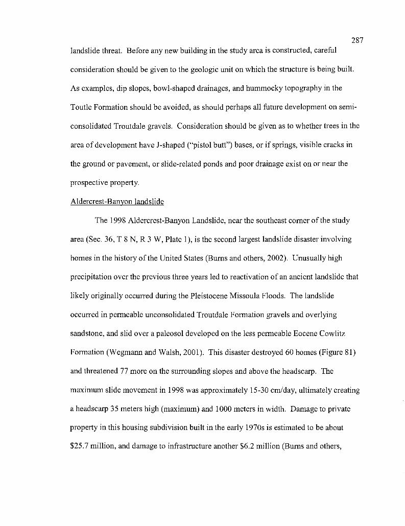
287
landslide threat. Before any new building in the study area is constructed, careful
consideration should be given to the geologic unit on which the structure is being built.
As examples, dip slopes, bowl-shaped drainages, and hummocky topography in the
Toutle Formation should be avoided, as should perhaps all future development on semi-
consolidated Troutdale gravels. Consideration should be given as to whether trees in the
area of development have J-shaped ("pistol butt") bases, or if springs, visible cracks in
the ground or pavement, or slide-related ponds and poor drainage exist on or near the
prospective property.
Aldercrest-Banyon landslide
The 1998 Aldercrest-Banyon Landslide, near the southeast corner of the study
area (Sec. 36, T 8 N, R 3 W, Plate 1), is the second largest landslide disaster involving
homes in the history of the United States (Burns and others, 2002). Unusually high
precipitation over the previous three years led to reactivation of an ancient landslide that
likely originally occurred during the Pleistocene Missoula Floods. The landslide
occurred in permeable unconsolidated Troutdale Formation gravels and overlying
sandstone, and slid over a paleosol developed on the less permeable Eocene Cowlitz
Formation (Wegmann and Walsh, 2001). This disaster destroyed 60 homes (Figure 81)
and threatened 77 more on the surrounding slopes and above the headscarp. The
maximum slide movement in 1998 was approximately 15-30 cm/day, ultimately creating
a headscarp 35 meters high (maximum) and 1000 meters in width. Damage to private
property in this housing subdivision built in the early 1970s is estimated to be about
$25.7 million, and damage to infrastructure another $6.2 million (Burns and others,
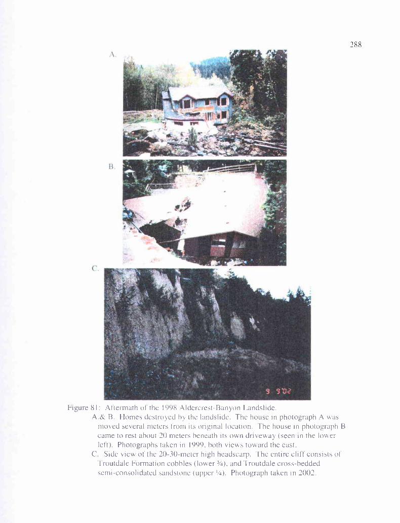
(..
Figure 81: Aftermath of the 1998 Aldercrest-Banyon Landslide.A.& B. Homes destroyed by the landslide. The house in photograph A was
moved several meters from its original location. The house in photograph Bcame to rest about 20 meters heneath its on driveway (seen in the lowerleft). Photographs taken in 1999, both views toward the east.
C. Side view of the 20-30-meter high headscarp. The entire cliff consists ofTroutdale Formation cobhles (lower 3/4), and Troutdale cross-beddedsemi-consolidated sandstone (upper '/a). Photograph taken in 2002
289
2002). Reactivation of this slide was mostly due to the increased precipitation
(increasing sediment pore pressure), but human activities may have helped initiate the
process (Bums and others, 2002). At the time of the initial movement, an excavation
across the lower part of the landslide to construct a road was underway, which may have
led to the breakage of storm drains that added to the water content of the Troutdale
gravels. In addition, a logging operation at the toe of the landslide was underway. To
further illustrate the danger of building on Troutdale gravels, another landslide on the
southwest side of the same hill has begun to reactivate (the Haussler Road-Apple Lane
landslide). Eighty eight homes are in danger below the scarp, and another 42 above it.
290
GEOLOGIC HISTORY
During early-middle Eocene time, relative northeastern movement of the Farallon
and Kula oceanic plates slowly moved the basaltic seamount chain of the Siletzia Terrane
toward the subduction zone of western North America (Wells and Coe, 1985). Accretion
of this terrane forced the subduction zone to jump westward, from approximately the
current position of the Cascade mountain range, to near its present position off the coast
on the continental slope. This event also produced northeast-southwest compression, and
the production of a northwest-southeast fault and fold trend, with resulting uplift and
erosion (Wells and Coe, 1985; Armentrout, 1987). Part of this was the Willapa Hills
uplift approximately 20 miles (32 km) northwest of the study area. This
compressional/subduction event was soon followed by a period of extension during the
middle Eocene, producing a large forearc basin (-P640 km long) that extended from the
Klamath Mountains of southwest Oregon to Vancouver Island, Canada (Niem and Niem,
1984; Niem et al., 1992). Differential subsidence of the Siletzia Terrane (termed the
Crescent Formation in southwest Washington and the Siletz Volcanics in Oregon)
produced several smaller basins. One such basin formed to the north and east of the
study area (the Chehalis Basin), immediately to the east of the Willapa Hills uplift
(Figure 3).
Within the Chehalis Basin and elsewhere in the region, bathyal slope mudstones
and thin turbidites of the lower McIntosh Formation began to cover the underlying
basalts and gabbro intrusions of the Siletzia Terrane. This was deposited as a lowstand,
transgressive, and high stand system tract and represents deposition by distal turbidity
currents. McIntosh Formation mudstones, derived from erosion of Mesozoic continental
291
crust in Washington (i.e., Okanogan uplift, the Northern Cascades, and the Idaho
Batholith)(Payne, 1998), onlap the Crescent Formation in the Willapa Hills (Wells,
1981), demonstrating that the hills were a paleo-topographic high in the late-middle
Eocene, resulting either from compressional uplift from accretion (Wells and Coe, 1985),
or remnant seamount topography (Stanley et al., 1994). In the type area of the Cowlitz
Formation, slope to outer shelf siltstones and bathyal mudstones of the lower McIntosh
Formation are overlain by shallow marine upper shoreface sandstones of the upper
McIntosh Formation (Payne, 1998). Approximately one hundred thirty meters of
shoreface sandstone and coal of the upper McIntosh was deposited on a wave-scoured
erosional surface cut down into the underlying deep marine mudstones, representing a
sharp sequence boundary between the two units (recording a relative sea level fall). This
boundary has been correlated to the 42.5 Ma eustatic sequence boundary of Haq et al.
(1987). Another marine transgression deposited a -500-meter thick bathyal siltstone of
the upper member of the McIntosh Formation, and the ensuing transgressive highstand
system tract produced a prograding delta front sandstone that caps the formation (Payne,
1998).
Another sequence boundary separates the highstand mudstone of the upper
McIntosh Formation and the comparatively shallow marine sandstone deposits of unit IA
of the Cowlitz Formation, ending 3rd order transgressive-regressive cycle 3 (Payne,
1998). In southwest Washington micaceous, arkosic sand of the Cowlitz delta prograded
westward, covering the deep-marine facies of the upper McIntosh. The Cowlitz
Formation is part of the large deltaic system of the Eocene Puget Group, produced from
metamorphic and granitic sources transported into the forearc basin by the ancestral
292
Columbia River, from Rocky Mountain sources to the east. The Cowlitz Formation
represents 3 transgressive-regressive 3rd order cycles (relative sea level fluctuations). The
lowermost part of the type Cowlitz Formation as described by Payne (1998) was
deposited during a regressive or lowstand event. This progradational phase ultimately
produced several marginal marine and coal-bearing delta plain (shoaling or prograding)
parasequences that form an aggradational parasequence set. In Coal Creek, 4
progradational parasequences define this lowermost portion of the Cowlitz Formation in
the study area, correlative to unit lB of the type section. Overlying the uppermost coal of
unit 1 (coal B) is a -35-meter thick Grays River basalt volcaniclastic, representing a
major pulse of volcanic activity and erosion from the Grays River highlands to the west.
This is likely part of the same pulse that produced the Lower Grays River Volcaniclastic
breccias and conglomerates (Tgvs 1) that underlies most of the arkosic Cowlitz Formation
throughout the study area. A molluscan assemblage at the base of this volcaniclastic
(overlying a coal) also shows that it represents a minor shallow marine transgression,
marking the base of unit 2. This unit is defined by numerous Grays River volcaniclastic
interbeds (Tgvs2), attesting to ongoing eruptive activity and erosion of the volcanic
shield. Most of unit 2 consists of 7 progradational parasequences representing a largely
aggradational parasequence set of shallow marine to delta plain successions, where most
parasequences fine- and thin-upward and terminate in a thin coal or carbonaceous shale.
Toward the top of unit 2, a major marine transgression occurs (a maximum flooding
surface), above which lower shoreface to shelf mudstones and siltstones were deposited
over delta front sands of the upper shoreface.
293
A sequence boundary at the top of parasequence 12 (top of unit 2, Plate 2)
juxtaposes upper shoreface sandstone against middle shoreface storm- and wave-
generated hummocky and swaley fine-grained sandstone of the middle shoreface. This
defines the base of unit 3, which consists of 6 progradational parasequences of middle
shoreface to delta plain successions, constituting 3rd order cycle 4 of a lowstand system
tract. Thin deposits of deep marine facies above unit 3 may be remnants of deep marine
unit 4 (3rd order cycle 4) of Payne (1998) in the type section. Scoured into the highstand
distal turbidite facies of unit 4 (?) is the submarine channel facies of the lower part of unit
5, which forms an erosional parasequence boundary between cycles 4 and 5. This facies
is overlain by distal turbidites. Western Cascade-derived airfall tuffs are preserved in
several coal-bearing coastal plain deposits of the Coal Creek section, attesting to minor
explosive activity of the Cascade volcanic calc-alkaline arc throughout the late-middle
Eocene.
Grays River volcaniclastic interbeds in the Cowlitz Formation in the study area,
as well as the underlying thick pile of Grays River volcaniclastics and flows, are part of
the Lower Grays River Volcanics as described by Payne (1998) and Kleibacker (2001).
This volcanic episode is associated with a period of northeast-southwest extension and
emplacement of northwest-trending Grays River dikes beginning at about 40 Ma, and
probably continuing throughout the duration of both the lower and upper Grays River
eruptive episodes from -40 to 36 Ma (which are separated by an unconformity north of
the study area). The period of dextral transtension induced by volcanic inflation and
continuing oblique subduction of the Farallon Plate, caused some clockwise tectonic
rotation of crustal blocks, and produced horst and graben-style, northwest-trending
294
dextral oblique-slip faults and subordinate northeast-trending conjugate normal faults
which offset these middle Eocene units. This late-middle Eocene transtensional period
resulting from inflation of magma, produced uplift and an erosional unconformity (major
sequence boundary 11 of Armentrout), which marks a period of reorganization of the
Farallon Plate, affecting the tectonically active margin of North America and part of
South America.
In the early Oligocene, during a lowstand period, the Cowlitz Formation
sediments were overlain by a paleo valley-fill sequence, the Toutle Formation, consisting
of meandering river sand channels incised into the upper deep-marine facies of the
Cowlitz Formation (a sequence boundary at the top of unit 5)(Payne, 1998). These
tuffaceous strata, including both marine and coastal plain fluvial facies, consist of a
combination of wave- and stream-reworked micaceous and arkosic Cowlitz Formation
sands, and tuffaceous, calc-alkaline silicic pyroclastic material derived from the Cascade
calc-alkaline volcanic arc to the east. A broad coastal plain existed in the study area at
this time, with meandering streams and shallow lakes on the floodplain (Figure 35),
depositing cross-bedded sandstone point bar sequences and overbank tuffaceous,
laminated siltstones.
The Paleogene volcanic and sedimentary units in the area (Crescent Formation,
Grays River Volcanics, Cowlitz Formation, Toutle Formation, and upper Eocene basaltic
andesite flows and andesite dikes derived from the western Cascades) were folded,
faulted, and uplifted during the transpressional event starting in the late-middle Miocene.
This wrench tectonic event produced the transpressional Coal Creek Fault, Kelso Fault
Zone, and both the Columbia Heights Anticline and Hazel Dell Syncline. It also
295reactivated many of the northwest-trending transtensional normal faults of the late-middle
Eocene. Erosion of the paleotopography created from this compression produced low
rolling hills. Into this environment Columbia River Basalt flows, erupting from fissures
in eastern Oregon and Idaho during the early to middle Miocene (Reidel and others,
1989), flowed down the ancestral Columbia River drainage and into the study area. At
least 6 Columbia River Basalt flows (3 Ortley, 1 Sentinel Bluffs, and at least 1
Frenchman Springs (Sand Hollow), and at least 1 Pomona flow (Saddle Mt. Formation)
entered the area. Remnant erosional paleotopography of the Eocene and Oligocene units
in the Columbia Heights fold forced the lower Ortley flow (#1) to go around, accounting
for the lack of this unit there. Continued transpressional uplift along the northwest-
trending faults produced faulting and differential uplift of the Columbia River Basalts and
underlying sedimentary units into a complex horst in the study area.
Ancestral Columbia River gravels and sand, a mixture of local volcanic clasts and
metamorphic quartzite and granitic rocks transported through the Cascades from eastern
Oregon, Idaho, and Montana during the Pliocene (and possibly the latest Miocene),
deposited the Troutdale Formation gravels. These nearly horizontal deposits are in
angular unconformity with underlying Eocene and Oligocene units, and represent the
coarse-grained thalweg deposits, and to a lesser degree overbank floodplain sand and silt,
of the ancestral Columbia River. Similar age terraces along the Cowlitz River consist
mostly of andesite gravel from a local western Cascade source. These semiconsolidated
to unconsolidated formations in the study area, up to 300 feet thick, have been uplifted to
form high terraces, attesting to continued broad uplift throughout the Pliocene and into
the Quaternary. During the late Pleistocene, catastrophic Missoula Floods deposited
296
coarse gravels and sands up into the drainage of the Cowlitz River, and have since also
been uplifted to form the Quaternary terraces along the Cowlitz River. Oversteepening of
hillsides in the area, due to erosional resistance of Columbia River Basalts capping some
of the hills, and also partly due to undercutting of units by the Missoula Floods, has
produced several Pleistocene and Holocene landslide deposits within the study area.
During the 1980 eruption of Mt. St. Helens, lahars rushed down the Toutle and Cowlitz
Rivers, inundating some communities, depositing gray ash and gravel along the Cowlitz
River, and creating a lahar delta at the mouth of the Cowlitz River.
297
CONCLUSIONS
Detailed lithological descriptions of a stratigraphic section of middle Eocene
Cowlitz Formation in Coal Creek, and geologic mapping of the Longview-Kelso area of
southwest Washington allowed interpretation of the geologic history of the area. The
Cowlitz Formation was studied using biostratigraphy, magnetostratigraphy,
lithostratigraphy, sequence stratigraphy, x-ray diffraction, and petrography. The goal was
to interpret the diagenetic history, provenance, depositional environment, and
hydrocarbon potential, and correlate the Cowlitz Formation in the study area to the type
area in Olequa Creek to the north. Eocene and Miocene volcanic units in the area were
identified, studied and mapped using lithology, petrography, geochemistry, and magnetic
polarity. Another goal was to investigate the structural history and assess the natural
hazard potential of the area through geologic mapping. In summary, the major results
and interpretations of this study are:
1. The 650-meter thick stratigraphic section of the Cowlitz Formation in Coal
Creek represents three 3rd order transgressive/regressive cycles and has been
divided into 5 informal units in this study that correlate well to the Cowlitz
Formation type section near Vader 20 km to the north. The lower 100 meters
of the Coal Creek section (informal unit 1, Chron 18r) was deposited in a
highstand system tract (HST) in the lower portion of 3rd order cycle 3. This
micaceous/arkosic sandstone unit is dominantly tidal reflecting upper
shoreface to lower delta plain/swamp depositional environments, and consists
of 4 shoaling-upward (both coarsening- and thickening-upward, and thinning-
and fining-upward) parasequences of an aggradational to retrogradational
298parasequence set. The upper part of unit 1 contains two coal beds (A and B)
that were used to correlate the complexly folded and faulted northern portion
of Coal Creek. The overlying unit 2 (Chron 18n) is defined by abundant
mollusk-bearing shallow marine Grays River basalt volcaniclastic interbeds
that intertongue with Cowlitz Formation arkosic sandstone and siltstone, and
represents the latter part of 3`d order cycle 3. The 7 parasequences that
comprise this aggradational set are largely thinning- and fining-upward and
terminate in thin upper coal beds, representing middle shoreface to lower delta
plain successions. The base of unit 2 is a 35-meter thick Grays River basalt
volcaniclastic tongue that is dominantly rounded basalt pebble conglomerate
and coarse basalt sandstone to the south and dominantly graded thin beds of
sandstone to siltstone to the north. A maximum flooding surface occurs near
the high stand system tract top of unit 2. Unit 3 comprises 3`d order cycle 4
(Chron l7r), a lowstand system tract, and consists of 6 mostly fining-and
thinning-upward parasequences of lower shoreface to delta plain coal-bearing
facies associations. A sequence boundary separates unit 5 from a thin deep
marine bedset that may be part of unit 4 of the type section Payne (1998).
Unit 5 (Chron 17r) consists of deep marine facies. The mostly massive
sandstone facies at the base is incised into the underlying units, and represents
low stand system tract deep marine channel-fill. This is overlain by thinly-
bedded to laminated overbank distal arkosic turbidites of unit 5 that define the
top of the Coal Creek section.
2992. A different interpretation of the Coal Creek section is being proposed in this
study. Structural and lithological data suggest that the Coal Creek section is
essentially two separate stratigraphic sections that are partially correlated by a
distinctive 35-meter thick basalt volcaniclastic marker unit that occurs at the
base of the southern section, and the top of the northern section. The northern
section is an upfaulted sequence that contains different and older lithologic
units than the southern section.
3. In this study, Grays River Volcanics within the map area have been
differentiated into two units. The lower unit is over 150 meters thick and
consists of basaltic subaerial flows, invasive flows, basalt dikes, some sills,
and thick volcaniclastic breccias. The lower Grays River volcaniclastic unit
overlies and is partially interfingered with Gray River flows in the study area
and is subdivided into 5 informal facies: 1) channelized fluvial gravels, 2)
matrix supported debris flow deposits, 3) hyperconcentrated flow deposits, 4)
phreatomagmatic scoriaceous hyaloclastite, and 5) autoclastic flow breccia.
The upper Grays River volcaniclastic unit consists of pebble and cobble
volcanic conglomerate and coarse-grained basalt sandstone interbeds that
interfinger with the Cowlitz Formation. These basaltic sedimentary interbeds
commonly contain shallow marine to brackish water molluscan fossil and
trace fossil assemblages and represent minor marine transgressive flooding
surfaces or storm wave/tsunami wave-lag deposits.
4. Grays River basalt flows and intrusions are augite-, olivine-, and plagioclase-
phyric, and are commonly glomeroporphyritic with a distinctive pilotaxitic
300
flow texture of aligned plagioclase microlites. Unless weathered, major
element geochemistry of Grays River basalts from the study area falls within
the fields defined by Phillips et al. (1989) and are high TiO2 and iron tholeiitic
basalts. Flows and scoriaceous bedded breccia from near Rocky Point, in the
core of the Columbia Heights Anticline, also fall within these fields, but are
anomalously low in TiO2. Therefore, they are considered in this study to be a
separate volcanic subunit. The two small hills that comprise Rocky Point are
the remnants of an isolated phreatomagmatic tuff cone or cinder cone erupting
into the middle Eocene Cowlitz arkosic estuary, and may represent mixing of
the tholeiitic Grays River magma, and calc-alkaline magma of the nearby
western Cascade arc. Over 60 originally near-vertical Grays River basalt
dikes and sills intrude the Cowlitz Formation in Coal Creek, and are typically
aphyric to glomeroporphyritic, but thicker dikes are somewhat zoned with
coarser crystalline interiors. One dike intruding an interval low in the section
has been dated at 40 ± 0.36 Ma.
5. Late Eocene western Cascade volcanism produced thick basaltic andesite
flows and andesite dikes in the easternmost part of the study area. Basaltic
andesite occurs as subaerial flows up to 100 meters thick, capping the hills
east of the Cowlitz River. These flows, partly correlative to the late Eocene
Goble Volcanics of northwest Oregon, are columnar jointed, augite- and
plagioclase-phyric, more porphyritic that Grays River flows and higher in
SiO2, and lower in FeO and TiO2 than Grays River basalt flows and dikes.
Two parallel western Cascade andesite dikes intrude the Cowlitz Formation
301
are significantly more silicic, more alkaline, and lower in FeO than Grays
River basalt and western Cascade basaltic andesite flows.
6. Unconformably overlying Grays River Volcanics and the Cowlitz Formation
in the study area are clayey and commonly tuffaceous siltstones, silty
sandstones, and tuffaceous arkosic sandstones of the Toutle Formation. This
unit is distinguished from the underlying Cowlitz Formation in that it is not
intruded by Grays River dikes, does not contain mollusk-bearing Grays River
volcaniclastic interbeds, contains significantly more clay and tuff, contains
unusual trace fossils, and is noticeably lighter in color. The unit has been
tentatively dated by leaf fossils as late Eocene/early Oligocene, This
formation is divided into two informal facies in the study area. The lower
shallow marine unit contains abundant vertical burrows and sparse molluscan
fossil molds, but is otherwise mostly massive with few distinguishing
characteristics. The upper unit consists dominantly of two lithologies: fining-
upward, fluvial channel trough cross-bedded sandstone, and thinly bedded to
laminated lacustrine and overbank clayey siltstones and silty sandstones,
representing point bar sequences and overbank siltstones of a coastal plain
with flood basins and oxbow lakes. The Toutle Formation sandstones and
siltstones are a mixture of reworked Cowlitz Formation extrabasinal clasts
(feldspar, quartz, mica, and granitic/metamorphic grains) and western Cascade
silicic pyroclastic material in the form of pumice, andesite, and dacite
fragments and clay, altered glass shards.
302
7. The early to middle Miocene Columbia River Basalt Group overlies these
Paleogene sedimentary and volcanic units in angular unconformity. At least 6
separate Columbia River Basalt flows occur in the study area based on
stratigraphic relationships, lithology, magnetic polarity, major oxide
geochemistry, and weathered soil characteristics. The lowermost flow (N2,
low MgO, Ortley flow #1 of the Grande Ronde Formation) is absent from the
Columbia Heights area (likely resulting from paleotopography at the time of
the flow) and forms a pillow/palagonite complex in the upper quarry on Mt.
Solo. It appears to be subaerial elsewhere. N2, intermediate MgO Ortley flow
#2 is the thickest in the study area (-30 meters) and is characterized by well-
developed upper and lower colonnade. This flow appears to be locally
invasive in one location. Overlying N2, low MgO Ortley flow #3 is subaerial
in the area except for the Storedahl Quarry where it forms a basal pillow
palagonite complex where it flowed into a lake. A 0-5 meter-thick tuffaceous
interbed overlies the 3 Ortley flows and underlies the Sentinel Bluffs flow of
the Grande Ronde Formation. This interbed appears to occur throughout the
study area, and is in part a tuffaceous siltstone with root traces and vertical
burrows, and in part a pebble to cobble conglomerate. The N2 Sentinel Bluffs
flow is high in MgO. The Frenchman Springs (Sand Hollow) flow of the
Wanapum Formation is poorly exposed in the study area and occurs only as
an isolated exposure in the Eufaula Heights area west of Coal Creek. It is
mapped largely by the occurrence of reddish soil, but one exposure of even-
sized, large colonnade with sparse large labradorite phenocrysts identifies this
303
unit. Pomona flows are mapped based on the regional geologic map work of
other authors.
8. Pliocene gravels and arkosic sand of the Troutdale Formation form terrace
deposits up to 100 meters thick in southern parts of the study area, and
represent the paleo-thalweg and overbank flood deposits of the ancestral
antecedent Columbia River. Clasts are a mixture of extrabasinal granitic and
metamorphic quartzite clasts from Rocky Mountain sources, and basaltic
andesite and basalt from the western Cascades and backarc Columbia River
Basalts. Troutdale gravels grade northward into gravel terrace deposits of the
same age transported along the ancestral Cowlitz River, that are dominantly
composed of andesite gravel and sand from the western Cascades. Lower
terraces along the Cowlitz River are also dominantly andesitic clasts but have
an extrabasinal component of granitic and metamorphic clasts. These are
thought to be deposits of the late Pleistocene Missoula Floods. These
unconsolidated to semiconsolidated Pliocene through Pleistocene terrace
gravels and sands are prone to landslides. The devastating Aldercrest-Banyon
landslide occurred in Troutdale Formation gravels at the impermeable
weathered soil contact with the underlying Cowlitz Formation.
9. Forearc extension in the late-middle Eocene produced a northwest-trending
set of oblique-slip normal faults along which Grays River dikes intruded.
Starting in the early Miocene the region underwent transpressional wrench
faulting, reactivating many of the northwest-trending faults in oblique-slip
motion, and producing the Columbia Heights Anticline, Hazel Dell Syncline,
304
Coal Creek Fault, and Kelso Fault Zone. Topography produced from this
event in the tilted Cowlitz, Grays River, and Toutle strata eroded down to a
nearly flat plain before emplacement of the Columbia River Basalts. The
Columbia River Basalts that filled the topographic lows were later faulted by
continued activity along the northwest-trending faults, producing differential
uplift. Continued post late-middle Miocene broad uplift of the Coast Range
has resulted in incisement of the ancestral Columbia and Cowlitz Rivers,
creating Pliocene through Pleistocene terraces.
10. The natural gas potential in the study area is low to moderate. This is due to
breaching of the Cowlitz Formation sandstones and coals by erosion. Cowlitz
Formation in the study area is unlikely to be a source rock for thermally
mature hydrocarbons. Even though the McIntosh Formation may underlie the
study area (the equivalent Hamlet Formation is the dominant source for
thermogenic methane at the Mist Gas Field), thermal maturation of these
strata in southwest Washington is poor. However, 8 substantial coals within
the Coal Creek section could act as local sources for biogenic or coal bed
methane. The lithic arkosic sandstones of unit 1 and associated thin coals
have acted as a minor biogenic source rock and reservoir for methane. The
-35-meter thick overlying well-indurated Grays River basalt volcaniclastic
beds act as a seal, and water wells through this stratigraphic trap have
produced groundwater bubbling with methane. The Columbia Heights
Anticline with overlying Columbia River Basalts could also act as a local
structural trap. Lithic arkosic sandstones in the study area are dirty compared
305to the C & W sandstone of the Mist Gas Field in northwest Oregon because of
the heavy slack water tidal influence during deposition, with the associated
flaser mud and carbonaceous debris. In addition, the comparatively high
percentage of Grays River basalt lithic clasts and interbeds in the study area
has led to decreased porosity and permeability of both the basaltic and arkosic
units, due to diagenetic clay alteration of this basaltic detritus to form pore-
clogging smectite rims and sparry calcite cement.
11. Geologic hazards include lahars, hyperconcentrated flows, and debris flows
such as those from the May, 1980 eruption of Mt. St. Helens. Other hazards
include potential liquefaction of water saturated silts and clays in heavily
populated and industrial portions of Longview and Kelso during the seismic
shaking of great earthquakes. 100-year winter and spring floods are another
geologic hazard to low-lying areas. However, landslides represent the greatest
and most common hazard, particularly to upland areas underlain by
unconsolidated Troutdale Formation gravels.
306
REFERENCES
Armentrout, J.M., 1973, Molluscan paleontology and biostratigraphy of the LincolnCreek Formation (late Eocene-Oligocene), southwestern Washington: Seattle,WA, University of Washington Ph.D. dissertation, 479 p.
Armentrout, and Suek, D.H., 1985, Hydrocarbon exploration in western Oregon andWashington: American Association of Petroleum Geologists Bulletin, v. 69,p. 627-643.
Armentrout, 1987, Cenozoic stratigraphy, unconformity bounded sequences, and tectonichistory of southwest Washington, in Schuster, J.E., ed., Selected papers on thegeology of Washington: Washington Department of Natural Resources, Divisionof Geology and Earth Resources Bulletin 77, p. 291-320.
Beeson, M. H., and Moran, M. R., 1979, Columbia River Basalt Group stratigraphy inwestern Oregon: Oregon Geology, v. 41, no. 1, p. 11-14.
Beeson, M. H., Perttu, R., and Perttu, J., 1979, The Origin of the Miocene basalts ofcoastal Oregon and Washington: An alternative hypothesis: Oregon departmentof Geology and Mineral Industries, Oregon Geology, v. 41, no. 10, p. 159-166.
Beeson, M. H., and Tolan, T. L., 1985, Regional correlations within the FrechmanSprings Member of the Columbia River Basalt Group: New insights into themiddle Miocene tectonics of northwestern Oregon: Oregon Geology, v. 47,p. 87-92.
Beeson, M.H., Tolan, T.L., and Anderson, J.L., 1989, The Columbia River Basalt Groupin western Oregon; Geologic structures and other factors that controlled flowemplacement patterns: in Reidel, S.P., and Hooper, P.R., eds., Volcanism andtectonism in the Columbia River flood-basalt province: Geological Society ofAmerica Special Paper 239, p. 223-246.
Bentley, R.D., Professor Emeritus, Central Washington University: personalcommunication, 2000.
Berkman, T.A., 1990, Surface-subsurface geology of the middle to upper Eocenesedimentary and volcanic rock units, western Columbia county, northwestOregon: Corvallis, Oregon, Oregon State University, masters thesis, 413 p.
Blakely, R.J., Wells, R.E., Yelin, T.S., Madin, I.P., and Beeson, M.H., 1995, Tectonicsetting of the Portland-Vancouver area, Oregon and Washington: Constraintsfrom low-altitude aeromagnetic data: Geological Society of America Bulletin,v. 107, p. 1051-1062.
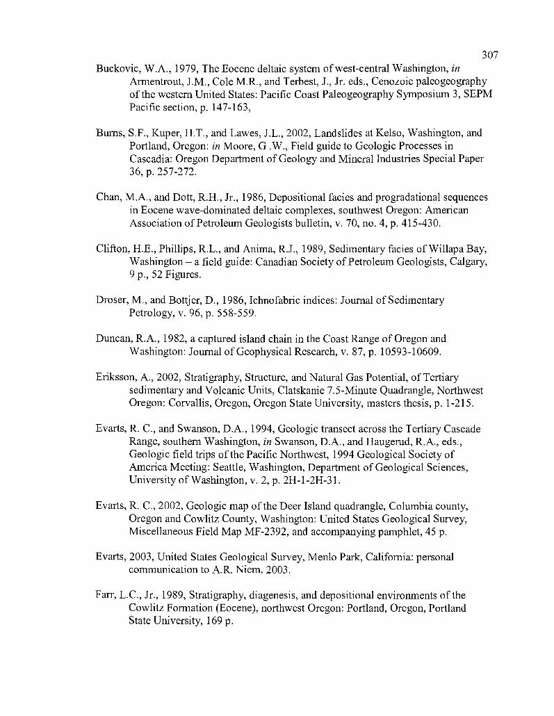
307
Buckovic, W.A., 1979, The Eocene deltaic system of west-central Washington, inArmentrout, J.M., Cole M.R., and Terbest, J., Jr. eds., Cenozoic paleogeographyof the western United States: Pacific Coast Paleogeography Symposium 3, SEPMPacific section, p. 147-163,
Burns, S.F., Kuper, H.T., and Lawes, J.L., 2002, Landslides at Kelso, Washington, andPortland, Oregon: in Moore, G.W., Field guide to Geologic Processes inCascadia: Oregon Department of Geology and Mineral Industries Special Paper36, p. 257-272.
Chan, M.A., and Dott, R.H., Jr., 1986, Depositional facies and progradational sequencesin Eocene wave-dominated deltaic complexes, southwest Oregon: AmericanAssociation of Petroleum Geologists bulletin, v. 70, no. 4, p. 415-430.
Clifton, H.E., Phillips, R.L., and Anima, R.J., 1989, Sedimentary facies of Willapa Bay,Washington - a field guide: Canadian Society of Petroleum Geologists, Calgary,9 p., 52 Figures.
Droser, M., and Bottjer, D., 1986, Ichnofabric indices: Journal of SedimentaryPetrology, v. 96, p. 558-559.
Duncan, R.A., 1982, a captured island chain in the Coast Range of Oregon andWashington: Journal of Geophysical Research, v. 87, p. 10593-10609.
Eriksson, A., 2002, Stratigraphy, Structure, and Natural Gas Potential, of Tertiarysedimentary and Volcanic Units, Clatskanie 7.5-Minute Quadrangle, NorthwestOregon: Corvallis, Oregon, Oregon State University, masters thesis, p. 1-215.
Evarts, R. C., and Swanson, D.A., 1994, Geologic transect across the Tertiary CascadeRange, southern Washington, in Swanson, D.A., and Haugerud, R.A., eds.,Geologic field trips of the Pacific Northwest, 1994 Geological Society ofAmerica Meeting: Seattle, Washington, Department of Geological Sciences,University of Washington, v. 2, p. 2H-1-2H-31.
Evarts, R. C., 2002, Geologic map of the Deer Island quadrangle, Columbia county,Oregon and Cowlitz County, Washington: United States Geological Survey,Miscellaneous Field Map MF-2392, and accompanying pamphlet, 45 p.
Evarts, 2003, United States Geological Survey, Menlo Park, California: personalcommunication to A.R. Niem, 2003.
Farr, L.C., Jr., 1989, Stratigraphy, diagenesis, and depositional environments of theCowlitz Formation (Eocene), northwest Oregon: Portland, Oregon, PortlandState University, 169 p.
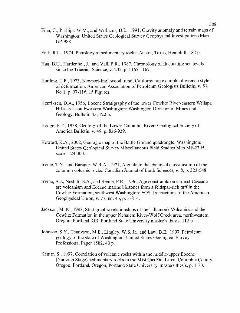
308
Finn, C., Phillips, W.M., and Williams, D.L., 1991, Gravity anomaly and terrain maps ofWashington: United States Geological Survey Geophysical Investigations MapGP-988.
Folk, R.L., 1974, Petrology of sedimentary rocks: Austin, Texas, Hemphill, 182 p.
Haq, B.U., Hardenbol, J., and Vail, P.R., 1987, Chronology of fluctuating sea levelssince the Triassic: Science, v. 235, p. 1165-1167.
Harding, T.P., 1973, Newport-Inglewood trend, California-an example of wrench styleof deformation: American Association of Petroleum Geologists Bulletin, v. 57,No 1, p. 97-116, 15 Figures.
Henriksen, D.A., 1956, Eocene Stratigraphy of the lower Cowlitz River-eastern WillapaHills area southwestern Washington: Washington Division of Mines andGeology, Bulletin 43, 122 p.
Hodge, E.T., 1938, Geology of the Lower Columbia River: Geological Society ofAmerica Bulletin, v. 49, p. 836-929.
Howard, K.A., 2002, Geologic map of the Battle Ground quadrangle, Washington:United States Geological Survey Miscellaneous Field Studies Map MF-2395,scale 1:24,000.
Irvine, T.N., and Barager, W.R.A., 1971, A guide to the chemical classification of thecommon volcanic rocks: Canadian Journal of Earth Sciences, v. 8, p. 523-548.
Irvine, A.J., Nesbitt, E.A., and Renne, P.R., 1996, Age constraints on earliest Cascadearc volcanism and Eocene marine biozones from a feldspar-rich tuff in theCowlitz Formation, southwest Washington: EOS Transactions of the AmericanGeophysical Union, v. 77, no. 46, p. F-814.
Jackson, M. K., 1983, Stratigraphic relationships of the Tillamook Volcanics and theCowlitz Formation in the upper Nehalem River-Wolf Creek area, northwesternOregon: Portland, OR, Portland State University master's thesis, 112 p.
Johnson, S.Y., Tennyson, M.E., Lingley, W.S, Jr., and Law, B.E., 1997, Petroleumgeology of the state of Washington: United States Geological SurveyProfessional Paper 1582, 40 p.
Kenitz, S., 1997, Correlation of volcanic rocks within the middle-upper Eocene(Narizian Stage) sedimentary rocks in the Mist Gas Field area, Columbia County,Oregon: Portland, Oregon, Portland State University, masters thesis, p. 1-70.
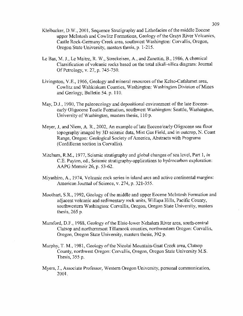
309
Kleibacker, D.W., 2001, Sequence Stratigraphy and Lithofacies of the middle Eoceneupper McIntosh and Cowlitz Formations, Geology of the Grays River Volcanics,Castle Rock-Germany Creek area, southwest Washington: Corvallis, Oregon,Oregon State University, masters thesis, p. 1-215.
Le Bas, M. J., Le Maitre, R. W., Streckeisen, A., and Zanettin, B., 1986, A chemicalClassification of volcanic rocks based on the total alkali-silica diagram: JournalOf Petrology, v. 27, p. 745-750.
Livingston, V.E., 1966, Geology and mineral resources of the Kelso-Cathlamet area,Cowlitz and Wahkiakum Counties, Washington: Washington Division of Minesand Geology, Bulletin 54. p. 110.
May, D.J., 1980, The paleoecology and depositional environment of the late Eocene-early Oligocene Toutle Formation, southwest Washington: Seattle, Washington,University of Washington, masters thesis, 110 p.
Meyer, J, and Niem, A. R., 2002, An example of late Eocene/early Oligocene sea floortopography imaged by 3D seismic data, Mist Gas Field, and in outcrop, N. CoastRange, Oregon: Geological Society of America, Abstracts with Programs(Cordilleran section in Corvallis).
Mitchum, R.M., 1977, Seismic stratigraphy and global changes of sea level, Part 1, inC.E. Payton, ed., Seismic stratigraphy-applications to hydrocarbon exploration:AAPG Memoir 26, p. 53-62.
Miyashiro, A., 1974, Volcanic rock series in island arcs and active continental margins:American Journal of Science, v. 274, p. 321-355.
Moothart, S.R., 1992, Geology of the middle and upper Eocene McIntosh Formation andadjacent volcanic and sedimentary rock units, Willapa Hills, Pacific County,southwestern Washington: Corvallis, Oregon, Oregon State University, mastersthesis, 265 p.
Mumford, D.F., 1988, Geology of the Elsie-lower Nehalem River area, south-centralClatsop and northernmost Tillamook counties, northwestern Oregon: Corvallis,Oregon, Oregon State University, masters thesis, 392 p.
Murphy, T. M., 1981, Geology of the Nicolai Mountain-Gnat Creek area, ClatsopCounty, northwest Oregon: Corvallis, Oregon, Oregon State University M.S.Thesis, 355 p.
Myers, J., Associate Professor, Western Oregon University, personal communication,2001.
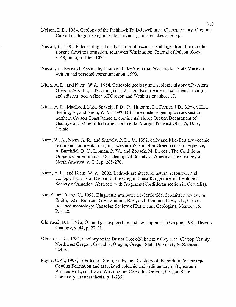
310Nelson, D.E., 1984, Geology of the Fishhawk Falls-Jewell area, Clatsop county, Oregon:
Corvallis, Oregon, Oregon State University, masters thesis, 360 p.
Nesbitt, E., 1995, Paleoecological analysis of molluscan assemblages from the middleEocene Cowlitz Formation, southwest Washington: Journal of Paleontology,v. 69, no. 6, p. 1060-1073.
Nesbitt, E., Research Associate, Thomas Burke Memorial Washington State Museumwritten and personal communication, 1999.
Niem, A. R., and Niem, W.A., 1984, Cenozoic geology and geologic history of westernOregon, in Kulm, L.D., et al., eds., Western North America continental marginand adjacent ocean floor off Oregon and Washington: sheet 17.
Niem, A. R., MacLeod, N.S., Snavely, P.D., Jr., Huggins, D., Fortier, J.D., Meyer, H.J.,Seeling, A., and Niem, W.A., 1992, Offshore-onshore geologic cross section,northern Oregon Coast Range to continental slope: Oregon Department ofGeology and Mineral Industries continental Margin Transect OGI-26, 10 p.,1 plate.
Niem, W. A., Niem, A. R., and Snavely, P. D., Jr., 1992, early and Mid-Tertiary oceanicrealm and continental margin - western Washington-Oregon coastal sequence;In Burchfiel, B. C., Lipman, P. W., and Zoback, M. L., eds., The CordilleranOrogen: Conterminous U.S.: Geological Society of America The Geology ofNorth America, v. G-3, p. 265-270.
Niem, A. R., and Niem, W. A., 2002, Bedrock architecture, natural resources, andgeologic hazards of NE part of the Oregon Coast Range forearc: GeologicalSociety ofAmerica, Abstracts with Programs (Cordilleran section in Corvallis).
Nio, S., and Yang, C., 1991, Diagnostic attributes of clastic tidal deposits: a review, inSmith, D.G., Reinson, G.E., Zaitlain, B.A., and Rahmani, R.A., eds., Clastictidal sedimentology: Canadian Society of Petroleum Geologists, Memoir 16,P. 3-28.
Olmstead, D.L., 1982, Oil and gas exploration and development in Oregon, 1981: OregonGeology, v. 44, p. 27-3 1.
Olbinski, J. S., 1983, Geology of the Buster Creek-Nehalem valley area, Clatsop County,Northwest Oregon: Corvallis, Oregon, Oregon State University M.S. thesis,204 p.
Payne, C.W., 1998, Lithofacies, Stratigraphy, and Geology of the middle Eocene typeCowlitz Formation and associated volcanic and sedimentary units, easternWillapa Hills, southwest Washington: Corvallis, Oregon, Oregon StateUniversity, masters thesis, p. 1-235.
311
Pezzopane, S.K., and Weldon, R.J., II, 1993, Tectonic role of active faulting in centralOregon: Tectonics, v. 12, p. 1140-1169.
Peterson, C. P. 1984, Geology of the Green Mountain-Youngs River area, ClatsopCounty, northwest Oregon: Corvallis, OR, Oregon State University master'sthesis, 215 p.
Phillips, W.M., 1987, Geologic map of the Mt. St. Helens quadrangle, Washington:Washington Division of Geology and Earth Resources Open File Report 87-4,63 p., 1 Plate, scalel: 100,000.
Phillips, W.M., Walsh, T,J., and Hagen, R.A., 1989, Eocene transition from oceanic toarc volcanism, southwest Washington: Proceeding of workshop XLIV;Geological, geophysical, and tectonic setting of the Cascade Range, UnitedStates Geological Survey Open File Report 89-187, p. 199-256.
Prothero, D.R., Nesbitt, E., Niem, A.R., and Kleibacker, D.W., 2001, Magneticstratigraphy and tectonic rotation of the upper-middle Eocene Cowlitz andHamlet Formations, western Oregon and Washington: Magnetic stratigraphyof the Oregon Coast Cenozoic: Pacific Section Society for Sedimentary Geology,Book 91, p. 75-95.
Rarey, P.J., 1986,Geology of the Hamlet-North Fork of the Nehalem River area, southernClatsop and Southern Tillamook counties, northwest Oregon: Corvallis, Oregon,Oregon State University, masters thesis, 457 p.
Reidel, S.P., Tolan, T.L., Hooper, P.R., Beeson, M.H., Fecht, K.R., Bentley, R.D., andAnderson, J.L., 1989, The Grande Ronde Basalt, Columbia River Basalt Group;stratigraphic descriptions and correlations in Washington, Oregon, and Idaho:Geological Society of America Special Paper 239, p. 21-53.
Roberts, A.E., 1958, Geology and coal resources of the Toledo-Castle Rock district,Cowlitz and Lewis counties, Washington: United States Geological SurveyBulletin 1062, 71 p., 6 Plates.
Robertson, C.L., 1997, Surface-subsurface facies and distribution of the EoceneCowlitz and Hamlet Formations, northwest Oregon: Corvallis, Oregon, OregonState University, masters thesis, p. 1-158.
Ryu, I.C., Niem, A.R., and Niem, W.A., 1992, Schematic fence diagram of the southernTyee basin, Oregon Coast Range, Oregon Department of geology and MineralIndustries Oil and Gas Investigation 18, Portland, Oregon, 28 p., 1 plate.
312
Shaw, N. B., 1986, Biostratigraphy of the Cowlitz Formation in the upper Nehalem RiverBasin, northwest Oregon: Portland, OR, Portland State University master's thesis,110 p.
Simpson, R.W., and Cox, A., 1977, Paleomagnetic evidence for tectonic rotation of theOregon Coast Range: Geology, v. 5, p. 585-589.
Smith, G.A., and Fisher, R.V., 1986, Sedimentation in volcanic settings: Society forSedimentary Geology, Special Publication no. 45, 257 p.
Snavely, P.D., Jr., 1987, Tertiary geologic framework, neotectonics, and petroleumpotential of the Oregon-Washington continental margin, in Scholl, D.W., Grantz,A., Vedder, J.G., eds., Geology and resource potential of the continentalmargin of western North America, and adjacent ocean basins- Beaufort Sea toBaja California: Circum-Pacific Council for Energy and Mineral Resources,Earth Sciences Series, v. 6, p. 305-335.
Stanley, W.D., Johnson, S.Y., and Nuccio, V.F., 1994, Analysis of deep seismicreflection and other data from the southern Washington Cascades, United StatesGeological Survey Open File Report 94-159.
Stanley, Johnson, S.Y., Qamar, A.I., Weaver, C.S., and Williams, J.M., 1996,Tectonics and seismicity of the Southern Washington Cascade Range, Bulletinof the Seismological Society of America, v. 86, no. 1A, p. 1-18.
Stormberg, G.L., 1991, The Mist Gas Field, N.W. Oregon: source rock characterizationand stable isotope (C,H,N) geochemistry: Corvallis, Oregon, Oregon StateUniversity, masters thesis, p. 1-191.
Swanson, D. A., and Wright, T. L., 1978, Bedrock geology of the northern ColumbiaPlateau and adjacent area; in Baker, V. R., and Nummendal, D., eds., TheChannelized Scabland: N.A.S.A., Planetary Geology Program, p. 186.
Swanson, D.A., Wright, T.L., Hooper, P.R., and Bentley R.D., 1979, Revisions instratigraphic nomenclature of the Columbia River Basalt Group: United StatesGeological Survey Bulletin 1457-G, 59 p.
Taubeneck, W.H., 1970, Dikes of the Columbia River Basalt in northwest Oregon,western Idaho, and southeastern Washington, in Gilmore, E.H., and Stradling,D., eds., Proceedings of the 2'd Columbia River Basalt Symposium: Cheney,Eastern Washington University Press, p. 73-96.
Timmons, D. M., 1981, Stratigraphy, lithofacies, and depositional environment of theCowlitz Formation, T 4 and 5 N, R 5 W, northwest Oregon: Portland, OR,Portland State University master's thesis, 89 p.
313
Tolan, T.L., Reidel, S.P., Beeson, M.H., Anderson, J.L., Fecht, K.R., and Swanson, D.A.,1989, Revisions to the estimates of the aerial extent and volume of the ColumbiaRiver Basalt Group: in Reidel, S.P., and Hooper, P.R., eds., Volcanism andtectonism in the Columbia River flood basalt province: Geological Society ofAmerica Special Paper 239, p. 1-20.
Van Wagoner, J. C., 1985, Reservoir facies distribution as controlled by sea-level change,abstract: Society of Economic Paleontologists and Mineralogists Mid-YearMeeting, Golden, Colorado, August 11-14, p. 91-92.
Van Wagoner, J. C., Mitchum R.M., Campion, K.M., and Rahmanian, V.D., 1992,Siliciclastic sequence stratigraphy in well logs, cores, and outcrops: AmericanAssociation of Petroleum Geologists Methods in Exploration Series 7, 55p.
Waitt, R. B., Jr., 1985, Case for periodic, colossal jokulhaups from Pleistocene glacialLake Missoula: Geological Society of America Bulletin v. 96, no. 10,p. 1271-1286.
Walsh, T.J., Korsec, M.A., Phillips, W.M., Logan, R.L., and Schasse, H.W., 1987,Geologic map of Washington-southwest quadrant: Washington Division ofGeology and Earth Resources Geologic Map GM-34, 2 pl., 28 p.
Warren, W. C., Norbisrath, H., and Grivetti, R.M., 1945, Geology of northwesternOregon, west of Willamette River and north of latitude 45 15': United StatesGeological Survey Oil and Gas Investigation Preliminary Map 42, scale
Warren, W. C., and Norbisrath, Hans, 1946, Stratigraphy of upper Nehalem RiverBasin, northwest Oregon: American Association of Petroleum GeologistsBulletin, v. 30, no. 2, p. 213-237.
Weaver, C. E., 1912, A preliminary report on the Tertiary paleontology of westernWashington: Washington Geological Survey Bulletin 15, 80 p.
Weaver, C. E., 1937, Tertiary stratigraphy of western Washington and northwest Oregon:University of Washington publications v. 4, Seattle, 166 p., 15 Pls.
Wegmann, K. W., and Walsh, T. J., 2001, Landslide hazards mapping in Cowlitz County-A progress report: Washington Geology, v. 29, no. V2, p. 30-33.
Wegmann, K., Washington Department of Natural Resources, personal and writtencommunication, 2001-2003.
Wells, R.E., 1981, Geologic map of the Eastern Willapa Hills, Cowlitz, Lewis, Pacific,and Wahkiakum Counties, Washington: United States Geological SurveyOpen File Report 81-674, scale 1:62,500.
Wells, R. E., Engebretson, D. C., Snavely, P. D., Jr., and Coe, R. S., 1984, Cenozoicplate motions and the volcano-tectonic evolution of western Oregon andWashington: Tectonics, v. 3, p. 275-294.
314
Wells, R. E., and Coe, R.S., 1985, paleomagnetism and geology of Eocene volcanic rocksof southwest Washington, implications for mechanisms of tectonic rotation:Journal of Geophysical Research, v. 90, no. B2, p. 1925-1947.
Wells, R. E., Weaver, C. S., and Blakely, R. J., 1998, Fore-arc migration in Cascadia andits neotectonics significance: Geology, v. 26, p. 759-762.
Wilcox, R.E., Harding, T.P., and Seely, D.R., 1973, Basic wrench tectonics: AmericanAssociation of Petroleum Geologists Bulletin, v. 57, p. 74-96.
Wilkinson, W.D., Lowry, W.D., and Baldwin, E.M., 1946, Geology of the St. Helensquadrangle, Oregon: Oregon Department of Geology and Mineral IndustriesBulletin 31, 39 p., scale 1:62,500.
Williams, H., Turner, F. F., and Gibert, C. M., 1954, Petrography: W. H. Freeman andCo., San Francisco, 460 p.
Wong, I.G., Hemphill-Haley, A., Liberty, L.M., and Madin, I.P., 2001, The Portland HillsFault: An earthquake generator or just another old fault?: Oregon, v. 63, p. 39-50.

315
APPENDICES
BURIEM U S E U M 0 FNATURAL HISTORYA N D C U L T U R E
4/9/99
APPENDIX I
Dear Mark
MACROFOSSIL IDENTIFICATION
I have finally identified your specimens from Coal Creek and the information is below(sorry it took so long). Two bivalves make their first appearance in the CowlitzFormation - both are common in the Coaledo and Spencer Formations. And the littlelimpet may be a new species-I still have some work to do on that one. Theenvironmental information is not startling, but shows a nice mix of very shallow normalmarine, delta embayment, true brackish water, and even a freshwater locality. An asterisk* marks the assemblages described in my 1995 Journal of Paleontology paper, whichdescribes these in detail (more than you care for, I'm sure!)
In return I'd like a copy of your section with these fossil localities marked. Do you wantthe fossils back, or should I included them in the Burke Museum collection? With thestrat. column they make a very useful and valuable collection.
In reference to your comments:I think that the reason you get fossils with basaltic sands is that these represent periodsof transgressive sea - not big transgressions, just little onlaps. Under these circumstanceswaves are pushing shallow subtidal sediments, and fossils upwards. This doesn't reallyexplain the phenomenon with the oyster bed (Acutostrea), but I assume if the shoreline istransgressing, so are the embayments. Then, the non-fossiliferous units are arkosic sandswashed down by river floods, and either carry no organisms, or (much more likely)anything that could be preserved was leached out. This is typical of all sand units becausethe pore spaces are large enough to carry lots of ground water - and is almost ubiquitousin the Cowlitz sands. Does this make sense?
Looking forward to hearing back from you
Sincerely
L7
Liz Nesbitt, Ph.D.Curator of Invertebrate Paleontology
WASHINGTON STATE MUSEUM SINCE ;899
316
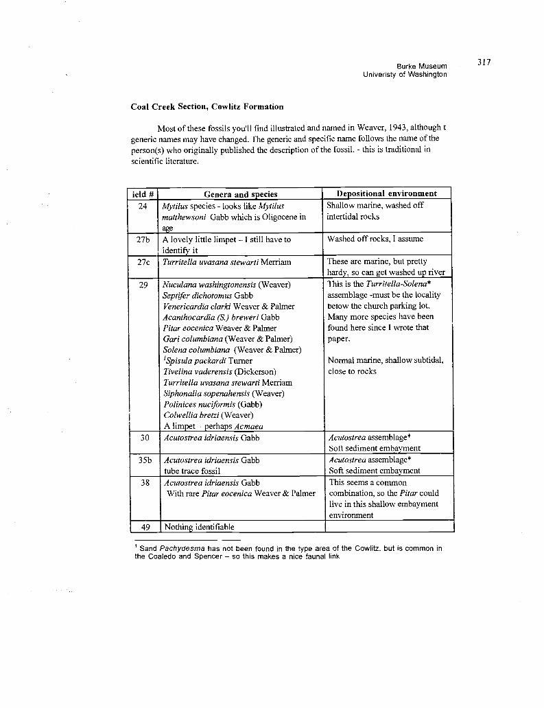
Burke MuseumUniveristy of Washington
Coal Creek Section, Cowlitz Formation
Most of these fossils you'll find illustrated and named in Weaver, 1943, although tgeneric names may have changed. The generic and specific name follows the name of theperson(s) who originally published the description of the fossil, - this is traditional inscientific literature.
ield # Genera and species Depositional environment24 Mytilus species - looks like Mytilus Shallow marine, washed off
matthewsoni Gabb which is Oligocene inage
intertidal rocks
27b A lovely little limpet - I still have to Washed off rocks, I assumeidentify it
27c Turritella uvasana stewarti Merriam These are marine, but prettyhardy, so can get washed up river
29 Nuculana washingtonensis (Weaver) This is the Turritella-Solena*Septifer dichotomus Gabb assemblage -must be the localityVenericardia clarki Weaver & Palmer below the church parking lot.Acanthocardia (S.) breweri Gabb Many more species have beenPitar eocenica Weaver & Palmer found here since I wrote thatGari columbiana (Weaver & Palmer) paper.Solena columbiana (Weaver & Palmer)'Spisula packardi Turner Normal marine, shallow subtidal,Tivelina vaderensis (Dickerson) close to rocksTurritella uvasana stewarti MerriamSiphonalia sopenahensis (Weaver)Polinices nuciformis (Gabb)Colwellia bretzi (Weaver)A limpet - perhaps Acmaea
30 Acutostrea idriaensis Gabb Acutostrea assemblage*Soft sediment embayment
35b Acutostrea idriaensis Gabb Acutostrea assemblage*tube trace fossil Soft sediment embayment
38 Acutostrea idriaensis Gabb This seems a commonWith rare Pitar eocenica Weaver & Palmer combination, so the Pitar could
live in this shallow embaymentenvironment
49 Nothing identifiable
317
' Sand Pachydesma has not been found in the type area of the Cowlitz, but is common inthe Coaledo and Spencer - so this makes a nice faunal link
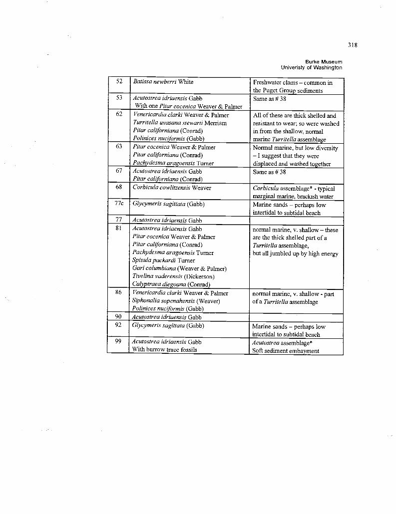
318
Burke MuseumUniveristy of Washington
52 Batissa newberri White Freshwater clams - common inthe Puget Group sediments
53 Acutostrea idriaensis Gabb Same as # 38With one Pitar eocenica Weaver & Palmer
62 Venericardia clarki Weaver & Palmer All of these are thick shelled andTurritella uvasana stewarti Merriam resistant to wear; so were washedPitar californiana (Conrad) in from the shallow, normalPolinices nuci ormis (Gabb) marine Turritella assemblage
63 Pitar eocenica Weaver & Palmer Normal marine, but low diversityPitar californiana (Conrad) - I suggest that they werePach desma ara oensis Turner displaced and washed together
67 Acutostrea idriaensis Gabb Same as # 38Pitar call orniana (Conrad)
68 Corbicula cowlitzensis Weaver Corbicula assemblage* - typicalmarginal marine, brackish water
77c Glycymeris sagittata (Gabb) Marine sands - perhaps lowintertidal to subtidal beach
77 Acutostrea idriaensis Gabb81 Acutostrea idriaensis Gabb normal marine, v. shallow - these
Pitar eocenica Weaver & Palmer are the thick shelled part of aPitar californiana (Conrad) Turritella assemblage,Pachydesma aragoensis Turner but all jumbled up by high energySpisula packardi TurnerGari columbiana (Weaver & Palmer)Tivelina vaderensis (Dickerson)Cal traea diegoana (Conrad)
86 Venericardia clarki Weaver & Palmer normal marine, v. shallow - partSiphonalia sopenahensis (Weaver) of a Turritella assemblagePolinices nuci ormis (Gabb)
90 Acutostrea idriaensis Gabb92 Glycymeris sagittata (Gabb) Marine sands - perhaps low
intertidal to subtidal beach99 Acutostrea idriaensis Gabb Acutostrea assemblage*
With burrow trace fossils Soft sediment embayment
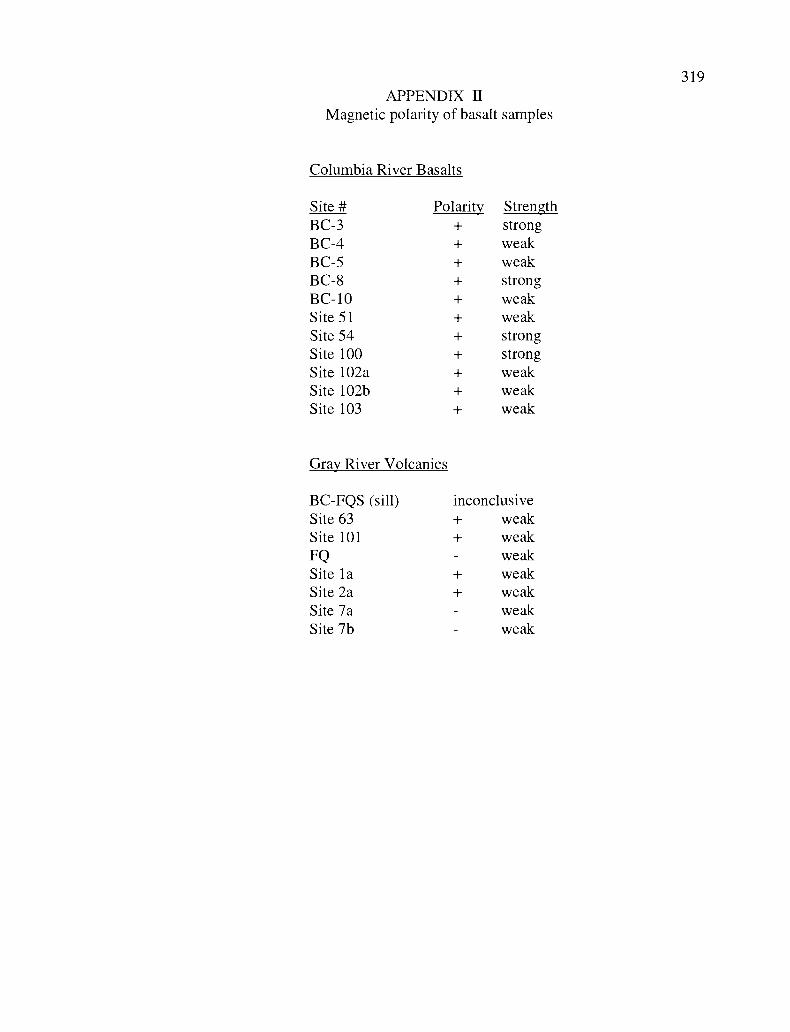
APPENDIX HMagnetic polarity of basalt samples
Columbia River Basalts
Site # Polarity StrengthBC-3 + strongBC-4 + weakBC-5 + weakBC-8 + strongBC-10 + weakSite 51 + weakSite 54 + strongSite 100 + strongSite 102a + weakSite 102b + weakSite 103 + weak
Gray River Volcanics
BC-FQS (sill) inconclusiveSite 63 + weakSite 101 + weakFQ - weakSite la + weakSite 2a + weakSite 7a - weakSite 7b - weak
319
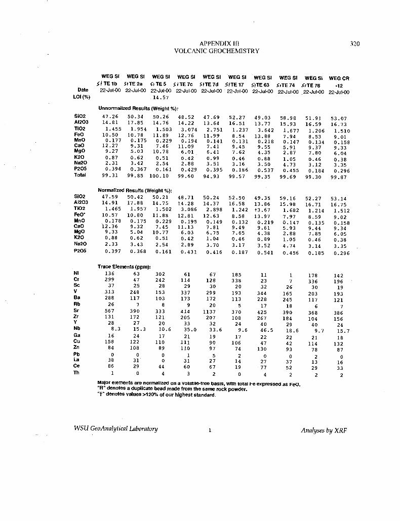
APPENDIX III 320VOLCANIC GEOCHEMISTRY
WEG SI WEG SI. I TE 1 b SITE 2a
WEG SI
SITESWEG SI
SITE 7cWEG SI
SITE 7dWEG SI
SITE 17WEG SI
SITE 63
WEG SI WEG SiSITE 74 . iTE 76
WEG CR
-12Date 22-Jul-00 22Jul-00 22-Jul-00 22Jul-00 22-Jul-00 22-Jul-00 22-Jul-00 22-Jul-00 .22Jul-00 22-Jul-00
LOI(%) 14.57
Unnormalized Results (Weight %):
Si02 47.26 50.34 50.26 48.52 47.69 52.27 49.03 58.98 51.91 53.07A1203 14.81 17.85 14.76 14.22 13.64 16.51 13.77 15.93 16.59 16.73T102 1.455 1.954 1.503 3.014 2.751 1.237 3.642 1.677 1.206 1.510FeO 10.50 10.78 11.89 12.76 11.99 8.54 13.88 7.94 8.53 9.01MnO 0.177 0.175 0.229 0.194 0.141 0.131 0.218 0.147 0.134 0.158CaO 12.27 9.31 7.46 11.09 7.41 9.45 9.55 5.91 9.37 9.33MgO 9.27 5.03 10.78 6.01 6.41 7.62 4.35 2.87 7.80 6.04K20 0.87 0.62 0.51 0.42 0.99 0.46 0.88 1.05 0.46 0.38Na2O 2.31 3.42 2.54 2.88 3.51 3.16 3.50 4.73 3.12 3.35P205 0.394 0.367 0.161 0.429 0.395 0.186 0.537 0.455 0.184 0.296Total 99.31 99.85 100.10 99.60 94.93 99.57 99.35 99.69 99.30 99.87
Normalized Results (Weight %):Si02 47.59 50.42 50.21 48.71 50.24 52.50 49.35 59.16 52.27 53.14A1203 14.91 17.88 14.75 14.28 14.37 16.58 13.86 15.98 16.71 16.75T102 1.465 1.957 1.502 3.086 2.898 1.242 t3.67 1.682 1.214 1.512FeO' 10.57 10.80 11.88 12.81 12.63 8.58 13.97 7.97 8.59 9.02MnO 0.178 0.175 0.229 0.195 0.149 0.132 0.219 0.147 0.135 0.158CaO 12.36 9.32 7.45 11.13 7.81 9.49 9.61 5.93 9.44 9.34MgO 9.33 5.04 10.77 6.03 6.75 7.65 4.38 2.88 7.85 6.05K20 0.88 0.62 0.51 0.42 1.04 0.46 0.89 1.05 0.46 0.38Na2O 2.33 3.43 2.54 2.89 3.70 3.17 3.52 4.74 3.14 3.35P205 0.397 0.368 0.161 0.431 0.416 0.187 0.541 0.456 0.185 0.296
Trace Elements (ppm):Ni 136 63 302 61 67 185 11 1 178 142Cr 299 47 242 114 128 338 23 7 336 196Sc 37 25 28 29 30 20 32 26 30 19V 313 248 153 337 299 193 344 165 203 193Ba 288 117 103 173 172 113 228 245 117 121Rb 26 7 8 9 20 5 17 18 6 7Sr 567 390 333 414 1137 370 425 390 368 386Zr 131 172 121 205 207 108 267 184 104 156Y 28 27 20 33 32 24 40 29 40 24Nb 8.3 15.3 10.6 35.0 33.6 9.6 46.5 18.6 9.7 15.7Ga 16 24 17 21 19 17 22 22 21 18Cu 158 122 110 111 90 106 47 42 114 132Zn 84 108 89 110 97 74 130 93 78 87Pb 0 0 0 1 5 2 0 0 2 0La 38 31 0 31 27 14 27 37 13 16Ce 86 29 44 60 67 19 77 52 29 33Th 1 0 4 3 2 0 4 2 2 2
Major elements are normalized on a Volatile-tree basis, With total Fe expressed as FeC."R" denotes a duplicate bead made from the same rock powder."t" denotes values >120% of our highest standard.
WSU GeoAnalytical Laboratory 1 Analyses by XRF
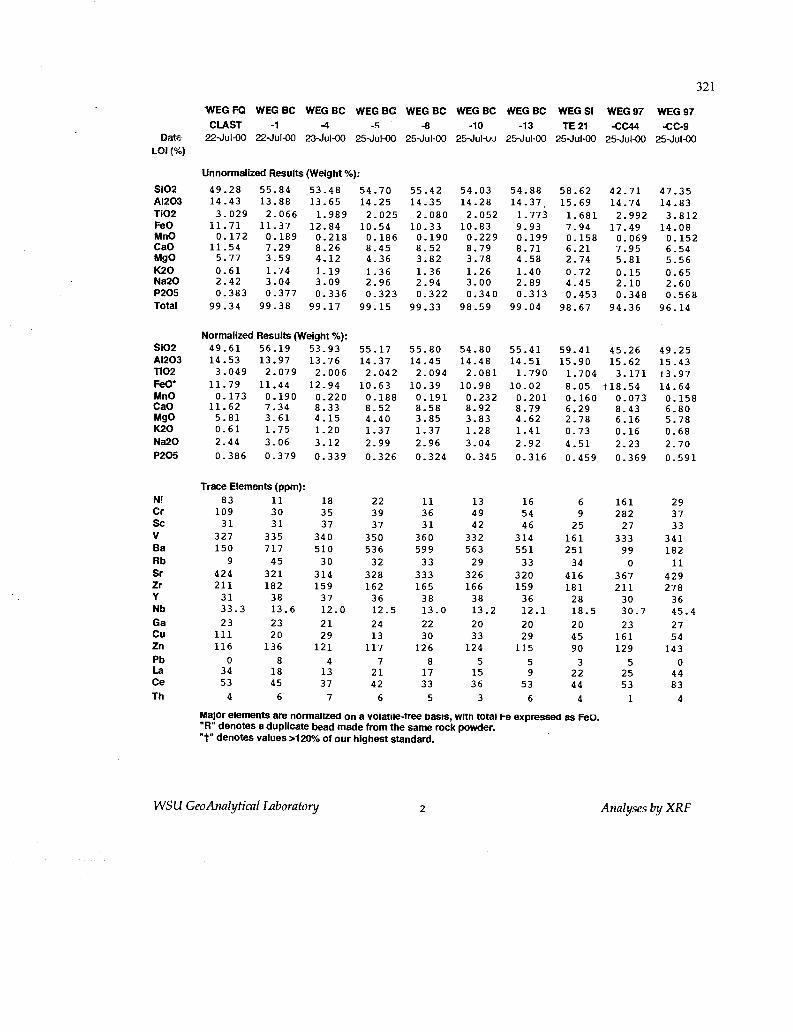
DateLOI (%)
321
WEG FQ WEG BC WEG BC WEG BC WEG BC WEG BC WEG BC WEG SI WEG 97 WEG 97CLAST -1 -4 -.r+ -8 -10 -13 TE 21 -CC44 -CC-9
22Ju1-00 22JuI-00 23-Jul-00 25Jui-00 25-Jul-00 25Jul-uu 25-Jul-00 25-Jul-00 25Jul-00 25Jul-00
Unnormalized Results (Weight %):
SiO2 49.28 55.84 53.48 54.70 55.42 54.03 54.88 58.62 42.71 47.35A12O3 14.43 13.88 13.65 14.25 14.35 14.28 14.37 15.69 14.74 14.8311O2 3.029 2.066 1.989 2.025 2.080 2.052 1.773 1.681 2.992 3.812FeO 11.71 11.37 12.84 10.54 10.33 10.83 9.93 7.94 17.49 14.08MnO 0.172 0.189 0.218 0.186 0.190 0.229 0.199 0.158 0.069 0.152CaO 11.54 7.29 8.26 8.45 8.52 8.79 8.71 6.21 7.95 6.54MgO 5.77 3.59 4.12 4.36 3.82 3.78 4.58 2.74 5.81 5.56K2O 0.61 1.74 1.19 1.36 1.36 1.26 1.40 0.72 0.15 0.65Na2O 2.42 3.04 3.09 2.96 2.94 3.00 2.89 4.45 2.10 2.60P2O5 0.383 0.377 0.336 0.323 0.322 0.340 0.313 0.453 0.348 0.568Total 99.34 99.38 99.17 99.15 99.33 98.59 99.04 98.67 94.36 96.14
Normalized Results (Weight %):SiO2 49.61 56.19 53.93 55.17 55.80 54.80 55.41 59.41 45.26 49.25A12O3 14.53 13.97 13.76 14.37 14.45 14.48 14.51 15.90 15.62 15.4311O2 3.049 2.079 2.006 2.042 2.094 2.081 1.790 1.704 3.171 t3.97FeO' 11.79 11.44 12.94 10.63 10.39 10.98 10.02 8.05 t18.54 14.64MnO 0.173 0.190 0.220 0.188 0.191 0.232 0.201 0.160 0.073 0.158CaO 11.62 7.34 8.33 8.52 8.58 8.92 8.79 6.29 8.43 6.80MgO 5.81 3.61 4.15 4.40 3.85 3.83 4.62 2.78 6.16 5.78K2O 0.61 1.75 1.20 1.37 1.37 1.28 1.41 0.73 0.16 0.68Na2O 2.44 3.06 3.12 2.99 2.96 3.04 2.92 4.51 2.23 2.70P2O5 0.386 0.379 0.339 0.326 0.324 0.345 0.316 0.459 0.369 0.591
Trace Elements (ppm):Ni 83 11 18 22 11 13 16 6 161 29Cr 109 30 35 39 36 49 54 9 282 37Sc 31 31 37 37 31 42 46 25 27 33V 327 335 340 350 360 332 314 161 333 341Ba 150 717 510 536 599 563 551 251 99 182Rb 9 45 30 32 33 29 33 34 0 11Sr 424 321 314 328 333 326 320 416 367 429Zr 211 182 159 162 165 166 159 181 211 278Y 31 38 37 36 38 38 36 28 30 36Nb 33.3 13.6 12.0 12.5 13.0 13.2 12.1 18.5 30.7 45.4Ga 23 23 21 24 22 20 20 20 23 27Cu 111 20 29 13 30 33 29 45 161 54Zn 116 136 121 117 126 124 115 90 129 143Pb 0 8 4 7 8 5 5 3 5 0La 34 18 13 21 17 15 9 22 25 44Ce 53 45 37 42 33 36 53 44 53 83Th 4 6 7 6 5 3 6 4 1 4
Major elements are normalized on a volatile-tree basis, with total Fe expressed as FeO."R" denotes a duplicate bead made from the same rock powder."t" denotes values >120% of our highest standard.
WSU GeoAnalytical Laboratory 2 Analyses by XRF
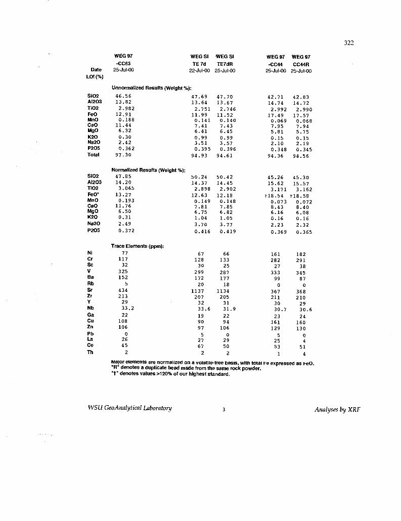
322
Date
LOI (%)
WEG 97
-CC6325,Jul-00
WEG SI
TE 7d22-Jul-00
WEG SI
TE7dR25-Jul-00
WEG 97
-CC4425-Jul-00
WEG 97
CC44R25-Jul-00
Unnormalized Results (Weight %):
S102 46.56 47.69 47.70 42.71 42.83A12O3 13.82 13.64 13.67 14.74 14.72TiO2 2.982 2.751 2.746 2.992 2.990FeO 12.91 11.99 11.52 17.49 17.57MnO 0.188 0.141 0.140 0.069 0.068CaO 11.44 7.41 7.43 7.95 7.94MgO 6.32 6.41 6.45 5.81 5.75K2O 0.30 0.99 0.99 0.15 0.15Na2O 2.42 3.51 3.57 2.10 2.19P2O5 0.362 0.395 0.396 0.348 0.345Total 97.30 94.93 94.61 94.36 94.56
S1O2
Normalized Results (Weight %):47.85 50.24 50.42 45.26 45.30
A12O3 14.20 14.37 14.45 15.62 15.5711O2 3.065 2.898 2.902 3.171 3.162FeO' 13.27 12.63 12.18 t18.54 t18.58MnO 0.193 0.149 0.148 0.073 0.072CaO 11.76 7.81 7.85 8.43 8.40MgO 6.50 6.75 6.82 6.16 6.08K2O 0.31 1.04 1.05 0.16 0.16Na2O 2.49 3.70 3.77 2.23 2.32P2O5 0.372 0.416 0.419 0.369 0.365
Ni
Trace Elements (ppm):77 67 66 161 182
Cr 117 128 133 282 291Sc 32 30 25 27 38V 325 299 287 333 345Ba 152 172 177 99 87Rb 5 20 18 0 0Sr 434 1137 1134 367 368Zr 213 207 205 211 210Y 29 32 31 30 29Nb 33.2 33.6 31.9 30.7 30.6Ga 22 19 22 23 24Cu 108 90 94 161 160Zn 106 97 106 129 130Pb 0 5 0 5 0La 26 27 29 25 4Ce 45 67 50 53 51Th 2 2 2 1 4
Major elements are normalized on a volatile-free basis, with total Fe expressed as FeO."R" denotes a duplicate bead made from the same rock powder."t" denotes values >120% of our highest standard.
WSU GeoAnalytical Laboratory 3 Analyses by XRF
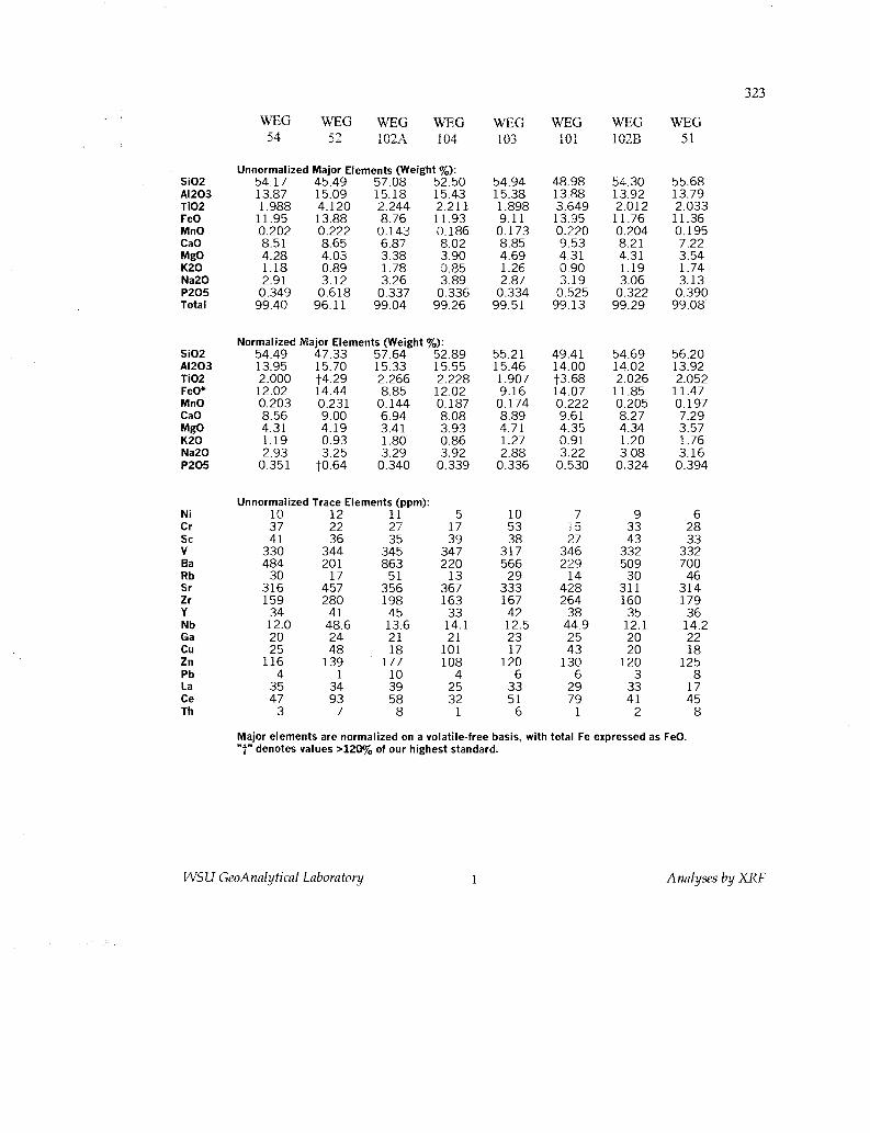
323
WEG WEG WEG WEG WEG WEGWE{G
WEGJY J J. 102A 1 V-^t 103 10 i 1028 J i
Unnormalized Major Elements (Weight %):Si02 54.17 45.49 57.08 52.50 54.94 48.98 54.30 55.68A1203 13.87 15.09 15.18 15.43 15.38 13.88 13.92 13.79Ti02 1.988 4.120 2.244 2.211 1.898 3.649 2.012 2.033FeO 11.95 13.88 8.76 11.93 9.11 13.95 11.76 11.36MnO 0.202 0.222 0.143 0.186 0.173 0.220 0.204 0.195CaO 8.51 8.65 6.87 8.02 8.85 9.53 8.21 7.22MgO 4.28 4.03 3.38 3.90 4.69 4.31 4.31 3.54K20 1.18 0.89 1.78 0.85 1.26 0.90 1.19 1.74Na20 2.91 3.12 3.26 3.89 2.87 3.19 3.06 3.13P205 0.349 0.618 0.337 0.336 0.334 0.525 0.322 0.390Total 99.40 96.11 99.04 99.26 99.51 99.13 99.29 99.08
Normalized Major Elements (Weight%):Si02 54.49 47.33 57.64 52.89 55.21 49.41 54.69 56.20A1203 13.95 15.70 15.33 15.55 15.46 14.00 14.02 13.92Ti02 2.000 t4.29 2.266 2.228 1.907 t3.68 2.026 2.052FeO* 12.02 14.44 8.85 12.02 9.16 14.07 11.85 11.47MnO 0.203 0.231 0.144 0.187 0.174 0.222 0.205 0.197CaO 8.56 9.00 6.94 8.08 8.89 9.61 8.27 7.29MgO 4.31 4.19 3.41 3.93 4.71 4.35 4.34 3.57K20 1.19 0.93 1.80 0.86 1.27 0.91 1.20 1.76Na20 2.93 3.25 3.29 3.92 2.88 3.22 3.08 3.16P205 0.351 tO.64 0.340 0.339 0.336 0.530 0.324 0.394
Unnormalized Trace Elements (ppm):Ni 10 12 11 5 10 7 9 6Cr 37 22 27 17 53 15 33 28Sc 41 36 35 39 38 27 43 33V 330 344 345 347 317 346 332 332Ba 484 201 863 220 566 229 509 700Rb 30 17 51 13 29 14 30 46Sr 316 457 356 367 333 428 311 314Zr 159 280 198 163 167 264 160 179Y 34 41 45 33 42 38 35 36Nb 12.0 48.6 13.6 14.1 12.5 44.9 12.1 14.2Ga 20 24 21 21 23 25 20 22Cu 25 48 18 101 17 43 20 18Zn 116 139 177 108 120 130 120 125Pb 4 1 10 4 6 6 3 8La 35 34 39 25 33 29 33 17Ce 47 93 58 32 51 79 41 45Th 3 7 8 1 6 1 2 8
Major elements are normalized on a volatile-free basis, with total Fe expressed as FeO."t" denotes values >120% of our highest standard.
WSU GeoAnalytical Laboratory 1 Analyses by XRF
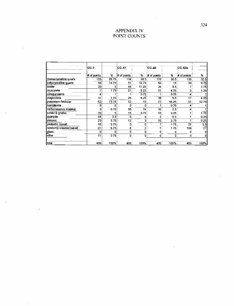
324
APPENDIX IVPOINT COUNTS
CC-7 CC-17 CC-48 CC-53b
# of points % # of points % # of points % # of points %monocrystalline quartz 103 25.75 114 28.5 122 30.5 130 32.5polycrystalline quartz 59 14.75 51 12.75 60 15 39 9.75biotite 20 5 45 11.25 34 8.5 7 1.75muscovite 7 1.75 21 5.25 17 4.25 5 1.25clinopyroxene 4 1 1 0.25 1 0.25 4 1
plagioclase 31 7.75 25 6.25 38 9.5 17 4.25potassium feldspar 63 15.75 52 13 73 18.25 51 12.75hornblende 0 0 0 0 1 0.25 4 1
carbonaceous material 3 0.75 56 14 10 2.5 4 1
schist & gneiss 20 5 15 3.75 13 3.25 7 1.75quartzite 14 3.5 0 0 2 0.5 1 0.25plutonic 23 5.75 12 3 15 3.75 1 0.25pilotaxitic basalt 15 3.75 0 0 7 1.75 22 5.5randomly oriented basalt 27 6.75 8 2 7 1.75 108 27glass 0 0 0 0 0 0 0 0other 11 2.75 0 0 0 0 0 0
total 400 100% 400 100% 400 100% 400 100%
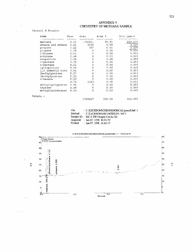
325
APPENDIX VCHEMISTRY OF METHANE SAMPLE
Channel A Results
Name Time Area A-ea % Cc;_c ppm-v
methane 0.41 1765921 99.81 260.278ethane and ethene 0.61 1555 0.09 0.121propane 1.12 387 0.02 0propene 1.34 0 0.00 X000i-butane 2.01 0 0.00 0.000n-butane 2.44 0 0.00 0.000neopentane 2.96 0 0.00 0.000i-pentane 3.74 0 0.00 0.000n-pentane 4.11 0 0.00 0.000cyclopentane 4.55 0 0.00 0.0002,2 dimethyl buta 4.82 0 0.00 0.0002methylpentane 5.27 0 0.00 0.0003methylpentane 5.35 0 0.00 0.000n-hexane 5.59 0 0.00 0.000
5.76 1363 0.08 0.041methylcyclopentan 5.95 0 0.00 0.000heptane 6.68 0 0.00 0.000methylcyclohexane 6.90 0 0.00 0.000
Totals .
1769227 100.00 260.465
File : C:\EZCHROiMCHROM\NORCAL'jonesfl\MC-1Method C:IEZCHROM\ME,THODS\JFL.METSample ID : MC-1 SW Oregon Cowliz fmAcquired : Jan 07, 1998 16:01:59Printed : Jan 07, 1998 16:42:37
C:\EZCHROM\CHROM\NORCAL\jonesfl\MC-1 - Channel A50i
Peak NameESTD Concentration
50
45
4(
IN
40
35 5
0C
30 S NON
30
m25 o
0'lic C
25 V
20
OI
C (CO 02
20
15
O
5
10
cC
E J
0
O.0 2.5 50 7.5
Minutes
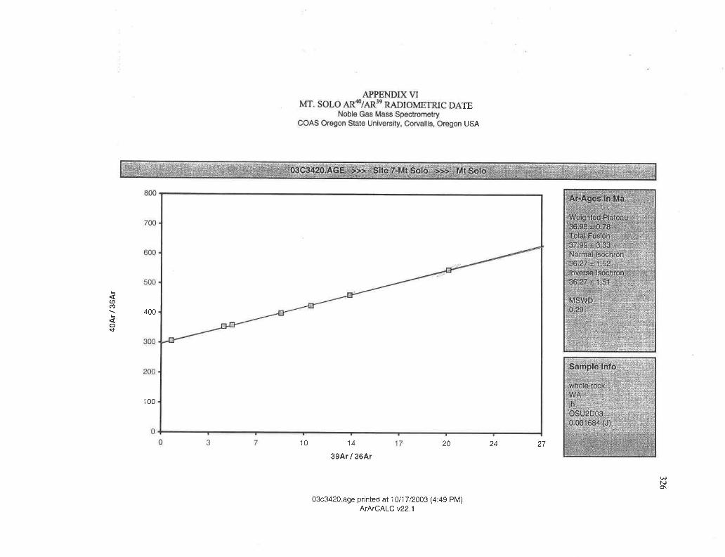
APPENDIX VIMT. SOLO AR'°/AR9 RADIOMETRIC DA
Noble Gas Mass SpectrometryCOAS Oregon State University, Corvallis, Oregon
03C3420.AGE. >>> Site 7-MtSolo >>> Mt Solo
0 3 7 17
Weighted Plateau36.98 ::: 0.78Total Fusion37.99±3.33Normal Isochron36.27 ±-1.52Inverse lsochron36.27. ± 1.51
3-s
,ate
400
100
TE
USA
27
03c3420 age printed at 10/17/2003 (4 49 PM)ArArCALC v22.1
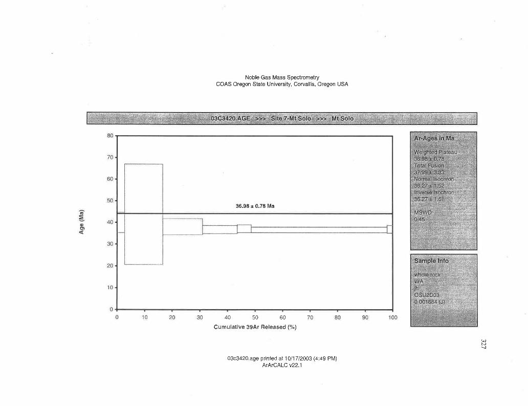
:03C3420.AGE »> Site 7-Mt Solo >>> Mt Solo:.
80
70
60 o
50 o
40 .
30
20
10-
0 10 20 30 70 80 90 100
Weighted Plateau36.98 0.78Total Fusion37,99-3.33Normal Isochron36.27 - 1.,--)2Inverse Isochron36.27±1,51
o
ock
Noble Gas Mass SpectrometryBOAS Oregon State Univers ty, Corvallis, Oregon USA
36.98 ± 0.78 Ma
03c3420 age printed at 10/17/2003 (4 49 PM)ArArCALC v22.1