Embed Size (px)
Citation preview
ma rtens consulting engineers since 1989
Surface Water and Groundwater Assessment: Roach Road, Wagga Wagga Quarry, Wagga Wagga, NSW.
P0802296JR01_V2 – November 2009
Page 100
19 Attachment H – Estimation of K from PSD Analysis
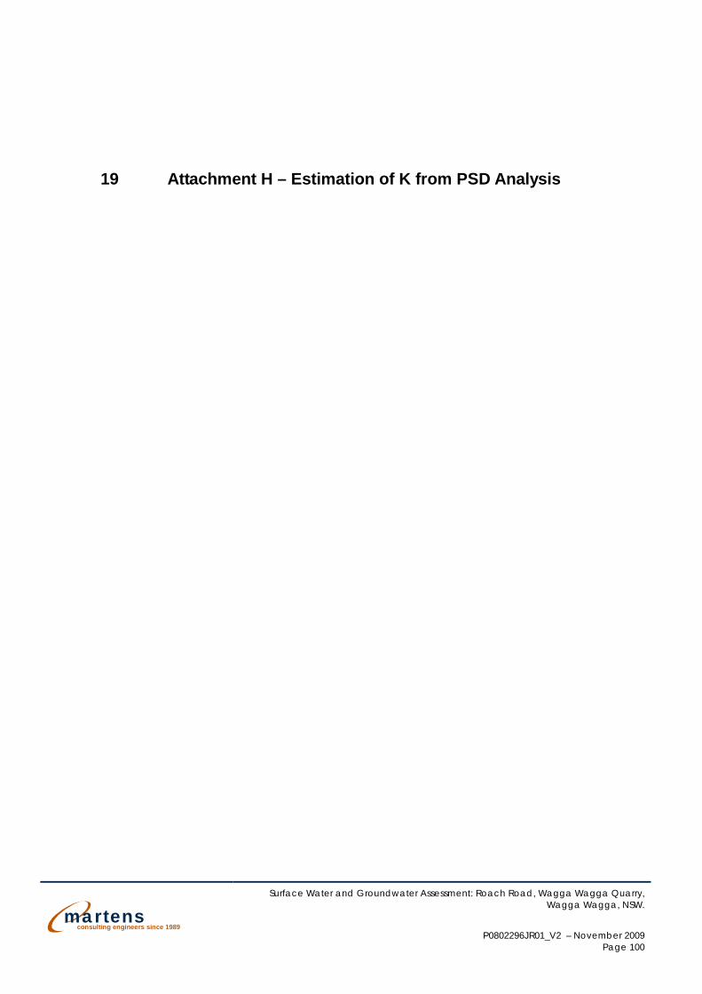
Estimation of K (hydraulic conductivity) from Particle Size Distribution AnalysisMethod ST-41 Revised 29.09.2009
PROJECT DETAILS
Project Test Date
Project Ref Field Testing
Borehole Ref Data Analysis
Sample Depth Reviewed
DATA AnalysisKozeny-Carman Equation (1956)
D10 0.20 mm K = (pg /u)*[n3/(1-n)2]*(dm2/180)
D50 0.60 mmD90 1.80 mm pg /u (density*gravity/fluid viscosity) 99300 cm/s (at 20 °C)
n (porosity) 0.30dm (effective grain size) 0.20 mm
K (hydraulic conductivity) 0.0122 cm/s
K (hydraulic conductivity) 10.51 m/d
DATA PLOT
2.7 to 3.0 mBGL A. Norris
Wagga Wagga Quarry - Hydrogeological Investigation unknownP0802296JS08_V1 HansonHole 1 (WG0901) B. Rose
Head Office Unit 6 / 37 Leighton Place Hornsby NSW 2077, Australia Ph 02 9476 8777 Fax 02 9476 8767 > [email protected] www.martens.com.au MARTENS & ASSOCIATES P/L ABN 85 070 240 890 ACN 070 240 890
0.01
0.1
1
10
0 10 20 30 40 50 60 70 80 90 100
Siev
e D
ia (m
m)
% Passing
Particle Size Distribution Plot
Series1
mar
tens
cons
ultin
g en
gine
ers
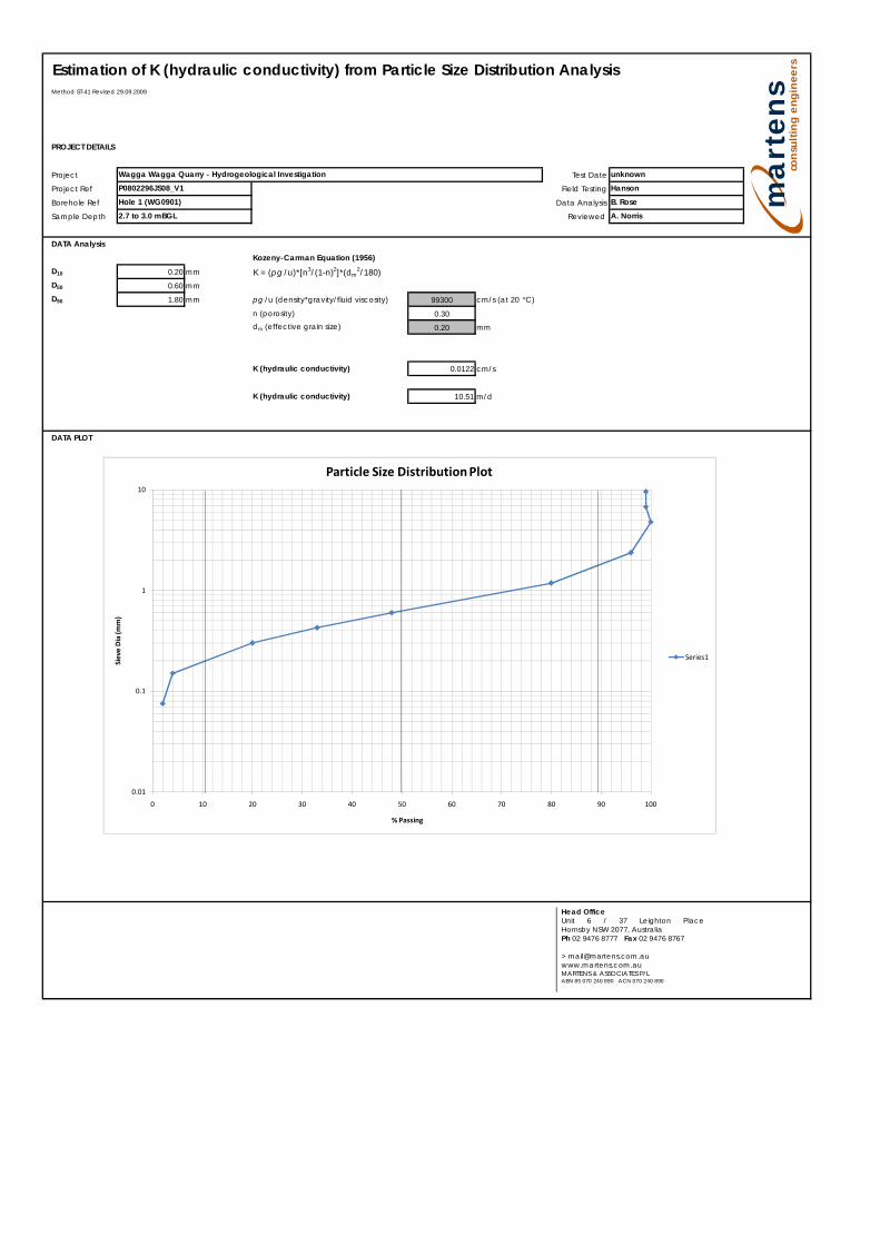
Estimation of K (hydraulic conductivity) from Particle Size Distribution AnalysisMethod ST-41 Revised 29.09.2009
PROJECT DETAILS
Project Test Date
Project Ref Field Testing
Borehole Ref Data Analysis
Sample Depth Reviewed
DATA AnalysisKozeny-Carman Equation (1956)
D10 0.15 mm K = (pg /u)*[n3/(1-n)2]*(dm2/180)
D50 0.30 mmD90 1.10 mm pg /u (density*gravity/fluid viscosity) 99300 cm/s (at 20 °C)
n (porosity) 0.30dm (effective grain size) 0.15 mm
K (hydraulic conductivity) 0.0068 cm/s
K (hydraulic conductivity) 5.91 m/d
DATA PLOT
3.2 to 3.5 mBGL A. Norris
Wagga Wagga Quarry - Hydrogeological Investigation unknownP0802296JS08_V1 HansonHole 2 (WG0902) B. Rose
Head Office Unit 6 / 37 Leighton Place Hornsby NSW 2077, Australia Ph 02 9476 8777 Fax 02 9476 8767 > [email protected] www.martens.com.au MARTENS & ASSOCIATES P/L ABN 85 070 240 890 ACN 070 240 890
0.01
0.1
1
10
0 10 20 30 40 50 60 70 80 90 100
Siev
e D
ia (m
m)
% Passing
Particle Size Distribution Plot
Series1
mar
tens
cons
ultin
g en
gine
ers
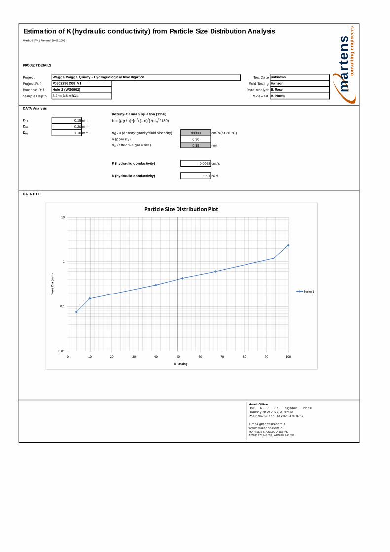
Estimation of K (hydraulic conductivity) from Particle Size Distribution AnalysisMethod ST-41 Revised 29.09.2009
PROJECT DETAILS
Project Test Date
Project Ref Field Testing
Borehole Ref Data Analysis
Sample Depth Reviewed
DATA AnalysisKozeny-Carman Equation (1956)
D10 0.28 mm K = (pg /u)*[n3/(1-n)2]*(dm2/180)
D50 0.40 mmD90 1.00 mm pg /u (density*gravity/fluid viscosity) 99300 cm/s (at 20 °C)
n (porosity) 0.30dm (effective grain size) 0.28 mm
K (hydraulic conductivity) 0.0238 cm/s
K (hydraulic conductivity) 20.59 m/d
DATA PLOT
3.5 to 3.8 mBGL A. Norris
Wagga Wagga Quarry - Hydrogeological Investigation unknownP0802296JS08_V1 HansonHole 3 (WG0903) B. Rose
Head Office Unit 6 / 37 Leighton Place Hornsby NSW 2077, Australia Ph 02 9476 8777 Fax 02 9476 8767 > [email protected] www.martens.com.au MARTENS & ASSOCIATES P/L ABN 85 070 240 890 ACN 070 240 890
0.01
0.1
1
10
0 10 20 30 40 50 60 70 80 90 100
Siev
e D
ia (m
m)
% Passing
Particle Size Distribution Plot
Series1
mar
tens
cons
ultin
g en
gine
ers
ma rtens consulting engineers since 1989
Surface Water and Groundwater Assessment: Roach Road, Wagga Wagga Quarry, Wagga Wagga, NSW.
P0802296JR01_V2 – November 2009
Page 104
20 Attachment I – Surface water and Groundwater
Management Flow Charts
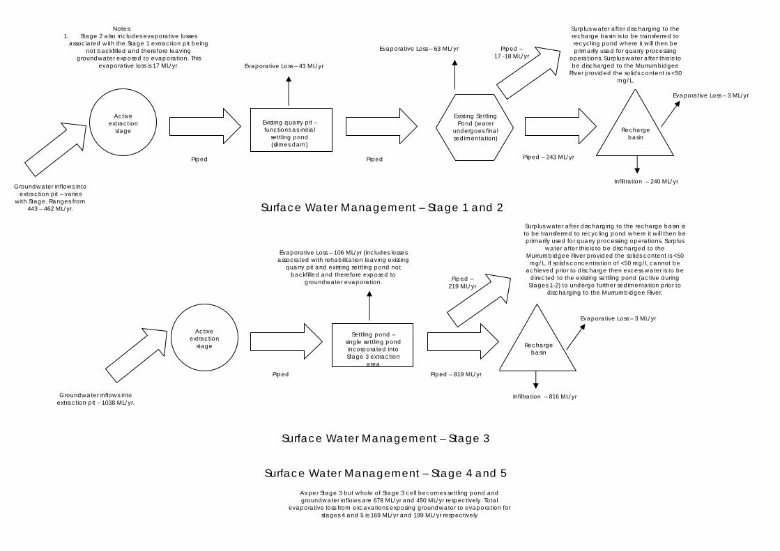
Evaporative Loss – 3 ML/yr
Surplus water after discharging to the recharge basin is to be transferred to recycling pond where it will then be primarily used for quarry processing operations. Surplus
water after this is to be discharged to the Murrumbidgee River provided the solids content is <50
mg/L. If solids concentration of <50 mg/L cannot be achieved prior to discharge then excess water is to be
directed to the existing settling pond (active during Stages 1-2) to undergo further sedimentation prior to
discharging to the Murrumbidgee River.
Piped – 219 ML/yr
Piped – 17 -18 ML/yr
Existing Settling Pond (water
undergoes final sedimentation)
Recharge basin
Settling pond – single settling pond incorporated into Stage 3 extraction
area
Active extraction
stage
Piped
Piped – 819 ML/yr
Recharge basin
Existing quarry pit – functions as initial
settling pond (slimes dam)
Active extraction
stage
Piped
Piped
Piped – 243 ML/yr
Surplus water after discharging to the recharge basin is to be transferred to recycling pond where it will then be primarily used for quarry processing
operations. Surplus water after this is to be discharged to the Murrumbidgee
River provided the solids content is <50 mg/L.
Surface Water Management – Stage 1 and 2
Surface Water Management – Stage 3
Surface Water Management – Stage 4 and 5
As per Stage 3 but whole of Stage 3 cell becomes settling pond and groundwater inflows are 678 ML/yr and 450 ML/yr respectively. Total
evaporative loss from excavations exposing groundwater to evaporation for stages 4 and 5 is 169 ML/yr and 199 ML/yr respectively
Groundwater inflows into extraction pit – varies
with Stage. Ranges from 443 – 462 ML/yr.
Groundwater inflows into extraction pit – 1038 ML/yr.
Evaporative Loss – 43 ML/yr
Evaporative Loss – 63 ML/yr
Evaporative Loss – 3 ML/yr
Infiltration – 240 ML/yr
Notes: 1. Stage 2 also includes evaporative losses
associated with the Stage 1 extraction pit being not backfilled and therefore leaving
groundwater exposed to evaporation. This evaporative loss is 17 ML/yr.
Evaporative Loss – 106 ML/yr (includes losses associated with rehabilitation leaving existing
quarry pit and existing settling pond not backfilled and therefore exposed to
groundwater evaporation.
Infiltration – 816 ML/yr
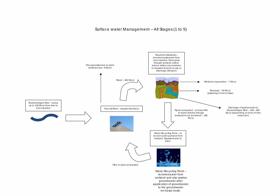
Piped – 402 ML/yr
Pipe to plant as required
Piped as required – at least 49% of water treated through
wetlands to be reclaimed – 186 ML/yr.
Process Losses due to plant inefficiencies – 8 ML/yr
Murrumbidgee River – pump up to 100 ML/yr from river to
process plant
Water Recycling Pond – receives water from
wetland and also surplus groundwater after
application of groundwater to the groundwater
recharge basin.
Process Plant – requires 410 ML/yr
Treatment Wetlands – receives wastewater from process plant. Flows pass through wetland cells to
reduce solids concentration to required level for re-use or
discharge (50 ppm)
Water Recycling Pond – to receive water pumped from wetland. Supplies water to
plant.
Surface water Management – All Stages (1 to 5)
Wetland evaporation – 7 ML/yr
Seepage – 16 ML/yr
(assuming 5 mm/d losses
Discharge of surplus water to Murrumbidgee River – 105 – 300
ML/yr (depending on level of river extraction)

ma rtens consulting engineers since 1989
Surface Water and Groundwater Assessment: Roach Road, Wagga Wagga Quarry, Wagga Wagga, NSW.
P0802296JR01_V2 – November 2009
Page 107
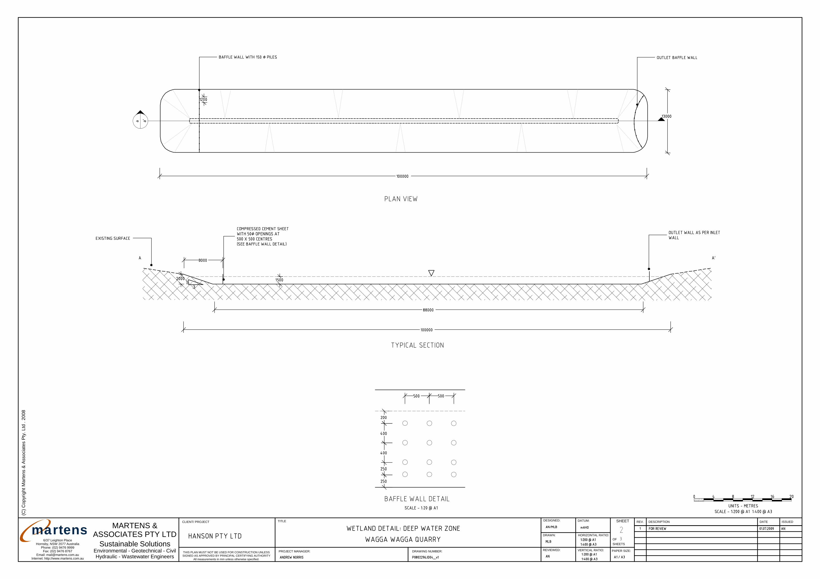
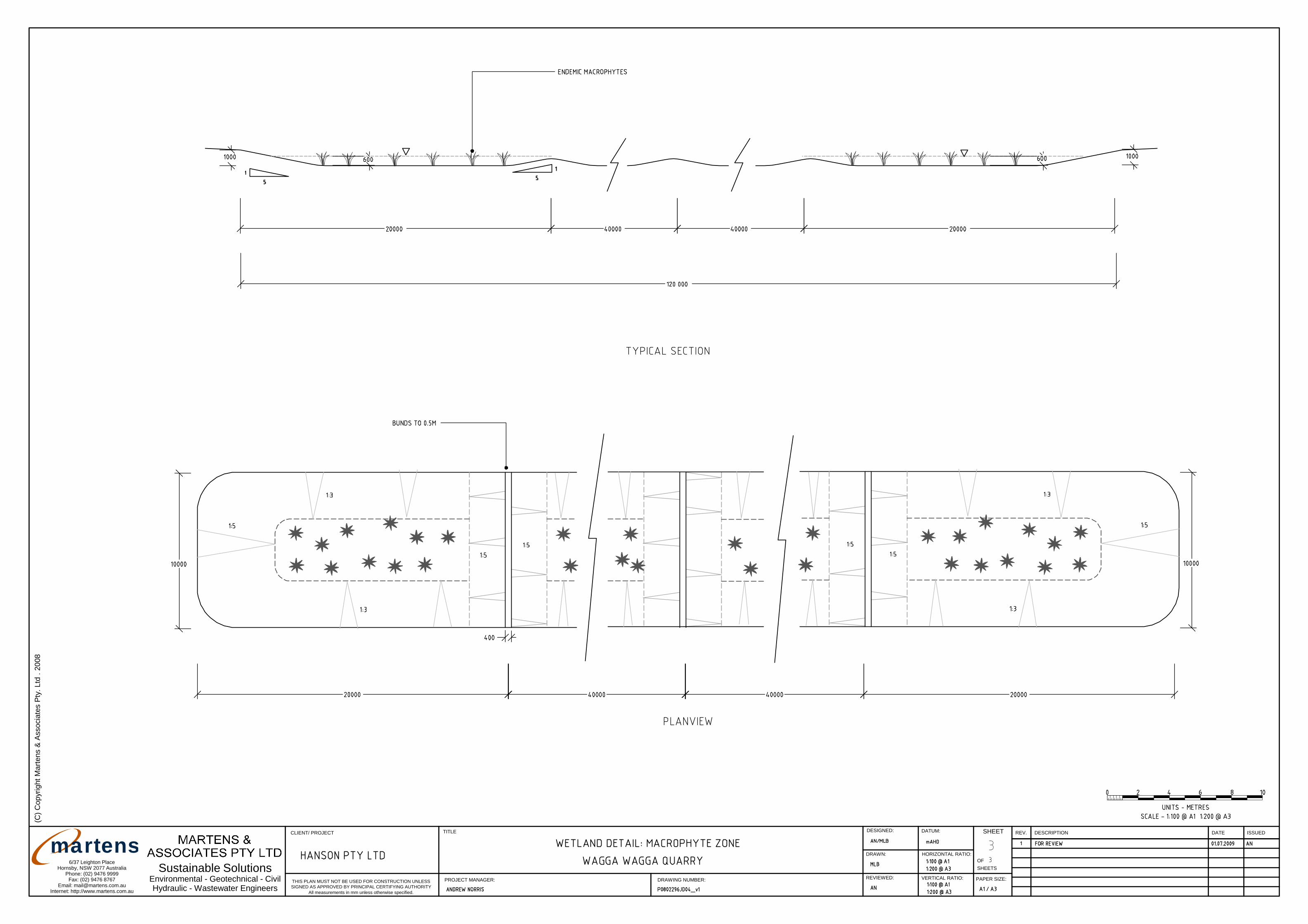
21 Attachment J – Preliminary Wetland Designs
DATECLIENT/ PROJECT DESCRIPTIONREV.TITLE SHEET
OFSHEETS
HORIZONTAL RATIO:
DATUM:
VERTICAL RATIO:
DESIGNED:
DRAWN:
PROJECT MANAGER:THIS PLAN MUST NOT BE USED FOR CONSTRUCTION UNLESSSIGNED AS APPROVED BY PRINCIPAL CERTIFYING AUTHORITY
ISSUED
Environmental - Geotechnical - CivilHydraulic - Wastewater Engineers
6/37 Leighton PlaceHornsby, NSW 2077 Australia
Phone: (02) 9476 9999Fax: (02) 9476 8767
Email: [email protected]: http://www.martens.com.au
MARTENS &ASSOCIATES PTY LTD
REVIEWED:DRAWING NUMBER:
All measurements in mm unless otherwise specified.
PAPER SIZE:
Sustainable Solutions
(C) C
opyr
ight
Mar
tens
& A
ssoc
iate
s Pt
y. L
td .
2008
martens
1 57
158
1 5 9
1 6 0
1
6 0
161
1 6 1
1 62
1 6 2
163
163
16 3
164
16 4
165
166
166
168
16
9
169
1 6 9
169
1 6 9
1 6 9
170
170
170
17
0
170
1 7 0
1 7 0
1
7 0
171
171
17
1
171
171
17
1
171
1 71
171
17
2
172
172
172
17
2
172
172
1 7 2
172
1 7 2
17 2
1 7 2
1 72
172
173 1 7 3
17 3
17
3
1 7 3
173
173
173
173
17
3
17
3
173
17
3
173
173
173
17
3
1 73
1 7 3
1 7 3
173173
173
174 17 4
174
174
17
4
174
174
1 7 4
1 74
1 74
17
4
174
174
1 7 4
174
17
41
74
17
4
1 7 4
1 7 4
174
174
174
1 74
174
1 74
17
4
1 74
174
1 7 41 7 4
174
1 7 4
1 7 4
17
4
175
175
17 5
175
17
5
1 7 5
175
175
1 75
1 7 5
175
175 175
1 7 5
17
5
17 5
1 7 5
17
5
17 5
175
175
1 75
175
175 175
17
5
175
1 7 5
175
175
175
175
175
175
1 7 5
175
175
175
1 7 5
176
176
17
6
176
1 7 6
17 6
176
176
17
6
17
6
176
1 7 6
176
176
1 7 6
176
176
17
6
176
17 6
17 6
1 7 6
176
176
1 76
1 7 6
17
6
1 76
176
1 7 6
17 6
1 7 6
1
76
1 76
176
176
177
17
7
17
7
17 7
17 7
1 7 7
1 7 7
1 7 71 77
17 7
1 7 7
177
1 7 7
17
7
17 7
1 77
177
1 77
17
7
1 7 7
17
7
1
7 7
1 7 7
17 7
178
17
8
17 8
17
8
178
1 7 8
179
17
9
180
180
18
1
181
182
18
2
183
183
184
18
4
185
18
5
186
18
6
187
18
7
188
188
189
189
190
190
1 9 0 191
191
191
192
192
192
193
193
193
194
194
194
195
195
195
196
196
196
197
197
197
198
198
198
199
199
199
200
200
200
201
201
20
1
201
202
20
2
202
202 2 0
3
203
203
203
204
204
204
204
20
5
205
20
5
205
206
206
20
6
206
207
207
207
207
208
208
2 0 8
208
209
20
9
20
9
209
210
210
210
210
210
211
211
211
211
212
212
212
2
12
2 1 2
213
213
213
21
3
214
214
214
15
215
21
52
15
216
216
216
2 1 6
217
217
217
218
218
21
8
219
219
21 9
2
220
22
0
221
22
1
222223
22425
S
N
W E
DATECLIENT/ PROJECT DESCRIPTIONREV.TITLE SHEET
OFSHEETS
HORIZONTAL RATIO:
DATUM:
VERTICAL RATIO:
DESIGNED:
DRAWN:
PROJECT MANAGER:THIS PLAN MUST NOT BE USED FOR CONSTRUCTION UNLESSSIGNED AS APPROVED BY PRINCIPAL CERTIFYING AUTHORITY
ISSUED
Environmental - Geotechnical - CivilHydraulic - Wastewater Engineers
6/37 Leighton PlaceHornsby, NSW 2077 Australia
Phone: (02) 9476 9999Fax: (02) 9476 8767
Email: [email protected]: http://www.martens.com.au
MARTENS &ASSOCIATES PTY LTD
REVIEWED:DRAWING NUMBER:
All measurements in mm unless otherwise specified.
PAPER SIZE:
Sustainable Solutions
(C) C
opyr
ight
Mar
tens
& A
ssoc
iate
s Pt
y. L
td .
2008
martens
13
DATECLIENT/ PROJECT DESCRIPTIONREV.TITLE SHEET
OFSHEETS
HORIZONTAL RATIO:
DATUM:
VERTICAL RATIO:
DESIGNED:
DRAWN:
PROJECT MANAGER:THIS PLAN MUST NOT BE USED FOR CONSTRUCTION UNLESSSIGNED AS APPROVED BY PRINCIPAL CERTIFYING AUTHORITY
ISSUED
Environmental - Geotechnical - CivilHydraulic - Wastewater Engineers
6/37 Leighton PlaceHornsby, NSW 2077 Australia
Phone: (02) 9476 9999Fax: (02) 9476 8767
Email: [email protected]: http://www.martens.com.au
REVIEWED:DRAWING NUMBER:
All measurements in mm unless otherwise specified.
PAPER SIZE:
Sustainable Solutions
(C) C
opyr
ight
Mar
tens
& A
ssoc
iate
s Pt
y. L
td .
2008
martens
HANSON
OCTOBER 2009
N CONSTRUCTION MATWAGGA W
ASSESSMENT OF HYDR
TERIALS PTY LTDWAGGA QUARRYRAULIC IMPACTS
WAGGA WAGGA QUARRY - ASSESSMENT OF HYDRAULIC IMPACTS
TABLE OF CONTENTS
PAGE
1. INTRODUCTION ........................................................................................................ 1
1.1. Background ................................................................................................ 1
2. DATA COLLECTION ................................................................................................. 2
2.1. Topographic Survey ................................................................................... 2
2.2. Model Inputs ............................................................................................... 2
3. APPROACH ADOPTED ............................................................................................. 3
4. HYDRAULIC ANALYSIS ........................................................................................... 4
4.1. Hydraulic Modelling Approach .................................................................... 4
4.2. Model Establishment .................................................................................. 4
4.3. Model Verification ....................................................................................... 5
5. TUFLOW MODEL RESULTS ..................................................................................... 6
5.1. Existing Scenario ........................................................................................ 6
5.2. Developed Scenario – Stage 3 ................................................................... 6
5.2.1. General ...................................................................................................... 6
5.2.2. Level of Protection ...................................................................................... 7
5.2.3. Preliminary Spillway Locations ................................................................... 8
6. POTENTIAL FOR SCOUR ASSESSMENT ................................................................ 9
7. CONCLUSIONS ....................................................................................................... 10
8. REFERENCES ......................................................................................................... 11
LIST OF TABLES Table 1 Comparison of Model Results RUBICON-TUFLOW – 1% AEP Event ........................ 5 Table 2 Summary of Peak Flood Level Impacts ...................................................................... 7 Table 3 Summary of Peak Flood Velocity Impacts ................................................................... 7
LIST OF FIGURES
Figure 1 Study Area Figure 2 Study Area – TUFLOW Model Layout Figure 3 Peak Flood Level – 5% AEP Event – Existing Scenario Figure 4 Peak Flood Level – 2% AEP Event – Existing Scenario Figure 5 Peak Flood Level – 1% AEP Event – Existing Scenario Figure 6 Peak Flood Level – 0.5 AEP Event – Existing Scenario Figure 7 Peak Flood Level – PMF Event – Existing Scenario Figure 8 Flood Level Impact – 5% AEP Event – Developed Scenario – Stage 3 Figure 9 Flood Level Impact – 2% AEP Event – Developed Scenario – Stage 3 Figure 10 Flood Level Impact – 1% AEP Event – Developed Scenario – Stage 3 Figure 11 Flood Level Impact – 0.5% AEP Event – Developed Scenario – Stage 3 Figure 12 Flood Level Impact – PMF Event – Developed Scenario – Stage 3 Figure 13 Comparison of Peak Flood Velocity – 5% AEP Event – Developed Scenario
– Stage 3 Figure 14 Comparison of Peak Flood Velocity – 2% AEP Event – Developed Scenario
– Stage 3 Figure 15 Comparison of Peak Flood Velocity – 1% AEP Event – Developed Scenario
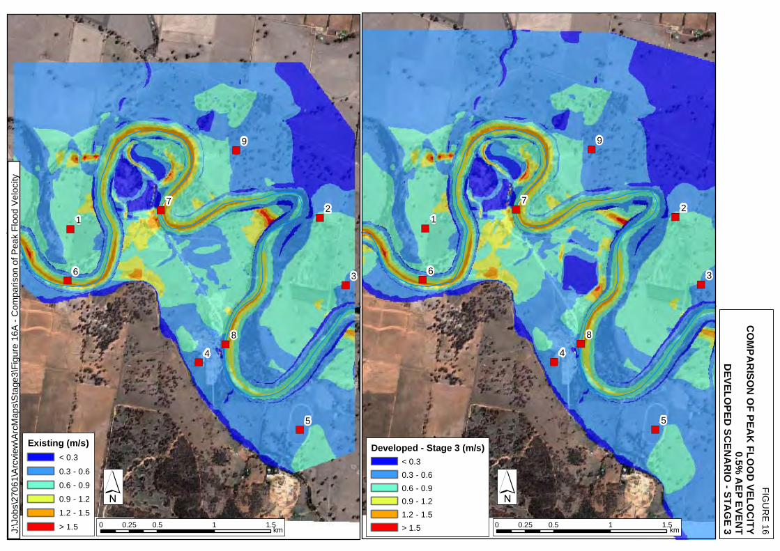
– Stage 3 Figure 16 Comparison of Peak Flood Velocity – 0.5% AEP Event – Developed
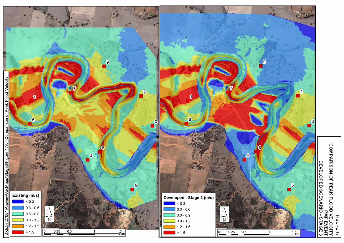
Scenario – Stage 3 Figure 17 Comparison of Peak Flood Velocity – PMF Event – Developed Scenario –
Stage 3 Figure 18 Level of Protection and Preliminary Spillway Locations Figure 19 Embankment Flood Profile – Developed Scenario – Stage 3 Figure 20 Scour Assessment
Wagga Wagga Quarry - Assessment of Hydraulic Impacts
WMAwater 27061 :Wagga_Quarry.docx:22 October 2009 1
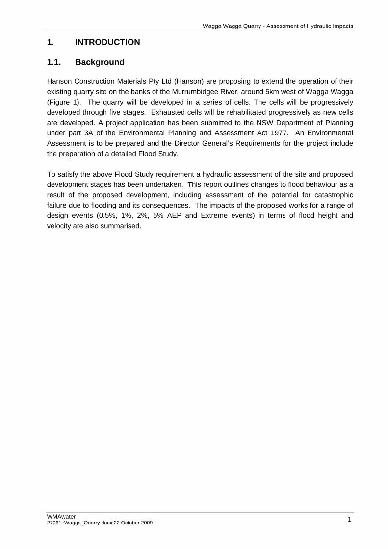
1. INTRODUCTION
1.1. Background
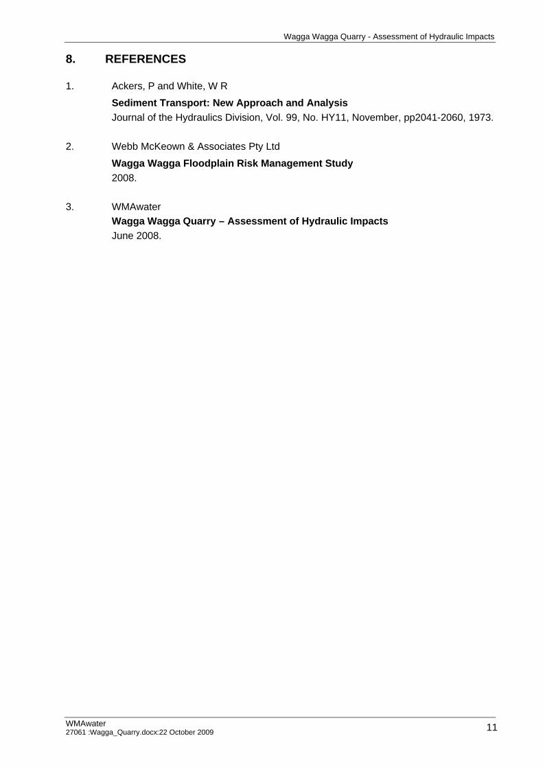
Hanson Construction Materials Pty Ltd (Hanson) are proposing to extend the operation of their existing quarry site on the banks of the Murrumbidgee River, around 5km west of Wagga Wagga (Figure 1). The quarry will be developed in a series of cells. The cells will be progressively developed through five stages. Exhausted cells will be rehabilitated progressively as new cells are developed. A project application has been submitted to the NSW Department of Planning under part 3A of the Environmental Planning and Assessment Act 1977. An Environmental Assessment is to be prepared and the Director General’s Requirements for the project include the preparation of a detailed Flood Study. To satisfy the above Flood Study requirement a hydraulic assessment of the site and proposed development stages has been undertaken. This report outlines changes to flood behaviour as a result of the proposed development, including assessment of the potential for catastrophic failure due to flooding and its consequences. The impacts of the proposed works for a range of design events (0.5%, 1%, 2%, 5% AEP and Extreme events) in terms of flood height and velocity are also summarised.
Wagga Wagga Quarry - Assessment of Hydraulic Impacts
WMAwater 27061 :Wagga_Quarry.docx:22 October 2009 2
2. DATA COLLECTION
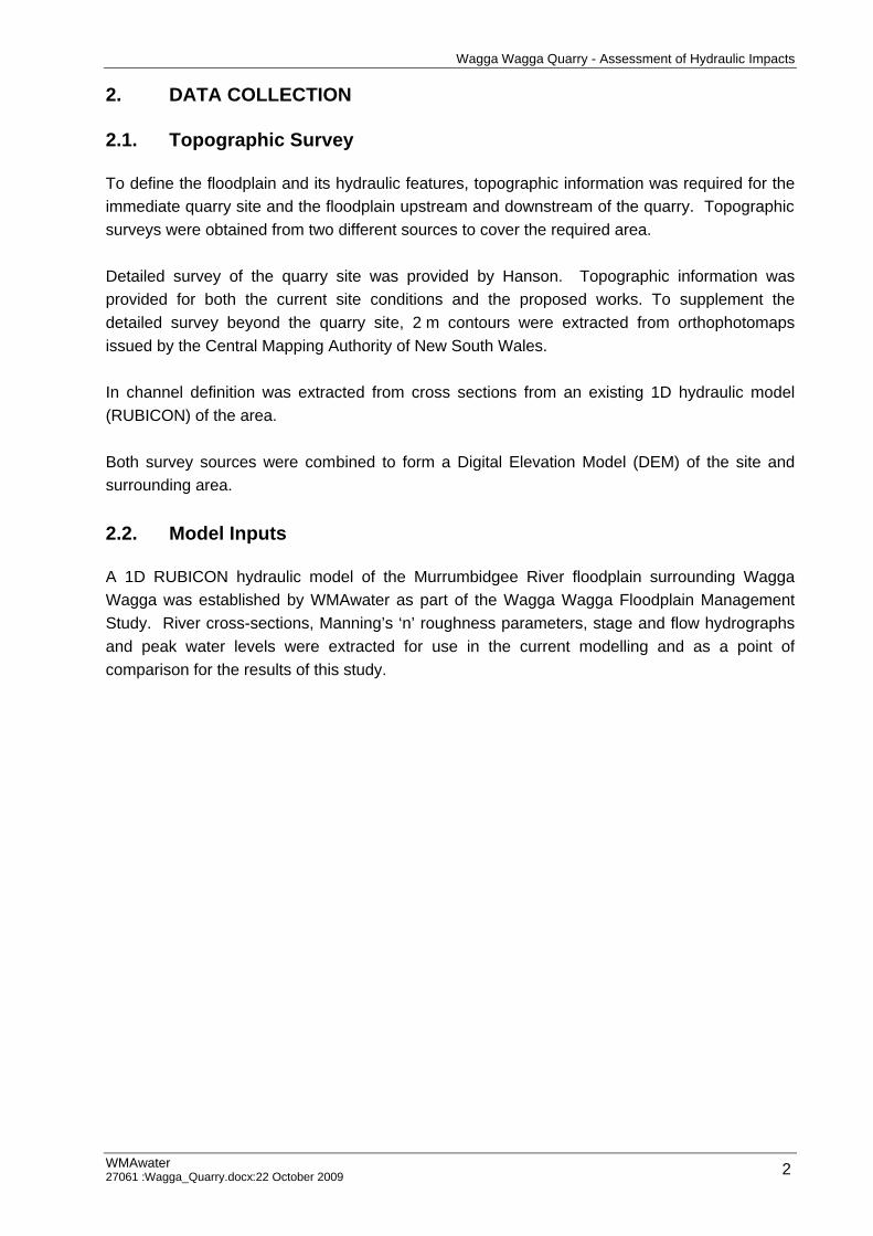
2.1. Topographic Survey
To define the floodplain and its hydraulic features, topographic information was required for the immediate quarry site and the floodplain upstream and downstream of the quarry. Topographic surveys were obtained from two different sources to cover the required area. Detailed survey of the quarry site was provided by Hanson. Topographic information was provided for both the current site conditions and the proposed works. To supplement the detailed survey beyond the quarry site, 2 m contours were extracted from orthophotomaps issued by the Central Mapping Authority of New South Wales. In channel definition was extracted from cross sections from an existing 1D hydraulic model (RUBICON) of the area. Both survey sources were combined to form a Digital Elevation Model (DEM) of the site and surrounding area. 2.2. Model Inputs
A 1D RUBICON hydraulic model of the Murrumbidgee River floodplain surrounding Wagga Wagga was established by WMAwater as part of the Wagga Wagga Floodplain Management Study. River cross-sections, Manning’s ‘n’ roughness parameters, stage and flow hydrographs and peak water levels were extracted for use in the current modelling and as a point of comparison for the results of this study.
Wagga Wagga Quarry - Assessment of Hydraulic Impacts
WMAwater 27061 :Wagga_Quarry.docx:22 October 2009 3
3. APPROACH ADOPTED
The key objective of this study was to determine the impact of the proposed works on flood behaviour. In order to achieve this, a 1D/2D hydraulic model (TUFLOW) of the study area was established. A scenario representing the current conditions at the site was initially established to determine the existing flood behaviour. The scenario provided a base case against which the impacts of the development scenario could be measured. The TUFLOW model was run for the 0.5%, 1%, 2%, 5% AEP and the PMF design events. A TUFLOW model was then established to represent the development at the site and was run for the same design events. A comparison of flood behaviour was made to determine the effect of the proposed development on flood behaviour. As the proposed quarry cells are to be located within a major river bend, the works increase the likelihood of the river short-circuiting the bend during a major flood event and severely scouring the study area. This risk was specifically addressed by applying Acker’s and White total bed load formulation to gauge the potential for scouring for the 1% AEP event.
Wagga Wagga Quarry - Assessment of Hydraulic Impacts
WMAwater 27061 :Wagga_Quarry.docx:22 October 2009 4
4. HYDRAULIC ANALYSIS
4.1. Hydraulic Modelling Approach
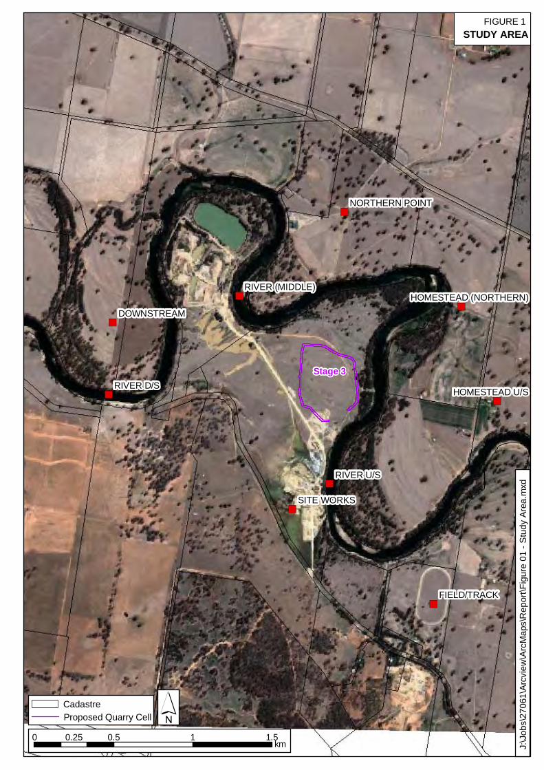
The Murrumbidgee River displays a complex pattern of flooding due to the expanse of the floodplain and the extent of inter-connection between the river and the floodplain overbank. The stretch of river at the proposed development is no exception. For this reason it is essential to select the best available technology for the modelling of flood behaviour. The selected hydraulic model must address the key characteristics of flood behaviour within the study area in an efficient and robust manner. In particular, the complex interactions between the main river, man-made works and overbank flows. Hydraulic models used to model flooding behaviours have been continually developed into more sophisticated and complex models. The application of a fully two-dimensional flow model allows an improved representation of both flow behaviour and the effects of flood storage in comparison to a one-dimensional model alone. A two-dimensional hydraulic model (TUFLOW) was established in the vicinity of the proposed quarry works to undertake a full assessment of the potential flood impacts. The TUFLOW modelling package includes a finite difference numerical model for the solution of the depth average shallow water flow equations in both one and two dimensions. TUFLOW is particularly suitable for applications at Wagga Wagga as it is capable of computing complex overland flow regimes (supercritical and subcritical) common in rural floodplain type situations. 4.2. Model Establishment
A 1D/2D TUFLOW hydraulic model was established to simulate the Murrumbidgee River, its floodplain and the interaction with Hanson’s existing and proposed site. A DEM of the study area was created from the available data. DEM’s were generated to represent the existing site as well as the proposed site details. To obtain a balance between topographic resolution and computational efficiency a 10 m grid spacing was used. To best represent the complex topography a combination of 1D and 2D domains were used. The 2D domain was used to represent the broader floodplain and overbank components. As the bathymetry of the river is not suitably represented by the adopted 10 m grid DEM, a 1D domain was therefore used to determine the conveyance of the river within the TUFLOW model. The 1D domain of the TUFLOW model utilised river cross sections from an existing 1D RUBICON model of the greater Murrumbidgee River floodplain.
Wagga Wagga Quarry - Assessment of Hydraulic Impacts
WMAwater 27061 :Wagga_Quarry.docx:22 October 2009 5
Input to the hydraulic model at the upstream boundary consisted of inflow hydrographs extracted from the existing 1D RUBICON model results. A staged discharge relationship for the downstream boundary was also based on the 1D RUBICON model results. The resistance to flood flow across the floodplain and down the river is accounted for within the hydraulic model by a coefficient of surface roughness referred to as Manning’s ‘n’. Stream and overbank Manning’s ‘n’ roughness parameters were based on those applied within the existing 1D RUBICON model and adjusted where required based on previous experience. 4.3. Model Verification
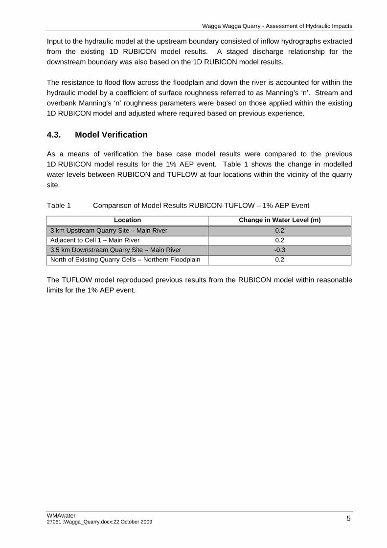
As a means of verification the base case model results were compared to the previous 1D RUBICON model results for the 1% AEP event. Table 1 shows the change in modelled water levels between RUBICON and TUFLOW at four locations within the vicinity of the quarry site. Table 1 Comparison of Model Results RUBICON-TUFLOW – 1% AEP Event
Location Change in Water Level (m) 3 km Upstream Quarry Site – Main River 0.2 Adjacent to Cell 1 – Main River 0.2 3.5 km Downstream Quarry Site – Main River -0.3 North of Existing Quarry Cells – Northern Floodplain 0.2
The TUFLOW model reproduced previous results from the RUBICON model within reasonable limits for the 1% AEP event.
Wagga Wagga Quarry - Assessment of Hydraulic Impacts
WMAwater 27061 :Wagga_Quarry.docx:22 October 2009 6
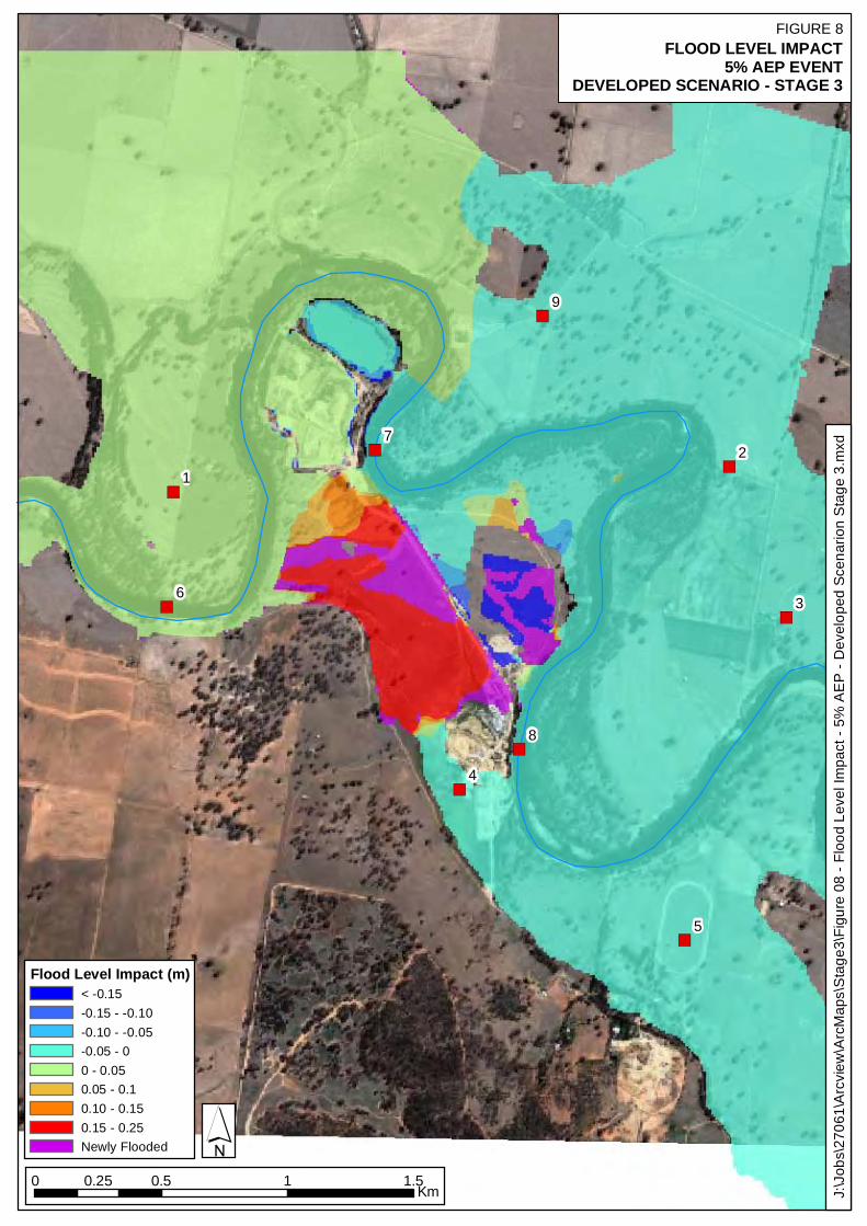
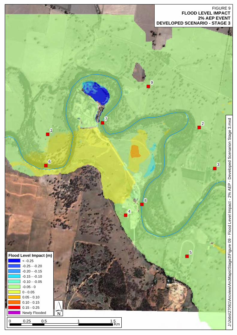
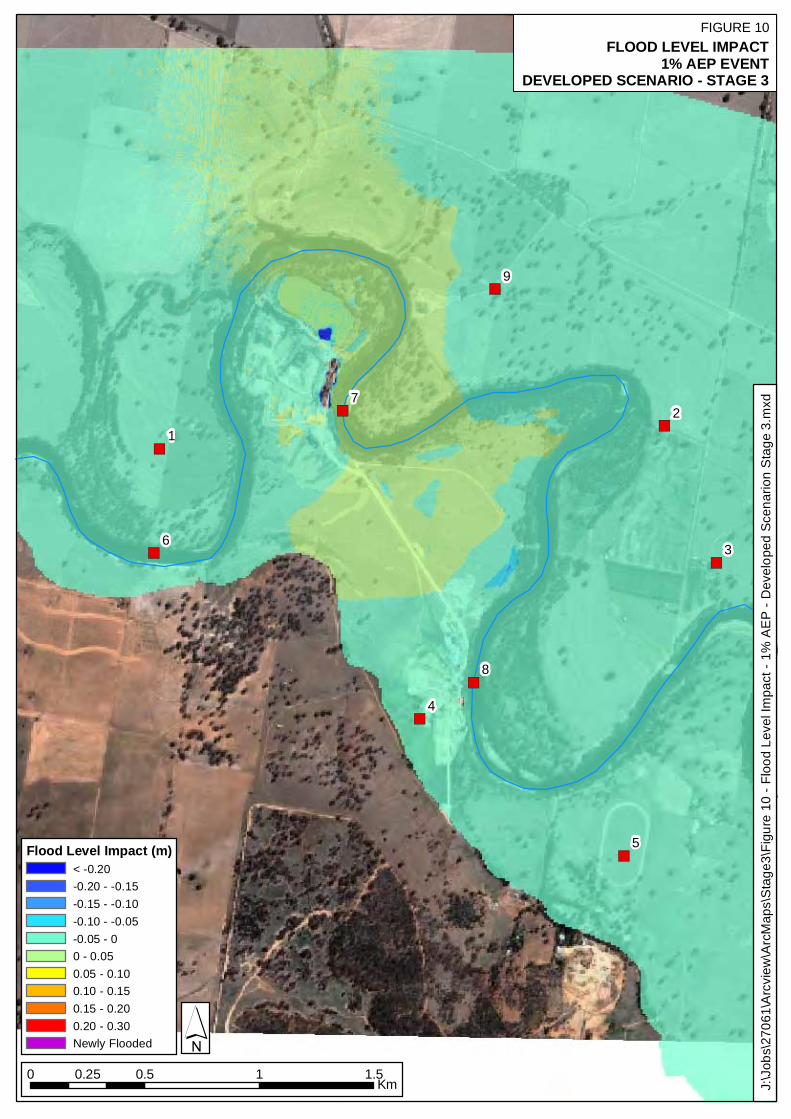
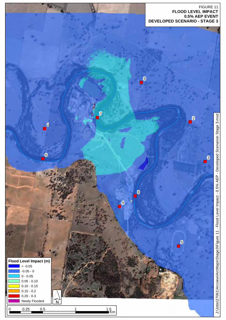
5. TUFLOW MODEL RESULTS
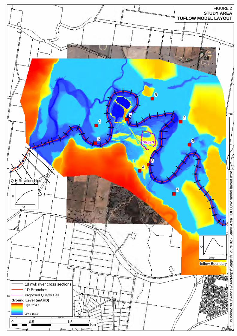
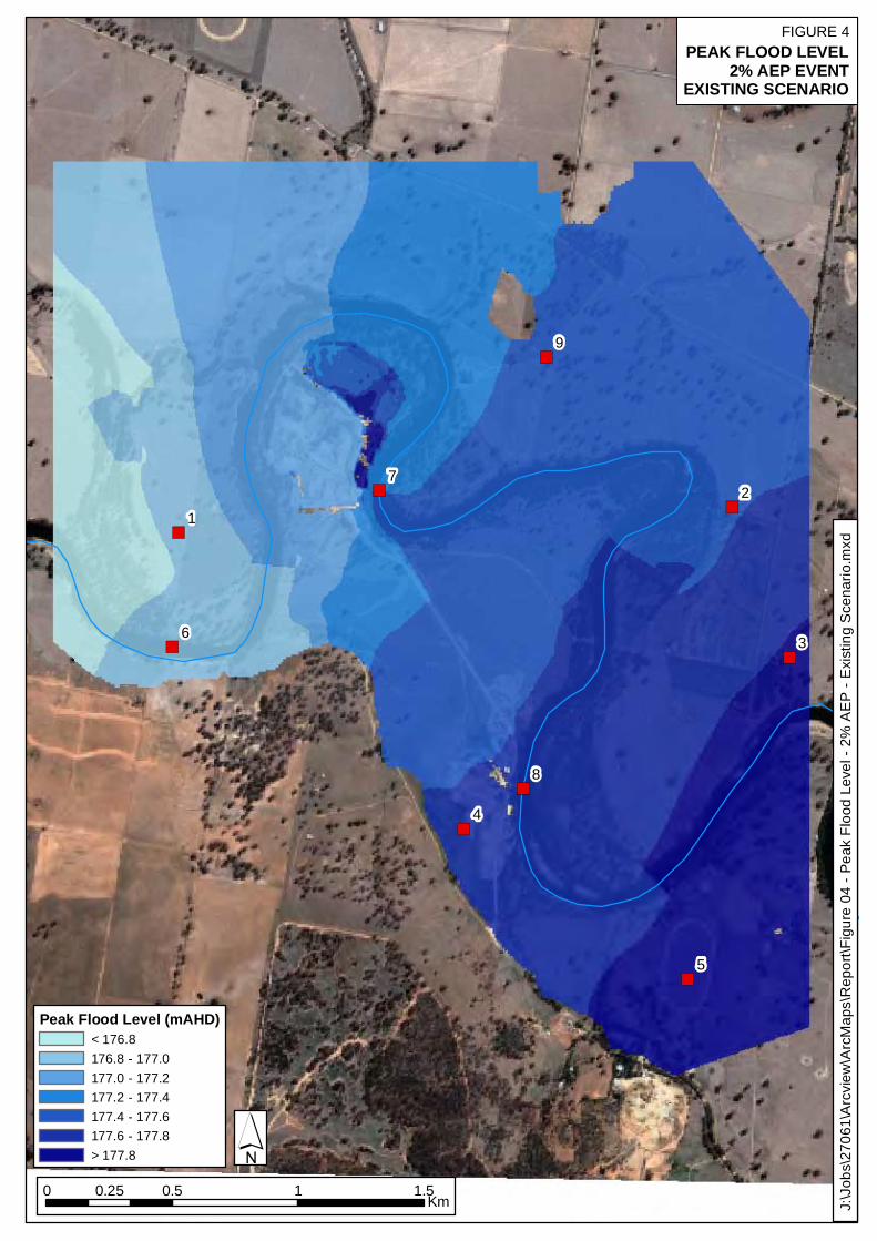
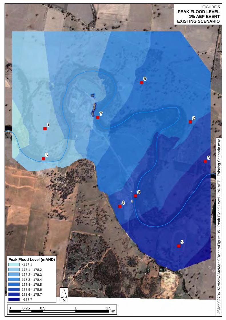
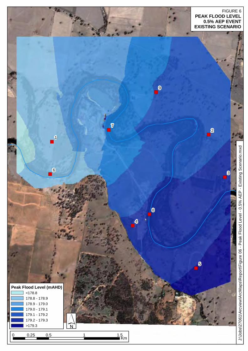
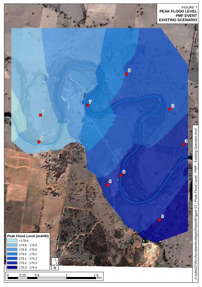
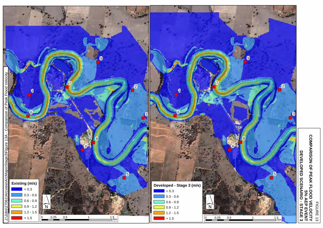
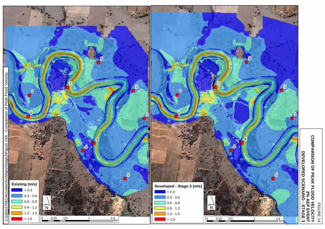
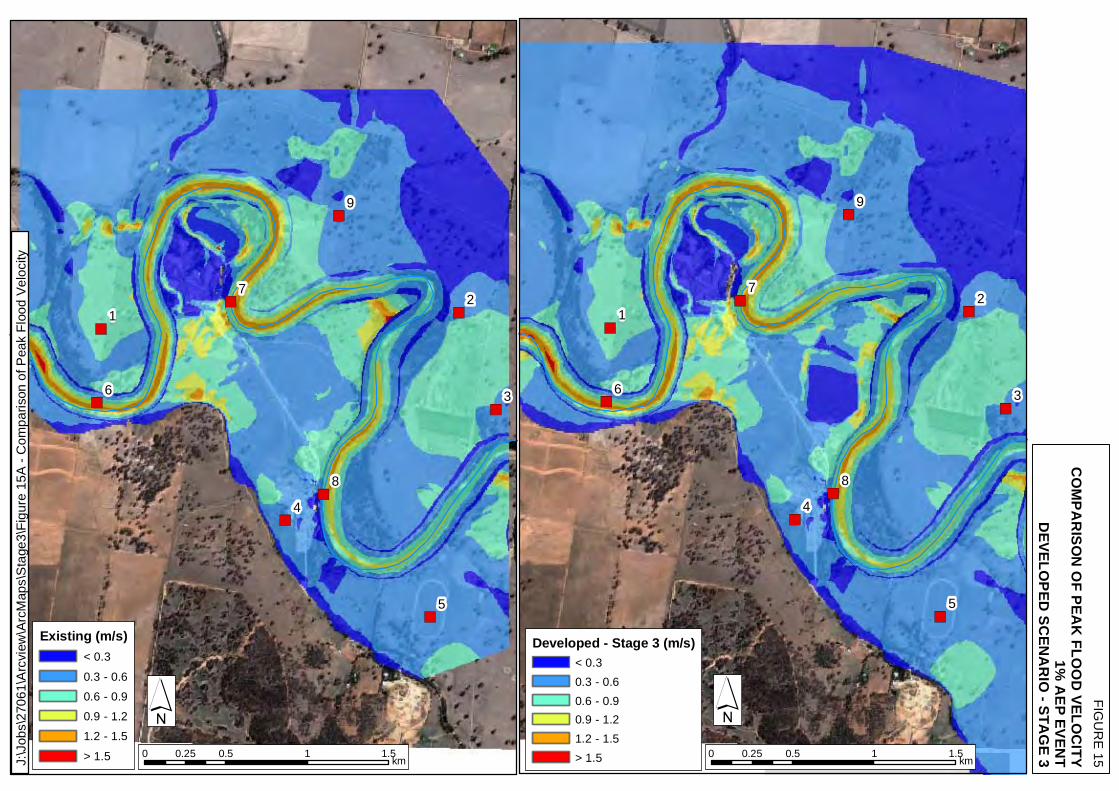
Flood conditions and flood impacts were specifically observed at the nine locations identified in Figure 1, these results are tabulated and referenced as appropriate. Broader scale flood behaviour and impacts are shown on Figure 3 through to Figure 17. 5.1. Existing Scenario
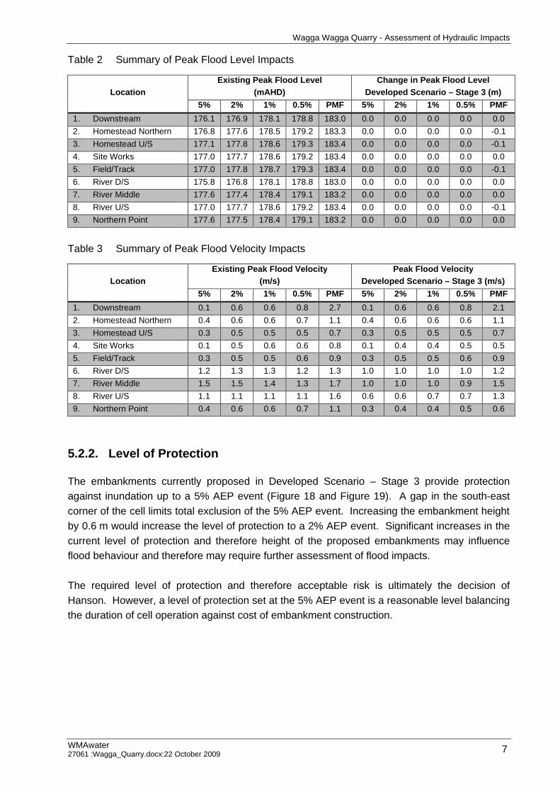
Table 2 and Table 3 summarise the flood level and velocity, respectively for the existing base case scenario for the 5%, 2%, 1% and 0.5% AEP and PMF events. A comparison against the Developed Scenario – Stage 3 is also provided in Table 2 and Table 3. Figure 3 through to Figure 7 show the peak flood levels for the same design events. The existing base case scenario results are essential as they provide a basis against which the impact of the modelled stages of development can be determined. 5.2. Developed Scenario – Stage 3
5.2.1. General
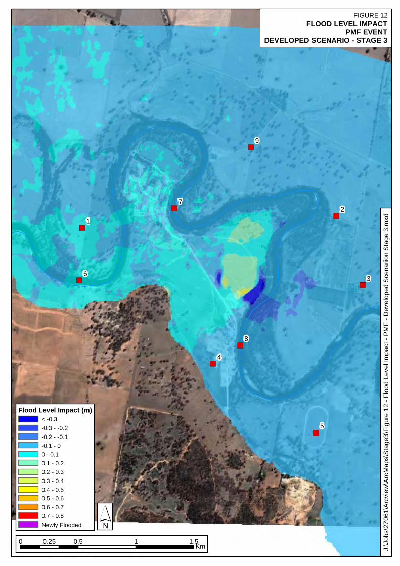
The quarry will be developed in a series of cells, progressively developed in five stages. Of the five development stages it was determined that Stage 3 would result in the most significant changes to flood behaviour, due to the location of the development embankments and their effect on flow redistribution. Stage 3 was therefore assessed for the full range of events. Table 2 and Table 3 summarise the changes in flood levels and velocities within the study area for the Developed Scenario – Stage 3. Figure 8 through to Figure 17 visually support these findings. As shown on Figure 12 the Developed Scenario – Stage 3 was shown to have a maximum impact on flood level of 0.5 m at the site works during the PMF event. The impact at this location is reduced to 0.2 m during the 5% AEP event and to less than 0.1 m during the other modelled events. Flood level impacts of 0.1 m or less were shown to occur elsewhere across the floodplain for all events modelled. Table 3 shows that the changes to peak flood velocity for the Developed Scenario – Stage 3 were typically minimal except during the PMF event.
Wagga Wagga Quarry - Assessment of Hydraulic Impacts
WMAwater 27061 :Wagga_Quarry.docx:22 October 2009 7
Table 2 Summary of Peak Flood Level Impacts
Location
Existing Peak Flood Level (mAHD)
Change in Peak Flood Level Developed Scenario – Stage 3 (m)
5% 2% 1% 0.5% PMF 5% 2% 1% 0.5% PMF 1. Downstream 176.1 176.9 178.1 178.8 183.0 0.0 0.0 0.0 0.0 0.0 2. Homestead Northern 176.8 177.6 178.5 179.2 183.3 0.0 0.0 0.0 0.0 -0.1 3. Homestead U/S 177.1 177.8 178.6 179.3 183.4 0.0 0.0 0.0 0.0 -0.1 4. Site Works 177.0 177.7 178.6 179.2 183.4 0.0 0.0 0.0 0.0 0.0 5. Field/Track 177.0 177.8 178.7 179.3 183.4 0.0 0.0 0.0 0.0 -0.1 6. River D/S 175.8 176.8 178.1 178.8 183.0 0.0 0.0 0.0 0.0 0.0 7. River Middle 177.6 177.4 178.4 179.1 183.2 0.0 0.0 0.0 0.0 0.0 8. River U/S 177.0 177.7 178.6 179.2 183.4 0.0 0.0 0.0 0.0 -0.1 9. Northern Point 177.6 177.5 178.4 179.1 183.2 0.0 0.0 0.0 0.0 0.0
Table 3 Summary of Peak Flood Velocity Impacts
Location
Existing Peak Flood Velocity (m/s)
Peak Flood Velocity Developed Scenario – Stage 3 (m/s)
5% 2% 1% 0.5% PMF 5% 2% 1% 0.5% PMF 1. Downstream 0.1 0.6 0.6 0.8 2.7 0.1 0.6 0.6 0.8 2.1 2. Homestead Northern 0.4 0.6 0.6 0.7 1.1 0.4 0.6 0.6 0.6 1.1 3. Homestead U/S 0.3 0.5 0.5 0.5 0.7 0.3 0.5 0.5 0.5 0.7 4. Site Works 0.1 0.5 0.6 0.6 0.8 0.1 0.4 0.4 0.5 0.5 5. Field/Track 0.3 0.5 0.5 0.6 0.9 0.3 0.5 0.5 0.6 0.9 6. River D/S 1.2 1.3 1.3 1.2 1.3 1.0 1.0 1.0 1.0 1.2 7. River Middle 1.5 1.5 1.4 1.3 1.7 1.0 1.0 1.0 0.9 1.5 8. River U/S 1.1 1.1 1.1 1.1 1.6 0.6 0.6 0.7 0.7 1.3 9. Northern Point 0.4 0.6 0.6 0.7 1.1 0.3 0.4 0.4 0.5 0.6
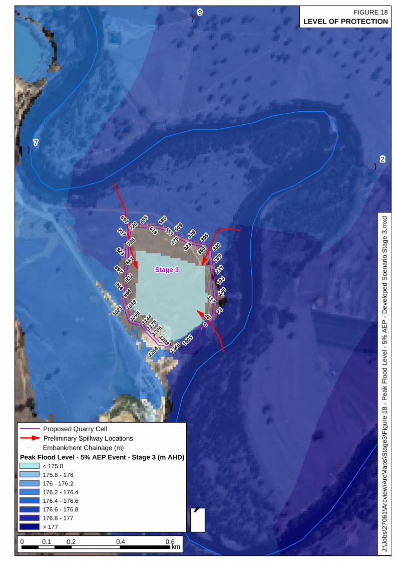
5.2.2. Level of Protection
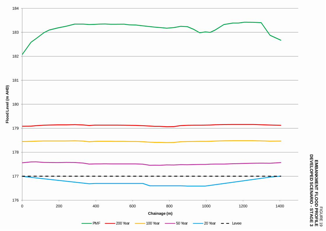
The embankments currently proposed in Developed Scenario – Stage 3 provide protection against inundation up to a 5% AEP event (Figure 18 and Figure 19). A gap in the south-east corner of the cell limits total exclusion of the 5% AEP event. Increasing the embankment height by 0.6 m would increase the level of protection to a 2% AEP event. Significant increases in the current level of protection and therefore height of the proposed embankments may influence flood behaviour and therefore may require further assessment of flood impacts. The required level of protection and therefore acceptable risk is ultimately the decision of Hanson. However, a level of protection set at the 5% AEP event is a reasonable level balancing the duration of cell operation against cost of embankment construction.
Wagga Wagga Quarry - Assessment of Hydraulic Impacts
WMAwater 27061 :Wagga_Quarry.docx:22 October 2009 8
5.2.3. Preliminary Spillway Locations
The inclusion of a designed spillway within the proposed embankments can reduce the amount of damage and erosion that could occur as a result of high velocities when the embankments are overtopped. The optimal inundation sequence is for initial backwater flooding to occur prior to overtopping of the upstream embankment. This enables the quarry cell to become filled prior to overtopping the upstream embankment. Ideally these would be structures designed to fail in a controlled manner during a flood event. Figure 18 shows the locations of three potential spillways, ideally one upstream and one downstream would be included within the embankment. A gap exists at the south-east corner of the embankment surrounding Stage 3. While not ideally placed in terms of flood behaviour this gap could be utilised as a spillway location. It is however essential that the downstream spillway be set at a level lower than this gap. A more optimal solution may be to include this gap on the north-west corner of the cell and utilise this location as the downstream spillway.
Wagga Wagga Quarry - Assessment of Hydraulic Impacts
WMAwater 27061 :Wagga_Quarry.docx:22 October 2009 9
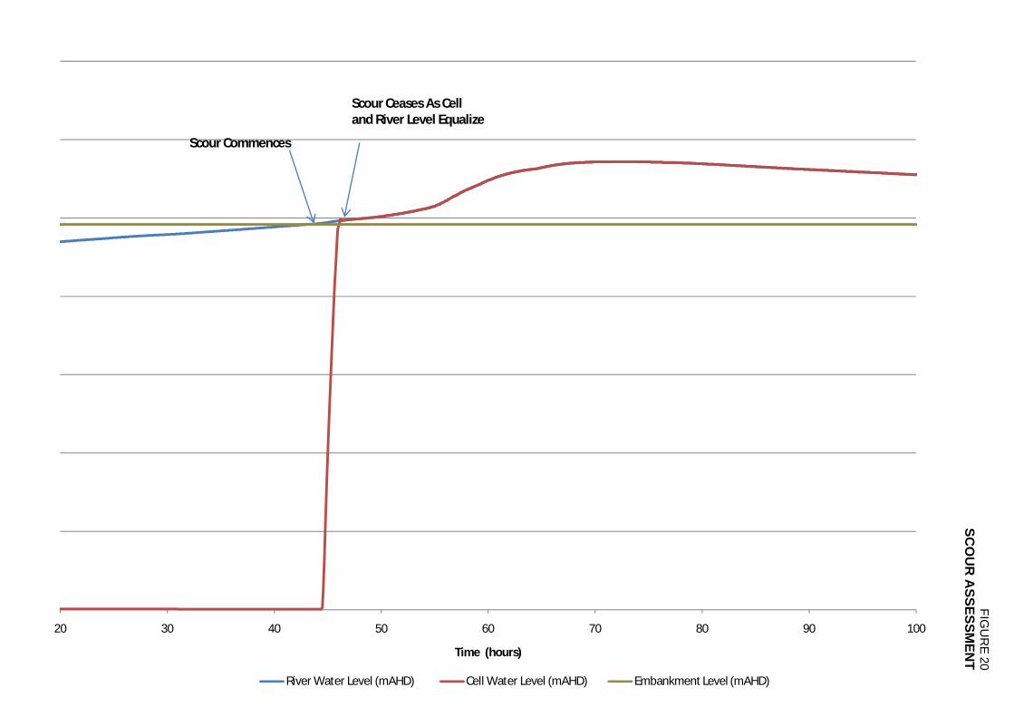
6. POTENTIAL FOR SCOUR ASSESSMENT
The location of the proposed quarry cells, within a major river bend, lends itself to potential scouring and short-circuiting during a major flood event. The Director General’s requirements for the Environmental Assessment included an assessment of potential for catastrophic failure. To specifically address this risk an assessment using Ackers and White’s total bed load formulation was applied for the 1% AEP event. Site soil properties and embankment dimensions were provided by Hanson. The assessment was undertaken on Cell 3 and it was assumed that the cell was empty at the commencement of flooding. The soil was assumed to be a fine sand with a specific gravity of 2.65 t/m3 and a D35 of 0.3 mm. The rate of erosion and scour is dependent on a number of factors including site conditions, soil properties, soil compaction, amount of disturbance, fracturing and velocity. The analysis of the rate of erosion based on the assumed soil properties and modelled velocities at the site shows a significant risk of erosion until the cell fills with flood water during the 1% AEP event (Figure 20). Due to the complex hydraulic behaviour and velocity generated from free overflow into the cell. A parameter sensitivity assessment was carried out where both the driving velocity and scour rate were doubled. The sensitivity assessment showed that the amount of scour is limited by the volume of the cell and the risk of scour exhausts itself once the cell fills. This reinforces that the cell should be filled long before the bank erosion occurs. This assessment also showed that controlled filling of the cell significantly reduces the risk of scour. The results of the assessment reinforce the ideal sequence of inundation where the cells initially fill by the slower backwater flooding thus minimising the potential for scour when the upstream embankment is overtopped.
Wagga Wagga Quarry - Assessment of Hydraulic Impacts
WMAwater 27061 :Wagga_Quarry.docx:22 October 2009 10
7. CONCLUSIONS
Of the five stages of quarry cell development, Stage 3 was determined to result in the greatest impact on flooding behaviour. Developed Scenario - Stage 3 causes the upstream water level to increase by up to 0.1 m for the 2%, 1% and 0.5% AEP events. A maximum modelled water level increase of 0.6 m is observed for the PMF event. For all modelled events the velocity increased by up to 0.1 m/s. The required level of protection and therefore acceptable risk is ultimately the decision of Hanson. However, a level of protection set at the 5% AEP event is a reasonable level balancing the duration of cell operation against cost of embankment construction. The current embankment design for Developed Scenario - Stage 3 provides protection against inundation during the 5% AEP event. The final embankment design should include a provision for a controlled spillway to minimise damage during a flood event. The relocation of the embankment gap in the south-east corner to the north-east corner may provide a solution for the inclusion of a downstream spillway. The Ackers and White scour assessment showed that for Cell 3 there is a significant risk of scour during the 1% AEP event until the cell fills with flood water. The potential damage resulting from overtopping can be minimised by ensuring the cells are initially inundated by backwater flooding and are full prior to the upstream embankment overtopping.
Wagga Wagga Quarry - Assessment of Hydraulic Impacts
WMAwater 27061 :Wagga_Quarry.docx:22 October 2009 11
8. REFERENCES
1. Ackers, P and White, W R
Sediment Transport: New Approach and Analysis Journal of the Hydraulics Division, Vol. 99, No. HY11, November, pp2041-2060, 1973. 2. Webb McKeown & Associates Pty Ltd
Wagga Wagga Floodplain Risk Management Study 2008. 3. WMAwater Wagga Wagga Quarry – Assessment of Hydraulic Impacts June 2008.

")
")
")
")
")
")
")
")
")
RIVER U/S
RIVER D/S
DOWNSTREAM
SITE WORKS
FIELD/TRACK
HOMESTEAD U/S
RIVER (MIDDLE)
NORTHERN POINT
HOMESTEAD (NORTHERN)
CadastreProposed Quarry Cell
0 0.5 1 1.50.25km
´
FIGURE 1STUDY AREA
J:\J
obs\
2706
1\Ar
cvie
w\A
rcM
aps\
Rep
ort\F
igur
e 01
- S
tudy
Are
a.m
xd
Stage 3
")
")
")
")
")
")
")
")
")1
7
9
2
3
8
5
4
6
1d nwk river cross sections1D BranchesProposed Quarry Cell
Ground Level (mAHD)High : 284.7 Low : 157.0
0 0.5 1 1.5 2Km
´
Q
time
Inflow Boundary
H
Q
Q-H Relationships
Stage 3
J:\J
obs\
2706
1\A
rcvi
ew\A
rcM
aps\
Sta
ge3\
Figu
re 0
2 - S
tudy
Are
a TU
FLO
W m
odel
layo
ut.m
xd
FIGURE 2STUDY AREA
TUFLOW MODEL LAYOUT
")
")
")
")
")
")
")
")
")1
7
9
2
3
8
5
4
6
Peak Flood Level (mAHD)< 175.8175.8 - 176.0176.0 - 176.2176.2 - 176.4176.4 - 176.6176.6 - 176.8176.8 - 177.0177.0 - 177.2177.2 - 177.4> 177.4
0 0.25 0.5 0.75 1Km
´
J:\J
obs\
2706
1\A
rcvi
ew\A
rcM
aps\
Rep
ort\F
igur
e 03
- Pe
ak F
lood
Lev
el -
5% A
EP
- Exi
stin
g S
cena
rio.m
xd
FIGURE 3PEAK FLOOD LEVEL
5% AEP EVENTEXISTING SCENARIO
")
")
")
")
")
")
")
")
")1
7
9
2
3
8
5
4
6
Peak Flood Level (mAHD)< 176.8176.8 - 177.0177.0 - 177.2177.2 - 177.4177.4 - 177.6177.6 - 177.8> 177.8
0 0.5 1 1.50.25Km
´
J:\J
obs\
2706
1\A
rcvi
ew\A
rcM
aps\
Rep
ort\F
igur
e 04
- Pe
ak F
lood
Lev
el -
2% A
EP
- E
xist
ing
Sce
nario
.mxd
FIGURE 4PEAK FLOOD LEVEL
2% AEP EVENTEXISTING SCENARIO
")
")
")
")
")
")
")
")
")1
7
9
2
3
8
5
4
6
Peak Flood Level (mAHD)<178.1178.1 - 178.2178.2 - 178.3178.3 - 178.4178.4 - 178.5178.5 - 178.6178.6 - 178.7>178.7
0 0.5 1 1.50.25Km
´
J:\J
obs\
2706
1\Ar
cvie
w\A
rcM
aps\
Rep
ort\F
igur
e 05
- P
eak
Floo
d Le
vel -
1%
AE
P -
Exis
ting
Sce
nario
.mxd
FIGURE 5PEAK FLOOD LEVEL
1% AEP EVENTEXISTING SCENARIO
")
")
")
")
")
")
")
")
")1
7
9
2
3
8
5
4
6
Peak Flood Level (mAHD)<178.8178.8 - 178.9178.9 - 179.0179.0 - 179.1179.1 - 179.2179.2 - 179.3>179.3
0 0.5 1 1.50.25Km
´
J:\J
obs\
2706
1\Ar
cvie
w\A
rcM
aps\
Rep
ort\F
igur
e 06
- P
eak
Floo
d Le
vel -
0.5
% A
EP -
Exi
stin
g S
cena
rio.m
xd
FIGURE 6PEAK FLOOD LEVEL
0.5% AEP EVENTEXISTING SCENARIO
")
")
")
")
")
")
")
")
")1
7
9
2
3
8
5
4
6
Peak Flood Level (mAHD)<178.8178.8 - 178.9178.9 - 179.0179.0 - 179.1179.1 - 179.2179.2 - 179.3179.3 - 179.4
0 0.5 1 1.50.25Km
FIGURE 7PEAK FLOOD LEVEL
PMF EVENTEXISTING SCENARIO
´
J:\J
obs\
2706
1\Ar
cvie
w\A
rcM
aps\
Rep
ort\F
igur
e 07
- P
eak
Floo
d Le
vel -
PM
F - E
xist
ing
Sce
nario
.mxd
")
")
")
")
")
")
")
")
")1
7
9
2
3
8
5
4
6
Flood Level Impact (m)< -0.15-0.15 - -0.10-0.10 - -0.05-0.05 - 00 - 0.050.05 - 0.10.10 - 0.150.15 - 0.25Newly Flooded
0 0.5 1 1.50.25Km
´
FIGURE 8FLOOD LEVEL IMPACT
5% AEP EVENTDEVELOPED SCENARIO - STAGE 3
J:\J
obs\
2706
1\A
rcvi
ew\A
rcM
aps\
Sta
ge3\
Figu
re 0
8 - F
lood
Lev
el Im
pact
- 5%
AE
P -
Dev
elop
ed S
cena
rion
Sta
ge 3
.mxd
")
")
")
")
")
")
")
")
")1
7
9
2
3
8
5
4
6
Flood Level Impact (m)< -0.25-0.25 - -0.20-0.20 - -0.15-0.15 - -0.10-0.10 - -0.05-0.05 - 00 - 0.050.05 - 0.100.10 - 0.150.15 - 0.25Newly Flooded
0 0.5 1 1.50.25Km
´
FIGURE 9FLOOD LEVEL IMPACT
2% AEP EVENTDEVELOPED SCENARIO - STAGE 3
J:\J
obs\
2706
1\A
rcvi
ew\A
rcM
aps\
Sta
ge3\
Figu
re 0
9 - F
lood
Lev
el Im
pact
- 2%
AE
P -
Dev
elop
ed S
cena
rion
Sta
ge 3
.mxd
")
")
")
")
")
")
")
")
")1
7
9
2
3
8
5
4
6
Flood Level Impact (m)< -0.20-0.20 - -0.15-0.15 - -0.10-0.10 - -0.05-0.05 - 00 - 0.050.05 - 0.100.10 - 0.150.15 - 0.200.20 - 0.30Newly Flooded
0 0.5 1 1.50.25Km
´
FIGURE 10FLOOD LEVEL IMPACT
1% AEP EVENTDEVELOPED SCENARIO - STAGE 3
J:\J
obs\
2706
1\A
rcvi
ew\A
rcM
aps\
Sta
ge3\
Figu
re 1
0 - F
lood
Lev
el Im
pact
- 1%
AE
P -
Dev
elop
ed S
cena
rion
Sta
ge 3
.mxd
")
")
")
")
")
")
")
")
")1
7
9
2
3
8
5
4
6
Flood Level Impact (m)< -0.05-0.05 - 00 - 0.050.05 - 0.100.10 - 0.150.15 - 0.20.20 - 0.3Newly Flooded
0 0.5 1 1.50.25Km
´
J:\J
obs\
2706
1\Ar
cvie
w\A
rcM
aps\
Sta
ge3\
Figu
re 1
1 - F
lood
Lev
el Im
pact
- 0.
5% A
EP -
Dev
elop
ed S
cena
rion
Stag
e 3.
mxd
FIGURE 11FLOOD LEVEL IMPACT
0.5% AEP EVENTDEVELOPED SCENARIO - STAGE 3
")
")
")
")
")
")
")
")
")1
7
9
2
3
8
5
4
6
Flood Level Impact (m)< -0.3-0.3 - -0.2-0.2 - -0.1-0.1 - 00 - 0.10.1 - 0.20.2 - 0.30.3 - 0.40.4 - 0.50.5 - 0.60.6 - 0.70.7 - 0.8Newly Flooded
0 0.5 1 1.50.25Km
´
FIGURE 12FLOOD LEVEL IMPACT
PMF EVENTDEVELOPED SCENARIO - STAGE 3
J:\J
obs\
2706
1\A
rcvi
ew\A
rcM
aps\
Stag
e3\F
igur
e 12
- Fl
ood
Leve
l Im
pact
- P
MF
- Dev
elop
ed S
cena
rion
Stag
e 3.
mxd
")
")
")
")
")
")
")
")
")1
7
9
2
3
8
5
4
6")
")
")
")
")
")
")
")
")1
7
9
2
3
8
5
4
6
0 0.5 1 1.50.25km
0 0.5 1 1.50.25km
FIGU
RE 13
CO
MPA
RISO
N O
F PEAK
FLOO
D VELO
CITY
5% A
EP EVENT
DEVELO
PED SC
ENA
RIO
- STAG
E 3
´ ´Developed - Stage 3 (m/s)
< 0.30.3 - 0.60.6 - 0.90.9 - 1.21.2 - 1.5> 1.5
Existing (m/s)< 0.3
0.3 - 0.6
0.6 - 0.9
0.9 - 1.2
1.2 - 1.5
> 1.5J:\J
obs\
2706
1\A
rcvi
ew\A
rcM
aps\
Sta
ge3\
Figu
re 1
3A -
Com
paris
on o
f Pea
k Fl
ood
Velo
city
")
")
")
")
")
")
")
")
")1
7
9
2
3
8
5
4
6")
")
")
")
")
")
")
")
")1
7
9
2
3
8
5
4
6
0 0.5 1 1.50.25km
0 0.5 1 1.50.25km
FIGU
RE 14
CO
MPA
RISO
N O
F PEAK
FLOO
D VELO
CITY
2% A
EP EVENT
DEVELO
PED SC
ENA
RIO
- STAG
E 3
´ ´Developed - Stage 3 (m/s)
< 0.30.3 - 0.60.6 - 0.90.9 - 1.21.2 - 1.5> 1.5
Existing (m/s)< 0.3
0.3 - 0.6
0.6 - 0.9
0.9 - 1.2
1.2 - 1.5
> 1.5J:\J
obs\
2706
1\A
rcvi
ew\A
rcM
aps\
Sta
ge3\
Figu
re 1
4A -
Com
paris
on o
f Pea
k Fl
ood
Velo
city
")
")
")
")
")
")
")
")
")1
7
9
2
3
8
5
4
6")
")
")
")
")
")
")
")
")1
7
9
2
3
8
5
4
6
0 0.5 1 1.50.25km
0 0.5 1 1.50.25km
FIGU
RE 15
CO
MPA
RISO
N O
F PEAK
FLOO
D VELO
CITY
1% A
EP EVENT
DEVELO
PED SC
ENA
RIO
- STAG
E 3
´ ´Developed - Stage 3 (m/s)
< 0.30.3 - 0.60.6 - 0.90.9 - 1.21.2 - 1.5> 1.5
Existing (m/s)< 0.3
0.3 - 0.6
0.6 - 0.9
0.9 - 1.2
1.2 - 1.5
> 1.5J:\J
obs\
2706
1\A
rcvi
ew\A
rcM
aps\
Sta
ge3\
Figu
re 1
5A -
Com
paris
on o
f Pea
k Fl
ood
Velo
city
")
")
")
")
")
")
")
")
")1
7
9
2
3
8
5
4
6")
")
")
")
")
")
")
")
")1
7
9
2
3
8
5
4
6
0 0.5 1 1.50.25km
0 0.5 1 1.50.25km
FIGU
RE 16
CO
MPA
RISO
N O
F PEAK
FLOO
D VELO
CITY
0.5% A
EP EVENT
DEVELO
PED SC
ENA
RIO
- STAG
E 3
´ ´Developed - Stage 3 (m/s)
< 0.30.3 - 0.60.6 - 0.90.9 - 1.21.2 - 1.5> 1.5
Existing (m/s)< 0.3
0.3 - 0.6
0.6 - 0.9
0.9 - 1.2
1.2 - 1.5
> 1.5J:\J
obs\
2706
1\A
rcvi
ew\A
rcM
aps\
Sta
ge3\
Figu
re 1
6A -
Com
paris
on o
f Pea
k Fl
ood
Velo
city
�)
�)
�)
�)
�)
�)
�)
�)
�)
1
7
9
2
3
8
5
4
6
�)
�)
�)
�)
�)
�)
�)
�)
�)
1
7
9
2
3
8
5
4
6
0 0.5 1 1.50.25km
0 0.5 1 1.50.25km
FIG
UR
E 1
7
CO
MP
AR
ISO
N O
F P
EA
K F
LO
OD
VE
LO
CIT
Y
PM
F E
VE
NT
DE
VE
LO
PE
D S
CE
NA
RIO
- ST
AG
E 3
� �
Developed - Stage 3 (m/s)
< 0.3
0.3 - 0.6
0.6 - 0.9
0.9 - 1.2
1.2 - 1.5
> 1.5
Existing (m/s)
< 0.3
0.3 - 0.6
0.6 - 0.9
0.9 - 1.2
1.2 - 1.5
> 1.5J:\
Job
s\2
70
61
\Arc
vie
w\A
rcM
ap
s\S
tage
3\F
igu
re 1
7A
- C
om
pa
rison
of
Pea
k F
loo
d V
elo
city
")
")
")
")
")
!
!
!
!
!
!
!
!
!
!!!
!!
!
!!!!!
!
!
!
!
!
!
!
!
!
!
!
!!
!
!
! !!
!
7
9
2
8
4
0
7448
994
96493
1
89786
1
82378
5
74772
0693 65
5618
580
553 509
479 44
9
423
395
364 33
0
285
239
194
148
117
1405
1346
1298
1254
120611
75114410
9510
48
1021
Proposed Quarry CellPreliminary Spillway Locations
! Embankment Chainage (m)Peak Flood Level - 5% AEP Event - Stage 3 (m AHD)
< 175.8175.8 - 176176 - 176.2176.2 - 176.4176.4 - 176.6176.6 - 176.8176.8 - 177> 177
0 0.2 0.4 0.60.1km
´
FIGURE 18LEVEL OF PROTECTION
Stage 3
J:\J
obs\
2706
1\Ar
cvie
w\A
rcM
aps\
Stag
e3\F
igur
e 18
- Pe
ak F
lood
Lev
el -
5% A
EP
- Dev
elop
ed S
cena
rio S
tage
3.m
xd
176
177
178
179
180
181
182
183
184
0 200 400 600 800 1000 1200 1400
Floo
d Le
vel (
m A
HD
)
Chainage (m)
PMF 200 Year 100 Year 50 Year 20 Year Levee
FIGU
RE
19EM
BAN
KM
EN
T FLOO
D PR
OFILE
DEVELO
PED SC
ENAR
IO -STAG
E 3
20 30 40 50 60 70 80 90 100
Time (hours)
FIGU
RE
20SC
OU
R A
SSESSMEN
T
River Water Level (mAHD) Cell Water Level (mAHD) Embankment Level (mAHD)
Scour Commences
Scour Ceases As Cell and River Level Equalize
GEOFF CUNNINGHAM NATURAL RESOURCE CONSULTANTS PTY LTD
Flora Study of the Proposed Extension to the Hanson Wagga Wagga Sand Quarry –February, 2009
1
Flora Study of the Lands Within the
Proposed Extension to the Hanson Wagga
Wagga Sand Quarry
Prepared for: Hanson Construction Materials Pty Ltd Level 5, 75 George Street, PARRAMATTA NSW 2150 By: Geoff Cunningham Natural Resource Consultants Pty Ltd,
9 The Crest KILLARA NSW 2071 [ACN 058 178 493] Telephone: 02 9416 1995 Fax: 02 9416 6626 Email: geoffcun @ bigpond.net.au
February, 2009
GEOFF CUNNINGHAM NATURAL RESOURCE CONSULTANTS PTY LTD
Flora Study of the Proposed Extension to the Hanson Wagga Wagga Sand Quarry –February, 2009
2
COPYRIGHT
This Copyright Is Included For The Protection Of This Document.
© Geoff Cunningham Natural Resource Consultants Pty. Ltd. 2009
All intellectual property and copyright reserved. Apart from any fair dealing for the purpose of private study, research, criticism or review, as permitted under the Copyright Act, 1968, no part of this report may be reproduced, transmitted, stored in a retrieval system or adapted in any form or by any means [electronic, mechanical, photocopying, recording or otherwise] without written permission. Enquiries should be addressed to Geoff Cunningham Natural Resource Consultants Pty. Ltd.
GEOFF CUNNINGHAM NATURAL RESOURCE CONSULTANTS PTY LTD
Flora Study of the Proposed Extension to the Hanson Wagga Wagga Sand Quarry –February, 2009
3
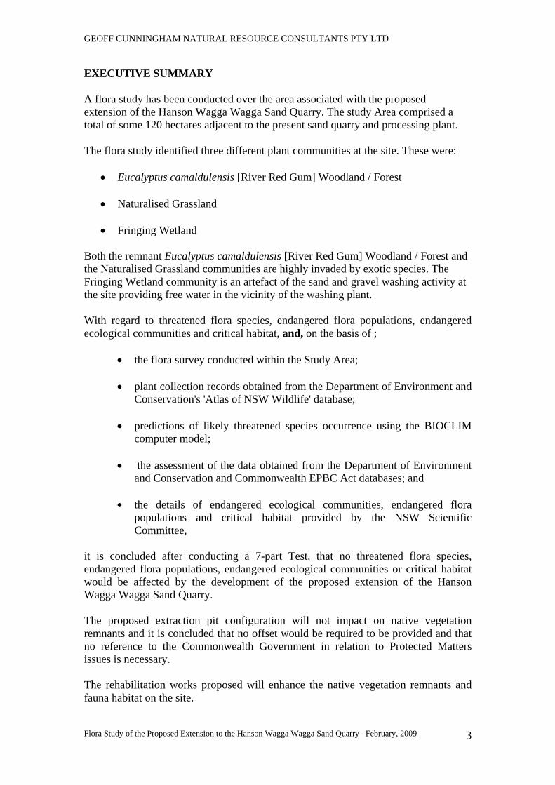
EXECUTIVE SUMMARY A flora study has been conducted over the area associated with the proposed extension of the Hanson Wagga Wagga Sand Quarry. The study Area comprised a total of some 120 hectares adjacent to the present sand quarry and processing plant. The flora study identified three different plant communities at the site. These were:
• Eucalyptus camaldulensis [River Red Gum] Woodland / Forest
• Naturalised Grassland
• Fringing Wetland Both the remnant Eucalyptus camaldulensis [River Red Gum] Woodland / Forest and the Naturalised Grassland communities are highly invaded by exotic species. The Fringing Wetland community is an artefact of the sand and gravel washing activity at the site providing free water in the vicinity of the washing plant. With regard to threatened flora species, endangered flora populations, endangered ecological communities and critical habitat, and, on the basis of ;
• the flora survey conducted within the Study Area; • plant collection records obtained from the Department of Environment and
Conservation's 'Atlas of NSW Wildlife' database; • predictions of likely threatened species occurrence using the BIOCLIM
computer model; • the assessment of the data obtained from the Department of Environment
and Conservation and Commonwealth EPBC Act databases; and
• the details of endangered ecological communities, endangered flora populations and critical habitat provided by the NSW Scientific Committee,
it is concluded after conducting a 7-part Test, that no threatened flora species, endangered flora populations, endangered ecological communities or critical habitat would be affected by the development of the proposed extension of the Hanson Wagga Wagga Sand Quarry. The proposed extraction pit configuration will not impact on native vegetation remnants and it is concluded that no offset would be required to be provided and that no reference to the Commonwealth Government in relation to Protected Matters issues is necessary. The rehabilitation works proposed will enhance the native vegetation remnants and fauna habitat on the site.
GEOFF CUNNINGHAM NATURAL RESOURCE CONSULTANTS PTY LTD
Flora Study of the Proposed Extension to the Hanson Wagga Wagga Sand Quarry –February, 2009
4
Flora Study of the Lands Within the Proposed Extension to the Hanson Wagga Wagga Sand
Quarry
1 INTRODUCTION This flora study has been carried out on behalf of Hanson Construction Materials Pty Ltd [the Proponent] for use in the preparation of an environmental assessment of a proposal to extend the existing sand quarry located to the west of the City of Wagga Wagga. 2 DESCRIPTION OF THE STUDY AREA The Study Area comprises some 120 hectares of level land at the site of the present Hanson Wagga Wagga sand quarry and processing plant. The Study Area is bordered by the Murrumbidgee River in the north and by a wetland and drainage line in the south. The current sand quarry lies to the west and the materials processing facilities are located to the east. The Proponent proposes that the area to be disturbed for sand extraction would at all times be outside a 100 metre buffer zone measured from the bank of the Murrumbidgee River. The Study Area is shown in Figure 1.
3 SURVEY METHODOLOGY Prior to field survey the Study Area was viewed stereoscopically using 1: 16,000 scale colour airphotos. The photos used [Wagga Wagga Run 2, Prints 26 and 27; Run 3, Prints 157 and 58] were flown in March, 2001 by Land and Property Information [NSW Government]. Stereoscopic interpretation of the photographs provided a good basis for identifying field sampling sites prior to the actual field visit. The vegetation within the Study Area was sampled at 21 sites. Quadrats 20m x 20m in area were sampled at each site. The quadrat locations are shown in Figure 1. The tree and shrub species recorded for each quadrat are listed in Table 1 while the ground layer species are shown in Table 2.
GEOFF CUNNINGHAM NATURAL RESOURCE CONSULTANTS PTY LTD
Flora Study of the Proposed Extension to the Hanson Wagga Wagga Sand Quarry –February, 2009
5
4 PREVIOUS VEGETATION STUDIES
4.1 Vegetation of the South-eastern Riverina [Moore, 1953] The Study Area lies within the broad area mapped by Moore [1953]. Moore identified three vegetation communities within the vicinity of the Study Area. These were
• Eucalyptus camaldulensis [River Red Gum] Alliance [Community];
• Eucalyptus woollsiana [now Eucalyptus microcarpa] [Grey Box] Alliance [Community[; and
• Eucalyptus albens [White Box] Alliance [Community].
The Eucalyptus albens [White Box] Alliance [Community] is located primarily on the ridge country to the south of the Study Area but a single White Box tree was recorded during field inspection of the level country that comprises most of the area inspected. Details of these communities are provided in Sections 4.1.1, 4.1.2 and 4.1.3. 4.1.1 Eucalyptus camaldulensis [River Red Gum] Alliance [Community] The only native tree species noted by Moore [1953] to occur in this community is Eucalyptus camaldulensis [River Red Gum] and the only recorded shrub is Acacia DECCurrens [Green Wattle]. Ground cover species noted within this community by Moore is dominated by introduced species including Hordeum leporinum* [Barley Grass], Bromus diandrus* [Great Brome], Bromus molliformis* [Silky Brome], Vulpia bromoides* Squirrel Tail Fescue], Trifolium glomeratum* [Cluster Clover], Medicago polymorpha* [Burr Medic] and Erodium moschatum* [Musky Crowfoot]. Native ground cover species include Austrodanthonia spp. [Wallaby Grasses] and Amphibromus neesii [Swamp Wallaby Grass] [in swampy areas]. 4.1.2 Eucalyptus woollsiana [now Eucalyptus microcarpa] [Grey Box] Alliance [Community] This community varies through the Riverina region and the exact nature and composition of the community within the Study Area prior to clearing is unknown. It is likely that Eucalyptus microcarpa [Grey Box] would have dominated the community and that Eucalyptus melliodora [Yellow Box] and possibly Callitris glaucophylla [White Cypress Pine] would have been present – the latter rarely so. Shrubs recorded in this community include Acacia buxifolia [Box-leaf Wattle] and Dodonaea viscosa subsp. cuneata [Wedge-leaf Hopbush]. Ground cover species include Sida corrugata [Corrugated Sida], Chamaesyce drummondii [Caustic Weed], Oxalis sp. [Yellow Wood Sorrel], Austrodanthonia spp. [Wallaby Grasses] and Austrostipa falcata [Speargrass].
GEOFF CUNNINGHAM NATURAL RESOURCE CONSULTANTS PTY LTD
Flora Study of the Proposed Extension to the Hanson Wagga Wagga Sand Quarry –February, 2009
6
4.1.3 Eucalyptus albens [White Box] Alliance [Community].
This community occurs on the ridge to the south of the Study Area. Moore [1953] notes that Eucalyptus albens [White Box] is the dominant species although Brachychiton populneus [Kurrajong] and Allocasuarina verticillata [Hill Oak] may be present in rocky situations. In some situations tree species such as Eucalyptus macrorhyncha [Red Stringybark, Eucalyptus microcarpa [Grey Box], Eucalyptus melliodora [Yellow Box] and Eucalyptus blakelyi [Blakely's Red Gum] may be present. Shrub species are uncommon and may include Acacia buxifolia [Box-leaf Wattle], Acacia paradoxa [Kangaroo Thorn], Acacia pycnantha [Golden Wattle], Dodonaea viscosa subsp. cuneata [Wedge-leaf Hopbush] and Bursaria spinosa [Native Blackthorn].
Ground cover species recorded include Austrostipa falcata [Speargrass], Austrodanthonia spp. [Wallaby Grasses], Panicum effusum [Hairy Panic], Chloris truncata [Windmill Grass], Sida corrugata [Corrugated Sida], Chamaesyce drummondii [Caustic Weed], Oxalis sp. [Yellow Wood Sorrel], Solenogyne bellioides, Goodenia pinnatifida [Scrambled Eggs], Chrysocephalum apiculatum [Yellow Buttons], Vittadinia triloba sens. lat [New Holland Daisy], Aristida behriana [Brush Wiregrass] and Elymus scaber [Common Wheatgrass].
4.2 Soil Conservation Service Wagga Wagga District Technical Manual The Study Area lies within the area covered by the Wagga Wagga District Technical Manual published by the former Soil Conservation Service of New South Wales [Anon, 1973]. The map and the community descriptions included in the Wagga Wagga Technical Manual are generally based on the work of Moore [1953].
However, Anon [1973] notes that the Eucalyptus woollsiana [now Eucalyptus microcarpa] [Grey Box] Alliance [Community] of Moore [1953] can at times contain trees of Eucalyptus albens [White Box]. This publication is not further discussed in this report 5 THE PRESENT STUDY The field survey was conducted in accordance with the principles and procedures outlined in the 5-Step process described in the Draft Guidelines for Threatened Species Assessment [DECCC and DPI, 2005]. A discussion of the key thresholds discussed in Step 5 of this document is contained in Section7 of this report. Three vegetation communities were identified within the Study Area. These were:
• Eucalyptus camaldulensis [River Red Gum] Woodland / Forest • Naturalised Grassland • Fringing Wetland
GEOFF CUNNINGHAM NATURAL RESOURCE CONSULTANTS PTY LTD
Flora Study of the Proposed Extension to the Hanson Wagga Wagga Sand Quarry –February, 2009
7
Community boundaries are shown in Figure 1. 5.1 Community 1 - Eucalyptus camaldulensis [River Red Gum] Woodland / Forest Community [Quadrats 1,2,3,5,6,7,10] This community occurs as a gallery woodland or forest along the banks and terraces of the Murrumbidgee River and in the major river bend within the Study Area. Eucalyptus camaldulensis [River Red Gum is the dominant tree species and regeneration of this species is common.. Introduced Salix spp.* [Willows] are very common. Some occurrences of Casuarina cunninghamiana [River Oak] were recorded. Shrubs include scattered Rosa rubiginosa* [Briar Rose], Rubus spp.* [Blackberry], Prunus persica* [Peach Tree], Fraxinus sp.* [Ash] and other introduced ornamental species that appear to have been spread by floodwater. Groundcover species noted included Arctotheca calendula* [Capeweed], Bromus catharticus* [Prairie Grass], Bromus diandrus* [Great Brome], Bromus molliformis* [Silky Brome], Cirsium vulgare* [Spear Thistle], Echium plantagineum* [Paterson's Curse], Hordeum leporinum* [Barley Grass], Hypochaeris radicata* [Flatweed], Lolium rigidum* [Annual Ryegrass], Oxalis sp.* [Yellow Wood Sorrel], Polygonum sp.* [Wireweed], Modiola caroliniana* [Red-flowered Mallow], Rumex conglomeratus* [Clustered Dock], Silybum marianum* [Variegated Thistle], Trifolium angustifolium* [Narrow-leaf Clover], Trifolium glomeratum* [Cluster Clover] and Vulpia muralis* [Silver Grass]. A complete list of the groundcover species recorded for this community is contained in Tables 2a and 2b. 5.2 Community 2 - Naturalised Grassland Community [Quadrats 4,8,9,11,12,14,15,16,17,18,19,20,21] Trees and shrubs are generally absent though one tree of Eucalyptus albens [White Box] was recorded as an isolated paddock tree. Shrubs were generally absent but in some areas scattered Rosa rubiginosa* [Briar Rose] bushes were noted. Groundcover species included Arctotheca calendula* [Capeweed], Avena sp.* [Wild Oats], Bromus molliformis* [Silky Brome], Cirsium vulgare* [Spear Thistle], Echium plantagineum* [Paterson's Curse], Hordeum leporinum* [Barley Grass], Lolium rigidum* [Annual Ryegrass], Oxalis sp.* [Yellow Wood Sorrel], Polygonum sp.* [Wireweed], Medicago polymorpha* [Burr Medic], Polypogon monspeliensis* [Annual Beardgrass], Silybum marianum* [Variegated Thistle], Trifolium angustifolium* [Narrow-leaf Clover], Trifolium arvense* [Hare'sfoot Clover], Trifolium glomeratum* [Cluster Clover] and Vulpia muralis* [Silver Grass].

GEOFF CUNNINGHAM NATURAL RESOURCE CONSULTANTS PTY LTD
Flora Study of the Proposed Extension to the Hanson Wagga Wagga Sand Quarry –February, 2009
8
A complete list of the groundcover species recorded for this community is contained in Tables 2a and 2b. 5.3 Fringing Wetland [Quadrat13] This area is located in the southeastern corner of the Study Area and is not included in the area proposed for development. It was examined to provide an overview of the species occurring there. Trees and shrubs are absent. Ground cover species recorded include Bromus molliformis* [Silky Brome], Echium plantagineum* [Paterson's Curse], Hordeum leporinum* [Barley Grass], Juncus flavidus [Rush], Lolium rigidum* [Annual Ryegrass],Rumex crispus* [Culred Dock], Trifolium glomeratum* [Cluster Clover], Trifolium angustifolium* [Narrow-leaf Clover], Lythrum hyssopifolia [Hyssop Loosestrife] and Amphibromus nervosus [A Swamp Wallaby Grass.. A complete list of the groundcover species recorded for this community is contained in Table 2b.
Table 1
Tree and Shrub Species Recorded in the Vegetation Communities within the Study Area [November, 2005 Survey using AMG coordinates]
NOTE - numbers after the symbols 'S' and 'T' denote the spacings [in metres] of shrubs and trees respectively at each site * denotes and introduced species QUADRAT LOCATION DESCRIPTION
1 527746E / 6116309N
Trees: T1-5: Salix sp. [Willow], Casuarina cunninghamiana [River Oak]; Shrubs: Rosa rubiginosa* [Briar Rose], Rubus sp.* [Blackberry]
2 527913E / 6116536N
Trees: T<1: Eucalyptus camaldulensis [River Red Gum] and regeneration, Willow; Shrubs: Blackberry
3 527920E / 6116823N
Trees: T1-5: River Red Gum [mainly smaller tress; Shrubs: Briar Rose
4 527891E / 6116954N
Trees: Scattered River Red Gum nearby, one Melia azedarach [White Cedar]; Shrubs: absent
5 528009E / 6117002N
Trees: T1-5: River Oak, Fraxinus sp* [Ash], Prunus sp., Willow, occasional River Red Gum; Shrubs: Absent
6 528120E / 6117111N
Trees: T<1-10: River Red Gum and regeneration, Willow, River Oak
7 528238E / 6117237N
Trees: T<1: River Red Gum and regeneration, Willow; Shrubs: Briar Rose, Prunus persica* [Peach Tree]; Shrubs: Absent
GEOFF CUNNINGHAM NATURAL RESOURCE CONSULTANTS PTY LTD
Flora Study of the Proposed Extension to the Hanson Wagga Wagga Sand Quarry –February, 2009
9
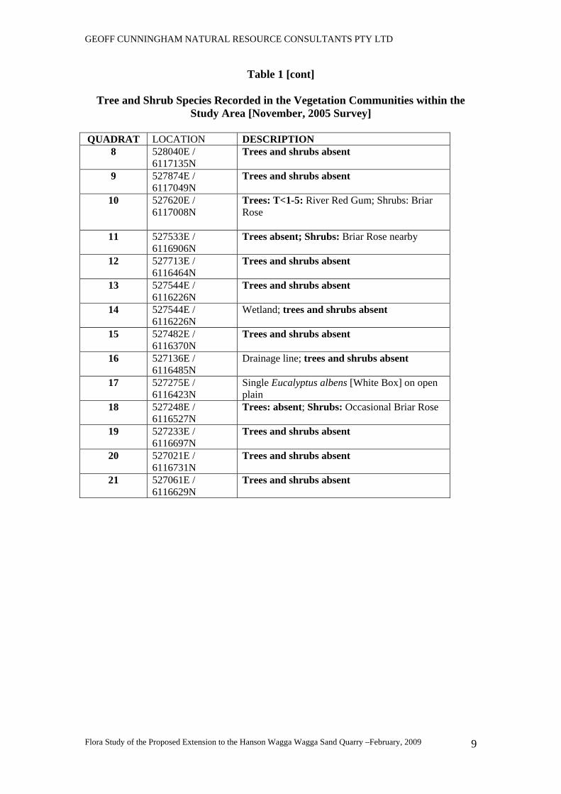
Table 1 [cont]
Tree and Shrub Species Recorded in the Vegetation Communities within the Study Area [November, 2005 Survey]
QUADRAT LOCATION DESCRIPTION
8 528040E / 6117135N
Trees and shrubs absent
9 527874E / 6117049N
Trees and shrubs absent
10 527620E / 6117008N
Trees: T<1-5: River Red Gum; Shrubs: Briar Rose
11 527533E / 6116906N
Trees absent; Shrubs: Briar Rose nearby
12 527713E / 6116464N
Trees and shrubs absent
13 527544E / 6116226N
Trees and shrubs absent
14 527544E / 6116226N
Wetland; trees and shrubs absent
15 527482E / 6116370N
Trees and shrubs absent
16 527136E / 6116485N
Drainage line; trees and shrubs absent
17 527275E / 6116423N
Single Eucalyptus albens [White Box] on open plain
18 527248E / 6116527N
Trees: absent; Shrubs: Occasional Briar Rose
19 527233E / 6116697N
Trees and shrubs absent
20 527021E / 6116731N
Trees and shrubs absent
21 527061E / 6116629N
Trees and shrubs absent
GEOFF CUNNINGHAM NATURAL RESOURCE CONSULTANTS PTY LTD
Flora Study of the Proposed Extension to the Hanson Wagga Wagga Sand Quarry –February, 2009
10
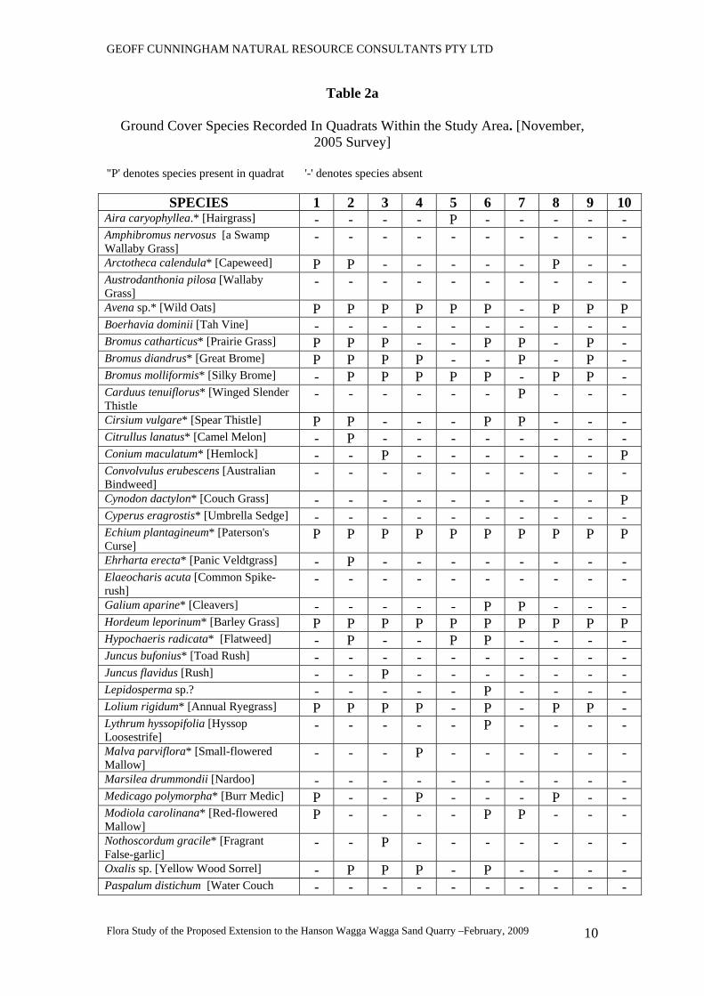
Table 2a
Ground Cover Species Recorded In Quadrats Within the Study Area. [November, 2005 Survey]
"P' denotes species present in quadrat '-' denotes species absent
SPECIES 1 2 3 4 5 6 7 8 9 10 Aira caryophyllea.* [Hairgrass] - - - - P - - - - - Amphibromus nervosus [a Swamp Wallaby Grass]
- - - - - - - - - -
Arctotheca calendula* [Capeweed] P P - - - - - P - - Austrodanthonia pilosa [Wallaby Grass]
- - - - - - - - - -
Avena sp.* [Wild Oats] P P P P P P - P P P Boerhavia dominii [Tah Vine] - - - - - - - - - - Bromus catharticus* [Prairie Grass] P P P - - P P - P - Bromus diandrus* [Great Brome] P P P P - - P - P - Bromus molliformis* [Silky Brome] - P P P P P - P P - Carduus tenuiflorus* [Winged Slender Thistle
- - - - - - P - - -
Cirsium vulgare* [Spear Thistle] P P - - - P P - - - Citrullus lanatus* [Camel Melon] - P - - - - - - - - Conium maculatum* [Hemlock] - - P - - - - - - P Convolvulus erubescens [Australian Bindweed]
- - - - - - - - - -
Cynodon dactylon* [Couch Grass] - - - - - - - - - P Cyperus eragrostis* [Umbrella Sedge] - - - - - - - - - - Echium plantagineum* [Paterson's Curse]
P P P P P P P P P P
Ehrharta erecta* [Panic Veldtgrass] - P - - - - - - - - Elaeocharis acuta [Common Spike-rush]
- - - - - - - - - -
Galium aparine* [Cleavers] - - - - - P P - - - Hordeum leporinum* [Barley Grass] P P P P P P P P P P Hypochaeris radicata* [Flatweed] - P - - P P - - - - Juncus bufonius* [Toad Rush] - - - - - - - - - - Juncus flavidus [Rush] - - P - - - - - - - Lepidosperma sp.? - - - - - P - - - - Lolium rigidum* [Annual Ryegrass] P P P P - P - P P - Lythrum hyssopifolia [Hyssop Loosestrife]
- - - - - P - - - -
Malva parviflora* [Small-flowered Mallow]
- - - P - - - - - -
Marsilea drummondii [Nardoo] - - - - - - - - - - Medicago polymorpha* [Burr Medic] P - - P - - - P - - Modiola carolinana* [Red-flowered Mallow]
P - - - - P P - - -
Nothoscordum gracile* [Fragrant False-garlic]
- - P - - - - - - -
Oxalis sp. [Yellow Wood Sorrel] - P P P - P - - - - Paspalum distichum [Water Couch - - - - - - - - - -
GEOFF CUNNINGHAM NATURAL RESOURCE CONSULTANTS PTY LTD
Flora Study of the Proposed Extension to the Hanson Wagga Wagga Sand Quarry –February, 2009
11
Table 2a [cont]
Ground Cover Species Recorded In Quadrats Within the Study Area. [November, 2005 Survey]
"P' denotes species present in quadrat '-' denotes species absent
SPECIES 1 2 3 4 5 6 7 8 9 10 Pennisetum clandestinum* [Kikuyu Grass]
- P - - - - - - - -
Phalaris aquatca* [Phalaris] - - - P - P P - - - Phyla nodiflora* [Lippia] - - - - - - - P - - Polygonum prostrata.* [Creeping Knotweed]]
P - P - - P - - - -
Polypogon monspeliensis* [Annual Beardgrass]
- - - - - - - - - -
Rumex brownii [Slender Dock] - - - P - - - - - - Rumex conglomeratus* [Clustered Dock]
- P P P P - - - - P
Rumex crispus* [Curled Dock] P - - - - - - P - - Silybum marianum* [Variegated Thistle]
- P P P - P - - P P
Sisymbrium officinale* [Indian Hedge Mustard]
- - - - - - - - - P
Sonchus oleraceus* [Sowthistle] - - - - - P P - - P Trifolium angustifolium* [Narrow-leaf Clover]
P P - - - P P P - -
Trifolium arvense* [Haresfoot Clover] - P - - - - - - - - Trifolium campestre* [Hop Clover] - - - - - - - - - - Trifolium dubium* [Yellow Suckling Clover]
- - - - - - - - - -
Trifolium glomeratum* [Cluster Clover]
P P - - - P P P - -
Trifolium sp.* [Clover] - - - - - - - - - - Verbascum virgatum* [Twiggy Mullein]
- - - - - P - - - -
Vulpia muralis* [Silver Grass] - P P - P - P - - -
Table 2b
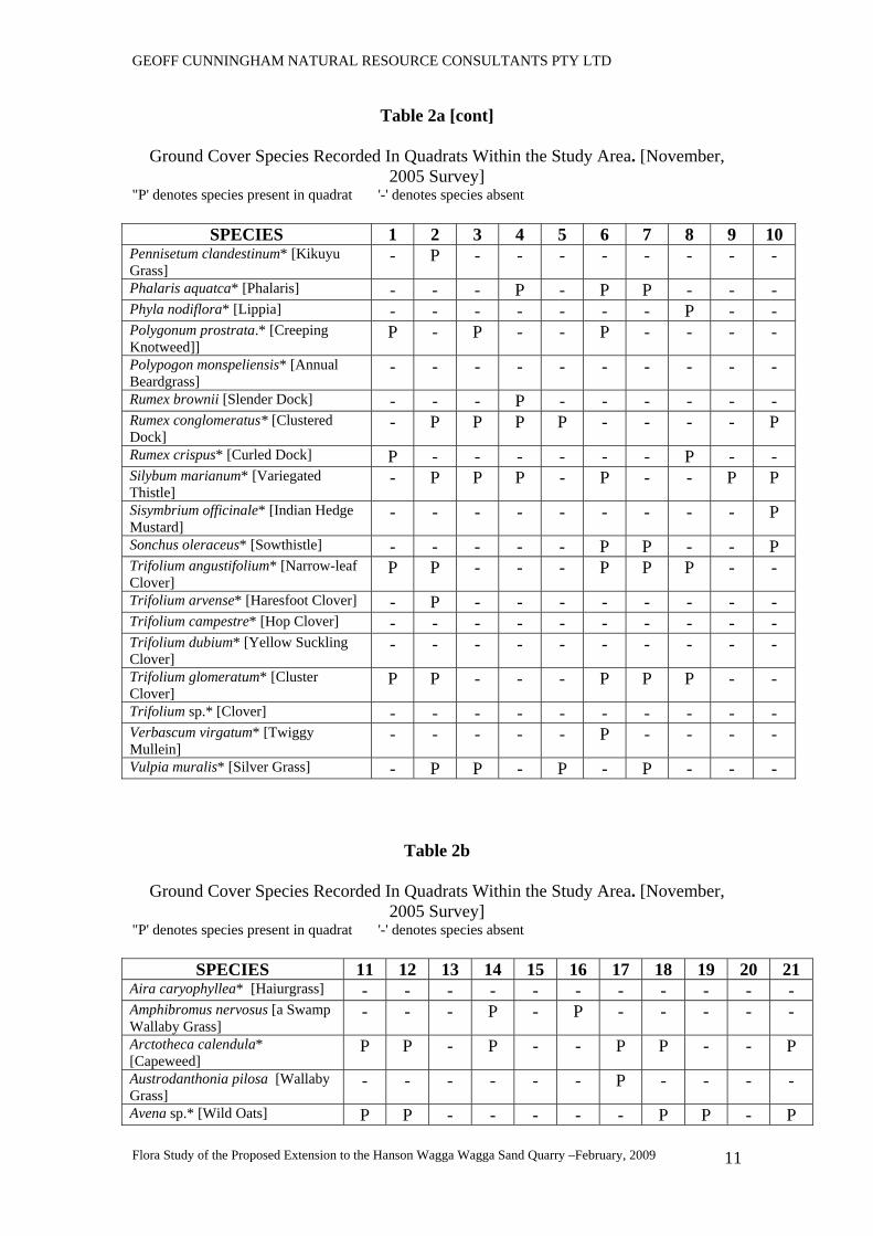
Ground Cover Species Recorded In Quadrats Within the Study Area. [November, 2005 Survey]
"P' denotes species present in quadrat '-' denotes species absent
SPECIES 11 12 13 14 15 16 17 18 19 20 21 Aira caryophyllea* [Haiurgrass] - - - - - - - - - - - Amphibromus nervosus [a Swamp Wallaby Grass]
- - - P - P - - - - -
Arctotheca calendula* [Capeweed]
P P - P - - P P - - P
Austrodanthonia pilosa [Wallaby Grass]
- - - - - - P - - - -
Avena sp.* [Wild Oats] P P - - - - - P P - P
GEOFF CUNNINGHAM NATURAL RESOURCE CONSULTANTS PTY LTD
Flora Study of the Proposed Extension to the Hanson Wagga Wagga Sand Quarry –February, 2009
12
Table 2b [cont]
Ground Cover Species Recorded In Quadrats Within the Study Area. [November, 2005 Survey]
"P' denotes species present in quadrat '-' denotes species absent
SPECIES 11 12 13 14 15 16 17 18 19 20 21 Boerhavia dominii [Tah Vine] - P - - - - - - - - - Bromus catharticus* [Prairie Grass]
- P - - - - - - - - -
Bromus diandrus* [Great Brome] P - - - - - - - - - - Bromus molliformis* [Silky Brome]
P - P P P - - P P P P
Carduus tenuiflorus* [Winged Slender Thistle]
- - - - - - - - - - -
Cirsium vulgare* [Spear Thistle] - - - - - - - - - - - Citrullus lanatus* [Camel Melon] - - - - - - - - - - - Conium maculatum* [Hemlock] - - - - - - - - - - - Convolvulus erubescens [Australian Bindweed]
- - - - - - P - - - -
Cynodon dactylon* [Couch Grass] - - - P - - P - - - Cyperus eragrostis* [Umbrella Sedge]
- - - - - P - - - - -
Echium plantagineum* [Paterson's Curse]
P P P P P P P P P P P
Ehrharta erecta* [Panic Veldtgrass]
- - - - - - - - - - -
Elaeocharis acuta [Common Spike-rush]
- - - P - - - - - - -
Galium aparine* [Cleavers] - - - - - - - - - - - Hordeum leporinum* [Barley Grass]
- P P P P P P - - P -
Hypochaeris radicata* [Flatweed] - - - - - - - - - - - Juncus bufonius* [Toad Rush] - - - P - - - - - - - Juncus flavidus [Rush] - - P P - - P - P - - Lepidosperma sp.? - - - - - - - - - - - Lolium rigidum* [Annual Ryegrass]
P P P - P P - P P P P
Lythrum hyssopifolia [Hyssop Loosestrife]
- - - P - - - - - - -
Malva parviflora* [Small-flowered Mallow]
- - - - - - P - - - -
Marsilea drummondii [Nardoo] - - - - - P - - - - - Medicago polymorpha* [Burr Medic]
- P - P - - - P - - -
Modiola carolinana* [Red-flowered Mallow]
P P - - - - - - - - -
Nothoscordum gracile* [Fragrant False-garlic]
- - - - - - - - - - -
Oxalis sp. [Yellow Wood Sorrel] - P P - - - - P - - - Paspalum distichum [Water Couch]
- - - P - - - - - - -
Pennisetum clandestinum* [Kikuyu Grass]
- - - - - - - - - - -
Phalaris aquatca* [Phalaris] - - - - - - - - - - -
GEOFF CUNNINGHAM NATURAL RESOURCE CONSULTANTS PTY LTD
Flora Study of the Proposed Extension to the Hanson Wagga Wagga Sand Quarry –February, 2009
13
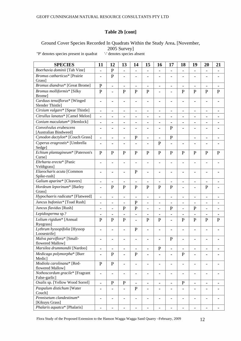
Table 2b [cont]
Ground Cover Species Recorded In Quadrats Within the Study Area. [November, 2005 Survey]
"P' denotes species present in quadrat '-' denotes species absent
SPECIES 11 12 13 14 15 16 17 18 19 20 21 Phyla nodiflora* [Lippia] - - - - - - - - - - - Polygonum prostrata.* [Creeping Knotweed]
- - - - - - - - - - P
Polypogon monspeliensis* [Annual Beardgrass]
- - - P - P - - - - P
Rumex brownii [Slender Dock] - - - - - - - P - - - Rumex conglomeratus* [Clustered Dock]
- - - P - P - - - - -
Rumex crispus* [Curled Dock] - - P - - - - - - P - Silybum marianum* [Variegated Thistle]
- - - - - - - - - P -
Sisymbrium officinale* [Indian Hedge Mustard]
- - - - - - - - - - -
Sonchus oleraceus* [Sowthistle] - - - - - - - - - - - Trifolium angustifolium* [Narrow-leaf Clover]
P P P - - - P - P P P
Trifolium arvense* [Haresfoot Clover]
P - - - - - P P P - -
Trifolium campestre* [Hop Clover]
- - - - - - P - - - -
Trifolium dubium* [Yellow Suckling Clover]
- - - P - - - - - - -
Trifolium glomeratum* [Cluster Clover]
P - P - - - - - P - P
Trifolium sp.* [Clover] - - - - - - - - P - - Verbascum virgatum* [Twiggy Mullein]
- - - - - - - - - - -
Vulpia muralis* [Silver Grass] - - - - P - P - P P -
5.4 Noxious Weed Considerations Ground cover over the whole of the Study Area is invaded by introduced weed and pasture species. Of these, Blackberry [Rubus spp.*] [class 4 weed], Hemlock [Conium maculatum*] [class 4 weed] and Briar Rose [Sweet Briar] [Rosa rubiginosa*] [class 4 weed] were present at some sites. Willows [Salix spp.] [class 5 weed] were common along the banks of the Murrumbidgee River. Paterson's Curse [Echium plantagineum*] [class 4 weed] occurs throughout the Study Area. All of these species are listed as being noxious for Wagga Wagga Local Government Area on the NSW Department of Primary Industries [Agriculture] Website. [search date10th February, 2009]. These species will need to be controlled.
GEOFF CUNNINGHAM NATURAL RESOURCE CONSULTANTS PTY LTD
Flora Study of the Proposed Extension to the Hanson Wagga Wagga Sand Quarry –February, 2009
14
Note: The noxious weed codes relevant to the species occurring within the Study Area are as follows: Class 4 weed - The growth and spread of the plant must be controlled according to the measures specified in a management plan published by the local control authority. Class 5 weed – The requirements in the Noxious Weeds Act 1993 for a notifiable weed must be complied with.
6 KOALA HABITAT CONSIDERATIONS Circular B35 issued to Councils by the Department of Urban Affairs and Planning provides information on State Environmental Planning Policy No 44 - Koala Habitat Protection (SEPP 44). The Study Area is situated within Wagga Wagga Local Government Area. Schedule 1 of the Policy lists this Government Area as one to which the Policy applies. SEPP 44 requires the identification of any “potential koala habitat” within the study area. However in section 1.5 of the ‘Explanation of the Policy’ it is noted that …”In relation to affected DAs it is the intention of the policy that investigations for ‘potential’ and ‘core’ koala habitats be limited to those areas in which it is proposed to disturb habitat. Potential koala habitat is an area ”…..of native vegetation where trees of the types listed in Schedule 2 [of SEPP 44] constitute at least 15% of the total number of trees in the upper and lower components of the tree component.” Two of the species listed in Schedule 2 of SEPP 44 is found within the Study Area. These are Eucalyptus camaldulensis [River Red Gum] and Eucalyptus albens [White Box] Eucalyptus camaldulensis is common along the Murrumbidgee River and in the river bend within the Study Area but only one isolated tree of Eucalyptus albens was recorded. This tree should not be further considered in relation to the Koala Habitat issue. However, the number of Eucalyptus camaldulensis trees exceeds 15% of the total number of trees present in the remnant native vegetation associated with the Murrumbidgee River and so the area occupied by this community can be regarded as "potential koala habitat". A fauna survey of the Study Area will indicate whether there are any indications of Koalas being present.
7 THREATENED SPECIES ISSUES Prior to the field surveys, and prior to preparation of the final flora study report,, requests were made to the NSW Department of Environment and Climate Change's 'Atlas of NSW Wildlife’ database for details of occurrences of any Threatened
GEOFF CUNNINGHAM NATURAL RESOURCE CONSULTANTS PTY LTD
Flora Study of the Proposed Extension to the Hanson Wagga Wagga Sand Quarry –February, 2009
15
Species of plants listed in Schedules 1 and 2 of the Threatened Species Conservation Act. The listings of threatened species current at 9th January, 2008 have also been checked to determine whether any of the species recorded during the field inspection have been listed subsequent to the field survey. 7.1 The ‘Atlas of NSW Wildlife’ Database The database was searched for records from the covered by the Wagga Wagga 1: 100 000 map sheet. Eight collections of a total of four threatened flora species are recorded for this map sheet area. The species records are: Brachyscome muelleroides – a single collection from the centre of the present city of Wagga Wagga in 1899] Ammobium craspedioides – two collections from Livingstone State Forest about 32km southeast of the Study Area Senecio garlandii – four collections, all from within and in the vicinity of The Rock Nature Reserve [about 30km southwest of the Study Area]. Swainsona recta - a single collection from the present city of Wagga Wagga in 1900. These species are discussed in Table 3 below. 7.2 BIOCLIM Model Predictions In addition to the detailed records of species occurrence, the Department of Environment and Climate Change has provided a list of threatened flora species predicted to occur within the boundaries of the Wagga Wagga 1: 100 000 map sheet area using the BIOCLIM model. These species are: Austrostipa wakoolica Brachyscome muelleroides Goodenia macbarronii [now removed from the TSC Act Schedules] Lepidium ascheersonii Pilularia novae-hollandiae Senecio garlandii Swainsona recta The likelihood of the occurrence of these species is assessed, in Table 3 below.
GEOFF CUNNINGHAM NATURAL RESOURCE CONSULTANTS PTY LTD
Flora Study of the Proposed Extension to the Hanson Wagga Wagga Sand Quarry –February, 2009
16
7.3 Commonwealth Environment Protection and Biodiversity Conservation Act 1997 [EPBC Act] Online Database Threatened Species Listing A search of the Commonwealth Environment Protection and Biodiversity Conservation Act Online Database revealed that nine plant species listed as threatened species under this Act were likely to occur in the Wagga Wagga Local Government Area in which the study area is located These species are: Ammobium craspedioides Amphibromus fluitans Austrostipa wakoolica Brachyscome muelleroides Brachyscome papillosa Diuris sheaffiana Senecio garlandii Swainsona murrayana Thesium australe These species are discussed in Table 3. 7.4 Endangered Flora Populations The Schedules of the New South Wales Threatened Species Conservation Act have been checked and it has been ascertained that there are no endangered flora populations recorded for the Study Area. 7.5 Endangered Ecological Communities The Schedules of the New South Wales Threatened Species Conservation Act have been checked and it has been ascertained that the following endangered ecological communities are likely to occur in the region surrounding the Study Area.
• White Box Yellow Box Blakely's Red Gum Woodland community • Myall Woodland in the Darling Riverine Plains, Brigalow Belt South, Cobar
Peneplain, Murray-Darling Depression, Riverina and NSW South Western Slopes Bioregions
• Fuzzy Box Woodland on Alluvial Soils of the South Western Slopes, Darling Riverine Plains and Brigalow Belt South Bioregions
• Inland Grey Box Woodland in the Riverina, NSW South Western Slopes, Cobar Peneplain, Nandewar and Brigalow Belt South Bioregions
The Commonwealth Environment Protection and Biodiversity Conservation Act 1999 [EPBC Act] Schedule of Threatened Ecological Communities also lists the equivalent White Box – Yellow Box – Blakely's Red Gum Grassy Woodland and Derived Native Grassland [formerly known as the Grassy White Box Woodlands] as likely to occur in the region. This community is equivalent to the White Box Yellow Box Blakely's Red
GEOFF CUNNINGHAM NATURAL RESOURCE CONSULTANTS PTY LTD
Flora Study of the Proposed Extension to the Hanson Wagga Wagga Sand Quarry –February, 2009
17
Gum Woodland [TSC Act] and has the status of 'critically endangered' under the EPBC Act. 7.6 Field Survey Data 7.6.1 Threatened Plant Species The Threatened plant species likely to occur in the general region of the study area were targeted during the field surveys of the Study Area. No Threatened plant species were recorded within the Study Area. 7.6.2 Endangered Ecological Communities and Populations After considering the structure and composition of the vegetation communities present it has been determined that the Study Area does not contain any remnants of the White Box- Yellow Box- Blakely's Red Gum Woodland Community that is listed in the Schedules of the NSW Threatened Species Conservation Act. This community equates with the White Box – Yellow Box – Blakely's Red Gum Grassy Woodland and Derived Native Grassland [formerly known as the Grassy White Box Woodlands] that is listed in the Schedules of the Commonwealth Environment Protection and Biodiversity Conservation Act. [NOTE: - this Endangered Ecological Community occurs to the south of the Study area on hill country.] The single Eucalyptus albens [White Box] tree that occurs within the Study Area on the Murrumbidgee River floodplain is considered to be just an outlying tree that does not constitute a remnant of the White Box Yellow Box Blakely's Red Gum Woodland [TSC Act] [White Box – Yellow Box – Blakely's Red Gum Grassy Woodland and Derived Native Grassland] [EPBC Act]. 7.6.3 Critical Habitat There are no areas of critical habitat listed for the study area or its environs. 7.6.4 Introduced Plant Species Of a total of 53 groundcover species recorded within the study area, forty seven [47] are introduced. The percentage of introduced ground cover plant species is 88.7% of the total plant species number. These plants are very numerous over the whole Study Area and comprise more than 95% of the total ground cover. Two main introduced shrub species were recorded as scattered plants over the Study Area. These were Rubus spp* [Blackberry] and Rosa rubiginosa* [Briar Rose]. Both of these species are noxious weeds.
GEOFF CUNNINGHAM NATURAL RESOURCE CONSULTANTS PTY LTD
Flora Study of the Proposed Extension to the Hanson Wagga Wagga Sand Quarry –February, 2009
18
Salix spp.* [Willows] are also common on the banks of the Murrumbidgee River while other introduced shrub species were also recorded along the river bank.
Table 3
Assessment of the Likelihood of Occurrence of Threatened Flora Species
SPECIES ASSESSMENT Ammobium craspedioides
A rosette forming perennial daisy with yellow flowers; found in dry forests, box and gum woodlands and grasslands derived from clearing of these communities; recorded from Crookwell to Wagga Wagga but most populations are in the Yass region [DECC, 2005a]; Suitable habitat is not present at the Study Area; the species was not recorded during field inspection and there are no records of its presence at the site in the past. Suitable habitat does not occur at the site. IT IS CONCLUDED THAT THIS SPECIES IS NOT PRESENT AT THE SITE.
Amphibromus fluitans
A stoloniferous or sometimes rhizomatous perennial grass to about 80cm high, culms Decumbent, flowers spring - autumn; grows mostly in permanent swamps; recorded in the Wagga Wagga area and at a number of other locations in the Riverina in permanent and non permanent wetlands [DECC 2005b]; the species was not recorded during field inspection and there are no records of its presence at the site in the past. Suitable habitat occurs at the site but will not be affected by the proposed development. IT IS CONCLUDED THAT THIS SPECIES IS NOT PRESENT AT THE SITE.
Austrostipa wakoolica
A densely tufted perennial grass to 1m tall; confined to areas associated with and adjacent to the floodplains of the Murray River tributaries in southwestern NSW; grows in open woodlands on silty clay to sandy loam soils in situations such as creek banks, swamp margins, in mallee and on low rocky rises DECC, 2005c]; suitable habitat is probably present at the Study Area; the species was not recorded during field inspection and there are no records of its presence at the site in the past. Suitable habitat does not occur at the site. IT IS CONCLUDED THAT THIS SPECIES IS NOT PRESENT AT THE STUDY AREA.
Brachyscome muelleroides
An annual daisy to 14cm tall; recorded in the Wagga Wagga, Narrandera, Tocumwal and Walbundrie districts; grows in damp areas on the margins of claypans, damp depressions, swamps and damp floodplain situations [DECC, 2005d]; the preferred habitat of this species is present within the Study Area – particularly along the banks of the Murrumbidgee River; suitable habitat does occur at the Study Area; the species was not recorded during field inspection and there are no records of its presence at the site in the past;. IT IS CONCLUDED THAT THIS SPECIES IS NOT PRESENT AT THE STUDY AREA.
Brachyscome papillosa
An erect perennial herb to 36 cm high; occurs on the south western plains from Mossgiel and Hay to Narrandera but is not common; grows in bladder saltbush communities on grey clay and is occasionally found in grassland; prefers open conditions and heavy soils; suitable habitat does occur at the Study Area; the species was not recorded during field inspection and there are no records of its presence at the site in the past;. IT IS CONCLUDED THAT THIS SPECIES IS NOT PRESENT AT THE STUDY AREA.
Diuris tricolor [sheaffiana]
This species was listed on the Schedules of the Threatened Species Conservation Act as Diuris sheaffiana but further taxonomic research indicates that the original species is really Diuris tricolor – a widespread orchid that occurs throughout the western slopes from Narrandera north. Its preferred habitat is sandy soils in Callitris communities. [Bishop, 1996]; suitable habitat is not present at the Study Area; the species was not recorded during field inspection and there are no records of its presence at the site in the past. Suitable habitat does not occur at the site. IT IS CONCLUDED THAT THIS SPECIES IS NOT PRESENT AT THE STUDY AREA.
GEOFF CUNNINGHAM NATURAL RESOURCE CONSULTANTS PTY LTD
Flora Study of the Proposed Extension to the Hanson Wagga Wagga Sand Quarry –February, 2009
19
Table 3 [cont]
Assessment of the Likelihood of Occurrence of Threatened Flora Species
SPECIES ASSESSMENT Lepidium aschersonii An erect perennial herb to 30cm high; found on ridges of gilgaid clay soils
supporting Brigalow; recorded in the south of the State at West Wyalong, Temora and Barmedman [DECC, 2005e]; suitable habitat does occur at the Study Area; the species was not recorded during field inspection and there are no records of its presence at the site in the past;. IT IS CONCLUDED THAT THIS SPECIES IS NOT PRESENT AT THE STUDY AREA.
Pilularia novae-hollandiae
A semi-aquatic and grass-like fern with a creeping underground rhizome; grows in shallow swamps and waterways and is most often recorded in drying mud; recorded in the region from Henty, Walbundrie, Balldale and Howlong [DECC, 2005f]; suitable habitat does occur at the Study Area; the species was not recorded during field inspection and there are no records of its presence at the site in the past;. IT IS CONCLUDED THAT THIS SPECIES IS NOT PRESENT AT THE STUDY AREA.
Senecio garlandii A much-branched perennial herb to 1.2m high; found between Temora, Betungrra and Albury; also recorded in and near The Rock Nature Reserve; occurs on sheltered slopes of rocky outcrops [DECC 2005g]; suitable habitat does not occur at the Study Area; the species was not recorded during field inspection and there are no records of its presence at the site in the past;. IT IS CONCLUDED THAT THIS SPECIES IS NOT PRESENT AT THE STUDY AREA.
Swainsona murrayana
A relatively widely spread herb with pea flowers; recorded in the Hay, Jerilderie and Deniliquin districts on clay soils; grows in a variety of communities including Bladder Saltbush, Black Box and grassland communities [DECC, 2005i]; Harden[1991] notes that this species often grows with Maireana species on heavy soil, especially in depressions; suitable habitat is not present the study area because of the evident previous heavy grazing and other disturbance of the area; the species was not recorded during field inspection and there are no records of its presence at the site in the past;. IT IS CONCLUDED THAT THIS SPECIES IS NOT PRESENT AT THE STUDY AREA.
Swainsona recta A slender erect perennial forb with purple pea flowers; recorded from the Wagga Wagga and Culcairn areas in the past; existing populations appear to be concentrated in areas where grazing is largely excluded [DECC, 2005h]; recorded from open grassy woodland situations dominated by Eucalyptus species; suitable habitat is not present the study area because of the evident previous heavy grazing and other disturbance of the area; the species was not recorded during field inspection and there are no records of its presence at the site in the past;. IT IS CONCLUDED THAT THIS SPECIES IS NOT PRESENT AT THE STUDY AREA.
Thesium australe A small straggling herb to 40cm tall; parasitic on other plants, particularly Kangaroo Grass [Themeda australis]; found in damp sites in grasslands and grassy woodlands in small populations [DECC [2005j]; suitable habitat does occur at the Study Area [ie. the habitat is very much disturbed and invaded by exotic species]; the species was not recorded during field inspection and there are no records of its presence at the site in the past;. IT IS CONCLUDED THAT THIS SPECIES IS NOT PRESENT AT THE STUDY AREA.
GEOFF CUNNINGHAM NATURAL RESOURCE CONSULTANTS PTY LTD
Flora Study of the Proposed Extension to the Hanson Wagga Wagga Sand Quarry –February, 2009
20
8 IMPACTS OF THE PROPOSAL 8.1 Rehabilitation Proposal The Proponent has recently modified its extraction cell design to ensure no impact on the Eucalptus camaldulensis [River Red Gum] Woodland / Forest Community which is the only remnant native community found within the study area. This community is considerably degraded in the shrub and ground cover layers However, no River Red Gums would be removed to allow the sand extraction operation to progress. As a consequence, there would not be a significant impact on this community. The proposal involves the extraction of material from areas in the central portion of the Hanson Wagga Wagga site within the area of naturalized grassland [Community 2]. No trees will be affected by the proposed works and the extraction cells are located well away from the Murrumbidgee River. The rehabilitation plan also shows linkages across the final landform to ensure that there are fauna corridors across the site and between the drainage line on the southern boundary and the Murrumbidgee River. Species that will comprise the rehabilitation plantings include:
• River Red Gum [Eucalyptus camaldulensis],
• Yellow Box [Eucalyptus melliodora],
• River Oak [Casuarina cunninghamiana]
• Green Wattle [Acacia pycnantha],
• Wedge-leaf Hopbush [Dodonaea viscosa subsp. cuneata], and
• Box-leaf Wattle [Acacia buxifolia] The outcome of the rehabilitation work will be a vastly improved vegetation remnant and fauna habitat compared with that existing currently. 8.2 Seven Part Test of Significance [section 5A Environmental Planning and Assessment Act 1979] The likelihood of the occurrence of the Threatened flora species has been assessed in Table 3 above. The Study Area has been highly modified from its original condition and habitat values as a consequence of previous agricultural use including logging of the tree cover, complete clearing [in parts] for grazing and invasion by exotic groundcover and shrub species.
GEOFF CUNNINGHAM NATURAL RESOURCE CONSULTANTS PTY LTD
Flora Study of the Proposed Extension to the Hanson Wagga Wagga Sand Quarry –February, 2009
21
There is no suitable habitat present at the Study Area for many of the Threatened flora species likely / predicted to occur there. Field observations have failed to record any Threatened flora species and there are no past records of any Threatened flora species at the Study Area. For the purposes of the Environmental Planning and Assessment Act 1979 N0. 203 the following must be taken into account in deciding whether there is likely to be a significant effect on threatened species, populations or ecological communities, or their habitats: [i] the assessment guidelines [issued under Section 94A of the Threatened Species Conservation Act 1975].and titled 'Assessment of Significance', and [ii] each of the factors listed in the following paragraphs [a] to [g]. [a] in the case of a threatened species, whether the action proposed is likely to have an adverse effect on the life cycle of the species such that a viable local population of the species is likely to be placed at risk of extinction: No threatened flora species listed in the Schedules of the NSW Threatened Species Conservation Act or under the Commonwealth Environment Protection and Biodiversity Conservation Act were recorded during the field survey and there are no records of collections of threatened flora species from the Study Area. Consequently the proposed development will not cause any adverse effect on the life cycle of any such species such that a viable local population of the species is likely to be placed at risk of extinction. [b] in the case of an endangered population, whether the action proposed is likely to have an adverse effect on the life cycle of the species that constitutes the endangered population such that a viable local population of the species is likely to be placed at risk of extinction: No endangered flora populations have been listed in the Schedules of the NSW Threatened Species Conservation Act or under the Commonwealth Environment Protection and Biodiversity Conservation Act for the Study Area. As a consequence, the proposed development will not have an adverse effect on any local populations of any threatened plant species such that a viable local population of the species is likely to be placed at risk of extinction. [c] in the case of an endangered ecological community or critically endangered ecological community , whether the action proposed:
[i] is likely to have an adverse effect on the extent of the ecological community such that its local occurrence is likely to be placed at risk of extinction, or
No endangered or critically endangered ecological communities that have been listed in the Schedules of the NSW Threatened Species Conservation Act or under the Commonwealth Environment Protection and Biodiversity Conservation Act ore present within the Study Area.
GEOFF CUNNINGHAM NATURAL RESOURCE CONSULTANTS PTY LTD
Flora Study of the Proposed Extension to the Hanson Wagga Wagga Sand Quarry –February, 2009
22
As a consequence, the action proposed will not have an adverse effect on the extent of any endangered or critically endangered ecological communities such that its / their local occurrence is likely to be placed at risk of extinction.
[ii] is likely to substantially and adversely modify the composition of the ecological community such that its local occurrence is likely to be placed at risk of extinction.
No endangered or critically endangered ecological communities that have been listed in the Schedules of the NSW Threatened Species Conservation Act or under the Commonwealth Environment Protection and Biodiversity Conservation Act occur within the Study Area. As a consequence, the action proposed is not likely to substantially and adversely modify the composition of any endangered or critically endangered ecological communities such that its / their local occurrence is likely to be placed at risk of extinction.
[d] in relation to the habitat of a threatened species, population or ecological community:
[i] the extent to which the habitat is likely to be removed or modified as a result of the action proposed, and No threatened flora species, populations or ecological communities occur within the Study Area. As a consequence, there will be no removal or modification of habitat for such species, populations or ecological communities as a result of the proposed action. [ii] whether an area of habitat is likely to become fragmented or isolated from other areas of habitat as a result of the proposed action, and No threatened flora species, populations or ecological communities occur within the Study Area. As a consequence, there will be no fragmentation or isolation of areas of habitat for such species, populations or ecological communities as a result of the proposed action. [iii] the importance of the habitat to be removed, modified, fragmented or isolated to the long-term survival of the species, population or ecological community in the locality. No threatened flora species, populations or ecological communities occur within the Study Area. There will be no removal, modification, fragmentation or isolation of habitat for such species, populations or ecological communities as a result of the proposed action. As a consequence, there is no requirement to assess the importance of such habitat.
GEOFF CUNNINGHAM NATURAL RESOURCE CONSULTANTS PTY LTD
Flora Study of the Proposed Extension to the Hanson Wagga Wagga Sand Quarry –February, 2009
23
[e] whether the action proposed is likely to have an effect on critical habitat [either directly or indirectly]. There is no critical habitat listed for the Study Area. As a consequence, there will be no direct or indirect effect on critical habitat as a result of the proposed action. [f] whether the action proposed is consistent with the objectives or actions of a species recovery plan or threat abatement plan. There are no threatened flora species recorded from the Study Area. As a consequence, there are no species recovery plans or threat abatement plans that need to be taken into account in relation to the proposed development. [g] whether the action proposed constitutes or is part of a key threatening process or is likely to result in the operation of, or increase the impact of, a key threatening process. There are a number of key threatening processes that need to be considered, including: [a] 'Clearing of Native Vegetation' has been listed as a Key Threatening Process on Schedule 3 of the Threatened Species Conservation Act. 'Land Clearance' is also listed as a Key Threatening Process under the Commonwealth Environment Protection and Biodiversity Conservation Act, 1999. The proposed development would entail the removal of no native tree species. The vegetation that would be affected is a highly invaded grassland containing many introduce species. This process does not involve the clearing of native vegetation and so there is not need to further consider this key threatening process. [b] 'Alteration of the Natural Flow Regimes of Rivers and Streams and their Floodplains and Wetlands' is a key threatening process listed on Schedule 3 of the Threatened Species Conservation Act.. The extension of the Wagga Wagga Sand Quarry and construction of associated levee banks to prevent its inundation has a potential to alter some overland and channelised flows in flood runners that cross the 'peninsula' of land associated with the major river bend within the Study Area [Figure 2]. The individual pits within the proposed development are located to allow flow of floodwater between the pits as shown in Figure 2. Consequently it is not envisaged that there would be any significant impact on the natural flow regime on the floodplain that would in turn have impact on any threatened flora species, population or community. [c] 'Removal of Dead Wood and Dead Trees' is a key threatening process listed on on Schedule 3 of the Threatened Species Conservation Act. The Study Area has some dead trees and fallen / cut / partly sawn tree trunks present in some sections following past logging. In terms of the definitions of this key threatening
GEOFF CUNNINGHAM NATURAL RESOURCE CONSULTANTS PTY LTD
Flora Study of the Proposed Extension to the Hanson Wagga Wagga Sand Quarry –February, 2009
24
process, the extension of the Wagga Wagga Sand Quarry would result in the removal of some habitat or potential habitat for native fauna species. At the same time, removal of these tree remnants would also remove habitat for the noxious European Rabbit and European Red Fox, both of which pose threats to native flora and fauna, respectively. The removal of any woody debris lying on the floodplain within the Study Area would have no impact on native flora species. [d] 'Degradation of Native Riparian Vegetation Along New South Wales Watercourses' is a key threatening process listed in Schedule 6 of the Fisheries Management Act 1994. The Murrumbidgee River banks, terraces associated gullies are already highly invaded by exotic groundcover, shrub and tree species and so would be considered as being degraded under the Fisheries Scientific Committee's recommendation to list this process as a key threatening process under the Fisheries Management Act 1994. The proposed development would not result in the removal of any native trees and so there would be not impact in terms of degradation of native riparian vegetation. [e] 'Removal of Large Woody Debris' is a key threatening process listed in Schedule 6 of the Fisheries Management Act 1994. The nature of the proposed action is such that no large woody debris would be removed from the Murrumbidgee River and so there is no further requirement to consider this key threatening process. 9 Threatened Species Overview [i] There are no records of threatened plant species contained in the ‘Atlas of NSW Wildlife’ database for the Study Area
. [ii] No threatened flora species were recorded from the Study Area during field survey, despite predictions and records that indicated that a number of threatened flora species might be likely to occur at the site. The likely occurrence of these species has been assessed in Table 3. [iii] Much of the Study Area has been logged, cleared and grazed in the past and the groundcover is extremely highly invaded by introduced species including weeds. [iv]There are no endangered Flora Populations listed for the Study Area in the Schedules of the Threatened Species Conservation Act 1995 or under the Commonwealth Environment Protection and Biodiversity Conservation Act 1997.
[v] There is no critical habitat listed for the study area or its environs.
[vi] There are no occurrences of endangered ecological communities recorded within the Study Area.
GEOFF CUNNINGHAM NATURAL RESOURCE CONSULTANTS PTY LTD
Flora Study of the Proposed Extension to the Hanson Wagga Wagga Sand Quarry –February, 2009
25
[vii] Consequently, it is concluded that there will be no significant impact on Threatened Flora species, Endangered Ecological Communities, Endangered Flora Populations or Critical Habitat as a consequence of the proposed development. [viii[ Given that there would be no significant impact on Threatened Flora species, Endangered Ecological Communities, Endangered Flora Populations or Critical Habitat as a consequence of the proposed development a reference to the Commonwealth Government in relation to Protected Matters under the EPBC Act would not be required.. 10 OFFSETS The proposed development, if approved, will not result in any native trees or shrubs being destroyed and consequently there is no requirement to provide a biodiversity offset to compensate for the impact of the proposed development. The rehabilitation proposal will result in a vastly enhanced fauna habitat and in the establishment of a valuable native vegetation remnant across what is now a very degraded site. 11 ADDRESSING DIRECTOR-GENERAL'S REQUIREMENTS
A number of issues relating to flora have been raised in the Director-General's Requirements. Table 3 lists the issues and indicates the section of this study where each issue is addressed.
Table 3 Director-General's Requirements
ORGANISATION PARAPHRASED ISSUE SECTION WHERE
ADDRESSED assessment of impacts on threatened flora species or endangered ecological communities or habitats
Section 7 Department of Planning General Requirements
provision of details of proposed vegetation offsets
Section 8
consideration of draft guidelines for threatened species assessment
Section 7
consideration of Commonwealth EPBC issues Section 7
State Government Technical and Policy Guidelines
consideration of aquatic habitat management issues
Section 7
consideration of threatened species impacts and their mitigation
Section 7 Department of Environment and Climate Change consideration of the thresholds set in Step 5 of
the Draft Guidelines for Threatened Species Assessment
Sections 5 and 7
GEOFF CUNNINGHAM NATURAL RESOURCE CONSULTANTS PTY LTD
Flora Study of the Proposed Extension to the Hanson Wagga Wagga Sand Quarry –February, 2009
26
12 REFERENCES Anon [1973] – Wagga Wagga District Technical Manual. Soil Conservation Service of New South Wales, Sydney. Bishop, A [1996] - Field Guide to the Orchids of New South Wales and Victoria. University of NSW Press, Sydney DECC [2005a] – Ammobium craspedioides – Yass Daisy Species Profile. NSW Threatened Species Website. Department of Environment and Conservation, Sydney DECC [2005b] – Amphibromus fluitans – River Swamp Wallaby-grass Species Profile. NSW Threatened Species Website. Department of Environment and Conservation, Sydney DECC [2005c] – Austrostipa wakoolica – A Speargrass Species Profile. NSW Threatened Species Website. Department of Environment and Conservation, Sydney DECC [2005d] – Brachyscome muelleroides – Claypan Daisy Species Profile. NSW Threatened Species Website. Department of Environment and Conservation, Sydney DECC [2005e] – Lepidium aschersonii – Spiny Peppercress Species Profile. NSW Threatened Species Website. Department of Environment and Conservation, Sydney DECC [2005f] – Pilularia novae-hollandiae – Austral Pillwort Species Profile. NSW Threatened Species Website. Department of Environment and Conservation, Sydney DECC [2005g] – Senecio garlandii – Woolly Ragwort Species Profile. NSW Threatened Species Website. Department of Environment and Conservation, Sydney DECC [2005h] – Swainsona murrayana – Slender Darling Pea Species Profile. NSW Threatened Species Website. Department of Environment and Conservation, Sydney DECC [2005i] – Swainsona recta – Small Purple-pea Species Profile. NSW Threatened Species Website. Department of Environment and Conservation, Sydney DECC [2005j] – Thesium australe – Australian Toadflax Species Profile. NSW Threatened Species Website. Department of Environment and Conservation, Sydney DECC and DPI [2005] – Draft Guidelines for Threatened Species Assessment. Department of Environment and Conservation and Department of Primary Industries Harden, G.J. [Ed] [2001] – Flora of New South Wales. Volume 1. Revised Edition. University of NSW Press, Kensington. Harden, G.J. [Ed] [2002] – Flora of New South Wales. Volume 2. Revised Edition. University of NSW Press, Kensington. Harden, G.J. [Ed] [1992] – Flora of New South Wales. Volume 3. University of NSW Press, Kensington.
GEOFF CUNNINGHAM NATURAL RESOURCE CONSULTANTS PTY LTD
Flora Study of the Proposed Extension to the Hanson Wagga Wagga Sand Quarry –February, 2009
27
Harden, G.J. [Ed] [1993] – Flora of New South Wales. Volume 4. University of NSW Press, Kensington. Geoff Cunningham B.Sc.Agr.[Hons]; FAIAST. Managing Director and Principal Ecologist. 20th February, 2009
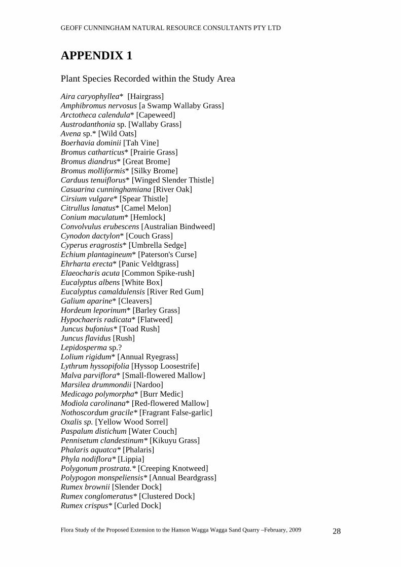
GEOFF CUNNINGHAM NATURAL RESOURCE CONSULTANTS PTY LTD
Flora Study of the Proposed Extension to the Hanson Wagga Wagga Sand Quarry –February, 2009
28
APPENDIX 1 Plant Species Recorded within the Study Area Aira caryophyllea* [Hairgrass] Amphibromus nervosus [a Swamp Wallaby Grass] Arctotheca calendula* [Capeweed] Austrodanthonia sp. [Wallaby Grass] Avena sp.* [Wild Oats] Boerhavia dominii [Tah Vine] Bromus catharticus* [Prairie Grass] Bromus diandrus* [Great Brome] Bromus molliformis* [Silky Brome] Carduus tenuiflorus* [Winged Slender Thistle] Casuarina cunninghamiana [River Oak] Cirsium vulgare* [Spear Thistle] Citrullus lanatus* [Camel Melon] Conium maculatum* [Hemlock] Convolvulus erubescens [Australian Bindweed] Cynodon dactylon* [Couch Grass] Cyperus eragrostis* [Umbrella Sedge] Echium plantagineum* [Paterson's Curse] Ehrharta erecta* [Panic Veldtgrass] Elaeocharis acuta [Common Spike-rush] Eucalyptus albens [White Box] Eucalyptus camaldulensis [River Red Gum] Galium aparine* [Cleavers] Hordeum leporinum* [Barley Grass] Hypochaeris radicata* [Flatweed] Juncus bufonius* [Toad Rush] Juncus flavidus [Rush] Lepidosperma sp.? Lolium rigidum* [Annual Ryegrass] Lythrum hyssopifolia [Hyssop Loosestrife] Malva parviflora* [Small-flowered Mallow] Marsilea drummondii [Nardoo] Medicago polymorpha* [Burr Medic] Modiola carolinana* [Red-flowered Mallow] Nothoscordum gracile* [Fragrant False-garlic] Oxalis sp. [Yellow Wood Sorrel] Paspalum distichum [Water Couch] Pennisetum clandestinum* [Kikuyu Grass] Phalaris aquatca* [Phalaris] Phyla nodiflora* [Lippia] Polygonum prostrata.* [Creeping Knotweed] Polypogon monspeliensis* [Annual Beardgrass] Rumex brownii [Slender Dock] Rumex conglomeratus* [Clustered Dock] Rumex crispus* [Curled Dock]
GEOFF CUNNINGHAM NATURAL RESOURCE CONSULTANTS PTY LTD
Flora Study of the Proposed Extension to the Hanson Wagga Wagga Sand Quarry –February, 2009
29
Silybum marianum* [Variegated Thistle] Sisymbrium officinale* [Indian Hedge Mustard] Sonchus oleraceus* [Sowthistle] Trifolium angustifolium* [Narrow-leaf Clover] Trifolium arvense* [Haresfoot Clover] Trifolium campestre* [Hop Clover] Trifolium dubium* [Yellow Suckling Clover] Trifolium glomeratum* [Cluster Clover] Trifolium sp.* [Clover] Verbascum virgatum* [Twiggy Mullein] Vulpia muralis* [Silver Grass]
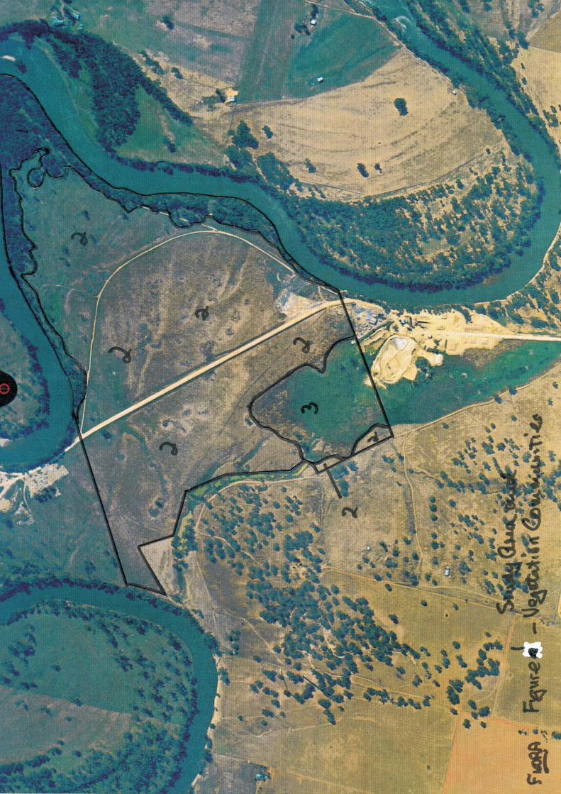
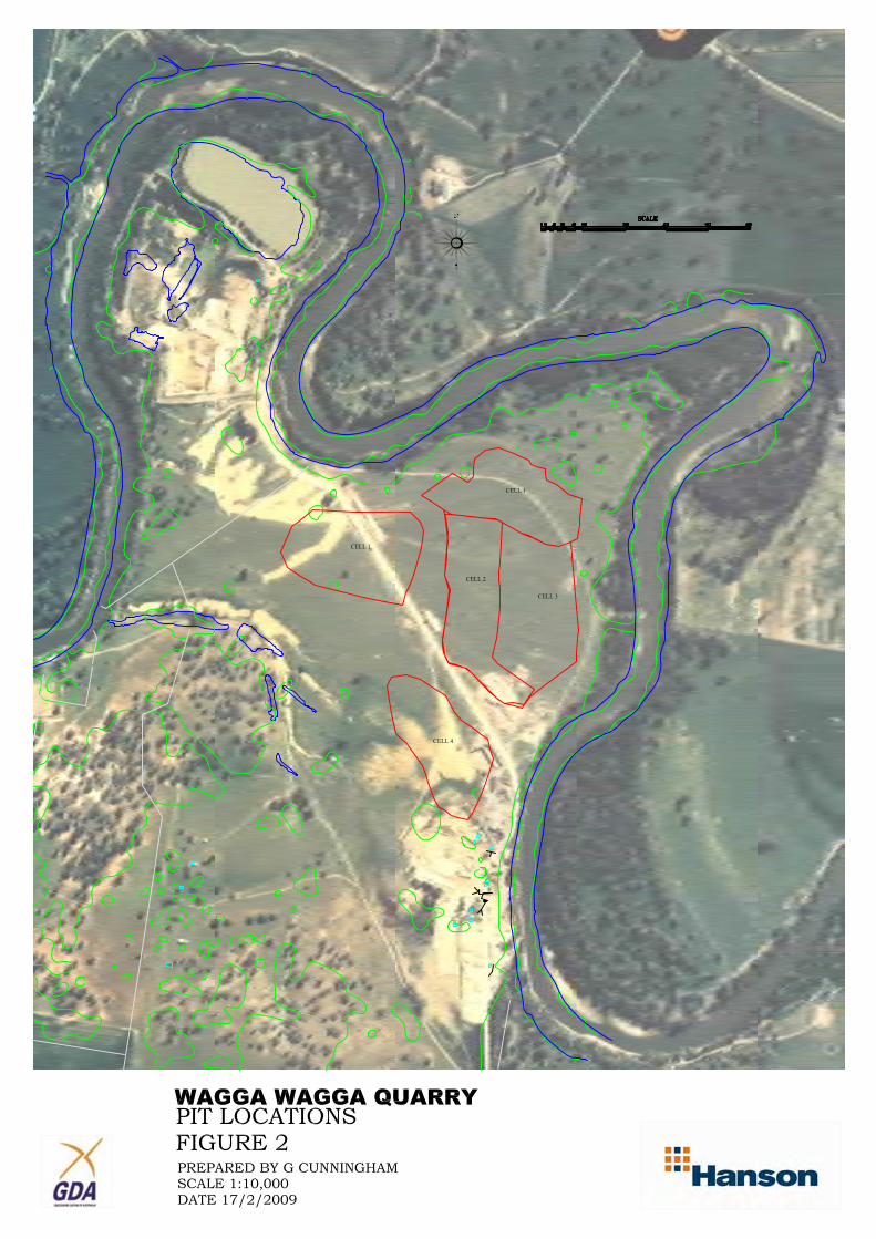
TERRESTRIAL FAUNA SURVEY
AND IMPACT ASSESSMENT REPORT
FOR THE PROPOSED EXTENSION TO THE SAND AND
GRAVEL QUARRY, ROACH ROAD, WAGGA WAGGA
Prepared for
Hanson Construction Materials Pty Ltd
ECOTONE ECOLOGICAL CONSULTANTS Pty Ltd 39 Platt Street, Waratah NSW 2298
phone: (02) 4968 4901 fax: (02) 4968 4960
e-mail: [email protected]
web: www.ecotoneconsultants.com.au
ABN 67 070 127 409
EEC PROJECT No. 0643HCM
Revised March 2009
TABLE OF CONTENTS
1.0 INTRODUCTION ......................................................................................................................................................1 1.1 Background and Scope.............................................................................................................................................1 1.2 General Description of the Subject Site, Study Area and Locality ..........................................................................2 1.3 Description of the Proposal......................................................................................................................................3
2.0 FIRST STAGE ECOLOGICAL INVESTIGATION – PRELIMINARY ASSESSMENT ..................................6 2.1 Review of Local Threatened Fauna Species ............................................................................................................6 2.2 EPBC Act Protected Matters Report........................................................................................................................7 2.3 Habitat Assessment of the Study Area.....................................................................................................................9 2.4 Determination of the Local Threatened Fauna as Subject Species ........................................................................14
3.0 SECOND STAGE ECOLOGICAL INVESTIGATION – FIELD SURVEYS....................................................21 3.1 Faunal Investigations .............................................................................................................................................21
3.1.1 Survey Methodology ......................................................................................................................................21 3.1.2 Survey Limitations .........................................................................................................................................22 3.1.3 Weather Details and Survey Effort.................................................................................................................24 3.1.4 Fauna Survey Results .....................................................................................................................................24
4.0 THREATENED SPECIES ASSESSMENT OF THE PROPOSAL .....................................................................28 4.1 Evaluation of Impacts Resulting from the Proposal (Part 3A of the EP&A Act, 1979) .........................................28 4.2 Environment Protection & Biodiversity Conservation Act 1999 (EPBC Act).......................................................35 4.3. SEPP 44 – Koala Habitat Protection.....................................................................................................................39
5.0 MITIGATION MEASURES ...................................................................................................................................41
6.0 CONCLUSIONS .......................................................................................................................................................42
7.0 REFERENCES .........................................................................................................................................................44
8.0 APPENDICES...........................................................................................................................................................46 Appendix 1. Fauna recorded within the Study Area and Wagga LGA ........................................................................46 Appendix 2. Field Data Sheets.....................................................................................................................................55 Appendix 3. Project Personnel and Relevant Licenses ................................................................................................56
LIST OF TABLES
Table 1. General Description of the Subject Site, Study Area and Locality .......................................................................2
Table 2. Threatened Fauna previously recorded within the Study Locality .......................................................................6
Table 3. Summary of Potentially Relevant Matters under the Commonwealth EPBC Act 1999 .......................................8
Table 4. Summary of habitat features within the subject site .............................................................................................9
Table 5. Determination of Subject Fauna Species ............................................................................................................14
Table 6. Weather conditions during the survey period .....................................................................................................24
Table 7. Summary of survey effort conducted for terrestrial fauna ..................................................................................24
LIST OF FIGURES
Figure 1. Study Locality ....................................................................................................................................................4
Figure 2. Layout of the Proposed Quarry Extension showing Habitat Trees.....................................................................5
Figure 3. Fauna Habitats and Threatened Species ............................................................................................................13
Figure 4. Location of Survey Methods .............................................................................................................................23
Terrestrial Fauna Survey and Impact Assessment Hanson Quarry, Roach Road, South Wagga Wagga
Revised Final Report March 2009
_______________________________________________________________________________________________
________________________________________________________________________________________________
ECOTONE ECOLOGICAL CONSULTANTS PTY LTD 1
1.0 INTRODUCTION
1.1 Background and Scope
This terrestrial fauna impact assessment report has been prepared by Ecotone Ecological
Consultants Pty Ltd at the request of Anthony Giannasca, Southern NSW area manager for Hanson
Construction Materials Pty Ltd. It investigates the proposed extension of the existing sand and
gravel quarry at Roach Road, South Wagga Wagga. The proposal is being assessed under Part 3A
of the Environmental Planning and Assessment Act, 1979 (EP&A Act) and under Section 75F of
this Act, the Director General’s Requirements for the proposal (dated 10 August 2007) have been
received from the NSW Department of Planning.
The original layout for the proposal incorporated five distinct stages separated by a buffer of un-
extracted material, with a bund wall constructed around the top wall of the cell in order to prevent
potential flooding. The proposal would have resulted in the removal of scattered trees, some of
which were hollow bearing, and piles of old logging waste, including large hollow logs. This
habitat was found to be a foraging and possibly breeding area for a group of brown treecreepers
which may be part of a population of the threatened eastern sub-species Climacteris picumnus
victoriae. Although it was considered in the assessment report that sufficient habitat would remain
outside of the extraction areas (Ecotone January 2008) a review by the NSW Department of the
Environment and Climate Change (DECC) suggested that significant impacts may occur and also
that the remnant trees formed part of a link across the floodplain to the riparian habitat. In order to
satisfy the DECC concerns the extraction areas have been redesigned so as to retain the remnant
trees and most of the fallen timber. This has significantly reduced the potential impact on threatened
species and therefore the 2008 report has been revised to reflect the changes to the plan.
The general objectives of this assessment are to:
� describe the existing biological environment of the study area in relation to fauna;
� identify the potential impacts of the proposal for any threatened species or endangered fauna
populations that occur or could be likely to occur in the subject site; and
� suggest measures to manage potential impacts and effects of the proposal, using the principles of “avoid,
minimise and mitigate” in that order of preference.
The environmental studies have been conducted in four stages:
(a) a review of available literature pertaining to the site and surrounding locality and preliminary habitat assessment of
the subject site;
(b) the completion of targeted field surveys for threatened species regarded as potential subject species, and surveys to
investigate the inherent biological attributes of the site;
(c) the preparation of a constraints and opportunities report based on the findings of the surveys (Ecotone July 2007;
and
(d) the preparation of an impact assessment report as required under a Part 3A proposal.
Within this report, reference is given to the relevant sections of the Commonwealth Environment
Protection and Biodiversity Conservation Act 1999 (EPBC Act); NSW Threatened Species
Conservation Act 1995 (TSC Act); Fisheries Management Act 1994 (FM Act), (if required);
National Parks and Wildlife Act 1974 (NP&W Act); Environmental Planning and Assessment Act
1979 (EP&A Act); and subsequent amendments to these.
Terrestrial Fauna Survey and Impact Assessment Hanson Quarry, Roach Road, South Wagga Wagga
Revised Final Report March 2009
_______________________________________________________________________________________________
________________________________________________________________________________________________
ECOTONE ECOLOGICAL CONSULTANTS PTY LTD 2
For this report,
- the subject site is defined as the land area directly affected by the proposed quarry extension;
- the study area consists of the subject site and surrounding land potentially affected indirectly by the proposal;
and
- the study locality is the area of land within a ten (10) kilometre radius of the centre of the study area.
Note: Terrestrial flora and aquatic fauna (other than aquatic reptiles and amphibians) and
flora have not been addressed in this report and are the subject of reports prepared by others.
1.2 General Description of the Subject Site, Study Area and Locality
Table 1. General Description of the Subject Site, Study Area and Locality
Client Hanson Construction Materials Pty Ltd.
Subject Site
Location Lot 2, DP 610795 and Lot B, DP 381991, Roach Road, South Wagga Wagga.
Map Grid 55: 527800E and 6117000N (GDA 94)
Elevation Approx. 180m ASL
Current Zoning 1d, Floodplain (Urban Living Area)
Current land use and
general condition
The subject site consists mostly of cleared grazing land, currently stocked by cattle. A well
formed riparian strip of remnant native trees and shrubs occur along the banks of the
Murrumbidgee River. There is evidence of past excavations for sand and gravel with old
bits of machinery and some rubbish evident. Common pasture weeds occur throughout the
property, however, the drought conditions in the area have resulted in the ground
vegetation being closely cropped by cattle, macropods and rabbits.
Significant features A continuous riparian strip of remnant native trees and shrubs occurs along the banks of
the Murrumbidgee River. The dominant tree species is the River Red Gum Eucalyptus
camuldensis, with some very large hollow bearing specimens up to 3m in DBH scattered
through the riparian strip and as individual paddock trees away from the river bank.
Weathered, large hollow logs are plentiful, particularly in parts of the cleared land and are
a result of the clearing of the land some time ago.
Study area
Bioregion NSW South Western Slopes
Botanical Subregion South Western Slopes
LGA Wagga Wagga City Council
Surrounding land use Existing sand and gravel extraction, rural, mainly grazing, isolated reserved bushland
remnants (Pomingalarna Reserve).
Watercourses,
Drainage and
catchment
The study area is surrounded on all sides, except the south, by the Murrumbidgee River.
The south-western part of the study area is more poorly drained and consists of a wetland
and settling ponds resulting from water used in the quarrying process.
Geology The geology of the site consists of Tertiary sand and gravels associated with the
Shepparton Formation (1:250,000 Wagga Wagga Geological Sheet). Drilling indicates that
fine grained sand and gravel occurs to a depth >20m and is continuous across the subject
site. Top soil is generally less than 50cms thick and changes abruptly to sand and gravel
(Hanson 2007)
Study Locality
Study Locality
Description
The study locality encompasses the town of Wagga Wagga and surrounds, on the
floodplain of the Murrumbidgee River. Land-use of the locality is predominantly based on
rural and primary industry pursuits, particularly cattle grazing, agriculture and sand
mining. Wagga Wagga is also a centre for the armed forces with an RAAF Base and
Army camp east of the town centre.
The study locality and subject site locations are shown in Figure 1.
Terrestrial Fauna Survey and Impact Assessment Hanson Quarry, Roach Road, South Wagga Wagga
Revised Final Report March 2009
_______________________________________________________________________________________________
________________________________________________________________________________________________
ECOTONE ECOLOGICAL CONSULTANTS PTY LTD 3
1.3 Description of the Proposal
The property holdings comprise a total of 200ha and the floodplain consists of 120ha with 29ha of
this used for past and current sand and gravel extraction. It is proposed to develop new areas of
quarrying in five stages. Stages 1-3 are contiguous with each other with Stage 1 being the most
northerly section. Therefore quarrying will commence in the most northerly section and then work
to the south-west and then south-east. Stages 4 and 5 are isolated pits situated to the west and south
of Stages 1-3 (see Figure 2). A bund wall will need to be constructed around the top wall of each
stage in order to prevent potential flooding.
Top soil will be stockpiled and used in rehabilitation work as each stage is exhausted. It is expected
that Stage 1 and about 80m to the south will be filled back to the existing ground level and
revegetated. The remainder of Stages 2 and 3 will be used for water storage and flooded. It is
proposed to revegetate the banks of each stage with native plant species similar to the surrounding
vegetation community (river red gum forest/woodland), ultimately resulting in a series of dams
similar to the restored area in the north-west of the study area.
The estimated sand and gravel reserves are >5,000,000 tonnes and annual production is expected to
be on average about 150,000 tonnes with possible peaks of 250,000 tonnes, therefore it is estimated
that the life of the proposal would be greater than 25 years.
The current method of extraction is via a 40T excavator and the material is transported to the
crushing plant in the south of the property via 35T dump trucks. The sand and gravel is washed,
screened and oversized material is crushed and then stockpiled into various size grades awaiting
sale. Processed material will be hauled by truck along Roach Road to the Sturt Highway for
distribution in the Wagga Wagga region.
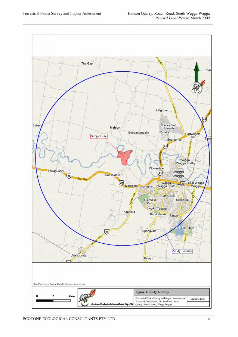
Terrestrial Fauna Survey and Impact Assessment Hanson Quarry, Roach Road, South Wagga Wagga
Revised Final Report March 2009
_______________________________________________________________________________________________
________________________________________________________________________________________________
ECOTONE ECOLOGICAL CONSULTANTS PTY LTD 4
Figure 1. Study Locality
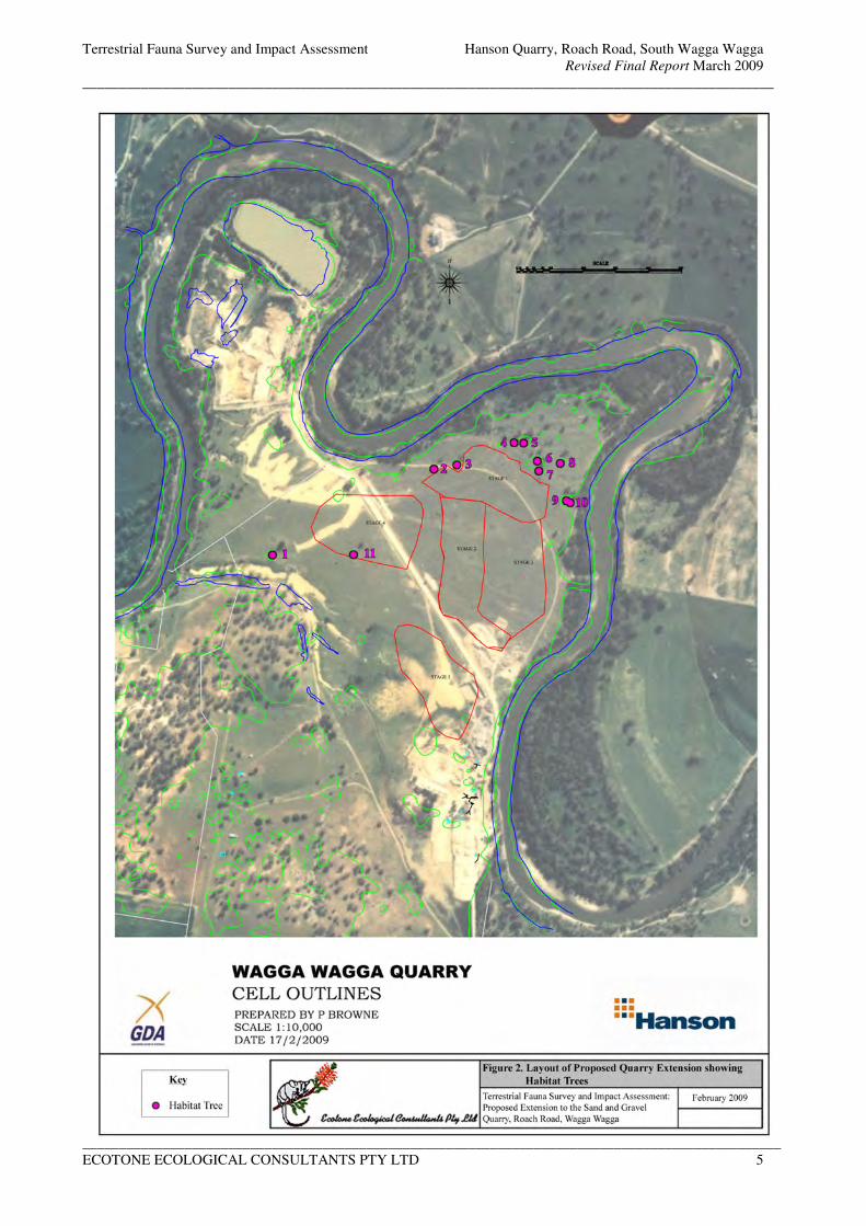
Terrestrial Fauna Survey and Impact Assessment Hanson Quarry, Roach Road, South Wagga Wagga
Revised Final Report March 2009
_______________________________________________________________________________________________
________________________________________________________________________________________________
ECOTONE ECOLOGICAL CONSULTANTS PTY LTD 5
Figure 2. Layout of the Proposed Quarry Extension showing Habitat Trees
Terrestrial Fauna Survey and Impact Assessment Hanson Quarry, Roach Road, South Wagga Wagga
Revised Final Report March 2009
_______________________________________________________________________________________________
________________________________________________________________________________________________
ECOTONE ECOLOGICAL CONSULTANTS PTY LTD 6
2.0 FIRST STAGE ECOLOGICAL INVESTIGATION – PRELIMINARY ASSESSMENT
2.1 Review of Local Threatened Fauna Species
A review of the documented records of the locations of threatened fauna species within the study
locality has been undertaken. Threatened species records were accessed from the DECC Atlas of
NSW Wildlife Database and BioNet (fauna only) for the Wagga Wagga (8327) 1: 100 000 map
sheets (updated to February 2009) and discussions with David Read, Wagga Wagga City Council.
A total of twenty-two (22) threatened terrestrial fauna species have previously been recorded within
the study locality, including sixteen bird and six mammal species. Of these, most species are
currently listed as Vulnerable on Schedule 2 of the TSC Act. Three species, the bush stone-curlew,
swift parrot and regent honeyeater, are listed as endangered, and one, the bilby, is listed as extinct
in NSW in Schedule 1 of the TSC Act. Five of the species are also listed on the Commonwealth
EPBC Act (1999). Three are listed as Endangered (spotted-tailed quoll, swift parrot and regent
honeyeater) and two as Vulnerable (superb parrot and bilby). The local threatened fauna species
previously recorded in the study locality by the DECC Wildlife Atlas are listed below in Table 2.
No further species were identified by the BioNet search.
Table 2. Threatened Fauna previously recorded within the Study Locality
Scientific Name Common Name Status
(TSC)
Status
(EPBC)
Earliest /
latest
record
Number
of records
within
10km of
site
Number
of records
within
2.5km of
site
Birds
Burhinus grallarius bush stone-curlew E1 - 1979-1999 3 0
Calyptorhynchus lathami glossy black cockatoo V - 2007 2 1
Cacatua leadbeateri Major Mitchell's or pink
cockatoo
V - 1998-1999 2 0
Callocephalon fimbriatum gang-gang cockatoo V - 1979 3 0
Climacteris picumnus
victoriae
brown treecreeper
(eastern subspecies)
V - 1979-2007 12 1
Lathamus discolor swift parrot E1 E 1996-2002 14 0
Melanodryas cucullata hooded robin V - 1979-2003 5 0
Melithreptus gularis
gularis
black-chinned
honeyeater (east subsp.)
V - 1977-2007 3 0
Neophema pulchella turquoise parrot V - 1996 1 0
Ninox connivens barking owl V - 1984-2004 5 1
Pachycephala inornata Gilbert's whistler V - 1979-1995 5 0
Polytelis swainsonii superb parrot V V 1986-2007 27 8
Pyrrholaemus sagittatus speckled warbler V - 1977 1 0
Stagonopleura guttata diamond firetail V - 1979-2007 6 0
Stictonetta naevosa freckled duck V - 2003 1 0
Xanthomyza phrygia regent honeyeater E1 E, Mi 1977-1980 1 0
Non-flying Mammals
Dasyurus maculatus Spotted-tailed quoll V E 2004-2006 1 0
Macrotis lagotis bilby E4 V 1912 1 0
Petaurus norfolcensis squirrel glider V, E2 - 1996-2006 8 1
Phascolarctos cinereus koala V - 2004-2006 2 0
Flying Mammals
Myotis macropus southern myotis V - 2000 1 0
Vespadelus baverstocki* Inland forest bat V - 2007 1 1
Terrestrial Fauna Survey and Impact Assessment Hanson Quarry, Roach Road, South Wagga Wagga
Revised Final Report March 2009
_______________________________________________________________________________________________
________________________________________________________________________________________________
ECOTONE ECOLOGICAL CONSULTANTS PTY LTD 7
Notes:
55 527800E and 6117000N are the closest coordinates to the centre of the study site: DECC Wildlife Atlas data from
Wagga Wagga (8327) 1:100000 mapsheets [GDA 94] as of January 2008.
* - record from surveys conducted for this project
Status (TSC): refers to the NSW Threatened Species Conservation Act 1995 (TSC)
E1 Schedule 1, Part 1: Endangered Species
E4 Schedule 1, Part 4: Species Presumed Extinct
V Schedule 2: Vulnerable Species
Status (EPBC): refers to the Commonwealth Environment Protection and Biodiversity Conservation Act 1999 (EPBC)
E Endangered Species
V Vulnerable Species
Mi Migratory Species
Please note: These records are based on information supplied by the Department of Environment and Climate Change
and other sources, and may contain errors or omissions.
Endangered Fauna Populations
The following populations of endangered fauna occur in the area covered by the 8327 1:100 000
map sheets:
• Squirrel glider Petaurus norfolcensis in the Wagga Wagga Local Government Area. This endangered population is relevant to the study area as the species is known to occur within the
riparian vegetation on the edge of the quarry boundary (David Read, WWCC).
2.2 EPBC Act Protected Matters Report
The EPBC Act Protected Matters Search Tool was accessed 27th
February 2009 to identify the
Protected Matters under the Commonwealth EPBC Act 1999 that occur, may occur or may be
relevant within the study locality. This review yielded a report (summarised in Table 3) listing the
matters that could potentially be relevant under the EPBC Act for activities within the study area.
Please note that species or other matters identified from the report as occurring, or having potential
to occur within the study locality, may not be relevant to the study area or subject site itself.
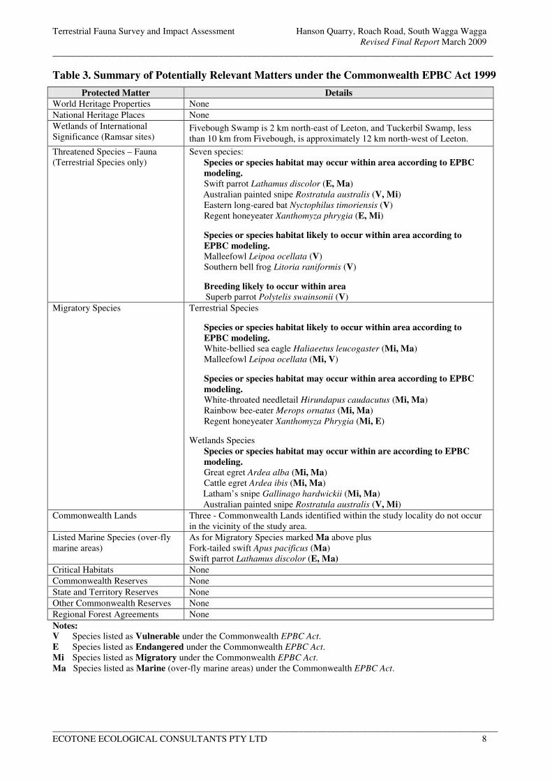
Terrestrial Fauna Survey and Impact Assessment Hanson Quarry, Roach Road, South Wagga Wagga
Revised Final Report March 2009
_______________________________________________________________________________________________
________________________________________________________________________________________________
ECOTONE ECOLOGICAL CONSULTANTS PTY LTD 8
Table 3. Summary of Potentially Relevant Matters under the Commonwealth EPBC Act 1999
Protected Matter Details
World Heritage Properties None
National Heritage Places None
Wetlands of International
Significance (Ramsar sites) Fivebough Swamp is 2 km north-east of Leeton, and Tuckerbil Swamp, less
than 10 km from Fivebough, is approximately 12 km north-west of Leeton.
Threatened Species – Fauna
(Terrestrial Species only)
Seven species:
Species or species habitat may occur within area according to EPBC
modeling.
Swift parrot Lathamus discolor (E, Ma)
Australian painted snipe Rostratula australis (V, Mi)
Eastern long-eared bat Nyctophilus timoriensis (V)
Regent honeyeater Xanthomyza phrygia (E, Mi)
Species or species habitat likely to occur within area according to
EPBC modeling.
Malleefowl Leipoa ocellata (V)
Southern bell frog Litoria raniformis (V)
Breeding likely to occur within area
Superb parrot Polytelis swainsonii (V)
Migratory Species Terrestrial Species
Species or species habitat likely to occur within area according to
EPBC modeling.
White-bellied sea eagle Haliaeetus leucogaster (Mi, Ma)
Malleefowl Leipoa ocellata (Mi, V)
Species or species habitat may occur within area according to EPBC
modeling.
White-throated needletail Hirundapus caudacutus (Mi, Ma)
Rainbow bee-eater Merops ornatus (Mi, Ma)
Regent honeyeater Xanthomyza Phrygia (Mi, E)
Wetlands Species
Species or species habitat may occur within are according to EPBC
modeling.
Great egret Ardea alba (Mi, Ma)
Cattle egret Ardea ibis (Mi, Ma)
Latham’s snipe Gallinago hardwickii (Mi, Ma)
Australian painted snipe Rostratula australis (V, Mi)
Commonwealth Lands Three - Commonwealth Lands identified within the study locality do not occur
in the vicinity of the study area.
Listed Marine Species (over-fly
marine areas)
As for Migratory Species marked Ma above plus
Fork-tailed swift Apus pacificus (Ma)
Swift parrot Lathamus discolor (E, Ma)
Critical Habitats None
Commonwealth Reserves None
State and Territory Reserves None
Other Commonwealth Reserves None
Regional Forest Agreements None
Notes: V Species listed as Vulnerable under the Commonwealth EPBC Act.
E Species listed as Endangered under the Commonwealth EPBC Act.
Mi Species listed as Migratory under the Commonwealth EPBC Act.
Ma Species listed as Marine (over-fly marine areas) under the Commonwealth EPBC Act.
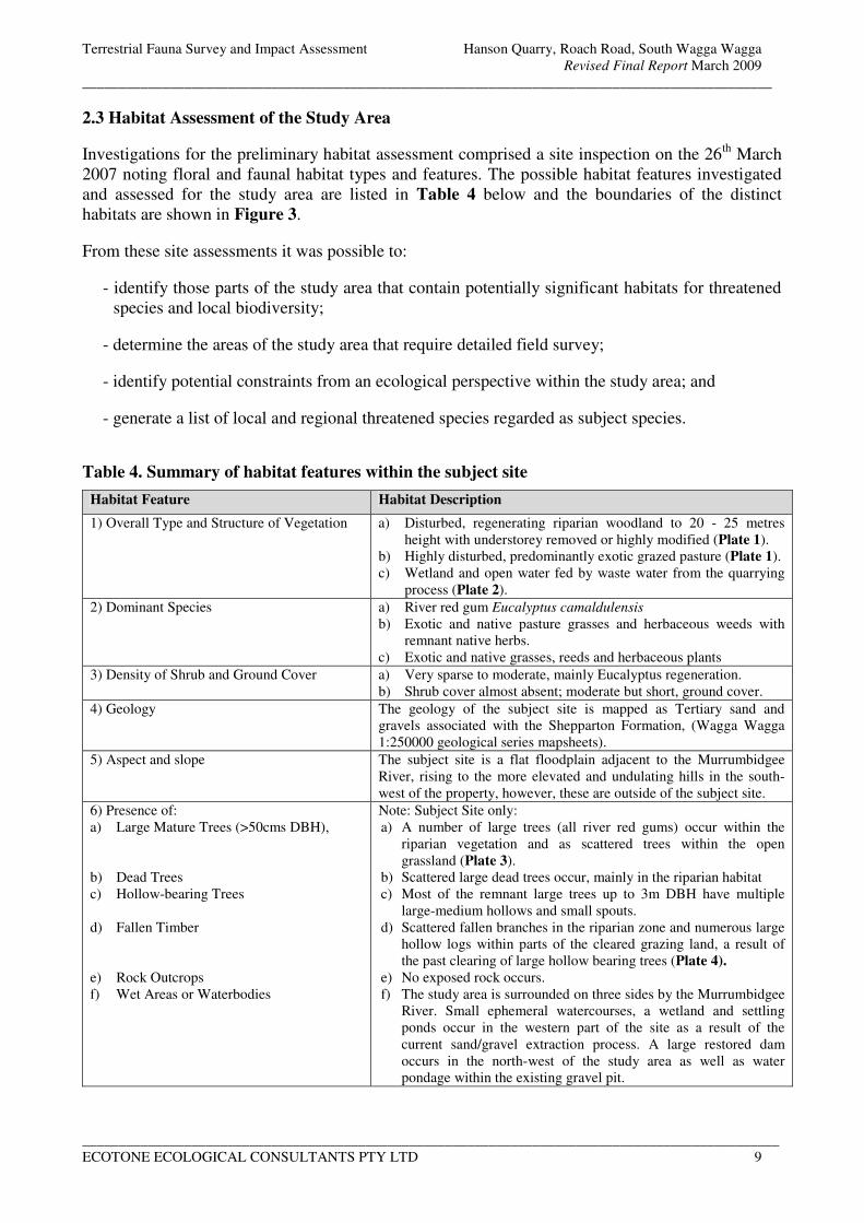
Terrestrial Fauna Survey and Impact Assessment Hanson Quarry, Roach Road, South Wagga Wagga
Revised Final Report March 2009
_______________________________________________________________________________________________
________________________________________________________________________________________________
ECOTONE ECOLOGICAL CONSULTANTS PTY LTD 9
2.3 Habitat Assessment of the Study Area
Investigations for the preliminary habitat assessment comprised a site inspection on the 26th
March
2007 noting floral and faunal habitat types and features. The possible habitat features investigated
and assessed for the study area are listed in Table 4 below and the boundaries of the distinct
habitats are shown in Figure 3.
From these site assessments it was possible to:
- identify those parts of the study area that contain potentially significant habitats for threatened
species and local biodiversity;
- determine the areas of the study area that require detailed field survey;
- identify potential constraints from an ecological perspective within the study area; and
- generate a list of local and regional threatened species regarded as subject species.
Table 4. Summary of habitat features within the subject site
Habitat Feature Habitat Description
1) Overall Type and Structure of Vegetation a) Disturbed, regenerating riparian woodland to 20 - 25 metres
height with understorey removed or highly modified (Plate 1).
b) Highly disturbed, predominantly exotic grazed pasture (Plate 1).
c) Wetland and open water fed by waste water from the quarrying
process (Plate 2).
2) Dominant Species a) River red gum Eucalyptus camaldulensis
b) Exotic and native pasture grasses and herbaceous weeds with
remnant native herbs.
c) Exotic and native grasses, reeds and herbaceous plants
3) Density of Shrub and Ground Cover a) Very sparse to moderate, mainly Eucalyptus regeneration.
b) Shrub cover almost absent; moderate but short, ground cover.
4) Geology The geology of the subject site is mapped as Tertiary sand and
gravels associated with the Shepparton Formation, (Wagga Wagga
1:250000 geological series mapsheets).
5) Aspect and slope The subject site is a flat floodplain adjacent to the Murrumbidgee
River, rising to the more elevated and undulating hills in the south-
west of the property, however, these are outside of the subject site.
6) Presence of:
a) Large Mature Trees (>50cms DBH),
b) Dead Trees
c) Hollow-bearing Trees
d) Fallen Timber
e) Rock Outcrops
f) Wet Areas or Waterbodies
Note: Subject Site only:
a) A number of large trees (all river red gums) occur within the
riparian vegetation and as scattered trees within the open
grassland (Plate 3).
b) Scattered large dead trees occur, mainly in the riparian habitat
c) Most of the remnant large trees up to 3m DBH have multiple
large-medium hollows and small spouts.
d) Scattered fallen branches in the riparian zone and numerous large
hollow logs within parts of the cleared grazing land, a result of
the past clearing of large hollow bearing trees (Plate 4).
e) No exposed rock occurs.
f) The study area is surrounded on three sides by the Murrumbidgee
River. Small ephemeral watercourses, a wetland and settling
ponds occur in the western part of the site as a result of the
current sand/gravel extraction process. A large restored dam
occurs in the north-west of the study area as well as water
pondage within the existing gravel pit.
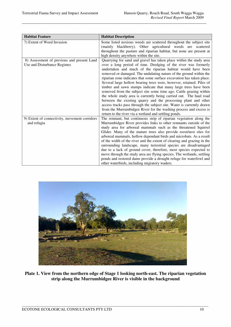
Terrestrial Fauna Survey and Impact Assessment Hanson Quarry, Roach Road, South Wagga Wagga
Revised Final Report March 2009
_______________________________________________________________________________________________
________________________________________________________________________________________________
ECOTONE ECOLOGICAL CONSULTANTS PTY LTD 10
Habitat Feature Habitat Description
7) Extent of Weed Invasion Some listed noxious weeds are scattered throughout the subject site
(mainly blackberry). Other agricultural weeds are scattered
throughout the pasture and riparian habitat, but none are present at
high density anywhere within the site.
8) Assessment of previous and present Land
Use and Disturbance Regimes
Quarrying for sand and gravel has taken place within the study area
over a long period of time. Dredging of the river was formerly
undertaken and much of the riparian habitat would have been
removed or damaged. The undulating nature of the ground within the
riparian zone indicates that some surface excavation has taken place.
Several large hollow bearing trees were, however, retained. Piles of
timber and sawn stumps indicate that many large trees have been
removed from the subject site some time ago. Cattle grazing within
the whole study area is currently being carried out. The haul road
between the existing quarry and the processing plant and other
access tracks pass through the subject site. Water is currently drawn
from the Murrumbidgee River for the washing process and excess is
return to the river via a wetland and settling ponds.
9) Extent of connectivity, movement corridors
and refugia
The remnant, but continuous strip of riparian vegetation along the
Murrumbidgee River provides links to other remnants outside of the
study area for arboreal mammals such as the threatened Squirrel
Glider. Many of the mature trees also provide roost/nest sites for
arboreal mammals, hollow dependant birds and microbats. As a result
of the width of the river and the extent of clearing and grazing in the
surrounding landscape, many terrestrial species are disadvantaged
due to a lack of ground cover, therefore, most species expected to
move through the study area are flying species. The wetlands, settling
ponds and restored dams provide a drought refuge for waterfowl and
other waterbirds, including migratory waders.
Plate 1. View from the northern edge of Stage 1 looking north-east. The riparian vegetation
strip along the Murrumbidgee River is visible in the background
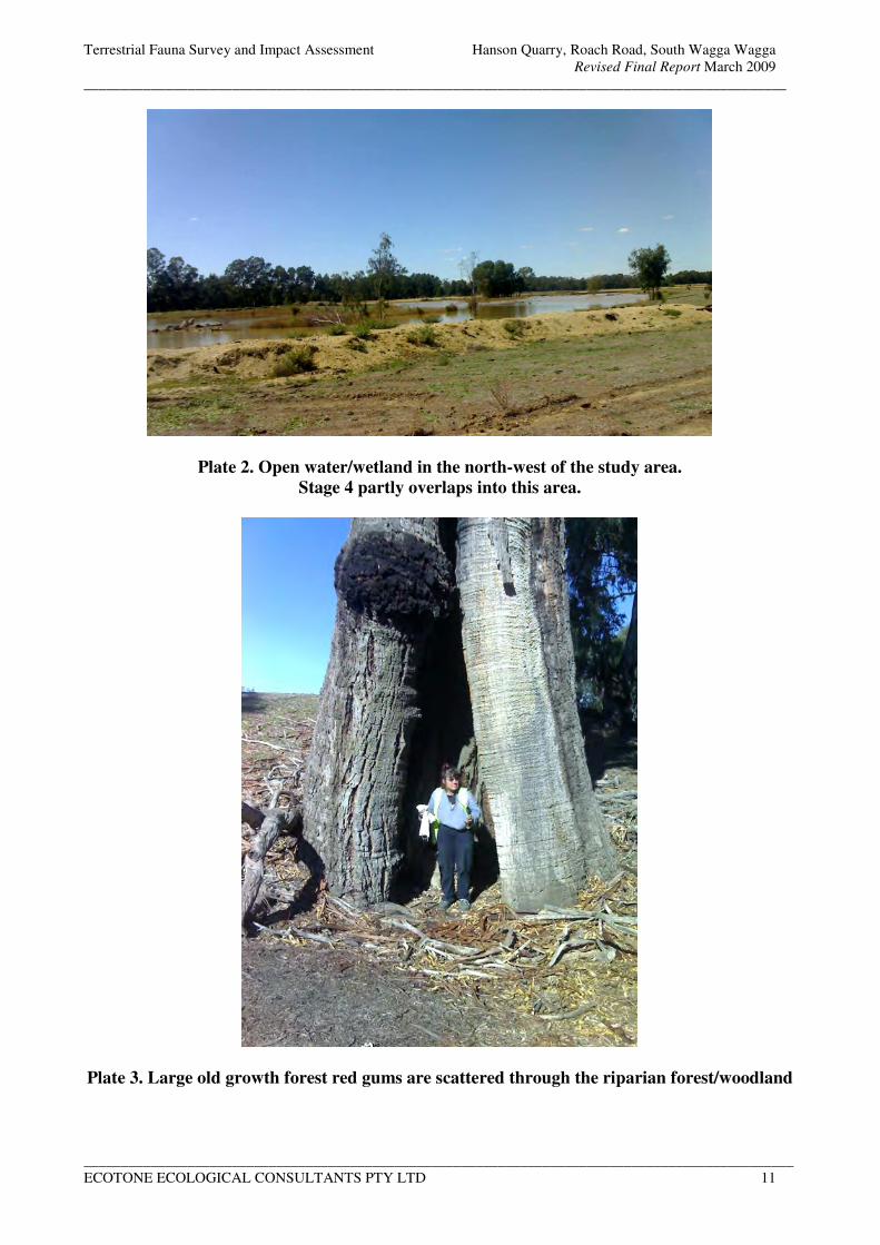
Terrestrial Fauna Survey and Impact Assessment Hanson Quarry, Roach Road, South Wagga Wagga
Revised Final Report March 2009
_______________________________________________________________________________________________
________________________________________________________________________________________________
ECOTONE ECOLOGICAL CONSULTANTS PTY LTD 11
Plate 2. Open water/wetland in the north-west of the study area.
Stage 4 partly overlaps into this area.
Plate 3. Large old growth forest red gums are scattered through the riparian forest/woodland
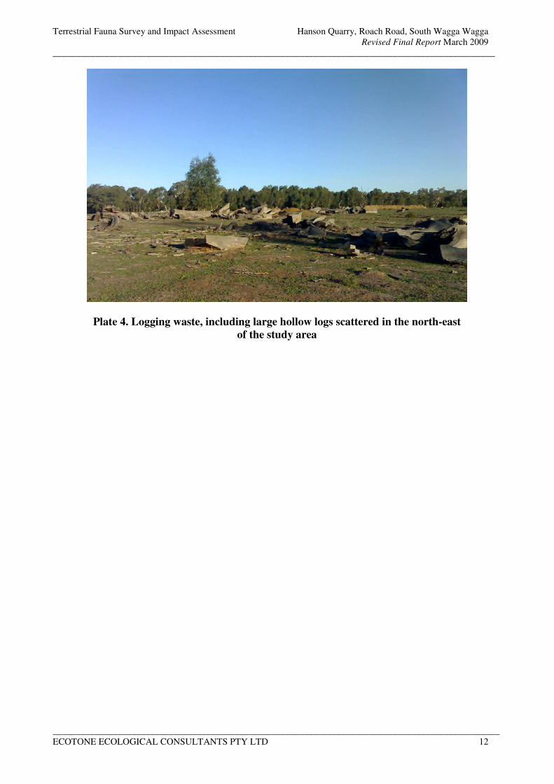
Terrestrial Fauna Survey and Impact Assessment Hanson Quarry, Roach Road, South Wagga Wagga
Revised Final Report March 2009
_______________________________________________________________________________________________
________________________________________________________________________________________________
ECOTONE ECOLOGICAL CONSULTANTS PTY LTD 12
Plate 4. Logging waste, including large hollow logs scattered in the north-east
of the study area
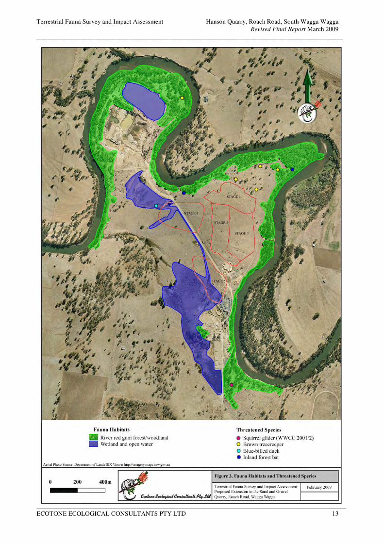
Terrestrial Fauna Survey and Impact Assessment Hanson Quarry, Roach Road, South Wagga Wagga
Revised Final Report March 2009
_______________________________________________________________________________________________
________________________________________________________________________________________________
ECOTONE ECOLOGICAL CONSULTANTS PTY LTD 13
Figure 3. Fauna Habitats and Threatened Species
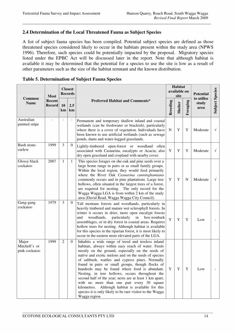
Terrestrial Fauna Survey and Impact Assessment Hanson Quarry, Roach Road, South Wagga Wagga
Revised Final Report March 2009
_______________________________________________________________________________________________
________________________________________________________________________________________________
ECOTONE ECOLOGICAL CONSULTANTS PTY LTD 14
2.4 Determination of the Local Threatened Fauna as Subject Species
A list of subject fauna species has been compiled. Potential subject species are defined as those
threatened species considered likely to occur in the habitats present within the study area (NPWS
1996). Therefore, such species could be potentially impacted by the proposal. Migratory species
listed under the EPBC Act will be discussed later in the report. Note that although habitat is
available it may be determined that the potential for a species to use the site is low as a result of
other parameters such as the size of the habitat remnant and the known distribution.
Table 5. Determination of Subject Fauna Species
Closest
Records
Habitat
available on
site Common
Name
Most
Recent
Record 10
km
2.5
km
Preferred Habitat and Comments*
Bre
edin
g
Sh
elte
r
Fo
rag
ing
Potential
to utilise
study
area
Su
bje
ct S
pec
ies
Australian
painted snipe
- - - Permanent and temporary shallow inland and coastal
wetlands (can be freshwater or brackish), particularly
where there is a cover of vegetation. Individuals have
been known to use artificial wetlands (such as sewage
ponds, dams and water-logged grasslands.
N Y Y Moderate √
Bush stone-
curlew
1999 3 0 Lightly-timbered open-forest or woodland often
associated with Casuarina, eucalypts or Acacia; also
dry open grassland and cropland with nearby cover.
Y Y Y Moderate √
Glossy black
cockatoo
2007 1 1 This species forages on she-oak and pine seeds over a
large home range in pairs or as small family groups.
Within the local region, they would feed primarily
where the River Oak Casuarina cunninghamiana
commonly occurs and in pine plantations. Large tree
hollows, often situated in the largest trees of a forest,
are required for nesting. The only record for the
Wagga Wagga LGA is from within 2 km of the study
area (David Read, Wagga Wagga City Council).
Y Y N Moderate √
Gang-gang
cockatoo
1979 3 0 Tall montane forests and woodlands, particularly in
heavily timbered and mature wet sclerophyll forests. In
winter it occurs in drier, more open eucalypt forests
and woodlands, particularly in box-ironbark
assemblages, or in dry forest in coastal areas. Requires
hollow trees for nesting. Although habitat is available
for this species in the riparian forest, it is most likely to
occur in the eastern more elevated parts of the LGA.
Y Y Y Low -
Major
Mitchell’s or
pink cockatoo
1999 2 0 Inhabits a wide range of treed and treeless inland
habitats, always within easy reach of water. Feeds
mostly on the ground, especially on the seeds of
native and exotic melons and on the seeds of species
of saltbush, wattles and cypress pines. Normally
found in pairs or small groups, though flocks of
hundreds may be found where food is abundant.
Nesting, in tree hollows, occurs throughout the
second half of the year; nests are at least 1 km apart,
with no more than one pair every 30 square
kilometres. Although habitat is available for this
species it is only likely to be rare visitor to the Wagga
Wagga region
Y Y Y Low -
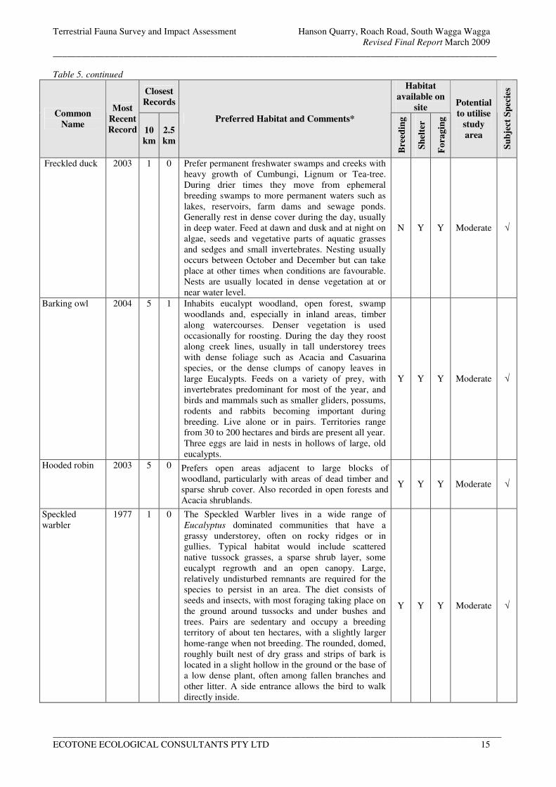
Terrestrial Fauna Survey and Impact Assessment Hanson Quarry, Roach Road, South Wagga Wagga
Revised Final Report March 2009
_______________________________________________________________________________________________
________________________________________________________________________________________________
ECOTONE ECOLOGICAL CONSULTANTS PTY LTD 15
Table 5. continued
Closest
Records
Habitat
available on
site Common
Name
Most
Recent
Record 10
km
2.5
km
Preferred Habitat and Comments*
Bre
edin
g
Sh
elte
r
Fo
rag
ing
Potential
to utilise
study
area
Su
bje
ct S
pec
ies
Freckled duck 2003 1 0 Prefer permanent freshwater swamps and creeks with
heavy growth of Cumbungi, Lignum or Tea-tree.
During drier times they move from ephemeral
breeding swamps to more permanent waters such as
lakes, reservoirs, farm dams and sewage ponds.
Generally rest in dense cover during the day, usually
in deep water. Feed at dawn and dusk and at night on
algae, seeds and vegetative parts of aquatic grasses
and sedges and small invertebrates. Nesting usually
occurs between October and December but can take
place at other times when conditions are favourable.
Nests are usually located in dense vegetation at or
near water level.
N Y Y Moderate √
Barking owl 2004 5 1 Inhabits eucalypt woodland, open forest, swamp
woodlands and, especially in inland areas, timber
along watercourses. Denser vegetation is used
occasionally for roosting. During the day they roost
along creek lines, usually in tall understorey trees
with dense foliage such as Acacia and Casuarina
species, or the dense clumps of canopy leaves in
large Eucalypts. Feeds on a variety of prey, with
invertebrates predominant for most of the year, and
birds and mammals such as smaller gliders, possums,
rodents and rabbits becoming important during
breeding. Live alone or in pairs. Territories range
from 30 to 200 hectares and birds are present all year.
Three eggs are laid in nests in hollows of large, old
eucalypts.
Y Y Y Moderate √
Hooded robin 2003 5 0 Prefers open areas adjacent to large blocks of
woodland, particularly with areas of dead timber and
sparse shrub cover. Also recorded in open forests and
Acacia shrublands.
Y Y Y Moderate √
Speckled
warbler
1977 1 0 The Speckled Warbler lives in a wide range of
Eucalyptus dominated communities that have a
grassy understorey, often on rocky ridges or in
gullies. Typical habitat would include scattered
native tussock grasses, a sparse shrub layer, some
eucalypt regrowth and an open canopy. Large,
relatively undisturbed remnants are required for the
species to persist in an area. The diet consists of
seeds and insects, with most foraging taking place on
the ground around tussocks and under bushes and
trees. Pairs are sedentary and occupy a breeding
territory of about ten hectares, with a slightly larger
home-range when not breeding. The rounded, domed,
roughly built nest of dry grass and strips of bark is
located in a slight hollow in the ground or the base of
a low dense plant, often among fallen branches and
other litter. A side entrance allows the bird to walk
directly inside.
Y Y Y Moderate √
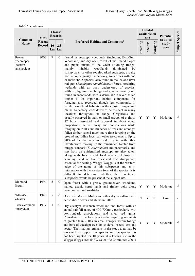
Terrestrial Fauna Survey and Impact Assessment Hanson Quarry, Roach Road, South Wagga Wagga
Revised Final Report March 2009
_______________________________________________________________________________________________
________________________________________________________________________________________________
ECOTONE ECOLOGICAL CONSULTANTS PTY LTD 16
Table 5. continued
Closest
Records
Habitat
available on
site Common
Name
Most
Recent
Record 10
km
2.5
km
Preferred Habitat and Comments*
Bre
edin
g
Sh
elte
r
Fo
rag
ing
Potential
to utilise
study
area
Su
bje
ct S
pec
ies
Brown
treecreeper
(eastern
subspecies)
2003 9 0 Found in eucalypt woodlands (including Box-Gum
Woodland) and dry open forest of the inland slopes
and plains inland of the Great Dividing Range;
mainly inhabits woodlands dominated by
stringybarks or other rough-barked eucalypts, usually
with an open grassy understorey, sometimes with one
or more shrub species; also found in mallee and river
red gum (Eucalyptus camaldulensis) Forest bordering
wetlands with an open understorey of acacias,
saltbush, lignum, cumbungi and grasses; usually not
found in woodlands with a dense shrub layer; fallen
timber is an important habitat component for
foraging; also recorded, though less commonly, in
similar woodland habitats on the coastal ranges and
plains. Sedentary, considered to be resident in many
locations throughout its range. Gregarious and
usually observed in pairs or small groups of eight to
12 birds; terrestrial and arboreal in about equal
proportions; active, noisy and conspicuous while
foraging on trunks and branches of trees and amongst
fallen timber; spend much more time foraging on the
ground and fallen logs than other treecreepers. Up to
80% of the diet is comprised of ants, with other
invertebrates making up the remainder. Nectar from
mugga ironbark (E. sideroxylon) and paperbarks, and
sap from an unidentified eucalypt are also eaten,
along with lizards and food scraps. Hollows in
standing dead or live trees and tree stumps are
essential for nesting. Wagga Wagga is at the western
edge of the range of this subspecies and as it
intergrades with the western form of the species, it is
difficult to determine whether the threatened
subspecies would be present at the subject site.
Y Y Y Moderate √
Diamond
firetail
1994 5 0 Open forest with a grassy groundcover, woodland,
mallee, acacia scrub lands and timber belts along
watercourses and roadsides.
Y Y Y Moderate √
Gilbert’s
whistler
1995 5 0 Occurs in Mallee, Mulga and other dry woodland with
dense shrub cover and abundant litter. N Y N Low -
Black-chinned
honeyeater
1977 1 0 Dry eucalypt savannah woodland and forest with an
annual rainfall range of 400-700mm, particularly with
box-ironbark associations and river red gums.
Considered to be locally nomadic requiring remnants
of greater than 200ha in area. Forages within foliage
and bark of eucalypt trees on spiders, insects, lerp and
nectar. The riparian remnants in the study area may be
too small to support this species and the species has
not been sighted for 10 years at a known site in the
Wagga Wagga area (NSW Scientific Committee 2001)
Y Y Y Moderate √
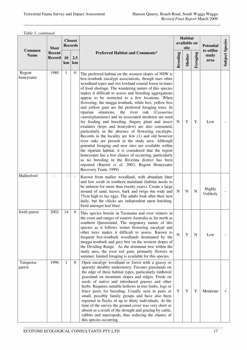
Terrestrial Fauna Survey and Impact Assessment Hanson Quarry, Roach Road, South Wagga Wagga
Revised Final Report March 2009
_______________________________________________________________________________________________
________________________________________________________________________________________________
ECOTONE ECOLOGICAL CONSULTANTS PTY LTD 17
Table 5. continued
Closest
Records
Habitat
available on
site Common
Name
Most
Recent
Record 10
km
2.5
km
Preferred Habitat and Comments*
Bre
edin
g
Sh
elte
r
Fo
rag
ing
Potential
to utilise
study
area
Su
bje
ct S
pec
ies
Regent
honeyeater
1980 1 0 The preferred habitat on the western slopes of NSW is
box-ironbark eucalypt associations, though uses other
woodland types and wet lowland coastal forest in times
of food shortage. The wandering nature of this species
makes it difficult to assess and breeding aggregations
appear to be restricted to a few locations. When
flowering, the mugga ironbark, white box, yellow box
and yellow gum are the preferred foraging trees. In
riparian situations, the river oak (Casuarina
cunninghamiana) and its associated mistletoe are used
for feeding and breeding. Sugary plant and insect
exudates (lerps and honeydew) are also consumed,
particularly in the absence of flowering eucalypts.
Records in the locality are few (1) and old however
river oaks are present in the study area. Although
potential foraging and nest sites are available within
the riparian habitat, it is considered that the regent
honeyeater has a low chance of occurring, particularly
as no breeding in the Riverina district has been
reported (Barrett et al. 2003, Regent Honeyeater
Recovery Team, 1999)
N Y Y Low -
Malleefowl - - - Known from mallee woodland, with abundant litter
and low scrub in southern mainland (habitat needs to
be unburnt for more than twenty years). Create a large
mound of sand, leaves, bark and twigs 4m wide and
75cm high to lay eggs. The adults look after their nest
daily, but the chicks are independent upon hatching.
Feed amongst leaf litter.
N N N Highly
Unlikely -
Swift parrot 2002 14 0 This species breeds in Tasmania and over winters in
the coast and ranges of eastern Australia as far north as
southern Queensland. The migratory nature of this
species as it follows winter flowering eucalypt and
other trees makes it difficult to assess. Known to
frequent box-ironbark woodlands dominated by the
mugga ironbark and grey box on the western slopes of
the Dividing Range. As the dominant tree within the
study area, the river red gum, primarily flowers in
summer, limited foraging is available for this species.
N Y N Low -
Turquoise
parrot
1996 1 0 Open eucalypt woodland or forest with a grassy or
sparsely shrubby understorey. Favours grasslands on
the edge of these habitat types, particularly timbered
grassland on mountain slopes and ridges. Feeds on
seeds of native and introduced grasses and other
herbs. Requires suitable hollows in tree limbs, logs or
fence posts for breeding. Usually seen in pairs or
small, possibly family groups and have also been
reported in flocks of up to thirty individuals. At the
time of the survey the ground cover was very short or
absent as a result of the drought and grazing by cattle,
rabbits and macropods, thus reducing the chance of
this species occurring.
Y Y Y Moderate √
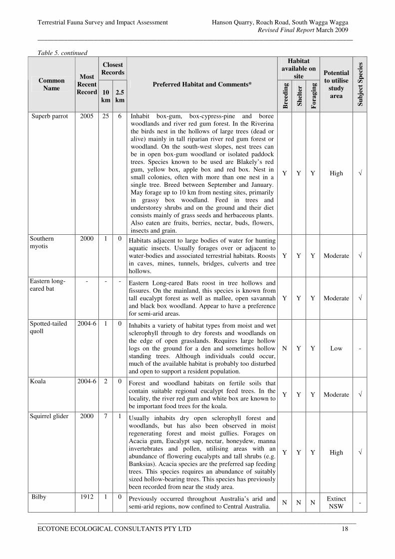
Terrestrial Fauna Survey and Impact Assessment Hanson Quarry, Roach Road, South Wagga Wagga
Revised Final Report March 2009
_______________________________________________________________________________________________
________________________________________________________________________________________________
ECOTONE ECOLOGICAL CONSULTANTS PTY LTD 18
Table 5. continued
Closest
Records
Habitat
available on
site Common
Name
Most
Recent
Record 10
km
2.5
km
Preferred Habitat and Comments*
Bre
edin
g
Sh
elte
r
Fo
rag
ing
Potential
to utilise
study
area
Su
bje
ct S
pec
ies
Superb parrot 2005 25 6 Inhabit box-gum, box-cypress-pine and boree
woodlands and river red gum forest. In the Riverina
the birds nest in the hollows of large trees (dead or
alive) mainly in tall riparian river red gum forest or
woodland. On the south-west slopes, nest trees can
be in open box-gum woodland or isolated paddock
trees. Species known to be used are Blakely’s red
gum, yellow box, apple box and red box. Nest in
small colonies, often with more than one nest in a
single tree. Breed between September and January.
May forage up to 10 km from nesting sites, primarily
in grassy box woodland. Feed in trees and
understorey shrubs and on the ground and their diet
consists mainly of grass seeds and herbaceous plants.
Also eaten are fruits, berries, nectar, buds, flowers,
insects and grain.
Y Y Y High √
Southern
myotis
2000 1 0 Habitats adjacent to large bodies of water for hunting
aquatic insects. Usually forages over or adjacent to
water-bodies and associated terrestrial habitats. Roosts
in caves, mines, tunnels, bridges, culverts and tree
hollows.
Y Y Y Moderate √
Eastern long-
eared bat
- - - Eastern Long-eared Bats roost in tree hollows and
fissures. On the mainland, this species is known from
tall eucalypt forest as well as mallee, open savannah
and black box woodland. Appear to have a preference
for semi-arid areas.
Y Y Y Moderate √
Spotted-tailed
quoll
2004-6 1 0 Inhabits a variety of habitat types from moist and wet
sclerophyll through to dry forests and woodlands on
the edge of open grasslands. Requires large hollow
logs on the ground for a den and sometimes hollow
standing trees. Although individuals could occur,
much of the available habitat is probably too disturbed
and open to support a resident population.
N Y Y Low -
Koala 2004-6 2 0 Forest and woodland habitats on fertile soils that
contain suitable regional eucalypt feed trees. In the
locality, the river red gum and white box are known to
be important food trees for the koala.
Y Y Y Moderate √
Squirrel glider 2000 7 1 Usually inhabits dry open sclerophyll forest and
woodlands, but has also been observed in moist
regenerating forest and moist gullies. Forages on
Acacia gum, Eucalypt sap, nectar, honeydew, manna
invertebrates and pollen, utilising areas with an
abundance of flowering eucalypts and tall shrubs (e.g.
Banksias). Acacia species are the preferred sap feeding
trees. This species requires an abundance of suitably
sized hollow-bearing trees. This species has previously
been recorded from near the study area.
Y Y Y High √
Bilby 1912 1 0 Previously occurred throughout Australia’s arid and
semi-arid regions, now confined to Central Australia. N N N
Extinct
NSW -
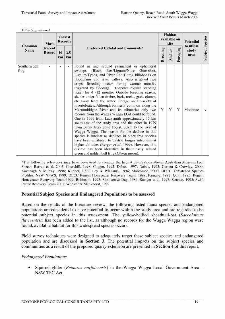
Terrestrial Fauna Survey and Impact Assessment Hanson Quarry, Roach Road, South Wagga Wagga
Revised Final Report March 2009
_______________________________________________________________________________________________
________________________________________________________________________________________________
ECOTONE ECOLOGICAL CONSULTANTS PTY LTD 19
Table 5. continued
Closest
Records
Habitat
available on
site Common
Name
Most
Recent
Record 10
km
2.5
km
Preferred Habitat and Comments*
Bre
edin
g
Sh
elte
r
Fo
rag
ing
Potential
to utilise
study
area
Su
bje
ct S
pec
ies
Southern bell
frog
- - - Found in and around permanent or ephemeral
swamps (Black Box/Lignum/Nitre Goosefoot,
Lignum/Typha, and River Red Gum), billabongs on
floodplains and river valleys. Also irrigated rice
crops. Breeding occurs during warmer months,
triggered by flooding. Tadpoles require standing
water for 4 -12 months. Outside breeding season,
shelter under fallen timber, bark, rocks, grass clumps
etc away from the water. Forage on a variety of
invertebrates. Although formerly common along the
Murrumbidgee River and its tributaries only two
records from the Wagga Wagga LGA could be found.
One in 1999 from Ladysmith approximately 15 km
south-east of the study area and the other in 1979
from Berry Jerry State Forest, 30km to the west of
Wagga Wagga. The reason for the decline in this
species is unclear as declines in other frog species
have been attributed to chytrid fungus infections at
higher altitudes (Berger et al. 1999). However, this
disease has been identified in the closely related
green and golden bell frog (Litoria aurea).
Y Y Y Moderate √
*The following references may have been used to compile the habitat descriptions above: Australian Museum Fact
Sheets; Barrett et al. 2003; Churchill, 1998; Cogger, 1995; Debus, 1997; Debus, 1993; Garnett & Crowley, 2000;
Kavanagh & Murray, 1996; Klippel, 1992; Ley & Williams, 1994; Morcombe, 2000; DECC Threatened Species
Profiles; NSW NPWS, 1999; DECC Regent Honeyeater Recovery Team, 1999; Parnaby, 1992; Quin, 1995; Regent
Honeyeater Recovery Team 1999; Robinson, 1993; Simpson & Day, 1984; Stanger et al, 1997; Strahan, 1995; Swift
Parrot Recovery Team 2001; Webster & Menkhorst, 1992.
Potential Subject Species and Endangered Populations to be assessed
Based on the results of the literature review, the following listed fauna species and endangered
populations are considered to have potential to occur within the study area and are regarded to be
potential subject species in this assessment. The yellow-bellied sheathtail-bat (Saccolaimus
flaviventris) has been added to the list, as although no records for the Wagga Wagga region were
found, available habitat for this widespread species occurs.
Field survey techniques were designed to adequately target these subject species and endangered
population and are discussed in Section 3. The potential impacts on the subject species and
communities as a result of the proposed quarry extension are presented in Section 4 of this report.
Endangered Populations
• Squirrel glider (Petaurus norfolcensis) in the Wagga Wagga Local Government Area –
NSW TSC Act

Terrestrial Fauna Survey and Impact Assessment Hanson Quarry, Roach Road, South Wagga Wagga
Revised Final Report March 2009
_______________________________________________________________________________________________
________________________________________________________________________________________________
ECOTONE ECOLOGICAL CONSULTANTS PTY LTD 20
Threatened Fauna
• Bush stone-curlew (Burhinus grallarius) – endangered NSW TSC Act
• Australian painted snipe (Rostratula australis) – - endangered NSW TSC Act and
vulnerable Federal EPBC Act
• Freckled duck (Stictonetta naevosa) – vulnerable NSW TSC Act
• Glossy black cockatoo (Calyptorhynchus lathami) – vulnerable NSW TSC Act
• Turquoise parrot (Neophema pulchella) – vulnerable NSW TSC Act
• Superb parrot (Polytelis swainsonii) – vulnerable NSW TSC Act and Federal EPBC Act
• Brown treecreeper (eastern subspecies) (Climacteris picumnus victoriae) – vulnerable
NSW TSC Act
• Black-chinned honeyeater (Melithreptus gularis gularis) – vulnerable NSW TSC Act
• Hooded robin (Melanodryas cucullata) – vulnerable NSW TSC Act
• Diamond firetail (Stagonopleura guttata) – vulnerable NSW TSC Act
• Speckled warbler (Pyrrholaemus sagittatus) – vulnerable NSW TSC Act
• Barking owl (Ninox connivens) – vulnerable NSW TSC Act
• Eastern long-eared bat (Nyctophilus timoriensis) – vulnerable NSW TSC Act and Federal
EPBC Act
• Southern myotis (Myotis macropus formerly adversus) – vulnerable NSW TSC Act
• Yellow-bellied sheathtail-bat (Saccolaimus flaviventris) – vulnerable NSW TSC Act
• Koala (Phascolarctos cinereus) – vulnerable NSW TSC Act
• Squirrel glider (Petaurus norfolcensis) – vulnerable NSW TSC Act
• Southern bell frog (Litoria raniformis) - endangered NSW TSC Act and vulnerable
Federal EPBC Act
Note that the record for inland forest bat (Vespadelus baverstocki) shown in Table 2 is the same as
that recorded during the surveys for this project.
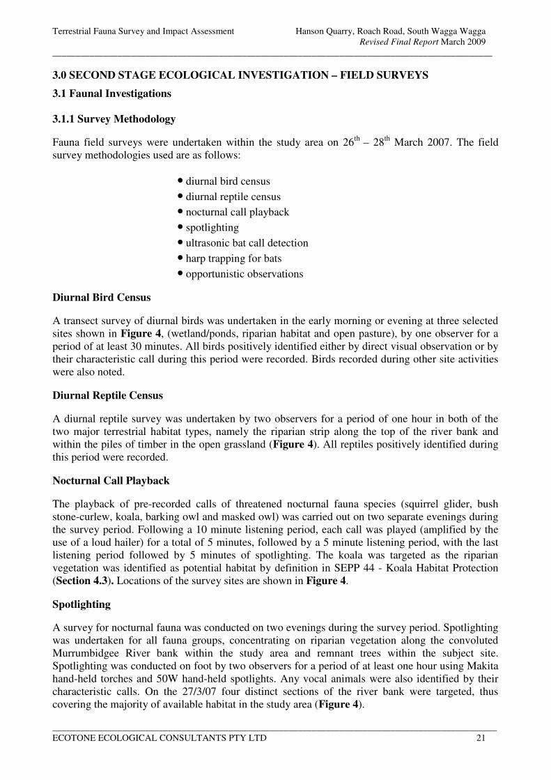
Terrestrial Fauna Survey and Impact Assessment Hanson Quarry, Roach Road, South Wagga Wagga
Revised Final Report March 2009
_______________________________________________________________________________________________
________________________________________________________________________________________________
ECOTONE ECOLOGICAL CONSULTANTS PTY LTD 21
3.0 SECOND STAGE ECOLOGICAL INVESTIGATION – FIELD SURVEYS
3.1 Faunal Investigations
3.1.1 Survey Methodology
Fauna field surveys were undertaken within the study area on 26th
– 28th
March 2007. The field
survey methodologies used are as follows:
• diurnal bird census
• diurnal reptile census
• nocturnal call playback
• spotlighting
• ultrasonic bat call detection
• harp trapping for bats
• opportunistic observations
Diurnal Bird Census
A transect survey of diurnal birds was undertaken in the early morning or evening at three selected
sites shown in Figure 4, (wetland/ponds, riparian habitat and open pasture), by one observer for a
period of at least 30 minutes. All birds positively identified either by direct visual observation or by
their characteristic call during this period were recorded. Birds recorded during other site activities
were also noted.
Diurnal Reptile Census
A diurnal reptile survey was undertaken by two observers for a period of one hour in both of the
two major terrestrial habitat types, namely the riparian strip along the top of the river bank and
within the piles of timber in the open grassland (Figure 4). All reptiles positively identified during
this period were recorded.
Nocturnal Call Playback
The playback of pre-recorded calls of threatened nocturnal fauna species (squirrel glider, bush
stone-curlew, koala, barking owl and masked owl) was carried out on two separate evenings during
the survey period. Following a 10 minute listening period, each call was played (amplified by the
use of a loud hailer) for a total of 5 minutes, followed by a 5 minute listening period, with the last
listening period followed by 5 minutes of spotlighting. The koala was targeted as the riparian
vegetation was identified as potential habitat by definition in SEPP 44 - Koala Habitat Protection
(Section 4.3). Locations of the survey sites are shown in Figure 4.
Spotlighting
A survey for nocturnal fauna was conducted on two evenings during the survey period. Spotlighting
was undertaken for all fauna groups, concentrating on riparian vegetation along the convoluted
Murrumbidgee River bank within the study area and remnant trees within the subject site.
Spotlighting was conducted on foot by two observers for a period of at least one hour using Makita
hand-held torches and 50W hand-held spotlights. Any vocal animals were also identified by their
characteristic calls. On the 27/3/07 four distinct sections of the river bank were targeted, thus
covering the majority of available habitat in the study area (Figure 4).
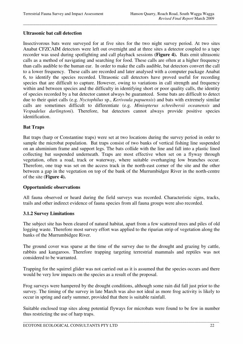
Terrestrial Fauna Survey and Impact Assessment Hanson Quarry, Roach Road, South Wagga Wagga
Revised Final Report March 2009
_______________________________________________________________________________________________
________________________________________________________________________________________________
ECOTONE ECOLOGICAL CONSULTANTS PTY LTD 22
Ultrasonic bat call detection
Insectivorous bats were surveyed for at five sites for the two night survey period. At two sites
Anabat CFZCAIM detectors were left out overnight and at three sites a detector coupled to a tape
recorder was used during spotlighting and call playback sessions (Figure 4). Bats emit ultrasonic
calls as a method of navigating and searching for food. These calls are often at a higher frequency
than calls audible to the human ear. In order to make the calls audible, bat detectors convert the call
to a lower frequency. These calls are recorded and later analysed with a computer package Anabat
6, to identify the species recorded. Ultrasonic call detectors have proved useful for recording
species that are difficult to capture. However, owing to variations in call strength and frequency
within and between species and the difficulty in identifying short or poor quality calls, the identity
of species recorded by a bat detector cannot always be guaranteed. Some bats are difficult to detect
due to their quiet calls (e.g. Nyctophilus sp., Kerivoula papuensis) and bats with extremely similar
calls are sometimes difficult to differentiate (e.g. Miniopterus schreibersii oceanensis and
Vespadelus darlingtoni). Therefore, bat detectors cannot always provide positive species
identification.
Bat Traps
Bat traps (harp or Constantine traps) were set at two locations during the survey period in order to
sample the microbat population. Bat traps consist of two banks of vertical fishing line suspended
on an aluminium frame and support legs. The bats collide with the line and fall into a plastic lined
collecting bat suspended underneath. Traps are most effective when set on a flyway through
vegetation, often a road, track or waterway, where suitable overhanging low branches occur.
Therefore, one trap was set on the access track in the north-east corner of the site and the other
between a gap in the vegetation on top of the bank of the Murrumbidgee River in the north-centre
of the site (Figure 4).
Opportunistic observations
All fauna observed or heard during the field surveys was recorded. Characteristic signs, tracks,
trails and other indirect evidence of fauna species from all fauna groups were also recorded.
3.1.2 Survey Limitations
The subject site has been cleared of natural habitat, apart from a few scattered trees and piles of old
logging waste. Therefore most survey effort was applied to the riparian strip of vegetation along the
banks of the Murrumbidgee River.
The ground cover was sparse at the time of the survey due to the drought and grazing by cattle,
rabbits and kangaroos. Therefore trapping targeting terrestrial mammals and reptiles was not
considered to be warranted.
Trapping for the squirrel glider was not carried out as it is assumed that the species occurs and there
would be very low impacts on the species as a result of the proposal.
Frog surveys were hampered by the drought conditions, although some rain did fall just prior to the
survey. The timing of the survey in late March was also not ideal as more frog activity is likely to
occur in spring and early summer, provided that there is suitable rainfall.
Suitable enclosed trap sites along potential flyways for microbats were found to be few in number
thus restricting the use of harp traps.
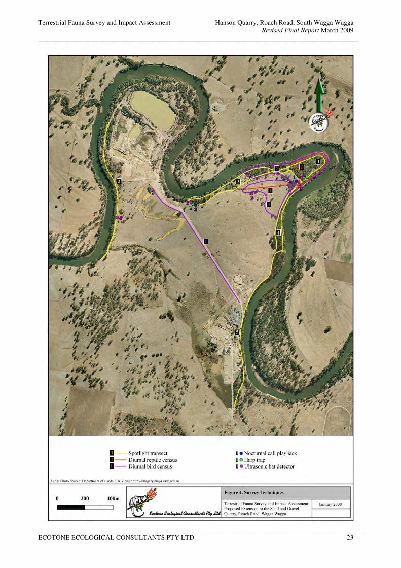
Terrestrial Fauna Survey and Impact Assessment Hanson Quarry, Roach Road, South Wagga Wagga
Revised Final Report March 2009
_______________________________________________________________________________________________
________________________________________________________________________________________________
ECOTONE ECOLOGICAL CONSULTANTS PTY LTD 23
Figure 4. Location of Survey Methods
Terrestrial Fauna Survey and Impact Assessment Hanson Quarry, Roach Road, South Wagga Wagga
Revised Final Report March 2009
_______________________________________________________________________________________________
________________________________________________________________________________________________
ECOTONE ECOLOGICAL CONSULTANTS PTY LTD 24
3.1.3 Weather Details and Survey Effort
The weather conditions were considered to be adequate during the survey period with warm day
temperatures and cool to mild night temperatures. No rain was recorded however 18.8 mm of rain
fell at Wagga Wagga meteorology station the week before the survey. The wind was light to
moderate, there was little cloud cover and the influence of moonlight was relatively high resulting
from a > half moon and the clear skies
Table 6. Weather conditions during the survey period
Date Cloud cover Wind (km/h) Moon Rain Temperature oC
26/03/07 1/8 E/31 @1500 hrs* 5/8 0 Max 23.7* Min 10.8* 18-20 dusk
27/03/07 0 - 1/8 ENE/13 @ 1500 hrs* 5/8 0 Max 24.3* Min 10* 20 dusk
28/03/07 1/8 ENE/19 @ 0900 hrs* 5/8 0 Max 27.9* Min 11.8 * 19 @ 0900 hrs*
* Reading taken at Wagga Wagga from the Bureau of Meteorology website
The survey effort is summarized in Table 7.
Table 7. Summary of survey effort conducted for terrestrial fauna
Method Habitat Type
Riparian
Forest/Woodland
Open Pasture with
Scattered Trees and
Logging Waste
Wetland/Open Water Opportunistic Survey
across Study Area
Bird Survey 27/03/2007
2 person hours
27/03/2007
1 person hour
26/11/2007
1 person hour
27/03/2007
1 person hour, NW
regenerated area
Bat Call
recording
(Anabat)
26 & 27/03/2007
14 hrs 10 mins
27/03/2007
10 hrs 30 mins Nil
Harp
Trapping
26-28/03/2007
3 trap nights Nil Nil
Nocturnal
Call
Playback
26 & 27/03/2007*
65 mins per night
26 & 27/03/2007*
65 mins per night
27/03/2007*
Spotlighting 26 & 27/03/2007
7.5 person hours
26 &27/03/2007
1 person hour Nil
26 & 27/03/2007
1 person hour
Reptile
Survey
28/03/2007
2 person hours
28/03/2007
2 person hours Nil
26-28/03/2007
1 person hour
Amphibian
Survey Nil Nil
26 & 27/03/2007
1 person hour
* Call playback on 26/03/07 covered both the riparian and adjacent open pasture habitat. On the 27/03/07 all three
habitats would have been covered.
3.1.4 Fauna Survey Results
A total of 65 fauna species, including 8 probable bat species, were recorded in the subject site
during the current surveys. By comparison, a total of 280 species have been recorded for the Wagga
Wagga LGA (BioNet and Wagga Wagga City Council), however, it should be noted that this covers
more intact and diverse habitats than those occurring within the study area. A list of all species
recorded in the study area during this survey and within the LGA is presented in Appendix 1.
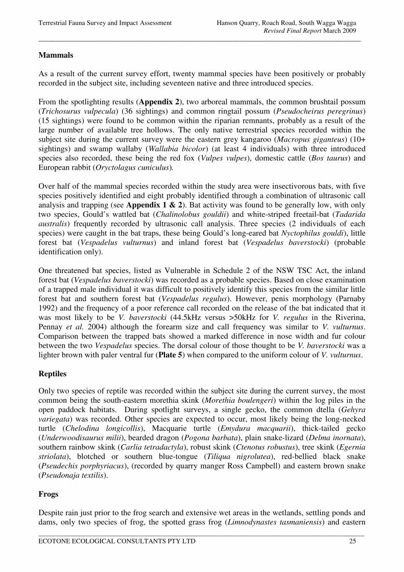
Terrestrial Fauna Survey and Impact Assessment Hanson Quarry, Roach Road, South Wagga Wagga
Revised Final Report March 2009
_______________________________________________________________________________________________
________________________________________________________________________________________________
ECOTONE ECOLOGICAL CONSULTANTS PTY LTD 25
Mammals
As a result of the current survey effort, twenty mammal species have been positively or probably
recorded in the subject site, including seventeen native and three introduced species.
From the spotlighting results (Appendix 2), two arboreal mammals, the common brushtail possum
(Trichosurus vulpecula) (36 sightings) and common ringtail possum (Pseudocheirus peregrinus)
(15 sightings) were found to be common within the riparian remnants, probably as a result of the
large number of available tree hollows. The only native terrestrial species recorded within the
subject site during the current survey were the eastern grey kangaroo (Macropus giganteus) (10+
sightings) and swamp wallaby (Wallabia bicolor) (at least 4 individuals) with three introduced
species also recorded, these being the red fox (Vulpes vulpes), domestic cattle (Bos taurus) and
European rabbit (Oryctolagus cuniculus).
Over half of the mammal species recorded within the study area were insectivorous bats, with five
species positively identified and eight probably identified through a combination of ultrasonic call
analysis and trapping (see Appendix 1 & 2). Bat activity was found to be generally low, with only
two species, Gould’s wattled bat (Chalinolobus gouldii) and white-striped freetail-bat (Tadarida
australis) frequently recorded by ultrasonic call analysis. Three species (2 individuals of each
species) were caught in the bat traps, these being Gould’s long-eared bat Nyctophilus gouldi), little
forest bat (Vespadelus vulturnus) and inland forest bat (Vespadelus baverstocki) (probable
identification only).
One threatened bat species, listed as Vulnerable in Schedule 2 of the NSW TSC Act, the inland
forest bat (Vespadelus baverstocki) was recorded as a probable species. Based on close examination
of a trapped male individual it was difficult to positively identify this species from the similar little
forest bat and southern forest bat (Vespadelus regulus). However, penis morphology (Parnaby
1992) and the frequency of a poor reference call recorded on the release of the bat indicated that it
was most likely to be V. baverstocki (44.5kHz versus >50kHz for V. regulus in the Riverina,
Pennay et al. 2004) although the forearm size and call frequency was similar to V. vulturnus.
Comparison between the trapped bats showed a marked difference in nose width and fur colour
between the two Vespadelus species. The dorsal colour of those thought to be V. baverstocki was a
lighter brown with paler ventral fur (Plate 5) when compared to the uniform colour of V. vulturnus.
Reptiles
Only two species of reptile was recorded within the subject site during the current survey, the most
common being the south-eastern morethia skink (Morethia boulengeri) within the log piles in the
open paddock habitats. During spotlight surveys, a single gecko, the common dtella (Gehyra
variegata) was recorded. Other species are expected to occur, most likely being the long-necked
turtle (Chelodina longicollis), Macquarie turtle (Emydura macquarii), thick-tailed gecko
(Underwoodisaurus milii), bearded dragon (Pogona barbata), plain snake-lizard (Delma inornata),
southern rainbow skink (Carlia tetradactyla), robust skink (Ctenotus robustus), tree skink (Egernia
striolata), blotched or southern blue-tongue (Tiliqua nigrolutea), red-bellied black snake
(Pseudechis porphyriacus), (recorded by quarry manger Ross Campbell) and eastern brown snake
(Pseudonaja textilis).
Frogs
Despite rain just prior to the frog search and extensive wet areas in the wetlands, settling ponds and
dams, only two species of frog, the spotted grass frog (Limnodynastes tasmaniensis) and eastern
Terrestrial Fauna Survey and Impact Assessment Hanson Quarry, Roach Road, South Wagga Wagga
Revised Final Report March 2009
_______________________________________________________________________________________________
________________________________________________________________________________________________
ECOTONE ECOLOGICAL CONSULTANTS PTY LTD 26
sign-bearing frog (Crinia parinsignifera), were recorded within the whole study area. The drought
conditions are likely to have impacted upon frog activity and additional species would be expected
to be recorded following a more intense rain event, particularly in spring. Most likely additional
species are the long-thumbed frog (Limnodynastes fletcheri), banjo frog (L. dumerilii), painted
burrowing frog (Neobatrachus sudelli), Bibron’s toadlet (Pseudophryne bibroni), wrinkled toadlet
(Uperoleia rugosa), green tree frog (Litoria caerulea), Peron’s tree frog (Litoria peronii) and
possibly the threatened southern bell frog (Litoria raniformis).
Birds
Forty-one bird species were recorded within the study area. This was regarded as being an average
total, given the disturbed nature of much of the site and the limited survey effort. Surveys
throughout the seasons would undoubtedly result in more species being recorded, particularly
nectar feeding species as no flowering eucalypts were noted during this survey. Most bird species
recorded within the subject site are common, widespread species, with a large proportion of species
often found in disturbed terrestrial and open water environments. Within the study area, the brown
treecreeper (Climacteris picumnus) was found to be relatively common, particularly on the edge of
the riparian remnants where log piles from old logging waste occur. Individuals were also sighted in
the north-western part of the property, outside of the subject site. As the eastern (Climacteris
picumnus victoriae) and western (Climacteris picumnus picumnus) subspecies of the brown
treecreeper intergrades in the Wagga Wagga region, it could not be determined whether the birds
present represented the eastern subspecies which is listed as vulnerable in the NSW TSC Act.
Another threatened species, the blue-billed duck (Oxyura australis) was observed foraging within
the settling ponds in the study area with at least five birds mixing with a large flock of grey teal
(Anas gracilis). No other records of the blue-billed duck for the Wagga Wagga LGA were found
during the literature review.
There was no response to the playback of the calls of the bush stone-curlew (Burhinus grallarius),
masked owl (Tyto novaehollandiae) or barking owl (Ninox connivens), with the only nocturnal bird
recorded being the southern boobook (Ninox boobook).
Fauna Diversity
Given the level of past disturbance and the largely linear nature of the riparian remnants along the
Murrumbidgee River within the subject site, fauna diversity was not expected to be high. The
recorded species diversity of 20 mammal, 41 bird, 2 reptile and 2 frog species is considered to be
reasonable, although additional species, particularly birds, frogs and reptiles are expected to occur.
Within the whole of the Wagga Wagga LGA, a total of 280 species have been recorded, comprising
of 32 mammal, 206 bird, 31 reptile and 11 amphibian species, however, given the more diverse
habitats within the LGA, only a fraction of these would be expected to occur on the subject site as
the habitat is unsuitable or marginal.
Significant Fauna Species
Two threatened fauna species, (blue-billed duck and brown treecreeper), were positively recorded
within the subject site during this survey and several others are known or expected to occur in the
local region. An additional threatened bat species, the inland forest bat (Vespadelus baverstocki),
was probably recorded by a capture and through ultrasonic call analysis however it is difficult to
differentiate this species from the similar little forest bat (Vespadelus vulturnus) and southern forest
bat (Vespadelus regulus). Other threatened bat species that could occur are the southern myotis
(Myotis macropus), eastern long-eared bat (Nyctophilus timoriensis) and the yellow-bellied
Terrestrial Fauna Survey and Impact Assessment Hanson Quarry, Roach Road, South Wagga Wagga
Revised Final Report March 2009
_______________________________________________________________________________________________
________________________________________________________________________________________________
ECOTONE ECOLOGICAL CONSULTANTS PTY LTD 27
sheathtail-bat (Saccolaimus flaviventris). Threatened species recorded within close proximity to the
subject site are the squirrel glider (Petaurus norfolcensis), superb parrot (Polytelis swainsonii),
glossy black cockatoo (Calyptorhyncus lathami) and barking owl (Ninox connivens) (DECC
Wildlife Atlas and David Read, Wagga Wagga City Council). The southern bell frog (Litoria
raniformis) was formerly reported along the Murrumbidgee River and therefore may still occur
(David Read, Wagga Wagga City Council). The squirrel glider is also listed as an endangered
population in the Wagga Wagga LGA.
Other threatened birds with potential to occur at least on an occasional or seasonal basis are the
speckled warbler (Pyrrholaemus sagittatus), hooded robin (Melanodryas cucullata), turquoise
parrot (Neophema pulchella) and freckled duck (Stictonetta naevosa).
Some of the more nomadic bird species, such as the black-chinned honeyeater (Melithreptus gularis
gularis), regent honeyeater (Xanthomyza phrygia) and swift parrot (Lathamus discolor), could
occasionally visit the local region during peak flowering periods, during winter in the case of the
swift parrot. However, based on known records and habitat preferences the chance of these species
occurring is considered to be low.
With the exception of the regent honeyeater, swift parrot and southern bell frog which are listed as
‘endangered’, the above species are listed as ‘vulnerable’ under the NSW TSC Act (1995). Of the
subject species, the regent honeyeater is listed as endangered and migratory, the swift parrot as
endangered and the superb parrot and eastern long-eared bat as vulnerable under the
Commonwealth EPBC Act.
Plate 5. Probable inland forest bat (Vespadelus baverstocki),
showing the contrasting ventral and dorsal fur colour
Terrestrial Fauna Survey and Impact Assessment Hanson Quarry, Roach Road, South Wagga Wagga
Revised Final Report March 2009
_______________________________________________________________________________________________
________________________________________________________________________________________________
ECOTONE ECOLOGICAL CONSULTANTS PTY LTD 28
4.0 THREATENED SPECIES ASSESSMENT OF THE PROPOSAL
4.1 Evaluation of Impacts Resulting from the Proposal (Part 3A of the EP&A Act, 1979)
The proposal involves the excavation of sand and gravel in five stages to a depth of approximately
30 metres. A bund wall will need to be constructed around each stage to prevent water from
entering the quarry area during any flooding event of the adjacent Murrumbidgee River. As each
stage is exhausted, starting with Stage 1 in the north-east corner, either the pit will be filled back to
the existing ground level (Stage 1 and 80m to the south in Stages 2 and 3) or it will be filled with
water and the banks revegetated. It is estimated that the annual extraction of sand and gravel will be
between 150,000 and 250,000 tons and that reserves would last for >25 years.
In the original pit layout, Stage 1 was positioned further to the north-east and would have resulted
in the removal of scattered trees (six of which were large mature hollow bearing tree) and a large
quantity of large hollow logs on the ground. This area was found to be favoured habitat for a group
of brown treecreepers, which are possibly part of a population of the threatened eastern sub-species
Climacteris picumnus victoriae. The current revised layout avoids all but one of the hollow bearing
trees (situated in Stage 4) and most of the brown treecreeper habitat. Therefore as a result of the
changed extraction areas, overall impacts on the terrestrial fauna diversity have been significantly
reduced.
Impacts on the existing terrestrial fauna diversity are identified as follows.
• A minor loss of fallen/felled timber on the ground, some being large hollow trunks mainly
within Stage 1.
• Encroachment into the existing wetland (Stage 5 only).
• Partial loss of an area of open water used by waterfowl (Stage 4 only).
As the extraction process will be progressive through Stages 1-5 it should be noted that not all of
the identified impacts would occur at any one time.
The guidelines for threatened species assessment under Part 3A of the EP&A Act, 1979 (appendix
3) gives a list of factors to be considered when identifying potential impacts on threatened species,
endangered populations or endangered ecological communities as a result of a proposal. In the case
of this proposal, the following threatened fauna species and an endangered population could
potentially be impacted by the proposal to some degree.
Barking owl
Brown treecreeper (eastern subspecies)
Blue-billed duck
Freckled duck
Glossy Black Cockatoo
Superb parrot
Tree roosting microbats, including the inland forest bat and yellow-bellied sheathtail-bat
Squirrel glider, endangered population in the Wagga Wagga district
Southern bell frog
The factors given in Appendix 3 of the Part 3A guidelines are discussed for the above species;
Terrestrial Fauna Survey and Impact Assessment Hanson Quarry, Roach Road, South Wagga Wagga
Revised Final Report March 2009
_______________________________________________________________________________________________
________________________________________________________________________________________________
ECOTONE ECOLOGICAL CONSULTANTS PTY LTD 29
a) How is the proposal likely to affect the lifecycle of a threatened species and/or endangered
population?
Barking owl (Ninox connivens) – vulnerable under the NSW TSC Act
All the large forest owl species are known to occupy very large territories particularly in fragmented
areas, which is a reflection of their high mobility and the diversity of prey species they take. The
barking owl appears to have a smaller home range than other species with estimates given as 30-200 ha.
This species has been recorded from a variety of habitats and roosts by day in dense thickets of
vegetation or foliage, particularly in riparian habitats. Birds live singularly or as a breeding pair, with
breeding taking place during late winter/early spring. Their nesting requirements are more specialised,
being totally dependent on suitably large tree-hollows (>20 cm in diameter) which are generally found
in the trunks of tall and mature trees greater than 4 metres from the ground (DECC threatened species
profile).
The barking owl favours open forest and woodland types for foraging, particularly on the edge of open
lands such as agricultural lands. It predominantly feeds on invertebrates, however, birds and small
arboreal and terrestrial mammals up to the size of a small rabbit are also taken. Therefore, although not
recorded during current surveys, the barking owl could forage and breed within the study area. Large
tree hollows suitable for nesting are common within the riparian vegetation along the Murrumbidgee
River and the dense riparian habitat does provide some roosting opportunities.
As the existing riparian habitat will be retained, it is considered highly unlikely that the life cycle of this
species would be significantly disrupted. Although potential foraging areas may be temporarily lost
and/or modified, few potential nest sites in hollow bearing trees will be lost.
Brown treecreeper (Climacteris picumnus victoriae) – vulnerable under the NSW TSC Act
The eastern form of the brown treecreeper prefers dry open woodland habitats, mainly on the western
slopes of the Great Dividing Range, with a patchy distribution to the east of the Divide. It is an
insectivorous species, mainly feeding on ants, beetles and larvae, and forages on tree trunks or on the
ground. They nest in tree hollows, with a pair or small family group frequenting a permanent territory.
Viable populations are thought to require a minimum patch size of 200ha of suitable habitat (DECC
threatened species profile).
This species was observed at several locations within the subject site, mainly on the edge of the riparian
remnants where felled timber was plentiful on the ground. As the eastern (Climacteris picumnus
victoriae) and western (Climacteris picumnus picumnus) subspecies of the brown treecreeper
intergrades in the Wagga Wagga region (DECC threatened species profile), it could not be determined
whether the birds present represented the vulnerable eastern subspecies. By applying the precautionary
principle it is assumed that the birds are the threatened subspecies for the purpose of this assessment.
The exact population size is unknown however it is estimated to be greater than five individuals. Stages
1-3 of the proposal have been moved to avoid most of the known foraging areas. It is expected that this
species will be able to survive in the un-worked areas to the north of Stage 1, including the restored area
in the north-west of the study area. It is suggested that any of the existing piles of timber within Stage
1, particularly hollow logs, be moved prior to excavation work and stockpiled for redistribution after
each stage is exhausted. Therefore, although there will be some local disturbances from the quarrying
process, it is expected that this species will still occur and be able to breed within the study area during
and after excavation work.
Terrestrial Fauna Survey and Impact Assessment Hanson Quarry, Roach Road, South Wagga Wagga
Revised Final Report March 2009
_______________________________________________________________________________________________
________________________________________________________________________________________________
ECOTONE ECOLOGICAL CONSULTANTS PTY LTD 30
Blue-billed duck (Oxyura australis) – vulnerable under the NSW TSC Act
This small aquatic duck occurs in the temperate wetlands of south-eastern and south-western Australia.
It feeds on the water surface and by diving for aquatic insects and invertebrates as well as consuming
seeds and vegetative material from water plants. The blue-billed duck is seasonally nomadic, with
young birds dispersing from breeding sites situated in inland NSW wetlands to non breeding areas
where they moult. Large numbers can congregate in large deep open water dams and lakes in autumn
and winter, with sewage ponds, large rivers and saline waters also used. Breeding occurs in secluded,
well vegetated wetlands with the nest constructed within the vegetation, often over water. The freckled
duck is similar in its habits to the blue-billed duck therefore the same impacts would apply (DECC
threatened species profile).
The blue-billed duck was observed swimming with large flocks of grey teal in the open water of the
settling ponds to the west of the existing haul road. At least five individuals were observed. It is unlikely
that breeding occurs on site as fringing vegetation is cropped low by cattle. In addition, the main
breeding area is identified as the Murray-Darling Basin further to the west. The settling ponds and
dams within the study area are expected to act as a drought refuge for waterfowl and waterbirds,
including the threatened Blue-billed Duck and Freckled Duck. Provided that the current drainage regime
is maintained, it is unlikely that the proposed quarry extension would impact on this species, in fact the
creation of new ponds as each stage is completed has the potential to increase available habitat and
compensate for any temporary loss of open water habitat during the quarrying activities for Stage 4.
Glossy black cockatoo (Calyptorhyncus lathami) – vulnerable under the NSW TSC Act
The glossy black cockatoo occupies forests of south-eastern Australia, from Shoalwater Bay in central
Queensland to the Victorian border region. Preferred habitat for this species generally consists of moist
and dry eucalypt forest types with a she-oak understorey. In areas where she-oaks are abundant, this
species is sedentary, however, in other areas glossy black cockatoos can be nomadic, moving from one
food source to another.
The breeding season is between March and August with eggs usually being laid between April and
June. The nests are located in large hollow limbs or trunks, often in tall dead trees standing in clearings.
The nests are usually between 13 and 22 metres above the ground. The Glossy Black-cockatoo relies
almost entirely on the seeds of a few species of she-oak for food and any factor that reduces the
quantity, quality or availability of the seed crop of these trees must have a direct impact on local
populations, through starvation or reduced fecundity. Land clearance for agriculture has substantially
reduced available habitat and the species is likely to be sensitive to continued habitat destruction in the
future. Regular fire may also reduce the presence of fruiting she-oaks (DECC threatened species
profile).
This species was not recorded during this survey however a group of four individuals, possibly a family
group were recorded within 2 km of the centre of the subject site in July 2007 (David Read WWCC
pers. com., and DECC Wildlife Atlas data). As this species feeds almost exclusively on she-oak seeds,
foraging would be confined to the river oaks (Casuarina cunninghamiana) within the retained riparian
vegetation. It is therefore considered unlikely that the proposal would have an impact on the lifecycle of
this species.
Superb parrot (Polytelis swainsonii) – vulnerable under the NSW TSC Act and Commonwealth
EPBC Act
The superb parrot occurs throughout inland eastern NSW with core breeding areas on the south-western
slopes and the Riverina, including the Murrumbidgee River, where it is present all year round. Nesting
in the Riverina occurs between September and January in the hollows of large dead or live trees, mainly
in riparian river red gum or woodland. Foraging takes place in trees, shrubs or on the ground with food
Terrestrial Fauna Survey and Impact Assessment Hanson Quarry, Roach Road, South Wagga Wagga
Revised Final Report March 2009
_______________________________________________________________________________________________
________________________________________________________________________________________________
ECOTONE ECOLOGICAL CONSULTANTS PTY LTD 31
items including grass seeds, herbaceous plants, fruits, berries, nectar, buds, flowers and insects (DECC
threatened species profile).
This species was not recorded during this survey however there are at least 6 records from within 2.5
km of the centre of the study site. The superb parrot is known to breed and forage within riparian river
red gum forest along the Murrumbidgee River and may nest in isolated paddock trees. As only one such
tree is likely to be removed as a result of the proposal, potential impacts on this species are unlikely to
occur. Given the large number of hollow trees within the riparian habitat, it is unlikely that a significant
impact on the lifecycle of this species would occur.
Southern bell frog (Litoria raniformis) – endangered under the NSW TSC Act and vulnerable
under the Commonwealth EPBC Act
In NSW, the southern bell frog was formerly found along the Murray and Murrumbidgee Rivers and
their tributaries as well as parts of the southern slopes and central tablelands. It is currently only known
from the Colleambally Irrigation Area in the western part of the Riverina, the Lowenbidgee floodplain
near Balranald and Lake Victoria in the far south-west of the state (DECC threatened species profile).
Breeding occurs from spring to autumn following flood events on the edge of slow flowing streams,
marshes, lagoons, lakes, farm dams and rice crops. Tadpoles require standing water for at least 4 months
in order to complete metamorphosis, which can take as long as 12 months. Following breeding, the
frogs disperse away from water and shelter under debris on the ground, such as fallen timber, bark,
rocks, grass clumps and cracks in the soil (DECC threatened species profile).
This species was not recorded during this survey and no records could be found for the locality.
However, this species has been identified as potentially occurring within habitats along the
Murrumbidgee River (David Read, environment officer WWCC), although it may now be locally
extinct. Despite this the species could still potentially occur anywhere along the banks of the river and
within the wetlands and open water areas of the study area. Outside of the breeding season individuals
may move away from water and shelter under fallen timber and other objects within the floodplain.
Therefore there is some potential for impacts to occur as a result of the removal of fallen timber and
logging waste from Stage 1, however, given the uncertainty of its presence, impacts on the overall
lifecycle of the species are not expected to be significant.
Inland Forest Bat Vespadelus baverstocki – vulnerable under the NSW TSC Act
The inland forest bat is one of the smallest bats in Australia weighing on average 4.8 grams. The
similarity to the sympatric little forest bat (Vespadelus vulturnus) makes positive identification difficult,
however, there are reported differences in fur colour and penis morphology (Parnaby 1992, Churchill
1998). The ultrasonic calls are similar and it is difficult to differentiate between these two species,
although there is a difference between these species and the slightly larger southern forest bat (V.
regulus) in the Riverina district (Pennay et al. 2004). The inland forest bat lives in a variety of habitats
in arid and semi arid parts of Australia, including river red gum woodland and roosts in trees hollows
and disused buildings. The breeding season occurs between November and January and maternity
colonies are formed (Churchill 1998) and therefore tree removal should be avoided during this period.
This species was trapped and possibly recorded by ultrasonic call analysis, however, as a result of
similarities in both appearance and call with the other forest bat known to occur (V. vulturnus), it was
only given a probable status. However, a combination of penis morphology, fur colour and slightly
larger size indicates this species as being most likely. As this species is less likely to forage over the
more open habitat of the proposed extraction areas and most of the riparian habitat, including potential
roost hollows, will be retained it is considered unlikely that the lifecycle of this or any other hollow
dependant bat species would be significantly impacted upon by the proposal.
Terrestrial Fauna Survey and Impact Assessment Hanson Quarry, Roach Road, South Wagga Wagga
Revised Final Report March 2009
_______________________________________________________________________________________________
________________________________________________________________________________________________
ECOTONE ECOLOGICAL CONSULTANTS PTY LTD 32
Endangered Squirrel Glider Population in Wagga Wagga LGA - NSW TSC Act
The squirrel glider is distributed along the coast and ranges of eastern Australia from about Cairns in
north Queensland to the Victorian/ South Australian border, extending to the western slopes and plains.
This species usually inhabits dry open sclerophyll forest and woodland but there have been observations
in moist regenerating forest and moist gullies. Although requiring nesting/den hollows, this species is
not dependent on mature forest as sightings have been made in eucalyptus plantations and forest
remnants (Ray Williams, Ecotone Ecological Consultants, pers. obs.). It is possible that disused Ringtail
Possum dreys and birds nests are used in the absence of an abundance of suitable hollows. The diet
includes acacia gum, eucalyptus sap, nectar, honeydew, manna, invertebrates and pollen (Quin 1995).
Survey work indicates a home range of about 13ha and a population density of 0.4 - 1 per hectare in a
Victorian population (Traill & Coates 1993) and 3.0 - 3.5ha with a density of 0.89 - 1.54 per hectare in a
mid north coast population (Quin 1995). Patterns of home range use appear to be tied to the distribution
and abundance of food resources (Quin 1995). The breeding cycle appears to be similar to that of the
closely related, but smaller sugar glider. The breeding season varies between localities and may be tied
to the availability of food resources (Williams 1990; Quin 1995). The litter size is 1 - 2, pouch life is 3
months and weaning takes place at 4 months. Young are sexually mature at 8 months of age and
disperse at 12.5 months (Williams 1990; Quin 1995). Squirrel gliders have been found to nest in
colonies of 2 to 9 individuals (Quin 1995). Nestling survival is usually high, however juveniles
experience heavy mortality. The cause of juvenile mortality may be a result of a number of factors
including adult aggression enforcing juvenile dispersal and subsequent failure to become established in
a population, juvenile inexperience in foraging and predator avoidance, lack of familiarity with the
home range and overt defence of food resources by adults (Quin 1995).
Although not recorded during the current surveys, the squirrel glider has been recorded within the road
reserve of Roach Road in 2000 (Wildlife Atlas records) and an individual was found entangled in a
barbed wire fence between the quarry weighbridge and the Murrumbidgee River in 2001/2 (David
Read, Wagga Wagga City Council pers. comm.). In order to improve connectivity between
Pomingalarna Reserve to the south-west of Roach Road and the riparian river red gum forest along the
banks of the Murrumbidgee River, tree planting has taken place between the river and the weighbridge.
The riparian habitat is continuous along the bank of the Murrumbidgee River and large hollow bearing
river red gums are common within the regenerating forest. It is therefore considered highly likely that
the squirrel glider occurs within the riparian vegetation, at least on a seasonal basis when the eucalypts
are in flower.
The extensive clearing of land for agriculture within the south-west slopes bioregion has resulted in the
severe fragmentation of potential glider habitat and the isolation of small discreet populations.
Therefore, it has been suggested that a landscape approach be undertaken if planning corridors between
forest remnants (Claridge and van der Ree, 2004). In the case of the quarry extensions, no forest
remnants will be isolated and there is some potential for an increase in available habitat by the
regeneration of forest in the north-east and north-west corner of the study area and future revegetation
as each stage is exhausted. Ample den sites will be available in the existing riparian habitat along the
Murrumbidgee River. Therefore, it is considered that the lifecycle of this endangered population will
not be impacted upon as a result of the proposal.
b) How is the proposal likely to affect the habitat of a threatened species, endangered
population or endangered ecological community?
Stages 1-3 of the quarry have been positioned so as to avoid all of the scattered standing trees in the
north-east corner of the study area therefore there will be no impact on hollow dependent fauna such as
the squirrel glider and microbats. A large amount of logging waste, including piles of large hollow logs,
occurs in the north-east part of the study area and this area was observed to be used for foraging by the
brown treecreeper. Hollow bearing trees in this area could also be used by the brown treecreeper as
nesting and roosting sites. A small percentage of the logging waste will need to be removed to another
Terrestrial Fauna Survey and Impact Assessment Hanson Quarry, Roach Road, South Wagga Wagga
Revised Final Report March 2009
_______________________________________________________________________________________________
________________________________________________________________________________________________
ECOTONE ECOLOGICAL CONSULTANTS PTY LTD 33
part of the property for Stage 1 of the project however the majority will still be available as foraging
sites for the brown treecreeper.
Stages 4 and 5 of the project encroach into the wetland and open water environments however
replacement habitat should be created following the completion of the existing extraction pit and Stages
1-3. Therefore ample habitat for the blue-billed duck and other waterfowl should be retained.
c) Does the proposal affect any threatened species or endangered population that are at the
limit of its known distribution?
The inland forest bat (Vespadelus baverstocki) may be at or near the eastern edge of its distribution.
This species was only probably recorded owing to the uncertainty of its identification by ultrasonic calls
and penis morphology however it was considered that this species was the most likely. A positive
identification would represent a significant easterly range extension for the species.
The eastern subspecies of the brown treecreeper (Climacteris picumnus victoriae) is at the limit of the
western edge of its distribution at Wagga Wagga. As the two subspecies intergrades at this point the true
identity of the brown treecreeper within the study area is unclear.
The glossy black cockatoo is near the western edge of its distribution in the Riverina district, however,
the proposal will not remove any foraging or nesting habitat.
The endangered population of the squirrel glider in the Wagga Wagga LGA is near the western edge of
the known distribution for the species in NSW, however, the quarry area is outside of the predicted area
of habitat that this species could potentially use within the study area.
Although the removal of felled hollow log piles in Stage 1 could have some minor impact on these
species through the loss of potential nest/roost/foraging sites, this is not expected to reduce the ability of
any of these species to occur in the study area as a large number of hollow bearing trees and the
majority of the log piles occur outside of the quarry areas.
d) How is the proposal likely to affect current disturbance regimes?
Current disturbance regimes include;
• overgrazing by cattle and rabbits;
• excavation of sand and gravel from the existing quarry pit in the north-west of the study area;
• vehicle movements across the property on the haul road linking the quarry to the processing
plant at the southern end of the study area;
• artificial water flows from the processing plant to the wetland and settling ponds in the west of
the floodplain, with water sourced from and excess returned to the Murrumbidgee River
Similar disturbance regimes are likely to occur for the proposal, except that the location of the quarry
site and haul roads will change and cattle and rabbit grazing could be controlled by fencing off riparian
and wetland habitats and initiating a rabbit control plan. The down side of reducing grazing pressure is
that weed invasion is likely to increase within fenced off areas however on the up side native vegetation
regeneration is also likely to increase.
e) How is the proposal likely to affect habitat connectivity?
The area to be disturbed is currently cleared of natural vegetation and the proposed revegetation outside
of the quarry area will, over time, enhance the riparian strip of river red gums along the banks of the
Murrumbidgee River. Therefore habitat connectivity is likely to be improved as a result of the proposal.
Terrestrial Fauna Survey and Impact Assessment Hanson Quarry, Roach Road, South Wagga Wagga
Revised Final Report March 2009
_______________________________________________________________________________________________
________________________________________________________________________________________________
ECOTONE ECOLOGICAL CONSULTANTS PTY LTD 34
f) How is the proposal likely to affect critical habitat?
No critical habitat is currently listed in the TSC Act for the subject species within the study area.
Key Threatening Processes
The following key threatening processes listed in the NSW TSC Act are considered to be relevant
to the proposed quarry extensions.
a) Clearing of native vegetation
The proposed extraction locations are within previously cleared land, therefore, the level of clearing
will be confined to one isolated tree.
b) Alteration of the natural flow regimes of rivers and streams and their floodplains and wetlands
Water is currently pumped from the Murrumbidgee River for the gravel crushing and sorting
process. Excess water then flows into a wetland and settling ponds and then back into the river.
Stages 4 and 5 are mainly west of the existing haul road and within or adjacent to the wetland,
therefore the excavation of these areas could have an impact on the drainage of the wetland. This
could have an impact on the waterfowl, including the threatened blue-billed duck, currently using
the open water within the study area, however, other open water areas will still be available within
the study area and new ponds within the existing pit and Stages 1-3 could be available before the
excavation of Stage 4 and 5 commences.
c) Removal of dead wood and dead trees
A large quantity of logging waste from tree clearing carried out many years ago occurs on the
ground, particularly to the north of and within part of Stage 1. Many of the logs are large, 1-2 m in
diameter, and provide multiple hollows of various sizes. Some of these will need to be removed
prior to excavation of Stage 1 and it is recommended that these be stockpiled for redistribution in
the restoration process.
d) Loss of Hollow-bearing Trees
The relocation of Stages 1-3 of the proposal has resulted in the retention of all hollow bearing trees
in the north-eastern section of the study area. Only one isolated hollow bearing tree will need to be
removed for Stage 4 of the proposal. e) & f) Predation by the European red fox Vulpes vulpes and the feral cat Felis catus
The final determination for the squirrel glider endangered population (NSW Scientific Committee
2004) identifies predation by foxes and cats as a threat to the survival of the population. These
threatening processes are likely to be already occurring within the study area. The proposed sand
and gravel extraction works are unlikely to increase the threat from these introduced predators.
Conclusion
Based on the results of this field survey and Part 3A threatened species assessment it is concluded
that although impacts may occur on individual members of a threatened fauna species population, it
is unlikely that any local populations would be significantly impacted upon and be at risk of local
extinction. The identified impacts on terrestrial fauna can be mitigated against, if the measures
given in Section 5 of this report are implemented.
Terrestrial Fauna Survey and Impact Assessment Hanson Quarry, Roach Road, South Wagga Wagga
Revised Final Report March 2009
_______________________________________________________________________________________________
________________________________________________________________________________________________
ECOTONE ECOLOGICAL CONSULTANTS PTY LTD 35
4.2 Environment Protection & Biodiversity Conservation Act 1999 (EPBC Act)
The EPBC Act was gazetted in 2000 and replaced several earlier Commonwealth statutes. This Act
focuses Commonwealth interests on matters of national environmental significance (NES)
including integrated biodiversity conservation and the management of important protected areas.
The Act also establishes a streamlined environmental assessment and approvals process.
The matters of NES as identified in the Act which require assessment and approval to be addressed
by the Commonwealth include:
� World Heritage properties
� National Heritage places
� RAMSAR wetlands
� Nationally threatened species and ecological communities (Part 13, Division 1,
Subdivision A of the EPBC Act)
� Migratory species
� Commonwealth Marine areas
� Nuclear actions (including uranium mining)
The assessment and approval process applies to any action that has, will have or is likely to have a
significant impact on a matter of NES. An ‘action’ is defined as a project, development,
undertaking or an activity or series of activities. As of 18 January 2007, a bilateral agreement has
been signed between the Commonwealth and the state of NSW which essentially accredits the
NSW assessment process of environmental impact for the purposes of the EPBC Act, provided that
the assessment has been done in accordance with the bilateral agreement. This has effectively
removed the need for duplication of assessment effort by both the Commonwealth and state.
With regard to flora and fauna, the only matters of NES relevant to the study area are nationally
threatened species and migratory species. The relevant criteria given in the administrative
guidelines for the Act to determine whether the action will or is likely to have a significant impact
on a nationally threatened species are as follows:
Critically endangered and endangered species
Significant Impact Criteria
An action has, will have, or is likely to have a significant impact on a critically endangered or endangered species if it
does, will, or is likely to:
• lead to a long-term decrease in the size of a population, or
• reduce the area of occupancy of the species, or
• fragment an existing population into two or more populations, or
• adversely affect habitat critical to the survival of a species, or
• disrupt the breeding cycle of a population, or
• modify, destroy, remove, isolate or decrease the availability or quality of habitat to the extent that the species
is likely to decline, or
• result in invasive species that are harmful to a critically endangered or endangered species becoming
established in the endangered or critically endangered species' habitat*, or
• interfere with the recovery of the species.
* Introducing an invasive species into the habitat may result in that species becoming established. An invasive species
may harm a critically endangered or endangered species by direct competition, modification of habitat, or predation.
Terrestrial Fauna Survey and Impact Assessment Hanson Quarry, Roach Road, South Wagga Wagga
Revised Final Report March 2009
_______________________________________________________________________________________________
________________________________________________________________________________________________
ECOTONE ECOLOGICAL CONSULTANTS PTY LTD 36
Vulnerable species
Significant Impact Criteria
An action has, will have, or is likely to have a significant impact on a vulnerable species if it does, will, or is likely to:
• lead to a long-term decrease in the size of an important population of a species, or
• reduce the area of occupancy of an important population#, or
• fragment an existing important population into two or more populations, or
• adversely affect habitat critical to the survival of a species, or
• disrupt the breeding cycle of an important population, or
• modify, destroy, remove or isolate or decrease the availability or quality of habitat to the extent that the species
is likely to decline, or
• result in invasive species that are harmful a vulnerable species becoming established in the vulnerable species'
habitat*, or
• interferes substantially with the recovery of the species.
#An important population is one that is necessary for a species' long-term survival and recovery. This may include
populations that are:
• key source populations either for breeding or dispersal,
• populations that are necessary for maintaining genetic diversity, and/or
• populations that are near the limit of the species range.
*Introducing an invasive species into the habitat may result in that species becoming established. An invasive species
may harm a vulnerable species by direct competition, modification of habitat, or predation.
Migratory Species Note that some migratory species are also listed as threatened species. The criteria below are relevant to migratory
species that are not threatened.
Significant Impact Criteria
An action is likely to have a significant impact on a migratory species if there is a real chance or possibility that it will:
• substantially modify (including by fragmenting, altering fire regimes, altering nutrient cycles or altering
hydrological cycles), destroy or isolate an area of important habitat# for a migratory species;
• result in an invasive species that is harmful to the migratory species becoming established in an area of
important habitat for the migratory species; or
• seriously disrupt the lifecycle (breeding, feeding, migration or resting behaviour) of an ecologically significant
proportion* of the population+ of a migratory species.
#An area of ‘important habitat’ for a migratory species is:
• habitat utilised by a migratory species occasionally or periodically within a region that supports an
ecologically significant proportion of the population of the species; and/or
• habitat that is of critical importance to the species at particular life-cycle stages; and/or
• habitat utilised by a migratory species which is at the limit of the species range; and/or
• habitat within an area where the species is declining.
*Listed migratory species cover a broad range of species with different life cycles and population sizes. Therefore what
is an ‘ecologically significant proportion’ of the population varies with the species (each circumstance will need to be
evaluated). Some factors that should be considered include the species’ population status, genetic distinctiveness and
species specific behavioural patterns (for example, site fidelity and dispersal rates). + ‘Population’, in relation to migratory species, means the entire population or any geographically separate part of the
population of any species or lower taxon of wild animals, a significant proportion of whose members cyclically and
predictably cross one or more national jurisdictional boundaries including Australia.
Terrestrial Fauna Survey and Impact Assessment Hanson Quarry, Roach Road, South Wagga Wagga
Revised Final Report March 2009
_______________________________________________________________________________________________
________________________________________________________________________________________________
ECOTONE ECOLOGICAL CONSULTANTS PTY LTD 37
Threatened and Migratory Fauna
Endangered Species
Both the swift parrot (Lathamus discolor) and regent honeyeater (Xanthomyza phrygia) have been
recorded within the study locality and have potential to forage within the subject site, although are
likely to visit the study area on an irregular opportunistic basis only. As only one mature tree is to
be removed and the riparian corridor will remain intact, the proposal is unlikely to have a
significant impact on either of these species based on the criteria for endangered species.
Vulnerable Species
The superb parrot (Polytelis swainsonii) is the only vulnerable EPBC Act listed species known to
occur close to the study area. The river red gum riparian forest/woodland expected to be used for
nesting and foraging will be retained, therefore, based on the criteria for vulnerable species, the
proposal is unlikely to have a significant impact on this species.
Vulnerable species not previously recorded, but predicted to occur or have habitat available within
the study locality according to EPBC modelling, are the Australian painted snipe (Rostratula
australis), southern bell frog (Litoria raniformis) and eastern long-eared bat (Nyctophilus
timoriensis).
Potential habitat for the Australian painted snipe occurs in the wetland, however cattle grazing has
reduced the fringing vegetation to short stubble. Given the lack of records for the locality and the
few records for NSW, the likelihood of this species occurring is slim, although if it did occur,
according to the proposal layout, most of the potential habitat would be retained.
The southern bell frog formerly occurred along the Murrumbidgee River and may inhabit the
wetland and settling ponds of the study area. However, given the apparent lack of recent records in
the Wagga Wagga LGA, it may now be locally extinct, although a record from 1999 occurs from
about 15 km south-east of Wagga Wagga. As flood events are required to trigger breeding in this
species and the survey was conducted during drought conditions it would have been difficult to
record this species during the current surveys. Despite this, much of the potential habitat for this
species will be retained, except that some potential shelter sites under logging waste within Stage 1
would be removed and relocated outside of the quarry areas.
The eastern long-eared bat has not been recorded within the Wagga Wagga LGA however suitable
foraging and roosting habitat occurs within the study area. Few roost sites would be lost as a result
of the proposal as only one hollow bearing tree will be removed within Stage 4.
Based on the criteria for vulnerable species, it is highly unlikely that the proposal would have a
significant impact on any of the above species.
Migratory and Marine species
Migratory species listed on the EPBC Act and predicted to occur or have habitat available within
the study locality according to EPBC modelling, are the white-bellied sea-eagle (Haliaeetus
leucogaster), regent honeyeater (Xanthomyza phrygia), white-throated needletail (Hirundapus
caudacutus), rainbow bee-eater (Merops ornatus), Latham’s snipe (Gallinago hardwickii),
Australian painted snipe (Rostratula australis), great egret (Ardea alba) and cattle egret (Ardea
Terrestrial Fauna Survey and Impact Assessment Hanson Quarry, Roach Road, South Wagga Wagga
Revised Final Report March 2009
_______________________________________________________________________________________________
________________________________________________________________________________________________
ECOTONE ECOLOGICAL CONSULTANTS PTY LTD 38
ibis). The swift parrot and fork-tailed swift (Apus pacificus) are listed as marine species (fly over
marine environments).
None of the predicted migratory species were recorded during the site surveys however suitable
habitat is available within the study area. As the majority of the existing suitable habitat (riparian
river red gum forest, wetland and open water ponds) are to be retained and in the future enhanced as
a result of the proposal, none of the migratory or marine species are expected to be significantly
impacted by the proposal according to the criteria for migratory species. However, if the existing
wetland and shallow open water was lost through changes to drainage and water flows, potential
habitat for migratory waders may be periodically unavailable.
Key Threatening Processes
Seventeen key threatening processes have been finally determined under the EPBC Act. Seven of
these could be potentially relevant to the proposal and are discussed below:
1) Competition and land degradation by feral rabbits;
Rabbits currently occur within the subject site and the proposed quarry extension is unlikely
to increase the rabbit population and therefore land degradation and competition resulting
from the rabbit population is unlikely to significantly change. As populations of feral rabbits
are known to be controlled by foxes and cats any reduction measures should target all three
species.
2) Dieback caused by the root-rot fungus (Phytophthora cinnamomi);
While unlikely, there is a small chance that Phytophthora cinnamomi could be imported into
or out of the study area on boots, machinery, tools and vehicles.
3) Infection of amphibians with chytrid fungus resulting in chytridiomycosis
The southern bell frog population has suffered a major decline across its range and chytrid
fungus may be one of the causes. Given the predicted traffic movements, there is a small
chance that contaminated equipment or footwear could be brought onto the site from an
infected area. However, as this pathogen is waterborne, it is unlikely that the effects of this
disease would significantly increase in the frog population as a result of the proposal should
a population actually occur in the local region.
4) Land clearance
The layout of the quarry proposal has been altered so as to avoid the scattered trees
(including mature, hollow bearing trees) in the north-eastern part of the property. Therefore
only one hollow bearing tree will be lost within Stage 4 of the project. There is no shrub
layer and the ground cover was sparse at the time of the survey due to grazing by cattle,
rabbits and kangaroos and the effects of drought. As the existing riparian river red gum
forest/woodland is to be retained, the impacts resulting from land clearing will be negligible.
5) Loss of climatic habitat caused by anthropogenic emissions of greenhouse gases;
The use of vehicles and other machinery and loss of vegetation associated with the proposal
is expected to result in the emission of a small amount of greenhouse gases.
Terrestrial Fauna Survey and Impact Assessment Hanson Quarry, Roach Road, South Wagga Wagga
Revised Final Report March 2009
_______________________________________________________________________________________________
________________________________________________________________________________________________
ECOTONE ECOLOGICAL CONSULTANTS PTY LTD 39
6) Predation by feral cats and (7) predation by the European red fox (Vulpes vulpes).
Foxes are known to occur and cats are likely to occur within the study area. It is unlikely
that an increase in population size in either species would occur as a result of the proposal.
Any control measures would need to also include the control of rabbits.
None of these key threatening processes are considered likely to provide sufficient grounds to refer
the proposal to the Department of the Environment and Water Resources.
No other matters of NES or other matters protected by the EPBC Act are directly relevant to the
listed fauna of the study area. Therefore the specific assessment process under the provisions of the
EPBC Act is not required for the proposal since it does not constitute an action that is likely to have
a significant impact on any matter of NES. Recommendations designed to mitigate against any
identified potential impacts are included in Section 5. No further action pursuant to the Act is
considered necessary.
4.3. SEPP 44 – Koala Habitat Protection
SEPP 44 was implemented on the 13
th of February, 1995, with the reasoning that the current known distribution of the
Koala in NSW is fragmented, with most colonies appearing to be small and isolated. Many of these populations are in
locations that are under increased pressure from habitat loss or modification, predation and exposure to drought, disease
and bushfire. These facts are the reason for the Koala being listed as ‘Vulnerable’ in Schedule 2 of the Threatened
Species Conservation Act, 1995.
Prior to a Development Application for bushland areas being approved, the following considerations need to be
assessed:
a) identification of “potential Koala Habitats” within the proposed development area; if the total tree cover contains
15% or more of the Koala food tree species listed in Schedule 2 of SEPP 44 then it is deemed to be “potential
Koala habitat”;
b) identification of “core Koala habitat” within the development area. “Core Koala habitat” is defined as an area of
land with a resident population of Koalas, evidenced by attributes such as breeding females (females with young),
recent sightings and historical records of a Koala population;
c) identification of “core Koala habitat” will require that a plan of management must accompany the DA application;
d) if the rezoning of lands, other than to environmental protection, involves potential or core Koala habitat then the
Director of planning may require a local environmental study be carried out.
As the Wagga Wagga LGA is listed in Schedule 1 of SEPP 44, an assessment of potential impacts
on koala habitat according to the criteria specified in SEPP 44 is required. In order to decide
whether habitat within the subject site represents “potential” or “core” koala habitat as defined
under SEPP44, a visual assessment of the percentage of koala food tree species present on the
subject land was carried out. Koala food tree species were identified as those listed in Schedule 2 of
SEPP 44.
Two preferred food species listed in SEPP 44 (river red gum (Eucalyptus camaldulensis) and white
box (Eucalyptus albens)) were recorded within the study area during a flora survey by Geoff
Cunningham Natural Resource Consultants Pty Ltd (2006). The river red gum was observed to be
the dominant tree species within the study area, with only one individual white box recorded. Given
that listed koala food tree species (predominantly the river red gum) comprise more than 15% of the
total tree cover within the subject site, the area is considered to represent potential koala habitat as
defined in SEPP 44.
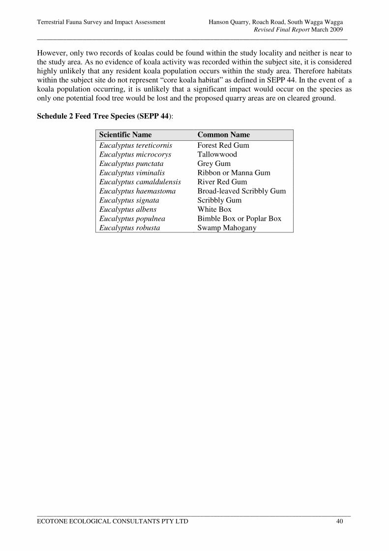
Terrestrial Fauna Survey and Impact Assessment Hanson Quarry, Roach Road, South Wagga Wagga
Revised Final Report March 2009
_______________________________________________________________________________________________
________________________________________________________________________________________________
ECOTONE ECOLOGICAL CONSULTANTS PTY LTD 40
However, only two records of koalas could be found within the study locality and neither is near to
the study area. As no evidence of koala activity was recorded within the subject site, it is considered
highly unlikely that any resident koala population occurs within the study area. Therefore habitats
within the subject site do not represent “core koala habitat” as defined in SEPP 44. In the event of a
koala population occurring, it is unlikely that a significant impact would occur on the species as
only one potential food tree would be lost and the proposed quarry areas are on cleared ground.
Schedule 2 Feed Tree Species (SEPP 44):
Scientific Name Common Name
Eucalyptus tereticornis Forest Red Gum
Eucalyptus microcorys Tallowwood
Eucalyptus punctata Grey Gum
Eucalyptus viminalis Ribbon or Manna Gum
Eucalyptus camaldulensis River Red Gum
Eucalyptus haemastoma Broad-leaved Scribbly Gum
Eucalyptus signata Scribbly Gum
Eucalyptus albens White Box
Eucalyptus populnea Bimble Box or Poplar Box
Eucalyptus robusta Swamp Mahogany
Terrestrial Fauna Survey and Impact Assessment Hanson Quarry, Roach Road, South Wagga Wagga
Revised Final Report March 2009
_______________________________________________________________________________________________
________________________________________________________________________________________________
ECOTONE ECOLOGICAL CONSULTANTS PTY LTD 41
5.0 MITIGATION MEASURES
In order to maximise conservation of local flora and fauna and to ameliorate impacts of the proposal
on the local natural environment (including potential habitat for threatened or significant species or
communities), it is recommended that the following steps be taken within the subject site:
• Remove and stockpile any hollow logs currently present within Stage 1 of the proposal for
use in restoration following the completion of extraction at each stage.
• Vegetation to be retained outside of the extraction areas should be fenced off to protect it
from machinery.
• Maintain open water for waterfowl and waterbirds within the study area by ensuring that
excess water from the processing plant is still directed to the wetland and settling ponds.
• A fauna expert/trained wildlife rescue person may need to be present during the removal of
the hollow bearing tree within Stage 4. This person should be trained in handling and
identification of a range of fauna, particularly birds and bats and be vaccinated for rabies as
protection against the bat lyssavirus.
• Areas outside of the quarry area that are to be revegetated, including the riparian vegetation
along the Murrumbidgee River, should be fenced in such a way to prevent cattle and rabbits
from entering. The use of barbed wire should be avoided as squirrel gliders and other fauna
are known to become entangled and could suffer a long painful death.
• Revegetation should allow a natural regrowth of trees, shrubs and groundcovers. River red
gums are likely to spread from local seed however shrubs and ground covers may need to be
planted. Only species natural to river red gum forest/woodland should be planted (see the
flora report, Geoff Cunningham, 2006/7).
• New haul roads should be constructed so as to avoid any of the existing riparian habitats.
Terrestrial Fauna Survey and Impact Assessment Hanson Quarry, Roach Road, South Wagga Wagga
Revised Final Report March 2009
_______________________________________________________________________________________________
________________________________________________________________________________________________
ECOTONE ECOLOGICAL CONSULTANTS PTY LTD 42
6.0 CONCLUSIONS
An assessment of the potential impacts on fauna as a result of the proposed quarry extension at
Hanson Quarry, Roach Road, South Wagga Wagga has been made based on a combination of
literature review and field survey. The resulting information has been used to address any impacts
that may occur and to carry out an assessment under Part 3A of the Environmental Planning and
Assessment Act 1979, the NSW Threatened Species Conservation Act 1995 (as amended in 2002),
the Commonwealth Environment Protection & Biodiversity Conservation Act 1999 and SEPP 44 –
Koala Habitat Protection.
Two threatened fauna species, the blue-billed duck and brown treecreeper, were recorded within the
study area and a further species, the inland forest bat, was probably recorded. A number of other
threatened fauna species have been recorded or have potential to occur within the local area, the
most likely being the barking owl, glossy black cockatoo, superb parrot, freckled duck, squirrel
glider and southern bell frog. Potential seasonal foraging habitat exists within the riparian habitat of
the study area for two endangered species listed in both the NSW TSC Act and the EPBC Act, the
swift parrot and regent honeyeater, however, based on available records and marginal habitat, the
probability of occurrence is considered to be low.
Potential impacts on all listed threatened fauna species have been addressed in Section 4. The two
main impacts of the proposed quarry extension on terrestrial fauna are the loss of piles of logging
waste, including some scattered large hollow logs, and possible changes to the drainage of the
wetland and settling ponds. The logging waste in the north-eastern section of the property provides
a foraging area for the brown treecreeper however, as a result of changes to the quarry layout, most
of this felled timber is now outside of the quarry area and potential significant impacts on this
species have been avoided. The open water provides habitat for the blue-billed duck and freckled
duck and a drought refuge for wildfowl, waterbirds and waders in general. Although some areas of
open water and wetland may be lost in Stages 4 and 5, these will be compensated for by the
flooding of some of the exhausted extraction pits (the existing pit and parts of Stages 2 and 3).
Habitat for the endangered population of the Squirrel Glider will not be significantly impacted upon
as only one remote tree will be removed during Stage 4 and none of the existing riparian habitat
will become isolated. The regeneration of areas outside of the extraction areas and restoration as
each stage becomes exhausted would potentially increase available habitat for the Squirrel Glider
over time.
The following key thresholds identified in the Guidelines for Threatened Species Assessment
(DECC 2005) are considered.
a) Whether or not the proposal, including actions to avoid or mitigate impacts or compensate
to prevent unavoidable impacts will maintain or improve biodiversity values.
The proposed quarry stages are situated within cleared grazed floodplain, except for some incursion
into the edge of the wetland (stage 5) and open water (stage 4). Drainage to and from the wetland
will need to be carefully managed during the excavation of stage 5. The flooding of the exhausted
pits would increase the areas of open water providing habitat and a drought refuge for waterbirds
including the threatened blue-billed duck and freckled duck. An example of the likely outcome is
demonstrated by the restored quarry in the north-west corner of the property. This consists of a
large lake surrounded by trees and shrubs connecting to the riparian vegetation along the
Murrumbidgee River. Therefore there is the potential to improve and increase the size of the
riparian vegetation along the Murrumbidgee River. Therefore in our opinion the proposal will be
able to maintain or improve biodiversity values if the suggested mitigation is implemented.
Terrestrial Fauna Survey and Impact Assessment Hanson Quarry, Roach Road, South Wagga Wagga
Revised Final Report March 2009
_______________________________________________________________________________________________
________________________________________________________________________________________________
ECOTONE ECOLOGICAL CONSULTANTS PTY LTD 43
b) Whether or not the proposal is likely to reduce the long-term viability of a local population
of the species, endangered population or endangered ecological community.
As mentioned above, the brown treecreeper and blue-billed duck were the only threatened species
recorded within the proposed quarry areas. The brown treecreeper was observed foraging within the
logging waste in the north-eastern part of the property and could potential breed and roost within
the scattered hollow bearing trees. The layout of the proposed quarry stages has been changed so as
to avoid the removal of hollow bearing trees and retain much of the fallen timber thus significantly
reducing the potential impacts on the species. Potential roosting sites for hollow dependant species,
including the threatened inland forest bat, superb parrot and turquoise parrot occur within the
riparian habitat and these will not be impacted by the proposal. With regards to the blue-billed duck
there would be some loss of habitat (open water) during Stages 4 and 5 however being a nomadic
species impacts would be low, especially as other areas of open water would be available. Therefore
it is considered highly unlikely that the long-term viability of local populations of any of the above
species and any other threatened species or endangered population (squirrel glider) that may occur
would be reduced.
c) Whether or not the proposal is likely to accelerate the extinction of the species, endangered
population or endangered ecological community or place it at the risk of extinction.
Given the cleared nature of the subject site and the existing land use, the proposal is unlikely to
result in the acceleration or risk of extinction to any of the fauna species identified or with potential
to occur within the study area.
d) Whether or not the proposal will adversely affect critical habitat.
No critical habitat has been listed in the TSC Act for the study area.
Therefore, the overall conclusion is that there is unlikely to be a significant impact on any local
population of threatened terrestrial fauna in the area as a result of the proposed quarry extensions. It
is also considered likely that the existing terrestrial fauna biodiversity can be retained within the
study area as there will be no loss of the existing naturally vegetated habitat. In fact there is the
potential for an increase in habitat over time provided that the intended rehabilitation works are
carried out.
Terrestrial Fauna Survey and Impact Assessment Hanson Quarry, Roach Road, South Wagga Wagga
Revised Final Report March 2009
_______________________________________________________________________________________________
________________________________________________________________________________________________
ECOTONE ECOLOGICAL CONSULTANTS PTY LTD 44
7.0 REFERENCES
Adams, M., Reardon, T.R., Baverstock, P.R. & Watts, C.H.S., 1988. Electrophoretic resolution of species boundaries
in Australian Microchiroptera. IV. The Molossidae (Chiroptera). Australian Journal of Biological Science 41: 315-326
Barrett, G., Silcocks, A., Barry, S., Cunningham, R. & Poulter, R., 2003. The New Atlas of Australian Birds, RAOU
Berger, L., Speare, R. & Hyatt, A., 1999. Chitrid fungi and amphibian declines: Overview, Implications and Future
Directions. Pp. 23-32 in Declines and Disappearances of Australian Frogs, edited by Alastair Campbell,
Biodiversity Group, Environment Australia, Canberra.
Claridge A. W. and van der Ree, 2004. Recovering endangered populations in fragmented landscapes: the squirrel
glider Petaurus norfolcensis on the south-west slopes of New South Wales. Pp 678-687 in the Conservation of
Australia’s Forest Fauna, (second edition), edited by Daniel Lunney. Royal Zoological Society of NSW,
Mosman, NSW, Australia
Cogger, H.G., 1995. Reptiles and Amphibians of Australia. Reed Books, Sydney.
Churchill, S. 1998. Australian Bats. Reed New Holland, Sydney.
Cunningham Natural Resource Consultants Pty Ltd, 2006. Flora Study of the Proposed Extension to the Hanson Wagga
Wagga Sand Quarry, report prepared for Hanson Construction Material Pty Ltd by Geoff Cunningham Natural
Resource Consultants Pty Ltd, Killara, NSW, March 2006.
DEC 2004. Threatened Biodiversity Survey and Assessment: Guidelines for Developments and Activities. Working
Draft. NSW Department of Environment and Conservation.
DECC website, Department of Environment and Climate Change (NSW) Threatened Species Profiles
http://www.threatenedspecies.environment.nsw.gov.au/tsprofile/index.aspx
Garnett, S. & Crowley, G., 2000, The Action Plan for Australian Birds Environment Australia, ACT, Australia
Hanson Construction Materials Pty Ltd, 2007. Background Report, Wagga Wagga Quarry , NSW.
Kavanagh, R. P. & Murray, M. 1996, Home range, habitat and behaviour of the Masked Owl Tyto novaehollandiae near
Newcastle, New South Wales in Emu 96., pp. 250 - 257.
Klippel, K. 1992. Wildlife Data Search - threatened animal species of New South Wales. Total Environment Centre,
Sydney.
Ley, A. & Williams, B. 1994, The domestic life of the Regent Honeyeater in Wingspan 13., pg. 27.
Morcombe M., 2000. Field Guide to Australian Birds. Steve Parish Publishing, Archerfield, QLD.
NPWS 1996. Threatened Species Management information circular No. 2. Threatened species assessment under the
EP&A Act: The '8 Part Test' of Significance.
NSW National Parks and Wildlife Service, 1999. Threatened Species Management: Species Information.
NPWS (NSW National Parks and Wildlife Service) 2001. Threat Abatement Plan for Predation by the Red Fox (Vulpes
vulpes). NSW National Parks and Wildlife Service, Hurstville.
NPWS 2003. Draft Recovery Plan for the Barking Owl. New South Wales National Parks and Wildlife Service,
Hurstville, NSW.
NPWS atlas of NSW wildlife http://wildlifeatlas.nationalparks.nsw.gov.au/wildlifeatlas
NPWS Website http://www.nationalparks.nsw.gov.au
NSW Dept. of Mines (1971). Geological Series 1:250 000 mapsheets: Wagga Wagga
Terrestrial Fauna Survey and Impact Assessment Hanson Quarry, Roach Road, South Wagga Wagga
Revised Final Report March 2009
_______________________________________________________________________________________________
________________________________________________________________________________________________
ECOTONE ECOLOGICAL CONSULTANTS PTY LTD 45
NSW Scientific Committee 2001. Final Determination to list the black-chinned honeyeater(eastern subspecies)
Melithreptus gularis gularis as a Vulnerable species on Schedule 2 of the TSC Act. NSW National Parks and
Wildlife Service.
NSW Scientific Committee 2004. Final determination – Squirrel glider population, Wagga Wagga Local Government
Area – endangered population listing. NSW Department of Environment and Conservation, Hurstville.
Parnaby, H. A. 1992. An Interim Guide to Identification of Insectivorous Bats of south-eastern Australia. Technical
Report No. 8. Australian Museum, Sydney.
Pennay, M.,Law, B., Reinhold, L., 2004. Bat calls of New South Wales: Region based guide to the echolocation calls of
Microchiropteran bats. NSW Department of Environment and Conservation, Hurstville.
Robinson, M. 1993. A Field Guide to Frogs of Australia. Reed Books, Sydney.
Simpson, K. & Day, N. 2003. The Claremont Field Guide to the Birds of Australia. Penguin Books Australia.
Stanger, M.., Clayton, M., Schodde, R., Wombey, J., and Mason, I. 1997. CSIRO List of Australian Vertebrates. A
reference with conservation status. CSIRO Publishing, Collingwood, Victoria.
Strahan, R. 1995, The Mammals of Australia. Reed Books and Australian Museum, Sydney.
Swan, G., Shea, G. and Sadlier, R., 2004. A Field Guide to Reptiles of New South Wales. 2nd
Edition Reed New
Holland, Australia
Webster, R. & Menkhorst, P. 1992. The Regent Honeyeater (Xanthomyza phrygia) population status and ecology in
Victoria and New South Wales. Arthur Rylah Institute for Environmental Research. Technical Report Series No.
126.
Williams, C. R. 1990, Possums and Gliders. pp. 97 - 108 in The Care and Handling of Australian Native Animals by
Hand, S. J. (ed). Royal Zoological Society and Surrey Beatty & Sons, Sydney.
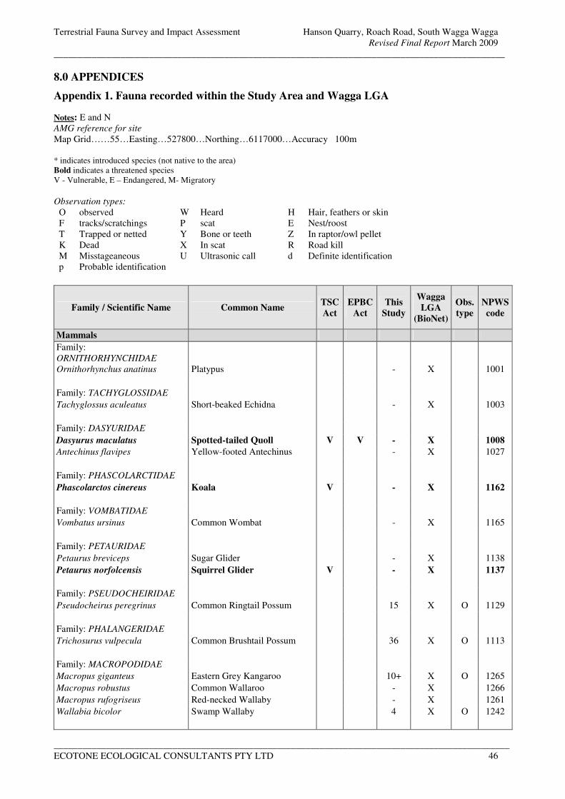
Terrestrial Fauna Survey and Impact Assessment Hanson Quarry, Roach Road, South Wagga Wagga
Revised Final Report March 2009
_______________________________________________________________________________________________
________________________________________________________________________________________________
ECOTONE ECOLOGICAL CONSULTANTS PTY LTD 46
8.0 APPENDICES
Appendix 1. Fauna recorded within the Study Area and Wagga LGA
Notes: E and N
AMG reference for site
Map Grid……55…Easting…527800…Northing…6117000…Accuracy 100m
* indicates introduced species (not native to the area)
Bold indicates a threatened species
V - Vulnerable, E – Endangered, M- Migratory
Observation types:
O observed W Heard H Hair, feathers or skin
F tracks/scratchings P scat E Nest/roost
T Trapped or netted Y Bone or teeth Z In raptor/owl pellet
K Dead X In scat R Road kill
M Misstageaneous U Ultrasonic call d Definite identification
p Probable identification
Family / Scientific Name Common Name TSC
Act
EPBC
Act
This
Study
Wagga
LGA
(BioNet)
Obs.
type
NPWS
code
Mammals
Family:
ORNITHORHYNCHIDAE
Ornithorhynchus anatinus Platypus - X 1001
Family: TACHYGLOSSIDAE
Tachyglossus aculeatus Short-beaked Echidna - X 1003
Family: DASYURIDAE
Dasyurus maculatus Spotted-tailed Quoll V V - X 1008
Antechinus flavipes Yellow-footed Antechinus - X 1027
Family: PHASCOLARCTIDAE
Phascolarctos cinereus Koala V - X 1162
Family: VOMBATIDAE
Vombatus ursinus Common Wombat - X 1165
Family: PETAURIDAE
Petaurus breviceps Sugar Glider - X 1138
Petaurus norfolcensis Squirrel Glider V - X 1137
Family: PSEUDOCHEIRIDAE
Pseudocheirus peregrinus Common Ringtail Possum 15 X O 1129
Family: PHALANGERIDAE
Trichosurus vulpecula Common Brushtail Possum 36 X O 1113
Family: MACROPODIDAE
Macropus giganteus Eastern Grey Kangaroo 10+ X O 1265
Macropus robustus Common Wallaroo - X 1266
Macropus rufogriseus Red-necked Wallaby - X 1261
Wallabia bicolor Swamp Wallaby 4 X O 1242
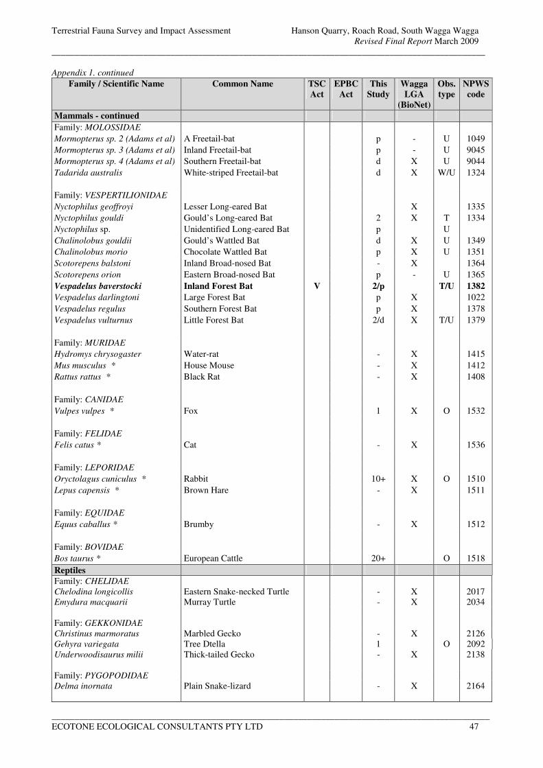
Terrestrial Fauna Survey and Impact Assessment Hanson Quarry, Roach Road, South Wagga Wagga
Revised Final Report March 2009
_______________________________________________________________________________________________
________________________________________________________________________________________________
ECOTONE ECOLOGICAL CONSULTANTS PTY LTD 47
Appendix 1. continued
Family / Scientific Name Common Name TSC
Act
EPBC
Act
This
Study
Wagga
LGA
(BioNet)
Obs.
type
NPWS
code
Mammals - continued
Family: MOLOSSIDAE
Mormopterus sp. 2 (Adams et al) A Freetail-bat p - U 1049
Mormopterus sp. 3 (Adams et al) Inland Freetail-bat p - U 9045
Mormopterus sp. 4 (Adams et al) Southern Freetail-bat d X U 9044
Tadarida australis White-striped Freetail-bat d X W/U 1324
Family: VESPERTILIONIDAE
Nyctophilus geoffroyi Lesser Long-eared Bat X 1335
Nyctophilus gouldi Gould’s Long-eared Bat 2 X T 1334
Nyctophilus sp. Unidentified Long-eared Bat p U
Chalinolobus gouldii Gould’s Wattled Bat d X U 1349
Chalinolobus morio Chocolate Wattled Bat p X U 1351
Scotorepens balstoni Inland Broad-nosed Bat - X 1364
Scotorepens orion Eastern Broad-nosed Bat p - U 1365
Vespadelus baverstocki Inland Forest Bat V 2/p T/U 1382
Vespadelus darlingtoni Large Forest Bat p X 1022
Vespadelus regulus Southern Forest Bat p X 1378
Vespadelus vulturnus Little Forest Bat 2/d X T/U 1379
Family: MURIDAE
Hydromys chrysogaster Water-rat - X 1415
Mus musculus * House Mouse - X 1412
Rattus rattus * Black Rat - X 1408
Family: CANIDAE
Vulpes vulpes * Fox 1 X O 1532
Family: FELIDAE
Felis catus * Cat - X 1536
Family: LEPORIDAE
Oryctolagus cuniculus * Rabbit 10+ X O 1510
Lepus capensis * Brown Hare - X 1511
Family: EQUIDAE
Equus caballus * Brumby - X 1512
Family: BOVIDAE
Bos taurus * European Cattle 20+ O 1518
Reptiles
Family: CHELIDAE
Chelodina longicollis Eastern Snake-necked Turtle - X 2017
Emydura macquarii Murray Turtle - X 2034
Family: GEKKONIDAE
Christinus marmoratus Marbled Gecko - X 2126
Gehyra variegata Tree Dtella 1 O 2092
Underwoodisaurus milii Thick-tailed Gecko - X 2138
Family: PYGOPODIDAE
Delma inornata Plain Snake-lizard - X 2164
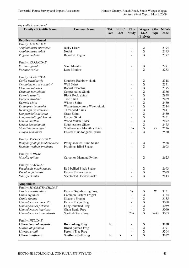
Terrestrial Fauna Survey and Impact Assessment Hanson Quarry, Roach Road, South Wagga Wagga
Revised Final Report March 2009
_______________________________________________________________________________________________
________________________________________________________________________________________________
ECOTONE ECOLOGICAL CONSULTANTS PTY LTD 48
Appendix 1. continued Family / Scientific Name Common Name TSC
Act
EPBC
Act
This
Study
Wagga
LGA
(BioNet)
Obs.
type
NPWS
code
Reptiles - continued
Family: AGAMIDAE
Amphibolurus muricatus Jacky Lizard - X 2194
Amphibolurus nobbi Nobbi - X 2195
Pogona barbata Bearded Dragon - X 2177
Family: VARANIDAE
Varanus gouldii Sand Monitor - X 2271
Varanus varius Lace Monitor - X 2283
Family: SCINCIDAE
Carlia tetradactyla Southern Rainbow-skink - X 2318
Cryptoblepharus carnabyi Wall Skink - X 2331
Ctenotus robustus Robust Ctenotus - X 2375
Ctenotus taeniolatus Copper-tailed Skink - X 2386
Egernia saxatilis Black Rock Skink - X 2938
Egernia striolata Tree Skink - X 2429
Egernia whitii White’s Skink - X 2430
Eulamprus heatwolei Warm-temperature Water-skink - X 2214
Hemiergis decresiensis Three-toed Skink - X 2441
Lampropholis delicata Grass Skink - X 2450
Lampropholis guichenoti Garden Skink - X 2451
Lerista muelleri Wood Mulch Slider - X 2492
Lerista bougainvillii South-eastern Slider - X 2475
Morethia boulengeri South-eastern Morethia Skink 10+ X O 2526
Tiliqua scincoides Eastern Blue-tongued Lizard - X 2580
Family: TYPHLOPIDAE
Ramphotyphlops bituberculatus Prong-snouted Blind Snake - X 2588
Ramphotyphlops proximus Proximus Blind Snake - X 2603
Family: BOIDAE
Morelia spilota Carpet or Diamond Python - X 2625
Family: ELAPIDAE
Pseudechis porphyriacus Red-bellied Black Snake - X 2693
Pseudonaja textilis Eastern Brown Snake - X 2699
Suta spectabilis Spectacled Hooded Snake - X 2813
Amphibians
Family: MYOBATRACHIDAE
Crinia parinsignifera Eastern Sign-bearing Frog 5+ X W 3131
Crinia signifera Common Eastern Froglet - X 3134
Crinia sloanei Sloane’s Froglet - X 3135
Limnodynastes dumerilii Eastern Banjo Frog - X 3058
Limnodynastes fletcheri Long-thumbed Frog - X 3059
Limnodynastes interioris Giant Banjo Frog - X 3060
Limnodynastes tasmaniensis Spotted Grass Frog 20+ X W/O 3063
Family: HYLIDAE
Litoria booroolongensis Booroolong Frog E - X 3168
Litoria latopalmata Broad-palmed Frog - X 3191
Litoria peronii Peron’s Tree Frog - X 3204
Litoria raniformis Southern Bell Frog E V - X 3207
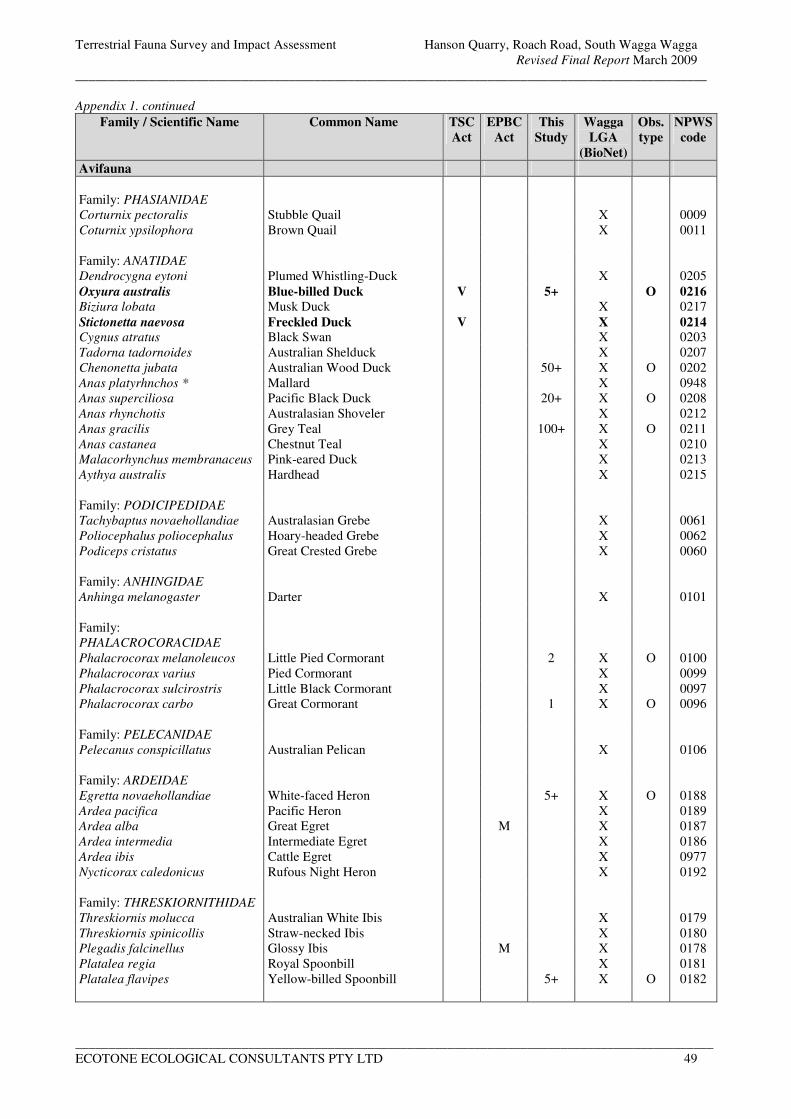
Terrestrial Fauna Survey and Impact Assessment Hanson Quarry, Roach Road, South Wagga Wagga
Revised Final Report March 2009
_______________________________________________________________________________________________
________________________________________________________________________________________________
ECOTONE ECOLOGICAL CONSULTANTS PTY LTD 49
Appendix 1. continued
Family / Scientific Name Common Name TSC
Act
EPBC
Act
This
Study
Wagga
LGA
(BioNet)
Obs.
type
NPWS
code
Avifauna
Family: PHASIANIDAE
Corturnix pectoralis Stubble Quail X 0009
Coturnix ypsilophora Brown Quail X 0011
Family: ANATIDAE
Dendrocygna eytoni Plumed Whistling-Duck X 0205
Oxyura australis Blue-billed Duck V 5+ O 0216
Biziura lobata Musk Duck X 0217
Stictonetta naevosa Freckled Duck V X 0214 Cygnus atratus Black Swan X 0203
Tadorna tadornoides Australian Shelduck X 0207
Chenonetta jubata Australian Wood Duck 50+ X O 0202
Anas platyrhnchos * Mallard X 0948
Anas superciliosa Pacific Black Duck 20+ X O 0208
Anas rhynchotis Australasian Shoveler X 0212
Anas gracilis Grey Teal 100+ X O 0211
Anas castanea Chestnut Teal X 0210
Malacorhynchus membranaceus Pink-eared Duck X 0213
Aythya australis Hardhead X 0215
Family: PODICIPEDIDAE
Tachybaptus novaehollandiae Australasian Grebe X 0061
Poliocephalus poliocephalus Hoary-headed Grebe X 0062
Podiceps cristatus Great Crested Grebe X 0060
Family: ANHINGIDAE
Anhinga melanogaster Darter X 0101
Family:
PHALACROCORACIDAE
Phalacrocorax melanoleucos Little Pied Cormorant 2 X O 0100
Phalacrocorax varius Pied Cormorant X 0099
Phalacrocorax sulcirostris Little Black Cormorant X 0097
Phalacrocorax carbo Great Cormorant 1 X O 0096
Family: PELECANIDAE
Pelecanus conspicillatus Australian Pelican X 0106
Family: ARDEIDAE
Egretta novaehollandiae White-faced Heron 5+ X O 0188
Ardea pacifica Pacific Heron X 0189
Ardea alba Great Egret M X 0187
Ardea intermedia Intermediate Egret X 0186
Ardea ibis Cattle Egret X 0977
Nycticorax caledonicus Rufous Night Heron X 0192
Family: THRESKIORNITHIDAE
Threskiornis molucca Australian White Ibis X 0179
Threskiornis spinicollis Straw-necked Ibis X 0180
Plegadis falcinellus Glossy Ibis M X 0178
Platalea regia Royal Spoonbill X 0181
Platalea flavipes Yellow-billed Spoonbill 5+ X O 0182
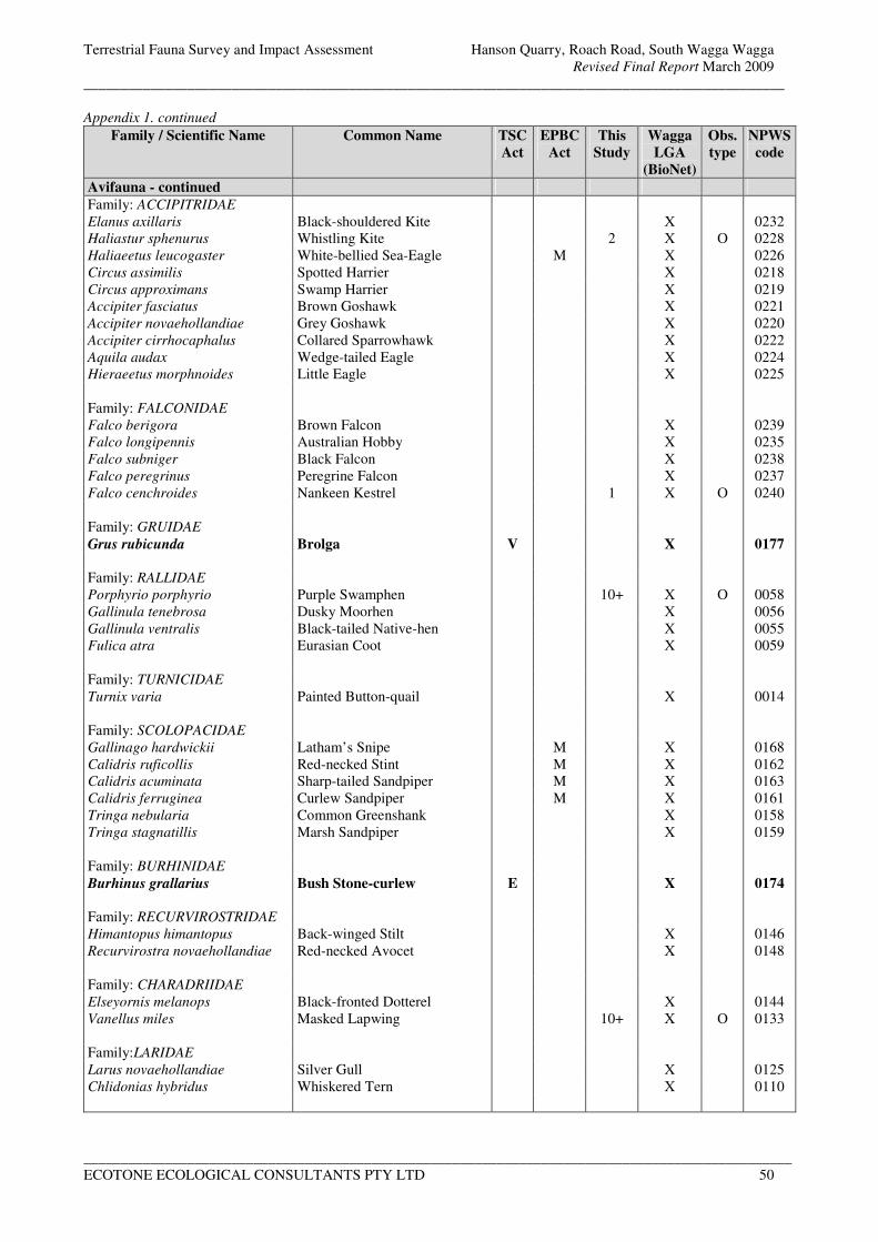
Terrestrial Fauna Survey and Impact Assessment Hanson Quarry, Roach Road, South Wagga Wagga
Revised Final Report March 2009
_______________________________________________________________________________________________
________________________________________________________________________________________________
ECOTONE ECOLOGICAL CONSULTANTS PTY LTD 50
Appendix 1. continued Family / Scientific Name Common Name TSC
Act
EPBC
Act
This
Study
Wagga
LGA
(BioNet)
Obs.
type
NPWS
code
Avifauna - continued
Family: ACCIPITRIDAE
Elanus axillaris Black-shouldered Kite X 0232
Haliastur sphenurus Whistling Kite 2 X O 0228
Haliaeetus leucogaster White-bellied Sea-Eagle M X 0226
Circus assimilis Spotted Harrier X 0218
Circus approximans Swamp Harrier X 0219
Accipiter fasciatus Brown Goshawk X 0221
Accipiter novaehollandiae Grey Goshawk X 0220
Accipiter cirrhocaphalus Collared Sparrowhawk X 0222
Aquila audax Wedge-tailed Eagle X 0224
Hieraeetus morphnoides Little Eagle X 0225
Family: FALCONIDAE
Falco berigora Brown Falcon X 0239
Falco longipennis Australian Hobby X 0235
Falco subniger Black Falcon X 0238
Falco peregrinus Peregrine Falcon X 0237
Falco cenchroides Nankeen Kestrel 1 X O 0240
Family: GRUIDAE
Grus rubicunda Brolga V X 0177
Family: RALLIDAE
Porphyrio porphyrio Purple Swamphen 10+ X O 0058
Gallinula tenebrosa Dusky Moorhen X 0056
Gallinula ventralis Black-tailed Native-hen X 0055
Fulica atra Eurasian Coot X 0059
Family: TURNICIDAE
Turnix varia Painted Button-quail X 0014
Family: SCOLOPACIDAE
Gallinago hardwickii Latham’s Snipe M X 0168
Calidris ruficollis Red-necked Stint M X 0162
Calidris acuminata Sharp-tailed Sandpiper M X 0163
Calidris ferruginea Curlew Sandpiper M X 0161
Tringa nebularia Common Greenshank X 0158
Tringa stagnatillis Marsh Sandpiper X 0159
Family: BURHINIDAE
Burhinus grallarius Bush Stone-curlew E X 0174
Family: RECURVIROSTRIDAE
Himantopus himantopus Back-winged Stilt X 0146
Recurvirostra novaehollandiae Red-necked Avocet X 0148
Family: CHARADRIIDAE
Elseyornis melanops Black-fronted Dotterel X 0144
Vanellus miles Masked Lapwing 10+ X O 0133
Family:LARIDAE
Larus novaehollandiae Silver Gull X 0125
Chlidonias hybridus Whiskered Tern X 0110
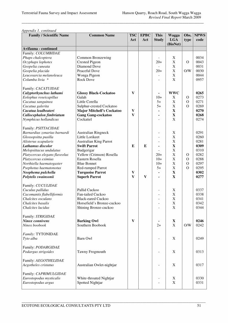
Terrestrial Fauna Survey and Impact Assessment Hanson Quarry, Roach Road, South Wagga Wagga
Revised Final Report March 2009
_______________________________________________________________________________________________
________________________________________________________________________________________________
ECOTONE ECOLOGICAL CONSULTANTS PTY LTD 51
Appendix 1. continued Family / Scientific Name Common Name TSC
Act
EPBC
Act
This
Study
Wagga
LGA
(BioNet)
Obs.
type
NPWS
code
Avifauna - continued
Family: COLUMBIDAE
Phaps chalcoptera Common Bronzewing - X 0034
Ocyphaps lophotes Crested Pigeon 20+ X O 0043
Geopelia cuneata Diamond Dove - X 0031
Geopelia placida Peaceful Dove 20+ X O/W 0030
Leucosarcia melanoleuca Wonga Pigeon - X 0044
Columba livia * Rock Dove - X 0957
Family: CACATUIDAE
Calyptorhynchus lathami Glossy Black-Cockatoo V - WWC 0265 Eolophus roseicapillus Galah 10+ X O 0273
Cacatua sanguinea Little Corella 5+ X O 0271
Cacatua galerita Sulphur-crested Cockatoo 5+ X O 0269
Cacatua leadbeateri Major Mitchell’s Cockatoo V - X 0270
Callocephalon fimbriatum Gang Gang-cockatoo V - X 0268
Nymphicus hollandicus Cockatiel - X 0274
Family: PSITTACIDAE
Barnardius zonarius barnardi Australian Ringneck - X 0291
Glossopsitta pusilla Little Lorikeet - X 0260
Alisterus scapularis Australian King Parrot - X 0281
Lathamus discolor Swift Parrot E E - X 0309 Melopsittacus undulatus Budgerigar - X 0310
Platycercus elegans flaveolus Yellow (Crimson) Rosella 20+ X O 0282
Platycercus eximius Eastern Rosella 10+ X O 0288
Northiella haematogaster Blue Bonnet 10+ X O 0297
Psephotus haematonotus Red-rumped Parrot 5+ X O 0295
Neophema pulchella Turquoise Parrot V - X 0302
Polytelis swainsonii Superb Parrot V V - X 0277
Family: CUCULIDAE
Cuculus pallidus Pallid Cuckoo - X 0337
Cacomantis flabelliformis Fan-tailed Cuckoo - X 0338
Chalcites osculans Black-eared Cuckoo - X 0341
Chalcites basalis Horsefield’s Bronze-cuckoo - X 0342
Chalcites lucidus Shining Bronze-cuckoo - X 0344
Family: STRIGIDAE
Ninox connivens Barking Owl V - X 0246
Ninox boobook Southern Boobook 2+ X O/W 0242
Family: TYTONIDAE
Tyto alba Barn Owl - X 0249
Family: PODARGIDAE
Podargus strigoides Tawny Frogmouth - X 0313
Family: AEGOTHELIDAE
Aegotheles cristatus Australian Owlet-nightjar - X 0317
Family: CAPRIMULGIDAE
Eurostopodus mysticalis White-throated Nightjar - X 0330
Eurostopodus argus Spotted Nightjar - X 0331
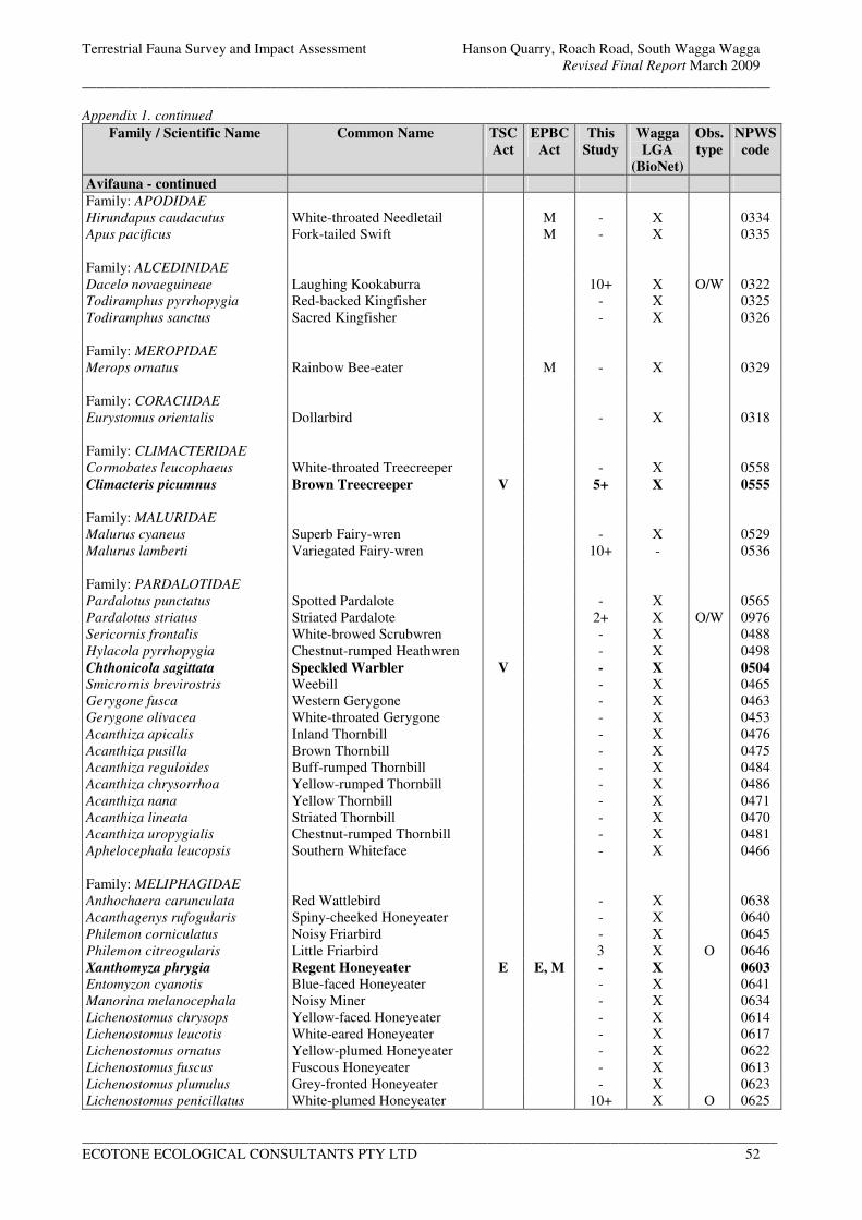
Terrestrial Fauna Survey and Impact Assessment Hanson Quarry, Roach Road, South Wagga Wagga
Revised Final Report March 2009
_______________________________________________________________________________________________
________________________________________________________________________________________________
ECOTONE ECOLOGICAL CONSULTANTS PTY LTD 52
Appendix 1. continued Family / Scientific Name Common Name TSC
Act
EPBC
Act
This
Study
Wagga
LGA
(BioNet)
Obs.
type
NPWS
code
Avifauna - continued
Family: APODIDAE
Hirundapus caudacutus White-throated Needletail M - X 0334
Apus pacificus Fork-tailed Swift M - X 0335
Family: ALCEDINIDAE
Dacelo novaeguineae Laughing Kookaburra 10+ X O/W 0322
Todiramphus pyrrhopygia Red-backed Kingfisher - X 0325
Todiramphus sanctus Sacred Kingfisher - X 0326
Family: MEROPIDAE
Merops ornatus Rainbow Bee-eater M - X 0329
Family: CORACIIDAE
Eurystomus orientalis Dollarbird - X 0318
Family: CLIMACTERIDAE
Cormobates leucophaeus White-throated Treecreeper - X 0558
Climacteris picumnus Brown Treecreeper V 5+ X 0555
Family: MALURIDAE
Malurus cyaneus Superb Fairy-wren - X 0529
Malurus lamberti Variegated Fairy-wren 10+ - 0536
Family: PARDALOTIDAE
Pardalotus punctatus Spotted Pardalote - X 0565
Pardalotus striatus Striated Pardalote 2+ X O/W 0976
Sericornis frontalis White-browed Scrubwren - X 0488
Hylacola pyrrhopygia Chestnut-rumped Heathwren - X 0498
Chthonicola sagittata Speckled Warbler V - X 0504
Smicrornis brevirostris Weebill - X 0465
Gerygone fusca Western Gerygone - X 0463
Gerygone olivacea White-throated Gerygone - X 0453
Acanthiza apicalis Inland Thornbill - X 0476
Acanthiza pusilla Brown Thornbill - X 0475
Acanthiza reguloides Buff-rumped Thornbill - X 0484
Acanthiza chrysorrhoa Yellow-rumped Thornbill - X 0486
Acanthiza nana Yellow Thornbill - X 0471
Acanthiza lineata Striated Thornbill - X 0470
Acanthiza uropygialis Chestnut-rumped Thornbill - X 0481
Aphelocephala leucopsis Southern Whiteface - X 0466
Family: MELIPHAGIDAE
Anthochaera carunculata Red Wattlebird - X 0638
Acanthagenys rufogularis Spiny-cheeked Honeyeater - X 0640
Philemon corniculatus Noisy Friarbird - X 0645
Philemon citreogularis Little Friarbird 3 X O 0646
Xanthomyza phrygia Regent Honeyeater E E, M - X 0603
Entomyzon cyanotis Blue-faced Honeyeater - X 0641
Manorina melanocephala Noisy Miner - X 0634
Lichenostomus chrysops Yellow-faced Honeyeater - X 0614
Lichenostomus leucotis White-eared Honeyeater - X 0617
Lichenostomus ornatus Yellow-plumed Honeyeater - X 0622
Lichenostomus fuscus Fuscous Honeyeater - X 0613
Lichenostomus plumulus Grey-fronted Honeyeater - X 0623
Lichenostomus penicillatus White-plumed Honeyeater 10+ X O 0625
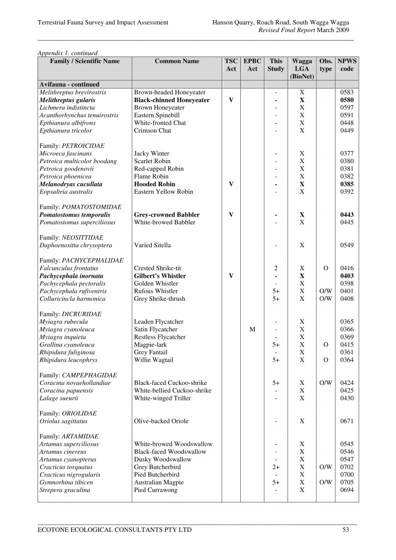
Terrestrial Fauna Survey and Impact Assessment Hanson Quarry, Roach Road, South Wagga Wagga
Revised Final Report March 2009
_______________________________________________________________________________________________
________________________________________________________________________________________________
ECOTONE ECOLOGICAL CONSULTANTS PTY LTD 53
Appendix 1. continued Family / Scientific Name Common Name TSC
Act
EPBC
Act
This
Study
Wagga
LGA
(BioNet)
Obs.
type
NPWS
code
Avifauna - continued
Melithreptus brevirostris Brown-headed Honeyeater - X 0583
Melithreptus gularis Black-chinned Honeyeater V - X 0580 Lichmera indistincta Brown Honeyeater - X 0597
Acanthorhynchus tenuirostris Eastern Spinebill - X 0591
Epthianura albifrons White-fronted Chat - X 0448
Epthianura tricolor Crimson Chat - X 0449
Family: PETROICIDAE
Microeca fascinans Jacky Winter - X 0377
Petroica multicolor boodang Scarlet Robin - X 0380
Petroica goodenovii Red-capped Robin - X 0381
Petroica phoenicea Flame Robin - X 0382
Melanodryas cucullata Hooded Robin V - X 0385
Eopsaltria australis Eastern Yellow Robin - X 0392
Family: POMATOSTOMIDAE
Pomatostomus temporalis Grey-crowned Babbler V - X 0443
Pomatostomus superciliosus White-browed Babbler - X 0445
Family: NEOSITTIDAE
Daphoenositta chrysoptera Varied Sitella - X 0549
Family: PACHYCEPHALIDAE
Falcunculus frontatus Crested Shrike-tit 2 X O 0416
Pachycephala inornata Gilbert’s Whistler V - X 0403
Pachycephala pectoralis Golden Whistler - X 0398
Pachycephala rufiventris Rufous Whistler 5+ X O/W 0401
Colluricincla harmonica Grey Shrike-thrush 5+ X O/W 0408
Family: DICRURIDAE
Myiagra rubecula Leaden Flycatcher - X 0365
Myiagra cyanoleuca Satin Flycatcher M - X 0366
Myiagra inquieta Restless Flycatcher - X 0369
Grallina cyanoleuca Magpie-lark 5+ X O 0415
Rhipidura fuliginosa Grey Fantail - X 0361
Rhipidura leucophrys Willie Wagtail 5+ X O 0364
Family: CAMPEPHAGIDAE
Coracina novaehollandiae Black-faced Cuckoo-shrike 5+ X O/W 0424
Coracina papuensis White-bellied Cuckoo-shrike - X 0425
Lalage sueurii White-winged Triller - X 0430
Family: ORIOLIDAE
Oriolus sagittatus Olive-backed Oriole - X 0671
Family: ARTAMIDAE
Artamus superciliosus White-browed Woodswallow - X 0545
Artamus cinereus Black-faced Woodswallow - X 0546
Artamus cyanopterus Dusky Woodswallow - X 0547
Cracticus torquatus Grey Butcherbird 2+ X O/W 0702
Cracticus nigrogularis Pied Butcherbird - X 0700
Gymnorhina tibicen Australian Magpie 5+ X O/W 0705
Strepera graculina Pied Currawong - X 0694
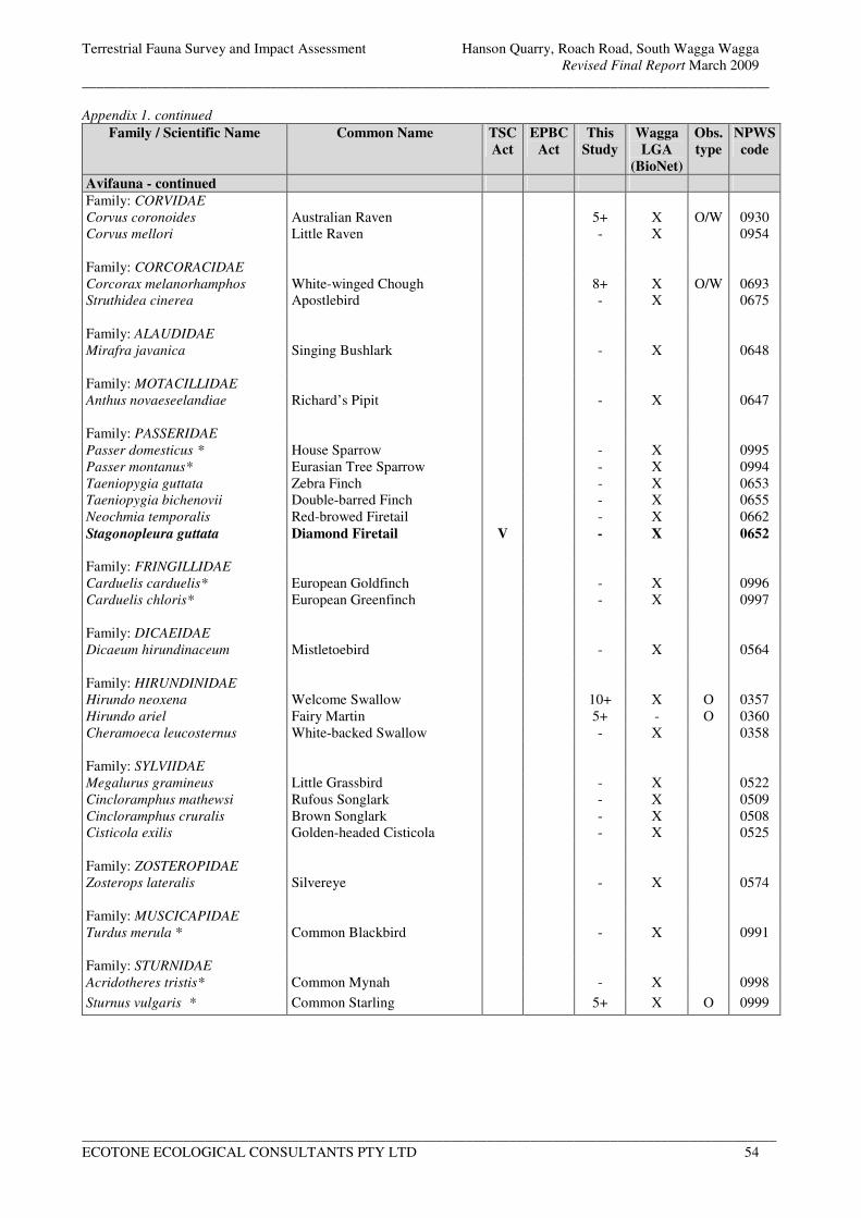
Terrestrial Fauna Survey and Impact Assessment Hanson Quarry, Roach Road, South Wagga Wagga
Revised Final Report March 2009
_______________________________________________________________________________________________
________________________________________________________________________________________________
ECOTONE ECOLOGICAL CONSULTANTS PTY LTD 54
Appendix 1. continued Family / Scientific Name Common Name TSC
Act
EPBC
Act
This
Study
Wagga
LGA
(BioNet)
Obs.
type
NPWS
code
Avifauna - continued
Family: CORVIDAE
Corvus coronoides Australian Raven 5+ X O/W 0930
Corvus mellori Little Raven - X 0954
Family: CORCORACIDAE
Corcorax melanorhamphos White-winged Chough 8+ X O/W 0693
Struthidea cinerea Apostlebird - X 0675
Family: ALAUDIDAE
Mirafra javanica Singing Bushlark - X 0648
Family: MOTACILLIDAE
Anthus novaeseelandiae Richard’s Pipit - X 0647
Family: PASSERIDAE
Passer domesticus * House Sparrow - X 0995
Passer montanus* Eurasian Tree Sparrow - X 0994
Taeniopygia guttata Zebra Finch - X 0653
Taeniopygia bichenovii Double-barred Finch - X 0655
Neochmia temporalis Red-browed Firetail - X 0662
Stagonopleura guttata Diamond Firetail V - X 0652
Family: FRINGILLIDAE
Carduelis carduelis* European Goldfinch - X 0996
Carduelis chloris* European Greenfinch - X 0997
Family: DICAEIDAE
Dicaeum hirundinaceum Mistletoebird - X 0564
Family: HIRUNDINIDAE
Hirundo neoxena Welcome Swallow 10+ X O 0357
Hirundo ariel Fairy Martin 5+ - O 0360
Cheramoeca leucosternus White-backed Swallow - X 0358
Family: SYLVIIDAE
Megalurus gramineus Little Grassbird - X 0522
Cincloramphus mathewsi Rufous Songlark - X 0509
Cincloramphus cruralis Brown Songlark - X 0508
Cisticola exilis Golden-headed Cisticola - X 0525
Family: ZOSTEROPIDAE
Zosterops lateralis Silvereye - X 0574
Family: MUSCICAPIDAE
Turdus merula * Common Blackbird - X 0991
Family: STURNIDAE
Acridotheres tristis* Common Mynah - X 0998
Sturnus vulgaris * Common Starling 5+ X O 0999
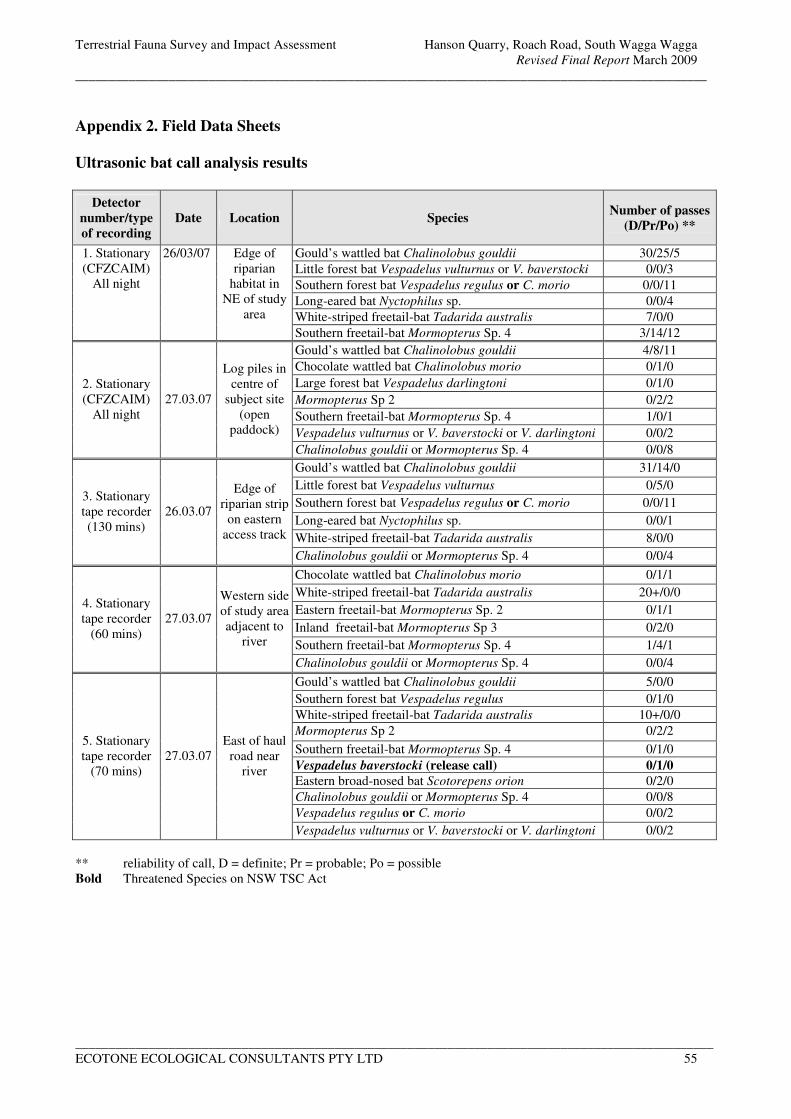
Terrestrial Fauna Survey and Impact Assessment Hanson Quarry, Roach Road, South Wagga Wagga
Revised Final Report March 2009
_______________________________________________________________________________________________
________________________________________________________________________________________________
ECOTONE ECOLOGICAL CONSULTANTS PTY LTD 55
Appendix 2. Field Data Sheets
Ultrasonic bat call analysis results
Detector
number/type
of recording
Date Location Species Number of passes
(D/Pr/Po) **
Gould’s wattled bat Chalinolobus gouldii 30/25/5
Little forest bat Vespadelus vulturnus or V. baverstocki 0/0/3
Southern forest bat Vespadelus regulus or C. morio 0/0/11
Long-eared bat Nyctophilus sp. 0/0/4
White-striped freetail-bat Tadarida australis 7/0/0
1. Stationary
(CFZCAIM)
All night
26/03/07 Edge of
riparian
habitat in
NE of study
area
Southern freetail-bat Mormopterus Sp. 4 3/14/12
Gould’s wattled bat Chalinolobus gouldii 4/8/11
Chocolate wattled bat Chalinolobus morio 0/1/0
Large forest bat Vespadelus darlingtoni 0/1/0
Mormopterus Sp 2 0/2/2
Southern freetail-bat Mormopterus Sp. 4 1/0/1
Vespadelus vulturnus or V. baverstocki or V. darlingtoni 0/0/2
2. Stationary
(CFZCAIM)
All night
27.03.07
Log piles in
centre of
subject site
(open
paddock)
Chalinolobus gouldii or Mormopterus Sp. 4 0/0/8
Gould’s wattled bat Chalinolobus gouldii 31/14/0
Little forest bat Vespadelus vulturnus 0/5/0
Southern forest bat Vespadelus regulus or C. morio 0/0/11
Long-eared bat Nyctophilus sp. 0/0/1
White-striped freetail-bat Tadarida australis 8/0/0
3. Stationary
tape recorder
(130 mins)
26.03.07
Edge of
riparian strip
on eastern
access track
Chalinolobus gouldii or Mormopterus Sp. 4 0/0/4
Chocolate wattled bat Chalinolobus morio 0/1/1
White-striped freetail-bat Tadarida australis 20+/0/0
Eastern freetail-bat Mormopterus Sp. 2 0/1/1
Inland freetail-bat Mormopterus Sp 3 0/2/0
Southern freetail-bat Mormopterus Sp. 4 1/4/1
4. Stationary
tape recorder
(60 mins)
27.03.07
Western side
of study area
adjacent to
river
Chalinolobus gouldii or Mormopterus Sp. 4 0/0/4
Gould’s wattled bat Chalinolobus gouldii 5/0/0
Southern forest bat Vespadelus regulus 0/1/0
White-striped freetail-bat Tadarida australis 10+/0/0
Mormopterus Sp 2 0/2/2
Southern freetail-bat Mormopterus Sp. 4 0/1/0
Vespadelus baverstocki (release call) 0/1/0
Eastern broad-nosed bat Scotorepens orion 0/2/0
Chalinolobus gouldii or Mormopterus Sp. 4 0/0/8
Vespadelus regulus or C. morio 0/0/2
5. Stationary
tape recorder
(70 mins)
27.03.07
East of haul
road near
river
Vespadelus vulturnus or V. baverstocki or V. darlingtoni 0/0/2
** reliability of call, D = definite; Pr = probable; Po = possible
Bold Threatened Species on NSW TSC Act
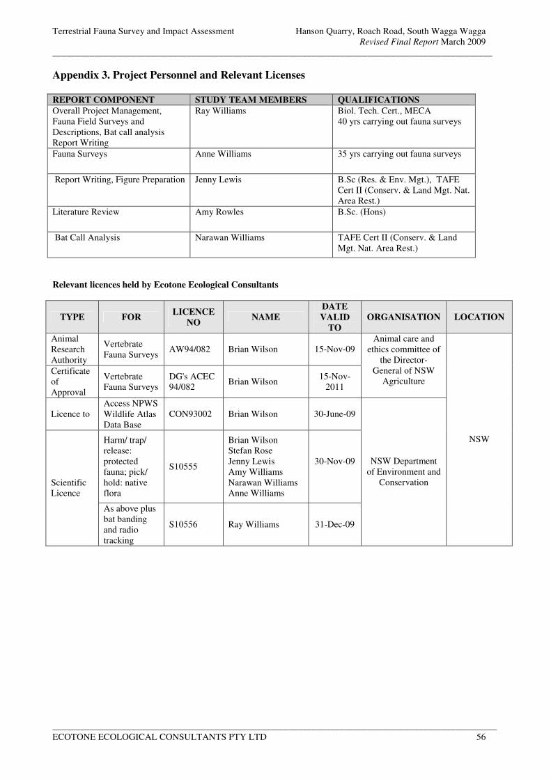
Terrestrial Fauna Survey and Impact Assessment Hanson Quarry, Roach Road, South Wagga Wagga
Revised Final Report March 2009
_______________________________________________________________________________________________
________________________________________________________________________________________________
ECOTONE ECOLOGICAL CONSULTANTS PTY LTD 56
Appendix 3. Project Personnel and Relevant Licenses
REPORT COMPONENT STUDY TEAM MEMBERS QUALIFICATIONS
Overall Project Management,
Fauna Field Surveys and
Descriptions, Bat call analysis
Report Writing
Ray Williams
Biol. Tech. Cert., MECA
40 yrs carrying out fauna surveys
Fauna Surveys Anne Williams 35 yrs carrying out fauna surveys
Report Writing, Figure Preparation Jenny Lewis B.Sc (Res. & Env. Mgt.), TAFE
Cert II (Conserv. & Land Mgt. Nat.
Area Rest.)
Literature Review Amy Rowles B.Sc. (Hons)
Bat Call Analysis Narawan Williams TAFE Cert II (Conserv. & Land
Mgt. Nat. Area Rest.)
Relevant licences held by Ecotone Ecological Consultants
TYPE FOR LICENCE
NO NAME
DATE
VALID
TO
ORGANISATION LOCATION
Animal
Research
Authority
Vertebrate
Fauna Surveys AW94/082 Brian Wilson 15-Nov-09
Certificate
of
Approval
Vertebrate
Fauna Surveys
DG's ACEC
94/082 Brian Wilson
15-Nov-
2011
Animal care and
ethics committee of
the Director-
General of NSW
Agriculture
Licence to
Access NPWS
Wildlife Atlas
Data Base
CON93002 Brian Wilson 30-June-09
Harm/ trap/
release:
protected
fauna; pick/
hold: native
flora
S10555
Brian Wilson
Stefan Rose
Jenny Lewis
Amy Williams
Narawan Williams
Anne Williams
30-Nov-09
Scientific
Licence
As above plus
bat banding
and radio
tracking
S10556 Ray Williams 31-Dec-09
NSW Department
of Environment and
Conservation
NSW

ADDENDUM
ECOTONE REPORT
ECOTONE ECOLOGICAL CONSULTANTS Pty Ltd
Ecological Research Impact Assessment Reports Flora, Fauna & Biodiversity Surveys Offset and BioBanking Assessments Specialised Bat Studies Nest Box Installation & Monitoring Bushland/Vegetation Management Plans Wildlife Monitoring & Management Wetland Studies Wildlife Photography
NEWCASTLE : 39 Platt Street, Waratah NSW 2298 Phone: (02) 49684901 Fax: (02) 49684960
E-mail: [email protected] Web: www.ecotoneconsultants.com.au
ABN 67 070 127 409
23 November 2009 Attention: Anthony Giannasca Area Manager, Southern NSW Hanson Construction Materials Pty Ltd PO Box 806 FYSHWICK ACT 2609 Dear Anthony,
Re: Wagga Wagga Quarry Extension - Impact Assessment for the Diamond Firetail (Staganopleura guttata)
As requested, an impact assessment for the diamond firetail has been prepared as an addendum to the fauna impact assessment (Ecotone 2009) for extensions to the Wagga Wagga sand and gravel quarry. An Environmental Assessment Adequacy Review conducted by DECCW (dated 23/07/08) considered that a detailed assessment of the diamond firetail should be conducted as it had been recorded from nearby Pomingalarma Reserve and that it was likely to utilise habitats within the study area. Note that this record does not appear to occur within the DECCW Wildlife Atlas as no records within 2 km of the site were identified. The updated final report (Ecotone, March 2009) inadvertently failed to add this species to the Part 3A assessment although it was identified as a potential species. The following assessment aims to rectify this omission. Part 3A Impact Assessment for the Diamond Firetail Evaluation of Impacts Resulting from the Proposal (Part 3A of the EP&A Act, 1979) (from Ecotone, March 2009) The proposal involves the excavation of sand and gravel in five stages to a depth of approximately 30 metres. A bund wall will need to be constructed around each stage to prevent water from entering the quarry area during any flooding event of the adjacent Murrumbidgee River. As each stage is exhausted, starting with Stage 1 in the north-east corner, either the pit will be filled back to the existing ground level (Stage 1 and 80m to the south in Stages 2 and 3) or it will be filled with water and the banks revegetated. It is estimated that the annual extraction of sand and gravel will be between 150,000 and 250,000 tons and that reserves would last for >25 years.
Impact Assessment for the Diamond Firetail Proposed extension to Hanson Quarry, Roach Rd, Wagga Wagga
ECOTONE ECOLOGICAL CONSULTANTS PTY LTD 2
In the original pit layout, Stage 1 was positioned further to the north-east and would have resulted in the removal of scattered trees (six of which were large mature hollow bearing tree) and a large quantity of large hollow logs on the ground. This area was found to be favoured habitat for a group of brown treecreepers, which are possibly part of a population of the threatened eastern sub-species Climacteris picumnus victoriae. The current revised layout avoids all but one of the hollow bearing trees (situated in Stage 4) and most of the brown treecreeper habitat. Therefore as a result of the changed extraction areas, overall impacts on the terrestrial fauna diversity have been significantly reduced. Impacts on the existing terrestrial fauna diversity are identified as follows.
• A minor loss of fallen/felled timber on the ground, some being large hollow trunks mainly within Stage 1.
• Encroachment into the existing wetland (Stage 5 only).
• Partial loss of an area of open water used by waterfowl (Stage 4 only).
As the extraction process will be progressive through Stages 1-5 it should be noted that not all of the identified impacts would occur at any one time. The guidelines for threatened species assessment under Part 3A of the EP&A Act, 1979 (appendix 3) gives a list of factors to be considered when identifying potential impacts on threatened species, endangered populations or endangered ecological communities as a result of a proposal. These factors are discussed for the diamond firetail (Staganopleura guttata), listed as vulnerable under the NSW TSC Act; a) How is the proposal likely to affect the lifecycle of a threatened species and/or endangered population?
The diamond firetail inhabits a wide range of habitats within the Murrumbidgee region, including the riverine river red gum forest/woodland found within the study area as well as eucalypt woodlands, forests and mallee with a grassy understorey and lightly wooded farmland. Diamond firetails forage on the ground for grass and herb seeds, plant material and insects (DECC 2005). Flocks of 20-30 individuals often form, with larger flocks reportedly forming in autumn and winter (Morcombe 2000). Diamond firetails breed from August through to January, with a clutch size of 4-6 (Morcombe 2000). Horizontal bottle shaped nests are built in the dense foliage of a tree or shrub up to 10m high. Long grass stems and blades are used to build the walls of the nest and fine grass and feathers are used to line the inside (Morcombe 2000). Birds roost in dense shrubs or within nests specially constructed as roost sites. Populations appear to be sedentary, although some populations may move locally (DEC 2005).
Identified threats to this species (DEC 2005) are;
• Clearing and fragmentation of woodland, open forest, grassland and mallee habitat for agriculture and residential development, and firewood collection.
• Poor regeneration of open forest and woodland habitats.
• Invasion of weeds, resulting in the loss of important food plants.
Impact Assessment for the Diamond Firetail Proposed extension to Hanson Quarry, Roach Rd, Wagga Wagga
ECOTONE ECOLOGICAL CONSULTANTS PTY LTD 3
• Modification and destruction of ground- and shrub layers within habitat through: removal of native plants, litter and fallen timber; introduction of exotic pasture grasses; heavy grazing and compaction by stock; and frequent fire.
• Predation of eggs and nestlings by increased populations of native predators such as the pied currawong Strepera graculina.
• Risk of local extinction due to small, isolated populations.
With regards to the subject site (proposed quarry area) many of the above threats have already occurred in that the area is largely cleared of natural vegetation, there is no shrub layer, drought and grazing by cattle, rabbits and kangaroos has much reduced the ground cover and weed invasion within the ground vegetation has occurred. Therefore, although potential seasonal foraging habitat occurs, it is unlikely that the lifecycle of this species would be significantly impacted upon as far better quality habitat is available in the surrounding riparian vegetation.
b) How is the proposal likely to affect the habitat of a threatened species, endangered population or endangered ecological community?
Stages 1-3 of the quarry have been positioned so as to avoid all of the scattered standing trees and much of the logging waste in the north-east corner of the study area. This area was observed to be used for foraging by the brown treecreeper and could also be potential used by the diamond firetail. A small percentage of the logging waste will need to be removed to another part of the property for Stage 1 of the project however the majority will still be available as potential foraging areas. Therefore although potential mediocre foraging habitat will be lost or modified as each stage is completed, no potential breeding or roosting habitat will be lost or impacted upon.
c) Does the proposal affect any threatened species or endangered population that are at the limit of its known distribution?
The diamond firetail is found over much of eastern Australia and therefore is not at the limit of its distribution at Wagga Wagga.
d) How is the proposal likely to affect current disturbance regimes?
Current disturbance regimes include;
• overgrazing by cattle, kangaroos and rabbits; • clearance of natural vegetation from the proposed quarry areas; • excavation of sand and gravel from the existing quarry pit in the north-west of the study area; • vehicle movements across the property on the haul road linking the quarry to the processing
plant at the southern end of the study area; • artificial water flows from the processing plant to the wetland and settling ponds in the west of
the floodplain, with water sourced from and excess returned to the Murrumbidgee River
Similar disturbance regimes are likely to occur for the proposal, except that the location of the quarry site and haul roads will change and cattle and rabbit grazing could be controlled by fencing off riparian and wetland habitats and initiating a rabbit control plan. The down side of reducing grazing pressure is that weed invasion is likely to increase within fenced off areas however on the up side native vegetation regeneration is also likely to increase.
Impact Assessment for the Diamond Firetail Proposed extension to Hanson Quarry, Roach Rd, Wagga Wagga
ECOTONE ECOLOGICAL CONSULTANTS PTY LTD 4
e) How is the proposal likely to affect habitat connectivity?
The area to be disturbed is currently cleared of natural vegetation and the proposed revegetation outside of the quarry area will, over time, enhance the riparian strip of river red gums along the banks of the Murrumbidgee River. Therefore habitat connectivity in the study area is likely to be improved as a result of the proposal.
f) How is the proposal likely to affect critical habitat?
No critical habitat is currently listed in the TSC Act for the diamond firetail within the study area. Key Threatening Processes The following key threatening processes listed in the NSW TSC Act are considered to be relevant to the proposed quarry extensions and the diamond firetail. a) Clearing of native vegetation The proposed extraction locations are within previously cleared land, therefore, the level of clearing will be confined to one isolated tree. b) Competition and grazing by the feral European rabbit Oryctolagus cuniculus Rabbits were found to be already common within the study area and along with cattle and kangaroos, have resulted in a major reduction in the available ground cover. The proposed quarry extension is unlikely to increase this situation and there is some potential to improve the level of ground cover by rabbit control measures and the removal of stock from at least the riparian habitat. c) Removal of dead wood and dead trees A large quantity of logging waste from tree clearing carried out many years ago occurs on the ground, particularly to the north of and within part of Stage 1. Many of the logs are large, 1-2 m in diameter, and provide multiple hollows of various sizes. Some of these will need to be removed prior to excavation of Stage 1 and it is recommended that these be stockpiled for redistribution in the restoration process. d) Invasion of native plant communities by exotic perennial grasses This key threatening process has already occurred in the study area and is unlikely to increase as a result of the proposed quarry. e) & f) Predation by the European red fox Vulpes vulpes and the feral cat Felis catus Predation by foxes and cats has the potential to be a threat to the survival of local populations of diamond firetails. These threatening processes are likely to be already occurring within the study area. The proposed sand and gravel extraction works are unlikely to increase the threat from these introduced predators. Conclusion Based on the results of the field survey and Part 3A threatened species assessment it is concluded that although potential seasonal foraging areas may be lost, it is unlikely that any local population
Impact Assessment for the Diamond Firetail Proposed extension to Hanson Quarry, Roach Rd, Wagga Wagga
ECOTONE ECOLOGICAL CONSULTANTS PTY LTD 5
of the diamond firetail would be significantly impacted upon and be at risk of local extinction. The identified impact on the diamond firetail (potential loss of foraging habitat) can be mitigated against if the relevant recovery measures given in DECCW Species Profile (DEC 2005) are implemented. Those measures most relevant to the subject site are;
• Retain dead timber on the ground in open woodland areas.
• Reduce heavy grazing by domestic stock in areas of known or potential habitat, to enable flowering and subsequent seeding of grasses and forbs that this species requires.
• Retain and protect woodland, open forest, grassland and mallee habitat from clearing, fragmentation and disturbance; areas of 200 hectares or greater within woody vegetation are particularly significant, though this species also uses treeless grasslands in the Southern Tablelands.
• Expand and reconnect smaller fragments of habitat, by fencing and encouraging natural regeneration or applying revegetation techniques where regeneration fails.
References DEC 2005. NSW Threatened Species Profile – Diamond Firetail. DECCW Threatened Species Information
http://www.threatenedspecies.environment.nsw.gov.au/tsprofile/index.aspx Ecotone 2009. Terrestrial Fauna Survey and Impact Assessment Report for the proposed extension to the sand and gravel quarry, Roach Road, Wagga Wagga. Report prepared for Hanson Construction Material Pty Ltd. Morcombe M., 2000. Field Guide to Australian Birds. Steve Parish Publishing, Archerfield, QLD. Yours sincerely Ray Williams (Senior Ecologist – Fauna)


