Embed Size (px)
Citation preview

During the Mesozoic breakup of the Gondwanasupercontinent, extension took place mainly along aNW-SE axis in the South Atlantic, giving rise towidespread N40-50E orthogonal structures in thesoutheast Brazilian margin. Nevertheless, the CaboFrio region, which includes the Cabo Frio StructuralHigh, an offshore tectonic feature that separates theCampos and Santos basins (Fig. 1), displays onshoreNW-SE (N30W), N-S and E-W (N80E) fault sys-tems associated with magmatic activity (Stanton andSchmitt, 2007).
The southeastern Brazilian margin and especially theCabo Frio region has been the site of intense tecton-ism and associated basic and alkaline magmatismsince the Cretaceous, represented by onshore andoffshore lineaments, dyke swarms, sills, plugs, vol-canic edifices and islands formation. In the firststages of rifting in the Cretaceous (130 Ma), mag-
matism was characterized by tholeiitic dyke swarms.Later, during the Cenozoic, the region was affectedby another important tectonic event which led tothe formation of the E-W magmatic Lineament ofPoços de Caldas-Cabo Frio (Sadowski and DiasNeto, 1981; Almeida et al., 1996), the NW-SECruzeiro do Sul Deformation Zone (Souza, 1991),alkaline intrusions (Cabo Frio Island, Morro de SãoJoão), innumerous onshore alkaline dykes (Bennioet al., 2002), and offshore basic magmatic bodies(Rangel, 2005; Oreiro, 2006), which characterizesthis as one of the most active regions of Brazil(Asmus and Ferrari, 1978; Ojeda, 1982; Almeida etal., 1996).
Some authors suggest that NW-SE transfer faults,active during rifting, along with E-W and NE-SWextensional structures, and the reactivation of oceanicfracture zones like the Rio de Janeiro Fracture Zone
Mesozoic rifting structures between Campos andSantos basins, Cabo Frio, Brazil: magnetic and
structural analysis
Abstract: The crustal structure and extension during the Mesozoic South Atlantic rifting in the CaboFrio region, between the Campos and Santos basins, is investigated based on onshore brittle structuresand offshore aeromagnetic anomalies. A correlation between the fault systems, the kinematic indica-tors of tholeiitic dykes of the Cabo Frio Dyke Swarm and the pattern of magnetic anomalies show evi-dence of widespread extensional tectonics, with an increasing rate towards offshore and an obliquecomponent in the first stages of rifting. The pattern of magnetic anomalies also suggests an offshoreprolongation of the Cabo Frio basement and a possible transitional crust zone.
Keywords: rifting, crustal structure, magnetic anomalies, Cabo Frio, Brazilian crustal margin.
1Rio de Janeiro State University, Faculty of Geology, Rio de Janeiro, Brazil.
2Institute Université Européen de La Mer, Université de Bretagne Occidentale, Brest, France.
3Institute de Physique du Globe de Paris, Paris, France.
*e-mail: [email protected]
N. S. G. STANTON1, 2*, R. S. SCHMITT1, M. MAIA2 AND A. GALDEANO3
Trabajos de Geología, Universidad de Oviedo, 30 : 253-260 (2010)

(Fig. 1) were responsible for the widespread magmat-ic and tectonic activity, associated with the possiblepresence of a mantle plume (Asmus and Ferrari,1978; Sadowski and Dias Neto, 1981; Almeida,1991; Szatmari and Mohriak, 1995; Cobbold et al.,2001; Thomaz Filho et al., 2005; Alves et al., 2006;Oreiro et al., 2007).
To better understand the crustal architecture ofthe Cabo Frio region we investigated the brittlestructures related to the rifting phase and the aero-magnetic anomalies, aiming to establish a correla-tion between the existing fault and dyke systems,their spatial distribution, and the pattern of mag-netic anomalies. As the magnetic intensity indi-rectly reflects the composition of the crust, itsvariations are associated with rock types distribu-tion and density variation, and can be ascribed togeological features and processes (Schwarz, 1991).The magnetic data is correlated with the onshoremapping of tholeiitic dykes.
The studied area
The Cabo Frio region is located in the easternmost tip ofthe Neoproterozoic-Eo-Paleozoic Ribeira Orogenic Belt(ROB) in a separate domain known as the Cabo FrioTectonic Domain (CFTD) (Fig. 2), which registered thelatest amalgamation event of the Gondwana continent,in the Cambrian (Schmitt et al., 2004). The basement ofthe CFTD is composed of Paleoproterozoic ortogneissesinterleaved with Neoproterozoic supracrustals, bothintensely deformed during the Buzios Orogeny, ca. 520Ma (Schmitt et al., 2004). The main structural trend isNW-SE-oriented, orthogonal to the predominant NE-SW trend of the ROB. This geological terrane is direct-ly correlated with the rocks that crop out on the Angolancoast, its counterpart in Africa.
Methods
Structural data were obtained during detailed geolog-ical mapping at the Cabo Frio coast and islands
N. S. G. STANTON, R. S. SCHMITT, M. MAIA AND A. GALDEANO
Figure 1. Free-air anomaly map from satellite of the southeastern Brazilian margin, showing the main regional tectonic features: RJFZ:Rio de Janeiro Fracture Zone; CSDZ: Cruzeiro do Sul Deformation Zone; CF: Cabo Frio coastal area.
254

between 2005 and 2007. In order to differentiate thepost-rift phases of tectonic activity from the riftingphase, cross-cutting relationships based on availablegeochronology of the dykes were used. Seven NE-SW-oriented diabase dykes were sampled, for geo-chemical and geochronological analysis (Ar-Ar,unpublished).
The high resolution aeromagnetic data were obtainedin 2002 by FUGRO-LASA and correspond to a 5×5s grid, with 1000 m of line spacing at 150 m altitude.The grids and maps were constructed using GMT(Generic Mapping Tools version 3.4.1) and Mironesoftware (Luis, 2007).
To characterize the crustal magnetic pattern, profileswere extracted from the aeromagnetic anomaly map,allowing a correlation between anomaly variations,basement structures and posible magmatic intrusionslike dykes. The magnetic response of dykes was also
investigated using a 2D model for bodies with differ-ent widths, lengths and depths (Fig. 5).
Results
The region of Cabo Frio is characterized by a highcrustal magnetization, with a large spatial variation.The magnetic anomalies display different patterns inthe southern sector, marked by strong lineaments,when compared to its northern part, characterized bychaotic anomalies, without clear orientation, proba-bly associated with the basement of the CFTD.
The magnetic anomaly map reduced to the pole (Fig.3) displays N45E-S45W oriented high, amplitudemagnetic anomaly trends in the continental part ofCabo Frio and Búzios Cape, and another subordinateN30E trend, on the adjacent continental shelf ofCampos Basin. The linearity of the magnetic anom-alies is intercepted by N30W negative lineaments,
MAGNETIC AND STRUCTURAL ANALYSIS OF MESOZOIC RIFTING STRUCTURES IN BRAZIL
Figure 2. Simplified geotectonic map of southeastern Brazil, showing the location of the Cabo Frio Tectonic Domain, which compris-es the Cabo Frio region (modified after Schmitt et al., 2004). Legend: CFPCL: Cabo Frio-Poços de Caldas Lineament; CF: Cabo Friocoastal area.
255

possibly related to transfer faults, which have beenmapped onshore (Riccomini et al., 2004; Zalán andOliveira, 2005). The most prominent positive anom-aly is observed offshore close to the Badejo High, ahorst structure formed during the rift phase at theCampos basin (Guardado et al., 1989). This areashows long, high amplitude (200-400 nT) magnetictrends N30E-S30W oriented, displaying longer wave-length anomalies when compared with those observedin the continental region. This is also evident on theprofile A-A’ extracted from the aeromagnetic anomalymap (Fig. 4). To the northwest, the magnetic profiledisplays high amplitude and short wavelength anom-alies, followed by a low magnetic region in the centralpart, which bounds a large plateau of high positiveanomalies, to the SE, corresponding to the area southof the Badejo High.
The continental region displays four main fault sys-tems: N45E, N70-80E, N-S and N40W. These are allhigh angle faults, with normal and oblique slip(Stanton and Schmitt, 2007), and they probablyserved as conduits for the magmatism in the area. Thedyke swarm in the Cabo Frio region, amongst whichthe thickest and most abundant bodies are N50E-S50W oriented (Tetzner and Almeida, 2003; Stantonand Schmitt, 2007), tholeiitic in composition, withages varying between 125-130 Ma (unpublisheddata). Their conduits are subvertical, varying in width
from centimetres up to 50 m, a few metres to morethan 4 km in length at the surface, and exhibit kine-matic indicators of transtention sin and/or late-intru-sion, such as bridges, oblique fracturing, en echelonpatterns, etc (Stanton and Schmitt, 2007). Somedykes are cross-cut by faults. This dyke swarmintrudes orthogonally the basement Cambrian struc-ture, but is parallel to the predominant NE-SW mainstructures that link the Ribeira Belt terranes (Fig. 2).
Discussion
The high magnetization intensity and the NE-SWlinear pattern observed offshore, on the continentalshelf of Campos basin close to the Badejo High andonshore at the Cabo Frio region, where several N50Edykes are mapped, show similar characteristics, sug-gesting that they are related to the same processes.The magnetic anomaly pattern seems to reflect thepresence of mafic intrusions in the form of dykes, butmay also be related to the presence of deep crustalfaults, which are commonly associated with strongmagnetization contrasts (Ussami et al., 1991).Nevertheless, as the magnetic contrast related todykes is commonly higher than those associated withsimple faults, and the anomalies observed at the shelfcan reach 500 nT, the magnetic lineaments mostprobably reflect a magmatic source underneath. Boththe structural direction and the location observed for
N. S. G. STANTON, R. S. SCHMITT, M. MAIA AND A. GALDEANO
Figure 3. Magnetic anomaly mapreduced to the pole of Cabo Frio(CF) area onshore and offshore(Campos basin). Illumination isfrom NW. The location of mag-netic profile A-A’ is shown (blackdotted line).
256

these igneous bodies are well correlated with the posi-tion of the short-wavelength positive magnetic anom-alies displayed on the aeromagnetic map.
Despite the same general orientation observed forthe continental and oceanic anomalies, the offshorearea corresponding to the Badejo High displayshigher intensities and longer wavelengths, possiblyindicating a wider and vertically continuous source.Also, the Badejo High area exhibits anomalies whichassume a NNE-SSW strike. The existence of twosubparallel NE-SW magnetic anomaly trends, N45Eand N30E oriented, may be associated with two dis-tinct structural systems present onshore (Stantonand Schmitt, 2007): A) a predominantly N45E-S45W system of faults and dykes, and B) a subordi-nate N30E-S30W system. A paleomagnetic recon-struction model by Ernesto (1996) showed that theSouth American plate displayed a clockwise rotationsince the Mesozoic what could account for the slightchange in the structural direction revealed by themagnetic lineaments at the Cabo Frio region. If thishypothesis is correct, a subtle change of the axis ofextension may have occurred during rifting, associ-ated with an oblique component of extension. Thissupports an alternative explanation for the two sub-parallel magnetic anomaly trends observed in thisarea, reflecting a change in the field of stress in thefirst stages of rifting.
Disrupting the positive magnetic lineaments there areNW-SE negative linear anomalies, which seem to rep-resent transfer faults. On the other hand, these anom-alies could reflect a magnetic contrast due to differ-ences in the composition of the crustal basement, buttheir linearity strongly suggests the presence of faults.These results are supported by the NW-SE transferfaults that have been widely documented onshore of
Santos Basin (Macedo, 1989; Riccomini et al., 2004;Zalán and Oliveira, 2005; Riccomini, 2008) as well asat the Campos Basin itself (Oreiro et al., 2007). Thesestructures acted like accommodation zones, as repre-sented by the Cruzeiro do Sul Deformation Zone(Souza, 1991), and have been associated with tecton-ic adjustments during the margin evolution.
The presence of magmatic features like dykes and vol-canic edifices in the offshore area of Cabo Frio wasreported by Oreiro et al. (2007), based on seismic data,and may explain the high magnetic anomaliesobserved. Many studies also suggest an increase of mag-matism in the surroundings of the Cabo Frio High(Mizusaki and Mohriak, 1993; Oreiro, et al., 2007).Fodor et al. (1989) reported the ages for the offshorebasalts varying from 67 to 123 Ma for this area. Suchexcess of magmatism, associated with an increase inboth intensity and wavelength of the magnetic anom-alies towards offshore, may be an evidence of intenseextension in this portion of the Campos Basin.
In order to allow interpretations about the possiblemagnetic sources, enabling a better correlation withlocal tectonics, we modeled the magnetic response ofdifferent magmatic bodies, represented by dykes(Figs. 4 and 5). The simulation using PDYKE showedthat the depth to the source is the strongest parame-ter for the magnetic anomaly of dykes. One largedyke conduit or a closely spaced dyke swarm at 1000m depth has a similar response of a smaller dykeintruded close to the surface. However, if both sourcesare placed close to the surface, they display the samestrong positive anomaly, with values around 100 nT.
Considering that the stress intensity during dykeemplacement is smaller for individual, closely spaceddykes than for a single large dyke of 1000 m (Jin and
MAGNETIC AND STRUCTURAL ANALYSIS OF MESOZOIC RIFTING STRUCTURES IN BRAZIL
Figure 4. Magnetic profilereduced to the pole, see locationin figure 3. The onshore region,at NW, shows high-amplitude,short-wavelength anomalies char-acteristic of dykes and/or faults,while the offshore area to the SEdisplays higher intensities withlonger wavelengths, associatedwith wider and deeper magmaticsources.
257

N. S. G. STANTON, R. S. SCHMITT, M. MAIA AND A. GALDEANO
Figure 5. A 2D Magnetic model showing the distinct anomalies produced by two different tabular magmatic bodies or dykes. The val-ues of k = 0.03 SI and H = 50000 are the same for two models. a) A large dyke or a dyke swarm, depth = 500 m; width = 2000 m; ver-tical extent = 1000 m, b) A thinner dyke or swarm, depth = 10 m; width = 100 m; vertical extent = 100 m.
258
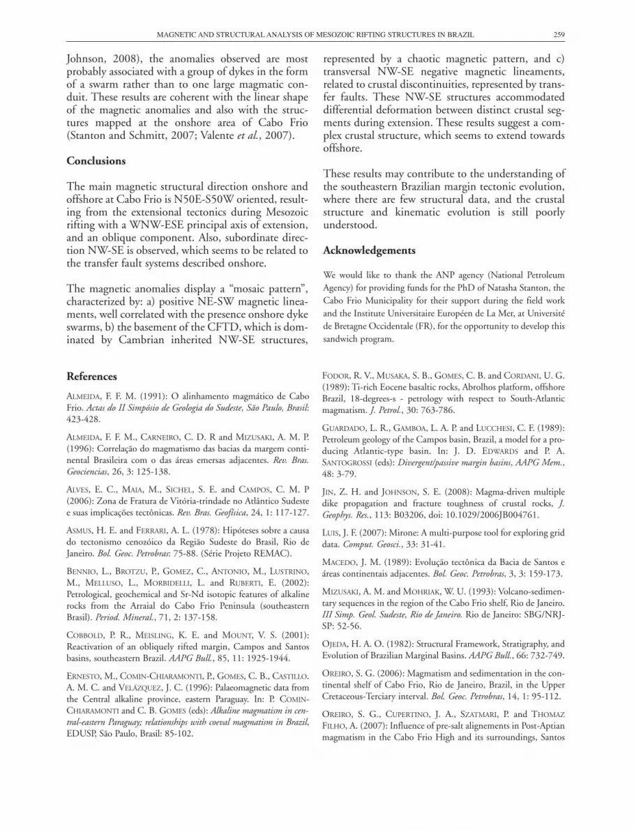
Johnson, 2008), the anomalies observed are mostprobably associated with a group of dykes in the formof a swarm rather than to one large magmatic con-duit. These results are coherent with the linear shapeof the magnetic anomalies and also with the struc-tures mapped at the onshore area of Cabo Frio(Stanton and Schmitt, 2007; Valente et al., 2007).
Conclusions
The main magnetic structural direction onshore andoffshore at Cabo Frio is N50E-S50W oriented, result-ing from the extensional tectonics during Mesozoicrifting with a WNW-ESE principal axis of extension,and an oblique component. Also, subordinate direc-tion NW-SE is observed, which seems to be related tothe transfer fault systems described onshore.
The magnetic anomalies display a “mosaic pattern”,characterized by: a) positive NE-SW magnetic linea-ments, well correlated with the presence onshore dykeswarms, b) the basement of the CFTD, which is dom-inated by Cambrian inherited NW-SE structures,
represented by a chaotic magnetic pattern, and c)transversal NW-SE negative magnetic lineaments,related to crustal discontinuities, represented by trans-fer faults. These NW-SE structures accommodateddifferential deformation between distinct crustal seg-ments during extension. These results suggest a com-plex crustal structure, which seems to extend towardsoffshore.
These results may contribute to the understanding ofthe southeastern Brazilian margin tectonic evolution,where there are few structural data, and the crustalstructure and kinematic evolution is still poorlyunderstood.
Acknowledgements
We would like to thank the ANP agency (National PetroleumAgency) for providing funds for the PhD of Natasha Stanton, theCabo Frio Municipality for their support during the field workand the Institute Universitaire Européen de La Mer, at Universitéde Bretagne Occidentale (FR), for the opportunity to develop thissandwich program.
MAGNETIC AND STRUCTURAL ANALYSIS OF MESOZOIC RIFTING STRUCTURES IN BRAZIL
References
ALMEIDA, F. F. M. (1991): O alinhamento magmático de CaboFrio. Actas do II Simpósio de Geologia do Sudeste, São Paulo, Brasil:423-428.
ALMEIDA, F. F. M., CARNEIRO, C. D. R and MIZUSAKI, A. M. P.(1996): Correlação do magmatismo das bacias da margem conti-nental Brasileira com o das áreas emersas adjacentes. Rev. Bras.Geociencias, 26, 3: 125-138.
ALVES, E. C., MAIA, M., SICHEL, S. E. and CAMPOS, C. M. P(2006): Zona de Fratura de Vitória-trindade no Atlântico Sudestee suas implicações tectônicas. Rev. Bras. Geofísica, 24, 1: 117-127.
ASMUS, H. E. and FERRARI, A. L. (1978): Hipóteses sobre a causado tectonismo cenozóico da Região Sudeste do Brasil, Rio deJaneiro. Bol. Geoc. Petrobras: 75-88. (Série Projeto REMAC).
BENNIO, L., BROTZU, P., GOMEZ, C., ANTONIO, M., LUSTRINO,M., MELLUSO, L., MORBIDELLI, L. and RUBERTI, E. (2002):Petrological, geochemical and Sr-Nd isotopic features of alkalinerocks from the Arraial do Cabo Frio Peninsula (southeasternBrasil). Period. Mineral., 71, 2: 137-158.
COBBOLD, P. R., MEISLING, K. E. and MOUNT, V. S. (2001):Reactivation of an obliquely rifted margin, Campos and Santosbasins, southeastern Brazil. AAPG Bull., 85, 11: 1925-1944.
ERNESTO, M., COMIN-CHIARAMONTI, P., GOMES, C. B., CASTILLO.A. M. C. and VELÁZQUEZ, J. C. (1996): Palaeomagnetic data fromthe Central alkaline province, eastern Paraguay. In: P. COMIN-CHIARAMONTI and C. B. GOMES (eds): Alkaline magmatism in cen-tral-eastern Paraguay; relationships with coeval magmatism in Brazil,EDUSP, São Paulo, Brasil: 85-102.
FODOR, R. V., MUSAKA, S. B., GOMES, C. B. and CORDANI, U. G.(1989): Ti-rich Eocene basaltic rocks, Abrolhos platform, offshoreBrazil, 18-degrees-s - petrology with respect to South-Atlanticmagmatism. J. Petrol., 30: 763-786.
GUARDADO, L. R., GAMBOA, L. A. P. and LUCCHESI, C. F. (1989):Petroleum geology of the Campos basin, Brazil, a model for a pro-ducing Atlantic-type basin. In: J. D. EDWARDS and P. A.SANTOGROSSI (eds): Divergent/passive margin basins, AAPG Mem.,48: 3-79.
JIN, Z. H. and JOHNSON, S. E. (2008): Magma-driven multipledike propagation and fracture toughness of crustal rocks, J.Geophys. Res., 113: B03206, doi: 10.1029/2006JB004761.
LUIS, J. F. (2007): Mirone: A multi-purpose tool for exploring griddata. Comput. Geosci., 33: 31-41.
MACEDO, J. M. (1989): Evolução tectônica da Bacia de Santos eáreas continentais adjacentes. Bol. Geoc. Petrobras, 3, 3: 159-173.
MIZUSAKI, A. M. and MOHRIAK, W. U. (1993): Volcano-sedimen-tary sequences in the region of the Cabo Frio shelf, Rio de Janeiro.III Simp. Geol. Sudeste, Rio de Janeiro. Rio de Janeiro: SBG/NRJ-SP: 52-56.
OJEDA, H. A. O. (1982): Structural Framework, Stratigraphy, andEvolution of Brazilian Marginal Basins. AAPG Bull., 66: 732-749.
OREIRO, S. G. (2006): Magmatism and sedimentation in the con-tinental shelf of Cabo Frio, Rio de Janeiro, Brazil, in the UpperCretaceous-Terciary interval. Bol. Geoc. Petrobras, 14, 1: 95-112.
OREIRO, S. G., CUPERTINO, J. A., SZATMARI, P. and THOMAZ
FILHO, A. (2007): Influence of pre-salt alignements in Post-Aptianmagmatism in the Cabo Frio High and its surroundings, Santos
259

and Campos basins, SE Brazil: An example of non-plume relatedmagmatism. J. S. Am. Earth. Sci., doi: 10.1016/j.jsa-mes.2007.8.006.
RANGEL, H. D. (2005): Manifestações magmáticas na parte sul daBacia de Campos (Área de Cabo Frio) e na Bacia deJequitinhonha. Bol. Geoc. Petrobras, 14, 1: 155-160.
RICCOMINI, C., SANT’ANNA, L. G. and FERRARI A. L. (2004):Evolução geológica do rifte continental do Sudeste do Brasil. In:V. MANTESSO NETO, A. BARTORELLI, C. D. R, CARNEIRO and B.B. BRITO NEVES (eds): Geologia do Continente Sul-Americano:evolução da obra de Fernando Flávio Marques de Almeida, Ed. Beca,São Paulo, Brasil, 647 pp.
RICCOMINI, C. (2008): Rapid changes of stress-field in the passivecontinental margin of southeastern Brazil. Abstracts, 33rdInternational Geological Congress, Oslo, Norway: 1345083.
SADOWSKI, G. R. and DIAS NETO, C. M. (1981): O lineamentotectônico de Cabo Frio. Rev. Bras. Geociencias, 11: 209-212.
SCHMITT, R. S., TROUW, R. A. J. and PIMENTEL, M. M. (2004):Late amalgamation in the central part of West Gondwana: newgeochronolocical data and the characterization of a Cambrian col-lisional orogeny in the Ribeira Belt (SE Brazil). Precambrian Res.,133: 29-61.
SCHWARZ, E. J. (1991): Magnetic expressions of intrusionsincluding magnetic aureoles, Tectonophysics, 192: 191-200.
SOUZA, K. G. (1991): La marge continentale brésilienne sud orien-tale et les domaines oceaniques adjacents: structure et evolution. PhDThesis, Université Pierre et Marie Curie, Paris, 230 pp.
STANTON, N. S. G. and SCHMITT, R. S. (2007): Cronologia rela-tiva das estruturas rúpteis e diques Meso-cenozóicos na porção
onshore do Alto do Cabo Frio – região costeira e ilhas adjacentes,RJ. Resumos expandidos, X Simpósio Nacional de Estudos Tectônicos– SNET, Natal, RN.
SZATMARI, P. and MOHRIAK, W. U. (1995): Plate model of post-breakup tectono-magmatic activity in SE Brazil and the adjacentAtlantic. SBG/Núcleo Rio Grande do Sul. V Simpósio Nacional deEstudos Tectônicos, Gramado, Anais, 1: 213-214.
TETZNER, W. and ALMEIDA, J. C. H. (2003): Registros da abertu-ra do oceano Atlântico Sul no Cabo de Búzios: os diques toleíti-cos. Anais do IX Simpósio Nacional de Estudos Tectônicos, Búzios,RJ: 250-253.
THOMAZ FILHO, A., CESERO, P., MIZUSAKI, A. M. P. and LEÃO, J.G. (2005): Hotspot volcanic tracks and their implications forSouth American Plate motion, Campos Basin (Rio de JaneiroState), Brazil. J. S. Am. Earth Sci., 18: 383-389.
USSAMI, N., KOLISNIK, A., RAPOSO, M. I. B., FERREIRA, F. J. F.,MOLINA, E. and ERNESTO, M. (1991): Detectabilidade magnéti-ca dos diques do Arco de Ponta Grossa: Um estudo integrado demagnetometria terrestre/aérea e magnetismo de rocha. Rev. Bras.Geociencias, 21, 4: 317-327.
VALENTE, S. C., CORVAL, A., DUARTE, B. P., ELLAM, R. M.,FALLICK, E. MEIGHAN, I. G. and DUTRA, T. (2007): Tectonicboundaries, crustal weakness zones and plume subcontinentallithospheric mantle interactions in the Serra do Mar dyke swarm,SE Brazil. Rev. Bras. Geociencias, 37, 1: 194-201.
ZALÁN, P. V. and OLIVEIRA, J. A. B. (2005): Origem e evoluçãoestrutural do Sistema de Riftes Cenozóicos do Sudeste do Brasil.Bol. Geoc. Petrobras, 13, 2: 169-300. .
N. S. G. STANTON, R. S. SCHMITT, M. MAIA AND A. GALDEANO260


