Embed Size (px)
Citation preview
E L S E V I E R Geomorphology 20 (1997) 219-235
I[/NIm
Micropiping processes and biancana evolution in southeast Tuscany, Italy
Dino Torri a, *, Rorke Bryan b
a C.N.R.-I.G.E.S., Piazzale delle Cascine 15, 1-50144 Firenze, Italy b Soil Erosion Laboratory, University of Toronto (Scarborough), 1265, Military Trail, Scarborough, Ont. M1C 1A4, Canada
Received 15 January 1995; accepted 15 August 1995
Abstract
Biancane badlands consisting of small domes dissected by rills and micropipes, with rough disordered microrelief, can be found along the Apennines in Italy. The dominant processes forming biancane differ from those of badlands formed on smectite-rich mudrocks, as micropipes associated with pseudokarstic enlargement of pores and cracks predominate and form the main routes for evacuation of eroded material.
Biancana evolution is controlled by water infiltration into intact bedrock, producing an erodible weathering 'rind' which is more porous than intact rock. This rind is easily removed by rill or micropipe flow, and erosion is therefore 'weathering-controlled', depending on rind production by infiltrating water. Infiltration is initially slow and stepped, due to slow water movement through very small capillary pores in intact rock alternating with rapid filling of macropores and cracks. This occurs due to rapid matrix pore enlargement by dispersion and/or dissolution. The infiltration pattern is accurately reproduced by a model built on progressive development of weathering layers by moisture penetration. Model results are consistent with weathering rind depths and erosion observed in the field, and show that a pipe network can be generated on newly exposed rock by the rainfall of one year.
Propagation of the pipe network diverts a progressively larger proportion of runoff into micropipes, expanding weathering rind production within the biancana as well as on the surface. Internal weathering and flow progressively dominate with few unweathered corestones, and the biancana gradually collapses into a penultimate 'souffle-like' form. © 1997 Elsevier Science B.V.
Keywords: badlands; erosion; weathering; piping; infiltration
I. Introduction
Badland landforrns occur along much of the length of the Apennine c!hain in Italy. Many landforms resemble those in badlands elsewhere (Marinelli,
* Corresponding author. Fax: +39 55 321148; E-mail: dbtorri@ csgccs.fi.cnr.it
1915) but two characteristic landforms known as 'calanchi' and 'biancane' are also common. These features sometimes form separately (e.g., in Tuscany, Vittorini, 1977), apparently reflecting differences in material clay content, mineralogy and cation adsorp- tion characteristics, but in other areas differences are less clear and transitional forms have been identified (e.g., in Basilicata, Alexander, 1982).
0169-555X/97/$17.00 c~ 1997 Elsevier Science B.V. All rights reserved. PH S0169-555X(97)00025-1
220 D. Torri, R. Bryan / Geomorphology 20 (1997) 219-235
The precise relationships between calanchi and biancane have engendered much discussion, and characteristics and material properties have been de- scribed in several papers (e.g., Vittorini, 1977; Guas- parri, 1978; Alexander, 1980, 1982; Pinna and Vit- torini, 1989; Rodolfi, 1991). Calanchi are usually much larger landforms with well-developed drainage networks formed by surface processes, especially rillwash, gullying and frequent shallow landsliding on very steep slopes. Piping is limited and usually confined to mudflow materials, though Alexander (1980) has identified cavitation piping along tension cracks in material in situ. Biancane are small clay domes, up to 20 m in height, which typically occur in clusters. They are dominated by incised rills and micropipes developed in bedrock, and are sur- rounded by miniature pediments.
Calanchi and biancane have frequently been de- scribed, but there have been few detailed process studies, and understanding of their formation is lim- ited, particularly in the case of biancane. Calanco development appears active in many parts of Italy and the total area of calanchi is probably expanding. By contrast, the smaller biancane are easily disturbed by agricultural operations, and have been greatly reduced in extent in recent years by slope levelling with bulldozers (Bigi et al., 1988).
Biancane resemble some landforms in other clay- rich badlands (Bryan and Yair, 1982), but it is not clear that either formation processes or landforms are identical. Most information on clay badland pro- cesses has come from smectite-rich lithologies in arid or semiarid areas (Schumm, 1956; Yair et al., 1980; Bryan and Hodges, 1984) where intense shrink-swell activity often produces relatively deep, loose, 'popcorn' regolith (> 0.3 m) of high macrop- orosity (Imeson, 1986; Finlayson et al., 1987). Com- plex, three-dimensional micropipe systems develop in this regolith which control rill network evolution and hillslope erosional response (Bryan et al., 1978; Hodges and Bryan, 1982; Bryan and Harvey, 1985; Gerits et al., 1987). The geometry of rill and mi- cropipe systems is apparently controlled initially by desiccation cracks, though linkage between dominant rill and pipe spacing and established drain-spacing criteria has been suggested by Gerits et al. (1987) and Imeson and Verstraten (1988).
By contrast, biancane develop on Pliocene marine
clays throughout Italy in quite varied climatic condi- tions. In some parts desiccation is much less intense and the disrupted 'popcorn' regolith is often much thinner. The Apennine chain has been intensely dis- turbed by frequent tectonic activity resulting in abun- dant complex fracturing. Where highly porous re- golith is not well-developed, the rill and micropipe formation and biancane evolution is apparently strongly influenced by the characteristics of these tectonic lineations.
The present study was undertaken in a residual area of biancane in southeast Tuscany to identify the origins of micropiping and its influence on biancane evolution.
2. Study site and design
The experimental site is located at Podere Becca- nello, in Val D'Orcia, part of a larger landholding known as La Foce-Chiarentana (Fig. 1). Biancane have developed in marine clays laid down in the structural Radicofani Basin during the Early and middle Pliocene, and uplifted during the Pleistocene (Losacco, 1963). The area was strongly influenced by subsequent tectonic disturbances which affected all of southern Tuscany, producing a complex pattern of tectonic lineations which have been linked with landslide initiation (Alexander and Formichi, 1993). At Podere Beccanello, two sets of vertical or sub- vertical joints traverse the biancana zone, with trends of N100 and N60 (Fig. 1), producing a dense rhom- boidal net of fractures with oxidized bands about 0.1 m in width (Colica and Guasparri, 1990). Some of these fractures are 10-15 m in depth.
The Beccanello biancane were initially part of an extensive biancana development on a SW-facing 10 ° slope. Only residual undisturbed patches, like the 15 ha Beccanello site, still exist. Individual biancana vary in size, but are typically about 20 m in diameter and 5-8 m in height, producing a cluster of rather regular size and spacing (Fig. 2). Biancane are usu- ally asymmetrical with steeper bare south-facing slopes (up to 60 °, but typically 30-40°), while north- ern slopes are 20-30 ° and usually covered in vegeta- tion. South-facing slopes are active erosional bedrock surfaces with a thin (5-15 cm) regolith, and are deeply dissected by rill channels, micropipes and
D. Torri, R. Bryan / Geomorphology 20 (1997) 219-235 221
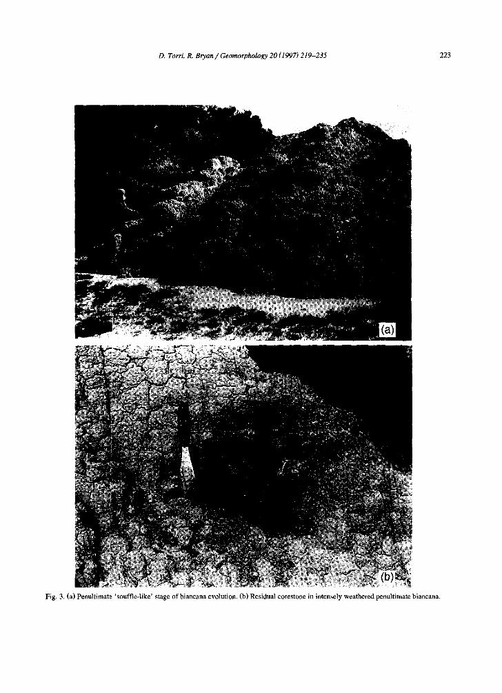
occasional slump scars. Vegetation on north-facing slopes is dominated by Bromus erectus (Calzolari et al., 1993a), often with Spartium junceum shrubs with well-developed soils up to 1 m deep on more stable slopes (Calzolari et al., 1993b). Both slopes are flanked by low-angle (1-2 °) depositional micro- pediments where sheetwash occurs during more in- tense rainstorms. Biancane maintain their typical form until an advanced stage of development, when they assume a 'soufflr-like' form (Fig. 3a) in which largely unweathered corestones (Fig. 3b) are sepa- rated by extensive weathering and piping along frac- ture planes.
Material propertie:~ of the marine clays at Becca-
nello are shown in Table 1. The Beccanello data include the biancane material proper (B), the thin oxidized fractures described by Colica and Guasparri (1990), (F) and the basal micropediment. Textures of biancane and fracture material are almost identical, with slight evidence of selective removal of fine silt from the fracture. The micropediment data show strong selective deposition of sand and silt. Data for the weathered regolith crusts and underlying intact rock suggest very slight selective removal of clays from the surface. Clay minerals are dominated by quartz, calcite and smectite, with low to moderate plasticity, and bulk densities are 2.15 g cm -3 and 1.8 g cm -3 for bedrock and regolith crust, respec-
[ ] Meteorological Station
/ / . Podere / , . . . ~ ~ , ~ /~oBeccane i lo ~ , C_L
| 100m
? / • CIIIANCIANOI
| MONTALCINO I
N /
I I [
Fig. 1. Map showing the location of La Foee-Chiarentana, and detailed site map of Podere Beccanello (modified after Colica and Guasparri, 1990). Lines represent joints, ellipsoids represent biancane.
222 D. Torri, R. Bryan/Geomorphology 20 (1997) 219-235
tively. Plasticity, shrinkage, and crust bulk density are similar to the Guadix badlands in Andalucia, where the clay content is much lower (Gerits et al., 1987), but they are much lower and higher, respec- tively, than the clay and smectite-rich Alberta bad- lands in Canada (Hodges and Bryan, 1982). Soluble salts are abundant with a Na concentration of 0 .2- 0.4% by weight (Torri and Monaci, 1991), which is reflected in high SAR and EC values.
There are two local long-term climatic stations, at Spedaletto (8.5 km to the west-northwes0 and La Foce (2.5 km to the north-northeas0, supplemented since 1990 by a weather station at Podere Beccanello (Fig. 1). The climate is transitional between sub- humid and sub-arid, with a summer moisture deficit at Spedaletto, but not at La Foce. Average annual precipitation (1951-1980) is 675 nun for Spedaletto and 815 mm for La Foce, with maxima at both stations in autumn and minima in July-August (Calzolari et al., 1993b). Some snow occurs in most
winters, but seldom persists for more than a few days. Mean rainfall (1991 and 1992) is 645 mm for Beccanello, with an average of 118.5 raindays, and a total of 41.25 mm for the three rainiest days. The limited available rainfall in tens i ty-dura t ion- frequency data are summarized in Table 2.
Few data are available on biancane erosion rates. Raglione et al. (1980) measured annual sediment loss of 17.5 kg m -2 with runoff troughs in Calabria, equivalent to denudation of 14 mm a - l . Alexander (1982) measured denudation ranging from 17 to 57 mm a - l with erosion pins in Basilicata, and in the Beccanello biancane, Colica (1992) measured de- nudation rates equivalent to 36 mm a -1. These data summarize erosion rates but provide little informa- tion about the precise processes involved. In two brief sprinkling tests on a Beccanello biancana Tom et al. (1994) found detectable runoff only in rills and micropipes, with detachment-controlled sediment re- lease reaching a peak concentration of 160 g 1-~ in
Fig. 2. Characteristic biancana dome clusters at Beccanello.
D. Torri, R. Bryan / Geomorphology 20 (1997) 219-235 223
Fig. 3. (a) Penultimate 'souffle-like' stage of biancana evolution. (b) Residual corestone in intensely weathered penultimate biancana.
224 D. Torri, R. Bryan/Geomorphology 20 (1997) 219-235
Table 1 Summary of material characteristics of unweathered rock on south-facing biancana slopes at Podere Beccanello
Particle size (mm)
< 0.002 0.002-0.020 0.02-0.05 0.05-2
mean range mean range mean range mean range
B 46 40-50 44 40-48 8 5-14 2 1.0-4.0 F 48 45-50 42 40-45 8 5-16 2 1.0-4.0 Pd 20 15-25 55 49-57 20 13-29 5.0 4.0-7.0
Consistency limits Density and porosity
LL (%) P1 (%) PI AI Bulk density (kg m- 3 )
mean range mean range mean range
B 47 45-49 24 23-26 23 0.5 2150 2000-2300 F 49 47-52 25 23-26 24 0.5
Saturated pas~ extract Modified COLE a
SAR EC (S m- 1 ) moisture (%)
B 20.5 11 57 F 29 14 59 Pd 15 0.5 40
0.057
B = unweathered rock; F = oxidized band (joints and cracks); Pd = micro-pediment; LL = liquid limit; PL = plastic limit; PI = plasticity index; AI = activity index; SAR = sodium absorption ratio; EC = electrical conductivity; COLE = coefficient of linear expansion. a After Alioto et al. (1989). b After Alioto et al. (1989).
dry antecedent condit ions. This agrees well with a peak concentra t ion of 149.6 g 1-1 measured by
Sorr iso-Valvo et al. (1995) in a more pro longed test at s imilar rainfall intensi ty on a Calabr ian b iancana
slope. Torr i et al. (1994) measured highest water and
sediment discharge in micropipes, but because of the complex, dynamic behaviour of micropipes, precise drainage area or vo lume could not be established. It is therefore difficult to compare erosion rates with the denudat ion rates cited. It is, however , clear that
Table 2 Summary rainfall duration, mean maximum intensity and fre- quency data for Podere Beccanello (1991) and Podere Beccanello (1992)
Duration Mean max. intensity 2-year frequency (min) (mm h - 1 ) (No.)
60 14.5 5 30 20.3 10 10 41.5 5
much erosion is sub-surface, and denudat ion rates measured from erosion pins alone mus t considerably underest imate actual erosion rates.
The sprinkl ing tests show that in the Beccanel lo b iancane much f low is routed through and erosion
concentrated in micropipes. The inf luence of pipes, once opened, on infi l t rat ion and throughflow patterns
is obvious, but the precise processes involved in pipe development are not. It seems that it must be related to localised infi l t rat ion along tectonic fractures, but ponding tests on bedrock stripped of regolith showed no clear difference be tween oxidized fractures and unfractured bedrock. The object of this study was to explain the process of micropipe evolut ion by: (1) measurement of rill and micropipe characteristics on representative biancane, and identif icat ion of any apparent relat ionship to tectonic fracture patterns; (2) laboratory tests of b iancana fragments under rainfall ; (3) deve lopment of a model to describe micropipe deve lopment in rainfall condi t ions typical of Becca- nello.
D. Torri, R. Bryan / Geomorphology 20 (1997) 219-235 225
3. Results
3.1. Rill, micropipe and fracture characteristics on representative biancane
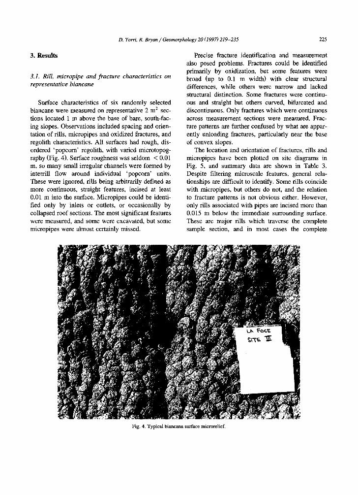
Surface characteristics of six randomly selected biancane were measured on representative 2 m 2 sec- tions located 1 m above the base of bare, south-fac- ing slopes. Observations included spacing and orien- tation of fills, mlcropipes and oxidized fractures, and regolith characteristics. All surfaces had rough, dis- ordered 'popcorn' regolith, with varied microtopog- raphy (Fig. 4). Surface roughness was seldom < 0.01 m, so many small irregular channels were formed by interrill flow around individual 'popcorn' units. These were ignored, fills being arbitrarily defined as more continuous, straight features, incised at least 0.01 m into the surf~tce. Micropipes could be identi- fied only by inlets or outlets, or occasionally by collapsed roof sections. The most significant features were measured, and some were excavated, but some mlcropipes were almost certainly missed.
Precise fracture identification and measurement also posed problems. Fractures could be identified primarily by oxidization, but some features were broad (up to 0.1 m width) with clear structural differences, while others were narrow and lacked structural distinction. Some fractures were continu- ous and straight but others curved, bifurcated and discontinuous. Only fractures which were continuous across measurement sections were measured. Frac- ture patterns are further confused by what are appar- ently unloading fractures, particularly near the base of convex slopes.
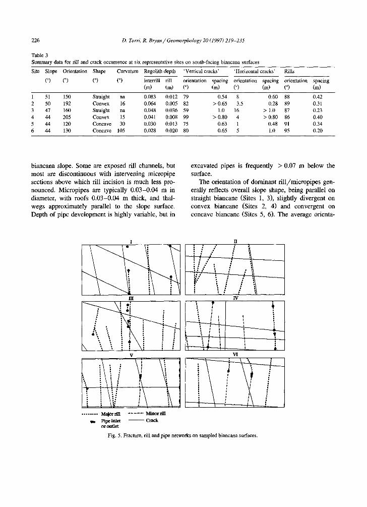
The location and orientation of fractures, rills and micropipes have been plotted on site diagrams in Fig. 5, and summary data are shown in Table 3. Despite filtering microscale features, general rela- tionships are difficult to identify. Some fills coincide with micropipes, but others do not, and the relation to fracture patterns is not obvious either. However, only fills associated with pipes are incised more than 0.015 m below the immediate surrounding surface. These are major fills which traverse the complete sample section, and in most cases the complete
Fig. 4. Typical biancana surface microrelief.
226 D. Torri, R. Bryan/Geomorphology 20 (1997)219-235
Table 3 Summary data for rill and crack occurrence at six representative sites on south-facing biancana surfaces
Site Slope Orientation Shape Curvature Regolith depth
(°) (°) (°) (°) ' Vertical cracks' ' H o r i z o n t a l cracks'
interrill rill orientation spacing orientation spacing orientation spacing (m) (m) (°) (m) (°) (m) (°) (m)
Rills
1 51 150 Straight na 0.083 0.012 79 0.54 8 0.60 88 0.42 2 50 192 Convex 16 0.064 0.005 82 > 0.65 3.5 0.28 89 0.31 3 47 160 Straight na 0.048 0.036 59 1.0 16 > 1.0 87 0.23 4 44 205 Convex 15 0.041 0.008 99 > 0.80 4 > 0.80 86 0.40 5 44 120 Concave 30 0.030 0.013 75 0.63 1 0.48 91 0.34 6 44 130 Concave 105 0.028 0.020 80 0.65 5 1.0 95 0.20
biancana slope. Some are exposed rill channels, but most are discontinuous with intervening micropipe sections above which rill incision is much less pro- nounced. Micropipes are typically 0.03-0.04 m in diameter, with roofs 0.03-0.04 m thick, and thal- wegs approximately parallel to the slope surface. Depth of pipe development is highly variable, but in
excavated pipes is frequently > 0.07 m below the surface.
The orientation of dominant rill/micropipes gen- erally reflects overall slope shape, being parallel on straight biancane (Sites 1, 3), slightly divergent on convex biancane (Sites 2, 4) and convergent on concave biancane (Sites 5, 6). The average orienta-
liT
i .E : : ~,: ,
' • . , :
" ~, i ~ ~ \ \. ".. T \i'
v
\
'I I
. . . . . . . . M a j o r rill . . . . . . M i n o r rill
Pipe Inlet ~ Crack o r outlet
1 II
: : i , • - . . . . " l , " l ",
IV • , ?
• i
. I i I
• I I I i I • ! I
L "l I I I • !
I •
vI
Fig. 5. Fracture, rill and pipe networks on sampled biancana surfaces.
D. Torri, R. Bryan / Geomorphology 20 (1997) 219-235 227
tion for all fills is 89 °, nearly parallel to the steepest slope. Detailed fill orientation is also strongly af- fected by mesoscale slope topography. Shallow, non-piped rills ( < 0.0115 m depth) are usually located on 'interrills' between deeper, piped rills, which are typically incised into the base of broad 'swales.' On smaller biancane (Sites 1, 2) these are up to 0.15 m wide and incised 0.12, m below the general surface, while on larger bianc~aae (e.g., Site 5), they can be 1 m wide and 0.75 m below the general surface. Once
formed, these 'swales' can concentrate water to- wards rill/micropipe channels.
The relationship between the major rill/micro- pipe channels and fracture patterns is not obvious. Some rills coincide with fractures, but the average orientation of 'vertical' fractures is 67 °, cutting obliquely across rill channels. Even considering only major fills, average spacing is less than half average fracture spacing. As noted, the most significant fills are associated with pipes, but excavation of domi-
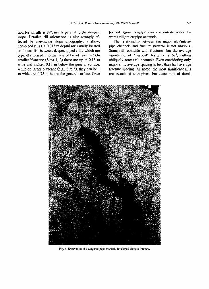
Fig. 6. Excavation of a diagonal pipe channel, developed along a fracture.
228 D. Torri, R. Bryan / Geomorphology 20 (1997)219-235
nant rill/micropipe systems, for example at Sites 3, 5 and 6, shows deeper pipe systems (up to 0.25 m) developed along major fractures, diagonally across surface drainage lines (Fig. 6). Some showed a dis- tinct zig-zag course, with alternating sections of varying length straight downslope and obliquely along fractures. These deeper pipe systems are nar- row (0.3-0.4 m), with irregular thalwegs. Most crack pipes show evidence of significant flow, such as clay deposition, and can clearly concentrate much of the flow from a biancana slope. No fractures blocked entirely by clay deposition were observed, though this could happen in shallow fracture systems during prolonged rainfall.
Biancana surfaces at Beccanello superficially re- semble highly active 'popcorn' surfaces on sodic smectites in western Canada and Kenya (Bryan et al., 1988), but the detailed structure is quite different, with shallower regolith and lower desiccation crack (as distinct from tectonic fracture) density. This re- flects lower clay contents and less active clays. Nevertheless, weathering produces a highly erodible surface 'rind' which can be easily entrained to pro- duce high sediment loads (Torri et al., 1994). Sur- face removal is concentrated in rills, as suggested by average regolith depths of 0.049 and 0.016 m for interrills and rills, respectively. In some fills 'rind' depth is only a few millimetres and it can be easily stripped by rill flow during rainstorms. Torri et al. (1994) confirm this 'weathering-limited' removal, with peak rill sediment discharges during initial flow. The rind is restored by moisture-controlled weather- ing between runoff-producing storms, so peak rill sediment concentrations during storms should be controlled by the rapidity of weathering and the number of wetting/drying cycles between runoff- producing storms.
While rill erosion can significantly affect bian- cana development, Torri et al. (1994) found highest sediment discharge from pipes, and the factors con- trolling flow routing through pipes are therefore critical. Site observations suggest close correlation between pipe and fracture development. Where frac- tures are open, as with unloading fractures, water
obviously penetrates easily and leads to internal re- golith weathering. The first development of the more frequent oxidised tectonic fractures is less clear. Newly excavated oxidised fractures are closed, but typically show denser cleavage and fracturing than the surrounding matrix and slightly higher SAR val- ues (Tables 1 and 2). On some surfaces oxidised areas are less resistant and form depressions, but this is not consistent. The denser cleavage could be expected to result in preferential infiltration, but comparative ring infiltrometer tests on horizontal surfaces cleared of regolith in the field did not support this conclusively.
The key factors affecting biancana development are the pattern of regolith development by wetting, the processes leading to concentrated infiltration and the development of piping. Laboratory experiments were carried out with biancana samples to provide further information on both processes.
3.2. Laboratory experiments
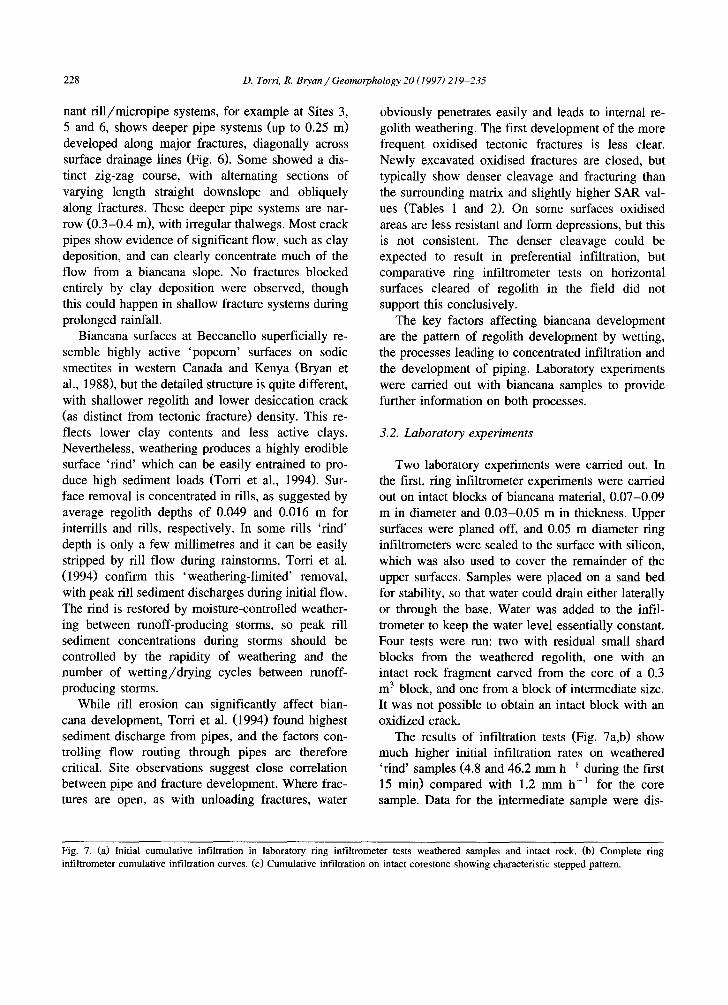
Two laboratory experiments were carried out. In the first, ring infiltrometer experiments were carried out on intact blocks of biancana material, 0.07-0.09 m in diameter and 0.03-0.05 m in thickness. Upper surfaces were planed off, and 0.05 m diameter ring infiltrometers were sealed to the surface with silicon, which was also used to cover the remainder of the upper surfaces. Samples were placed on a sand bed for stability, so that water could drain either laterally or through the base. Water was added to the infil- trometer to keep the water level essentially constant. Four tests were run: two with residual small shard blocks from the weathered regolith, one with an intact rock fragment carved from the core of a 0.3 m 3 block, and one from a block of intermediate size. It was not possible to obtain an intact block with an oxidized crack.
The results of infiltration tests (Fig. 7a,b) show much higher initial infiltration rates on weathered 'rind' samples (4.8 and 46.2 mm h- 1 during the first 15 min) compared with 1.2 mm h -1 for the core sample. Data for the intermediate sample were dis-
Fig. 7. (a) Initial cumulative infiltration in laboratory ring infiltrometer tests weathered samples and intact rock. (b) Complete ring infiltrometer cumulative infiltration curves. (c) Cumulative infiltration on intact corestone showing characteristic stepped pattern.
D. Torri, R. Bryan/Geomorphology 20 (1997) 219-235 2 2 9
(a)
22
18
14
10 5
o 6
(b) 24
20 E g
g i s
; 12-f
E 8
WEATH~ED REGOLITH (SAMPLE A)
/ /
/ ! !
/ _/ I
WEATHERED REGOLITH (SAMPLE B} CORESTONE
L ........................
........................ ; .............. i ..... L I 30 60 60 120 150 180
WEATHERED REGOLITH (SAMPLE A) /
/ -- /
/ /
J
Time (min)
$0
(c)
/ I
,o-'"°'CORESTONE
81 . . . . . . . . . . . . . . . . . . I WEATHERED REGOLITH (SAMPLE E) ................. I ..°-°'"" ...... ""
6 I ....................... J ,.o,o"°"
""ri' i I I I I I q I i I I 120 240 360 480 600 720 840 960 1080 1200 1320 1440 1600
Time (min)
2.5 A i - - -
g 2
.5
0 0 50 1 O0 150 200 250
minutes from start of rainfall
230 D. Torri, R. Bryan/Geomorphology 20 (1997) 219-235
torted by major cracking and are not included. Weathering associated with moisture penetration transforms the material, progressively increasing moisture penetration in subsequent storms. However, this effect is somewhat time-dependent, as shown by the decline in rate on the regolith sample with the highest initial rate after 21 min to a sustained rate similar to that for the unweathered core sample. This suggests that moisture in the regolith sample had penetrated to an unweathered core. The last stage of each test was very rapid infiltration (shown for the core sample, Fig. 7b) precluding precise measure- ment, which just preceded exfiltration of water from the sides and base of the sample, and sample col- lapse in a mudflow.
Infiltration into all samples is conspicuously stepped, as shown by the plot of actual corestone sample values over the first 200 min (Fig. 7c). This pattern can only be explained by material in which infrequent large pores or microcracks are separated by intact matrix with very small capillary pores. Water penetration initially driven by capillary ten- sion will eventually reach cracks, bedding planes or macropores, but the rate of gravitational filling will be limited by the extremely small capillary pores of the intact matrix. The key factor in infiltration is interaction of moisture with the material resulting in rapid enlargement of capillary pores, thereby permit- ting gravitational filling of macropores, and renewed capillary movement once the wetting front reaches intact material. Capillary pore enlargement has been observed at the surface in the field during wetting by fog. The precise process has not yet been fully examined experimentally, but it involves slaking, some differential swelling, dispersion and solution of salt crystals in the matrix. Once infiltration ceases, residual moisture moves towards the evaporating surface, depositing salt crystals and clogging pores near the surface. These crystals initially will tend to impede infiltration during subsequent rainstorms, but are apparently rapidly removed by solution and me- chanical erosion of the surface layer.
The infiltration curves in Fig. 7a,b can be interpo- lated with a Philip-type equation:
i = a t ° 5 + b t
where i = cumulative infiltration, t = time, and a and b are constants. The following values were obtained for the corestone block and weathered sam- ple B:
a b r 2
Sample B 0.02 0.005 0.95 Corestone 0.01 0.0005 0.99
These values are used below in the section on model development. The curve for weathered sample A could not be interpolated due to the small number of observations and strong initial curvature.
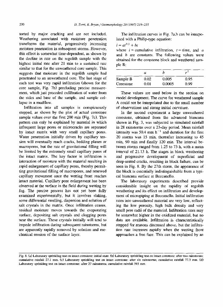
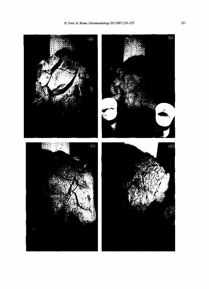
In the second experiment a large unweathered corestone, obtained from the advanced biancana shown in Fig. 3, was subjected to simulated rainfall in 28 rainstorms over a 23-day period. Mean rainfall intensity was 50.4 mm h-1 and duration for the first 20 storms was 15 rain, thereafter increasing to 45 min, 90 min and finally 120 min. The interval be- tween storms ranged from 1.25 to 73 h, with a mean interval of 21.13 h. The stages in block weathering and progressive development of superficial and deep-seated cracks, resulting in block failure, can be seen in Fig. 8. By the 27th storm, the appearance of the block is essentially indistinguishable from a typi- cal biancana surface at Beccanello.
The laboratory experiments described provide considerable insight on the rapidity of regolith weathering and its effect on infiltration and develop- ment of micropiping at Beccanello. Initial infiltration rates into unweathered material are very low, reflect- ing the low porosity, high bulk density and very small pore radii of the material. Infiltration rates may be somewhat higher in the oxidized material, but no data are available. Infiltration is characteristically stepped for reasons discussed above, but the infiltra- tion rate increases rapidly when the wetting front approaches a free face. This can be explained by an
Fig. 8. (a) Laboratory sprinkling test on intact corestone: initial state. (b) Laboratory sprinkling test on intact corestone: after two rainstorms; cumulative rainfall 27.1 mm. (c) Laboratory sprinkling test on intact corestone: after six rainstorms; cumulative rainfall 77.3 mm. (d) Laboratory sprinkling test on intact corestone: after 27 rainstorms; cumulative rainfall 593 mm.
D. Torri, R. Bryan / Geomorphology 20 (1997) 219-235 231
232 D. Torri, R. Bryan/Geomorphology 20 (1997) 219-235
increase in pore diameter by slaking, dispersion and solution, with ejection of released material at the free face. The existence of a free face is important, permitting accelerated removal of material from pores. The initial development in intact material is probably very slow, but as a dense network of macropores and cracks progressively develops it will accelerate, particularly once significant flow passes through the evolving pipe system. As cracks open, high cleft pore pressures during rainfall will further enhance network development, but otherwise it is cumulative rainfall amount that appears to be more important than rainfall intensity.
Ring infiltrometer experiments clearly show higher initial infiltration into weathered regolith sur- faces. The total input of water required to bring the test block to a typical field state was 593 mm, approximately equivalent to the mean annual rainfall at Beccanello, but a clearly distinct weathering find was apparent after six rainfall cycles. The threshold rainfall necessary in the field would presumably be somewhat higher as a result of evaporation loss and erosion, although these would differ greatly between internal and external surfaces.
3.3. Model development
Significant information is still required about the precise processes involved in the development of porosity, cracking and piping in rocks of the Becca- nello biancane. Nevertheless, the data available from the laboratory experiments permit the development of an initial model of infiltration and weathering on newly exposed biancana rocks. In the model, three dominant processes are described through the follow- ing basic algorithms.
3.3.1. Infiltration As noted, data from the laboratory experiments,
together with those from field rainfall simulation experiments (Torri et al., 1994) are well described by a Philip-type equation, in which the coefficients of t ( = time since rain initiation) vary in the following ranges:
% = 0.001 to 0.3 cms - °5
Cfin = 0.00005 tO 0.03 cm S- 1
These coefficients were allowed to increase with
porosity from initial values of Cin = 0.0008 cms -°5 and cfi n = 0.00004 cm s-1 to reach maxima at a dry bulk density of 1.8 g cm -3.
3.3.2. Erosion Overland flow was calculated for a water accumu-
lation length of 0.25 m (approximately half the typical distance between successive infiltration 'sinks' (e.g., fractures and fills). Only interrill ero- sion was considered as a sediment source as data are available from field simulation experiments (Torri et al., 1994, and unpublished data). Following field observations no transport capacity limitation was assumed. Following Torri et al. (1994) runoff de- tachment was treated as proportional to water pene- tration depth, but was allowed to decline exponen- tially over time to 1% of its maximum value, which occurred during initial slaking.
3.3.3. Weathered depth Conceptually, a biancana rock was subdivided in
compartments of 0.01 cm thickness, each compart- ment being characterised by a porosity value which changed with the number of times it was reached by infiltrating water. This was obtained using an S- shaped function:
ag = 1 - e - n / b
where ag = the aging factor, n = frequency of pene- tration by infiltrating water, and b = an empirical decay function.
Porosity was allowed to change from 0.13 to 0.32, the values observed for corestone and weathered find, respectively. The calculated infiltration amount was redistributed in compartments following poros- ity, which allowed calculation of the maximum depth reached by the wetting front (md) and the frequency with which water reached each compartment. Finally the eroded depth was subtracted from the maximum depth (md) to yield the residual weathered depth.
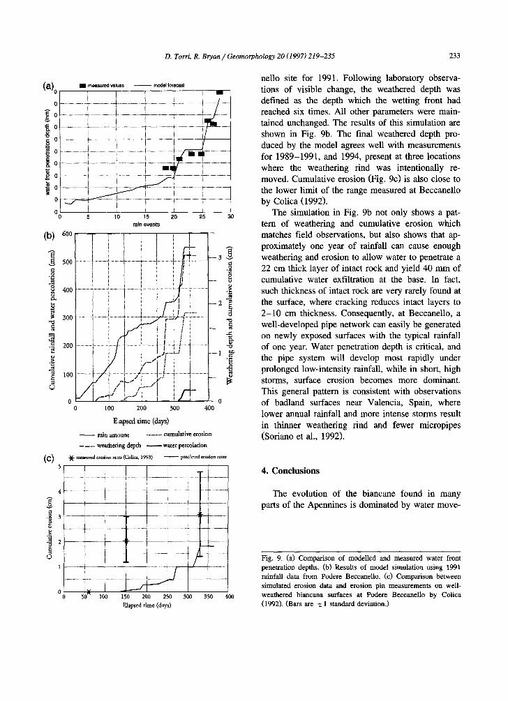
The model was run for an iteration of 28 rainfall and desiccation cycles. The resulting values for depth of water front penetration are plotted in Fig. 9a, together with measured values derived from the lab- oratory experiment with the large corestone block. While the fit is not perfect, it is sufficiently close to encourage confidence in the basic logic of the model. The model was then applied to a biancana slope using 10 min interval rainfall data from the Becca-
D. Torri. R. Bryan / Geomorphology 20 (1997) 219-235 233
a ) , , . measu red va lues mode l forecast
0 ! I i i BB
o ......................... I ......................... i ............................................ i .......................... ~ - - - / ......... ~ . o i- . . . . . . . . . . . . ~ .............. ± . . . . . . . . . . -<-- . . . . . . . . . . . . 4 . . . . . . . . . . . . . . . i-...-.,./ ............
l i l { i !
~ o .............................. ~ ....................................................... i " ........................... i . . . . . . . . . . i - i ................................
I o ...................... i ...................... ) . . . . . . . . . . . . . . . . . . . ~ . . . . . . . . . . . . . . ~ ................... ~ .......................... i l l ' i
£ 0 .................... F . . . . . . . . . . . . . . . ~ . . . . . . . . . . . . . l- . . . . . . . . . . . . . . . . . . . . . . . . . . . . . . . . . . . ~ ......................
~o
0 5 1 0 1 5 2 0 2 5 3 0
ra in e v e n t s
( b ) ~oo I
. ~ 500 ................................................................... t -- --~ ........... - - 3
0= [ ..............
I :..L.. - 2
. . . . . . . . . . . . . . . . . . . . . . . . . . . . . . . . !
o o 0 100 200 300 400
Elapsed time (days)
- - rain aa~mnt ......... cumulative erosion - - -- - weathering depth water percolation
(C) -~- measured eroai . . . . . (Collca, 1993) predicted exoslo . . . .
, t - . . . . . . . . . . . .
3 ................... ~ ......................... i ..................................... i ....................... i ........................... I i ......................
i I ] i i " ' i l
1 .... . . . . . . . . - 4 .................. ! .................................... 4., ..................... ~ ' . . . . . . r - - - " - ' ............... ~ ...................... i i i i ! i i - i i #
o lt~ i . . . 1 . . - - / I i i i 50-- 100 150 200 250 300 350 400
Elapsed time (days)
nello site for 1991. Following laboratory observa- tions of visible change, the weathered depth was defined as the depth which the wetting front had reached six times. All other parameters were main- tained unchanged. The results of this simulation are shown in Fig. 9b. The final weathered depth pro- duced by the model agrees well with measurements for 1989-1991, and 1994, present at three locations where the weathering rind was intentionally re- moved. Cumulative erosion (Fig. 9c) is also close to the lower limit of the range measured at Beccanello by Colica (1992).
The simulation in Fig. 9b not only shows a pat- tern of weathering and cumulative erosion which matches field observations, but also shows that ap- proximately one year of rainfall can cause enough weathering and erosion to allow water to penetrate a 22 cm thick layer of intact rock and yield 40 mm of cumulative water exfiltration at the base. In fact, such thickness of intact rock are very rarely found at the surface, where cracking reduces intact layers to 2 - 1 0 cm thickness. Consequently, at Beccanello, a well-developed pipe network can easily be generated on newly exposed surfaces with the typical rainfall of one year. Water penetration depth is critical, and the pipe system will develop most rapidly under prolonged low-intensity rainfall, while in short, high storms, surface erosion becomes more dominant. This general pattern is consistent with observations of badland surfaces near Valencia, Spain, where lower annual rainfall and more intense storms result in thinner weathering rind and fewer micropipes (Soriano et al., 1992).
4. Conclusions
The evolution of the biancane found in many parts of the Apennines is dominated by water move-
Fig. 9. (a) Comparison of modelled and measured water front penetration depths. (b) Results of model simulation using 1991 rainfall data from Podere Beccanello. (c) Comparison between simulated erosion data and erosion pin measurements on well- weathered biancana surfaces at Podere Beccanello by Colica (1992). (Bars are + 1 standard deviation.)
234 D. Torri, R. Bryan/Geomorphology 20 (1997)219-235
ment and erosion along small pipes and micropipes which form rapidly by pseudokarst processes rather than by enlargement of desiccation cracks. Desicca- tion cracks do occur, but are confined to a thin superficial layer, and apparently have little influence on erosional patterns,
Typical small-domed biancana landforms are dis- sected by straight rills which follow the steepest slope, and numerous pipes and micropipes which follow more erratic courses. Both are erosionally active, but most sediment is evacuated by pipes, and the most deeply incised rills are associated with collapsing pipes. The key process in biancana devel- opment is the rapid transformation of the Pliocene marine clay rock on contact with water. Initial infil- tration into newly exposed rock surfaces is slow, and characteristically stepped, due to alternation of intact matrix with very small pores and cracked material with macropores. The matrix rapidly changes on contact with water due to slaking, dispersion and dissolution, resulting in rapid formation of a more porous weathering 'rind'. This is easily detached by rill or pipe flow, and has a significantly higher infiltration capacity than intact bedrock. Detached weathering rind material is easily transported and the process rate is 'weathering-limited' by the produc- tion rate of the rind. This is controlled by the pene- tration of infiltrating water, and can be satisfactorily predicted by a model based on infiltration depth and frequency, erosion rates and change in porosity on wetting.
Initial biancana erosion is by surface rillwash and shallow micropiping, with most sediment coming from the surface weathering rind. Repeated wetting cycles cause progressive propagation of macropores and enlarged cracks, and progressively deeper water penetration. The model shows that an intact homoge- neous 22 cm thick layer of biancana rock will weather and erode sufficiently in one year to allow cumula- tive water exfiltration at the base of 40 nml. Such thicknesses of intact rock are very rare, as cracks usually reduce the intact layer to 2 - 1 0 cm thickness. Under these conditions extensive shallow piping can easily develop within one year, leading to internal as well as surface weathering rinds. As the biancana evolves, an increasingly large proportion of eroded sediment is generated within the landform, through a pipe network increasingly controlled by tectonic
cracks and bedding planes. The biancana, which is increasingly dominated by enlarged cracks and weathered surfaces, with very few residual core- stones, declines to a penultimate 'soufflE-like' fea- ture and eventually disappears.
Acknowledgements
The authors wish to thank M. Del Sette for help in conducting some of the tests and in operating the weather station at Beccanello. Thanks are also due to the La Foce-Chiarentana farm for permission to carry out research at Beccanello. R.B. Bryan's par- ticipation was supported by research grants from the Natural Sciences and Engineering Research Council, Canada, which is gratefully acknowledged.
References
Alexander, D.E., 1980. I calanchi--accelerated erosion in Italy. Geography 65, 95-100.
Alexander, D.E., 1982. Difference between 'calanchi' and 'bi- ancane' badlands in Italy. In: Bryan, R., Yair, A. (Eds.), Badland Geomorphology and Piping. GeoBooks, Norwich, pp. 71-87.
Alexander, D.E., Formichi, R., 1993. Tectonic causes of land- slides. Earth Surf. Process. Landf. 18, 311-338.
Alioto, M.N., Magaldi, D., Ristori, G.G., 1989. Alcune propriet~ fisiche, geotecrtiche e mineralogiche dei suoli argillosi della Val d'Orcia (Siena). Quaderni Sci. Suoli 2, 97-130.
Bigi, L., Gonnelli, I., Rossi, R., 1988. Le condizioni paesaggistico ambientali dell'area delle 'Crete di Camposodo' e dell'area delle 'Crete di Asciano' e di 'Monte Oliveto Maggiore'(Siena). In: Rossi, R. (Ed.), Progetto Toscana a Misura D'ambiente, Giunta Regionale Toscana. Marsili Editore, Firenze, pp. 27-36.
Bryan, R.B., Harvey, L.E., 1985. Observations on the geomorphic significance of tunnel erosion in a semi-arid ephemeral drainage system. Geogr. Ann. 67A (3-4), 257-272.
Bryan, R.B., Hodges, W.K., 1984. Runoff and sediment transport dynamics in Canadian badland microcatchments. In: Burt, T.P., Walling, D.E. (Eds.), Catchment Experiments in Fluvial Geomorphology. GeoBooks, Norwich, pp. 115-131.
Bryan, R.B., Yair, A. (Eds.), 1982. Badland Geomorphology and Piping. GeoBooks, Norwich, 408 pp.
Bryan, R.B., Yalr, A., Hodges, W.K., 1978. Factors controlling the initiation of runoff and piping in Dinosaur Provincial Park badlands, Alberta, Canada. Z. Geomorphol. Suppl. 29, 151- 168.
Bryan, R.B., Campbell, I.A., Sutherland, R.A., 1988. Fluvial geomorphic processes in semi-add ephemeral catchments in Kenya and Canada. In: Harvey, A.M., Sala, M. (Eds.), Geo-
D. Torri, R. Bryan/Geomorphology 20 (1997) 219-235 235
morphic Processes in Environments with Strong Seasonal Contrasts, 1I. Geomorplfic Systems. Catena Suppl. 13, 13-36.
Calzolari, C., Ristori, J., Eusoni, E., Chiarucci, A., 1993a. Mor- phology development in a 'biancana' badland area and rela- tionships with soils and vegetation. Proc. Workshop on Soil Erosion in Semi-arid Mediterrenean Areas, Oct. 28-30th 1993, Taormina, Italy. CNR-P.F. RAISA, Rome, pp. 205-216.
Calzolari, C., Ristori, J., Sparvoli, E., Chiarucci, A., Soriano, M.D., 1993b. Soils of hiancana badlands: distribution, charac- teristics and genesis in Beccanello Farm (Tuscany, Italy). Quad. Sci. Suolo 5, 11'9-142.
Colica, A., 1992. Processi erosivi in calanchi e biancane e loro implicazioni per le opere di conservazione nell'alta Val d' Orcia (Siena). Unpublished doctoral thesis, Univ. degli Studi di Firenze, 163 pp.
Colica, A., Guaspam, G., 1990, Sistemi di fratturazione nelle argille plioceniche del territorio senese. Implicazione geomor- fologiche. Atti Accad. Fisiocritici, Siena 15 (9), 29-36.
Finlayson, B.L., Gerits, 1., Van Wesemael, B., 1987. Crusted microtopography on badland slopes in SE Spain. Catena 14, 131-144.
Gerits, J., lmeson, A.C., Verstraten, J.M., Bryan, R.B., 1987. Rill development and badl~aad regolith properties. In: Bryan, R.B. (Ed.), Rill Erosion: Precesses and Significance. Catena, Suppl. 8, 141-160.
Guasparri, G., 1978. Calanchi e biancane nel territorio senese: studio geomorfologico. Universo 58, 97-140.
Hodges, W.K., Bryan, R.B., 1982. The influence of material behaviour on runoff initiation in the Dinosaur Badlands, Canada. In: Bryan, R.B., Yair, A. (Eds.), Badland Geomor- phology and Piping. GeoBooks, Norwich, pp. 13-46.
Imeson, A.C., 1986. Investigating volumetric changes in clayey soils related to subsurface water movement and piping. Z. Geomorphol. Suppl. 5!), 115-130.
Imeson, A.C., Verstraten, J.M., 1988. Rills on badland slopes: a physico-chemically controlled phenomenon. In: Imeson, A.C., Sala, M. (Eds.), Geo~orphic Processes in Environments with Strong Seasonal Con~xasts, I. Hillslope Processes. Catena, Suppl. 12, 139-150.
Losacco, U., 1963. Osservazioni geologiche e morfologiche nei dintorui di Pienza e nella media Val d'Orcia. Universo 43 (4), 657-688.
Marinelli, O., 1915. Differences between American and Italian badlands. Memorial Volume of the Transcontinental Excursion of 1912 of the American Geographical Society of New York, New York, pp. 223-230.
Pinna, S., Vittorini, S., 1989. Su alcune carratteristiche geotec- niche della Valle dell'Era (Toscana), in rapporto alia genesi di calanchi e biancane. Geogr. Fis. Din. Quat. 12, 131-137.
Raglione, M., Sfalanga, M., Torri, D., 1980. Misura dell'erosione in un ambiente argilloso della Calabria. Ann. Ist. Sper. Stud. Difesa Suolo, Firenze 11, 159-181.
Rodolfi, G., 1991. Forme dei erosione nei sedimenti neogenici e quaterni. In: Mazzanti, R. (Ed.), La Gestione delle Aree Collinari Argillose e Sabbiose. Edizione delle Autonomie, Roma, pp. 19-30.
Schumm, S.A., 1956. Evolution of drainage systems and slopes in badlands at Perth Amboy, New Jersey. Bull. Geol. Soc. Am. 67, 597-646.
Soriano, M.D., Colica, A., Torri, D., 1992. Estudio preliminar de la influencia de la estructura y propriedas de los materiales en la evolucion de badlands. Estudios de Geomorfologia en Es- pafia, Actas de la II Reunion National de Badlands, Murcia, pp. 183-191.
Sorriso-Valvo, M., Bryan, R.B., Yair, A., Antronico, L., Iovino, F., 1995. Impact of afforestation on hydrological response and sediment production in a small Calabrian catchment. Catena 25, 89-104.
Torri, D., Monaci, F., 1991. La meccanica dell'erosione idrica superficiale nei sedimenti neogenici argillosi. In: Mazzanti, R. (Ed.), La Gestione delle Area Collinari Argillose e Sabbiose. Edizione delle Autonomie, Roma, pp. 31-39.
Torri, D., Colica, A., Rockwell, D., 1994. Preliminary study of the erosion mechanisms in a biancana badland (Tuscany, Italy). Catena 23 (3-4), 281-294.
Vittorini, S., 1977. Osservazioni sulle origini e sul ruolo di due forme di erosione nelle argille: calanchi e biancane. Boll. Soc. Geogr. Ital. Ser. 10, 6, 25-54.
Yalr, A., Bryan, R.B., Lavee, H., Adar, E., 1980. Runoff and erosion processes and rates in the Zin Valley badlands, North- em Negev, Israel. Earth Surf. Process. 5, 205-225.


