Embed Size (px)
Citation preview
Mining Plan
1 Penganga OC (Expansion) Mine
MINING PLAN Penganga Opencast (Expansion) mine
(Enhancement In Production Capacity By 40% From 4.5 MTPA To 6.3 MTPA) 1. INTRODUCTION
The Penganga OC Mine (Mungoli Expansion Block) is located in the South of existing
Mungoli OC / Kolgaon OC Mines, which forms the south -western most coal bearing
area of western limb of Wardha Valley Coalfields limited, under Chandrapur district of
Maharashtra state and it is under the administrative control of Wani Area of Western
Coalfields Limited.
The Project Report of Penganga OC (2008) was approved by WCL Board in 214th
meeting held on 23.10.2008 and based on the aforesaid approved PR, the Environment
Clearance (EC) of 4.5 MTPA having Mining Lease hold area of 781.00 Ha (ML area 766
Ha & outside ML area 15 Ha)(there was no forest land involved) has been granted by
Ministry of Environment Forest and Climate Change (MOEF and CC), New Delhi vide
letter number J-11015/46/2009-IA-II(M) on 31.01.2013.
The enhanced land rates, new R&R policy 2012 and other cost parameters
necessitated updation of Project Report of Penganga OC. Accordingly the Revised
Project Report of Penganga OC was completed in August 2014 and approval of WCL
Board (257th meeting held on 27.09.2014) was secured vide letter no.
WCL/BD/SECTT/BM -257/2014/1601 dated 02.10.2014. In this PR, the total land
involved is 763.06 Ha (wherein the land of 15 Ha earmarked for colony outside ML area
was deleted & the area finalized based on 7/12 records). The area of 763.06 Ha
comprises of 743.83 Ha of project activity area (ML area) & 19.23 Ha outside ML area.
There is no forest land involved.
Mining operations has been started since 01.06.2015 and the mine is expected to
achieve its EC capacity of 4.5 MTPA, during the financial year 2018-19.
As per the direction of Govt. of India, the production level of the Western Coalfields
Limited should be increased to achieve the demands of the power sectors to bridge the
gap between the supply and demand of coal and it is proposed to enhance the annual
coal production rate of Penganga OC Mine by 40 % (i.e. from 4.5 MTPA to 6.30 MTPA)
within the existing set up without any capital infusion.
Mining Plan
2 Penganga OC (Expansion) Mine
As such this Mining Plan including the mine closure plan is prepared for obtaining
approval of WCL Board. On receipt of the same, application for securing fresh EC for
40% enhancement in capacity will be made to MoEF&CC u/s 7 (ii) of EIA
notification,2006.
2. NEED FOR ENHANCEMENT OF CAPACITY
The present scenario of the company and as per the direction of Govt. of India, the
production level of the Western Coalfields Limited is to be increased to fulfill the
demands of the power sectors & other coal consumers to meet the gap between
demand & supply of coal. As such, the proposed enhancement will help WCL in adding
a capacity of 1.80 MTPA which will lead in reduction of demand-supply gap to that
extent without any capital investment.
3. LOCATION & COMMUNICATION
The area of Mungoli Extension Block falls in the Korpana tehsil of Chandrapur district of
Maharashtra State. The area is bounded by Latitudes : N 19°50'24" to 19°52'02"
Longitudes: E 79°06'56" to 79°09'16". The block is covered in the survey of India
Toposheet No.- 56 M/1.
The Penganga OC Mine (Mungoli Expansion Block) is located in the South of existing
Mungoli OC / Kolgaon OC Mines, which forms the south-western most coal bearing
area of western limb of Wardha Valley Coalfields limited, under Chandrapur district of
Maharashtra state and it is under the administrative control of Wani Area of Western
Coalfields Limited. Mine is at a distance of 16 km from Ghugus and 40 km from
Chandrapur district and having nearest railway station Chandrapur at a distance of 40
Km.
4. PHYSIOGRAPHY AND DRAINAGE:
The entire area of the mine block is covered by agriculture land with black cotton soil
and exhibits gently undulating topography with general slope from south to north
direction. The altitude of the area ranges between 176.60 m and 189.73 m. The HFL of
the Mine area is 185 m and whole quarry area falls below HFL. The total accumulated
water of the area is drained into the Penganga River through drainage system and
before discharging into river it is treated through sedimentation tank. There are few
seasonal nallahs which are passing through the area and their flow direction is from
Mining Plan
3 Penganga OC (Expansion) Mine
south to north. These nallahs joins to the easterly flowing Penganga River in the north
direction which ultimately joins to Wardha River near Jugad Village.
5. GEOLOGY:
5.1 General
MECL has drilled one regional borehole MWSM-1 in the northern part of south of
Mungoli Block (Mungoli Extn. Block) during the period 28.3.1998 to 06.5.1998 to locate
shallow occurrence of coal further south of Mungoli O.C. Mine. Based on the data of this
borehole, MECL has prepared a geological note entitled "Geological Note on
exploration for coal in South of Mungoli Block, Wardha Valley Coalfield, Dist. –
Chandrapur (M.S.) in April, 1999". Based on the positive borehole data, CMPDI has
taken up detailed drilling to locate the occurrence of shallow coal in this area. Later on
Total 44 boreholes were drilled by CMPDI in Mugoli Extn. Block with the total meterage
of 4846.50 m. during the period from 20.7.2005 to 12.6.2007. The year wise and
agency wise breakup of the boreholes and meterage considered for this documentation
are given below.
TABLE NO 1: AGENCY WISE & YEARWISE DRILLING, MUGOLI EXTN. BLOCK
The Project report is based on "Geological Note on Exploration for coal in South of
Mugoli Block, MECL, April,1999" and "Geological Report on Mugoli Extension Block,
CMPDI, December,2007". Total 45 bore holes were drilled in an area of 2.26 Km2.
Borehole density is 20.
SECTOR
Period of Drilling
No. of boreholes
Meterage Drilled
(m) 1. CMPDI
2005 – 2006 26 3035.00 2006 – 2007 12 1227.00 2007 – 2008 6 584.50
Sub-Total 44 2. MECL
1998-1999 1 204.00 Total 45 5050.50
Mining Plan
4 Penganga OC (Expansion) Mine
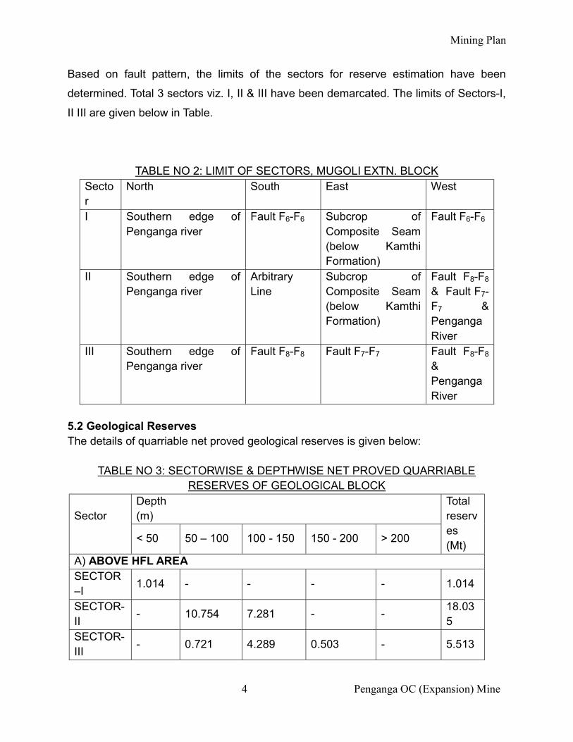
Based on fault pattern, the limits of the sectors for reserve estimation have been
determined. Total 3 sectors viz. I, II & III have been demarcated. The limits of Sectors-I,
II III are given below in Table.
TABLE NO 2: LIMIT OF SECTORS, MUGOLI EXTN. BLOCK Sector
North South East West
I Southern edge of Penganga river
Fault F6-F6 Subcrop of Composite Seam (below Kamthi Formation)
Fault F6-F6
II Southern edge of Penganga river
Arbitrary Line
Subcrop of Composite Seam (below Kamthi Formation)
Fault F8-F8
& Fault F7-F7 & Penganga River
III Southern edge of Penganga river
Fault F8-F8 Fault F7-F7 Fault F8-F8
& Penganga River
5.2 Geological Reserves The details of quarriable net proved geological reserves is given below:
TABLE NO 3: SECTORWISE & DEPTHWISE NET PROVED QUARRIABLE RESERVES OF GEOLOGICAL BLOCK
Sector
Depth (m)
Total reserves (Mt)
< 50 50 – 100 100 - 150 150 - 200 > 200
A) ABOVE HFL AREA SECTOR –I
1.014 - - - - 1.014
SECTOR-II
- 10.754 7.281 - - 18.035
SECTOR-III
- 0.721 4.289 0.503 - 5.513
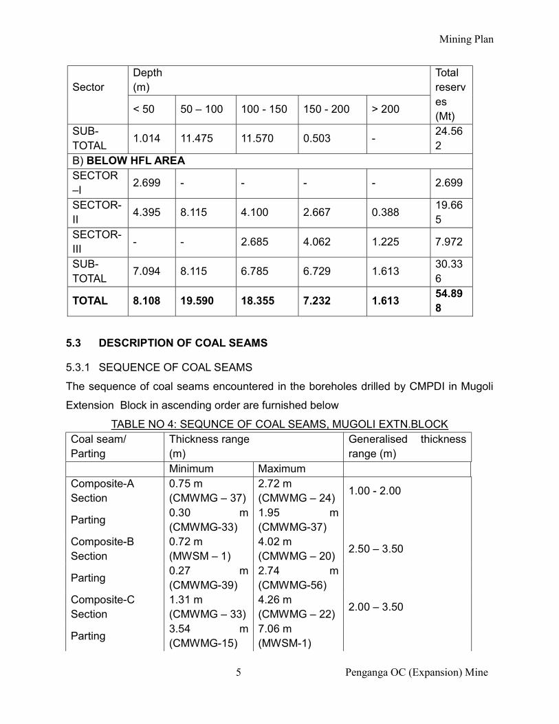
Mining Plan
5 Penganga OC (Expansion) Mine
Sector
Depth (m)
Total reserves (Mt)
< 50 50 – 100 100 - 150 150 - 200 > 200
SUB-TOTAL
1.014 11.475 11.570 0.503 - 24.562
B) BELOW HFL AREA SECTOR –I
2.699 - - - - 2.699
SECTOR-II
4.395 8.115 4.100 2.667 0.388 19.665
SECTOR-III
- - 2.685 4.062 1.225 7.972
SUB-TOTAL
7.094 8.115 6.785 6.729 1.613 30.336
TOTAL 8.108 19.590 18.355 7.232 1.613 54.898
5.3 DESCRIPTION OF COAL SEAMS
5.3.1 SEQUENCE OF COAL SEAMS
The sequence of coal seams encountered in the boreholes drilled by CMPDI in Mugoli
Extension Block in ascending order are furnished below
TABLE NO 4: SEQUNCE OF COAL SEAMS, MUGOLI EXTN.BLOCK Coal seam/ Parting
Thickness range (m)
Generalised thickness range (m)
Minimum Maximum Composite-A Section
0.75 m (CMWMG – 37)
2.72 m (CMWMG – 24)
1.00 - 2.00
Parting 0.30 m (CMWMG-33)
1.95 m (CMWMG-37)
Composite-B Section
0.72 m (MWSM – 1)
4.02 m (CMWMG – 20)
2.50 – 3.50
Parting 0.27 m (CMWMG-39)
2.74 m (CMWMG-56)
Composite-C Section
1.31 m (CMWMG – 33)
4.26 m (CMWMG – 22)
2.00 – 3.50
Parting 3.54 m (CMWMG-15)
7.06 m (MWSM-1)
Mining Plan
6 Penganga OC (Expansion) Mine
Composite-D Section
7.65 m (CMWMG – 38)
11.65 m (CMWMG – 21)
9.70 – 11.00
Composite-A+B+C+D Sections (excluding > 1.00 m parting
14.84 m (CMWMG – 11)
22.19 m (CMWMG – 24)
17.50– 20.50
It could be seen from the above table that the seams sections encountered in Mugoli Extn. Block are potential and persistent in nature in the entire area of the block. 5.3.2 COMPOSITE SEAM
The Composite Seam, which is about 21 m to 26 m thickness including all dirt bands
and parting in the present area occurs in 4 sections viz. Composite-A Section,
Composite-B Section, Composite-C Section and Composite-D Section. The parting
between Composite-A+B+C Sections and Composite-D Section varies from 3.54 m
(CMWMG-15) to 7.06 m (MWSM-1). All sections of the Composite Seam are virgin.
5.4 STRIKE AND DIP
The general strike of the coal seam is north-south in the major part of the area with
minor swing in central part of the area as determined from the floor contour plan of
Composite-D Section. In the sub crop zone near boreholes CMWMG-17 & 28 the strike
becomes northwest-southeast. The dip of the strata ranges from 4° to 7.5° (gradient 1 in
7.5 to 1 in 14.0) and dipping towards west and southwest direction. The eastern part of
the area is generally having less gradient (1 in 14) as compare to remaining part of the
block. The attitude of the seam is presented in floor contour plan.
5.5 FAULTS
The area of the block is traversed by 6 total numbers of faults. Most of the faults are
oblique faults, cutting across the strike of the strata. The major i.e. F6-F6, F7-F7 & F8-
F8 continuing from the northern adjoining block i.e. Kolgaon Sawangi Block and its fault
numbers have been retained as mentioned in the geological report (Kolgaon Sawangi,
May 1993) prepared by MECL. This major fault (F8-F8) also demarcates the western
limit of the geological plan and floor positions of faults are shown in floor contour / iso-
Mining Plan
7 Penganga OC (Expansion) Mine
parting/seam folio plans. The newly interpreted faults have been numbered i.e. F1-F1,
F2-F2 & F3 & F3. For further details kindly refer Chp.-4, Pg. 11 & 12 of PR 07.10.2014.
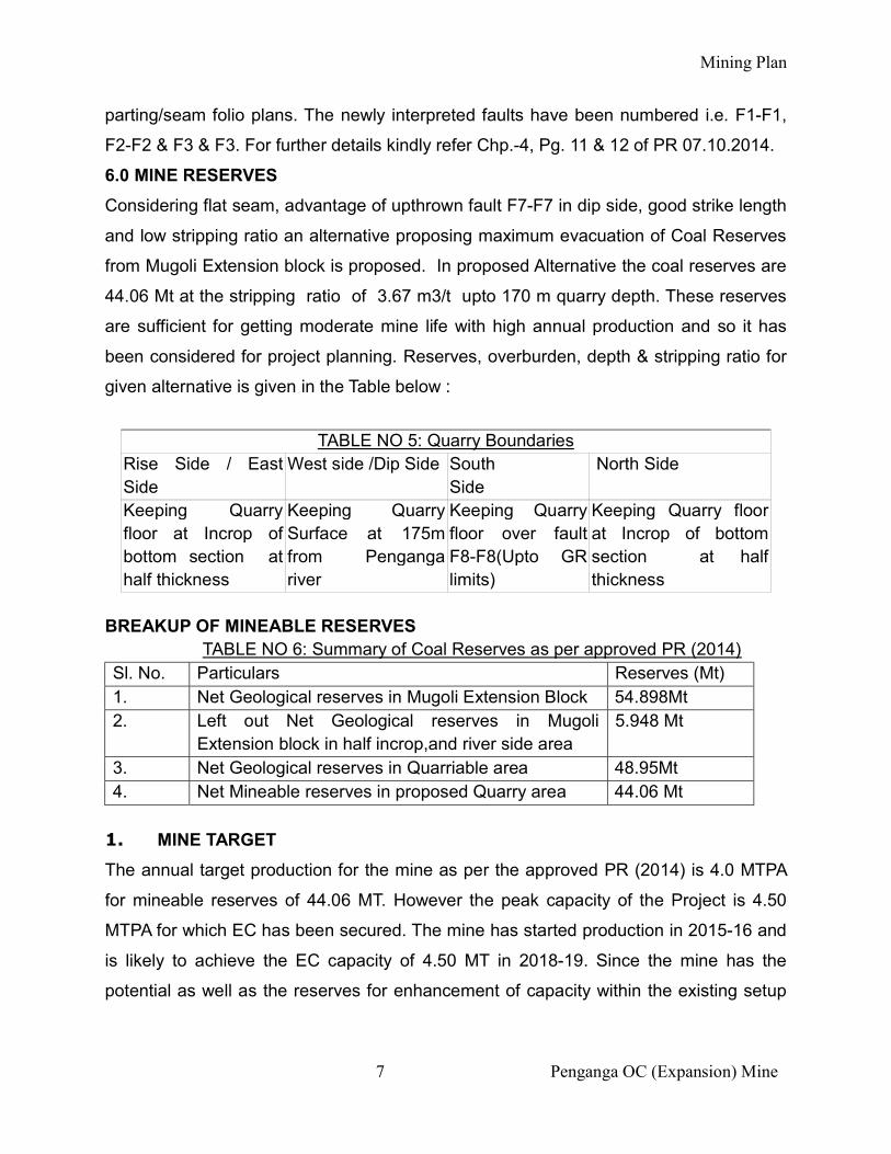
6.0 MINE RESERVES
Considering flat seam, advantage of upthrown fault F7-F7 in dip side, good strike length
and low stripping ratio an alternative proposing maximum evacuation of Coal Reserves
from Mugoli Extension block is proposed. In proposed Alternative the coal reserves are
44.06 Mt at the stripping ratio of 3.67 m3/t upto 170 m quarry depth. These reserves
are sufficient for getting moderate mine life with high annual production and so it has
been considered for project planning. Reserves, overburden, depth & stripping ratio for
given alternative is given in the Table below :
TABLE NO 5: Quarry Boundaries
Rise Side / East Side
West side /Dip Side South Side
North Side
Keeping Quarry floor at Incrop of bottom section at half thickness
Keeping Quarry Surface at 175m from Penganga river
Keeping Quarry floor over fault F8-F8(Upto GR limits)
Keeping Quarry floor at Incrop of bottom section at half thickness
BREAKUP OF MINEABLE RESERVES
TABLE NO 6: Summary of Coal Reserves as per approved PR (2014) Sl. No. Particulars Reserves (Mt) 1. Net Geological reserves in Mugoli Extension Block 54.898Mt 2. Left out Net Geological reserves in Mugoli
Extension block in half incrop,and river side area 5.948 Mt
3. Net Geological reserves in Quarriable area 48.95Mt 4. Net Mineable reserves in proposed Quarry area 44.06 Mt
1. MINE TARGET
The annual target production for the mine as per the approved PR (2014) is 4.0 MTPA
for mineable reserves of 44.06 MT. However the peak capacity of the Project is 4.50
MTPA for which EC has been secured. The mine has started production in 2015-16 and
is likely to achieve the EC capacity of 4.50 MT in 2018-19. Since the mine has the
potential as well as the reserves for enhancement of capacity within the existing setup

Mining Plan
8 Penganga OC (Expansion) Mine
(without any capital investment) therefore, considering the increased demand of power
sector it is proposed to enhance the target by 40% i.e from 4.50 MTPA to 6.30 MTPA.
2. MINE LIFE
As per the approved PR (Oct'2014), the life of the project works out to 15 years
(including initial one year for land acquisition). The mine has started the coal production
in the year 2015-16 & considering the enhance capacity of 6.30 MTPA the balance life
would be 7 years from 2018-19.
TABLE NO 7: YEARWISE COAL PRODUCTION & OB REMOVAL PROGRAMME
SL. No
Year Coal Production
(MT)
OB Removal (Mm3)
HOE Dept (Considering as on date capacity)
Total
1 2015-16 1.05 (Actual) 2.03 0.00 2.03 2 2016-17 2.70 (Actual) 2.40 0.00 2.40 3 2017-18 3.70 (Actual) 4.74 1.19 5.93 4 2018-19 4.50 14.72 1.85 16.57 5 2019-20 6.00 20.82 1.92 22.74 6 2020-2021 6.30 22.24 1.84 24.08 7 2021-2022 6.30 24.15 1.80 25.95 8 2022-2023 6.00 24.01 1.80 25.80 9 2023-2024 5.00 24.01 1.44 25.46 10 2024-2025 2.51 12.18 0.63 12.81
Total 44.06 151.30 12.47 163.77
3. GRADE OF MINEABLE COAL
As per the approved PR (Oct'2014), the Grade of Quarry Coal without dilution is ‘G’10
with GCV of 4551 k.cal/kg after removing of major partings.
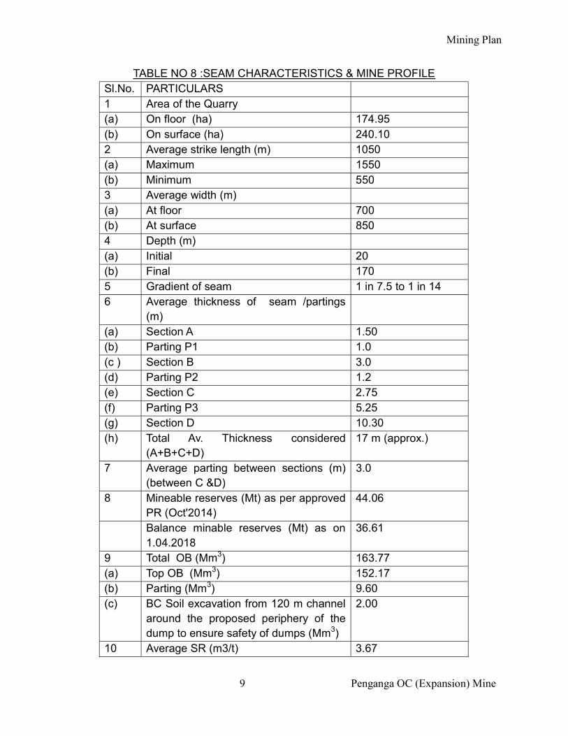
As per the approved PR (Oct'2014), the seam characteristics and the profile of the
quarries are as given below in table:-
Mining Plan
9 Penganga OC (Expansion) Mine
TABLE NO 8 :SEAM CHARACTERISTICS & MINE PROFILE Sl.No. PARTICULARS 1 Area of the Quarry (a) On floor (ha) 174.95 (b) On surface (ha) 240.10 2 Average strike length (m) 1050 (a) Maximum 1550 (b) Minimum 550 3 Average width (m) (a) At floor 700 (b) At surface 850 4 Depth (m) (a) Initial 20 (b) Final 170 5 Gradient of seam 1 in 7.5 to 1 in 14 6 Average thickness of seam /partings
(m)
(a) Section A 1.50 (b) Parting P1 1.0 (c ) Section B 3.0 (d) Parting P2 1.2 (e) Section C 2.75 (f) Parting P3 5.25 (g) Section D 10.30 (h) Total Av. Thickness considered
(A+B+C+D) 17 m (approx.)
7 Average parting between sections (m) (between C &D)
3.0
8 Mineable reserves (Mt) as per approved PR (Oct'2014)
44.06
Balance minable reserves (Mt) as on 1.04.2018
36.61
9 Total OB (Mm3) 163.77 (a) Top OB (Mm3) 152.17 (b) Parting (Mm3) 9.60 (c) BC Soil excavation from 120 m channel
around the proposed periphery of the dump to ensure safety of dumps (Mm3)
2.00
10 Average SR (m3/t) 3.67
Mining Plan
10 Penganga OC (Expansion) Mine
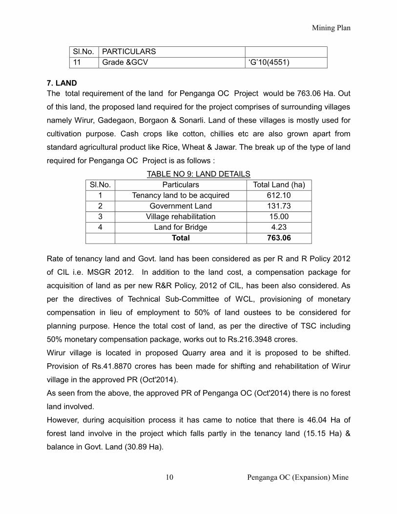
Sl.No. PARTICULARS 11 Grade &GCV ‘G’10(4551)
7. LAND The total requirement of the land for Penganga OC Project would be 763.06 Ha. Out
of this land, the proposed land required for the project comprises of surrounding villages
namely Wirur, Gadegaon, Borgaon & Sonarli. Land of these villages is mostly used for
cultivation purpose. Cash crops like cotton, chillies etc are also grown apart from
standard agricultural product like Rice, Wheat & Jawar. The break up of the type of land
required for Penganga OC Project is as follows :
TABLE NO 9: LAND DETAILS Sl.No. Particulars Total Land (ha)
1 Tenancy land to be acquired 612.10 2 Government Land 131.73 3 Village rehabilitation 15.00 4 Land for Bridge 4.23 Total 763.06
Rate of tenancy land and Govt. land has been considered as per R and R Policy 2012
of CIL i.e. MSGR 2012. In addition to the land cost, a compensation package for
acquisition of land as per new R&R Policy, 2012 of CIL, has been also considered. As
per the directives of Technical Sub-Committee of WCL, provisioning of monetary
compensation in lieu of employment to 50% of land oustees to be considered for
planning purpose. Hence the total cost of land, as per the directive of TSC including
50% monetary compensation package, works out to Rs.216.3948 crores.
Wirur village is located in proposed Quarry area and it is proposed to be shifted.
Provision of Rs.41.8870 crores has been made for shifting and rehabilitation of Wirur
village in the approved PR (Oct'2014).
As seen from the above, the approved PR of Penganga OC (Oct'2014) there is no forest
land involved.
However, during acquisition process it has came to notice that there is 46.04 Ha of
forest land involve in the project which falls partly in the tenancy land (15.15 Ha) &
balance in Govt. Land (30.89 Ha).
Mining Plan
11 Penganga OC (Expansion) Mine
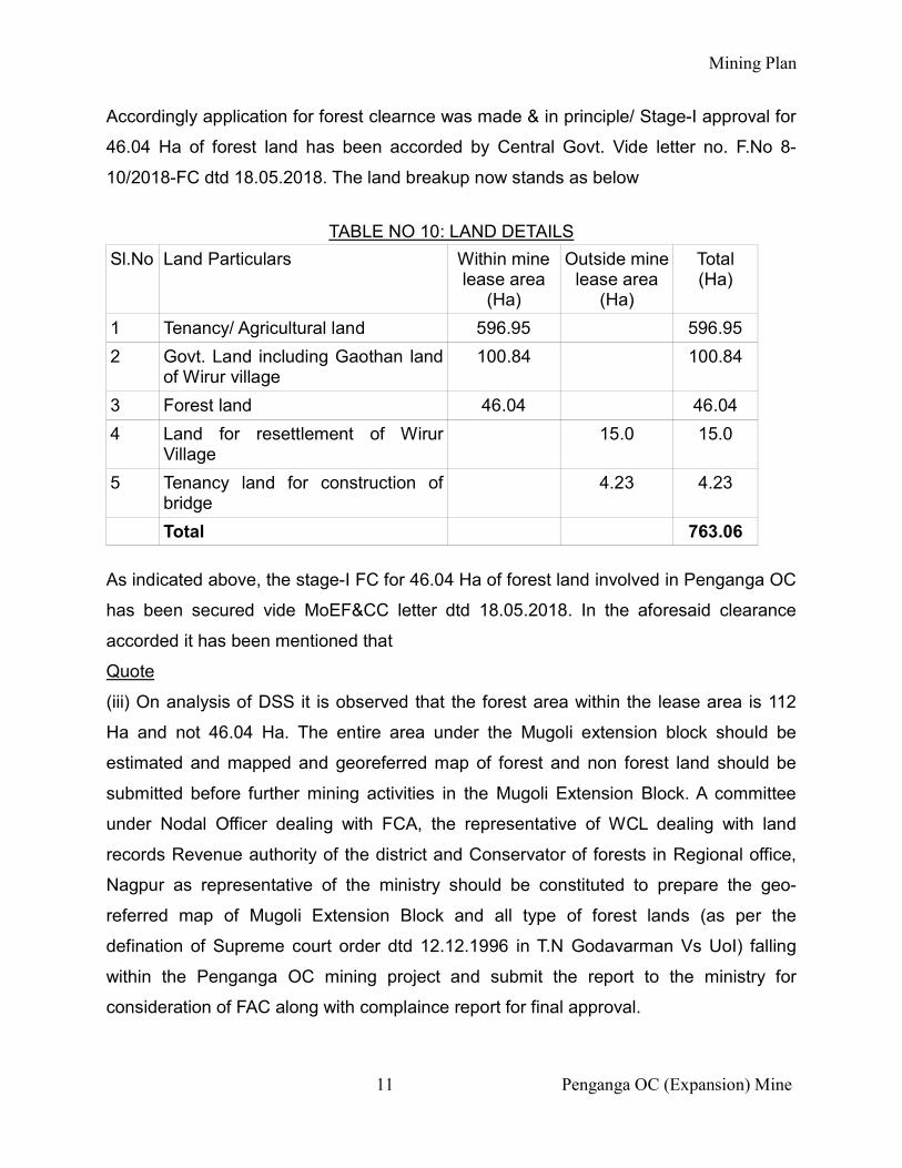
Accordingly application for forest clearnce was made & in principle/ Stage-I approval for
46.04 Ha of forest land has been accorded by Central Govt. Vide letter no. F.No 8-
10/2018-FC dtd 18.05.2018. The land breakup now stands as below
TABLE NO 10: LAND DETAILS
Sl.No Land Particulars Within mine lease area
(Ha)
Outside mine lease area
(Ha)
Total (Ha)
1 Tenancy/ Agricultural land 596.95 596.95
2 Govt. Land including Gaothan land of Wirur village
100.84 100.84
3 Forest land 46.04 46.04
4 Land for resettlement of Wirur Village
15.0 15.0
5 Tenancy land for construction of bridge
4.23 4.23
Total 763.06 As indicated above, the stage-I FC for 46.04 Ha of forest land involved in Penganga OC
has been secured vide MoEF&CC letter dtd 18.05.2018. In the aforesaid clearance
accorded it has been mentioned that
Quote
(iii) On analysis of DSS it is observed that the forest area within the lease area is 112
Ha and not 46.04 Ha. The entire area under the Mugoli extension block should be
estimated and mapped and georeferred map of forest and non forest land should be
submitted before further mining activities in the Mugoli Extension Block. A committee
under Nodal Officer dealing with FCA, the representative of WCL dealing with land
records Revenue authority of the district and Conservator of forests in Regional office,
Nagpur as representative of the ministry should be constituted to prepare the geo-
referred map of Mugoli Extension Block and all type of forest lands (as per the
defination of Supreme court order dtd 12.12.1996 in T.N Godavarman Vs UoI) falling
within the Penganga OC mining project and submit the report to the ministry for
consideration of FAC along with complaince report for final approval.
Mining Plan
12 Penganga OC (Expansion) Mine
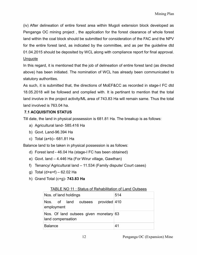
(iv) After delineation of entire forest area within Mugoli extension block developed as
Penganga OC mining project , the application for the forest clearance of whole forest
land within the coal block should be submitted for consideration of the FAC and the NPV
for the entire forest land, as indicated by the committee, and as per the guideline dtd
01.04.2015 should be deposited by WCL along with compliance report for final approval.
Unquote
In this regard, it is mentioned that the job of delineation of entire forest land (as directed
above) has been initiated. The nomination of WCL has already been communicated to
statutory authorities.
As such, it is submitted that, the directions of MoEF&CC as recorded in stage-I FC dtd
18.05.2018 will be followed and complied with. It is pertinant to mention that the total
land involve in the project activity/ML area of 743.83 Ha will remain same. Thus the total
land involved is 763.04 ha.
7.1 ACQUISITION STATUS
Till date, the land in physical possession is 681.81 Ha. The breakup is as follows:
a) Agricultural land- 585.416 Ha
b) Govt. Land-96.394 Ha
c) Total (a+b)– 681.81 Ha
Balance land to be taken in physical possession is as follows:
d) Forest land - 46.04 Ha (stage-I FC has been obtained)
e) Govt. land – 4.446 Ha (For Wirur village, Gawthan)
f) Tenancy/ Agricultural land – 11.534 (Family dispute/ Court cases)
g) Total (d+e+f) – 62.02 Ha
h) Grand Total (c+g)- 743.83 Ha
TABLE NO 11 : Status of Rehabilitation of Land Outsees
Nos. of land holdings 514
Nos. of land outsees provided employment
410
Nos. Of land outsees given monetary land compensation
63
Balance 41
Mining Plan
13 Penganga OC (Expansion) Mine
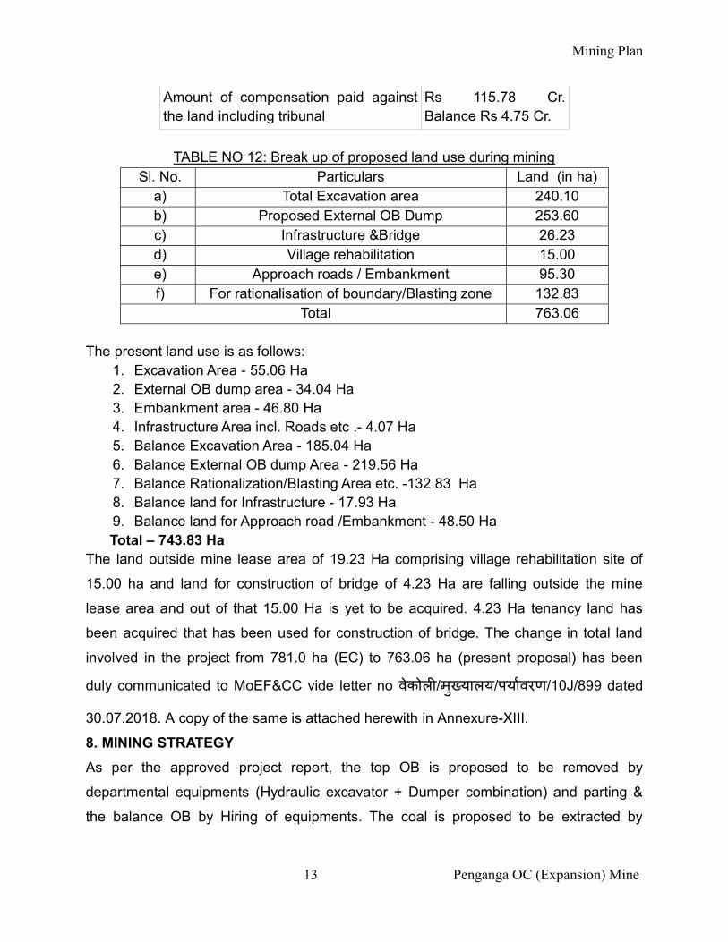
Amount of compensation paid against the land including tribunal
Rs 115.78 Cr. Balance Rs 4.75 Cr.
TABLE NO 12: Break up of proposed land use during mining
Sl. No. Particulars Land (in ha) a) Total Excavation area 240.10 b) Proposed External OB Dump 253.60 c) Infrastructure &Bridge 26.23 d) Village rehabilitation 15.00 e) Approach roads / Embankment 95.30 f) For rationalisation of boundary/Blasting zone 132.83
Total 763.06 The present land use is as follows:
1. Excavation Area - 55.06 Ha 2. External OB dump area - 34.04 Ha 3. Embankment area - 46.80 Ha 4. Infrastructure Area incl. Roads etc .- 4.07 Ha 5. Balance Excavation Area - 185.04 Ha 6. Balance External OB dump Area - 219.56 Ha 7. Balance Rationalization/Blasting Area etc. -132.83 Ha 8. Balance land for Infrastructure - 17.93 Ha 9. Balance land for Approach road /Embankment - 48.50 Ha
Total – 743.83 Ha The land outside mine lease area of 19.23 Ha comprising village rehabilitation site of
15.00 ha and land for construction of bridge of 4.23 Ha are falling outside the mine
lease area and out of that 15.00 Ha is yet to be acquired. 4.23 Ha tenancy land has
been acquired that has been used for construction of bridge. The change in total land
involved in the project from 781.0 ha (EC) to 763.06 ha (present proposal) has been
duly communicated to MoEF&CC vide letter no वेकोल /मु यालय/पयावरण/10J/899 dated
30.07.2018. A copy of the same is attached herewith in Annexure-XIII.
8. MINING STRATEGY
As per the approved project report, the top OB is proposed to be removed by
departmental equipments (Hydraulic excavator + Dumper combination) and parting &
the balance OB by Hiring of equipments. The coal is proposed to be extracted by
Mining Plan
14 Penganga OC (Expansion) Mine
surface miner on hiring basis. At present there is 01 no. of surface miner deployed in the
mine for coal on hiring system.
8.1 SEQUENCE OF MINING
The total average strike length of proposed Penganga OC is about 1.05 km. Since the
gradient of seam is flat, mining cuts are proposed such that substantial internal
backfilling of OB upto surface and heightening of OB dump over quarry area and
merging it with proposed external OB dump can take place.
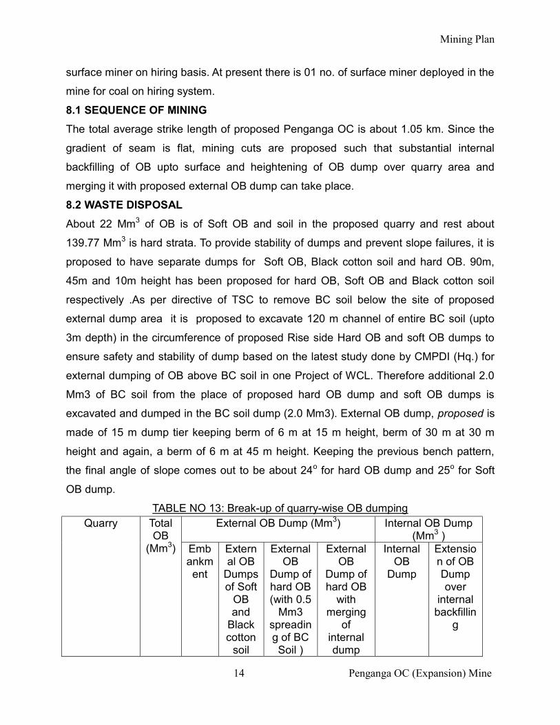
8.2 WASTE DISPOSAL
About 22 Mm3 of OB is of Soft OB and soil in the proposed quarry and rest about
139.77 Mm3 is hard strata. To provide stability of dumps and prevent slope failures, it is
proposed to have separate dumps for Soft OB, Black cotton soil and hard OB. 90m,
45m and 10m height has been proposed for hard OB, Soft OB and Black cotton soil
respectively .As per directive of TSC to remove BC soil below the site of proposed
external dump area it is proposed to excavate 120 m channel of entire BC soil (upto
3m depth) in the circumference of proposed Rise side Hard OB and soft OB dumps to
ensure safety and stability of dump based on the latest study done by CMPDI (Hq.) for
external dumping of OB above BC soil in one Project of WCL. Therefore additional 2.0
Mm3 of BC soil from the place of proposed hard OB dump and soft OB dumps is
excavated and dumped in the BC soil dump (2.0 Mm3). External OB dump, proposed is
made of 15 m dump tier keeping berm of 6 m at 15 m height, berm of 30 m at 30 m
height and again, a berm of 6 m at 45 m height. Keeping the previous bench pattern,
the final angle of slope comes out to be about 24o for hard OB dump and 25o for Soft
OB dump.
TABLE NO 13: Break-up of quarry-wise OB dumping Quarry Total
OB (Mm3)
External OB Dump (Mm3) Internal OB Dump (Mm3 )
Embankment
External OB
Dumps of Soft
OB and
Black cotton
soil
External OB
Dump of hard OB (with 0.5
Mm3 spreading of BC Soil )
External OB
Dump of hard OB
with merging
of internal dump
Internal OB
Dump
Extension of OB Dump over
internal backfillin
g
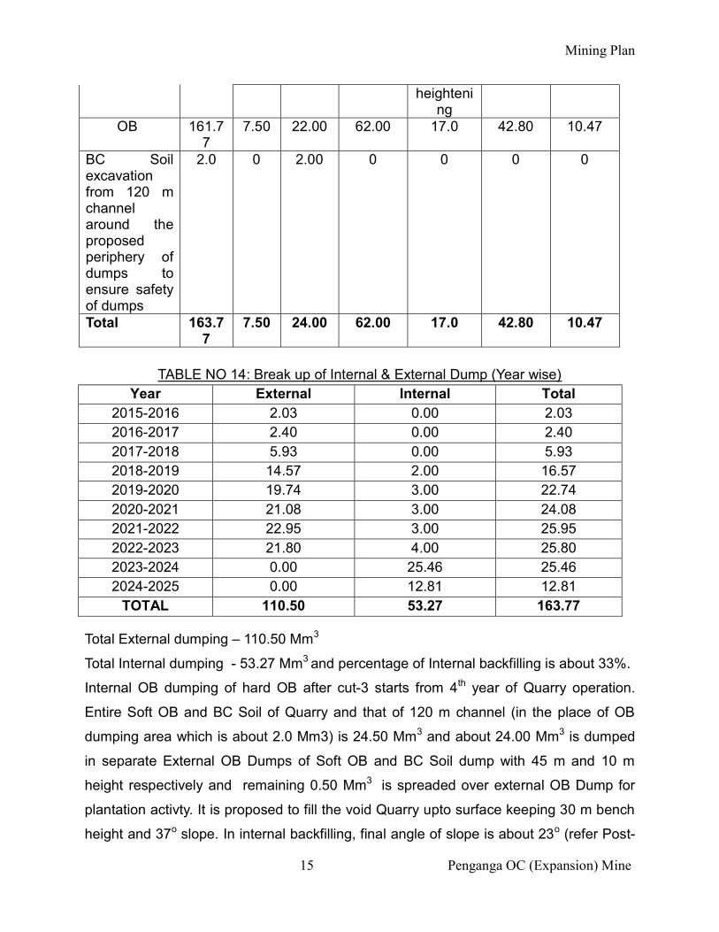
Mining Plan
15 Penganga OC (Expansion) Mine
heightening
OB 161.77
7.50 22.00 62.00 17.0 42.80 10.47
BC Soil excavation from 120 m channel around the proposed periphery of dumps to ensure safety of dumps
2.0 0 2.00 0 0 0 0
Total 163.77
7.50 24.00 62.00 17.0 42.80 10.47
TABLE NO 14: Break up of Internal & External Dump (Year wise)
Year External Internal Total 2015-2016 2.03 0.00 2.03 2016-2017 2.40 0.00 2.40 2017-2018 5.93 0.00 5.93 2018-2019 14.57 2.00 16.57 2019-2020 19.74 3.00 22.74 2020-2021 21.08 3.00 24.08 2021-2022 22.95 3.00 25.95 2022-2023 21.80 4.00 25.80 2023-2024 0.00 25.46 25.46 2024-2025 0.00 12.81 12.81
TOTAL 110.50 53.27 163.77
Total External dumping – 110.50 Mm3
Total Internal dumping - 53.27 Mm3 and percentage of Internal backfilling is about 33%.
Internal OB dumping of hard OB after cut-3 starts from 4th year of Quarry operation.
Entire Soft OB and BC Soil of Quarry and that of 120 m channel (in the place of OB
dumping area which is about 2.0 Mm3) is 24.50 Mm3 and about 24.00 Mm3 is dumped
in separate External OB Dumps of Soft OB and BC Soil dump with 45 m and 10 m
height respectively and remaining 0.50 Mm3 is spreaded over external OB Dump for
plantation activty. It is proposed to fill the void Quarry upto surface keeping 30 m bench
height and 37o slope. In internal backfilling, final angle of slope is about 23o (refer Post-
Mining Plan
16 Penganga OC (Expansion) Mine
mining Land Use Plan). About 33 % of Total OB is proposed to be internally backfilled. It
is proposed that total parting OB will be internally backfilled .
As on 31.03.2018, total OB excavation is 10.36 Mm3 out of which OB accomodated in
embankment is 3.70 M m3 and dumped in external OB dump is 6.66 Mm3.
For balance life, the distribution will be as follows:
Total OB to be excavated (as on 1.04.2018)-153.41 Mm3
Total OB in external Dump – 100.14 Mm3
Total OB in internal dump – 53.27 Mm3
9. MANPOWER
The Manpower deployed in the mine (as on date) is as follows:
Nos. of Executive- 33
Nos. of Monthly rated – 86
Nos. of Daily rated -341
10. DISPATCH ARRANGEMENTS
The coal evacution at Penganga OC Mine is done through contractual agency from
Face to Ghugus siding. The Surface miner is deployed in the mine for cutting the coal
without and produces -100 mm size coal which is transported through tippers loaded by
payloaders directly to to Ghugus Railway siding from there the coal is transported to
different thermal Power stations by Rail mode. Restricted Quantity of coal i.e. 20% is
Stocked at Coal stock yard for Local Consumers , which uses tippers for transportation
of coal.
In future, the coal excavated by surface miner from quarry will be received into the 6 x
150t capacity hopper near quarry mouth by means of rear discharge dumpers/Trucks as
given in PR 2014.
11. SAFETY
The project report has been drawn in conformity with the prevailing statutory provisions
as per Mines Act, 1952 and CMR, 1957 applicable for safety in Opencast Mines.
However, all statutory rules, regulations, applicable laws etc. and statutory requirement
related to Govt. licences , workers compensation, Insurance, etc. shall have to be
adhered to. All the regulations & schedules of Coal Mines Regulations, 1957 and
Mining Plan
17 Penganga OC (Expansion) Mine
subsequent ammendments relating to opencast mining have to be adhered to and
implemented in order to maintain day to day safety precautions as per statute.
11.1 SAFETY ASPECT FOR BLASTING OPERATIONS
As explosives are required in bulk for blasting in OC mines, provision of regulation -
164 A of CMR 1957 should be ensured.
All blasting operations shall be carried out in day light. Suitable precautions shall
be taken as per statute before and after blasting operations. Controlled blasting
technique has to be practised to minimise fly off rocks and ground vibrations and
keep them within safe limits . In order to keep the ground vibrations within the
permissible limit as per DGMS Circular No. 7 of 1997, to avoid flying of rock fragments
and also to achieve satisfactory blasting results, optimized drilling / blasting parameters
depending upon rock formation using combination of relays / delays will have to be
evolved. It is further recommended that at the time of actual execution, proper study for
controlled blasting and ground vibration is done with scientific body in order to evolve
site specific charge distance relationship.
11.2 SAFETY ASPECTS FOR OUTSOURCING/HIRING OF MACHINERIES
Special precaution should be taken while deploying workers in the mine. Before
employing any labour to the mine proper vocation training should be imparted and
recommendations of Recent Safety Conference should be strictly followed. Terms and
conditions shall be fixed by management for deployment of labours by leaser of
machineries. Before deploying workers they must be trained and briefed about safety
aspects in opencast mine. However during course of execution of the work, if any
accident occurs whether major or minor, the matter shall have to be immediately
informed to mine management i.e, Colliery Manager/Agent/GM of Area so that Notices
of accidents in accordance of Reg. 9 of CMR 1957 (subsequent amendments) and
Sector 23 of Mines Act 1952 may be given and other necessary steps may be taken in
accordance of Section 23 of Mines Act ,1952 & Reg. 9 of CMR ,1957 (subsequent
amendments) and other relevant laws.
12. Environment Pollution control measures
To control air pollution following arrangements have been made
1. Dust suppression measures- By mobile tankers 2 Nos. of 28 KL departmental
Mining Plan
18 Penganga OC (Expansion) Mine
equipment and 3 nos. of 16 KL and 1 no. of 12 KL by hiring.
2. All the trucks carrying coal are covered with tarpaulin.
3. In 2017-18, 500 saplings has been planted in office and service building
premises. In 2018-19, 25000 nos. saplings are being planted on plain area as
well as on slopes of embankment.
4. To control Water pollution, a sedimentation pond of size 23 m *11 m *1.5 m has
been put in to operation.
13. Mine Closure Planning
13.1 General
Mine closure planning has to be carried out at the starting of the mine and needs
periodic reviewing and revision during its life cycle to cope with the geo-technical
constraints, safety and economic risks, social & environmental challenges. For the Mine
Closure activities, a corpus fund is created by opening an escrow account with the coal
controller organization in nationalised bank. For opencast mine, an amount @ Rs 6.00
lakhs per Ha of the project area is required to be deposited in this account for final mine
closure. The above rate has been adopted as per Circular No. 55011-01-2009-CPAM,
GOI, Ministry of Coal, dated 27 August 2009.
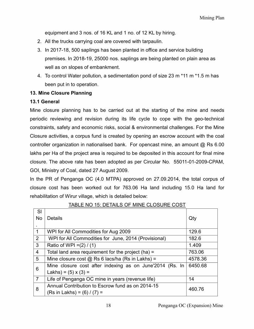
In the PR of Penganga OC (4.0 MTPA) approved on 27.09.2014, the total corpus of
closure cost has been worked out for 763.06 Ha land including 15.0 Ha land for
rehabilitation of Wirur village, which is detailed below:
TABLE NO 15: DETAILS OF MINE CLOSURE COST Sl No.
Details Qty
1 WPI for All Commodities for Aug 2009 129.6 2 WPI for All Commodities for June, 2014 (Provisional) 182.6 3 Ratio of WPI =(2) / (1) 1.409 4 Total land area requirement for the project (ha) = 763.06 5 Mine closure cost @ Rs 6 lacs/ha (Rs in Lakhs) = 4578.36
6 Mine closure cost after indexing as on June'2014 (Rs. In Lakhs) = (5) x (3) =
6450.68
7 Life of Penganga OC mine in years (revenue life) 14
8 Annual Contribution to Escrow fund as on 2014-15 (Rs in Lakhs) = (6) / (7) =
460.76
Mining Plan
19 Penganga OC (Expansion) Mine
Sl No.
Details Qty
9 Annual Contribution to Escrow fund as on 2015-16 with 5% Escalation (1st year of Closure Cost Deposit) (Rs in Lakhs) = (7) / (8) =
483.80
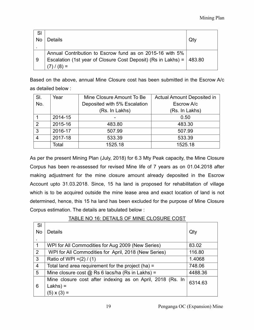
Based on the above, annual Mine Closure cost has been submitted in the Escrow A/c
as detailed below :
Sl. No.
Year Mine Closure Amount To Be Deposited with 5% Escalation
(Rs. In Lakhs)
Actual Amount Deposited in Escrow A/c
(Rs. In Lakhs) 1 2014-15 - 0.50 2 2015-16 483.80 483.30 3 2016-17 507.99 507.99 4 2017-18 533.39 533.39 Total 1525.18 1525.18
As per the present Mining Plan (July, 2018) for 6.3 Mty Peak capacity, the Mine Closure
Corpus has been re-assessed for revised Mine life of 7 years as on 01.04.2018 after
making adjustment for the mine closure amount already deposited in the Escrow
Account upto 31.03.2018. Since, 15 ha land is proposed for rehabilitation of village
which is to be acquired outside the mine lease area and exact location of land is not
determined, hence, this 15 ha land has been excluded for the purpose of Mine Closure
Corpus estimation. The details are tabulated below :
TABLE NO 16: DETAILS OF MINE CLOSURE COST Sl No.
Details Qty
1 WPI for All Commodities for Aug 2009 (New Series) 83.02 2 WPI for All Commodities for April, 2018 (New Series) 116.80 3 Ratio of WPI =(2) / (1) 1.4068 4 Total land area requirement for the project (ha) = 748.06 5 Mine closure cost @ Rs 6 lacs/ha (Rs in Lakhs) = 4488.36
6 Mine closure cost after indexing as on April, 2018 (Rs. In Lakhs) = (5) x (3) =
6314.63
Mining Plan
20 Penganga OC (Expansion) Mine
Sl No.
Details Qty
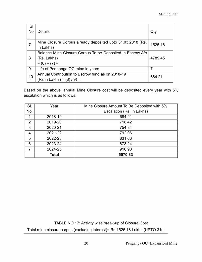
7 Mine Closure Corpus already deposited upto 31.03.2018 (Rs. In Lakhs)
1525.18
8 Balance Mine Closure Corpus To be Deposited in Escrow A/c (Rs. Lakhs) = (6) – (7) =
4789.45
9 Life of Penganga OC mine in years 7
10 Annual Contribution to Escrow fund as on 2018-19 (Rs in Lakhs) = (8) / 9) =
684.21
Based on the above, annual Mine Closure cost will be deposited every year with 5% escalation which is as follows:
Sl. No.
Year Mine Closure Amount To Be Deposited with 5% Escalation (Rs. In Lakhs)
1 2018-19 684.21 2 2019-20 718.42 3 2020-21 754.34 4 2021-22 792.06 5 2022-23 831.66 6 2023-24 873.24 7 2024-25 916.90 Total 5570.83
TABLE NO 17: Activity wise break-up of Closure Cost
Total mine closure corpus (excluding interest)= Rs.1525.18 Lakhs (UPTO 31st
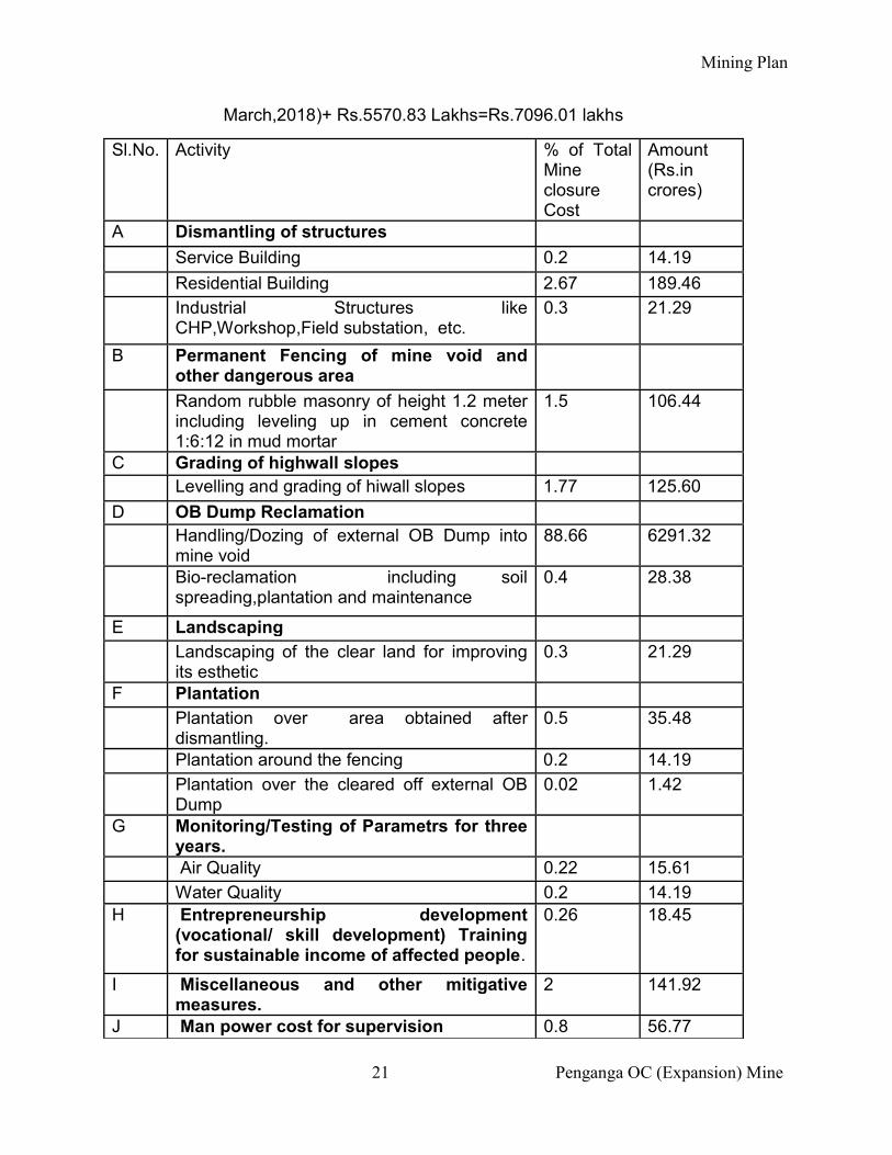
Mining Plan
21 Penganga OC (Expansion) Mine
March,2018)+ Rs.5570.83 Lakhs=Rs.7096.01 lakhs
Sl.No. Activity % of Total Mine closure Cost
Amount (Rs.in crores)
A Dismantling of structures
Service Building 0.2 14.19
Residential Building 2.67 189.46
Industrial Structures like CHP,Workshop,Field substation, etc.
0.3 21.29
B Permanent Fencing of mine void and other dangerous area
Random rubble masonry of height 1.2 meter including leveling up in cement concrete 1:6:12 in mud mortar
1.5 106.44
C Grading of highwall slopes Levelling and grading of hiwall slopes 1.77 125.60
D OB Dump Reclamation Handling/Dozing of external OB Dump into
mine void 88.66 6291.32
Bio-reclamation including soil spreading,plantation and maintenance
0.4 28.38
E Landscaping
Landscaping of the clear land for improving its esthetic
0.3 21.29
F Plantation
Plantation over area obtained after dismantling.
0.5 35.48
Plantation around the fencing 0.2 14.19
Plantation over the cleared off external OB Dump
0.02 1.42
G Monitoring/Testing of Parametrs for three years.
Air Quality 0.22 15.61
Water Quality 0.2 14.19 H Entrepreneurship development
(vocational/ skill development) Training for sustainable income of affected people.
0.26 18.45
I Miscellaneous and other mitigative measures.
2 141.92
J Man power cost for supervision 0.8 56.77
Mining Plan
22 Penganga OC (Expansion) Mine
TOTAL 100% 7096.01 13.2 BREAK-UP OF CLOSURE FUND FOR VARIOUS CLOSURE ACTIVITIES
Mining is to be carried out in a phased manner initiating afforestation / reclamation work
in the mined out area of first phase while commencing mining in the 2nd phase.
Upto 80% of the total deposited amount including interest accrued in the ECSROW
account may be released after every 5 years. The amount released should be equal to
expenditure incurred on Progressive Mine closure in past 5 years or 80% whichever is
less.
The above cost/expenditure will be met from the corpus fund deposited in the escrow
account by the mine operator. However, the additional amount beyond the escrow
account will be provided by the mine operator after estimating the final mine closure
cost (as per the mine closure guideline).
The amount indicated separately under each head in the above table is indicative only
and based on actual expenditure the amount may change.
14. CONCLUSION
WCL board in its in its 303rd meeting held on 24-08-2018 deliberated on the above
mining plan and approval of WCL Board has been secured vide letter no
WCL/BD/SECTT/BM-303/2018/429 dated 03-09-2018.
---------------------------------------------------------------------------------------------------
*******************


