Embed Size (px)
Citation preview
Missing intentionality: the limitations of social media analysis for participatory urban design Luca Simeone, case study for Civic Media Reader.
Simeone, L. (2015). Missing intentionality: the limitations of social media analysis for participatory urban
design, in Eric Gordon and Paul Mihailidis (Eds) Civic Media Project, Cambridge, MA, MIT Press
This article can be also viewed here: http://civicmediaproject.org/works/civic-‐media-‐
project/missingintentionalityparticipatoryurbandesign
Overview
This case study reflects upon some limitations of Urban Sensing, a research
project funded by the European Commission, which explored the potential of
social media analysis and data visualization as sources of knowledge for
participatory urban design and managementi. The overall idea behind the
project was:
• To analyze what city inhabitants and visitors publish on different social
media channels (Twitter, Facebook, Foursquare, Flickr);
• To extract indicators on how these people perceive and live in the urban
environment;
• To use this knowledge to feed more inclusive urban design processes
(e.g., by measuring the real-‐time reactions of citizens towards new
architectural interventions).
Urban Sensing built upon several existing projects, either conducted by
research institutions (e.g., CASA at the University College Londonii, Spatial
Information Design Lab at the Columbia Universityiii or Senseable City Lab at the
Massachusetts Institute of Technologyiv) or independent designers and design
firms (e.g., Christian Noldv, Art is Open Sourcevi or Stamen Designvii). The
trajectory of Urban Sensing was also influenced by the work of scholars coming
from different disciplines, from geography, to urban studies, up to computer
science (Zook and Graham 2007; Girardin et al. 2008; Kotov, Zhai, and Sproat
2011; Liu et al. 2011; Shi and Barker 2011). In a 24-‐month period, the teamviii
behind Urban Sensing created and tested a technological platform, which:
• Gathers data from 4 social media streams: Twitter, Facebook,
Foursquare and Flickr;
• Applies multiple strategies (including text mining) to analyze these
data and extract indicators related to several areas of interest (such as
characterizations and perceived identities of geographic areas or users'
feeling toward local policies and urban interventions);
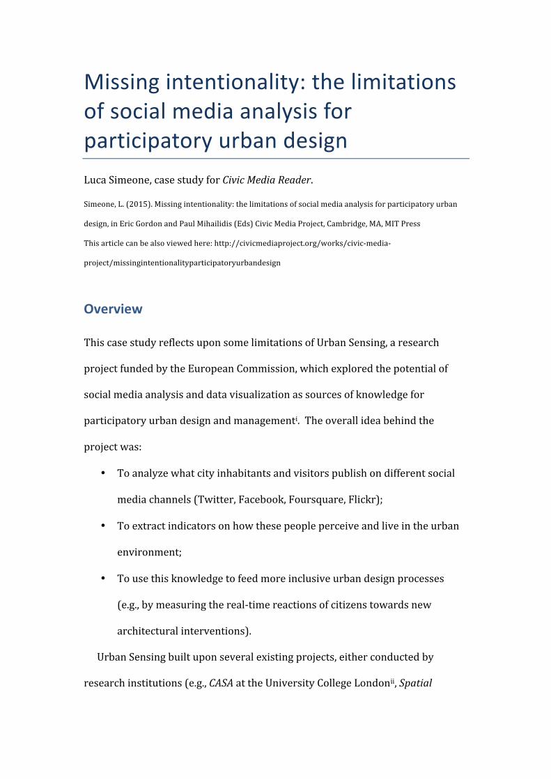
• Visualizes the results, plotting them on a web-‐based map, like in
the Figure 1, which represents the position of geo-‐located tweets in the
city of Milan (Italy) in a two-‐week period (January 2012). Colors denote
the eight most adopted languages while writing the tweets (yellow =
Italian, green = English, bright green = Indonesian; pink = Spanish, light
pink = French; blue = Dutch; light blue = Portuguese; and red = Japanese).
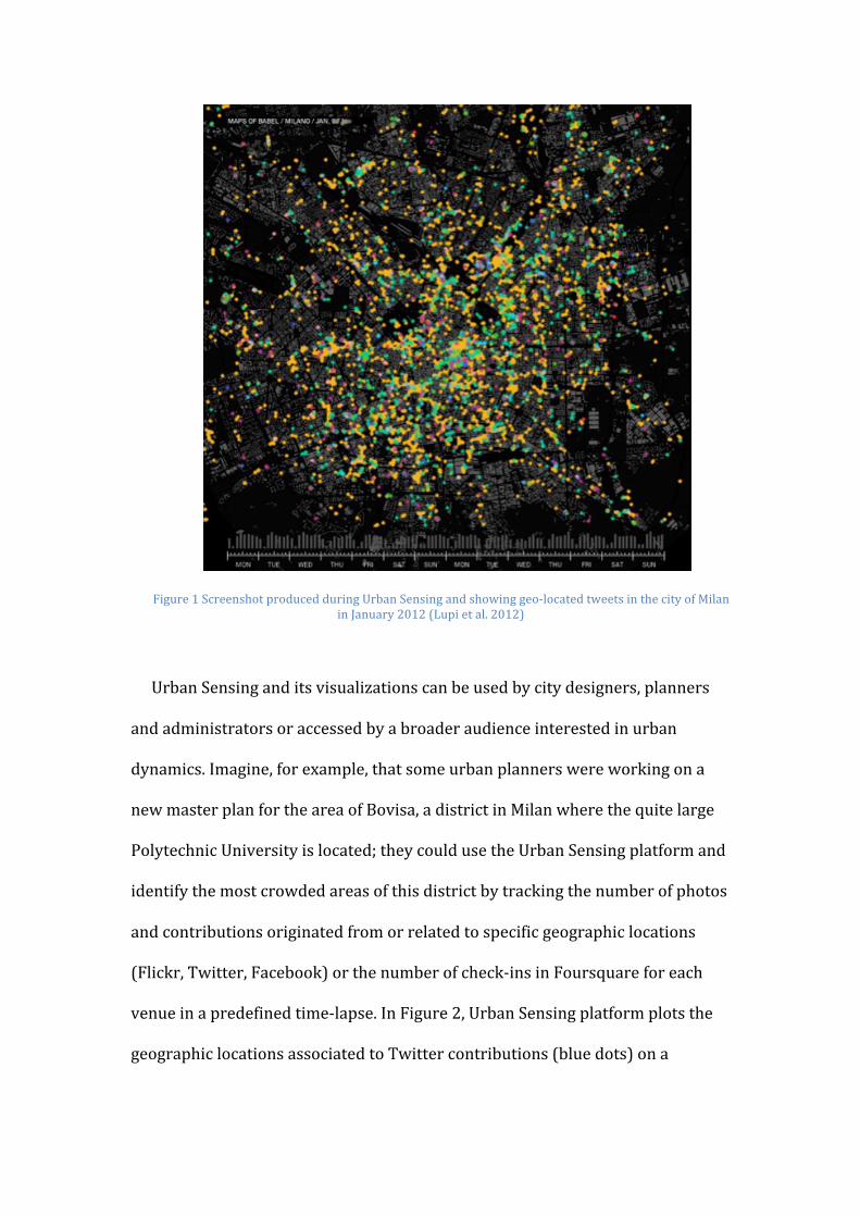
Figure 1 Screenshot produced during Urban Sensing and showing geo-‐located tweets in the city of Milan in January 2012 (Lupi et al. 2012)
Urban Sensing and its visualizations can be used by city designers, planners
and administrators or accessed by a broader audience interested in urban
dynamics. Imagine, for example, that some urban planners were working on a
new master plan for the area of Bovisa, a district in Milan where the quite large
Polytechnic University is located; they could use the Urban Sensing platform and
identify the most crowded areas of this district by tracking the number of photos
and contributions originated from or related to specific geographic locations
(Flickr, Twitter, Facebook) or the number of check-‐ins in Foursquare for each
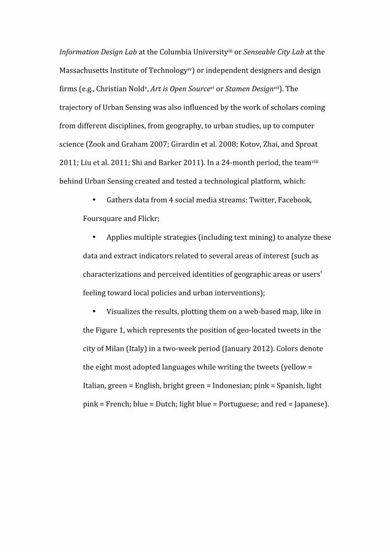
venue in a predefined time-‐lapse. In Figure 2, Urban Sensing platform plots the
geographic locations associated to Twitter contributions (blue dots) on a
geographic map of Milan, also displaying the time trends (i.e., the number of
contributions per day in the time span)..
Figure 2 Urban Sensing, visual representation of the area of Bovisa, in Milan (August-‐September 2013)
Figure 2 shows how, during weekdays, the Bovisa university campus presents
spikes of social media activity during lesson hours (9 a.m. to 6 p.m.), whilst the
nearby UCI movie theatre and the shopping centre are the stage for a high
concentration of social media activity from 9 p.m. until midnight. This data can
be further analyzed by tracking contributions from single users and –
consequently – investigating how the users move across the city. In Figure 3, the
blue dots represent the initial position of the users, whilst the green and red dots
show the positions of the same users immediately before and after. By
connecting the dots, we can clearly trace users’ movements over time and have
an idea not only of the most crowded areas of Bovisa, but also of the locations
where specific students come from before getting to the Polytechnic campus, and
where they go after. In this sense, the analyses elaborated with Urban Sensing
highlight some of the students’ patterns of use for this specific area of Milan.
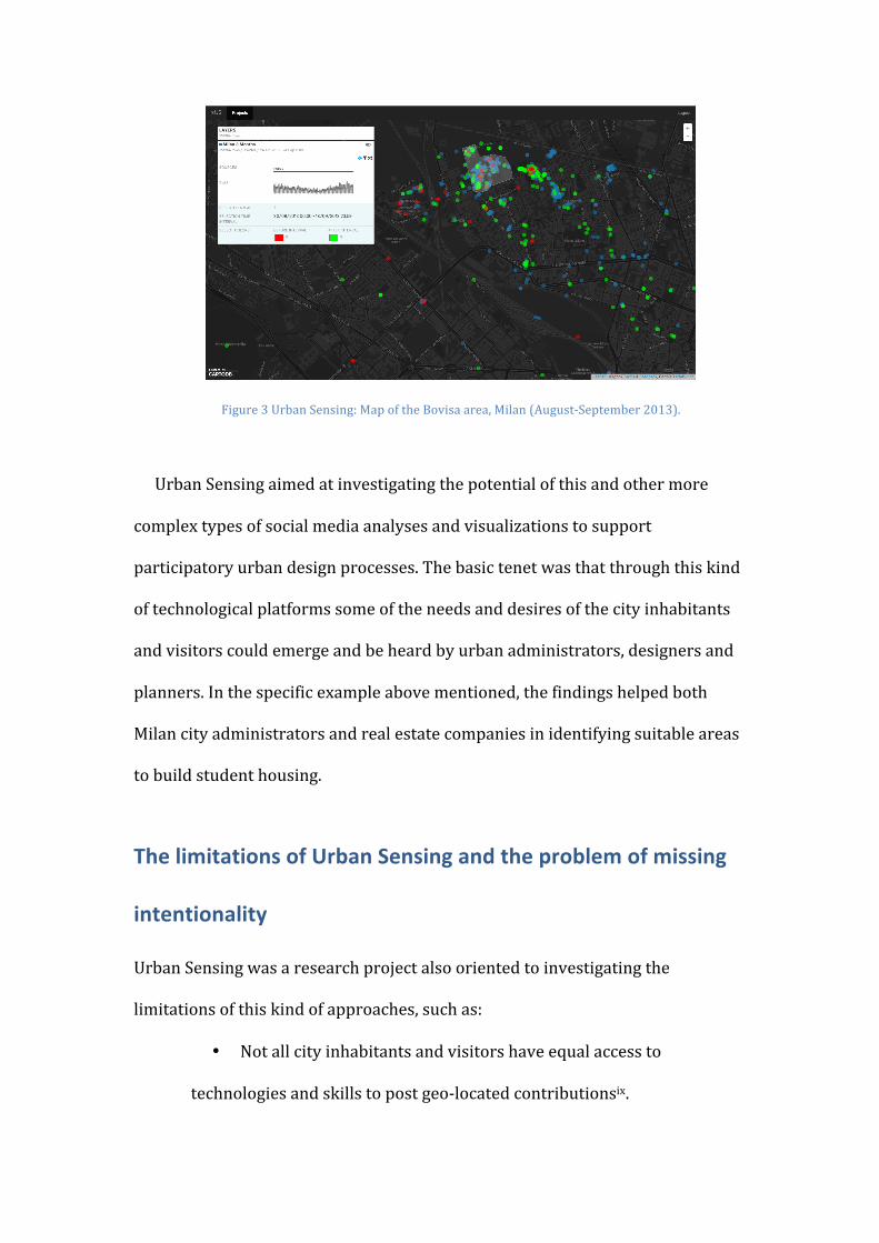
Figure 3 Urban Sensing: Map of the Bovisa area, Milan (August-‐September 2013).
Urban Sensing aimed at investigating the potential of this and other more
complex types of social media analyses and visualizations to support
participatory urban design processes. The basic tenet was that through this kind
of technological platforms some of the needs and desires of the city inhabitants
and visitors could emerge and be heard by urban administrators, designers and
planners. In the specific example above mentioned, the findings helped both
Milan city administrators and real estate companies in identifying suitable areas
to build student housing.
The limitations of Urban Sensing and the problem of missing
intentionality
Urban Sensing was a research project also oriented to investigating the
limitations of this kind of approaches, such as:
• Not all city inhabitants and visitors have equal access to
technologies and skills to post geo-‐located contributionsix.
• Although Urban Sensing fully respected the guidelines offered by
each social media platform in terms of privacy policy and in some cases
also applied anonymization techniques (Naor and Yung 1989), there are
still serious issues in terms of privacy.
• The accuracy of geo-‐located social media analyses is affected by
the distribution of free WIFI networks. Especially tourists visiting foreign
countries might not have data plans that allow a constant Internet
connection. In these cases, they might still travel with their smartphone
and use it, for example, to take pictures or notes to be shared at a later
stage when they have access to a WIFI network (typically, either a free or
public one or the one at their hotel). Obviously, the distribution of these
WIFI networks in the city affects the geographic dimension of social
media analyses, as a large number of contributions might emerge in areas
where accessible WIFI networks are located.
Elsewhere, these limitations of Urban Sensing have been more thoroughly
described (Ciuccarelli, Lupi, and Simeone 2014).
I want to focus here on the problem of the lack of intentionality.
Urban Sensing does not only collect users’ contributions related to the context
of their use and perception of the city but also all kinds of contributions such as
private comments or conversations with friends that are completely unrelated to
urban issues. In most of the collected contributions, there is no clear
intentionality from the users to post a tweet, share a picture on Instagram or
check-‐in at Foursquare as actions to influence urban planning and management
processes. Can this lack of intentionality undermine the potential of this kind of
platforms as tools for more participatory processes?
Participatory design has been defined as a “process of investigating,
understanding, reflecting upon, establishing, developing, and supporting mutual
learning between multiple participants” who strongly contribute to the design
activities (Simonsen and Robertson 2013, 2). In the specific context of Urban
Sensing, this definition highlights the need for the users to become part of the
design process (as participants) through a specific act of will. As of now, with the
current instance of the platform, the users are somewhat passive and, in the vast
majority of cases, do not even know that the platform exists and is monitoring
them.
Some authors have warned against those technocratic approaches that praise
the potential of urban informatics as a way of monitoring, controlling, and
seamlessly operating the city (Mitchell 2005; Foth 2009; Greenfield and Shepard
2007; Ratti and Townsend 2011). As Ratti and Townsend argued: ‘‘Rather than
focusing on the installation and control of network hardware, city governments,
technology companies and their urban-‐planning advisers can exploit a more
ground-‐up approach to creating even smarter cities in which people become the
agents of change’’ (Ratti and Townsend 2011, 44).
Platforms and approaches such as Urban Sensing can easily become
instruments of control and surveillance if the users are not actively involved as
participants. In order to tackle this risk, the users first need to be aware of these
platforms and of how they can control their interaction with them (Galloway
2004). Secondly, it is important to set mechanisms of participation that
guarantee that all city stakeholders have sustained access to these platforms as
tools of expression, investigation and critique. It is only when the city
stakeholders (a) are aware of the potential and the limitations of platforms such
as Urban Sensing, (b) are in the conditions of actively participating and (c) their
agency is framed by a clear intentionality, that they become agents of change and
not passive recipients of top-‐down approaches.
Final remarks
In a way, Urban Sensing showed how social media analyses could support urban
design, decision-‐making and administration, but at present there are still serious
shortcomings for these approaches to be used as a tool of collaborative
intervention. The lack of intentionality on the users side is one of these
limitations and undermines the potential of these approaches in terms of
widened participation.
References
Ciuccarelli, Paolo, Giorgia Lupi, and Luca Simeone. 2014. Visualizing the Data City -‐ Social Media as a Source of Knowledge for Urban Planning and Management. Milan, Heidelberg, New York, Dordrecht, London: Springer.
Foth, Marcus, ed. 2009. Handbook of Research on Urban Informatics : The Practice and Promise of the Real-‐Time City. Hershey PA: Information Science Reference.
Galloway, Anne. 2004. “Intimations of Everyday Life: Ubiquitous Computing and the City.” Cultural Studies 18 (2-‐3): 384–408. doi:10.1080/0950238042000201572.
Girardin, Fabien, Francesco Calabrese, Filippo dal Fiore, Carlo Ratti, and Josep Blat. 2008. “Digital Footprinting: Uncovering Tourists with User-‐Generated Content.” IEEE Pervasive Computing 7 (4): 36–43.
Greenfield, Adam, and Mark Shepard. 2007. Urban Computing and Its Discontents. New York: The Architectural League of New York.
Kotov, Alexander, ChengXiang Zhai, and Richard Sproat. 2011. “Mining Named Entities with Temporally Correlated Bursts from Multilingual Web News Streams.” In Proceeding of WSDM ’11, ACM International Conference on Web Search and Data Mining, 237–46. New York.
Liu, Xiaohua, Long Jiang, Furu Wei, Ming Zhou, and QuickView Team Microsoft. 2011. “QuickView: Advanced Search of Tweets.” In SIGIR ’11 Proceedings of the 34th International ACM SIGIR Conference on Research and Development in Information Retrieval, 1275–76. New York.
Lupi, Giorgia, Paolo Patelli, Luca Simeone, and Salvatore Iaconesi. 2012. “Maps of Babel. Urban Sensing through User Generated Content.” In Proceedings of Human Cities Symposium. Brussels (BE).
Mitchell, William John. 2005. Placing Words. Cambridge Mass.: MIT Press. Naor, Moni, and Moti Yung. 1989. “Universal One-‐Way Hash Functions and Their
Cryptographic Applications.” In ACM Symposium on Theory of Computing. New York.
Ratti, Carlo, and Anthony Townsend. 2011. “The Social Nexus.” Scientific American September: 42–48.
Shi, George, and Ken Barker. 2011. “Thematic Data Extraction from Web for GIS and Application.” In IEEE International Conference on Spatial Data Mining and Geographical Knowledge Services, 273–78. Fuzhou, China.
Simonsen, Jesper, and Toni Robertson, eds. 2013. Routledge International Handbook of Participatory Design. New York: Routledge.
Zook, Matthew, and Mark Graham. 2007. “Mapping DigiPlace: Geocoded Internet Data and the Representation of Place.” Environment and Planning B: Planning and Design 34 (3): 466–82.
i A more thorough description of Urban Sensing is offered in Ciuccarelli, Lupi,
and Simeone (2014).
ii http://www.bartlett.ucl.ac.uk/casa accessed 27 August 2014.
iii http://www.spatialinformationdesignlab.org/ accessed 27 August 2014.
iv http://senseable.mit.edu accessed 27 August 2014.
v http://www.softhook.com/ accessed 27 August 2014.
vi http://www.artisopensource.net/ accessed 27 August 2014.
vii http://stamen.com/ accessed 27 August 2014.
viii T-‐Connect and Accurat from Italy, IT4All from France, the Technical
University of Kosice from Slovakia, Mobivery from Spain and LUST from the
Netherlands.
ix According to Gartner (June 2014), smartphones account for 66% of all
mobile phone global sales in 2014. A significant percentage of population still
buys phones, which are not fully equipped to access mobile apps and social

networks. The Portio Research (March 2013) showed that only 30% of the
population in Europe used mobile apps at the end of 2012.


