Embed Size (px)
Citation preview
International Journal of Environmental Protection and Policy 2020; 8(6): 123-128
http://www.sciencepublishinggroup.com/j/ijepp
doi: 10.11648/j.ijepp.20200806.13
ISSN: 2330-7528 (Print); ISSN: 2330-7536 (Online)
Mountain Farmers' Perception of on-farm Environmental Degradation, the Case of Damota, Southern Ethiopia
Getahun Garedew Wodaje
Department of Environmental Science, Wolaita Sodo University, Wolaita Sodo, Ethiopia
Email address:
To cite this article: Getahun Garedew Wodaje. Mountain Farmers' Perception of on-farm Environmental Degradation, the Case of Damota, Southern Ethiopia.
International Journal of Environmental Protection and Policy. Vol. 8, No. 6, 2020, pp. 123-128. doi: 10.11648/j.ijepp.20200806.13
Received: November 24, 2020; Accepted: December 18, 2020; Published: December 25, 2020
Abstract: Mountain people understand environmental degradation only at times when they lost the production options of their
farmlands that sustained them in the past. This study was conducted to assess the farmers’ perception of on-farm environmental
degradation in mount Damota, Southern Ethiopia. Data collection techniques used in this study was interviews, focus group
discussions, field observations and questionnaires. Multi-stage Purposive and Systematic sampling technique methods were
used to select study sites and households, respectively. Using systematic sampling technique from all the four kebeles of the
Woreda a total of 200 households was selected. Data were presented in descriptive statistics. The result of the study shows that
almost all households appreciate the causes, indicators and problems of on-farm environmental degradation. 69% of the
respondents agree that their land is severely eroded while 24.5% say it is moderate on their land holding. Only 6.5% say the
erosion rate is slight on their land holding and none of the respondents doubt the problem of soil erosion on their agricultural
productivity and natural resource base. The main reason of depletion of the natural vegetation as perceived by the respondents
is clearance of the forest for farming, over grazing and timber cutting. About the climatic problems of farm lands on the
mountain, flood during the rainy season (which is also the growing season) is their main problem and windstorm and drought
were also seen by the study population as the main climatic problem of the area.
Keywords: Perception of Farmers, Damota Mountain, Environmental Degradation
1. Introduction
Different biophysical variables in a given area make up the
environment and the interactions of these variables were
influenced by socioeconomic factors of the area. Moreover,
the biophysical factors generating environment as a joint
product are not only contributors to but also products of the
environment [5, 10].
The process of environmental changes can be presented as
a rate and pattern of deforestation, soil erosion, disruption in
water movements, reduction in biodiversity, and
interdependence of various biophysical variables as a part of
regenerative process [4, 6]. In Ethiopia, natural resources are
under the influence of various interrelated factors like
population pressure, agricultural expansion, resettlement,
climate change, and environmental pollution. Because of its
rugged topography and unsustainable land management
practices soil degradation is common throughout the country
and it decreased land productivity and also increased social
problems [7].
Physical attributes (topography, altitude, slope, etc) play an
important role in environmental changes [16]. Therefore,
when dealing with mountain areas, Specific conditions or
characteristics of mountain areas that arise due to the
physical attributes need to be considered. The mismatch
between mountain conditions and human activities,
insensitive to the limitations of the resource base, leads to
environmental degradation [5].
People residing in the mountain understand environmental
degradation only at times when they lost the production
options of their farmlands. These farmers, owning small
degraded land, obliged to produce more than ever before due
to the increasing number of people without any viable
technologies. These lead to negative environmental changes
on the lands of mountains [6, 17]. The Ethiopian mountains are experiencing serious
environmental problems as a result of deforestation,
overgrazing, agricultural encroachment and the unregulated
124 Getahun Garedew Wodaje: Mountain Farmers' Perception of on-farm Environmental
Degradation, the Case of Damota, Southern Ethiopia
use of agrochemicals, which in turn caused food shortage and
degradation of natural resources. Mountain agriculture was
seemingly sustainable till population pressure was low and
ultimate goal of agriculture was to achieve local production
based food security. But with integration of mountain
societies in to the mainstream market, the management goal
has been shifting more and more towards profit maximization
[3, 13, 15].
In Mount Damota, as in other mountainous areas, there are
strong causal relationships among the state of the
environment, human well-being and vulnerability.
Environmental assets that can provide important
opportunities for improving the human well-being are being
over exploited. Natural hazards, such as floods, droughts, and
landslides also threaten everyone residing on the mountain.
So it is compulsory to see the current land related negative
environmental changes with respect to the high level of
human interventions. This research was intended to evaluate
how local communities’ perceive their environment in order
to help understand the causes of ecological degradation on
Mount Damota and Point out indicators of un-sustainability
that face their farming system.
2. Materials and Methods
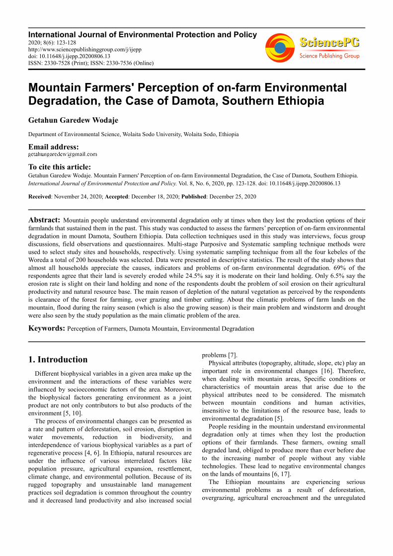
2.1. Description of the Study Area
Mount Damota is located in south central Ethiopia
between 6.4°-6.9° N latitude and 37.4°-37.8° E longitude and
is at 390km distance from Addis Ababa, the capital city of
Ethiopia. The Mountain is found in the Wolaita zone of the
Southern Nations Nationalities and Peoples Regional State
(SNNPRS), and holds three Woredas of the Zone.
The mean annual temperature of the Damota area varies
from 16°C to 19.9°C and the annual monthly temperature
varies throughout the year from 16°C to 19.7°C. The absolute
maximum temperature occurs in mid-march and is about 28°C
and the absolute minimum temperature occurs in November
and is about 10.8°C. The annual mean rainfall from the records
in the nearby stations is around 1375 mm. Mount Damota is a
part of the most densely populated area in the country and is
being cultivated up to the top even on steep slopes [11].
Figure 1. Map of the study area.
2.2. Data Collection and Sampling Technique
Multi-stage Purposive and Systematic sampling technique
methods were used to select study sites and households,
respectively. The first stage was to apply purposive sampling
techniques and therefore Damot gale Woreda was selected
from the other two Woredas due to its more human
encroachment on Damota mountain and because the majority
of the kebeles are exposed to degradation problems. In stage
two four Kebeles were purposively selected from the Damot
Gale Woreda. This is based on their higher population density
and human encroachment as well as the degree of
disturbance of the natural resources that represent the various
topographic features and land use patterns. These are:
Akabilo, Woshi Gale, Wondara Gale and Wondara Boloso
International Journal of Environmental Protection and Policy 2020; 8(6): 123-128 125
Kebeles. In the third stage a random sampling technique was
employed to take representative respondents from the
selected kebeles. Thus, the sample size for the study was 200
and the researcher used systematic sampling technique from
all the four kebeles of the woreda. Accordingly, from the
registry-frame of kebeles, 50 households from each kebele
were selected. Considering the homogeneity of the
households in their livelihood is more representative to the
rest of the population.
2.3. Methods of Data Analysis
Descriptive statistical procedure of the statistical package
for the social sciences (SPSS version 20) was used in
analyzing and summarizing the data obtained through
questionnaires survey. The qualitative description was used
to describe data acquired through focus group discussions
and field observations.
3. Results and Discussion
3.1. Household and Farm Characteristics
The survey revealed that 100 percent of the households
were farm dependent and the household size was between 2
and 17 with a mean of 7.6 members. Across the households,
the average land size is 0.54 hectares and only 2.5 percent of
the households have land size of more than 1 hectare. Fifty four percent of the land is owned before 15 years and
owing to saturation of fragmentation, the amount of the land
owned in the last 5 years (by all means i.e. from family,
government, purchased and cleaned forest) is only 9 percent
of the total owned land. Young men used to inherit land from
their parents when they got married, but this rarely happens
now that households have such smallholdings. This resulted
in such an extended family size (of 7.6/HH) when compared
to a regional average of 4.7 persons per household and a
zonal average of 4.9 persons per household.
Agriculture in the study area is mainly subsistent rain-fed
crop cultivation practice, with little use of modern
agricultural inputs and supplemented with some livestock
production. Crop cultivation is carried out on land ranging
from gentle to very steep slopes. Although different types of
crops are cultivated, the most predominant one are Maize,
Barely, Wheat, Bean & pea, Root crops and Enset. This
constitutes the basis of the economy of the Damota area.
Wolaita zone in southern Ethiopia is known for its high
population density in the country. Districts of Soddo zuria,
Boloso sore and Damot Gale with a population density of
600, 678 and 781 per square kilometer are parts of the zone
where Mount Damota lies (Regional bureau of Finance and
Economic Development Division of statistics and population,
2007). These already saturated areas are also expected to
continue with at least 2.9% annual population growth rate of
the regional average.
Since 2004 the average population growth rate of the study
Kebele’s were 3.13%, 3.0%, 2.99% and 3.01% for Akabilo,
Woshi Gale, Wondara Gale and Wondara boloso respectively
[11]. This result shows that, though the study area is located
on a highly fragile mountain side, its population continued to
grow with rates comparable to that of the nearby plain areas.
3.2. Farmers’ Perception on Agricultural Problems
Informants told that they face four most significant
problems related to agricultural production. Rain fall
variability (71.4%) and landslide (18.1%), decline in soil
fertility (10.1%t) and the prevalence of weeds; insect pest
and disease problem (0.5%) were the highest agricultural
problems perceived by the farmers in the study area. As
understood from the group discussions, agriculture in the
study area suffers from erratic rainfall characteristics and its
variability especially during the onset of the growing season.
Landslide on the marginal farmlands occurring during the
rainy seasons is also another threat for them and their cattle’s.
Table 1. Major agricultural production and environmental problems Perceived by the farmers.
Major agriculture production
problems
Akabilo Woshi Gale Wondara boloso Wondara Gale Over all
Frequency % Frequency % Frequency % Frequency % Frequency %
Decline of soil fertility 0 0 3 6 11 22 7 14 20 10.1
Land slide 1 2 4 8 14 28.6 17 34 36 18.1
Rain fall variability 49 98 43 86 25 51 25 50 142 71.4
Damage by pest and disease 0 0 0 0 0 0 1 2 1 0.5
Total 50 100 50 100 50 100 50 100 200 100
The over exploitation of natural resources without
considering their regenerative capacity of a given area raises
a question of biodiversity loss in that locality. In interviews
during the field survey it is understood that people of the
study area are aware of the loss of some native species. The
bamboo tree which has been the alternative income source by
its production and bamboo craft works in the nearby towns is
no more available for these purposes.
Negative changes in environmental parameters like
land/topsoil fertility; vegetation, water flows and seasonal
stresses; can show the unsustainable condition of a given agro-
ecology [5].
In cultural farming system of Wolaita the homestead fields
closer to resident were very fertile while the out fields were less
fertile across farms. So, the soil fertility gradient decreases
within a farm with distance from the home due to management
differences [9, 12].
In addition to this problem of non-uniformity,
deforestation and the use of crop residues and manure as fuel
are causes of soil degradation and accelerated erosion. But
126 Getahun Garedew Wodaje: Mountain Farmers' Perception of on-farm Environmental
Degradation, the Case of Damota, Southern Ethiopia
Cultivation of steep slopes stands above all land related
problems of the Mountain. The Damota farmers till the land
with ox ploughs, using the local maresha to prepare seedbeds
and control weeds. According to traditional wisdom, well-
tilled soils produce higher yields, so they aim to till several
times a year, regardless of slope.
Although, the farmers are using the traditional terracing
method and inorganic fertilizers for soil conservation and
fertility management of their farmland it is hardly possible
for them to produce cereals with a minimum soil lose in such
steep slope farmland. The farmers also agree that sooner or
later their farm land will be abandoned because of the loss of
top soil and un-sustainability of their farming system.
Table 2. How did you see the agricultural production of your Kebele in the
last 20 years?
Frequency Percent
Valid
Reduced 149 74.5
Increased 46 23.0
Constant 3 1.5
Cannot determine 2 1.0
Total 200 100.0
74 percent of the respondent farmers argued that the
agricultural production of their Kebele was reduced in the
last 20 years. The 23 percent, who said that the production is
increased, also pointed out their mechanism for production
increase is agricultural land expansion. Older farmers were
repeatedly reported a decline in yields due to deteriorating
soil conditions. They complained that they were able to
harvest much greater product from their small farm than what
could be obtained from a much larger farm today. But this
couldn’t be substantiated by Comparative yield statistics due
to unavailable of such a data.
3.3. Farmers’ Perception of Resource Degradation
Farmers’ perception and attitude towards conservation of
natural resources can have major bearing on resource
management [2]. To identify the most important agricultural
and environmental issues and traditional conservation
practices in the study area, households were asked to indicate
the current state of natural resources and the extent of the
problem. In addition, a group discussion was held with
community elders to enrich the data.
Degradation is associated with the destruction of natural
forests, overgrazing, hillside demolition, and the increasingly
intensive use of land for crops in the absence of conservation
measures. In the study area, marginal land is being cultivated
in response to the shortage of farmland in the mountains due
to increasing population pressure.
The major cause of land degradation in mountain areas is
soil erosion which depends both on natural conditions and on
land use patterns. Under natural condition the climate
(especially rain intensity), slopes, vegetation cover and the
nature of the soil are important parameters. With regard to
land use the major one human activity, which entails the
removal of the protective vegetation cover, is improper
measures such as ploughing along slopes [14].
69% of the respondents agree that their land is severely
eroded while 24.5% say it is moderate on their land holding.
Only 6.5% say the erosion rate is slight on their land holding
and none of the respondents doubt the problem of soil
erosion on their agricultural productivity and natural resource
base. During the survey some respondents argued that their
land is moderately eroded while there is already gully
formation on their farmland. This is because they compare
their farm with the already abandoned land due to severe
erosion on the steep slopes.
Table 3. The current state of soil erosion as perceived by farmers of the Study Area.
Type of
erosion rate
Akabilo Woshi Gale Wondara boloso Wondara Gale Overall
Fre. % Fre. % Fre. % Fre. % Fre. %
Slightly eroded 0 0 7 14 0 0 6 12 13 6.5
Moderately eroded 0 0 29 58 9 18 11 22 49 24.5
Severely eroded 50 100 14 28 41 82 33 66 138 69.0
Total 50 100 50 100 50 100 50 100 200 100
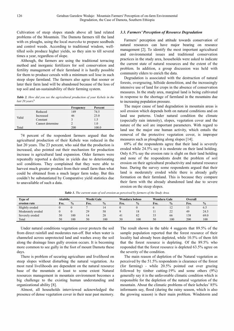
Under natural conditions vegetation cover protects the soil
from direct rainfall and moderates run-off. But when water is
channeled across unprotected land and washes away the soil
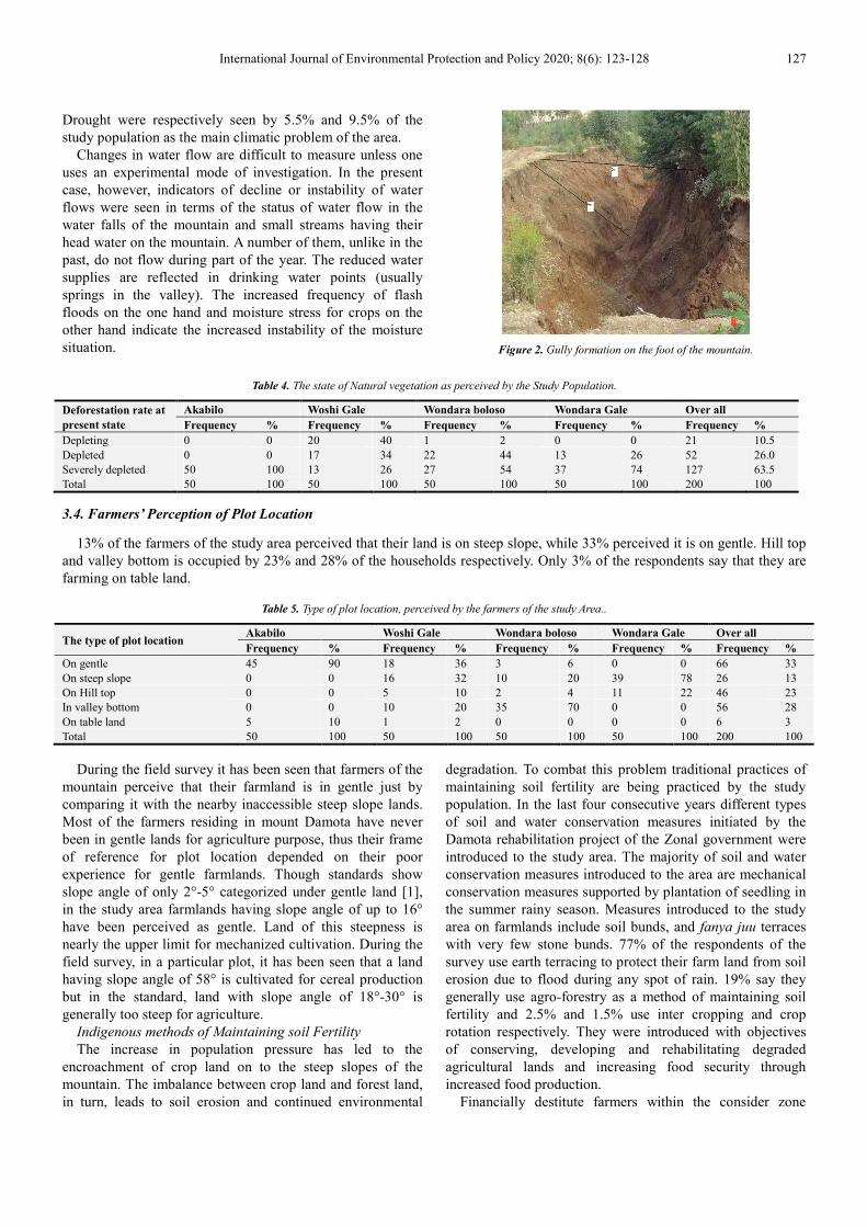
along the drainage lines gully erosion occurs. It is becoming
more common to see gully in the foot of mount Damota these
days.
There is problem of securing agriculture and livelihood on
steep slopes without disturbing the natural vegetation. As
most rural livelihoods are dependent on the natural resource
base of the mountain at least to some extent Natural
resources management in mountain environment becomes a
big challenge to the existing human understanding and
organizational ability [8].
Almost, all households interviewed acknowledged the
presence of dense vegetation cover in their near past memory.
The result shown in the table 4 suggests that 89.5% of the
sample population reported that the forest resource of their
locality had already been depleted, while 10.5% of them felt
that the forest resource is depleting. Of the 89.5% who
responded that the forest resource is depleted 63.5% agree on
the severity of the condition.
The main reason of depletion of the Natural vegetation as
perceived by the 51.5% respondents is clearance of the forest
(for farming) - while 20.5% pointed out over grazing
followed by timber cutting-19% and some others (9%)
generally say it is the unfavorable climatic condition which is
responsible for the depletion of the natural vegetation of the
mountain. About the climatic problems of their kebeles’ 85%
informants say, flood (during the rainy season, which is also
the growing season) is their main problem. Windstorm and
International Journal of Environmental Protection and Policy 2020; 8(6): 123-128 127
Drought were respectively seen by 5.5% and 9.5% of the
study population as the main climatic problem of the area.
Changes in water flow are difficult to measure unless one
uses an experimental mode of investigation. In the present
case, however, indicators of decline or instability of water
flows were seen in terms of the status of water flow in the
water falls of the mountain and small streams having their
head water on the mountain. A number of them, unlike in the
past, do not flow during part of the year. The reduced water
supplies are reflected in drinking water points (usually
springs in the valley). The increased frequency of flash
floods on the one hand and moisture stress for crops on the
other hand indicate the increased instability of the moisture
situation.
Figure 2. Gully formation on the foot of the mountain.
Table 4. The state of Natural vegetation as perceived by the Study Population.
Deforestation rate at
present state
Akabilo Woshi Gale Wondara boloso Wondara Gale Over all
Frequency % Frequency % Frequency % Frequency % Frequency %
Depleting 0 0 20 40 1 2 0 0 21 10.5
Depleted 0 0 17 34 22 44 13 26 52 26.0
Severely depleted 50 100 13 26 27 54 37 74 127 63.5
Total 50 100 50 100 50 100 50 100 200 100
3.4. Farmers’ Perception of Plot Location
13% of the farmers of the study area perceived that their land is on steep slope, while 33% perceived it is on gentle. Hill top
and valley bottom is occupied by 23% and 28% of the households respectively. Only 3% of the respondents say that they are
farming on table land.
Table 5. Type of plot location, perceived by the farmers of the study Area..
The type of plot location Akabilo Woshi Gale Wondara boloso Wondara Gale Over all
Frequency % Frequency % Frequency % Frequency % Frequency %
On gentle 45 90 18 36 3 6 0 0 66 33
On steep slope 0 0 16 32 10 20 39 78 26 13
On Hill top 0 0 5 10 2 4 11 22 46 23
In valley bottom 0 0 10 20 35 70 0 0 56 28
On table land 5 10 1 2 0 0 0 0 6 3
Total 50 100 50 100 50 100 50 100 200 100
During the field survey it has been seen that farmers of the
mountain perceive that their farmland is in gentle just by
comparing it with the nearby inaccessible steep slope lands.
Most of the farmers residing in mount Damota have never
been in gentle lands for agriculture purpose, thus their frame
of reference for plot location depended on their poor
experience for gentle farmlands. Though standards show
slope angle of only 2°-5° categorized under gentle land [1],
in the study area farmlands having slope angle of up to 16°
have been perceived as gentle. Land of this steepness is
nearly the upper limit for mechanized cultivation. During the
field survey, in a particular plot, it has been seen that a land
having slope angle of 58° is cultivated for cereal production
but in the standard, land with slope angle of 18°-30° is
generally too steep for agriculture.
Indigenous methods of Maintaining soil Fertility
The increase in population pressure has led to the
encroachment of crop land on to the steep slopes of the
mountain. The imbalance between crop land and forest land,
in turn, leads to soil erosion and continued environmental
degradation. To combat this problem traditional practices of
maintaining soil fertility are being practiced by the study
population. In the last four consecutive years different types
of soil and water conservation measures initiated by the
Damota rehabilitation project of the Zonal government were
introduced to the study area. The majority of soil and water
conservation measures introduced to the area are mechanical
conservation measures supported by plantation of seedling in
the summer rainy season. Measures introduced to the study
area on farmlands include soil bunds, and fanya juu terraces
with very few stone bunds. 77% of the respondents of the
survey use earth terracing to protect their farm land from soil
erosion due to flood during any spot of rain. 19% say they
generally use agro-forestry as a method of maintaining soil
fertility and 2.5% and 1.5% use inter cropping and crop
rotation respectively. They were introduced with objectives
of conserving, developing and rehabilitating degraded
agricultural lands and increasing food security through
increased food production.
Financially destitute farmers within the consider zone
128 Getahun Garedew Wodaje: Mountain Farmers' Perception of on-farm Environmental
Degradation, the Case of Damota, Southern Ethiopia
lease their own farm lands for other financially way better
ranchers. This in turn influenced the execution of
preservation practices negatively.
Table 6. Indigenous practices to maintain soil fertility as practiced by
respondents.
Indigenous practices Frequency Percent
Earth terraces 154 77
Agro-forestry 38 19
Inter cropping 5 2.5
Crop rotation 3 1.5
Total 200 100
4. Conclusion
In this paper an attempt has been made to review the
causes of ecological degradation on Mount Damota and Point
out indicators of un-sustainability that face their farming
system as perceived by local farmers. The results in this
study revealed that there are limited alternatives to land use
other than farming and cultivation of steep slopes has led to
severe soil erosion. From the present finding it is clear that
the study area is under serious threat of environmental
degradation which is found to be mainly human induced.
Increasing human population on top of poor planning forced
farmers to use the land more intensively and more frequently.
Careful investigation and immediate intervention from all
concerned bodies to implement integrated environmental
rehabilitation strategies is mandatory. Existing biophysical,
socioeconomic, and institutional conditions need
amendments based on further study.
References
[1] Alan, C. and Peter, C. 1987. Process and land forms. Conceptual frameworks in geography. Oliver and Boyed.
[2] Ayana, A., Vandenabeele, N. and Arts, B. 2017. Performance of participatory forest management in Ethiopia: institutional arrangement versus local practices, Critical Policy Studies 11: 1, 19-38, DOI: 10.1080/19460171.2015.1024703.
[3] Birhanu, A., 2014. Environmental Degradation and Management in Ethiopian Highlands: Review of Lessons Learned. International Journal of Environmental Protection and Policy 2 (1): 24.
[4] Ibisch, P. L. & A. Vega E., T. M. Herrmann (eds.) 2010. Interdependence of biodiversity and development under global change. Technical Series No. 54. Secretariat of the Convention on Biological Diversity, Montreal (second corrected edition).
[5] Jeanne x., Roger E. and Turner, B. L. 1995. Regions at risk: comparison of treated environment. United Nations university press, Tokyo.
[6] Kasperson, J. X., Kasperson, R. E. and Turner, B. L. 1995. Regions at risk: comparisons of threatened environments. New York: United Nations University Press.
[7] Merkineh M M, Aklilu B M, Efrem G, Gashaw G. Community Adoption of Watershed Management Practices at Kindo Didaye District, Southern Ethiopia. Int J Environ Sci Nat Res. 2018; 14 (2): 555881. DOI: 10.19080/IJESNR.2018.14.555881.
[8] Sati, V. P. 2004. Resource Utilization Pattern and Development in Hills: A Case for the Pindar Basin of Garhwal Himalaya, India. Journal of Mountain Science, 1 (2). PP. 155~165.
[9] Soil Conservation Research Programme (SCRP). 1996. Data base report (1982-1993) Series II: Gununo Research Unit, University of Berne, Berne.).
[10] Sherbinin, A., Carr, D., Cassels, S., and Jiang, L. 2007. Annual Review of Environment and Resources. Population and Environment 32 pp 345-373.
[11] SNNPR Regional Bureau of Finance and economic dev. Division of statistics and population, 2007. socio-economic profile of the SNNPR region.
[12] Tilahun Amede, and Endale Taboge. 2004. Enhancing farmer innovation through manipulation of soil fertility gradients in Enset systems. Paper presented at the African Soils Network (AFNet) Conference (In press). Yaoundé, Cameroon.
[13] Tilahun Amede, Takele Belachew and Endrias Geta. 2001. Reversing Degradation of Arable Lands in Southern Ethiopia. African Highlands Initiative (AHI). Working Papers # 1.
[14] United nations population information network (POPIN). 1995. Background document on the population programme of the united nations. UN Population Division, Department of Economic and Social Affairs.
[15] Wassie, S. B., 2020. Natural resource degradation tendencies in Ethiopia: a review. Environmental Systems Research 9 (33).
[16] Wondie, M., Teketay, D., Melesse, A. M. and Schneider, W. 2012. Relationship between Topographic Variables and Land Cover in the Simen Mountains National Park, a World Heritage Site in Northern Ethiopia. International Journal of Remote Sensing Vol. 2.
[17] Wymann von Dach S, Romeo R, Vita A, Wurzinger M, Kohler T (eds). 2013. Mountain Farming Is Family Farming: A contribution from mountain areas to the International Year of Family Farming 2014. Rome, Italy: FAO, CDE, BOKU, pp. 100.


