Embed Size (px)
Citation preview

' •••
n.,3,̂ CORNISHARCHAEOLOGY
HENDHYSCANSKERNOW

C o v e r : Cornish Archaeology, a study in vertical forms by our member Marjorie I. Somerscales. © The Society, 1963.
Cornwall Archaeological Society
PresidentC . A. R a l e g h Ra d f o r d , m .a ., d .l it t ., f .b .a ., f .s .a ., f .r .h ist .s .
Vice-PresidentsMiss D o r o t h y D u d le y , m .a., f .s .a .R . H . C orfield
Professor E. M. Jope, m .a ., b .sc ., f .s .a .
Hon. SecretaryMrs. F l o r e n c e N a n k i v e l l , Bosgea, Steeple Lane, St. Ives
Hon. TreasurerP . A . S. P o o l , m .a., 59b, Causewayhead, Penzance
Hon. EditorC h a r le s T h om as, m .a., f .s .a . , Churchtown, Gwithian, Hayle
Hon. Photographic EditorC h a r l e s W o olf, m .p .s .
Director, season 1964 M rs. E. M arie M inter
General Committee 1964Ex officio t h e o f f i c e r s o f t h e s o c ie t y
D e sm o n d B o n n e y , b .a . ( Wadebridge), M rs. P a t r ic ia C h r is t ie (London)
H . L . D o u c h , b .a . {Truro), J o h n L in g w o o d (Reading), W . B. P ic a r d (Mousehole),
R . B. W a r n e r (Chacewater), C h a r le s W o o l f , m .p.s. (Newquay);
Co-opted, A. G u t h r ie (St. Ives)-, also E. J. W ig le y , b .e.m ., and Mrs. J. W ig le y , representing the Wayside Museum, Zermor
m e m b e r s h ip o f t h e s o c i e t y is open to all individuals or groups interested in the history and material culture of Cornwall and the Isles of Stilly. The annual subscription (£1.0.0, or 10/- for full-time students and those under 21) is payable each January 1st, and entitles members to receive the Society’s annual journal, and to be notified of all activities. At least one excavation is held annually, and the A.G.M. takes place in late July or early August.Enquiries about membership, or requests for any publications of the Society or the former Field Club, should be sent to the Secretary.
Designed by Ian Mackenzie Kerr, a .r .c .a ., and printed in Cornwall by H. E. Wame Ltd., St. Austell

Contents
CORNISH ARCHAEOLOGY NO. 3 1 9 6 4
Editorial
The Society’s 1962 Excavations: The Henge at CastillyC h a r l e s T h o m a s , m .a ., f .s .a .
Excavation of a Menhir at Try, GulvalV iv ie n R u s s e l l a n d P . A . S. P o o l , m .a .
The Rumps, St. Minver: Interim Report on the 1963 ExcavationsR. T. B r o o k s
Nineteenth-Century Discoveries at LelantC y r i l N o a l l
Minor Sites in the Gwithian Area (Iron Age to Recent)C h a r l e s T h o m a s , m .a ., f .s .a .
Launceston Castle: An Interim ReportA n d r e w S a u n d e r s , m .a ., f .s .a .
Settlement-History in Early Cornwall: I, The HundredsC h a r l e s T h o m a s , m .a ., f .s .a .
Industrial ArchaeologyK e n n e t h H u d s o n
SeriesExcavation News, 1963-1964Digest of Cornish Periodicals: 3, 1963-1964Parochial Check-Lists of Antiquities: Hundred of Penwith (West):
7 , Penzance and M adron (V. R u s s e l l ) . Hundred of Powder:1, Kea. 2 , St. Allen ( R . B. W a r n e r )
Cumulative Index of Cornish Archaeology, List No. 12: April 1963-March 1964
Short NotesThe Deserted Village of Sheepstall M. I. S o m e r s c a l e s
Interesting Discovery near Bude Carew’s ‘Survey of Cornwall’Tolcreeg Barrow, Gulval P . A . S . P o o l , m .a .
2
3
15
26
34
37
63
70
80
8388
90
100
102
Reviews 107

Editorial
T h e S o c ie t y ’s past year has been noteworthy, not only for the outstanding success of our first season at The Rumps, St. Minver, under R. T. Brooks’ leadership (this issue, pp.26 - 33), but also for the continued increase in membership. When we came into being in 1961, even the most sanguine proponents of the new body did not dare to envisage a membership greater than three hundred. As I write (March, 1964), it stands, with block subscribers, at about 380, and we hope to attain our 1964 target of four hundred without too much difficulty.
It is perhaps worth pausing to define our standpoint. The expansion of an established, but numerically weak, Field Club into a county society was admittedly a gamble. In all such cases, tactically there must be room for such a society, and a popular demand for it; financially, the increases in publications and other facilities should not immediately lead to a rise in the annual subscription; and socially, new members should feel that they have adequate committee representation, a chance to participate in excavation, in fieldwork, and in print, and are not just so many new entries in a treasurer’s ledger. The enlarged Committee has given a great deal of thought to all these points. It feels now that, despite some anxious moments in the first financial year (when Field Club reserves had to be expended to launch both society and journal), this particular gamble has come off; and that the small beginnings at Porthm eor in the far-off 1930s have grown, logically and smoothly, into a body really representative of what is being done (and what can be done) in Cornish archaeology.
The last thing that we would wish is to be considered as in competition with our sister-organisations, particularly the Royal Institution o f Cornwall and the Federation of Old Cornwall Societies. A high percentage—probably over a third—of our members also belong to these, and other more specialised, county bodies. We see ourselves (quite apart from the conduct of excavations) as offering, firstly, a new journal with a larger form at suitable for excavation reports, thus relieving JR IC and Old Cornwall of an awkward burden; secondly, through our annual serial items, the raw material for research, much of which would overcrowd other journals; and thirdly, through centralised oversight of our various field activities, a framework specifically intended to keep archaeological work in Cornwall along the most up-to-date British (which is to say European) lines.
It would be impossible to allow the resignation of our senior Vice-President, Miss Ada Williams of Penzance, to pass without proper comment. Miss Williams’ active links with archaeology extend over many decades. She was among the original band of workers under the late Lt. Col. F. C. Hirst, at Porthmeor, and, after the two surviving Foundation Members who are still with us, Mrs. Hyslop (then Mrs. Lloyd) and our current senior Vice-President Miss Dudley, is the senior permanent member of the original West Cornwall Field Club, having been elected on August 20th, 1936. She joined the Prehistoric Society in 1939, and in addition to her archaeological work was a most active member of most bodies concerned with Cornish studies. She became a Bard in 1933 and served on the Gorsedd Council for some years, was four times President of Penzance Old Cornwall Society, and in 1950 received the Bolitho Silver Medal of the
2

Royal Geological Society of Cornwall in recognition of her work as its Secretary. Her very many friends may not all be aware that she was equally distinguished in the M ethodist Church, both as a former missionary in India—where she thought nothing of putting a tiger to flight with her umbrella—and at home as a Local Preacher o f many years standing. In her well-earned retirement at Minehead, she carries with her the Society’s affection and best wishes, and our thanks for her many seasons o f excavation, her service as Vice-President, and the example of her indomitable courage, cheerfulness, and faith.
Largely for the sake of future generations, the Society is now maintaining a detailed record o f its own activities, circulars, and ephemeral publications, and is trying to do the same for the West Cornwall Field Club. W.C.F.C. Annual Programmes (single sheet, 8vo., printed) for 1948 (if issued), 1949, and 1953, are needed to complete the series. Will any older member who has any o f these, and is willing to present them in a good cause, be kind enough to let the Editor have them ?
Industrial Archaeology is much to the fore these days. Whether one is still chary of it (review, p. 111), or an ardent supporter (p. 80), it is undesirable (and to some extent impossible) to remain ignorant of developments in this fast-moving field. Particularly in view of the forthcoming C.B.A. Conference in our region, we welcome the article specially written for Cornish Archaeology by M r. Kenneth Hudson. Mr. Hudson is well-known in the region as the B.B.C.’s Industrial Correspondent at Bristol, and as an active exponent o f the subject with which he is now associated. We are most grateful to him for his timely and provocative contribution.
The Society’s 1962 Excavations: The Henge at Castilly, Lanivet
CHARLES THOMAS, m .a . , f .s .a .
GeneralT h e S o c i e t y ’s first field season involved the excavation of the large Class I henge monument at Castilly (Bousfield, 1954), a small barrow or ring-ditch on the nearby Innis Downs, and the outer ram part of the presumably Iron Age hill-fort at St. Dennis. Survey work was also undertaken on certain other sites. A brief report was given in CA 2 (1963), 47. The current paper constitutes the final report on the work at Castilly; those on the two other sites, which failed to produce dateable finds, and on the surveyed sites, will appear in CA 4.
3

The Site
Position. Castilly henge lies on the mid-Cornwall weathered slate plateau at 500'O.D., and is actually in the parish of Luxulyan (at SX 031627). It was very fully described, with surface measurements, by Drs. Paul and Sigrid Bousfield in 1954, and it is only necessary here to draw attention (see plan, fig. 1) to its markedly oval outline, the central area being about 160 ft. N-S and only 97 ft. or so E-W. Although it now appears to possess a second entrance on the S. side, it is clear on ground inspection that this is unlikely to be original, and the excavations point to its being of medieval date. The aim of the excavations was of course to check just such points, to examine the interior o f the henge for possible features, to obtain further information about the neolithic period in Cornwall, and to explain the apparent absence of silting in the ditches. Henge monuments (see Atkinson et a/., 1951) consist in general of circular or slightly ovoid areas enclosed by a bank and ditch, but differ from almost all known fortifications in that the ditch is inside the bank. A variety of henge excavations allow the tentative conclusion that such monuments had a ritual function, perhaps in connection with open-air assemblies; some have yielded traces of burial, and many of them possess or have possessed internal settings of stone or wooden uprights. Class I henges have a single entrance: Class II, two entrances diametrically opposed. Henges of the former class, at any rate, are now known to be as early as the ‘middle’ neolithic, i.e. in the second half of the 3rd millenium B.C. Cornwall possesses at least three Class I henges—the Stripple Stones on Bodmin M oor (Gray, 1908), Castlewitch near Callington (Fox, 1952), and Castilly, and it is possible that there are others at Curdodden in Rose- land (Bousfield, 1952) and at Halgarras near Truro (Warner, 1963).
History. On the Tithe Apportionm ent map for Luxulyan, the earthwork is marked as ‘Castle’, only the primary northern entrance being shown. The Class B road which now runs alongside the western flank of the henge was apparently ‘Castilly Lane’. W. Copeland Borlase, some time around 1870, appreciated that this was not a normal earthwork at all. In his unpublished MSS. notebooks at the Royal Institution of Cornwall, Truro, we find (‘Ancient Cornwall’, vol. I, p. 13, and drawing no. 2) a fairly accurate field-sketch showing both entrances. ‘Plan of Castelly’ he notes ‘probably a plaen an Gware’, and his drawing indicates all the features: ‘a-a, A vallum of earth about 10 or 11 feet perpendicular height above the bottom of the ditch, b-b, the ditch, c, the northern entrance, d, the south entrance, e, the area perfectly level’.
At much the same period, almost certainly independently, the surveyor-antiquary Richard Thomas of Falm outh published his account of the site, in the West Briton for 20th January, 1852. He described it as ‘an elliptical entrenchment which has the bank on the outer side of the ditch, it occupies about 1 acre. This does not appear to have been a fort, but from the bank being outside it might probably have been a fold wherein to confine cattle occasionally. A road now passes through it.’
A further variant of the name (so far, Castilly, Castelly) was given by J. Polsue, editor o f the four-volume Parochial History o f Cornwall (Lake, Truro, 1867), under Luxulyan. Noting that the little farm adjoining was then known as ‘Castle Hill’, he refers to the earthwork as ‘Casthilly’.
The late Charles Henderson visited the site in August, 1923, and wrote an account of it (M S. Parochial Antiquities, 111, ‘Pydar and Powder’, p .313). After giving dimensions and a description, he concluded chat “ . . . the vallum with its gentle internal slope resembles nothing so much as a Plain-an-gwary. There are traditions in the locality o f it having been used as an amphitheatre and it is also said that fragments of an ‘arrow head’ and some ‘cannonballs’ have been found here—now in the possession o f Sir William Sargent of St. Benet’s’ (a well-known collector of such things, then
4
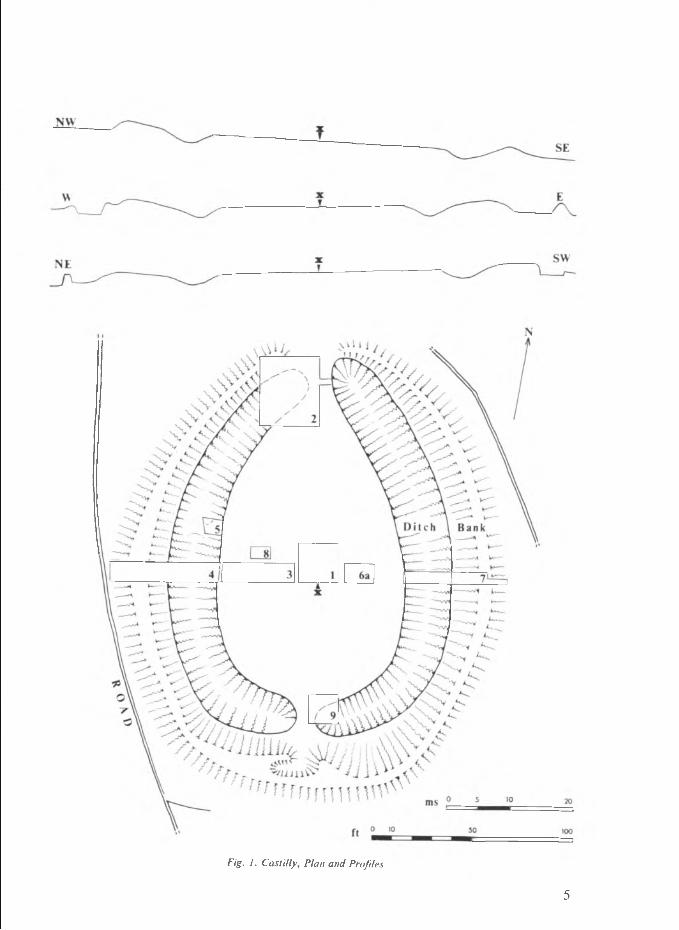
Fig. 1. CastUly, Plan and Profiles
5

residing at St. Benet’s in Lanivet village). ‘The name of the earthwork is M out Stormer, and the tenement Castle-Hill, but both these names are possibly modern and the first may be a mispelling.”
In 1953 the Bousfields collected locally the name ‘M ont Stormer’, which makes it clear that Henderson read, or mis-read, the word ‘M out’, and did not receive it orally.
Name o f the site. It should be stressed that the ‘M ont Stormer’ name goes back no further than 1923, and it is difficult to suggest any Cornish word of which this could be a corruption. The Tithe M ap name of ‘Castle’ and the name ‘Castle Hill’ for the farm close by, have probably been in use for some centuries. There is, to the writer’s mind, a strong likelihood that ‘castle’ here simply translates the Middle or Modern Cornish castel or kestel, ultimately from Latin castell(um), in the sense of ‘fort, earthwork, stronghold’ (cf. Castle-an-Dinas in St. Columb, Castle Dynas 1478, Castle-Dennis 1617). In view o f the suspected date of the demise of spoken Cornish in this part of the county {Nance, 1961) such replacement may have taken place in the 16th century, if not before. The word Castilly is not so easy to explain. If the ‘Castilly lane’ of the Luxulyan Tithe M ap is an early track, and (so also Bousfield, 1957, 38) it has the appearance of perpetuating a stretch of a north-south trackway of considerable antiquity, then this stretch of it may, whilst Cornish was still locally spoken, have been called \an) vounder castellek, or kestellek', using the adjectival form of the word castel, kestel (cf. here ‘Castallack’ in Paul parish, which has become the name of the actual earthwork). The word castellek, surviving, but losing the final unvoiced stop and becoming ‘Castilly’, could have become attached to the monument. Alternately, there is an uncommon form recorded by William Sea wen (1639-1689), whose short account of the Cornish language is printed in Davies Gilbert’s Parochial History o f Cornwall (1838), IV, 190-221. He states that castylly (with usual modifications of the vowel) is the plural of castel, and the sense indicates that it could be used, in the plural, to refer to a single earthwork (cf.the semantically loose English word ‘entrenchments’). Either castellek or castylly could then underlie the name of the site. It is doubtful how much weight can be attached to W. C. Borlase’s ‘Castelly’, owing to the common confusion in Cornish dialect speech between short e and short i, even when (as here) in a stressed syllable.
The Excavation
GeneralIt was decided that the best chances of obtaining dated finds, and information as to
the nature of the earthwork itself, would lie in the opening of both entrances, in the stripping of an area o f the centre, and in the sectioning E-W of the whole site. All this was accomplished well within the allotted time, despite adverse weather.
The profiles of the monument prior to excavation are shown at the top of fig. 1; these have been taken, on the bearings shown, through an assumed centre ‘X ’ midway along the southern side of cutting 1. They indicate well the extraordinary ‘reversed’ nature of the bank-and-ditch profiles, for which an explanation can now be offered. The various cuttings can be described individually. In all cases, these were taken down to the bedrock (heavily-decayed M eadfoot slates).The central area (Cuttings 1, 3, 6a, 8)
The depth of overburden here did not exceed a foot and was slightly less nearer the ditches. Ploughing, admittedly not within local memory before the last few years, had disturbed this topsoil, in which nothing was found, but even allowing for weathering of the underlying slate, it is clear that no internal structures of any kind can be shown to have existed. It is also considered that sufficient ground was opened to detect the lack of any regular peripheral setting.
6

Fig. 2. Castilly, sections: cutting 2 (above), cutting 9 (below)
The main (northern) entrance (Cutting 2)The area opened here was laid out to cover the western half of the entrance, which
consists simply of an undug causeway, and the whole o f the western butt-end o f the ditch, with the tail of the outer bank at this point. The relevant section, drawn along the west edge of the cutting, is given here (fig. 2, upper). This was o f some importance, as it demonstrated for the first time that the ditch presented a most irregular appearance. The ditch had originally been cut into bedrock (f), very weathered on the north side (e) where the side of the ditch ran across the dip of the natural. The lowest filling was extremely wet, and contained fragments of slate, either as a result o f frost-weathering or as spill from the bank. The dark compact stony soil which represented the natural silting (d) was, allowing even for the break-up o f roots, abruptly defined along its upper edge by the junction with a loose, root-packed layer representing existing growth of brambles, gorse, coarse grasses and the like; a stony intrusive lens (b) on the north was traced to a slighting of the bank at this point which seems comparatively recent.
Finds consisted of a single large flint flake (fig. 4, 3) only an inch above bedrock more or less in the centre o f the ditch, and a scatter of medieval sherds (fig. 4, 2) at the top of the dark silt (d). The section clearly suggested that a large quantity of upper silting had been removed from the ditch, but in itself gave no indication where this had been deposited. The bank was not sectioned at this point. In the eastern half of cutting 2, the following sequence of levels could be detected. A dark thin compacted old land surface lay above the bedrock, cut away of course by the neatly-rounded butt-end of the ditch, where a small drainage gully was noted leading from the centre of the entrance into the ditch itself. Over much of the area exposed by excavation, irregular lenses of a very gravelly soil, stretching N-S, overlay this old land surface, and in the southern part of the cutting, deep wheel-ruts were observed, grooving not only the gravel but also the underlying dark material. Recent plough-soil, derived from both inside and outside the entrance, thinly cloaked the whole area, the depth below grass being a matter of six to nine inches. A single flint flake (fig. 4, 4) was found embedded in the top of the old land surface.
7

It would appear that the entrance had not been stripped by the henge-builders. The introduction of the gravel was patently connected with the use of the entrance by some heavy wheeled vehicle and, as the excavators found in the adjoining lane with their own cars in wet weather, had obviously been required to prevent skidding and slipping. The wheel-ruts were just under 4 ft. from centre to centre, implied something of considerable weight, and stratigraphically did not seem very recent; the writer considers it most likely that they refer to the passage of heavy pieces of ordnance, presumably during the Civil War, and this point will be mentioned below.Irregularities in the ditch (Cutting 5)
In spite of its seemingly regular lay-out (plan, fig 1) the ditch appears to have been constructed in sections, and at (at least) five points, the original junction of stretches of quarried ditch are marked by notable rises in the ditch level. One such was examined in cutting 5; it proved to be merely a point where the underlying slate rose to a little crest or ‘causeway’, rather irregular, but transversely across the axis of the ditch at that point.The secondary entrance (Cutting 9)
Surface inspection shows that the bank immediately south of this cutting had, at some time, been cut through. In recent years, the gap has been closed by the erection of a wall along the outside, and localised spread of the bank here gives the impression (plan, fig. 1) of a small cell within the bank: Henderson’s field-sketch of 1923 in fact marks this as ‘Modern Pit’.
Cutting 9 was designed to test the ditch at this point. A diptych section, showing the southern and western faces spread flat from their 90-degree junction in the S-W corner o f the cutting, is given here (fig. 2, lower). It revealed at once that the basis of this secondary entrance is another little undug causeway within the ditch itself (like cutting 5 above), represented on the section by bedrock (f), weathered on the actual causeway and towards the ditch bottom (e). The dark naturally silting (d) had again been dug into, and numerous sherds occurred in the disturbed upper part of this (‘Pot 1’ in the section, and see fig. 4, 1). The causeway had then been converted, and widened, into a secondary entrance by the dumping of material taken from the gap in the bank. In the section, layer (c), a mottled grey and brown turfy soil, seems to represent the vegetation layers and the turf from the bank: (b), a loose, brown to dark brown soil with numerous stones and fragments of slate, the body of the bank, originally of course derived from digging a ditch; and (a), a compact sticky yellow-brown soil with weathered slate, the lowest levels of the bank admixed with the pre-bank turf.Main sections (Cuttings 4 and 7)
These are shown together in fig. 3, the upper one being the section along the south side o f cutting 4, the lower along the south side of cutting 7.
In both, a modern vegetation layer (a), very coarse tu rf with rank grass, gorse, bracken and heather, continued down into the very prominent ditches, where it sealed a sorry remnant of the original dark silt (b), containing few stones and only a few inches of dark soil. Cutting through the bank, in both sections there lay on the bedrock slate a heavily-compacted layer of sticky clayish soil (f), predominantly a dirty yellow with grey tinges, which must represent the pre-bank turf; this stops short of the ditch in both cases. This material is repeated in isolated lumps, lenses and stacks (e) above the layer, and though the conditions did not permit physical recognition of isolated turves, it seems clear that these are tu rf stacks (from above the ditches) forming the core of the bank. Over and above them, layer (d), a uniform mass of reddish rubbly weathered slate fragments and clayish red soil represents the material derived from the ditch. A junction line, clearly detectable in digging by a change in the degree of compactness and by a tendency to delimit material likely to fall or not to fall out of the section-face

Os
Fig. Castilly , main ditch sections: catting 4 (above), cutting 7 (below )

during excavation, divides this layer (d) from a similar, but much looser, layer marked (g). The sections show clearly how this junction-line, produced out towards the ditches (as ‘x—x’), defines the most likely profile of the original ban k : layer (g) then represents in each case a mass of bank material, dug away from the inner face and thrown loosely back over the outer. In the upper section, a further layer (c), consisting of a patchy but fairly fine greyish-black soil, some of which had been carried down into the rubble below it, lies below the present tu rf and roots, and lies above both layers (d) and (g). It can hardly be other than the natural silting dug out of the ditch at this point, and indicates that, in this section at least, the re-modelling of the bank preceded the clearing- out o f the ditch.Discussion Castilly as a henge
Apart, perhaps, from the two flint flakes, only one of which (fig. 4, 3) actually occurred in primary silting, there is no evidence that Castilly is a prehistoric henge at all, save from the general resemblance to Class I henges. The discontinuity of the ditch, as revealed in cuttings 5 and 9, does faintly recall those henges where the ditch is to be seen as a string of quarry-pits (for example, M aumbury Rings, Dorchester, where they assumed fantastic depths in the chalk) and not, as in the early barrows, a ritual feature in itself.The remodelled structure
We have to consider the evidence that Castilly, both prior to excavation and indeed as excavated, exhibited ditches which signally lacked the expected degree of silting. The sections show clearly that the normal primary silt, derived from wind-borne dust, vegetation, frost-action on the sides, and continued collapse and rain-wash from the banks, is either virtually absent or else is encountered, quite abnormally, just below the modern turf-line. In two instances—cuttings 2 and 9—this interference with the silting appears to be associated with medieval pottery. In another—cutting 4—ditch silt appears to have been spread on the bank.
Again, the bank, as shown in the profiles in the top of fig. 1, is the wrong way around; the longest slope and gentlest gradient, instead of being on the reverse side of the crest from the ditch, where it should bear some relationship to the angle of rest of the material involved, is on the inner side. The sections in fig. 3 show how this is due to later interference, and the assumption must be that the entire bank was so treated, a t the same time that the ditch silt was being dug out.
Finally, it is clear that a secondary entrance, opposite the primary northern entrance (though not geometrically so—see fig. 1), was constructed on the core of a small undug ridge in the ditch, and was constructed by digging through the bank at this point. One should recall here Richard Thomas’ statement of 1852 that ‘a road now passes through it’ (scil. the henge).
It might be argued that the presence of heavy guns within the henge in the 17th century (if the wheel-ruts in cutting 2 mean this) led to some modification of the south end—in similar fashion, M aumbury Rings was in part re-fashioned from its already altered state to make a gun emplacement in the Civil War—but this can scarcely be held to cover the total re-scarping o f the bank or the digging-out of the ditch, neither of which would in any way suit the site for the deployment of ordnance.
The only possible explanation is that Castilly was deliberately re-modelled, carefully, and on a large scale, as a ‘plain-an-gwarry’ (Cornish plen an gwarry), playing-place, or am phitheatre for the open-air production of religious plays in the medieval period. That both W. C. Borlase and Charles Henderson regarded it as potentially such, before indeed the class of prehistoric monument known as ‘a henge’ had been defined, merely emphasises the similarity between the two—a similarity which is presumably due to a
10

shared function, the accommodation of as many spectators as possible under conditions which allow uninterrupted vision.
O f very considerable interest are the facts that no plain-an-gwarry has so far been located in east or mid-Cornwall, and that the date indicated by the pottery for the conversion of the monument—tentatively, the latter part of the 13th century—is fairly early in the known history of the miracle plays themselves. The surviving instances include the three-day Ordinalia cycle (Origo Mundi, Passio Christi, Resurrexio Domini), written in Middle Cornish, and known from an early 15th-century copy (MS. Bodl. 791); Gwryans an Bys (‘The Creation o f the W orld’), known from William Jordan’s copy of 1611 (MS. Bodl. 219) and from Keigwin’s later bilingual version: the so-called Beunans Meriasek (‘Life of St. Meriasek’ or Meriadoc), surviving in a copy dated 1504, and possibly composed not very long before this (Nat. Lib. of Wales, MS. Peniarth 105); and perhaps one should add the play (if it is a play, and not a poem) represented by what is said to be an actor’s part written on the back of a 15th century MS. (charter) in the British Museum, discovered by the late Henry Jenner. O f these, the Ordinalia is fairly well associated with Penryn; Beunans Meriasek, is so far as it is set in Cornwall, with the Camborne district; and the earliest copy o f Gwryans an Bys comes to us from a Helston man.
Previous estimates of the age of these plays have been based, rather loosely, on estimates of the ages of surviving undated MSS. In an im portant recent study, our member Professor David Fowler has given very cogent reasons {Fowler, 1961) for regarding the oldest demonstrable drama, the Ordinalia, as having been composed (at or near Penryn) \ . . somewhere between 1300 and 1375, or, more narrowly, between 1350 and 1375’ {op. cit., p. 125); this is arrived at by a study of the contained place- names, and in some degree is confirmed by the Middle English loan-elements present in the plays. It is, however, very uncertain whether these comments can be made to refer to a wider sphere than west Cornwall, where Cornish would have been widely understood until the beginning of the 17th century at any rate. Castilly is not only some way eastwards—it is a good seventeen miles north-east o f Truro—but it offers the spectacle of a plain-an-gwarry, if it be such, capable of accommodating a good two thousand people, and is thus on a par with the surviving instances of the St. Just-in-Penwith plain {Nance, 1935, 192: Guthrie, 1957) and Perran Round {Nance, 1935, 193). Yet all this seems unlikely to have been brought about, on the excavated evidence, later than the early 14th century! In the absence of any known documentary references to this extraordinary place, there is not much point in speculating further about it, but it seems likely that our estimates, both as to the range o f the plain-an-gwarry as a type in Cornwall, and as to the period when they replaced the former performances within the parish church (at any rate in mid-Cornwall) may require some adjustment.
While it is quite feasible that the excavation failed to reveal traces o f any secondary internal structures relating to such performances—the sockets for temporary stands representing Heaven, courts of grandees, and so on, indicated by marginal plans in the MSS. of the Ordinalia and Beunans Meriasek, and surviving as depressions in the centre of Perran Round (so Nance, 1935), the construction of the secondary southern entrance is perhaps best seen as something brought about by the requirements of the drama. The site itself slopes downhill slightly northwards, and to anyone standing on any part of the bank, the entire northern entrance and the present field beyond are largely visible. Conversely, the area outside the bank on the southern side is dead ground, suitable both for a primitive green-room and for the dram atic entrance of armies, tyrants on horseback, etc., at the beginning of the work, and perhaps during it if they were not concealed (as the text of, say Beunans Meriasek, makes clear) in booths and tents on the plain itself. It is not easy to see why this southern entrance should otherwise have been
11

necessary, since a perfectly good lane of great age runs alongside the henge, and the context o f the pottery in cutting 9 relates the construction of this southern entrance to the time o f the re-modelling.The Finds (fig. 4) Flint3. Large keeled flake, the dorsal face still with patches of cortex remaining. From
lowest ditch silt, cutting 2.4. Thin flake, possibly struck from a worked core. From old land surface, cutting 2.5. Keeled flake, struck from a core: patch of cortex at distal tip of dorsal face. From a
recent rubbish-pit just outside the S.E. corner of the site.All the above are in a dull greyish flint, and the worn state of the cortex suggests
beach-pebble sources. The most that can be said about these is that they are not inconsistent with a prehistoric date.Pottery1. Fragments (a large area of rim, neck and shoulder, and a single basal sherd) of a
thin-walled wheel-made cooking pot, with tall everted rim and sagging base. The fabric is a fine dull sandy-red to red ware, with a texture like fine sandpaper, a fine grit which includes tiny particles of mica, and the reddish surfaces shade to a light grey central core. From disturbed surface of ditch silt in cutting 9 (see fig. 2).
2. Tentative reconstruction of a handled jug or jar, from three rim and neck sherds, base of handle with attached wall, and a basal angle (note sagging base). The fabric is very much as for 1 above, but rather more orange-red surfaces, perhaps a little more prominently gritted, and with a grey core. From disturbed surface of ditch silt in cutting 2 (see fig. 2).
This pottery is clearly crucial in attaching a date to the reconstruction of the henge as a plain-an-gwarry, and it is therefore a pity that our present knowledge of early (i.e. 12th to 14th century) wares in Cornwall is so extraordinarily sketchy. As far as thq fabric itself goes, comparison should be made with the sherds from small jugs found in the Gwithian area at three sites (Thomas, 1964,58 and fig. 19, SL.l and SL.2), to which, as the relevant discussion there shows, some such date as circa 1250-1300 could now be attached. An earlier dating on fabric grounds within the county itself does not seem likely, but a later one is of course quite possible. The form of 1 above, with its very thin walls, and thin neck with tiny out-turned rim, is consistent with such a date, though exact parallels in the similar pots from Trewortha, and other Cornish sites (Jope, 1958, figs, 32, 33), are lacking. The jug or jar, 2, again is more or less matched by Beere, N. Tawton {Jope, 1958, fig. 28, e.g. no. 1) of the 13th century, though the precise form and decoration if any of the handle is here unknown. In short, the 13th century is the m ost likely date, with the proviso that the latter part, and perhaps the earlier 14th century as well, are more acceptable still.Acknowledgements
The writer, as director of the excavations, would especially wish to thank his friend and fellow-member, Miss Vivien Russell, who acted throughout as assistant and materially aided every aspect of the work; our members Messrs. J. P. Stengelhofen and M. E. Weaver, who acted as surveyors and where necessary as supervisors, and also assisted in training beginners; Miss M. I. Somerscales and the Society’s Secretary, Mrs. Nankivell, for the efficient running of the camp, the finances, and the sales of guides; and all other members who helped to carry through the work.
Permission to excavate Castilly, an ancient monument, was given by the (then) M inistry of Works Ancient M onuments Inspectorate, and by the landowner, Hugh Stickland, Esq., o f Penmount, Lanivet. Local members, particularly Prebendary Gordon Lawes at Lanivet, helped in many ways, and to them, to Mr. Stickland, and to Mr. and Mrs. Johns o f Castle Hill Farm, the Society is most grateful.
12

Fig. 4. Castilly, the finds (Scale: one-quarter)
Appendix: Wheel-ruts in Cutting 2
The narrowness of the tracks (just under 4 ft.) tends to rule out either a two-wheeled cart (wain) or a four-wheeled wagon, quite apart from the historical unlikelihood of these being present in rural Cornwall much before 1800. The ‘standard’ railway gauge of 4 ft. 8 | in., being the average of a hundred measured cart-tracks, is by no means the limit; George Sturt (The Wheelwright's Shop (1958), p .18,) regarded 5 ft. 10| in., as suitable for a dung-cart or waggon in his own (Farnham) district, measured ‘over’, that is from outside to outside of the ruts. J. G. Jenkins (The English Farm Wagon (1961), 229) quotes 5 ft. 6 in. and 5 ft. 8 in. for two Cornish wagons of 1895 and 1900. The ‘standard’ track is of some age: wheel-ruts at Verulamium (Prae Wood) were from 4 ft. 7in. to 4 ft. 9 in. apart, measured from centres (Wheeler, Verulamium (1936), p.43), and measurements from chariot-burials of the Continental Iron Age conform approximately to this.
For these reasons, the wheel-ruts at Castilly, which are cut down into the old turf and the thrown-in overlying gravel, yet are both filled with (and covered to a depth of some inches by) subsequent plough-soil and turf, imply not a wain or wagon, but some vehicle with a 4 ft. or so track, of considerable weight, making several journeys in wettish weather (under conditions requiring the gravel packing). The most likely occasion seems to be January of 1643, when Sir Ralph Hopton, the Royalist second- in-command, acting as Commander-in-Chief, was based on Bodmin. On the 19th, Hopton took his infantry, horse and dragoons, and two light iron pieces, to confront the Parliamentarians under Ruthin at Braddock Down, about 6 miles ESE of Bodmin. Hopton had left his artillery in the main at Bodmin (Burne and Young, The Great Civil War: a Military History, &c., (1959), p. 40) and it is perfectly conceivable that either now, or slightly earlier, the position of Castilly, commanding the major road west down the spine of Cornwall, had recommended itself as a ready-made battery.
A track of 4 ft. implies, of course, a slightly wider axle-tree than might be thought, since most wheels were, after the 16th century, ‘dished’. Dished wheels, which form a flattened cone, rest on axle arms which are bent downwards, and thus at any point the weight of the vehicle is transmitted to the tyre on the ground via a near-vertical spoke. This technique, alleged to take the strain of lateral movement, is of great age, and in China goes back to Han or even late Chou times (Lu Gwei-Djen, R. A. Salaman, and Joseph Needham, ‘The wheelwright’s art in ancient China, I : the invention of “dishing” ’, Physis,I.fasc. ii (1959), pp. 103-126) and though, like printing and the casting of iron, it did not reach western Europe from China until after the Renaissance, it was certainly being applied to military vehicles by the 17th century.
13

If then one adds up to a foot to the ‘dished’ track for the total axle-tree length, making about 5 ft., one can turn to Robert Harford’s useful English Military Discipline . . . . with a Treatise o f all sorts o f Arms (1680), more relevant here than the better known English edition of Le Blond’s Treatise o f Artillery (1746) (part I of his Elements de Guerre). Harford cites both the Faucon (2f in. bore) and the smaller Fauconet, total widths on the axle-tree being 5 ft. 6 ins. and 4 ft. 6 ins. respectively (ibid., pp. 82-3). Guns at this period were mounted on long-trailed carriages, the point of balance (i.e., at the trunnions) being slightly behind the line of the axle-tree, but the weight transmitted to the broad-tyred wheels was, even with these small pieces, formidable. A Faucon or ‘falcon’ weighed 800 lbs. (metal) and a falconet 740 lbs. and the carriage in each case, with its broad oak cheeks, would be several hundredweights at least. Hopton in 1643 would certainly have possessed instances of both these light field pieces. In conclusion, it should be recalled that Charles Henderson stated that ‘cannon-balls’ (solid iron shot) had been found in the henge at Castilly, and there is no reason to doubt the possibility of this. (I am grateful to my colleague Stuart Piggott for the reference to the article in Phvsis, cited above.)
ReferencesA t k i n s o n , R. J. C., P i g g o t t , C. M. and S a n d a r s ,
N. K., 1951. Excavations at Dorchester, Oxon.: First Report (Ashmolean, Oxford, 1951)
B o u s f i e l d , P . & S., 1952. ‘Late Bronze Age burial at St. Just in Roseland’, JRIC (N S ) 1.2 (1952)
B o u s f i e l d , P . & S ., 1954. ‘A notable Cornish Henge Monument’ PWCFC 1.2 (1954), 33 ff.
F o w l e r , D. C., 1961. ‘The date of the Cornish Ordinalia’, Medieval Studies (Toronto), X X III (1961)
Fox, A. 1952. ‘The Castlewitch Ringwork—a new henge monument’, Ant. Journal X X X II (1952)
G r a y , H. St. G., 1908. ‘On the Stone Circles of East Cornwall’ Archaeologia XL (1908), 1 ff
G u t h r i e , A., 1957. ‘The Plain-an-Gwarry, St. Just-in-Penwith’, PWCFC II.l (1957), 3 ff
J o p e , E. M. and T h r e l f a l l , R. I. 1958, ‘Excavation of a medieval settlement at Beere, N. Tawton, Devon’, Medieval Arch. II (1958), 112-140
N a n c e , R. M., 1935. ‘The Plen an gwary or Cornish Playing Place’, JRIC X X IV 3 (1935), 190-212
N a n c e , R. M., 1961. ‘The Cornish Language in the 17th Century’, Old Cornwall VI. I (1961). 20 ff.
T h o m a s , A. C., 1964 ‘Minor Sites in the Gwithian Area’, Cornish Arch. 3 (1964), 37
W a r n e r , R. B., 1963. ‘A Possible Henge at Halgarras, near Truro’, Cornish Arch. 2 (1963), 79-80.
THE SO C IE T Y wishes to acknowledge its special gratitude to the Carnegie United Kingdom Trust, fo r a substantial grant towards the costs o f this training excavation.
14

Excavation of a Menhir at Try, Gulval
VIVIEN RUSSELL and P. A. S. POOL
SUMMARYThe menhir was found to be standing by a cairn o f stones which covered a stone cist
containing a beaker burial. The menhir had been put in position before the cist, but it is probable that they form a single monument. Sherds found in the surrounding soil suggest the insertion o f secondary burials in the cairn, which had been scattered by ploughing.
The main excavation was undertaken in the winter of 1958 by the writers, with the assistance of Miss M. I. Somerscales and Mr. A. Guthrie. A further short excavation was carried out in August 1962 when the ground was again available.
THE SITETry Farm lies about miles N. by W. of Penzance. The menhir stands in the second
field S. from the farm (O.S. 192; O.S. 6-in., 1908 edn., Cornwall LXVIII NW and SW; SW 460350). It is just above the 500 ft. contour, on a ridge from which the land falls gently to the E. and more steeply to the Try Valley on the West. M ulfra Hill rises on the opposite side of the valley, the Quoit being just out of sight over the crest. The field is called Longstone Field in the Tithe Apportionment o f 1843, but there does not appear to be any other record of the monument. There is another Longstone Field a quarter of a mile to the E.N.E., but no menhir stands there now.
The stone, which is of the local coarse-grained granite, stands 8 ft. high above the present ground level. Below the top, which is pointed, the cross-section is nearly an equilateral triangle; further down, the eastern-most edge loses its sharpness and broadens towards the base of the stone into a fourth side. At tu rf level, the sides measure 24 in., 24 in., 23 in. and 8 in. There were no surface indications of any structures around the stone.
TH E EXCAVATIONThe menhir was found to have been bedded in a pit dug in the rab. Part o f this pit
was excavated to a depth of 4 ft. below tu rf level, and the base of the stone was found by probing to be 6 in. lower. It was considered inadvisable to clear the pit any further, having regard to the stability of the stone. There were few packing stones round the menhir, and the socket was mainly filled with dark soil. The edge of the pit was about a foot from the stone on the S. and E. sides and 1 ft. 6 in. on the N. On the W. side a later disturbance o f the ground had destroyed the side of the original pit; some horse bones and a coin o f Gallienus (259-268 A.D.) were found here.
On the E. side o f the menhir, 3 ft. 4 in. from its base, was a stone cist. For this, a pit had been dug separately from that which contained the menhir. It must have been dug after the erection of the menhir, since the rab upcast from this pit partly overlay the soil filling of the menhir socket. Each wall of the cist is formed by a single rectangular stone with a flat inner face and straight edges. They appear to have been trimmed to shape, though no tool marks are visible. They are not grooved to fit into each other, but are wedged vertically against each other, and the spaces behind them are packed with small stones. The resulting enclosure is not strictly rectangular, being wider at the S. end than the N. and longer on the W. side than the E. The average internal measurements are length 4 ft. 2 in., width 1 ft. 9 in., depth 1 ft. 7 in. The long axis of the cist lies N/S, and the centre point is almost due E. of the menhir.
15

The floor is paved with rough unshapen stones with more or less flat surfaces. Three or four o f these appear to have been specially chosen and the remaining spaces filled in with small stones. This was probably done after the setting-up of the walls, as none of the paving stones go under the walls.
On the bottom of the cist, near the S.W. corner, a handled beaker was found lying on its side with its rim towards the N. Near it were two unburnt bones which were too decayed even to allow of their identification as human.
The cist appears to have been deliberately filled in before being covered over, and to have been filled in at once, as there was no silt on the base. The filling consisted o f a very gritty soil with frequent traces o f rab, and scattered throughout it were fragments of calcined human bone, a few sherds [nos. 7-12], charcoal, two small pieces of haematite, and many small waterworn pebbles. (Throughout this report, the sherd numbers in square brackets refer to the excavators’ catalogue and not to the illustrations.) The filling of the beaker was identical with this, and it included some of each of the objects mentioned above except for the haematite.
The cist was covered by a single flat block of granite. It is irregularly shaped, its maximum measurements being 6 ft. 8 in. by 3 ft. 10 in., its thickness 8 to 10 in. On the N. and E. sides it rested directly on the walls of the cist; on the S. side it was trigged by three flat stones placed on the S. wall; and on the W. side there were a number o f small stones which were probably rammed underneath to steady it after it was in position.
Close to the S.W. corner of the cist, an irregularly-shaped pit about 2 ft. by 1 ft. 6 in.,9 in. deep, was dug into that already dug for the cist. It was filled with soft dark soil which contrasted sharply with the leached, gritty, stony soil found in the main pit. At the base, against the sides, were three smears of charcoal, and near the top three beaker sherds [nos. 13-15] were found. A flat slab of granite about 2 ft. 4 in. by 1 ft. 8 in. lay horizontally over this pit but did not fully cover it.
A cairn of rough, unshapen stones lay over the whole area. When excavated, it spread over the main capstone, the pit dug for the cist and the smaller pit, and beyond; on the W. side it came halfway round the menhir. Its original size could not be determined as no retaining wall was found, and the stones, on the E. side at least, appeared to have fallen outwards or to have been spread by ploughing. The soil among the stones was dark and gritty, and contained occasional flecks of charcoal and waterworn pebbles. Among the cairn-stones, near the top of the smaller pit, was a granite saddle-quern. This was found broken in two pieces, but had evidently been intact when inserted in the cairn.
Over the cairn, on the S. side, was a patch of heavily charcoal-flecked soil two to three inches thick, measuring about 2 ft. 6 in. by 1 ft. 10 in. This contained some sherds [nos. 1 - 5] and a large quantity o f very small waterworn pebbles; a slight depression in the surface, 6 in. in diameter, was packed full of these pebbles. This layer would appear to fix a limit to the height of the cairn near its edge, though it may have been higher in the centre.
A trench continuing the line of section eastwards showed that outside the cairn, below the m odern ploughsoil, was a deep layer, reaching to within 3 in. of the undisturbed rab, o f gritty soil containing a number of stones o f approximately cairn-stone size. This layer probably represents mediaeval ploughing which has caused a spreading of the cairn. Sherds [nos. 17, 19-98], fragments of calcined human bone, and four flint flakes were found in this layer, and the trench was extended to give good clearance to the finds. These are possibly from a secondary burial inserted into the cairn. It may be noted that secondary burials have been found in several beaker tumuli in Wales (Griffiths,1957, 79).
16

Fig. 5. Above, plan as excavated (A, area o f charcoal-flecked soil with pebbles). Below, section; key, a— medium brown soft soil, b—dark brown soft soil, c—grey leached gritty soil, darker at base o f layer, d—chocolate-brown weathered rab ( ?), e—rab upcast.
DISCUSSIONIt is evident that the menhir was placed in position before the cist, since the rab upcast
from the pit dug for the cist partly overlies the soil filling of the menhir pit. From the absence of any layer which can be recognised as being due to silting or weathering, it
17

seems likely that there was only a short interval between the two operations. Thus the menhir and the cist can probably be regarded as a single monument.
The cremation would have taken place elsewhere, and the remains have been scraped up and placed in the cist with the beaker, thus accounting for the fragmentary state of the calcined bones and for the mixture of rab found in the soil in the cist. Dr. Cornwall suggests that the unburnt bones found near the beaker might have been a joint of meat put in as a funerary offering.
The small pit to the S.W. of the cist with its separate capstone contained beaker sherds and is probably contemporary. The cairn would presumably have been raised soon after the other structures were in position, and this overlay both capstones. If, however, part of the cairn had been removed in order to dig the pit at a later date and the stones replaced, it is doubtful whether this would have been apparent in the course of excavation.
Some time later, burials were probably inserted into the upper part of the cairn. One o f these is probably represented by sherds [1-5] found in the charcoal-flecked layer still in situ over the surviving part of the cairn; others by sherds [17 and 19-98], including parts of two urns, which were probably scattered, perhaps in mediaeval times, when the cairn was demolished for agricultural purposes. In his report on the pottery, Mr. ApSimon states that two of the sherds found in the cist filling [7 and 11] are from one of these urns, and suggests that they and the beaker sherds so found may have been washed into the cist by heavy rainstorms. The excavators feel, having regard to the massive nature of the capstone and the manner in which it fitted on the cist, that this suggestion is improbable, but they have no alternative to offer.
No other double monument of this kind—a menhir standing by a cist containing a beaker burial—is so far known in Cornwall. At Tregiffian in St. Buryan. W. C. Borlase found a menhir fallen across the capstone of a cist, and in his opinion this must have stood by it; but the cist contained only bone and ashes, and was not dateable (W. C. Borlase, 1872, 108). In the majority of recorded menhir excavations the finds have been contained in a pit in the rab, either in the one dug for the menhir or in a separate pit a short distance away, and none has been of beaker date. (The appendix contains a brief account o f findings in West Penwith.) Outside Cornwall, at Porth Dafarch on Holyhead Island a fallen menhir was found near a cist, and an AI beaker was found near the cist, which was empty (Griffiths, 1957, 75, 86). At Longstone Rath near Naas in Co. Kildare, a cist containing a Bronze Age cremation and possibly beaker artifacts was found on the W. side of a menhir (Macalister et al, 1913, 351-360). Ai Prat-Palud in Plomeur (Brittany) 8 to 10 cists containing urns and cremations were found 20 metres E. of a menhir, while a beaker or E.B.A. urn lay at the foot of the stone on the N. side (Materiaux, 1881, xii, 60).
Only two other beakers (both type A) have been recorded in West Penwith—at Tregiffian in St. Buryan (Patchett, 1953, 23) and at Trevedra in St. Just (RussellandPat- chett, 1954, 41; Thomas, 1961, 189). Both were found in stone cists but with no menhir or barrow marking the site, though it is always possible that either or both may have existed and have been removed in the course of cultivation.
THE FINDSREPO RT ON TH E PO TTERY by A. M. ApSimon (Queen’s University of Belfast)GENERAL
The pottery as received was in a very fragile condition and had suffered some damage in transit. Before it could be examined it had to be impregnated with Polyvinyl Acetate. This was done in the Department of Archaeology laboratory by Mr. S. Rees-Jones, who also made up the joining sherds as far as possible.
18

Fig. 6. Try: sherds and handled beaker (scale: one-half)
DESCRIPTION OF POTTERY
Fig. 6. Nos. 1, 2, 3, 4 and 7 are from the cist, no. 1 being found inside no. 7; nos. 5 and 6 are from the pit under the small capstone S.W. of the cist.
1-3. Three body sherds of fine reddish-brown beaker ware containing very smallyellowish-white grits, the surfaces smooth. The decoration on the outside consists of vertical thumbnail impressions between deeply impressed lines o f comb impressions, forming running hatched chevron zones, alternating with plain zones. It would appear that the pot was held with the left hand and decorated with the right thumb-nail. The nail impressions suggest either a female hand or a male hand no larger than the writer’s. No. 1 may be from the waist of the pot, 2 perhaps from near the base. [18, 8, 9]
4. W orn sherd of fine reddish-brown beaker ware, buff inside, one large whitestone grit and fragments of quartz in the paste. Circular impressions on the outside. [10]
19

5. Decorated sherd of the same ware as nos. 1-3, probably the same pot. Another scrap found with this fitted on before being cleaned. [14, 15]
6. Body sherd of fine brown ware with white stone grits, very like nos. 1-3, thesurfaces reddish (inside black in part). The outside is decorated with impressed lines which very careful examination suggests were made with a comb, although the tooth impressions are almost imperceptible. The sherd is worn although the fractures are still sharp. It is certainly beaker and could possibly be from the same pot as nos. 1-3 and 5. [13].
7. Complete handled beaker, hard lumpy medium-gritted ware, fired reddish-brown outside, brown inside. 6.65 in. high, rim diameter 5 in. The upper part of the profile slopes inward and the rim has an inward bevel. The middle part of the profile is concave and the greatest diameter coincides with the lower end of the handle. The handle is strap-like in section. The outside is decorated with comb impressions, much coarser and more carelessly arranged than those of the other beaker pottery. On the middle part of the pot the comb impressions are replaced by deep wedge-shaped impressions perhaps made with the back of the comb. The pattern on the upper part consists of a narrow zone of sloping lines in between horizontal lines. The middle and lower parts have broad zones of diamond pattern enclosed between further horizontal lines, the diamonds being mostly divided up into nine smaller diamonds. In places there are outer lines roughly parallel to the edges of the diamonds, but the pattern is too irregular to be certain exactly what was intended. To the right of the handle the space between it and the nearest diamonds is filled with 5 vertical chevrons parallel to the outline of the diamond. The outer surface of the handle has a central diamond with a smaller one inside, meeting triple nested half diamonds above and below, the whole being rather irregular. The base and the rim bevel are left plain. A feature of the outside are the numerous small impressions, perhaps of chaff. [6]
Also from the filling of the cist were a rim sherd and a scrap belonging to the urn, Fig. 7, no. 1 [7,11], From the packing behind the cist stones came a scrap of reddish beaker ware with comb decoration [16]; this was thinner than nos. 1-3 and 5, but might be from the same pot.Fig. 7 This pottery came from the spread of sherds to the east of the cairn.1. Urn, represented by joined rim, shoulder and body sherds, also 3 other decora
ted sherds and 5 plain sherds of which 2 may be from the base. Chocolate- brown ware with stone grit, mainly small and yellowish, but some up to 7 mm., core dark brown to black, coarse and poorly fired. Surfaces originally smooth but now much weathered in places. The pot was ring-built and the join between shoulder and rim shows as an oblique line of fracture. Where this surface is exposed two thumb impressions can be seen on the ring forming the rim. The shoulder cordon probably also marks a join but this is not visible. The decoration consists of lines of deeply impressed twisted cord impressions. These are arranged in two horizontal lines on the outside of the short upstanding neck formed by the rim, with a triple row of slanting zig-zag impressions covering the shoulder below. The lower part of the pot and the rim bevel are left plain [27, 28, 29, 35, 39, 52, 53, 70 etc.],
2. Urn, represented by 4 rim sherds, 3 shoulder sherds, 7 other decorated sherds and a dozen plain body sherds. Some of the body sherds join but their place on the profile cannot be established because of uncertainty about their orientation. The diameter is uncertain but was probably more than 8 in. inside the rim and perhaps at least a foot at the shoulder. The height of the upper
20

5
Fig. 7. Try: pottery from east o f cairn (scale: one-third)
3.
part is uncertain and it is possible that the two parts as drawn overlap. Probably, though, this urn was not very different from urn 1 in size and proportion. The ware is black, stone-gritted (to 4 mm.) with surfaces varyingfrom black to dark brown. Below the shoulder the outer half o f the core is reddish-brown and the outside brown. The outside is finger-worked and smoothed. Two ring joins are visible on the parts drawn, one just below the rim and one just above the shoulder, marked externally by a raised ridge, and there appears to be another on the body sherds mentioned above. The decoration consists of lines o f cord impressions similar to, but a little finer than, those on urn 1. The arrangement of the decoration is similar except that here the zig-zag pattern is limited above and below by a single horizontal line and there are short vertical lengths of cord impressions on the rim bevel. On this urn, as on the last, the decoration is muddled and confused in places and it seems that the vertical zig-zag pattern was a difficult one to carry through correctly. Despite the appearance of greater neatness many of the impressions are smudged. [26, 31, 32, 34, 46, 47, 55, 65, 68, etc.].Detached fragment of lug handle. To judge from the fabric this probably belongs to urn 2 but this is not certain. The fragment represents less than half the handle, the lower half and part of the right hand side being missing. The inner surface is probably not that of the wall of the pot but rather that of the tenon by which it was attached to the pot. The left hand side is slightly dished while the top surface and back show slight vertical finger tip grooving. This feature is likely to be deliberate as it is known to occur on at least three other pots. To judge from the fragment the lug was solid and devoid of the usual
21

horizontal hole. Such lugs are usuallyattached to the shoulder of the pot. [33],4. Rim sherd of fine brown stone-gritted ‘speckled’ fabric, with some quartz
grits to 3 mm., surfaces dark brown, no decoration. The slope of this rim sherd is as drawn, but this may have varied round the rim. [24, 51]
5. Rim sherd of flaky dark ware with some angular stone grits, surfaces light brown, worn and perhaps burnt. A horizontal line of impressions on the outside which may be of twisted cord. [81].
The remaining fragments from this area seem likely to be from urns 1 and 2 and there is nothing clearly different. The sherds and fragments from the layer of charcoal flecked soil on the south of the cairn were of coarse brown ware with whitish stone grits and were similar to the urn sherds described above. [1-5]COMMENTS ON THE POTTERY
The handled beaker from the cist is the first to be found in Cornwall. As handled beakers are seldom found in beaker graves south of the Thames, this is not surprising, in view of the small number of such graves so far found in Cornwall. A t least one is known from Dorset and there are three detached handles from settlement sites in Somerset so there is nothing surprising in this occurrence. Such handled beakers are characteristic of the A Beaker group and are so excessively rare among other beaker groups in the British Isles, as to suggest that they may be regarded as one of the indications of renewed contact with Central Europe (where handled beaker mugs are common) that can be seen in the material equipment of the A Beaker group. The rather flat handle as compared to good round-bodied handles, and the rather coarse decoration and clumsy shape, may be signs o f typological devolution, possibly but not certainly an indication of late date. The diamond pattern occurs on handled beakers in the Midlands, but such parallels have only general and not special significance.
The decoration has plainly been arranged to suit the shape. The inbent rim of this beaker appears to be a characteristic developed in Britain, perhaps first on handled beakers, though it occurs on beakers without handles, including two of those from Cornwall, Praa Sands (Patchett, 1946, 23) and Tregiffian Vean (Patchett, 1953).
The other beaker sherds are all acceptable as belonging to the ‘A’ group in respect of fabric, technique of decoration and the pattern of running chevrons which is quite common in south-west England, occurring for example on the Praa Sands beaker.
The two large urns are of a type belonging to a distinctive group whose pottery is known from over 150 burials and settlement sites in south-west England and south Wales, with solitary outliers in Ireland and northern France. The time span of this group extends from the Early Bronze Age through the Middle Bronze Age, but not certainly into the Late Bronze Age. The present examples are similar in shape and decoration to urns found associated with daggers and other objects assigned to the Wessex phase and may be thought to date from near the end of the Early Bronze Age. The two rim sherds, Fig. 7, 4 and 5, can also belong to this group, much of whose pottery was published by Miss Patchett in her two articles on Cornish Bronze Age pottery (Patchett, 1946 and 1952). Some o f the problems relating to this material have been discussed in my report, as yet un-published, on the pottery from Trevisker Round, St. Eval.
The presence o f stray sherds of beaker and urn in the cist requires brief discussion here. The urn sherds, deriving as they do from the secondary burials, can only have got into the cist by accident, presumably through being washed in. This raises the question whether the other stray sherds and the material filling the cist may not also have been introduced in the same manner. A succession of heavy rain storms might perhaps suffice for this. Such an agency could explain why the handled beaker was found lying on its side, rather than upright as one might have expected it to be. The presence of the beaker sherds in the cist, in the small pit to the south-west of the cist and in the packing stones
22

of the cist, raises the question of whether there was not more than one phase of beaker activity on the site. Cremation burial is so unusual in the A Beaker group that its occurrence suggests external contacts, and, in conjunction with the typological features of the handled beaker, the possibility of a relatively later date. On the other hand the cist in which it was found was big enough to take the normal inhumation burial and the stray beaker sherds could represent the remains of a typologically earlier beaker associated with such a burial. The absence of flint and other sherds (except Fig. 6 no. 4) seem to argue against the bringing of debris from a domestic site, while several examples of beaker burials being disturbed by subsequent beaker burials are known.
FLINT ARTIFACTSFour fragments of flint were found with the pottery in the layer o f gritty soil E. of the cairn. These are simply waste, incomplete flakes with no sign of retouch or use.
b o n e s by Dr. I. W. Cornwall (Institute of Archaeology, University of London) Calcined bones from cist. These are human, consisting o f fragments o f skull, mandible, limb-bones and extremities. All are very incomplete. The state o f the sutures o f the skull-fragments show that the individual was fully adult, as does part of the socket o f a fully-erupted third molar (wisdom-tooth). The thinness of the bones of the skull-vault suggest possibly female sex, in view of the above conclusions as to age. A much-warped fragment of the occipital bone, with the impression o f one o f the transverse bolld- sinuses, is also notably thin where, if male, it would normally be rather thick.Calcined bones from pot. These included a fragment o f a hum an vertebra and of a (7) unciform bone of the wrist, with some other indeterminable chips, some of long bones. Unburnt bones from cist. These were too crumbled for any determination even as between man and a lower animal. The mass seems to consist exclusively o f fragments of long bone—possibly a tibia, but nothing can be said beyond this. If contemporary with the cremated remains, it is possible that it represented a joint of meat put in as a funerary offering, but this is only a guess from its unburnt condition.Calcined bones from outside the cairn. M ost are pieces o f the shafts of long bones; two are certainly skull; one perhaps pelvis. From the characteristic distortion and shrinkage and circumferential cracking they are clearly calcined by heat, and the two skull-fragments confirm their humanity.
c h a r c o a l by Dr. I. W. CornwallOak, birch, willow and ivy were identified among the charcoals. The first two only
were found in the collection from the small pot. All were present in the cist.
q u e r n
The quern, of which two pieces were found in the cairn, is incomplete. It would probably have been roughly oval, about 14 by 10 ins., 2 \ to 3 ins. thick. It has not been trimmed to shape, but one o f the two opposing flat faces has been worn to a silky smoothness. Mr. G. J. Shrimpton (Museum of the Royal Geological Society o f Cornwall, Penzance) states that the stone appears to be a fine-grained biotite granite. This can be found a short distance E. of the site in the Gulval-Ludgvan area, so the quern is probably o f local provenance.p e b b l e s
W ater-worn pebbles have been noticed on many burial sites in Cornwall, such as Bosavern-Ros in St. Just {W. Borlase, 1769, 235), Boscregan in St. Just ( W. C. Borlase, 1879, 204) and Trewavas in Breage (Blight, 1867, 308). Those found at Try ranged from about a fifth to half an inch in diameter. The nearest possible source would seem to be the stream which runs down the valley about 200 yards W. of the site, but they do not resemble any seen there now, and their provenance is not known.
23
HORSE BONESThese were found in a late disturbance of the ground on the W. side of the menhir.
Judging by the relatively undecayed state of the bones, as well as by the coin which appeared to be in the same disturbance, they were probably buried in Roman times. Horse bones have also been found at the foot of a menhir at Lavenael in Plomeur (Brittany) (Materiaux, 1881, xii, 63).c o i n (Identified by Mrs. J. S. Martin, Dept, of Coins and Medals, British Museum).
The coin of Gallienus (259-268, mint of Rome) found here recalls the urn with coins (presumably Roman) found in 1789 at Carne in Morvah at the foot of a very long and large stone (W. C. Borlase, 1872, 183). Another recorded Roman find is that of three sherds o f Samian ware by a menhir at Lestridion in Penmarc’h (Materiaux, 1881, xii, 59). The Rom an coins found by W. C. Borlase in a barrow on W atch Croft in M orvah may also be mentioned in this context. (IV. C. Borlase, 1872, 251).
The finds from this excavation have been placed on loan in Truro Museum (Royal Institution of Cornwall), by kind permission of Mr. W. R. Bolitho.
ACKNOWLEDGEMENTSThanks are due to Mr. W. R. Bolitho, the landowner, and to Mr. A. Roberts of Try
Farm, for permission to dig. Mr. Roberts also gave much valuable help in the course of the excavation.
Thanks are also due to Mr. A. M. ApSimon for his report on the pottery and flints; to Dr. I. W. Cornwall, for reports on the bones and charcoal; to Mrs. E. M. Minter for drawing the beaker; to Mrs. J. S. M artin, for identifying the coin; to Mr. A. C. Thomas, for identifying the horse bones; and to Mr. G. J. Shrimpton, for reporting on the granite quern.
APPENDIXMENHIRS IN WEST PENW ITH
M ore than 80 menhirs are recorded in West Penwith, either by actual report or indicated by place names. They are mainly concentrated in two areas—the highland part of M adron, M orvah and Zennor, and the relatively lower land of St. Buryan and Paul. Nearly 40 are still standing; of these, 17 have been explored and the results are summarised below, by parishes.
ST. BURYANBoleigh (Piper, N.E.). Excavated by W. C. Borlase in 1871. Nil result (IV. C. Borlase,
1872, 106-7).Boleigh (Piper, S.W.). Excavated by W. C. Borlase in 1871. Nil result (W. C. Borlase,
1872, 106-7).Tregiffian (Goon Rith). Excavated by W. C. Borlase in 1871. Nil result (W. C. Borlase,
1872, 106-7).Tregiffian. Excavated by W. C. Borlase in 1871. A fallen menhir 11 ft. long lay across a
capstone 9 ft. in diameter. On the capstone were bone splinters, ashes and a flint flake. The capstone rested at the S. and W. sides on two upright stones, at the other end on the ground, forming a cavity 2 to 3 ft. deep. Under the capstone were more bone and ashes. Under a smaller flat stone, beneath the S. end of the capstone, was a pit lined with shell-sand from Porthcurnow containing a quantity o f bone and ashes (W. C. Borlase, 1872, 108-10).
Pridden. Excavated by W. C. Borlase in 1871. There were probably the remains of a cairn heaped against the menhir. A cremation was found in the side of the pit dug for the menhir, 1 ft. from it, apparently on the S. side, covered by a flat stone 1 ft. in diameter which rested partly on the rab and partly on two small stones (W. C. Borlase, 1872, 100-1).
24

Trelew. Excavated by W. C. Borlase in 1871. A crem ation was in the side of the pit dug for the menhir, 3 ft. from it on the N. side. Finds were bone, charcoal, a flint flake and a baked clay plug. There were no covering or side stones (W. C. Borlase, 1872, 101-2 ).
Treverven. Excavated by Mr. Tonkin in 1922. Nil result (Henderson, 1912-16, 1.50).
GULVALCarfury. Excavated by the present writers in 1958. Nil result (Pool and Russell, 1959,128).Try. See present paper, above.
MADRONTrewern. Excavated by Dr. Borlase in 1752. The monument consists of two menhirs
10 ft. apart on a line E.N.E./W.S.W. Between the two stones was a pit 6 ft. 6 in. by 2 ft. 9 in., 4 ft. 6in. deep, close to the westernmost stone. Near the bottom it contained black greasy earth but no bones ( W. Borlase, 1769, 187, PI. 164). It was re-opened in c. 1870 and was seen by W. C. Borlase, who considered the black earth to be natural peaty soil (W. C. Borlase, 1872, 22-3).
MORVAHCame. In 1789 an urn and coins were found at the foot of a very long and large stone
inserted in a wall, about a foot from the surface covered by a flat granite stone (W. C. Borlase, 1872, 183).
PAULTresvennack. Opened in 1840 by the farmer. A stone 18 in. square covered a pit cut in
the rab about 2 ft. E of the menhir. This contained a large M.B.A. urn standing upright which contained calcined bones; smaller fragments of bone and ashes were found in the rest of the pit. A small M.B.A. urn, also standing upright, was found 18 in. N.E. of the large one, filled with snuff-coloured powder; there were no covering or side stones for this urn ( W . C. Borlase, 1872, 102-6).
Kerris. Excavated by W. C. Borlase. Nil result (fV. C. Borlase, 1872, 175).
SANCREEDTrenuggo. Opened by a labourer in the 19th cent. He found bone chips and ashes at the
foot of the menhir (W. C. Borlase, 1872, 102).Higher Drift. Excavated by W. C. Borlase in 1871. The monument consists o f two
menhirs \ 1 \ ft. apart on a line N.N.W ./S.S.E. A rectangular pit was found cut in the rab, 6 ft. by 3 ft. 3 in., 5 ft. deep, lying E./W ., its W. end midway between the menhirs. This contained only disturbed rab ( W . C. Borlase, 1872, 23-4).
ZENNORKerrow. Excavated in 1935 by Col. F. C. Hirst and Miss D. Dudley. Two urns, published
as L.B.A., one inside the other, were found on the E. side of the menhir in heavily burnt soil, standing upright on a small pile o f charcoal. There was no bone ( Dudley and Patchett, 1954, 44).
Porthmeor. Excavated by W. C. Borlase in 1879. Nil result (Lukis and Borlase, 1885, 26).
References
B l i g h t , J. T. 1867. ‘Barrow with Kist-vaen on Trewavas Head’ JRIC, II
B o r l a s e , W . 1769. Antiquities o f Cornwall (2nd edn.)
B o r l a s e , W. C. 1872. Naenia Cornubiae B o r l a s e , W. C. 1879. ‘Archaeological Discov
eries in the parishes of St. Just and Sennen’, JRIC VI
25

D u d l e y , D . & P a t c h e t t , F. M . 1954. ‘Excavations on Kerrow Farm, Zennor, 1935’, PWCFC, I. 2
G r i f f i t h s , W. E. 1957. ‘The Typology and Origins of Beakers in Wales’, PPS, X X III
H e n d e r s o n , C. G. 1912-16 M S Notebooks on the Antiquities of Penwith (penes R.I.C., Truro)
L u k is , W. C. & B o r l a s e , W. C. 1885. Prehistoric Stone Monuments o f Cornwall (Soc. of Ant. of London)
M a c a l i s t e r , R. A. S. et al. 1913. ‘On a Bronze Age Interment with Associated Standing Stone and Earthen Ring, near Naas, co. Kildare’ Proc. Roy. Irish Acad., 30 C (We are indebted to M r. ApSimon for this reference)
The Rumps, St. Minver: Interim Report on the 1963 Excavations
R. T. BROOKS
IntroductoryThe Rumps, Wadebridge, N orth Cornwall (O .S.l" 185, SW 934812) is a cliff castle
o f approximately 6.1 acres joined to the mainland by an isthmus about 550 feet wide and defended by three ram parts and ditches set across it. The primary object was to elucidate the sequence o f construction and occupation of these defences. The writer is much indebted to the National Trust and their Area Agent, Mr. G. E. M. Trinick, for permission to carry out the work; also to Mr. Old of Pentire Farm on whose land most o f the volunteers camped. He is very grateful to Mr. A. Guthrie, the assistant director; to Mrs. F. Nankivell on whose shoulders fell m ost of the organisation of a happy and successful camp; to Mr. Charles W oolf for his fine series of photographs; to Mr. Desmond Bonney for his plan of the site, and to Dr. Ralegh Radford and Mr. A. C. Thomas for much advice and generous encouragement. Some 40 volunteers, of whom 35 were members of the Society, participated and sincere thanks are due to them for their willing and thorough work. Lady Aileen Fox, Mr. A. D. Saunders, Mrs. Christie and M r. P. Y. Addyman were amongst those who visited the site and gave the writer the benefit of their experience.
The excavations covered:—
M a t e r i a u x pour l'histoire de l'homme, 1881. (Paris). (We are indebted to Miss Dudley for this reference)
P a t c h e t t , F. M. 1946, 1952. ‘Cornish Bronze Age Pottery’ (in two parts). Arch. Journ., Cl, CVII
P a t c h e t t , F. M. 1953. ‘The Bronze Age Beaker from Tregiffian Farm’. PWCFC, I. 1
P o o l , P . A. S. & R u s s e l l , V. 1959 ‘Preliminary Note on Two Menhir Excavations in Gulval'. PWCFC, II. 3
R u s s e l l , V. & P a t c h e t t , F. M. 1954. ‘A Beaker from Trevedra Farm, St. Just-in-Penwith ’ PWCFC, I. 2
T h o m a s , A. C. 1961. ‘A new Cist from Trevedra Common, St. Just-in-Penwith’ PWCFC, II. 5
2 6

Fig. 8. The Rumps, plan and survey by Mr. Desmond Bonney
1. (Site B) The inner slope of the innermost rampart.2. (Site A) The middle rampart.3. (Site A) The outermost ram part and its associated features.
1. The inner slope of the innermost rampartThis ram part is sited on a slate outcrop which, to the east of the present path, retains
a capping of earth, shillet and stones. The crest shows no evidence of fortification but the inner slope may have been stabilized by a layer o f stones. The natural slate of the inner slope had been cut sharply and levelled off to form a floor; this had been extended by a laid floor of large cut slates on which a circular feature of smaller slates resembled the basal remains of a potrest. Nearby was a large thick slate worn smooth on one side and having ancient scratches. One large posthole cut into the rock had been packed with small stones and there were two smaller rock-cut postholes adjacent. The 4 feet wide trench dug there was extended east and west to find any continuation of the slate floor and any other postholes but without success.2. The middle rampart
This is parallel to the innermost ram part and appears to be entirely man-made. It was excavated at the crest to a depth of 8 feet only, owing to the unstable nature of the material, and in steps to the front and rear. The front o f the outer slope is revetted by akerb of large stones set on the old ground surface. No structure remains at the crestalthough a circular feature of two courses o f stones suggests packing stones for a large vertical timber.
On the inner slope were three parallel fight revetting walls and a stout wall standing to a height of 4 feet separated the tail of the bank from an occupation area. This is sited
27

over a deliberately filled-in ditch which is assumed to have been the ditch relating to the innermost ram part and a midden area lay between the stout wall and a wall built on the lip of the filled-in ditch; this contained large blocks of indurated sand, a material which is not of immediate provenance. It is considered that this ditch was a natural feature which had been enlarged at the time the innermost ram part was constructed and refilled when the stronger middle ram part was made.
Set into the ditch filling and covered by the dark occupation soil was a bowl-shaped oven of a material resembling Cornish cob reddened by fire on its inner surface. At some stage after its original use it had been floored and lined on two sides by fragments o f very large broken ‘pot-lids’. A similar ‘pot-lid’ in two parts lay slightly away as though it had tumbled off the top. The slate linings showed signs of moderate heat but there was a plentiful scatter of charcoal The top of the ditch filling contained a number of dark markings resembling stake-holes, and there were rock-cut postholes on the northern lip, the largest of which had been packed with small stones.
The outer ditch was an impressive feature measuring 32 feet across. It was not fully excavated owing to the limited equipment available but the natural slate was reached at a depth o f 15 feet from the present surface. Tumbled stones appeared throughout the levels excavated and were mainly concentrated in the southern half of the section as though they had gained m omentum in slipping and had bounded on reaching the lip of the ditch. Some were of considerable size and were evidently important building stones.3. The outermost rampart
This is not on the same alignment as the other two and is separated from the middle ram part by a platform about 60 feet wide on which a modern tu rf lies directly on the natural slate. The absence o f a sub-soil is taken to indicate that it was stripped off when the middle ram part was built to form the capping to that ram part.
The outermost ram part lies on the old ground surface. Associated with it is a small V-shaped ditch cut into its tail, the material from which forms the base of a low mound which lies on the sub-soil. In modern times when one face of a stone hedge was set into the inner slope of the ram part, the low mound was enlarged by the material cut away.
The outer ditch is rock-cut and shallow at the point excavated. The northern side is revetted by a fine dry stone wall standing on the ditch bottom and between this and the crest o f the ram part is a further light revetting wall.
The ram part itself was not excavated as it appears in section in the eroded west face of the cliff. I t consists of largish loose black shillet lying on the grey clayey soil which is assumed to be the old top soil beneath which the red subsoil with a band of small shillet lies on the natural rock.The Finds
These came from the occupation areas behind the innermost and middle ramparts. They include an unusually large am ount of pottery and animal bones, part of an infant skull, whetstones, hones and utilized stones, ‘pot-lids’, iron slag and a light clinker with traces o f iron, iron and bronze fragments and a bronze finger-ring. Limpet and mussel shells were found in considerable quantities and beach pebbles occurred both in the occupation areas and in the ram parts and ditches.A t h e p o t t e r y (Appendix 1)
This is in course of examination by Mrs. M. Aylwin Cotton. She comments that almost without exception, it consists o f finely made, wheel-turned ware for which parallels can be quoted in the material from St. Mawgan-in-Pydar (Arch. Journ. CXIII (1956), 53-69, M urray-Threipland) and with affinities with the cordoned urns of N.W. France o f the 1st century B.C. b t h e a n i m a l b o n e s (Appendix 2)
These have been examined by Mr. R. E. Chaplin, Assistant Curator of the Passmore
28

Edwards Museum, London, and Miss J. P. Coy, to whom the writer is very grateful. The minimum number o f sheep present is 19, slender-limbed and resembling, in this respect, the Soay sheep. A sheep’s radius shows the mark o f gnawing, probably by a dog.
The minimum number of pig is five and o f cattle, four. Both are of domesticated type. The fragments o f bird bones present are probably of casual origin.
One bone has been identified as o f a beaver (castor fiber).C THE INFANT SKULL
Dr. N. E. France, M.B., B.Ch., B.Sc., has kindly examined the fragments and reports that they comprise the complete right parietal, an almost complete right frontal and the greater part of the left parietal o f a normal, fullterm baby who was unlikely to have been more than one month old.General Discussion
In general, a 4 foot wide trench only was dug through the features above described and the findings at this stage may well be contradicted by subsequent excavation. At present, it may be considered that the innermost and middle ram parts form a simple bivallate defence of the same period. Phase A was the utilization of the slate outcrop as a basis for the innermost ram part and the enlarging of a natural ditch outside it. Phase B was the deliberate in-filling o f this ditch and the construction of the dominant defence, the middle ram part and its ditch. No considerable period appears to have elapsed between the two phases and the pottery from the occupation areas behind both is of similar type.
The outermost ram part cannot as yet be related to the others and there were no finds from this area. It is not on the same alignment as them and the dry-stone wall differs from and is of more careful construction than the revetment walls behind the middle rampart. It should, however, be borne in mind that with the associated low mound it has preserved the old soil and may, therefore, have been in existence and functional when the others were built.
Surface markings of a number of hut-platforms were observed in the interior of the Cliff Castle.
The results obtained from the first season’s work indicate that this was an im portant defended village of settlers who brought with them pottery traditions if not actual pottery derived from N.W. France. The occupation seems to have been intensive but at present should be considered as of shorter duration than that at St. Mawgan-in- Pydar.
APPENDIX 1: BRIEF PRELIMINARY REPORT ON THE POTTERYMRS. M. AYLW IN COTTON, o .b .e . , m .b ., b .s ., f .s .a .
Although the 1963 excavations a t The Rumps consisted chiefly of an examination of the defences, an unusually large am ount o f pottery was found. It includes several largish pieces from vessels, though as yet, no complete sections. The bulk came from a level over the filled-in inner ditch and is probably to be associated with an adjacent hut-floor. Some, however, was derived from the silt of this ditch (the middle bank representing the dominant defence). As a whole, the pottery suggests a single uniform culture and one which can be taken perhaps as representative and as dating the building of the main defences and the occupation o f the site.
Almost without exception, it consists o f well-made wheel-turned wares, though a slow wheel only seems to have been used for some pieces. The most striking characteristic is the prevalence of cordoned vessels. Using the typology worked out by Mrs. Murray Threipland for the material from St. Mawgan-in-Pydar {Arch. Journ. CXIII (1956), 53-69), parallels can be quoted amongst the sherds found to her types G, H, and J
29

(For the Cornish distribution of these cordoned sherds cf. M urray-Threipland, op. cit., 79 and Fig. 39). High-shouldered jars of her Type D are plentiful, with part of a flared rim ja r of this type. One quoit-shaped pedestal base and one ring-base occurred. At present there is only one rim sherd of an internally-grooved rim jar, her Type A, and not enough to show whether or not it is decorated. (For notes and distribution of these in N.W . France and S.W. England, cf. Wheeler and Richardson, Hillforts o f Northern France (1957), 58-61 and Fig. 12). Seven decorated sherds were found, for which parallels may be found in the St. Mawgan-in-Pydar material.
A number o f pieces are pierced with round or oblong holes, some still conserving iron knobs. In view of the recent finds from Croft Ambrey hill-fort, Hertfordshire, where remains of an iron handle have been found in a cooking-pot of the Western Third B culture, similar evidence should be sought at The Rumps. Some pots, however, seem rather to have been mended, in antiquity, with iron rivets, suggesting that they were precious and were not easily replaced or readily discarded.
The impression gained in a first study of this pottery was that it was intrusive, and a uniform and distinctive culture which was of C character. In view of this, and noting Professor Hawke’s earlier treatment of this problem (Antiquity XXXIII (1959), 182), I consulted him. I am deeply indebted to him for his ready permission to publish his revised nomenclature for (and views on) these Cornish cordoned wares. In his ‘ABC of the British Iron Age’ system, he would now, for this material, replace a ‘South- Western Third B’ label with that o f ‘South-Western Third C’. Dr. Derek Allen’s work on the coins has shown that Belgic culture could have been brought into Southern England, at least in the Sussex coastal plain, by the users of his Gallo-Belgic D coins, hardly later than circa 80-75 B.C. Towards 60 B.C., when Belgic Gaul was experiencing the start of the troubles which anticipated the Caesarian conquest, Gallo-Belgic E coins arrive in England. Their distribution is farther inland, reaching N.E. Wiltshire. These two will form a Southern Second C culture. So that, farther west, any new stage of culture which has full Continental La Tene III elements (i.e. wheel-turned pottery and coins), can be called Third C.
But—no Armorican silver coins are known from West Cornwall. ‘The presumed Venetic tin-trade’, Hawke writes, ‘is absolutely coinless.’ He suggests that the answer lies in postulating two stages. The presumably ancient tin-trade described by Diodorus (doubtless from an earlier source) will have started before Armorica used coins. It could perhaps have been continuous since the Bronze Age. When, however, coins came into use in Armorica, they would be useless in Cornwall, whose traders presumably continued, as of old, to barter their tin for good Gaulish foodstuffs. If, as Caesar says, this trade was in the hands of the Veneti, or, as Diodorus says, passed through Corbilo at the m outh of the river Loire, neither region shows much use of early coins. There are no agreed Venetic coins, as there are of the northern coastal tribes of the Redones, Coriosolites and people of sites such as Le Petit Celland. The Cornish trade, being pre-coin in origin, remained non-coin using.
The Cornish cliff-castle-building complex sprang originally from this trading relationship, at whatever date Armorica started to use plank-built ships (after circa 150 B.C., or, as Hawke thinks more likely, after 120 or 106 B.C., when Roman conquests in S. Gaul made trading conditions steadier). But this first stage does not bring in wheel-turned pottery. Occasional cordoned pots, not made on a fast wheel, or an occasional duck-stamped pot, as found at G urnard’s Head, can belong to this stage; but not The Rumps pottery.
Here, allowing that it may be one of cultural period, its fine wheel-turned pottery of Final Armorican origin, though still coinless, would represent the second stage. Hawkes suggests that this, at last, is a real colony of 100% Armorican refugees from Caesar
30

who settled in Cornwall. They knew that coins were valueless there, so ‘ditched all they had (c.f. the Jersey hoards) before they started, but packed some pots for the voyage and took a couple of potters along’. It could, alternatively, be a colony established somewhat earlier, still coinless, but with fully Final Armorican pottery. In this case, it could hardly be before 75 B.C., for only then would they have had this pottery in their French homeland. As will be seen elsewhere in this Journal (pp. 61), this wheel- turned pottery ‘took root’ and persisted in use for a considerable time.
Another point is that The Rumps pottery is of oppidum character, i.e. of northern Armorican and inland sites in derivation, rather than cliff-castle and Atlantic, for the Breton cliff-castles (e.g. Kercaradec) were poor in pottery.
This season’s work at The Rumps has shown that the site is of great importance in a developing understanding of the Cornish Early Iron Age.
APPENDIX 2: REPORT ON THE ANIMAL BONES RAYMOND E. CHAPLIN and JENNIE P. COY, b .sc.
All the bones from this site have been identified and examined. The bone material is largely fragmentary and in a poor state of preservation. Measurements have been taken whenever possible so as to give an indication of the size of the animals. The nature of the material in most cases does not permit measurements o f the highest accuracy which are obtainable only with fresh bones Invariably with archaeological material at least some erosion of the surface has taken place. This factor of erosion is always taken into account when considering this material and is accepted as a limiting factor to accuracy. In some cases, as with this material, clear abrasion of the surface has taken place, as much as one or two millimetres overall. In this report, in order to indicate the general dimensions of the animals it has been necessary to measure these slightly abraded specimens. These figures are needed for comparative purposes, and to avoid any confusion such measurements are preceded by the approximate sign ~ . With these abraded specimens the abrasion in no case exceeds two millimetres and in most is considerably less; therefore all these approximate measurements are slightly less than the true figure but are still valid as indicators of size.
The bones examined are all derived from occupation and rubbish levels, closely sealed and capable of close dating by the associated pottery. All the material in this report is of the same date, though at the time of writing the dates have not been closely determined pending a detailed study of the pottery. It is within the period 100 B.C.— 100 A.D.
In assessing the importance of any animal species on a site, the actual number of bone fragments identified of that species has been demonstrated by us to bear almost no relationship to the true importance of that species in the economy of the site. The method we adopt with samples of adequate size, as has been done here, is to calculate the minimum number of animals present for each species. This is an absolute figure and is probably representative of the proportions of the animals on the site at any one time. We have expressed this, for the material identified, in fig. 9, where the minimum number of animals present for each species is shown as a percentage of the minimum total for all species and is plotted as a divided-circle graph. Normally this calculation would be extended to indicate the food value of the animals present. In this calculation the minimum number of animals present per species is multiplied by the probable weight o f meat per carcass. Thus these weights of meat per species expressed as a percentage of the total weight of meat all species, shows, the importance o f each species in the diet of the people. This figure has not been calculated here as it seems likely that further excavations may take place and produce more evidence. It is unsound to derive these figures from fairly small groups of bone because of the possibility of bias
31

BEEF. 0 M I L K . B A C O N .
P O R K . F A T S .
B U T T E R . C H E E S E . D O M E S T I C A N I M A L S :
d r a u g h t , h i d e s . P O T E N T I A L E C O N O M Y
Fig. 9
in the group compared with the site as a whole. The two calculations are of equal validity but they show two very different things and must not be confused. The wild species have not been incorporated in this diagram as the Roe deer is a solitary tentative identification. The bird remains are so few as probably to be of casual origin. The Beaver (Castor fiber) is a young animal and may have been a pet. It would require further remains of this species before it could be suggested that this animal was hunted for meat or fur.
It is possible to obtain a number of products from the domesticated animals other than meat and offals, these products have been incorporated into figure 9. This figure represents the numerical proportions of each species (see above) and the potential produce obtainable from each—not necessarily those that were exploited.
A list o f the identifications made is not appended here as it serves little purpose. Under each species is given, along with comment where necessary, a list of the measurements made which are im portant in size determination.
Sheep or GoatThe minimum number of animals present is nineteen, making 68% of the total.
Apart from certain parts of the cranium it is impossible to distinguish sheep and goats from their bones. Two cranial fragments gave positive identifications of sheep and there is no direct evidence for the presence of goats.
The sheep are very different in proportion from those o f the present day. Our present specimens are smaller and much more slender than those of the Derbyshire and more closely resemble in this respect the slender limbed Soay sheep. Like the Soay sheep both the Derbyshire and Rumps specimens are horned. The Soay breed is thought by many
32
to be a descendant of the early sheep of Britain; certainly slender limbed sheep are those most commonly found on early sites in this country.
MEASUREMENTS
BoneHumerus R.Humerus R.Metacarpal R.Tibia L.M etatarsal R.Metatarsal R.
Calcaneum L.Calcaneum R.Calcaneum R.Calcaneum R.Astragalus L.Astragalus L.Astragalus L.Phalanges,
proximal.
Maximum width distal end 29 mm.28 mm.24 mm.26 mm.23 mm.23 mm.M aximum length49 mm.51 mm.50 mm.46 mm. lacks epiphysis. 26 mm.26 mm.28 mm.
M aximum width
19 mm.20 mm. 20 mm.
34 mm.32 mm. Phalanges are not33 mm. distinguished between28 mm. fore and hind limb.
above there are the fore and hind limb bones o f a very young soon after birth. There is a sheep’s radius with marks of gnawing by a dog.
ungual In addition to the
animal that died at or on it, probably made
PigThere is a minimum of five animals present, making up 18% of the total species.
To judge from the tooth wear the animals present appear to have a full permanent dentition normally achieved between 18 and 24 months after birth. The teeth are generally larger than those of the modern domestic animals in the museum collection but are smaller than our wild boar. It seems likely that these pigs are domesticated animals rather than wild species and measurements o f the third molar tooth (one upper and two lower) are given. From these it should be possible to decide definitely on this point when more work has been done on archaeological material.
MEASUREMENTS
Upper M 3 Lower M 3
Humerus
Anterior/posterior length 31 mm.31 mm.32.2 mm.Maximum width distal end 41 mm.M aximum length 39 mm.
Me so distal width 18 mm.14.4 mm.14 mm.
Maximum width 25 mm.Astragalus
CattleThere is a minimum of four animals present making 14% of the total species.The animals are all domesticated and are probably referable to the Bos taurus longi-
frons type.
33

M aximum length Proximal width Distal widthHumerus 67 mm.proximalPhalange 52 mm. 27 mm. 25 mm.Tibia L. 55 mm.Tibia L. 53 mm.M etatarsal 144 mm. 38 mm. 41 mm.
(Lacks the distal epiphysis)Deer
There is only a single fragment of bone which suggests the presence of deer. The identification made is not positive. The specimen in question is a lateral fragment o f a metacarpal bone; it has the beginnings of a marked posterior groove and the proportions are long and slender, both features of the Cervidae. The bone is strong and thick walled in marked contrast to the same bones o f the sheep present. In point of size Dama dama (Fallow deer) and Cervus elaphus (Red deer) are at once excluded and the tentative identification of Capreolus capreolus (Roe deer) is made.Birds
There are three fragments of bird which do not permit of specific identification and are probably of casual origin.
BeaverThe right exoccipital bone is present of an immature animal. Four pelvic fragments
may also belong to this species. The presence of the beaver at this time is an interesting record of an animal now long extinct in this country. October, 1963The Passmore Edwards Museum, Romford Road, London, E.15.
MEASUREMENTS
Nineteenth-Century Discoveries at LelantCY RIL NOALL
In t h e s p r i n g of 1875, when a gang of navvies were at work on the Towans above Lelant Ferry (SW 549379), excavating a cutting for the new branch railway to St. Ives, they laid bare what appeared to be some remains of the ancient church or chapel of old Lelant Town, together with a portion of its associated burial ground. Although Dr. Robert Hunt recorded a few details of the finding of graves in the Western Antiquary, III (M arch 1884), neither he, nor any other writer so far as I am aware, gave any particulars of the discovery of the church. It is therefore desirable that this should now be placed on record.
The first find made by the navvies occurred in April 1875. When making pits to fix the palings for fencing the new railway across the Towans, on the sand-hill above the ferry, several skeletons were found at a shallow depth, being mostly about a foot below the turf. These had been interred in haphazard fashion, some lying on their faces, others doubled up. ‘The remains seem to have belonged to men in their prime’ reported the Cornish Telegraph (7th April 1875) ‘the jawbones being full of teeth, which still preserve their whiteness, and have been sought by the navvies as an antidote against the toothache’. One of the skeletons was that of a man measuring 6 ft. 4 ins. The nature of these remains and the shallowness of the burials led to much speculation. A popular theory was advanced at the time that they represented bodies washed ashore from a wreck on the coast nearbv. Some old people of the district also recalled bodies having been dis-
34
covered at this place many years before ‘enclosed in rude graves built and covered with flat stones’. They likewise recounted a tradition to the effect that a church was buried in the sand here. These statements were actually published in the Cornish Telegraph on April 7th—several weeks before the labourers encountered any graves (as opposed to mere skeletons) and two months prior to the uncovering of the church.
The next discoveries were reported on May 26th, 1875, when some stone-built graves, exactly similar to those described by the old Lelant residents, were uncovered ‘. . . at such a shallow depth—from two to three feet—as would shock the m odem idea of decent burial’. Another account which I have of these discoveries, written two years after they were made, states that when excavating the railway cutting ‘. . . at a few feet from the surface and in a place eight or nine feet square, many a ton of human bones were found. We were told that there was no order of burial—feet to the east, etc.—but that the bones seemed to lie in any and every direction . . . One skeleton was in what looked like a little walled grave.’ This account clearly conflates the separate discoveries o f April and May, 1875.
The third, and most remarkable, discovery of all, took place about a fortnight after the finding of the graves: that is, at the beginning o f June, 1875. The newspaper report at this time was headed ‘Presumed Finding of the Ancient Church of Uny Lelant’, and it goes on to describe how the workmen, when sloping the western side o f the cutting through the sand-hill by the ferry, uncovered ‘traces o f some ancient structure—presumably a church—in the shape of roofing slate of a very primitive type, the remains o f a stone wall, and what would seem to be part o f a side pillar.’
There is considerable literary and historical evidence to the effect that the ancient town and church of Lelant were much troubled with wind-blown sand. Lelant was once a seaport of consequence, having a market and custom-house; but both the town and much of the farmland to the north o f it were overwhelmed and buried with sand in a single night, up to a depth of many feet in some parts, and the place subsequently declined in importance. Phillack, on the opposite (east) side of the Hayle estuary, suffered a similar eclipse, and at both places much land is said to have been lost by encroachment of the sea. Robert Hunt indeed collected a tradition that ‘. . . the site of the ancient church and village of Lelant was somewhere seaward of the Black R ock ; the ancient burial ground has been long washed away and human teeth are still frequently found on the shore, after a great undertow that takes the sand out to sea’. John Ray, the naturalist, writing in 1662, described Lelant church as \ . . almost quite covered with sand blown up by the wind’, whilst John Norden, writing about 1580, considered that
. . Lelant was sometyme a haven towne, but then of late decayed, owing to the drifting in of the sands, which had buried much of the lands and houses, and many devices were used to preserve the church.’
Davies Gilbert (Parochial History o f Cornwall, III, 1838, p.6) informs us that foundations of houses had undoubtedly been discovered under the sand, adding that the tradition of the loss of the old town of Lelant ‘. . . is somewhat confirmed by a distinction paid to the principal village, which is universally called Lelant Town, and not Church Town, as in other parishes.’
The church, through repeated incursions of the sand, had fallen into a bad state of repair at the beginning of the 18th century; and the late Ann Pool has quoted several extracts from the churchwardens’ accounts showing how a heavy rate (termed ‘Bounty M oney’), amounting to £263 15s., was levied in the parish to meet these repairs, in 1727. The restoration appears to have been completed in 1728, but in 1731 the churchwardens’ records contain the significant entry ‘One day’s work caring out the sand out of the church, Is.’, showing that trouble from this source had still not been overcome. Indeed, the problem was not finally solved until the dunes were planted with marram
35

grass, whose long roots effectively stabilised the sand and prevented it drifting inland with the wind.
All the foregoing facts present us with an interesting problem ; was the ruined building found in 1875 actually a church or chapel at all—the original church of old Lelant Town—or did it serve some other, secular, purpose?
The existing church is itself an edifice o f considerable antiquity. It contains some undoubted remains o f Norm an work, probably of the 12th century, whilst the main part o f the structure is of the early 15th century. There is also the tradition, attested by William o f Worcester in 1478, that the remains of St. Uny, the supposedly Irish missionary in whose honour the church is dedicated, ‘jacet in ecclesiae parochiali Sancti Uny prope villam Lallant super mare boriale’ (‘lies in the parish church of St. Uny, next to the town o f Lallant, on the northern sea’) (Lake's Parochial History, ed. Polsue, IV (1868), supp. papers p.98).
St. Uny, if he existed, is likely to have lived in the 6th or 7th centuries A.D., and if his burial and shrine were indeed in the present church, that would tend to count against the idea that the ruins found in the railway cutting were those of an older church. However, it must be remembered that such relics could easily have been transferred from one sacred edifice to another, and re-interred there. No archaeological evidence is known to show that any building stood on the site of the present church before the 12th century.
The theory that the ruined building discovered above the ferry was an ancient church or chapel is not therefore invalidated. Those who saw the structure when it was uncovered had little doubt as to its ecclesiastical nature. They may have formed this opinion from its general design, or from the presence of the ‘side pillar’—presumably a buttress or the spring of an arch. The existence of the stone-built graves in its immediate vicinity would seem to support this view. If the building were indeed an ancient church, then it must have belonged to a much earlier (and almost certainly pre-Norman) period, and have been abandoned long before the inundation of sand in the early 16th century which overwhelmed old Lelant Town.
If it was not a church at all, however, but of secular origin, can it have been the ancient Vicarage of Lelant, buried in the sand many centuries ago? A parish Terrier of 1727, describing the bounds of the glebe, states that ‘there has been no Vicarage House standing in the Parish of Euny Lelant aforesaid within the memory o f man, not only that having been destroyed, but all the Glebe Lands entirely covered by an immense quantity of sand blown in upon them from the sea’. These glebe lands, of about 50 acres, are known to have extended in a northerly direction from the Church as far as Chapel Anjou (or Anja) Point, and to the south-east as far as ‘. . . the High Way which leads from St. Ives to Helston’. A reliable tradition collected by the present writer places the site of the old Vicarage just north of Lelant Railway Station, in the vicinity o f the Brewery Quay, and therefore some distance south from where the ruined edifice was found in 1875. Moreover, the presence o f graves nearby argues strongly against its being for domestic use, assuming, of course, that the graves were not antecedent to it in date.
The balance o f evidence therefore does seem to indicate the conclusion that the discoveries made by the ferry in 1875 were actually those of the remains of an older, pre-Norm an, church and burial ground of the former Lelant Town. A definite solution to this problem must await an archaeological exploration of the site.St. Ives(This article appeared several years ago, in a slightly longer form , in ‘The Cornishman' , the well-known west Cornwall weekly paper. The Society is grateful both to Mr. Noall, and to the Editor o f ‘The Cornishman’ (Mr. John Page) fo r their ready permission to reprint it here. E d i t o r )
36

Minor sites in the Gwithian area (Iron Age to recent times)
CHARLES THOM AS, m .a ., f .s .a .
INTRODUCTIONT h e t e r m ‘Gwithian area’ describes a region o f some four square miles, being the northern two-thirds of the small ecclesiastical parish or chapelry of Gwithian, the northwestern end of the much larger parish o f Camborne, and the north-eastern extremity of the parish of Phillack. The area has claims to geographical unity. It is focussed on the broad estuarine valley of the conjoined Red River and Connor River, with the long sandy beach through which this meets the sea, and includes the stretches of towans or sand-dunes both north-east and south-west of the river outlet. An eroded Pleistocene plateau o f Devonian slates, between approximately 200 and 250 ft. O.D., frames the area, and, apart from the churchtown village of Gwithian (population about 60), isolated townplaces, farms, and cottages form the settlement-pattern. The main industry is agriculture, followed (regrettably) by seasonal tourism, the latter being physically represented by caravan parks and a chalet conglomeration on Gwithian Towans.
ARCHAEOLOGY OF THE AREASince 1949, intensive fieldwork and chance discovery have between them revealed over sixty sites within the relevant four square miles. These range from the mesolithic period to the 19th century, and some two-thirds have been surveyed, sampled, or excavated. The m ajor sites a re : a neolithic and Bronze Age complex of an agricultural character (sites V, IX, X, XI, XV and XVI—Megaw et a i, 1961); a Romano-British open homestead, Porth Godrevy (Fowler, 1962); a Dark Age dwelling-complex (I, IV, XXII) with associated cultivated fields and tracks (Y, XX, XXI), covering most of the first millenium A.D. (Thomas, 1954, 1958b; Fowler & Thomas, 1962); and a native earthwork o f the local Iron Age, re-occupied in the 12th century by a small medieval manor, Crane Godrevy (Thomas, 1958a). M ost of these sites are physically extensive—the Bronze Age farm is at least 7 acres—and they have formed the objects of prolonged campaigns, involving up to five years of large-scale area excavation. Only Porth Godrevy, and the Dark Age fields, have so far reached the stage of final reports.
O f the numerous smaller sites, the examination of any one o f which may only occupy a week or so, few lend themselves to a cohesive report of more than a few pages. Rather than that such reports should appear in a series o f disjointed notes, it has been decided to combine a number of them in this current paper. As far as is feasible, they are given in chronological order. Restriction of the paper to the period A.D. has o f course led to the omission of seven (surface) mesolithic sites—GB, GT, GU, CM, HU, N D and NE (see map, Thomas, 1958a, fig. 1)—which will be considered in the next report, No. 4 in this series; a number of Bronze Age barrows, cists, and stray finds of stone axes and post-mesolithic flints, which will be included in the final report on the neolithic and Bronze Age complex; and also (for want of space) the remarkable systems of supposedly medieval fields on Godrevy farm and Godrevy Green, which will be examined in the final Crane Godrevy report.
In the text which follows, the date of work, with the name or names of the relevant supervisors or surveyors, is given under each site. A wider acknowledgement is none the less at once due to all those people, numbering several hundreds, who dug or who helped to plan these sites, frequently in adverse weather, for all their help and enthusiasm.
17

THE IRON AGEGeneralThis term implies the period corresponding to the Early Iron Age in southern Britain (insofar as the main cultural streams can be detected in west Cornwall) and the local equivalent o f the Roman period, here very largely represented by native continuity. Domestic sites of this era in the Gwithian are both open and enclosed.
‘Rounds'Predominant in the landscape of the Cornish Iron Age, though apparently replaced by open agricultural settlements in the post-Rom an period, were the ‘rounds’ or enclosed homesteads, usually reflected in toponomy as caer-, car-, ker-, or -gear. These are not forts o f military character, either in their nature or their situation, and the word ‘camp’, so often applied to them, can become a misnomer. Consisting of generally only univallate bank-and-ditch enclosures, the vast majority under two acres in area, and circular, oval, or ovoid in plan, the rounds indicate perhaps a population expansion during the later Iron Age, coupled with large-scale exploitation of what had previously been uncleared and uncultivated downland. Most rounds are found between 200 and 400 ft. O .D .—the exceptions are lower rather than higher—and the favoured siting was near the junctions of the west Cornish plateau lands and the valleys which drain and intersect them. It seems highly probable that rounds can be traced over most of Cornwall, given these geographical limitations (cf. Dudley, 1960; Saunders, 1961), but their known density in the two western Hundreds of Penwith and Kerrier must approach one per two square miles, overall, and in east Penwith (which includes the Gwithian area) it is nearer to one per square mile.
Surprisingly few rounds have been excavated. A very broad temporal bracket—from the 2nd century B.C. until the equivalent of late Romano-British times—may be assigned from the few excavated instances, from associations with such monuments as souterrains, from chance finds, and by analogy with comparable monuments elsewhere. It seems very probable that the word ker, O.Co. *caer, represents a contemporary label. Pokorny’s derivation from the rather obscure Latin word quadra, ‘square (earthwork)’ is not convincing (Journ. Celtic Studies I (1950), 129-135, no. 9). It is worth remarking that the curious semantic shift in Breton, whereby Br. ker largely occupies in Breton toponom y the position held in Cornish toponomy by tre(f), hints that at the period of the migrations to Armorica (circa late 5th to early 7th centuries A.D., so K. H. Jackson) the ker (enclosed homestead) had not been wholly replaced by the tre f (unenclosed homestead) in south-west England.
There are five known rounds, two still clearly visible, in the area.
Trevarnon Round OS 25" 62.10, no.218a; NGR SW 588402; at 220' O .D .; Gwithian Tithe M ap (1839), nos. 473,4,5, ‘The Round’; Rd. Thomas’ map no. 51. Surveyed April 1958 by a team under Mr. T. J. Scantlebury. See Fig. 10, measured plan by Messrs. M. E. Weaver and J. P. Stengelhofen. Original internal area, about 1 acre.
This round is in an extremely ruined state, only one isolated portion of bank remaining on the eastern side. The original ditch has been almost wholly obliterated by ploughing. The basic plan appears, as Richard Thomas wrote in 1842, to have been ‘somewhat elliptical’. Local tradition, recorded in print, has long linked this particular earthwork with the Civil War, but the story that cannon-balls were once found either in the interior or in the ditch cannot now be verified. It seems likely that more than one phase of construction is represented here; surrounding hedges are of enormous and unusual width, one being ten feet across its top. Another such separates the round, on its north-
38

Fig. 10. Trevarnon Round
western side, from a large deep ditch, several hundred feet long, over thirty wide, and nine to ten feet in depth (see fig. 10). Its nature, function, and association (if any) with the round itself, are all obscure.
A quantity of copper coins is said to have been found about 1900 when parts of the bank were being demolished, and a large granite muller, pear-shaped, 2 ft. long and 1 ft. 6 in. across, with one end heavily battered, was found in the surviving bank section more recently.
Trevoryan Round OS 25" 62.7, no. 179; N G R SW 612412; at 230' O .D .; Camborne Tithe M ap (1838), no. 290, ‘The Round’, nos. 288, 293, 4,5,6, (adjoining), ‘G errier’ ( (an) ger hyr, ‘long camp’); Rd. Thomas’ map, no. 64. Locally called ‘C at’s Field’. Surveyed M arch 1958 by a team under Mr. T. J. Scantlebury. See fig. 11, measured plan by Messrs. M. E. Weaver and P. P. Pratt. Original internal area, about 1J acres.
This interesting round, with internal dimensions o f approximately 190 ft. by 240 ft., still possesses a detectable inner bank and outer ditch. On the north-east, where the ground falls away, a double change in gradient indicates a possible outer bank. On the west and south-west, the bank, now indicated by a platform at ground level, has been destroyed in the construction of a stone-faced hedge. No trace o f any entrance was observed. The survey party found only a few post-medieval sherds and two small pieces of flint; the proprietor (Mr. Bennett) could not recall anything unusual ever having been found there.
39

Fig. 11. Trevoryan Round
Trevoryan (Southern) Round Not illustrated. OS 25" 62.8, no. 906; N G R SW 614408; at about 250' O .D .; Camborne Tithe Map (1838), no. 312, ‘Round Croft’ (shown as circular); Rd. Thomas’ map, no. 63.
Richard Thomas described this as ‘a quarter-mile south of Trevoryan, area 2 acres, traces o f a circular entrenchment.’ Nothing can now be seen, either on the ground, or from aerial photographs. The presence of two rounds, so close together, is interesting, and less uncommon than is realised.
Carlenno Round OS 25" 62.7, n o . l l l ; N G R SW 606418; at about 210' O .D .; Camborne Tithe Map (1838), no. 217, ‘Gerrier’, 218 (adjoining) ‘Park Round’; Rd. Thom as’ map, no. 65; Basset Estate Map, 1850 (Tehidy Minerals Ltd., Camborne), ‘Old Encampm ent’. Original internal area, just under 1 acre. See fig. 12.
The remains of this round, intersected by an old footpath, now lie on M enadarva Farm, but until the last century they were within the now-vanished tenement of Carlenno (farm in N.E. corner of OS 25" 62.7, no. 99—not to be confused with neighbouring farm of Callean). Carlenno, so spelled in 1690, embodies the prefix car-, ker-, and possibly the personal name (*Laianou) also seen in Bolenowe (1838 Bolenno, 1327 Bolenowe.
40

Fig. 12. Left, Carlenno Round (from Basset Estate Map); Right, Corwin in Phillack (from Gwithian and PhitlackTithe Maps).
bo(t) + *Laianou) at the other end of the same parish. Faint traces of the bank can be made out on the north-eastern side. The Tehidy (Basset) m ap o f 1850 shows the entire eastern semi-circle, implying an internal diameter o f about 220 feet. This particular round was mentioned in the Will (1447) of Dr. Reginald M ertherderwa, o f the nearby farm now called M enadarva (1280 Mertherderwa), as Kayr Rescasek, starting-point o f a footpath leading eventually to Camborne Church. Rescasek is now Reskajeage, the the farm adjoining on the west.
Crane Godrevy OS 2" 62.2, nos. 25, 46 and 62.3, no. 31; N G R SW 589427; at about 230'-240' O .D .; Gwithian Tithe M ap (1839), no. 23, ‘Crane Godrevy’. Excavated by various directors and supervisors, 1955-59. See fig. 13, outline plan and profiles, based largely on work by Mr. Jeffrey M ay and the writer, 1959. Original internal area, unknown as yet, but in advance of an acre.
Crane Godrevy was discovered by the writer, partly from fieldwork and partly from documentary research, in 1951. It differs from the preceding in that no aspect of the round itself was visible on the ground, nor clearly has been for many centuries. The main focus of interest is the building complex in the northern corner (see fig. 13) which, as it stands, represents the last (circa 1680) phase of the small M anor of Crane Godrevy, a subsidiary element of the much larger (Domesday) M anor of Tehidy which cannot have come into being much before the 13th century. The round was first noted when a cutting at the profile marked ‘1’ in fig. 13 revealed the rock-cut ditch, in 1956; subsequent work has traced this ditch over a wide area. Finds from the original (Iron Age) occupation were recovered in ditch silting and filling, in a restricted area below the (sunken) floors of the medieval buildings, and in field O.S. no. 46 (the southern part of the round); here, as at ‘X ’ in fig. 13, there are grounds for believing in fairly extensive early occupation unencumbered by medieval activity.
This round is univallate, the ditch of uneven depth being hacked down into the slate up to a depth of 7 ft. below present turf. The bank (profiles 1, 2 and 4 in fig. 13) was
41

crza /
Fig. 13. Crane Godrevy, plan and ditch profiles
revetted on the inner side, the revetment sometimes sitting in a step or gully, and in one instance—profile 1 on the plan above—the foundation courses of this revetment had survived to be incorporated into a medieval wall. The report on the pottery from here (fig.21 and Appendix) indicates a broad range from the 1st century B.C. to the 2nd A.D.
The name Crane Godrevy is likely to date from the re-occupation in the 12th century. ‘Godrevy’, the generic name of the whole northern piece of Gwithian parish (cf. map, Thomas, 1958a, fig. 12), is merely the plural form of the Cornish diminutive godref, ‘hut, little dwelling’, doubtless acquired in the post-Rom an era with reference to the ruins o f the native Late Iron Age farm above Porth Godrevy (Fowler, 1962). Crane
42

Godrevy appears in the form ‘Godrevy Caran’ in 1603, where the second element must represent car hen, ker hen, ‘the old round’; the implication that the defining ditch, if not the bank, was still visible about 1200 is borne out by the depth to which medieval midden material occurs in excavated ditch sections.
Open Sites and Fields
Site GH (‘Godrevy Hillside’) OS 25' 62.3 and 7, no. 22; no significant names. Preliminary excavation in 1958 by Miss Rosemary Campbell (Mrs. Bruce Anderson); section by her, fig. 16, lower part.
The large 12-acre uncultivated hillslope field immediately south-east o f Crane Godrevy presents, on the ground and from the air, a complex palimpsest of banks, tracks and changes of level. Many of these are referable to a complete re-planning of Pencobben Farm about 1860, when a number of small fields were incorporated in larger areas designed to pasture sheep. Mrs. Anderson’s work was designed to test the theory that other and less definite remains indicated field-systems pertaining to Crane Godrevy, in either its Iron Age or its medieval existence. In all, six cuttings were made, in the upper (northern) part of the field. The general stratification presented was one o f two buried soils. The uppermost, encountered at about a foot below the present tu rf and separated from itbyathinsand-blow , yielded both medieval and post-medieval sherds, the earliest being perhaps the late 13th-century rim fragment GH.3 shown in fig. 19. The lower soil, separated from the upper by another sand-blow from 4 to 6 in. thick, contained such sherds as GH.5, 8 and 9, shown in fig.21, which must be referred to the Iron Age occupation o f Crane Godrevy and indeed cannot be separated from pottery of that date found in the round itself.
The section (fig. 19, lower) represents a cutting made across an area where the roughly parallel crests of two banks, some 30 ft. apart, appeared to resemble incipient lynchet form ation; especially since the banks lay across the slope. In the section, (d) is the undisturbed natural, a buried sandy soil shading into the weathered slate surface below it; (c), a ginger-coloured sandy soil with numerous shell-fragments, possibly an old plough-soil, has been interrupted at two points, on the up-hill sides of the banks, by being dug out to form the bank material. The irregular turf-lines (b) represent temporary stabilisation of a sand-blow which has choked the soil (c), and (a), a rather dirty grey sand above these turf-lines but below modern turf, has been extensively disturbed by rabbits.
It is clear that the two banks have been piled up from digging, and do not represent lynchets. The section shows, in both banks, the included lens of light sand which indicate that such digging represented the removal and piling of turf, not of an exposed soil, and the southern bank (on the right in the section) is separated by a thin sand lens from the layer (c) below it. Whilst (c) may, and probably does, represent Iron Age agriculture, the banks are clearly later; despite the absence of informative sherds, it is tempting to refer them to the medieval re-occupation o f Crane Godrevy.
Godrevy Headland OS 25" 62.2, no. 4; N G R SW 582433; at about 40' O.D. (cliffedge); no significant names. Discovered by Mr. P. J. Fowler in 1961. Planned survey (fig. 14) by Mr. J. P. Stengelhofen and the writer, 1963.
43

Reference was made in the Porth Godrevy report (Fowler, 1962) to the possibility of so-called ‘Celtic fields’ being associated with the late Iron Age homestead, and in Fowler & Thomas, 1962, fig. 21, ‘A’, two such groups were reported. Those immediately next to Porth Godrevy are extremely difficult to detect, even in oblique light, and would be even more difficult to plot. The fields shown here in fig. 14 are however perfectly visible. The slope of the ground is down to the SSW—to the top left-hand corner of the plan—and the tiny divisions between plots are genuine positive-negative lynchets. ‘B’ is a bank, or head-dike, associated with the medieval or post-medieval system of fields in broad—and narrow—rig which cover Godrevy Green, ‘L’ being the massive terminal lynchet on the western, seaward, extremity of this system. The intrusions of the angle formed by ‘B’ and ‘L’ into the much earlier system of tiny lyncheted plots is well shown here. There seems little reason to doubt that these plots are contemporary with the homestead of Porth Godrevy—roughly the 2nd to 4th centuries A.D. inclusive— and represent survivals in rough croft outside the range of later arable.
Site OLS (‘Old Land Surface’) OS 25" 62.6, no. 38 (southern half); NG R SW 584416 (centre); no significant names. Discovered by the writer in field-work, 1960. For description, see below, p.48.
In addition to the rounds, and to such formal ‘open’ sites at Porth Godrevy, it is now clear that the coastal belt from Gwithian to Hayle may have harboured a scattered population of pastoralists or scratch agriculturists, dwelling on the rather poor and thinly-turfed land which now for the greater part lies below massive sand-dunes of Dark Age and medieval date. One such site, which has
44
actually yielded fragmentary evidence of (field ?) walls, though not of dwellings, is PT (‘Phillack Towans’) at SW 568394. Here, as indeed at OLS, it is now known that a Late Dark Age occupation characterised by bar-lug pottery (Somerscales, 1957) was preceded by a local Iron Age one (Somerscales, 1961, and this journal, forthcoming, with illustrations).
The OLS material (fig.20) consists entirely of surface finds of sherds, some of them wind-eroded, but o f sufficient quality and number to indicate their date. If anything, it appears to precede the occupation at Porth Godrevy by a century or so (see Appendix, for discussion o f this pottery). It raises again the question o f the co-existence o f open and enclosed sites in the west Cornish Iron Age, possibly stressing again that the rounds may be primarily stock-enclosures and not defensive earthworks, and that the distinction between a round and an open site may have been to some extent a social or functional one.
ROMAN (?)
Carwin in Phillack OS 25" 62.10, no. 4; N G R SW 584398; at about 160' O.D. Discovered by the writer in field-work, 1953 (see Dudley, 1954, no. 7: Fowler, 1962, 37, no. 5). Surveyed by a team under Mr. P. J. Fowler in April, 1956. See fig. 12.
How this prominent and very remarkable site escaped notice until so recently is a mystery. It is a rectangular camp, possibly a Rom an military work, whose internal dimensions were of the order of 700 ft. NE-SW and 350 ft. NW-SE. Until recently, almost the entire northern (recte north-western) side, and much of the south-western end, were intact. At the moment (the site having now been scheduled under the Ancient Monuments legislation) the eastern half of the north-western side alone remains. This is, from the internal ground level, up to nine feet high, and measures some 30 feet across its base. The external glacis descends straight into a filled, but perceptible, ditch, from which a modern stone-faced hedge rises to form the boundary o f OS field no. 2.
The soil capping of the interior is only 6 in. thick, and covers clean blown sand. Recent burials of deceased farm livestock in the bank have revealed that this, too, consists entirely o f blown sand without turf-lines. The field which now engulfs the south-western half of the site was formed by levelling the south-western portion (some 250 ft.) of the surviving ram part and by depositing and mechanically spreading about thousand tons of soil. The south-eastern (long side) is detectable over much o f its length, however, as a slight linear depression (the ditch ?).
Linguistically this is an extremely interesting example o f nomenclature. Carwin is a farm, and a very ancient tenement, in Phillack parish, situated some little distance away at SW 582387, and separated from this camp by the modern farms known as Treeve and Pulsack. Earlier forms are Caerwyn 1335, Kaerwen 1317, and Kaergwyn in 1311. This represents O.Co. *caer guyn (or possibly the suspected fem. form guen, since *caer, ker, is a fem. noun) and can only mean ‘the white camp’. There is no other round or earthwork of any description within at least a mile and certainly none which, historically, could ever have stood on Carwin tenement. The name must then refer to this particular fort, since such it seems to be, and is a safe example o f the extension of ker to a non-native work.
Despite the apparent impermanency of a work constructed entirely in sand (and it must be recalled that the north-western ram part is still standing today to an impressive height) a work of this size—5 | acres internally—is large enough for a milleniary cohort
45

in Rom an terms. Is it a practice camp o f the late 1st, of or the 2nd, century A.D.? Does it hint a t some otherwise unknown garrison in the far west connected with the local stream-tin production? W ould it repay excavation?
LATE DARK AGE AND EARLY MEDIEVAL TIMESGeneralConsiderable uncertainty surrounds (in terms both o f pottery and of material culture generally) the transition from the pre-Norm an centuries to the full Middle Ages in Cornwall. This epoch, characterised by the wide-scale English penetration of most of the county, by the Norm an conquest, and by the birth of the parochial system, to list only the m ost im portant facets, has hitherto lacked even the rudiments o f a ceramic progression equivalent to that so convincingly worked out for East Anglia and the Home Counties. The absence of the well-known middle Saxon, late Saxon, and Saxo-Norman wares, the dearth of suitably-endowed sites of the 12th to 14th centuries from which a later pottery sequence might be obtained, and (dare one add?) an understandable if regrettable lack of local interest, have meant that archaeologists in Cornwall scarcely possess the means to identify sites of this period, even if such should be found.
Some slight redress, at any rate in west Cornwall, is offered by two recent excavations. The first, that of the hermitage and chapel site at St. Helen’s, Stilly (Radford, 1941), soon to be published by Mrs. Helen O’Neil, will contain a pottery report by Mr. G. C. Dunning (Dunning, St. Helen’s) throwing much light on the transition period in Stilly. The second, of a group of new sites at Gwithian, here discussed, does the same in a limited way for west Cornwall, since it provides a long-sought link between the main Dark Ages site (site I, dug from 1954 to 1958) and the main medieval site, the little manor-farm of Crane Godrevy.
Local Pottery SequenceThis is now tolerably certain (Thomas, 1958a, 1958b, 1958c, I960) and relies on some twenty sites. Following the local Romano-British forms up to circa 400 or later (Fowler, 1962), a selective range of very similar pottery was in use in west Cornwall during the 5th and 6th centuries, under the name of ‘Gwithian style’, and may have continued later in east Cornwall, e.g. as at Tintagel. It was largely replaced in Cornwall west of the Crantock-Cubert area, and in Stilly, by a much cruder kind of flat-based cooking- pot, its external base and lower walls bearing the negative impressions of finely-chopped grass on which the pot had rested in the drying stage, sometime in the later 6th century. This pottery, known simply as ‘grass-marked’, finds its closest m atch in the ‘souterrain ware’ of northern Ireland, and despite historical difficulties in establishing suitable links, the combined weight o f associated material evidence, epigraphy, and the later popular and hagiographical traditions all suggest that Irish immigrants were responsible for it. Relevant (Dublin) radio-carbon measurements include souterrain ware from Larne (D 66), 480+ 120 A.D., and White Fort, Drum aroad, co. Down, further souterrain ware, 1050 + 120 A.D. (D 65—both in Radiocarbon 3 (1961), 36); the extreme internal range of these two, 600—930 A.D., would not conflict with current Ulster opinion as to the age of this pottery and the Larne date does permit it to appear in Cornwall circa 600 (see fig. 15).
The third phase is marked by the adoption of the opposed internal handles, called ‘bar-lugs’, shielded from the fire by pulled-out peaked rim-areas (‘bar-lips’), but both apparently added to the existing grass-marked cooking-pots. It will be argued below
46

CM. 55-116
fL
Fig. 15. ‘Grass-marked’ cooking pots {scale: one-fifth)
that the latest Cornish bar-lug pots he in the 11th century A.D., but the date of introduction, indeed the very mode, are both uncertain. Frisian traders, around or soon after 800 A.D., are now usually adduced (Dunning, 1959, 48). The earlier bar-lug pots, like certain of the grass-marked pots, bear simple ornament of the nicked, notched, or finger-tipped type on the rims, again a link with the northern Irish souterrain ware, though the (later?) plastic ornament of the latter is not found in Cornwall.
This sequence is contained in part at a number of Cornish sites, and occurs in toto at Gwithian, site I : here the three main levels, C (the lowest), B and A cover the period from the early 5th to the late 11th or early 12th centuries, and though, as in all sand sites, the distinction between levels is not always clear physically, and thus precision cannot be given to the phases represented, the two lower (C and B) also contain imported wares o f the writer’s classes A, B and E (Medieval Archaeology, I I I (1959), 89-111), which confirm this general chronology. Site I, layer C, with its ‘Gwithian-style’, locally-made sub-Roman pottery, in all probability follows on from the Romano- British homestead at Porth Godrevy (Fowler, 1962, 39, 42, with some reservations); in 1957 it was considered that the discovery o f grass-marked pottery at Crane Godrevy indicated continuity from site I, layer A (Thomas, 1958a, 23, 28), and this is still held.
Site 'O LS' and the Final Date o f Bar-Lug PotteryThe bar-lug cooking-pot, suspended when full over a fire by two thongs around its lugs (protected from burning by the extruded lips), requires a coarse strong fabric for its manufacture. The load on the lugs can be as much as a gallon, and they must be pulled out from, or luted on to, thicker walls than would be needed in the simple handle-less grass-marked pot, which apparently sat directly on the fire. From the 9th century onwards, then, thickness (of base, walls and rim) and coarseness of gritting
47

do to a limited extent distinguish the two forms of vessel. Again, the very large examples o f either—cf. Dunning, 1959, fig. 20, no. 4 (Hellesvean), and one from Gwithian, site I, layer B, so big that it had to be entirely ring-built—seem to be an early feature, abandoned as impracticable; later sites suggest that a diameter of 8 or 9 ins. was usual for both types o f cooking-pot.
Bar-lug pottery was not universally popular. From its very coastal range in Cornwall, there are no instances o f a spread into south-east Cornwall or south Devon. It is absent from Tintagel. Though found actually at the Land’s End (Guthrie, 1962), it is as yet unknown in Scilly, where at least four sites producing grass-marked pottery between the 6th and 11th centuries are known. A t Mawgan Porth, the coin of Aethelred II (Bruce-Mitford, 1956, 111 and pi.) shows bar-lug pottery in use until at least 1000 A.D., and this is supported from Gunwalloe (Jope & Threlfall, 1956: Thomas, 1963) where there are good grounds for regarding the site as the Winnianton of Domesday Book. A few other sites might perhaps reinforce the idea o f 10th and 11th century bar-lug pottery, but there are none certainly later than this.
The bar-lug material from site OLS at Gwithian (see above, p.44) is to be associated with an ill-defined series of destroyed field-banks resting on an old land surface, sloping from under dunes northward down to the present Gwithian beach. This surface, rich in non-marine molluscs, is displayed as a dark band a few inches thick. In one instance, the pottery occurs in a very stony patch with a ruined bank south (or uphill) of it, and this may conceivably be the remains of some very humble peasant home, since animal bones also occur; elsewhere, the manuring of fields must be supposed (cf. site XXI, Fowler & Thomas, 1962, 12). The pottery itself, identical in fabric with that from Gwithian, site I, layers A and B, but generally heavily eroded by wind and sand, cannot cover a long period. It exhibits a number of clues to its lateness in the series. There is an absence of that free, if uninventive, decoration of the rims and the lugs to be seen on bar-lug pottery in site I, layer B, and in this the OLS pottery resembles that from Gunwalloe. The bar-lug pots (cf. fig. 20, OLS 3 and 4) are o f smallish diameter, and the lugs include one (OLS 101) of unusual if not unique tininess. The rim forms tend to the curved or flared everted kind, also seen in site I, layer A. The platter, OLS 108, if it is such, is a large one—cf. Gunwalloe 30, for example (Thomas, 1963)—and this too is a late feature at Gwithian, site I.
In view of what will be said below, the period represented on site OLS by this pottery is likely to fall between circa 950 and circa 1050 A.D., and the character of the pottery itself confirms the general correctness of this late dating.
Site SL (‘Sandy Lane') and re-occupation o f Crane GodrevyThe productive site SL stands in the middle of a rough track, known as ‘Sandy Lane’, leading from the northern edge of Gwithian church-town to the holiday chalets on Gwithian Towans. It consists mainly o f a low, oval, midden, some 20 ft. E—W and some 8 ft. N —S across the centre, which is barely eighteen inches off the ground, and it was exposed in January 1963 by a series of severe gales. A scatter o f surface material westwards, including a small clearance-heap o f stones, rests on a dark old land surface with further dune material below it, and immediately north of the midden are some two acres o f the same old surface. This cannot, through distance, safely be correlated with the old land surface of site OLS, which produced inter alia bar-lug pottery, and the general slope and height suggests that the SL surface is higher and later than that o f OLS. It appears to represent a turf-stabilised surface, no doubt in large part cultivated, on the reverse face of dunes flanking Gwithian beach, and sloping down to the present church-town village. In functional terms, we have the refuse tip o f some homestead,
48

perhaps not far from the building itself, at the edge of the associated fields. Unfortunately the homestead must now lie below the sandy field due west of the present Church- town Farm (Mr. T. C. James) and is therefore inaccessible.
The midden contained much fine charcoal; a limited am ount o f animal bone (predominantly sheep, but with cow, pig, and fish also represented); two very decayed iron objects, perhaps medium-sized square-section nails; a quantity of daub showing good impressions of thick reeds or withies, something not previously encountered anywhere in the Gwithian area; a few pebbles including two crude hones or whetstones; and the flat piece of grit shown in PI. I which has been incised to form a board for the game known as ‘merrills’ or ‘nine men’s morris’. The general impression is one of peasant poverty. The presence of numerous land molluscs, particularly Cochlicella acuta, Cepaea nemoralis and Helicella virgata, throughout the material, points to a continuous vegetation cover. The body o f the midden was irregularly intercalated with bands or tip-lines of dirty sand, precluding any real stratigraphy; though a number o f sherds gathered from the exposed surface in the spring of 1963 presumably refer to the last stage of the midden and belong to what has been labelled below as 'Style 3’ (fig. 18). The excavation (August, 1963) had to be conducted with some dispatch since, had the midden been left partially dug and unguarded at any stage, visitors and local children would have got at it. Despite this, almost the whole midden was examined, and the material (less the finds) then replaced.
The pottery is of great interest. Of the many hundreds of sherds, all that can be profitably shown are illustrated here. It is possible to distinguish three classes.
Style 1 (fig. 17) is a group o f small grass-marked cooking-pots, hand-made, and bearing inside the vertical or near-vertical marks caused by the potter’s fingers pulling up and shaping the remarkably thin fabric (PL I). The paste from the viewpoint of colour, grit, and general texture, is that o f site I, layers A and B, and local manufacture —perhaps even on the spot—is reasonably certain. Only one pot has a finger-tipped rim ; the bases often have a slight ‘kick’, either under the angle or at the base of the external wall. This variety of small grass-marked pot is known elsewhere in Cornwall. In fig. 17, C G .8/228 and the base, CG.373, both from Crane Godrevy, are identical in colour, fabric, and appearance to the SL pottery, and must be by the same potter(s). The little flattened rim of CG.8 is a form previously remarked upon ( Wailes, 1956, fig. 29; Thomas, 1963, no. 23) and parallels are here shown from Lanvean, Mawgan-in- Pydar: The Kelsies, Cubert: and Trink, Lelant. Now at the two former sites ( Wailes, 1956: Harding, 1950) these are associated with bar-lug pottery in similar fabrics; fig.XX. here shows (K2.29) an unpublished bar-lug from the Kelsies. The same rim form is seen at Gunwalloe, both on bar-lug pots (Thomas, 1963, nos. 2, 3, and 12) and ordinary small grass-marked pots (ibid. nos. 23 and 25—the latter is the same size, and bears the same ornament, as SL 20 shown here in fig. 17).
Our ‘Style 1’ then looks as if it should fall within the 10th and 11th centuries. But the complete and significant absence o f any bar-lug pottery at all—cf. fig. 20—surely indicates the latter century. Indeed, since site OLS is so near, it is probably safe to suggest that Style 1 cannot be far off 1100 A.D. If this is so, then, the similar absence of bar-lug pottery at Crane Godrevy suggests that its re-occupation is also circa 1100 A.D., and, as will be seen below, the evidence from site 1 tends to confirm this.
If Style 1 indicates the last stage o f a long, and purely local, tradition of village-made cooking-pots in the west Cornish grass-marked series, ‘Style 2’ (fig. 18, upper portion) represents changes in both form and technique. Both ware and internal fingering recall Style 1, but SL 3 and SL 6 have been finished on a slow wheel; related sherds from Crane Godrevy (CG 116) shows a sagging base, and grass-marking seems to have disappeared completely; and the whole group is now based, not on the simple pot of
49

Style 1, but on a form with a definite everted rim. Style 2 is thus a transitional style, demonstrating the incursion, into a native tradition, of the widely-known medieval cooking-pot with everted rim and sagging base, and the use o f the wheel. It should therefore be dated to some such era as the first half o f the 12th century. Dunning suggests, with good reason (Dunning, St. Helen's), that these innovations must be associated in Cornwall only with the Norm an conquest, and the date of circa 1100— 1150 is likely to be correct. The correspondences between Style 2, and Dunning’s ‘Group I’ of the St. Helen’s material (cf. his no. 1 with SL 5, his no. 4 w ithCG. 419), confirms this.
Style 3 (lower part o f fig. 18) is the largest component of the SL midden pottery, and as at least half the sherds of this style here shown were collected from the surface of the midden, its position as the latest style is secure. It comprises a group of large cooking-pots with sagging bases, the majority wheel-made. The fabrics involved are not quite the same as those for styles 1 and 2, but are close enough to suggest a west Cornish source. Only SL 41, with its micaceous ware, may come from further afield.
These pots cannot be earlier than the 12th century, and may well continue into the 13th. It is worth noting that none o f them corresponds to the Westcountry variety with the internal concave bevel to the rim, mapped recently by Jope (1963, 331, map—the dot at Crane Godrevy is an error), and that we may be dealing with the products of small local centres like Truro, traditionally a very early focus of this craft. On the other hand, certain rather vague regional traits can be seen, as, for instance, the ‘wobbly’ neck profile of SL 33 and SL 34, recalling Beere, N orth Tawton (Jope & Threlfall,1958, figs. 30, 31, passim), and also Trewortha, north Cornwall (ibid. fig. 32 no. 44); whilst the simple rim of SL.9 and SL.32, rather short-necked and externally burred is also seen at Gunwalloe on a medieval pot (Jope & Threlfall, 1956, no. 10).
If the later 12th and earlier 13th centuries be assigned to Style 3, then the final date is perhaps confirmed by two fragments (SL 1, SL 2) of a fine red ware with mica specks, from the surface of the midden. These, as Dunning has shown (St. Helen's) are neck fragments o f jugs, and similar sherds occur at both G H (no. 3) and Negosias (GK. 101), both nearby sites. The corresponding St. Helen’s fragment (Dunning’s ‘G roup III’, no. 1) is placed by him to the second half of the 13th century. This particular ware is in fact common in west Cornwall, and again a local source is likely.
DiscussionIn summary, the OLS bar-lug pottery is late 10th or early 11th, and it is probable that the very similar ‘exposure’ site a mile south-west in Phillack Towans (site P T : Somer- scales, 1957) belongs to the same phase. The three styles at SL cover the late 11th, early 12th, and mid-12th to mid-13th centuries. Crane Godrevy, possessing no bar-lug, but instances of SL Styles 1 and 2, must then have been re-occupied not much after 1100. In west Cornwall generally, this is also the horizon for the disappearance of bar- lug ware and the arrival of everted-rim cooking-pots, though grass-marking may have lingered on for a half-century or so. Gwithian, site I, presumably continues into the 11th century, but as it lacks the equivalent of SL Style I small grass-marked cooking-pots and has no everted-rim pots, it is unlikely that it was occupied much later. This site has also yielded some peculiar late sherds, from the top of layer A or from the disturbed sand above this layer, but below a medieval turf-line containing occasional 14th-l 5th century sherds which seals most of the site. These peculiar sherds are shown in fig. 19 O f them, G M .E and GM. 1000 are both of non-local ware; GM .B. 1 is local, but without parallel. The catalogue below (Appendix) gives the reasons for supposing these to be (at the latest) late 11th or early 12th century.
We are then left with the problem; what set of circumstances led to the orderly
50

abandonment of site I in the 11th or early 12th century, when the family who were later to appear as the de Godrevys moved up the hill and re-occupied Crane Godrevy? Can this be linked with the abandonment of the fields and homesteads (if any) o f site OLS, to be superseded by site SL a little further inland, or without eventual abandonment of site SL itself? In both cases the cause appears to have been the threat of uncontrollable blowing sand. Elsewhere on the Cornish coast the period from the late 11th to the 13th centuries A.D. can be suspected of having been one which the coastal dunes, bereft for some reason o f the thin grass cover which had stabilised them, were moving inland, covering arable and choking entire settlements. The present churchtown village of Gwithian is almost certainly a 13th century foundation resulting from a necessary move inland, the preceding settlement being the Domesday one of Conarton in the immediate area of site SL and the present Gwithian common or ‘Green’. The chapel of St. Gothian, enlarged from a late Dark Age rectangular building by the addition of a small chancel in the late 10th or early 11th centuries (Thomas, 1958a, fig. 11) was similarly abandoned about or soon after 1200 A.D. for the same reason. The present parish church, though rebuilt twice, can be traced to a small cruciform with chancel arch of circa 1200— 1250 A.D. Older historians of Cornwall repetitively refer to an alleged account of the inroads of sand containing in some document (at W ardour?) appertaining to the Arundell family. This is likely to be the 13th (and not, as is usually stated, in the 12th) century, since it was not until shortly before 1268 that Renfred de Arundell married the daughter and heiress of the Pincerna family, the previous lords of Conerton.
Very similar circumstances must have obtained at Phillack Towans, where site PT cannot be shown to have been occupied later than the bar-lug pottery phase; and at Lelant (A W /, 1964) where the parish church, still rich in Norm an work, stands inland from its most likely predecessor. At Perranzabuloe, further up the coast, two such moves inland—the first, circa 1100— 1150, the second in 1804—were necessary. The replacement o f the bar-lug site at Gunwalloe by the present W innianton Farm is another instance. N or is this confined to Cornwall; in south Wales, where the main period of danger and movement was in the 13th rather than the 12th century, Higgins {Arch. Cambrensis, L X X X V I I I (1933), 26) has attempted to place the sandblows on a firmer chronological basis and to carry the series back into prehistoric times.
ABANDONED MEDIEVAL SETTLEM ENTS
GeneralThe scarcity of deserted medieval villages in west Cornwall must be attributed, not to peculiarly stable local conditions, but to the comparative rarity of the English-type village in the area before recent times. The local equivalent is rather the deserted medieval tenement, townplace or farm. There are several in the Gwithian area, any one of which would probably repay examination.
Tolgarrack OS 25" 62.7, no. 60a; NG R SW 597423; parish of Camborne. Tollgarrack 1600 (‘hole in the rock’).
This is a small steading, built into a hillside quarry (hence the name), and now incorporated into Reskajeage farm. Air photographs indicate a long rectangular main building, with subsidiaries, and ridged seed-plots in front o f the house.
51

Hellowe OS 25" 62.7, no. 80 (SE corner); NG R SW 596419; parish o f Camborne. The name is Co. hallow, ‘(place in) the moors’, using ‘m oor’ in its local sense o f low- lying marshy ground.
Hellowe was apparently a large farm which disappeared early in the last century; from the air three sides of a quadrangle can be seen. In 1740 ‘Hillowe’ was a tenement in the M anor o f Crane and Gear (Camborne). Its customary grazing was the eastern (Camborne) half of what is now Godrevy Towans.
Site GK (‘Garrack’), name uncertain OS 25" 62.7, no. 73 (‘Old Sand Pit’); NGR SW 594417; parish of Gwithian; Gwithian Tithe Map (1839) no. 32, ‘Sandy G round’.
Since 1950, wind erosion on this exposed bluff has revealed traces of very ruined walls, animal bones, and a good deal of pottery. Some of this is as late as the 17th century, but the series commences in the 13th century (see fig.19, little jug, GK.101). ‘Garrack’ (Co. (an) garrek, ‘the rock, rocky place’) is really the name of the extensive towan below and westwards of this bluff, so-called from the exposed and quarried slate cliff which bounds it. But there was a tenement in Gwithian called Garrek 1335, Engarrecke als Angarrack 1659, and this may be the remains of that tenement.
Negosias OS 25" 62.7, no. 73a (south-west corner, in quarry); N G R SW 595416; parish of Gwithian; Gwithian Tithe M ap (1839) no. 33, ‘House, garden, etc.’ Negosias 1784, Nansgrecias als Nagasias 1659, Nansgracias 1343; Co. nans, ‘valley’, and possibly *grasias, *grasyas, cf. Welsh graddiad, ‘slope?’
This farm, remembered locally under the corruption of ‘Nicky’s Ease’, is now represented by scarcely-detectable remains in a quarry platform. The lands form part of Nanterrow.
Boskensa OS 25" 62.11, no. 257; NG R SW 603406; parish of Gwithian; Gwithian Tithe M ap no. 176, ‘Town plot, etc.’ Boskensa 1335; Co. bos, ‘house, home’, and kensa, ‘first, chief’.
The site of this ancient and interestingly-named tenement is now on a side-lane to Nancemellin farm. Very elderly people in the parish, who knew this place as ‘Skeenya’, are apparently aware that it was once a building.
Upton Barton OS 25" 62.10, no. 203 (“site o f’); N G R SW 582399; parish of Gwithian; Gwithian Tithe M ap no. 323, ‘Great Towan’, now called Upton Towans.
Upton was a substantial holding occupying the south-western part of the parish, with a large arable and an even larger stretch of towan grazing. At a date which is uncertain, but m ust have been not long after 1650, the farmhouse was overwhelmed with sand in a night, the occupants escaping through the upper windows. (This is perfectly feasible, and would occur with the frontal collapse of a high dune.) The remains of Upton were visible briefly in the winter of 1808-9, following a temporary shift of sand, but have not been seen since.
The evidence for the exact location as marked on the 1876 (1st edition) of the OS 25" sheet has now perished, with the bulk of the Ordnance Survey name-books for England,
52

during the Southampton bombing in the 1939-45 War. As far as the writer can ascertain, Upton would lie some twenty feet within the (stabilised) front of a very large sand-dune, and its exposure would be a task of massive proportion. The place-name itself is an early (Upton, 1659) anglicisation of an older Andrewartha (an dre wartha, ‘the upper townplace, -ton, or farm’), and the name survives as that of a family in the area, representatives of the original proprietors of Upton. In 1839, John and Philip Andrewartha still held the arable land of Upton.
MISCELLANEOUS MEDIEVAL AND POST-MEDIEVAL SITES
Fig. 16. Sections, Parish Boundary and site GH
Parish BoundaryThe bounds between the parishes of Gwithian and Camborne, as indicated in the respective parochial statements, comprise on the northern side o f ‘dog-leg’ drawn from Gwithian Bridge (over the Red River at SW 587420) to the North Cliffs just above ‘Fishing’ or ‘Fisherman’s’ cove. In the Camborne Bounds (1601) this stretch is described as ‘. . . from Gwythian bridge by a path and a banke unto the north sea cliffe . . .’, and in the Gwithian Bounds (circa 1603) we have ‘The first bound is Gwithian Bridge: the one half of the bridge is in Gwithian and the other Cambron. And from that to Pitt Mulfra, the church path of Crane Godrevy is the bound, between Gwithian and Camborne. The banke between Crane Godrevy and Pencobme is the bounde betwixt Gwithian and Camborne. All which bounds are on the north .’
The ‘banke’ in the above is the remnant of the uphill side of a hollow way (running along the south side of OS 25" 62.3, nos. 31, 33 and 35). The ‘path’ or ‘church path’, now quite untraceable, connected Crane Godrevy with Gwithian Bridge. Its northern part is however further defined by a smaller linear bank (Fowler & Thomas, 1962, 82 and figs. 15 and 21) which, in addition to separating the two ecclesiastic parishes, also forms the head-dyke on the south-east o f the whole Crane Godrevy strip field system, and is extended to form in part a physical division between the two grazing blocks of Godrevy Towans (Gwithian) and Hellowe Towans (Camborne—see p .52 above).
53

This bank was sectioned at two points by Miss M. J. M ountain and the writer in 1963. The better section is given here in fig. 16, upper part. The undisturbed stony surface (d) is partly covered by an early sand-blow (a) on the west, and by remnants of what may be a plough-soil (c), if so, probably to be connected with the Iron Age occupation o f Crane Godrevy. The upper ‘ginger’ sandy soil (b), which can be seen at each end of the section approaching its normal thickness of some 8 inches, was presumably turf-covered at the time when the bank was constructed. Turf and underlying soil was then stripped from either side of the bank, and piled up against a sandy core (a). The resultant ditches became traps for further blown sand (a) and in the last few centuries a modern turf, with m arram grass, has covered the whole.
The temporal brackets for the construction of this bank are on the one hand the various statements of bounds (1601, 1603, etc.) and on the other the date at which the field-system of which it forms a head-dyke came into being. The latter event must be connected with the severance of Crane Godrevy from Tehidy, and putatively with the re-occupation of the Crane Godrevy round—that is, not before the 12th-century. If this bank then originated as a constructed medieval lield-boundary and manorial bound, it forms a good parallel to the smaller but similarly-constructed banks from site GH, seen in the lower part of fig. 16.
The ‘Armada Bank’A ttention was drawn in Fowler, 1962, 21-22, to an extensive linear bank which effectively cuts off Godrevy Green and Headland from the rest of Godrevy; this is marked, not wholly accurately, with a hachure on OS 25" 62.2, where it divides fields nos. 9 and 10. Objections to a prehistoric date are that this bank has a ditch on its ‘inner’ or uphill side, suggesting a defence against the headland area and not o f it, and that it is integrated with the boundaries of a group of fields which, if no later than the 17th century, are nonetheless clearly of medieval or post-medieval form.
There is a remote possibility that this is a temporary defence erected shortly after 1588 against the possibility of a Spanish invasion. The section now visible shows parts of the inner face to possess basal stone revetting, and the bank would well serve as a breastwork for musketeers. A map showing the state of the ports in Cornwall, 1593-1595 (H. L. Rowett, JRIC IV .14 (1873), after L. Pine’s 1740 engraving), indicates defences at Black Cliff, Hayle Towans, and also in a position which might be taken for Godrevy.
The Hundred PoundImmediately north-east of Gwithian village is an area of about 15 acres (OS 25" 62.6, no. 61), uncultivated ground crossed by several streams, known as ‘the Green’ and regarded as parish commons. A deed of 1808 in the writer’s possession, in which six principal parishioners agree to define their interests, identifies and describes it as such, and it appears as no. 295, ‘Green’, in the Gwithian Tithe M ap (1839). There are good grounds {Thomas, 1964) for believing this area to be, together with that of the SL (‘Sandy Lane’) site, the locale of the pre-13th century manor and village of Conerton. In the south-eastern part of the Green there is a circular enclosure (OS 25" 62.6, no. 62), exactly one half-acre in extent, known variously as ‘the Round’ and ‘the Withy Garden'. It is defined by a stout high stone-faced bank, and appears to have been surrounded by a ditch which, with the immediate environs, has become waterlogged and reverted to marsh. The entrance, which has been rebuilt, is on the west, and is approached by a stone-cored track across the Green.
The writer regards this as being the former hundred pound, situate at Conerton,
54

for the Hundred of Penwith. This hundred, in medieval times more usually called the hundred of Conerton, was a ‘private’ one, the rights being in the hands of the Arundell family for many centuries. P. A. S. Pool’s study o f the Penheleg MS. (.Poo/, 1959, 184) contains an account of a court held at Gwinear in 1564, where, as a result of complaints that \ . . the pound of Connerton being the head pound of the hundred (of) Penwith was so far from the Land’s End to drive cattel unto . . .’ the jury appointed two more pounds to be set up at Marazion and at Carninney in Lelant. If the identification with the ‘Withy G arden’ is correct, then this surviving pound is at least as old as the 16th century. Its preservation is due, one feels, to the obscurity o f its situation and its gradual eclipse by the other, more accessible, hundred pounds after 1564. The Gwithian Tithe Map (1839) lists a parochial Pound, in the field now occupied by the council houses in the village, and indeed this is remembered locally; such a parish pound, originating in the 17th century, would have to be established de novo, since the Hundred Pound, even if it had fallen into disuse, would still be the property of the Lords of the Hundred.
Coastguard HutsIn the middle of the modern chalet conglomeration on Gwithian Towans there is a small circular stone-built construction with a conical roof. In recent years, under the soubriquet of ‘The Jam -Pot’, this has been a shop for sweets and ice-cream, but on the 1876 edition of OS 25" 62.6 (part 39c) it is marked ‘Coastguard Lookout.’ Local tradition is that, even earlier, it was a huer’s hut, and the style o f its construction is not inconsistent with an early 19th century date. (‘Huers’ in Cornwall are, or were, persons who from vantage points on the cliffs watched the movements of shoals of fish, and by a system of signals directed the boats to them. Pevsner’s Penguin guide, Cornwall (1951), shows (pi. 9) the well-known huer’s hut at Newquay.)
On the Basset Estate map, marked ‘I’, by Nicholas Whitley (1850), at Tehidy Minerals Ltd., Camborne, a small rectangular building is marked ‘Preventive H ut’. This occurs on OS 25" 62.3, about half an inch SSW of the trig, point plotted in the centre of no. 28, the headland known as The Knavocks, and was still visible at the end of the last century, when it had been converted into a little summer-house. The site is no longer visible. It was possibly a look-out dating from the Napoleonic wars.
ACKNOWLEDGEMENTSSpecial thanks are due, in addition to all those individually named earlier, to the various proprietors who have permitted survey on their lands: Mr. G. H. Bennett, Trevoryan, Mr. E. J. Bowden, Reskajeage, Mr. S. H. Hosking, Trevarnon, and the National Trust (per G. E. M. Trinick, Esq.) in respect of land at Godrevy. Over many years, the writer has had the benefit of discussions with his colleagues Messrs. P. J. Fowler, J. V. S. Megaw, and Bernard Wailes, in respect of most o f the sites listed here, and especially with Mr. P. A. S. Pool concerning Conerton and the early history o f Penwith. Gratitude is also due to Messrs. Charles W oolf for Plate I, b, and Malcolm M urray for Plate I, a. Where sections have been re-drawn, acknowledgement to the originals appears in the text.
Finally, in discussing the pottery from the various sites (Appendix, below), much valuable help and advice has kindly been given by Dr. M. Aylwin Cotton (the Iron Age material) and Mr. G. C. Dunning (the late Dark Age and early medieval wares). Mr. Dunning has most generously provided a copy of (and permitted discussion of) his St. Helen’s report in advance o f his own publication.
55

APPENDIX: DESCRIPTIVE CATALOGUE OF POTTERY (Figs. 17 to 21)(HM =hand-m ade: W F = wheel-finished: WM=wheel-made: ext. =external, exterior: int. = internal, interior)
Grass-marked cooking-pots or bowls (Figs. 15)1. HM, buff fabric coarsely gritted, ext. carbonised, ext. base and lower walls grass-marked.
From context and associations (Thomas, 1956b, 76-7), 6th-7th centuries. Chun Castle.2. HM, dull brown medium-gritted fabric, ext. carbonised, ext. base and lower walls heavily grass-
marked. Base is ring-built, rim knife-trimmed. 6th-7th centuries. Gwithian, site I, junction of layers C and B.
3. HM, fabric as above. Rim only, ext. bearing nicked decoration. 6th-7th centuries. Gwithian, site I, top of layer C.
4. HM, fabric as above. Rim rounded and everted slightly. 7th century ? Gwithian, site I, early in layer B.
5. HM, fabric as above. Complete profile of near-complete bowl. Ext. carbonised, ext. base and lower walls grass-marked. The size and flaring rim suggested bar-lug influence; 8th-9th centuries? Gwithian, site I, layer B.
6. HM, fabric as above. Irregular and unusual shape, ext. base and lower walls grass-marked; ext. of rim bears ‘dimples’ made with bone or small pebble. 7th-9th centuries. Gwithian, site I, layer B.
Site SL, 'Style ]' and comparanda (Fig. 17)SL 21 —HM, dull greyish-brown ware, fine grit, thin irregular fabric. Int. finger-marked;
ext. carbonised; ext. base and lower walls grass-marked.SL 22 —HM, reddish-brown ware, fine grit, irregular fabric. Int. finger-marked; ext. carbonised;
ext. base and lower walls grass-marked.SL 4 —HM, base only (7 sherds), as for SL 22.SL 7 —HM, rim only, as for SL 21.SL 20 —Rim only, with finger-tip impressions. HM, dull grey-brown ware, eroded and sand-
scoured; fine grit; no trace of ext. carbonisation.LV 7 —HM, dull reddish-brown ware, fine to medium grit, ext. reddish but eroded. Lanvean
(Wailes, 1956, fig. 29).LV 5 —As for LV 6. Lanvean (Wailes, ibid.).CG.8/228 —HM, rim and base only. Reddish-brown ware, fine grit, thin irregular fabric. Ext.
carbonised, with ext. base and lower walls heavily grass-marked. Crane Godrevy, cutting V, 1958.
CG.373 —HM, base only, as for CG.8/228. Crane Godrevy, cutting A l, 1958.K2.19 —HM, rather eroded rim, greyish-brown ware, fine to medium grits (cf. LV 6 and 5
above). The Kelsies, site K.2, surface (Harding, 1950).TR1NK —HM, dull greyish-brown ware, fine grit, surfaces dull brown, trace of ext. carbonisa
tion. Trink, Lelant, chance find (Thomas, 1956a, 170).
Site SL, 'Style 2' and comparanda (Fig. 18, upper portion)SL 5 —HM, light reddish-brown ware, fine grits, thin hard fabric. Int. finger-marked, ext.
carbonised. Top of rim finger-tipped.SL 3 —HM and WF, reddish-brown ware, fine grit, irregular fabric. Dull light-brown ext.SL 6 —HM and WF, ware and surfaces reddish-brown, fine grit.CG 227 —HM, neck sherd, dark reddish-brown ware, fine grit, int. finger-marked. Crane
Godrevy, cutting AC, 1958.CG 384 —HM (WF ?), shoulder sherd, as for CG 227. Crane Godrevy, house A, rubble below
turf on E. wall, 1958.CG 419 — HM (WF ?), light reddish-brown ware, fine to medium grit, ext. carbonised. Crane
Godrevy, cutting AL, 1958.CG 116 —HM and WF, part of sagging base, dull brown ware, rather gritty, ext. carbonised.
Crane Godrevy, cutting M, 1957.
Site SL, 'Style 3' (Fig. 18, lower portion)SL 9 —WM, dull grey-brown ware, medium grits, hard fabric; ext. below neck slightly
carbonised; rim irregularly finger-tipped along crest.SL 32 —WM, dull red-brown ware, fine to medium grit, coarse hard fabric with sharp frac
tures; traces of int. finger-marking, and remains of some pattern incised with blunt
56


PLATE I
GW ITH IAN: Above, ‘Nine M en s Morris' scratched on stone (seven-eighths actual size). Below, grass marked base (left), stam ped sherd GM.IOOO (see fig. 19). centre , and SL Style / vertical internal finger-marking (see p. 49), right; all three just below actual size. Photos: above. Malcolm Murray; below , Charles Woolf.

CG S/Z28
- S L 20
CG 373
SL 22
T K 2 19 \ T*IN* 7Fig. /7. SL 'S tyle 1' pottery, with comparanda (scale: one-third)
point before firing on int. rim flange.SL 33 —WM, with dragged grits visible as tiny grooves on ext. surface. Dull brown ware, fine
grits, ext. shades of reddish- and orange-brown; traces of int. finger-marking.SL 31 —WM, reddish-brown ware fine grit, rather hard and thin fabric.SL 34 —WM (or possibly WF), dull reddish-brown ware, lighter surfaces, fine grit. Int.
strongly finger-marked; int. of neck horizontally fingered in manner suggesting slow or badly-seated wheel.
SL 42 —WM, sagging base; as for SL 31 but not apparently same vessel.SL 44 —WM, flat base, reddish-brown ware with fine grit. Not grass-marked, but just possibly
base of SL 6 above and thus really ‘Style 2’.SL 43 —WM (or possibly WF), angle of sagging base; light brown ware, fine to medium grit,
ext. carbonised.SL 41 —WM, sagging base (3 sherds); reddish-grey ware, fine grit, thin good fabric; reddish
surfaces, unusual in showing sprinkling of mica.
57

VSL?
SL 6
T Z ?
<
>
SL.9S i. .3 2
wSL 43
Fig. /S. 5 £ 'Styles 2 & 3' pottery with comparanda (scale: one-quarter)
Site I, very late sherds; and local small red jugs (Fig. 19)GM.E
GM.B.l
GM.1000
GK.101
GH.3 SL 1 and
—HM, dull grey ware with light brown int. surface (5 in.) and ext. carbonised from rim flange downwards; abundant fine to medium grit including flint, shell (?) and a dark mineral; rim flange nicked with broad point. Site I, cutting E. South (1956). disturbed sand above occupation: 12th century ?
—HM, rim sherd with internal flange bearing incised cross ornament (cf. SL 32, fig. 18), top of rim with close neat ‘finger-tipped’ or similar decoration. Ware as for grass- marked pots or bowls from Site I, fig. 15 above. Cutting B. North (1955), disturbed sand above layer B but below medieval turf-lines. 11th century?
—HM, rather coarse ware of non-local appearance, cf. sherd GM.E above. Dull grey, with light reddish-brown ext. surface (J in.), abundant fine to medium grit including slate (?) and a dark mineral. Bears part of a cross-stamp, impressed ab o u tx/x6 in- before firing. Site I, top of layer A, just inside porch of house 1 (Thomas, 1958a, fig. 10): and cf. possibly Dunning, 1959, 35, fig. 11. Late llth/early 12th centuries?
—WM, neck and rim sherd from a small jug or pitcher. Fine bright red ware, light grey core, surfaces are unglazed and show sprinkling of mica. Site GK (see p. 52), surface find, 1956.
—Similar sherd, identical ware. Site GH, cutting 3 (1958), in buried soil.—Similar sherds, identical ware. Site SL, surface of midden.
58

VGM.E
IGM 1000
IGK 101
7SL.2
GH.3 SL 1
Fig. 19. Late sherds and small red jugs (scale: one-quarter)
0.LS.105
'PTI D
PHS.2 PHS.9
OLS. 103 \
OLS. 101
IOLS.100
K2.29 '
OLS104 V OLS. 106
OLS. 108!V V
J OLS 102
Fig. 20. Bar-Lug pottery (scale: one-third)
59

Site OLS, Bar-Lug pottery and comparanda {Fig. 20)(The sherds from sites OLS and PT are all the same ware. This is a dull grey-brown ware with medium
grits, external surfaces sometimes reddish-brown, sometimes carbonised. All sherds, due to exposure to wind and sand, are rather eroded; all are hand-made.)
OLS 3 and 4 —Base, and part of rim showing spring of lug of a small bar-lug pot; cf. Gunwalloe 3 ( Thomas, 1963).
OLS 101 — Fragment of very small bar-lug.OLS 100 — Fragment of bar-lug of rather thin type, cf. Gunwalloe 7 (Thomas, 1963).OLS 105 —Body sherd, considerably thicker than usual, from a bar-lug pot.PT — Rim sherd of everted type.PHS 2 —Rim sherd of everted type, probably bar-lug; from Perranporth Sands, courtesy of
Mr. Richard Warner. Dull grey-brown, medium quartz grit, surfaces reddish-brown.PHS 9 —Perranporth Sands, similar sherd, rather finer ware.K2.29 —Bar-lug of angular section from site K2, The Kelsies (Harding, 1950). Ware exactly
as for the rim K2.19, Fig. 17 above.OLS 103 —Flaring rim of bar-lug pot, a type also seen at Gwithian site I, layer A.OLS 104 —Similar rim.OLS 106 —Fragment of similar rim.OLS 108 —Rim sherd, with trace of grass-marking externally, rather more finely gritted. This is
possibly from a large platter, the only kind of vessel where grass-marking commonly occurs so near the rim.
OLS 102 —Small base, possibly of a bar-lug pot: no sign of grass-marking. For the pronouncedangle, cf. Gunwalloe, 18.
OLS 109 —Basal angle of another base, larger diameter.
Sites CG, GH, OLS and comparanda (Fig. 21)CG. 01 —HM ? W F? Eroded rim and neck sherd. Light brown ware, smooth fabric, fine white
shell-sand grit. Cutting 1, 1955.CG.309 —WM. Cordoned ware: very hard greyish-brown ware, medium to fine grit, surfaces
grey due to calcium deposits. At base of hollow, sealed by medieval floor in the pen isaf (Thomas, 1958a, fig. 14).
CG.292-9 —HM? Light reddish-brown ware, fine white shell-sand grit, int. dull red-brown,ext. black. Cutting Y, 1958, in collapsed rubble fill in ditch.
GH.5 —HM? W F? Reddish brown ware, fine grits, hard fabric. Site GH, surface find, 1958.GH.9 —WF. Greyish-brown ware, fine grit including white shell-sand, grey surfaces with
slightly burnished look. Site GH, cutting 7, in buried soil (1958).CG.100 —WM (or at any rate WF). Reddish-brown ware, fine white shell-sand grit, int. smooth
and reddish, ext. black. Cutting IV extension, in rubble, 1956.OLS 202 —WF. Basal sherd. Reddish-brown ware, fine white shell-sand grit, smooth thin fabric
with int. almost burnished.OLS 201 —As for OLS 202.OLS 203 —As for OLS 202. Body sherd, with trace of perforation made after firing.CG.292 —WM? Dull buff-brown ware, fine white shell-sand grit. Ext. smooth and black.
Decoration bluntly incised before firing. Cutting Y, 1958.G H .8 —HM? W F? Greyish-brown ware, fine white shell-sand grit: groove incised before
firing. Cutting 7, buried soil.PT.81 —WF. Fine reddish-brown ware, fine white shell-sand grit. Surface find, 1956.OLS 2 —WM? W F? Reddish-brown ware, fine white shell-sand grit. Neat regular beading
of rim.OLS 1 —Similar to OLS 2, but ware more greyish-brown.K2.21 —Eroded rim sherd, reddish-brown ware, fine grit. Surface find, The Kelsies, site K2
(Harding, 1950).K2.3 —Similar rim from same site.CG.431 —WM. Medium brown ware with fine white shell-sand grit, and fine to medium minerals.
Both faces a good dark grey-brown, ext. almost burnished. The groove is very regular, of rounded U-section. A large group of joining sherds, found together in cutting AQ, in rubble filling of ditch, 1958.
CommentsMuch of this material recalls Porth Godrevy (Fowler, 1962)\ cf. ibid. fig. 9, nos. 2, 10, 23 and fig. 10,
no. 1, with CG.292-9, fig. 12, nos. 6, 7, 8, with CG.292 and GH.8. The cordoned sherd, CG.309, isfrom a Carloggas (type H or J?) jar: for recent estimates, see Cotton, 1964. OLS 201, 202, 203—
60

Y CG.OI
; C G .292.-9
! G H .9
v//
(r /
i
(
/ ' ■ t - 0 r e
Fig. 21. Iron Age pottery (scale: one-third)
especially 203 with its perforation after firing, suggestive of iron rivet mending—are (so M. A. Cotton), on ware, burnish, and WF, possibly to be considered South-Western Third C (Cotton, 1964, re-defines this term). OLS 2, with its congeners OLS 1, K2.21 and K2.3, might conceivably be 1st cent. B.C. or A.D. The very large bowl (CG.431) has some characteristics in common with a smaller one from Camp d’Arthus (Wheeler & Richardson, Hill Forts o f Northern France (1957), 33, fig. 5, 11).
While much of the GH and CG material is likely in any event to be contemporary with Porth Godrevy (? 2nd to 4th cents. A.D., Fowler, 1962), some of the CG sherds—e.g. 309, 431—-and the OLS material appears to be a century, or even a century and a half, earlier than this. It is to be hoped that further finds from OLS and from PT may give clearer confirmation of this dating.
61
ReferencesC o t t o n , M. A. 1964 Pottery report in ‘The
Rumps, St. Minver; Interim report’ CA 3 (1964), 30
D u d l e y , D . 1954 ‘Sub-rectangular earthworks with rounded corners’ PWCFC 1.2 (1954), 54
D u d l e y , D . 1960 ‘Pendeen earthwork, Three- milestone, Truro’ JRIC supplement (1960), 1-13
D u n n i n g , G. C. 1959 ‘Pottery of the late Anglo- Saxon period in England’ Med. Arch. I l l (1959), 31
D u n n i n g , G. C . St. Helen's; pottery report in O ’N e i l , H., St. Helen’s, Scilly, report, Arch. Journal (forthcoming)
F o w l e r , P. J. 1962 ‘A native homestead of the Roman period at Porth Godrevy, Gwithian’ CA /(1962), 17 (Gwithian Report no. 1)
F o w l e r , P. J. & T h o m a s , A. C. 1962 ‘Arable fields of the pre-Norman period at Gwithian’ CA /(1962), 61 (Gwithian Report no. 2)
G u t h r i e , A. 1962 ‘Miscellaneous sherds from Sennen’ CA I (1962), 118
H a r d i n g , J. R. 1950 ‘Prehistoric sites on the north Cornish coast’ Ant. Journal X X X (1950), 156
J o p e , E . M . 1963 ‘The regional cultures of medieval Britain’, chap. xiii of Culture and Environment, ed. Foster & Alcock (1 9 6 3 )
J o p e , E. M. & T h r e l f a l l , R. I. 1956 ‘A Late Dark Ages Site at Gunwalloe' PWCFC 1.4 (1956), 136
J o p e , E . M . & T h r e l f a l l , R . 1.1958 ‘E x c a v a t io n
o f a m e d ie v a l s e t t le m e n t a t B e e re , N o r t h
T a w to n , D e v o n ’ Med. Arch. 7/(1958), 112 M e g a w , J . V . S ., T h o m a s , A. C . & W a i l e s , B.
1961 ‘T h e B ro n z e Age s e t t le m e n t a t G w i th ia n ,
C o r n w a l l . . & c .’ PWCFC II.5 (1961), 200 M i t f o r d , R . L . S. B r u c e - , 1956 ‘A D a r k Age
s e t t le m e n t a t M a w g a n P o r t h ’, in Recent Archaeological Excavations in Britain, e d .
B r u c e - M i t f o rd (1956), 167 N o a l l , C . 1964 ‘N in e te e n th - c e n tu r y D is c o v e r ie s
a t L e la n t ’, CA 3 (1964), 34 P o o l , P . A. S. 1959 ‘T h e P e n h e le g M a n u s c r ip t ’
JRIC (n.s.) 111.3 (1959), 163 R a d f o r d , C . A. R . 1941 ‘A M o n a s te r y o n S t.
H e le n ’s, I s le s o f S c il ly ' Ant. Journal XXI(\9A\), 344
S a u n d e r s , A. D. 1961 ‘Excavations at Castle Gotha, St. Austell: interim report' PWCFC11.5 (1961), 216
S o m e r s c a l e s , M. 1957 ‘A Dark Age site on Phillack To wans’ PWCFC II. 1 (1957), 9
S o m e r s c a l e s , M. 1961 ‘Recent finds from Phillack Towans’ PWCFC 11.5 (1961), 216
T h o m a s , A. C. 1954 ‘Excavation of a Dark Ages site at Gwithian, Cornwall: interim report' PWCFC 1.2 (1954), 59
T h o m a s , A. C. 1956a ‘Antiquities at Trink, Lelant’ PWCFC 1.4 (1956), 170
T h o m a s , A. C. 1956b ‘Pottery from Chun Castle, Cornwall’ Ant. Journal X X X V I (1956), 75
T h o m a s , A. C. 1958a Gwithian: Ten Years' Work ( West Cornwall Field Club, Camborne, 1958)
T h o m a s , A. C. 1958b ‘The Celtic Dark Ages: excavations at Gwithian, Cornwall, 1953-58’ Arch. News Letter VI.6 (1958), 131
T h o m a s , A. C. 1958c ‘Cornwall in the Dark Ages’, chap. vii of PWCFC II.2 (special volume) (1958)
T h o m a s , A. C. 1960 ‘People and pottery in Dark Age Cornwall’ Old Cornwall V.II (1960) 452, and WCFC Field Guide no. 6
T h o m a s , A. C. 1963 ‘Gunwalloe (late Dark Age) pottery, Helston Museum’ CA 2 (1963), 60
T h o m a s , A. C. 1964 Gwithian; Notes on the church, parish, etc. (Earle, Redruth, 1964)
R d . T h o m a s ’ M a p by Richard Thomas of Falmouth, circa 1840, at Public Library, Morrab Road, Penzance
W a i l e s , B. 1956 ‘A Late Dark Ages and Early Medieval site at Mawgan in Pydar' PWCFC1.4 (1956), 141
AbbreviationsCA Cornish Archaeology (1962- )Co. Cornish languageJRIC Journal o f the Royal Institution o f
Cornwall O.Co. Old Cornish (language)O.D. Ordnance datum (sea level)OS 25" Ordnance Survey 25-in. maps, Corn
wall, 2nd edn. 1907 PWCFC Proceedings o f the West Cornwall
Field Club (1953-1961)T.A. Tithe (Apportionment) maps, 1838-42
The cost o f illustrating this paper (Gwithian Report no. 3) has been defrayed by a grant from the Gwithian Excavation Fund.
62
Launceston Castle : An Interim ReportA. D. SAUNDERS, m .a ., f .s .a .
‘T he C o u n t h as o ne m ano r which is called Dunhevet [the former name of Launceston].. . And there is the Count’s castle’. This is the first documentary reference to Launceston Castle, and it occurs in the Domesday Survey o f 1086. Only one other Cornish castle is mentioned at this date, that at Trematon, also belonging to Robert, Count of M ortain. Launceston Castle (SX 331864) had particular strategic importance, and occupied a dominating position which can be appreciated by anyone approaching from the east. It controlled the whole of the country between Bodmin M oor and Dartm oor, and overlooked the ford and bridge at Polston, which, until the recent construction o f the Tam ar Bridge, was the chief entry into Cornwall (Henderson and Coates, 1928, 11).
This very early Norm an fortress falls into the familiar class o f motte and bailey castles. The huge motte is at the northern edge of a ridge o f high ground, which falls sharply on the west, and to the river Kensey on the north. To the south is a large bailey. This has massive ram parts on the east and south but on the west, where the ground falls away, there is now no visible trace of earthworks. Outside the ditch, and under the shadow of ‘Castle Terrible’ (Carew, 1602, 185) grew the town, which originated from the market the Count had seized from the Canons of St. Stephen’s ( VCH Cornwall, 101a).
The first masonry defences were probably not constructed until the twelfth-century, and this work is represented by the shell-keep on the motte. Further building took place after it had been granted to Richard of Cornwall. Richard was a prolific builder, and clearly much of the work was done in his time. A survey drawn up by the Black Prince’s officers, after he had been created Duke o f Cornwall in 1337, listed all the various buildings. This indicates that by then the castle had reached its greatest extent (History o f the King's Works, 1963, II. 693). The fact that Launceston remained the administrative capital of the county meant that a number of these buildings were kept in order, while the castle itself deteriorated during the sixteenth and subsequent centuries. Leland mentions the hall ‘for syses and sessions’ and there were, besides, the infamous gaols and the constable’s house above the N orth Gate. When the Assizes were moved to Bodmin in 1840, and the gaol swept away, the castle had no function left. Afterwards the earthworks were landscaped and the whole castle turned into a public park and garden. It was leased by the Corporation of Launceston from the Duchy of Cornwall, who remain the owners. In 1951, it was transferred into the guardianship of the (then) Ministry of Works to be maintained as a national monument.
Since that time, the Ministry’s Ancient M onuments Department have been working towards the castle’s preservation. The major effort has been directed towards the motte and the structures upon it, which were then in grave danger o f collapsing. Even now, a lean of 3 ft. 2 ins. in the wall o f the round tower can make a visitor, unaware that it has been stabilized, feel nervous. Much of the danger was caused by the serious erosion of the motte itself. The slipping away of ground, probably due to the ill-advised terracing on the west side during the nineteenth-century landscaping, produced considerable movement in the shell-keep as well as the round tower within. Heavy rains in 1959 aggravated the position still further. On the advice of the M inistry’s structural engineers, a reinforced concrete ring-beam was inserted round the summit. The effect of this has been to corset the motte and to prevent further spreading and movement in the masonry.
63

L A U N C E S T O N C A S T L E B A S E D O N O .S . M A P
Fig. 22 (based on Ordnance Survey 25-in. sheet, with the sanction o f the Controller-General, Ordnance Survey)
The excavations for this beam, as well as the routine consolidation of the structure, have enabled a re-examination of the building history of the keep to be made, revising some previously expressed views and confirming others.
No traces o f the original timber defences were found. N or has it yet been possible to determine fully the structure of the motte, but it is clear that its scale is not simply due to the scarping of a ‘natural hillock’ (Toy, 1933, 203). The excavations have shown that it is substantially artificial; the upper ten feet at least have been added, and there is every likelihood that there is a greater depth of broken rock, clay and shillet dug from the slatey subsoil. The motte appears to be a mainly artificial mound roughly 60 ft. in height, constructed on a natural ridge which slopes steeply to the west so that the total
64

PLA
TE
II
LAUNCESTON CASTLE: Left, Foundations o f original steps and E. flank wall. Right, Junction of mantlet wall with W. flank wall.


1 2 th C e n t u r y
1 3 th Cen f- 'u rij
M o d e rn
D tlj- S to n e W a l l in g
10 0 10 20 30 40 50-k— 4 SCALE OF FEET
L A U N C E S T O N C A S T L E K E E P
Fig. 23
height appears to be greater. On the south side, immediately east of the entrance to the shell-keep, the tip-lines of the mound material slope down towards the centre. This may have been due to a later making-up of this side o f the motte, following a landslip for which there is further evidence to be discussed later.
The top o f the motte has a diameter o f some 95 ft. Along its edge were found three separate stretches of the mantlet wall which had been assumed to have totally disappeared (Toy, 1933 203). This had been a low wall providing a third line of defence and a fighting platform at the edge of the mound. It appears on drawings of the sixteenth and seventeenth century (e.g. Norden, circa 1584; Speed, 1660), and was described by Borlase (1769, 358). It was in existence in 1337 when a stretch 3 perches long had fallen (King's Works, II. 694). The longest stretch found was on the north (plan, see fig. 23). A short length was traced on the west, and more was found built against the wall flanking the west side of the steps up the motte (plan, fig. 23, and PI. II). Elsewhere, erosion of the motte had taken the masonry with it. The wall was built in
uncoursed rubble of local origin, bonded with a light brown, gritty, m ortar. A terrace had been cut in the upper part of the yellow-grey clay and shillet forming the top of the mound, and the m antlet wall had been constructed on it (section C-D, fig. 24). At the base it was 3 ft. 9 ins. wide, without an offset on the inner face. The outer face had disappeared at a higher level, but according to Borlase (1769), the total width of the wall was under 3 ft. There was a path between it and the battered base of the curtain wall of the shell-keep, about 6 ft. wide. On the western side of the steps up to the motte the wall survived up to roughly three courses high (plate II). It was partially bonded into the flank wall of the steps, but there was a distinct change of build, and it was evident that the mantlet wall was a later addition. Well in front o f the line of the mantlet wall at this point, the edge o f the mound has been altered by the construction of pitched dry-stone walling 9 ft. in front o f the original edge o f the motte. This walling, built in the nineteenth century, exists round much of the southern half of the motte. It was, perhaps, an earlier attempt to consolidate its top, but in carrying it out the builders distorted the m otte’s profile.
In the now ragged gap on the west side o f the shell-keep was a drain or garderobe shute. A fragment of splayed wall face on the north side suggests perhaps that the opening was originally due to the presence of a window. On the south side is a narrow drain, 8 ins. square, running vertically in the thickness of the wall. It might have carried rain water from the wall-walk, perhaps for flushing a garderobe. This was described as a ventilation shaft for a mural cell by Toy (1933), but its association with a drain outlet below makes this suggestion improbable. The outlet o f the drain itself was certainly not an original feature, for its opening, 3 ft. 1 | ins. high and 10 ins. wide with ashlar dressings, was placed in a large patch of masonry between the two ragged ends of walling and extending below the foundations o f the curtain wall. This patch measured 6 ft. lOins. across. Originally the garderobe shute or drain discharged into a cutting on the m otte top. The construction o f the outer m antlet wall must, in these circumstances, have threatened to create an unpleasant sump. To avoid this, a block o f rough masonry with fine, sandy-buff m ortar was built against the masonry patch. It contained a channel which could carry away refuse from the drain out to the edge of the motte, probably through the mantlet wall, although the latter had not survived at this point.
W ithin the shell-keep is a massive round tower, called in the fourteenth century the ‘high tower’ (King’s Works, II. 693). Between the tower and the shell-keep was a narrow passage only six to ten feet wide, which had been roofed at the level of the shell-keep wall-walk. Three trenches were cut between the outer curtain wall and the round tower in order to investigate the relationship between the two (plan, see fig. 23). The curtain, in company with much of the masonry in the castle, is built in large, uncoursed rubble. A variety o f stone was used, with killas predominating. The m ortar is light yellow in colour with much white quartz in the aggregate. In contrast, the round tower is built of uncoursed, blue-black slate rubble in thin slabs \ in. to 3 i ins. thick with very little large stone. The m ortar is light brown to buff and pebbly, but the core of the upper portion is very hard and white with less grit and little quartz. The basic building material is still blue-black slate. The differing construction of the tower and shell-keep made it likely that the two were o f different dates, but this does not in itself establish which came first. They have been thought to be contemporary, or of only slightly different dates (Jones, 1959).
The sections cut on the west and east sides (section A-B, fig. 25), and confirmed by that on the north, indicate that the curtain wall on the west had its footings inserted into the top of the motte material (yellow grey clay and shillet and the black slatey soil which overlay it). On the east, the shillet and the brown rubble layers of the motte sloped sharply down towards its edge, and the wall was bedded in a substantial levelling-
66

■ ID
MS
S C A L E O F F E E T
KEEP SECT ION C - DFig. 24
n H u m u s
122 M i x e d R u b b l e
f- - o - l D a r k G r e L j S la te i_ j S o i l
HU L i g h t G r e i j S h i l l e t K. C l a t j
S k i l l e t
cm L o o s e B r o w n R u b b l e
M i x e d B r o w n S o i l
□ L i g h t B r o w n M o r t a r i ^ S o i l
[mu 'Y e l l o w G r e t j C l a i j & S h i l l e t
up of packed stone. This layer o f packed stone suggests a making-up of the edge of the motte before the keep wall was constructed, counteracting perhaps an earlier landslip. This repair of the motte might explain the unorthodoxy of the tip-lines on the southern edge which have already been mentioned. The stone layer became less packed and more mixed with dark brown soil towards the round tower in the centre. A very similar layer of mixed brown clay and rubble exists on the west side and laps over the offset of the footings for the curtain wall. Cut into this brown clay and rubble are the foundations of the round tower, clearly trench-built with light brown to buff m ortar rem aining in the filling o f the trench. Above this was a greyish soil on the west side which also filled a pit or trench cut into the brown clay and rubble. On the east the mixed brown clay and rubble was capped with a thin, sooty, occupation layer. As on the west side,
Gre^j-Black S i l t and S la te
C o ncre te
M ixed Grei^ S o il and S la te
M o rta r
Brow n Sa n d ij So il
B la c k S o il
M ixe d B u f f M o r t a r and R ub b le
M ixe d B ro w n Clai| and Rubble
D a rk B ro w n Rubble and Packed Stones
B la c k S o il and S la te
Ye l lo w -G re c j C la tj ond S H i l le t
Brow n Rub b le
S C A L E OF F E E T
8 9 IO
KEEP S E C T I O N A - BFig. 25
67
ip

the ground was made up with grey slatey soil, added in fairly modern times, and on it were the remains of concrete with which the passage had previously been surfaced.
Inside the round tower, the extent of modern disturbance had ruined practically all stratification. The interior had been dug up and large masses of concrete laid down to support a central flag pole and the stays which kept it in position. In consequence it was only close to the wall face in certain areas that traces of the earlier levels could be seen. This was recorded for a short distance immediately north of the doorway on the west side (section A-B, fig. 25). A line o f whitish m ortar marked a building level which sealed the light brown to buff m ortar which filled the tower’s foundation trench. There were suggestions that a blue slate floor overlaid the white m ortar, but the evidence for it was very scrappy. In the foundation trench, and in the black layer below the mortar, were a few sherds of thin, hard, reddish ware, most likely of thirteenth century date. Above the m ortar was a mixed grey soil and slate, with black soil above that. A concrete floor was put down, probably in the last century, and this had been cut in 1939 by a cable trench for an air-raid warning siren.
Stratigraphically, therefore, the round tower can be seen to be later in date than the curtain wall. Apart from the few sherds already mentioned nothing dateable was found in the excavations; there was a general paucity of finds. The dating of the various building periods had to be assessed from other evidence. Toy (1933) has demonstrated that the entrance through the curtain wall is of two periods. The original gate arch had a plain chamfered impost for the springing line of the arch 2 ft. 8 ins. higher than the springing of a later arched entrance which had been added to the outer face. This addition, which includes the slot for a portcullis, is built in white mortar, in appearance similar to that used in the round tower and different from the yellowish m ortar of the inner entrance. The plain chamfered impost is consistent with a twelfth-century date, and the replacement of timber structures by masonry shell-keeps is also common during the twelfth century. Thus on architectural grounds the first stone castle is likely to have been built during the period from 1141 to 1175, when Reginald de Dunstanville held the Earldom of Cornwall. Between 1175 and 1216, the castle reverted to the Crown, and there are no entries of expenditure in the Pipe Rolls which indicate any further major building campaign. The round tower probably belongs to Richard of Cornwall’s tenure, from 1227 to 1272. The double chamfered and pointed arch of the ground floor entrance, and the window seat and fireplace of the first floor chamber, indicate a thirteenth-century building date. It is unlikely that the building of the mantlet wall is also o f this period. This type of castle and its building sequence is closely paralleled at Tretower in Breconshire, where a motte had been strengthened with a curtain of masonry soon after 1150. Later, probably in the second quarter of the thirteenth-century, a great circular tower was set on top of the motte within the older curtain (Radford, 1960). A lthough the tower at Tretower has three floors above ground, while Launceston is only two-storeyed, the dimensions in plan are very close. Internally Tretower is 20 ft. in diameter with walls 9 ft. thick; Launceston is 19 ft. in diameter with walls 10 ft. thick. Such additions to earlier shell-keeps are part of a movement begun in the late twelfth- century for great circular towers (O'Neil, 1953, 13), which in England developed during the early thirteenth century. The best examples are to be found in South Wales and in the Marches.
The clearance of vegetation and accumulated rubbish on the walls of Launceston has enabled more of the mediaeval features to be seen. The lower portions of the shell-keep parapet remain, 2 ft. 9 ins. wide, and in places about 2 ft. high, leaving a wall walk 8 ft. 6 ins. wide. Part of the parapet on the round tower also has survived. It was 3 ft. 3 ins. wide. The large fractures in the tower have been knitted together, and the large patches o f modern facework have been taken out. In the filling of a large water-worn cavity in
68

the first-floor doorway, leading out on to the roofed passage and the curtain, was a slate inscribed '1872'. This is an indication of the date o f the substantial masonry repairs and alterations. It accounted for the strange triangular hood given to the fireplace in the first-floor chamber. This confusing addition has been removed, and the remains of the original hood carried on two pairs of chamfered corbels can now be seen.
As the work on the keep has almost reached completion attention has been directed towards the steps up the motte. The steps had been flanked by two high walls and roofed. The walls had become very ruined and had practically all disappeared on the east side, and the steps were of nineteenth-century construction, ill designed and dangerous. It was decided to replace them, and on their removal a small area of masonry was uncovered which was clearly the foundation for the original steps (Plate II). This was a particularly im portant discovery, for it revealed the width of the original stairway, 4 ft. 9 ins. wide, instead of the nineteenth-century width of 6 ft. 6 ins. It also indicated the line of the inner face of the east flank wall. These dimensions mean that the steps and the flank walls were aligned on the entrance through the shell-keep. Previously they were off centre. Borlase (1769) records that the width of the steps was 7 ft., so the alteration must have taken place comparatively early. The original masonry has been covered again but the scale of the new steps has been narrowed to the original width. This elaborate covered stairway would seem to be contemporary with the alteration to the shell-keep entrance and may be thirteenth-century. The flank walls are certainly earlier than the D-shaped guard tower at the bottom of the steps which is built against and then over the western wall. This guard tower is itself contemporary with the now-collapsed stone revetment which bounded the terrace at the base of the motte to the west of the stairs. This terrace is in the course of examination.
The preservation work that still confronts the M inistry is considerable. The curtain walls of the bailey require treatment, as do the north and south gate-houses. The motte itself needs repair. The ‘temporary’ wartime huts within the bailey which have been occupied as offices are soon to be demolished. Below the present level o f the bailey are the halls and other buildings which occupied it during the Middle Ages. Their foundations are now hidden by quantities of earth from the motte and the bailey bank, spread over them by the enthusiastic nineteenth-century gardeners. In contrast with the preservation methods of today which aim at consolidating existing masonry and eschewing restoration, it is interesting to note the observations made a century ago (Pattison, 1851, 19): ‘The present condition of the ruins as regards their conservation, is all that the most scrupulous antiquary can wish. The constableship of the castle ceased to be a sinecure in the hands o f the late Duke of Northum berland and of his successor the present Duke, who have munificently expended a large sum of money in enclosing the ruins and ornamenting the grounds; so that the progress of decay, if not arrested, may yet be concealed by the graceful decorations of living foliage’.
Ancient Monuments Inspectorate, Ministry o f Public Building and Works.ReferencesB o r l a s e , W. 1769. Antiquities o f Cornwall . . . O 'N e i l , B. H. St. J., 1953. Castles (Ministry of
&c., 2nd edn., (1769) Works, H.M.S.O., 1953)C a r e w , R. 1602. The Survey’ o f Cornwall (in P a t t i s o n , S. R., 1851. ‘Launceston Castle’
F. E. Halliday's edition, 1953) 33 RR1C (1851) app. IH e n d e r s o n , C . & C o a te s , H . 1928. Old Cornish R a d f o r d , C . A, R., 1960. Tretower, The Castle
Bridges and Streams (1928) and the Court’ Brycheiniog VI (1960), 1 ff.H ISTO RY OF THE KING'S WORKS, vol. II T o y , S. 1933. ‘The Round Castles of Cornwall’
(1963), H .M .S .O . Archaeologia L X X X Ill (1933)Jones, T. L., 1959. Launceston Castle (Min. of VCH CORNWALL. Victoria History o f the
P.B. & Works Guide, H.M.S.O., 1959) Counties o f England: Cornwell, II, pt. 8 (1924)
69
Settlement-History in early Cornwall
I: The Antiquity of the HundredsCH ARLES THOM AS, m .a ., f .s .a .
Settlement-history, the study and elucidation o f settlement patterns from (roughly) the Early Iron Age to the present time, is still a comparatively new facet o f Cornish archaeology. The purpose o f the short paper which follows is to stimulate interest in the topic, and to provide a basis fo r a sequel, in which the development o f the two features known in Cornish place-names as ker and tref can be explored.
GeneralThe Cornish hundreds, which survive today mainly as the names o f petty sessional
divisions, licensing areas, and some of the Anglican deaneries, have long presented something of a mystery. Why are they so much larger than the average southern English hundred ? How long before the N orm an conquest can they be traced ? W hat do their names mean, and why is there no Cornish word which is equivalent to the English ‘hundred’ in this sense?
Charles Henderson, whose untimely death in 1933 robbed us of his considered views on these questions, had written (1935, 108) ‘It is . . . fairly clear that the original six divisions were created at once and did not grow up casually from Celtic tribal divisions. Evidence o f this is found in the fact that the four western hundreds all meet together at one point and are obviously intended to divide western Cornwall into four quarters as far as the geographical features will allow.’ M ore recently, Dr. W. G. Hoskins has written (1960, 22) ‘It was probably Athelstan, too, who re-organized the six ancient tribal divisions o f Cornwall into hundreds on the English model.’ Are these apparently conflicting statements reconcilable? W hat is meant by ‘a tribal division’?
At present, there are nine hundreds (fig. 26). It is generally agreed that Trigg, Les- newth and Stratton originated as one area, Trigg; and that East and West are the two halves of another area known only by the late and apparently AS. name of Wivel, or Wivelshire. The trisection of Trigg is not recorded at the time of the Domesday survey, 1086, but the bisection of Wivelshire, on the other hand, appears already at this time. In broad geographical terms, the hundreds are arranged three to the north, three to the south, o f the central spine or watershed of Cornwall. There are grounds for thinking that the long median boundary, still in parts a highway, was based on a customary ridgeway from the neighbourhood of Launceston to the neighbourhood of St. Michael’s M ount. The lateral bounds between hundreds appear to have been, originally, natural features. On the south, these are the Restronguet stream and creek between Kerrier and Powder, and the Fowey between Powder and Wivelshire; on the north, the Camel between Trigg and Pydar, and originally the Portreath valley and stream between Pydar and Penwith. Henderson (1935,20) implies this, since it is known that Nancekuke, immediately east of the stream, was formerly in Pydar, and Pool (1959, 226) has confirmed this from the Penheleg account. In contrast, the later (?) divisions between Trigg, Lesnewth and Stratton, and between East and West, are not demonstrably so arranged, and must have been based only in part on natural boundaries, in part probably on the bounds o f co-extant land-holdings.
70
The medieval Cornish name for a hundred was kevran, keveran, or keverang, from Co. ranna, ‘to divide’, and a prefix kev-, Lat. cum, con-; compare our word ‘com partm ent’. It survives in two place-names at least; Keverango (‘the Hundreds’) near the railway station at Scorrier, a little west of Redruth, meeting-place of the four western divisions (Pool, 1959, 224-228, with map, correcting Henderson, 1935, 109 n.2.), and M aen or Meen Keverango (‘stone o f the hundreds’), some lost natural feature between Kerrier and Penwith at Prussia Cove (Pool, 1959, 196). Kevran, used in this geographical sense, seems peculiar to Cornwall, and one suspects that it is late. There is a definite hint from the hundredal names themselves (see Appendix A, under Powder, Kerrier) that older, wider terms like pou and bro were formerly applied to the hundred.
Other administrative divisionsUntil at least the 16th century, the primary subdivision of the hundred was the
tithing, and not the parish (Pool, 1959, passim). The AS. tithing, an institution adopted and extended in Norm an times, was a group of persons liable as sureties for each other, for convenience persons in the same limited area. However ‘the Cornish tithing was a piece of land, and not an association o f persons as it was elsewhere’ (Henderson, MS. note, quoted Pool, 1959, 213 n.). In Cornwall, the link between tithing and manor was, as Pool has proved, close and fundamental. The parish, on the other hand, is in origin an area allotted for purposes of support to a religious foundation selected to serve as an ecclesia, a full church with rights of burial and an attached rectory or vicarage. In Cornwall, where between one-third and one-half o f the pre-medieval Celtic chapelries were thus selected, the parochial system seems no older than the 12th century; Henderson (1935, 109) thought not before 1100. The eclipse of the tithings as administrative divisions in favour o f the parishes may have commenced in the 14th century with the Subsidy Rolls, but the decisive step was the 1601 Poor Law which established the parish as a civil unit. The manor, a unit of property, is independent of the parish in origin, and probably rather earlier. It is not impossible that a connection exists between the medieval Cornish manor, the Domesday manerium or mansio, the late Saxon vill, and the pre-Saxon tref\ it is probable that, in this order reversed, there are medieval landholdings in the county which commenced as the holdings of upper-class Cornishmen in the post-Rom an era (see Finberg, 1953, 20-31, for a brilliant exposition of this theme in respect of Treable, Devon).
But whereas, in a sense, the m anor and the parish are organic growths, the one inevitable in a stratified land-owning society, the other essential for the support of organised religion, the hundred represents a division of the county on another basis altogether. The origin o f the English hundred is an unresolved problem. Stenton (1947) claims that ‘. . . there is no direct evidence of its existence before the reign o f Edm und’ (939-946), but both he and Whitelock (1952,138) indicate that ‘. . . in origin the hundred was a district assessed to public burdens at a round hundred hides’, and that in the Midlands, where hundredal organisation is ascribed to the 10th century, this is generally so. In the south, where hundredal assessments ‘may range from less than 20 to more than 150 hides’ (Stenton, 1947, 295), the usual explanation is that the name of ‘hundred’ was given ‘to areas that had never consisted of a hundred hides, or that the division was of a much older date’ (so Whitelock, 1952, 138).
We cannot assume that the Cornish hundreds were either modelled upon, or corresponded to, the ‘standard’ English hundred. Cornwall was too remote and too unim portant to experience the self-organisation that affected Wales in the 10th century. Unlike the Welsh, the Cornish did not codify their customary laws, as the English had been doing for several centuries; nor is there any trace of a socio-legal system o f gwlad (petty kingdom), cantref (in theory, an area of a hundred trefydd and thus the counterpart of
71

the theoretical English hundred), and commote or cymwd, sub-division of a cantref.
Incorporation of Cornwall into Southern EnglandThe Cornish frontier, as every Devon schoolboy knows, is the river Tam ar; beyond
it, people have tails and eat pasties. William of Malmesbury shared something of this viewpoint, when he wrote his Gesta Regum Anglorum in the early 12th century, and recorded (Rolls Series, vol. 90, 148) how Athelstan first ridded Exeter of the Cornu- Britons, contaminata gens, and then fixed the left bank o f the Tam ar as the shire boundary. Subject to some minor, but very complex, local adjustments (Hoskins and Finberg,1952, 19-39), this has been the ‘frontier’ ever since.
Hoskins’ contention that Athelstan re-organised Cornwall on a hundredal basis may in part be accepted. The Domesday hidage of Cornwall ( VCHD, passim) is an extremely complex subject, the total assessment being between 401 and 415 hides, and the only certain point is that the hundreds, whether as six, seven, or nine, bear no numerical relationship to each other, to the total hidage, or to units o f one hundred. The division o f Wivel into East (Rileston or Rillaton in Exeter Domesday) and West (Fawiton) reduces their hidage to 69 (recte 68) and 43^ hides respectively, which makes them slightly closer to Pauton (Pydar), 44 hides, Tibesta (Powder), 61 J, Conarditon (Penwith), 33, and Winnenton (Kerrier), 36^, than the undivided Wivel would have been with 112 or so hides, and than Straton (undivided Trigg) was with 83 hides.
The division o f Wivel into East and West may thus have arisen from a 10th century English desire to arrange an area of overwhelmingly English character on lines closer to those of the other southern shires. We have no evidence that the trisection of Trigg took place before the Domesday survey, in spite o f the fact that all three hundred-towns
72

(Henliston, Helston in Lanteglos-by-Camelford for Trigg, Lisniwen, Lesnewth, and Straton, Stratton) of the later divisions appear as Domesday manors. On the other hand the early forms o f the name Trigg (see Appendix A) make it clear that customary thirds o f this large area may well have existed prior to both Domesday and Athelstan, even if they were not ratified until a later time.
Possible origin of the hundredsThe foregoing remarks suggest that, prima facie, the hundreds o f Cornwall were six
in num ber; that in the 10th century they were regarded as quantitatively equivalent to a southern English ‘irregular’ hundred; that the bipartition o f Wivel into East and West may well date from the 10th century and is certainly reflected in the late 11th, when it is recorded in Domesday; and that the trisection o f Trigg, though possibly following customary lines o f some antiquity, was either later than Domesday survey or, if ever accomplished by the English at the time of the partition o f Wivel, was ignored by the Norm an clerks. We may further note (Appendix A) that, though the hundreds are named in Domesday by their chief manors, the modern and medieval names for them are, in the case of Trigg and Pen with, certainly pre-Domesday, and that it is therefore likely that these names (actually five, since that of Wivel is lost) descend from the pre- Domesday and probably the pre-English, post-Rom an era.
W hat we cannot tell is how much ‘tidying up’ has taken place. As Henderson states (1935, 109), ‘It is rare to find a hundred boundary bisecting a parish or m anor’. This is not in itself evidence o f anything more than the stated fact, since (a) parishes were probably shaped on pre-existing manors, or tithings, which may very well have conformed to hundred bounds, especially where these were natural barriers like rivers, and (b) we know that a certain amount of hundred-bound adjustment has always taken place, right up to comparatively modern times (Pool, 1959, 228). I do not find the fact that four western hundreds meet at or near one point in itself strong enough to rule out evolution from ‘Celtic tribal divisions’. It indicates, rather, agreed definition o f hundredal boundaries at a time when precision had become desirable, and it is possible that such precision, surely associable with fiscal assessment, is of the Domesday period; but this does not imply that looser, customary boundaries had not been in existence for centuries earlier than this stage. We know that, in early Irish society, the bounds of the tuath or local kingdom were of the greatest social and legal import, but we are far from certain how they were physically indicated.
It may be tentatively suggested, then, that the six ancient hundreds of Cornwall are pre-English, and preserve in some degree the internal divisions of the peninsula in the post-Roman era. It must be recalled that, under the Romans and indeed until the 8th century, Cornwall experienced a very long period o f precarious independence as a Celtic-speaking kingdom of Iron Age origin. Archaeologically, the development of housing, of locally-made pottery, of religious buildings and structures, and of graphic art (nearly all on stone), all indicate that this period was one of conservation rather than innovation, and that the few intrusive elements (imports from the M editerranean and the Continent, Irish and south Welsh settlers and ‘missionaries’) made no real impact on the material culture o f the region. Tin-streaming seems to have gone out with the Roman market in the fourth century; in the fifth and sixth centuries, there must have been an appreciable drain on the more active aspect o f the population with the great migrations to Armorica; and, with pastoralism and shell-gathering as much to the fore as agriculture, an explosive population-rise is most unlikely. Under these circumstances, broad land-divisions such as the hundreds, encountered in the 9th and 10th centuries at the end o f this era, are more likely to represent survivals from its inception than to be the outcome of some centuries of rather unproductive isolation.
73

The existence of such land-divisions is wholly in keeping with what we know of Iron Age Britain. From the mid-first century A.D., Cornwall, Devon and a small part of Somerset, an ethnic conglomeration known to the Romans as Dumnonia or Damnonia, from the predom inant tribal name, formed the lands of the civitas Dumnoniorum centred on Isca, the modern Exeter. The civitates, quasi-republican administrative units carved, largely for fiscal purposes, out of England and south Wales, preserved to some extent the pre-Rom an tribal groupings, and even at this stage the Tam ar may have divided Dumnonia into the prototypes o f the later Devon and Cornwall (only the former, through the MW. Dyfneint, still preserves the original name of the region). As we have no evidence o f widespread immigration or folk-movement in the south-west during the Rom an period, we may safely assume that the civitas in question represents the archaeological background now labelled ‘British Iron Age south-western 2nd B, and 3rd C \ But it is in the highest degree unlikely that this had ever been one coherent kingdom, like the smaller Belgic (Iron Age C) realms in the south-east o f England. Dum nonia issued no coinage, no dynastic or royal names have been recorded from the pre- or early Roman period, and in spite o f such overall labels as ‘south-western B \ there are detectably distinctive cultural strains present, some pointing to the survival o f rather older groups, others to incoming refugees or settlers from Armorica. On the analogy o f Celtic Gaul, as recorded by Roman observers, and indeed on that of southern Britain, we should expect to find that Dumnonia was split into smaller areas of the kind which continued within the Rom an civitates, and were known as pagi. In view of the large size and poor internal communications of Dumnonia, the existence o f pagi can be suspected here, if anywhere. Is the post-Rom an ancestor of the Cornish hundred then to be regarded as the descendant o f the pre- or early Rom an pagus ? This m ust remain no more than a hypothesis, but it has much to commend it. N or should it be forgotten that, in the morass o f quasi-historical evidence from saints’ lives and later Welsh sources which refers to post-Rom an Dumnonia, with few exceptions the tyrants and petty kings that we encounter fit more easily into the role of pagi regulus than into that o f supreme m onarch of the south-west: and that even the candidates for the latter position, such as (Marc) Cunomorus and Constantine, never appear to rule from the tam e seat.
APPEND IX A: THE NAMES OF THE CORNISH HU ND RED S
PENW ITHEarly forms occur in A SC E (Laud), Penwiht 997 (D, PenwaeS); C, PenwiS 1052.
The Pipe Rolls have Penwid 1186. The various AS. references are to Penwiht steort, etc., i.e. the Land’s End itself. Parallel W. versions commence with Pengvaed (—Pen
74

(g)waed in the White Book M abinogion Culhwch ac Olwen, perhaps referable to a 9th or 10th century source (cf. Foster, BBC S VIII, 23-4— in Welsh—and EPN, s.n.), and slightly later, Penryn Penwaed from the triads (Bromwich, Trioedd Ynys Prydein (Cardiff, 1961), 234). The names are in the first instance the AS. and W. ones for Land’s End, perhaps in the broad sense of the whole prom ontory between W hitesand Bay and Porth Cumow. ‘Penwith’ contains Co .pen, ‘head(land)’, and a second element variously referred to OCo .guit, ModCo.gos, ‘blood’, or cf. W .gwedd, ‘aspect, view’ (Co-gwel), W .gwydd, ‘wild’ (Co.gwyIs). In view of the 10th century forms quoted above, one can be fairly sure that Co fynweth, W .ffin, ‘end, limit’, is not involved.
PYDER or PYDARHenderson’s oft-repeated contention (1935, 120-1) that this word is a contracted form
of Petrock-shire ( ?*Petroc-scire) is not really likely in view of Pider-scire 1130, 1186, Pipe Rolls. N or does it seem probable (so Ekwall, E P N s.n. ‘Petherwin’) that N orth and South Petherwin—the latter, Suth-pydrewyn 1269—really contain the same word, especially in view of their connection with the paruchia o f a saint latinised as Paternus (Doble, St. Patern (1940), appendix). As Pydar hundred forms the north-w est‘quarter’ o f mid- and west Cornwall, it is tempting to refer it to a lost OCo. form from Brit. *petuar-ija, ‘fourth, quarter’ (fern.adj.), with which of course cf.PETVARIA (Brough- on-Humber), a ‘fourth’ town of the Parisii o f E. Yorkshire (Rivet, 1958, 157). Co. has preserved, as have W. and Br., both masc. and fem. forms o f ‘four’— Co .peswar, peder. Note: the first vowel o f Pydar is short, though whether the AS. *pider represents OCo. -e or -i is uncertain; the modern pronounciation to rhyme with ‘spider’ must be deplored.
TRIGGThis hundred-name is o f the greatest interest. It is first found in the 7th century Life
o f St. Samson of Dol (ed. R. Fawtier, La Vie de St. Samson, Paris (1912); trans. T. Taylor, The Life o f St. Samson o f Dol, S.P.C.K. London (1925)), at i, 48), where it is pagus Tricurius. In Alfred’s will, 880 x 885 (881?), it is found twice, printed by Birch (C S 553) as Triconscire, a reading followed by Hoskins and Finberg (1952, 24, 29, etc.;1953, 17) and by Ekwall (EPN, s.n. ‘Trigg’), but rejected by Jackson (LHEB, 587) in favour o f Tricor-scire. It might be thought that Trigerscire 1130, Pipe Rolls, supports the latter form.
The name, which is paralleled by Br. Treger (—Treguier), is from Br. *tri-corios, ‘three war-bands’, suggesting that in the Pr. or OCo. forms the numeral was followed, as in M Co., by a singular noun. In practice, as a place-name, Ekwall is probably justified (EPN) in translating as ‘a district consisting of three divisions’. The present Trigg (through Trigge, Triger, Tricor-) is the label o f one-third o f the original pagus.
LESNEWTHLesnewth (Lysnewyth 1238, Feet of Fines) is the middle division of the original
Trigg. The name means ‘new court’, and as Henderson (1935, 113) implied, transfer of authority to Lesnewth m ust have given rise to the name Helston (*henlys-tun) in Trigg, the ‘old court’; cf. the Helston in Kerrier hundred.
STRATTONThe third division of Trigg, the extreme north-eastern tip of Cornwall, contains the
75

present town of Stratton, a Domesday m anor which gave its name to the (undivided) Trigg hundred, as ‘Stratone’, in Exeter Domesday. Like the many other Strattons, Strettons, this name is surely from strcet-tun, containing the word almost invariably used in AS. to describe a Roman road. Recently, Hoskins (1960, 17) has suggested that the English could have reached this tip of Cornwall soon after 682; does the name Stratton then carry the implication that a stretch of Roman road was still visible here in the late 7th or 8th century? Unfortunately the earliest record of this area in AS. is Alfred’s will, 881 (?), which refers to his landes a t Strcetneat on Tricorscire. Though Finberg (1953, 17) identifies this as ‘i.e., Stratton in Trigg’, Ekwall (EPN, s.n. ‘Stratton’, and ER N , s.n. ‘N eth’) sees this as being an AS. record o f OCo. stret, ‘vale, valley bottom ’, cf.W. ystrad, and a name *Nett, Neht, the lost name o f the stream now called, by back-formation from the modern Stratton, the river Strat. Strcetneat, then, is ‘Neth Vale’ to Ekwall, and cannot be used as evidence of the antiquity of Stratton as a hundred- name, though this does not rule out an 8th century origin for the nearby tun (later m anor and present town) of Stratton itself.
EAST and WESTThe adjoining hundreds of south-east Cornwall now so called were, until fairly
recently, known as East and West Wivelshire. That this bipartition is o f some age is shown by the fact that East and West Wivelshire appear, as Rielton (Risleton, Rileston, Rillaton) and Fawiton (Fawton) in the Domesday survey. But no original native names, either for the undivided ‘shire’ or its two components, seem to have survived. Wivelshire ( l*wifelscire) may embody the AS. personal name Wifel, found in Wivelis- combe, Somerset; it does not appear to be Celtic. East hundred contained English settlers in the 8th century, and by the late 9th, Wivelshire must have been largely English; under such circumstances the Cornish name may have been lost at a very early date.
POWDERHenderson (1935, 108) records Powder and Poudre-shire ‘in the 12th century’, where
the first vowel is presumably for MCo. -ow, -ou (long o, long ou) rather than the sound of English ‘rowdy’, ‘now’. W hether the second syllable imitates the ending of the neighbouring hundred-name Pydar (Pider- 1130), or whether it is the (softened) MCo. tir, ‘land’ (OIr. tir, W.tir, ModCo. tyr), could only be settled from earlier forms. The first element in Powder is surely Lat.pagus, OCo.pou, MCo.pow, OBr.pou, ‘territory, part o f a larger region’, and one should cf. the term pagus Tricurius for Trigg. It is remotely possible that, on the analogy of naming a hundred from one feature within it, as Penwith, Lesnewth, above, and cf. the terms ‘Pencair’ and ‘Pembro’ in connection with Kerrier, below, the 12th century Poudre contains Co.pou, pow and dre(f), for tref— '‘the hundredal tre f \ referring to a presumed centre of the hundred. Against this we may note that the param ount Domesday m anor of Powder was Tibeste (Tibesta in Creed), which is not a tre f at all.
KERRIER or KIRRIERThere is no point in assuming any connection with kelly, OCo. celli-, ‘grove, little
wood’, even if this were topographically likely. As elsewhere in Cornish place- and field-names, e.g. Reskajeage, Camborne, Tithe Survey no. 217, ‘Gerrier’, the most likely explanation is OCo. caer hir, ModCo. ker hyr, ‘the long fort’ ; as a title, and
76
without the preceding definite article an, which would soften the initial voiceless stop to -g- (Gear, Gerrier, etc.).
The problem is o f course which fort is meant. There are very few large isolated hill- forts in Kerrier, which contains the Lizard plateau and the coastal belt from M arazion to Helston; the (still unpublished) bivallate fort on Prospidnick Hill, Sithney, is in no sense long. Some hght is shed however by the traditional pre-eminence of the parish of Breage in this hundred. The lost (Latin?) Life of the eponymous saint, Breaca, an Irish woman, was seen by John Leland (Polsue 1873, 72) in the 1540’s. Leland noted, as he said, ex vita Sanctae Breacae, the following: ‘Breaca venit ad Pencair—Pencair, an hill in Pembro paroche . . . Cair Kinan, alias Gonyn and Conin, stoode in the hille of Pencair. There yet apperith 2 ditches. Sum say that Conin had a sun caullid Tristrame.’
Quentel (1959, 30) has pointed out that Pencair must mean ‘le fort principal’ (pen + caer), and Leland’s notes allow us to identify it with (a) a two-ditched fort called Cair Kinan, Gonyn or Conin, and (b) a hill in Pembro (=B reage) parish. This can only be the elongated contour-fort on Tregonning Hill, Breage, centred at O.S. SW 600300, and marked on the 1-in. map as ‘Castle Pencaire’; and the evidence suggests that this, the ‘principal fort’, is also the long fort or ker hyr o f the hundredal title. ‘Pembro’, the curious name for Breage (church-town ?), mentioned four times by Leland, is of equal interest; it is pen bro, assimilated to pem bro, ‘the head (place) o f the bro'. The latter word—Gaul, broga, Brit. *broga, WCoBr. bro, cf. I r .mruig and the Germanic words in -mark (Eng. ‘m arch’)—has much the same meaning as pagus, pou, discussed above. It is found, for example, in Bro-Werec, a stretch o f country between Vannes and Con- carneau named after the late-6th century hero ‘W aroc’ or *Uuarocus, and, like pou, may indicate the native Cornish term for a ‘hundred’ in the pre-English period.
The reason for the pre-eminence o f Pencair/Cair Gonyn in such quasi-historical sources as the lost Life of St. Breaca may be bound up with the personal name Conyn, Conan, which also appears in Tregonning, Breage, the tre f (now in Germoe parish, a later creation out o f Breage) near the hill which bears its name. We are reminded of the late Roman kinglet, Conan Meriadoc, associated by Geoffrey of M onm outh with the sub-Roman emigration to Armorica (Brittany), who also appears as the ultimate ancestor of St. Meriadoc (Meryasek) in the late 15th (or early 16th) century ModCo. dram a Bewnans Meryasek. Leland’s comment ‘Sum say that Conin had a sun caullid Tristrame’ carries us to the royal Dumnonian genealogy as set out from early medieval Welsh sources, by Chadwick (Studies in Early British History (1954), 52); the link is that ‘Kynan’ (Conan) is the great-great-grandfather o f ‘Kynvawr’ (Conomorus, Cunomorus), and the latter is usually identified with the CVNOM ORI (gen.) of the Castle Dore inscribed pillar, circa 500 (LHEB, 291) and with the Breton or Cornish king Marcus . . . quern alio nomine Quonomorium vocant, in the late 9th century Latin Life o f St. Paul Aurelian (Pol de Leon) by the Br. monk W rmonoc (Doble, St. Paul Aurelian (1941), text, cap.viii). The Castle Dore pillar is the memorial of a son of Cunomorus called Drustanus (so now Jackson and Radford). In the fragmentary tradition preserved by Leland, we may then have a transference to Kerrier of a Conan- Cunomorus-Drustanus story, designed to explain ‘Tregonning’, ‘Cair Gonyn’, and the pre-eminence of both hill-fort and nearby church-town (‘Pem bro’) in the hundred, akin to the 9th/10th century localisation o f the M ark-Tristan-Isolde (or Essyllt) story in Cornwall and Brittany, from its original N orth British habitat (Trans. Hon. Soc. Cymmr. (1953), 32). The Conan-Drustanus story, alas! lost for ever, would derive from the local ‘heroic age’ of the great migration to Armorica (Bromwich, in Studies in Early British History (1954), 83-136: see also LH EB, chap.l) and the circumstances under which it would be transferred from (?) the Castle Dore region to Kerrier presumably involved the English conquests of the former area in the 9th century.
77
APPEN D IX B: ‘LOBAN RA TH ’
Henderson found, on two MS maps dated 1770, that a further alternative name of the hill-fort on Tregonning Hill (see Kerrier, above) was Lob-an-rath or Loban Rath. Enormous play has been made with this: cf. Doble, St. Gwinear (1926), 14, numerous uncritical local writings, and now Quentel (1959, 30-31). It should be stated at once that it is in the highest degree unlikely that Ir. rath, ‘small fort, earthwork’ enters into this, and this 18th-century form cannot be used to buttress the idea o f Irish settlement. ‘R ath’ in Ireland seldom refers to large hill-forts, for which Ir .dun would be used; it is almost always the first, not the last, element in a place-name; it is not otherwise found in Cornwall or Devon, to the writer’s knowledge; and ‘Lob-an-rath’, late and corrupt as it is, is much more likely to be Cornish. The -an looks like the Co. definite art. in the appositional gen. (‘of the’), and it is suggested that the name really refers to some rock or feature on the hill-top. ‘An-wragh’ Co. an (g)wragh, ‘of the witch, of the old woman’, is more likely; ‘Lob’, perhaps a miscopying (before 1770, not by Henderson) o f some word like tol, ‘hole, hollow, ditch’ or tal ‘brow, crest of hill’. Nance (unpublished, per R. G. Jenkin) suggested lam wragh, ‘witch’s leap’, passing to labm (cf. cum, ModCo. cobm, ‘valley’), Iabban, and so loban.
It is necessary to stress this, because many historians of early Britain seem uncertain o f the slenderness o f the evidence for Irish settlement in sub- and post-Rom an Cornwall (archaeological summary, Thomas, PW CFC II.2 (1958), 63 ff. and map). Recently we have seen such grotesque statements as this: ‘From the distribution of ogam stones1 and place-names2 it is known that the Irish conquered most of Cornwall and Devon some time after the end o f the third century3’ (N. Tolstoy, BBC S X IX (1961), 157). When followed up, it transpires that n .l refers only to Macalister’s Corpus; not to LH EB, where we find that none o f these stones are earlier than the late 5th century, and m ost o f them are after 500 A.D. Note 2 takes us to C.L. W renn’s ‘Saxons and Celts in south-west Britain’ published in Trans. Hon. Soc. Cymmr. for 1959, at p.38 ff., a paper in which this eminent AS. and Norse scholar hardly does himself justice, and in which the remarks on Cornish place-names are questionable; and note 3 reads ‘Cf. the Roman villa at Cam borne’ (this is M agor, Illogan, JR IC X X IV (1933-34), suppl.) ‘evacuated by its owner in the second half of the third century probably through fear of Irish marauders’. This idea, first put forward in Antiquity V (1931), 494-5, was simply a guess by O’Neil in a short preliminary note (‘Later, in the 3rd century, the house was probably abandoned through fear of Irish raiders whose influence was beginning to be felt’) and is probably influenced, like the passage in LH E B , 154, and an assumption set out by Collingwood (Roman Britain and the English Settlements, with Myres, 2nd edn. (1937), 282-3) by a guess of Haverfield’s; that the reason why Constans visited Britain in 342-3 A.D. was that the Irish had then settled in south-west and south Wales.
I have set this out at length to show why, though names like ‘Loban-rath’ are so easily seized upon to support a case, it is quite unsafe to rely on the inverted pyramid of pseudo-evidence, typically expressed by Tolstoy in his BBC S article. There is no direct historical evidence for the presence of Irish settlers in west Cornwall before the 5th century. The epigraphical and archaeological evidence only commences at this time, and most o f it belongs to the 6th century. Let us hear no more of ‘Loban-rath’, first recorded in 1770 A.D., and, if we are to assume that M agor was ‘evacuated’ in the late 3rd century A.D. from fear of the Irish, let us explain why the undefended homestead on the sea’s edge at Porth Godrevy, a few miles away (Fowler, CA 1 (1962), 17 ff.) continued as a peaceful, un-marauded settlement until at least 400 A.D.
78

ABBREVIATIONS AND REFERENCES
AS. Anglo-Saxon or ‘Old English’ CA Cornish ArchaeologyBr. Breton CS W. Birch, Cartularium Saxonicum,Brit. British Celtic (Brythonic), up to 3 vols., 1885-93
5th-6th cents. A.D. EPN E. Ekwall, Oxf. Diet, o f EnglishCo. Cornish Place Names, 2nd edn., 1939Gaul. Gaulish, roughly contemporary with ERN E. Ekwall, Oxf. Diet, o f English
Brit. River Names, 1928Ir. Irish JRIC Journal of the Royal Institution ofLat. Latin Cornwall, TruroW. Welsh LHEB K. H. Jackson, Language and HistoryPr.,0 ..,M.,Mod. Primitive, Old, Middle and in Early Britain, Edinburgh 1953
Modern forms of the Celtic languages PWCFC Proceedings of the West Cornwall(see LHEB, Introduction) Field Club
ASC Anglo-Saxon Chronicle VCHD Victoria County History of CornwallBBCS Bulletin of the Board of Celtic II.8, The Cornwall Domesday, ed.
Studies, Cardiff L. F. Salzmann and T. Taylor, 1924
F i n b e r g , H . P . R ., The Early Charters o f Devon and Cornwall, Leicester 1953
H e n d e r s o n , C h a r l e s , Essays in Cornish History, O.U.P. 1935
H o s k in s , W. G. and F i n b e r g , H . P . R . , Devonshire Studies, Cape, London, 1952
H o s k in s , W. G., The Westward Expansion o f Wessex, Leicester 1960
P o o l , P. A. S ., ‘The Penheleg Manuscript’, JRIC III.3 (1959), 163-228
Lake's Parochial History o f Cornwall. 4 vols., ed. J. Polsue: vol. 4, Supplementary Papers, 1873
Q u e n t e l , P., note in Revue Internat. d'Onomas- tique, 11 ann., 1 (1959), 25
R i v e t , A. L. F . , Town and Country in Roman Britain, London 1958
S t e n t o n , S i r F r a n k , Anglo-Saxon England, 2nd edn., O.U.P. 1947
W h i t e l o c k , D o r o t h y , The Beginnings o f Englisl Society, Penguin Books 1952
79

Industrial Archaeology in the South-WestK EN N ETH HUDSON
‘T h e i n d u s t r i a l a r c h a e o l o g i s t ’, says Dr. E. R. R. Green, ‘is concerned with recording and studying early industrial remains, especially those o f the eighteenth and nineteenth centuries, which have not hitherto been the subject o f field study. The methods of field survey and record and even of excavation on appropriate sites make the subject properly a branch o f archaelogy, even though the results obtained are likely to prove of most value to the historian of technology and to the economic historian’. 1
Industrial archaeology, in other words, deals with material which can still be seen and studied on its original site and which is new and fresh in the sense that nobody has previously published a description of it. The definition is a useful one, although there appears to be a good deal of disagreement as to which industrial remains are to be considered reputable and worthy of attention; where is one to draw the line?
For M r. Michael Rix, the core o f the subject lies in ‘ . . . . the study of early remains produced by the Industrial Revolution’. Such remains he identifies as eighteenth and nineteenth century factory premises, industrial housing of the same period, ‘the steam engines and locomotives that made possible the provision of power, the first metalframed buildings, cast-iron aqueducts and bridges, and the pioneering attempts at railways, locks and canals.’ All these things, he feels, ‘represent a fascinating interlocking field o f study, whole tracts of which are virtually unexplored’. 2
The im portant word here is ‘interlocking’. Industrial archaeology is not a ‘pure’ subject, with well-defined boundaries. It inevitably straddles and nourishes economic history, social history, architectural history and the history of technology, and its practitioners, if their work is to be effective, must possess a fairly broad range of knowledge. In its essence, however, it is a field study, and it has come into existence as a discipline in its own right as a result o f a growing dissatisfaction with the fact that our industrial past has been investigated and written about too much from libraries and archives and too little from the surviving buildings and machinery. In the interests of accuracy and completeness, fieldwork was needed, and on a large scale.
It may be suggested, however, that such phrases as ‘industrial monuments’ or ‘the surviving buildings and machinery’ narrow the subject unreasonably and unprofitably. The devastated landscape of South Lancashire or Swansea, or parts of Cornwall, is just as truly evidence of the Industrial Revolution as, say, an early canal or foundry. An abandoned mine-shaft is as worthy of attention as an abandoned beam-engine.
There is no particular reason, also, why the industrial archaeologist should allow himself to be mesmerised by dates. Each industry has to be considered against its own life-span. For woollen, cotton, and linen textiles, as for coal and iron, the pioneering days are indeed the eighteenth and early nineteenth centuries; but in the case of the petroleum industry, for instance, or of construction in reinforced concrete, the old and rare remains belong to the second half o f the nineteenth century. For the manufacture o f aeroplanes or motorcars, the date to go for may be as recent as 1910 or 1920, and, for atomic energy and for a wide range of plastics and synthetic fibres, the earliest equipment and buildings are now hardly more than twenty years old. The first car assem- bly-line, with the cars moving past the workers, should certainly have been scheduled
1. E .R .R . G reen, The Industrial Archaeology o f County Down (Belfast, H .S .M .O ., 1963), introduction2. M ichael Rix, in The Amateur Historian, A utum n 1955
80

and preserved as a national monument, but it was scrapped before such an idea entered anybody’s head. It would be well, however, to earmark the first fully-automatic factory, the first atomic power station and the first gas-from-oil plant for preservation before it is too late.
It is undoubtedly true that the closer industrial remains are, or, more usually and sadly, were, to the present day, the more likely it is that they will have been swept away unvalued and unrecorded. This is particularly true in the case of fast-developing industries and rapidly-growing companies, where the pace of technical change and commercial necessity cause both equipment and premises to become out-dated within a very short time. To take a single example, it is extremely difficult nowadays to discover a petrol- pump of the early 1920s in anything approaching the original condition and on its original site.
The really well-known industrial monuments, especially those connected with railways or canals, are most unlikely to be demolished or converted to some other use without first being carefully photographed or recorded. But industrial history cannot be written or illustrated only in terms of the outstanding buildings or machines or engineers, any more than literary history could confine itself to the greatest writers, or the history of art to the greatest painters and sculptors. Perhaps the most essential, and certainly the most neglected, task at the present time is to discover, test, photograph and describe the less distinguished and therefore less obvious relics of our industrial past—-the smaller and the much modified factories and mills, the half-built canals, the domestic workshops, the toll-houses, the more modest bridges and viaducts, the abandoned coalpits and railways, and the workers’ cottages. It is here that the greatest amount of ignorant destruction is likely to occur, usually not because o f ill-will or of a philistine hatred of the past, but because local people are simply unaware o f historically significant things of this type around them.
In such a situation, the most important people in Industrial Archaeology for a long time to come may well be the propagandist and the educator, rather than the field worker and the historian. The problem is to find ways and means of creating an informed public opinion before the bulldozers and demolition gangs get to work. Some industrial and commercial firms, like some politicians, still appear to believe that it is dangerous or even immoral to show any interest in the past, but these backwoodsmen are becoming a steadily smaller minority. Most owners of old buildings and old machinery are interested and rather flattered to be told that they have historic material under their care, and are willing to co-operate, provided that the investigator has the tact and commonsense to remember that the owners and managers of factories, quarries, ports and railways exist primarily in order to survive and to make a profit, not to run a museum.
No two areas present the same problems or the same opportunities. In the South- West, there is no shrine of Industrial Archaeology to compare with Coalbrookdale, no company museum on the scale of that organised with such magnificence and efficiency by Pilkington Brothers at St. Helen’s, no complex of small workshops to measure up to what exists in the Birmingham area, no stretch o f industrial devastation as hideous as that between Sheffield and Leeds. In the impressiveness o f sheer size, the South-West is probably unable to compete.
On the other hand, there are remarkably few cities in Britain which can show such a variety of industries, over such a long period of time, as Bristol can; coal, textiles, glass, ship-building, metal-working and engineering, boot-making and tobacco are only a few of them. For old textile mills, there is no richer area than that of the valleys leading away from Stroud, in Gloucestershire. The railway line from Paddington to Penzance rivals any in the country for engineering feats and architectural interest. The remains of mining activities in the Forest of Dean and in Cornwall constitute an industrial museum
81

in themselves. The ports of Southampton, Bristol, Bridgwater, Falm outh and Plymouth are enormously rich in historical material, and there are at least fifty smaller places around the coast with much to offer the student of shipping and commerce.
The South-West is, in tact, one o f the most satisfying areas in Great Britain from the industrial archaeologist’s point of view, and one which is showing an encouraging amount o f activity at the present time. During the past twelve months, successful courses and conferences have been held, either by university extra-mural departments or by local education authorities, in Stroud, Trowbridge, Swindon, W incanton, Wells, Yeovil and Southampton, and in each case the result has been considerable stimulus to fieldwork within the area concerned. Industrial Archaeology is essentially a practical subject and the general opinion whether in Manchester, Birmingham, Newcastle, or W incanton, has been that it attracts the kind of person who wants to do something active himself, whether that something is to be taking photographs, measuring buildings, helping to repair old machinery or remove it to a place of safety, identifying the manufacturers of window-frames or manhole-covers, or recording the reminiscences of ancient workers in a dying or defunct industry.
W ithin the south-western counties, the two most remarkable efforts to inspire and to co-ordinate amateur activity have probably been in Gloucestershire and N orth Somerset. In the first of these areas, the Gloucestershire Council for Industrial Archaeology was set up earlier this year to decide which projects appeared to be the most urgent, and to organise manpower in a way that would get the work done in reasonable time. The Council grew naturally out of two courses run by the University of Bristol’s Department of Extra-M ural Studies, and it owes much of its strength to the support it has received from local industrialists, one of whom is its President.
In N orth Somerset, the driving force has been the Bath and Camerton Archaeological Society. Under the guidance of the chairman, M r. W. J. Wedlake, members have decided to undertake the formidable task of recording anything and everything connected with the early stages of industrial development in the area, which includes the Bathavon rural district, the urban districts of Keynsham and Norton-Radstock, and parts of Clutton and Frome rural districts. M ost of the Somerset coal-field falls within the area, and among the other industrial remains to be sought for are those relating to brickmaking, quarrying, lime-burning, iron-founding, railways, canals and the manufacture of agricultural implements.
One member has accepted the responsibility for sifting the information brought in and recording it in a standard form, and in the autum n a stock-taking meeting is to be held, when the summer’s efforts and successes can be discussed.
It is becoming more apparent each m onth that the bulk of the fieldwork in Industrial Archaeology will inevitably have to be carried out by amateurs. The size and urgency o f the task makes it impossible for the professionals to cope with it on their own without local help. By the time that the representative of the Ministry of Public Building and W orks, or of the local Planning Authority, hears about a venerable steam-engine, or a particularly interesting mill building, the odds are that the im portant relic will have been demolished or sent to the scrapyard. There is, however, a real danger that a great deal o f am ateur enthusiasm and effort will be frittered away through lack of co-ordination and informed direction. The fieldworker must be adequately briefed—that is why a body like the Gloucestershire Council is so im portant—and the information that is gathered must be kept where it is readily available to students, and in a form which is intelligible to other people. The system of standard record cards, organised by the Council for British Archaeology, under the guidance of Mr. Rex Wailes, is very useful in this connection, and in some areas—Worcester and Southampton are cases in point—the local authority is doing a great deal to provide an efficient repository and index within the district.
82

For Cornwall, much valuable primary work has already been accomplished—one thinks at once of Mr. Barton’s and M r. Hamilton Jenkin’s investigations into mining, of the maritime collection in Falmouth, o f the material preserved at the Royal Institution of Cornwall and by Messrs. Holman Brothers, Ltd., and of the successful efforts of the Cornish Engines Preservation Society. But there are a number of serious gaps and more than one sinister possibility. China clay, by reason of its very progress and prosperity, could well, in ten or twenty years’ time, be the major industry to have preserved the least evidence of its own past. The great sand-tips will remain permanently, but of the old type of linhay or mica-drag, for instance—what ? There is, so far as the present writer has been able to discover, no surviving example o f a wooden horse-drawn clay-wagon, or of one of the original pattern of low-pressure water-jet. The special boots and tools used by the china-clay workers until quite recent times have now become rare and efforts to make a fully-representative collection of them seem very desirable, before it is too late. A china clay museum, in and around one of the linhays, would seem to be the right solution to the problem. It could be made into a useful and even profitable tourist attraction, and it would be a fine piece of public relations for an industry that has so far not excelled in this sphere.
Quarrying provides another excellent opportunity of the same kind. A proper survey of Cornish quarries and quarrying techniques, disused and still functioning, to include the housing and amenities provided for the workers and their families, and the methods used to get the stone and slate away to the port or railhead, would be extremely valuable. A quarry-museum within a quarry could be a reasonable aim and by-product o f such an investigation.
One has no idea, of course, of what the ultimate future of the railway lines in Cornwall may be but, come what may, two problems are certain to arise before many years are out. One concerns Brunei’s great bridge over the Tamar. Should it become structurally unsafe to carry trains any longer, would there be a case for preserving it and, if so, who should provide the considerable sums needed for maintenance ? M ight tourists themselves raise the money, by being allowed to walk across at half-a-crown a head? The same solution suggests itself to the second problem, that of the masonry piers to Brunei’s original timber viaducts. These, by the side of the present-day viaducts, constitute one o f the most dramatic of all monuments to the great age of railway-building, and a deliberate attempt should be made to preserve a group o f them, or perhaps more than one. Old piers and modern viaduct, plus some large reproductions o f photographs showing the original timber spans in position, might make a very reasonable Brunei museum for, say, Truro. And the public should pay to have a look round.
W hat, in general, I am proposing, is that Industrial Archaeology in Cornwall should be financed by taking a slice from the tourist trade. A little thought and ingenuity would show many ways in which this could be done. Tin-streaming could be made popular, and visits to the bottom of an old china clay pit something really to come to Cornwall for.
Excavation News, 1963-1964
ROSECLISTON, CRANTOCKA fine ribbon-handled urn with accompanying
knife-dagger was found on January 17th, 1964, by workmen excavating for a swimming-pool at Newquay’s Pleasure Haven Holiday Camp
(SW 814593). The owner of the site, Mr. W. Bayly, immediately gave orders for work to stop and contacted Mr. G. White, Mr. C. Woolf and Mr. S. Beard, officers of the local Old Cornwall Society and members, also, of the Cornwall
83

Archaeological Society. A rescue excavation was arranged and made during the next two days, which, unfortunately, were very wet. The work was supervised by the writer.
The urn proved to be a fine specimen of the ribbon-handled class; it is 17ins. high,biconical with out-turned internally bevelled rim, decorated with single twisted-cord impressions, as are the two drooping handles. The paste is fairly thick and shows some grit; it is moderately well-fired; in colour it is red externally and black inside. The two carinations are clear and have a simple decoration, but the upper decoration is complicated and unusual. The urn had been placed, inverted, in an oval pit and covered with a heavy slate slab. There was no trace of the material used to cover the pot as was noted at Carvinack. The urn had been set on clay lying in a hollow in a piece of slate, and the groove made by the pressure of the rim was clearly seen. The urn contained a cremation; the bones were clean with very little ash or charcoal. On top of the bones lay a knife-dagger 3} ins. long. There was no trace of the pyre.
The mound had all been ploughed away many years ago but the ditch, or part of it, could be seen in the section of the side of the swimming- pool. As seen, it measured 5 ft. wide and 4 ft. deep. A branch had been dropped in the bottom. The barrow was approximately 50 ft. wide and a date in the early part of the Middle Bronze Age is suggested. D o r o t h y D u d l e y
February, 1964
GWITHIANThe short season of work last year (CA 2 (1963),
56), directed by Miss Mary-Jane Mountain and the writer, consisted of (a) field-survey of the Godrevy Headland area—to be reported upon in due course; (b) work on some new Late Dark Age sites—this issue, pp. 48-9; and (c) further work on the Bronze Age complex.
Site XVI, supposedly an ‘incomplete earthwork’ on the hillside above the main Bronze Age complex (sites V, IX-XV), was extensively sectioned. It would appear to comprise a circular earthwork, some 320 ft. in diameter; the visible half is defined by a small V-shaped, flat-based ditch, the bank spread being generally outside and downhill. Sherds from the basal filling of this ditch, and from area cuttings in the interior,
generally match those from layers 5 and 3 (E.BA. 2 and M.B.A. 2 or 3) of the main Bronze Age site. Tentatively, XVI is seen as the ditched enceinte of the missing ‘layer 5 farm’, associated with the field system reported by Megaw, Wailes and the writer in PWCFC 11.5 (1961), 200 ff. Heavy undergrowth precluded further work nearer the assumed centre. Comparison with the so-called Deverel-Rimbury enclosures of Wessex (cf. Boscombe Down and Thorny Downs, Wilts.; WA M XL VII, 466-489 and 640-660; South Lodge Camp and Martin’s Down, Dorset, Pitt-Rivers, Excavations at Cranbourne Chase, iv (1898), 5 and 185; and possibly Gripper’s Pound, Devon, TDA L X X X V II , 55-62) is perhaps inevitable.
Immediately below (south of) site XVI, an enormous negative lynchet was uncovered. A change in gradient in the hill-slope about 100 ft. south of this suggests that two further fields have to be added, reading N. from the top right-hand corner of Megaw, Thomas and Wailes, PWCFC11.5 (1961), 201, fig. 21.
Sectioning of certain areas on the late Dark Age cultivated field, site XXI—Fowler and Thomas in CA I (1962), 69, fig. 19, immediately N. of the end of the ridges—again produced evidence of a Bronze Age plough-soil, putatively Layer 5 of the main complex (and cf. Fowler and Thomas, op. cit., section, fig. 20, layer labelled ‘5? 7’), the base of which showed clear plough- or ard-marks in section. Still further W. or seawards, on the hill-slope immediately behind the disused butts of the rifle range, a small site (GW) defined by a sub-recent stone wall running along the slope was sectioned in September, 1963: this showed, below the wall-footings (in blown sand), a similar plough-soil at a depth of from 2 to 3ft., from which sherds of cf. Layer 5, Bronze Age complex, character were recovered. Although this particular site is nearly a quarter of a mile W. of the main IX-XV complex, it now appears as if Bronze Age cultivation extends over a very much wider area than had been supposed. January, 1964 C h a r l e s T h o m a s
LANYON, MADRONThe Society’s summer excavation will take
place from July 28th to August 19th, 1964, as detailed already in the Annual Programme sent to members. It is proposed to excavate the ruinous structures near the West Lanyon Quoit,
84

referred to by Blight as ‘Old Lanyon’ (SW 422337) with a view to planning and dating the site. Mrs. E. M. Minter will direct for the Society, with Mr. John Lingwood as assistant.
The summer excavation will be preceded by a short period of work from March 25th to April 8th, 1964, for site clearance and survey. December, 1963 E. M. M i n t e r
TREDARVAH, PENZANCEIn the summer of 1963, whilst workmen were
cutting back into a hillside for the erection of a bungalow at Tredarvah (SW 464303 approx., not to be confused with Tredavoe, Penzance) a number of bronze objects were found, apparently associated with a burnt layer. Thanks to the prompt action of Mr. H. L. Douch, these were acquired for the Royal Institution of Cornwall, and though building operations were already advanced, Mr. Douch, with two other members of the Society, was able to record the exposure and to obtain other finds.
The circumstances strongly suggest that, in cutting back, the builders removed most of a living site of the Bronze Age. The bronzes themselves—a high-flanged palstave, a socketed spearhead with loops, a two-edged tanged and riveted knife, parts of various pins (quoit-headed? and side-looped), some small fragments, and a fragmentary double spiral—were kindly examined by Mr. Dennis Britton, who would at the moment regard them as possibly a hoard of the ‘ornament horizon’ phase, Middle Bronze Age 2 on Hawkes’ scheme. The abundant pottery, nearly all from what appears to be the hut floor, is of the heavy cord-ornamented and incised ‘domestic Bronze Age’ type known from sites X to XV at Gwithian, and in general appears to correspond to the levels there labelled 5 and 3— perhaps E.B.A. 2, more certainly M.B.A. 2 and 3. In addition, two pieces of slag, a large lump of haematite, some stone objects, and literally masses of charcoal, some of it sizeable pieces, were recovered, and insofar as this was still possible, a section was drawn.
The importance of this find, with its associated bronzes and pottery, is obvious. A full report for CA is being prepared.
CASTLE-AN-DINAS, ST. COLUMB MAJORTwo w e e k s were spent in August, 1963, continu
ing the investigations of 1962 (Cornish Archaeology. 2 (1963), 51-55 and fig. 18: q.v. for allusions below). The interior of ihe fort was cleared of undergrowth in order to effect a proton magnetometer survey (by Mr. Michael Tite, Research Laboratory for Archaeology and the History of Art, Oxford) and a phosphate survey (by Mr. Derek Gay, Queen’s University, Belfast). Magnetic anomalies were few, and the limited cuttings made to check some of these showed most to be ron-archaeological. The phosphate sample analyses (not yet checked by excavation) show slightly higher phosphate content in a sporadic ring immediately inside Rampart 1, including the ‘backfill’ of Cutting 41 (Area III), where post-holes and Iron Age pottery were found in 1962: this suggests light occupation at intervals in this zone. These surveys both tend to confirm the archaeological conclusions of the preceding season, that occupation of the site was slight.
In addition to the surveys, excavation was carried out to define Rampart 3 more clearly. In Area IV a definite break in this rampart was proved, both butt ends of the ditch being exposed. In Area III (main entrance, at the south-west of the site) Rampart 3 does not continue underneath the main entrance-way: a butt end to the Rampart3 ditch was exposed on the south side of the entrance-way, but the inner side of Rampart 4 overlay the fill of the Rampart 3 ditch, clearly showing the latter to be earlier. The discovery of two breaks in Rampart 3 suggest that this structure is not so simple as had been supposed in 1962. There are still no associated finds to indicate a date for Rampart 3.
A further season is planned for June-July 1964, to continue following up the magnetometer and phosphate surveys, and to investigate Rampart 3 further.Philadelphia, March 1964 B e r n a r d W a i l e s
CARN EUNY, SANCREED The Ministry of Public Building and Works have invited Mrs. P. M. Christie to undertake reexamination of this important guardianship site (SW 403288). Work will commence on August 31st, 1964, for four weeks, and in the first instance will centre on the excavation of an unopened hut by the present entrance, and an attempt to drain the fogou. A limited number of volunteer helpers, with experience of living-sites
85

in West Penwith, would be welcomed, at the usual Ministry rates; those interested are asked to apply directly to Mrs. Christie at 23 Princes Gate Mews, London, S.W.7.
TREWORLD, LESNEWTHThe site at Treworld in Lesnewth (SX 121905)
was excavated on behalf of the Ministry of Public Building and Works by Miss D. Dudley and Mrs. E. M. Minter. The outlines visible in the field proved to be those of a stone-walled long- house with a small pen abutting the S. wall, linked to a barn by an enclosed yard with a shed in the W. corner. The barn was found to be the lower end of a stone long-house of which the upper end had been destroyed. Delabole slate was used for roofing.
The excavation of the stone buildings revealed a succession of earlier rectangular structures overlying a number of shallow oval depressions. The houses of this period had turf walls faced on the inside with wattle hurdles. The roofs were of turf, probably protected by a layer of thatch. The last phase showed two large turf houses in which the inner lining of wattle hurdles had at some time been replaced by a stone facing and the outside of the walls also faced with stone.
Hearths and post-holes were associated with both building periods, and large slates with tethering holes, part of the manger, were found in situ in the byre of the stone-walled long- house. Finds included pottery, whet-stones and pieces of incised slate.
A pre-conquest to 15th century date is suggested for the occupation of the site.D e c e m b e r , 1963 E . M . M i n t e r
HALANGY DOWN, ST. MARY’S, ISLES OF SCILLY
It is planned to continue, on behalf of the Ministry of Public Building and Works, the task begun in 1950 of excavating the apparently extensive settlement at Halangy Down (Ant. J. X X X V (1955), pp. 187-198). The 1950 excavations disclosed what seemed to be an oval hut, with annexes, terraced into the hillside. Provincial Roman wares were found, together with an industry of quartz, flint, and selected pebbles. Within the hut were tanks and a drainage system.
In 1950, the whole hillside was shrouded in high-standing bracken, concealing all but the
most salient features. Clearance of the hillside during the last decade has disclosed the mutilated remains of a further complex of foundations below, and adjacent to, the structure then examined. Also upon the hillside and apparently associated is a series of stone-walled terraces, each holding a fair depth of soil. Their purpose might well have been agricultural. A similar terrace had in it the cist-grave cemetery on the northern slope of the Garrison height at Hugh Town (Arch. J. C X I (1954), pp. 1-25).
The problems envisaged are those of the continuity of the settlement, for the complex seems closely associated not only with the Entrance Grave on the hill above, but also with the traces of settlement and midden (with pottery), as well as the ruined structure, which have been noted in the cliff immediately below (Hencken, Archaeo- logy o f Cornwall and Scilly, p.29). It would seem reasonable to suppose that the Halangy Down complex is a later continuum set on the same hillside, some time at the beginning of the first millenium A.D., in the face of the considerable marine transgression which has taken place in the archipelago (Antiquity 7(1927), pp. 5-14: Daniel, Prehistoric Chamber Tombs o f England and Wales (1950), pp. 24-26).February, 1964 P a u l A s h b e e
ISLES OF SCILLY MUSEUM ASSOCIATION
During the first year of our existence, membership has grown steadily and there are now 100 members and 16 junior members. Our biggest project has been the temporary museum, which was open from the beginning of June to the end of August, 1963. Over 8,000 people came to see the exhibits, which ranged chronologically from specimens of the Islands’ geological beginnings, through the centuries, to German aerial photographs taken in the last war. There was also a natural history section. All the exhibits were lent to the Association and, thanks to the kindness of the Duchy of Cornwall and the Ministry of Public Building and Works, we were able to show the brooches and pottery from the Nor-Nour excavations of the previous summer (CA 2 (1963),57). The museum was a success financially, and visitors and Scillonians alike showed great interest in the various exhibits. We plan to have another temporary exhibition in summer, 1964,
86

opening at Whitsun, but our aim of course is to acquire a permanent site.
We have had several very interesting talks. Miss Dorothy Dudley talked to us about some archaeological sites in Cornwall, and also gave an in situ talk on Nor-Nour. Mr. A. C. Thomas talked about early Christianity in Scilly, and Miss Celia Sisam about Robert Maybee. Mr. A. Simpson gave us a talk about game in the Ngoro-ngoro crater in Kenya; Dr. F. A. Turk about the study of local natural history; and Dr. A. T. J. Dollar very kindly gave a public lecture on ‘The Rocks of Scilly’, the proceeds from which he gave to the Association’s museum fund.
We were very grateful to Miss Dudley for giving us the chance of taking part in the Nor- Nour excavation in the summer, and (when time, tide, and weather permitted) our more energetic members helped at week-ends.
Sections of O.S. 25 in. sheets of Scilly were distributed to willing members on St. Mary’s, St. Agnes and St. Martin’s, our eventual aim being a field-survey of all the islands. Some of the sections have been completed, and some retained for further work.The completed sections now record the sites of some previously unmapped wells, kelp-pits, querns, etc.We have also made a start on compiling an Index for the Scillonian Magazine, a task full of interest as the Magazine started in 1925, and covers anything and everything of local interest up to the present day. Members of the Natural History section of the Association are studying and recording independently various species—beetles, moths, wild flowers, etc.—and, Scilly being one of the Cornwall Naturalists’ Trust’s regions, we are working with them in their recording of local sites of naturalist interest.
Our first year has been a reasonably constructive one and, given time and the necessary enthusiasm, we hope to continue and complete the various projects during the coming years. More members are needed, and would be warmly welcomed: subscriptions (annual, 10/-: Life membership, 5 guineas) should be sent to the Treasurer, Isles o f Stilly Museum Association, Lloyds Bank, St. Mary's, Stilly.January, 1964 M a r y M a c k e n z i e
NOR-NOUR, ISLES OF SCILLYFurther excavation was carried out at Nor-
nour in the early summer of 1963 by the Ministry of Public Building and Works, re-inforced by the enthusiastic and valuable work of the Isles of Scilly Museum Association; for the help of both bodies I am most grateful. The work done was most interesting and useful, but it did not provide the rich finds of the previous year and it left several problems unsolved.
The excavation of Room 2 in House I was completed and showed the room to have had considerable domestic use; two hearths, each with a saddle-quem beside it, must have provided a very hot ‘kitchen’. There were a great many bones and the remains of pots; the pottery was of both Bronze and Iron age date, almost all hand-made and much of it built up on the coil method. Some sherds were of a finer quality than any previously found. A piece of a bronze dagger came from a chink in the wall, and many fragments of glass were present—probably, it is thought, as waste for use in the manufacture of the brooches; two door pivots, a fine bone pin and the usual utility stones were found and one hearth had a deep little cooking-pit by its side. The eastern wall of this room is probably an addition to the original building; one of the hearths partly lies beneath it and externally it is seen to be built on earlier pavement.
The area of the midden found in 1962 was cleared and considered to rest on a Bronze Age level 8 in. to 12 in. below the beach of to-day. In it there is a small single-walled hut or store-house. The contents of the midden material are limpet shells and animal bones; pieces of a Roman ornament were noted in the top layers.
Shortly before the excavation was due to close, part of a Workshop was found; this lay behind the midden area and was quite free from midden material. Two pits each 2 ft. 6 in. in diameter were found, one perhaps, to hold water, the other was burnt; close to these pits was a larger one6 ft. by 4 ft. which has the appearance of a casting-pit. On the limit of the 1963 excavation, close to these pits, a hearth or furnace was found and partially excavated.
Work will be renewed here in Spring of 1964. February, 1964 D o r o t h y D u d l e y
87

Digest of Cornish Periodicals: 3. 1963-1964
T h e p u r p o s e of this feature is to acquaint readers, not all of whom will have had access to the originals, with any notes, articles, or records bearing on the archaeology, early history, or material culture of Cornwall, appearing in the various County Journals during the previous year. This third Digest covers the period from April 1963 to March 1964, inclusion depending upon the actual date of publication of any issue. Some, but not all, o f the material (in general, only contributions representing original research or giving new information) is also listed in the year’s Cumulative Index. Omission of any journal from this particular Digest means that the issues in question contain nothing relevant to the Society’s field of interest.
Journal of the Royal Institution of CornwallNew Series, vol. IV, pt. 2 (1962). Price on request from Curator, County Museum, River Street, Truro.As CA takes up the backlog of archaeology, this (premier) Journal is free to publish lengthy accounts of a historical or documentary nature; the present issue is a notable one. Stella Campbell’s Haveners o f the Mediaeval Dukes o f Cornwall and the Organisation o f the Duchy Ports (p. 113), utilising original records, is a valuable account of a little-studied aspect of medieval (1337-1484) economic history. H. L. Douch’s appreciations of Thomas Tonkin of Trevaunance, St. Agnes, p. 145, will be of interest to the growing number of students who use the Tonkin MSS at Truro. Our county archivist P. L. Hull contributes Richard Carew's Discourse about the Duchy Suits, 1594 (p. 181), an article which not only makes available a mass of unpublished material, but which reads as well as a historical novel.
Devon and Cornwall Notes and Queries current volume X X IX , parts v - vii (1963), viii (1964). One guinea annually to subscribers; non-subscribers 7/6d. each part, from Mrs. M. C. S. Cruwys,F.S.A., 31 St. Peter Street, Tiverton, Devon. Surg.-Capt. Ellis’, ‘Cornish Crosses' deals with St. Stephens by Saltash (v. vii), Talland (v) and Tresmeer (v). A new series, presented by C. E. Welch, gives extracts from a 17th century survey of the Duchy manors: Portlowe (vi), Tregameer, Treverbyn Courtney (vii). Landrine, Northill, and Tinten (viii). These issues otherwise have surprisingly little Cornish material this time.
Old Cornwall—Journal of the Federation of Old Cornwall Societies Vol. VI no. 5 (1963), no. 6(1964). Each number, 2/lOd. post free from 13 Bedford Road, St. Ives.In No. 5, students of Cornish crosses should note (p. 215) a useful account, with drawing, of the reconstructed and thus possibly confusing Dun- heved Cross, Launceston. Douglas Vosper contributes (pp. 220-225) a concise account of Saltash history. P. A. S. Pool summarises the unpublished Borlase MS Account of Ludgvan Parish (1770—at Morrab Library), pp. 228-231, the traditional division between morrep and gunran, coastal arable and upland ground, being both new and important to students of settle- ment-history. Mr. Vosper again gives a brief parish history, St. Just-in-Penwith, in No. 6, pp. 255-261. E. G. R. Hooper (‘Talek’) deals with two Ordinalia place-names (Lanerhy, Guerthour), p.262—refer to our Cumulative Index, item no. 431, for the context—and at p.268, Mr. Pool has some addenda to his Zennor Cross-sites (vide Old Cornwall, vol. V, 408). Short accounts of Delabole, Luxulyan, and Stithians complete an issue rich in local topography, with much new and valuable material.
The Lizard—a magazine of field studies. Vol. II, no. 3 (1962). Price not stated; Lizard Field Club (secretary, Mrs. Holden), Kernyk, Housel Bay, Lizard, Helston.This issue marks the 10th anniversary of the Lizard Field Club. Of special interest will be the account of the complex hut F3 at Kynance Gate (with plan and section) by Ivor Thomas (p. 12),

and R. M. Phillips’ article on the little-known Lizard Brick and Pipe Works (p. 16). The consistently high standard of natural history (in this issue, further notes on Lizard flora, and a preliminary handlist of birds on the Lizard serpentine zone) is maintained.
Journal of the Cornish Methodist Historical Association nos. 7 and 8 (1963). Biennial, May-October; 2/6d. annually from J.C.C. Probert, 1 Penventon Terrace, Redruth.With these two issues, Volume I is complete— 192 pp. including Index—forming a record worthy of the devoted efforts and high standard we associate with its editor, Revd. Mr. Shaw. Mr. Probert’s notes on Cornish Methodist chapel arrangement and architecture (pp. 156-161, 177- 180) cover graveyards, internal fittings, and fonts, communion plate and loving-cups. Other local historical interests in the County could do a lot worse than follow the example of the C.M.H.A. in producing their own duplicated 8vo journal.
New Cornwall vol II, nos. 1-6 (1963). Six issues annually; by post, 6/6d a year from Richard Jenkin, An Gernyk, Leedstown, Hayle.No. 1. p. 3, contains an account of the Cornwall Archaeological Society’s first year in the field. We draw attention to the fact that almost all books and pamphlets on the Cornish past are noticed in New Cornwall shortly after publication, and that for this reason alone it is a journal which many members may find of great use.
Cornish Magazine Vol. 6, nos. 1-11 (May 1963- March-1964). Monthly, ll6d; most Cornish booksellers, or (also back numbers) from Cornish Magazine, Ponsharden, Falmouth (add postage). In No. 1, Cyril Noall discusses Wesley’s open-air preaching places (‘Wesley’s Rocks’), a fertile source of modem folklore. His article on Smeaton’s 18th-century pier at St. Ives (No. 2) is both valuable and welcome. No. 3 contains an account of Antony House, and no. 6 of a 17th-century house, formerly the ‘Labour in Vain’ Inn, in St. Ives. In No. 8, Mr. Noall has an illustrated precis of his book on Cornish coaches (reviewed elsewhere in these pages), and No. 9, an illustrated account of some windmill towers by W. Pickles and a foretaste, again by Mr. Noall, of his forthcoming study of Cornish shipwrecks. Mr. Noall’s study of the Hain Steamship Company (No. 10, pp.321- 328) seems to be a pioneer account. No. 11 has ‘Curious Epitaphs’ from Cornish churchyards, and an article on the clockmaker Joseph Mayell (1761-1833). A notable feature of this volume is the short accounts (illustrated) of Cornish parish churches (No. 2, Zennor; No. 3, St. Buryan; No. 5, St. Just-in-Roseland; No. 6, Tintagel; No. 7, Breage; No. 11, Carbis Bay). These are concise, factual, and well done. Congratulations go to the editor (Mr. John Saxton) for a balanced and interesting volume.
89

Parochial Check-Lists of AntiquitiesT h e So ciety is glad to be able to report that, in response to previous editorial appeals, work has now started on lists in the Isles of Scilly (Isles of Scilly Museum Association), and the Hundreds of Stratton (Mr. and Mrs. A. H. Bass) and of Kerrier (Mrs. Edith Dowson). We print here, in addition to Miss Russell’s seventh list from west Penwith, the first two from Powder, thanks to M r. Richard W arner’s energy and skill. It must however be stressed that the four Hundreds of Trigg, Lesnewth, East and West are still untouched; they contain between them over ninety parishes, and at least fifty members o f the Society. The Editor would be delighted to supply source-lists, the names of suitable parishes, and advice in general, to would-be contributors, and to put them in touch with those members already engaged on this vital work.
The following abbreviated references for the current lists should be added to those given in CA 1 (1962), 107, and CA 2 (1963), 64.For PenwithJennings Jennings, Canon H. R. Historical Notes on Madron Morvah & Penzance
(Penzance 1936)For PowderBaird Maj. R. D. Baird and Lady White, Cornish Crosses (MS. illus. account,
R.I.C., Truro)M artin Jos. M artin, Map o f Cornwall (1748)Thom as 42 Richard Thomas, Letter no. 42, to West Briton, 19 November, 1851Thom as 43 Ditto, Letter no. 43, 2 January, 1852
HUNDRED OF PENWLTH, WESTERN DIVISION 7: PARISHES OF MADRON AND PENZANCEVIVIEN RUSSELL
(The boundary is taken as that of the two parishes combined, at the time of the Tithe Apportionments of 1840).
ANYPLACE GRID REF. REMAINS REFERENCES
EXTANT
Barrows1 Lanyon (Quoit)
23456
Lanyon Lanyon Lanyon Lanyon Lanyon (West Lanyon Quoit) Mulfra (Quoit)
8 Mulfra9 Mulfra
42983369 Yes Hencken 38-9, 319; Borlase Ant. 231, PI.223;N.C. 16-9; L.E. 25; Lukis 8, 25, XVIII;
Cotton 33-4; PWCFC 1.4. 167-9; C.Arch. I, front cover Lukis 8 N.C. 154-5Borlase Par. Mem. 38; N.C. 155; Halliwell 85 Crom. 96N.C. 42-5; Hencken 44-5, 319; PZ I. 196; Cotton 37-8; A.N.Cwll. 8-10
45183536 Yes Borlase Par. Mem. 5,9; Borlase Ant. 230,PI.287;N.C. 59-61; Hencken 48, 319; Lukis 9, 28, XIX
45173550 Yes N.C. 6145023554 Yes N.C. 61
App. 43003366 App. 42983379 42983367 YesApp. 42983366 42313379 Yes
90
PLACE GRID REF.ANYREMAINSEXTANT
REFERENCES
10 Trannack
11 Nancothan12 Boswednan13 Boswednan14 Lanyon15 Gt. Bosullow16 Trereife17 Bosiliack18 Hr. Boswarva19 Ninnis20 Tolcarne
21 Lanyon22 Lanyon23 Mulfra24 Mulfra25 Mulfra26 Mulfra27 Mulfra Menhirs
1 Lanyon2 Mulfra3 Trewern
(2 stones)4 Boswarthen5 Trewern
6 T re w e rn
7 Kerrow8 Bosullow9 Boswarthen
10 Carthew11 Mulfra12 Gt. Bosullow13 Ninnis ‘Men-an-Tol’
1 Lanyon
Stone Circles 1 Bosiliack
Stone Rows 1 Trewern
Hill Forts1 Lesingey
2 Lescudjack
3 Tolcarne4 Chun (part
in Morvah)
PZ 1.233, PI.229; N.C. 208-10; CBAP 1.35-7, table 4
43752941 YesApp. 442306 A.N.Cwll. 152App. 445305 A.N.Cwll. 15243113422 Yes40153355 Yes Hend. 1.11844823015 Yes Langdon 208
TRGSC VI.44App. 43293336 T.A. 569 Noon CreegeApp. 45003466 Gwell Creeg in Lanhydrock Atlas, 1696App. 46002950 O.S. 6-in., 1887 edn., LXXIV NW; Halliwell
14442683500 Yes42633504 Yes44773578 Yes44843554 Yes Hend. II.P1.1844823553 Yes44883560 Yes? Hend. II.P1.1844823547 Yes? Hend. II.P1.18
App. 42923373 45183532 Yes?42983138 1 stone
App. 44273298 43203208 Yes
43193194
41453425 41903443? App. 44623304 App. 42483188 App. 45673455 App. 40303345 App. 45183424
42643493
Removedsince1951Yes
Yes
Borlase Ant. 23; Crom. 96 N.C. 99Borlase Ant. 187, PI. 164; Borlase Par. Mem. 8 ;
N.C. 22-3; Halliwell 102; A.Cwll. I.P1.30 Hend. 11.25; V.C.H. 372 C.P.R.E. 52; Halliwell 103; Hend. II. 2,23,Pis.
3,24C.P.R.E. 52; Halliwell 103; Hend. II. 2,23,
Pis.3,24
Hend. 11.28 P1.22 Hend. 11.28,, P1.22 T.A.754 Long Stone Field T.A.947 Long Stone Field T.A.2733 Further Long Stone Field T.A.l The PillarMenhere in Lanhydrock Atlas, 1696
Borlase Ant. PI.177; Borlase Par. Mem. 5; Hencken 46-7, 50, 319, P1.48; Lukis 17, 25, XXXIV; Cotton 28; JRIC IV.xxi, 152-4; JRIC XII.200-2; V.C.H. 372-3
Buller 116; Misc. 45
App. 429314 Borlase Par. Mem. 8
45343035 Yes Norden 36; PZ 1.343; PZ 1890-1; 207;L.E. 39; V.C.H. 461
47543104 Yes Halliwell 48; Misc. 44; L.E. 39; PZ 1.343;V.C.H. 461
46002950 Yes? O.S. 6-in., 1887 edn., LXXIV NW ; Hend. II. 140503395 Yes Borlase Par. Mem. 12; Borlase Ant. 347, P1.346;
V.C.H. 461; Hencken 116, 125-7, 137, 142-3, 155-6, 160,167,180,186,194, 304,313-4; C.W.C. 223-6; JRIC (NS) II.1.15; Ant.J. 36 (1956); PWCFC II.2.50, 65, 71-2; PWCFC II.4.160
91
PLACE GRID REF.ANYREMAINSEXTANT
REFERENCES
Rounds, Fortified Areas1 Trewern 43313197 Yes
2 Lanyon 42623361 Yes3 Carthew 42543171 ?4 Poltair App. 460831415 Lanyon 43153357 Yes6 Tregavarah 43942967 Yes
7 Lanyon App. 4333398 Kerrow App. 4133429 Lanyon 42543492 Yes
10 Bosiliack 43363437 YesHuts
1 Mulfra 45333488 \ Yes45393496 /
2 Mulfra 45083532 Yes3 Trewern 42783217 Yes
4 Bosullow 40953423 Yes
5 Boswarva 42953303 Yes6 Boswarva 42853298 Yes7 Boswarva 43013289 Yes8 Lanyon 429333299 Hr. Boswarva 43093325 Yes
10 Lanyon 42453365 Yes11 Lanyon 42453353 Yes12 Trewern App. 43331913 Lit. Bosullow 42133480 Yes14 Lit. Bosullow 42143488 Yes15 Lit. Bosullow 42203486 Yes16 Lit. Bosullow 41763488 Yes17 Mulfra 45433524 Yes18 Lanyon App. 43333919 Mulfra 4492356220 Lanyon 42813442 Yes21 Lanyon 43083428 Yes22 Lanyon 43133441 Yes23 Mulfra App. 44835524 Lanyon 42913457 Yes‘Round Fields’. ? Rounds, Huts, Barrows?
1 Gt. Bosullow 416533432 Gt. Bosullow 415633333 Hr. Trewern 427232044 Kerrow 414734295 Lr. Boswarva 429232696 Carthew 427131627 Trewidden 440429538 Lanyon
Fogous1 Trewern2 Bosullow
42213387
App. 428322 App. 410342
Hencken 149, 302; L.E. 39-40, PI.30; PZ 1.245-7; PWCFC (1937) 8, 16
Name CarthewMisc. 43; T.A.2369 Round Meadow Crom. 98Hend. 11.25., P1.24; T.A.1314 Park Castle;
Tithe Map Crom. 98 Name Kerrow
Borlase Par. Mem. 5; Misc. 43; Hencken 138,302;Hend. H.16-20, Pis. 17-18; C. Arch. II, 23-8, 62
Hend. 11.20, PI. 18L.E. 48; Halliwell 103; PWCFC (1937) 13, 16;
C.H.S. 82n, 84, 86, 97 PZ I.,286-9; Hencken 137,302, 313; C.W.C. 222
L.E. 44; JRIC I pt.IV, 69; A.N.Cwll. 38,40 Arch. J. 120 (1873) 338n; CBAP 1.48 ? C.H.S. 75, 77, 81, 82n, 83-5,96; PWCFC (1937)14
Misc. 43 and 2 Pis.; C.H.S. 96
O.S. 6-in., 1906 edn., LXVII SE
PZ 1.246-7; Cat. 185 Tithe Map
Crom. 98O.S. 6-in., 1906 edn., LXVIII NW
Hend. II.P1.18
T.A.131 Round FieldT.A.108a Round FieldT.A.936 Round CroftT.A.185 Round FieldT.A.524 Round FieldT.A.966 Round Croft, 967 Little RoundT.A.1381 The RoundT.A.320 Round Field
C.H.S. 82n; Fogous 124-5 A.N.Cwll. 40; C.H.S. 82n
92

PLACE g r i d r e f . r e m a in s
EXTANTREFERENCES
‘Jews’ House’1 Trereife TRGSC VI. 44-6
Fields and Terraces1 Mulfra 453349 Yes2 Lanyon 421339 Yes3 Mulfra 451353 Yes4 Bosiliack 434343 Yes5 Lanyon 432345 Yes6 Boswarthen 442327 Yes7 Lanyon 429345 Yes
Mediaeval and Post-Mediaeval'Borlase N.H. 31;
1 Madron Chapel 44653280 Y e s \ A. N.Cwll. 42-4; JRIC (NS) 111.2.318-20;2 Holy Well 44553275 Yes / <
PWCFC II.4.159; Couch 125; C.W.C.230-2; OC IV.9.311
3 Chapel of St. JRIC (NS) III.2.325Raphael andSt. Gabriel
4 Chapel of St. JRIC (NS) III.2.325Anthony
5 Chapel of St. Clare App. 466308 JRIC (NS) III.2.3256 Adja Porth Chapel JRIC (NS) III.2.3257 Lanyon Chapel App. 42583398 JRIC (NS) III.2.3208 Trewern Chapel JRIC (NS) III.2.3209 Lanyon, houses 42213377 Yes Misc. 50
10 Lanyon, house 42143392 Yes11 Nancothan, house 44322925 Hend. I.P1.9, II.5-11, Pls.3,4; JRIC (NS)
III.2.32112 Nancothan, Chapel JRIC (NS) III.2.32113 Hr. Boswarva Chapel App. 43373262 T.A. 5 62 Chapel Field14 Tregavarah Chapel App. 44432991 T.A. 1302-1305 Chapel Park15 Castle Horneck Couch 25
Holy Well16 Nanseglos Couch 164; CCG 251
Holy Well17 Bone Holy Well Couch 164; CCG 25118 Boswarthen App. 44363333 T.A.633,644 Clumber Field
Culverhouse
PRESENTPROVENANCE LOCALITY REFERENCES
Inscribed Stones1 Men Scryfa 42683530 Hencken 222, 227, 302; Lukis 15, 26, XXX;
JRIC XXI, 56-62; V.C.H. 419, P1.417; BorlaseAnt. 393-4, P1.391; PWCFC II.2.61; JRIC
IV, 67-92 Madron Church 45353181 Jennings 45-6, PI.803 Penzance 47053005 see Cross no. 15
Crosses1 Madron Madron Langdon 278; V.C.H. 437
Churchtown Churchyard2 Boscathnoe 45443149 Langdon 313; X.W.42; V.C.H. 437; T.A.1856
Cross Close3 Boswarthen 44503254 Langdon 115; X.W. 30; V.C.H. 429;
CCG PI.241; T.A.775 Cross Downs
93

PROVENANCEPRESENTLOCALITY REFERENCES
4 Heamoor5 Parc an Growze6 Trembath
7 Trengwainton8 Trereife
9 Madron Churchyard
10 On boundary with Zennor, Gulval Morvah
11 Mulfra12 Boswednan13 On boundary with
St. Just14 Boswarthen15 Penzance, Green
Market
16
460731374470305444882915
44073217Newlyn
ChurchyardMadron
Churchyard
PenleeGardens
Penzance, near St. Mary’sQuay Churchyard
17 Trereife18 Trereife19 NinnisN.B. The crosses in Trereife garden and at brought here from Paul. See Paul crosses nos.
Langdon 66 ; X.W. 33; V.C.H.426 Langdon 220; X.W. 57 Langdon 325; X.W. 7; V.C.H. 438;
C.W.C. 187-8; Dexter 152, 269 Langdon 49; X.W. 5; V.C.H. 426 Langdon 122, 212; X.W. 39; V.C.H. 434
OC 1.7.14, 1.12.9
OC 1.12.7T.A.1168 Park an Grouse OC 1.12.9 (= S t. Just cross no. 13)
T.A.761, 762, 763 Grouse Langdon 308; X.W. 3; V.C.H. 412, 419,
429,437; Hencken 248, 268-70; PZ 1891-2, 350; Dexter 42, 60, 66, 69, 75, 119, 126, 152
Langdon 426; X.W. 54; PZ II.46-7
T.A.1505, 1509, 1512 Park en Crows T.A.1515 Cross Field T.A.2656, 2665 Park an Grouse
Tremethick do not belong to this parish, having been5 and 8.
PROVENANCE OBJECTPRESENTLOCALITY REFERENCES
Miscellaneous Finds and Sites1 Trewern Neolithic axe2 Heamoor Axe-hammer
3 Penzance cemetery
4 Penzance cemetery
5 Penzance cemetery
6 Trereife
7 Penzance8 Newlyn
9 Penzance10 Lit. Bosullow
11 Gt. Bosullow
12 Penzance
13 Laregan14 Laregan15 Lesingey
PenzancePenzance
J2 Roman
coins Tin block
QuernsCanoe
Adze or mace Pounder
Cup-markedstone
Arrow-headedcelt
QuernQuernCup-marked
stone
Penzance
PenzanceMiss
Russell
Hencken 302Axes III. 152, IV.252(516);A.Cwll. II, PI.30; PWCFC 11.2.22
fV.C.H. 362; N.C. 146; PZ 1886-7,J 293; A.Cwll. II.P1.33; CBAP I."I table 5
V.C.H. 362
Proc. Soc. Ant. XVIII, 121; V.C.H.R.24, 42; TRGSC VI, 44
PZ 1886-7, 286, 295,298-9G.M. 1840, 79; JRIC IV,lxxxvii;
OC 1.2.33; Hencken 177; Doble,St. Paul, 61
Axes III. 157, IV.255(663)Axes III.158, IV.256(702)
Hend. 11.29, P1.22
PZ 1855, 277
Hend. 1.8 Hend. 1.8A.Cwll. 1.33
94

PROVENANCE OBJECTPRESENTLOCALITY REFERENCES
16 Bosiliack
17 Gt. Bosullow
18 Lanyon19 Alverton
20 Tredarvah21 Lanyon22 Penlee Museum23 Geological Museum24 Gear Rock
Jews’ Home Tin
Rubber? A. C.Thomas
Roman coins Mediaeval
potteryB.A. pottery Truro Socketed stone 42803445
Source of greenstone axes
TRGSC VI, 44
Axes IV.213, 258(825)
C.Arch. 1.96Information, Miss Patchett
Information, H. L. Douch
C.Arch. 1.100 C.Arch. 1.100Axes III. 103; PWCFC 11.2.18
ANYPLACE GRID REF. REMAINS
EXTANT
Barrows1 Playing Place 81504117
2 Playing Place 81194124 Yes
3 Penweathers Down 80104307
4 Carrine Common 79804315 Yes5 Sparnock 79704223
6 Sparnock 79774217
7 Sparnock 798042138 Sparnock 79704198 Yes
9 Sparnock 79734193 Yes
10 Sparnock 79734180 Yes
11 Sparnock 79514222 Yes
12 Sparnock 79404237 Yes
13 Sparnock 79344269 Yes
14 Gnoderne 79044302 Yes
15 Wheal Baddon 78034234 Yes
HUNDRED OF POWDER 1: PARISH OF KEA
RICH A RD W ARNER
REFERENCES
Hend V 139 & 117 Map; RRIC XXIX 33 & PI. XI fig 2; OS LXIV NE (site); (Beacon).
Hend V 139 & 117 Map; RRIC XXIX 33 & PI. XI fig 2; OS LXIV NE; Thomas 42 TA 2644 Burrow Croft, 2640 Burrow Close;OS LXIV NE; Thomas 42; Tonkin H 60, ‘Boscawen Borrow’Hend V 130 Map; OS LXIV NE; Thomas 42 Hend V 130 Map & 139; RRIC XXIX 35;
Thomas 42 Hend V 139 & 130 Map; RRIC XXIX 35;
Thomas 42 Hend V 139 & 130 Map Hend V 139 & 130 Map; TA 3479
‘Burrow close’; Thomas 42 Hend V 139 & 130 Map; TA 3479 ‘Burrow
close’; Thomas 42 Hend V 139; Thomas 42; TA 3479 ‘Burrow
close’Hend V 139 & 130 Map; TA 3352 ‘Burrow
croft’; RRIC XXIX 35 & PI. XII, ‘Croft an Creeg’; OS LXIV NE; Thomas 42
TA 3116 ‘Burrow close’, 3003 ‘Crock a Dodden’; (Hend V 130 Map & 140)
Hend V 140 & 130 Map; RRIC XXIX 35& PI. XII; OS LXIV NE; Thomas 42; ‘Sanctuary Barrow’.
Hend V 130 Map & fig; RRIC XXIX 35& PI. XII; OS LXIV NE; Thomas 42; Doble no. 20 34
OS LXIV NW; Thomas 42
95

PLA CE GRID REF.ANYREMAINSEXTANT
REFERENCES
1617
Wheal Baddon Baldhu
7818423377744319 Yes
18 Kerley Downs
19 Coombe20 Killiow
21 Carlyon ‘Burrow Fields’ etc.1 Baldhu2 Baldhu
Menhirs1 Old Kea Ch. yd.
(Cross 1)Stone Rows
1 Near Baldhu Camps, ‘Rounds' and
1 Woodbury
75974385
App. 83974075 App. 80104215
82074223
App. 77104295 App. 76754340
84434171 Yes
2 Carlyon
3 Carlyon4 Playing Place
5 Playing Place
6 Gooderne
7 Baldhu
8 Hugus9 Kerley
10 Nanjiles‘Round Fields’ Etc.
1 Playing Place Fogous
1 Gooderne Chapels
1 Sparnock
2 Old Kea Ch. (Landegea)
Fortified AreasApp. 421846
82204230
8215423381464190
81434197
Yes
Yes
78954305 Yes
77874347 77824340
77684384 75804355 76474188
81304232
App. 79054335
App. 79104257
84434171
YesYes
YesYes
OS LXIV NW ?Hend 141 Map; OS LXIV NW; RRIC
XXIX 35 & PI. XII; Tonkin H 61, (Gilbert PH 300, Lake II 317); ‘Gooderne Barrow'
RRIC XXIX 36; OS 1813; OS LVII SW;Thomas 42; ‘Kerley Barrow’ or ‘Crugigizzard’
TA 4583 ‘Crock-a-Dodden’TA 3473 ‘Crowdillion’, (‘Crugegollian’
A.D. 1578, Hend Topog III 120)Air Photo. ?
TA 2084 ‘Burrow close’TA 1637 ‘Barrow close’
A converted Menhir ?, now Cross 1. provenance unknown. Doble no. 20 33
Tonkin H 62, 177
Name OS (same 1748 Martin);Doble no. 20 34
Name (Karleghion A.D. 1278,Hend Topog III 120)
Air PhotoHend V 137 & 117 Map & 136 plan;
Thomas 42; RRIC XXIX 33 & PI. XI fig 2; VCH 466; Doble no. 20 34; Air Photo; OS LXIV NE; OS 1813; TA 3739 ‘Round Croft’ ; see M.E. 1
Hend V 137 & 117 Map & 136 plan; Doble no. 20 34; OS LXIV NE; Air Photo; see M.E. 1
Hend V 130 Map & plan; RRIC XXIX 35& PI. XII; VCH 466; Doble no. 20, 33, 34,0 5 LXIV NE; TA 2429 ‘Round’; (Name Carrine, Carieyn in A.D. 1380, Gover 458)
TA 1754 ‘The Round’TA 1866 ‘Fortification’; Hend V 141 Map
6 planTA 1413a ‘The Round'TA 1322 ‘Round’; Name (Martin)TA 2931 ‘South Kestle’; (Doble no. 20 34).
TA 3448 'Round close'
TA 2176 ‘Park an Chamber’ ?
TA 2862 ‘Chapel close'; Hend V 140 & 130 Map; name of Barrow 13
(Under the Old Church ?). (Monastic) Borlase Par Mem 93 n.l 1; C.C.G 116; (Landegei C l2; Landegea C l8 , Martin); see Med. 2
96

PROVENANCE PRESENT LOCALITY REFERENCES
CrossesHigher Lanner App. 835415 (St. Kea Wayside Cross) see Cross 2 Higher Lanner 83454156Under Poor House (81334134 ?)
Cross Lanes?
76644277
Mission Church 84434171 (Base only)
Old Kea Ch.yd. 84434171 (head missing)
9
Hend V III & 108 fig;Hend EA 251; Baird;Lake II 320; Doble no. 20 33
TA 4279 ‘Hr Cross close’?—Cross 1.
Hend V III & 110 fig; Baird; Langdon 225; Hend EA 251; Lake II 320; Doble no. 20 33;
see Menhyr 1.Name OS and TAKea Cross. Hals—(Hend V 111; Borlase
Par Mem 93 n.5; Lake II 316; Gilbert PH 300); Hend EA 251; Baird; Lake II 320; ?=Cross 1
PLACE GRID REF.ANYREMAINSEXTANT
REFERENCES
Medieval1 Playing Place,
Plen an Guaresee Camp 4
2 Old Kea Ch.yd. Lan 7
3 Hollywell Holy Well ?
Post-Medieval 1 Carnhot
Winnowing-floorMiscellaneous
1 Penweathers Common
84434171 Yes
App. 81354145
74344560 Yes
Axe-hammer Truro
TA 3808 ‘Plain Place’; Name OS; Thomas 42; ‘Kea Playing Place’, refers to Camp 4; RRIC XXIX 33 ditto; Hend V 137, erroneously thinks Camp 5 is the P an G; Air Photos and Early maps (see Refs to Camp 4) suggest also that Camp 4 is the P an G.
See Chapel 2.Bank of Old Church yard
Name (Holywell 1840 TA);Doble no. 20 33
2: PARISH OF ST. ALLENR IC H A R D W ARNER
PLACE GRID REF.ANYREMAINSEXTANT
REFERENCES
Barrows1 Pennycomequick
see also C.A.2, 68 Camps
1 Bishops Wood
2 Lanner
App. 823530 TA Cargoll Burrow. ?(Perran list) barrows no. 74, 75 (Zelah)
82904873
82204973
Yes
Yes
Hend V 182; OS LVII NE; RRIC XXIX 46; Thomas 43; Lysons (i) 249; Lake 115; Borlase Par Mem 120 no. 7
Hend V 182 & 185 plan; Hend III 208; RRIC XXIX 46; TA 409 ‘Round’ & 408, 410 ‘Round Closes’.
97

ANYPLACE GRID REF. REMAINS
EXTANTREFERENCES
3 Tretherras 820503 Yes Hend V 183 & 185 plan; TA 756 ‘Gear’4 Zelah Hill 81955260 Yes ? Hend V 183,4; TA 964 ‘Round close’, 992
‘Parkengeer’ (S. of it).5 Henver 81455235 Yes Hend V 184; TA 247 ‘Round meadow’6 Hendra 81425300 TA 289 ‘Castle close’; may refer to 7 ?7 Hendra 81155297 Air Photos8 Engelly 80505270 Yes Thomas 40, 43; VCH 462; TA (Perranzabuloe)
‘Castle’; ? Hend III 191; RRIC XXIX 29; (Kerrow an gilley ?) (see M.E. 3)
TA 42 ‘Berry Park’9 Trerice App. 82051410 Lanner
Dykes ?
? William of Worcester—(Lysons (ii) 12; Lake 1 14) (The Bishops Castle) ? = 1 or 2 ?
1 Killyvose App. 806495 Name (Kylvos 1314, Gover 430)(See also Marazanvose (Dyke no. 3), CA 2 (1963), 70)
Chapels1 Tretherras 82064996 (with cemetery). Hend EA 12; OS XLVIII SE;
TA 790,1 ‘Chappie closes’; Hend V 191; Hend III 207; Hals—Gilbert PH I 15, 18; Lysons (ii) 13; H & D II 24; Lake I 12, 15; RRIC XXIX 46
2 Lanner App. 825497 (Capella de Lanerghe 1314, Gover 431); (Hend V 191); Hend EA 12; Borlase ParMem 120 no. 2; H & D II 24; Lake 111;C.C.G. 54
(It is not dear which of chapels 1 & 2 is referred to by some authors. It is also not clear which was ‘St. Martin’s Chapel’).Gwarnick 81474887 TA 614 ‘Pt of Chapel close’; Hend EA 13;
Hend III 131; Lysons (ii) 12; H & D II 25; Lake 115; Gilbert PH I 16; OS LVII NE; RRIC XXIX 45
Gwarnick App. 815489 Lysons (ii) 12; H & D II 25; Lake 115;Gilbert PH I 16; RRIC XXIX 45
(It is not clear which of 3 & 4 was ‘St. Mary’s Chapel’, nor which adjoined the Old House.)
PROVENANCE PRES. LOCALITY REFERENCES
Crosses ( and Sites and Bases)1 Tolcarne
82515123 (?)
2 Tolcarne App. 829511
3 Trefronick (?)
4 ?
5 Nancarrow App. 80055045
6 ZelahApp. 81035168
7 Near Pres. Ioc.
8 Ninnis 80984905
Destroyed (pieces of base at Trefronick& Lanner Mill)
7
Churchyard82255060
Zelah Hill 82115277
Trerice81705183
TA 813 ‘Cross Downs’; Hend EA 12 no. 4; JRIC XIX 397; JRIC X 301; Langdon 218; Baird
TA 449 ‘Cross close’; may refer to 1 ?
Hend EA 11 no. 2; Baird; Langdon 218; JRIC X 301; JRIC XIX 397 (2); VCH 434
& 435 fig 79 Gate Post
TA 1036 ‘Cross close'
TA 625 ‘Cross close’
Hend III 204 fig; Hend EA 12 no. 3; Baird; Langdon 218, 222; JRIC XIX 397 (3); JRIC X 301; VCH 429; OS XLVIII SE
TA 717a ‘Cross Close’
98

PROVENANCE PRES LOCALITY REFERENCES
9 Churchyard ? Gable Cross Hend V 181; Hend EA 11 no. 1; Baird:on Church?? VCH 434; JRIC XIX 397 no. 1
10 Chapel no. 1 Tretherras (Altar Piece—Hend III 207 & 206 fig;Hend EA 12); Baird. ?
11 Churchyard Churchyard Hend III 204 fig; Hend EA 11 no. 1; Baird;JRIC XIX 397 (1); VCH 429 & 430 fig 66
12 ? The Church font Hend EA 11;C.C.G. 54(converted base) ?
13 Churchyard Churchyard Baird
ANYPLACE GRID REF. REMAINS REFERENCES
EXTANT
Medieval1 Ventoneague App. 828577 Hend EA 14
? Holywell2 Venton Allen 82104930 ? Hend EA 10 (‘St. Aluns Well’ 1613)
? Holywell3 Engelly (Camp no. 8 ?) Hend Topog IV 9 (Plyn-en-Gwear)
Plen an Guary ?(The Lazar House near Marazanvose will appear as an addition to Perranzabuloe, and St. Martin'sWell will appear in the Kenwyn List. Both of these:are on the St. Allen boundary.)
PROVENANCE OBJECT PRES. LOCALITY REFERENCES
Miscellaneous1 Parish Spindle Whorl Truro2 Camp 2 Flint Core Hend V 183
THE SOCIETY’S 1964 QUESTIONNAIRE:
PRELIMINARY RESULTS
One hundred and forty replies had been received by early April, 1964. The Committee wish to offer their warmest thanks to all those members who replied, and especially to those who (in addition to the standard answers) made many helpful suggestions or appreciative comments.
A close analysis of the expressed preferences reveals that the block of archaeological time from the Bronze Age to the medieval period, for long the traditional arena of the Society and the former Field Club, still commands the greatest interest. The more technical subjects found favour with the under 21’s and those from 21 to 40 rather than with older members. The Committee were pleasantly surprised at the high proportion of members both able and willing to take part in excavation, and note also that Easter is nearly as popular as the traditional summer season; this preference has already been met by
the preliminary campaign at Lanyon this year. With regard to the possibility of winter meetings or lectures, almost all those members who would be able to attend (i.e. who live in Cornwall or Scilly the whole year round) indicated a desire for these, the balance at the moment being in favour of occasional rather than regular events. Truro remains the most popular centre for these, but a substantial group of members would prefer Penzance.
The Committee have therefore decided to arrange, as a preliminary venture, two such lecture-meetings this winter, one at Truro, one at Penzance. Any extension of this scheme will of course depend upon the support received. It is hoped to announce the exact times and subjects at the Annual General Meeting, but all members will of course be sent a circular well in advance.
99

Cumulative Index of Cornish ArchaeologyLIST No. 12 A PRIL 1963— M ARCH 1964
T his L ist covers material published between the dates given above, with some additional references to earlier material. In all items which do not form part of journals, or separate (‘hard cover’) books, the letters (PC) imply ‘paper covers’, i.e. unbound. Numbers in brackets, such as (282), are cross-references to earlier items in this Index, for instance, where a preliminary or interim report has been followed by a definitive one. Numbers below 341 will be found in PW CFC, the predecessor of this journal.
General445 R u s s e l l , V. Lists of the antiquities of west
Penwith, by parishes, 6 ; Paul. CA 2 (1963), 64
446 S a v i g e a r , R. A. G. Some observations on slope development in N. Devon and N. Cornwall. Inst. Brit. Geographers, Trans, and Papers 31 (1962), 23
447 T h o m a s , A. C. and Pool, P. A. S. The Principal antiquities of the Land’s End District. CAS Field Guide no. 2, 8th edn., 1963
448 T h o m a s , A. C. The Cornwall Archaeological Society. Bristol Archaeol. Research Group Bull. 1.7 (1964), 90
449 W a r n e r , R. Lists of the antiquities of Pydar, by parishes 2; Perranzabuloe. CA 2 (1963), 67
450 W i l l i a m s , M a r y . Folklore and placenames (includes numerous Cornish instances). Folklore, vol 74 (1963), 361
Mesolithic451 S m i th , I. F. Transversely sharpened axe
from Cornwall (Dinas Head, nr. Trevose Head). PPS X X IX (1 9 6 3 ), 429
Neolithic452 M e g a w , J. V. S. The Neolithic in the South
west of England: a reply and some further comments. CA 2 (1963), 4 (393)
453 S m ith , W. C. Jade Axes from sites in the British Isles (Cornwall: 3 jade, 1 nephrite). PPS X X IX (1963), 133
454 T h o m a s . A. C. The Society's 1962 excavation(Castilly Henge); interim report. CA 2 (1963), 47 (149, 394)
455 W a r n e r , R. A possible henge at Halgarras, near Truro. CA 2 (1963), 79
Bronze Age456 A i t k e n , M. J. and W e a v e r . G. H. Magnetic
dating; some archaeo-magnetic measurements in Britain (Gwithian, sites X & XV, 3 hearths). Archaeometry 5 (1962), 4
457 C a l l o w , W. J., B a k e r , M. J. and P r i t c h a r d
D. H. N .P .L . Radio-carbon measurements ( N P L 21: Gwithian, site X. layer 5). Radiocarbon V (1963), 34
458 H a w k e s , C . F. C . and C l a r k e , R. R. TwoFinds of Late Bronze Age Irish Gold (‘Morvah’ (Amalveor) hoard, pp. 207, 230, 231 (fig.), 234, 246). C and E, 193-250 (60)
459 T h o m a s , A. C. Flat Axe from Praa SandsCA 2(1963), 77 (148)
460 T h o m a s , J. I. Excavations at Kynance Gate. The Lizard 11.3 (1963), 12
Early Iron Age461 C r e e t h , W. A. Fogous of West Cornwall.
The Lizard, II. 3 (1963), 18462 T h o m a s , A. C. The Cliff Castle at The Rumps
St. Minver. CAS Field Guide no. 9 (1963)463 V i l l a r d , F. La Ceramique Grecque de
Marseille (VI-IV siecles). Bibl. des Ecoles Francaises d ’Athenes et de Rome, fasc. 195; Paris, 1960 (Full refs, to the early tin trade)
100

464 W a i l e s , B . Excavation at Castle-an-Dinas, St. Columb Major; Interim report. CA 2 (1963), 51
Roman and Native (— 400)465 F o w l e r . E. A penannular brooch from God
revy Headland, Gwithian. CA 2 (1963), 76(402)
466 R u s s e l l , V. and P o o l , P . A. S . Excavation of a R .B . Hut at Boscreege in Gulval. CA 2 (1963), 19
467 T h o m a s , A. C. Trial Excavation at Mulfra Vean, 1954. CA 2 (1963), 23
Early Christian (400— 1100)468 A l c o c k , L. Pottery and settlements in Wales
and the Marches, A .D . 400-700 (refs, to imported wares, Gwithian, Tintagel, etc.). C and E, 281-302.
469 T h o m a s , A. C . Gunwalloe pottery (Late Dark Age) in Helston Museum. CA 2 (1963), 60
470 T h o m a s , A . C. The re-discovery of St. la ’s chapel, Camborne. CA 2 (1963), 77
Medieval (1100-1500)471 C a m p b e l l , S t e l l a . The Haveners of the
Medieval Dukes of Cornwall and the organisation of the Duchy Ports. JRIC(NS) IV.2 (1962), 113
472 C o o k , J e a n L. (Ref. to 6 pieces of 13th cent, enamelled Syro-Frankish glass, Restormel Castle, now in Brit. Mus.). Med. Arch. II (1958), 176
473 H u l l , P. L. The Statute Merchant Seal of Lostwithiel. Archives (Journ. Brit. Record Assoc.) VI. 29 (1963), 40
474 J o p e , E. M. The Regional Cultures of Medieval Britain (numerous refs, to Cornwall, with distrib. maps). C and E, 303-326
475 ------Note on Launceston Castle. Med. Arch.V (1961), 318
Post-medieval (1500— ) and architectural476 C r o w l e y , J . Sundials in Cornwall: I. CA 2
(1963), 34A ll G r a h a m , F. Old Inns and Taverns of Corn
wall (2nd series). Allan, Newcastle, 1963 (illus.). (PC)
4 7 8 W o o d , P. D. Open Field Strips, Forrabury Common, near Boscastle. CA 2 (1963), 29
Scillv479 A s h b e e , P . The chambered tombs on St.
Mary's, Scilly. CA 2(1963), 9
Material Culture and Industrial480 B a r t o n , D. B. A Guide to the Mines of
West Cornwall. Barton, Truro, 1963 (PC)481 D o u c h , H. L. Cornish Windmills. Blackford,
Truro, 1963482 J e n k i n , A. K. H. Mines and Miners of
Cornwall (issued in parts). 6, Around Gwen- nap; 7, Perranporth-Newquay. Barton, Truro, 1963 (PC)
483 N o a l l , C. A History of Cornish Mail- and Stage-Coaches. Barton, Truro, 1963
484 P e a r s e , R. Ports and Harbours of Cornwall. Warne, St. Austell, 1963
485 P h i l l i p s , R. M. The Lizard Brick and Pipe Works. The Lizard II. 3 (1963), 16
Cornish Language and Literature486 B a i l e y , H. W. and Ross, A. S. C. Idrisi on
Lyonesse. JCS 2 (1958), 32487 G r a v e s , E . van T. The Old Cornish Vocabu
lary. Xerox, 474 pp: Univ. Microfilms Inc., Ann Arbor, Michigan, 1962
488 H a m p , E r i c P. Morphological correspondences in Cornish Breton. JCS 2 (1958), 5
489 H a m p , E r i c P. Middle Welsh, Cornish and Breton personal pronominal forms. Etudes Celtiques VIII (Paris, 1958-9), 394
490 H o o p e r , E . G. R. ( ‘T a l e k ’). An ‘Ordinalia’ Place Name. Old Cornwall VI. 6 (1964), 262
491 J a c k s o n , K. H. Brittonica (incl. notes on O. Corn. Vocab.). JCS 1 (1950), 11
492 S m ith , A. S. D. ( ‘C a r a d a r ’). An examination of the functions and forms of the Cornish verb bos (ed. posthum. J. J. Parry). JC S 2 (1958), 156
493 T h o m a s , A. C. An Dasserghyans Kernewek. Old Cornwall, VI. 5 (1963), 196
494 W il l i a m s , J. E . C. Old Welsh, Middle Welsh and Middle Breton rac. Middle Cornish rag. Etudes Celtiques VI (Paris, 1952-4), 11
Local History495 C l a r k e , B. B. The church of St. Petroc at
Padstow and the new church at Trevone. 3rd. edn. revised, Newquay, 1962 (P C )
496 R e y n o l d s . T. The Chapels and Curates of Market Jew. Worden, Marazion, 1963
497 T o y , H . S. The parish church of St. Mary Magdalen, Launceston. B.P.C., Gloucs. 1963
101
AbbreviationsCA CAS C and E
JCS
Cornish Archaeology Cornwall Archaeological Society Culture and Environment: Essays presented to Sir Cyril Fox, ed. Foster and Alcock. Routledge, 1963 Journal of Celtic Studies (Baltimore, U.S.A.)
JRIC Journal of the Royal Institution ofCornwall (Truro)
Med. Arch. Medieval Archaeology (London)PPS Proceedings of the Prehistoric Society
Short Notes
THE DESERTED VILLAGE OF SHEEPSTALL
Sheepstall stood on the left bank of the river Fal, three-quarters of a mile below Tregony bridge. It possessed a chapel, a lazar house, a weekly market, and a fair held annually on the eve day (July 30th) and morrow of St. Margaret the Virgin (Henderson, JRIC (ns), III.4 (1960), 428). The chapel was dedicated to St. Margaret, and is shown on Baptista Boazio's map of Falmouth and the South Coast (1597). It is close to the river, and has a spire. Bequests to the lazar house are recorded.
A lane which forms the boundary between the parishes of Veryan and Ruan Lanihorne runs through the site of the village, and is, Charles Henderson claimed, part of the old road from Veryan to Truro, crossing the river by a ford and joining the modern road at Freewater. The Tithe Apportionment maps (c.1840) of Veryan and of Ruan give some indication of the position of the village. Two fields to the north of the boundary lane are called Sheepstors Great Field, and one to the south is Chapel Meadow (see fig. 27). These fields are on a knoll which falls away steeply on all sides except the east, where there is a gradual rise to the Tregony-Veryan road.
Henderson, writing between the two wars, commented ‘Of this very considerable medieval village . . . not a vestige has survived.’ There are however some indications on the war-time air photographs (e.g. 3093 of July, 1946). These consist of irregular, light-coloured lines and dots in Sheepstors Great Field, which suggest walls. They are interrupted by odd-shaped patches of ploughing, pale in colour with a few blurred darker bands. In the field itself on the ground, lines and
patches of dead grass were observed in October, 1963, but as the field is on the highest part of the knoll, and as the boundary lane is a hollow way five feet deep, it is not possible to see from ground level whether these markings form any pattern. The farmer (Mr. Towsey) informs the writer that the soil in the field is very thin, and troublesome to plough, being full of stones. These are thickest at the top of the field.
The photograph shows nothing in Chapel Meadow that might suggest buildings. This field slopes very steeply to a tributary of the Fal. The only possible place for a building would be on the rather more level ground near the gate; this would agree with the position of the chapel as shown on Boazio’s map of 1597.
Henderson (op. cit.) gives from the Assize Rolls some interesting details of a local dispute which may give a clue to the position of the lazar house. “ In 1291, Hugo deBathonis conveyed to Stephen de Haccumbe messuages and a water mill in Shepestalle juxta Tregoni. In 1301, Hugo’s widow Alice claimed dower in the mill against Walter de Tremur, who produced in his defence a charter from Hugo, granting him a fulling mill at Schipstall with the plot of ground on which it stood ‘. . . lying between my corn-mill and the door of the lazar house’.” It will be seen from fig. 27 that the lane curves around a wedge-shaped patch of land just in front of the farmhouse called Porter’s. It is a rough overgrown plot on which are the farmer’s pigsties, and there seems to be no reason why the lane, which is very old, should take this curve in the first place unless to circumvent some then-existing buildings. If the lazar house stood there, there would be a space between it and the stream on which, presumably,
102

Fig. 27. The Deserted Village o f Sheepstall.
the cornmill stood. A marshy patch of ground near the junction of the stream with the river may represent a former mill-pool; or perhaps a silted-up inlet of the river itself. (Compare fig. 27 , which shows a possible arrangement of these various structures.) The fulling mill could then have been a tide mill on the river, which in the
middle ages was tidal as far as Tregony (then a port) and indeed beyond. The ford mentioned earlier was no doubt a passage at low tide, but at other times there would have been a good run of water to work the mill. Of other buildings or jetties along the river there is no mention. Phillack M . I . S o m e r s c a l e s
VILLAGE
A CHAPEL B LAZAR HOUSE C CORN M ILL D FULLING MILL
103

INTERESTING DISCOVERY NEAR BUDEThe following, under this title, appeared in the
Western Morning News, 21st September 1893; it seems well worth repeating for the benefit of our members in that area. ‘At Bude, a curious and interesting discovery has just been brought to light at a secluded spot along the coast, locally known as the Earthquake, originally a landslip of some magnitude from the high cliff about a quarter of a mile from Northcott Mouth. For some time past men in the employ of Mr. Ross Heard have been carrying on there quarrying operations for building purposes. Digging around the foot of one part of the hill, the workmen were surprised at the quantity of loose rubble which constantly kept falling away upon them. At length there was revealed what appeared to be a rude grave, probably many centuries old, and of a very different nature from the shallow graves of shipwrecked sailors found at different places along the coast before the time of churchyard interments. The grave itself (if such it be) in position lies about due north and south, and before the original subsidence took place was probably about 6ft. below the surface, and stood upon one of the highest spots along the coast. It was covered with two large thick stones, each measuring about 4 ft. by 3 ft. and weighing over a ton. This antiquated remain is rendered all the more interesting from the fact that there is no stone found in this neighbourhood which corresponds to it. On the top of these two covering stones was another of the same kind, about 3 ft. by 2 j ft., lying about 3 ft. below the surface. Pebbles from the beach, some 200 ft. below, are found in the filling up and around the upright slabs. The supposed grave is 29 inches wide and about six feet in length. The stone placed at the head is untouched. There are other stones on their edges on the other side of the grave, and those are not local. The foot, unfortunately, has tumbled out, and is mixed up with the rubble. As yet no relics, such as bones, beads, tin, copper, or coins, such as are occasionally discovered by antiquaries in these rude barrows, have been found; but further search will be made. The grave was surmounted by a low hillock, but no trace of artificial workmanship is apparent, save the rude stones, which are placed in regular form.’ This account, for its time a model of concise detail, perhaps points to an Early Bronze Age inhumation (the skeleton
having disappeared in acid soil) under a small barrow. The absence of orientation rules out the historic period; the absence of cremation or ashes, which might have been noticed, most of the Bronze Age: and the presence of the mound, the Early Iron Age. The extended inhumation would admittedly seem unusual. One might compare the similarly undated cists in west Penwith, particularly that at Cape Cornwall which contained two unburnt human skulls and a vessel of uncertain, but possibly native Early Bronze Age, character (PWCFC 11. 5 (1961), 192-3).
CAREW’S SURVEY OF CORNWALLThe writer recently purchased in London an
imperfect copy of Richard Carew of Antony’s Survey o f Cornwall, first edition (1602), which is believed to have passed through Sotheby’s since the war but otherwise bears no marks of provenance. Lacking everything before B, the opening of the ‘first Booke’, and with edges clipped, it had nevertheless been carefully repaired and rebound in calf, probably in the early 19th century. The copy is extensively annotated in text and margins in two 17th-century hands. The verso of the ‘Corrections’ page (160 V) bears part of a penmanship flourish and the words ‘Mathew Wickham / practionaris / in / arte Chyrurgiae / Giles Whiting / Ams Thoson' (Amos Thomson?). Mr. H. L. Douch notes that Mathew Wickham married Rosamund Collquit at Fowey, 27th April 1607. The greater part of the annotations are in one hand, and consist of corrections of printers’ errors, the alteration of personal states (e.g. ‘Mr.’ to ‘Sir’), some heraldic matter, and some significant additions. It is difficult to escape the conclusion that these are the work of the author, and that we have here Richard Carew’s draft for the projected, but unrealised, second edition of his Survey (cf. F. E. Halliday, Richard Carew o f Antony . . . Melrose, London (1953), p.63). The annotations in the second hand, an uneven one, might possibly be thought to be the work of any of the three people named at the end; but Mr. Halliday points out that these notes particularly concern north-east Cornwall, and makes the interesting suggestion that William Carnsew, of Bokelly (in that area), Carew’s brother-in-law and close friend, may have been responsible. It is known that Carnsew read
the original script, as Carew himself acknowledges (cf. Halliday, op. cit., p .198). It is perhaps just conceivable that the absence of title-page, etc., indicates this to be some form of proof copy, kept by Carew for the express purposes of correction towards a later edition.
Grateful thanks are due to Mr. F. E. Halliday, who has examined all the annotations most carefully, for ready permission to mention his views here; and to Mr. H. L. Douch, who has also seen the book, for his helpful opinions. A full list of the corrections and additions will be published in due course.Gwithian C h a r l e s T h o m a s
TOLCREEG BARROW, GULVALUntil October 1963 this barrow stood at
SW 453361 in the extreme N. of Gulval parish, a few yards S. of the Penzance-Zennor road, which here forms the boundary between Gulval and Zennor parishes and coincides with the presumed route of the ancient Penwith watershed track. The barrow is site 18 in the recent survey of the antiquities of this part of Gulval parish (Russell and Pool, 1960). Its name (1613 Bridge— for Cridge—Toll, 1843 Toll Creeg) is Cornish tolcruk, barrow with hole, or possibly talcruk, barrow on brow; the first name is appropriate to its type and the second to its situation.
A plan of this barrow by Canon J. Rogers (1778-1856) is preserved (Blight, 1870), with a note that it was ‘surrounded with stones and about18 yards diameter.’This plan (fig. 28) shows a conventional entrance-grave layout, but the diameter puts the barrow in a far larger class than such local entrance graves as Pennance (diameter 26 ft.), Treen (25 ft.) and Brane (15 ft.). Observation confirmed the general accuracy of the diameter given by Rogers, but his plan cannot be to scale since it shows a passage marked as10 ft. long extending almost to the centre of the barrow. The plan bears no orientation, but shows the barrow as not circular but oval, with the passage running on the long axis. The barrow as observed had an E - W diameter of 54 ft. and a N - S one of approximately 47 ft., from which it follows that the entrance to the passage probably faced either E. or W., but as the stone curb on the W. was intact until 1963, it seems likely that the
entrance was on the E. side. However, the ruined state of the barrow even before 1963, and the difficulty of taking accurate measurements or of placing full reliance on Rogers’ plan, make this suggestion very tentative, and an alternative one is given below.
At some time subsequent to its examination by Rogers the barrow suffered serious damage. When first seen by the writer in 1958 it was very ruinous, although standing 9 ft. high on the W. side, w'here 30 ft. of the massive retaining wall were intact, its stones being up to 5 ft. long and 2 ft.8 ins. high above turf; in one place a single smaller stone placed above and within the main curb, apparently in situ, indicated the possibility o f a second range of such stones. A robbers’ pit 21 ft. in diameter had been dug in the approximate centre of the barrow, with a gap leading into this from the N., which may possibly have marked the line of the grave passage. Also, most of the S. and E. of the barrow had been removed, but despite all this mutilation it remained an impressive monument and might well have repaid proper excavation.
In October 1963 the barrow was bulldozed for the purpose of agricultural clearance, without any opportunity being given for a proper archaeological examination. (In fairness to the person concerned, it must be stated that it was marked on the Ordnance Survey maps as a mine-shaft and was not scheduled as an ancient monument; the first of these omissions has since been rectified.) After much of this destruction had been carried out, a respite of two days was used by Mr. A. Guthrie, Miss V. Russell and the writer to undertake an emergency salvage operation. The short time available and the deplorable condition of the site necessitated extreme haste and crudity of method.
An empty cist was found high up in the W. part of the barrow, evidently representing a secondary use. Its W. side was approximately 13 ft. from the W. curb of the barrow, and its base about 2 ft.6 ins. above the exterior turf level. It measured internally 1 ft. 10 ins. E. - W. by 1 ft. 6 ins. N. - S. The N., S. andE. sides were well defined, being formed of single stones set vertically and packed behind with small stones, but the apparent capstone had slipped down inside and the W. side was not well defined, apparently consisting of two stones sloping outwards at about 45 deg., beyond
105
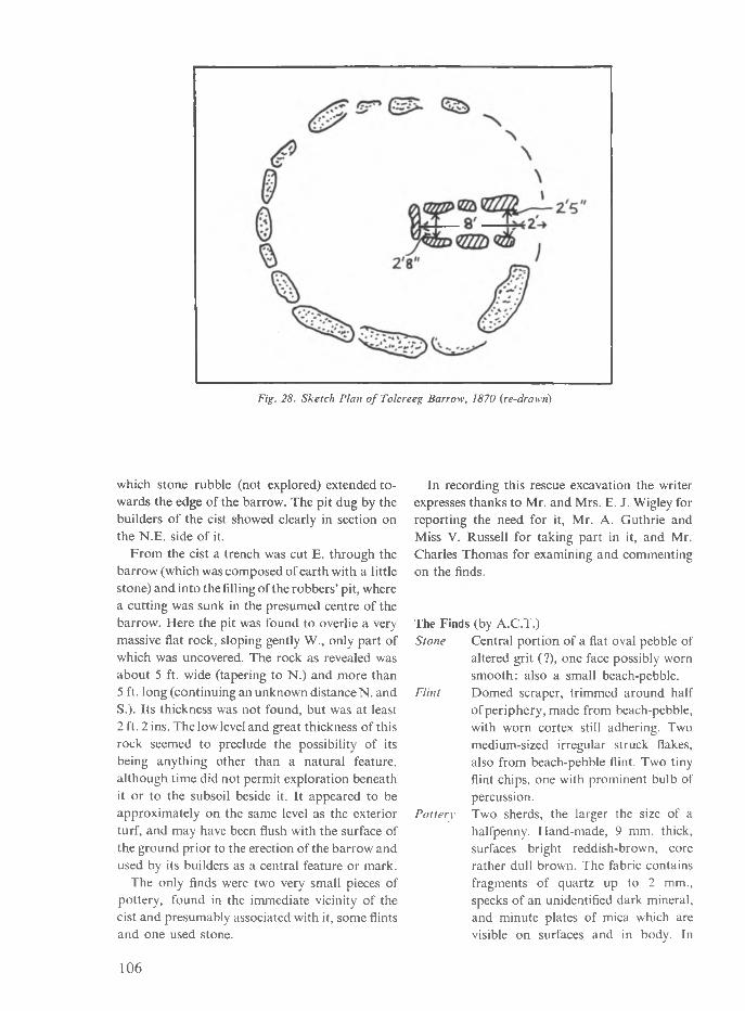
Fig. 28. Sketch Plan o f Tolcreeg Barrow, 1870 (re-drawn)
which stone rubble (not explored) extended to wards the edge of the barrow. The pit dug by the builders of the cist showed clearly in section on the N.E. side of it.
From the cist a trench was cut E. through the barrow (which was composed of earth with a little stone) and into the filling of the robbers’ pit, where a cutting was sunk in the presumed centre of the barrow. Flere the pit was found to overlie a very massive flat rock, sloping gently W., only part of which was uncovered. The rock as revealed was about 5 ft. wide (tapering to N.) and more than5 ft. long (continuing an unknown distance N. and S.). Its thickness was not found, but was at least2 ft. 2 ins. The low level and great thickness of this rock seemed to preclude the possibility of its being anything other than a natural feature, although time did not permit exploration beneath it or to the subsoil beside it. It appeared to be approximately on the same level as the exterior turf, and may have been flush with the surface of the ground prior to the erection of the barrow and used by its builders as a central feature or mark.
The only finds were two very small pieces of pottery, found in the immediate vicinity of the cist and presumably associated with it, some flints and one used stone.
In recording this rescue excavation the writer expresses thanks to Mr. and Mrs. E. J. Wigley for reporting the need for it, Mr. A. Guthrie and Miss V. Russell for taking part in it, and Mr. Charles Thomas for examining and commenting on the finds.
The Finds (by A.C.T.)Stone Central portion of a flat oval pebble of
altered grit (?), one face possibly worn smooth: also a small beach-pebble.
Flint Domed scraper, trimmed around halfof periphery, made from beach-pebble, with worn cortex still adhering. Two medium-sized irregular struck flakes, also from beach-pebble flint. Two tiny flint chips, one with prominent bulb of percussion.
Pottery Two sherds, the larger the size of a halfpenny. Hand-made, 9 mm. thick, surfaces bright reddish-brown, core rather dull brown. The fabric contains fragments of quartz up to 2 mm., specks of an unidentified dark mineral, and minute plates of mica which are visible on surfaces and in body. In
106

general, this is not inconsistent with a Bronze Age date, though perhaps closer to Bodrifty (L.B.A.) material than to the few sherds from Zennor and Sperris cromlechs, which are in a darker ware.
Penzance p . A . S . P o o l
ReferencesB l i g h t , J. T. 1870. The Cromlechs o f Cornwall
(unpublished, proof copy at Morrab Library, Penzance), p. 169.
R u s s e l l , V. and P o o l , P . A. S. 1960. ‘The Antiquities of the North-East part of the Parish of Gulval’, PWCFC 11.4 (I960), p.148.
SURVEY OF ‘ROUND-CHIMNEYED’ HOUSESA g r o u p of members of the Society has, for some years, been preparing a survey of ‘round-chimneyed’ houses, mainly in mid- and west-Cornwall. They would welcome news of further instances from any member who happens to know of any. The ‘round chimney’ is a semi-circular chimney, extruded like a buttress, normally on the gable end(s) of a house. It can either taper in an unbroken line up to roof level, or else go up in two or three stepped stages. Preliminary work suggests that these go back to at least the first half of the 17th century, and may have been constructed as late as circa 1800, if not later. Good accessible examples are: Hillside Terrace, Releath village, SW 661331: Mount Pleasant Farm
(‘Trevu Farm’), Camborne, SW 651392: cottage near Lanvean, opposite Polstrong, visible from the A.30 road, SW 626404; Trevingey Farm, Redruth, behind the Hospital, SW 693415; and Nogoby, Tregaseal, nr. St. Just-in-Penwith, SW 374324.
Information (exact grid reference or description of location, and a rough sketch would be welcomed) would be most gratefully received either by the Editor (at Churchtown, Gwithian, Hayle), or John Stengelhofen, 3 Cornwood Close, London, N.2. About thirty examples have so far been found, drawn, and photographed, three of which have been destroyed or converted even in the last two years.
ReviewsR. M o r t o n N a n c e A Glossary of Cornish Sea- words. Edited, with preface and various memoirs and appreciations of the (late) author, by P . A. S.P o o l . Worden Ltd., Marazion, for Federation o f Old Cornwall Societies (1963). Pp. 204,pis. 7. 25s. Od. Obtainable from L. R. Moir, Pengarth, Carbis Bay, St, Ives.
The circumstances under which this handsome memorial volume appears are unusual. Robert Morton Nance (1873-1959) was, for much of his lifetime, not only Grand Bard of the Gorsedd
of Cornwall and president of a variety of county societies, but also the widely acknowledged doyen of a large sector of Cornish studies— notably linguistics, vernacular literature, and folklore. The bibliography of his published work alone (pp. 195 If.) runs to ten closely-printed pages; the only omissions this reviewer could find were Nance’s (unified) version of ‘Seth Hag Adam' from Origo Mundi, printed in parallel with Breton in Cwalarn, 119/120 (1938), 15-55, and allegedly also his version of ‘Jowan Chy-an- Horth' in Gwalarn, 20 (1929), 55.
107

Nance left a good deal of material behind him, notably his important versions of texts of the miracle plays (with A. S. D. Smith), correcting many previous misreadings. But the current book consists of a glossary, virtually completed in 1920, with notes added from time to time up to 1959, and never published in his lifetime. It is here most faithfully and carefully edited by Mr. Pool, who was familiar with Nance’s method and style, and who has enlisted four experts (Rev. D. R. Evans, Cdr. Oliver Hill, Dr. Kenneth Sisam, Dr. Frank Turk) to check entries from a variety of viewpoints. There is a short factual memoir of Nance by the editor, and eleven short appreciations of Nance which well bring out, not only the extent to which he contributed to so many disciplines, but something of the man himself— his steadfast purpose, his innate kindliness and modesty, his high principles, and his lifelong devotion to the cause of scholarship.
The Glossary itself reflects not only Nance's interest in Cornish dialect—as an expression of continuing Cornish, as the repository of Middle English and other loanwords, as an index of Cornwall's multiplicity of external contacts—but also his involvement in the whole field of nautical history, model sailing-ships (on which he was an authority of European stature), techniques of fishing and boatwork, and the entire specialised vocabulary of the sea. It could never have been collected today; it may be doubted whether anyone save Nance could have done so in the first place. There are something like 1600 separate entries. These involve the names of boats, parts of boats and tackle, fishing-gear, the names (and synonyms) of fishes, crustaceans, mollusca, and sea-weeds; names of landmarks and landfalls, islands, rocks, currents, winds; the seining industry, fish-cellars, persons engaged in fishing, folk-lore terms, terms of abuse, taboo-words, and in short anything connected with Cornwall’s coast. The entries are not mere glosses. If a word is a loan-word, the circumstances and probable date of the loan are set out. Parts of boats, rigging and tackle are carefully explained, natural history is classified in correct taxonomic terms, and parallels outside Cornwall are given in full.
One special value of this magnificent wordbook to the student of the past is the light thrown, in a great many entries, on the Cornish fishing-
boats prior to the mid-19th century, and by implication to the earlier periods. The two- masted lugger of west Cornwall (St. Ives, or the slightly different Mount’s Bay) is widely known as a symbol of the Cornish fisherman, through the paintings of Stanhope Forbes, Lamorna Birch, calendar reproductions and advertisements. Yet it represents a very recent development from a quite different three-masted boat (cf. the picture of the Emily, p. 181; this model was re-rigged by Nance, but is itself much older and probably reliable) in which the derivation from something like the three-masted square-rigged coastal vessel of herring-buss type is obvious. How long before 1800 did the change in the set of sail, the shortening of the mizzenmast, and the addition of the vargord and mizzen-boom, take place ? How did the Cornish three-master sail? Contemporary (e.g. Penaluna) engravings imply that only foresail and mizzen were normally set in Mount's Bay, and indeed the weight of canvas indicated in the photograph on p. 181, on a shallow draught broad-beamed vessel, probably implies that the whole spread could only be set when sailing before the wind under pretty favourable conditions. The admirable little Science Museum handbooks (British Fishing-Boats and Coastal Craft, 2 parts) should be read in conjunction with such problems.
Probably the best compliment one can pay this book is to say that (save for the appreciations, which would have made him shrink) it is set out very much as the author himself would have done. It forms a most suitable and memorable tribute to his work, and exceptional value at the price; we must wish it the success it deserves.
A.C.T.
J a n F i l i p Celtic Civilization and Its Heritage(transl. from original Czech edition (1960) by R. F. Samsour). Czechoslovak Academy o f Sciences and ARTIA, Prague (1962). Paper covers: pp. 256. pis. 40, figs. (incl. maps) 52. 10s. 6d.
Archaeology, perhaps more than most other studies on the borderline between the ‘Two Cultures', is becoming a subject where more and more is being studied about less and less. Few scholars these days seem to have the time—or perhaps the inclination—to sit back, and to set about presenting general surveys, however
108

impermanent and transitory these may be. Iron Age studies have perhaps suffered as badly as any branch of our discipline, despite the key position which they occupy in European archaeology between prehistory and history, barbarian and civilised.
Until Mr. T. G. E. Powell’s The Celts (1956- now available, by the way, as a 12/6 Thames and Hudson paperback), no fresh attempt had been made to study the many and varied problems of Celtic origins and survivals since the pioneer writings of Joseph Dechelette just before World War One. Now Professor Filip, Director of the Archaeological Institute in Prague, and a man whose knowledge of the Central European Iron Age it would be an understatement to call encyclopaedic, has given us a complementary volume. His Celtic Civilization (which, in its new English translation, one must earmark for its length, prolific illustrations, and low price as amongst the ‘best buys’ of 1964) is perhaps concerned more with the material evidence of the Celts than the general historical and linguistic approach of Mr. Powell. None the less, Filip’s summary of the written, as well as the archaeological, accounts of the Celts’ inexorable expansion across Europe to Asia Minor (where their descendants became the ‘Galatians’ of Paul’s Epistle) in the 4th-3rd cents. B.C. balances the awesome amount of detail which is packed in almost without the casual reader realising it. Cemetery sites, (on which we largely depend for the framework of Iron Age chronology), and fortified towns— the oppida of Caesar’s campaign note-books,— are discussed; social systems and economics, coinage (the first struck outside the Mediterranean world in the West), and the more mundane pin and pot types all find a place. Filip’s exposition of the art styles, the first truly Western art recognisable in Europe, by no means ignores the contribution of the British Isles recently surveyed by Sir Cyril Fox.
Balanced as it is by well chosen, if perhaps not always so well reproduced, line drawings and half-tone plates, and a select bibliography, wide- ranging but even so only hinting at the work which must have preceded publication, and a pleasingly straight-forward typography, it is pointless to carp at the occasional infelicities of translation, inevitable in a difficult language and a topic which, in Czech as in English, possesses
its own jargon. It says much for the publishing enterprise of the Czechoslovak Academy of Sciences that an English version should have been prepared so speedily. If this reviewer would not always agree with Filip’s remarks on the British Iron Age, one only has to counter with the thought that here is the best, indeed almost the only illustrated, outline of that period in thirty years.
Celtic Civilization is not merely recommended reading for all interested in the background to the Iron Age, whether he or she be amateur or professional; it is obligatory for anyone who wants to know what the best in archaeological research is really like. J. V . S. M e g a w
University o f Sydney(In view o f possible difficulties in obtaining copies, members are advised that Mr. Barton, Truro Bookshop, Frances Street, Truro, has kindly undertaken to import and supply them. ED.)
M a r y C o a t e Cornwall in the Great Civil War and Interregnum, 1642—1660 (1st edn., 1933) 2nd edn., D. Bradford Barton, Ltd., Truro (1963). Pp. viii (recte x) + 414, pis. 5 ,5 maps. £2 .10s. Od.
Long well-known and praised in Cornwall and in academic circles elsewhere, this book needs no description and only the briefest re-introduction. The main point here is simply to draw attention to the welcome fact that Mary Coate’s ‘Civil War in Cornwall’ is once again in print. In the last issue of CA it was mentioned (p. 81) as one of the standard works on Cornish history completely unobtainable; Mr. Barton has remedied this defect, and suddenly both this volume and Henderson’s Essays have re-appeared within the same year.
This noteworthy achievement by Mr. Barton means that this book is available once more, exactly a conventional generation after its original publication—a lapse of time which would suffice to make most historical studies seem old- fashioned. Here, however, the aptness of the text to modern interests is particularly striking. Lauded as a local history on its publication, this new edition re-establishes the book’s distinguished position among the slowly-growing library of volumes winning academic respectability for local historical studies.
The 1963 production, though called ‘Second
109

edition’, is in fact a reprint of the 1933 text, supplemented by a new preface. In this, the author points to one of the assets of such a local survey. In preparing the detailed material for a narrative of events in one locale, one can avoid contemporary trends—for example, today’s ‘economic’ interpretation of history—which, consciously or otherwise, influence the broader sweep required for a larger area or a longer period. While not fully agreeing . . that the English Revolution (can) only be understood through regional studies’ of the kind under review, it is nevertheless refreshing to return to an historical account firmly based on topography: Cornwall’s naturally defensive situation, its landlocked harbours, its dreadful cross-country communications. And here this approach is especially valid, since the county of Cornwall is, within the context of the Civil War, an historical factor, not simply an arbitrary unit of the historian.
May the success of this book in finding its way on to the shelves of a new generation of readers embolden Mr. Barton to undertake yet further ventures of enlightened publication.
P. J. F o w l e r
Barford St. Martin, Wiltshire
T. R e y n o l d s The Chapels and Curates ofMarket Jew Worden Ltd., Marazion (1963). Pp. x-82, pis 8. 12s. 6d.
Marazion church, built by Piers St. Aubyn in 1861, is what one would expect. Neither church nor village would lead one to suppose that the place is among the oldest towns in the country. Mr. Reynolds gives a fascinating account of the history of the church and its preceding chapels, for till 1892 it was a mere chapelry to St. Hilary. ‘Marazion' says the author ‘was widely known before and for centuries after the Norman Conquest for its port and markets, an importance shared by no other port in West Cornwall.’ It developed partly as an accommodation centre for pilgrims to the Mount, and this must have been early, but one would like to know the pre- Conquest references. At first the inhabitants worshipped at the Mount but when the parochial system developed both were included in St. Hilary. A chapel was licensed in 1309 (and may
have existed long before) but only for services on Mondays, Wednesdays and Fridays.
It is noteworthy that the mediaeval licences (a longer series than usual) were to the 'villani', and the fact that a number of ordinations and enquiries were held in the chapel attests to its importance. Mr. Reynolds’ book is on the chapels and curates, not the borough, but one would like to know more of this. From its earlier importance one would guess that Elizabeth’s charter was a revival of an earlier incorporation and it seems likely that even in mediaeval times the chapel was a borough chapel. In the eighteenth century the mayor had the right of nominating the curate, subject to the consent of the vicar of St. Hilary, and the author narrates later disputes on the subject. The chapel was maintained by the corporation, and the curate supported by collections and fees, etc. The corporation probably represented the villani of the earlier licences. (St. Mary Magdalen, Launceston, is a rather similar case, for which fortunately mediaeval accounts have survived, many printed in the Peters' Histories o f Launceston and Dunheved, 1885.)
The name of only one mediaeval chaplain is known, but the author gives a fairly complete list from 1691. Few stayed for more than a year or two. The most famous was H. F. Lyte (1917- 19), but his successor J. H. Townsend (1819-45) was the one to whom Marazion owes most.
The book is beautifully printed and has a number of plates. J. H. A d a m s
St. Goran
G. H. D o b l e The Saints of Cornwall Part Three, Saints o f the Fal. Pp. 140, paper covers. Printed for the Dean and Chapter o f Truro (1964). 18s. Od. (by post, 18/6d from Rev. R. M. Catling, Helford Cottage, Florence Tee.. Falmouth.)
The value of this series was stressed in a previous notice (CA 2 (1963), 83-4) and the same comments apply to this, the third, instalment. It contains, edited by Mr. Donald Attwater from the latest editions of each original booklet, SS. Budoc, Gluvias, Melor, Feock, Mawes, Gerent, Kea and Fili, Cuby. and Day (with Wennap). For some reason which has been obscure to this reviewer, the ‘Fal’ lives in Doble’s series have always been particularly hard to find. London booksellers (e.g. Quaritch’s) have been asking
110

up to £1 for some of them, and, even at local prices of from 3/- to 5/- when obtainable, this current volume represents a very considerable saving to the student of the area. It appears to be printed on slightly cheaper paper than Part Two, no doubt in order to maintain the price at the same level.
Perhaps one can stress again the arduous, if unobtrusive, role played by Mr. Attwater as editor. Many of these Doble papers were written twenty to thirty years ago—during his life, the author was obliged to revise a number of them, often at intervals of ten to fifteen years—and it would be unrealistic to suppose that, if Gilbert Hunter Doble were now still with us, he would not by now have produced still further revisions. The distinguished hagiographer who has taken on this delicate task deserves all our thanks for it. Support for the series is essential. Members and other readers engaged in work on the post- Roman and medieval periods, parochial checklists or local historical studies, are all urged to invest in the issues to date, and to help ensure the appearance of the remaining three instalments.
A.C.T.
K e n n e t h H u d s o n Industrial Archaeology—An Introduction John Baker Ltd., London (1963). Pp. 180, 35 pp. photos, 2 plans. 36s. Od.
Gone are the days of the antiquary; even the local historian becomes out-dated with the invention of this or that new specialist study. Archaeologists, historians, and geographers are classified into categories largely of their own making. Now, with the advent of Industrial Archaeology, we will have—Heaven forbid!— industrial archaeologists. Mr. Hudson, like a proud but guilty father, feels it incumbent upon him to plead its case at some length in order to establish its legitimacy. However, it is its name and not its nature which many will question; the investigation of this particular branch of human activity is not new, having been pursued enthusiastically at a local level by numerous societies and individuals. If this book is to be accepted as a plea for more assiduous study on the old foundations, it is to be recommended. If it has been designed as a primer for a new race of specialist, nurtured by the C.B.A. and the National Trust, it is to be deprecated.
The contents of Mr. Hudson’s book are neatly arranged and very adequately illustrated, but in attempting to sketch the outlines of the subject the author achieves slightness without breadth. One could have wished for a survey of industrial monuments on a county level—this at least would have given us detail and originality—or a monograph such as Bernard Watney’s Longton Hall Porcelain, in which Mr. Hudson might have pursued a problem through archives and excavation, thus illustrating the study by practical precept. All we seem to have here are the elementary rules of investigation which have been familiar to more than one generation of antiquary.Truro H. L . D o u c h
C y r i l N o a l l A History of Cornish Mail- and Stage-Coaches D. Bradford Barton, Ltd., Truro (1963). Pp. 116, 4 pp. photos, 1 map, 3 figs. 21s. Od.
‘Then there was the music of the rattling harness, and the ring of the horses’ feet on the hard road, and the glare of the two bright lamps through the steaming hoar frost, over the leaders’ ears, into the darkness; and the cheery toot of the guard’s horn, to warn some drowsy pikeman or the ostler at the next change . . .’ The stagecoach, as English as a Christmas robin, tends to be associated with the Midland world of Tom Brown’s Schooldays, or the home counties and Mr. Pickwick. Yet, from the sixteenth to the late nineteenth centuries, this picturesque and incredibly efficient mode of public transport not only covered most parts of Britain, but left an indelible mark on its successor, the railway system (are not the earliest carriages merely stage-coaches on flanged wheels ?—and where does the word ‘guard’ derive from ?), and is in part represented today by the local ’bus routes. Mr. Noall lists sixty-two mail- and stage-coach enterprises in Cornwall, and sixty-six coaching inns. It is clear that his book represents a long overdue enquiry into a complex subject.
Mr. Noall is the curator of the St. Ives Museum, and is well known in West Cornwall for his frequent, scholarly, and detailed articles in the local press on various aspects of the Cornish past, notably mining, shipping, and shipwrecks. An inspection of his Appendix B, the catalogue of the coaches themselves, will make it obvious
111

that a great deal of painstaking research has gone into this survey; this is reflected in the eleven preceding chapters, in which the entire history of Cornish coaching is carefully and logically set out. The photographs evoke a nostalgic world of the pre-tourist era, also recalled in the Foreword by Lady Browning (Daphne Du Maurier). The book itself, printed by Messrs. Worden, is not only an attractive addition to its publishers’ important and growing series covering the Cornish scene of the immediate past; it will, for most readers, acquaint them with a chapter of that past that until now was wholly unknown and inaccessible. We must accord our warmest gratitude to Mr. Noall, coupled with the assurance that his next work, on Cornish shipwrecks, will be the more eagerly awaited. A.C.T.
A. K. H a m i l t o n J e n k i n Mines and Miners ofCornwall (continued). III. Around Redruth. Pp.52 (1962), 8s. Od. IV. Penzance—Mount's Bay. Pp. 66(1962) 8s. 6d. V. Hayle, Gwinear and Gwithian. Pp. 64 (1963), 8s. 6d. VI. Around Gwennap. Pp. 60(1963), 8s. 6d. VII. Perranporth-Newquay, Pp. 68 (1963), 9s. 6d. All numbers illus. with maps, plans, drawings, photos. D. Bradford Barton, Ltd., Truro. The first seven parts of this series have covered much of the western half of the county, including many of the most intensively mined regions. Since the war only one other work has appeared which could be used as a field guide by the Industrial Archaeologist; (the late) H. G. Dines’ Metalliferous Mining Regions o f the South-West o f England; and so we are tempted to compare the two works, but in fact they cover the subject from very different points of view. Dines, written for the geologist, has been used by those interested in mining history for lack of any better readily available source; he locates the mines and individual shafts clearly, and gives very detailed descriptions of the lodes, but with only the briefest historical notes, often omitting early
history, and the many previous names of the workings. In Mines and Miners we have the result of Mr. Jenkin’s lifelong study, forming possibly the most comprehensive history we are ever likely to see in print.
Hardly a mine exists where the complete history can be written: while it is surprising how in a hundred years all evidence of a small mine can disappear, and others leave only an entry in a mining magazine or a local paper (although this is a problem encountered by all industrial historians), Mr. Jenkin concentrates on these smaller lesser-known mines. In many cases he has been able to establish the definite position not previously known, and to tell some of the history from a few notes uncovered in his researches in letter-books, family records, or mine cost-books.
Mines and Miners probably holds more fascination for the casual reader where the information has been more extensive. The detailed history of the many small workings under the streets of Redruth, or East Wheal Rose, flooded out after a cloudburst, with great loss of life, or little Magdalen Mine in Ponsanooth with records from 1522 until the 1920s when winding was carried out by an old motor-car engine, spring to mind as examples.
The selection of photographs and maps has been very varied. With a subject offering so wide a choice, it is good to see apart from the photographs of ruined engine houses and stacks, such things as an engraving of the sailing dredger on the Loe, a Goldsithney bank-note, and a drawing of a horse-whim, as well as early photographs of the mines at work.
Any points of criticism are small; it is sometimes awkward to use as reference book, being in small volumes, and many people will want to have them bound together, but this does not detract from a work of such a high standard, which makes a great contribution to the subject; one awaits the further parts impatiently.London J. P. S t e n g e l h o f e n
112
recently published...A H ISTORY OF C O RN ISH MAIL- A N D STAGE-COACHES C. Notil
Stage-coaches were late in coming to Cornwall, the county’s remoteness and isolation delaying their Introduction until the close of the eighteenth century. As if to compensate for this however, they survived here later than in most other parts of England— down indeed to the end of the First W orld War. Their full history is told here in detail for the first time. W ith foreword by Daphne du Maurier 21s Od net
C O R N W A L L IN THE GREAT CIV IL W A R A N D INTER-REGNUM Mary Coat*
A re-issue of this important and now scarce study of the county at the most important period of its history, during the exciting years from the Civil W ar to the Restoration. Since its original publication in 1933 (when the Times Literary Supplement described it as ‘a distinguished contribution to the history of England’) it has steadilygrown in stature: a book of lasting importance far beyond the confines of Cornwall. 50s Od net
A H ISTOR ICAL SURVEY OF THE M INES A N D M INERAL RA ILW AYS OF EAST C O R N W A L LA N D W EST D EV O N D. B. Barton
A historical guide to the larger and more noteworthy mines of East Cornwall and W est Devon (from Truro to Tavistock) outlining their position and history, together with that of the mineral railways that served them.W ith line drawings by the author and ten sketch maps of the major mining districts. 21s Od net
to be published shortly...W R EC K A N D RESCUE R O U N D THE CO RN ISH CO AST I: The Story of the North Coast Lifeboats
Cyril Noall and Graham. Farr
Since 1803, when the first Cornish lifeboat was stationed at Penzance, a great humanitarian work of rescue from shipwreck has been carried on around the cruel coasts of the county with unfailing heroism and devotion by the men of this noble service. The story of their work forms a magnificent saga, but one which has so far gone untold. A full history of the lifeboat service in Cornwall is now in preparation, based on official R.N.L.I. records, supplemented by information from local sources, and wiir deal in detail with each of the Cornish stations past and present. The first volume tells the story of the north coast lifeboats, from Bude to Hayle; this will be followed by the story of the Land’s End stations and then by that of the south coast stations from Porthleven eastward to Looe. about 21s Od each volume net
EAST W H EA L ROSE: THE H ISTORY OF C O R N W A L L ’S GREATEST LEAD M INE H. L. Douch
A detailed history, told in full for the first time, of East Wheal Rose, greatest and richest of the lead mines of Cornwall. This account, based largely on original research, throws new light not only on the cloudburst disaster of 1846 but on the little known beginnings of East Wheal Rose and on the final, financially disastrous re-working in the early I880’s. Also included is a history of the neighbouring Old Wheal Rose whose riches first established this once important mining district. about 8s 6d
from all good booksellers or direct (postage extra) from
D. BRADFORD BARTON LTD
TRURO BOOKSHOP TRURO CORNWALL

B LO C K SU BS CR IP TI O N S
Impressive results have been obtained in Cornish archaeology in the last two decades through both fieldwork and excavation; this is especially so in periods like the Bronze Age and the post-Roman era. The Society publishes, in addition to this journal, various field guides and occasional papers. You can obtain all our publications annually as they appear (unless you are a resident of Cornwall or the Isles of Stilly) without having to be a member. Through the Block Subscription scheme, an annual payment of 25/-, made each January 1st by bankers’ order, brings these to you post- free. Many museums and libraries have taken advantage of this scheme already. Write to the Treasurer or the Editor (addresses inside) for a Block Subscription form which gives full details of the scheme. Sets of the various items for 1962 and 1963 are still available at 25/- a set.
D E V O N A N D C O R N W A L L N O T E S A N D Q U ERIES
A Journal devoted to the
LOCAL HISTORY, ARCHAEOLOGY, BIOGRAPHY and ANTIQUITIES
of the Counties o f Devon and Cornwall
21/- a year, post free
The Editor will be glad to receive suitable material relating to the History, Archaeology and Antiquities o f the two counties. This should be sent to Mrs. M. C. S. Cruwys, 31, St. Peter Street, Tiverton, Devon.


