Embed Size (px)
Citation preview

New lake district in Europe: origin and hydrochemicalcharacteristics
Mariusz Rzetaza1 & Andrzej Jagus2
1Faculty of Earth Sciences, University of Silesia, Sosnowiec, Poland; and 2Institute of Environmental Protection and Engineering, University of Bielsko-
Biaza, Bielsko-Biaza, Poland
Keywords
eutrophication; field mapping; lake district;
Upper Silesian region; water bodies; water
chemistry.
Correspondence
Mariusz Rzetaza, Faculty of Earth Sciences,
University of Silesia, Bedzinska 60, 41-200
Sosnowiec, Poland. Email:
doi:10.1111/j.1747-6593.2011.00269.x
Abstract
This article presents a new lake district in Southern Poland created as a result of
human activity in the Upper Silesian region. The area has been named the
Upper Silesian Anthropogenic Lake District. The lake density of the Lake
District as delineated by the authors (with an area of 6766 km2) is 2.74%. It
includes 4773 water bodies of various origins – reservoirs retained by dams,
flooded mineral workings, water bodies formed in subsidence basins and
hollows, levee ponds, residual water bodies following river regulation and
other water bodies. These are located in urban-industrial, rural-agricultural or
quasi-natural areas. The hydrochemical diversity of water bodies is conditioned
by their origin, location in the catchment and function. Studies have shown the
widespread occurrence of eutrophication processes in limnic waters within the
Lake District. The diverse origin and hydrochemical properties of water bodies
within the Upper Silesian Anthropogenic Lake District make it special among
other anthropogenic lake districts.
Introduction
The term ‘lake district’ is usually associated with areas
exhibiting early postglacial relief features, i.e. with
numerous natural postglacial lakes. Lake districts defined
in this manner are typical of the temperate climate zone
(Kapfer 1998; Boehrer et al. 2000; Schnaiberg et al. 2002;
Tipping et al. 2002; Pienimaki & Leppakoski 2004) and
distinguish themselves by their high lake density, i.e. the
percentage of the land area covered by lentic waters. If a
sufficiently high lake density is considered the main
criterion for recognising lake districts, this term could
apply to many areas all over the world, as lake density is
high in certain regions owing to the presence of diverse
bodies of water formed as a result of human activity. In
such cases, however, the term ‘anthropogenic lake dis-
trict’ is preferred (Jankowski & Rzetaza 2004), which
points to the different origin and functioning of limnic
basins compared with natural lake districts.
Long-term limnological studies conducted in southern
Poland by the authors of this work have demonstrated
that it is possible to distinguish a new Upper Silesian
Anthropogenic Lake District (the name is derived from
the historical and ethnographic region of Upper Silesia)
situated close to the Polish, Czech and Slovak borders
(Fig. 1). In this area (Fig. 2), a cluster of anthropogenic
water bodies has been found that can be considered a lake
district and that has not been mentioned earlier or has
only been referred to in the literature on clusters of limnic
water bodies in Poland (Choinski 1995, 2007; Kolada et al.
2005). Moreover, special features of this lake district that
set it apart among other anthropogenic lake districts
described by researchers from various countries have
been pointed out. It has been named the Upper Silesian
Anthropogenic Lake District after the region where it is
situated.
The anthropogenic lake districts described in the world
literature are usually associated with a specific type of
human economic activity and the water bodies present
within a single lake district exhibit many similarities.
Examples of such lake districts abound. They are present
e.g. in the Polish and German parts of the area where
lignite is mined (Solski & Jedrczak 1990; Duis & Oberemm
2001; Grunewald 2001; Nixdorf et al. 2003; Hangen-
Brodersen et al. 2005; Kleeberg & Gruneberg 2005;
Schultze et al. 2010). In the United States, anthropogenic
lake districts are associated with areas where water bodies
have formed in excavations formerly used to mine gold,
copper ores, zinc ores and other elements in Nevada (Eary
Water and Environment Journal (2011) c� 2011 The Authors. Water and Environment Journal c� 2011 CIWEM. 1
Water and Environment Journal. Print ISSN 1747-6585
108 Water and Environment Journal 26 (2012) 108–117 © 2011 The Authors. Water and Environment Journal © 2011 CIWEM.

1999; Tempel et al. 2000). In France, on the other hand,
such lake districts formed, e.g. within the Massif Central,
in areas where coal had beenmined (Denimal et al. 2005).
Among anthropogenic lake districts, areas with clusters of
levee ponds used for fish breeding are also found, e.g. in
the south of the Czech Republic (Pokorny & Hauser 2002)
or in southern Britain (Williams et al. 2003). The peculiar
feature of the Upper Silesian Anthropogenic Lake District
is the presence of water bodies of very diverse origins and
hydrochemical properties (Rzetaza 2008) resulting from
their formation and functioning in urban-industrial, rural-
agricultural or quasi-natural geographical areas. This
paper therefore endeavours to present the Upper Silesian
Anthropogenic Lake District not just as a new European
lake district but also as a region, providing special research
opportunities with respect to the development and pro-
tection of lentic water resources.
The purpose of this study was to determine the number
and areas of all water bodies situated in the Upper Silesia
region and on its edges, and subsequently, to delineate the
area of the anthropogenic lake district. Another purpose
of the study was to determine the origin of water bodies
and evaluate their natural and economic importance as
well as to determine and evaluate the quality of the water
retained in lake district water bodies. In connection with
the shortage of water resources in the region, the paper
describes the functions that the water bodies described
fulfil or could fulfil, given effective protection.
Materials and methods
An anthropogenic lake district was defined in the Upper
Silesian region and surrounding areas on the basis of
long-standing observations and field surveys as well as
the analysis of maps and satellite images. The entire area
of almost 10 000 km2 that stood out from its surroundings
owing to the visible concentration of water bodies was
divided into 10 km2, each with an area of 100 km2.
Hydrological mapping as well as inventory and carto-
metric work were performed on the basis of 1 : 10 000
scale maps. Aerial photographs and satellite images were
also used. As concerns the inventory of water bodies, only
those water bodies that were permanently filled with
water and those fish rearing ponds that were emptied
almost completely only in winter or occasionally when
harvesting fish or other water organisms were taken into
account (water bodies that contained no water during the
most part of the year were not included in the count).
Within each square, water bodies were inventoried and
lake density was determined as the ratio of water area to
the grid cell (square) area. On the basis of lake density
values assigned to the central points of grid cells, 0.5, 1, 2,
4, 8 and 16% lake density contour lines were drawn using
the interpolation method. The extent of the lake district
was determined by adopting the 0.5% lake density con-
tour line as the boundary and drawing an artificial lake
district boundary along the Polish/Czech border.
Fig. 1. Location of the Upper Silesian region.
Water and Environment Journal (2011) c� 2011 The Authors. Water and Environment Journal c� 2011 CIWEM.2
New lake district in Europe M. Rzetaza and A. Jagus
109Water and Environment Journal 26 (2012) 108–117 © 2011 The Authors. Water and Environment Journal © 2011 CIWEM.
M. Rzetała and A. Jagus New lake district in Europe
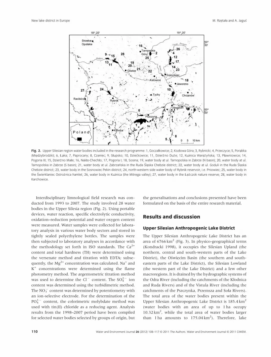
Interdisciplinary limnological field research was con-
ducted from 1993 to 2007. The study involved 28 water
bodies in the Upper Silesia region (Fig. 2). Using portable
devices, water reaction, specific electrolytic conductivity,
oxidation–reduction potential and water oxygen content
were measured. Water samples were collected for labora-
tory analysis in various water body sectors and stored in
tightly sealed polyethylene bottles. The samples were
then subjected to laboratory analyses in accordance with
the methodology set forth in ISO standards. The Ca2+
content and total hardness (TH) were determined using
the versenate method and titration with EDTA; subse-
quently, the Mg2+ concentration was calculated. Na+ and
K+ concentrations were determined using the flame
photometry method. The argentometric titration method
was used to determine the Cl� content. The SO42� ion
content was determined using the turbidimetric method.
The NO3� content was determined by potentiometry with
an ion-selective electrode. For the determination of the
PO43� content, the colorimetric molybdate method was
used with tin(II) chloride as a reducing agent. Analysis
results from the 1998–2007 period have been compiled
for selected water bodies selected by groups of origin, but
the generalisations and conclusions presented have been
formulated on the basis of the entire research material.
Results and discussion
Upper Silesian Anthropogenic Lake District
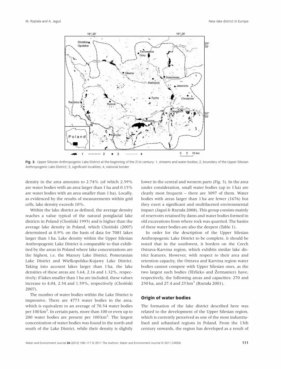
The Upper Silesian Anthropogenic Lake District has an
area of 6766 km2 (Fig. 3). In physico-geographical terms
(Kondracki 1998), it occupies the Silesian Upland (the
northern, central and south-western parts of the Lake
District), the Oswiecim Basin (the southern and south-
eastern parts of the Lake District), the Silesian Lowland
(the western part of the Lake District) and a few other
macroregions. It is drained by the hydrographic systems of
the Odra River (including the catchments of the Kzodnica
and Ruda Rivers) and of the Vistula River (including the
catchments of the Pszczynka, Przemsza and Soza Rivers).
The total area of the water bodies present within the
Upper Silesian Anthropogenic Lake District is 185.4 km2
(water bodies with an area of up to 1ha occupy
10.32 km2, while the total area of water bodies larger
than 1ha amounts to 175.04 km2). Therefore, lake
Fig. 2. Upper Silesian region water bodies included in the research programme: 1, Goczazkowice; 2, Kozzowa Gora; 3, Rybnicki; 4, Przeczyce; 5, Porabka
(Miedzybrodzki); 6, yaka; 7, Paprocany; 8, Czaniec; 9, Szupsko; 10, Dzieckowice; 11, Dzierz’no Duz’e; 12, Ku$nica Warez’ynska; 13, Pzawniowice; 14,
Pogoria III; 15, Dzierz’no Maze; 16, Nakzo-Chechzo; 17, Pogoria I; 18, Sosina; 19, water body at ul. Tarnopolska in Zabrze (N basin); 20, water body at ul.
Tarnopolska in Zabrze (S basin); 21, water body at ul. Zabrzanska in the Ruda �Slaska Chebzie district; 22, water body at ul. Goduli in the Ruda �Slaska
Chebzie district; 23, water body in the Sosnowiec Pekin district; 24, north-western side water body of Rybnik reservoir, i.e. Pniowiec; 25, water body in
the �Swierklaniec Ostroz’nica hamlet; 26, water body in Ku$nica (the Mitrega valley); 27, water body in the yez’czok nature reserve; 28, water body in
Karchowice.
Water and Environment Journal (2011) c� 2011 The Authors. Water and Environment Journal c� 2011 CIWEM. 3
New lake district in EuropeM. Rzetaza and A. Jagus
110 Water and Environment Journal 26 (2012) 108–117 © 2011 The Authors. Water and Environment Journal © 2011 CIWEM.
New lake district in Europe M. Rzetała and A. Jagus
density in the area amounts to 2.74% (of which 2.59%
are water bodies with an area larger than 1ha and 0.15%
are water bodies with an area smaller than 1ha). Locally,
as evidenced by the results of measurements within grid
cells, lake density exceeds 10%.
Within the lake district as defined, the average density
reaches a value typical of the natural postglacial lake
districts in Poland (Choinski 1995) and is higher than the
average lake density in Poland, which Choinski (2007)
determined at 0.9% on the basis of data for 7081 lakes
larger than 1ha. Lake density within the Upper Silesian
Anthropogenic Lake District is comparable to that exhib-
ited by the areas in Poland where lake concentrations are
the highest, i.e. the Mazury Lake District, Pomeranian
Lake District and Wielkopolska-Kujawy Lake District.
Taking into account lakes larger than 1ha, the lake
densities of these areas are 3.64, 2.16 and 1.32%, respec-
tively; if lakes smaller than 1ha are included, these values
increase to 4.04, 2.54 and 1.59%, respectively (Choinski
2007).
The number of water bodies within the Lake District is
impressive. There are 4773 water bodies in the area,
which is equivalent to an average of 70.54 water bodies
per 100 km2. In certain parts, more than 100 or even up to
200 water bodies are present per 100 km2. The largest
concentration of water bodies was found in the north and
south of the Lake District, while their density is slightly
lower in the central and western parts (Fig. 3). In the area
under consideration, small water bodies (up to 1ha) are
clearly most frequent – there are 3097 of them. Water
bodies with areas larger than 1ha are fewer (1676) but
they exert a significant and multifaceted environmental
impact (Jagus & Rzetaza 2008). This group consists mainly
of reservoirs retained by dams and water bodies formed in
old excavations fromwhere rock was quarried. The basins
of these water bodies are also the deepest (Table 1).
In order for the description of the Upper Silesian
Anthropogenic Lake District to be complete, it should be
noted that in the southwest, it borders on the Czech
Ostrava-Karvina region, which exhibits similar lake dis-
trict features. However, with respect to their area and
retention capacity, the Ostrava and Karvina region water
bodies cannot compete with Upper Silesian ones, as the
two largest such bodies (Terlicko and %ermanice) have,
respectively, the following areas and capacities: 270 and
250ha, and 27.4 and 25hm3 (Rzetaza 2001).
Origin of water bodies
The formation of the lake district described here was
related to the development of the Upper Silesian region,
which is currently perceived as one of the most industria-
lised and urbanised regions in Poland. From the 13th
century onwards, the region has developed as a result of
Fig. 3. Upper Silesian Anthropogenic Lake District at the beginning of the 21st century: 1, streams and water bodies; 2, boundary of the Upper Silesian
Anthropogenic Lake District; 3, significant localities; 4, national border.
Water and Environment Journal (2011) c� 2011 The Authors. Water and Environment Journal c� 2011 CIWEM.4
New lake district in Europe M. Rzetaza and A. Jagus
111Water and Environment Journal 26 (2012) 108–117 © 2011 The Authors. Water and Environment Journal © 2011 CIWEM.
M. Rzetała and A. Jagus New lake district in Europe

the mining of minerals (lead, silver and iron ores, coal,
zinc ores, rock) and their use in the metallurgical indus-
try. As a result of industrialisation and population inflows,
urban centres developed and the services sector started
to operate. Additionally, land situated further from the
centre of the region was brought into agricultural use.
Ongoing development entailed the need to manage the
water conditions in the area while ensuring the supply of
water for both economic and municipal uses. All these
factors led to the formation of numerous water bodies
that either served certain social and economic functions
or were the unintended result of human activity. Ana-
lyses of historical maps indicate that the lake district
formed during the 20th century but a rapid increase in
water body area was only observed in its second half. In
the 1960s, only 3097 water bodies with a total area of
113.4 km2 existed within the present lake district. Lake
density amounted to 1.68% and there were on average
45.77 bodies of water per 100 km2.
The following types of water bodies can be distin-
guished with regard to their origin within the lake district:
reservoirs impounded behind dams, flooded mineral
workings, water bodies formed in subsidence basins and
hollows, levee ponds and residual water bodies remaining
after water management projects, various pools, park
ponds, tanks, sedimentation tanks, industrial or fire-fight-
ing tanks, etc. All these types of water bodies were formed
as a result of human activity. Apart from these, small
natural water bodies are found, albeit rarely (e.g. in
depressions between dunes).
Dams were built to retain reservoirs in places where the
morphology of river valleys was conducive to the erection
of dams. There are few such reservoirs within the Lake
District. The largest ones can be found on the outskirts of
urban and industrial areas. While constructed mainly as
flood protection measures and domestic water reservoirs,
they currently serve many purposes. Most of them also
serve as tourist and leisure destinations. An interesting
exception here is the Kozzowa Gora Reservoir, which was
constructed in the 1930s for military and defence reasons
(as a water barrier), and was only later adapted for water
supply purposes (Jagus & Rzetaza 2003). The largest dam-
retained reservoir in the Lake District with respect to both
area and capacity is the Goczazkowice Reservoir (32 km2;
167hm3), while the oldest one is the Paprocany Reser-
voir, which dates back to ca. 1870.
Flooded mineral workings formed in depressions that
were created as a result of open-pit mining of minerals:
coal, zinc and lead ores, sand, limestone, dolomite, clay.
Their areas range from several dozen square metres to
several square kilometres. They are numerous within the
Lake District, as excavated areas were usually reclaimed
by flooding them. Many excavations were also flooded as
a result of spontaneous inflows of groundwater. The
largest flooded mineral workings can be found in former
sand pits; sand was sourced in large quantities to serve as
filling in deep coal mining. Former sand pits often serve
leisure purposes precisely on account of their geological
situation. Flooded mineral workings – just like reservoirs
retained by dams – often serve as leisure destinations.
They are used for sailing, kayaking, angling and power-
boating (in those places where the use of engines is
allowed). Bathing beaches have been set up and, in
addition, there are some unofficial bathing spots that are
customarily used. A good example here is the complex
consisting of the three Pogoria lakes together with the
adjacent Ku$nica Warez’ynska lake (created in 2005)
(Jagus & Rzetaza 2008).
Water bodies in subsidence basins and hollows have
formed as an unintended by-product of mining activities.
In the case of subsidence basins, the formation of basins is
the result of the deflection and downward movement of
rock layers situated in zones where underground mining
takes place at deep levels (local subsidence may be as deep
as 30m). On the other hand, rock hollows flooded with
water are typical of shallow underground mining zones.
These water bodies are relatively numerous; their area is
usually small and they assimilate into their surroundings
most easily. Apart from the angling opportunities they
offer, water bodies of this type usually do not serve any
important economic purposes and are therefore often
Table 1 Largest water bodies of the Upper Silesian Anthropogenic Lake
District
Namea Maximum area (ha) Total capacity (hm3)
Reservoirs impounded behind dams
Goczazkowice 3200 167.0
Kozzowa Gora 587 15.3
Rybnicki 555 24.0
Przeczyce 470 20.7
Porabka (Miedzybrodzki) 380 26.6
yaka 350 11.2
Paprocany 120 2.5
Czaniec 45 1.3
Szupsko 35 1.2
Flooded mineral workings
Dzieckowice 730 52.8
Dzierz’no Duz’e 615 94.0
Ku$nica Warez’ynska 560b 51.1b
Pzawniowice 240 29.2
Pogoria III 208 12.0
Dzierz’no Maze 160 12.6
Nakzo-Chechzo 90 1.5
Pogoria I 75 3.6
Sosina 51 1.3
aLocation of water bodies (see Fig. 2).bTarget parameters.
Water and Environment Journal (2011) c� 2011 The Authors. Water and Environment Journal c� 2011 CIWEM. 5
New lake district in EuropeM. Rzetaza and A. Jagus
112 Water and Environment Journal 26 (2012) 108–117 © 2011 The Authors. Water and Environment Journal © 2011 CIWEM.
New lake district in Europe M. Rzetała and A. Jagus

filled in to obtain new areas for development after appro-
priate reclamation measures have been implemented.
A significant group of water bodies in the lake district
under examination are levee ponds. They are usually
clustered in river valleys in places where water can be
retained. These ponds are flat-bottomed and shallow
(typically around 1–1.5m); their depth is conditioned by
the height of the dikes or levees constructed around them.
In urban and industrial areas, levee ponds are used to
store clean or polluted water (wastewater). In rural areas,
they usually serve as fish farm facilities (fish ponds) and,
with a few exceptions, are typically emptied for winter.
They are used to breed many fish species, especially the
common carp but also tench, grass carp (Carassius auratus)
and Crucian carp (Carassius carassius), silver carp, ide,
pike, wels catfish and European perch. Common carp is
the most popular breeding species (yields range from 300
to 1000 kg/ha) but there are some ponds where the share
of other fish species is as high as 40%. The largest fish
farms are located in the vicinity of Oswiecim, where
ponds were operated as early as the 13th century. Pond
area in this region amounts to ca. 3000ha, with the
largest pond measuring 78ha.
Residual water bodies following river management
activities are water-filled sections of river channels that
were cut off during regulation work within the flood-
plain. Although they have usually retained morpho-
metric and biocenotic properties similar to natural
oxbow lakes, they should be classified as anthropogenic
water bodies. The number of these water bodies was
much higher several decades ago when river regulation
used to be widespread, because they tend to become
overgrown and have silted up with time. They are usually
classified as wasteland.
Water bodies belonging to the other types mentioned
above are very numerous and their areas are small. They
are usually single-purpose reservoirs. Moreover, they are
usually single-purpose reservoirs serving fire-fighting,
industrial, municipal or decorative functions, etc.
Water bodies in the lake district in question typically
have multiple purposes in both the economic and the
environmental spheres. One feature common to water
bodies of different origins is the fact that they are leisure
and tourist destinations. Nearly every water body in the
region serves anglers. The angling economy is regulated
by the Polish Angling Association (PAA). Fisheries admi-
nistered by the PAA are stocked with appropriate fish
species; in 2010 for example, water bodies were stocked
with eel (435 kg of fish fry were introduced into water
bodies) and pike perch (770 000 fry were introduced). The
range of fish species present in the water bodies under
examination is very broad. The fish that are most often
caught by anglers include predators such as the European
perch, pike perch, wels catfish, eel and pike as well as
nonpredatory fish such as the common roach, common
bream, common carp, Crucian carp, tench, grass carp and
ide.
All water bodies constitute significant factors that affect
natural conditions – hydrological conditions, microcli-
mate and habitats; they provide, inter alia, sanctuaries for
numerous rare plant and animal (particularly bird) spe-
cies. For this reason, nature conservation measures have
been instituted with respect to some water bodies; some
have also been declared bird sanctuaries with significance
at the local, regional (e.g. Zbiornik Rybnicki, Dzierz’no
Duz’e), national (e.g. Kozzowa Gora, yez’czok ponds) or
even international (the Goczazkowice reservoir) levels.
Chemistry of water bodies
Water bodies within the Upper Silesian Anthropogenic
Lake District exhibit considerable diversity with respect to
their hydrochemical properties – these vary even between
bodies of water that have the same origin (Table 2).
Differences are primarily the result of the fact that anthro-
pogenic pressure on their catchments varies but can also
stem from the different geological situation of basins or
the manner in which individual water bodies are used
(Rzetaza 2008). Water body catchments are subject to
various degrees of anthropogenic pressure – they can be
urban and industrial areas or rural and agricultural ones,
used for various purposes; sometimes, they remain largely
quasi-natural in their nature (woods, bogs, marshes).
Owing to their location on the boundaries of the most
industrialised part of the region, reservoirs retained
behind dams are usually subject to anthropogenic pres-
sure, mainly agricultural but also industrial and urban in
the case of the Rybnik Reservoir. This is often reflected by
their excessive content of biogenic substances, and in the
case of the Rybnik Reservoir, also other nutrients, salinity
and thermal pollution. This leads to annual blooms as well
as increased alkalisation and oxygen oversaturation of
surface layers while the hypolimnion has insufficient
amounts of oxygen.
Studies have found various levels of pollution in
flooded mineral workings – ranging from levels consid-
ered natural to those reflecting a complete degradation of
the water environment. The Nakzo-Chechzo reservoir is
mostly free from anthropogenic pressure and the quality
of its waters can be considered the best among those
studied. On the other hand, the Dzierz’no Duz’e Reservoir,
which has been affected by human industrial activity, is
subject to extreme anthropogenic pressure. Certain para-
meter values exceed those considered natural several or
several dozen times (or, in the case of phosphates, up to
several hundred times). The waters of the Dzierz’no Duz’e
Water and Environment Journal (2011) c� 2011 The Authors. Water and Environment Journal c� 2011 CIWEM.6
New lake district in Europe M. Rzetaza and A. Jagus
113Water and Environment Journal 26 (2012) 108–117 © 2011 The Authors. Water and Environment Journal © 2011 CIWEM.
M. Rzetała and A. Jagus New lake district in Europe

Reservoir are hypertrophic and polytrophic because of the
supply of pollutants from the Kzodnica River. A special
group of postexploitation water bodies are small water
bodies formed in old quarries or mining pits; these lack
drainage. Owing to the limited possibilities of water
exchange and self-purification, their chemistry is affected
by the denudation of rock layers and local sources of
pollutants.
The physico-chemical properties of water bodies
formed in subsidence basins and hollows depend on the
manner in which the deformed land area is utilised,
irrespective of its size – e.g. the storage of mining or
metallurgical waste within the subsidence directly affects
the quality of the water accumulated in it. In areas subject
to subsidence that are under agricultural use, biogenic
pollutant concentrations can be observed. Among water
bodies of this type, the best parameters with respect to
quality are exhibited by those situated in areas where
forest, shrub and herbaceous plant communities are
present and that have not been in intensive use.
The hydrochemical properties of levee ponds vary and
depend largely on the intensity of fish breeding; when
such ponds are fed from external sources, their para-
meters are dependent on the type of land use in the
catchment that recharges them. However, these water
bodies are usually polluted with nitrogen and phosphorus
compounds whose concentrations exceed applicable stan-
dards. Unused levee ponds are often clean water enclaves
– an example here is the �Swierklaniec Ostroz’nica Pond.
As concerns the presentation of the results of analysis
of physico-chemical water properties in water bodies of
different origins (Table 2), the broad spectrum of extreme
values that document the real extent of differences be-
tween lakes and anthropogenic water bodies has to be
emphasised. With respect to water reaction, the lowest pH
(5.28) was detected in the Nakzo-Chechzo acidotrophic
water body, while the highest pH (9.50) was found during
the period when eutrophication processes reached the
peak intensity in the Kozzowa Gora water body, which is
situated in an agricultural catchment. The lowest specific
conductivity values were measured in the aforemen-
tioned Nakzo-Chechzo water body (169mS/cm) and in
the oligotrophic Ostroz’nica lake (169 mS/cm), while the
highest SEC (7320 mS/cm) was found in the Dzierz’no
Duz’e lake supplied with water by the Kzodnica river,
which drains the western part of the urban Silesian
Upland area. Differences in water electrical conductivity
values are related to concentrations of ions, mostly
Table 2 Physico-chemical properties of water in selected Upper Silesian Anthropogenic Lake District water bodies. 1998–2007 (mean values)
Water bodya Reaction (pH) C (mS/cm)
O2 Ca2+ Mg2+ Na+ K+ Cl� SO42� NO3
� PO43�
(mg/dm3)
Reservoirs retained behind dams
1 7.91 217.5 11.4 45.0 6.1 9.0 3.1 14.4 24.2 6.1 0.074
2 8.17 364.2 12.4 63.3 20.8 8.1 3.0 27.9 40.1 7.6 0.062
3 8.02 891.8 10.1 72.4 19.1 91.7 9.0 186.8 86.2 12.2 0.269
6 7.62 588.0 9.6 43.1 10.6 52.2 6.5 89.2 68.5 10.4 0.389
7 7.42 324.8 11.6 41.6 15.7 17.7 3.1 55.2 45.9 1.8 0.056
Flooded mineral workings
11 7.81 5829.5 9.8 199.1 78.4 887.6 38.2 1710.1 444.0 238.4 2.805
13 8.17 575.7 12.6 73.0 14.8 33.5 5.3 90.7 57.8 4.8 0.347
14 7.89 617.3 11.0 82.3 29.4 21.1 5.1 48.3 107.5 1.3 0.029
16 7.41 192.2 11.3 20.0 17.1 6.7 2.3 15.5 32.2 1.0 0.006
17 7.82 610.9 30.9 86.5 20.4 22.8 4.7 60.1 98.3 2.1 0.033
Water bodies in subsidence basins and hollows
19 7.70 134.5 – 38.0 159.6 77.4 70.0 176.3 469.3 4.2 1.200
20 8.40 139.5 – 36.0 141.6 72.6 34.4 162.1 415.6 2.6 0.580
21 8.01 1063.9 – 52.5 108.2 40.9 67.1 80.5 259.0 1.1 0.521
22 7.80 1453.0 – 62.0 190.8 51.6 120.0 74.6 546.3 0.4 1.400
23 7.62 3021.0 – 63.0 114.1 132.4 54.1 759.3 282.3 58.9 1.300
Levee ponds
24 8.20 270.9 – 55.5 21.9 9.8 3.9 42.6 36.6 11.3 0.028
25 6.91 224.0 – 40.0 0.1 5.5 1.5 8.0 20.1 1.0 0.008
26 8.25 409.0 – 60.0 40.8 6.2 4.3 20.7 44.0 3.0 0.080
27 7.53 415.0 – 46.0 18.0 12.2 4.7 34.0 85.6 11.5 0.096
28 7.25 822.0 – 30.0 51.6 21.1 9.6 66.7 83.6 17.8 0.111
aLocation of water bodies (see Fig. 2).
Water and Environment Journal (2011) c� 2011 The Authors. Water and Environment Journal c� 2011 CIWEM. 7
New lake district in EuropeM. Rzetaza and A. Jagus
114 Water and Environment Journal 26 (2012) 108–117 © 2011 The Authors. Water and Environment Journal © 2011 CIWEM.
New lake district in Europe M. Rzetała and A. Jagus

chlorides. As concerns biogenic substances, the highest
concentration of nitrates (288mg NO3� /dm3) was found
in the Dzierz’no Duz’e Reservoir (the largest flooded
mineral working in Poland to date), while the highest
phosphate concentration (51mg PO43� /dm3) was exhib-
ited by the Pzawniowice water body, with its predomi-
nantly agricultural catchment. The lowest nitrate
concentration was found in the Paprocany water body
(0.2mg NO3� /dm3), while phosphates were not present at
all in several water bodies, e.g. Paprocany, Nakzo-Chechzo,
Pogoria III.
A characteristic feature of water bodies in the Upper
Silesian Anthropogenic Lake District is widespread water
eutrophication, which results from their location in areas
that have been considerably transformed by human
activity. Eutrophication effects, which are reflected in
unfavourable physico-chemical water parameters, are
typical of many water bodies all over the world, but
they usually concern much smaller clusters or just single
water bodies. Therefore, some examples should be cited
with respect to eutrophication indicators that are of
interest: oxygen deficit, chlorophyll content and water
transparency.
Oxygen conditions in Upper Silesian water bodies are
relatively good from autumn to spring, but in summer,
the epilimnion is oversaturated with oxygen, while the
hypolimnion suffers from oxygen deficit or lacks it com-
pletely. Deep summer oxygen deficits and good oxygen
conditions during other seasons are also typical of the
South Australian South Para, Barossa and Warren Reser-
voirs (Recknagel et al. 1998). A pronounced oxygen
deficit below the epilimnion in summer is found in
the Japanese Ohmorigawa, Tomisato, Kawamata and
Maeyama Reservoirs; in the two latter ones, an oxygen
deficit or the lack of it are observed for several months
each year (Nakshima et al. 2007). Zones that are deficient
in oxygen are also found below the mixing layer in
equatorial lakes such as Victoria Lake and other lakes in
Central Africa (Hecky 2000). A certain peculiarity of
Upper Silesian water bodies is the presence of surface
water oxygen oversaturation, which is as high as 250%,
owing to intensive photosynthesis.
In many cases, the chlorophyll content a in Upper
Silesian water bodies, which reflects the amount of
primary production, testifies to the intensive growth of
phytoplankton in the water mass. Its concentrations
exceed the level considered sufficient to trigger eutrophi-
cation processes, i.e. 25 mg/dm3, particularly in water
bodies that receive flows from agricultural areas.
Maximum concentrations as high as over 100mg/dm3
have been recorded. Higher chlorophyll a concentrations
are found in few bodies of water in the world, e.g. the
highly productive hypertrophic polymictic fishponds in
the southern Czech Republic (Komarkova 1998), several
lakes in south-eastern Brazil (Petrucio et al. 2006) and the
Guadalupe Reservoir in Mexico (Lugo et al. 1998).
The transparency of water bodies in the Upper Silesian
Anthropogenic Lake District varies depending on the scale
of anthropogenic impact. In summer, the depth of the
photic zone (measured as the Secchi disk visibility) very
often does not exceed 2m, which is a sign of eutrophica-
tion. Many water bodies all over the world are reported to
exhibit similar water transparency levels. For example,
the transparency of certain eutrophic bodies of water in
Korea ranges from 0.8 to 2.1m (Kim et al. 2001), while in
a sample of 73 eutrophic Swedish lakes, the Secchi depth
ranges from 0.5 to 9.75m (Hakanson et al. 2005). Other
Swedish lakes have been described by Thierfelder (2000),
who reports depths ranging from 0.03 to 7.3m. Varied
transparency values, sometimes very low (starting at
0.3m), are also typical of many lakes in Florida (Conney
& Allen 2006).
According to the data provided by the State Inspecto-
rate for Environmental Protection (‘Environmental Con-
ditions in the Silesian Province’ annual reports), surface
waters in a considerable part of the Upper Silesia region
are significantly polluted with trace elements as a result of
industrial effluent dumping as well as runoff from agri-
cultural and urban areas. For example, the following
maximum metal concentrations were found in 2009 in
water from the rivers that supplied the following water
bodies: Kozzowa Gora – 120mgAl/dm3, 84 mgZn/dm3, 21 mgCu/dm3, 0.5mgPb/dm3; Dzierz’no Duz’e – 16 mgAl/dm3,
43 mgZn/dm3, 7mgCu/dm3; Rybnik Reservoir – 45 mgAl/dm3, 69 mgZn/dm3, 4 mgCu/dm3, 20 mgCrTot/dm
3; Goczaz-
kowice – 25 mgAl/dm3, 5mgZn/dm3, 12 mgCu/dm3, 119mgMn/dm3, 2.5 mgPb/dm3. In most cases, the concentra-
tions listed above indicated anthropogenic contamination
as well as toxicological hazard (Moore & Ramamoorthy
1984; Kostecki 2007). Anthropogenic pressure on the
aquatic environment was also confirmed by the presence
of organic micropollutants in water. High concentrations
of volatile phenols were most often found (e.g. up to 17 mg/dm3 in the waters feeding the Rybnik Reservoir), but
significant amounts of polycyclic aromatic hydrocarbons,
e.g. in the waters feeding the Kozzowa Gora and Przeczyce
Reservoirs, were also determined in some cases. Elevated
PAH concentrations were determined on the basis of the
combined concentrations of benzo(g,h,i)perylene and
indeno(1,2,3-cd)pyrene; 0.002 mg/dm3 was assumed to
constitute the threshold for assessing chemical water
quality as good. As opposed to organic micropollutants
related mainly to industrial activity, organic micropollu-
tants typical of the agricultural economy (i.e. pesticides)
were not present in detectable quantities in surface waters
in the Upper Silesia region.
Water and Environment Journal (2011) c� 2011 The Authors. Water and Environment Journal c� 2011 CIWEM.8
New lake district in Europe M. Rzetaza and A. Jagus
115Water and Environment Journal 26 (2012) 108–117 © 2011 The Authors. Water and Environment Journal © 2011 CIWEM.
M. Rzetała and A. Jagus New lake district in Europe

With respect to the chemistry of water bodies of the
Upper Silesian Anthropogenic Lake District, it should also
be added that the physico-chemical parameters of their
waters are being transformed as a result of numerous
physical, chemical and biological processes typical of
lentic water environments. This is highlighted by studies
of water quality in flow-through water bodies (comparing
inflows to outflows) (Rzetaza 2008, 2009; Jagus & Rzetaza
2009). These have shown that individual water bodies
exert different impacts on the quality parameters of the
water flowing through them – the effect is varied and
selective with respect to certain chemical substances.
Among the regularities observed, it should be noted in
particular that eutrophic water bodies situated in catch-
ments subject to agricultural anthropogenic pressure
exerted almost an entirely adverse impact on the water
flowing through them. On the other hand, water bodies
loaded with municipal and industrial pollutants demon-
strated significant capabilities to absorb certain pollutants
(e.g. suspensions, heavy metals), but their trophic para-
meters deteriorated steadily. A relatively neutral or posi-
tive impact of limnic water bodies on water quality was
observed where these were situated in quasi-natural
catchments.
Conclusions
(1) The economic development of the Upper Silesian
region in southern Poland has resulted in the formation
of a new anthropogenic lake district with an area of
6766km2 and a lake density of 2.74% – the Upper Silesian
Anthropogenic Lake District.
(2) The 4773 water bodies within this lake district have
different origins resulting from varied human activity.
They were built for specific purposes, formed as a result
of land reclamation measures or emerged spontaneously
through anthropogenic transformation of the environ-
ment. They are used for flood protection purposes,
serve as potable and household water reservoirs,
breeding grounds, environmental use areas or leisure
and recreation destinations; sometimes, they are consid-
ered wasteland.
(3) The hydrochemical parameters of water bodies are
not conditioned by their origin but rather by the manner
in which they are used and the impact of their catch-
ments. Good-quality waters are rare and can be found in
water bodies that exhibit seminatural environmental
conditions.
(4) The diverse origins and hydrochemical diversity of
water bodies makes the Upper Silesian Anthropogenic
Lake District a unique phenomenon worldwide, also with
respect to the possibilities of conducting interdisciplinary
limnological studies.
Acknowledgements
Wewould like to thank Dr.Martin Cahn for correcting the
English language of the manuscript. The scientific work in
this research project was financed by funds for research in
the years 2006–2009 (project no. N306 034 31/2179,
project no. N306 031 32/1698).
To submit a comment on this article please go to http://
mc.manuscriptcentral.com/wej. For further information please see the
Author Guidelines at wileyonlinelibrary.com
References
Boehrer, B., Matzinger, A. and Schimmele, M. (2000) Simila-
rities and Differences in the Annual Temperature Cycles of
East German Mining Lakes. Limnologica, 30, 271–279.
Choinski, A. (1995) Zarys limnologii fizycznej Polski [Physical
Limnology Profile of Poland]. Adam Mickiewicz University,
Poznan.
Choinski, A. (2007) Limnologia fizyczna Polski [Physical Limnology
of Poland]. Adam Mickiewicz University, Poznan.
Conney, P.B. and Allen, M.S. (2006) Effects of Introduced
Groundwater on Water Chemistry and Fish Assemblages in
Central Florida Lakes. Hydrobiologia, 556, 279–294.
Denimal, S., Bertrand, C., Mudry, J., Paquette, Y., Hochart, M.
and Steinmann, M. (2005) Evolution of the Aqueous Geo-
chemistry of Mine Pit Lakes – Blanzy-Montceaules-Mines
Coal Basin (Massif Central, France): Origin of Sulfate
Contens; Effects of Stratification on Water Quality. Appl.
Geochem., 20, 825–839.
Duis, K. and Oberemm, A. (2001) Aluminium and Calcium –
Key Factors Determining the Survival of Vendace Embryos
and Larvae in Post-Mining Lakes? Limnologica, 31, 3–10.
Eary, L.E. (1999) Geochemical and Equilibrium Trends in Mine
Pit Lakes. Appl. Geochem., 14, 963–987.
Grunewald, U. (2001) Water Resources Management in River
Catchments Influenced by Lignite Mining. Ecol. Eng., 17,
143–152.
Hakanson, L., Blenckner, T., Brynh, A.C. and Hellstrom, S.
(2005) The Influence of Calcium on the Chlorophyll–Pho-
sphorus Relationship and Lake Secchi Depths. Hydrobiologia,
537, 111–123.
Hangen-Brodersen, Ch., Strempel, P. and Grunewald, U.
(2005) Characteristics of Catchments Disturbed by Lignite
Mining – Case Study of Schlabendorf/Seese (Germany).
Ecol. Eng., 24, 37–48.
Hecky, R.E. (2000) A Biogeochemical Comparison of Lakes
Superior and Malawi and the Limnological Consequences of
an Endless Summer. Aquat. Ecosyst. Health Manage., 3, 23–33.
Jagus, A. and Rzetaza, M. (2003) Zbiornik Kozzowa Gora –
funkcjonowanie i ochrona na tle charakterystyki geograficznej i
limnologicznej [Kozzowa Gora Reservoir - Functioning and Protec-
tion Against a Background of Geographical and Limnological
Characteristics]. Polish Geographical Society, Warszawa.
Jagus, A. and Rzetaza,M. (2008) Znaczenie zbiornikow wodnych w
ksztaztowaniu krajobrazu na przykzadzie kaskady jezior Pogorii
Water and Environment Journal (2011) c� 2011 The Authors. Water and Environment Journal c� 2011 CIWEM. 9
New lake district in EuropeM. Rzetaza and A. Jagus
116 Water and Environment Journal 26 (2012) 108–117 © 2011 The Authors. Water and Environment Journal © 2011 CIWEM.
New lake district in Europe M. Rzetała and A. Jagus

[Role of Anthropogenic Reservoirs in the Shaping of Landscapes a
Case Study of Cascade Pogoria Lakes]. University of Bielsko-
Biaza, University of Silesia – Faculty of Earth Sciences,
Bielsko-Biaza, Sosnowiec.
Jagus, A. and Rzetaza, M. (2009) Transformation of Physico-
chemical Parameters of Waters Flowing in Transfer Water
Reservoirs. Environ. Prot. Nat. Res., 38, 115–122.
Jankowski, A.T. and Rzetaza, M. (2004) Stan badan limnolo-
gicznych w regionie gornoslaskim [State of limnological
research in the Upper Silesian region]. In Jankowski, A.T.
and Rzetaza, M. (eds) Jeziora i sztuczne zbiorniki wodne –
funkcjonowanie, rewitalizacja i ochrona [Lakes and Water Reser-
voirs – Functioning, Revitalization and Protection], pp. 101–204.
University of Silesia, Polish Limnological Society, Polish
Geographical Society, Sosnowiec.
Kapfer, M. (1998) Assessment of the Colonization and Primary
Production of Microphythobentos in the Littoral of Acidic
Mining Lakes in Lusatia (Germany).Water Air Soil Poll., 108,
331–340.
Kim, B., Park, J.H., Hwang, G., Jun, M.S. and Choi, K. (2001)
Eutrophication of Reservoirs in South Korea. Limnology, 2,
223–229.
Kleeberg, A. and Gruneberg, B. (2005) Phosphorus Mobility in
Sediments of Acid Mining Lakes, Lusatia, Germany. Ecol.
Eng., 24, 89–100.
Kolada, A., Soszka, H., Cydzik, D. and Gozub, D. (2005) Abiotic
Typology of Polish Lakes. Limnologica, 35, 145–150.
Komarkova, J. (1998) Fish Stock as a Variable Modifying
Trophic Pattern of Phytoplankton. Hydrobiologia, 369/370,
139–152.
Kondracki, J. (1998) Geografia regionalna Polski [Regional
Geography of Poland]. Polish Scientific Publishers PWN,
Warszawa.
Kostecki, M. (2007) Bioakumulacja metali ciez’kich w wybranych
elementach antropogenicznych ekosystemow wodnych
Gornoslaskiego Okregu Przemyszowego [Bioaccumulation of Heavy
Metals in Selected Parts of Anthropogenic Water Ecosystems of the
Upper Silesia Industrial District]. Institute of Environmental
Engineering of the Polish Academy of Sciences, Zabrze.
Lugo, A., Bravo-Incla, L.A., Alcocer, J., Gaytan, M.L., Oliva,
M.G., Sanchez, M.R., Chavez, M. and Vilaclara, G. (1998)
Effect on the Planktonic Community of the Chemical Pro-
gram Used to Control Water Hyacinth (Eichhornia crassipes)
in Guadalupe Dam, Mexico. Aquat. Ecosyst. Health Manage.,
1, 333–343.
Moore, J. and Ramamoorthy, S. (1984) Heavy Metals in Natural
Waters. Springer-Verlag, Berlin.
Nakshima, S., Yamada, Y. and Tada, K. (2007) Characterization
of theWater Quality of Dam Lakes on Shikoku Islans, Japan.
Limnology, 8, 1–22.
Nixdorf, B., Krumbeck, H., Jander, J. and Beulker, C. (2003)
Comparison of Bacterial and Phytoplankton Productivity in
Extremely Acidic Mining Lakes and Eutrophic Hard Water
Lakes. Acta Oecol., 24, 281–288.
Petrucio, M.M., Barbosa, F.A.R. and Furtado, A.L.S. (2006)
Bacterioplankton and Phytoplankton Production in Seven
Lakes in the Middle Rio Doce Basin, South-East Brazil.
Limnologica, 36, 192–203.
Pienimaki, M. and Leppakoski, E. (2004) Invasion Pressure on
the Finnish Lake District: Invasion Corridors and Barriers.
Biol. Invasions, 6, 331–346.
Pokorny, J. and Hauser, V. (2002) The Restoration of Fish Ponds
in Agricultural Landscapes. Ecol. Eng., 18, 555–574.
Recknagel, F., Burch, M., Jablonskas, G., Minney, J. and
Schofs, S. (1998) Combined Effects of Organic Pollution and
Eutrophication in the South Para Reservoirs, South Austra-
lia. Water Sci. Technol., 37, 113–120.
Rzetaza, M. (2001) Niektore moz’ liwosci wykorzystania sztucz-
nych zbiornikow wodnych na obszarze gornoslasko-os-
trawskiego regionu przemyszowego [Selected Possibilities of
Utilization of Artificial Water Reservoirs in the Upper Sile-
sian-Ostrava Industrial Region]. In Prasek, J. (ed.) Zmeny
geografickho prosted v pohraninch oblastech Ostravskho a Horno-
slezskho Regionu, pp. 198–204. Ostrava University, Ostrava.
Rzetaza, M. (2008) Funkcjonowanie zbiornikow wodnych oraz
przebieg procesow limnicznych w warunkach zroz’nicowanej an-
tropopresji na przykzadzie regionu gornoslaskiego [Functioning of
Water Reservoirs and the Course of Limnic Processes Under Condi-
tions of Varied Anthropopression a Case Study of Upper Silesian
Region]. University of Silesia, Katowice.
Rzetaza, M. (2009) Purification of Surface Waters Flowing in
Transfer Reservoirs. Series of Monographs. Pol. J. Environ.
Stud., 3, 43–50.
Schnaiberg, J., Riera, J., Turner, M.G. and Voss, P.R. (2002)
Explaining Human Settelment Patterns in a Recreational
Lake District: Vilas Country, Wisconsin, USA. Environ. Man-
age., 30, 24–34.
Schultze, M., Pokrandt, K-H. and Hille, W. (2010) Pit Lakes
of the Central German Lignite Mining District: Creation,
Morphometry and Water Quality Aspects. Limnologica, 40,
148–155.
Solski, A. and Jedrczak, A. (1990) Ionic Composition of Waters
of the ‘‘Anthropogenic Lake District’’. Pol. Arch. Hydrobiol.,
37, 361–382.
Tempel, R.N., Shevenell, L.A., Lechler, P. and Price, J. (2000)
Geochemical Modeling Approach to Predicting Arsenic
Concentrations in a Mine Pit Lake. Appl. Geochem., 15,
475–492.
Thierfelder, T.K.E. (2000) Orthogonal Variance Structures in
Lake Water Quality Data and their Use for Geochemical
Classification of Dimictic, Glacial/Boreal Lakes. Aquat.
Geochem., 6, 47–64.
Tipping, E., Bass, J.A.B., Hardie, D., Haworth, E.Y., Hurley,
M.A. and Wills, G. (2002) Biological Responses to the
Reversal of Acidification in Surface Waters of the English
Lake District. Environ. Pollut., 116, 137–146.
Williams, P., Whitfield, M., Biggs, J., Bray, S., Fox, G., Nicolet,
P. and Sear, D. (2003) Comparative Biodiversity of Rivers,
Streams, Ditches and Ponds in an Agricultural Landscape
in Southern England. Biol. Conserv., 115, 329–341.
Water and Environment Journal (2011) c� 2011 The Authors. Water and Environment Journal c� 2011 CIWEM.10
New lake district in Europe M. Rzetaza and A. Jagus
117Water and Environment Journal 26 (2012) 108–117 © 2011 The Authors. Water and Environment Journal © 2011 CIWEM.
M. Rzetała and A. Jagus New lake district in Europe


