Embed Size (px)
Citation preview
On-Road Remote Sensing of Automobile Emissions in the Phoenix Area: Year 5, November 2004 Gary A. Bishop, Daniel A. Burgard and Donald H. Stedman Department of Chemistry and Biochemistry University of Denver Denver, CO 80208 May 2006 Prepared for: Coordinating Research Council, Inc. 3650 Mansell Road, Suite 140 Alpharetta, Georgia 30022 Contract No. E-23-9
On-Road Remote Sensing of Automobile Emissions in the Phoenix Area: Year 5
1
EXECUTIVE SUMMARY
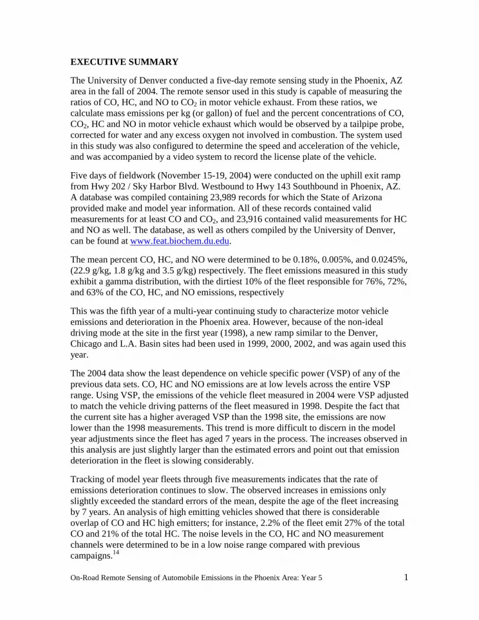
The University of Denver conducted a five-day remote sensing study in the Phoenix, AZ area in the fall of 2004. The remote sensor used in this study is capable of measuring the ratios of CO, HC, and NO to CO2 in motor vehicle exhaust. From these ratios, we calculate mass emissions per kg (or gallon) of fuel and the percent concentrations of CO, CO2, HC and NO in motor vehicle exhaust which would be observed by a tailpipe probe, corrected for water and any excess oxygen not involved in combustion. The system used in this study was also configured to determine the speed and acceleration of the vehicle, and was accompanied by a video system to record the license plate of the vehicle.
Five days of fieldwork (November 15-19, 2004) were conducted on the uphill exit ramp from Hwy 202 / Sky Harbor Blvd. Westbound to Hwy 143 Southbound in Phoenix, AZ. A database was compiled containing 23,989 records for which the State of Arizona provided make and model year information. All of these records contained valid measurements for at least CO and CO2, and 23,916 contained valid measurements for HC and NO as well. The database, as well as others compiled by the University of Denver, can be found at www.feat.biochem.du.edu.
The mean percent CO, HC, and NO were determined to be 0.18%, 0.005%, and 0.0245%, (22.9 g/kg, 1.8 g/kg and 3.5 g/kg) respectively. The fleet emissions measured in this study exhibit a gamma distribution, with the dirtiest 10% of the fleet responsible for 76%, 72%, and 63% of the CO, HC, and NO emissions, respectively
This was the fifth year of a multi-year continuing study to characterize motor vehicle emissions and deterioration in the Phoenix area. However, because of the non-ideal driving mode at the site in the first year (1998), a new ramp similar to the Denver, Chicago and L.A. Basin sites had been used in 1999, 2000, 2002, and was again used this year.
The 2004 data show the least dependence on vehicle specific power (VSP) of any of the previous data sets. CO, HC and NO emissions are at low levels across the entire VSP range. Using VSP, the emissions of the vehicle fleet measured in 2004 were VSP adjusted to match the vehicle driving patterns of the fleet measured in 1998. Despite the fact that the current site has a higher averaged VSP than the 1998 site, the emissions are now lower than the 1998 measurements. This trend is more difficult to discern in the model year adjustments since the fleet has aged 7 years in the process. The increases observed in this analysis are just slightly larger than the estimated errors and point out that emission deterioration in the fleet is slowing considerably.
Tracking of model year fleets through five measurements indicates that the rate of emissions deterioration continues to slow. The observed increases in emissions only slightly exceeded the standard errors of the mean, despite the age of the fleet increasing by 7 years. An analysis of high emitting vehicles showed that there is considerable overlap of CO and HC high emitters; for instance, 2.2% of the fleet emit 27% of the total CO and 21% of the total HC. The noise levels in the CO, HC and NO measurement channels were determined to be in a low noise range compared with previous campaigns.14

On-Road Remote Sensing of Automobile Emissions in the Phoenix Area: Year 5
2
INTRODUCTION
Many cities in the United States are in violation of the air quality standards established by the Environmental Protection Agency (EPA). Carbon monoxide (CO) levels become elevated primarily due to direct emission of gas; and ground-level ozone, a major component of urban smog, is produced by the photochemical reaction of nitrogen oxides (NOx) and hydrocarbons (HC). As of 1998, on-road vehicles were estimated to be the single largest source for the major atmospheric pollutants, contributing 60% of the CO, 44% of the HC, and 31% of the NOx to the national emission inventory.1
According to Heywood2, carbon monoxide emissions from automobiles are at a maximum when the air/fuel ratio is rich of stoichiometric, and are caused solely by a lack of adequate air for complete combustion. Hydrocarbon emissions are also maximized with a rich air/fuel mixture, but are slightly more complex. When ignition occurs in the combustion chamber, the flame front cannot propagate within approximately one millimeter of the relatively cold cylinder wall. This results in a quench layer of unburned fuel mixture on the cylinder wall, which is scraped off by the rising piston and sent out the exhaust manifold. With a rich air/fuel mixture, this quench layer simply becomes more concentrated in HC, and thus more HC is sent out the exhaust manifold by the rising pistons. There is also the possibility of increased HC emissions with an extremely lean air/fuel mixture when a misfire can occur and an entire cylinder of unburned fuel mixture is emitted into the exhaust manifold. Nitric oxide (NO) emissions are maximized at high temperatures when the air/fuel mixture is slightly lean of stoichiometric, and are limited during rich combustion by a lack of excess oxygen and during extremely lean combustion by low flame temperatures. In most vehicles, practically all of the on-road NOx is emitted in the form of NO.2 Properly operating modern vehicles with three-way catalysts are capable of partially (or completely) converting engine-out CO, HC and NO emissions to CO2, H2O and N2.2
Control measures to decrease mobile source emissions in non-attainment areas include inspection and maintenance (I/M) programs, oxygenated fuel mandates, and transportation control measures, but the effectiveness of these measures remains questionable. Many areas remain in non-attainment, and with the new 8-hour ozone standards introduced by the EPA in 1997, many locations still violating the standard may have great difficulty reaching attainment.3
The remote sensor used in this study was developed at the University of Denver for measuring the pollutants in motor vehicle exhaust, and has previously been described in the literature.4,5 The instrument consists of a non-dispersive infrared (IR) component for detecting carbon monoxide, carbon dioxide (CO2), and hydrocarbons, and a dispersive ultraviolet (UV) spectrometer for measuring nitric oxide. The source and detector units are positioned on opposite sides of the road in a bi-static arrangement. Collinear beams of IR and UV light are passed across the roadway into the IR detection unit, and are then focused through a dichroic beam splitter, which serves to separate the beams into their IR and UV components. The IR light is then passed onto a spinning polygon mirror, which distributes the light across the four infrared detectors: CO, CO2, HC and reference.

On-Road Remote Sensing of Automobile Emissions in the Phoenix Area: Year 5
3
The UV light is reflected off the surface of the beam splitter and is focused into the end of a quartz fiber-optic cable, which transmits the light to an ultraviolet spectrometer. The UV unit is then capable of quantifying nitric oxide by measuring an absorbance band at 226.5 nm in the ultraviolet spectrum and comparing it to a calibration spectrum at the same wavelength.
The exhaust plume path length and the density of the observed plume are highly variable from vehicle to vehicle, and are dependent upon, among other things, the height of the vehicle’s exhaust pipe, wind, and turbulence behind the vehicle. For these reasons, the remote sensor can only directly measure ratios of CO, HC or NO to CO2. The ratios of CO, HC, or NO to CO2, termed Q, Q’ and Q”, respectively, are constant for a given exhaust plume; and, on their own, are useful parameters for describing a hydrocarbon combustion system. The remote sensor used in this study reports the %CO, %HC and %NO in the exhaust gas, corrected for water and excess oxygen not used in combustion. The %HC measurement is a factor of two smaller than an equivalent measurement by an FID instrument.6 Thus, in order to calculate mass emissions, the %HC values in the equations below would be RSD measured values multiplied by 2. These percent emissions can be directly converted into mass emissions per gallon by the equations shown below.
gm CO/gallon = 5506×%CO/(15 + 0.285×%CO + 2.87×%HC) gm HC/gallon = 8644×%HC/(15 + 0.285×%CO + 2.87×%HC) gm NO/gallon = 5900×%NO/(15 + 0.285×%CO + 2.87×%HC)
These equations indicate that the relationship between concentrations of emissions to mass of emissions is almost linear, especially for CO and NO and at the typical low concentrations for HC. Thus, the percent differences in emissions calculated from the concentrations of pollutants reported here are equivalent to differences calculated from the fuel-based mass emissions of the pollutants.
Another useful conversion is directly from the measured ratios to g pollutant per kg of fuel. This conversion is achieved directly by first converting the pollutant ratio readings to the moles of pollutant per mole of carbon in the exhaust from the following equation:
moles pollutant = pollutant = (pollutant/CO2) = (Q,2Q’,Q”) moles C CO + CO2 + 3HC (CO/CO2) + 1 + 6(HC/CO2) Q+1+6Q’
Next, moles of pollutant are converted to grams by multiplying by molecular weight (e.g., 44 g/mole for HC since propane is measured), and the moles of carbon in the exhaust are converted to kilograms by multiplying (the denominator) by 0.014 kg of fuel per mole of carbon in fuel, assuming gasoline is stoichiometrically CH2. Again, the HC/CO2 ratio must use two times the reported HC (as above) because the equation depends upon carbon mass balance and the NDIR HC reading is about half a total carbon FID reading.6
Quality assurance calibrations are performed as dictated in the field by the atmospheric conditions and traffic volumes. A puff of gas containing certified amounts of CO, CO2, propane and NO is released into the instrument’s path, and the measured ratios from the instrument are then compared to those certified by the cylinder manufacturer (Praxair).

On-Road Remote Sensing of Automobile Emissions in the Phoenix Area: Year 5
4
These calibrations account for day-to-day variations in instrument sensitivity and variations in ambient CO2 levels caused by atmospheric pressure and instrument path length. Since propane is used to calibrate the instrument, all hydrocarbon measurements reported by the remote sensor are as propane equivalents.
Studies sponsored by the California Air Resources Board and General Motors Research Laboratories have shown that the remote sensor is capable of CO measurements that are correct to within ±5% of the values reported by an on-board gas analyzer, and within ±15% for HC.7,8 The NO channel used in this study has been extensively tested by the University of Denver. Tests involving a late-model low-emitting vehicle indicate a detection limit (±3σ) of 25 ppm for NO, with an error measurement of ±5% of the reading at higher concentrations. Appendix A gives a list of the criteria for valid/invalid data.
The remote sensor is accompanied by a video system to record a freeze-frame image of the license plate of each vehicle measured. The emissions information for the vehicle, as well as a time and date stamp, is also recorded on the video image. The images are stored on videotape, so that license plate information may be incorporated into the emissions database during post-processing. A device to measure the speed and acceleration of vehicles driving past the remote sensor was also used in this study. The system consists of a pair of infrared emitters and detectors (Banner Industries), which generate a pair of infrared beams passing across the road, 6 feet apart and approximately 2 feet above the surface. Vehicle speed is calculated from the time that passes between the front of the vehicle blocking the first and the second beam. To measure vehicle acceleration, a second speed is determined from the time that passes between the rear of the vehicle unblocking the first and the second beam. From these two speeds and the time difference between the two speed measurements, acceleration is calculated and reported in mph/s.
The purpose of this report is to describe the remote sensing measurements made in the Phoenix, AZ area in November 2004, under CRC contract no. E-23-4. Measurements were made for 5 consecutive weekdays, from Monday, Nov. 15 to Friday, Nov. 19, conducted on the uphill exit ramp from Hwy 202 / Sky Harbor Blvd. Westbound to Hwy 143 Southbound in Phoenix, AZ. This intersection is just east of Sky Harbor Airport, and the ramp consists of a rather large loop approximately a mile long. The instrument was located as far up the ramp as possible (described as location A in previous reports). The uphill road grade was 1.3°. A map of the measurement location is shown in Figure 1. Measurements were generally made between the hours of 6:00 and 17:00. This was the fifth year of a multi-year study to characterize motor vehicle emissions and deterioration in the Phoenix area.
RESULTS AND DISCUSSION
Following the five days of data collection in November 2004, the videotapes were read for license plate identification. Plates, which appeared to be in state and readable, were sent to the State of Arizona to be matched against registration records. The resulting

On-Road Remote Sensing of Automobile Emissions in the Phoenix Area: Year 5
5
database contains 23,989 records with registration information and valid measurements for at least CO and CO2. Most of these records also contained valid measurements for HC and NO (see Table 1). The complete structure of the database and the definition of terms are included in Appendix B. The temperature and humidity record from nearby Sky Harbor Airport is included in Appendix C.
The validity of the attempted measurements is summarized in Table 1. The table describes the data reduction process beginning with the number of attempted measurements and ending with the number of records containing both valid emissions measurements and vehicle registration information. An attempted measurement is defined as a beam block followed by a half second of data collection. If the data collection period is interrupted by another beam block from a close following vehicle, the measurement
Hwy 202 / Sky Harbor Blvd. Westbound
Hw
y. 1
43
So
uthtbo
und
N
1. Winnebago2. Detector3. Light Source4. Speed/Accel. Sensors5. Generator6. Video Camera7. Road Cones8. "Shoulder Work Ahead" Sign
1
1
1
2
3
4
5
6
7
8
1C
B
A
Figure 1. Layout of the on-ramp from Highway 202 to Highway 143 in the Phoenix area.

On-Road Remote Sensing of Automobile Emissions in the Phoenix Area: Year 5
6
attempt is aborted and an attempt is made at measuring the second vehicle. In this case, the beam block from the first vehicle is not recorded as an attempted measurement. Invalid measurement attempts arise when the vehicle plume is highly diluted, or the reported error in the ratio of the pollutant to CO2 exceeds a preset limit (see Appendix A). The additional losses are from the usual sources such as trailer hitches that obstruct the view of the license plate.
Table 2 provides an analysis of the number of vehicles that were measured repeatedly, and the number of times they were measured. Of the 23,989 records used in this fleet analysis, 9,871 (41%) were contributed by vehicles measured once, and the remaining 14,118 (59%) records were from vehicles measured at least twice. A look at the distribution of measurements for vehicles measured five or more times showed that low mean or negligible emitters had nearly normally distributed emission measurements, while higher mean emitters had more skewed distributions, as shown previously by Bishop, et al.9 For example, of the 508 vehicles that had five or more valid CO measurements, fifteen had mean %CO > 1 : 1.0, 1.0, 1.1, 1.2, 1.5, 1.5, 1.7, 2.0, 2.2, 2.2, 2.2, 2.5, 3.5, 3.5 and 7.9. These fifteen vehicles’ calculated variances in their measurements were 0.5, 3.8, 6, 1, 0.2, 10.8, 4.1, 4.8, 6.8, 2.1, 6.3, 0.2, 1.7, 3.6 and 4 respectively, while the average variance in the measurements of the other 493 vehicles was 0.07.
Table 3 is the data summary; included is the summary of the previous remote sensing data collected by the University of Denver at the older site in the Phoenix area in the fall of
Table 1. Data Collection Summary. CO HC NO
Attempted Measurements 32,964 Valid Measurements Percent of Attempts
30,279 91.9%
30,159 91.5%
30,268 91.8%
Submitted Plates Percent of Attempts
Percent of Valid Measurements
25,707 78.0% 84.9%
25,633 77.8% 85.0%
25,699 78.0% 84.9%
Matched Plates Percent of Attempts
Percent of Valid Measurements Percent of Submitted Plates
23,989 72.8% 79.2% 93.3%
23,922 72.6% 79.3% 93.3%
24,983 72.8% 79.2% 93.3%
Table 2. Number of measurements of repeat vehicles. Number of Times Measured Number of Vehicles
1 9,871 2 2,110 3 1,192 4 909 5 413 6 65 7 15
>7 15

On-Road Remote Sensing of Automobile Emissions in the Phoenix Area: Year 5
7
1998 and the 1999, 2000, 2002 and 2004 data from the current site. Since the site of measurement during the three years was not the same, it is difficult to compare these fleet averages because influential factors such as load are not constant. The dramatic reductions in on-road vehicle emissions can be seen between 1998 and 2004. Despite the current monitoring site’s higher mean accelerations and VSP’s, the raw measurements continue to decrease and are now well below even the 1998 data.
The fleet measured in 2004 shows a steady decrease in mean emissions from the previous two years of measurement at the Highway 202 site. The decrease is especially impressive for NO. The average HC values here have been adjusted for comparison purposes only to remove an artificial offset in the measurements. This offset, restricted to the HC channel, has been reported in earlier CRC E-23-4 reports. Calculation of the offset is accomplished by computing the mode and means of the newest model year vehicles and assuming these vehicles emit negligible levels of hydrocarbons, using the lowest of either of these values as the offset. The offset is then subtracted from all of the hydrocarbon data. Since we
Table 3. Data summary. Study Year 1998a 1999b 2000 2002 2004
Mean CO (%) (g/kg of fuel)
0.28 (34.4)
0.31 (38.3)
0.27 (34.2)
0.22 (27.3)
0.18 (22.9)
Median CO (%) 0.07 0.06 0.05 0.05 0.04 Percent of Total CO from Dirtiest 10% of the Data 70.7% 77.8% 75.5% 72.3% 76.3%
Mean HC (ppm)* (g/kg of fuel)* Offset (ppm)
110 (3.9) 80
85 (3.0) 50
99 (3.8) -60
66 (2.6) 40
49 (1.8) 40
Median HC (ppm)* 10 40 70 30 20 Percent of Total HC from Dirtiest 10% of the Data 65.5% 79.0% 71.1% 51.9% 71.5%
Mean NO (ppm) (g/kg of fuel)
360 (5.1)
572 (8.1)
448 (6.4)
327 (4.6)
245 (3.5)
Median NO (ppm) 120 167 99 63 43 Percent of Total NO from Dirtiest 10% of the Data 56.0% 49.1% 52.6% 57.4% 63.0%
Mean Model Year 1993.3 1994.0 1995.3 1997.4 1999.4 Mean Speed (mph) 37.2 34.6 34.0 34.7 36.1
Mean Acceleration (mph/s) -0.7 1.2 1.1 2.2 1.9 Mean VSP (kw/tonne)
Slope (degrees) 2.7 2.1°
17.5 1.3°/1.4°
16.6 1.3°
25.1 1.3°
23.7 1.3°
aData collected at different Phoenix site, exit ramp from I-10W to US 143N. bData collected at current ramp but at two different locations on the ramp. *Indicates values that have been HC offset adjusted as described in text.

On-Road Remote Sensing of Automobile Emissions in the Phoenix Area: Year 5
8
assume the cleanest vehicles to emit little hydrocarbons, such an adjustment will only err slightly towards clean because the true offset will be a value somewhat less than the average of the cleanest model year and make. This adjustment facilitates comparisons with the other E-23 sites and/or different collection years for the same site. The offset subtraction has been performed here and later in the analysis where indicated.
Figure 2 shows the distribution of CO, HC, and NO emissions by percent category from the data collected in this study. The solid bars show the percentage of the fleet in a given emission category, and the gray bars show the percentage of the total emissions contributed by that category. This figure illustrates the skewed nature of automobile emissions; the lowest emission category for each of three pollutants is occupied by no less than 80% of the measurements (for HC). The lowest emission categories for CO and NO contain 96% and 84% of the measurements, respectively. The fact that the cleanest 96% of the measurements are responsible for only 42% of the CO emissions further demonstrates how the emissions picture can be dominated by a small number of high emitters. This skewed distribution was also seen in all of the previous years and is reflected in the high values of percent of total emissions from the dirtiest 10% of the data (see Table 3).
The inverse relationship between vehicle emissions and model year has been observed at a number of locations around the world, and Figure 3 shows that the fleet in the Phoenix area, during all five years of measurement, is not an exception.4 The plot of gNO/kg vs. model year rises sooner, at least compared to the plots for CO and HC, and then appears to level out in model years prior to 1989. This has been observed previously,5, 10 and is likely due to the tendency for older vehicles to lose compression and operate under fuel-rich conditions, both factors resulting in lower NO emissions. These figures show that vehicle deterioration is slowing, now even for tailpipe NO emissions. Unlike data collected in Chicago from 1997-1999, the Phoenix measurements do not show a tendency for the mean and median emissions to increase significantly for the newest model year.11 The absence is most likely due to license plates remaining with the vehicle in Arizona, as opposed to license plates moving with the owner, as is the case in Illinois.
Plotting vehicle emissions by model year, with each model year divided into emission quintiles results in the plots shown in Figures 4 - 6. Very revealing is the fact that, for all three major pollutants, the cleanest 60% of the measurements, regardless of model year, make an essentially negligible contribution to the total emissions. This observation was first reported by Ashbaugh, et al.12 These plots also show that even though older model years have higher average emissions, the numerical superiority of newer models dominate the fraction of emissions. Figures 2 and 5 highlight the decreasing HC emission levels where 80% of the measurements now have HC emission readings that are zero ± instrument noise. The results shown here continue to demonstrate that broken emissions control equipment has a greater impact on fleet emissions than vehicle age.
An equation for determining the instantaneous power of an on-road vehicle has been proposed by Jimenez13, which takes the form
SP = 4.39•sin(slope)•v + 0.22•v•a + 0.0954•v + 0.0000272•v3

On-Road Remote Sensing of Automobile Emissions in the Phoenix Area: Year 5
9
Figure 2. Emissions distribution showing the percentage of the fleet in a given emission category (black bars) and the percentage of the total emissions contributed by the given category (shaded bars).

On-Road Remote Sensing of Automobile Emissions in the Phoenix Area: Year 5
10
Figure 3. Mean vehicle emissions illustrated as a function of model year. HC data have been offset adjusted as described in the text.

On-Road Remote Sensing of Automobile Emissions in the Phoenix Area: Year 5
11
-50
0
50
100
150
200
250
300
350
400gC
O/k
g Fu
el
1988
1989
1990
1991
1992
1993
1994
1995
1996
1997
1998
1999
2000
2001
2002
2003
2004
2005 1st 2n
d 3rd 4t
h 5th
Model Year
Quintile
0
0.02
0.04
0.06
0.08
0.1
0.12
0.14
1988
1989
1990
1991
1992
1993
1994
1995
1996
1997
1998
1999
2000
2001
2002
2003
2004
2005
Model Year
Frac
tion
of F
leet
-1
0
1
2
3
4
5
6
7
8
Frac
tion
of T
otal
CO
1988
1989
1990
1991
1992
1993
1994
1995
1996
1997
1998
1999
2000
2001
2002
2003
2004
2005 1s
t 2nd 3r
d 4th 5t
h
Model Year
Quintile
Figure 4. 2004 CO emissions by model year and quintile (top), fleet distribution (middle) and their product showing the total fractional CO emissions by model year and quintile (bottom).

On-Road Remote Sensing of Automobile Emissions in the Phoenix Area: Year 5
12
-15
-10
-5
0
510
15
20
25
30
35
40
gHC
/kg
Fuel
1988
1989
1990
1991
1992
1993
1994
1995
1996
1997
1998
1999
2000
2001
2002
2003
2004
2005 1s
t 2nd 3r
d 4th 5t
h
Model Year
Quintile
0
0.02
0.04
0.06
0.08
0.1
0.12
0.14
1988
1989
1990
1991
1992
1993
1994
1995
1996
1997
1998
1999
2000
2001
2002
2003
2004
2005
Model Year
Frac
tion
of F
leet
-1.5
-1.0
-0.5
0.0
0.5
1.0
1.5
2.0
Frac
tion
of T
otal
HC
1988
1989
1990
1991
1992
1993
1994
1995
1996
1997
1998
1999
2000
2001
2002
2003
2004
2005 1s
t 2nd 3r
d 4th 5t
h
Model Year
Quintile
Figure 5. 2004 HC emissions by model year and quintile (top), fleet distribution (middle) and their product showing the total fractional HC emissions by model year and quintile (bottom).

On-Road Remote Sensing of Automobile Emissions in the Phoenix Area: Year 5
13
-5
0
5
10
15
20
25
30
gNO
/kg
Fuel
1988
1989
1990
1991
1992
1993
1994
1995
1996
1997
1998
1999
2000
2001
2002
2003
2004
2005 1s
t 2nd 3r
d 4th 5t
h
Model Year
Quintile
0
0.02
0.04
0.06
0.08
0.1
0.12
0.14
1988
1989
1990
1991
1992
1993
1994
1995
1996
1997
1998
1999
2000
2001
2002
2003
2004
2005
Model Year
Frac
tion
of F
leet
-0.2
0.0
0.2
0.4
0.6
0.8
1.0
1.2
Frac
tion
of T
otal
NO
1988
1989
1990
1991
1992
1993
1994
1995
1996
1997
1998
1999
2000
2001
2002
2003
2004
2005 1s
t 2nd 3r
d 4th 5t
h
Model Year
Quintile
Figure 6. 2004 NO emissions by model year and quintile (top), fleet distribution (middle) and their product showing the total fractional NO emissions by model year and quintile (bottom).

On-Road Remote Sensing of Automobile Emissions in the Phoenix Area: Year 5
14
where SP is the vehicle specific power in kW/metric tonne, slope is the slope of the roadway (in degrees), v is vehicle speed in mph, and a is vehicle acceleration in mph/s. Using this equation, vehicle specific power was calculated for all measurements in the database. The emissions data were binned according to vehicle specific power, and illustrated in Figure 7. The solid line in the figure provides the number of measurements in each bin for the 2004 data. The 2004 data show the least dependence on VSP of any of the previous data sets. All of the species are remarkably flat across the VSP range with only slight rises at the VSP levels that in past years showed larger increases. These observations are probably the result of a number of factors that influence vehicle emissions. This could possibly include the continued improvement in emissions systems durability and lower national tailpipe standards through the 50-state certification program.
Using vehicle specific power, it is possible to eliminate some of the influence of load and of driving behavior from the mean vehicle emissions for the 1998, 1999, 2000, 2002 and 2004 databases. Table 4 shows the mean emissions from vehicles in the 1998 database, from vehicles measured at the two locations in 1999 and from vehicles in 2000, 2002 and 2004 with specific powers between -5 and 20 kW/tonne. Note that these emissions do not vary considerably from the mean emissions for the entire databases, as shown in Table 3. This correction is accomplished by applying the mean vehicle emissions for each specific power bin in Figure 7, for each of the two locations in 1999, the 2000, 2002 and the 2004 measurements, to the vehicle distribution by specific power, for each bin from 1998. A sample calculation, for the specific power adjusted mean NO emissions in Chicago in 1998, is shown in Appendix D. The uncertainty values in the table are standard errors of the means determined from the daily averages. Table 4 shows the mean VSP adjusted emissions during the five years have been steadily decreasing since the 1999 data set. The current measurements are the lowest to date, most likely due to the robust emissions durability of the newer model year vehicles entering the Phoenix fleet.
A correction similar to the VSP adjustment can be applied to a fleet of specific model
Table 4. Vehicle specific power adjusted fleet emissions (-5 to 20 kW/tonne only) with standard error of the means calculated using daily averages.
1998a
measured (adjusted)
1999b
measured (adjusted)
2000c
measured (adjusted)
2002 measured (adjusted)
2004 measured (adjusted)
Mean gCO/kg 31.5 ± 2.5 (31.5 ± 2.5)
37.8 ± 1.5 (42.3 ± 1.7)
33.0 ± 0.9 (36.7 ± 1.0)
23.6 ± 2.0 (23.0 ± 1.9)
22.7 ± 1.8 (24.8 ± 2.1)
Mean gHC/kgd 6.5 ± 1.4 (3.2 ± 1.2)
5.3 ± 0.4 (4.2 ± 0.5)
1.4 ± 0.3 (4.5 ± 0.4)
4.7 ± 0.4 (3.7 ± 0.4)
4.4 ± 0.6 (4.5 ± 0.5)
Mean gNO/kg 5.2 ± 0.2 (5.2 ± 0.2)
7.5 ± 1.2 (7.0 ± 1.1)
6.0 ± 0.2 (5.8 ± 0.2)
3.6 ± 0.2 (2.8 ± 0.1)
3.8 ± 0.2 (2.2 ± 0.1)
aData collected at different Phoenix site, exit ramp from I-10W to US 143N. bData collected at current ramp but at two different locations on the ramp. cData presented from location A only. dHC emissions are offset adjusted for all of the years adjusted data.

On-Road Remote Sensing of Automobile Emissions in the Phoenix Area: Year 5
15
Figure 7. Vehicle emissions as a function of vehicle specific power for the entire Phoenix E-23 data sets. Error bars are standard errors of the mean calculated from daily samples. The solid line without markers is the vehicle count profile for the 2004 data set.

On-Road Remote Sensing of Automobile Emissions in the Phoenix Area: Year 5
16
year vehicles to look at model year deterioration, provided we use as a baseline only model years measured in the 1998 study. This restriction reduces the number of vehicles in the calculation for each subsequent year and that fleet size is listed at the bottom of the table. Table 5 shows the mean emissions for all vehicles from model years 1984 to 1999, as measured in 1998, 1999, 2000, 2002 and 2004. Applying the vehicle distribution by model year from 1998 to the mean emissions by model year from each of the other three years of measurement yields the model year adjusted fleet emissions. What deterioration that is occurring in this fleet is small with only the CO emissions showing an increase that is outside the error limits given. The HC and now the NO emissions have flattened out and do not show a statistically significant deterioration effect. An expanded sample calculation, for the model year adjusted mean NO emissions in Chicago in 1998, is shown in Appendix E.
Vehicle deterioration can also be illustrated by Figure 8, which shows the mean emissions of the 1984 to 2005 model year fleet as a function of vehicle age. The first point for each model year was measured in 1998, the second in 1999, the third in 2000, the fourth in 2002 and the fifth in 2004. Vehicle age is determined by the difference between the year of measurement and the vehicle model year. Since the measurements are taken in November, the model year that matches the measurement year are considered one year old because the following model year vehicle has already been released for most manufacturers. The analysis is somewhat confounded by differences in measurement location during the three years of measurement. This is especially noticeable in the highly load dependent pollutant - NO - which measured high in 1999. As more data are collected, what is most striking is how the first four to six years of age the mean CO and HC show very small amounts if any emissions deterioration. With the current data set NO emissions are starting to appear to flatten out in the first 5 years of age.
Another use of the on-road remote sensing data is to predict the abundance of vehicles that are high emitting for more than one pollutant measured. One can look at the high CO emitters and calculate what percent of these are also high HC emitters, for example. This type of analysis would allow a calculation of HC emission benefits resulting from fixing all high CO emitters. To this extent, we have analyzed our data to determine what percent
Table 5. Model year adjusted fleet emissions (MY 1984-1999 only). Errors are standard error of the means calculated using the daily means.
1998 Measured (Adjusted)
1999 Measured (Adjusted)
2000 Measured (Adjusted)
2002 Measured (Adjusted)
2004 Measured (Adjusted)
Mean gCO/kg 29.4 ± 3.2 (29.4 ± 3.2)
34.0 ± 1.0 (37.6 ± 1.1)
34.6 ± 0.9 (39.9 ± 1.1)
36.8 ± 1.1 (44.6 ± 1.3)
40.3 ± 1.2 (51.4 ± 1.6)
Mean gHC/kga 6.5 ± 1.3 (3.1 ± 1.2)
4.6 ± 0.5 (2.7 ± 0.5)
1.2 ± 0.3 (4.0 ± 0.3)
4.9 ± 0.3 (3.9 ± 0.4)
4.6 ± 0.6 (3.8 ± 0.8)
Mean gNO/kg 4.7 ± 0.2 (4.7 ± 0.2)
7.8 ± 1.0 (8.4 ± 1.1)
6.9 ± 0.3 (7.7 ± 0.3)
6.3 ± 0.3 (7.2 ± 0.4)
5.9 ± 0.3 (6.9 ± 0.3)
Number of Vehicles 16,947/11,675/11,371 17,427 16,463 13,355 9,164
aHC emissions are offset adjusted for all of the years adjusted data.

On-Road Remote Sensing of Automobile Emissions in the Phoenix Area: Year 5
17
0
50
100
150
200
0 5 10 15 20
CO
g/k
g
0
5
10
15
20
0 5 10 15 20
HC
g/k
g
0
5
10
15
20
0 5 10 15 20Age (Years)
NO
g/k
g
2005 2004 2003 2002 2001 2000 1999 19981997 1996 1995 1994 1993 1992 1991 19901989 1988 1987 1986 1985 1984
Figure 8. Mean vehicle emissions as a function of age, shown by model year. Included are data from the sites in 1998, 1999, 2000, 2002 and 2004.

On-Road Remote Sensing of Automobile Emissions in the Phoenix Area: Year 5
18
of the top decile of emitters of one pollutant are also in the top decile for another.
These data are in Table 6; included in the analysis are only those vehicles that have valid readings for all three pollutants. The column heading is the pollutant whose top decile is being analyzed, and the values indicate what percentage of the data are high emitters only for the pollutants in the column and row headings. Where the column and row headings are the same, the values indicate the percentage that is high emitting in only that pollutant. The sum of these three bins gives the percentage that is high emitting for any pollutant. The “All” row gives the percentage of the data that are high emitting in all three pollutants. Thus 2.2% of the measurements are in the top decile for both HC and CO but not NO; 0.9% are high emitting for CO and NO but not HC; 6.5% are only high CO emitters.
The preceding analysis gives the percent of vehicle overlap but does not directly give emissions overlap. In order to assess the emissions overlap one must convert the Table 6 values to percent of emissions. Table 7 shows that identification of all measurements that are high emitting for CO would identify an overall 21% of HC and 5.8% of NO. More efficiently, identification of the 2.2% high CO and HC vehicles accounts for 27% of the total CO and 21% of the total on-road HC from these data.
Most vehicles are low emitting and show little emissions variability when measured more than once. Vehicles that have one high reading often have other readings that vary widely.9 This effect has also been observed from multiple FTP and IM240 tests. The evidence from pullover studies in California is that even one high reading identifies vehicles that have a >90% probability of failing an alternative I/M test if performed immediately. These vehicles also have a high probability of showing evidence of tampered or defective emission control equipment.7 Because of this variability in the emissions of broken cars, the emissions distribution obtained from any snapshot of fleet emissions (remote sensing or annual I/M testing) is bound to be more skewed than were one able to monitor the emissions of all vehicles at all times. This phenomenon does not
Table 6. Percent of all measurements that are high emitting. Top 10% Decile CO HC NO
CO 6.5% 2.2% 0.9% HC 2.2% 6.3% 0.9% NO 0.9% 0.9% 7.6% All 0.6%
Table 7. Percent of total emissions from high emitting vehicles. Top 10% Decile CO HC NO
CO 39% 21% 5.8% HC 27% 39% 5.8% NO 4.6% 5.5% 47% All 4.1% 5.2% 4.2%

On-Road Remote Sensing of Automobile Emissions in the Phoenix Area: Year 5
19
effect the means measured by these snapshots but it does imply that the overlap and high emitter fractions in the tables above would show less skewness were one able to fully characterize all vehicles and their variability.
In the manner described in the Phoenix, Year 2 report14, instrument noise was measured by looking at the slope of the negative portion of the log plots. Such plots were constructed for the three pollutants. Linear regression gave best fit lines whose slopes correspond to the inverse of the Laplace factor, which describes the noise present in the measurements. This factor must be viewed in relation to the average measurement for the particular pollutant to obtain a description of noise. The Laplace factors were 5.8, 5.2, and 0.4 for CO, HC and NO, respectively. These values indicate standard deviations of 8.2 g/kg (0.07%), 7.3 g/kg (180 ppm) and 0.6 g/kg (50 ppm) for individual measurements of CO, HC and NO, respectively. These levels are consistent with the low noise level as discussed in a previous Phoenix report.14 In terms of uncertainty in average values reported here, the numbers are reduced by a factor of the square root of the number of measurements. For example, with averages of 100 measurements, which is the low limit for number of measurements per bin, the uncertainty reduces by a factor of 10. Thus, the uncertainties in the averages reduce to 0.8 g/kg, 0.7 g/kg, and 0.06 g/kg, respectively.
CONCLUSION
The University of Denver successfully completed the fourth year of a multi-year remote sensing study in Phoenix. Five days of fieldwork (November 15-19, 2005) were conducted on the uphill exit ramp from Hwy 202 / Sky Harbor Blvd. Westbound to Hwy 143 Southbound in Phoenix, AZ. A database was compiled containing 23,989 records for which the State of Arizona provided make and model year information. All of these records contained valid measurements for at least CO and CO2, and 23,916 contained valid measurements for HC and NO as well. Of these measurements, 9871 (41%) were of vehicles measured only once. The rest were of vehicles measured at least twice. Analysis of these repeat vehicles showed that high emitters have skewed emissions distributions while low emitters have more normally distributed emissions.
The mean measurements for CO, HC, and NO were determined to be 22.9 gCO/kg, 1.8 gHC/kg, and 3.5 gNO/kg, respectively with an average model year of 1999.4. As expected, the fleet emissions observed in this study exhibited a typical skewed distribution, with the dirtiest 10% of the fleet contributing 76%, 72%, and 63% of the CO, HC, and NO emissions, respectively. An analysis of emissions as a function of model year showed a typical inverse relationship.
The 2004 data show the least dependence on VSP of any of the previous data sets. CO and HC emissions are at low levels across the entire VSP range. Using vehicle specific power, the emissions of the vehicle fleet measured in 2004 were VSP adjusted to match the vehicle driving patterns of the fleet measured in 1998. Despite the fact that the current site has a higher averaged VSP than the 1998 site, the emissions are now lower than the 1998 measurements. This trend is more difficult to discern in the model year adjustments since the fleet has aged 7 years in the process. The increases observed in this analysis are just slightly larger than the estimated errors and point out that emission deterioration in

On-Road Remote Sensing of Automobile Emissions in the Phoenix Area: Year 5
20
the fleet is slowing considerably.
Tracking of model year fleets through four measurements indicates that the rate of emissions deterioration continues to slow. The observed increases in emissions only slightly exceeded the standard errors of the mean, despite the age of the fleet increasing by 7 years. An analysis of high emitting vehicles showed that there is considerable overlap of CO and HC high emitters, for instance 2.2% of the fleet emit 27% of the total CO and 21% of the total HC. The noise levels in the CO, HC and NO measurement channels were determined to be in a low noise range compared with previous campaigns.14
ACKNOWLEDGEMENTS The successful outcome of this project would not be possible without the assistance of the Mr. Jeffery Kearns of the Arizona Department of Transportation and Mrs. Annette Bishop whose plate reading skills are phenomenal. Comments from the various reviewers of this report were also invaluable.

On-Road Remote Sensing of Automobile Emissions in the Phoenix Area: Year 5
21
LITERATURE CITED
1. National Air Quality and Emissions Trends, 1998, United States Environmental Protection Agency, Research Triangle Park, NC, 2000; EPA-454/R-00-003, pp. 11.
2. Heywood, J.B. Internal Combustion Engine Fundamentals. McGraw-Hill: New York, 1988.
3. Lefohn, A.S.; Shadwick, D.S.; Ziman, S.D. Environ. Sci. Technol. 1998, 32, 276A.
4. Bishop, G.A.; Stedman, D.H. Acc. Chem. Res. 1996, 29, 489.
5. Popp, P.J.; Bishop, G.A.; Stedman, D.H. J. Air & Waste Manage. Assoc. 1999, 49, 1463.
6. Singer, B.C.; Harley, R.A.; Littlejohn, D.; Ho, J.; Vo, T. Environ. Sci. Technol. 1998, 27, 3241.
7. Lawson, D.R.; Groblicki, P.J.; Stedman, D.H.; Bishop, G.A.; Guenther, P.L. J. Air & Waste Manage. Assoc. 1990, 40, 1096.
8. Ashbaugh, L.L.; Lawson, D.R.; Bishop, G.A.; Guenther, P.L.; Stedman, D.H.; Stephens, R.D.; Groblicki, P.J.; Parikh, J.S.; Johnson, B.J.; Haung, S.C. In PM10 Standards and Nontraditional Particulate Source Controls; Chow, J.C., Ono, D.M., Eds.; AWMA: Pittsburgh, PA, 1992; Vol. II, pp. 720-739.
9. Bishop, G.A.; Stedman, D.H.; Ashbaugh, L.L. J. Air Waste Manage. Assoc., 1996, 46:667-675.
10. Zhang, Y.; Stedman, D.H.; Bishop, G.A.; Guenther, P.L.; Beaton, S.P.; Peterson, J.E. Environ. Sci. Technol. 1993, 27, 1885.
11. Popp, P.J.; Bishop, G.A.; Stedman, D.H. On-Road remote Sensing of Automobile Emissions in the Chicago Area: Year 2, Final report to the Coordinating Research Council, Contract E-23-4, 1999.
12. Ashbaugh, L.L; Croes, B.E.; Fujita, E.M.; Lawson, D.R. Presented at 13th North American Motor Vehicle Emissions Control Conference, 1990.
13. Jimenez, J.L.; McClintock, P.; McRae, G.J.; Nelson, D.D.; Zahniser, M.S. In Proceedings of the 9th CRC On-Road Vehicle Emissions Workshop, CA, 1999.
14. Pokharel, S.S.; Bishop, G.A.; Stedman, D.H. On-Road Remote Sensing of Automobile Emissions in the Phoenix Area: Year 2, Final report to the Coordinating Research Council, Contract E-23-4, 2000.

On-Road Remote Sensing of Automobile Emissions in the Phoenix Area: Year 5
22
APPENDIX A: FEAT criteria to render a reading “invalid” or not measured.
Not measured:
1) vehicle with less than 0.5 seconds clear to the rear. Often caused by elevated pickups and trailers causing a “restart” and renewed attempt to measure exhaust. The restart number appears in the data base.
2) vehicle which drives completely through during the 0.4 seconds “thinking” time (relatively rare).
Invalid :
1) insufficient plume to rear of vehicle relative to cleanest air observed in front or in the rear; at least five, 10ms >160ppmm CO2 or >400 ppmm CO. (0.2 %CO2 or 0.5% CO in an 8 cm cell. This is equivalent to the units used for CO2 max.) Often HD diesel trucks, bicycles.
2) too much error on CO/CO2 slope, equivalent to +20% for %CO. >1.0, 0.2%CO for %CO<1.0.
3) reported %CO , <-1% or >21%. All gases invalid in these cases.
4) too much error on HC/CO2 slope, equivalent to +20% for HC >2500ppm propane, 500ppm propane for HC <2500ppm.
5) reported HC <-1000ppm propane or >40,000ppm. HC “invalid”.
6) too much error on NO/CO2 slope, equivalent to +20% for NO>1500ppm, 300ppm for NO<1500ppm.
7) reported NO<-700ppm or >7000ppm. NO “invalid”.
Speed/Acceleration valid only if at least two blocks and two unblocks in the time buffer and all blocks occur before all unblocks on each sensor and the number of blocks and unblocks is equal on each sensor and 100mph>speed>5mph and 14mph/s>accel>-13mph/s and there are no restarts, or there is one restart and exactly two blocks and unblocks in the time buffer.
A restart is an occurrence of a beam block within the 0.5 s exhaust data acquisition time. Data analysis is restarted using the clean air data collected in advance of the first blocking event. High clearance pickups typically generate one restart.

On-Road Remote Sensing of Automobile Emissions in the Phoenix Area: Year 5
23
APPENDIX B: Explanation of the Az_2004.dbf database.
The Az_2004.dbf is a Microsoft FoxPro database file, and can be opened by any version of MS FoxPro. The file can be read by a number of other database management programs as well, and is available on CD-ROM or from www.feat.biochem.du.edu. The following is an explanation of the data fields found in this database:
License Arizona license plate.
Date Date of measurement, in standard format.
Time Time of measurement, in standard format.
Percent_co Carbon monoxide concentration, in percent.
Co_err Standard error of the carbon monoxide measurement.
Percent_hc Hydrocarbon concentration (propane equivalents), in percent.
Hc_err Standard error of the hydrocarbon measurement.
Percent_no Nitric oxide concentration, in percent.
No_err Standard error of the nitric oxide measurement.
Percent_co2 Carbon dioxide concentration, in percent.
Co2_err Standard error of the carbon dioxide measurement.
Opacity Opacity measurement, in percent.
Opac_err Standard error of the opacity measurement.
Restart Number of times data collection is interrupted and restarted by a close-following vehicle, or the rear wheels of tractor trailer.
Hc_flag Indicates a valid hydrocarbon measurement by a “V”, invalid by an “X”.
No_flag Indicates a valid nitric oxide measurement by a “V”, invalid by an “X”.
Opac_flag Indicates a valid opacity measurement by a “V”, invalid by an “X”.
Max_co2 Reports the highest absolute concentration of carbon dioxide measured by the remote sensor over an 8 cm path; indicates plume strength.
Speed_flag Indicates a valid speed measurement by a “V”, an invalid by an “X”, and slow speed (excluded from the data analysis) by an “S”.
Speed Measured speed of the vehicle, in mph.
Accel Measured acceleration of the vehicle, in mph/s.
Ref_factor Reference factor.
CO2_factor CO2 factor.
Plate_key Coded plate type.
Vin Vehicle identification number.

On-Road Remote Sensing of Automobile Emissions in the Phoenix Area: Year 5
24
Category Coded vehicle category.
Make Manufacturer of the vehicle.
Year Model year.
Fuel Fuel type G (gasoline), D (diesel) and N (natural gas).
Weight Gross vehicle weight.
County Arizona county vehicle is registered in.
City Registrant's mailing city.
Zipcode Registrant's mailing zip code.
State Registrant’s mailing state.
Emis_type Code for tested vehicle emissions type.
Init_test 8 digit date of initial emissions test.
Date_pass 8 digit date of passing emissions test.
Result_cd Coded result of emissions test.
Waiver Waiver status, codes are blank and Y.
Emis_area Unsure, codes are A, B and blank.
Exp_date License expiration date.

On-Road Remote Sensing of Automobile Emissions in the Phoenix Area: Year 5
25
APPENDIX C: Temperature and Humidity Data.
Phoenix 1998 Temperature and Humidity Data Time 11/16
°F 11/16 %RH
11/17 °F
11/17 %RH
11/18 °F
11/18 %RH
11/19 °F
11/19 %RH
6:56 53 61 55 49 50 54 48 66 7:56 55 57 56 49 53 49 50 61 8:56 61 46 60 41 58 41 55 45 9:56 65 40 66 33 63 35 60 38 10:56 70 35 69 31 66 34 64 33 11:56 74 28 72 26 70 30 67 30 12:56 77 26 75 23 73 29 69 25 13:56 79 24 77 21 75 26 71 24 14:56 80 23 79 19 75 25 71 24 15:56 81 22 78 19 74 24 72 24 16:56 79 24 77 21 72 24 70 26
Phoenix 1999 Temperature and Humidity Data Time 11/15
°F 11/15 %RH
11/16 °F
11/16 %RH
11/17 °F
11/17 %RH
11/18 °F
11/18 %RH
11/19 °F
11/19 %RH
5:56 60.1 46 63 37 60.1 42 57 53 55.9 46 6:56 61 44 63 37 59 42 57 51 55 49 7:56 64 41 63 41 62.1 38 57.9 50 57 45 8:56 70 27 69.1 29 66 32 63 41 60.1 39 9:56 77 20 75 23 71.1 26 64.9 42 66.9 32
10:56 81 19 79 21 75 23 69.1 38 70 30 11:56 84 17 82.9 19 78.1 22 71.1 34 72 31 12:56 88 16 84.9 18 80.1 21 73.9 32 75 30 13:56 88 16 86 17 84 19 75 30 77 30 14:56 90 15 87.1 17 82.9 20 75.9 30 77 31 15:56 90 16 88 16 82.9 22 75.9 30 78.1 28 16:56 89.1 16 87.1 17 81 23 75 31 77 28

On-Road Remote Sensing of Automobile Emissions in the Phoenix Area: Year 5
26
Phoenix 2002 Temperature and Humidity Data Time 11/18
°F 11/18 %RH
11/19 °F
11/19 %RH
11/20 °F
11/20 %RH
11/21 °F
11/21 %RH
11/22 °F
11/22 %RH
5:56 50 39 52 34 64 21 62 25 60 26 6:56 50 39 49 39 64 23 58 31 58 28 7:56 53 37 52 35 66 21 62 28 57 33 8:56 58 30 58 30 70 18 69 23 62 28 9:56 62 24 62 22 74 15 76 14 68 22
10:56 69 17 67 15 76 16 80 11 76 16 11:56 73 13 71 13 80 13 83 9 79 15 12:56 75 12 73 12 83 12 84 9 80 13 13:56 76 11 76 10 83 11 85 9 84 11 14:56 77 10 78 9 86 10 87 8 85 10 15:56 77 10 80 9 85 11 87 8 84 10 16:56 76 12 77 10 84 11 86 8 83 10
Phoenix 2000 Temperature and Humidity Data Time 11/13
°F 11/13 %RH
11/14 °F
11/14 %RH
11/15 °F
11/15 %RH
11/16 °F
11/16 %RH
11/17 °F
11/17 %RH
5:56 43 34 47 33 45 34 41 32 42 31 6:56 41 35 46 32 43 36 40 32 43 30 7:56 46 31 48 35 46 36 43 31 43 33 8:56 50 28 53 33 50 37 47 30 50 27 9:56 54 27 58 34 53 31 52 28 54 22
10:56 58 29 61 32 56 29 54 27 56 21 11:56 58 27 63 34 57 24 58 26 58 21 12:56 62 25 64 35 61 27 60 20 58 18 13:56 62 24 66 37 60 28 62 20 62 16 14:56 63 23 66 36 63 24 62 18 63 16 15:56 64 21 65 34 62 21 63 18 63 14 16:56 64 21 64 34 61 21 61 19 62 16

On-Road Remote Sensing of Automobile Emissions in the Phoenix Area: Year 5
27
Phoenix 2004 Temperature and Humidity Data Time 11/15
°F 11/15 %RH
11/16 °F
11/16 %RH
11/17 °F
11/17 %RH
11/18 °F
11/18 %RH
11/19 °F
11/19 %RH
5:56 55 62 53 83 53 77 55 77 55 69 6:56 60 46 54 80 53 74 56 72 54 72 7:56 61 44 56 75 55 72 56 72 56 67 8:56 64 38 59 67 59 62 61 58 59 60 9:56 65 37 62 58 62 58 64 52 62 56
10:56 68 36 66 50 67 49 68 47 66 49 11:56 69 38 69 44 67 49 70 42 69 42 12:56 60 72 70 41 69 44 71 41 69 42 13:56 60 75 70 41 71 41 72 40 71 38 14:56 63 65 71 36 72 38 74 37 73 33 15:56 62 73 72 38 72 40 74 37 73 32 16:56 60 84 71 41 71 36 72 40 71 35

On-Road Remote Sensing of Automobile Emissions in the Phoenix Area: Year 5
28
APPENDIX D: Sample Calculation of Vehicle Specific Power Adjusted Vehicle Emissions using data from Chicago 1997 and 1998. 1997 (Measured) VSP Bin Mean NO (ppm) Measurements Total Emissions -5 236 225 53200
0 224 1609 360090 5 307 4985 1531000 10 431 6146 2648020 15 548 2624 1438060 20 590 456 269180 16045 6299550 Mean NO (ppm) 393
1998 (Measured) VSP Bin Mean NO (ppm) Measurements Total Emissions -5 233 137 31951 0 239 784 187394 5 265 3613 956613 10 385 6685 2576433 15 475 6012 2856195 20 483 2392 1156320 19623 7764906 Mean NO (ppm) 396
1998 (Adjusted) VSP Bin 98 Mean NO (ppm) 97 Measurements Total Emissions -5 233 225 52474 0 239 1609 384588 5 265 4985 1319877 10 385 6146 2368700 15 475 2624 1246616 20 483 456 220436 16045 5592691 Mean NO (ppm) 349
Note that the Mean NO readings listed here have been rounded to the nearest ppm values which results in the Total Emissions column appearing to not be a direct multiplication product. The -5 to 20 kw/tonne bins are chosen to preclude any “off-cycle” emissions. The object of this adjustment is to have the 1998 fleet’s emissions calculated as if they drove (VSP wise) like the 1997 fleet. This is accomplished by first binning and averaging the 1997 and 1998 data (the top two tables). We then combine the mean NO values from the 1998 fleet with the numerical VSP bin distribution from the 1997 fleet in the bottom table. The product of these two columns is summed and the sum total emissions are divided by the number of 1997 vehicles to produce the 1998 adjusted mean NO average. For this example, it shows that the 1998 fleet when driven like the 1997 fleet has lower NO emissions than the 1997 fleet.

On-Road Remote Sensing of Automobile Emissions in the Phoenix Area: Year 5
29
APPENDIX E: Sample Calculation of Model Year Adjusted Fleet Emissions using data from Chicago 1997 and 1998
1997 (Measured) Model Year Mean NO (ppm) No. of Measurements Total Emissions 83 690 398 274620
84 720 223 160560 85 680 340 231200 86 670 513 343710 87 690 588 405720 88 650 734 477100 89 610 963 587430 90 540 962 519480 91 500 1133 566500 92 450 1294 582300 93 460 1533 705180 94 370 1883 696710 95 340 2400 816000 96 230 2275 523250 97 150 2509 376350 17748 7266110 Mean NO (ppm) 409
1998 (Measured) Model Year Mean NO (ppm) No. of Measurements Total Emissions 83 740 371 274540 84 741 191 141531 85 746 331 246926 86 724 472 341728 87 775 557 431675 88 754 835 629590 89 687 1036 711732 90 687 1136 780432 91 611 1266 773526 92 538 1541 829058 93 543 1816 986088 94 418 2154 900372 95 343 2679 918897 96 220 2620 576400 97 177 3166 560382 20171 9102877 Mean NO (ppm) 451
1998 (Adjusted) Model Year ‘98 Mean NO (ppm) ‘97 No. of Meas. Total Emissions 83 740 398 294520 84 741 223 165243 85 746 340 253640 86 724 513 371412 87 775 588 455700 88 754 734 553436 89 687 963 661581 90 687 962 660894 91 611 1133 692263 92 538 1294 696172 93 543 1533 832419 94 418 1883 787094 95 343 2400 823200 96 220 2275 500500 97 177 2509 444093 17748 8192167 Mean NO (ppm) 462

On-Road Remote Sensing of Automobile Emissions in the Phoenix Area: Year 5
30
APPENDIX F: Field Calibration Record.
2000
Date Time CO Cal Factor HC Cal Factor NO Cal Factor
11/13 8:00 1.48 1.22 1.68 11/13 12:30 1.04 0.96 1.06 11/14 6:00 1.47 1.25 1.66 11/14 12:30 1.18 1.00 1.29 11/15 5:40 1.62 1.33 1.76 11/15 12:45 1.17 0.98 1.23 11/16 5:35 1.52 1.30 1.68 11/16 12:20 1.24 1.10 1.50 11/17 6:00 1.76 1.55 2.34 11/17 11:07 1.27 1.11 1.66
1999
Date Time CO Cal Factor HC Cal Factor NO Cal Factor
11/15 12:05 1.02 .91 .76 11/16 6:55 1.02 1.06 .98 11/16 10:00 .99 .80 .84 11/17 6:00 1.37 1.04 1.03 11/17 12:28 1.1 .99 .92 11/18 5:50 1.4 1.1 .98 11/18 13:00 1.18 1.0 .98 11/19 6:00 1.47 1.18 1.08 11/19 13:00 1.14 .95 .82

On-Road Remote Sensing of Automobile Emissions in the Phoenix Area: Year 5
31
2002
Date Time CO Cal Factor HC Cal Factor NO Cal Factor
11/18 6:15 1.538 1.26 0.097
11/18 10:30 1.16 0.98 1.49
11/19 5:40 1.61 1.28 1.74 11/19 10:30 1.32 1.07 1.52
11/20 5:40 1.19 0.98 1.37 11/20 10:30 1.05 0.84 1.276
11/21 5:40 1.25 1.03 1.83 11/21 10:10 1.04 0.85 1.42
11/21 12:30 0.98 0.83 1.17
11/22 5:50 1.40 1.12 1.91 11/22 11:15 1.05 0.88 1.30
2004
Date Time CO Cal Factor HC Cal Factor NO Cal Factor
11/15 7:10 1.37 1.07 2.3 11/15 11:10 1.17 0.92 1.16 11/16 6:10 1.66 1.33 2.5 11/16 10:15 1.27 1.04 1.63 11/17 5:55 1.53 1.18 2.6 11/17 9:05 1.56 1.22 2.25 11/17 12:40 1.18 0.96 1.75 11/18 5:40 1.47 1.2 1.94 11/18 9:20 1.37 1.07 1.73 11/18 13:10 1.10 0.9 1.56 11/19 5:40 1.6 1.23 2.64 11/19 9:40 1.26 0.98 1.87 11/19 12:15 1.23 0.93 1.73


