Embed Size (px)
Citation preview

On the origin of the Oak Ridges Moraine1
P.J. Barnett, D.R. Sharpe, H.A.J. Russell, T.A. Brennand, G. Gorrell, F. Kenny,and A. Pugin
Abstract: Landscape analysis, mapping, sedimentology, shallow geophysics, and borehole data are integrated to betterunderstand the complex landform–sediment geometries and event sequences of the Oak Ridges Moraine, southernOntario. A model for the origin of the Oak Ridges Moraine is based on the recognition that the moraine is built on ahigh-relief, erosional surface (unconformity) consisting of drumlin uplands and a network of deep, steep-walled,interconnected valleys (tunnel channels). The development of the moraine is thought to have occurred in four stages: I,subglacial sedimentation; II, subaqueous fan sedimentation; III, fan to delta sedimentation; IV, ice-marginalsedimentation. The model traces the transition from subglacial to proglacial conditions during moraine formation andexamines the order and timing of sedimentation. It is thought that the early stages of moraine construction are betterexposed in the east; in the west, these stages are buried by later stages.
Résumé: Les études de paysage, cartographie, sédimentologie, géophysique de subsurface et des carottes de trous dessondages ont été menées conjointement pour chercher à mieux comprendre les configurations complexes des formes derelief–sédiments, et les séquences des événements qui ont affecté la Moraine d’Oak Ridges, dans le sud de l’Ontario.Un modèle interprétant l’origine de la Moraine d’Oak Ridges est fondé sur le fait que cette moraine fut édifiée sur unesurface d’érosion (discordance) en terrain à topographie accentuée, comprenant des drumlins sur terres élevées et desvallées à parois subverticales interconnectées (chenaux tunnels). Le modèle propose un développement de la moraineen quatre phases : I, sédimentation sous-glaciaire; II, sédimentation d’un éventail sous-aquatique; III, sédimentation del’éventail évoluant vers un dépôt deltaïque; IV, sédimentation en bordure d’un glacier. Le modèle retrace la transitionde conditions sous-glaciaires à proglaciaires durant la formation de la moraine, et traite de l’ordre et de la chronologiedu sédiment. Il apparaît que c’est dans le secteur oriental que les premières phases de l’édification de la moraine sontle mieux exposées; tandis que dans le secteur partie occidental, elles sont enfouies sous le sédiment des phases plustardives.
[Traduit par la Rédaction] Barnett et al. 1167
The Oak Ridges Moraine (ORM) is the most prominent,stratified moraine complex in southern Ontario. It is one ofseveral linear moraines (e.g., Hartman, Harricana, ValleyHeads, St. Narcisse) in the Great Lakes region (Fig. 1). Theorigins of these stratified moraines are poorly understood
and to truly understand their genesis and landform characterrequires the application of multiple approaches (includingsubsurface surveys; e.g., Sharpe et al. 1992; Brennand andShaw 1996). To what extent are these moraines the productof glaciofluvial and glaciolacustrine processes as opposed toice-dynamic processes? Was sedimentation subglacial, icesupported, and (or) ice marginal? Was it time transgressiveor synchronous? Was sedimentation rapid and sporadic orslow and more continuous? How does this knowledge allowone to improve predictions of lithofacies occurrence andtransitions that are important to environmental reconstruc-tion and, for example, hydrogeologic understanding?
Studies completed on the Hartman Moraine have identi-fied glaciofluvial and glaciolacustrine features and sediment-ological characteristics of meltwater floods (Sharpe andCowan 1990; Sharpe et al. 1992). The Harricana Moraine isa glaciofluvial complex that may represent time-transgressiveformation at receding ice margins (Veillette 1986) or syn-chronous but episodic, high-energy sedimentation within aconduit (Brennand and Shaw 1996). The Valley Heads Mo-raine formed from ice-marginal sedimentation downflow oftunnel channels now occupied by the Finger Lakes (Mullinsand Hinchy 1989; Petruccione et al. 1996). Parts of the St.Narcisse Moraine are the product of subaqueous fan sedi-mentation into the Champlain Sea (Burbidge and Rust1988).
Can. J. Earth Sci.35: 1152–1167 (1998) © 1998 NRC Canada
1152
Received December 12, 1997. Accepted June 19, 1998.
P.J. Barnett.2 Ontario Geological Survey, 933 Ramsey LakeRoad, Sudbury, ON P3E 6B5, Canada.D.R. Sharpe.Geological Survey of Canada, 601 BoothStreet, Ottawa, ON K1A 0E8, Canada.H.A.J. Russell. Department of Geology, University ofOttawa, Ottawa, ON K1N 6N5, Canada.T.A. Brennand. Department of Geography, Simon FraserUniversity, Burnaby, BC V5A 1S6, Canada.G. Gorrell. Gorrell Resources Investigations, RR1, OxfordMills, ON K0G 1S0, Canada.F. Kenny. Ontario Ministry of Natural Resources,Peterborough, ON K9J 8M5, Canada.A. Pugin. Institut F.-A. Forel, route de Suisse 10, CH-1290Versoix, Switzerland, and Département de géologie, 13, ruedes Marachers, 1211 Géneve 4, Switzerland.
1 Geological Survey of Canada Contribution 1997239.2 Corresponding author (e-mail: [email protected]).
1I:\cjes\cjes35\cjes-10\E98-062.vpWednesday, February 17, 1999 13:55:21
Color profile: Generic CMYK printer profileComposite Default screen

The purpose of this paper is to present a model for theformation of the Oak Ridges Moraine. The paper demon-strates that the moraine is built on a regional unconformitythat, in part, controls the distribution and thickness of mo-raine sediments (e.g., Barnett 1995; Sharpe and Barnett1997a; Pugin et al. 1999). The development of the moraineis thought to have occurred in four stages: I, subglacial sedi-mentation; II, subaqueous fan sedimentation; III, fan to deltasedimentation; IV, ice-marginal sedimentation.
The model traces the transition from subglacial to pro-glacial conditions during moraine formation and examinesthe order and timing of sedimentation. The event sequencerecording the transition between erosional glaciofluvialevents, expressed as channels found beneath the moraine,and glaciofluvial and glaciolacustrine sedimentation incoarse channel fills, fining-upward sequences, and fan anddelta sedimentation that completed moraine building is in-completely understood. However, this event sequence af-fected ice and basin geometry, lake level and outlet stability,and the timing of events that concentrated a thick, raised,sediment package north of Lake Ontario (Fig. 2).
This paper integrates geomorphology, sedimentology, andsurface mapping, subsurface geophysics, and borehole datainterpretation to provide further understanding of the ORM.It emphasizes regional methodologies and three-dimensionaltechniques that are necessary to improve understanding ofthe ORM and similar moraines or complex glacial terrains(e.g., Eyles et al. 1985; Sharpe et al. 1992). Geomorph-ological analysis using a digital elevation model (DEM), airphotographs, and satellite imagery of the moraine and sur-rounding area allows insight into regional relationships notreadily apparent on topographic maps (e.g., Shaw et al. 1996).Detailed and regional mapping, combined with sediment-ological mapping of exposed sediment and cores, providesinformation on composition, structure, and environments of
deposition. Integrating these data with shallow geophysics(e.g., reflection seismic profiles) affords definition of seis-mic facies and subsurface geometry that can be linked tosurface landforms. This integration leads to an improvedlandform event sequence for the ORM
The Oak Ridges Moraine forms a drainage divide of highsandy ground between Lake Ontario and Georgian Bay. Itextends from the Niagara Escarpment to beyond Rice Lakefor a total lateral extent of approximately 160 km (Fig. 2).The ORM has been defined in many ways in the past, basedprimarily on geomorphology and (or) the distribution of sur-face sediment (Table 1). It is often referred to as a complexfeature of interlobate origin, although this is disputed bysome (Gwyn and Cowan 1978).
The moraine and older sediments rest on gently dipping,Paleozoic strata situated along the margin of exposed Pre-cambrian shield north of the moraine. The Niagara Escarp-ment, a prominent bedrock-controlled cuesta, forms thewestern margin of the ORM (Fig 2) and played a fundamen-tal role in its formation. A channel system both across andalong the escarpment (Fig. 3) provided corridors for ice-marginal drainage that probably controlled regional waterlevels as the moraine formed (Chapman 1985).
The ORM occurs in the southern marginal zone of the for-mer Laurentide Ice Sheet (Shaw et al. 1996). To the north ofthe moraine is the Peterborough drumlin field (Chapman andPutnam 1943, 1951, 1984), which forms a regional north-east–southwest-oriented surface (Fig. 2) that is underlain bythick deposits of Newmarket Till. Several studies have sug-gested that the drumlin field underlies and extends beyondthe ORM (Mirynech 1962; Gwyn and Cowan 1978; Barnettet al. 1991).
The drumlin field is cut by a complex, northeast–south-west-oriented, network of deep valleys (Fig. 4). The valleyshave steep sides, a branching pattern, inset eskers, and largebedforms, and they cut adjacent strata. These features havebeen interpreted as tunnel channels formed by high-energysubglacial meltwater flow (e.g., Barnett 1989, 1990; Shawand Gorrell 1991; Brennand and Shaw 1994). The ORMshares the channel landform association in common with theValley Heads Moraine (Mullins and Hinchy 1989).
The channels appear to end at the ORM and thus theymay be important to the origin of the moraine. This relation-ship needs to be assessed but it is only touched on briefly inthis paper. Suffice it to say that channels are considered torelate to very large meltwater discharges (e.g., Barnett1990), whereas the ORM has a significant component offine-grained rhythmites, recording deposition in a glacio-lacustrine environment (e.g., Gilbert 1997).
The south slope physiographic region, consisting of slop-ing land underlain by fine-grained sediments, is consideredby some to contain part of the ORM (Chapman and Putnam1984). Farther south, low-relief till and lake plains occur(Peel plains physiographic region of Chapman and Putnam1984). These plains carry little evidence of regional channelsexcept broad, shallow scours (Sharpe and Barnett 1997a),which are cut by the Lake Iroquois bluff (Coleman 1932).The Iroquois plain occupies the lowest land between the
© 1998 NRC Canada
Barnett et al. 1153
Glacial Limit
U.S.A.
Q U BECÉO NTARIOHt
Oak RidgesMoraine
W
Vh
H
SN
0 100
Kilometres
200
GB
LO
NE
69 48'0
4030
'0
5330
'0
95 15'0
N
C
Fig. 1. Location of the Oak Ridges Moraine and stratifiedmoraines in the Great Lakes area. C, Chapleau Moraine; H,Harricana Moraine; Ht, Hartman Moraine; NE, NiagaraEscarpment; SN, St. Narcisse Moraine; Vh, Valley HeadsMoraine; W, Waterloo Moraine;GB, Georgian Bay;LO, LakeOntario.
2I:\cjes\cjes35\cjes-10\E98-062.vpWednesday, February 17, 1999 13:55:31
Color profile: Generic CMYK printer profileComposite Default screen

Lake Iroquois bluff and Lake Ontario (Chapman and Putnam1984).
Five main landscape elements can be observed from theanalysis of enhanced topographic information displayed in aDEM of the study area (Fig. 2a; Kenny 1997; Skinner andMoore 1997). The five landscape elements, based on surfacetexture and elevation, are I, Oak Ridges Moraine; II, NiagaraEscarpment; III, drumlinized uplands; IV, wide, flat-flooredvalleys; and V, areas of low-relief plains (Fig. 2b). The rela-tionships of these five main landscape elements provide use-ful information for understanding the origin of the ORM.
These landscape elements generally have characteristicform and sedimentary associations. Using seismic reflectionprofiles and borehole data, the sediments, sedimentary archi-tecture, and landform relationships can be extended into thesubsurface (Pugin et.al. 1999). These are necessary tech-niques in areas where sediments are complex and their thick-ness can exceed 200 m.
The ORM contains extensive areas of hummocky topogra-phy, smaller areas of elevated plains, and narrow ridges thatsuggest various degrees of ice control during formation. TheORM consists of four large, elevated, wedge-shaped bodies(from west to east: Albion Hills (A); Uxbridge (U);Pontypool (P); and Rice Lake (R) sediment wedges, Sharpeet al. 1994b; Fig. 2b). These bodies are separated by nar-rower, east–west ridges. South of Rice Lake, the moraine is
© 1998 CNRC Canada
1154 Can. J. Earth Sci. Vol. 35, 1998
Fig. 2. (a) Digital elevation model (DEM) of Oak Ridges Moraine (ORM), shown as a hill-shaded model (from Kenny 1997).Rectangle is the location of the area shown in Fig. 5. (b) Landscape elements of the ORM area visible on the DEM (from Skinner andMoore 1997).
3I:\cjes\cjes35\cjes-10\E98-062.vpWednesday, February 17, 1999 13:56:11
Color profile: Generic CMYK printer profileComposite Default screen

absent, isolating the Rice Lake sediment wedge from thewedges farther to the west (Fig. 2).
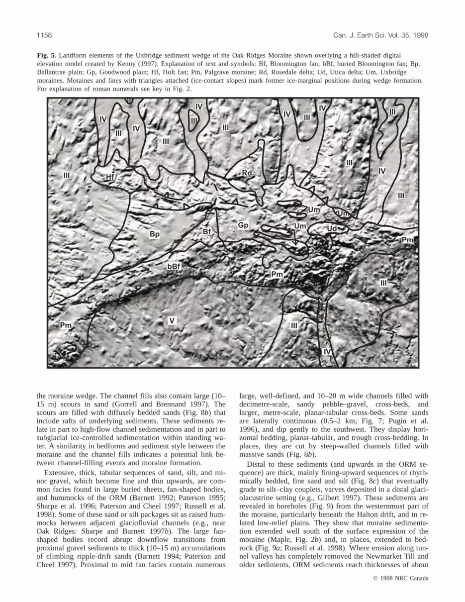
On close examination of the DEM, combined with surfacemapping, it is possible to recognize several smaller land-forms or architectural elements within each sediment wedge(e.g., Barnett 1995, Fig. 5). For example, the Uxbridge sedi-ment wedge (Fig. 5) contains the Bloomington and Holtfans, low-relief plains (Goodwood and Ballantrae plains–deltas), areas of hummocky topography (Palgrave moraine),and minor ridges (Uxbridge moraines). In addition, somesmaller landforms (bedforms) occur within valleys leadingdirectly into the moraine south of Rice Lake (Gorrell andBrennand 1997). The sediments of the ORM are discussedbelow.
The Niagara Escarpment forms the western margin of theORM (Fig. 2) and played a fundamental role in moraine for-mation. A channel system, eroded into the cuesta and alongits face, provided corridors for meltwater to drain southwest-ward and northwestward as the ORM was forming (Fig. 3;Chapman and Putnam 1984; Hunter and Associates and Ra-ven/Beck Environmental Ltd. 1996). These channels proba-bly controlled regional water levels during moraine building(Chapman 1985).
The Caledon channel (White 1975) follows one of severalreentrants in the escarpment face and is cut down to an ele-vation of about 425 m (Fig. 6). The channel cuts through thegravelly Singhampton and Paris moraines, west of the ORM,located above the Niagara Escarpment. Lower channels oc-cur along the escarpment face at elevations of 350 m atActon, approximately 290 m at Campbellville, and about245 m near Kilbride (Fig. 6; Karrow 1989).
The channel network along the Niagara Escarpment haseither bare bedrock floors or is floored with coarse gravel(Cowan and Sharpe 1973; Cowan 1976) that indicate high-volume southwesterly flows up to elevations of about425 m. The Caledon channels contain outwash terraces ofcoarse, high-energy gravel facies (Costello and Walker1972; Fraser 1982). All these channels acted as outlet con-trols for the trapped meltwater into which ORM sedimentsaccumulated and hence they provide a water-level datum forthe sedimentary depositional settings.
The landscape north of the moraine consists of large areasof uplands separated by wide, flat-floored valleys (Fig. 2).The upland surfaces are drumlinized and are considered tobe part of the Peterborough drumlin field. Based on exami-nation of the DEM and field mapping, the uplands are found
© 1998 NRC Canada
Barnett et al. 1155
Author Contribution
Bigsby (1829) Noted “Oak Ridge,” the height-of-land, north of Toronto
Logan (1863) Suggested moraine extended from Niagara Escarpment to east of Trent River
Taylor (1913) Formally defined “Oak Ridges Moraine”; extended from King and Maple to the Trent River; inferredinterlobate and overlapping nature (Lake Ontario Lobe, younger, and Lake Simcoe Lobe, older)
Chapman and Putnam (1943) Modified Taylor’s definition of ORM; included smaller moraines named by Taylor extending themoraine to the Niagara Escarpment and to approximately Trent River (e.g., Logan 1863); agreed tointerlobate origin (most accepted definition of ORM)
Gravernor (1957) ORM interlobate and may be old and, in part, palimpsest, having been overridden by a readvancefrom the north
Mirynech (1962, 1978) Eastern ORM moved west of Trent River (Castleton); ORM was not overridden
White (1975) Redefined ORM in west based on sediment character; identified a separate Palgrave Moraine (LakeOntario ice only); ORM to include only interlobate high-level sands in King Township
Gwyn (1972) Sandy till underlies ORM north and south (Newmarket; Bowmanville Tills)
Gwyn and DiLabio (1973) Palgrave Moraine extended to all areas on south flank of ORM covered by Halton Till
Duckworth (1975, 1979) Palgrave Moraine extended into Newmarket area; ORM not interlobate; a braided stream deposit fedfrom the south
Gwyn and Cowan (1978) ORM not an interlobate moraine; it is a young feature (~13 ka)
Chapman (1985) Identified strong regional control on water level and sedimentation within ORM
Barnett (1992, 1993, 1994) ORM is interlobate and composite (e.g., Taylor 1913); subaqueous fans, deltas, end moraines of bothnorthern and southern ice lobes; one till, Late Wisconsinan, underlies ORM; linked tunnel valleysand ORM genesis
Gorrell and McCrae (1993) ORM has subglacial origin in eastern area; ORM linked to eskers, tunnel channels
Brennand and Shaw (1994) Early part of ORM was deposited in a subglacial depositional environment (esker)
Gilbert (1997) ORM sediments at Vandorf formed in 100 m deep lake in about 100 years
This paper ORM is not continuous along its length; has several depositional environments: subglacial, ice-marginal, and proglacial lacustrine; ORM comprises smaller landforms, including Palgrave Moraine;ORM origin is linked to channel filling; sedimentation was rapid, a few hundred years at most
Table 1. Development of ideas on extent and origin of Oak Ridges Moraine (ORM).
4I:\cjes\cjes35\cjes-10\E98-062.vpWednesday, February 17, 1999 13:56:11
Color profile: Generic CMYK printer profileComposite Default screen

both north and south of the moraine (Fig. 2; Barnett 1997b).There is little change in drumlin long-axis orientation on ei-ther side of the moraine, and thus it appears that these sur-faces extend beneath the moraine and were formed by acommon process.
The drumlinized uplands are composed of a regionally ex-tensive, dense, stony, sandy silt to silty sand diamicton, theNewmarket Till (Figs. 2 and 4; Gwyn and DiLabio 1973),which outcrops in drumlins both north and south of the mo-raine (Barnett et al. 1991). In drill cores obtained throughoutthe area, the Newmarket Till is intercepted between eleva-tions of 200 and 280 m (Fig. 4) and has seismic velocitiesbetween 2 and 3 km/s, making it a useful marker horizon forthe interpretation of seismic profiles (Pullan et al. 1994;Boyce et al. 1995). Seismic profiles from a survey runacross ORM sediments show ridges on a thick, high-velocityfacies (till in Fig. 7; Pugin et al. 1996) beneath ORM sedi-ments. These ridges are similar to surface forms (drumlins)found north of the moraine. This confirms the idea that a re-gional till sheet and drumlin field continue beneath theORM (Barnett et al. 1991; Sharpe et al. 1994a, 1996; Gerberand Howard 1996; contrary to Gravenor 1957; Boyce andEyles 1991). The extension of both drumlins and NewmarketTill south of the moraine was also verified by drilling(Barnett 1993) and by mapping (e.g., Sharpe et al. 1997,Fig. 4).
Large, flat-floored, underfit valleys (tunnel channels), ori-ented northeast–southwest, dominate the landscape north ofthe moraine (Fig. 2). The channels are commonly 1–4 kmwide, steep sided, up to 50 m deep, and they may containeskers on their floors (e.g., Barnett and Dodge 1996). Inplaces, the channels extend beneath the moraine and beyondto the low-relief plains south of the ORM. The extension ofboth uplands and channels beneath the ORM indicates that
their formative processes were regional in scope. In thewestern part of the area, the channels contain thick sedimentfills overlain by recent organic accumulations in wetlands.South of Rice Lake, a broad, steep-walled, east–west chan-nel occurs along the axis of the ORM. It links the adjacentsediment wedges. The density of the channel network and itsanabranching pattern separate them from narrower, incisedpostglacial valleys.
The network of large, wide, south-trending channels isalso revealed to be up to 100 m deep beneath ORM sedi-ments by drilling (Barnett 1993; Russell et al. 1998) and byreflection seismic profiles (Fig. 7; Pullan et al. 1994; Puginet al. 1996). These profiles show an unconformity (erosionalsurface) defined by the steep-walled channels and upperdrumlinized surface of the Newmarket Till (Fig. 7). Thechannel structures are the buried extensions of the tunnelchannels observed north of the moraine (Barnett and Gwyn1997; Fig. 2). In places, positive features at the base of thechannel show an arched geometry that may be interpreted aseskers overlying gravelly fill (Sharpe et al. 1994b; Pugin etal. 1996).
The age of the channel fills is not known and they maypredate the moraine or they may be contemporaneous withit. Fining-upward sequences of gravel and sand are commonin the tunnel channels near Rice Lake (Gorrell and Brennand1997). Sheet gravels and large cross-sets (megaripples;Shaw and Gorrell 1991) have been recognized in section andon seismic profiles (Pugin et al. 1996, 1999). Streamlinedbedforms also occur within the channels south of Rice Lake(Gorrell 1997).
The broad, low-relief plains bordering the southwesternmargin of the ORM (Fig. 2) are, in part, subdued extensionsof the wide, flat-floored channel and drumlin uplands and, inpart, are covered by glaciolacustrine sediment (e.g., Sharpeand Barnett 1997b).
In summary, the ORM is built on a regional unconformity(erosional surface) consisting of the irregular, streamlinedupper surface (drumlins) of the Newmarket Till in the broadupland areas and the base of the deep, wide, inter-uplandvalleys. The valleys with their inset subglacial landforms areinterpreted as having formed by the erosion of upland sedi-ments by large subglacial meltwater flood events (i.e., tunnelvalleys or tunnel channels). It follows that the streamlinedupland surface (drumlins) had also been eroded by sub-glacial meltwater (e.g., Shaw and Sharpe 1987). An alterna-tive mechanism for the formation of the streamlined uplandsurface is erosion by subglacial deformation (Boyce andEyles 1991). However, erosion by subglacial deformationdoes not explain the formation of the large valleys that formthe remaining part of the regional unconformity nor thecoarse gravel fill and very large bedforms that are com-monly found within the valleys. In places, the ORM sedi-ments completely mask this erosional surface. South of themoraine the erosional surface is partly subdued as a result oflater sediment infilling.
The Niagara Escarpment forms the western margin of theORM and played a significant role in moraine formation.The system of channels along the escarpment provided out-lets for ice-marginal drainage and they controlled regionalwater levels during moraine building.
© 1998 NRC Canada
1156 Can. J. Earth Sci. Vol. 35, 1998
Lake
Ontario
Present
Lake Erie
Oak Ridges MoraineBasin
N IAGARA
E SCARPMENT
Fig. 3. Synoptic view from the southwest of ice positions anddepositional environment in the Oak Ridges Moraine area. Studyarea is highlighted by the rectangle. Arrows indicate drainageatop the Niagara Escarpment. Drawing by J.R. Glew, Queen’sUniversity.
5I:\cjes\cjes35\cjes-10\E98-062.vpWednesday, February 17, 1999 13:56:15
Color profile: Generic CMYK printer profileComposite Default screen

The Oak Ridges Moraine sediment wedges contain areasof hummocks, plains, and ridges. Their sediments includediamicton and predominately thick sets of fining-upward,rhythmically bedded, silt, sand, and gravel (Fig. 8) of glacio-fluvial and glaciolacustrine origin, resting on an irregularchanneled surface. The sediments formed within four mainsedimentary settings: (i) subglacial, (ii ) subaqueous fan,(iii ) glaciofluvial delta, and (iv) ice-marginal environments.They also represent proximal (high energy) to distal (low en-ergy) settings. Detailed sedimentological study of outcrops(Fig. 8) and drill core (Fig. 9) has helped reconstruction ofthe main depositional environments of the moraine (e.g.,Barnett 1995).
The ORM in places reveals raised, coarse sediments ar-ranged in a linear fashion with finer grained flanking sedi-ments. The core of the Uxbridge wedge (Fig. 5: eskers at thenorth end of the Bloomington fan) contains sand and gravel
bodies trending southwest and dominated by thick sequencesof clast-supported, pebble to boulder gravels with poorly de-fined, southwest-dipping beds (Barnett 1994). Individualgravel beds may display normal or reverse grading. The coreof the Pontypool wedge also contains coarse, clast-supported, gravelly sediments arranged as tabular sheets re-cording westward paleoflows (Barnett 1997a). These coarsesediments are believed to have been deposited in confined,ice-walled conditions, likely as open-channel eskers. Sharp-crested eskers in tunnel channels near Bethany (Fig. 2b;Barnett 1997b) may have provided sediment to thePontypool wedge, or the eskers were deposited later.
The Rice Lake wedge also contains abundant coarse sedi-ments in large bedforms (Fig. 8a). Megaripples are foundwithin broad tunnel channels that lead into the ORM; thechannels also contain eskers (e.g., Shaw and Gorrell 1991;Gorrell and Brennand 1997; Russell et al. 1998). Channelsheets grade (fine) upward from stratified gravels to thicksets of cross-laminated sands, and they may also merge with
© 1998 NRC Canada
Barnett et al. 1157
Fig. 4. Regional geology and stratigraphic architecture in (a) cross section and (b) block profile of the central part (c) of the Oak RidgesMoraine study area. Location of boreholes and seismic reflection profiles, including the profile displayed in Fig.7, are shown in (c).
6I:\cjes\cjes35\cjes-10\E98-062.vpWednesday, February 17, 1999 13:56:17
Color profile: Generic CMYK printer profileComposite Default screen
the moraine wedge. The channel fills also contain large (10–15 m) scours in sand (Gorrell and Brennand 1997). Thescours are filled with diffusely bedded sands (Fig. 8b) thatinclude rafts of underlying sediments. These sediments re-late in part to high-flow channel sedimentation and in part tosubglacial ice-controlled sedimentation within standing wa-ter. A similarity in bedforms and sediment style between themoraine and the channel fills indicates a potential link be-tween channel-filling events and moraine formation.
Extensive, thick, tabular sequences of sand, silt, and mi-nor gravel, which become fine and thin upwards, are com-mon facies found in large buried sheets, fan-shaped bodies,and hummocks of the ORM (Barnett 1992; Paterson 1995;Sharpe et al. 1996; Paterson and Cheel 1997; Russell et al.1998). Some of these sand or silt packages sit as raised hum-mocks between adjacent glaciofluvial channels (e.g., nearOak Ridges: Sharpe and Barnett 1997b). The large fan-shaped bodies record abrupt downflow transitions fromproximal gravel sediments to thick (10–15 m) accumulationsof climbing ripple-drift sands (Barnett 1994; Paterson andCheel 1997). Proximal to mid fan facies contain numerous
large, well-defined, and 10–20 m wide channels filled withdecimetre-scale, sandy pebble–gravel, cross-beds, andlarger, metre-scale, planar-tabular cross-beds. Some sandsare laterally continuous (0.5–2 km; Fig. 7; Pugin et al.1996), and dip gently to the southwest. They display hori-zontal bedding, planar-tabular, and trough cross-bedding. Inplaces, they are cut by steep-walled channels filled withmassive sands (Fig. 8b).
Distal to these sediments (and upwards in the ORM se-quence) are thick, mainly fining-upward sequences of rhyth-mically bedded, fine sand and silt (Fig. 8c) that eventuallygrade to silt–clay couplets, varves deposited in a distal glaci-olacustrine setting (e.g., Gilbert 1997). These sediments arerevealed in boreholes (Fig. 9) from the westernmost part ofthe moraine, particularly beneath the Halton drift, and in re-lated low-relief plains. They show that moraine sedimenta-tion extended well south of the surface expression of themoraine (Maple, Fig. 2b) and, in places, extended to bed-rock (Fig. 9a; Russell et al. 1998). Where erosion along tun-nel valleys has completely removed the Newmarket Till andolder sediments, ORM sediments reach thicknesses of about
© 1998 NRC Canada
1158 Can. J. Earth Sci. Vol. 35, 1998
III
III
IIIIII
IIIIV
IV
III
IIIIV
III
IV
IIIIIIIV
IV
III
III
V
Hf
Bp
bBf
BfGp
Pm
Um Ud
Pm
Um Um
Rd
IV
Pm
Fig. 5. Landform elements of the Uxbridge sediment wedge of the Oak Ridges Moraine shown overlying a hill-shaded digitalelevation model created by Kenny (1997). Explanation of text and symbols: Bf, Bloomington fan; bBf, buried Bloomington fan; Bp,Ballantrae plain; Gp, Goodwood plain; Hf, Holt fan; Pm, Palgrave moraine; Rd, Rosedale delta; Ud, Utica delta; Um, Uxbridgemoraines. Moraines and lines with triangles attached (ice-contact slopes) mark former ice-marginal positions during wedge formation.For explanation of roman numerals see key in Fig. 2.
7I:\cjes\cjes35\cjes-10\E98-062.vpWednesday, February 17, 1999 13:56:21
Color profile: Generic CMYK printer profileComposite Default screen

150 m (Fig. 9a). In summary, widespread sequences indicatesubaqueous fan depositional environments possibly up to100 km2.
Regional landform relations, textural trends, and paleo-flow measurements indicate flow to the southwest, west,northwest, and locally divergent flow directions (Duckworth1975, 1979; Barnett 1994; Paterson 1995; Russell et al.1998). The above sequences and flow patterns are well re-corded and are interpreted as subaqueous fans (e.g.,Bloomington fan, Fig. 5; Barnett 1994; Paterson and Cheel1997), deposited rapidly in a lake ponded between the iceand the greater than 425 m high Niagara Escarpment(Figs. 3 and 6).
Sand plains with coarsening-upward sequences are foundin several areas of the ORM (e.g., Ballantrae plain, Fig. 5;Barnett 1997a). A Geological Survey of Canada (GSC)borehole near Vandorf reveals 10–20 m of uniform, coarseto medium sand overlying (at ~285 m asl) many ten’s ofmetres of rhythmically bedded, fine sand, silt, and clay(Fig. 9b). The top portion of these sediments is interpretedas deltaic deposits. The deltaic deposits overlie basinal(Gilbert 1997) and subaqueous fan deposits. Paleoflows inthe delta package are predominately westward where it sitson the north flank of the ORM height of land (Figs. 2 and5). A prominent break in slope on this surface appears to in-dicate a prograding wedge of deltaic sediment on thedepositional slope (Fig 5; Barnett 1994). Delta sedimentsthat flank the core of the Pontypool wedge show northerlypaleoflows, deflected northward by the preexisting morainecore sediments (Barnett 1997b). Shoreline features related tothese delta surfaces are mapped nearby (e.g., Barnett andMcCrae 1996). Aeolian sand dunes, 5–8 m high, drape thedelta top.
Falling water levels necessary to allow delta sedimenta-tion resulted from the retreat of the ice dam at the NiagaraEscarpment (Fig. 3), allowing successfully lower ice-marginal channels (e.g., Caledon outwash, Fig. 6) or sub-glacial conduits to open. The delta interpretation atBallantrae is supported by the ice-controlled outlet channelidentified at ~290 m asl at Campbellville (Karrow 1989).The Campbellville outlet projects to about 327 m asl, orabout the surface of the Ballantrae plain (Fig 5; a remnantdelta surface).
Ice-marginal sedimentation, whether subglacial or pro-glacial, refers here to late sedimentation where debris flowand low-energy sediments were better preserved than duringperiods of high-energy deposition of sand and gravel. SiltyHalton Till and associated drift onlap the hummocky south-ern flank of the moraine (Fig. 4), particularly in the Humberwatershed, where it may be more than 30 m thick (Russelland Arnott 1997). Thickness of this till diminishes sharplyaway from the ORM on broad low-relief plains east of theHumber watershed (Sharpe and Barnett 1997a). Thin, dis-continuous fine-grained, glaciolacustrine sediments andinterbedded beds and lenses of Halton Till (Fig. 8d) appearto indicate a facies gradation to the sediments of the adja-cent low-relief plains, particularly in the area of glacial lakedeposits north of Markham (e.g., Sharpe and Barnett 1997b).Halton drift consists of thicker diamicton deposits, up to15 m thick, represented by the Palgrave ridge (moraine:White 1975). It commonly contains quasi-continuous silt,
clay, and fine sand beds and lenses that are 0.5–2 m thick(Russell and Arnott 1997).
A modest Halton glacial advance (2–3 km) toward thenorth overrode the southern edge of the ORM fan and deltasediments (Barnett 1994). The advance may have extendedfarther in the Humber River watershed. The limit of the Hal-ton advance is marked by a narrow zone of hummocky to-pography containing extensive kettle depressions (Palgravemoraine: White 1975) and by the surface distribution of theHalton Till (Fig. 4). Advance is indicated by the occurrenceof unidirectional overturned strata beneath (Halton) diamic-ton, the orientation of shear planes within the diamicton, andthe occurrence of lodgement till over melt-out till along thesouthern flank of the ORM (Barnett 1993). Local incorpora-tion of subsole sediments into the base of the till was alsonoted locally. In addition, deposits of fine-grainedrhythmites (30–50 cycles) between gravels beneath theGoodwood and Ballantrae plains may be the result of an ad-vance of the Ontario basin ice, temporarily closing theCampbellville outlet.
© 1998 NRC Canada
Barnett et al. 1159
Mono Hills
Caledon
BelfountainErin
Cheltenham
Acton
Kilbride
Campbellville
5000 0 5
kmmeters
Niagara EscarpmentOutwashBare LimestoneBedrock
425m
380m
350m
290m
N
Ice covered
250m
SM
PM
Outlet Channel
Fig. 6. Outlet channels and water level controls on Oak RidgesMoraine sedimentation along the Niagara Escarpment (afterChapman 1985). Singhampton Moraine (SM) and Paris Moraine(PM) are shown draping the Niagara Escarpment.
8I:\cjes\cjes35\cjes-10\E98-062.vpWednesday, February 17, 1999 13:56:24
Color profile: Generic CMYK printer profileComposite Default screen

Rippled sands with northward paleoflow are associatedwith the Halton Till and indicate that the advancing ice mar-gin also contributed meltwater flow to the ORM, north ofBrampton (Saunderson and Jopling 1980), in the HumberRiver watershed (Russell and Arnott 1997), and nearBloomington. Meltwater pulses also contributed sand to Hal-ton drift from the ORM complex, lying to the north and east.The strong glaciolacustrine character to the Halton drift, thehigh ponded water levels (greater than 335 m asl in theUxbridge wedge area; Fig. 2), and the limited ice fluctuationsuggest that ORM sedimentation was transitional to Haltondrift and adjacent proglacial lake sedimentation (especiallynear Markham).
The Oak Ridges Moraine was built on a high-relief, ero-sional surface defined by the surface of the drumlinized up-
lands and network of deep tunnel channels. Moraine devel-opment is highlighted in four stages and evolved rapidlyfrom a glaciofluvial-dominated core to flankingglaciolacustrine-dominated wedge sediments (Fig. 10). Themodel reflects the transition from subglacial to proglacialconditions during moraine formation, with emphasis on themain processes of deposition. It may reflect sedimentationpatterns through time, although the “stages” are not neces-sarily sequential and reconstruction reflects an idealized se-quence. The initial stages of moraine construction are betterexposed in the east; in the west, these stages are buried bylater stages.
Stage I: subglacial sedimentationStage I portrays the initial stage of moraine formation
where sediment-laden meltwater was delivered along sub-glacial and possibly englacial openings to subglacial cavities
© 1998 NRC Canada
1160 Can. J. Earth Sci. Vol. 35, 1998
Fig. 7. Portion of east–west seismic reflection profile acquired near Vandorf (Figs. 2 and 4c) showing (a) processed data (downholevelocity profile is superimposed) and (b) the interpretation (from Pugin et al.1999). Half arrows mark the base of a possible largeslump along the buried valley wall. A 135 m deep lithologic log (inset) displays the geological material encountered. Triangle fillrepresents diamicton. See Fig. 9 caption for explanation of other units in graphic logs.
9I:\cjes\cjes35\cjes-10\E98-062.vpWednesday, February 17, 1999 13:56:33
Color profile: Generic CMYK printer profileComposite Default screen

(Fig. 10, I). Initially, erosional processes produced channels(Nye channels), such as the east–west channel south of RiceLake (Fig. 2). Early, formative flows may have also en-hanced the network of north–south channels, or used thecorridors for sediment delivery to the ORM. As flow waned,deposition of coarse to fine channel fills (Fig. 10, I) tookplace along the core of the ORM and beyond, as shown bythe thick, coarse sediment sequences observed along channelbases in seismic profiles and borehole logs (Figs. 7 and 9).
The channels north of the Rice Lake sediment wedge(Gorrell and Brennand 1997) contain coarse to fine sedimentsequences that may be transitional to ORM sediments. Thechannels contain pendant bars and large ripples, similar tothose associated with Missoula flood events (Bretz et al.1956). The strata also contain high-energy scours (Fig. 8b)similar to those found in esker and proximal fan environ-ments (Rust and Romanelli 1975; Gorrell and Shaw 1991;Brennand 1994; Brennand and Shaw 1994). Eskers foundwithin these valleys tend to broaden to form gravel sheetsand other bedforms (Fig. 10, I), where flow expanded toform a thick moraine segment (e.g., north of the Rice Lakewedge). Some long esker systems found well to the east ofthe ORM appear to connect to it (Gorrell 1997). Thesesedimentological data support the interpretation that the
underfit valleys are tunnel channels eroded and filled byhigh-velocity, perhaps subglacial, meltwater.
The channel sediments and forms grade from gravels tosands and from sheets to large dunes as they near the ORM.Thus, there appears to be an intimate relationship betweenthe channels, thick channel fills, eskers, and the moraine.The first stage, while fragmentary, is best observed in theRice Lake sediment wedge, where an entirely subglacial ori-gin is inferred (Gorrell and McCrae 1992).
Stage II: subaqueous fan sedimentationThe expansion of the subglacial cavity or expansion of a
narrow ice-walled lake environment is highlighted in thesecond stage (Fig. 10, II). Proximal sedimentation was dom-inated by gravel; transition to sandy facies was abrupt and inmany sites the high-energy gravelly sediments were buried.ORM sedimentary sequences (Paterson 1995; Paterson andCheel 1997) are similar to those reported in other subaque-ous fans (e.g., Rust and Romanelli 1975), although diffuselybedded sands are rare (Fig. 8b), and ice confinement re-sulted in proximal sedimentary facies extending farther, pos-sibly 1–2 km, downflow. Distally (perhaps only 100–1000 m; possibly 1–5 km), cyclic, silt–sand ripple-drift se-quences can dominate (Russell et al. 1998). Both the
© 1998 NRC Canada
Barnett et al. 1161
Fig. 8. Prominent lithofacies of the Oak Ridges Moraine. (a) Large-scale gravel cross-beds interpreted to result from a migratingbedform, Brighton; exposed face approximately 3m high. (b) Diffusely bedded sand with rip-up clasts, interpreted to result fromdeposition from suspension by hyperconcentrated flow (Gorrell and Shaw 1991; Brennand 1994), Bolton. (c) Sand and silt rhythmites,inferred to be glaciolacustrine deposits, Coppins Corners; grub hoe handle is 1 m, for scale. (d) Interbedded sand, silt, and diamicton,representing deposition from suspension and sediment flows, Woodbridge; knife is 10 cm long, for scale.
10I:\cjes\cjes35\cjes-10\E98-062.vpWednesday, February 17, 1999 13:57:15
Color profile: Generic CMYK printer profileComposite Default screen

Pontypool and Uxbridge sediment wedges contain landformsand sediment sequences that illustrate this stage of moraineformation (Barnett 1994, 1995).
In the Uxbridge wedge, eskers lead into a large subaque-ous fan from the northwest (Bloomington fan: Fig. 5) toform one of the highest parts of the moraine (>360 m asl).The fan sediments extend in a southwesterly direction as alinear body of plane-bedded sands and fine gravels (Fig. 10,II) cut by deep, broad, steep-walled scours, filled with mas-sive sand, typical of fan environments. Distal deposits tendto have rhythmic fine-grained sets, indicating standing wa-ter. With outlet channels at the Niagara Escarpment at about425, 380, and 350 m asl (Fig. 6), early ORM fan sedimenta-tion could have occurred in water depths of over 100 m.
Stage III: fan to delta sedimentationStage III includes the transition of fan to fan delta and to
deltaic sedimentation (Fig. 10, III), lateral to and overlyingstage II, where ice-confined sedimentation occurs. Fan sedi-mentation in this stage is distal to primary sediment inputsources and occurs in a large ice-controlled lake (Figs. 3 and10, III). Fine sand and silt rhythmites were extensively de-posited. These sets are the result of deposition primarily by
underflows (Fig. 10, III) whose distribution is controlled bybasin topography and source location. The rhythmically bed-ded sediments are thickest in the deeper parts of the basins(water depths 100–200 m) such as the preexisting troughsassociated with the tunnel channels (Figs. 2 and 4). Distalfan sedimentation contributing to moraine formation is bestpreserved in the Humber River basin (Russell and White1997) and the Albion Hills sediment wedge (Fig. 2b).
Glaciolacustrine fan sedimentation changed to deltaic sed-imentation as regional water levels fell in response to theopening of the outlet at Campbellville on the Niagara Es-carpment (290 m asl; Fig. 6). The lower outlet at Kilbride(245 m asl; Fig. 6) opened subsequently. Most of theUxbridge wedge (Goodwood and Ballantrae plains: Fig. 5)is at an elevation of about 335 m and corresponds to a lakecontrolled by the Campbellville outlet. Allowing for iso-static rebound, the level of the proglacial lake projects to anelevation of about 327 m at Uxbridge.
Subaqueous fans were also built at localized input sourcesalong the ice margins (e.g., Holt fan, 250–255 m asl: Fig. 5;Barnett 1994). Deltaic and glaciofluvial sediments were de-posited in expanding glacial lake basins (Fig. 10, IV) formedbetween the receding ice margins and existing coarse mo-raine sediments (stages I and II). The landforms and sedi-ments of the Pontypool and Uxbridge wedges illustrate thisstage (Barnett 1994, 1995). Deltaic sedimentation dominatedwhere sediment delivery was primarily by ice-marginalbraided streams flowing westward to the expanding lake(e.g., near Ballantrae and Lake Scugog; Barnett 1997b;Fig. 10, III). The distribution of sediments was affected byrapid variation in discharge and outlet control (ice dam floa-tation and ice-marginal fluctuations) related to ice thicknessand position. For example, silt–clay rhythmites occur withingravelly sediment sequences in the Goodwood area of theUxbridge wedge (Duckworth 1979; Chapman 1985). Thesefine-grained rhythmites occur within sediments of theBallantrae and Goodwood plains and were possibly depos-ited as the result of a rapid short-lived (30–50 years) rise inwater level in response to the advance of the Halton ice(Barnett 1995). Data from a semicontinuous core of morainesediments in the Uxbridge wedge, near Vandorf, indicateabout 100 years of stable, deep-water lake sedimentation,delivered in a few main cylces (Gilbert 1997) prior to depo-sition of coarsening-up deltaic sands in the top 20 m of thecore (285–305 m asl).
Stage IV: ice-marginal sedimentationIn the deeper basinal areas and along the southern flank of
the ORM, the upper part of the succession of moraine sedi-ments is commonly interbedded glaciolacustrine stratifiedsediments and massive to bedded diamictons (Halton Tilland debris flows, Wildfield Complex, White 1975; Russelland Arnott 1997; Fig. 10, IV). Some of these sedimentswere deposited ice marginally, under a partially buoyant iceterminous or at a grounding line, particularly in the HumberRiver basin (Fig. 10, IV; Russell and Arnott 1997). In areasto the east, deposition predominantly focused along the gla-cial margin (Palgrave moraine, White 1975). The narrowpart of the moraine south of Lake Scugog consists of a thickdiamicton sequence, interpreted primarily as flowtills or gla-cially derived debris flows (Halton Till; Barnett 1994,
© 1998 NRC Canada
1162 Can. J. Earth Sci. Vol. 35, 1998
Vaughan(V4-4D)
150
200
250
30015kmSW
Haltondrift
ORMsediments(channel fill)
Bedrock
ORMdeltaic
ORMsubaqueousfan and basinalsediments
Channelfill
Newmarkettill
Lowerdeposits
Vandorf(94-1VD)
(b)(a)
C Z S G
C Z S G
unconformity
elev
atio
n(m
asl)
Fig. 9. Graphic log of drill core from (a) Vaughan and(b) Vandorf. Figures 2 and 3 show sites. C, clay; Z, silt; S, sand;G, gravel. Parallel lines are rhythmites.
11I:\cjes\cjes35\cjes-10\E98-062.vpWednesday, February 17, 1999 13:57:18
Color profile: Generic CMYK printer profileComposite Default screen

1997a). These sediments overlie subaqueous fan sedimentsdeposited along the northern margin of the ice in the LakeOntario basin. Evidence of northward-flowing conduitswithin the Lake Ontario basin has been presented bySaunderson (1975) and Saunderson and Jopling (1980).
The four stages of moraine formation may be present inany one sediment wedge. In general, there is a transitionfrom sub-glaciofluvial to glaciolacustrine and from subaque-
© 1998 NRC Canada
Barnett et al. 1163
Fig. 10. Conceptual model showing the developmental stages of the Oak Ridges Moraine. I, subglacial sedimentation: high-energyerosion and coarse sedimentation within a tunnel; II, subaqueous fan sedimentation: ice-confined, high-energy to reduced-energysedimentation of gravelly sequences transitional to large sandy sets; III, fan to delta sedimentation: distal fan deposition of silt–clayrhythmites and sandy subaerial braid-plain sedimentation; IV, ice-marginal sedimentation: debris flows, turbidity currents, andsedimentation from suspension. View is from the southwest. Drawings by J.R. Glew, Queen’s University.
12I:\cjes\cjes35\cjes-10\E98-062.vpWednesday, February 17, 1999 13:57:32
Color profile: Generic CMYK printer profileComposite Default screen

ous to subaerial environments of deposition. However, theimportance and contribution of any one stage to the sedi-ment wedge varies and is difficult to determine becausedeep sediments are incompletely exposed. The western sedi-ment wedges (Albion Hills and Uxbridge; Fig. 2b) containsa more complete record of the four stages of moraine forma-tion than the easternmost sediment wedge (Rice Lake). TheORM appears to have formed in a time sequence but moresynchronous sedimentation may be revealed in deeper de-posits.
Formation of the ORM(1) ORM probably formed as the margin of the Late
Wisconsinan ice melted back from atop the Niagara Escarp-ment. Initially subglacial conduits expanded to form a grow-ing west-to-east reentrant between the main Laurentide IceSheet and a mass of ice in the Lake Ontario basin.
(2) ORM forms a thick sequence (up to 150 m) of strati-fied sediment deposited rapidly on a high-relief, regionalerosional surface defined by a network of tunnel channelsand the surface of the intervening drumlinized uplands.
(3) Coarse tunnel channel fills may show transitional rela-tionships with the ORM in both landform sequences andsediment trends in boreholes.
(4) Lowest fills show north–south-trending paleoflows,whereas upper sediments have more axial (east–west) paleo-flows.
(5) ORM sediments consist of heterogeneous to cross-bedded gravel, diffusely bedded to ripple cross-laminatedsand, massive to rhythmically laminated silt and clay, andminor, massive to stratified diamictons.
(6) Moraine sedimentation was predominantly glaciofluvial–glaciolacustrine with late-stage diamicton accumulation alongthe ice margins.
(7) Moraine sediments were deposited, in part, in sub-glacial environments, but they were mainly deposited in ice-confined, subaqueous fan environments followed by deltaicenvironments of deposition. Varves within the moraine sedi-ments indicate that wedge formation may have occurred inas little as a few hundred years.
(8) Sedimentation appears to have occurred generally insequence from west to east at the four main sedimentwedges, Albion, Uxbridge, Pontypool, and Rice Lake. How-ever, more synchronous sedimentation may have occurred inthe lowest beds.
(9) The Niagara Escarpment controlled water levels andhence moraine sedimentation as recorded by a series of out-let channels. For example, the Uxbridge wedge formed sub-aqueously until the outlet at Campbellville (290 m asl) wasexposed; then subaerial and deltaic sedimentation occurred.
(10) The retreating ice margins shed ice-marginal diamic-tons into shallow lakes. An ice- marginal fluctuation of sev-eral kilometres deposited Halton drift during the final stagesof moraine formation. Deposition of diamicton into shallow-lake environments may have occurred ice marginally, frombeneath a partially bouyant ice terminus, or along the ground-ing line.
Integration of terrain evaluation methods increases ourknowledge of large complex landforms (moraines). It can
improve the understanding of the form, three-dimensionalextent, and architecture present in complex features such asthe Oak Ridges Moraine. The areal extent and interrelationof landform elements in the ORM and adjacent terrain arerevealed in a high-resolution digital elevation model (DEM:Figs. 2 and 5) and in high-resolution subsurface data (e.g.,seismic reflection profiles: Fig. 6).
The ORM was built on a high-relief erosional surface de-fined by deeply eroded tunnel channels and drumlinized up-lands. Widespread glaciofluvial erosion preceded moraineformation as for other moraines, for example, the ValleyHeads Moraine (Mullins and Hinchy 1989) and the Eagle–Finlayson, Hartman, and Lac Seule moraines in northwest-ern Ontario (Sharpe and Cowan 1991).
There is a transition from glaciofluvial to glaciolacustrinedeposition. The ORM has a core of glaciofluvial-dominatedsediments (subglacial cavity fills to confined subaqueousfans). These are overlain and flanked by slightly younger,topographically lower, glaciolacustrine sediments (deltas andbasinal sediments). This landform–sediment relationship ispresent in the Harricana glaciofluvial complex (Brennandand Shaw 1996), stratified moraines in northwestern On-tario, and may be present in other stratified moraines, suchas the Waterloo Moraine (Karrow and Paloschi 1996:Fig. 1). Glaciofluvial and glaciolacustrine sediments are pre-dominant in these moraines even though diamicton maycover large surface areas, as it does in the ORM.
The location of the Oak Ridges Moraine may be related,in part, to its regional topographic setting, and this in turnaffected the style of sedimentation. Major lake basins (LakeOntario and Georgian Bay), the Niagara Escarpment, and theretreating ice front all combined to create deep, ice-marginal-lake conditions following the erosion of the tunnelchannels. Water levels and sedimentation within the systemwere controlled at first by glacial hydrology and later by re-gional outlet channels (425–245 m asl) along the NiagaraEscarpment. Water levels within the cavities or the expand-ing, ice-walled lake controlled sedimentation so that sub-aqueous deposition occurred prior to drainage through theCampbellville outlet, whereas subaerial and deltaic deposi-tion occurred during and following the opening of theCampbellville outlet. Water levels fluctuated as a result ofice-marginal position, for example, with the Halton ice ad-vance. However, generally a water level decline with time isrecorded within the moraine sediments.
The opportunity to apply an integrated approach to studythe Oak Ridges Moraine was provided by several organiza-tions, including the National Mapping Program (NATMAP),the Geological Survey of Canada, the Ontario GeologicalSurvey (Ministry of Northern Development and Mines), theOntario Ministry of Natural Resources, the Ontario Ministryof the Environment and Energy, and the regional municipali-ties of Peel and York. H.A.J.R. was supported, in part, by aNatural Sciences and Engineering Research Council of Can-ada operating grant to W.R.C. Arnott, University of Ottawa.The support of all these organizations is greatly appreciated.Dr Jean Veillette reviewed the manuscript for the GSC. Theblock diagrams were created by John R. Glew.
© 1998 NRC Canada
1164 Can. J. Earth Sci. Vol. 35, 1998
13I:\cjes\cjes35\cjes-10\E98-062.vpWednesday, February 17, 1999 13:57:33
Color profile: Generic CMYK printer profileComposite Default screen

Barnett, P.J. 1989. Tunnel valleys in the Georgian Bay area, On-tario. Geological Association of Canada, Program with Ab-stracts,14: A89.
Barnett, P.J. 1990. Tunnel valleys: evidence of catastrophic releaseof subglacial meltwater, central-southern Ontario, Canada. Geo-logical Society of America, Northeastern Section, Abstractswith Programs,22(2): 3.
Barnett, P.J. 1992. Geological investigations within the Oak RidgesMoraine area, Whitchurch–Stouffville and Uxbridge townshipmunicipalities, Ontario.In Summary of fieldwork and other ac-tivities 1992. Ontario Geological Survey, Miscellaneous Paper160, pp. 144–145.
Barnett, P.J. 1993. Geological investigations in the Oak RidgesMoraine area, parts of Scugog, Manvers and Newcastle town-ship municipalities and Oshawa municipality, Ontario.In Sum-mary of fieldwork and other activities 1993. Ontario GeologicalSurvey, Miscellaneous Paper 162, pp. 158–159.
Barnett, P.J. 1994. Geology of the Oak Ridges Moraine area, partsof Peterborough and Victoria counties and Durham and York re-gional municipalities, Ontario.In Summary of fieldwork andother activities 1994. Ontario Geological Survey, MiscellaneousPaper 163, pp. 155–160.
Barnett, P.J. 1995. Project 92-19 Geology of the Oak Ridges Mo-raine area, parts of Peterborough and Victoria counties and Dur-ham and York regional municipalities, Ontario.In Summary offieldwork and other activities 1995. Ontario Geological Survey,Miscellaneous Paper 164, pp. 177–182.
Barnett, P.J. 1997a. Stop 7. TRT gravel pit.In 1977. Where is thewater? Regional geologicaL/hydrological framework, OakRidges Moraine area, southern Ontario.Compiled by D.R.Sharpe and P.J. Barnett. Geological Association of Canada –Mineralogical Association of Canada Joint Annual Meeting, Ot-tawa ’97, Field Trip A1, Guidebook.
Barnett, P.J. 1997b. Surficial geology of the Scugog (31 D/2) 1 :50 000 NTS map sheet, southern Ontario; Geological Survey ofCanada, Open File 3330.
Barnett, P.J., and Dodge, J.E.P. 1996. Quaternary geology of theUxbridge area. Ontario Geological Survey, Map 2633, scale 1 :20 000
Barnett, P.J., and Gwyn, Q.H.J. 1997. Surficial geology of theNewmarket (31 D/3) 1 : 50 000 NTS mapsheet, southern On-tario. Geological Survey of Canada, Open File 3329.
Barnett, P.J., and McCrae, M.K. 1996. Quaternary geology of theMt. Albert area. Ontario Geological Survey, Map 2631, scale 1 :20 000.
Barnett, P.J., Cowan, W.R., and Henry, A.P. 1991. Quaternary geol-ogy of Ontario, southern sheet. Ontario Geological Survey, Map2556, scale 1 : 1 000 000.
Bigsby, J.J. 1829. A sketch of the topography and geology of LakeOntario. Philosophical Magazine, Series 2,5: 263–274.
Boyce, J.I., and Eyles, N. 1991. Drumlins carved by deforming tillstreams below the Laurentide Ice Sheet. Geology,19: 787–790.
Boyce, J.I., Eyles, N., and Pugin, A. 1995. Seismic reflection,borehole and outcrop geometry of Late Wisconsin tills at a pro-posed landfill near Toronto, Ontario. Canadian Journal of EarthSciences,32: 1331–1349.
Brennand, T. 1994. Macroforms, large bedforms and rhythmic sed-imentation patterns in subglacial terrain, south-central Ontario:implications for esker genesis and meltwater regime. Sedimen-tary Geology,91: 9–55.
Brennand, T., and Shaw, J. 1994. Tunnel channels and associatedlandforms: their implication for ice sheet hydrology. CanadianJournal of Earth Sciences,31: 502–522.
Brennand, T., and Shaw, J. 1996. The Harricana glaciofluvial com-plex, Abitibi region Quebec: Its genesis and implications formeltwate regime and ice-sheet dynamics. Sedimentary Geology,102: 221–262.
Bretz, J.H., Smith, H.T.U., and Neff, G.E. 1956. Channeledscablands of Washington State: new data and interpretations.Bulletin of the Geological Society of America,67: 957–1049.
Burbidge. G., and Rust, B.R. 1988. Champlain Sea subwash fan atSt. Lazarre, Quebec.In The Late Quaternary development of theChamplain Sea Basin.Edited byN.R. Gadd. Geological Associ-ation of Canada, Special Paper 35, pp. 47–61.
Chapman, L.J. 1985. On the origin of the Oak Ridges Moraine,southern Ontario. Canadian Journal of Earth Sciences,22: 300–303.
Chapman, L.J., and Putnam, D.F. 1943. The moraines of southernOntario. Transactions of the Royal Society of Canada, Section 3,37(4): 33–41.
Chapman, L.J., and Putnam, D.F. 1951. The physiography ofsouthern Ontario. University of Toronto Press, Toronto.
Chapman, L.J., and Putnam, D.F. 1984. The physiography ofsouthern Ontario. Ontario Geological Survey, Toronto. SpecialVolume 2.
Coleman, A.P. 1932. The Pleistocene of the Toronto region. On-tario Department of Mines, Report XLI, Part VII.
Costello, W.R., and Walker, R.G. 1972. Pleistocene sedimentology,Credit River, southern Ontario: a new component of the braidedriver model. Journal of Sedimentary Petrology,42: 389–400.
Cowan, W.R. 1976. Quaternary geology of Orangeville, southernOntario. Ontario Division of Mines, Geological Report 141.
Cowan, W.R., and Sharpe, D.R. 1973. Quaternary geology ofOrangeville, southern Ontario. Ontario Division of Mines, Map2326, scale 1 : 50 000.
Duckworth, P.B. 1975. Paleocurrent trends in the latest outwash atthe western end of the Oak Ridges moraine, Ontario. Ph.D. the-sis, University of Toronto, Toronto, Ont.
Duckworth, P.B. 1979. The late depositional history of the westernend of the Oak Ridges Moraine, Ontario. Canadian Journal ofEarth Sciences,16: 1094–1107.
Eyles, N., Clark, B.M., Kaye, B.G., Howard, K.W.F., and Eyles,C.H. 1985. The application of basin analysis techniques to glaci-ated terrains: an example from the Lake Ontario basin, Canada.Geoscience Canada,12: 22–32.
Fraser, J.Z. 1982. Derivation of a summary facies sequence basedon Markov chain analysis of Caledon outwash: a Pleistocenebraided glacial fluvial deposit.In Glacial, glaciofluvial andglaciolacustrine systems.Edited by R. Davidson-Arnott, W.Nickling, and B.D. Fahey. Geo Books (Geo Abstracts Ltd.),Norwich, pp. 175–202.
Gerber, R.E., and Howard, K.W.F. 1996. Evidence for recentgroundwater flow through Late Wisconsinan till near Toronto,Ontario. Canadian Geotechnical Journal,33: 538–555.
Gilbert, R. 1997. Glaciolacustrine sedimentation in part of the OakRidges Moraine. Géographie physique et Quaternaire,7(1): 55–66.
Gorrell, G. 1997. Surfical geology of the Trenton (31 C/4) 1 :50 000 NTS map sheet, southern Ontario. Geological Survey ofCanada, Open File 3333.
Gorrell, G., and Brennand, T.A. 1997. Surficial geology of theRice Lake (31 D/1) 1 : 50 000 NTS mapsheet, southern On-tario. Geological Survey of Canada, Open File 3332.
Gorrell, G., and McCrae, M. 1992. Aggregate resource inventoryof Haldimand and Alnwick townships, Northumberland County.Ontario Geological Survey, Aggregate Resource Inventory Pa-per 143.
© 1998 NRC Canada
Barnett et al. 1165
14I:\cjes\cjes35\cjes-10\E98-062.vpWednesday, February 17, 1999 13:57:34
Color profile: Generic CMYK printer profileComposite Default screen

Gorrell, G., and Shaw, J. 1991. Deposition in an esker, bead andfan complex, Lanark, Ontario, Canada. Sedimentary Geology,72: 285–314.
Gravenor, C.P. 1957. Surficial geology of the Lindsay–Peterborough area, Ontario. Geological Survey of Canada,Memoir 288.
Gwyn, Q.H.J. 1972. Quaternary geology of the Alliston–Newmarket area, southern Ontario. Geological Branch, Miscel-laneous Paper 53, pp. 144–147.
Gwyn, Q.H.J., and Cowan, W.R. 1978. The origin of the OakRidges and Orangeville moraines of southern Ontario. CanadianGeographer,22(4): 345–352.
Gwyn, Q.H.J., and DiLabio, R.N.W. 1973. Quaternary geology ofthe Newmarket area, southern Ontario. Ontario Division ofMines, Preliminary map P.836, scale 1 : 50 000.
Hunter and Associates and Raven/Beck Environmental Ltd. 1996.Executive summary and technical report, hydrogeological evalu-ation of the Oak Ridges Moraine area, part of Background Re-port No. 3 for the Oak Ridges Moraine Planning Study.Prepared forthe Oak Ridges Moraine Technical Working Com-mittee. Available from the Ministry of Natural Resources,Peterborough, Ont.
Karrow, P.F. 1989. Quaternary geology of the Great Lakes subre-gion. In Quaternary geology of Canada and Greenland.Editedby R. Wheeler. Geological Survey of Canada, Geology of Can-ada, No. 1, pp. 326–350.
Karrow, P.F., and Paloschi, G.V.R. 1996. The Waterloo kame mo-raine revisited: new light on the origin of some Great Lake re-gion interlobate moraines. Zeitschrift für Geomorphologie, N.F.,40(3): 305–315.
Kenny, F. 1997. A chromo-stereo enhanced digital elevation modelof the Oak Ridges Moraine area, southern Ontario. GeologicalSurvey of Canada, Open File 3374, scale 1 : 200 000.
Logan, W.E. 1863. Geology of Canada. Geological Survey of Can-ada, Report of Progress to 1863, Ottawa.
Mirynech, E. 1962. Pleistocene geology of the Trenton–Campbellford area. Ph.D. thesis, University of Toronto, Toronto,Ont.
Mirynech, E. 1978. Surfical geology Trenton, Ontario. GeologicalSurvey of Canada, Open File 545, scale 1 : 50 000.
Mullins, H.T., and Hinchy, E.J. 1989. Erosion and infill of NewYork Finger Lakes: Implications for Laurentide Ice Sheetdeglaciation. Geology,17: 622–625.
Paterson, J.T. 1995. Sedimentology of the Bloomington fan com-plex, Oak Ridges Moraine, southern Ontario. M.Sc. thesis,Brock University, St. Catherines, Ont.
Paterson, J.T., and Cheel, R.J. 1997. The depositional history ofthe Bloomington complex, an ice-contact deposit in the OakRidges Moraine, southern Ontario, Canada.. Quaternary ScienceReviews,16(7): 705–719.
Petruccione, J.L., Wellner, R.W., and Sheridan, R.E. 1996. Seismicreflection investigations of Montezuma wetlands New YorkState: Evolution of a Late Quaternary subglacial meltwaterchannel system.In Subsurface geologic investigations of NewYork Finger Lakes: Implications for Late Quaternarydeglaciation and environmental change.Edited byH.T. Mullinsand N. Eyles. Geological Society of America, Special Publica-tion 311, pp. 77–89.
Pugin, A., Pullan, S.E., and Sharpe, D.R. 1996. Observations oftunnel channels in glacial sediments with shallow land-basedseismic reflection. Annals of Glaciology,22: 176–180.
Pugin, A., Pullan, S.E., and Sharpe, D.R. 1999. Seismic facies andregional architecture of the Oak Ridges Moraine area, southernOntario. Canadian Journal of Earth Sciences,36, in press.
Pullan, S.E., Pugin, A., Dyke, L.D., Hunter, J.A., Pilon, J.A., Todd,B.J., Allen, V.S., and Barnett, P.J. 1994. Shallow geophysics in ahydrogeological investigation of the Oak Ridges Moraine, On-tario. In Proceedings, SAGEEP ’94, Symposium on the Applica-tion of Geophysics to Engineering and Environmental Problems,Boston, Massachusetts, March 27–31, Vol. 1, pp. 143–161.
Russell, H.A.J., and Arnott, R. 1997. Stop 1. Nobleton borehole.InWhere is the water? Regional geological/hydrological frame-work, Oak Ridges Moraine area, southern Ontario.Compiled byD.R. Sharpe and P.J. Barnett. Geological Association of Can-ada – Mineralogical Association of Canada Joint Annual Meet-ing, Ottawa ’97, Field Trip A1, Guidebook.
Russell, H.A.J., and White, O.L. 1997. Surficial geology of theBolton (30 M/13) 1 : 50 000 NTS mapsheet. Geological Surveyof Canada, Open File 3299.
Russell, H.A.J., Sharpe, D.R., and Arnott, R.W.C. 1998. A prelimi-nary report on the sedimentology of the Oak Ridges Moraine,Humber River watershed, southern Ontario. Geological Surveyof Canada, Current Research 1998-C, pp. 155–166.
Rust, B.R., and Romanelli, R. 1975. Late Quaternary subaqueousoutwash deposits near Ottawa, Canada.In Glaciofluvial andglaciolacustrine sedimentation.Edited byA.V. Jopling and B.C.McDonald. Society of Economic Paleontologists and Mineralo-gists, Special Publication No. 23.
Saunderson, H.C. 1975. Sedimentology of the Brampton esker andits associated deposits: an empirical test of theory.InGlaciofluvial and glaciolacustrine sedimentation.Edited byA.V.Jopling and B.C. McDonald. Society of Paleontologists andMineralogists, Special Publication 23, pp. 155–176.
Saunderson, H.C., and Jopling, A.V. 1980. Paleohydraulics of atabular, cross-stratified sand in the Brampton esker, Ontario.Sedimentary Geology,25: 169–188.
Sharpe, D.R., and Barnett, P.J. (Compilers). 1997a. Where is thewater? Regional geological/ hydrological framework, OakRidges Moraine area, southern Ontario. Geological Associationof Canada – Mineralogical Association of Canada Joint AnnualMeeting, Ottawa ’97, Field Trip A1, Guidebook.
Sharpe, D.R., and Barnett, P.J. 1997b. Surficial geology of theMarkham (30M/14) 1 : 50 000 NTS map sheet. Geological Sur-vey of Canada, Open File 3300.
Sharpe, D.R., and Cowan, W.R. 1990. Moraine formation in north-western Ontario: product of subglacial fluvial andglaciolacustrine sedimentation. Canadian Journal of Earth Sci-ences,27: 1478–1486.
Sharpe, D.R., Pullan, S.E., and Warman, T.A. 1992. A basin analy-sis of the Wabigoon basin of Lake Agassiz, a Quaternary claybasin in northwestern Ontario. Géographie physique etQuaternaire,45(4): 295–309.
Sharpe, D.R., Dyke, L.D., and Pullan, S.E. 1994a. Hydrogeologyof the Oak Ridges Moraine: partners in geoscience. GeologicalSurvey of Canada, Open File 2867.
Sharpe, D.R., Barnett, P.J., Dyke, L.D., Howard, K.W.F., Hunter,G.T., Gerber, R.E., Paterson, J., and Pullan, S.E. 1994b. Quater-nary geology and hydrogeology of the Oak Ridges Morainearea. Geological Association of Canada – Mineralogical Associ-ation of Canada Joint Annual Meeting, Waterloo, 1994, FieldTrip A7, Guidebook.
Sharpe, D.R., Dyke, L.D., Hinton, M.J., Pullan, S.E., Russell,H.A.J., Brennand, T.A., Barnett, P.J., and Pugin, A. 1996.Groundwater prospects in the Oak Ridges Moraine area, south-ern Ontario: application of regional geological models. Geologi-cal Survey of Canada, Current Research 1996-E, pp. 181–190.
Sharpe, D.R., Barnett, P. J., Brennand, T.A., Finley, D., Gorrell, G.,and Russell, H.A. 1997. Glacial geology of the Greater Toronto
© 1998 NRC Canada
1166 Can. J. Earth Sci. Vol. 35, 1998
15I:\cjes\cjes35\cjes-10\E98-062.vpWednesday, February 17, 1999 13:57:35
Color profile: Generic CMYK printer profileComposite Default screen
© 1998 NRC Canada
Barnett et al. 1167
and Oak Ridges Moraine areas compilation map sheet. Geologi-cal Survey of Canada, Open File 3062, scale 1 : 200 000.
Shaw, J., and Gorrell, G.A. 1991. Subglacially formed dunes withbimodal and graded gravel in the Trenton drumlin field, Ontario,Canada. Géographie physique et Quaternaire,45(1): 21–34.
Shaw, J., and Sharpe, D.R. 1987. Drumlin formation by subglacialmeltwater erosion. Canadian Journal of Earth Sciences,24:2316–2322.
Shaw, J., Rains, B., Eyton, R., and Weissling, L. 1996. Laurentidesubglacial outburst floods: landform evidence from digital ele-vation models. Canadian Journal of Earth Sciences,33: 1154–1168.
Skinner, H., and Moore, A. 1997. Digital elevation model of theOak Ridges Moraine, southern Ontario (hillshade enhanced).Geological Survey of Canada, Open File 3297.
Taylor, F.B. 1913. The moraine systems of southwestern Ontario.Canadian Institute Transactions,10: 57–79.
Veillette, J.J. 1986. Former southwesterly flows in the Abitibi–Temiskaming region: implications for the configuration of thelate Wisconsinan ice sheet. Canadian Journal of Earth Sciences,23: 1724–1741.
White, O.L. 1975. Quaternary geology of the Bolton area, southernOntario. Ontario Division of Mines, Geological Report 117.
16I:\cjes\cjes35\cjes-10\E98-062.vpWednesday, February 17, 1999 13:57:35
Color profile: Generic CMYK printer profileComposite Default screen


