Embed Size (px)
Citation preview

Ophiolite accretion in the Lachlan Orogen, Southeastern Australia
Catherine V. Spaggiaria,*, David R. Grayb, David A. Fosterc
aSchool of Geosciences, Monash University, Victoria 3800, AustraliabSchool of Earth Sciences, University of Melbourne, Victoria 3010, Australia
cDepartment of Geological Sciences, University of Florida, Gainesville, FL 32611, USA
Received 1 August 2002; received in revised form 21 January 2003; accepted 15 May 2003
Abstract
Slivers of dismembered Cambrian ophiolites are preserved in major fault zones of the turbidite-dominated, western and central Lachlan
Orogen of southeastern Australia. Geometrical, chronological, and metamorphic constraints indicate that these slivers did not undergo classic
Tethyan-style obduction but were incorporated into evolving turbidite wedges as offscraped slices, imbricated fault slivers or duplexes, and
as blocks in melange. The processes involved include decoupling of the oceanic crustal stratigraphy predominantly above the moho,
formation and metamorphism of serpentinite/talc matrix melange up to blueschist conditions, and accretion via underplating or offscraping
during underthrusting. These processes have produced major, large-scale fault zones within the chevron folded turbidites that show marked
along-strike variation in structural complexity that relate to magnitude of displacement. The fault zones may have formed preferentially
where topographic highs occurred in the oceanic crust, promoting fold and fault nucleation within irregularities in the layering. These fault
zones have predominantly brittle character due to their formation under a low geothermal gradient. Duplex-like structures in the fault zones
and the inferred development through buckling of, then faulting of, the oceanic lithosphere, have analogues in modern oceanic environments
(e.g. Indian Ocean) and young subduction systems (e.g. Sulu Sea, southeast Asia). They are interpreted to have formed due to convergence in
a non-collisional, intra-oceanic setting during closure of a Cambrian backarc basin.
q 2003 Elsevier Ltd. All rights reserved.
Keywords: Ophiolitic fault slices; Melange; Underplating; Accretion; Oceanic setting; Lachlan Orogen
1. Introduction
Obduction relates to the emplacement of oceanic crust as
a sheet onto a continental margin, enabling relatively
complete sections of oceanic stratigraphy to be preserved
(e.g. Semail ophiolite, Oman; Coleman, 1971; Dewey and
Bird, 1971). This process is thought to be initiated by intra-
oceanic thrusting, where contact and friction with young,
hot oceanic crust produces a strongly deformed, meta-
morphic sole (e.g. Hacker et al., 1996). The resulting nappe
is commonly modified by deformation, particularly during
terminal continent–continent collision (e.g. the European
Alps; Dewey, 1976). Where clear relationships to con-
tinental basement exist, such ophiolites have been termed
‘Tethyan-type’ (Moores, 1982; Moores et al., 2000). Many
ophiolites are not sheet-like, do not have well-preserved
oceanic stratigraphies, lack a metamorphic sole, and consist
of fault-bounded, dismembered fragments that have ambig-
uous relationships to continental basement and may be
emplaced over or incorporated into accretionary complexes
(termed ‘Cordilleran-type’; Moores, 1982; Moores et al.,
2000). Many Pacific-rim ophiolites are Cordilleran-type and
occur within accreted oceanic terranes and/or trench–
forearc settings, and may be the products of accretion and
underplating (or ‘tectonic wedging’), rather than obduction
in the classic sense (e.g. Kimura et al., 1996; Coleman,
2000). In this paper we describe dismembered ophiolites
preserved in large-scale fault zones in the Lachlan Orogen,
southeastern Australia, and argue that their emplacement
was largely the product of forearc accretion in a predomi-
nantly intra-oceanic setting, not unlike parts of the present-
day SW-Pacific.
The processes involved in dismembering and accretion
versus obduction of ophiolites as sheets may depend on
factors such as the age and temperature of the oceanic crust
(old cold versus young hot; e.g. Hacker et al., 1996), the
0191-8141/03/$ - see front matter q 2003 Elsevier Ltd. All rights reserved.
doi:10.1016/S0191-8141(03)00084-1
Journal of Structural Geology 26 (2004) 87–112
www.elsevier.com/locate/jsg
* Corresponding author. Present address: Department of Applied
Geology, Curtin University of Technology, Kent Street, Bentley, Western
Australia 6102, Australia. Tel.: þ61-8-9266-2445; fax: þ61-8-9266-3153.
E-mail address: [email protected] (C.V. Spaggiari).
nature of the oceanic crust (suprasubduction zone versus
mid-ocean ridge type), the presence of topographic highs
such as oceanic plateaux or seamounts, the nature, thickness
and effect of the overlying sediment pile, and whether the
oceanic crust is deformed prior to obduction or accretion
(e.g. intraplate buckling (Royer and Gordon, 1997);
presence of transform faults (Coleman, 2000)). These
factors are dependent on tectonic setting, which in turn
influences the types of lithologies involved and the
structures produced.
This paper builds on a model of intra-oceanic, accre-
tionary wedge deformation in the Lachlan Orogen given by
Gray and Foster (1998), but with emphasis on the character
and emplacement mechanisms of the oceanic crustal
sections and melange. It incorporates new data from two
major fault zones (the Heathcote and Governor Fault Zones)
that defines their geometry, foliation type and chronology,
kinematic evolution, and lithological associations. These
elements have been determined from detailed field mapping
coupled with interpretation of aeromagnetic and radiometric
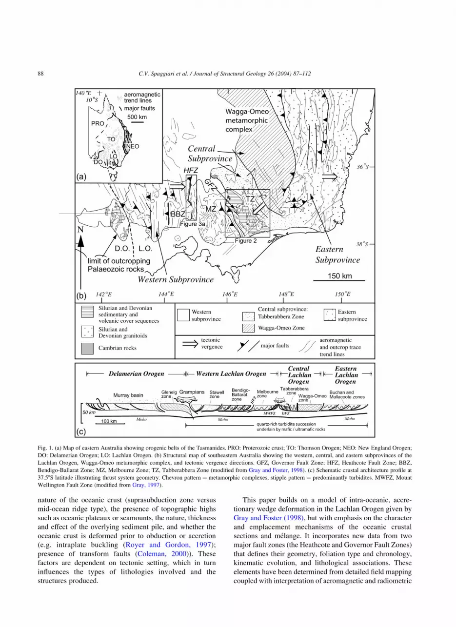
Fig. 1. (a) Map of eastern Australia showing orogenic belts of the Tasmanides. PRO: Proterozoic crust; TO: Thomson Orogen; NEO: New England Orogen;
DO: Delamerian Orogen; LO: Lachlan Orogen. (b) Structural map of southeastern Australia showing the western, central, and eastern subprovinces of the
Lachlan Orogen, Wagga-Omeo metamorphic complex, and tectonic vergence directions. GFZ, Governor Fault Zone; HFZ, Heathcote Fault Zone; BBZ,
Bendigo-Ballarat Zone; MZ, Melbourne Zone; TZ, Tabberabbera Zone (modified from Gray and Foster, 1998). (c) Schematic crustal architecture profile at
37.58S latitude illustrating thrust system geometry. Chevron pattern ¼ metamorphic complexes, stipple pattern ¼ predominantly turbidites. MWFZ, Mount
Wellington Fault Zone (modified from Gray, 1997).
C.V. Spaggiari et al. / Journal of Structural Geology 26 (2004) 87–11288

data, and microstructural analysis. Detailed metamorphic
analyses are provided in Spaggiari et al. (2002a). The results
have implications for understanding the processes involved
in formation of large-scale fault zones in predominantly
intra-oceanic settings, where slices of suprasubduction zone
oceanic (backarc and forearc) crust are incorporated into an
evolving orogen during formation of crust of continental
character. In contrast to passive margin obduction, these
processes have led to the preservation of ophiolites within
thick, turbidite-dominated, accretionary wedges.
2. Geological overview
The Lachlan Orogen is part of the Tasman orogenic
system, which formed along the eastern margin of
Gondwana during late Neoproterozoic through Palaeozoic
times (Fig. 1; Coney et al., 1990; Fergusson and Coney,
1992; Foster and Gray, 2000). It is dominated by
voluminous and extensive, low grade turbidites of mostly
Ordovician to Silurian age that are intruded by Silurian to
Devonian granitoids (Gray, 1997; Collins, 1998). The thick
turbidite pile was deposited on Middle to Late Cambrian
backarc/forearc crust consisting of predominantly low-K,
MORB to arc-tholeiite basalts, dolerites and gabbros, high-
Mg low-Ti boninites, ultramafics, and calc-alkaline, ande-
sitic to rhyodacitic arc rocks. These rocks are interpreted to
have formed in an intra-oceanic, suprasubduction zone
setting (Crawford et al., 1984; Nelson et al., 1984; Crawford
and Cameron, 1985; Crawford and Keays, 1987).
Based on differences in tectonic vergence and geological
evolution, the Lachlan Orogen has been divided into
western, central, and eastern subprovinces (Fig. 1; Gray,
1997; Gray and Foster, 1998). These differences are related
to a history of complex microplate interaction during
closure of the backarc basin in Late Ordovician through
Silurian times (Gray and Foster, 1998; Foster et al., 1999).
The subprovinces are further divided into structural zones
bound by major faults (Gray, 1997). Major inter-zone fault
zones, such as the Heathcote and Governor Fault Zones
(Figs. 1 and 2) are interpreted to have formed by
underthrusting of the oceanic crust beneath thick, turbidite
wedges, producing leading-imbricate fan geometries (Fig.
1c; Gray and Foster, 1998). Remnants of the oceanic crust
are preserved predominantly in the frontal portions of the
wedges where maximum displacement has occurred. This
has led to massive shortening and structural thickening of
the overlying turbidite pile by chevron-folding and thrust-
faulting (Gray and Willman, 1991; Gray and Foster, 1998).
The boundary between east-directed tectonic vergence in
Fig. 2. Map of the eastern Melbourne zone and Tabberabbera zone, showing the locations of the Mount Wellington Fault Zone (MWFZ), Governor Fault Zone
(GFZ), and Late Devonian cover sequences (modified from VandenBerg et al., 1995, 2000; Gray and Foster, 1998).
C.V. Spaggiari et al. / Journal of Structural Geology 26 (2004) 87–112 89

Fig. 3. Maps of the Heathcote Fault Zone. (a) Simplified map of the northern, central, and southern segments, showing outcrop extent of the Cambrian rocks.
(b) Map and profile of the lower portion of the central segment, including structural data for the melange zone and turbidites from the Red Hill area. All planes
are plotted as poles. (c) Map and profiles of the northern part of the central segment and southern part of the northern segment. Structural data on equal angle
stereonet is from the northern segment. All planes are plotted as poles (maps modified from Gray and Willman, 1991; Wohlt and Edwards, 1999).
C.V. Spaggiari et al. / Journal of Structural Geology 26 (2004) 87–11290
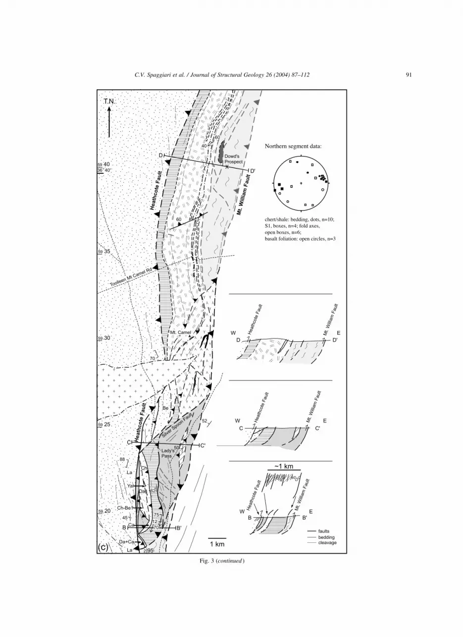
Fig. 3 (continued )
C.V. Spaggiari et al. / Journal of Structural Geology 26 (2004) 87–112 91

C.V. Spaggiari et al. / Journal of Structural Geology 26 (2004) 87–11292

the western subprovince and southwest-directed tectonic
vergence in the central subprovince is defined as the
Governor Fault Zone (Figs. 1 and 2; VandenBerg et al.,
1995, Spaggiari et al., in press). The fault zone crops out as
structural highs lying unconformably beneath an en-echelon
sequence of three, Late Devonian, transtensional basins that
mark the transition from a marine to a continental setting
(Fig. 2; VandenBerg et al., 2000). It is at least partially
overridden by the Mount Wellington Fault Zone, which
defines the eastern margin of the western subprovince (Fig.
2). The Heathcote Fault Zone, which marks a major
boundary between two structural zones within the western
subprovince, separates chevron-folded Ordovician turbi-
dites linked to high strain zones adjacent to inter- and intra-
zone faults, from gently folded, predominantly Silurian–
Devonian turbidites to the east (Fig. 1; Gray and Willman,
1991; Gray, 1997).
3. Geometry and fabric character of the fault zones
3.1. Heathcote Fault Zone
Cambrian ophiolitic rocks are exposed in the northern,
central, and southern segments of the Heathcote Fault Zone
(HFZ; Fig. 3). They are bound by major west- or southwest-
dipping thrust faults that are interpreted to have listric form
and flatten at approximately 17 km depth (Gray and
Willman, 1991; Gray et al., 1991). The fault zone shows
marked lateral variation in exposed structural levels and
lithology that relate to differences in displacement along
faults within and bounding the zone (Gray and Willman,
1991). Differences in structural levels are largely defined by
differences in metamorphic grade, structural complexity,
and foliation intensity, and in places coincide with strike
changes. The fault zone completely loses displacement
within the southern segment, where the Mount William
Fault steepens and steps east into rocks of similar age on
either side (Fig. 3a; Gray and Willman, 1991). A
conformable sequence of Cambrian, homoclinally west-
dipping, prehnite-pumpellyite facies, tholeiitic basalt,
volcaniclastics, chert and shale overlain by early Ordovician
turbidites comprise the western margin of this segment
(VandenBerg, 1991).
The northern segment is dominated by north-trending
ridges of homoclinally west-dipping, prehnite-pumpellyite
facies, tholeiitic basalt, dolerite and volcaniclastics with
interbedded and overlying chert and silicified shale (cf.
Crawford et al., 1984; Edwards et al., 1998). These
structurally overlie fault slivers of boninite, andesite, basalt,
chert, and turbidite in the northern part of the central
segment (Figs. 3a and c and 4a and c). The basalt and
dolerite are weakly foliated, and locally cut by fine bands of
cataclasite. Chert and silicified shale sequences have a
spaced cleavage axial planar to open to tight folds. The
ridges coincide with strong linear features on aeromagnetic
imagery, some of which correlate with Fe-rich and highly
magnetic pelagic rocks (Fig. 4a and c). This highlights a
pronounced curvature of the belt to the northwest where a
structurally complex area of chevron folds is cut by
numerous faults (Fig. 4c). This area is completely under
cover but comparisons of total magnetic intensity, first
vertical derivative images, and magnetic gradients suggest
most faults in this area are steeply dipping, and that the
western margin consistently dips to the west. Strongly
deformed chert and silicified shale (Rochester Quarry; Fig.
4c) coincide with a strong magnetic high on the western
margin. Tight to isoclinal folds in these rocks plunge
moderately to steeply northwest and southeast, are upright
or inclined to the northeast, and cut by steeply southwest-
dipping reverse faults (Edwards et al., 1998). A sharp drop
in magnetic signature to the east along the north–south
section of the northern segment coincides with a change in
lithology and flat topography (Figs. 3c and 4a; section D–
D0). This correlates with weakly deformed tholeiitic rocks
underlain by melange similar to that in the central segment
(Fig. 3c; drill core analysis, Dowd’s Prospect; Spaggiari,
2002).
Where the melange is exposed in the central segment the
belt narrows markedly and changes strike from north–south
to northwest–southeast (Figs. 3a and b and 4a and b; section
A–A0). Here strongly deformed Ordovician turbidites are in
direct fault contact with the melange. The main foliation in
the turbidites has a moderate to subvertical dip, trends east–
southeast, and is locally folded into steeply southwest-
plunging folds (Gray and Willman, 1991). The melange
contains blocks of variably deformed boninite, andesite,
dolerite, ultramafics, chert, and volcanogenic sandstone,
metamorphosed up to greenschist or blueschist conditions
(Spaggiari et al., 2002a). The serpentinite/talc-chlorite
matrix has a well-developed scaly foliation with a
predominant southwest dip, folded into moderately north-
west plunging, tight to isoclinal folds that are cut by small
brittle faults and carbonate veins (Spaggiari et al., 2002b).
Small blocks have pervasive foliations and are overprinted
by well-developed crenulation cleavages, and silica and
carbonate alteration. Blocks in the melange greater than
approximately 30 cm diameter have foliated margins and
less deformed interiors, but rarely show any development of
crenulation cleavage except on their margins. Diorite and
Fig. 4. Aeromagnetic images and interpretation of the Heathcote Fault Zone, showing large-scale geometry. Dashed lines are inferred whereas solid lines are
based on field data. (a) Central and northern segments of the Heathcote Fault Zone. Data source: Bendigo dataset, Australian Geological Survey Organisation–
Geoscience Australia. (b) Lower portion of the central segment. Data source: Heathcote dataset, Geological Survey of Victoria. (c) Rochester area of the
northern segment. Data source: Rochester dataset, Geological Survey of Victoria.
C.V. Spaggiari et al. / Journal of Structural Geology 26 (2004) 87–112 93

microgranodiorite bodies within the melange also have
foliated margins and where exposed, faulted contacts with
mafic melange rocks (Fig. 3b).
West to northwest-dipping, elongate fault slices of
Cambrian sedimentary rocks, high-Mg andesite, boninite,
Ordovician turbidite and black shale are interpreted to form
a series of stacked and disrupted duplexes, structurally
above the melange (Fig. 3c; section B–B0; cf. Gray and
Willman, 1991). The main foliation in these fault slices is
mostly west-dipping or subvertical, and more intense close
to the fault slice margins. The most intensely deformed
zones contain steep to moderately south-plunging, rootless
fold hinges refolded by northwest-striking and plunging
folds (Gray and Willman, 1991). Northeast-trending faults
(e.g. the Silver Spoon Fault) appear to link with the Mount
William Fault and may be ‘roof thrusts’ to the inferred
duplex packages. The Mount William Fault can be traced on
aeromagnetic imagery to the east, and appears to have cut up
sequence through the melange rocks (Fig. 4). Aeromagnetic
imagery shows small, northeast- and northwest-trending
faults with both sinistral and dextral apparent offset that
disrupt belt-parallel faults and stratigraphy, but do not
always offset the major bounding faults.
Major deformation and metamorphism in the HFZ
occurred between ,455 and 440 Ma, coinciding with
ongoing sedimentation further outboard (Melbourne zone;
Foster et al., 1999). This is constrained by Ar/Ar ages of
white mica from the main (S1) thrust-related fabric in Early
Ordovician phyllite from the hanging wall of the Heathcote
Fault, metamorphic biotite in diorite within the melange,
detrital mica ages in Melbourne zone rocks similar to fault
zone fabric ages (,440 Ma; Foster et al., 1999), presence of
slivers of early to middle Ordovician turbidites within the
fault zone (Fig. 3), and fossil ages in the footwall turbidites
(Melbourne zone; VandenBerg et al., 2000). Steeply
plunging folds that are oblique to major bounding faults
and occur within the hanging wall turbidites have been
interpreted to relate to reactivation with a strike-slip
component, but without significant displacement (Gray
and Willman, 1991). Based on Ar/Ar data, this has been
inferred to have occurred at ,425–420 Ma, followed by
further reactivation at ,380 Ma (Foster et al., 1999). The
youngest deformational events have clearly involved a
component of thrusting on both the Heathcote Fault and
particularly the Mount William Fault as they clearly
truncate most of the small, northeast- and northwest-
trending faults throughout the HFZ, as well as folds in the
Siluro – Devonian rocks of the Melbourne zone (cf.
VandenBerg et al., 2000).
3.2. Governor Fault Zone—Howqua
Cambrian ophiolitic rocks in the Governor Fault Zone
(GFZ) at Howqua (Fig. 2) are preserved in two, elongate,
northwest-trending fault slices, and as blocks and smaller
fault slices in melange (Fig. 5). From northeast to southwest
(and structurally highest to lowest) the sequence consists of
folded and faulted turbidites, folded bedded cherts and
silicified shale, imbricated tholeiitic pillow basalts, dolerite,
gabbro, volcaniclastics and chert, and imbricated mafic and
ultramafic rocks including boninites (Fig. 6). These overlie
an approximately 2.5-km-wide, folded and faulted melange
zone (see also Spaggiari et al., 2002a,b). As in the HFZ,
foliation intensity increases with metamorphic grade and is
indicative of the structural level exposed. Whereas the upper
structural levels are dominated by brittle structures,
melange from the deeper levels is largely polydeformed.
A magnetic model constructed along approximately the
same line of section as Fig. 6 provided an independent test
of the interpreted geometry, and showed a good correlation
(Spaggiari, 2002).
The turbidite sequence is dominated by upright, gently
southeast plunging chevron folds with a closely spaced,
axial planar cleavage cut by small brittle faults (Figs. 5 and
6a). Crenulation cleavages and small kink-folds occur
sporadically in the vicinity of brittle faults, and are probably
fault-related. A subvertical, northwest-trending fault within
the turbidite sequence separates Lower Ordovician (Lance-
fieldian), quartz–lithic–feldspathic sandstone and mud-
stone from Lower to Middle Ordovician (Bendigonian–
Darriwilian), quartz-rich sandstone, mudstone and shale
(Fig. 6a; cf. Fergusson, 1998). Structures in these rocks are
truncated to the east by a subvertical, approximately north-
trending, dextral strike-slip fault (Fig. 5). The contact
between the turbidites and chert/silicified shale is also
folded into gently southeast plunging folds, but is locally
disrupted by brittle faults with minor displacement. The
map pattern of the chert/silicified shale sequence is
suggestive of a tapered sliver that thickens to the northwest
where it passes underneath Late Devonian volcanics, and
disappears completely to the southeast where turbidites are
in direct contact with pillow basalt. Fold plunges within the
sequence vary from steep to gentle, and north to southeast
directions. Axial plane orientations are also variable but
bedding dips are mostly to the northeast (Figs. 5 and 6a).
Cleavage development is weak and mostly restricted to
hinge zones.
The contact between the chert/shale and underlying
pillow basalts is conformable, but locally offset by small
faults. The map pattern indicates the tholeiitic mafic
sequence is an elongate, tapered body that thins both to
the northwest and southeast. It appears to be structurally
thickened by imbrication as indicated by repetition of
bedded chert and volcanic breccia within the pile that
coincide with interpreted faults in the aeromagnetic data
(Figs. 5–7). A steeply northeast-dipping fault (Mai Fault)
separates the weakly deformed, tholeiitic mafic rocks from
tholeiitic and boninitic, mafic and ultramafic rocks in the
footwall sequence. Pillow basalts in the immediate hanging
wall show marked carbonate alteration and moderate
foliation development whereas serpentinised ultramafics in
the footwall have a strong, ‘scaly’ anastomosing foliation
C.V. Spaggiari et al. / Journal of Structural Geology 26 (2004) 87–11294

Fig. 5. Geological map of the Governor Fault Zone and part of the Mount Wellington Fault Zone in the Howqua River region.
C.V. Spaggiari et al. / Journal of Structural Geology 26 (2004) 87–112 pages 95–98

occasionally cut by small mesoscopic or microscopic faults
(Fig. 8a). Drag folds in splays in the footwall indicate a top
to the southwest thrust sense. The mafic–ultramafic
sequence forms a second elongate tapered body, bound to
the west by the steeply northeast-dipping Yaw Fault. Mai
Fault is interpreted to link into Yaw Fault to the southeast.
The scaly foliation in the serpentinite is subparallel to a
foliation in small mafic–ultramafic pods defined by blue–
green sodic–calcic amphiboles and chlorite, indicative of
intermediate pressure conditions (,4 kbars; Spaggiari et al.,
2002a). Strongly deformed, gabbroic and ultramafic rocks
are in fault contact with relatively undeformed pillow lavas
and cherts that show consistent northeast-younging, indica-
tive of imbrication. Neither this nor the overlying tholeiitic
sequence show any evidence of folding.
Structurally underlying the mafic–ultramafic sequence is
a melange zone that consists of fault slices of basalt,
dolerite, boninite, talc schist, phyllite, and slate (Figs. 5 and
6b; see also Spaggiari et al., 2002a,b). Unlike the overlying
mafic sequences at least two phases of folding are evident
resulting in a fold interference pattern. The first phase folds
are predominantly tight to isoclinal, gently southwest
plunging with variably dipping axial surfaces, and occur
predominantly in the talc schist, phyllite, and slate. The
second set can be traced across the melange zone and the
Howqua Fault into the Mount Wellington Fault Zone (Fig.
5). These have open, sinusoidal, rounded to kink-like form,
plunge gently to moderately steeply both to the northwest
and southeast, and have subvertical axial surfaces. The
melange zone is truncated to the southwest by the south-
west-dipping Howqua Fault, where Mount Wellington Fault
Zone rocks have been thrust over GFZ rocks in the footwall.
Mafic slivers and blocks in the melange show hetero-
geneous foliation development, whereas talc schist, slate,
and phyllite have three foliations of which the second is the
most dominant. The talc schists form a matrix to mostly less
deformed, more competent blocks or slices of basalt,
dolerite or boninite, some of which, along with the matrix,
have been metamorphosed to blueschist conditions (Spag-
giari et al., 2002a). The main foliation is axial planar to tight
to isoclinal folds that in places have been stretched to form a
rodding lineation, indicative of high strain (Fig. 8b). No
folding related to the first foliation has been identified.
The dominant foliation throughout the slate and phyllite
is a crenulation cleavage (S2) defined by zones of
recrystallised white mica and/or dark dissolution seams
due to pressure solution (Fig. 8c). It is axial planar to tight to
isoclinal folds, which fold bedding, an earlier foliation,
zones of broken formation, and quartz veins. Because both
foliations are mostly subparallel, the crenulation cleavage
often has the appearance of a slaty cleavage except where
the earlier foliation is preserved in hinges and some pressure
shadows. Quartz-rich lithologies show development of mica
beards off the ends of slightly elongate quartz grains. The
earlier foliation (S1) is a closely spaced cleavage mostly
subparallel to bedding, defined by both dark dissolution
seams due to pressure solution and small white micas. Large
quartz veins are boudinaged approximately parallel to the
main foliation, whereas smaller quartz veins locally cross-
cut it. Open folding of the melange zone has produced small
parasitic kink folds, and a discrete, second crenulation
cleavage (S3), mostly due to pressure solution, in talc schist,
slate and phyllite.
Zones of broken formation within the sedimentary
sequence are indicative of tectonic stratal disruption early
in the deformation history, and may relate to formation of
the first foliation. Within these zones bedding has been
fractured, pulled apart and is cut by small normal faults and
fine, perpendicular veins. Cataclasis is evident in the necks
of some blocks (see also Spaggiari et al., 2002b). This has
produced a black mud-matrix enclosing rhomboidal blocks
of sandstone, siltstone, and minor chert ranging in size from
centimetre-scale to approximately 0.5 m (Fig. 8d), and
chaotically veined and disrupted sequences (Fig. 8e). Larger
sandstone blocks are mostly unfoliated except on their
margins where the main foliation (S2) wraps around them.
Some have quartz veins that terminate at the block margins,
indicating that disruption took place in lithified rocks prior
to the main deformation.
The timing of melange formation is constrained by Ar/Ar
dating of the main fabric (S2) forming white mica at
446 ^ 2 Ma, and blueschist metamorphism (,450 Ma, U–
Pb in titanite; Spaggiari et al., 2002b). These ages are
consistent with the presence of graptolite fauna in slates in
the melange indicative of Middle to early Late Ordovician
(,467–455 Ma) depositional ages (Teale, 1920a; Harris
and Thomas, 1938). Turbidites above the pelagic section
have fauna indicative of Lower Ordovician to Middle to
early Late Ordovician depositional ages (,490–455 Ma;
e.g. Fergusson, 1998). Turbidites east of the strike-slip fault
at 8-mile Flat and west of the Howqua Fault (Fig. 5) have an
inferred early Silurian age (,440 Ma; Fergusson, 1998;
VandenBerg et al., 2000). Late Ordovician chert/shale
sequences with interbedded sandstone and mudstone occur
throughout the Tabberabbera zone, and together with the
turbidites indicate that sedimentation continued during fault
zone formation (cf. Foster et al., 1999).
3.3. Governor Fault Zone—Dolodrook
Cambrian ophiolitic rocks exposed in the GFZ at
Dolodrook (Fig. 2) consist of serpentinised ultramafics
(dunite, harzburgite, orthopyroxenite, podiform chromitite,
and clinopyroxenite; Crawford, 1982) and mafic–ultramafic
breccia, which together constitute an approximately 5-km-
long, 1-km-wide body (Fig. 9). This is flanked by lenses of
mafic mudstone and sandstone with minor conglomerates
that include olistostromes of Cambrian limestone. Middle to
Late Ordovician chert, silicified shale, and interbedded
sandstone and mudstone are in fault contact with and
surround the serpentinite body and mafic rocks. The
Ordovician rocks are flanked by weakly deformed turbidites
C.V. Spaggiari et al. / Journal of Structural Geology 26 (2004) 87–112 99

Fig. 6. (a) and (b) Composite profile of the Howqua River region. See Fig. 5 for section line locations. All equal angle stereonet data are from the Governor
Fault Zone, and all planes are plotted as poles.
C.V. Spaggiari et al. / Journal of Structural Geology 26 (2004) 87–112100

of probable Early Silurian age (Harris and Thomas, 1954).
There is no indication of metamorphic grades higher than
anchizonal or prehnite–pumpellyite facies in any of the
rocks in this fault zone.
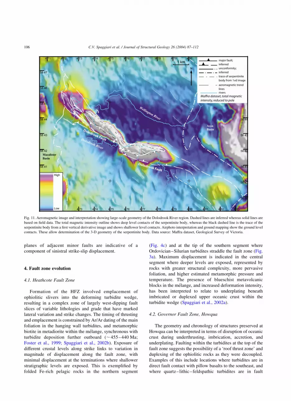
The serpentinite body trends northwest–southeast in the
northwest, and east–west in the southeast and has a
predominantly asymmetric, antiformal geometry with
steeper dips on its northeastern and northern margins
(Figs. 10 and 11). Towards the centre its margins steepen
to subvertical dip, and it appears to narrow giving it a
slightly curved geometry (Fig. 10). The antiformal geome-
try suggests that only the top of the body is currently
exposed. Gradients in the aeromagnetic data indicate that
the serpentinite body plunges gently to the southeast. A
well-developed foliation within the serpentinite body has
the same trend as its outline. It is mostly steeply dipping and
anastomosing, but is locally folded into small-scale, tight
folds. In the southeast the foliation appears to be folded into
east-trending, upright open folds that have minor axial
planar cleavage. The serpentinite is dominated by phacoidal
texture defined by anastomosing foliations that enclose
small lenticular pods of less foliated serpentinite, morpho-
logically similar to S–C foliations. These lenses have shiny,
striated fracture surfaces. The serpentine minerals are
lizardite and chrysotile (XRD powder analyses; Spaggiari,
2002) and primary serpentinisation textures are mostly
overprinted by serpentine, carbonate, and talc foliations, and
carbonate veins.
In the northwest, Cambrian mafic sandstone and
mudstone is interleaved with the Ordovician sequence
forming a series of tapered fault slivers. Both bedding and
cleavages are mostly steeply northeast- or southwest-
dipping, and folds have gentle to steep, mostly southeasterly
plunges (Figs. 9 and 10a). Open chevron folds predominate
in these rocks but tight to isoclinal folds also occur in the
Ordovician sequence, particularly close to fault contacts.
The closely spaced, marked spread in ages of graptolite
fauna in these rocks is also suggestive of tight folding and/or
faulting (cf. Andrews, 1988). The strongest foliation
throughout the Ordovician rocks is a locally developed,
spaced cleavage defined by a combination of mica (mostly
due to rotation) and dark dissolution seams due to pressure
solution. This foliation is in places folded into tight to
isoclinal folds that have little axial planar crenulation
Fig. 7. Aeromagnetic image and interpretation showing large-scale geometry of the Howqua River region. Dashed lines are inferred whereas solid lines are
based on field data. Radiometric data (not shown) were used to help determine contacts where magnetic signatures overlapped (e.g. Late Devonian basin
volcanics and Cambrian mafics) and the extent of mafic–ultramafic rocks. Data source: Wellington dataset, Geological Survey of Victoria.
C.V. Spaggiari et al. / Journal of Structural Geology 26 (2004) 87–112 101

cleavage development. These folds sometimes have unusual
morphologies, such as changing interlimb angles along their
length, and plunge variation. The foliation in the hinges is at
a low angle to bedding, and is mostly subparallel elsewhere.
In the southeast, two generations of tight to isoclinal folds
with minor development of axial planar crenulation
cleavage are locally present. This correlates with exposure
of slightly deeper levels adjacent to the gently southeast-
plunging serpentinite body. Both fold sets have gentle to
steep, mostly east-plunging fold axes and steep north or
Fig. 8. Photos and photomicrographs from the Governor Fault Zone. (a) Photo of scaly foliation in talcose, serpentinised mafic–ultramafic section, Howqua.
Sledge hammer is approximately 40 cm long. (b) Rodding in talc schist melange matrix, Tobacco Flat, Howqua. Lens cap is approximately 4 cm. (c)
Photomicrograph of phyllite from the melange zone, Howqua. The dominant foliation (S2) is a crenulation cleavage, diagonal from upper right to lower left in
the image. The earlier foliation (S1) and bedding are approximately vertical in the image. PPL. Base of photomicrograph is approximately 4 mm. (d) Photo of
rhomboidal sandstone block in slaty mud-matrix, footwall of Yaw Fault, Fry’s Flat, Howqua. Pencil is approximately 15 cm long. (e) Photomicrograph of
chaotically disrupted and veined black late and minor sandstone from the melange zone, Howqua. The main foliation (S2) is subhorizontal in the image and is
overprinted by a weak crenulation cleavage (S3), diagonal from upper right to lower left. XPL. Base of photomicrograph is approximately 2 cm. (f) Scaly fabric
in Ordovician mudstone, eastern Dolodrook River. Note the intrusion of mud into the disrupted sandstone layering (arrow, lower left), prior to folding. Lens cap
is approximately 3 cm wide.
C.V. Spaggiari et al. / Journal of Structural Geology 26 (2004) 87–112102

N
Mapping and compilation by C. V. Spaggiari.
Base map: Tali Karng 8222-4-1/8222-1-4 topographic map, 1st ed.
Australian Map Grid Zone 55. Transverse mercator projection.
Additional information from:
Teale, 1920b; Andrews, 1988; O'Halloran, 1996.
Palaeontological data from:
Harris and Thomas,1954; Ebsworth,1974.
Fig. 9. Geological map of the Governor Fault Zone, Dolodrook River region.
C.V
.S
pa
gg
iari
eta
l./
Jou
rna
lo
fS
tructu
ral
Geo
log
y2
6(2
00
4)
87
–1
12
10
3

Fig. 10. Profiles and structural data from the Governor Fault Zone, Dolodrook River region. See Fig. 9 for section line locations. All planes on equal area
stereonets are plotted as poles. (a) Northwestern part (section A–A0) and central part (section B–B0) of the map area. (b) Eastern part of the map area.
C.V. Spaggiari et al. / Journal of Structural Geology 26 (2004) 87–112104

south dipping axial surfaces (Figs. 9 and 10b). In places
these folds are refolded by small-scale open folds.
Localised, late open folds in the Ordovician sequence
have mostly steep plunges and variably orientated axial
surfaces, some of which are oriented almost perpendicular
to the main strike of the belt. The Ordovician sequence and
the mafic/ultramafic rocks are cut by numerous, mostly
northwest-trending and steeply dipping brittle faults associ-
ated with zones of cataclasite.
Zones of stratal disruption (broken formation) up to
several metres wide occur in mudstone and sandstone within
the Ordovician sequence. Folds within these zones have
similar orientations to those outside the zones, and are cross-
cut by late brittle faults (Figs. 9 and 10b). The broken
formation is in part interleaved with the serpentinite along
the northern margin of the body. Stratal disruption in these
rocks is characterised by pulled apart sandstone beds
resulting in isolated blocks in mudstone, some of which
show rotation, and a strong bedding-parallel, scaly foliation
in the mudstone matrix (Fig. 8f). The foliation is a spaced
cleavage defined by rotated micas and dark seams due to
pressure solution, and where incipiently developed consists
of a fracture network with small polished and striated
surfaces with mineral steps. Fine sand dykes predate
foliation formation, and are subperpendicular to bedding.
Both the scaly foliation and isolated fragments of sandstone
layering are locally folded into isoclinal folds, and some-
times refolded into open folds. There is no development of
axial planar cleavage, or cataclasis. Some of the folded
sandstone layers are intruded by mud injections (Fig. 8f).
Turbidites in fault contact with Ordovician rocks on both
sides of the serpentinite body are simply folded into
predominantly gently southeast plunging, chevron or
rounded open folds with steeply dipping axial surfaces,
occasionally cut by small, northwest-trending, steeply
dipping brittle faults (Figs. 9 and 10a). Folds on the north
and northeastern side have a slight asymmetry indicative of
southwest transport (Andrews, 1988). Where developed,
axial planar cleavage is disjunctive and defined by rotated
mica and chlorite, or due to pressure solution. The
southwestern boundary between the turbidites and the
Ordovician sequence is marked by the Dolodrook Fault,
which is locally folded and has a mostly subvertical or steep
northeasterly dip. En echelon vein sets on steeply dipping
Fig. 10 (continued )
C.V. Spaggiari et al. / Journal of Structural Geology 26 (2004) 87–112 105
planes of adjacent minor faults are indicative of a
component of sinistral strike-slip displacement.
4. Fault zone evolution
4.1. Heathcote Fault Zone
Formation of the HFZ involved emplacement of
ophiolitic slivers into the deforming turbidite wedge,
resulting in a complex zone of largely west-dipping fault
slices of variable lithologies and grade that have marked
lateral variation and strike changes. The timing of thrusting
and emplacement is constrained by Ar/Ar dating of the main
foliation in the hanging wall turbidites, and metamorphic
biotite in metadiorite within the melange, synchronous with
turbidite deposition further outboard (,455–440 Ma;
Foster et al., 1999; Spaggiari et al., 2002b). Exposure of
different crustal levels along strike links to variation in
magnitude of displacement along the fault zone, with
minimal displacement at the terminations where shallower
stratigraphic levels are exposed. This is exemplified by
folded Fe-rich pelagic rocks in the northern segment
(Fig. 4c) and at the tip of the southern segment where
Ordovician–Silurian turbidites straddle the fault zone (Fig.
3a). Maximum displacement is indicated in the central
segment where deeper levels are exposed, represented by
rocks with greater structural complexity, more pervasive
foliation, and higher estimated metamorphic pressure and
temperature. The presence of blueschist metavolcanic
blocks in the melange, and increased deformation intensity,
has been interpreted to relate to underplating beneath
imbricated or duplexed upper oceanic crust within the
turbidite wedge (Spaggiari et al., 2002a).
4.2. Governor Fault Zone, Howqua
The geometry and chronology of structures preserved at
Howqua can be interpreted in terms of disruption of oceanic
crust during underthrusting, imbrication, accretion, and
underplating. Faulting within the turbidites at the top of the
fault zone suggests the possibility of a ‘roof thrust zone’ and
duplexing of the ophiolitic rocks as they were decoupled.
Examples of this include locations where turbidites are in
direct fault contact with pillow basalts to the southeast, and
where quartz–lithic–feldspathic turbidites are in fault
Fig. 11. Aeromagnetic image and interpretation showing large-scale geometry of the Dolodrook River region. Dashed lines are inferred whereas solid lines are
based on field data. The total magnetic intensity outline shows deep level contacts of the serpentinite body, whereas the black dashed line is the trace of the
serpentinite body from a first vertical derivative image and shows shallower level contacts. Airphoto interpretation and ground mapping show the ground level
contacts. These allow determination of the 3-D geometry of the serpentinite body. Data source: Maffra dataset, Geological Survey of Victoria.
C.V. Spaggiari et al. / Journal of Structural Geology 26 (2004) 87–112106

contact with more quartz-rich turbidites (Figs. 5 and 6a).
Strongly deformed mafic–ultramafic rocks at the base of the
fault slice (section between Yaw Fault and Mai Fault) may
represent a ‘floor thrust zone’, as they partially consist of the
deepest parts of the oceanic crustal stratigraphy, show the
most pronounced foliation development, and have slightly
higher estimated metamorphic pressure and temperature
(Fig. 6; Spaggiari et al., 2002a). These ‘floor and roof’ zones
most likely did not develop as smooth breaks, but involved
disruption and variation of the initiation point and level of
structural break over a period of time. This may have been
in part due to the lack of a significant slip horizon within the
turbidite section, and a non-layer-cake stratigraphy in the
floor thrust zone.
The higher metamorphic pressure and temperature, and
greater structural complexity of the melange zone below
Yaw Fault are indicative of maximum disruption to produce
block-in-matrix type melange, and underplating beneath
oceanic crustal slivers. Ophiolitic rocks within the melange
are predominantly volcanic or doleritic, and indicate that it
is the upper stratigraphic levels of the oceanic crust that are
disrupted during underthrusting. Partial exhumation of the
blueschist rocks resulted in interleaving with underplated
slate, phyllite, and slices of basalt and dolerite, followed by
tight to isoclinal folding of the now complete melange.
Rodding in the talc–schist matrix that hosts the blueschists
is indicative of rotation of fold axes into the transport
direction (to the southwest), and matches the orientation of
fold axes of tight to isoclinal folds within the slate and
phyllite, and stretching (boudinage) of large quartz veins
(Fig. 6b).
Estimated P–T conditions in the melange range from
7–9 kbars and ,450 8C (blueschists; Spaggiari et al.,
2002a) to anchizonal/subgreenschist and intermediate P
(,4 kbars, micas from the dominant S2 foliation in the
slates; average illite crystallinity ¼ 0.25 and bo ¼ 9.026;
Spaggiari, et al., in press). This indicates that the
blueschists did not require more than approximately
12 km of partial exhumation prior to interleaving, and
not more than approximately 25 km in total. The illite
crystallinity and bo data indicate removal of approxi-
mately 10 – 12 km of overburden following Late
Ordovician interleaving and prior to deposition of
unconformably overlying Late Devonian volcanics and
sedimentary rocks. This suggests that wedge thickening
by underplating may have been balanced by significant
erosion. Subsequent collision of the Tabberabbera zone
with the eastern Melbourne zone (Figs. 1 and 2), and
formation of the Howqua Fault, produced the open folds
in the melange, and most likely reactivated and possibly
steepened the major faults such as Yaw Fault and Mai
Fault. Sections above Yaw Fault appear to have also
been affected as indicated by small back-thrusts, offsets
of contacts, slickensides in the mafic sections, and
steepening of northwest–southeast trending axial planes
in the turbidite section.
4.3. Governor Fault Zone, Dolodrook
Structural evolution of the GFZ at Dolodrook has taken
place at relatively shallow crustal depths, and is interpreted
to have involved offscraping of a Cambrian topographic
high on the seafloor (Spaggiari et al., 2003), followed by
disruption and compression during accretion. Faulting
processes during suprasubduction zone crustal formation
may have led to emplacement of the serpentinite body
within a transform or normal fault, leaving it in an elevated
position with respect to the surrounding ocean basin.
Alternatively, the serpentinite body may represent a fault
slice only related to the surrounding younger sedimentary
rocks by post-Ordovician faulting.
The early deformation history within the Ordovician
sequence has involved stratal disruption, and folding of
partly lithified rocks. Partial lithification may have affected
mechanical behaviour, resulting in variable plunges of
isoclinal fold axes and localised refolding, and allowing
these rocks to behave in a ‘ductile’ manner with little
development of axial planar cleavage. Apparent fold axis
rotation is unlikely to be due to thrusting as the lack of
downdip stretching lineations, rodding, or development of
pressure shadows suggests these rocks did not undergo high
strain or recrystallisation during faulting. Stratal disruption
is interpreted to have taken place in partly lithified rocks as
both ductile and brittle behaviour appear to have occurred
simultaneously. Pulled apart sandstone layering and devel-
opment of scaly foliation has semi-brittle characteristics
whereas tight folding of the foliation and sandstone
layering, and intrusion of mud into semi-soft sandstone
during folding has semi-ductile characteristics (Fig. 8f).
Brittle faulting and cataclasite zones have mostly occurred
late in the deformation history as they truncate foliations at
contacts, cross-cut folds, and mark a transition to fully
lithified rocks.
The main foliation in the Ordovician sequence and mafic
sedimentary rocks is interpreted to relate to subhorizontal
stresses as the serpentinite body and overlying sedimentary
rocks were offscraped and accreted to the turbidite wedge.
The very low metamorphic grade, and the characteristics of
the folds and foliations are consistent with well-documented
examples of offscraped and accreted rocks from elsewhere
(e.g. Barbados and the Middle America trench, southern
Mexico; Lucas and Moore, 1986; Moore et al., 1986; see
also Sample and Moore, 1987).
5. Thrusting and underthrusting in intra-oceanic
environments
The geometrical relationships of the ophiolitic slices
within the turbidite wedges is similar to observations of
accreted oceanic crustal slices in modern accretionary
environments. Seismic imaging has shown the presence of
large-scale duplex-like structures in the New Britain
C.V. Spaggiari et al. / Journal of Structural Geology 26 (2004) 87–112 107

C.V. Spaggiari et al. / Journal of Structural Geology 26 (2004) 87–112108

accretionary wedge in the Solomon Sea, which, in
conjunction with magnetic data, are interpreted as accreted
ophiolitic slivers (Bernstein-Taylor et al., 1992). Similar
observations have been made and tested by deep sea drilling
or observed on land in the Sulu Sea and South China Sea
(Rangin et al., 1995). It is clear that ophiolite accretion does
take place within forearcs, but the mechanics of emplace-
ment, and particularly how this may occur at deeper levels,
are not well understood.
Major fault zones such as the HFZ and GFZ have been
interpreted as having formed by underthrusting of oceanic,
suprasubduction zone crust during basin closure, with the
Delamerian (Gondwana) margin acting as a backstop
relative to the western subprovince (Fig. 1; Gray and
Foster, 1998). On a larger scale, marginal basin closure may
have been initiated and driven by a change in convergence
relative directions and rates between Australia and the
palaeo-Pacific plate in the Late Ordovician, because of plate
reorganisations suggested by clockwise rotation of the
Gondwana apparent polar wander path in the Late
Ordovician and Early Silurian (Li et al., 1990). Significant
counterclockwise rotation of Australia in the Late Silurian–
Early Devonian (Li et al., 1990) coincides with ,420 Ma
Ar/Ar ages of reactivation in the HFZ and deformation in
the Tabberabbera and Wagga-Omeo structural zones (Fig.
1; Foster et al., 1999).
The structural and metamorphic data from the fault zones
are indicative of thrusting in relatively cool conditions, but
it is unclear why they form linear belts with distinct along-
strike variation. It has been noted that major faults
containing Cambrian oceanic crust within the western
subprovince are regularly spaced across strike at intervals
of approximately 100–150 km (Gray and Foster, 1998).
This has been attributed to the horizontal strength of the
oceanic crust (beam strength), and is also probably
influenced by the ‘overburden’ effect of the large turbidite
pile (Gray and Foster, 1998). The presence of upper
stratigraphic levels of oceanic crust in the hanging walls
of these faults requires a break within that crust, while the
consistent presence of Lower Ordovician (Lancefieldian)
turbidites in the hanging walls of intra-zone faults within the
western subprovince requires a higher break between the
oceanic crust and the turbidite pile (Gray and Willman,
1991). These features are indicative of two decollement
horizons, but do not explain the along-strike variation and
non-uniform exposure of crustal levels within the major
fault zones.
5.1. Proposed model of oceanic thrusting
Fig. 12 is a series of schematic diagrams illustrating how
these fault zones may develop by underthrusting of oceanic,
suprasubduction zone-type crust during convergence.
Deformation of the oceanic crust may be initiated by long
wavelength buckling at the onset of convergence (Fig. 12a).
In the central Indian Basin of the Indian Ocean observations
of undulating topography with ,1 km amplitude and 100–
300 km wavelengths, east–west-trending thrust faults, and
intraplate seismicity over distances greater than 1000 km
indicate north–south shortening of the oceanic lithosphere
by buckling and faulting (Royer and Gordon, 1997; see also
Gerbault (2000) for numerical modelling of these data for
required stresses). Similar observations have been made
along the eastern margin of the Japan Sea, and interpreted to
relate to incipient subduction due to convergence (Tamaki
and Honza, 1985; Rangin et al., 1995). Pre-existing
irregularities such as topographic highs associated with
variable lithologies in the oceanic crust may help fold
nucleation, which may in turn lead to fault activation.
Inversion of normal faults formed during development of
the oceanic crust may also contribute to fault zone initiation.
At approximately 20% shortening, these faults may either
begin to decouple the oceanic crust, perhaps along
hydrothermally altered sections (e.g. Kimura and Ludden,
1995), and/or cut through the entire crust and therefore
initiate underthrusting (Fig. 12b). This may be assisted
where variable density in the oceanic crust occurs (e.g.
serpentinised sections) or where transform faults are located
(e.g. Casey and Dewey, 1984). In plan view these faults are
likely to have a staggered morphology, as would be
expected where the overall amount of shortening is low.
Once underthrusting is underway, the faults may merge and
grow laterally as deeper levels within the oceanic crust fail
(Fig. 12c). In this scenario the oceanic crust is already partly
disrupted prior to underthrusting, but significant disruption
takes place during underthrusting to form fault slivers and
eventually, melange. As the system matures and flexural
rigidity of the plate is overcome, decoupling of the oceanic
crust may also be assisted by the downward pull of the slab,
which may also help continue to drive underthrusting.
Episodic thrusting within the wedge and tiered decollements
Fig. 12. Schematic diagrams illustrating deformation of oceanic crust under compression and incorporation of fault slivers and melange into a turbidite wedge.
(a) Large-scale buckling and incipient fractures form in the oceanic crust of the marginal basin at the onset of convergence. (b) At approximately 20%
shortening fractures in the oceanic crust begin to increase in number and magnitude. The faults are short and staggered, and are overlain by a thick turbidite
blanket. The length and position of the Cambrian island arc, relicts of which are now preserved in the Mount Wellington Fault Zone, are inferred. (c)
Convergence during basin closure leads to underthrusting, possibly initiated at a transform fault, or as the initial fractures cut through irregularities in the
oceanic crust. This leads to disruption of the upper oceanic crust, and formation of melange. Decoupling and underplating may be assisted by slab pull as the
system matures. Accreted units are propagated forwards and upwards by lateral wedge migration and underplating during underthrusting. (d) The oceanic
crustal slivers and melange are incorporated into the basal decollement of the wedge and thrust to higher crustal levels. The major faults have grown laterally
but do not cover the full length of the basin.
C.V. Spaggiari et al. / Journal of Structural Geology 26 (2004) 87–112 109

may help transfer the fault slivers and melange to the
hanging wall, and propagate them trenchwards. As the
amount of shortening of the wedge increases, propagation
along the basal decollement brings the accreted oceanic
slivers and melange to higher crustal levels, now exposed in
the hanging walls of the major faults (Fig. 12d; cf. Gray and
Foster, 1998).
The non-uniform development of this basal decollement
reflects the accretion of oceanic materials from different
crustal levels, and lateral growth of the fault zones during
deformation of the oceanic substrate prior to propagation
along the decollement. The metamorphic assemblages and
the predominantly brittle character of these fault zones are
indicative of relatively cool conditions. The presence of low
grade blueschists in melange are perhaps indicative of the
deepest levels at which these types of fault zones may
develop, that is, at depths not greater than 25–30 km. High
fluid activity is indicated by prolific vein development at all
structural levels observed, and by alteration rinds on blocks
in the melange (see also Spaggiari et al., 2002a). These
features support an interpretation of thrusting or under-
thrusting of oceanic crust during periods of convergence (cf.
Gray and Foster, 1998; Foster et al., 1999).
5.2. Problems of footwall versus hanging wall accretion
Accretion in the thrust wedge is defined as transfer from
the footwall to the hanging wall, but because discrete
footwall and hanging wall lithologies cannot be defined, the
resultant geometry makes it impossible to determine
whether emplacement of the ophiolite slices is purely by
accretion, or a combination of accretion and wedge collapse
(Fig. 13). It is evident that what is preserved in the
Heathcote and Governor Fault Zones is predominantly
upper rather than lower oceanic crustal stratigraphies but,
apart from offscraped slices such as topographic highs (e.g.
Dolodrook), these may have originated from either the
footwall or hanging wall (Fig. 13). Pillow lavas metamor-
phosed to blueschist facies in melange (Spaggiari et al.,
2002a) are perhaps more likely to have been derived from
the footwall (lower plate) as they would require under-
thrusting to depths possibly beyond where the hanging wall
breaks. The matrix to the blocks may have formed by
mixing with ultramafics from deeper parts of the hanging
wall (upper plate). Fault slivers structurally above the
melange, however, may have been derived from either the
footwall or hanging wall, or both (Fig. 13).
6. Conclusions
Oceanic crustal rocks are preserved in major fault zones
of the Lachlan Orogen as fault slivers, offscraped wedges, or
melange, and are examples of Cordilleran-type ophiolites.
They are typified by their fragmentation, lack of thick
mantle sections, pervasive low temperature metamorphism,
and brittle character. Unlike most Tethyan-types, these
ophiolites are dismembered, occur as fault slices with
elongate, tapered geometries, and lack high temperature,
strongly deformed, metamorphic soles. These features, and
their position within turbidite wedges rather than overlying
Fig. 13. Possibilities of ophiolite emplacement by footwall collapse, wedge
collapse, or both, with duplexing of the oceanic crust (see also fig. 19 of
Boyer and Elliot, 1982). (a) Underthrusting with progressive footwall
collapse, and rearwards propagating duplexes indicated by numbering of
duplexes. Melange may form beneath the duplexes where maximum
disruption occurs. Forward propagation of the wedge would occur along the
basalt/turbidite interface, without deforming the underlying oceanic crust in
the upper plate. (b) Underthrusting with hanging wall collapse, and
rearwards propagating duplexes. Melange would probably form in the
decoupled zone between the duplexes and underthrusting plate. The lower
plate is not deformed during underthrusting. (c) Underthrusting with
duplexing in both plates, and melange formation either between the plates
or beneath duplexes in the lower plate as in (a). (d) Underthrusting with
duplexing in the upper plate, and melange formation in the underthrust
plate.
C.V. Spaggiari et al. / Journal of Structural Geology 26 (2004) 87–112110

continental basement, are consistent with the interpretation
that they were emplaced as fault slices and melange during
underthrusting of cool, ,50 m.y. old, suprasubduction
zone-type oceanic crust.
In both the HFZ and GFZ, differences in along-strike
exposure of different crustal levels is interpreted to relate to
non-uniform displacement during lateral growth of major
faults. Accretion takes place by either offscraping or
underplating, but hanging wall (wedge) collapse may also
occur. Decollement formation within the oceanic crust is not
uniformly extensive in the initial stages, but is a clear
requirement in the final stages of transfer of oceanic crustal
slices to higher crustal levels, where they occur in the
hanging walls of major faults.
The formation of Cordilleran-type ophiolites such as
those of the Lachlan Orogen is a function of a non-
collisional, intra-oceanic tectonic setting, where closure of a
backarc marginal basin has produced large-scale fault zones
incorporating suprasubduction zone-type oceanic crust. The
nature of this oceanic crust, with its topographic highs and
presumably complex primary structure may have enhanced
nucleation of the host fault zones, leading to underthrusting.
Thus, the tectonic setting, presence of cool, old, complex
crust, and low geothermal gradient are perhaps all features
that lead to the production of Cordilleran-type ophiolites.
Acknowledgements
This work has been supported by the Australian
Geodynamics Cooperative Research Center, Australian
Research Councils Grant A39601548 (awarded to D.R.
Gray), and National Science Foundation Grant EAR
0073638 (awarded to D.A. Foster). The Geological Survey
of Victoria and the Australian Geological Survey Organis-
ation–Geoscience Australia are thanked for supplying
geophysical datasets. Esther Harris, Mark Jessell, and
Peter Betts are thanked for help with geophysical data
processing and modelling. We thank Peter Cawood and
Chris Fergusson for their constructive reviews of the
manuscript. This is Tectonics Special Research Center
(TSRC) publication no. 252.
References
Andrews, S., 1988. The Dolodrook River Lower Palaeozoic Inlier:
structural geology and implications for the tectonic development of
the Mount Wellington Fault Zone. BSc Honours Thesis, Monash
University, Melbourne.
Bernstein-Taylor, B.L., Kirchoff-Stein, K.S., Silver, E.A., Reed, D.L.,
1992. Large-scale duplexes within the New Britain accretionary wedge:
a possible example of accreted ophiolitic slivers. Tectonics 11 (4),
732–752.
Boyer, S.E., Elliot, D., 1982. Thrust systems. The American Association of
Petroleum Geologists Bulletin 66 (9), 1196–1230.
Casey, J.F., Dewey, J.F., 1984. Initiation of subduction zones along
transform and accreting plate boundaries, triple-junction evolution, and
forearc spreading centres: implications for ophiolite geology and
obduction. In: Gass, I.G., Lippard, S.J., Shelton, A.W. (Eds.),
Ophiolites and Oceanic Lithosphere. Geological Society Special
Publications 13, pp. 269–290.
Coleman, R.G., 1971. Plate tectonic emplacement of upper mantle
peridotites along continental edges. Journal of Geophysical Research
76, 1212–1222.
Coleman, R.G., 2000. Prospecting for ophiolites along the California
continental margin. In: Dilek, Y., Moores, E.M., Elthon, D., Nicholas,
A. (Eds.), Ophiolites and Oceanic Crust: New Insights from Field
Studies and the Ocean Drilling Program. Geological Society of America
Special Paper 349, pp. 351–364.
Collins, W.J., 1998. Evaluation of petrogenetic models for Lachlan Fold
Belt granitoids: implications for crustal architecture and tectonic
models. Australian Journal of Earth Sciences 45, 483–500.
Coney, P.J., Edwards, A., Hine, R., Morrison, F., Windrum, D., 1990. The
regional tectonics of the Tasman Orogenic system, eastern Australia.
Journal of Structural Geology 125, 19–43.
Crawford, A.J., 1982. The geology, petrology, geochemistry and tectonic
implications of the Victorian Cambrian greenstones. Ph.D. thesis,
Melbourne University, Melbourne.
Crawford, A.J., Cameron, W.E., 1985. Petrology and geochemistry of
Cambrian boninites and low-Ti andesites from Heathcote, Victoria.
Contributions to Mineralogy and Petrology 91, 93–104.
Crawford, A.J., Keays, R.R., 1987. Petrogenesis of Victorian Cambrian
tholeiites and implications for the origin of associated boninites. Journal
of Petrology 28 (6), 1075–1109.
Crawford, A.J., Cameron, W.E., Keays, R.R., 1984. The association
boninite low-Ti andesite–tholeiite in the Heathcote greenstone belt,
Victoria; ensimatic setting for the early Lachlan fold belt. Australian
Journal of Earth Sciences 31, 161–175.
Dewey, J.F., 1976. Ophiolite obduction. Tectonophysics 31, 93–120.
Dewey, J.F., Bird, J.M., 1971. Origin and emplacement of the ophiolite
suite: Appalachian ophiolites in Newfoundland. Journal of Geophysical
Research 76 (14), 3179–3206.
Ebsworth, G.B., 1974. The geology of the Dolodrook River lower
Palaeozoic inlier and Ordovician graptolites from the Dolodrook
Rover and Phosphate Hill inliers, Victoria. BSc Honours Thesis,
Melbourne University, Melbourne.
Edwards, J., Wholt, K.E., Slater, K., Olshina, A., Hutchinson, D.F., 1998.
Heathcote and parts of Woodend and Echuca 1:100 000 map area
geological report. Geological Survey of Victoria Report 108.
Fergusson, C.L., 1998. Cambrian–Silurian oceanic rocks, upper Howqua
River, eastern Victoria: tectonic implications. Australian Journal of
Earth Sciences 45, 633–644.
Fergusson, C.L., Coney, P.J., 1992. Convergence and intraplate defor-
mation in the Lachlan Fold Belt of southeastern Australia. Tectono-
physics 214, 417–439.
Foster, D.A., Gray, D.R., 2000. Evolution and structure of the Lachlan Fold
Belt (Orogen) of Eastern Australia. Annual Reviews Earth and
Planetary Science 28, 47–80.
Foster, D.A., Gray, D.R., Bucher, M., 1999. Chronology of deformation
within the turbidite-dominated Lachlan Orogen: implications for the
tectonic evolution of eastern Australia and Gondwana. Tectonics 18,
452–485.
Gerbault, M., 2000. At what stress level is the central Indian Ocean
lithosphere buckling? Earth and Planetary Science Letters 178,
165–181.
Gray, D.R., 1997. Tectonics of the southeastern Australian Lachlan Fold
Belt: structural and thermal aspects. In: Burg, J.-P., Ford, M. (Eds.),
Orogeny Through Time. Geological Society Special Publications 121,
pp. 149–177.
Gray, D.R., Foster, D.A., 1998. Character and kinematics of faults within
the turbidite-dominated Lachlan Orogen: implications for tectonic
evolution of eastern Australia. Journal of Structural Geology 20 (12),
1691–1720.
C.V. Spaggiari et al. / Journal of Structural Geology 26 (2004) 87–112 111

Gray, D.R., Willman, C.E., 1991. Deformation in the Ballarat Slate Belt,
central Victoria, and implications for the crustal structure across
southeast Australia. Australian Journal of Earth Sciences 38, 171–201.
Gray, D.R., Wilson, C.J.L., Barton, T.J., 1991. Intracrustal detachments and
implications for crustal evolution within the Lachlan fold belt,
southeastern Australia. Geology 19, 574–577.
Hacker, B.R., Mosenfelder, J.L., Gnos, E., 1996. Rapid emplacement of the
Oman ophiolite: thermal and geochronological constraints. Tectonics
15, 1230–1247.
Harris, W.J., Thomas, D.E., 1938. Notes on the geology of the Howqua
valley. In: Dickinson, D.R. (Ed.), Mining and Geological Journal 1,
Department of Mines, Victoria, pp. 81–84.
Harris, W.J., Thomas, D.E., 1954. Notes on the geology of the Wellington–
Macalister area. Mining and Geological Journal 5, Department of
Mines, Victoria, pp. 34–49.
Kimura, G., Ludden, J., 1995. Peeling oceanic crust in subduction zones.
Geology 23, 217–220.
Kimura, G., Maruyama, S., Isozaki, Y., Terabayashi, M., 1996. Well-
preserved underplating structure of the jadeitized Franciscan complex,
Pacheco Pass, California. Geology 24 (1), 75–78.
Li, Z.X., Powell, C.McA., Thrupp, G.A., 1990. Australian Palaeozoic
palaeomagnetism and tectonics—II. A revised apparent polar wander
path and palaeogeography. Journal of Structural Geology 12, 567–575.
Lucas, S.E., Moore, J.C., 1986. Cataclastic deformation in accretionary
wedges: Deep Sea Drilling Project Leg 66, southern Mexico, and on-
land examples from Barbados and Kodiak Islands. Geological Society
of America Memoir 166, 89–103.
Moore, J.C., Roeske, S., Lundberg, N., Schoonmaker, J., Cowan, D.,
Gonzales, E., Lucas, S.E., 1986. Scaly fabrics from Deep Sea Drilling
Project cores from forearcs. Geological Society of America Memoir
166, 55–73.
Moores, E.M., 1982. Origin and emplacement of ophiolites. Reviews of
Geophysics and Space Physics 20, 735–760.
Moores, E.M., Kellogg, L.H., Dilek, Y., 2000. Tethyan ophiolites, mantle
convection, and tectonic “historical contingency”: a resolution of the
“ophiolite conundrum”. In: Dilek, Y., Moores, E.M., Elthon, D.,
Nicholas, A. (Eds.), Ophiolites and Oceanic Crust: New Insights from
Field Studies and the Ocean Drilling Program. Geological Society of
America Special Paper 349, pp. 3–12.
Nelson, D.R., Crawford, A.J., McCulloch, M.T., 1984. Nd–Sr isotopic and
geochemical systematics in Cambrian boninites and tholeiites from
Victoria, Australia. Contributions to Mineralogy and Petrology 88,
164–172.
O’Halloran, G.J., 1996. The sedimentological, volcanological and strati-
graphic evolution of the Mt Howitt Province, east-central Victoria:
implications for tectonic settings in the Late Devonian–Early
Carboniferous Lachlan Fold Belt. PhD thesis, Monash University,
Melbourne.
Rangin, C., Silver, E.A., Tamaki, K., 1995. Closure of western Pacific
marginal basins: rupture of the oceanic crust and the emplacement of
ophiolites. In: Taylor, B., Natland, J. (Eds), Active Margins and
Marginal Basins of the Western Pacific. Geophysical Monograph 88,
American Geophysical Union, pp. 405–417.
Royer, J.-Y., Gordon, R.G., 1997. The motion and boundary between the
Capricorn and Australian plates. Science 277, 1268–1274.
Sample, J.C., Moore, J., 1987. Structural style and kinematics of an
underplated slate belt, Kodiak and adjacent islands, Alaska. Geological
Society of America Bulletin 99, 7–20.
Spaggiari, C.V., 2002. Structural, metamorphic, and tectonic evolution of
Cambrian ophiolites, Lachlan Orogen, southeastern Australia. Ph.D.
thesis, Monash University, Melbourne, Australia.
Spaggiari, C.V., Gray, D.R., Foster, D.A., 2002a. Blueschist metamorphism
during accretion in the Lachlan Orogen, southeastern Australia. Journal
of Metamorphic Geology 20, 711–726.
Spaggiari, C.V., Gray, D.R., Foster, D.A., Fanning, C.M., 2002b.
Occurrence and significance of blueschists in the southern Lachlan
Orogen. Australian Journal of Earth Sciences 49, 255–269.
Spaggiari, C.V., Gray, D.R., Foster, D.A., 2003. Tethyan and Cordilleran-
type Ophiolites of eastern Australia: implications for the evolution of
the Tasmanides. In: Dilek, Y., Robinson, P.T. (Eds), Ophiolites in
Earth’s History. Geological Society of London Special Publications, in
press.
Spaggiari, C.V., Gray, D.R., Foster, D.A., McKnight S., in press. Evolution
of the boundary between the western and central Lachlan Orogen:
implications for Tasmanide tectonics. Australian Journal of Earth
Sciences.
Tamaki, K., Honza, E., 1985. Incipient subduction and obduction along the
eastern margin of the Japan Sea. In: Carter, N.L., Uyeda, S. (Eds.),
Collision Tectonics: Deformation of Continental Lithosphere. Tecto-
nophysics 119, pp. 391–406.
Teale, E.O., 1920a. The diabases and associated rocks of the Howqua
River. Proceedings of the Royal Society of Victoria 32, 33–66.
Teale, E.O., 1920b. A contribution to the Palaeozoic geology of Victoria,
with special reference to the districts of Mount Wellington and Nowa
Nowa respectively. Proceedings of the Royal Society of Victoria 32,
67–146.
VandenBerg, A.H.M., 1991. Kilmore 1:50,000 map geological report.
Geological Survey of Victoria Report 91.
VandenBerg, A.H.M., Willman, C.E., Hendrickx, M., Bush, B.D., Sands,
B.C., 1995. The geology and prospectivity of the 1993 Mount
Wellington Airborne survey area. Victorian Initiative for Minerals
and Petroleum Report 2.
VandenBerg, A.H.M., Willman, C.E., Maher, S., Simons, B.A., Cayley,
R.A., Taylor, D.H., Morand, V.J., Moore, D.H., Radojkovic, A., 2000.
The Tasman Fold Belt System in Victoria. Geological Survey of
Victoria Special Publication.
Wohlt, K.E., Edwards, J., 1999. Heathcote 1:50,000 geological map.
Geological Survey of Victoria.
C.V. Spaggiari et al. / Journal of Structural Geology 26 (2004) 87–112112


