Embed Size (px)
Citation preview
BCC January 26, 2012 Page 42 Application No. Z/CA-2011-00404 BCC District 03 Control No. 1999-00033 Project No. 05837-000
PALM BEACH COUNTY
PLANNING, ZONING AND BUILDING DEPARTMENT ZONING DIVISION
Application No.: Z/CA-2011-00404 Control No.: 1999-00033 Applicant: AS Hagen Ranch LLC Owners: As Hagen Ranch Llc Agent: Cotleur & Hearing, Inc. - Brian Cheguis Telephone No.: (561) 747-6336 Project Manager: Carrie Rechenmacher, Senior Site Planner
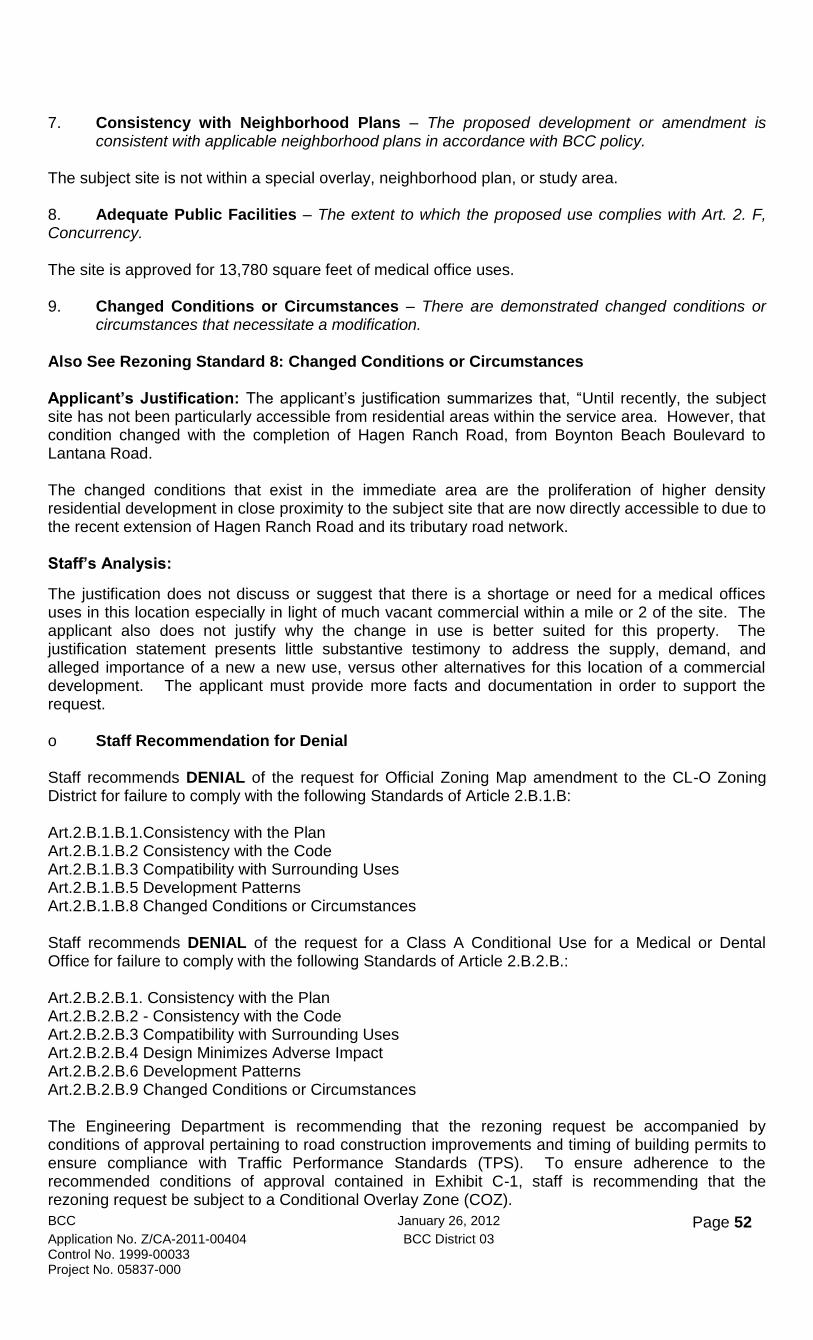
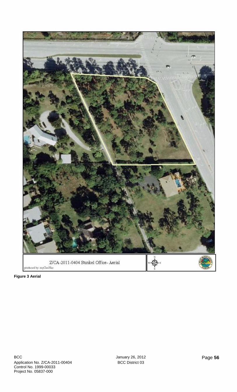
Location: Southwest corner of Lantana Road and Hagen Ranch Road. (Stunkel Medical Office)
TITLE: an Official Zoning Map Amendment REQUEST: to rezone from the Residential Transitional Suburban (RTS) District to the Commercial Low-Office (CL-O) Zoning District. TITLE: a Class A Conditional Use REQUEST: to allow Medical or Dental Office
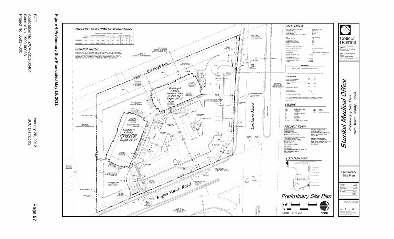
APPLICATION SUMMARY: Proposed is the rezoning of a 2.09-acre parcel of land from the Residential Transitional Suburban (RTS) Zoning District to the Commercial Low Office (CL-O) Zoning District to allow for the development for medical office uses. Also proposed is a concurrent Small Scale Land Use Atlas Amendment (SCA 2011-001) to change the Land Use designation from Low Residential 3 Units (LR-3) per acre to Commercial Low Office (CL-O). The Preliminary Site Plan (PSP) indicates two 1-story structures with 7,505 square feet for Building A and 6,275 square feet for Building B providing a total of 13,780 square feet. The 2.09-acre site was previously approved by the Board of County Commissioners (BCC) on October 28, 1999 for a rezoning from Agricultural Residential (AR) to RTS (R-99-2075) and a Class A Conditional Use to allow a day care center via Resolution R-99-2076. The approval for the day care center was revoked in January 2003 (R-2003-096) by the BCC through the Monitoring Review Process. A total of 69 parking spaces is indicated on the PSP, and acess will be from Hagen Ranch Road (1) and Lantana Road (1).
ISSUES SUMMARY: o Project History In 1998, the site was subject of a small scale Future Land Use amendment (Hagen Ranch/Lantana Road Commercial, 98-SCA 81 COM 1), to change the FLU from LR-3 to Commercial Low with an underlying LR-3 (CL/3). The applicant withdrew the amendment application prior to a BCC public hearing. In 1999, subsequent property owners were granted zoning approval using the existing LR-3 FLU designation for a 9,300 square foot day care with up to 194 children. The BCC approved the rezoning request from the AR Zoning District to the RTS Zoning District through resolution R-99-2075 and granted a Class A Conditional Use approval for a day care, general, use through resolution R-99-2076. The approved day care was approval was never implemented and in 2003 the BCC revoked the approval. Although the approval for the day care was revoked the RTS Zoning District was

BCC January 26, 2012 Page 43 Application No. Z/CA-2011-00404 BCC District 03 Control No. 1999-00033 Project No. 05837-000
retained since the Zoning District was in compliance with the LR-3 FLU designation. In 2008, Article 3 of the Unified Land Development Code (ULDC) was amended to eliminate and combine the RTS Zoning District to correspond with the Residential Transitional Zoning District (RT). Therefore the subject site would be currently reviewed under the RT Zoning District. o August 4, 2011 Zoning Commission (ZC) Hearing At the August 4 ZC hearing, staff gave a presentation outlining reasons for the denial and the agent gave a presentation defending the applicant’s request. A resident from the Plantation Mobile Home Park located to the east of the subject site, submitted for the record, a petition with 51 signatures (Exhibit G) in opposition to the request. Also, residents from the homes on Pineneedle Lane highlighted their fears and concerns in regard to the request through 2 Power Point presentations and various speakers. The concerns focused on the incompatibility of a commercial use adjacent to residential uses, increase in traffic, decrease in property values, destruction of Pine Trees, disruption of a quiet and peacefull lifestyle, and the lack of need for more commercial offices in light of the many vacant commercial bays and complexes within a few miles of the site. A representative for the Coalition of Boynton West Residential Association (COBWRA) read a letter in support of the request, (Exhibit H); however, the residents indicated that this is not in COBWRA’s jurisdiction. The ZC concurred there is sufficient vacant commercial offices or commericial potential in the area, but also expressed doubt as to whether the busy intersection of Hagen Ranch Road and Lantana Road is a desirable spot for a residential use. They also discussed increased buffer widths, whether is was desirable to leave the lot vacant, or what are the equitable development rights for this location. The applicant also spoke and offered a compromise by decreasing squarefootage and to address the residents’ concerns. Staff had recommended conditions of approval in the event that the ZC did recommend approval. However, the ZC recommended a postponment by a 7-0 vote to the October 6, 2011 hearing to allow sufficient time for the agent and the public to review and consider staff recommended conditions of approval, ZC recommendations, and to allow the agent, applicant and staff to meet with the adjacent homeowners. A meeting was conducted on August 18, 2011 with the concerned residents agent and Planning and Zoning staff. The residents provided a list of recommendations and conditions (Exhibit E). The agent later provided a written response dated August 22, 2011 to these recommendations (Exhibit F) however no compromise that was agreeable to all parties was acheived. The residents in opposition were not interested in any further meetings, discussions or consessions. o Zoning Commission (ZC) Hearing (October 6, 2011) At the October 6, 2011 ZC hearing, this application was on the regular agenda. Staff provided an update to the Zoning Commission on the attempt to bring a consensus regarding the proposed changes. Brian Cheguis, Agent for Cotleur Hearing, provided a revised site plan and explained that the applicant did provide some concessions and revision to the plan. Members from the public, primarily residents who live on Pine Needle Lane, came to the podium and indicated that they were still adamantly opposed to the change in the Future Land and Zoning designations. They did mention that they would prefer to have the day care here which was previously approved in 1998 and revoked in 2003 since the approval was never implemented. Representatives from COBWRA read in the record their support of the project indicating the site had been vacant for 40 years and therefore should be developed. However, this area is not under COBWRA’s jurisdiction and the residents confirmed they have no interaction or standing with this organization. The residents were quite upset with COBWRA’s representation and COBWRA was not authorized by these neighbors to speak. The Commissioners discussed the site design and possible relocation of the structures, tree height, increasing of buffer and landscaping, pros and cons of a wall on the south property line, hours of operation, and an increase in setbacks. The ZC approved the request for the rezoning and the Class A Conditional Use with a vote of 6-3, with Commissioners, Brumfield, Currie and Davis in opposition, and voting to deny the requests.

BCC January 26, 2012 Page 44 Application No. Z/CA-2011-00404 BCC District 03 Control No. 1999-00033 Project No. 05837-000
Below is a chart summarizing issues discussed, the applicant’s request, Zoning Commission’s recommendation, the resident’s requests and Conditions of Approval as applicable. A new Exhibit C-2 has been provided with ZC’s recommendation for the Saturday hours of operation.
Issues Applicant’s Request
Staff Recommends
ZC’s Rec.
Residents’ Requests
COA
Use Limitation
Medical, Dental or Professional
Requested Use for Medical & Dental- Professional Office is a Permitted Use- Use Code
Limit to Medical and Dental
Medical & Dental Only
Ex C-1: Ex C-2 Revised: All Petition Cond. 1. Limits to Medical & Dental
Hours of Operation
7:00 am to 9:00 pm. Mon.- Fri. Saturday 7:00 am to 6:00 pm
7:00 am to 9:00 pm Mon. - Fri. No Saturday
7:00 am to 9:00 pm Mon.-Fri. 9:00 am to 5:00 pm on Sat.- Ex C-3
9:00 am 6:00pm Mon.- Fri. No Saturday
Ex C-1. Not Revised: 7:00 am to 9:00 pm Mon.-Fri. No Saturday
Intensity
Building Square Footage
2 Bldgs 6250 SF each 12,550 SF total
Same Same 9,300 SF same as Day Care Approval
Ex C-1. New-Revised: Use Limitation 2. Limits to 12,550 SF
Site Design
Building Setback
35 Ft Rear (S) and 15 Ft Side (W)
50 Ft Rear (S) and 50 Ft Side (W)
15 Ft BBL Side 35 Ft. Rear (S)
No discussion
Ex C-1. Not Revised: Site Design 1
Signage 10 Ft Height 200 SF Sign Face Area 1 on the corner
8 Ft Height 50 SF Sign Face Area 1 per frontage
No Discussion
One 7 Ft Height 56 SF Sign Face Area (Same as Church)
Ex C-1. Revised: Limit to One Sign
Buffering R/W Lantana & Hagen Ranch Road
20 Ft width and additional planting along the E property line Code of 20 Ft along N property line
20 Ft width and additional planting along the E property line. Code of 20 Ft along N property line
No Discussion
20 foot R/W buffer
Ex C-1. Revised: Code Req & Landscape Conditions 2 & 4
South and West Property Lines
15 Feet S & W property line
Add conditions per ZC’s recommendation & discussions
Requested Staggered tree heights, taller trees, increase natives
Do not want a wall. Taller trees & thick buffer
Ex C-1. Revised: Landscape Conditions 2 &5
Access Lantana Road (1) & Hagen Ranch Road (1)
Supported Supported Limit to 1 access on Lantana Road
Ex C-1. Not Revised: Eng Conditions

BCC January 26, 2012 Page 45 Application No. Z/CA-2011-00404 BCC District 03 Control No. 1999-00033 Project No. 05837-000
o Board of County Commission (BCC) Hearing (October 27, 2011) At the October 27, 2011 BCC hearing, this application was on the regular agenda. Planning and Zoning Staff provided a presentation with a recommendation for denial of the proposal. Brian Cheguis, Agent for Cotleur Hearing, provided a revised site plan and explained that the applicant did provide some concessions and revisions to the plan to meet the residents concerns and Zoning Commission recommendations. However, members from the public, primarily residents who live on Pine Needle Lane, came to the podium and indicated that they were still adamantly opposed to the change in Future Land and Zoning use designations. Although the ZC and BCC had discussions that a day care would have created more of a traffic and noise impact, the adjacent residents indicated that they would prefer to have a day care here. A day care was previously approved in 1998 and revoked in 2003 since the approval was never implemented. Representatives from COBWRA read in the record their support of the project indicating the site had been vacant for 40 years when the property was subdivided and therefore should be developed. The site currently supports fully grown pine trees and native shrubs and ground cover and is not overgrown with exotics. There was considerable discussion as to whether a commercial designation is appropriate for the parcel due to the adjacent right of way expansion and if this location is desirable for a residential use. The Commissioners also shared their opinion of and what uses would make the most negative impact. In response the Planning staff provided further similar situations where single family residential was appropriate for this type of location. Since an agreement could not be reached at this time, the BCC with a 4-2 vote postponed the application to the December Hearings held January 5, 2012 due to the holiday schedule. The postponement was to allow sufficient time for the agent to meet with the residents in order to reach a consensus on site design, building scale, hours of operation, and uses permitted for the proposed Medical, Dental or Professional Offices in the Commercial Low-Office (CL-O) Zoning District. The Commissioners recommended that these modifications should be something the residents could agree with and they could support either through redesign or Conditions of Approval. A meeting was held in the evening on November 30th, at the Lantana Library with the residents of Pine Needle Lane, the District Commissioner Shelly Vanna, and County Staff to discuss the amended proposal. o Meeting with the District Commissioner, Agent and Residents (November 30, 2011)
An evening meeting at the Lantana Library was held on Wednesday November 30, with Commissioner Vana, Brian Cheguis, the property owner, County staff, COBWRA representatives and residents of Pine Needle Lane to see if a compromise could be met on the proposal. The discussion was on uses- currently allowed by the ULDC and proposed uses, hours of operation, site design and project history. Mr. Cheguis said he could submit a revised plan prior the to the December 7th deadline for the January 5th BCC packet. If the FLU and Zoning change is approved, the residents want a building that blends in with the existing residential uses with scaling down of the structure, increased setbacks and landscaping, change in access (subject to Traffic Eng approval) and possibly 1 structure instead of two. The agent determined they wished to postpone from the January 5, 2012 meeting since the District Commissioner would not be present. In addition a revised plan has not been submitted prior to publication of this report. o Board of County Commission (BCC) Hearing (January 05, 2012) This item was postponed to the January 26, 2012 Hearing at the applicant’s request. The BCC recommended approval of the postponement with a 6-0 vote.
BCC January 26, 2012 Page 46 Application No. Z/CA-2011-00404 BCC District 03 Control No. 1999-00033 Project No. 05837-000
o Revised Plan submitted by the applicant on January 11, 2012 On January 11, 2012 the applicant submitted a revised plan to the Zoning Division indicating a single structure and revised parking and setbacks. Due to the late submittal this plan has not been reviewed by the DRO or Zoning Commission, and is not included in this report. FINDINGS: Rezoning Standards: When considering a development order application for rezoning to a standard zoning district, the BCC and ZC shall consider standards 1-8 indicated below. In addition the standards indicated in section 2.B shall also be considered for rezoning to a standard zoning district with a conditional use, and rezoning to a PDD or TDD with or without a requested use or waiver. An amendment, which fails to meet any of these standards shall be deemed adverse to the public interest and shall not be approved. Staff has reviewed the request for compliance with the standards that are expressly established by Article 2.B.1.B and provides the following assessment: 1. Consistency with the Plan - The proposed amendment is consistent with the Plan. Applicant’s Statement: “No residential development has occurred on this parcel due to the fact that was always contemplated and is currently bounded on two sides by significant arterial and collector roadways. This type of corner parcel is prime for development of commercial uses that can effectively buffer the impacts of busy roadways from adjacent residential developments.” Staff’s Response: Staff has determined that the request is not in compliance with Standard 1 based on the following analysis. The Planning Division has reviewed the Zoning application and has found the request to not be inconsistent with the site's proposed Zoning District. However, Planning staff is recommending denial of the proposed FLUA amendment based on the following evaluation: The site is currently the subject of a proposed Small Scale Future Land Use Atlas (FLUA) amendment (SCA 2011-001) to change the FLU designation from Low Residential, 3 units per acre (LR-3) to Commercial Low-Office (CL-O). Planning staff is recommending denial of the proposed FLUA amendment concluding that “the applicant has not provided an adequate justification for the proposed amendment and is therefore inconsistent with Policy 2.1-f.” The proposed FLUA amendment was heard by the Planning Commission at the July 8, 2011 Land Planning Agency (LPA) public hearing. The Planning Commission supported staff recommendation to deny the petition by a 11-0 vote. 2. Consistency with the Code - The proposed amendment is not in conflict with any portion of
this Code, and is consistent with the stated purpose and intent of this Code.
Applicant’s Statement: The applicant’s Justification Statement indicated that “The proposed zoning map amendment is not in conflict with any portion of the ULDC, and is consistent with the stated purpose and intent of the ULDC. The conceptual site plan indicates how the site can be developed pursuant to the criteria of the ULDC.” Staff’s Response: Staff has determined that the request is not in compliance with Standard 2 based on the following analysis. The request to allow a rezoning from the RTS Zoning District to the CLO Zoning District is contingent upon BCC adoption of the proposed FLUA amendment. The applicant has not demonstrated how the request complies with Section 2.B.1.A Official Zoning Map Amendment: Purpose where necessary adjustment in light of the changed conditions require the rezoning without conferring special privileges or rights on any person and determine the consistency of the proposed amendment with the intent of the Plan.
BCC January 26, 2012 Page 47 Application No. Z/CA-2011-00404 BCC District 03 Control No. 1999-00033 Project No. 05837-000
The applicant has not demonstrated where this is a “necessary adjustment in light of the changed conditions.” The ULDC has eliminated and combined the RTS Zoning District to correspond with the RT Zoning District. Article 3.C.1.F. defines the RT district as a district “to provide a transition between a suburban and single family atmosphere and estate development, which promotes active recreational facilities within the privacy of an individual lot”. Changing this site to a commercial parcel is not only not necessary but is not interrelated to the residential uses and in fact is disruptive to the current residential lifestyle of the adjacent large lot subdivision. Further, as stated in the FLU analysis by staff; “the applicant has provided broad statements with regards to need, but has not provided an adequate justification for CL-O on this specific site considering the surrounding suburban development pattern and residential land uses.” However, contingent upon BCC adoption of the proposed FLUA amendment, the request would be consistent with the minimum property development regulations of the CL-O Zoning District. 3. Compatibility with Surrounding Uses - The proposed amendment is compatible, and
generally consistent with existing uses and surrounding zoning districts, and is the appropriate zoning district for the parcel of land. In making this finding, the BCC may apply an alternative zoning district.
Applicant’s Statement:
“The property is one of 6 similarly sized lots located at the southwest corner of the intersection. Each of the remaining 5 lots contains a single-family home. Three of the homes were constructed in the 1970’s and one each was constructed 1986 and 1995, respectively. None of the homes were constructed during the past 15 years, and 4 of the 5 were constructed a minimum of 24 years ago.” Further the applicant concludes the proposed development would meet FAR and “To be compatible, it is not necessary that two uses have the exact same function (e.g. residential, commercial, institutional, etc.). Rather, compatibility is attained when uses do not adversely affect each other. Further, two uses whose functions are different can compliment and support each other.” Staff’s Analysis: Staff has determined that the request is not in compliance with Standard 3 based on the following analysis.
EAST: FLU Designation: Medium Residential (MR-5) Zoning District: Single-Family Residential District (RS) Supporting: Mobile Home Park ( Control No 1986-027) NORTH: FLU Designation: Low Residential (LR-1) Zoning District: Residential Transitional District (RT) Supporting: Place of Worship ( Control No 2005-508) WEST: FLU Designation: Low Residential (LR-3) Zoning District: Agricultural Residential District (AR) Supporting: Single Family Dwelling ( Control No n/a) SOUTH: FLU Designation: Low Residential (LR-3) Zoning District: Agricultural Residential District (AR) Supporting: Single Family Dwelling ( Control No n/a)
The proposed amendment is not compatible, or generally consistent with existing uses and surrounding zoning districts. Furthermore, the applicant has not demonstrated that this is the appropriate zoning district for this parcel of land. This introduction of commercial zoning is out of character with the immediate vicinity and the land use pattern in the area. As stated in the concurrent FLU amendment report “The subject site is located in a low density suburban area for which the Comprehensive Plan has designated commercial development at medium to large commercial centers and nodes (as shown on the Existing Land Use Map).
BCC January 26, 2012 Page 48 Application No. Z/CA-2011-00404 BCC District 03 Control No. 1999-00033 Project No. 05837-000
The proposed amendment would introduce a new commercial uses in an area that is designated for and largely built as, residential.” In addition there are vacant commercial buildings and shopping centers in close proximity to this site that could be utilized without disruption to a parcel that is surrounded primarily by residential or institutional uses. 4. Effect on Natural Environment – The proposed amendment will not result in significantly
adverse impacts on the natural environment, including but not limited to water, air, storm water management, wildlife, vegetation, wetlands, and the natural functioning of the environment.
Applicant’s Justification: The applicant’s justification describes the site that is covered with dense mature Pine Trees: There are native Pine trees on the subject property which will be preserved in the site design to the greatest extent possible and included in the project’s landscape plan. All exotic species will be removed from the subject property. Staff’s Analysis: Environmental Resource Department (ERM) staff of PBC has determined that the request is in compliance with Standard 4. There are no significant environmental issues associated with this petition beyond compliance with ULDC requirements. The applicant has provided a tree survey with the proposal and will incorporate a small portion of the trees into the site design. However, the Zoning Division recommends a Landscape condition 1 requiring the existing native vegetation be preserved subject to the revised site plan and additional setback requirements. (See Landscape Condition 1) 5. Development Patterns – The proposed amendment will result in a logical, orderly, and timely
development pattern. Applicant’s Justification: The applicant’s Justification Statement claims that “The development provides for an interesting commercial/office center that engages the roadway with interesting architecture and provides for safe and convenient pedestrian routes through the site. The development shall be programmed to the design standards provided in the ULDC and will effectively integrate into the existing built fabric of the surrounding community” Staff’s Analysis: Staff has determined that the request is not in compliance with Standard 5 based on the following analysis. The applicant fails to describe how the proposal results in a logical, orderly and timely development pattern or interacts with the adjacent residential uses. As stated in the concurrent FLUA amendment staff report: “The proposed amendment would introduce a new commercial office use in an area that is designated for and largely built as residential. This introduction can be considered out of character with the immediate vicinity and the land use pattern in the area. The applicant has provided broad statements with regards to need, but has not provided an adequate justification for CL-O on this specific site considering the surrounding suburban development pattern and residential land uses.” The applicant’s justification statement provided statements of integration into the existing built fabric but fails to demonstrate how this is achieved through this rezoning request. 6. Consistency with Neighborhood Plan – The proposed zoning district is consistent with
applicable neighborhood plans in accordance with BCC policy. The subject site is not within a special overlay, neighborhood plan, or study area. 7. Adequate Public Facilities – The proposed amendment complies with Art. 2. F, Concurrency. The site is approved for 13,780 square feet of medical office uses.
8. Changed Conditions or Circumstances – There are demonstrated changed conditions or circumstances that necessitate the amendment.
Applicant’s Justification: The applicants’ justification states, “... there are no properties with a CL-O FLUA designation within the primary service area…. Applying the above determined “CL-O balance
BCC January 26, 2012 Page 49 Application No. Z/CA-2011-00404 BCC District 03 Control No. 1999-00033 Project No. 05837-000
rate” to the primary service area population results in the need for 6.47 acres of CL-O designated land in order to attain the unincorporated area norm. Until recently; the subject site has not been particularly accessible from residential areas within the service area. However, that condition changed with the completion of Hagen Ranch Road, from Boynton Beach Boulevard to Lantana Road The changed conditions that exist in the immediate area are the proliferation of higher density residential development in close proximity to the subject site that are now directly accessible to due to the recent extension of Hagen Ranch Road and its tributary road network” Staff’s Analysis: Staff has determined that the request is not in compliance with Standard 8 based on the following analysis: Although the completion of Hagen Ranch Road has changed the character of this area this does not automatically trigger a change to a commercial parcel for the subject site. The Planning Staff report continues their analysis by stating the applicant has not provided adequate justification that the ideal balance rate of commercial to residential is “appropriate to apply within a much smaller defined area where the character of development is predominantly a suburban residential development pattern with commercial uses located in nodes. The lack of CL-O FLU could be indicative that commercial in general has concentrated at larger nodes in this suburban area or that CL-O is already adequately balanced in the area.” Further…“There are other CL-O properties just beyond the boundary that the applicant selected. In fact, there are vacant or partially vacant properties with CL-O FLU within 2 ½ miles of most areas of the communities the applicant identifies as the primary and secondary service areas.” The proposed rezoning would introduce a new commercial designation in an area that is designated for and largely built as, residential. Other than the completion of Hagen Ranch Road, from Boynton Beach Boulevard to Lantana Road, and attempting to save a fraction of the mature slash pines on site the applicant has done little to defend or justify the changed circumstances to support the rezoning request. The introduction of commercial in this location would be disjointed and out of character with the immediate vicinity and the residential land use pattern in the area. The haphazard introduction of commercial in this location would disrupt the surrounding suburban development pattern and residential land uses. FINDINGS: Conditional Uses, Requested Uses and Development Order Amendments: When considering a development order application for a conditional or requested use, or a development order amendment, the BCC and ZC shall consider standards 1 – 9 indicated below. A conditional or requested use or development order amendment which fails to meet any of these standards shall be deemed adverse to the public interest and shall not be approved. Staff has reviewed the request for compliance with the standards that are expressly established by Article 2.B.-2.B and provides the following assessment:
1. Consistency with the Plan – The proposed use or amendment is consistent with the purposes, goals, objectives and policies of the Plan, including standards for building and structural intensities and densities, and intensities of use.
See Rezoning Standard 1. Consistency with the Plan
2. Consistency with the Code - The proposed use or amendment complies with all applicable standards and provisions of this Code for use, layout, function, and general development characteristics. The proposed use also complies with all applicable portions of Article 4.B, SUPPLEMENTARY USE STANDARDS.
Also See Rezoning Standard 2. Consistency with the Code Applicant’s Statement:
BCC January 26, 2012 Page 50 Application No. Z/CA-2011-00404 BCC District 03 Control No. 1999-00033 Project No. 05837-000
The applicant’s Justification Statement indicated that “The proposed zoning map amendment is not in conflict with any portion of the ULDC, and is consistent with the stated purpose and intent of the ULDC. The conceptual site plan indicates how the site can be developed pursuant to the criteria of the ULDC.” Staff’s Response: Staff has determined that the request is not in compliance with Standard 2 based on the following analysis. Contingent upon BCC adoption of the proposed FLUA amendment, the request would be consistent with the minimum property development regulations of the district. The applicant concludes that since the proposed development would meet minimum property development regulations for FAR, landscape, setbacks, and maximum height would therefore be compatible. The applicant does volunteer for a height limitation of a single story. However the proposed site plan configuration cannot support any additional square footage since the site plan already maximizes the use in terms of setbacks, access, parking and retention areas. o Conditional Uses Purpose In addressing whether the proposed use is in compliance with Standard 2, Consistency with the Code, the applicant failed to address how the proposed design, configuration and intensity are appropriate and compatible at the proposed location. The responsibility lies with the applicant to demonstrate how the proposed development will minimize the impacts on surrounding residential development. This should be typically done through the analysis of the design and configuration for the proposed use. Staff is recommending denial of the requests. However, if the Commissioners vote for approval of the request staff would recommend conditions of approval as further discussed below.
o Landscape/Buffering The applicant has provided buffers in accordance with Article 7 of the ULDC. Staff recommends additional pine trees along the right of way (ROW) frontages of Hagen Ranch Road and Lantana Road and a condition of approval to assure the ROW buffer for Hagen is a minimum of 20 feet in width with a 5 foot easement overlap permitted. o Signs Staff is recommending signage be limited to a maximum of 8 feet in height and 50 square feet of sign face area with 1 sign per ROW frontage. Wall signage shall be in accordance with ULDC requirements of Article 7. o Access
During the DRO certification process of the zoning application, there were discussions as to whether the access to the site would be a shared access via Pine Tree Lane (an easement) or directly on Lantana Road. The site plan was revised to provide a separate access from Pine Tree Lane directly to Lantana Road. This particular ingress and egress arrangement places the two access point in close proximity to each other. A waiver to the access standards was required and was granted by the Engineering Department. In addition Land Development granted a base building line waiver to establish side setbacks for Medical Building B. o Hours of Operation Article 3.D.3.A.2.a., Hours of Operation states– Commercial uses located within 250 feet of a residential district shall not commence business activities, including deliveries and stocking, prior to 6:00 a.m. nor continue business activities later than 11:00 p.m. daily. Staff recommends a condition limiting hours of operation from 7:00 a.m. to 9:00 p.m. and allowing business activities Monday through Friday only.
BCC January 26, 2012 Page 51 Application No. Z/CA-2011-00404 BCC District 03 Control No. 1999-00033 Project No. 05837-000
3. Compatibility with Surrounding Uses – The proposed use or amendment is compatible and generally consistent with the uses and character of the land surrounding and in the vicinity of the land proposed for development. See Rezoning Standard 3. Compatibility with Surrounding Uses 4. Design Minimizes Adverse Impact – The design of the proposed use minimizes adverse
effects, including visual impact and intensity of the proposed use on adjacent lands. Also See Rezoning Standard 5: Development Patterns Applicant’s Justification: the applicant’s Justification statement states” “The elements of the site design have been carefully reviewed to minimize any adverse impacts. Two (2) points of access are proposed to the subject site from Hagen Ranch Road and Lantana Road via a private road easement. Additionally buffers are provided adjacent to all property lines and all buildings are designed as to minimize any impact on the surrounding properties. A visual impact analysis has been provided with this request which demonstrates that the proposed building does not have any negative visual impact on the adjacent lands.” Staff’s Analysis: Staff has determined that the request is not in compliance with Standard 4 based on the following analysis. The applicant fails to describe how the proposal minimizes adverse effects, including visual impact and intensity of the proposed use on adjacent lands or compliments the development pattern or interacts with the adjacent residential uses. The proposal maximizes the potential square footage since no additional parking could be provided. The proposed buffers are the minimum required with the exception of the ROW buffer adjacent to Hagen Ranch Road which is 20 foot with a 5 foot easement overlap instead of a 15 foot wide with a 5 foot easement overlap that is permitted if the ROW is less than 100 feet in width. Except for this one factor the applicant is not providing anything beyond minimum Code requirements. This introduction of a commercial use is out of character, destroys numerous slash pines which serve as a buffer from the expanded Hagen Ranch Road and is not consistent with the immediate vicinity and the land use pattern in the area. The applicant has not provided an adequate justification to use this area for a commercial use when there is a large amount of vacant commercial that could be utilized for the proposed use of medical offices within a few miles of the subject site.
5. Design Minimizes Environmental Impact – The proposed use and design minimizes environmental impacts, including, but not limited to, water, air, storm water management, wildlife, vegetation, wetlands and the natural functioning of the environment.
See Rezoning Standard 4: Effect on Natural Environment
Applicant’s Justification: There are native Pine trees on the subject property which will be preserved in the site design to the greatest extent possible and included in the project’s landscape plan. All exotic species will be removed from the subject property. Staff’s Analysis: Staff has determined that the request is in compliance with Standard 5 based on the following analysis. Trees indicated on the survey will be incorporated to the greatest extent possible in the overall site design or mitigated. However the applicant has mitigated the minimum amount of trees in order to maximize the site for the proposed development.
6. Development Patterns – The proposed use or amendment will result in a logical, orderly and timely development pattern.
Also See Rezoning Standard 5: Development Patterns The proposed use is a commercial use which is allowed, subject to a Conditional Use approval process and procedures. The applicant; however, fails to describe in the justification statement how the proposed use complies or will result in a logical, orderly and timely development pattern.
BCC January 26, 2012 Page 52 Application No. Z/CA-2011-00404 BCC District 03 Control No. 1999-00033 Project No. 05837-000
7. Consistency with Neighborhood Plans – The proposed development or amendment is
consistent with applicable neighborhood plans in accordance with BCC policy. The subject site is not within a special overlay, neighborhood plan, or study area. 8. Adequate Public Facilities – The extent to which the proposed use complies with Art. 2. F, Concurrency.
The site is approved for 13,780 square feet of medical office uses. 9. Changed Conditions or Circumstances – There are demonstrated changed conditions or
circumstances that necessitate a modification. Also See Rezoning Standard 8: Changed Conditions or Circumstances Applicant’s Justification: The applicant’s justification summarizes that, “Until recently, the subject site has not been particularly accessible from residential areas within the service area. However, that condition changed with the completion of Hagen Ranch Road, from Boynton Beach Boulevard to Lantana Road. The changed conditions that exist in the immediate area are the proliferation of higher density residential development in close proximity to the subject site that are now directly accessible to due to the recent extension of Hagen Ranch Road and its tributary road network. Staff’s Analysis:
The justification does not discuss or suggest that there is a shortage or need for a medical offices uses in this location especially in light of much vacant commercial within a mile or 2 of the site. The applicant also does not justify why the change in use is better suited for this property. The justification statement presents little substantive testimony to address the supply, demand, and alleged importance of a new a new use, versus other alternatives for this location of a commercial development. The applicant must provide more facts and documentation in order to support the request.
o Staff Recommendation for Denial Staff recommends DENIAL of the request for Official Zoning Map amendment to the CL-O Zoning District for failure to comply with the following Standards of Article 2.B.1.B: Art.2.B.1.B.1.Consistency with the Plan Art.2.B.1.B.2 Consistency with the Code Art.2.B.1.B.3 Compatibility with Surrounding Uses Art.2.B.1.B.5 Development Patterns Art.2.B.1.B.8 Changed Conditions or Circumstances Staff recommends DENIAL of the request for a Class A Conditional Use for a Medical or Dental Office for failure to comply with the following Standards of Article 2.B.2.B.: Art.2.B.2.B.1. Consistency with the Plan Art.2.B.2.B.2 - Consistency with the Code Art.2.B.2.B.3 Compatibility with Surrounding Uses Art.2.B.2.B.4 Design Minimizes Adverse Impact Art.2.B.2.B.6 Development Patterns Art.2.B.2.B.9 Changed Conditions or Circumstances The Engineering Department is recommending that the rezoning request be accompanied by conditions of approval pertaining to road construction improvements and timing of building permits to ensure compliance with Traffic Performance Standards (TPS). To ensure adherence to the recommended conditions of approval contained in Exhibit C-1, staff is recommending that the rezoning request be subject to a Conditional Overlay Zone (COZ).

BCC January 26, 2012 Page 53 Application No. Z/CA-2011-00404 BCC District 03 Control No. 1999-00033 Project No. 05837-000
If the Board of County Commissioners votes to approve the requests, staff recommends the approval of the rezoning be subject to a COZ and Conditions of Approval as indicated in Exhibit C-1 or as indicated in Exhibit C-2 (Zoning Commission Recommendations) and the approval of the Class A Conditional Use be subject to Conditions of Approval as indicated in Exhibit C-3.
TABULAR DATA
EXISTING
PROPOSED
Property Control Number(s)
00-42-44-40-00-040-0012 Same
Land Use Designation: Low Residential 3 (LR-3) Commercial Low Office (CLO)
Zoning District: Residential Transitional Suburban (RTS)
Commercial Low Office (CLO)
Tier: Urban/Suburban Tier Same
Use: Vacant
Medical or Dental Office
Building Coverage n/a 13,780 square feet
FAR n/a 15.3%
Acreage: 2.09 acres Same
Parking: n/a 70 spaces
Access: n/a Lantana Road (1) Hagen Ranch Road (1)
PUBLIC COMMENT SUMMARY: At the time of publication, staff had received approximately 10 phone calls requesting hearing dates in general information from the public regarding this project and one letter in opposition, a letter with recommended conditions from residents of Pine Needle Lane (Exhibit F) and a petition with 51 signatures in opposition (Exhibit G) to the request.
RECOMMENDATION: Staff recommends denial of the requests.
ACTION BY THE ZONING COMMISSION: October 6, 2011: Motion to recommend approval of the rezoning with a Conditional Overlay Zone (COZ) subject to the Conditions of Approval as amended. Motion carried 6-3. Motion to recommend approval of the Class A Conditional Use carried by a vote of 6-3.
MOTION: To recommend denial of an Official Zoning Map Amendment to rezone from the Residential Transitional Suburban (RTS) Zoning District to the Commercial Low-Office (CL-O) Zoning District. OR To adopt a resolution approving an Official Zoning Map Amendment to rezone from the Residential Transitional Suburban (RTS) Zoning District to the Commercial Low-Office (CL-O) Zoning District with a Conditional Overlay Zone (COZ) subject to Conditions of Approval as indicated in Exhibit C-1 or Exhibit C-2. MOTION: To recommend denial of a Class A Conditional Use to allow a Medical or Dental Office. OR To adopt a resolution approving a Class A Conditional Use to allow a Medical or Dental Office subject to the Conditions of Approval as indicated in Exhibit C-3.
BCC January 26, 2012 Page 54 Application No. Z/CA-2011-00404 BCC District 03 Control No. 1999-00033 Project No. 05837-000
Figure 1 Land Use Atlas Map
PALM BEACH COUNTY PLANNING DIVISION
SITE LOCATION AND LAND USE
i 1£
tr
\
LR-1 -i I!R-3 I)
I~,,!.!..~ seA 2011 -001 82 LR.l lo CL.O
't'·"'·' ..... • • \ ~
:' . . . . . . . . ...... '1 . .
'\. \. ': ~ ...', . ' . , ..... ",.".,. .
,
, ,
\
• !
MR-5 2009..QJ6
. ~ __ .....,.. __ .o-_________ ~--"--" .. '-' --"--"--"--"-'-'-'-'-'--"--" --"
:1 T
MR-5
AWlical im Number
COrtro N LITl oe~
Z/CA -2001-404
1986'()27
Lard Use Mias Page: _----"81'----_
Date 0612012011
\
t N

BCC January 26, 2012 Page 55 Application No. Z/CA-2011-00404 BCC District 03 Control No. 1999-00033 Project No. 05837-000
Figure 2 Zoning Quad Map
BCC January 26, 2012 Page 56 Application No. Z/CA-2011-00404 BCC District 03 Control No. 1999-00033 Project No. 05837-000
Figure 3 Aerial
VCA-2011-0404 Stunkel Office- Aerial
• •
•
. -. '"
...
,
•
BC
C
January
26
, 20
12
Pa
ge
57
App
licatio
n N
o. Z
/CA
-201
1-0
040
4
BC
C D
istric
t 03
Contro
l No
. 19
99-0
003
3
Pro
ject N
o. 0
58
37-0
00
F
igu
re 4
Pre
limin
ary
Site
Pla
n d
ate
d M
ay 1
6, 2
011
~
r PROPERTY DEVELOPMENT REGULATIONS -- --- --_ .. _- --.. -.. ~---.... ~ ... -
,c'"" I ""'"C" w'"'"'~'OO, I 1"'00 I "" ,we "'~ lAND USE SIZE I WIDTH I DEPTH FAR COVER mONT I SIDE IS~~~TIFlEAR
EXIST1NG
J~D~~I
oeo 1 'AC 1 '00 1 '"' I" 1 ,,. 1 ,"' I'" 1 '" 1 '"
GENERAL NOTES AN AMENDMENTTOTHE SITE PLAN PARKING REQUIREMENTS WIll. BE REQljIREDIF
~~~~~~5F~~~~~~~GO~I~~~~~;~~:;r:~~~BI~D IMPAIRMENTS,I>SA HIGHER PERCENTAGE OF ACCESSIBLE PARKlNG SPACES WILL BE REQU1RED PURSUANT TO FLORIDA BUILDING CODE SECTION 11.4.1.2. (5}(D).
~----
ZONINGAR LANDUSELR3
EXISTING USE SF RESIDENllAL
, '" 15' -- 1 100' \ LB
.1
Q-lAINUNK FENCE
EXISTINifU£I~fE~DENTIAL
~ ----
ADDIT10NAL RIGHT-OF-WAY
I TO BE DEDICATED
I I I I I I I I I
R25' I
+-40'---I'fIf---III40'-_J<rj ,8(4)
5 (20) .. RlS' : I'2"62l
I LAQIJ I
SITE DATA ;RO~=TION.(FKANO.ME)
APPLlCATlONNlI>IBER
EXlSTlNGLAIflUSE PROPOSED LAND USE ElGSTlNGlOrlINGDI5TRICT PROPOSEDlOrlINGClSTRICT ~,
SECTlON'IO,TOWNSf!IP44,1lANGE42 PROPBm'COM'ROLNJMEER(S)
EXISTlNr:;tAP?RO'IEDUSE PROPOSED USE
Shmkel MedKaI 0I'fH;. ,~
%-C:-~11-004Q4
lkbanSuburban 00
= = .. ~ .. Medlcal,D:!ntal&ProfesskmIOffice
IllID1llN'3AMEDrAL{]fFJ[E 7,505 SF
BUllDlNGB:MEDlCALOFFICE 6,275 SF lOrAL 13,78DSF
''''\111 I 110'ULTROW-'fII--lfi------t--W \'" I '-;."'m'''''"'''""~= •• '''.;;;~''',~=.,'''_="~'''.''',,'''~''"~'",o;;_=oo.'''.'''~~
I MONUMOO SIGN I
I I I I I I I I I I
5' LAE : I
5'OVE~ I I I I I
1 LANTANA Ro.aD R/W
~~~~~~Oi~6~' I
't3 ~
C(
~ ~
~ : 3 (15) 2 (11) 1
: 1 G i ..... ._--/1 I ..... ....-.-' 1/
........... ----r ..... y..-...-..... :
c:(]//i \ .. /
EXIMThDN~~~ I'fRS 40' I HO~~"IIPBl~_~~
I I I I I I I I I I I I I
:~ : 7 (4) I I I I I I I I I I I I I I I I I I I I
., 10 (6)
n
I I I I I
1 SPACE PER 200 IJJlliJING SF
~CAPACCESSIfIt.E~"'LlIElrnTOTAL)
-M " , . Jf~~tiHIP =" 9 N
"" , , I I I I I I I I I I I I I I I I I I I I I I I I I I I I I I I
~- 2~'-2"
NlJoIlER OF STORIES , TIW'fICAilW.YSJ5ZO~(T1\Z)
NOTE: SITE PlANIlASEDON SLRYEYPROPOSBlB'f MICfiOfi B. SCHiJRAH AND ASSOCIATES. REFERENCE #1471 SJGlJEDAIIIlSEAlID Bl'JONATWlNT. GILBERT ONOl-25-1I.
LEGEND
'"' "''' coo
" , " '" m ULTRW
BASE BUIWINGLJNE CONCRETE HANDICAP LANDSCAPE BUFFER
SIDEWALK
IT"= ULTIMATERIGKTOFWAY
PROJECT TEAM
~~~~~~~ 4 COUNTRY ROAD WEST VILlAGEOFGOLF,FL33436
LANDSCAPE ARCHITECT/PLANNER: OOTLEUR&HEARING,INC. 193~ OOMMERCE LANE, SUITE 1
~~~!7~G3~:34S8 CONTACT:BRIANCHEGUIS
ARCHITECT: KEN CARLSON IOO2E. NEWPORT CENTER DR., SUITE 101
~~.~i.~2~EACH, A. 33442
LOCATION MAP
± 8
TRAFFIC CONSULTANT: SIMMONS & WI-IITE 5601 CORPORATE WAY, SUliE 2QO
~~~:EAOl,FL33407
~~~:~~INl: 1850 FOREST HIll. BLVD., SUITE 206
~~~:EAOl,FL33406
0) - FLORIDA-S TUR~'----!!
N ~l". If;~ !; PrOject Slte\!o! r~~-~~-~~-~~O
~,t~;1(~~r~~~~~~o Preliminary Site Plan
~"=2~ i i 0) North
~ Cotleur Hearing Landscape ArchHecture Planning EnvlronmentalConsuHing Graphic Dssign
1934 Commerce Lane Suite 1 Jupiier, Florida 33458 561-747-6336 Fax-747-1377
~
~ ~ ~ """- ~"C "'t:i:.Q ,~ LL
~
~ '" ~ § ~
~ >. ,1:! 1:: V) ::::l
~O III () .~ "5 .§ m ~Ill tS:E
ctI a..
Preliminary Site Plan
JOB NUMaER 10·1002 DATECcnd~ REVISIONS~
04-25·11
MoyI3.201'2·4720pm Orowlng:10-10D2SPDWG
SHEET 1 OF 2
BC
C
January
26
, 20
12
Pa
ge
58
App
licatio
n N
o. Z
/CA
-201
1-0
040
4
BC
C D
istric
t 03
Contro
l No
. 19
99-0
003
3
Pro
ject N
o. 0
58
37-0
00
F
igu
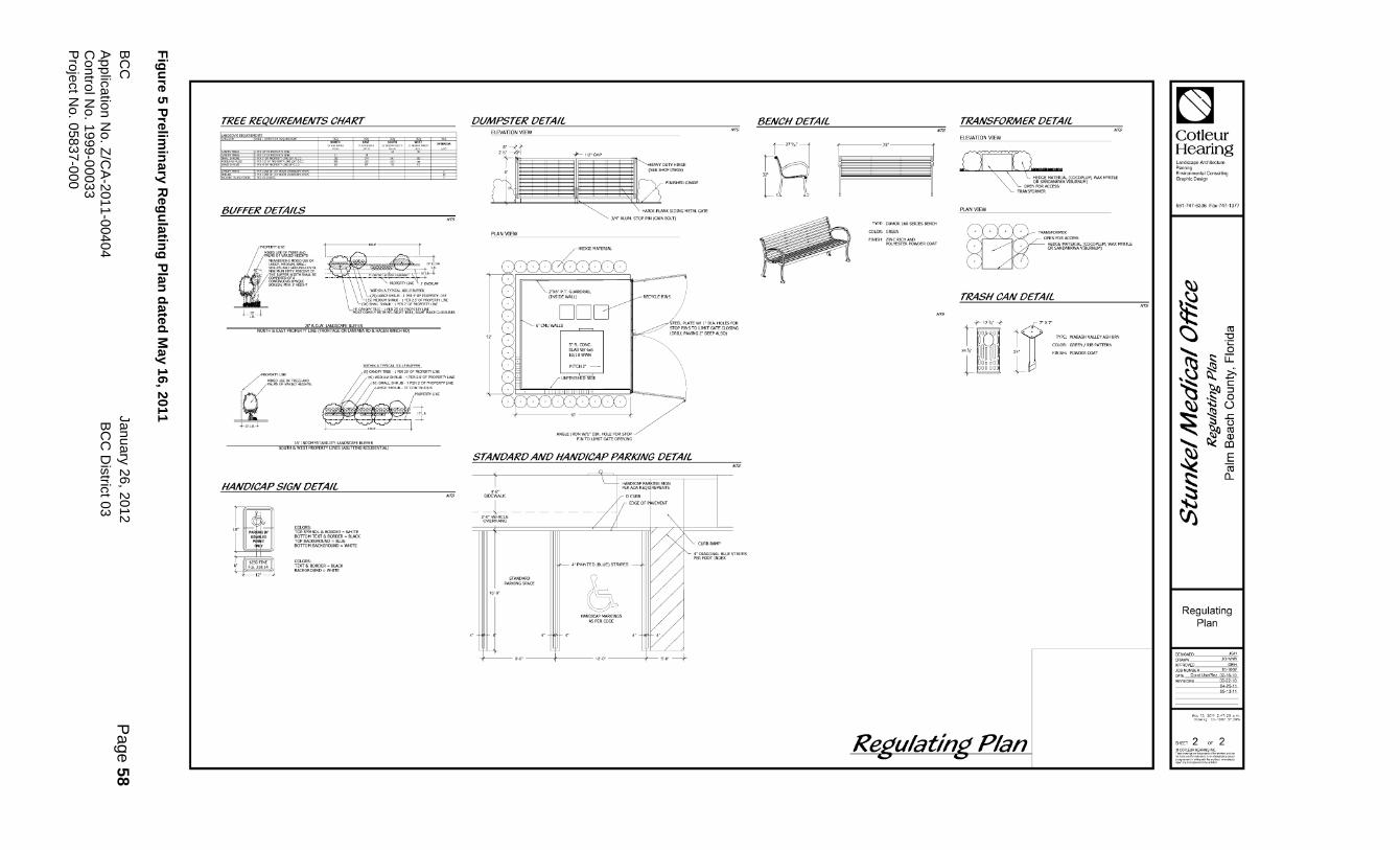
re 5
Pre
limin
ary
Reg
ula
ting
Pla
n d
ate
d M
ay 1
6, 2
01
1
TREE REQUIREMENTS CHART
BUFFER DETAILS
+-,~-+ .' ~'?Jrt!8::;)'~WrrA ~~~~~-\WE~Em.#~ GUIDEUNES
NORTH & EAST PROPERTYUNE (ffiONTAGE ON lANTANARD & HAGEN RANCH RD)
SOlJTH&WESTPROPERTYUNES(ABUTTlNGRESIDENTlAL)
HANDICAP SIGN DETAIL
COLORS:
i2t~~~~~:~:c: COLORS:
~G&~~~E!;'::~
DUMPSTER DETAIL ELEVATION VIEW
HARDI-PLANK SIDING METAL GATE
3/4" ALUM. STOP PIN (CAIN BOLT}
ANGLE IROp~:~' ~;:ir~~E~:':~~
STANDARD AND HANDICAP PARKING DETAIL
4'-6" SIDEWAlK
-z-=s:·viHICLE- - - - --OVERHANG
STANDARD PARKING SPACE
4"PAINTED(BLUE)STRIPES
o HANDICAPMAIOONGS
AS PER CODE
--+1-0'" --+
4"DIAGONAlBLUESTRIPES PER FDOT INDEX
BENCH DETAIL
fA FINISH: ZINC RIQ-I AND
POLYESTER POWDER COAT
TRANSFORMER DETAIL
ELEVATION VIEW
OPEN~~~~~~vI~~M'WAXMYRTlE
fBf' , , ~o~,,~ OPEIllFORACCESS
+ + HEDGE MATERIAL [COCOPLUM, WAX MYRTLE OR SANDANKWAVlBURNUM)
TRASH CAN DETAIL
+120/0"+
r!~oo! ,," ~~~ ~~~ Loo"oo
000000
~"
• Tl'PE: WABASHVALl.EYASHURN 1 COWR: GREENfRIBPATTERN L ""~ "'",,,"",,
Plan
~ Cotleur Hearing Landscape Art:hiteclure Planning Environmental Consulting Graphic Design
~
~ ~ ~ ....... I::: .Q cti ~ LL.
,~~ ~ ~ ~:::J \l .;;: 0 ~'W() ~-l!l..c:: ~ ~~ ....... ~ &l ~ ~ ;:: [L
~ ~
Regulating Plan
,~~
APPROVED ___ "_'" JOB NUMBER __ DATE CondUseiRez02_16-'O
REVlSIONS~
~ay 13, WII 2:47:20 p.rn Dcow,"! 'D_'002 SPOWG
SHEET 2 OF 2
BC
C
January
26
, 20
12
Pa
ge
59
App
licatio
n N
o. Z
/CA
-201
1-0
040
4
BC
C D
istric
t 03
Contro
l No
. 19
99-0
003
3
Pro
ject N
o. 0
58
37-0
00
F
igu
re 6
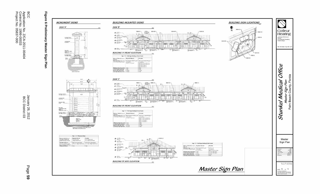
Pre
limin
ary
Maste
r Sig
n P
lan
MONUM£NTSIGNS 801LDING MOUNTED SIGNS
SIGN:.!' SIGN '8'
SIGNV'
BUILDING '8' FRONT ELEVATION
ReferIOTabJeS.G.2.A-7 MulmnmDumberper AII_Lalll.naRoa<! prnJeetfrontB!I""UiSTle. A21_H~RanchRoad
M .. imumSign ....
~~~df:;";': lin:~t~ It
~ ::::... ~I 0- J;tj
BUILDING '8' SIDE ELEVATION
RoquirodlAllowed
~~i~,~!-S;gn C328.75 (2.5X6) NiANo otlte, sign, NIANoothersiom'
801LDING SIGN LOCATIONS N
SIGNA
Master Sign Plan
~ Cotleur Hearing Landscape Architecture Planning ErTYironmenlalConsulting Graphic Design
561-747-6336 Fax-747-1377
~
~ ~ til
"0
"'" ~ "§
,~ u:::
~ ~ ~ C
~ .~ 5 ~() ~ .c ~ ~
~ ~~ E
~ ro a..
.a ~
Master Sign Plan
DESIGNED "G" m"", JGH/NB
APPROVED "" JOB NUMBER 10-1002 illiTE ~ REVISIONS 05_13-11
W~;":f~g 201'~To~~ ·J,.~;G
SHEET 1 " 1 .-"""~'"""'
",,-..
BC
C
January
26
, 20
12
Pa
ge
60
App
licatio
n N
o. Z
/CA
-201
1-0
040
4
BC
C D
istric
t 03
Contro
l No
. 19
99-0
003
3
Pro
ject N
o. 0
58
37-0
00
F
igu
re 7
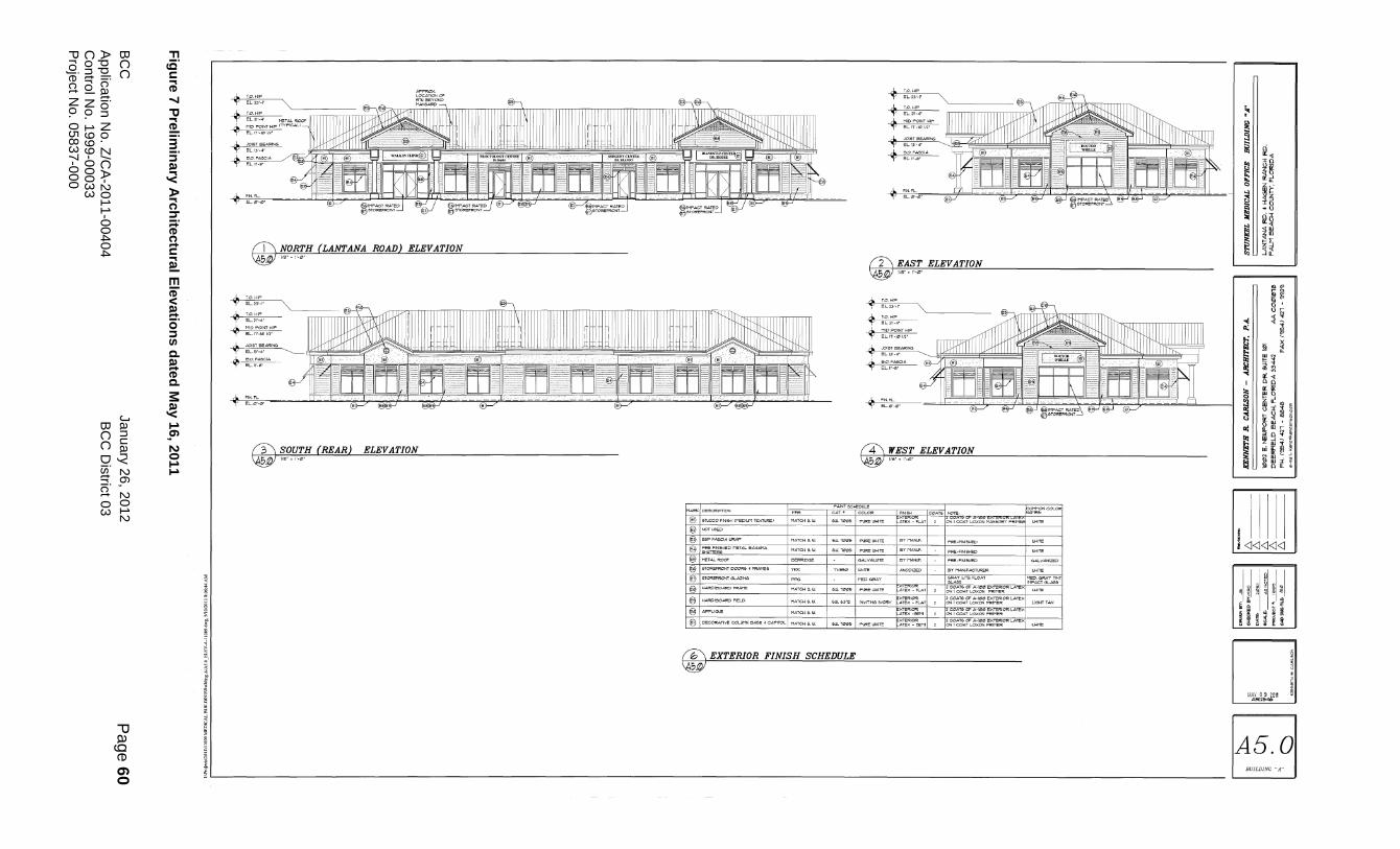
Pre
limin
ary
Arc
hite
ctu
ral E
lev
atio
ns d
ate
d M
ay 1
6, 2
01
1
~ ; ~
~
i I
I ; ~ Z §
rT\ NORTH (Lil.NTANA ROAD) ELEVATION ~1IS •• ".".
A. ToO. HIP
't' EL.~3'_I· "'~__ ~ fTTI'FCmTTTmTITlmTITlTTTTTTTTTTiT-nt' rTTTTTlTITmTTTTTTTTTTTTTTTTTTmTTllCTTTTTlTITTTTTTTTTTnTTK"'"
~ :~~~:, I " I " I ~"" rf1lJlft1! 11111111111111111111111111111111 N 1111111111111111111111111111111111111111111111IIIIIIIIIIIIIffftffinhll I " " I " I " I I " " "
~ :&~,:::ARI~ ~
~ ~'II~'A
A. y
(3\ SOUTH (REAR) ELEVATION ~'/eI':I"'"
® Ie-TIJCCO 1'1N161-1 CMEPIUM Tl:XnIFi!E)
® ® €3l1~FIN[5IoIEPMET.o!.Le_A
@ @1&TOREf'AcNTD0CII'54~
@l1&TO~TG!..AZING
@IHAF!PI~AAD~E
fj 1I-IAI¢'IBOAJOID FIELD
® @ I o:coruT'VI! COLIJ'1N eAae • CAI"11"OL I MATCI-I 6. Ul
fb\ EXTERIOR FINISH SCHEDULE
~
r2\ EAST ELEVATION ~1Ie'."-'"
f4\ WEST ELEVATION ~'IS'."'!Zl'
GlUT LI'fI;. FLOAT
I---'"'MMON COLOI """",
aLAee liMI"ACTGl-A5e
INVITIN:roIVOR'r ~1~lAT IORIOI'!
ATIP< -eet11
~=RIOR LATEX - eEHl
2 C:OATElC!f' A-IIHI EXTERIOR LAU!X QN I COAT LOXCN FRff"ER
1!2 COATS a< A-JeIeI EXlERI~ lATEX 2 ON 1 COAT LO><ON PFlt11OFi.
12 COA'T'& c:I= A-JeIeI EXIEFlioJi<: LATix 2 ON I COAT LOXCN!"RIMER
I~ COAT& Cf' A_JeIeI ~II!!IOI'!: LATEX 2 ON I COAT LOXGN I""I't/MEl'ii
~~I--------------------------------------------------------------------------------------------------____________________________________________________ _
~
~ ~ ,
~'" ~ (\~ t: jjf Q zi ~ h a .u
~~ ~ ~iIl ~ >-1:
til ~~
.... ~~
8~ .. :I::: 0; ..
1Il I § ~ ~ q iil " Ii", I nn
it; H '" >---1
~ ~:i~ t; ~ll~ III ill ~
n'" ~ 'l'ul,<
~~~ I:i ~IH
I!~~~~ I ~I ~I §I !I ~I ~l Ii • • ;
II n n
Mi~~UOII
A5.0 BUILDING "A"

BCC January 26, 2012 Page 61 Application No. Z/CA-2011-00404 BCC District 03 Control No. 1999-00033 Project No. 05837-000
STAFF REVIEW AND ANALYSIS PLANNING DIVISION COMMENTS: PLANNING COMMENTS FUTURE LAND USE (FLU) PLAN DESIGNATION: Low Residential 3 units per acre (LR-3). PROPOSED FUTURE LAND USE (FLU) PLAN DESIGNATION: Commercial Low-Office (CL-O) TIER: The subject site is in the Urban/Suburban Tier. FUTURE ANNEXATION AREAS: The site is located within the future annexation area of the Town of Lantana. INTERGOVERNMENTAL COORDINATION: The site is not within one mile of a municipality. CONSISTENCY WITH FUTURE LAND USE (FLU) PLAN DESIGNATION: The Planning Division has reviewed the request to allow a rezoning from the Residential Transitional Suburban (RTS) Zoning District to the Commercial Low Office (CLO) Zoning District, and for a Class A Conditional use request to allow Medical and Dental offices. This 2.09 acre site is currently the subject of a proposed Small Scale Future Land Use Atlas amendment known Stunkel Medical Office (SCA 2011-001) to change the FLU designation from Low Residential, 3 unit per acre (LR-3) to Commercial Low-Office (CL-O). Staff is recommending denial of the proposed FLUA amendment based on the following conclusion in the FLUA amendment staff report: “ the proposed amendment from Low Residential 3 to Commercial Low-Office does not violate any facility or service standards and the future land use designation proposed is compatible with the surrounding future land use designations. However, the applicant has not provided an adequate justification for the proposed amendment and is therefore inconsistent with Policy 2.1-f.” The proposed FLUA amendment was heard by the Planning Commission at the July 8, 2011 Local Planning Agency (LPA) public hearing. The Planning Commission voted to recommend denial in an 11-1 vote. The Planning Commission discussed the importance of preserving the existing low density residential lifestyle and character of the area, both within subdivision and to the north along Colbright and Fearnley Roads. The Commission discussed the availability of other commercial designations within the area vs. the potential encroachment, compatibility issues, and isolated nature of commercial on the subject site that could have the potential for future commercialization on adjacent parcels (i.e. domino effect) and represent inappropriate piece by piece planning. One person, the president of the Coalition of Boynton West Residential Associations (COBWRA), spoke in support of the proposed amendment and six people spoke in opposition, including four residents on Pine Needle Lane and the president and vice president of Serene Estates (aka Lexington Estates). The opposing residents raised concerns regarding the potential negative impacts on home values and the area's agricultural residential lifestyle, increased traffic, and raised safety concerns regarding access to the site, access to Pine Needle Lane and with regards to the many children that walk to the neighboring elementary school. The residents cited the locations and amount of various existing vacant commercial buildings in the area. The residents also objected to COBWRA's support of the amendment and stated that their subdivision and Serene Estates are not part of COBWRA. The speakers submitted several letters at the hearing (see exhibits). Contingent upon BCC adoption of the proposed FLUA amendment, the requested rezoning from the RTS Zoning District to the CLO Zoning District for the development of medical and dental, and professional offices would be consistent with the proposed CL-O FLU designation. Contingent upon BCC adoption of the proposed FLUA amendment, the request would also be consistent with the maximum Floor Area Ratio (FAR) of .35 for a site with a CL-O FLU designation. For this 2.09 acre site, the site could develop with a maximum of 31,864 square feet at the .35 FAR. The applicant has requested a FAR of approximately .15 or 13,780 square feet for this site.
BCC January 26, 2012 Page 62 Application No. Z/CA-2011-00404 BCC District 03 Control No. 1999-00033 Project No. 05837-000
SPECIAL OVERLAY DISTRICT/NEIGHBORHOOD PLAN/PLANNING STUDY AREA: The subject site is not within a special overlay, neighborhood plan, or study area. FINDINGS: Contingent upon BCC adoption of the proposed Small Scale FLUA amendment, the requested rezoning from RTS to CLO for the development of medical and dental, and professional office would be consistent with the CL-O FLU designation of the Palm Beach County Comprehensive Plan.
ENGINEERING COMMENTS: REQUIRED ENGINEERING RELATED PERMITS The property owner shall obtain an onsite Drainage Permit from the Palm Beach County Engineering Department, Permit Section, prior to the application of a Building Permit. The property owner shall obtain a Turnout Permit from the Palm Beach County Engineering Department, Permit Section, for access onto Hagen Ranch Road and Lantana Road. TRAFFIC IMPACTS Petitioner has estimated the build-out of the project to be December 31, 2015. Total net new traffic expected from this project is 455 trips per day, 45 trips in the PM peak hour. Additional traffic is subject to review for compliance with the Traffic Performance Standard. There are no improvements to the roadway system required for compliance with the Traffic Performance Standards. ADJACENT ROADWAY LEVEL OF SERVICE (PM PEAK directional - WB) Segment: Lantana Road from Hagen Ranch Road to Lyons Road Existing count: 1118 Background growth: 394 Project Trips: 10 Total Traffic: 1522 Present laneage: 4LD LOS “D” capacity: 1770 Projected level of service: D
PALM BEACH COUNTY HEALTH DEPARTMENT: No Staff Review Analysis
ENVIRONMENTAL RESOURCE MANAGEMENT COMMENTS: VEGETATION PROTECTION: The property supports scattered slash pine trees which will be incorporated into the site plan or mitigated on the site. WELLFIELD PROTECTION ZONE: The property is not located within a Wellfield Protection Zone. IRRIGATION CONSERVATION CONCERNS AND SURFACE WATER: All new installations of automatic irrigation systems shall be equipped with a water sensing device that will automatically discontinue irrigation during periods of rainfall pursuant to the Water and Irrigation Conservation Ordinance No. 93-3. Any non stormwater discharge or the maintenance or use of a connection that results in a non stormwater discharge to the stormwater system is prohibited pursuant to Palm Beach County Stormwater Pollution Prevention Ordinance No. 93-15. ENVIRONMENTAL IMPACTS: There are no significant environmental issues associated with this petition beyond compliance with ULDC requirements.
BCC January 26, 2012 Page 63 Application No. Z/CA-2011-00404 BCC District 03 Control No. 1999-00033 Project No. 05837-000
OTHER: FIRE PROTECTION: The Palm Beach County Department of Fire Rescue will provide fire protection. SCHOOL IMPACTS: No comment PARKS AND RECREATION: No comment CONCURRENCY: Concurrency is approved for 13,780 square feet of medical office uses. WATER/SEWER PROVIDER: Palm Beach County Water Utilities (PBCWU) FINDING: The proposed Zoning Map Amendment complies with Article 2.F of the ULDC, Concurrency (Adequate Public Facility Standards).
BCC January 26, 2012 Page 64 Application No. Z/CA-2011-00404 BCC District 03 Control No. 1999-00033 Project No. 05837-000
CONDITIONS OF APPROVAL
EXHIBIT C-1 Official Zoning Map Amendment ALL PETITIONS 1. Development of the site is limited to the use of a Medical or Dental Office Facility approved by the Board of County Commissioners. The approved Preliminary Site Plan is dated May 16, 2011. All modifications to the Development Order must be approved by the Board of County Commissioners or Zoning Commission, unless the proposed changes are required to meet Conditions of Approval. (DRO: ZONING - Zoning) ARCHITECTURAL REVIEW 1. The maximum height for all structures including air conditioning, mechanical equipment and satellite dishes shall not exceed twenty-five (25) feet. Heights shall be measured from finished grade to highest point. (DRO: ARCH REVIEW - Zoning) ENGINEERING 1. In order to comply with the mandatory Traffic Performance Standards, the Property owner shall be restricted to the following phasing schedule: a. No Building Permits for the site may be issued after December 31, 2015. A time extension for this condition may be approved by the County Engineer based upon an approved Traffic Study which complies with Mandatory Traffic Performance Standards in place at the time of the request. This extension request shall be made pursuant to the requirements of Art. 2.E of the Unified Land Development Code. (DATE: MONITORING-Eng) 2. The property owner shall provide to the Palm Beach County Land Development Division a road right of way deed and all associated documents as required by the County Engineer for right of way for the expanded intersection at Lantana Road and Hagen Ranch Road, including the corner clip. All right of way deed(s) and associated documents shall be provided and approved prior to the issuance of the first building permit or within ninety (90) days of a request by the County Engineer, whichever shall occur first. Right of way conveyance shall be along the entire frontage and shall be free and clear of all encroachments and encumbrances. Property owner shall provide Palm Beach County with sufficient documentation acceptable to the Right of Way Acquisition Section to ensure that the property is free of all encumbrances and encroachments, including a topographic survey. The Grantor must further warrant that the property being conveyed to Palm Beach County meets all appropriate and applicable environmental agency requirements. In the event of a determination of contamination which requires remediation or clean up on the property now owned by the Grantor, the Grantor agrees to hold the County harmless and shall be responsible for all costs of such clean up, including but not limited to, all applicable permit fees, engineering or other expert witness fees including attorney's fees as well as the actual cost of the clean up. Thoroughfare Plan Road right of way conveyances shall be consistent with Palm Beach County's Thoroughfare Right of Way Identification Map, as determined by the County Engineer. The Property Owner shall not record these required deeds or related documents. Palm Beach County will prepare a tax pro-ration. A check, made payable to the Tax Collector's Office, shall be submitted by the property owner for the pro-rated taxes. After final acceptance, Palm Beach County shall record all appropriate deeds and documents. (BLDG PERMIT/ONGOING: MONITORING-Eng) 3. Prior to issuance of the first building permit the property owner shall combine the property into a single lot of record in accordance with provisions of Article 11 of the Unified Land Development Code. (BLDG PERMIT: MONITORING-Eng)

BCC January 26, 2012 Page 65 Application No. Z/CA-2011-00404 BCC District 03 Control No. 1999-00033 Project No. 05837-000
4. The property owner shall provide an acceptable drainage study identifying any historical drainage from offsite parcels, including proposed grading cross sections. The project's stormwater management system shall be designed to address any historical drainage. The property owner shall provide drainage easements, as required, to accommodate offsite drainage. a. Drainage study shall be provided the Land Development Division prior to final approval of the Site Plan by the DRO. (DRO: ENGINEERING-Eng) b. Any required drainage easements shall be dedicated in conjunction with any required lot combination or recorded prior to issuance of the first building permit, whichever shall occur first. (PLAT/BLDG PERMIT: MONITORING-Eng) 5. Prior to the issuance of the first building permit, the property owner shall provide a joint-access easement over the proposed driveway connection to Lantana . This access easement shall extend from the west property line to Lantana Road and shall contain an area as necessary to accommodate access to/from the parcels to the west and south, as determined by the County Engineer. After approval by the County Engineer and County Attorney, the property owner shall record these required easements or related documents in the public records. (BLDG PERMIT: MONITORING-Eng) 6. The Property Owner shall extend the west approach right turn lane on Lantana Road at Hagen Ranch Road to the west property line or as approved by the County Engineer. This construction shall be concurrent with the paving and drainage improvements for the site. Any and all costs associated with the construction shall be paid by the property owner. These costs shall include, but are not limited to, utility relocations and acquisition of any additional required right-of-way. a. Permits required from Palm Beach County for this construction shall be obtained prior to the issuance of the first building permit. (BLDG PERMIT: MONITORING-Eng) b. Construction shall be completed prior to the issuance of the first Certificate of Occupancy. (CO: MONITORING-Eng) 7. The Property Owner shall design, install and perpetually maintain median landscape within the median of all abutting right of way of Lantana Road. This landscaping and irrigation shall strictly conform to the specifications and standards for the County's Only Trees, Irrigation, and Sod (OTIS) program. Additional landscaping beyond OTIS requires Board of County Commissioner's approval. Median landscaping installed by Property Owner shall be perpetually maintained by the Property Owner, his successors and assigns, without recourse to Palm Beach County, unless the Property Owner provides payment for maintenance as set forth in Paragraph c and d below. a. The necessary permit(s) for this landscaping and irrigation shall be applied for from Palm Beach County Land Development prior to the issuance of the first building permit. (BLDG PERMIT: MONITORING-Eng) b. All installation of the landscaping and irrigation shall be completed prior to the issuance of the first certificate of occupancy. (CO: MONITORING -Eng) c. At property owner's option, when and if the County is ready to install OTIS on the surrounding medians of this roadway adjacent to the Property Owner installed landscaping, payment for the maintenance may be provided to the County. The payment shall be in the amount and manner that complies with the schedule for such payments that exists on the date payment is made. Once payment has been provided, Palm Beach County shall assume the maintenance responsibility for the OTIS landscaping and irrigation that has been installed by the Property Owner. The Property Owner shall first be required to correct any deficiencies in the landscaping and irrigation. This option is not available to medians with additional landscaping beyond OTIS standards, unless those medians are first brought into conformance with OTIS standards by the Property Owner. (ONGOING: ENGINEERING-Eng)
BCC January 26, 2012 Page 66 Application No. Z/CA-2011-00404 BCC District 03 Control No. 1999-00033 Project No. 05837-000
d. Alternately, at the option of the Property Owner or if the construction of the required landscape and irrigation is not possible due to physical constraints, the Property Owner may make a contribution to the County's Only Trees Irrigation and Sod, OTIS program, unincorporated thoroughfare beautification program prior to the issuance of the first Building Permit. This payment option is only available if the roadway segment is included in the County's current OTIS Master Plan and shall be based on the project's front footage along Lantana Road. This payment shall be in the amount and manner that complies with the schedule for such payments as it currently exists or as it may from time to time be amended. (BLDG PERMIT: MONITORING -Eng) LANDSCAPE - GENERAL 1. At time of submittal for final approval by the Development Review Officer, the property owner shall submit a Landscape Plan or an Alternative Landscape Plan to the Landscape Section for review and approval. The Plan(s) shall be prepared in compliance with all landscape related Conditions of Approval as contained herein. (DRO: LANDSCAPE - Zoning) 2. All canopy trees along the buffers shall meet the following standards: a. A minimum of sixty (60) percent of the canopy trees shall be fourteen (14) foot in height and twenty (20) percent shall be eighteen (18) feet. (DRO:LANDSCAPE-Zoning) LANDSCAPE - PERIMETER 3. LANDSCAPING ALONG THE NORTH AND EAST PROPERTY LINES (FRONTAGE OF LANTANA ROAD AND HAGEN RANCH ROAD) In addition to the Code requirements, landscaping and buffering along the north and east property lines shall be upgraded to include: a. Buffer width for Hagen Ranch Road shall be a minimum of twenty (20) feet. A maximum of five (5) foot easement encroachment may be permitted; b. One (1) additional native palm or pine for each thirty (30) linear feet of the property line; and, c. Additional palms or pines shall be planted in clusters of three (3) with a maximum spacing of forty (40) feet between clusters. (DRO:LANDSCAPE-Zoning) 4. LANDSCAPING ALONG THE SOUTH AND WEST PROPERTY LINES (ABUTTING RESIDENTIAL) In addition to the Code requirements, landscaping and buffering along the south and west property lines shall be upgraded to include the following: a. One (1) additional pine for each twenty (20) linear feet of the property line. Pines shall be planted in clusters of five (5) with a maximum spacing of forty (40) feet between cluster; and, b. Large shrubs shall be Saw Palmetto, and Medium shrubs shall be Coco-plum. (DRO:LANDSCAPE-Zoning) SIGNS 1. Ground mounted freestanding signs fronting on Lantana Road and Hagen Ranch Road shall be limited as follows: a. maximum sign height, measured from finished grade to highest point - eight (8) feet; b. maximum sign face area per side - fifty (50) square feet; c. maximum number of signs - one (1); d. style - monument style only. (BLDG PERMIT: BLDG - Zoning) SITE DESIGN 1. The minimum setback for all principal buildings and/or accessory structures shall be fifty (50) feet from the south and west property lines. (DRO: ZONING - Zoning) USE LIMITATIONS 1. Business activities, including deliveries and stocking, shall not commence prior to 7:00 a.m. nor continue business activities later than 9:00 p.m. daily, and shall be limited to Monday through Friday only. (ONGOING: CODE ENF - Zoning) 2. Total gross floor area shall be limited to a maximum of 12,550 Square Feet or 6,250 Square Feet per structure. No further expansion is permitted except subject to Board of County Commissioner (BCC) approval. (ONGOING: ZONING - Zoning)
BCC January 26, 2012 Page 67 Application No. Z/CA-2011-00404 BCC District 03 Control No. 1999-00033 Project No. 05837-000
COMPLIANCE 1. In granting this approval, the Board of County Commissioners relied upon the oral and written representations of the property owner/applicant both on the record and as part of the application process. Deviations from or violation of these representations shall cause the approval to be presented to the Board of County Commissioners for review under the compliance condition of this approval. (ONGOING: MONITORING - Zoning) 2. Failure to comply with any of the conditions of approval for the subject property at any time may result in: a. The issuance of a stop work order; the issuance of a cease and desist order; the denial or revocation of a building permit; the denial or revocation of a Certificate of Occupancy (CO); the denial of any other permit, license or approval to any developer, owner, lessee, or user of the subject property; the revocation of any other permit, license or approval from any developer, owner, lessee, or user of the subject property; revocation of any concurrency; and/or b. The revocation of the Official Map Amendment, Conditional Use, Requested Use, Development Order Amendment, and/or any other zoning approval; and/or c. A requirement of the development to conform with the standards of the Unified Land Development Code (ULDC) at the time of the finding of non-compliance, or the addition or modification of conditions reasonably related to the failure to comply with existing conditions; and/or d. Referral to code enforcement; and/or e. Imposition of entitlement density or intensity. Staff may be directed by the Executive Director of PZ&B or the Code Enforcement Special Master to schedule a Status Report before the body which approved the Official Zoning Map Amendment, Conditional Use, Requested Use, Development Order Amendment, and/or other zoning approval, in accordance with the provisions of Section 2.E of the ULDC, in response to any flagrant violation and/or continued violation of any condition of approval. (ONGOING: MONITORING - Zoning)

BCC January 26, 2012 Page 68 Application No. Z/CA-2011-00404 BCC District 03 Control No. 1999-00033 Project No. 05837-000
EXHIBIT C-2- Zoning Commission Recommendation (Difference in Hours of Operation on Saturday & Increase Setbacks only for South Property Line.) Official Zoning Map Amendment ALL PETITIONS 1. Development of the site is limited to the use of a Medical or Dental Office Facility approved by the Board of County Commissioners. The approved Preliminary Site Plan is dated May 16, 2011. All modifications to the Development Order must be approved by the Board of County Commissioners or Zoning Commission, unless the proposed changes are required to meet Conditions of Approval. (DRO: ZONING - Zoning) ARCHITECTURAL REVIEW 1. The maximum height for all structures including air conditioning, mechanical equipment and satellite dishes shall not exceed twenty-five (25) feet. Heights shall be measured from finished grade to highest point. (DRO: ARCH REVIEW - Zoning) ENGINEERING 1. In order to comply with the mandatory Traffic Performance Standards, the Property owner shall be restricted to the following phasing schedule: a. No Building Permits for the site may be issued after December 31, 2015. A time extension for this condition may be approved by the County Engineer based upon an approved Traffic Study which complies with Mandatory Traffic Performance Standards in place at the time of the request. This extension request shall be made pursuant to the requirements of Art. 2.E of the Unified Land Development Code. (DATE: MONITORING-Eng) 2. The property owner shall provide to the Palm Beach County Land Development Division a road right of way deed and all associated documents as required by the County Engineer for right of way for the expanded intersection at Lantana Road and Hagen Ranch Road, including the corner clip. All right of way deed(s) and associated documents shall be provided and approved prior to the issuance of the first building permit or within ninety (90) days of a request by the County Engineer, whichever shall occur first. Right of way conveyance shall be along the entire frontage and shall be free and clear of all encroachments and encumbrances. Property owner shall provide Palm Beach County with sufficient documentation acceptable to the Right of Way Acquisition Section to ensure that the property is free of all encumbrances and encroachments, including a topographic survey. The Grantor must further warrant that the property being conveyed to Palm Beach County meets all appropriate and applicable environmental agency requirements. In the event of a determination of contamination which requires remediation or clean up on the property now owned by the Grantor, the Grantor agrees to hold the County harmless and shall be responsible for all costs of such clean up, including but not limited to, all applicable permit fees, engineering or other expert witness fees including attorney's fees as well as the actual cost of the clean up. Thoroughfare Plan Road right of way conveyances shall be consistent with Palm Beach County's Thoroughfare Right of Way Identification Map, as determined by the County Engineer. The Property Owner shall not record these required deeds or related documents. Palm Beach County will prepare a tax pro-ration. A check, made payable to the Tax Collector's Office, shall be submitted by the property owner for the pro-rated taxes. After final acceptance, Palm Beach County shall record all appropriate deeds and documents. (BLDG PERMIT/ONGOING: MONITORING-Eng) 3. Prior to issuance of the first building permit the property owner shall combine the property into a single lot of record in accordance with provisions of Article 11 of the Unified Land Development Code. (BLDG PERMIT: MONITORING-Eng)
BCC January 26, 2012 Page 69 Application No. Z/CA-2011-00404 BCC District 03 Control No. 1999-00033 Project No. 05837-000
4. The property owner shall provide an acceptable drainage study identifying any historical drainage from offsite parcels, including proposed grading cross sections. The project's stormwater management system shall be designed to address any historical drainage. The property owner shall provide drainage easements, as required, to accommodate offsite drainage. a. Drainage study shall be provided the Land Development Division prior to final approval of the Site Plan by the DRO. (DRO: ENGINEERING-Eng) b. Any required drainage easements shall be dedicated in conjunction with any required lot combination or recorded prior to issuance of the first building permit, whichever shall occur first. (PLAT/BLDG PERMIT: MONITORING-Eng) 5. Prior to the issuance of the first building permit, the property owner shall provide a joint-access easement over the proposed driveway connection to Lantana . This access easement shall extend from the west property line to Lantana Road and shall contain an area as necessary to accommodate access to/from the parcels to the west and south, as determined by the County Engineer. After approval by the County Engineer and County Attorney, the property owner shall record these required easements or related documents in the public records. (BLDG PERMIT: MONITORING-Eng) 6. The Property Owner shall extend the west approach right turn lane on Lantana Road at Hagen Ranch Road to the west property line or as approved by the County Engineer. This construction shall be concurrent with the paving and drainage improvements for the site. Any and all costs associated with the construction shall be paid by the property owner. These costs shall include, but are not limited to, utility relocations and acquisition of any additional required right-of-way. a. Permits required from Palm Beach County for this construction shall be obtained prior to the issuance of the first building permit. (BLDG PERMIT: MONITORING-Eng) b. Construction shall be completed prior to the issuance of the first Certificate of Occupancy. (CO: MONITORING-Eng) 7. The Property Owner shall design, install and perpetually maintain median landscape within the median of all abutting right of way of Lantana Road. This landscaping and irrigation shall strictly conform to the specifications and standards for the County's Only Trees, Irrigation, and Sod (OTIS) program. Additional landscaping beyond OTIS requires Board of County Commissioner's approval. Median landscaping installed by Property Owner shall be perpetually maintained by the Property Owner, his successors and assigns, without recourse to Palm Beach County, unless the Property Owner provides payment for maintenance as set forth in Paragraph c and d below. a. The necessary permit(s) for this landscaping and irrigation shall be applied for from Palm Beach County Land Development prior to the issuance of the first building permit. (BLDG PERMIT: MONITORING-Eng) b. All installation of the landscaping and irrigation shall be completed prior to the issuance of the first certificate of occupancy. (CO: MONITORING -Eng) c. At property owner's option, when and if the County is ready to install OTIS on the surrounding medians of this roadway adjacent to the Property Owner installed landscaping, payment for the maintenance may be provided to the County. The payment shall be in the amount and manner that complies with the schedule for such payments that exists on the date payment is made. Once payment has been provided, Palm Beach County shall assume the maintenance responsibility for the OTIS landscaping and irrigation that has been installed by the Property Owner. The Property Owner shall first be required to correct any deficiencies in the landscaping and irrigation. This option is not available to medians with additional landscaping beyond OTIS standards, unless those medians are first brought into conformance with OTIS standards by the Property Owner. (ONGOING: ENGINEERING-Eng) d. Alternately, at the option of the Property Owner or if the construction of the required landscape and irrigation is not possible due to physical constraints, the Property Owner may make a contribution to the County's Only Trees Irrigation and Sod, OTIS program, unincorporated thoroughfare
BCC January 26, 2012 Page 70 Application No. Z/CA-2011-00404 BCC District 03 Control No. 1999-00033 Project No. 05837-000
beautification program prior to the issuance of the first Building Permit. This payment option is only available if the roadway segment is included in the County's current OTIS Master Plan and shall be based on the project's front footage along Lantana Road. This payment shall be in the amount and manner that complies with the schedule for such payments as it currently exists or as it may from time to time be amended. (BLDG PERMIT: MONITORING -Eng) LANDSCAPE - GENERAL 1. At time of submittal for final approval by the Development Review Officer, the property owner shall submit a Landscape Plan or an Alternative Landscape Plan to the Landscape Section for review and approval. The Plan(s) shall be prepared in compliance with all landscape related Conditions of Approval as contained herein. (DRO: LANDSCAPE - Zoning) 2. At time of submittal for final approval by the Development Review Officer, the property owner shall submit a landscape plan indicating all trees, meeting the following minimum standards: a. clear trunk: staggered heights of twelve (12) to eighteen (18) feet; and, b. clusters: to be planted in groups of five (5) with a maximum spacing of forty (40) feet between clusters. (DRO: LANDSCAPE - Zoning) 3. All canopy trees along the buffers shall meet the following standards: a. A minimum of sixty (60) percent of the Canopy trees shall be fourteen (14) foot in height and the remainder shall be of staggered heights from twelve (12) feet to eighteen (18) feet. (DRO:LANDSCAPE-Zoning) LANDSCAPE - PERIMETER 4. LANDSCAPING ALONG THE NORTH AND EAST PROPERTY LINES (FRONTAGE OF LANTANA ROAD AND HAGEN RANCH ROAD) In addition to the Code requirements, landscaping and buffering along the north and east property lines shall be upgraded to include: a. Buffer width for Hagen Ranch Road shall be a minimum of twenty (20) feet. A maximum of five (5) foot easement encroachment may be permitted; b. One (1) additional native palm or pine for each thirty (30) linear feet of the property line; and, c. Additional palms or pines shall be planted in clusters of three (3) with a maximum spacing of forty (40) feet between clusters. (DRO:LANDSCAPE-Zoning) 5. LANDSCAPING ALONG THE SOUTH AND WEST PROPERTY LINES (ABUTTING RESIDENTIAL) In addition to the Code requirements, landscaping and buffering along the south and west property lines shall be upgraded to include the following: a. One (1) additional pine for each twenty (20) linear feet of the property line. Pines shall be planted in clusters of five (5) with a maximum spacing of forty (40) feet between cluster; and, b. Large shrubs shall be Saw Palmetto, and Medium shrubs shall be Coco-plum. (DRO:LANDSCAPE-Zoning) SIGNS 1. Ground mounted freestanding signs fronting on Lantana Road and Hagen Ranch Road shall be limited as follows: a. maximum sign height, measured from finished grade to highest point - eight (8) feet; b. maximum sign face area per side - fifty (50) square feet; c. maximum number of signs - one (1); d. style - monument style only. (BLDG PERMIT: BLDG - Zoning) SITE DESIGN 1. The minimum setback for all principal buildings and/or accessory structures shall be thirty five- (35) feet from the south property line. (DRO: ZONING - Zoning) USE LIMITATIONS 1. Business activities, including deliveries and stocking, shall not commence prior to 7:00 a.m. nor continue business activities later than 9:00 p.m. daily, and shall be limited to Monday through Friday only and 9:00 a.m. to 5 p.m. on Saturdays. (ONGOING: CODE ENF - Zoning)
BCC January 26, 2012 Page 71 Application No. Z/CA-2011-00404 BCC District 03 Control No. 1999-00033 Project No. 05837-000
2. Total gross floor area shall be limited to a maximum of 12,550 Square Feet or 6,250 Square Feet per structure. No further expansion is permitted except subject to Board of County Commissioner (BCC) approval. (ONGOING: ZONING - Zoning) COMPLIANCE 1. In granting this approval, the Board of County Commissioners relied upon the oral and written representations of the property owner/applicant both on the record and as part of the application process. Deviations from or violation of these representations shall cause the approval to be presented to the Board of County Commissioners for review under the compliance condition of this approval. (ONGOING: MONITORING - Zoning) 2. Failure to comply with any of the conditions of approval for the subject property at any time may result in: a. The issuance of a stop work order; the issuance of a cease and desist order; the denial or revocation of a building permit; the denial or revocation of a Certificate of Occupancy (CO); the denial of any other permit, license or approval to any developer, owner, lessee, or user of the subject property; the revocation of any other permit, license or approval from any developer, owner, lessee, or user of the subject property; revocation of any concurrency; and/or b. The revocation of the Official Map Amendment, Conditional Use, Requested Use, Development Order Amendment, and/or any other zoning approval; and/or c. A requirement of the development to conform with the standards of the Unified Land Development Code (ULDC) at the time of the finding of non-compliance, or the addition or modification of conditions reasonably related to the failure to comply with existing conditions; and/or d. Referral to code enforcement; and/or e. Imposition of entitlement density or intensity. Staff may be directed by the Executive Director of PZ&B or the Code Enforcement Special Master to schedule a Status Report before the body which approved the Official Zoning Map Amendment, Conditional Use, Requested Use, Development Order Amendment, and/or other zoning approval, in accordance with the provisions of Section 2.E of the ULDC, in response to any flagrant violation and/or continued violation of any condition of approval. (ONGOING: MONITORING - Zoning)
BCC January 26, 2012 Page 72 Application No. Z/CA-2011-00404 BCC District 03 Control No. 1999-00033 Project No. 05837-000
EXHIBIT C-3 Conditional Use Class A ALL PETITIONS 1. Development of the site is limited to the use of a Medical or Dental Office Facility approved by the Board of County Commissioners. The approved Preliminary Site Plan is dated May 16, 2011. All modifications to the Development Order must be approved by the Board of County Commissioners or Zoning Commission, unless the proposed changes are required to meet Conditions of Approval. (DRO: ZONING - Zoning) ARCHITECTURAL REVIEW 1. At time of submittal for final approval by the Development Review Officer (DRO), the architectural elevations for the medical offices shall be submitted for final architectural review and approval. Elevations shall comply with the standards indicated in Article 5.C of the Unified Land Development Code (ULDC) and shall be designed to be generally consistent with the facade elevations prepared by Kenneth Carlson - Architect, P.A. and dated May 16, 2011. Development shall be consistent with the approved architectural elevations, the DRO approved site plan, all applicable conditions of approval, and all ULDC requirements. (DRO: ARCH REVIEW - Zoning) COMPLIANCE 1. In granting this approval, the Board of County Commissioners relied upon the oral and written representations of the property owner/applicant both on the record and as part of the application process. Deviations from or violation of these representations shall cause the approval to be presented to the Board of County Commissioners for review under the compliance condition of this approval. (ONGOING: MONITORING - Zoning) 2. Failure to comply with any of the conditions of approval for the subject property at any time may result in: a. The issuance of a stop work order; the issuance of a cease and desist order; the denial or revocation of a building permit; the denial or revocation of a Certificate of Occupancy (CO); the denial of any other permit, license or approval to any developer, owner, lessee, or user of the subject property; the revocation of any other permit, license or approval from any developer, owner, lessee, or user of the subject property; revocation of any concurrency; and/or b. The revocation of the Official Map Amendment, Conditional Use, Requested Use, Development Order Amendment, and/or any other zoning approval; and/or c. A requirement of the development to conform with the standards of the Unified Land Development Code (ULDC) at the time of the finding of non-compliance, or the addition or modification of conditions reasonably related to the failure to comply with existing conditions; and/or d. Referral to code enforcement; and/or e. Imposition of entitlement density or intensity. Staff may be directed by the Executive Director of PZ&B or the Code Enforcement Special Master to schedule a Status Report before the body which approved the Official Zoning Map Amendment, Conditional Use, Requested Use, Development Order Amendment, and/or other zoning approval, in accordance with the provisions of Section 2.E of the ULDC, in response to any flagrant violation and/or continued violation of any condition of approval. (ONGOING: MONITORING - Zoning)
BCC January 26, 2012 Page 73 Application No. Z/CA-2011-00404 BCC District 03 Control No. 1999-00033 Project No. 05837-000
Exhibit D Disclosure Forms
PALM BEACH COUNTY - ZONING DIVISION FORM#-.ruL
DISCLOSURE OF OWNERSHIP INTERESTS - PROPERTY
TO: PALM BEACH COUNTY PLANNING, ZONING AND BUILDING EXECUTIVE
DIRECTOR, OR HIS OR HER OFFICIALLY DESIGNATED REPRESENTATIVE
STATE OF FLORIDA
COUNTY OF PALM BEACH
o BEFORE ME, the undersigned authority, this day personally appeared
-4= 06 ell-"f V· St r.J I-' kJ , hereinafter referred to as "Affiant," who
being by me first duly sworn, under oath, deposes and states as follows:
1. Afliantls the [ J;ndividuaJ or [l 111 iI"'''~ Ae ... L. ... {position-
e.g., president, partner, trustee] of A"S. .H..It-5.<'Mv 'eb./ifname and type of
entity-e.g., ABC Corporation,· XYZ Limited Partnership] that holds an ownership
interest in real property legally described on the attached Exhibit "A" (the "Property").
The Property is the subject of an application for Comprehensive Plan amendment or
Development Order approval with Palm Beach County.
2. Affii:ft's address is:
v'/II~
3. Attached hereto as Exhibit "B" is a complete listing of the names and
addresses of every person or entity having a five percent or greater interest in the
Property. Disclosure does not apply to an individual's or entity's interest in any entity
registered with the Federal Securities Exchange Commission or registered pursuant to
Chapter 517, Florida Statutes, whose interest is for sale to the general public.
4. Affiant acknowledges that this Affidavit is given to comply with Palm
Beach County policy, and will be relied upon by Palm Beach County in its review of
application for Comprehensive Plan amendment or Development Order approval
affecting the Property. Affiant further acknowledges that he or she is authorized to
execute this Disclosure of Ownership Interests on behalf of any and all individuals or
entities holding a five percent or greater interest in the Property.
5. Affiant further acknowledges that he or she shall by affidavit amend this
disclosure to reflect any changes to ownership interests in the Property that may occur
before the date of final public hearing on the application for Comprehensive Plan
amendment or Development Order approval.
Disclosure of Beneficial Interest Ownership form Created 01/22/2007 Updated 01/31/2007
BCC January 26, 2012 Page 74 Application No. Z/CA-2011-00404 BCC District 03 Control No. 1999-00033 Project No. 05837-000
PALM BEACH COUNTY - ZONING DIVISION FORM#~
6. Affiant further states that Affiant is familiar with the nature of an oath and
with the penalties provided by the laws of the State of Florida for falsely swearing to
statements under oath.
7. Under penalty of perjury, Affiant declares that Affiant has examined this
Affidavit and to the best of Affiant's knowledge and belief it is true, correct, and
complete.
FURTHER AFFIANT SAYETH NAUGHT.
~~ffiam (Print Affiant Name)
The foregoing instrument was acknowledged before me thid!l day of JANU'Y'4 ' 20_1\_, by :B 0 b.u--+ " S-fu., \(QJ . .. ,[ J who is persoriat/y
knowf! to me or [...(who has produced ---=.n.....:...==--..!:D~L'--__________ _
as identification and who did take an oath.
Disclosure of Beneficial Interest Ownership form
t;~s§v~ Na;yPU!?
t1ftt'U:.~~~N..S (Print Notary Name)
NOTARY PUBLIC State of Florida at Large L J My Commission Expires: 7 2.: 2.011
Created 01/22/2007 Updated 01/31/2007
BCC January 26, 2012 Page 75 Application No. Z/CA-2011-00404 BCC District 03 Control No. 1999-00033 Project No. 05837-000
PALM BEACH COUNTY - ZONING DIVISION FORM # -.illL
EXHIBIT "A"
A PARCEL OF LAND LYING IN TRACT 40 OF SUBDIVISION OF THE HIATUS BETWEEN TOWNSHIP 44 SOUTH AND TOWNSHIP 45 SOUTH, RANGE 42 EAST, PALM BEACH COUNTY, FLORIDA, SAID PARCEL BEING MORE PARTICULARLY DESCRIBED AS FOLLOWS:
COMMENCING ATTHE NORTHWEST CORNER OF THE EAST HALF (E1/2) OF LOT 2 OF SAID TRACT 40; THENCE SOUTH 88°08'56" EAST ALONG THE NORTH LINE OF SAID TRACT 40, BEING ALSO THE CENTERLINE OF STATE ROAD S-812, A DISTANCE OF 1135.0 FEET; THENCE SOUTH 23°18'35" EAST, A DISTANCE OF 44.19 FEETTO AN INTERSECTION WITH THE SOUTH RIGHT-OF-WAY LINE OF SAID STATE ROAD S-812 AND THE POINT OF BEGINNING; THENCE CONTINUE SOUTH 23°18'35" EAST, A DISTANCE OF 376.43 FEET; THENCE SOUTH89°43'11" WEST, PARALLEL WITH THE SOUTH LINE OF SAID TRACT 40, A DISTANCE OF 283.86 FEET; THENCE NORTH 22°52'52" WEST, A DISTANCE OF 386.75 FEET TO AN INTERSECTION WITH THE SAID SOUTH RIGHT-OF-WAY LINE OF STATE ROAD S-812; THENCE SOUTH 88°08'56" EAST ALONG SAID SOUTH RIGHT-OF-WAY LINE, A DISTANCE OF 285.36 FEET TO THE POINT OF BEGINNING.
SUBJECT TO AN EASEMENT FOR ROAD AND UTILITIES PURPOSES OVER THE WEST 25 FEET THEREOF, AS MEASURED AT RIGHT ANGLES.
LESS AND EXCEPT THE FOLLOWING: BEING A PORTION OF LAND FOR ADDITIONAL RIGHT-OF-WAY PURPOSES FOR HAGEN RANCH ROAD (OFFICIAL RECORDS BOOK 5298, PAGE 738) IN THE HIATUS OF TOWNSHIP 44-1/2 SOUTH, RANGE 42 EAST, PALM BEACH COUNTY FLORIDA; SAID PORTION BEING PART OF LOT I, TRACT 40 OF THE PALM BEACH FARMS COMPANY, PLAT NO. 13, AMENDMENTTO SHEET NO.4 OF PLAT 3, PALM BEACH COUNTY, FLORIDA AS RECORDED IN PLAT BOOK 6, PAGES 98 AND 99, INCLUSIVE AND BEING MORE PARTICULARLY DESCRIBED AS FOLLOWS:
COMMENCING ATTHE SOUTHEAST CORNER OF SECTION 33, TOWNSHIP 44, RANGE 42 EAST; THENCE NORTH88°32'15" WEST (BEARINGS USED FOR THIS PROJECT AND HEREIN ARE BASED ON PALM BEACH COUNTY SECTIONAL DATA, NORTH-SOUTH MIDSECTION LINE, SECTION 3-45-42, BEARING NORTH 00°47'13" WEST) ALONG THE SOUTH LINE OF SAID SECTION, A DISTANCE OF 852.45 FEET; THENCE SOUTH 01°27'45" WEST, A DISTANCE OF 67.00 FEET TO A POINT ON THE SOUTH LINE OF LANTANA ROAD AND THE POINT OF BEGINNING; THENCE SOUTH 23°41'35" EAST, A DISTANCE OF 731.37 FEET TO A POINT WHICH IS 380.31 FEET NORTHERLY OF THE SOUTH LINE OF SAID TRACT 40; THENCE SOUTH 89°19'28" WEST ALONG A LINE WHICH IS PARALLEL WITH THE SOUTH LINE OF SAID TRACT 40, A DISTANCE OF 1.17 FEET; THENCE NORTH 23°51'21" WEST, A DISTANCE OF 732.39 FEET TO A POINT ON THE SOUTH LINE OF LANTANA ROAD; THENCE SOUTH 88°32'15" EAST ALONG SAID LINE, A DISTANCE OF 3.48 FEET TO THE POINT OF BEGINNING.
CONTAINING 1,545 SQUARE FEET, MORE OR LESS.
SUBJECT TO EXISTING EASEMENTS, RIGHTS-OF-WAY, RESTRICTIONS AND RESERVATIONS OF RECORD.
AND LESS AND EXCEPT THE FOLLOWING: BEING A PORTION OF LAND FOR ADDITIONAL RIGHT-OF-WAY PURPPOSES FOR LANTANA ROAD (C.R.812) IN TH EHIATUS PARCEL IN TOWNSHIP 44-1/2 SOUTH, RANGE 42 EAST, PALM BEACH COUNTY, FLORIDA; SAID PORTION BEING PART OF LOT I, TRACT 40 OF THE PALM BEACH FARMS COMPANY, PLAT NO. 13, AMENDMENTTO SHEET NO.4 OF PLAT 3, PALM BEACH COUNTY, FLORIDA AS RECORDEDIN PLAT BOOK 6, PAGES 98 AND 99, INCLUSIVE AND BEING MORE PARTICULARLY DESCRIBED AS FOLLOWS:
COMMENCING ATTHE SOUTHEAST CORNER OF SECTION 33, TOWNSHIP 44, RANGE 42 EAST; THENCE NORTH 88°32'15" WEST (BEARINGS USED FOR THIS PROJECT AND HEREIN ARE BASED ON PALM BEACH COUNTY SECTIONAL DATA, NORTH-SOUTH MIDSECTION LINE, SECTION 3"45-42, BEARING NORTH 00°47'13" WEST) ALONG THE SOUTH LINE OF SAID SECTION, A DISTANCE OF 865.12 FEET; THENCE SOUTH LINE OF 01 °27'45" WEST, A DISTANCE OF 40.00 FEETTO A POINT ON THE SOUTH LINE OF LANTANA ROAD AND THE POINT OF BEGINNING; THENCE SOUTH 23°41'35" EAST, A DISTANCE OF 29.83 FEET; THENCE NORTH 88°32'15" WEST, A DISTANCE OF 173.49 FEET; THENCE NORTH 84°43'24" WEST, A DISTANCE OF 115.92 FEET; THENCE NORTH 23°15'49" WEST, A DISTANCE OF 21.24 FEET TO THE SOUTH LINE OF LANTANA ROAD; THENCE SOUTH 88°32'15" EAST ALONG SAID LINE 285.36 FEET TO THE POINT OF BEGINNING.
CONTAINING 7,276 SQUARE FEET, MORE OR LESS.
Disclosure of Beneficial Interest Ownership form Created 01/22/2007 Updated 01/31/2007
BCC January 26, 2012 Page 76 Application No. Z/CA-2011-00404 BCC District 03 Control No. 1999-00033 Project No. 05837-000
PALM BEACH COUNTY - ZONING DIVISION FORM #.-.illL
EXHI81T "8"
DISCLOSURE OF OWNERSHIP INTERESTS IN APPLICANT
Affiant must identify all entities and individuals owning five percent or more ownership interest in the Property. Affiant must identify individual owners. For example, if Affiant is an officer of a corporation or partnership that is wholly or partially owned by another entity, such as a corporation, Affiant must identify the other entity, its address, and the individual owners of the other entity. Disclosure does not apply to an individual's or entity's interest in any entity registered with the Federal Securities Exchange Commission or registered pursuant to Chapter 517, Florida Statutes, whose interest is for sale to the general public.
Name Address Percentage of Interest
12o~r {. t t!;'/zAkIAA: <Sit/iliA! 60 ~ ~ GP'tv&u J2e1 tv- Yt'/!A-f#aJ6 FL-
Disclosure of Beneficial Interest Ownersilip form Created 01/22/2007 Updated 01/31/2007
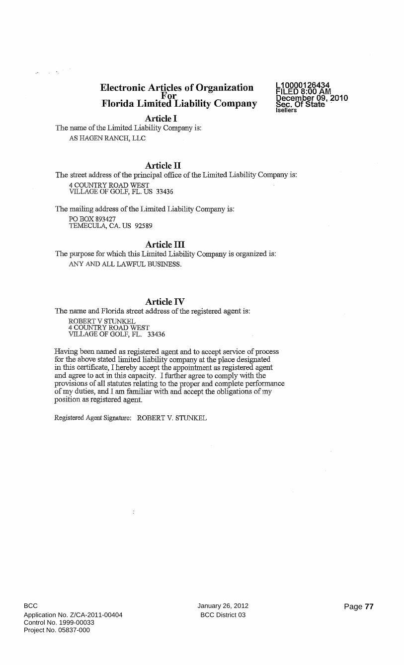
BCC January 26, 2012 Page 77 Application No. Z/CA-2011-00404 BCC District 03 Control No. 1999-00033 Project No. 05837-000
Electronic Articles of Organization For
Florida Limited Liability Company
Article I The name of the Limited Liability Company is:
AS HAGEN RANCH, LLC
Article II
L10000126434 FILED 8:00 AM December 09, 2010 Sec. Of State . Isellers
The street address of the principal office of the Limited Liability Company is: 4 COUNTRY ROAD WEST VILLAGE OF GOLF, FL. US 33436
The mailing address of the Limited Liability Company is: PO BOX 893427 TEMECULA, CA. US 92589
Article III The plU-pose for which this Limited Liability Company is organized is:
ANY AND ALL LAWFUL BUSINESS.
Article IV The name and Florida street address of the registered agent is:
ROBERT V STUNKEL 4 COUNTRY ROAD WEST VILLAGE OF GOLF, FL. 33436
Having been named as registered agent and to accept service of process for the above stated limited liability company at the place designated in this certificate, I hereby accept the appointment as registered agent and agree to act in this capacity. I further agree to comply with the provisions of all statutes relating to the proper and complete performance of my duties, and I am familiar with and accept the obligations of my position as registered agent.
Registered Agent Signature: ROBERT V. STUNKEL
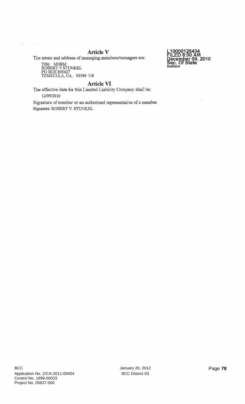
BCC January 26, 2012 Page 78 Application No. Z/CA-2011-00404 BCC District 03 Control No. 1999-00033 Project No. 05837-000
Article V The name and address of managing members/managers are:
Title: MGRM ROBERT V STUNKEL PO BOX 893427 TEMECULA, CA. 92589 US
Article VI The effective date for this Limited Liability Company shall be:
12/09/2010
Signature of member or an authorized representative of a member Signature: ROBERT V. STUNKEL
L10000126434 FILED 8:00 AM December 09, 2010 Sec. Of State Isellers

BCC January 26, 2012 Page 79 Application No. Z/CA-2011-00404 BCC District 03 Control No. 1999-00033 Project No. 05837-000
Exhibit E: Conditions Recommended by the adjacent Residents on Pine Needle Lane
DRAFT PROPOSAL 8/18/2011
1. Pine Needle Lane, Serene Estates and surrounding residents remain totally opposed to your desire to make the
corner lot a commercial enterprise.
2. Pine Needle Lane, Serene Estates and surrounding residents are totally opposed to a zoning change and would rather
have a church or a day care at this location-at least we would know how the facility would be used. You say that it
will be a professional medical, dental or used by lawyers. That may be so until you sell the location or can't rent out
locations and then the use is changed or you decide to move the use into the next "zoning" level.
3. The Zoning Commissioners have told us to meet with you, therefore, the following is the minimum conditions
acceptable by the Pine Needle Lane residents for the acceptance of the Stunkel project at the corner of Lantana and
Hagen Ranch Road.
a. Because a building of 9,300 square feet was given to the Day Care Center this is the maximum building size.
The building design must be that of a one story Florida home with the front that looks like a home -not a strip
mall-placed on the property with the front of the house and parking area facing Lantana Road. This will allow
for the continuation of a residential atmosphere which you have said you wish to preserve. The house size will
be that established by necessary set-backs, parking and landscaping. However, only one house.
b. Conditions set forth by Palm Beach County zoning staff that 50 foot set-backs are placed on the west and south
property lines. This buffer zone will be planted with native plants high enough to block the parking area.
c. Only one entrance/exit off Hagen Ranch Road after allowing for the 50 foot set-back on the south property
line. No illuminated signage.
d. Landscaping along the Lantana and Hagen Ranch sidewalks will be thick enough with native plants to create a
buffer. This buffer needs to be 20 feet thick from the sidewalk property edge facing your property. Please look
at the beauty created by the buffer at the church across the street-duplication would create positive
community attitude towards your project.
e. Signage will be placed at the corner of Lantana and Hagen Ranch Road-one sign that complements the church
sign.
f. Because the Day Care Center was going to plant and maintain the center strip of Lantana road you must
assume this responsibility. There exist a pipe that was placed from your property to the center island when
Lantana Road was widened.
g. Hours of operation will be 9:00 a.m. to 6:00 p.m. Monday through Friday, limited to dental and medical. No
pain centers, urgent care lawyers or retail businesses.
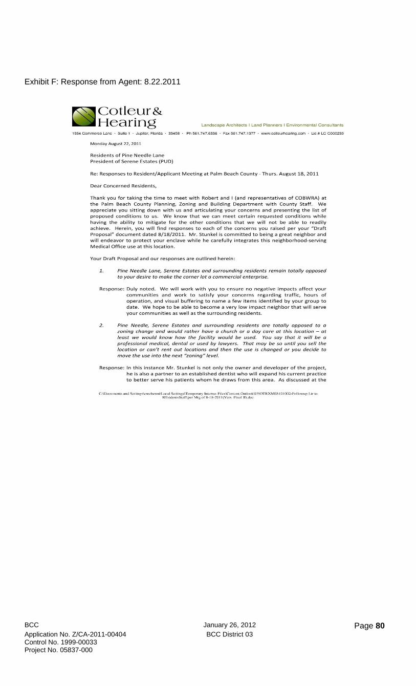
BCC January 26, 2012 Page 80 Application No. Z/CA-2011-00404 BCC District 03 Control No. 1999-00033 Project No. 05837-000
Exhibit F: Response from Agent: 8.22.2011
Cotleur& Hearing Landscape Architects I Land Planners I Environmental Consultants
1934 Commerce Lane Suite 1 Jupi ter, Florida 33458 Ph 561 .747. 6336 Fax 561.747.1377 www_cotleurhearing_com Lie # LC-C000239
Monday Aug ust 22, 2011
Residents of Pine Needle lane President of Serene Estates (PUD)
Re: Responses to Resident/Applicant Meeting at Palm Beach County - Thurs. Au g ust 18, 2011
Dear Concerned Residents,
Thank you for taking the time to meet with Robert and I (and representatives o f COBWRA) at the Pa lm Beach County Planning, Zon ing and Bu i lding Department with County Staff. We appreciate you sitting down w ith us and articu lating your concerns and presenting the list of proposed conditions to us. We know that we can meet certain requested conditions w hile havin g the ability to m it igate for the other conditions that we wi ll not be able to readily achieve. Herein, you wi ll f ind responses to each of the concerns you raised per your "Draft Proposal" docum ent dated 8/18/2011. M r. Stunkel is committed to being a great neighbor and w ill endeavor to protect your enclave while he carefully integrates this neighborhood-serving Medica l Office use at this loca tion.
Your Draft Proposal and our responses are outlined here in:
1 . Pine Needle Lone, Serene Estates and surrounding residents remain totally opposed to your desire to make the corner lot a commercial enterprise.
Response: Du ly noted. We will work with you to ensure no negat ive impact s affect your communit ies a nd work to sati sfy your concerns rega rdin g traffic, hours of operation, and v isua l buffering to name a f ew items ide ntified by your group to d ate . We hope to be able to become a very low impact neighbor that will se rve your communities as we ll as the surrounding residents.
2. Pine Needle, Serene Estates and surrounding residents are totally opposed to a zoning change and would rather have a church or a day care at this location - at least we would know how the facility would be used. You soy that it will be a professional medico/' dental or used by lawyers. That may be so until you sell the location or can't rent out locations and then the use is changed or you decide to move the use into the next "zoning" level.
Response : In thi s inst ance Mr. Stunkel is not on ly the owner and developer of the project, he is al so a partner to an established d e ntist w ho w ill expand hi s cu rre n t practice to better serve hi s patien t s whom he draws from th is area. As di scu ssed at the
C:\Docu"'CniS ,,"d SCning'\c ..... -chcnmIL..ocal Scnins,ITcmpomry lmernc{ Fi lcslComenl.0u{lookIU50TRXMDII 0IOO2-I'ollowup Ltr {o RE,idclI"S{aff per Mtg of 8 _18_201 I (Ver-; Final H).doc
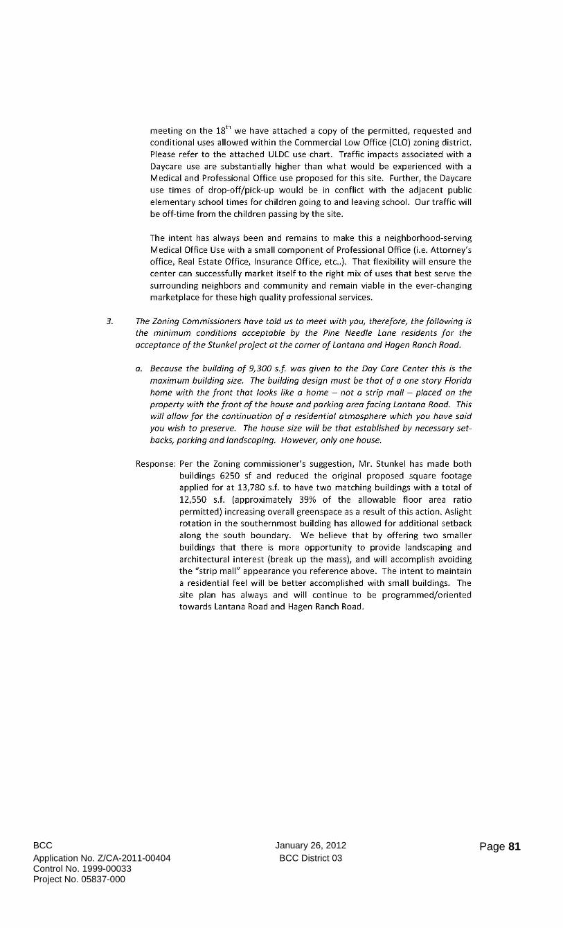
BCC January 26, 2012 Page 81 Application No. Z/CA-2011-00404 BCC District 03 Control No. 1999-00033 Project No. 05837-000
meeting on the 18th we have attached a copy of the permitted, requested and conditional uses allowed within the Commercial Low Office (CLO) zoning district. Please refer to the attached ULDC use chart. Traffic impacts associated with a Daycare use are substantially higher than what would be experienced with a Medical and Professional Office use proposed for this site. Further, the Daycare use times of drop-off/pick-up would be in conflict with the adjacent public elementary school times for children going to and leaving school. Our traffic will be off-time from the children passing by the site.
The intent has always been and remains to make this a neighborhood-serving
Medical Office Use with a small component of Professional Office (i.e. Attorney's office, Real Estate Office, Insurance Office, etc .. ). That flexibility will ensure the center can successfully market itself to the right mix of uses that best serve the surrounding neighbors and community and remain viable in the ever-changing marketplace for these high quality professional services.
3. The Zoning Commissioners have told us to meet with you, therefore, the following is the minimum conditions acceptable by the Pine Needle Lane residents for the acceptance of the Stunkel project at the corner of Lantana and Hagen Ranch Road.
a. Because the building of 9,300 sf was given to the Day Care Center this is the maximum building size. The building design must be that of a one story Florida home with the front that looks like a home - not a strip mall - placed on the property with the front of the house and parking area facing Lantana Road. This will allow for the continuation of a residential atmosphere which you have said you wish to preserve. The house size will be that established by necessary setbacks, parking and landscaping. However, only one house.
Response: Per the Zoning commissioner's suggestion, Mr. Stunkel has made both buildings 6250 sf and reduced the original proposed square footage applied for at 13,780 s.f. to have two matching buildings with a total of
12,550 s.f. (approximately 39% of the allowable floor area ratio permitted) increasing overall greenspace as a result of this action. Aslight rotation in the southernmost building has allowed for additional setback along the south boundary. We believe that by offering two smaller buildings that there is more opportunity to provide landscaping and architectural interest (break up the mass), and will accomplish avoiding the "strip mall" appearance you reference above. The intent to maintain a residential feel will be better accomplished with small buildings. The site plan has always and will continue to be programmed/oriented towards Lantana Road and Hagen Ranch Road.
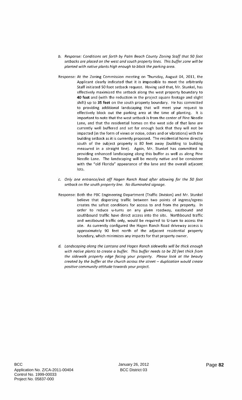
BCC January 26, 2012 Page 82 Application No. Z/CA-2011-00404 BCC District 03 Control No. 1999-00033 Project No. 05837-000
b. Response: Conditions set forth by Palm Beach County Zoning Staff that 50 foot setbacks are placed on the west and south property lines. This buffer zone will be planted with native plants high enough to block the parking area.
Response: At the Zoning Commission meeting on Thursday, August 04, 2011, the Applicant clearly indicated that it is impossible to meet the arbitrarily Staff initiated 50 foot setback request. Having said that, Mr. Stunkel, has effectively maximized the setback along the west property boundary to 40 feet and (with the reduction in the project square footage and slight shift) up to 35 feet on the south property boundary. He has committed to providing additional landscaping that will meet your request to effectively block out the parking area at the time of planting. It is important to note that the west setback is from the center of Pine Needle Lane, and that the residential homes on the west side of that lane are currently well buffered and set far enough back that they will not be impacted (in the form of views or noise, odors and or vibrations) with the building setback as it is currently proposed. The residential home directly south of the subject property is 80 feet away (building to building measured in a straight line). Again, Mr. Stunkel has committed to providing enhanced landscaping along this buffer as well as along Pine Needle Lane. The landscaping will be mostly native and be consistent with the "old Florida" appearance of the lane and the overall adjacent lots.
c. Only one entrance/exit off Hagen Ranch Road after allowing for the 50 foot setback on the south property line. No illuminated signage.
Response: Both the PBC Engineering Department (Traffic Division) and Mr. Stunkel believe that dispersing traffic between two points of ingress/egress creates the safest conditions for access to and from the property. In order to reduce u-turns on any given roadway, eastbound and
southbound traffic have direct access into the site. Northbound traffic and westbound traffic only, would be required to U-turn to access the site. As currently configured the Hagen Ranch Road driveway access is approximately 90 feet north of the adjacent residential property boundary, which minimizes any impacts for that property owner.
d. Landscaping along the Lantana and Hagen Ranch sidewalks will be thick enough with native plants to create a buffer. This buffer needs to be 20 feet thick from the sidewalk property edge facing your property. Please look at the beauty created by the buffer at the church across the street - duplication would create positive community attitude towards your project.
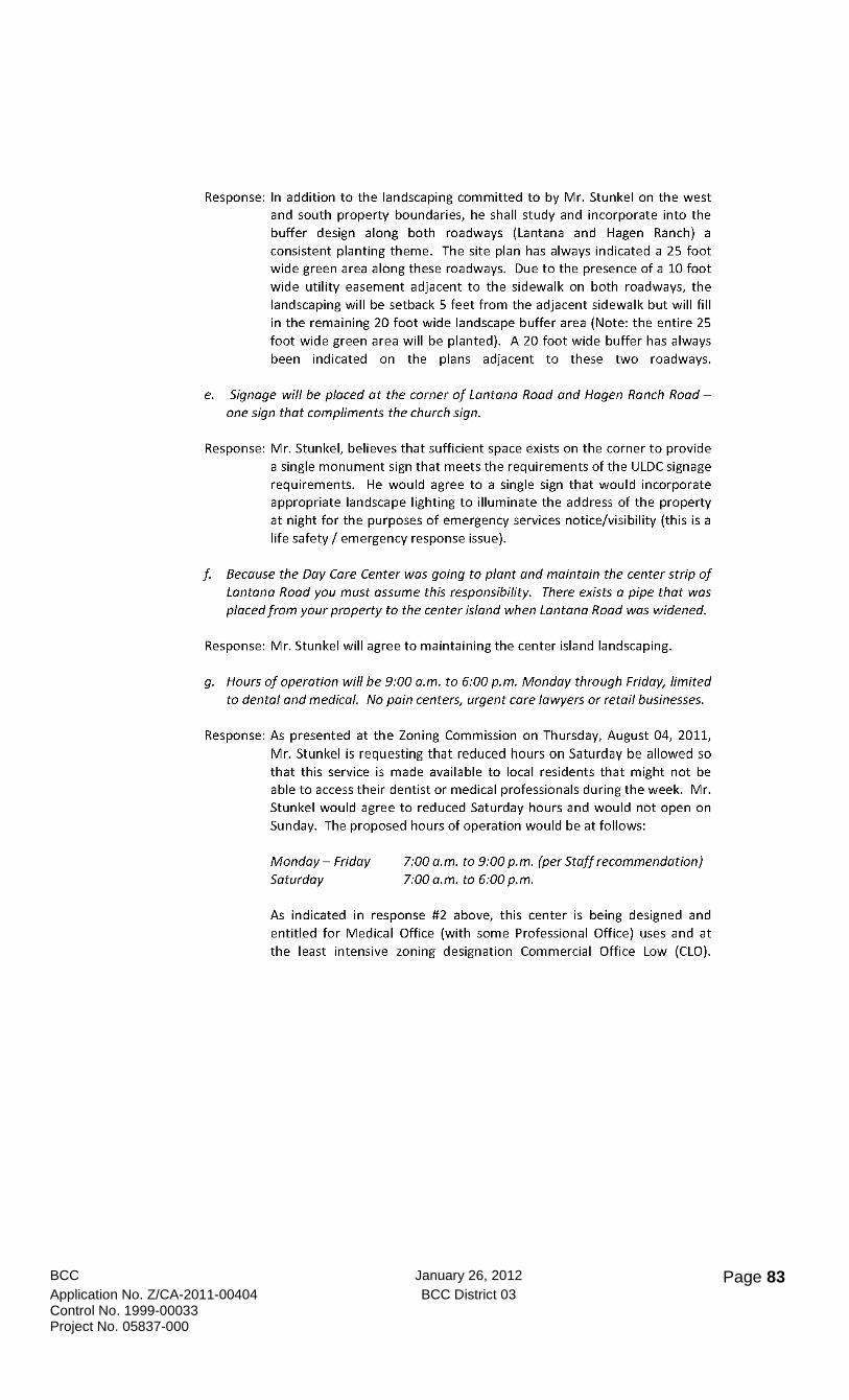
BCC January 26, 2012 Page 83 Application No. Z/CA-2011-00404 BCC District 03 Control No. 1999-00033 Project No. 05837-000
Response: In addition to the landscaping committed to by Mr. Stunkel on the west and south property boundaries, he shall study and incorporate into the buffer design along both roadways (Lantana and Hagen Ranch) a consistent planting theme. The site plan has always indicated a 25 foot wide green area along these roadways. Due to the presence of a 10 foot wide utility easement adjacent to the sidewalk on both roadways, the landscaping will be setback 5 feet from the adjacent sidewalk but will fill in the remaining 20 foot wide landscape buffer area (Note: the entire 25 foot wide green area will be planted). A 20 foot wide buffer has always been indicated on the plans adjacent to these two roadways.
e. Signage will be placed at the corner of Lantana Road and Hagen Ranch Road -one sign that compliments the church sign.
Response: Mr. Stunkel, believes that sufficient space exists on the corner to provide a single monument sign that meets the requirements of the ULDC signage requirements. He would agree to a single sign that would incorporate appropriate landscape lighting to illuminate the address of the property at night for the purposes of emergency services notice/visibility (this is a life safety / emergency response issue).
f. Because the Day Care Center was going to plant and maintain the center strip of Lantana Road you must assume this responsibility. There exists a pipe that was placed from your property to the center island when Lantana Road was widened.
Response: Mr. Stunkel will agree to maintaining the center island landscaping.
g. Hours of operation will be 9:00 a.m. to 6:00 p.m. Monday through Friday, limited to dental and medical. No pain centers, urgent care lawyers or retail businesses.
Response: As presented at the Zoning Commission on Thursday, August 04, 2011,
Mr. Stunkel is requesting that reduced hours on Saturday be allowed so that this service is made available to local residents that might not be able to access their dentist or medical professionals during the week. Mr. Stunkel would agree to reduced Saturday hours and would not open on Sunday. The proposed hours of operation would be at follows:
Monday - Friday
Saturday 7:00 a.m. to 9:00 p.m. (per Staff recommendation) 7:00 a.m. to 6:00 p.m.
As indicated in response #2 above, this center is being designed and entitled for Medical Office (with some Professional Office) uses and at the least intensive zoning designation Commercial Office Low (CLO).

BCC January 26, 2012 Page 84 Application No. Z/CA-2011-00404 BCC District 03 Control No. 1999-00033 Project No. 05837-000
Attached please review the list of uses that are permitted, conditional and/or prohibited in this zoning district.
h. (not in Draft Proposal - raised at meeting on 8/18/2011) Developer to install signals at the intersection of Woodland Creek and Lantana Road (west of subject site and Serena Estates entrance drive).
Response: The Applicant shall agree to issue a letter of support for the inclusion of a traffic light to be located at the above referenced intersection. Mr. Stunkel cannot commit funds to this request as the neighborhood scale of what he is proposing on this corner will not warrant the construction of said traffic signal. The Applicant shall inquire with Palm Beach County's Traffic Engineering Division to understand the likelihood and/or potential timing of traffic lights at that intersection to better understand if this request is in the realm of possibilities in the near term.
We would be more than happy to make ourselves available to speak to you again on this matter at a location and time that is convenient for you. Please feel free to contact me anytime on the above matter directly at 561-718-4512; Office at 561-747-6336 x 127; by email at [email protected]
Sincerely, Cotleur & Hearing, Inc.
Brian Cheguis, Senior Land Planner
CC: Mr. Robert Stunkel/ Mr. Donaldson Hearing / Mr. Ken Lassiter / Ms. Carrie Rechenmacher Attachments: ULDC Use Chart for CLO Zoning District (all uses shown)
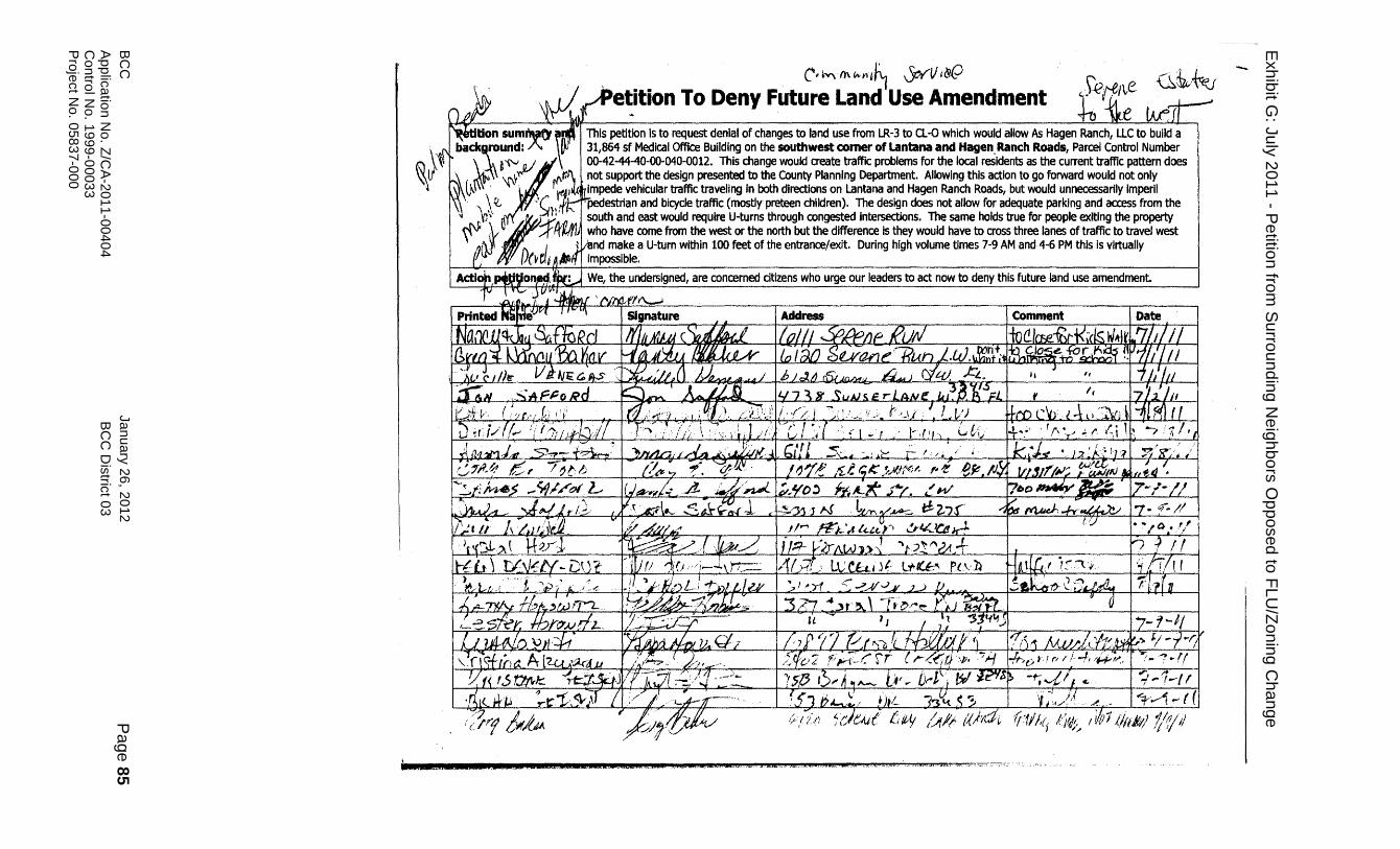
BC
C
January
26
, 20
12
Pa
ge
85
App
licatio
n N
o. Z
/CA
-201
1-0
040
4
BC
C D
istric
t 03
Contro
l No
. 19
99-0
003
3
Pro
ject N
o. 0
58
37-0
00
E
xh
ibit G
: Ju
ly 2
011
- Pe
tition fro
m S
urro
un
din
g N
eig
hb
ors
Op
po
sed
to F
LU
/Zo
nin
g C
ha
nge
, C; tv\ {'(\ ~f1~~ 0-c='¥"V i&(;)
etition To Deny Future Land Use Amendment This petition is to request denial of changes to land use from LR-3 to CL-O which would allow As Hagen Ranch, LLC to build a 31,864 sf Medical Office Building on the southwest corner of Lantana and Hagen, Ranch Roads, Parcel Control Number 00-42-44-40-00-040-0012. This change would create traffic problems for the local residents as the current traffic pattern does not support the design presented to the County Planning Department. Allowing this action to go forward would not only Impede vehicular traffic traveling in both directions on Lantana and Hagen Ranch Roads, but would unnecessarily ImperII pedestrtan and bicycle traffic (mostly preteen children). The design does not allow for adequate parking and access from the south and east would require U-turns through congested intersections. The same holds true for people exiting the property who have come from the west or the north but the difference Is they would have to cross three lanes of traffic to travel west
nd make a U-turn within 100 feet of the entrance/exit. During high volume times 7·9 AM and 4-6 PM this is virtually impossible.
We, the undersigned, are concerned citizens who urge our leaders to act now to deny this future land use amendment.
":; ... 1-//
~".- I ~---1 - ( ( l;'tl/'(i l;Id;~ / i/{J1{hf/t1) f/1/'/
b &.S& a2: .• sa 2",;,eO&&; 2=. Uk .K.saa£~.Q. AU ,,43WL.. oM.t. ,2, i,2U, .... 'i1".,"CtA; lao. M,.:: ,£.&:,.6. ..~","'~': ':'-'7""\'.-
-.

BC
C
January
26
, 20
12
Pa
ge
86
App
licatio
n N
o. Z
/CA
-201
1-0
040
4
BC
C D
istric
t 03
Contro
l No
. 19
99-0
003
3
Pro
ject N
o. 0
58
37-0
00
Petition To Deny Future Land Use Amendment r Petition summary and This petition is to request denial of changes to land use from LR-3 to a.-o which would allow As Hagen Ranch, LLC to build a "ckground: 31,864 sf Medical Office Building on the southwest comer of lantana and Hagen Ranch Roads, Parcel Control Number
00-42-44-40-00-040-0012. This change would create traffic problems for the local residents as the current traffic pattern does not support the design presented to the County Planning Department. Allowing this action to go forward would not only impede vehicular traffic traveling in both directions on Lantana and Hagen Ranch Roads, but would unnecessarily imperil pedestrian and bicycle traffic (mostly preteen children). The design does not allow for adequate parking and access from the south and east would require U-turns through congested intersections. The same holds true for people exiting the property who have come from the west or the north but the difference is they would have to cross three lanes of traffic to travel west and make a U-turn within 100 feet of the entrance/exit. During high volume times 7-9 AM and 4-6 PM this is virtually impossible.
ktion petitioned for: We, the undersigned, are concerned citizens who urge our leaders to act now to deny this future land use amendment.
PrInted Name Address Comment
1'-llP")1'=i 16f rlYls:c.ufA .:;;A",'IlP':9,.'H ~~(;! I <--"'<7~' ~c."o~t1:- ,,,,,-e .... ' VI. '-"1"'1 'H''l!0'P'>O r .... ·J'P""J~' ,'1'",1 1
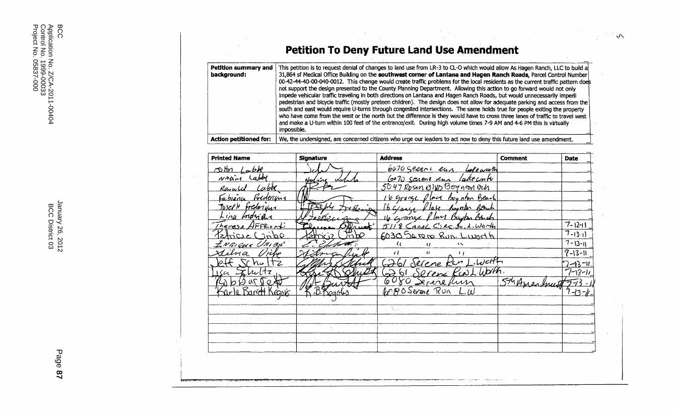
BC
C
January
26
, 20
12
Pa
ge
87
App
licatio
n N
o. Z
/CA
-201
1-0
040
4
BC
C D
istric
t 03
Contro
l No
. 19
99-0
003
3
Pro
ject N
o. 0
58
37-0
00
Petition To Deny Future Land Use Amendment
Petition summary and This petition is to request denial of changes to land use from LR-3 to CL-O which would allow As Hagen Ranch, LLC to build a background: 31,864 sf Medical Office Building on the southwest corner of Lantana and Hagen Ranch Roads, Parcel Control Number
00-42-44-40-00-040-0012. This change would cre~te traffic problems for the local residents as the current traffic pattern doe not support the design presented tathe County Planning Department. Allowing this action to go forward would not only impede vehicular traffic traveling in both directions on Lantana and Hagen Ranch Roads, but would unnecessarily imperil pedestrian and bicycle traffic (mostly preteen children). The design does not allow for adequate parking and access from the south and east would require U-turns through congested Intersections. The same holds true for people exiting the property who have come from the west or the north but the difference is they would have to cross three lanes of traffic to travel west and make a U-turn within 100 feet of the entrance/exit. During high volume times 7-9 AM and 4-6 PM this is virtually Impossible.
Action petitioned for: We, the undersigned, are concerned citizens who urge our leaders to act now to deny this ruture land use amendment.
-Printed Name
,~ tin J ~bj,e N~~ ~( .la.J.bJ. f2b~,-,JrJ CDb!;c ~bllL;'fA ~v:' i
}I I' -" 1bJd .... >~.d(A-i J... (;'11 W:!!ii~
~-- A J~ //'<r't!!.5A FFR-II ,..-1-/
----rt'.Jroo~ (. l~bQ L'¥/J'~_~;~~:r ~ t=t- t/;-ik I '"-£ff . ~~L hI.> jtz hl~~_~~~~ --/~, b feb cA\ f~ '&l~ llLfxlr<d4J\ibrllk'
J
Signature I Address I Comment I Date
\,1" /'--; , [;,[170 <;e4-er-' ~A __ kl~W'l>Al~ ~~., .JV!~ (~1I7u -Cbte.-tt ,,!.~/\. Ia-J~unlv> I
dJ2.~ - I sf) it 7 12i~. G llUJ B C71ft)'h>Vl I'?e-h I
17 NJj ~ I I 0c,rfJ I'C,(_ /J 111-.:.-1. &, ~ n ~ p.,t>¥~vt.. I , I'+I'~ . J - I' /" " '/1 I I l . J r D4:l>£'/" "Y-N 0 .. , _..... r {, c.. /r. A u II {fJJ,t hiW fJ/lJ(\ ~,;;f., I
1//\ T .' '"""~T~V--'------I' "/tuu ' .AI'" '":fA /);(J / J A:L_ ~ _ ./ ...... 1. r/" /-...--IH1.~ jl~~_.. hv. k~ I
'';?yd>;?~' 1 - ( « (, 1 7 -\3-1\
~ ... ==~-=-=- ~~, l-fi/77~ C;;;iI.A~-C'i~_.l~L.W~.-Ih1 1 7 -12-1'--= ~~-\) t ~\P r I ~()~c:,c::~~~QN) ~d~. L\.ut'\("\ ~ 1 / 7 -13-1)-=
c;:d~ 7L:--;g; III 1/ "I I ,1 _______ _J?-\5-\l_~ ~~£d~1 (~bl r\U~ /:!c..r L·k)ott:r 1·'d1-tc P6«~q\\~ (~be r~(/f,,~·eu0L,U)YIft· /(1-1$.-1/_ ?lJt..-75~JI{g-0'io ~r~~~ 1~~L1J1A.n~7=iLt VK :B.':K{j~~t£~~"fJ- I ~RC>~et"Dhl1?01\ L. w ,- - >-'~17 -13 -u-
-J -
-=
-= -
-=
-=
",J'..,
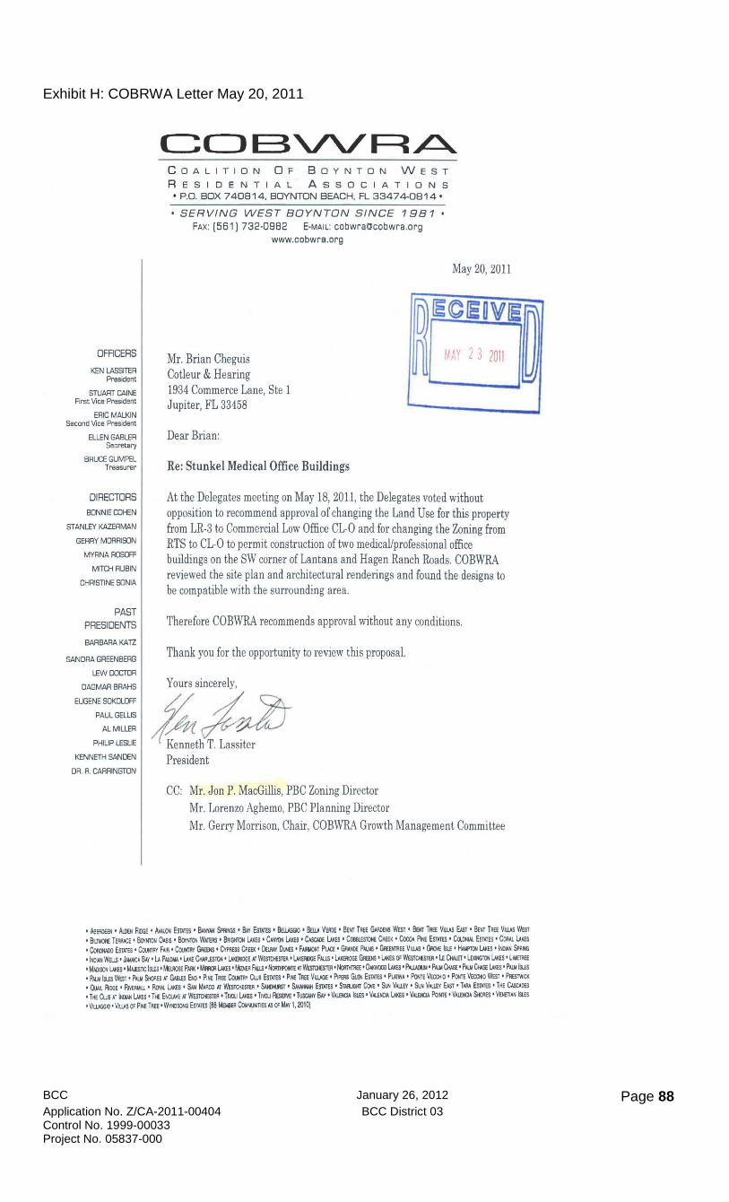
BCC January 26, 2012 Page 88 Application No. Z/CA-2011-00404 BCC District 03 Control No. 1999-00033 Project No. 05837-000
Exhibit H: COBRWA Letter May 20, 2011
OFFICERS
KEN LASSITER President
STUART CAINE First Vice President
ERIC MALKIN Second Vice President
ELLEN GABLER Secretary
BRUCE GUMPEL Treasurer
DIRECTORS
&lNNIE CXlHEN
STANLEY KAZERMAN
GEARY MORRISON
MYRNA ROSOFF
MITCH AUBIN
CHRISTINE SONIA
PAST PRESIDENTS
BARBARA KATZ
SANDRA GREENBERG
lEW=roA
DAGMAR BRAHS
EUGENE SOKOLOfF
PAUL GELLIS
ALMILLEA
PHILIP LESLIE
KENNETH SANDEN
DR. A. CARRINGTON
C( JE3VVRA... C OALITION OF .BOYNTON WEST
R ESIDENTIAL ASSOCIATIONS • P.O. BOX 740B14, BOYNTON BEACH, FL 33474-0B14'
SERVING WEST BOYNTON SINCE 19B 1 FAX: [5611 732·0982 E·MAIl: cobwrallcobwra.org
www.cobwra.org
May 20, 2011
Mr. Brian Cheguis Cotleur & Hearing
o ~"~~n:,~~ '::.I
1934 Commerce Lane, Ste 1 Jupiter, FL 33458
Dear Brian:
Re: Stunke[ Medica[ Office Buildings
At the Delegates meeting on May 18, 2011, the Delegates voted without opposition to recommend approval of changing the Land Use for this property from LR·3 to Commercial Low Office CL·O and for changing the Zoning from RTS to CL·O to permit construction of two medicaUprofessional office buildings on the SW corner of Lantana and Hagen Ranch Roads. COBWRA reviewed the site plan and architectural renderings and found the designs to be compatible with the surrounding area.
Therefore COBWRA recommends approval without any conditions.
Thank you for the opportunity to review this proposal.
Yours sincerely,
e;~~ President
CC: Mr. Jon P. MacGillis, PBC Zoning Director Mr. Lorenzo Aghemo, PBC Planning Director Mr. Gerry Morrison, Chair, COBWRA Growth Management Committee
I Aw.llEEN • .Io.wI RiooE • Av~ Esu.T!S • BooNl SmfGs • 8.l.y EsrATfS • ~ • Sew VEKlE • Boo TRE! GNIoENS WEST • Boo TJEE Vws EI.sT • BEt!T TREE Vws WEST , BIDI'JRE TEI'WCE I 6oiKrOH OASIS • ~ WoIlB'S' klHToN 1JxEs· CNI'iQIlMEs I CASC.I£E lAKEs • ~E CREEK • Co::oI. PM Es'ooEs ' Ca.CfIAI. ESTATES' CoIw. lAKEs • Coo::twxl Eswu • Co.Ml\'i Fill • CooiTR'I' GAeENS • C'vPF.Ess Cim:' DewY DJEs • FAIMlh'T Pva • GP.ooE PIIJoIS' GIwirREE Vws • GKwe IstE • HNmtw I.AICEs • kw SPMIG 'I!()WI WElls • .I.I.Iw::A SAY .IJ, PAUlIU. • lME 0wusr0N • lAKEliIOOe AT WeSTO£ST6l·lJ.K£fI)5E FALLS ' l.Aw.I:lGE GfHNS 'l»:.Es Of WesTCIESTER • LE 0IAlET ·l..ExtI'lTON lAKEs ·llt.lETl'£E 'l.IJDIsaIlAKEs' MwTC Iw ' Mwose Pm< ./MoIl»:.Es' M0£R F/IUS' NcJmfoorE fiI WESTQ61&I' NofmIrm: • ~ l»:a' P.IWDlII ' PIuI CIIISE • P/OI QW£ lAKEs' P1LIr I!W • Pw.IIw WEsT' PIIUI St«:ns N Gw.Es Etcl· P'INE TREE CooHTltI 0J.e EswEs' pff. TI'.EE YWGE' PIPERS GlEli EstIrEs· PUUtA • POlITE VEWtO' POOE VEcorJ WiST' PREs1wa • OJln..IbooE ' RMfMU.' RcPfALI.J.i<ES' SAN MAAco AT WESTMSTEJI' SNot.fsr. 5,l.VNfWI ESOOES' S'wulKr CM' SlfI YAI.UV· SUN VAlUY EAST' T.w. EswEs' THE CAscAw • Tff CuII,\T 1tDNIl»:Es' Tff E»::uvE AT ~. Tr.oo 1.AKEs' TI'IOO AESEM'liJsc"wi 1I.q. VAI.E~ IsLES' VAl.fI(;IA I.J.i<ES· VAl.ftQI. PowTE' VAI.fIDA Slats 'VENElIAN ISLES 'VllJGG(I' VI..I.AS Of pff. TREE'Wv!tosc»oIl EsT.l.TES (88 MEIiIeER CrwMtls AS Of MAy I, 2010)