Embed Size (px)
Citation preview
Pakistan-China
Trade and Economic
Corridor
Economic Analysis
Submitted to: Dr. Mehmood Karim Qureshi
Business Economics for Mathematics
MBA – 2 years (Evening)
Submitted by: Asad Akram
Roll No. 14I – 1216
Introduction:
Pakistan and Chinese governments are planning to execute a
trade and economic corridor through the length of Pakistan, from
Gwadar in Baluchistan to Kashgar in Xingjiang. It will be a land
based transport route alternate to the conventional sea route
spanning Persian Gulf to China’s coastal regions. This corridor
development can prove vital to bringing Pakistan’s economy back
on its feet and also helping China in increasing trade with
Middle East and African Countries.
More than half of the world's proven oil reserves are
located in the Middle East, the top region-based supplier of
crude oil to China. In 2012, China imported 5.4 million bbl/d or
56% of its daily consumption in crude oil, of which 48.1%
originated from the Persian Gulf.
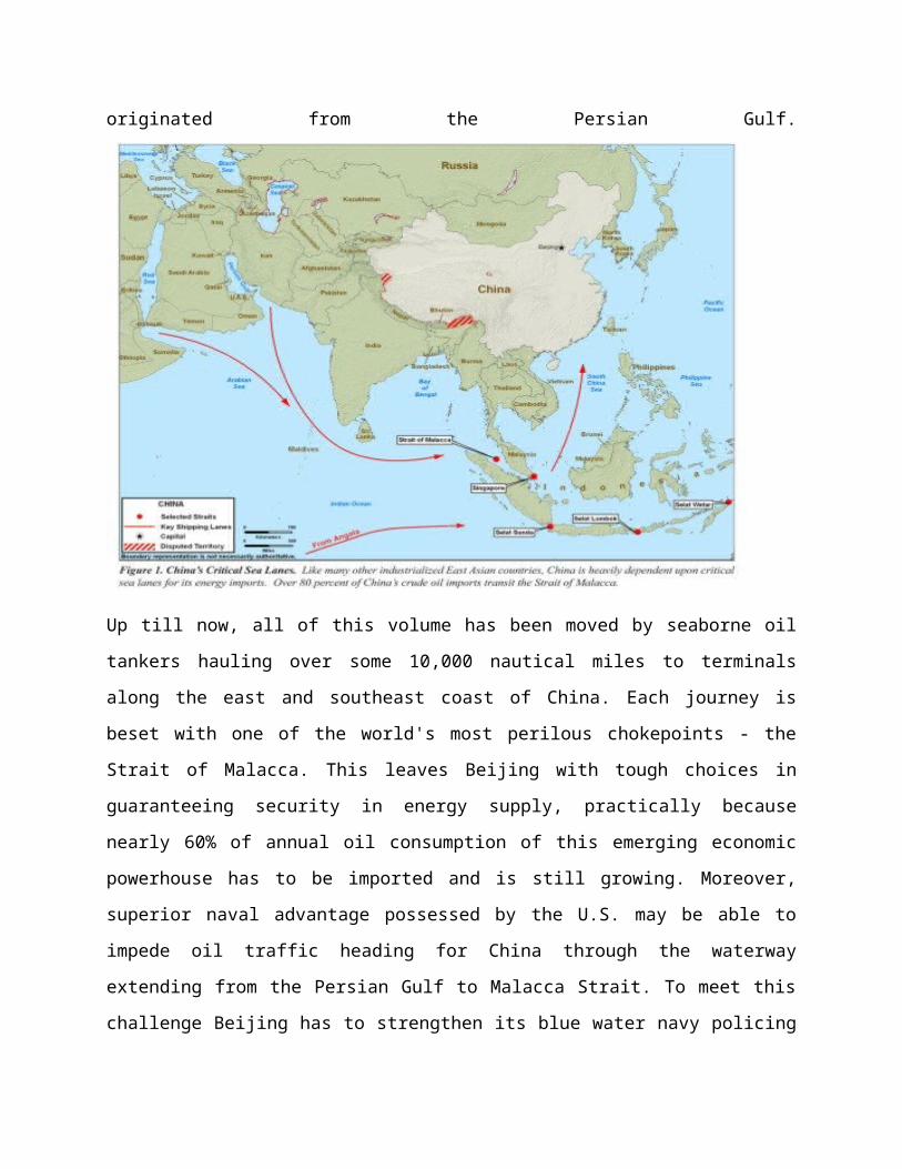
Up till now, all of this volume has been moved by seaborne oil
tankers hauling over some 10,000 nautical miles to terminals
along the east and southeast coast of China. Each journey is
beset with one of the world's most perilous chokepoints - the
Strait of Malacca. This leaves Beijing with tough choices in
guaranteeing security in energy supply, practically because
nearly 60% of annual oil consumption of this emerging economic
powerhouse has to be imported and is still growing. Moreover,
superior naval advantage possessed by the U.S. may be able to
impede oil traffic heading for China through the waterway
extending from the Persian Gulf to Malacca Strait. To meet this
challenge Beijing has to strengthen its blue water navy policing
its rapidly expanding maritime trading routes. Alternatively,
Beijing’s development planners have to build overland pipeline
infrastructures in collaboration with upstream transit countries
and crude producers, bypassing possible blockade along the
shipping lanes over India to the South China Sea. This is best
exemplified by the Sino-Myanmar oil and gas pipelines. Another
possible way chalked out by the Chinese planners is the Sino-
Pakistan “Trade and Energy Corridor” (TEC). Main features of this
new initiative are unraveled next in the context of China’s
overture in sourcing overseas energy via continental land routes
through Gwadar, the transshipping hub. It also shows how the
tripos formed of railroad, highway and a pipe shape the pivotal
north-south crossroad in Eurasia.
The planned “Trade and Energy Corridor” is formed of one
transshipment node –the Gwadar Port - and three legs: a pipe, a
highway and a railroad. This three-in-one triple corridor carries
not only oil but also dry cargos moving to and from Gwadar as a
regional hub east of the Persian Gulf.
Background:As early as 1954 the United States Geological Survey (USGS)
conducted a survey of Pakistan’s coastline thereby identified
Gwadar a suitable site for a seaport. Notwithstanding, Oman had
exercised legal and actual suzerainty over the port of Gwadar,
which until September 1958, was an alien enclave in Pakistan on
the Makran Coast over 200 years. Islamabad purchased this enclave
from Sultanate of Oman for $3 million and it officially became a
part of the Pakistan territory. In 1964 the Pakistani Government
decided to transform this small and undeveloped fishing village
of only a few thousand inhabitants into a deep sea port.
Successive governments had drawn up plans for developing Port Bin
Qasim (BQ) in Sindh and Gwadar in Baluchistan as alternate ports
because of the need to dilute the country’s dependence on the
Karachi port, which now handles over 80 percent of Pakistan's
international trade. Framed within the transport plan of
Pakistan’s 8th Five Year Plan (1993-94) a technical and financial
feasibility study on Gwadar Port was conducted by Gifford &
Partners & Technecon of Southampton, U.K., jointly with the
Karachi-based Pakistani firm, Techno-Consult International. Their
efforts made construction of the Gwadar port project a priority
evaluated from a multiplicity of causes ranging from logistic,
geostrategic to the imperatives of regional development. But
actual execution of this undertaking had been postponed until
2001 when Beijing agreed to provide financing and technical
assistance. Phase-1 construction work began upon the signing of
bilateral agreement on aid and development in March 2002 which
took three years to complete. On 18 February 2013, Chinese
Overseas Port Holdings Ltd. took over the port managing rights
from PSA of Singapore.
I. Gwadar Port:
On 20 March 2007, Gwadar port (Phase-1) was officially
inaugurated by President Pervez Musharraf, along with Chinese
Minister of Communication Li Shingling. The port began cargo
handling from 15 March 2008. The first ship carrying 64,000 tons
wheat from Canada docked and unloaded, the largest vessel ever
called at Pakistan.
However, since first handed over to the Singapore Port
Authority (SPA) in 2007, this highly prized asset has been a
commercial failure, due to the lack of investment in the port
facilities and internal as well as external transport linkages.
Concurrently, Baluchistan's instability and local political
opposition have scared investors away. In December 2007 the
Government of Pakistan approved a plan to build two new large
sized shipyards at Gwadar in Baluchistan Province ("Gwadar
Shipyard") and Port Qasim near Karachi in Sindh Province ("Qasim
Shipyard") on a fast track basis. On February 18th 2013, Pakistan
handed over management rights of Gwadar seaport to China upon
expiration of the SPA contract.
Importance : Located 75 km east to the Iranian border closing
to the mouth of the Strait of Hormuz and 460 km west of
Karachi, Gwadar port witnesses twenty percent of the world’s
traded oil and about thirty-five percent of the oil traded by
seaborne freight with every passing day. This port and
Pakistan at large lie rightly also at the traffic juncture of
three regions traditionally lacking direct communication in
between: the South, Central and West Asia. Superbly located
geo-strategically, it commands together with the prospect to
become a world class deep-sea port, having attracted
increasing attention. Essentially, Gwadar may turn into a
pivotal harbor city, comparable to Singapore, Hong Kong,
Colombo and Dubai. Liquid fuels reaching Gwadar by
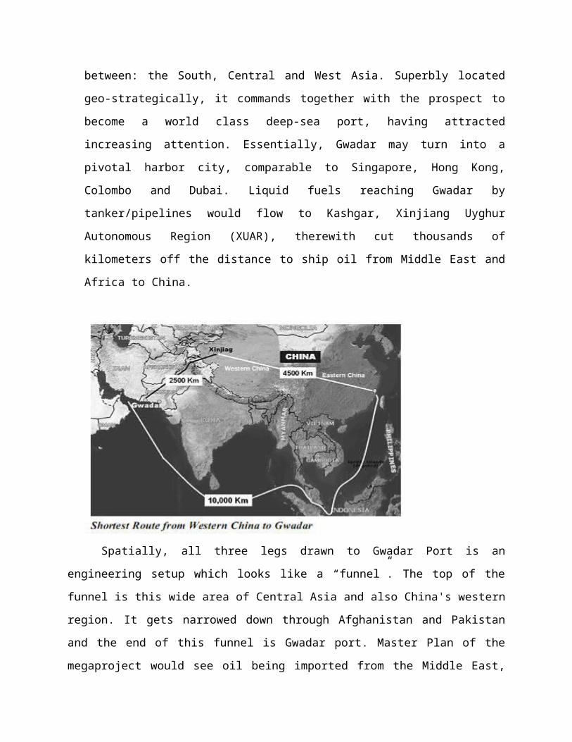
tanker/pipelines would flow to Kashgar, Xinjiang Uyghur
Autonomous Region (XUAR), therewith cut thousands of
kilometers off the distance to ship oil from Middle East and
Africa to China.
Spatially, all three legs drawn to Gwadar Port is an
engineering setup which looks like a “funnel”. The top of the
funnel is this wide area of Central Asia and also China's western
region. It gets narrowed down through Afghanistan and Pakistan
and the end of this funnel is Gwadar port. Master Plan of the
megaproject would see oil being imported from the Middle East,
stored in refineries at Gwadar and re-exported to China via
roads, pipelines or railway.
II. Roads:a. Karakoram Highway:
The first half - 1,300 km Karakoram Highway setting off
from Kashgar to Hasan Abdal - was built from 1959 to
1978. A time-honored achievement, notwithstanding, this
lofty spectacle, often referred to as the "eighth
wonder of the world”, remained short of accessing the
Arabian Sea from China’s landlocked western region. It
has to be upgraded and expanded to full length; to pave
Karakoram Highway to the sea so as to catch businesses
through Gwadar as a regional hub in international trade
and shipping. As of 30 June 2006, work is on to widen
the KKH. This six-lane highway will increase its
operating capacity for heavy vehicular traffic some
threefold.
b. Motorway:
Lahore-Karachi Motorway, Gwadar-Karachi Motorway,
Multan-Sukkur Motorway, East Bay Gwadar Port Expressway
are all included in the infrastructure development plan
of China-Pakistan Economic Corridor.
III. Railway:
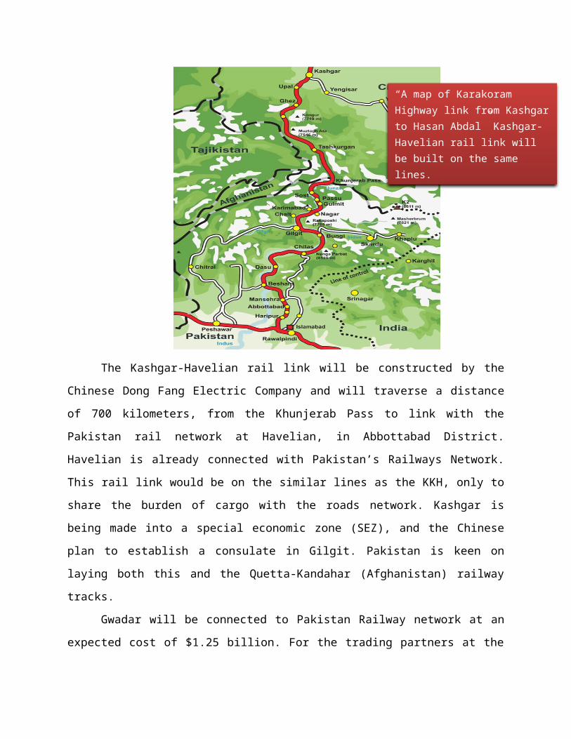
The Kashgar-Havelian rail link will be constructed by the
Chinese Dong Fang Electric Company and will traverse a distance
of 700 kilometers, from the Khunjerab Pass to link with the
Pakistan rail network at Havelian, in Abbottabad District.
Havelian is already connected with Pakistan’s Railways Network.
This rail link would be on the similar lines as the KKH, only to
share the burden of cargo with the roads network. Kashgar is
being made into a special economic zone (SEZ), and the Chinese
plan to establish a consulate in Gilgit. Pakistan is keen on
laying both this and the Quetta-Kandahar (Afghanistan) railway
tracks.
Gwadar will be connected to Pakistan Railway network at an
expected cost of $1.25 billion. For the trading partners at the
“A map of Karakoram Highway link from Kashgarto Hasan Abdal” Kashgar-Havelian rail link will be built on the same lines.
two ends of the TEC, by extending the Kashgar offshoot of ECB
(Eurasian Continental Land Bridge, Lianyungang-Rotterdam) to
Peshawar in Pakistan's northwest, China and Pakistan can benefit
enormously from it along the shortest route, i.e. from Karachi to
Peshawar. The rail network could also be used to supply oil from
the Persian Gulf to Xinjiang. Actual cost of this second leg is
yet to be determined, but 2005 estimates showed it over $10
billion.
According to recent news, China is expected to invest $3.5
billion in Pakistan’s Railways network from Karachi to Peshawar.
The areas where the money will be injected include replacement of
rail tracks over 375 km, deep screening of ballast over 1,260 km,
conversion of un-manned level-crossing into underpasses at 50
places, conversion of manned level-crossing into flyovers at 250
places, realignment of 40 big curves, strengthening of 500
bridges and doubling a 438km track at various places between
Shahdara and Peshawar.
IV. Pipelines:The master plan of the TEC or CPEC envisages oil imported
from Middle-East to Gwadar, stored in refineries, and re-exported
to China via road, railway or pipelines. China has announced to
invest in developing a 60000 bbl/d processing capacity oil
refinery in Gwadar. This refinery is a part of China’s $12
billion investment planned in Pakistan.
Significance:The significance of Gwadar as an alternative exit of traffic
to and from greater Central Asia warrants undoubted attention.
According to ADB’s Ports Master Plan studies this new transport
hub excels both Karachi and PQA in terms of proximity to the main
international shipping routes and superior harbor conditions,
including draft and turnaround time of large bulk carriers.
Together with the interconnected domestic traffic network it
evokes the whole system to overcome the harsh and complex terrain
blocking century-old north-south flow of goods and services. ADB
errs nevertheless in maintaining from the viewpoint of Central
Asian Regional Economic Cooperation Program (since 1997) that
"Gwadar is for Central Asia, not for Pakistan” (2013). Evidently,
it is both for Pakistan and China, as the minimum to expedite the
sequence of development projects envisaged, as the Ministerial
Committee meeting of the Pakistan government dismissed on 1
October, 2008, Karachi and PQA as the candidates for establishing
shipyards and transshipment trade. Instead, Gwadar was chosen for
it is “a place of great strategic value, enhancing Pakistan's
importance in the whole region, extending from the Persian Gulf
through the Indian Ocean to Southeast Asia and the Far East”.
Analysis & Conclusion:
Post 9/11 world economy has entered a new phase of
geopolitical tensions and turbulences across the globe. The so-
called “arc of instability” stretching all the way from ISME
(Indian Subcontinent & Middle East) to North Africa comprises
paradoxically, of countries also within the “arc of
opportunities”. Against the dichotomy of risks and reward, TEC
surfaced as a co-development agenda over a wide range of
strategic investment opportunities Islamabad proposed to China.
It occurred at a time when the world’s highest “Tsinghai-Tibet
railway” began performance debut. This amazing achievement
undoubtedly was instrumental in Beijing’s decision to confront
the natural topographical barriers bordering the Karakoram and
construct the Kashgar-Havelian rail link.
i. In modern day’s calculations, the Malacca passage from
Iran or Africa takes 16-25 days for the tankers to
complete. Once the revamped Karakoram Highway, rail
and energy pipeline corridor come through, this could
be done in just 48 hours from the port of Gwadar,
although destinations of shipment differ from each
other in the two cases. This is dictated by the
compulsion of China’s energy security strategy to
avert a naval blockade that could stop the flows of
life blood – liquid fuels - to China, save voyage time
and distance,
ii. Secondly, as expected, continuous injection of Chinese
capital would benefit the resource-rich but
impoverished regions, especially the long-neglected
Baluchistan and pockets of Pashtun inhabitants.
Pakistan will also receive a transit fee for energy
and goods passing through its territories. During the
new century, Chinese development aid to Pakistan are
no longer confined to infrastructures, defense,
regional security against narcotics, Uygur separatism
and terrorism, but extended also to trade and
investment in minerals, energy, power, communication,
and other regional development programs. The pivot
exercised by TEC heralds the growing all-weather Sino-
Pak ties in a new dimension where two converging
trends meet. For China it is accounted for by the
exodus and transplantation of the motor of the “great
western development” model in alien soil; further, if
the Pakistan corridor is developed it will reduce the
traffic overload now shouldered by ports in China’s
coastal region, integrate the western regions into the
world market, and balance regional socioeconomic
wealth gap. For Pakistan this endeavor is due to
revive the less developed southwest region and the
national economy.
iii. Besides boosting the region’s trade, the corridor will
push bilateral trade between Pakistan and China still
higher. China’s exports to Pakistan which was Rs320
billion in FY-2009 rose to Rs642.4 billion in FY-13.
Pakistani exports to China rose from Rs54.4 billion in
FY—2009 to Rs252 billion in FY-13. The boost followed
signing of their Free Trade Agreement.
iv. This trade corridor will earn huge sums for Pakistan
in the form of transit fee and custom duties etc. Also
transit route and its development will generate much
needed employment for Pakistanis.