Embed Size (px)
Citation preview

2 NEAR EASTERN ARCHAEOLOGY 74:1 (2011)
In the early 1930s, while members of the labor corps of the newly established Kibbutz Ramat Rahel were dig-ging a water channel, they uncovered an ancient burial
chamber adjacent to the nearby tell. The curiosity of the local archaeological community was piqued by the discovery—but it would take almost twenty-five years for formal archaeological investigations to get underway.
In August 1954, Yohanan Aharoni began a four-month sal-vage excavation at Tel Ramat Rahel. Enthusiasm and anticipa-tion soared as word spread that remains from the end of the First and the Second Temple periods had been unearthed (Aharoni 1956).
On Sunday, 23 September 1956, five hundred participants of the twelfth annual conference of the Israel Exploration Society gathered at the site for a first-hand glimpse into Judah’s royal past. It was clear to everyone present that Aharoni’s short dig had very literally only scratched the surface—that buried deep beneath the dust and debris of Tel Ramat Rahel, just waiting to be revealed, lay secrets of major historical and political conse-quence. Although the day ended in tragedy—Jordanian snip-ers on a nearby hill where the Mar-Elias monastery is located opened fire, killing five and injuring many more—it marked
the start of a decades-long, multiexpeditional effort to piece together the millennial history of the tell.
Today, half a century and nine major excavation seasons later—four conducted between 1959 and 1962 by Aharoni under the joint auspices of the Hebrew University of Jerusalem and the Sapienza–Università di Roma (Aharoni 1962, 1964) and six more between 2005 and 2010 by the Renewed Expedi-tions under the joint auspices of Tel Aviv and Heidelberg Uni-versities—many of the secrets lurking beneath the sand and stones of Tel Ramat Rahel have been laid bare. No one—not the early kibbutzniks and excavators, not the early visitors, not even those of us in the Renewed Expeditions—had any idea just how many secrets lay buried there and just how significant the site would prove in elucidating the political, social, and economic history of the kingdom of Judah.
Location of the SiteThe ancient tell of Ramat Rahel is located on a prominent
summit 818 m above sea level, halfway between Jerusalem and Bethlehem (4 km from each; see fig. 1). It is one of the high-est peaks in the area south of Jerusalem and part of the ridge that surrounds the Rephaim Valley from the east. The peak on which the site sits is actually the northwestern edge of a long
Oded Lipschits, Yuval Gadot, Benjamin Arubas, and Manfred Oeming
PALACE AND VILLAGE, PALACE AND VILLAGE, PARADISE AND OBLIVION:PARADISE AND OBLIVION:
Unraveling the Riddles Unraveling the Riddles of Ramat Rahof Ramat Rahelel

NEAR EASTERN ARCHAEOLOGY 74:1 (2011) 3
ridge that extends from the southeast (the location of the modern village of Zur Baher) to the north-west. The slopes of the hill in the south, west, and northwest are steep and relatively difficult to climb. The eastern and northeastern slopes, however, are far more moderate.
The hill is made up of soft chalk of the Senonian Menuha formation, coated by hard nari, with areas containing exposures of chert of the Mishash forma-tion. Throughout the site’s history, the exposed local nari rock was the primary raw material used for con-struction, a fact made evident by the many quarries found there.
Although there are numerous strategic, political, and economic advantages to the location, a major drawback to human settlement is the obvious absence of a significant, stable, natural water source at the site or in its vicinity. Domestic water cisterns are in evidence everywhere, but it is clear that the royal and public buildings of the Iron, Persian, and possibly also the Hellenistic periods demanded a more elabo-rate system for gathering and storing rain water.
The Strategic Importance of Ramat RahelThe ancient site of Ramat Rahel was built on a
prominent hilltop. Its location offered three distinct advantages.
1. Security and control. The prominent hill with its steep slopes and commanding view of vast portions of the Jerusalem Highlands is an ideal location for a fortress and watchtower. It offers a superb view to the north (Mount Zion and modern-day western Jeru-salem), to the west (the Rephaim Valley), and to the south (Mount Giloh and Bethlehem). The hill is also in direct control of two of the main roads that connect Jerusalem to other parts of the country: the “King’s Road,” which leads to Jerusalem from the south—from Beer-sheba, Hebron, and Bethlehem (see fig. 1); and the road leading west in the direction of Beth-shemesh, through the Rephaim Valley. Ramat Rahel’s only strategic weakness is its lack of con-trol in the east: the outskirts of the Judean Desert. It should come as no surprise that a small Iron Age fort was found and excavated approximately 2 km east of Ramat Rahel, which in ancient times served as an eastern outpost to the main edifice.
2. Commerce and economics. The Rephaim Valley with its rich alluvium soil and moderately terraced slopes has histori-cally been one of the prosperous agricultural districts in the Jerusalem landscape, vital to the economy of the city. The mounting archaeological data from the site, underscored by the many agricultural installations and small farmsteads found in the area, confirms that those periods during which the Rephaim Valley flourished agriculturally are the same periods during which there was construction at Ramat Rahel. Ramat Rahel’s proximity to the two main roads was also economically advantageous to the site.
3. Visibility and politics. The site’s location on a prominent peak not only gives it a commanding view but also turns its construction into a projecting landmark that is visible all across the Jerusalem landscape (fig. 2). Palatial architecture is an active symbol, spatially conveying the iconography of political power. When our team examined the site’s monu-mental structures spatially, we found that the image of edi-fice and tower could be seen by people living throughout the Rephaim catchment, the main agricultural district of the city. The imposing image of Ramat Rahel conveyed a message of might and control.
Interestingly, Ramat Rahel could not be seen from the City of David and the Temple Mount. Visual contact between the two centers was blocked by the ridge of the High Commis-sioner’s Residence, which controlled the City of David and the Temple Mount from the south. Clearly, when choosing the hilltop for Ramat Rahel, the architects of the project were cognizant of the presence it would command in the landscape and were concerned with its spatial communication with the surrounding settlements, above all Jerusalem, the capital city
Figure 1. Map of Ramat Rahel and its vicinity, based on a map prepared by the Palestine Exploration Fund. Adapted by Ido Koch.

4 NEAR EASTERN ARCHAEOLOGY 74:1 (2011)
Identifying the Biblical SiteManfred Oeming
Ramat Rahel is a modern name given by Menachem Ussish-kin, president of the Jewish National Fund (1923–1941), to the kibbutz established in 1926 on the high hill facing Rachel’s Tomb in Bethlehem. Given the building’s luxurious façade, it is quite remarkable that the Bible makes no mention of a pal-ace such as this south of Jerusalem. The biblical authors seem to ignore the site or (polemically?) play down or obscure its importance. Over the years, scholars have debated the identi-fication of the site.
B. Maisler (= Mazar) and M. Stekelis identified the site as Netophah, a settlement in the vicinity of Bethlehem men-tioned several times in the Hebrew Bible (2 Sam 23:28; 1 Chr 2:54, cf. Ezra 2:22; Neh 7:26, 12:28; Jer 40:8).
Aharoni (1956) suggested identifying the site as Beit Hak-kerem. He assumed that the lavish palace, constructed to meet the requirements of a harem, had probably been built on the property of a royal vineyard (perhaps he was inspired by the story of Naboth in 1 Kgs 21). Aharoni supported his assump-tion with three additional biblical passages: Jer 6:1, according to which Beit Hakkerem sent out signal fires for refugees from Jerusalem to the south in the final days of the monarchy; a Septuagint supplement to Josh 15:59a that mentions Karem as a site near Bethlehem; and Neh 3:14, which refers to Beit Hakkerem as a center of one of the districts in the province of Yehud.
Y. Yadin (1973) emphasized the striking similarity between Ramat Rahel and edifices in Samaria and presumed that the site contained a building erected by Queen Athaliah (which,
according to our findings, is impossible). He assumed that there was a connection to a foreign cult and identified the site with the house of Ba‘al mentioned in 2 Kgs 11:18.
By a process of exclusion, G. Barkay (2006) identified the site with mmšt (perhaps Mamshit or Memshelet). Of all the administrative locales mentioned on the lmlk stamps, only this one remains unidentified (the others are Hebron, Socoh, and Ziph).
K. Soennecken (2006) proposed identifying the site with Ramah in the New Testament—“A voice was heard in Ramah, weeping and great mourning, Rachel weeping for her children” (Matt 2:18)—as the site matches its topography as the highest point (= ramah).
Using various implausible philological arguments, L. Niesi-olowski-Spanò (2005) equated Ramat Rahel with Gideon’s Ophrah in Ephrathah (Judg 6:11). Employing entirely differ-ent arguments, Oeming (Oeming and Lipschits forthcoming) arrived at the same conclusion. If the locations mentioned in Gen 35:16, 19; 48:7; Josh 15:59a Septuagint; and Ruth 4:11 are not sought in the north but rather in the south, and assuming that Mic 5:1 (Eng. 5:2) expects a new king not out of Jerusalem but from elsewhere, then Ramat Rahel becomes a plausible location for this ancient site: “And you, Bethlehem Ephrathah,although you are a little one among the thousands of Judah, out of you shall come forth unto me the one who is to be the ruler in Israel.” Lipschits and Na’aman (forthcoming) agree with Aharoni about the name of the palace—Beit Hakkerem, and suggest that before it was built at the end of the eighth cen-tury b.c.e. the hill was called Ba‘al Perazim.
Although the mystery of this site’s name in biblical tradition has yet to be solved, the majority of scholars favor Beit Hak-kerem.
Figure 2. A reconstruc-tion of the Ramat
Rahel edifice as it was seen from the south-
west. Drawing by Nirit Kedem.

NEAR EASTERN ARCHAEOLOGY 74:1 (2011) 5
of the kingdom of Judah, traditional seat of the Judean mon-archs and the site of the temple. It is no coincidence, then, that a site was chosen from which the edifice would not be seen from Jerusalem; the decision to build the site on a more southerly ridge, one that relates to the Rephaim catchment and not to the ridge immediately to the south of Jerusalem, carries much weight in any discussion of who originally built the site and why.
The ancient name of the site is unknown. The name Khir-bet Abu Bureik is mentioned on British survey maps. The modern Arabic name for the western part of the ridge, where the ancient site was located, is Marj el-Gharbi (“the Western Plain”), while the eastern part of the same ridge was called Marj ed-Deir (“the Plain of the Monastery”) or Marj esh-Sharqi (“the Eastern Plain”). In the 1920s, Theodor Fast identified ancient remains at the site, whose Arabic name, Khirbet es-Sallah (should be Khirbet S ālih) was still preserved (Fast 1924). At the foot of the mound, adjacent to Hebron Road, a man-made water cistern with the Arabic name Bir Kadismu was found; the reservoir is also known by the same name on nine-teenth-century Palestine Exploration Fund maps (fig. 1). This appellation preserves the name of the Kathisma Byzantine Church, built at the foot of the tell. Several fifth- and sixth-century sources mention the church’s construction and the reasons for its location; according to Christian tradition, it is
the place where the pregnant Mary rested before setting out on the final leg of her journey to Bethlehem.
Previous Excavations at the Site Between August and November 1954, salvage excavation
was carried out on the summit of Tell Ramat Rahel itself, at a location designated for the kibbutz’s water reservoir. This excavation was carried out under the auspices of the Department of Antiquities and the Israel Exploration Soci-ety; Yohanan Aharoni was invited to lead it. The excavation exposed remains of structures from different periods, but the most important find was a segment of a casemate wall 35 m in length, oriented from east to west, with a central section composed of high-quality ashlars (see fig. 4). An ornamen-tal volute stone capital found close to the built section of the casemate wall and an additional capital, found close by (“proto-Aeolic” or “proto-Ionic,” as Aharoni called them in the preliminary publications), facilitated Aharoni’s under-standing of the grandeur and importance of the site. Sixty-nine jar handles with stamp impressions, dating from the Iron Age to the Hellenistic period, were found and recorded in this first season—evidence of Ramat Rahel’s importance and administrative status.
While Aharoni was conducting his excavations at Ramat Rahel, the Israeli army began to fortify the summit of the tell
Early Investigators and ExcavatorsIdo Koch
The vicinity of Ramat Rahel has long been known for its rich archaeological remains. In the late nineteenth century, Schick (1878, 13–15) investigated robbed burial caves, while Cler-mont-Ganneau (1899, 1:457), Dickie (1896, 22), and Bliss and Dickie (1898, 239) surveyed the region and recorded dozens of sites, installations, and architectural remains. Theodor Fast was the first to show special interest in the site itself, but he never undertook any actual excavations. In the fall of 1923, he surveyed some of the caves at the site, which he named Chirbet ‘Ēlet Sāleh. One of them was probably a columbarium later excavated by Aharoni (Fast 1924, 243). A few years later Maisler (Mazar) surveyed the area and located Greek, Roman, and Byzantine remains at the site and its surround-ing area (Maisler 1935, 6; see fig. 3).
Due to construction work that damaged two Jewish ossu-aries in 1930, Maisler and Stekelis, under the auspices of the Jewish Palestine Exploration Society, conducted a two-month-long salvage excavation. They found architectural remains and pottery that dated from the Iron Age to the Byz-antine period (Maisler 1935, 8–9). Some 200 m southeast of
the hilltop they found a Jewish burial cave that contained ten Herodian ossuaries with ancient human remains. They also found pottery, coins, oil lamps, jewelry, and glass vessels (Maisler 1935, 12–14). The most interesting find was a volute stone capital (“proto-Aeolic” or “proto Ionic” capitals, now at the Rockefeller Museum, Jerusalem), which was in secondary use.
Figure 3. Chaim Weizmann, future first president of the State of Israel, visiting the 1931 excavations.

6 NEAR EASTERN ARCHAEOLOGY 74:1 (2011)
above the kibbutz. As soldiers dug bunkers and com-munication tunnels on the northeastern slope of the tell, they struck a section of ancient wall and exposed part of a mosaic floor. As a result of this serendipitous find, Aharoni was able to expose the complete outline of a Byzantine church, together with a street and a row of buildings to the south of the church. Just a few months later, in the preliminary publication of this salvage exca-vation, the plan of the complete church was published. Aharoni suggested identifying it as the Church of the Kathisma.
The findings of the 1954 salvage excavation led Aha-roni to initiate organized excavations at Ramat Rahel, and he succeeded in setting up an archaeological expedi-tion under the joint auspices of the Hebrew University of Jerusalem and the Sapienza–Università di Roma. Four large-scale excavation seasons were conducted between
Yohanan AharoniBoaz Gross
Hans Josef Ahronheim was born in Germany on 7 July 1919. In 1933, in response to escalating anti-Semitism, he emigrated alone, a boy of just fourteen, to British-ruled Palestine. After attending the science-oriented Reali School in Haifa for two years, he transferred to the agricultural school at Mikve-Israel. There he changed his name to Yohanan Aharoni.
Following his graduation in 1938, Aharoni joined Kibbutz Alonnim. The ideals of the kibbutz movement, with its fer-vent Zionist orientation and strong position on economic and social equality, appealed to him, and in 1940 he became an official member of the kibbutz. In 1944, while working for the kibbutz movement’s Jerusalem branch, Aharoni began studying historical geography at the Hebrew University of Jerusalem. In 1948, at the age of twenty-nine, Aharoni joined the Israel Defense Forces and served as an aide to the Culture Officer in charge of instruction and teaching of geography and history. While in the military, he wrote his first book, This Is My Country. After receiving his Ph.D. (his dissertation was on the “Settlement of the Israelite Tribes in Upper Galilee”) in 1954, he began teaching at the Hebrew University. That same year he began his first major, independent excavation—at Ramat Rahel (see fig. 5).
In 1968 Aharoni began teaching at Tel Aviv University. His pioneering spirit also resulted in the founding of the Institute of Archaeology at Tel Aviv University. Aharoni regarded this institute not only as an instrument for combining teaching and
research but also a means of achieving cooperation through the independent efforts of various scholars. He founded and was the first editor of Tel Aviv: The Journal of Archaeology of Tel Aviv University, established the institute’s book-publish-ing program, and set up modern laboratories for analysis of archaeo-botanical, metallurgical, and zoological finds. Aha-roni also founded the institute’s library for the use of the insti-tute’s and department’s researchers and students.
He served as the head of the Institute of Archaeology until his death in 1976. During his lifetime, Aharoni published
numerous books, including The Land of the Bible: His-torical Geography; T h e C ar ta Bib l e At l a s ; T he Mac -millan Bible Atlas (with Michael Avi-Yonah); Investiga-tions at Lachish: The Sanctuary and the Residency; Beer-Sheba I: Exca vations at Tel Beer-Sheba, 1969–1971; and The Arad Inscriptions.
Figure 4. The areas excavated by Aharoni from 1954 until 1962. Illustration prepared by Benjamin Arubas and adapted by Ido Koch.
Figure 5. Aharoni during the excavations at Ramat Rahel. From the Ramat Rahel excavation archive.
his death in 1976. During his lifetime, A
Fi 5 Ah i d i h i R

NEAR EASTERN ARCHAEOLOGY 74:1 (2011) 7
1959 and 1962. Aharoni identified five settlement levels, which he dated from the late Iron Age to the beginning of the Early Islamic period. The results of these excavations were published in two volumes, defined as preliminary reports, near the end of the excavations in 1962 and in 1964. Aharoni saw these reports as a forum for general summaries and planned to publish later a full and final report of the findings of the excavation. Unfor-tunately, he soon became involved in other projects, and the full report never materialized.
By early 1963, the archaeological site had fallen into neglect, but for many Israelis the site offered a fabulous view of inacces-sible sites such as Bethlehem and Rachel’s Tomb to the south, the Judean Desert and Herodium to the east, and the Old City of Jerusalem and the Temple Mount to the north. Through to the 1967 Six-Day War, throngs of enthusiastic Israelis would trek up the mound, eager for a look into unreachable parts of their “promised land.” After the war, when these sites became accessible, not even Ramat Rahel’s view attracted visitors. The mound fell into disregard, dominated by dereliction, and it became the backyard of the kibbutz. A brief excavation headed by Gabriel Barkay was carried out in 1984 (Barkay
2006). As part of the creation of an archaeological park, small-scale salvage excavations, headed by Gideon Solimany of the Israel Antiquities Authority, were conducted at different loca-tions at the site together with reconstruction work (December 2000, November 2001, and August 2002; Solimany and Barzel 2008).
The New Ramat Rahel ProjectIn 2004, Tel Aviv University, supported by the Shelby White–
Leon Levy Program for Archaeological Publications, under-took the preparation of a final comprehensive publication of Aharoni’s excavations. The project, with Oded Lipschits at the helm, has proved not only thrilling as a scholarly pursuit but also exciting as detective work. Aharoni’s excavation docu-mentation, it turned out, was scattered among archaeological offices around the country, often misplaced or mismarked in sometimes weathered and cobwebbed cardboard boxes that had sat open under sun and rain for decades. Thousands of cards, photo albums, negatives, field plans, and notes had to be tracked down and restored piece by piece from dozens of locations before any organizational progress could be made. Nor were the
Figure 5. Aharoni during the excavations at Ramat Rahel. From the Ramat Rahel excavation archive.
The Modern FortificationsEfrat Bocher
Kibbutz Ramat Rahel was established in 1926 by the “Trumpeldor Work and Defense Battalion.” Due to its location in the then-barren southern entrance to Jerusalem, it was com-pletely isolated; its only line of communication was through the Talpiot neighborhood to its north.
In 1929, after it was attacked by villagers from nearby Zur Baher, the kibbutz was burned to the ground and abandoned for one year. The attacks recommenced in 1936 and continued for three years. The kibbutz defended itself successfully during this period, although much property was destroyed and three members were killed.
With the onset of the 1948 Israeli War of Independence, the kibbutz was choked off by neighboring Arab villages. Three times the Jordanian and Egyptian forces overran the kibbutz; three times the Israelis fought to win it back. In the end, the kibbutz was completely destroyed. Thirteen kibbutz members and forty Israeli soldiers were killed, and many were wounded. There are no records on how many Arab villagers and Jordanian and Egyptian soldiers were wounded and killed during the fights over the hill of Ramat Rahel. On 3 April 1949 an armistice agreement between Israel and Jordan was signed in Rhodes. When the map between Israel and Jordan was established, Ramat Rahel sat on Israel’s southern border. The Israeli Defense Force (IDF) decided to fortify the Kib-butz and its surroundings, including “Elijah hill”—the hilltop that would become the archaeological site. The actual works
began only in 1954. During the 2009 excavation season, the date “1954” was found incised on the cement of one of the IDF bunkers in the area of the Byzantine church. It seems, however, that the majority of the work was only completed in 1956 (see fig. 6).
The damage the fortifications caused to the ancient archaeo-logical remains, especially in its southern and eastern sectors, can be seen to this day. In some cases the modern bunkers and communication tunnels were located just above the ancient walls, an example of how similar the ancient inhabitants’ thinking was to their modern counterparts.ZuZur
nned uuedd riingg hreee
nnce, gges. tthee tthee
buutzz weree ggerss llledd ppril wwass ddann dderr.
KKib--lttop orrks
jwalls, an examplp e of how similar the ancient inhabitants’ thththininininkikikikingnggg w wasas tt too hththth ieieirr momodddedernrn c couou tntntererpapapp trtrtss.
Figure 6. IDF fortification at Ramat Rahel. IDF archive.
8 NEAR EASTERN ARCHAEOLOGY 74:1 (2011)
finds neatly stored in a single warehouse; many had been lent to museums and collections and now had to be retrieved. Even those properly stored were insufficiently catalogued.
The project finally traced the whereabouts of most of the documentation and retrieved most of the finds. These have now been scanned, computerized, and fully cataloged. The Renewed Expedition is now in the process of amalgamating
Aharoni’s material with an enhanced stratigraphic and archi-tectural analysis of the excavations. This material is being readied for publication as the final report of Aharoni’s excava-tions at Ramat Rahel and should be ready to go to press by 2011.1
The Renewed Expeditions began excavating at Ramat Rahel in 2004 as a joint effort of the Institute of Archeology
“Creative Preservation” in Ramat Rahel’s Archaeological GardenRan Morin
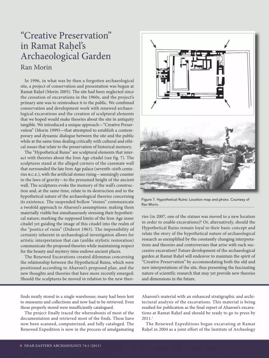
In 1996, in what was by then a forgotten archaeological site, a project of conservation and presentation was begun at Ramat Rahel (Morin 2005). The site had been neglected since the cessation of excavations in the 1960s, and the project’s primary aim was to reintroduce it to the public. We combined conservation and development work with renewed archaeo-logical excavations and the creation of sculptural elements that we hoped would make theories about the site in antiquity tangible. We introduced a unique approach—“Creative Preser-vation” (Morin 1999)—that attempted to establish a contem-porary and dynamic dialogue between the site and the public while at the same time dealing critically with cultural and ethi-cal issues that relate to the preservation of historical memory.
The “Hypothetical Ruins” are sculptural elements that inter-act with theories about the Iron Age citadel (see fig. 7). The sculptures stand at the alleged corners of the casemate wall that surrounded the late Iron Age palace (seventh–sixth centu-ries b.c.e.), with the artificial stones rising—seemingly counter to the laws of gravity—to the presumed height of the ancient wall. The sculptures evoke the memory of the wall’s construc-tion and, at the same time, relate to its destruction and to the hypothetical nature of the archaeological theories concerning its existence. The suspended hollow “stones” communicate a twofold approach to Aharoni’s assumptions: making them materially visible but simultaneously stressing their hypotheti-cal nature; marking the supposed limits of the Iron Age inner citadel yet guiding the image of this citadel into the realm of the “poetics of ruins” (Diderot 1963). The impossibility of certainty inherent in archaeological investigation allows for artistic interpretation that can (unlike stylistic restoration) communicate the proposed theories while maintaining respect for the beauty and mystery time endows ancient places.
The Renewed Excavations created dilemmas concerning the relationship between the Hypothetical Ruins, which were positioned according to Aharoni’s proposed plan, and the new thoughts and theories that have more recently emerged: Should the sculptures be moved in relation to the new theo-
ries (in 2007, one of the statues was moved to a new location in order to enable excavations)? Or, alternatively, should the Hypothetical Ruins remain loyal to their basic concept and relate the story of the hypothetical nature of archaeological research as exemplified by the constantly changing interpreta-tions and theories and controversies that arise with each suc-cessive excavation? Future development of the archaeological garden at Ramat Rahel will endeavor to maintain the spirit of “Creative Preservation” by accommodating both the old and new interpretations of the site, thus presenting the fascinating nature of scientific research that may yet provide new theories and dimensions in the future.
Figure 7. Hypothetical Ruins: Location map and photo. Courtesy of Ran Morin.

NEAR EASTERN ARCHAEOLOGY 74:1 (2011) 9
of Tel Aviv University and the Theological Seminary (Wissen-schaftlich-Theologisches Seminar) and the Faculty for Jew-ish Studies (Hochschule für jüdische Studien) at Heidelberg University. First we conducted a preliminary underground survey (2004), which was followed by six extensive excavation seasons (2005–2010).2 With the assistance of students and vol-unteers from around the world, large areas of the site and the surrounding area were excavated. Aharoni’s Areas C2, D3, D4, D5, and D6 were expanded and deepened, and eight new areas (A1, B1, B2, B3, C1, C4, D1, and D2) were opened (see fig. 8). In addition, a comprehensive survey of underground spaces, a survey of agricultural installations in the immediate vicinity,
and a comprehensive study of the agricultural terraces on the slopes of the mound were carried out.3
For reconstruction of the site’s architectural history, espe-cially during the Iron, Persian, and early Hellenistic periods, we decided to use the term “building phase,” with its implication of development and extension, rather than “stratum,” which implies destruction and later rebuilding. The chronological and stratigraphic picture exposed by the excavations of the Renewed Expeditions at Ramat Rahel includes nine separate phases of construction and development and additional phases of destruction and desolation. The different phases of construc-tion and development are summarized in the following table.
Construction Phase Aharoni’s Stratum
Period Date
From Until
Building Phase 1Royal administrative center under imperial hegemony
Vb Iron Age II The end of the eighth or the beginning of the sev-enth century b.c.e.
The second half of the seventh century b.c.e.
Building Phase 2Royal administrative center under imperial hegemony
Va Iron Age II–Persian period
The second half of the seventh century b.c.e.
The end of the fourth century b.c.e.
Building Phase 3Expanding construction
Persian period The end of the sixth or the beginning of the fifth century b.c.e.
The end of the fourth century b.c.e.
Destruction and robbery of the walls
Building Phase 4Imperial administrative center?
IVb Hellenistic period The second century b.c.e. The second century b.c.e.
Building Phase 5Village
IVa The end of the second or the beginning of the first century b.c.e.
The first century c.e. (the Great Revolt)
Destruction (?)
Building Phase 6Village
III Roman period The middle of the second century c.e. (?)
Uninterrupted con-tinuation to construction Phase 8
Building Phase 7Village
IIb Early Byzantine period
The fifth century c.e. Uninterrupted con-tinuation to construction Phase 8
Building Phase 8Village; construction of the church
IIa Late Byzantine– Umayyad period
The sixth century c.e. The middle of the ninth century c.e.
Building Phase 9Farm with agricultural installa-tions
I Abbasid period The ninth century c.e. The eleventh century c.e.
Agricultural zone with installa-tions
Fatimid–Ottoman The twelfth century c.e. The nineteenth century c.e.
Military fortifications and com-munication trenches
1947/1948,1954 1967

10 NEAR EASTERN ARCHAEOLOGY 74:1 (2011)
Iron Age II (Late Eighth—Seventh Centuries B.C.E.): The First Building Phase At Ramat Rahel
Prior to the late eighth century b.c.e., the area of Ramat Rahel was rocky and desolate, with no evidence of human habitation (fig. 9). Structures of the earliest building phase at Ramat Rahel were either incorporated into structures of the following phase or were dismantled to their foundations. Reconstructing the plan of the earliest building phase, there-fore, is no easy matter, and dating it accurately is even harder still. Aharoni identified very few remains belonging to the early phase (which he called Stratum Vb). In his opinion, most of the early architectural remains were terrace walls and walls of dwellings. He did, however, date part of a casemate wall exposed in the southeastern corner to this early building phase, but primarily because that part of the wall projected southward beyond what he understood as the palace plan of
the following phase (Aharoni’s Stratum Va). He claimed that this part of the wall, along with the pottery and the many lmlk jar handles that had been excavated, dated to the late eighth century b.c.e. and that they were evidence of the earliest phase in the history of the site.
While the Renewed Excavations at the site confirmed Aha-roni’s claims regarding the earlier phase, they also showed that he had erred in his reconstruction of this phase. A new plan had to be drawn (fig. 10).
Aharoni associated the “Western Tower” with the palace building of the second building phase (his Stratum Va).We believe that this tower, which differs greatly in style and build-ing method from the remains of the royal palace of the second building phase, should be allocated to the first building phase. While the structures of the second building phase (Aharoni’s Stratum Va) are characterized by high-quality construction—thin, elongated ashlar stones of local nari rock, laid course upon course as headers and stretchers—the Western Tower was constructed using building techniques common in Judah during the Iron Age: wide walls built of mixed fieldstones of varying sizes, some large, some medium-sized, and all uncut
Figure 8. Excavation areas of the Renewed Expedition to Ramat Rahel. Photo by Sky-View, adapted by Ido Koch.

NEAR EASTERN ARCHAEOLOGY 74:1 (2011) 11
or cut only partially and crudely. The foundations of these walls are sometimes integrated into the bedrock outcrops and sometimes into shallow foundation trenches. In our opinion, this structure functioned in Phase 1 as a tower fortress, situ-ated at the top of the hill for all to see, controlling the main road at its base, looking out at and watching over all who passed by (Lipschits and Gadot 2008; see fig. 11).
In its plan and building method, the tower belongs to the array of fortresses built around Jerusalem in the late Iron Age, such as the citadel exposed by Negbi on French Hill (Barkay, Fantalkin, and Tal 2002), on a location similar to that of Ramat Rahel: high on a hill, controlling a main road leading to Jerusa-lem. Similar citadels were also excavated at Binyanei Ha’uma, on the summit of Givat Ram (Ram Hill), on the road leading
Figure 9 (above). The Ramat Rahel hill prior to the First Building Phase. Prepared by Nirit Kedem.
Figure 11 (right). Western Tower walls–Phase 1. Photo by Pavel Shrago.
Figure 10 (above). The plan of the Ramat Rahel edifice in Building Phases 1–3. Prepared by Benjamin Arubas.

12 NEAR EASTERN ARCHAEOLOGY 74:1 (2011)
to Jerusalem from the west (Arubas and Goldfus 2007), as well as at the recently excavated for-tress on the outskirts of the village of Zur Baher, 1.5 km east of Ramat Rahel (Eisenberg and De Groot 2006). This fortress defends Ramat Rahel’s main topographical weak spot, its eastern side, and there is direct visual contact between the two sites. It was dated by its excavators to the late eighth or early seventh century b.c.e., and it was probably constructed at the same time as the first building phase at Ramat Rahel.
The stratigraphic connection between some sections of walls east of the tower show that they were parts of other buildings that had already been constructed on the hill during the first building phase. The main evidence of this was exposed by the Renewed Excavations in the southeastern corner of the site (Area D2). There a long section of the inner wall of what Aharoni called “the early casemate wall,” the continua-tion of the same wall found by Aharoni in his last season of excavations (1962), was exposed. The wall was found buried beneath a thick white floor. This floor is a continuation of the eastern courtyard floor, which had also been identified
by Aharoni and by us, in the excavation to the north (see below). This is the only location where the white floor of the second phase can be seen unequivocally sitting above the wall of the first phase—proving archaeologically that this wall indeed belongs to the early building phase (fig. 12). In our opinion, this wall is not part of a casemate wall but rather a section of a large building in the south of the site.
Further evidence of the duration of the early phase and its importance can be found in the profusion of pottery discov-ered in the fill levels beneath the second-phase floors, especially in the fill under the white floor of the inner courtyard and the casement rooms. Pottery types
Figure 12. Area D2—the southern wall and the courtyard floor above it. Photo by Pavel Shrago.
Figure 13. Selected pottery found below the courtyard floor. Illustration prepared by Yulia Gotlieb.

NEAR EASTERN ARCHAEOLOGY 74:1 (2011) 13
found beneath the white floor of the courtyard include frag-ments of bowls, jugs, lamps with high base, cooking pots, crude stands, and cylindrical holemouth jars with a thick, smooth rim. These vessels date mostly to the seventh century b.c.e. (fig. 13; see sidebar “Iron Age Pottery Assemblages: Typology, Chronology, and Function”). Aharoni had already noticed this, claiming that the same pottery types belonged to Stratum Va–b of the late Iron Age.
A similar stratigraphic situation was found inside a casemate room excavated south of the inner courtyard. Beneath the white floor and on top of the bedrock we found many sherds of holemouth jars, similar to ones found scattered across the site. It appears that these sherds were thrown here or placed in secondary use as part of the floor infrastructure and had been in use in a phase earlier than that of the building of the palace courtyard (fig. 14).
Iron Age Pottery Assemblages: Typology, Chronology, and FunctionLiora Freud
The pottery from about twenty loci from Aharoni’s casemate wall and palace courtyard, defined as “clean loci,” was reexam-ined. Clean Iron Age material came from fills or pits located below the white floor of the courtyard and the casemate rooms rather than from the floor level itself. Only a small amount of Iron Age pottery, mixed with Persian and even later pottery types, was found above the floor level.
Typologically, the assemblage from below the floors includes mainly bowls and holemouth jars but also some cooking pots, jugs, juglets, stands, kraters, and oil lamps. Most of the bowls are of the out-folded rim and shallow, flat type, burnished; many are also red slipped (fig. 13). Red slip and wheel burnish are common in the eighth- and seventh-century b.c.e. strata in Judah; they become less common toward the seventh and sixth centuries b.c.e. Therefore, these bowls and the frequent use of
red slip help date the establishment of the first stratum to the end of the eighth/beginning of the seventh centuries b.c.e.
The most common jar type at Ramat Rahel is the holemouth jar with thick, smoothed rims, which is found all over the site (see fig 14). Although the holemouth jar is a common type in strata of the eighth–seventh century b.c.e., its appearance at Ramat Rahel as the almost sole type is a unique phenomenon. In one room we found thirteen jars of this type in secondary use in a fill below the floor (see fig 14).
Together with these pottery vessels, we found other bowls and kraters, some burnished and a few red slipped, lamps with high bases, cooking pots of two types: the first with everted rim and neck with a single ridge, the second without a neck—all typical of the end of the Iron Age—along with crude stands, cylindrical holemouth jars with thick, smoothed rims, red slipped jugs, and decanters. These vessels should be dated to the seventh and early sixth centuries b.c.e.
Typologically, all the pottery types that are found above the floors are also found below them. These include the neckless cooking pot, oil lamps with an elevated base, delicate wheel-burnished shallow bowls, bowls and kraters with a folded rim, holemouth jars, jugs, decanters, and so forth. It seems that, despite the change in architecture, the pottery shows continuation. That having been said, additional types were
Figure 14. Holemouth jar sherds under the floor of the Southern Casemate Room. Photo by Pavel Shrago.

14 NEAR EASTERN ARCHAEOLOGY 74:1 (2011)
also found above the floors: the alabastrone, flat oil lamps, wedged-shaped kraters, holemouth jars with a rim depression, and mortaria. These types are usually associated with the Per-sian period, but their earliest appearance is dated as early as the beginning of the sixth century b.c.e. Since no destruction layer exists above the floor of the citadel and the floor con-tinued to function long after its initial construction, no clean assemblages were uncovered from this stratum. However, it is reasonable to assume that during the establishment of the second stratum the same pottery vessels, which continued the pottery traditions of the end of the Iron Age, remained in use alongside the new types. This phenomenon is characteristic of the Babylonian period, which, due to its short duration, is very difficult to define and isolate through specific pottery types unique to it. It is nonetheless possible that Ramat Rahel is an exceptional case, that this period is visible here, and that the sequence of settlement runs uninterrupted from the sev-enth century b.c.e. through the sixth century b.c.e. and up to the end of the Persian period.
Two unique assemblages deserve special attention: Locus 477 and Locus 14109. Locus 477, which was excavated under the building to the north of the inner courtyard, included a cache of hundreds of pottery vessels, most of them small bowls. Aharoni interpreted the Locus 477 assemblage as evi-dence of a destruction level above the floor. Comparing the height of the floor and the height at which the vessels were
found makes it clear that the vessels from this locus had been retrieved in one concentration beneath the floor.
Locus 14109, which is quite similar to Aharoni’s Locus 477, is a pit that had been sealed by the courtyard’s white floor and exposed in one of the squares excavated by us within the inner courtyard of the palace (2008 season). A high concentration of complete vessels, most of them open bowls, was found in the pit (see figs. 15–16).
The similarity in typology and functionality between the vessels in the two caches is striking. Both concentrations include a high percentage of small, open bowls, in particular the outfolded rim-bowl type and the flat-bowl type, all with surface treatment of slip and wheel burnish. There were also some chalices, jugs, and red slip jugs. The pits also yielded figurines. The vessels that make up the assemblage lead us to conclude that the assemblages are not domestic in nature. Their location in burials below the floors, the style of the ves-sels, and the fact that most of the vessels (small, open bowls and jugs) are part of a drinking set suggest that the caches are evidence of a symbolically charged performance. It could be political, such as feasting (ritual activity involving communal food and drink consumption and display that, in context, dif-fer from mundane consumption; Dietler 1996, 89), or cultic, such as foundation deposits. Further research will, hopefully, allow for the reconstruction of the social event that led to the burial of the caches.
Figure 15 (left). Selected pottery vessels found in Pit L14109 below the courtyard floor. Photo by Pavel Shrago.
Figure 16 (right). Pit L14109 below courtyard floor while being excavated. Photo by Oded Lipschits.

NEAR EASTERN ARCHAEOLOGY 74:1 (2011) 15
Jar handles with lmlk and “private” stamp impressions were also discovered in the fill beneath the second-phase floors. Two hundred lmlk jar handles have now been unearthed at Ramat Rahel (this number includes those found by Aharoni and by the Renewed Excavations). One-third of these (about seventy stamp impressions) come from clear stratigraphic con-texts beneath the inner courtyard floor and floors of additional buildings attributed to the second building phase. These stamp impressions include representations of all the known varieties and therefore characterize the entire chronological span of the administrative system of which these stamp impressions were
part. In addition, five of the eighteen private stamp impres-sions originated in the fill beneath the courtyard floor. Find-ing these jar handles beneath the floor of the second building phase establishes that they were part of the living assemblage of the first building phase. Aharoni hypothesized that the system of lmlk stamp impressions represented the period of King Hezekiah in the late eighth century b.c.e. In our opinion, there is a great deal of evidence that this administrative system continued to exist during the first part of the seventh century b.c.e. in the area of Jerusalem and the Central Hill Country (Lipschits, Sergi, and Koch 2010).
Ido Koch
The unique administrative nature of Ramat Rahel is best reflected in its profusion of stamped jar handles (fig. 17). Over six hun-dred stamped handles have been found at the site, dated to the Iron Age, Persian and Hel-lenistic periods, including lmlk and “private” stamp impressions (eighth–seventh centuries b.c.e.); concentric circle incisions (seventh century b.c.e.); rosette stamp impressions (late seventh–early sixth centuries b.c.e.); lion stamp impressions (sixth century b.c.e.); yhwd stamp impressions (sixth–second cen-turies b.c.e.); and yršlm stamp impressions (second century b.c.e.). All together, this phenomenon covers more than half a millen-nium of continuous administrative function at Ramat Rahel. No other Judahite site, not even Jerusalem, can challenge this record.
The study of the stamp impression phenom-enon from Ramat Rahel, within the country-wide stamp impression system, sheds a great deal of light on the different administrative systems in place over the period and the con-tinuity between them. Furthermore, a better understanding of the administrative system in any period will result in a better understand-ing of the historical reality in Judah itself.
Ramat Rahel: A Stamp Impression Center That Carried On for Five Hundred Years
Figure 17. Various types of stamp impressions found at Ramat Rahel. Illustration by Rodika Pinchas.

16 NEAR EASTERN ARCHAEOLOGY 74:1 (2011)
Omer Sergi
The date of the lmlk stamp impressions is connected to the destruction of Level III of Lachish by Sennacherib. We know this because the largest number of lmlk stamp impressions was discovered there. Consequently, most scholars agree with the dating of the lmlk stamp impressions to the late eighth century b.c.e. and connect them to the reign of Hezekiah. However, while archaeology can supply a clear terminus ad quem for the use of the lmlk stamp impressions (701 b.c.e.), we should take into account that the type of jars bearing the impressions already appeared in the late ninth–early eighth centuries b.c.e. and that Level III at Lachish had already been founded in the first half of the eighth century b.c.e. and was of long duration. Therefore, attempts to determine the initial phase of the lmlk administrative system must also involve historical consider-ations. As recently demonstrated (Lipschits, Sergi, and Koch 2010), the lmlk stamp impressions represent the administrative and economic system established in Judah when it became an Assyrian vassal kingdom. Accordingly, we may tentatively date the beginning of the lmlk stamp-impression system to the last quarter of the eighth century b.c.e., either in the late years of King Ahaz or the early reign of King Hezekiah.
As for the date of the termination of the lmlk administrative system, it should be noted that at least half the lmlk stamped handles were discovered at sites in the Judahite Hill Coun-try (Jerusalem, Ramat Rahel, Tell en-Nasbeh [Mizpah], and Gibeon)—sites not destroyed during Sennacherib’s campaign and inhabited continuously throughout the seventh century b.c.e. In addition, some lmlk stamp impressions were found in clear seventh-century b.c.e. archaeological contexts. While these stamp impressions might have been in secondary and continued use and have originated from sites in the Judahite Highlands not destroyed by Sennacherib, we should also con-sider the possibility that some of them were produced and stamped only after Sennacherib’s campaign in Judah. The assumed continuity of production of the same type of jars at the same production centers in the Shephelah and the con-tinued use of stamped handles of royal jars throughout the seventh century b.c.e. support this hypothesis.
By examining the distribution of the lmlk stamp impres-sions according to their detailed typology, it is possible to isolate three types of stamp impressions that appear only in Hill Country sites not destroyed in 701 b.c.e.: two-winged lmlk stamp impressions of Types IIb, IIc, and XII. Not even one example of these types was found in a clear 701 b.c.e. destruc-tion level. Therefore, it must be assumed that these types were produced after the 701 campaign and should be considered “late types” dated to the first half of the seventh century b.c.e. Accordingly, the four-winged lmlk stamp impressions and the
two-winged Type IIa stamp impressions that were found in the destruction of Lachish Level III (and other sites in the Judahite Shephelah) should be considered “early types” dated to the last quarter of the eighth century b.c.e.
The administrative importance of Ramat Rahel compared to other major Judahite centers may be deduced from the types of lmlk stamp impressions they yielded. The profusion of early lmlk stamp impressions found at Lachish Level III clearly demonstrates its administrative importance in Judah prior to Sennacherib’s campaign in 701 b.c.e. (fig. 18a). Fur-thermore, the data clearly show the lack of late lmlk stamp impressions at Lachish and the abundance found at Ramat Rahel and Jerusalem, both of which superseded Lachish as the main administrative centers of Judah in the seventh century b.c.e. (fig. 18b).
Ramat Rahel as an Administrative Center: The Early and Late lmlk Stamp Impressions
Figures 18a (top) and b (bottom). Lmlk stamp impressions found at five main Judahite sites. Illustration by Ido Koch.

NEAR EASTERN ARCHAEOLOGY 74:1 (2011) 17
Private Stamp Impressions from Ramat RahelIdo Koch
Of the 250 “private” stamp impressions known, 185 were found in archaeological excavations. They are called “private” because of their nature: every stamp has two (in some cases three) inscribed lines that include two personal names (PN), usually understood as: (belonging to) PN (son of) PN. These stamp impressions were defined early on as part of the royal Judahite storage jars and were later linked to the system of the lmlk stamp impressions.
A recent reanalysis of the forty-three different seals that were used to stamp the different types of private stamp impres-sions (Lipschits, Sergi, and Koch 2010) has shown that thirty-five of the forty-three known types were excavated in late eighth-century b.c.e. destruction levels (mostly Lachish Level III) that are generally associated with Sennacherib’s 701 b.c.e.campaign to Judah. Moreover, five of the remaining eight types contain names (both personal and patronymic) that also appear on stamp impressions from Lachish Level III or its contemporaries and therefore probably date to the same time.
Three names, הושעם/חגי hwš‘m/hgy (Hosh‘am son of Hagay), חשי/אלשמע hšy/’lšm‘ (Hushay son of Elishama),
and צמח/אלשמע smh/’lšm‘ (Zemah son of Elishama; see Lip-schits 2009) were discovered in Jerusalem and Ramat Rahel but do not have any parallel from Lachish or any other site in the Judahite Shephelah. Being only three out of forty-three types, it is likely that they also date to the late eighth century b.c.e. In any case, we can conclude that, unlike the lmlk stamp impressions, no private stamp impressions on jar handles were discovered in clear seventh-century b.c.e. archaeological con-texts.
The distribution of the private stamp impressions, which were concentrated mostly in the Judahite lowlands, is more limited than that of the lmlk stamp impressions. Only fifty-one were discovered in Jerusalem and its environs; nineteen of these were found at Ramat Rahel (Lipschits and Koch forthcoming). The unique nature of the private impressions stamped on the royal Judahite jars, combined with their lim-ited duration before Sennacherib’s campaign, their distribution mainly in the Judahite Shephelah, and their relative scarcity (a ratio of 1:7 compared to the lmlk stamp impressions), leads us to hypothesize that the private stamp impression system was used by the kingdom of Judah as part of its preparations for the Assyrian onslaught (Lipschits, Sergi, and Koch 2010). Follow-ing the Assyrian campaign, the private stamp impression sys-tem disappeared, while the lmlk system continued to develop with necessary changes in response to the massive Assyrian destruction.
Oded Lipschits
During the sixth excavation season at Ramat Rahel (18 August 2010), an ivory seal with a heretofore unknown name was discovered under the floor of the courtyard of the edifice, clearly dating it to the late eighth or early seventh century b.c.e. (fig. 19). The shape of the seal is oval, and its size is 1.4 cm long and 1.2 cm wide; there is a hole in its backside along the long side of the seal, probably in order to thread a cord, which allows the seal to be hung from around the neck. The two written lines of the seal can be read as follows:
šlm שלמklkl כלכל
As in other seals and stamp impressions from this type, it should be understood as šlm (the son of) klkl. On the seal and the meaning of the two names, see Lipschits forthcoming.
An Ivory Seal with the Name šlm (the Son of) klkl Discovered in the 2010 Excavation Season at Ramat Rahel
Figure 19. The Ivory Seal with the name šlm (the son of) klkl discovered at Ramat Rahel. Photo by Pavel Shargo.

18 NEAR EASTERN ARCHAEOLOGY 74:1 (2011)
Decipherable “Private” Stamp Impressions from Ramat Rahel and Their Parallels
Other Sites Where This Name Was Discovered
Other Sites Where This Type Was DiscoveredType
LachishBeth-shemesh, Tell en-Nasbehאחזי/ו.תנחמ’hzyh/w.tnhmAhazio son of Tanhum
1
Beth-shemesh, Tell Beit Mirsimלאליקמ.נע/ר.יכנl’ lyqm.n‘/r.yknto Elyakim servant of Yukan
2
Lachish, Jerusalemיהוחל/שחרyhwhl/šhrYehohail son of Shahar
3
LachishJerusalemליהוחיל/שחרlyhwhyl/šhrto Yehohail son of Shahar
4
Beth-shemesh, Tel GodedGibeon, Adullam, Socho למנחמ/יובנהlmnhm/ywbnhto Menahem son of Yehobanah
5
Beth-shemeshמנחמ/ויהבנהmnhm/wyhbnh(see above)
6
LachishGibeon, Jerusalemלנחמ/הצליהוlnhm/hslyhwto Nahum son of Hazalyahu
7
Beth-shemesh, Jerusalem, Lachishלנרא/שבנאLnr’/šbn’to Nera son of Shuvna
8
LachishGibeonלצפן/עזריהוlspn/‘zryhwto Zafan son of Azariah
9
לצמח/אלשמעlsmh/’lšm‘to Zemah son of Elishama
10
Tell en-Nas beh, Lachishלשבנ/א.שחרlšbn/’.šhrto Shuvna son of Shahar
11
Arad, Beth-shemesh, Jerusalem, Debir, Lachish, Tell Goded
לשלם/אחאlšlm/’h’to Shalum son of Aha
12
Gibeon, Lachish, Tell Erani, Tekoa
לתנחמ/מגןltnhm/mgnto Tanhum son of Magen
13
Beth-shemesh, Jerusalem, Gibeonלתנח/מ.נגבltnh/m.ngbto Tanhum son of Negev
14

NEAR EASTERN ARCHAEOLOGY 74:1 (2011) 19
The pottery vessels and other finds from the fills and pits beneath the second building phase floors (Aha-roni’s Stratum Va) are keys to dat-ing the period of the first phase of the fortress. Most of them should be dated to the seventh century and only a few to the late eighth century b.c.e. A similar chronological horizon appears in finds of jar handles with lmlk and private stamp impressions. All this leads us to conclude that the site came into existence in the late eighth or early seventh century b.c.e. The many stamp impressions, as well as the ceramic assemblage with its “palatial” characteristics, confirm that even in the early phase the site served as an administrative and gov-ernmental center.
This conclusion is supported by architectural features that are unique to Ramat Rahel: Aharoni’s ten volute capitals (the so-called “proto-Aeolic” capitals; see Lipschits 2009); Maisler and Stekelis’s relief in the line of small stone columns, similar to those found by Aharoni; and the Renewed Excavations’ three additional capital fragments, as well as a series of small carved stone columns with tiny pal-mette capitals that had been part of a window balustrade, similar to those that appear in the reliefs known as “the woman in the window.” It is rea-sonable to assume that all these items belonged to the same architectural assemblage (figs. 20–21a, b).
Aharoni attributed this assemblage of items to the magnificent palace of the second building phase (his Stra-tum Va), which he dated to the late seventh century b.c.e. Yigal Shiloh (1979, 10, 21), on the other hand, claimed that the capitals, along with many other ashlar building stones, are in secondary use in Stratum Va and that they originated in the early
Crenellations
Window Balustrades
Decorated Stone CapitalFigure 20. Architectural features from the Iron Age. Computer reconstruction by Ido Koch.

20 NEAR EASTERN ARCHAEOLOGY 74:1 (2011)
phase (Aharoni’s Stratum Vb). In this dating, Shiloh relied on, among others things, Yadin’s suggestion of dating the early stratum at Ramat Rahel to the ninth century b.c.e. and identifying the grand palace with the house of Ba‘al built by Queen Athaliah, as described in 2 Kgs 11:18 (Yadin 1973, 59–66). Based on this, Shiloh proposed the obvious analogy between the capitals found at Ramat Rahel and those found in the monumental ninth-century b.c.e. Omride-period architec-ture of the kingdom of Israel’s main cities (Samaria, Megiddo, Hazor, and Dan).
Since not even a single pot-tery sherd earlier than the late eighth century b.c.e. has been discovered at Ramat Rahel, it is no longer possible to accept the date suggested by Shiloh and Yadin for the earliest phase at the site. Nevertheless, we do accept the attribution of the volute capitals and some of the other unique architectural items to the early building phase. Apart from all the proof that points to Ramat Rahel having a well-constructed administrative center during this period, parts of whose walls were built of fine ashlars, there is evidence that strongly supports the assumption that these capitals were at this stage in secondary use: all the capitals at Ramat Rahel show marks of adaptation and modification, the most obvious of them being the deep slit at the top that was probably made as part of the process of incorporating them into the ceiling of the building of Stratum Va.
Our conclusion is that, by the first building phase (Aharoni’s
Stratum Vb; late eighth or early seventh century b.c.e.), Ramat Rahel was already a well-assembled royal administrative cen-ter, and our evidence suggests that the monumental architec-tural elements found at the site originate from this level. Even
at this early stage, the palace at Ramat Rahel was unparalleled by any other in the kingdom of Judah. It included a for-tress tower in the west and several ashlar-stone buildings with ornamental volute capitals, small stone columns that deco-rated a window or windows, and other stone ornaments. The profusion of stamp impressions on jar handles found at the site testifies to its role as the Judahite administrative center for the collection of agricultural produce, probably paid as tax to the Assyrian empire (see also
Na’aman 2001). This administrative role would grow in impor-tance in subsequent stages of its existence.
The Late Iron II (Late Seventh–End of the Fourth Centuries B.C.E.): The Second Building Phase at Ramat Rahel
This building phase, whose start should be dated to the second half of the seventh century b.c.e., is what gave the site its current monumental plan and provided it with a grandeur unknown elsewhere in Judah. Its monumental appearance at this stage was not merely a result of its ornamental architec-tural components (which, as suggested above, were a product of secondary use) but also a result of an expression of the general concept of planning a complex and extensive assem-blage, the uniform outline of the plan and the relationship and
Figures 21a–b. Window balustrade (above) and an example of “the woman in the window” (right). Illustration by Ido Koch.
By the first building phase, Ramat Rahel was
already a well-assem-bled royal administra-
tive center.

NEAR EASTERN ARCHAEOLOGY 74:1 (2011) 21
balance between its different parts, and the quality of building and its extensive complementary infrastructure.
Implementing the comprehensive planning concept at this stage required significant logistical and operational ground-work, and the results can be seen in the altered appearance of the natural hill. These changes also severely damaged the earlier settlement in a way that nearly blotted out its core char-acter. The new plan landscaped the palace with a royal garden on the west and extended the palace, including its courtyards and walls along the sloping eastern side of the hill, all the way to the fortress tower that already dominated that part of the summit. Extensive new infrastructure was required to imple-ment both these tasks, and the outcome shows a high degree of logistical planning and operational ability. The large quantity of material extracted from the quarrying of the natural hill and the material removed in the creation of a garden sunk into the bedrock on the western side were intended for use as fill and were taken and poured over the eastern slope. This fill created a large, level base upon which the palace units and courtyards were constructed. The extent of the energy required to adjust the natural outline of the extension to the satisfaction of the architects/engineers of the new design is testimony to the
grandeur and might of the state’s investment, planning, and construction of the second-phase palace at Ramat Rahel.
The plan of the complex, as seen in fig. 10, shows that during the second phase a rectangular complex was added to the east-ern side of the western tower that had been built on the sum-mit of the natural hill in the first phase. The plan originally published by Aharoni shows the tower as an integral part of the fortified palace complex and incorporated into the western casemate wall. However, during the Renewed Excavations it was discovered that Aharoni’s assumption regarding the termi-nation of the southwestern corner of the casemate wall south of the tower was no longer valid. The Renewed Excavations unearthed in that same spot a plastered pool that formed part of the water system of the royal garden (see below). A reexami-nation of the connection between the northern casemate wall and the tower (see above, fig. 10) revealed the existence of a “seam” between the casemate wall and the corner of the tower. There was a marked difference in building styles between the casemate wall, which is built as a row of thin, long ashlar-stone headers made of nari rock that abuts to the north side of the organic corner of the tower, and the corner itself, which is characterized by particularly thick walls made of two rows of
Iron Age II Architecture Fragments at Ramat RahelKeren Ras
Volute CapitalsAharoni’s excavations at Ramat Rahel unearthed four com-
plete and six fragments of volute capitals (the so-called proto-Aeolic capitals). The size of the complete capitals is roughly 100 x 50 x 40 cm. Three additional fragments were found in the Renewed Excavations (see fig. 20, decorated stone capital).
Capitals of this type have been found at various excavations in the kingdoms of Israel, Judah, Ammon, and Moab. Accord-ing to Lipschits (2009), the capitals from Judah and the capi-tals from Transjordan date to roughly the same time period, while the twenty-four volute capitals from the kingdom of Israel are earlier, dating to the Omride dynasty (ninth century b.c.e.). Lipschits proposes that the Assyrians, after conquer-ing the kingdom of Israel, were influenced by this architec-tural style and adopted it in some of the late eighth- and early seventh-century b.c.e. palaces in Assyria. It was probably an Assyrian directive to Judah, Moab, and Ammon that these capitals be incorporated as important architectural features in the administrative centers that they had designed as part of their vassal kingdoms.
Window Balustrade FragmentsDuring Aharoni’s excavations at Ramat Rahel, small deco-
rated pillars topped with volute capitals were found (Aharoni 1964, 56–58, fig. 38.1, pl. 48.1–2). The pillars and capitals were made separately and joined together by a square-shaped hole drilled through their center, where a metal rod was inserted. The base and top of the pillars are wider than the midsection, which is decorated with drooping palmettes. The capital is simple and has an oval center and two volutes. From there they connect to each other, forming the balustrade sequence.
The Maisler and Stekelis excavation uncovered a stone relief depicting this type of window balustrade (Stekelis 1935, 26). This find has a parallel in the window balustrade fragments and in the ivory reliefs of the “woman in the window” known from other sites in Palestine, Syria, and Mesopotamia (see fig. 20).
The Renewed Excavations unearthed twelve additional bal-ustrade fragments: three capital fragments and nine pillar fragments. These were found mainly in Area C3 (the collapsed cave), the same location where Aharoni had unearthed the previously excavated examples of balustrade fragments.
Pyramid-Shaped Stones (Crenellations)Aharoni’s excavations unearthed one complete pyramid-
shaped object and at least four related fragments. These frag-ments of three-stepped pyramid-type architectural artifacts (crenellations) were made of limestone (Aharoni 1964, 55, fig. 38.4, pl. 44.1). The bottom step measures 54 x 30 x 14 cm, the middle 33 x 22 x 15 cm, and the top step 17 x 15 x 10 cm. These stones are now located in the Israel Museum in Jerusalem, where the fragments have been reconstructed into two additional pyramid-shaped stones. An additional, almost complete, pyramid-shaped stone was found in the 2009 season of the Renewed Excavations.

22 NEAR EASTERN ARCHAEOLOGY 74:1 (2011)
Site Formation of Ramat RahelNirit Kedem
The analysis of the decisions that were made by the planners of the edifice of Building Phase 2 shows just how much energy and manpower were needed in order to impose the planners’ will and preconceived plan on the natural terrain. A functional explanation for these choices seems inadequate, and some of the choices exemplify the builders’ symbolic and cosmological intentions.
The construction of the edifice was carried out in an east to west orientation despite its location on a hill that faced southeast–northwest. In other words, the construction in a very real sense defied the natural topography of the hill. This indicates that the palace complex was built accord-ing to a predetermined architec-tural plan that intentionally dis-regarded the area’s topography. Could it be that the choice to build the edifice along an east–west axis was linked to a cosmol-ogy associated with thoughts of the sun-god?
Furthermore, the palatial compound of Ramat Rahel, with its prime location, served as a political landmark transmitting messages of “conspicuous consumption.” For the creation of the monumental structure at Ramat Rahel, large parts of the rocky terrain of the western face of the hill were quarried and then replaced by soil brought in from other parts of the hill. The soil belt was turned into an artificial garden that was irri-gated by stored reserves of rainwater (figs. 22a–c). This activ-ity could be witnessed by anyone living in settlements located west of Ramat Rahel. The alterations were meant to impress on observers the ability of the ruling elite to flout natural conditions and to overcome natural constraints. The scarcity of water was ignored, and a sophisticated water-collecting system (much still remains unknown; see sidebar “Water Installations in the Garden and ‘Conspicuous Consumption’ of Water”) enabled the creation of an artificial garden. The rocky, steep terrain was overcome by artificial quarrying and by the addition of a large fill. A projecting tower was built above the peak to ensure that no one would miss the ambitious building enterprise.
Who was the elite behind this ambitious building operation? It seems that the palace at Ramat Rahel was built according to an Assyr-
ian architectural plan that can be seen in reliefs from the royal palaces of Sargon II at Dur-Sharukin and Ashurbanipal at Nineveh. In these reliefs, the tower, standing on a hill and sur-rounded by gardens, water pools, and canals, carries important meaning. The architectural elements found at Ramat Rahel, such as the volute capitals and the crenellations, can also be seen in the Assyrian reliefs (see sidebar “Iron Age II Architec-ture Fragments at Ramat Rahel”). This evidence reinforces the assumption that a Judahite administrative center was built at Ramat Rahel under the watchful eye and with the encourage-ment of imperial rule, when Judah became an Assyrian vassal state.4
Figures 22a–c. Location of carving in the western part of the site and the fills in the eastern part. Photo by Pavel Shrago. Illustrations by Nirit Kedem.

NEAR EASTERN ARCHAEOLOGY 74:1 (2011) 23
large, unworked flint “boulders.” It turns out that the tower fortress of the first phase was integrated into the new, enlarged plan (fig. 23). At the time of the construction of the sunken garden, the fortress was isolated on three sides—south, west, and north—and stood upon a prominent rock cube projecting westward out of the palace complex.
The Royal Garden and the Water SystemThe garden extended around the western tower on its north-
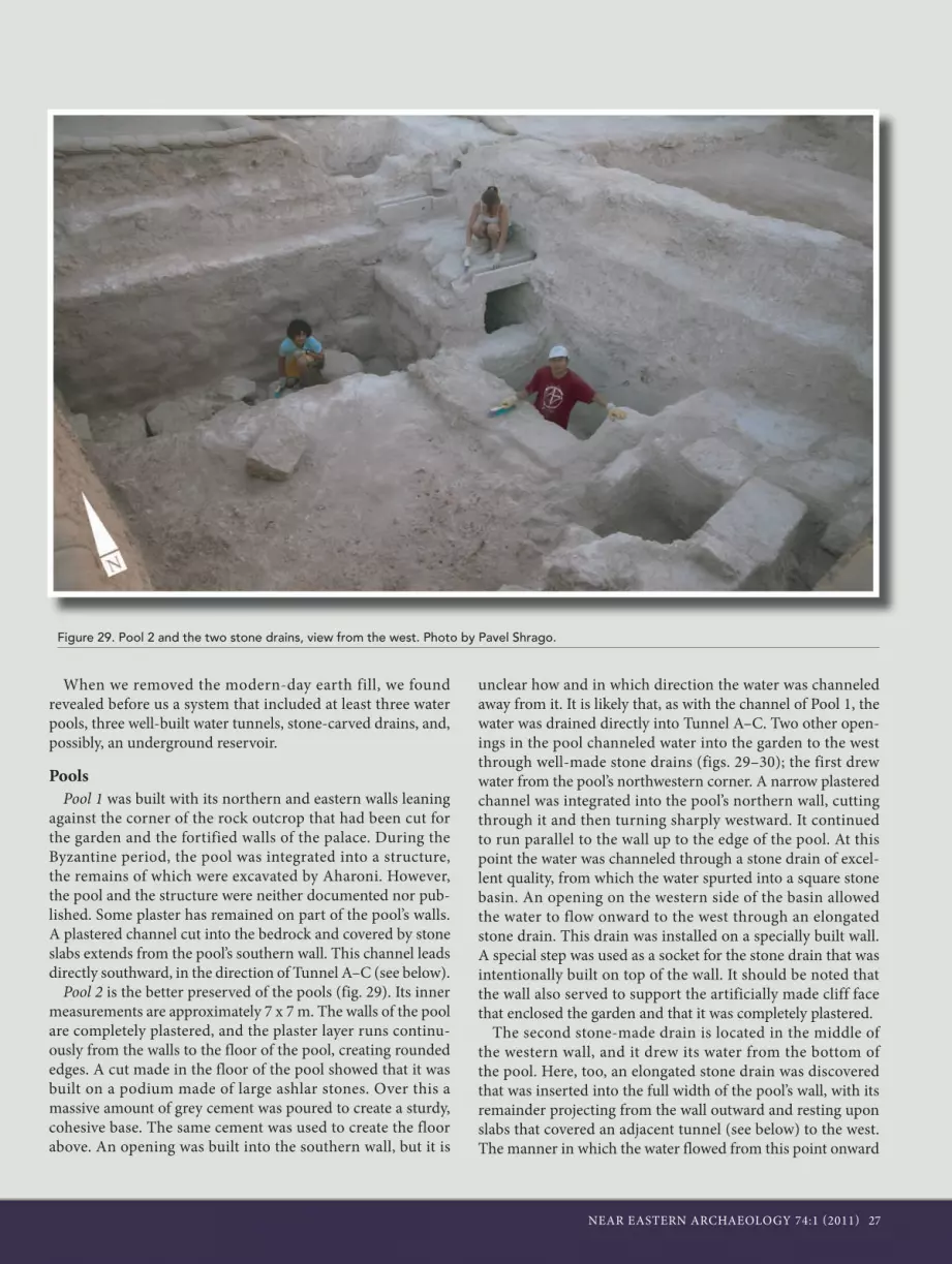
ern, western, and southern sides, on a lowered, leveled surface covering 16 dunams and possibly more. In creating the sunken garden in relation to the palace, the planners wanted to set apart the tower as a fortified wing isolated on three sides by an artificial cliff approximately 3 m high and to accentuate it fur-ther in the general westward landscape, toward the main road that passes at the foot of the hill (figs. 24–25). The quarrying and removal of nari rock from the natural surface enabled the creation of a leveled and unified rock surface. This surface was covered by a layer of unified, brown garden soil 45 cm deep (fig. 26). This layer of soil was discovered in our extended sur-face examinations around the western part of the palace. This soil was free of stones and sherds, and, although it appears that it was an original part of the hill, its placement upon the lev-eled limestone surfaces was artificial.
Other features besides the brown soil found incorporated into the flattened area are related to water (see the sidebar “Water Installations in the Garden and ‘Conspicuou s Con-sumption’ of Water”). At least two, possibly three, plastered pools (the better preserved of which is Pool 2) with two rock-cut and roofed tunnels were found to the south of the tower (fig. 27). The first tunnel follows the outer contour of Pool 2 and connects the eastern and northern escarpments. The second tunnel connects the eastern and the southern escarp-ments. Both tunnels end abruptly with no visible outlet for the water; the tunnels must have been intended to hold water rather than conduct it to another place. Two exceptionally well-built drains conducted water from Pool 2 westward. One of the drains was built on a heavily plastered wall built against the face of the northern escarpment. This wall may have been part of another pool that did not endure.
More features were found to the north of the tower, includ-ing Pool 6, which connects with a third roofed tunnel and a large underground water reservoir. A central water reser-voir would have been essential to a site of this size. Aharoni unearthed during the 1962 season a collapsed cave in the northern part of the site. Due to a late Persian or early Hel-lenistic period wall that had been built on top of the collapse, Aharoni understood that this cave had already collapsed in
Figure 23. A comparison between Aharoni’s plan of the western part of the palace and our plan, including the join of the western tower and the casemate wall. Adapted by Ido Koch.

24 NEAR EASTERN ARCHAEOLOGY 74:1 (2011)
Figure 24. Western and northern sides of the cut cliff face. Photos by Sky-View and Oded Lipschits.
Figure 25. Reconstruction of the relationship between the tower and its surroundings. Illustration by Nirit Kedem.
Figure 26. Garden soil and the smoothed bedrock. Photo by Pavel Shrago.

NEAR EASTERN ARCHAEOLOGY 74:1 (2011) 25
antiquity. The finds above the collapsed ceiling included the famous window balustrades. We used a crane to move the collapsed roof, which was made of large nari rocks weighing approximately 10 tons each. Excavations into the exposed cave revealed a well-plastered reservoir. Its measurements are impossible to reconstruct. We also lack information regarding the way it operated and how it connected to other water instal-lations located nearby.
The various components described here and in the “Water Installations in the Garden and ‘Conspicuous Consumption’ of
Water” sidebar do not form a complete picture of a coherent system; more remains unknown than known. From the outset, parts of the water system were connected to the royal garden’s irrigation system, and it was modified each time the palace complex was modified. However, the question of the source for the site’s water supply remains unanswered. At this stage, although many more components have been discovered from larger sections of the water system, the full picture of how the complete system once looked is still fragmented, and it is clear that other parts of the system have yet to be discovered.
Figure 27. Aerial view of the garden area. Photo by Sky-View.

26 NEAR EASTERN ARCHAEOLOGY 74:1 (2011)
Yuval Gadot
Due to the absence of a permanent and reliable water source on the hill, water was always scarce at Ramat Rahel. Rainfall, which averages 480 mm a year, is the only available source. Surprisingly, this lack of water did not deter the site’s inhabit-ants; on the contrary, the seventh-century b.c.e. garden with pools, Second Temple ritual baths (miqvaot), and a Roman bathhouse—all examples of water-intensive installations—were established throughout the site’s history. All these installations were undoubtedly reliant on efficient rainwater collection. Thus, one must ask: How was the water collected? Was there an underground reservoir at the site? After being collected, how was the water distributed across the garden and the site?
Various water-collecting installations were revealed during Aharoni’s excavations, most of them from the Roman and Byzantine periods. Rock-cut, bell-shaped water cisterns dotted the site as well. Today we know of at least nineteen water cis-terns, some of them located just meters from each other—clear evidence of the intensity of water collection on the hilltop. Aharoni uncovered a more elaborate water-collecting installa-
tion west of the church: a large, well-built reservoir dating to the Byzantine period.
The first clue of the existence of a sophisticated water sys-tem dating to the Iron and Persian periods was revealed only in Aharoni’s last days of excavation (1962). A well-built and plastered tunnel was unearthed in the southwestern corner of the edifice. With it, a small section of a plastered pool was revealed. Since Aharoni was by then planning his next cam-paign at Arad, these finds were only partially documented (fig. 28). The Renewed Expedition team has, since 2005, invested much of its resources in revealing water collection, storage, and usage installations integrated into the artificially lowered enclosure of the garden. We followed the course of the well-built plastered tunnel discovered by Aharoni and found it to be much longer than he had supposed. After we cleared the pool, we realized that Aharoni’s discoveries were only the “tip of the iceberg”; the rest of it was buried below earth accumu-lated during Aharoni’s excavations and the digging of military trenches.
Water Installations in the Garden and “Conspicuous Consumption” of Water
Figure 28. Tunnel A as documented by Aharoni and published in 1974. Illustration by Ido Koch.
NEAR EASTERN ARCHAEOLOGY 74:1 (2011) 27
When we removed the modern-day earth fill, we found revealed before us a system that included at least three water pools, three well-built water tunnels, stone-carved drains, and, possibly, an underground reservoir.
PoolsPool 1 was built with its northern and eastern walls leaning
against the corner of the rock outcrop that had been cut for the garden and the fortified walls of the palace. During the Byzantine period, the pool was integrated into a structure, the remains of which were excavated by Aharoni. However, the pool and the structure were neither documented nor pub-lished. Some plaster has remained on part of the pool’s walls. A plastered channel cut into the bedrock and covered by stone slabs extends from the pool’s southern wall. This channel leads directly southward, in the direction of Tunnel A–C (see below).
Pool 2 is the better preserved of the pools (fig. 29). Its inner measurements are approximately 7 x 7 m. The walls of the pool are completely plastered, and the plaster layer runs continu-ously from the walls to the floor of the pool, creating rounded edges. A cut made in the floor of the pool showed that it was built on a podium made of large ashlar stones. Over this a massive amount of grey cement was poured to create a sturdy, cohesive base. The same cement was used to create the floor above. An opening was built into the southern wall, but it is
unclear how and in which direction the water was channeled away from it. It is likely that, as with the channel of Pool 1, the water was drained directly into Tunnel A–C. Two other open-ings in the pool channeled water into the garden to the west through well-made stone drains (figs. 29–30); the first drew water from the pool’s northwestern corner. A narrow plastered channel was integrated into the pool’s northern wall, cutting through it and then turning sharply westward. It continued to run parallel to the wall up to the edge of the pool. At this point the water was channeled through a stone drain of excel-lent quality, from which the water spurted into a square stone basin. An opening on the western side of the basin allowed the water to flow onward to the west through an elongated stone drain. This drain was installed on a specially built wall. A special step was used as a socket for the stone drain that was intentionally built on top of the wall. It should be noted that the wall also served to support the artificially made cliff face that enclosed the garden and that it was completely plastered.
The second stone-made drain is located in the middle of the western wall, and it drew its water from the bottom of the pool. Here, too, an elongated stone drain was discovered that was inserted into the full width of the pool’s wall, with its remainder projecting from the wall outward and resting upon slabs that covered an adjacent tunnel (see below) to the west. The manner in which the water flowed from this point onward
Figure 29. Pool 2 and the two stone drains, view from the west. Photo by Pavel Shrago.

28 NEAR EASTERN ARCHAEOLOGY 74:1 (2011)
is unclear, since the channel terminates here. The channel was probably made from a series of stone drains that were also dismantled. The drains and the basin have survived in situ, but they are a very small part of the complete system. They were carefully constructed from hard white crystal chalk rock, probably the same rock that was used to make the ornamental stone capitals and the small columns of the balustrades. This type of rock is not found in the vicinity of the site and was brought there from distant quarries. The use of this type of rock shows that the planners wanted not only a functional water system but a refined, decorative one as well.
The primary function of the pool was as a water distribution device. Its use for gathering water should be viewed as second-ary. The three water exits are discernable only from outside of the pool, since the exits were sealed from within when the final coat of cement was poured. This demonstrates that the function of the pool changed in a later period. The thick layer of inert quicklime that filled the pool was found, and this also attests to the latest use of the pool during the Hellenistic period. The quicklime was probably produced in a nearby lime kiln to the south of the pool.
Were there other pools in the southern part of the garden? It is possible that another pool existed west of Pool 2. The most significant surviving part of this pool is its plastered north-ern wall (the same wall that was used as a base for the drain described above). Its western edge ends abruptly with a sharp turn southward, perhaps indicating a corner that existed at this point. Not much has survived from the walls of the pool, if it indeed was a pool, apart from what looks like a robbers’ trench and the remains of poor foundations. Moreover, it is not clear how this pool was integrated into the water system and if it was part of the original plan.
Pool 6, the largest yet to be found, was placed at the foot of the
northwestern part of the tower cliff. It is 13 x 9 m, with a depth of up to 2.5 m, giving it a maximum volume of about 290 m3. The pool is completely plastered and built in a technique resembling that of Pool 2, with evenly placed stone slabs as foundation and then plastered over. The pool was, at one time at least, connected to the garden’s water-channeling system through a plastered hewn tunnel. This connection was cut in a later phase, although the pool remained in use.
The exact function of the pool within the intricate system of the garden in the site is still unclear. However, the fact that the bottom of the pool in the area of the connection to the channeling system is higher than any other location measured inside the channels in the northwestern area indicates that the pool probably served as the source of water rather than its des-tination. Unlike the case of the nearby channels in the massive foundation trenches (see “The Persian Period [End of Sixth/Early Fifth–End of Fourth Century B.C.E]: The Third Build-ing Phase” below), Pool 6 was not deliberately covered with a thick layer of fill but was abandoned and filled gradually and naturally over time.
Covered TunnelsThree covered channels, designed to look like tunnels, were
discovered in the garden area. Two were found in the southern area of the garden and another one on the northern side. They were cut wide and deep into the chalk rock in the lowered level of the garden; the entire length of the rock walls was lined with cut masonry, and their face was coated with a thick layer of grey plaster. Along the roof were large covering slabs of narirock. This created channel-tunnels whose inner dimensions were 1.5 m high and .05 m wide.
Tunnel A–C, the best preserved of the three tunnels, abuts Pool 2 and surrounds it parallel to its southern and western
Figure 30. A suggested reconstruction of Pool 2 and the two stone-built drains. Prepared by Nirit Kedem.

NEAR EASTERN ARCHAEOLOGY 74:1 (2011) 29
walls. Tunnel D–E is located slightly south of Pool 2. It starts out as a shallow niche cut into the eastern rock outcrop that borders the garden; from there it progresses westward for about 3 m before turning sharply to the southwest for about 15 m, until it reaches the rock outcrop that borders the garden on the south side and ends with another shallow niche inside the rock wall. This tunnel was poorly preserved; most of the cover-ing slabs were dismantled, and very little plaster has survived. Tunnel F is located close to the foot of the northwestern corner of the tower fortress, where it was installed inside a channel cut deeply into the bedrock. It is roughly 4.5 m long and ends below the floor level of Pool 6.
This channel-tunnel merges into a longer, more complex system that has not yet been fully exposed and understood. The system includes water channels that run parallel to the massive walls of a large building that was added to the palace complex north of the tower fortress (see below). The channels lead eastward along the artificial cliffs. Their exact destination is unknown. One may speculate that they lead into a reservoir located further to the northeast, where a rock-cut tunnel was exposed already in 1962 by Aharoni (1964, 53).
Although we do not yet fully comprehend the full extent of the water system and the manner in which it functioned, it is clear that the installations found were meant to dis-play the power and ability of their builders to turn a barren hilltop into a flowering garden. The absence of a natural resource was turned into a manifestation of political might and human will.
Figure 31. Tunnel A interior. Photo by Pavel Shrago.
Figure 32. Collapsed ceiling of the reservoir and the walls that were built above of it, before (left) and after (right) excavations. Photos by Pavel Shrago.

30 NEAR EASTERN ARCHAEOLOGY 74:1 (2011)
The Borders of the Rectangular Complex and Its Forti-fications
A rectangular complex (“the palace”) was constructed east of the garden and the tower. According to Aharoni, it was sur-rounded by casemate walls on its northern, eastern, and south-ern sides and had a crushed limestone courtyard in the center. Our large excavation areas now enable us to suggest that the fortress was wider on the eastern and southern sides.
The northern casemate wall discovered during Aharoni’s excavations is made of ashlar stones laid in the typical Iron Age style of headers. Aharoni thought he had exposed the entire length of the wall and suggested a reconstruction of its western and eastern corners. He interpreted a small section of wall that continues eastward from the northeastern corner as part of a circumferential wall of the entire site. Our excavations have established that this section is a continuation of the casemate wall to the east. The excavations we carried out under the church floor in the northeastern part of the site exposed the continuation of the northern casemate wall. Small sections
of this wall and robbers’ trenches were extant. It appears that both the inner and outer walls of the casemate wall continued and that sandwiched between them were construction fills composed of various shades of soil.
Our excavation next exposed sections of the eastern wall of the complex, demonstrating that the eastern wall was quite different from the walls on the other sides. An entire section of the wall was exposed beneath the remains of the church in the northeastern corner of the site, and it aligns with a wide robbers’ trench to the south already identified by Aharoni and ascribed by him to an earlier building phase. The foundations of the wall are built of large (up to 2 m wide) ashlar stones that were laid on top of the bedrock. It is one thick wall, not a casemate system as in the north. The length of the section of the eastern wall that was exposed is 30 m. The remains of the church make examination of the architectural character of the corner, where the thick eastern wall joins the northern case-mate walls, impossible (fig. 33).
Aharoni believed that the southern casemate wall that bor-
Figure 33. Aerial view of the church and the Iron Age fortifications. Photo by Sky-View.

NEAR EASTERN ARCHAEOLOGY 74:1 (2011) 31
ders the inner courtyard also borders the entire palace on the southern side. In the Renewed Excavations (Area D6) we found sections of walls built upon the bedrock all over the area south of the casemate wall. Some of these sections should be attributed to the second building phase, and some should be attributed to the earlier phase. The palace, it turns out, expands southward far beyond what Aharoni reconstructed in his plan and includes the section of casemate wall that he attributed to Stratum Vb. Therefore, the ashlar walls south of the courtyard should now be seen as part of the inner building of the palace, not as part of the outer wall.
The Inner Courtyard, the Eastern Courtyard, and the Buildings inside the Complex
The inner courtyard at the heart of the rectangular complex was already exposed in its entirety by Aharoni (fig. 34). Its borders are clear, and, according to Aharoni’s reconstruction, it is surrounded on the northern, western, and southern sides by building complexes and bordered on the east by building complexes and a wall and passageway that stood between it and another courtyard located further to the east.
The courtyard was built on top of the natural bedrock, which has a gentle, northeasterly slope. Sections cut beneath the floor and down to the bedrock, both by Aharoni and by the Renewed Excavations, showed that, in order to level the natural rock face, construction fill was used from the extensive quarrying at the royal gardens. Due to the angular slope, the depth of the fill is between 20 cm and 1 meter; at some points it is even deeper. The fill is made of ground white chalk and contains many pottery sherds, including figurine fragments and several other finds belonging to Building Phase 1.
According to Aharoni, the remains of the wall found both west and north of the courtyard belonged to official build-ings of the palace that stood between the courtyard and the northern casemate wall and between the courtyard and the western tower that sits on the summit. As for the south, Aha-roni thought that the inner court bordered the southern case-mate wall and that no building existed south of the court. The Renewed Excavations established, as described above, that there was a building south of the courtyard. The “southern casemate wall” should be considered part of this building, not part of the fortification wall at the edge of the edifice. Aharoni
Concentric Incisions on Jar Handles from Ramat RahelOmer Sergi
To date, 274 jar handles with incisions of concentric circles have been found at various sites in Judah. About 132 of them were incised on handles that already had a lmlk stamp impres-sion. The concentric circles were incised after the jars had been fired with the lmlk impression, so the circles postdate the stamping of the lmlk stamp impressions. It seems, therefore, that the incisions system cancelled, adapted, or replaced its predecessor, the lmlk stamp impression system.
In attempting to date the incisions system, it is important to note that most of the jar handles with incised concentric circles were uncovered at Hill Country sites not destroyed at the end of the eighth century b.c.e., while only a few were found in the Judahite Shephelah. Moreover, the distribution of the incised handles is quite similar to the distribution of the late types of the lmlk stamp impressions dated to the seventh century b.c.e. and different from the distribution of the rosette stamp impres-sions, dated to the last third of the seventh century (see below, sidebar “Rosette Stamp Impressions from Ramat Rahel”). Accordingly, it is reasonable to assume that in the final decades of the lmlk system, before the rosette stamp-impression system was introduced, the lmlk and incised handles systems over-lapped. The incised handles should thus be dated to the middle or second-third of the seventh century b.c.e.
Ramat Rahel yielded about sixty handles incised with con-centric circles, and since the number of stamped jar handles
is indicative of the administrative importance of the site, it seems that Ramat Rahel maintained its importance through-out the seventh century b.c.e. Only Jerusalem yielded more incised handles (128 incised concentric circles on jar handles were found in Jerusalem, about half the total found). Thus the relations between Ramat Rahel and Jerusalem as the main Judahite administrative centers remained the same throughout the seventh century b.c.e., with the use of the lmlk system and the consequent use of the incisions system. It is important to note that all the incised jar handles from Ramat Rahel found in a clear archaeological context came from the construction fills of Building Phase 2 and therefore date to Building Phase 1.
Measurements of the Iron Age ComplexShatil Emanuelov
The tower, part of the first building phase, was constructed on a square plan. The length of each of the walls is 28.5 m, and the entire structure covered an area of approximately 824 m2. The structure to the east of the tower was built in the second building phase. Measuring 84 m by 72 m, it covered an area of 6,340 m2. The inner courtyard was 30 m long, 24 m wide, and covered an area of 753 m2. The eastern courtyard was ca. 60 m long, ca. 21 m wide, and covered an area of 1,260 m2. To the south, west, and north of the tower, a garden was landscaped on an area of approximately 16 dunams.

32 NEAR EASTERN ARCHAEOLOGY 74:1 (2011)
defined the route of the eastern casemate wall as east of the courtyard. In the center of the courtyard, he identified the entrance gate to the palace. The identification and reconstruc-tion of the gate is based on an ashlar wall that jutted out from the course of the casemate wall and ended with an inward cor-ner that creates a gap in the line of the outer wall. The floor in
this space was paved with large stone slabs and was interpreted as the floor of the gate.
Intensive construction in this area in later periods, includ-ing the building of a Roman bathhouse, makes it more dif-ficult to identify diverse phases and attribute the structures to their correct periods (fig. 35). The excavations carried out
Figure 34. Inner courtyard of the edifice. Photo by Sky-View.
Figure 35. Section in the area of the gate. Photo by Pavel Shrago.

NEAR EASTERN ARCHAEOLOGY 74:1 (2011) 33
by the Renewed Expeditions beneath the paved floor of the gate have established that the paving dates to the early Roman period, not to the Iron Age gate. Beneath the stone paving, we found a floor made of ground chalk. This floor continues on to the inner courtyard and reaches the corner of the ashlar wall. This leads us to believe that there was a passage of sorts from the inner courtyard through the walls and building complexes. The existence of another courtyard east of these walls and the discovery of the eastern wall about 20 m to the east allow for the reconstruction of a larger palace complex toward the east and illustrate that the passage found beneath the stone floor was in fact an inner gate within the palace complex.
The eastern courtyard appears to be similar in character to the inner courtyard. It is built on a fill of ground chalk com-bined with an abundance of pottery sherds (see fig. 22). An extensive part of the courtyard floor has been exposed; it con-tinues southward for another 30 m and covers the wall of an earlier building (see fig. 12). Eastward the floor continues for another 15 m, where it reaches the wall of the eastern fortifica-tion. The size of the inner courtyard is thus 600 m2, and the size of the eastern courtyard 450 m2.
Now that it can be stated with certainty that the dimensions of the Building Phase 2 fortified palace at Ramat Rahel were much larger than they appear in Aharoni’s plan, we take our investigation a step further to see whether the building of the complex in the second building phase was the result of a con-tinuous building project or whether it was constructed gradu-ally in several stages. This question pertains especially to the
relationship between the eastern and inner courtyards: Were both these spaces built at the same time, or do they constitute different chronological stages? The artifacts found, especially the pottery gathered beneath the floors of the courtyards, as well as the stamp impressions on jar handles, do not provide a precise chronological distinction. Nonetheless, an examination of the architectural remains of the northeastern corner of the complex, according to Aharoni’s plan, shows that the wall con-tinuing from that corner eastward is not only thicker but also clearly attached to the corner of the inner complex. In our last season of excavations we made a special effort to re-expose the face of the wall separating the inner and eastern courtyards. It is a fine built wall made of worked stones. Its face implies that it was not an inner but an outer wall. In light of all the above, it seems that the fortification system of the eastern extension identified in our excavations was actually attached to the inner complex as outlined on the plan by Aharoni. Another possibil-ity is that these are different technical building phases within a single building process.
ChronologyIn order to determine the time frame in which the palace of
the second building phase existed—from its construction until it went out of use—we must use both datable finds unearthed in the foundations of the buildings and finds above the floors of the buildings. Beneath the floors of the rooms, and espe-cially within the fill beneath the courtyards, we found an abun-dance of pottery sherds, figurines, and jar handles with stamp impressions, most of them from assemblages common to the
Rosette Stamp Impressions from Ramat RahelIdo Koch
The last third of the seventh century was a period of great change in the kingdom of Judah. The kingdom had partly recovered from the catastrophic Assyrian campaign (701 b.c.e.), and its demographic, economic, and territorial situa-tion was beginning to improve. During this period, the con-centric-circles stamp system was replaced with a new system: the rosette stamp impressions on jar handles (Koch 2008). This reflects the final phase of the kingdom of Judah. Unlike stamps of the previous seventh-century systems, rosette stamp impressions were found not only in the Central Highlands but also in Judean Lowland sites such as Lachish and Azekah, along the Beersheba Valley and the lower Jordan Valley. This demonstrates the re-expansion of the kingdom into its lost Judahite territories (Koch and Lipschits 2010). Furthermore, the great number of impressions found in Jerusalem reflects the city’s retention of its leadership position in the kingdom
and attests to the continuing importance of the administrative center at Ramat Rahel.
The dozens of rosette stamp impressions found at Ramat Rahel are invaluable for dating the system as a whole. The rosette system has been dated to the late seventh century (Koch 2008, 45–47), and since not a single handle was found below the floor of Building Phase 2, the construction of this phase must be contemporary with the rosette system. This, added to the supposition that the rosette stamp impression system was administrative in nature and that it perpetuated the objectives of its predecessor (the concentric circle incisions; see above), leads to the conclusion that the system was initially used in close proximity to the time of the previous administration sys-tem, not only at the end of the seventh century b.c.e. As a his-torical hypothesis, one could point to the days of King Josiah.
The rosette symbol was the third (after the lmlk and con-centric incisions) in a series of governmental royal Judahite symbols used for marking official storage jars. The symbol was adopted by the local government as part of the strong Mesopotamian-Aramaic cultural influence, which was domi-nant throughout the Levant, just like the lmlk symbols that had been adopted for the kingdom’s administration approximately one hundred years previously (Ornan 2005).

34 NEAR EASTERN ARCHAEOLOGY 74:1 (2011)
late eighth and early seventh centuries b.c.e. In relation to this, it is also important to point out what was not found in these assemblages. The absence of rosette stamp impressions, which came into circulation no earlier than the last third of the seventh century b.c.e., is particularly obvious and sig-nificant. This fact enables us to narrow the time frame for the construction of the second building phase and determine that construction began no later than the 630s b.c.e.
Aharoni attributed the end of Stratum Va to the Babylonian occupation of 587/586 b.c.e. He based this assumption on what he called a “destruction layer” in the palace buildings and a “burnt layer” on top of the gate’s floor (Aharoni 1964, 120). Our examinations have shown that the pottery assemblage representing the destruction was not on the floor but beneath it and is identical to the pottery assemblages found beneath the courtyard fill. At the same time, the paving of the gate and the fire above it belong to the late Roman period. It appears that all the artifacts found on the surface of Aharoni’s Stratum V represent late periods: Persian, Hellenistic, Roman, and Byzan-tine. Therefore, they cannot contribute to solving the question of the final date of this level. From our finds and reanalysis of Aharoni’s and Sulimani’s excavations, it appears that the palace of this stage was not destroyed in the late Iron Age and that the question of its continued use during the sixth century b.c.e. (the period of the Babylonian exile) remains open. However, further use of the palace’s rooms during the Persian period, expansion of the western sector, and the continued function of the central courtyard are evidence that, even if it was tem-porarily abandoned or there was a change in its role, there was no destruction. A more accurate determination of the date of abandonment or destruction of the complex needs to be based on the time of construction and abandonment of the next
phase (see below) and on the degree of architectural continuity between the two phases.
The Persian Period (End of Sixth/Early Fifth–End of Fourth Century B.C.E): The Third Building Phase
The profusion of artifacts found at Ramat Rahel shows a significant presence at the site at the beginning of the Second Temple period. Out of a total of about 640 yhwd stamp impres-sions of the Persian and Hellenistic periods (sixth–second centuries b.c.e.) known to us to date, 365 (60 percent) were found at Ramat Rahel. Of the 495 yhwd stamp impressions of the early and middle types, dated to the Persian period and the beginning of the Hellenistic period (sixth–fourth centuries b.c.e.), 332 were discovered at Ramat Rahel (67 percent; Van-derhooft and Lipschits 2007; Lipschits and Vanderhooft 2009; Lipschits, Vanderhooft, Gadot, and Oeming 2009). This is a clear indication that during the Persian and early Hellenistic periods the palace at Ramat Rahel was used in an administra-tive/governmental capacity for collecting wine and oil jars in Judah, probably as a levy.
Until now it has not been possible to securely reconstruct the architectural character of the Persian period palace at Ramat Rahel. However, the Renewed Excavations have uncov-ered some surprising evidence that sheds new light on Persian period Ramat Rahel. The remains of a new building, both sturdy and large, were exposed; up until its discovery, there had been no clue of its existence. Rectangular in shape, it was built on the northwestern side of the second-phase palace complex. It covers an area of about 600 m2 (ca. 20 x 30 m) taken from the royal garden. The brown soil of the garden was removed, and foundation trenches were dug into the flattened chalk rock. It appears that the building was not planned as an
Lion stamp impressions on jars or jar handles were first identified more than a century ago. Over one-hundred lion-stamped handles have been found, mostly at Ramat Rahel (75) and Jerusalem (21; see Ariel and Shoham 2000). In general, it is possible to draw the boundaries of this phenomenon as concentrated around the north Judean Hills and En-Gedi, with Ramat Rahel as the primary center of the system.
Until recently, scholars dated the lion stamp impressions to the very beginning of the Persian period (e.g., Ariel and Shoham 2000; Stern 2007). Current developments in research may hint at a wider dating. A modified typological classifica-tion demonstrates that two types (out of 10 types; 23 stamped handles out of 116) were found solely at Ramat Rahel, and one additional type was found at Ramat Rahel and Nebi Samwil.
Furthermore, petrographic analysis of the lion-stamped han-dles by Goren and Gross, Tel Aviv University’s Microarchae-ology Laboratory, shows a resemblance to Iron Age patterns (pottery production in the Shephelah of Judah and in the area of Jerusalem), not to Persian period patterns (pottery produc-tion solely in the area of Jerusalem). These two important developments may shed new light on the Babylonian period—the “dark decades” in the history of Judah.
We speculate that the lion stamp impression system is the “missing link” in the administrative continuity in Judah: it was part of the Babylonian administration that lasted until the beginning of the Persian period, at which point it was replaced by the yhwd stamp impression system.
Lion Stamp Impressions from Ramat Rahel and the Babylonian Period in JudahOded Lipschits and Ido Koch

NEAR EASTERN ARCHAEOLOGY 74:1 (2011) 35
independent structure but rather was built as a new wing added to the existing complex—an expansion northward of the fortress tower that extends west of the line of the palace. The building was constructed on a level lower than the tower and would have been as high as the tower, which explains the digging of the foundation trenches to such an extensive depth.
Since the building was dismantled and removed from its foundations in the following phase, it is possible to dis-cern the enormity of the construction project only from the deep foundation trenches of its outer walls. These founda-tion trenches became robbers’ trenches after the building was dismantled, but they can be discerned by their deliber-ate sealing with large amounts of fill made up of soil, con-struction debris, ash, and pottery sherds. These foundation trenches have an outline of a square arch open to the south and were dug deeply into the chalk rock that surrounded the already-sunken garden (fig. 36). They reach 2.5–3.0 m deep, and their average width is about 2.5 m. Sturdy walls of the structure were built inside the foundation trenches, first as supporting walls against the inner rock face of the foundation trench, then as a free-standing superstructure. The sections of the walls preserved at the bottom of the foundation trenches show a unique building technique that was unknown in the region before the Roman period. In this building technique, which could be called “half-casting,” the large nari stones were placed in front of the wall in high and equal courses. The face of the stone was cut smoothly, while the rest of the stone was turned toward the inside of the wall. The mass of masonry inside of the wall turned into a strong, solid unit onto which a grey bonding mixture, rich with ash and quicklime, was poured, giving it an unusual strength and the qualities of concrete casting. The walls surround
Figure 36 (left). Foundation trenches of the walls from Phase 3. Photo by Pavel Shrago.
Figure 37 (below). Plastered channels in Area C4. Photo by Pavel Shrago.

36 NEAR EASTERN ARCHAEOLOGY 74:1 (2011)
Pool 6 from the west, north, and east. We cannot determine at this stage if the walls and pools were built together or whether the pool was built in an earlier stage and the walls were added later.
Leaning against and surrounding the walls of the struc-ture was a plastered water channel, 30 cm wide, reaching a maximum depth of 2 m (fig. 37). It was installed in the gap left between the inner face of the foundation trench and the stones composing the walls of the building. The channel begins on the western side of the third-phase addition, a little south of the joint between the building and the northwestern corner of the protruding cliff on which the Iron Age tower fortress stands. It was constructed here with two well-built walls inside its own wide construction channel that was cut into the cliff rock. At this point the water channel slopes down to the depth of the foundation trench and after a short way clings to the western, northern, and eastern walls of the new building that forms its inner wall, up to the point where the wall meets the northern cliff rock of the Iron Age tower fortress. Here the channel veers from the building and turns sharply eastward along the north-ern cliff face of the complex toward a destination that has yet to be determined. At the turning point eastward, the channel is joined from the west by covered Tunnel F, approximately 4.5 m long, originating from Pool 6 (see sidebar “Water Installations in the Garden and ‘Conspicuous Consumption’ of Water”).
As stated above, the building was dismantled to its founda-tions, and little of it has survived. Thus far, only a section of the floor close to the northeast corner has been uncovered. This floor is unique in its construction; it is built on a thick
coating of up to 15 cm of grey cement over an infrastructure of thick-cut nari slabs. In addition, a wall has been exposed that divides the inner space of the building. It is 4 m long with a north–south trajectory, and it was constructed in a similar half-casting technique. This wall also serves as the western wall of Pool 6. Evidence of other construction with the same characteristics is found elsewhere at the site, but in most cases these are fragmented sections or remains of dismantled build-ings. In one of these, in the southern part of the garden, a layer of destruction debris was exposed that had sealed a pottery assemblage of three jars and a jug in the floor. This assemblage shows that the building was destroyed and abandoned in the late Persian period (fourth century b.c.e.; figs. 38a–b).
This evidence points to the probability of a surprising devel-opment in the settlement history of Ramat Rahel. The admin-istrative center that was founded at the site by the central gov-ernment of the kingdom of Judah, most likely while still under the yoke of the Assyrian Empire, was not destroyed with the fall of the kingdom but continued to serve as an administra-tive center under the rule of the Persian kings. Furthermore, it appears that Ramat Rahel had become one of the central government’s most important—if not the most important—administrative tax collection centers during the existence of the province of Judea. This is the only possible explanation for the unusual concentration of yhwd stamp impressions on jar handles found there. The involvement of the central Achaeme-nid Persian government can be seen in the intensive construc-tion at the site and in the unusual creation of the additional wing on the northwestern side of the existing palace, the style
Figures 38a–b. Pottery vessels from Area C1 in situ (left) and as a group after restoration (below). Photos by Pavel Shrago.

NEAR EASTERN ARCHAEOLOGY 74:1 (2011) 37
and strength of which is unparalleled by any finds from the area from that period.
Ruin, Oblivion, and Reconstruction during the Late Hellenistic Period
The next architectural development shows a drastic change in the history of Ramat Rahel. The fortified edifice, which for centuries had served as a mighty administrative and political center in the kingdom of Judah under the rule of the Assyr-ian and Babylonian Empires and later in the province of Judea under the rule of the Babylonian and Persian Empires, was completely obliterated. Its walls were dismantled and its sunken garden buried in debris. For the first time in Ramat Rahel’s history, a rural settlement cropped up on the hill.
O u r e x c a v a t i o n s h a v e unearthed a great deal of evi-dence for the destruction of the complex from Phases 1–3. The walls of the early com-plex—especially those on the western side—were robbed and the stones removed from the foundation trenches that had been cut into the bed-rock. The open trenches that remained after the founda-tion stones were robbed were then filled with earth mixed with stones of various sizes, including items unique to the Iron Age, such as fragments of volute capitals and crenella-tions (fig. 39). Examination of the pottery sherds from inside the fill has revealed that the latest ones date to the late Hel-lenistic period. Coins, stamp impressions, and other arti-facts found show that this is the latest period to which the fill can be dated. Refuse and land fill were also found above the sunken garden south of the tower. The fill, approximately 2 m deep, leveled the hill anew, obliterating the entire area that had been artificially lowered. This fill yielded a profusion of sherds, architectural elements, coins, and stamp impressions on jar handles; here, too, the latest items can be dated no later than the late Hellenistic period.
While excavating the top of the collapsed cave (described above), Aharoni noticed an earth fill similar to those we found
in extensive parts of the site. He dated it to the same period suggested by us. In none of these places was there any evi-dence that could attest to construction work being carried out on the fill. It was, therefore, obvious that these fills were not construction fills intended for use as base platforms but must have served a different function. The thoroughness with which the stones were excised from the foundation channels, the furnaces constructed next to the water pool in the southern section of the garden, and the entire area covered over with fill suggest that it was an intentional act of annihilation carried out in order to eradicate the ancient garden and the buildings
at the western front of the site. Demolishing the royal com-plex in this way was meant to obliterate from the landscape and thus the social memory any reminder of the adminis-trative base that had for centu-ries served as the nerve center of imperial rule in Judea.
The Fate of the Site during the Early Hellenistic Period
Following the end of Per-sian period, Ramat Rahel lost its prominence, and some of the walls of its complex were robbed. Its status during the early Hellenistic period is cloaked in obscurity, but it seems to have regained its standing as an administrative center at the beginning of the second century b.c.e. This is evidenced primarily by the distribution of handles that carry administrative stamp impressions, the continua-tion of a tradition begun in the Iron Age and maintained through the Persian period. Of 144 yhwd stamp impressions dated to the second century b.c.e., 33 were found at Ramat Rahel (23 percent). Of 95 yršlmstamp impressions dated to the sec ond century b.c.e., 31 were found at Ramat Rahel (33
percent). Thus far, no structures have been found whose con-struction can be dated with certainty to this time period. On the eastern edge of the site, Aharoni documented a wall that he dated to the early Hellenistic period (Stratum IVb). In our opinion, this was a fortifying wall that was built upon the east-ern fortifying wall of the former complex, which was partially robbed. We also managed to follow this wall northward for a
Figure 39. Fill above the foundation trenches of the walls of the northwestern addition. Photo by Oded Lipschits.
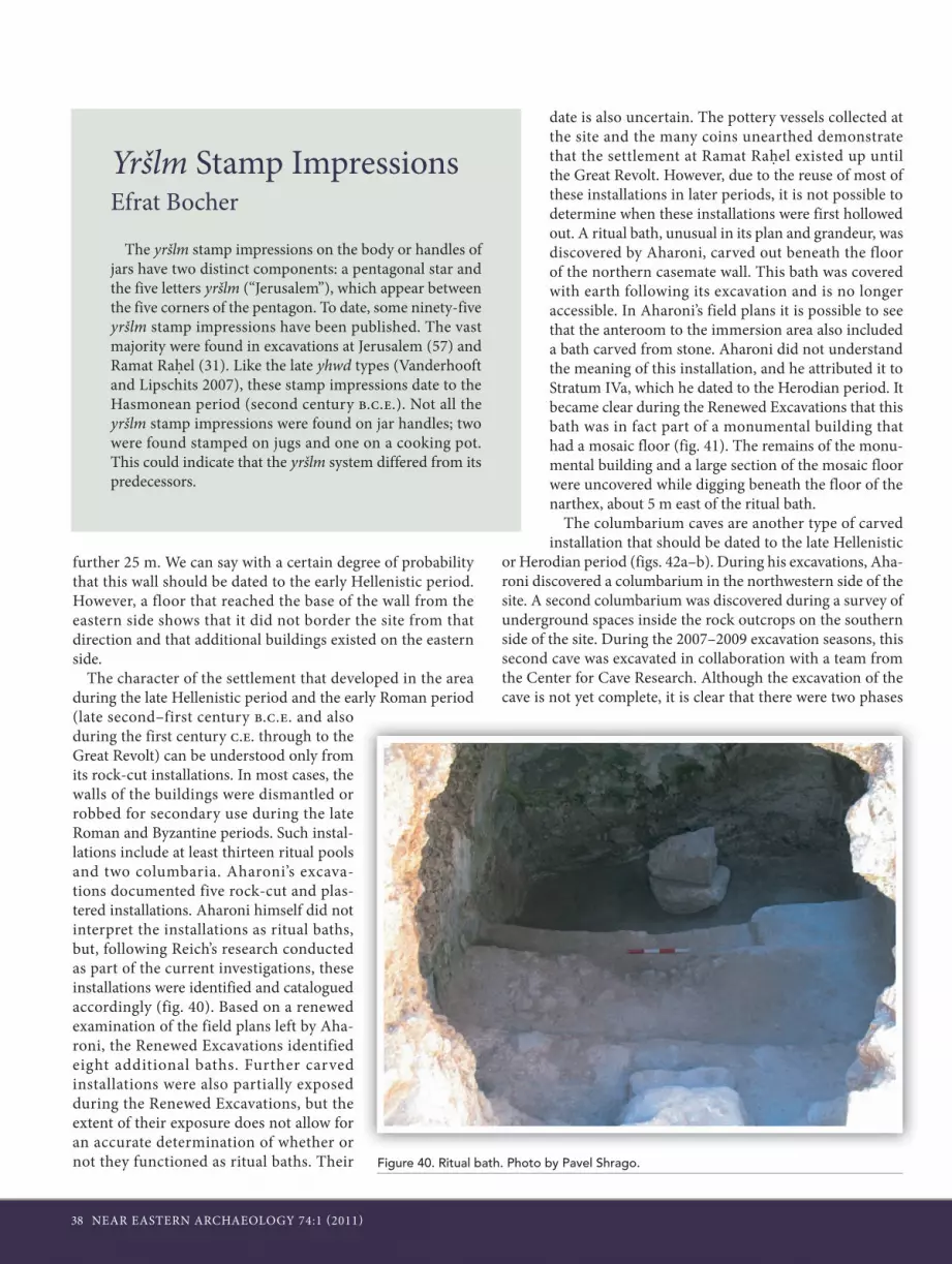
38 NEAR EASTERN ARCHAEOLOGY 74:1 (2011)
further 25 m. We can say with a certain degree of probability that this wall should be dated to the early Hellenistic period. However, a floor that reached the base of the wall from the eastern side shows that it did not border the site from that direction and that additional buildings existed on the eastern side.
The character of the settlement that developed in the area during the late Hellenistic period and the early Roman period (late second–first century b.c.e. and also during the first century c.e. through to the Great Revolt) can be understood only from its rock-cut installations. In most cases, the walls of the buildings were dismantled or robbed for secondary use during the late Roman and Byzantine periods. Such instal-lations include at least thirteen ritual pools and two columbaria. Aharoni’s excava-tions documented five rock-cut and plas-tered installations. Aharoni himself did not interpret the installations as ritual baths, but, following Reich’s research conducted as part of the current investigations, these installations were identified and catalogued accordingly (fig. 40). Based on a renewed examination of the field plans left by Aha-roni, the Renewed Excavations identified eight additional baths. Further carved installations were also partially exposed during the Renewed Excavations, but the extent of their exposure does not allow for an accurate determination of whether or not they functioned as ritual baths. Their
date is also uncertain. The pottery vessels collected at the site and the many coins unearthed demonstrate that the settlement at Ramat Rahel existed up until the Great Revolt. However, due to the reuse of most of these installations in later periods, it is not possible to determine when these installations were first hollowed out. A ritual bath, unusual in its plan and grandeur, was discovered by Aharoni, carved out beneath the floor of the northern casemate wall. This bath was covered with earth following its excavation and is no longer accessible. In Aharoni’s field plans it is possible to see that the anteroom to the immersion area also included a bath carved from stone. Aharoni did not understand the meaning of this installation, and he attributed it to Stratum IVa, which he dated to the Herodian period. It became clear during the Renewed Excavations that this bath was in fact part of a monumental building that had a mosaic floor (fig. 41). The remains of the monu-mental building and a large section of the mosaic floor were uncovered while digging beneath the floor of the narthex, about 5 m east of the ritual bath.
The columbarium caves are another type of carved installation that should be dated to the late Hellenistic
or Herodian period (figs. 42a–b). During his excavations, Aha-roni discovered a columbarium in the northwestern side of the site. A second columbarium was discovered during a survey of underground spaces inside the rock outcrops on the southern side of the site. During the 2007–2009 excavation seasons, this second cave was excavated in collaboration with a team from the Center for Cave Research. Although the excavation of the cave is not yet complete, it is clear that there were two phases
Yršlm Stamp ImpressionsEfrat Bocher
The yršlm stamp impressions on the body or handles of jars have two distinct components: a pentagonal star and the five letters yršlm (“Jerusalem”), which appear between the five corners of the pentagon. To date, some ninety-five yršlm stamp impressions have been published. The vast majority were found in excavations at Jerusalem (57) and Ramat Rahel (31). Like the late yhwd types (Vanderhooft and Lipschits 2007), these stamp impressions date to the Hasmonean period (second century b.c.e.). Not all the yršlm stamp impressions were found on jar handles; two were found stamped on jugs and one on a cooking pot. This could indicate that the yršlm system differed from its predecessors.
Figure 40. Ritual bath. Photo by Pavel Shrago.

NEAR EASTERN ARCHAEOLOGY 74:1 (2011) 39
Figure 41. Mosaic floor, beneath the mosaic floor of the church. Photo by Pavel Shrago.
Figures 42a–b. Columbarium. Photos by Pavel Shrago and Oded Lipschits.

40 NEAR EASTERN ARCHAEOLOGY 74:1 (2011)
during which it was used for raising pigeons and three phases of further use after it no lon-ger served its original function.
A hoard of fifteen Tyrian shekels was dis-covered in one of the nesting compart-ments carved into the wall of the cave (figs. 43a–c). The treasure was found inside a small ceramic cooking pot that had been placed inside one of the pigeon nesting compartments, just above the floor of the main hall. The coins represent a single collection: they were all minted in Tyre and are dated from to 38/37 b.c.e. to 11/10 b.c.e. The unifor-mity of the coins shows that the hoard represents a collection of coins from the period of placement (as opposed to a continuous collec-tion). The coin hoard joins the other two hoards of Tyrian coins from the first century b.c.e. found at Qumran and Mount Scopus and also to several other similar hoards dated to the last third of the first century b.c.e. We assume that the coins were hidden in the niche when the cave was no longer used for rais-ing pigeons and that the latest coin thus serves as the latest possible date for the cessation of the use of the cave. Therefore, the cave was used to raise pigeons in the first century b.c.e. and possibly even a little earlier. After that time, the columbarium became a refuse pit into which glass production waste, jar fragments, and other forms of waste were thrown until the cave was completely filled.
As a direct result of the suppression of the Judean rebellion and the destruction of Jerusalem, Ramat Rahel, like Binyanei Ha’uma and other villages in the Jerusalem surroundings, ceased to exist. Later developments at the site left us with no tangible evidence of the destruction, but the numismatic evi-dence shows the presence of Judean coins no later than year 2 of the rebellion. Furthermore, there is a very pronounced lack of evidence that can substantiate the existence of a settle-ment or any other Judean activity at the site during the period between the two Judean revolts.
The Settlement during the Late Roman, Byzantine, and Umayyad Periods
Following the Great Revolt, the ethnicity of the Ramat Rahel population changed. The site was abandoned for a short period, then reoccupied—this time as a Roman village. Aha-roni’s Stratum III is distinguished by the appearance of Roman period buildings: a peristyle villa and a bathhouse with sunken pottery bricks bearing stamp impressions of the Tenth Roman Legion. According to Aharoni, these finds represented the reoccupation of the site by the central government—in the
form of a military camp—because of its strategic location in relation to the city, now in its new guise as Colonia Aelia Capitolina. Aharoni dated this phase to the middle of the third century c.e. In light of data uncovered by the Renewed Expeditions and reexamination of the findings, Aharoni’s interpretation and suggested time frame can no longer be considered valid. The existence of a small bathhouse alone cannot indicate a military presence; other corroborating evi-dence, such as the remains of barracks, military fortresses, and other finds of a military nature, is necessary. The bathhouse and some of the other Roman period buildings at the site are agrarian and industrial in nature, while others are dwellings. We therefore suggest that at this stage a Roman country villa (of the kind known as villa rustica), equipped with a typical bathhouse, existed at Ramat Rahel. In this phase it was part of a new settlement model that developed, at least in the area south of Jerusalem, and it was based on an array of private estates similar to those excavated at Ein Yael (about 3 km west of Ramat Rahel) and Um el-Asfir (about 1.5 km southeast); Roman bathhouses were found as part of the complexes at both these sites. It seems reasonable to assume that all these sites were the private estates of the high officials of provincial rule or Roman veterans and that they had close connections with military units encamped in the area.
Aharoni thought that the resettlement of Ramat Rahel took place in the middle of the third century c.e. and that the site had remained unsettled for almost two hundred years before
Figures 43a–c. Silver shekels from the columbarium. Photos by Oded Lipschits.

NEAR EASTERN ARCHAEOLOGY 74:1 (2011) 41
then. In our opinion, there is no reason for this late date—neither according to our findings nor the stylistic and artistic comparative analysis. The bathhouse and its lovely mosaic pat-terns can be dated to around one hundred years earlier.
Examination of the characteristics of the remains from Ramat Rahel from the Roman period (second century c.e.) to the Umayyad period (eighth century c.e.) shows an organic development in various areas of local community life. These finds demonstrate that over a long period of time no signifi-cant changes occurred in the nature of the settlement, yet it is still possible to track the physical expression of the changes that took place in accordance with the spatial-functional divi-sion.
Agricultural InstallationsAharoni’s excavations in the southwestern part of the site and
our Renewed Excavations in Areas D2, D1, and D6 revealed an array of insulae divided into rooms and courtyards. In some cases agricultural production facilities survived and contin-
ued to function, with some modifications, from the Roman period through to the Umayyad period. For example, in Area D1 a collecting vat that was probably part of a large winepress was revealed (fig. 45). Another vat about the same size was found by Aharoni about 10 m northeast of this one. The use of both facilities ceased at some point, and the vat discovered by Aharoni was reused as part of an oil-press installation, as is made evident by the crushing stones, stone weights, and a stone drain found close by. The plastered basin in Area D1 was purposely filled with soil and rock debris. Large stone slabs were placed on the basin and integrated into the room’s floor, which was now also used for oil production. The oil-press facility included a rounded crushing stone, a screw device, and a built and plastered collecting vat with a bell outline that led to a stone drain.
The most complete winepress installation was discovered beneath the floor of the church in the northeast of the site. It included three square collecting vats, a paved treading sur-face, and a screw device for extraction that was sunk into the
A Unique Bulla Bearing the Name of HadrianYoav Farhi
A lead sealing (bulla) was discovered during the 2006 exca-vations at Ramat Rahel. The bulla is circular in shape (diam-eter: 11 mm). The reverse is blank, but on the obverse there is a three-line Latin inscription (figs. 44a–b):
IMP[H?]ADRIAN[A]VG
The following reconstruction is suggested for the abbreviated inscription:
Imp(eratoris) [H]adrian(i) or Adrian(i) [A]ug(usti)
If this reconstruction is correct, the translation of the inscrip-tion would be: “[Seal] of Emperor Hadrian Augustus.” The inscription indicates that the object to which the bulla was attached, probably an official letter written on papyrus, belonged to the emperor, or more likely, the letter, which had been sent from one place to another, sealed with the bulla, was identified as belonging to the emperor.
Roman imperial lead sealings, especially those with Hadri-an’s name, are very rare. This is the first of its kind found in Israel. Moreover, no other example of this type, with Hadrian’s name, is known thus far from the Roman world.
The discovery of this bulla in Ramat Rahel could mean that the site was the destination of an official consignment. This would suggest that during the second century c.e. the site may have been a temporary or even permanent station of a Roman military unit or, as recently suggested, a private estate, most likely the property of a high officer or a person connected with the provincial authorities.
Figures 44a–b. Hadrian Bulla: obverse (left) and reverse (right). Photos by Pavel Shrago.

42 NEAR EASTERN ARCHAEOLOGY 74:1 (2011)
treading surface. The facility was inside an insula whose walls were torn down when it was converted into a church. The floor of the winepress, made of industrial mosaic stones, was covered by the church floor. This modi-fication, which was made when the church was built, occurred in the late Byzantine or the early Umayyad period (seventh–eighth centu-ries c.e.). Since the installation in the north-eastern part of the site was out of use while the church was under construction, it is obvious that wine production did not cease because of religious changes in the settlement. It is pos-sible that the decline in wine production and the switch to olive-oil production was due to changes in the local demand for wine follow-ing the rise of Islam (the export market for wine continued to flourish).
CemeteryThe western part of the site remained out-
side the settled area. Tracts of land that had been created by the covering over of the ancient garden and the fortress areas were likely valuable in this rocky terrain and were used as crop fields, while the construction of buildings centered on areas where the bedrock was closer to the surface.
The northwestern part of the site, where the land fill was probably shallower, was converted in the late Roman period into a cemetery of rectangular shaft tombs. Graves were dis-covered in Areas A1, B1, B2, B3, C2, and C4 (figs. 46–47). The cemetery is similar to the one excavated at nearby Beit Safafa. The entry
Figure 45. Agricultural installations in Area D1. Photo by Pavel Shrago.
Figure 46. Aerial view of Area B3. Photo by Sky-View.
Figure 47. Plan (left) and section (right) of two graves in Area B3. Illustrations by Benjamin Arubas.

NEAR EASTERN ARCHAEOLOGY 74:1 (2011) 43
shaft into the tomb was first dug into the soil (in some cases “garden soil”) and later carved into the bedrock to a depth averag-ing about 2 m.
The graves are arranged in a north–south or east–west direction. The shaft has an elongated elliptical shape and is about 0.5 m wide and 2.1 m long. A row of cov-ering slabs separated the shaft from the burial chamber that was dug downward at the bottom of the shaft. In order to sta-bilize the covering slabs, sockets were cut into the bedrock. Most of the graves were found sealed, and inside there was usually one individual, but sometimes two bodies were buried facing each other. Some of the graves were found with no burial gifts (graves on the northern part of the burial fields). In other graves, such as those situ-ated on the southern side of the cemetery, glass bottles and sometimes jewelry such as gold earrings and also a large number of iron nails were found next to the interred. Between two and four bottles were found in each grave. The glass bottles help date the graves to the late Roman period (third–fourth century c.e.).
One unusual grave was discovered in Area C2, next to the walls of the Iron Age “western tower.” Three rectangular shaft tombs were found in this area. Two of the graves were similar in size and plan to the northern tombs. The third was a rock-cut rectangular grave (1.1 x 0.5 m), and inside was a lead coffin measuring 0.8 x 0.5 m and 0.3 m deep. The coffin contained the teeth of a two-year-old female tod-dler as well as a gold earring and crude iron nails (fig. 48).
The Kathisma Church and the Construction of the Church at Ramat Rahel
The process of Christianization of the Roman Empire had a profound effect on Ramat Rahel, and this was expressed in the appearance of the church within the plan of the existing settlement. In 1954, during Aharoni’s salvage excavations, the outline of a church became visible in the northeastern sector of the site. Adjoining it, on one side of a stone alley, a structure identified as a monastery was exposed. The plan of the church was confirmed during the following excavation season. The church, it appeared, had been “planted” on the northeastern outskirts of the settled area, on top of earlier industrial facili-ties and dwellings. Publication of the findings was accompa-nied by a discussion of Christian tradition that associated Ramat Rahel with Mary’s resting place on the last leg of her journey from Jerusalem to Bethlehem—a place that the early church had sanctified by constructing the Kathisma Church (“resting place”). Aharoni and his partners from the Sapienza–Università di Roma concluded that the church they discovered
was the Kathisma Church, and they dated it to the rather early fifth century c.e. Accordingly, they preferred interpreting the area surrounding the church as monastic in character.
Between 1993 and 2000, development work was carried out on the Bethlehem–Jerusalem road adjacent to Ramat Rahel. A salvage excavation that preceded the work exposed a church built on an octagonal plan with a natural rock at its center (Avner-Levy 2006–2007, 117–21). The church had been built on the third mile of the main road between Jerusalem and Bethlehem, just as the location of the Kathisma is described in the New Testament (see Avner-Levy 2006–2007 for further discussion). In light of this discovery, in our renewed explora-tion of the church discovered by Aharoni we investigated its function as a church within a settlement, knowing that both sites—the Ramat Rahel church and the Kathisma Church—are inextricably connected to each other and that it would be impossible to understand one without understanding the other. The results of our efforts confirm the plan of the church as it was published by Aharoni, as well as the use of the struc-ture as a church: it was a simple rural church meant to serve the local population. The apse on the east was made of finely cut ashlar stones; it is quite likely that a fresco was painted over them (fig. 49). The narthex and the southern pillars further clarified that the purpose of the architectural structure was a
Figure 48. Lead coffin from Area C2 and some of the finds discovered inside of it. Photos by Pavel Shrago.

44 NEAR EASTERN ARCHAEOLOGY 74:1 (2011)
church. Nevertheless, the pottery and coins unearthed from and beneath the foundations confirm that the church was built during the sixth, possibly the seventh, century c.e., not the fifth century c.e., as Aharoni had suggested.
An examination of the interaction between the Kathisma Church and the church at Ramat Rahel shows that the Kathisma Church was built first. Obviously, the settlement at Ramat Rahel existed before the Kathisma was erected at its base. It comes as no surprise, then, that the answer to the ques-tion of the role and identity of the church and of the settlement at Ramat Rahel is found in the same Christian sources that were used to identify the Kathisma. In the Gregorian calendar that consolidated the schedule of services and memorial days within the Church of Jerusalem in the Byzantine period, we find the following topographical denotations for the thirteenth day of August: “On the way to Bethlehem, on the third mile, in the village of Bethofor, at Kathisma, at the Church of the Mother of God a memorial service [will be held] with fast-ing and dedication.” In toponymic terms, the names of both places—the Kathisma and Bethofor Pago—are mentioned here
on the third mile at the side of the road between Jerusalem and Bethlehem. As stated earlier, in the past a great deal of attention was directed toward the mention of Kathisma, as opposed to that of the second place, Bethofor Pago. The Latin term pago attached to a name usually denotes a village; in our case, it refers to the village closest to the Kathisma Church. Previous researchers of Ramat Rahel paid no heed to this top-onym, probably due to their fixed idea regarding the identity of the Kathisma. Only now, with the discovery of the authentic Kathisma located adjacent to the remains of the extensive set-tlement at the top of the hill, can it be stated with relative cer-tainty (in the spirit of the words of Pascual Testini of Aharoni’s expedition) that the information given in the historical source “matches perfectly the historical surroundings.” Therefore, there is little room to doubt the nature of the village commu-nity of the settlement, whose name, Bethofor, we now know. To this we can add the variants of Bethofor—Pathofor and Betheabra—both of which are also mentioned in additional Byzantine calendars.
Ramat Rahel during the Abbasid Period OnwardIn the eighth century c.e., under Umayyad rule, there is clear
evidence of collapse and conflagration in diverse areas of the site: the northern wall of the church collapsed, there are signifi-
Figure 49. Area of the apse inside the church. Photo by Sky-View.

NEAR EASTERN ARCHAEOLOGY 74:1 (2011) 45
cant signs of various parts of Byzantine buildings giving way, and Aharoni notes indications of burning on the mosaic floor of the church. This destruction scene hints at the sudden end of the settlement, a destruction from which it never seems to have recovered—at least not as a Christian settlement. It is possible that this termination was the result of an earthquake that took place on 18 January 749 c.e. Confirmation of this date can be found in the annals of the Kathisma; the excavators attributed its last building stage to the eighth century c.e., when it was at least partially converted into a mosque. It is possible that this building stage is the result of the same fate suffered by the vil-lage on top of the adjacent hill. Although the Kathisma contin-ued to function in this hybrid state up until the late ninth–early tenth centuries c.e., it is unclear whether it remained under Christian control. From then through to the twelfth century c.e. there are no references in historical records to what hap-pened to the church. An explanation of this lack of information is hinted at in the description of a pilgrim, the abbot Daniel, who wrote in 1106 c.e. that the Kathisma and all its surround-ings were deserted and in ruins, being used as a source of build-ing stones for the local Arab population.
Aharoni attributed sections of the walls and furnaces for stone burning to Stratum I, which he dated to the seventh–eighth centuries c.e. (the Umayyad period). Reexamination of the finds from Aharoni’s excavations housed in the storerooms
of the Israel Antiquities Authority at Beth-shemesh revealed that among the pottery sherds found in his excavations were some that should be dated to the Abbasid, Fatimid, and even the Mamluk periods (see details in the sidebar “Ramat Rahel in the Islamic Periods: An Unknown History Comes to Light”). Sulimani’s and the Renewed Excavations’ findings show that, at least in the southern area of the site, the settlement continued through to the Abbasid period. In this area (D1), a courtyard house, which put the agricultural facilities mentioned earlier out of commission, was built by thickening the walls of the building that was in use in the Umayyad and Byzantine peri-ods. In the southeastern corner of the courtyard, an aperture was discovered that led to a space mostly under the courtyard floors and between walls that had been used by earlier build-ings. The paving of the courtyard was used as a roof for the underground space and was supported by a pediment. A small segment of plaster visible on the stones and the round aperture suggest that the space was used as a water cistern, but it is also possible that it was used for storage. The level of the halls on the north and south of the courtyard, which had vaulted roofs, was significantly lower than that of the courtyard. Within the rooms a large stone collapse and a profusion of pottery vessels that dated to the destruction of the structure in the tenth–elev-enth centuries c.e. was found. This debris also marked the end of permanent settlement at the site of Ramat Rahel.
Ramat Rahel in the Islamic Periods: An Unknown History Comes to LightItamar Taxel
The Renewed Excavations at Ramat Rahel have revealed an as-yet untold segment in the long history of the site, a segment that lasted through the end of the Late Islamic period. From Aharoni’s excavation reports, one gets the impression that the site ceased to exist not long after the Muslim conquest in the seventh century c.e. According to his stratigraphic-chronolog-ical interpretation, after the Late Byzantine period (his Stratum IIA; sixth–seventh centuries c.e.) the site existed as “a short-lived and poor settlement” until the eighth century (Stratum I), when it was finally abandoned. Aharoni barely discusses the architectural remains he attributed to Stratum I in his reports, and he published only a few of the finds he related to this stage. Jodi Magness, whose revision of the site’s history is based on the pottery published in Aharoni’s reports, also concluded that, “although some of the types … have an eighth to ninth century range, the absence of ‘Mefjer’ or buff ware and glazed pottery suggests that the settlement was abandoned around the middle of the eighth century” (Magness 1993, 118).
According to the stratigraphic-architectural and artifactual (mainly ceramic) evidence, it can be proposed with a high degree of probability that the Christian village that existed at the site during the Byzantine period remained generally unchanged. Barring repairs, adjustments, and local additions, the community life of the settlement, including the use of the church, continued with no unusual interruptions even during the Umayyad period, under early Islamic rule (first half of the eighth century), until, as suggested here, it was destroyed by a sudden catastrophe, possibly the earthquake of 749 c.e.
At this stage of research, it is impossible to determine whether the settlement was temporarily abandoned follow-ing its apparent destruction in the mid-eighth century or remained occupied for an unknown period. Whatever the case, the next stage in the site’s history is characterized by a substantial reduction in area and probably by a change in the religious affiliation of its population. The main architectural feature of this phase is a large, well-built courtyard building unearthed in Area D1. The latest pottery found beneath the floor of the southern hall (908) provides a late eighth–early ninth century (i.e., early Abbasid) terminus post quem for the construction of that hall and most probably of the entire build-ing. The floors of the various architectural units were found covered by a massive stone collapse associated with fire traces, which contained a large amount of pottery sherds, the latest of which are dated to the eleventh century c.e. Additional pottery of the late eighth–eleventh century has been found in other

46 NEAR EASTERN ARCHAEOLOGY 74:1 (2011)
parts of the site, mainly in relation to structures of the Byz-antine–Umayyad phase, which seems to have been partially renovated and reoccupied. The end of this phase is marked by the above-mentioned destruction, which occurred sometime in the eleventh century (i.e., in the Fatimid period), for a rea-son as yet unknown.
The settlement’s material culture during this phase, as reflected in the pottery, is not unusual compared to other con-temporary rural sites: it is characterized by various local (Pal-estinian/Levantine) wares, such as buff (“Mefjer”) ware, glazed bowls and jugs, and mold-made lamps. The most promi-nent exceptions are fragments of two tenth–eleventh century imported glazed bowls—an Egyptian luster ware (fig. 50a) and a Chinese celadon ware—which are very rare in small, rural settlements of the period. Noteworthy is another rare type: a glazed, apparently ninth-century, Kerbschnitt bowl (fig. 50b). The presence of such luxuries at Ramat Rahel points to the relative affluence of some of the inhabitants, which may have derived from the site’s location beside a major road.
The absence of ceramic types clearly dated to the Crusader–Ayyubid period indicates that, following its destruction in the eleventh century, the site remained unsettled at least until the thirteenth century c.e. The next stage in Ramat Rahel’s history, according to the ceramic evidence, can be dated to the Mamluk period. A relatively small—though still varied—
amount of pottery dated to the thirteenth–fifteenth centuries has been retrieved from the topsoil and upper occupation layers at various locations of the site, yet without clear rela-tion to any contemporary architectural features. This pottery consisted of typical household vessels, including handmade geometric painted ware, glazed bowls, and handmade cooking pots, most of which were locally produced, with the exception of one north Italian glazed bowl of the fourteenth to sixteenth centuries. These finds may suggest that during the Mamluk period Ramat Rahel was either a small settlement reoccupied by sedentary or seasonal peasants or even just used as a resting place for passers-by on the nearby road.
An Italian (Tuscan) bowl of the sixteenth–seventeenth cen-turies c.e., decorated with a polychrome underglaze painting in geometric, floral, and zoomorphic motifs (fig. 50c), dates to the early Ottoman period. This rare vessel may have reached the site via merchants or pilgrims traveling on the nearby Jeru-salem–Bethlehem road. The later part of the Ottoman period is represented by a handful of pottery sherds: Gaza ware water jugs, a handmade cooking pot, and handmade, painted geo-metric jars that differ from their Mamluk predecessors, all of which can be dated to as late as the nineteenth or early twentieth centuries. By then, the site of Ramat Rahel was most probably no more than a forgotten ruin visited by occasional shepherds.
Figures 50.a–c. Three types of glazed bowls: luster ware glazed bowl (left); glazed Kerbschnitt bowl (middle); and Italian glazed bowl (right). Photos by Pavel Shrago.

NEAR EASTERN ARCHAEOLOGY 74:1 (2011) 47
ConclusionAn ancient administrative center and sunken garden
propped in magnificence on a high hill for nearly five hundred years; a small agrarian Jewish, then Roman, then Christian, then Muslim settlement that cropped up and disappeared one after another for well over a thousand years; all but abandoned for nearly a thousand years more—this is the millennia-long history of Ramat Rahel. Although some evidence (troughs and water holes) of nine more centuries of agrarian activ-ity has been found, it was only in the 1930s that the hill was resettled—this time by members of the Jewish labor corps that founded Kibbutz Ramat Rahel. While digging a channel to transfer water to the kibbutz, they uncovered an ancient burial chamber adjacent to the nearby tell, a discovery that led to the first excavation of the site. The rest is history.
Notes1. We would like to thank the following people for assisting us in locating many of the documents and finds from Aharoni’s excavations at Ramat Rahel and making them available to us: Prof. Ronny Reich (Haifa University); Prof. Ze’ev Herzog (The Sonia and Marco Nadler Institute of Archaeology of Tel Aviv University); Prof. Anna Belfer-Cohen, Benjamin Sekay, and Daphna Tsoran (Institute of Archaeology, the Hebrew University of Jerusalem); Dr. Hava Katz, Pnina Shor, Dr. Orit Shamir, Michael Saban, Deborah Ben-Ami, Adi Ziv-Esudri, and Alegre Sabriano (Israel Antiquities Authority); Dr. Michal Dayagi-Mendels and Eran Arie (The Israel Museum); Cecilia Meir and Ziva Simon (Eretz Israel Museum, Tel Aviv); Prof. Giovanni Garbini and Prof. Maria Julia Amadassi (the Sapienza–Università di Roma).2. The directors of the excavations are Oded Lipschits of the Institute of Archaeology, Tel Aviv University, and Manfred Oeming of the Theological Seminary (Wissenschaftlich-Theologisches Seminar) at Heidelberg University. The excavation staff includes Yuval Gadot (Field Director); Benjamin Arubas (architectural analysis and measurements); Liora Freud (Registrar and Office Manager); Nirit Kedem (Area Supervisor, 2005–2009); Omer Sergi (Volunteer Coordinator, Assistant Area Supervisor, and Area Supervisor, 2005–2010); Gilad Cinamon (Area Supervisor, 2005–2006); Lior Marom (Area Supervisor, 2006–2007); Shahaf Zach (Area Supervisor, 2005–2007); Veronica Zltakovski (Area Supervisor, 2005–2008); Lisa Yehuda (Area Supervisor, 2007–2009); Rina Avner (Area Supervisor, 2007); Ido Koch (Assistant Area Supervisor and Area Supervisor, 2007–2010); Boaz Gross (Assistant Area Supervisor and Area Supervisor, 2007–2010); Dana Katz (Assistant Area Supervisor and Area Supervisor, 2007–2008); Keren Ras (Assistant Area Supervisor and Area Supervisor, 2007–2010); Alla Volvovsky (Area Supervisor, 2008–2010); Efrat Bocher (Assistant Area Supervisor and Area Supervisor, 2008–2010); Yoav Tsur (Assistant Area Supervisor and Area Supervisor, 2009–2010); Uri Davidovich (Supervisor of Columbarium and Terraces Excavations, 2008–2010); David Dunn (Assistant Area Supervisor, 2005–2010); Boris Babaiev (Assistant Area Supervisor, 2005–2007); Peter van der Veen (Assistant Area Supervisor, 2005–2006); Shani Rubin (Assistant Area Supervisor, 2006); Patricia Grandieri (Assistant Area Supervisor, 2006); Sivan Einhorn (Assistant Area Supervisor, 2007); James Boss (Assistant Area Supervisor, 2007); Shani Amit (Assistant Area Supervisor, 2007); David Frism (Assistant Area Supervisor, 2007); Katja Soennecken (Assistant Area Supervisor, 2007); Jacob Wright (Assistant Area Supervisor, 2007); Chris Bodine (Assistant Area Supervisor, 2008–2009); Andrew Pleffer (Assistant Area Supervisor, 2008–2009); Lindsey Moat (Assistant Area Supervisor,
2008–2009); Arian Goren (Assistant Area Supervisor, 2008); Lucas Schulte (Assistant Area Supervisor, 2009); Jason Radine (Assistant Area Supervisor, 2009); Parker Diggory (Assistant Area Supervisor, 2009); Sharon Napchan (Assistant Area Supervisor, 2009); Jennifer Purcell (Assistant Area Supervisor, 2009); Deborah Appler (Assistant Area Supervisor, 2009); Madhavi Nevader (Assistant Area Supervisor, 2009–2010); Richard Berendt (Assistant Area Supervisor, 2009–2010); Kook-Young Yoon (Assistant Area Supervisor, 2010); Konni Koesgen (Assistant Area Supervisor, 2010); Anja Kroschewski (Assistant Area Supervisor 2010); Carly Crouch (Assistant Area Supervisor, 2010); Donna Laird (Assistant Area Supervisor, 2010); Caroline Patterson (Assistant Area Supervisor, 2010); Assaf Kliemann (Assistant Area Supervisor, 2010); Sabine Metzer (Assistant Area Supervisor, 2010); Shatil Immanuelov (sketching and measurements); Amitai Achiman (administration, 2005–2008); Carsten Kettering (administration, 2007–2010); Yoav Farhi (metal detector and publication of coins); Uri Davidovich and Roi Porat (on behalf of the Centre for Cave Research, survey of subterranean features); Oren Tal and Itamar Taxel (cerami c analysis of Persian, Hellenistic, Roman, Byzantine, and Early Islamic pottery); Gila Yudkin (Volunteer Coordinator); and Pavel Shrago (photography).3. For the preliminary reports of the excavations, see Lipschits, Oeming, Gadot, Arubas, and Cinamon 2006; Lipschits, Oeming, Gadot, and Arubas 2009.4. For the “Assyrian” architectural connection of Ramat Rahel, see Reich 2003.
ReferencesAharoni, Y. 1956. Excavations at Ramat Rahel, 1954: Preliminary
Report. IEJ 6:102–11, 135–37.———. 1962. Excavations at Ramat Rahel, Seasons 1959 and 1960. Uni-
versità di Roma, Centro di studi semitici, Serie archeological 2. Rome: Università degli studi, Centro di studi semitici.
———. 1964. Excavations at Ramat Rahel, Seasons 1961 and 1962. Università di Roma, Centro di studi semitici, Serie archeologica 6. Rome: Università degli studi, Centro di studi semitici.
Ariel, D. T., and Y. Shoham. 2000. Locally Stamped Handles and Asso-ciated Body Fragments of the Persian and Hellenistic Periods. Pp. 137–71 in Inscriptions, ed. D. T. Ariel. Vol. 6 of Excavations at the City of David 1978–1985. Qedem 41. Jerusalem: Institute of Archaeology, Hebrew University of Jerusalem
Arubas, B., and H. Goldfus. 2007. The Site at Binyanei ha-Uma and Its Role in the Settlement Network Surrounding Jerusalem [Hebrew]. Eretz-Israel 28:14–20.
Avner-Levy, R. 2006–2007. The Kathisma: A Christian and Muslim Pilgrimage Site. ARAM 18–19:541–57.
Barkay, G. 2006. Royal Palace, Royal Portrait? The Tantalizing Possibili-ties of Ramat Rahel. BAR 32.5:34–44.
Barkay, G., A. Fantalkin, and O. Tal. 2002. A Late Iron Age Fortress North of Jerusalem. BASOR 328:49–71.
Bliss, F. J., and A. C. Dickie. 1898. Excavations at Jerusalem, 1894–1897. London: Committee of the Palestine Exploration Fund.
Clermont-Ganneau, C. 1899. Archaeological Researches in Palestine during the Years 1873–1874. 2 vols. London: Committee of the Palestine Exploration Fund.
Dickie, A. C. 1896. Report on Tombs Discovered near Sûr Bâhir. PEFQS 28:22–24.
Diderot, D. 1963. Salon de 1767. Edited by J. Senznec and Jean Adhé-mar. Oxford: Clarendon.

48 NEAR EASTERN ARCHAEOLOGY 74:1 (2011)
Dietler, M. 1996. Feasts and Commensal Politics in the Political Econ-omy: Food, Power and Status in Prehistoric Europe. Pp. 87–125 in Food and the Status Quest: An Interdisciplinary Perspective, ed. P. Weissner and W. Schiefenhovel. Providence: Berghahn.
Eisenberg, E., and A. De Groot. 2006. A Tower from the Iron Age Near Ramat Rahel [Hebrew with English summary]. Pp. 129–33 in New Studies on Jerusalem 11, ed. E. Baruch, Z. Greenhut, and A. Faust. Ramat-Gan: University of Bar-Ilan.
Fast, T. 1924. Neugefundene Schalensteine. ZDPV 47:242–44.Koch, I. 2008. Rosette Stamp Impressions from the Kingdom of Judah
[Hebrew]. M.A. thesis. Tel Aviv University.Koch, I., and O. Lipschits. 2010. The Final Days of the Kingdom of
Judah in Light of the Rosette-Stamped Jar Handles [Hebrew]. Cathedra 137:7–26.
Lipschits, O. 2009. The Origin and Date of the Volute Capitals from Judah, Moab, and Ammon [Hebrew]. Cathedra 131:5–24.
———. Forthcoming. “Like Father Like Son”—The Ivory Seal of šlm (the Son of) klkl, Discovered in the 2010 Excavation Season at Ramat Rahel. IEJ.
Lipschits, O., and Y. Gadot. 2008. Ramat Rachel and the Emeq Rephaim Sites—Links and Interpretations [Hebrew]. Pp. 88–96 in vol. 2 of
New Studies in the Archaeology of Jerusalem and Its Region, ed. D. Amit and G. D. Stiebel. Jerusalem: Israel Antiquity Authority.
Lipschits, O., and I. Koch. Forthcoming. Private Stamp Impressions from Aharoni’s Excavations at Ramat Rahel. In Final Publication of Aharoni’s Excavations at Ramat Rahel, ed. O. Lipschits. Vol. 3 of Ramat Rahel. Emery and Claire Yass Publications in Archaeol-ogy–Monograph Series of the Institute of Archaeology of Tel Aviv University. Tel Aviv: Institute of Archaeology, Tel Aviv University.
Lipschits, O., and N. Na’aman. Forthcoming. From “Baal Perazim” to “Beth-Haccherem”: On the Ancient Name of Ramat-Rahel [Hebrew]. Beth-Miqra.
Lipschits, O., M. Oeming, Y. Gadot, and B. Arubas. 2009. The 2006–2007 Excavation Seasons at Ramat Rahel. IEJ 59:1–20.
Lipschits, O., M. Oeming, Y. Gadot, B. Arubas, and G. Cinamon. 2006. Ramat Rahel 2005. IEJ 56:227–35.
Lipschits, O., O. Sergi, and I. Koch. 2010. Royal Judahite Storage Jars: Reconsidering the Chronology of the lmlk Stamp Impressions. TA 37:3–32.
Lipschits, O., and D. S. Vanderhooft. 2009. Forty Unpublished yehud Stamp Seal Impressions from Aharoni’s Excavations at Ramat Rahel [Hebrew]. Eretz-Israel 29:248–69.
ABOUT THE AUTHORS
Oded Lipschits is the Head of the Sonia and Marco Nadler Institute of Archaeology and the Head of “Ancient Israel Stud-ies” at the Alkow Department of Archaeology and Ancient Near Eastern Cultures, Tel Aviv Uni-versity. He is co-director of the Ramat Rahel Excavations Proj-ect, author of The Fall and Rise of Jerusalem (Eisenbrauns, 2005), and co-author of Yehud Stamp Impressions: A Corpus of Inscribed Stamp Impressions from the Persian and Hel-lenistic Periods in Judah (Eisenbrauns, forthcoming).
Yuval Gadot is the Field Director of the Ramat Rahel Excavations Proj-ect and the Archaeological Director for the European council–supported research program titled “Ancient Israel: The Exact and Life Sciences Perspective.” Gadot Teaches archae-ology at the New York University branch at Tel Aviv and at the School for Oversees Students, Tel Aviv Uni-versity.
Benny Arubas is an external lecturer and a PhD candidate in the Institute of Archaeology at the Hebrew University in Jerusalem. He is a Senior Research-er of the Hebrew University Expedi-tion to The Beth Shean–Scythopolis Excavation Project, a co-director of several excavations (Binyanei Ha-Ummah–Jerusalem; Masada–the Roman siege works; Haluza), architect and surveyor of many other excava-tions in Israel and abroad.
Manfred Oeming is a professor of Old Testament Theology at the Ruprecht-Karls-Universität, Heidelberg, Germany. He is the co-director of the Ramat Rahel Excavations Project and the author of Einführung in die Biblische Hermeneutik (Darm-stadt, 2003), translated into Eng-lish as Contemporary Biblical Hermeneutics: An Introduction (2006).
i A C f

NEAR EASTERN ARCHAEOLOGY 74:1 (2011) 49
Lipschits, O., D. S. Vanderhooft, Y. Gadot, and M. Oeming. 2009. Twenty-Four New yehud Stamp Impressions from the 2007 Exca-vation Season at Ramat-Rahel. Maarav 15:7–25.
Magness, J. 1993. Jerusalem Ceramic Chronology, Circa 200–800 CE. JSOT/ASOR Monograph Series 9. Sheffield: JSOT Press.
Maisler, B. 1935. Ramat Rachel and Kh. Salah [Hebrew]. Qobetz 3:4–18.Morin, R. 1999. Creative Preservation: The Development of an Artistic
Approach to the Preservation and Presentation of the Past. Con-servation and Management of Archaeological Sites 3:191–201.
———. 2005. “Creative Preservation” in the Recently Opened Archaeo-logical Garden at Ramat Rachel, Jerusalem. Conservation and Management of Archaeological Sites 7:56–62.
Na’aman, N. 2001. An Assyrian Residence at Ramat Rahel? Tel Aviv 28:260–80.
Niesiolowski-Spanò, L. 2005. Where Should One Look for Gideon’s Ophra? Biblica 86:478–93.
Oeming, M., and O. Lipschits. Forthcoming. Die Rätsel von Ramat Rahel. Welt und Umwelt der Bibel.
Ornan, T. 2005. A Complex System of Religious Symbols: The Case of the Winged Disc in Near Eastern Imagery of the First Millen-nium BCE. Pp. 207–41 in Crafts and Images in Contact: Studies on Eastern Mediterranean Art of the First Millennium BCE, ed. C. E. Suter and C. Uehlinger. Orbis biblicus et orientalis 210. Fribourg: Academic; Göttingen: Vandenhoeck & Ruprecht.
Reich, R. 2003. On the Assyrian Presence at Ramat Rahel. Tel Aviv 30:124–29.
Schick, C. 1878. Mitteilungen aus Jerusalem. ZDPV 1:11–23.Shiloh, Y. 1979. The Proto-Aeolic Capital and Israelite Ashlar Masonry.
Qedem 11. Jerusalem: Institute of Archaeology, Hebrew Univer-sity of Jerusalem.
Solimany, G., and V. Barzel. 2008. Ramat Raẖel. Hadashot Arkheologi-yot 120. Online: http://www.hadashot-esi.org.il/report_detail_eng.asp?id=793&mag_id=114.
Soennecken, K. 2006. Ramat Rahel in the Byzantine Period. M.A. the-sis. University of Edinburgh, College of Humanities and Social Sciences, School of History and Classics.
Stekelis, M. 1935. A Jewish Tomb-Cave at Ramat Rachel [Hebrew]. Qobetz 3:19–40.
Stern, E. 2007. En-Gedi Excavations I: Final Report (1961–1965). Jerusa-lem: Israel Exploration Society: Institute of Archaeology, Hebrew University of Jerusalem.
Vanderhooft, D., and O. Lipschits. 2007. A New Typology of the Yehud Stamp Impressions. TA 34:12–37.
Yadin, Y. 1973. The “House of Baal” in Samaria and in Judah [Hebrew]. Pp. 52–66 in Eretz Shomron: The Thirtieth Archaeological Conven-tion September 1972, ed. J. Aviram. Jerusalem: Israel Exploration Society.