Embed Size (px)
Citation preview
Irrigation at Garðar, SW Greenland and its NorthEuropean context
Eva Panagiotakopulu • Paul C. Buckland
Received: 10 October 2011 / Accepted: 20 April 2012� Springer Science + Business Media B.V. 2012
Abstract Southwest Greenland was settled, largely from Iceland, at the end of the tenth
century. Agriculture, based upon secondary products from domestic animals, lasted until
the fifteenth century when the last farms were finally abandoned. From the twelfth century,
the inhabitants had their own bishop and cathedral at Garðar in the more southerly Eastern
Settlement and this, with several other sites, shows evidence of agricultural innovation in
the use of irrigation as well as manuring of hayfields. This paper attempts to place the
Greenland irrigated fields in their Icelandic and North European context, suggesting that
their origins lie in the reorganisation consequent upon the arrival of the first resident bishop
from Scandinavia in 1126 and his ability to call upon labour beyond that available on the
episcopal farm.
Keywords Greenland � Norse � Irrigation � Palaeoecology � Medieval � Europe
Introduction
Recent palaeoecological research at Igaliku, the site of the medieval episcopal Seat of
Garðar in South West Greenland, has provided evidence for a system of irrigation and
manuring of the associated farm’s hayfields (Buckland et al. 2009; Panagiotakopulu et al.
in press). This evidence expands upon previous archaeological and geoarchaeological
results (Arneborg 2005; Adderley and Simpson 2006), which suggest the widespread
adoption of similar methods elsewhere in South West Greenland. It has been argued that
this change in land use reflects the organisation of the estate by the first Bishop, Arnald,
sent out from Lund in 1126 (Buckland et al. 2009). After four hundred years of occupation,
E. PanagiotakopuluDepartment of Geography, School of Geosciences, University of Edinburgh, Drummond Street,Edinburgh EH8 9XP, Scotland, UKe-mail: [email protected]
P. C. Buckland (&)20 Den Bank Close, Crosspool, Sheffield S10 5PA, UKe-mail: [email protected]
123
Water HistDOI 10.1007/s12685-012-0058-7

all sites had been deserted by sometime in the fifteenth century, and this process can
probably be correlated with an abrupt change in the peat stratigraphy at Igaliku. The
origins of the Greenland irrigation systems are difficult to trace since they appear earlier
than similar irrigation systems evidenced in Norway, and before the widespread adoption
of patterns of flooding influenced by English water meadows. Partly, this reflects the
survival of archaeological evidence in Greenland, whilst it has largely been overprinted
elsewhere. This paper examines historical and archaeological evidence for systems of
irrigation in medieval northern Europe in relation to the Garðar field results.
Throughout most of the North Atlantic region, from the head of the Gulf of Bothnia in
the East to Greenland and the Davis Strait in the West, the balance between precipitation
and evapotranspiration is such that water management concerns largely the removal of
excess water from the fields rather than its deliberate guiding onto the cultivated areas to
alleviate drought. It is only in unusual years that significant parts of this region suffer from
potential water deficits. Such comments are of course only valid for systems which predate
the modern agri–industrial landscapes, where increased yields are often dependent upon
irrigation water, often pumped from deep aquifers the recharge time of which is sufficiently
long for depletion to be treated as an SEP, someone else’s problem (sensu Adams 1989). In
the past, agricultural systems were essentially rain-fed relying upon systems tuned to the
vagaries of the annual cycle, and where too little, or too much precipitation at the wrong
time of year often led to widespread famine. The weather of the early years of the four-
teenth century provides a particularly good example (Dawson et al. 2007) with famine
reported from the Reykjanes Peninsula of southwest Iceland to northern Italy (Jordan
1996). Whilst communities were never immune to the unpredictability of individual years,
high rainfall and a potential water deficit, in those limited areas where either of the norm,
were often countered by agricultural innovation, either by drainage or by irrigation,
techniques which were not necessarily mutually exclusive. High rainfall in itself leads to
the leaching of essential nutrients from the soils, to acidification and podsolization, ulti-
mately causing waterlogging and development of acid mires, a process which has been
exacerbated by farming since at least the Neolithic in Western Europe (cf. Moore 1993).
Paring and burning, then spreading the ashes on the arable fields, provided a means by
which farming could be maintained on the formerly widespread heathlands of the west
(e.g. Hjelle et al. 2010), whilst northern forested landscapes often relied upon swidden,
small temporary clearances achieved by judicious use of fire (Lehtonen and Huttunen
1997). In both cases, however, the incremental drain on nutrients resulted in declining
yields and ultimate abandonment, unless the process could be slowed by the addition of
manure in the form of mineral or animal fertilisers. The latter has a long prehistory, which
probably extends back to the origins of agriculture (Guttmann et al. 2005), and can be seen
in the quasi-random scatter of archaeological materials of all ages across many landscapes.
The combination of manuring with irrigation, however, into what became a sophisticated
system of water management, known in England, as water meadows, has been seen by
many workers as a specifically post-medieval English development which later spread to
Scandinavia (e.g. Emanuelsson and Moller 1990; Vasari and Vaananen 1986).
Such an interpretation, however, creates an anomaly of the irrigation systems first noted
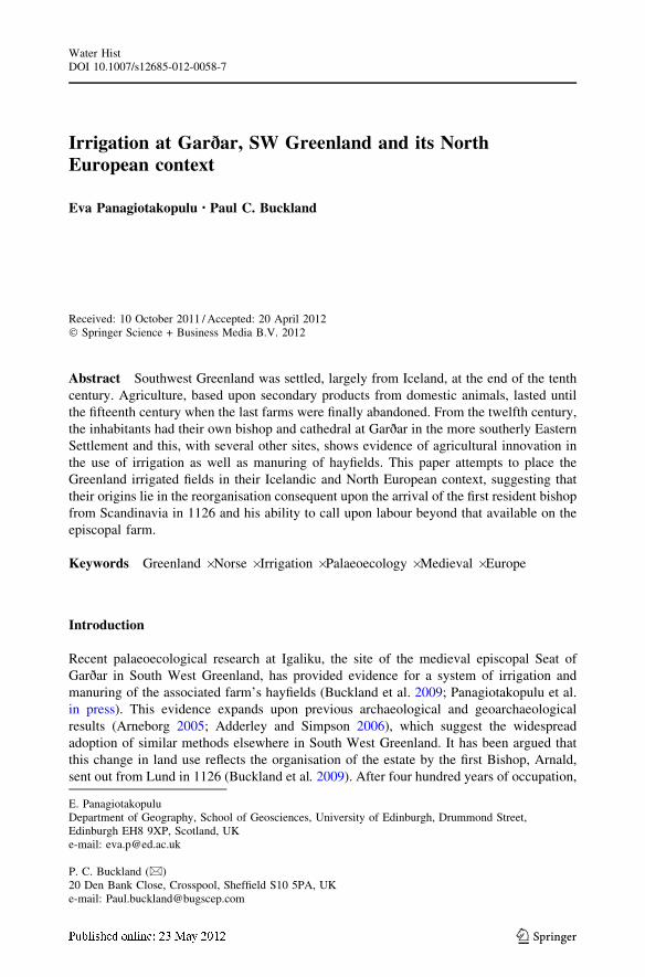
by Ingstad (1960)(see also Krogh 1974) associated with farms in South West Greenland
(Fig. 1), the last of which had been finally abandoned at sometime in the fifteenth century
(Seaver 2010). Arneborg (2005) has reviewed the evidence for irrigation channels in Norse
Greenland, summarising the evidence from the sites, all bar one in the more southerly
Eastern Settlement, and drawing parallels with post-medieval systems in Gudbrandsdalen
in southern Norway. More recently, the cutting of drainage ditches immediately adjacent to
E. Panagiotakopulu and P. C. Buckland
123
the cathedral and episcopal farm at Igaliku, Norse Garðar (Figs. 2, 3), has allowed the
examination of extensive deposits which indicate that irrigation of the hayfield of the farm
was associated with extensive manuring (Buckland et al. 2009; Panagiotakopulu et al. in
press), and this leads to a review of the historical evidence for medieval systems of
irrigation north of the Alps in mainland Europe and in Iceland.
Fig. 1 The Norse Eastern Settlement, SW Greenland. (redrawn by Anastasios Panagiotakopoulos)
Irrigation at Garðar, SW Greenland, and its North European context
123

Garðar
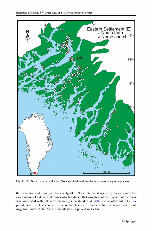
The system of dams across the small streams draining from the hills to the north of the
episcopal residence at Garðar (Fig. 2) had been noted by Nørlund (1929, p. 109) during the
archaeological investigation of the cathedral and associated farm, but it was some thirty
years before the Norwegian Helge Ingstad recognised something with which he was
familiar from his homeland. Nørlund had commented on the large size of the two principal
byres on the farm, which had a capacity of between 75 and one hundred head of cattle. This
stands in marked contrast with the majority of sites. At the probable farm of the chieftain at
Brattahlıð (Qassiarssuk), apparently divided into two farms in the later medieval period,
the stalls in the four byres indicate about forty animals (Nørlund 1936, p. 67), and for the
smaller farms about five cattle were more usual. Whilst his rough calculation, based on
Icelandic data, of 2 500 kilograms of hay per animal to enable them to be overwintered
is perhaps excessive in view of the small size of Greenlandic Norse cattle
Fig. 2 Irrigation at Garðar, SW Greenland (redrawn by Anastasios Panagiotakopoulos from Ingstad 1960and Krogh 1974). The sampling locations are indicated by (?)
E. Panagiotakopulu and P. C. Buckland
123
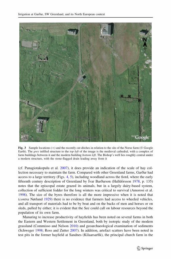
(cf. Panagiotakopulu et al. 2007), it does provide an indication of the scale of hay col-
lection necessary to maintain the farm. Compared with other Greenland farms, Garðar had
access to a large territory (Figs. 4, 5), including woodland across the fiord, where the early
fifteenth century description of Greenland by Ivar Barðarson (Halldorsson 1978, p. 135)
notes that the episcopal estate grazed its animals, but in a largely dairy-based system,
collection of sufficient fodder for the long winters was critical to survival (Amorosi et al.
1998). The size of the byres therefore is all the more impressive when it is noted that
(contra Nørlund 1929) there is no evidence that farmers had access to wheeled vehicles,
and all transport of materials had to be by boat and on the backs of men and horses or on
sleds, pulled by either; it is evident that the See could call on labour resources beyond the
population of its own farm.
Manuring to increase productivity of hayfields has been noted on several farms in both
the Eastern and Western Settlement in Greenland, both by isotopic study of the modern
grassland (Commisso and Nelson 2010) and geoarchaeological examination of sediments
(Schweger 1998; Ross and Zutter 2007). In addition, artefact scatters have been noted in
test pits in the former hayfield at Sandnes (Kilaarsarfik), the principal church farm in the
Fig. 3 Sample locations (?) and the recently cut ditches in relation to the site of the Norse farm (� GoogleEarth). The grey infilled structure to the top left of the image is the medieval cathedral, with a complex offarm buildings between it and the modern building bottom left. The Bishop’s well lies roughly central undera modern structure, with the stone-flagged drain leading away from it
Irrigation at Garðar, SW Greenland, and its North European context
123
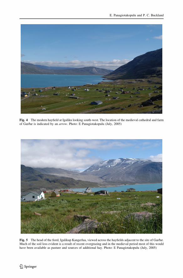
Fig. 4 The modern hayfield at Igaliku looking south-west. The location of the medieval cathedral and farmof Garðar is indicated by an arrow. Photo: E Panagiotakopulu (July, 2005)
Fig. 5 The head of the fiord, Igalikup Kangerlua, viewed across the hayfields adjacent to the site of Garðar.Much of the soil loss evident is a result of recent overgrazing and in the medieval period most of this wouldhave been available as pasture and sources of additional hay. Photo: E Panagiotakopulu (July, 2005)
E. Panagiotakopulu and P. C. Buckland
123
Western Settlement (Arneborg and McGovern, Unpubl.). The preservation of organic
materials at Garðar, however, provides more extensive evidence. Artefactual material
recovered from the upcast of modern ditch sections, includes a tally stick, fragments of
stave-built vessels, a possible prayer stick, wood-working debris and bone and stone
fragments. These are scattered over 100 m of ditch section and occur in a 0.5-m thin silty
organic deposit which extends out from the farm and sits over a gently sloping terrace of
sandy silt with pebbles, part of an early Holocene raised beach system (cf. Sparrenbom
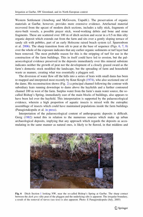
et al. 2006). The sharp transition from silt to peat at the base of sequence (Figs. 6, 7, 8)
over the whole of the exposure indicates that any earlier organic sediments or turf layer had
been removed. The most probable reason for this is the stripping of turf for use in the
construction of the farm buildings. This in itself could have led to erosion, but the pal-
aeoecological evidence preserved in the deposits immediately over this mineral substrate
indicates neither the growth of peat nor the development of a closely grazed sward as the
farm’s domestic stock modified the landscape, but the spreading of farm and household
waste as manure, creating what was essentially a plaggen soil.
The diversion of water flow off the hills into a series of leats with small dams has been
re-mapped and interpreted most recently by Knut Krogh (1974), who also sectioned one of
the dams. His reconstruction shows (Fig. 2) a principal channel following the contour with
subsidiary leats running downslope to dams above the hayfields and a further contoured
channel 100 m west of the farm. Surplus water from the farm’s main water source, the so-
called Bishop’s Spring, immediately east of the main blocks of buildings, also appears to
have been led over the hayfield. This interpretation is supported by the palaeoecological
evidence, wherein a high proportion of aquatic insects is mixed with the eutrophic
assemblage of insects which could have maintained populations inside the farm buildings
(Panagiotakopulu et al. in press).
Interpretation of the palaeoecological content of anthropogenic deposits is difficult.
Greig (1982) noted this in relation to the numerous sources which make up urban
archaeological deposits, implying that any approach which regards the deposits as accu-
mulating in the same manner as natural ones, is likely to be flawed, in that middens and
Fig. 6 Ditch Section 1 looking NW, near the so-called Bishop’s Spring at Garðar. The sharp contactbetween the dark grey silty peat of the plaggen and the underlying silts is apparent. The irregular boundary,a result of the removal of turves (see text) is also apparent. Photo: E Panagiotakopulu (July, 2005)
Irrigation at Garðar, SW Greenland, and its North European context
123
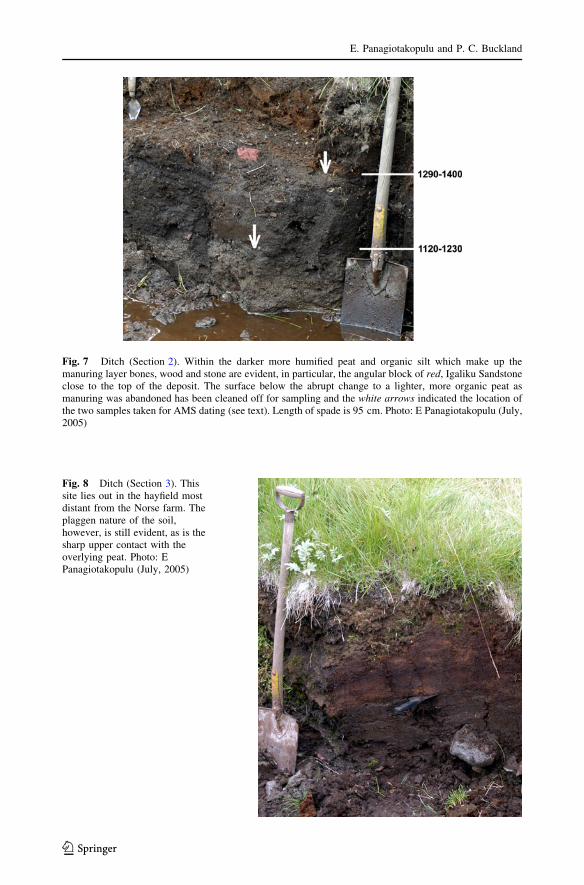
Fig. 7 Ditch (Section 2). Within the darker more humified peat and organic silt which make up themanuring layer bones, wood and stone are evident, in particular, the angular block of red, Igaliku Sandstoneclose to the top of the deposit. The surface below the abrupt change to a lighter, more organic peat asmanuring was abandoned has been cleaned off for sampling and the white arrows indicated the location ofthe two samples taken for AMS dating (see text). Length of spade is 95 cm. Photo: E Panagiotakopulu (July,2005)
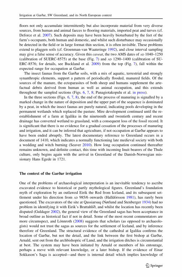
Fig. 8 Ditch (Section 3). Thissite lies out in the hayfield mostdistant from the Norse farm. Theplaggen nature of the soil,however, is still evident, as is thesharp upper contact with theoverlying peat. Photo: EPanagiotakopulu (July, 2005)
E. Panagiotakopulu and P. C. Buckland
123
floors not only accumulate intermittently but also incorporate material from very diverse
sources, from human and animal faeces to flooring materials, imported peat and turves (cf.
Deforce et al. 2007). Such deposits may have been heavily bioturbated by the feet of the
farm’s occupants, both human and domestic, and whilst such disturbance may occasionally
be detected in the field or in large format thin section, it is often invisible. These problems
extend to plaggen soils (cf. Groenman-van Waateringe 1992), and close interval sampling
may give a false sense of accuracy. Given this caveat, the two AMS dates of AD 1040–1250
(calibration of SUERC-8575) at the base (Fig. 7) and AD 1290–1400 (calibration of SU-
ERC-8576; for details, see Buckland et al. 2009) from the top (Fig. 7), fall within the
expected range for occupation at Garðar.
The insect faunas from the Garðar soils, with a mix of aquatic, terrestrial and strongly
synanthropic elements, support a pattern of periodically flooded, manured fields. Of the
sources of the manure, the ectoparasites of both sheep and humans supplement the arte-
factual debris derived from human as well as animal occupation, and this extends
throughout the sampled sections (Figs. 6, 7, 8; Panagiotakopulu et al. in press).
In the three sections (Figs. 6, 7, 8), the end of the process of manuring is signalled by a
marked change in the nature of deposition and the upper part of the sequence is dominated
by a peat, in which the insect faunas are purely natural, indicating pools developing in the
permanent wetlands which replaced the pasture. Mire development continued until the re-
establishment of a farm at Igaliku in the nineteenth and twentieth century and recent
drainage has converted wetland to grassland, with a consequent loss of the fossil record. It
is significant that there is no evidence for a gradual cessation of the processes of manuring
and irrigation, and it can be inferred that agriculture, if not occupation at Garðar appears to
have been ended abruptly. The latest documentary reference to Greenland occurs in a
document of 1410, which indicates a normally functioning late medieval society with both
a wedding and witch burning (Seaver 2010). How long occupation continued thereafter
remains unknown, and definite contact, this time with incoming Inuit bearers of the Thule
culture, only begins again with the arrival in Greenland of the Danish-Norwegian mis-
sionary Hans Egede in 1721.
The context of the Garðar irrigation
One of the problems of archaeological interpretation is an inevitable tendency to ascribe
excavated evidence to historical or partly mythological figures. Greenland’s foundation
myth of exploration by an outlawed Eirik the Red from Iceland, and its subsequent set-
tlement under his direction from AD 985/6 onwards (Halldorsson 1981), has rarely been
questioned. The excavators of the site at Qassiarsuq (Nørlund and Stenberger 1934) had no
problem in identifying it with Eirik’s Brattahlıð, and whilst the location has recently been
disputed (Guldager 2002), the general view of the Greenland sagas has been acceptance in
broad outline as historical fact if not in detail. Some of the most recent commentators are
more circumspect, and Lonnroth (2008) suggests that scholars (as opposed to archaeolo-
gists) would not trust the sagas as sources for the settlement of Iceland, and by inference
therefore of Greenland. The structural evidence of the cathedral at Igaliku confirms the
location of Garðar, but not the detail, and the link between the first bishop at Garðar,
Arnald, sent out from the archbishopric of Lund, and the irrigation ditches is circumstantial
at best. The system may have been initiated by Arnald or members of his entourage,
perhaps a reeve with relevant knowledge, or a later bishop. If the evidence of Einar
Sokkason’s Saga is accepted—and there is internal detail which implies knowledge of
Irrigation at Garðar, SW Greenland, and its North European context
123
local topography—Arnald overwintered in Iceland in 1125, at Oddi with Sæmundur Sig-
fusson. Sæmundr froði (=the wise) had travelled widely in Europe and had been educated
in Franconia (Vesteinsson 2000), now in southwest Germany. He is likely to have been
aware of monastic utilisation of water sources in the great abbeys of the Rhineland, and the
two clerics may have exchanged ideas. Most medieval examples of water management
refer to the powering of mills, and more extensive systems of water delivery and
employment largely owe their existence to the slightly later foundations of the Cistercians
from the twelfth century onwards (see, for example, Arnold 2005). Charlemagne’s palace
at Ingelsheim in the Rhineland, however, had a piped water supply in the eighth century
(Grewe 2000), and Magnusson (2001, p. 5) refers to a late eighth century system at the
monastery of Fulda. Arnold (2007) has examined an eleventh century hagiographic work, a
life of St Hubert, founder of the Benedictine abbey at Andage in the Ardenne, in the
context of reference to the abbey’s manipulation of water supply and quotes:
ubi irriguosa foret limpha, quæ de fonte vocabulo Andaina fontana dirivatur … et
eam ubi per canales ad diversos monasterii usus influit, illuc postulando perduci
impetravit,
which is translated as
where the irrigation stream that had been diverted … from the spring called ‘Andaina
fontana’ flows through canals for various monastic purposes.
The implication is that a stream used for irrigation was also utilised to supply other
facilities at the monastery.
Whatever the origins, it is in an Icelandic context that the earliest definite evidence for
irrigation in the North Atlantic region appears. Gragas, the earliest Icelandic lawbook, was
compiled in the late thirteenth century but incorporates much that is earlier (Dennis et al.2000). The legal constraints upon irrigation are clearly stated and the fact that it refers to
the potential for injury to livestock implies something more than small ditches:
He has the right to make dams on such meadowland…and to dig his meadowland for
the purpose and so divert water onto the meadowland. He is to start the irrigation on
his meadowland and the water is to run off his meadowland into its old course. He
must not damage other men’s land by his irrigation. If other men’s animals suffer
damage in the water courses he digs, then he must pay for that. A man has no right to
make irrigation channels on his land in such a way as to spoil the land or mead-
owland of the man who lives lower down… (K § 188, transl. Dennis et al. 2000,
p.115).
The likely disputes are aptly described in one of the lesser known Icelandic sagas, that of
Havarður of Isafjorður:
It is said that Ljotur and Þorbjorn jointly owned an irrigated field (veitiengi). It was
very precious. The understanding was that they used it in alternate summers. There
was a stream below Ljotur’s farm that flooded the field in the spring. It was equipped
with dams that were well finished. It always happened that when Þorbjorn was due to
use the field he never managed to make use of the stream and in the end Ljotur said
that it did not belong to Þorbjorn and that he should not dare to claim the right to use
it. § 14, transl. Guðrun Sveinbjarnardottir.
In the context of Icelandic sagas, the inevitable outcome of this dispute is the murder of
Ljotur. Written down in the fourteenth century (Durrenburger and Durrenburger 1996,
E. Panagiotakopulu and P. C. Buckland
123
p. 15), the saga is set in the eleventh century when Christianity was being adopted in
Iceland, and perhaps incorporates an older oral tradition.
It seems similarly unlikely that irrigation in Iceland was an indigenous development,
but systems elsewhere in Europe are often difficult to date and whilst urban and monastic
domestic supply has been examined in some detail (most recently, see Magnusson 2001),
the literature on medieval irrigation systems north of the Alps is more scattered. It is
apparent, however, that there is no chronological overlap between the English system of
water meadow management (Bettey 1999) and the similar techniques used in medieval
Greenland. Berglund (1986), followed by Adderley and Simpson (2006) have argued that
the irrigation systems in Norse Greenland reflect an indigenous development. The latter,
utilising the climate records, also point to the frequent water deficits which this south-
western part of the country is prone to, and it is perhaps not a little ironic that the present
farmer finds a need to cut ditches to drain the hayfield, and incidentally are thereby
destroying the important palaeoecological record. The more controlled approach of the
Norse farmers suggests a more reasoned input in planning the system and the labour
required for the medieval Garðar system implies that it represents the imposition of a
management system on the landscape by an individual, or individuals, with previous
knowledge of irrigation techniques. Buckland et al. (2009) have suggested that the likely
context is the arrival of the first bishop, Arnald, in 1126. This would correlate with the
higher probability (71 %) for basal AMS date on the plaggen soil of AD 1120–1230
(=875 ± 35 uncalibrated bp SUERC-8575) (Buckland et al. 2009). Whilst the Saga of
Einar Sokkeson (Krogh 1967, pp. 167–182) need not be taken as a factual account of
events, the bare bones of the account are substantiated elsewhere, and Arnald was sent
out to the new See from Lund. He successfully weathered the internecine disputes of
Greenland for nearly thirty years before returning to Norway where in 1150 he became
bishop of another newly created See, that of Hamar (Halldorsson 1978, p. 66). Whilst the
appointment may have reflected his organisational skills, it may also relate to a return to
a sinecure near his point of origin, for Hamar lies less than thirty kilometres from
Gudbrandsdalen. As Arneborg (2005) has pointed out, in the early post-medieval period,
it is precisely this region, in the rain shadow of the high mountains of Sogn and
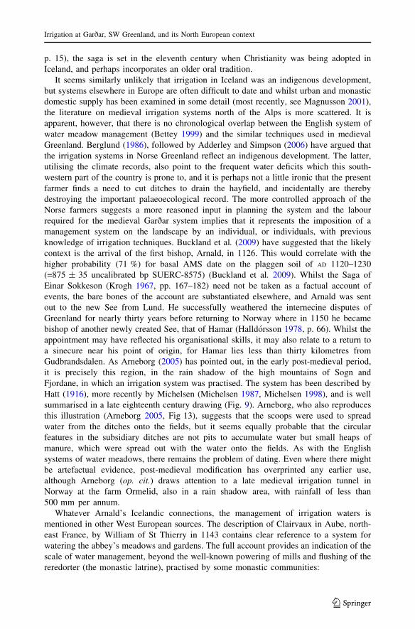
Fjordane, in which an irrigation system was practised. The system has been described by
Hatt (1916), more recently by Michelsen (Michelsen 1987, Michelsen 1998), and is well
summarised in a late eighteenth century drawing (Fig. 9). Arneborg, who also reproduces
this illustration (Arneborg 2005, Fig 13), suggests that the scoops were used to spread
water from the ditches onto the fields, but it seems equally probable that the circular
features in the subsidiary ditches are not pits to accumulate water but small heaps of
manure, which were spread out with the water onto the fields. As with the English
systems of water meadows, there remains the problem of dating. Even where there might
be artefactual evidence, post-medieval modification has overprinted any earlier use,
although Arneborg (op. cit.) draws attention to a late medieval irrigation tunnel in
Norway at the farm Ormelid, also in a rain shadow area, with rainfall of less than
500 mm per annum.
Whatever Arnald’s Icelandic connections, the management of irrigation waters is
mentioned in other West European sources. The description of Clairvaux in Aube, north-
east France, by William of St Thierry in 1143 contains clear reference to a system for
watering the abbey’s meadows and gardens. The full account provides an indication of the
scale of water management, beyond the well-known powering of mills and flushing of the
reredorter (the monastic latrine), practised by some monastic communities:
Irrigation at Garðar, SW Greenland, and its North European context
123
Where the orchard ends, the garden begins, marked out into rectangles, or, more
accurately, divided up by a network of streamlets; for, although the water appears
asleep, it is in fact slipping slowly away. ….This water, which serves the dual
purpose of feeding the fish and irrigating the vegetables, is supplied by the tireless
course of the river Aube, of famous name, which flows through the many workshops
of the abbey. …. By means of a winding channel cut through the middle of the
valley, not by nature but by the hard work of the brethren, the Aube sends half its
waters into the monastery. ….
Now that we have returned the stream to its bed, let us go back to those rills we left
behind. They too are diverted from the river and meander placidly through the
meadows, saturating the soil that it may germinate. And when, with the coming of
the mild spring weather, the pregnant earth gives birth, they keep it watered too lest
the springing grass should wither from lack of moisture….. This meadow is refreshed
by the floodwaters of the Aube, which runs though it, so that the grass, thanks to the
moisture at its roots, can stand the summer heat. Its extent is great enough to tire the
community for the space of twenty days when the sun has baked to hay its shorn
grassy fleece. Nor is the haymaking left to the monks alone: alongside them a
countless multitude of lay-brothers…. Transl. Matarasso (1993), p. 291.
Modification of such systems in the post-medieval period has made much of the
archaeological evidence ambivalent, but Glynn Coppack (1986, 1998, p. 101) has argued
that the diversion of the river Rye adjacent to the Cistercian abbey at Rievaulx in Yorkshire
enabled a system of water meadows from the mid-twelfth century onwards, and Steve
Moorhouse (1981, p. 696) has pointed to documentary evidence from the Augustinian
Priory at Bolton in the same county for diversion of the river Aire at Kildwick, presumably
for the same purpose. The English evidence for the medieval origins of water meadows has
been reviewed by both Brown (2005) and Cook et al. (2003), and it is apparent that the
Fig. 9 Manuring and irrigation in Gudbrandsdalen in the 17th Century, from Hatt (1916)
E. Panagiotakopulu and P. C. Buckland
123
prevailing paradigm of a post-medieval agricultural innovation is being replaced by one of
development from contoured systems of both monastic and secular origin. The problem
remains, however, as to how far back such water management north of the Alps can be
traced. Early medieval monarchs were not averse to organising their subjects for large
scale earth movement, and Squatriti (2002) makes the point that this may have been as
much assertion of centralised authority as practicality. Compared, for example, with
Charlemagne’s abortive attempt in 792-3 to connect the Rhine and Danube systems via a
canal (op. cit.), the contour irrigation of hayfields at Garðar is small scale, but in terms of
labour, it would represent the orchestration of a significant part of the otherwise dispersed
manpower of the Greenland farms and the assertion of someone’s, presumably a bishop’s,
authority.
Conclusion
The system of dams and contoured irrigation channels at Garðar and other sites in
Greenland cannot be seen as a spontaneous indigenous response to a seasonal water deficit,
but belongs to a tradition of similar responses widespread across the North Atlantic region,
from Iceland through Britain to Norway and southwards through France. Whilst several
examples are known in monastic contexts, secular systems are also recorded in docu-
mentary sources. It is probable, however, that the Greenland irrigation systems, with their
need for relatively large scale organisation of labour, for construction, maintenance and
annual harvest of hay crops relate to the increasing power of the Church, perhaps beginning
with the arrival of the first bishop, Arnald, from Norway. Insofar as it is possible to see
precipitate change in the palaeoecological record, the rapid transition from plaggen soil to
wetlands and peat growth suggests that this system fell apart abruptly, perhaps with the
departure of the last reeve in the Eastern Settlement and the final abandonment of Norse
Greenland.
Acknowledgments The Leverhulme Trust (UK) funded fieldwork in Greenland as part of projects fundedby grants to Professor K. J. Edwards, University of Aberdeen, Professor A. J. Dugmore and Eva Panag-iotakopulu, University of Edinburgh and Professor I. A. Simpson, University of Stirling. Fieldwork wascarried out in association with Kevin Edwards and Ed Schofield, and the text owes much to subsequentdiscussions, particularly with Jette Arneborg, Georg Nygaard and Guðmundur Olafsson of the respectiveNational Museums of Denmark, Greenland and Iceland. Guðrun Sveinbjarnardottir provided a new trans-lation of the relevant passage in Havarður’s Saga. Anastasios Panagiotakopoulos is thanked for drawing themap and site plan.
References
Adams D (1989) The hitchhiker’s guide to the galaxy: a trilogy in four parts. Guild Publ, LondonAdderley PW, Simpson IA (2006) Soils and palaeo-climate based evidence for irrigation requirements in
Norse Greenland. J Archaeol Sci 33:1666–1679Amorosi T, Buckland PC, Edwards KJ, Mainland I, McGovern TH, Sadler JP, Skidmore P (1998) They did
not live by grass alone: the politics and palaeoecology of fodder on the North Atlantic islands. EnvironArchaeol 1:41–54
Arneborg J (2005) Greenland irrigation systems on a west Nordic background. An overview of the evidenceof irrigation systems in Norse Greenland c. 980–1450 AD, Pamatky Archeol Supplementum 17. RuraliaV:137–145
Arnold S (2005) Wasserwirtschaft im ehemaligen Zisterzienkloster von Maulbronn. Pamatky ArcheolSupplementum 17 Ruralia V:183–187
Irrigation at Garðar, SW Greenland, and its North European context
123
Arnold EF (2007) Engineering miracles: water control, conversion and the creation of a religious landscapein the medieval Ardennes. Environ Hist 13:477–502
Berglund J (1986) The decline of the Norse settlement in Greenland. Arctic Anthropol 23:109–135Bettey J (1999) The development of water meadows in the southern counties. In: Cook H, Williamson T
(eds) Water management in the English landscape. Field, marsh and meadow. Edinburgh UniversityPress, Edinburgh, pp 179–195
Brown G (2005) Irrigation of water meadows in England. Pamatky Archeol Supplementum 17. RuraliaV:84-92
Buckland PC, Edwards KJ, Panagiotakopulu E, Schofield EJ (2009) Palaeoecological and historical evi-dence for manuring and irrigation at Garðar (Igaliku), Norse Eastern Settlement, Greenland. Holocene19:105–116
Commisso RG, Nelson DE (2010) Stable nitrogen isotopic examination of Norse sites in the Westernsettlement of Greenland. J Archaeol Sci 37:1233–1240
Cook H, Stearne K, Williamson T (2003) The origins of water meadows in England. Agric Hist Rev51:155–162
Coppack G (1986) Some descriptions of Rievaulx Abbey in 1538-9: The disposition of a major Cistercianprecinct in the early sixteenth century. J Br Archaeol Assoc 139:100–139
Coppack G (1998) The White Monks. The Cistercians in Britain. Tempus, Stroud, pp 1128–1540Dawson AG, Hickey K, Mayewski PA, Nesje A (2007) Greenland (GISP2) ice core and historical indicators
of complex North Atlantic climate changes during the fourteenth century. Holocene 17:427–434Deforce K, Bastiaens J, Ameels V (2007) Peat re-excavated at the abbey of Ename (Belgium): archaeo-
botanical evidence for peat extraction and long distance transport in Flanders around 1200 AD.Environ Archaeol 12:87–94
Dennis A, Foote P, Perkins R (eds) (2000) Laws of early Iceland, Gragas: the Codex Regius of Gragas.University of Manitoba Press, Winnipeg
Durrenburger EP, Durrenburger D (1996) The Saga of Havarður of Isafjorður. With an essay on the politicaland cultural background of the saga. Hisarlik Press, Enfield
Emanuelsson U, Moller J (1990) Flooding in Scania: a method to overcome the deficiency of nutrients inagriculture in the nineteenth century. Agric Hist Rev 38:136–148
Greig JRA (1982) The interpretation of pollen spectra from urban archaeological deposits. In: Hall AR,Kenward HK (eds) Environmental archaeology in the urban context, vol 43. Council for BritishArchaeology Research Report, London, pp 47–65
Grewe K (2000) Water technology in medieval Germany. In: Squatriti P (ed) Working with water inmedieval Europe: technology and resource use. Brill, Leiden, pp 129–160
Groenman-van Waateringe W (1992) Palynology and archaeology: the history of a plaggen soil from theVeluwe, The Netherlands. Rev Palaeobot Palynol 73:87–98
Guldager O (2002) Brattahlıd reconsidered. Some thoughts on the social structure of medieval NorseGreenland, and the location of Brattahlıd. Archaeol Isl 2:74–97
Guttmann EB, Simpson IA, Davidson DA (2005) Manuring practices in antiquity: a review of the evidence.In: Smith DN, Brickley MB, Smith W (eds) Fertile ground. Papers in honour of Susan Limbrey.Oxbow Books, Oxford, pp 68–76
Halldorsson O (1978) Grænland ı miðaldaritum. Sogufelag, ReykjavıkHalldorsson O (1981) The conversion of Greenland in historical sources. In: Bekker-Nielsen H, Foote P,
Olsen B (eds) Proceedings of the eighth Viking Congress, Arhus, 24–31 August 1977. Odense Uni-versity Press, Odense, pp 203–216
Hatt G (1916) Agervandingen i Gudbrandsdalen. Geog Tidskr 23:148–158Hjelle KL, Halvorsen LS, Overland A (2010) Heathland development and relationship between humans and
environment along the coast of western Norway through time. Quatern Int 220:133–146Ingstad H (1960) Landet under leidar-stjernen. Gyldendal Norsk, OsloJordan WC (1996) The Great Famine. Northern Europe in the early fourteenth century. Princeton University
Press, PrincetonKrogh KJ (1967) Viking Greenland. National Museum of Denmark, CopenhagenKrogh KJ (1974) Kunstvanding - hemmeligheden bag Grønlandspispens hundrede køer. Nationalmuseets
Arbejdsmark, CopenhagenLehtonen H, Huttunen P (1997) History of forest fires in eastern Finland from the fifteenth century AD—the
possible effects of slash-and-burn cultivation. Holocene 7:223–228Lonnroth L (2008) The Icelandic Sagas. In: Brinck S, Price N (eds) The viking world. Routledge, London,
pp 304–310Magnusson RJ (2001) Water technology in the Middle Ages. John Hopkins University Press, Baltimore
E. Panagiotakopulu and P. C. Buckland
123
Matarasso P (1993) The Cistercian world: monastic writings of the twelfth century. Penguin,Harmondsworth
Michelsen P (1987) Irrigation in Norway and elsewhere in northern Europe. Tools Tillage 5:243–260Michelsen P (1998) Irrigation in Norway and elsewhere in northern Europe. In: Ciriacono S (ed) Land
drainage and irrigation. Studies in the history of civil engineering, vol 3. Ashgate, Aldershot,pp 83–100
Moore PD (1993) The origin of blanket mire revisited. In: Chambers FM (ed) Climate change and humanimpact on the landscape. Chapman and Hall, London, pp 217–225
Moorhouse S (1981) The rural medieval landscape. In: Faull ML, Moorhouse S (eds) West Yorkshire: anarchaeological survey to AD 1500, vol 3. West Yorkshire Metropolitan Country Council, Wakefield,pp 581–850
Nørlund P (1929) Norse ruins at Gardar. The episcopal seat of medieval Greenland. Medd Grønland76:1–170
Nørlund P (1936) Viking settlers in Greenland and their descendents during five hundred years. CambridgeUniversity Press, London
Nørlund P, Stenberger M (1934) Researches into Norse culture in Greenland: Brattahlid. Medd Grønland88(1):1–161
Panagiotakopulu E, Skidmore P, Buckland PC (2007) Fossil insect evidence for the end of the WesternSettlement in Norse Greenland. Naturwissenschaften 94:300–306
Panagiotakopulu E, Greenwood M, Buckland PC (in press) Insect fossils and irrigation in medievalGreenland. Geografiska Annalen Ser. A
Ross JM, Zutter C (2007) Comparing Norse animal husbandry practices: palaeoethnobotanical analysesfrom Iceland and Greenland. Arct Anthropol 44:62–85
Schweger CE (1998) Geoarchaeology of the GUS site: a preliminary framework. In: Arneborg J, Gulløv HC(eds) Man, culture and environment in ancient Greenland. Danish Polar Centre and Danish NationalMuseum, Copenhagen, pp 14–18
Seaver KA (2010) The last Vikings. I. B. Tauris, LondonSparrenbom CJ, Bennike O, Bjorck S, Lambeck K (2006) Holocene relative sea-level in the Qaqortoq area,
southern Greenland. Boreas 35:171–187Squatriti P (2002) Digging ditches in early medieval Europe. P Present 176:11–65Vasari Y, Vaananen K (1986) Stratigraphical indications of the former use of wetlands. In: Behre K-E (ed)
Anthropogenic indicators in pollen diagrams. Balkema, Rotterdam, pp 65–72Vesteinsson O (2000) The christianization of Iceland. Priests, power and social change 1000–1300. Oxford
University Press, Oxford
Author Biographies
Eva Panagiotakopulu Eva Panagiotakopulu is lecturer in the Department of Geography at the University ofEdinburgh, Scotland. Having training initially as an archaeologist in Athens, she moved to Sheffield,England, for a master’s degree and subsequent doctorate, specialising in the identification and interpretationof fossil insect remains associated with man-made habitats, in particular those of stored products and relatedenvironments. As a Leverhulme Trust Research Fellow, she has expanded her primary work in the easternMediterranean, including examination of Classical sources, to Northern Europe and the North Atlanticislands. Current research stretches from Old Kingdom Egypt to post-medieval Labrador. She has recentlyadded research with fossil larval Diptera (true flies) to the range of techniques used in interpreting the past.
Paul C Buckland Paul Buckland graduated in geological sciences and archaeology from the University ofBirmingham, where he subsequently completed a doctorate in Quaternary entomology. He has taught in theuniversities of Birmingham, Sheffield, Bristol and Bournemouth, and is currently a self-employed technicianspecialising in work with fossil insects.
Irrigation at Garðar, SW Greenland, and its North European context
123


