Embed Size (px)
Citation preview
Examiners CommitteeTitle, Name & Affiliation
Prof. (external examiner)Professor of (…)University of (…)
Prof. (Title/Name)Professor of (…)University of (…)
Prof. (Title/Name)Professor of (…)University of (…)
Prof. (Title/Name)Professor of (…)University of (…)
07/29/2018Signature
Retrofitting Urbanism: Participatory development of Industrial Brownfields A Thesis submitted in the Partial Fulfillment for the Requirement of the Degree of Master of Science in Integrated Urbanism and Sustainable Design
by Kh M Abdullah
Supervised by
Prof. Dr. Mohamed SalheenProfessor of (…)Ain Shams University
Prof. Dr. Astrid LeyProfessor of (…)University of Stuttgart

Disclaimer
This dissertation is the outcome of the research conducted as partial require-ment for completion of the degree MSc in Integrated Urbanism and Sustainable design (IUSD) taught and evaluated jointly by Ain Shams University (ASU), Cairo, Egypt and University of Stuttgart, Germany. The research was conducted in February-July 2018 with compliance to IUSD-ASU master thesis regulation and general ethics of academic research & publication. The work was not sub-mitted anywhere else for evaluation.
The author endorses this work of his/her own if not appropriate credits & refe-rences have been acknowledged otherwise. The author also claims sole respon-sibility of the contents, stands by their meanings and shall be held responsible in case of copyright dispute.Ain Shams University, Cairo, Egypt & University of Stuttgart holds the rights to public distribution of this dissertation in the present university standard for-mat. The author holds the right to publish the contents in any other format.
07/29/2018
Kh M Abdullah

Acknowledgement:
I would like to take the opportunity to thank my supervisors, Professor Dr. Mo-hamed A. Salheen from Ain Shams University and Professor Dr. Astrid Ley form University of Stuttgart for their constant inputs. Without their lucid guidance & gracious support this research would not have gone anywhere. I am also forever obliged to the following persons for their guidance, suggestions, information and motivation. Dr. Marwa Abdellatif from Ain Shams University, Franziska Laue From University of Stuttgart, Professor Dr. Farida Nilufar from Bangladesh University of Engineering Technology, Dr. Md. Akter Mahmud from Jahangirnagar University for their selfless help throughout the research.I owe my sincere appreciations to Architect Kazi Golam Nasir, Chief Architect in the Department of Architecture, Ministry of Housing & Public Works, Bangla-desh, Dr. Abu Sayeed M. Ahmed, President of Institute of Architects Bangladesh, Architect Iqbal Habib, Planner Hasibul Kabir, Dr. Khurshid Zabin Hossain Tau-fiq, Director of Urban Development Directorate, Bangladesh, Golam Mostafa, Managing Director, Kallol Group of Companies & as representative of ‘Tejgaon Shilpo Malik Kolyan Somiti’, the interviewees, and representatives of local gov-ernment for providing with all the supports, important information and their passionate participation during my field visit to Bangladesh. I would like to convey my sincere gratitude to my colleagues, professors, teachers & stuffs at both universities; without their help this mammoth task would not have been possible.I send my heartfelt cheers to my friends and finally, I must yield my unmatched gratefulness to my family for providing me with unfailing support and contin-uous encouragement throughout my years of study and through the process of researching and writing this thesis.

Abstract:
Industrial Brownfields are derelicts, underused or deserted stretches of land in urban areas, formerly used for industrial facilities. Being affected by former use, possible contamination, uninhibitedness or renounce; deteriorating with abun-dant intrinsic potentials and can be redeveloped with intervention. These for-mer industrial areas contain significant identified potentials to be redeveloped for new urban use. Brownfield redevelopments have been in the vortex of urban development and associated academic discussion in developed countries in con-temporary times. Comprising redevelopment of many former industrial areas in different parts of the world namely Europe and United States. (Leger et al. 2016; Berens, 2010; p.xi) Recently the idea has been imported to the global south. Many redeveloping initiatives are taking place in developing economic context. However, citizen participation in the redevelopment has largely been overlooked and underutilized. Intrigued by the overlooked potential of citizen participation in brownfield redevelopment, this research is instigated with the aim of investi-gating the possibility of citizen participation in brownfield redevelopment as an instrument for aggregating social inclusion in the redevelopment process. And explore the tools (How), Nature (What), Extant and selection (Who & Why) of participation in brownfield redevelopment.
In order to critically understand the issue, besides literature review, past projects will be studies. The real-life scenarios will demonstrate the complexities, impli-cations of participatory process in sites. Cases of already redeveloped brownfield from Germany combined with background study in Cairo; a participatory de-velopment framework will be developed to experiment with the case study in Dhaka, Bangladesh. Namely, the industrial area in Tejgaon is going through a drastic transformation following the government decision followed by the rapid commercial urban development in and around the site. Through a careful inves-tigation, an imminent site will be identified awaiting foreseen redevelopment. Participatory planning tools will be formulated in a solution matrix to be imple-mented in the participatory redevelopment of the selected site. A successful com-pletion of this research pursues to contribute to the contemporary development

discourse about participatory brownfield redevelopments, citizen participation in space making and participation to enhance spatial cohesion in a city.
Keywords: Brownfield, citizen participation, urban development.
Table of Contents
List of Figures List of Acronyms and definition s of technical terms
Chapter I Introduction 1
Chapter IIResearch Question 52.1 The Phenomenon 52.2 In Dhaka 62.3 Problem Statement 72.4 The Questions 8
Chapter IIIResearch Analogy 9
Chapter IV Research Aim & Outcome 114.1 Research Aim 114.2 Outcomes 12
Chapter VResearch Methods 135.1 Literature Review 135.2 Extended Literature Review 145.3 Empirical Study 145.4 Motivation behind choosing the approach 15
Chapter VI Literature Review 17
Chapter VIIScenarios 237.1 Al-Azhar Park 257.1.1 Discussion 277.1.2 Learning 287.2 Maspero Triangle 30 7.2.1 History 31 7.2.2 Demography 327.2.3 Urban Fabric of Marpero Triangle 33 7.2.4 Land Use 34 7.2.5 Land Value 35 7.2.6 Land tenure 36 7.2.7 Project development 38 7.2.8 Stakeholder analysis 39 7.2.9 Introducing participatory process 41 7.2.10 Challenges 45 7.2.11 Discussion on participatory process in Maspero 46 7.2.12 learning 487. 2.13 Moving to a better future 487.2.14 Criticism & Skepticism 497.2.15 Remarks 527.3 Endnote on citizen participation in Cairo 537.4 KreativQuartier München (Creative Quarter Munich) 53 7.4.1 The Project 54 7.4.2 Project Development 56 7.4.3 Involved stakeholders and influences 58 7.4.4 Participatory tools 597.5 Endnote on citizen participation in Germany 607.6 Learning from the Scenarios 60
Chapter VIIIField Research Framework 63
Chapter IXCase Study 679.1 Development of Tejgaon Industrial Area 699.1.1 Demography 709.1.2 Built Environment 719.1.3 Connectivity & Surroundings 72 9.1.4 Current Land use 75 9.1.5 Policy development for the area 79 9.1.6 Current Developments 79 9.1.8 Economy of Land 81 9.1.9 Flip side of the need 819.1.10 Brownfield of Tejgaon I/A 82 9.1.11 Legal Perspective of participation 83 9.1.12 Stakeholders 839.2 Context analysis 849.3 Economic style of the city 85
Chapter X10.0 Solution (Step Model): 8910.0.1 Action Matrix 8910.0.2 Triangulation 9010.1 Project Demonstration 9010.1.1 Step 1: Understanding 91 10.1.2 Step 2: Comparative study and program proposals 92 10.1.3 Step 3: Prioritizing and Vision 94 10.1.4 Step 4: Final Vision, policy suggestion & Strategy formulation 9510.2 Conceptualizing the Step Model 9710.3 Challenges of the Step Model 9810.4 Recommendation for the Step Model 9810.5 General limitations of participatory process 9910.6 General Recommendations 10010.7 Advocating Participatory process 10010.8 Final Remarks on understanding participatory process 102

Chapter XIConclusion 105
ReferenceBibliography & Additional ReferencesAppendixAbstract in ArabicDisclaimer in Arabic
List of Figures
Figure 01: Breakdown of the research Figure 02: New developments in Tejgaon Gulshan link Road Figure 03: Research Analogy Figure 04: Aerial View of Al-Azhar Park (After Development) Figure 05: Section of replaced top soil Figure 06: ‘Maspero Triangle’ along Nile Figure 07: ‘Maspero Triangle’ in the context Figure 08: Demolished area within Maspero TriangleFigure 09: Economic Activities in Maspero Figure 10: Landmarks in ‘Marpero Triangle’ Area Figure 11: Land ownership in Maspero area Figure 12: Proportion of Land owned by each stakeholder; Figure 13: Interests, influences of stakeholders in Maspero Figure 14: One of the agreed upon zoning option Figure 15: Level of citizen participation in different phases Figure 16: Maspero Triangle after Demolition Figure 17: (Clockwise). Image:1 The site location in the city & its proximity to OlympiaPark. Figure 18: Project development timeline of KreativQuartier Munich Figure 19: Stakeholders and Influences in KreativQuartier Munich project Figure 20: Understanding the current process and identify the possible point of interventionFigure 21: Two possible sites for case study Figure 22: Location of Dhaka in Bangladesh Figure 23: Location of Tegaon I/A in Dhaka city Figure 24: Master plan of Tengaon I/A Figure 25: Chronological development of Dhaka city Figure 26: Inside Tejgaon I/A with abandoned industries, makeshift houses in the footpath, & new commercial developments Figure 27: Connectivity & road network of Tejgaon I/A to the city
Figure 28: highly dense underdeveloped residential areas surround the Site Figure 29: Graphical representation of density around the site Figure 30: Land Use (by area) of Tejgaon I/A Figure 31: Land Use map of Tejgaon I/A Figure 32: Structure Type map of Tejgaon I/A Figure 33: Site’s proximity to the affluent commercial and residential area Gul-shan Figure 34: Streetscape of old Dhaka Figure 35: New facilities around HatirjheelFigure 36: Diagram representing Step Model
List of Acronyms
AKDN Aga Khan Development NetworkAKTC Aga Khan Trust for CultureCAPMAS Center for Public Mobilization and StatisticsCBD Central Business District DAP Detail Area PlanDTCA Dhaka Transport Coordination AuthorityECCLR Egyptian Center for Civil and Legislative ReformEGP Egyptian PoundsERTU Egyptian Radio and Television Union FGD Focused group discussionsGCR Greater Cairo region GoB Government of BangladeshGOPP General Organization for Physical Planning Govt. GovernmentI/A Industrial AreaKfw Kreditanstalt für Wiederaufbau (Reconstruction Credit Institute)MURIS Ministry of Urban Renewal and Informal SettlementsPWD Public Works DepartmentRAJUK Rajdhani Unnayan Kartipakhkha (Capital development Authori-ty)UNDP United Nations Development Program
Brownfields“Brownfields are sites that have been affected by the former uses of the site and surrounding land, are derelict and underused, may have real or perceived con-tamination problems, are mainly developed in urban areas, and require inter-vention to bring them back to beneficial use.” (CLARINET; 2002, pp 9)
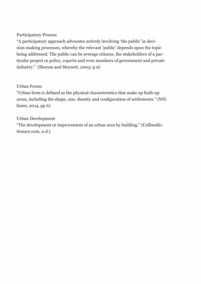
Participatory Process“A participatory approach advocates actively involving ‘the public’ in deci-sion-making processes, whereby the relevant ‘public’ depends upon the topic being addressed. The public can be average citizens, the stakeholders of a par-ticular project or policy, experts and even members of government and private industry.” (Slocum and Steyaert, 2003; p.9)
Urban Forms “Urban form is defined as the physical characteristics that make up built-up areas, including the shape, size, density and configuration of settlements.” (Wil-liams, 2014, pp 6)
Urban Development“The development or improvement of an urban area by building.” (Collinsdic-tionary.com, n.d.)
1
Chapter I | Introduction
Exploring the possibility of using participatory process in industrial brownfield redevelopment projects to increase social inclusion is the undelaying principle of the intended research. Cities all over the world are trying to use the maximum geographical resources it contains. Old industrial areas are becoming a great re-source in that context. Resulting from different causes like, change in technology, moving of the industries into new geographic locations, incompetency of an area to serve industries for infrastructural shortcomings, city growth consuming the surroundings of the industries are to name a few reasons, old industrial areas are becoming abandoned, underperforming regions of a city. Taking the opportunity alternative culture takes over the area and turns into something more useful, adding cultural and economic values to it. On top of that, the universal appeal of old industrial aesthetics seems to work for its own good. Following the alterna-tive cultural initiatives, realizing the growing demand other potential beneficiar-ies like investors, city authority, developers continue to initiate redevelopment of these old abandoned industrial area.
“The allure of the industrial aesthetics cannot be dismissed, and in many instanc-es, is cruitial for the success of their redevelopment.” (Berens, 2010; p.xi)
2
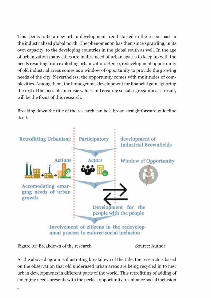
This seems to be a new urban development trend started in the recent past in the industrialized global north. The phenomenon has then since sprawling, in its own capacity, to the developing countries in the global south as well. In the age of urbanization many cities are in dire need of urban spaces to keep up with the needs resulting from exploding urbanization. Hence, redevelopment opportunity of old industrial areas comes as a window of opportunity to provide the growing needs of the city. Nevertheless, the opportunity comes with multitudes of com-plexities. Among them, the homogenous development for fi nancial gain, ignoring the rest of the possible intrinsic values and creating social segregation as a result, will be the focus of this research.
Breaking down the title of the research can be a broad straightforward guideline itself.
Figure 01: Breakdown of the research Source: Author
As the above diagram is illustrating breakdown of the title, the research is based on the observation that old underused urban areas are being recycled in to new urban developments in diff erent parts of the world. This retrofi tting of adding of emerging needs presents with the perfect opportunity to enhance social inclusion

3
in urban fabric. Often in the developing economic context the redevelopment process fails to employ the opportunity to include bigger mass of the people by implementing homogenous development exclusively without taking into consid-eration of their needs.
This research is instigated in that premise of challenging the status quo and test-ing the possibility of enforcing citizen participation in the redevelopment process to achieve a better socially inclusive built environment.

4
5
Chapter II | Research Question
2.1 The Phenomenon
Today’s society is facing diverse and rapid changes. Cities are shaping and reshaping quickly leaving only a small window to act/react to its change. Hence many of today’s urban development initiatives are ‘reaction’ to a transformative city. In an attempt to adapt to its changes, make the different parts of the city lively, functional, sustainable which became less effective resulting from the rapid change. Many old industrial areas of the city are becoming vacant, irrelevant, underused because of the rapid change in the nature of their use. Post industrial cities (often called ‘rust belt’ in the United States), or old industrial part of the city, especially in the developed countries; city neighborhoods like old dock yards in London, old industrial districts like Soho in NewYork city, Old military industrial complex in Munich or Berlin have been vacant after they are being abandoned by their orig-inal use. Which was then taken over by other uses like, artist’s lofts in Soho, new urban neighborhood in London, KreativeQuertier in Munich and so on. Often the new changes are being accused of gentrification, aiming to supply only to the needs of the richest of the city. (Etherington, 2018).
6
2.2 In Dhaka
In case of Dhaka, a compact city, it houses a signifi cant number of people in a very small place. Any possibility of redevelopment is faced with immense pres-sure from developers, investors and consumers. Pressure of ever-growing market presents with the motivation to maximize the fi nancial gains ignoring the spatial impacts and social looses. Assumable-ly, that leaves out a sizable group of citizen out of the opportunity. With growing development aimed for fi nancial benefi ts only, social segregation in urban spaces grows. This research is motivated to scrutiny the proposition that whether, adding citizen participation can encounter this and instigate social inclusion in the redevelopment projects.
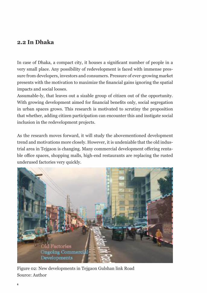
As the research moves forward, it will study the abovementioned development trend and motivations more closely. However, it is undeniable that the old indus-trial area in Tejgaon is changing. Many commercial development off ering renta-ble offi ce spaces, shopping malls, high-end restaurants are replacing the rusted underused factories very quickly.
Figure 02: New developments in Tejgaon Gulshan link Road Source: Author
7
Within the current law (with some amendment in building regulation, added in the appendix) the new constructions are all facilitating commercial development for high-end offices or luxury commodities like cars. Besides amending the build-ing regulation the government is yet to come up with new vision for the area. There is not enough evidence of rigorous study to support new developments. That raises another aspect of inadequacy of infrastructure to support these devel-opments. Which is frequently sought out by the civil society (Letter of Institute of Planners, the national professional body of planners to the ministry of housing and public works & research finding pointing out incompetency of road network of Tejgaon area presented in inter-ministerial meeting, added in the appendix) and meeting minutes of the development committee supports the concern. (RA-JUK meeting minutes no. RAJUK/21-161/2006/106/9; dated 31 January 2018, added in appendix).
2.3 Problem Statement
From the documents and practical scenarios, it is manifested that the rapid re-development of the area is undergo. The government does not have a clear vision for the area nor there is a guideline/law to safeguard social benefits. So the on-going development is mainly carried out by the selected few rich people to gain the maximum economic benefits. Stirred by the situation this research started to look at the problem from a macro a micro scale. In the macro scale this research aims to look at the problem of social exclusion caused by omnidirectional finan-cial benefit oriented development from a solution perspective. By exploring the possibility of social inclusion by implementing participatory process in the ongo-ing redevelopment to achieve social inclusion. On the micro scale this research aims to deal with the problem of how exactly a participatory process can be im-plemented in this context. By carving out a solution matrix consisting the exact tools required for implementing participatory process, how to use them, why & when completed with the step-by-step process implemented on a redevelopment project.
A lack of study and clear guideline poses even more risk of failing to yield the potential serving the majority of the citizens. If all plots are being redeveloped individually however the land owner and investor intend, (mostly if not all com-
8
mercial/rentable office spaces) it might create an enormous socioeconomic im-balance with abundance of commercial developments and lacking other facilities. Not to mention, imposing pressure on infrastructures and utilities.
2.4 The Question/s
Conclusively, transfering the two-fold problem into the quest, this thesis aims to peruse; First, is it possible to encounter this anticipated social exclusion through partic-ipation?Later as the research develops, through a comprehensive understanding of par-ticipatory process, its uses, benefits and implications this question will be im-plored on.
Second fold of the question will explore how exactly participatory process is im-plemented on a redevelopment project? Gathering the tools, methodologies, ac-tors, knowhow this question will look for the appropriate tool set to implement a participatory process in the context.
9
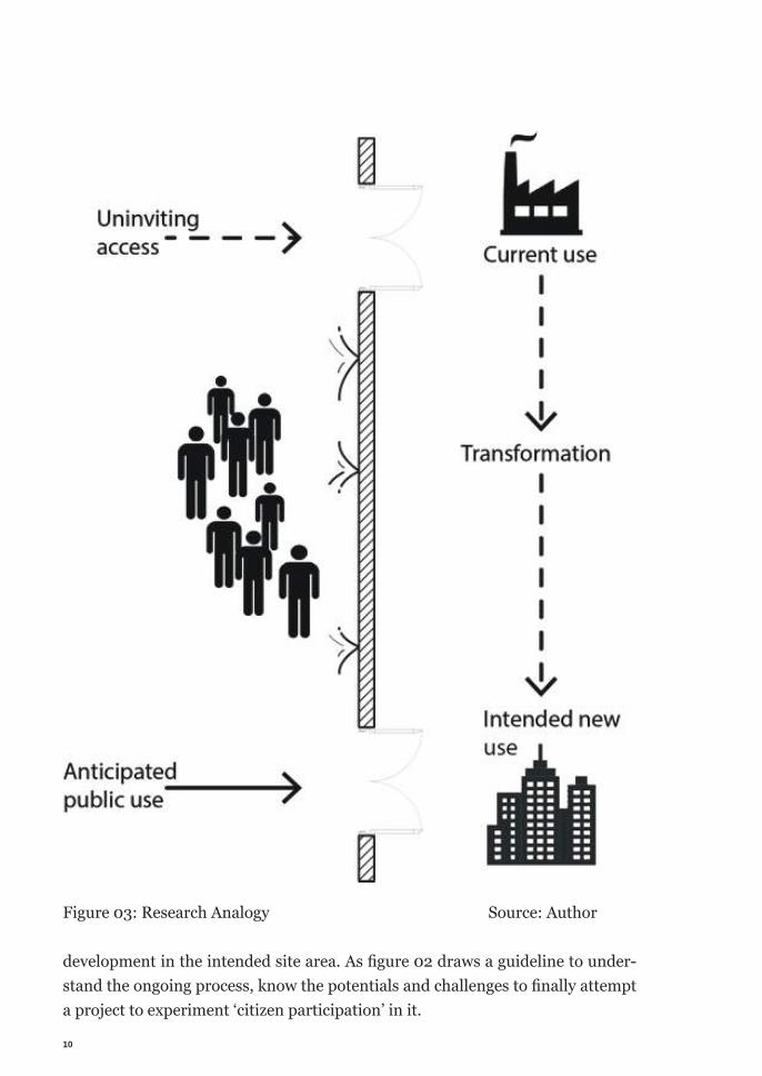
Chapter III | Research Analogy
This research is intended to identify the possible point of interventions to in-troduce the possibility of citizen participation in the redevelopment process of brownfield redevelopment in Tejgaon Industrial Area, Dhaka. Currently the area is going through a functional transformation in its urban forms. The lack of clear guideline for the transformation is clearly visible in the haphazard transforma-tion; however, some traces of development trends are traceable in the redevel-oped clusters from the initial overview. From the pattern of ongoing transforma-tion it is clear that the transformation process is controlled and solely benefited by the economic elite, complemented with lack of public friendly policy and cor-ruption. Following figure is depicting the current scenario and indicates the in-tention of the field research.According to the Detailed Area Plan (DAP), currently the site is declared unfit for industrial usages by the government. Hence the old lease agreements have be-come non-renewable with old usage, giving way for new usages under new lease. However, the handover process lacks transparency makes it even harder for an inclusive participatory redevelopment. This research aims to understand the ongoing process through collecting and analyzing data, identifying a possible project to implement the participatory re-
10
Figure 03: Research Analogy Source: Author
development in the intended site area. As fi gure 02 draws a guideline to under-stand the ongoing process, know the potentials and challenges to fi nally attempt a project to experiment ‘citizen participation’ in it.
11
Chapter IV | Research Aim & Outcome
4.1 Research Aim
The main focus of this research is trying out the possibility of incorporating par-ticipatory process in urban redevelopment to improve social inclusion. In the de-veloping context of Dhaka, the city is growing faster than ever. Keeping up with the rising demand of different facilities, many functions are being developed. With the increased demand, the possibility of higher economic benefits drives the development to provide with the affluent needs. Overlooking the vast majori-ty of the people. Which creates the social division in the urban spaces in the city.This research aims to scrutiny the possibility of closing the gap by introducing participation in the development process. The speculation is grounded on the understanding that if people from different socioeconomic class of the city have a voice in the decision-making in further redevelopment of the Tejagaon Industrial Area, potentially the new development will be able to accommodate them too. This research will henceforth also shred light on, it participation an appropriate tool to create more inclusive development for a large-scale project like this. This will be checked with different projects done previously in different contexts and put them to use in the case study context to register the impact. This research also aims to customize a participatory project framework for re-
12
development project. Through, suggesting imply-able strategies and arrange the set of tools for participation. Using gathered knowledge from theoretical under-standing combined with learning from scenarios in two contexts. Empirically, this research has two main aims to achieve. They are-- To test, if citizen participation can be an appropriate tool for social inclusion in urban redevelopment projects. Through critical analysis of past projects, reg-ister and compare the impacts of participation in the previous redevelopment projects, this research will check the axiomatic utility of participation. And try to extent the success to increase social inclusion by involving citizen participation in the redevelopment process. Later, this said possibility would be tested in the con-text of anticipated redevelopment project in Tejgaon Industrial Area in Dhaka. - To customize a framework of participatory process in the said context is the second aim of the research. This will be formulated through learning from ap-plied knowledge from used tools in previous projects, taking into considerations of the case study context.
4.2 Outcomes
This research intends to produce two pragmatic outcomes.- Fist, this endeavor is intended to achieve a clear understanding of the participa-tory process. Formulate the researchers own understanding about the discussed issues to propose the usefulness in the case study context. Leading to the second outcome,- Is to customize a model solution for a hypothetical project in the case study area. A set of strategies will be proposed to achieve best outcome of the use of citizen participation, based on the researcher’s critical understanding about the issue through this research. A solution matrix, containing the tools to-be-used for the proposed participatory process for a hypothetical future redevelopment project in Dhaka. In a nutshell, this research is intended as a rendezvous of theoretical learning about participatory process, social inclusion and urban redevelopment; but-tressed with critical understanding of different contexts (Cairo, Munich) to or-chestrate a suitable solution to achieve a socially inclusive redevelopment for home context (Dhaka).
13
Chapter V |Research Methods
This chapter will provide with a broad outline of the intended research process. This broad structure will act as a guideline as the research is being carried on and mature through data collection, learning and accumulate clear understanding. Details of the research process are explored and implemented in their respective chapters. Refrained form repeating them in this chapter, this chapter only intend to provide an overall recommendation to follow the research.
Conducted research method is twofold. In order to achieve the aims, the research is conducted with established approach of learning through understanding exist-ing literature combined with empirical approach of learning from critical analy-sis of different projects as scenarios. Analyzing practical impacts of the scenarios, tailor them according to the context is the implied approach of this research.
5.1 Literature Review
In order to answer the prompted questions, the first prerequisite was to under-stand the issues and ideas encompassing it. Hence the research attempts to study the existing literature. Attempting to create a solid base of understanding about
14
concerning issues. Which will also help formulating individual singular perspec-tive about the issues leading to articulate the argument.
5.2 Extended Literature Review
Following the literature reviews, the research will examine different scenarios as in past projects in different contexts. Which is intended to learn from practical past projects in different context. Predictably, as a complex process, participa-tory approach poses more questions and confusions, which needed to be clarified in order to formulate a clear and concise understanding. These scenarios will also aimed to demonstrate the tools, actions and strategies implied in the realm of urban redevelopment to successfully integrate community in the projects. The scenarios will also bring forward the impacts of participatory approach in urban redevelopment, showing the positive and negative effects in real life implemen-tation of a project, along with the final acceptability of the project in the society with critical analysis by the academics and celebrated use by the citizens.
5.3 Empirical Study
This part of the research will focus on the real life implication of the understand-ing through the case study. This effort will consists of, first-hand data collection from the site, synthesize them to concentrate in broad understand about the con-text. Empirical data will be collected form the site through physical survey of the site, collecting information from previous researches, gathering information and opinions of researchers and academics. Tools to study urban contexts like, semi structured interview, stroll-ology, mapping, photo-documenting, data verifica-tion from indirect sources, GIS analysis and so on will be used to accumulate the first-hand data. Expert opinions, recent past or ongoing research findings, government laws & announcements, minutes of important relevant meetings of different organizations, memorandums, media and press release will be studied to gather information and visualize the socioeconomic context of the case study area. Then use the context analysis along with the knowledge gathered from the liter-ature review, in a final attempt to arrange the set of strategies and tools to con-
15
duct an effective participatory redevelopment project in the foreseen case study project.This will also propose some general learning from other scenarios, for preparing the context for the participatory process.
5.4 Motivation behind choosing the approach
Following the conventional approach of studying the literature will equip the re-search with the obtainable knowledge. Generating a comprehensive understand-ing is essential for the research to move forward. Followed by the study of differ-ent scenarios in two contexts. The first context of Cairo will present with similar complexities of developing economies of a centrally important city. Perhaps, the projects in Cairo will also demonstrate the gradual growth of participatory pro-cess through different urban development project in the center of economic, so-cial and cultural pressure from the status quo. Since redevelopment projects in Cairo has been being going on for a couple of years, it can also be a beacon and inspiration for the case study project.
The comparative study of different scenario will also provide a practical idea about the achievable levels of participation, since that is another repeated dis-course in terms of defining participation and actually implementing it.
Conceivably, the most important benefit of studying the practical scenarios to acquire the understanding of how the process actually takes place within the con-text of redevelopment project on the ground. Detailed actions, pros and cons, advancement and setbacks will furnish the research with the adequate wisdom to compose the final set of tools and strategies for the final outcome.
Studying the scenarios combined with the literature review are anticipated to provide the answer to the first part of the research question; critical understand-ing of participatory process, its usefulness, impact, knowhow and essentiality. Followed by the empirical study to provide the final outcome of testing the set of tools on implementing participatory redevelopment process in the case study area.

16
The two-armed research framework is appointed to achieve two main objective of the research. On the first hand it will educate the research with the critical understanding of the issues, on the other hand it will provide the designed de-velopment framework for the case study area intended to implemented through citizen participation.
17
Chapter VI |Literature Review
“I know no state depository of the ultimate power of society, but the people them-selves; and if we think them no eligible enough to exercise their power with a wholesome discretion, the remedy is not to take it form them, but to inform their discretion.” (Jefferson, 1820)
The above mention statement from the founding father of the United States sums up the reputation of citizen participation at the same time outlining the defini-tions of participation. Citizen participation in development has been defined in many ways. The main underlying understanding is captured by the definition provided by Shery R. Arnstein. She argued citizen participation as citizen power. According to her definition, redistribution of power among people, especially to provide the un-derprivileged their fair share. Hence, redistribution of power is fundamental to participation. She graded different levels of participation through an eight-rung ladder, famously known as Arnstein’s ladder of participation. According to Arn-stein, manipulation and therapy using illusory participation is no participation hence are in the lowest in the level of participation. Informing, placation and consultation is minimum participation as tockenism. The final three rungs of the ladder indicate the highest level of participation through partnership, delegating power to representatives of people and total citizen control. However, she also
18
mentioned that the lower rungs are not full participation but they are important in the process of moving to citizen participation. They might not be effective to deliver a participatory development process but they are effective to the devel-opment of participatory process itself. Final step of participation as Arnstein ad-vocated, is giving complete power to make the decision to the citizens. Not to be altered with the rhetoric of asking for absolute autonomy.’ (Arnstein, 1969)
Martin & Mathema (2011), on the other hand, have connected participation di-rectly to economy and influence of economy to power structure of decision-mak-ing.
The authors continue to define different kinds of participation, ignited by differ-ent causes. For example, an immediate threat of eviction of a community might mobilize them to take part in a negotiation with the authority to save their tenure and livelihood. Other actions igniting participation are mentioned, Negotiation as participation, Activism as participation, partnership as participation and so on. Naturally, they prompt different level of participation. The check and balance in leadership is important to maintain the effectiveness of the decision-making mechanism in a participatory process. Often time without the check, power tends to lean to imbalance and grow dominant over weak and powerless. The author gave the example of psychology experiment of Philip Zimbardo ‘the Stanford ex-periment 1971’ to bring out the abusive psychological tendency of abuse of pow-er without balancing with accountability. (Martin & Mathema, 2011. p.164). As Beard (2003) says citizens move from participatory planning and covert plan-ning practices to insurgent or radical planning “when the repressive state is weakened” (p.14).
Stiefel & Wolfe (1994) vigilantly criticized quite a few forms of participation for being misused in the name of participation. For example pluralist democracy is not an effective reflection of peoples voice. Modernization is another misused form of participation. It is often seen as the means and instrument for measur-ing participation. They stated it a popular form of therapy to legitimize a preset planning through popular consultation. She points out participation was assert-ed as the missing ingredients of development overlooking the intrinsic meaning of it. The authors alarmed about the legitimization of power using participation. As authoritarian governments have overly seen and used participation (through different rhetoric) as a tool to legitimize their power. It has also been used as the
19
alternative to manipulative divisive plural democracy. (Stiefel & Wolfe, 1994)
Other authors have pointed out different deviations and threats of abuse of par-ticipation. Such as, ‘Sectarianism is an influence to give rise to social exclusion, promotes segregation hence elevates social division.’ (Reeves, 2005; p.16). Which justified, what Saxena’s stated, ‘Participation (peoples) was used as a tool to justi-fy, what already been designed for them. That did not work. If Participation fails to establish people’s right it is not participation.’ (saxena, 1998).
Form the above discussion; it is evident that proper involvement of citizens is an undeniable, essential effort for any form of development & policy making.
Since, spaces around us helps to form and defines our identity, it is essential to be able to formulate the spaces according to our identity. Being able to participate in a place making that follows preference is perhaps per se to the right to live in it. Now the equal importance of being able to take part in place making are also asserted sincerely and confirmed by many researches. As Reeves refer to Tutan, “if our sense of who we are is based on our personal and social identity, our sense of place also reflects this.” As she refers to Tutan (1990) “Some have argued that a sense of place is part of what it is to be human.” (Reeves, 2005; p.29).Knox (2014) described that more objectively, stating ‘Four fundamental func-tions of cities-
1. The decision-making capacity of cities.Cities are concentration of public-private, political organizations, which gives cit-ies the power to take decisions for the people within and around it. 2. The transformative capacity of citiesThe discrete characteristics of cities are liberating from traditional way of life. Allow people to choose/participate in a variety of lifestyle and behavior. 3. The mobilizing function of citiesCity provides the opportunity to organize labor, capital or raw materials. Urban settings provide with the capacity of getting things done. A sizeable mass of peo-ple living in a close proximity equips the city with such capacity. 4. The generative function of citiesCities are perfect settlings for knowledge sharing, necessity and opportunities. (knox, 2014; p.11)
20
In a bigger context of a city, in this connected globalized era, diversity is one of the key elements to host different needs of different users as advocated above. To support Knox’s idea of four main functionality of a city, in order to utilize the functions, it is important to include all the different communities in it. Without inclusion, a segregated city will not be able to maximize the benefits. More im-portantly, by definition, exclusion will be the crucial obstacle of participation and vice versa. According to Jan Gehl, “…what are needed are a language, literacy, an understanding of place and space which represents difference, and diversity and promotes equality.” (Gehl, 1996; p.29). Again confirmed by Reeves, “higher num-ber of social contact is linked with mental health and life expectancy” (Reeves, 2005; p.22)
As this research advocates citizen participation as a tool for social inclusion. There are many new, innovative, often technology driven ways, people are taking part in place making, communicating with each other; which is helping cities grow towards a better future. Some example given by Knox, ‘Social innovations like car sharing, urban agriculture are changing lifestyle to create more sustain-able cities.’ (knox, 2014; p.219). Global connectivity, spread of intercultural con-nation stands evident to support that. “Adaptation to mobile technologies and diffusion of internet connection has made information accessible to most indi-viduals. (knox, 2014; p.228)Here it is worthwhile to mention Sarah white’s (1996) caution that, only sharing the resources or the decision making through participation does not necessarily mean sharing in power, hence not complete participation. It is important to in-corporate all the stakeholders in management and decision making to make it a total participation.
This research looks into the newly available places within the city to be redevel-oped. Offering new window of opportunity to stitch the segregation and offer better degree of inclusion. Assertively, redevelopment of industrial brownfields is not new in the world. However, this paradigm has been moved to the develop-ing world recently.
“New generation is rescuing these buildings since 1060s.” (Berens, 2010; p.xi)
The reasons of revising the opportunity of redeveloping these abandoned areas are concealed in the underused values of this land from the development perspec-
21
tive. Combined with the aesthetic appeal, broad opportunity that comes along.“Where the industry settled and the type of land it was using plays a major role in redevelopment. Water was needed for past industries. Now, waterfronts are most attractive for residential and cultural uses.” (Berens, 2010; p.x). The allure of the industrial aesthetics cannot be dismissed, and in many instances, is cruitial for the success of their redevelopment.” (Berens, 2010; p.xi)
Recognizing the inherent qualities of these old facilities cities across the world are taking initiatives to redevelop them for the benefit of the citizens.
However, inherent values, people’s appreciation for the industrial aesthetics are also attracting economic benefits. Which pushes out the possibility it offers as a window of opportunity to be a platform for inclusion in the city. As Beres describes his learned opinion, “…conversations with developers, architects and proponents is that the development has become more complex and expensive since those first transformative projects. While the process might have been eas-ier, the concepts were novel requiring innovative thinking.” (Berens, 2010; p.xi).
Which is also supported by Martin & Mathema (2011). As they have attributed the rapacious nature of growing economy. They argued, in a developing econo-my, as the economy grows, the power of capital grows. A careful and well-intend-ed capital might be good, on the other hand it can also influence the policies and to manipulate the resources to its own benefits. Rhetoric like, standardization, equal right, law or any other purport are often used to overlook to meet the need of all parts of the society. But the authors argued the necessity of compatibility of policies, standards and laws should follow to support all people’s need not the other way around.
There are many types of approaches attempted to yield the maximum benefits of the discussed redevelopment. Following the footsteps of previously developed project, developing with expert opinions and so on. But to encounter the afore-mentioned ‘power of capital in a developing economy’ it is important to come up with a counter balance to safeguard the ‘window of opportunity’ provided by the intended redevelopment projects. A well-crafted, local policy lead by the local citizens set of development strategy is what this research advocating for.

22
23
Chapter VII |Scenarios
This chapter discussed about different scenarios as ongoing or completed pro-jects done in two different contexts, namely in Cairo, Egypt and Germany. Agreeably, the cases described as scenarios are not the same as the case study context in Dhaka, Bangladesh in many socio-cultural aspects. However, the aforementioned scenarios are selected based on their relevance to the research topic, economic similarity, driving motivation for the development & anticipated conventional approach to redevelopment with the case study context and as ex-amples of ideal cases. At the same time access to empirical information & analyze them combined with the contemporary simultaneity of the projects made them important to study to attempt to solve the issue in the said case study context. For example, in the context of Egypt, Cairo has significant economic, social, polit-ical importance as a capital city, broadly resembles the influence and importance of Bangladeshi capital Dhaka within the country. The example of Maspero hence provides with the foresight of redevelopment of a central district of the city.
Al-Azhar Park on the contrary is not located in a very central node of the city. And because of being used as a hill of rubbles for 500 years it was isolated from the main city fabric. However, the intention of looking at this case was to shred light on the uniqueness of the project both as the pioneer of redevelopment project in the region and the unusual process of redevelopment by a private welfare organ-ization as well.
24
Though redevelopment initiatives for several areas of greater Cairo have been proposed in ‘Strategic Development Plan for Greater Cairo Region 2050’ or pop-ularly known as ‘Cairo Vision 2050’ (El-hefnawi, 2010); redevelopment pro-ject for Maspero triangle has advanced most toward realizing a redevelopment project. Throughout the course of its development, the project has gone though many approaches from a top down profit driven development approach towards a participatory approach through rehabilitation of local residents, involvement of people and civil society. This shift indicates the positive snowballing of the acceptance of participatory process in the Egyptian context. This will demon-strate the approach through which a conventional development approach can be maneuvered to a citizen led project along with demonstrating the challenges that come along. Both the projects are not considered as industrial brownfields, rather demon-strates the execution of redevelopment project in a developing context. One with the multitude of complexity of being in the vertex node of Cairo city center, with rich history, complicated land ownership and great socioeconomic tension. And the later becomes the rousing instance of reusing urban derelict transforming into a social gathering of congruence. Projects in Germany are being studied to accumulate knowledge about an ideal situation where a project was successfully implemented with citizen participa-tion. Despite being in completely different socio-economic-political context from Dhaka this projects are anticipated to provide with the tools of participatory pro-cess. The success of this set of projects was supported by wide acceptance by the peo-ple, cherishment from researchers, media and as an impact they inspired more projects with similar approach. The participatory tools used in these projects, strategies and policies takes in this project are studied to learn the know how of implementing a participatory process in a redevelopment project. Nonetheless, all of the projects are redevelopment of former neighborhood of different use, centrally located within a major city, bear significance importance in the city and offered immense opportunity to the people of the city.These scenarios are assessed as sources of pragmatic knowledge from practical contemporary projects. In other words this chapter is an extended literature re-view focusing on gathering practical knowledge from recent real life project sce-narios.
25
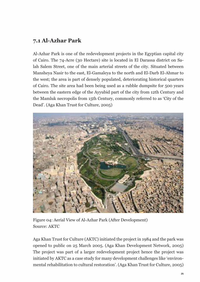
7.1 Al-Azhar Park
Al-Azhar Park is one of the redevelopment projects in the Egyptian capital city of Cairo. The 74-Acre (30 Hectare) site is located in El Darassa district on Sa-lah Salem Street, one of the main arterial streets of the city. Situated between Mansheya Nasir to the east, El-Gamaleya to the north and El-Darb El-Ahmar to the west; the area is part of densely populated, deteriorating historical quarters of Cairo. The site area had been being used as a rubble dumpsite for 500 years between the eastern edge of the Ayyubid part of the city from 12th Century and the Mamluk necropolis from 15th Century, commonly referred to as ‘City of the Dead’. (Aga Khan Trust for Culture, 2005)
Figure 04: Aerial View of Al-Azhar Park (After Development) Source: AKTC
Aga Khan Trust for Culture (AKTC) initiated the project in 1984 and the park was opened to public on 25 March 2005. (Aga Khan Development Network, 2005) The project was part of a larger redevelopment project hence the project was initiated by AKTC as a case study for many development challenges like ‘environ-mental rehabilitation to cultural restoration’. (Aga Khan Trust for Culture, 2005)
26
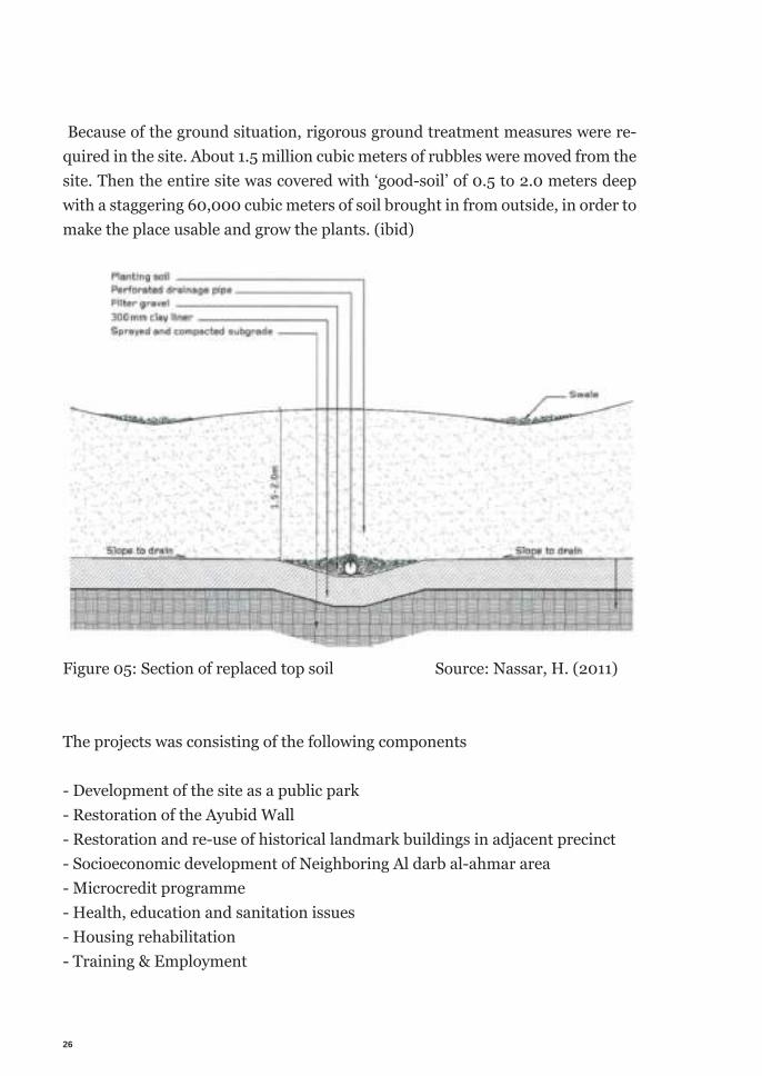
Because of the ground situation, rigorous ground treatment measures were re-quired in the site. About 1.5 million cubic meters of rubbles were moved from the site. Then the entire site was covered with ‘good-soil’ of 0.5 to 2.0 meters deep with a staggering 60,000 cubic meters of soil brought in from outside, in order to make the place usable and grow the plants. (ibid)
Figure 05: Section of replaced top soil Source: Nassar, H. (2011)
The projects was consisting of the following components
- Development of the site as a public park- Restoration of the Ayubid Wall- Restoration and re-use of historical landmark buildings in adjacent precinct - Socioeconomic development of Neighboring Al darb al-ahmar area- Microcredit programme - Health, education and sanitation issues - Housing rehabilitation- Training & Employment
27
The AKTC initiated the project with a goal of creating a large green space to serve the entire city realizing the increasing scarcity of parks and open green spaces in the city. Upon selection of the site, necessity of developing the adjacent ar-eas arose. The excavation for soil treatment reveled the historic wall lead to its restoration to include it in the project. Being part of the historic quarter, there are many historic landmark buildings around. AKTC extend the project to re-store the archeological landmarks. Another part of the project was to improve socioeconomic situation of the Al darb al-ahmar area. AKTC undertook different programs like providing with microcredits, technical trade training to empow-er people to find income opportunities. Housing rehabilitation provided hous-ing support for families. Providing healthcare & education by establishing & re-storing clinics & schools. Helping the local municipality to establish & maintain swage lines, fresh water supplies were also initiated for the improvement of the Al darb al-ahmar area.
7.1.1 Discussion
This project was an early example of redevelopment of abandoned urban areas in Cairo. Though it was initiated by welfare organization, provided with majority of the funding, leadership, execution but a clear reflection of public need of urban space. AKTC worked closely with the government, other civil society organiza-tion, donor agencies and public. A successful completion of the projects states the possibility of executing a redevelopment project by private organization. Despite being a private organization, AKTC was motivated to provide people with their need. It allowed AKTC to determine a program that provides benefits maximum people of the city. Willingness to benefit the people of the city, not being a finan-cial organization let AKTC implement a program that does not require generating weighty economic benefits. The project only needed to generate enough money for its own sustainability therefore it was able to fulfilling common soci0cultural need of the citizens. Mutual vision for the project shared by the involved stake-holders contributed meaningfully to successful completion of the project. Prioritizing environmental need played a deciding role for the project as AKTC was intending to create ‘a lung’ for the city. It the face of rapid population growth, urbanization was also growing fast. Thus imposing environmental threats to the
28
city. Redevelopment of an urban brownfield into a public park came with multi-ple environmental benefits. The area is no longer contributing to the pollution, urban heat island effect. Being a green oasis it is also housing a rich ecosystem to plants and animal species. To accommodate the unprecedented growth of Cairo, a number of new towns have been being created around the city. These satellite towns are detached from the main city and loosely connected. These new townships are often criticized for being under occupied to a large extent. (Hegazy & Moustafa 2013). Undeniably new townships are being developed to respond to the need generated in the city. Redevelopment of brownfield into a public park can be a pioneering example to find out under utilized opportunities within the city to provide citizens with theirs needs.
7.1.2 Learning
The project was deliberate to involve more stakeholders. The pronounced reali-zation of citizen participation as a critical need for successful completion and sus-tainability of the project sought the projects awareness & willingness to involve citizens in the process. Different components of the project, steps taken during the course of the project demonstrated the enticement of participation of differ-ent stakeholders and projects capacity to accommodate them as well. Economic, technical limitation encouraged the implementing organization to partner with other stakeholders, hence acting as a connection between citizens and other in-stitutions. Denouncing the ‘top down’ process as ‘outdated’; the project aims to take a more comprehensive approach to implement the project. (Aga Khan Trust for Culture, 2005) Introducing training programs for citizens in order to employ them to the project, as worker was one prominent attempt of implementing participatory process in this project. Assumable-ly, involving the neighboring community in the develop-ment through injecting economic activities through restore & reusing heritage buildings, providing financial benefits through microcredits was also an attempt to increase citizen involvement.The project was intended as an open space for all the citizens of the city, attrac-tive citizens from all economic tires would supposedly improve the possibility of
29
social cohesion. This project offers a sizable open space, not restricted to abili-ties and availabilities of any social-economic groups exclusively combined with a common need elevated this project as a hub for interaction and social cohesion on a citywide scale.
However many have argued that the project has failed to achieve a higher level of participation. At the user end, the park is still a gated and entry is permitted only with purchase a ticket. Which might be limiting the accessibility for many peo-ple. Connectivity poses another significant obstacle to the universal accessibility. The ticket office and entry to Al-Azhar Park is on the Salah Saleem Street, which is not in a close proximity to any metro station or a transportation hub. Private vehicle and only a handful transport route carries visitor to the park. Not having a safe passage to cross the high-speed traffic on Salah Saleem Street adjacent to the facility, it is very risky to cross the street for the people coming with public transport or dropping off on the other side of the street. Limiting the accessibility to a majority of peoples coming without private vehicles. Not having access from its residential neighborhoods prevents easy access to the neighboring areas.
At implementation level, the project did not actively involve lot of different stake-holders including students, researchers, citizens beyond financial and technical necessity during its course. Understandably, the technicalities imposed by the physical condition of the site, legal bindings, organizational capacity structured the process of the project sub-stantially. Owing to the unique nature of the project in the region it did not have any present guideline or any example to follow. As a privately initiated public project it had to rely on the willingness and extent of aspiration of the organiza-tion. Lack of preparedness of different stakeholders played a role as well. As com-plex and lengthy process, participatory approach takes a lot of mobilizing firstly through raising awareness for the need of it. Nevertheless, the project pioneered to set an example in many different aspects. The project is a highly celebrated ur-ban social space, visited by 2 million people every year (Aga Khan Development Network) It is also a great example of a social hub to enhance social cohesion, incepted for common public benefits, implemented through private initiative by exploring and utilizing the intrinsic potentials of abandoned urban spaces to its highest.
30
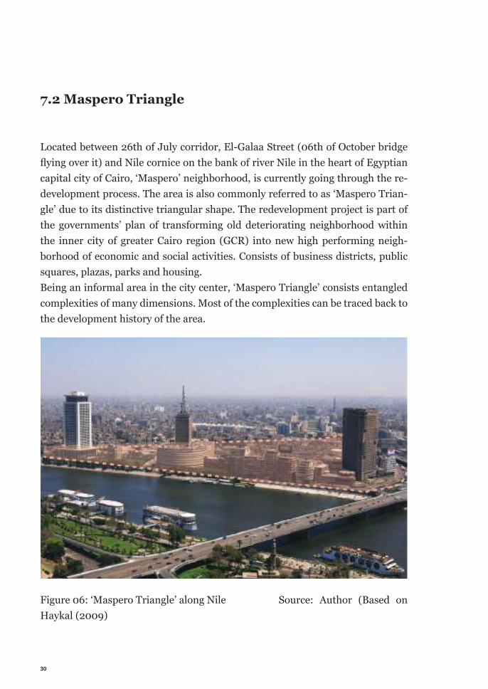
7.2 Maspero Triangle
Located between 26th of July corridor, El-Galaa Street (06th of October bridge fl ying over it) and Nile cornice on the bank of river Nile in the heart of Egyptian capital city of Cairo, ‘Maspero’ neighborhood, is currently going through the re-development process. The area is also commonly referred to as ‘Maspero Trian-gle’ due to its distinctive triangular shape. The redevelopment project is part of the governments’ plan of transforming old deteriorating neighborhood within the inner city of greater Cairo region (GCR) into new high performing neigh-borhood of economic and social activities. Consists of business districts, public squares, plazas, parks and housing.Being an informal area in the city center, ‘Maspero Triangle’ consists entangled complexities of many dimensions. Most of the complexities can be traced back to the development history of the area.
Figure 06: ‘Maspero Triangle’ along Nile Source: Author (Based on Haykal (2009)
31
7.2.1 History
After opening of a street along current day 26th of July corridor, connecting Khe-divate Cairo (current day Downtown) with older neighborhood Bulaq Abu el Ela from Mamluki period and Gezira Island in early 19th century by French colonial government during their short lived expedition in Cairo, settlements started to grow in the proximity. However, significant part of present day ‘Maspero’ area got its built forms during late 19th century (1880-1890) when one of the elites of Khedivate1 rulers allowed his servants to built their residences in the area. Later generations of first settlers were living in the area. They had their tenure secured through the endowment issued in 1940 for later 20 years by the descends of the owners, when they were leaving the country, moving to Turkey. Many of the landowners avoided the governments’ acquisition through 1952 land reforma-tion act using the endowment. Respectively, taking advantage of Anwar el Sa-dat’s neo-liberal policies of privatization in 1970s and 1980s Egyptian Ministry of Awqaf2 mediated transferring the properties’ titles form individual owners and the descendants of khedivate elites to interested private investors from gulf countries (Kuwait & Saudi Arabia). With the commissioning of a building for Arab and Television Union, now called, , by president Gamal Abdel Nasser in Au-gust 1959 façade of the area along Nile Cornice started to change. In the 1970s it took most of its current look through radical changes and ambitious projects. All along the residents of the Maspero Triangle community suffered form eviction, violence and shrank constantly. Namely in 1979, when the government evicted Turguman Informal Settlement to El Zawya Al Hamra on the city’s periphery for the construction of Ministry of Foreign Affairs building under president Anwar el Sadat. Radical change in government policies, change in landownership and ad-judicated by investors’ interest, residents stated to suffer different consequences. Exemplarily, many of the buildings were damaged in 1992 earthquake, yet res-idents were prohibited to repair, maintain or construct houses by government decree. Successively, government also started to buy lands from private owners
1 Khediviate: the government or dominion of a khediveKhedive: a ruler of Egypt from 1867 to 1914 governing as a viceroy of the sul-tan of Turkey (Khedivate. n.d.)2 Awqaf: (Another Spelling Waqf) is an Islamic endowment of property to be held in trust and used for a charitable or religious purpose (waqf. n.d.)
32
through the holding company, ‘Maspero for Urban Development’. (ZaaZaa et. al, 2015; Khalil, 2018; Ali, 2014; Selim, 2014)
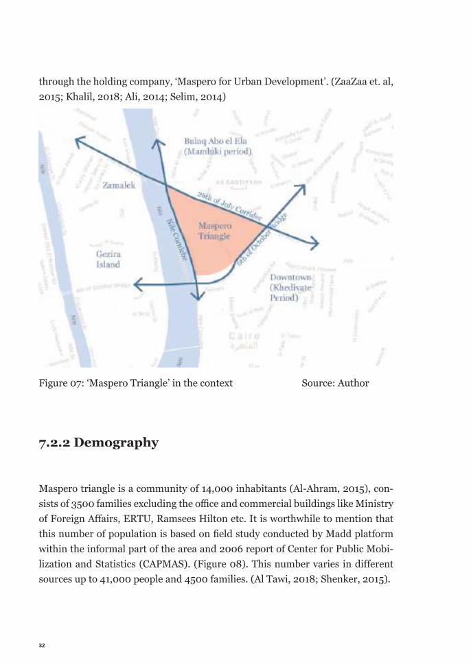
Figure 07: ‘Maspero Triangle’ in the context Source: Author
7.2.2 Demography
Maspero triangle is a community of 14,000 inhabitants (Al-Ahram, 2015), con-sists of 3500 families excluding the offi ce and commercial buildings like Ministry of Foreign Aff airs, ERTU, Ramsees Hilton etc. It is worthwhile to mention that this number of population is based on fi eld study conducted by Madd platform within the informal part of the area and 2006 report of Center for Public Mobi-lization and Statistics (CAPMAS). (Figure 08). This number varies in diff erent sources up to 41,000 people and 4500 families. (Al Tawi, 2018; Shenker, 2015).
33
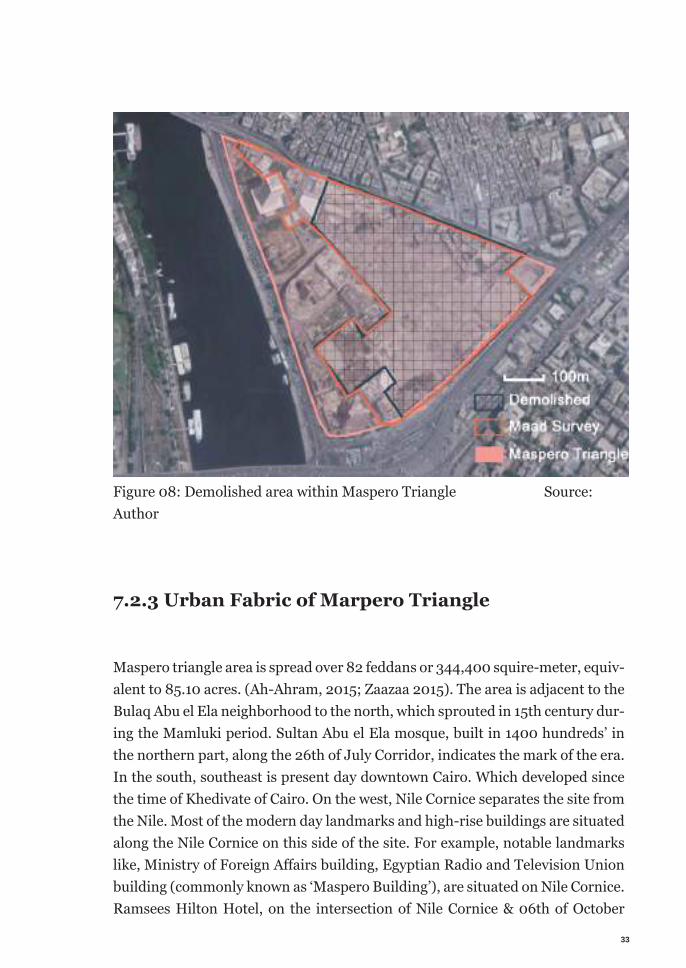
Figure 08: Demolished area within Maspero Triangle Source: Author
7.2.3 Urban Fabric of Marpero Triangle
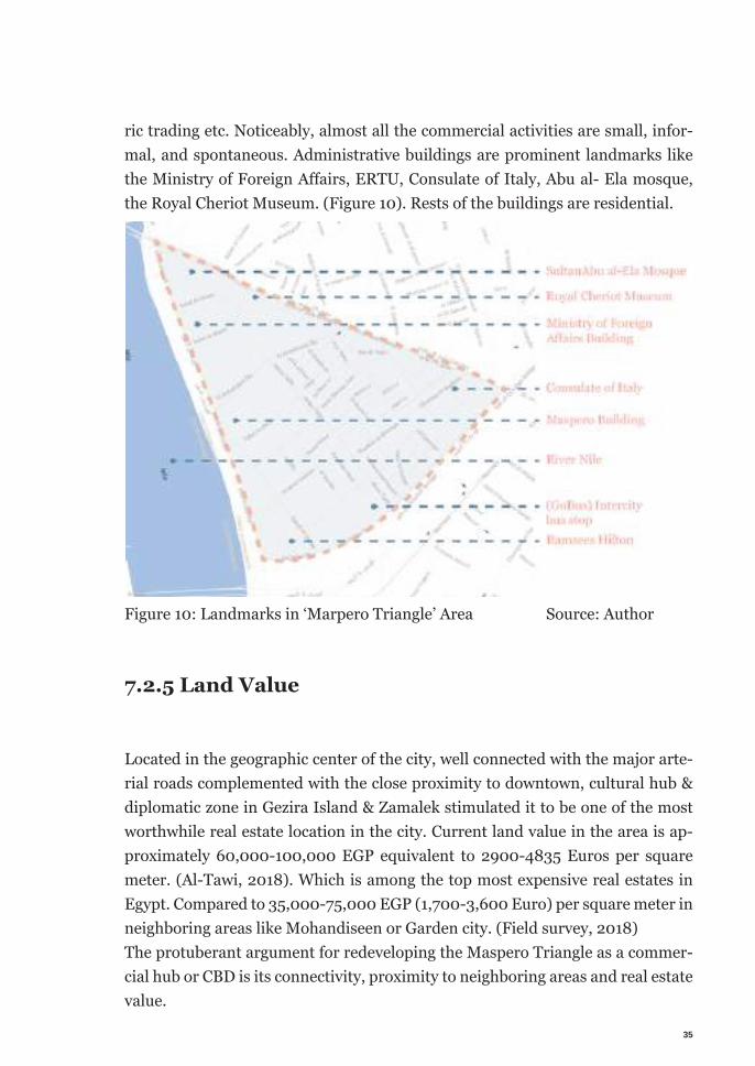
Maspero triangle area is spread over 82 feddans or 344,400 squire-meter, equiv-alent to 85.10 acres. (Ah-Ahram, 2015; Zaazaa 2015). The area is adjacent to the Bulaq Abu el Ela neighborhood to the north, which sprouted in 15th century dur-ing the Mamluki period. Sultan Abu el Ela mosque, built in 1400 hundreds’ in the northern part, along the 26th of July Corridor, indicates the mark of the era. In the south, southeast is present day downtown Cairo. Which developed since the time of Khedivate of Cairo. On the west, Nile Cornice separates the site from the Nile. Most of the modern day landmarks and high-rise buildings are situated along the Nile Cornice on this side of the site. For example, notable landmarks like, Ministry of Foreign Aff airs building, Egyptian Radio and Television Union building (commonly known as ‘Maspero Building’), are situated on Nile Cornice. Ramsees Hilton Hotel, on the intersection of Nile Cornice & 06th of October
34
Bridge, Royal Chariot Museum, and Consulate of Italy, on 26th of July Corridor are also among the most recognizable landmarks in the area. Though, offi cially there are seven buildings are registered with the Cultural Ministry’s ‘National Organization for Urban Harmony (NOUH)’ as ‘Architecturally unique structure’.
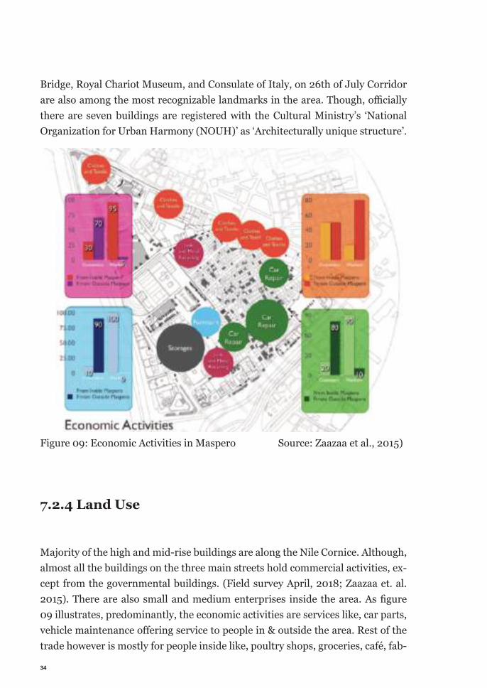
Figure 09: Economic Activities in Maspero Source: Zaazaa et al., 2015)
7.2.4 Land Use
Majority of the high and mid-rise buildings are along the Nile Cornice. Although, almost all the buildings on the three main streets hold commercial activities, ex-cept from the governmental buildings. (Field survey April, 2018; Zaazaa et. al. 2015). There are also small and medium enterprises inside the area. As fi gure 09 illustrates, predominantly, the economic activities are services like, car parts, vehicle maintenance off ering service to people in & outside the area. Rest of the trade however is mostly for people inside like, poultry shops, groceries, café, fab-
35
ric trading etc. Noticeably, almost all the commercial activities are small, infor-mal, and spontaneous. Administrative buildings are prominent landmarks like the Ministry of Foreign Aff airs, ERTU, Consulate of Italy, Abu al- Ela mosque, the Royal Cheriot Museum. (Figure 10). Rests of the buildings are residential.
Figure 10: Landmarks in ‘Marpero Triangle’ Area Source: Author
7.2.5 Land Value
Located in the geographic center of the city, well connected with the major arte-rial roads complemented with the close proximity to downtown, cultural hub & diplomatic zone in Gezira Island & Zamalek stimulated it to be one of the most worthwhile real estate location in the city. Current land value in the area is ap-proximately 60,000-100,000 EGP equivalent to 2900-4835 Euros per square meter. (Al-Tawi, 2018). Which is among the top most expensive real estates in Egypt. Compared to 35,000-75,000 EGP (1,700-3,600 Euro) per square meter in neighboring areas like Mohandiseen or Garden city. (Field survey, 2018)The protuberant argument for redeveloping the Maspero Triangle as a commer-cial hub or CBD is its connectivity, proximity to neighboring areas and real estate value.
36
Yet, the rent inside the area is very low. Owning to the fi xed rent rule, many residents inside the area still pay 10 to 20 EGP per month (approx. 0.50 Euro to 1 Euro). (Al-Tawi, 2018). Because of the injunction posed by the government, new buildings cannot be built, nor the old ones can be maintained or renovated. Which is gradually worsening the physical state of the area. Unable to yield the maximum benefi t of the real estate value, need of a drastic redevelopment para-mount among the investors and land owners.
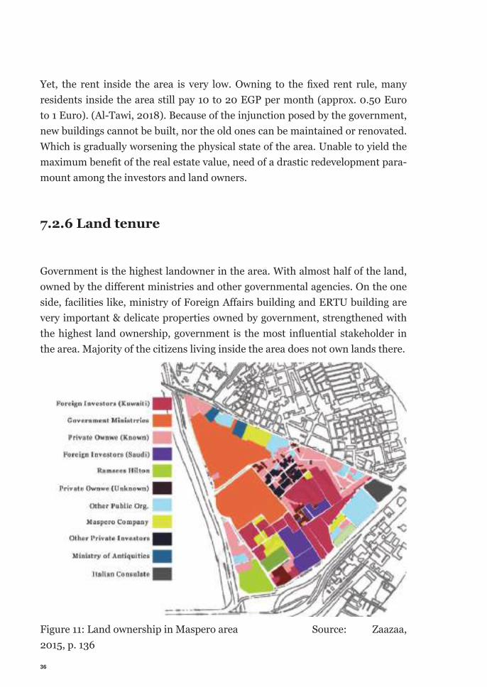
7.2.6 Land tenure
Government is the highest landowner in the area. With almost half of the land, owned by the diff erent ministries and other governmental agencies. On the one side, facilities like, ministry of Foreign Aff airs building and ERTU building are very important & delicate properties owned by government, strengthened with the highest land ownership, government is the most infl uential stakeholder in the area. Majority of the citizens living inside the area does not own lands there.
Figure 11: Land ownership in Maspero area Source: Zaazaa, 2015, p. 136
37
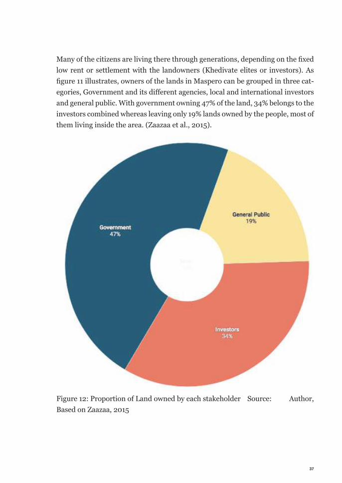
Many of the citizens are living there through generations, depending on the fi xed low rent or settlement with the landowners (Khedivate elites or investors). As fi gure 11 illustrates, owners of the lands in Maspero can be grouped in three cat-egories, Government and its diff erent agencies, local and international investors and general public. With government owning 47% of the land, 34% belongs to the investors combined whereas leaving only 19% lands owned by the people, most of them living inside the area. (Zaazaa et al., 2015).
Figure 12: Proportion of Land owned by each stakeholder Source: Author, Based on Zaazaa, 2015
38
7.2.7 Project development
Redevelopment of ‘Maspero Triangle’ first sought out by the government through a presentation document entitled ‘Vision of Cairo 2050 within a national vision of Egypt’ (also popularly known as ‘Cairo vision 2050’) in 2008. (Tarbush, 2012; pp. 172) The document was published online unofficially that raised appre-hension among civil society and fear of eviction among the dwellers. (Amnes-ty International, 2011,2013; Sims, 2010; Tarbush, 2012). In ‘Cairo vision 2050’, ‘Maspero Triangle’ was proposed as a central business district (CBD) without a complementary study to support the idea. (El-hefnawi, 2010. pp. 84, 86-91). Government started relocating residents to Al-Nahda and Assalam housing pro-jects located in suburbs, northeast of Cairo. (Khalil, 2018). In retaliation resi-dents of the neighborhood created Maspero Youth Association to mobilize the community in order to save their tenure. Followed by continued forced eviction by bygone president Hosni Mubarak, citizens of ‘Maspero Triangle’ area took ac-tive part in 2011 revolution. (Mackey, 2011). After the revolution, citizen’s of the area saw hope, when the possibility of negotiation with the new president Mo-hamed Morsi surfaced. But the discussion did not take place due to the change in presidency. (Ali, 2014)However, after the revolution with the change in leadership, government pro-posed a new approach towards development of Cairo. New proposal was initiated with collaboration with the United Nations and called ‘Strategic Development Plan for Greater Cairo Region 2050’ (Strategic Development Plan for Greater Cairo, UNDP). New strategic plan was intended to focus on participatory plan-ning process. Parallelly, in the time of post revolution reforms, there were a few other projects were developing which influenced the redevelopment of Maspe-ro. For Example, As part of the ‘Strategic Development Plan for Greater Cairo Region 2050’ project, UNDP, UNHABITAT & GOPP was developing plans for developing Abedeen Squre and neighboring open spaces. (Redevelopment of Ab-deen square, 2015; Adel et al., 2013). In 2011 two houses collapsed in Othman Rashdan Alley, killing 11 people in the incident. In response, GOPP proposed replacing the existing neighborhood fabric with 64 towers. The Maspero Youth Association started mobilizing people opposing the top down proposal of GOPP. (Khalil, 2018). Following the event Maspero triangle got into the center of many discussions. Members of the civil society saw the government’s plan not suitable
39
for the area. Many came forward to help directly. A group of human rights activ-ists from the Egyptian Center for Civil and Legislative Reform (ECCLR) volun-teered to provide legal support to Maspero Triangle residents. They conducted legal and social studies in the area, started advocating for the citizens rights by establishing contact with government officials and raising awareness. (ibid). An-other group of architects and activists platform called Madd came forward to eco people’s voice and advocating a more inclusive redevelopment process. In June 2013 Madd started their fieldwork in the Maspero Triangle area. They launched ‘Maspero Parallel Participatory Project’ aiming to achieve a comprehensive re-development for Marpero Triangle area. Through an extensive socio economic research, elaborated documentation of built form Madd tried to understand the issue as much as possible. (Zaazaa et al., 2015; Khalil, 2018). Simultaneously, they started to mobilize the community though community meetings, focused group discussions (FGDs), community consultations, interviews, story telling, presentations and so on. Outside of the community the group attempted to gain public support through presenting talks in different discourse groups, publish-ing newspaper article at the same time establishing communication with govern-ment agencies promoting their approach of participatory planning for a better redevelopment.
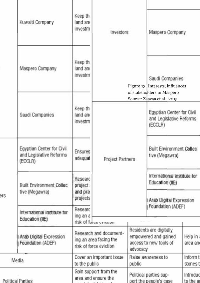
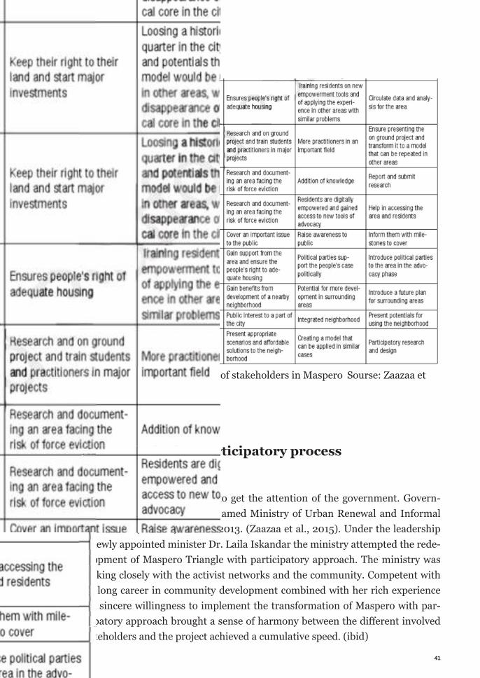
7.2.8 Stakeholder analysis
Beside the multitudes of complexities, there were following stakeholders involve in the project, namely, local residents, the government, investors, different activ-ist groups, media, political parties and city dwellers. All of them had their own interest, influence over the project and contributed to shape the policies. Follow-ing matrix borrowed form Madd platforms analysis manages to simplify each stakeholders interest and contribution to the policies.
Pointing out the interests of the stakeholders reveals the possible influences of them in the project. Analysis of the interests helps to find out the possible con-flicts of interests and window of compromises. It points out the possible relation-ship hence allowing initiating the negotiation.
4040
Figure 13: Interests, infl uences of stakeholders in Maspero Sourse: Zaazaa et al., 2015
41
Figure 13: Interests, infl uences of stakeholders in Maspero Sourse: Zaazaa et al., 2015
7.2.9 Introducing participatory process
The collective eff ort was able to get the attention of the government. Govern-ment formed a new ministry named Ministry of Urban Renewal and Informal Settlements (MURIS) in June 2013. (Zaazaa et al., 2015). Under the leadership of newly appointed minister Dr. Laila Iskandar the ministry attempted the rede-velopment of Maspero Triangle with participatory approach. The ministry was working closely with the activist networks and the community. Competent with her long career in community development combined with her rich experience and sincere willingness to implement the transformation of Maspero with par-ticipatory approach brought a sense of harmony between the diff erent involved stakeholders and the project achieved a cumulative speed. (ibid)
Settlements (MURIS) in June 2013. (Zaazaa et al., 2015). Under the leadership of newly appointed minister Dr. Laila Iskandar the ministry attempted the rede-velopment of Maspero Triangle with participatory approach. The ministry was working closely with the activist networks and the community. Competent with her long career in community development combined with her rich experience and sincere willingness to implement the transformation of Maspero with par-ticipatory approach brought a sense of harmony between the diff erent involved stakeholders and the project achieved a cumulative speed. (ibid)
Figure 13: Interests, infl uences of stakeholders in Maspero Sourse: Zaazaa et al., 2015
7.2.9 Introducing participatory process
The collective eff ort was able to get the attention of the government. Govern-ment formed a new ministry named Ministry of Urban Renewal and Informal Settlements (MURIS) in June 2013. (Zaazaa et al., 2015). Under the leadership
42
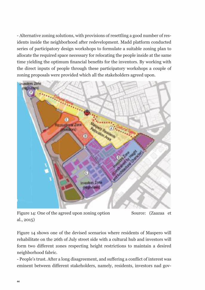
Prior to government’s involvement, Madd platform had to work through a long process to establish the process. As the contention between the local community and other stakeholders (from outside the community) was prominent; residents were far from entrusting the group as their advocate. Not to mention their obliv-ion to the process as a whole. Through consultation, fair communication they have managed to gain the community’s trust, to be allowed on their side. The elaborated documentation process helped both sides to understand the intrinsic values of the community. Which helped with the negotiation later on. Realistic understanding of the socioeconomic situation of the community, fabric of the built form and innovative use of the structures, real scenarios inside the housing units came clear through the documentation study. At the same time, through this communication with people they have managed to formulate the needs of the community. Through series of community workshop the group formulated the design morphology for alternative designs. At the end they have provided alternatives solution in terms of zoning, swapping land ownership between owns to come up with the optimum benefits for all the stakeholders. Alternative solutions, formulated through the community work-shops succeeded to house the interested residents in the area after the resettle-ment, provide areas for investors with different condition to create a beneficial situation for the investors and contribute to formulate an agreed upon diverse neighborhood.
It’s the participatory process that deserves the credit to launch the processes of negotiation between the people and the government. Through a successful par-ticipatory communication with the community they have managed to bring the both leading stakeholders of the opposite ends to an agreement. The executed participatory process consists of negotiation to formulate the poli-cies and design workshops provides with zonings and design guidelines.The negotiation consists of the following main deals agreed by the stakeholders-- The government proposed alternative relocation packages for the people to choose from to compensate with the eviction.- Creating bigger chunks of lands by merging smaller piece of lands from differ-ent owners. - Provide the flexibility of tweaking the lads of different owners to propose agree-able solution.- Finalize the amount of people wanting to be relocating in the area after redevel-opment, amount of lands needed for relocating them and provide design guide-
43
line for the redevelopment. With the endorsement from the minister, formal assignment form the ministry, the activist groups started to sketch out a solution to protect the residence, utilize the real estate potential to maximum and come up with a socially-culturally ac-ceptable redevelopment scheme. The minister’s visit to the community including the prime minister and other government officials improved people’s trust that allowed the process to move forward faster. Concord effort from all the stakeholders, notably the efforts of activist network, political goodwill of government grounded by extended discus-sions, consultation with the community and elaborated negotiations the stake-holders agreed on a proposal consists a set of key decision. These are also the achievement of the participatory exercise executed in Maspero Triangle.Most noteworthy achievements of the participatory process executed by the Mass platform are-- Government’s attention. Changing the top down approach to a people led par-ticipatory approach. Perhaps, this is the most important achievement of the pro-cess. Since this is the very first attempt of implementing a participatory process to a redevelopment project in Egyptian context. Since, this project attracted much attention, it made it stronger point, that a people led approach is capable of carv-ing a better solution. Albeit it came with its costs, people had to suffer, fight and wait but at the end, attaining governments covenant to change its course to bot-tom up process stands as a pioneer example one of its kind. The activist networks were working closely with the community. Their sincere systematic approach, support from the civil society, mirrored desire of the community, humanitarian appeal made the case strong and made the government adopt to a more time appropriate system. Paying attention to all stakeholders to secure their rights. - Resettlement compensation packages for citizens of Maspero, consisting three options. The government offered resettlement packages to the expelled citizens for their homes and businesses. The package includes, relocating to a new hous-ings inside the area after redevelopment. The residents will pay prices for the new houses in long-term monthly installments. Second option is moving to a government built new house in the suburbs of Cairo with nominal financial com-pensation. Prices of these new homes will also be paid in long-term monthly in-stallments. The third option offers financial compensation only. Residents have to find their own homes and transfer themselves with the fixed amount paid by the government. Similar offers were made available for shops and other commer-cial facilities.
44
- Alternative zoning solutions, with provisions of resettling a good number of res-idents inside the neighborhood after redevelopment. Madd platform conducted series of participatory design workshops to formulate a suitable zoning plan to allocate the required space necessary for relocating the people inside at the same time yielding the optimum fi nancial benefi ts for the inventors. By working with the direct inputs of people through these participatory workshops a couple of zoning proposals were provided which all the stakeholders agreed upon.
Figure 14: One of the agreed upon zoning option Source: (Zaazaa et al., 2015)
Figure 14 shows one of the devised scenarios where residents of Maspero will rehabilitate on the 26th of July street side with a cultural hub and investors will form two diff erent zones respecting height restrictions to maintain a desired neighborhood fabric. - People’s trust. After a long disagreement, and suff ering a confl ict of interest was eminent between diff erent stakeholders, namely, residents, investors nad gov-
45
ernment. During the early development of the project, government advertised the new vision considering the old area will be wiped out while the residents were incapable of bearing the lose nor did they found an entity to seek justice. A successful negotiation established an exemplary system, which can lead other immediate intended redevelopment projects. Accompanied with some policy recommendation, these solutions were adopted for the redevelopment project. The combined outcome created a new framework for the project, which was used as the project brief for the international design completion as the next step of the process. (Zaazaa et al., 2015)
7.2.10 Challenges
Maspero redevelopment project came with multiple layers of complexities. The development history of the neighborhood goes back more than a century, which imposed de-facto challenges to the redevelopment project. On top of that, since it had grown as an informal area, where residents were living without owning the land, under the land tenure of their employers. Over the time with the change of rulers, the employers left the country without paying much attention to the proper settlement of the issue of ownership. At the same time, in the face of rapid urban growth people came in grate number and tried to settle in the area. Many tried to misuse the situation by trying to establish illegal ownership over the land by occupying it. Not to mention, the over population density, widespread poverty and illiteracy made a perfect market for drug dealing and other crimes. Govern-ment and its involved agencies has always been trying and constantly failing to maintain law and order in the area. Any attempt of redevelopment was realized with forced eviction, many times leading to violence. This situation sprouted the tension between the people and the government. So when the government finally proposed a redevelopment plan for the entire area, without consulting the peo-ple; their natural reaction was to retaliate and not to cooperate. The geographic location of the site also contributed to make it more difficult pro-ject. Located in the heart of the city made it lucrative for all sorts of functions. Contradicted with its predominant use as an informal housing area created the conflict of interest between the ideas of transforming it for commercial use to gain financial benefits against the preserving the social-archaeological value with
46
humanitarian arguments. It can be said that the increasing tension resulting form communication gap and top down policies over the year made the project a sensitive one and exposed the inhabitants to many vulnerabilities & exploitation. Overlooking the need of a sensible communication with the community created a rugged ground for any development work.
7.2.11 Discussion on participatory process in Maspero
At this point it is safe to say, noticeably there are two distinguishable parallel processes in the Masepro redevelopment project. First is the rehabilitation of the evicted residents and second is the participatory project development. They are connected, but not interchangeable. A proper rehabilitation of evicted and effect-ed population is undeniable responsibility of the responsible party of the project despite the redevelopment process. Implementing the participatory process is another tool to make the project more convincing to larger group of stakeholders. Also a tool to find a point of cooperation between conflicts of interests, as is the case with Maspero triangle project. Proceeding with a project with forceful eviction without the intention to reha-bilitate on legal ground does not stand the moral ground from the humanitarian perspective. Development for some at the cost of others, in the name of entitle-ment is harmful for the city as a whole in the long run. However it is interesting to no notice here that systematic participation can kill two birds with one stone. In case of this project, a parallel exercise of participatory process by a group of civil society activists enabled the people to get their right to rehabilitation at the same time came to terms with the other involved stakeholders to articulate a common vision for the project. In the beginning thereat of eviction was eminent to the entire community. Many families were evicted over the time since the first account of eviction during the construction of ERTU building.On top of that, the project was envisioned from the perspective of selected few, leading the status quo. The propagated visions for the built environment were alienating for the common people of the city. Nor did it reflect the desire of city and growing needs against its rapid growth. Slow but steady revolt from different stakeholders surfaced over the time.
47
Finally, to the immediate fear of actualizing the undesired transformation by the cost of the community living there and the intrinsic value of the tangible and intangible fabric of the area some organizations from the community and form the civil society emerged to mobilize the people. Their sincere effort made the big shift in the paradigm. The government, leader of the project agreed to adopt the participatory process. Compensating the effected people was part of it too. It was a major victory and milestone achievement for the project. This was an admira-ble success by the civil society initiatives supported by the community. This was a new paradigm in planning; a first account of participation in a development project in the Egyptian context. Madd platform introduced the participatory planning process to the project aim-ing to achieve acceptable solution for all the stakeholders. Establishing a solid case advocating the rights of the citizens through instigating a negotiation be-tween owners, investors and settlers. The group initiated their project as a paral-lel approach to demonstrate the effectiveness as a solution to the situation. They succeeded marvelously. Government’s adaptation of the process to the project, acceptance of the solution by all the stakeholders stands as a solid proof of that. They have managed to shift government’s perspective, mobilized people, and raised enough support from the civil society to establish participatory process as the main development process. It demonstrated a perfect instance of how a systematic approach, complemented with necessary expertise, sincere willing-ness, redevelopment project can be executed through participation in an urban complexity of multitude. Albeit, activist groups like Egyptian Center for Civil and Legislative Reform (EC-CLR) and Maspero Youth Association’s collective effort contributed to the suc-cess significantly. Though their initiative was more towards establishing legal rights of people, and Madd initiated participatory planning, but it is the collective effort of all the activist groups, community mobilization, and working towards a collective vision that made the achievement come true. Though a closer look into the project reveals many shortcomings. Which ulti-mately lead to suffering of the project with new process. According to many scholars, redistribution of power to the people is the ultimate tool of measuring participation. Which is evident in case of Maspero too. Argua-bly, the level of participation in Maspero project was low. In this case participa-tion was only effectively used as a therapy. Two major tangible outcome of this process were, first, negotiating compensations with the possibility of relocation of residents within the neighborhood after redevelopment; second, the sketched
48
vision of the new development as zoning and guidelines. However, after the most recent steps of development, which was an international design competition in-tended for designing the area. Many are criticizing the outcome as not culturally coherent with the community. (Shenker, 2015). And sudden changes in govern-ment decisions like, dissolving the Ministry of Urban Renewal and Informal Set-tlements, who were leading the project raised speculation about the future of the project.
7.2.12 Learning
Analyzing the redevelopment of Mapspero project contributed to pragmatic knowledge of this research. This illustrates perfectly how a redevelopment pro-ject in a developing context can help attaining peoples’ rights despite being in the vortex of conflict. Another obvious learning was the catalysis of people’s move-ment to change the course of the project to a participatory approach after it start-ed as a top down conventional approach. The cost of delay, change in approach, invest in services like redesigning the project, appointing a dedicated authority to deal with it are all well worth. At the end the intention of participation is to raise the sense of ownership by the users of the project, opening up a level ground with the possibility of interaction through integration of all the involved stakeholders; is also established in this example. It demonstrates the usefulness of the effective mobilization of the community, helpfulness of supports from outside to organize the community for their specific goals. It shows the possibility of going hand in hand towards a vision for new development in a congested and highly populated area with the victims and in-vestors yet achieve an agreeable platform. In other words, with all the struggles and room for improvements, introducing participatory process to the Maspero Triangle redevelopment project stands as a pioneering example of a project of its kind.
7. 2.13 Moving to a better future
Two projects discussed in this chapter indicate the gradual development of the process towards more people centric developments. The first project, redevelopment of Al-Azhar Park stands as a first example of
49
turning a brownfield into a public place serving the city with a mega scale project instigated by private welfare organization. There are a few important aspects to appreciate here are-- The project was intended for the purpose of serving the city. Despite, adequate potential and motive, the project successfully maneuvers its aim out of commer-cial gains and pledge to public good. - It also attended its attention to the community in and around the area. The in-tention to incorporate the people living around the area was praiseworthy. - The project celebrated the essential cultural and historical values throughout its course of development. The redevelopment of Maspero Triangle area on the other hand is more ripened as people centric project. With well worth fight in its account, labor & resource intensive chores, this project managed to pull the people back to the center of the steering of the project. Bringing peoples’ right back to the central driving force of the project development made it a truly successful initiative as an early example of peoples participation in Egyptian context.From the projectile of the above-discussed projects indicates towards a steady progress of people’s participation in redevelopment projects in Egypt.It is also evident that, the absence of mobilized community contributed to the absence of participation. For example, in the Al-Azhar park project, there were initiatives to incorporate the community from the neighboring El-Gamaleya to the north and El-Darb El-Ahmar area, but it was limited to some skill developing workshops. Lastly, from the discussion above it is consultable that, an immediate threat can motivate the community to organize themselves quickly. (Martin and Mathema, 2011, p. 143). As it was the case of Maspero project, with a little help from pro-fessionals outside, the community formulates a strong argument to achieve their goals.
7.2.14 Criticism & Skepticism
Maspero redevelopment project is one of the most discussed about projects in recent times in Cairo. Its density, contention between owners, investors and resi-dents; catalyzed with threats of eviction, movements of the residents this project was in attention for last few years. The success of the project cannot be under-
50
mined, however from a critical perspective it had a lot more to achieve to be a perfect participatory process and give the decision making power back to the people. Different tools used in the process can be attributed to different levels of partici-pation. Comparing the steps to Aronstein’s ladder of citizen participation can be a way to scrutinize the level of participation. (Arnstein, 1969). In Madd platform’s attempt ‘Parallel Participatory Project’ in Maspero, they started by researching and documenting the detail scenario of the area, where the participation of the people was limited to consultation. In the decision making process they did not have any stakes whatsoever. Nor did Madd have any control over the process. The communication between the people and the different activist groups includ-ing the Madd platform can be identified as ‘therapy’ for the people. The initiative by the activist groups were first amplified voice of people, which provided the people with hope and expressed in peoples’ trust in the activist groups. As the project moved on, the ‘parallel process’ have managed to gain access to the de-cision making discussion, when the government opened the new ministry and invited the activist groups to the discussions, where Madd present their findings from the area. (Zazaa et al., 2015). This can be attributed as ‘placation’. Through these improvements, the level of participation was improving from ‘no participa-tion’ to ‘tokenism’. Afterwards, the community was given opportunity to be a part of making the zoning propositions for the future design development. Additionally, selected community members were invited to the jury process of the international com-pletion. At this point, community participation was at its peak; as this can be credited as altered ‘delegation of power’. Though it was only a proposition and no promise of actualization was made beforehand, it was a positive gesture towards the involvement of the people. However, the situation deteriorated from that point. The called for international architectural completion to design the area to a major extent failed to reflect the community values distilled through Madd’s research. The design morphologies of the leading entries also did not match the cultural values & morphologies of Egyptian culture and context. (Shenkar, 2015)The jury acknowledged the lack of attention to practical, contextual details of the participation and refrained from declaring a first prize. (Worldarchitecturenews.com, 2018)
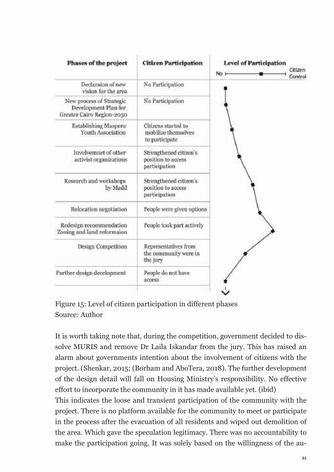
51
Figure 15: Level of citizen participation in diff erent phases Source: Author
It is worth taking note that, during the competition, government decided to dis-solve MURIS and remove Dr Laila Iskandar from the jury. This has raised an alarm about governments intention about the involvement of citizens with the project. (Shenkar, 2015; (Borham and AboTera, 2018). The further development of the design detail will fall on Housing Ministry’s responsibility. No eff ective eff ort to incorporate the community in it has made available yet. (ibid)This indicates the loose and transient participation of the community with the project. There is no platform available for the community to meet or participate in the process after the evacuation of all residents and wiped out demolition of the area. Which gave the speculation legitimacy. There was no accountability to make the participation going. It was solely based on the willingness of the au-
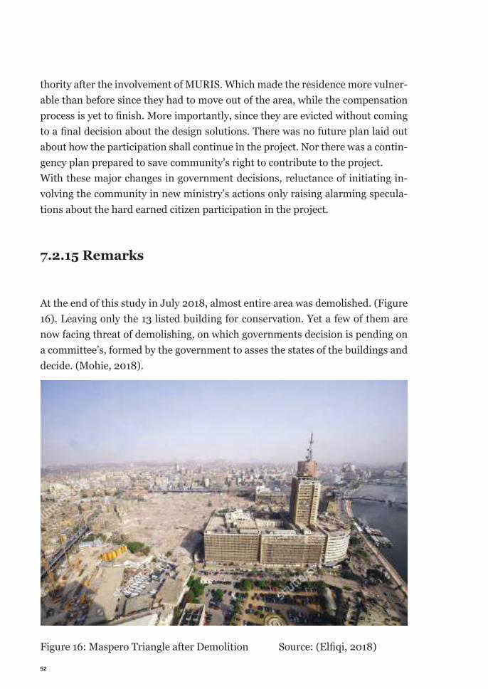
52
thority after the involvement of MURIS. Which made the residence more vulner-able than before since they had to move out of the area, while the compensation process is yet to fi nish. More importantly, since they are evicted without coming to a fi nal decision about the design solutions. There was no future plan laid out about how the participation shall continue in the project. Nor there was a contin-gency plan prepared to save community’s right to contribute to the project. With these major changes in government decisions, reluctance of initiating in-volving the community in new ministry’s actions only raising alarming specula-tions about the hard earned citizen participation in the project.
7.2.15 Remarks
At the end of this study in July 2018, almost entire area was demolished. (Figure 16). Leaving only the 13 listed building for conservation. Yet a few of them are now facing threat of demolishing, on which governments decision is pending on a committee’s, formed by the government to asses the states of the buildings and decide. (Mohie, 2018).
Figure 16: Maspero Triangle after Demolition Source: (Elfi qi, 2018)
53
7.3 Endnote on citizen participation in Cairo
Participatory redevelopment is a relatively new concept in Cairo. Lead by its po-litical context, urban development in Cairo always has been top down. However, a paradigm shift is undeniable. More and more projects are being initiated and participatory process is always there in the discussion. Owing to lack of citizen mobilization, limited previous example &, inadequate expertise & practice in the field and to some extent skeptic status of quo is making the progress slower. Al-beit, people’s voices are getting stronger, civil society, researchers, activists are putting sincere effort to redistribute the power of generating the urban fabric to the citizens. As the two examples discussed earlier this chapter indicates, there is a clear in-crease of peoples power or in other words people are participating more in ur-ban redevelopments with time. The research also surrenders under the limited breadth of the topic for not being able to look into other socioeconomic issues, which allegedly has significant impact on the level of citizen participation. To name a few, political context of Egypt, recent radical shifts (i.e. the Egyptian Rev-olution of 2011), fast urbanization and rapid economic development are slowly paving the paths for citizen participation in urban development within the devel-oping context.
7.4 KreativQuartier München (Creative Quarter Mu-nich)
This part of the discussion will focus on learning participatory tool their effective use, condition to use, benefits and shortcoming in a practical project in Munich, Germany. As the city decided to change one of its old industrial areas into new urban district, they applied citizen participation as the development process.The participatory development framework was carried out through design com-petitions, focused workshops and stakeholders meetings. The aim is to extract the exact tools used for different phases and register their usefulness in the par-ticipatory process.
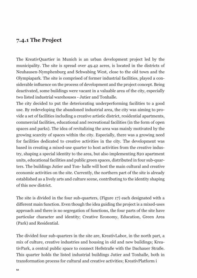
54
7.4.1 The Project
The KreativQuartier in Munich is an urban development project led by the municipality. The site is spread over 49.42 acres, is located in the districts of Neuhausen-Nymphenburg and Schwabing West, close to the old town and the Olympiapark. The site is comprised of former industrial facilities, played a con-siderable influence on the process of development and the project concept. Being deactivated, some buildings were vacant in a valuable area of the city, especially two listed industrial warehouses - Jutier and Tonhalle. The city decided to put the deteriorating underperforming facilities to a good use. By redeveloping the abandoned industrial area, the city was aiming to pro-vide a set of facilities including a creative artistic district, residential apartments, commercial facilities, educational and recreational facilities (in the form of open spaces and parks). The idea of revitalizing the area was mainly motivated by the growing scarcity of spaces within the city. Especially, there was a growing need for facilities dedicated to creative activities in the city. The development was based in creating a mixed-use quarter to host activities from the creative indus-try, shaping a special identity to the area, but also implementing 820 apartment units, educational facilities and public green spaces, distributed in four sub-quar-ters. The buildings Jutier and Ton- halle will host the main cultural and creative economic activities on the site. Currently, the northern part of the site is already established as a lively arts and culture scene, contributing to the identity shaping of this new district.
The site is divided in the four sub-quarters, (Figure 17) each designated with a different main function. Even though the idea guiding the project is a mixed-uses approach and there is no segregation of functions, the four parts of the site have particular character and identity; Creative Economy, Education, Green Area (Park) and Residential.
The divided four sub-quarters in the site are, KreativLabor, in the north part, a mix of culture, creative industries and housing in old and new buildings; Krea-tivPark, a central public space to connect Heßstraße with the Dachauer Straße. This quarter holds the listed industrial buildings Jutier and Tonhalle, both in transformation process for cultural and creative activities; KreativPlatform i
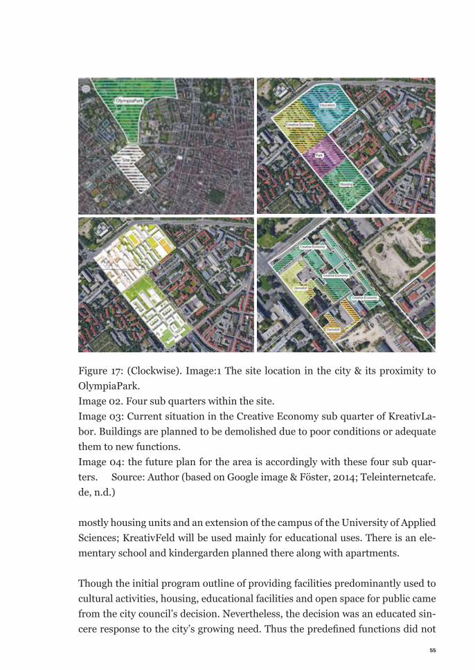
55
Figure 17: (Clockwise). Image:1 The site location in the city & its proximity to OlympiaPark. Image 02. Four sub quarters within the site.Image 03: Current situation in the Creative Economy sub quarter of KreativLa-bor. Buildings are planned to be demolished due to poor conditions or adequate them to new functions. Image 04: the future plan for the area is accordingly with these four sub quar-ters. Source: Author (based on Google image & Föster, 2014; Teleinternetcafe.de, n.d.)
mostly housing units and an extension of the campus of the University of Applied Sciences; KreativFeld will be used mainly for educational uses. There is an ele-mentary school and kindergarden planned there along with apartments.
Though the initial program outline of providing facilities predominantly used to cultural activities, housing, educational facilities and open space for public came from the city council’s decision. Nevertheless, the decision was an educated sin-cere response to the city’s growing need. Thus the predefi ned functions did not
56
contradict with the further development of the program. As the redevelopment process adopted participatory process in it’s further phases of the development.
7.4.2 Project Development
The redevelopment project was initiated in 2008 through creating a framework plan for the project. In 2010 the program decision was taken. Later in 2011, first participatory step was introduced. By that time, there we already some small in-itiatives were operating hosting some cultural activity. Hence, the municipality set up a coordination office dedicatedly for the project. Through a public even ‘Impulse event’ the municipality introduced the ‘Coordination office’ to the local business or cultural activity initiatives. The event consists of presentation form the municipality’s side and podium discussions to discuss the citizen’s (including the tenants) vision about the site. Later that year two parallel processes have been being started developing by the initiators of the project. First, conducting a workshop with the primary stakeholders consisting the municipality, coordina-tion office and tenants of the area. They formulated a broad project framework. Followed by the second workshop with wider audience. Which is also part of a series of design development process for the area, through urban design com-pletion. However, the multi staged urban design went through a couple of steps. After developing each steps by design professional through a close completion, it was presented to the audience, consists of different stakeholders. Through, presentations and exhibitions the projects were presented to them. Then their feedbacks were incorporated in the design development and move on to the more detailed next level. At different phase, different issues were at the focus of the workshop. For example, sustainability and creative economy were to name a few focus issues dealt with in the workshops. Till June 2012, a vision for the area was finalized in a master plan. In 2013, architectural designs for ‘the Halls’ were com-pleted and construction for the Phase 1 started in 2014. Nonetheless, the execu-tion of the design was done through a series of participatory workshops. Through the workshops the relationships between the functionality of the facilities pro-vided and the benefits of the citizens were determined. At the end of the process, the Labor München organization was formulated to carry out and overseer the activities in the KreativLabor part of the site. Labor München is mainly the ten-
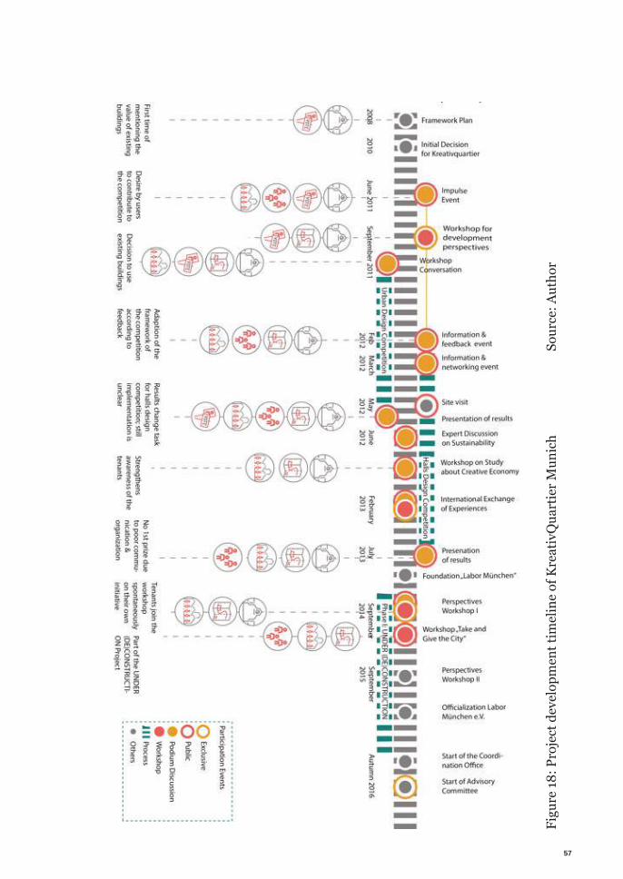
57
Figu
re 18
: Pro
ject
dev
elop
men
t tim
elin
e of
Kre
ativ
Qua
rtie
r Mun
ich
Sour
ce: A
utho
r
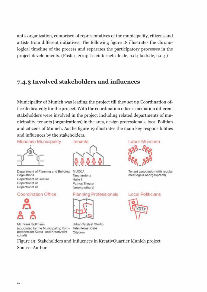
58
ant’s organization, comprised of representatives of the municipality, citizens and artists from diff erent initiatives. The following fi gure 18 illustrates the chrono-logical timeline of the process and separates the participatory processes in the project developments. (Föster, 2014; Teleinternetcafe.de, n.d.; Iakb.de, n.d.; )
7.4.3 Involved stakeholders and infl uences
Municipality of Munich was leading the project till they set up Coordination of-fi ce dedicatedly for the project. With the coordination offi ce’s mediation diff erent stakeholders were involved in the project including related departments of mu-nicipality, tenants (organizations) in the area, design professionals, local Politian and citizens of Munich. As the fi gure 19 illustrates the main key responsibilities and infl uences by the stakeholders.
Figure 19: Stakeholders and Infl uences in KreativQuartier Munich project Source: Author
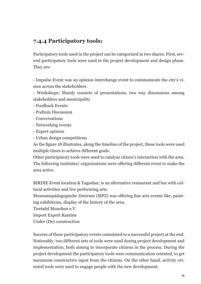
59
7.4.4 Participatory tools:
Participatory tools used in the project can be categorized in two shares. First, sev-eral participatory tools were used in the project development and design phase. They are-
- Impulse Event was an opinion interchange event to communicate the city’s vi-sion across the stakeholders.- Workshops; Mainly consists of presentations, two way discussions among stakeholders and municipality- Feedback Events- Podium Discussion- Conversations- Networking events- Expert opinion- Urban design competitionsAs the figure 18 illustrates, along the timeline of the project, these tools were used multiple times to achieve different goals. Other participatory tools were used to catalyze citizen’s interaction with the area. The following institutes/ organizations were offering different event to make the area active.
BIRDIE Event location & Tagesbar; is an alternative restaurant and bar with cul-tural activities and live performing arts. Museumspädagogische Zentrum (MPZ) was offering fine arts events like, paint-ing exhibitions, display of the history of the area.Tiertafel Munchen e.V. Import Export Kantine Under (De) construction
Success of these participatory events cumulated to a successful project at the end. Noticeably, two different sets of tools were used during project development and implementation, both aiming to incorporate citizens in the process. During the project development the participatory tools were communication oriented, to get maximum constructive input from the citizens. On the other hand, activity ori-ented tools were used to engage people with the new development.
60
7.5 Endnote on citizen participation in Germany
Citizen participation is in prime attention in urban redevelopment in recent times. Many redevelopment projects in Germany are trying to achieve better suc-cess through incorporating larger stakeholders community in the process. The example of KreativQuartier is one of the examples of such projects. Assertively, this is not the most successful one, nor there is such measure exists to measure or define the universal parameters compare and decide the most successful inte-gration in a redevelopment project. However, this example demonstrates perfectly how, government initiative can delegate the leadership role to an independent organization, giving the decision making power back to the people in tern. It also, implemented one more strategy that increased the possibility of success the project. That is, splitting the leader-ship along the way according to necessity. Which was put on balance at the same time by relying the responsibility of making the decision on the different stake-holders. In a nutshell, it can be said, the leadership role was played to steer the project to reach the vision but the larger community of stakeholders collectively formulated the vision.
7.6 Learning from the Scenarios
Three scenarios from two completely different contexts enrich the knowhow about community engagement in a redevelopment project. In cases of Cairo, it was a chronological growth of the process in redevelopment projects. It showed how community engagement is increasing throughout the time. Also, influenc-es of different facilitators are noticeable. The KreativQuartier in Munich project can stand as a good benchmark as a participatory process along with illustrating knowledge of how and which participatory tools to use to achieve higher level of integration of the community.
Knowledge accumulated from the scenarios will contribute to create better strat-egies for a participatory redevelopment project in the case study context of Te-jgaon Industrial Area in Dhaka.
61
Analyzing the scenarios answers another unavoidable discourse of level of par-ticipation. Undeniably participatory process is a new approach in urban develop-ment. It is tough, slow, hard to implement and requires a lot of time & resources. Often absolute participation is not achieved because of some reason or another. Hence the question arises, to define the minimum level of citizen participation required to call a process participatory process. These scenarios reflect different level of success with different ways of participation in different extent. But the underlying learning from this is the gradual improvement. Independent from its definition, it often turns out difficult to implement than define. But instigation of the process is always necessary to lead to higher level of participation. It is diffi-cult to redistribute the process among people without increasing their capacity to be able to do so. By practicing the process over the time through different pro-jects, the stakeholders become more competent to increase confidence on each other, being able to negotiate with each other and execute the project better.

62
63
Chapter VIII|Field Research Framework
The field research framework consists of two main steps, data collection and data synthesis. Through mapping, photo-documentation, survey, interview, analyze statistical data, previous research, site visit first hand data will be collected about the site of the case study area. GIS data from the government agencies will be analyzed to collect information on land use, area, utilities, infrastructure capac-ities etc. Then the information will be verified and updated with data from site survey. Land ownership data, if available, will allow registering the end of current lease for factory use. And show which lands are immediate on line of redevelop-ment. Data from previous study will be analyzed to attain the comparative understand-ing of the development trend. Also this will render the development rate, type, actors and beneficiaries of the new developments.
Analysis of the data set will illustrate the holistic picture of the area. Which will create the solid learning base to figure out the possible intervention site, type f in-tervention needed, determining involved stakeholders, their influence and so on.
Figure 20: Understanding the current process and identify the possible point of
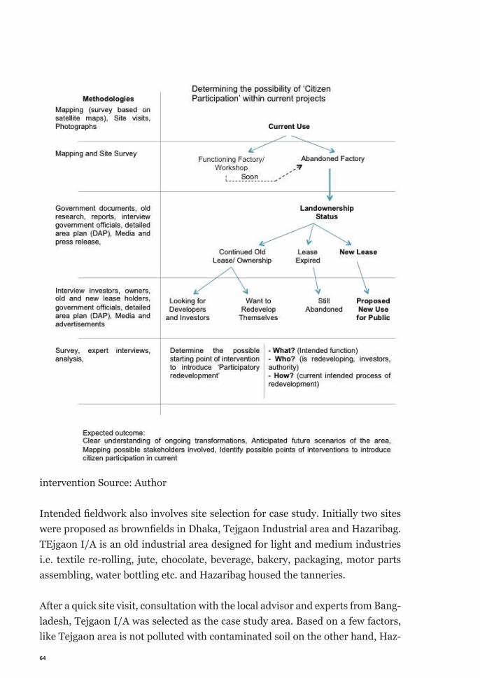
64
intervention Source: Author
Intended fi eldwork also involves site selection for case study. Initially two sites were proposed as brownfi elds in Dhaka, Tejgaon Industrial area and Hazaribag. TEjgaon I/A is an old industrial area designed for light and medium industries i.e. textile re-rolling, jute, chocolate, beverage, bakery, packaging, motor parts assembling, water bottling etc. and Hazaribag housed the tanneries.
After a quick site visit, consultation with the local advisor and experts from Bang-ladesh, Tejgaon I/A was selected as the case study area. Based on a few factors, like Tejgaon area is not polluted with contaminated soil on the other hand, Haz-
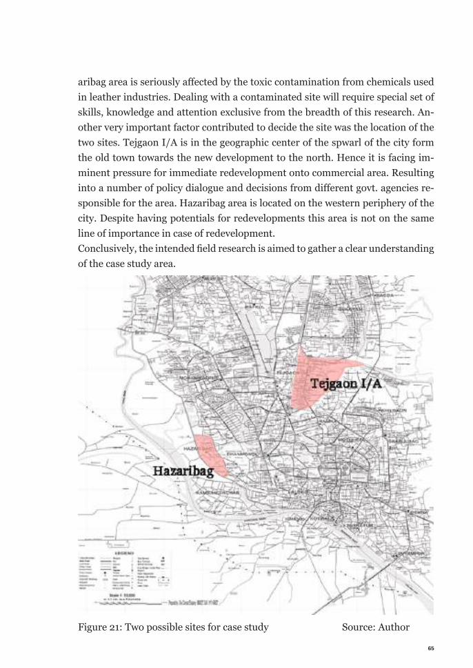
65
aribag area is seriously aff ected by the toxic contamination from chemicals used in leather industries. Dealing with a contaminated site will require special set of skills, knowledge and attention exclusive from the breadth of this research. An-other very important factor contributed to decide the site was the location of the two sites. Tejgaon I/A is in the geographic center of the spwarl of the city form the old town towards the new development to the north. Hence it is facing im-minent pressure for immediate redevelopment onto commercial area. Resulting into a number of policy dialogue and decisions from diff erent govt. agencies re-sponsible for the area. Hazaribag area is located on the western periphery of the city. Despite having potentials for redevelopments this area is not on the same line of importance in case of redevelopment. Conclusively, the intended fi eld research is aimed to gather a clear understanding of the case study area.
Figure 21: Two possible sites for case study Source: Author

66
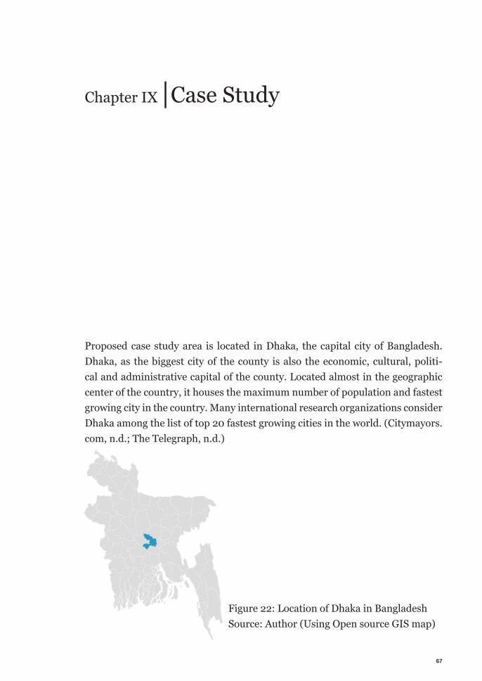
67
Chapter IX |Case Study
Proposed case study area is located in Dhaka, the capital city of Bangladesh. Dhaka, as the biggest city of the county is also the economic, cultural, politi-cal and administrative capital of the county. Located almost in the geographic center of the country, it houses the maximum number of population and fastest growing city in the country. Many international research organizations consider Dhaka among the list of top 20 fastest growing cities in the world. (Citymayors.com, n.d.; The Telegraph, n.d.)
Figure 22: Location of Dhaka in Bangladesh Source: Author (Using Open source GIS map)
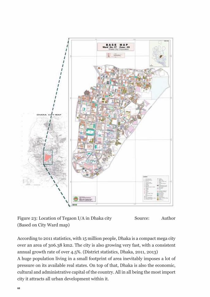
68
According to 2011 statistics, with 15 million people, Dhaka is a compact mega city over an area of 306.38 km2. The city is also growing very fast, with a consistent annual growth rate of over 4.5%. (District statistics, Dhaka, 2011, 2013)A huge population living in a small footprint of area inevitably imposes a lot of pressure on its available real states. On top of that, Dhaka is also the economic, cultural and administrative capital of the country. All in all being the most import city it attracts all urban development within it.
Figure 23: Location of Tegaon I/A in Dhaka city Source: Author (Based on City Ward map)
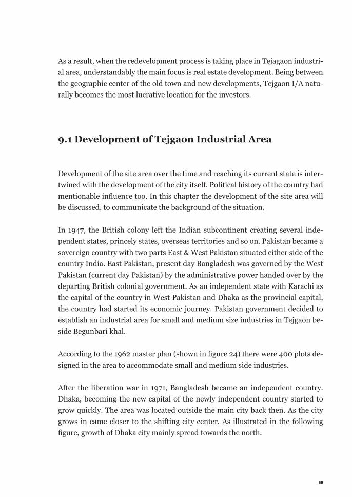
69
As a result, when the redevelopment process is taking place in Tejagaon industri-al area, understandably the main focus is real estate development. Being between the geographic center of the old town and new developments, Tejgaon I/A natu-rally becomes the most lucrative location for the investors.
9.1 Development of Tejgaon Industrial Area
Development of the site area over the time and reaching its current state is inter-twined with the development of the city itself. Political history of the country had mentionable influence too. In this chapter the development of the site area will be discussed, to communicate the background of the situation.
In 1947, the British colony left the Indian subcontinent creating several inde-pendent states, princely states, overseas territories and so on. Pakistan became a sovereign country with two parts East & West Pakistan situated either side of the country India. East Pakistan, present day Bangladesh was governed by the West Pakistan (current day Pakistan) by the administrative power handed over by the departing British colonial government. As an independent state with Karachi as the capital of the country in West Pakistan and Dhaka as the provincial capital, the country had started its economic journey. Pakistan government decided to establish an industrial area for small and medium size industries in Tejgaon be-side Begunbari khal.
According to the 1962 master plan (shown in figure 24) there were 400 plots de-signed in the area to accommodate small and medium side industries.
After the liberation war in 1971, Bangladesh became an independent country. Dhaka, becoming the new capital of the newly independent country started to grow quickly. The area was located outside the main city back then. As the city grows in came closer to the shifting city center. As illustrated in the following figure, growth of Dhaka city mainly spread towards the north.
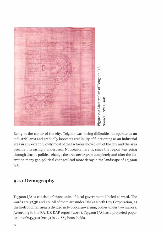
70
Being in the center of the city, Tejgaon was facing diffi culties to operate as an industrial area and gradually looses its credibility of functioning as an industrial area in any extent. Slowly most of the factories moved out of the city and the area became increasingly underused. Noticeable here is, since the region was going through drastic political change the area never grew completely and after the lib-eration many geo-political changes lead more decay in the landscape of Tejgaon I/A.
9.1.1 Demography
Tejgaon I/A is consists of three units of local government labeled as ward. The words are 37,38 and 20. All of them are under Dhaka North City Corporation, as the metropolitan area is divided in two local governing bodies under two mayors. According to the RAJUK DAP report (2010), Tejgaon I/A has a projected popu-lation of 245,340 (2015) in 22,663 households.
Figu
re 2
4: M
aste
r pla
n of
Ten
gaon
I/A
Sour
ce: P
WD
, GoB
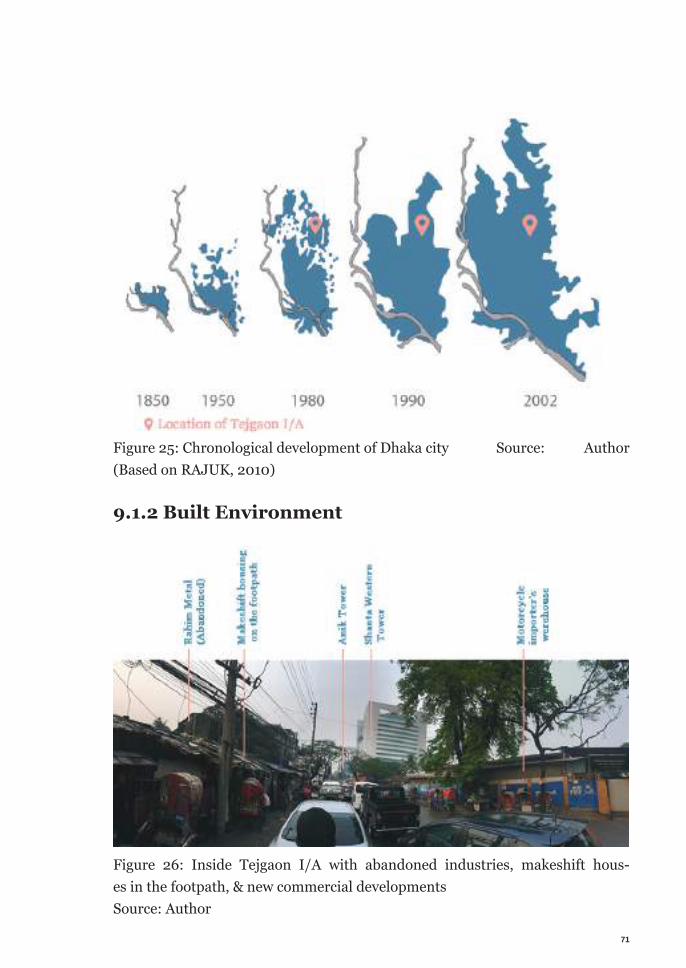
71
Figure 25: Chronological development of Dhaka city Source: Author (Based on RAJUK, 2010)
9.1.2 Built Environment
Figure 26: Inside Tejgaon I/A with abandoned industries, makeshift hous-es in the footpath, & new commercial developments Source: Author
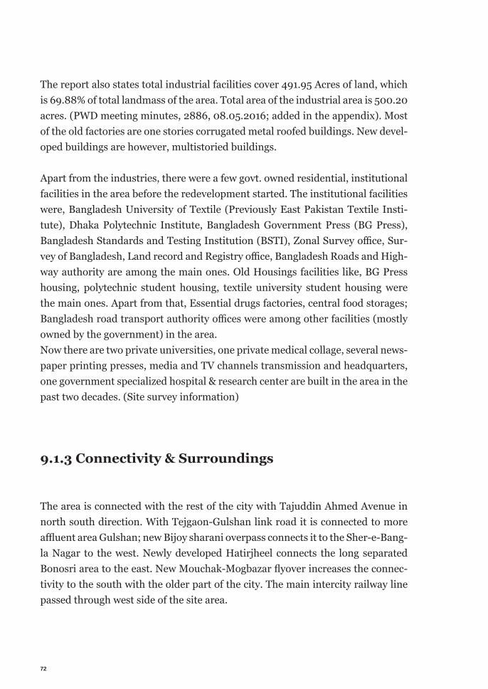
72
The report also states total industrial facilities cover 491.95 Acres of land, which is 69.88% of total landmass of the area. Total area of the industrial area is 500.20 acres. (PWD meeting minutes, 2886, 08.05.2016; added in the appendix). Most of the old factories are one stories corrugated metal roofed buildings. New devel-oped buildings are however, multistoried buildings.
Apart from the industries, there were a few govt. owned residential, institutional facilities in the area before the redevelopment started. The institutional facilities were, Bangladesh University of Textile (Previously East Pakistan Textile Insti-tute), Dhaka Polytechnic Institute, Bangladesh Government Press (BG Press), Bangladesh Standards and Testing Institution (BSTI), Zonal Survey office, Sur-vey of Bangladesh, Land record and Registry office, Bangladesh Roads and High-way authority are among the main ones. Old Housings facilities like, BG Press housing, polytechnic student housing, textile university student housing were the main ones. Apart from that, Essential drugs factories, central food storages; Bangladesh road transport authority offices were among other facilities (mostly owned by the government) in the area. Now there are two private universities, one private medical collage, several news-paper printing presses, media and TV channels transmission and headquarters, one government specialized hospital & research center are built in the area in the past two decades. (Site survey information)
9.1.3 Connectivity & Surroundings
The area is connected with the rest of the city with Tajuddin Ahmed Avenue in north south direction. With Tejgaon-Gulshan link road it is connected to more affluent area Gulshan; new Bijoy sharani overpass connects it to the Sher-e-Bang-la Nagar to the west. Newly developed Hatirjheel connects the long separated Bonosri area to the east. New Mouchak-Mogbazar flyover increases the connec-tivity to the south with the older part of the city. The main intercity railway line passed through west side of the site area.
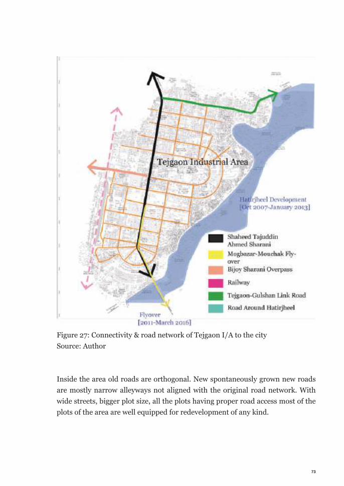
73
Figure 27: Connectivity & road network of Tejgaon I/A to the city Source: Author
Inside the area old roads are orthogonal. New spontaneously grown new roads are mostly narrow alleyways not aligned with the original road network. With wide streets, bigger plot size, all the plots having proper road access most of the plots of the area are well equipped for redevelopment of any kind.
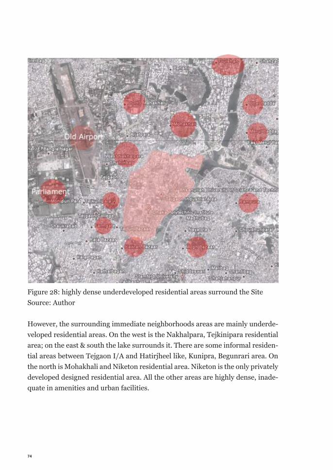
74
Figure 28: highly dense underdeveloped residential areas surround the Site Source: Author
However, the surrounding immediate neighborhoods areas are mainly underde-veloped residential areas. On the west is the Nakhalpara, Tejkinipara residential area; on the east & south the lake surrounds it. There are some informal residen-tial areas between Tejgaon I/A and Hatirjheel like, Kunipra, Begunrari area. On the north is Mohakhali and Niketon residential area. Niketon is the only privately developed designed residential area. All the other areas are highly dense, inade-quate in amenities and urban facilities.
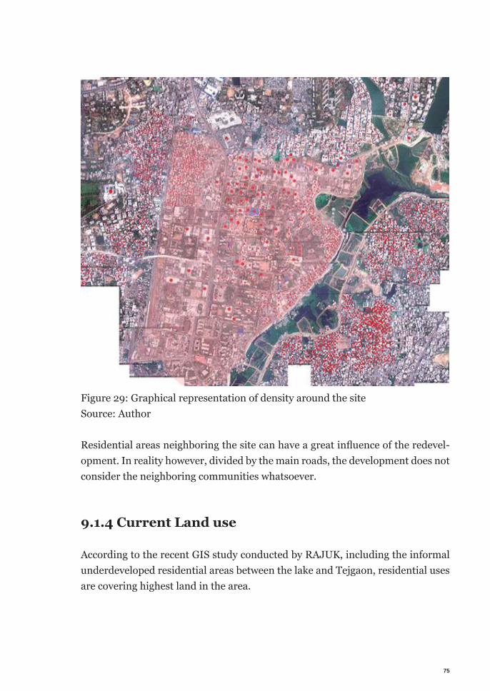
75
Figure 29: Graphical representation of density around the site Source: Author
Residential areas neighboring the site can have a great infl uence of the redevel-opment. In reality however, divided by the main roads, the development does not consider the neighboring communities whatsoever.
9.1.4 Current Land use
According to the recent GIS study conducted by RAJUK, including the informal underdeveloped residential areas between the lake and Tejgaon, residential uses are covering highest land in the area.
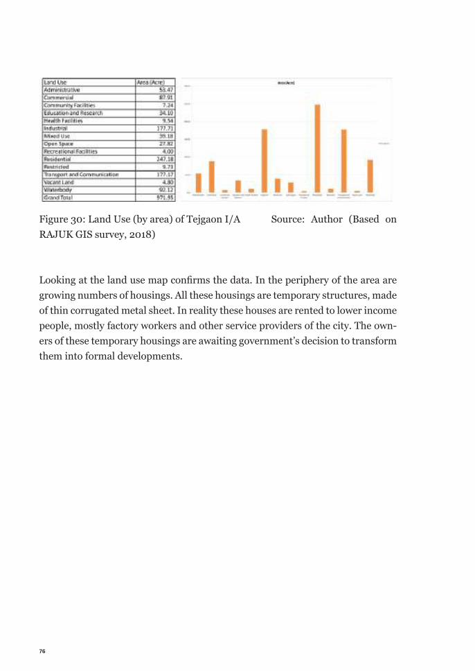
76
Figure 30: Land Use (by area) of Tejgaon I/A Source: Author (Based on RAJUK GIS survey, 2018)
Looking at the land use map confi rms the data. In the periphery of the area are growing numbers of housings. All these housings are temporary structures, made of thin corrugated metal sheet. In reality these houses are rented to lower income people, mostly factory workers and other service providers of the city. The own-ers of these temporary housings are awaiting government’s decision to transform them into formal developments.
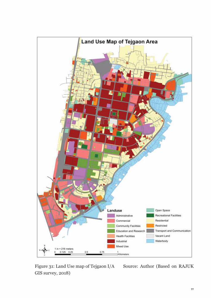
77
Figure 31: Land Use map of Tejgaon I/A Source: Author (Based on RAJUK GIS survey, 2018)
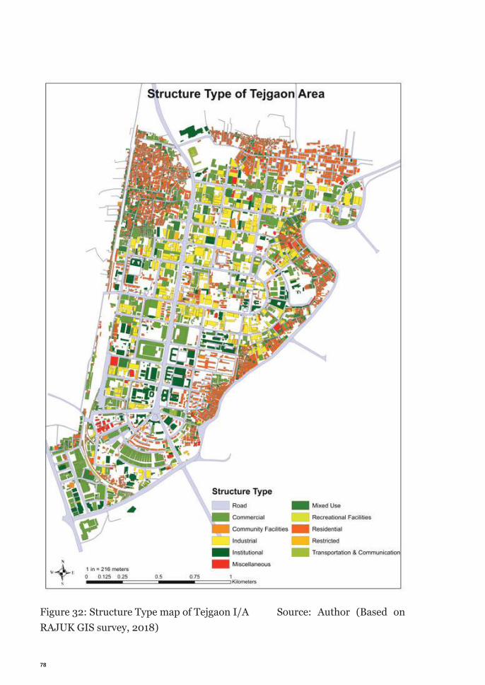
78
Figure 32: Structure Type map of Tejgaon I/A Source: Author (Based on RAJUK GIS survey, 2018)
79
From the site survey it is noticeable that, though according to the land use map many of the facilities are factories or administrative or single use facilities, in re-ality many facilities adapted to multiple usages to deal with the needs.
From the analysis of different types of structures reveal that many of the land dedicated to one type of use are already been transformed to adapt multiple use. According to the GIS survey around 35 facilities are abandoned in the area.
9.1.5 Policy Development for the area
In recent time first governmental change in the government legislation happened in 20 October 1998. Government of Bangladesh issued an announcement to con-vert the land use of Tejgaon-Gulshan Link road to commercial. Which allowed rapid change in land use of the surrounding area quickly. Later after several initiatives from the land owners, investors and developers in 20.06.2016 in a government announcement (number 25.00.0000.020.32.003.11-580, attached in appendix) Tejgaon I/A was converted to industrial cum com-mercial and residential use. In the meeting lead by the prime minister, the government decided to initiate a committee lead by the housing and public works minister to prepare a mega master plan for the area. (Bdnews24.com, 2014) There was a few official discussion sessions held afterwards. However, no final initiatives have been taken to conduct a dedicated study for the area. Different professional organizations expressed their concern and proposed different solu-tions for moving forward with the project. One common outcry can be noticed in all the opinions. A need for a elaborated study of the area to determine appropri-ate vision before moving forward with the development process.
9.1.6 Current Developments
Field study indicates that not only individual plots are redeveloped to new uses, but many new medium and large-scale infrastructure development projects are also being developed in and around the site area in the past couple of years. For
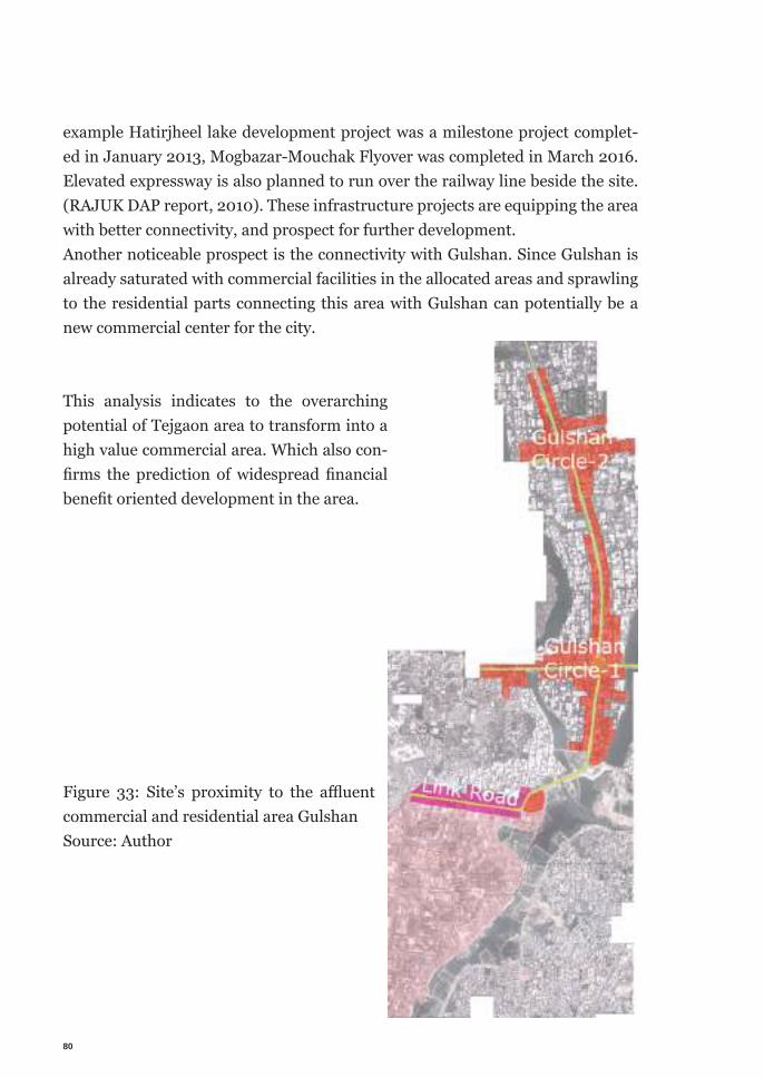
80
example Hatirjheel lake development project was a milestone project complet-ed in January 2013, Mogbazar-Mouchak Flyover was completed in March 2016. Elevated expressway is also planned to run over the railway line beside the site. (RAJUK DAP report, 2010). These infrastructure projects are equipping the area with better connectivity, and prospect for further development. Another noticeable prospect is the connectivity with Gulshan. Since Gulshan is already saturated with commercial facilities in the allocated areas and sprawling to the residential parts connecting this area with Gulshan can potentially be a new commercial center for the city.
Figure 33: Site’s proximity to the affl uent commercial and residential area Gulshan Source: Author
This analysis indicates to the overarching potential of Tejgaon area to transform into a high value commercial area. Which also con-fi rms the prediction of widespread fi nancial benefi t oriented development in the area.
81
9.1.7 Land value
Survey in the site, interview with experts, real estate agents confirms that the land value of the area is among the highest in the city. Dhaka being the most expensive city in the country, it makes the land price among the highest in the country.
Depending on the location the land price in Tejgaon area can vary from 3.33 million Euro to 5.96 million euros per acre. Comparing it to a residential plot in Uttara is 0.94 million Euro to 1.5 million Euro per acre. To put that into perspec-tive comparing it to local economy, in the national budget of 2018-19 financial year, Bangladesh government allocated 6.2 million Euro equivalent of money for pubic relation through publication, media campaign, rally etc. (Karim Byron and Habib, 2018).
9.1.8 Economy of Land
Continuing the argument, the following hypothetical calculation will demon-strate the financial perspective of the area. There are 500.6 acres of land in Te-jgaon I/A in total calculating with the mean average value of the land per acre, the total land value of the area would be 2.3 billion euros. Leaving the 40% gov-ernment owned lands, the rest of the land is an economy of 1.4 billion Euros before development.
9.1.9 Flip side of the need
This superficially simple calculation could alone illustrate the magnitude of an-ticipated financial force the area is facing. All these points make it very clear that the potential of the area is leading the development for financial gain with a land-slide force. On the contrary the neighboring area are deprived of urban facilities.
82
In the context of Dhaka as a whole, this is a repeated scenario. A very few area has open spaces; educational institutes are in serious lack of recreation facili-ties with it. The city does not have adequate facilities for cultural activities. With limited number of museums, even lesser facilities for performing arts, financial abilities are arresting cultural practices. Absent from social activities, cultural in-teractions and divided activities based on economic activities, people are drifting apart in the society. With all the potential Tejgaon I/A should be used carefully to maximize not only the economic benefits but also the social and cultural ones.
9.1.10 Brownfield of Tejgaon I/A
At this point of discussion it is important to mention that, in its history Tejgaon I/A was never abandoned. Resulting from the socioeconomic & political changes the area never was fully developed. Since government owns significant part of the lands, drastic change like liberation had a great impact on the government owned lands. Many of them were never being used fully. Change in technology, explosion of population after liberation influenced the government to change its original plans regarding the area. Similar happened to the privately owned lands. Initially political turmoil, change in ownership, rapid change in industrial technologies and land requirements soon made the plots inadequate for new demands for industries. Rapid growth of the city, increased living expenses in the city made it unaffordable for the indus-try workers to live and work in an area close to the city center contributed to the abandonment of the industries too. As a result, running industries had to move outside of the area; planned projects and empty plots soon became undecided and hesitant about their use. Many temporary functions started to take place. All in all the land use pattern of Tejgaon I/A was always changing. Nor did it was ever fully functioning. Many plots have been being always empty and were never in use. And many plots are changing their use over the time. Considering that the area is not completely a brownfield.Nevertheless, the seriousness and magnitude of the project consisting the impor-tant location, land value, socio-political influences, potential per se requires the attention of brownfield redevelopment. Also the ongoing change only be able to understand and dealt with if considered through the criteria of brownfield rede-velopment.
83
9.1.11 Legal perspective of participation
According to the current land development law, the law encourages maximum citizen participation but does not strictly safeguard possibility of citizen partici-pation in urban development. People are generally unaware too. As a result de-velopment process are mostly top town, driven by the decisions from the very top tire of the government. According to Bangladesh Town Improve act 1953, any development plan needs a public hearing before being approved. However the details are not elaborated in the act. In case urban development, according to Local Government Act 2009 (City Corporation Act), citizen’s rights are defended. According to section 49, any development proposal in the urban area shall be presented to the people. Their opinion shall be considered in the planning. In case of Tejgaon I/A, lands are own by people, individually or through compa-ny. Acquiring the land from people to implement a public welfare project will be tough. But the government owns 40% of the lands in Tejgaon I/A area. Many of them are under used too. A public welfare project can be supported and imple-mented through public participation with less complexity on a government land.
9.1.12 Stakeholders
With the ongoing redevelopment of Tejgaon Industrial Area, very few direct stakeholders are involved. Primary stakeholders are the landowners, govern-ment, investors and developers. Secondary stakeholders like, civil society, neigh-boring communities have very little or no influence in the current process. Pri-mary beneficiaries or the target groups are users from outside the area. In the development process they do not have any say either. Hence the beneficiaries are present only as end users.
84
9.2 Context analysis
From the field visit, interview of different stakeholders it appeared that people inside or outside of the area are generally unaware about the ongoing policy changes in the area. Only noticeable changes to public are the physical changes in the area. Constructions of new buildings, availability of new office space, com-mercial activity are the noticed feature of the development. It is noteworthy that, generally the idea of citizen participation in the develop-ment is also lesser recognized in the context. Different stakeholders rely on top down decision-making as the de-facto process for development. Anything related to policy making or taking decision for the city are associated with politics and seen as the job of policy makes by the citizens. Overall aware-ness about the right to be able to take part in the policy making is largely absent. Which raises the need for citizen mobilization as a prerequisite.
But there are other factors to be considered too. Spreads of technologies are allowing more and more peoples access to information. New technologies and services like smart phones, satellite televisions, Internet, Uber, Social media in-creases people’s accessibility & ability. People can avail new services and benefits. On a positive side, this accessibility can be used for quick mobilization of large number of people. In fact, recent history shows, people can self mobilize them-selves for a common and imminent cause. 2012 anti was-criminal movement, anti vat-on-education-movement are a few examples. Though the causes, nature and activism behind these movements are grossly different from participatory urban development. But it does demonstrate the capacity of quick mobilization of people to achieve a common vision.
On the contrary access to information, technologies and services also raises awareness among people about their rights and make them more aware about oppressions. Which in terns leaves less room for tolerance against partiality, eu-phemism, or privilege of any kind.
More fluid flow of information creates an even raise of needs, awareness about own rights and existence of others. This raises the need for social cohesion. A physically separated city with open flow of information is already a conflict. Im-
85
proving social inclusion is the only way to prevent the social & cultural conflict and yield the maximum benefit of a well-informed society.
Hence, mobilizing all stakeholders, raising awareness among people is one of the first and foremost important prerequisites of successful participatory process implementation. If everyone does not share a common future vision, success of participatory process is highly unlikely.
9.3 Economic style of the city
A comparative analysis between the old fabric of the city and the new develop-ment shows that the old part of the city had a complex mixed fabric of different facilities serving different group of people. But the new development is encourag-ing homogenous development only supporting the affiant of the city. As a result informal economy is growing around it in a competitive pace. The dilemma here is, the new development is open to all and intended grossly for the general public. But lacking the guideline, with the presence of the opportunity development is only answering to the most profitable needs. If Tejgaon industrial area in anticipated serving as a connecting hub, connecting the old city center with new commercial sprawl in Gulshan, it needs to address the broader rage of consumers.
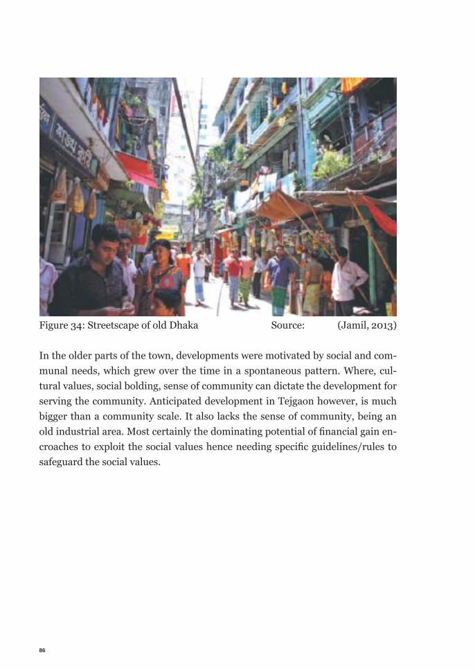
86
Figure 34: Streetscape of old Dhaka Source: (Jamil, 2013)
In the older parts of the town, developments were motivated by social and com-munal needs, which grew over the time in a spontaneous pattern. Where, cul-tural values, social bolding, sense of community can dictate the development for serving the community. Anticipated development in Tejgaon however, is much bigger than a community scale. It also lacks the sense of community, being an old industrial area. Most certainly the dominating potential of fi nancial gain en-croaches to exploit the social values hence needing specifi c guidelines/rules to safeguard the social values.
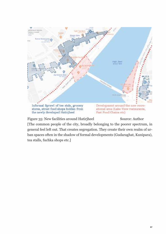
87
Figure 35: New facilities around Hatirjheel Source: Author[The common people of the city, broadly belonging to the poorer spectrum, in general feel left out. That creates segregation. They create their own realm of ur-ban spaces often in the shadow of formal developments (Gudaraghat, Kunipara), tea stalls, fuchka shops etc.]

88
89
Chapter X |Solution (Step Model):
This chapter will demonstrate the understanding about participation by laying out a step-by-step participatory process by proposing a new mole of participatory process appropriate for the site context. This model is proposed based on the ac-cumulated understanding through this research.
To establish a successful participatory process in the site context a model is being proposed consisting of two basic principles. They are - Action Matrix - Triangulation
10.0.1 Action Matrix
Based on the knowledge gathered, this research suggests establishing a step model of participatory process in order to successful completion of a participa-tory project. In the action matrix part of the step model, a project is divided in smaller separa-ble steps. Each steps consists different tasks. Which are decided, executed, mon-
90
itored and checked by a set of stakeholders, called actor group. Each step is inde-pendent and executed likewise. The rest of the steps will not affect level of success of one step and vice versa. Also each step is executed with different groups of actors, lead by rotating leaderships. Actor Group, leaderships are decided based on the tasks needed in that step. The whole process of selecting leadership and setting up actor groups are executed democratically with neutral mediation.
Following Arnstein’s ladder of participation as basic model of solution, different steps of action aims to achieve different level of participation, since it is impos-sible to achieve all at once, or the highest level of participation for all the steps.
10.0.2 Triangulation
The second principle of the model is triangulation. To maintain a balance of pow-er, accountability and to justify the actions by the actor group triangulation has to be maintained for each step. In each step a counter balance has to be set to justify the decisions, monitor the actions. Since the power structure is constantly chang-ing following the requirement, not an exclusive group of leader can accumulate autocracy. On top of that, moving cycle of leaderships allows to one team to take the decision by being the leader in one step and triangulate through constructive criticism in the other step. Many involved group can complement each other as the process moves on. This motion of power structure will prevent aggravating through power abuse, concentrated benefit to a specific group and so on, ulti-mately giving the power back to people.
Dividing the source of power & introducing different balancing tool to encounter concentration of power, followed by benefiting exclusively is important to come out of the status quo and giving the people back their rights.
10.1 Project Demonstration
The aim of this participatory project is mainly but not limited to raising aware-ness among people, improving political good will, establishing a common long-
91
term vision for the area which benefits everyone is another essentiality, the suc-cessful redistribution of power to people.
10.1.1 Step 1: Understanding
The first step of the project is to create a knowledge base to have a profound un-derstanding of the site area. Collecting detail, neutral data, knowledgeable analy-sis and most of all a well documentation is the first task of the process.
Tasks:Detailed data collections, analysis, create a knowledge base about the Tejgaon I/A. At the end of this step, publish the data in as much public domain as possi-ble.
Actor Group: Independent research groups, consists of sectorial experts, like urban planners, architects, geographers, sociologists, environmentalists etc.
Leadership:This step should be lead by the set of senior experts from the professionals. Since it is necessary to overseer the tasks and activity of the Actor Group with technical expertise.
Initiation and Mediation:Higher government officials should initial this step. Since, this is the first step and currently they hold all the responsibility and power. For example, from the current state of the project, wither the prime minister or the housing and public works minister is in the official capacity of initiating and mediating this step. After initiating this step the Actor Group will not be responding to the initiator unless a serious official mediation is necessary. Instead they will be hold account-able through triangulation.
Triangulation:First and most important actor of triangulation in each step is the people. So in-forming them is the most important tool to ensure triangulation. For this step a
92
set of team shall be formed consists of journalists, academics, data analysts and senior professionals. Journalists will, being advised by the experts, inform the progress to the people. Other form of communication will have to set up too. Interactive website, where people can overlook the collected information, and give their own input of data, shall be operated effectively. Other form of commu-nication like, telephone, sms, social media, and blogs shall be operated under the triangulation team. This will, on one hand increase communication with people. On the other hand, regain people’s trust and raise their sense of responsibility to gain rights as well.
Outcomes:Comprehensive compendium of the collected data is the final out come of this step. Synthesized data will be broadcasted in the same interactive channels. NGO’s can volunteer to curate the data and publish it for the welfare of the peo-ple.
Tools used:Urban planning tools, built environment study tools, Geographic study tools, public communication tools, media & infective communication tools with public, Citizens Jury, Consensus Conference etc.
10.1.2 Step 2: Comparative study and program propos-als
In this step previously studied data will be put into the city and country context. Preparing justified program proposals for the area.
Tasks:Analyze site data with other socioeconomic studies, figuring out needed pro-grams, public opinion survey, and program justification workshop with the peo-ple.
Actor Group:Experts, public involvement & relation team,
93
Leadership:Triangulation team fits to lead this step. With their knowledge about the data set, expertise in social understanding, they will be leading this task.
Initiation and mediation:At this point a dedicated team/office/committee can be arranged for mediating through the rest of the project. Apart from initiating the steps, organizing the necessary resources the dedicated team will have no other task/responsibility, holding no more power.
Triangulation:From this stage triangulation is largely based on transparency, adequate selec-tion of team, selection of participants will have to be fair, need based and ran-dom. Participatory workshops should be conducted by specialized groups, ex-pert in public events, workshops. Stakeholders selection can be divided based on required expertise and random. The team can be consists of members of civil society, leaders of research organizations, foreign employee in development or-ganization (with similar experience & expertise) etc.
Outcomes:A detailed structure plan of the area, justified program proposals, the combina-tion of the aforementioned two should also contain the details of the program proposals. For example, details study of potential of the area and need of com-mercial space in the market at the moment (& in near future) should be able to suggest the amount of commercial space appropriate for the area. And consider-ing other social needs of the city, suggestion form citizen it will be able to suggest amount & types of social spaces. Third party NGO or government agency or pro-fessional organization can take the volunteering responsibility to
Tools Used:Data analysis, public communication tools, media & infective communication tools with public, survey, workshop, publication etc.
94
10.1.3 Step 3: Prioritizing and Vision
This step will start fabricating a vision for the area. Divide the area to prioritize which part to develop first.
Tasks:Divide the area based on logical structure, provide guideline to concerning gov-erning agencies to start planning on it. For example, with the program in previous step, combined with the vision & prioritization in this step, infrastructure need of a certain part or blocks of the area can be predicted. The concerned agency can start planning on it. They can coordinate with the next step to finalize the plan.
Actor Group:At this step, we need more then one set of actor group. A few sets of actor groups should be arranged in the beginning. Consisting renowned professionals (archi-tects, urban designers, landscape designers, infrastructure engineers), teamed up with university students of multiple disciplines and common citizens from the city. Through independent workshop each team will come up with its own set of results. Then with the mediation of leaderships it will be combined through workshop, exhibitions, feedback roundtable discussions and interactive commu-nication through the established channels.
Leadership:Groups will be lead by different renowned professionals, different events will be held independently.
Initiation and mediation:Central coordination team can play the role of mediator at this stage. The team will organize different event, provide with logistics and coordinate the outcomes with the triangulation team.
Triangulation:At the stage triangulation will be two fold. First, keeping balance between the participants in groups during workshops. Making sure equal participation of all
95
participants and all groups. Selection of participants needs to be fair. Partici-pants will be selected based on study discipline and random. Mixing of students, professionals and common citizens has to be well balanced. Citizen selection will be random from all over the city. At this step, citizen selection criteria will be set. Second, keeping balance between inputs of different groups while formulating the vision. A team of critics, experts and professors will act as the triangulation team at this step.
Making the selection criteria fair and public, presenting the independent groups result to the public regularly, organizing feedback discussion session with public and maintaining the old communication channel with common people will be the triangulation criteria for this step.
Outcomes:At the end of this step the process will obtain rough/sketchy (not final) visions for the area. Consisting of justifiable ideas from all the participants. Based on the previous step’s knowledge, the area will be divided in zones and chronological or-der for development will be set according to the studies from the previous steps.
Tools used:Series of participatory design workshops, online games for vision, real life place making workshop through games and simulation, public feedback events, Char-rette, Citizens Jury, Planning cell & The World Café.
10.1.4 Step 4: Final Vision, policy suggestion & strategy formulation
This step will compile the holistic vision for the area and for smaller zones inde-pendently. Visions will be in form of ideas, programs, drawings, sketches, models etc. Following the vision, combined with the logical zoning from the last step, strategy for the first priority will be formulated.
96
Tasks:Finalize visions for the development of the area, compile overlapping ideas, sort unjustifiable ideas, put the visions in visuals, propagate to the people, refine with their feedback. Delegate to different government agencies for preparing action plan for future development. For example, waster supply authority can present with the commutability of the current infrastructure with the vision and propose required strategy to improve the infrastructure for the intended development. Trying out cutting edge new technology like, city building with citizens through online games can be implemented in this step. These activities also encourage people by making the process more interactive and fun.
Actor Group:With random selection process participants from same discipline can be adopted.
Leadership:At this point with the previous algorithm of leaders, citizens will be added in the leadership.
Initiation and mediation:With the central coordination team, citizens, elected representatives of people will form mediation team.
Triangulation:At this step citizen are in the leadership role too, which marks a milestone, where citizens are involved in all of the levels of decision-making process. So in this step it is important to overseer their roles as well. Expert team with highest govern-ment level officials will form the team with the citizens to make the final decision for the common vision of the area.
Outcomes:The area divided in zones, visualized vision of the area, justified program division to support the vision, design features selection etc.
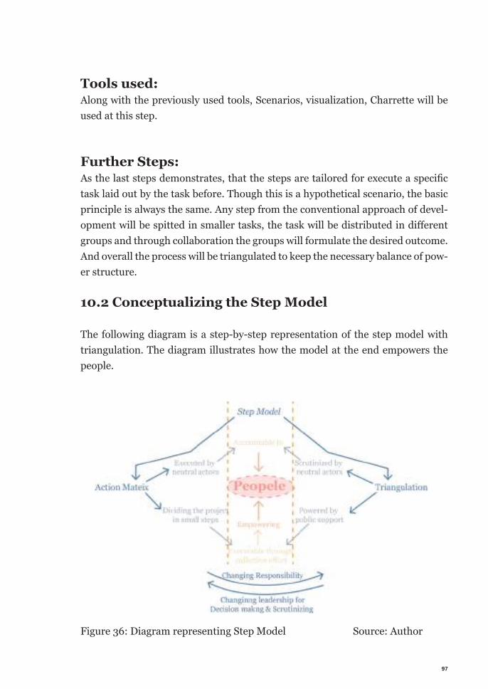
97
Tools used:Along with the previously used tools, Scenarios, visualization, Charrette will be used at this step.
Further Steps:As the last steps demonstrates, that the steps are tailored for execute a specifi c task laid out by the task before. Though this is a hypothetical scenario, the basic principle is always the same. Any step from the conventional approach of devel-opment will be spitted in smaller tasks, the task will be distributed in diff erent groups and through collaboration the groups will formulate the desired outcome. And overall the process will be triangulated to keep the necessary balance of pow-er structure.
10.2 Conceptualizing the Step Model
The following diagram is a step-by-step representation of the step model with triangulation. The diagram illustrates how the model at the end empowers the people.
Figure 36: Diagram representing Step Model Source: Author
98
The diagram illustrates the two basic principles of the Step Model they are, Ac-tion Matrix and Triangulation at the either far end of the diagram. The action matrix is consists of dividing the project in small steps and executing them with different stakeholders. On the other side, Triangulation is maintained by care-ful scrutiny of the step and gaining public justification. All of them at the end is empowering people. So in its core, the step model is accountable to people and empowering the people through the elaborated steps.
10.3 Challenges of the Step Model
The aforementioned step model is anticipated to face the following challenges.
This is a new approach in the context. Moreover it challenges the status quo. This model, and participatory process as a whole poses threat to taking the autocrat-ic decision-making power form the policy makers & bureaucrats and involves people in the process. That can demotivate the social elite to loose interest in the process.
Implementing participatory process in a developing context comes with another challenge per se. As discussed before, citizens are not aware of their rights and re-luctant to take part in decision-making in general. Raising necessary awareness will pose another great challenge to implement the model.
The complexity and vastness of the project holds the potential to fail implemen-tation of participatory process or create widespread chaos.
10.4 Recommendation for the Step Model
Step by step development, triangulation and great emphasis to raise awareness among all the stakeholders are key to successful implementation to the project and prevent the anticipated chaos.Implement-ability of the process, success of each step should be proved by the actions tested on the ground. Very careful execution, considering the pros and
99
cons of each step should be carefully considered beforehand. Superlative careful-ness is needed to design each step before testing it on the ground. Basic concepts like triangulation, modular development should be acting as guid-ing principles. At the end meaningful participation relies on appropriate redistri-bution of power to people.
This is a theoretical model; based on the understanding, ground situation, public opinion, expert opinion. This theoretical model intends to act as a guideline or a starting point for starting an effective practical participatory project.
10.5 General limitations of participatory process
Participatory process is not the perfect remedy. It is certainly not the only way to achieve social inclusion. But in a democratic process, distributing the decision making voice to the sensible mass fundamentally works for the greater good.
Followings are the commonly sought criticisms of participatory process. It is a lengthy process. A selected few making the choice for the rest of the mass is faster, compared to giving everyone a choice. Giving everyone an exclusive choice is expensive in terms of resource & time; it can be chaotic too.
But participation is not about giving everyone a choice exclusively. It is merely an effort to looking beyond one choice for all decided by somebody else and explor-ing other collective choices.
Mobilization and right mindset of all the involved stakeholders is essential. The idea of participation is complex in nature. In urban development context it be-comes more entangling. Lacking a clear understanding about the process and vision will most likely to create more problem and mistrust at best.
100
10.6 General Recommendations
As discussed before, participatory process is tricky. Only pragmatic involvement of stakeholders involve can promise a successful outcome. It needs a lot of expert attention in each step. Each decision has to be scrutinized to block the invasion of corruption. To increase the possibility of success with participatory process in a redevelopment project in the context, along with the triangulation decisions, these general recommendations can be followed.
Increasing political goodwill among bureaucrats and policy makers. Making the long tern benefits of participation, social & cultural values as add on can make the mobilization possible. Therefore, motivate the status quo decision makers to step down and mode the citizens to the front to lead.Same motivation works for owners of the plots, investors, businessmen too. Mak-ing them aware of the long-term benefits, advocacy for a collective long-term vision for the area, benefiting everyone in the city, combined with the humane responsibility to the society will prevail the better judgment of everybody and allow the participatory process to be implemented.
Successful participatory process, by definition requires great flexibility and toler-ance. Finding the collective entropy is a highly ambitious goal in humane setting. In circumstance of redevelopment the rigidity multiplies. Through, ability to ad-just, allow tolerance with mutual respect the equilibrium is achieved.
10.7 Advocating Participatory process
From the previous chapter’s discussion it is clear that the potential and pres-sure of financial gain is making the development acentric. A balance between commercial development and safeguarding the social values is necessary. By in-volving people of the city in the redevelopment process this research advocates participation for social inclusion. So that they will be able to actively take part in the redevelopment of the city. Therefore, shaping the build environment accord-ing to their needs.
101
From the history and cultural analysis of Dhaka. It was stated that the old fabric of the city was shaped by the cultural and community values. As a result it pre-sented with a complex, diverse urban fabric. All the new developments are over-looking these per se community values dodged by efficiency, economy or some other euphemism of such kind. Therefore the segregation between communities went drifted apart. New ongoing redevelopment is a window of opportunity to implement design that helps to gain these community culture and social values back.
This opportunity should be utilized to bridge the increasing gap between differ-ent social classes. Projects with monitory benefit as only motivation will lean to-wards the affluent social class and leave the others behind. It is important to balance by providing the needs of everyone. Participatory process will make sure people form all social classes have a voice. By incorporating as much stakeholder as possible chances of reflecting everyone’s needs increases. Participation is a great tool to redistribute the attention to all the stakeholders of the city through consenting them the power to take part and change the planning. For example, a well intended project development combined with knowledgeable study could achieve the same result in the built environment. It can often facil-itate the need of many social groups. But participatory process has some extra added values, which the city clearly needs now. First, it can act as a therapy to neutralize any existing contention among user groups over the built forms of the city.Second, it will systematically mobilize the citizens to take active part of shaping the city fabric. In this time of rapid growth of the city, this mobilization can be a great asset for the policy making and future development projects.Most importantly, successful implementation of participatory process will pro-vide equal voice to all user groups. Preventing concentration of money and power to any certain group. A social justice will prevail by establishing citizens right to the city. Other benefits of participatory process offers, a harmonies presence of different user groups will increase diversity. Which will help the city grow financially and culturally. Being able to take part in the system will increase their trust on the system. Which will give more legitimacy to the policies. At the same time they will be respondent to the competencies of policies which will allow policy maker to make more effective policies. Presumably, that will make the policy easy to implement.
102
10.8 Final Remarks on understanding participatory process
At the beginning of the research, I started with the predictable misunderstand-ing that; land ownership plays the most vital role in participatory process. And I confused rehabilitation of evicted citizens to the participatory process. Participa-tory process is entirely independent to the abovementioned two conditions. Only thing that land ownership contributes is to make an easy decision of adopting the approach. For example, if the government is developing a new large-scale project like commercial district/ industrial park, in common practice, often the busi-ness/factory owners are seriously consulted. The technical requirements for the factory or infrastructure requirements for the commercial development are con-sidered seriously and met to the point. Here participation is in a way necessary. If the industrial park cannot provide facilities required for the industries, the companies cannot install their plant there. [It happened with the Tejgaon I/A, by the time the land was ready, technology was improved and the lands were too small to accommodate proper industries. It appeared more profitable to use the land for storage than a production unit.] Or if the companies cannot make profit and go out of business, the development will be a waste. In case of other type and scale of projects the old school ‘owner takes the decision solely’ suffers different consequences, in this case, profit oriented development is creating social separa-tion in build environment. Isolating a specific economic group is a small area in a compact city creates tension between different social groups. At the end it harms the economy as well.
Admit-ably, rehabilitation is a chief part of participatory process, if there are people living in the area without a secured tenure. But the actual participatory development is not rehabilitating. For example, if a necessity arises to redevelop an inner city neighborhood of informal housing. In an ideal situation, a good suc-cessful participatory process can lead to a solution that the inhabitants will hap-pily move to a new location without any compensation, any violence, at their own cost. Through a widespread participatory process the government can combine the relocation of the informal neighborhood with a new industrial development with the intended commercial development in the emptied site. Just for the sake of giving example, one solution could be, new living opportunities are given to
103
the evicted peoples through housing finance schemes from a special fund created from the benefits from the commercial development. New job opportunities in the agreed upon industries are going to provide with livelihoods and double as a pulling factor.
In reality often, ill political motivation, greed and corruption make the process more complicated and impossible to implement without enforcing forces of some kind. Often in a redevelopment project, where rehabilitation is involved, it stars as a fight rather than a negotiation. Pressure of rushing the process makes the process harder. Participatory process provides better result at the cost of time and collective effort.
Above understanding can be rendered in the following quick example. Cities have its own regulations for development. Irrespective of the land ownership citizens has to follow the regulations. Usually these rules are set to make the justified, civ-il development. People’s representatives, with consultation of experts make these rules. If, direct citizen consultation can also be involved in the makings of rules; than that is already a higher participation that conventional. Now if recourses al-lows, if this can be repeated for later redevelopment project as well, logically that shall render better outcome. And achieve higher level of participation.
Participatory process is a dialogue between different stakeholders. Achieving most comprehensive development through discussion, negotiation, compromise and innovation. It is at its best, offers to distribute the choice of decision making to everyone.
It is customary to mention that, redistribution of power and wealth does not and should not be altered with the state of chaos and disorder. Order and structure in the redistribution is essential to make it effective for greater good. It should not be monopolized or grubbed by a group of selected elite using policies and governance against people.

104
105
Chapter XI |Conclusion
Through an industries exertion this research attempted to understand partici-patory process in urban brownfield development. Learning through theoretical understanding and pragmatic examples a conveyable understanding was gener-ated.
Nonetheless, participation is a complex process. There is no arithmetic definition or universal guideline to follow. It is a highly contextual process. The definition, process, tools and attributes have to be changed to adapt with every particular case in every context. Participation in case of urban development presents with more knotted challeng-es. Depending on the urban form, built fabric, demography and every other soci-oeconomic and political issues influence it prominently. Complexity increases with lack of fairness; efficiency, disorganization of the gov-ernment; socio-economic inequality among people and so on. Only a very care-fully crafted process, lead by collective goodwill and driven by well-informed awareness offers an appropriate success.
However, fundamental requirements to successfully enforce participatory pro-cess include, political goodwill, public awareness, and transparent trusted lead-ership. Honest and active civil society is also an essential ingredient.
106
Needless to say, lacking a universal blueprint, participatory process is always changing. One set of tools will not work again in case of a change in the context. At the same time participation requires flexibility and acceptance. Through flu-idity of reasons and justification of mutual respect the equilibrium is achieved. It requires a lot of effort, trials, good wills, complemented with awareness and other resources; a proper participatory process can be implemented. It is well worth the effort, because at the end it does offer the most acceptable outcome for everyone.
Completed with crafting a set of solution for the redevelopment project in the case study context, this systematic endeavor gained comprehensive understand-ing about the process and the contexts methodically. Through proposing a con-text oriented specific model this research provided the resolution to the instigat-ed intent of the research.
107
Reference
Adel, Ahmed; Moustafa, Yesmin; Aladdin, Annas (2013) Revitalization and upgrading of the central zone of Khedive’s Cairo. (2013). Nairobi, UN-HABI-TAT. Available online form: https://unhabitat.org/revitalization-and-upgrad-ing-of-the-central-zone-of-khedives-cairo/ [Accessed: 22 June 2018]
Aga Khan Development Network (n. d.), A "green lung" for CairoThe creation of the Al-Azhar Park. Available from: http://www.akdn.org/akdn/project/green-lung-cairo [Accessed: 4 June 2018].
Aga Khan Trust for Culture (2005), Al-Azhar park, Cairo and the revitalization of Darb al-Ahmar . Available from: http://www.akdn.org/publication/al-azhar-park-cairo-and-revitalisation-darb-al-ahmar [Accessed: 4 June 2018].
Aga Khan Development Network (2005), Inauguration of Al-Azhar Park. Avail-able from: http://www.akdn.org/speech/his-highness-aga-khan/inaugura-tion-al-azhar-park [Accessed: 4 June 2018].
Agnes Förster, A. (2014). “Planungsprozesse wirkungsvoller gestalten Wirkun-gen, Bausteine und Stellgrößen kommunikativer planer- ischer Methoden”. PhD Thesis. Technical University of Munich, Munich.
Al Tawi, Ayat. (10 March 2018). Residents of Cairo's Maspero Triangle cling on as demolition looms. Al Ahram. [Online] Available From: http://english.ahram.org.eg/News/292339.aspx [Accessed 26 June 2018]
Ali, Randa. (16 February 2014). Residents of Maspero Triangle: We will not leave our land. Al Ahram. [Online] Available From: http://english.ahram.org.eg/News/94488.aspx [Accessed 26 June 2018]
Amnesty International (2011). 'We are not dirt'. Forced eviction in Egypt's infor-mal settlements. [e-book] London, Amnesty International Ltd. Available from: https://www.amnesty.org/download/Documents/32000/mde120012011en.pdf [Accessed: 12 July 2018]
108
Amnesty International (2013). The dirty secret behind some of Cairo’s devel-opment dreams. [Online] Available from: https://www.amnesty.org/en/latest/news/2013/11/dirty-secret-behind-some-cairo-s-development-dreams/ [Ac-cessed: 12 July 2018]
Arnstein, S. (1969). A Ladder Of Citizen Participation. Journal of the American Institute of Planners, 35(4), pp.216-224.
Bdnews24.com. (2014). Govt to make a mega plan for Tejgaon as a commer-cial hub. [online] Available at: https://bdnews24.com/business/2014/09/08/govt-to-make-a-mega-plan-for-tejgaon-as-a-commercial-hub [Accessed 15 April 2018].
Beard, V. A. (2003). Learning radical planning: The power of collective action. Planning Theory, 2(1), pp. 13-35
Berens, C. (2010). Redeveloping industrial sites. Hoboken, N.J., Wiley.
Borham, A. and AboTera, M. (2018). The Maspero Competition Entries: A Reflection. [online] Cairobserver. Available from: http://cairobserver.com/post/133235472724/the-maspero-competition-entries-a-reflection#.W1K4y-baB29Z [Accessed 6 June 2018].
Citymayors.com. (n.d.). City Mayors: World's fastest growing urban areas (1). [online] Available at: http://www.citymayors.com/statistics/urban_growth1.html [Accessed 14 May 2018].
Collinsdictionary.com. (n.d.). Urban development definition and meaning | Col-lins English Dictionary. [online] Available at: https://www.collinsdictionary.com/dictionary/english/urban-development [Accessed 14 Aug. 2018]
Contaminated Land Rehabilitation Network for Environmental Technologies (2002) Brownfields and redevelopment of urban areas. Research report. Vienna, Umweltbundesamt
109
District statistics, Dhaka, 2011. (2013). Dhaka: Bangladesh Bureau of Statistics, Statistical Division, Ministry of Finance & Planning, Govt. of the People's Repub-lic of Bangladesh.
El-hefnawi, A. (2010) The strategic development plan of greater Cairo region: Cai-ro vision 2050. Presented at the World Urban Forum 5. Reo de Janeiro. [Online] Available from: http://mirror.unhabitat.org/downloads/docs/8635_42944_AymanEl-hefnawi.pdf [Accessed 20 May 2018].
Elrahman, A. (2015) Redevelopment Aspects for Brownfields sites in Egypt, Im-proving Sustainability Concept in Developing Countries, ISCDC, 2 – 4 December 2015
Hegazy, I., Moustafa, W. (2013). Toward revitalization of new towns in Egypt case study: Sixth of October, International Journal of Sustainable Built Environ-ment (2013) 2, pp. 10–18
Heykal, M. (2009). Cairo from Cairo Tower. Flicker image. Available from: https://www.flickr.com/photos/haykal/3466825152/in/photostream/ [Ac-cessed 18 July 2018]
Etherington, C. (17 April 2018). NYC Artists' Lofts Before and After the Loft Law. [online] Cityrealty.com. Available at: https://www.cityrealty.com/nyc/mar-ket-insight/features/iconic-addresses/nyc-artists039-lofts-before-after-loft-law/4621 [Accessed 12 May 2018]
Elfiqi, K. (2018). Demolition of Maspero triangle slums in Cairo, Egypt - 29 Apr 2018. Stock photo. Available from: https://www.shutterstock.com/editorial/image-editorial/demolition-of-maspero-triangle-slums-in-cairo-egypt-29-apr-2018-9645750a [Accessed: 20 July 2018]
Gehl, J. and Koch, J. (2011). Life between buildings. Washington, DC: Island Press.
Iakb.de. (n.d.). Selbstdarstellung. [online] Available at: http://www.iakb.de/mucca.html [Accessed 10 May 2018]
110
‘Invitation of local and international specialized consultants to participate into in the prequalification for a limited design competition for the urban re-plan-ning and architecture design of Maspiro Triangle in Cairo’, Friday, 5 June 2015, Al-Ahram, p. 30.
Jamil, S. (01 August 2013). Eateries of Dacca. [online] The Daily Star. Availa-ble at: https://www.thedailystar.net/news/eateries-of-dacca [Accessed 14 Jun. 2018]
Karim Byron, R. and Habib, W. (06 June 2018). Budget aims to please all. [on-line] The Daily Star. Available at: https://www.thedailystar.net/frontpage/budget-aims-please-all-1586914 [Accessed 15 Jun. 2018].
Khalil, O. (2018). From Community Participation to Forced Eviction in the Mas-pero Triangle. [Online] Cairo: The Tahrir Institute for Middle East Policy. Avail-able from: https://timep.org/commentary/analysis/from-community-partici-pation-to-forced-eviction-in-the-maspero-triangle/ [Accessed 18 July 2018]
Khedivate. (n.d.) In Merriam-Webster’s collegiate dictionary. Available from: https://www.merriam-webster.com/dictionary/khedivate [Accessed 18 July 2018]
Knox, P. (2014). Atlas of cities. Princeton: Princeton University Press.
McCann, E. and Ward, K. (2011). Mobile urbanism. Minneapolis: University of Minnesota Press.
Mackey, Robert. Social Media Accounts of Violence in Cairo Challenge Offi-cial Narrative. The New York Times. October 10, 2011". The New York Times. 10 October 2011. [Online] Available from: https://thelede.blogs.nytimes.com/2011/10/10/social-media-accounts-of-violence-in-cairo-challenge-offi-cial-narrative/ [Accessed 20 May 2018]
Martin, R. and Mathema, A. (2011). Development Poverty and Politics: Putting Communities in the Driver’s Seat. London: Routledge.
111
Mitlin, D., & Thompson, J. (1995). Participatory approaches in urban areas: strengthening civil society or reinforcing the status quo? Environment and ur-banization, 7(1), 231-250.
Mohie, Mostafa. (19 July 2018). What remains of the Maspero Triangle: Res-idents of 13 properties attempt to stay. Madamasr. [Online] Available From: https://www.madamasr.com/en/2018/07/19/feature/politics/what-remains-of-the-maspero-triangle-residents-of-13-properties-attempt-to-stay/ [Accessed 20 July 2018]
Nassar, H. (2011). In Cairo, A new park on former dump site led to a larger initi-ative to revive an improvised neighbourhood. Landscape Architecture Magazine, 2011(April).
Rajdhani Unnayan Kartipakhkha (RAJUK) (2010). Preparation of Detailed Area Plan (DAP) for DMDP Area: Group-C. Dhaka: Rajdhani Unnayan Kartipakhkha (RAJUK). Pp. 127-132.
Redevelopment of Abdeen square and the surrounding open spaces. (2015). UNDP Egypt. Tender Document. Reference number: UNHABITAT/0007. Pro-ject ID: C226
Reeves, D. (2005). Planning for diversity. London: Routledge.
Sabry, Sarah (12 October 2015). Informal settlements: Swept under the car-pet? Madamasr. [Online] Available From: https://www.madamasr.com/en/2015/10/12/opinion/u/informal-settlements-swept-under-the-carpet/ [Ac-cessed 20 June 2018]
Saxena, N., (1998), ‘What is mean by peoples participation?’, in Cornwall, A. (eds), (2011) The Participation Reader. London. Zed Books Ltd.
Selim, G. (2014). Instituting order: the limitations of Nasser’s post-colonial plan-ning visions for Cairo in the case of the indigenous quarter of Bulaq (1952–1970). Planning Perspectives, vol 29, no. 1, pp. 67 - 89.
112
Shenker, Jack. (23 December 2015). Norman Foster's Cairo redevelopment has locals asking: where do we fit in? The Guardian. [Online] Available From: https://www.the-guardian.com/cities/2015/dec/23/norman-fosters-cairo-redevelopment-has-locals-ask-ing-where-do-we-fit-in [Accessed 26 June 2018]
Sims, D. (2010). Understanding Cairo: The Logic of a City out of Control. Cairo: The American University in Cairo Press.
Slocum, N. and Steyaert, S. (2003). Participatory methods toolkit: a practitioner's manu-al. Brussels: King Baudouin Foundation.
Strategic Development Plan for Greater Cairo Region 2050. What is this project about?, n.d. United Nations Development Program (UNDP), Egypt. [Online]. Available from: http://www.eg.undp.org/content/egypt/en/home/operations/projects/democratic-gov-ernance-and-peacebuilding/StrategicPlanforGreaterCairo2050.html [Accessed: 23 June 2018]
Stiefel, M. and Wolfe, M. (1994). A Voice for the Excluded–Popular Participation in De-velopment: Utopia or Necessity? London. Zed Books Ltd.
Tarbush, N. (2012). Cairo 2050: urban dream or modernist delusion? Journal of Inter-national Affairs, Vol. 65, N0. 2, pp 171-186. Available from: http://www.jstor.org/sta-ble/24388230 [Accessed: 13 July 2018]
Teleinternetcafe.de. (n.d.). IBA Campus 2016 – Zukunftswerkstatt Eiermannbau | TELEINTERNETCAFE. [online] Available at: http://teleinternetcafe.de/iba-cam-pus-2016-zukunftswerkstatt-eiermannbau/?c=true [Accessed 10 May 2018].
Tomas Jefferson, 1820, Letter to William Charles Jarvis, 2o September 1820; in Hamdi, N. (1995). Housing without houses. Intermediate technology publications, Rugby, UK. P.75
Tuan, Y. (1990). Topophilia. New York: Columbia University Press.
يضارتلاب «شيفطتلا» لسلسم :قالوب ةلمرو وريبسام ثلثم .(2018) .أ ,ليلخ [online] Mada Masr. Available at: https://www.madamasr.com/ar/2018/01/31/opin-

113
ion/u/فطتلا-لسلسم-قالوب-ةلمرو-وريبسام-ثلثم/ [Accessed 4 Jun. 2018].
Waqf. (n.d.) In Merriam-Webster’s collegiate dictionary. Available from: https://www.merriam-webster.com/dictionary/waqf [Accessed 18 July 2018]
Williams, K. (2014), Urban form and infrastructure: a morphological review, University of the West of England, Bristol. Available from: https://www.gov.uk/government/uploads/system/uploads/attachment_d ata/file/324161/14-808-urban-form-and-infrastructure-1.pdf [Accessed 06 February 2018] (pp 6)
White, S. C. (1996). Depoliticising development: The uses and abuses of partici-pation. Development in Practice, in Cornwall, A. (eds), (2011) The Participation Reader. London. Zed Books Ltd.
Worldarchitecturenews.com. (2018). WAN IN-BRIEF: Three projects awarded for Maspero Triangle Masterplan Competition in Cairo Egypt. [online] Avail-able at: http://www.worldarchitecturenews.com/in-brief/2551/three-pro-jects-awarded-for-maspero-triangle-masterplan-competition-in-cairo-egypt.html [Accessed 8 Jun. 2018].
The Telegraph. (n.d.). The world's 20 fastest growing cities. [online] Available at: https://www.telegraph.co.uk/travel/lists/fastest-growing-cities-in-the-world/fastest10/ [Accessed 14 May 2018].
Zaazaa, A., Borham, A., Abotera, M., Muhammad, A., Abutawila, A., Elmansi, A., El-Marsafy, N., Mourad, R. and Alaa, R. (2015). Maspero Parallela participatory Process. [online] Cairo: Madd Platform. Available from: https://issuu.com/mad-dplatform/docs/maspero_parallel_participatory_proj [Accessed 18 May 2018].
Bibliography & Additional References
Abdullah, K., Zukeran, D., Gretsch, S. (2017). Spatial production of Participation, KreativQuartier München. Final report on the seminar course ‘Spatial Produc-tion of Participation taught in Winter 2017 semester at the University of Stuttgart as part of the same degree course.
114
Cornwall, A. (2011). The participation reader. London: Zed Books.
Harvey, D. (2005). Spaces of neoliberalization: towards a theory of uneven geo-graphical development. Stuttgart: Steiner.
Fainstein, S. (2010). The just city. Ithaca: Cornell University Press.
Fatemi, M. and Rahman, T. (2015). Regeneration of the Hazaribagh urban brownfield: An imperative for Dhaka’s sustainable urban development. Urbani izziv, 26(2), pp.132-145.
Paans, O. and Pasel, R. (2014). Situational Urbanism. Berlin: Jovis.
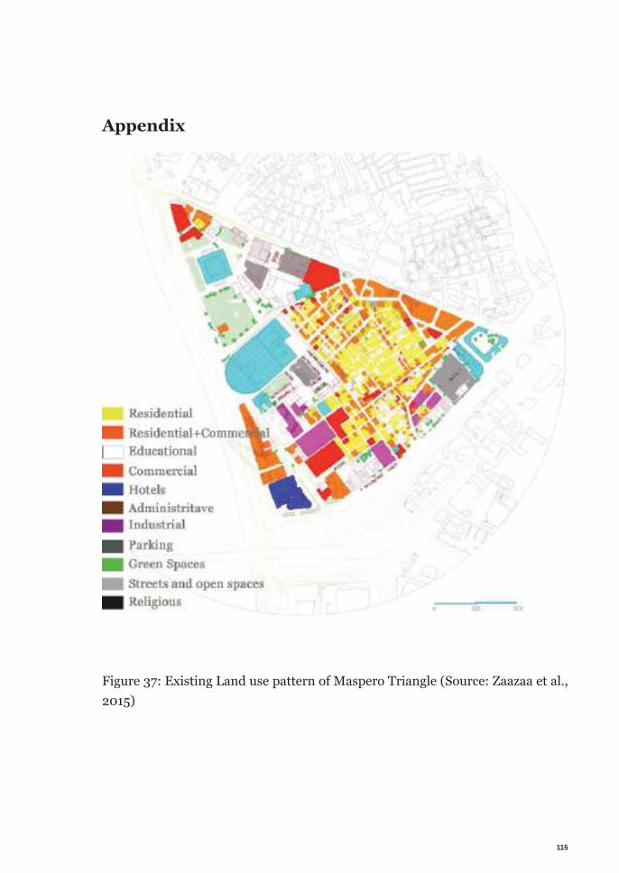
115
Appendix
Figure 37: Existing Land use pattern of Maspero Triangle (Source: Zaazaa et al., 2015)
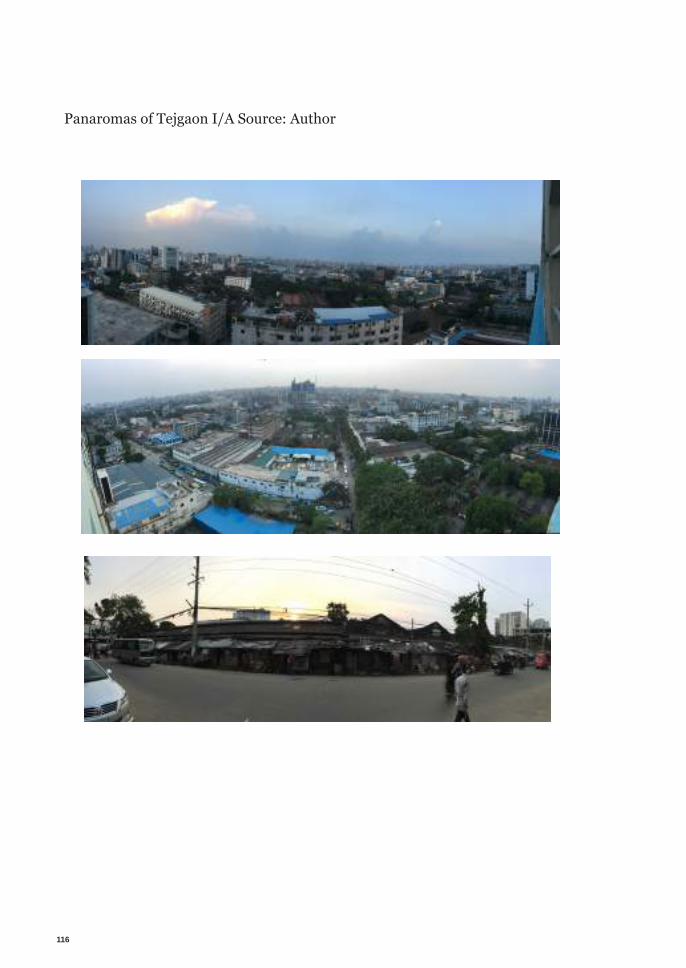
116
Panaromas of Tejgaon I/A Source: Author

117
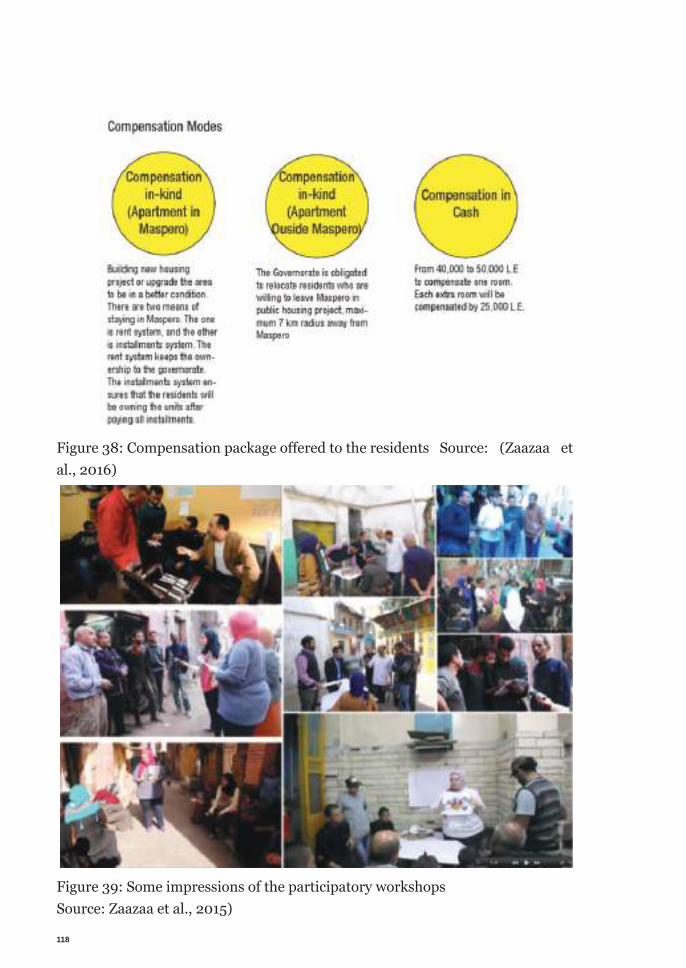
118
Figure 38: Compensation package off ered to the residents Source: (Zaazaa et al., 2016)
Figure 39: Some impressions of the participatory workshops Source: Zaazaa et al., 2015)
119
Interviews:
Followings are the summery of the semi-structured interview conducted during the field visit.
01.Place & Date: BUET, Dhaka. 18 March 2018Interviewee: Prof. Dr. Farida Nilufar, Professor, Department of Architecture, Bangaldesh University of Technology, DhakaSummary of the interview in keywords: Initial meeting about the field visit. Focus of the research, site selection, target groups, sources of information, study ma-terials, surrounding developments, documents regarding new developments in the proposed site area, discussion about both site options, participatory process, stakeholders, governments role, lease agreement and land ownerships of plots in Tejgaon I/A, state of Tejgaon Industrial Area, deficiency of Tejgaon I/A, Utilities, tansport, Hatirjheel lake development etc.
02. Place & Date: Vitti office, Farmgate, Dhaka. 20 March 2018Interviewee: Iqbal Habib, Architect.Summary of the interview in keywords: 1987 Structure plan, development around Tejgaon I/A, public private partnership, 1953 acts RAJUK, Private land development act, Access to information act, new vision for surrounding areas of Hatirjheel, new development trend in Tejgaon, Anticipated future of Tejgaon, government’s plan, infrastructure capacity of the area and so on.
03.Place & Date: Kfw office, Innstar, Bonani, Dhaka. 27 March 2018Interviewee: Mehdi Ahsan, Urban PlannerSummary of the interview in keywords: Focus of foreign agencies in Bangladesh, infrastructure capacity, funding interests of kfw, funding possibility for redevel-opment projects, complexities of redevelopment projects in Dhaka, social assess-ment by kfw, feasibility, water quality improvement etc.
120
04. Place & Date: Bengal Institute, Dhaka. 27 March 2018Interviewee: professor Samsul Wares, Professor of architectureSummary of the interview in keywords: Research focus, possibility of citizen par-ticipation, government’s plan, laws and costs, influence of private sector etc.
05.Place & Date: Ha-Min group of Industries office, Tejgaon, Dhaka. 28 March 2018Interviewee: Engr. Shohel. Engineer in charge of construction of Ha-mim group of industries. Summary of the interview in keywords: Facilities of Ha-mim group in the area, land ownership, current investment, type of ongoing projects, future plan, land value, problems of industries, types of current industries, project development process, investors, lack of availability of workers, workers constrains, housing scarcity for workers, DAP, factory’s compliance with DAP, contradiction of gov-ernment decision with private investment, alternative plan of companies in case of change of use, anticipated financial benefits of company, investment rate in land etc.
06.Place & Date: Urban Development Directorate, Shegunbagicha,Dhaka. 01 April 2018Interviewee: Dr. Khurshid Zabin Hossain Taufiq, Director of Urban Develop-ment Directorate, BangladeshSummary of the interview in keywords: Research focus, current approach, top down process, future plan for Tejgaon, fragile connectivity of the area, road trans-port capacity, state of government own lands in the area, state of vacant lands, participatory process in Bangladesh, economics of development in Tejgaon I/A etc.
07.Place & Date: RAJUK anex building, Dhaka. 01 April 2018Interviewee: Hasibul Kabir, Urban Planner, DAPSummary of the interview in keywords: Possibility of participatory redevelop-ment, sketch law, involvement of civil society, overlapping of personnel in differ-ent organizations, 1982-2017 land accreditation acts, previous critical analysis of the development, justification of the decision, lack of transparency, corruption,
121
lack of participation of public, no initiatives to include people in the planning process etc.
08.Place & Date: Architecture Department, Public Works Department, Shegunbagi-cha, Dhaka. 02 April 2018Interviewee: Kazi Golam NasirSummary of the interview in keywords: history of Tejgaon I/A, process of rede-velopment, miscommunication between different agencies, involvement of peo-ple in the process, who will initiate, who will be responsible, lack of impact study, indecision of government etc.
09.Place & Date: RAJUK anex building, Dhaka. 02 April 2018Interviewee: Ashraful Islam, Project Director, DAPSummary of the interview in keywords: DAP, revised DAP, Special DAP for Te-jgaon I/A, preparation of special DAP, new use of the area, lack of coordination between top down, bottom up process, meeting with root level people through lo-cal council, share information, availability of information for research, limitation of responsibility of RAJUK, etc.
10.Place & Date: Uttara, Dhaka. 02 April 2018Interviewee: Dr. Akter Mahmud, Professor of Urban planning, Jahangirnagar University, BangladeshSummary of the interview in keywords: Town improvement act 1953, only law safeguarding peoples voice, section 59 constitution, responsibility of public rep-resentative of local government, tejgaon industry owners association, DTCA, lack of triangulation, dispute over responsibility of different govt. agencies etc.
11.Place & Date: BUET, 03 April 2019Interviewee: Dr. Farida Nilufar, Professor, Department of Architecture, Ban-galdesh University of Technology, Dhaka
122
Summary of the interview in keywords: Research question, official responsibility of different govt. agencies, limiting by political goodwill, 1959 master plan, data organization, further data processing, revisit thesis focus etc.
12.Place & Date: Kallol Group of Industries HQ, 04 April 2018Interviewee: Golam Mostafa, Managing Director Kallol Group of Industries, vice president, Tejgaon Industry Owners Association.Summary of the interview in keywords: future plans, intended development, what the owners are doing, how they want the development to happen, govern-ment owns lot of lands, government lands are idle, potentials of Tejgaon I/A etc.
13. Place & Date: No. 37 Ward Councilors office, Tejgaon, Dhaka. 05 April 2018Interviewee: Shofiullah Shaofi, Ward councilor.Summary of the interview in keywords: Local government’s involvement in the development process, not informed about current state, not involved in the pro-cess, lack of mobilization, lack of direction to participate etc.
14. Place & Date: Tejgaon I/A, 05 April 2018Interviewee: Jahid Hasan, Rahim AfrozSummary of the interview in keywords: Personal experience, opinion about rede-velopment, concern about eviction, transportation etc.
15. Place & Date: Hatirjheel, 06 April 2018Interviewee: Sabrina Shammi, Brac Worker
16. Place & Date: Tejgaon I/A, 06 April 2018Interviewee: Sultana, Garments workerSummary of the interview in keywords: Concerns about job, travel time, trans-portation etc.

123
17. Place & Date: Tejgaon I/A, 06 April 2018Interviewee: Rafiq, Garments workerSummary of the interview in keywords: Housing problem, travel time, transpor-tation, new open space, etc.
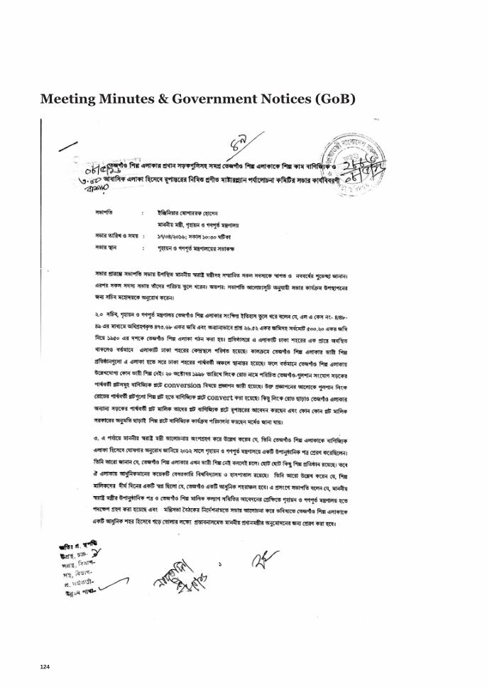
124
Meeting Minutes & Government Notices (GoB)
125
Scanned with CamScanner
126
Scanned with CamScanner
127
Scanned with CamScanner
128
Scanned with CamScanner
129
Scanned with CamScanner
130
Scanned with CamScanner
131
Scanned with CamScanner

132
Scanned with CamScanner

133
Scanned with CamScanner
134
Scanned with CamScanner

136
إقرار
هذه الرسالة هي نتيجة البحث الذي تم إجراؤه كمتطلب جزئي إلكمال درجة الماجستير في التصميم العمراني (ASU) التي تم تدريسها وتقييمها بشكل مشترك من قبل جامعة عين شمس (IUSD) المتكامل والتصميم المستدام، القاهرة ، مصر وجامعة شتوتغارت ، ألمانيا. تم إجراء البحث في الفترة من فبراير إلى يوليو 2018 مع االلتزام بتنظيم رسالة الماجستير IUSD-ASU واألخالقيات العامة للبحوث األكاديمية والنشر. لم يتم تقديم العمل في أي
مكان آخر للتقييم.المؤلف يؤيد هذا العمل من تلقاء نفسه إذا لم يتم االعتراف باالعتمادات والمراجع المناسبة خالف ذلك.
يدعي المؤلف أيضا المسؤولية الوحيدة للمحتويات ، ويقف حسب معانيها ، ويكون مسؤوال في حالة نزاع على حق المؤلف.تمتلك جامعة عين شمس ، القاهرة ، مصر وجامعة شتوتغارت الحق في التوزيع العام لهذه الرسالة في
الشكل القياسي الحالي للجامعة. يحتفظ المؤلف بالحق في نشر المحتويات بأي تنسيق آخر.
وهذا إقرار مني بذلك،،،
التوقيع:
الباحث: ق.ح م عبد هللا
التاريخ: /07/29/2018
137
التوقيع
تاريخ المناقشة:..............
أجيزت الرسالة بتاريخ:.............موافقة مجلس الجامعة .../.../...
لجنة الحكمأ.د. ……..الممتحن الخارجي
أستاذ.............. جامعة ....................
أ.د. ……..أستاذ..............
جامعة ....................
أ.د. ……..أستاذ..............
جامعة ....................
الدراسات العليا
ختم اإلجازةموافقة مجلس الكلية .../.../...
MM/DD/YYYY
إعادة التهيئة العمرانية إعادة التطوير التشارکي في االراضي المهملة
مقدمة للحصول على درجة الماجستير في العمران المتكامل والتصميم المستدام
أعداد:ق.ح م عبد هللا
أ.د استريد لي أستاذ
جامعة شتونجارت
لجنة أشرافأ.د محمد عبد الكريم صالحين
أستاذ التخطيط و التصميم المتكاملجامعة عين شمس
جامعة شتوتجارت
جامعة عين شـــــــمس


