Embed Size (px)
Citation preview
4 Phoenician Cities and Water: The Role of the Sacred Sources in the Urban Development of Motya, Western Sicily
Federica Spagnoli1
InTRoDUCTIon
Water played a primary role in Near Eastern religious beliefs and cults. The Phoenicians,2 one of the foremost populations living in the Levant at the beginning of the first millennium bc, erected their cult buildings close to natural spring waters, and the water was collected inside huge sanctuaries, such as Bostan esh-Sheikh in Lebanon, Amrit in Syria, and many other sacred compounds. Moreover, the presence of fresh water has been one of the necessary conditions for the rising of a city since early urbanization.
This chapter aims to present and discuss the case study of the Phoenician site of Motya, where a sacred compound, named “Temple of the Kothon”, was erected close to a freshwater spring by the first settlers coming from the homeland. This highlights how the creation of this sacred area molded the later urban plan of the city.3 The Temple is strictly linked to an artificial basin, the so-called “Kothon”,4 which collects the water of the under-hearth spring. This arrangement has close similarities to some of the most important sacred compounds of the Phoenician homeland, both from an architectural and a cult point of view. After a brief introduc-tion about the Phoenician origins of the city of Motya, the main archi-tectural phases of the Temple of the Kothon and the principal finds will be described, and the cult installations found inside the Temple, and the role the water held in the cult, will be interpreted in light of the results of recent excavations.
The PhoenICIan exPanSIon In The MeDITeRRanean Sea: The FoUnDaTIon oF MoTya
The Phoenician culture5 grounds its roots in the Bronze Age Levantine cultures, with which it shares politics, social structures, material culture, and religiosity, but it had its floruit in the first half of the first millennium
089-106 WaterUrban Pt1 Ch04 Spagnoli.indd 89 29/11/2013 10:17
90 a history of Water
bc, from the twelfth century to the sixth century bc. During this period, a milestone of Phoenician history was the rising of the Assyrian Empire and the conquest of the Levant in the eighth century bc. The new political layout of the region caused Phoenician cities to prefer to pay tributes to Assyrians over losing their political independence. Moreover, the Assyrian control of the principal trade-routes from the Egypt and the Red Sea to Anatolia made Phoenicians increase maritime commerce through the west. Many ports of trade, called also emporia, thus rose up on the coasts of the Mediterranean.6 Therefore, the presence of Phoenicians along the coasts of the Mediterranean Sea, already testified by archaeological evidence from the beginning of the Iron Age (eleventh and tenth centuries bc), grew in importance and influence from the middle of the eighth century bc, with the settlement of new foundations in Italy (Sicily and Sardinia), Iberia, and North Africa.7 Western Phoenician cities are characterized, as in Phoenicia, the present-day Lebanon and coastal Syria, by the presence of a neighboring spring, a river, or a lake basin that could assure survival and population growth. These conditions occurred at Motya, an island city of western Sicily, where the first Phoenician settlement, dating back to the first half of the eighth century bc, arose in the place where water emerged from underground, forming a natural lake. The first founding action of the new settlers was probably to put water under the control of a divine authority, making the area consecrated to a deity by offering rites and cult activities in favissae8 and cult pits. In the second half of the eighth century bc the freshwater spring was collected to a sacred building, the Temple of the Kothon, by underground canals (Nigro, 2004b). Therefore, this temple represents an important attestation of Phoenician culture in the Western Mediterranean, indicating the sacred use of water in this central region of the Phoenician world.
aRChaeology oF MoTya: olD exCavaTIonS anD ReCenT DISCoveRIeS
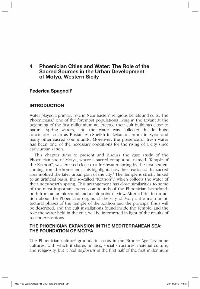
Motya is a little island 45 ha in size and 1 km off the coast of Sicily. It is located between Marsala in the south and Trapani in the north, in the center of the Marsala Lagoon; it is enclosed and protected on the western and northern sides by several islands, of which the largest and most important is called Isola Lunga (Figure 4.1). Motya hosts one of the most important Phoenician sites of the western Mediterranean since the first phases of Phoenician expansion into the West at the beginning of the eighth century bc.
Motya is an exceptional case in Phoenician archaeology. It was a flourishing city from the end of the eighth century to the start of the fourth century bc. At that point it was conquered and razed by the Greeks, and afterwards was gradually abandoned.9 As a consequence, there is a lack of
089-106 WaterUrban
Phoenician Cities and Water 91
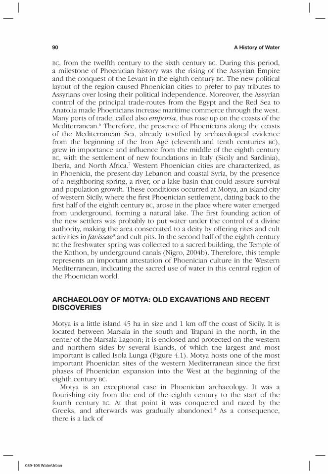
later superimposing occupation levels and so there is broad preservation of the Phoenician layers.10 The site has been investigated since the end of the nineteenth century, but only in the second half of the last century have methodological stratigraphic excavations been carried out. In the 1960s the archaeological mission of the University of Leeds, directed by Professor B. S. J. Isserlin, explored the southwestern region of the island, near the South Gate. A residential quarter was found here,11 and a rectangular basin carved into the rock, the so-called “Kothon”, where a small portion (just the monumental entrance) of a building located on the east of the artifi-cial basin emerged (Isserlin et al., 1974). The activities of Professor Isserlin paved the way for the joint Archaeological Expedition of La Sapienza University and the Soprintendenza of Western Sicily, which carried out meaningful research activities at Motya from 1964 to 1993. Since 2002, after a hiatus of nearly a decade, the Archaeological Mission to Motya of the University of Rome “La Sapienza” resumed investigations on the island (Figure 4.2).12
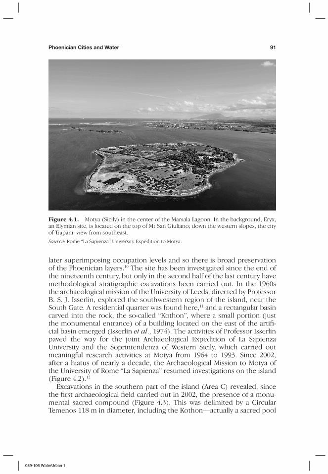
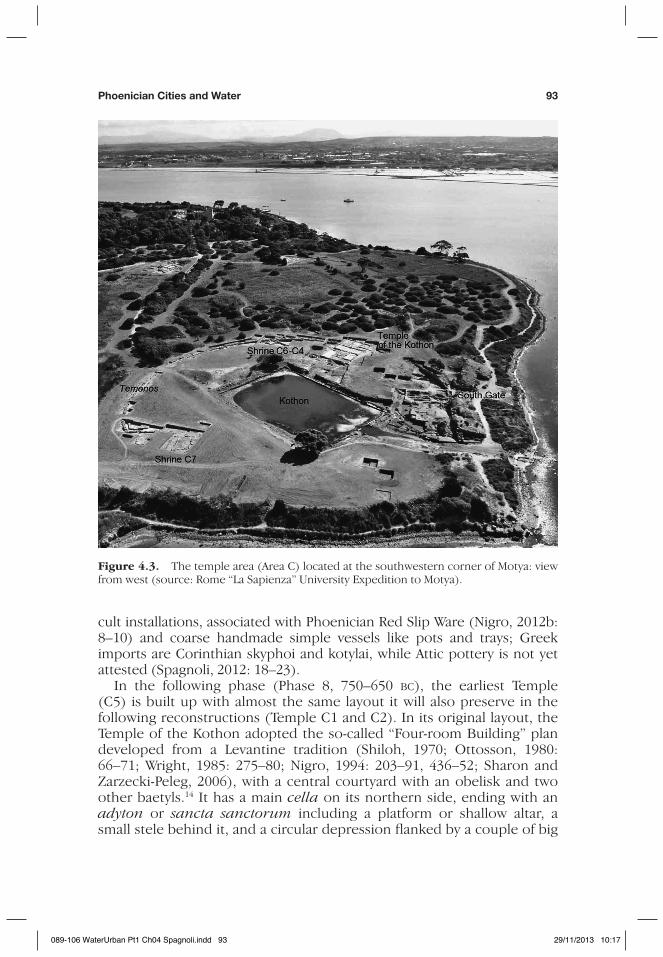
Excavations in the southern part of the island (Area C) revealed, since the first archaeological field carried out in 2002, the presence of a monu-mental sacred compound (Figure 4.3). This was delimited by a Circular Temenos 118 m in diameter, including the Kothon—actually a sacred pool
Figure 4.1. Motya (Sicily) in the center of the Marsala Lagoon. In the background, Eryx, an Elymian site, is located on the top of Mt San Giuliano; down the western slopes, the city of Trapani: view from southeast.
Source: Rome “La Sapienza” University Expedition to Motya.
089-106 WaterUrban 1
92 a history of Water
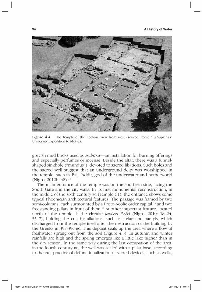
of fresh water flowing from a spring—and a large sacred building, the “Temple of the Kothon”, erected in the eighth century bc,13 and razed to the ground after the siege and the overall destruction brought about by Dionysius of Syracuse in 397/396 bc. After this dramatic event, the ruins of the temple were transformed in an open cult place called “Sanctuary C3”, which was used until the end of the fourth century bc (Figure 4.4).
Ten seasons of excavations in Area C (2002–11) made it possible to reconstruct the architecture and stratigraphy of the Temple thoroughly. The earliest occupational layers (Phase 9, 770–750 bc) show votive pits and
Figure 4.2. Excavation areas of the Archaeological Mission of “La Sapienza” University of Rome since 2002 (after Nigro, 2007c: fig. 1.3).
089-106 WaterUrban 29/11/2013 10:17
Phoenician Cities and Water 93
cult installations, associated with Phoenician Red Slip Ware (Nigro, 2012b: 8–10) and coarse handmade simple vessels like pots and trays; Greek imports are Corinthian skyphoi and kotylai, while Attic pottery is not yet attested (Spagnoli, 2012: 18–23).
In the following phase (Phase 8, 750–650 bc), the earliest Temple (C5) is built up with almost the same layout it will also preserve in the following reconstructions (Temple C1 and C2). In its original layout, the Temple of the Kothon adopted the so-called “Four-room Building” plan developed from a Levantine tradition (Shiloh, 1970; Ottosson, 1980: 66–71; Wright, 1985: 275–80; Nigro, 1994: 203–91, 436–52; Sharon and Zarzecki-Peleg, 2006), with a central courtyard with an obelisk and two other baetyls.14 It has a main cella on its northern side, ending with an adyton or sancta sanctorum including a platform or shallow altar, a small stele behind it, and a circular depression flanked by a couple of big
Figure 4.3. The temple area (Area C) located at the southwestern corner of Motya: view from west (source: Rome “La Sapienza” University Expedition to Motya).
089-106 WaterUrban Pt1 Ch04 Spagnoli.indd 93 29/11/2013 10:17
94 a history of Water
greyish mud bricks used as eschara—an installation for burning offerings and especially perfumes or incense. Beside the altar, there was a funnel-shaped sinkhole (“mundus”), devoted to sacred libations. Such holes and the sacred well suggest that an underground deity was worshipped in the temple, such as Baal ‘Addir, god of the underwater and netherworld (Nigro, 2012b: 48).15
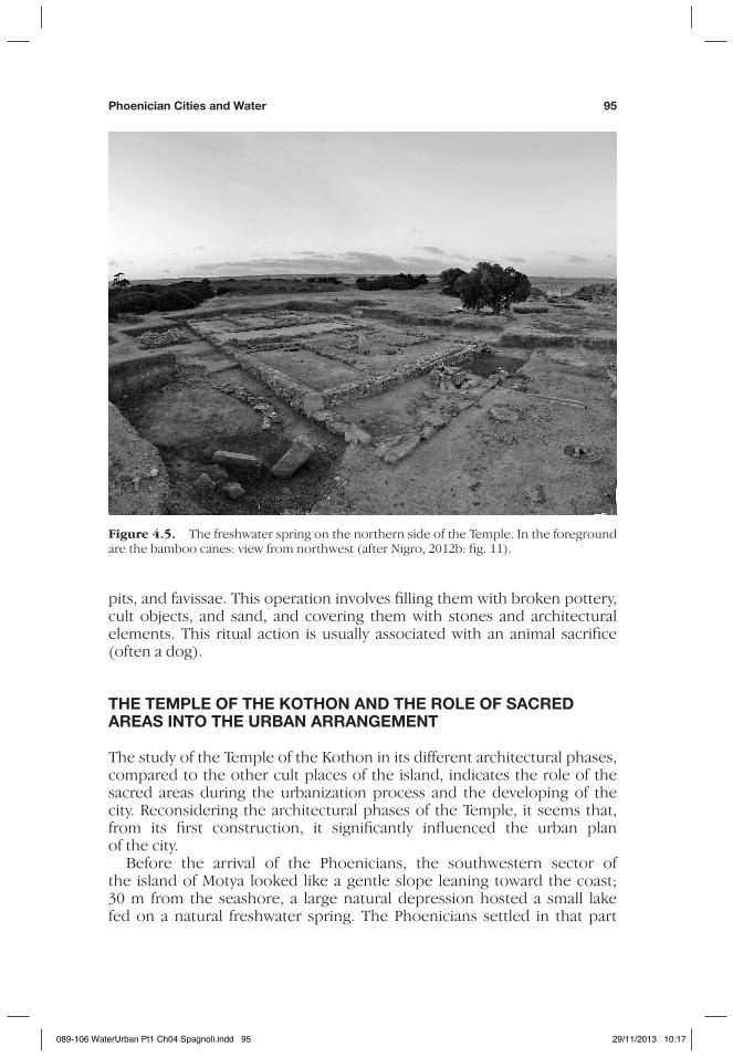
The main entrance of the temple was on the southern side, facing the South Gate and the city walls. In its first monumental reconstruction, in the middle of the sixth century bc (Temple C1), the entrance shows some typical Phoenician architectural features. The passage was framed by two semi-columns, each surmounted by a Proto-Aeolic order capital,16 and two freestanding pillars in front of them.17 Another important feature, located north of the temple, is the circular favissa F.864 (Nigro, 2010: 18–24, 35–7), holding the cult installations, such as stelae and baetyls, which discharged from the temple itself after the destruction of the building by the Greeks in 397/396 bc. This deposit seals up the area where a flow of freshwater sprang out from the soil (Figure 4.5). In autumn and winter rainfalls are high and the spring emerges like a little lake higher than in the dry season. In the same way during the last occupation of the area, in the fourth century bc, the well was sealed with a pillar base, according to the cult practice of defunctionalization of sacred devices, such as wells,
Figure 4.4. The Temple of the Kothon: view from west (source: Rome “La Sapienza” University Expedition to Motya).
089-106 WaterUrban Pt1 Ch04 Spagnoli.indd 94 29/11/2013 10:17
Phoenician Cities and Water 95
pits, and favissae. This operation involves filling them with broken pottery, cult objects, and sand, and covering them with stones and architectural elements. This ritual action is usually associated with an animal sacrifice (often a dog).
The TeMPle oF The KoThon anD The Role oF SaCReD aReaS InTo The URban aRRangeMenT
The study of the Temple of the Kothon in its different architectural phases, compared to the other cult places of the island, indicates the role of the sacred areas during the urbanization process and the developing of the city. Reconsidering the architectural phases of the Temple, it seems that, from its first construction, it significantly influenced the urban plan of the city.
Before the arrival of the Phoenicians, the southwestern sector of the island of Motya looked like a gentle slope leaning toward the coast; 30 m from the seashore, a large natural depression hosted a small lake fed on a natural freshwater spring. The Phoenicians settled in that part
Figure 4.5. The freshwater spring on the northern side of the Temple. In the foreground are the bamboo canes: view from northwest (after Nigro, 2012b: fig. 11).
089-106 WaterUrban Pt1 Ch04 Spagnoli.indd 95 29/11/2013 10:17
96 a history of Water
of the island, which had previously been occupied by an indigenous community,18 and cut the slope to level off the surface and to capture the water in numerous wells, exploiting the impermeability of the soil of this part of the island. The site of the natural lake was also modified: a rock-cut basin collecting water from the spring and a temple linked to it by a complex system of underground channels were built as the focal point of the rising city.
On the other side of the island, to the north and at the nearest point to the coast of Sicily, another sacred building, the Sanctuary of “Cappiddazzu”, was erected a little later. The first sacred use of the area is attested from the end of the eighth century bc by several ritual favissae, where offerings and votive objects were found. Just as for the Temple of the Kothon, the Sanctuary of “Cappiddazzu” also knows two main monumental phases: the sixth and the fifth centuries bc, and a significant rebuilding after 397/ 396 bc.19 The “Cappiddazzu” and the Temple of the Kothon are the twin sacred poles of the island, both a peripheral and liminal place in respect of the residential quarters located at the center of the island. The position of those religious poles probably influenced also the arrangement of the two principal city gates,20 which were connected by an important street that intercepts both sacred areas crossing the island north–south.
The KoThon, a SaCReD baSIn ConneCTeD To The TeMPle
Archaeological evidence allows us to reconsider the function of the Kothon itself. This can now be interpreted as a sacred pool instead of a dry-dock, as believed in the past. The survey of the Kothon confirmed that the built-up basin was completely enclosed by a continuous wall made of ashlar blocks. The southern wall of the basin, in its lower courses, also belongs to the original unitary ashlar structure enclosing the pool on all sides. In Late Roman Period the southern wall was partially dismantled in order to connect the basin to the sea by a channel to use it as a fishpond. Further on, in the twelfth century ad the Kothon was used as a “salina”, a salt-producing device up to the eighteenth century ad (as already noticed by Isserlin, 1971: 185).
During the 2005 season, the emptying of the basin21 revealed the presence of a flow of freshwater from the northern wall of the pool, where a series of blocks protrude from the edge of the perimeter wall.22 This device proved to be the structural element through which freshwa-ter flowed into the pool. A basic element required to understand the water systems linking the basin to the Temple was obtained by geological investigations and paleo-environmental studies in the Marsala Lagoon23 where Motya lies. In antiquity, in fact, the sea level was 0.8–1 m lower,24 allowing fresh water, present in the underground marl strata, to erupt. Moreover, geological investigations demonstrated that the sacred well in the central
089-106 WaterUrban Pt1 Ch04 Spagnoli.indd 96 29/11/2013 10:17
Phoenician Cities and Water 97
cult space of the Temple received fresh water from the same source (Nigro, 2009a: 552, figs 306–7, 319). The Kothon and the Temple were thus connected by an underground system, which can be easily related to classic ideological conceptions that the Phoenicians held. The sacred pool and the sacred well were both communicating directly with the world of underground waters.
The levanTIne ChaRaCTeR oF The TeMPle oF The KoThon anD The Role oF WaTeR In PhoenICIan CUlTURe
Recent discoveries at the Temple of the Kothon allow us to understand better the significance and the importance of this sacred building l inked to the sacred basin, especially in the light of the religious architectural tradition to which this Phoenician temple is ascribable (Nigro, 2009c). The deep relationship that links Mediterranean cult places and water sources, especially in the Phoenician homeland, descends from one of the most typical Near Eastern religious conceptions. Underworld water in the Levant, as well as in earlier Mesopotamia, is always the water from which the world had its beginning in the Creation, and it is from the same water that, by a divine act, human civilization emerged. The presence of such water thus gives to a place the status of sacred space and, at the same time, makes it suitable for human settlement, therefore enabling the foundation of a city and the seat of the temple (Nigro, 2012a: 303). The major Phoenician cities and their main sanctuaries arose in direct connec-tion with important water sources (Tyre with Ras el ‘Ain, Sidon with Nahar al-Awali and Bostan esh-Sheikh, Arwad with Amrit and the source of Naba’ el-Tell). Byblos, in particular, since the earliest origins of the settlement,25 had been focused on the central source and the nearby “sacred lake”, located in between the two major temples of the city: Balaat Gebal and the so-called “Temple en L”, successively reconstructed as the Obelisks Temple (Dunand, 1950–8: 644–52, fig. 767; Finkbeiner, 1981; Saghieh, 1983: 14–25; Nigro, 2012a: 304).
The Levantine character of the Temple of the Kothon is further demon-strated by comparing it with some illustrious Phoenician sanctuaries. The obelisk in the central court of the temple recalls the earlier Temple of the Obelisks in Byblos, which comprised a sacred well and various alignments of obelisks and baetyls possibly related to libation activities. These vertical elements were discarded and accumulated in a favissa in Byblos (as in the Temple of the Kothon). The Phoenician temple that is most strikingly similar to the Temple of the Kothon from an architectural point of view is Ma’abed of Amrit, ancient Marathos, in Syria.26 Some general correspondences between the two religious complexes can be observed: both temples were erected in the sixth century bc, and they were both created by cutting and modeling bedrock. They were both built of ashlar structures; they are
089-106 WaterUrban Pt1 Ch04 Spagnoli.indd 97 29/11/2013 10:17
98 a history of Water
both centered on a rectangular pool with the corners oriented according to the cardinal points (Dunand and Saliby, 1985: fig. 2). Finally, in both cases the pool was connected with a water source and some other struc-tures. The Ma’abed is connected with the spring of Naba’ el-Tell through a channel: this channel led the waters into a cave, on the eastern side of the basin, and from the latter into the pool. Another branch of the channel runs along the eastern and southern edges of the pool, possibly to be used in ritual acts as libations; this channel may explain why that connecting the sacred well to the Kothon at Motya emerged on the eastern quay of the latter. At the middle of its northern side a structure made of blocks protrudes towards the pool, probably serving as a dock for the boat of the priests to reach the shrine in the center of the basin (Nigro, 2012a: 306). The similar protruding structures visible on the northern side of the Kothon at Motya was never fully excavated, and it was, thus, not possible to establish its function (Isserlin, 1971: 179).
ConClUDIng ReMaRKS
The foundation of the Temple of the Kothon occurred together with that of the city itself, in a favorable spot of the island, due to the presence of fresh water not far away from the sea-shore serving as a dockland. For the Phoenician colonies, the availability of fresh water was a basic factor for the location of the new settlement, together with other typical features of the Phoenician landscape, such as coastal lagoons, spurs overlooking a bay, river mouths, and so on. The Marsala Lagoon is actually a very partic-ular aquatic ecosystem where, in its southern side,27 the high-saline waters meet the sea. This leads to a propitious environment for the breeding of several ichthyic species and shellfish, such as mullet and lobsters. A fishy sea and the presence of the fresh water in the island favored the prolif-eration of wild animals (ducks and other birds, but also ungulates, such as deer) that had a primary role in the local diet.28 Similar environmen-tal features are also attested in Gades (modern Cádiz, in Spain), a western colony beyond the Pillars of Hercules, hosting two sacred compounds. Described in Greek and Latin texts, the Temple of Heracles-Melqart (also called “Herakleion”), in the south, and the Temple of Baal Hammon, in the north,29 were erected at the beginning of Phoenician occupation of the island.30
Gades is traditionally one of the most ancient colonies of Tyre (as Arrianus recalls: Arr., Anabasis, II, 16: 4), dating back to the beginning of the first millennium bc.31 The myth of its foundation is strictly related to the erection of the Temple of Herakles-Melqart, mentioned by classical authors. According to Strabo (III, 5: 7–8) and Silius Italicus (Sil. Ital., Punica, III, 29–31), a Phoenician cult of a deity represented in an aniconic way was worshipped in the temple: two baetyls, three altars, and two
089-106 WaterUrban Pt1 Ch04 Spagnoli.indd 98 29/11/2013 10:17
Phoenician Cities and Water 99
freshwater springs, a wellspring and a smaller temporary one, as in the Temple of the Kothon, were the foremost cult installations (Plácido, 1993: 75). The Temple of Heracles-Melqart at Gades rose in the southeastern part of the island in the place where, coming from the East, navigators could safely reach the coast.32
The similarities between the temple at Gades and the Temple of the Kothon, compared to the main cult places of Phoenicia, show the strong cultural unity of Syro-Palestinian, Canaanite, and Phoenician sacred archi-tecture and religious beliefs connected to the presence of fresh water, and highlight the importance of the water as one of the principal reasons for the development of Phoenician sites along the coast of the Mediterranean Sea.
noTeS
1 I would like to thank the Director of the Archaeological Mission to Motya of the University of Rome “La Sapienza” Professor Lorenzo Nigro, for giving me precious advice in the study of this topic.
2 The name “Phoenicians”, descending from the Greek word Phoinikes (plur. of “purple”. Textile industry is one of the most typical Phoenician handicraft), is employed for the first time in the Odyssey (Hom. Od., XIV, 288: δὴ τότε Φοῖνιξ ἦλθεν ἀνὴρ ἀπατήλια εἰδώς; XV, 415: ἔνθα δὲ Φοίνικες ναυσίκλυτοι ἤλυθον ἄνδρες) to indicate this population. Actually the Phoenicians called them-selves “Sidonian”, from the name of one of the most powerful Phoenician cities, but also “Canaanites”. In spite of the lack of direct written sources, indirect sources testify the strong character and identity of this population. In the fifth century ad, St Augustine writes about farmers of the Hippo region, in Algeria: “Unde interrogati rustici nostri quid sint punici repondentes: Canani” (August., Expositio ad Rom., 13).
3 Nigro (2010) with a summary of Rome “La Sapienza” University excavations in the sacred area of the Kothon.
4 Kothon is a Greek word that means “ring-shaped cake”, and so it could be more appropriate for a circular basin.
5 The developing area of this culture encompasses the region including coastal Syria, Lebanon, and the north of Israel. It is delimited by the Orontes River to the north and the Anti-Lebanon Mountains to the south. The principal cities, which are actually city-states politically independent of each other, set up on the coast and controlled a wide part of the neighboring region at the back, which furnished alimentary goods, water, raw materials, and the workforce.
6 Emporion, a Greek word meaning “port of call, market”, is the first nucleus of a Phoenician colony. It is an independent political settlement, and not always has a mother city. The emporion is characterized by three principal features: the temple (usually consecrated to Melqart, the deity that, in the homeland, especially in Tyre, represents the power of the king of the city), the dock, and the storehouse (Aubet, 1997: 85–6). The emporion is the place where Phoenician merchants met native populations to obtain raw materials in exchange for various merchandise, often luxury goods.
089-106 WaterUrban Pt1 Ch04 Spagnoli.indd 99 29/11/2013 10:17
100 a history of Water
7 The most important and probably the first “colony” (in the Greek meaning of the word, implying an ideological and political reliance on the mother city) is Carthage, founded by Tyre in 814/813 bc, based on the written sources. In particular, Flavius Josephus in Against Apion (1.18) says that the city was founded during the seventh year of the reign of King Pygmalion (who ruled from 820 to 774 bc). His source is an earlier (and nowadays lost) work of Menander of Ephesus about the history of Tyre, with a list of the kings of Tyre from Abibaal to Pygmalion. This assertion follows the theory of Timeus of Taormine, which states that Carthage was founded by the Tyrians 38 years before the first Olympiad (performed in 776 bc).
8 A favissa is an underground reservoir or cellar near the temples, for water, for sacred utensils or votives no longer in use. The noun, descending from the Latin favissae, -arum, correspond to the Greek word θησαυροί.
9 After the destruction, the city continued for about two centuries, but it lost the strategic and economic role it had played before. From the following periods, there are sporadic traces of Roman and Byzantine occupation and a re-use of the ruins of the Sanctuary of “Cappiddazzu” (see infra) during the Norman Period.
10 Intensive agricultural works (especially grapevines), and a steady despo-liation of the ruins in order to obtain building materials, have been carried out from Medieval times up to the beginning of the twentieth century. Those activities heavily damaged the stratigraphy and the architectural structures of the Phoenician city (Nigro, 2004c: 43; Nigro, 2005: 26–9; Nigro, 2007c, 14–18; Nigro, 2011: 27–30).
11 This area was formally investigated by Joseph Whitaker in 1906 by taking several soundings; findings were later deepened by the archaeological mission directed by Isserlin. The area has been occupied with residential and commercial/storage purposes since the seventh century bc. The area partially changed its plan after the erection of the city walls with the South Gate and probably the Circular Temenos of the Temple of the Kothon in the middle of the sixth century bc, and the structures were reused after the overall destruc-tion of the city at the beginning of the fourth century bc (Whitaker, 1921: 145–78; Isserlin, 1962–63: 116–17; Nigro and Lisella, 2004: 81–2).
12 Archaeological explorations center on six different points of interest. On the western side of the coast (Area F), next to the West Gate and the adjacent large line of city walls, a defensive building (the “Western Fortress”) was found. This edifice was originally a military building, established for defensive purposes and contemporary to the erection of the city walls (mid-sixth century bc). After the destruction of Motya, brought about by Dionysius of Syracuse in 397/396 bc, it was reused as a luxury residency (excavation results were published in 2011 in the volume Mozia—XIII). In this later phase, a small shrine, sacred to Astarte, one of the principal Phoenician deities, was added south of the palace (Nigro, 2010). The southwestern and southeast-ern slopes of the Acropolis, at the centre of the island (Area D and Area B, respectively), hosted two important residential quarters. These areas were occupied before the incoming of the Phoenician colonists, at least since the Middle Bronze Period (fourteenth century bc), as shown by the stratigraphic soundings in Area D (Caltabiano, 2007: 105–9; Caltabiano and Spagnoli, 2010). These areas were so early occupied because of their favorable position,
089-106 WaterUrban Pt1 Ch04 Spagnoli.indd 100 29/11/2013 10:17
Phoenician Cities and Water 101
which allowed a wide control of the sea, and because of the presence of drinking water drawn from deep wells. In the last phases of the Phoenician occupation, coinciding with the second half of the fifth century bc until the destruction in 397/396 bc, areas B and D were occupied by three patrician residences, the “House of the Domestic Shrine” and the “House of the Horn of Triton” in Area D, and the “House of the Square Well” in Area B, where ivory furniture, bronze jewellery and tools, attic black-painted and red-figured pottery, and stone and terracotta small sculptures were found. The Tofet, an open cult place at the northwestern side of the island, in use from the end of the eighth century to the end of the fourth century bc, is characterized by the deposition of urns containing buried remains of infants and children, commemorated by steles or gravestones. The sanctuary was excavated by Antonia Ciasca (“La Sapienza” University of Rome) in several campaigns carried out from 1964 to 1993. Ciasca gave a complete stratigraphic sequence of the deposition inside the sanctuary and a plausible hypothesis of recon-struction of the compound, which is articulated in two principal architectural phases. The first o ne i s f rom t he e nd o f t he e ighth c entury t o t he m iddle of the sixth century bc, and the second phase is from the latter half of the sixth century to the fourth century bc. Since 2009, during the investigations of the southern perimeter wall carried out by the Archaeological Mission at Motya of “La Sapienza” University, a series of rectangular cult-rooms, erected during the rearrangement of the sacred area after the destruction at the beginning of the fourth century bc, was brought to light. Renewed field activities also interested the Necropolis area, where six archaic tombs dating back to the beginning of the seventh century bc, were brought to light. The last area of investigation is Area C, located in the southern part of the island. This includes the South Gate Area, with the artificial basin called “Kothon” and the sacred building east of it (Nigro, 2004a: 19–32).
13 The Temenos encircled the whole sacred area, including the Temple of the Kothon, marking its major reconstruction in Phase 5 in the mid-sixth century bc. In the same phase, Shrine C6-C4 and Sanctuary C7 were erected west of the sacred pool.
14 Cult furnishings recall similar installations in the renowned Temple of the Obelisks at Byblos (Dunand, 1950–8: 644–52, fig. 767). The erection of steles and baetyls in cult places is largely documented in Syria and Palestine during the Bronze and Iron Ages. This religious practice lasts in use until the Roman Period, as shown by a coin of Macrinus (ad 217), representing a temple with a sacred precinct and an obelisk/baetyl in the middle (Jidejian, 1968: fig. 121).
15 Baal ‘Addir, attested at Bylos in the sixth century bc with the epithet “Mighty Lord”, has in the Phoenician Pantheon a chthonian and agrarian character. In later periods, especially in the Punic regions of North Africa, he is considered similar to Baal Hammon. Baal Hammon and Baal ‘Addir are both versions of Baal, one of the most important deities of the Semitic Pantheon. Baal, son of Dagan, the god of crop fertility and vegetation in the third and second millennia bc, is the god of the storm, the rain, and the dew, and also the god of life and fertility. In Semitic mythology, he engaged in mortal combat with Mot, the god of death and sterility, and then came back to life as the god of vegetation (Lipinsky, 1992: 55–6, 126).
089-106 WaterUrban Pt1 Ch04 Spagnoli.indd 101 29/11/2013 10:17
102 a history of Water
16 One of those capitals was found thrown into the sacred well at the centre of the temple, while its base was reused and set up on the closed top of the well at the time of Sanctuary C3, in the fourth century bc.
17 Two bronze pillars, which had been made by Tyrian metallurgists, also flanked the entrance of Solomon’s Temple in Jerusalem, according to the Biblical account (1 King 7:15–22; 2 Chronicles 3:15–17; Busink, 1970: 299–321).
18 The indigenous settlement of the Middle and Late Bronze Ages (fifteenth to eleventh centuries bc) is testified in this area only by potsherds and objects. No architectural structures were found, probably because of the later rear-rangement of the area, carried out by the Phoenicians in the middle of the eighth century bc.
19 Architectural phases of the Sanctuary of “Cappiddazzu” are discussed in Tusa (2000), Nigro and Spagnoli (2004), Nigro (2009b: 243–51).
20 The distance between the South Gate and the Temple of the Kothon is on average 30 m, while the Sanctuary of “Cappiddazzu” is 100 m from the North Gate.
21 The Kothon was partly emptied by J. Whitaker in its western part, while the perimeter structure, in the corners and in some spots of the northern and southern sides, was explored by the British Expedition directed by B. S. J. Isserlin (1971: 184–6).
22 The protruding structure has been interpreted in the past as an inner berth (Isserlin, 1970: 565; 1971: 185, pl. XXIXb; Famà, 1995: 178; Tusa, 2004: 448).
23 The presence of numerous fish and birds of various kinds concentrating in the Kothon and in its immediate neighbourhood, as already observed by Whitaker (1921: 190), indicated the presence of a flow of fresh water.
24 As testified by the nowadays submerged quays and docks all around the island of Motya (Isserlin, 1971: 179; Tusa, 2004: 450, fig. 9; Caltabiano, 2011: 447–8).
25 The earliest sacred building at Byblos (the Enceinte Sacrée) arose just aside the central well by the end of Early Bronze IA (around 3300 bc) (Dunand, 1973: 235–41, fig. 143, pl. J,c; Dunand, 1982: 195; Nigro, 2007a: 1–3, 26–31; Sala, 2007: 48–58).
26 The similarities between the Kothon of Motya and the Ma’abed of Amrit were stressed for the first time by P. Mingazzini (Mingazzini, 1968: 105–12).
27 In antiquity, Isola Lunga was joined to the coast, closing the northern side of the lagoon because of the lower level of the sea.
28 As in the Levant, the island city obtained any foodstuffs from the indigenous communities, such as the Sicanians and the Elymes settled on the fertile hills of oriental Sicily (Falsone, 1988: 43–5). Those populations were able to offer a wide range of agricultural products in a favorable exchange system (Tusa and Morris, 2004).
29 The temple is mentioned by Strabo (III: 5, 3) and Pliny the Elder (Nat. Hist. 4. 120). A Proto-Aeolic capital found under the sea, west of the city, is the unique architectural remains of the building (Aubet, 1997: 236–7).
30 In ancient times, the archipelago of Gades was composed of three islands: Erytheia, where the Phoenician city was built up, to the north; the island of San Fernando to the west; Kotinoussa, a long and narrow island ending in two promontories. The Temple of Herakles-Melqart was founded south of it (Plinius, Nat. Hist., 4: 22). Nowadays the modern city lies at the end of the promontory that closes at the west of the Gulf of Cadiz. The geography of
089-106 WaterUrban Pt1 Ch04 Spagnoli.indd 102 29/11/2013 10:17
Phoenician Cities and Water 103
that area was modified by the alluvium of the Guadalete River flowing into the Gulf.
31 M. Velleius Paterculus asserts the city was founded 80 years after the War of Troy, in 1104/1103 bc (Hist. Rom., 1: 2, 1–3).
32 A good example is the usual locations of Melqart’s and Astarte’s temples in the Mediterranean (Bernardini, 2003: 112–19).
ReFeRenCeS
Arrianus, L. Flavius (2010). Anabasis Alexandri, edited by A. G. Roos, Florence.Aubet, M. E. (1997). Tiro y las Colonias Fenicias de Occidente, Bellaterra,
Ediciones S.A., Barcelona. Bernardini, P. (2003). “I Fenici ai confini del mondo: le isole erranti e le colonne di
Melqart”, in Sardinia, Corsica et Baleares Antiquae, I, pp. 112–21.Busnik, Th. A. (1970). “Der Tempel von Jerusalem von Salomo bis Herodes: Eine
archäologish-historische Studie unter Berücksichtigung des westsemitischen Tempelbaus 1: Der Tempel Salomos”, Leiden: Studia Francisci Scholten Memoriae Dedicata 3.
Caltabiano, A. (2007). “La ceramica preistorica dal Sondaggio I”, in L. Nigro (ed.), Mozia—XII, pp. 105–9, Missione Archeologica a Mozia, Rome.
——— (2011). “Gli approdi di Porta Sud e Porta Ovest a Mozia”, in L. Nigro (ed.), Mozia—XIII, pp. 441–56, Missione Archeologica a Mozia, Rome.
Caltabiano, A. and F. Spagnoli (2010). “Mozia: La ceramica fenicia arcaica dal sondaggio stratigrafico III nella Zona D”, in L. Nigro (ed.), Motya and the Phoenician Ceramic Repertoire Between the Levant and the West, 9th–6th Century bc. Proceedings of the International Conference held in Rome, 26th February 2010, Quaderni di Archeologia Fenicio-Punica, V, pp. 117–49, Missione Archeologica a Mozia, Rome.
Dunand, M. (1950–8). Fouilles de Byblos. Tome II, Paul Geuthner, Paris.——— (1973). Fouilles de Byblos. Tome V. L’architecture, les tombes, le matériel
domestique, des origines néolithiques à l’avènement urbain, Paul Geuthner, Paris.
——— (1982). “Byblos et ses Temples après la pénétration amorite”, in H.-J. Nissen and J. Renger (eds), Mesopotamien und Seine Nachbarn. Politische und kulturelle Wechselbeziehungen im Alten Vorderasien vom 4. bis 1. Jahrtausend v. Chr. XXIV. Rencontre Assyriologique Internationale Berlin 3. bis 7. Juli 1978, pp. 195–201, Dietrich Reimer Verlag, Berlin.
Dunand, M. and N. Saliby (1985). Le Temple d’Amrith dans la Pérée d’Aradus, BAH CXXI. Paris.
Falsone, G. (1988). “The Bronze Age occupation and Phoenician foundation at Motya”, Bulletin of the Institute of Archaeology London, 25, pp. 31–53.
Famà, M. L. (1995). “Il porto di Mozia”, Sicilia Archeologica, 87–9, pp. 171–9.Finkbeiner, U. (1981). “Untersuchungen zur Stratigraphie des Obeliskentempels in
Byblos. Versuch einer methodischen Auswertung”, Baghdader Mitteilungen, 12, pp. 13–69.
Isserlin, B. S. J. (1971). “New light on the Kothon at Motya”, Antiquity, 45, pp. 178–86.
089-106 WaterUrban Pt1 Ch04 Spagnoli.indd 103 29/11/2013 10:17
104 a history of Water
Isserlin, B. S. J. and J. du Plat. Taylor (1974). Motya. A Phoenician and Carthaginian City in Sicily. A report of the excavations undertaken during the years 1961–65 on behalf of the University of Leeds, the Institute of Archaeology of London University and Fairleigh Dickinson University, New Jersey, vol. I. Field Work and Excavation, E. J. Brill, Leiden.
Jidejian, N. (1968). Byblos through the Ages, Dar el-Machreq Publishers [distribu-tion Librairie Orientale], Beirut.
Lipinsky, E. (1992). Dictionnaire de la Civilisation Phénicienne et Punique, Brepols, Paris.
Mingazzini, P. (1968). “Scopo e natura del cosiddetto Kothon di Mozia”, in A. Ciasca, G. Garbini, P. Mingazzini, B. Pugliese, and V. Tusa. Mozia—IV. Rapporto preliminare della Missione archeologica della Soprintendenza alle Antichità della Sicilia Occidentale e dell’Università di Roma, Studi Semitici, 29, pp. 105–12, Istituto di Studi del Vicino Oriente, Università di Roma, Rome.
Nigro, L. (1994). Ricerche sull’architettura palaziale della Palestina nelle Età del Bronzo e del Ferro. Contesto archeologico e sviluppo storico, Contributi e Materiali di Archeologia Orientale V, Università degli studi di Roma “La Sapienza”, Rome.
——— (2004a). Mozia—X. Rapporto preliminare della XXII campagna di scavi—2002 condotta congiuntamente con il Servizio Beni Archeologici della Soprintendenza Regionale per i Beni Culturali e Ambientali di Trapani, Quaderni di Archeologia Fenicio-Punica, I, Università degli studi di Roma “La Sapienza”, Rome.
——— (2004b). “Gli scavi di Antonia Ciasca al Tofet e alle mura (1964–1993)”, in L. Nigro and G. Rossoni (eds), “La Sapienza” a Mozia. Quarant’anni di ricerca archeologica (1964–2004), pp. 20–9, Università degli studi di Roma “La Sapienza”, Rome.
——— (ed.) (2005). Mozia—XI. Il Tempio del Kothon. Rapporto preliminare delle campagne di scavo XXIII e XXIV (2003–2004) condotte congiuntamente con il Servizio Beni Archeologici della Soprintendenza Regionale per i Beni Culturali e Ambientali di Trapani, Quaderni di Archeologia Fenicio-Punica, II, Università degli studi di Roma “La Sapienza”, Rome.
——— (2007a). “Aside the spring: Byblos and Jericho from village to town in the second half of the 4th millennium bc”, in L. Nigro (ed.), Byblos and Jericho in the Early Bronze I: Social Dynamics and Cultural Interactions. Proceedings of the International Workshop held in Rome on March 7th 2006 by Rome “La Sapienza” University, Rome “La Sapienza” Studies on the Archaeology of Palestine & Transjordan, 4, pp. 1–45, Università degli studi di Roma “La Sapienza”, Rome.
——— (2007b). “Il lago sacro e l’obelisco”, Kalós, 19, pp. 24–9.——— (ed.) (2007c). Mozia—XII. Zona D. La “Casa del sacello domestico”, il
“Basamento meridionale” e il Sondaggio stratigrafico I. Rapporto prelim-inare delle campagne di scavi XXIII e XXIV (2003–2004) condotte congiun-tamente con il Servizio Beni Archeologici della Soprintendenza Regionale per i Beni Culturali e Ambientali di Trapani, Quaderni di Archeologia Fenicio-Punica, III, Università degli studi di Roma “La Sapienza”, Rome.
——— (2009a). “Recenti scoperte dell’Università di Roma ‘La Sapienza’ a Mozia (2002–2006): il Tempio del Kothon, la ‘Casa del sacello domestico’, il ‘Basamento meridionale’ e la Fortezza Occidentale”, in C. Ampolo (ed.),
089-106 WaterUrban Pt1 Ch04 Spagnoli.indd 104 29/11/2013 10:17
Phoenician Cities and Water 105
Immagine e immagini della Sicilia e di altre isole del Mediterraneo antico, Vol. II. Atti delle seste giornate internazionali di studi sull’area elima e la Sicilia occidentale nel contesto mediterraneo. Erice 12–16 ottobre 2006, pp. 551–9, Università degli studi di Roma “La Sapienza”, Pisa.
——— (2009b). “Il Tempio del Kothon e il ruolo delle aree sacre nello sviluppo urbano diMozia dall’VIII al IV secolo a.C.”, in S. Helas and D. Marzoli (eds), Phönizisch und punisches Städtewesen. Akten der internationalen Tagung in Rom vom 21. bis 23. Februar 2007, Iberia Archaeologica Band 13, pp. 241–70, Università degli studi di Roma “La Sapienza”, Mainz am Rhein.
——— (2009c). “Il Tempio del Kothon e le origini fenicie di Mozia”, in A. Mastino, P. G. Spano, and R. Zucca (eds), Naves Plenis Velis Euntes, Tharros Felix 3, pp. 77–118, Università degli studi di Roma “La Sapienza”, Rome.
——— (2010). “Alle origini di Mozia: stratigrafia e ceramica del Tempio del Kothon dall’VIII al VI secolo a.C.”, in L. Nigro (ed.), Motya and the Phoenician Ceramic Repertoire between the Levant and the West, 9th–6th Century bc. Proceedings of the International Conference held in Rome, 26th February 2010, Quaderni di Archeologia Fenicio-Punica, V, pp. 1–48, Università degli studi di Roma “La Sapienza”, Rome.
——— (ed.) (2011). Mozia—XIII. Zona F. La Porta Ovest e la Fortezza Occidentale. Rapporto preliminare delle campagne di scavi XXIII–XXVII (2003–2007) condotte congiuntamente con il Servizio Beni Archeologici della Soprintendenza Regionale per i Beni Culturali e Ambientali di Trapani, Quaderni di Archeologia Fenicio-Punica, VI, Università degli studi di Roma “La Sapienza”, Rome.
——— (2012a). “The Temple of the Kothon at Motya, Sicily: Phoenician religious architecture from the Levant to the West”, in M. Gruber, S. Ahituv, G. Lehmann, and Z. Talshir (eds), All the Wisdom of the East. Studies in Near Eastern Archaeology and History in Honor of Eliezer D. Oren, Orbis Biblicus et Orientalis, 255, pp. 293–331, Università degli studi di Roma “La Sapienza”, Friburg.
——— (2012b). “La favissa di Baal ‘Addir”, in L. Nigro and F. Spagnoli, Alle sorgenti del Kothon. Il rito a Mozia nell’Area sacra di Baal ‘Addir—Poseidon. Lo scavo dei pozzi sacri nel Settore C Sud-Ovest (2006–2011), Quaderni di Archeologia Fenicio-Punica/CM 02, pp. 8–12, Università degli studi di Roma “La Sapienza”, Rome.
Nigro, L. and A. R. Lisella (2004). “Il Quartiere di Porta Sud”, in L. Nigro and G. Rossoni (eds), “La Sapienza” a Mozia. Quarant’anni di ricerca archeolog-ica, 1964–2004. Catalogo della mostra, Università di Roma «La Sapienza», Facoltà di Scienze Umanistiche, Museo dell’Arte Classica, 27 febbraio–18 maggio 2004, pp. 78–83, Università degli studi di Roma “La Sapienza”, Rome.
Nigro, L. and F. Spagnoli (2004). “Il Santuario del ‘Cappiddazzu’”, in L. Nigro and G. Rossoni (eds), “La Sapienza” a Mozia. Quarant’anni di ricerca archeolog-ica, 1964–2004. Catalogo della mostra, Università di Roma “La Sapienza”, Facoltà di Scienze Umanistiche, Museo dell’Arte Classica, 27 febbraio–18 maggio 2004, pp. 56–61, Università degli studi di Roma “La Sapienza”, Rome.
Ottosson, M. (1980). Temples and Cult Palaces in Palestine, Acta Universistatis Upsaliensis, Boreas, 12, Vandenhoek and Ruprecht Göttingen, Uppsala.
Paterculus, C. Velleius (2010). Historiae Romanae, Libri Duo, Notis Adiectis, Nabu Press, Florence.
089-106 WaterUrban Pt1 Ch04 Spagnoli.indd 105 29/11/2013 10:17
106 a history of Water
Plácido, D. (1993). “Le vie di Ercole nell’estremo Occidente”, in A. Mastrocinque, Ercole in Occidente, Labirinti. Collana del Dipartimento di Scienze Filologiche e Storiche, 2, pp. 63–80, Università degli Studi di Trento, Trento.
Pliny the Elder, Naturalis Historia, edited by K. F. Th. Mayhoff, Perseus Digital Library, Tufts University, G. R. Crane editor-in-chief, www.perseus.tufts.edu
Saghieh, M. (1983). Byblos in the Third Millennium B.C.: A Reconstruction of the Stratigraphy and a Study of the Cultural Connections, Aris & Phillips, Warminster.
Sala, M. (2007). “Early shrines at Byblos and Tell es-Sultan/ancient Jericho in the Early Bronze I (3300–3000 bc)”, in L. Nigro (ed.), Byblos and Jericho in the Early Bronze I: Social Dynamics and Cultural Interactions. Proceedings of the International Workshop held in Rome on March 7th 2006. by Rome “La Sapienza” University. Rome “La Sapienza” Studies on the Archaeology of Palestine & Transjordan, 4, pp. 47–68.
Sharon, I. and A. Zarzecki-Peleg (2006). “Podium structures with lateral access: authority ploys in royal architecture in the Iron Age Levant”, in S. Gitin, J. E. Wright, and J. P. Dessel (eds), Confronting the Past. Archaeological and Historical Essays on Ancient Israel in Honor of William G. Dever, pp. 145–67, Eisenbrauns, Winona Lake, IN.
Shiloh, Y. (1970). “The four-room house—its situation and function in the Israelite city”, Israel Exploration Journal, 20, pp. 180–90.
Silius Italicus, Punica, edited by W. C. Summers and J. P. Postgate, Perseus Digital Library, Tufts University, G. R. Crane editor-in-chief, www.perseus.tufts.edu
Spagnoli, F. (2012). “Ceramica dei primi utilizzi della favissa F.2950”, in L. Nigro and F. Spagnoli, Alle sorgenti del Kothon. Il rito a Mozia nell’Area sacra di Baal ‘Addir—Poseidon. Lo scavo dei pozzi sacri nel Settore C Sud-Ovest (2006–2011), Quaderni di Archeologia Fenicio-Punica/CM 02, pp. 18–23, Missione Archeologica a Mozia, Rome.
Strabo, Geography, Perseus Digital Library, G. R. Crane editor-in-chief, www.perseus.tufts.edu, Tufts University.
Tusa, S. (2004). “Il sistema portuale di Mozia. Il Kothon”, in L. Nigro (ed.), Mozia—X, pp. 445–64, Missione Archeologica a Mozia, Rome.
Tusa, S. and I. Morris (2004). “Scavi sull’acropoli di Monte Polizzo, 2000–2003”, Sicilia Archeologica, 102, pp. 35–90.
Whitaker, J. I. S. (1921). Motya, a Phoenician Colony in Sicily, G. Bell and Sons, London.
Wright, G. R. H. (1985). Ancient Building in South Syria and Palestine, Handbuch der Orientalistik 7, E. J. Brill, Leiden-Köln.
089-106 WaterUrban Pt1 Ch04 Spagnoli.indd 106 29/11/2013 10:17


![Język fenicki – brat bliźniak hebrajskiego [Phoenician language – twin brother of Hebrew]](https://img.pdfslide.net/doc/110x75/631464ce511772fe450fe8ac/jezyk-fenicki-brat-blizniak-hebrajskiego-phoenician-language-twin-brother.jpg)


