Embed Size (px)
Citation preview
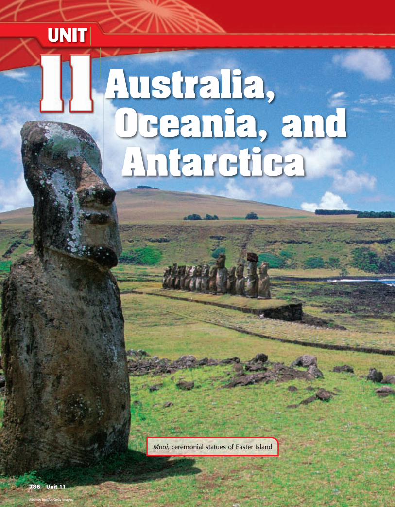
Moai, ceremonial statues of Easter Island
UNIT
Australia, Oceania, and Antarctica
786 Unit 11
Altrendo Images/Getty Images
AUSTRA
LIA, O
CEAN
IA, A
ND
AN
TARCTICA
What Makes This a Region? 788–791
Regional Atlas 792–799
Chapter 32: Physical Geography 800–815
Chapter 33: Cultural Geography 816–833
Chapter 34: The Region Today 834–853
Why It MattersVast and sparsely populated, the region of Australia, Oceania, and Antarctica is perhaps the most diverse of the world’s regions. Parts of the region — Australia and Oceania — are developing close economic ties to other coun-tries in the Pacific Rim, the area bordering the Pacific Ocean. Such ties to prosperous Pacific Rim nations will influence global trade and trading networks for decades to come. Cold, icy Antarctica lacks a permanent human population, but the data being gathered there by scientists will broaden your understanding of the world’s climates and resources in the years ahead.
787
To learn more about Australia, Oceania, and Antarctica visit www.nationalgeographic.com/education.
788 Unit 11
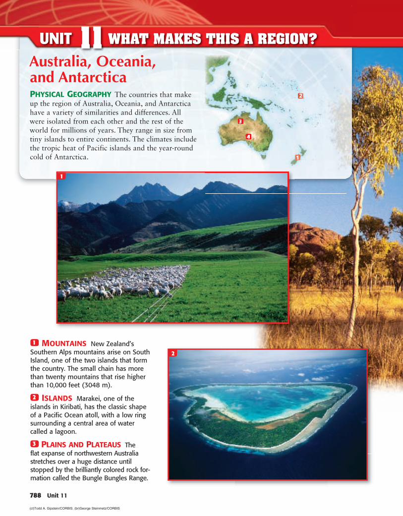
1 MOUNTAINS New Zealand’s Southern Alps mountains arise on South Island, one of the two islands that form the country. The small chain has more than twenty mountains that rise higher than 10,000 feet (3048 m).
2 ISLANDS Marakei, one of the islands in Kiribati, has the classic shape of a Pacific Ocean atoll, with a low ring surrounding a central area of water called a lagoon.
3 PLAINS AND PLATEAUS The flat expanse of northwestern Australia stretches over a huge distance until stopped by the brilliantly colored rock for-mation called the Bungle Bungles Range.
1
Australia, Oceania, and AntarcticaPHYSICAL GEOGRAPHY The countries that make up the region of Australia, Oceania, and Antarctica have a variety of similarities and differences. All were isolated from each other and the rest of the world for millions of years. They range in size from tiny islands to entire continents. The climates include the tropic heat of Pacific islands and the year-round cold of Antarctica.
2
UNIT 11 WHAT MAKES THIS A REGION?
(cl)Todd A. Gipstein/CORBIS . (br)George Steinmetz/CORBIS
Unit 11 789
3
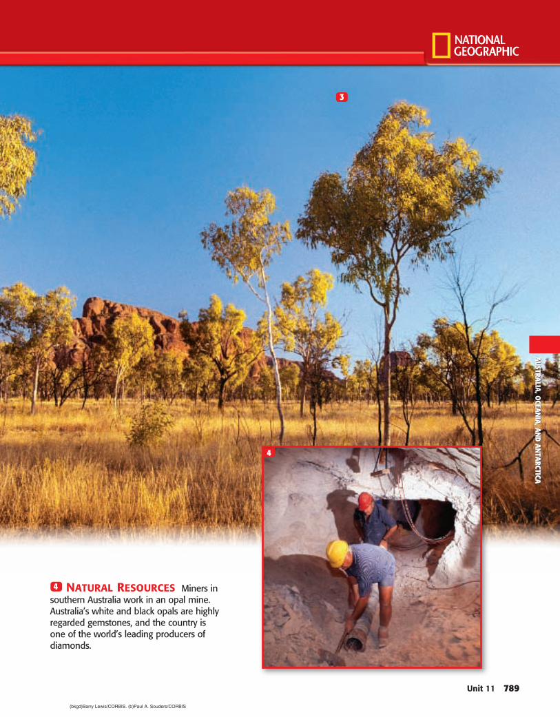
4 NATURAL RESOURCES Miners in southern Australia work in an opal mine. Australia’s white and black opals are highly regarded gemstones, and the country is one of the world’s leading producers of diamonds.
4
AUSTRA
LIA, O
CEAN
IA, A
ND
AN
TARCTICA
(bkgd)Barry Lewis/CORBIS. (b)Paul A. Souders/CORBIS
REGIONAL TIME LINE
A.D. 1800A.D. 700 A.D. 170045,000 B.C. A.D. 1600
790 Unit 11
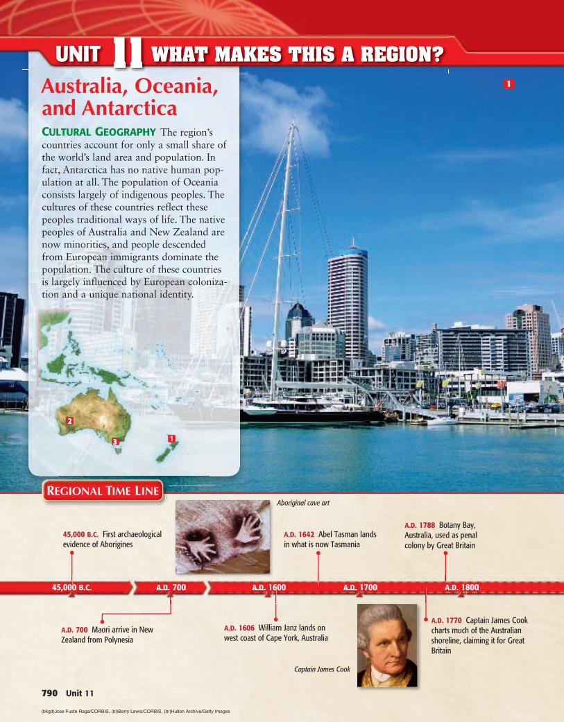
UNIT 11 WHAT MAKES THIS A REGION?1Australia, Oceania,
and AntarcticaCULTURAL GEOGRAPHY The region’s countries account for only a small share of the world’s land area and population. In fact, Antarctica has no native human pop-ulation at all. The population of Oceania consists largely of indigenous peoples. The cultures of these countries reflect these peoples traditional ways of life. The native peoples of Australia and New Zealand are now minorities, and people descended from European immigrants dominate the population. The culture of these countries is largely influenced by European coloniza-tion and a unique national identity.
A.D. 700 Maori arrive in New Zealand from Polynesia
45,000 B.C. First archaeological evidence of Aborigines
A.D. 1642 Abel Tasman lands in what is now Tasmania
A.D. 1606 William Janz lands on west coast of Cape York, Australia
A.D. 1788 Botany Bay, Australia, used as penal colony by Great Britain
A.D. 1770 Captain James Cook charts much of the Australian shoreline, claiming it for Great Britain
Aboriginal cave art
Captain James Cook
(bkgd)Jose Fuste Raga/CORBIS, (bl)Barry Lewis/CORBIS , (br)Hulton Archive/Getty Images
A.D. 1910 A.D. 1940 A.D. 1970 A.D. 2000
Unit 11 791
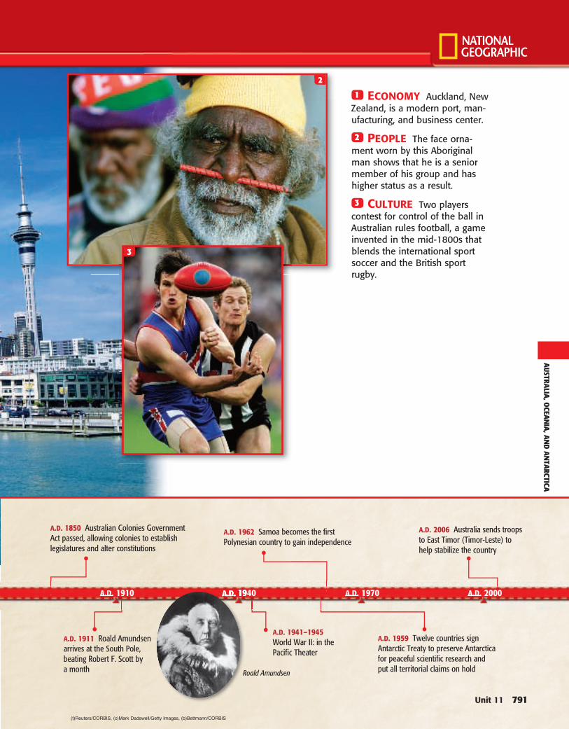
2
1 ECONOMY Auckland, New Zealand, is a modern port, man-ufacturing, and business center.
2 PEOPLE The face orna-ment worn by this Aboriginal man shows that he is a senior member of his group and has higher status as a result.
3 CULTURE Two players contest for control of the ball in Australian rules football, a game invented in the mid-1800s that blends the international sport soccer and the British sport rugby.
3
A.D. 1959 Twelve countries sign Antarctic Treaty to preserve Antarctica for peaceful scientific research and put all territorial claims on hold
A.D. 1941–1945 World War II: in the Pacific Theater
A.D. 2006 Australia sends troops to East Timor (Timor-Leste) to help stabilize the country
A.D. 1962 Samoa becomes the first Polynesian country to gain independence
A.D. 1850 Australian Colonies Government Act passed, allowing colonies to establish legislatures and alter constitutions
A.D. 1911 Roald Amundsen arrives at the South Pole, beating Robert F. Scott by a month Roald Amundsen
AUSTRA
LIA, O
CEAN
IA, A
ND
AN
TARCTICA
(t)Reuters/CORBIS , (c)Mark Dadswell/Getty Images , (b)Bettmann/CORBIS
792 Unit 11
UNIT 11 REGIONAL ATLAS
PHYSICAL Australia, Oceania, and Antarctica
Unit 11 793
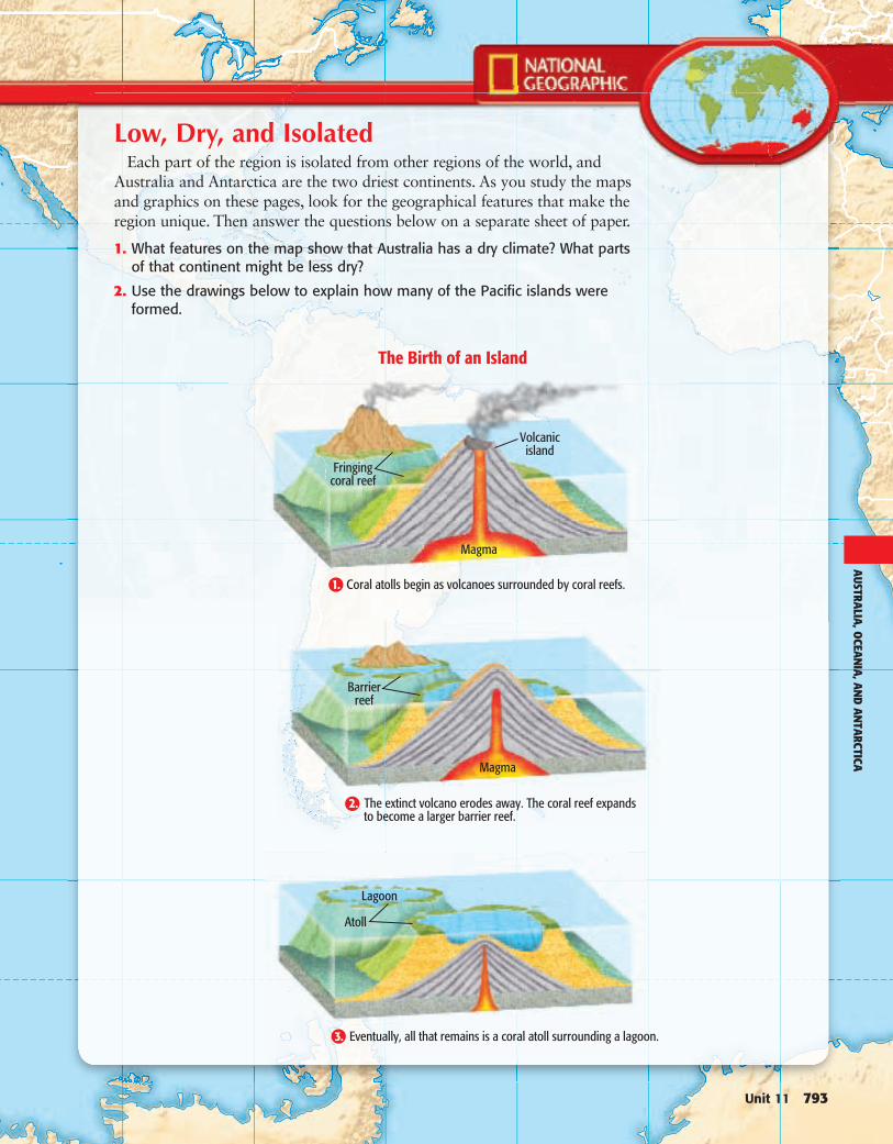
Low, Dry, and IsolatedEach part of the region is isolated from other regions of the world, and
Australia and Antarctica are the two driest continents. As you study the maps and graphics on these pages, look for the geographical features that make the region unique. Then answer the questions below on a separate sheet of paper.
1. What features on the map show that Australia has a dry climate? What parts of that continent might be less dry?
2. Use the drawings below to explain how many of the Pacific islands were formed.
2.
Atoll
Eventually, all that remains is a coral atoll surrounding a lagoon.
Lagoon
AUSTRA
LIA, O
CEAN
IA, A
ND
AN
TARCTICA
794 Unit 11
UNIT 11 REGIONAL ATLAS
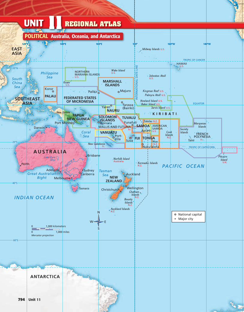
POLITICAL Australia, Oceania, and Antarctica
Unit 11 795
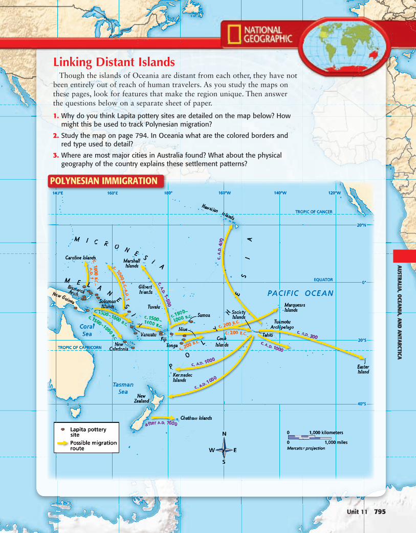
Linking Distant IslandsThough the islands of Oceania are distant from each other, they have not
been entirely out of reach of human travelers. As you study the maps on these pages, look for features that make the region unique. Then answer the questions below on a separate sheet of paper.
1. Why do you think Lapita pottery sites are detailed on the map below? How might this be used to track Polynesian migration?
2. Study the map on page 794. In Oceania what are the colored borders and red type used to detail?
3. Where are most major cities in Australia found? What about the physical geography of the country explains these settlement patterns?
POLYNESIAN IMMIGRATION
AUSTRA
LIA, O
CEAN
IA, A
ND
AN
TARCTICA
796 Unit 11
UNIT 11 REGIONAL ATLAS
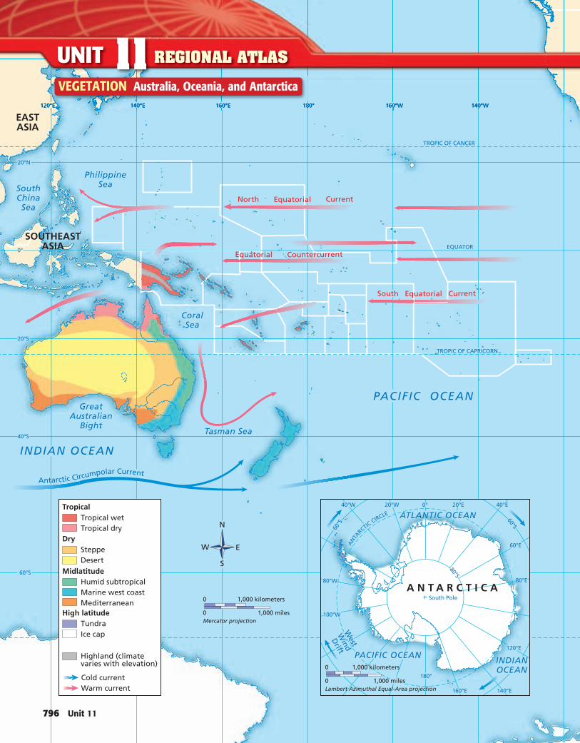
VEGETATION Australia, Oceania, and Antarctica
Unit 11 797
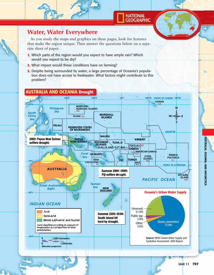
Water, Water EverywhereAs you study the maps and graphics on these pages, look for features
that make the region unique. Then answer the questions below on a sepa-rate sheet of paper.
1. Which parts of the region would you expect to have ample rain? Which would you expect to be dry?
2. What impact would these conditions have on farming?
3. Despite being surrounded by water, a large percentage of Oceania’s popula-tion does not have access to freshwater. What factors might contribute to this problem?
AUSTRALIA AND OCEANIA Drought
AUSTRA
LIA, O
CEAN
IA, A
ND
AN
TARCTICA
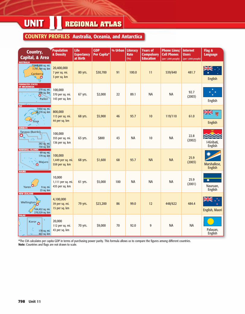
Country, Capital, & Area
Population & Density
Life Expectancyat Birth
GDPPer Capita*
% Urban Literacy Rate (%)
Years ofCompulsoryEducation
Phone Lines/ Cell Phones (per 1,000 people)
Internet Users (per 1,000 people)
Flag &Language
20,400,0007 per sq. mi.3 per sq. km
80 yrs. $30,700 91 100.0 11 539/640 481.7
English
100,000370 per sq. mi.143 per sq. km
67 yrs. $2,000 22 89.1 NA NA92.7
(2003)English
800,000113 per sq. mi.44 per sq. km
68 yrs. $5,900 46 93.7 10 119/110 61.0
English
100,000355 per sq. mi.136 per sq. km
63 yrs. $800 43 NA 10 NA22.8
(2002) I-Kiribati, English
100,0001,449 per sq. mi.559 per sq. km
68 yrs. $1,600 68 93.7 NA NA25.9
(2003) Marshallese, English
10,0001,111 per sq. mi.435 per sq. km
61 yrs. $5,000 100 NA NA NA25.9
(2001) Nauruan, English
4,100,00039 per sq. mi.15 per sq. km
79 yrs. $23,200 86 99.0 12 448/622 484.4
English, Maori
20,000112 per sq. mi.43 per sq. km
70 yrs. $9,000 70 92.0 9 NA NAPalauan, English
COUNTRY PROFILES Australia, Oceania, and Antarctica
798 Unit 11
UNIT 11 REGIONAL ATLAS
2,988,888 sq. mi.7,741,184 sq. km
270 sq. mi.699 sq. km
7,054 sq. mi.18,270 sq. km
282 sq. mi.730 sq. km
69 sq. mi.179 sq. km
9 sq. mi.23 sq. km
104,452 sq. mi.270,529 sq. km
178 sq. mi.461 sq. km
* The CIA calculates per capita GDP in terms of purchasing power parity. This formula allows us to compare the figures among different countries. Note: Countries and flags are not drawn to scale.
AUSTRALIA
FEDERATED STATESOF MICRONESIA
FIJI
KIRIBATI
MARSHALL ISLANDS
NAURU
NEW ZEALAND
PALAU
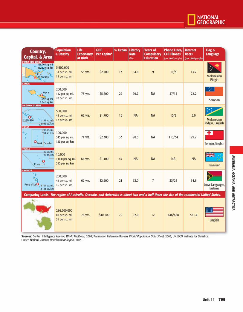
Country, Capital, & Area
Population & Density
Life Expectancyat Birth
GDPPer Capita*
% Urban Literacy Rate (%)
Years ofCompulsoryEducation
Phone Lines/ Cell Phones (per 1,000 people)
Internet Users (per 1,000 people)
Flag &Language
5,900,00033 per sq. mi.13 per sq. km
55 yrs. $2,200 13 64.6 9 11/3 13.7Melanesian
Pidgin
200,000182 per sq. mi.70 per sq. km
73 yrs. $5,600 22 99.7 NA 57/15 22.2
Samoan
500,00045 per sq. mi.17 per sq. km
62 yrs. $1,700 16 NA NA 15/2 5.0Melanesian
Pidgin, English
100,000345 per sq. mi.133 per sq. km
71 yrs. $2,300 33 98.5 NA 113/34 29.2
Tongan, English
10,0001,000 per sq. mi.385 per sq. km
64 yrs. $1,100 47 NA NA NA NA
Tuvaluan
200,00042 per sq. mi.16 per sq. km
67 yrs. $2,900 21 53.0 7 33/24 34.6Local Languages,
Bislama
Comparing Lands: The region of Australia, Oceania, and Antarctica is about two and a half times the size of the continental United States.
296,500,00080 per sq. mi.31 per sq. km
78 yrs. $40,100 79 97.0 12 646/488 551.4English
Unit 11 799
178,703 sq. mi.462,839 sq. km
Sources: Central Intelligence Agency, World Factbook, 2005; Population Reference Bureau, World Population Data Sheet, 2005; UNESCO Institute for Statistics; United Nations, Human Development Report, 2005.
11,158 sq. mi.28,899 sq. km
290 sq. mi.751 sq. km
10 sq. mi.26 sq. km
4,707 sq. mi.12,191 sq. km
1,097 sq. mi.2,841 sq. km
AUSTRA
LIA, O
CEAN
IA, A
ND
AN
TARCTICA
SOLOMON ISLANDS
TONGA
TUVALU
VANUATU
PAPUA NEW GUINEA
SAMOA
800 Unit 11
Why It MattersA study of the physical geography of Australia, Oceania, and Antarctica reveals a region of extreme differences — from the dry Australian Outback to the vol-canic islands of the Pacific to the cold ice cap of Antarctica. Each of these subregions offers unique opportunities for economic growth, tourism, and scientific research.
Section 1: The LandThe physical environment affects people and their activities. Australians have adapted to life in a country with large expanses of dry, flat land. People in Oceania take advantage of the volcanic soil of many of the islands.
Section 2: Climate and VegetationThe physical environment affects people and their activities. Australia is characterized by several different climates, while most of Oceania has a tropical wet climate and New Zealand has a marine west coast climate. Each type of climate affects human activities.
Geography ONLINE
Chapter Overview Visit the World Geography and Cultures Web site at glencoe.com and click on Chapter Overviews—Chapter 32 to preview infor-mation about the physical geography of the region.
CHAPTER
PHYSICAL GEOGRAPHY OF
Australia, Oceania, and Antarctica
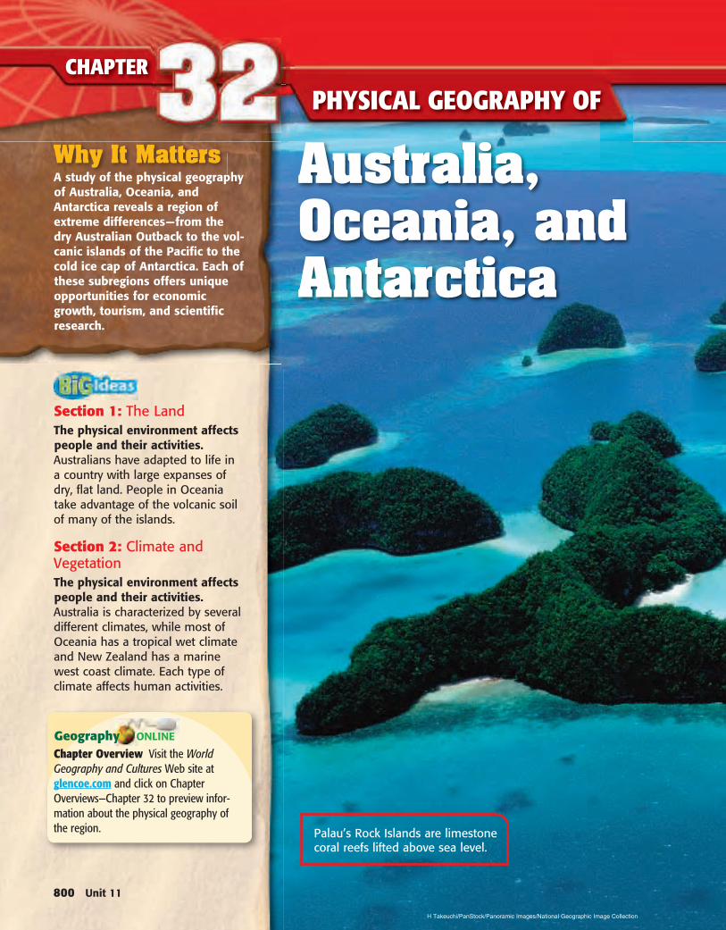
Palau’s Rock Islands are limestone coral reefs lifted above sea level.
H Takeuchi/PanStock/Panoramic Images/National Geographic Image Collection
AUSTRA
LIA, O
CEAN
IA, A
ND
AN
TARCTICA
Reading and Writing As you read the chapter, write notes under the appropriate tab about the physical geog-raphy of the three subregions discussed in this chapter.
Summarizing Information Create a Three-Tab Book to summarize information about the physical geog-raphy of Australia, Oceania, and Antarctica. Write the name of a sub-region on each of the three tabs.
Chapter 32 801
802 Unit 11
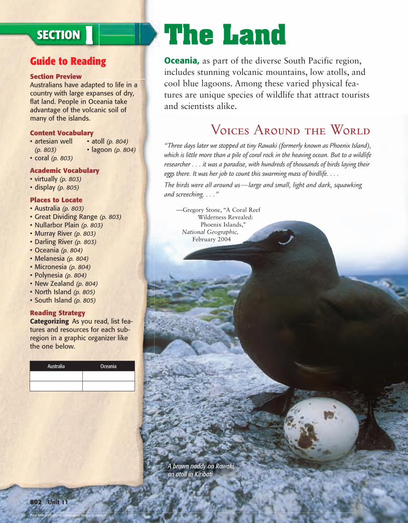
The LandOceania, as part of the diverse South Pacific region, includes stunning volcanic mountains, low atolls, and cool blue lagoons. Among these varied physical fea-tures are unique species of wildlife that attract tourists and scientists alike.
Voices Around the World“Three days later we stopped at tiny Rawaki (formerly known as Phoenix Island), which is little more than a pile of coral rock in the heaving ocean. But to a wildlife researcher . . . it was a paradise, with hundreds of thousands of birds laying their eggs there. It was her job to count this swarming mass of birdlife. . . .
The birds were all around us — large and small, light and dark, squawking and screeching. . . .”
— Gregory Stone, “A Coral Reef Wilderness Revealed: Phoenix Islands,”
National Geographic, February 2004
Guide to ReadingSection PreviewAustralians have adapted to life in a country with large expanses of dry, flat land. People in Oceania take advantage of the volcanic soil of many of the islands.
Content Vocabulary
Academic Vocabulary• virtually (p. 803)• display (p. 805)
Places to Locate• Australia (p. 803)• Great Dividing Range (p. 803)• Nullarbor Plain (p. 803)• Murray River (p. 803)• Darling River (p. 803)• Oceania (p. 804)• Melanesia (p. 804)• Micronesia (p. 804)• Polynesia (p. 804)• New Zealand (p. 804)• North Island (p. 805)• South Island (p. 805)
Reading StrategyCategorizing As you read, list fea-tures and resources for each sub-region in a graphic organizer like the one below.
SECTION 1
• artesian well (p. 803)
• coral (p. 803)
• atoll (p. 804)• lagoon (p. 804)
A brown naddy on Rawaki, an atoll in Kiribati
Australia Oceania
Paul Nicklen/National Geographic Image Collection
Chapter 32 803
AustraliaMAIN MAIN IdeaIdea Australia’s physical environment con-
tributes in various ways to the country’s economy.
GEOGRAPHY AND YOU How does the Mississippi River contribute to the U.S. economy? Read to learn how Australia’s rivers contribute to its agriculture.
As the only place on the Earth that is both a continent and a country, Australia is unique. Although water surrounds Australia in the same way as an island, geographers classify it as a con-tinent because of its tremendous size.
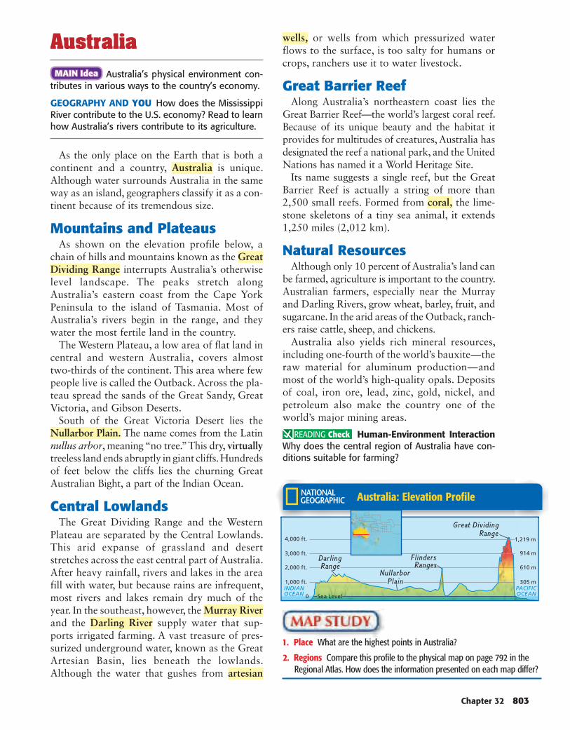
Mountains and PlateausAs shown on the elevation profile below, a
chain of hills and mountains known as the Great Dividing Range interrupts Australia’s otherwise level landscape. The peaks stretch along Australia’s eastern coast from the Cape York Peninsula to the island of Tasmania. Most of Australia’s rivers begin in the range, and they water the most fertile land in the country.
The Western Plateau, a low area of flat land in central and western Australia, covers almost two-thirds of the continent. This area where few people live is called the Outback. Across the pla-teau spread the sands of the Great Sandy, Great Victoria, and Gibson Deserts.
South of the Great Victoria Desert lies the Nullarbor Plain. The name comes from the Latin nullus arbor, meaning “no tree.” This dry, virtuallytreeless land ends abruptly in giant cliffs. Hundreds of feet below the cliffs lies the churning Great Australian Bight, a part of the Indian Ocean.
Central LowlandsThe Great Dividing Range and the Western
Plateau are separated by the Central Lowlands. This arid expanse of grassland and desert stretches across the east central part of Australia. After heavy rainfall, rivers and lakes in the area fill with water, but because rains are infrequent, most rivers and lakes remain dry much of the year. In the southeast, however, the Murray Riverand the Darling River supply water that sup-ports irrigated farming. A vast treasure of pres-surized underground water, known as the Great Artesian Basin, lies beneath the lowlands. Although the water that gushes from artesian
wells, or wells from which pressurized water flows to the surface, is too salty for humans or crops, ranchers use it to water livestock.
Great Barrier ReefAlong Australia’s northeastern coast lies the
Great Barrier Reef—the world’s largest coral reef. Because of its unique beauty and the habitat it provides for multitudes of creatures, Australia has designated the reef a national park, and the United Nations has named it a World Heritage Site.
Its name suggests a single reef, but the Great Barrier Reef is actually a string of more than 2,500 small reefs. Formed from coral, the lime-stone skeletons of a tiny sea animal, it extends 1,250 miles (2,012 km).
Natural ResourcesAlthough only 10 percent of Australia’s land can
be farmed, agriculture is important to the country. Australian farmers, especially near the Murray and Darling Rivers, grow wheat, barley, fruit, and sugarcane. In the arid areas of the Outback, ranch-ers raise cattle, sheep, and chickens.
Australia also yields rich mineral resources, including one-fourth of the world’s bauxite — the raw material for aluminum production — and most of the world’s high-quality opals. Deposits of coal, iron ore, lead, zinc, gold, nickel, and petroleum also make the country one of the world’s major mining areas.
Human-Environment Interac tionWhy does the central region of Australia have con-ditions suitable for farming?
Australia: Elevation Profile
1. Place What are the highest points in Australia?
2. Regions Compare this profile to the physical map on page 792 in the Regional Atlas. How does the information presented on each map differ?
804 Unit 11
OceaniaMAIN MAIN IdeaIdea Life on the islands of Oceania is influ-
enced by the type of island and the physical pro-cess by which it was formed.
GEOGRAPHY AND YOU What other islands around the world have been formed as a result of tectonic activity? Read to learn which islands in Oceania were formed through similar processes.
Thousands of islands, differing in size and extending across millions of square miles of the Pacific Ocean, form the region called Oceania(oh•shee•A•nee•uh). Some islands were created by colliding tectonic plates millions of years ago. Other islands were created by volcanic hot spots.
Island GroupsOceania’s islands are classified into three
groups, based on location, how the islands formed, and the inhabitants’ cultures. Melanesia, meaning “black islands,” lies north and east of Australia. The “little islands” of Micronesiaextend north of Melanesia. Polynesia, or “many islands,” spans an area larger than either Melanesia or Micronesia, ranging from Midway Island in the north to New Zealand in the south.
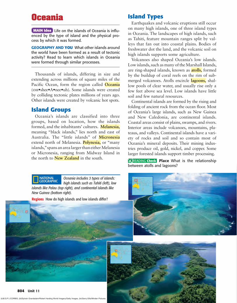
Island TypesEarthquakes and volcanic eruptions still occur
on many high islands, one of three island types in Oceania. The landscapes of high islands, such as Tahiti, feature mountain ranges split by val-leys that fan out into coastal plains. Bodies of freshwater dot the land, and the volcanic soil on high islands supports some agriculture.
Volcanoes also shaped Oceania’s low islands. Low islands, such as many of the Marshall Islands, are ring-shaped islands, known as atolls, formed by the buildup of coral reefs on the rim of sub-merged volcanoes. Atolls encircle lagoons, shal-low pools of clear water, and usually rise only a few feet above sea level. Low islands have little soil and few natural resources.
Continental islands are formed by the rising and folding of ancient rock from the ocean floor. Most of Oceania’s large islands, such as New Guinea and New Caledonia, are continental islands. Coastal areas consist of plains, swamps, and rivers. Interior areas include volcanoes, mountains, pla-teaus, and valleys. Continental islands have a vari-ety of rocks and soil and so contain most of Oceania’s mineral deposits. Their mining indus-tries produce oil, gold, nickel, and copper. Some larger forested islands support timber processing.
Place What is the relationship between atolls and lagoons?
Oceania includes 3 types of islands: high islands such as Tahiti (left), low
islands like Palau (top right), and continental islands like New Guinea (bottom right).
Regions How do high islands and low islands differ?
(tr)B.S.P.I./CORBIS , (bl)Sylvain Grandadam/Robert Harding World Imagery/Getty Images , (br)Gerry Ellis/Minden Pictures
AUSTRA
LIA, O
CEAN
IA, A
ND
AN
TARCTICA
Geography ONLINE
Study Central™ To review this section, go to glencoe.com and click on Study Central.
SECTION 1 REVIEWVocabulary 1. Explain the significance of: artesian well, coral, atoll, lagoon.
Main Ideas 2. How does Australia’s physical environment contribute to the
country’s economy? Give examples. 3. Describe examples of how people in New Zealand utilize ele-
ments of the physical environment to make a living. 4. Complete a table like the one below by describing the three
types of islands in Oceania and how human activity on the island is influenced by the type of island and the process by which it was formed.
Critical Thinking 5. Comparing and Contrasting Identify similarities
and differences between New Zealand’s two main islands and a high island such as Tahiti.
6. Making Decisions Of the three types of islands found in Oceania, which type would you choose for a home? Why?
7. Analyzing Visuals Study the physical map on page 792 of the Regional Atlas. Which parts of Australia have the highest elevation?
Writing About Geography 8. Expository Writing Consider the location of Oceania’s
islands in relation to other parts of the world. Write a para-graph explaining how this location might affect the develop-ment of natural resources, including plants and animals.
Geography ONLINE
Study Central™ To review this section, go to glencoe.com and click on Study Central.
Island Description Life Low island High island Continental island
New ZealandMAIN MAIN IdeaIdea People in New Zealand utilize elements
of the physical environment to make a living.
GEOGRAPHY AND YOU What advantages do areas of volcanic activity offer people? Read to learn how New Zealanders take advantage of living in an area of tectonic activity.
Located southeast of Australia, New Zealand’s North Island and South Island display sandy beaches, emerald hillsides, and snow-tipped mountains. North Island’s northern region includes golden beaches, ancient forests, and rich soil. A central plateau of volcanic stone fea-tures hot springs and several active volcanoes. Chief among them is Mount Ruapehu (roo•uh•PAY•hoo), North Island’s highest point. Shining freshwater lakes appear through-out the plateau. East of the plateau, a band of hills runs north and south.
The towering, snowy peaks of the Southern Alps run along South Island’s western edge. New Zealand’s earliest inhabitants, the Maori, named the highest peak on South Island Aorangi (ow•RAHNG•ee), which means “cloud piercer.”
Today, Aorangi is known as Mount Cook and rises to 12,316 feet (3,754 m). This high country also features sparkling lakes, carved by glaciers, and tumbling rivers. The Canterbury Plains, New Zealand’s flattest and most fertile land, lie on the eastern coast. Rugged cliffs, deep fjords, and coastal caves dot the western coast.
New Zealand’s fertile volcanic soil, perhaps its most important resource, greatly benefits the country’s economy. About half of the land sup-ports crops and livestock. New Zealand’s sheep and wool products dominate exports, and its forests yield valuable timber. The country’s riv-ers and dams produce abundant hydroelectric power. New Zealand also uses geothermal energy, here provided by water heated under-ground by volcanoes, to generate power.
Place What natural resources does New Zealand’s physical environment provide?
Geography ONLINE
Student Web Activity Visit the World Geography and Cultures Web site at glencoe.com and click on Student Web Activities—Chapter 32 for an activity about the Ring of Fire.
Chapter 32 805
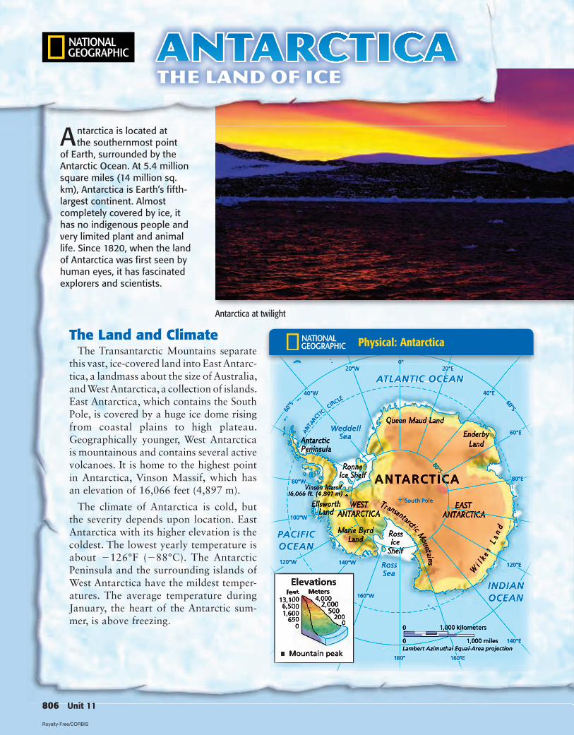
Antarctica at twilight
Antarctica is located at the southernmost point
of Earth, surrounded by the Antarctic Ocean. At 5.4 million square miles (14 million sq. km), Antarctica is Earth’s fifth-largest continent. Almost completely covered by ice, it has no indigenous people and very limited plant and animal life. Since 1820, when the land of Antarctica was first seen by human eyes, it has fascinated explorers and scientists.
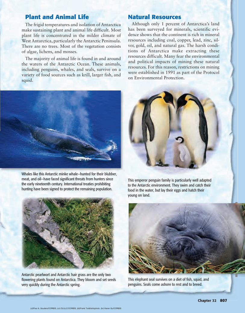
The Land and ClimateThe Transantarctic Mountains separate
this vast, ice-covered land into East Ant arc-tica, a landmass about the size of Aus tralia, and West Antarctica, a collection of islands. East Antarctica, which contains the South Pole, is covered by a huge ice dome rising from coastal plains to high plateau. Geographically younger, West Antarctica is mountainous and contains several active volcanoes. It is home to the highest point in Antarctica, Vinson Massif, which has an elevation of 16,066 feet (4,897 m).
The climate of Antarctica is cold, but the severity depends upon location. East Antarctica with its higher elevation is the coldest. The lowest yearly temperature is about 126°F ( 88°C). The Antarctic Peninsula and the surrounding islands of West Antarctica have the mildest temper-atures. The average temperature during January, the heart of the Antarctic sum-mer, is above freezing.
AntarcticaThe Land of Ice
806 Unit 11
Physical: Antarctica
Royalty-Free/CORBIS
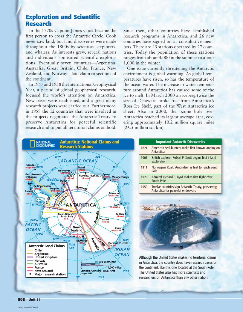
Plant and Animal LifeThe frigid temperatures and isolation of Antarctica
make sustaining plant and animal life difficult. Most plant life is concentrated in the milder climate of West Antarctica, particularly the Antarctic Peninsula. There are no trees. Most of the vegetation consists of algae, lichens, and mosses.
The majority of animal life is found in and around the waters of the Antarctic Ocean. These animals, including penguins, whales, and seals, survive on a variety of food sources such as krill, larger fish, and squid.
Natural ResourcesAlthough only 1 percent of Antarctica’s land
has been surveyed for minerals, scientific evi-dence shows that the continent is rich in mineral resources including coal, copper, lead, zinc, sil-ver, gold, oil, and natural gas. The harsh condi-tions of Antarctica make extracting these resources difficult. Many fear the environmental and political impacts of mining these natural resources. For this reason, restrictions on mining were established in 1991 as part of the Protocol on Environmental Protection.
Chapter 32 807
This emperor penguin family is particularly well adapted to the Antarctic environment. They swim and catch their food in the water, but lay their eggs and hatch their young on land.
Whales like this Antarctic minke whale—hunted for their blubber, meat, and oil—have faced significant threats from hunters since the early nineteenth century. International treaties prohibiting hunting have been signed to protect the remaining population.
Antarctic pearlwort and Antarctic hair grass are the only two flowering plants found on Antarctica. They bloom and set seeds very quickly during the Antarctic spring.
This elephant seal survives on a diet of fish, squid, and penguins. Seals come ashore to rest and to breed.
(cl)Paul A. Souders/CORBIS , (cr) DLILLC/CORBIS , (bl)Frank Todd/articphoto . (br) Keren Su/CORBIS
Exploration and Scientific Research
In the 1770s Captain James Cook became the first person to cross the Antarctic Circle. Cook never saw land, but land discoveries were made throughout the 1800s by scientists, explorers, and whalers. As interests grew, several nations and individuals sponsored scientific explora-tions. Eventually seven countries—Argentina, Australia, Great Britain, Chile, France, New Zealand, and Norway—laid claim to sections of the continent.
In 1957 and 1958 the International Geophysical Year, a period of global geophysical research, focused the world’s attention on Antarctica. New bases were established, and a great many research projects were carried out. Furthermore, in 1959 the 12 countries that were involved in the projects negotiated the Antarctic Treaty to preserve Antarctica for peaceful scientific research and to put all territorial claims on hold.
Important Antarctic Discoveries1821 American seal hunters make first known landing on
Antarctica
1901 British explorer Robert F. Scott begins first inland exploration
1911 Norwegian Roald Amundsen is first to reach South Pole
1929 Admiral Richard E. Byrd makes first flight over South Pole
1959 Twelve countries sign Antarctic Treaty, preserving Antarctica for peaceful endeavors
Since then, other countries have established research programs in Antarctica, and 26 new countries have signed on as consultative mem-bers. There are 43 stations operated by 27 coun-tries. Today the population of these stations ranges from about 4,000 in the summer to about 1,000 in the winter.
One issue currently threatening the Antarctic environment is global warming. As global tem-peratures have risen, so has the temperature of the ocean water. The increase in water tempera-ture around Antarctica has caused some of the ice to melt. In March 2000 an iceberg twice the size of Delaware broke free from Antarctica’s Ross Ice Shelf, part of the West Antarctica ice sheet. Also in 2000, the ozone hole over Antarctica reached its largest average area, cov-ering approximately 10.2 million square miles (26.5 million sq. km).
808 Unit 11
Although the United States makes no territorial claims in Antarctica, the country does have research bases on the continent, like this one located at the South Pole. The United States also has more scientists and researchers on Antarctica than any other nation.
Antarctica: National Claims and Research Stations
Galen Rowell/CORBIS
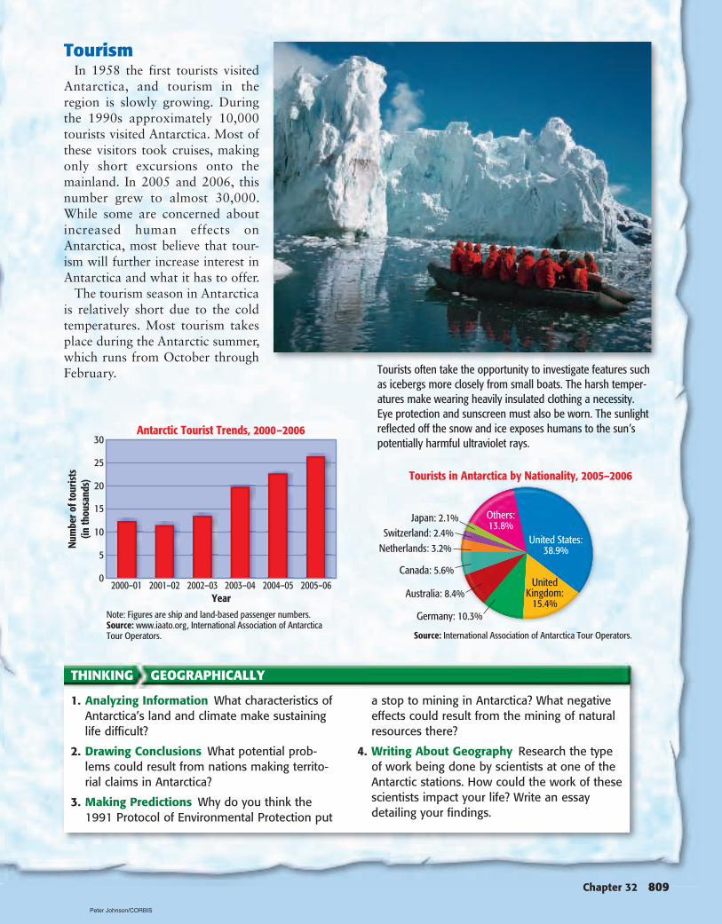
TourismIn 1958 the first tourists visited
Antarctica, and tourism in the region is slowly growing. During the 1990s approximately 10,000 tourists visited Antarctica. Most of these visitors took cruises, making only short excursions onto the mainland. In 2005 and 2006, this number grew to almost 30,000. While some are concerned about increased human effects on Antarctica, most believe that tour-ism will further increase interest in Antarctica and what it has to offer.
The tourism season in Antarctica is relatively short due to the cold temperatures. Most tourism takes place during the Antarctic summer, which runs from October through February.
Chapter 32 809
Tourists often take the opportunity to investigate features such as icebergs more closely from small boats. The harsh temper-atures make wearing heavily insulated clothing a necessity. Eye protection and sunscreen must also be worn. The sunlight reflected off the snow and ice exposes humans to the sun’s potentially harmful ultraviolet rays.
THINKING GEOGRAPHICALLY
1. Analyzing Information What characteristics of Antarctica’s land and climate make sustaining life difficult?
2. Drawing Conclusions What potential prob-lems could result from nations making territo-rial claims in Antarctica?
3. Making Predictions Why do you think the 1991 Protocol of Environmental Protection put
a stop to mining in Antarctica? What negative effects could result from the mining of natural resources there?
4. Writing About Geography Research the type of work being done by scientists at one of the Antarctic stations. How could the work of these scientists impact your life? Write an essay detailing your findings.
Peter Johnson/CORBIS
SECTION 2Guide to ReadingSection PreviewAustralia is characterized by several different climates, while most of Oceania has a tropical wet climate and New Zealand has a marine west coast climate. Each type of climate affects human activities.
Content Vocabulary
Academic Vocabulary• framework (p. 811)• occupy (p. 812)
Places to Locate• Western Plateau (p. 811)• Southern Alps (p. 812)
Reading StrategyOrganizing As you read, use an outline like the one below to take notes about the climate and vege-tation of Australia, Oceania, and New Zealand.
810 Unit 11
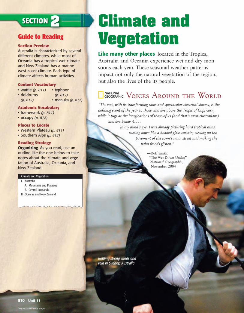
Climate and VegetationLike many other places located in the Tropics, Australia and Oceania experience wet and dry mon-soons each year. These seasonal weather patterns impact not only the natural vegetation of the region, but also the lives of the its people.
Voices Around the World“The wet, with its transforming rains and spectacular electrical storms, is the defining event of the year to those who live above the Tropic of Capricorn, while it tugs at the imaginations of those of us (and that’s most Australians)
who live below it. . . . In my mind’s eye, I was already picturing hard tropical rains
coming down like a beaded glass curtain, sizzling on the pavement of the town’s main street and making the
palm fronds glisten.”
— Roff Smith, “The Wet Down Under,” National Geographic, November 2004
• wattle (p. 811) • doldrums
(p. 812)
• typhoon (p. 812)
• manuka (p. 812)
Climate and Vegetation
I. Australia A. Mountains and Plateaus B. Central Lowlands II. Oceania and New Zealand
Battling strong winds and rain in Sydney, Australia
Greg Wood/AFP/Getty Images
AustraliaMAIN MAIN IdeaIdea Variations in rainfall affect Australia’s
climate and vegetation.
GEOGRAPHY AND YOU Does the region in which you live receive little or much rainfall? Read to learn how rainfall influences climate in Australia.
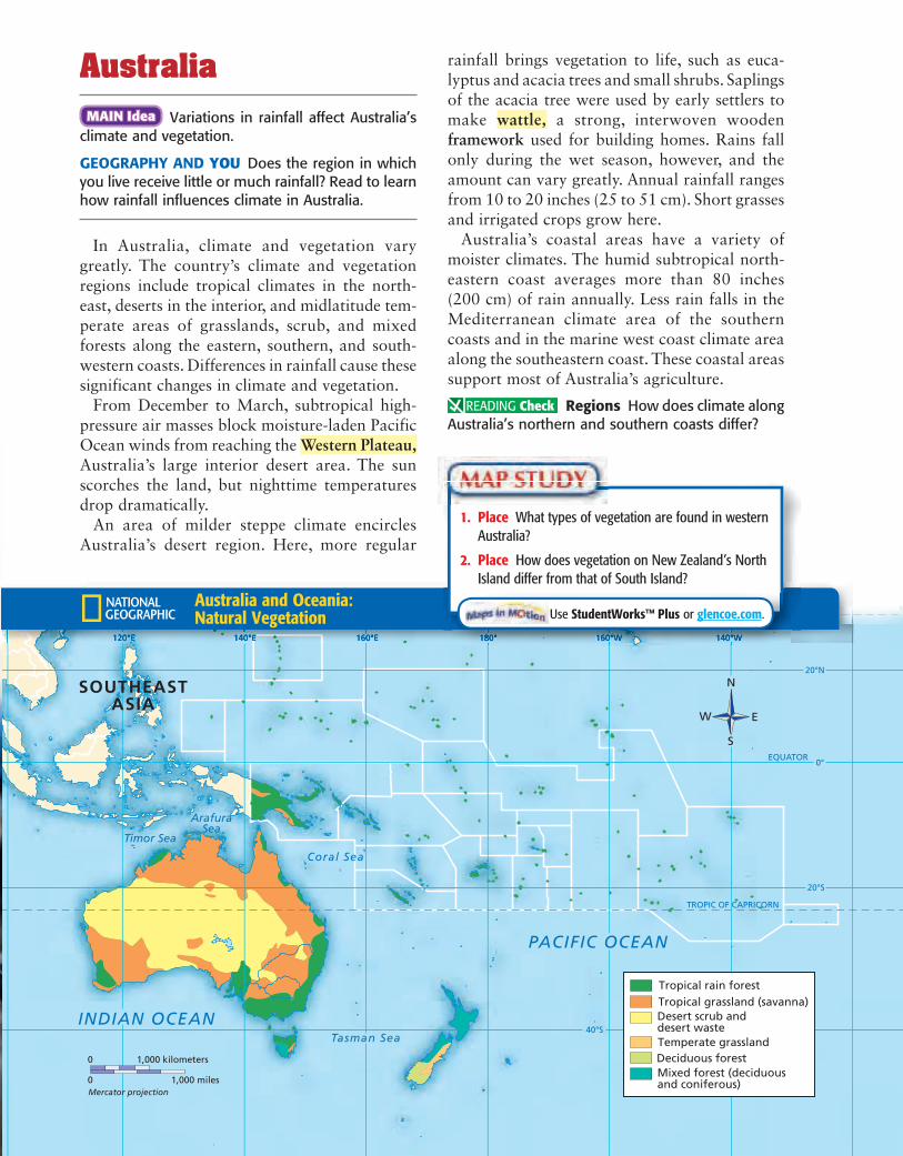
In Australia, climate and vegetation vary greatly. The country’s climate and vegetation regions include tropical climates in the north-east, deserts in the interior, and midlatitude tem-perate areas of grasslands, scrub, and mixed forests along the eastern, southern, and south-western coasts. Differences in rainfall cause these significant changes in climate and vegetation.
From December to March, subtropical high-pressure air masses block moisture-laden Pacific Ocean winds from reaching the Western Plateau,Australia’s large interior desert area. The sun scorches the land, but nighttime temperatures drop dramatically.
An area of milder steppe climate encircles Australia’s desert region. Here, more regular
rainfall brings vegetation to life, such as euca-lyptus and acacia trees and small shrubs. Saplings of the acacia tree were used by early settlers to make wattle, a strong, interwoven wooden framework used for building homes. Rains fall only during the wet season, however, and the amount can vary greatly. Annual rainfall ranges from 10 to 20 inches (25 to 51 cm). Short grasses and irrigated crops grow here.
Australia’s coastal areas have a variety of moister climates. The humid subtropical north-eastern coast averages more than 80 inches (200 cm) of rain annually. Less rain falls in the Mediterranean climate area of the southern coasts and in the marine west coast climate area along the southeastern coast. These coastal areas support most of Australia’s agriculture.
Regions How does climate along Australia’s northern and southern coasts differ?
Australia and Oceania: Natural Vegetation
1. Place What types of vegetation are found in western Australia?
2. Place How does vegetation on New Zealand’s North Island differ from that of South Island?
Use StudentWorks™ Plus or glencoe.com.
Vocabulary 1. Explain the significance of: wattle, doldrums, typhoon, manuka.
Main Ideas 2. Why is Oceania characterized by a tropical wet climate? 3. Describe New Zealand’s marine west coast climate. What does
it provide? 4. Complete a table like the one below to explain how variations
in rainfall affect Australia’s climate and vegetation.
Critical Thinking 5. Making Inferences How does elevation affect
climate patterns in New Zealand? 6. Identifying Cause and Effect How do Pacific ocean currents
and winds affect the climate and vegetation of Oceania? 7. Analyzing Visuals Study the vegetation map on page 811.
What type of vegetation is suitable for raising livestock?
Writing About Geography 8. Expository Writing Write a paragraph explaining how climate
relates to the way farmers operate in New Zealand and Australia.
SECTION 2 REVIEW
Geography ONLINE
Study Central™ To review this section, go to glencoe.com and click on Study Central.
currents meet. The calm within the doldrums can change to violent storms called typhoons.
A marine west coast climate is found in most of New Zealand. Ocean winds warm the land in winter and cool it in summer, preventing tem-perature extremes. Temperatures hover between 65°F (18°C) and 85°F (29°C) in summer and between 35°F (2°C) and 55°F (13°C) in winter.
Geographic differences also cause climatic variations. North Island’s central plateau is warm and sunny during summer, but mountain-tops may have snow year-round. Mountainous areas exposed to western winds generally have more rainfall than do other areas. Although the country as a whole averages 25 to 60 inches (64 to 152 cm) of rain annually, the Southern Alps on South Island have an average annual rainfall of 315 inches (800 cm).
New Zealand’s geographic isolation gives rise to unique plant life. Almost 90 percent of the country’s indigenous plants are native only to New Zealand. Manuka, a small shrub, carpets land where prehistoric volcanic eruptions destroyed ancient forests. Early settlers from Great Britain cut down almost all of the pinelike kauri trees, but some still grow among thriving evergreen forests. To address erosion in defor-ested areas, several tree species have been imported from Europe and North America.
Place How does rainfall vary from low islands to high islands?
Oceania and New ZealandMAIN MAIN IdeaIdea Oceania is characterized by a tropical
wet climate, while New Zealand experiences a more temperate marine west coast climate.
GEOGRAPHY AND YOU What parts of the world have tropical climates? Read to learn why Oceania and New Zealand have different climates.
Much of Oceania lies between the Equator and the Tropic of Capricorn, so many islands have a tropical wet climate. Most days are warm year-round, ranging from 70°F (21°C) to 80°F (27°C). Seasons throughout most of Oceania alternate between wet and dry. The dry season features cloudless blue skies, but the wet season brings constant rain and high humidity. Low islands get little rainfall, but the larger land-masses of high islands give off warm, moisture-laden air. When this air rises and mixes with cool ocean breezes, heavy rains fall.
Only shrubs and grasses grow on dry, low islands, but coconut palms and other trees appear on islands with more rainfall. Hot, steamy rain forests thrive where heavy rains drench island interiors. A generally windless area called the doldrums occupies a narrow band near the Equator where opposing ocean
812 Unit 11
Climate Region Rainfall Vegetation
Tropical wet
VISUAL SUMMARY A
USTRALIA
, OCEA
NIA
, AN
D A
NTA
RCTICA
Chapter 32 813
CHAPTER 32Study anywhere, anytime by downloading quizzes and flashcards to your PDA from glencoe.com.
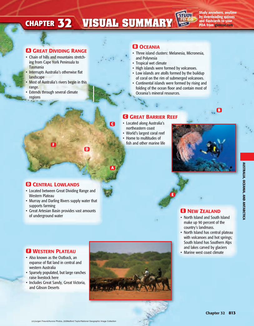
A GREAT DIVIDING RANGE• Chain of hills and mountains stretch-
ing from Cape York Peninsula to Tasmania
• Interrupts Australia’s otherwise flat landscape
• Most of Australia’s rivers begin in this range.
• Extends through several climate regions
F WESTERN PLATEAU• Also known as the Outback, an
expanse of flat land in central and western Australia
• Sparsely populated, but large ranches raise livestock here
• Includes Great Sandy, Great Victoria, and Gibson Deserts
D CENTRAL LOWLANDS• Located between Great Dividing Range and
Western Plateau• Murray and Darling Rivers supply water that
supports farming• Great Artesian Basin provides vast amounts
of underground water
C GREAT BARRIER REEF• Located along Australia’s
northeastern coast• World’s largest coral reef• Home to multitudes of
fish and other marine life
E NEW ZEALAND• North Island and South Island
make up 90 percent of the country’s landmass.
• North Island has central plateau with volcanoes and hot springs; South Island has Southern Alps and lakes carved by glaciers
• Marine west coast climate
B OCEANIA• Three island clusters: Melanesia, Micronesia,
and Polynesia• Tropical wet climate• High islands were formed by volcanoes.• Low islands are atolls formed by the buildup
of coral on the rim of submerged volcanoes.• Continental islands were formed by rising and
folding of the ocean floor and contain most of Oceania’s mineral resources.
A
C
F
E
D
B
(cr)Jurgen Freund/Aurora Photos , (bl)Medford Taylor/National Geographic Image Collection
GO ON
STANDARDIZED TEST PRACTICE
814 Unit 11
CHAPTER 32
Read all the choices before you select your answer. You can often eliminate one choice immediately. For example, if the choice has nothing to do with Australia, Oceania, and Antarctica, you can be sure it is not the correct answer.
Reviewing VocabularyDirections: Choose the word or words that best complete the sentence.
1. Pressurized water reaches Earth’s surface through .
A oases
B canyons
C ditches
D artesian wells
2. Ring-shaped islands that are made up of coral attached to submerged volcanoes are .
A artesian wells
B high islands
C atolls
D seamounts
3. Early settlers in Australia used acacia trees to make , a strong, woven framework for houses.
A posts
B logs
C thatch
D wattle
4. is a small shrub that grows on land where prehis-toric volcanoes destroyed ancient forests in New Zealand.
A Kauri
B Teak
C Kiwi
D Manuka
Reviewing Main IdeasDirections: Choose the best answers to the following questions.
Section 1 (pp. 802–805)5. Australia produces one-quarter of the world’s , the
raw material of aluminum.
A nickel
B iron ore
C manganese
D bauxite
6. In Oceania, which islands have the most mineral resources?
A atolls
B high islands
C Polynesia
D continental islands
Section 2 (pp. 810–812)7. In Australia the climates with the most rainfall are found in
.
A coastal areas
B the west
C the center of the country
D the south central area
8. Most of New Zealand has a climate.
A tropical wet
B marine west coast
C humid continental
D steppe
TEST-TAKING TIP
STOP
Chapter 32 815
ASSESSMENT
Geography ONLINE
For additional test practice, use Self-Check Quizzes—Chapter 32 on glencoe.com.
Critical ThinkingDirections: Choose the best answers to the following questions.
9. Why did early European explorers regard Australia as unin-viting for settlement?
A The coasts that they saw were mostly desert and steppe.
B They did not know how to use mineral ores.
C They saw thick forests, and they were uncomfortable in forests.
D The native people attacked them with sophisticated weapons.
Base your answer to question 10 on the map and on your knowledge of Chapter 32.
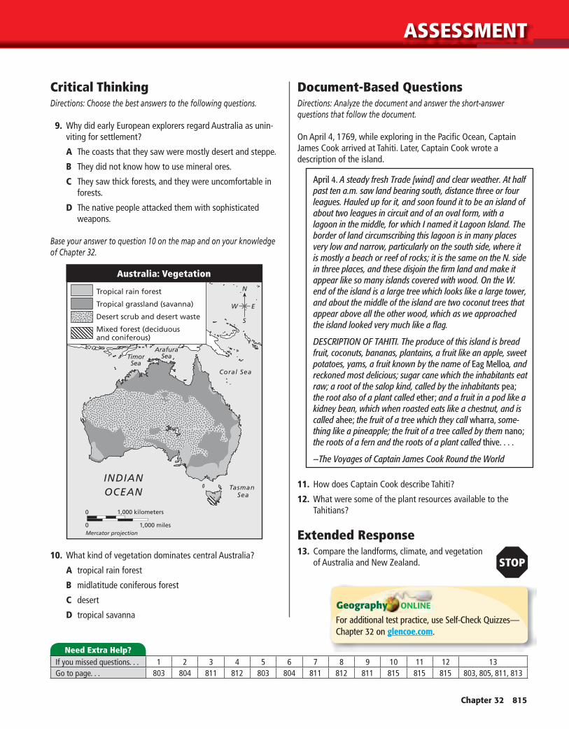
10. What kind of vegetation dominates central Australia?
A tropical rain forest
B midlatitude coniferous forest
C desert
D tropical savanna
Document-Based QuestionsDirections: Analyze the document and answer the short-answer questions that follow the document.
On April 4, 1769, while exploring in the Pacifi c Ocean, Captain James Cook arrived at Tahiti. Later, Captain Cook wrote a description of the island.
April 4. A steady fresh Trade [wind] and clear weather. At half past ten a.m. saw land bearing south, distance three or four leagues. Hauled up for it, and soon found it to be an island of about two leagues in circuit and of an oval form, with a lagoon in the middle, for which I named it Lagoon Island. The border of land circumscribing this lagoon is in many places very low and narrow, particularly on the south side, where it is mostly a beach or reef of rocks; it is the same on the N. side in three places, and these disjoin the fi rm land and make it appear like so many islands covered with wood. On the W. end of the island is a large tree which looks like a large tower, and about the middle of the island are two coconut trees that appear above all the other wood, which as we approached the island looked very much like a fl ag.
DESCRIPTION OF TAHITI. The produce of this island is bread fruit, coconuts, bananas, plantains, a fruit like an apple, sweet potatoes, yams, a fruit known by the name of Eag Melloa, and reckoned most delicious; sugar cane which the inhabitants eat raw; a root of the salop kind, called by the inhabitants pea; the root also of a plant called ether; and a fruit in a pod like a kidney bean, which when roasted eats like a chestnut, and is called ahee; the fruit of a tree which they call wharra, some-thing like a pineapple; the fruit of a tree called by them nano; the roots of a fern and the roots of a plant called thive. . . .
—The Voyages of Captain James Cook Round the World
11. How does Captain Cook describe Tahiti?
12. What were some of the plant resources available to the Tahitians?
Extended Response13. Compare the landforms, climate, and vegetation
of Australia and New Zealand.
INDIAN OCEAN Tasman
Sea
Coral Sea
ArafuraSeaTimor
Sea
N
S
W E
Mercator projection
Australia: Vegetation
If you missed questions. . . 1 2 3 4 5 6 7 8 9 10 11 12 13Go to page. . . 803 804 811 812 803 804 811 812 811 815 815 815 803, 805, 811, 813
Need Extra Help?


