Embed Size (px)
Citation preview
22 November 2019
PLANNING COMMITTEE - 4 DECEMBER 2019 A meeting of the Planning Committee will be held at 6.00pm on Wednesday 4 December 2019 in the Council Chamber at the Town Hall, Rugby. Adam Norburn Executive Director Note: Members are reminded that, when declaring interests, they should declare the existence and nature of their interests at the commencement of the meeting (or as soon as the interest becomes apparent). If that interest is a pecuniary interest, the Member must withdraw from the room unless one of the exceptions applies. Membership of Warwickshire County Council or any Parish Council is classed as a non-pecuniary interest under the Code of Conduct. A Member does not need to declare this interest unless the Member chooses to speak on a matter relating to their membership. If the Member does not wish to speak on the matter, the Member may still vote on the matter without making a declaration. A G E N D A
PART 1 – PUBLIC BUSINESS 1. Minutes.
To confirm the minutes of the meeting held on 6 November 2019. 2. Apologies.
To receive apologies for absence from the meeting.
3. Declarations of Interest. To receive declarations of – (a) non-pecuniary interests as defined by the Council’s Code of Conduct for
Councillors; (b) pecuniary interests as defined by the Council’s Code of Conduct for Councillors; and
(c) notice under Section 106 Local Government Finance Act 1992 – non-payment of Community Charge or Council Tax.
4. Applications for Consideration.
5. Advance Notice of Site Visits for Planning Applications – no advance notice of site visits has been received.
6. Delegated Decisions – 23 October 2019 – 19 November 2019.
PART 2 – EXEMPT INFORMATION
There is no business involving exempt information to be transacted.
Any additional papers for this meeting can be accessed via the website.
The Reports of Officers are attached.
Membership of the Committee:
Councillors Miss Lawrence (Chairman), Bearne, Mrs Brown, Brown, Butlin, Eccleson, Mrs Garcia, Gillias, Picker, Roodhouse, Sandison and Srivastava. If you have any general queries with regard to this agenda please contact Claire Waleczek, Democratic Services Team Leader (01788 533524 or e-mail [email protected]). Any specific queries concerning reports should be directed to the listed contact officer. If you wish to attend the meeting and have any special requirements for access please contact the Democratic Services Officer named above. The Council operates a public speaking procedure at Planning Committee. Details of the procedure, including how to register to speak, can be found on the Council’s website (www.rugby.gov.uk/speakingatplanning).
1
Agenda No 4
Planning Committee – 4 December 2019
Report of the Head of Growth and Investment
Applications for Consideration
Planning applications for consideration by the Committee are set out as below.
• Applications recommended for refusal with the reason(s) for refusal (pink pages on the printed version of the agenda)
• Applications recommended for approval with suggested conditions (yellow pages on the printed version of the agenda)
Recommendation
The applications be considered and determined.
2
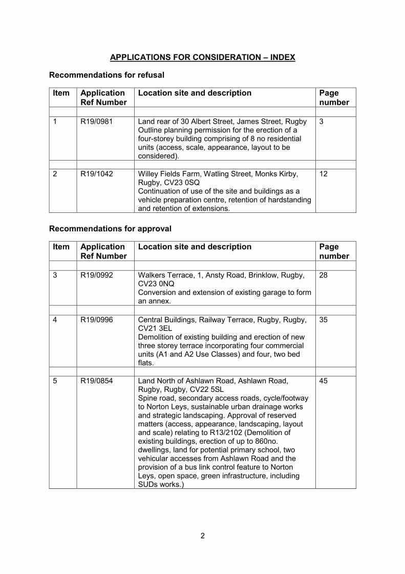
APPLICATIONS FOR CONSIDERATION – INDEX
Recommendations for refusal
Item Application Ref Number
Location site and description Page number
1 R19/0981
Land rear of 30 Albert Street, James Street, Rugby Outline planning permission for the erection of a four-storey building comprising of 8 no residential units (access, scale, appearance, layout to be considered).
3
2 R19/1042
Willey Fields Farm, Watling Street, Monks Kirby, Rugby, CV23 0SQ Continuation of use of the site and buildings as a vehicle preparation centre, retention of hardstanding and retention of extensions.
12
Recommendations for approval
Item Application Ref Number
Location site and description Page number
3 R19/0992
Walkers Terrace, 1, Ansty Road, Brinklow, Rugby, CV23 0NQ Conversion and extension of existing garage to form an annex.
28
4 R19/0996
Central Buildings, Railway Terrace, Rugby, Rugby, CV21 3EL Demolition of existing building and erection of new three storey terrace incorporating four commercial units (A1 and A2 Use Classes) and four, two bed flats.
35
5 R19/0854
Land North of Ashlawn Road, Ashlawn Road, Rugby, Rugby, CV22 5SL Spine road, secondary access roads, cycle/footway to Norton Leys, sustainable urban drainage works and strategic landscaping. Approval of reserved matters (access, appearance, landscaping, layout and scale) relating to R13/2102 (Demolition of existing buildings, erection of up to 860no. dwellings, land for potential primary school, two vehicular accesses from Ashlawn Road and the provision of a bus link control feature to Norton Leys, open space, green infrastructure, including SUDs works.)
45
Reference: R19/0981
Site Address: LAND REAR OF 30 ALBERT STREET, JAMES STREET, RUGBY
Description: Outline Planning Permission for the erection of a four-storey building comprising of 8 no residential units (access, scale, appearance, layout to be considered).
Case Officer Name & Number: Maxine Simmons, 01788 533697
Introduction
This application is being reported to Planning Committee in accordance with the Scheme of
Delegation as the application is on land owned by Councillor James Shera.
Application Proposal
This application seeks outline planning permission for the erection a four storey building of 8 flats
on land adjoining 30 Albert Street, which is the former car park of Alma Lodge, currently operating
as a hotel. The proposal would involve the erection of a new dwelling comprising 7 x 2 bedroom
flats, with 1 x one bedroom flat, including integrated cycle parking and bin stores. Eight car parking
spaces are proposed with 4 spaces to be set up as electric car charging spaces. Scale, massing,
appearance and layout are to be determined at this stage, with landscaping reserved to be
determined at a later stage.
The upper most floor, situated within the roof, incorporates dormer windows which, due to the
steep roof slopes, extend from the same plane as the flank walls in the main structure. The sloping
roof extends to a lower point giving the appearance of a set in within the roof slope. The design
of the scheme is an amendment to that first submitted which envisaged a more modern design.
The agent has specifically designed the scheme to traditional design to complement the adjacent
Alma Lodge.
Site and Surrounding Area
The application plot is adjacent to Alma Lodge, a striking and visually prominent locally listed
building in the town centre on the corner of Albert Street and James Street with connected
outbuildings, some of which are in a state of disrepair. The site is within Rugby Town Conservation
Area and Alma Lodge is a locally listed building. It is therefore a non-designated heritage asset
within the meaning of the NPPF. Alma Lodge is currently operating as a hotel in providing a room
only basis for longer term extended residential stay accommodation. Planning permission was
granted in May 2019 under reference R19/0048 to convert Alma Lodge itself into 8 residential flats,
whilst retaining the external appearance of the building, including small scale alterations, mainly
at the rear. As part of the latter application, the car park was specifically excluded from the planning
application associated with Alma Lodge which was outside the red line boundary of the application.
The current planning application excludes Alma Lodge from the red line boundary of the current
scheme.
Recommendation: Refusal on harm to heritage assets and amenities of adjoining
occupiers
3
The John Barford car park, providing 570 spaces is in close proximity to the east. To the north is
British Telecom’s Telephone Exchange, a four storey modern structure, not within the conservation
area boundary. The Robbins Building, a four storey 1930s Art Deco commercial building is situated
to the north-west in close proximity on the corner of Albert Street and Henry Street, within the
conservation area. The latter obtained planning permission in May 2019 under reference R18/2128
for two x two bedroom flats on the roof of the Robbins building, adding development on top of the
1930s four storey building. The agent insists that this is a key factor in this case as it makes the
Robbins building effectively into a five storey building. Albert Street contains a variety of uses and
property styles as it transitions into the heart of the conservation area, the application premises
existing on its very edge of its boundary. The Robbins building and the Telephone exchange, are
taller than the proposed building and Alma Lodge.
There are no listed buildings in close proximity to the site, but as noted, Alma Lodge is locally
listed. The conservation area appraisal categorises this area as predominantly Victorian,
interspersed with Gothic and Italianate styles, noting that this area of Albert Street is less
harmonious, with a greater variety of building heights and plainer styles compared with the more
Edwardian Regent Street nearby.
Alma Lodge Hotel is described as a two storey red-brick building incorporating fish scale roof tiles,
timber mullions/transom windows, with ornate barge boards, contrasting blue diaper work and
prominent chimneys.
Relevant Planning History
R19/0048 Conversion of Alma Lodge into 8 Flats. Note that this application excluded the part of the site which is the current application.
Approved 23 May 2019
Technical Responses
No objections have been received from:
Warwickshire County Council (Highways) – subject to conditions and informatives
Warwickshire County Council (Ecology) – subject to informatives
RBC Work Services Unit
Rugby Borough Council (Environmental Services) - raise no objection in principle to the
development, but due to the central location raise concerns over existing ambient noise levels
which have the potential to have an adverse impact on residential amenity. Due to the location
being near to commercial (including licensed) businesses, the development may have the potential
for noise impacts. They therefore recommend a noise assessment to determine the minimum
acoustic specification of glazing and whether additional insulation or ventilation is required. A
contaminated land condition, together with various other informatives, are suggested.
Third Party Responses
Neighbours notified and a site and press notice have been posted. The following representations
were received:
4
1. Proprietor of Quigleys, 22 Albert Street, strongly objects to the proposals as they are a music venue, and can anticipate complaints from new residents in the future. Bands have played at Quigleys for 30 years. Lack of parking in the area, will displace hotel residents.
2. Occupier of the Robbins building opposite, objects to the scheme due to overdevelopment of the site, and would not be in keeping with the character of the area. The development could be made acceptable by reducing the number of floors, making it a three floor development, in line with the existing buildings immediately abutting the proposed development. The nature of the building is not sympathetic to the character of the area. The dormer windows in the scheme will have direct views into the Robbins building, which will constitute a loss of privacy. The elevation only shows the impact of the building from Henry Street, where it is partially obscured. The elevation from Albert Street, travelling towards the town centre, will show the development in a different light. The visual impact will be overbearing. The development of the parcel of land is clearly acceptable, subject to the above comments. In a further letter, he added that the amendments are an improvement, however, there is no drawing showing the prospective view from Henry Street, a revised drawing is necessary. New buildings should be subordinate to the main/existing building, not dominant or equal to it in stature. In short, building is still too high.
Relevant Planning Policies and Guidance
National Planning Policy Framework – 2019
Section 2: Achieving Sustainable Development
Section 5: Delivering a Sufficient Supply of Homes
Section 12: Achieving Well Designed Places
Section 16: Conserving and Enhancing the Historic Environment
Rugby Borough Council Local Plan 2011 – 2031
Policy GP2: Settlement Hierarchy
Policy H1: Informing Housing Mix
Policy HS5: Traffic Generation and Air Quality
Policy SDC1: Sustainable Design
Policy SDC3: Protecting and Enhancing the Historic Environment
Policy D2: Parking Facilities
Determining Considerations
The main determinants of this application are the principle of development, the effect of the
proposal on the conservation area and locally listed building of Alma Lodge, the effect on the
existing and future occupiers of Alma Lodge, and the effect upon character, design and street
scene, car parking issues, air quality and noise.
1. Principle of Development
1.1 Policy GP2 of the adopted Local Plan states that development must conform with the
settlement hierarchy. The application is located within Rugby Town Centre which is at the
top of the settlement hierarchy in sustainability terms, and therefore is in the most
sustainable location. The application premises is outside of both the Primary Shopping
Area and the primary and secondary shopping frontages. Residential uses are encouraged
in town centre locations, as emphasised by paragraph 85 (f) of the NPPF which recognises
that residential development often plays an important role in ensuring the vitality of centres
and encourages residential development on appropriate sites. In principle, the proposal is
5

acceptable subject to all planning matters being appropriately addressed in line with other
policies. The proposal therefore does not conflict with policy GP2 of the Local Plan.
2. Effect of the Proposal on Heritage Assets
2.1 Section 38 (6) of the Planning and Compulsory Purchase Act 2004 states that "If regard is
to be had to the development plan for the purposes of any determination to be made under
the Planning Acts, the determination must be made in accordance with the development
plan unless material considerations indicate otherwise."
2.2 The application site was formally within the curtilage of Alma Lodge and is therefore within
the setting of the locally listed building. The Planning Practice Guidance defines non-
designated heritage assets as ‘buildings, monuments, sites, places, areas or landscapes
identified by plan-making bodies as having a degree of significance meriting consideration
in planning decisions, but which do not meet the criteria for designated heritage assets. A
substantial majority of buildings have little or no heritage significance and thus do not
constitute heritage assets. Only a minority have enough heritage significance to merit
identification as a non-identified heritage asset.’1 Alma Lodge is a non-designated heritage
asset. The conservation area, to which the application belongs, is a designated heritage
asset
2.3 Paragraph 190 of the NPPF requires local planning authorities to identify and assess the
particular significance of any heritage asset that may be affected by a proposal (including
by development affecting the setting of a heritage asset) to minimise any conflict between
the heritage asset’s conservation and any aspect of the proposal.
2.4 Paragraph 185 of the NPPF states that in determining applications, local planning
authorities should take account of the desirability of new development making a positive
contribution to local character and distinctiveness.
2.5 Policy SDC3 states that development will be supported that sustains and enhances the
significance of the Borough’s heritage assets, including conservation areas, whilst
development affecting the significance of a non-designated heritage asset and its setting
will be expected to preserve or enhance its significance. In weighing applications that affect
non-designated heritage assets, a balanced judgement will be required having regard to
the scale of any harm or loss and the significance of the asset.
2.6 The supporting text to policy SDC3 explains that proposals that seek to protect, sustain
and enhance non-designated heritage assets will be supported, noting that the
‘appearance of new development and its relationship with its surrounding built and natural
environment has a significant effect on the character and appearance of the area.’
2.7 The application site is on the very edge of a conservation area. The application site, Alma
Lodge and The Robbins Building are included within the conservation area, but the
Telephone Exchange and the John Barford Car Park which are on James Street, opposite
the application site are not. Section 72 (1) of the Planning (Listed Buildings and
Conservation Areas) Act 1990 places a duty on a decision maker to pay special attention
to the need to preserve and enhance the character or appearance of a conservation area.
1 Paragraph: 039 Reference ID: 18a-039-20190723 – Planning Policy Practice Guidance
6
2.8 The agent states that 8 flats are required to make the scheme viable, which is why four
stories are required, with one of those stories situated within the roof. No viability evidence
to justify the assertion that 8 flats are needed has been submitted. Photo montage images
have been submitted to illustrate how the scheme would appear in the street scene
(although the dormers are not visible in the particular views submitted).
2.9 The height of the proposed building would at eaves level would be 7.6 metres, whereas the
equivalent eaves height at Alma Lodge is 6 metres. The roof height pushes the height
difference to two metres above Alma Lodge to the top of the ridge of the roof. The John
Barford Car Park, although not a residential property, employs a design that mirrors
residential features and proportions of a two storey building with dormer like structures in
the roof at the front; its equivalent eaves height is 5 metres. Sat between eaves heights of
5 metres on one side, and 6 metres on the other side, an eaves height of 7.6 metres would
be read along this part of James Street as being dominant, rather than subservient between
these two structures. This dominance does not preserve or enhance the local
distinctiveness of Alma Lodge or the wider conservation area. It is correct that this eaves
height is lower than the Robbins building, and the Telephone exchange opposite, but it can
be argued that the proposal will be read in conjunction with both of its immediate
neighbouring properties, rather than comparing it with the heights of buildings which are
opposite, whilst acknowledging that they are higher. These factors weigh against the
proposal.
2.10 The fact that the proposal is higher than Alma Lodge has been specifically addressed by
the agent. He submits evidence to show that The Robbins Building and Telephone
exchange are taller, and points to other tall buildings within the conservation area, and
other buildings which employ dormer windows to add a further storey. It is correct, in the
proposals favour, that height per se, would not be a reasonable reason for refusal given
that these two buildings are in close proximity and taller than the application premises.
2.11 It is also acknowledged, in the proposal’s favour, that the scheme has been altered in
design terms from a more modern conventional four storey structure to the traditional
design proposed at present. The design has been specifically arrived at to mitigate the
impact upon Alma Lodge, by replicating its style, materials, detailing and design of Alma
Lodge. It is accepted that, compared with the original brutalist, modern design, the current
design is an improvement to the context of the site.
2.12 From the perspective drawings submitted, the heights appear somewhat lessened from
James Street and Henry Street, particularly as the design of the proposal mirrors Alma
Lodge. However, the proposal will be read in its primary relationship with Alma Lodge, and
the John Barford Car Park, rather than the taller telephone exchange and The Robbins
building opposite, because the latter are separated by James and Henry Street. Their
separation with a highway is not in as close relationship of the application site and Alma
Lodge. Whilst it is correct that the conservation area contains a variety of storey heights, it
is necessary to consider the harm of the proposed building on Alma Lodge due to its close
proximity to it. Whilst considerable efforts have been made to reduce the floor to ceiling
heights to be as low as possible, the proposed building is still 2 metres higher than Alma
Lodge. The roof storey is not narrower than the rest of the floorplates for each floor. The
perspective drawings when viewed from Henry Street and James Street, somewhat
disguise the rooms in the roof by having front gables showing large windows on three
7
levels. However, when viewing the front elevation, the change in height, scale and bulk
will still be evident, particularly when viewed from Castle Mews when viewing the flank
elevation.
2.13 Taking a balanced planning judgement, it is concluded that despite considerable efforts by
the agent to improve the design to allow it to complement Alma Lodge, the incorporation of
polychromatic brickwork and red facings, stone sills and window details to match that of
Alma Lodge, the fact that the proposed building would not be subservient to Alma Lodge,
and would be of a larger scale, would be bulkier and higher, would be a discordant element
within this part of the conservation area, would result in a feeling of enclosure of this former
estate house and would result in harm to the distinctiveness of the conservation area and
to the locally listed building. This is contrary to policy SDC3 because the proposal does not
preserve or enhance Alma Lodge’s significance, or that of the surrounding conservation
area.
3. Character & Design
3.1 Policy SDC1 of the adopted Local Plan states that new developments will only be supported
where new developments are of a scale, density and design that responds to the character
of the area in which they are situated.
3.2 The overall size, bulk, scale and height of the structure would appear higher and larger
than the existing two storey Alma Lodge.
3.3 Photographic evidence submitted by the agent shows the Robbins building on the corner
of Henry Street and James Street, directly opposite the application site, being higher than
the proposal (particularly due to its Art Deco proportions having a higher floor to ceiling
heights compared with Alma Lodge). The Robbins building is four storey which has been
granted planning permission for two flats to be situated on top of the roof structure earlier
in 2019. Similarly, the Telephone Exchange is a modern taller structure, and although
outside of the conservation area, is still taller than the proposal. The principle of tall
buildings, and taller buildings than that proposed is clearly established within the immediate
vicinity. This is listed by the agent as being a reason to justify the proposed height of the
proposal.
3.4 Given that these higher properties are on the other side of the road, it is still a fact that
despite their presence, the proposed size, bulk, scale and height of the structure, would
still be higher than Alma Lodge. In this context, the proposal is considered out of scale to
its immediate neighbours, whilst acknowledging that the two structures nearby are taller.
3.5 To reduce the overall bulk of the scheme the dormer windows were requested to be omitted
form the scheme. The agent rejected this proposal and submitted additional material
relating to the principle of a wide variety of dormers in the town centre. It is accepted, that
dormer windows are present within the town centre, and are attached to a variety of
buildings of different sizes, but this does not detract from the fact that the bulk, size and
massing of the scheme is still larger and more dominant when compared with Alma Lodge.
The scale of the proposal in design terms would be out of keeping with the buildings either
site of the application site, and does not therefore respond to the character in which it is
situated. As such the proposal is contrary to this aspect of policy SDC1.
8
3.6 Adopted policy H1 if the Local Plan encourages a housing mix in developments that
ensures that a wide choice of high quality market homes across the borough are provided.
The proposal exceeds the requirement for two bedroom flats, providing 87% two bed flats
as opposed to the 25-30% recommended level for this category in the supporting text to
policy H1. It slightly exceeds (but not significantly) the one bedroom requirement at 12%
(which is suggested to be 5-10% in the Local Plan). The proposal provides no 3 or 4 bed
accommodation which are recommended to be 40-45% and 20-25% respectively. Policy
H1 stresses, however, that it allows alternative mixes where the shape and size of the site
justifies it, where market factors demonstrate an alternative mix would better meet local
demand, and where the location of the site is very accessible, in Rugby town centre. In this
case, three of the criteria within the policy apply.
3.7 In addition, the layout of the property lends itself to smaller units and would be less suitable
for families, given that there is no amenity space on the site. Given the urban location, the
close proximity to public green spaces such as Caldecott Park it is deemed to be
acceptable in this regard, and it would be unreasonable to refuse consent either due to
housing mix or a lack of amenity space. The development would add to the housing stock
which is a factor in its favour within the final balancing of the proposal.
4. Residential Amenity
4.1 With the approved scheme of Alma Lodge, there are two flats situated on the flank and rear
of the building. The scheme has not been implemented at the moment, but policy SDC1 of
the Local Plan states that ‘proposals for new development will ensure that the living
conditions of existing and future neighbouring occupiers are safeguarded.’ One flat has a
window to a bedroom, considered to be a habitable room, which directly faces Flat 1, to a
bedroom window at ground floor in the proposed scheme. The agent has submitted
amended plans showing high trellis screening to protect against adverse impacts on
privacy. It is correct that screening would go some way to protect privacy, especially if
climbing plants could be used which would eventually grow and obscure the gaps in the
trellis fencing. These features would also add to the amenity area. However, a four storey
building is proposed at 2.5 metres distance from the bedroom window in this flat. Whilst
trellis would mitigate privacy to a certain extent, given that this is the only light source to
this bedroom, the installation of trellis will worsen the available light to this bedroom, in
addition to the three storey building. The proposal would lead to loss of light and outlook
to this bedroom window to future occupiers of the scheme. The erection of the building will
have adverse impacts upon existing and future residents of Alma Lodge as a result.
4.2 In the approved Alma Lodge scheme, there is an existing dilapidated building at the rear of
the site which is set at an angle to the main building of Alma Lodge. It adjoins the
application premises. In the approved scheme, there is a ground floor flat with living room
windows facing the courtyard, which are the only light sources to this flat. At first floor level,
there is a further studio flat which has two windows to the living space, overlooking the
external courtyard. It has no other windows to the rear or flank elevation but has two roof
lights over the living space and the single bedroom. The position of the building in the
proposed scheme in relation to these flats is positioned at a 45 degree angle. At its closest
point it is 1.5m away. The closest window is 3.5 metres away, at an angle to the proposed
building in the lower ground flat. The first floor flat is positioned even closer, as this is
approximately 2 metres from the corner of the building to the proposed corner of the three
9
storey building. Since these two flats have windows to habitable rooms over the courtyard
of Alma Lodge, a four storey building in such close proximity is likely to lead to loss of light
and outlook to the residential amenities of these flats. The building cuts a 45 degree angle
and will create a sense of enclosure.
4.3 The agent has requested consideration that the proposed building would enclose the
courtyard at Alma Lodge and creature a feature amenity area, similar to the scheme behind
St. Andrew’s church. This scheme has been taken into account when reaching this
decision. It is accepted that the courtyard feature would create a pleasant area, reminiscent
of the scheme referred to. This acts as a point in favour of the proposal. However, the fact
that the scheme affects the amenity of future occupiers of Alma Lodge’s flat conversion
remains an issue, and in terms of planning judgement is contrary to policy SDC1.
4.4 The agent has requested that the decision maker takes into account the fact that in urban
environments, residential amenity is tolerated to a much greater degree when compared
with more suburban situations. Nevertheless, policy SDC1 of the adopted Local Plan does
not distinguish between urban or rural residential dwellers. Given that the two flats would
enjoy two windows (albeit large windows) facing the courtyard, it is considered that the
proposal would lead to loss of light and outlook as a result of the development. As such
the proposal is contrary to policy SDC1 of the Local Plan.
5. Highway Safety and Car Parking
5.1 The proposal includes 8 car parking spaces, 4 of which are to be converted to electric
charging spaces. This conforms with RBC’s parking guidance standards. Given it is a town
centre location, the residents of the apartments would have access to a range of public
transport modes, with reliable bus services available. The train station is within walking
distance and as such the site is within a sustainable location. The NPPF in paragraph 109
emphasises that development should only be prevented or refused on highways grounds
if there would be an unacceptable impact on highway safety, or the residual cumulative
impacts on the road network would be severe.
5.2 In this case, there is no objection to the development in highways terms subject to a
condition relating to highway details.
5.3 The proposal would not result in an adverse effect on highway safety and as such, the
proposal complies with policy T1 and Appendix 5 of the adopted Local Plan.
6. Biodiversity
6.1 WCC Ecology raise no objection to the scheme. Should the scheme be acceptable in other
respects, the imposition of informatives would mean that there is no adverse impact on
biodiversity and the proposal therefore complies with policy NE1 of the adopted plan and
the NPPF.
7. Air Quality
7.1 The agent has confirmed that suitable mitigation measures for air quality would be
incorporated into the scheme including ultra-low emission boilers, electric charging points,
hive based technology and solar panels. If other factors rendered the scheme acceptable
it is considered that the impacts on air quality could be successfully mitigated in air quality
terms. The proposal is not considered to conflict with policy HS5 as a result.
10
8. The Planning Balance and Conclusion
8.1 The principle of residential apartments is acceptable given that the site is within a
sustainable location at the top of the sustainability hierarchy which is an acceptable use in
the town centre. The factors in favour of the proposal are that it would contribute to the
housing stock of 8 additional housing units, would be an efficient use of land, would
generate transient economic activity during the construction process, and more permanent
economic activity from future residents of the scheme. The design of the scheme is aimed
at replicating the same style, materials and design features of Alma Lodge in a traditional
design. Other buildings in the immediate vicinity are taller than the proposed structure,
which is characteristic of this part of the conservation area and just beyond it. The current
car park makes a neutral contribution to the conservation area. Electric charging points
and other measures are incorporated into the scheme to mitigate the proposal’s impact on
car parking and air quality. These factors weigh in favour of the proposal.
8.2 Factors weighing against the proposal are that the overall size, scale, bulk and massing of
the proposed building, and its close proximity to Alma Lodge means that it would dominate
the street scene in this part of the conservation area and immediate neighbouring
properties on this side of James Street, this part of the conservation area and the non-
designated heritage asset of Alma Lodge. The proposal would also adversely affect the
amenities of existing and future occupiers of Alma Lodge. In the planning balance, it is
considered that the harm to both the conservation area, the non-designated heritage asset
of Alma Lodge, this part of the street scene and the amenities of adjoining properties
outweighs the positive benefits of the proposal. The proposal is therefore recommended
for refusal as a result.
Recommendation: Refusal
1. The proposal would result in harm to the significance of the non-designated heritage asset of Alma Lodge, the surrounding conservation area, and this part of the street scene on James Street by reason of excessive height, bulk and massing and would represent a discordant feature in the immediate street scene, thereby contrary to sections 12 and 16 of the NPPF, together with policies SDC3 and SDC1 of the Local Plan which seek to sustain and enhance the significance of the Borough’s heritage assets (including conservation areas), to preserve or enhance the significance of non-designated heritage assets, and to ensure that new developments are of a scale and design that responds to the character of the area in which they are situated.
2. The proposal would lead to loss of light and outlook to the present and future occupiers of Alma Lodge, thereby contrary to policy SDC1 of the Local Plan which seeks to ensure that the living conditions of existing and future neighbouring occupiers are safeguarded.
11
Reference: R19/1042 Site Address: WILLEY FIELDS FARM, WATLING STREET, MONKS KIRBY, RUGBY, CV23 0SQ Description: Continuation of use of the site and buildings as a vehicle preparation centre, retention of hardstanding and retention of extensions. Case Officer Name & Number: Chris Davies, 01788 533627
1. This case has been brought to the Planning Committee for consideration at the request
of Councillor Heather Timms, who considers it to be inappropriate development in the Green Belt.
2. Planning History (when operated as Potter’s Poultry)
R09/0508/AG Determination as to whether prior approval is Not required 17/06/09 required for the erection of a steel frame steel clad building. R11/2323 Retention of one temporary static caravan for Approved 27/01/12 employees. NB – Conditioned to be temporary and had an agricultural tie. R14/1893 Erection of a storage building to replace existing Approved 27/10/14 storage shed to be demolished.
3. Relevant Planning Policies 3.1 Rugby Borough Council Local Plan 2011-2031:
GP1: Securing Sustainable Development Conflicts GP2: Settlement Hierarchy Conflicts GP3: Previously Developed Land and Conversions Conflicts ED1: Protection of Rugby’s Employment Land Conflicts ED3: Employment Development Outside Rugby Urban Area Conflicts HS5: Traffic Generation and Air Quality, Noise and Vibration Complies if
conditioned (see below for explanation)
NE1: Protecting Designated Biodiversity and Geodiversity Assets Complies SDC1: Sustainable Design Conflicts SDC7: Protection of the Water Environment and Water Supply Conflicts D1: Transport Conflicts D2: Parking Facilities Complies
3.2 The National Planning Policy Framework June 2019
Section 2: Achieving sustainable development Conflicts
Recommendation
Refusal due to conflict with local and national policy, and referral back to the Planning
Enforcement Team for further action.
12
Section 9: Promoting sustainable transport Conflicts Section 11: Making effective use of land Conflicts Section 12: Achieving well-designed places Conflicts Section 13: Protecting Green Belt land Conflicts Section 15: Conserving and enhancing the natural environment Complies
4 Technical consultation responses 4.1 Highways England • No objections due to distance from A5 4.2 WCC Highways • No objection as site is accessed via a trunk road that is under the control of Highways
England rather than Warwickshire County Council 4.3 WCC Ecology • Recommend all existing vegetation, trees and hedgerows be retained, and
opportunities be explored for habitat and biodiversity enhancement • Notes required re habitat enhancement 4.4 WCC Rights of Way • Public Footpath R49 runs along the access track, and R50 was legally diverted onto
its current path. 4.5 Environmental Health • Conditions required re contaminated land, air quality and environmental noise. • Note required re drainage, air quality and lighting. 4.6 Warwickshire Ramblers • No objection provided footpaths R49 and R50a are not obstructed and remain open.
5 Third Party Responses 5.1 Ward consultation responses: 5.1.1 Councillor Heather Timms
• Objects as it is inappropriate development in the Green Belt. • Requested that the case be referred to the Planning Committee.
5.2 Parish Council Responses 5.2.1 Objections due to conflict with policy, impact on Green Belt, and social
and economic impact on the local community • Breaches policy ED3
o Only accessible by private vehicle, no other transport options o Doesn’t limit impact on local community
• Breaches policy D1 o No safe and convenient access for pedestrians or cyclists o Heavy goods vehicles coming through Willey village o They should have to pay for traffic calming measures to reduce risk
• Documents confirm vehicle movements increase those anticipated for a B2 operation (which is the authorised use for the site)
o 10 transporters to come and go from site in one day o 300 - 650 vehicles on site o 70 - 80 cars prepared a day o 70 - 80 cars leave the site every day
• Impact on Willey village is immense 5.3 Neighbour consultation responses: 5.3.1 Objections (10)
13
• Continually expanding site • Site is untidy and unsightly • Business seems to operate 24/7 • Noise nuisance from business and vehicles is constant.
o Reversing warnings o Loud engines o Machinery
• Delivery vehicles coming through the village of Willey rather than using the A5 causing damage and congestion, littering and safety issues due to speeding
• Lorries making U-turns on the A5 to access the site, or swinging over into adjacent lanes
• Unauthorised and improper use of water supply o Water meter disconnected so excessive usage not monitored or paid for o Installation of cess pit causing “back wash” of contamination into adjacent fields
and properties and causing water supply to local villages and businesses to be cut off due to health risks while Severn Trent had to treat the pipes after an E-Coli outbreak
o Longer term effects not currently known so ongoing concern • Light pollution from external lighting • Concerns over effects on access as it is shared by other properties • Impact on adjacent fields • Site not set up or suitable for this type of use, and there are other warehousing and
industrial sites nearby that would be better suited • Inaccuracies in documentation submitted
o How is car parking not relevant when the business is all about cars? o On-site activities and lighting do affect three adjacent public footpaths o How can hours of opening not be relevant when they operate 24 hours a day? o Employee details are not an accurate reflection on what is happening
• Concrete hardstandings being increased, and development inside buildings increasing
• Insufficient drainage within the site to cope with the large amounts of water used, so water runs off onto adjacent land and causes flooding on fields and in properties
• No details provided of what happens to their waste. o Rubbish o Recycling o Effluent and contaminants o Sewerage
• Size of business doesn’t fit on the site and not a suitable use for an agricultural setting • High performance vehicles are “test driven” through Willey village and the surrounding
roads at high speed, up to approximately 80 per day. • Operations and lighting have temporarily reduced in the time the application has been
in, and don’t currently reflect the level of disruption usually experienced. • Not a sustainable development, so conflicts with the NPPF and policies SDC1 and 2. • Air pollution • Impact on Green Belt in breach of policy D1 • No consideration towards sustainable transport • Lack of sufficient signage on the A5 • No bunding or landscaping proposed to mitigate for the visual and light pollution
impacts of the site.
6 Proposal:
14
6.1 The applicant purchased the site some time ago, and began to operate his car business from there, gradually establishing it across the site as the sitting tenant (Potters Poultry) wound down their operations.
6.2 The business did not operate within the established Class B uses authorised for the site,
and also involved a considerable amount of unauthorised open air parking and storage of vehicles.
6.3 In response to an Enforcement investigation, this application was submitted to ask to
regularise the current operations within the main part of the site in order to enable the applicant to continue to operate as they do at present. No new or additional uses or activities are proposed, but it is proposed to extend one of the larger buildings (which would involve demolishing an existing redundant storage building).
7 Other Relevant Information: 7.1 Willey Fields Farm was until recently primarily occupied by an established Poultry
business, but this business closed down in October 2019 following a period of downscaling production in preparation for retirement. Part of the site had historically been separated off to serve a furniture manufacturing business (A5 Pine), which as far as the LPA are aware is still actively in business and operating around the original farm yard and the original farm house. There is also a small dwelling towards the back of the site, which is owned by the applicant and occupied by a tenant family.
7.2 The site presently comprises several large buildings, a modular office building, and
several areas of hardstanding used for the open air storage and parking of vehicles as they progress through their various stages of preparation in readiness for being shipped on to sales sites and/or third party operators who purchase the refurbished cars.
7.3 Access to the site is via a long private access road directly off the A5 Watling Street,
close to the main turn-off for the village of Willey. As the A5 is a dual carriageway, traffic leaving the site must turn left onto the A5 to follow the correct direction of travel.
7.4 Public footpaths run through or adjacent to the outer edges of the site, including one that
follows the path of the access road. The site is also surrounded by agricultural land, including fields that separate the site from the nearby settlement of Willey.
7.5 The applicant’s business essentially involves purchasing pre-owned or ex fleet/lease
vehicles (usually still comparatively new) refurbishing them within the workshops on site, and then valeting and servicing them ready for the resale market. MOT’s are carried out as part of this process, as they are required prior to the sale of the vehicles.
8 Considerations 8.1 Principle of Development 8.1.1 The site lies wholly within the West Midlands Green Belt, and is also in open
countryside. Rural sites such as this are generally not considered suitable for large scale operations, unless the operation can be directly linked to an agricultural or rural business that necessitates it being located in a rural area (such as a farming business or riding school). Even then, it must be shown that the location is suitable for the intended purpose, and that the use will not be harmful to either the site or the wider setting.
15
8.1.2 Paragraph 143 of Section 13: Protecting Green Belt land of the NPPF 2019 states that “Inappropriate development is, by definition, harmful to the Green belt and should not be approved except in very special circumstances”.
8.1.3 Policy GP2: Settlement Hierarchy of the Local Plan reflects this national stance, stating
that “New development will be resisted; only where national policy on Green Belt allows will development be permitted”.
8.1.4 Whilst Section 2: Achieving sustainable development of the NPPF states a presumption
in favour of development, paragraph 12 still makes it clear that this presumption only applies in cases where there is no policy conflict; it states that “Where a planning application conflicts with an up-to-date development plan … permission should not usually be granted”.
8.1.5 Section 11: Making effective use of land similarly ring fences its support for
development, with its primary focus being development that supports identified needs for housing or community facilities. In its closing paragraph (paragraph 123.c)), it states that “local planning authorities should refuse applications which they consider fail to make efficient use of land, taking into account the policies in this Framework”.
8.1.6 Prior to the applicant setting up his business operation on the site, the primary use of
both the site and the buildings was an agricultural operation (rearing chickens to serve the food market). The buildings on the site were predominantly chicken sheds, with some buildings set aside for processing the animals and eggs prior to them entering the food chain. Such a use would be entirely in accordance with the ethos of local and national Green Belt policy.
8.1.7 A smaller satellite operation opened up in the 1990’s, producing and restoring furniture
(A5 Pine). This operation was considerably smaller than the main agricultural operation that still dominated the site, occupying a yard area and some small agricultural buildings that the poultry business had outgrown and/or had no practical use for. Its use was first regularised (for a limited period) in 1997. Subsequent applications regularised the use on a permanent basis once it was established that the operations had no adverse impact on either the Green Belt or the agricultural character of the site and the surrounding area. At that time, the operation of the business was limited by conditions such that there was very little scope either for an alternative business to take its place or for the business to be able to expand. This business was considered acceptable on the grounds that it was an enabling development to support the farming business, and that it made use of redundant buildings without materially affecting the overall character of either the site or the Green Belt. As the operation was almost exclusively conducted inside existing buildings, there was no material impact on the openness of the Green Belt or the purpose of including the site within it.
8.1.8 The present business owned and operated from the site by the applicant, whilst also
making use of existing redundant buildings, has (by contrast to the A5 Pine operation) had a significant impact. In addition to the use of the buildings, there is large scale outdoor storage of vehicles and a considerable amount of hardstanding and tarmacked areas. The operation dominates the site, which no longer retains any relationship to its former agricultural use beyond its name (Willey Fields Farm). It does not meet any of the other stated acceptable exemptions to the principle against development in Green Belt locations, and detracts from the rural character of the setting around Willey.
16
8.1.9 For the reasons set out above, the application is considered to be an inappropriate
development that is harmful both to the openness of the Green Belt and to its character and appearance. The use is also not appropriate for the rural location and agricultural setting.
8.1.10 The principle of continuing the present operation on the site would therefore conflict with
policy GP2: Settlement Hierarchy of the Rugby Borough Council Local Plan 2011-2031. It also conflicts with guidance set out in sections 2, 11 and 13 of the NPPF 2019.
8.2 The other relevant considerations for this application are the impact of retaining and
completing the on-site development and continuing the on-site commercial activities on a) the character and appearance of the site and the wider setting, b) rural employment, c) residential amenity, d) highway safety and parking, e) sustainability, contamination and environmental factors, and f) biodiversity.
8.3 Character and appearance 8.3.1 The purpose of this application is largely to regularise changes that have already been
completed, meaning that the visual impact of the development can for the most part already be assessed. Where extension to one of the buildings is proposed, it is in place of similar volume and massing found in an adjacent building that is to be demolished to make space for it.
8.3.2 Policy GP3: Previously Developed Land and Conversions of the Local Plan does, as the
title suggests, support the reuse and re-purposing of land and the conversion of buildings to other uses. A key proviso for this support is that new uses are compliant with other Local Plan and national policies. In particular, focus is drawn to “The visual impact on the surrounding landscape and properties” and “The impact on existing services if an intensification of the land is proposed”. It also makes it clear that building conversions need to be suitable for the sites and buildings affected. Crucially for this case, this policy also specifies that when looking at a building it should be asked if “… its nature and location makes it suitable for re-use or adaption” and that “The appearance and setting of the building following conversion protects, and where possible enhances, the character and appearance of the countryside”.
8.3.3 Policy SDC1: Sustainable Design of the Local Plan emphasis the need for development
to suit the dynamics of the location and the setting in which it is situated. In particular, it states that “… new development will only be supported where proposals are of a scale, density and design that responds to the character of the areas in which they are situated. All development should aim to add to the overall quality of the areas in which they are situated”.
8.3.4 Section 12: Achieving well-designed places of the NPPF 2019 opens with the following
statement (in paragraph 124): “The creation of high quality buildings and places is fundamental to what the planning and development process should achieve. Good design is a key aspect of sustainable development, creates better places in which to live and work and helps make development acceptable to communities”. In paragraph 127, it sets out key requirements for policies and decisions, including ensuring that developments:-
“a) will function well and add to the overall quality of the area…”;
17
“b) are visually attractive as a result of good architecture, layout and appropriate and effective landscaping”; and
“c) are sympathetic to the local character… including the surrounding … landscape setting”.
8.3.5 As mentioned in paragraph 8.3.1 of this report, the current visual impact of the
development on this site is easy to establish. Aside from the proposed extension no further work is proposed as part of this application, and there is no clear indication of any pre-existing intention to reduce or moderate the current operation. The merits or otherwise of this case in terms of visual impact and impact on character can therefore be formed using the current arrangements as a strong indicative basis for assessment.
8.3.6 As is noted in paragraph 5.3.1 of this report, there have been numerous objections
raised by local residents in relation to the impact of the on-site operations on the character and appearance of the village of Willey and the surrounding areas. Key concerns relate to the light pollution arising from the external lighting, the considerable open air car storage, the large expanses of hardstanding, the lack of landscaping or other means of screening, and the conflicts between the rural and agricultural setting and current on-site activities.
8.3.7 From a visual impact perspective, it is a fact that the business has already resulted in
significant on-site changes, and also the intensification of use of both the site and the buildings that have been modified and converted. The changes all logically relate to the needs of the applicant’s business operations, which clearly require a combination of workshops and storage/parking areas in addition to the modular office space. The crucial issue here is that these key requirements for this type of operation are precisely why it is more suited to industrial, commercial or more intensively developed areas, where they would be more in keeping with the built environment and commercial/industrial character of an area and so would not stand out as prominently. In its current location, these required features alienate the site from its rural setting and the character of the agricultural land that surrounds it. Even during hours of darkness, when perhaps the extent of the site is less appreciable, the site is still clearly identifiable from a considerable distance away due to the use of powerful external floodlighting around the site. Again, there is a logical need for this for the purposes of site safety and security, but again this is also something that means the operation need to be relocated to a more urban and commercial/industrial setting.
8.3.8 The LPA recognise and appreciate the efforts made by the applicant recently to keep his
site in good order, and particularly appreciate that he has acted swiftly on the LPA’s advice to move the cars that were parked/stored outside the development boundary (relocating them back onto the designated parking areas within the site). However, whilst this has improved the appearance of the land immediately surrounding the application site, it has not (and, to be fair to the applicant, could not) address the visual impact of the application site itself.
8.3.9 Moving on to character and setting, as mentioned several times within this report the
character of the area immediately surrounding the application site is one of open rural farmland. Where significant structures and hardstanding do occur, these are predominantly within pre-existing agricultural sites and to serve identified agricultural requirements. The one obvious exception to this, if we take the scope wide enough, would be Magna Park. However, this is an established industrial and commercial area
18
that has been developed over several years on land specifically identified and designated for that purpose. It is also, of course, outside the Borough boundary and so not within this LPA’s jurisdiction. If the LPA were to guide the applicant to more suitable locations for his business however, then established sites such as Magna Park (where there is a predominance of storage, industrial and commercial uses) would be considered much more suitable for locating this business compared to the application site. The LPA are happy to discuss alternative sites should the applicant wish to do so, and this could be done separately from this application as part of a structured pre-application process.
8.3.10 In terms of screening and landscaping, there is at present no realistic provision within
the site to screen the open areas, although the buildings (whilst not screened) do have some provenance in that they are established buildings of a size and scale that may (if used for appropriate purposes) still be considered to be suitable for an agricultural operation. Discussions with the applicant and his agent have indicated that consideration would be given to some form of structured landscaping to help to mitigate the impact of these areas, and if the principle of development had been deemed acceptable then this would have been explored further through the development of a landscaping scheme and further discussions with the Council’s Landscaping and Tree Officer. It does not form a prominent part of the current proposals currently under consideration, because the LPA do not consider it fair or reasonable to expect the applicant to invest in the considerable time and resources required to achieve a good quality landscaping scheme when this would not resolve the in principle objections to this type of development in a rural Green Belt location.
8.3.11 For the reasons set out above, the retention of the operations and physical changes that
have been made to the site would be considered to be harmful to the character and appearance of both the site and the wider rural setting.
8.3.12 The scheme therefore conflicts with policies GP3: Previously Developed Land and
Conversions and SDC1: Sustainable Design of the Rugby Borough Council Local Plan 2011-2031 that relate to character and appearance. It also conflicts with guidance set out in Section 12 of the NPPF 2019.
8.4 Rural Employment 8.4.1 Policy ED1: Protection of Rugby’s Employment Land of the Local Plan states that
“Proposals for new employment development (including expansion of established businesses and upgrading improvement or redevelopment of existing premises) will be permitted within all employment areas subject to accordance with other policies in the Local Plan. Provision should be made for the accommodation needs of small and medium sized enterprises within both existing employment sites and new allocations”.
8.4.2 Policy ED3: Employment Development Outside Rugby Urban Area of the Local Plan
states that “With the exception of those sites allocated for employment purposes in this Local Plan, or with a current B use class, employment development will not be permitted outside the Rugby urban area except in the following circumstances: • Conversion of a building for employment purposes, subject to its location and
character, including historic or architectural merit, being suitable for the proposed use and it having been in existence for at least ten years; or • Redevelopment, at a similar scale, of an existing building or vacant part of an existing employment site for employment purposes, where this would result in a more effective use of the site; or
19
• Sustainable expansion of an existing group of buildings for business uses where the site is readily and regularly accessible by means of transport other than the private car; or
• A building or structure related to agriculture, horticulture or forestry where it is genuinely required as an ancillary use for an existing rural employment development.
To be considered acceptable, any proposals meeting one of these exceptions must also demonstrate compliance with all other relevant policies in the Local Plan, in particular where a proposal is located in the Green Belt”.
8.4.3 As the applicant’s agent has stated in their Planning Design and Access Statement, the
commercial operation of this site obviously generates employment opportunities. The previous poultry business similarly provided these opportunities, but on a reduced scale due to the nature of the poultry operation requiring fewer operatives and specialisms to manage the site effectively.
8.4.4 The demands of the business that the applicant is now operating from the site generate
a considerable employment need, far in excess of what would have been required for the agricultural business. It also requires employees with a wide range of specialisms and expertise, as there are many different roles needed to enable the different aspects of the business to function effectively. The business model therefore accords with the primary objection of policy ED1. However, this policy includes the following caveat:-
“The infilling or the partial or complete redevelopment of existing employment sites will be supported subject to the consideration of potential impacts to their surroundings against the relevant policies in the Local Plan and national policy, in particular those sites located in the Green Belt”.
As there are already other conflicts with adopted policies demonstrated within this report, this condition is not met by the development. There is therefore conflict with policy ED1.
8.4.5 Policy ED3 also has conditions on compliance, as set out in paragraph 8.4.2. In this
case, as set out in sections 8.1 and 8.3 of this report, the LPA do not consider that this location is appropriate for the type and nature of the applicant’s business. It also hasn’t been in operation on the site for at least 10 years, which would have meant that policy ED3 would lose its weight due to the duration of establishment of the on-site operations. The case therefore fails to meet the relevant requirements of policy ED3 and so conflicts with it.
8.4.6 For the reasons set out above, the development conflicts with policies ED1: Protection of
Rugby’s Employment Land and ED3: Employment Development Outside Rugby Urban Area of the Rugby Borough Council Local Plan 2011-2031 that relate to rural employment.
8.5 Residential Amenity – immediate proximity.
8.5.1 As the site is comparatively remote, there are few dwellings immediately adjacent to the site. However, as can be seen from the number and length of the responses to consultations, the local community of Willey and the surrounding areas are feeling considerably affected by this site and the business operations taking place. The scale and size of the development understandably requires consideration of the wider local community in terms of amenity assessment, and this is what the LPA has endeavoured to do.
20
8.5.2 As mentioned in paragraph 7.1 of this report, there is within the immediate proximity of the application site a small dwelling that the applicant owns and leases to a tenant. This dwelling clearly has the greatest potential for impact on residential amenity. Due to the topography of the land, which slopes down towards Willey from the A5, this dwelling has had significant issues with flooding from the run-off coming from the hardstanding areas. The LPA understands that this has reduced following works to clear ditches and drainage channels around the site but is still a significant concern for the occupants.
8.5.3 Whilst the relationship of the dwelling to be main operational parts of the application site
is sufficient to avoid and loss of privacy within the dwelling, there is some overlooking on outside areas die to the main part of the site being located on higher ground than the dwelling. However, it could arguably be said that the former poultry business could also theoretically have caused this problem, although the nature of the poultry activities and the fact that there was a significantly smaller workforce serving that business meant that it was less of an issue for the occupants of the dwelling.
8.5.4 Environmental Health have raised concerns over the potential implications of the noise
generated from the applicant’s business and have stated that further assessment of the noise should be carried out if the scheme was approved. This would have been in the form of a specifically worded condition, which the applicant agreed to abide by if he got an approval. One of the key receptors that raised Environmental Health’s concern was this nearby dwelling, as there are no physical features between the business operation and the dwelling that would help to control or mitigate for noise disruption.
8.6 Residential Amenity – Willey village and the surrounding area
8.6.1 The majority of neighbour objections received came from the community living in and around the nearby village of Willey. The concerns raised were consistent, indicating that the problems they were experiencing were more likely to indicate actual issues.
8.6.2 The most prevalent concerns raised related to the impact of the on-site operations in
terms of noise and light pollution, with several of the objectors citing issues that they felt amounted to noise and light nuisance. This was also discussed in paragraph
8.6.3 During daylight hours it seems to be noise that is the primary concern, with many
objectors describing noises that they felt were caused by both the engineering elements of reconditioning the cars, and the movement of vehicles in and around the site. Whilst both of these are inevitable and unavoidable results of this type of business, the lack of comparable disruption in the area (due to its rural location) again points towards the conclusions reached in section 8.3 of this report when looking at character and appearance. This is a business that involves noisy processes; it is nigh on impossible to service and repair vehicles and move them around a site without creating a degree of noise. The noise arising from this site is not mitigated for as it would be if the operation were located in a more industrial, commercial or urban setting. Their impact on the residents of Willey and the surrounding farms is therefore amplified, and the nuisance is likewise more significant.
8.6.4 The same is true for the issues experienced by these neighbouring residents during the
hours of dusk and darkness, with several reporting that the floodlighting around the site is so disruptive that it is affecting their sleep; many have complained that when the floodlights are on, they cast light not only across the site but also down the hill and into their homes. Without the floodlighting the area would be quite dark during these times,
21
with the only passive light spill coming from the A5. As Manga Park is on the other side of the A5 to Willey, and quite significantly above the level of the village, impact from this perspective is minimal. As recognised in paragraph 8.3.7 of this report, there is a clear and understandable need for the applicant to illuminate his site for the purposes of safety and security. Again though, this points to the fact that this is not an appropriate location for a business that generates these kinds of requirements if in doing so it also creates these detrimental effects on residential amenity. If the overall analysis of the application resulted in a recommendation of approval, it may have been possible to look and how on-site illumination could have been better controlled (such as cowling around the lights to direct their beams down onto the site), but this would not have been able to completely resolve the issue without compromising on-site safety and security for the applicant’s customers and employees. As a responsible company owner, the applicant would obviously hold the safety of his employees and customers as one of his primary concerns, and rightly so.
8.6.5 As set out above, the on-site operational requirements of the applicant’s business are
clearly having a significant and detrimental impact on those who live not only in the immediate locality of the site but also further afield. As noted in paragraph 8.3.10 of this report, the impact on residents could possibility have been reduced or controlled through the provision of adequate landscaping and planting (although this would be more effective in terms of noise control than for the lighting issues), but it would have been unreasonable of the LPA to require the applicant to invest in such measures when the outcome would still be a recommendation of refusal due to being inappropriate development.
8.6.6 The scheme therefore complies with policies GP1: Securing Sustainable Development
and SDC1: Sustainable Design of the Rugby Borough Council Local Plan 2011-2031 that relate to residential amenity. It also accords with guidance set out in Section 2 of the NPPF 2019.
8.7 Highway Safety and Parking
8.7.1 Concerns were raised within all the objections received by the LPA about the impact of the use on the safety of the A5 trunk road, as well as the impact on the main route through Willey village (due to its use as a route for deliveries and test-driving).
8.7.2 WCC Highways have confirmed that they do not object, on the grounds that the A5 is a
trunk road and so falls within the jurisdiction of Highways England rather than the County Council.
8.7.3 Highways England, who were also consulted from the outset, have assessed the
potential impact on the A5. Their conclusion is that, due to the distance from the actual business to the highway, they have no objections.
8.7.4 As the nature of the business already requires access for large car transporter lorries,
the site layout is already capable of facilitating access and manoeuvring for emergency vehicles and refuse lorries, so no further provision would be required to accommodate these.
8.7.5 During the process of this application, the applicant has established the designated
parking areas within the site by setting out marked parking bays. There are also designated circulatory routes around the main car park, specific areas allocated for key
22
roles (such as for cars awaiting an MOT, office parking and visitor parking bays). The level of parking provision actually exceeds the Council’s adopted parking standards requirements.
8.7.4 Due to the fact that no objections or concerns have been raised by either WCC
Highways or Highways England, the LPA do not consider it appropriate to recommend refusal on the grounds of highway safety.
8.7.5 As confirmed in paragraph 8.6.5 of this report (above), the level of parking provision
exceeds the requirements set out in the Council’s adopted parking standards. The scheme therefore complies with policy D2: Parking Facilities of the Rugby Borough Council Local Plan 2011-2031 that relate to residential amenity.
8.8 Sustainability, Contamination and Environmental Factors
8.8.1 The environmental implications of development must be carefully considered, particularly as the Rugby Borough Council Local Plan 2011-2031 has reinforced the need to consider offsetting the impact of development through its policies GP1, HS5, SDC4 and SDC7. These in turn reinforce the wider importance and focus raised on these issues within Sections 2 and 12 of the NPPF 2019.
8.8.2 These environmental considerations cross over into the requirements that will be placed
on the developer through the need to comply with Building Regulation requirements, but also require control at the development and planning stages. In cases where the principle of development is deemed acceptable, this can be addressed through the application of specifically worded conditions and supportive text.
8.8.3 The development site, though near a small settlement and close to Magna Park, is still
quite isolated, as discussed in sections 7, 8.1 and 8.3 of this report. There are footpaths running through and adjacent to the site, but the considerable distance from any means of public transport access means that it is highly likely that the predominant means of accessing the site would continue to be by private vehicle. As the company operates with other sites around the country and given the nature of the business model portrayed by the applicant, the need to be able to access the site from other locations (such as to view the vehicles and premises or attend meetings) would also generate additional private vehicle demand. Whilst the LPA accept that this is not an uncommon requirement for modern businesses, particularly in the car industry, this also means that the sustainability of the site location is poor. For this reason, the development conflicts with policies GP1: Securing Sustainable Development, the sustainability elements of HS5: Traffic Generation and Air Quality, Noise and Vibration, SDC1: Sustainable Design and D1: Transport of the Rugby Borough Council Local Plan 2011-2031. It also conflicts with the relevant elements of Sections 2, 9 and 12 of the NPPF 2019.
8.8.3 Willey Fields Farm and the surrounding area does not lie within the Council’s designated
Air Quality Management Area, which is located to the south-west of the development site. Environmental Health have also confirmed that the location and anticipated traffic movements of the development are unlikely to trigger the need for an Air Quality Assessment. However, they have advised that as the size of the development does meet that the condition triggers of policy HS5: Traffic Generation and Air Quality, Noise and Vibration, a condition should be applied in the event of an approval relating to air quality neutral standards. If the recommendation for this development were that it should be approved, then the LPA would have recommended inclusion of this condition.
23
With this this condition in place, the scheme would then have complied with the elements of policy HS5: Traffic Generation and Air Quality, Noise and Vibration of the Rugby Borough Council Local Plan 2011-2031 that relate to how development affects air quality and traffic generation.
8.8.4 If the LPA’s recommendation for this development had been for retrospective approval,
then officers would have recommended to the applicant that they work towards identifying and utilising options for reducing water consumption on the site, particularly given the fact that their valeting processes result in the use of a considerable amount of water. If Members are minded to approve the scheme, then officers would recommend that the case be referred back to them in order to explore this matter further and help the applicant facilitate on-site process changes that could improve their water consumption. In doing so, the development could potentially comply with policy SDC7: Protection of the Water Environment and Water Supply of the Rugby Borough Council Local Plan 2011-2031, and the relevant elements of Sections 2 and 12 of the NPPF 2019.
8.8.5 Moving on to the potential impacts of contamination, the applicant commissioned a
Phase 1 Geo-Environmental Assessment. The assessment identified potential for contamination, and the report recommended that further work should be done to clarify the potential risks and what may need to be done to address them. Environmental Health therefore recommended that, if the application was approved, specific contamination conditions should be applied requiring the applicant to undertake further investigative work. The conditions would create a phased approach, with risks needing to be properly identified and then mitigated for as required. They also recommended that a further Phase 2 assessment should be carried out before any further work was undertaken on the site. This would have been addressed through a pre-commencement condition.
8.8.6 Environmental Health also advised that they had made some initial investigations into
surface water drainage, following concerns being raised by local residents with regards to contamination of surrounding land and water sources. This is a matter that may need to be referred to the Environment Agency for further investigation, and one that does not wholly fall within the remit of planning legislation. This issue can be investigated further irrespective of the outcome of this application, but in the event that Members decided to approve the development, officers would recommend that the case be referred back to them to enable formal consultation with the Environment Agency and further discussions with the applicant.
8.8.7 Dependent on the advice received from the Environment Agency, the scheme may
require alterations that would generate the need for a new planning application. If this was the case, then the applicants would be advised to take on board any recommended changes made by both the Environment Agency and Environment Health, and then incorporate these into a resubmitted scheme that include on-site works required to redress any contamination issues identified. Given the fact that the development is largely completed (the only element of the scheme that is not wholly retrospective is the extension works to one of the buildings), a reasonable timescale would be imposed on the applicant for submission of this revised scheme.
8.8.8 Environmental Health have also looked at options to help address residents’ concerns
over noise generated by the site. In the event that Members were to decide to approve the scheme, they have recommended a specific condition be applied requiring
24
submission of details for all plant and machinery used on the site that would have the capacity to generate significant noise. They have advised that noise emissions from the site should achieve NOEL (No Observed Effect Level) standards. This is to ensure that the overall background noise experienced by nearby residents is not noticeably increased as a result on the on-site activities.
8.8.9 Based on the development as portrayed in the applicants’ submitted documents, the
LPA consider that elements of the scheme (with the relevant accompanying conditions) could potentially comply with the relevant elements policies HS5: Traffic Generation and Air Quality, Noise and Vibration and SDC7: Protection of the Water Environment and Water Supply of the Rugby Borough Council Local Plan 2011-2031. Similarly, there could be selective compliance with parts of Sections 2 and 12 of the NPPF 2019.
8.8.10However, the site and development must be assessed on the basis of what is already
occurring, and the limited additional development proposed, bearing in mind the current impacts of the development. The LPA therefore deems that this development conflicts with policies the sustainability and environmental directions of policies GP1: Securing Sustainable Development, HS5: Traffic Generation and Air Quality, Noise and Vibration, SDC1: Sustainable Design, SDC4: Sustainable Buildings and D1: Transport of the Rugby Borough Council Local Plan 2011-2031. It also fails to meet all of the requirements set out in sections 2: Achieving sustainable development, Section 9: Promoting sustainable transport and 12: Achieving well-designed places of the NPPF 2019.
8.9 Biodiversity
8.9.1 The Ecology Unit have assessed the scheme, and due to the extensive areas of hardstanding have recommended that all remaining vegetation, trees and hedgerows be retained. They have also recommended that the applicant should seek to enhance biodiversity and habitat options around the site.
8.9.2 With this in mind, had the recommendation been for approval, a specifically worded
informative note would have been included regarding opportunities for increasing habitat and biodiversity options.
8.9.3 The scheme therefore complies with policy NE1: Protecting Designated Biodiversity and
Geodiversity Assets of the Rugby Borough Council Local Plan 2011-2031, and accords with Section 15: Conserving and enhancing the natural environment of the NPPF 2019.
9 Recommendation 9.1 Refusal due to conflicts with policies GP1: Securing Sustainable Development, GP2:
Settlement Hierarchy, GP3: Previously Developed Land and Conversions, ED1: Protection of Rugby’s Employment Land, SDC1: Sustainable Design, SDC7: Protection of the Water Environment and Water Supply and D1: Transport of the Rugby Borough Council Local Plan 2011-2031, and Sections 2, 9, 11, 12 and 13 of the NPPF 2019.
9.2 Referral back to the Planning Enforcement Team for further action.
25
DRAFT DECISION REFERENCE NO: DATE APPLICATION VALID: R19/1042 11-Jul-2019 APPLICANT: Farhad Taylor, V12 Sports and Classics V12 Sports and Classics, c/o Agent AGENT: Joe Mitson, GHM Planning Ltd GHM PLanning Limited, 87, Park Road, Chilwell, NG9 4DE ADDRESS OF DEVELOPMENT: WILLEY FIELDS FARM, WATLING STREET, MONKS KIRBY, RUGBY, CV23 0SQ APPLICATION DESCRIPTION: Continuation of use of the site and buildings as a vehicle preparation centre, retention of hardstanding and retention of extensions. REASONS: REASON FOR REFUSAL 1: The site is located in the Green Belt where there is a presumption against inappropriate development. It is the policy of the Local Planning Authority, as set out in the Development Plan and having regard to the NPPF not to grant planning permission except in very special circumstances, for uses other than for agriculture and forestry, outdoor sports and recreation facilities, cemeteries and other uses which do not conflict with the purposes of including land within the Green Belt. The development does not fall within any of the above categories. Therefore the proposed scheme and its associated on-site works constitute inappropriate development which is, by definition, harmful to the Green Belt. In the opinion of the Local Planning Authority, there are no special circumstances, which would justify the granting of planning permission for this development in the face of a strong presumption against inappropriate development derived from the prevailing policies. The development is therefore contrary to policy GP2 of the Rugby Local Plan 2011-2031, June 2019 and the NPPF. REASON FOR REFUSAL 2: The development had resulted in an increased dependence on private vehicles to access the site and the development due to the lack of accessible sustainable transport provision. The isolated location lack of sufficient safe pedestrian or cycle routes along the A5 trunk road also mean that access by foot or cycle is not reasonably practicable. In the opinion of the Local Planning Authority, there are no special circumstances which would justify the granting of planning permission for this development in the face of a strong presumption against inappropriate rural development derived from the prevailing policies. The development is therefore contrary to policies GP1, HS5, SDC1, SDC4, SDC7 and D1 of the Rugby Local Plan 2011-2031, June 2019 and the NPPF. REASON FOR REFUSAL 3: The site is located in open countryside, where industrial and large scale commercial operations are usually considered to be inappropriate unless there are special exceptional circumstances that require the operation to be in a rural location (such as to support large scale infrastructure or green energy production).
26
There is insufficient screening to mitigate for the visual impact of the development both in daylight hours and in darkness. The lack of screening has also resulted in a detrimental impact on residential amenity due to the light and noise nuisances caused by the on-site activities. In the opinion of the Local Planning Authority, there are no special circumstances which would justify the granting of planning permission for this development in the face of a strong presumption against inappropriate rural development derived from the prevailing policies. The development is therefore contrary to policies GP3 and SDC1 of the Rugby Local Plan 2011-2031, June 2019 and the NPPF. REASON FOR REFUSAL 4: The operations undertaken on the site do not meet the necessary requirements set out in adopted local and national policy to justify the development being deemed acceptable on the grounds of being a rural employment site. In the opinion of the Local Planning Authority, there are no special circumstances which would justify the granting of planning permission for this development in the face of a strong presumption against inappropriate rural development derived from the prevailing policies. The development is therefore contrary to policies ED1 and ED3 of the Rugby Local Plan 2011-2031, June 2019 and the NPPF. RELEVANT DEVELOPMENT PLAN POLICIES & GUIDANCE: GP1: Securing Sustainable Development GP2: Settlement Hierarchy GP3: Previously Developed Land and Conversions ED1: Protection of Rugby’s Employment Land SDC1: Sustainable Design SDC7: Protection of the Water Environment and Water Supply D1: Transport The development plan policies referred to above are available for inspection on the Rugby Borough Council’s web-site www.rugby.gov.uk or at the Council Offices. STATEMENT OF POSITIVE ENGAGEMENT: In dealing with this application Rugby Borough Council has actively sought to work with the applicant and agent in a positive and proactive manner, in accordance with paragraph 38 of the NPPF. Unfortunately is has not been possible to reach a positive conclusion in this instance due to conflict with adopted local and national policies.
27
Reference: R19/0992 Site Address: WALKERS TERRACE, 1, ANSTY ROAD, BRINKLOW, RUGBY, CV23 0NQ Description: Conversion and extension of existing garage to form an annex. Case Officer Name & Number: Jo Orton, 01788 533549
Introduction This application is being reported to Planning Committee in accordance with the Scheme of Delegation as the applicant is related to an existing officer of the Local Authority. Application Proposal This application seeks full planning permission for the conversion and extension of the existing detached garage to form an annex. The proposal would maintain a maximum height of 4.2 metres with 2.2 metres to the eaves; a width of 14.3 metres and a depth of 5 metres resulting in a footprint of approximately 71.5 square metres. It is proposed to be constructed brick and oak along with roof tiles to match the existing dwelling. During the course of the application the proposal has been amended in an attempt to overcome officer concerns over the impact of the Green Belt. Site and Surrounding Area The application dwelling is an end terraced property which is sited on the corner of Ansty Road and is accessed from an unnamed tarmac road to the side of the residential dwelling. This access road also serves a number of dwellings and Severn Trent Water treatment plant the proposal would be access off this adjacent road. Parking to this dwelling is provided within the garage and on hardstanding provided to the front of the existing garage. Relevant Planning History
Application Number Description Decision Date
R05/0224 Erection of a two-storey side and rear extension, and creation of a vehicular access and parking area.
Approved 22nd November 2015
R13/1693 Retention of double garage. Approved 6th November 2013
Recommendation
Approve subject to appropriate conditions and informatives.
28
Relevant Planning Policies National Planning Policy Framework – 2019 Section 12: Achieving Well Designed Places Section 13: Protecting Green Belt Land Local Plan 2011-2031 Policy GP2: Settlement Hierarchy Policy SDC1: Sustainable Design Policy D2: Parking Facilities Supplementary Planning Documents – 2012 Planning Obligations Technical Consultation Responses No objections have been received from: Warwickshire County Council (Public Right of Way) Warwickshire County Council (Highways) Rugby Borough Council (Arboriculture Officer) The Ramblers Association Third Party Responses No objections have been received from: Brinklow Parish Council Neighbours notified and a site notice has been posted. No letters of representation have been received. Determining Considerations The main considerations in respect of this application are the principle of development; the impacts the proposal has on the openness of the Green Belt; character and appearance; and the impact on neighbouring properties.
1. Principle of Development 1.1 Policy GP2 of the Local Plan states that development will be allocated and supported in
accordance with the settlement hierarchy. The application site is located within the West Midlands Green Belt and as such new development will be resisted and only where national policy on Green Belt allows will development be permitted. Therefore, the proposal needs to be assessed against Section 13 of the NPPF.
1.2 Paragraph 145 clearly states that the construction of new buildings is inappropriate
within the Green Belt unless the proposal falls within certain appropriate exceptions such
29
as that contained within Paragraph 145 (C). This identifies that the extension or alteration of a building will not be inappropriate, provided that it does not result in disproportionate additions over and above the size of the original building.
1.3 Whilst the NPPF does not categorise how an authority should determine whether
extensions and alterations are disproportionate, it is considered that a reasonable approach is to calculate the percentage by which the building will be enlarged by the proposed extensions. Neither local nor national policy provides a threshold figure to be used to assess whether an extension is considered to be disproportionate to the original building; it is however considered by the Local Planning Authority that a reasonable figure is 30%.
1.4 The original garage benefited from an area of 100.80 cubic metres. The proposed
extension would consist of a single storey side extension combined with the existing garage would result in a total area of 226.80 cubic metres. The proposed extension would therefore result in an increase in volume over the original garage by approximately 125 %.
1.5 In the opinion of the case officer the cumulative volume increase represents a
disproportionate amount of extensions in relation to the original garage and is not considered to be limited. Therefore, the proposal is inappropriate development which is harmful to the fundamental aims of the Green Belt. No very special circumstances have been put forward by the applicant, which justify the inappropriate development. Due to the increase in volume of the proposed building being a disproportionate addition the applicant has agreed to remove an existing building. Subsequently, the volume of the building (to be removed) can be then added to the volume (increase of the proposed building).
1.6 Amended plans where received from the agent which sees the demolition of a lean-to
attached shed with a volume of 20.66 cubic metres. This combined with the volume of the garage of 100.80 cubic metres, equates to a total existing volume of 120.66 cubic metres. Following the receipt of amended plans the revised cubic volume of the proposed annexe totals 140.96 cubic metres resulting in a percentage increase of 16.05%.
1.7 Following the submission of the revised plans it is considered that the proposed
additions represent a proportionate amount of extensions in relation to the original garage and are therefore considered to be limited and constitute appropriate development within the Green Belt.
1.8 This application is therefore considered to be in accordance with Section 13 of the NPPF
and Policy GP2 of the Local Plan.
2. Character and Appearance/Impact on Openness 2.1 Local Plan Policy SDC1 states that all development will demonstrate high quality,
inclusive and sustainable design and new development will only be supported where the proposals are of a scale, density and design that response to the character of the areas in which they are situated.
30
2.2 Section 12 of the NPPF states that the creation of high-quality buildings and place is fundamental to what the planning and development process should achieve. Likewise, paragraph 127 (a) states that buildings will add to the overall quality of the area, not just for the short term but over the lifetime of the development. Whereas Paragraph 127 (b) are visually attractive as a result of good architecture, layout and appropriate and effective landscaping.
2.3 The proposed extension would be sited to the rear of the garage to be converted and
would be sited approximately 40 metres away from Ansty Road and as such would not have an adverse impact from the street scene.
2.4 The proposal would however be visible from the access road. The extensions proposed
in order to carry out the conversion to form an annexe, have been carried out sympathetically, to remain in keeping with the existing property and its positioning. It is therefore considered that the proposal will not have an adverse impact in the character and appearance of the surrounding area.
2.5 Following the significant amendments to the proposal, whilst there would be some
impact on the openness of the Green Belt, taken into consideration the minor scale and it’s positioning in relation to other development, it is considered that this would not be sufficient to warrant refusal of the application.
2.6 This application is therefore considered to be in accordance with Local Plan Policy
SDC1 and Section 12 of the NPPF.
3. Impact on Residential Amenity 3.1 Local Plan Policy SDC1 state that the living conditions of existing and future
neighbouring occupiers should be safeguarded. 3.2 No. 6 Ansty Road is located to the North East of the application site and is detached.
Taking into account the positioning of the neighbouring property in relation to the proposal it is considered there would not have any materially adverse impacts on the occupiers of this property.
3.3 No. 2 Ansty Road is located to the South West of the application site and is detached.
Taking into account the positioning of the neighbouring property in relation to the proposal, and the separation distance of at least 7 metres to the common boundary, it is considered there would not have any materially adverse impacts on the occupiers of this property.
3.4 This application is therefore considered to be in accordance with Local Plan Policy
SDC1.
31
4. Conclusion 4.1 The proposal would respect the scale and character of the surrounding area, would not
adversely affect the amenities of the occupiers of neighbouring properties, and would not impact upon highway safety. Accordingly, the application is to be considered to be in accordance with the National Planning Policy Framework and the Local Plan and is therefore recommended for approval subject to conditions.
32
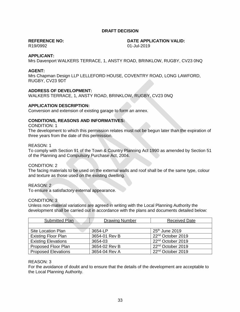
DRAFT DECISION REFERENCE NO: DATE APPLICATION VALID: R19/0992 01-Jul-2019 APPLICANT: Mrs Davenport WALKERS TERRACE, 1, ANSTY ROAD, BRINKLOW, RUGBY, CV23 0NQ AGENT: Mrs Chapman Design LLP LELLEFORD HOUSE, COVENTRY ROAD, LONG LAWFORD, RUGBY, CV23 9DT ADDRESS OF DEVELOPMENT: WALKERS TERRACE, 1, ANSTY ROAD, BRINKLOW, RUGBY, CV23 0NQ APPLICATION DESCRIPTION: Conversion and extension of existing garage to form an annex. CONDITIONS, REASONS AND INFORMATIVES: CONDITION: 1 The development to which this permission relates must not be begun later than the expiration of three years from the date of this permission. REASON: 1 To comply with Section 91 of the Town & Country Planning Act 1990 as amended by Section 51 of the Planning and Compulsory Purchase Act, 2004. CONDITION: 2 The facing materials to be used on the external walls and roof shall be of the same type, colour and texture as those used on the existing dwelling. REASON: 2 To ensure a satisfactory external appearance. CONDITION: 3 Unless non-material variations are agreed in writing with the Local Planning Authority the development shall be carried out in accordance with the plans and documents detailed below:
Submitted Plan Drawing Number Received Date
Site Location Plan 3654-LP 25th June 2019
Existing Floor Plan 3654-01 Rev B 22nd October 2019
Existing Elevations 3654-03 22nd October 2019
Proposed Floor Plan 3654-02 Rev B 22nd October 2019
Proposed Elevations 3654-04 Rev A 22nd October 2019
REASON: 3 For the avoidance of doubt and to ensure that the details of the development are acceptable to the Local Planning Authority.
33
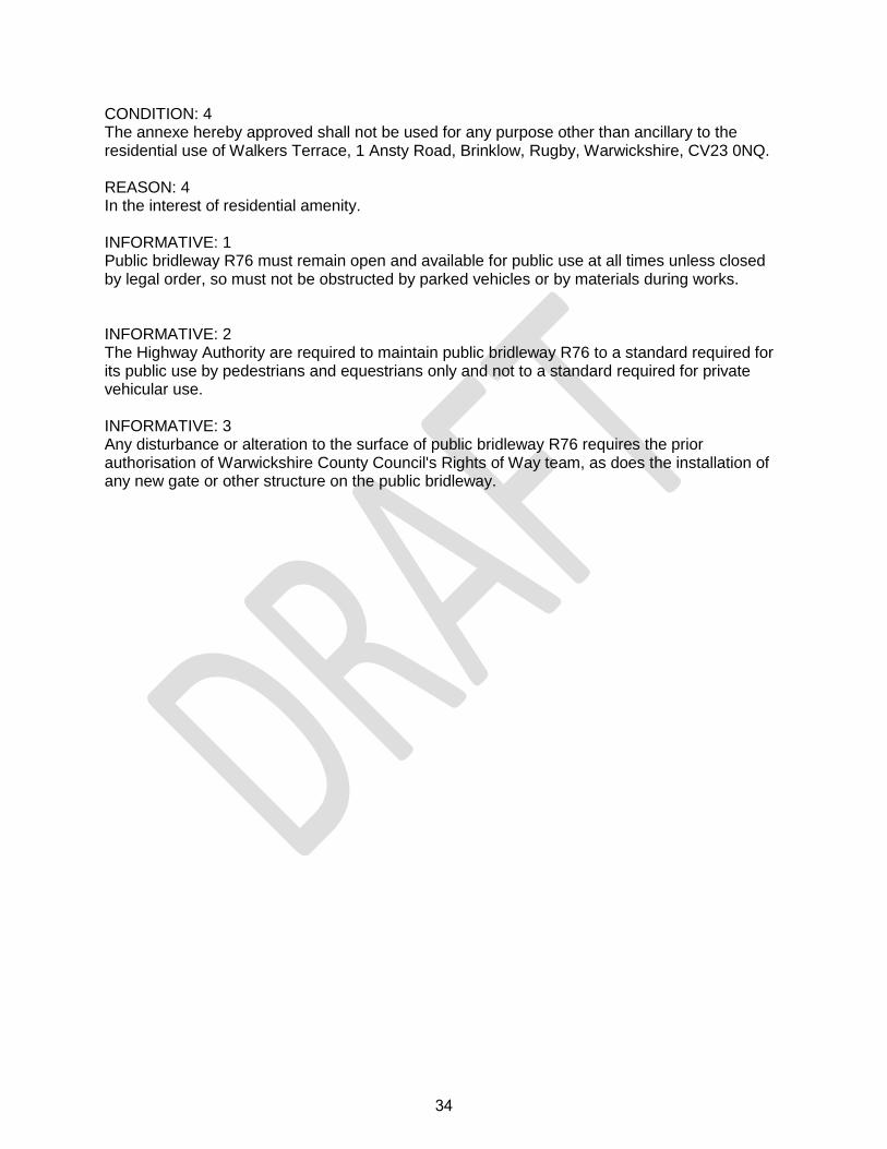
CONDITION: 4 The annexe hereby approved shall not be used for any purpose other than ancillary to the residential use of Walkers Terrace, 1 Ansty Road, Brinklow, Rugby, Warwickshire, CV23 0NQ. REASON: 4 In the interest of residential amenity. INFORMATIVE: 1 Public bridleway R76 must remain open and available for public use at all times unless closed by legal order, so must not be obstructed by parked vehicles or by materials during works. INFORMATIVE: 2 The Highway Authority are required to maintain public bridleway R76 to a standard required for its public use by pedestrians and equestrians only and not to a standard required for private vehicular use. INFORMATIVE: 3 Any disturbance or alteration to the surface of public bridleway R76 requires the prior authorisation of Warwickshire County Council's Rights of Way team, as does the installation of any new gate or other structure on the public bridleway.
34
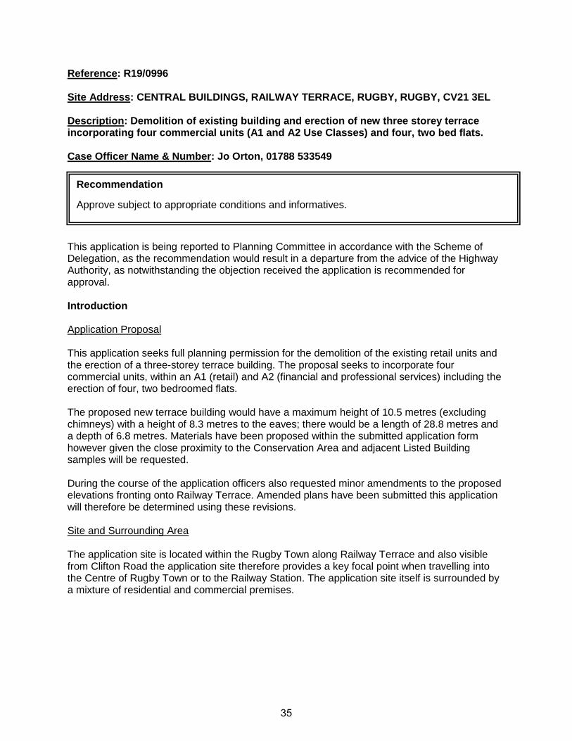
Reference: R19/0996 Site Address: CENTRAL BUILDINGS, RAILWAY TERRACE, RUGBY, RUGBY, CV21 3EL Description: Demolition of existing building and erection of new three storey terrace incorporating four commercial units (A1 and A2 Use Classes) and four, two bed flats. Case Officer Name & Number: Jo Orton, 01788 533549
This application is being reported to Planning Committee in accordance with the Scheme of Delegation, as the recommendation would result in a departure from the advice of the Highway Authority, as notwithstanding the objection received the application is recommended for approval. Introduction Application Proposal This application seeks full planning permission for the demolition of the existing retail units and the erection of a three-storey terrace building. The proposal seeks to incorporate four commercial units, within an A1 (retail) and A2 (financial and professional services) including the erection of four, two bedroomed flats. The proposed new terrace building would have a maximum height of 10.5 metres (excluding chimneys) with a height of 8.3 metres to the eaves; there would be a length of 28.8 metres and a depth of 6.8 metres. Materials have been proposed within the submitted application form however given the close proximity to the Conservation Area and adjacent Listed Building samples will be requested. During the course of the application officers also requested minor amendments to the proposed elevations fronting onto Railway Terrace. Amended plans have been submitted this application will therefore be determined using these revisions. Site and Surrounding Area The application site is located within the Rugby Town along Railway Terrace and also visible from Clifton Road the application site therefore provides a key focal point when travelling into the Centre of Rugby Town or to the Railway Station. The application site itself is surrounded by a mixture of residential and commercial premises.
Recommendation
Approve subject to appropriate conditions and informatives.
35
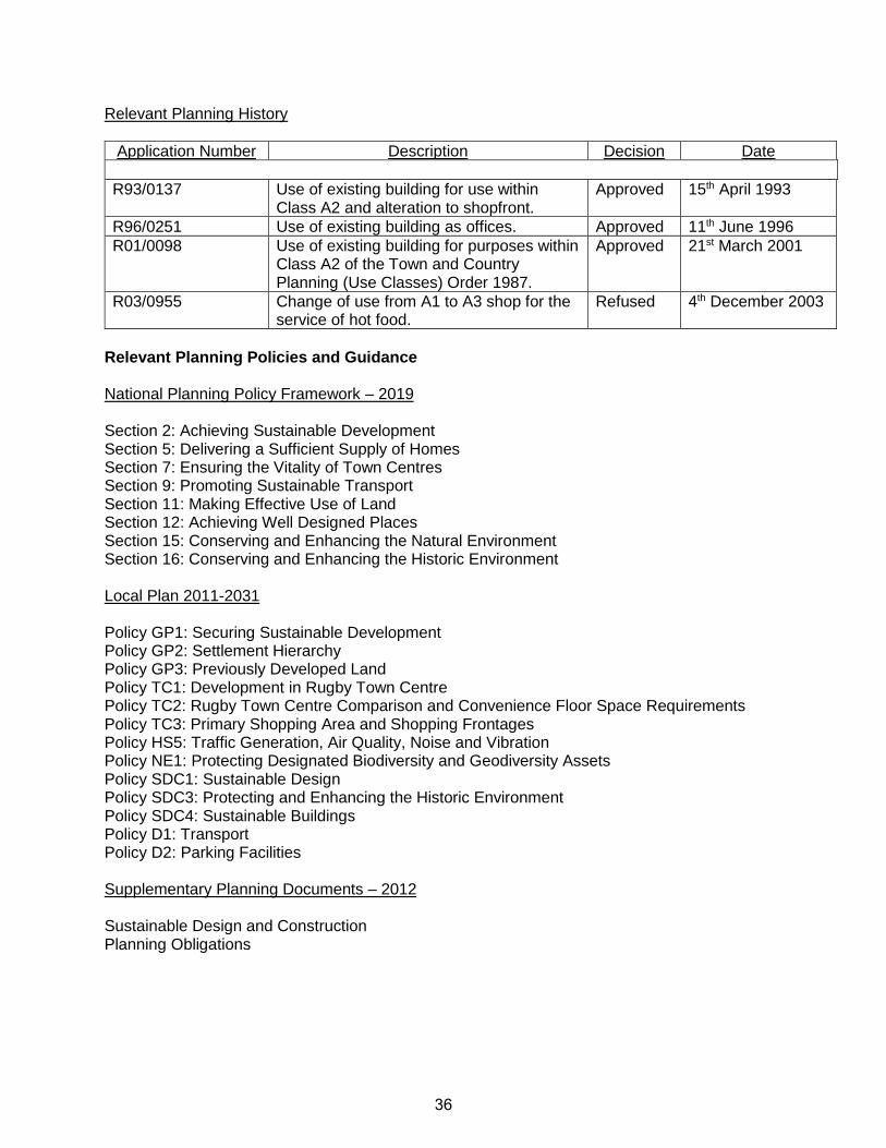
Relevant Planning History
Application Number Description Decision Date
R93/0137 Use of existing building for use within Class A2 and alteration to shopfront.
Approved 15th April 1993
R96/0251 Use of existing building as offices. Approved 11th June 1996
R01/0098 Use of existing building for purposes within Class A2 of the Town and Country Planning (Use Classes) Order 1987.
Approved 21st March 2001
R03/0955 Change of use from A1 to A3 shop for the service of hot food.
Refused 4th December 2003
Relevant Planning Policies and Guidance National Planning Policy Framework – 2019 Section 2: Achieving Sustainable Development Section 5: Delivering a Sufficient Supply of Homes Section 7: Ensuring the Vitality of Town Centres Section 9: Promoting Sustainable Transport Section 11: Making Effective Use of Land Section 12: Achieving Well Designed Places Section 15: Conserving and Enhancing the Natural Environment Section 16: Conserving and Enhancing the Historic Environment Local Plan 2011-2031 Policy GP1: Securing Sustainable Development Policy GP2: Settlement Hierarchy Policy GP3: Previously Developed Land Policy TC1: Development in Rugby Town Centre Policy TC2: Rugby Town Centre Comparison and Convenience Floor Space Requirements Policy TC3: Primary Shopping Area and Shopping Frontages Policy HS5: Traffic Generation, Air Quality, Noise and Vibration Policy NE1: Protecting Designated Biodiversity and Geodiversity Assets Policy SDC1: Sustainable Design Policy SDC3: Protecting and Enhancing the Historic Environment Policy SDC4: Sustainable Buildings Policy D1: Transport Policy D2: Parking Facilities Supplementary Planning Documents – 2012 Sustainable Design and Construction Planning Obligations
36
Technical Consultation Responses Warwickshire County Council (Highways) have objected to the application on the following grounds: 1. A Transport Statement has not been submitted with the application; and 2. A Parking Survey needs to be carried out on the parking provision within the area of Rugby. No objections have been received from: Warwickshire County Council (Ecology) Rugby Borough Council (Environmental Services) Rugby Borough Council (Work Services) Warwickshire Fire and Rescue Third Party Consultation Responses Neighbours notified and a site and press notice have been displayed and no letters of representation have been received. Determining Considerations The main considerations in respect of this application are the principle of development; the impact the proposed development has on Rugby Town Centre and the character and appearance of the area; impact on neighbouring properties; heritage assets and highway safety.
1. Principle of Development 1.1 Policy GP2 of the Local Plan states that development will be allocated and supported in
accordance with the settlement hierarchy. 1.2 The application site is located within the Rugby Town as defined in Policy GP2 of the
Local Plan which is the main focus for all development in the Borough providing the best access to a range of services and facilities. As such; there is a principle in favour of sustainable development subject to all appropriate planning matters being appropriately addressed.
1.3 This application is therefore considered to be in accordance with Policy GP2 of the Local
Plan.
2. Impact on Town Centre 2.1 Policy TC1 of the Local Plan states that proposals for the redevelopment and
refurbishment of the existing built environment will demonstrate high quality design that complements and enhances the existing environment. Likewise, Policy TC3 states that proposals within secondary shopping areas will only be permitted where the proposed use maintains and enhances its vitality with an expectation that non-retail uses are above those contained within the primary shopping areas.
2.2 Furthermore Section 7 of the NPPF states that planning should support the role that
town centres play at the heart of the community by taking a positive approach to their
37
growth, management and adaption. Paragraph F also recognises that residential development often plays an important role in ensuring the vitality of centres and encourages residential development on appropriate sites. This approach is further supported within Policy TC3 which states that residential development is encouraged within the Town Centre.
2.3 As with the existing building, the proposal would occupy the full extent of the application,
with four retail units of 32 square metres replacing the existing five retail units which benefiting from similar floor areas. Within the middle row, a pedestrian access and central stairway has been included which takes up the space from the loss of the retail unit, allowing access to the flats above. The four retail units would be replaced on a like for like basis, with a kitchen and toilet facilities to the rear of the building.
2.4 Whilst the proposal would result in the loss of a retail unit, the proposed redevelopment
and refurbishment of the Central Buildings, results in an enhancement to the surrounding area and creates an attractive retail and residential frontage. The loss of the retail unit is further supported by Policy T3 of the Local Plan and Section 7 of the NPPF which clearly identifies the importance of allowing residential development within the town centre.
2.5 This application is therefore considered to be in accordance with Policy TC1 and TC3 of
the Local Plan and Section 7 of the NPPF.
3. Character and Design 3.1 Local Plan Policy SDC1 states that development will only be supported where the
proposals are of a scale, density and design that responds to the character of the areas in which they are situated.
3.2 Section 12 of the National Planning Policy Framework (NPPF) states that developments
will function well and add to the overall quality of the area not just for the short term but over the lifetime of the development whilst being visually attractive as a result of good architecture.
3.3 The proposed new three storey terrace property would replace the existing one and a
half storey terrace of five retail units located within Railway Terrace. The existing building, whilst they are in a good condition, appear to be out of character with the surrounding built form along Railway Terrace and given the visual prominence detract from the character and appearance of the surrounding area.
3.4 The proposal has been well designed to ensure that it complements the heights of the
adjoining Florence Court and Heart of England Training building. The building incorporates design features to complement Florence Court including fenestration details including sills and headers as well as Ashlar moulding effect to the ground floor façade. The shops fronts would reinforce the traditional character through the use of central doorways, low sills and mullioned windows.
3.5 This application seeks the opportunity to enhance the character and appearance of the
area along with the setting of the adjoining Conservation Area through the provision of a well-designed scheme.
38
3.6 It is therefore considered that the application is considered to be in accordance with Policy SDC1 of the Local Plan and Section 12 of the NPPF.
4. Impact on Residential Amenity 4.1 Policy SDC1 states that development will ensure that the living conditions of existing and
future neighbouring occupiers are safeguarded with Section 12 of the NPPF stating that developments will provide a high standard of amenity for existing and future users.
4.2 The residents of Florence Court which is located to the South East of the application site
and are detached apartments. The ground, first and second floors of the apartments all have the same layout with a kitchen, bathroom and secondary bedroom window facing on the side elevation of Central Buildings. Whilst these windows would be fronting a blank elevation with a separation distance of at least 3.4 metres, as the windows are either non-habitable or secondary in nature, it is not considered that the proposal would have an adverse impact on the occupiers of Florence Court in terms of overlooking; overbearing or loss of light.
4.3 The windows proposed to the rear elevation would all be obscurely glazed windows and
would serve the bathrooms and central lobby/circulation space and as such would not have an adverse impact on the occupants of Florence Court.
4.4 It is therefore considered that this application is in accordance with Policy SDC1 of the
Local Plan and Section 12 of the NPPF.
5. Highway Safety 5.1 Local Plan Policy D1 states that sustainable transport methods should be prioritised with
measures put in place to mitigate any transport issues. The Planning Obligations SPD and Appendix 5 expands on this and further sets out the need for transport assessments to be submitted with planning applications to assess the impact and acceptability of development proposals.
5.2 Local Plan Policy D2 goes on to say that planning permission will only be granted for
development which incorporates satisfactory parking facilities as set out within the Planning Obligations SPD and Appendix 5 of the Emerging Local Plan.
5.3 Warwickshire County Council (Highways) have objected to the application on the
grounds that a Transport Assessment needs to be submitted with the application in order to understand the true impact of the development on the operation of the highway and transport network. A further request was made to the applicant for parking surveys to be undertaken on the grounds that parking provision within this area of Rugby is at a premium.
5.4 The application site currently compromises a terrace of five retail units, due to the
constraints of the site, there are currently no parking facilities available for these retail units. The proposal seeks planning permission for four new retail units which are being provided on a like for like basis with no parking facilities as per the existing situation as such, the key area for consideration in relation to parking and traffic generation are the formation of four new apartments.
39
5.5 For apartments consisting of 2 bedroom units within the high access zone a minimum of
3 car parking spaces and 4 cycle spaces are required. Given the constraints of the site, no dedicated parking is proposed, however; the required cycle spaces have been provided and contained within the entrance lobby of the property.
5.6 Given the location of the proposal within the Town Centre, Railway Terrace can be
considered a sustainable location, with easy access to the following:
• Nearby public car parking including Railway Terrace; Gas Street and the John Barford;
• Public transport links including the two-way bus route on Church Street; Clifton Road and further down Railway Terrace;
• The Clock Tower Taxi Rank is within a 5-minute walk; and • Rugby Railway Station is located within 12-minute walk from the application site.
5.7 It is therefore considered that there will not be an adverse impact on parking within the
surrounding area. 5.8 It is therefore considered that the proposal is in accordance with Local Plan Policy D1;
D2; Appendix 5 and the SPD on Planning Obligations.
6. Conclusion 6.1 The proposal would respect the scale and character of the surrounding area, would not
adversely affect the amenities of the occupiers of neighbouring properties, and would not impact upon highway safety. Accordingly, the application is to be considered to be in accordance with the National Planning Policy Framework and the Local Plan and is therefore recommended for approval subject to conditions.
40
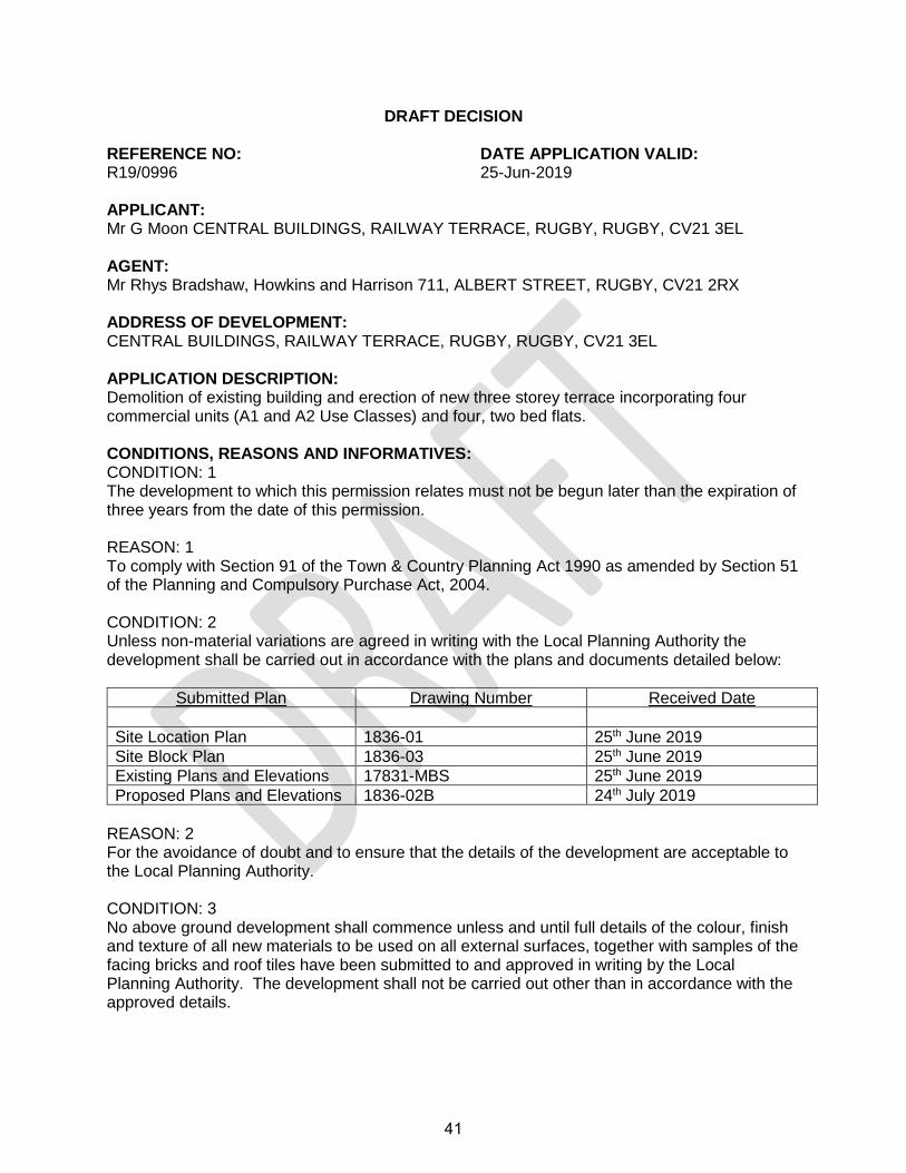
DRAFT DECISION REFERENCE NO: DATE APPLICATION VALID: R19/0996 25-Jun-2019 APPLICANT: Mr G Moon CENTRAL BUILDINGS, RAILWAY TERRACE, RUGBY, RUGBY, CV21 3EL AGENT: Mr Rhys Bradshaw, Howkins and Harrison 711, ALBERT STREET, RUGBY, CV21 2RX ADDRESS OF DEVELOPMENT: CENTRAL BUILDINGS, RAILWAY TERRACE, RUGBY, RUGBY, CV21 3EL APPLICATION DESCRIPTION: Demolition of existing building and erection of new three storey terrace incorporating four commercial units (A1 and A2 Use Classes) and four, two bed flats. CONDITIONS, REASONS AND INFORMATIVES: CONDITION: 1 The development to which this permission relates must not be begun later than the expiration of three years from the date of this permission. REASON: 1 To comply with Section 91 of the Town & Country Planning Act 1990 as amended by Section 51 of the Planning and Compulsory Purchase Act, 2004. CONDITION: 2 Unless non-material variations are agreed in writing with the Local Planning Authority the development shall be carried out in accordance with the plans and documents detailed below:
Submitted Plan Drawing Number Received Date
Site Location Plan 1836-01 25th June 2019
Site Block Plan 1836-03 25th June 2019
Existing Plans and Elevations 17831-MBS 25th June 2019
Proposed Plans and Elevations 1836-02B 24th July 2019
REASON: 2 For the avoidance of doubt and to ensure that the details of the development are acceptable to the Local Planning Authority. CONDITION: 3 No above ground development shall commence unless and until full details of the colour, finish and texture of all new materials to be used on all external surfaces, together with samples of the facing bricks and roof tiles have been submitted to and approved in writing by the Local Planning Authority. The development shall not be carried out other than in accordance with the approved details.
41
REASON: 3 To ensure a satisfactory external appearance and in the interests of the visual amenities of the locality. CONDITION: 4 The development hereby permitted shall be timetabled and carried out to wholly accord with the mitigation measures outlined in Section 6 for the safeguarding of bats and nesting birds within the site as set out in the document ‘Protected Species Survey’ prepared by Philip Irving, received by the Local Planning Authority in October 2019. REASON: 4 To ensure that protected species are not harmed by the development. CONDITION: 5 A noise assessment should be undertaken by a suitably qualified person to determine the extent of the existing noise sources in the area that could have a significant adverse impact on the proposed development, including traffic, plant and machinery from external and internal sources, existing and proposed commercial/business uses. This assessment should include a scheme of sound insulation to protect proposed residential development from any identified excessive noise ingress, it shall be submitted to and approved in writing by the Local Planning Authority prior to the proposed change of use taking place, then implemented prior to occupation. REASON: 5 In the interests of residential amenity and to ensure the details are acceptable to the Local Planning Authority CONDITION: 6 Unless non-material amendments are otherwise agreed in writing with the Local Planning Authority, no above ground development shall begin until a scheme detailing the on-site measures to be incorporated within the development in order to meet air quality neutral standards has been submitted to and approved in writing by the Local Planning Authority. Prior to occupation of the development, the approved scheme shall be implemented and maintained in perpetuity. REASON: 6 In the interests of air quality. CONDITION: 7 Prior to the commencement of any works, a Demolition and Construction Method Plan shall be submitted in writing to, and approved by, the Local Planning Authority. This shall include details relating to:
• The control of noise and vibration emissions from demolition and construction activities including groundwork’s and the formation of infrastructure including arrangements to monitor noise emissions from the development site during the construction phase;
• The control of dust including arrangements to monitor dust emissions from the development site during the demolition and construction phases; and
• Measures to reduce mud deposition offsite from vehicles leaving the site.
42
Development shall be carried out in compliance with the approved Demolition Construction Method Statement, unless otherwise approved in writing by the Local Planning Authority. REASON: 7 In the intersts of health and safety. CONDITION: 8 The dwellings hereby approved shall incorporate measures to limit water use to no more than 110 litres per person per day within the home in accordance with the optional standard 36 (2b) of Approved Document G of the Building Regulations 2010 (as amended). REASON: 8 In the interests of sustainability and water efficiency. INFORMATIVE: 1 Environmental Services advise that in order to reduce the likelihood of local residents being subjected to adverse levels of noise annoyance during construction, work on site should not occur outside the following hours: - Monday - Friday - 7.30 a.m. - 18.00 p.m., Saturday - 8.30 a.m. - 13.00 p.m. No work on Sundays & Bank Holidays. If work at other times is required permission should be obtained from the local planning authority INFORMATIVE: 2 Where any demolition, redevelopment or refurbishment is required or intended for the site it is required that an appropriate asbestos survey where applicable is undertaken for such work by an asbestos licensed/authorised company/person. For pre-demolition assessment the asbestos survey is fully intrusive and will involve a destructive inspection, as necessary, to gain access to all areas, including those that are difficult to reach. There is a specific requirement in the Control of Asbestos Regulations 2012 for all asbestos containing materials (ACMs) to be removed as far as reasonably practicable before demolition. Note to Client: The value and usefulness of the asbestos survey can be seriously undermined where either the client or the surveyor imposes restrictions on the survey scope or on the techniques/methods used by the surveyor. Information on the location of all ACMs, as far as reasonably practicable, is crucial to the risk assessment and management. Any restrictions placed on survey scope will reduce extent to which ACMs are located and identified; incur delays and consequently make managing asbestos more complicated, expensive and potentially less effective. It should be noted that refurbishment/demolition contractors are required to inspect a site. Where presence of asbestos is suspected the Health and Safety Executive (HSE) and Environment Agency must be notified and special waste regulations complied with. Asbestos contaminated waste is required for removal to a designated waste management facility licensed to take asbestos. A consignment note for the national inspectorate is required for each load and a paper trail of waste movements kept.
43
INFORMATIVE: 3 As per the condition the applicant is required to incorporate measures to assist in reducing their impact upon the Air Quality Management Area as part of this development. Initiatives could include the installation of an ultra-low emission boilers (<40mg/kWh), increased tree planting, green walls and roofs. Such measures contribute towards making new development air quality neutral. Should you require any further advice on ensuring your development has a positive contribution on air quality. INFORMATIVE: 5 To register the properties on this development and receive postal addresses or to amendment an existing address please complete an application form for Postal Naming and Numbering. This should be done prior to above ground works commencing. The form can be downloaded at: http://www.rugby.gov.uk/site/scripts/documents_info.php?documentID=223&categoryID=200295 . INFORMATIVE: 5 Warwickshire Fire and Rescue Authority fully endorse and support the fitting of Sprinkler Installations, in accordance with the relevant clauses of BS EN 12845 : 2004, associated Technical Bulletins, and or to the relevant clauses of British Standard 9251:2014, for residential premises. INFORMATIVE: 6 Warwickshire Fire and Rescue Authority ask you to consider and ensure that the access to the site, during construction and once completed, are maintained free from obstructions such as parked vehicles, to allow Emergency Service vehicle access.
44
Reference: R19/0854 Site Address: LAND NORTH OF ASHLAWN ROAD, ASHLAWN ROAD, RUGBY, RUGBY, CV22 5SL Description: Spine road, secondary access roads, cycle/footway to Norton Leys, sustainable urban drainage works and strategic landscaping. Approval of reserved matters (access, appearance, landscaping, layout and scale) relating to R13/2102 (Demolition of existing buildings, erection of up to 860no. dwellings, land for potential primary school, two vehicular accesses from Ashlawn Road and the provision of a bus link control feature to Norton Leys, open space, green infrastructure, including SUDs works.) Case Officer Name & Number: Karen McCulloch, 01788 533623
This application is being reported to Planning Committee as requested by Councillor Dumbleton. 1.0 Description of Site 1.1 This application relates to parts of an overall development site where outline planning
permission was granted at appeal. 1.2 This application relates to the parts of the site where the infrastructure will be provided,
this comprises the roads, surface water drainage areas, open space and landscape areas including the play areas and sports pitches.
1.3 The overall site is an area of land located to the south of Rugby Urban area and to the
north of Ashlawn Road. Residential properties in an area known as Hillside are to the north of the site, these are mostly 2 storey houses and some bungalows with the rear elevations facing the site, however the side elevations of some properties are also adjacent to the site boundary.
1.4 Land to the east of the site is in agricultural use and land to the south, across Ashlawn
Road is mostly agricultural land with some dwellings and farms. Bilton Fields Farm is to the west of the site, this is no longer a working farm and the buildings have been converted to residential use, Sainsbury’s is to the north of this.
1.5 There is a residential property, Martin’s House, located on the north side of Ashlawn Road,
this is not included in the application site. Martin’s Farm is also to the north of Ashlawn Road and comprises brick cottages and a modern barn, this is within the overall site and is now vacant.
1.6 The overall Ashlawn Road site is currently divided into 3 fields by hedgerows. The western
field slopes gradually from west to east towards the hedge. The central field contains a
Recommendation
Approval – subject to conditions to secure the delivery of replacement hedgerow and open
space
45
large pond in the centre, this fields slopes down with the lowest point being an area to the rear of Brafield Leys. The eastern field is relatively flat.
1.7 A public bridleway crosses the site from north to south across the site. At the north this
runs along the hedgerow, at the southern part of the site the alignment changes to run towards Ashlawn Road. Close to where the bridleway meets Ashlawn Road is a traffic light controlled crossing.
1.8 The site boundaries mostly comprise hedgerows with some mature trees, there are also
trees within the hedges and adjacent to the farm track. The boundary with Bilton Fields Farm Lane is open.
1.9 Large parts of the hedgerow fronting Ashlawn Road were removed earlier this year. 1.10 A power line crosses the site, running above the hedgerow dividing the eastern fields. 1.11 The south western part of the overall site falls within Dunchurch Parish. 2.0 Description of proposals 2.1 This is an approval of reserved matters application for the infrastructure for the whole of
the Ashlawn Road development. Approval is sought for the access, appearance, landscaping, layout and scale.
2.2 The infrastructure comprises the estate roads, surface water drainage, open space and
landscape areas, play areas and pitches. 2.3 This includes the main spine road which forms a loop from the two approved accesses to
Ashlawn Road and a secondary loop road the north of this. The plans include the junctions where the spine road will connect to housing areas but the details of the smaller roads are not to be considered at this stage.
2.4 The proposed plans show 2 bus stops in each direction on the spine road. Pedestrian and
equestrian crossing points are also proposed. 2.5 The plans also include a cul-de-sac off this secondary loop, this joins a proposed cycle
and footway which will link the site to Norton Leys. This is instead of the controlled bus link that was included in the outline application.
2.6 The surface water drainage will connect to the existing pond and new drainage basins
located within the open space areas to the north of the site. One pond is proposed in the northern most corner of the site with a series of 5 interlinked basins proposed close to the existing pond and the proposed footpath/cycle link to Norton Leys.
2.7 This application includes details of the strategic landscaping around the site. Amended
plans were submitted which include the reinstatement of the majority of the hedgerow to the Ashlawn Road frontage, the area of hedgerow to either side of Martins House is included within the David Wilson housing application for this part of the site.
2.8 The hedgerow will be set back from the Ashlawn Road frontage by an area of meadow
grassland in order to provide the drainage necessary for the highway works. The hedge will comprise a mix of native species (hazel, hawthorn, holly, dog-rose, blackthorn and
46
guelder rose) interspersed with native trees (hornbeam, maple, silver birch, sweet cherry, rowan and lime).
2.9 Paths are proposed around the existing pond area and within the open space areas to the
north of the site. A range of grassland and tree and shrub planting are proposed in these areas.
2.10 Paths are proposed adjacent to the proposed drainage basins. These basins will be
provided as areas of grassland with channels running though the centre and will become wet in times of heavy rainfall.
2.11 Areas of grass and trees are also proposed along the main spine road. 2.12 The proposals also include the play areas and sports pitches. 2.13 The sports pitches will be provided at the western part of the site and will comprise 4
pitches: 1 youth U15/16 pitch, 1 youth U13/14 pitch, 1 youth U11/12 pitch and 1 mini-soccer U9/10 pitch.
2.14 Two play areas are proposed, one close to the existing pond in the centre of the site and
a larger play area to the west of the site close to the sports pitches. 2.15 The central play area will include swings, a see-saw, climbing bars and a climbing frame
with slide. 2.16 The plans for the play area to the west initially showed swings and a see-saw as well as
a roundabout, larger climbing frame skate board ramps and a small sports pitch with goal. However, following discussions with Parks the details of this equipment to be provided in this area are not to be considered at this stage and will be subject to a separate application in the future.
3.0 Planning History R13/2102 Demolition of existing buildings, erection of up to 860no. dwellings, land for potential primary school, two vehicular accesses from Ashlawn Road and the provision of a bus link control feature to Norton Leys, open space, green infrastructure, including SUDs works. Approved by Planning Inpectorate, 10/07/2017 R19/0941 Erection of 105 dwellings, associated infrastructure and landscaping. Approval of reserved matters (appearance, landscaping, layout and scale) relating to R13/2102. Currrently under consideration. R19/1185 Erection of 325 dwellings, associated access, infrastructure and landscaping. Approval of reserved matters (access, appearance, landscaping, layout and scale) relating to R13/2102. Currently under consideration. 4.0 Relevant Planning Policies 4.1 Rugby Borough Local Plan 2011-2031, June 2019 GP1: Complies Securing Sustainable Development GP2: Complies Settlement Hierarchy GP4: Complies Safeguarding Development Potential
47
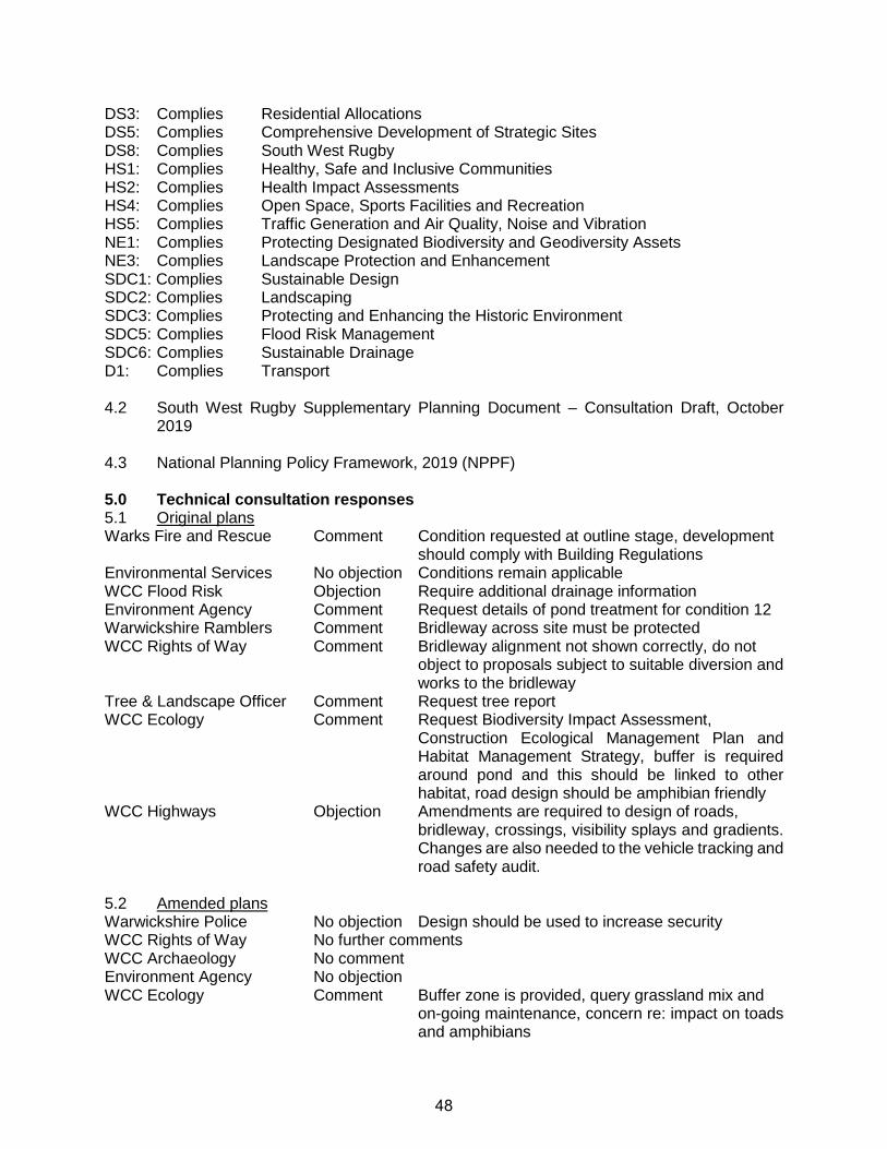
DS3: Complies Residential Allocations DS5: Complies Comprehensive Development of Strategic Sites DS8: Complies South West Rugby HS1: Complies Healthy, Safe and Inclusive Communities HS2: Complies Health Impact Assessments HS4: Complies Open Space, Sports Facilities and Recreation HS5: Complies Traffic Generation and Air Quality, Noise and Vibration NE1: Complies Protecting Designated Biodiversity and Geodiversity Assets NE3: Complies Landscape Protection and Enhancement SDC1: Complies Sustainable Design SDC2: Complies Landscaping SDC3: Complies Protecting and Enhancing the Historic Environment SDC5: Complies Flood Risk Management SDC6: Complies Sustainable Drainage D1: Complies Transport 4.2 South West Rugby Supplementary Planning Document – Consultation Draft, October
2019 4.3 National Planning Policy Framework, 2019 (NPPF) 5.0 Technical consultation responses 5.1 Original plans Warks Fire and Rescue Comment Condition requested at outline stage, development
should comply with Building Regulations Environmental Services No objection Conditions remain applicable WCC Flood Risk Objection Require additional drainage information Environment Agency Comment Request details of pond treatment for condition 12 Warwickshire Ramblers Comment Bridleway across site must be protected WCC Rights of Way Comment Bridleway alignment not shown correctly, do not
object to proposals subject to suitable diversion and works to the bridleway
Tree & Landscape Officer Comment Request tree report WCC Ecology Comment Request Biodiversity Impact Assessment,
Construction Ecological Management Plan and Habitat Management Strategy, buffer is required around pond and this should be linked to other habitat, road design should be amphibian friendly
WCC Highways Objection Amendments are required to design of roads, bridleway, crossings, visibility splays and gradients. Changes are also needed to the vehicle tracking and road safety audit.
5.2 Amended plans Warwickshire Police No objection Design should be used to increase security WCC Rights of Way No further comments WCC Archaeology No comment Environment Agency No objection WCC Ecology Comment Buffer zone is provided, query grassland mix and
on-going maintenance, concern re: impact on toads and amphibians
48
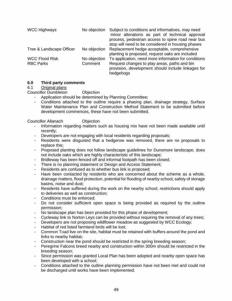
WCC Highways No objection Subject to conditions and informatives, may need minor alterations as part of technical approval process, pedestrian access to spine road near bus stop will need to be considered in housing phases
Tree & Landscape Officer No objection Replacement hedge acceptable, comprehensive planting is proposed, request oaks are included
WCC Flood Risk No objection To application, need more information for conditions RBC Parks Comment Request changes to play areas, paths and bin
provision, development should include linkages for hedgehogs
6.0 Third party comments 6.1 Original plans Councillor Dumbleton Objection
- Application should be determined by Planning Committee; - Conditions attached to the outline require a phasing plan, drainage strategy, Surface
Water Maintenance Plan and Construction Method Statement to be submitted before development commences, these have not been submitted.
Councillor Allanach Objection
- Information regarding matters such as housing mix have not been made available until recently;
- Developers are not engaging with local residents regarding proposals; - Residents were disgusted that a hedgerow was removed, there are no proposals to
replace this; - Proposed planting does not follow landscape guidelines for Dunsmore landscape, does
not include oaks which are highly characteristic of this landscape; - Bridleway has been fenced off and informal footpath has been closed; - There is no planning statement or Design and Access Statement; - Residents are confused as to whether bus link is proposed; - Have been contacted by residents who are concerned about the scheme as a whole,
drainage matters, flood protection, potential for flooding of nearby school, safety of storage basins, noise and dust;
- Residents have suffered during the work on the nearby school, restrictions should apply to deliveries as well as construction;
- Conditions must be enforced; - Do not consider sufficient open space is being provided as required by the outline
permission; - No landscape plan has been provided for this phase of development; - Cycleway link to Norton Leys can be provided without requiring the removal of any trees; - Developers are not proposing wildflower meadow as suggested by WCC Ecology; - Habitat of red listed farmland birds will be lost; - Common Toad live on the site, habitat must be retained with buffers around the pond and
links to nearby habitat; - Construction near the pond should be restricted in the spring breeding season; - Peregrine Falcons breed nearby and construction within 300m should be restricted in the
breeding season; - Since permission was granted Local Plan has been adopted and nearby open space has
been developed with a school; - Conditions attached to the outline planning permission have not been met and could not
be discharged until works have been implemented;
49
- Construction Environmental Management Plan does not include breeding pond or measures for protection of toads detailed at outline stage;
- Phases on plan submitted for conditions do not reflect separate applications; - Trees outside of site will be lost during highway works, these are not in the tree report; - Noise assessment information does not include assessment of construction activities; - Application should also include appearance, landscaping and scale for this phase; - No details of fencing, including around ponds, levels, street lighting or drainage
calculations have been provided; - Surface Water Maintenance Plan and Construction Method Statement have not been
provided; - Is not clear if suitable buffer has been provided around pond; - Development does not comply policy DS8 as it is not clear how a walking and cycling
network or public transport will be provided and no woodland management plan has been provided;
- Part of the site is within Dunchurch Parish and it has not been shown how separation between Rugby and Dunchurch will be achieved;
- The South West Supplementary Planning Document has not been produced; - Application is for piecemeal and ad hoc development; - Is not clear if sufficient open space can be provided on the overall site as required by the
outline permission; - Central park shown at outline stage has been replaced with a larger pond; - Habitats are not protected contrary to policy NE1; - Lack of landscape plans is contrary to NE3 and SDC2; - Insufficient drainage information has been provided contrary to SDC5; - Policy D1 requires sustainable transport, pedestrian and cycle links should be provided at
an early stage; - Updated masterplan should be provided to allow comparison with the outline application; - Bridleway should be retained along historic field boundaries and away from estate roads; - If application is to be approved conditions should be used to secure the recommendations
of the Construction Ecological Management Plan and to secure the replacement of the hedge with suitable species;
Neighbours (7) Objection General/Principal
- All previous objections raised by Stop Ashlawn Road Development group apply, the decision to refuse the application was correct;
- No part of the scheme should be approved; - Application does not include any details of houses, school, open spaces, school or
footpaths, who will buy the houses; - Plans are being submitted in phases so as not to arouse concerns; - Application does not include a Design and Access Statement making it hard to understand
the proposals; - Is not clear how the road layout will provide walking and cycling linkages, location of new
secondary school is not known so links cannot be provided; - Health care and open space facilities are not sufficient for extra residents, no extra
services are proposed; - Development should not come forward before the South West SPD to comply with DS8; - No proposals to replace hedge to Ashlawn Road; - Development does not comply with policy DS8 as application does not show how a
comprehensive walking and cycling network will be provided, does not include a Woodland
50
Management Plan, does not provide physical and visual separation from Dunchurch and there is no South West SPD;
Amenity - Impact on character of the area, loss of open space and tranquility; - Rural setting will be destroyed; - Increased noise and disturbance; - Traffic will impact on the greater area, there will be 2 cars per house; - Disturbance and worry during construction will impact on residents’ health;
Drainage - Existing properties have experienced flooding; - Have had to provide own flood defence wall; - Do not believe drainage scheme will be successful; - Open water storage is a safety issue, children may play in this area; - No risk assessment for pond areas; - Who will be responsible for maintenance?
Highways - Have studies of additional traffic and congestion been carried out; - Current road surfacing works are causing congestion;
Open space/Ecology - Loss of habitat and green space; - Sufficient open space has been lost in this area; - Park will be accessible 24 hours a day leading to disturbance; - Will not be possible to prevent motor cycles using open space; - Park should be designed to prevent antisocial behavior close to existing properties; - How will 14 hectares of open space be provided; - Lack of open space in application R19/0941 suggests minimum level of open space
cannot be provided; - Hedges have been removed; - Council has failed to protect the amenity of the local area; - Road runs parallel to the bridleway and this has not been addressed by the application;
Outline application - Original Environmental Statement has been invalidated and cannot be relied on as
hedgerow has been removed; - Biodiveristy off-setting should be adjusted to address this; - Information has not been provided to address a range of outline conditions;
Neighbours (3) Comment
- It is not clear who owns sewers to the north of the site, although these should have been adopted by Severn Trent believe this was not done;
- If sewers are not adopted developers cannot connect into these without consent from all owners;
- No reference to current field drainage system; - Existing ditches drain into pipes which are blocked leading to water in the ditch and field; - Houses are lower than the site and at risk of flooding if drainage is not suitable; - Relived bus link is not proposed, was not clear how it would have been controlled and
would have led to traffic chaos; 6.2 Amended plans Councillors Allanach & Dumbleton Objection
- Amended plans do not help the public understand the proposals; - Revised parameters plan should be submitted;
51
- Insufficient play equipment is proposed in the play areas when compared to sites such as Cawston;
- Rokeby and Overslade already has a shortfall in play provision; - There are no teenage facilities in the area and these must be provided; - Issue of the allocation of open space is still unsettled.
Neighbours (1) Objection
- Council should ensure all legal requirements for development are met and ensure the protection and welfare of Rugby citizens;
- Believe the developers intention to connect to private watercourse to the north of the site is illegal, if the Council do not address this it is an abandonment of the Council’s duty of care and is highly offensive;
- Believe RBC are considering deliberately, recklessly and wantonly preparing to flout the law and recommending acceptance of the proposals, this will become a very serious situation;
- Do not believe RBC will have professional indemnity insurance to cover deliberate, reckless disobeying of the law and those involved could face huge consequential damages and perhaps a criminal record;
- Severn Trent have confirmed the sewers are private, RBC have had over a decade to challenge this unwarranted redesignation;
- Consider the developer cannot connect to private watercourse without the consent of the owners;
- The watercourse is the responsibility of the property owners; - Failure to ensure compliance with planning laws is a serious matter;
Neighbours (1) Comment
- Concern bus link may be proposed in future; - Is unlikely to be an increase in bus usage; - If link is not controlled existing estate would be used as a rat run, roads are not suitable; - Proposal includes removal of a tree to provide the foot/cycle link, may allow a road link in
the future; 7.0 Assessment of proposals 7.1 This is an approval of reserved matter application which relates to the outline planning
permission for the overall site. This outline planning application granted permission for the principle of the development and the two site accesses from Ashlawn Road. Conditions and a s106 Legal Agreement attached to the outline permission also set out specific requirements for the development.
7.2 This current application seeks approval for the access, appearance, landscaping, scale
and scale for the infrastructure for the development. 8.0 Principle of development 8.1 As detailed above the principle of the development of the site has been established by the
outline permission and cannot be considered at this stage. 8.2 However, the site is within the South West Rugby allocation detailed within policy DS3 of
the Local Plan where policy GP2 states development will be permitted. 8.3 Policy DS5 sets out how strategic sites must be developed in a comprehensive manner,
including the provision of public transport links, cycle links, community facilities and Green
52
Infrastructure. Policy DS8 sets out the development requirements for the overall South West allocation and includes similar requirements, this also includes the requirement for developments to comply with the South West Rugby Supplementary Planning Document, however this document has not yet been adopted by the Council.
8.4 Although the principle of the Ashlawn Road development was established by the outline
permission the development in in general accordance with the requirements of DS5 and DS8.
9.0 Highway Safety & Transport 9.1 As detailed above the proposals include the main spine road through the site, the loop
road to the north of this and the junctions where these will connect with roads leading to other parts of the site.
9.2 The highway authority, Warwickshire County Council, initially objected to the application
and requested amendments to the design of the roads, bridleway, crossings, visibility splays and gradients. Revised tracking plans and Road Safety Audit were also requested.
9.3 The applicant updated the layout and submitted revised plans to address this objection. 9.4 WCC Highways commented on the revised plans. They advised that the proposed road
layout will allow for a bus route to be provided through the site, although minor alterations may be required at the stage where technical approval is required for the roads. They also advised that the precise positions of street trees and street lighting will be considered in more detail at that stage. A revised Safety Audit would also be required as part of the technical approval process.
9.5 In the area of one of the proposed bus stops the Highway Authority commented that they
would seek to resist dwellings with pedestrian access onto the spine road due to the proximity to the bus stop and increased need for pedestrians crossing in that location. This is not a matter for this application and has been passed to the relevant housing developer.
9.6 Overall WCC Highways raised no objection to the amended plans and the impact on
highway safety is considered acceptable. 9.7 Policy D1 refers to development being permitted where sustainable transport methods are
prioritised and measures to mitigate the transport impacts are provided. 9.8 The outline planning permission allowed for the provision of a controlled bus link to Norton
Leys to the north of the site. Following the initial application this was discussed further with the bus companies and it was concluded that this bus link was not required and that a suitable bus service could be provided through the site itself. The submitted plans do not include a bus link and a pedestrian and cycle link is shown at this point. The s106 agreement also allows for the owners to agree with the County that the bus gate is not required and the applicants have written to the County to agree the removal of the bus link.
9.9 A Transport Assessment was submitted at the outline stage and a range of measures to
mitigate the transport impacts were secured by condition and s106. These include alterations to a range of junctions within the area as well as contributions towards a cycleway along Ashlawn Road. A contribution to public transport was also secured to
53
provide a half hourly bus service Monday-Saturday 7.00am-7.00pm. This is in accordance with policy D1.
10.0 Pedestrian and cycle links and bridleway 10.1 As detailed above the need for pedestrian and cycle links to the development and wider
area was considered at the outline stage. 10.2 The current application shows a 3m cycle/footway to both sides of the main spine road
and to one side of the loop connecting to this. This application also includes a cycle/footway link to Norton Leys to the north of the site.
10.3 Pedestrian routes are also proposed through the open space areas to the site boundaries
and connecting to the existing residential development to the north and to Ashlawn Road itself. These allow access to the site by sustainable transport methods in accordance with policies D1, DS5 and DS8.
10.4 There is an existing bridleway which crosses the site in a north to south direction. This is
to be retained through the development and equestrian crossing points are provided where this crosses the roads.
10.5 WCC Rights of Way commented on the application and welcomed that the bridleway is to
be retained in a green corridor and that equestrian crossing facilities will be provided. They also advise that consent will be required to stop or divert the bridleway to carry out drainage works. Conditions are also requested to ensure the drainage ponds and vegetation are a suitable distance from the bridleway, this required separation is shown on the submitted plans.
10.6 WCC Rights of Way also comment that the existing alignment of the bridleway closest to
Ashlawn Road is shown incorrectly on the submitted plans but advised they do not object to the application subject to suitable a diversion and works to the bridleway being obtained. The applicant has confirmed that the relevant section of the bridleway is outside of the current application site and that the alignment and diversion will be addressed as part of the approval of reserved matters application for the part of the site containing the bridleway. On this basis the impact of the current application on the bridleway is considered acceptable in accordance with paragraph 98 of the NPPF.
11.0 Drainage 11.1 Policy SDC5 requires the submission of a Flood Risk Assessment for sites over 1 hectare
in Flood Zone 1. An assessment was provided as part of the outline application and it was considered that a suitable drainage scheme could be provided.
11.2 The application includes the surface water drainage to serve the overall Ashlawn Road
site. 11.3 The surface water will run to the existing pond close to the centre of the site and to a range
of balancing ponds which are to be provided close to the northern boundary. These will not be permanently wet but water will run through the centres. In times of heavy rainfall water will be stored within these basins. Water will then run to an existing drainage system to the north of the site using an existing connection close to Brafield Leys.
54
11.4 Warwickshire County Council as Lead Local Flood Authority and the Environment Agency raised objections to the original plans and requested further information regarding the treatment of the existing pond and the drainage system.
11.5 Amended plans and additional drainage information were provided as requested. The
Environment Agency advised that they have no objection to the amended plans. The Lead Local Flood Authority advised that they have no objection to this reserved matters application, although additional information will be required in relation to the planning conditions relating to drainage.
11.6 On this basis the proposed surface water drainage proposed is considered acceptable in
accordance with policy SDC6. 11.7 Objections have been received from a local resident regarding the surface water drainage
proposals to the north of the site. They consider that as the surface water drainage system is not a public sewer the developers will require consent from all the property owners to make a connection to this drainage system.
11.8 This matter has been discussed with Warwickshire County Council as Lead Local Flood
Authority. WCC advised that whilst the surface water drainage system is a culverted watercourse rather than a public sewer they consider that it is suitable to deal with the surface water flows from the development. They advised that as the developers will be using an existing connection within the site additional consents will not be required to use this drainage system.
11.9 Notwithstanding this, agreements relating to connections to drainage systems are private
matters between the relevant organisations and landowners involved and are not a planning matter. If additional drainage consents are required it is for the developer to ensure these are obtained and this is not grounds to refuse the application. Advice regarding this has been sought from the Council’s Legal Section who confirmed that this is not a matter to consider in the determination of the application.
12.0 Landscaping 12.1 The application includes the areas of strategic landscaping for the overall development.
This includes the dry parts of the balancing ponds close to the northern boundary and the areas of amenity open space surrounding these. The application also includes the areas around the existing central pond and proposed play areas and pitches. The proposals are also for the reinstatement of the majority of the hedge to the Ashlawn Road.
12.2 Areas of amenity space that will be within, or directly adjacent to housing phases will be
included as part of those applications and assessed at the relevant time. In addition, the area of hedgerow to the Ashlawn Road frontage that is adjacent to Martin’s House is included within the current David Wilson Homes application that is currently under consideration.
12.3 The proposals are for a range of grassland, tree and shrub planting to be provided within
the open space areas and for walking routes to be provided around the site. 12.4 The replacement hedgerow will be set back from the Ashlawn Road frontage by an area
of meadow grassland in order to provide the drainage necessary for the highway works. The hedge will comprise a mix of native species (hazel, hawthorn, holly, dog-rose,
55
blackthorn and guelder rose) interspersed with native trees (hornbeam, maple, silver birch, sweet cherry, rowan and lime).
12.5 The Council’s Landscape Officer initially requested that a Tree Report be submitted with
the application and this was provided. This detailed trees that are to be removed. The majority of these were to the site frontage and losses are required to provide the site accesses and roads within the site. This involved the loss of one high quality Oak tree and a range of low quality, category C trees. One category B Lime is also to be removed to provide the pedestrian and cycle link to Norton Leys.
12.6 The report also details some areas where the provision of roads and paths will encroach
into the root protection areas of retained trees. The report details how work will be carried out in these areas to ensure the trees are not adversely affected.
12.7 The Landscape Officer did not object to the application and advised they are generally
happy with the proposed landscaping as comprehensive planting is proposed throughout the site with a good species mix. In relation to the replacement hedge they commented that this included numerous replacement trees. However, they recommended that English Oak be incorporated into the replacement hedge proposals.
12.8 These comments were put to the application who advised that Oak were proposed within
the open space areas however, there is not sufficient space to provide these within the hedgerow to the Ashlawn Road frontage due to the proximity to the foundations of the proposed properties. Whilst Oak would have been preferred as detailed above a range of native hedgerow species and trees are proposed within the replacement hedgerow and this is not considered grounds to recommend refusal of the application.
12.9 The County Ecologist also welcomed the use of native tree and hedgerow planting and a
mix of native marginal and emergent plant species around the attenuation features. 12.10 A phasing plan for landscaping and open space has been provided in relation to the
phasing condition attached to the outline planning permission. This shows that the replacement hedge will be provided by the 100th occupation on the overall site. However, a condition is suggested requiring this to be provided prior to the 100th occupation, on in the planting season following the commencement of development, whichever is sooner.
12.11 The proposed landscaping is therefore considered acceptable in accordance with policies
NE3 and SDC2. 13.0 Open Space & Play Provision 13.1 The outline planning permission considered the provision of open space across the overall
site and the s106 set out the requirements for a minimum of 12.93 hectares of open space across the different open space typologies.
13.2 A plan has been submitted in accordance with a phasing condition for the outline
permission which shows that a total of 12.93 hectares is to be provided. This includes the open space proposed as part of this application and within the individual residential phases.
13.3 As detailed above this application includes open space and amenity areas to the site
boundaries in addition to play areas and sports pitches.
56
13.4 The proposals include two play areas, one close to the existing pond in the centre of the
site and a larger play area to the west of the site close to the sports pitches. 13.5 The original plans for the central play area included swings, a see-saw, climbing bars and
a climbing frame with slide. The play area to the west included swings and a see-saw as well as a roundabout, larger climbing frame skate board ramps and a small sports pitch with goal.
13.6 Colleagues within Parks commented on the proposals and suggested changes to the
proposed equipment proposed to allow for a wider range of play to be undertaken on the site. In relation to the western play area they commented that the proposal to provide ramps and a small sports pitch resulted in both of these being substandard. They also advised that as this area is to be provided later in the development it would be preferable to delay the consideration of this area to allow the play requirements to be assessed at the relevant time.
13.7 Amended plans were provided for the central play area which made changes to the
proposed equipment within the central play area to reflect the comments made by Parks. 13.8 Amended plans were also received which for the western play area which replaced the
small pitch with an amended ramp area. However, Park considered that these amended plans did not meet their requirements.
13.9 The open space phasing plan, submitted in relation to the outline planning condition shows
that the western play area, including any youth provision will be provided by the occupation of 800 dwellings. Amended plans were therefore provided, as suggested by Parks, which show that the details of equipment to be provided in this area will be subject of a separate application in the future.
13.10 The sports pitches will be provided at the western part of the site and will comprise 4
pitches ranging in size from mini-soccer (Under 9/10) to youth (Under 15/16). Parks did not raise an objection to the proposed pitches. However, they commented that a car park area may be required to prevent conflicts due to vehicles parking on nearby roads.
13.11 These comments were put to the agent who advised that they were opposed to providing
a car park in this area due this leading to a loss of public open space and biodiversity and issues relates to providing suitable levels and drainage in this area.
13.12 A requirement for a car park was not specified at the outline stage and it is not considered
that the lack of car park is grounds to refuse the application. Therefore, the playing pitch provision is considered acceptable.
13.13 The open space phasing plan submitted in relation to the phasing condition on the outline
application shows that central plan area and open space close to the northern boundary will be provided by the 200th occupation on the site. The applicant has advised that due to the build programme this cannot be provided sooner as it would involve members of the public crossing construction areas resulting in health and safety issues. Notwithstanding this the proposal to provide these areas by 200th occupation is similar to the timing of open space on other large sites. A condition is suggested to ensure this open space is delivered in accordance with this plan.
57
13.10 It is therefore considered that the proposed open space complies with the requirements
of policy HS4 relating to the provision of accessible and high quality open space. 13.11 A local resident has raised concerns that the location of the open space areas close to
existing properties could lead to disturbance and anti-social behaviour. The areas closest to existing residential properties generally comprises amenity space with the western play area being a minimum of 30m from the nearest dwelling. No objection has been received from Environmental Services on this basis.
13.12 Councillor Allanach has commented that the proposals do not provide the amount of open
space required by policy HS4 and has calculated that the required level of provisions should be 14.2 hectares. However, this was considered at the outline stage and the requirement of 12.93 hectares was included in the s106 at the time of the determination of the application. The difference in requirements is that the calculations is likely to be due to the previously calculations using an occupancy rate of 2.35 per dwelling whilst the Local Plan includes an occupancy rate of 2.4 per dwelling.
14.0 Biodiversity 14.1 As this application includes areas of open space and balancing ponds there will be an
impact in terms of existing habitats on the site and habitat creation. 14.2 The Council Ecologist initially commented on the application and requested a Biodiversity
Impact Assessment be provided, as required by the s106 agreement. They also advised that a Construction Environmental Management Plan and Habitat Management Strategy are required by condition and that it would be useful if these were provided with the application.
14.3 The County Ecologist also commented that species rich grassland and linkages between
habitats should be provided and that the road design should be amphibian friendly. They and the Environment Agency commented that the 8m buffer around the pond, required by condition had not been provided.
14.4 Amended landscape plans were submitted and these provided the required buffer zone
from the pond. In addition the Biodiversity Impact Assessment, Construction Environmental Management Plan and Habitat Management Strategy were also provided.
14.5 The County Ecologist commented on the revised plans and additional information. They
advised that the Biodiversity Impact Assessment showed this application would lead to an increase of 1.44 biodiversity units. Therefore the impact on the existing biodiversity is mitigated for on the site and no off-setting contribution will be required in relation to this application.
14.6 In relation to the Habitat Management Strategy the County Ecologist advised that this is
appropriate and includes suitable landscaping as well as bat and bird boxes and hedgehog boxes.
14.7 The Construction Environmental Management Plan included the provision of an
amphibian tunnel linking the existing pond with the open space to the north and the provision of wildlife kerbs where a gap is left between the kerb and drain openings. The County Ecologist welcomed this mitigation but commented that it should extend further
58
from the pond. The agent provided an amended document which included this additional mitigation.
14.8 The impact of the proposals on biodiversity is therefore considered acceptable in
accordance with policy NE1. 15.0 Other issues 15.1 Policy HS5 seeks to address the impact of development in terms of air quality. However,
as this is an approval of reserved matters application additional requirements cannot be imposed at this stage. However, as detailed above the outline conditions and s106 included requirements to promote cycling and walking and the use of public transport. A condition also requires that 10% of dwellings with on plot parking be provided with electric vehicle charging points with all other dwellings with on plot parking having an external socket to allow this to be provided. It is therefore considered that this is in accordance with policy HS5.
15.2 Policy HS2 states that developments above certain sizes will need to demonstrate that
there will not be an adverse impact on health and wellbeing through a Health Impact Assessment screening report. However, this requirement was not imposed at the outline stage and this cannot be imposed as part of the assessment of the approval of reserved matters application.
15.3 The closest heritage asset to the site is North Lodge, Bilton Grange which is a Grade II
Listed Building located on the south side of Ashlawn Road around 175m to the west of the site. The playing pitches are the closest part of the current proposals to this building. The impact on this building was considered acceptable at the outline stage and the proposals are broadly in accordance with the plans submitted at that stage. The impact on the heritage asset is therefore acceptable in accordance with policy SDC3.
15.4 Policy GP4 states that development will not be approved if it would prejudice the
development potential of other land. This application will allow the development of future phases of the Ashlawn Road site and is in accordance with this policy.
15.5 A draft Supplementary Planning Document has been produced for South West Rugby and
consultation has been carried out on this document. However, this is clear that applications determined prior to the adoption of the SPD, such as the Ashlawn Road development, will not be required to comply with the SPD.
16.0 Conditions 16.1 As this is an approval of reserved matters application the conditions attached to the outline
planning permission will be applicable to these proposals. As detailed above information has been submitted in relation to some of these conditions in order to support this application.
16.2 Information in relation to other conditions have been submitted in relation to the overall
Ashlawn Road site. 16.3 This condition information will be assessed and consultations carried out with the relevant
technical consultees.
59
16.4 Comments received from local residents and Councillors have expressed concern that condition information has not been provided. However, the majority of conditions which require details to be agreed require this to occur prior to the commencement of development, therefore this reserved matters application can be approved prior to these details being agreed.
16.5 The Archaeological condition requires a Written Scheme of Investigation (WSI),
programme of archaeological evaluation work and an Archaeological Mitigation Strategy (AMS) to be submitted and for the WSI and AMS to be agreed prior to the determination of any reserved matters.
16.6 These documents have been provided and the WSI has previously been agreed in relation
to the condition. The submitted AMS has been discussed with the County Archaeologist who has informally advised that the document is acceptable. They advised that they are satisfied that the reports would not prevent the determination of reserved matters applications and advised they will provide formal comments shortly to allow the condition to be agreed.
17.0 Representations received 17.1 Objections received from local residents and Councillors include comments regarding the
principle of the development and the impact of the overall development on the area in relation to traffic, loss of habitat, impact on the character of the area, noise and disturbance and demand for local services.
17.2 As this is an approval of reserved matters application these factors were considered in
detail at the appeal in relation to the outline application and the impacts were considered acceptable, subject to conditions and a s106 agreement.
17.3 Only the access, appearance, landscaping, layout and scale of the development are to be
considered at this stage and the principle of the development cannot be revisited. 17.4 Local residents were also upset that the hedge to the Ashlawn Road frontage had been
removed. Whilst these works were unauthorised the Council served a breach of condition notice at that time. As detailed above the proposed plans include a suitable replacement hedge and the carrying out of unauthorised works is not grounds to refuse this application.
17.5 The National Planning Practice Guidance is also clear that conditions can only be imposed
on reserved matters approvals where they directly relate to those reserved matters. It is not therefore possible to impose conditions relating to Local Plan policies which have been adopted since the grant of the outline planning permission.
17.6 Comments made in relation to issues such as drainage, biodiversity, landscaping, play
provision and footpath/cycle connections have been addressed earlier in this report. 18.0 Conclusion and Planning Balance 18.1 As detailed earlier in the report this is an approval of reserved matters application related
to the outline planning permission for the overall Ashlawn Road site. 18.2 The proposals will provide the main spine roads and will not have an adverse impact on
highway safety. Pedestrian and cycle linkages will be provided within the open space
60
areas and connecting to the surrounding area and the proposed layout will allow the provision of a bus service through the site.
18.3 Suitable open space, central play area and sports pitches will be provided in accordance
with the outline planning permission and details of the western play area will be submitted at a later date. The open spaces are to be provided in a way that will add to biodiversity. The proposals will also secure the replacement of the hedgerow to the Ashlawn Road frontage which was removed.
18.4 The surface water drainage system will also be provided and no objection has been
received from the relevant technical consultees. 18.5 It is considered that the scale and design of the development are in keeping with the
character of the area and that the proposed development will not have an adverse impact on residents in accordance with policy SDC1.
18.6 The development is also in accordance with policy HS1 which requires development to
contribute to a high quality, safe convenient walking and cycling network, and provide a high quality and attractive public realm.
18.7 The development will also enable the overall development of the site and will allow the
provision of housing, including affordable housing, to meet the housing needs of the Borough.
18.8 These factors carry weight in favour of the proposals. 18.9 Although the proposals include the replacement of the hedge the applicant has advised
that it will not be possible to provide oaks in the hedge, although they are to be provided within open space areas, this carries very limited weight against the proposals.
18.10 Parks advised that a car park may be required to serve the playing pitches, however, the
applicant has advised that it is not possible to provide this due to the loss of open space and biodiversity and engineering issues. This carried limited weight against the proposals.
18.11 It is therefore considered that the development is acceptable in accordance with the
outline planning permission, the NPPF and Local Plan policies including policy GP1. 19.0 Recommendation 19.1 Approval – subject to conditions
61
DRAFT DECISION REFERENCE NO: DATE APPLICATION VALID: R19/0854 13-Jun-2019 APPLICANT: Miss Helen Bareford, DAVID WILSON HOMES FOREST BUSINESS PARK CARTWRIGHT WAY BARDON HILL LEICESTER LE67 1UB AGENT: ADDRESS OF DEVELOPMENT: LAND NORTH OF ASHLAWN ROAD, ASHLAWN ROAD, RUGBY, RUGBY, CV22 5SL APPLICATION DESCRIPTION: Spine road, secondary access roads, cycle/footway to Norton Leys, sustainable urban drainage works and strategic landscaping. Approval of reserved matters (access, appearance, landscaping, layout and scale) relating to R13/2102 (Demolition of existing buildings, erection of up to 860no. dwellings, land for potential primary school, two vehicular accesses from Ashlawn Road and the provision of a bus link control feature to Norton Leys, open space, green infrastructure, including SUDs works.) CONDITIONS, REASONS AND INFORMATIVES: CONDITION: 1 Unless non-material variations are agreed in writing with the Local Planning Authority the development shall be carried out in accordance with the plans and documents detailed below: S38 Highway Adoption Plan - 17244/S38-101 P4 S38 Carriageway Levels - 17244/S38-100 P4 S38 Existing Utilities - 17244/S38-550 P2 S38 Roads and Pavements - 17244/700 P4 S38 Markings and Signage - 17244/S38-1200 P4 S38 Primary Access Road Bridleway Crossing - 17244/S38-120 P1 S38 Secondary Access Road Bridleway Crossing - 17244/S38-121 P1 Highway Construction Details 1 of 4 - 17244/S38-710 P1 Highway Construction Details 2 of 4 - 17244/S38-711 P1 Highway Construction Details 3 of 4 - 17244/S38-712 P1 Highway Construction Details 4 of 4 - 17244/S38-713 P1 Typical Highway Cross Sections - 17244/S38-750 P1 Highway Long Sections 1 of 8 - 17244/102 P3 Highway Long Sections 2 of 8 - 17244/103 P3 Highway Long Sections 3 of 8 - 17244/104 P3 Highway Long Sections 4 of 8 - 17244/105 P2 Highway Long Sections 5 of 8 - 17244/106 P2 Highway Long Sections 6 of 8 - 17244/107 P2 Highway Long Sections 7 of 8 - 17244/108 P2 Highway Long Sections 8 of 8 - 17244/109 P2 Basin Construction Details - 17244/545 P2
62
Detention Basin Typical Lining Detail - 17244/550 P1 Arboricultural Impact Assessment - 10049_AIA.001 Rev B Arboricultural Method Statement - 10049_AIA.001 Rev A Received 25/09/2019 S104 Surface Water Catchments - 17244/S104-530 P4 S104 Exceedance Flow Flood Routing - 17244/S104-537 P4 Overland Flow Analysis Calculations - 17244 Basin Flow Control Chamber - 17244/546 P3 Micro Drainage Calculations Received 22/10/2019 Reserved Matters Location Plan - 17244/RM-100 P8 Section 38 Highway Works - 17244/S38-100 P12 Section 38 Highway Works Autotrack Analysis Scania Kub Bus - 17244/S38-900 P6 Section 38 Highway Works Refuse Vehicle 1 of 2 - 17244/S38-901 P6 Section 38 Highway Works Refuse Vehicle 2 of 2 - 17244/S38-902 P6 Section 38 Highway Works Refuse Vehicle 4 of 4 - 17244/S38-904 P3 Received 28/10/2019 S104 Whole Site Drainage Layout - 17244/S104-508 P4 S38 Proposed Drainage - 17244/S38-500 P6 Drainage Strategy Layout - 17244/512 P6 S104 Drainage Layout Sheet 1 - 17244/S104-500 P7 S104 Drainage Layout Sheet 2 - 17244/S104-501 P7 S104 Drainage Layout Sheet 3 - 17244/S104-502 P7 S104 Drainage Layout Sheet 4 - 17244/S104-503 P7 Attenuation Basins Overview - 17244/547 P4 Attenuation Basin A4, A3 & A2 General Arrangement - 17244/540 P5 Attenuation Basin A1 & A6 General Arrangement - 17244/541 P5 Attenuation Basin A7 General Arrangement - 17244/542 P5 Attenuation Basin B1 General Arrangement - 17244/543 P5 Basin A1 Sections - 17244/570 P4 Basin A2 Sections - 17244/571 P4 Basin A3 Sections - 17244/572 P4 Basin A4 Sections - 17244/573 P4 Basin A6 Sections - 17244/574 P4 Basin A7 Sections - 17244/575 P4 Basin B1 Sections - 17244/577 P4 Rugby Borough Council Headwall Sections - 17244/544 P5 Severn Trent Water Headwall Sections - 17244/549 P3 Received 19/11/2019 Soft Landscape Proposals 1 of 12 - GL0869 04D Soft Landscape Proposals 2 of 12 - GL0869 05D Soft Landscape Proposals 3 of 12 - GL0869 06C Soft Landscape Proposals 4 of 12 - GL0869 07D Soft Landscape Proposals 5 of 12 - GL0869 08D Soft Landscape Proposals 6 of 12 - GL0869 09C Soft Landscape Proposals 7 of 12 - GL0869 10C Soft Landscape Proposals 8 of 12 - GL0869 11D Soft Landscape Proposals 9 of 12 - GL0869 12D
63
Soft Landscape Proposals 10 of 12 - GL0869 13C Landscape Proposal Locations - GL0869 18 Landscape Management Plan - GL0869 Rev B Received 20/11/2019 Habitat Management Strategy – RSE_1350-R19-0854-HMS-V1 Construction Ecological Management Plan – RSE_1350-R19-0854_854_CEMP_V1 Received 21/11/2019 Soft Landscape Proposals 11 of 12 - GL0869 14D Soft Landscape Proposals 12 of 12 - GL0869 17B Play Area Proposals - GL0869 15B Drainage Layout Plan for the Sports Pitches - GL0869 16B Received 22/11/2019 REASON: For the avoidance of doubt and to ensure that the details of the development are acceptable to the Local Planning Authority. CONDITION: 2 Notwithstanding the details shown on the Composite Open Space Plan - H6325-017-01/B received on 19/11/2019 in relation to condition 4 of R13/2102 the replacement hedge to the Ashlawn Road frontage shall be provided in the first planting season following the commencement of development, or by the occupation of 100 dwellings on the Ashlawn Road site, whichever is the soonest. REASON: In the interests of biodiversity and visual amenity. CONDITION: 3 The open space areas, play areas and sports pitches shall be provided in accordance with the Composite Open Space Plan - H6325-017-01/B received on 19/11/2019 in relation to condition 4 of R13/2102. REASON: In the interests of biodiversity and visual amenity and to secure suitable open space provision. CONDITION: 4 Notwithstanding any details shown on the approved plans this permission does not convey any approval for the equipment to be provided in the western play area. A separate application will be required for this play area. REASON: To allow suitable equipment to be provided at the relevant time. CONDITION: 5 A gap of at least of 2 metres shall be retained between the edge of the Public Right of Way and the edge of any pond, water body or water course, or any vegetation which could overhang the Right of Way. REASON: To protect the Public Right of Way.
64
Agenda No 6
AGENDA MANAGEMENT SHEET Report Title: Delegated Decisions - 23rd October 2019 to 19th
November 2019 Name of Committee: Planning Committee Date of Meeting: 4 December 2019 Report Director: Head of Growth and Investment Portfolio: Growth and Investment Ward Relevance: All Prior Consultation: None Contact Officer: Dan McGahey 3774 Public or Private: Public Report Subject to Call-In: No Report En-Bloc: No Forward Plan: No Corporate Priorities: (CR) Corporate Resources (CH) Communities and Homes (EPR) Environment and Public Realm (GI) Growth and Investment
This report relates to the following priority(ies): To provide excellent, value for money
services and sustainable growth Achieve financial self-sufficiency by 2020 Enable our residents to live healthy,
independent lives Optimise income and identify new revenue
opportunities (CR) Prioritise use of resources to meet changing
customer needs and demands (CR) Ensure that the council works efficiently and
effectively (CR) Ensure residents have a home that works for
them and is affordable (CH) Deliver digitally-enabled services that
residents can access (CH) Understand our communities and enable
people to take an active part in them (CH) Enhance our local, open spaces to make
them places where people want to be (EPR) Continue to improve the efficiency of our
waste and recycling services (EPR) Protect the public (EPR)
2
Promote sustainable growth and economic prosperity (GI)
Promote and grow Rugby’s visitor economy with our partners (GI)
Encourage healthy and active lifestyles to improve wellbeing within the borough (GI)
Statutory/Policy Background: Planning and Local Government Legislation Summary: The report lists the decisions taken by the Head
of Growth and Investment under delegated powers
Financial Implications: There are no financial implications for this report Risk Management Implications: There are no risk management implications for
this report Environmental Implications: There are no environmental implications for this
report Legal Implications: There are no legal implications for this report Equality and Diversity: There are no equality and diversity implications
for this report Options: Recommendation: The report be noted. Reasons for Recommendation: To ensure that members are informed of
decisions on planning applications that have been made by officers under delegated powers
3
Agenda No 6
Planning Committee - 4 December 2019
Delegated Decisions - 23rd October 2019 to 19th November 2019
Public Report of the Head of Growth and Investment
Recommendation The report be noted.
1.1 BACKGROUND
Decisions taken by the Head of Growth and Investment in exercise of powers delegated to her during the above period are set out in the Appendix attached.
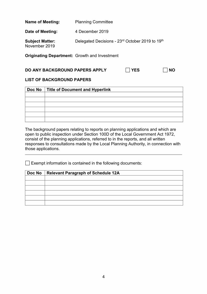
4
Name of Meeting: Planning Committee Date of Meeting: 4 December 2019 Subject Matter: Delegated Decisions - 23rd October 2019 to 19th
November 2019 Originating Department: Growth and Investment DO ANY BACKGROUND PAPERS APPLY YES NO LIST OF BACKGROUND PAPERS Doc No Title of Document and Hyperlink
The background papers relating to reports on planning applications and which are open to public inspection under Section 100D of the Local Government Act 1972, consist of the planning applications, referred to in the reports, and all written responses to consultations made by the Local Planning Authority, in connection with those applications.
Exempt information is contained in the following documents: Doc No Relevant Paragraph of Schedule 12A
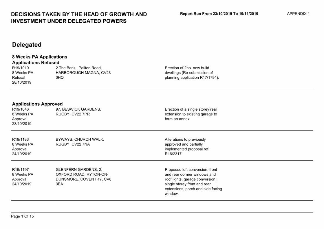
Report Run From 23/10/2019 To 19/11/2019 APPENDIX 1DECISIONS TAKEN BY THE HEAD OF GROWTH ANDINVESTMENT UNDER DELEGATED POWERS
Delegated
8 Weeks PA ApplicationsApplications Refused
Erection of 2no. new builddwellings (Re-submission ofplanning application R17/1794).
2 The Bank, Pailton Road,HARBOROUGH MAGNA, CV230HQ
R19/10108 Weeks PARefusal28/10/2019
Applications Approved97, BESWICK GARDENS,RUGBY, CV22 7PR
Erection of a single storey rearextension to existing garage toform an annex
R19/10468 Weeks PAApproval23/10/2019
BYWAYS, CHURCH WALK,RUGBY, CV22 7NA
R19/11838 Weeks PAApproval24/10/2019
Alterations to previouslyapproved and partiallyimplemented proposal ref.R16/2317
R19/11978 Weeks PAApproval24/10/2019
GLENFERN GARDENS, 2,OXFORD ROAD, RYTON-ON-DUNSMORE, COVENTRY, CV83EA
Proposed loft conversion, frontand rear dormer windows androof lights, garage conversion,single storey front and rearextensions, porch and side facingwindow.
Page 1 Of 15
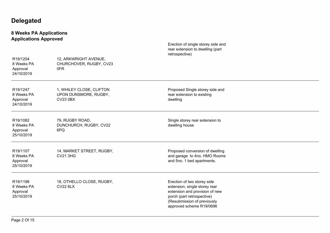
Delegated
8 Weeks PA ApplicationsApplications Approved
Erection of single storey side andrear extension to dwelling (partretrospective)
12, ARKWRIGHT AVENUE,CHURCHOVER, RUGBY, CV230FR
R19/12048 Weeks PAApproval24/10/2019
Proposed Single storey side andrear extension to existingdwelling
1, WHILEY CLOSE, CLIFTONUPON DUNSMORE, RUGBY,CV23 0BX
R19/12478 Weeks PAApproval24/10/2019
Single storey rear extension todwelling house
79, RUGBY ROAD,DUNCHURCH, RUGBY, CV226PQ
R19/10828 Weeks PAApproval25/10/2019
14, MARKET STREET, RUGBY,CV21 3HG
Proposed conversion of dwellingand garage to 4no. HMO Roomsand 5no. 1 bed apartments.
R19/11078 Weeks PAApproval25/10/2019
18, OTHELLO CLOSE, RUGBY,CV22 6LX
R19/11988 Weeks PAApproval25/10/2019
Erection of two storey sideextension, single storey rearextension and provision of newporch (part retrospective)(Resubmission of previouslyapproved scheme R19/0696
Page 2 Of 15
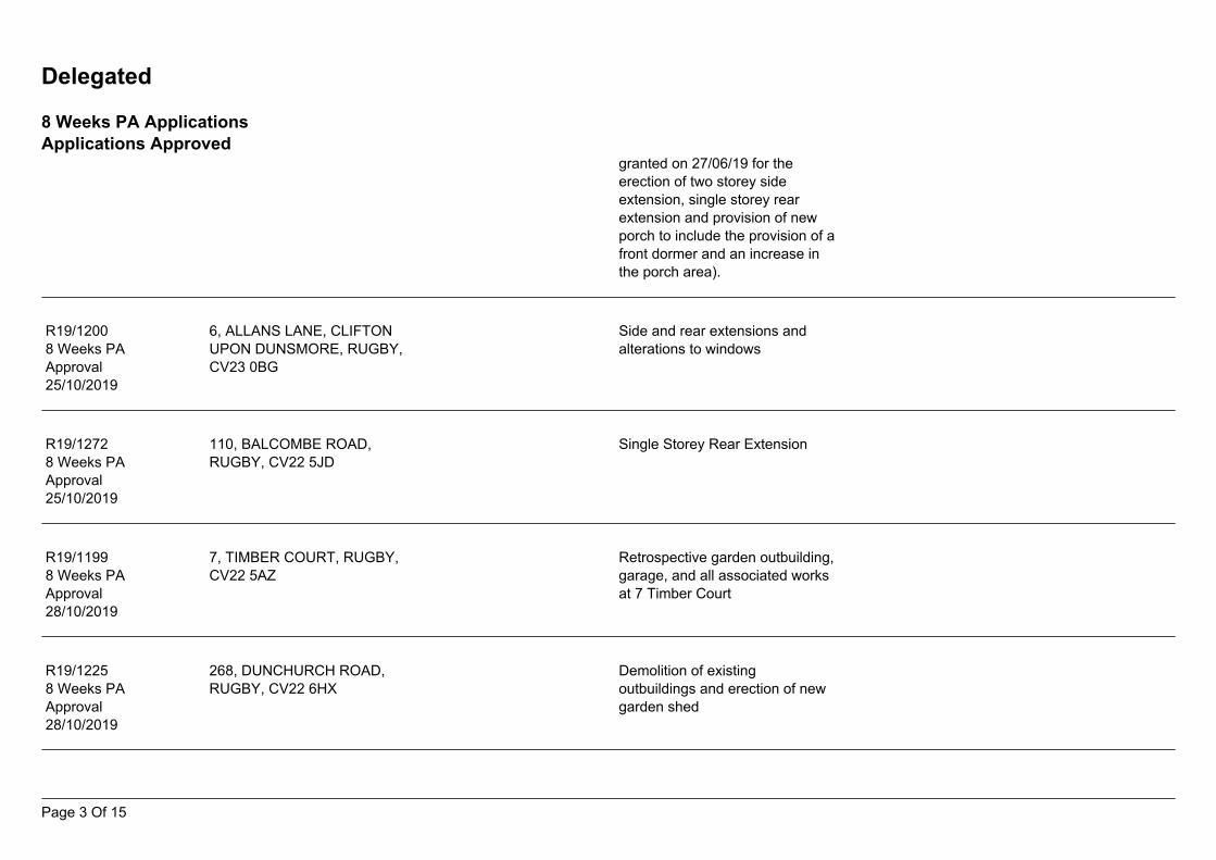
Delegated
8 Weeks PA ApplicationsApplications Approved
granted on 27/06/19 for theerection of two storey sideextension, single storey rearextension and provision of newporch to include the provision of afront dormer and an increase inthe porch area).
Side and rear extensions andalterations to windows
6, ALLANS LANE, CLIFTONUPON DUNSMORE, RUGBY,CV23 0BG
R19/12008 Weeks PAApproval25/10/2019
Single Storey Rear Extension110, BALCOMBE ROAD,RUGBY, CV22 5JD
R19/12728 Weeks PAApproval25/10/2019
7, TIMBER COURT, RUGBY,CV22 5AZ
Retrospective garden outbuilding,garage, and all associated worksat 7 Timber Court
R19/11998 Weeks PAApproval28/10/2019
268, DUNCHURCH ROAD,RUGBY, CV22 6HX
Demolition of existingoutbuildings and erection of newgarden shed
R19/12258 Weeks PAApproval28/10/2019
Page 3 Of 15
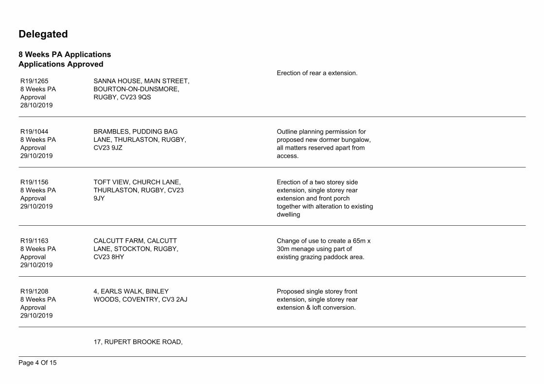
Delegated
8 Weeks PA ApplicationsApplications Approved
Erection of rear a extension.SANNA HOUSE, MAIN STREET,BOURTON-ON-DUNSMORE,RUGBY, CV23 9QS
R19/12658 Weeks PAApproval28/10/2019
BRAMBLES, PUDDING BAGLANE, THURLASTON, RUGBY,CV23 9JZ
R19/10448 Weeks PAApproval29/10/2019
Outline planning permission forproposed new dormer bungalow,all matters reserved apart fromaccess.
TOFT VIEW, CHURCH LANE,THURLASTON, RUGBY, CV239JY
R19/11568 Weeks PAApproval29/10/2019
Erection of a two storey sideextension, single storey rearextension and front porchtogether with alteration to existingdwelling
Change of use to create a 65m x30m menage using part ofexisting grazing paddock area.
CALCUTT FARM, CALCUTTLANE, STOCKTON, RUGBY,CV23 8HY
R19/11638 Weeks PAApproval29/10/2019
4, EARLS WALK, BINLEYWOODS, COVENTRY, CV3 2AJ
Proposed single storey frontextension, single storey rearextension & loft conversion.
R19/12088 Weeks PAApproval29/10/2019
17, RUPERT BROOKE ROAD,
Page 4 Of 15
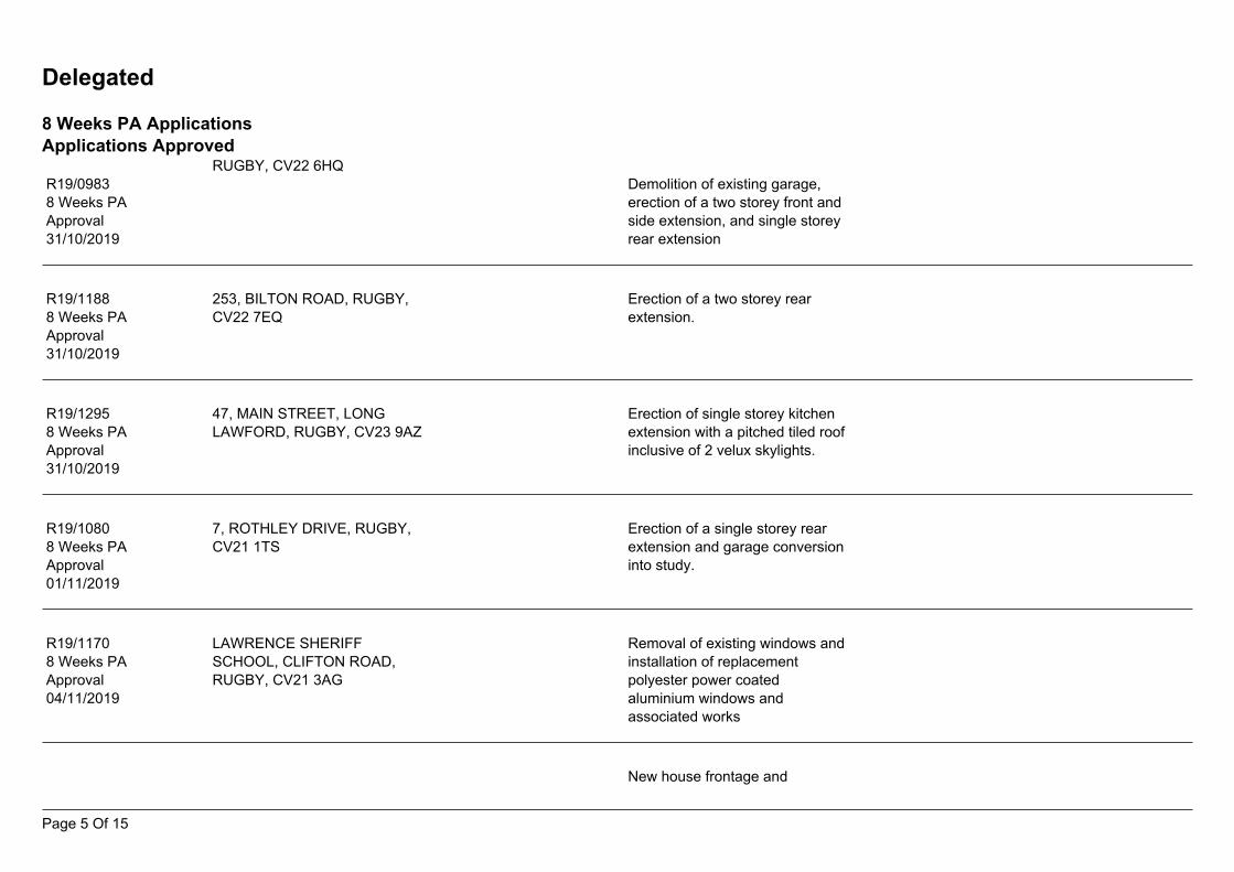
Delegated
8 Weeks PA ApplicationsApplications Approved
RUGBY, CV22 6HQR19/09838 Weeks PAApproval31/10/2019
Demolition of existing garage,erection of a two storey front andside extension, and single storeyrear extension
Erection of a two storey rearextension.
253, BILTON ROAD, RUGBY,CV22 7EQ
R19/11888 Weeks PAApproval31/10/2019
47, MAIN STREET, LONGLAWFORD, RUGBY, CV23 9AZ
Erection of single storey kitchenextension with a pitched tiled roofinclusive of 2 velux skylights.
R19/12958 Weeks PAApproval31/10/2019
7, ROTHLEY DRIVE, RUGBY,CV21 1TS
Erection of a single storey rearextension and garage conversioninto study.
R19/10808 Weeks PAApproval01/11/2019
LAWRENCE SHERIFFSCHOOL, CLIFTON ROAD,RUGBY, CV21 3AG
R19/11708 Weeks PAApproval04/11/2019
Removal of existing windows andinstallation of replacementpolyester power coatedaluminium windows andassociated works
New house frontage and
Page 5 Of 15
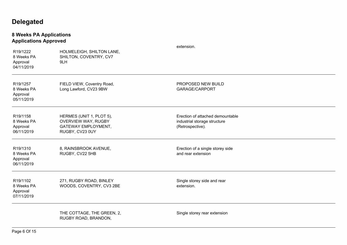
Delegated
8 Weeks PA ApplicationsApplications Approved
extension.HOLMELEIGH, SHILTON LANE,SHILTON, COVENTRY, CV79LH
R19/12228 Weeks PAApproval04/11/2019
PROPOSED NEW BUILDGARAGE/CARPORT
FIELD VIEW, Coventry Road,Long Lawford, CV23 9BW
R19/12578 Weeks PAApproval05/11/2019
Erection of attached demountableindustrial storage structure(Retrospective).
R19/11588 Weeks PAApproval06/11/2019
HERMES (UNIT 1, PLOT 5),OVERVIEW WAY, RUGBYGATEWAY EMPLOYMENT,RUGBY, CV23 0UY
Erection of a single storey sideand rear extension
8, RAINSBROOK AVENUE,RUGBY, CV22 5HB
R19/13108 Weeks PAApproval06/11/2019
Single storey side and rearextension.
271, RUGBY ROAD, BINLEYWOODS, COVENTRY, CV3 2BE
R19/11028 Weeks PAApproval07/11/2019
Single storey rear extensionTHE COTTAGE, THE GREEN, 2,RUGBY ROAD, BRANDON,
Page 6 Of 15
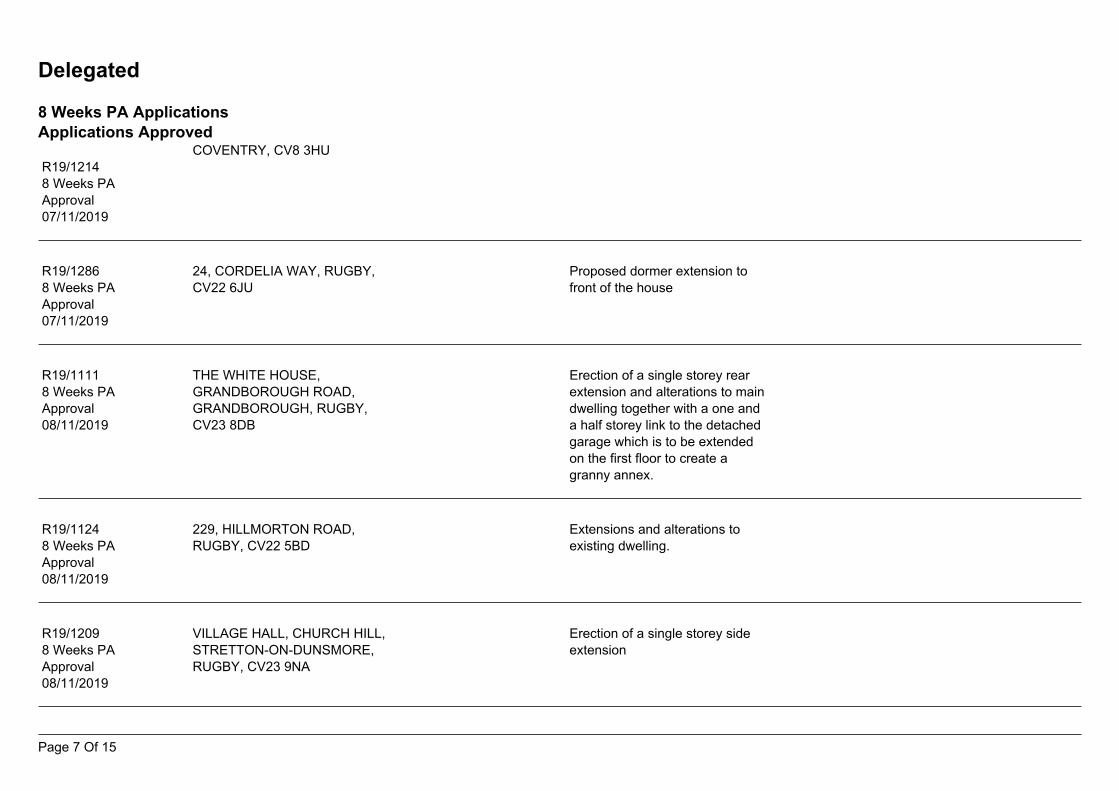
Delegated
8 Weeks PA ApplicationsApplications Approved
COVENTRY, CV8 3HUR19/12148 Weeks PAApproval07/11/2019
Proposed dormer extension tofront of the house
24, CORDELIA WAY, RUGBY,CV22 6JU
R19/12868 Weeks PAApproval07/11/2019
R19/11118 Weeks PAApproval08/11/2019
THE WHITE HOUSE,GRANDBOROUGH ROAD,GRANDBOROUGH, RUGBY,CV23 8DB
Erection of a single storey rearextension and alterations to maindwelling together with a one anda half storey link to the detachedgarage which is to be extendedon the first floor to create agranny annex.
Extensions and alterations toexisting dwelling.
229, HILLMORTON ROAD,RUGBY, CV22 5BD
R19/11248 Weeks PAApproval08/11/2019
Erection of a single storey sideextension
VILLAGE HALL, CHURCH HILL,STRETTON-ON-DUNSMORE,RUGBY, CV23 9NA
R19/12098 Weeks PAApproval08/11/2019
Page 7 Of 15
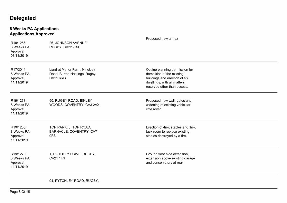
Delegated
8 Weeks PA ApplicationsApplications Approved
Proposed new annex26, JOHNSON AVENUE,RUGBY, CV22 7BX
R19/12568 Weeks PAApproval08/11/2019
Land at Manor Farm, HinckleyRoad, Burton Hastings, Rugby,CV11 6RG
R17/20418 Weeks PAApproval11/11/2019
Outline planning permission fordemolition of the existingbuildings and erection of sixdwellings, with all mattersreserved other than access.
90, RUGBY ROAD, BINLEYWOODS, COVENTRY, CV3 2AX
Proposed new wall, gates andwidening of existing vehicularcrossover
R19/12338 Weeks PAApproval11/11/2019
Erection of 4no. stables and 1no.tack room to replace existingstables destroyed by a fire.
TOP PARK, 8, TOP ROAD,BARNACLE, COVENTRY, CV79FS
R19/12358 Weeks PAApproval11/11/2019
1, ROTHLEY DRIVE, RUGBY,CV21 1TS
Ground floor side extension,extension above existing garageand conservatory at rear
R19/12708 Weeks PAApproval11/11/2019
94, PYTCHLEY ROAD, RUGBY,
Page 8 Of 15
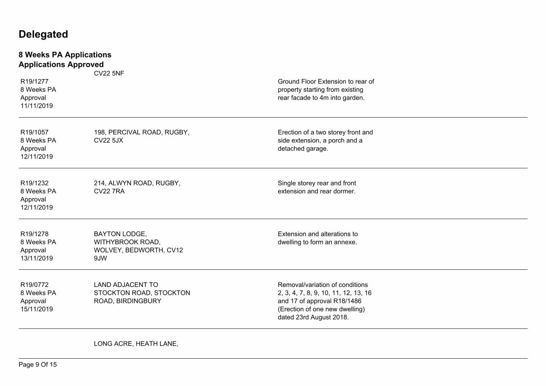
Delegated
8 Weeks PA ApplicationsApplications Approved
CV22 5NFGround Floor Extension to rear ofproperty starting from existingrear facade to 4m into garden.
R19/12778 Weeks PAApproval11/11/2019
198, PERCIVAL ROAD, RUGBY,CV22 5JX
Erection of a two storey front andside extension, a porch and adetached garage.
R19/10578 Weeks PAApproval12/11/2019
Single storey rear and frontextension and rear dormer.
214, ALWYN ROAD, RUGBY,CV22 7RA
R19/12328 Weeks PAApproval12/11/2019
Extension and alterations todwelling to form an annexe.
R19/12788 Weeks PAApproval13/11/2019
BAYTON LODGE,WITHYBROOK ROAD,WOLVEY, BEDWORTH, CV129JW
LAND ADJACENT TOSTOCKTON ROAD, STOCKTONROAD, BIRDINGBURY
R19/07728 Weeks PAApproval15/11/2019
Removal/variation of conditions2, 3, 4, 7, 8, 9, 10, 11, 12, 13, 16and 17 of approval R18/1486(Erection of one new dwelling)dated 23rd August 2018.
LONG ACRE, HEATH LANE,
Page 9 Of 15
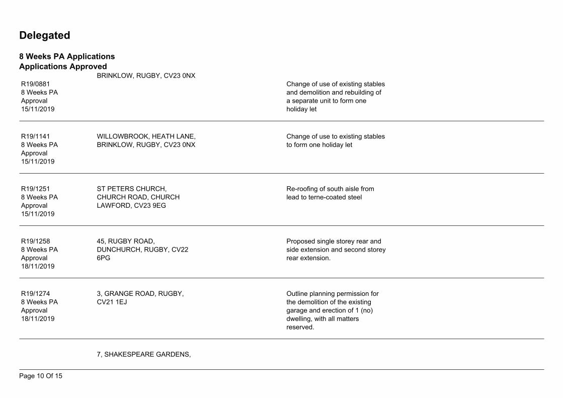
Delegated
8 Weeks PA ApplicationsApplications Approved
BRINKLOW, RUGBY, CV23 0NXR19/08818 Weeks PAApproval15/11/2019
Change of use of existing stablesand demolition and rebuilding ofa separate unit to form oneholiday let
Change of use to existing stablesto form one holiday let
WILLOWBROOK, HEATH LANE,BRINKLOW, RUGBY, CV23 0NX
R19/11418 Weeks PAApproval15/11/2019
Re-roofing of south aisle fromlead to terne-coated steel
ST PETERS CHURCH,CHURCH ROAD, CHURCHLAWFORD, CV23 9EG
R19/12518 Weeks PAApproval15/11/2019
Proposed single storey rear andside extension and second storeyrear extension.
45, RUGBY ROAD,DUNCHURCH, RUGBY, CV226PG
R19/12588 Weeks PAApproval18/11/2019
3, GRANGE ROAD, RUGBY,CV21 1EJ
R19/12748 Weeks PAApproval18/11/2019
Outline planning permission forthe demolition of the existinggarage and erection of 1 (no)dwelling, with all mattersreserved.
7, SHAKESPEARE GARDENS,
Page 10 Of 15
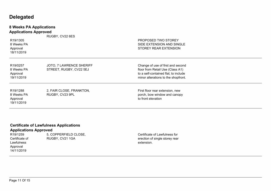
Delegated
8 Weeks PA ApplicationsApplications Approved
RUGBY, CV22 6ESPROPOSED TWO STOREYSIDE EXTENSION AND SINGLESTOREY REAR EXTENSION
R19/13058 Weeks PAApproval18/11/2019
JOTO, 7 LAWRENCE SHERIFFSTREET, RUGBY, CV22 5EJ
R19/02578 Weeks PAApproval19/11/2019
Change of use of first and secondfloor from Retail Use (Class A1)to a self-contained flat; to includeminor alterations to the shopfront.
2, FAIR CLOSE, FRANKTON,RUGBY, CV23 9PL
First floor rear extension, newporch, bow window and canopyto front elevation
R19/12888 Weeks PAApproval19/11/2019
Certificate of Lawfulness ApplicationsApplications Approved
5, COPPERFIELD CLOSE,RUGBY, CV21 1GA
Certificate of Lawfulness forerection of single storey rearextension.
R19/1259Certificate ofLawfulnessApproval14/11/2019
Page 11 Of 15
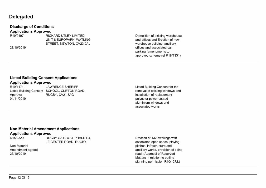
Delegated
Discharge of ConditionsApplications Approved
RICHARD UTLEY LIMITED,UNIT 8 EUROPARK, WATLINGSTREET, NEWTON, CV23 0AL
R19/0497
28/10/2019
Demolition of existing warehouseand offices and Erection of newwarehouse building, ancillaryoffices and associated carparking (amendments toapproved scheme ref R18/1331)
Listed Building Consent ApplicationsApplications Approved
LAWRENCE SHERIFFSCHOOL, CLIFTON ROAD,RUGBY, CV21 3AG
R19/1171Listed Building ConsentApproval04/11/2019
Listed Building Consent for theremoval of existing windows andinstallation of replacementpolyester power coatedaluminium windows andassociated works
Non Material Amendment ApplicationsApplications Approved
RUGBY GATEWAY PHASE R4,LEICESTER ROAD, RUGBY,
R15/2329
Non-MaterialAmendment agreed23/10/2019
Erection of 132 dwellings withassociated open space, playingpitches, infrastructure andancillary works, provision of spineroad; (Approval of ReservedMatters in relation to outlineplanning permission R10/1272.)
Page 12 Of 15
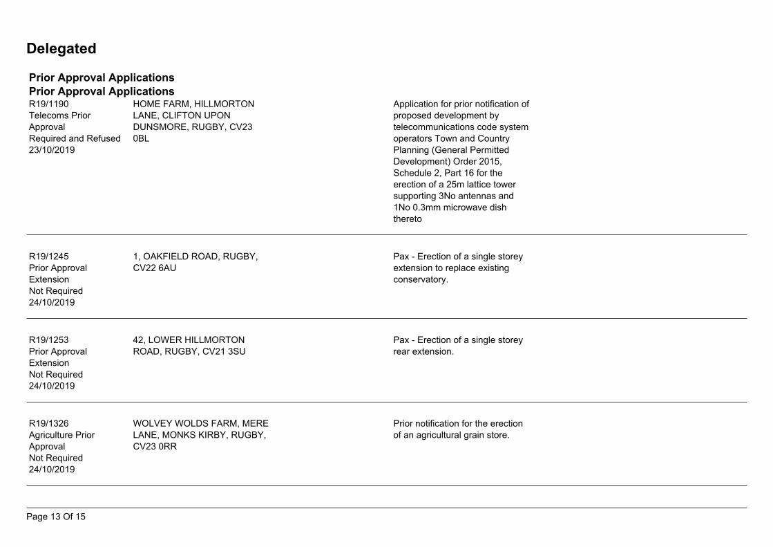
Delegated
Prior Approval ApplicationsPrior Approval Applications
HOME FARM, HILLMORTONLANE, CLIFTON UPONDUNSMORE, RUGBY, CV230BL
R19/1190Telecoms PriorApprovalRequired and Refused23/10/2019
Application for prior notification ofproposed development bytelecommunications code systemoperators Town and CountryPlanning (General PermittedDevelopment) Order 2015,Schedule 2, Part 16 for theerection of a 25m lattice towersupporting 3No antennas and1No 0.3mm microwave dishthereto
1, OAKFIELD ROAD, RUGBY,CV22 6AU
Pax - Erection of a single storeyextension to replace existingconservatory.
R19/1245Prior ApprovalExtensionNot Required24/10/2019
Pax - Erection of a single storeyrear extension.
42, LOWER HILLMORTONROAD, RUGBY, CV21 3SU
R19/1253Prior ApprovalExtensionNot Required24/10/2019
Prior notification for the erectionof an agricultural grain store.
WOLVEY WOLDS FARM, MERELANE, MONKS KIRBY, RUGBY,CV23 0RR
R19/1326Agriculture PriorApprovalNot Required24/10/2019
Page 13 Of 15
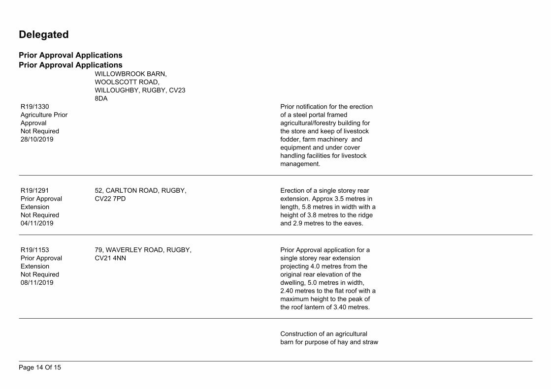
Delegated
Prior Approval ApplicationsPrior Approval Applications
WILLOWBROOK BARN,WOOLSCOTT ROAD,WILLOUGHBY, RUGBY, CV238DA
R19/1330Agriculture PriorApprovalNot Required28/10/2019
Prior notification for the erectionof a steel portal framedagricultural/forestry building forthe store and keep of livestockfodder, farm machinery andequipment and under coverhandling facilities for livestockmanagement.
52, CARLTON ROAD, RUGBY,CV22 7PD
R19/1291Prior ApprovalExtensionNot Required04/11/2019
Erection of a single storey rearextension. Approx 3.5 metres inlength, 5.8 metres in width with aheight of 3.8 metres to the ridgeand 2.9 metres to the eaves.
79, WAVERLEY ROAD, RUGBY,CV21 4NN
R19/1153Prior ApprovalExtensionNot Required08/11/2019
Prior Approval application for asingle storey rear extensionprojecting 4.0 metres from theoriginal rear elevation of thedwelling, 5.0 metres in width,2.40 metres to the flat roof with amaximum height to the peak ofthe roof lantern of 3.40 metres.
Construction of an agriculturalbarn for purpose of hay and straw
Page 14 Of 15
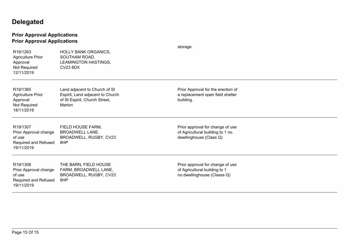
Delegated
Prior Approval ApplicationsPrior Approval Applications
storage.HOLLY BANK ORGANICS,SOUTHAM ROAD,LEAMINGTON HASTINGS,CV23 8DX
R19/1263Agriculture PriorApprovalNot Required12/11/2019
Prior Approval for the erection ofa replacement open field shelterbuilding.
Land adjacent to Church of StEspirit, Land adjacent to Churchof St Espirit, Church Street,Marton
R19/1365Agriculture PriorApprovalNot Required18/11/2019
Prior approval for change of useof Agricultural building to 1 no.dwellinghouse (Class Q)
FIELD HOUSE FARM,BROADWELL LANE,BROADWELL, RUGBY, CV238HP
R19/1307Prior Approval changeof useRequired and Refused19/11/2019
Prior approval for change of useof Agricultural building to 1no.dwellinghouse (Classs Q)
THE BARN, FIELD HOUSEFARM, BROADWELL LANE,BROADWELL, RUGBY, CV238HP
R19/1308Prior Approval changeof useRequired and Refused19/11/2019
Page 15 Of 15