Embed Size (px)
Citation preview
MELBOURNE: 292 Mt Alexander Road, Ascot Vale VIC 3056 GEELONG: 230 Latrobe Terrace, Geelong West VIC 3218 BRISBANE: Level 22, 127 Creek Street, Brisbane QLD 4000 ADELAIDE: 78 Edmund Avenue, Unley SA 5061
CANBERRA: 19-23 Moore Street, Turner ACT 2612 SYDNEY: Level 5, 616 Harris Street, Ultimo NSW 2007 www.ehpartners.com.au | 1300 839 325
Final Report
Report on Submission 42 to the Joint Standing Committee on Northern Australia
Inquiry into the destruction of 46,000 year old caves at the Juukan Gorge in the
Pilbara Region of Western Australia by Messrs Andrew and Robert Starkey 31 July
2020
Hill to Hill (H2H) Power Transmission Line
Commissioned by OZ Minerals Pty Ltd and Kokatha Aboriginal Corporation RNTBC, prepared in
consultation with the South Australian Department of the Premier and Cabinet Aboriginal
Affairs and Reconciliation (DPC-AAR) 07 December 2020
Ecology and Heritage Partners Pty Ltd
Cherrie De Leiuen and Oona Nicolson
PLEASE NOTE THIS DOCUMENT CONTAINS CULTURALLY SENSITIVE INFORMATION, INCLUDING PHOTOGRAPHS. A SUMMARY OF THE FINDINGS CAN BE FOUND AT PAGES 8, 39-43, 83
1
Report on Submission 42to the Joint Standing Committee on Northern Australia Inquiry into the destruction of Western Australia by Messrs Andrew and Robert
Stary Final Report on Submission 42 Hill to Hill (H2H) Power Transmission Line 2020
DOCUMENT CONTROL
Activity
Report on Submission 42 to the Joint Standing Committee on Northern Australia Inquiry into the destruction of 46,000 year old caves at the Juukan Gorge in the Pilbara Region of Western Australia by Messrs Andrew and Robert Starkey 31 July 2020 Hill to Hill (H2H) Power Transmission Line
Project number 14463
Project manager Cherrie De Leiuen
Report author(s) Cherrie De Leiuen
Report reviewer Oona Nicolson
File name EHP Report to OZM and KAC on Submission 42_Final_07.12.2020
Client Kokatha Aboriginal Corporation RNTBC
Aboriginal Organisation
Kokatha Aboriginal Corporation RNTBC
2
Report on Submission 42to the Joint Standing Committee on Northern Australia Inquiry into the destruction of Western Australia by Messrs Andrew and Robert
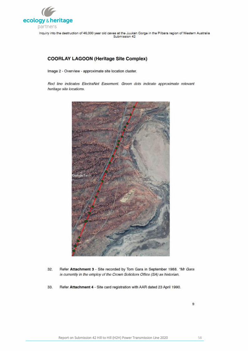
Stary Final Report on Submission 42 Hill to Hill (H2H) Power Transmission Line 2020
Report versions Details Date submitted
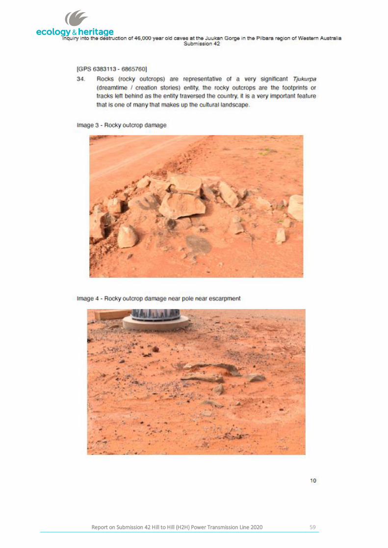
Draft v1 Draft for internal QA Review at Ecology and Heritage Partners Pty Ltd 19.10.2020
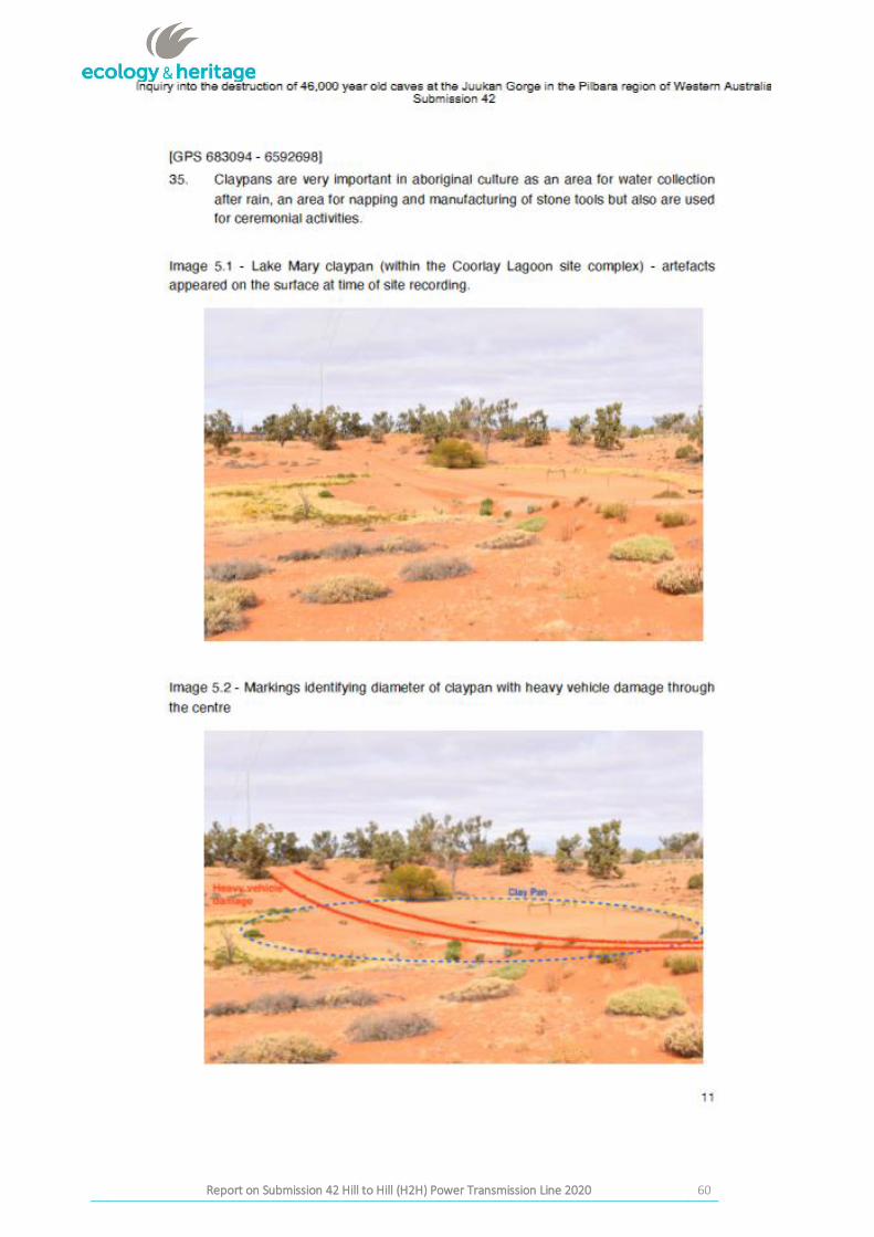
Draft v2 Draft to OZM and KAC for comment 20.10.2020
Draft v3 Draft to DPC-AAR for comment 28.10.2020
Oral summary of review process by AAR to KAC Board 30.11.2020
Draft v4 Technical review by KAC, DPC_AAR and OZM 6.11.2020
Draft v5 Internal technical review by Joanne Thredgold (Australian Heritage Services Pty Ltd)
18.11. 2020
Final Report Final Report endorsed by KAC Board TBC
Final Report Report released TBC
3
Report on Submission 42to the Joint Standing Committee on Northern Australia Inquiry into the destruction of Western Australia by Messrs Andrew and Robert
Stary Final Report on Submission 42 Hill to Hill (H2H) Power Transmission Line 2020
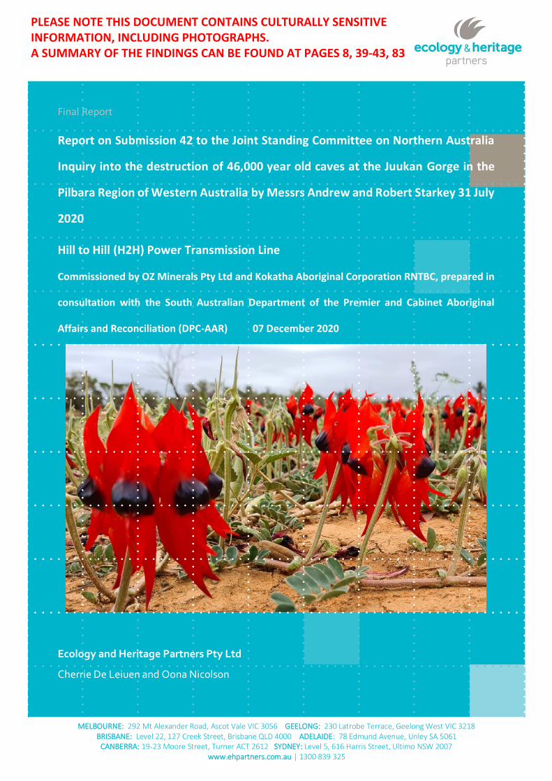
Cover Photo: Roadside Sturt Desert Peas
(Photo by C. De Leiuen, Ecology and Heritage Partners Pty Ltd)
Protocols for Handling Sensitive Information
Some of the information contained within this Aboriginal Cultural Heritage Assessment is culturally sensitive. Before releasing the contents of this report to the public, written consent must be provided by the Kokatha Aboriginal Corporation RNTBC. The contents of the report are the property of Kokatha Aboriginal Corporation RNTBC.
Disclaimer
Although Ecology and Heritage Partners Pty Ltd have taken all the necessary steps to ensure that an accurate document has been prepared, the company accepts no liability for any damages or loss incurred as a result of reliance placed upon the report and its contents.
4
Report on Submission 42to the Joint Standing Committee on Northern Australia Inquiry into the destruction of Western Australia by Messrs Andrew and Robert
Stary Final Report on Submission 42 Hill to Hill (H2H) Power Transmission Line 2020
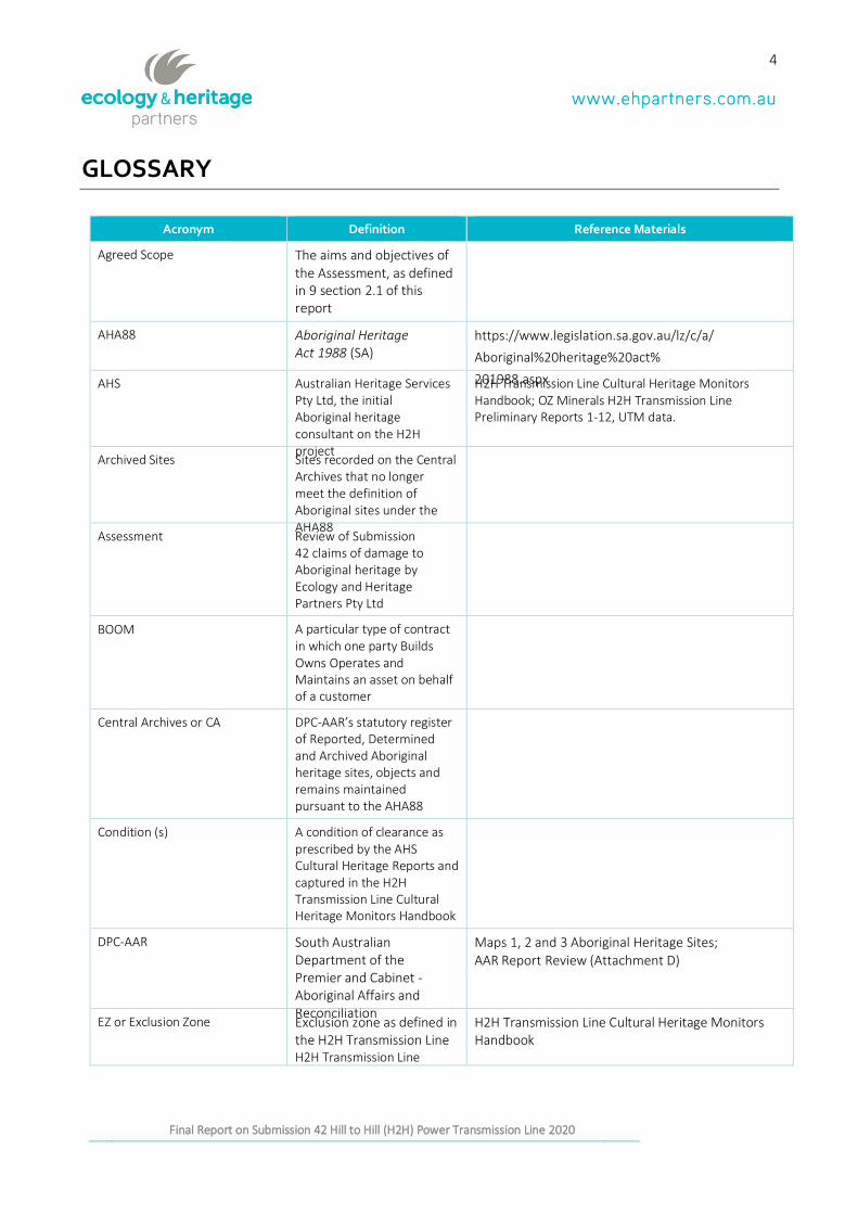
GLOSSARY
Acronym Definition Reference Materials
Agreed Scope The aims and objectives of the Assessment, as defined in 9 section 2.1 of this report
AHA88 Aboriginal Heritage Act 1988 (SA)
https://www.legislation.sa.gov.au/lz/c/a/
Aboriginal%20heritage%20act%
201988.aspx AHS Australian Heritage Services Pty Ltd, the initial Aboriginal heritage consultant on the H2H project
H2H Transmission Line Cultural Heritage Monitors Handbook; OZ Minerals H2H Transmission Line Preliminary Reports 1-12, UTM data.
Archived Sites Sites recorded on the Central Archives that no longer meet the definition of Aboriginal sites under the AHA88
Assessment Review of Submission 42 claims of damage to Aboriginal heritage by Ecology and Heritage Partners Pty Ltd
BOOM A particular type of contract in which one party Builds Owns Operates and Maintains an asset on behalf of a customer
Central Archives or CA DPC-AAR’s statutory register of Reported, Determined and Archived Aboriginal heritage sites, objects and remains maintained pursuant to the AHA88
Condition (s) A condition of clearance as prescribed by the AHS Cultural Heritage Reports and captured in the H2H Transmission Line Cultural Heritage Monitors Handbook
DPC-AAR South Australian Department of the Premier and Cabinet - Aboriginal Affairs and Reconciliation
Maps 1, 2 and 3 Aboriginal Heritage Sites; AAR Report Review (Attachment D)
EZ or Exclusion Zone Exclusion zone as defined in the H2H Transmission Line H2H Transmission Line
H2H Transmission Line Cultural Heritage Monitors Handbook
5
Report on Submission 42to the Joint Standing Committee on Northern Australia Inquiry into the destruction of Western Australia by Messrs Andrew and Robert
Stary Final Report on Submission 42 Hill to Hill (H2H) Power Transmission Line 2020
Acronym Definition Reference Materials
Cultural Heritage Monitors Handbook
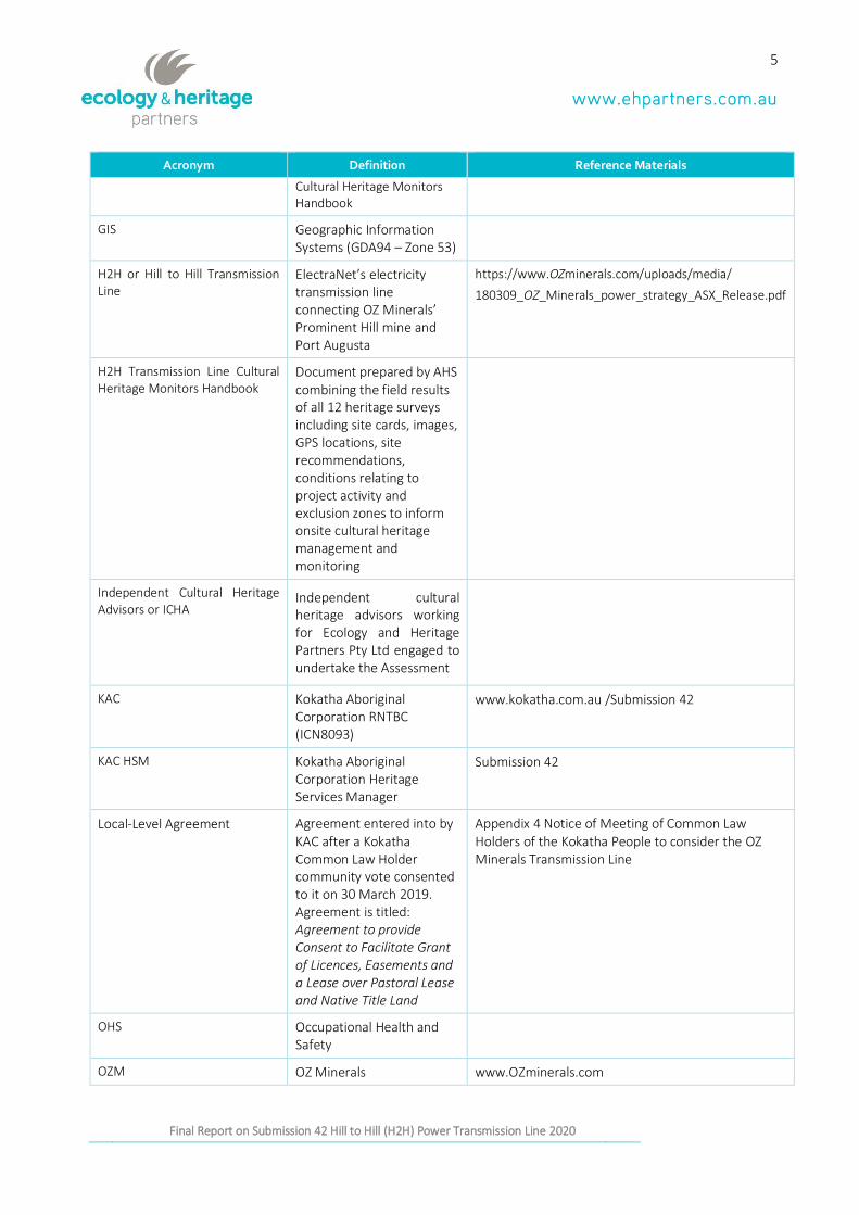
GIS Geographic Information Systems (GDA94 – Zone 53)
H2H or Hill to Hill Transmission Line
ElectraNet’s electricity transmission line connecting OZ Minerals’ Prominent Hill mine and Port Augusta
https://www.OZminerals.com/uploads/media/
180309_OZ_Minerals_power_strategy_ASX_Release.pdf
H2H Transmission Line Cultural Heritage Monitors Handbook
Document prepared by AHS combining the field results of all 12 heritage surveys including site cards, images, GPS locations, site recommendations, conditions relating to project activity and exclusion zones to inform onsite cultural heritage management and monitoring
Independent Cultural Heritage Advisors or ICHA
Independent cultural heritage advisors working for Ecology and Heritage Partners Pty Ltd engaged to undertake the Assessment
KAC Kokatha Aboriginal Corporation RNTBC (ICN8093)
www.kokatha.com.au /Submission 42
KAC HSM Kokatha Aboriginal Corporation Heritage Services Manager
Submission 42
Local-Level Agreement Agreement entered into by KAC after a Kokatha Common Law Holder community vote consented to it on 30 March 2019. Agreement is titled: Agreement to provide Consent to Facilitate Grant of Licences, Easements and a Lease over Pastoral Lease and Native Title Land
Appendix 4 Notice of Meeting of Common Law Holders of the Kokatha People to consider the OZ Minerals Transmission Line
OHS Occupational Health and Safety
OZM OZ Minerals www.OZminerals.com
6
Report on Submission 42to the Joint Standing Committee on Northern Australia Inquiry into the destruction of Western Australia by Messrs Andrew and Robert
Stary Final Report on Submission 42 Hill to Hill (H2H) Power Transmission Line 2020
Acronym Definition Reference Materials
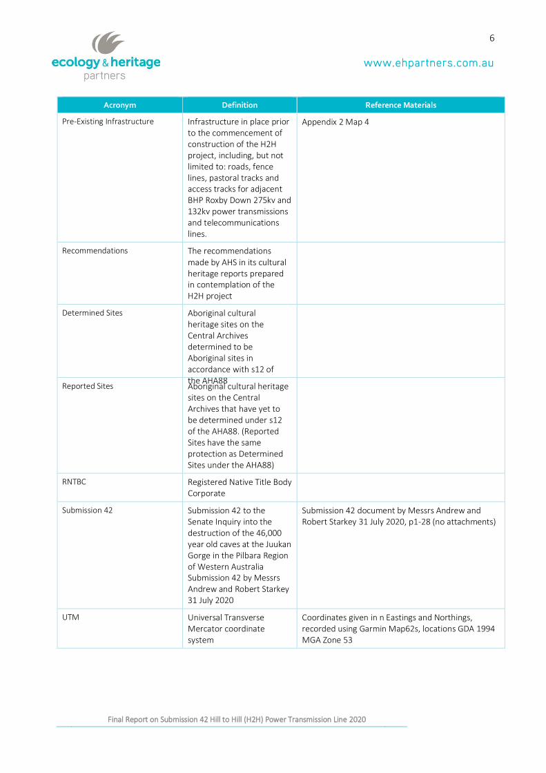
Pre-Existing Infrastructure Infrastructure in place prior to the commencement of construction of the H2H project, including, but not limited to: roads, fence lines, pastoral tracks and access tracks for adjacent BHP Roxby Down 275kv and 132kv power transmissions and telecommunications lines.
Appendix 2 Map 4
Recommendations The recommendations made by AHS in its cultural heritage reports prepared in contemplation of the H2H project
Determined Sites Aboriginal cultural heritage sites on the Central Archives determined to be Aboriginal sites in accordance with s12 of the AHA88
Reported Sites Aboriginal cultural heritage sites on the Central Archives that have yet to be determined under s12 of the AHA88. (Reported Sites have the same protection as Determined Sites under the AHA88)
RNTBC Registered Native Title Body Corporate
Submission 42 Submission 42 to the Senate Inquiry into the destruction of the 46,000 year old caves at the Juukan Gorge in the Pilbara Region of Western Australia Submission 42 by Messrs Andrew and Robert Starkey 31 July 2020
Submission 42 document by Messrs Andrew and Robert Starkey 31 July 2020, p1-28 (no attachments)
UTM Universal Transverse Mercator coordinate system
Coordinates given in n Eastings and Northings, recorded using Garmin Map62s, locations GDA 1994 MGA Zone 53
7
Report on Submission 42to the Joint Standing Committee on Northern Australia Inquiry into the destruction of Western Australia by Messrs Andrew and Robert
Stary Final Report on Submission 42 Hill to Hill (H2H) Power Transmission Line 2020
8
Report on Submission 42to the Joint Standing Committee on Northern Australia Inquiry into the destruction of Western Australia by Messrs Andrew and Robert
Stary Final Report on Submission 42 Hill to Hill (H2H) Power Transmission Line 2020
EXECUTIVE SUMMARY
Ecology and Heritage Partners Pty Ltd (EHP) was engaged in September 2020 EHP was engaged by KAC and
OZM in consultation with DPC-AAR to prepare a review of Submission 42 by Messrs Andrew and Robert Starkey
provided to the Senate Inquiry into the destruction of the 46,000 year old caves at the Juukan Gorge in the
Pilbara Region of Western Australia dated 31 July 2020.
Submission 42 made claims of breaches of the Aboriginal Heritage Act 1988 (SA) (AHA88) occurred during the
construction of the H2H Power Transmission Line.
KAC sought this report and Oz Minerals funded it.
The project brief was developed in consultation with DPC-AAR and agreed upon by KAC and OZM. EHP’s
independent assessment included an on-ground inspection of the specific areas within the Kokatha
Determination area referred to by Submission 42, excluding the Davenport Mythological Site as the location,
as it falls outside of the Kokatha Consent Determination Area.
EHP was contracted to deliver a report detailing the outcomes of its on-ground assessments, and with respect
to the areas of site disturbance claims referenced in the Submission 42, give its independent and professional
opinion about the questions below:
1. Did the heritage recommendations provided by the previous H2H heritage consultant (H2H Consultant) comply with the requirements of the Aboriginal Heritage Act 1988 (AHA88)? Yes. This report concludes that there is no evidence of damage to any Determined, Reported or Archived Sites.
All works carried out by the consultant were undertaken in consultation with the KAC RNTBC.
2. Did project activities associated with H2H Project comply with the heritage recommendations of the H2H Cultural Heritage Consultant? Yes. All works inspected were in compliance with the consultant’s Recommendations and work did not occur in Exclusion Zones and was within agreed Conditions.
3. Did the heritage recommendations provided by the H2H Cultural Heritage Consultant comply with the ‘Local-Level Agreement’ between KAC, OZ Minerals and ElectraNet? Yes.
4. What, if any, evidence exists that H2H Project activities resulted in damage, disturbance or interference with Aboriginal sites, objects or remains? There is no evidence that works carried out by H2H project activities damaged, disturbed or interfered with Aboriginal sites, objects or remains.
9
Report on Submission 42to the Joint Standing Committee on Northern Australia Inquiry into the destruction of Western Australia by Messrs Andrew and Robert
Stary Final Report on Submission 42 Hill to Hill (H2H) Power Transmission Line 2020
CONTENTS
1 INTRODUCTION . . . . . . . . . . . . . . . . . . . . . . . . . . . . . . . . . . . . . . . . . . . . . . . . . . . . . . . . . . . . . . . . . . . . . . . . . . . . . . . . . . . . . . . . . . . . . . 12
1.1 Background and Scope of Works .......................................................................................................... 12
1.2 Hill to Hill (H2H) Power Transmission line project ............................................................................... 12
1.3 EHP - Independent Cultural Heritage Advisors ..................................................................................... 13
2 FIELD INSPECTION AND RESULTS . . . . . . . . . . . . . . . . . . . . . . . . . . . . . . . . . . . . . . . . . . . . . . . . . . . . . . . . . . . . . . . . . . . . . . 15
2.1 Aims and Objectives ............................................................................................................................... 15
2.2 Methodology of the Inspection ............................................................................................................. 15
2.3 Limitations of the Inspection ................................................................................................................. 16
3 RESULTS OF THE INSPECTION . . . . . . . . . . . . . . . . . . . . . . . . . . . . . . . . . . . . . . . . . . . . . . . . . . . . . . . . . . . . . . . . . . . . . . . . . . . 17
3.1 Coorlay Lagoon (Heritage Site Complex) .............................................................................................. 17
3.1.1 Rocky outcrops .............................................................................................................................. 17
3.1.2 Lake Mary Claypan ......................................................................................................................... 20
3.1.3 Lake Mary Tea Trees ...................................................................................................................... 22
3.1.4 Coorlay Creek ................................................................................................................................. 24
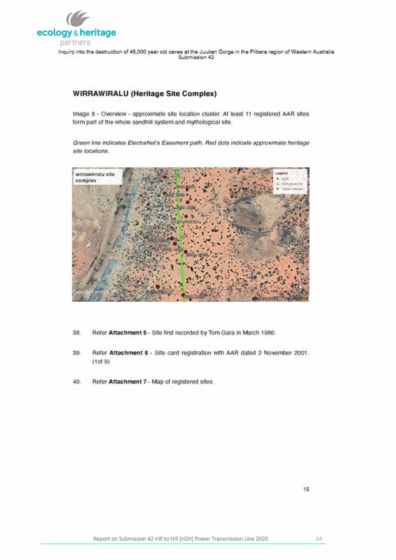
3.2 Wirrawiralu (Heritage Site Complex) .................................................................................................... 25
Submission 42 (Item 41 and Images 9 to 14, pages 15 to 20) ......................................................................... 25
3.3 H2H Roxby Downs Northern End (Heritage Site Complex) .................................................................. 32
4 CONCLUSION . . . . . . . . . . . . . . . . . . . . . . . . . . . . . . . . . . . . . . . . . . . . . . . . . . . . . . . . . . . . . . . . . . . . . . . . . . . . . . . . . . . . . . . . . . . . . . . . . 37
APPENDIX 1: SUMMARY OF RESULTS . . . . . . . . . . . . . . . . . . . . . . . . . . . . . . . . . . . . . . . . . . . . . . . . . . . . . . . . . . . . . . . . . . . . . . . 38
APPENDIX 2: TRACK LOGS . . . . . . . . . . . . . . . . . . . . . . . . . . . . . . . . . . . . . . . . . . . . . . . . . . . . . . . . . . . . . . . . . . . . . . . . . . . . . . . . . . . . . . 44
APPENDIX 3 : COPY OF SUBMISSION 42 . . . . . . . . . . . . . . . . . . . . . . . . . . . . . . . . . . . . . . . . . . . . . . . . . . . . . . . . . . . . . . . . . . . . 49
APPENDIX 4: NOTICE OF MEETING OF COMMON LAW HOLDERS OF THE KOKATHA PEOPLE
TO CONSIDER THE OZ MINERALS TRAN SMISSION LINE . . . . . . . . . . . . . . . . . . . . . . . . . . . . . . . . . . . . . . . . . . . . . . . 78
10
Report on Submission 42to the Joint Standing Committee on Northern Australia Inquiry into the destruction of Western Australia by Messrs Andrew and Robert
Stary Final Report on Submission 42 Hill to Hill (H2H) Power Transmission Line 2020
FIGURES:
Figure 1: Pole #331 predicted location of Item 34 rocky outcrop damage, showing nature of works carried out
in this section of the H2H Transmission Line. View SE UTM 681979 6595737 taken 06.10.2020 at 3:46pm. Note
pole on gibber, no evidence of damage between pole locations. ....................................................................... 19
Figure 2: View N from pole #331 to #332 showing indicative landform, existing track running west in relation
to Transmission Line, and Highway to west. No observed damage. Taken 6.10.2020 3:50 pm ........................ 19
Figure 3: Lake Mary Claypan View SW, showing pre-existing track with vehicle tyre marks, taken at UTM 682114
6584949 photo taken on 6.1.02.2020 at 3:26pm. ................................................................................................ 21
Figure 4: Lake Mary Clay Pan view N, showing existing track running through claypan and H2H Transmission
Line works to the East to pole #288. Pre-existing fencing on left of image (W). Photo taken 6.10.2020 3:28 pm
................................................................................................................................................................................. 21
Figure 5: Lake Mary Claypan, view South eastern section (on H2H Transmission Line side) showing indicative
surface materials .................................................................................................................................................... 22
Figure 6: Damage to trees located between #318 and #319 view NW, UTM 683092 6592681 taken 06.10.2020
at 2:34pm. Note this is not the location of alleged tea tree damage at Item 36 but closest area of most similarity
to given waypoints. ................................................................................................................................................. 23
Figure 7: View S to pole #318 showing landform and indicative vegetation in this section of the corridor. .... 23
Figure 8: View SW of Coorlay Creek showing existing track running through creek bed. Photo taken 6.10.2020
at UTM 681133 6600353 at 4:05 pm. ................................................................................................................... 25
Figure 9: View W to highway showing existing track running through Coorlay Creek and pre-existing
infrastructure .......................................................................................................................................................... 25
Figure 10: CA site 6235 5340 western boundary view north east to BHP line showing current condition, and
artefacts in foreground. Taken 6.10.2020 at 11:42 am. ....................................................................................... 26
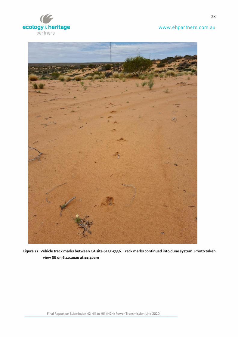
Figure 11: Vehicle track marks between CA site 6235-5336. Track marks continued into dune system. Photo
taken view SE on 6.10.2020 at 11:40am ............................................................................................................... 28
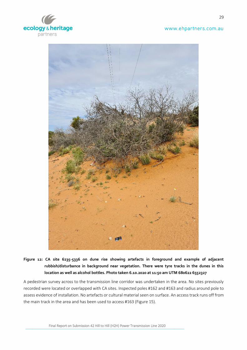
Figure 12: CA site 6235-5336 on dune rise showing artefacts in foreground and example of adjacent
rubbish/disturbance in background near vegetation. There were tyre tracks in the dunes in this location as well
as alcohol bottles. Photo taken 6.10.2020 at 11:50 am UTM 680622 6552327 ................................................ 29
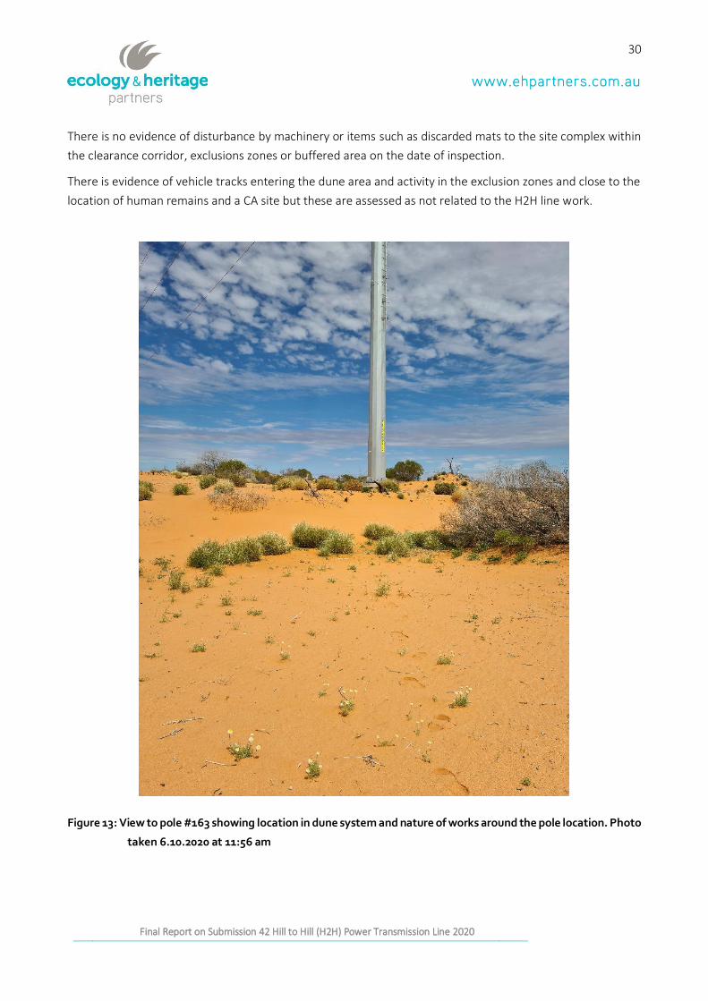
Figure 13: View to pole #163 showing location in dune system and nature of works around the pole location.
Photo taken 6.10.2020 at 11:56 am ...................................................................................................................... 30
11
Report on Submission 42to the Joint Standing Committee on Northern Australia Inquiry into the destruction of Western Australia by Messrs Andrew and Robert
Stary Final Report on Submission 42 Hill to Hill (H2H) Power Transmission Line 2020
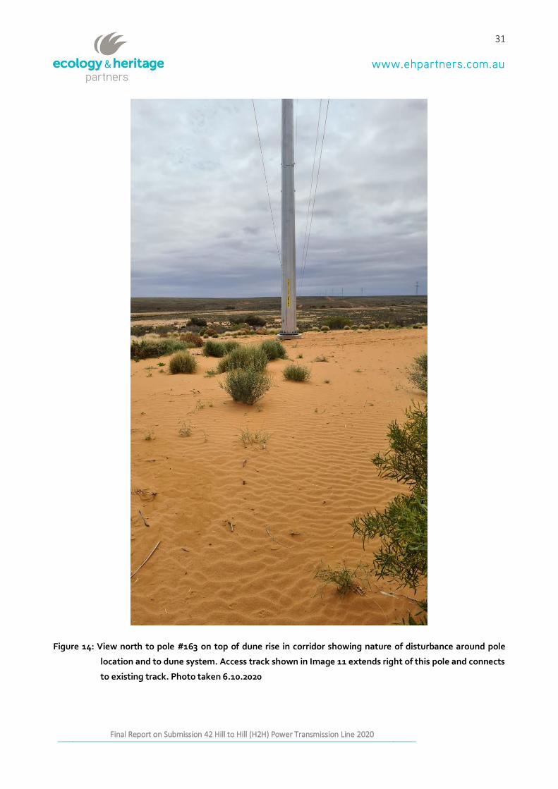
Figure 14: View north to pole #163 on top of dune rise in corridor showing nature of disturbance around pole
location and to dune system. Access track shown in Image 11 extends right of this pole and connects to existing
track. Photo taken 6.10.2020 ................................................................................................................................. 31
Figure 15: Location of Image 23 and alleged tree damage taken 7.10.2020 at 2:11 pm UTM 676817 6621247
................................................................................................................................................................................. 32
Figure 16: Clay pan view north corresponding to Image 21 (view south) showing flooding but some track marks
present. Photo taken 7.10.2020 2:30 pm ............................................................................................................. 33
Figure 17: View south photo taken 7.10.2020 at 2:50 pm. UTM 677054 6618688 ........................................... 33
Figure 18: Possible location of alleged rocky outcrop damage Complex 6……………………………………………………..35
12
Report on Submission 42to the Joint Standing Committee on Northern Australia Inquiry into the destruction of Western Australia by Messrs Andrew and Robert
Stary Final Report on Submission 42 Hill to Hill (H2H) Power Transmission Line 2020
1 INTRODUCTION
1.1 Background and Scope of Works
EHP was engaged by KAC and OZM in consultation with DPC-AAR to prepare a review of Submission 42.
Submission 42 made claims of breaches of the AHA88 occurred during the construction of the H2H Power
Transmission Line.
The Agreed Scope was developed in consultation with DPC-AAR and agreed upon by KAC and OZM. It required
EHP to undertake an on-ground inspection of the specific areas within the Kokatha Determination Area that
were referenced by Submission 42. EHP was asked to deliver a report that detailed the outcomes of the on-
ground assessment, and with respect to the areas of alleged site disturbance referenced in Submission 42,
give its independent and professional opinion about the following:
1. Did the heritage recommendations provided by the previous H2H heritage consultant (H2H Consultant) comply with the requirements of the Aboriginal Heritage Act 1988 (SA) (AHA88)?
2. Did project activities associated with H2H Project comply with the heritage recommendations of the H2H Cultural Heritage Consultant?
3. Did the heritage recommendations provided by the H2H Cultural Heritage Consultant comply with the ‘local-level agreement’ between KAC, OZ Minerals and ElectraNet?
4. What, if any, evidence exists that H2H Project activities resulted in damage, disturbance or interference with Aboriginal sites, objects or remains?
1.2 Hill to Hill (H2H) Power Transmission line project
The first phase of the project involves OZM’s current South Australian assets remaining connected to the
electricity grid via a new high voltage power transmission line. Infrastructure in the region does not support
OZM’s current activities and future regional expansion plans. The new transmission line will meet the
company’s operational requirements and enable its growth strategy for the region.
The H2H project was initiated because in August 2018, OZM received notice from BHP that it would not be
extending a previous agreement which allowed OZM’s Prominent Hill mine to share BHP’s power line from
Davenport to Olympic Dam.
OZM also had a power strategy to achieve reliable, secure and affordable power for its current and future
assets. As a result, OZM and ElectraNet entered into a build, own, operate and maintain (BOOM) arrangement
to provide high voltage electricity transmission services to OZM’s Prominent Hill and Carrapateena operations.
This is referred to as the H2H project being undertaken under the Development Act 1993 (SA).
13
Report on Submission 42to the Joint Standing Committee on Northern Australia Inquiry into the destruction of Western Australia by Messrs Andrew and Robert
Stary Final Report on Submission 42 Hill to Hill (H2H) Power Transmission Line 2020
The H2H project consists of a new 275 kV transmission line from Davenport Substation (near Port Augusta) to
an augmented Mount Gunson South Substation, and subsequently a new 132 kV transmission line from Mount
Gunson South Substation to a connection point into the existing Prominent Hill to Olympic Dam 132 kV
transmission line, west of Olympic Dam. Construction of the new transmission line was completed and
successfully commissioned in early October.
1.3 EHP - Independent Cultural Heritage Advisors
The fieldwork and this report have been prepared by Dr Cherrie De Leiuen (Archaeologist/ Heritage Advisor).
Cherrie is a Heritage Advisor/Archaeologist at EHP, and has over 20 years’ experience working with cultural
heritage as a field supervisor, academic, policy advisor, museum professional and researcher. She has expertise
in both historical and Indigenous archaeology and has worked across Australia and with and for a variety of
stakeholders including regulatory bodies, landowners, community groups and Traditional Owners. This
includes working across a number of regions in South Australia, from the mid-north to far west coast, as is
familiar with a range of landforms and site types.
Cherrie has led teams in archaeological survey and reconnaissance, subsurface testing programs and
excavation. She is experienced in project management, background research, site recording and photography,
artefact cataloguing, analysis and curation. She has direct experience in the design, implementation and
management of archaeological investigations, cultural heritage assessments, and the preparation of
management plans for heritage places. She has also published extensively in international journals and
monographs. She has also presented at conferences nationally and internationally on a range of archaeological
projects and has utilised her teaching and archaeological experience to devise and implement fieldwork
methodology and prepare cultural heritage management reports. Cherrie brings a highly professional skill set
and a strong academic background, project management experience, report writing, stakeholder and client
relationship management.
Her formal qualifications include:
QUALIFICATIONS
• Ph.D. Archaeology, Flinders University (2018).
• Bachelor of Arts (Honours) Archaeology Flinders University (1998).
The quality assurance review was undertaken by Oona Nicolson (Director/Principal Heritage Advisor). Oona
Nicolson is a Director and the Principal Heritage Advisor at EHP. She is a heritage specialist with over 25 years
of experience in the archaeological consulting sector, working in Victoria, South Australia, New South Wales
and Tasmania. Oona regularly appears before VCAT and independent panels as an expert witness in the
areas of Aboriginal and historical heritage – both built and archaeological.
Oona’s skills include project management, peer reviews, diligence assessments, built heritage,
archaeological survey, subsurface testing and salvage excavation, Aboriginal and non-Aboriginal site
identification, recording and photography, drone recording and 3-Dmodelling of structures, site significance
assessment, development
14
Report on Submission 42to the Joint Standing Committee on Northern Australia Inquiry into the destruction of Western Australia by Messrs Andrew and Robert
Stary Final Report on Submission 42 Hill to Hill (H2H) Power Transmission Line 2020
of recommendations to mitigate the impact of development upon Aboriginal and non-Aboriginal historical heritage, communication and consultation with regulatory bodies, agents, landowners, Registered
Aboriginal Parties and community representatives, preparation of conservation management plans,
expert witness statements, Permits and Consents to Disturb for Heritage Victoria, appeals to the
Heritage Council and complex Aboriginal CHMPs. Her formal qualifications and memberships include:
• Bachelor of Arts (Honours in Archaeology; First Class), Flinders University (1996);
• Bachelor of Arts (Australian Archaeology and Australian Studies), Flinders University (1995);
• Past Archaeology (Alternate) Member of the Victorian Heritage Council;
• Maritime Archaeology Certificate: Part 1 (Part 2 pending), AIMA and NAS (U.K.);
• Australian Association of Consulting Archaeologists Inc. AACAI (Full Member and past National President
and current Victorian representative);
• Member and current Victorian representative, Australian Archaeological Association (AAA);
• Fellow and Former Board Member of the Victorian Planning and Environmental Law Association; and
• Accredited UDIA EnviroDevelopment Professional (Accredited August 2012).
Oona is a past member of the South Australian Chamber of Mines and Energy and regularly attended
environmental committee meetings when requested to advise on heritage practice and legislation and served
four years on the Legislative Reform Committee for the Minerals Council of Australia.
EHP has no real or perceived conflict of interest in relation to any of the organisations or individuals concerned.
15
Report on Submission 42to the Joint Standing Committee on Northern Australia Inquiry into the destruction of Western Australia by Messrs Andrew and Robert
Stary Final Report on Submission 42 Hill to Hill (H2H) Power Transmission Line 2020
2 FIELD INSPECTION AND RESULTS
2.1 Aims and Objectives
EHP was engaged to survey, identify, inspect and record all specific areas described and/or photographed in
Submission 42 within the Kokatha Determination Area1for the following purposes:
• To assess whether AHM’s initial Recommendations for the H2H project were in line with the AHA88
• To assess whether activities associated with H2H project complied with AHM’s heritage Recommendations for it
• To assess whether AHM’s Recommendations complied with the Local Level Agreement between KAC, OZM and ElectraNet
• To assess if any evidence exists that H2H project activities resulted in any damage, disturbance or interference with Aboriginal sites, objects or remains on KAC’s native title lands.
The above aims and objectives are referred to in this report as the Agreed Scope.
2.2 Methodology of the Inspection
Three cultural heritage datasets were assessed prior to the field inspection, which was undertaken on 6-7
October, 2020.
1. Reported, Determined and Archived Sites recorded on the Central Archives (provided by DPC-AAR)
2. The twelve OZ Minerals H2H Transmission Line Preliminary Reports (AHS) including GIS data
3. The claims relating to the areas described in Submission 42
(https://www.aph.gov.au/Parliamentary_Business/Committees/Joint/Northern_Australia/CavesatJu
ukanGorge/Submissions and Appendix 3)
The contents of these datasets were assessed by EHP against the claims in Submission 42, including the report
conditions and Exclusion Zones.
A pre-inspection methodology was devised by Cherrie De Leiuen based on the UTM coordinates given in
Submission 42 and matched with existing GIS data, which included nearest pole locations, Exclusion Zones,
access tracks and roads.
The areas described in Submission 42 were inspected between the 5th and 8th October 2020 by:
1 The Davenport Mythological Site is included in Submission 42 but is not included in this Report as the location falls outside of the
Kokatha Consent Determination Area.
16
Report on Submission 42to the Joint Standing Committee on Northern Australia Inquiry into the destruction of Western Australia by Messrs Andrew and Robert
Stary Final Report on Submission 42 Hill to Hill (H2H) Power Transmission Line 2020
• EHP’s Independent Cultural Heritage Advisor (ICHA) - Cherrie De Leiuen, with
• Cultural Heritage Consultant - Joanne Thredgold from Australian Heritage Services (AHS); and
• Kevin Kerry from ElectraNet (Construction Manager) technical escort to facilitate OHS requirements
due to live project activities
Following KAC’s authorisation, Jo Thredgold provided a copy of the H2H Transmission Line Cultural Heritage
Monitors Handbook and corresponding reports. Ms Thredgold then carried a GPS with UTM data of the H2H
corridor and pole locations, cleared areas, conditions and exclusion zones for cross checking in field as well as
confirming locations.
Kevin Kerry provided all required inductions and drove the vehicle to the locations requested to be inspected
as described in Submission 42.
The inspection took the form of a targeted pedestrian survey of the sites described in Submission 42. The
locations were inspected and photographed and the UTM location and tracks recorded with a GPS. Where
they existed, any Aboriginal Heritage sites recorded on DPC-AAR’s Central Archives were inspected to check
against transmission corridor location, cleared areas, conditions or Exclusion Zones. Locations given in UTM
coordinates in Submission 42 and any sites on the Central Archives were used in conjunction with mapping
undertaken by AHS, which shows the alignment and corridor clearance areas surveyed and any exclusion zones
and conditions.
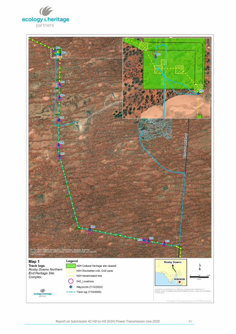
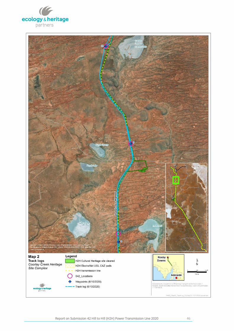
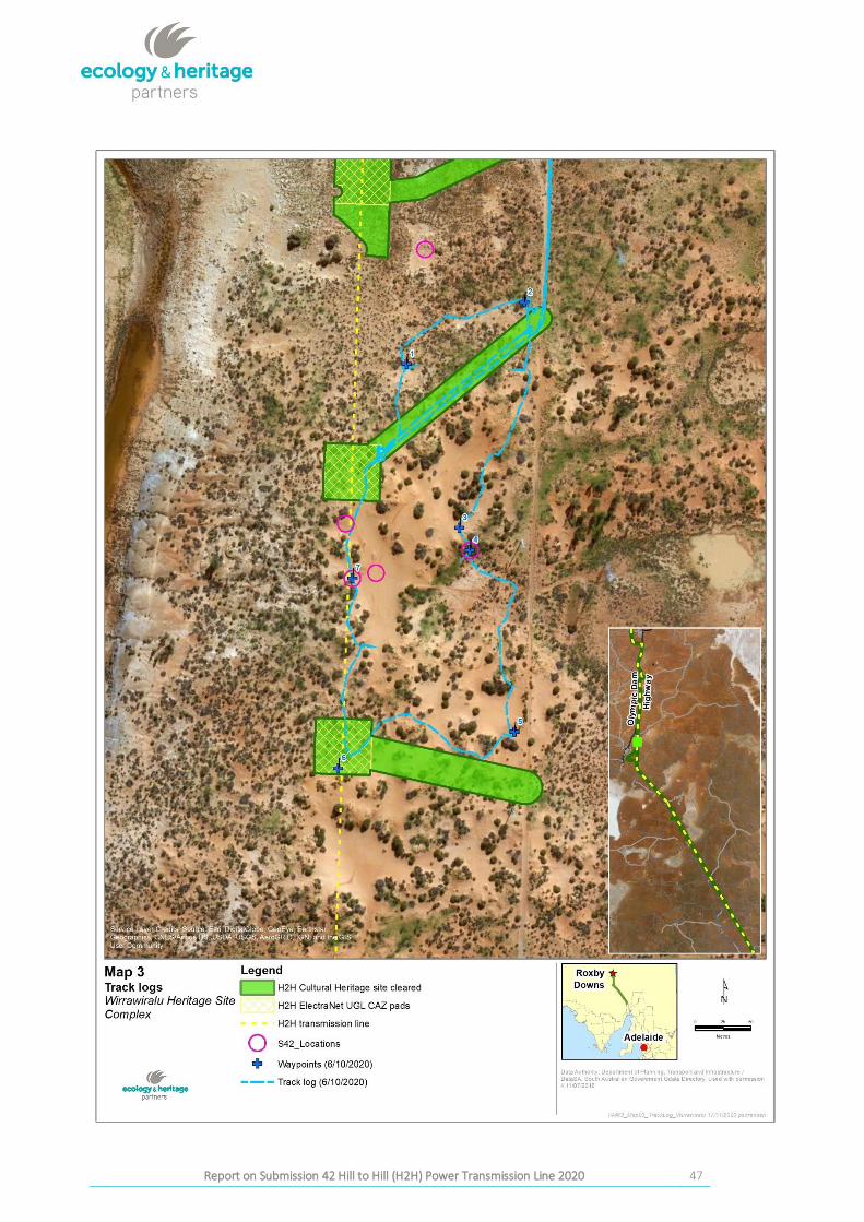
A summary of the inspection results appears in Appendix 1. Maps of track logs are provided in Appendix 2.
2.3 Limitations of the Inspection
Inclement weather including storms occurred at the time of the site inspections (October 6-7th 2020). This
impact is described in Section 4.5. Access to all areas described in Submission 42 was possible.
17
Report on Submission 42to the Joint Standing Committee on Northern Australia Inquiry into the destruction of Western Australia by Messrs Andrew and Robert
Stary Final Report on Submission 42 Hill to Hill (H2H) Power Transmission Line 2020
3 RESULTS OF THE INSPECTION
The results below are discussed following the order of listing in Submission 42, being Coorlay Lagoon (Heritage
Site Complex), Wirrawiralu (Heritage Site Complex) and H2H Roxby Downs - Northern End (Heritage Site
Complex). The photographs taken for this report are referred to as Figures and any reference to Images relates
to the images presented in Submission 42.
Please note these following sections contain images of Aboriginal places and sites that may be culturally
sensitive. No part of this report or the images contained therein may be shared or distributed without the
express permission of KAC.
3.1 Coorlay Lagoon (Heritage Site Complex)
Coorlay Lagoon (Heritage Site Complex) Submission 42, Items 32 to 37, Images 2 to 7.2 were inspected on 6th
October 2020.
The inspection targeted areas named and photographed in Submission 42 and aimed to match images
provided of alleged damage to sites with what was visible on the day following the UTM coordinates provided
in Submission 42, specifically to a rocky outcrop, Lake Mary Claypan, Lake Mary Tea Trees and Coorlay Creek.
Image 2, p 9 of Submission 42 provides twenty-three indicative points of approximate relevant site heritage
site locations or location clusters. These were noted by Joanne Thredgold to likely be pole locations, on top of
dunes or rises along the transmission line. A review of data provided by AHR and AAR showed no overlap of
the 50m transmission line clearance corridor and sites on the Central Archives as claimed within Submission
42. An inspection of pole locations on top of dunes by vehicle with intermittent stops at areas of interest along this entire section of the line found no visible surface artefacts, rock outcrops in poles or corridor or poles positioned within clay pans as claimed within Submission 42.
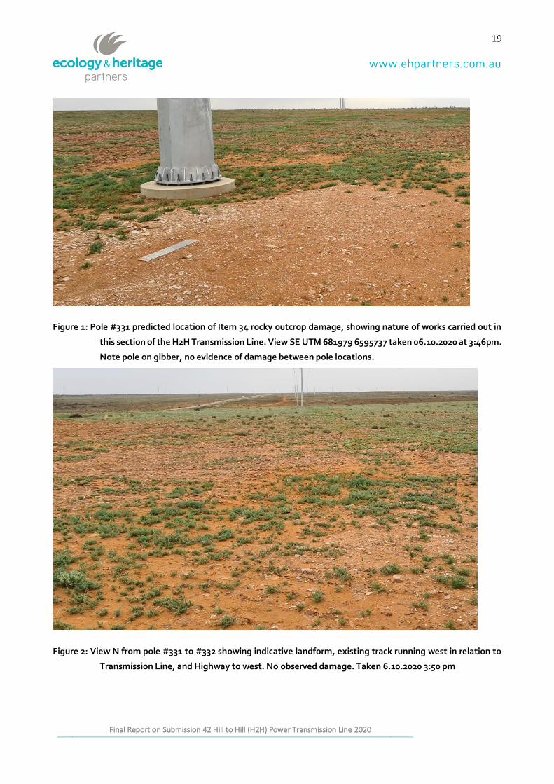
3.1.1 Rocky outcrops
The coordinates given in Submission 42 at Item 34, page 10, have the incorrect number of UTM digits for the
rocks/rocky outcrops and alleged damage relating to Tjukurpa shown in Image 3 and Image 4 (page 10).
Nevertheless, combinations of UTM digits were attempted to be matched with pole location data and
narrowed down to possibly near pole #331 or #332 along the Coorlay Lagoon section of the transmission line.
When inspected the landform in these locations was gibber, and not same sandy soils nor escarpments as
described (see Figure 1). No damage to rocky outcrops was seen at either pole location. No visible damage or
tracks were observed in Exclusion Zone 102 or within the clearance corridor as claimed in Submission 42.
Poles #339 and #340 were also inspected as possible locations for Images 3 and 4 in Submission 42. No damage
to rocky outcrops as claimed in Submission 42 was identified at these pole locations.
None of the poles inspected in this section of the line were located on limestone or rocky outcrops. There
were no visible chert nodules around pole locations. No artefacts were seen on the surface any of the four
18
Report on Submission 42to the Joint Standing Committee on Northern Australia Inquiry into the destruction of Western Australia by Messrs Andrew and Robert
Stary Final Report on Submission 42 Hill to Hill (H2H) Power Transmission Line 2020
pole locations as claimed in Submission 42. No evidence of track marks or damage to rock outcrops (if present)
within 50m corridor as claimed in Submission 42. There were some track marks visible at the time of inspection
from an existing track at pole #331. None of the pole locations inspected overlapped or intersected with any
Central Archives sites, as claimed in Submission 42. An existing track runs west of the transmission line shown
in Figure 2 and may be the track shown in Image 3 and thus the alleged damage may be a result of a pre-
existing track work or vehicle travel rather than by works on the H2H Transmission Line.
19
Report on Submission 42to the Joint Standing Committee on Northern Australia Inquiry into the destruction of Western Australia by Messrs Andrew and Robert
Stary Final Report on Submission 42 Hill to Hill (H2H) Power Transmission Line 2020
Figure 1: Pole #331 predicted location of Item 34 rocky outcrop damage, showing nature of works carried out in
this section of the H2H Transmission Line. View SE UTM 681979 6595737 taken 06.10.2020 at 3:46pm.
Note pole on gibber, no evidence of damage between pole locations.
Figure 2: View N from pole #331 to #332 showing indicative landform, existing track running west in relation to
Transmission Line, and Highway to west. No observed damage. Taken 6.10.2020 3:50 pm
20
Report on Submission 42to the Joint Standing Committee on Northern Australia Inquiry into the destruction of Western Australia by Messrs Andrew and Robert
Stary Final Report on Submission 42 Hill to Hill (H2H) Power Transmission Line 2020
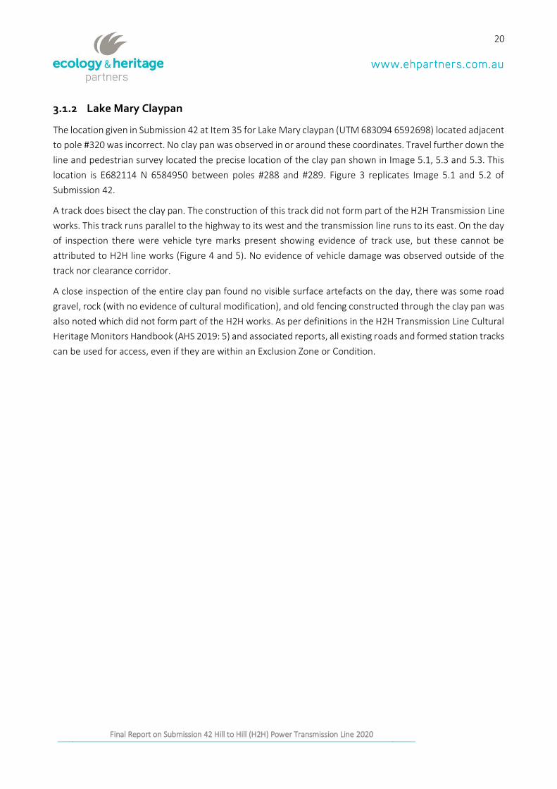
3.1.2 Lake Mary Claypan
The location given in Submission 42 at Item 35 for Lake Mary claypan (UTM 683094 6592698) located adjacent
to pole #320 was incorrect. No clay pan was observed in or around these coordinates. Travel further down the
line and pedestrian survey located the precise location of the clay pan shown in Image 5.1, 5.3 and 5.3. This
location is E682114 N 6584950 between poles #288 and #289. Figure 3 replicates Image 5.1 and 5.2 of
Submission 42.
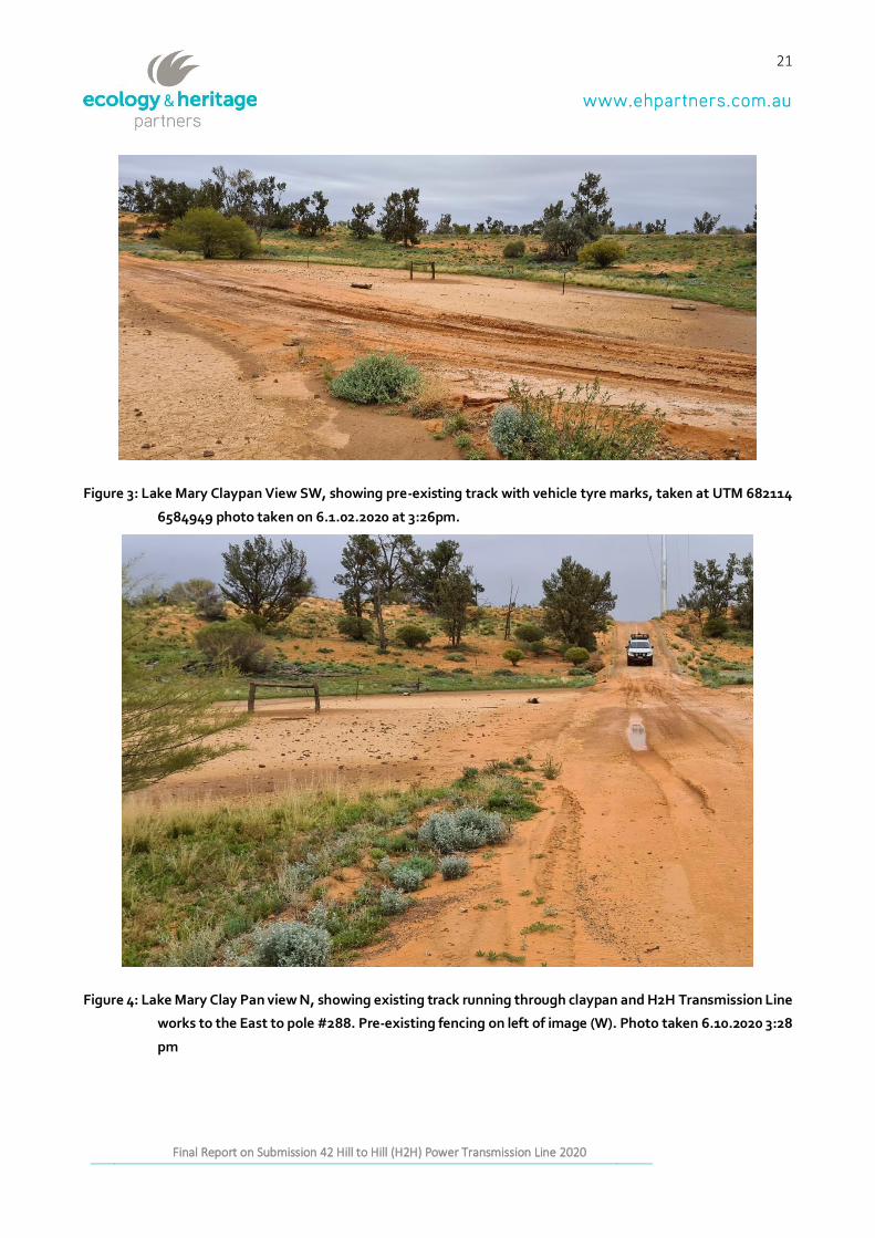
A track does bisect the clay pan. The construction of this track did not form part of the H2H Transmission Line
works. This track runs parallel to the highway to its west and the transmission line runs to its east. On the day
of inspection there were vehicle tyre marks present showing evidence of track use, but these cannot be
attributed to H2H line works (Figure 4 and 5). No evidence of vehicle damage was observed outside of the
track nor clearance corridor.
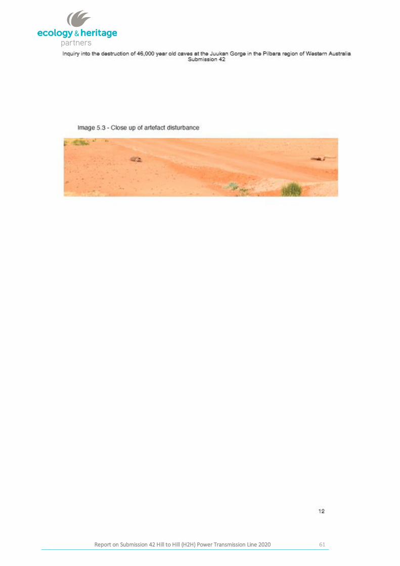
A close inspection of the entire clay pan found no visible surface artefacts on the day, there was some road
gravel, rock (with no evidence of cultural modification), and old fencing constructed through the clay pan was
also noted which did not form part of the H2H works. As per definitions in the H2H Transmission Line Cultural
Heritage Monitors Handbook (AHS 2019: 5) and associated reports, all existing roads and formed station tracks
can be used for access, even if they are within an Exclusion Zone or Condition.
21
Report on Submission 42to the Joint Standing Committee on Northern Australia Inquiry into the destruction of Western Australia by Messrs Andrew and Robert
Stary Final Report on Submission 42 Hill to Hill (H2H) Power Transmission Line 2020
Figure 3: Lake Mary Claypan View SW, showing pre-existing track with vehicle tyre marks, taken at UTM 682114
6584949 photo taken on 6.1.02.2020 at 3:26pm.
Figure 4: Lake Mary Clay Pan view N, showing existing track running through claypan and H2H Transmission Line
works to the East to pole #288. Pre-existing fencing on left of image (W). Photo taken 6.10.2020 3:28
pm
22
Report on Submission 42to the Joint Standing Committee on Northern Australia Inquiry into the destruction of Western Australia by Messrs Andrew and Robert
Stary Final Report on Submission 42 Hill to Hill (H2H) Power Transmission Line 2020
Figure 5: Lake Mary Claypan, view South eastern section (on H2H Transmission Line side) showing indicative
surface materials
3.1.3 Lake Mary Tea Trees
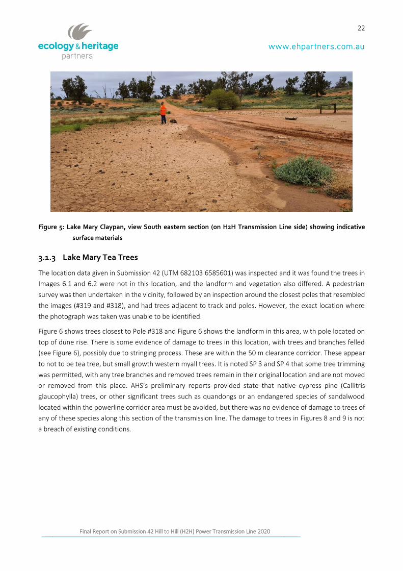
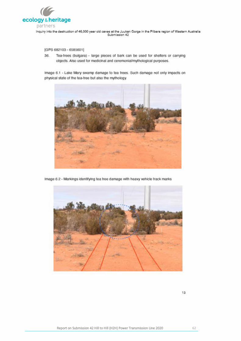
The location data given in Submission 42 (UTM 682103 6585601) was inspected and it was found the trees in
Images 6.1 and 6.2 were not in this location, and the landform and vegetation also differed. A pedestrian
survey was then undertaken in the vicinity, followed by an inspection around the closest poles that resembled
the images (#319 and #318), and had trees adjacent to track and poles. However, the exact location where
the photograph was taken was unable to be identified.
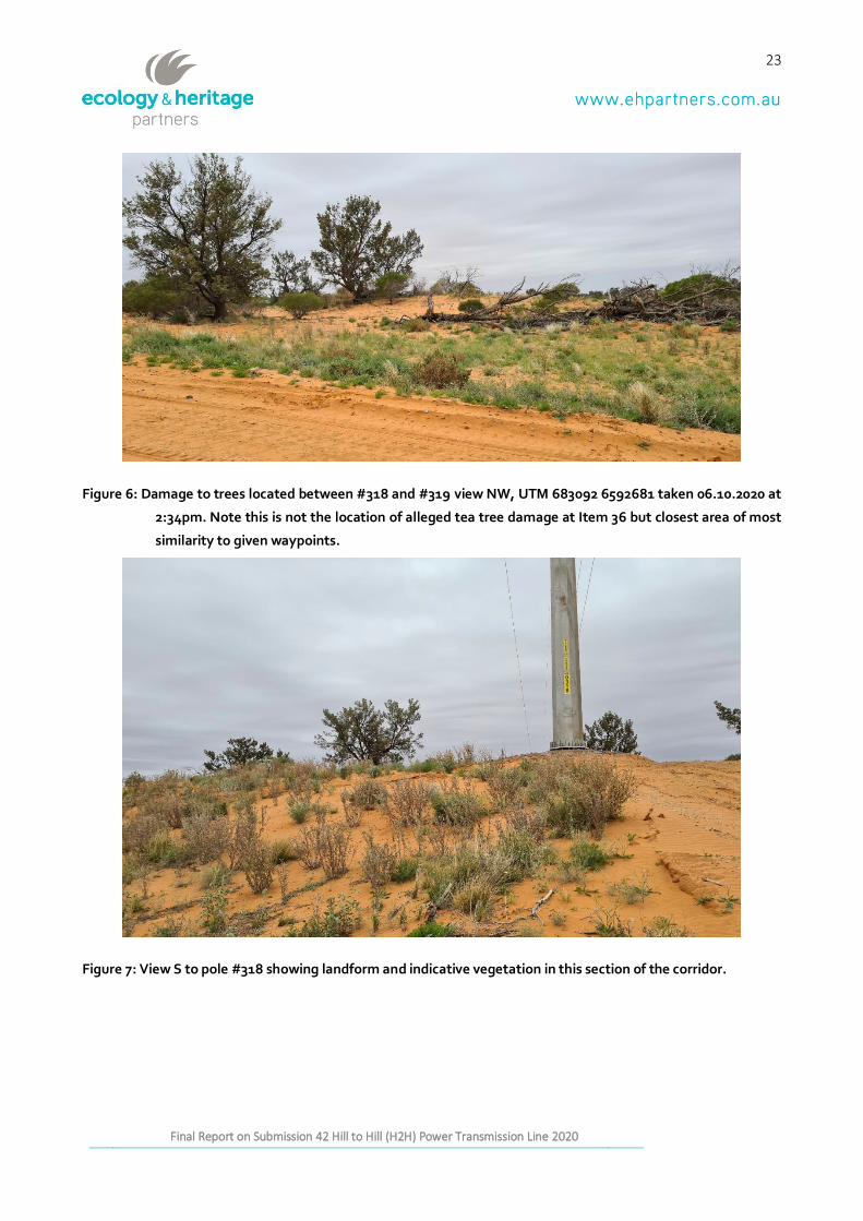
Figure 6 shows trees closest to Pole #318 and Figure 6 shows the landform in this area, with pole located on
top of dune rise. There is some evidence of damage to trees in this location, with trees and branches felled
(see Figure 6), possibly due to stringing process. These are within the 50 m clearance corridor. These appear
to not to be tea tree, but small growth western myall trees. It is noted SP 3 and SP 4 that some tree trimming
was permitted, with any tree branches and removed trees remain in their original location and are not moved
or removed from this place. AHS’s preliminary reports provided state that native cypress pine (Callitris
glaucophylla) trees, or other significant trees such as quandongs or an endangered species of sandalwood
located within the powerline corridor area must be avoided, but there was no evidence of damage to trees of
any of these species along this section of the transmission line. The damage to trees in Figures 8 and 9 is not
a breach of existing conditions.
23
Report on Submission 42to the Joint Standing Committee on Northern Australia Inquiry into the destruction of Western Australia by Messrs Andrew and Robert
Stary Final Report on Submission 42 Hill to Hill (H2H) Power Transmission Line 2020
Figure 6: Damage to trees located between #318 and #319 view NW, UTM 683092 6592681 taken 06.10.2020 at
2:34pm. Note this is not the location of alleged tea tree damage at Item 36 but closest area of most
similarity to given waypoints.
Figure 7: View S to pole #318 showing landform and indicative vegetation in this section of the corridor.
24
Report on Submission 42to the Joint Standing Committee on Northern Australia Inquiry into the destruction of Western Australia by Messrs Andrew and Robert
Stary Final Report on Submission 42 Hill to Hill (H2H) Power Transmission Line 2020
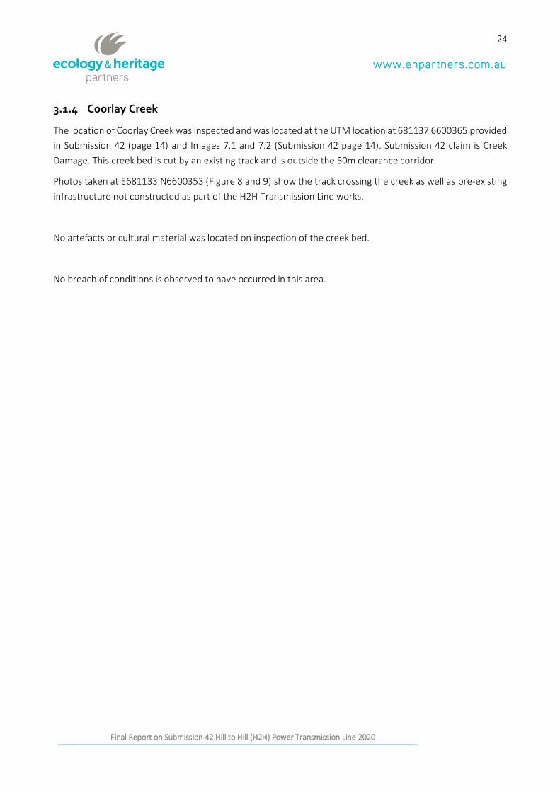
3.1.4 Coorlay Creek
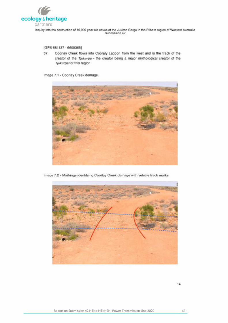
The location of Coorlay Creek was inspected and was located at the UTM location at 681137 6600365 provided
in Submission 42 (page 14) and Images 7.1 and 7.2 (Submission 42 page 14). Submission 42 claim is Creek
Damage. This creek bed is cut by an existing track and is outside the 50m clearance corridor.
Photos taken at E681133 N6600353 (Figure 8 and 9) show the track crossing the creek as well as pre-existing
infrastructure not constructed as part of the H2H Transmission Line works.
No artefacts or cultural material was located on inspection of the creek bed.
No breach of conditions is observed to have occurred in this area.
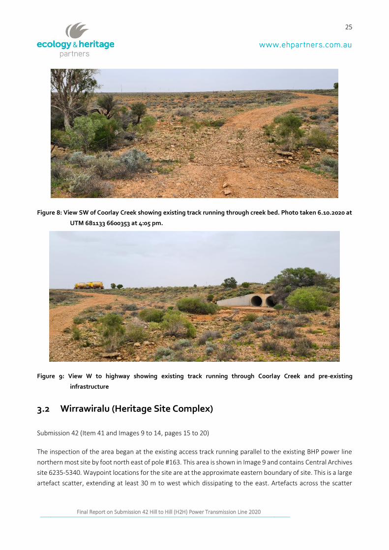
25
Report on Submission 42to the Joint Standing Committee on Northern Australia Inquiry into the destruction of Western Australia by Messrs Andrew and Robert
Stary Final Report on Submission 42 Hill to Hill (H2H) Power Transmission Line 2020
Figure 8: View SW of Coorlay Creek showing existing track running through creek bed. Photo taken 6.10.2020 at
UTM 681133 6600353 at 4:05 pm.
Figure 9: View W to highway showing existing track running through Coorlay Creek and pre-existing
infrastructure
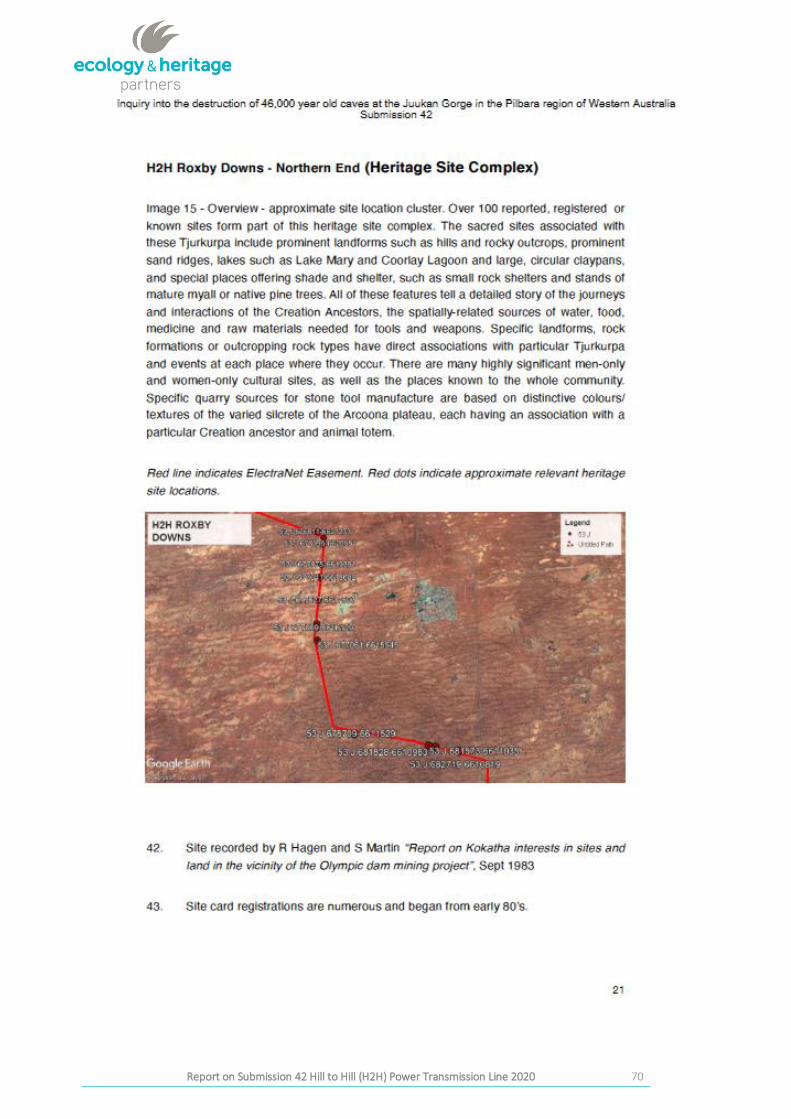
3.2 Wirrawiralu (Heritage Site Complex)
Submission 42 (Item 41 and Images 9 to 14, pages 15 to 20)
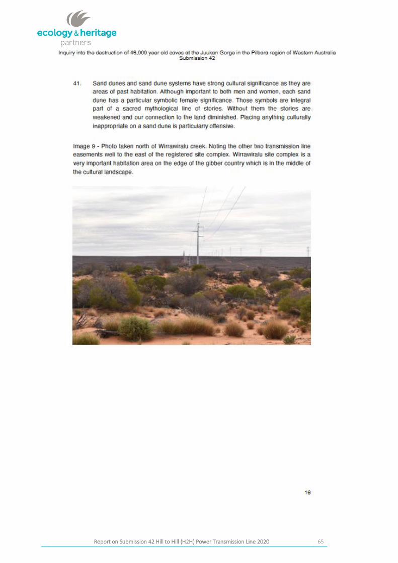
The inspection of the area began at the existing access track running parallel to the existing BHP power line
northern most site by foot north east of pole #163. This area is shown in Image 9 and contains Central Archives
site 6235-5340. Waypoint locations for the site are at the approximate eastern boundary of site. This is a large
artefact scatter, extending at least 30 m to west which dissipating to the east. Artefacts across the scatter
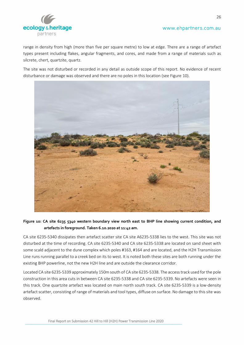
26
Report on Submission 42to the Joint Standing Committee on Northern Australia Inquiry into the destruction of Western Australia by Messrs Andrew and Robert
Stary Final Report on Submission 42 Hill to Hill (H2H) Power Transmission Line 2020
range in density from high (more than five per square metre) to low at edge. There are a range of artefact
types present including flakes, angular fragments, and cores, and made from a range of materials such as
silcrete, chert, quartzite, quartz.
The site was not disturbed or recorded in any detail as outside scope of this report. No evidence of recent
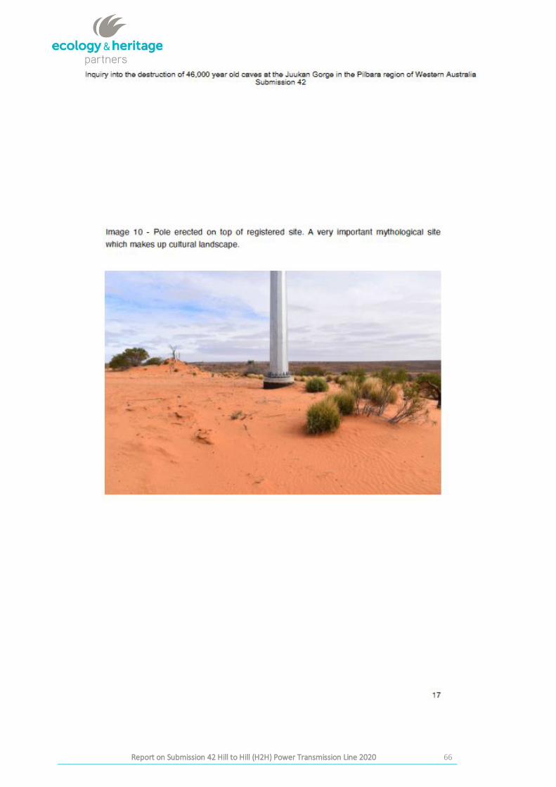
disturbance or damage was observed and there are no poles in this location (see Figure 10).
Figure 10: CA site 6235 5340 western boundary view north east to BHP line showing current condition, and
artefacts in foreground. Taken 6.10.2020 at 11:42 am.
CA site 6235-5340 dissipates then artefact scatter site CA site A6235-5338 lies to the west. This site was not
disturbed at the time of recording. CA site 6235-5340 and CA site 6235-5338 are located on sand sheet with
some scald adjacent to the dune complex which poles #163, #164 and are located, and the H2H Transmission
Line runs running parallel to a creek bed on its to west. It is noted both these sites are both running under the
existing BHP powerline, not the new H2H line and are outside the clearance corridor.
Located CA site 6235-5339 approximately 150m south of CA site 6235-5338. The access track used for the pole
construction in this area cuts in between CA site 6235-5338 and CA site 6235-5339. No artefacts were seen in
this track. One quartzite artefact was located on main north south track. CA site 6235-5339 is a low-density
artefact scatter, consisting of range of materials and tool types, diffuse on surface. No damage to this site was
observed.
27
Report on Submission 42to the Joint Standing Committee on Northern Australia Inquiry into the destruction of Western Australia by Messrs Andrew and Robert
Stary Final Report on Submission 42 Hill to Hill (H2H) Power Transmission Line 2020
CA site 6235-5337 is located in dunes swale and was also a low-density scatter, of range of materials and tool
visible on surface. No damage through H2H works was observed and all conditions and Exclusion zones were
seen to have been complied with at the time of this inspection.
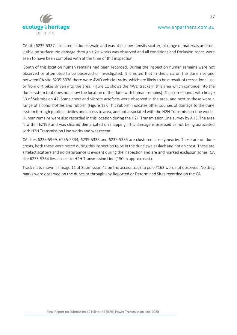
South of this location human remains had been recorded. During the inspection human remains were not
observed or attempted to be observed or investigated. It is noted that in this area on the dune rise and
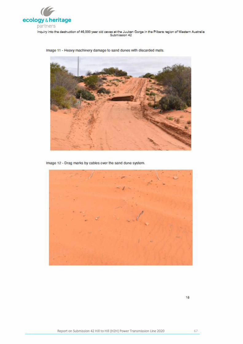
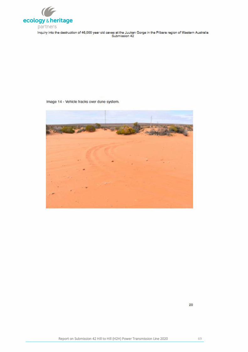
between CA site 6235-5336 there were 4WD vehicle tracks, which are likely to be a result of recreational use
or from dirt bikes driven into the area. Figure 11 shows the 4WD tracks in this area which continue into the
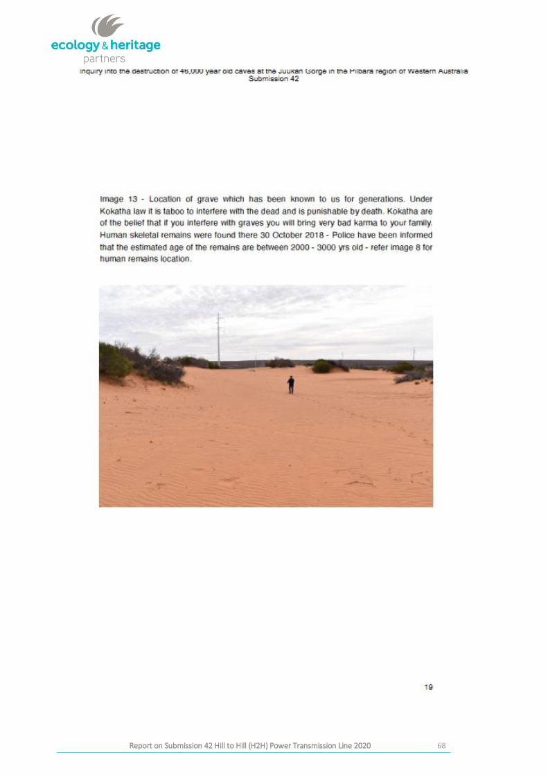
dune system (but does not show the location of the dune with human remains). This corresponds with Image
13 of Submission 42. Some chert and silcrete artefacts were observed in the area, and next to these were a
range of alcohol bottles and rubbish (Figure 12). This rubbish indicates other sources of damage to the dune
system through public activities and access to area, and not associated with the H2H Transmission Line works.
Human remains were also recorded in this location during the H2H Transmission Line survey by AHS. The area
is within EZ199 and was cleared demarcated on mapping. This damage is assessed as not being associated
with H2H Transmission Line works and was recent.
CA sites 6235-5999, 6235-5334, 6235-5333 and 6235-5335 are clustered closely nearby. These are on dune
crests, both these were noted during this inspection to be in the dune swale/slack and not on crest. These are
artefact scatters and no disturbance is evident during the inspection and are and marked exclusion zones. CA
site 6235-5334 lies closest to H2H Transmission Line (150 m approx. east).
Track mats shown in Image 11 of Submission 42 on the access track to pole #163 were not observed. No drag
marks were observed on the dunes or through any Reported or Determined Sites recorded on the CA.
28
Report on Submission 42to the Joint Standing Committee on Northern Australia Inquiry into the destruction of Western Australia by Messrs Andrew and Robert
Stary Final Report on Submission 42 Hill to Hill (H2H) Power Transmission Line 2020
Figure 11: Vehicle track marks between CA site 6235-5336. Track marks continued into dune system. Photo taken
view SE on 6.10.2020 at 11:40am
29
Report on Submission 42to the Joint Standing Committee on Northern Australia Inquiry into the destruction of Western Australia by Messrs Andrew and Robert
Stary Final Report on Submission 42 Hill to Hill (H2H) Power Transmission Line 2020
Figure 12: CA site 6235-5336 on dune rise showing artefacts in foreground and example of adjacent
rubbish/disturbance in background near vegetation. There were tyre tracks in the dunes in this
location as well as alcohol bottles. Photo taken 6.10.2020 at 11:50 am UTM 680622 6552327
A pedestrian survey across to the transmission line corridor was undertaken in the area. No sites previously
recorded were located or overlapped with CA sites. Inspected poles #162 and #163 and radius around pole to
assess evidence of installation. No artefacts or cultural material seen on surface. An access track runs off from
the main track in the area and has been used to access #163 (Figure 15).
30
Report on Submission 42to the Joint Standing Committee on Northern Australia Inquiry into the destruction of Western Australia by Messrs Andrew and Robert
Stary Final Report on Submission 42 Hill to Hill (H2H) Power Transmission Line 2020
There is no evidence of disturbance by machinery or items such as discarded mats to the site complex within
the clearance corridor, exclusions zones or buffered area on the date of inspection.
There is evidence of vehicle tracks entering the dune area and activity in the exclusion zones and close to the
location of human remains and a CA site but these are assessed as not related to the H2H line work.
Figure 13: View to pole #163 showing location in dune system and nature of works around the pole location. Photo
taken 6.10.2020 at 11:56 am
31
Report on Submission 42to the Joint Standing Committee on Northern Australia Inquiry into the destruction of Western Australia by Messrs Andrew and Robert
Stary Final Report on Submission 42 Hill to Hill (H2H) Power Transmission Line 2020
Figure 14: View north to pole #163 on top of dune rise in corridor showing nature of disturbance around pole
location and to dune system. Access track shown in Image 11 extends right of this pole and connects
to existing track. Photo taken 6.10.2020
32
Report on Submission 42to the Joint Standing Committee on Northern Australia Inquiry into the destruction of Western Australia by Messrs Andrew and Robert
Stary Final Report on Submission 42 Hill to Hill (H2H) Power Transmission Line 2020
3.3 H2H Roxby Downs Northern End (Heritage Site Complex)
Targeted inspections to given UTM locations provided on p21 of Submission 42 occurred on 7th October 2020
on this section of the transmission line. This was undertaken following the line north to south.
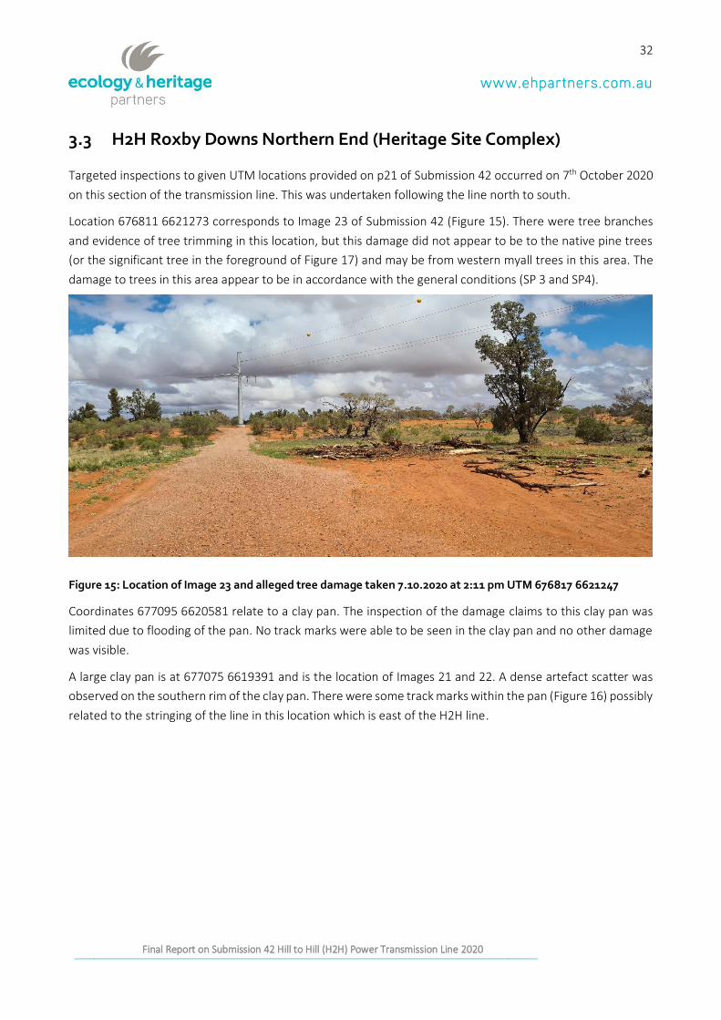
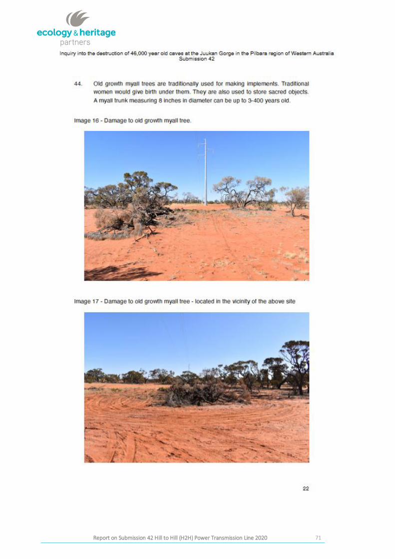
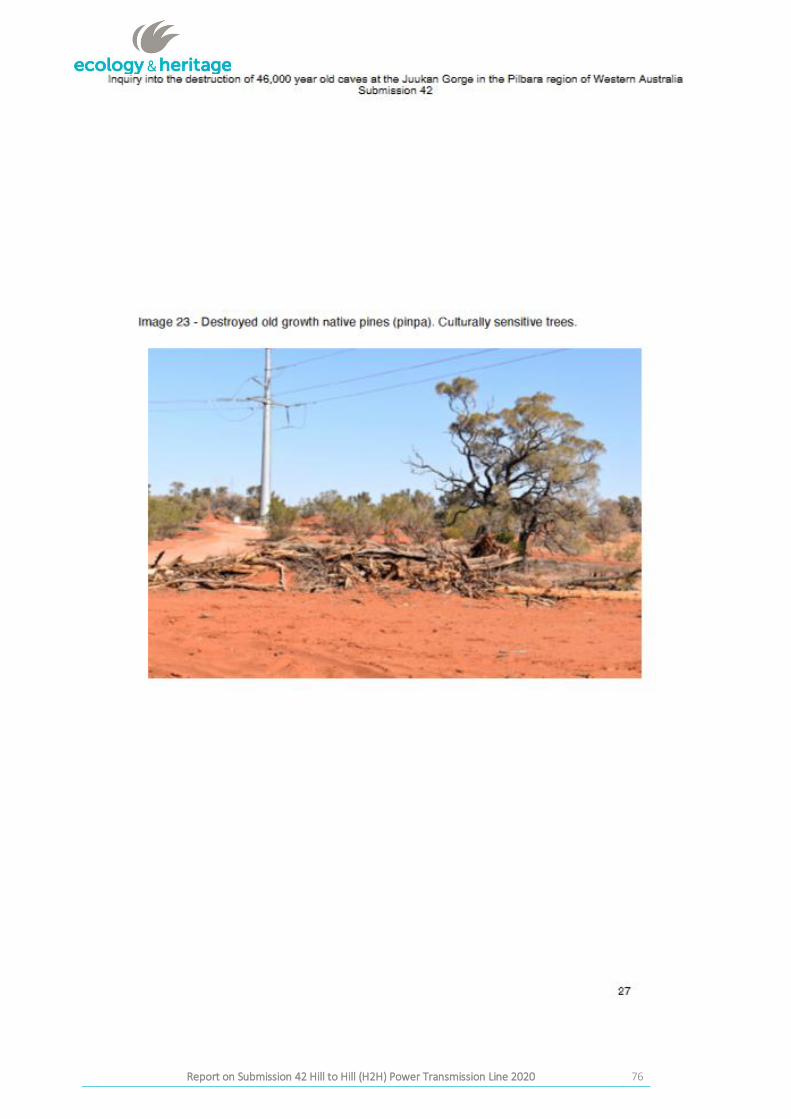
Location 676811 6621273 corresponds to Image 23 of Submission 42 (Figure 15). There were tree branches
and evidence of tree trimming in this location, but this damage did not appear to be to the native pine trees
(or the significant tree in the foreground of Figure 17) and may be from western myall trees in this area. The
damage to trees in this area appear to be in accordance with the general conditions (SP 3 and SP4).
Figure 15: Location of Image 23 and alleged tree damage taken 7.10.2020 at 2:11 pm UTM 676817 6621247
Coordinates 677095 6620581 relate to a clay pan. The inspection of the damage claims to this clay pan was
limited due to flooding of the pan. No track marks were able to be seen in the clay pan and no other damage
was visible.
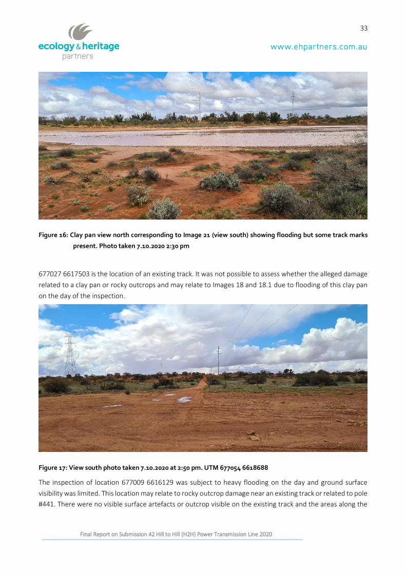
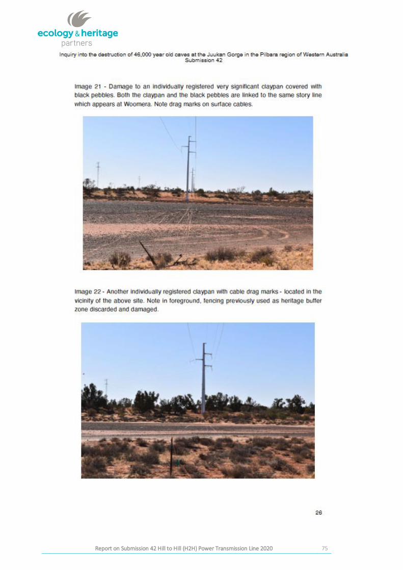
A large clay pan is at 677075 6619391 and is the location of Images 21 and 22. A dense artefact scatter was
observed on the southern rim of the clay pan. There were some track marks within the pan (Figure 16) possibly
related to the stringing of the line in this location which is east of the H2H line.
33
Report on Submission 42to the Joint Standing Committee on Northern Australia Inquiry into the destruction of Western Australia by Messrs Andrew and Robert
Stary Final Report on Submission 42 Hill to Hill (H2H) Power Transmission Line 2020
Figure 16: Clay pan view north corresponding to Image 21 (view south) showing flooding but some track marks
present. Photo taken 7.10.2020 2:30 pm
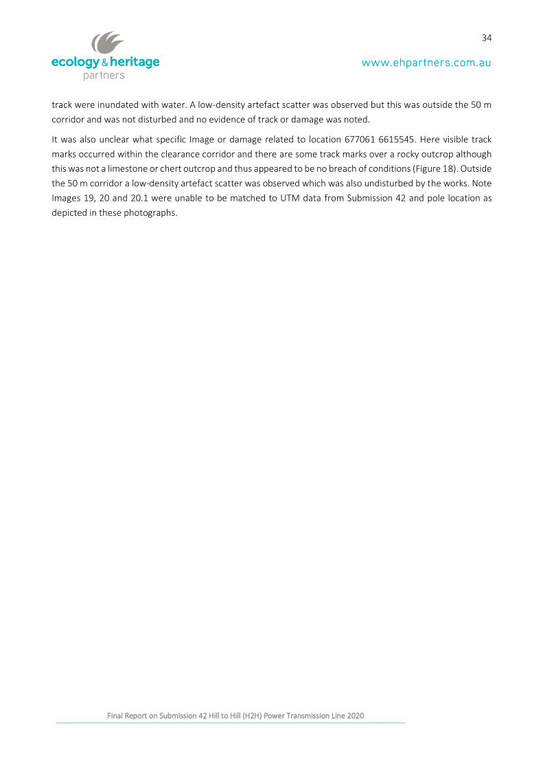
677027 6617503 is the location of an existing track. It was not possible to assess whether the alleged damage
related to a clay pan or rocky outcrops and may relate to Images 18 and 18.1 due to flooding of this clay pan
on the day of the inspection.
Figure 17: View south photo taken 7.10.2020 at 2:50 pm. UTM 677054 6618688
The inspection of location 677009 6616129 was subject to heavy flooding on the day and ground surface
visibility was limited. This location may relate to rocky outcrop damage near an existing track or related to pole
#441. There were no visible surface artefacts or outcrop visible on the existing track and the areas along the
34
Report on Submission 42to the Joint Standing Committee on Northern Australia Inquiry into the destruction of Western Australia by Messrs Andrew and Robert
Stary Final Report on Submission 42 Hill to Hill (H2H) Power Transmission Line 2020
track were inundated with water. A low-density artefact scatter was observed but this was outside the 50 m
corridor and was not disturbed and no evidence of track or damage was noted.
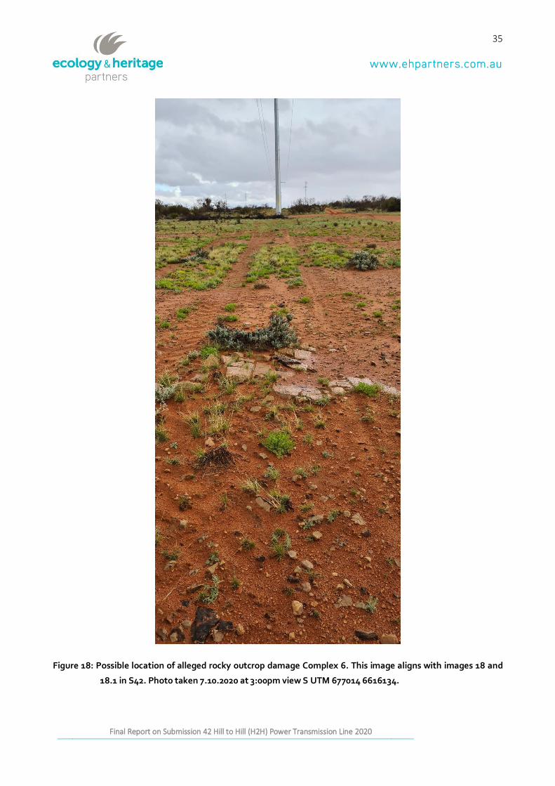
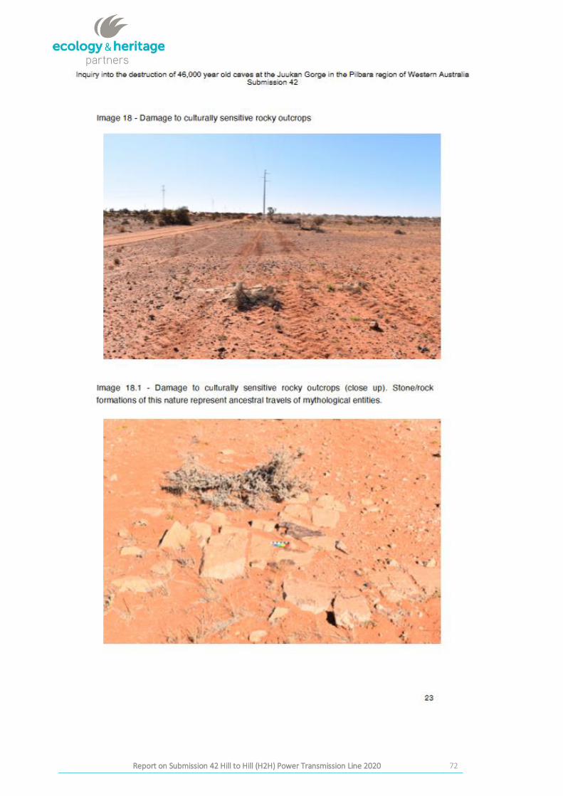
It was also unclear what specific Image or damage related to location 677061 6615545. Here visible track
marks occurred within the clearance corridor and there are some track marks over a rocky outcrop although
this was not a limestone or chert outcrop and thus appeared to be no breach of conditions (Figure 18). Outside
the 50 m corridor a low-density artefact scatter was observed which was also undisturbed by the works. Note
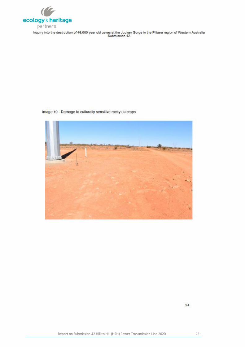
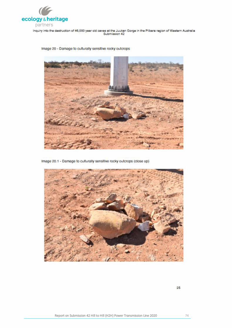
Images 19, 20 and 20.1 were unable to be matched to UTM data from Submission 42 and pole location as
depicted in these photographs.
35
Report on Submission 42to the Joint Standing Committee on Northern Australia Inquiry into the destruction of Western Australia by Messrs Andrew and Robert
Stary Final Report on Submission 42 Hill to Hill (H2H) Power Transmission Line 2020
Figure 18: Possible location of alleged rocky outcrop damage Complex 6. This image aligns with images 18 and
18.1 in S42. Photo taken 7.10.2020 at 3:00pm view S UTM 677014 6616134.
36
Report on Submission 42to the Joint Standing Committee on Northern Australia Inquiry into the destruction of Western Australia by Messrs Andrew and Robert
Stary Final Report on Submission 42 Hill to Hill (H2H) Power Transmission Line 2020
Locations 678709 611529; 681828 6610983 and 677041 661682 relate to trees/vegetation near poles. These
have been trimmed and branches felled. The trees do not appear to be of significant size or species as alleged
in Submission 42 and works have been carried out in accordance with agreed conditions. The alleged damage
in Submission 42 possibly refers to this tree damage and the existing tracks.
The location at 677041 661682 likely refers to tracks between poles #397 and #396 which may have occurred
during line stringing, but no Image in Submission 42 was able to be linked to this location. There were no
surface artefacts visible in the corridor nor any rocky outcrops. There is some tree damage but these are not
significant old growth trees or of the species to be avoided during works as alleged in Submission 42.
37
Report on Submission 42to the Joint Standing Committee on Northern Australia Inquiry into the destruction of Western Australia by Messrs Andrew and Robert
Stary Final Report on Submission 42 Hill to Hill (H2H) Power Transmission Line 2020
4 CONCLUSION
1. Did the heritage recommendations provided by the previous H2H heritage consultant (H2H Consultant) comply with the requirements of the Aboriginal Heritage Act 1988 (AHA88)? Yes. This report concludes there is no evidence of damage to any Reported, Determined or Archived Aboriginal Heritage Site. All work carried out by the consultant was undertaken in consultation with KAC.
2. Did project activities associated with H2H Project comply with the heritage recommendations of the H2H Cultural Heritage Consultant? Yes. All works inspected were in compliance with the AHM’s Recommendations. Work did not occur in Exclusion Zones and was within the agreed Conditions.
3. Did the heritage recommendations provided by the H2H Cultural Heritage Consultant comply with the ‘Local-Level Agreement’ between KAC, OZ Minerals and ElectraNet? Yes.
4. What, if any, evidence exists that H2H Project activities resulted in damage, disturbance or interference with Aboriginal sites, objects or remains? There is no evidence that works carried out by H2H project activities damaged, disturbed or interfered with Aboriginal sites, objects or remains.
38
Report on Submission 42to the Joint Standing Committee on Northern Australia Inquiry into the destruction of Western Australia by Messrs Andrew and Robert
Stary Final Report on Submission 42 Hill to Hill (H2H) Power Transmission Line 2020
APPENDIX 1: SUMMARY OF RESULTS
Report on Submission 42 Hill to Hill (H2H) Power Transmission Line 2020 39
Site Name/ID Description of
Submission 42
Claim
Submission 42 GPS
location UTM provided
(Eastings and
Northings)
Photo
Log
Number
Date and Time
inspected
Conditions and/or exclusions
AAR
Registered
Site (if
applicable)
Evidence
of Breach
Comments
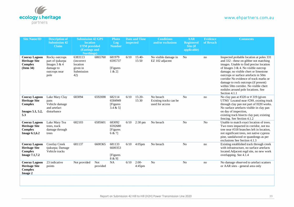
Cooray Lagoon
Heritage Site
Complex (Item 34)
Rocky outcrops part of tjukurpa Images 3 & 4 damage to outcrops near pole
6383113 (incorrect location given in Submission 42)
6865760 681979 6595737
[Figures 1 & 2]
6/10 15:40-15:50
No visible damage in EZ 102 adjacent
No no Inspected probable location at poles 331 and 332 - these on gibber not matching images. Unable to find precise location of Images 3 & 4. No visible outcrop damage; no visible chert or limestone outcrops or surface artefacts in 50m corridor No evidence of track marks or
damage to rock outcrops (if present) within 50m corridor. No visible chert nodules around pole locations. See Section 4.1.1
Cooray Lagoon
Heritage Site
Complex
Images 5.1, 5.2,
5.3
Lake Mary Clay pans Vehicle damage and artefact
disturbance
683094 6592698 682114 6584949 [Figures 3.4 & 5]
6/10 15:20- 15:30
No breach Existing tracks can be used for access
No no No clay pan at #320 or # 319 (given UTM)’ Located near #288, existing track through clay pan not part of H2H works. No surface artefacts visible in clay pan
on day of inspection, existing track bisects clay pan; existing fencing. See Section 4.1.2
Cooray Lagoon
Heritage Site
Complex Image 6.1,6.2
Lake Mary Tea trees, track damage through trees
682103 6585601 683092 6592680 [Figures 6 & 7]
6/10 2:30 pm No breach No No Unable to match exact location of trees. Two trees impacted in corridor, not tea tree near #318 branches left in location, not significant trees, not native cypress
pine, sandalwood or quandongs as per exclusions See Section 4.1.3
Cooray Lagoon
Heritage Site
Complex Image 7.1,7.2
Coorlay Creek tjukurpa; Damage Vehicle tracks
681137 6600365 681133 6600353
[Figures 8 & 9]
6/10 4:05pm No breach No no Existing established track through creek with infrastructure, no surface artefacts located.Adjacent regd site, no new work overlapping. See 4.1.4
Cooray Lagoon
Heritage Site
Complex Image 2
23 indicative points
Not provided Not provided
NA 6/10 2:00-4:45pm
No No no No damage observed to artefact scatters or AAR sites - general area only
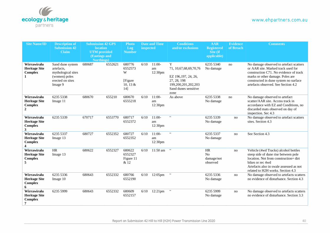
Report on Submission 42 Hill to Hill (H2H) Power Transmission Line 2020 40
Site Name/ID Description of
Submission 42
Claim
Submission 42 GPS
location UTM provided
(Eastings and
Northings)
Photo
Log
Number
Date and Time
inspected
Conditions and/or exclusions
AAR
Registered
Site (if
applicable)
Evidence
of Breach
Comments
Wirrawiralu
Heritage Site
Complex 1
Sand dune system artefacts, mythological sites (women) poles erected on sites Image 9
680687 6552621 680776 6552573 W
[Figure 10, 13 & 14]
6/10 11:00-am 12:30pm
Y 71, 10,67,68,69,70,76
EZ 196,197, 24, 26, 27, 28, 198 199,200,201,202,203 Sand dunes sensitive
zone
6235 5340 No damage
no No damage observed to artefact scatters or AAR site. Marked track used for construction C71. No evidence of track marks or other damage. Poles are constructed in dune system no surface artefacts observed. See Section 4.2
Wirrawiralu
Heritage Site
Complex 2
6235 5338 Image 11
680670 655210 680670 6555218
6/10 11:00-am 12:30pm
As above 6235 5338 No damage
no No damage observed to artefact scatter/AAR site. Access track in accordance with EZ and Conditions, no discarded mats observed on day of inspection. Sec 4.3
Wirrawiralu
Heritage Site
Complex 3
6235 5339 670717 6553770 680717
6552372
6/10 11:00-
am 12:30pm
“ 6235 5339
No damage
no No damage observed to artefact scatters
sites. Section 4.3
Wirrawiralu
Heritage Site
Complex 4
6235 5337 Image 13
680727 6552352 680727 6552352
6/10 11:00-am 12:30pm
“ 6235 5337 No damage
no See Section 4.3
Wirrawiralu
Heritage Site
Complex 5
HR Image 13
680622 6552327 680622 6552327 Figure 11 & 12
6/10 11:50 am “ HR No damage/not observed
no Vehicle (4wd Tracks) alcohol bottles steep side of dune rise between pole location. Not from construction= dirt bikes or rec 4wd Artefacts also in swale assessed as not related to H2H works. Section 4.3
Wirrawiralu
Heritage Site
Complex 6
6235 5336
Image 10
680643 6552332 680766
6552190
6/10 12:05pm “ 6235 5336
No damage
no No damage observed to artefacts scatters
no evidence of disturbance. Section 4.3
Wirrawiralu
Heritage Site
Complex 7
6235 5999 680643 6552332 680609 6552157
6/10 12:21pm “ 6235 5999 No damage
no No damage observed to artefacts scatters no evidence of disturbance. Section 3.3
Report on Submission 42 Hill to Hill (H2H) Power Transmission Line 2020 41
Site Name/ID Description of
Submission 42
Claim
Submission 42 GPS
location UTM provided
(Eastings and
Northings)
Photo
Log
Number
Date and Time
inspected
Conditions and/or exclusions
AAR
Registered
Site (if
applicable)
Evidence
of Breach
Comments
Wirrawiralu
Heritage Site
Complex 8
6235 5335 680643 6552332 680640 6552260
6/10 12:27pm “ 6235 5335 No damage
no No damage observed to artefacts scatters no evidence of disturbance
Wirrawiralu
Heritage Site
Complex 9
6235 5334 680643 6552332 680645 6552376
6/10 12:48pm “ 6235 5334 No damage
no No damage observed to artefacts scatters no evidence of disturbance. Section 3.3
Wirrawiralu
Heritage Site
Complex 10
6235 5333 680616 6552376 680616 6552376
6/10 1:21pm “ 6235 5333 No damage
no No damage observed to artefacts scatters no evidence of disturbance. Section 3.3
H2H Roxby
Downs
Northern End
Heritage Site
Complex 1
Damage to old
growth trees Image 16 & 17
676811 6621273 676817
6621247 W
[Figure 15]
7/10 2:11pm “ no no Trees branches felled and left in location
Trees not significant. See section 3.4
H2H Roxby
Downs
Northern End
Heritage Site
Complex 2
Clay pan damage 677095 6620581 677095 6621011 S
7/10 2:30pm C6 no no Clay pan flooded on day of inspection, inconsistent with Image provided in Submission 42. No tracks seen in clay
pan Section 4.3
H2H Roxby
Downs
Northern End
Heritage Site
Complex 3
Clay pan damage Image 21 and 22
677075 6619391 677067 6619404 Figure 16 & 17
7/10 2:30 pm C6 no no Dense artefact scatter on S side of clay pan some tracks section 4.3
H2H Roxby
Downs
Northern End
Heritage Site
Complex 4
Clay pan damage, rocky outcrops? tracks, Possibly Fig 18
677027 6617503 677054 6618688 Figure 18
7/10 2:50pm no no no No damage in corridor existing access track 4 Sec 4.3
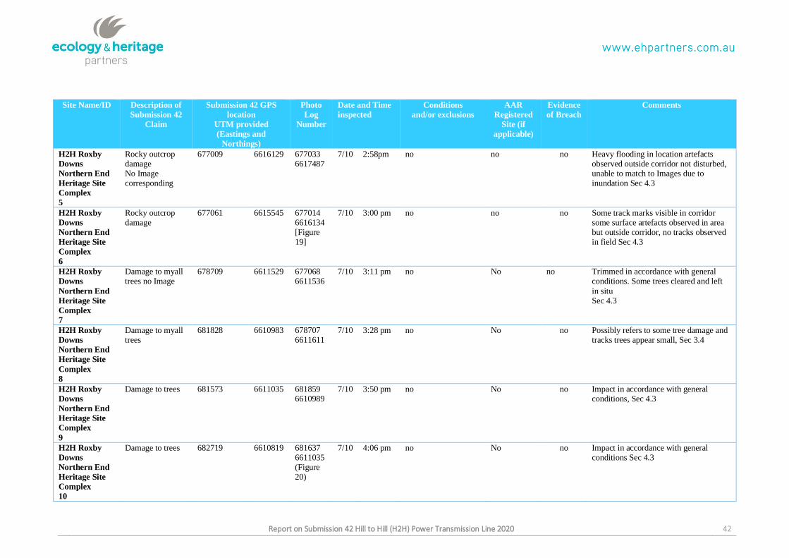
Report on Submission 42 Hill to Hill (H2H) Power Transmission Line 2020 42
Site Name/ID Description of
Submission 42
Claim
Submission 42 GPS
location UTM provided
(Eastings and
Northings)
Photo
Log
Number
Date and Time
inspected
Conditions and/or exclusions
AAR
Registered
Site (if
applicable)
Evidence
of Breach
Comments
H2H Roxby
Downs
Northern End
Heritage Site
Complex 5
Rocky outcrop damage No Image corresponding
677009 6616129 677033 6617487
7/10 2:58pm no no no Heavy flooding in location artefacts observed outside corridor not disturbed, unable to match to Images due to inundation Sec 4.3
H2H Roxby
Downs
Northern End
Heritage Site
Complex 6
Rocky outcrop damage
677061 6615545 677014 6616134 [Figure 19]
7/10 3:00 pm no no no Some track marks visible in corridor some surface artefacts observed in area but outside corridor, no tracks observed in field Sec 4.3
H2H Roxby
Downs
Northern End
Heritage Site
Complex 7
Damage to myall trees no Image
678709 6611529 677068 6611536
7/10 3:11 pm no No no Trimmed in accordance with general conditions. Some trees cleared and left
in situ Sec 4.3
H2H Roxby
Downs
Northern End
Heritage Site
Complex 8
Damage to myall trees
681828 6610983 678707 6611611
7/10 3:28 pm no No no Possibly refers to some tree damage and tracks trees appear small, Sec 3.4
H2H Roxby
Downs
Northern End
Heritage Site
Complex
9
Damage to trees 681573 6611035 681859 6610989
7/10 3:50 pm no No no Impact in accordance with general conditions, Sec 4.3
H2H Roxby
Downs
Northern End
Heritage Site
Complex 10
Damage to trees 682719 6610819 681637 6611035 (Figure 20)
7/10 4:06 pm no No no Impact in accordance with general conditions Sec 4.3
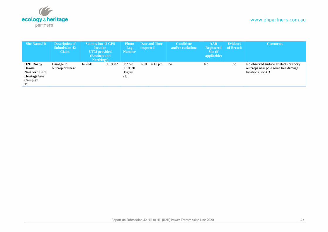
Report on Submission 42 Hill to Hill (H2H) Power Transmission Line 2020 43
Site Name/ID Description of
Submission 42
Claim
Submission 42 GPS
location UTM provided
(Eastings and
Northings)
Photo
Log
Number
Date and Time
inspected
Conditions and/or exclusions
AAR
Registered
Site (if
applicable)
Evidence
of Breach
Comments
H2H Roxby
Downs
Northern End
Heritage Site
Complex 11
Damage to outcrop or trees?
677041 6618682 682728 6610830 [Figure 21]
7/10 4:10 pm no No no No observed surface artefacts or rocky outcrops near pole some tree damage locations Sec 4.3
Report on Submission 42 Hill to Hill (H2H) Power Transmission Line 2020 44
APPENDIX 2: TRACK LOGS
Report on Submission 42 Hill to Hill (H2H) Power Transmission Line 2020 45
Report on Submission 42 Hill to Hill (H2H) Power Transmission Line 2020 46
Report on Submission 42 Hill to Hill (H2H) Power Transmission Line 2020 47
Report on Submission 42 Hill to Hill (H2H) Power Transmission Line 2020 48
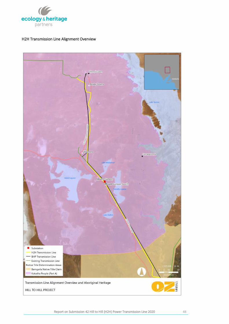
H2H Transmission Line Alignment Overview
Report on Submission 42 Hill to Hill (H2H) Power Transmission Line 2020 49
APPENDIX 3: COPY OF SUBMISSION 42
Report on Submission 42 Hill to Hill (H2H) Power Transmission Line 2020 50
Report on Submission 42 Hill to Hill (H2H) Power Transmission Line 2020 51
Report on Submission 42 Hill to Hill (H2H) Power Transmission Line 2020 52
Report on Submission 42 Hill to Hill (H2H) Power Transmission Line 2020 53
Report on Submission 42 Hill to Hill (H2H) Power Transmission Line 2020 54
Report on Submission 42 Hill to Hill (H2H) Power Transmission Line 2020 55
Report on Submission 42 Hill to Hill (H2H) Power Transmission Line 2020 56
Report on Submission 42 Hill to Hill (H2H) Power Transmission Line 2020 57
Report on Submission 42 Hill to Hill (H2H) Power Transmission Line 2020 58
Report on Submission 42 Hill to Hill (H2H) Power Transmission Line 2020 59
Report on Submission 42 Hill to Hill (H2H) Power Transmission Line 2020 60
Report on Submission 42 Hill to Hill (H2H) Power Transmission Line 2020 61
Report on Submission 42 Hill to Hill (H2H) Power Transmission Line 2020 62
Report on Submission 42 Hill to Hill (H2H) Power Transmission Line 2020 63
Report on Submission 42 Hill to Hill (H2H) Power Transmission Line 2020 64
Report on Submission 42 Hill to Hill (H2H) Power Transmission Line 2020 65
Report on Submission 42 Hill to Hill (H2H) Power Transmission Line 2020 66
Report on Submission 42 Hill to Hill (H2H) Power Transmission Line 2020 67
Report on Submission 42 Hill to Hill (H2H) Power Transmission Line 2020 68
Report on Submission 42 Hill to Hill (H2H) Power Transmission Line 2020 69
Report on Submission 42 Hill to Hill (H2H) Power Transmission Line 2020 70
Report on Submission 42 Hill to Hill (H2H) Power Transmission Line 2020 71
Report on Submission 42 Hill to Hill (H2H) Power Transmission Line 2020 72
Report on Submission 42 Hill to Hill (H2H) Power Transmission Line 2020 73
Report on Submission 42 Hill to Hill (H2H) Power Transmission Line 2020 74
Report on Submission 42 Hill to Hill (H2H) Power Transmission Line 2020 75
Report on Submission 42 Hill to Hill (H2H) Power Transmission Line 2020 76
Report on Submission 42 Hill to Hill (H2H) Power Transmission Line 2020 77

Report on Submission 42 Hill to Hill (H2H) Power Transmission Line 2020 78
APPENDIX 4: NOTICE OF MEETING OF COMMON
LAW HOLDERS OF THE KOKATHA PEOPLE TO
CONSIDER THE OZ MINERALS TRANSMISSION LINE
Report on Submission 42 Hill to Hill (H2H) Power Transmission Line 2020 79
Report on Submission 42 Hill to Hill (H2H) Power Transmission Line 2020 80
Page 1
SECTION TWO OF THE KOKATHA ABORIGINAL CORPORATION RNTBC (ICN 8093) INDEPENDENT EVALUATION OF SUBMISSION 42 DAMAGE CLAIMS
SECTION TWO OF THE KOKATHA ABORIGINAL CORPORATION RNTBC (ICN 8093) INDEPENDENT EVALUATION OF SUBMISSION 42 DAMAGE CLAIMS:
AAR CENTRAL ARCHIVES REVIEW OF SUBMISSION 42 DAMAGE CLAIM The Submission identifies over 40 locations that it says support Aboriginal heritage, and asserts that ElectraNet’s Hill to Hill Transmission Line Project (H2H) damaged over 20 of them.
KAC and OZ asked AAR to compare the sites referenced in the Submission to the information held in AAR’s central archives. We have completed that task. The outcomes are that the H2H Project intersected and impacted two sites for which records exist in the central archives:
• the Davenport site (6433-5968)• a former site that was previously destroyed by another project – thus the record is of an
historical or ‘archived’ site that used to exist, and does not represent ElectraNet damaging afurther existing site.
The other sites referenced by the Submission do not exist in the central archives. As such, the Starkeys are not the “registered custodians [and] informants” for those sites as stated in the Submission, unless they are recorded as such in local archives kept by Kokatha.
AAR acknowledges that the locations referenced in the Submission may nonetheless be sites within the meaning of the Aboriginal Heritage Act 1988 (SA) (Act), and that the Starkeys may be the, or some of the, Traditional Owners of them. To confirm whether the areas are sites within the meaning of the Act, or whether they were impacted by the H2H project, would require on-ground investigation. I understand EHP have been engaged for this purpose.
The Submission clusters the allegedly damaged sites into four groups. Following are AAR maps of each group. The Coorlay Lagoon shown across two maps. Information to assist you to interpret each map is set out below:
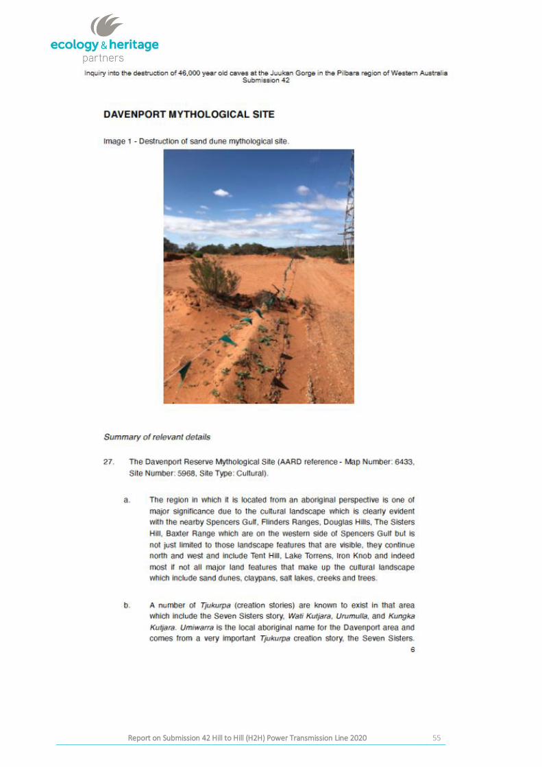
Davenport Mythological Site (Map 1) The Davenport site described on pages 6 to 8 of the Submission is recorded in the central archives as site 6433–5968. While reported and recorded, the site has not been determined to be an Aboriginal site by the minister under section 12 of the Act. This is common. Nonetheless, all heritage sites are protected, whether undiscovered, recorded, reported or determined. It is clear to AAR that the Davenport site is in fact a site. The site cards indicates a mythological site covering an area of dunes.
Coorlay Lagoon (Heritage Site Complex) and Lake Mary (Map 2)
The Submission asserts that at least 23 heritage sites were impacted between Lake Mary and Coorlay Lagoon.
Where spatial coordinates were provided in the Submission between pages 9 and 14 (inclusive), they have been depicted on Map 2 as an aqua coloured circle with a description (three in total). Note that the coordinates on page 10 of the Submission (which relates to a rocky outcrop) are incorrect, and so could not be mapped by AAR. Of the three sets of coordinates that could be mapped, none relate to an Aboriginal site listed in the central archives. Nearby Aboriginal sites listed in the archives are shown in red (recorded/reported sites) and yellow (archived sites – that is, former sites).
Of the three locations of alleged damage that could be mapped within this area, the Tea-Trees (Bulgara - shown on page 13 of the Submission) are the closest to any Aboriginal heritage sites
Page 2
SECTION TWO OF THE KOKATHA ABORIGINAL CORPORATION RNTBC (ICN 8093) INDEPENDENT EVALUATION OF SUBMISSION 42 DAMAGE CLAIMS
recorded in the central archives. However, they are around 200m from any recorded sites, and on the other side of the Olympic Dam Highway from the transmission line.
Coorlay Lagoon (Heritage Site Complex) (Map 3) Map 3 depicts the northern end of Coorlay Lagoon; the H2H easement (in brown); the Olympic Dam Highway (in pink); known sites listed in the central archives; and the locations of alleged site damage within the Submission.
Note that all sites listed in the central archives shown on this map are ‘archived’, meaning that owing to previous disturbance they are no longer considered current Aboriginal sites. The single circular yellow dot on the map depicts the second intersection of the H2H Project with central archives records. This site was archived in 2005 owing to its destruction by a highway upgrade in or before 2005.
Beyond the single yellow circle icon, there are no other records for Aboriginal sites in the central archives, either existing or former sites, that match the locations listed in the Submission.
Wirrawirralu (Heritage Site Complex) (Map 4) All sites depicted on page 15 of the Submission are also listed in the central archives. However, the image provided in the Submission portrays the H2H line as being further to the east than it is. It is possible that an incorrect datum was used in the production of the map within the Submission. Map 4 shows the actual alignment of the H2H line in this area, with the line being at least 35 m to the west of this site complex.
Records available in the central archives indicate that these nine sites are part of the same sand hill system, and that the sites are archaeological in nature. No mythological information is recorded for these sites.
H2H Roxby Downs Northern End (Heritage Site Complex) (Map 5) Map 5 depicts the H2H line west of Roxby Downs (in brown); eleven individual locations of alleged site damage (in aqua); and nearby known Aboriginal sites (in green). There are no Aboriginal sites listed in the central archives within 500m of the alleged locations of site damage.
I trust the above information assists your enquiries into the veracity of the Submission.
Regards
Toby Forde Manager Aboriginal Heritage Manager Legislative Review Aboriginal Affairs and Reconciliation Department of the Premier and Cabinet
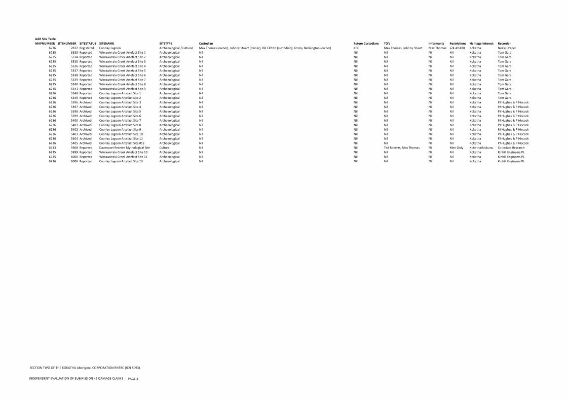
AAR Site TableMAPNUMBER SITENUMBER SITESTATUS SITENAME SITETYPE Custodian Future Custodians TO's Informants Restrictions Heritage Interest Recorder
6236 2832 Registered Coorlay Lagoon Archaeological /Cultural Max Thomas (owner), Johnny Stuart (owner), Bill Clifton (custodian), Jimmy Bannington (owner) KPC Max Thomas, Johnny Stuart Max Thomas s24 AHA88 Kokatha Neale Draper6235 5333 Reported Wirrawirralu Creek Artefact Site 1 Archaeological Nil Nil Nil Nil Nil Kokatha Tom Gara6235 5334 Reported Wirrawirralu Creek Artefact Site 2 Archaeological Nil Nil Nil Nil Nil Kokatha Tom Gara6235 5335 Reported Wirrawirralu Creek Artefact Site 3 Archaeological Nil Nil Nil Nil Nil Kokatha Tom Gara6235 5336 Reported Wirrawirralu Creek Artefact Site 4 Archaeological Nil Nil Nil Nil Nil Kokatha Tom Gara6235 5337 Reported Wirrawirralu Creek Artefact Site 5 Archaeological Nil Nil Nil Nil Nil Kokatha Tom Gara6235 5338 Reported Wirrawirralu Creek Artefact Site 6 Archaeological Nil Nil Nil Nil Nil Kokatha Tom Gara6235 5339 Reported Wirrawirralu Creek Artefact Site 7 Archaeological Nil Nil Nil Nil Nil Kokatha Tom Gara6235 5340 Reported Wirrawirralu Creek Artefact Site 8 Archaeological Nil Nil Nil Nil Nil Kokatha Tom Gara6235 5341 Reported Wirrawirralu Creek Artefact Site 9 Archaeological Nil Nil Nil Nil Nil Kokatha Tom Gara6236 5348 Reported Coorlay Lagoon Artefact Site 1 Archaeological Nil Nil Nil Nil Nil Kokatha Tom Gara6236 5349 Reported Coorlay Lagoon Artefact Site 2 Archaeological Nil Nil Nil Nil Nil Kokatha Tom Gara6236 5396 Archived Coorlay Lagoon Artefact Site 3 Archaeological Nil Nil Nil Nil Nil Kokatha PJ Hughes & P Hiscock6236 5397 Archived Coorlay Lagoon Artefact Site 4 Archaeological Nil Nil Nil Nil Nil Kokatha PJ Hughes & P Hiscock6236 5398 Archived Coorlay Lagoon Artefact Site 5 Archaeological Nil Nil Nil Nil Nil Kokatha PJ Hughes & P Hiscock6236 5399 Archived Coorlay Lagoon Artefact Site 6 Archaeological Nil Nil Nil Nil Nil Kokatha PJ Hughes & P Hiscock6236 5400 Archived Coorlay Lagoon Artefact Site 7 Archaeological Nil Nil Nil Nil Nil Kokatha PJ Hughes & P Hiscock6236 5401 Archived Coorlay Lagoon Artefact Site 8 Archaeological Nil Nil Nil Nil Nil Kokatha PJ Hughes & P Hiscock6236 5402 Archived Coorlay Lagoon Artefact Site 9 Archaeological Nil Nil Nil Nil Nil Kokatha PJ Hughes & P Hiscock6236 5403 Archived Coorlay Lagoon Artefact Site 10 Archaeological Nil Nil Nil Nil Nil Kokatha PJ Hughes & P Hiscock6236 5404 Archived Coorlay Lagoon Artefact Site 11 Archaeological Nil Nil Nil Nil Nil Kokatha PJ Hughes & P Hiscock6236 5405 Archived Coorlay Lagoon Artefact Site #12 Archaeological Nil Nil Nil Nil Nil Kokatha PJ Hughes & P Hiscock6433 5968 Reported Davenport Reserve Mythological Site Cultural Nil Nil Ted Roberts, Max Thomas Nil Men Only Kokatha/Nukunu Co-ordata Research6235 5999 Reported Wirrawirralu Creek Artefact Site 10 Archaeological Nil Nil Nil Nil Nil Kokatha Kinhill Engineers PL6235 6000 Reported Wirrawirralu Creek Artefact Site 11 Archaeological Nil Nil Nil Nil Nil Kokatha Kinhill Engineers PL6236 6006 Reported Coorlay Lagoon Artefact Site 13 Archaeological Nil Nil Nil Nil Nil Kokatha Kinhill Engineers PL
SECTION TWO OF THE KOKATHA Aboriginal CORPORATION RNTBC (ICN 8093)
INDEPENDENT EVALUATION OF SUBMISSION 42 DAMAGE CLAIMS PAGE 3
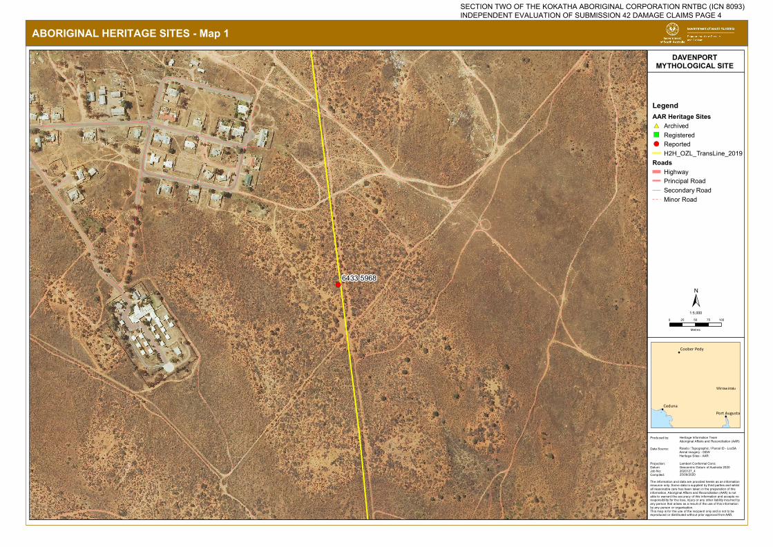
!(6433 5968
ABORIGINAL HERITAGE SITES - Map 1
!
!
!
Ceduna
Coober Pedy
Port Augusta
LegendAAR Heritage Sites#* Archived") Registered!( Reported
H2H_OZL_TransLine_2019Roads
HighwayPrincipal RoadSecondary RoadMinor Road
DAVENPORTMYTHOLOGICAL SITE
The information and data are provided herein as an information resource only. Some data is supplied by third parties and whilstall reasonable care has been taken in the preparation of thisinformation, Aboriginal Affairs and Reconciliation (AAR) is not able to warrant the accuracy of this information and accepts noresponsibility for the loss, injury or any other liability incurred by any person that arises as a result of the use of this information by any person or organisation.This map is for the use of the recipient only and is not to be reproduced or distributed without prior approval from AAR.
Produced by:
Data Source:
Projection:Datum:Job No:Compiled:
Heritage Information TeamAboriginal Affairs and Reconciliation (AAR)
Roads / Topographic / Parcel ID - LocSAAerial imagery - DEWHeritage Sites - AAR
Lambert Conformal ConicGeocentric Datum of Australia 20202020127_4
0 25 50 75 100
Metres
±1:5,000
25/09/2020
Wirrawirralu
SECTION TWO OF THE KOKATHA ABORIGINAL CORPORATION RNTBC (ICN 8093) INDEPENDENT EVALUATION OF SUBMISSION 42 DAMAGE CLAIMS PAGE 4
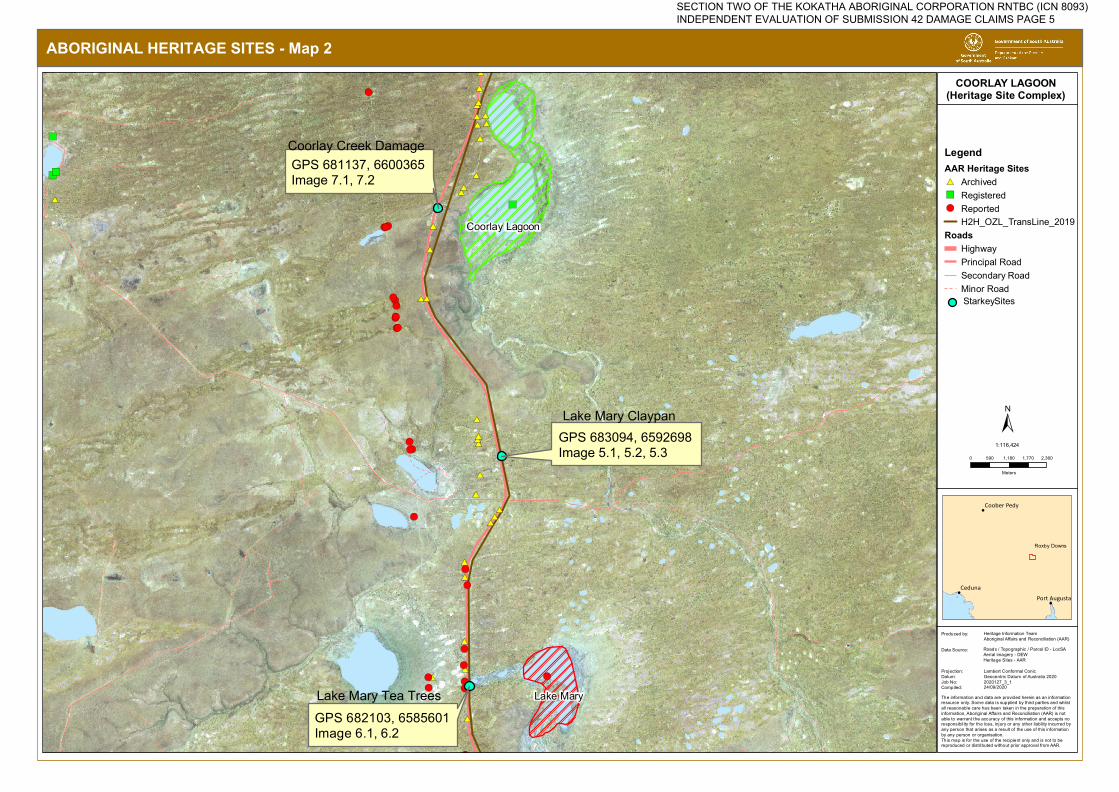
#*#*#*
#*
#*
#*
#*#*
#*
#*
#*
#*
#*#*#*
#*
#*
#*
!(
#*
#*#*
#*
#*
#*#*#*#*
#*#*
#*
#*
!(!(!(
!(
#*
!(!(
!(
!(!(
!(
!(!(
!(
!(!(
!(
!(
!(
!(
!(
!(
!(!(
")")
")
")
!(
GPS 683094, 6592698 Image 5.1, 5.2, 5.3
GPS 682103, 6585601Image 6.1, 6.2
GPS 681137, 6600365 Image 7.1, 7.2
Coorlay Lagoon
Lake Mary
ABORIGINAL HERITAGE SITES - Map 2
!
!
!
Ceduna
Coober Pedy
Port Augusta
LegendAAR Heritage Sites#* Archived") Registered!( Reported
H2H_OZL_TransLine_2019Roads
HighwayPrincipal RoadSecondary RoadMinor Road
COORLAY LAGOON(Heritage Site Complex)
The information and data are provided herein as an information resource only. Some data is supplied by third parties and whilstall reasonable care has been taken in the preparation of thisinformation, Aboriginal Affairs and Reconciliation (AAR) is not able to warrant the accuracy of this information and accepts noresponsibility for the loss, injury or any other liability incurred by any person that arises as a result of the use of this information by any person or organisation.This map is for the use of the recipient only and is not to be reproduced or distributed without prior approval from AAR.
Produced by:
Data Source:
Projection:Datum:Job No:Compiled:
Heritage Information TeamAboriginal Affairs and Reconciliation (AAR)
Roads / Topographic / Parcel ID - LocSAAerial imagery - DEWHeritage Sites - AAR
Lambert Conformal ConicGeocentric Datum of Australia 20202020127_3_1
0 590 1,180 1,770 2,360
Meters
±1:116,424
24/09/2020
Roxby Downs
StarkeySites
Coorlay Creek Damage
Lake Mary Claypan
Lake Mary Tea Trees
SECTION TWO OF THE KOKATHA ABORIGINAL CORPORATION RNTBC (ICN 8093) INDEPENDENT EVALUATION OF SUBMISSION 42 DAMAGE CLAIMS PAGE 5
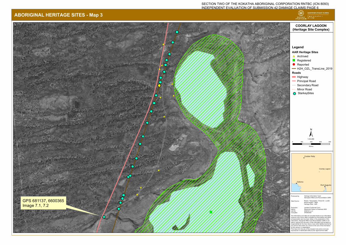
#*
#*
#*
#*
#*#*
#*#*
#*
#*
#*
#*
")
GPS 681137, 6600365Image 7.1, 7.2
ABORIGINAL HERITAGE SITES - Map 3
!
!
!
Ceduna
Coober Pedy
Port Augusta
LegendAAR Heritage Sites#* Archived") Registered!( Reported
H2H_OZL_TransLine_2019Roads
HighwayPrincipal RoadSecondary RoadMinor Road
COORLAY LAGOON(Heritage Site Complex)
The information and data are provided herein as an information resource only. Some data is supplied by third parties and whilstall reasonable care has been taken in the preparation of thisinformation, Aboriginal Affairs and Reconciliation (AAR) is not able to warrant the accuracy of this information and accepts noresponsibility for the loss, injury or any other liability incurred by any person that arises as a result of the use of this information by any person or organisation.This map is for the use of the recipient only and is not to be reproduced or distributed without prior approval from AAR.
Produced by:
Data Source:
Projection:Datum:Job No:Compiled:
Heritage Information TeamAboriginal Affairs and Reconciliation (AAR)
Roads / Topographic / Parcel ID - LocSAAerial imagery - DEWHeritage Sites - AAR
Lambert Conformal ConicGeocentric Datum of Australia 20202020127_3_2
0 200 400 600 800
Metres
±1:25,000
24/09/2020
Coorlay Lagoon
StarkeySites
SECTION TWO OF THE KOKATHA ABORIGINAL CORPORATION RNTBC (ICN 8093) INDEPENDENT EVALUATION OF SUBMISSION 42 DAMAGE CLAIMS PAGE 6
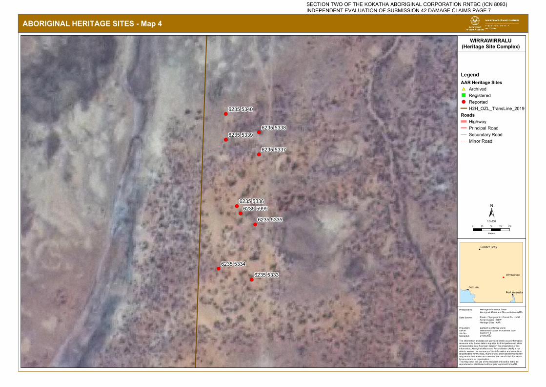
!(
!(
!(
!(
!(
!(
!(
!(
!(6235 5333
6235 5334
6235 5335
6235 5336
6235 5337
6235 53386235 5339
6235 5340
6235 5999
ABORIGINAL HERITAGE SITES - Map 4
!
!
!
Ceduna
Coober Pedy
Port Augusta
LegendAAR Heritage Sites#* Archived") Registered!( Reported
H2H_OZL_TransLine_2019Roads
HighwayPrincipal RoadSecondary RoadMinor Road
WIRRAWIRRALU(Heritage Site Complex)
The information and data are provided herein as an information resource only. Some data is supplied by third parties and whilstall reasonable care has been taken in the preparation of thisinformation, Aboriginal Affairs and Reconciliation (AAR) is not able to warrant the accuracy of this information and accepts noresponsibility for the loss, injury or any other liability incurred by any person that arises as a result of the use of this information by any person or organisation.This map is for the use of the recipient only and is not to be reproduced or distributed without prior approval from AAR.
Produced by:
Data Source:
Projection:Datum:Job No:Compiled:
Heritage Information TeamAboriginal Affairs and Reconciliation (AAR)
Roads / Topographic / Parcel ID - LocSAAerial imagery - DEWHeritage Sites - AAR
Lambert Conformal ConicGeocentric Datum of Australia 20202020127_2
0 25 50 75 100
Metres
±1:5,000
24/09/2020
Wirrawirralu
SECTION TWO OF THE KOKATHA ABORIGINAL CORPORATION RNTBC (ICN 8093) INDEPENDENT EVALUATION OF SUBMISSION 42 DAMAGE CLAIMS PAGE 7
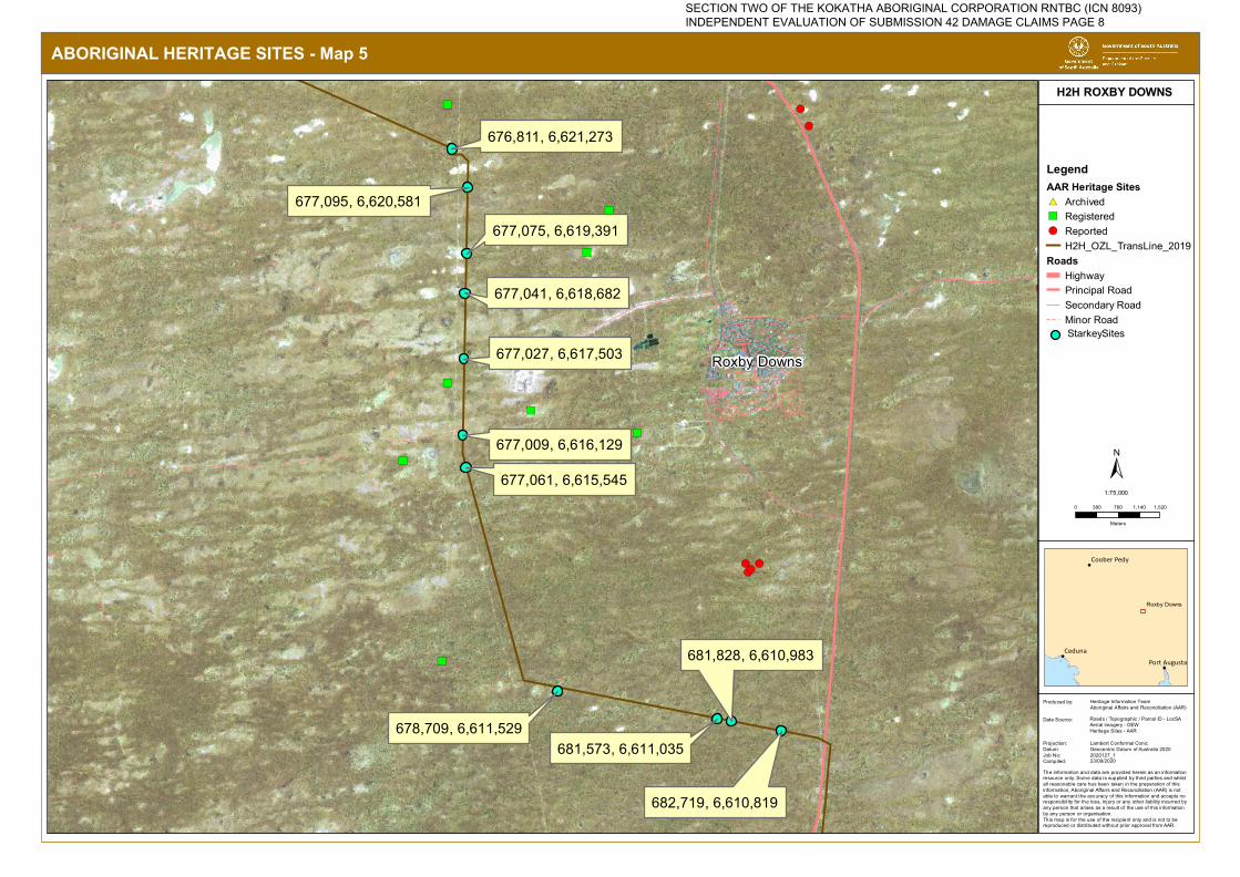
")
")
!(!(!(
!(!(!(!(
")
")
")
")
")
")
")
!(
!(
677,061, 6,615,545
676,811, 6,621,273
677,095, 6,620,581
677,075, 6,619,391
677,041, 6,618,682
677,027, 6,617,503
677,009, 6,616,129
678,709, 6,611,529
681,828, 6,610,983
681,573, 6,611,035
682,719, 6,610,819
ABORIGINAL HERITAGE SITES - Map 5
!
!
!
Ceduna
Coober Pedy
Port Augusta
LegendAAR Heritage Sites#* Archived") Registered!( Reported
H2H_OZL_TransLine_2019Roads
HighwayPrincipal RoadSecondary RoadMinor Road
H2H ROXBY DOWNS
The information and data are provided herein as an information resource only. Some data is supplied by third parties and whilstall reasonable care has been taken in the preparation of thisinformation, Aboriginal Affairs and Reconciliation (AAR) is not able to warrant the accuracy of this information and accepts noresponsibility for the loss, injury or any other liability incurred by any person that arises as a result of the use of this information by any person or organisation.This map is for the use of the recipient only and is not to be reproduced or distributed without prior approval from AAR.
Produced by:
Data Source:
Projection:Datum:Job No:Compiled:
Heritage Information TeamAboriginal Affairs and Reconciliation (AAR)
Roads / Topographic / Parcel ID - LocSAAerial imagery - DEWHeritage Sites - AAR
Lambert Conformal ConicGeocentric Datum of Australia 20202020127_1
0 380 760 1,140 1,520
Meters
±1:75,000
23/09/2020
Roxby Downs
Roxby Downs
StarkeySites
SECTION TWO OF THE KOKATHA ABORIGINAL CORPORATION RNTBC (ICN 8093) INDEPENDENT EVALUATION OF SUBMISSION 42 DAMAGE CLAIMS PAGE 8


