Embed Size (px)
Citation preview
International Geology ReviewVol. 54, No. 1, January 2012, 33–50
Plio-Quaternary development of the Baklan–Dinar graben: implicationsfor cross-graben formation in SW Turkey
Alper Gürbüz*, Sonay Boyraz and M. Tariq Ismael
Mühendislik Fakültesi, Jeoloji Mühendisligi Bölümü, Ankara Üniversitesi, 06100 Tandogan, Ankara, Turkey
(Accepted 24 May 2010)
Western Turkey is characterized mainly by E–W, NW–SE, and NE–SW-trending grabens. The reverse V-shaped geometryof the Baklan–Dinar graben is formed by coupling of the NE–SW-trending Baklan and the NW–SE-trending Dinar grabens,and is critical to an understanding of the structural evolution of the Aegean region. Its geometry indicates biaxial extensionin the region, as proposed in the current literature (e.g. Temiz et al. 1997; Cihan et al. 2003). The Acıgöl and Burdur grabensparallel the axis of the Baklan graben in the south, and these three basins terminate against the Dinar fault. The BaklanBasin is bounded along both margins by the Baklan and Çal left-lateral oblique faults. Basin-fill deposits of the Baklan Basinthicken towards the Dinar fault, and the basin floor dips northeastward. In addition, geomorphological characteristics of theBaklan–Dinar graben indicate that the Dinar fault is relatively more active than the faults of the Baklan Basin. All availablemorphologic, structural, borehole, and geophysical data from the Baklan–Dinar graben define a cross-graben structure thatdeveloped during Plio-Quaternary uniaxial NE-directed extension in SW Turkey. In this framework, the Dinar fault plays therole of a breakaway fault of this formation. The increase in the normal components of the northwestern left-lateral obliquebasin-bounding faults of the Baklan Basin is explained by the gradual steepening of the pitch of the slip vectors towards thenortheast, because of capturing of the extension by the Dinar breakaway fault.
Keywords: extensional tectonics; cross-graben; Plio-Quaternary; Baklan–Dinar graben; Western Anatolia; Aegean region
Introduction
Western Turkey is one of the most seismically activeregions in the world, and the region is rapidly beingdeformed by extensional tectonics (e.g. Jackson andMcKenzie 1984; Eyidogan 1988; Taymaz et al. 1991;Reilinger et al. 1997; Ambraseys and Jackson 1998;Bozkurt 2001) (Figure 1A). As a result, western Turkeyis also one of the best-studied continental extensionalregions. It is characterized mainly by E–W-trendinggrabens (e.g. Büyük Menderes and Küçük Menderes) andNW–SE (e.g. Denizli and Soma) to NE–SW-directed (e.g.Gördes and Usak-Güre) relatively short cross-grabens thatdeveloped as a result of regional extension (Sengör 1987;Sengör et al. 1985; Bozkurt 2001).
The Baklan–Dinar graben has a different structuralgeometry in this framework (Figure 1B). This angulargraben formed by the coupling geometries of NE–SW-trending Baklan and NW–SE-trending Dinar cross-grabensaround the town of Isıklı (Figure 2). The landscape reflectsa biaxial extensional regime in the uniaxial extensionalframework and is very important for a fuller understandingof the structural evolution of western Turkey.
This study is based on relationships between tecton-ics and geomorphology of the Baklan–Dinar graben, and
∗Corresponding author. Email: [email protected]
demonstrates the presence of Plio-Quaternary basin devel-opment and active faulting in SW Turkey. Its angulargeometry reflects the complexity of the general E–W-trending graben structure of western Turkey. The geologyof the area is also complex, with high seismicity rates.Thus, the understanding of its evolution will be informa-tive as to the extensional regime in the adjacent Aegeanregion.
Geological setting
Turkey is one of the most actively deforming regions in theworld. Its neotectonic framework is a result of the continen-tal collision of the Arabian and Eurasian plates in easternTurkey, the related westward escape of the Anatolian plate,and the subduction of the African plate towards the east,the North and the East Anatolian fault zones in the northand east, and the Aegean–Cyprian subduction zone in thesouth and west of Turkey (Figure 1A).
Western Turkey has been experiencing extensional tec-tonics. The proposals on the origin of this extension can begrouped into four models: (1) the tectonic escape modelconsiders that westward escape of the Anatolian platealong the North and East Anatolian fault zones followedthe collision between the Arabian and Eurasian plates
ISSN 0020-6814 print/ISSN 1938-2839 online© 2012 Taylor & Francishttp://dx.doi.org/10.1080/00206814.2010.496543http://www.tandfonline.com
Dow
nloa
ded
by [
Ank
ara
Uni
vers
itesi
] at
12:
00 0
9 N
ovem
ber
2011
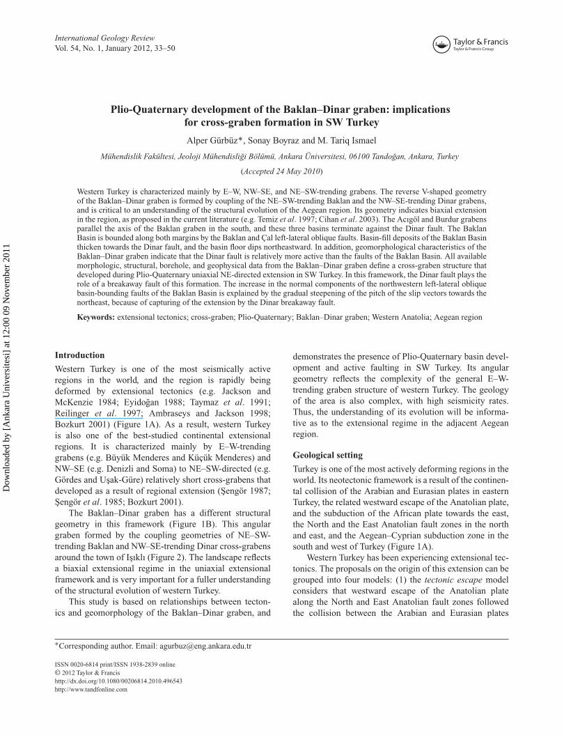
34 A. Gürbüz et al.
Figu
re1.
(A)
Tect
onic
outl
ine
ofTu
rkey
and
the
east
ern
Med
iter
rane
anar
ea.M
.S.,
Mar
mar
ase
a;F
BF
Z,F
ethi
ye-B
urdu
rfa
ultz
one;
NA
FZ
,Nor
thA
nato
lian
faul
tzon
e;E
AF
Z,E
ast
Ana
toli
anfa
ult
zone
;N
EA
FZ
,Nor
thea
stA
nato
lian
faul
tzo
ne;
DS
FZ
,Dea
dS
eafa
ult
zone
.(B
)S
impl
ified
map
show
ing
the
maj
orac
tive
grab
ens
inw
este
rnTu
rkey
and
the
loca
tion
ofth
est
udy
area
.B
DG
,B
akla
n–D
inar
;A
G,
Acı
göl;
BuG
,B
urdu
r;D
G,
Den
izli
;K
G,
Kal
e;B
MG
,B
üyük
Men
dere
s;K
MG
,K
üçük
Men
dere
s;G
G,
Ged
iz;
BaG
,B
akır
çay
grab
ens
(mod
ified
from
Kay
mak
çi,2
006)
.(C
)G
eolo
gica
lmap
ofw
este
rnTu
rkey
.MN
F,M
ugla
Nap
pefr
ont(
mod
ified
from
Yıl
maz
etal
.200
0).
Dow
nloa
ded
by [
Ank
ara
Uni
vers
itesi
] at
12:
00 0
9 N
ovem
ber
2011
International Geology Review 35
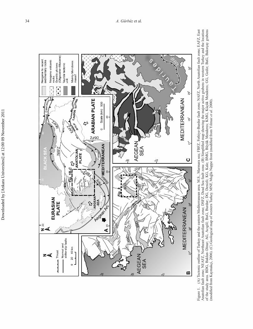
Figure 2. Physiographic image of SW Turkey from SRTM data.
since ∼12 Ma (McKenzie 1972; Dewey and Sengör 1979;Sengör 1979, 1987; Sengör et al. 1985); (2) the back-arc spreading model based on the extension caused bythe southeastward migration of the Aegean trench system(McKenzie 1978; Le Pichon and Angelier 1979; Jacksonand McKenzie 1984; Kissel and Laj 1988; Meulenkampet al. 1988; Avigad et al. 1997; Jolivet et al. 1998;Thomson et al. 1998); (3) the orogenic-collapse modelsuggests that the extension in the region is related to the lateorogenic collapse following the closing of Neotethys bythe collision between the Sakarya zone and the Anatolide-Tauride platform along the Izmir-Ankara suture zone(Dewey 1988; Seyitoglu and Scott 1991, 1992, 1996;Seyitoglu et al. 1992; Seyitoglu and Scott 1994; McCluskyet al. 2000); and (4) the episodic, two-stage graben modelis a combination of the above mechanisms. According tothis model, the extension occurs in two distinct structuralstyles that are separated by an interval of N–S crustal short-ening (Koçyigit et al. 1999; Bozkurt 2000, 2001, 2003,2004; Yılmaz et al. 2000; Cihan et al. 2003; Koçyigit andÖzacar 2003; Purvis and Robertson 2004, 2005; Bozkurtand Rojay 2005; Koçyigit 2005; Koçyigit and Deveci,2007; Gürer et al. 2009b).
There is controversy concerning the age of develop-ment of the grabens. The three major views are (1) thebasins started to form during the late Miocene (McKenzie1972; Sengör and Yilmaz 1981; Sengör et al. 1985;
Sengör 1987); (2) the grabens began to form during thelate Oligocene–early Miocene, and have been continu-ously evolving ever since (Seyitoglu et al. 1992, 1996;Sen and Seyitoglu 2009; Demircioglu et al. 2010); (3) thebasins date from the Plio-Quaternary (Koçyigit et al. 1999;Bozkurt 2000; Sarıca 2000; Yılmaz et al. 2000; GürerYilmaz 2002; Gürer et al. 2001, 2006, 2009).
The Baklan–Dinar graben is situated between twotectonostratigraphic units in the southeastern margin of theWest Anatolian Extensional Province (Sengör et al. 1985;Bozkurt 2001): the Menderes massif in the north and theMugla nappes (also known as Lycian nappes) in the south(Figure 1C). The Menderes massif is an autochthonousPan-African basement, overlain by pre-Devonian-Eoceneschists and marbles and Mesozoic-early Cenozoic plat-form carbonates (Özer et al. 2001). The Mugla nappesform a tectonic package, consisting of slices of the east-ern Taurides metamorphic basement, which is overlain byMesozoic platform carbonates, and the dismembered ophi-olite and volcano-sedimentary units that form the upper-most nappe (Yılmaz et al. 2000). The Mugla nappes, wherethe study area and other similar grabens are located, isbounded by the Fethiye-Burdur fault zone (FBFZ) in thesouth. The FBFZ is an oblique fault with a left-lateralstrike-slip component (Taymaz and Price 1992; Temizet al. 1997; Koçyigit et al. 2000; Yagmurlu 2000; Güreret al. 2004, 2009). This fault zone is the northeastern
Dow
nloa
ded
by [
Ank
ara
Uni
vers
itesi
] at
12:
00 0
9 N
ovem
ber
2011
36 A. Gürbüz et al.
continuation of the Pliny fault zone of the Aegean arcsystem (Dumont et al. 1979; Barka et al. 1995; Eyidoganand Barka 1996; Aksu et al. 2009; Hall et al. 2009)(Figure 1A).
The study area is located in the east of the Ispartaangle and characterized by three NE–SW-trending grabens:Baklan, Acıgöl, and Burdur (Figure 2). These basins aredefined by Price and Scott (1994) as half-grabens, becauseof major NW-dipping, listric basement faults that boundthem to the southeast sides. This graben system is boundedby the NW–SE-trending Dinar fault to the northeast. Thisregion experienced a NE–SW-directed extensional regimein late Miocene time (Temiz et al. 1997). The biaxial NE–SW and NW–SE-trending extension has been active in thestudy area since the late Pliocene (Price and Scott 1994;Temiz et al. 1997; Cihan et al. 2003; Verhaert et al. 2006).This could be related to the westward migration of theAnatolian plate and the rollback of the African slab belowthe Aegean arc (Cihan et al. 2003; Gürer et al. 2009)(Figure 1A). Also, some researchers suggest that the recentearthquake activity in the area indicates a biaxially orientedextension (Taymaz and Price 1992; Eyidogan and Barka1996).
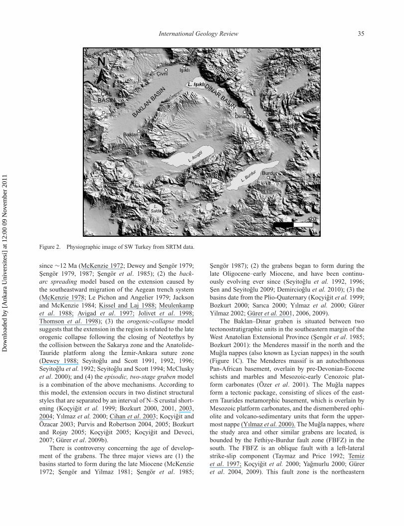
Pre-Neogene rock succession around the Baklan–Dinargraben consists of non-metamorphosed rocks that overlie a
metamorphic basement (Figure 3). The Neogene succes-sion begins with conglomerates that are covered uncon-formably by an interbedded sandstone, claystone, marl,and limestone unit deposited in a lacustrine environ-ment. This unit contains lignites with an economic reserve(about 5 million tonnes (Ünal et al. 1990)), and repre-sents some invertebrate and vertebrate fossils, the agesof which range from early Miocene to early Pliocene(Platen 1967; Konyalı 1970; Dubertret 1973). To thenorth of the graben, Pliocene deposits containing pele-cypod and gastropod fauna are represented by lacustrinelimestones (Konak et al. 1986). Along the northern edgeof the graben, carbonate-cemented conglomerate uncon-formably overlies the basement rocks and represents theinitiated activity of neotectonics in the latest stages ofthe Pliocene in the region. Towards the basin, there isa fluvio-lacustrine sequence that contains red-, brown-,green- and yellow-coloured claystone, marl, siltstone, andintercalated conglomerate lenses. The Plio-Quaternary for-mations deposited under the control of active tectonismare represented by alluvial fan and fluvio-lacustrine sedi-ments. They consist of a sequence (clayey, silty complexcomprising sand, sandy clay with pebble, gravel lenses)mainly resulting from the evolution of the deposition fromlacustrine towards fluvial environment.
Figure 3. Geological map of the study area. The pre-Quaternary units are from the MTA (2002) and the Quaternary units are fromthis study.
Dow
nloa
ded
by [
Ank
ara
Uni
vers
itesi
] at
12:
00 0
9 N
ovem
ber
2011
International Geology Review 37
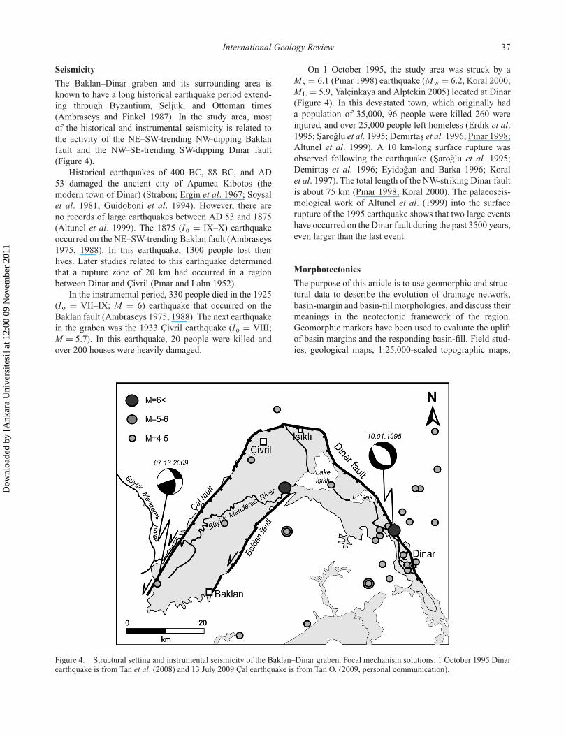
Seismicity
The Baklan–Dinar graben and its surrounding area isknown to have a long historical earthquake period extend-ing through Byzantium, Seljuk, and Ottoman times(Ambraseys and Finkel 1987). In the study area, mostof the historical and instrumental seismicity is related tothe activity of the NE–SW-trending NW-dipping Baklanfault and the NW–SE-trending SW-dipping Dinar fault(Figure 4).
Historical earthquakes of 400 BC, 88 BC, and AD53 damaged the ancient city of Apamea Kibotos (themodern town of Dinar) (Strabon; Ergin et al. 1967; Soysalet al. 1981; Guidoboni et al. 1994). However, there areno records of large earthquakes between AD 53 and 1875(Altunel et al. 1999). The 1875 (Io = IX–X) earthquakeoccurred on the NE–SW-trending Baklan fault (Ambraseys1975, 1988). In this earthquake, 1300 people lost theirlives. Later studies related to this earthquake determinedthat a rupture zone of 20 km had occurred in a regionbetween Dinar and Çivril (Pınar and Lahn 1952).
In the instrumental period, 330 people died in the 1925(Io = VII–IX; M = 6) earthquake that occurred on theBaklan fault (Ambraseys 1975, 1988). The next earthquakein the graben was the 1933 Çivril earthquake (Io = VIII;M = 5.7). In this earthquake, 20 people were killed andover 200 houses were heavily damaged.
On 1 October 1995, the study area was struck by aM s = 6.1 (Pınar 1998) earthquake (Mw = 6.2, Koral 2000;ML = 5.9, Yalçinkaya and Alptekin 2005) located at Dinar(Figure 4). In this devastated town, which originally hada population of 35,000, 96 people were killed 260 wereinjured, and over 25,000 people left homeless (Erdik et al.1995; Saroglu et al. 1995; Demirtas et al. 1996; Pınar 1998;Altunel et al. 1999). A 10 km-long surface rupture wasobserved following the earthquake (Saroglu et al. 1995;Demirtas et al. 1996; Eyidogan and Barka 1996; Koralet al. 1997). The total length of the NW-striking Dinar faultis about 75 km (Pınar 1998; Koral 2000). The palaeoseis-mological work of Altunel et al. (1999) into the surfacerupture of the 1995 earthquake shows that two large eventshave occurred on the Dinar fault during the past 3500 years,even larger than the last event.
Morphotectonics
The purpose of this article is to use geomorphic and struc-tural data to describe the evolution of drainage network,basin-margin and basin-fill morphologies, and discuss theirmeanings in the neotectonic framework of the region.Geomorphic markers have been used to evaluate the upliftof basin margins and the responding basin-fill. Field stud-ies, geological maps, 1:25,000-scaled topographic maps,
Figure 4. Structural setting and instrumental seismicity of the Baklan–Dinar graben. Focal mechanism solutions: 1 October 1995 Dinarearthquake is from Tan et al. (2008) and 13 July 2009 Çal earthquake is from Tan O. (2009, personal communication).
Dow
nloa
ded
by [
Ank
ara
Uni
vers
itesi
] at
12:
00 0
9 N
ovem
ber
2011
38 A. Gürbüz et al.
and digital elevation models are combined to illuminate theeffects of structural features on morphology.
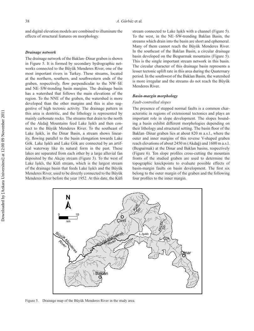
Drainage network
The drainage network of the Baklan–Dinar graben is shownin Figure 5. It is formed by secondary hydrographic net-works connected to the Büyük Menderes River, one of themost important rivers in Turkey. These streams, locatedat the northern, southern, and southwestern ends of thegraben, respectively, flow perpendicular to the NW–SEand NE–SW-trending basin margins. The drainage basinhas a watershed that follows the main elevations of theregion. To the NNE of the graben, the watershed is moredeveloped than the other margins and this is also sug-gestive of high tectonic activity. The drainage pattern inthis area is dentritic, and the lithology is represented bymainly carbonate rocks. The streams that drain to the northof the Akdag Mountains feed Lake Isıklı and then con-nect to the Büyük Menderes River. To the southeast ofLake Isıklı, in the Dinar Basin, a stream shows linear-ity, flowing parallel to the basin elongation towards LakeGök. Lake Isıklı and Lake Gök are connected by an artif-ical waterway like its natural form in the past. Theselakes are separated from each other by a large alluvial fandeposited by the Akçay stream (Figure 3). To the west ofLake Isıklı, the Küfi stream, which is the largest streamof the drainage basin that feeds Lake Isıklı and the BüyükMenderes River, used to be directly connected to the BüyükMenderes River before the year 1952. At this date, the Küfi
stream connected to Lake Isıklı with a channel (Figure 5).To the west, in the NE–SW-trending Baklan Basin, thestreams which drain into the basin are short and ephemeral.Many of them cannot reach the Büyük Menderes River.In the southeast of the Baklan Basin, a circular drainagebasin developed on the Besparmak mountains (Figure 5).This is the single important stream network in this basin.The circular character of this drainage basin represents alesser tectonic uplift rate in this area during the Quaternaryperiod. In the southwest of the Baklan Basin, the watershedis more irregular and the streams do not reach the BüyükMenderes River.
Basin-margin morphology
Fault-controlled slopes
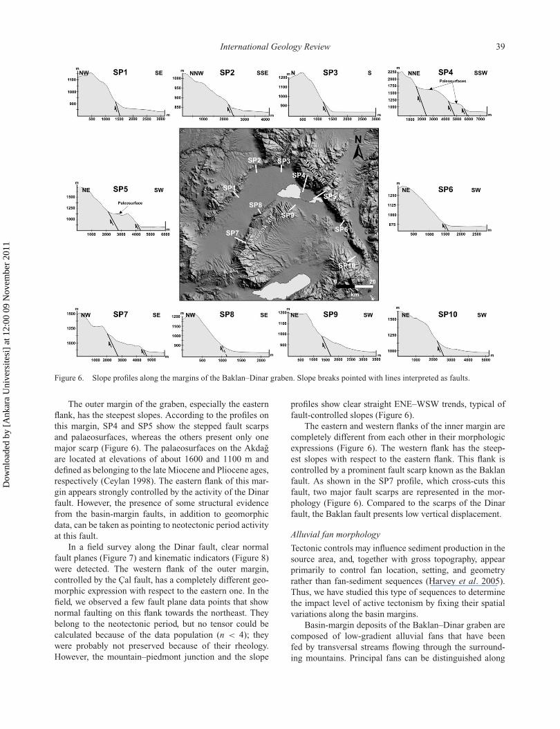
The presence of stepped normal faults is a common char-acteristic in regions of extensional tectonics and plays animportant role in slope development. The slopes bound-ing a basin exhibit different morphologies depending ontheir lithology and structural setting. The basin floor of theBaklan–Dinar graben lies at about 820 m a.s.l., where theouter and inner margins of this reverse V-shaped grabenreach elevations of about 2450 m (Akdag) and 1600 m a.s.l.(Besparmak) at the Dinar and Baklan basins, respectively(Figure 6). Ten slope profiles cross-cutting the mountainfronts of the studied graben are used to determine thetopographic knickpoints to evaluate possible effects ofbasin-margin faults on basin development. The first sixbelong to the outer margin of the graben and the followingfour profiles to the inner margin.
Figure 5. Drainage map of the Büyük Menderes River in the study area.
Dow
nloa
ded
by [
Ank
ara
Uni
vers
itesi
] at
12:
00 0
9 N
ovem
ber
2011
International Geology Review 39
Figure 6. Slope profiles along the margins of the Baklan–Dinar graben. Slope breaks pointed with lines interpreted as faults.
The outer margin of the graben, especially the easternflank, has the steepest slopes. According to the profiles onthis margin, SP4 and SP5 show the stepped fault scarpsand palaeosurfaces, whereas the others present only onemajor scarp (Figure 6). The palaeosurfaces on the Akdagare located at elevations of about 1600 and 1100 m anddefined as belonging to the late Miocene and Pliocene ages,respectively (Ceylan 1998). The eastern flank of this mar-gin appears strongly controlled by the activity of the Dinarfault. However, the presence of some structural evidencefrom the basin-margin faults, in addition to geomorphicdata, can be taken as pointing to neotectonic period activityat this fault.
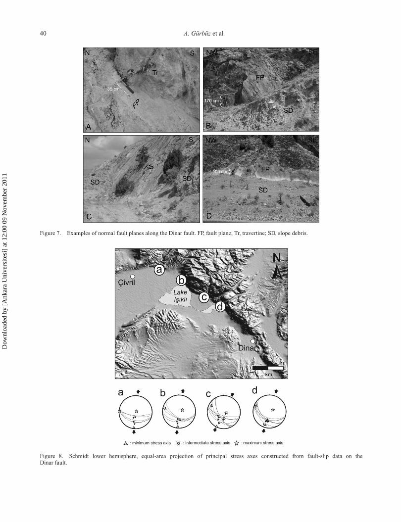
In a field survey along the Dinar fault, clear normalfault planes (Figure 7) and kinematic indicators (Figure 8)were detected. The western flank of the outer margin,controlled by the Çal fault, has a completely different geo-morphic expression with respect to the eastern one. In thefield, we observed a few fault plane data points that shownormal faulting on this flank towards the northeast. Theybelong to the neotectonic period, but no tensor could becalculated because of the data population (n < 4); theywere probably not preserved because of their rheology.However, the mountain–piedmont junction and the slope
profiles show clear straight ENE–WSW trends, typical offault-controlled slopes (Figure 6).
The eastern and western flanks of the inner margin arecompletely different from each other in their morphologicexpressions (Figure 6). The western flank has the steep-est slopes with respect to the eastern flank. This flank iscontrolled by a prominent fault scarp known as the Baklanfault. As shown in the SP7 profile, which cross-cuts thisfault, two major fault scarps are represented in the mor-phology (Figure 6). Compared to the scarps of the Dinarfault, the Baklan fault presents low vertical displacement.
Alluvial fan morphology
Tectonic controls may influence sediment production in thesource area, and, together with gross topography, appearprimarily to control fan location, setting, and geometryrather than fan-sediment sequences (Harvey et al. 2005).Thus, we have studied this type of sequences to determinethe impact level of active tectonism by fixing their spatialvariations along the basin margins.
Basin-margin deposits of the Baklan–Dinar graben arecomposed of low-gradient alluvial fans that have beenfed by transversal streams flowing through the surround-ing mountains. Principal fans can be distinguished along
Dow
nloa
ded
by [
Ank
ara
Uni
vers
itesi
] at
12:
00 0
9 N
ovem
ber
2011
40 A. Gürbüz et al.
Figure 7. Examples of normal fault planes along the Dinar fault. FP, fault plane; Tr, travertine; SD, slope debris.
Figure 8. Schmidt lower hemisphere, equal-area projection of principal stress axes constructed from fault-slip data on theDinar fault.
Dow
nloa
ded
by [
Ank
ara
Uni
vers
itesi
] at
12:
00 0
9 N
ovem
ber
2011
International Geology Review 41
the eastern flank of the outer and western flank of theinner margins of the graben. These deposits, which hidethe lower lacustrine sequence, appear to control the NNEgradient of the basin floor.
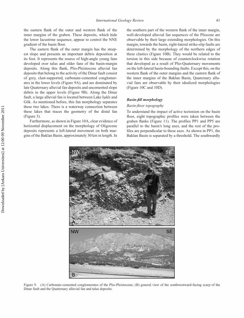
The eastern flank of the outer margin has the steep-est slope and presents an important debris deposition atits foot. It represents the source of high-angle young fansdeveloped over talus and older fans of the basin-margindeposits. Along this flank, Plio-Pleistocene alluvial fandeposits that belong to the activity of the Dinar fault consistof grey, clast-supported, carbonate-cemented conglomer-ates in the lower levels (Figure 9A), and are dominated bylate Quaternary alluvial fan deposits and uncemented slopedebris in the upper levels (Figure 9B). Along the Dinarfault, a large alluvial fan is located between Lake Isıklı andGök. As mentioned before, this fan morphology separatesthese two lakes. There is a waterway connection betweenthese lakes that traces the geometry of the distal fan(Figure 3).
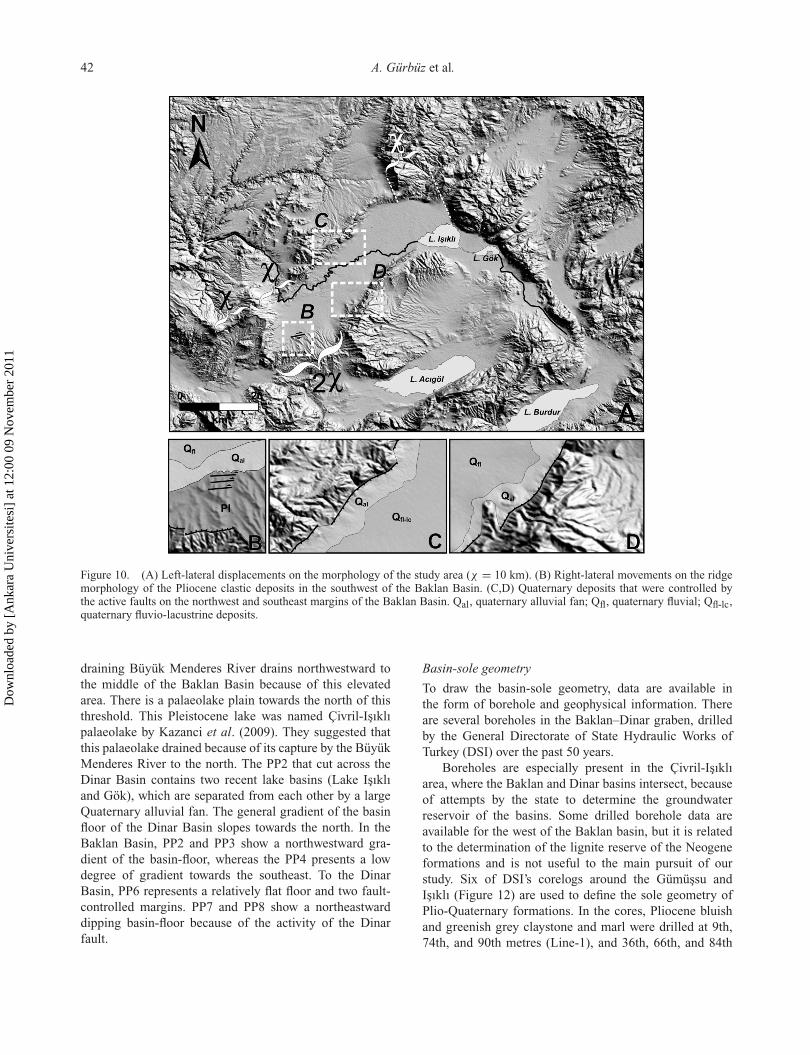
Furthermore, as shown in Figure 10A, clear evidence ofhorizontal displacement on the morphology of Oligocenedeposits represents a left-lateral movement on both mar-gins of the Baklan Basin, approximately 30 km in length. In
the southern part of the western flank of the inner margin,well-developed alluvial fan sequences of the Pliocene areobservable by their large extending morphologies. On thismargin, towards the basin, right-lateral strike-slip faults aredetermined by the morphology of the northern edges ofthese clastics (Figure 10B). They would be related to thetorsion in this side because of counterclockwise rotationthat developed as a result of Plio-Quaternary movementson the left-lateral basin-bounding faults. Except this, on thewestern flank of the outer margins and the eastern flank ofthe inner margins of the Baklan Basin, Quaternary allu-vial fans are observable by their idealized morphologies(Figure 10C and 10D).
Basin-fill morphology
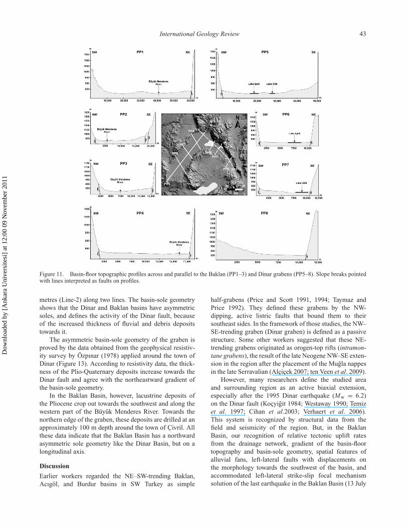
Basin-floor topography
To understand the impact of active tectonism on the basinfloor, eight topographic profiles were taken between thegraben flanks (Figure 11). The profiles PP1 and PP5 areparallel to the basin’s long axes, and the rest of the pro-files are perpendicular to these axes. As shown in PP1, theBaklan Basin is separated by a threshold. The southwardly
Figure 9. (A) Carbonate-cemented conglomerates of the Plio-Pleistocene; (B) general view of the southwestward-facing scarp of theDinar fault and the Quaternary alluvial fan and talus deposits.
Dow
nloa
ded
by [
Ank
ara
Uni
vers
itesi
] at
12:
00 0
9 N
ovem
ber
2011
42 A. Gürbüz et al.
Figure 10. (A) Left-lateral displacements on the morphology of the study area (χ = 10 km). (B) Right-lateral movements on the ridgemorphology of the Pliocene clastic deposits in the southwest of the Baklan Basin. (C,D) Quaternary deposits that were controlled bythe active faults on the northwest and southeast margins of the Baklan Basin. Qal, quaternary alluvial fan; Qfl, quaternary fluvial; Qfl-lc,quaternary fluvio-lacustrine deposits.
draining Büyük Menderes River drains northwestward tothe middle of the Baklan Basin because of this elevatedarea. There is a palaeolake plain towards the north of thisthreshold. This Pleistocene lake was named Çivril-Isıklıpalaeolake by Kazanci et al. (2009). They suggested thatthis palaeolake drained because of its capture by the BüyükMenderes River to the north. The PP2 that cut across theDinar Basin contains two recent lake basins (Lake Isıklıand Gök), which are separated from each other by a largeQuaternary alluvial fan. The general gradient of the basinfloor of the Dinar Basin slopes towards the north. In theBaklan Basin, PP2 and PP3 show a northwestward gra-dient of the basin-floor, whereas the PP4 presents a lowdegree of gradient towards the southeast. To the DinarBasin, PP6 represents a relatively flat floor and two fault-controlled margins. PP7 and PP8 show a northeastwarddipping basin-floor because of the activity of the Dinarfault.
Basin-sole geometry
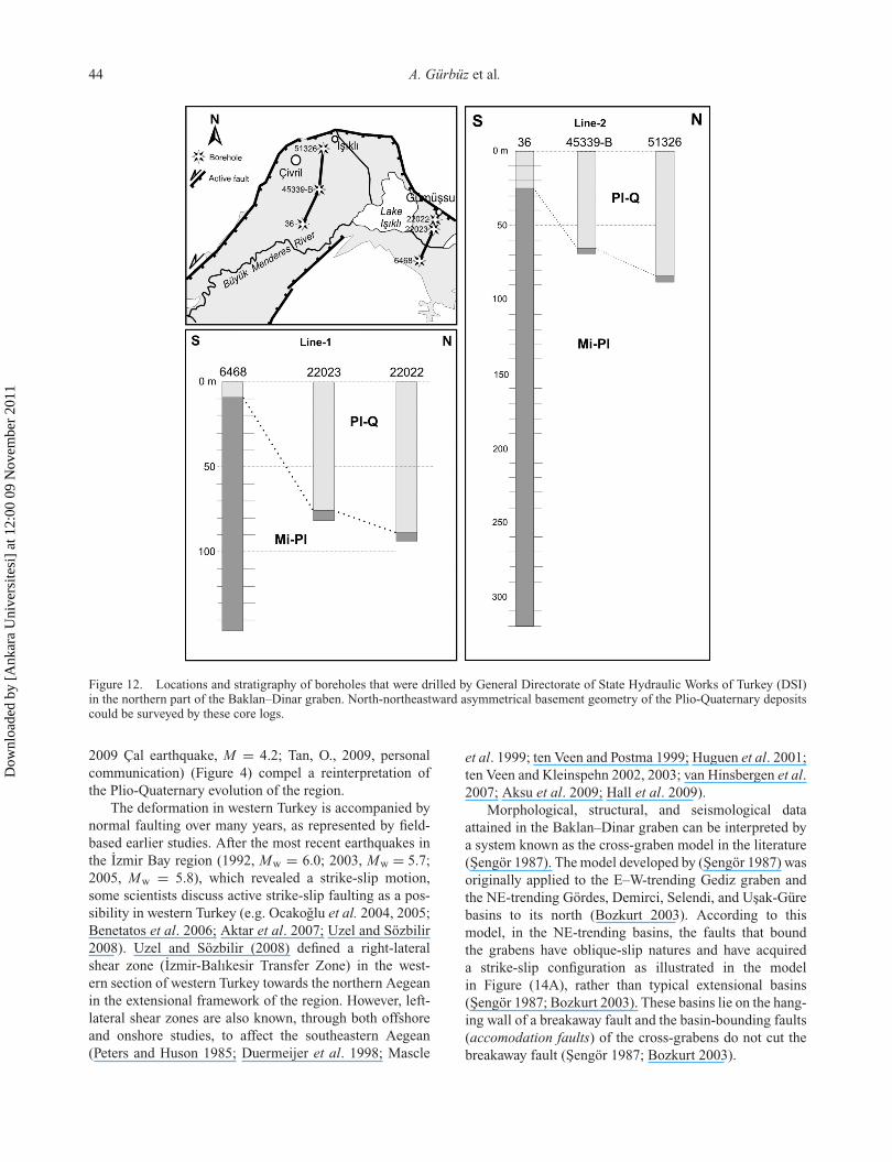
To draw the basin-sole geometry, data are available inthe form of borehole and geophysical information. Thereare several boreholes in the Baklan–Dinar graben, drilledby the General Directorate of State Hydraulic Works ofTurkey (DSI) over the past 50 years.
Boreholes are especially present in the Çivril-Isıklıarea, where the Baklan and Dinar basins intersect, becauseof attempts by the state to determine the groundwaterreservoir of the basins. Some drilled borehole data areavailable for the west of the Baklan basin, but it is relatedto the determination of the lignite reserve of the Neogeneformations and is not useful to the main pursuit of ourstudy. Six of DSI’s corelogs around the Gümüssu andIsıklı (Figure 12) are used to define the sole geometry ofPlio-Quaternary formations. In the cores, Pliocene bluishand greenish grey claystone and marl were drilled at 9th,74th, and 90th metres (Line-1), and 36th, 66th, and 84th
Dow
nloa
ded
by [
Ank
ara
Uni
vers
itesi
] at
12:
00 0
9 N
ovem
ber
2011
International Geology Review 43
Figure 11. Basin-floor topographic profiles across and parallel to the Baklan (PP1–3) and Dinar grabens (PP5–8). Slope breaks pointedwith lines interpreted as faults on profiles.
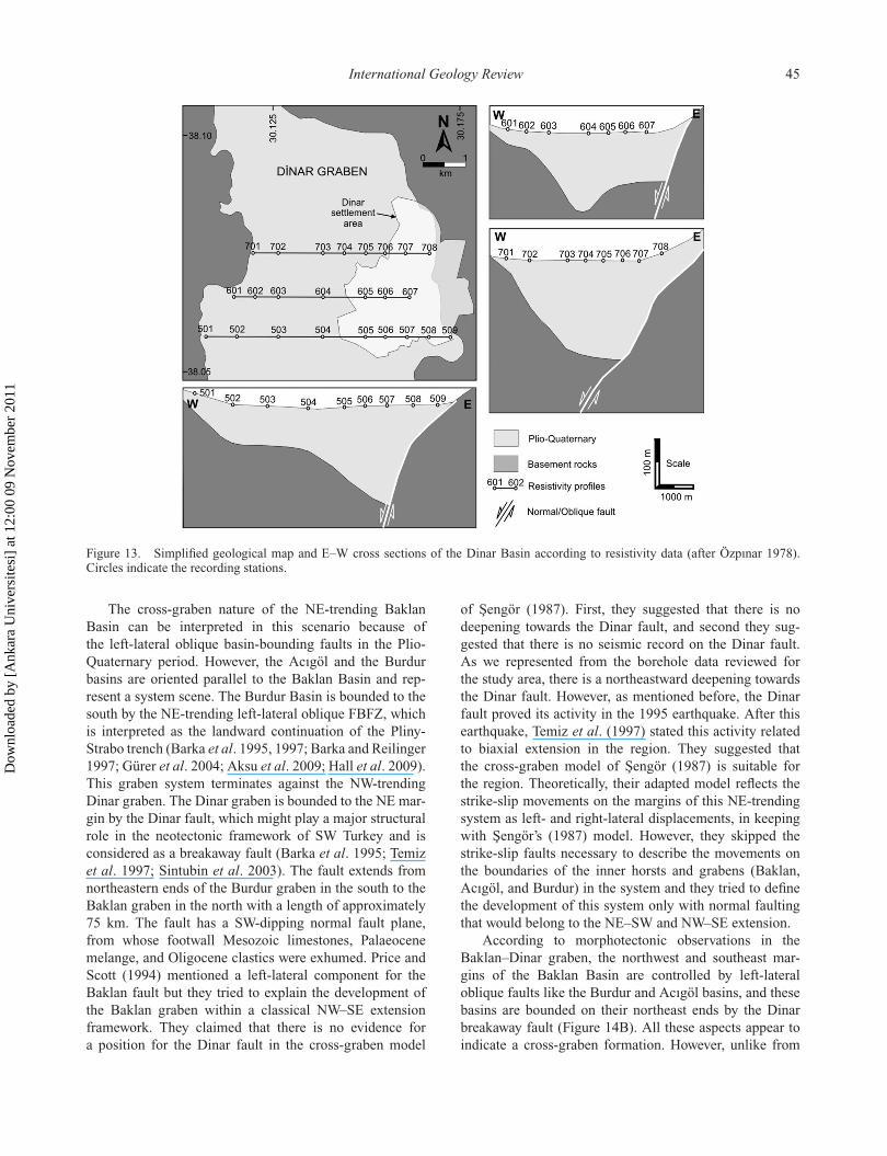
metres (Line-2) along two lines. The basin-sole geometryshows that the Dinar and Baklan basins have asymmetricsoles, and defines the activity of the Dinar fault, becauseof the increased thickness of fluvial and debris depositstowards it.
The asymmetric basin-sole geometry of the graben isproved by the data obtained from the geophysical resistiv-ity survey by Özpınar (1978) applied around the town ofDinar (Figure 13). According to resistivity data, the thick-ness of the Plio-Quaternary deposits increase towards theDinar fault and agree with the northeastward gradient ofthe basin-sole geometry.
In the Baklan Basin, however, lacustrine deposits ofthe Pliocene crop out towards the southwest and along thewestern part of the Büyük Menderes River. Towards thenorthern edge of the graben, these deposits are drilled at anapproximately 100 m depth around the town of Çivril. Allthese data indicate that the Baklan Basin has a northwardasymmetric sole geometry like the Dinar Basin, but on alongitudinal axis.
Discussion
Earlier workers regarded the NE–SW-trending Baklan,Acıgöl, and Burdur basins in SW Turkey as simple
half-grabens (Price and Scott 1991, 1994; Taymaz andPrice 1992). They defined these grabens by the NW-dipping, active listric faults that bound them to theirsoutheast sides. In the framework of those studies, the NW–SE-trending graben (Dinar graben) is defined as a passivestructure. Some other workers suggested that these NE-trending grabens originated as orogen-top rifts (intramon-tane grabens), the result of the late Neogene NW–SE exten-sion in the region after the placement of the Mugla nappesin the late Serravalian (Alçiçek 2007; ten Veen et al. 2009).
However, many researchers define the studied areaand surrounding region as an active biaxial extension,especially after the 1995 Dinar earthquake (Mw = 6.2)on the Dinar fault (Koçyigit 1984; Westaway 1990; Temizet al. 1997; Cihan et al.2003; Verhaert et al. 2006).This system is recognized by structural data from thefield and seismicity of the region. But, in the BaklanBasin, our recognition of relative tectonic uplift ratesfrom the drainage network, gradient of the basin-floortopography and basin-sole geometry, spatial features ofalluvial fans, left-lateral faults with displacements onthe morphology towards the southwest of the basin, andaccommodated left-lateral strike-slip focal mechanismsolution of the last earthquake in the Baklan Basin (13 July
Dow
nloa
ded
by [
Ank
ara
Uni
vers
itesi
] at
12:
00 0
9 N
ovem
ber
2011
44 A. Gürbüz et al.
Figure 12. Locations and stratigraphy of boreholes that were drilled by General Directorate of State Hydraulic Works of Turkey (DSI)in the northern part of the Baklan–Dinar graben. North-northeastward asymmetrical basement geometry of the Plio-Quaternary depositscould be surveyed by these core logs.
2009 Çal earthquake, M = 4.2; Tan, O., 2009, personalcommunication) (Figure 4) compel a reinterpretation ofthe Plio-Quaternary evolution of the region.
The deformation in western Turkey is accompanied bynormal faulting over many years, as represented by field-based earlier studies. After the most recent earthquakes inthe Izmir Bay region (1992, Mw = 6.0; 2003, Mw = 5.7;2005, Mw = 5.8), which revealed a strike-slip motion,some scientists discuss active strike-slip faulting as a pos-sibility in western Turkey (e.g. Ocakoglu et al. 2004, 2005;Benetatos et al. 2006; Aktar et al. 2007; Uzel and Sözbilir2008). Uzel and Sözbilir (2008) defined a right-lateralshear zone (Izmir-Balıkesir Transfer Zone) in the west-ern section of western Turkey towards the northern Aegeanin the extensional framework of the region. However, left-lateral shear zones are also known, through both offshoreand onshore studies, to affect the southeastern Aegean(Peters and Huson 1985; Duermeijer et al. 1998; Mascle
et al. 1999; ten Veen and Postma 1999; Huguen et al. 2001;ten Veen and Kleinspehn 2002, 2003; van Hinsbergen et al.2007; Aksu et al. 2009; Hall et al. 2009).
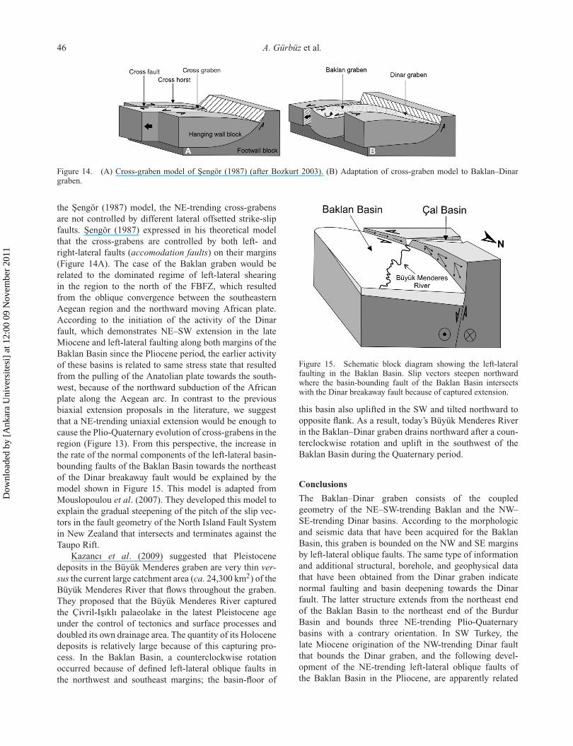
Morphological, structural, and seismological dataattained in the Baklan–Dinar graben can be interpreted bya system known as the cross-graben model in the literature(Sengör 1987). The model developed by (Sengör 1987) wasoriginally applied to the E–W-trending Gediz graben andthe NE-trending Gördes, Demirci, Selendi, and Usak-Gürebasins to its north (Bozkurt 2003). According to thismodel, in the NE-trending basins, the faults that boundthe grabens have oblique-slip natures and have acquireda strike-slip configuration as illustrated in the modelin Figure (14A), rather than typical extensional basins(Sengör 1987; Bozkurt 2003). These basins lie on the hang-ing wall of a breakaway fault and the basin-bounding faults(accomodation faults) of the cross-grabens do not cut thebreakaway fault (Sengör 1987; Bozkurt 2003).
Dow
nloa
ded
by [
Ank
ara
Uni
vers
itesi
] at
12:
00 0
9 N
ovem
ber
2011
International Geology Review 45
Figure 13. Simplified geological map and E–W cross sections of the Dinar Basin according to resistivity data (after Özpınar 1978).Circles indicate the recording stations.
The cross-graben nature of the NE-trending BaklanBasin can be interpreted in this scenario because ofthe left-lateral oblique basin-bounding faults in the Plio-Quaternary period. However, the Acıgöl and the Burdurbasins are oriented parallel to the Baklan Basin and rep-resent a system scene. The Burdur Basin is bounded to thesouth by the NE-trending left-lateral oblique FBFZ, whichis interpreted as the landward continuation of the Pliny-Strabo trench (Barka et al. 1995, 1997; Barka and Reilinger1997; Gürer et al. 2004; Aksu et al. 2009; Hall et al. 2009).This graben system terminates against the NW-trendingDinar graben. The Dinar graben is bounded to the NE mar-gin by the Dinar fault, which might play a major structuralrole in the neotectonic framework of SW Turkey and isconsidered as a breakaway fault (Barka et al. 1995; Temizet al. 1997; Sintubin et al. 2003). The fault extends fromnortheastern ends of the Burdur graben in the south to theBaklan graben in the north with a length of approximately75 km. The fault has a SW-dipping normal fault plane,from whose footwall Mesozoic limestones, Palaeocenemelange, and Oligocene clastics were exhumed. Price andScott (1994) mentioned a left-lateral component for theBaklan fault but they tried to explain the development ofthe Baklan graben within a classical NW–SE extensionframework. They claimed that there is no evidence fora position for the Dinar fault in the cross-graben model
of Sengör (1987). First, they suggested that there is nodeepening towards the Dinar fault, and second they sug-gested that there is no seismic record on the Dinar fault.As we represented from the borehole data reviewed forthe study area, there is a northeastward deepening towardsthe Dinar fault. However, as mentioned before, the Dinarfault proved its activity in the 1995 earthquake. After thisearthquake, Temiz et al. (1997) stated this activity relatedto biaxial extension in the region. They suggested thatthe cross-graben model of Sengör (1987) is suitable forthe region. Theoretically, their adapted model reflects thestrike-slip movements on the margins of this NE-trendingsystem as left- and right-lateral displacements, in keepingwith Sengör’s (1987) model. However, they skipped thestrike-slip faults necessary to describe the movements onthe boundaries of the inner horsts and grabens (Baklan,Acıgöl, and Burdur) in the system and they tried to definethe development of this system only with normal faultingthat would belong to the NE–SW and NW–SE extension.
According to morphotectonic observations in theBaklan–Dinar graben, the northwest and southeast mar-gins of the Baklan Basin are controlled by left-lateraloblique faults like the Burdur and Acıgöl basins, and thesebasins are bounded on their northeast ends by the Dinarbreakaway fault (Figure 14B). All these aspects appear toindicate a cross-graben formation. However, unlike from
Dow
nloa
ded
by [
Ank
ara
Uni
vers
itesi
] at
12:
00 0
9 N
ovem
ber
2011
46 A. Gürbüz et al.
Figure 14. (A) Cross-graben model of Sengör (1987) (after Bozkurt 2003). (B) Adaptation of cross-graben model to Baklan–Dinargraben.
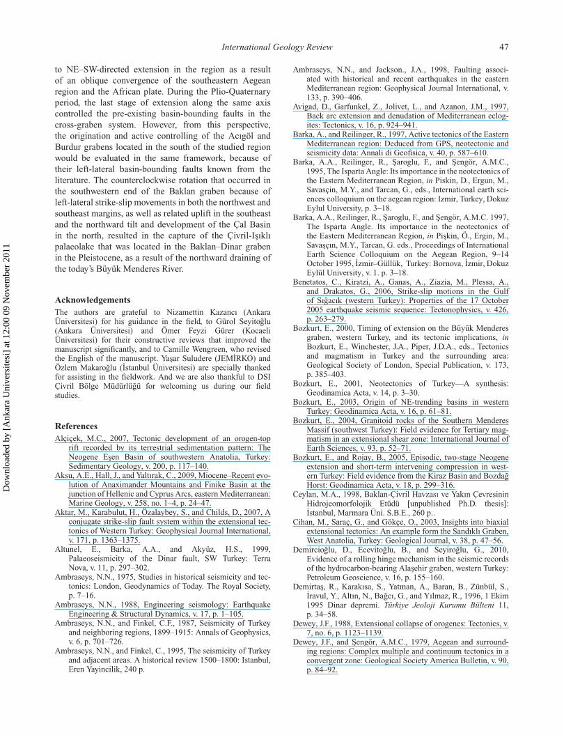
the Sengör (1987) model, the NE-trending cross-grabensare not controlled by different lateral offsetted strike-slipfaults. Sengör (1987) expressed in his theoretical modelthat the cross-grabens are controlled by both left- andright-lateral faults (accomodation faults) on their margins(Figure 14A). The case of the Baklan graben would berelated to the dominated regime of left-lateral shearingin the region to the north of the FBFZ, which resultedfrom the oblique convergence between the southeasternAegean region and the northward moving African plate.According to the initiation of the activity of the Dinarfault, which demonstrates NE–SW extension in the lateMiocene and left-lateral faulting along both margins of theBaklan Basin since the Pliocene period, the earlier activityof these basins is related to same stress state that resultedfrom the pulling of the Anatolian plate towards the south-west, because of the northward subduction of the Africanplate along the Aegean arc. In contrast to the previousbiaxial extension proposals in the literature, we suggestthat a NE-trending uniaxial extension would be enough tocause the Plio-Quaternary evolution of cross-grabens in theregion (Figure 13). From this perspective, the increase inthe rate of the normal components of the left-lateral basin-bounding faults of the Baklan Basin towards the northeastof the Dinar breakaway fault would be explained by themodel shown in Figure 15. This model is adapted fromMouslopoulou et al. (2007). They developed this model toexplain the gradual steepening of the pitch of the slip vec-tors in the fault geometry of the North Island Fault Systemin New Zealand that intersects and terminates against theTaupo Rift.
Kazancı et al. (2009) suggested that Pleistocenedeposits in the Büyük Menderes graben are very thin ver-sus the current large catchment area (ca. 24,300 km2) of theBüyük Menderes River that flows throughout the graben.They proposed that the Büyük Menderes River capturedthe Çivril-Isıklı palaeolake in the latest Pleistocene ageunder the control of tectonics and surface processes anddoubled its own drainage area. The quantity of its Holocenedeposits is relatively large because of this capturing pro-cess. In the Baklan Basin, a counterclockwise rotationoccurred because of defined left-lateral oblique faults inthe northwest and southeast margins; the basin-floor of
Figure 15. Schematic block diagram showing the left-lateralfaulting in the Baklan Basin. Slip vectors steepen northwardwhere the basin-bounding fault of the Baklan Basin intersectswith the Dinar breakaway fault because of captured extension.
this basin also uplifted in the SW and tilted northward toopposite flank. As a result, today’s Büyük Menderes Riverin the Baklan–Dinar graben drains northward after a coun-terclockwise rotation and uplift in the southwest of theBaklan Basin during the Quaternary period.
Conclusions
The Baklan–Dinar graben consists of the coupledgeometry of the NE–SW-trending Baklan and the NW–SE-trending Dinar basins. According to the morphologicand seismic data that have been acquired for the BaklanBasin, this graben is bounded on the NW and SE marginsby left-lateral oblique faults. The same type of informationand additional structural, borehole, and geophysical datathat have been obtained from the Dinar graben indicatenormal faulting and basin deepening towards the Dinarfault. The latter structure extends from the northeast endof the Baklan Basin to the northeast end of the BurdurBasin and bounds three NE-trending Plio-Quaternarybasins with a contrary orientation. In SW Turkey, thelate Miocene origination of the NW-trending Dinar faultthat bounds the Dinar graben, and the following devel-opment of the NE-trending left-lateral oblique faults ofthe Baklan Basin in the Pliocene, are apparently related
Dow
nloa
ded
by [
Ank
ara
Uni
vers
itesi
] at
12:
00 0
9 N
ovem
ber
2011
International Geology Review 47
to NE–SW-directed extension in the region as a resultof an oblique convergence of the southeastern Aegeanregion and the African plate. During the Plio-Quaternaryperiod, the last stage of extension along the same axiscontrolled the pre-existing basin-bounding faults in thecross-graben system. However, from this perspective,the origination and active controlling of the Acıgöl andBurdur grabens located in the south of the studied regionwould be evaluated in the same framework, because oftheir left-lateral basin-bounding faults known from theliterature. The counterclockwise rotation that occurred inthe southwestern end of the Baklan graben because ofleft-lateral strike-slip movements in both the northwest andsoutheast margins, as well as related uplift in the southeastand the northward tilt and development of the Çal Basinin the north, resulted in the capture of the Çivril-Isıklıpalaeolake that was located in the Baklan–Dinar grabenin the Pleistocene, as a result of the northward draining ofthe today’s Büyük Menderes River.
AcknowledgementsThe authors are grateful to Nizamettin Kazancı (AnkaraÜniversitesi) for his guidance in the field, to Gürol Seyitoglu(Ankara Üniversitesi) and Ömer Feyzi Gürer (KocaeliÜniversitesi) for their constructive reviews that improved themanuscript significantly, and to Camille Wengreen, who revisedthe English of the manuscript. Yasar Suludere (JEMIRKO) andÖzlem Makaroglu (Istanbul Üniversitesi) are specially thankedfor assisting in the fieldwork. And we are also thankful to DSIÇivril Bölge Müdürlügü for welcoming us during our fieldstudies.
ReferencesAlçiçek, M.C., 2007, Tectonic development of an orogen-top
rift recorded by its terrestrial sedimentation pattern: TheNeogene Esen Basin of southwestern Anatolia, Turkey:Sedimentary Geology, v. 200, p. 117–140.
Aksu, A.E., Hall, J., and Yaltırak, C., 2009, Miocene–Recent evo-lution of Anaximander Mountains and Finike Basin at thejunction of Hellenic and Cyprus Arcs, eastern Mediterranean:Marine Geology, v. 258, no. 1–4, p. 24–47.
Aktar, M., Karabulut, H., Özalaybey, S., and Childs, D., 2007, Aconjugate strike-slip fault system within the extensional tec-tonics of Western Turkey: Geophysical Journal International,v. 171, p. 1363–1375.
Altunel, E., Barka, A.A., and Akyüz, H.S., 1999,Palaeoseismicity of the Dinar fault, SW Turkey: TerraNova, v. 11, p. 297–302.
Ambraseys, N.N., 1975, Studies in historical seismicity and tec-tonics: London, Geodynamics of Today. The Royal Society,p. 7–16.
Ambraseys, N.N., 1988, Engineering seismology: EarthquakeEngineering & Structural Dynamics, v. 17, p. 1–105.
Ambraseys, N.N., and Finkel, C.F., 1987, Seismicity of Turkeyand neighboring regions, 1899–1915: Annals of Geophysics,v. 6, p. 701–726.
Ambraseys, N.N., and Finkel, C., 1995, The seismicity of Turkeyand adjacent areas. A historical review 1500–1800: Istanbul,Eren Yayincilik, 240 p.
Ambraseys, N.N., and Jackson., J.A., 1998, Faulting associ-ated with historical and recent earthquakes in the easternMediterranean region: Geophysical Journal International, v.133, p. 390–406.
Avigad, D., Garfunkel, Z., Jolivet, L., and Azanon, J.M., 1997,Back arc extension and denudation of Mediterranean eclog-ites: Tectonics, v. 16, p. 924–941.
Barka, A., and Reilinger, R., 1997, Active tectonics of the EasternMediterranean region: Deduced from GPS, neotectonic andseismicity data: Annali di Geofisica, v. 40, p. 587–610.
Barka, A.A., Reilinger, R., Saroglu, F., and Sengör, A.M.C.,1995, The Isparta Angle: Its importance in the neotectonics ofthe Eastern Mediterranean Region, in Piskin, D., Ergun, M.,Savasçin, M.Y., and Tarcan, G., eds., International earth sci-ences colloquium on the aegean region: Izmir, Turkey, DokuzEylul University, p. 3–18.
Barka, A.A., Reilinger, R., Saroglu, F., and Sengör, A.M.C. 1997,The Isparta Angle. Its importance in the neotectonics ofthe Eastern Mediterranean Region, in Piskin, Ö., Ergin, M.,Savasçın, M.Y., Tarcan, G. eds., Proceedings of InternationalEarth Science Colloquium on the Aegean Region, 9–14October 1995, Izmir–Güllük, Turkey: Bornova, Izmir, DokuzEylül University, v. 1. p. 3–18.
Benetatos, C., Kiratzi, A., Ganas, A., Ziazia, M., Plessa, A.,and Drakatos, G., 2006, Strike-slip motions in the Gulfof Sıgacık (western Turkey): Properties of the 17 October2005 earthquake seismic sequence: Tectonophysics, v. 426,p. 263–279.
Bozkurt, E., 2000, Timing of extension on the Büyük Menderesgraben, western Turkey, and its tectonic implications, inBozkurt, E., Winchester, J.A., Piper, J.D.A., eds., Tectonicsand magmatism in Turkey and the surrounding area:Geological Society of London, Special Publication, v. 173,p. 385–403.
Bozkurt, E., 2001, Neotectonics of Turkey—A synthesis:Geodinamica Acta, v. 14, p. 3–30.
Bozkurt, E., 2003, Origin of NE-trending basins in westernTurkey: Geodinamica Acta, v. 16, p. 61–81.
Bozkurt, E., 2004, Granitoid rocks of the Southern MenderesMassif (southwest Turkey): Field evidence for Tertiary mag-matism in an extensional shear zone: International Journal ofEarth Sciences, v. 93, p. 52–71.
Bozkurt, E., and Rojay, B., 2005, Episodic, two-stage Neogeneextension and short-term intervening compression in west-ern Turkey: Field evidence from the Kiraz Basin and BozdagHorst: Geodinamica Acta, v. 18, p. 299–316.
Ceylan, M.A., 1998, Baklan-Çivril Havzası ve Yakın ÇevresininHidrojeomorfolojik Etüdü [unpublished Ph.D. thesis]:Istanbul, Marmara Üni. S.B.E., 260 p..
Cihan, M., Saraç, G., and Gökçe, O., 2003, Insights into biaxialextensional tectonics: An example form the Sandıklı Graben,West Anatolia, Turkey: Geological Journal, v. 38, p. 47–56.
Demircioglu, D., Ecevitoglu, B., and Seyiroglu, G., 2010,Evidence of a rolling hinge mechanism in the seismic recordsof the hydrocarbon-bearing Alasehir graben, western Turkey:Petroleum Geoscience, v. 16, p. 155–160.
Demirtas, R., Karakısa, S., Yatman, A., Baran, B., Zünbül, S.,Iravul, Y., Altın, N., Bagcı, G., and Yılmaz, R., 1996, 1 Ekim1995 Dinar depremi. Türkiye Jeoloji Kurumu Bülteni 11,p. 34–58.
Dewey, J.F., 1988, Extensional collapse of orogenes: Tectonics, v.7, no. 6, p. 1123–1139.
Dewey, J.F., and Sengör, A.M.C., 1979, Aegean and surround-ing regions: Complex multiple and continuum tectonics in aconvergent zone: Geological Society America Bulletin, v. 90,p. 84–92.
Dow
nloa
ded
by [
Ank
ara
Uni
vers
itesi
] at
12:
00 0
9 N
ovem
ber
2011
48 A. Gürbüz et al.
Dubertret, L., 1973, 1/500 000 ölçekli Türkiye Jeoloji HaritasıIzmir paftası izahnamesi: Ankara, MTA Enst. Yay.
Duermeijer, C., Krijgsman, W., Langereis, C., and Ten Veen,J.H., 1998, Post-early Messinian counterclockwise rotationson Crete: Implications for Late Miocene to recent kinemat-ics of the southern Hellenic arc: Tectonophysics, v. 298,p. 177–189.
Dumont, J.F., Uysal, S., Simsek, S., Karamanderesi, I.H., andLetouzey, J., 1979, Güneybatı Anadolu’daki grabenlerinolusumu: MTA Bulletin, v. 97, p. 7–18.
Erdik, M., Aydınoglu, N., Pınar, A., and Kalafat, D., 1995,October 1, 1995 Dinar (Turkey) earthquake.Ms D 6:1/,Preliminary reconnaissance report (1), in Proceedings FifthInternational Conference on Seismic Zonation, Nice, France,17–19 October, Volume 3: Nantes, France, Quest Editions,p. 2235–2245.
Ergin, K., Güçlü, U., and Uz, Z., 1967, A catalogue of earth-quakes for Turkey and surrounding area (11 A.D.–1964 A.D.):Istanbul, Publication of the Technical University of Istanbul.
Eyidogan, H., 1988, Rates of crustal deformation in westernTurkey as deduced from major earthquakes: Tectonophysics,v. 148, p. 83–92.
Eyidogan, H., and Barka, A., 1996, The 1 October 1995 Dinarearthquake, SW Turkey: Terra Nova, v. 8, p. 479–485.
Guidoboni, E., Comastri, A., and Traina, G., 1994, Catalogueof ancient earthquakes in the mediterranean area up to 10thcentury: Rome, Instituto Nazionale di Geofisica.
Gürer, A., Bayrak, M., and Gürer, Ö.F., 2009a, A VLF surveyusing current gathering phenomena for tracing buried faultsof Fethiye-Burdur Fault Zone, Turkey: Journal of AppliedGeophysics, v. 68, p. 437–447.
Gürer, A., Bayrak, M., Gürer, Ö.F., and Ilkısık, O.M., 2004,The deep resistivity structure of southwestern Turkey:Tectonic implications: International Geology Review, v. 46,p. 655–670.
Gürer, Ö.F., Bozcu, M., Yılmaz, K., and Yılmaz, Y., 2001,Neogene basin development around Söke-Kusadası (WesternAnatolia) and its bearing on tectonic development of theAegean region: Geodinamica Acta, v. 14, p. 57–69.
Gürer, Ö.F., Sangu, E., and Özburan, M., 2006, Neotectonics ofthe SW Marmara Region, NW Anatolia, Turkey: GeologicalMagazine, v. 143–2, p. 229–241.
Gürer, Ö.F., Sarica-Filoreau, N., Özburan, M., Sangu, E., andDogan, B., 2009b, Progressive development of the BüyükMenderes Graben based on new data, Western Turkey:Geological Magazine, v. 146, no. 5, p. 652–673.
Gürer, Ö.F., and Yılmaz, Y., 2002, Geology of the Ören andsurrounding areas, SW Anatolia: Turkish Journal of EarthSciences, v. 11, p. 1–13.
Hall, J., Aksu, A.E., Yaltırak, C., and Winsor, J.D., 2009,Structural architecture of the Rhodes Basin: A deep depocen-tre that evolved since the Pliocene at the junction of Hellenicand Cyprus Arcs, eastern Mediterranean: Marine Geology, v.258, no. 1–4, p. 1–23.
Harvey, A.M., Mather, A.E., and Stokes, M., 2005, Alluvial fans:Geomorphology, sedimentology, dynamics-introduction. Areview of alluvial-fan research, in Harvey, A.M., Mather,A.E., and Stokes, M., eds., Alluvial Fans: Geomorphology,sedimentology, dynamics: Geological Society, London,Special Publications, v. 251, p. 1–7.
Huguen, C., Mascle, J., Chaumillon, E., Woodside, J.M.,Benkhelil, J., Kopf, A., and Volkonskaia, A., 2001,Deformational style of the eastern Mediterranean Ridge andsurroundings from combined swath mapping and seismicreflection profiling: Tectonophysics, v. 343, p. 21–47.
Jackson, J.A., and McKenzie, D.P., 1984, Active tectonics ofthe Alpine-Himalayan belt between Turkey and Pakistan:Geophysical Journal of Royal Society of AstronomicalSociety, v. 77, p. 185–264.
Jolivet, L., Faccenna, C., Goffé, B., Mattei, M., Rossetti, F.,Brunet, C., Storti, F., Funiciello, R., Cadet, J.P., andParra, T., 1998, Mid-crustal shear zones in post-orogenicextension: The northern Tyrrhenian Sea case: Journal ofGeophysical Research, v. 103, no. 6, p. 12123–12160.
Kaymakçı, N., 2006, Kinematic development and paleostressanalysis of the Denizli Basin (Western Turkish): Implicationsof spatial varition of relative paleostress magnitudes andorientations: Journal of Asian Earth Sciences, v. 27,p. 207–222.
Kazancı, N., Dündar, S., Alçiçek, M.C., and Gürbüz, A., 2009,Quaternary deposits of the Büyük Menderes Graben in west-ern Anatolia, Turkey: Implications for river capture andthe longest Holocene estuary in the Aegean Sea: MarineGeology, v. 264, no. 2–3, p. 165–176.
Kissel, C., and Laj, C., 1988, The Tertiary geodynamical evo-lution of the Aegean arc: A paleomagnetic reconstruction:Tectonophysics, v. 146, p. 183–210.
Koçyigit, A., 1984, Güneybati Türkiye ve yakın dolayinda levhaiçi yeni Tektonik gelisimi: Geological Society of TurkeyBulletin, v. 27, p. 1–16.
Koçyigit, A., 2005, The Denizli graben–horst system and theeastern limit of the western Anatolian continental exten-sion: Basin fill, structure, deformational mode, throw amountand episodic evolutionary history, SW Turkey: GeodinamicaActa, v. 18, p. 167–208.
Koçyigit, A., and Deveci, S., 2007, A N–S-trending active exten-sional structure, the Suhut (Afyon) graben: Commencementage of the extensional neotectonic period in the IspartaAngle, SW Turkey: Turkish Journal of Earth Sciences, v. 16,p. 391–416.
Koçyigit, A., Yusufoglu, H., and Bozkurt, E., 1999, Evidencefrom the Gediz graben for episodic two-stage extension inwestern Turkey: Journal of Geological Society of London, v.156, p. 605–616.
Koçyigit, A., and Özacar, A.A., 2003, Extensional neotectonicregime through the NE edge of the Outer Isparta Angle, SWTurkey: New field and seismic data: Turkish Journal of EarthSciences, v. 12, p. 67–90.
Koçyigit, A., Ünay, E., and Saraç, G., 2000, Episodic graben for-mation and extensional neotectonic regime in west CentralAnatolia and the Isparta Angle: A case study in the Aksehir–Afyon Graben, Turkey, in Bozkurt, E., Winchester, J.A., andPiper, J.D.A., eds., Tectonics and magmatism in Turkey andthe surrounding area: Geological Society of London, SpecialPublication, v. 173, p. 405–421.
Konak, N., Akdeniz, N., and Çakır, M.H., 1986, Çal-Çivril-Karahallı dolayının jeolojisi. MTA Enst. Rapor No.8945,Ankara (Yayınlanmamıs).
Konyalı, Y., 1970, Çivril kazası Tokça Karahacılı bölgesi jeolojiketüdü ve linyit imkanları. MTA. Enst. Rapor no. 6142, Ankara(Unpublished report).
Koral, H., 2000, Surface rupture and rupture mechanism of theOctober 1, 1995 (Mw=6.2) Dinar earthquake, SW Turkey:Tectonophysics, v. 327, p. 15–24.
Koral, H., Laçin, D., and Sakir, S., 1997, 1 Ekim 1995 Dinardepreminin yüzey çatlakları: Jeoloji Mühendisligi, v. 50,p. 50–58.
Le Pichon, X., and Angelier, J., 1979, The Hellenic arc and trenchsystem: a key to the neotectonic evolution of the EasternMediterranean area: Tectonophysics, v. 60, p. 11–42.
Dow
nloa
ded
by [
Ank
ara
Uni
vers
itesi
] at
12:
00 0
9 N
ovem
ber
2011
International Geology Review 49
Mascle, J., Huguen, C., Benkhelil, J., Chamot-Rooke, N.,Chaumillon, E., Foucher, J.P., Griboulard, R., Kopf, A.,Lamarche, G., Volkonskaia, A., Woodside, J., and Zitter, T.,1999, Images may show start of European–African plate col-lision: EOS, Transactions American Geophysical Union, v.80, p. 421, 425, 428.
McClusky, S., Balassanian, S., Barka, A., Demir, C., Ergintav,S., Georgiev, I., Gürkan, O., and Hamburger, M., 2000,Global Positioning System constraints on the plate kinemat-ics and dynamics in the eastern Mediterranean and Caucasus:Journal of Geophysical Research, v. 105, p. 5695–5719.
McKenzie, D.P., 1972, Active tectonics of the MediterraneanRegion: Journal of the Royal Astronomical Society, v. 30,p. 109–185.
McKenzie, D., 1978, Active tectonics of the Alpine-Himalayanbelt: the Aegean Sea and surrounding regions: GeophysicalJournal of the Royal Astronomical Society, v. 55,p. 217–254.
Meulenkamp, J.E., Wortel, M.J.R., Van Wamel, W.A., Spakman,W., and Hoogerduyn Strating, E., 1988, On the Hellenicsubduction zone and the geodynamical evolution of Cretesince the late Middle Miocene: Tectonophysics, v. 146,p. 203–215.
Mouslopoulou, V., Nicol, A., Little, T.A., and Walsh, J.J., 2007,Terminations of large strike-slip faults: An alternative modelfrom New Zealand, in Cunningham, W.D., and Mann, P.,eds., Tectonics of strike-slip restraining and releasing bends:Geological Society of London, Special Publications v. 290,p. 387–415.
Ocakoglu, N., Demirbag, E., and Kusçu, I., 2004, Neotectonicstructures in the area offshore of Alaçatı, Doganbey andKusadası (western Turkey): Evidence of strike-slip faultingin the Aegean extensional province: Tectonophysics, v. 391,p. 67–83.
Ocakoglu, N., Demirbag, E., and Kusçu, I., 2005, Neotectonicstructures in Izmir Gulf and surrounding regions (westernTurkey): Evidences of strike-slip faulting with compressionin the Aegean extensional regime: Marine Geology, v. 219,p. 155–171.
Özer, S., Sözbilir, H., Özkar, I., Toker, V., and Sarı, B., 2001,Stratigraphy of Upper Cretaceous–Palaeogene sequences inthe southern and eastern Menderes Massif (western Turkey):International Journal of Earth Sciences, v. 2001, p. 852–866.
Özpınar, B., 1978, Geophysical resistivity investigation report onthe Afyon-Dinar plain, in 18th District of the State HydraulicWorks, Isparta, Turkey, p. 8 [in Turkish].
Peters, J.M., and Huson, W.H., 1985, The Pliny and Strabotrenches (eastern Mediterranean): Integration of seismicreflection data and SeaBeam bathymetric maps: MarineGeology, v. 64, p. 34715.
Platen, B., 1967, Çivril bölgesindeki Neojen havzasının linyitetüdü. MTA Enst. Ege Bölge Müdürlügü Kütüphanesi Raporno. kö/70, Izmir (Yayınlanmamıs).
Price, S.P., and Scott, B., 1991, Pliocene Burdur basin, SWTurkey: Tectonics, seismicity and sedimentation: Journal ofthe Geological Society of London, v. 148, p. 345–354.
Price, S.P., and Scott, B., 1994, Fault-block rotations at the edgeof a zone of continental extension: Southwest Turkey: Journalof Structural Geology, v. 16, p. 381–392.
Purvis, M., and Robertson, A.H.F., 2004, A pulsed exten-sion model for the Miocene NE–SW-trending Selendi andGördes Basins and the Neogene–Recent E–W trendingAlasehir (Gediz) Graben, W Turkey: Tectonophyscis, v. 391,p. 171–201.
Purvis, M., and Robertson, A., 2005, Sedimentation of theNeogene–Recent Alasehir (Gediz) continental graben system
used to test alternative tectonic models for western (Aegean)Turkey: Sedimentary Geology, v. 173, p. 373–408.
Pınar, A., 1998, Source inversion of the October 1, 1995,Dinar earthquake Ms.6:1 a rupture model with implicationsfor seismotectonics in SW Turkey: Tectonophysics, v. 292,p. 255–266.
Pınar, N., and Lahn, E., 1952, Açıklamalı Türkiye depremlerkatalogu: Imar ve Iskan Bakanligi, v. 6, 36 p.
Reilinger, R., McClusky, S., Oral, B., King, R., Toksöz, M.,Barka, A., Kinik, I., Lenk, O., and Sanli, I., 1997, GPS mea-surements of present-day crustal movements in the Arabia–Africa–Eurasia Plate collision zone: Journal of GeophysicalResearch, v. 102, no. B5, p. 9983–9999.
Sarıca, N., 2000, Plio-Pleistocene age of Büyük Menderes andGediz grabens and their tectonic significance on N–S exten-sional tectonics in West Anatolia: Mammalian evidence fromthe continental deposits: Geological Journal, v. 35, no. 1,p. 1–24.
Saroglu, F., Kusçu, I., Emre, Ö., and Yıldırım, N., 1995, 1 Ekim1995 Dinar Depremi (Ön Rapor), 14 s. Ankara (Unpublishedreport).
Sengör, A.M.C., 1979, The North Anatolian transform fault:Its age, offset and tectonic significance: Journal of theGeological Society of London, v. 136, p. 269–282.
Sengör, A.M.C., 1987, Cross-faults and differential stretchingof hanging-walls in regions of low-angle normal faulting:Example from Western Turkey, in Coward, M.P., Dewey, J.F.,and Hancock, P.L., eds., Continental extensional tectonics:London, Geological Society of London, Special Publications,v. 28, p. 575–589.
Sengör, A.M.C., Görür, N., and Saroglu, F., 1985, Strike-slipfaulting and related basin formation in zones of tectonicescape: Turkey as a case study, in Biddle, K.T., and Christie-Blick, N., eds., Strike-slip deformation, basin formations andsedimentation: Society of Econ. Paleontology Mineralogy,Special Publication, v. 37, p. 227–264.
Sengör, A.M.C., and Yılmaz, Y., 1981, Tethyan evolution ofTurkey: a plate tectonic approach: Tectonophysics, v. 75,p. 181–241.
Sen, S., and Seyitoglu, G., 2009, Magnetostratigraphy of early-middle Miocene deposits from east-west trending Alasehirand Buyuk Menderes grabens in western Turkey, and itstectonic implications. In: Van Hinsbergen, D.J.J., Edwards,M.A., and Govers, R., eds., Collision and collapse atthe Africa-Arabia-Eurasia subduction zone: London, TheGeological Society, Special Publications, v. 311, p. 321–342.
Seyitoglu, G., and Scott, B.C., 1991, Late Cenozoic crustalextension and basin formation in west Turkey: GeologicalMagazine, v. 128, p. 155–216.
Seyitoglu, G., and Scott, B.C., 1994, Late Cenozoic basin devel-opment in west Turkey, Gördes basin: Tectonics and sedimen-tation: Geological Magazine, v. 131, p. 631–637.
Seyitoglu, G., and Scott, B.C., 1996, Age of the Alsehir graben(west Turkey) and its tectonic implications: GeologicalJournal, v. 31, p. 1–11.
Seyitoglu, G., Scott, B.C., and Rundle, C.C., 1992, Timing ofCenozoic extensional tectonics in west Turkey: Journal of theGeological Society of London, v. 149, p. 533–538.
Sintubin, M., Muchez, P., Similox-Tohon, D., Verhaert, G.,Paulissen, E., and Waelkens, M., 2003, Seismic catastrophesat the ancient city of Sagalassos (SW Turkey) and their impli-cations for the seismotectonics in the Burdur-Isparta area:Geological Journal, v. 38, p. 359–374.
Soysal, H., Sipahiglu, S., Kolçak, D., and Altınok, Y., 1981,Türkiye ve Çevresinin Tarihsel Deprem Katalogu (MÖ 2100-MS 1900), TUBITAK project Tbag 341, Istanbul.
Dow
nloa
ded
by [
Ank
ara
Uni
vers
itesi
] at
12:
00 0
9 N
ovem
ber
2011
50 A. Gürbüz et al.
Tan, O., Tapırdamaz, M.C., and Yoruk, A., 2008, The earthquakecatalogues for Turkey: Turkish Journal of Earth Sciences,v. 17, no. 2, p. 405–418.
Taymaz, T., Jackson, J., and McKenzie, D., 1991, Active tecton-ics of the north and central Aegean Sea: Geophysical JournalInternational, v. 106, p. 433–490.
Taymaz, T., and Price, S.P., 1992, The 12.05.1971 Burdur earth-quake sequence: A synthesis of seismological and geologi-cal observations: Geophysical Journal International, v. 108,p. 589–603.
Temiz, H., Poisson, A., Andrieux, J., and Barka, A., 1997,Kinematics of the Plio-Quaternary Burdur-Dinar cross-faultsystem in SW Anatolia (Turkey): Annales Tectonicae, v. 11,p. 102–103.
ten Veen, J.H., Boulton, S.J., and Alçiçek, M.C., 2009, Frompalaeotectonics to neotectonics in the Neotethys realm: Theimportance of kinematic decoupling and inherited struc-tural grain in SW Anatolia (Turkey): Tectonophysics, v. 473,p. 261–281.
ten Veen, J.H., and Kleinspehn, K.L., 2002, Geodynamicsalong an increasingly curved convergent plate margin: LateMiocene–Pleistocene Rhodes (Greece): Tectonics, v. 21.doi:10.1029/2001TC001287 (published online).
ten Veen, J.H., and Kleinsphen, K.L., 2003, Incipient continen-tal collision and plate-boundary curvature: Late Pliocene–Holocene transtensional Hellenic forearc, Crete, Greece:Journal of the Geological Society of London, v. 160,p. 161–181.
ten Veen, J.H., and Postma, G., 1999, Neogene tectonics and basinfill patterns in the Hellenic outer-arc: Basin Research, v. 11,p. 223–241.
Thomson, S.N., Stoeckhert, B., and Brix, M.R., 1998,Thermochronology of the high-pressure metamorphic rocksof Crete, Greece: Implications for the speed of tectonicprocesses: Geology, v. 26, p. 259–262.
Ünal, D., 1981, Denizli-Çivril-Tokça kömürlü Neojen havzasıjeoloji raporu, MTA. Enst. Rapor no.1017, Ankara(Unpublished report).
Uzel, B., and Sözbilir, H., 2008, A First record of strike-slipbasin in western Anatolia and its tectonic implication: TheCumaovası basin as an example: Turkish Journal of EarthSciences, v. 17, p. 559–591.
van Hinsbergen, D.J.J., Krijgsman, W., Langereis, C.G., Cornée,J.J., Duermeijer, C.E., and van Vugt, N., 2007, DiscretePlio-Pleistocene phases of tilting and counterclockwise rota-tion in the southeastern Aegean arc (Rhodos, Greece): EarlyPliocene formation of the south Aegean left-lateral strike-slipsystem: Journal of the Geological Society of London, v. 164,p. 1–12.
Verhaert, G., Similox-Tohon, D., Vandycke, S., Sintubin, M., andMuchez, P., 2006, Different stress states in the Burdur-Ispartaregion (SW Turkey) since Late Miocene times: a refl ectionof a transient stress regime: Journal of Structural Geology,v. 28, p. 1067–1083.
Westaway, R., 1990, Block rotations in western Turkey: 1.Observational evidence: Journal of Geophysical Research,v. 95, p. 19857–19884.
Yagmurlu, F., 2000, Burdur fayının sismotektonik özellik-leri, Batı Anadolu’nun Depremselligi Sempozyumu, Izmir,p. 143–151.
Yalçınkaya, E., and Alptekin, Ö., 2005, Numerical 2D modelingof site response in Dinar graben, southwest Turkey, and com-parison with observations: Annals of Geophysics, v. 48, no.2, p. 247–258.
Yılmaz, Y., Genç, S.C., Gürer, F., Bozcu, M., Yılmaz, K.,Karacık, Z., Altunkaynak, S., and Elmas, A., 2000, Whendid the western Anatolian grabens begin to develop?Journal of the Geological Society of London, v. 173, p.353–384.
Dow
nloa
ded
by [
Ank
ara
Uni
vers
itesi
] at
12:
00 0
9 N
ovem
ber
2011


