Embed Size (px)
Citation preview

Port Hinterland Linkages in Mediaeval Indian Trade.
Abstract
There have been many references of over-seas trade of India in
Greco-Roman texts. There have been references of sea-ports and the
trade routes emerging from them reaching into the hinterland. To study
of trade through the mediaeval period extending between the 5th and 14th
century, till the arrival of the European colonial traders, it would be
adequate to examine the trade situation in three centuries as
representative of the entire period, namely the trade situation
prevalent during 6th, 10th and the 14th century.
Around 4th century A.D., the Roman trade with South India was
positively on a decline and was reaching a stage of extinction. Trickles
of trade from China and S. E. Asia prior to 4th century had also almost
stopped. This however does not mean that the Indian sea trade across
the Arabian Sea and Bay of Bengal had altogether ceased. No doubt
the ports which were prominent in the early Christian era like
Bhrugukaccha, Soparaka, Muziris and Nelcyndi on the west coast and
Korkai, Poohar, Masalia, Palur and Tamralipti on the east coast had lost
their importance but the Indian products like pepper and other spices,
textiles, timber, pearls, gemstones and conches and cowries continued
to be exported together with Chinese silk, camphor and other products
from S. E. Asia reaching Indian ports in transit trade. The areas of

destination however underwent a marked change. Persia, Persian Gulf
countries, Oman, Yemen and Eastern African coast became significant,
the Middle East developing a stranglehold on the overland trade in
Indian and S. E. Asian products to the Mediterranean countries, so too
Indian trade dominated the Bay of Bengal. The Indian states playing a
key role in the trade of the Indian ports indulging in sea trade had also
undergone a significant change. The ports that emerged did not last
long for more than a few centuries. The port sites were continuously
shifting over the centuries depending on the ruling powers of S. India
as well as those of Northern plains.

Port Hinterland Linkages in Mediaeval Indian Trade.
There are references to many ports like Sopara in North Konkan on the west coast
of India and to its Phoenician trade with Sopara for gold, sandalwood, cotton, sugar,
cinnamon, rice, and ivory. However, direct sea-trade with Egypt was through the port of
Bhrugukachha but not Sopara. Later sea trade relations continued under the Satavahanas,
which is evident from the inscriptions of the Nana Ghat. The Romans continued the use
of old Egyptian coasting route across the Persian Gulf to Karachi, and from there to
Chaul and Zizerus, (perhaps Janjira or Rajpuri) till Hippalus discovered the monsoon
around 47 A. D. There are references to many ports on the west coast of India and their
trade with the hinterland in early Greco-Roman works like the writings of Strabo,
Ptolemy and Pliny and a more authentic and a precise voyage account under the name
The ‘Periplus of the Erythrean Sea’. These references mostly talk of a number of trading
ports that were in existence on the west cost of India between the first century B.C. and
2nd Century A.D. In addition, Ptolemy makes mention of Armagara (Harnai), and Nitras
(Nivti) in the context of piracy in coastal waters. These references also mention the
external sea-linkages across the Erythrean Sea.

The trade flows through them and then through the land routes across the
Sahyadri into and out of the Deccan hinterland. The Periplus of the Erythrean Sea gives a
very detailed and interesting account of Indian trade with the Roman World. It names
many Indian ports and harbours, some of which are in Konkan carrying on brisk trade
with foreign countries. The chief articles of export from India were spices, perfumes,
medicinal herbs, pigments, pearls, precious stones like diamond, sapphire, turquoise and
lapis lazuli, animal skins, cotton cloth, silk yarn, muslin, indigo, ivory, porcelain and
tortoise shell. The chief imports were cloth, linen, perfume, medicinal herbs, glass
vessels, silver, gold, copper, tin, lead, pigment, precious stones and coral. It is interesting
to study the mediaeval trade from and to India and its overland trade-route to its
hinterlands.
With the rise of Satvahanas between the 3rd century B.C. and 4th century A.D give
positive and definite indications of port locations. These references occur in inscriptional
evidences, mostly in Prakrit, in and around North Konkan. Under Ashoka the west coast
of India was enriched by the opening of a direct sea-trade with Egypt, emanating from the
great Deccan trade centre of Tagara. To study the trade through the mediaeval
period extending between the 5th and 14th century, till the arrival of the
European colonial traders, it would be adequate to examine the trade
situation in three centuries as representative of the entire period,
namely the trade situation prevalent during 6th, 10th and the 14th
century.
The 6th century was a period of political instability in Northern
India. Later Guptas and Sasankas were ruling with considerable
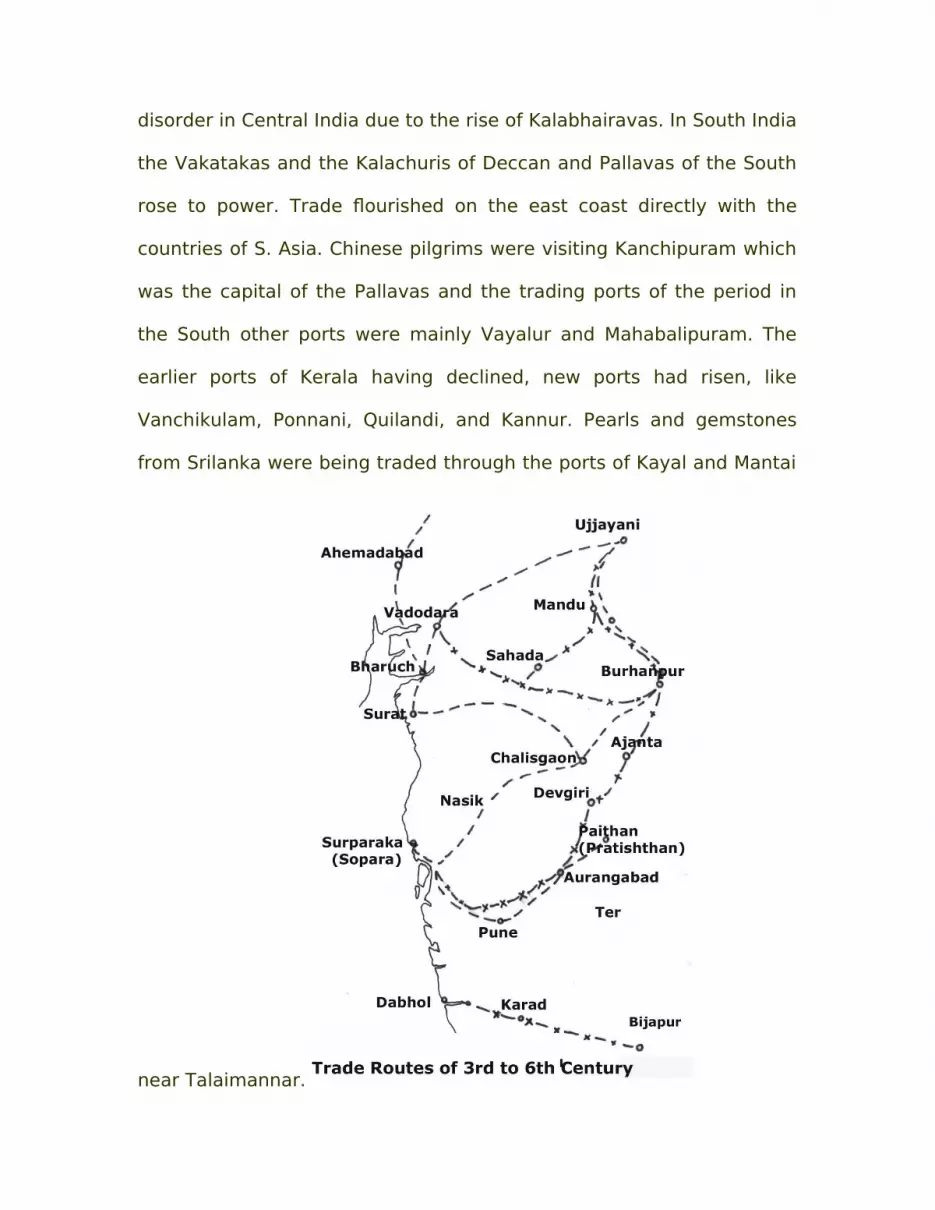
disorder in Central India due to the rise of Kalabhairavas. In South India
the Vakatakas and the Kalachuris of Deccan and Pallavas of the South
rose to power. Trade flourished on the east coast directly with the
countries of S. Asia. Chinese pilgrims were visiting Kanchipuram which
was the capital of the Pallavas and the trading ports of the period in
the South other ports were mainly Vayalur and Mahabalipuram. The
earlier ports of Kerala having declined, new ports had risen, like
Vanchikulam, Ponnani, Quilandi, and Kannur. Pearls and gemstones
from Srilanka were being traded through the ports of Kayal and Mantai
near Talaimannar.

Further north on the west coast, Mangalapuram, Kollam,
Sandabar (Goa) and Chaul were the active traders with Persia in
particular, and East African coast. Egyptian trade with Berenice in the
Red Sea was also active. Tamralipti on the coast of Bengal, Charitra in
Orissa were the trading ports of the late Guptas and Palas. While
timber, textiles and spices continued to be prominent in the Arabian
Sea export trade the imports were mainly Persian horses,
frankincense, and other resins from around Socotra, Aden and
Ethiopian coast.
No port can sustain by its own self however advantageous its
site. A port needs a hinterland backing it for providing it with
exportable products and consumer population to make use of the
imports. The capital of the ruler of the territory gets connected with
the ports to facilitate the flow of the trade in and out. When the ruling
power shifts in position, the port hinterland linkages promoting trade
also undergoes shifts in the routes followed.
Around the sixth Century A.D., the trade routes connecting the
port with the hinterland broadly followed the earlier route ways of the
times when Roman trade flourished. Thus moving from the South
northwards many trade routes can be recognized however with some
deviations.
The Malaimandalam route from Tekkukollam (Quilon) across the
passes of the Southern Ghats carrying Persian horses to Pandyanadu

was still active, bringing in return from waning Korkai to West coast
pearls and Srilankan spices. Further north, trade route from Muziris
eastwards across the Palghat to the the Cera capital Karur continued to
thrive, though with a shift. Muziris got replaced by Ponnani and
Quilandi that were on the direct path to Palghat. Beyond Karur the
route ran further east to Madurai, the Pandya capital, Uraiyur, the Cola
capital on the apex of the Kaveri delta and Kanchi the Pallava capital.
An itinerant trade flow followed a route from Korkai across the Vaigai
valley towards Uraiyur and Madurai. A major export trade emanated
from Kodumanal near the Cera capital carrying beryl and other semi-
precious gemstones, apart from textiles. Further north, Kannur and
Honavar functioned as ports, for the hinterland across the Sahyadri to
Mysore plateau. Goa was rising as Kadamba port leading to
Tungabhadra Krishna valleys. The ancient port of Cheul was still active
connecting with Yadava territory across the many passes in the Ghats.
Sopara was a waning port connected with north Deccan hinterland of
the Satavahanas, Yadavas and Chalukyas, the trade route running
through Lonad, Kalyan, Naneghat, Junnar, to Pratisthan and Ter and
another along the Tansa valley to Tryambak and Nasik. Dahanu was
also a lesser port connecting with Nasik. Further north, Khambhat was
emerging, connecting with Patan, (Anhilvad), Ujjain and Mathura as
well as Central India. On the east coast the main trade routes ran along
the Kaveri, Krishna, Godavari and Mahanadi Valleys. The Ganges valley

was the main trade route of the Late Gupta period, reaching up to
Mathura and connecting with Tamralipti that was in its last days of
prosperity.
By about 10th century A.D., a number of new ruling powers had
stabilized and sea trade became very significant. Itinerant traders
originating in many inland centers exchanged the export products of
the hinterland with the imported goods arriving from across the Bay of
Bengal. Trade activity received a major impetus and forward thrust in
volume, variety and value during this period mainly through a large
number of merchant guilds functioning at different hierarchic levels.
Local organizations like the Jews Manigramam indulged in trade with
the Jews of Egypt, Palestine and Lebanon coasts as evident from the
Geniza papyrus documents and Cochin Kodungallur old Tamil records.
At a higher level multi national corporations like Nankunattar,
Nanadesis were active at mid-hierarchic level, whereas Ainuruvar (500
people) and Padinen Vishayam (18 countries) at the highest level were
dynamic. Trading merchants of different cities collaborating were
exceptionally active in sea trade across the Bay of Bengal, Karnataka,
southern Andhra and Tamil Nadu had many centers of such trading
organizations apart from the ruler’s own ports. The Vaigai valley route
connecting Madurai, the Pandya capital through Ramnathapuram,
Mandapam connected Mantai in N.W. Srilanka. Mantai was the main
port of exchange of Chinese goods with Arab and Persian products.

Known to Tamils as Perundurai, this port was the largest importer of
horses needed by the Pandyas and the Cholas.
On the east coast Palayakayal. Nagapattinam, and Motupalli.
Manikapattinam (Konarak), Baleshwar, Pipili and Gaur were engaged In
the Kalinga and Gangetic delta trade (Palas). On the northern part of
west coast of India the trading ports were mainly Chaul, Thane and
Valsad engaged in trade of Deccan hinterland, mainly the domains of
Rashtrakutas. Khambhat at the head of Gulf of Cambay was the most
active port of the Solankis, Gurjaras and Pratiharas. The Chandelas,

Ujjain and Rajasthan rulers were also trading mainly through
Khambhat. By the 10th century, Persian trade was on a decline but
trade with Persian Gulf ports like Hormuz; Omani and Arab ports
gained importance at the cost of Egyptian trade. The Arabs and
Omanis had ventured into the Bay of Bengal with trading settlements
along the south east coast of Tamil Nadu and were steadily marching
ahead into the southern Bay of Bengal to capture the trade of Sumatra,
Java and Malaya.
The Tang and the Sung period in China was one of ups and
downs with the Chinese ports being closed at one time and open at the
other for foreign trade. It is the keen competition that the Arabs and
Omani were offering that led the Chola kings like Rajendra Chola and
Kulotunga take massive naval expeditions to Srivijaya and Sailendra
kingdoms of S. E. Asia. This search was not for territorial conquest but
essentially to protect Tamil trade through corporate organizations
which almost held monopoly in Bay of Bengal trade till this time. On
the west coast Kollam, Mahodayapuram, Ponnani, Mangalapuram,
Honavar, and Goa, were ports of southern parts.
The tenth century marks the period of the sea trade at its zenith
with China by the Cholas. Port trade converging at Mahabalipuram and
Nakapattinam flowed through the itinerant trade routes connecting
with Tanjavur and Gangakondacholapuram of the Cholas, Kanchi of the
Pallavas, Madurai of te Pandyas and the Cera ports like

Mahodayapuram, Ponnani across the Palghat. Further south, Kollam on
the west coast continued to be linked with Palayakayal along the
Tambraparani valley. The Kanarese ports linked the Hoysala inland
trade centers across a number of passes along the valleys. The
Kadamba port was Goa, connecting through the Kali river valley, the
upper Panchganga valley and central Deccan trade centers.
Mahim and Thane were leading ports of Konkan connecting
through Naneghat route the interior Deccan of upper Godavari, Bhima
valleys, serving the Silaharas and the Yadavas. Khambhat was the
outstanding port serving the Solankis and the Gurjaris reaching up to
Ujjain and Mathura. On the Ganges delta, the Palas had a number of
small ports on the Ganga distributaries, Tamralipti having already
declined.
The 14th century marks the dominance of Arab- Omani trade on
the west coast under the active support of Malabar Zamorins, the
Vijayanagara rulers and Bahamani Sultanates.

West coast ports like Kollam, Kochi, Kozikode were acting as
transit points for the Arabian Sea trade with China. It is during this
period that ports like Devgad, Boria (Dabhol), Chaul, Sanjan, and
Khambhat came to position of their own. Surat was just on rise and
Khambhat was on its decline. Kharepatan served the interior Deccan
Sultanate across the Ghat passes. Porbandar- Miani, Mangrol and
Madwad near Diu were the newer ports serving Kathiawad and North
Gujarat, Champaner in South Gujarat was connected with Khambhat as
well as minor ports of Narmada, Tapi mouths. In northern India slave
kings, Khiljis, Tughlaks and Lodis successively ruled and the trade
outlets on west coast were Veraval, Khambhat on decline and Surat.

The Krishna Godavari valley ports were connected along the valleys to
the interior. On the Kalinga and Bengal coasts there were no major
significant ports. Periapatinam on the lower Vaigai valley and Kilakarai
replaced Mantai and Kayal that had declined in the Arabi-Tamilnad
trade. During this period Haj pilgrimage was gaining importance while
the Persian trade had totally collapsed. East African products like live
animals, cloves were being traded. It was in 14th century that the
Chinese trade once again revived under the Sung and Ming dynasties
and for the first time significant volume of Chinese trade essentially
silk, camphor, and horses entered directly into the Bay of Bengal and
for the first time under the leadership of Admiral Cheng Ho
established direct trade with Hormuz and Omani ports.

During the entire mediaeval period, sea trade flows were partly
through coasting and partly overseas. Coasting was beneficial from the
view-point of trade, as coastal vessels touched a number of ports
enroute. Possible, over the centuries overseas trade gained importance
over coasting as bulk or wholesaling became more significant.

In conclusion, it may be added that the late mediaeval trade
routes converging on the ports facilitated the colonial traders of post
15th century in their penetration into interior, locating the hinterlands
of origin of various Indian export products like textiles. When the rival
colonial trading companies like the Portuguese, the Dutch, the French
and lastly the British chose their port sites for further development,
often at proximity to each other, it is the areas of production of
exportable surpluses of Indian goods that decided their decisions. The
obtaining trade route situation is well exemplified in the travel
accounts of Varthema, Nicolo Conti, Abdul Razak, Nikitin, Ibn Batuta
and later still F.Laval.

Bibliography:
1. B. Arunachalam: Mumbai by the Sea, MHS, 2004.
2. Behera. K.S. Maritime Heritage of India. 1999.3. Chakrabarti Dilip K. The Archaeology of the Deccan Routes: The
Ancient Routes from the Ganga Plain to the Deccan. Munshiram Manoharlal, 2005.
4. Chakravarti Ranabir, TRADE IN EARLY INDIA: Edited by; Oxford University Press.
5. Deloche Jean, Transport and Communications in India Vol.2. Water Transport. Gazetteer of Bombay Presidency, Thana, 1882, Vol Xlll, PartI,II.
6. Gazetteer of Bombay Presidency, Ratnagiri and Savantwadi Districts, 1882, Vol X.
7. Hebalkar Sharad, Ancient Indian Ports, (Munshiram Manoharlal Publishers, 2001).
8. Marathe Ashok: Contribution to Prehistoric and Historic Archaeology of
Konkan, Bulletin of the Deccan College, 2004-05
9. Morarka Ambika Prasad, Studies in India’s External Trade Relations During Ancient Times, Phd,
10. Nairne Alexander: History of Konkan, Asian Educational Services, New Delhi,
1988.
11. Schoff. W.H. The Periplus of the Erythraean Sea: Travel and Trade in the Indian Ocean by a Merchant of the First Century.
12. Tibbetts. G.R. Arab Navigation, Royal Asiatic Society of Great Britain, 1971.


