Embed Size (px)
Citation preview

Animal Learning & Behavior2000,28 (3),257-277
Possible uses of path integrationin animal navigation
ROBERT BIEGLERUniversity ofEdinburgh, Edinburgh, Scotland
Path integration, in its simplest form, keeps track of movement from a starting point and so makesit possible to return to this point Path integration can also be used to build a metric spatial representation of the environment, if given a suitable readout mechanism that can store and recall the coordinates of anyone of multiple locations, A simple averagingprocess can make this representation as accurate as desired, givenenough visits to the locations stored in the representation, There are more thanthese two ways of using path integration in navigation. They can be classified systematically according to the following three criteria: Is there one point at which coordinates can be reset to correct errors, or several? Is there one possible goal, or several? Is there one path integrator, or several? I describe the resulting eight methods of using path integration and compare their characteristics with theavailableexperimental evidence, The classification offers a theoretical framework for further research,
Methods of navigation can be broadly divided intothose that use location-based information, which specifies(with varying precision) where an animal is by reference tospecific and identifiable features of the environment, andthose that use movement-based or location-independentinformation. Location-independent information encompasses internal, self-generated motion cues (such as efference copies ofmotor commands, kinesthetic cues, andinertial cues from the vestibular system, collectively calledidiothetic cues; H. Mittelstaedt & M, L. Mittelstaedt,1973), external motion-based cues (such as optic flow,doppler effect, and air or water speed), and finally, compass cues (such as the geomagnetic field and celestialcues or landmarks that are far enough away that theirbearings stay approximately constant), Location-independent information can be used to record movementfrom a starting point. This record may take the form of amovement sequence, the direction back to the startingpoint or direction and distance, Path integration is thecomputation, based on location-independent cues, ofdistance and direction or, sometimes, direction only fromthe current location to the starting point or vice versa.
Animals in a variety of taxonomic groups, from arthropods to mammals and birds, have been found to use path
This work was supported by the Wellcome Trust. This manuscript ispartly based on a PhD thesis written under the supervision ofR. G. M.Morris. I am grateful for his teaching and support. I also thank him andthe following for critical comments on earlier versions of this manuscript: S. Benhamou, P. Boulcott, S. E. Dye, D.1.Foster, K. M. Gothard,A. S. Griffin, S. D. Healy, 1. Henderson, A. McGregor, H. Mittelstaedt,O. Trullier, R. 1. Willson, and several anonymous reviewers. Correspondence concerning this article should be addressed to R. Biegler,Centre for Neuroscience, University of Edinburgh, Crichton Street, Edinburgh EH8 9LE, Scotland (e-mail: [email protected]). After September I, 2000, address correspondence to Department of Psychology,Norwegian University of Technology and Science (NTNU), N-7491Trondheim, Norway (e-rnail: [email protected]).
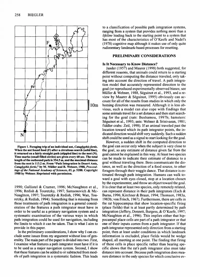
integration (arthropods: Beugnon & Campan, 1989;Hoffmann, 1984; H. Mittelstaedt, 1985; Muller & Wehner,1988; Ronacher & Wehner, 1995; Schmidt, Collett, Dillier, & Wehner, 1992; von Frisch, 1967; Wehner & Raber,1979; Wehner & Wehner, 1990; Zeil, 1998; mammals:Etienne, Hurni, Maurer, & Seguinot, 1991; Etienne,Maurer, & Saucy, 1988; Etienne, Maurer, Saucy, & Teroni, 1986; Etienne, Teroni, Maurer, Portenier, & Saucy,1985; M. L. Mittelstaedt & Glasauer, 1991; H. Mittelstaedt & M. L. Mittelstaedt, 1973; Seguinot, Cattet, &Benhamou, 1998; Seguinot, Maurer, & Etienne, 1993;birds: von Saint Paul, 1982). The use of path integrationhas been investigated extensively in ants of the genusCataglyphis (Figure I; reviewed by Wehner, Michel, &Antonsen, 1996). Their habitat includes flat salt pandesert largely devoid of landmarks. The ants go on circuitous foraging trips, looking for insects killed by theheat. If a forager does not return to the nest within aboutan hour, it is likely to die itself. The ability to return directly to the nest, rather than retracing the outward path,is valuable. The nest entrance is a hole only millimetersacross, often without conspicuous landmarks nearby, sothe ants need accurate and reliable navigation. They usepath integration to generate a direct trajectory back to thenest. Path integration appears to be their primary navigation method, being backed up only by landmarks.
If path integration can be that important, the questionarises of whether Cataglyphis ants are a special case. Isit justified to treat path integration in most other casesonly as a kind of back-up mechanism for occasions onwhich no landmarks are available or as a simple, quick,and dirty navigation method used in between the occasions on which more sophisticated but slower landmarkbased methods provide accurate information? O'Keefe(1976) has already suggested that path integration could,rather, be the basis for cognitive mapping. More recently,there has been renewed interest in that idea (Gallistel,
257 Copyright 2000 Psychonomic Society, Inc.
258 BIEGLER
~;:-r')
)
~ ( (F. )
/v/t
~~~I"-0.f c-
l., Cl v
. f
rS:~
~:.···o.
I :.~
) t"".( ,.~ ...
~:
.:
N
Figure 1. Foraging trip of an individual ant, Cataglyphisfortis.When the ant found food (F) after a circuitous search (solid line),it returned on a fairly straight path (stippled line) to the nest (N).Time marks (small filled circles) are given every 60 sec. The totallength oCtheoutbound path is 354.5 m, and the maximal distancefrom the nest is 113.2 m. From "Path Integration in Desert Ants,Cataglyphisfortis," by M. Muller and R. Wehner, 1988, Proceedings ofthe National Academy ofSciences, 85, p. 5288. Copyright1988 by Wehner. Reprinted with permission.
1990; Gallistel & Cramer, 1996; McNaughton et aI.,1996; Redish & Touretzky, 1997; Samsonovich & MeNaughton, 1997; Touretzky & Redish, 1996; Wan, Touretzky, & Redish, 1994). Something that is missing fromthese treatments of path integration is a general consideration of the features a path integrator must have inorder to be useful as a primary navigation system and asystematic examination of the various ways in whichpath integration could be used for navigation, includingthe limits to which it can be taken. That is what I aim toprovide in this paper.
In the preliminary considerations, I show why I can exclude some issues from my argument without loss ofgenerality.The main part ofthe paper is divided into two. First,I examine what features a path integrator must have if it isto be used as a major navigation system. Second, I showthat these features can be added to or subtracted from models of path integration in a systematic fashion. This leads
to a classification of possible path integration systems,ranging from a system that provides nothing more than alifeline leading back to the starting point to a system thathas most of the characteristics of O'Keefe and Nadel's(1978) cognitive map although it makes use of only quiterudimentary landmark-based processes for resetting.
PRELIMINARY CONSIDERATIONS
Is It Necessary to Know Distance?Jander (1957) and Maurer (1998) both suggested, for
different reasons, that animals could return to a startingpoint without computing the distance traveled, only taking into account the direction of travel. A path integration model that accurately represented direction to thegoal (or reproduced experimentally observed biases; seeMuller & Wehner, 1988, Seguinot et aI., 1993, and a review by Maurer & Seguinot, 1995) obviously can account for all of the results from studies in which only thehoming direction was measured. Although it is less obvious, such a model can also cope with findings thatsome animals travel for a set distance and then start searching for the goal (rats: Benhamou, 1997b; hamsters:Seguinot et aI., 1993; ants: Wehner & Srinivasan, 1981;fiddler crabs: Zeil, 1998). If an animal traveled past thelocation toward which its path integrator points, the indicated direction would shift very suddenly. Such a suddenshift could be used as a signal to start looking for the goal.
However, a sudden shift in the computed direction tothe goal can occur only when the subject is very close tothe goal, so any estimate of distance given far from thegoal cannot be explained in this way. At least two speciescan be made to indicate their estimate of distance to agoal without traveling there. Bees communicate the distance, as well as the direction of a food source, to otherforagers through their waggle dance. That distance is estimated through path integration. Humans can walk toward a goal with eyes closed, stop at a location chosenby the experimenter, and throw an object toward the goal.It is clear that at least two species, only remotely related,can represent distance in their path integrators (Esch &Burns, 1996; Kirchner & Braun, 1994; Thomson, 1983a,1983b; von Frisch, 1967). Furthermore, there are cells inthe rat hippocampus that show location-specific firing(place fields) that is at least partly determined by pathintegration (Jeffery, Donnett, Burgess, & O'Keefe, 1997;McNaughton et aI., 1996). This implies either that hippocampal place cells are part of a path integrator or thatone of their inputs comes from a path integrator. If thatpath integrator represented only direction from a startingpoint, then at least under conditions in which landmarkinformation is excluded, place fields would be wedgeshaped, all meeting at one point. The finding that firingof these cells is place specific rather than bearing specific shows that the rat's path integrator also must takedistance into account. Because path integration does measure distance in the only species for which conclusive ev-

idence is available, I will, in the remaining sections ofthepaper, deal only with path integrators that represent bothdistance and direction.
Path Integration Including Distance:Computations and Representations
The principle underlying path integration is to calculate position relative to a reference point, using information about one's movements. The information availableto a path integration mechanism is speed integrated overtime (or distance traveled within a finite time interval,,1s), and direction of travel relative to some compass cueor internally generated reference direction. The computations are conventionally described in either a Cartesianor a polar coordinate system (Figure 2). With a Cartesiancoordinate system, ,1s and the angle to the reference direction (A) are used to calculate the path components alongx- and y-axes. With a polar coordinate system, locationis defined by the angle, U, between the current position,the nest, and the reference direction and by the distance,r, from the nest. The animal must compute the incrementofradial distance, Sr, and the increment ofthe nest angle,,1v. Assuming that Sq. the increment of tangential distance, is small, as compared with r (see also Figure 2),
Polar coordinates:Sr = M COS(A - v) = ,1s cos dSq = M sin(A - v) = ,1s sin d,1V = Sqlr =,1s sin(A - v)/r = ,1s sin d/r.
Cartesian coordinates:,1x = ,1s sin A,1y = ,1s cos A.
PATH INTEGRATION 259
There is a third way ofperforming path integration thatsidesteps computation oftrigonometric functions. It is bestexplained by comparing use of a survey map with use ofthe Cartesian coordinate system printed over the map.For the coordinate system, locations are specified by apair ofnumbers or some equivalent variable (e.g., the locations ofpeaks ofneural activity in Hartmann and Wehner's, 1995, model). The x and y components of the lastpath segment are then added to the retrieved coordinatesofthe previous position, and the updated values are stored,for example, by writing them down. Rather than usingpairs of numbers, position might also be specified bymaking a mark on the map. The length of the last pathsegment is determined by reference to a scale, its directionrelative to north, or some equivalent reference. Then, using a ruler, a line can be drawn, representing the pathsegment, and a new mark made at its end, representingthe new position. At no point is it necessary to split thepath segment into two components and calculate theirlengths by multiplication with a trigonometric function.Only the end result of the computation is the same. Eachof these types of representation has been used in modelsof path integration (Hartmann & Wehner, 1995; MeNaughton et aI., 1996; H. Mittelstaedt, 1983, 1985; H. Mittelstaedt & M. L. Mittelstaedt, 1973; Muller & Wehner,1988; Samsonovich & McNaughton, 1997).
The crucial point for the purposes of this paper is thatCartesian and polar coordinate systems and the graphicalupdating ofa map are mathematically strictly equivalent.Although it has been argued that the differences betweenalgorithms affect accuracy when implemented in a noisybiological system (Gallistel, 1990) and that they could be
A B Cfinal position
-: 'A.: initial position
Figure 2. Information available for path integration. (A) With a polar coordinate system, the radial distance from the home (r) andthe angle (v) between home and some reference direction describe the position (r, v) of the ant. Locomotion in direction A by a pathincrement.:1s results in a new position (r + 4r, v + 4V), as long as 4S« r. (B) With a Cartesian coordinate system, the same path increment (4S) and direction (A) are decomposed into increments, 4X and 4y, added to the current position (x.y). (C) Graphical updating of a map does not require decomposition ofthe path increment 4s. A marker (e.g., a coin put on a survey map or a patch ofneural activation on a place cell map) is moved from an initial position by distance 4S in the appropriate direction into the final position. Calculation oftrigonometric functions is implicit rather than explicit, but the isomorphism of algebra and geometry guaranteesthat the result is the same.

260 BIEGLER
relevant when one is trying to account for systematic errorsin path integration (Hartmann & Wehner, 1995; Muller &Wehner, 1988), this is not relevant for the purposes ofmyargument. Therefore, I will not make any such distinction.
Likewise, it is irrelevant for the purposes of this paperwhether a representation is assumed to be egocentric (theanimal's position in the representation is stationary, andeverything else moves) or exocentric (the animal moves,and the represented environment is stationary; for adiscussion of this topic, see Benhamou, 1997a). For anyexocentric representation, it is possible to develop anequivalent egocentric representation. For the sake ofsimplicity, from here on, representations are always described as exocentric.
NECESSARY FEATURESOF PATH INTEGRATION
For a path integrator to be useful in navigation, it is notsufficient that it represents the spatial relationship between an animal's current location and some point of interest. Twomore things are needed: First, because randomerrors accumulate over time, the animal must have a wayofdetermining its position by reference to location-basedinformation (fixing a position) so as to reset the path integrator to more accurate coordinates. Second, there mustbe a readout mechanism that can lead the animal to itsgoal. I will discuss readout in more detail later.
Resetting of the Path Integrator:Characteristics and Experimental Evidence
Resetting has three characteristic features. All havebeen observed experimentally. First, if there is a discrepancy between the estimated position and the position fix,resetting revises the estimated position so as to reduceor eliminate the discrepancy. Such a discrepancy or deviation may be caused by accumulated errors in path integration, mistakes in identifying landmarks, errors in theposition fix, or movement oflandmarks. Gothard, Skaggs,and McNaughton (1996b) simultaneously recorded fromseveral hippocampal place cells while a rat shuttled backand forth between a startbox and a goalbox. They foundresetting of the hippocampal place field representationwhen they created a discrepancy between location-basedand location-independent information by reducing thedistance between the start- and the goalboxes, as compared with the distance used during initial training. If thedistance was reduced a little, the place field representation initially reflected distance from the starting point;then it raced through the place fields corresponding toplaces in the central part of the runway until it reflecteddistance from the destination. Ifthe distance between thestart- and the goalboxes was reduced more, the place fieldrepresentation skipped over the fields corresponding tothe central part ofthe runway. Srinivasan, Zhang, and Bidwell (1997) investigated distance estimation by path integration in bees flying along a tunnel. When they shifteda landmark that the bees passed in the tunnel well before
reaching the goal, the bees' search shifted accordingly,consistent with resetting ofthe path integrator at the landmark.
Second, after resetting, the coordinates in the path integrator should reflect the animal's position more accurately than before. I will argue that it cannot be guaranteedthat resetting will improve accuracy in every instance andthat specific conditions must be met even to ensure thatresetting improves accuracy on average. Nevertheless,improving accuracy is the whole purpose of resetting,and accuracy can be measured. Ifan animal is repeatedlyobserved while it is searching for a goal and if, sometimes, it is given an opportunity to reset path integrationnear the goal, then, after resetting, the peak of its searchdistribution should, on average, be centered more accurately on the goal. The bees' search for food in Srinivasanet al.'s (1997) tunnel was more accurate, as measured byreduced scatter of the peaks of the search time distribution ofeach visit, ifthe bees passed a landmark earlieron in their flight through the tunnel. Griffin and Etienne(1998) found that hamsters that were passively rotated indarkness could home more accurately if the light wasswitched on briefly before they started the returnjourriey.
A third characteristic of resetting is that if an animalcan assess the uncertainty (the magnitude of potentialerror) in its estimated position based on path integration,then, after fixing its position relative to location-basedcues and resetting the path integrator, its estimate of theuncertainty should decrease. Accordingly, when a goal issearched for, not only should the peak ofthe search distribution be centered more accurately on the goal after resetting, but the search distribution should also be narrower.This is exactly what Srinivasan et al. (1997) found whentesting bees' estimation of distance by path integration.
It is functionally important to make a distinction between, on the one hand, the deviation ofthe estimated position from the actual position of the animal and, on theother hand, the uncertainty of the estimated position.The deviation can only be determined and eliminatedwhen a position fix is taken. The uncertainty is a functionofdistance traveled and the presence of other sources ofnoise. Therefore, uncertainty can be estimated in the absence ofa position fix.
There is at least suggestive evidence that animals domake such a distinction. Under some conditions, resettingmay not occur-for example, if the deviation oflocationindependent from location-based information is large(Etienne, Teroni, Hurni, & Portenier, 1990). The reasonmay be that landmarks are identified partly by referenceto the estimated position and orientation given by thepath integrator. If the deviation is too large, landmarkidentification based on other information may be rejectedas too inconsistent with the estimated position, in whichcase there would be no position fix to revise the estimatedposition. Effectively, the position fix would be rejectedbecause the deviation exceeds the uncertainty of the estimated position.
A different experimental approach supports this interpretation. Rats were trained to find food at a specific dis-

tance and direction from a landmark in an open-fieldarena. In the first of four tests, the rats ignored a 90°counterclockwise rotation of visual and acoustic directional cues and searched in the same direction as thatsearched during training. Before the second test, the ratswere disoriented by passive rotations on their way to thestarting point, and directional cues were rotated 90° clockwise. Under these conditions, the rats' direction ofsearchrelative to the landmark rotated with the directional cues.When tested in the absence ofdirectional cues and whennot disoriented, the rats searched in the same direction asthat searched during training. The presence ofuncontrolleddirectional cues could not account for this behavior, sincethe rats had no preferred search direction in the absenceof the directional cues and when disoriented. It appearsthat, in the first test, a 90° deviation of orientation basedon vestibular cues from visual and acoustic directionalcues was larger than the rats' uncertainty and did notlead to resetting, whereas the disorientation procedure inthe second test increased uncertainty and, therefore, thesame 90° deviation from the training direction did leadto resetting (Biegler & Morris, 1996).
Matching Position Fixes to Path IntegrationIt is a common assumption that a position fix provides
more accurate information than does the estimated position given by a path integrator, with all its accumulatedrandom errors. This is usually true in the special case ofhuman navigation when accurate maps and charts areavailable. However, in more general terms, specific conditions must be met if position fixes are to be more accurate than path integration.
Estimations of distance through path integration andby reference to landmarks both follow Weber's law: Errors are proportional to distance (Cheng, 1990; Cheng,Srinivasan, & Zhang, 1999; Kamil & Jones, 1997; Srinivasan et al., 1997). If the error from path integration is alarger proportion of distance than is the error from theuse oflandmarks, the position fix will be, on the average,more accurate than the estimated position. On the otherhand, if the likely error in distance estimated by path integration is, for example, 8%, and the error in determining distance relative to a landmark is 10%, then if the animal walks in a straight line from the landmark, pathintegration will be more accurate than a landmark-basedposition fix. The animal should not use a position fix toreset its path integrator. But ifthe path is circuitous enoughto be at least 25% longer than the straight-line distancefrom the landmark, estimating distance from that landmark will provide more accurate information.
Of course, the animal may also obtain an accurate fixwhen it comes close to another landmark, but then twoquestions arise. How can the animal know the coordinateof the landmark or of the place from which it sees thelandmark? And how can it know these coordinates withsufficient accuracy that a position fix is likely to improveon the animal's estimated position as given by pathintegration?
PATH INTEGRATION 261
Obtaining Landmark Coordinates for ResettingRegarding the first question (whether it is necessary to
know distance), landmarks or places must be registeredin a representation with the same metric and scale as andcongruent with the representation used by the path integrator. If the same representation were to be used for pathintegration and as a map of the environment, this correspondence would be guaranteed, but separate representations are possible in principle.
At this point, it is necessary to make a distinction between animals capable or incapable of piloting. Pilotingis the process ofdetermining one's own position relativeto a location of interest by first determining position relative to landmarks with known spatial relationships tothe relevant location and then inferring one's own spatialrelationship to that location by vector addition. In thecontext of resetting a path integrator, the location of interest would be the point at which path integration wasinitiated. An animal capable ofpiloting can fix its positionat any place at which it can determine its distance andbearing relative to at least one identified landmark. Thenumber and density ofresetting points is effectively infinite, even if the number of known landmarks is finite.
Piloting could also be used to create the representation that is later used to provide position fixes. In principle, the animal could sit at any arbitrary location, determine the distance and bearing of each landmark, andinfer the spatial relationships between them. For reasonsofaccuracy (see below), the animal should move betweenlandmarks, but it is not necessary to visit them all. It isnot clear whether any species has separate metric representations ofspace-one based on landmarks and one onpath integration-and if so, how these two representationswould be matched up.
Alternatively, assume that all an animal can do withlandmarks is to recognize a place, PI' perhaps by identifying a smell or a texture or by matching the currentlyperceived visual scene to a panorama stored in memory.It has no metric, landmark-based representation that couldprovide resetting coordinates. In order to obtain these,the animal must store in memory the coordinates givenby the path integrator when it reaches a place that is tobe used as a resetting point. It then can fix its positionand reset path integration only at these specific resettingpoints for which it has coordinates. Because the coordinates of the resetting points are given by the path integrator in the first place, there is no need to match the scale,metric, and orientation of two different representations.
How Can Resetting Be Made Accurate?Regarding the question of accuracy, in the case of an
animal capable of piloting, there are three possibilities.If piloting is far more accurate than path integration,there is no problem. The animal can create an accuratereference frame that it can use to obtain a position fix(once it has either matched up its two representations ofspace or, if it has only one representation, calibrated itsodometer to the scale used when piloting).

262 BIEGLER
On the other hand, ifthere is a significant error in theuse of landmarks, random errors must first be removedby averaging. Each time the animal determines its spatialrelationship to one or more of the landmarks and inferstheir spatial relationships to each other, the result will bedifferent. Ifthe process is repeated often enough and theresults averaged, the representation will converge to anaccurate state. It is advantageous to move around whilecarrying out this averaging process, because error is proportional to distance from a landmark (Cheng, 1990;Kamil & Jones, 1997), and therefore, accuracy in estimating the spatial relationship among landmarks willimprove as the animal comes closer. Once a sufficientlyaccurate representation oflandmark locations is available,resetting is possible at any place at which a familiar landmark is visible and close enough to allow a position fixwith less error than is likely to have accumulated in thepath integrator.
The third possibility is to use the only process of creating an accurate frame of reference that is available toan animal not capable ofpiloting: averaging out randomerrors. As before, I will assume not only that an animalis incapable of piloting, but also that all it can do withlandmarks is to recognize a place, PI' and distinguish itfrom other places, P2 to P; (for reasons of efficiency, itwill also need a way of finding a place Pn quickly whenit is near; image matching, as described by Cartwright &Collett, 1982, 1983, would be one candidate mechanism).Whenever the animal arrives at PI' it stores the currentcoordinates given by the path integrator and averagesthem with coordinates already in memory. It does thesame for other places, P2 to Pn . Given sufficient sampling,the coordinates ofthese places will accurately reflect thespatial relationships between them, even without any capacity for piloting. Resetting will then be possible ateach of these specific points but nowhere else (the number and density of resetting points is finite).
It is, therefore, possible not just to get coordinates forresetting from a path integrator, but also to make thesecoordinates accurate without relying on piloting or anylandmark-based process more sophisticated than the ability to recognize a location (and, perhaps, image matching,in order to find a resetting point quickly when near to it).
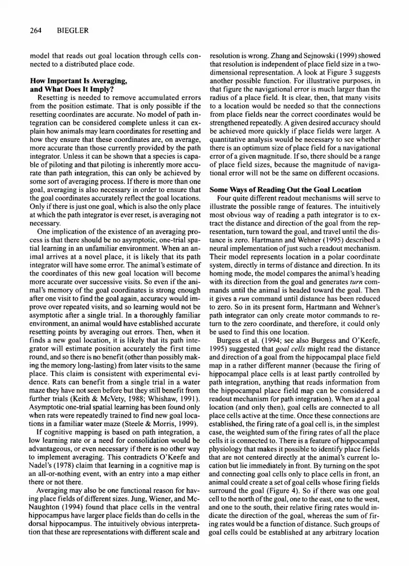
Possible Implementationof the Averaging Process
Although there has not been, to my knowledge, any attempt yet to incorporate an averaging process into models ofpath integration, this can be done quite easily. I willtake as an example a model by Samsonovich and MeNaughton (1997). They proposed that hippocampal placecells are part ofa path integrator. Location is representedby the ensemble ofactive place cells (Figure 3). This ensemble can be thought ofas a compact packet ofactivitythat moves over a two-dimensional chart as the animalmoves through the environment (for a detailed explanation of both how the activity packet moves and why thistopographical ordering of place cells is permissible for
illustration, even though neighboring hippocampal placecells do not have neighboring place fields, see Samsonovich & McNaughton, 1997).
A resetting point is established by linking units responsive to a place-specific visual scene to simultaneously active place cells (the visual units are hypothetical;no anatomical correlate has yet been identified). If thesame scene is encountered again later (recognition ofthescene constituting a position fix), activation of placecells through these connections will create an activitypacket at the same coordinates in the place cell representation. Inhibitory interconnections ensure that therecan be only one stable activity packet in a chart; therefore, if the packet representing the animal's estimatedposition is at different coordinates, the packet will eithermove to the location given by the position fix or fade whilea new packet is forced into existence.
The crucial point is that if the links between visual unitsand place cells are permanently established at asymptotic strength on a single occasion, any error made by thepath integrator when the resetting point is establishedwill be retained and will be reinstated every time the animal resets path integration at this point. Such a fixationof an initial error would be avoided if several visits areneeded to establish permanent connections of asymptotic strength. If errors in path integration over successive visits are random, only links from visual units to placecells at the correct coordinates will be strengthened during most or all of the visits. This way of averaging coordinates over successive visits to a place could be implemented in one or both oftwo ways.The learning rate mightbe low enough that connections could only grow to asymptotic strength over several visits. Or connections mightdecay unless activated repeatedly and, thus, consolidated.The path integration model of Samsonovich and MeNaughton (1997) can incorporate averaging by use ofappropriate learning rules, without special computationalmachinery. This implementation ofan averaging processis not unique to the model ofSamsonovich and McNaughton but can be applied to any model with a distributedplace code.
The same argument applies to the storage of accurategoal coordinates. Burgess, Recce, and O'Keefe (1994) andBurgess and O'Keefe (1995) proposed a model of hippocampal function that involves readout of goal coordinates by goal cells (see below). Goal cells must be linkedto place cells in order to specify the goal coordinates, inmuch the same manner as Samsonovich and McNaughton's (1997) visual units are linked to place cells to allowresetting. A low learning rate or the use of connectionsthat decay unless consolidated by repeated activationwould guarantee that goal coordinates approach accuratevalues over time. The use of goal cells is entirely compatible with a model that assumes hippocampal placecells are primarily driven by path integration, so a singlemodel can incorporate averaging of both resetting coordinates and goal coordinates. Again, the principle can beapplied not only to Burgess et al.'s model, but to any

A / .Cells tuned to
/ visual scenes
/Hippocampalplace cells
--------~
c
B
D
r-/
PATH INTEGRATION 263
Cells tuned tovisual scenes
Hippocampalplace cells
•••••••••••••••. . .
/Cells tuned tovisual scenes
Hippocampalplace cells
•••••••••••••••. . .
Cells tuned tovisual scenes
Hippocampalplace cells
• ••••• ••••
• ••••...Figure 3. Resetting of path integration in the model ofSamsonovich and McNaughton (1997) and removal of er
rors by averaging. For simplicity, place cells are arranged as if cells with adjacent place fields were also anatomically adjacent. Likewise, a unit tuned to recognize a visual scene is shown as if units tuned to neighboring sceneswere anatomically adjacent. Place cells are represented by squares, whose size is proportional to the firing rate ofthe cell. (A) Connections from a cell or group ofcells tuned to a specific visual scene to simultaneously active placecells are potentiated. The more active a place cell is, the stronger the connection from the visual unit(s) to the placecell (shown here as the thickness of the connecting lines). In this example, visual unit(s) and place cells match upexactly. (B) The animal finds itself at the point at which it stored a visual scene, but owing to an error in path integration, the activity packet representing the animal's estimated position (gray squares on the lower right) is somedistance from where it should be. Activation ofthe visual unit will excite the correct set of place cells through theconnections established earlier. Inhibitory connections between place cells ensure that there can be only one stable activity packet in the place cell representation. When an activity packet is forced into existence at the coordinate to which visual units are linked (black squares), the original packet (gray squares) either moves there or fadesas a new one is created. (C) If there was an error in path integration when the animal first linked a visual scene toplace cells and ifthe learning rate is high enough that learning effectively occurs in a single trial, any error madeon that occasion will be retained. Recognition of the visual scene would reset path integration to the erroneous coordinates given when the animal established the link. (D) If the learning rate is low enough that connections fromthe visual unit(s) to place cells are established over a number of visits to the resetting point, each with a randomlyvarying error in path integration, connections from the visual unit(s) to place cells will cover a larger area but arelikely to be centered far more accurately on the correct coordinates. In Samsonovich and McNaughton's model,the broader spread of the connections would not affect the size of the activity packet, which is determined by inhibitory connections. Even ifthe activity packet established initially is large (as shown by the gray squares on thelower left of diagram (D), it would shrink to normal size (black squares).
264 BIEGLER
model that reads out goal location through cells connected to a distributed place code.
How Important Is Averaging,and What Does It Imply?
Resetting is needed to remove accumulated errorsfrom the position estimate. That is only possible if theresetting coordinates are accurate. No model of path integration can be considered complete unless it can explain how animals may learn coordinates for resetting andhow they ensure that these coordinates are, on average,more accurate than those currently provided by the pathintegrator. Unless it can be shown that a species is capable of piloting and that piloting is inherently more accurate than path integration, this can only be achieved bysome sort ofaveraging process. If there is more than onegoal, averaging is also necessary in order to ensure thatthe goal coordinates accurately reflect the goal locations.Only if there is just one goal, which is also the only placeat which the path integrator is ever reset, is averaging notnecessary.
One implication of the existence of an averaging process is that there should be no asymptotic, one-trial spatiallearning in an unfamiliar environment. When an animal arrives at a novel place, it is likely that its pathintegrator will have some error. The animal's estimate ofthe coordinates of this new goal location will becomemore accurate over successive visits. So even if the animal's memory of the goal coordinates is strong enoughafter one visit to find the goal again, accuracy would improve over repeated visits, and so learning would not beasymptotic after a single trial. In a thoroughly familiarenvironment, an animal would have established accurateresetting points by averaging out errors. Then, when itfinds a new goal location, it is likely that its path integrator will estimate position accurately the first timeround, and so there is no benefit (other than possibly making the memory long-lasting) from later visits to the sameplace. This claim is consistent with experimental evidence. Rats can benefit from a single trial in a watermaze they have not seen before but they still benefit fromfurther trials (Keith & McVety, 1988; Whishaw, 1991).Asymptotic one-trial spatial learning has been found onlywhen rats were repeatedly trained to find new goallocations in a familiar water maze (Steele & Morris, 1999).
If cognitive mapping is based on path integration, alow learning rate or a need for consolidation would beadvantageous, or even necessary if there is no other wayto implement averaging. This contradicts O'Keefe andNadel's (1978) claim that learning in a cognitive map isan all-or-nothing event, with an entry into a map eitherthere or not there.
Averaging may also be one functional reason for having place fields ofdifferent sizes. lung, Wiener, and MeNaughton (1994) found that place cells in the ventralhippocampus have larger place fields than do cells in thedorsal hippocampus. The intuitively obvious interpretation that these are representations with different scale and
resolution is wrong. Zhang and Sejnowski (1999) showedthat resolution is independent ofplace field size in a twodimensional representation. A look at Figure 3 suggestsanother possible function. For illustrative purposes, inthat figure the navigational error is much larger than theradius of a place field. It is clear, then, that many visitsto a location would be needed so that the connectionsfrom place fields near the correct coordinates would bestrengthened repeatedly. A given desired accuracy shouldbe achieved more quickly if place fields were larger. Aquantitative analysis would be necessary to see whetherthere is an optimum size ofplace field for a navigationalerror ofa given magnitude. If so, there should be a rangeof place field sizes, because the magnitude of navigational error will not be the same on different occasions.
Some Ways of Reading Out the Goal LocationFour quite different readout mechanisms will serve to
illustrate the possible range of features. The intuitivelymost obvious way of reading a path integrator is to extract the distance and direction of the goal from the representation, turn toward the goal, and travel until the distance is zero. Hartmann and Wehner (1995) described aneural implementation ofjust such a readout mechanism.Their model represents location in a polar coordinatesystem, directly in terms ofdistance and direction. In itshoming mode, the model compares the animal's headingwith its direction from the goal and generates turn commands until the animal is headed toward the goal. Thenit gives a run command until distance has been reducedto zero. So in its present form, Hartmann and Wehner'spath integrator can only create motor commands to return to the zero coordinate, and therefore, it could onlybe used to find this one location.
Burgess et al. (1994; see also Burgess and O'Keefe,1995) suggested that goal cells might read the distanceand direction ofa goal from the hippocampal place fieldmap in a rather different manner (because the firing ofhippocampal place cells is at least partly controlled bypath integration, anything that reads information fromthe hippocampal place field map can be considered areadout mechanism for path integration). When at a goallocation (and only then), goal cells are connected to allplace cells active at the time. Once these connections areestablished, the firing rate ofa goal cell is, in the simplestcase, the weighted sum ofthe firing rates ofall the placecells it is connected to. There is a feature ofhippocampalphysiology that makes it possible to identify place fieldsthat are not centered directly at the animal's current location but lie immediately in front. By turning on the spotand connecting goal cells only to place cells in front, ananimal could create a set ofgoal cells whose firing fieldssurround the goal (Figure 4). So if there was one goalcell to the north ofthe goal, one to the east, one to the west,and one to the south, their relative firing rates would indicate the direction of the goal, whereas the sum of firing rates would be a function ofdistance. Such groups ofgoal cells could be established at any arbitrary location

N
Figure 4. Firing fields of goal cells in the model of Burgess,Recce, and O'Keefe (1994). At the goal, the animal looks in several directions. Each time it selects the place cells with fields thatlie ahead and connects those to a goal cell. In this example, fourgoal cells offset from the goal (G) in four different directions(N, E, S, and W). The relative firing rates ofthe goal cells specifydirection to the goal; the sum of their firing provides a measureof distance. From "A Model of Hippocampal Function," byN. Burgess, M. Recce, and J. O'Keefe, 1994, Neural Networks, 7,p, 1070. Copyright 1994 by Elsevier Science. Reprinted with permission.
the animal has visited. As long as there is a way ofselectively activating one such group ofgoal cells, the animalcan read out the location of any goal. However, it wouldneed additional computational machinery in order to select the nearest of several goals (it must store each distance in memory and then compare them), to calculate
PATH INTEGRATION 265
distance between goals, or to plan a short path betweenseveral destinations.
It is not necessary to extract distance and directionfrom the representation, as was demonstrated by the example ofH. Mittelstaedt's (1983, 1985; see also H. Mittelstaedt & M. L. Mittelstaedt, 1973) model of path integration. This model represents location as x- and ycoordinates in a Cartesian coordinate system. It uses theanimal's heading and the difference between the animal'scurrent coordinates and the goal coordinates, not to compute the direction and beeline distance to a goal, but tofind out whether the goal is in front of or behind the animal and whether it is to the right or to the left ofthe current heading. The model then directly generates separateturn and run commands. Any point in space is characterized by a combination ofthese commands. The animalmoves and turns until the turn commands cancel, thenmoves in a straight line to the goal, where the run commands cancel (Figure 5). Using this mechanism, an animal could travel to any goal, but estimating the distanceto a goal, choosing among several destinations based ondistance, or planning a path between several destinationswould require additional computational mechanisms.
Reid and Staddon (1998) proposed a readout mechanism that does not explicitly deal with any spatial parameters at all. It does not use coordinates, distances, or directions in its computations. Rather, an expectation valueis attributed to each location. Initially, only the goal 10cations have an expectation value above zero (Figure 6A).This expectation then spreads to neighboring locationsin a manner analogous to diffusion (Figure 6B). The animal chooses a path by comparing, at each step, the loca-
Figure 5. Run and turn commands (shown as straight and curved arrows) in H. Mittelstaedt's (1985) model of path integration.For a given heading of the animal, each point in space is characterized by a combination of run and turn commands. The brokenlines show where commands cancel. The intersection ofthese lines is always at the goal. Their orientation depends on the animal'sheading. In the location shown on the left, the animal must turn right and move forward to approach the goal. Once it has turnedfar enough (right diagram), right and left turn commands cancel, and it moves straight toward the goal.

266 BIEGLER
1 A.9.8.7.6
~.5.4.3 -J.2.1 /
/
/"
0 /->
.015 B
.015 C
.010
.005
.000
Figure 6. Plots of expectation values for all locations in an area for Reid andStaddon's (1998) model of the readout for a map. (A) Five locations are given aninitial expectation value that is proportional to the size ofthe reward found there.(8) This expectation spreads to neigh boring locations by a process analogous to diffusion. Note different scale. (C) A model animal has started searching for rewardin the lower right corner of the diagram. At each point, it chooses to travel to theneigh boring location with the highest expectation value. If there is no reward orwhen it has consumed the reward, it sets expectation at its current location to zero.This pushes down the expectation surface and prevents the animal from backtracking immediately to an already depleted reward. As the animal moves away,expectation diffuses back in from neigh boring locations. In Reid and Staddon's intentionally simple version of this model, there is only a single layer of units, representing both expectation (shown here) and location. If the model were adapted soas to be a neurophysiological model, there would need to be three layers, each connected to both of the others in an ordered fashion: one layer of place cells representing location, one layer of cells implementing the spread of expectation (shownhere), and a layer of goal cells representing the locations at which expectation is"injected" into the system. Furthermore, there would need to be a mechanism forcomparing expectation values at locations adjacent to the current one. Reid andStaddon also coded location in the activation of just one unit at a time, but adaptation of the model to a distributed place code, as found in the hippocampus, wouldbe straightforward.

tions immediately adjacent to its own and selecting theone with the highest expectation value. Whenever it failsto find reward or when it has consumed the reward it hasfound, it sets the expectation value at its current locationto zero (Figure 6C). The dynamic nature of the expectation surface prevents the animal from getting permanently caught in a local maximum of expectation. Thecomputation ofa path even between multiple goals is implicit in the generation of expectation values. This readout mechanism can provide a solution to the travelingsalesman problem of finding a short path between multiple destinations (see Bures, Buresova, & Nerad, 1992,and Cramer & Gallistel, 1997, for studies in rats andmonkeys, respectively) without ever retrieving any coordinates or explicitly computing distances.
These four examples illustrate that there is a wide variety ofways to read out spatial information. For the purposes ofthis paper, the crucial point is that some readoutmechanisms can only be used to find one specific goal,whereas others can deal with multiple goals. It must benoted, however, that no readout mechanism has yet beenidentified in any species. They must all be consideredhypothetical.
PATH INTEGRATION INCLUDINGDISTANCE: ITS USE IN NAVIGATION
If there are multiple resetting points, it is necessary toretrieve the correct coordinates and to have a mechanismthat can reset to any arbitrary coordinate (because resetting coordinates cannot be known in advance). Also, if apath integrator is to be used to find any of several goals,there must be ways of storing and retrieving the corresponding coordinates, as well as selecting a goal. Thewhole system would be simpler ifit had to deal with onlyone goal and/or one resetting point. Finally, there may beonly one path integrator, or there may be several, working independently. That leads to eight possible combinations. Not all of these will be examined in detail, sincesome relevant data can be used to reject more than onepossible scheme, at least for the species for which dataare available.
Single Path Integrator WithSingle Resetting Point and Goal
Here, it is assumed that path integration may be initiated and reset only at a home location. Then, the path integrator will always only have information about the spatial relationship between home and the current locationand so can only be used to return home, not to find anyother goal (Figure 7). A physical analogue ofsuch a pathintegrator would be a measuring tape tied to a weight thatis put down at the goal. Resetting the path integrator isequivalent to moving the weight if it has been disturbed.To do that, one must be at the goal (assume that the weightis too heavy to move by pulling at the tape, or the analogybreaks down). If a polar or Cartesian coordinate systemis used, the origin would usually be set at the location theanimal wants to find again. As an example, the model of
PATH INTEGRATION 267
Hartmann and Wehner (1995) makes exactly this assumption, and the neural implementation of the readout mechanism would have to be substantially modified in orderfor the animal to be able to find a path to a destination otherthan the origin.
This simple version ofa path integrator can be rejectedfor bees, rats, hamsters, and humans. Bees can approachan arbitrary goal specified by another forager's waggledance, and they use path integration for doing so (vonFrisch, 1967). Kirchner and Braun (1994) also found thatbees use path integration to determine the location of afood source they signal in a waggle dance. They capturedbees at a feeding station 10 m south of the hive and letthem fly in a wind tunnel, in which a moving pattern created optic flow. After varying flight durations, the beesemerged 1 m east ofthe first feeding station and were fed.On their return, they had an equivalent flight in the windtunnel. Those bees that danced reported the new feedingstation as due east, at distances up to several hundred meters, depending on the duration of the flight in the windtunnel. Therefore, they must have used path integrationto determine the feeder location, because if they hadused landmarks to identify the feeder location, theywould have reported a location just east ofsouth, at a distance of 10 m. Furthermore, it is clear that the bees alsoused path integration to find the hive on the return flight.If the bees were left to fly home on their own after anoutbound flight through the tunnel, they did not turn northtoward the hive only 10 m away but flew about 200 mwest before circling and searching for the hive, an estimated position of the hive consistent with the optic flowthey had been exposed to in the tunnel. Chittka and Kunze(1995) also reported that bees used path integration tofind their way back to the hive.
Furthermore, bees have to be able to reset path integration at the hive before they set out on a foraging trip,but they can also reset path integration while on theirway (Srinivasan et al., 1997). Rats shuttling back andforth between a startbox and a goal box reset their hippocampal place field representation at both ends (Gothardet aI., 1996b). Hamsters can also find more than one destination by path integration (Etienne et aI., 1991; Etienneet aI., 1998) and can reset path integration while on a foraging trip (Griffin & Etienne, 1998). Humans can viewup to four goals in a novel environment, close their eyes,walk past the goals, turn and then walk, with eyes stillclosed, to any of these goals (Rieser, Guth, & Everett,1986). They must be able to keep track of at least fourpoints. In a number ofother experiments, human subjectsalso kept track of several points without visual feedback(Easton & Sholl, 1995; Farrell & Thomson, 1993, 1998;Loomis et aI., 1993). Human noninstrumental marine navigation is based on path integration, and position fixes areobtained whenever available (Gladwin, 1970; Lewis, 1994).
Single Path Integrator With MultipleResetting Points but Only One Goal
Resetting at any arbitrary point requires the ability toreplace the current vector or pair of coordinates in a path

268 BIEGLER
D
v -------~~~
Home)~/
•
Figure 7. Path integration with resetting at and return to only one point. As an animal sets out from home, it keeps trackof where it has gone from its starting point (in this case, home). This is represented here as a vector from the starting pointto the animal's estimated position but could equally well be represented by a vector pointing from the animal to the estimated position of the starting point. Initially, the vector accurately reflects the spatial relationship between the startingpoint and the animal's current location, and so the estimated and the actual positions coincide (A). As the animal travels,errors in path integration accumulate (B--E), which is represented here by an error bar showing the deviation between theanimal's estimated position (at the end of the arrow) and its actual position. When the path integrator indicates that the animal should be home, it may still have some way to go (D). As the animal searches for and finally finds home, the estimatedposition necessarily moves farther away from home (E). Before the next foraging trip, the animal must reset the vector sothat its calculated starting point is home. In this simplest example, both resetting and homing are restricted to one singlepoint. The path integrator keeps track of only one spatial relationship, that between the starting point and the animal's estimated position. The path integrator can lead the animal back only to the point at which path integration was initiated (inthis case, home), with some deviation caused by accumulated errors. Because the path integrator can be reset only to a zerovector, it must be reset only when the animal has returned home. If the path integrator were reset to the zero vector whilethe animal was under way, it could not lead the animal home. Therefore, this way of using path integration for navigationdoes not allow error correction while under way.
integrator by a different, arbitrary vector. This ability hastwo uses. First, the new vector could be retrieved fromlong-term memory and used to reset the path integrator,for error correction. A physical analogy for this is to attach a measuring tape, not to a dead weight to which onehas to return to carry it to a new position, but to a remotelycontrolled vehicle. At recognizable places, one makes anote ofthe distance on the tape and the direction in whichit points. If, on a return to one of these points, there is adeviation, the vehicle is moved until the distance and thedirection correspond to what was noted down. That is
only useful if the stored vector is more accurate in relation to the goal than the current one. Accuracy could beachieved by an averaging process, as was described inthe Necessary Features of Path Integration section.
This scheme still has at least one potential problem.An animal must be able to find its resetting points. Unless these occur at such a high density that the animal isguaranteed to come across resetting points quite frequently, that means the resetting points must also begoals. Although resetting and finding a goal are logicallyindependent, they are functionally related. This scheme

PATH INTEGRATION 269
A B c
L
F
-,-,
-,,-,
-,-,
-,-,
-,-,
-,-,
-,-,
-,
-,-,
-,
-,-,,
-,-,
-,-,,
-,-,
-,-,
-,-,
-,-,
-,
L
L
o
I
I
I
I
I
I
I
I
I
I
I
I
I
I
I
I
I
Figure 8. Resetting to move the whole frame of reference, including the goal. In the experiment of Chittka and Kunze (1995),bees flew to a feeder (F) at a bearing of 3520 from the hive. Neither the feeder nor the landmark was visible from the hive, and thehive was not visible from the feeder. (A) During training, the bees returned directly from the feeder to the hive. (B) A change ofthebearings of both the feeder and the landmark by 300 simulates an error in path integration on the outbound journey. If resettingwere used to redefine the goal, the bees would first need to retrieve the stored hive-feeder vector and then reset the path integrator to reverse the vector, in order to fly back to the hive. Consistent with this scheme, the bees departed from the feeder on the samecourse as that during training. (C) Moving only the feeder before any bee arrives there, but not the landmark, simulates depletionofthe original food source and finding a different food source elsewhere. If resetting were used to redefine the goal, the bees wouldhave two choices on their first return flight: Either they fly back on the same bearing as during training, which would not leadthem to the hive, or they fly first to the original feeder location (light gray arrows and letter F), which still serves as the goallocation of the path integrator, retrieve the hive-feeder vector, and reset path integration so that the hive becomes the goal. In contrastto this prediction, the bees flew straight home, showing that they had kept track of the hive location and ruling out the possibilitythat they used resetting to redefine the goal location.
can be rejected for bees, hamsters, and humans, who haveall been shown to be capable of finding more than oneplace by path integration (see the preceding section).
Alternatively, resetting a path integrator to an arbitrary vector could serve a different function: It could beused to redefine the single goal location. Assume that abee has to find a food source by path integration, eitherbecause it read the location from another forager's waggle dance or because the goal, the landmarks near thegoal, and intermediate landmarks are not visible from thehive, as in Chittka and Kunze's (1995) experiment. Inthat experiment, bees flew to a food source 175 m fromthe hive at a bearing of 352° (Figure 8). When starting itsforaging trip at the hive, a bee may store that distance anddirection in memory, then reset its path integrator so thatthe goal is no longer at the hive but at the food source. Inorder to return from the food source to the hive, the beewould need to retrieve from memory the distance and direction of its intended destination and reverse that vector.
Given the assumption that the path integrator can keeptrack ofonly one spatial relationship, that between the goal
and the animal's estimated position, shifting the frame ofreference so that the feeder becomes the goal excludeskeeping track of position relative to the hive. The onlyinformation the bee can store for later retrieval is thevector to its intended destination; it cannot predict in advance where else it might end up. Obviously, it couldcompute the hive location by adding the vector from itsestimated position to its destination to the destinationhive vector, but then this capacity for vector addition wouldrequire explanation. The assumption here is that the animal can only reverse the vector it set out on, not compute a new vector.
In Chittka and Kunze's (1995) experiment, bees learnedto return from the feeder directly to the hive. When Chittka and Kunze moved both the feeder and a nearby landmark to a point also 175 m from the hive but at a bearingof 322°, the bees set off on their return journey on thesame bearing as that during training, although that bearing was wrong by 30°. This is consistent with the bees'resetting their apparently erroneous path integrator at thefeeder, then retrieving the vector they set out on from the

270 BIEGLER
hive and reversing it. Then, Chittka and Kunze movedonly the feeder, not the landmark. This manipulation simulates depletion of a foraging patch, rather than a navigation error, since the landmark is still in its old position, far from the new feeder location.
If the bees had used resetting in order to redefine thegoal, they would have had two choices at the feeder: Either they could have left on the same bearing as that during training and after the shift of both landmark andfeeder, or they could have flown at a bearing of 67° toward their original destination, where they could have retrieved the coordinates of that destination from memoryin order to reverse the vector and fly home. Instead, thebees flew from the new feeder location directly to thehive. Bees' navigational abilities cannot be accountedfor by use of a single path integrator, which has multipleresetting points but can find only one goal, not even if re-
setting is used to redefine the goal. However, M. Collett,T. S. Collett, and Wehner (1999) interpreted ants' behavior in displacement experiments in these terms.
Multiple Independent Path Integrators,Each With Single Resetting Point and Goal
Another possible way to keep track of several placeswould be to use several path integration mechanisms, asdescribed in the Single Path Integrator With Single Resetting Point and Goal section, working in parallel andindependently. An inactive path integrator may initiatepath integration at some point of interest, to allow returnthere later. The path integrators do not interact in anyway. Each keeps track of its own goal entirely independently of what is happening with the other path integrators. Knowing the coordinates given by one path integrator would not give any information about where those
•
.~ .........
".\ HOme)'>~!,,~.
Figure 9. Multiple path integrators, each with resetting at and return to only one point. An animal goes on the same foraging trip as that in Figure 6. At C, it finds acorns under an oak tree. It starts up a second path integrator, keeping track ofits movements from the moment it leaves the oak (represented by gray arrows). The two paths are equally affected by anyerrors in the estimation ofdistance or direction. Otherwise, they are completely independent, and each works as if the otherdid not exist. On arrival at D, the estimated position of home, the second path integrator has accumulated a somewhat different error. When the animal arrives home (E) and resets the first path integrator, this does not affect the error accumulated by the second path integrator. All the animal's movements until it returns to the oak will accumulate further errors inthe estimated position relative to the oak, given by the second path integrator. Only on arrival at the oak, where the secondpath integrator was started up, can it be reset. In turn, the resetting of the second path integrator will make no differenceto any other path integrator started up somewhere else. One consequence is that, on a journey from home to the oak andback, the estimated position in the second path integrator depends on information coming in only during the return journey from the oak toward home.

A-s
PoAB
PoA
c
PATH INTEGRATION 271
PoA
oI
I
I
I\
J----_I
I
I/1/ - -,
/ 1 1 ---/ ......\ /
I
I
/
/
\
II
/
Figure 10. Summary of part of an experiment by Lindauer (1963). (A) Bees were recruited, through the waggledance of experienced foragers, to fly to a feeder (PoA, for point of arrival). All the experimental manipulations werecarried out on the bee's first flight, when any landmarks they encountered were still unknown. If the bees used independent path integrators, one of them (PH) would keep track of the bee's estimated position relative to the hive.(B) As soon as a bee started feeding, the feeder was covered up and transported to another location, at the same distance from the hive, where the bee was released (PoD, for point of departure). (C) Lindauer does not report the initial bearing of the return flight but only states that it was not direct. In analogy with the results of Kirchner and Braun(1994), it seems safe to assume that if the place of arrival was north of the hive, bees would initially fly south, thensearch for the hive (broken line). If bees use independent path integrators, they would start up a second path integrator (PlC> when leaving the feeder, which would estimate position relative to this point of departure. On their nextforaging flight, bees should, therefore, fly to their point of departure. Instead, Lindauer found that they flew to theirpoint of arrival, suggesting that they used coordinates stored in memory when they started feeding. Bees do not usemultiple independent path integrators to keep track of hive and food locations.
places are whose coordinates are defined relative to another frame ofreference. Errors in estimating distance anddirection would be shared between the path integrators.Random errors in computation would be independent,and the location estimates of the path integrators woulddrift, relative to each other (Figure 9). In the analogy usedbefore, that would be equivalent to using several measuring tapes, each attached to a different weight. If one of theweights is disturbed, this does not affect the others.
The characteristic feature of this scheme becomes apparent when an animal travels between two points, usingseparate path integrators to keep track of its position relative to each point, and experiences conflicting locationindependent information on each part of the journey.Lindauer ( 1963) carried out just such an experiment (seeFigure 10). He captured foraging bees newly recruitedthrough the waggle dance as soon as they arrived, for thefirst time, at the feeder and transported them to a different location while they were feeding. If bees used one
path integrator, PH' to keep track of position relative thehive and another, independent path integrator, PF, thatthey start up at the feeder, the bee's estimated positionrelative to the feeder, provided by PF, can be affected onlyby information received on the return journey to the hive.When searching for the feeder again, the bees would flyto their place ofdeparture, where they started their returnjourney to the hive, not to the place ofarrival, where theystarted feeding and were captured.
Lindauer found that if the feeder was more than 50 mfrom the hive, 28 out of 33 bees retraced their originaloutbound journey, suggesting instead that, on arrival, theyhad stored the coordinates of the feeder relative to thehive. Srinivasan et al. (1997) also found that bees' estimateof distance depended on how far they flew into a tunnel,rather than on the distance flown when leaving the tunnel. Extended training is necessary to make bees compromise between outbound and return journey (Otto,1959), and recent experiments by M. Collett et al. (1999)

272 BIEGLER
in ants gave similar results. In a displacement experiment,multiple path integrators of the type discussed here canonly ever lead an animal back to its point ofdeparture. Ifan animal returns instead to the original point of arrival,or compromises between the two, use of multiple independent path integrators, each keeping track ofonly onegoal, cannot account for this behavior.
Multiple Independent Path Integrators,Each With Multiple Resetting Pointsbut a Single Goal
This type of path integrator would deal with multiplegoal locations in the same way as the system describedin the preceding section. Lindauer's (1963) experimentprovides evidence against multiple independent path integrators's dealing with one goal each, regardless ofwhetherthey each have one or several resetting points (see thepreceding section for a discussion).
Single Path Integrator WithSingle Resetting Point and Multiple Goals
Path integrators with resetting at only one point canbe rejected, at least for bees, rats, hamsters, and humans(Gladwin, 1970; Gothard et aI., 1996b; Griffin & Etienne,1998; Lewis, 1994; Srinivasan et aI., 1997), as has already been discussed in the Single Path Integrator WithSingle Resetting Point and Goal section. The characteristic features of an ability to deal with multiple goals are,therefore, discussed in the next section.
Single Path Integrator WithMultiple Resetting Points and Goals
When the animal using this type ofpath integrator arrives at a place that is worth returning to, it stores the coordinates ofthat place in memory (Figure 11). It can laterreturn to these coordinates or to any other coordinates retrieved from memory. At anyone time, the path integrator would only represent the animal's estimated positionrelative to one location-namely, the current goal-butthe animal can switch from one goal to another. Becauseany coordinate can be a destination, there is no need touse a different path integrator for each destination (although there may still be reasons to use separate path integrators for different areas, each of which may containmultiple destinations; see below). Effectively, each pathintegrator constitutes a common reference for all the goalswhose coordinates are stored in memory, guaranteeingefficient information storage and internal consistency.Any random error affects the computed spatial relationships to all remembered locations equally (Figure 11).Likewise, resetting at a point with reliably known coordinates would correct errors in the representation ofspatial relationships to all destinations.
The ability to treat any remembered place as a destination effectively constitutes a capacity for vector addition. If the stored locations are thought of as vectors tosome reference point, the vector to the destination is the
sum ofthe vector from the current location to the referenceand the vector from the reference to the destination.
Benhamou (personal communication, 1998) has suggested that path integration may represent only distanceand direction relative to a home location but that animalscould store goal coordinates in memory. They could thenretrieve the distance and direction of the goal and headstraight from home toward a goal. Ifforced to make a detour, or if traveling from one goal location to another,they would have to match the retrieved goal coordinatesto the current coordinates by a trial and error process. Forexample, a biased random walk (see Benhamou & Bovet,1992) may be used to reduce the difference between theanimal's current bearing from home and the goal's remembered bearing, and the same could be done for distance. I consider this scheme to be a variant ofa path integrator with multiple goals, which uses a different readoutmechanism for the home location than for other locations. In either case, it is necessary to retrieve goal coordinates from memory and to replace the current set ofgoal coordinates with another set.
Multiple Independent Path Integrators,Each With Multiple Goals and EitherSingle or Multiple Resetting Points
A path integrator with multiple goals can provide acomplete metric representation of space. At first sight,there seems to be no need to postulate use of several suchpath integrators. However, the averaging process that isnecessary to remove random errors from the representation takes time, and that time grows with the area covered. An animal may save time by first constructing accurate representations ofsmall areas, only loosely linkedtogether. Within such an area or reference frame, the animal could determine distance and direction to any pointregistered in the representation, but knowledge ofthe spatial relationships between reference frames may initiallybe limited to neighborhood relations. The overall representation of space would initially consist of a topologicalnetwork of small, accurately represented areas, much asPoucet (1993) proposed. Ifmultiple reference frames dospeed up the construction ofa spatial representation whenpath integration is inaccurate, animals without an external compass should benefit most, because directional errors degrade the overall accuracy ofpath integration morethan errors in estimating distance do (Benhamou, Sauve,& Bovet, 1990).
From this argument, it is not clear whether or howthese separately represented areas would eventually linkup into an overall map of the environment, as Worden(1992) argued. It just suggests that there may be multiple frames of reference even if an animal has path integrators that can deal with multiple goals and resettingpoints. The existence of multiple reference frames hasalso been advocated, for a variety of theoretical reasonsand to account for empirical data, by other authors (Davis,1986; Gothard, Skaggs, & McNaughton, 1996a, 1996b;

PATH INTEGRATION 273
•
•H
Figure 11. Single path integrators that can reset anywhere and are capable of using any coordinate as a goal. An animal goes onthe same foraging trip as that in Figure 6. At C, it finds acorns under an oak tree. It stores the coordinates of its estimated position, which may not coincide with its actual position, in memory (shown here as crosshairs in a circle). Continuing on its foragingtrip, it finds blackberries at D and again stores the coordinates of its estimated position in memory. At E, the animal arrives at theestimated position of home; at F, it is home and must reset its path integrator before its next trip. When the animal sets out to goto the oak tree (G), it uses the stored coordinates of the tree as its goal. From these coordinates and the coordinates of its own position, it derives its estimated position relative to the stored coordinates. The stored coordinates may not coincide with the actuallocation of the goal. While the animal is on the way to the goal, there will likely be some error in path integration (H). When theanimal arrives at the estimated goal location, it may not be at the goal or even at the actual location where it last stored coordinates.Jt will need to search for the goal. When there (J), it can average its current estimated position (in this figure, roughly northeast of its actual location) with the stored coordinates to arrive at a better estimate of the goal location.

274 BIEGLER
McNaughton et al., 1996; Redish & Touretzky, 1997;Samsonovich & McNaughton, 1997; Tanila, Shapiro, &Eichenbaum, 1997; Touretzky & Redish, 1996; Wanet aI., 1994).
SUMMARY AND FURTHER IMPLICATIONS
The number of resetting points and goals a path integrator can deal with are features that are crucial for determining how useful path integration is in navigation.The results of most studies ofpath integration can be accounted for by use ofa single path integrator keeping trackofonly one goal and resetting only at the goal. However,Etienne et al. (1991; Etienne et aI., 1998; Etienne, Maurer, & Sequinot, 1996) reported that hamsters can use pathintegration not only to return home but also to find againthe location of food they had been shown. Humans cankeep track of several destinations while deprived of location-based information (Farrell & Thomson, 1993; Lee& Thomson, 1982; Loomis et aI., 1993; Rieser et aI., 1986;Thomson, 1983a, 1983b). Bees also have the capacity tokeep track of at least two goals at a time. Their waggledances specify only the distance and direction of a destination, not its spatial relationship to landmarks. Bees,therefore, must use path integration to find a foragingpatch specified in a waggle dance. The distance that dancing foragers communicate is itself determined throughpath integration, and the return flight is also controlledby path integration (Esch & Burns, 1996; Kirchner &Braun, 1994; Srinivasan, Zhang, Lehrer, & Collett, 1996).Bees can store the coordinates ofstart point and destination and are able to switch from one destination to another(Lindauer, 1963; see the section on Multiple Independent Path Integrators, Each With Single Resetting Pointand Goal). There is also evidence that bees, rats, hamsters, and humans can reset path integration at locationsother than home (Gladwin, 1970; Gothard et aI., 1996b;Griffin & Etienne, 1998; Lewis, 1994; Srinivasan et aI.,1997). Therefore, it appears that bees and humans haveat least one path integrator that can deal with multiplegoals and resetting points.
A path integrator with multiple goals and resettingpoints would be an ideal substrate for a cognitive map.Indeed, Gould (1986) suggested that bees do have a cognitive map, on the grounds that they were able to fly anovel shortcut between two familiar places. However, itwas later found that this ability depended on the bees'being able to see landmarks visible from the destination(Dyer, 1991; Dyer, Berry, & Richard, 1993; Wehner &Menzel, 1990). In the absence of such landmarks, beesfirst returned to the hive, rather than shortcutting. Howcan this failure to shortcut be reconciled with my argument that bees use a path integrator that provides an idealsubstrate for cognitive mapping and that should makeshortcutting a trivial problem? After all, when bees werecaught on their way to a feeder and displaced to a familiar place, they only needed to do three things in order toshortcut. First, they had to identify the place, which they
were evidently able to do, given that they returned directly to the hive. Second, after identification of theplace to which they had been carried, they should haveretrieved the coordinates of this release site in order toreset. Third, the bees must retrieve as their goal coordinates those oftheir original destination, rather than thoseof the hive. The necessity of the second and third stepsmeans that a failure of memory retrieval could accountfor bees' failure to shortcut even if representation andreadout are adequate for the task.
A second line of reasoning leads to the same point.Bees can average two vectors (T. S. Collett, Baron, &Sellen, 1996; Menzel et al., 1996; Menzel, Geiger, Muller,Joerges, & Chittka, 1998), and vector averaging is vector addition and then division by the number of vectors.Why do bees not use that capacity for vector addition tocreate shortcuts? A factor that could account for the discrepancy is the presence or absence of visual retrievalcues. Bees failed to shortcut when they were passivelytransported to a place that was familiar but at which nolandmarks were present that were also visible from thebees' intended destination. However, landmarks couldhave served not only as beacons or part of a snapshot tobe used for image matching (Cartwright & Collett, 1982,1983), but also as retrieval cues for vectors. In both ofthe studies demonstrating vector averaging, the bees hadlearned to fly along two vectors, each associated with adifferent visual scene. Vector averaging occurred whenthe bees saw a scene intermediate to those serving as retrieval cues for the learned vectors.
That leads to two possible explanations for bees' failure to shortcut. Ifbees can retrieve vectors only after beingcued by a visual scene, that constraint on memory retrieval,not spatial ability, would prevent them from shortcuttingin experiments designed not to give such visual cues. Alternatively, visual cues might not be necessary retrievalcues but might be strong enough to override other motivations. The bees' starting point was familiar because theyhad repeatedly shuttled back and forth between a feederthere and the hive. The panorama surrounding this feeding place could be strongly associated with a return vector, taking priority over computing a shortcut. In thiscase, a different way of giving bees information regarding starting point and destination might reveal an abilityto use shortcuts. Bees could be trained to a food sourcejust rich enough to keep them foraging, but poor enoughthat they would switch to a richer source indicated by another forager's waggle dance. If they found no food whenarriving at that new location, which is not yet strongly associated with a return vector, would they shortcut to thefamiliar food source?
Regardless ofwhether an ability to use shortcuts mightbe revealed by such a procedure, under most conditions,bees fail the shortcut criterion for cognitive mapping(Dyer, 1991; Dyer et aI., 1993; Wehner & Menzel, 1990).However, the point here is that there are many ways inwhich an animal's navigation system may fail at cognitive mapping. In the case ofthe bee, the shortcoming may

be not in the representation or even the readout mechanism, but in the type of information the bee uses to cueretrieval of goal coordinates.
There is a further useful feature a path integrator mighthave, which is best explained by an example. Imagine Iam sailing in fog on a large but shallow lake, navigatingby path integration. I know from experience that my navigational error is in the range of 10%. After sailing for10 km, I encounter a wreck where none should be, withinthe limits of my uncertainty. I mark it on my chart as ahazard to shipping, with a I-km circle around that position representing my confidence interval. After sailingon for another 2 km, the fog lifts, and I can fix my position. I find that I am 600 m south ofmy estimated position.That allows me to update retrospectively the estimatedposition of the wreck to 600 m further south, with a confidence interval now of 200 m, which represents the uncertainty of my navigation between the wreck and myposition fix. Note that both position and uncertainty areupdated.
Although the example shows that retrospective updating is part of formal navigation methods, I am not awareofany convincing evidence that it occurs under more naturalistic conditions, even in humans. When bees and antsrepeatedly experience conflicting motion-based information on the outward and return journey ofa displacementexperiment, they compromise between point ofarrival andpoint of departure (M. Collett et al., 1999; Otto, 1959).The compromise could be achieved by retrospective updating of coordinates on arrival at the hive or nest, butM. Collett et al. suggested an alternative interpretation.The issue remains open for the moment.
CONCLUSIONS
Several authors have suggested that path integrationcould be the basis ofcognitive mapping (Gallistel, 1990;McNaughton et aI., 1996; O'Keefe, 1976; Redish & Touretzky, 1997; Samsonovich & McNaughton, 1997; Touretzky & Redish, 1996; Wan et aI., 1994), rather than asimpler alternative that must be ruled out (Bennett, 1996).I suggest that it depends on what type of path integratora species uses. At one extreme, a path integrator with asingle goal and resetting point clearly cannot be the basisfor cognitive mapping. It represents only the spatial relationship between the current position and one fixedgoal, providing nothing more than a lifeline that alwaystells an animal where home is. At the other extreme, pathintegrators capable of dealing with multiple goals provide the unified, internally consistent, metric representation with efficient information storage that O'Keefeand Nadel (1978) considered characteristic of cognitivemapping. They would enable an animal to plan a path toany point with known coordinates, including novel shortcuts (given good enough readout and retrieval mechanisms). This would be possible by doing nothing moresophisticated with landmarks than using them to recognize resetting points-for example, by matching the cur-
PATH INTEGRATION 275
rent visual scene to a stored retinal snapshot. A sufficientdensity of resetting points can keep the accumulation ofrandom errors within any desired bounds, and the accuracyofresetting and goal coordinates can be ensured throughan averaging process. Path integration can be the basis ofsophisticated and flexible navigation.
REFERENCES
BENHAMOU, S. (1997a). On systems of reference involved in spatialmemory. Behavioural Processes, 40,149-163.
BENHAMOU. S. (1997b). Path integration by swimming rats. Animal Behaviour, 54, 321-327.
BENHAMOU, S., & BOVET, P. (1992). Distinguishing between elementary orientation mechanisms by means of path analysis. Animal Behaviour, 43,371-377.
BENHAMOU, S., SAUVE, l. P., & BOVET, P. (1990). Spatial memory inlarge-scale movements: Efficiency and limitation of the egocentriccoding process. Journal of Theoretical Biology, 145, 1-12.
BENNETT, A. T. D. (1996). Do animals have cognitive maps? Journal ofExperimental Biology, 199,219-224.
BEUGNON, G., & CAMPAN, R. (1989). Homing in the field cricket, GrylIus campestris. Journal ofInsect Behaviour, 2, 187-198.
BIEGLER, R., & MORRIS, R. G. M. (1996). Landmark stability: Furtherstudies pointing to a role in spatialleaming. Quarterly Journal ofExperimental Psychology, 498, 307-345.
BURES, L, BURESOVA,0., & NERAD, L. (1992). Can rats solve a simpleversion of the traveling salesman problem? Behavioural Brain Research, 52,133-142.
BURGESS, N., & O'KEEFE, 1. (1995). Modelling spatial navigation by therat hippocampus. International Journal ofNeural Systems, 6(Suppl.),87-94.
BURGESS, N., RECCE, M., & O'KEEFE, l. (1994). A model of hippocampal function. Neural Networks, 7,1065-1081.
CARTWRIGHT, B. A., & COLLETT, T. S. (1982). How honey bees uselandmarks to guide their return to food. Nature, 295, 560-564.
CARTWRIGHT, B. A., & COLLETT, T. S. (1983). Landmark learning inbees: Experiments and models. Journal ofComparative Physiology,151,521-543.
CHENG, K. (1990). More psychophysics of the pigeon's use of landmarks. Journal ofComparative Physiology A, 166,857-863.
CHENG, K., SRINIVASAN, M. v., & ZHANG, S. W. (1999). Error is proportional to distance measured by honeybees: Weber's law in theodometer. Animal Cognition, 2,11-16.
CHITTKA, L., & KUNZE, l. (1995). The significance of landmarks forpath integration in homing honeybee foragers. Naturwissenschaften,82,341-343.
COLLETT, M., COLLETT, T. S., & WEHNER, R. (19l!l9). Calibration ofvector navigation in desert ants. Current Biology, 9,1031-1034.
COLLETT, T. S., BARON,J.,&SELLEN, K. (1996). On the encoding ofmovement vectors by honeybees: Are distance and direction represented independently? Journal ofComparative Physiology A, 179,395-406.
CRAMER, A. E., & GALLlSTEL, C. R. (1997). Vervet monkeys as travelling salesmen. Nature, 387, 464.
Dxvts, E. ( 1986). Representing and acquiring spatial knowledge. London: Pitman.
DYER, F.C. (1991). Bees acquire route-based memories but not cognitive maps in a familiar landscape. Animal Behaviour, 41, 239-246.
DYER, F.C; BERRY, N. A., & RICHARD, A. S. (1993). Honey bee spatialmemory: Use of route-based memories after displacement. AnimalBehaviour, 45, 1028-1030.
EASTON, R. D., & SHOLL, M. l. (1995). Object-array structure, framesof reference, and retrieval of spatial knowledge. Journal 0/ Experimental Psychology: Learning. Memory. & Cognition, 21, 483-500.
ESCH, H. E., & BURNs, 1. E. (1996). Distance estimation by foraginghoneybees. Journal ofExperimental Biology, 199, 155-162.
ETlENNE, A. S., HURNI, c., MAuRER, R., & SEGUINOT, V. (1991).Twofold path integration during hoarding in the golden hamster? Ethology. Ecology & Evolution, 3, 1-11.
276 BIEGLER
ETlENNE, A. S., MAURER, R., BERLIE, J., REVERDIN, B., ROWE, T.,GEORGAKOPOULOS, J., & SEGUINOT, V. (1998). Navigation throughvector addition. Nature, 396, 161-164.
ETlENNE,A. S., MAURER, R., & SAUCY, E (1988). Limitations in the assessment of path dependent information. Behaviour, 106, 81-111.
ETlENNE, A. S., MAURER, R., SAUCY, E, & TERONI, E. (1986). Shortdistance homing in the golden hamster after a passive outward journey. Animal Behaviour, 34, 696-715.
ETlENNE,A. S., MAURER, R., & SEGUINOT, V. (1996). Path integrationin mammals and its interaction with visual landmarks. Journal ofExperimental Biology, 199,201-209.
ETlENNE,A. S., TERONI, E., HURNI,C, & PORTENIER, V. (1990). Theeffect of a single light cue on homing behaviour of the golden hamster. Animal Behaviour, 39, 17-41.
ETlENNE,A. S., TERONI, E., MAURER, R., PORTENIER, v., & SAUCY, E(1985). Short distance homing in a small mammal: The role ofexteroceptive cues and path integration. Experientia, 41,122-125.
FARRELL, M. J., & THOMSON, 1. A. (1993). Direct and computationalmechanisms in spatial updating. In S. S. Valenti & 1. B. Pittenger(Eds.), Studies in perception and action II (pp. 172- I75). Hillsdale,NJ: Erlbaum.
FARRELL, M. J.,& THoMsoN, J. A. (1998). Automatic spatial updatingduring locomotion without vision. Quarterly Journal ofExperimental Psychology, 51A, 637-654.
GALLISTEL, C. R. (1990). The organization oflearning. Cambridge, MA:MIT Press, Bradford Books.
GALLISTEL, C. R., & CRAMER, A. E. (1996). Computations on metricmaps in mammals: Getting oriented and choosing a multi-destinationroute. Journal ofExperimental Biology, 199, 211-217.
GLADWIN, T. (1970). East is a big bird: Navigation and logic on Puluwat atoll. Cambridge, MA: Harvard University Press.
GOTHARD, K. M., SKAGGS, WE., & McNAUGHTON, B. L. (I 996a).Binding of hippocampal CA I neural activity to multiple referenceframes in a landmark-based navigation task. Journal ofNeuroscience,16, 823-835.
GOTHARD, K. M., SKAGGS, WE., & McNAUGHTON, B. L. (1996b). Dynamics of mismatch correction in the hippocampal ensemble codefor space: Interaction between path integration and environmentalcues. Journal ofNeuroscience, 16,8027-8040.
GOULD, 1. L. (1986). The locale map of honey bees: Do insects havecognitive maps? Science, 232, 861-863.
GRIFFIN, A. S., & ETlENNE, A. S. (1998). Updating the path integratorthrough a visual fix. Psychobiology, 26, 240-248.
HARTMANN, G., & WEHNER, R. (1995). The ant's path integration system: A neural architecture. Biological Cybernetics, 73,483-497.
HOFFMANN, G. (1984). Orientation behaviour of the desert woodlouseHemilepistus reaumuri: Adaptations to ecological and physiologicalproblems. Symposium of the Zoological Society of London, 53,405-422.
JANDER, R. (1957). Die optische Richtungorientierung der roten Waldameise (Formic rufa L.) [The optical directional orientation of thered forest ant (Formica rufa L.). Zeitschrift fir vergleichende Physiologie, 40, 162-238.
JEFFERY, K. J., DONNETT, J. G., BURGESS, N., & O'KEEFE, J. (1997). Directional control ofhippocampal place cells. Experimental Brain Research, 117, 131-142.
JUNG,M. W, WIENER, S. I., & McNAUGHTON, B. L. (1994). Comparison ofspatial firing characteristics ofunits in dorsal and ventral hippocampus of the rat. Journal ofNeuroscience, 14, 7347-7356.
KAMIL, A. c., & JONES, J. J. (1997). The seed-storing corvid Clark'snutcracker learns geometric relationships among landmarks. Nature,390,276-279.
KEITH, J. R., & MCVETY, K. M. (1988). Latent place learning in a novelenvironment and the influences of prior training in rats. Psychobiology, 16,146-151.
KIRCHNER, W R., & BRAUN, U. (1994). Dancing honey bess indicatethe location of food sources using path integration rather than cognitive maps. Animal Behaviour, 48,1437-1441.
LEE, D. N., & THoMsoN, J. A. (1982). Vision in action: The control oflocomotion. In D.1. Ingle, M. A. Goodale, & R. 1.W. Mansfield (Eds.),
Analysis of visual behavior (pp. 411-433). Cambridge, MA: MITPress.
LEWIS, D. (1994). We. the navigators. Honolulu: University of HawaiiPress.
LINDAUER, M. (1963). KompaBorientierung [Compass orientation].Ergebnisse der Biologie, 26, 158-181.
LooMIS, J. M., KLATZKY, R. L., GOLLEDGE, R. G., CIClNELLl, 1.G., PELLEGRINO,1. W, & FRY, P. A. (1993). Nonvisual navigation by blind andsighted: Assessment of path integration ability. Journal ofExperimental Psychology: General, 122, 73-91.
MAURER, R. (1998). A connectionist model ofpath integration with andwithout a representation of distance to the starting point. Psychobiology, 26, 21-35.
MAURER, R., & SEGUINOT, V. ( 1995). What is modelling for? A criticalreview of the models of path integration. Journal of Theoretical Biology, 175,457-475.
McNAUGHTON, B. L, BARNES, C. A., GERRARD, J. L., GOTHARD, K. M..JUNG,M. W, KNIERIM, J. J., KUDRIMOTl, H., QIN, Y.,SKAGGS, WE.,SUSTER, M., & WEAVER, K. L. (1996). Deciphering the hippocampalpolyglot: The hippocampus as a path integration system. Journal ofExperimental Biology, 199, 165-171.
MENZEL, R., GEIGER, K., CHITTKA, L., JOERGES. J., KUNZE. J.. &MULLER. U. (1996). The knowledge base of bee navigation. JournalofExperimental Biology, 199, 141-146.
MENZEL, R., GEIGER, K., MULLER, U.• JOERGES, J.• & CHITTKA. L.(1998). Bees travel novel homeward routes by integrating separatelyacquired vector memories. Animal Behaviour, 55, 139-152.
MITTELSTAEDT, H. (1983). The role ofmulti modal convergence in homing by path integration. Fortschritte der Zoologie, 28, 197-212.
MITTELSTAEDT, H. (1985). Analytical cybernetics of spider navigation.In F. G. Barth (Ed.), Neurobiology ofarachnids (pp. 298-316). Berlin:Springer-Verlag.
MITTELSTAEDT, M. L., & GLASAUER. S. (1991 ).Idiothetic navigation ingerbils and humans. Zoologisches Jahrbuch: Physiologie, 95, 427435.
MITTELSTAEDT, H., & MITTELSTAEDT, M. L. (1973). Mechanismen derOrientierung ohne richtende AuBenreize [Mechanisms oforientationwithout guiding external cues]. Fortschritte der Zoologie, 21. 46-58.
MULLER, M., & WEHNER. R. (1988). Path integration in desert ants,Cataglyphisfortis. Proceedings ofthe National Academy ofSciences,85, 5287-5290.
O'KEEFE, J. (1976). Place units in the hippocampus of the freely moving rat. Experimental Neurology, 51,78-109.
O'KEEFE, J.,& NADEL, L. (1978). The hippocampus as a cognitive map.Oxford: Oxford University Press, Clarendon Press.
OTTO. E (1959). Die Bedeutung des Riickfluges fiir die Richtungs- undEntfernungangabe der Bienen [The significance of the return flightfor the indication of direction and distance in bees]. ZeitschriftfiirVergleichende Physiologie, 15,303-333.
POUCET, B. (1993). Spatial cognitive maps in animals: New hypotheseson their structure and neural mechanisms. Psychological Review.100, 163-182.
REDISH, A. D., & TOURETZKY, D. S. (1997). Cognitive maps beyond thehippocampus. Hippocampus, 7, 15-35.
RElD,A. K.•& STADDON. J. E. R. (1998). A dynamic reader for the cognitive map. Psychological Review, 105,585-60 I.
RIESER, J. J., GUTH, D. A.. & EVERETT, E. W (1986). Sensitivity to perspective structure while walking without vision. Perception, 15,173-188.
RONACHER, B., & WEHNER, R. (1995). Desert ants Cataglyphisfortisuse self-induced optic flow to measure distances traveled. Journal ofComparative Physiology A, 177,21-27.
SAMSONOVICH, A., & McNAUGHTON, B. L. (1997). Path integration andcognitive mapping in a continuous attractor neuronal network model.Journal ofNeuroscience, 17,5900-5920.
SCHMlDT. I.. COLLETT, T.S., DILLlER. E X.. & WEHNER, R. (1992). Howdesert ants cope with enforced detours on their way home. Journal ofComparative Physiology A, 171,285-288.
SEGUINOT, v.. CATTET, J., & BENHAMOU, S. (1998). Path integration indogs. Animal Behaviour, 55, 787-797.

SEGUINOT, v.. MAURER, R., & ETlENNE, A. S. (1993). Dead reckoningin a small mammal: The evaluation of distance. Journal ofComparative Physiology A, 173,103-113.
SRINIVASAN, M. v.. ZHANG, S. W., & BIDWELL, N. (1997). Visually mediated odometry in honeybees. Journal of Experimental Biology,200, 2513-2522.
SRINIVASAN, M. V., ZHANG, S. W., LEHRER, M., & COLLETT, T. S.(1996). Honeybee navigation en route to the goal: Visual flight control and odometry. Journal ofExperimental Biology, 199, 237-244.
STEELE, R. 1., & MORRIS, R. G. M. (1999). Delay-dependent impairment of a hippocampal-dependent matching-to-sample task withchronic and intrahippocampal infusion of the NMDA antagonist 0AP5. Hippocampus, 9, 118-136.
TANILA, H., SHAPIRO, M. L., & EI('HENBAUM, H. (1997). Discordanceof spatial representation in ensembles of hippocampal place cells.Hippocampus, 7, 613-623.
THOMSON, J. A. (1983a). How do we use visual information to controllocomotion? Trends in Neurosciences, 3, 247-250.
THOMSON, J. A. (1983b). Is continuous visual monitoring necessary invisually guided locomotion? Journal of Experimental Psychology:Human Perception & Performance, 9, 427-443.
TOURETZKY, D. S., & REDlSH, A. D. (1996). Theory of rodent navigation based on interacting representations of space. Hippocampus, 6,247-270.
VON FRISCH, K. (1967). The dance language and orientation ofbees.Cambridge, MA: Harvard University Press, Belknap Press.
VON SAINTPAUL,U. (1982). Do geese use path integration for walkinghome? In F. Papi & H. G. Wallraff(Eds.), Avian navigation (pp. 296307). Berlin: Springer-Verlag.
PATH INTEGRATION 277
WAN,H. S., TOURETZKY, D. S., & REDlSH, A. D. (1994). Towards a computational theory of rat navigation. In M. Mozer, P. Smolensky,D. Touretzky, 1.Elman, & A. Weigend (Eds.), Proceedings ofthe 1993Connectionist Models Summer School (pp. 11-19). Hillsdale, NJ:Erlbaum.
WEHNER, R., & MENZEL, R. (1990). Do insects have cognitive maps?Annual Review ofNeuroscience, 13, 403-414.
WEHNER, R., MICHEL,B., & ANTONSEN, P. ( 1996). Visual navigation ininsects: Coupling of egocentric and geocentric information. JournalofExperimental Biology, 199,129-140.
WEHNER, R., & RABER, F.(1979). Visual spatial memory in desert ants,Cataglyphis bicolor. Experientia, 35, 1569-157 I.
WEHNER, R., & SRINIVASAN, M. V. (1981). Searching behaviour ofdesert ants, genus Cataglyphis (Formicidae, Hymenoptera). JournalofComparative Physiology, 142, 315-338.
WEHNER, R., & WEHNER, S. (1990). Insect navigation: Use of maps orAriadnes thread? Ethology, Ecology & Evolution, 2, 27-48.
WHISHAW, I. Q. (1991). Latent leaning in a swimming pool place taskby rats: Evidence for the use ofassociative and not cognitive mappingprocesses. Quarterly Journal ofExperimental Psychology, 438, 83-103.
WORDEN, R. ( 1992). Navigation by fragment fitting: A theory ofhippocampal function. Hippocampus, 2,165-187.
ZEIL, J. (1998). Homing in fiddler crabs (Uca lactea annulipes and Ucavomeris). Journal ofComparative Physiology A, 183,367-377.
ZHANG,K., & SEJNOWSKI, T. J. (1999). Neuronal tuning: To sharpen orto broaden? Neural Computation, 11,75-84.
(Manuscript received August 24, 1999;revision accepted for publication November 15,1999.)


