Embed Size (px)
Citation preview

Journal of Archaeological Science 34 (2007) 1449e1460http://www.elsevier.com/locate/jas
Process-based models for port evolution and wrecksite formation at Mombasa, Kenya
Rory Quinn a,*, Wes Forsythe a, Colin Breen a,Donal Boland a, Paul Lane b, Athman Lali Omar c
a Centre for Maritime Archaeology, Environmental Sciences Research Institute, School of Environmental Sciences,
University of Ulster, Coleraine, Co. Derry, BT52 1SA, UKb The British Institute in Eastern Africa, PO Box 30710, GPO 00100, Nairobi, Kenya
c Department of Coastal Archaeology, National Museums of Kenya, Old Court, Mombasa, Kenya
Received 10 July 2006; received in revised form 4 November 2006; accepted 9 November 2006
Abstract
Mombasa Island, settled for almost 2000 years, played a central role in the development of the central seaboard of East Africa, emerging bythe 16th century as a centre of sustained port dominance. Marine geoarchaeological surveys were conducted in Mombasa Harbour in 2001 (i) toquantify the nature and extent of the submerged archaeological resource, (ii) to investigate site formation and preservation potential of historicshipwrecks, and (iii) to explore the natural evolution of the Old Port and adjacent basins in the context of hydrodynamic and sedimentary pro-cesses. Backscatter and single-beam echo-sounder data were acquired, interpreted and diver-truthed using surface-demand and SCUBA systems.It is proposed that sustained scour processes, resultant from the interaction of ebb and flood tidal currents with bedrock ridges, control the bathy-metric evolution of Mombasa Harbour, negating requirement for mechanical dredging. The submerged archaeological resource in the area com-prises fish traps and shipwrecks. Physical processes govern shipwreck site formation, with scour and bed-migration dominant, ultimately leadingto structural instability and site degradation. The wreck of Santo Antonio de Tanna (1697) has been subject to gravitational collapse and massdown-slope movement of material, concentrating wreck structure and material along the portside stern third of the vessel.� 2006 Elsevier Ltd. All rights reserved.
Keywords: Geoarchaeology; Port; Shipwreck; Sonar; Scour; Mombasa, Kenya
1. Introduction
The port of Mombasa (Kenya) is situated four degreessouth of the Equator and includes Kilindini Harbour, PortReitz, Mombasa Harbour, Port Tudor and the tidal waterssurrounding Mombasa Island (Figs. 1 and 2). The district ofMombasa comprises the Island settlement of Mombasa (con-nected to the mainland by the Makupa causeway) and a seriesof urban developments to the northeast, west and southwest,with a combined population in excess of 500,000 (Williamset al., 1997). The first large-scale jetty was constructed on
* Corresponding author. Tel.: þ44 27 70 324 884; fax: þ44 28 70 324911.
E-mail address: [email protected] (R. Quinn).
0305-4403/$ - see front matter � 2006 Elsevier Ltd. All rights reserved.
doi:10.1016/j.jas.2006.11.003
the Island in 1896 and used mainly for discharge of materialfor the construction of the railway line between Kenya andUganda. The present port, centred on Kilindini Harbour com-prises 14 conventional, three container, two oil and one ce-ment/coal/gypsum berths. The Old Port, located at MombasaHarbour on the east coast of the Island (Fig. 1), is still used bysmaller vessels such as coasters and dhows from the ArabianGulf and India. Mombasa serves as a gateway port to the interior,serving Uganda, Congo, Rwanda, Burundi and to some extentsouthern Sudan, Somalia and southern Ethiopia.
The central seaboard of East Africa, from Somalia in thenorth to Madagascar and Mozambique in the south (Fig. 1),is regarded as a dynamic region of maritime cultural activity(Breen and Lane, 2003). This is principally due to the region’s

1450 R. Quinn et al. / Journal of Archaeological Science 34 (2007) 1449e1460
Fig. 1. Inset: location map of the study area at Mombasa (Kenya) on the coast of East Africa. Main map: Mombasa Island and the surrounding Ports: Old Port,
Kilindini Port and Port Tudor. Bathymetry is contoured at a 10 m interval.
association with ‘Swahili’ cultural identity, which emerged inthe middle of the 1st millennium AD (Allen, 1993; Breen andLane, 2003; Forsythe et al., 2003; Horton and Middleton,2000). The maritime nature of this culture is emphasised byits extension along a 3000 km coastal fringe, reaching only15 km inland. Mombasa Island, settled for almost 2000 years(Forsythe et al., 2003), played a central role in this landscape,emerging by the 16th century as a centre of sustained portdominance (Hoyle, 2000). Competition came from other portsalong the East African coast, but none possessed Mombasa’scombination of positive situation and site factors (Hoyle,2000). The island coastline is irregular and dominated bylow relief coral cliffs (typically 20 m in height) indentedwith numerous creeks and bays. One of its prime attractionsfrom a maritime perspective is the presence of two sheltereddeep-water anchorages to the east (Old Port) and west (Kilin-dini Port) of the Island, allowing easy access and shelter forvessels of all sizes (Breen and Lane, 2003).
The earliest reference to the town (ca. 1154, by al Idrisi inhis Geography of the World ) mentions its suitability for ship-ping: ‘this town is on the sea and on the edge of a big creek upwhich a ship can sail for two days’ (Cerulli, 1970). Vasco daGama visited Mombasa in 1498 and noted, ‘the city is a largeone and is situated on a cliff on which the sea beats, and there isa port at which ships may enter’ (Ravenstein, 1898). Excava-tions at Ras Kiberamini, on the northeast of the Island, revealeda vigorous medieval settlement with ceramics reflectingArabian, Indian and Far Eastern contacts (Sassoon, 1980).The later Portuguese fortification of Fort Jesus confirms the
strategic value of the town and its port (Kirkman, 1974).Despite conflict, occupation and varying economic fortunesthere is evidence of continuity in trade and overseas contactthroughout the historic period (Alpers, 1976), with the resultthat a variety of vessels from around the fringes of the westernIndian Ocean and Europe would have visited Mombasa’s port(Forsythe et al., 2003).
This article outlines the results and interpretation of a seriesof marine geoarchaeological investigations centred on the OldPort area of Mombasa Harbour in 2001. The principal aims ofthis research were: (1) to determine the morphology of the sea-bed at the Old Port area and elucidate the natural evolution ofthe Old Port and adjacent basins in the context of hydrody-namic and sedimentary processes; (2) to quantify the natureof the submerged archaeological resource at Mombasa Har-bour, and (3) to investigate site formation and preservationpotential of historic shipwrecks within the Old Port area.The Mombasa project is one of a series of collaborativearchaeological research and training programmes on the EastAfrica coast undertaken by the Centre for Maritime Archaeol-ogy (University of Ulster) and the British Institute in EasternAfrica (Breen and Lane, 2003).
2. Environmental and archaeological context
2.1. Natural environment
The 500 km Kenya coast (latitudes 1�S to 5�S) representsthe northern extreme of the tropical East African coast that

1451R. Quinn et al. / Journal of Archaeological Science 34 (2007) 1449e1460
Fig. 2. (a) Trackchart of the bathymetric (approximately 16 km trackline data) and side-scan sonar (approximately 36 km trackline data) surveys conducted in the
Old Port area, Mombasa. (b) Side-scan sonar mosaic and spatial distribution of anomalies interpreted from the side-scan sonar data.

1452 R. Quinn et al. / Journal of Archaeological Science 34 (2007) 1449e1460
extends 3500 km south through Tanzania and Mozambique(Fig. 1). To the north, the Somali coastline extends a further1500 km, marking a transition from the warm water environ-ments of the East Africa coast to the seasonal upwelling sys-tem of the Somali current (Obura, 2001). The southern half ofthe Kenyan coast, from the Tanzanian border to Malindi com-prises tiers of Pleistocene reef above and below sea level; themost prominent is the intertidal platform that forms the currentfringing reef (Obura, 2001). The southern coast is character-ised by a 20-km wide coastal plane, and a range of hillsextending 500 m above sea level. North of Malindi, the coastis dominated by broad sedimentary plains of Quaternary andTertiary origin, drained by Kenya’s two largest rivers (Tanaand Athi-Sabaki), transporting large volumes of sedimentand freshwater to the coast. Kenya’s narrow continental shelfaverages 5 km in width, with the exception of the offshoreareas at the Tana River mouth and Malindi, where the shelfextends 60 km offshore with extensive shallow reef banks(Obura, 2001).
The tidal regime in East Africa is macro-tidal with semi-diurnal periodicity (Brakel, 1982). Spring tidal variationreaches a maximum of 4.0 m, with average variation of 2.5e3.0 m. Fringing reef crests vary from submerged to 1.4 mabove mean low water, providing up to 6 h of calm conditionsper tidal cycle to back reef habitats (Obura, 2001). Monsoonwinds are the dominant climatic influence on the Kenya coast,blowing from the northeast (DecembereMarch) and southeast(MayeOctober) with 1e2 months transition periods character-ised by variable and weaker winds (Obura, 2001). Ocean cur-rents off Kenya are dominated by the East African coastalcurrent (EACC), formed by the northward deflection of thesouthern equatorial current (SEC) where it meets the Africancontinent in southern Tanzania and northern Mozambique(Obura, 2001). The EACC flows northwards throughout theyear, accelerated during the southeast monsoon when rein-forced by the prevailing winds, to speeds of 0.5e0.75 m s�1.During the northeast monsoon, the winds blow counter tothe current, at speeds of less than 0.25 m s�1 (Obura et al.,2000).
Although the sea-level history for the east coast of Africaand the western Indian Ocean is poorly defined (Woodroffe,2005), as the African continent is relatively stable in geologi-cal terms, the sea level history of the east African coast isprobably grossly similar to that for South Africa (Ramsayand Cooper, 2002). In South Africa, the 20 kaBP lowstandof �120 m, was followed by a continuous rise in sea levelto a maximum highstand of þ3.5 m at 3880 14C yr BP andthen dropped to �2 m by 3000 14C yr BP. A subsequent riseto þ1.5 m occurred at 1610 14C yr BP with a fall to the presentlevel by ca. 900 14C yr BP (Ramsay, 1995; Ramsay andCooper, 2002; Woodroffe, 2005).
The open coastline to the northeast and southwest of Mom-basa Island is fringed by multiple reefs located 1.0e1.5 kmoffshore. Mombasa Island is bounded by the Port Kilindiniand Port Reitz creek complexes to the south and west respec-tively, and by the Mombasa Harbour and Port Tudor complexto the east and north (Fig. 1). Fluvial inputs to these systems
are provided by the Shimba, Mwache, Komboni and TsaluRivers, with annual discharge ranges of 10e50 � 106 m3
(Williams et al., 1997). Bathymetry is variable around theisland, with a maximum depth of 55 m recorded where thewaters of Port Kilindini and Mombasa Harbour meet offthe southeast of the island.
2.2. Cultural environment
Although early contact with the East African coast is evi-denced by references to trading voyages in the mid-1st cen-tury, organised settlements associated with coastal trade firstemerged in the 8th century (Chittick, 1984). Overseas tradingcontact intensified under Swahili rulers in the 11th century,reaching its peak in the 13th and 14th centuries (Forsytheet al., 2003). During this period, exports to India, China andthe Persian Gulf included skins, horns, ivory and gold, whilstpottery, glass, textiles and beads were imported (Forsytheet al., 2003). A European presence was established in the16th century, most notably by the arrival of the Portuguese.The gold of the interior and the strategic position of the Swa-hili settlements on their sea-lanes to the East prompted theconstruction of forts and the seizure of coastal trade (Forsytheet al., 2003). The Portuguese occupation ensured the decline ofthe Swahili cities as independent trading centres, and the localeconomy in turn relied on supplying the Europeans with localproduce and manpower (Newitt, 1978). In the late 17thcentury, the Portuguese monopoly was lost to Omani Arabs,who controlled the region for the next 150 years.
Historic settlements such as Mombasa and Kilwa wereimportant ports of call for merchant shipping, and transportby sea continues to be the most convenient way to travel totowns such as Lamu on the East African coast (Fig. 1). Porttowns are naturally sited along busy sea-lanes and the concen-tration of maritime activity in these areas has potentially richrewards for archaeologists working in coastal and underwaterenvironments. The most common type of underwater site isthe shipwreck and ports often contain dense concentrationsof these sitesdlost due to collision, conflict, navigationalhazards or bad weather.
One of the chief characteristics of traditional vessels aroundthe western Indian Ocean was the use of sewn hull planks asopposed to iron nail fastenings (Adams, 1985; Hourani,1995). The arrival of Portuguese ships, such as caravels,prompted a change in boat design to square sterns and theuse of nails in Arab and Indian craft such as the baghla,sambuk and kotia (Hornell, 1946). However, local sewn boatssuch as the mtepe survived in the waters of East Africa untilrelatively recently. Other local boat types common to theMombasa area include the cargo and passenger dhow ( jahazi)and coastal dhow (mashua), as well as the dugout boat(ngalawa). To date, much of the research on East Africanboats and ships has concentrated on the examination of cul-tural and technical aspects of vernacular craft and their associ-ation with the many examples of ship graffiti known from sitesalong this coastline (Adams, 1985; Hornell, 1941; Prins,1982). Such graffiti is found on the walls of mosques and

1453R. Quinn et al. / Journal of Archaeological Science 34 (2007) 1449e1460
houses in the ‘Swahili’ port towns. A number of examples arealso found carved on the walls of the later Portuguese andOmani forts; for example those from the Captain’s House atFort Jesus in Mombasa (Garlake and Garlake, 1964).
Recent research into shipwreck sites along the East Africancoast includes the ongoing survey and excavation of a mid-4thto early 7th century vessel off Black Assarca Island, Eritrea,by the Institute of Nautical Archaeology based at TexasA&M University. To the south, a number of 17th and 18th cen-tury vessels engaged in the East Indian trade are recorded lostoff the coast of South Africa and Madagascar. Of more directrelevance to the this study is the work of Piercy (1977, 1978,1979, 1981) in partially excavating the wreck of Santo Antoniode Tanna below Fort Jesus. The remains of this Portuguesefrigate, lost during the Arab siege of Mombasa in 1697, repre-sent one of the best-preserved historic shipwrecks in EastAfrica. The material culture from the wreck provides impor-tant context for the study of the political situation of thePortuguese presence in the Indian Ocean and trade patternsinvolving Europe, Africa and India. The backscatter signatureand condition of this historic shipwreck provided an importantbenchmark for this study.
3. Methodology
Fifty-eight kilometres of trackline geophysical data wereacquired over a 6-day period (15e20 January 2001), coveringan area of 3.0 � 0.5 km centred on the Old Port at MombasaHarbour (Fig. 2). Bathymetric profiles, side-scan sonar andmagnetic data were acquired using a wooden-hull motordhow. Positional data for the geophysical and dive surveys,with a horizontal resolution of �5 m, was provided by a LittonMarine LMX 400 series global positioning system (GPS) withdifferential corrections from the marine beacon system. Posi-tional data were downloaded at a 2-s interval via a standardRS-232 serial port interface to an Apple Macintosh notebook,using the WGS-84 ellipsoid.
The bathymetric survey, conducted over a 6-h period (3 hbefore and 3 h after high water) on the 19 January 2001,used an AutoHelm SeaTalk single-beam echo-sounder operat-ing at 200 kHz. Positional and bathymetric data were down-loaded at 2-s intervals via an RS-232 serial port interface toa laptop. Bathymetric data were corrected for tidal variationsand plotted as a series of two-dimensional contour plots andthree-dimensional digital elevation models. A total of 18 kmof bathymetric profile data were acquired, with survey linesorientated northesouth and eastewest (Fig. 2a).
The side-scan sonar survey, conducted over a 3-day period(16e18 January 2001), used a dual-frequency GeoAcousticsModel 159A side-scan sonar towfish and Model SS941 trans-ceiver system at operational frequencies of 500 kHz and100 kHz. Data were acquired without slant-range correction,and user-defined (depth-dependent) swath widths varied be-tween 95 m and 190 m. Data were acquired in SEG-Y format,processed in GeoPro LC on an Apple Macintosh platform andlogged to 2 GB Jaz disks. In excess of 40 km of side-scan so-nar trackline data were acquired, with survey lines orientated
northesouth and northwestesoutheast (Fig. 2a). Side-scansonar data were subsequently mosaiced on a GeoAcousticsGeoPro 4 platform. The magnetometer survey was conductedon 18 January 2001 using an Aquascan AX2000 proton mag-netometer linked to the LMX 400 GPS unit. However, due tothe weakness of the magnetic field at Mombasa, combinedwith the limited sensitivity of the Aquascan AX2000, mag-netic data were not processed or interpreted.
The interpretation of sonar data for archaeological researchoften focuses on the identification of ’anomalies’ (Quinn et al.,2002, 2005). For the Mombasa survey, where one of the pri-mary aims of the geophysical exercise was to identify possibleshipwreck locations for diver investigations, the identificationand subsequent ground-truthing of anomalies played a majorrole in the data acquisition and post-survey periods. It is diffi-cult, and often impossible, for a geophysicist to identify the or-igin of an anomaly from the context of the sonar data alone.Therefore, it is necessary to ground-truth anomalies in a sys-tematic manner. The most effective method for ground-truth-ing in shallow water is by diver investigation. The methodadopted for the Mombasa Programme was to create a databaseof interpreted anomalies (containing the sonar data, an initialinterpretation, positional and depth information), and for thedive-team to ground-truth these data. This methodologyresulted in a database of 49 sonar anomalies (Fig. 2b).
Forty targeted dives at 24 anomaly sites were conductedover an 8-day period (16e23 January 2001). Anomaly posi-tions were relocated by the dive team using an LMX 400GPS. A weighted buoy was dropped at each site, diversdescended via a shot line, took a surface sediment sample,attached a search line to the shot and moved out a set distance(typically 2e5 m) depending on visibility. Circular searcheswere conducted to locate or ‘snag’ each anomaly. In the major-ity of cases, this type of search proved adequate and provideda rapid means for ground-truthing interpreted anomalies fromthe sonar data. The dive team used surface-demand andSCUBA systems. The former comprised an on-board, low-pressure compressor feeding air to the diver through an umbil-ical. Divers used Kirby Morgan 18 Bandmasks and KirbyMorgan 17 Superlites, allowing communication with the sur-face via the umbilical. SCUBA was carried out using AGAfacemasks, capable of communication with the dive boat bythrough-water means.
4. Results and interpretation
4.1. Location, geomorphology and evolution ofthe Old Port and Mombasa Harbour
The integration of side-scan sonar data with ground-truth-ing observations from diver and sediment-sampling exercisesindicate the seabed within the study area largely comprises auniform, planar sand substrate, with local mud concentrationsin the nearshore areas around Fort Jesus and north of the OldPort. Locally developed bedforms (imaged in the side-scansurvey) indicate increased flow velocity and bed movementunder bi-directional flow conditions. These observations are

1454 R. Quinn et al. / Journal of Archaeological Science 34 (2007) 1449e1460
reinforced by tidal data, with typical ebb and flood flow veloc-ities of 0.3 and 0.2 m s�1 respectively. Maximum peak tidalflow is orientated southesoutheast on the ebb tide. Modern de-bris (imaged during the side-scan sonar and diver surveys) isconcentrated around the areas of the Old Nyali Bridge andthe Old Port, typically comprising car tyres, fouled anchors,moorings and household rubbish.
Results from the bathymetric survey highlight the presenceof three locally developed basins at Ras Kiberamini, the OldPort and Fort Jesus between Mombasa Island and the Nyalimainland (Fig. 3a and b). The Ras Kiberamini Basin (RKB)is the deepest of the three, with a maximum recorded depthof 51 m (Fig. 3). The RKB is separated from the Old PortBasin (OPB) by an extensive flat planar sand area with aver-age depths of 16 m. This shallow, sheltered area is currentlyused as an anchorage, servicing the Old Port. The OPB,with a maximum depth of 38 m is separated from the FortJesus Basin (FJB) by two coral bedrock ridges strikingperpendicular to the main channel, characterised by high-backscatter signatures with pronounced acoustic shadows(Fig. 3c). Water depth over the ridges averages 22 m in themain channel. The FJB, an elongate shore parallel basinwith a maximum recorded depth of 46 m, gives way to an ex-tensive flat sand seafloor to the south, extending into the openwater of the Indian Ocean at the Leven Reefs (Figs. 2a and 3).Although the OPB is shallower than the FJB, the angle of
repose on the southern margin of the OPB is steeper, reachinga maximum of 34� at inflection point (Fig. 3).
Despite a 2000-year history of exploitation, mechanicaldredging has never been required to keep the Old Port areafree from silting and choking. To that end, we proposea new process-based evolutionary model of the Old Port andFort Jesus basins (Fig. 4). This model is based on the success-ful integration and geological interpretation of the bathymetricand backscatter data in the context of hydrodynamic andsedimentary processes. The model proposes that:
(i) Sustained scour processes, resultant from the interac-tion of ebb and flood tidal currents with bedrock ridgesat the juncture of the Old Port and Fort Jesus Basins,control the geomorphic evolution of Mombasa Har-bour, negating any requirement for mechanical dredg-ing. Tidal data for the survey area (summarised in therose plot in Fig. 4) illustrates typical ebb and floodflow velocities of 0.3 and 0.2 m s�1 respectively, withmaximum peak tidal flow orientated southesoutheastat ebb tide. Both ebb and flood tidal currents interactwith the bedrock ridges at the juncture of the Old Portand Fort Jesus Basins (Fig. 3c), acting on the face ofthe ridge, inducing a strong vertical pressure gradient(with lower pressure at the seafloor and high pressurein the current above). This leads to down-flow of water
Fig. 3. (a) Two-dimensional contour plot of results of the bathymetric survey of the Old Port area [RKB, Ras Kiberamini Basin; OPB, Old Port Basin; FJB, Fort
Jesus Basin]. (b) Three-dimensional digital terrain model from the same data set. (c) Side-scan sonar data showing the northeastesouthwest trending bedrock
ridges separating the OPB and FJB.

1455R. Quinn et al. / Journal of Archaeological Science 34 (2007) 1449e1460
Fig. 4. Model outlining the proposed natural scour process resultant from the interaction of the ebb and flood tides with the bedrock ridges separating the OPB and
FJB. The rose diagram illustrates the ebb and flood flow velocities, with maximum peak tidal flow orientated south-south-east (source data: tidal diamond C,
Admiralty Chart 666, Hydrographic Office, 1990). The position of sites M2 and M49 (Santo Antonio de Tanna) are plotted.
on the upstream face. When this pressure-induceddown-flow impinges on the seafloor, a re-circulatingflow pattern is induced, promoting scour at the bed.As the oncoming (ebb or flood) flow is drawn intothis recirculation, flow line contraction occurs, acceler-ating flow, increasing local velocities, promotingfurther scour. Scour is naturally accelerated until tide-associated flow velocity wanes and eventually reversesthe process, concentrating scour in the adjacent basin.The stronger ebb current may account for the steep(34�) slope on the southern margin of the Old PortBasin.
(ii) Sediment is supplied to the extensive shallow sandareas located north of the OPB and south of the FJBby a drop in velocity of a counter-rotating eddy resul-tant from the interaction of the ebb and flood tideswith the bedrock ridges (Fig. 4). This shallow sandarea north of the OPB acts as an ideal anchorage forvessels as they wait for cargo or shelter from storms,whilst the area south of the FJB provided anchoragefor ships defending Fort Jesus.
(iii) Finally, the two coral ridges south of the OPB that con-trol the scouring, may also act as a natural barrier forthe port, analogous to modern-day harbour defences.
4.2. Fish traps
A series of working and abandoned fish traps were imagedduring the side-scan surveys at Mombasa Harbour, located onthe expansive fine-grained inter-tidal zone to the north of theOld Port (Fig. 5). The foundations of a surviving wooden fishtrap are imaged as a tick-shaped linear high-backscatter anom-aly (Fig. 5a), with the longer limb measuring 20.7 m and theshorter limb 3.6 m. This site is one of the few stationary fishtraps still worked on the island, and extends from high waterto low water, employing the traditional construction methodof woven strands between poles (McConkey and McErlean,in press). The trap comprises three elements, a straight lineof closely spaced wooden posts, the tick-shaped arrangementat the end of the line at low water and a circular trap witha small opening. Individual vertical poles can be resolvedon the longer limb of the trap in the side-scan sonar data

1456 R. Quinn et al. / Journal of Archaeological Science 34 (2007) 1449e1460
(Fig. 5a), whilst the woven palm comprising the walls ofthe trap is imaged connecting the poles. The longer limb ofthe trap is orientated northeastesouthwest, parallel to flow-perpendicular bedform crests (Fig. 5a). The presence, orienta-tion and morphology of the bedforms indicate a mobilesubstrate, with peak flow towards the southeast (Fig. 5a).Scouring at the base of the wood structure, evident throughthe southeast trending flow-parallel scour signatures may intime cause structural instability of the trap (Fig. 5a).
At a second site, stone foundations of an abandonedsubmerged fish trap were imaged as a tick-shaped linear highbackscatter anomaly (Fig. 5b), the long limb measuring24.5 m and the shorter limb 9.0 m. The foundations of thisabandoned trap comprise coral boulders, acoustic shadows in-dicating the boulders rise 0.6 m above the seafloor. Althoughthis abandoned trap is located in deeper water than the workingwooden structure outlined above, the long limbs of both trapsare orientated parallel to each other and perpendicular to peaktidal flow. Although the stone foundations of this submergedstone trap are impossible to date, the positioning of the trapin deeper water, beyond the present low water mark, indicates
Fig. 5. Side-scan data of (a) wooden fishtrap (Site M7) and (b) stone fishtrap
foundations (Site M8) located in the intertidal zone at the western margin of
the OPB.
the trap was constructed at a lower sea level, therefore pre-dating the wooden fish trap. The relative chronologies ofthese traps (and other archaeological monuments located inthe coastal zone) have important implications for the potentialof archaeological sites as an aid to constructing relativesea-level (RSL) curves. Individual dated sites can either actas index points for sea-level curves or as constraints on pub-lished curves.
4.3. Wreck site formation processes
4.3.1. Twentieth century sitesA number of 20th century anthropogenic features (wrecks
and bridge remains) were imaged during the side-scan anddiver surveys. Although these sites are not of direct archaeo-logical significance, important information and patternsregarding hydrodynamic and sedimentary processes can be ex-tracted from the geophysical data acquired at these locationsand used to constrain site formation models. These data there-fore provide important baseline information and geomorpho-logical contexts for site formation models of historic wrecksites formed under similar hydrodynamic and sedimentaryregimes at the same location.
Evidence for sediment and material transport is derivedfrom the remains of the Old Nyali Bridge, a floating pontoonstructure intentionally sunk in the 1980s to make way for theconstruction of the New Nyali Bridge. The scattered remainsof the old bridge structure were repeatedly imaged in theside-scan survey, most notably a large section of the bridgeand a number of pontoons at Site M6 (Fig. 6). The locationand spatial distribution of the main bridge component (imagedas a coherent section measuring 43.0 � 8.3 m, with individualstringers and beams clearly visible) and six additional bridgepontoon components (sites M26A, M26B, M29, M31, M41and M42) indicates net material transport to the south, parallelto peak flow. The size and bulk of this material indicates large
Fig. 6. Side-scan data of the remains of the Old Nyali Bridge (Site M6), a float-
ing pontoon bridge deliberately scuttled when the New Nyali Bridge was
constructed in the early 1980s.

1457R. Quinn et al. / Journal of Archaeological Science 34 (2007) 1449e1460
Fig. 7. Side-scan data of (a) the Calicut wreck site (Site M33), (b) four discrete scatters of Calicut tiles (Site M1) near the Old Mombasa hospital, (c) a single-hold
steel wreck (Site M4) and (d) double-hold steel wreck (Site M14).
structural elements are capable of being transported by tidalcurrents in Mombasa Harbour over large distances, predomi-nantly in the direction of the ebb current.
Further evidence for net sediment and material transport isprovided by data from three 20th century shipwrecks imagedin the surveys (Fig. 7a, c, d). At site M33 (Fig. 7a), the remainsof a 1920s shipwreck, divers found concentrations of clay tilesin and around the wreck, manufactured by the Calicut TileCompany in Kerala, India. Subsequent diver investigations atsite M1 (Fig. 7b) near the entrance to the harbour (a distanceof 2.1 km from M33) located four mounds of Calicut tiles(with identical markings and appearance to those found on theCalicut wreck site), providing strong evidence for net materialtransport to the south. Furthermore, double and single scourpatterns developed at wreck sites M4 and M14 (Fig. 7c andd), similar to signatures recorded from wreck sites in northernlatitudes (Caston, 1979; Quinn, 2006), indicate net sedimentand material transport to the south, parallel to peak tidal flow.
4.3.2. Historic sitesTwo historic shipwreck sites were imaged in the geophysi-
cal surveys and subsequently investigated by the dive team.Anomaly M2, located north of the Old Port (Fig. 4), was inter-preted from the sonar data as ‘a seafloor mound’ measuring8.3 � 4.4 m and standing proud of the seafloor by 1.1 m(Fig. 8). The backscatter signature of the site shows mediumbackscatter returns dominate, with local returns of high back-scatter at the centre of the mound (Fig. 8). Sand ripples devel-oped around the anomaly site indicate bed movement and
sediment transport to the south, similar patterns to those devel-oped at the 20th century sites described above. Subsequentdiver investigations of site M2 identified the anomaly asa wreck mound, extending 35 m from north to south. The dis-crepancy in the length of the anomaly interpreted from the side-scan data and the measurement recorded by the dive team isexplained by the relative low topographic expression of themound (i.e. it was severely underestimated in the side-scan in-terpretation due to the lack of any topographic information inthe sonar data). Divers noted the wreck site was almost entirelycovered by a sand veneer, with locally exposed timbers and ar-tefact scatters, coincident with the high backscatter signaturesin the side-scan data. The timber element of the site comprised atightly packed area of structural beams measuring 1.0 � 2.0 m,exposed at the northern margin of the mound. Artefacts asso-ciated with the mound include pottery and glassware, indicat-ing a 17th or 18th century date. The mouth of a large jar,partially exposed at the wreck site, has a form similar to aglazed stoneware jar described from the 17th century wreckof Santo Antonio de Tanna (Sassoon, 1982).
Due to limitations imposed by sediment cover and time andsupport available to fully excavate the wreck mound, it is im-possible to state the type and function of the ship wrecked atsite M2 with certainty. However, based on the type and con-struction of the exposed beams and the range of artefactualevidence, it is tentatively suggested that the vessel representsa large European ship, possibly engaged in supplying thePortuguese settlement at Mombasa. Sediment cover at thesite, although restrictive for diver observation, has positive
1458 R. Quinn et al. / Journal of Archaeological Science 34 (2007) 1449e1460
implications for short-term site preservation. However, bedformsignatures immediately adjacent to the site (Fig. 8), implies theseafloor is mobile, and the site may experience a cycle of burialand exposure. Undisputedly, preservation of the site is promotedby the location of the wreck in an area of net sediment deposi-tion, with sustained supply from the counter-rotating eddyresultant from scour action at the Old Port (Fig. 4).
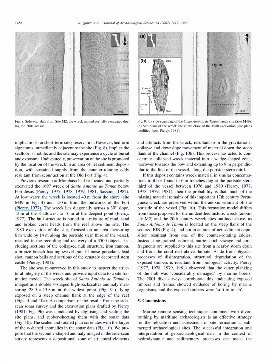
Previous research at Mombasa had re-located and partiallyexcavated the 1697 wreck of Santo Antonio de Tanna belowFort Jesus (Piercy, 1977, 1978, 1979, 1981; Sassoon, 1982).At low water, the wreck is located 40 m from the shore (siteM49 in Fig. 4) and 150 m from the outworks of the Fort(Piercy, 1977). The wreck lies diagonally across a 30� slope,13 m at the shallowest to 16 m at the deepest point (Piercy,1977). The hull structure is buried in a mixture of mud, sandand broken coral heads from the reef above the site. The1980 excavation of the site, focused on an area measuring6 m wide by 14 m along the portside stern third of the vessel,resulted in the recording and recovery of a 3500 objects, in-cluding sections of the collapsed hull structure, iron cannon,a bronze breech loading swivel gun, Chinese porcelain, leadshot, cannon balls and sections of the ornately decorated sterncastle (Piercy, 1981).
The site was re-surveyed in this study to inspect the struc-tural integrity of the wreck and provide input data to a site for-mation model. The wreck site of Santo Antonio de Tanna isimaged as a double v-shaped high-backscatter anomaly mea-suring 28.9 � 15.8 m at the widest point (Fig. 9a), lyingexposed on a steep channel flank at the edge of the reef(Figs. 4 and 10a). A comparison of the results from the side-scan sonar survey and the excavation plans drafted by Piercy(1981; Fig. 9b) was conducted by digitising and scaling thesite plans, and rubber-sheeting them with the sonar data(Fig. 10). The scaled and rotated plan correlates with the largerof the v-shaped anomalies in the sonar data (Fig. 10). We pro-pose that the second v-shaped anomaly imaged in the side-scansurvey represents a depositional zone of structural elements
Fig. 8. Side-scan data from Site M2, the wreck mound partially excavated dur-
ing the 2001 season.
and artefacts from the wreck, resultant from the gravitationalcollapse and downslope movement of material down the steepflank of the channel (Fig. 10b). This process has acted to con-centrate collapsed wreck material into a wedge-shaped zone,narrower towards the bow and extending up to 9 m perpendic-ular to the line of the vessel, along the portside stern third.
If this deposit contains wreck material in similar concentra-tions to those found in 6 m trenches dug at the portside sternthird of the vessel between 1976 and 1980 (Piercy, 1977,1978, 1979, 1981), then the probability is that much of themissing material remains of this important 17th century Portu-guese wreck are preserved within the anoxic sediment off theportside of the vessel (Fig. 10). This formation model differsfrom those proposed for the unidentified historic wreck (anom-aly M2) and the 20th century wreck sites outlined above, asSanto Antonio de Tanna is located on the steep flank of thescoured FJB (Fig. 4), and not in an area of net sediment depo-sition resultant from one of the counter-rotating eddies.Instead, fine-grained sediment, nutrient-rich sewage and coralfragments are supplied to this site from a nearby storm drainand from the coral reef above the site. Aside from physicalprocesses of disintegration, structural degradation of theexposed timbers is resultant from biological activity. Piercy(1977, 1978, 1979, 1981) observed that the outer plankingof the hull was ‘considerably damaged’ by marine borers.The 2001 dive surveys corroborate this, indicating exposedtimbers and frames showed evidence of boring by marineorganisms, and the exposed timbers were ‘soft to touch’.
5. Conclusions
Marine remote sensing techniques combined with diver-truthing by maritime archaeologists is an effective strategyfor the relocation and assessment of site formation at sub-merged archaeological sites. The successful integration andinterpretation of geoarchaeological data in the context ofhydrodynamic and sedimentary processes can assist the
Fig. 9. (a) Side-scan data of the Santo Antonio de Tanna wreck site (Site M49).
(b) Site plans of the wreck site at the close of the 1980 excavation (site plans
modified from Piercy, 1981).
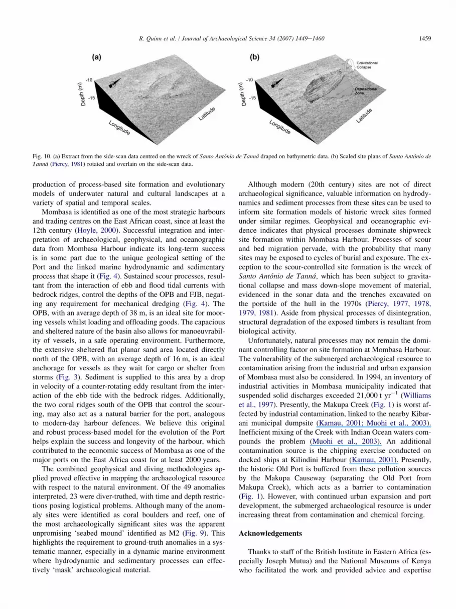
Fig. 10. (a) Extract from the side-scan data centred on the wreck of Santo Antonio de Tanna draped on bathymetric data. (b) Scaled site plans of Santo Antonio de
Tanna (Piercy, 1981) rotated and overlain on the side-scan data.
1459R. Quinn et al. / Journal of Archaeological Science 34 (2007) 1449e1460
production of process-based site formation and evolutionarymodels of underwater natural and cultural landscapes at avariety of spatial and temporal scales.
Mombasa is identified as one of the most strategic harboursand trading centres on the East African coast, since at least the12th century (Hoyle, 2000). Successful integration and inter-pretation of archaeological, geophysical, and oceanographicdata from Mombasa Harbour indicate its long-term successis in some part due to the unique geological setting of thePort and the linked marine hydrodynamic and sedimentaryprocess that shape it (Fig. 4). Sustained scour processes, resul-tant from the interaction of ebb and flood tidal currents withbedrock ridges, control the depths of the OPB and FJB, negat-ing any requirement for mechanical dredging (Fig. 4). TheOPB, with an average depth of 38 m, is an ideal site for moor-ing vessels whilst loading and offloading goods. The capaciousand sheltered nature of the basin also allows for manoeuvrabil-ity of vessels, in a safe operating environment. Furthermore,the extensive sheltered flat planar sand area located directlynorth of the OPB, with an average depth of 16 m, is an idealanchorage for vessels as they wait for cargo or shelter fromstorms (Fig. 3). Sediment is supplied to this area by a dropin velocity of a counter-rotating eddy resultant from the inter-action of the ebb tide with the bedrock ridges. Additionally,the two coral ridges south of the OPB that control the scour-ing, may also act as a natural barrier for the port, analogousto modern-day harbour defences. We believe this originaland robust process-based model for the evolution of the Porthelps explain the success and longevity of the harbour, whichcontributed to the economic success of Mombasa as one of themajor ports on the East Africa coast for at least 2000 years.
The combined geophysical and diving methodologies ap-plied proved effective in mapping the archaeological resourcewith respect to the natural environment. Of the 49 anomaliesinterpreted, 23 were diver-truthed, with time and depth restric-tions posing logistical problems. Although many of the anom-aly sites were identified as coral boulders and reef, one ofthe most archaeologically significant sites was the apparentunpromising ‘seabed mound’ identified as M2 (Fig. 9). Thishighlights the requirement to ground-truth anomalies in a sys-tematic manner, especially in a dynamic marine environmentwhere hydrodynamic and sedimentary processes can effec-tively ‘mask’ archaeological material.
Although modern (20th century) sites are not of directarchaeological significance, valuable information on hydrody-namics and sediment processes from these sites can be used toinform site formation models of historic wreck sites formedunder similar regimes. Geophysical and oceanographic evi-dence indicates that physical processes dominate shipwrecksite formation within Mombasa Harbour. Processes of scourand bed migration pervade, with the probability that manysites may be exposed to cycles of burial and exposure. The ex-ception to the scour-controlled site formation is the wreck ofSanto Antonio de Tanna, which has been subject to gravita-tional collapse and mass down-slope movement of material,evidenced in the sonar data and the trenches excavated onthe portside of the hull in the 1970s (Piercy, 1977, 1978,1979, 1981). Aside from physical processes of disintegration,structural degradation of the exposed timbers is resultant frombiological activity.
Unfortunately, natural processes may not remain the domi-nant controlling factor on site formation at Mombasa Harbour.The vulnerability of the submerged archaeological resource tocontamination arising from the industrial and urban expansionof Mombasa must also be considered. In 1994, an inventory ofindustrial activities in Mombasa municipality indicated thatsuspended solid discharges exceeded 21,000 t yr�1 (Williamset al., 1997). Presently, the Makupa Creek (Fig. 1) is worst af-fected by industrial contamination, linked to the nearby Kibar-ani municipal dumpsite (Kamau, 2001; Muohi et al., 2003).Inefficient mixing of the Creek with Indian Ocean waters com-pounds the problem (Muohi et al., 2003). An additionalcontamination source is the chipping exercise conducted ondocked ships at Kilindini Harbour (Kamau, 2001). Presently,the historic Old Port is buffered from these pollution sourcesby the Makupa Causeway (separating the Old Port fromMakupa Creek), which acts as a barrier to contamination(Fig. 1). However, with continued urban expansion and portdevelopment, the submerged archaeological resource is underincreasing threat from contamination and chemical forcing.
Acknowledgements
Thanks to staff of the British Institute in Eastern Africa (es-pecially Joseph Mutua) and the National Museums of Kenyawho facilitated the work and provided advice and expertise

1460 R. Quinn et al. / Journal of Archaeological Science 34 (2007) 1449e1460
at all stages of the project. Thanks also to Prof. DaveEastwood, Prof. Andrew Cooper and Dr Brian Williamsfor encouraging the collaboration. The comments of two anon-ymous referees improved the structure, focus and content ofthis manuscript.
References
Adams, R.M., 1985. Designed flexibility in a sewn boat of the western Indian
Ocean. In: McGrail, S., Kently, E. (Eds.), Sewn Planked Boats. BAR Series
276, Oxford, pp. 289e302.
Allen, J.V., 1993. Swahili Origins: Swahili Culture and the Shungwaya
Phenomenon. James Currey, London.
Alpers, E.A., 1976. Gujarat and the trade of East Africa, c.1500e1800. The
International Journal of African Historical Studies 9, 22e44.
Brakel, W., 1982. Tidal patterns on the East African coast and their implica-
tions for the littoral biota. Symposium on Coastal and Marine Environ-
ments of the Red Sea. Gulf Aden and Tropical Western Indian Ocean.
403e418.
Breen, C., Lane, P.J., 2003. Archaeological approaches to East Africa’s chang-
ing seascapes. World Archaeology 35, 469e489.
Caston, G.F., 1979. Wreck marks: indicators of net sand transport. Marine
Geology 33, 193e204.
Cerulli, E., 1970. Opus Geographicum. Neapoli, Naples and Rome.
Chittick, H.N., 1984. Manda: Excavations at an Island Port on the Kenya
Coast. British Institute in Eastern Africa, Memoir 9, Nairobi.
Forsythe, W., Quinn, R., Breen, C., 2003. Subtidal archaeological investiga-
tions in Mombasa’s Old Port. In: Mitchell, P., Haour, A., Hobart, J.
(Eds.), Researching Africa’s Past: New Contributions from British Archae-
ologists. Oxford University School of Archaeology Monograph 57, Oxbow
Books, Oxford, pp. 133e138.
Garlake, P., Garlake, M., 1964. Early ship engravings of the East African
coast. Tanganyika Notes and Records 63, 197e206.
Hornell, J., 1941. The sea-going mtepe and dau of the Lamu archipelago.
Mariner’s Mirror 27, 54e68.
Hornell, J., 1946. Water Transport. Cambridge University Press, Cambridge.
Horton, M.C., Middleton, J., 2000. The Swahili: The Social Landscape of
a Mercantile Society. Blackwell, Oxford.
Hourani, G.F., 1995. Arab Seafaring. Princeton University Press, New Jersey.
Hoyle, B., 2000. Global and local forces in developing countries, Journal for
Maritime Research February, 1e17.
Hydrographic Office, 1990. Admiralty Chart 666: Port Mombasa including
Port Kilindini and Port Reitz, Taunton.
Kamau, J.N., 2001. Heavy metals distribution in sediments along the Killindini
and Makupa creeks, Kenya. Hydrobiologia 458, 235e240.
Kirkman, J.S., 1974. Fort Jesus: A Portuguese Fort on the East African Coast.
Clarendon Press, Oxford.
McConkey, R., McErlean, T. Coastal survey on Mombasa Island: a preliminary
report. International Journal of Historical Archaeology, in press.
Muohi, A.W., Onyari, J.M., Omondi, J.G., Mavuti, K.M., 2003. Heavy metals
in sediments from Makupa and Port-Reitz Creek systems: Kenyan Coast.
Environmental International 28, 639e647.
Newitt, M., 1978. The southern Swahili coast in the first century of European
expansion. Azania 13, 111e126.
Obura, D., 2001. Kenya. Marine Pollution Bulletin 42, 1264e1278.
Obura, D., Muthiga, N., Watson, M., 2000. Kenya, In: McClanahan, T.,
Sheppard, C., Obura, D. (Eds.), Coral Reefs of the Indian Ocean:
Their Ecology And Conservation. Oxford University Press, Oxford, pp.
199e230.
Piercy, R.C.M., 1977. Mombasa wreck excavation, preliminary report. Interna-
tional Journal of Nautical Archaeology 6, 331e347.
Piercy, R.C.M., 1978. Mombasa wreck excavation, second preliminary report.
International Journal of Nautical Archaeology 7, 301e319.
Piercy, R.C.M., 1979. Mombasa wreck excavation, third preliminary report.
International Journal of Nautical Archaeology 8, 303e309.
Piercy, R.C.M., 1981. Mombasa wreck excavation, fourth preliminary report,
1980. International Journal of Nautical Archaeology 10, 109e118.
Prins, A.H.J., 1982. The Mtepe of Lamu, Mombasa and the Zanzibar Sea.
Paideuma 28, 95e100.
Quinn, R., 2006. The role of scour in shipwreck site formation processes and
the preservation of wreck-associated scour signatures in the sedimentary
record e evidence from seabed and sub-surface data. Journal of Archaeo-
logical Science 33, 1419e1432.
Quinn, R., Dean, M., Lawrence, M., Liscoe, S., Boland, D., 2005. Backscatter
responses and resolution considerations in archaeological side-scan sonar
surveys: a control experiment. Journal of Archaeological Science 32,
1252e1264.
Quinn, R., Forsythe, W., Breen, C., Dean, M., Lawrence, M., Liscoe, S., 2002.
Comparison of the maritime sites and monuments record with side-scan
sonar and diver surveys: a case study from Rathlin Island, Ireland.
Geoarchaeology 17, 441e451.
Ramsay, P.J., 1995. 9000 years of sea-level change along the southern African
coastline. Quaternary International 31, 71e75.
Ramsay, P.J., Cooper, J.A.G., 2002. Late Quaternary sea-level change in South
Africa. Quaternary Research 57, 82e90.
Ravenstein, E.G., 1898. Journal of the First Voyages of Vasco da Gama.
Hakluyt Society, London.
Sassoon, H., 1980. Excavations at the site of early Mombasa. Azania 15, 1e42.
Sassoon, H., 1982. The sinking of the Santo Antonio de Tanna in Mombasa
Harbour. Paideuma 28, 101e108.
Williams, T.M., Rees, J.G., Ferguson, A., Herd, R.A., Kairu, K.K., Yobe, A.C.,
1997. Metals, petroleum hydrocarbons and organochlorines in inshore
sediments and waters of Mombasa, Kenya. Marine Pollution Bulletin 34,
570e577.
Woodroffe, C.D., 2005. Late Quaternary sea-level highstands in the central
and eastern Indian Ocean: a review. Global and Planetary Change 49,
121e138.


