Embed Size (px)
Citation preview
1
Profile of Mining Concession
District Dera Ghazi Khan
DIRECTORATE GENERAL OF MINES AND MINERALS PUNJAB
Profile Summary
Lease Title ML.DGK. FULLER EARTH (07)
Mineral Fuller Earth
Reserve Status Proved
Acreage 175.62 acres
Location Near Khalgari Chur – Mohi Nala
2
TECHNICAL DATA
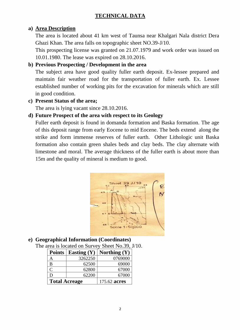
a) Area Description
The area is located about 41 km west of Taunsa near Khalgari Nala district Dera
Ghazi Khan. The area falls on topographic sheet NO.39-J/10.
This prospecting license was granted on 21.07.1979 and work order was issued on
10.01.1980. The lease was expired on 28.10.2016.
b) Previous Prospecting / Development in the area
The subject area have good quality fuller earth deposit. Ex-lessee prepared and
maintain fair weather road for the transportation of fuller earth. Ex. Lessee
established number of working pits for the excavation for minerals which are still
in good condition.
c) Present Status of the area;
The area is lying vacant since 28.10.2016.
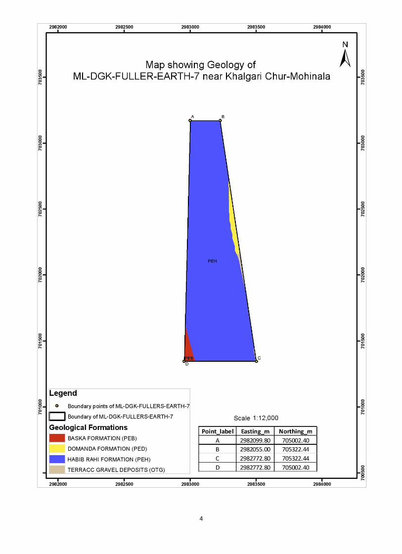
d) Future Prospect of the area with respect to its Geology
Fuller earth deposit is found in domanda formation and Baska formation. The age
of this deposit range from early Eocene to mid Eocene. The beds extend along the
strike and form immense reserves of fuller earth. Other Lithologic unit Baska
formation also contain green shales beds and clay beds. The clay alternate with
limestone and moral. The average thickness of the fuller earth is about more than
15m and the quality of mineral is medium to good.
e) Geographical Information (Coordinates)
The area is located on Survey Sheet No.39, J/10.
Points Easting (Y) Northing (Y) A 3262250 0769000
B 62500 69000
C 62800 67000
D 62200 67000
Total Acreage 175.62 acres
3
f) Reserve Price of Mining Concession
1) = acres
2) Approximate mineral bearing area 40% = acres
3) =
4) =
Sr. No.
Max
Weightag
e %
Weightage
Assigned
(%)
1 100 5%
2 300 5%
3 100 5%
4 300 5%
5 100 5%
6 6%
ML.DGK.FULLER EARTH(07)
Calculated Amount
(Rs.)
21,072Rs
21,072Rs
175.62
70.24
6,000Rs
421,440Rs
Total Acreage of Mining Concession
Proposed base price per acre
(Royalty Rate of Mineral x 200)
Proposed base price of Mining Concession
70.24 x 6000
Major Factor
21,072Rs
Seam thickness
Future Potential
Proposed base price
550,000Rs Say Reserve Price of Concession
25,286Rs
Total Reserve Price of Concession
130,646Rs
421,440Rs
552,086Rs
Total of contributing factors
21,072Rs
21,072Rs
Availability of Labour facility, residential and health
service
Over Burden Factor
Availability of infrastructure roads, water supply
electrictiy
Availability of consumption market
Note:
The approximate mineral bearing area is estimated on the inferred basis from the
geology of the area keeping in view the sub surface rock formation however, it
may not be necessary that 100% mineral bearing formation for the reasons the
factors including structural behavior of the area and depositional environment of
the mineral may change within the formation from place to place.
ASSISTANT DIRECTOR MINES & MINERALS
D.G KHAN REGION, D.G KHAN
DEPUTY DIRECTOR MINES & MINERALS
D.G KHAN REGION, D.G KHAN
4
5
Profile of Mining Concession
District Dera Ghazi Khan
DIRECTORATE GENERAL OF MINES AND MINERALS PUNJAB
Profile Summary
Lease Title ML.DGK. FULLER EARTH (17)
Mineral Fuller Earth
Reserve Status Proved
Acreage 54.99 acres
Location Near Suleman Chur
6
TECHNICAL DATA
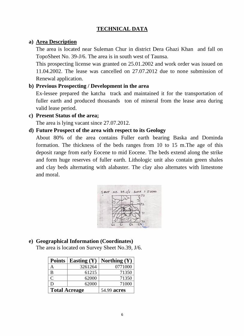
a) Area Description
The area is located near Suleman Chur in district Dera Ghazi Khan and fall on
TopoSheet No. 39-J/6. The area is in south west of Taunsa.
This prospecting license was granted on 25.01.2002 and work order was issued on
11.04.2002. The lease was cancelled on 27.07.2012 due to none submission of
Renewal application.
b) Previous Prospecting / Development in the area
Ex-lessee prepared the katcha track and maintained it for the transportation of
fuller earth and produced thousands ton of mineral from the lease area during
valid lease period.
c) Present Status of the area;
The area is lying vacant since 27.07.2012.
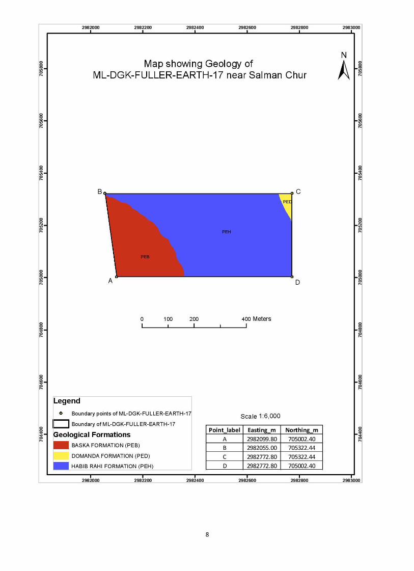
d) Future Prospect of the area with respect to its Geology
About 80% of the area contains Fuller earth bearing Baska and Dominda
formation. The thickness of the beds ranges from 10 to 15 m.The age of this
deposit range from early Eocene to mid Eocene. The beds extend along the strike
and form huge reserves of fuller earth. Lithologic unit also contain green shales
and clay beds alternating with alabaster. The clay also alternates with limestone
and moral.
e) Geographical Information (Coordinates)
The area is located on Survey Sheet No.39, J/6.
Points Easting (Y) Northing (Y) A 3261264 0771000
B 61215 71350
C 62000 71350
D 62000 71000
Total Acreage 54.99 acres
7
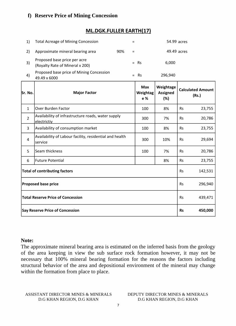
f) Reserve Price of Mining Concession
1) = acres
2) Approximate mineral bearing area 90% = acres
3) =
4) =
Sr. No.
Max
Weightag
e %
Weightage
Assigned
(%)
1 100 8%
2 300 7%
3 100 8%
4 300 10%
5 100 7%
6 8%
Availability of infrastructure roads, water supply
electrictiy
Availability of consumption market
Seam thickness
Future Potential
Proposed base price
450,000Rs Say Reserve Price of Concession
23,755Rs
Total Reserve Price of Concession
142,531Rs
296,940Rs
439,471Rs
Total of contributing factors
20,786Rs
ML.DGK.FULLER EARTH(17)
Calculated Amount
(Rs.)
23,755Rs
29,694Rs
54.99
49.49
6,000Rs
296,940Rs
Total Acreage of Mining Concession
Proposed base price per acre
(Royalty Rate of Mineral x 200)
Proposed base price of Mining Concession
49.49 x 6000
Major Factor
23,755Rs
20,786Rs
Availability of Labour facility, residential and health
service
Over Burden Factor
Note:
The approximate mineral bearing area is estimated on the inferred basis from the geology
of the area keeping in view the sub surface rock formation however, it may not be
necessary that 100% mineral bearing formation for the reasons the factors including
structural behavior of the area and depositional environment of the mineral may change
within the formation from place to place.
ASSISTANT DIRECTOR MINES & MINERALS
D.G KHAN REGION, D.G KHAN
DEPUTY DIRECTOR MINES & MINERALS
D.G KHAN REGION, D.G KHAN
8
9
District Dera Ghazi Khan
Profile of Mining Concession
District Dera Ghazi Khan
DIRECTORATE GENERAL OF MINES AND MINERALS PUNJAB
Profile Summary
Lease Title ML.DGK.GYPSUM(44)
Mineral Gypsum
Reserve Status Proved
Acreage 239.10 acres
Location Near Zindapir
10
TECHNICAL DATA
a) Area Description
The area is situated in the West of Shahdan Lund town at about 25 KM from Indus
Highway and 7 KM from village Kaleri Dirtrict D.G.Khan and fall on topo sheet
number is 39-J/11.
b) Previous Prospecting / Development in the area
In the early ten years of the grant lessee worked in the area with full swing. He developed
the pits and prepared the tracks for transportation of gypsum and he reported about seven
thousand ton of gypsum from this lease area. Later on he loosed the interest due to
unknown reason and kept the area idle till the cancellation.
c) Present Status of the area;
This area still has good quality gypsum and working pits readily available for excavation
of gypsum after small investment.
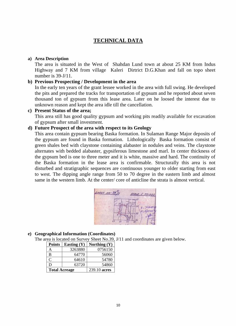
d) Future Prospect of the area with respect to its Geology
This area contain gypsum bearing Baska formation. In Sulaman Range Major deposits of
the gypsum are found in Baska formation. Lithologically Baska formation consist of
green shales bed with claystone containing alabaster in nodules and veins. The claystone
alternates with bedded alabaster, gypsiferous limestone and marl. In center thickness of
the gypsum bed is one to three meter and it is white, massive and hard. The continuity of
the Baska formation in the lease area is confirmable. Structurally this area is not
disturbed and stratigraphic sequences are continuous younger to older starting from east
to west. The dipping angle range from 50 to 70 degree in the eastern limb and almost
same in the western limb. At the center/ core of anticline the strata is almost vertical.
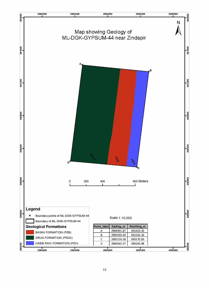
e) Geographical Information (Coordinates)
The area is located on Survey Sheet No.39, J/11 and coordinates are given below. Points Easting (Y) Northing (Y)
A 3263880 0756150
B 64770 56060
C 64610 54780
D 63720 54860
Total Acreage 239.10 acres
11
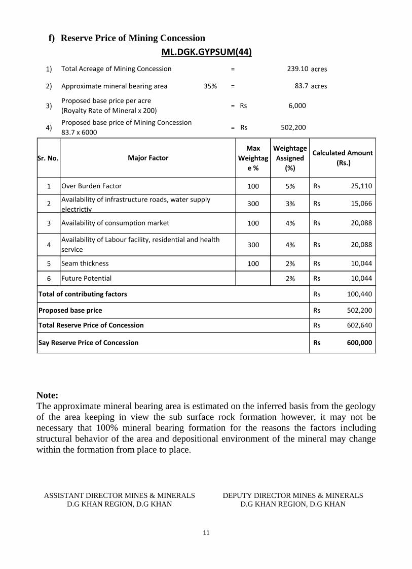
f) Reserve Price of Mining Concession
1) = acres
2) Approximate mineral bearing area 35% = acres
3) =
4) =
Sr. No.
Max
Weightag
e %
Weightage
Assigned
(%)
1 100 5%
2 300 3%
3 100 4%
4 300 4%
5 100 2%
6 2%
15,066Rs
Availability of Labour facility, residential and health
service
Over Burden Factor
Availability of infrastructure roads, water supply
electrictiy
Availability of consumption market
Seam thickness
Future Potential
Proposed base price
600,000Rs Say Reserve Price of Concession
10,044Rs
Total Reserve Price of Concession
100,440Rs
502,200Rs
602,640Rs
Total of contributing factors
10,044Rs
ML.DGK.GYPSUM(44)
Calculated Amount
(Rs.)
20,088Rs
20,088Rs
239.10
83.7
6,000Rs
502,200Rs
Total Acreage of Mining Concession
Proposed base price per acre
(Royalty Rate of Mineral x 200)
Proposed base price of Mining Concession
83.7 x 6000
Major Factor
25,110Rs
Note:
The approximate mineral bearing area is estimated on the inferred basis from the geology
of the area keeping in view the sub surface rock formation however, it may not be
necessary that 100% mineral bearing formation for the reasons the factors including
structural behavior of the area and depositional environment of the mineral may change
within the formation from place to place.
ASSISTANT DIRECTOR MINES & MINERALS
D.G KHAN REGION, D.G KHAN
DEPUTY DIRECTOR MINES & MINERALS
D.G KHAN REGION, D.G KHAN
12
13
District Dera Ghazi Khan
Profile of Mining Concession
District Dera Ghazi Khan
DIRECTORATE GENERAL OF MINES AND MINERALS PUNJAB
Profile Summary
Lease Title ML.DGK.GYPSUM(45)
Mineral Gypsum
Reserve Status Proved
Acreage 249.12 acres
Location Near Lagthal
14
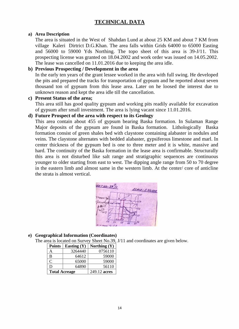
TECHNICAL DATA
a) Area Description
The area is situated in the West of Shahdan Lund at about 25 KM and about 7 KM from
village Kaleri Dirtrict D.G.Khan. The area falls within Grids 64000 to 65000 Easting
and 56000 to 59000 Yds Northing. The topo sheet of this area is 39-J/11. This
prospecting license was granted on 18.04.2002 and work order was issued on 14.05.2002.
The lease was cancelled on 11.01.2016 due to keeping the area idle.
b) Previous Prospecting / Development in the area
In the early ten years of the grant lessee worked in the area with full swing. He developed
the pits and prepared the tracks for transportation of gypsum and he reported about seven
thousand ton of gypsum from this lease area. Later on he loosed the interest due to
unknown reason and kept the area idle till the cancellation.
c) Present Status of the area;
This area still has good quality gypsum and working pits readily available for excavation
of gypsum after small investment. The area is lying vacant since 11.01.2016.
d) Future Prospect of the area with respect to its Geology
This area contain about 455 of gypsum bearing Baska formation. In Sulaman Range
Major deposits of the gypsum are found in Baska formation. Lithologically Baska
formation consist of green shales bed with claystone containing alabaster in nodules and
veins. The claystone alternates with bedded alabaster, gypsiferous limestone and marl. In
center thickness of the gypsum bed is one to three meter and it is white, massive and
hard. The continuity of the Baska formation in the lease area is confirmable. Structurally
this area is not disturbed like salt range and stratigraphic sequences are continuous
younger to older starting from east to west. The dipping angle range from 50 to 70 degree
in the eastern limb and almost same in the western limb. At the center/ core of anticline
the strata is almost vertical.
e) Geographical Information (Coordinates)
The area is located on Survey Sheet No.39, J/11 and coordinates are given below. Points Easting (Y) Northing (Y)
A 3264440 0756110
B 64612 59000
C 65000 59000
D 64890 56110
Total Acreage 249.12 acres
15
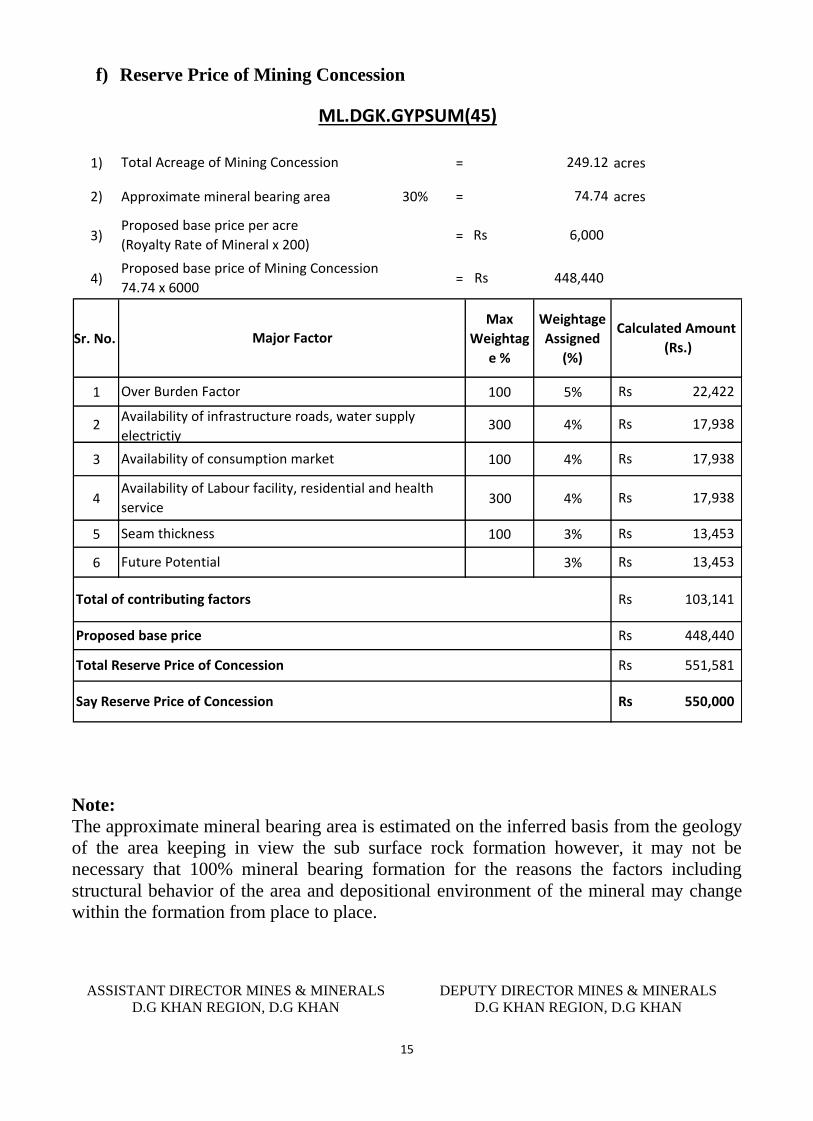
f) Reserve Price of Mining Concession
1) = acres
2) Approximate mineral bearing area 30% = acres
3) =
4) =
Sr. No.
Max
Weightag
e %
Weightage
Assigned
(%)
1 100 5%
2 300 4%
3 100 4%
4 300 4%
5 100 3%
6 3%
ML.DGK.GYPSUM(45)
Calculated Amount
(Rs.)
17,938Rs
17,938Rs
249.12
74.74
6,000Rs
448,440Rs
Total Acreage of Mining Concession
Proposed base price per acre
(Royalty Rate of Mineral x 200)
Proposed base price of Mining Concession
74.74 x 6000
Major Factor
22,422Rs
Seam thickness
Future Potential
Proposed base price
550,000Rs Say Reserve Price of Concession
13,453Rs
Total Reserve Price of Concession
103,141Rs
448,440Rs
551,581Rs
Total of contributing factors
13,453Rs
17,938Rs
Availability of Labour facility, residential and health
service
Over Burden Factor
Availability of infrastructure roads, water supply
electrictiy
Availability of consumption market
Note:
The approximate mineral bearing area is estimated on the inferred basis from the geology
of the area keeping in view the sub surface rock formation however, it may not be
necessary that 100% mineral bearing formation for the reasons the factors including
structural behavior of the area and depositional environment of the mineral may change
within the formation from place to place.
ASSISTANT DIRECTOR MINES & MINERALS
D.G KHAN REGION, D.G KHAN
DEPUTY DIRECTOR MINES & MINERALS
D.G KHAN REGION, D.G KHAN

16
17
Profile of Mining Concession
District Dera Ghazi Khan
DIRECTORATE GENERAL OF MINES AND MINERALS PUNJAB
Profile Summary
Lease Title ML.DGK.GYPSUM(47)
Mineral Gypsum
Reserve Status Proved
Acreage 249.08 acres
Location Near Zain
18
TECHNICAL DATA
a) Area Description
The area is located near Zain District D.G. Khan and fall on Topo sheet No:39J/6.
A metaled road passes through Mohoi which is at about 20 kilometer from the
area. This prospecting license was granted on 06.10.2003 and work order was
issued on 13.11.2013. The lease was cancelled on 24.09.2014 due to none
submission renewal application.
b) Previous Prospecting / Development in the area
Ex lessee develop the area but could not submit the renewal application in time and
lease was cancelled. He also prepared the katcha track which is now destroyed due
to rainy water.
c) Present Status of the area;
The area is lying vacant since 24.09.2014.
d) Future Prospect of the area with respect to its Geology
About 50 % of the area contain gypsum bearing Baska formation in this area. The
gypsum deposits are found in Baska formation. Baska formation consists of green
shales bed with claystone containing alabaster in nodules and veins. The claystone
alternates with bedded alabaster, gypsiferous limestone and marl. The alabaster
bed ranges from 10cm to 10m thick. Structurally the fold belt is not disturbed like
salt range and stratigraphic sequences are continuous younger to older starting
from east to west. The dipping angle range from 50 to 70 degree in the eastern limb
and almost same in the western limb.
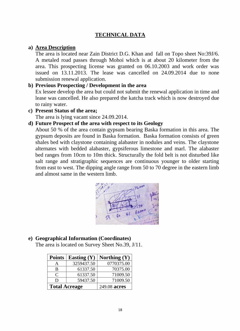
e) Geographical Information (Coordinates)
The area is located on Survey Sheet No.39, J/11.
Points Easting (Y) Northing (Y) A 3259437.50 0770375.00
B 61337.50 70375.00
C 61337.50 71009.50
D 59437.50 71009.50
Total Acreage 249.08 acres
19
f) Reserve Price of Mining Concession
1) = acres
2) Approximate mineral bearing area 35% = acres
3) =
4) =
Sr. No.
Max
Weightag
e %
Weightage
Assigned
(%)
1 100 5%
2 300 4%
3 100 5%
4 300 4%
5 100 4%
6 3%
20,921Rs
Availability of Labour facility, residential and health
service
Over Burden Factor
Availability of infrastructure roads, water supply
electrictiy
Availability of consumption market
Seam thickness
Future Potential
Proposed base price
650,000Rs Say Reserve Price of Concession
15,691Rs
Total Reserve Price of Concession
130,755Rs
523,020Rs
653,775Rs
Total of contributing factors
20,921Rs
ML.DGK.GYPSUM(47)
Calculated Amount
(Rs.)
26,151Rs
20,921Rs
249.08
87.17
6,000Rs
523,020Rs
Total Acreage of Mining Concession
Proposed base price per acre
(Royalty Rate of Mineral x 200)
Proposed base price of Mining Concession
87.17 x 6000
Major Factor
26,151Rs
Note:
The approximate mineral bearing area is estimated on the inferred basis from the geology
of the area keeping in view the sub surface rock formation however, it may not be
necessary that 100% mineral bearing formation for the reasons the factors including
structural behavior of the area and depositional environment of the mineral may change
within the formation from place to place.
ASSISTANT DIRECTOR MINES & MINERALS
D.G KHAN REGION, D.G KHAN
DEPUTY DIRECTOR MINES & MINERALS
D.G KHAN REGION, D.G KHAN

20
21
Profile of Mining Concession
District Dera Ghazi Khan
DIRECTORATE GENERAL OF MINES AND MINERALS PUNJAB
Profile Summary
Lease Title ML.DGK.GYPSUM(48)
Mineral Gypsum
Reserve Status Proved
Acreage 249.76 acres
Location Near Zain
22
TECHNICAL DATA
a) Area Description
The is situated near Zain, District D.G.Khan. The area falls on topo sheetNo.39 J/6.
A metaled road from Indus high way is at about 20 kilometers from the leased
area. This prospecting license was granted on 20.05.2004 and work order was
issued on 09.12.2004. The lease was cancelled on 09.06.2014 due to none
submission of renewal application and Govt. dues of Rs.30,994/-.
b) Previous Prospecting / Development in the area
Ex- lessee kept the area idle since grant and did not submit renewal application
before the expiry of mining lease.
c) Present Status of the area;
The area is lying vacant since 09.06.2014.
d) Future Prospect of the area with respect to its Geology
Lithologically Baska formation consist of green shales bed with claystone
containing alabaster in nodules and veins. The claystone alternates with bedded
alabaster, gypsiferous limestone and marl. The alabaster bed ranges from 10cm to
10m thick. In central Sulaman range thickness of the gypsum bed is one to three
meter and it is gypsum is white massive and hard. The continuity of the Baska
formation in sulaman range is reported thoroughly. Structurally the this fold belt is
not disturbed like salt range and stratigraphic sequences are continuous younger to
older starting from east to west. The dipping angle range from 50 to 70 degree in
the eastern limb and almost same in the western limb. At the center/ core of
anticline alone hing line the strata is almost verticle. The Future prospects of the
area relating to Baska formation containing gypsum is sustainable.
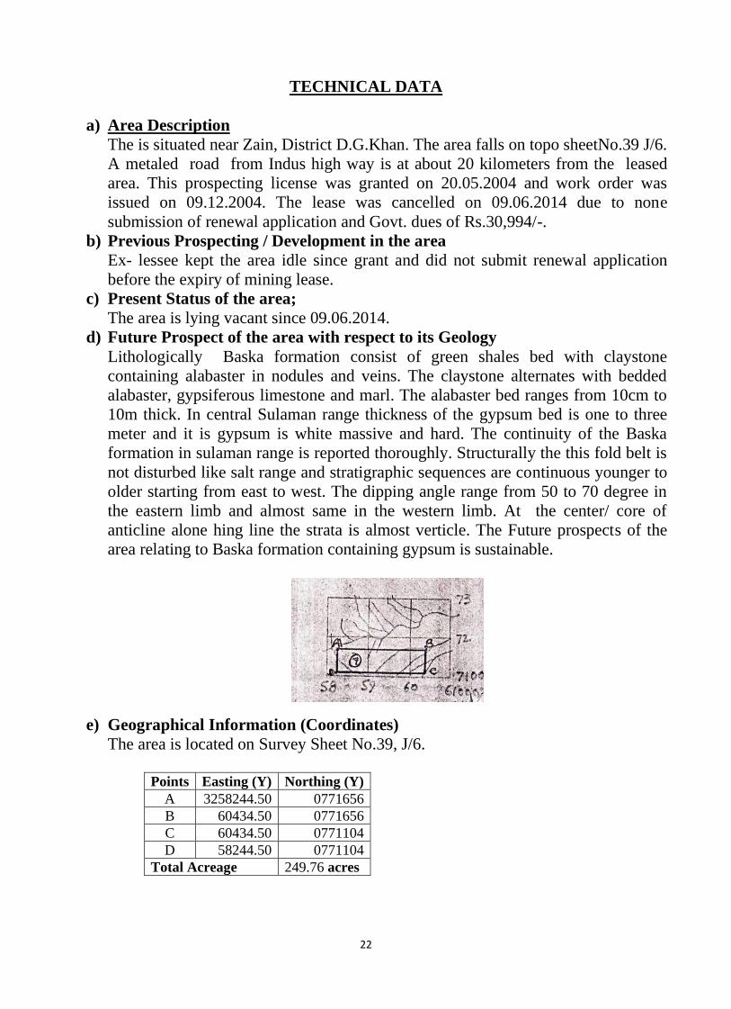
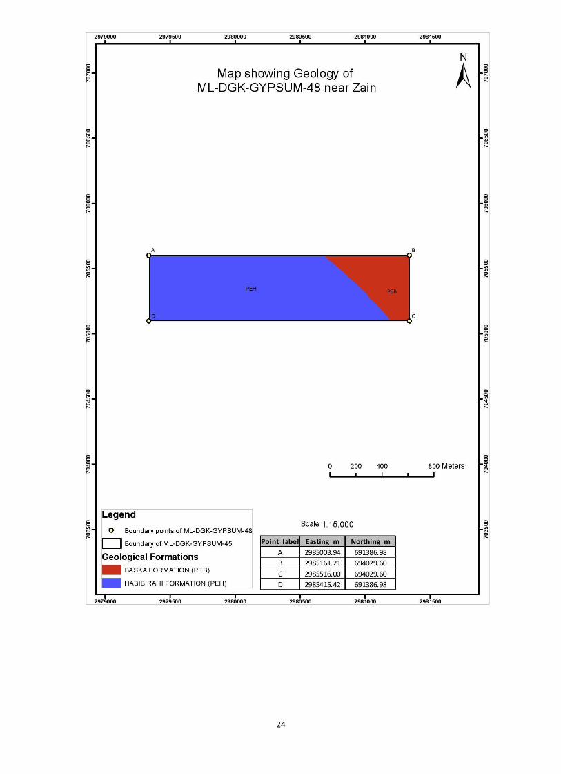
e) Geographical Information (Coordinates)
The area is located on Survey Sheet No.39, J/6.
Points Easting (Y) Northing (Y)
A 3258244.50 0771656
B 60434.50 0771656
C 60434.50 0771104
D 58244.50 0771104
Total Acreage 249.76 acres
23
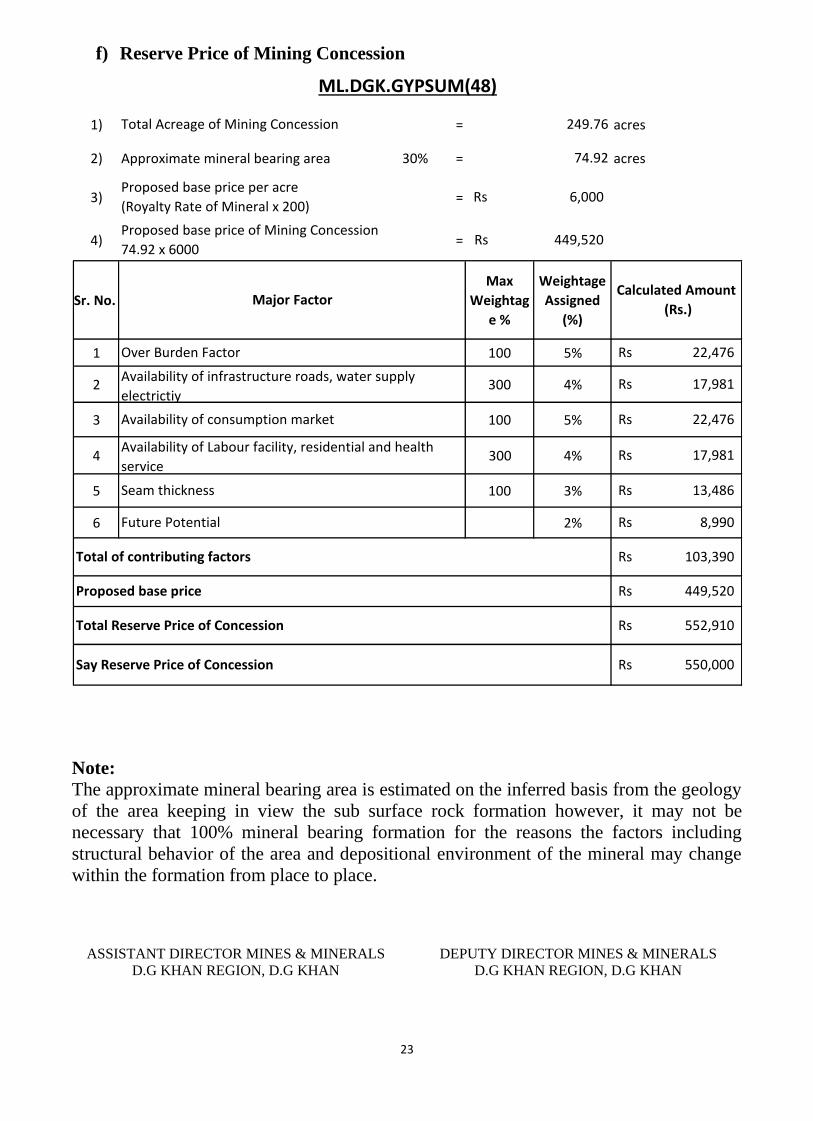
f) Reserve Price of Mining Concession
1) = acres
2) Approximate mineral bearing area 30% = acres
3) =
4) =
Sr. No.
Max
Weightag
e %
Weightage
Assigned
(%)
1 100 5%
2 300 4%
3 100 5%
4 300 4%
5 100 3%
6 2%
ML.DGK.GYPSUM(48)
Calculated Amount
(Rs.)
22,476Rs
17,981Rs
249.76
74.92
6,000Rs
449,520Rs
Total Acreage of Mining Concession
Proposed base price per acre
(Royalty Rate of Mineral x 200)
Proposed base price of Mining Concession
74.92 x 6000
Major Factor
22,476Rs
Seam thickness
Future Potential
Proposed base price
550,000Rs Say Reserve Price of Concession
8,990Rs
Total Reserve Price of Concession
103,390Rs
449,520Rs
552,910Rs
Total of contributing factors
13,486Rs
17,981Rs
Availability of Labour facility, residential and health
service
Over Burden Factor
Availability of infrastructure roads, water supply
electrictiy
Availability of consumption market
Note:
The approximate mineral bearing area is estimated on the inferred basis from the geology
of the area keeping in view the sub surface rock formation however, it may not be
necessary that 100% mineral bearing formation for the reasons the factors including
structural behavior of the area and depositional environment of the mineral may change
within the formation from place to place.
ASSISTANT DIRECTOR MINES & MINERALS
D.G KHAN REGION, D.G KHAN
DEPUTY DIRECTOR MINES & MINERALS
D.G KHAN REGION, D.G KHAN
24

25
Profile of Mining Concession
District Dera Ghazi Khan
DIRECTORATE GENERAL OF MINES AND MINERALS PUNJAB
Profile Summary
Lease Title ML.DGK.GYPSUM(49)
Mineral Gypsum
Reserve Status Proved
Acreage 164.62 acres
Location Near Ghazi Nala
26
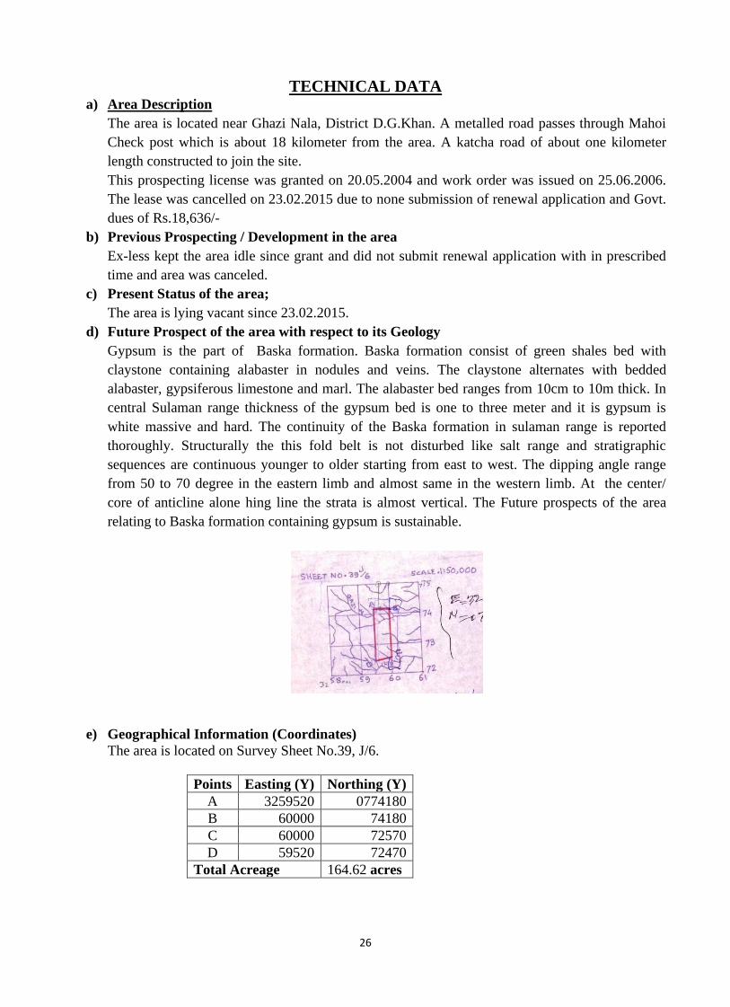
TECHNICAL DATA a) Area Description
The area is located near Ghazi Nala, District D.G.Khan. A metalled road passes through Mahoi
Check post which is about 18 kilometer from the area. A katcha road of about one kilometer
length constructed to join the site.
This prospecting license was granted on 20.05.2004 and work order was issued on 25.06.2006.
The lease was cancelled on 23.02.2015 due to none submission of renewal application and Govt.
dues of Rs.18,636/-
b) Previous Prospecting / Development in the area
Ex-less kept the area idle since grant and did not submit renewal application with in prescribed
time and area was canceled.
c) Present Status of the area;
The area is lying vacant since 23.02.2015.
d) Future Prospect of the area with respect to its Geology
Gypsum is the part of Baska formation. Baska formation consist of green shales bed with
claystone containing alabaster in nodules and veins. The claystone alternates with bedded
alabaster, gypsiferous limestone and marl. The alabaster bed ranges from 10cm to 10m thick. In
central Sulaman range thickness of the gypsum bed is one to three meter and it is gypsum is
white massive and hard. The continuity of the Baska formation in sulaman range is reported
thoroughly. Structurally the this fold belt is not disturbed like salt range and stratigraphic
sequences are continuous younger to older starting from east to west. The dipping angle range
from 50 to 70 degree in the eastern limb and almost same in the western limb. At the center/
core of anticline alone hing line the strata is almost vertical. The Future prospects of the area
relating to Baska formation containing gypsum is sustainable.
e) Geographical Information (Coordinates)
The area is located on Survey Sheet No.39, J/6.
Points Easting (Y) Northing (Y)
A 3259520 0774180
B 60000 74180
C 60000 72570
D 59520 72470
Total Acreage 164.62 acres
27
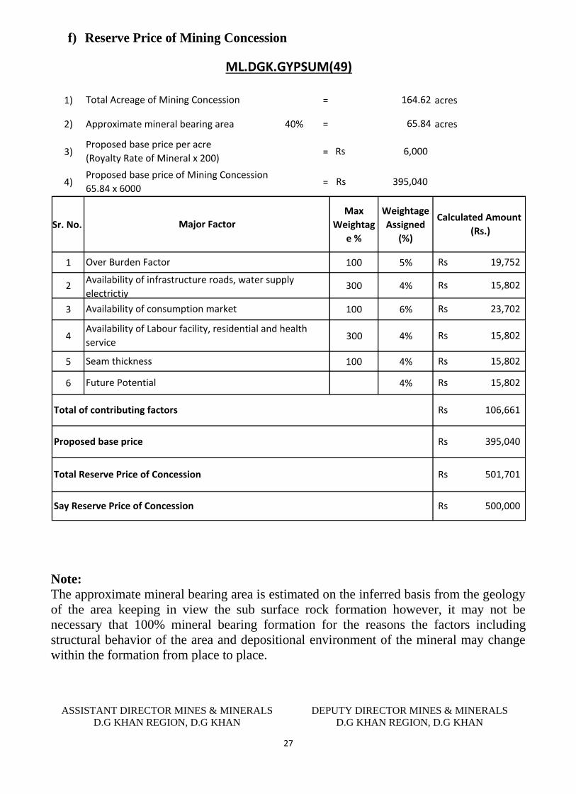
f) Reserve Price of Mining Concession
1) = acres
2) Approximate mineral bearing area 40% = acres
3) =
4) =
Sr. No.
Max
Weightag
e %
Weightage
Assigned
(%)
1 100 5%
2 300 4%
3 100 6%
4 300 4%
5 100 4%
6 4%
ML.DGK.GYPSUM(49)
Calculated Amount
(Rs.)
23,702Rs
15,802Rs
164.62
65.84
6,000Rs
395,040Rs
Total Acreage of Mining Concession
Proposed base price per acre
(Royalty Rate of Mineral x 200)
Proposed base price of Mining Concession
65.84 x 6000
Major Factor
19,752Rs
Seam thickness
Future Potential
Proposed base price
500,000Rs Say Reserve Price of Concession
15,802Rs
Total Reserve Price of Concession
106,661Rs
395,040Rs
501,701Rs
Total of contributing factors
15,802Rs
15,802Rs
Availability of Labour facility, residential and health
service
Over Burden Factor
Availability of infrastructure roads, water supply
electrictiy
Availability of consumption market
Note:
The approximate mineral bearing area is estimated on the inferred basis from the geology
of the area keeping in view the sub surface rock formation however, it may not be
necessary that 100% mineral bearing formation for the reasons the factors including
structural behavior of the area and depositional environment of the mineral may change
within the formation from place to place.
ASSISTANT DIRECTOR MINES & MINERALS
D.G KHAN REGION, D.G KHAN
DEPUTY DIRECTOR MINES & MINERALS
D.G KHAN REGION, D.G KHAN
28

29
Profile of Mining Concession
District Dera Ghazi Khan
DIRECTORATE GENERAL OF MINES AND MINERALS PUNJAB
Profile Summary
Lease Title ML.DGK.GYPSUM(50)
Mineral Gypsum
Reserve Status Proved
Acreage 95.04 acres
Location Near Basti Taraki
30
TECHNICAL DATA
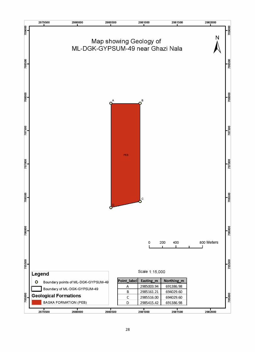
a) Area Description
The area is situated near Basti Taraki Chur in District D.G. Khan. The toposheet of
this lease area is 39 J/10. A metaled road is passing through Mahoi which is about
25 K.M from the area.
This prospecting license was granted on 26.05.2004 and work order was issued on
06.12.2004. The lease was cancelled on 27.09.2014 due to none submission of
renewal application.
b) Previous Prospecting / Development in the area
The Ex Lessee reported more than 13000 ton of production from his leased area.
Over all this area is good for gypsum deposits. The tracks for the transportation of
gypsum are available in area.
c) Present Status of the area
The area is lying vacant since 27.09.2014.
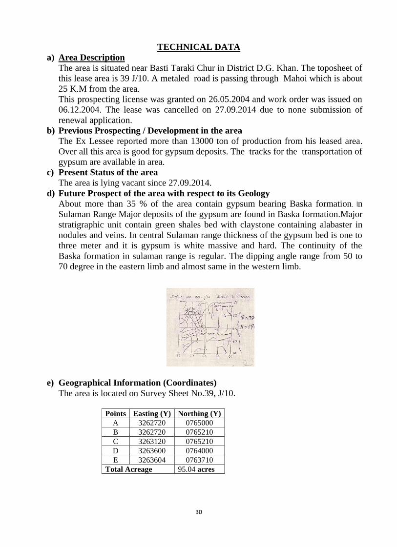
d) Future Prospect of the area with respect to its Geology
About more than 35 % of the area contain gypsum bearing Baska formation. In
Sulaman Range Major deposits of the gypsum are found in Baska formation.Major
stratigraphic unit contain green shales bed with claystone containing alabaster in
nodules and veins. In central Sulaman range thickness of the gypsum bed is one to
three meter and it is gypsum is white massive and hard. The continuity of the
Baska formation in sulaman range is regular. The dipping angle range from 50 to
70 degree in the eastern limb and almost same in the western limb.
e) Geographical Information (Coordinates)
The area is located on Survey Sheet No.39, J/10.
Points Easting (Y) Northing (Y)
A 3262720 0765000
B 3262720 0765210
C 3263120 0765210
D 3263600 0764000
E 3263604 0763710
Total Acreage 95.04 acres
31
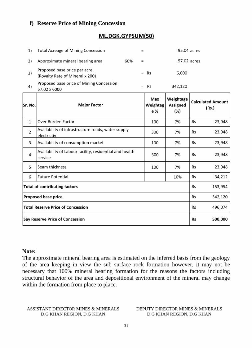
f) Reserve Price of Mining Concession
1) = acres
2) Approximate mineral bearing area 60% = acres
3) =
4) =
Sr. No.
Max
Weightag
e %
Weightage
Assigned
(%)
1 100 7%
2 300 7%
3 100 7%
4 300 7%
5 100 7%
6 10%
ML.DGK.GYPSUM(50)
Calculated Amount
(Rs.)
23,948Rs
23,948Rs
95.04
57.02
6,000Rs
342,120Rs
Total Acreage of Mining Concession
Proposed base price per acre
(Royalty Rate of Mineral x 200)
Proposed base price of Mining Concession
57.02 x 6000
Major Factor
23,948Rs
Seam thickness
Future Potential
Proposed base price
500,000Rs Say Reserve Price of Concession
34,212Rs
Total Reserve Price of Concession
153,954Rs
342,120Rs
496,074Rs
Total of contributing factors
23,948Rs
23,948Rs
Availability of Labour facility, residential and health
service
Over Burden Factor
Availability of infrastructure roads, water supply
electrictiy
Availability of consumption market
Note:
The approximate mineral bearing area is estimated on the inferred basis from the geology
of the area keeping in view the sub surface rock formation however, it may not be
necessary that 100% mineral bearing formation for the reasons the factors including
structural behavior of the area and depositional environment of the mineral may change
within the formation from place to place.
ASSISTANT DIRECTOR MINES & MINERALS
D.G KHAN REGION, D.G KHAN
DEPUTY DIRECTOR MINES & MINERALS
D.G KHAN REGION, D.G KHAN

32
33
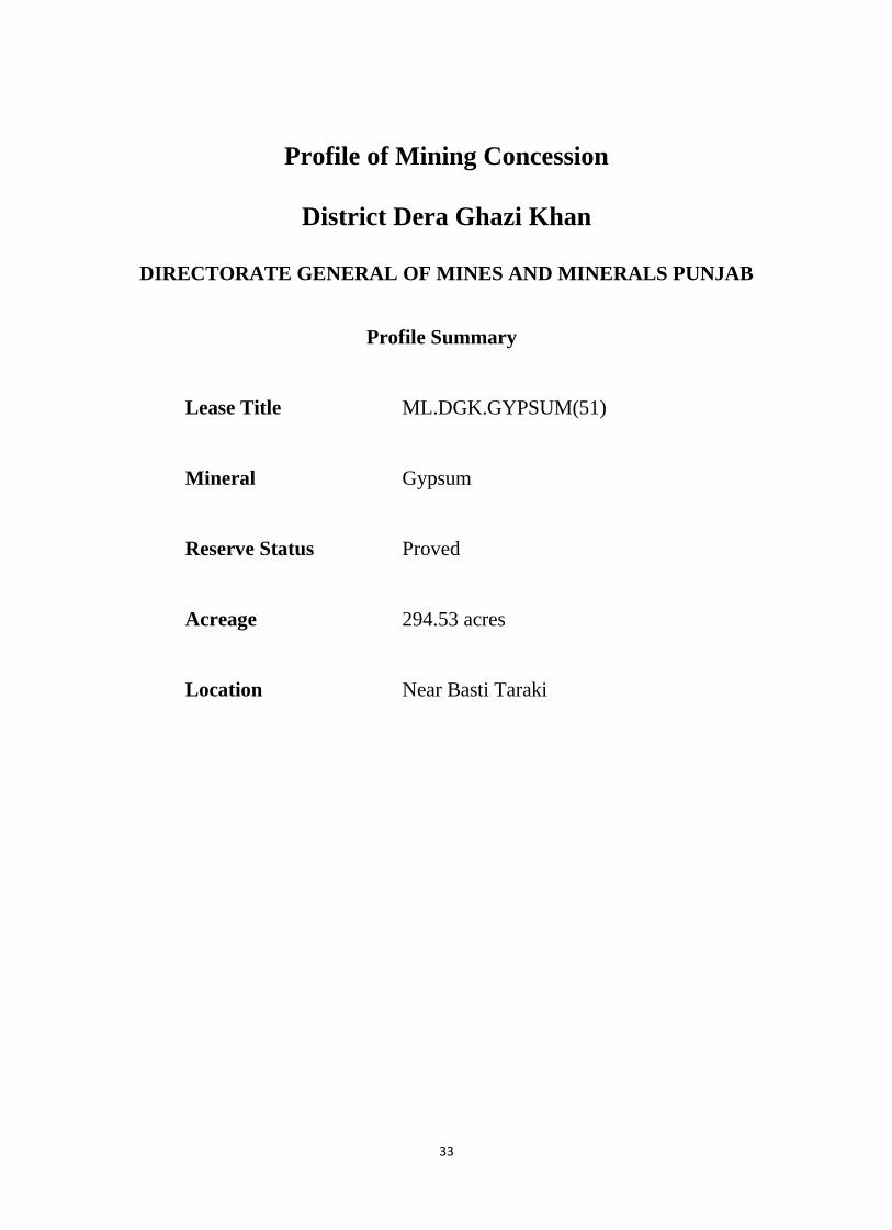
Profile of Mining Concession
District Dera Ghazi Khan
DIRECTORATE GENERAL OF MINES AND MINERALS PUNJAB
Profile Summary
Lease Title ML.DGK.GYPSUM(51)
Mineral Gypsum
Reserve Status Proved
Acreage 294.53 acres
Location Near Basti Taraki
34
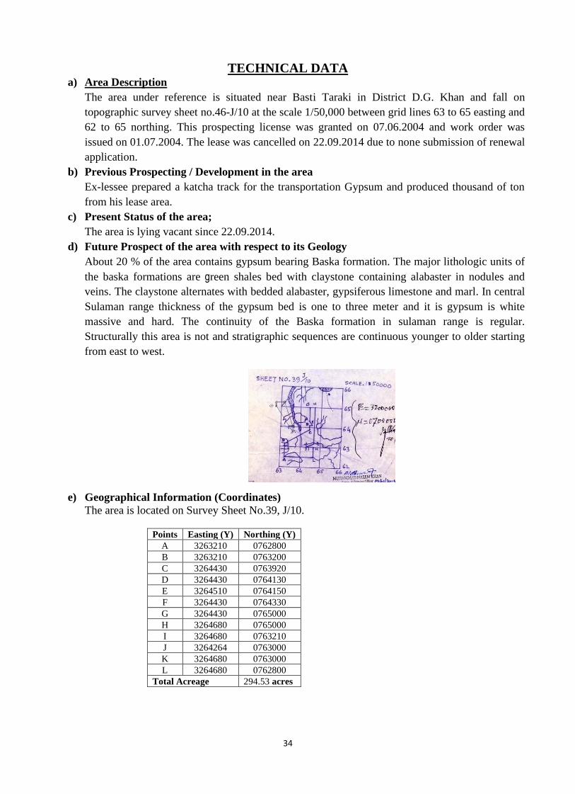
TECHNICAL DATA a) Area Description
The area under reference is situated near Basti Taraki in District D.G. Khan and fall on
topographic survey sheet no.46-J/10 at the scale 1/50,000 between grid lines 63 to 65 easting and
62 to 65 northing. This prospecting license was granted on 07.06.2004 and work order was
issued on 01.07.2004. The lease was cancelled on 22.09.2014 due to none submission of renewal
application.
b) Previous Prospecting / Development in the area
Ex-lessee prepared a katcha track for the transportation Gypsum and produced thousand of ton
from his lease area.
c) Present Status of the area;
The area is lying vacant since 22.09.2014.
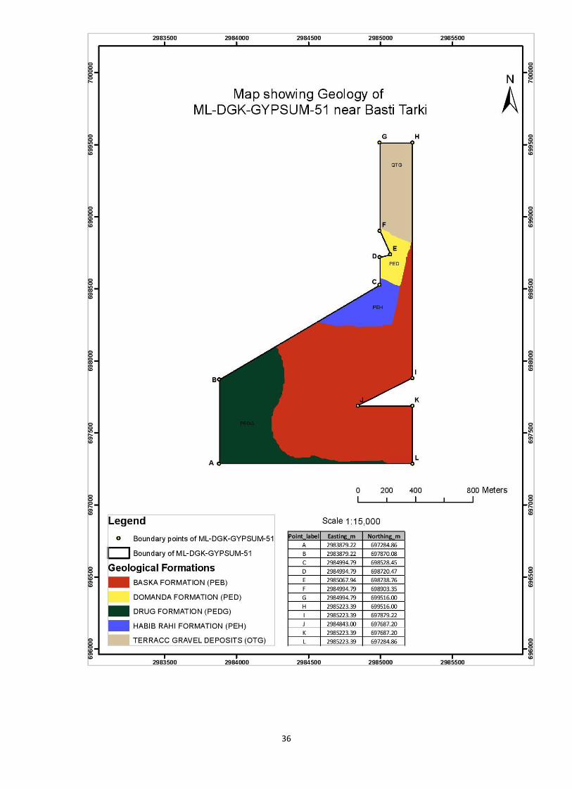
d) Future Prospect of the area with respect to its Geology
About 20 % of the area contains gypsum bearing Baska formation. The major lithologic units of
the baska formations are green shales bed with claystone containing alabaster in nodules and
veins. The claystone alternates with bedded alabaster, gypsiferous limestone and marl. In central
Sulaman range thickness of the gypsum bed is one to three meter and it is gypsum is white
massive and hard. The continuity of the Baska formation in sulaman range is regular.
Structurally this area is not and stratigraphic sequences are continuous younger to older starting
from east to west.
e) Geographical Information (Coordinates)
The area is located on Survey Sheet No.39, J/10.
Points Easting (Y) Northing (Y)
A 3263210 0762800
B 3263210 0763200
C 3264430 0763920
D 3264430 0764130
E 3264510 0764150
F 3264430 0764330
G 3264430 0765000
H 3264680 0765000
I 3264680 0763210
J 3264264 0763000
K 3264680 0763000
L 3264680 0762800
Total Acreage 294.53 acres
35
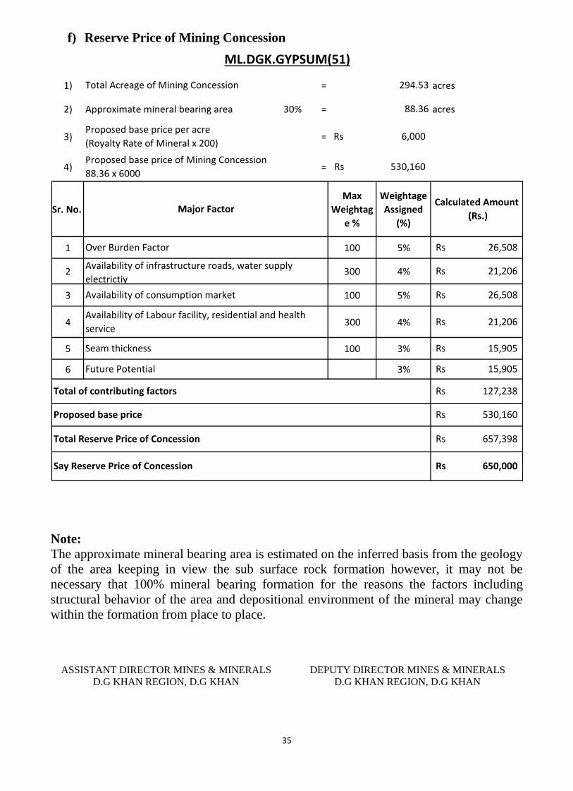
f) Reserve Price of Mining Concession
1) = acres
2) Approximate mineral bearing area 30% = acres
3) =
4) =
Sr. No.
Max
Weightag
e %
Weightage
Assigned
(%)
1 100 5%
2 300 4%
3 100 5%
4 300 4%
5 100 3%
6 3%
Availability of infrastructure roads, water supply
electrictiy
Availability of consumption market
Seam thickness
Future Potential
Proposed base price
650,000Rs Say Reserve Price of Concession
15,905Rs
Total Reserve Price of Concession
127,238Rs
530,160Rs
657,398Rs
Total of contributing factors
15,905Rs
ML.DGK.GYPSUM(51)
Calculated Amount
(Rs.)
26,508Rs
21,206Rs
294.53
88.36
6,000Rs
530,160Rs
Total Acreage of Mining Concession
Proposed base price per acre
(Royalty Rate of Mineral x 200)
Proposed base price of Mining Concession
88.36 x 6000
Major Factor
26,508Rs
21,206Rs
Availability of Labour facility, residential and health
service
Over Burden Factor
Note:
The approximate mineral bearing area is estimated on the inferred basis from the geology
of the area keeping in view the sub surface rock formation however, it may not be
necessary that 100% mineral bearing formation for the reasons the factors including
structural behavior of the area and depositional environment of the mineral may change
within the formation from place to place.
ASSISTANT DIRECTOR MINES & MINERALS
D.G KHAN REGION, D.G KHAN
DEPUTY DIRECTOR MINES & MINERALS
D.G KHAN REGION, D.G KHAN
36
37
Profile of Mining Concession
District Dera Ghazi Khan
DIRECTORATE GENERAL OF MINES AND MINERALS PUNJAB
Profile Summary
Lease Title ML.DGK.GYPSUM(54)
Mineral Gypsum
Reserve Status Proved
Acreage 244.66 acres
Location Near Sori Nala
38
TECHNICAL DATA
a) Area Description
The area measuring 244.66 acres is located near Sori Nala in District Dera Ghazi
Khan. Topographically the area falls on survey of Pakistan SheetNo.39-J/11This
prospecting license was granted on 11.01.2007. The lease was cancelled on
20.03.2015.
b) Previous Prospecting / Development in the area
The ex-lessee develop the area for excavation of gypsum and prepared the fair
weather track which was washed out due to rainy water. The good quality gypsum
is available at site.
c) Present Status of the area;
The area is lying vacant since 20.03.2015.
d) Future Prospect of the area with respect to its Geology
In Sulaman Range Major deposits of the gypsum are found in Baska formation.
Lithologically Baska formation consist of green shales bed with claystone
containing alabaster in nodules and veins. The claystone alternates with bedded
alabaster, gypsiferous limestone and marl. The alabaster bed ranges from 10cm to
10m thick. In central Sulaman range thickness of the gypsum bed is one to three
meter and it is gypsum is white massive and hard. The continuity of the Baska
formation in sulaman range is reported continuous without disturbance.
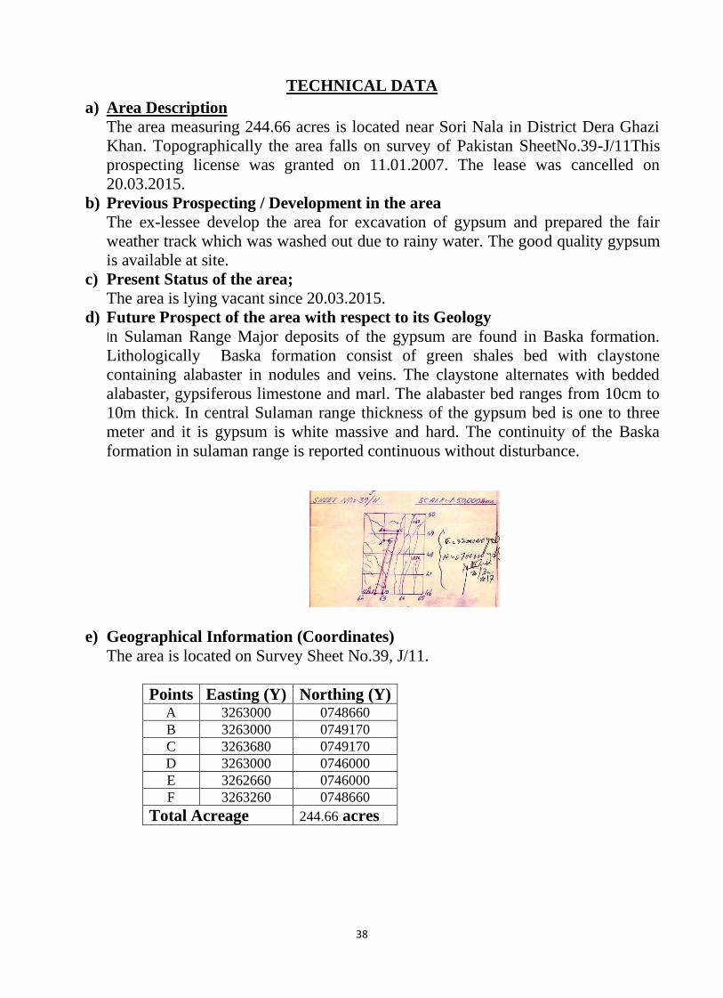
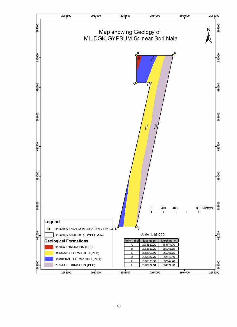
e) Geographical Information (Coordinates)
The area is located on Survey Sheet No.39, J/11.
Points Easting (Y) Northing (Y) A 3263000 0748660
B 3263000 0749170
C 3263680 0749170
D 3263000 0746000
E 3262660 0746000
F 3263260 0748660
Total Acreage 244.66 acres
39
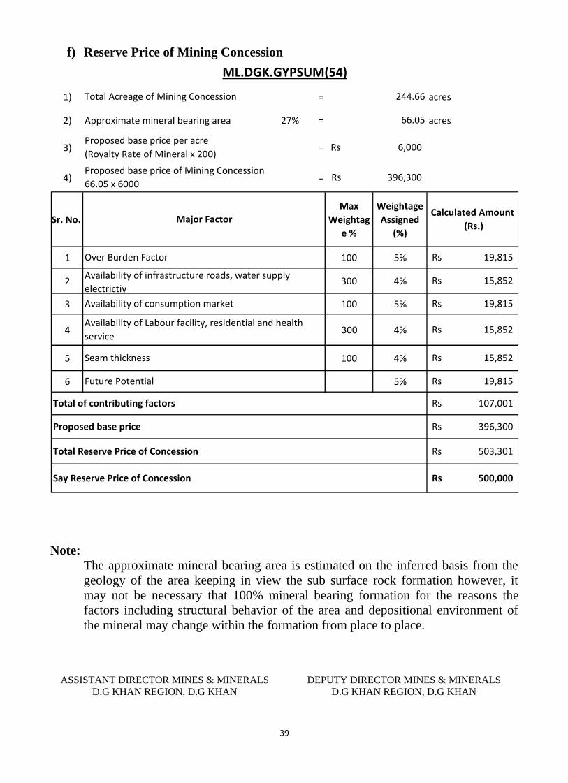
f) Reserve Price of Mining Concession
1) = acres
2) Approximate mineral bearing area 27% = acres
3) =
4) =
Sr. No.
Max
Weightag
e %
Weightage
Assigned
(%)
1 100 5%
2 300 4%
3 100 5%
4 300 4%
5 100 4%
6 5%
ML.DGK.GYPSUM(54)
Calculated Amount
(Rs.)
19,815Rs
15,852Rs
244.66
66.05
6,000Rs
396,300Rs
Total Acreage of Mining Concession
Proposed base price per acre
(Royalty Rate of Mineral x 200)
Proposed base price of Mining Concession
66.05 x 6000
Major Factor
19,815Rs
Seam thickness
Future Potential
Proposed base price
500,000Rs Say Reserve Price of Concession
19,815Rs
Total Reserve Price of Concession
107,001Rs
396,300Rs
503,301Rs
Total of contributing factors
15,852Rs
15,852Rs
Availability of Labour facility, residential and health
service
Over Burden Factor
Availability of infrastructure roads, water supply
electrictiy
Availability of consumption market
Note:
The approximate mineral bearing area is estimated on the inferred basis from the
geology of the area keeping in view the sub surface rock formation however, it
may not be necessary that 100% mineral bearing formation for the reasons the
factors including structural behavior of the area and depositional environment of
the mineral may change within the formation from place to place.
ASSISTANT DIRECTOR MINES & MINERALS
D.G KHAN REGION, D.G KHAN
DEPUTY DIRECTOR MINES & MINERALS
D.G KHAN REGION, D.G KHAN
40
41
Profile of Mining Concession
District Dera Ghazi Khan
Profile Summary
Lease Title ML.DGK.GYPSUM(56)
Mineral Gypsum
Reserve Status Proved
Acreage 247.93 acres
Location Near Zain
42
TECHNICAL DATA a) Area Description
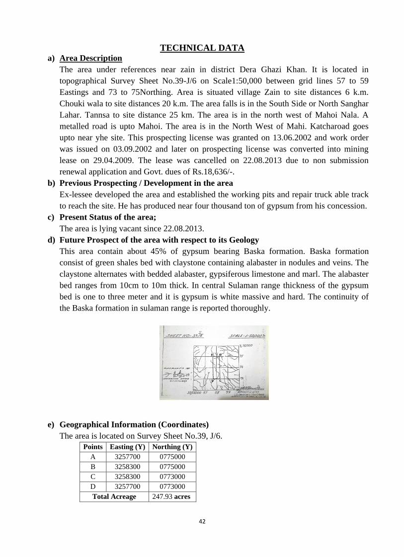
The area under references near zain in district Dera Ghazi Khan. It is located in
topographical Survey Sheet No.39-J/6 on Scale1:50,000 between grid lines 57 to 59
Eastings and 73 to 75Northing. Area is situated village Zain to site distances 6 k.m.
Chouki wala to site distances 20 k.m. The area falls is in the South Side or North Sanghar
Lahar. Tannsa to site distance 25 km. The area is in the north west of Mahoi Nala. A
metalled road is upto Mahoi. The area is in the North West of Mahi. Katcharoad goes
upto near yhe site. This prospecting license was granted on 13.06.2002 and work order
was issued on 03.09.2002 and later on prospecting license was converted into mining
lease on 29.04.2009. The lease was cancelled on 22.08.2013 due to non submission
renewal application and Govt. dues of Rs.18,636/-.
b) Previous Prospecting / Development in the area
Ex-lessee developed the area and established the working pits and repair truck able track
to reach the site. He has produced near four thousand ton of gypsum from his concession.
c) Present Status of the area;
The area is lying vacant since 22.08.2013.
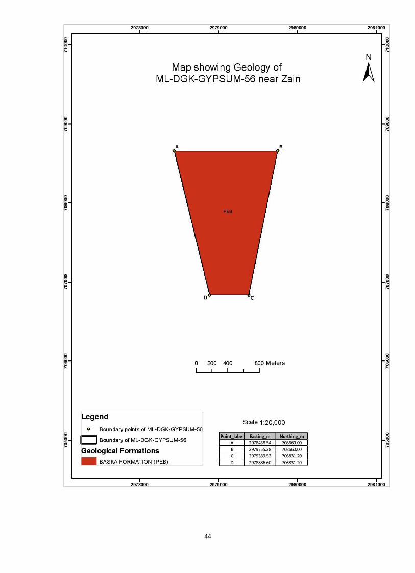
d) Future Prospect of the area with respect to its Geology
This area contain about 45% of gypsum bearing Baska formation. Baska formation
consist of green shales bed with claystone containing alabaster in nodules and veins. The
claystone alternates with bedded alabaster, gypsiferous limestone and marl. The alabaster
bed ranges from 10cm to 10m thick. In central Sulaman range thickness of the gypsum
bed is one to three meter and it is gypsum is white massive and hard. The continuity of
the Baska formation in sulaman range is reported thoroughly.
e) Geographical Information (Coordinates)
The area is located on Survey Sheet No.39, J/6.
Points Easting (Y) Northing (Y)
A 3257700 0775000
B 3258300 0775000
C 3258300 0773000
D 3257700 0773000
Total Acreage 247.93 acres
43
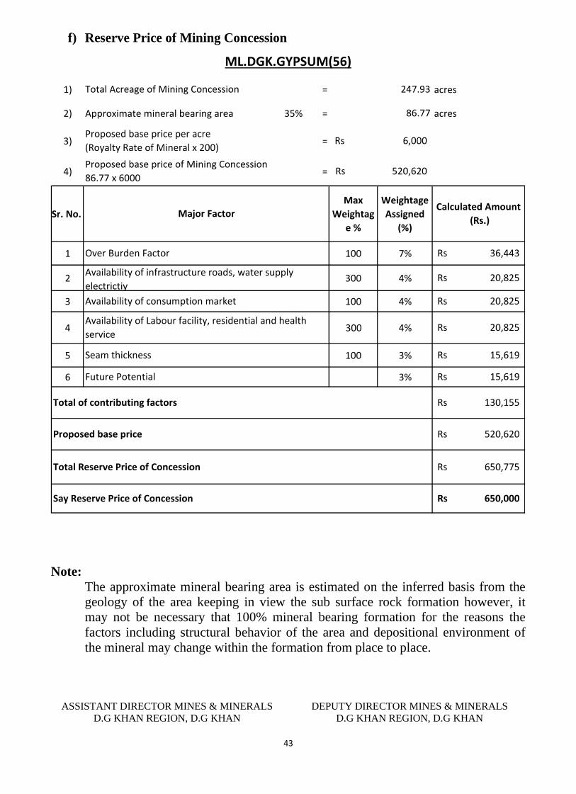
f) Reserve Price of Mining Concession
1) = acres
2) Approximate mineral bearing area 35% = acres
3) =
4) =
Sr. No.
Max
Weightag
e %
Weightage
Assigned
(%)
1 100 7%
2 300 4%
3 100 4%
4 300 4%
5 100 3%
6 3%
Availability of infrastructure roads, water supply
electrictiy
Availability of consumption market
Seam thickness
Future Potential
Proposed base price
650,000Rs Say Reserve Price of Concession
15,619Rs
Total Reserve Price of Concession
130,155Rs
520,620Rs
650,775Rs
Total of contributing factors
15,619Rs
ML.DGK.GYPSUM(56)
Calculated Amount
(Rs.)
20,825Rs
20,825Rs
247.93
86.77
6,000Rs
520,620Rs
Total Acreage of Mining Concession
Proposed base price per acre
(Royalty Rate of Mineral x 200)
Proposed base price of Mining Concession
86.77 x 6000
Major Factor
36,443Rs
20,825Rs
Availability of Labour facility, residential and health
service
Over Burden Factor
Note:
The approximate mineral bearing area is estimated on the inferred basis from the
geology of the area keeping in view the sub surface rock formation however, it
may not be necessary that 100% mineral bearing formation for the reasons the
factors including structural behavior of the area and depositional environment of
the mineral may change within the formation from place to place.
ASSISTANT DIRECTOR MINES & MINERALS
D.G KHAN REGION, D.G KHAN
DEPUTY DIRECTOR MINES & MINERALS
D.G KHAN REGION, D.G KHAN
44
45
Profile of Mining Concession
District Dera Ghazi Khan
DIRECTORATE GENERAL OF MINES AND MINERALS PUNJAB
Profile Summary
Lease Title PL.DGK.GYSUM(144)
Mineral Gypsum
Reserve Status Proved
Acreage 291.00 acres
Location Near Kaura Sori
46
TECHNICAL DATA
a) Area Description
Kora Sori Gypsum deposits of economic importance are located in Kora Sori area
almost 18 miles of NS of Cement Factory.
This prospecting license was granted on 06.08.2004 and work order was issued on
08.11.2004. The lease was cancelled on 18.02.2011 due to none submission of
conversion of application.
b) Previous Prospecting / Development in the area
The ex-lessee did not develop the area on scientific lines and small surface pits
were developed by excavate minerals from the mineral bearing area. About 20 to
30% of the area contain gypsum bearing Baska formation. However a kacha track
was available to approach the working site.
c) Present Status of the area;
The area is lying vacant since 18.02.2011.
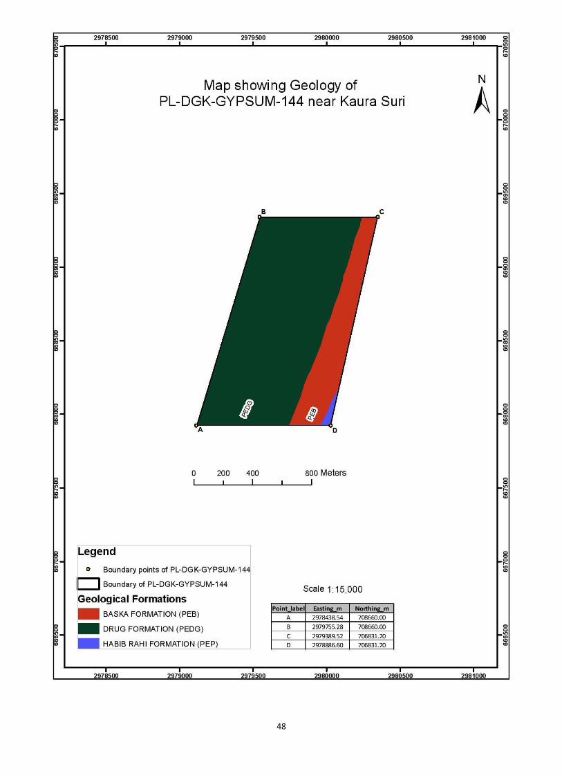
d) Future Prospect of the area with respect to its Geology
Gypsum deposits are found in Baska formation. Lithologically Baska formation
consists of green shales bed with claystone containing alabaster in nodules and
veins. The claystone alternates with bedded alabaster, gypsiferous limestone and
marl. The alabaster bed ranges from 10cm to 10m thick. Structurally the fold belt
is not disturbed like salt range and stratigraphic sequences are continuous younger
to older starting from east to west. The dipping angle range from 50 to 70 degree in
the eastern limb and almost same in the western limb. At the center/ core of
anticline alone hinge line the strata is almost vertical. The Future prospects of the
area relating to Baska formation containing gypsum are sustainable.
e) Geographical Information (Coordinates)
The area is located on Survey Sheet No.39, J/7.
Points Easting (Y) Northing (Y)
A 32”58000 07”30500
B 58470 32000
C 59350 32000
D 59000 30500
Total Acreage 291.00 acres
47
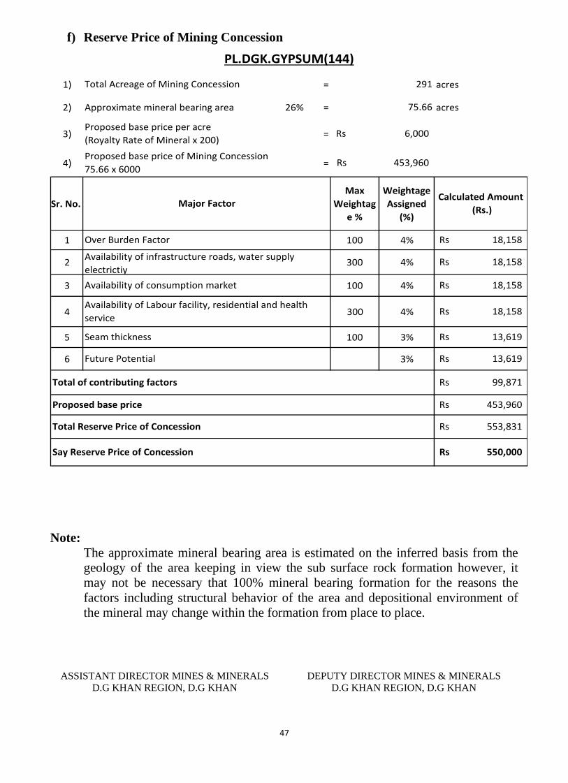
f) Reserve Price of Mining Concession
1) = acres
2) Approximate mineral bearing area 26% = acres
3) =
4) =
Sr. No.
Max
Weightag
e %
Weightage
Assigned
(%)
1 100 4%
2 300 4%
3 100 4%
4 300 4%
5 100 3%
6 3%
Availability of infrastructure roads, water supply
electrictiy
Availability of consumption market
Seam thickness
Future Potential
Proposed base price
550,000Rs Say Reserve Price of Concession
13,619Rs
Total Reserve Price of Concession
99,871Rs
453,960Rs
553,831Rs
Total of contributing factors
13,619Rs
PL.DGK.GYPSUM(144)
Calculated Amount
(Rs.)
18,158Rs
18,158Rs
291
75.66
6,000Rs
453,960Rs
Total Acreage of Mining Concession
Proposed base price per acre
(Royalty Rate of Mineral x 200)
Proposed base price of Mining Concession
75.66 x 6000
Major Factor
18,158Rs
18,158Rs
Availability of Labour facility, residential and health
service
Over Burden Factor
Note:
The approximate mineral bearing area is estimated on the inferred basis from the
geology of the area keeping in view the sub surface rock formation however, it
may not be necessary that 100% mineral bearing formation for the reasons the
factors including structural behavior of the area and depositional environment of
the mineral may change within the formation from place to place.
ASSISTANT DIRECTOR MINES & MINERALS
D.G KHAN REGION, D.G KHAN
DEPUTY DIRECTOR MINES & MINERALS
D.G KHAN REGION, D.G KHAN
48
49
Profile of Mining Concession
District Dera Ghazi Khan
DIRECTORATE GENERAL OF MINES AND MINERALS PUNJAB
Profile Summary
Lease Title PL.DGK.GYSUM(146)
Mineral Gypsum
Reserve Status Proved
Acreage 150.79 acres
Location Near Mohi Nala
50
TECHNICAL DATA
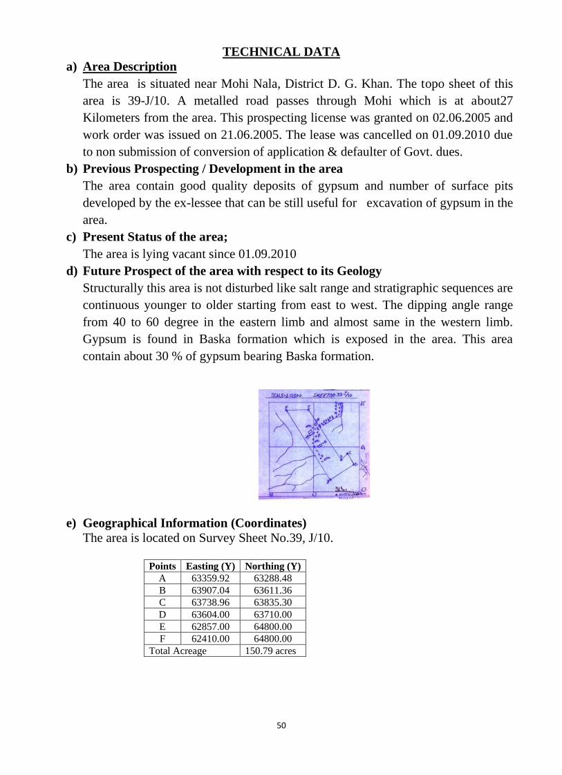
a) Area Description
The area is situated near Mohi Nala, District D. G. Khan. The topo sheet of this
area is 39-J/10. A metalled road passes through Mohi which is at about27
Kilometers from the area. This prospecting license was granted on 02.06.2005 and
work order was issued on 21.06.2005. The lease was cancelled on 01.09.2010 due
to non submission of conversion of application & defaulter of Govt. dues.
b) Previous Prospecting / Development in the area
The area contain good quality deposits of gypsum and number of surface pits
developed by the ex-lessee that can be still useful for excavation of gypsum in the
area.
c) Present Status of the area;
The area is lying vacant since 01.09.2010
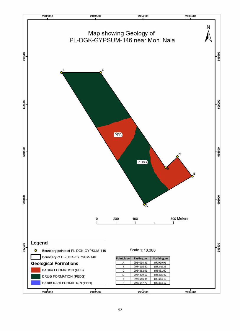
d) Future Prospect of the area with respect to its Geology
Structurally this area is not disturbed like salt range and stratigraphic sequences are
continuous younger to older starting from east to west. The dipping angle range
from 40 to 60 degree in the eastern limb and almost same in the western limb.
Gypsum is found in Baska formation which is exposed in the area. This area
contain about 30 % of gypsum bearing Baska formation.
e) Geographical Information (Coordinates)
The area is located on Survey Sheet No.39, J/10.
Points Easting (Y) Northing (Y)
A 63359.92 63288.48
B 63907.04 63611.36
C 63738.96 63835.30
D 63604.00 63710.00
E 62857.00 64800.00
F 62410.00 64800.00
Total Acreage 150.79 acres
51
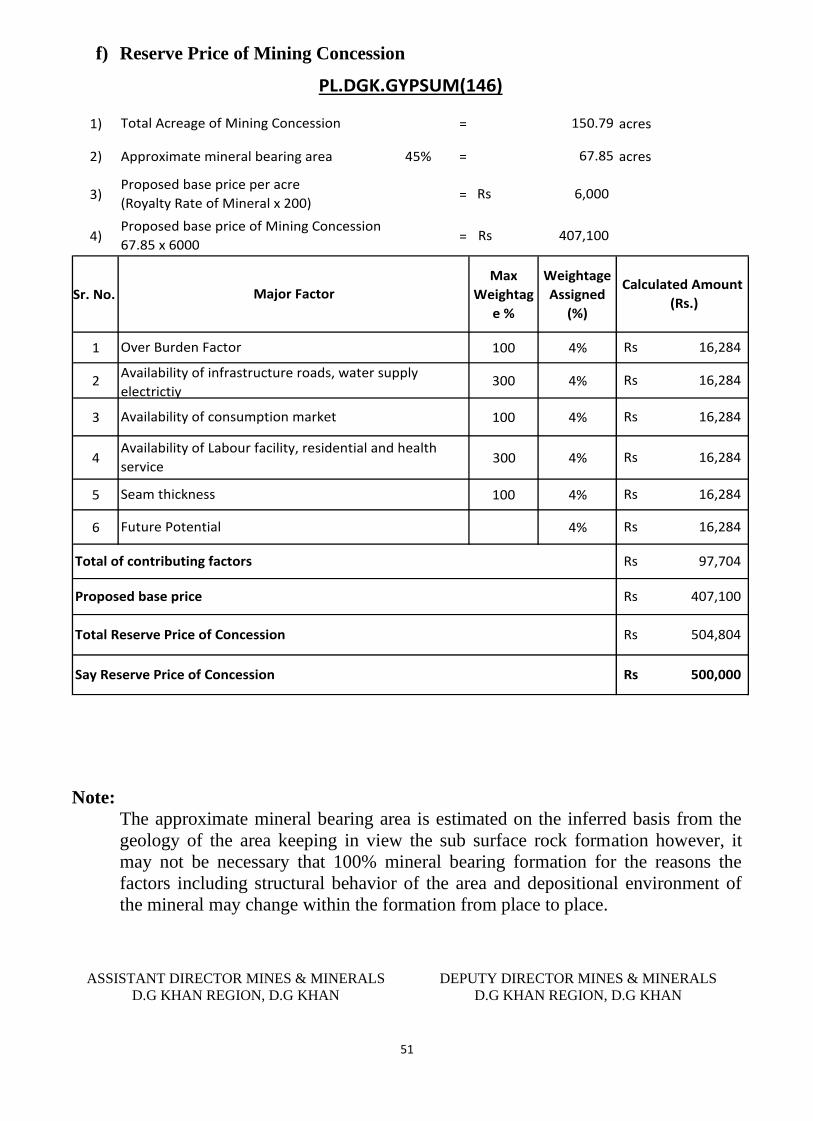
f) Reserve Price of Mining Concession
1) = acres
2) Approximate mineral bearing area 45% = acres
3) =
4) =
Sr. No.
Max
Weightag
e %
Weightage
Assigned
(%)
1 100 4%
2 300 4%
3 100 4%
4 300 4%
5 100 4%
6 4%
16,284Rs
Availability of Labour facility, residential and health
service
Over Burden Factor
Availability of infrastructure roads, water supply
electrictiy
Availability of consumption market
Seam thickness
Future Potential
Proposed base price
500,000Rs Say Reserve Price of Concession
16,284Rs
Total Reserve Price of Concession
97,704Rs
407,100Rs
504,804Rs
Total of contributing factors
16,284Rs
PL.DGK.GYPSUM(146)
Calculated Amount
(Rs.)
16,284Rs
16,284Rs
150.79
67.85
6,000Rs
407,100Rs
Total Acreage of Mining Concession
Proposed base price per acre
(Royalty Rate of Mineral x 200)
Proposed base price of Mining Concession
67.85 x 6000
Major Factor
16,284Rs
Note:
The approximate mineral bearing area is estimated on the inferred basis from the
geology of the area keeping in view the sub surface rock formation however, it
may not be necessary that 100% mineral bearing formation for the reasons the
factors including structural behavior of the area and depositional environment of
the mineral may change within the formation from place to place.
ASSISTANT DIRECTOR MINES & MINERALS
D.G KHAN REGION, D.G KHAN
DEPUTY DIRECTOR MINES & MINERALS
D.G KHAN REGION, D.G KHAN
52
53
Profile of Mining Concession
District Dera Ghazi Khan
DIRECTORATE GENERAL OF MINES AND MINERALS PUNJAB
Profile Summary
Lease Title PL.DGK.GYSUM(155)
Mineral Gypsum
Reserve Status Proved
Acreage 299.55 acres
Location Near Zain
54
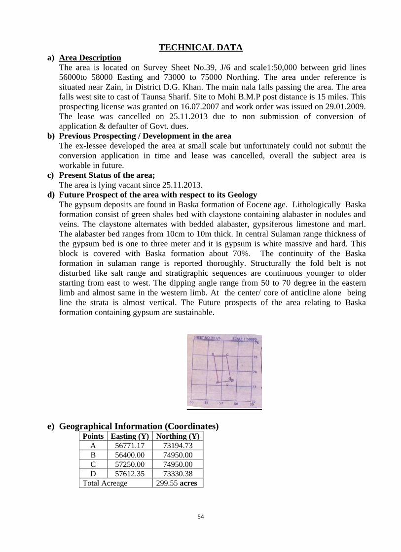
TECHNICAL DATA a) Area Description
The area is located on Survey Sheet No.39, J/6 and scale1:50,000 between grid lines
56000to 58000 Easting and 73000 to 75000 Northing. The area under reference is
situated near Zain, in District D.G. Khan. The main nala falls passing the area. The area
falls west site to cast of Taunsa Sharif. Site to Mohi B.M.P post distance is 15 miles. This
prospecting license was granted on 16.07.2007 and work order was issued on 29.01.2009.
The lease was cancelled on 25.11.2013 due to non submission of conversion of
application & defaulter of Govt. dues.
b) Previous Prospecting / Development in the area
The ex-lessee developed the area at small scale but unfortunately could not submit the
conversion application in time and lease was cancelled, overall the subject area is
workable in future.
c) Present Status of the area;
The area is lying vacant since 25.11.2013.
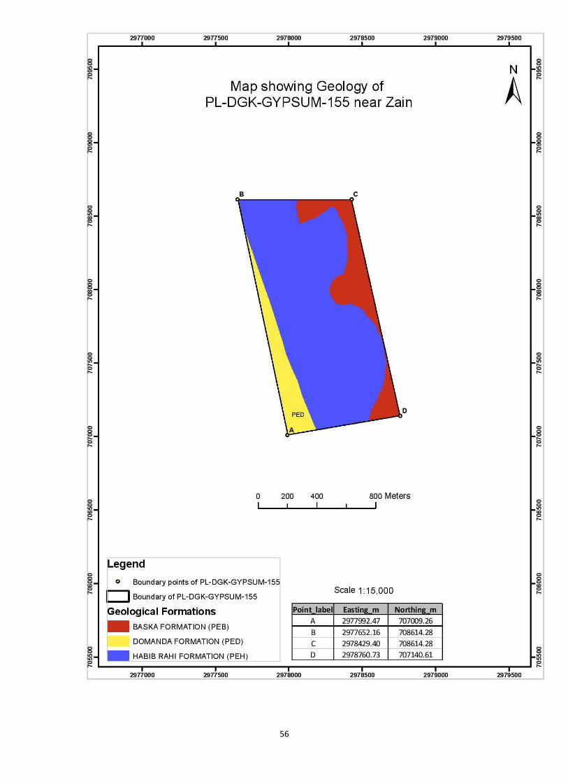
d) Future Prospect of the area with respect to its Geology
The gypsum deposits are found in Baska formation of Eocene age. Lithologically Baska
formation consist of green shales bed with claystone containing alabaster in nodules and
veins. The claystone alternates with bedded alabaster, gypsiferous limestone and marl.
The alabaster bed ranges from 10cm to 10m thick. In central Sulaman range thickness of
the gypsum bed is one to three meter and it is gypsum is white massive and hard. This
block is covered with Baska formation about 70%. The continuity of the Baska
formation in sulaman range is reported thoroughly. Structurally the fold belt is not
disturbed like salt range and stratigraphic sequences are continuous younger to older
starting from east to west. The dipping angle range from 50 to 70 degree in the eastern
limb and almost same in the western limb. At the center/ core of anticline alone being
line the strata is almost vertical. The Future prospects of the area relating to Baska
formation containing gypsum are sustainable.
e) Geographical Information (Coordinates) Points Easting (Y) Northing (Y)
A 56771.17 73194.73
B 56400.00 74950.00
C 57250.00 74950.00
D 57612.35 73330.38
Total Acreage 299.55 acres
55
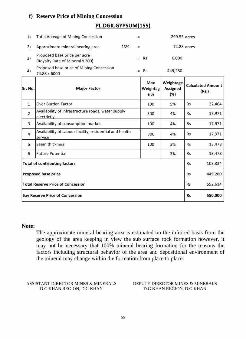
f) Reserve Price of Mining Concession
1) = acres
2) Approximate mineral bearing area 25% = acres
3) =
4) =
Sr. No.
Max
Weightag
e %
Weightage
Assigned
(%)
1 100 5%
2 300 4%
3 100 4%
4 300 4%
5 100 3%
6 3%
17,971Rs
Availability of Labour facility, residential and health
service
Over Burden Factor
Availability of infrastructure roads, water supply
electrictiy
Availability of consumption market
Seam thickness
Future Potential
Proposed base price
550,000Rs Say Reserve Price of Concession
13,478Rs
Total Reserve Price of Concession
103,334Rs
449,280Rs
552,614Rs
Total of contributing factors
13,478Rs
PL.DGK.GYPSUM(155)
Calculated Amount
(Rs.)
17,971Rs
17,971Rs
299.55
74.88
6,000Rs
449,280Rs
Total Acreage of Mining Concession
Proposed base price per acre
(Royalty Rate of Mineral x 200)
Proposed base price of Mining Concession
74.88 x 6000
Major Factor
22,464Rs
Note:
The approximate mineral bearing area is estimated on the inferred basis from the
geology of the area keeping in view the sub surface rock formation however, it
may not be necessary that 100% mineral bearing formation for the reasons the
factors including structural behavior of the area and depositional environment of
the mineral may change within the formation from place to place.
ASSISTANT DIRECTOR MINES & MINERALS
D.G KHAN REGION, D.G KHAN
DEPUTY DIRECTOR MINES & MINERALS
D.G KHAN REGION, D.G KHAN
56

57
Profile of Mining Concession
District Dera Ghazi Khan
DIRECTORATE GENERAL OF MINES AND MINERALS PUNJAB
Profile Summary
Lease Title PL.DGK.GYSUM(159)
Mineral Gypsum
Reserve Status Proved
Acreage 262.39 acres
Location Near Dhadhachi
58
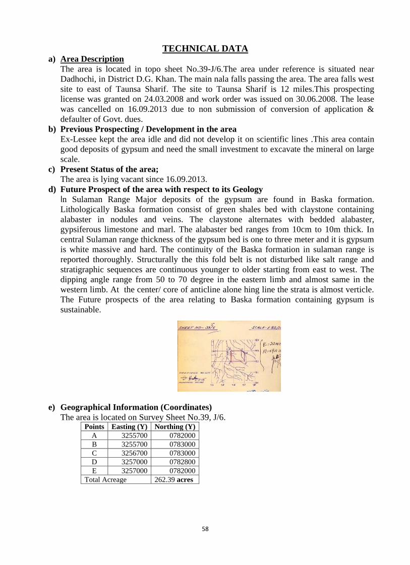
TECHNICAL DATA a) Area Description
The area is located in topo sheet No.39-J/6.The area under reference is situated near
Dadhochi, in District D.G. Khan. The main nala falls passing the area. The area falls west
site to east of Taunsa Sharif. The site to Taunsa Sharif is 12 miles.This prospecting
license was granted on 24.03.2008 and work order was issued on 30.06.2008. The lease
was cancelled on 16.09.2013 due to non submission of conversion of application &
defaulter of Govt. dues.
b) Previous Prospecting / Development in the area
Ex-Lessee kept the area idle and did not develop it on scientific lines .This area contain
good deposits of gypsum and need the small investment to excavate the mineral on large
scale.
c) Present Status of the area;
The area is lying vacant since 16.09.2013.
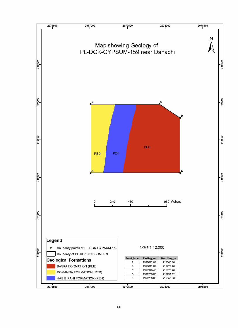
d) Future Prospect of the area with respect to its Geology
In Sulaman Range Major deposits of the gypsum are found in Baska formation.
Lithologically Baska formation consist of green shales bed with claystone containing
alabaster in nodules and veins. The claystone alternates with bedded alabaster,
gypsiferous limestone and marl. The alabaster bed ranges from 10cm to 10m thick. In
central Sulaman range thickness of the gypsum bed is one to three meter and it is gypsum
is white massive and hard. The continuity of the Baska formation in sulaman range is
reported thoroughly. Structurally the this fold belt is not disturbed like salt range and
stratigraphic sequences are continuous younger to older starting from east to west. The
dipping angle range from 50 to 70 degree in the eastern limb and almost same in the
western limb. At the center/ core of anticline alone hing line the strata is almost verticle.
The Future prospects of the area relating to Baska formation containing gypsum is
sustainable.
e) Geographical Information (Coordinates)
The area is located on Survey Sheet No.39, J/6. Points Easting (Y) Northing (Y)
A 3255700 0782000
B 3255700 0783000
C 3256700 0783000
D 3257000 0782800
E 3257000 0782000
Total Acreage 262.39 acres
59
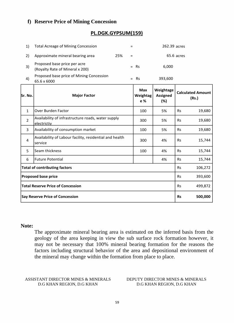
f) Reserve Price of Mining Concession
1) = acres
2) Approximate mineral bearing area 25% = acres
3) =
4) =
Sr. No.
Max
Weightag
e %
Weightage
Assigned
(%)
1 100 5%
2 300 5%
3 100 5%
4 300 4%
5 100 4%
6 4%
19,680Rs
Availability of Labour facility, residential and health
service
Over Burden Factor
Availability of infrastructure roads, water supply
electrictiy
Availability of consumption market
Seam thickness
Future Potential
Proposed base price
500,000Rs Say Reserve Price of Concession
15,744Rs
Total Reserve Price of Concession
106,272Rs
393,600Rs
499,872Rs
Total of contributing factors
15,744Rs
PL.DGK.GYPSUM(159)
Calculated Amount
(Rs.)
19,680Rs
15,744Rs
262.39
65.6
6,000Rs
393,600Rs
Total Acreage of Mining Concession
Proposed base price per acre
(Royalty Rate of Mineral x 200)
Proposed base price of Mining Concession
65.6 x 6000
Major Factor
19,680Rs
Note:
The approximate mineral bearing area is estimated on the inferred basis from the
geology of the area keeping in view the sub surface rock formation however, it
may not be necessary that 100% mineral bearing formation for the reasons the
factors including structural behavior of the area and depositional environment of
the mineral may change within the formation from place to place.
ASSISTANT DIRECTOR MINES & MINERALS
D.G KHAN REGION, D.G KHAN
DEPUTY DIRECTOR MINES & MINERALS
D.G KHAN REGION, D.G KHAN
60

61
Profile of Mining Concession
District Dera Ghazi Khan
DIRECTORATE GENERAL OF MINES AND MINERALS PUNJAB
Profile Summary
Lease Title PL.DGK.GYSUM(160)
Mineral Gypsum
Reserve Status Proved
Acreage 231.40 acres
Location Near Mohi Nala
62
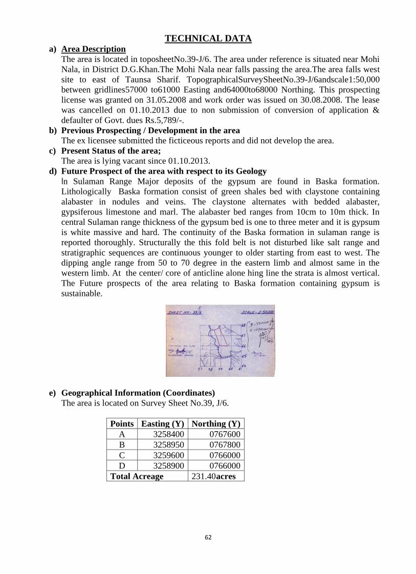
TECHNICAL DATA a) Area Description
The area is located in toposheetNo.39-J/6. The area under reference is situated near Mohi
Nala, in District D.G.Khan.The Mohi Nala near falls passing the area.The area falls west
site to east of Taunsa Sharif. TopographicalSurveySheetNo.39-J/6andscale1:50,000
between gridlines57000 to61000 Easting and64000to68000 Northing. This prospecting
license was granted on 31.05.2008 and work order was issued on 30.08.2008. The lease
was cancelled on 01.10.2013 due to non submission of conversion of application &
defaulter of Govt. dues Rs.5,789/-.
b) Previous Prospecting / Development in the area
The ex licensee submitted the ficticeous reports and did not develop the area.
c) Present Status of the area;
The area is lying vacant since 01.10.2013.
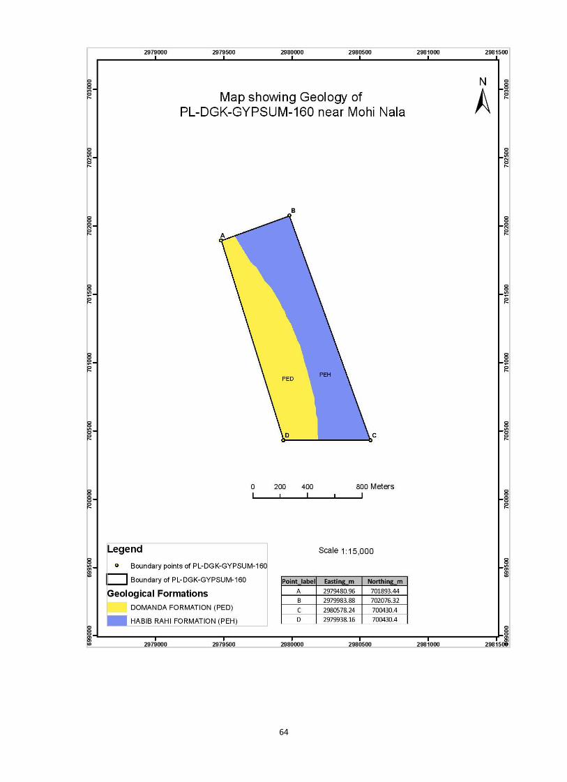
d) Future Prospect of the area with respect to its Geology
In Sulaman Range Major deposits of the gypsum are found in Baska formation.
Lithologically Baska formation consist of green shales bed with claystone containing
alabaster in nodules and veins. The claystone alternates with bedded alabaster,
gypsiferous limestone and marl. The alabaster bed ranges from 10cm to 10m thick. In
central Sulaman range thickness of the gypsum bed is one to three meter and it is gypsum
is white massive and hard. The continuity of the Baska formation in sulaman range is
reported thoroughly. Structurally the this fold belt is not disturbed like salt range and
stratigraphic sequences are continuous younger to older starting from east to west. The
dipping angle range from 50 to 70 degree in the eastern limb and almost same in the
western limb. At the center/ core of anticline alone hing line the strata is almost vertical.
The Future prospects of the area relating to Baska formation containing gypsum is
sustainable.
e) Geographical Information (Coordinates)
The area is located on Survey Sheet No.39, J/6.
Points Easting (Y) Northing (Y)
A 3258400 0767600
B 3258950 0767800
C 3259600 0766000
D 3258900 0766000
Total Acreage 231.40 acres

63
f) Reserve Price of Mining Concession
1) = acres
2) Approximate mineral bearing area 30% = acres
3) =
4) =
Sr. No.
Max
Weightag
e %
Weightage
Assigned
(%)
1 100 4%
2 300 4%
3 100 4%
4 300 4%
5 100 2%
6 2%
16,661Rs
Availability of Labour facility, residential and health
service
Over Burden Factor
Availability of infrastructure roads, water supply
electrictiy
Availability of consumption market
Seam thickness
Future Potential
Proposed base price
500,000Rs Say Reserve Price of Concession
8,330Rs
Total Reserve Price of Concession
83,304Rs
416,520Rs
499,824Rs
Total of contributing factors
8,330Rs
PL.DGK.GYPSUM(160)
Calculated Amount
(Rs.)
16,661Rs
16,661Rs
231.40
69.42
6,000Rs
416,520Rs
Total Acreage of Mining Concession
Proposed base price per acre
(Royalty Rate of Mineral x 200)
Proposed base price of Mining Concession
69.42 x 6000
Major Factor
16,661Rs
Note:
The approximate mineral bearing area is estimated on the inferred basis from the
geology of the area keeping in view the sub surface rock formation however, it
may not be necessary that 100% mineral bearing formation for the reasons the
factors including structural behavior of the area and depositional environment of
the mineral may change within the formation from place to place.
ASSISTANT DIRECTOR MINES & MINERALS
D.G KHAN REGION, D.G KHAN
DEPUTY DIRECTOR MINES & MINERALS
D.G KHAN REGION, D.G KHAN
64
65
Profile of Mining Concession
District Dera Ghazi Khan
DIRECTORATE GENERAL OF MINES AND MINERALS PUNJAB
Profile Summary
Lease Title PL.DGK.GYSUM(165)
Mineral Gypsum
Reserve Status Proved
Acreage 296.60 acres
Location Near Chapri
66
TECHNICAL DATA
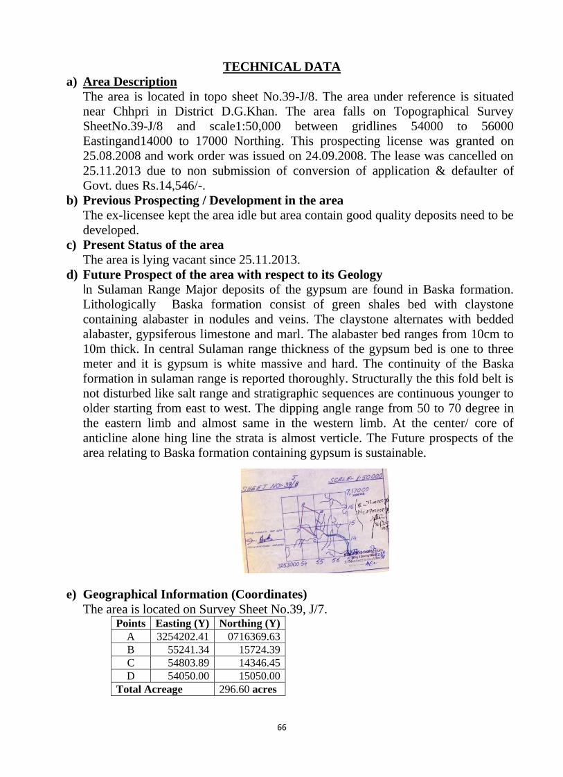
a) Area Description
The area is located in topo sheet No.39-J/8. The area under reference is situated
near Chhpri in District D.G.Khan. The area falls on Topographical Survey
SheetNo.39-J/8 and scale1:50,000 between gridlines 54000 to 56000
Eastingand14000 to 17000 Northing. This prospecting license was granted on
25.08.2008 and work order was issued on 24.09.2008. The lease was cancelled on
25.11.2013 due to non submission of conversion of application & defaulter of
Govt. dues Rs.14,546/-.
b) Previous Prospecting / Development in the area
The ex-licensee kept the area idle but area contain good quality deposits need to be
developed.
c) Present Status of the area
The area is lying vacant since 25.11.2013.
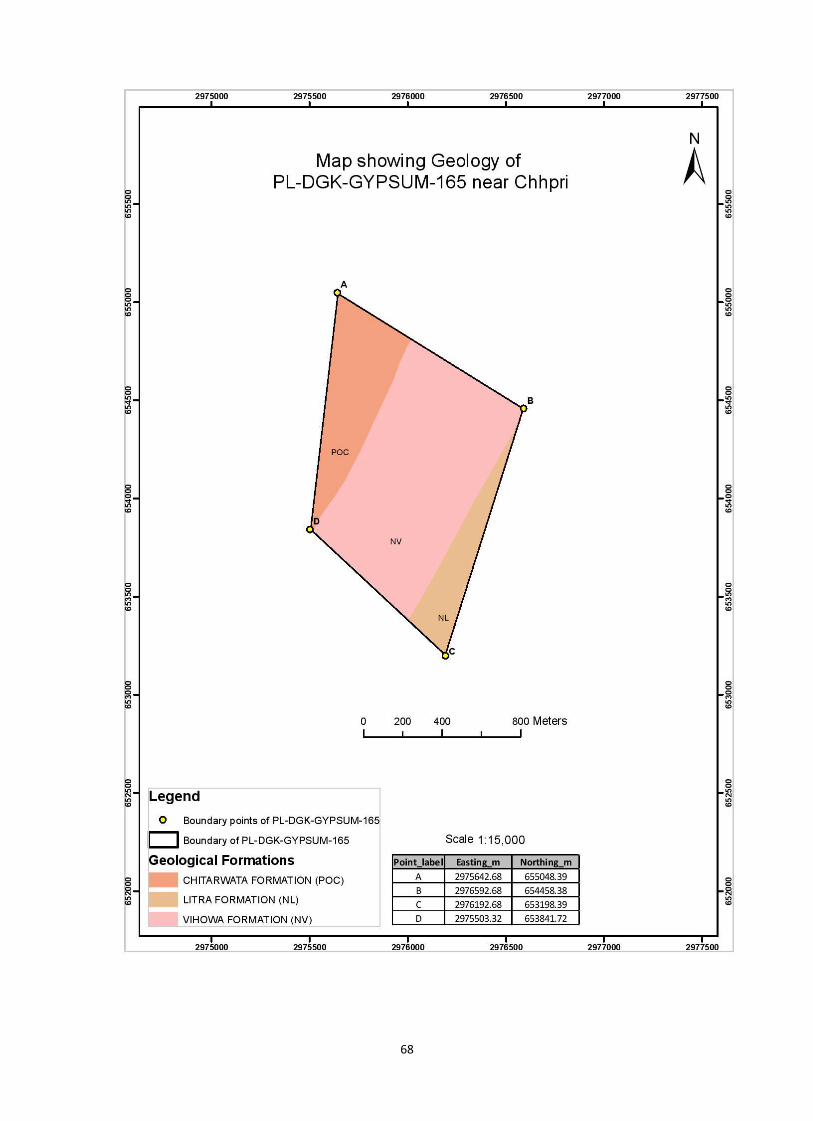
d) Future Prospect of the area with respect to its Geology
In Sulaman Range Major deposits of the gypsum are found in Baska formation.
Lithologically Baska formation consist of green shales bed with claystone
containing alabaster in nodules and veins. The claystone alternates with bedded
alabaster, gypsiferous limestone and marl. The alabaster bed ranges from 10cm to
10m thick. In central Sulaman range thickness of the gypsum bed is one to three
meter and it is gypsum is white massive and hard. The continuity of the Baska
formation in sulaman range is reported thoroughly. Structurally the this fold belt is
not disturbed like salt range and stratigraphic sequences are continuous younger to
older starting from east to west. The dipping angle range from 50 to 70 degree in
the eastern limb and almost same in the western limb. At the center/ core of
anticline alone hing line the strata is almost verticle. The Future prospects of the
area relating to Baska formation containing gypsum is sustainable.
e) Geographical Information (Coordinates)
The area is located on Survey Sheet No.39, J/7. Points Easting (Y) Northing (Y)
A 3254202.41 0716369.63
B 55241.34 15724.39
C 54803.89 14346.45
D 54050.00 15050.00
Total Acreage 296.60 acres
67
f) Reserve Price of Mining Concession
1) = acres
2) Approximate mineral bearing area 25% = acres
3) =
4) =
Sr. No.
Max
Weightag
e %
Weightage
Assigned
(%)
1 100 4%
2 300 4%
3 100 4%
4 300 4%
5 100 4%
6 4%
17,796Rs
Availability of Labour facility, residential and health
service
Over Burden Factor
Availability of infrastructure roads, water supply
electrictiy
Availability of consumption market
Seam thickness
Future Potential
Proposed base price
550,000Rs Say Reserve Price of Concession
17,796Rs
Total Reserve Price of Concession
106,776Rs
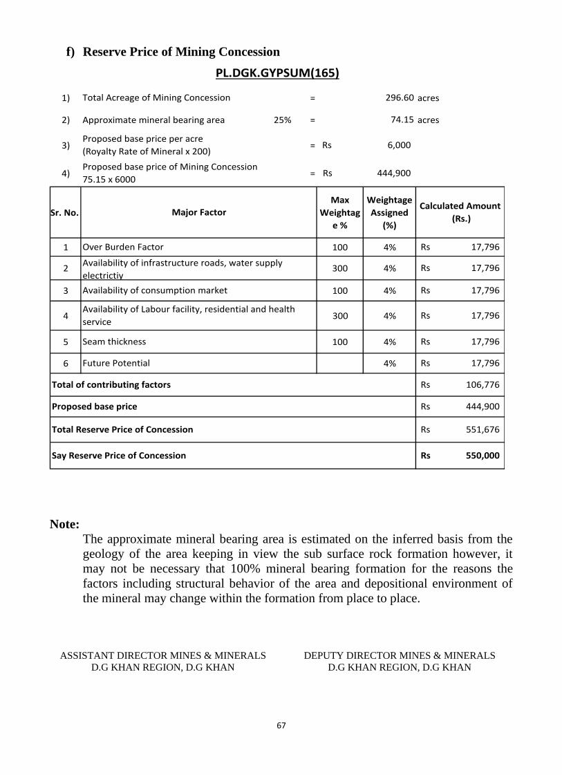
444,900Rs
551,676Rs
Total of contributing factors
17,796Rs
PL.DGK.GYPSUM(165)
Calculated Amount
(Rs.)
17,796Rs
17,796Rs
296.60
74.15
6,000Rs
444,900Rs
Total Acreage of Mining Concession
Proposed base price per acre
(Royalty Rate of Mineral x 200)
Proposed base price of Mining Concession
75.15 x 6000
Major Factor
17,796Rs
Note:
The approximate mineral bearing area is estimated on the inferred basis from the
geology of the area keeping in view the sub surface rock formation however, it
may not be necessary that 100% mineral bearing formation for the reasons the
factors including structural behavior of the area and depositional environment of
the mineral may change within the formation from place to place.
ASSISTANT DIRECTOR MINES & MINERALS
D.G KHAN REGION, D.G KHAN
DEPUTY DIRECTOR MINES & MINERALS
D.G KHAN REGION, D.G KHAN
68
69
Profile of Mining Concession
District Dera Ghazi Khan
DIRECTORATE GENERAL OF MINES AND MINERALS PUNJAB
Profile Summary
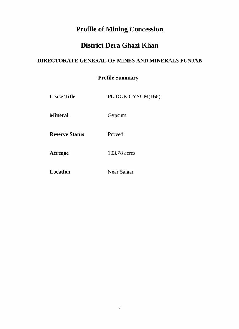
Lease Title PL.DGK.GYSUM(166)
Mineral Gypsum
Reserve Status Proved
Acreage 103.78 acres
Location Near Salaar
70
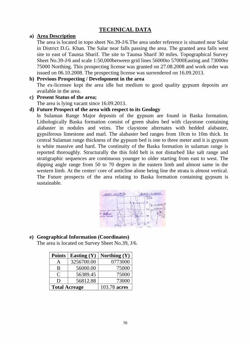
TECHNICAL DATA a) Area Description
The area is located in topo sheet No.39-J/6.The area under reference is situated near Salar
in District D.G. Khan. The Salar near falls passing the area. The granted area falls west
site to east of Taunsa Sharif. The site to Taunsa Sharif 30 miles. Topographical Survey
Sheet No.39-J/6 and scale 1:50,000between grid lines 56000to 57000Easting and 73000to
75000 Northing. This prospecting license was granted on 27.08.2008 and work order was
issued on 06.10.2008. The prospecting license was surrendered on 16.09.2013.
b) Previous Prospecting / Development in the area
The ex-licensee kept the area idle but medium to good quality gypsum deposits are
available in the area.
c) Present Status of the area;
The area is lying vacant since 16.09.2013.
d) Future Prospect of the area with respect to its Geology
In Sulaman Range Major deposits of the gypsum are found in Baska formation.
Lithologically Baska formation consist of green shales bed with claystone containing
alabaster in nodules and veins. The claystone alternates with bedded alabaster,
gypsiferous limestone and marl. The alabaster bed ranges from 10cm to 10m thick. In
central Sulaman range thickness of the gypsum bed is one to three meter and it is gypsum
is white massive and hard. The continuity of the Baska formation in sulaman range is
reported thoroughly. Structurally the this fold belt is not disturbed like salt range and
stratigraphic sequences are continuous younger to older starting from east to west. The
dipping angle range from 50 to 70 degree in the eastern limb and almost same in the
western limb. At the center/ core of anticline alone being line the strata is almost vertical.
The Future prospects of the area relating to Baska formation containing gypsum is
sustainable.
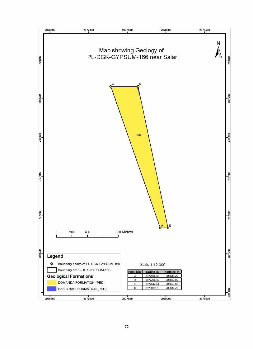
e) Geographical Information (Coordinates)
The area is located on Survey Sheet No.39, J/6.
Points Easting (Y) Northing (Y)
A 3256700.00 0773000
B 56000.00 75000
C 56389.45 75000
D 56812.88 73000
Total Acreage 103.78 acres
71
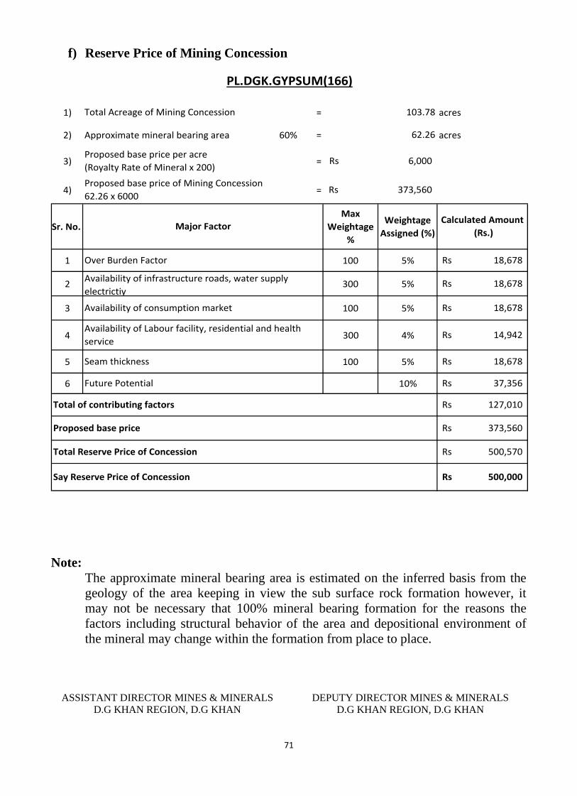
f) Reserve Price of Mining Concession
1) = acres
2) Approximate mineral bearing area 60% = acres
3) =
4) =
Sr. No.
Max
Weightage
%
Weightage
Assigned (%)
1 100 5%
2 300 5%
3 100 5%
4 300 4%
5 100 5%
6 10%
18,678Rs
Availability of Labour facility, residential and health
service
Over Burden Factor
Availability of infrastructure roads, water supply
electrictiy
Availability of consumption market
Seam thickness
Future Potential
Proposed base price
500,000Rs Say Reserve Price of Concession
37,356Rs
Total Reserve Price of Concession
127,010Rs
373,560Rs
500,570Rs
Total of contributing factors
18,678Rs
PL.DGK.GYPSUM(166)
Calculated Amount
(Rs.)
18,678Rs
14,942Rs
103.78
62.26
6,000Rs
373,560Rs
Total Acreage of Mining Concession
Proposed base price per acre
(Royalty Rate of Mineral x 200)
Proposed base price of Mining Concession
62.26 x 6000
Major Factor
18,678Rs
Note:
The approximate mineral bearing area is estimated on the inferred basis from the
geology of the area keeping in view the sub surface rock formation however, it
may not be necessary that 100% mineral bearing formation for the reasons the
factors including structural behavior of the area and depositional environment of
the mineral may change within the formation from place to place.
ASSISTANT DIRECTOR MINES & MINERALS
D.G KHAN REGION, D.G KHAN
DEPUTY DIRECTOR MINES & MINERALS
D.G KHAN REGION, D.G KHAN
72
73
Profile of Mining Concession
District Dera Ghazi Khan
DIRECTORATE GENERAL OF MINES AND MINERALS PUNJAB
Profile Summary
Lease Title PL.DGK.GYSUM(171)
Mineral Gypsum
Reserve Status Proved
Acreage 133.41 acres
Location Near Khalgari
74
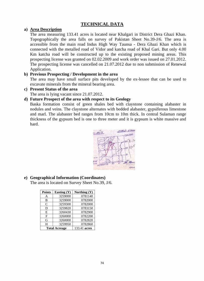
TECHNICAL DATA a) Area Description
The area measuring 133.41 acres is located near Khalgari in District Dera Ghazi Khan.
Topographically the area falls on survey of Pakistan Sheet No.39-J/6. The area is
accessible from the main road Indus High Way Taunsa - Dera Ghazi Khan which is
connected with the metalled road of Vidor and katcha road of Khal Gari. But only 4.00
Km katcha road will be constructed up to the existing proposed mining areas. This
prospecting license was granted on 02.02.2009 and work order was issued on 27.01.2012.
The prospecting license was cancelled on 21.07.2012 due to non submission of Renewal
Application.
b) Previous Prospecting / Development in the area
The area may have small surface pits developed by the ex-lessee that can be used to
excavate minerals from the mineral bearing area.
c) Present Status of the area
The area is lying vacant since 21.07.2012.
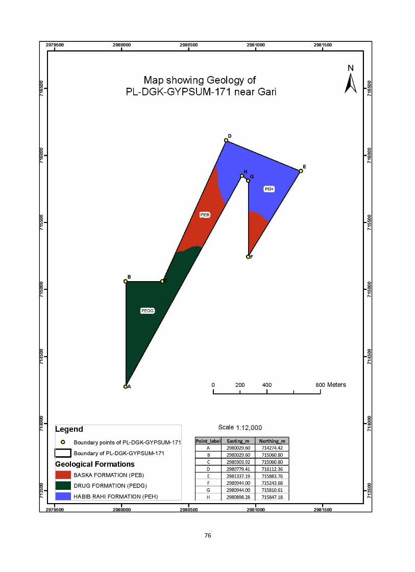
d) Future Prospect of the area with respect to its Geology
Baska formation consist of green shales bed with claystone containing alabaster in
nodules and veins. The claystone alternates with bedded alabaster, gypsiferous limestone
and marl. The alabaster bed ranges from 10cm to 10m thick. In central Sulaman range
thickness of the gypsum bed is one to three meter and it is gypsum is white massive and
hard.
e) Geographical Information (Coordinates)
The area is located on Survey Sheet No.39, J/6.
Points Easting (Y) Northing (Y)
A 3259000 0781140
B 3259000 0782000
C 3259300 0782000
D 3259820 0783150
E 3260430 0782900
F 3260000 0782200
G 3260000 0782820
H 3259950 0782860
Total Acreage 133.41 acres
75
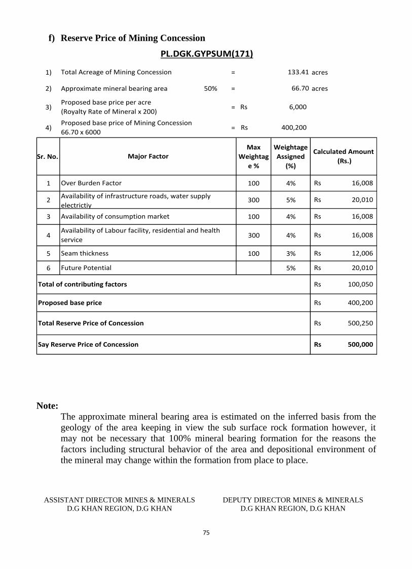
f) Reserve Price of Mining Concession
1) = acres
2) Approximate mineral bearing area 50% = acres
3) =
4) =
Sr. No.
Max
Weightag
e %
Weightage
Assigned
(%)
1 100 4%
2 300 5%
3 100 4%
4 300 4%
5 100 3%
6 5%
20,010Rs
Availability of Labour facility, residential and health
service
Over Burden Factor
Availability of infrastructure roads, water supply
electrictiy
Availability of consumption market
Seam thickness
Future Potential
Proposed base price
500,000Rs Say Reserve Price of Concession
20,010Rs
Total Reserve Price of Concession
100,050Rs
400,200Rs
500,250Rs
Total of contributing factors
12,006Rs
PL.DGK.GYPSUM(171)
Calculated Amount
(Rs.)
16,008Rs
16,008Rs
133.41
66.70
6,000Rs
400,200Rs
Total Acreage of Mining Concession
Proposed base price per acre
(Royalty Rate of Mineral x 200)
Proposed base price of Mining Concession
66.70 x 6000
Major Factor
16,008Rs
Note:
The approximate mineral bearing area is estimated on the inferred basis from the
geology of the area keeping in view the sub surface rock formation however, it
may not be necessary that 100% mineral bearing formation for the reasons the
factors including structural behavior of the area and depositional environment of
the mineral may change within the formation from place to place.
ASSISTANT DIRECTOR MINES & MINERALS
D.G KHAN REGION, D.G KHAN
DEPUTY DIRECTOR MINES & MINERALS
D.G KHAN REGION, D.G KHAN
76


