Embed Size (px)
Citation preview

Carveni P., Benfatto S., Imposa S., Mele G. (2012). Proposal of a geomorphosite for a small glacial valley on the northeastern flank of the Mount Etna volcano (Sicily). In: C. Giusti (Ed.), Geomorphosites 2009: raising the profile of geomorphological heritage through iconography, inventory and promotion, Paris Sorbonne Université, Paris, pp. 50-54.

Géomorphosites 2009 : imagerie, inventaire, mise en valeur et vulgarisation du patrimoine géomorphologiqueGeomorphosites 2009: raising the profile of geomorphological heritage
through iconography, inventory and promotionParis-Sorbonne Université
Proposal of a geomorphosite for a small glacial valleyon the northeastern flank of the Mount Etna volcano (Sicily)
Carveni P.1, Benfatto S.1, Imposa S.1, Mele G.2
1Dipartimento di Scienze GeologicheUniversità di Catania, Corso Italia, 57 – 95129 Catania
2Istituto Nazionale di Geofisica e VulcanologiaVia di Vigna Murata, 605 – 00143 Roma
AbstractMount Etna is the largest active volcano of Europe and the highest mountain (about 3,330 m a.s.l.) of peninsular and insular Italy; moreover, during the Last Glacial Maximum (LGM, 25,000 ÷ 14,000 years BP) it was some hundreds meters higher than today. Since other mountains of the Apennines were covered by glaciers during the Upper Pleistocene, several authors hypothesized that a glacial cover could have been also present on Mount Etna during the LGM, being the estimated limit of perpetual snow around 2,500 m a.s.l. at that time and latitude. We have carried out a morphological survey in a portion of the volcanic edifice where rocks older than the LGM outcrop. This portion includes Punta Lucia, on the NW slope, and Serra delle Concazze, on the NE slope. Along the upper part of the northeastern slope of Etna we have found a small valley, about 170 m long, 15 m wide and 7 m deep, characterized by a clear U-shaped section, that we interpreted to be of glacial origin.The search for moraine deposits that could be ascribed to the activity of the hypothesized glacier was unsuccessful so far and is also complicated by the presence of vegetation and recent lava and tephra deposits covering the volcano flanks. We are aware that this valley should be considered as a possible geomorphosite to guarantee its preservation and further study.
Association Internationale des Géomorphologues (AIG) – International Association of Geomorphologists (IAG)Groupe de travail sur les Géomorphosites – Working Group on Geomorphosites
Groupe français de Géomorphologie (GFG) – Fédération française des Géosciences (FFG)
50

Géomorphosites 2009 : imagerie, inventaire, mise en valeur et vulgarisation du patrimoine géomorphologiqueGeomorphosites 2009: raising the profile of geomorphological heritage
through iconography, inventory and promotionParis-Sorbonne Université
RésuméProposition de géomorphosite glaciaire sur le versant Nord-Est du volcan Etna (Sicile). – Le mont Etna est le plus grand volcan actif du continent européen (environ 3 300 mètres d’altitude). Au cours du dernier maximum glaciaire (25 000 ÷ 14 000 ans BP), l’Etna culminait environ 700 mètres plus haut que de nos jours. En considérant le fait que les autres montagnes de l’Apennin ont été couvertes par des glaciers au cours du Pléistocène Supérieur, plusieurs auteurs ont proposé une possible couverture glaciaire de l’Etna au cours de la dernière glaciation. Il a aussi été supposé que, à cette époque, la limite des neiges permanentes se tenait sur l’Etna à 2 500 mètres. Les roches volcaniques antérieures au dernier maximum glaciaire affleurent à Punta Lucia sur le versant Nord-Ouest, et à Serra delle Concazze sur le versant Nord-Est.Sur la haute côte nord-est de l’Etna il y a une petite vallée qui a un profil transversal en forme de “U”, typique des vallées glaciaires. La vallée est longue 170 mètres et a une largeur moyenne de 15 mètres et une profondeur de 7 mètres. En hiver, cette vallée est souvent recouverte de neige, et dans les cas d’événements pyroclastiques, elle est souvent remplie par des dépôts épais de cendres et de lapilli.À cause de l'intensité du couvert forestier, ainsi que des coulées de lave et des dépôts pyroclastiques qui cachent les rochers des côtés de l’Etna, aucun dépôt morainique n’a été trouvé jusqu’à présent. Une telle découverte pourrait confirmer l’origine glaciaire de cette vallée.
Extended Abstract1. IntroductionThe term geomorphosite is used to define a part of the Earth’s surface that is of particular importance for the knowledge of the Earth, climate and life history (Reynard, 2004). In this article we focus on a small valley located on the upper part of the northeastern flank of the Mount Etna volcano, where evidence of glacial morphology has been recognized (Carveni et al., 2007), and propose this area as a possible geomorphosite.It is well known that Pleistocene glacial events in the Apennines and other circum-Mediterranean mountains were irrelevant with respect to the Alps. Pleistocene glaciations in the Mediterranean region were in fact of small extent and discontinuous. For this reason the identification of morphologies related to extinct glaciers is very important from a paleoclimatic viewpoint.The first hypothesis that glaciers could have formed on Mount Etna during the Upper Pleistocene was proposed by Maier (1929) and later re-considered by Vagliasindi (1949). This author hypothesized that some of the summit zones of the volcano and the large depression of Valle del Bove were glacial cirques, from where glacial tongues at times extended down to the Ionian Sea. However, even though many researches were carried out from time to time to verify this hypothesis, no evidence of the presence of glaciers in the past has been found so far.At the latitude of Mt. Etna the present-day limit of perpetual snow is 3,500 m a.s.l. (Messerli, 1980), while it was estimated to be around 2,500 m or slightly lower during the Last Glacial Maximum (LGM, 25,000 ÷ 14,000 years BP) (Neri et al., 1994; Neri, 2002). At that time the Etna volcano was higher than today, culminating with the eruptive center called Ellittico at an elevation exceeding 3,700 m a.s.l.. Its activity ended about 15,000 years ago with the formation of a caldera, whose remnants can still be recognized on the NE slope, along the ridge extending from Pizzi Deneri, (PD, ~ 2,800 m a.s.l.) to Serra delle Concazze, and on the NW slope, at Punta Lucia (PL, ~ 2,900 m a.s.l.) (Fig. 1) (Romano & Guest, 1979; Kieffer, 1985).
2. The study areaThe study area is located on the upper part of the northeastern flank of Mt. Etna (Fig. 1-2). The maximum elevation is reached at its western edge, along the Valle del Bove rim.Following Romano et al. (1979), in this portion of the volcanic edifice outcrop products of the eruptive phase called Mongibello Antico (35,000 ÷ 15,000 years BP) that are consistent with the timing of a possible glacial coverage of the slope. Portions of this slope have been covered by lava flows during the 1928, 1971 and 1979 eruptions.
Association Internationale des Géomorphologues (AIG) – International Association of Geomorphologists (IAG)Groupe de travail sur les Géomorphosites – Working Group on Geomorphosites
Groupe français de Géomorphologie (GFG) – Fédération française des Géosciences (FFG)
51

Géomorphosites 2009 : imagerie, inventaire, mise en valeur et vulgarisation du patrimoine géomorphologiqueGeomorphosites 2009: raising the profile of geomorphological heritage
through iconography, inventory and promotionParis-Sorbonne Université
Figure 1 – Geologic sketch of the Etna summit area. A: post-Last Glacial Maximum (LGM) volcanics; B: pre-LGM volcanics; C: crater edges (CC: Central Craters area, MC: Monte Concazza, MF: Monte Frumento, MR: Monte Rinatu, PD: Pizzi Deneri,PL: Punta Lucia);
D: buried caldera edges; E: caldera edges; F: location of the glacial valley hypothesized in this study; G: study area. The upper portion of the North-East Rift (RNE) and the depression of
Valle del Bove are also indicated.
Figure 2 – Aerial view of the NE Etna flank. Arrow indicates the hypothesized glacial valley.
Association Internationale des Géomorphologues (AIG) – International Association of Geomorphologists (IAG)Groupe de travail sur les Géomorphosites – Working Group on Geomorphosites
Groupe français de Géomorphologie (GFG) – Fédération française des Géosciences (FFG)
52
Géomorphosites 2009 : imagerie, inventaire, mise en valeur et vulgarisation du patrimoine géomorphologiqueGeomorphosites 2009: raising the profile of geomorphological heritage
through iconography, inventory and promotionParis-Sorbonne Université
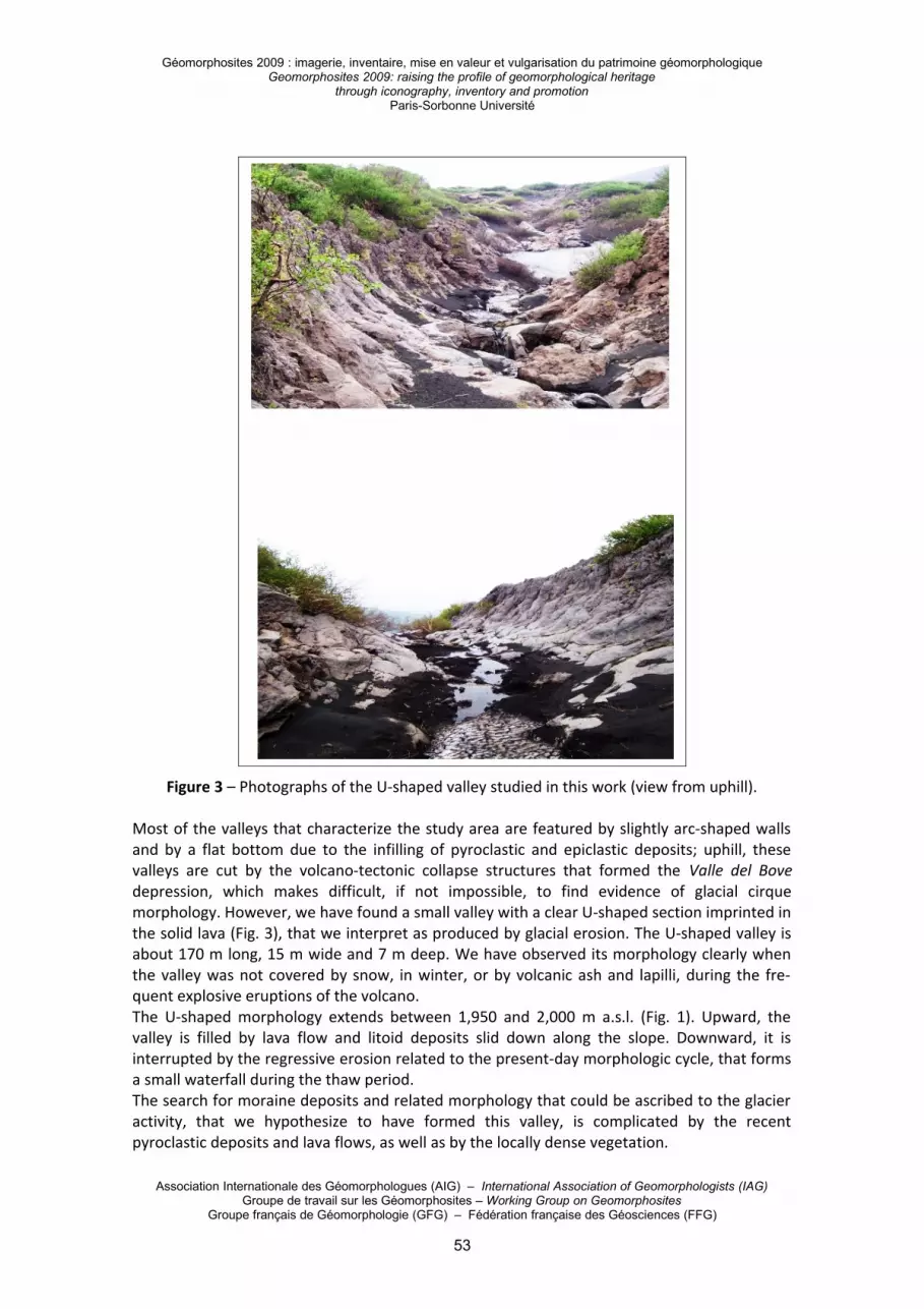
Figure 3 – Photographs of the U-shaped valley studied in this work (view from uphill).
Most of the valleys that characterize the study area are featured by slightly arc-shaped walls and by a flat bottom due to the infilling of pyroclastic and epiclastic deposits; uphill, these valleys are cut by the volcano-tectonic collapse structures that formed the Valle del Bove depression, which makes difficult, if not impossible, to find evidence of glacial cirque morphology. However, we have found a small valley with a clear U-shaped section imprinted in the solid lava (Fig. 3), that we interpret as produced by glacial erosion. The U-shaped valley is about 170 m long, 15 m wide and 7 m deep. We have observed its morphology clearly when the valley was not covered by snow, in winter, or by volcanic ash and lapilli, during the fre-quent explosive eruptions of the volcano.The U-shaped morphology extends between 1,950 and 2,000 m a.s.l. (Fig. 1). Upward, the valley is filled by lava flow and litoid deposits slid down along the slope. Downward, it is interrupted by the regressive erosion related to the present-day morphologic cycle, that forms a small waterfall during the thaw period.The search for moraine deposits and related morphology that could be ascribed to the glacier activity, that we hypothesize to have formed this valley, is complicated by the recent pyroclastic deposits and lava flows, as well as by the locally dense vegetation.
Association Internationale des Géomorphologues (AIG) – International Association of Geomorphologists (IAG)Groupe de travail sur les Géomorphosites – Working Group on Geomorphosites
Groupe français de Géomorphologie (GFG) – Fédération française des Géosciences (FFG)
53

Géomorphosites 2009 : imagerie, inventaire, mise en valeur et vulgarisation du patrimoine géomorphologiqueGeomorphosites 2009: raising the profile of geomorphological heritage
through iconography, inventory and promotionParis-Sorbonne Université
ConclusionVolcanic deposits and lava flows dating back to 35,000 ÷ 15,000 years ago outcrop along the northeastern flank of Mt. Etna, beneath the northern edge of the Valle del Bove depression. It is reasonable to hypothesize that, during the Quaternary glaciation, this portion of the volcanic edifice could have been covered by thick ice sheets that excavated U-shaped valleys along their pathway. We have found this kind of evidence only in a small valley located in this area, that we interpret to be of glacial origin. We are aware that further studies are needed to confirm our hypothesis and to provide additional information on the geologic past of the Etna landscape, and we recommend its consideration as a possible geomorphosite to guarantee the necessary preservation.
ReferencesCarveni P., Benfatto S., Salleo Puntillo M. (2007): First finding of glacial morphology on Mt. Etna volcano north-eastern flank (Sicily), Geoitalia, Epitome, 2, doi: 10.1474/Epitome.02.0986.Geoitalia2007. Kieffer G. (1985): Évolution structurale et dynamique d’un grand volcan polygénique: stades d’édification et d’activité actuelle de l’Etna (Sicile), Ann. Sci. Univ. Clermont-Ferrand, 84, Clermont-Ferrand.Maier W. (1929): Beitrag zur Morphologie des Ätna, Zeitschrift für Geomorphologie, 4, 241-254. Messerli B. (1980): Mountain glaciers in the Mediterranean area and in Africa, World Glacier Inventory, Proc. Riederalp Workshop, Sept. 1978, IAHS-AISH Publ., N° 126.Neri M. (2002): Incidenza dei ghiaccia pleistocenici nell’evoluzione morfo-strutturale del Vulcano Etna (Sicilia, Italia), Terra Glacialis, V, 9-32.Neri M., Coltelli M., Orombelli G., Pasquarè G. (1994): Ghiacciai pleistocenici dell’Etna: un problema aperto, Ist. Lomb. Acc. Sc. Lett. (Rend. Sc.), B 128, 103-125.Reynard E. (2004): Geosites. – In: Goudie, A. (ed.): Encyclopedia of geomorphology, London, Routledge, 440. Romano R., Guest J.E. (1979): Volcanic geology of the summit and northern flank of Mount Etna (Sicily), Boll. Soc. Geol. It., 98, 189-215.Romano R., Lentini F., Sturiale C., Amore C., Atzori P., Carter S.R., Cristofolini R., Di Geronimo I., Di Grande A., Duncan A.M., Ferrara V., Ghisetti F., Guest J.E., Hamill H., Patanè G., Pezzino A., Puglisi D., Schilirò F., Torre G., Vezzani L. (1979): Carta geologica del Monte Etna, scala 1:50.000, Litogr. Art. Cartogr., Firenze.Vagliasindi C. (1949): L'Etna durante il periodo glaciale e la formazione della Valle del Bove, Ist. Geo-Paleontologico, Università di Catania, Catania.
Carveni P., Benfatto S., Imposa S., Mele G. (2012). Proposal of a geomorphosite for a small glacial valley on the northeastern flank of the Mount Etna volcano (Sicily). In: C. Giusti (Ed.), Geomorphosites 2009: raising the profile of geomorphological heritage through iconography, inventory and promotion, Paris Sorbonne Université, Paris, pp. 50-54.
Association Internationale des Géomorphologues (AIG) – International Association of Geomorphologists (IAG)Groupe de travail sur les Géomorphosites – Working Group on Geomorphosites
Groupe français de Géomorphologie (GFG) – Fédération française des Géosciences (FFG)
54


