Embed Size (px)
Citation preview
156 Manitoba Geological Survey
Quaternary geology between Gauer Lake and Wishart Lake, north-central Manitoba (NTS 64H4, 5, 12, 13, parts of 64G1, 8)
by M.S. Trommelen
GS-15
Trommelen, M.S. 2013: Quaternary geology between Gauer Lake and Wishart Lake, north-central Manitoba (NTS 64H4, 5, 12 13, parts of 64G1, 8); in Report of Activities 2013, Manitoba Mineral Resources, Manitoba Geological Survey, p. 156–168.
SummaryQuaternary geology investigations, including
1:50 000 scale mapping of surficial materials and ice-flow indicators, and regional till sampling surveys, were undertaken between Gauer Lake and Wishart Lake, north-central Manitoba (NTS 64H4, 5, 12, 13, parts of 64G1, 8). This report presents a summary of activities related to three weeks of fieldwork in the summer of 2013. The Quaternary geology survey focused on site characteriza-tion (geomorphology, thickness, texture) and collection of till samples for compositional analysis to determine provenance. Wherever possible, ice-flow indicators were collected to augment the current understanding of the regional ice-flow history. Geological observations, sam-pling of till and/or measurements of ice-flow indicators were recorded at 233 stations within the 3330 km2 study area. Preliminary findings of this mapping are presented herein. Once analyses and interpretations are completed, knowledge of sediment source, dispersal orientation and transport distance will be used to update drift-prospecting methodology for this region of northern Manitoba.
Dominant glacial landforms in the study area include streamlined ridges, hummocky stagnant ice moraine and esker ridges, which are variably draped by organic and/or glaciolacustrine sediments. Preliminary results indicate the dominant till is a beige calcareous silty clay to silty sand till, though variations in colour, texture and lithology are present. Following the retreat of ice, the deep waters of glacial Lake Agassiz inundated the entire region and deposited clay and clayey silt of variable thickness (10–300 cm). In the northern part of the study area, till-capped sand and gravel drumlinoid ridges and raised hummocks were formed during a major resurgence of lobate ice into glacial Lake Agassiz—termed the Quinn Lake re-advance.
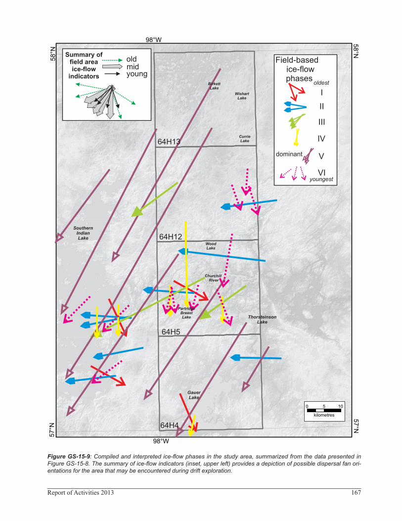
New collection of ice-flow indicators has allowed for recognition of six ice-flow phases that indicate spatial and temporal variations in the orientation and source areas of ice flow. The oldest flow (Phase I) trends toward the southeast (between 120 and 160°), and is followed by a westward flow (Phase II, between 260 and 280°) and a southwestward flow (Phase III, between 230 and 240°). Rare but widespread ice-flow indicators then document southward ice flow (Phase IV, between 180 and 194°). This was followed by strong, fairly erosive, south-southwest-ward ice flow (Phase V, between 203 and 212°). During deglaciation, ice flowed to the southwest (Phase VI,
between 220 and 230°) and south and southeast (Phase VI, ~196 and 160°) during the Quinn Lake re-advance. Drumlinoid ridge for-mation in the northern half of the study area occurred dur-ing the Quinn Lake phase, while streamlined landforms in the southern half of the area are presumed to correlate with Phase V.
IntroductionIn the summer of 2013, Quaternary geology field-
work was conducted between Gauer Lake and Wishart Lake (NTS 64H4, 5, 12, 13), using a helicopter based out of the Manitoba Hydro station at Missi Falls. Addi-tional data was collected along the southeastern shores of Southern Indian Lake by boat (parts of NTS 64G1, 8). This report presents a summary of fieldwork activities that included surficial geology mapping at 1:50 000 scale, regional ice-flow indicator analysis and till sample collec-tion for geochemical and lithological analyses.
ObjectivesThe current objectives of the Quaternary component
of the Manitoba Geological Survey are to better under-stand the glacial geology and geomorphology of Mani-toba, and to generate geoscience data and maps that aid mineral exploration. The specific goals of the detailed surveys are to• document micro- and meso-scale ice-flow indicators
(e.g., glacial striae, roches moutonnées),• improve understanding of regional ice flow phases, and• sample glacial sediments (till) to investigate compo-
sitional patterns (dispersal trains).
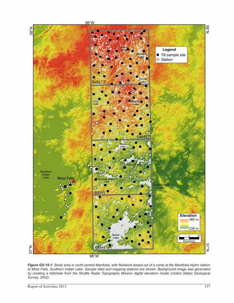
PhysiographyThe study area is located in the north-central part of
Manitoba (Figure GS-15-1). Elevation varies mainly from 240 to 360 m asl. Local relief is generally 5 to 30 m. The drift cover is generally thick, though bedrock outcrops along the shores of most major lakes in the region. The area is part of the extensive discontinuous permafrost zone (Sladen, 2011), and permafrost was encountered beneath organic deposits at most sites.
The study area is largely underlain by granitoid rocks of the Wathaman-Chipewyan batholith1 and the Southern
1 For the sake of consistency, the Manitoba Geological Survey has opted to make a universal change from capitalized to noncapitalized for the generic part of lithostructural feature names (formal stratigraphic and biostratigraphic nomenclature being the exceptions).
157Report of Activities 2013
Figure GS-15-1: Study area in north-central Manitoba, with fieldwork based out of a camp at the Manitoba Hydro station at Missi Falls, Southern Indian Lake. Sample sites and mapping stations are shown. Background image was generated by creating a hillshade from the Shuttle Radar Topography Mission digital elevation model (United States Geological Survey, 2002).
158 Manitoba Geological Survey
Indian domain (Corrigan and Rayner, 2002). The southern half of the study area includes supracrustal rocks of the Southern Indian Lake sedimentary gneiss belt (Corkery and Lenton, 1993). Rock types include diorite, metagab-bro, metarhyolite, mafic tuff and associated epiclastic rocks, metaconglomerate, metasiltstone, metagreywacke and metasandstone (Kremer et al., 2009). These supra-crustal rocks are bounded by a variety of granitoid rocks.
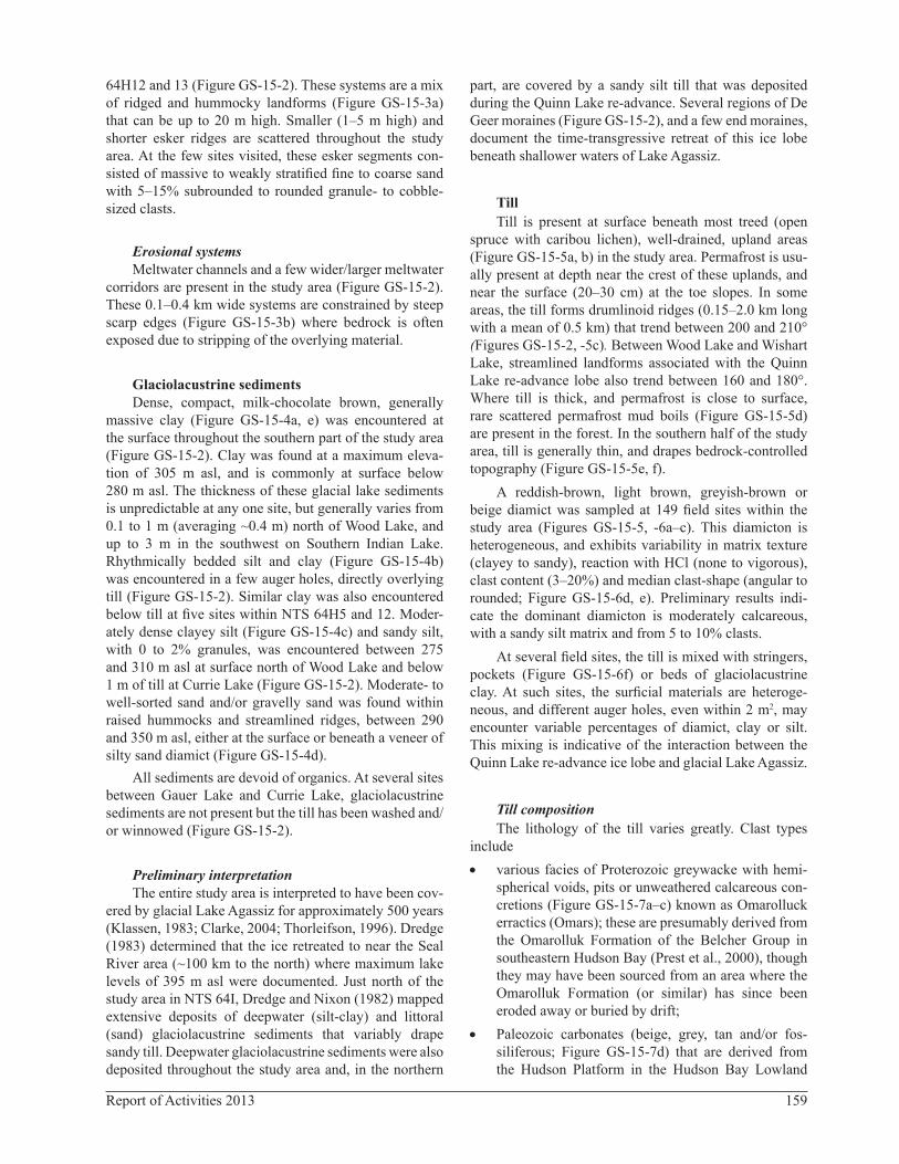
Regional glacial historySurficial geology between Gauer Lake and Wishart
Lake (NTS 64H4, 5, 12, 13) was previously mapped at a reconnaissance scale by Klassen and Netterville (1980, 1:250 000 scale) and rereleased as a regional "A" series map (Klassen and Netterville, 1985, 1:500 000 scale). This mapping was conducted using aerial photographs, with only limited ground checking (two field sites for the area included herein). More information about the field area can be gleaned from detailed mapping and till com-position surveys conducted just to the west (NTS 64G; Kaszycki, 1989; Kaszycki and Way Nee, 1990; Lenton and Kaszycki, 2005; Kaszycki et al., 2008).
The study area was repeatedly glaciated by the Lau-rentide Ice Sheet (LIS) during the Quaternary (Klassen, 1986; Dredge and Cowan, 1989). According to Kaszycki et al. (2008), there were four main phases of ice flow in the area. The oldest flow (Phase I) includes rare striae that trend westward. This was followed by southeasterly ice flow (Phase II, between 140 and 175°). Phase II striae were then crosscut by southwest-trending striae, which generally document a transition in the orientation of ice flow from southeast to southwest (Phase III, between 190 and 210°). During deglaciation, ice was thought to have flowed to the west-southwest (Phase V).
During deglaciation, around 8.2 ka 14C BP, the study area was inundated by glacial Lake Agassiz (Klassen, 1983; Thorleifson, 1996). Radiocarbon dates are rare in northern Manitoba, but it is thought that this inunda-tion was short-lived and absent by around 7.7 ka 14C BP (Thorleifson, 1996; Teller and Leverington, 2004). The northern half of the study area is dominated by a lobate streamlined-landform fan (Quinn lobe; Dredge et al., 1986; Dredge and Nixon, 1992), which was thought to have been formed during a surge or re-advance into glacial Lake Agassiz. These streamlined landforms also outline the deglacial-type Quinn Lake glacial terrain zone (GTZ) (Trommelen et al., 2012). Just north of Southern Indian Lake, Kaszycki et al. (2008) observed several sections where calcareous sandy silt till (with a 170° clast-fabric trend) overlies a clay-rich till with similar calcareous content (clast-fabric trend of ~235° near the base and 260° at the top). These tills were separated in section by
glaciolacustrine laminated silty fine sand and clay, which was interpreted as deposition within an ice-proximal envi-ronment. Clayey till also overlays the regional surface till in a few areas, and Kaszycki et al. (2008) suggested both the clay-rich and sandy silt tills are indicative of re-advances or surges during deglaciation. Time-transgres-sive southeast-trending drumlinoid ridges, in the same area, support this interpretation.
MethodsHelicopter-supported fieldwork was undertaken dur-
ing a three-week period in the summer of 2013, based out of the Manitoba Hydro station at Missi Falls, Southern Indian Lake (Figure GS-15-1). A total of 244 field sites were visited to ground truth the surficial geology map-ping, collect till samples and identify ice-flow indicators. A total of 154 samples, each weighing around 2 kg, were collected from C-horizon till throughout the area for geo-chemical analysis (Figure GS-15-1). All till samples will be submitted for trace-element geochemistry (>63 μm fraction) and clast lithology (2–80 mm fraction) analy-sis. The orientation of striations, grooves, chattermarks and roches moutonnées were measured at 45 sites (Data Repository Item DRI20130032).
One goal this season was to map the surficial geol-ogy with emphasis on better delineation of the complex geomorphology and surficial geology in the region. Prior to fieldwork, 1:60 000 scale black and white aerial photo-graphs were pre-mapped using a stereoscope. Final map production of the project area is in progress.
Results
Surficial geology
OrganicsOrganic, treed bog deposits are common on very
poorly drained surfaces in the study area, and are usu-ally underlain by permafrost. Small streams that link the numerous lakes are usually bordered by thick fen depos-its. Organic cover is commonly thin (5–30 cm) where it overlies drumlinoid ridges, and thicker in low-lying areas between drumlins or where the underlying surficial mate-rial is finer textured.
Glaciofluvial sediments
Ice-contact sedimentsEsker ridges are the dominant glaciofluvial landform
in the region. Several major esker systems, deposited during the Quinn Lake re-advance, are situated in NTS
2 MGS Data Repository Item DRI2013003, containing the data or other information sources used to compile this report, is available online to down-load free of charge at http://www2.gov.mb.ca/itm-cat/web/freedownloads.html, or on request from [email protected] or Mineral Resources Library, Manitoba Mineral Resources, 360–1395 Ellice Avenue, Winnipeg, Manitoba R3G 3P2, Canada.
159Report of Activities 2013
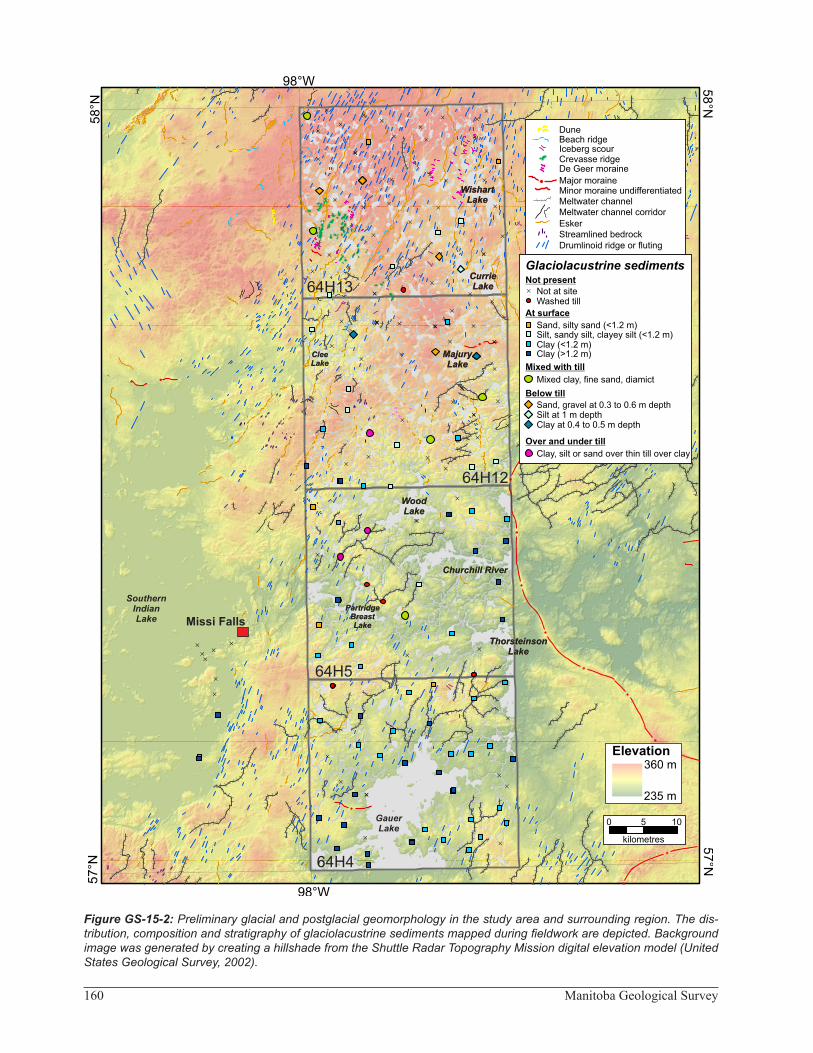
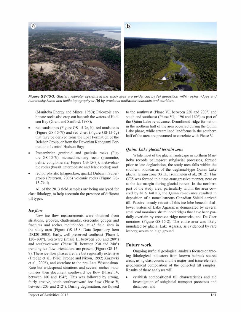
64H12 and 13 (Figure GS-15-2). These systems are a mix of ridged and hummocky landforms (Figure GS-15-3a) that can be up to 20 m high. Smaller (1–5 m high) and shorter esker ridges are scattered throughout the study area. At the few sites visited, these esker segments con-sisted of massive to weakly stratified fine to coarse sand with 5–15% subrounded to rounded granule- to cobble-sized clasts.
Erosional systemsMeltwater channels and a few wider/larger meltwater
corridors are present in the study area (Figure GS-15-2). These 0.1–0.4 km wide systems are constrained by steep scarp edges (Figure GS-15-3b) where bedrock is often exposed due to stripping of the overlying material.
Glaciolacustrine sedimentsDense, compact, milk-chocolate brown, generally
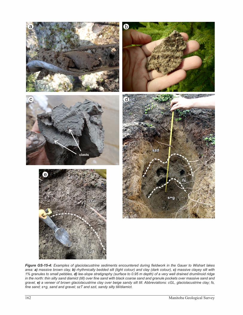
massive clay (Figure GS-15-4a, e) was encountered at the surface throughout the southern part of the study area (Figure GS-15-2). Clay was found at a maximum eleva-tion of 305 m asl, and is commonly at surface below 280 m asl. The thickness of these glacial lake sediments is unpredictable at any one site, but generally varies from 0.1 to 1 m (averaging ~0.4 m) north of Wood Lake, and up to 3 m in the southwest on Southern Indian Lake. Rhythmically bedded silt and clay (Figure GS-15-4b) was encountered in a few auger holes, directly overlying till (Figure GS-15-2). Similar clay was also encountered below till at five sites within NTS 64H5 and 12. Moder-ately dense clayey silt (Figure GS-15-4c) and sandy silt, with 0 to 2% granules, was encountered between 275 and 310 m asl at surface north of Wood Lake and below 1 m of till at Currie Lake (Figure GS-15-2). Moderate- to well-sorted sand and/or gravelly sand was found within raised hummocks and streamlined ridges, between 290 and 350 m asl, either at the surface or beneath a veneer of silty sand diamict (Figure GS-15-4d).
All sediments are devoid of organics. At several sites between Gauer Lake and Currie Lake, glaciolacustrine sediments are not present but the till has been washed and/or winnowed (Figure GS-15-2).
Preliminary interpretationThe entire study area is interpreted to have been cov-
ered by glacial Lake Agassiz for approximately 500 years (Klassen, 1983; Clarke, 2004; Thorleifson, 1996). Dredge (1983) determined that the ice retreated to near the Seal River area (~100 km to the north) where maximum lake levels of 395 m asl were documented. Just north of the study area in NTS 64I, Dredge and Nixon (1982) mapped extensive deposits of deepwater (silt-clay) and littoral (sand) glaciolacustrine sediments that variably drape sandy till. Deepwater glaciolacustrine sediments were also deposited throughout the study area and, in the northern
part, are covered by a sandy silt till that was deposited during the Quinn Lake re-advance. Several regions of De Geer moraines (Figure GS-15-2), and a few end moraines, document the time-transgressive retreat of this ice lobe beneath shallower waters of Lake Agassiz.
TillTill is present at surface beneath most treed (open
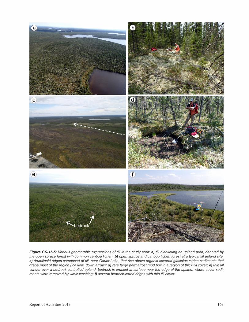
spruce with caribou lichen), well-drained, upland areas (Figure GS-15-5a, b) in the study area. Permafrost is usu-ally present at depth near the crest of these uplands, and near the surface (20–30 cm) at the toe slopes. In some areas, the till forms drumlinoid ridges (0.15–2.0 km long with a mean of 0.5 km) that trend between 200 and 210° (Figures GS-15-2, -5c). Between Wood Lake and Wishart Lake, streamlined landforms associated with the Quinn Lake re-advance lobe also trend between 160 and 180°. Where till is thick, and permafrost is close to surface, rare scattered permafrost mud boils (Figure GS-15-5d) are present in the forest. In the southern half of the study area, till is generally thin, and drapes bedrock-controlled topography (Figure GS-15-5e, f).
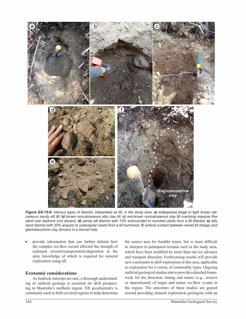
A reddish-brown, light brown, greyish-brown or beige diamict was sampled at 149 field sites within the study area (Figures GS-15-5, -6a–c). This diamicton is heterogeneous, and exhibits variability in matrix texture (clayey to sandy), reaction with HCl (none to vigorous), clast content (3–20%) and median clast-shape (angular to rounded; Figure GS-15-6d, e). Preliminary results indi-cate the dominant diamicton is moderately calcareous, with a sandy silt matrix and from 5 to 10% clasts.
At several field sites, the till is mixed with stringers, pockets (Figure GS-15-6f) or beds of glaciolacustrine clay. At such sites, the surficial materials are heteroge-neous, and different auger holes, even within 2 m2, may encounter variable percentages of diamict, clay or silt. This mixing is indicative of the interaction between the Quinn Lake re-advance ice lobe and glacial Lake Agassiz.
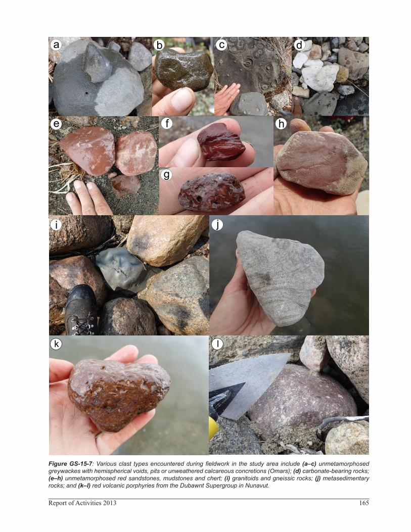
Till compositionThe lithology of the till varies greatly. Clast types
include• various facies of Proterozoic greywacke with hemi-
spherical voids, pits or unweathered calcareous con-cretions (Figure GS-15-7a–c) known as Omarolluck erractics (Omars); these are presumably derived from the Omarolluk Formation of the Belcher Group in southeastern Hudson Bay (Prest et al., 2000), though they may have been sourced from an area where the Omarolluk Formation (or similar) has since been eroded away or buried by drift;
• Paleozoic carbonates (beige, grey, tan and/or fos-siliferous; Figure GS-15-7d) that are derived from the Hudson Platform in the Hudson Bay Lowland
160 Manitoba Geological Survey
Figure GS-15-2: Preliminary glacial and postglacial geomorphology in the study area and surrounding region. The dis-tribution, composition and stratigraphy of glaciolacustrine sediments mapped during fieldwork are depicted. Background image was generated by creating a hillshade from the Shuttle Radar Topography Mission digital elevation model (United States Geological Survey, 2002).
161Report of Activities 2013
(Manitoba Energy and Mines, 1980); Paleozoic car-bonate rocks also crop out beneath the waters of Hud-son Bay (Grant and Sanford, 1988);
• red sandstones (Figure GS-15-7e, h), red mudstones (Figure GS-15-7f) and red chert (Figure GS-15-7g) that may be derived from the Loaf Formation of the Belcher Group, or from the Devonian Kenogami For-mation of central Hudson Bay;
• Precambrian granitoid and gneissic rocks (Fig-ure GS-15-7i), metasedimentary rocks (psammite, pelite, conglomerate; Figure GS-15-7j), metavolca-nic rocks (basalt, intermediate and felsic rocks); and
• red porphyritic (plagioclase, quartz) Dubawnt Super-group (Peterson, 2006) volcanic rocks (Figure GS-15-7k, l).All of the 2013 field samples are being analyzed for
clast lithology, to help ascertain the presence of different till types.
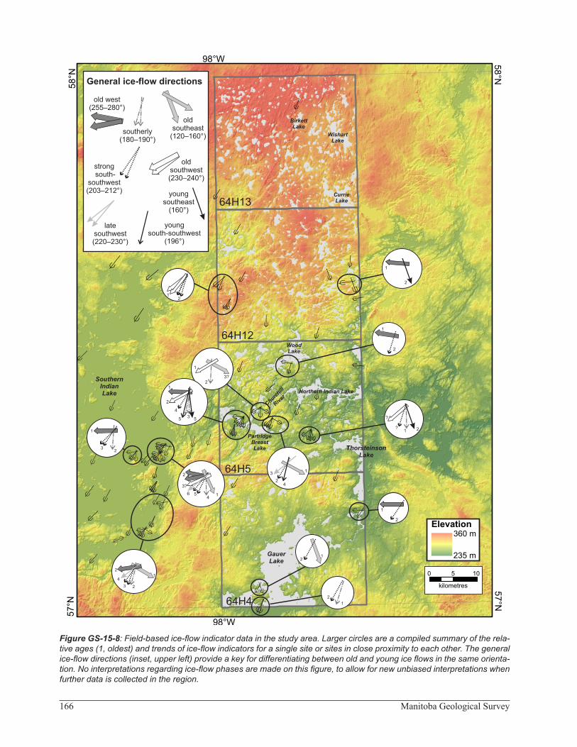
Ice flowNew ice flow measurements were obtained from
striations, grooves, chattermarks, crescentic gouges and fractures and roches moutonnées, at 45 field sites in the study area (Figure GS-15-8; Data Repository Item DRI2013003). Early, well-preserved southeast (Phase I, 120–160°), westward (Phase II, between 260 and 280°) and southwestward (Phase III; between 230 and 240°) trending ice-flow orientations are present (Figure GS-15-9). These ice-flow phases are rare but regionally extensive (Dredge et al., 1986; Dredge and Nixon, 1992; Kaszycki et al., 2008), and correlate to the pre–Late Wisconsinan. Rare but widespread striations and several roches mou-tonnées then document southward ice flow (Phase IV, between 180 and 194°). This was followed by strong, fairly erosive, south-southwestward ice flow (Phase V, between 203 and 212°). During deglaciation, ice flowed
to the southwest (Phase VI, between 220 and 230°) and south and southeast (Phase VI, ~196 and 160°) as part of the Quinn Lake re-advance. Drumlinoid ridge formation in the northern half of the area occurred during the Quinn Lake phase, while streamlined landforms in the southern half of the area are presumed to correlate with Phase V.
Quinn Lake glacial terrain zoneWhile most of the glacial landscape in northern Man-
itoba records palimpsest subglacial processes, formed prior to late deglaciation, the study area falls within the southern boundaries of the deglacial-type Quinn Lake glacial terrain zone (GTZ, Trommelen et al., 2012). This GTZ was formed in a time-transgressive manner, near or at the ice margin during glacial retreat. In the northern part of the study area, particularly within the area cov-ered by NTS 64H13, the Quinn re-advance resulted in deposition of a noncalcareous Canadian Shield–derived till. Passive, steady retreat of this ice lobe beneath shal-lower waters of Lake Agassiz is demarcated by several small end moraines, drumlinoid ridges that have been par-tially overlain by crevasse ridge networks, and De Geer moraines (Figure GS-15-2). The entire area was likely inundated by glacial Lake Agassiz, as evidenced by rare iceberg scours on high ground.
Future workOngoing surficial geological analysis focuses on trac-
ing lithological indicators from known bedrock source areas, using clast counts and the major- and trace-element geochemical composition of the collected till samples. Results of these analyses will
• establish compositional till characteristics and aid investigation of subglacial transport processes and distances; and
Figure GS-15-3: Glacial meltwater systems in the study area are evidenced by (a) deposition within esker ridges and hummocky kame and kettle topography or (b) by erosional meltwater channels and corridors.
a b
162 Manitoba Geological Survey
Figure GS-15-4: Examples of glaciolacustrine sediments encountered during fieldwork in the Gauer to Wishart lakes area: a) massive brown clay, b) rhythmically bedded silt (light colour) and clay (dark colour), c) massive clayey silt with 1% granules to small pebbles, d) lee-slope stratigraphy (surface to 0.95 m depth) of a very well drained drumlinoid ridge in the north: thin silty sand diamict (till) over fine sand with black coarse sand and granule pockets over massive sand and gravel, e) a veneer of brown glaciolacustrine clay over beige sandy silt till. Abbreviations: cGL, glaciolacustrine clay; fs, fine sand; s+g, sand and gravel; szT and szd, sandy silty till/diamict.
.
a
c
b
d
e
clasts
szT
cGLcGL
szT
c
e
szdszd
s+gs+g
fsfs
163Report of Activities 2013
Figure GS-15-5: Various geomorphic expressions of till in the study area: a) till blanketing an upland area, denoted by the open spruce forest with common caribou lichen; b) open spruce and caribou lichen forest at a typical till upland site; c) drumlinoid ridges composed of till, near Gauer Lake, that rise above organic-covered glaciolacustrine sediments that drape most of the region (ice flow, down arrow); d) rare large permafrost mud boil in a region of thick till cover; e) thin till veneer over a bedrock-controlled upland; bedrock is present at surface near the edge of the upland, where cover sedi-ments were removed by wave washing; f) several bedrock-cored ridges with thin till cover.
a b
bedrock
e
c
f
d
164 Manitoba Geological Survey
Figure GS-15-6: Various types of diamict, interpreted as till, in the study area: a) widespread beige to light brown cal-careous sandy silt till; b) brown noncalcareous silty clay till; c) red-brown noncalcareous clay till overlying massive fine sand over bedrock (not shown); d) sandy silt diamict with 10% subrounded to rounded clasts from a till blanket; e) silty sand diamict with 20% angular to subangular clasts from a till hummock; f) vertical contact between mixed till (beige) and glaciolacustrine clay (brown) in a shovel hole.
Till
Glaciolacustrineclay
f
a cb
d
e
• provide information that can further delimit how the complex ice-flow record affected the strength of sediment erosion/transportation/deposition in the area; knowledge of which is required for mineral exploration using till.
Economic considerationsAs bedrock outcrops are rare, a thorough understand-
ing of surficial geology is essential for drift prospect-ing in Manitoba’s northern region. Till geochemistry is commonly used in drift-covered regions to help determine
the source area for boulder trains, but is more difficult to interpret in palimpsest terrains such as the study area, which have been modified by more than one ice advance and transport direction. Forthcoming results will provide new constraints to drift exploration in this area, applicable to exploration for a variety of commodity types. Ongoing surficial geological studies aim to provide a detailed frame-work for the direction, timing and nature (e.g., erosive or depositional) of major and minor ice-flow events in the region. The outcomes of these studies are geared toward providing mineral exploration geologists with an
165Report of Activities 2013
Figure GS-15-7: Various clast types encountered during fieldwork in the study area include (a–c) unmetamorphosed greywackes with hemispherical voids, pits or unweathered calcareous concretions (Omars); (d) carbonate-bearing rocks; (e–h) unmetamorphosed red sandstones, mudstones and chert; (i) granitoids and gneissic rocks; (j) metasedimentary rocks; and (k–l) red volcanic porphyries from the Dubawnt Supergroup in Nunavut.
f
a cb d
e
g
h
i j
k l
166 Manitoba Geological Survey
Figure GS-15-8: Field-based ice-flow indicator data in the study area. Larger circles are a compiled summary of the rela-tive ages (1, oldest) and trends of ice-flow indicators for a single site or sites in close proximity to each other. The general ice-flow directions (inset, upper left) provide a key for differentiating between old and young ice flows in the same orienta-tion. No interpretations regarding ice-flow phases are made on this figure, to allow for new unbiased interpretations when further data is collected in the region.
167Report of Activities 2013
Figure GS-15-9: Compiled and interpreted ice-flow phases in the study area, summarized from the data presented in Figure GS-15-8. The summary of ice-flow indicators (inset, upper left) provides a depiction of possible dispersal fan ori-entations for the area that may be encountered during drift exploration.
168 Manitoba Geological Survey
up-to-date surficial geology knowledge base and the ade-quate tools to more accurately locate exploration targets in Manitoba’s north.
AcknowledgmentsThe author thanks A. Vanjecek (University of Mani-
toba) and B. Clayton (University of Manitoba) for providing capable and enthusiastic field assistance, as well as N. Brandson and E. Anderson for thorough logistical sup-port. Many thanks also to C. Böhm for his support and collaboration as a surficial crew lead. Manitoba Hydro provided accommodations and communications. Custom Helicopters, and F. Roberts in particular, are thanked for excellent flying and for accommodating our swampy land-ings. Wings Over Kississing provided fixed-wing support.
ReferencesClarke, G.K.C., Leverington, D.W., Teller, J.T. and Dyke, A.
2004: Paleohydraulics of the last outburst flood from gla-cial Lake Agassiz and the 8200 BP cold event; Quaternary Science Reviews, v. 23, p. 389–407.
Corkery, M.T. and Lenton, P.G. 1993: Partridge Breast Lake area (parts of NTS 64H/4, 5 and 64G/1, 8); Manitoba Energy and Mines, Manitoba Geological Survey, Preliminary Map 1993L-1, scale 1:50 000.
Corrigan, D. and Rayner, N. 2002: Churchill River–Southern Indian Lake Targeted Geoscience Initiative (NTS 64B, 64C, 64G, 64H), Manitoba: update and new findings; in Report of Activities 2002, Manitoba Industry Trade and Mines, Manitoba Geological Survey, p. 144–158.
Dredge, L.A. 1983: Character and development of northern Lake Agassiz and its relation to Keewatin and Hudso-nian ice regimes; in Glacial Lake Agassiz, J.T. Teller and L. Clayton (ed.), Geological Association of Canada, Spe-cial Paper 26, p. 117–131.
Dredge, L.A. and Cowan, W.R. 1989: Quaternary geology of the southwestern Canadian Shield; in Quaternary geology of Canada and Greenland, R.J. Fulton (ed.), Geological Survey of Canada, Geology of Canada Series, no 1, p. 214–248.
Dredge, L.A. and Nixon, F.M. 1982: Surficial geology, Shetha-nei Lake, Manitoba; Geological Survey of Canada, Prelim-inary Map 6-1980, scale 1:250 000.
Dredge, L.A. and Nixon, F.M. 1992: Glacial and environmental geology of northeastern Manitoba; Geological Survey of Canada, Memoir 432, 80 p.
Dredge, L.A., Nixon, F.M. and Richardson, R.J.H. 1986: Qua-ternary geology and geomorphology of northwestern Man-itoba; Geological Survey of Canada, Memoir 418, 38 p.
Grant, A.C. and Sanford, B.V. 1988: Bedrock geology mapping and basin studies in Hudson Bay region; in Current research Part B, Geological Survey of Canada, Paper 88-1B, p. 287–296.
Kaszycki, C.A. 1989: Surficial geology and till composition, northwestern Manitoba, Geological Survey of Canada, Open File 2118, 50 p.
Kaszycki, C.A. and Way Nee, V.J. 1990: Surficial geology, Big Sand Lake, Manitoba; Geological Survey of Canada, “A” Series Map 1761A, scale 1:250 000.
Kaszycki, C.A., Dredge, L.A. and Groom, H. 2008: Surficial geology and glacial history, Lynn Lake–Leaf Rapids area, Manitoba; Geological Survey of Canada, Open File 5873, 105 p.
Klassen, R.W. 1983: Lake Agassiz and the late glacial history of northern Manitoba.; in Glacial Lake Agassiz, J.T. Teller and L. Clayton (ed.), Geological Association of Canada, Special Paper 26, p. 97–115.
Klassen, R.W. 1986: Surficial geology of north-central Mani-toba; Geological Survey of Canada, Memoir 419, 57 p.
Klassen, R.A. and Netterville, J.A. 1980: Surficial geology, northern Indian Lake, Manitoba; Geological Survey of Canada, Preliminary Map 3-1979, scale 1:250 000.
Klassen, R.W. and Netterville, J.A. 1985: Surficial geology, north-central Manitoba; Geological Survey of Canada, “A” Series Map 1603A, scale 1:500 000.
Kremer, P.D., Corkery, M.T. and Lenton, P.G. 2009: Bedrock geology of the Partridge Breast Lake belt, Manitoba (parts of NTS 64G1, 8, 64H4, 5); Manitoba Innovation Energy and Mines, Manitoba Geological Survey, Preliminary Map PMAP2009-2, scale 1:50 000.
Lenton, P.G. and Kaszycki, C.A. 2005: Till geochemistry in northwestern Manitoba (NTS 63N, 64B, 64F, 64G and parts of 63K, 63O, 64A, 64C); Manitoba Industry, Eco-nomic Development and Mines, Manitoba Geological Sur-vey, Open File Report OF2005-2, 1 CD-ROM.
Manitoba Energy and Mines 1980: Churchill, NTS 54L; Mani-toba Department of Energy and Mines, Mineral Resources Division, Bedrock Geology Compilation Map, scale 1:250 000.
Peterson, T.D. 2006: Geology of the Dubawnt Lake area, Nun-avut-Northwest Territories, Geological Survey of Canada, Bulletin 580, p. 56.
Prest, V.K., Donaldson, J.A. and Mooers, H.D. 2000: The Omar story: the role of Omars in assessing glacial history of west-central North America; Geographie physique et Qua-ternaire, v. 54, no. 3, p. 257–270.
Sladen, W. E. 2011: Permafrost; Geological Survey of Canada, Open File 6724.
Teller, J.T. and Leverington, D.W. 2004: Glacial Lake Agassiz: a 5000 yr history of change and its relationship to the δ18O record of Greenland; Geological Society of America Bul-letin, v. 116, no. 5–6, p. 729–742.
Thorleifson, L. H. 1996: Review of Lake Agassiz history; in Sedimentology, Geomorphology and History of the Cen-tral Lake Agassiz Basin, J.T. Teller, L.H. Thorleifson, G.L.D. Matile and W.C. Brisbin (ed.), Geological Associa-tion of Canada–Mineralogical Association of Canada, Joint Annual Meeting, Field Trip Guidebook B2, p. 55–84.
Trommelen, M.S., Ross, M. and Campbell, J.E. 2012: Glacial Terrain Zone analysis of a fragmented paleoglaciological record, southeast Keewatin sector of the Laurentide Ice Sheet; Quaternary Science Reviews, v. 40, p. 1–20.
United States Geological Survey 2002: Shuttle Radar Topogra-phy Mission, digital topographic data; <http://dds.cr.usgs.gov/srtm/> 90 m cell, zipped hgt format [December 2011–June 2012].


