Embed Size (px)
Citation preview

249D. Lóczy et al. (eds.), Recent Landform Evolution: The Carpatho–Balkan–Dinaric
Region, Springer Geography, DOI 10.1007/978-94-007-2448-8_10,
© Springer Science+Business Media B.V. 2012
Abstract In the Romanian Carpathians, developed on crystalline and volcanic
rocks, the main geomorphological processes are rockfalls, debris fl ows, and topples.
In the eastern part of the Eastern Carpathians, built up of Cretaceous and Paleogene
fl ysch, landslides and mudfl ows are of major signifi cance. High and middle moun-
tain karst features and cave systems are also widespread. In the alpine area of the
Southern and Eastern Carpathians, avalanches are common on the steep slopes of
D. Bălteanu • M. Jurchescu (*) • M. Sima
Institute of Geography , Romanian Academy , D. Racoviţa Str. 12,
023993 Bucharest , Romania
e-mail: [email protected] ; [email protected] ; [email protected]
V. Surdeanu
Faculty of Geography , Babeş-Bolyai University of Cluj-Napoca , Clinicilor Str. 5-7 , 400006
Cluj-Napoca , Romania
e-mail: [email protected]
I. Ionita
Department of Geography , “Alexandru Ioan Cuza” University of Iasi ,
Carol I Blvd., 20 A , 700505 Iasi , Romania
e-mail: [email protected]
C. Goran
“Emil Racoviţă” Institute of Speleology , Romanian Academy ,
Calea 13 Septembrie Str. 13 , 050711 Bucharest , Romania
e-mail: [email protected]
P. Urdea
Department of Geography, Faculty of Chemistry, Biology and Geography ,
West University of Timişoara , Pestalozzi Blvd. 16 , 300115 Timişoara , Romania
e-mail: [email protected]
M. Rădoane • N. Rădoane
Faculty of History and Geography , “Ştefan cel Mare” University of Suceava ,
Universitatii Str., 13 , 722029 Suceava , Romania
e-mail: [email protected] ; [email protected]
Chapter 10
Recent Landform Evolution in the Romanian
Carpathians and Pericarpathian Regions
Dan Bălteanu , Marta Jurchescu , Virgil Surdeanu , Ion Ionita , Cristian Goran ,
Petru Urdea , Maria Rădoane , Nicolae Rădoane , and Mihaela Sima

250 D. Bălteanu et al.
glacial cirques and valleys. Landslides also develop on high quarry slopes, waste
dumps and tailing dams characteristic of the mining sites of the Apuseni Mountains.
High discharges along the Carpathian rivers cause intense erosion and the undercut-
ting of slopes, favoring landslides and fl ooding. Although in fl uvial erosion channel
incision is predominant (for half of all river sections studied), riverbed aggradation
is also observed locally. On the agricultural lands of the Subcarpathians and in the
Transylvanian Depression slopes are degraded by sheet and gully erosion, land-
slides, and mudfl ows. On the Moldavian Plateau soil erosion, gullying, and land-
slides are major exogenous geomorphic processes. The country-wide spatial
distribution of these geomorphological hazards has been evaluated by several
authors (e.g., Geografi a României I. 1983 ; Bălteanu 1997 ).
Keywords Landslides • Soil erosion and gullying • Karst • Periglacial processes
• Fluvial processes • Mining impact
10.1 Major Geomorphological Units
Dan Bălteanu
The Romanian section of the Carpathian Mountains occupies 66,303 km² (27.8% of
the country’s territory) and stretches along 910 km between the Tisza Valley and the
Danubian Gorges, with an extension, the Apuseni Mountains, up to the Someş Valley
(Romania. Space, Society, Environment 2006 ) . The Carpathian arch is bordered by a
hill and tableland region (the Subcarpathians, the Banat and Crişana Hills, the Getic
Piedmont, and the Moldavian Plateau) and encircles the Transylvanian Depression.
Average altitude is 1,136 m, the highest summit is Moldoveanu Peak in the Făgăraş
Massif (2,544 m). This range has a very complex morphology and structure, being
also very much fragmented. The Carpathians in Romania can be divided into the fol-
lowing distinct units (Romania. Space, Society, Environment 2006 ) .
10.1.1 The Eastern Carpathians
The Eastern Carpathians (33,584 km²), between Romania’s northern border and the
Prahova Valley, are structured in three distinct longitudinal units: a crystalline unit in
the central part, with the highest peaks in the Rodna Mountains (Pietrosu 2,303 and
Ineu 2,279 m); a sedimentary unit in the east, built up from Cretaceous and Paleogene
Flysch; and a Neogene volcanic unit in the west, at the contact with the Transylvanian
Depression. In the southeast there are the Curvature Carpathian and Subcarpathian
areas, where the Vrancea Seismic Region of high seismicity potential is located
(three over 7 M Richter scale earthquakes/century on the average).

25110 Recent Landform Evolution in the Romanian Carpathians…
10.1.2 The Southern Carpathians
The Southern Carpathians (15,000 km²) extend from east to west between the
Prahova Valley and the Timiş-Cerna Corridor. They represent the highest and most
compact section of the Romanian Carpathians, with heights above 2,500 m, large
denudational levels, and a characteristic alpine relief dotted with numerous glacial
cirques and valleys. At altitudes above 2,000 m, extended alpine and subalpine
meadows are found. These mountains are made up of crystalline schists and
Mesozoic sedimentary deposits of distinct elevations. The main tectogenetic phase
is dated to the Upper Cretaceous.
10.1.3 The Banat and Apuseni Mountains
The Banat and Apuseni Mountains (17,714 km²), spread out between the Danube
and the Someş rivers, include two distinct subunits: the Banat Mountains in the
south up to the Mureş Corridor, and the Apuseni Mountains (highest peak Curcubata,
1,847 m) north of the Corridor. They have a complex horst and graben structure,
being built of crystalline rocks, limestones, and volcanic rocks with important fer-
rous and non-ferrous ore deposits.
10.1.4 The Transylvanian Depression
The Transylvanian Depression (25,029 km²) lies between the three units of the
Romanian Carpathians. It is a tableland with heights of 400–800 m and has a
tectonic origin. The basement is Carpathian with a post-tectonic mantle of
Upper Cretaceous to Lower Miocene age. The depression is fi lled by clastic
rocks, marine tuffs, a salt formation, marls, sands, and clays (Miocene to
Pliocene), with monoclinal and dome-like structures (Romania. Space, Society,
Environment 2006 ) . The Pericarpathian region includes the following units. The Mehedinţi Plateau
(785 km²) is situated in the southwest of Romania between the Danube and the
Motru rivers, at heights of 500–600 m. It is actually a lower compartment of the
Southern Carpathians and consists of crystalline schists and limestones. The
Subcarpathians (16,409 km², 400–900 m altitude), which border the Carpathians on
the east and south along 550 km length, are built up of folded-faulted Neogene
molasses and are affected by neotectonic uplift (Zugrăvescu et al. 1998 ) . Human
pressure in the area is particularly severe and has contributed to an intense remodeling
of stream channels and slopes. The Getic Piedmont (12,940 km²) is located to the
south of the Southern Carpathians at altitudes of 200–700 m and consists of gravels
and sands with intercalations of marls and clays. It was formed in the Romanian-

252 D. Bălteanu et al.
Quaternary interval and is basically a relict piedmont fragmented by large, conse-
quent allochthonous valleys. Piedmont catchment basins are affected by gully
erosion and landslides, their intensity decreasing from north to south. The Moldavian
Plateau (23,085 km²) lies in eastern Romania and is developed on a platform base-
ment covered by sedimentary formations deposited in several cycles. The Banat and
Crişana Hills and Plain (28,640 km²) are situated in the western part of the Banat
and Apuseni Mountains, are discontinuous and have a predominant piedmont char-
acter. The plain lies to the west and it was formed during several stages after the
recession of the Pannonian Lake and the accumulation of the fl uvio-lacustrine and
lacustrine sediments.
10.2 History of Geomorphological Research
Dan Bălteanu and Marta Jurchescu
The research of geomorphological processes in the Romanian Carpathians has
evolved differently for the various types of processes but more common features
appeared in the phase of a more rapid development since 1990, corresponding to
relatively suddenly opened access to international literature.
Landslide investigations have a long tradition in Romania. Landslide-related
studies started especially in the 1920s (Mihăilescu 1926 ) . In the following decades,
numerous articles and books addressed this subject, in a more descriptive manner,
either with the aim of classifying, presenting some local cases, or zoning landslides
across geomorphic units or all over the country (e.g., Mihăilescu 1939b ; Tufescu
1964, 1966 ; Morariu and Gârbacea 1968b ; Ielenicz 1970 ) . Regionally, the Curvature
Carpathians and Subcarpathians, being among the most complex units in terms of
lithological and structural conditions and part of the Vrancea Seismic Region with
the most active subcrustal earthquake activity in Europe are intensely modeled by a
wide range of landslide processes and benefi tted from a long history of observations
(e.g., Mihăilescu 1939a ; Tufescu 1959 ; Posea and Ielenicz 1970 ) . The relatively
recent development could be summarized by a two-level analysis: regional assess-
ments and site-specifi c studies. Regional assessments focus on study-areas ranging
from small-size catchments to larger geomorphic units. In an earlier stage, direct
qualitative methods and some of the fi rst quantitative ones were employed, involv-
ing geomorphological classifi cation and large-scale mapping (1:5,000, 1:10,000)
(Bălteanu 1975, 1983 ; Ielenicz 1984 ) . This was done repeatedly in the course of
time, allowing to differentiate between annual, seasonal, and monthly changes, with
the aim of assessing the morphodynamic trends of slopes and of elaborating
morphodynamic maps (Bălteanu 1975 ) . From 1980 to 2000, the research focus was
placed on elaborating the methodology of general geomorphological mapping at
regional scales of 1:25,000 and 1:200,000 and on synthesizing available landslide
information over wider areas (e.g., Gârbacea 1992 ; Irimuş 1998 ; Surdeanu 1996,

25310 Recent Landform Evolution in the Romanian Carpathians…
1998 ; Bălteanu 1997 ; Dinu and Cioacă 2000 ) . These regional studies were the
precursors of the fi rst landslide susceptibility and hazard maps produced after 2000.
Direct susceptibility and hazard maps, based on expert judgment, have been elabo-
rated on test areas at large scales. Indirect susceptibility assessments were based
fi rst on heuristic methods associated with the use of GIS techniques (Mihai 2005 ) ,
and subsequently, with the constant construction or improvement of some landslide
databases (e.g., Şandric and Chiţu 2009 ) , through statistical analyses of empirical
data (Şandric 2005, 2008 ; Micu 2008 ; Bălteanu and Micu 2009 ; Micu and Bălteanu
2009 ; Chiţu et al. 2009 ; Mihai et al. 2009 ; Constantin et al. 2011 ; Chiţu 2010 ) . In
the last few years, quantitative research was also extended to other processes, like
debris fl ows or rockfalls (Ilinca 2010 ; Pop et al. 2010 ; Surdeanu et al. 2010 ) .
Recently, by analyzing either the variability of rainfall as triggering factor or the
historical frequency of landslides, it has been possible to make primary estimations
on the temporal probabilities of landslide occurrence and produce landslide hazard
maps (Dragotă et al. 2008 ; Micu 2008 ; Şandric 2008 ; Bălteanu and Micu 2009 ;
Chiţu 2010 ) . Qualitative, expert-based hazard maps have also been drawn over
wider areas (Micu et al. 2010 ) . In some cases it has been proven that validated sus-
ceptibility and hazard assessments are in agreement with the detailed morphody-
namic mapping made in the past (Bălteanu and Micu 2009 ) .
Investigations at the local scale included repeated mapping projects, measure-
ments, estimations of movement rates, collection of soil samples and determination
of geotechnical properties (Bălteanu and Teodoreanu 1983 ; Bălteanu 1983, 1986 ) ,
topographical, inclinometrical measurements (Surdeanu 1998 ) , the analysis of
internal landslide structures by geophysical techniques (Andra and Mafteiu 2008 ;
Urdea et al. 2008b ; Chiţu 2010 ) and eventually the application of deterministic
methods (Micu 2008 ; Constantin et al. 2010 ; Chiţu 2010 ) .
The landslide susceptibility map of Romania (Bălteanu et al. 2010 ) , based on a
semi-quantitative method, offers a general view on landslide occurrence in the
Romanian Carpathians.
The study of soil erosion and gullying processes has focused on two major direc-
tions: (1) the long-term monitoring on some experimental plots, conducted at several
research stations located in different environmental conditions, and (2) the inventory-
ing of gullies, as well as repeated surveying of some representative gullies over lon-
ger periods of time. Experimental results on runoff plots enabled the formulation of
empirical methods of soil erosion prediction (Moţoc 1963 ; Moţoc et al. 1975 ; Traci
1979 ; Dârja et al. 2002 ; Moţoc and Mircea 2002 ; Ionita et al. 2006 ) , later tested
in various areas (e.g., Patriche et al. 2006 ) . The second fi eld of investigation
(e.g., Moţoc et al. 1979a ; Mihai and Neguţ 1981 ; Ichim et al. 1990 ; Rădoane and
Rădoane 1992 ; Ionita 1998, 2000a, 2006 ; Rădoane 2002 ) covered both types of gullies ,
continuous and discontinuous (Ionita 2003 ) , on which measurements of head
regression and area and volume growth have been performed over time. Among the
techniques used, the one involving 137 Cs isotope provided information on temporal
variations in sediment deposition and soil erosion rates (e.g., Ionita and Margineanu
2000 ; Ionita et al. 2000 ) . Furthermore, based on repeated surveys, it became possible

254 D. Bălteanu et al.
to apply statistical and deterministic models to gully evolution (e.g., Rădoane et al.
1995, 1997 ; Ionita 1998, 2003, 2006 ; Mircea 2002 ; Ionita et al. 2006 ) . Models capa-
ble to predict the initiation of future gully processes within a catchment have also
been developed (Moţoc 2000 cited in Mircea 2002 ; Moţoc and Mircea 2005 ) .
Moreover, total erosion and sediment delivery in small catchments were assessed
either in an empirical or deterministic manner (Moţoc et al. 1979b ; Ichim and
Rădoane 1984 ; Ionita 1999, 2008 ; Mircea 2006 ) .
The earliest maps or descriptions of karst forms ( caves ) on the present territory
of Romania are as old as the late seventeenth up to the nineteenth centuries.
Nevertheless, a systematic scientifi c research of karst forms and processes began
with the establishment of the Institute of Speleology by E.G. Racoviţă in the city of
Cluj in 1920. Reorganization of the old Institute led to the elaboration of mono-
graphical studies devoted to different karst areas (Bleahu and Rusu 1965 ; Orghidan
et al. 1965 ) . Starting with 1965, simultaneously with the specialization of research-
ers in different areas of interest, the speleological activity was enriched by amateur
contributions to cave exploration and survey ( sports speleology ). The unprecedented
progress in discoveries occurred in close collaboration with researchers who con-
stantly verifi ed and standardized new data (e.g., Bleahu and Povară 1976 ; Goran
1980, 1982 ; Lascu and Sârbu 1987 ) .
The more recent activity of the Institute of Speleology has been divided among
several fi elds of theoretical and applied karstology and has developed both in
Bucharest (e.g., Constantin 1992 ; Constantin et al. 2001 ) and in Cluj (e.g., Onac
2002 ; Racoviţă et al. 2002 ; Perşoiu et al. 2011 ) , using modern equipment and inves-
tigation methods (absolute datings, paleoclimate reconstitutions, chemical and
drainage analysis of karst aquifers, etc.). Besides, an important element is the con-
tinuous updating of the Romanian cave inventory.
The fi rst observations on some specifi c periglacial elements , though not defi ned
as such, date back to the end of the nineteenth and the beginning of the twentieth
centuries (de Martonne 1900, 1907 ; etc.). Corresponding to an international trend,
a sudden concern for both actual and Pleistocene periglacial issues occurred only
after 1955. An abundance of works followed, including some syntheses on the
whole territory of the country (e.g., Niculescu and Nedelcu 1961 ; Niculescu 1965 ;
Naum 1970 ; Schreiber 1974 ; Mihăilescu and Morariu 1957 ; Morariu et al. 1960 ;
Ichim 1980 ) . Until 1990, however, only the identifi cation of specifi c phenomena,
alongside the description and explanation of their occurrence and age, was aimed at.
After that year, specifi c methods and techniques started being applied in the alpine
areas of the Romanian Carpathians for various purposes. Rock glacier investiga-
tions, BTS-measurements and geophysical tomographies were performed and a
solar radiation model was applied to investigate the presence of permafrost in the
Carpathians (Urdea 1991, 1993, 1998a, 2000 ; Urdea et al. 2001 –2002; 2008a ) .
Using geophysical techniques the inner confi guration of some periglacial deposits
could also be analyzed (Urdea et al. 2008a, c ) . Dendrogeomorphological methods
served to date periglacial landforms or reconstruct their evolution (Urdea 1998b ) .
Local measurements of active processes included: the study of frost weathering in
rocks by means of thermal infrared images; the monitoring of the movements pro-

25510 Recent Landform Evolution in the Romanian Carpathians…
duced by frost heave and frost thrusting, as well as by pipkrake, needle ice, and frost
sorting processes, through the use of elevationmeters and cryometers (Urdea et al.
2004 ) . Other periglacial phenomena, such as solifl uction, the movement of plough-
ing blocks, talus and rock creep, or nivation-related processes were also monitored
in order to estimate movement rates or the occurrence frequency of events (Urdea
et al. 2004 ; Voiculescu 2009 ; Voiculescu and Popescu 2011 ) .
The study of fl uvial geomorphic processes took on a pronounced quantitative
character when, starting with the 1960s, the necessary hydrometrical measurements
increased in number and quality and mainly focused on the rivers draining the outer
fl anks of the Eastern Carpathians, and, to a lesser extent, on rivers crossing the
Southern or the Banat and Apuseni Mountains (including the Danube Gorge). The
aim was to identify the behavior of riverbed systems in relation to natural and espe-
cially to human controlling factors: man-made reservoirs (an earlier overview in
Ichim and Rădoane 1986 ) , river channelization (Hâncu 1976 ) , river straightening,
embankments, in-stream sand mining, etc. The major issues were the vertical and
planform mobility of river channels, followed both in river longitudinal profi les and
in cross-sections , statistically analyzed by employing databases on numerous cross-
sections over short and long periods of time, in order to detect evolution trends (e.g.,
Diaconu et al. 1962 ; Ichim and Rădoane 1980, 1981 ; Bătucă 1978 ; Ichim et al.
1979 ; Bondar et al. 1980 ; Rădoane et al. 1991 ; Feier and Rădoane 2008 ; Perşoiu
2008 ) ; the contribution of slopes to riverbeds and sediment budget estimations by
indirect methods (e.g., Gaşpar and Untaru 1979 ; Ichim et al. 1998 ; Rădoane and
Rădoane 2003b ; Dumitriu 2007 ; Feier 2007 ; Burdulea-Popa 2007 ) ; the past and
future evolution of drainage basins in terms of the degree of concavity of the longi-
tudinal profi les modeled mathematically (Rădoane et al. 2003 ) ; geometrical, physical
and petrographic analyses of current stream channel deposits (Ichim et al. 1996,
1998 ) in the light of two distinct laws: downstream fi ning and channel material
bimodality (Rădoane and Rădoane 2003a ; Rădoane et al. 2008a ) , using specifi c
fi eld sampling and laboratory processing techniques.
10.3 Recent Landform Evolution in the Carpathian
and Pericarpathian Regions
10.3.1 Landslides
Dan Bălteanu, Virgil Surdeanu and Marta Jurchescu
Landslides are among the most widespread geomorphological processes in the
hilly regions built of Neogene molasse deposits, as well as in the mountainous
regions of Romania developed on Cretaceous and Paleogene fl ysch. Primarily due
to the presence of these sedimentary rocks consolidated to various degrees and to
tectonic infl uences , landslides are most common in the Subcarpathian Region and

256 D. Bălteanu et al.
in the Eastern Carpathians – particularly in the Curvature area of high seismicity
and active neotectonic activity. The uneven incision of the drainage network has
generated variable relative relief ranging from 50–350 m for smaller streams to
350–700 m for major rivers (like the Moldova, Bistriţa, Trotuş, Buzău, and Prahova).
Annual average precipitation , ranging from 600 to 1,000 mm, falls within
85–125 days, the snow pack lasts for 100–180 days. The pluviometric regime
alternates between wet and dry periods, triggering and maintaining the masses
of earth in a dynamic state for a long period of time. In the last 130 years, the
four intervals of pluviometric excess (1912–1913; 1939–1942; 1970–1972 and
2004–2005) led to a recrudescence of landslide processes in the fl ysch area
(Surdeanu 1996 ) .
As two-thirds of the fl ysch mountains are below 1,000 m altitude, large areas are
accessible to human settlement and the development of economic activities . As a
result, the equilibrium of their slopes has been upset. Although around 40% of
Romania’s forests are concentrated in the Eastern Carpathians, yet deforestation ,
gradually expanding from mountain foot to top during the Middle Ages and at even
faster rates in the nineteenth, twentieth and twenty-fi rst centuries, mostly in the
mountain basins of the Buzău, Trotuş, Bistriţa, Moldova rivers and in the Curvature
area, has contributed to the reactivation of old slides. In many cases, the valleys of
fi rst to third order rivers, developed on marls and clays, are fi lled with landslide col-
luvia (the basins of the Buzău, Putna, Trotuş, Bistriţa, etc.), and have a specifi c slide
valley morphology.
Mining works, oil drilling, ever more densely built-up areas and communica-
tion routes (at densities of 6.4 km km −2 in the oil fi elds), as well as the hydro-
technical structures raised in the Buzău, Bistriţa, Argeş, Olt, and Someş valleys
have challenged the stability of slopes and extended landslide-prone areas, par-
ticularly on the slopes of reservoirs in the Buzău and Bistriţa valleys and in the
Trotuş Mountains oil fi elds. The mining areas of the Apuseni Mountains and the
Eastern Carpathians present a special situation: some areas are affected by land-
slides related to waste dumps and tailings dams. Unstable waste dumps in the
mining zones of Baia Mare, Ostra – Tarniţa and Călimani (the Eastern
Carpathians) and Certej – Săcărâmb (the Apuseni Mountains) pollute rivers
over long distances. In the late twentieth and the early twenty-fi rst centuries,
salt extraction in the inner and sub-montane depressions (of Maramureş at
Coştui, and of Târgu Ocna, respectively), as well as in the Carpathian Foreland
(Ocnele Mari) led to the collapse of galleries, triggering large-scale sliding-
collapsing processes.
The geomorphological mapping projects, fi eld surveys and laboratory tests
undertaken in the Carpathian area (Mihăilescu 1939a ; Badea 1957 ; Donisa 1968 ;
Barbu 1976 ; Posea and Ielenicz 1976 ; Ichim 1979 ; Untaru 1979 ; Surdeanu 1979,
1998 ; Bălteanu 1983 ; Ielenicz 1984 ; Micu 2008 ; Mureşan 2008 , etc.) have revealed
some regularities in the great diversity of mass movements:
Most landslides would affect the surface deposits lying at the base of slopes of •
35–62% clays and, as a rule, slides with a 1:20 to 1:50 length-to-width ratio prevail.

25710 Recent Landform Evolution in the Romanian Carpathians…
In the mountain region, landslides occurring at 700–800 m maximum elevation have •
the greatest impact on landform evolution (given that human pressure, such as raw
materials extraction, is also at its peak – up to 1,100 m in the Tarcău Mountains).
Nearly 75% of the active landslides recorded in the mountains occur on defor-•
ested slopes. There are instances, however, when big landslides also develop on
forested slopes (in the Ceahlău and the Buzău Mountains).
Shallow slides last for a couple of weeks. Deep-seated slides may extend over •
years, scores of years with episodes of rapid and slower rates of material removal.
Having analyzed over 500 active landslides in the Eastern Carpathian Flysch
zone north of the Trotuş River over the past four decades (Surdeanu 1979, 1987,
1996, 1998 ) , the following features have been distinguished:
• Translational shallow slides with a 0.5–1.0 m circular scarp and a short dynamic
phase (days), 55 m long and 22 m wide on the average;
• Rotational slides with a linear scarp, on the average 70 m long and 31 m wide;
• Slumps with a micromorphology of monticles and waves, and a 2–30 m high
circular or linear scarp; on the average 95 m long and 25 m wide;
• Valley slides , developed in the upper part of drainage basins, with a 2–3 m high
scarp, on the average 180 long and 90 m wide;
The volume of material entailed is of the order of hundreds and thousands (some-•
times even over one million) cubic meters;
The landslide-induced • denudation rate in the fl ysch mountains was estimated at
2–40 mm year −1 for slide-affected areas (Surdeanu 1998 ) .
A special case is represented by the Curvature Carpathians, where tectonic uplift
and the seismicity specifi c of the Vrancea area favor the occurrence of deep-seated
landslides (Bălteanu 1983 ; Ielenicz 1984 ) (Fig. 10.1 ).
In the Subcarpathians, with a dominantly argillaceous Neogene molasse substrate
and a high content of montmorillonite and illite (quick clays), landslides have a greater
share in the modeling of the slopes. Shallow translational slides and moderate to
very deep-seated rotational slides, alongside mudfl ows, are common.
Recent assessments (Micu and Bălteanu 2009 ; Bălteanu et al. 2010 ) have
shown that the most affected areas lie in the Curvature Subcarpathians (Fig. 10.2 ).
Besides rainfall, shocks induced by strong earthquakes (magnitude over 7 M on
the Richter scale and return period of 35–40 years), localized in the Vrancea
Seismic Region, play a major role in activating deep-seated slides, rockfalls and
debris fl ows. In some areas denudation rates were estimated at 0.5–10 mm year −1
corresponding to years of high precipitation with a return period of 5–7 years
(Bălteanu 1983 ) . The slopes of this unit, mostly covered by landslide deposits,
range from highly stable to unstable with an annual frequency in landslide reacti-
vations. These affect primarily the lower part of slopes associated with the land
use changes of the post-communist period and with the higher frequency of tor-
rential rainfalls.
In the Getic Subcarpathians and the Getic Piedmont, the spatial distribution of
slides shows a correlation to small catchments and gully erosion. In addition,

258 D. Bălteanu et al.
Fig. 10.1 Deep-seated landslide on the righthand slope of the Siriu Reservoir, Buzău Mountains
(Curvature Carpathians) ( left ) and its scarp ( right ) (Photos: Dan Bălteanu)
Fig . 10.2 Active mudfl ow at Malu Alb, Pătârlagele (Curvature Subcarpathians), in 2010 (Photo:
Laurenţiu Niculescu)
degradation caused by coal and salt mining over large areas led to an increase of
landslide susceptibility (Bălteanu et al. 2010 ) (Figs. 10.3 and 10.4 ).
A great diversity of landslides occurs on vast stretches of land in the Transylvanian
Depression. In the Transylvanian Plain, mainly built of clayey rocks, shallow and

Fig. 10.3 Deep-seated slump at the margin of a coal quarry, Berbeşti (Getic Subcarpathians)
(Photo: Marta Jurchescu)
Fig. 10.4 Waste dump affected by a recent deep-seated landslide, Mateeşti (Getic Subcarpathians)
(Photo: Marta Jurchescu)

260 D. Bălteanu et al.
medium-deep slides prevail. In the central and southern part of the Depression we
fi nd large-sized, deep-seated landslides of lateral spreading type, produced on a
substrate of marl-clayey complexes with intercalations of Sarmatian sandstone and
sand. Spores and pollen analyses dated them to the humid Boreal stage (Morariu
et al. 1964 ; Morariu and Gârbacea 1966, 1968a, b ; Gârbacea and Grecu 1983 ; Grecu
1992 ; Gârbacea 1992, 1996 ; Irimuş 1996, 1998 ) (Fig. 10.5 ).
Landslides are also common for the homoclinal relief of the Moldavian Plateau,
particularly on cuesta fronts. Pujina and Ionita ( 1996 ) , investigating a time span of
170 years, found that periods of landslide reactivation outnumbered those with fi rst
time failures (Bălteanu et al. 2010 ) .
10.3.2 Soil Erosion and Gullying
Ion Ionita
One of the most severely eroded agricultural areas in Romania is the Moldavian
Plateau (27,000 km 2 ). Clayey-sandy Miocene-Pliocene layers with a gentle north-
northwest to south-southeast dip of 7–8 m km −1 outcrop from the sedimentary
substrate (Jeanrenaud 1971 ) . The climate is temperate continental (mean annual
Fig. 10.5 Deep-seated landslides (“Glimee”) in the Transylvanian Depression (based on over 50
scientifi c papers, books and PhD theses published between 1950 and 2002) (Bălteanu and
Jurchescu 2008 )

26110 Recent Landform Evolution in the Romanian Carpathians…
temperature: 8.0–9.8°C; average annual precipitation: 460 mm at lower elevations
in the south and 670 mm in the central and northwestern area rising to 587 m).
Natural vegetation cover was drastically changed by human action, particularly
over the past two centuries. Mollisols and argiluvisols (forest soils) used for crop
production are the most common (arable land 58%, pastures and meadows 16%
and forests 13%).
Currently soil erosion and gullying are assessed from long-term monitoring of
experimental plots and repeated fi eld surveys of gullies . The effect of soil cover on
runoff and soil losses was studied on runoff plots over the period 1970–1999 at the
Central Research Station for Soil Erosion Control Perieni-Bârlad. Substantial fi eld
databases have resulted from almost 20 years of monitoring representative gullies
located in the southern part of the Moldavian Plateau near the city of Bârlad, using
aerial photographs of the 1960 and the 1970 fl ights, classical leveling work and
repeated surveys through a particular close stakes grid after 1980.
The Perieni runoff plots were established on the left valley side of Tarina catch-
ment with 12% slope and slightly eroded mollisol. Generally, data collected here
over a 30-year period on soil and water losses indicate the following (Ionita 2000a ;
Ionita et al. 2006 ) :
Mean annual precipitation is 504.3 mm, and the precipitation that causes runoff •
and erosion falls as rain during the growing season from May to October;
About 26% (133.5 mm) of the annual precipitation induced runoff/erosion on •
continuous fallow and 18.5% (93.5 mm) for maize;
Runoff ranges from 36.5 mm under continuous fallow with the peak of 12.0 mm •
in July and 17.7 mm under maize with the peak of 6.5 mm in June;
Average soil loss is 33.1 t ha • −1 year −1 for continuous fallow with the peak of
12.8 t ha −1 in July and 7.7 t ha −1 year −1 for maize with the peak of 3.7 t ha −1 in
June.
It has to be remarked that on heavily eroded forest soils the value of the soil loss
is doubled.
According to Moţoc and co-workers ( 1998 ) data collected from the continuous
fallow plot and processed using a 3-year moving average revealed that over the
period 1970–1999 there were three soil erosion peaks, in 1975, 1988 and 1999.
Radoane and co-workers ( 1995 ) identifi ed two areas with a higher gully density:
the fi rst in the north, where mostly small discontinuous gullies have developed on
clays and the second in the south, around the city of Bârlad, where, on loamy-sandy
layers, valley-bottom continuous gullies prevail. Results on discontinuous gullies
have indicated that during a variable period of 6–18 years the gully head retreated
0.92 m year −1 on average with a range from 0.42 to 1.83 m year −1 . The mean growth
of gully area was 17.0 m 2 year −1 and varied between 3.2 and 34.3 m 2 year −1 . Both
values indicate a slow erosion rate (Ionita 2000b, 2003, 2006 ; Ionita et al. 2006 ) .
Moreover, the annual regime of gullying shows great fl uctuations and 60% of total
gully growth took place in only 5 years (1980, 1981, 1988, 1991 and 1996).
Conventional measurements on sedimentation using check-iron plates along the
fl oor of discontinuous gullies over the period 1987–1997, indicate a higher rate of

262 D. Bălteanu et al.
aggradation in the upper half of the gully fl oor. This fi nding supports the development
of a short steeper reach within the gully fl oor as a critical location for gullying
renewal. Similar values were obtained from the 137 Cs depth profi le. Furthermore, it
was possible to date gullies at 23–48 years and to claim that discontinuous gullies
deliver most of the sediment needed for their own aggradation. The evolution pulses
refl ect a dynamic balance between two simultaneous processes, erosion and sedi-
mentation, within a single system. As for continuous gullies, linear gully head
retreat, areal gully growth and erosion rates were established for three periods
(1961–1970, 1971–1980 and 1981–1990). Results indicate that gully erosion has
decreased since 1960 (Ionita 2000b, 2006 ; Ionita et al. 2006 ) . Average gully head
retreat ranged from 19.8 m year −1 in the 1960s and 12.6 m year −1 in the 1970s to
5.0 m year −1 during the 1980s. This decline is due to the rainfall distribution, and the
increased infl uence of soil conservation. The mean gully head retreat of 12.5 m year -1
over the 30-year period (1961–1990) was accompanied by a mean gully area growth
of 366.8 m 2 year −1 and a mean erosion rate of 4,168 t year −1 . The continuous gullies
also developed in pulses. Gullying in the 1981–1996 period concentrated mostly on
the 4 months from mid-March to mid-July in an area with mean annual precipitation
around 500 mm. Another main fi nding of this 16-year stationary monitoring was
that 57% of the total gullying occurred during the cold season, especially in March
due to freeze-thaw cycles, with the remainder during the warm season. Of the total
gully growth, 66% results from only 4 years (1981, 1988, 1991 and 1996) when
precipitation was higher.
Field measurements performed in small catchments during fl ash streamfl ows
allowed the identifi cation of two types of sediment delivery scenarios, synchronous
and asynchronous (Ionita 1999, 2000b, 2008 ) . Even for very rare events, the synchro-
nous scenario, mostly associated with quick thawing, shows very high sediment con-
centration, exceeding 300.0 g L −1 at the basin outlet and low values, up to 40.0 g L −1 ,
upstream of gullies in the upper basin. Gullying is the major source of sediment. The
asynchronous scenario commonly occurs and is characterized by higher water dis-
charges and fl uctuating sediment concentration (Piest et al. 1975 ) . Total erosion in the
Moldavian Plateau of Eastern Romania averages 15–30 t ha −1 year −1 (Moţoc 1983 ) .
Since 1991, by implementing the new Land Reform (Acts nos 18/1991 and
01/2000), the previous area under conservation practices was gradually converted to
the traditional downhill farming system. Under these circumstances the rate of soil
erosion and sedimentation doubled (Ionita et al. 2000 ) .
10.3.3 Karst
Cristian Goran
The carbonate karst of the Carpathians occupies 3,700 km 2 , representing 5.6% of
the mountainous area and 82% of the total karst area of Romania. Karst areas occur
in all Carpathian units, being the most extensive in the central and northern parts of

26310 Recent Landform Evolution in the Romanian Carpathians…
the Eastern Carpathians, in the west of the Southern Carpathians and in the Banat
and Apuseni Mountains (Fig. 10.6 ). The karst terrains are distributed as follows:
16% in the Eastern Carpathians, 27% in the Southern Carpathians, 26% in the Banat
Mountains and 31% in the Apuseni Mountains (Bleahu and Rusu 1965 ) . Karst-
prone rocks mainly outcrop in the Mesozoic mountain massifs in contact with
uplifted blocks of crystalline schists. The widest limestone outcrops, relatively uni-
tary, are located in the Reşiţa–Moldova Nouă Syncline from Banat (over 600 km 2 ),
in the Bihor Massif and in the Pădurea Craiului Mountains. Karst structures were
identifi ed up to a maximum elevation of more than 2,400 m (in Negoiu, Făgăraş
Mountains) and down to a minimum elevation, reached under the sea level (in the
Danube Gorges, Almăj Mountains).
The distribution of the karst units is correlated with the morphology and the
structure of limestone areas (Fig. 10.7 ). Following the stages of tectonic uplift, the
Mesozoic carbonate platforms were divided into morphotectonic types : plateaus
(in the mountains with elevated crystalline basement), limestone bars (along the
margins of mountains borders or along the tectonic corridors) and isolated massifs
(in the area of high ridges, by the outcropping of crystalline limestones and around
tectonic depressions, by the fracturing of the limestone cliffs). These morphotec-
tonic types were further diversifi ed during the Quaternary morphohydrographical
Fig. 10.6 The distribution of karst regions in the Romanian Carpathians (Modifi ed after Bleahu
and Rusu 1965 )
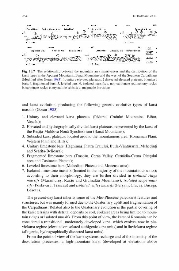
264 D. Bălteanu et al.
and karst evolution, producing the following genetic-evolutive types of karst
massifs (Goran 1983 ) :
1. Unitary and elevated karst plateaus (Pădurea Craiului Mountains, Bihor,
Vaşcău);
2. Elevated and hydrographically divided karst plateaus, represented by the karst of
the Reşiţa-Moldova Nouă Synclinorium (Banat Mountains);
3. Subsided karst plateaus, located around the mountainous area (Romanian Plain,
Western Plain and Hills);
4. Unitary limestone bars (Hăghimaş, Piatra Craiului, Buila-Vânturariţa, Mehedinţi
and Scăriţa-Belioara);
5. Fragmented limestone bars (Trascău, Cerna Valley, Cernădia-Cerna Olteţului
area and Casimcea Plateau);
6. Leveled limestone bars (Mehedinţi Plateau and Moneasa area);
7. Isolated limestone massifs (located in the majority of the mountainous units);
according to their morphology, they are further divided in isolated ridge
massifs (Maramureş, Rarău and Giumalău Mountains), isolated slope mas-
sifs (Postăvaru, Trascău) and isolated valley massifs (Perşani, Ciucaş, Bucegi,
Leaota).
The present-day karst inherits some of the Mio-Pliocene paleokarst features and
structures, but was mainly formed due to the Quaternary uplift and fragmentation of
the Carpathians. Related also to the Quaternary evolution is the partial covering of
the karst terrains with detrital deposits or soil, epikarst areas being limited to moun-
tain ridges or isolated massifs. From this point of view, the karst of Romania can be
considered a transitional, moderately developed karst, which evolves now in plu-
viokarst regime (elevated or isolated authigenic karst units) and in fl uviokarst regime
(allogenic, hydrographically dissected karst units).
From the point of view of the karst systems recharge and of the intensity of the
dissolution processes, a high-mountain karst (developed at elevations above
Fig. 10.7 The relationship between the mountain area massiveness and the distribution of the
karst types in the Apuseni Mountains, Banat Mountains and the west of the Southern Carpathians
(Modifi ed after Goran 1983 ) . 1, unitary elevated plateaus; 2 dissected elevated plateaus; 3, unitary
bars; 4, fragmented bars; 5, leveled bars; 6, isolated massifs; a, non-carbonate sedimentary rocks;
b, carbonate rocks; c, crystalline schists; d, magmatic intrusions

26510 Recent Landform Evolution in the Romanian Carpathians…
1,500–1,700 m), with water recharge from snow and rain, mainly as authigenic
(unitary) karst, with well-represented epikarst, and karst areas of medium and low
mountains, hydrographically divided, with lower relief energy, binary karst func-
tioning and covered by forests, meadows and limited arable land, can be identifi ed.
High-mountain karst presents the following genetic types: limestone ridges
(Piatra Craiului, Buila–Vânturariţa, Oslea, Scăriţa–Belioara), unitary and elevated
plateaus (Hăghimaş, Retezat, and Bihor–Vlădeasa) or isolated ridge massifs
(mountains such as Maramureş, Rodna, Bistriţa, Postăvaru, Bucegi, Făgăraş,
Parâng, and Bihor). On this karst landscape, there are extensive areas occupied by
karren and large sinkholes, while the endokarst consists mainly of potholes,
genetically related to underground drainage networks of a few kilometers in
length. Among the high mountains karst units of the massifs rise higher than
2,000 m and provide evidence for the presence of Quaternary glaciers (Rodna,
Făgăraş, Parâng, and Retezat). There are also nivokarst structures, represented by
karren, chimneys, dissolution arches, and sinkholes continued with shafts in the
Bihor, Retezat, Piatra Craiului, and Bucegi Mountains. Another feature of the
high-mountain karst is the presence of potholes and caves sheltering perennial ice
deposits, also affected by the glaciokarst or nivokarst processes (Scărişoara
Glacier Cave, Borţig Pothole, Glacier from Zgurăşti, Zăpodie Cave from the Bihor
Mountains, the potholes from Stănuleţi, Retezat, Soarbele, and Albele Mountains).
The landscape of the middle and low mountains is marked by planation and recent
debris deposits. The limestones outcrop in isolated peaks and ridges or on surfaces
where the clay or soil cover has been eroded. This landscape pertains to the
Pericarpathian erosion levels (Râul Şes and Gornoviţa), consisting of unitary and
elevated karst plateaus (Pădurea Craiului Mountains, Vaşcău and Dumbrăviţa pla-
teaus from the Codru-Moma Mountains, Vf. lui Stan–Domogled Ridge from the
Mehedinţi Mountains, the west of the Şureanu Mountains), elevated and fragmented
plateaus (Banat and Vâlcan Mountains), dissected limestone bars (Trascău
Mountains,“Ciucevele” and “Râmnuţele” from the Cerna Valley, Galbenul–Olteţ–Cerna
Vâlceană area), leveled limestone bars (Mehedinţi Plateau) and many isolated
massifs. On the karst surface, sinkhole fi elds or valleys with sinkholes are fre-
quently developed, while along the massif margins, at the inlets, along the litho-
logical contacts, blind valleys and fl uviokarst depressions are formed. The endokarst
is represented by outlet and multilevel caves, located on the valley slopes.
Over 12,000 caves have been recorded in the Romanian Carpathians (cavities
more than 5 m long), this fi gure accounting for 96% of the caves of Romania (Goran
1982 ) . The distribution of the caves on mountain units is depending on the size of
the karst area and on the intensity of the karst processes. Therefore, from the Eastern
Carpathians, 810 caves have been registered, from the Southern Carpathians, 5,697
caves, from the Banat Mountains, 1,553, and from the Apuseni Mountains – 3,960
caves. An exceptional concentration of caves is found in the Bihor Mountains
(1,299), Retezat Unit (more than 2,800), Anina Mountains (1,041) and Pădurea
Craiului Mountains (800). The Vântului Cave (Pădurea Craiului Mountains) is the
longest (more than 50 km long) cave, while the V5 Pothole (Bihor Mountains) is the
deepest (−641 m).

266 D. Bălteanu et al.
10.3.4 Periglacial Processes
Petru Urdea
Romanian geoscientists agree that the landscape of Romania fi nally took shape in the
Quaternary period. In this complex process, periglaciation played a decisive part –
especially in the mountains. The relict elements have to be distinguished from
present-day periglacial processes. Obviously, in lowlands and hills periglacial ele-
ments have a relict character, in contrast to uplands (alpine regions), where some of
the recent periglacial elements have reached their climax.
The climatic conditions in the periglacial zone of the Romanian Carpathians are
exemplifi ed by a mean annual air temperature of 3°C at Cozia (1,577 m), 1.0°C at
Vlădeasa, 0.2°C at Bâlea Lake (2,038 m), −0.5°C at Ţarcu (2,180 m) and −2.5°C at
Omu (2,505 m), where the absolute minimum temperature is −38°C. Mean annual
precipitation is 844.2 mm at Cozia, 1151.3 mm at Vlădeasa, 1,246 mm at Bâlea
Lake, 1,180 mm at Ţarcu and 1,280 mm at Omu. The continentality index according
to Gams (CIG) is over 50°. Snow depth is highly variable, between 50 and 370 cm,
according to the wind action. About 60–75% of precipitation falls as snow, and the
snow cover in the region lasts 150–210 days of the year. The 3°C mean annual iso-
therm, i.e., the lower limit of periglacial environment, runs at ca 1,700 m elevation.
In the periglacial region there are three zones, the solifl uction zone between the 3°C
and 0°C isotherm, the zone of complex periglacial processes between 0°C and −3
(−2)°C isotherm, and the cryoplanation zone of intense mechanical weathering
between the −3 (−2)°C and −6°C isotherm. From the Peltier diagram the morpho-
climatic systems are periglacial system with physical dominance for Omu and Bâlea
Lake and boreal system for Ţarcu (Urdea and Sîrbovan 1995 ) .
BTS measurements and the low water temperatures (<2°C) of rock glaciers out-
lets prove the existence of permafrost in rock glaciers and scree deposits. It was an
interesting and amazing discovery that permafrost is also present at low elevations,
at 1,100 m at Detunata Goală (Apuseni Mountains) (Urdea 2000 ) , proved by the
solar radiation model (Urdea et al. 2001 –2002). Recently, the existence of perma-
frost was documented by geophysical investigations, especially for rock glaciers
(Urdea et al. 2008a ) .
Periglacial deposits , important paleoclimatic indicators, are formed by freeze-
thaw action (blockfi elds, talus cones, scree, stone streams, rock rivers), by solifl uc-
tion and aeolian deposition (loess, nivo-eolian deposits). For scree slopes at Bâlea
Lake and Văiuga, geoelectrical DC tomography (Urdea et al. 2008a ) , based on the
Wenner–Schlumberger array layout confi guration, shows the presence of distinct
layers specifi c to stratifi ed slope deposits (Sass 2006 ) , in fact “ éboulis ordonée”
(Urdea 1995 ) . The resulted models for the solifl uction lobe Paltina, in dipole-dipole
confi guration (suitable for vertical structures), and at an equal distance of 1 m
between the electrodes, permit a differentiation of distinct layers of 40–50 cm and
undulating solifl uctional layers (Fig. 10.8 ). In the case of the fossil patterned ground
Paltina–Piscul Negru, the 2D electrical resistivity tomography model in Wenner

26710 Recent Landform Evolution in the Romanian Carpathians…
confi guration, presents distinct layers with a special undulating and pocket design
formed by frost heaving and frost sorting. For rock glaciers (Ana and Pietrele in the
Retezat Mountains, Capra Tunnel and Văiuga in the Făgăraş Mountains) electrical
tomography reveals typical structures. In the bottom part high resistivity (>700 k W m)
points to rock bodies rich in ice (Urdea et al. 2008a ) .
Although the alpine area of the Romanian Carpathians belongs to the periglacial
and boreal morphoclimatic altitudinal zones, present-day geomorphological pro-
cesses are very complex (Urdea et al . 2004 ) . Frost weathering is regarded as a par-
ticularly effective geomorphic agent, a combination of frost shattering and frost
wedging. The occurrence of freshly split blocks, gravelly and sandy regolith in the
granitoid massifs (Retezat, Parâng, Vârfu Pietrii, and others) with tors indicates that
the process of grussifi cation and rock weathering, and the production of coarse
loose debris, monitored in the Lolaia Mountain area (Retezat Mountains) and in the
Transfăgărăşan area, are still active and continuous under present-day climatic con-
ditions. The information obtained from thermal images (a thermoinfrared camera
Fluke Ti20) confi rms surface temperature variations between minerals in granitoid
rocks under short-term (diurnal) temperature fl uctuations controlled by color and
crystal size. Surface temperatures variations between minerals (quartz, feldspar,
mica, amphibole) cause differential thermal expansion, strain and disintegration
and, with the contribution of nivo-eolian processes, cavernous weathering or the
formation of honeycomb microforms (Fig. 10.9 ). The predominantly upward
directed frost heaving and predominantly lateral frost thrusting, induced by ice
segregation in the ground, produce pipkrakes or needle ice, which can heave stones
as large as cobbles and frost sorting, very active on the surfaces of the solifl uction
terraces. Sorted patterned ground is characteristic of the strandfl ats of glacial lakes
(like Ana and Valea Rea, Retezat Mountains) (Fig. 10.10 ).
Fig. 10.8 Electrical resistivity tomography profi le (inversion model) on the solifl uction lobe
Paltina (Făgăraş Mountains) (Urdea et al. 2008d )

268 D. Bălteanu et al.
Fig. 10.9 Honeycombs on
Lolaia Mountain (1,750 m,
Retezat Mountains)
Fig. 10.10 Frost sorting on the Ana Lake strandfl at (at 1,975 m in the Retezat Mountains)

26910 Recent Landform Evolution in the Romanian Carpathians…
The monitoring of two areas on the Muntele Mic Mountain, i.e., a fi eld of perigla-
cial earth hummocks at the 1,765 m and an area with fl at surface at 1,774 m eleva-
tion, using elevationmeters BAC and Danilin cryometers, shows the values between
30 and 72 mm for earth hummocks and between 8 and 35 mm for fl at ground (Urdea
et al. 2004 ) . The differential downslope displacement of colluvial deposits and
rocks through gelifl uction processes and frost creep produce a range of landforms,
like gelifl uction lobes, gelifl uction sheets, gelifl uction benches, and plowing blocks.
The movement of the plowing blocks was monitored on Muntele Mic and Parângul
Mic Mountains (Table 10.1 ).
Frost creep is controlled by the number of freeze-thaw cycles, slope angle and
ground moisture content. The talus cones and scree slopes affected by frost creep
have a distinct aspect. Creep is also important for rock glaciers (Fig. 10.11 ). The
rock debris of scree cones on Lolaia Mountain and “stone banked lobes” or “rocky
lobes” (e.g., on Gemănarea Mountain in the Parâng Mountains) show differentiated
rates of movement for the different parts, ranging from 1.22 to 3.78 cm year −1 (Urdea
et al. 2004 ) .
Nivation , embracing all processes associated with enduring snow patches, trans-
port debris by snow creep and slopewash by melting snow. Monitored in the Muntele
Mic area, it has been found still active in the present-day morphodynamics of the
Carpathians periglacial belt (Urdea et al. 2004 ) . The combination of nivation and
other periglacial processes is responsible for the development of erosional features,
such as nivation hollows, benches, niches (Fig. 10.12 ), cryoplanation terraces and
others. In the Romanian Carpathians, avalanches affect steep slopes with a fre-
quency of 2–20 events per year.
10.3.5 Fluvial Processes
Maria Rădoane and Nicolae Rădoane
In Romania there are over 250 reservoirs, with ca 500 km branches and supplies and
16,000 km of river embankments. Thus, fl uvial processes have been a major con-
cern of the researchers in the last 30 years (Diaconu et al. 1962 ; Grumăzescu 1975 ;
Hâncu 1976 ; Panin 1976 ; Pascu 1999 ; Bondar et al. 1980 ; Armencea et al. 1980 ;
Ichim et al. 1989 ; Ichim and Rădoane 1990 ; Rădoane et al. 1991, 2003, 2008a, b, c ;
Amăriucăi 2000 ; Rădoane 2004 ; Rădoane and Rădoane 2005 ; Dumitriu 2007 ;
Burdulea-Popa 2007 ; Canciu 2008 ; Feier and Rădoane 2008 ; Perşoiu 2008 ) .
Quantitative research of fl uvial geomorphology has focused mainly on the main
rivers in the eastern part of Romania, respectively the Prut and Siret rivers with their
major tributaries and drainage basins of over 70,000 km 2 .
The geomorphological analysis of longitudinal profi les (Rădoane et al. 2003 )
involved mathematical models and coeffi cients of variation to select a concavity
index (Fig. 10.13 ). The index values tend to increase from north to south in the
Eastern Carpathians. The explanation for this situation has called for a review of

270
D. B
ălte
anu et a
l.
Table 10.1 Results of monitoring ploughing blocks in the Parângu Mic area
#
Altitude
(m above
sea level) Slope (°)
Block size Block movement (mm) Block azimuth (°)
Length (m) Width (m) Height (m)
Relative
volume (m 3 ) 2000–2001 2001–2003 Annual 2000 2001 2003
1 2,035 26 1.45 0.54 0.115 0.09 11.4 25.6 12.3 195 195 199
2 2,037 18 2.26 0.69 0.25 0.38 9.9 14.1 8 202 198 202
3 2,050 16 1.83 1 0.25 0.45 12.6 22.4 11.6 228 220 226
4 2,045 15 2 0.91 0.16 0.29 6.2 8.8 5 213 212 217

27110 Recent Landform Evolution in the Romanian Carpathians…
Fig. 10.11 Talus rock glaciers at Ştirbu (Retezat Mountains) affected by frost creep
Fig. 10.12 Nivation niches on Ţarcu Mountain at 2,020 m above sea level

272 D. Bălteanu et al.
ideas on the stages of evolution of the drainage network in the region. The
relationship between river age and longitudinal profi le shape shows that the geo-
morphologic evolution of the river has not made a footprint in a decisive way on
the shape of the longitudinal profi le as, for instance, the Davisian erosional cycle
concept suggests. The rivers from the north of Trotuş river (ages of 13–14 million
years on the same course) have longitudinal profi les apparently less evolved
(reduced concavity, increased slope) (Fig. 10.13 ). In contrast, the rivers south of
Trotuş (Putna, Buzău, Prahova, Ialomiţa), whose courses have undergone major
changes, interruptions, tectonic uplift, subsidence in the approximately 2.5 million
years of evolution, are characterized by highly concave longitudinal profi les.
However, in accordance with the classical Davisian conceptual and modern models
(Snow and Slingerland 1987 ) , the latter profi les should have a much higher concav-
ity coeffi cient. The linear–exponential equilibrium expresses a balance between
erosion and accumulation, therefore, it is a characteristic profi le of transport , with
a high slope, which the rivers north of Trotuş have preserved, with some variations,
for 14 million years. In accordance to Hack’s dynamic equilibrium theory, a form of
relief preserves those characteristics that ensure a state of equilibrium in the
exchange of mass and energy with other forms of relief (Hack 1960 ). This applies
to the shape of the longitudinal profi les of rivers in the Eastern Carpathians.
The geomorphic analysis of longitudinal profi les is linked to the processes of
downstream fi ning and channel material bimodality. These processes were studied
for the six major Carpathian rivers ( Rădoane et al. 2008a ) . The investigations on the
bed material variability of the Siret Basin rivers were mainly focused on verifying the
Fig. 10.13 Illustration of the relationship between the shape and the age of longitudinal profi les
for the rivers in the eastern and southeastern part of Romania (Rădoane et al. 2003 )

27310 Recent Landform Evolution in the Romanian Carpathians…
exponential model of reduction in the sediment size along the river, according to
Sternberg’s law, which shows that the river bed particles reduce their dimension pro-
portionally with the mechanical work made against friction along the river. Depending
on the length of the river, the median diameter (D 50
) is reduced overall exponentially,
but on important lengths of the rivers this exponential decrease is acutely disturbed.
From this point of view as well, the Eastern Carpathian rivers record many deviations
from the conceptual model. The Trotuş and Siret Rivers even show an increase in the
material’s dimension along most of their lengths. The only rivers that nearly relate to
the exponential model on their entire length are the Suceava and the Moldova. The
main cause for which the Sternberg model does not fi t to the other four rivers lies in
the contribution of the tributaries with a massive sediment input in the rivers in ques-
tion, a lot greater than their ability to modify (Fig. 10.14 , left).
The bedload has a distinct bimodality , the two peaks in the grain size distribution
curve being separated by a small gravel fraction of 1–8 mm diameter. This bimodal-
ity of fl uvial deposits may be explained by the different origin of the bedload. For
the Carpathian tributaries of the Siret River, coarse gravel joins a unimodal distribution
presenting a right skewness with enhanced downstream fi ning. The source of the
Fig. 10.14 Map of suspended sediment transport in the Siret drainage basin. The transport of fi ne
sediment represented by arrows is superimposed on coarse sediment transport, identifi ed by the
extension of piedmonts and alluvial terraces. The central line divides the two main areas of the
sediment system: source area and sedimentation area ( to the left ). Bimodality is seen at the inter-
section of both distributions on the example of the Buzău River. Numbers indicate sampling sites
from source to mouth ( to the right ) (Rădoane et al. 2008a )

274 D. Bălteanu et al.
coarse material is the river channel itself. A second distribution with a sandy mode
is, in general, skewed to the left. The source of the second peak is the amount of
sand that reached the riverbed from erosion on hillslopes. The tails of the histo-
grams skewed to the right (for the gravel) and skewed to the left (for the sands)
intersect. The intersection of the two modes occurs in the area of fractions from the
0.5–8 mm range. This explains the penury of particles between 0.5 and 8 mm. For
the rivers where the sources of fi ne sediment are low, the 0.5–8 mm fractions are
more frequent than the factions under 1 mm (Fig. 10.14 , right). For the Siret River
itself, bed sediment bimodality is greatly enhanced due to the fact that the second
mode represents more than 25% of the full sample. As opposed to its tributaries, the
source of the fi rst mode, of gravel, is allochthonous to the Siret River, generated by
the massive input of coarse sediment from Carpathian tributaries, while the second
mode, of the sands, is local.
The riverbed material is subject to vertical mobility in the longitudinal profi le
and in cross section. Change in the bed elevation of alluvial rivers, in a positive or a
negative way as related to a reference point, is a direct response to a sediment-supply
defi cit or surplus. Data from 63 cross sections of the Siret River basin were
analyzed, in particular those from the right side of the river. From monitoring bed
elevation in the cross sections for a period of over 70 years, degradation (100–120 cm)
was found in almost half of the cases and aggradation (80–100 cm) in less than 30%
of cases. Stability of the riverbed, the vertical oscillation of the riverbed below the
value of 50 cm, characterizes a little over 20% of the cases.
The most abrupt human intervention into the river systems is the construction of
dams and reservoirs. There are ca 250 reservoirs in Romania, mainly on the Bistriţa,
Siret, and Prut Rivers. On the Prut River, for instance, a dam was built at Stânca–
Costeşti (Fig. 10.15 ), resulting in capturing almost all (over 95%) the sediment load
in the upper drainage basin. Consequently, immediately downstream the dam, river
is entirely devoid of suspended load . Along the next 500 km downstream the river
attempts to compensate for the sediment load lost, but only achieves to raise its
suspended sediment transport to 63%, as measured at the river mouth. The amount
of water discharge, however, has not been affected by dam construction, only the
regime was modifi ed through human regulation.
Current measurements at seven gauging stations on aggradation-degradation pro-
cesses along the Prut River are available for the period 1975–2005. Naturally, upstream
of Stânca Reservoir, the riverbed shows slight aggradation, probably as a response to
sediment storage at the end of the reservoir. Immediately downstream of the dam, deg-
radation is the dominant process as a direct effect of a drastic reduction of sediment load.
Incision , however, is not linear, but there are also areas where the riverbed is slightly
aggrading. Overall, the effect of the dam is transmitted downstream the Prut riverbed
over a distance of 400 km, with an incision rate of over 4 m 3 year −1 . Only towards the
confl uence with the Danube the rate drops below 0.5 m 3 year −1 (Fig. 10.15 ).
In conclusion, the fl uvial processes in Romania follow the tendencies observed
for European rivers under prolonged human impact (Petts et al. 1989 ) . At the begin-
ning of the nineteenth century, the process of aggradation was dominant, while in
the twentieth century the complexity of anthropogenic interventions resulted in a

27510 Recent Landform Evolution in the Romanian Carpathians…
deepening and narrowing of riverbeds. In Romania, however, there is a certain delay
in channel response. Although the incision is dominant (for over 50% of all sections
studied), riverbed aggradation is still present.
10.3.6 Mining Activities and Environmental Impacts
Mihaela Sima
The Romanian Carpathians are rich in mineral deposits, some having been
exploited since ancient and even pre-historical times (e.g., gold in the Apuseni
Mountains) (Fig. 10.16 ). Although mining is practiced on a fairly small scale, its
environmental impact is extremely severe: contamination of waters with heavy met-
als from the exploitation and processing of non-ferrous ores; acid drainage from coal
mines and metallurgical plants; suspended load mainly from coal mines; radioactive
ores; air pollution related to fl otation, burning and processing plants (sulfur and
nitrogen oxides, carbon-dioxide and methane); topographic changes (waste dumps,
tailings ponds, and underground galleries) affecting the environmental and degrading
lands, soils, fl ora and fauna and, most importantly, human health.
After 1990, Romanian mining industry experienced a major restructuring: the
majority of mines, still economically effi cient, were gradually closed down, an action
Fig. 10.15 Rate of fl uvial processes (aggradation or degradation) along the Prut River

276 D. Bălteanu et al.
that continued after 2000 and particularly in 2006–2007. Most mining sites are under
environmental rehabilitation , but, because of money shortage, during the past few
years rehabilitation programs were either not launched, or implemented only in cer-
tain areas. In 2001 technological accidents in the tailing dams of Maramureş Country
had a signifi cant cross-border impact. The loud international response led to funda-
mental changes in European legislation (e.g., the Seveso II Directive on the control
of major accidents involving dangerous substances covers also mining activities). In
the course of the accidents several rivers (the Lăpuş/Someş, Novăţ/Vişeu, the Tisza
and the Danube) on the territory of neighboring countries were polluted. One of the
main results obtained by studying the situation in those regions is that the pollution
found at all the major observation points of Maramureş and Satu Mare counties and
from the Apuseni Mountains, was caused by waste spills from active mines being
either untreated or their waste water treatment plants were out of operation
(Fig. 10.17 ). The contamination, especially of surface and groundwaters, with pollut-
ants of mining origin extends only up to 5 km from the observation point, affecting a
corridor some 1 km wide along the river channel. In general, between these observa-
tion points, both river and groundwater lie within EU quality standard limits, although
the metal concentrations found in the river and fl oodplain sediments are somewhat
higher due to historical pollution (Brewer et al. 2002 ; Macklin et al. 2003 ; Bird et al.
2003, 2008 ; Şerban et al. 2004 ) .
Fig. 10.16 Distribution of ore deposits in north-western Romania (Şerban et al. 2004 )

27710 Recent Landform Evolution in the Romanian Carpathians…
Under the current technical and technological conditions mining is no longer
economically effi cient, and many pits are already exhausted. Unfortunately, mines
that have been closed down do not benefi t from ecological rehabilitation programs
or from adequate conservation measures either and continue to yield high quantities
of pollutants, thereby being detrimental to the environment. However, there are
companies that have maintained or even plan to extend their activity (e.g., at Roşia
Montană). Non-ferrous metal ores are no longer extracted or processed in Romania
for lack of state subventions to update obsolete technology. Unless countermeasures
are taken, environmental degradation is expected to go on for scores and hundreds
of years with a serious long-term impact.
References
Amăriucăi M (2000) Şesul Moldovei extracarpatice dintre Păltinoasa şi Roman. Studiu geomorpho-
logic şi hidrologic (The Extra-Carpathian fl oodplain of Moldova River between Păltinoasa and
Roman. Geomorphological and Hydrologic Study). Edit. Carson, Iaşi, 180 p (in Romanian)
Andra A, Mafteiu M (2008) The landslides from Tigveni–Momaia. In: Bălteanu D (ed) IAG
Regional conference on geomorphology “Landslides, fl oods and global environmental
change in mountain regions”. Field Guidebook, University Publishing House, Bucharest,
pp 59–64
Fig. 10.17 River affected by acid mine drainage in the Southern Apuseni Mountains, Romania

278 D. Bălteanu et al.
Armencea Gh, Marinescu Gh, Stoicescu H, Lup I (1980) Aspecte ale prognozei procesului de
coborâre al albiei râurilor aval de baraje (On the river bed incision prognosis downstream of
dams). Hidrotehnica 25(5):101–103 (in Romanian)
Badea L (1957) Observaţii asupra unor alunecări din bazinul Buzăului (Some remarks on the land-
slides of the Buzău drainage basin). Probleme de Geografi e 4:388–392 (in Romanian)
Bălteanu D (1975) Un eşantion de hartă morfodinamică din Subcarpaţii Buzăului (A morphody-
namic map in the Buzău Subcarpathians). In: Lucrările Colocviului Naţional de Geomorfologie
Aplicată şi Cartografi ere Geomorfologică, Iaşi, pp 349–354 (in Romanian)
Bălteanu D (1983) Experimentul de teren în geomorfologie (Field experiment in geomorphology).
Edit. Academiei Române, Bucureşti, 156 p (in Romanian)
Bălteanu D (1986) The importance of mass movement in the Romanian Subcarpathians.
Z Geomorphol 58(Supplement-Band):173–190
Bălteanu D (1997) Geomorphological hazards of Romania. In: Embleton C, Embleton-Hamann
Ch (eds) Geomorphological hazards of Europe. Elsevier, Amsterdam, pp 409–427
Bălteanu D, Jurchescu M (2008) Deep-seated landslides (Glimee) in the Transylvanian Depression.
Map in: Bălteanu D (ed) IAG Regional conference on geomorphology “Landslides, fl oods and
global environmental change in mountain regions”. Field Guidebook, University Publishing
House, Bucharest
Bălteanu D, Micu M (2009) Landslide investigation: from morphodynamic mapping to hazard
assessment. A case study in the Romanian Subcarpathians, Muscel catchment. In: Malet J-Ph,
Remaitre A, Bogaard T (eds) Landslide Processes. From geomorphologic mapping to dynamic
modelling. CERG Editions, Strasbourg, pp 235–241
Bălteanu D, Teodoreanu V (1983) The mass movement from Malu Alb. In: Excursion guidebook
symposium “The role of geomorphological fi eld experiments in land and water management”,
Bucharest, pp 77–80
Bălteanu D, Chendeş V, Sima M, Enciu P (2010) A country-wide spatial assessment of landslide
susceptibility in Romania. Geomorphology 124(3–4):102–112
Barbu N (1976) Obcinele Bucovinei. Edit. Stiint. si Enciclop, Bucuresţi, 316 p (in Romanian)
Bătucă D (1978) Aspecte ale morfologiei generale a albiilor râurilor din bazinul hidrografi c Mureş
superior, (On the general morphology of the riverbeds in the Upper Mureş drainage basin).
Hidrotehnica 23(6):121–124 (in Romanian)
Bird G, Brewer P, Macklin M, Balteanu D, Driga B, Serban M, Zaharia S (2003) The solid state
portioning of contaminant metals and As in river channel sediments of the mining affected Tisa
drainage basin, northwestern Romania and eastern Hungary. Appl Geochem 18:1583–1595
Bird G, Brewer P, Macklin M, Balteanu D, Serban M, Driga B, Zaharia S (2008) River system
recovery following the Novat-Rosu tailings dam failure, Maramureş County, Romania. Appl
Geochem 23(12):3498–3518
Bleahu M, Povară I (1976) Catalogul peşterilor din România (The catalogue of the caves of
Romania). Edit. C.N.E.F.S, Bucureşti, 53 p
Bleahu M, Rusu T (1965) Carstul din România (Karst in Romania). Lucrările Institutului de
Speologie “Emil Racoviţă”, Bucureşti 4:59–73 (in Romanian)
Bondar C, State I, Dediu R, Supuran I, Vaşlaban G, Nicolau G (1980) Date asupra patului albiei
Dunării în regim amenajat pe sectorul cuprins între Baziaş şi Ceatal Izmail (Data on the Danube
managed riverbed between Baziaş and Ceatal Izmail). Studii şi Cercetări de Hidrologie
48:145–168 (in Romanian)
Brewer P, Macklin M, Balteanu D, Coulthard T, Driga B, Howard A, Bird G, Zaharia S, Serban M
(2002) The January and march tailings dam failures in Maramures county, Romania, and their
transboundary impacts on the river systems. In: Proceedings of advanced research workshop
“Approaches to handling environmental problems in the mining and metallurgical regions of
NIS counties”, Mariupol, 5–7 Sept 2002, pp 56–64
Burdulea-Popa A (2007) Geomorfologia albiei râului Siret (The geomorphology of the Siret River
Channel). Manuscript PhD thesis. Al. I. Cuza University of Iaşi (in Romanian)
Canciu C (2008) Valea Dunării între Brăila şi Pătlăgeanca – studiu geomorfologic (The Danube
Valley between Brăila and Pătlăgeanca – Geomorphological Study). Manuscript PhD thesis,
University of Bucharest (in Romanian)

27910 Recent Landform Evolution in the Romanian Carpathians…
Chiţu Z (2010) Predicţia spaţio-temporală a hazardului la alunecări de teren utilizând tehnici S.I.G.
Studiu de caz arealul subcarpatic dintre Valea Prahovei şi Valea Ialomiţei (Spatial and temporal
prediction of landslide hazard using GIS. Case-study: the Subcarpathian area between the
Prahova and Ialomiţa valleys). Manuscript PhD thesis, University of Bucharest, 295 p
(in Romanian)
Chiţu Z, Şandric I, Mihai B, Săvulescu I (2009) Evaluation of landslide susceptibility using multi-
variate statistical methods: a case-study in the Prahova Subcarpathians, Romania. In: Malet
JPh, Remaitre A, Bogaard T (eds) Landslide Processes. From geomorphologic mapping to
dynamic modelling. CERG Editions, Strasbourg, pp 265–270
Constantin S (1992) The intra-Aptian karstifi cation phase and the paleokarst associated deposits in
the southern sector of Locva Mountains (South-West Romania). Theor Appl Karstol 5:83–92
Constantin S, Lauritzen S-E, Stiuca E, Petculescu A (2001) Karst evolution in the Danube Gorge
from U-series dating of a bear skull and calcite speleothems form Pestera de la Gura Ponicovei
(Romania). Theor Appl Karstol 13–14:39–50
Constantin M, Trandafi r AC, Jurchescu MC, Ciupitu D (2010) Morphology and environmental
impact of the Colţi-Aluniş landslide (Curvature Carpathians), Romania. Environ Earth Sci
59(7):1569–1578
Constantin M, Bednarik M, Jurchescu MC, Vlaicu M (2011) Landslide susceptibility assessment
using the bivariate statistical analysis and the index of entropy in the Sibiciu basin (Romania).
Environ Earth Sci 63(2):397–406. doi: 10.1007/s12665-010-0724-y
Dârja M, Budiu V, Tripon D, Păcurar I, Neag V (2002) Eroziunea hidrică şi impactul asupra
mediului (Erosion by water and its impact on the environment). Edit. Risoprint, Cluj-Napoca,
100 p (in Romanian)
de Martonne E (1900) Contribution a l’etude de la période glaciaire dans les Karpates Méridionales.
Bull Soc Géol de la France 28(3):275–319
de Martonne E (1907) Recherches sur l’évolution morphologique des Alpes de Transylvanie
(Karpates Méridionales). Revue de géographie annuelle I (1906–1907), 286 p
Diaconu C, Ciobanu S, Avădanei A, Motea I, Stănescu S (1962) Despre stabilitatea albiilor râurilor
României (On the stability of river channels in Romania during the last 30–40 years). Studii de
Hidrologie 3:53–66 (in Romanian)
Dinu M, Cioacă A (2000) Rolul hazardelor naturale în evoluţia localităţilor din România (On the
role of natural hazards in the evolution of settlements in Romania). Analele Universităţii Spiru
Haret, Bucureşti 3:43–52 (in Romanian)
Donisa I (1968) Geomorfologia văii Bistriţei (Geomorphology of the Bistriţa Valley). Edit.
Academiei Române, Bucureşti, 285 p (in Romanian)
Dragotă C, Micu M, Micu D (2008) The relevance of pluvial regime for landslide genesis and
evolution. Case study: Muscel basin (Buzău Subcarpathians, Romania). In: Present environ-
ment & sustainable development. 2. Edit. Universităţii “Al. I. Cuza”, Iaşi, pp 242–257
Dumitriu D (2007) Sistemul aluviunilor din bazinul râului Trotuş (Alluvial system in the Trotuş
River basin). Edit. Universităţii, Suceava, 259 p (in Romanian)
Feier I (2007) Evoluţia istorică a migrării albiei râului Someşu Cald, (Historical evolution of the
Someşu Cald riverbed mobility). Manuscript PhD thesis, “A. I. Cuza” University, Iaşi
(in Romanian)
Feier I, Rădoane M (2008) Dinamica in plan orizontal a albiei minore a raului Somesu Mic inainte
de lucrarile hidrotehnice majore (1870–1968) (Channel planform dynamics of the Someşu Mic
River before the major human modifi cations, 1870–1968). Analele Universităţii Suceava
16:13–26 (in Romanian)
Gârbacea V (1992) Harta glimeelor din Câmpia Transilvaniei (Map of the “glimee”-type land-
slides distribution in the Transylvanian Plain). Studia Universitatis Babeş-Bolyai, Geographia
37(1–2):21–24 (in Romanian)
Gârbacea V (1996) Remarques sur le relief de “glimee” en Roumanie. Geografi a Fisica e Dinamica
Quaternaria 19:219–221
Gârbacea V, Grecu F (1983) Relieful de glimee din Podişul Transilvaniei şi potenţialul lor eco-
nomic (The glimee landforms of the Transylvanian Plateau and their economic potential).
Memoriile Secţiilor Ştiinţifi ce ale Academiei R.S.R. 4(2):305–312 (in Romanian)

280 D. Bălteanu et al.
Gaşpar R, Untaru E (1979) Contribuţii la studiul transportului de aluviuni în bazinele torenţiale
parţial împădurite (Contributions to the study of sediment transport in partially forested tor-
rential catchments). Buletinul Informativ ASAS 8:87–95 (in Romanian)
Goran C (1980) Catalogul peşterilor din România – 1979 (The Romanian Caves Register – 1979).
Buletinul Informativ CCSS 4:172–179 (in Romanian)
Goran C (1982) Catalogul sistematic al peşterilor din România (A systematic catalogue of caves in
Romania). Edit. Sport-Turism, Bucureşti, 496 p (in Romanian)
Goran C (1983) Les types de relief karstique de Roumanie. Trav Inst Spéol “Emile Racovitza”,
Bucureşti 22:91–102
Grecu F (1992) Bazinul Hârtibaciului – Elemente de morfohidrografi e (The Hârtibaciu Basin –
Elements of Morphohydrography). Edit. Academiei Române, Bucureşti, 160 p (in Romanian)
Grumăzescu C (1975) Depresiunea Haţegului. Studiu geomorfologic (The Haţeg Depression.
Geomorphological study). Edit. Academiei Romăne, Bucureşti, 148 p (in Romanian)
Hack JT (1960) Interpretation of erosional topography in humid temperate regions. Am J Sci
258-A(67):219–230
Hâncu S (1976) Regularizarea albiilor râurilor (Channelization of Riverbeds). Edit. Ceres,
Bucuresti, 144 p (in Romanian)
Ichim I (1979) Muntii Stanisoarei. Studiu geomorfologic (The Stânişoara Mountains. Geomorphic
Study). Ed. Acad, Bucuresti, 121 p (in Romanian)
Ichim I (1980) Probleme ale cercetării periglaciarului în România (Issues on the periglacial
research in Romania). Studii şi Cercetări Geol Geofi z Geogr–Geografi e 27(1):127–135
(in Romanian)
Ichim I, Rădoane M (1980) On the anthropic infl uence time in morphogenesis with a special regard
on the problem of channel river dynamics. Revue Roumaine Géol Géophys Géogr, série
Géographie 24:35–40
Ichim I, Rădoane M (1981) Contribuţii la studiul dinamicii albiilor de râu în perioade de timp scurt
şi de timp îndelungat (Contributions to the study of riverbed dynamics during short and long
time periods). Hidrotehnica 25(5):135–138 (in Romanian)
Ichim I, Rădoane M (1984) Cercetări privind sursele de aluviuni şi energia potenţială de eroziune,
cu exemplifi cări din regiunea Vrancei (Research on the sediment sources and the potential
energy of erosion, with examples from the Vrancea region). Hidrotehnica 29(6):183–187
(in Romanian)
Ichim I, Rădoane M (1986) Efectele barajelor în dinamica reliefului. Abordare geomorfologică
(The effects of dams on relief dynamics. A geomorphological approach). Edit. Academiei R. S.
România, Bucureşti, 157 p (in Romanian)
Ichim I, Rădoane M (1990) Channel sediment variability along a river: a case study of the Siret
River, Romania. Earth Surf Process Landf 15(3):211–226
Ichim I, Rădoane M, Rădoane N, Surdeanu V, Amăriucăi M (1979) Problems of meander geomor-
phology with particular emphasis on the channel of the Bârlad River. Revue Roumaine Géol
Géophys Géogr, série Géographie 23:35–47
Ichim I, Bătucă D, Rădoane M, Duma D (1989) Morfologia şi dinamica albiilor de râu (River
channel morphology and dynamics). Edit. Tehnică, Bucureşti, 407 p (in Romanian)
Ichim I, Mihaiu G, Surdeanu V, Rădoane M, Rădoane N (1990) Gully erosion in agricultural lands
in Romania. In: Boardman J, Foster IDL, Dearing JA (eds) Soil erosion on agricultural land.
Wiley, Chichester, pp 55–68
Ichim I, Rădoane M, Rădoane N, Miclăuş C, Grasu C (1996) Sediment budget of the Putna drain-
age basin (Vrancea). Revue Roumaine Géol Géophys Géogr, série Géographie 40:125–132
Ichim I, Rădoane M, Rădoane N, Grasu C, Miclăuş C (1998) Dinamica sedimentelor. Aplicaţii la
râul Putna – Vrancea (Sediments dynamics. Applications to the Putna River, Vrancea). Edit.
Tehnică, Bucuresti, 192 p (in Romanian with English summary)
Ielenicz M (1970) Zonele cu alunecări de teren din ţara noastră (Landslides in our country). Terra
2(1):31–40 (in Romanian)
Ielenicz M (1984) Munţii Ciucaş-Buzău. Studiu geomorfologic (The Ciucaş-Buzău Mountains.
Geomorphic Study). Edit. Academiei Române, Bucureşti, 146 p (in Romanian)

28110 Recent Landform Evolution in the Romanian Carpathians…
Ilinca V (2010) Valea Lotrului. Studiu de geomorfologie aplicată, (The Lotru Valley.
Applied geomorphological study). Manuscript PhD thesis, University of Bucharest, 217
p (in Romanian)
Ionita I (1998) Studiul geomorfologic al degradarilor de teren din bazinul mijlociu al Barladului .
(Geomorphological study of the land degradation in the middle catchment of Barlad river).
Manuscript PhD thesis, University “Alexandru Ioan Cuza”, Iaşi, 287 p (in Romanian)
Ionita I (1999) Sediment delivery scenarios for small watersheds. In: Proceedings of the symposium
“Vegetation, land use and erosion processes”. Institute of Geography, Bucharest, pp 66–73
Ionita I (2000a) Geomorfologie Aplicata. Procese de degradare a terenurilor deluroase (Applied
Geomorphology. Processes of hilly terrain degradation). Edit. Univ. “Al.I. Cuza”, Iaşi, 247 p
(in Romanian)
Ionita I (2000b) Formarea si evolutia ravenelor din Podisul Barladului. (Forming and evolution of
gullies in the Bârlad Plateau). Edit. Corson, Iaşi, 169 p (in Romanian)
Ionita I (2003) Hydraulic effi ciency of the discontinuous gullies. In: Poesen J, Valentin C (eds)
Gully erosion and global change. Catena 50(2–4):369–379
Ionita I (2006) Gully development in the Moldavian Plateau of Romania. In: Special Issue Helming
K, Rubio JL, Boardman J (eds) Soil erosion research in Europe. Catena 68(2–3):133–140
Ionita I (2008) Sediment movement from small catchments within the Moldavian Plateau of
Eastern Romania. In: Schmidt J, Cochrane T, Phillips Ch, Elliot S, Davies T, Basher L
(eds) Sediment dynamics in changing environments. IAHS Publication 325, IAHS Press,
Wallingford, pp 316–320
Ionita I, Margineanu RM (2000) Application of 137 Cs for measuring soil erosion/deposition rates in
Romania. Acta Geologica Hispanica 35(3–4):311–319
Ionita I, Margineanu R, Hurjui C (2000) Assessment of the reservoir sedimentation rates from
137 Cs measurements in the Moldavian Plateau. In: Queralt I, Zapata F, Agudo G (eds) Assessment
of soil erosion and sedimentation through the use of the 137 Cs and related techniques. Acta
Geologica Hispanica Special 35(3–4):357–367
Ionita I, Rădoane M, Mircea S (2006) Chapter 1.13 “Romania”. In: Boardman J, Poesen J (eds)
Soil erosion in Europe. Wiley, Amsterdam–London–New York, pp 155–166
Irimuş I-A (1996) La corréllation des glissements de terrain avec les types de dômes péripheriques dans
le bassin de Transylvanie (Roumanie). Geografi a Fisica e Dinamica Quaternaria 19:245–248
Irimuş I-A (1998) Relieful pe domuri şi cute diapire în Depresiunea Transilvaniei (Landforms
Developed on Domes and Diapir Folds). Edit. Presa Universitară Clujeană, Cluj, 300 p (in
Romanian)
Jeanrenaud, P (1971) Geologia Moldovei centrale dintre Siret şi Prut (Geology of the Central
Moldavia between the Siret and Prut rivers). Manuscript abstract of the PhD thesis, Al. I. Cuza
University, Iaşi (in Romanian)
Lascu C, Sârbu Ş (1987) Peşteri scufundate (Underwater caves). Edit. Acad, Bucureşti, 255 p (in
Romanian)
Macklin M, Brewer P, Bălteanu D, Colthard T, Driga B, Howard A, Zaharia S (2003) The long-
term fate and environmental signifi cance of contaminant metals released by the January and
March 2000 mining tailings dam failures in Maramureş County, upper Tisa Basin, Romania.
Appl Geochem 18:241–257
Micu M (2008) Evaluarea hazardului legat de alunecari de teren in Subcarpatii dintre Buzau si
Teleajen (Landslide Hazard Assessment in the Buzău – Teleajen Subcarpathians). Manuscript
PhD thesis, Institute of Geography, Bucharest, 242 p (in Romanian)
Micu M, Bălteanu D (2009) Landslide hazard assessment in the Bend Carpathians and
Subcarpathians, Romania. Z Geomorphol 53(Supplement 3):49–64
Micu M, Sima M, Bălteanu D, Micu D, Dragotă C, Chendeş V (2010) A multi-hazard assessment
in the Curvature Carpathians of Romania. In: Malet J-Ph, Glade T, Casagli N (eds) Mountain
risks: bringing science to society. CERG Editions, Strasbourg, pp 11–18
Mihai B (2005) Munţii Timişului (Carpaţii Curburii). Potenţialul geomorfologic şi amenajarea
spaţiului montan (The Timiş Mountains (Curvature Carpathians): Geomorphic Potential and
Mountain Landscape Planning). Edit. Universităţii din, Bucureşti

282 D. Bălteanu et al.
Mihai Gh, Neguţ N (1981) Observaţii preliminare privind evoluţia ravenelor formate pe alternanţe
de orizonturi permeabile şi impermeabile (Preliminary observations on the evolution of gullies
formed on alternating permeable and impermeable horizons). Studii şi Cercetări de Geografi e
28:117–126 (in Romanian)
Mihai B, Şandric I, Săvulescu I, Chiţu Z (2009) Detailed mapping of landslide susceptibility for
urban planning purposes in Carpathian and Subcarpathian towns of Romania. In: Gartner G,
Ortag F (eds) Cartography in central and eastern Europe, Lecture notes in geoinformation and
cartography. Springer, Heidelberg/Berlin, pp 417–429
Mihăilescu V (1926) Despre frane sau forme de teren rezultate din acţiunea de dărâmare a agenţilor
externi (o propunere) (On landslides and landforms issued from the demolition action of external
agents. A suggestion). Buletinul Societăţii Române de Geografi e 45:101–110 (in Romanian)
Mihăilescu V (1939a) Porniturile de teren din regiunea Nehoiaş, (Landslides in the Nehoiaş
region). Buletinul Societăţii Române de Geografi e 58:191–193 (in Romanian)
Mihăilescu V (1939b) Porniturile de teren şi clasifi carea lor (Landslides and their classifi cation).
Revista Geografi că Română 2(2–3):106–113 (in Romanian)
Mihăilescu V, Morariu T (1957) Consideraţii generale asupra periglaciarului şi stadiul cercetărilor actu-
ale în România (General aspects on the periglacial and overview of current research in Romania).
Studii şi Cercetări Geol série Géographie, Acad. Rom., Filiala Cluj 8(1–2):21–44 (in Romanian)
Mircea S (2002) Formarea, evoluţia şi strategia de amenajare a ravenelor (Formation, evolution
and management strategy of gullies). Edit. Bren, Bucureşti, 209 p (in Romanian)
Mircea S (2006) Contribuţii la cunoaşterea evoluţiei formaţiunilor în adâncime în bazinele hidro-
grafi ce, Rezumatul tezei de doctorat, (Contributions to the study of the evolution of gully for-
mations in drainage basins), Manuscript abstract of the PhD thesis. University of Agricultural
Sciences and Veterinary Medicine, Bucureşti, 85 p (in Romanian)
Morariu T, Gârbacea V (1966) Quelques observations au sujet des processus de versant de la Depression
Transylvanique. Revue Roumaine Géol Géophys Géogr, série Géographie 10(2):147–165
Morariu T, Gârbacea V (1968a) Studii asupra proceselor de versant din Depresiunea Transilvaniei
(Studies on slope processes in the Transylvanian Depression). Studia Universitatis Babeş-Bolyai,
Geol Geogr, Cluj 1:81–90 (in Romanian)
Morariu T, Gârbacea V (1968b) Déplacements massifs de terrain de type glimee en Roumanie.
Revue Roumaine de Géol Géophys Géogr, serie Géographie 12(1–2):13–18
Morariu T, Mihăilescu V, Dragomirescu SŞ, Posea Gr (1960) Le stade actuel de recherches sur le
périglaciaire de la R.P. Roumaine. In: Recueil d’études géographiques concernant le territoire
de la R.P. Roumaine. Edit. Academiei, Bucureşti, pp 45–53
Morariu T, Diaconeasa B, Gârbacea V (1964) Age of land-slidings in the Transylvanian Tableland.
Revue Roumaine de Géol Géophys Géogr, série Géographie 8:149–157
Moţoc M (1963) Eroziunea solului pe terenurile agricole şi combaterea ei (Soil erosion on agricul-
tural lands and its control). Edit. Agrosilvică, Bucureşti, 318 p (in Romanian)
Moţoc M (1983) Ritmul mediu de degradare erozionala a solului in R. S. Romania (Mean rate of soil
degradation by erosion in Romania). Buletinul Informativ al ASAS, 13. Bucureşti, (in Romanian)
Moţoc M, Mircea S (2002) Evaluarea factorilor care determină riscul eroziunii hidrice în suprafaţă
(Evaluation of the factors determining the soil erosion risk). Edit. Bren, Bucuresti, 60 p (in
Romanian)
Moţoc M, Mircea S (2005) Unele probleme privind formarea viiturilor şi eroziunea în bazine
hidrografi ce mici (Some problems regarding fl ash-fl ood formation and erosion in small catch-
ments). Edit. Cartea Universitară, Bucureşti, 104 p (in Romanian)
Moţoc M, Munteanu St, Băloiu V, Stănescu P, Mihai Gh (1975) Eroziunea solului şi metodele de
combatere (Soil erosion and the control methods). Edit. Ceres, Bucureşti, 301 p (in Romanian)
Moţoc M, Taloescu I, Neguţ N (1979a) Estimarea ritmului de dezvoltare a ravenelor (Assessment of
the development rate of gullies). Buletinul Informativ ASAS, 8:77–86 (in Romanian)
Moţoc M., Stănescu, P., Taloescu, I., (1979b) Metode de estimare a eroziunii totale şi a eroziunii
efuente pe bazine hidrografi ce mici (Methods for assessing total erosion and sediment delivery
within small catchments). Buletinul I.C.P.A., Bucureşti, 38 p (in Romanian)

28310 Recent Landform Evolution in the Romanian Carpathians…
Moţoc M, Ionita I, Nistor D (1998) Erosion and climatic risk at the wheat and maize crops in the
Moldavian Plateau. Rom J Hydrol Water Resour 5(1–2):1–38
Mureşan A (2008) Geomorfodinamica vailor de pe versantul vestic al Muntilor Maramureşului.
(Geomorphodynamics of the valleys on the western slope of the Maramureş Mountains).
Manuscript PhD thesis, Babeş–Bolyai University, Cluj Napoca (in Romanian)
Naum T (1970) Complexul de modelare nivo-glaciar din masivul Călimanului (Carpaţii Orientali),
(The nivo-glacial modeling complex in the Călimani Massif, Eastern Carpathians). Anal Univ
Buc–Geogr 19:67–75 (in Romanian)
Niculescu Gh (1965) Munţii Godeanu. Studiu geomorfologic (The Godeanu Mountains.
Geomorphological study). Edit. Academiei, Bucureşti, 339 p (in Romanian)
Niculescu Gh, Nedelcu E (1961) Contribuţii la studiul microreliefului crio-nival din zona înaltă a
munţilor Retezat, Godeanu–Ţarcu şi Făgăraş–Iezer (Contribution to the study of crio-nival
microrelief in the high zone of the Retezat, Godeanu–Ţarcu and Făgăraş–Iezer Mountains).
Probleme de Geografi e 8:87–121 (in Romanian)
Onac BP (2002) Caves formed within upper Cretaceous skarns at Băiţa, Bihor county, Romania:
mineral deposition and speleogenesis. Can Mineral 40:1693–1703
Orghidan T, Puşcariu V, Bleahu M, Decu V, Rusu T, Bunescu A (1965) Harta regiunilor carstice
din România (Map of the karst regions in Romania). Lucrările Institutului de Speologie “Emil
Racoviţă” 4:75–104, (in Romanian)
Panin N (1976) Some aspects of fl uvial and marin processes in the Danube Delta. Anuarul
Institutului de Geologie şi Geofi zică 50:149–165
Pascu M (1999) Cercetări privind infl uenţa regularizării radicale a albiilor de râuri asupra stabilităţii
unor construcţii aferente şi a mediului înconjurător – cu referire la bazinul hidrografi c al râului
Prahova (Research on the infl uence of radical Riverbeds Channelization on the Stability of
Nearby Buildings and Environment – Case Study: Prahova Drainage Basin). Manuscript PhD
thesis, “Gh. Asachi” Technical University, Iaşi (in Romanian)
Patriche CV, Căpăţână V, Stoica DL (2006) Aspects regarding soil erosion spatial modeling using
the USLE/RUSLE within GIS. Geographia Technica 2:87–97 (in Romanian)
Perşoiu I (2008) Time and space adjustments of Somesu Mic River. Geophysical research abstracts
10, EGU General Assembly, Vienna. EGU2008-A-00826
Perşoiu A, Onac BP, Wynn JG, Bojar A-V, Holmgren K (2011) Stable isotopes behavior during
cave ice formation by water freezing in Scarisoara Ice Cave, Romania. J Geophys Res, Atmos
116 (D02111):8 p, doi: 10.1029/2010JD014477
Petts GE, Möller H, Roux AL (eds) (1989) Historical changes of large alluvial rivers in western
Europe. Wiley, Chichester/London, pp 323–352
Piest RF, Bradford JM, Wyatt MG (1975) Soil erosion and sediment transport from gullies. ASCE
J Hydraul Div 101(1):65–80
Pop O, Surdeanu V, Irimuş I-A, Guitton M (2010) Distribution spatiale des coulées de debris con-
temporaines dans le Massif du Căliman (Roumanie). Studia Universitatis Babeş-Bolyai,
Geographia, Cluj-Napoca 55(1):33–44
Posea Gr, Ielenicz M (1970) Alunecările de teren de pe Valea Buzăului (sectorul montan)
(Landslides along the Buzău Valley (mountain sector)). Analele Universităţii Bucureşti,
Geografi e: 59–66 (in Romanian)
Posea G, Ielenicz M (1976) Types de glissements dans les Carpathes de la courbe (Bassin du
Buzău). Revue Roumaine Géol Géophys Géogr, série Géographie 20:63–72
Pujina D, Ionita, I (1996) Present-day variability and intensity of the sliding processes in the Barlad
Tableland. In: Proceedings of international conference on disasters and mitigation Madras,
India, pp 4–35
Racoviţă Gh, Moldovan OT, Onac BD (2002) Monografi a Carstului din Munţii Pădurea Craiului
(The Karst of Padurea Craiului Mountains. Monographic Study). Institutul de Speologie “Emil
Racoviţă”, Cluj-Napoca, 263 p (in Romanian with summary in English)
Rădoane N (2002) Geomorfologia bazinelor hidrografi ce mici (Geomorphology of small catch-
ments). Edit. Universităţii Suceava, Suceava, 255 p (in Romanian)

284 D. Bălteanu et al.
Rădoane M (2004) Dinamica reliefului în zona lacului Izvoru Muntelui (The Relief Dynamics
in the Izvoru Muntelui Reservoir Area). Edit. Universităţii Suceava, Suceava, 218 p
(in omanian)
Rădoane M, Rădoane N (1992) Areal distribution of gullies by the grid square method. Case study:
Siret and Prut interfl uve. Revue Roumaine Géol Géophys Géogr, série Géographie 36:95–98
Rădoane M, Rădoane N (2003a) Morfologia albiei râului Bârlad şi variabilitatea depozitelor
actuale (The Bârlad riverbed morphology and variability of current deposits). Revista de
Geomorfologie 4–5:85–97
Rădoane N, Rădoane M (2003b) Cercetări geomorfologice pentru evaluarea rolului albiei râului
Olteţ ca sursă de aluviuni (Geomorphic research for the assessment of the Olteţ riverbed role as
a sediment source). Analele Universităţii “Ştefan cel Mare”, Suceava, Geografi e 10(2001):27–35
(in Romanian)
Rădoane M, Rădoane N (2005) Dams, sediment sources and reservoir silting in Romania.
Geomorphology 71:217–226
Rădoane M, Ichim I, Pandi G (1991) Tendinţe actuale în dinamica patului albiilor de râu din
Carpaţii Orientali (Present-day trends in the river channels changes in the Eastern Carpathians).
Studii şi Cercetări Geol Geofi z Geogr–Geografi e 38:21–31 (in Romanian)
Rădoane M, Rădoane N, Ichim I (1995) Gully distribution and development in Moldavia, Romania.
Catena 24:127–146
Rădoane M, Rădoane N, Ichim I (1997) Analiza multivariată a geomorfologiei ravenelor din
Podişul Moldovei (Multivariate analysis of the geomorphology of gullies in the Moldavian
Plateau). Analele Universităţii “Ştefan cel Mare”, Suceava, pp 19–32 (in Romanian)
Rădoane M, Rădoane N, Dumitriu D (2003) Geomorphological evolution of river longitudinal
profi les. Geomorphology 50:293–306
Rădoane M, Rădoane N, Dumitriu D, Miclăuş C (2008a) Downstream variation in bed sediment
size along the East Carpathians Rivers: evidence of the role of sediment sources. Earth Surf
Process Landforms 33(5):674–694
Rădoane M, Rădoane N, Cristea I, Oprea-Gancevici D (2008b) Evaluarea modifi cărilor con-
temporane ale albiei râului Prut pe graniţa românească (Assessment of the contemporary
changes of the Prut riverbed on the Romanian border). Revista de Geomorfologie 10:57–71
(in Romanian)
Rădoane M, Feier I, Rădoane N, Cristea I, Burdulea A (2008c) Fluvial deposits and environmental
history of some large Romanian rivers. Geophysical research abstracts 10, EGU General
Assembly, Vienna. EGU 2008 1MO3P-0399
Şandric I (2005) Aplicaţii ale teoriei probabilităţilor condiţionate în geomorfologie (Application of
the conditional probability theory in geomorphology). Analele Universităţii Bucureşti 54:83–97
(in Romanian)
Şandric I (2008) Sistem informaţional geografi c temporal pentru analiza hazardelor naturale.
O abordare bayesiană cu propagare a erorilor (Temporal geographic information system for the
analysis of natural hazards. A Bayesian approach with error propagation). Manuscript PhD
thesis, University of Bucharest, 243 p (in Romanian)
Şandric I, Chiţu Z (2009) Landslide inventory for the administrative area of Breaza, Curvature
Subcarpathians, Romania. J Maps 2009/7:75–86. doi: 10.4113/jom.2009.1051
Sass O (2006) Determination of the internal structure of alpine talus deposits using different geo-
physical methods (Lechtaler Alps, Austria). Geomorphology 80:45–58
Schreiber WE (1974) Das Periglazialrelief des Harghita-Gebirges. Revue Roumaine Géol Géophys
Géog, série Géographie 18(2):179–187
Şerban M, Macklin M, Brewer P, Bălteanu D, Bird G (2004) The impact of metal mining activities
on the upper Tisa River Basin, Romania, and transboundary river pollution. Studia
Geomorphologica Carpatho-Balcanica 38:97–111
Snow RS, Slingerland RL (1987) Mathematical modelling of graded river profi les. Geology
95:15–33
Surdeanu V (1979) Recherches experimentales de terrain sur les glissements. Studia Geomorphologica
Carpatho-Balcanica 15:49–64
28510 Recent Landform Evolution in the Romanian Carpathians…
Surdeanu V (1987), Studiul alunecărilor de teren din valea mijlocie a Bistriţei (zona munţilor
fl işului) (The study of landslides from the middle Buzău Valley, area of the fl ysch mountains).
Manuscript PhD thesis, Iaşi, 192 p (in Romanian)
Surdeanu V (1996) La repartition des glissements de terrain dans le Carpates Orientales (zone du
fl ysch). Geografi a Fisica e Dinamica Quaternaria 19(2):265–271
Surdeanu V (1998) Geografi a terenurilor degradate. I Alunecari de teren (Geography of Degraded
Lands. I. Landslides). Edit. Presa Universitară Clujeana, Cluj-Napoca, 274 p (in Romanian)
Surdeanu V, Pop O, Chiaburu M, Dulgheru M, Anghel T (2010) La dendrogéomorphologie appli-
quee a l’étude des processus geomorphologiques des zones minieres dans le Massif du Calimani
(Carpates Orientales, Roumanie). In: Surdeanu V, Stoffel M, Pop O (eds) Dendrogéomorphologie
et dendroclimatologie – méthodes de reconstitution des milieux géomorphologiques et clima-
tiques des régions montagneuses. Presa Universitară Clujeană, Cluj-Napoca, pp 107–124
Traci C (1979) Aspecte privind rolul culturilor forestiere în combaterea proceselor de eroziune şi
în ameliorarea solului (Aspects regarding forest cultivations in mitigating erosion processes
and improving soil). Buletinul Informativ ASAS 8:125–130
Tufescu V (1959) Torenţi de noroi în Vrancea (Mud-torrents in Vrancea). Comunicările Academiei
RPR 1:67–72 (in Romanian)
Tufescu V (1964) Typologie des glissements de Roumanie. Revue Roum Géol Géophys Géogr
7:140–147
Tufescu V (1966) Modelarea naturală a reliefului şi eroziunea accelerată (Natural relief modelling
and accelerated erosion). Edit. Acad. R.S.R, Bucureşti, pp 155–256 (in Romanian)
Untaru E (1979) Contribuţii la prevenirea alunecărilor de teren din bazinele hidrografi ce ale
Milcovului şi Călnăului prin culturi forestiere de protecţie (Contributions to Landslides
Prevention within the Catchments of the Milcov and Câlnău Rivers through Protective
Reforestations). Manuscript PhD thesis, ASAS, Bucharest (in Romanian)
Urdea P (1991) Rock glaciers and other periglacial phenomena in the Southern Carpathians.
Analele Universităţii Oradea, Geografi e 13–26
Urdea P (1993) Permafrost and periglacial forms in the Romanian Carpathians. In: Proceedings of
sixth international conference on Permafrost, Beijing, 5–9 July 1993, South China University
of Technology Press 1, pp 631–637
Urdea P (1995) Quelques considérations concernant des formations de pente dans les Carpates
Méridionales. Permafr Periglac Process 6:195–206
Urdea P (1998a) Rock glaciers and permafrost reconstruction in the Southern Carpathians
Mountains, Romania. Permafrost. In: Seventh international conference proceedings,
Yellowknife, Canada, University Laval, Collection Nordicana 57, pp 1063–1069
Urdea P (1998b) Consideraţii dendrogeomorfologice preliminare asupra unor forme periglaciare din
Munţii Retezat (Preliminary dendrogeomorphic considerations on some periglacial forms in the
Retezat Mountains). Analele Universităţii Craiova, Geografi e, Serie nouă 1:41–45 (in Romanian)
Urdea P (2000) Un permafrost de altitudine joasă la Detunata Goală (Munţii Apuseni). (A low
elevation permafrost at Detunata Goală, Apuseni Mountains). Revista de Geomorfologie
2:173–178 (in Romanian)
Urdea P, Sîrbovan C (1995) Some considerations concerning morphoclimatic conditions of the
Romanian Carpathians. Acta Climatologica Szegediensis 28–29:23–40
Urdea P, Török-Oance M, Ardelean M, Vuia F (2001–2002) Aplicaţii ale S.I.G. în investigarea
permafrostului sporadic de la Detunata Goală (Munţii Apuseni). (GIS-applications in investi-
gating sporadic permafrost at Detunata Goală, Apuseni Mountains). Analele Universităţii Vest
Timişoara, Geografi e 11–12:7–16 (in Romanian)
Urdea P, Vuia F, Ardelean M, Voiculescu M, Törok-Oance M (2004) Investigations of some pres-
ent-day geomorphological processes in the alpine area of the Southern Carpathians
(Transylvanian Alps). Geomorphologia Slovaca 4(1):5–11
Urdea P, Ardelean F, Onaca A, Ardelean M, Törok-Oance M (2008a) Application of DC resistivity
tomography in the alpine area of Southern Carpathians (Romania). In: Kane DL, Hinkel K
(eds) Ninth International conference on Permafrost, Institute of Northern Engineering,
University of Alaska, Fairbanks, pp 323–333
286 D. Bălteanu et al.
Urdea P, Ardelean F, Onaca A, Ardelean M (2008b) Deep-seated landslides (glimee) in the Saschiz
and Şoard-Seciunei area. Geophysical investigations. In: Bălteanu D (ed) IAG Regional con-
ference on geomorphology “Landslides, fl oods and global environmental change in mountain
regions”. Field Guide. University Publishing House, Bucureşti, pp 32–33
Urdea P, Törok-Oance M, Ardelean F, Onaca A, Ardelean M, Voiculescu M (2008c) The Făgăraş
Mountains: Bâlea-Capra area. In: Bălteanu D (ed), IAG Regional conference on geomorphol-
ogy “Landslides, fl oods and global environmental change in mountain regions”. Field Guide.
University Publishing House, Bucureşti, pp 42–48
Urdea P, Ardelean M, Onaca A, Ardelean F (2008d) An outlook on periglacial of the Romanian
Carpathians. Analele Universităţii Vest Timişoara, Geografi e 18:5–28
Voiculescu M (2009) Snow avalanche hazards in the Făgăraş massif (Southern Carpathians) –
Romanian Carpathians. Management and perspectives. Nat Hazards 51:459–475
Voiculescu M, Popescu F (2011) Management of Snow Avalanche Risk in the Ski Areas of the
Southern Carpathians – Romanian Carpathians. Case Study: The Bâlea (Făgăraş Massif) and
Sinaia (Bucegi Mountains) Ski Areas. In: Zhelezov G (ed) Sustainable development in moun-
tain regions, southern Europe. Springer, Heidelberg/Berlin, pp 103–122
Zugrăvescu D, Polonic G, Horomnea M, Dragomir V (1998) Recent vertical crustal movements on
the Romanian territory, major tectonic compartments and their relative dynamics. Revue
Roumaine Géol Géophys Géogr, série Géographie 42:3–14 (in Romanian)
(1983) Geografi a României I. Geografi a Fizică (Geography of Romania, I. Physical Geography).
Edit. Academiei, Bucureşti, pp 171–194 (in Romanian)
(2006) Romania. Space, society, environment. Publishing House of the Romanian Academy,
Bucharest, pp 60–81


